mineral resources of the pueblo mountains wilderness … · 1976) requires the u.s ... mineral...
TRANSCRIPT

Mineral Resources of the Pueblo Mountains Wilderness Study Area, Harney County, Oregon, and Humboldt County, Nevada
U.S. GEOLOGICAL SURVEY BULLETIN 1740-B

Chapter B
Mineral Resources of thePueblo Mountains Wilderness Study Area,
Harney County, Oregon, and
Humboldt County, Nevada
By ROBERT C. ROBACK, DEAN B. VANDER MEULEN, HARLEY D. KING, and DONALD PLOUFF U.S. Geological Survey
STEVEN R. MUNTS and SPENCEE L. WILLETT U.S. Bureau of Mines
U.S. GEOLOGICAL SURVEY BULLETIN 1740
MINERAL RESOURCES OF WILDERNESS STUDY AREAS STEENS MOUNTAIN RINCON REGION, OREGON

DEPARTMENT OF THE INTERIOR
DONALD PAUL MODEL, Secretary
U.S. GEOLOGICAL SURVEY
Dallas L. Peck, Director
UNITED STATES GOVERNMENT PRINTING OFFICE, WASHINGTON : 1987
For sale by theBooks and Open-File Reports SectionU.S. Geological SurveyFederal Center, Box 25425Denver, CO 80225
Library of Congress Cataloging-in-Publication Data
Mineral resources of the Pueblo Mountain Wilderness Study Area, Harney County, Oregon, and Humboldt County, Nevada.
U.S. Geological Survey Bulletin 1740-BBibliographySupt. of Docs. No.: I 19.3:1740-61. Mines and mineral resources Pueblo MountainWilderness (Or. and Nev.) 2. Pueblo Mountain Wilderness (orand Nev.) I. Roback, Robert C. II. Series.
QE75.B9 No. 1740-B 557.3s 87-600284 [TN25.P78] [553'.09795'95]

STUDIES RELATED TO WILDERNESS
Bureau of Land Management Wilderness Study Areas
The Federal Land Policy and Management Act (Public Law 94-579, October 21, 1976) requires the U.S. Geological Survey and the U.S. Bureau of Mines to conduct mineral surveys on certain areas to determine the mineral values, if any, that may be present. Results must be made available to the public and be submitted to the President and the Congress. This report presents the results of a mineral survey of part of the Pueblo Mountains Wilderness Study Area (OR-002-081/NV-020-642) Harney County, Oregon, and Humboldt County, Nevada.


CONTENTS
Summary BlAbstract 1Character and setting 1 Identified resources 3 Mineral resource potential 3
Introduction 3Area description 3 Previous and present investigations 4 Acknowledgments 5
Appraisal of identified resources 5 History and production 5 Mines, prospects, and mineralized areas 6 Identified mineral resources 6
Assessment of mineral resource potential 7 Geology 7Geochemical studies 8 Geophysical studies 9
Conclusions 9Mineral resources 9
Silver and mercury deposits 10Epithermal gold-silver deposits 10Porphyry deposits 10Base and precious metals in metamorphosed volcanic and
volcaniclastic rocks 11 Volcanogenic massive-sulfide deposits 11
Energy resources and other commodities 11 References cited 12 Appendixes 15
Definition of levels of mineral resource potential and certainty ofassessment 16
Resource/reserve classification 17 Geologic time chart 30
PLATEIn pocket
1. Mineral resource potential map of the Pueblo Mountains Wilderness Study Area, Harney County, Oregon, and Humboldt County, Nevada
FIGURES
1. Index map showing location of the Pueblo Mountains Wilderness Study Area, Harney County, Oregon, and Humboldt County, Nevada B2
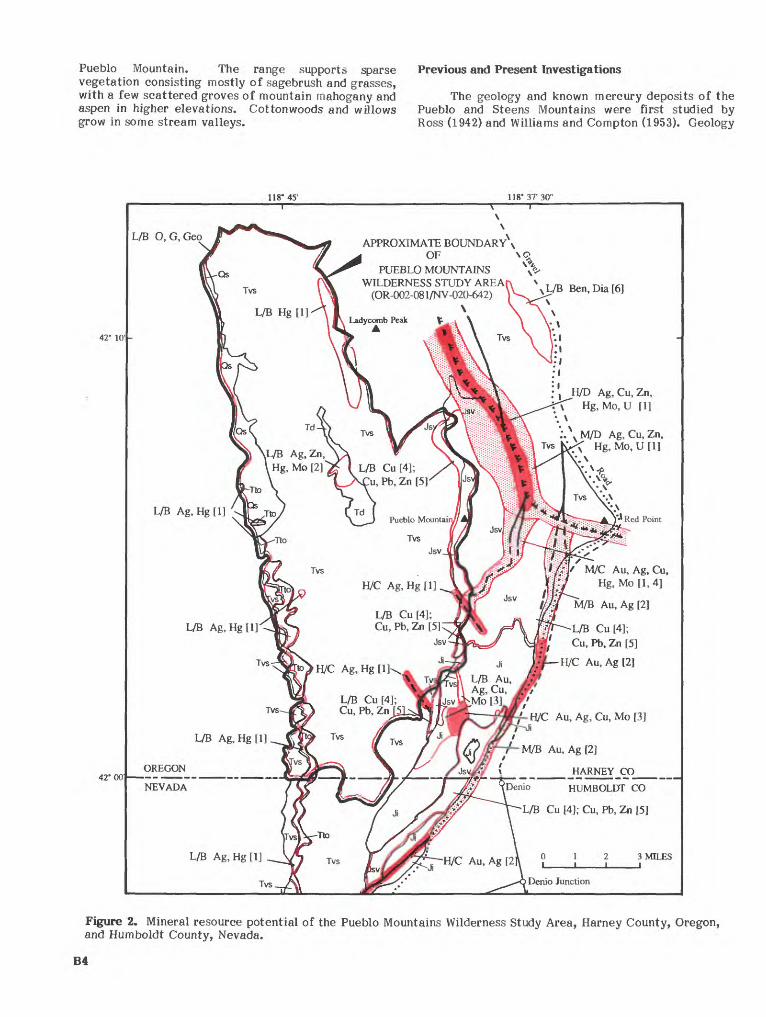
2. Map showing mineral resource potential of the Pueblo Mountains Wilderness Study Area, Harney County, Oregon, and Humboldt County, Nevada 4
TABLE
1. Mines, prospects, and mining claims in and adjacent to the Pueblo Mountains Wilderness Study Area B18


MINERAL RESOURCES OF WILDERNESS STUDY AREAS: STEENS MOUNTAIN RINCON REGION, OREGON
Mineral Resources of the Pueblo Mountains Wilderness Study Area, Harney County, Oregon, and Humboldt County, Nevada
By Robert C. Roback, Dean B. Vander Meulen, Harley D. King, and Donald Plouff U.S Geological Survey
Steven R. Munts and Spencee L.Willett U.S. Bureau of Mines
SUMMARY
Abstract
Mineral surveys were conducted on 41,315 acres of the Pueblo Mountains Wilderness Study Area (OR- 002-08 l/NV-020-642) in southeastern Oregon and northern Nevada, at the request of the U.S. Bureau of Land Management (BLM). The original wilderness study area is larger than the area on which mineral surveys were requested. This report discusses the geology, mineralizing processes, and mineral resource potential of an area larger than the 41,315-acre area on which surveys were requested, in order to more accurately determine the mineral resource potential of the study area. Throughout this report "wilderness study area" and "study area" apply only to the 41,315- acre area on which surveys were requested. The U.S. Bureau of Mines (USBM) and the U.S. Geological Survey (USGS) conducted geological, geophysical, and geochemical surveys during 1984 and 1985 to assess the mineral resources (known) and mineral resource potential (undiscovered) of the study area.
No resources were identified in the Pueblo Mountains Wilderness Study Area. However, the study indicates high potential for silver and mercury resources in altered rocks located along two northwest-trending fault zones that cross the east boundary of the study area; moderate potential for gold, silver, copper, mercury, and molybdenum resources in quartz veins along a fault near the east boundary of the study area; low potential for silver, zinc, mercury, and molybdenum resources in intermediate flows located in the central part of the study area; and low potential for undiscovered silver
and mercury in silicic tuff. The eastern part of the study area has low potential for copper, lead, and zinc resources in metavolcanic and metasedimentary rocks; and the northeast part of the study area has low potential for mercury resources in mafic flows. The resource potential for oil, gas, and geothermal energy is considered low in the study area.
Part of the Pueblo Mountains east of the study area has four areas of high mineral resource potential and several areas of moderate and low mineral resource potential. All terranes that have high mineral resource potential outside of the study area are discussed in the text. Metamorphic rocks and Quaternary sedimentary deposits exposed along two segments of the Pueblo Mountains range-front fault, 2 mi east of the study area, have high potential for gold and silver resources. Rocks adjacent to the Pueblo caldera ring fault, 1 mi east of the study area, have high potential for silver, copper, zinc, mercury, molybdenum, and uranium resources. A metamorphosed quartz diorite intrusion near the southeast boundary of the study area has high potential for gold, silver, copper, and molybdenum resources. Caldera-fill sedimentary rocks 3 mi east of the study area have low potential for diatomite and bentonite resources.
Character and Setting
The Pueblo Mountains Wilderness Study Area (OR-002-81/NV-020-642) is located in southeastern Oregon and northern Nevada about 2 mi northwest of Denio, Nev., and 5 mi south of Fields, Oreg. (fig. 1). The Pueblo Mountains comprise part of a north-
Bl

trending fault block in the northwestern Basin and Range physiographic province. The east flank of the Pueblo Mountains is very steep, while the west flank dips gently to the west. Van Horn and Little Cottonwood Creeks (fig. 1) divide the range into two parallel, north-trending crests. Metamorphosed
volcanic, plutonic, and sedimentary rocks of Jurassic age (138 to 205 million years before present (Ma); see appendix for geologic time chart) are the oldest rocks in the range. They are intruded by a granodioritic pluton of probable Cretaceous age. The pre-Tertiary rocks are overlain unconformably by Tertiary
I 19° Ofll
^Fields APPROXIMATE BOUNDARY
OFPUEBLO MOUNTAINS WILDERNESS STUDY AREA
(OR-002-081/NV-020-642)
OREGON NEVADA
HARNEY CO HUMBOLDT CO
PINE FOREST
RANGE
Figure 1. Index map showing location of Pueblo Mountains Wilderness Study Area, Harney County, Oregon, and Humboldt County, Nevada.
B2

sedimentary and volcanic rocks.Mining activity in the Pueblo Mountains began in
1884, and by 1910, 150 lode claims had been filed and the Pueblo Mountain mining district was formed. The principal commodities sought were gold, copper, and mercury. A few mines produced small amounts of gold and mercury. Recently, high prices have stimulated exploration for gold, and between 1980 and 1982 more than 300 claims were filed. There are no active mines in the study area.
Identified Resources
Seventy-two mines and prospects in or near the study area were evaluated (see appendix). Most are located along a northwest-trending range-front fault that is currently being evaluated by several mineral exploration companies. No mineral resources were identified in the study area.
probably the source of the silver and mercury anomalies recorded by Gray and others (1983).
Metamorphic, volcanic, volcaniclastic, and sedimentary rocks along the east edge of the study area have low potential for copper, lead, and zinc resources.
In the northern part of the study area basalt flows exposed along a north-trending fault zone have low potential for mercury resources.
The study area has low potential for geothermal resources.
Sedimentary rocks in the study area have low potential for oil and gas resources. A seismic study and drilling program are needed to test these rocks for oil and gas resources.
Caldera-fill sedimentary rocks located 3 mi east of the study area have low potential for bentonite and diatomite resources.
The study area contains deposits of sand, gravel, and building stone.
Mineral Resource Potential
Along the east boundary of the study area, two fault zones peripheral to the Pueblo caldera ring fracture (Rytuba and McKee, 1984) have high potential for silver and mercury resources (pi. 1, fig. 2). Metamorphic, volcanic, and sedimentary rocks exposed along these northwest-trending faults (pi. 1) are locally altered and silicified. Geochemical analyses indicate anomalous concentrations of arsenic and mercury in the silicified zones. The mineral resource potential is based on anomalous concentrations of these elements in soil and rock samples (Gray and others, 1983; Roback, 1986). Although no gold was detected in the samples analyzed, arsenic and mercury are good pathfinders for gold resources.
Areas adjacent to a north-trending fault near the east boundary of the study area have moderate potential for gold, silver, copper, mercury, and molybdenum resources. The fault extends across the east boundary of the study area into a mineralized caldera ring fracture (pi. 1). Metamorphic rocks exposed along the fault are locally altered and cut by quartz veins. Geochemical analyses (Roback, 1986) indicate that the altered rocks and quartz veins contain anomalous concentrations of gold, silver, copper, mercury, and molybdenum.
Dacite flows located along the western crest of the Pueblo Mountains, near the central part of the study area, have low potential for silver, zinc, mercury, and molybdenum resources. Dacite flow breccias proximal to a dacite plug are locally hydro therm ally altered. Geochemical analyses indicate that flows near the dacite plug contain anomalous concentrations of silver, zinc, mercury, and molybdenum.
Areas underlain by the tuff of Oregon Canyon along the western flanks of the Pueblo Mountains near the west boundary of the study area (pi. 1) have low potential for silver and mercury resources. The ash- flow tuff contains high background values of silver and mercury (J.J. Rytuba, unpub. data, 1985) and is
INTRODUCTION
This mineral survey is a joint effort by the U.S. Geological Survey and the U.S. Bureau of Mines. The history and philosophy of such joint surveys are discussed by Beikman and others (1983). The U.S. Bureau of Mines (USBM) evaluates identified resources at individual mines and known mineralized areas by collecting data on current and past mining activities and through field examination of mines, prospects, claims, and mineralized areas. Identified resources are classified according to the system described by the U.S. Bureau of Mines and the U.S. Geological Survey (1980). Studies by the U.S. Geological Survey (USGS) are designed to provide a reasonable scientific basis for assessing the potential for undiscovered mineral resources by determining geologic units and structures, possible environments of mineral deposition, presence of geochemical and geophysical anomalies, and applicable ore-deposit models. Mineral assessment methodology and terminology as they apply to these suveys were discussed by Goudarzi (1984). See appendix for the definition of levels of mineral resource potential, certainty of assessment, and classification of identified resources.
Area Description
The Pueblo Mountains Wilderness Study Area (OR-002-081/NV-020-642) encompasses 41,315 acres in the Basin and Range geologic province of southeastern Oregon and northwestern Nevada. The study area lies approximately 5 mi south of Fields, Oreg., and 2 mi northwest of Denio, Nev., and encompasses most of the high country of the Pueblo Mountains (fig. 1). The area is accessible year round by gravel roads that parallel the eastern and western range fronts. Several jeep trails lead into higher parts of the range. The eastern crest of the Pueblo Mountains is particularly steep and rugged, whereas the western range front dips gently to the west. Elevations range from 4,200 ft at the town of Denio (fig. 1) to 8,632 ft at the summit of
B3
Pueblo Mountain. The range supports sparse Previous and Present Investigations vegetation consisting mostly of sagebrush and grasses,with a few scattered groves of mountain mahogany and The geology and known mercury deposits of theaspen in higher elevations. Cottonwoods and willows Pueblo and Steens Mountains were first studied bygrow in some stream valleys. Ross (1942) and Williams and Compton (1953). Geology
118-45' 118" 37'30"
42* 10
42'00'
L/B O, G.Geo APPROXIMATE BOUNDARYOF
PUEBLO MOUNTAINS WILDERNESS STUDY AREA
(OR-002-08 l/NV-020-642) \
L/B Ag,Hg[l]
H/D Ag, Cu.Zn, \"" Hg, Mo, U [1]\
;.\M/D Ag, Cu, Zn, Hg, Mo, U [1]
| J Red Point
OREGON
NEVADA
L/B Ag,Hg[l]
L/B Ag,Hg[l]
M/C Au, Ag, Cu, Hg, Mo [1, 4]
M/B Au,Ag[2]
L/B Cu[4]; Cu, Pb, Zn [5]
H/C Au, Ag [2]
H/C Au, Ag, Cu, Mo [3]
M/B Au, Ag[2]
HARNEY CODenio HUMBOLDT CO
L/B Cu [4]; Cu, Pb, Zn [5]
L/B Ag,Hg[l] 3 MILES
TVS Denio Junction
Figure 2. Mineral resource potential of the Pueblo Mountains Wilderness Study Area, Harney County, Oregon, and Humboldt County, Nevada.
B4

of the Pueblo Mountains is included in the reconnaissance geologic maps of the Adel quadrangle, Oreg. (Walker and Repenning, 1965), and Humboldt County, Nev. (Willden, 1965). Other studies in the Pueblo Mountains include those of Avent (1965), Rowe
EXPLANATION
Area with high mineral resource potential
Area with moderate mineral resource potential
Area with low mineral resource potential
See appendix for definition of levels of mineral resource potential and certainty of assessment
Commodities
Ag SilverAu GoldCu CopperHg MercuryMo MolybdenumPb LeadU UraniumZn ZincBen BentoniteDia DiatomiteO,G Oil and GasGeo Geothermal
[ J Types of deposits
1 Hydrothermal caldera-related deposits2 Epithermal vein deposits3 Porphyry deposits4 Base- and precious-metal deposits5 Volcanogenic massive sulfide deposits6 Sedimentary lake deposits
Geologic map units
Qs Surficial deposits (Quaternary)Tto Tuff of Oregon Canyon (Miocene)Td Dacite (Miocene)TVS Volcanic and sedimentary rocks (Tertiary)Ji Intrusive rocks (Jurassic)Jsv Schist and volcanic rocks (Jurassic)
ContactFault Dashed where approximate; dotted where
concealed Approximate margin of Pueblo Mountains
caldera
Figure 2. Continued.
(1971), Tower (1972), and Harold (1973). A geologic map of the Turn Turn Lake 7 1/2-minute quadrangle (Rytuba and others, 1982) located east of the study area covers part of the Pueblo Mountains. A report on the McDermitt volcanic field (Rytuba and McKee, 1984) indicates that the margin of the Pueblo caldera borders the eastern part of the study area.
The State of Oregon Department of Geology and Mineral Industries investigated most of the mines, prospects, and mining claims and conducted a geochemical survey in and adjacent to the Pueblo Mountains Wilderness Study Area (Gray and others, 1983). The U.S. Geological Survey conducted combined geological, geochemical (Roback, 1986), and geophysical surveys during 1984 and 1985. The U.S. Bureau of Mines conducted library research and examined county claim records, U.S. Bureau of Mines Industry Location System data, and U.S. Bureau of Land Management mining and mineral lease records. U.S. Bureau of Mines, state, and other production records were also examined. Field studies involved examination of all of the mines, mining claims, and prospects in and near the study area. Where warranted, some of these were mapped and sampled in detail. Of the 240 rock samples collected, 204 were taken from these areas. Twenty-eight alluvial samples and 13 soil samples were also collected. All samples were analyzed by fire assay, fire assay-inductively coupled plasma, semiquantitative spectroscopy, atomic absorption, colorimetry, radiometry, and X-ray fluorescence (Munts and Willett, 1987). This work was described in detail by Munts and Willett (1987). Detailed sample analyses are available from U.S. Bureau of Mines, Western Field Operations Center, E. 360 Third Avenue, Spokane, WA 99202.
Acknowledgments
The authors gratefully acknowledge the help of K.J. Tegtmeyer and M.J. Grubensky of the U.S. Geological Survey for assistance in fieldwork for this study. Lee Nelson and John Davis kindly gave us a tour of the Cowden mine, allowed access to the property, and shared information on mining activity in the area.
APPRAISAL OF IDENTIFIED RESOURCES
B_y_ Steven R. Munts and Spencee L. Willett U.S. Bureau of Mines
History and Production
Harney County claim records indicate at least 628 lode and 4 placer claims have been located within the Pueblo Mountain Range area to date. Three- hundred eighty lode claims were active in the Pueblo Mountain Range and 20 of the 70 lode claims that have been located in the study area are active (1984). Current U.S. Bureau of Land Management records indicate that about half the study area is leased for oil and gas.
B5

Two major periods of mining activity occurred in the Pueblo Mountain Range. The first recorded lode mining activity within or near the study area was by M.J. O'Conner and L. Denio, who located the Illinois gold claim on Mineral Creek (exact location unknown) in March 1894. By 1900, 19 lode claims were located in the Denio Basin area and, although considerable placer exploration had occurred, only one placer claim was filed. During the next ten years, approximately 150 lode claims were filed in the Pueblo Mountains, and the Pueblo Mountain (also known as the Pueblo) mining district was formed. Most of the claims were for gold; a few were located for copper. By 1910, activity had decreased dramatically with only about 67 lode and 3 placer claims filed during the next 60 years. Most of these claims were located for mercury. During the 1970's, at least 63 claims were located in the eastern Pueblo Mountains, primarily for gold. However, during the mid-1970's, the Denio Creek area was examined and drilled by a major exploration company looking for a porphyry copper deposit. Increasing gold prices stimulated precious metal interest and more than 300 claims were filed in the eastern Pueblo Mountains between 1980 and 1982 by Inspiration Copper Company and FMC Corporation. Other exploration companies that have evaluated this area recently include Amoco Minerals, Manville Corporation, and Molycorp, Inc. To date, no claims have been patented.
Only minor placer mining activity has occurred in and near the study area since the early 1900's. All four placer claims recorded since 1900 are outside the study area.
The Pueblo Mountain Range area has been explored for nonmetallic commodities, including zeolites. One site on the northeast edge of the mountain range was reportedly briefly mined for zeolites.
No mineral production is recorded from within the study area. Within the Pueblo Mountain mining district, three mines have recorded production. The Pueblo mine (pi. 1, No. 26) (now part of the Pueblo (Farnham) group) has produced both gold and mercury (Brooks, 1963). Approximately one flask of mercury was produced from the Rabbit Hole mine (pi. 1, No. 14) (now part of the Victor group). The Denio Basin group (pi. 1, No. 61) and the Sulfide group (pi. 1, No. 67) appear to have had minor production although none is officially reported. No significant placer gold production (less than 1 troy ounce) is reported. Total district production is estimated to be less than 500 Ib of mercury and less than 25 oz of gold.
Mines, Prospects, and Mineralized Areas
Sixty-seven mines, prospects, and mining claim groups were examined during this study (pi. 1, table 1). Sixteen groups are inside or partly inside, and 51 are outside the study area. These groups are composed of one or more claims that may be active or nonactive. Only three of the latter group (pi. 1, Nos. 15, 57, and 58) may extend into the study area. Analyses of rock samples taken from mineralized areas and alluvial samples collected from creeks draining the
area are given in appendix. Examination of individual sites and analyses of samples were designed to establish the presence of commodity resources for all but oil and gas, and geothermal energy.
Identified Mineral Resources
Significant metallic and nonmetallic commodities that are present within or near the study area include mercury, gold, copper, basalt, gemstones, stone, and sand and gravel. Of the 67 mines, prospects, and mining claim groups in and near the study area (located for mercury, gold, or copper), 16 are present in the study area. These mines, prospects, and mining claim groups are located along a north- northwest-trending mineralized range front fault zone that contains variable localized concentrations of mercury and gold. This fault zone is currently being evaluated by several major exploration companies for large-tonnage disseminated gold deposits. Surface exposures of large, low-grade occurrences of gold, copper/molybdenum, and mercury mainly in the southeast corner of the study area and small high- grade deposits mainly on the east side of the study area may also continue to be exploration targets. However, none of the mines and prospects appear to have resources and indicated grades of exposed rock are not within limits that can currently be mined on a large scale for gold, mercury, molybdenum, or copper.
All four placer prospects examined are adjacent to the study area and were evaluated with grab samples of alluvium. Gold values in two samples were $0.008 and $0.01/yd (pi. 1, table 1, Nos. 25 and 17, respectively) at a gold price of $300/oz. None of the claims contained more than 100 yd of gravel. Because of the low grade and volume, these prospects do not contain identified resources.
Reconnaissance mapping by Walker and Repenning (1965) and Williams and Compton (1953, fig. 2), which delineated basalt in much of the western part of the study area, was used as a geologic basis for USBM studies. Subsequently, more detailed mapping was done by the U.S. Geological Survey during this study (pi. 1). In the western part of the study area, basalt flows locally consist of layers 4 to 10 in. thick, which are divided by parting planes. These tabular layers may be suitable for flagstone, slabstone, or decorative stone. However, vesicle content is too low for a high-quality product. The basalts contain 15.5 to 16.9 percent alumina and are in the high-alumina category (Hart and others, 1984). Basalts of this type are suitable for basalt fiber manufacturing (Subramanian, 1978). Current development of the basalts for aluminum or basalt fiber is unlikely because higher quality materials are available closer to potential markets. Basalts within the study area do not currently constitute a resource.
Three small (less than 0.25 mi in diameter) mafic-appearing plugs and surrounding creek drainage sediments on the western slopes of the Pueblo Mountains were examined for diamonds and traditional diamond indicator minerals. Neither were found. No
B6

favorable host rock occurrences such as kimberlites or ultramafic rocks were found. No diamond resources were identified within the study area.
Field examination of an area about 1 mi northwest of the study area (pi. 1) revealed several tuffaceous units with relatively thin (less than 25 ft), clay- and silt-rich diatomaceous interbeds. A sample from the lower bed contained less than 5 percent diatoms, and one from the upper bed (50 ft above the lower bed) contained 90 percent ash and 10 percent diatoms. These beds contain insufficient diatomite and are too thin to be considered a resource (on the basis of guidelines described by Kadey, 1983).
None of the occurrences of chalcedony and agate in the study area represent a resource; however, they may be of importance as collecting areas for recreational collectors.
No geothermal resources were identified in the study area. A petroleum study by Warner (1980) examined known pertinent geology of the Alvord Valley and vicinity and concluded that the area was a "prime exploration target" for oil and gas. Conversely, a study by Newton (1982) indicated the Alvord Valley had a "low favorability" for economic concentrations of oil. The study area is not known to contain thick accumulations of sedimentary rocks or structures typically associated with hydrocarbon traps and no oil and gas resources were identified.
Gneissic outcrops in the Pueblo Mountains Wilderness Study Area are suitable for rubble stone or flagstone. Gneiss crops out in Denio Canyon along Denio Creek for at least 2,000 ft. Cliffs are as high as 200 ft and spall into cliff base talus slopes. Individual talus fragments are as thick as 4 in. and as large as 6 ft in surface area. Pieces are generally rectangular to triangular and vary in color from dark gray to orange. Orange-colored rock contains clay and weathers more easily than the unaltered gray variety. This material meets the general criteria for rubble and rough construction stone and flagstone, as described by Power (1983). However, the altered variety appears to be less suitable. This occurrence is not economic (currently) because of a lack of nearby markets. However, this area could be developed to supply construction stone for local use.
Small occurrences of mixed sand and gravel are present both in and adjacent to the study area. All are alluvial and occupy Dip, Rincon, Willow, and Arizona Creeks. They are generally wedge shaped in cross section, as wide as 20 ft, and as thick as 10 ft. At the confluence of Dugout and Dip Creeks, a small (less than 1 acre) occurrence of pebble- to boulder-rich material is preserved. However, it contains as much as 40 percent soil in surface exposure. None of these occurrences appear to be economic, because larger and better quality deposits are present closer to major market areas; however, they could support local use.
An occurrence of zeolites 3 mi northeast of the study area (Gray and others, 1983) was explored by extensive bulldozer scrapes. Although the prospect appears to have supported minor but unrecorded production, both chemical field tests and laboratory X- ray defraction analysis failed to detect any zeolites. The host rocks could not be traced into the study area.
ASSESSMENT OF MINERAL RESOURCE POTENTIAL
By Robert C. Roback, Dean B. Vander Meulen, Harley D. King, and Donald Plouf f U.S. Geological Survey
Geology
The Pueblo Mountains comprise part of a large 10- by 30-mi north-trending, west-tilted, basin-and- range fault block, bounded on the east side by a high- angle normal fault that has at least 15,000 ft of vertical offset. The oldest exposed rocks are metamorphosed volcanic, plutonic, and sedimentary rocks of Jurassic age here informally named the metamorphic complex of Pueblo Mountains. The metamorphic complex was intruded by plutons of probable Cretaceous age. A thick sequence of Oligocene and Miocene volcanic and sedimentary rocks unconformably overlies the metamorphic complex. Quaternary age alluvial, lacustrine, and eolian deposits fill the basins and valleys. Landslides and slumps are common, particularly on the east side of the range.
The summit of Pueblo Mountain and most of the eastern crest of the Pueblo Mountains consist of resistant rocks of the Jurassic metamorphic complex of Pueblo Mountains. The metamorphic complex can be divided into three major groups: (1) schists, which have protoliths of lava flows, tuff, and volcanogenic sediment; (2) plutons that are dominantly quartz diorite and include lesser amounts of granodiorite, tonalite, and quartz monzonite; and (3) lava flows that are dominantly intermediate in composition and include lesser amounts of felsic flows, flow breccia, tuff, agglomerate, and sedimentary rocks. Rocks of the metamorphic complex were probably formed in a magmatic arc setting. Some of the rock materials appear to have been deposited in a subaqueous environment. All of the rocks underwent regional, dynamothermal, middle-greenschist-facies metamorphism during Late Jurassic and Early Cretaceous time. Unmetamorphosed granodioritic stocks of probable Cretaceous age intrude the metamorphic complex.
The dominant pre-Tertiary structure in the metamorphic complex is a strong, locally developed, northeast-trending and southeast-dipping foliation. Quartz veins and gossan zones in these rocks parallel the foliation and possibly formed synchronously.
Metamorphic rocks of Mesozoic age exposed along the east boundary of the study area are unconformably overlain by conglomerate, sandstone, and shale of Oligocene and Miocene age. These rocks are probably lithologically correlative with the Pike Creek Formation (Walker and Repenning, 1965). Andesite flows and a thick sequence of basalt flows and related dikes and sills overlie the sedimentary rocks. The volcanic rocks are probably stratigraphically correlative with the Steens Mountain Volcanics (Williams and Compton, 1957) or the Steens Basalt (Piper and others, 1939). Basalt flows cover a large part of the central part of the study area (pi. 1) and are locally intercalated with air-fall tuff beds and
B7

dacite and latite flows. The basalt flows are overlain by andesite flows and sedimentary rocks, which, in turn, are unconformably overlain by middle Miocene rhyolite ash-flow tuff of the McDermitt volcanic field; dated at 16.1 to 15 Ma (Rytuba and McKee, 1984). The andesite flows, tuff, and sedimentary rocks are exposed along the western part of the study area (pi. 1) and form the dip slope of the Pueblo Mountains.
The Pueblo Mountains are situated along two regional northwest-trending structures: the Eugene- Denio fault zone (Lawrence, 1976) and the Orevada rift (Rytuba and Conrad, 1981). Several calderas and related high-silica rhyolite ash-flow tuffs are located along or near the southeast extension of the rift zone. The Pueblo caldera (Rytuba and others, 1982; Rytuba and McKee, 1984) forms a broad embayment along the eastern front of the Pueblo Mountains. The western topographic wall of the caldera coincides with the steep eastern slope of the range front. A ring fault that parallels the base of the topographic wall juxtaposes Tertiary sedimentary rocks against the metamorphic complex. The highly mineralized, northwest-trending ring fault is located approximately 1 mi east of the study area (pi. 1). North- to northwest-trending faults peripheral to the ring fault are probably related to the formation of the Pueblo caldera.
North of Red Point (pi. 1), basin and range faults are oriented northwest, parallel to the margin of the Pueblo caldera; however, south of Red Point, basin and range faults trend north-northeast, parallel to the regional trend. This reorientation is the result of horsetail faults north and south of Colony Creek (pi. 1). One of these faults juxtaposes Jurassic volcanic rocks and schist and is probably an older fault that may have been reactivated during the Tertiary. Several prospects and altered areas are present along this fault.
The western part of the Pueblo caldera ring fracture was apparently reactivated during basin and range extensional faulting that began in middle or late Miocene time. Regional extension initiated the basin and range faults and tilted the Pueblo Mountains fault block approximately 20° to the west. Total vertical displacement along the eastern range-front fault is about 15,000 ft. Quaternary deposits are offset by the range-front fault, indicating it is still active. Several lode-gold mines and prospects are located along this fault. The Sleeper gold deposit (Wood, 1986) 55 mi southeast of the study area is proximal to range-front faults in a similar range-front environment.
Geochemical Studies
In 1984 the U.S. Geological Survey conducted a geochemical study of the Pueblo Mountains Wilderness Study Area. One hundred twenty-one samples collected in or near the study area were analyzed for 31 elements using a six-step semiquantitative emission spectrographic method (Myers and others, 1961; Grimes and Marranzino, 1968). Samples were also analyzed by inductively coupled argon plasma-atomic emission spectroscopy (ICAP-AES) (Crock and others, 1983) for arsenic, bismuth, cadmium, antimony, and zinc using a modification of the O'Leary and Viets
digestion method (1986). Atomic absorption and cold- vapor atomic-absorption methods were used to determine concentrations of gold and mercury (Thompson and others, 1968; Koirtyohann and Khalil, 1976). Analytical data, sample locations, and results are given in Roback (1986). The State of Oregon Department of Geology and Mineral Industries (DOGAMI), under contract with the BLM, collected 17 rock samples, 133 stream-sediment samples, and 207 soil samples for analysis by atomic absorption, spectrophotometry, and fluorimetry (Gray and others, 1983). Barringer Resources, Inc., analyzed the heavy- mineral concentrates from the DOGAMI study (Bukofski and others, 1984).
Geochemical data obtained from stream- sediment analyses represents the composite chemistry of rock units in a particular drainage basin. Drainage basins within the study area range from 0.5 to several square miles in size.
The largest producing mercury mine in the United States, the McDermitt mine, is located 30 mi east of the study area near the margin of the Long Ridge caldera. The Long Ridge caldera is one of several calderas located in the McDermitt caldera complex. Formation of the Pueblo caldera and the McDermitt caldera complex (15.8 and 15.6-16.1 Ma, respectively, Rytuba and McKee, 1984) was roughly synchronous and they are both present along the same structural trend, the Orevada rift (Rytuba and Conrad, 1981). Similar mechanisms of ore deposition at the McDermitt mine and in the Pueblo Mountains are assumed. Near the east boundary of the study area, numerous mercury mines are localized along part of the Pueblo caldera margin. Rocks exposed along the caldera margin are hydrothermally altered and silicified and contain anomalous concentrations of antimony (4,400 parts per million, or ppm), arsenic (1,370 ppm), copper (32,100 ppm), mercury (894 ppm), molybdenum (15 ppm), silver (225 ppm), and zinc (830 ppm) (Roback, 1986; Gray and others, 1983). Mineralizing events that concentrated these elements along the caldera margin may also be responsible for geochemical anomalies along faults peripheral to the margin. In the study area, rocks exposed along two fault zones that trend parallel to the caldera margin contain anomalous concentrations of mercury and silver. A rock sample collected north of Van Horn Creek (fig. 2, pi. 1; Roback, 1986, station 84BR139A) contained 13 ppm mercury. Concentrations as high as 606 ppm mercury and 1 ppm silver were obtained from a rock sample collected at the Tiller Cabin shaft in the Denio basin (pi. 1; Gray and others, 1983) near the east boundary of the study area. These metals were probably concentrated by caldera-related hydrothermal activity, similar to the process that occurred in the Long Ridge caldera (Rytuba and Glanzman, 1979).
An aerial gamma-ray survey performed in the study area as part of the U.S. Department of Energy National Uranium Resource Evaluation (Geodata International, Inc., 1980) shows anomalous levels of equivalent uranium along and near the Pueblo caldera margin. The study indicates the possibility of uranium mineralization similar to that found in the McDermitt caldera complex (Rytuba and Conrad, 1981). Soil samples collected along the caldera margin contain
B8

anomalous concentrations of uranium (3.1 ppm) (Gray and others, 1983).
A metamorphosed quartz porphyry located near the southern part of the study area was developed by numerous trenches, pits, adits, and two drill holes. A gossan zone in the quartz porphyry contains anomalous concentrations of antimony (16 ppm), arsenic (108 ppm), copper (1,500 ppm), gold (13 ppm), molybdenum (50 ppm), and silver (15 ppm).
Stream-sediment samples collected in the study area west and southwest of Ladycomb Peak (pi. 1) contain anomalous concentrations of arsenic (7.7 ppm), mercury (0.3 ppm), and silver (1.6 ppm). These elements are characteristic of the caldera-related mercury deposits and the epithermal silver, mercury, and molybdenum deposits found in the Pueblo Mountains east of the study area and suggest the potential for similar resources near Ladycomb Peak.
Local anomalous concentrations of mercury (0.4 ppm) and silver (0.6 ppm) in stream sediments along the western flank of the Pueblo Mountains are attributed to high background values of these elements in the tuff of Oregon Canyon. Samples of this tuff collected from the Trout Creek Mountains 30 mi east of the study area have concentrations of mercury ranging from 0.020 to 0.026 ppm and silver ranging from 0.81 to 1.5 ppm (J.J. Rytuba, written commun., 1985).
Areas of hydrothermal alteration were mapped adjacent to a dacite feeder plug in the north-central part of the study area. A rock sample from the brecciated dacite contains anomalous concentrations of arsenic (21 ppm), molybdenum (7.0 ppm), and zinc (460 ppm) (Roback, 1986). Stream-sediment samples from this area contain anomalous concentrations of mercury (0.5 ppm) and silver (1.5 ppm) (Gray and others, 1983).
Geophysical Studies
In 1984 the U.S. Geological Survey established 29 gravity stations adjacent to the Pueblo Mountains Wilderness Study Area. The data were used to prepare a Bouguer gravity anomaly map (Donald Plouff, unpub. data, 1984). The map reveals a prominent gravity high with an amplitude exceeding 20 milligals that extends from the inferred margin of the Pueblo caldera to a gravity minimum 5 mi east in Pueblo Valley. The sharp decrease likely reflects a deep, steep-dipping contact between basement rocks of the Pueblo Mountains and intracaldera sedimentary, volcanic, and unconsolidated sedimentary rocks beneath Pueblo Valley.
North-northwest-trending gravity contours closely parallel an inferred ring fracture along the western wall of the Pueblo caldera (Rytuba and McKee, 1984, fig. 3) and suggest the presence of a thick wedge of low-density, intracaldera tuff and sedimentary rocks to the east. This trend continues south past the caldera margin (Plouff, 1977) rather than curving southeastward along the inferred southern wall of the caldera. The gravity data do not distinguish low-density intracaldera tuff and sedimentary rocks from low-density valley-fill sediments. The gravity minimum in Pueblo Valley is
probably due to a comoination of caldera-fill sedimentary and volcanic rocks and valley-fill sediments.
Limited gravity data coverage near the northwest edge of the study area shows a gravity gradient of about 5 mGal/mi along the west edge of the Pueblo Mountains. This gravity gradient continues for about 20 mi north along the western flank of Steens Mountain and for about 20 mi south along the western flank of the Pine Forest Range in Nevada (Plouff, 1984). The westward decrease of the Bouguer gravity anomaly associated with this gradient was previously interpreted as a westward thickening of Tertiary volcanic rocks over the pre-Tertiary basement (Plouff, 1984), but may also be due to concealed low-density plutons.
An aeromagnetic survey (U.S. Geological Survey, 1985) was flown with flightlines spaced at 0.5 mi and at altitudes of about 1,000 ft above the mean terrain. The resulting magnetic-intensity map is dominated by a pair of complex, north-elongated magnetic highs and lows, separated by 300 to 1,000 nanoteslas (gamma) of amplitude. The magnetic low in the western part of the study area closely coincides with hillcrests and west-dipping slopes composed of Steens Basalt; this low is probably coincident with the reversely magnetized flows of the Steens Basalt sampled by Mankinen and others (1985, fig. 3). Complex maxima within the central magnetic high reflect an exposed section of normally magnetized Steens Basalt, which is older than the reversely magnetized section. Pre- Tertiary rocks in the eastern part of the study area are apparently weakly magnetized and do not show this magnetic gradient. North-trending magnetic contours along the eastern flank of the Pueblo Mountains are partly deflected along the margin of the Pueblo caldera. The buried margin of the caldera is further delineated by a ground magnetic survey (Rytuba and McKee, 1984) that shows a zone of low magnetization along the ring fracture. This magnetic low is presumed to have formed by the hydrothermal alteration of iron oxide. A prominent magnetic low 1.1 by 2.5 mi and 200 nanoteslas (gamma) in amplitude over Snake Den Butte (fig. 1) in the northeast corner of the study area may reflect an intracaldera wedge of reversely magnetized tuffaceous sedimentary rock. Intense magnetic anomalies associated with the Steens Basalt generally mask other local anomalies that may be relevant to evaluation of mineral resource potential.
CONCLUSIONS
Mineral Resources
Geochemical investigations indicate that the Pueblo Mountains Wilderness Study Area has anomalous concentrations of gold, silver, copper, zinc, molybdenum, mercury, uranium, antimony, and arsenic. Five deposit models help explain the processes of mineralization in the area. Mineral resources are classified according to the criteria set forth in Goudarzi (1984) (see appendix).
B9

Silver and Mercury Deposits
Anomalous concentrations of mercury are present at various localities in and adjacent to the study area (Gray and others, 1983; Roback, 1986), mostly along the eastern and northeastern sides of the Pueblo Mountains. Anomalous concentrations of mercury in stream-sediment samples along the western flank of the Pueblo Mountains and southwest of Ladycomb Peak (Gray and others, 1983) and in rock samples north of Van Horn and Denio Creeks (Roback, 1986) indicate there is high potential for mercury resources in these areas. Identified mercury resources located adjacent to the study area are generally structurally controlled along north- to northwest- trending faults.
Ross (1942) and Williams and Compton (1953) studied the mercury deposits along the eastern flank of the Pueblo Mountains, where mercury is present as cinnabar (HgS) and mercurian tetrahedrite schwatzite (Cu, Hg, Zn, Fe)12 (Sb, AshS 13 ) along with copper and iron sulfide minerals. The mercury resources are associated with silicified Jurassic metavolcanic rocks and silicified Tertiary volcanic and sedimentary rocks. Mercury mines, prospects, and silicified zones are located along the margin of the Pueblo caldera (pi. 1). Deposition of silver, copper, zinc, molybdenum, mercury, uranium, antimony, and arsenic are attributed to hydrothermal systems associated with the Pueblo caldera.
Anomalous concentrations of silver and mercury are present in silicified zones located along two northwest-trending faults peripheral to the Pueblo caldera ring fracture. Anomalous concentrations of mercury and arsenic in stream-sediment samples collected southwest of Ladycomb Peak (pi. 1) are downstream from an inferred north-northeast-trending fault in Tertiary volcanic rocks. Hydrothermal processes that concentrated potential silver and mercury resources along the faults are probably genetically related to hydrothermal activity that concentrated mercury resources along the caldera margin. In the study area, northwest-trending fault zones north of Van Horn and Denio Creeks have high potential for silver and mercury resources, level C certainty, and the fault zone southwest of Ladycomb Peak has low potential for mercury resources, with level B certainty. See appendix for definition of levels of mineral resource potential and certainty.
Mineralized areas along a north-northeast- trending fault (fig. 2; pi. 1) that juxtaposes Jurassic volcanic rocks and schist contain malachite and azurite in quartz veins and veinlets in pyritized and argillized schist and meta-andesite. Mineralization is possibly related to development of the Pueblo caldera. Hydrothermal systems active during the close of the caldera cycle may have concentrated mineral- forming elements in the fault zone; alternatively, mineralization may have occurred during metamorphism (see also discussion below on base and precious metals in metamorphosed volcanic and volcaniclastic rocks). Possibly both mechanisms were active. In the eastern part of the study area, rocks exposed along a north-northeast-trending fault that splays off the caldera ring fracture have moderate
potential for gold, silver, copper, mercury and molybdenum resources, level C certainty.
Stream-sediment analyses (Gray and others, 1983) indicate anomalous concentrations of silver and mercury along the west side of the Pueblo Mountains. The tuff of Oregon Canyon (pi. 1) contains high background values of both of these elements (J.J. Rytuba, unpub. data, 1985) and is probably the source of these anomalies. This tuff likely serves as a source rock for silver and mercury; therefore, exposures of the tuff along the west boundary of the study area have low potential for silver and mercury resources, level B certainty.
Epithermal Gold-Silver Deposits
Several gold mines and prospects, including the Cowden and Hall mines (pi. 1; appendix) are located in areas of hydrothermal alteration along the southeastern range front of the Pueblo Mountains. At the Cowden mine very fine yet visible gold is found in limonitic quartz veins and veinlets of strongly argillized metamorphosed quartz diorite. The veins at this mine roughly parallel the range front. Numerous slickensides and brecciated quartz veins indicate that mineralization occured along faults. Strong linearity of mines, prospects, and altered areas and evidence from the Cowden mine indicate that localization of gold deposition was structurally controlled by basin and range normal faults. Movement along these faults brecciated the host rock and provided channelways for ascending auriferous hydrothermal solutions, typical of epithermal gold-silver deposits (Berger, 1981). Between Mapes Springs and the mouth of Van Horn Creek, near the northeast-trending range-front fault, prospect pits reveal quartz veins in brecciated and argillized metamorphosed quartz diorite. Two samples from these quartz veins contain anomalous concentrations of gold, silver, copper, mercury, and molybdenum. The range front fault is continuous from Red Point, southwest to the south end of the Pueblo Mountains, although much of it is buried by younger basin fill. No mineralized areas or altered zones were noted north of Van Horn Creek, yet the environment is permissable for the occurrence of epithermal gold deposits. Two areas outside of the study area, which are located along the range front fault south of Van Horn Creek, have high potential for gold and silver resources, level C certainty.
A Tertiary dacite plug and related flows and volcaniclastic rocks are exposed along the western ridge crest of the Pueblo Mountains at the headwaters of Little Cottonwood Creek (pi. 1). Stream-sediment samples (Gray and others, 1983) from this area contain anomalous concentrations of silver and mercury. One rock sample collected near the plug contains high concentrations of molybdenum, arsenic, and zinc (Roback, 1986). This area has low potential for silver, zinc, mercury, and molybdenum resources, level B certainty.
Porphyry Deposits
An intensely deformed and metamorphosed quartz porphyry is exposed along Denio Creek near the southeast boundary of the study area. Igneous textures
BIO

and contact relations indicate it was stock emplaced prior to the regional greenschist-facies metamorphism. The primary porphyritic texture suggests that the stock was emplaced at shallow levels, and the presence of ubiquitous pyrite and locally abundant sericite indicate that a hydrothermal system was probably active in the porphyry. The porphyry model of mineralization (Cox, 1981) is appropriate; however, subsequent metamorphism has modified geologic relations and complicates application of the deposit model.
Gossan zones less than 15 ft thick are common within the porphyry. They generally parallel the foliation in the porphyry but are discontinuous along strike. Analyses of rock samples from the unit (Roback, 1986) show little evidence of mineralization; however, in one locality north of Denio Creek gossan zones yield anomalous concentrations of gold, silver, copper, molybdenum, arsenic, and antimony. These anomalous concentrations may be the result of remobilization of the elements by metamorphic processes in the porphyry, which subsequently concentrated the elements in zones favorable to precipitation. Although the possibility exists for this type of mineralization throughout the porphyry, extensive geochemical analyses revealed no other mineralized areas within the unit. Exposures of quartz porphyry 1 mi southeast of the study area have high potential for gold, silver, copper, and molybdenum resources, level C certainty.
Base and Precious Metals in Metamorphosed Volcanic and Volcaniclastic Rocks
Chalcopyrite, malachite, azurite, pyrite, and specular hematite are present in quartz pods and veins that are found locally in Jurassic schist and volcanic rocks. In the schist, quartz pods and veins are parallel to a northeast-trending foliation. In the volcanic rocks, quartz veins and veinlets are present in northeast-trending shear zones. Host rocks in mineralized areas are typically argillized and pyritized. These deposits may have formed during regional greenschist facies metamorphism. Fluids that evolved from metamorphic dehydration reactions are thought to have leached copper from the wall rocks. Solutions migrated along structural weaknesses (foliation planes in schist and shear zones in volcanic rocks) to sites where conditions favored precipitation. Harper (1977) suggested similar mechanisms for formation of the Sustut copper deposit in British Columbia where cupriferous ore zones are as much as 250 ft thick. Although mineralized areas of this type in the Pueblo Mountains are small, larger ore zones may exist at depth. Exposures of Jurassic schists and volcanic rocks along the east boundary of the study area have low potential for copper, lead, and zinc resources, level B certainty.
North and south of Colony Creek (pi. 1), a fault juxtaposes Jurassic schist and volcanic rocks. Several prospects and altered areas are localized along this fault. Mineralization here may be related to late Mesozoic metamorphism or Tertiary age caldera hydrothermal processes (see discussion above on mercury deposits).
Volcanogenic Massive-Sulfide Deposits
Several locations in Oregon (Derkey, 1981, Juhas and others, 1981), California (Mosier and others, 1983), and Nevada (M.L. Sorensen, written commun., 1986) contain massive-sulfide deposits associated with metamorphosed volcanic flows and tuffs erupted in a submarine environment. In the Pueblo Mountains, Jurassic schist consists of metamorphosed intermediate to felsic tuff, flows, and sedimentary rocks. Some of the tuff was likely deposited in a marine environment. This environment is permissible for the development of volcanogenic massive-sulfide deposits. On the ridge crest south of Van Horn Creek (pi. 1) discontinuous O.l-in.-thick layers of stratabound pyrite are interbedded with greenschist (metatuff) and tourmaline-rich argillite, suggesting that submarine hydrothermal systems were active during deposition of these flows and sediments. Exposures of Jurassic schists located along the east boundary of the study area have low potential for copper, lead, and zinc resources in massive-sulfide deposits, level B certainty.
Energy Resources and Other Commodities
The Pueblo Mountains Wilderness Study Area lies approximately 8 mi south of the Alvord Valley geothermal area described by Muffler (1979) and Cleary and others (1981). Hot springs located in the valleys to the south and southeast of the study area are aligned along faults (Garside and Schilling, 1979). These known hot springs are restricted to the basins; none are located in the adjacent ranges. No hot springs are present in the study area, and such occurrences are unlikely because the study area does not include basin areas. The study area has low potential for geothermal resources, level B certainty.
Sedimentary rocks that could serve as a source rock for oil and natural gas resources are limited and there is no geologic evidence to suggest that they are of greater extent at depth. A drilling program in conjunction with seismic studies is needed to test the sedimentary rocks for their oil and natural gas resource potential. The study area is considered to have low potential for oil and natural gas resources, level B certainty.
Beds of bentonite and diatomite are intercalated with caldera-fill Tertiary tuffaceous sedimentary rocks, 3 mi east of the study area. Massive, cream- colored bentonite beds are as much as 15 m thick. Pink to white beds of diatomite are minor. This area has low potential for bentonite and diatomite resources, level B certainty. Within the study area there are no identified beds of bentonite or diatomite.
Tuff exposed along the western part of the study area may be a source for building stone; however, larger quantities of similar and more accessible tuff are available outside the study area.
Large quantities of sand, gravel, and rock are present throughout the study area; however, more accessible deposits of sand and gravel outside the study area preclude likely development.
Bll

REFERENCES CITED
Avent, J.C., 1965, Cenozoic stratigraphy and structure of Pueblo Mountains region, Oregon-Nevada: Seattle, University of Washington, Ph.D. dissertation, 119 p.
Berger, B.R., 1981, The geological attributes of Au- Ag-base-metal epithermal deposits, in Erickson, R.L., ed., Characteristics of mineral deposit occurrences: U.S. Geological Survey Open-File Report 82-795, p. 108-112.
Brooks, H.C., 1963, Quicksilver in Oregon: Oregon Department of Geology and Mineral Industries Bulletin 55, 223 p.
Bukofski, J.F., Lovell, J.S., and Meyer, W.T., 1984, Mineral resource assessment through geochemical studies of heavy mineral concentrates from wilderness study areas in Burns, Prineville, and Vale Districts, southeastern Oregon: Golden, Colo. 94 p., Barringer Resources Incorporated available from U.S. Bureau of Land Management .
Cleary, J., Lange, I.M., Qamar, A.I., Krouse, H.R., 1981, Gravity, isotope, and geochemical study of the Alvord Valley geothermal area, Oregon: Geological Society of America Bulletin, v. 92, p. 934-962.
Cox, D.P., 1981, A generalized empirical model for porphyry copper deposits, in Erickson, R.L., ed., Characteristics of mineral deposit occurrences: U.S. Geological Survey Open-File Report 82-795, p. 23-28.
Crock, J.G., Lichte, F.E., and Briggs, P.H., 1983, Determination of elements in National Bureau of Standards' Geological Reference Materials SRM 278 Obsidian and SRM 688 Basalt by inductively coupled argon plasma-atomic emission spectrometry: Geostandards Newsletter, v. 7, p. 335-340.
Derkey, R.E., 1981, The Silver Peak volcanogenic massive sulfide, northern Klamath Mountains, Oregon, in Silberman, M.L., Field, C.W., and Berry, A.L., eds., Proceedings of the Symposium on mineral deposits of the Pacific Northwest: U.S. Geological Survey Open-File Report 81-355, p. 213-222.
Fuller, R.E., 1931, The geomorphology and volcanic sequence of Steens Mountain in southeastern Oregon: University of Washington Publications in Geology v. 3, no. 1, p. 1-30.
Garside, L.J., and Schilling, J.H., 1979, Thermal waters of Nevada: Nevada Bureau of Mines and Geology Bulletin 91, 163 p.
Geodata International, Inc., 1980, Aerial radiometric and magnetic survey, Adel National Topographic Map, Oregon, Rocky Mountain 1979: Prepared for the U.S. Department of Energy, Grand Junction Office, Grand Junction, Colo., under Bendix Field Engineering Subcontract No 79-336- S, GJBX-104(80).
Goudarzi, G.H., 1984, Guide to preparation of mineral survey reports on public lands: U.S. Geological Survey Open-File Report 84-787, 51 p.
Gray, J.J., Peterscn, J.C., Clayton, Janine, Baxter, Gary, 1983, Geology and mineral resources of 18 BLM wilderness study areas Harney and Malheur
Counties, Oregon: State of Oregon Department of Geology and Mineral Industries Open File Report 0-83-2, 106 p.
Grimes, D.J., and Marranzino, A.P., 1968, Direct- current arc and alternating current spark emission spectrographic field methods for the semiquantitative analysis of geologic materials: U.S. Geological Survey Circular 591, 6 p.
Harold, J.L., 1973, Geology of the north-central Pueblo Mountains, Harney County, Oregon: Corvallis, Oregon State University, M.S. thesis, 121 p.
Harper, Gerald, 1977, Geology of the Sustut copper deposit in B.C.: Canadian Mining and Metallurgical Bulletin, v. 69, no. 777, p. 97-104.
Hart, W.K., Aronson, J.L., and Mertzman, S.A., 1984, Series distribution and age of low-K, high alumina olivine tholeiite in the northwestern Great Basin: Geological Society of America Bulletin, v. 95, p. 186-195.
Juhas, A.P., Freeman, P.S., and Fredericksen, R.S., 1981, Kuroko-type copper-gold mineralization at the Iron Dyke mine, Oregon, in_ Silberman, M.L., Field, C.W., and Berry, A.L., Proceedings of the Symposium on mineral deposits of the Pacific Northwest: U.S. Geological Survey Open-File Report 81-355, p. 236-245.
Kadey, F.L., Jr., 1983, Diatomite: in Industrial Minerals and Rocks, LeFond, S. J., Editor-in- Chief: Society of Mining Engineers, American Institute of Mining, Metallurgical, and Petroleum Engineers, Inc., New York, p. 677-708.
Koirtyohann, S.R., and Kahalil, Moheb, 1976, Variables in the determination of mercury by cold vapor atomic absorption: Analytical Chemistry, v. 48, no. 1, p. 136-139.
Lawrence, R.D., 1976, Strike-slip faulting terminates the Basin and Range province in Oregon: Geological Society of America Bulletin, v. 87,
Mankinen, E.A., Prevot, Michel, and Gromme, C.S., 1985, The Steens Mountain (Oregon) geomagnetic polarity transition 1. Directional history, duration of episodes, and rock magnetism: Journal of Geophysical Research, v. 90, no. B12, p. 10,393-10,416.
Mosier, D.L., Singer, D.A., and Salem, B.B., 1983, Geologic and grade tonnage information on volcanic-hosted Cu-Zn-Pb massive sulfide deposits: U.S. Geological Survey Open-File Report 83-89, 78 p.
Muffler, L.J.P., ed., 1979, Assessment of geothermal resources of the United States, 1978: U.S. Geological Survey Circular 790, 163 p.
Munts, S.R., and Willett, S.L., 1987, Mineral Resources of the Pueblo Mountains Study Area, Harney County, Oregon and Humboldt County Nevada: U.S. Bureau of Mines Open-File Report MLA-8- 87, 43 p.
Myers, A.T., Haven, R.G., and Dunton, P.J., 1961, A spectrochemical method for the semiquantitative analysis of rocks, minerals, and ores: U.S. Geological Survey Bulletin 1084-E, p. 207-229.
Newton, V.C., 1982, Geology, energy, and minerals resources assessment, BLM Region I, Columbia Plateau: prepared for TerraData, 7555 West Tenth Avenue, Lakewood, CO, 17 p.
B12
O'Leary, R.M., and Viets, J.G., 1986, Determination of antimony, arsenic, bismuth, cadmium, copper, lead, molybdenum, silver, and zinc in geological materials by atomic absorbtion spectrometry using a hydrochloric acid-hydrogen peroxide digestion: Atomic Spectroscopy, v. 7, no. 1, p. 4- 8.
Piper, A.M., Robinson, T.W., and Park, C.F., Jr., 1939, Geology and groundwater resources of the Harney basin, Oregon: U.S. Geological Survey Water Supply Paper 841, 189 p.
Plouff, Donald, 1977, List of principal facts and gravity anomalies for an area between Orovada, Nevada, and Adel, Oregon: U.S. Geological Survey Open-File Report 77-683, 40 p.
___1984, Interpretation of aeromagnetic and gravity data, Charles Sheldon Wilderness Study Area, Nevada and Oregon, in U.S. Geological Survey and U.S. Bureau of Mines, Mineral resources of the Charles Sheldon Wilderness Study Area, Humboldt and Washoe Counties, Nevada, and Lake and Harney Counties, Oregon: U.S. Geological Survey Bulletin 1538-B, 15 p., 1 pi., scale 1:1Z5,000.
Power, R.W., 1983, Construction stone: in Industrial Minerals and Rocks (nonmetallics other than fuels), Fifth ed., vol. 1, LeFond, S.J., Editor-in- Chief: Society of Mining Engineers, American Institute of Mining, Metallurgical, and Petroleum Engineers, New York, p. 161-181.
Roback, R.C., 1986, Geochemical analyses of rock samples from the Pueblo Mountains Wilderness Study Area, Harney County, Oregon, and Humboldt County, Nevada: U.S. Geological Survey Open-File Report 86-368, 11 p.
Ross, C.P., 194Z, Quicksilver deposits in the Steens and Pueblo Mountains, southern Oregon: U.S. Geological Survey Bulletin 931-J, p. ZZ7-Z58.
Rowe, W.A., 1971, Geology of the south-central Pueblo Mountains (Mesozoic-Cenozoic), Oregon- Nevada: Corvallis, Oregon State University, M.S. thesis, 81 p.
Rytuba, J.J., 1981, Relation of calderas to ore deposits in the western United States, hi Dickinson, W.R., and Payne, W.D., eds., Relations of tectonics to ore deposits in the southern Cordillera: Arizona Geological Society Digest, v. 14, p. ZZ7-Z36.
Rytuba, J.J., and Conrad, W.K., 1981, Petrochemical characteristics of volcanic rocks associated with uranium deposits in the McDermitt caldera complex, in Goodell, P.C., and Waters, A.C., eds., Uranium in volcanic and vole ani clastic rocks: American Association of Petroleum Geologists, Studies in Geology, no. 13, p. 63-7Z.
Rytuba, J.J., and Glanzman, R.K., 1979, Relation of mercury, uranium, and lithium deposits to the McDermitt caldera complex, Nevada-Oregon: Nevada Bureau of Mines and Geology, Report 33, 5th International Association on the Genesis of Ore Deposits Quadrennial Symposium, p. 109- 117.
Rytuba, J.J., Vander Meulen, D.B., Vercoutere, T.L., Minor, S.A., Caress, M.E., and Kriens, B.J.C., 198Z, Reconnaissance geologic map of the Turn Turn Lake quadrangle, Harney County, Oregon: U.S. Geological Survey Open-File Report 8Z- 11Z7, scale 1:Z4,000.
Rytuba, J.J., and McKee, E.H., 1984, Per alkaline ash- flow tuffs and calderas of the McDermitt Volcanic Field, southeastern Oregon and north- central Nevada: Journal of Geophysical Research, v. 89, no. BIO, p. 8616-86Z8.
Sorenson, M.L., Plouff, Donald, Turner, R.L., and Hamilton, M.M., 1987, Mineral resources of the South Jackson Mountains Wilderness Study Area, Humboldt County, Nevada: U.S. Geological Survey Bulletin 17Z6-B.
Subramanian, R.V., 1978, Basalt fibers: in Abstracts of papers presented at the 1978 Northwest Metals and Minerals Conference, Portland, Oregon.
Thompson, C.E., Nakagawa, H.M., and Van Sickle, G.H., 1968, Rapid analysis for gold in geologic materials, in Geological Survey Research 1968: U.S. Geological Survey Professional Paper 600-B, p. B130-B13Z.
Tower, D.B., 197Z, Geology of the central Pueblo Mountains (Triassic-Recent), Harney County, Oregon: Corvallis, Oregon State University, M.S. thesis, 96 p.
U.S. Bureau of Mines and U.S. Geological Survey, 1980, Principles of a resource/reserve classification for minerals: U.S. Geological Survey Circular 831, 5 p.
U.S. Geological Survey, 1985, Aeromagnetic map of the Pueblo Mountains, southeastern Oregon: U.S. Geological Survey Open-File Map 85-671, 1 sheet, scale 1:6Z,500.
Walker, G.W., and Repenning, C.A., 1965, Reconnaissance geologic map of the Adel quadrangle, Lake, Harney, and Malheur Counties, Oregon: U.S. Geological Survey Miscellaneous Geological Investigations Map 1-446, scale 1:Z50,000.
Warner, M.M., 1980, S. Idaho, N. Nevada, southeastern Oregon - prime exploration target: Oil and Gas Journal, May 5, 1980, p. 3Z7-341.
Willden, Ronald, 1965, Geology and mineral deposits of Humboldt County, Nevada: Nevada Bureau of Mines Bulletin 59, 154 p.
Williams, Howell, and Compton, R.R., 1953, Quicksilver deposits of Steens Mountain and Pueblo Mountains, southeastern Oregon: U.S. Geological Survey Bulletin 995-B, p. 19-77.
Wood, J.D., 1986, General geology of the Sleeper gold deposit, Humboldt County, Nevada, in Tingley, J.V., and Bonham, H.F., eds., Precious-metal mineralization in hot springs systems, Nevada- California: Nevada Bureau of Mines and Geology Report 41, p. 1Z7-130.
B13


APPENDIXES
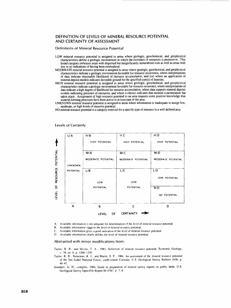
DEFINITION OF LEVELS OF MINERAL RESOURCE POTENTIAL AND CERTAINTY OF ASSESSMENT
Definitions of Mineral Resource Potential
LOW mineral resource potential is assigned to areas where geologic, geochemical, and geophysical characteristics define a geologic environment in which the existence of resources is permissive. This broad category embraces areas with dispersed but insignificantly mineralized rock as well as areas with few or no indications of having been mineralized.
MODERATE mineral resource potendal is assigned to areas where geologic, geochemical, and geophysical characteristics indicate a geologic environment favorable for resource occurrence, where interpretations of data indicate reasonable likelihood of resource accumulation, and (or) where an application of mineral-deposit models indicates favorable ground for the specified type(s) of deposits.
HIGH mineral resource potential is assigned to areas where geologic, geochemical, and geophysical characteristics indicate a geologic environment favorable for resource occurence, where interpretations of data indicate a high degree of likelihood for resource accumulation, where data supports mineral-deposit models indicating presence of resources, and where evidence indicates that mineral concentration has taken place. Assignment of high resource potential to an area requires some positive knowledge that mineral-forming processes have been active in at least part of the area.
UNKNOWN mineral resource potential is assigned to areas where information is inadequate to assign low, moderate, or high levels of resource potential.
NO mineral resource potential is a category reserved for a specific type of resource in a well-defined area.
Levels of Certainty
tU/A
UNKNOWN
POTENTIAL
H/B
HIGH POTENTIAL
M/B
MODERATE POTENTIAL
L/B
LOW
POTENTIAL
H/C
HIGH POTENTIAL
M/C
MODERATE POTENTIAL
L/C
LOW
POTENTIAL
H/D
HIGH POTENTIAL
M/D
MODERATE POTENTIAL
L/D
LOW POTENTIAL
N/D
NO POTENTIAL
B C
LEVEL OF CERTAINTY
A. Available information is not adequate for determination of the level of mineral resource potential.B. Available information suggests the level of mineral resource potential.C. Available information gives a good indication of the level of mineral resource potential.D. Available information clearly defines the level of mineral resource potential.
Abstracted with minor modifications from:
Taylor, R B., and Steven, T. A., 1983, Definition of mineral resource potential: Economic Geology,v 78, no. 6, p. 1268-1270
Taylor, R. B . Stoneman, R J., and Marsh, S P , 1984, An assessment of the mineral resource potentialof the San Isabel National Forest, south-central Colorado: U.S Geological Survey Bulletin 1638, p.4CM2.
Goudarzi, G. H., compiler, 1984, Guide to preparation of mineral survey reports on public lands: U.S.Geological Survey Open-File Report 84-0787, p 7, 8.
B16

RESOURCE/RESERVE CLASSIFICATION
ECONOMIC
MARGINALLY ECONOMIC
SUB- ECONOMIC
IDENTIFIED RESOURCES
Demonstrated
Measured Indicated
I Reserves
I 1 r^
1 Marginal Reserves
1 Demonstrated Subeconomic
ResourcesI
Inferred
Inferred Reserves
Inferred Marginal Reserves
Inferred Subeconomic
Resources
UNDISCOVERED RESOURCES
Probability Range
Hypothetical
-_ _
Speculative
Major elements of mineral resource classification, excluding reserve base and inferred reserve base. Modified from U.S. Bureau of Mines and U.S. Geological Survey, 1980, Principles of a resource/reserve classification for minerals: U.S. Geological Survey Circular 831, p. 5.
B17

Table 1. Mines, prospects, and mining claims in and[*, outside
Map No. (pl. 1) Summary
B and H claim group
A thin (less than 3 in.) malachite-rich quartz vein cuts basalt. Zeolites present as amygdaloids in vesicular parts of basalt. A trace of malachite was found on basalt float.
*3 Red Oxide group Vesicular basalt contains clear to opaque quartzamygdaloids in scoriaceous flow tops. Some quartz is banded and appears chalcedonic.
Black Beauty No veins exposed on surface. Diorite and basalt show prospect only minor chloritic alteration and are weakly
bleached near some fractures.
*6
Raven prospect
King Coal prospect
Freeman Dorsey prospect
Diorite and basalt display limonite on some fractures.
Pit exposes two vitrophyric ignimbrite units, separated by a 2-ft-thick red clay-rich zone, which overlie vesicular basalt. The flow-banded lower unit is gray to black with rare pumice clasts; upper unit is dark-gray to green vitrophyre.
Crystalline basalt with minor surficial iron oxide.
*8 Star prospect Basalt and andesite display weak propylitic alteration and some local silicification along fractures. Some chalcedony float.
*9
*10
*12
Cash-Willow Creek group
Stumb lebum prospect
Star of the West prospect
Glow 1 and 2 prospect
Chalcedony float near outcrops of propylitically altered andesite. Quartz present as rounded pieces and appears to have formed amygdules in vesicular flow tops.
An andesite dike strikes N. 28° E. and dips 80° E., and cuts basalt flows and lamprophyre and diabase intrusives. A trace of opaque, white quartz float was found near dike.
An opaque white quartz vein and an opalite vein parallel a quartz porphyry dike; both cut vesicular basalt, porphyritic andesite, vitrophyre, and welded tuff. Both veins and dike trend N. 20° W. and dip vertically.
Host rocks include silicified basalt, aplite, andesite, quartzite (?), and granodiorite. Limonite on fractures; silicification of host rocks is most intense near fractures. In some areas, feldspars are altered to clay and sericite; other areas display intense clay alteration of entire host rock. Pebble breccia zone exposed in one pit.
Chukar group Host rocks consist of basalt, local granodiorite, tuffaceous sandstone and siltstone, and conglomerate, cut by north- to northwest-trending silicified fault zone. Host rocks locally silicified and altered to clay and sericite. Zone is as wide as 500 ft. Magnetite, pyrite, a trace of malachite, and cinnabar locally in fractures.
B18

adjacent to the Pueblo Mountain Wilderness Study Area study area]
Workings and production Sample and resource data
No workings One random chip sample contains no gold or silver.
One 11-ft-deep pit
No workings
No workings
No workings
One large pit (15-ft by 25-ft by 14-ft- deep).
Four grab samples of basalt with a trace of quartz. Gold values range from less than 0.007 to 0.008 ppm; silver values are less than 0.3 ppm; barium ranges from less than 0.01 to 0.08 percent; zinc is less than 2 to 110 ppm; copper ranges from less than 5 to 250 ppm, and arsenic is less than 2 to 110 ppm.
One grab sample of diorite contains less than 0.007 oz/ton gold, less than 0.3 oz/ton silver, 12 ppm arsenic, and 28 ppm molybdenum.
less than 0.007i cent
One grab sample of diorite contains less than 0.0 oz/ton gold, less than 0.3 oz/ton silver, 120 ppm zinc, 97 ppm copper, 4.3 ppm molybdenum, 0.03 per vanadium, 82 ppm arsenic, and 0.03 percent barium
;rab sample each of basalt and diorite contains or silver, 100 ppm zinc, and 85 ppm copper.
One ggold or silver
One chip sample collected over 12 ft of gray to black ignimbrite contains no gold or silver.
Small pit
No workings
No workings
No workings
No workings
One chip sample collected over 2 ft contains no gold or silver, 24 ppm mercury, 54 ppm arsenic, 0.15 percent barium, and 49 ppm zinc.
One grab sample each of basalt, andesite, and chalcedony contains less than 0.007 oz/ton gold, less than 0.3 oz/ton silver, 0.12 percent barium, 71 ppm zinc, and 3.4 ppm molybdenum.
One grab sample of chalcedony float contains less than 0.007 oz/ton gold, less than 0.03 oz/ton silver, 83 ppm arsenic, 71 ppm zinc, 0.03 percent vanadium, and 0.09 percent barium.
One chip sample of dike collected over 5 ft contains less than 0.007 oz/ton gold, less than 0.3 oz/ton silver, 2 ppm mercury, 23 ppm arsenic, 0.07 percent barium, and 43 ppm zinc.
One grab sample each of quartz and opalite material contains less than 0.007 oz/ton gold, less than 0.3 oz/ton silver, 2 ppm mercury, 17 ppm mercury, 0.08 percent barium, and 53 ppm molybdenum.
Two pits and one 900-ft-long bulldozer scrape on the ridge crest.
Seven grab samples of andesite and aplite. Gold values range from less than 0.007 to 0.01 oz/ton and silver values range from less than 0.03 to 0.03 oz/ton. One chip sample of a pebble breccia zone collected over 6 ft contains less than 0.007 oz/ton gold and less than 0.3 oz/ton silver, 2 to 400 ppm mercury, 45 to 200 ppm arsenic, less than 2 to 4 ppm antimony, 0.02 percent to 0.15 percent barium, less than 2 to 280 ppm zinc, and less than 2 to 4.7 ppm molybdenum.
Five shallow pits less than 5-ft-deep and one 15-ft-deep shaft.
One grab sample of silicified granodiorite contained no gold or silver, 54 ppm arsenic, arsenic, and 280 ppm zinc.
B19

Table 1. Mines, prospects, and mining claims in and adjacent
Map No.(pi. 1) Name Summary
*14 Victor group Porphyritic basalt cut by a 10- to 20-ft-thick, opaque (Rabbit Hole mine) to clear-white quartz vein. Vein strikes N. 30° W.
and dips 50° to 70° SW., and locally contains inclusions of host rock. Basalt is often silicified as much as 10 ft away from vein on each side and zone is encased in a clay and chlorite alteration envelope. Pyrite, cinnabar, and limonite occur sporadically.
*15 Arizona group Clear and opaque white quartz veinlet
*16 Arizona Copper A 6-in.-thick vein of opaque white quartz cutsgroup porphyritic dacite. Vein strikes N. 45° E. and dips
80° S3., and is cut by later milky quartz veinlets. Host rock locally bleached, contains quartz and clay alteration, and has chlorite on some fractures. Limonite occurs only on dump rock.
*17 White House placer Claim is located on alluvial fans and pediment. Areais cut by a small dry creek bed.
*18 Quail prospect A 2-ft-thick silicified zone in dark-gray porphyriticandesite trends north-northwest for approximately 100 ft and dips vertically. Zone is bleached, silicified, and contains some clay and chlorite alteration but no visible limonite or sulfides. Claim block also covers greenstones and a rhyolite plug that are locally silicified and contain some limonite.
19 Irenes group Quartz veins parallel dacite dikes; both cut quartzmonzonite and metasedimentary rocks. En echelon, opaque white quartz veins as thick as 4 ft trend N. 50° E. and dip 80° ES., and contain sericite, a trace of pyrite, schorl (tourmaline); each vein can be traced for as much as 100 ft. Both dacite and quartz monzonite show epidote, clay, sericite, and silica alteration minerals, more abundant near veins. Limonite occurs sporadically in the host rocks.
20 Lone Star mine A 3-ft-thick, opaque white quartz vein cuts silicifiedlimestone and quartzite and can be traced for 40 ft. Vein trends N. 89° to 90° W. and dips 85° NE., and contains only trace amounts of limonite.
*21 King Copper A 2-ft-thick breccia zone cuts porphyritic andesite. prospect Breccia is cemented with clear, chalcopyrite-bearing
quartz, and strikes N. 20° E. and dips 73° SE. Andesite is propylitically altered and contains minor limonite.
*'22 Whale prospect Two, opaque, white quartz veins, 1 ft and 5 ft thick,cut greenstone and schist. The 1-ft-thick vein strikes N. 51° E. and dips 76° SE.; the 5-ft-thick vein strikes N. 45° W. and is vertical. Both veins contain minor amounts of schorl (tourmaline) with sericite on the hanging wall contact; walls show slickensides. Host rocks are bleached and silicified, and show sericite and clay alteration, and some limonite. Pyrite and malachite in trace amounts in both the veins and host rocks.
B20

to the Pueblo Mountains Wilderness Study Area Continued
Workings and production Sample and resource data
Five shallow pits, and one shaft that is 75-ft deep.
Three shallow pits (less than 5 ft deep) and two bulldozer cuts.
One pit 3-ft deep
No workings
Two chip and 13 soil samples. Vein chip samples contain 0.017 and less than 0.007 ppm gold and each less than 0.3 ppm silver. Soil samples contain less than 0.01 to 1.2 ppm gold, less than 0.7 ppm silver, 110 to 460 ppm zinc, less than 5 to 180 ppm copper, less than 2 to 3.9 ppm molybdenum, 78 to 200 ppm arsenic, less than 20 to 48 ppm antimony, and less than 5 to 6 ppm tungsten.
Five chip and three grab samples. Two grab samples of dump rock contain 0.037 and 0.064 oz/ton gold, and less than 3 and 0.840 oz/ton silver. The third grab sample, from a quartz stockpile, contained 0.066 oz/ton gold and less than 0.3 oz/ton silver. These three samples also contain 0.19 percent to 5.2 percent copper. Two chip samples of greenstone (across 1 ft and 5 ft) contain 0.018 and 0.040 oz/ton gold, and less than 0.3 oz/ton silver. Three additional chip samples of andesite contain 0.066 to 0.098 oz/ton gold and less than 0.3 to 0.370 oz/ton silver. Other values for all 8 samples included: 81 to 250 ppm zinc, 99 to 400 ppm copper, and 2 to 64 ppm molybdenum.
Three grab and six chip samples. Grab samples of dump rock contain 0.037 to 0.066 ppm gold, less than 0.3 to 4.02 ppm silver, and 0.19 to 5.2 percent copper. Two chip samples from two quartz veins collected over 6 ft and 2 ft respectively, contain 0.066 and 0.081 ppm gold and less than 0.3 oz/ton silver. Four additional chip samples of host rock contain 0.018 to 0.098 ppm gold and less than 0.3 ppm silver. Other values for all 9 samples included 99 to 400 ppm copper and 3 ppm antimony.
One grab sample: $0.Oil/yd 3
One pit and one 12-ft-wide, 48-ft-long dozer cut.
A chip sample of the pit face collected over 3 ft contains 0.082 ppm gold and less than 0.3 ppm silver. A chip sample of silicified andesite collected over 2 ft contains 0.121 ppm gold and less than 0.3 ppm silver. Other values included 64 ppm zinc and 5.1 ppm molybdenum.
One pit and one 12-ft-wide, 48-ft-long dozer cut.
Two grab and six chip samples. One grab sample of metasedimentary rocks contains no gold or silver; one grab sample of quartz monzonite contains 0.014 ppm gold and less than 0.3 ppm silver. Five chip samples of four veins contain less than 0.007 to 0.008 oz/ton gold and less than 0.3 ppm silver. A chip sample of dacite contains no gold and silver.
One shallow shaft 20-ft-deep One chip sample of vein quartz collected over 3 ft contains 4 ppm arsenic but no gold or silver.
One pit 4-ft-deep A chip sample of breccia zone collected over 2 ft contains 0.12 percent copper but no gold or silver.
Three open cuts, all 5-ft-deep One grab and two chip samples. A dump rock grab sample contains 0.011 ppm gold and less than 0.3 ppm silver. Two chip samples from quartz veins contain less than 0.007 and 0.010 ppm gold, and less than 0.3 ppm silver, respectively.
B21

Table 1. Mines, prospects, and mining claims in and adjacent
Ma p No.(pi. 1) Name Summary
*23 Big Bad John- Both clear and milky quartz veins and veinlets asWillies groups thick as 6 in., strike N. 60° E. and dip 70° SE., and
cut greenstone and a dacite dike. Host rocks show areas of silicification, clay, sericite, and tourmaline alteration, weak bleaching, and some hornfels alteration. Some magnetite and limonite on fractures.
24 Unnamed prospect A 3-ft-thick milky quartz vein, which can be tracedfor 50 ft, trends N. 53° E. and dips 75° NW., and cuts porphyritic dacite. Host rock contains chlorite, and epidote, and shows areas of weak silicification.
*25 Pueblo group Narrow creek channel contains limited gravel (placer) concentrations.
*26 Pueblo (Farnham) group
Several veins cut greenstone and schist. Vei thick as 3 ft, trend N. 5° to 20° E. and dip 90° NW.. and composed of clear to milky quart
*27 Grace mine Several veins cut greenstone. Veins composed of clearto opaque white quartz, are as thick as 1.5 ft, and trend N. 10° E. to N. 20° E. and dip 65° to 90° SE. Traces of cinnabar, pyrite, chalcopyrite, and schwatzite in and along the edges of quartz veins. In some places calcite accompanies or occurs in place of the opaque quartz. Host rock is altered to chlorite, epidote, and clay, and silicified adjacent to veins.
*28 Blue Bird group Area is covered by eluvium with local alluvium near (placer) creeks.
*29 Unnamed prospect Quartz and greenstone float near adit and on mine dumpis moderately bleached and chloritically and argillically altered, and contains some clots of schorl (tourmaline) and specularite.
30 Ace group Veins of milky quartz, as thick as 4 ft, strike N. 55° E. and dip 69° NW. in dacite and greenstone; veins can be traced for 50 ft. Host rocks are weakly bleached near veins and altered to quartz, sericite, clay, tourmaline, and minor chlorite. Limonite, chrysocolla, and a trace of cinnabar also present.
*31 Mohawk claim A 2-ft-thick altered zone in granodiorite strikesnorth and dips 56° W. and contains quartz, malachite, and chrysocolla.
*32 Shamrock prospect Brecciated shear zones strike N. 45° E. and N. 85° W.,dip 75° NW. and 55° NE., respectively, and contain white quartz veinlets in fine-grained to porphyritic andesite. Area also contains quartz, greenstone, and porphyritic andesite float. All host rock lithologies contain chalcopyrite and malachite on some fracture surfaces and as veinlets.
*33 Robert Smith Veinlets of limonite and of opaque white quartz cut prospect fine-grained andesite and granodiorite in float.
*34 Unnamed prospect Silicified, recemented breccia contains quartz,limonite, and possible hematite. Predominant rock types are porphyritic andesite, quartzite, and granodiorite.
B22

to the Pueblo Mountains Wilderness Study Area Continued
Workings and production Sample and resource data
No workings One grab sample of host rock and one chip sample both contain as much as 19 ppm arsenic, 100 ppm copper, 13 ppm molybdenum, and 0.013 percent barium; neither sample contains gold or silver.
One 6-ft by 15-ft by 3-ft-deep pit A vein chip sample collected over 2.5 ft contained 0.007 ppm gold, less than 0.3 ppm silver, and 25 ppm molybdenum.
No workings One grab sample: $0.008/yd J
Five pits and three caved adits estimated to be as much as 260 ft long. Production includes "a few hundred pounds of quick silver . . ." (Brooks, 1963, p. 202) and 5.13 oz gold.
Seven pits, two shafts, and two caved adits.
No workings
One caved adit
Nine grab and ten chip samples. Five host rock grab samples contain less than 0.007 to 0.028 ppm gold and less than 0.3 ppm silver. Four dump grab samples contain 0.009 to 0.019 ppm gold and less than 0.3 ppm silver. Chip samples of veins contained less than 0.007 to 0.076 ppm gold and less than 0.3 to 21.72 ppm silver. Other values included less than 2 to 135 ppm mercury, less than 2 ppm to 0.236 percent arsenic, less than 2 ppm to 0.43 percent antimony, less than 50 ppm to 0.083 percent barium, less than 80 to 110 ppm lead, less than 2 to 170 ppm zinc, 190 ppm to 2.5 percent copper, and less than 2 to 62 ppm molybdenum.
nd four chip samples. Grab samples from a 0.01 to 17.74 ppm gold and less than 0.3 silver. Four chip samples at caved
One grab sample: no gold detected.
One grab sample of dump rock contains 0.010 ppm gold, less than 0.3 ppm silver, 0.34 percent copper, and 0.115 percent barium.
One small pit 5 ft by 5 ft by 2 ft deep Two chip and one grab sample. None of the samples contains detectable gold. One chip sample contained 0.031 percent barium, 100 ppm copper, and 13 ppm molybdenum.
Two small pits A chip sample of altered rock contains 0.011 ppm gold, less than 0.3 ppm silver, and 0.33 percent copper.
Seven pits ranging from 6 ft to 30 ft long and as much as 6 ft wide.
None
One small pit
One chip and four grab samples. The chip sample of the vein contains 0.042 ppm gold and less than 0.3 ppm silver. Grab samples of dump rock contain 0.285 to 5.954 ppm gold, less than 0.3 to 4.508 ppm silver, and 0.4 to 0.86 percent copper. Other values include 5 to 26.5 ppm arsenic, 90 ppm to 0.054 percent lead, 140 ppm zinc, 22 ppm molybdenum, and 1.2 to 26 ppm U308.
One grab sample contains 0.019 ppm gold, less than 0.03 ppm silver, and 0.086 percent barium.
Three grab samples of dump rock contain 0.023 to 0.106 ppm gold, less than 0.3 to 0.73 ppm silver; one sample contains 0.037 percent barium, and 0.33 percent copper.
B23

Table 1. Mines, prospects, and mining claims in and adjacent
Map No.(pi. 1) Name Summary
*35 Climax prospect Pyrite-bearing quartz veins in fracture zones strike N. 40° E. and N. 62° E. and dip 62° SE. and 77° SE., respectively. Host rocks include greenstone and andesite.
*36 Unnamed prospect Brecciated quartz vein float fragments with malachite and limonite occur with granodiorite, diorite, and andesite float.
Pueblo claim Silicified, altered rhyolite(?) dike rock in contact with andesite. Contact strikes N. 65° E. and dips 75 C SE.
*38 Bonanza claim Two discontinuous, hydrothermally altered zones, 4 ft thick and 5 ft thick, cut porphyritic andesite. Zones strike N. 25° E. and N. 80° E., respectively, dip vertically, and contain minor amounts of malachite and limonite. An 11-ft-thick shear zone near face of adit strikes N. 55° E. and dips 51° SE. and contains seams of clay.
*39
*40
*41
*42
Ethel May prospect
Lucky Dane claims
Colony Creek prospec t
Viqueen prospect
Quartz vein float fragments with porphyritic andesite, granodiorite, and greenstone float. Small amount of specular hematite on some greenstone fragments.
Quartz vein float fragments with granodiorite, andesite, and greenstone float. Predominant rock type is green phyllite.
A 4.5-ft-thick, silicified zone at greenstone-andesite contact strikes N. 55° E. and dips 85° NW. and contains arsenopyrite and limonitic boxwork. Dark- gray, fine-grained andesite has discontinuous quartz veinlets and minor iron oxide stains; greenstone is dark green and silicified where exposed.
Fine grained, dark gray andesite with minor limonite
*43 Mammoth No. 1 prospect
Limonitic quartz vein in phyllitic host rock
*44 Coyote Rob prospect
Quartz vein, with limonitic and hematitic stains, in phyllitic host rock.
*45
*46
Monolith prospect Discontinuous quartz veinlets with malachite in an outcrop of silicified phyllite; foliation trendsN. 45° E.
Coyote Roy Intensely altered, silicified zone strikes N. 10° E. prospect and dips 45°-75° SE. and extends for approximately
200 ft in phyllitic host rock. Apparent mineralizan pyc o oc. ppan tion includes malachite and chrysocolla and pe limonite.
rvasive
*47
*48
*49
Keystone prospect Quartz with minor limonite and hematite stains in dark green phyllite.
Lone Claim A bull quartz vein and 5-ft-thick quartz-rich zone; prospect quartz veinlets and malachite in foliated schist.
Ten-ft-thick massive bull quartz vein strikesN. 46° E. and dips vertically.
Viking claim Quartz vein contains specular hematite and limonite and cuts both unaltered and altered phyllite.
50
B24
Pueblo prospect Outcrops of dark brown basalt with malachite coated amygdules and veinlets of calcite.

to the Pueblo Mountains Wilderness Study Area Continued
Workings and production Sample and resource data
Two small pits
One small pit
No workings
One 80-ft-long adit and three small pits
No workings
No workings
Two chip samples collected across 3 ft and 5 ft fracture zones contain 0.017 and 0.034 ppm gold and less than 0.3 ppm silver; one fracture zone contains 0.142 percent barium. Other values include 7 ppm arsenic, 3 ppm antimony, and 42 ppm zinc.
One grab sample of quartz float from pit contains 0.078 ppm gold, less than 0.3 ppm silver, 0.023 percent arsenic, 0.002 percent yttrium, 0.002 percent ytterbium, and 0.39 percent copper.
One chip sample collected across 2-ft-thick dike contains 0.015 ppm gold, less than 0.3 ppm silver, and 0.049 percent barium.
Seven chip samples and two grab samples. Chip samples across hydrothermally altered zones contain 0.008 to 0.433 ppm gold and 1.3 to 1.788 ppm silver. Samples from two pits also contain 0.13 percent and 0.17 percent copper and as much as 0.036 percent barium. Grab samples of quartz vein float and host rock contain 0.009 and 0.023 ppm gold, less than 0.3 ppm silver, 0.92 to 0.96 percent barium; one contains 0.11 percent copper.
One grab sample of quartz vein float contains 0.095 ppm gold, less than 0.3 ppm silver, and 0.19 percent barium.
Two grab samples of quartz vein float contain 0.019 and 0.029 ppm gold and less than 0.3 ppm silver.
One shaft 5 ft long, 4 ft wide, and 4 ft deep.
No workings
No workings
One pit 100 ft long and 5 ft wide.
One pit 35 ft long and 6 ft wide.
One pit
No workings
One small pit
Two trenches: 100 ft long, 12 ft wide, and 50 ft long.
No workings
Two chip samples of veins and one grab sample of dump rock. Chip samples taken across the silicified zone contain 0.009 and 0.034 ppm gold, less than 0.3 ppm silver, and 0.013 and 0.141 percent barium. A select sample of quartz-rich dump rock contains 0.026 ppm gold and less than 0.3 ppm silver.
One grab sample of andesite float contains no gold or silver and 0.106 percent barium.
0.014One grab sample of quartz vein float contains 0.0 ppm gold, less than 0.3 ppm silver, 0.039 percent barite, and 130 ppm copper.
One grab sample of quartz vein float contains 0.020 ppm gold, less than 0.3 ppm silver, and 0.018 percent barium.
One chip sample collected across 3 ft of silicified outcrop contains 1.670 ppm gold, 2.408 ppm silver, 0.015 percent arsenic, and 0.57 percent copper.
Two chip samples collected across a 4- to 5-ft-thick silified zone contain 0.068 and 0.065 ppm gold, 1.380 and 1.615 ppm silver, 0.103 and 0.079 percent arsenic, 0.035 percent and 0.022 percent antimony, 0.12 percent and 0.046 percent barium, and 1.5 and 1.3 percent copper.
One grab sample of the float contains 0.014 ppm gold, less than 0.3 ppm silver, and 0.021 percent barium.
Two chip samples of the quartz vein contain 0.050 and 0.011 ppm gold, less than 0.3 ppm silver, 0.048 and 0.040 percent barium; one sample contains 0.16 percent coppe r.
One grab sample of quartz vein and phyllite contains 0.024 ppm gold, less than 0.3 ppm silver, 0.068 percent barium, 10 ppm arsenic, 150 ppm zinc, and 230 ppm copper.
One chip sample of amygdaloidal basalt contains 0.032 ppm gold, less than 0.3 ppm silver, and 0.034 percent barium, 75 ppm zinc, and 130 ppm copper. B25

Table 1. Mines, prospects, and mining claims in and adjacent
Map No.(pi. 1) Name Summary
51 Unnamed prospect Fine- to medium-grained chalcedony fragments scatteredin vesicular, scoriaceous basalt float that contains xenoliths of amygdaloidal basalt.
52 F & G claims Outcrop of dark-gray, finely crystalline, silicifiedandesite with minor iron oxide stains.
53 White Elephant Outcrop of phyllitic greenstone with bronze-colored claim biotite on some fracture surfaces.
54 Golden No. 1 claim Outcrop of reddish rhyolite(?) with aphaniticgroundmass and minute feldspar phenocrysts.
55 Blue Jay claim Outcrop of dark-gray, fine-grained, silicifedandesite.
56 Van Horn claim Siliceously altered fracture zone with discontinuousquartz veins and malachite. Zone strikes N. 48° E. and dips 78° SE. in foliated metamorphic rocks, and is 4.0 to 5.0 ft thick and about 10 ft long.
*57 Two Friends clain Two nearly parallel, hydr
*58 Pearl mine Two hydrothermally altered, brecciated, intersectingfault zones, 4.5 and 5.0 ft thick, in phyllite host. Zones contain quartz veinlets and malachite; one strikes N. 60° E. and the other N. 60° W., with 60° SE. and vertical dips, respectively.
*59 Unnamed prospect Clear comb quartz and limonite-filied fractures cutschist and granodiorite. Fractures trend N. 20° W. and dip 40° NE., and are enveloped by quartz-clay- sericite alteration, some limonite, and weak bleaching.
*60 Missouri group Located in 1895. Small creek contains deposits ofgravel in channels in metamorphic bedrock.
61 Denio Basin group Veinlets and small lenses of chalcedony in alteredbasalt and andesite can be traced for 100 ft, trend N. 55° W. and dips 65° E. to vertical, and contain a trace of cinnabar and clay minerals. Host rocks are altered to clay with some silicification near veins. Williams and Compton (1953) observed chrysocolla, malachite, and schwatzite.
*62 Unnamed prospect Talus of white quartz and schist. Quartz is opaque tosemitranslucent. Schist is weakly bleached and altered to chlorite and clay with minor silicification. Limonite on fractures in quartz and in the schist.
*63 Gray Eagle A 100-ft-long zone contai prospect
A 100-ft-long zone contains narrow (less than 1 in. thick) opaque white quartz veinlets in schist. Veinlets trend N. 40° E. and dip 70° SE., approximately parallel to schistosity. Schist is strongly bleached for 1 to 2 ft on either side of veins; contact zones also contain limonite, clay, anc sericite alteration.
B26

to the Pueblo Mountains Wilderness Study Area Continued
Workings and production Sample and resource data
No workings One grab sample of chalcedony fragments contains no gold or silver.
No workings
No workings
No workings
No workings
Two small pits
Two small pits and one shallow inclined shaft.
contains 0.020chip sample of silicified andesite contains 0 gold, less than 0.3 ppm silver, 0.040 percent ium, 93 ppm zinc, and 150 ppm arsenic.
One pit
One 25-ft-long open cut and a 50-ft-long bulldozer cut.
One pit
OnePPmbarium, 93 ppm
One chip sample of phyllitic greenstone contains 0.017 ppm gold, less than 0.3 ppm silver, 0.11 percent barium, and 42 ppm zinc.
One chip sample of volcanic rock contains 0.015 ppm gold, less than 0.3 ppm silver, 0.08 percent barium, 4 ppm arsenic, and 51 ppm zinc.
One chip sample of silicified andesite contains 0.016 ppm gold, less than 0.3 ppm silver, 0.087 percent barium, 240 ppm zinc, and 170 ppm copper.
Two chip samples across fracture zone contain 0.015 ppm and 0.012 ppm gold, 3.629 and less than 0.3 ppm silver, less than 50 ppm and 3,700 ppm copper, and 0.079 percent and 0.050 percent barium, 6 and 13 ppm arsenic, 5 and 29.6 ppm antimony, and 40 and 48 ppm zinc.
Three chip samples and one grab sample. Chip samples of quartz vein and hydrothermally altered rock contain 0.016 to 0.194 ppm gold, 0.430 to 0.986 ppm silver, less than 5 ppm to 0.01 percent arsenic, 0.012 percent to 1.62 percent barium, and less than 50 ppm to 2,100 ppm copper. Grab sample of high-grade dump rock contains 0.068 ppm gold, 1.226 ppm silver, 2.17 percent barite, and 1.3 percent copper.
Two chip samples across the fault zones contain 0.057 and 0.030 ppm gold, 0.943 and less than 0.3 ppm silver, less than 5 ppm to 1,100 ppm arsenic, 0.16 and 0.33 percent barium, and less than 50 ppm to 1,900 ppm copper.
One chip and one grab sample. Grab sample of granodiorite contains 0.156 ppm gold and less than 0.3 ppm silver. Chip sample of quartz-filled fractures contained 0.133 ppm gold, less than 0.3 ppm silver, and 0.19 percent barium.
One grab sample, no gold detected.
One caved shaft, one caved adit estimated to be 100-ft- long, one open adit 30-ft- long, and two 240-ft-long bulldozer cuts.
Four bulldozer cuts
Five grab and four chip samples; grab samples of dump rock contain 0.019 to 0.055 ppm gold and less than 0.3 to 0.560 ppm silver. Chip samples of veins contain 0.027 to 0.078 ppm gold, less than 0.3 ppm silver, 47 to 126 ppm mercury (Williams and Compton (1953, p. 47) indicate samples from this prospect contain a trace to 8.6 Ib of mercury per ton), and 0.014 to 0.052 percent barium. Other values in both chip and grab samples include 18 ppm molybdenum, 110 ppm copper, 4 to 10 ppm antimony, 31 ppm arsenic, and 75 to 670 ppm mercury.
Five grab samples of quartz and schist float. Gold values range from less than 0.007 to 10.78 ppm; silver values range from less than 0.3 to 1.938 ppm.
No workings One random chip sample of altered schist contains 0.029 ppm gold and less than 0.3 ppm silver.
B27
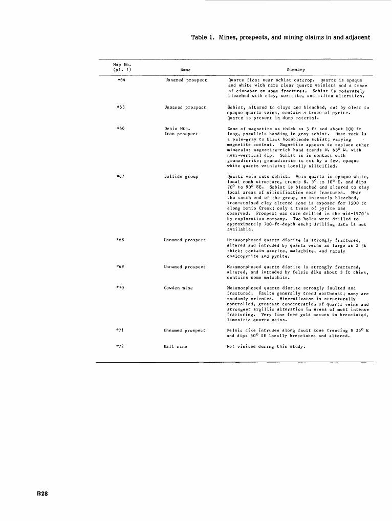
Table 1. Mines, prospects, and mining claims in and adjacent
Map No.(pi. 1) Name Summary
*64 Unnamed prospect Quartz float near schist outcrop. Quartz is opaqueand white with rare clear quartz veinlets and a trace of cinnabar on some fractures. Schist is moderately bleached with clay, sericite, and silica alteration.
*65 Unnamed prospect Schist, altered to clays and bleached, cut by clear toopaque quartz veins, contain a trace of pyrite. Quartz is present in dump material.
*66 Denio Mtn. Zone of magnetite as thick as 3 ft and about 100 ftIron prospect l°ng> parallels banding in gray schist. Host rock is
a pale-gray to black hornblende schist; varying magnetite content. Magnetite appears to replace other minerals; magnetite-rich band trends N. 65° W. with near-vertical dip. Schist is in contact with granodiorite; granodiorite is cut by a few, opaque white quartz veinlets; locally silicified.
*67 Sulfide group Quartz vein cuts schist. Vein quartz is opaque white,local comb structure, trends N. 5° to 10° E. and dips 70° to 90° SE. Schist is bleached and altered to clay local areas of silicification near fractures. Near the south end of the group, an intensely bleached, iron-stained clay altered zone is exposed for 1500 ft along Denio Creek; only a trace of pyrite was observed. Prospect was core drilled in the mid-1970's by exploration company. Two holes were drilled to approximately 700-ft-depth each; drilling data is not available.
*68 Unnamed prospect Metamorphosed quartz diorite is strongly fractured,altered and intruded by quartz veins as large as 2 ft thick; contain azurite, malachite, and rarely chalcopyrite and pyrite.
*69 Unnamed prospect Metamorphosed quartz diorite is strongly fractured,altered, and intruded by felsic dike about 3 ft thick, contains some malachite.
*70 Cowden mine Metamorphosed quartz diorite strongly faulted andfractured. Faults generally trend northeast; many are randomly oriented. Mineralizaton is structurally controlled, greatest concentration of quartz veins and strongest argillic alteration in areas of most intense fracturing. Very fine free gold occurs in brecciated, limonitic quartz veins.
*71 Unnamed prospect Felsic dike intrudes along fault zone trending N 35° Eand dips 50° SE locally brecciated and altered.
*72 Hall mine Not visited during this study.
B28
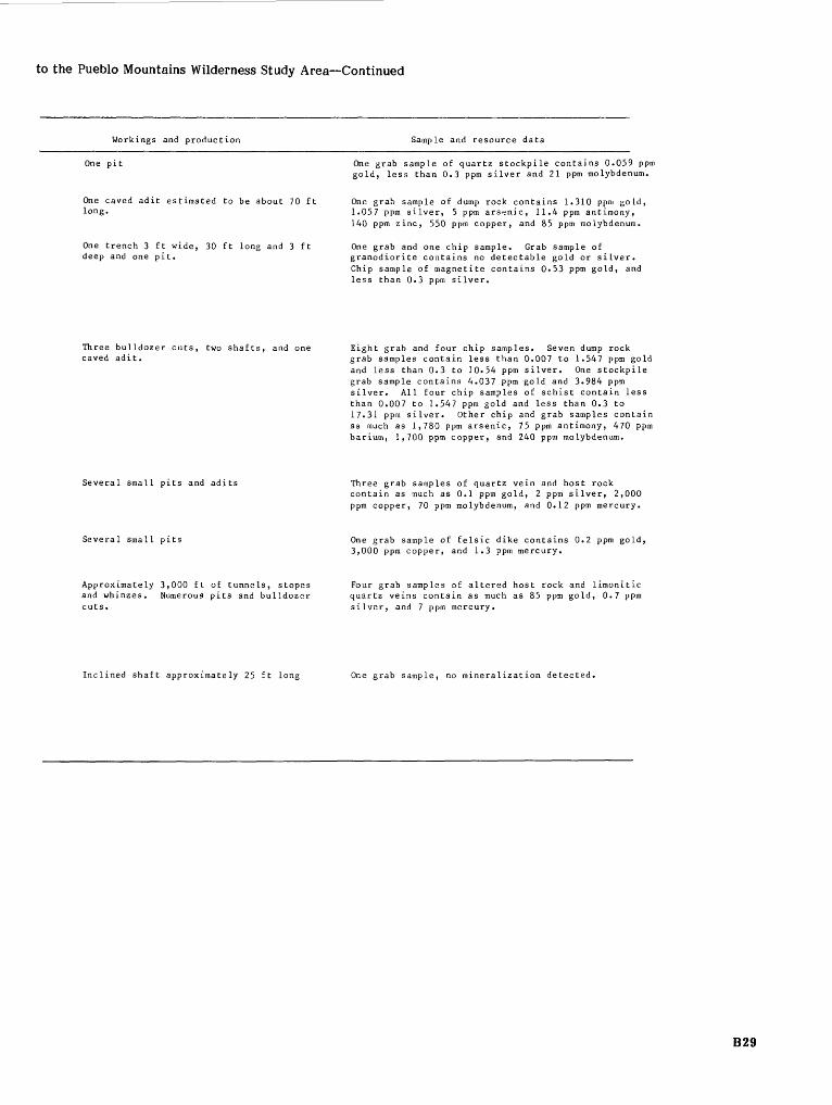
to the Pueblo Mountains Wilderness Study Area Continued
Workings and production Sample and resource data
One grab sample of quartz stockpile contains 0.059 ppir gold, less than 0.3 ppm silver and 21 ppm molybdenum.
One pit
One caved adit es long.
timated to be about 70 ft One grab sample of dump rock contains 1.310 ppm go 11.057 ppm silver, 5 ppm arsenic, 11.4 ppm antimony, 140 ppm zinc, 550 ppm copper, and 85 ppm molybd
Id,
One trench 3 ft wide, 30 ft long and 3 ft deep and one pit.
enum.
One grab and one chip sample. Grab sample of granodiorite contains no detectable gold or silver. Chip sample of magnetite contains 0.53 ppm gold, and less than 0.3 ppm silver.
Three bulldozer cuts, two shafts, and one caved adit.
Several small pits and adits
Several small pits
Eight grab and four chip samples. Seven dump rock grab samples contain less than 0.007 to 1.547 ppm gold and less than 0.3 to 10.54 ppm silver. One stockpile grab sample contains 4.037 ppm gold and 3.984 ppm silver. All four chip samples of schist contain less than 0.007 to 1.547 ppm gold and less than 0.3 to 17.31 ppm silver. Other chip and grab samples contain as much as 1,780 ppm arsenic, 75 ppm antimony, 470 ppm barium, 1,700 ppm copper, and 240 ppm molybdenum.
Three grab samples of quartz vein and host rock contain as much as 0.1 ppm gold, 2 ppm silver, 2, ppm copper, 70 ppm molybdenum, and 0.12
000 ppm mercury.
One grab sample of felsic dike contains 0.2 ppm gold, 3,000 ppm copper, and 1.3 ppm mercury.3,000 ppm copper, and 1.3 ppm mercury.
Approximately 3,000 ft of tunnels, stopes Four grab samples of altered host rock and limoniticand whinzes. Numerous pits and bulldozer quartz veins contain as much as 85 ppm gold, 0.7 ppmcuts. silver, and 7 ppm mercury.
Inclined shaft approximately 25 ft long One grab sample, no mineralization detected.
B29

GEOLOGIC TIME CHART Terms and boundary ages used by the U.S. Geological Survey in this report
EON
Phanerozoic
Proterozoic
Archean
pre- Arc
ERA
Cenozoic
Mesozoic
Paleozoic
Late Proterozoic
Middle Proterozoic
Early Proterozoic
Late Archean
Middle Archean
Early Archean
hean 2
PERIOD
Quaternary
Tertiary
Neogene
Subperiod
Paleogene
Subperiod
Cretaceous
Jurassic
Triassic
Permian
Carboniferous Periods
Pennsylvanian
Mississippian
Devonian
Silurian
Ordovician
Cambrian
-(3800?)- -
EPOCH
Holocene
Pleistocene
Pliocene
Miocene
Oligocene
Eocene
Paleocene
Late Early
Late Middle Early
Late Middle
Early
Late Early
Late Middle Early
Late Early
Late Middle Early
Late Middle
Early
Late Middle Early
Late Middle Early
-
AGE ESTIMATES OF BOUNDARIES
(in Ma)
- 0.010
- 1.7
w/
1 A
JO
_ cc
_ cc
- 96 no
one
- ~240
^*7w
f\f\f\
tRn
- 410
- 4?RHOvJ
- 500
«J / \J
- 900
ifinn
- 2500
- 3000
- 3400
'Rocks older than 570 Ma also called Precambrian, a time term without specific rank.
Informal time term without specific rank.
B30 GPO 785-048/77410