mineral resources of the organ mountains … · box 25425 denver, co 80225 any use of ... mineral...
TRANSCRIPT
Mineral Resources of theOrgan Mountains Wilderness Study Area,Dona Ana County, New Mexico
U.S. GEOLOGICAL SURVEY BULLETIN 1735-D


Chapter D
Mineral Resources of theOrgan Mountains Wilderness Study Area,Dona Ana County, New Mexico
By STEVE LUDINGTON, WILLIAM F. HANNA, and ROBERT L TURNER U.S. Geological Survey
RODNEY E. JESKE U.S. Bureau of Mines
U.S. GEOLOGICAL SURVEY BULLETIN 1735
MINERAL RESOURCES OF WILDERNESS STUDY AREAS- SOUTHWESTERN NEW MEXICO

DEPARTMENT OF THE INTERIOR
DONALD PAUL MODEL, Secretary
U. S. GEOLOGICAL SURVEY
Dallas L Peck, Director
UNITED STATES GOVERNMENT PRINTING OFFICE: 1988
For sale by theBooks and Open-File Reports SectionU.S. Geological SurveyFederal CenterBox 25425Denver, CO 80225
Any use of trade names in this report is for descriptive purposes only and does not imply endorsement by the U.S. Geological Survey.
Library of Congress Cataloging-in-Publication Data
Mineral resources of the Organ Mountains Wilderness Study Area, Dona Ana County, New Mexico.
(Mineral resources of wilderness study areas southwestern New Mexico ; ch. D) (U.S. Geological Survey bulletin ; 1735)
Bibliography: p. Supt. of Docs, no.: I 19.3:1735-0I. Mines and mineral resources New Mexico Organ Mountains
Wilderness. 2. Organ Mountains Wilderness (N.M.) I. Ludington, Steve.II. Series. III. Series: U.S. Geological Survey bulletin ; 1735.
QE75.B9 no. 1735-D 557.3 s 88-600358 [TN24.N6] [553'.09789'66]

STUDIES RELATED TO WILDERNESS
Bureau of Land Management Wilderness Study Areas
The Federal Land Policy and Management Act (Public Law 94-579, October 21, 1976) requires the U.S. Geological Survey and the U.S. Bureau of Mines to conduct mineral surveys on certain areas to determine the mineral values, if any, that may be present. Results must be made available to the public and be submitted to the President and the Congress. This report presents the results of a mineral survey of the Organ Mountains Wilderness Study Area (NM-03G-074), Dona Ana County, New Mexico.


CONTENTS
Summary Dl Abstract Dl
Character and setting Dl Identified resources D2 Mineral resource potential D2
Introduction D2Location and physiography D2 Previous investigations D2 Investigations by the U.S. Bureau of Mines D3 Investigations by the U.S. Geological Survey D4
Appraisal of identified resources D4Mining and mineral-exploration history D4 Mines, prospects, and mineral occurrences D5
Assessment of mineral resource potential D9 Geology D9 Geochemistry Dll Geophysics D12 Mineral and energy resources D15
Porphyry copper-molybdenum deposits D15 Copper-bearing breccia-pipe deposits D15 Skarn deposits D16 Polymetallic replacement deposits D16 Low-grade gold and silver deposits D16 Vein fluorspar deposits D16 Other commodities D16
References cited D17 Appendix D19
FIGURES
1. Index map showing location of the Organ Mountains Wilderness Study Area D3
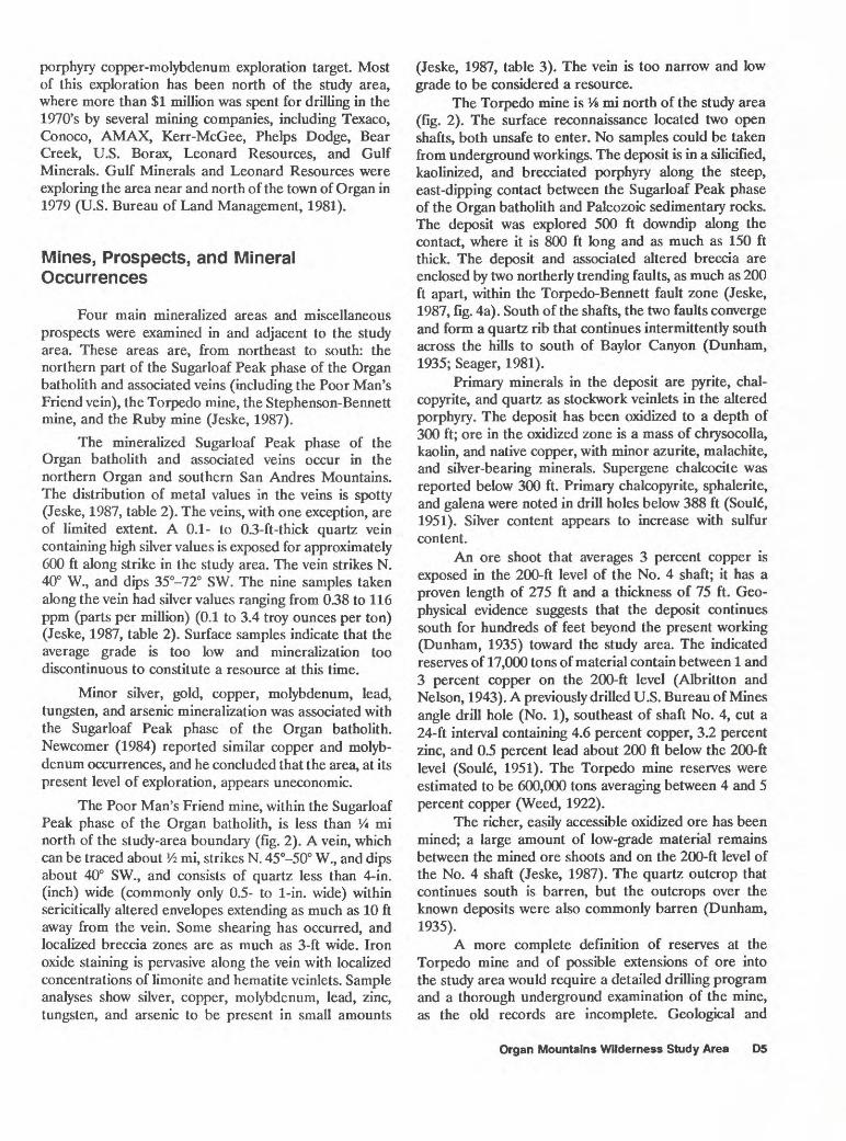
2. Geology and mineral resource potential of the Organ Mountains Wilderness Study Area D6
3. Bouguer gravity anomaly map of the Organ Mountains Wilderness Study Area and vicinity D13
4. Total-intensity aeromagnetic anomaly map of the Organ Mountains Wilderness Study Area and vicinity D14
TABLE
1. Mining history and production near the Organ Mountains Wilderness Study Area, New Mexico D4
Contents


Mineral Resources of theOrgan Mountains Wilderness Study Area,Dona Ana County, New Mexico
By Steve Ludington, William F. Hanna, andRobert L TurnerU.S. Geological Survey
Rodney E. Jeske U.S. Bureau of Mines
SUMMARY
Abstract
The Organ Mountains Wilderness Study Area (NM-030-074) is located in the Organ Mountains, Dona Ana County, southern New Mexico. At the request of the U.S. Bureau of Land Management, a total of 7,283 acres were studied (fig. 1). In this report, the area studied is referred to simply as "the study area." Field work for this report was conducted in 1984 and 1985. About 83 claims and prospects have been located within and adjacent to the study area; none are presently active. Inferred subeconomic resources of common variety carbonate rock and sand and gravel have been mined occasionally for limited local use. No other identified resources are located within the study area, although immediately adjacent to, and surrounded by the study area, copper resources are present at the Torpedo mine; silver, lead, zinc, and possible gold resources are present at the Stephenson-Bennett mine; and fluorspar resources are present at the Ruby mine (fig. 2).
. The mineral resource potential for copper, molyb denum, gold, and silver is high in an area along the northern edge of the study area, where a porphyry copper- molybdenum system has been emplaced at the margins of a granitic batholith of mid-Tertiary age (see geologic time chart in the Appendix for geologic time terms). The potential for lead, zinc, copper, silver, gold, and fluorspar resources is moderate near the western edge of the study area, where steeply dipping, faulted Paleozoic sedimentary rocks are
Publication approved by the Director, U.S. Geological Survey, March 15, 1988.
intruded by the batholith. Although the batholith is expressed by both gravity and magnetic anomalies, the subsurface extent of the mineralized phase of the batholith is not well-constrained by the geophysical anomaly data. Geo- chemical studies confirm the presence of known mineralized areas and help constrain the delineation of tracts with mineral resource potential. The mineral resource potential for oil and gas, and for geothermal energy is low throughout the study area.
Character and Setting
The Organ Mountains Wilderness Study Area is located in the northern end of the Organ Mountains, in Dona Ana County in southernmost New Mexico, about 15 mi (miles) northeast of Las Cruces, N. Mex. The study area straddles the mountain crest, which is about 8,000 ft (feet) high. Most of the central and eastern part of the study area is underlain by units of the Oligocene Organ batholith. In the western part of the study area, the rocks are primarily westward-dipping Paleozoic shales and carbonate rocks. The entire study area is part of an uplifted and west-tilted fault block. The topography is very rugged, with narrow ridges and needles of intrusive rock falling abruptly away into deep, narrow canyons. A broad pediment is developed on the Organ batholith on the east side of the range; on the west, the mountains are flanked by thick alluvial fans.
Mining and prospecting began at least as early as the 1840's when silver, lead, and zinc ore was discovered at what is now the Stephenson-Bennett mine, although legends exist that describe much earlier mining activity, possibly in the 18th century, when the area was part of New Spain. Mining activity peaked in the early part of the 20th century and had nearly ceased by 1935.
Organ Mountains Wilderness Study Area D1

Recent exploration activity has focused just north of the study area where extensive exploration of a porphyry copper-molybdenum system was carried out by several major mining companies throughout the 1970's (Newcomer, 1984).
Identified Resources
Inferred subeconomic resources of carbonate rock and sand and gravel exist in the study area. No other identified resources are within the study area, although immediately adjacent to the study area, copper resources are present at the Torpedo mine; silver, lead, zinc, and possibly gold resources are present at the Stephenson-Bennett mine; and fluorspar resources are present at the Ruby mine (fig. 2).
Mineral Resource Potential
The northern edge of the wilderness study area has high mineral resource potential for copper, molybdenum, silver, and gold and the western edge has moderate resource potential for lead, zinc, copper, silver, gold, and fluorspar(fig- 2).
Mineral deposits and occurrences in and near the study area are primarily related to intrusion of rocks of the Organ batholith, and are found in two major environments: (1) In the northern part of the area, within and near the probable top of the Sugarloaf Peak phase of the batholith, a porphyry copper-molybdenum system has developed, along with associated copper-bearing breccia pipe deposits, and (2) along the west side of the area, where steeply dipping Paleozoic rocks cut by fault zones are found on the flanks of the batholith, the geologic environment is permissive for skarn deposits, polymetallic replacement deposits, low- grade precious metal deposits, and vein fluorspar deposits.
The northern area is defined by the presence of existing deposits, hydrothermally altered rocks, geochemical anoma lies, and drilling results. This area has a high mineral resource potential for copper, molybdenum, gold, and silver in porphyry copper-molybdenum deposits, and a moderate potential for copper in copper-bearing breccia-pipe deposits.
The second area is defined by the presence of existing deposits, silicified, brecciated, and hydrothermally altered rocks, and geochemical anomalies. This area has moderate mineral resource potential for copper, silver, lead, and zinc in skarn deposits, and moderate potential for lead, zinc, copper, silver, and gold in polymetallic replacement deposits. In addition, altered rock and geochemical anomalies indicate a moderate mineral resource potential for silver and gold in large, low-grade deposits. The area also has moderate potential for fluorspar in vein deposits.
The potential for oil and gas resources and for geo- thermal energy resources is low.
INTRODUCTION
Location and Physiography
The Organ Mountains (NM-03Q-074) Wilderness Study Area is in Dona Ana County, N. Mex., about 15 mi northeast of Las Cruces, N. Mex. (fig. 1). At the request
of the U.S. Bureau of Land Management, a total of 7,283 acres was studied. The study area is in the northern Organ Mountains, which are part of the Southern Rocky Mountains physiographic province. The physiographic province consists of a large west-tilted fault block that extends from El Paso, Tex., northward for 150 mi to central New Mexico. The central part of the study area consists of steep ridges and needles that reach elevations of more than 8,000 ft. On the east, the range is flanked by a broad pediment, and on the west, the mountain front is draped with thick alluvial fans. Elevations along the eastern and western boundaries of the study area are near 5,000 ft.
Road access is by paved highways adjoining the northern (U.S. 70 and 82) and eastern boundaries. Along the western margin of the area, several unimproved roads approach the mountain front from a gravel road that traverses the base of the alluvial fans (fig. 1).
Previous Investigations
This report presents an evaluation of the mineral endowment (identified resources and mineral resource potential) of the study area and is the product of several separate studies by the U.S. Bureau of Mines (USBM) and the U.S. Geological Survey (USGS). Identified resources are classified according to the system of the U.S. Bureau of Mines and the U.S. Geological Survey (1980) which is shown in the Appendix of this report. Identified resources are studied by the U.S. Bureau of Mines. Mineral resource potential is the likelihood of occurrence of undiscovered metals and nonmetals, industrial rocks and minerals, and of undiscovered energy sources (coal, oil, gas, oil shale, and geothermal sources). It is classified according to the system of Goudarzi (1984) which is shown in the Appendix. Undiscovered resources are studied by the U.S. Geological Survey.
The first comprehensive study of the geology and ore deposits of the Organ Mountains was by Dunham (1935). Earlier reports on the area were referenced by him. Albritton and Nelson (1943) provided further detailed descriptions of some of the mines in the area. Soul6 (1951) summarized results of core drilling at the Torpedo mine by the U.S. Bureau of Mines. Glover (1975) mapped the central part of the range. Macer (1978) interpreted the origin of fluorspar deposits in the region. In 1979, a minerals inventory and evaluation of the southern parts of the Organ mining district and parts of the eastern slopes of the Organ Mountains was prepared by McAnulty and McAnulty (1979). Seager (1981) published a detailed geologic map and description of the geology and mineral deposits of the area.
D2 Mineral Resources of Wilderness Study Areas Southwestern New Mexico

32°30'
32°15'
106°45'T~ 106°30'
I
White Sands Missle RangeAPPROXIMATE BOUNDARY
OF THE ORGAN MOUNTAINS WILDERNESS STUDY AREA (NM-030-074)
Fort BlissMilitaryReservation
10 MILES
Figure 1. Index map showing location of the Organ Mountains Wilderness Study Area, Dona Ana County, New Mexico.
Newcomer (1984) provided a detailed account of the porphyry copper-molybdenum system on the northern margin of the study area.
Investigations by the U.S. Bureau of Mines
The U.S. Bureau of Mines investigations included a literature search and a field investigation of the study area and adjacent areas. The literature search included the following sources: U.S. Bureau of Mines files; New Mexico Bureau of Mines and Mineral Resources mining files in Socorro, N. Mex.; U.S. Bureau of Land Management mining-claim records, oil and gas, and geothermal lease information from the U.S. Bureau of Land Management State Office in Santa Fe, N. Mex.; geothermal information from the New Mexico State University Energy Institute, Las Cruces; the Rio Grande
Historical Collection, New Mexico State University, Las Cruces; owners of patented claims, and the U.S. Bureau of Land Management Las Cruces District Office. There are no oil and gas leases within the study area.
The U.S. Bureau of Mines conducted field investigations in 1985. All known mines and prospects were visited. Foot traverses and a helicopter overflight were used to search for additional prospects. A total of 199 rock samples was collected and analyzed (Jeske, 1987). One hundred seventy-four samples were analyzed for 33 elements by ICP (inductively coupled plasma- atomic emission spectrography); the remaining samples were analyzed for 40 elements using semiquantitative optical emission spectrography. All samples were analyzed for silver and gold by fire assay/TCP, for arsenic by AA (atomic absorbtion), for tungsten by colorimetry, and for fluorine by chemical methods. In addition, 13 samples were analyzed for mercury by a combustion AA method, 29 samples were analyzed by whole-rock
Organ Mountains Wilderness Study Area D3
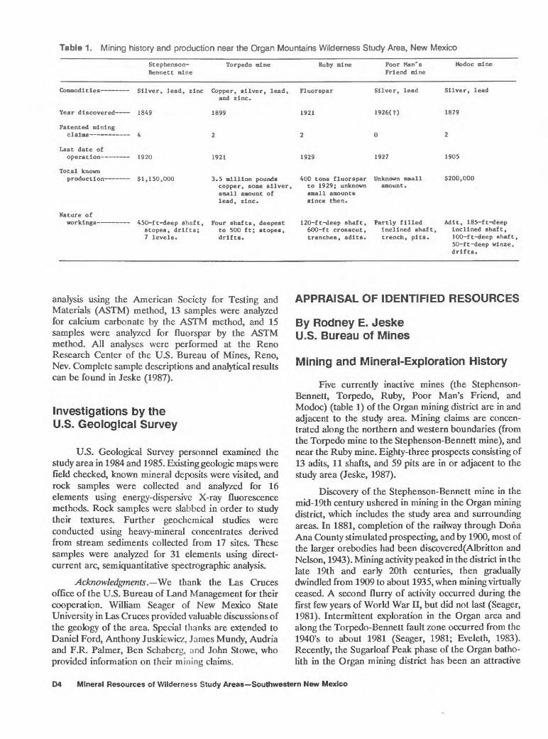
Table 1. Mining history and production near the Organ Mountains Wilderness Study Area, New Mexico
Year discovered
Patented mining
Last date of op era t Ion
Total known
Stephenaon- Torpedo mine BenneCt mine
and zinc.
1849 1899
A 2
1920 1921
ci I «;n nnn i «; ..4114*1.. ns,..~A~
Ruby mine Poor Man's Friend mine
1921 1926(?)
2 0
1929 1927
Mo doc mine
1879
2
1905
<!9nn nnncopper, some silver, small amount of lead, zinc.
to 1929; unknown amount. small amounts since then.
Nature ofworkings 450-ft-deep shaft, Four shafts, deepest 120-ft-deep shaft, Partly filled Adit, 185-ft-deep
scopes, drifts; to 500 ft; stopes, 600-ft crosscut, Inclined shaft, Inclined shaft, 7 levels. drifts. trenches, adits. trench, pits. 100-ft-deep shaft,
50-ft-deep winze, drifts.
analysis using the American Society for Testing and Materials (ASTM) method, 13 samples were analyzed for calcium carbonate by the ASTM method, and 15 samples were analyzed for fluorspar by the ASTM method. All analyses were performed at the Reno Research Center of the U.S. Bureau of Mines, Reno, Nev. Complete sample descriptions and analytical results can be found in Jeske (1987).
Investigations by the U.S. Geological Survey
U.S. Geological Survey personnel examined the study area in 1984 and 1985. Existing geologic maps were field checked, known mineral deposits were visited, and rock samples were collected and analyzed for 16 elements using energy-dispersive X-ray fluorescence methods. Rock samples were slabbed in order to study their textures. Further geochemical studies were conducted using heavy-mineral concentrates derived from stream sediments collected from 17 sites. These samples were analyzed for 31 elements using direct- current arc, semiquantitative spectrographic analysis.
Acknowledgments. We thank the Las Cruces office of the U.S. Bureau of Land Management for their cooperation. William Seager of New Mexico State University in Las Cruces provided valuable discussions of the geology of the area. Special thanks are extended to Daniel Ford, Anthony Juskiewicz, James Mundy, Audria and F.R. Palmer, Ben Schaberg, and John Stowe, who provided information on their mining claims.
APPRAISAL OF IDENTIFIED RESOURCES
By Rodney E. Jeske U.S. Bureau of Mines
Mining and Mineral-Exploration History
Five currently inactive mines (the Stephenson- Bennett, Torpedo, Ruby, Poor Man's Friend, and Modoc) (table 1) of the Organ mining district are in and adjacent to the study area. Mining claims are concen trated along the northern and western boundaries (from the Torpedo mine to the Stephenson-Bennett mine), and near the Ruby mine. Eighty-three prospects consisting of 13 adits, 11 shafts, and 59 pits are in or adjacent to the study area (Jeske, 1987).
Discovery of the Stephenson-Bennett mine in the mid-19th century ushered in mining in the Organ mining district, which includes the study area and surrounding areas. In 1881, completion of the railway through Dona Ana County stimulated prospecting, and by 1900, most of the larger orebodies had been discovered(Albritton and Nelson, 1943). Mining activity peaked in the district in the late 19th and early 20th centuries, then gradually dwindled from 1909 to about 1935, when mining virtually ceased. A second flurry of activity occurred during the first few years of World War II, but did not last (Seager, 1981). Intermittent exploration in the Organ area and along the Torpedo-Bennett fault zone occurred from the 1940's to about 1981 (Seager, 1981; Eveleth, 1983). Recently, the Sugarloaf Peak phase of the Organ batho- lith in the Organ mining district has been an attractive
D4 Mineral Resources of Wilderness Study Areas Southwestern New Mexico
porphyry copper-molybdenum exploration target. Most of this exploration has been north of the study area, where more than $1 million was spent for drilling in the 1970's by several mining companies, including Texaco, Conoco, AMAX, Kerr-McGee, Phelps Dodge, Bear Creek, U.S. Borax, Leonard Resources, and Gulf Minerals. Gulf Minerals and Leonard Resources were exploring the area near and north of the town of Organ in 1979 (U.S. Bureau of Land Management, 1981).
Mines, Prospects, and Mineral Occurrences
Four main mineralized areas and miscellaneous prospects were examined in and adjacent to the study area. These areas are, from northeast to south: the northern part of the Sugarloaf Peak phase of the Organ batholith and associated veins (including the Poor Man's Friend vein), the Torpedo mine, the Stephenson-Bennett mine, and the Ruby mine (Jeske, 1987).
The mineralized Sugarloaf Peak phase of the Organ batholith and associated veins occur in the northern Organ and southern San Andres Mountains. The distribution of metal values in the veins is spotty (Jeske, 1987, table 2). The veins, with one exception, are of limited extent. A 0.1- to 0.3-ft-thick quartz vein containing high silver values is exposed for approximately 600 ft along strike in the study area. The vein strikes N. 40° W., and dips 35°-72° SW. The nine samples taken along the vein had silver values ranging from 0.38 to 116 ppm (parts per million) (0.1 to 3.4 troy ounces per ton) (Jeske, 1987, table 2). Surface samples indicate that the average grade is too low and mineralization too discontinuous to constitute a resource at this time.
Minor silver, gold, copper, molybdenum, lead, tungsten, and arsenic mineralization was associated with the Sugarloaf Peak phase of the Organ batholith. Newcomer (1984) reported similar copper and molyb denum occurrences, and he concluded that the area, at its present level of exploration, appears uneconomic.
The Poor Man's Friend mine, within the Sugarloaf Peak phase of the Organ batholith, is less than Vi mi north of the study-area boundary (fig. 2). A vein, which can be traced about V* mi, strikes N. 45°-50° W., and dips about 40° SW., and consists of quartz less than 4-in. (inch) wide (commonly only 0.5- to 1-in. wide) within sericitically altered envelopes extending as much as 10 ft away from the vein. Some shearing has occurred, and localized breccia zones are as much as 3-ft wide. Iron oxide staining is pervasive along the vein with localized concentrations of limonite and hematite veinlets. Sample analyses show silver, copper, molybdenum, lead, zinc, tungsten, and arsenic to be present in small amounts
(Jeske, 1987, table 3). The vein is too narrow and low grade to be considered a resource.
The Torpedo mine is Vs mi north of the study area (fig. 2). The surface reconnaissance located two open shafts, both unsafe to enter. No samples could be taken from underground workings. The deposit is in a silicified, kaolinized, and brecciated porphyry along the steep, east-dipping contact between the Sugarloaf Peak phase of the Organ batholith and Paleozoic sedimentary rocks. The deposit was explored 500 ft downdip along the contact, where it is 800 ft long and as much as 150 ft thick. The deposit and associated altered breccia are enclosed by two northerly trending faults, as much as 200 ft apart, within the Torpedo-Bennett fault zone (Jeske, 1987, fig. 4a). South of the shafts, the two faults converge and form a quartz rib that continues intermittently south across the hills to south of Baylor Canyon (Dunham, 1935; Seager, 1981).
Primary minerals in the deposit are pyrite, chal- copyrite, and quartz as stockwork veinlets in the altered porphyry. The deposit has been oxidized to a depth of 300 ft; ore in the oxidized zone is a mass of chrysocolla, kaolin, and native copper, with minor azurite, malachite, and silver-bearing minerals. Supergene chalcocite was reported below 300 ft. Primary chalcopyrite, sphalerite, and galena were noted in drill holes below 388 ft (Soul6, 1951). Silver content appears to increase with sulfur content.
An ore shoot that averages 3 percent copper is exposed in the 200-ft level of the No. 4 shaft; it has a proven length of 275 ft and a thickness of 75 ft. Geo physical evidence suggests that the deposit continues south for hundreds of feet beyond the present working (Dunham, 1935) toward the study area. The indicated reserves of 17,000 tons of material contain between 1 and 3 percent copper on the 200-ft level (Albritton and Nelson, 1943). A previously drilled U.S. Bureau of Mines angle drill hole (No. 1), southeast of shaft No. 4, cut a 24-ft interval containing 4.6 percent copper, 3.2 percent zinc, and 0.5 percent lead about 200 ft below the 200-ft level (Soul6, 1951). The Torpedo mine reserves were estimated to be 600,000 tons averaging between 4 and 5 percent copper (Weed, 1922).
The richer, easily accessible oxidized ore has been mined; a large amount of low-grade material remains between the mined ore shoots and on the 200-ft level of the No. 4 shaft (Jeske, 1987). The quartz outcrop that continues south is barren, but the outcrops over the known deposits were also commonly barren (Dunham, 1935).
A more complete definition of reserves at the Torpedo mine and of possible extensions of ore into the study area would require a detailed drilling program and a thorough underground examination of the mine, as the old records are incomplete. Geological and
Organ Mountains Wilderness Study Area D5

106°32'30"
32°25'00
32°22'30
APPROXIMATE BOUNDARY OF THE ORGAN MOUNTAINS WILDERNESS STUDY AREA
(NM-030-074)
Geology generalized from Seager (1 981)
Figure 2. Geology and mineral resource potential of the Organ Mountains Wilderness Study Area, Doha Ana County, New Mexico.
D6 Mineral Resources of Wilderness Study Areas Southwestern New Mexico
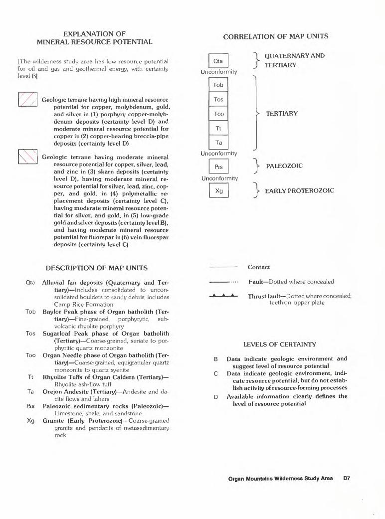
EXPLANATION OF MINERAL RESOURCE POTENTIAL
[The wilderness study area has low resource potential for oil and gas and geothermal energy, with certainty level B]
Geologic terrane having high mineral resource potential for copper, molybdenum, gold, and silver in (1) porphyry copper-molyb denum deposits (certainty level D) and moderate mineral resource potential for copper in (2) copper-bearing breccia-pipe deposits (certainty level D)
Geologic terrane having moderate mineral resource potential for copper, silver, lead, and zinc in (3) skarn deposits (certainty level D), having moderate mineral re source potential for silver, lead, zinc, cop per, and gold, in (4) polymetallic re placement deposits (certainty level C), having moderate mineral resource poten tial for silver, and gold, in (5) low-grade gold and silver deposits (certainty level B), and having moderate mineral resource potential for fluorspar in (6) vein fluorspar deposits (certainty level C)
CORRELATION OF MAP UNITS
QUATERNARY AND
TERTIARY
> TERTIARY
PALEOZOIC
EARLY PROTEROZOIC
DESCRIPTION OF MAP UNITS
Qta Alluvial fan deposits (Quaternary and Ter tiary) Includes consolidated to uncon- solidated boulders to sandy debris; includes Camp Rice Formation
Tob Baylor Peak phase of Organ batholith (Ter tiary) Fine-grained, porphyrytic, sub- volcanic rhyolite porphyry
Tos Sugarloaf Peak phase of Organ batholith (Tertiary) Coarse-grained, seriate to por- phyritic quartz monzonite
Too Organ Needle phase of Organ batholith (Ter tiary) Coarse-grained, equigranular quartz monzonite to quartz syenite
Tt Rhyolite Tuffs of Organ Caldera (Tertiary) Rhyolite ash-flow tuff
Ta Orejon Andesite (Tertiary) Andesite and da- cite flows and lahars
Rzs Paleozoic sedimentary rocks (Paleozoic) Limestone, shale, and sandstone
Xg Granite (Early Proterozoic) Coarse-grained granite and pendants of metasedimentary rock
A A A
Contact
Fault Dotted where concealed
Thrust fault Dotted where concealed; teeth on upper plate
LEVELS OF CERTAINTY
Data indicate geologic environment and suggest level of resource potential
Data indicate geologic environment, indi cate resource potential, but do not estab lish activity of resource-forming processes
Available information clearly defines the level of resource potential
Organ Mountains Wilderness Study Area D7

geophysical evidence suggest that additional mineralized rock occurs at depth and south of the present workings and suggest that silver may have been supergene enriched near the water table. The resources may extend into the study area, but drilling is needed to verify this.
The Stephenson-Bennett mine, which has been "cherry-stemmed" out of the study area, consists of three mined silver-lead-zinc orebodies: the Stephenson, the Bennett, and the Page (Jeske, 1987). All are subparallel replacement deposits in steeply dipping Paleozoic sedimentary rocks between two major strands of the Torpedo-Bennett fault zone. Porphyry dikes cut the sedimentary rocks and, locally, the mineralization followed the dike contacts. The primary ore minerals in all orebodies are sphalerite, argentiferous galena, and minor chalcopyrite.
The Stevenson and Page orebodies are approxi mately 300 ft long and 15 to 20 ft thick (Dunham, 1935). They are mostly mined out, except for ore left in pillars, samples from which contained as much as 0.036 troy ounces gold per ton, 14.2 troy ounces silver per ton, 25.2 percent lead, 14.6 percent zinc, 0.36 percent copper, 550 ppm molybdenum, 700 ppm tungsten, and 0.064 percent arsenic (Jeske, 1987, table 4).
The Bennett orebody is 500 ft long, as much as 20 ft thick, and has been mined downdip for 250 ft and explored to 600 ft. Drilling during 1946-48 encountered mineralized rock at depths between 550 and 650 ft (Daniel Ford, owner, written commun., 1985). Low- grade pillars of mineralized rock remain above 250 ft (Jeske, 1987). Upper parts of the Bennett orebody are oxidized; whereas, lower parts consist of sulfide minerals. The oxidized part has a low zinc content, about 25 percent lead, and about 20 troy ounces silver per ton. The low zinc values suggest the leaching of this element from the upper zone. Assays that represent samples at 10-ft intervals on the 450-ft level contained 2.89 troy ounces silver per ton, 10.77 percent lead, and 12.96 percent zinc (Dunham, 1935).
A conservative estimate (Dunham, 1935) is that approximately 35,000 tons of mineralized rock, present between the 250-ft level and 50 ft below the 450-ft level, averages approximately 2.9 troy ounces silver per ton, 10-11 percent lead, and 13 percent zinc. A small amount of mineralized rock also remains in pillars and in the walls of the slopes.
The downdip extent of the Bennett orebody is not known. Additional resources could be present within the Torpedo-Bennett fault zone and surrounding sedi mentary rocks, and mineralized rock may be present along strike north or south of the Stephenson-Bennett mine inside the study area. Drilling would be needed to determine whether resources exist at depth.
Other samples from the Stephenson-Bennett mine were from underground, the quarry, and from the surface. They contain minor amounts of gold, silver, lead, zinc, copper, molybdenum, tungsten, and arsenic. Three samples taken from what appeared to be barren dolomite assayed 0.2-2.0 troy ounces silver per ton over 7- to 10-ft sample lengths (Jeske 1987, table 4). Thirteen of 14 random samples taken from sedimentary rocks in the Stephenson-Bennett mine area contained 0.008-0.085 ppm gold.
The Ruby fluorspar mine is a 40-acre inholding within the study area (fig. 2; table 1). The fluorspar occurs mainly as open-space fillings and to a lesser extent as replacements along several minor, north-trending, east-dipping faults that cut west-dipping Paleozoic rocks (Seager, 1981). A 500-ft-thick Tertiary andesite porphyry sill contains fluorspar veinlets less than 3 in. thick on the crosscut level.
Most of the fluorspar in the Ruby mine area occurs in six veins that are exposed on the surface (Jeske, 1987). Five of the veins are subparallel, strike approximately north and dip 55°-70° E., and are exposed for 369-615 ft along strike and have widths ranging from 1.5-15 ft. The sixth vein is a bedding-plane vein that strikes northwesterly and dips 45°-60° W. (Glover, 1975). Several additional mineralized fracture zones exposed in the underground workings contain varying but minor amounts of fluorspar.
Of the 15 samples collected from the Ruby mine area (Jeske, 1987, table 5), 9 samples from the six major veins contained from 2.4 to 45 percent fluorspar and had a weighted average of 18.3 percent fluorspar. The six sampled veins at the Ruby mine have an identified resource of 209,000 tons averaging 18.3 percent fluor spar. Exploration drilling would be needed to locate additional fluorspar resources in the area of the Ruby mine and to determine whether such mineralized rock extends into the study area.
A composite bulk sample for three veins taken by a consultant for the lessee contained an average of 52 percent fluorspar. A chemical analysis in 1972 on fluor spar ore shipped to the Tuscaloosa Metallurgy Research Laboratory of the U.S. Bureau of Mines in Alabama contained 41.5 percent fluorspar. Flotation tests made by the U.S. Bureau of Mines showed that preparing acid- grade fluorspar ( > 97 percent CaF2) concentrates, with good recovery, is feasible (B.F. Schaberg, written com mun., 1985).
Mining of fluorspar in the Western United States is currently (1986) uneconomic because of high freight rates, low-cost foreign supplies, and the depressed demand on the world market (U.S. Bureau of Mines, 1986).
D8 Mineral Resources of Wilderness Study Areas Southwestern New Mexico

Samples from several prospects and occurrences along the western slope of the Organ Mountains, in and adjacent to the study area, contained minor amounts of silver, gold, arsenic, copper, fluorine, molybdenum, lead, zinc, and tungsten (Jeske, 1987, table 6). A high-grade select dump sample from an inaccessible shaft approxi mately V-i mi northwest of Baylor Pass in the study area contained 8.2 troy ounces silver per ton and 31.9 percent zinc.
Several elements were identified as geochemically anomalous in rock samples collected by McAnulty and McAnulty (1979) along the western slope of the Organ Mountains, from approximately 1 mi north of the Stephenson-Bennett mine to 1 mi south of the Ruby mine. The anomalous concentrations of elements included silver, arsenic, gold, barium, beryllium, cobalt, copper, fluorine, mercury, manganese, molybdenum, lead, strontium, titanium, tungsten, and zinc. These anomalies were associated with silicified limestone, skarn, and argillized zones. The skarn is characterized by disseminated epidote, garnet, and other calc-silicate minerals. Mercury anomalies were associated with most of the arsenic anomalies that occur in silicified limestone (McAnulty and McAnulty, 1979).
Extensive deposits of common variety carbonate rocks are an inferred subeconomic resource. Carbonate rock crops out along the western side of the study area (fig. 2, Pzs) and could be used in local markets for building material. Whole-rock analyses on 13 carbonate rock samples show that the calcium carbonate (CaCO3) content ranged from 29.27-85.32 percent and the mag nesium carbonate (MgCO3 ) content ranged from 1.65-48.95 percent (Jeske, 1987). The silica (SiO2) content (from chert and other impurities) ranged from 6.4-39.1 percent. These results show that the carbonate rocks are suitable for agricultural lime or agricultural dolomite (greater than or equal to 85 percent combined CaCO3 and MgCO3 ). Bands of marble, about 2,000 ft long by 300-600 ft wide, north and east of the Ruby mine are estimated to have a total extractable quantity of about 1.5 million tons (U.S. Bureau of Land Management, 1981). Currently there is only little demand for this material.
Valley Transit Mix, Ltd., Las Cruces, N. Mex., has a use permit for about 10 acres of Federal land adjacent to the Stephenson-Bennett mine. The company is occasionally removing the carbonate rock that has been stockpiled in the study area since 1974 from the quarry at the Stephenson-Bennett mine (U.S. Bureau of Land Management, 1981). Small amounts of the rock are currently being used for landscaping and road metal. According to John Stowe, of Valley Transit Mix Ltd., also an owner of the Stephenson-Bennett mine (oral com- mun., 1985) material at the quarry are adequate to meet local demand for several years.
Large quantities of colluvium cover the pediment in the study area (fig. 2, QTa), and consist of pebbles, cobbles, and boulders in a matrix of silty clay. Rocks in the colluvium could be used for landscape decorative purposes, for preparing crushed stone, and as road metal and agglomerate. A local market for these inferred subeconomic resources exists, and the demand for them, though small, is continuous (U.S. Bureau of Land Management, 1981).
ASSESSMENT OF MINERAL RESOURCE POTENTIAL
By Steve Ludington, William F. Hanna, and Robert L. Turner U.S. Geological Survey
Geology
The Organ Mountains Wilderness Study Area is located in the Organ Mountains, which are part of a large, west-tilted fault block that extends for 150 mi from El Paso, Tex., northward to central New Mexico, along the eastern margin of the Rio Grande rift. In the immediate vicinity of the study area, the rocks range in age from Precambrian to Quaternary, and the older rocks have been complexly deformed at least twice. A detailed account of the geology of the region can be found in Seager (1981), and the description that follows is largely abstracted from his study.
Precambrian rocks are present as small remnants in the northwest portion of the study area. They consist primarily of brown or gray, coarse-grained, slightly porphyritic granite and a few small pendants of metamorphic rock. These rocks have not been dated radiometrically in this area, but, by analogy with other nearby Precambrian granites, they are believed to be about 1,400 Ma (million years before present).
Between 7,000 and 8,000 ft of Paleozoic sedi mentary rocks are variously exposed in the vicinity of the study area. These include the Upper Cambrian Bliss Sandstone, the Lower Ordovician El Paso Group, the Middle and Upper Ordovician Montoya Group, the Lower and Middle Silurian Fusselman Dolomite, the Middle Devonian Canutillo Formation, the Upper Devo nian Percha Shale, the Lower Mississippian Caballero Formation and Lake Valley Limestone, the Lower and Upper Mississippian Rancheria Formation, the Upper Mississippian Las Cruces and Helms Formations, the Pennsylvanian Lead Camp Limestone, the Lower Pennsylvanian La Tuna and Middle Pennsylvanian Berino Members of the Magdalena Formation, the
Organ Mountains Wilderness Study Area D9

Upper Pennsylvania!! and Lower Permian Panther Seep Formation, and the Lower Permian Hueco Limestone, Abo Sandstone, Yeso Formation, and San Andres Limestone. Carbonate rocks are prominent throughout this thick, complex section, and some evidence of skarn and polymetallic replacement mineralization is present in all of the carbonate strata. For the purpose of this mineral resource assessment, the Paleozoic strata are treated as one unit.
The study area lies on the northeast margin of the Cordilleran orogenic belt described by Drewes (1978), which was active during Laramide (Late Cretaceous and earliest Tertiary) time. The orogenic belt is characterized by large-scale northwest-trending thrust faults and asymmetric and overturned folds. The foreland to the northeast, of which the study area is a part, responded with the formation of broad, basement-cored uplifts flanked by monoclines and steeply dipping faults. The Organ Mountains, in the vicinity of the study area, are part of such a block, bounded on the east by the Organ Mountains fault, and on the west by a major monoclinal structure and the parallel and associated Torpedo- Bennett fault zone. In the study area, the fault zone separates a block of Precambrian granite on the east from vertical to overturned Paleozoic sedimentary rocks on the west (fig. 2). The zone consists in detail of many closely spaced, anastomosing and branching faults.
The Torpedo-Bennett fault zone is intruded and mineralized by the Oligocene Organ batholith. Though there is some evidence for post-emplacement movement on some faults, many details' of the batholith contact prove that it is intrusive, and it is clear that the batholith contact has been largely controlled by a pre-existing fault zone.
The Laramide structures of the study area were eventually covered by a great volume of lava flows and tuffs, and subsequently intruded by the Organ batholith, which is interpreted to represent the magma chamber that was the source of most of the volcanic rocks.
The volcanic rocks form two distinct groups. The lower group is andesitic to dacitic in composition and accumulated primarily as lava flows. These rocks, termed the Orejon Andesite (Tertiary), have not been radiomet- rically dated, and may be, in part, as old as Eocene. The upper group is mostly rhyolitic in composition, and accumulated primarily as ash-flow tuffs that fill the Organ caldera, a volcanic collapse structure south of the study area. These rocks are Oligocene in age and immediately predate the intrusion of the Organ batho lith. Although the silicic ash-flow tuffs of the Organ caldera form an important part of the geologic history of the region, they do not occur within the study area, and are found only in the extreme southern part (fig. 2) 1-2 mi southeast of the study-area boundary.
The Organ batholith is a complex body made up of multiple intrusions of medium- to coarse-grained, seriate to porphyritic granite, quartz syenite, and quartz mon- zonite. It underlies most of the study area, and intruded and deformed its overlying roof of Paleozoic sedimentary and Tertiary volcanic rocks. Volumetrically, the two principal phases are the quartz monzonite porphyry of Sugarloaf Peak, in the northern part of the area, and the quartz monzonite of Organ Needle, in the central and southern parts.
Subsequent to emplacement of the batholith, beginning at an unknown time, the study area has been uplifted as a horst. The block is bounded on the east by the Organ Mountains fault zone, several miles east of the study area, and on the west by the largely inferred west-side boundary fault, which is apparently covered by alluvial material and probably lies 1-2 mi west of the study-area boundary. In other parts of the Southern Rocky Mountains, this style of deformation began in late Oligocene to early Miocene time, continuing until the present. This uplift has been differential and has resulted in late Tertiary rotation of the Organ Mountains structural block by about 20° to the west.
Major erosion of the range in late Tertiary time has resulted in the deposition of the Camp Rice Formation, of late Pliocene to middle Pleistocene age (Seager, 1981). These rocks are primarily boulder conglomerates and finer sediments of continental origin and represent an erosional regime similar to that found today. The youngest rocks in the study area are largely alluvial fans that cover the lower slopes of the mountains.
The Organ batholith is interpreted to represent the magma that remained after the expulsion of the silicic ash-flow tuffs of the Organ caldera. Seager (1981) believed the intrusive rocks to be chemically related to the tuffs. They are distinctly less silica-rich, consistent with the hypothesis that they are the deeper, intrusive part of a chemically zoned magma chamber. However, an examination of the petrologic data of both Seager (1981) and Newcomer (1984) suggests that the two major phases of the batholith may not be comagmatic. The available data suggest that the quartz monzonite porphyry of Sugarloaf Peak is, compared to the slightly older quartz monzonite of Organ Needle, slightly more silica-rich (though both plutons span large compositional ranges), and distinctly poorer in alkalis and richer in calcium. The Sugarloaf Peak rocks are also richer in titanium and magnesium, relative to total iron. In short, it is more calc-alkaline in nature; the Organ Needle pluton shows alkalic affinities, similar to the volcanic tuffs of the Organ caldera.
Both plutons are closely associated with mineral deposits, the Sugarloaf Peak pluton with a porphyry copper-molybdenum system, with related skarn and
D10 Mineral Resources of Wilderness Study Areas Southwestern New Mexico

replacement deposits, and the Organ Needle pluton with skarn and possibly fluorspar deposits.
Geochemistry
A reconnaissance geochemical survey was completed in the Organ Mountains Wilderness Study Area in the fall of 1984. Heavy-mineral concentrates derived from stream sediments, and rocks were selected as the primary sample media. Seventeen sites were sampled for heavy-mineral concentrates and eight sites were sampled for rocks.
The heavy-mineral concentrate samples were collected at each site from active alluvium in the stream channel. Each sample was composited from several localities along a channel length of approximately 50 ft. The stream-sediment samples were sieved through a 10-mesh screen and then panned until most of the quartz, feldspar, clay material, and organic matter were removed. The remaining light minerals were separated from the heavy minerals with a heavy liquid (bromoform, specific gravity 2.8). The material of specific gravity greater than 2.8 was further separated in an isodynamic magnetic separator. This sample medium represents a concentration of ore-forming and ore-related minerals that permits determination of some elements that are not easily detected in bulk stream sediments.
The rock samples were taken from mineralized and unmineralized outcrop and stream float. Samples that appeared fresh and unaltered were collected to provide information on geochemical background values. Altered or mineralized samples were collected to determine the suite of elements associated with the observed alteration or mineralization.
The nonmagnetic fraction of the heavy-mineral concentrates and the rocks were analyzed for 31 ele ments by direct-current arc, semiquantitative emission spectrographic analysis (Grimes and Marranzino, 1968; Crock and others, 1983). The rocks were also analyzed for arsenic, bismuth, cadmium, antimony, and zinc (O'Leary and Viets, 1986), for gold (Thompson and others, 1968), and for mercury (Koirtyohann and Khalil, 1976). Analytical data and a description of the sampling and analytical techniques are given in Delaney and others (1987).
Three anomalous areas were identified, based on the heavy-mineral concentrate and rock data. The first area is at the southeast corner of the study area and contains heavy-mineral concentrates anomalous in lead (as much as 100 ppm), bismuth (as much as 20 ppm), and thorium (as much as 300 ppm), and rocks anomalous in copper (as much as 300 ppm) and molybdenum (as much as 5 ppm). Although no mineralized rock was observed,
these sample sites are from an area which drains the Organ batholith where it is cut by aplite dikes and overlain by epidote-akered Orejon Andesite.
The second anomalous area, in the north and northeast parts of the study area, was delineated by anomalous bismuth (150-500 ppm), tungsten (100-500 ppm), silver (as much as 5 ppm), lead (as much as 100 ppm), molybdenum (as much as 20 ppm), and thorium (as much as 300 ppm) in heavy-mineral concentrates. Rocks collected as float in the stream beds from this area are anomalous in silver (1-150 ppm), bismuth (12-700 ppm), molybdenum (70-150 ppm), lead (700-20,000 ppm), zinc (200-500 ppm), cadmium (1.7-2.3 ppm), arsenic (as much as 340 ppm), and antimony (as much as 240 ppm). These anomalies are probably due to peripheral veins related to the porphyry copper system.
The third anomalous area in the study area is on the west flank of the mountains. This anomalous zone is represented by heavy-mineral concentrates with anoma lous values of lead (100-1,000 ppm), molybdenum (15-30 ppm), bismuth (30-70 ppm), zinc (1,000-5,000 ppm), cadmium (as much as 100 ppm), and silver, (as much as 7 ppm). These sample sites are downslope from the Torpedo-Bennett fault zone and the contact of the Organ batholith with Paleozoic sediments. There are several mines and prospects along this zone from the Stephenson-Bennett mine in the north to the Ruby mine in the south, as well as several areas of silicification and iron oxide alteration in the north to central part of this zone. Outcrop was sampled in the silicic and iron oxide alteration zone immediately to the south of the Stephenson-Bennett mine, but not at the mine site, and near the Ruby mine. The rocks sampled are anomalous in zinc (7-34,000 ppm), lead (less than 10-20,000 ppm), arsenic (16-1500 ppm), antimony (21-2,000 ppm), and silver (20-300 ppm).
A large body of geochemical data for rock samples is also available (McAnulty and McAnulty, 1979). Because the sample coverage is very uneven, these data are not very useful for elimination of unmineralized areas or for delineation of favorable tracts. Nevertheless, the data are useful to help characterize the nature of known mineralized areas, and the results are summarized here. The reader is referred to the original study for details about sample collection, preparation, and analysis (McAnulty and McAnulty, 1979).
Six of the geographic areas sampled are relevant to this study, the Stephenson-Bennett mine area, the Ruby mine area, the Modoc mine area, the San Augustin Pass area, the Baylor Pass area, and the area of The Needles.
In the vicinity of the Stephenson-Bennett mine, samples from near known mineralized rock are, as expected, anomalous in copper, molybdenum, lead, zinc, and silver. A weaker set of anomalous samples is from just northeast of the mine in argillized intrusive rock of
Organ Mountains Wilderness Study Area D11

the batholith at the mouth of Blair Canyon. In addition, arsenic and mercury were detected in anomalous amounts in several samples of silicified limestone, and two anomalous gold values were found (0.25 and 0.2 ppm).
Near the Ruby mine, scattered skarn-mineralized rock and silicified limestone were noted, in addition to the known fluorspar deposits. The area with skarn minerals is characterized by copper, lead, molybdenum, and silver anomalies. North of the mine, arsenic, mercury, and scattered tungsten anomalies are coin cident with silicified limestone. Here also, two samples were found to be anomalous in gold (0.2 and 0.02 ppm).
Near the Modoc mine, more weakly skarn- mineralized rock and silicified limestone were found. The area is particularly high in barium, manganese, lead, and strontium; this geochemical signature may be a charac teristic of the Hueco Limestone, which is host to. the mineralization in this area. Here also, arsenic, mercury, and tungsten were found to be anomalous in some samples of silicified limestone, as well as one gold anomaly (0.27 ppm).
In the San Augustin Pass area, between Baylor Peak and San Augustin Pass, copper and molybdenum anomalies, with some associated tungsten and arsenic, were found within areas of weak argillic and phyllic hydrothermal alteration. These results can probably be attributed to peripheral veins related to the porphyry copper-molybdenum system described by Newcomer (1984).
In the Baylor Pass area, at the head of Baylor Canyon, just southwest of Baylor Peak, a few molyb denum, lead, and silver anomalies were found in a zone of weakly altered rock.
In the area of The Needles, northeast of The Needles, within 1 mi of the study-area boundary, a few molybdenum, lead, silver, and barium anomalies were found associated with mineralized aplite dikes.
Geophysics
The Organ Mountains Wilderness Study Area and the surrounding area are covered by regional gravity and detailed aeromagnetic surveys having sufficient reso lution to define anomalies of Vi or more square miles in areal extent. Gravity data are in the form of a partially terrain-corrected Bouguer gravity anomaly map (Keller and Cordell, 1983) and are based largely on about 35 observation points within or adjacent to the study area. Aeromagnetic data are in the form of an anomaly map (Keller and Aiken, 1979) contoured from measurements made along 40 flight lines in an east-west direction, spaced 1/6 mi apart, at an average altitude of about 500 ft above ground.
The gravity data (fig. 3 shown at the regional scale of fig. 1, index map) indicate that the rectangular area of figure 2 is characterized by short-wavelength anomalies surrounded by long-wavelength lows of basins to the east and west and by long-wavelength highs of elevated bedrock to the north and south. Two of the short-wavelength features are important: (1) a low- amplitude low over the northeastern part of the rectan gular area, associated largely with the Organ batholith and related volcanic rocks, and (2) a higher amplitude high over the southwestern part of the rectangular area, associated largely with Paleozoic sedimentary rocks and Precambrian granite. The gravity high, which may be caused in part by hornfels and skarn at the margin of the batholith, suggests that no appreciable amounts of Tertiary intrusive rock underlie the Paleozoic and Pre cambrian rocks. At the periphery of the rectangular area, sublinear, steep gravity gradients mark steeply dipping faults that bound basins and ranges, such as the west- tilted block forming the Organ Mountains.
The aeromagnetic anomaly data show a strong correlation of detailed features with both mapped geology and topography. The single most prominent feature is a high-amplitude high which trends north- northwest across the southern part of the study area (fig. 4). This high, which has a steep western gradient marking in part the Torpedo-Bennett fault zone, is associated almost exclusively with intrusive rocks of the Organ Needle phase of the Organ batholith at elevations above 6,500 ft. This high becomes smaller in amplitude and somewhat discontinuous in the north, where the Sugar- loaf Peak phase of the Organ batholith, a rhyolite porphyry and other rocks less magnetic than those to the south, form the exposed top of the batholith. The weak high over the central part of the rhyolite porphyry suggests that this part of the body is thin.
The anomaly data also suggest that other igneous rocks of the map area are magnetic, as anticipated from measurements made on rocks in nearby areas (Bath, 1976; Klein and Wynn, 1984), but they are probably less magnetic than the rocks of the Organ Needle phase. This is especially evident in areas of high relief. For example, highly elevated parts of the Sugar loaf Peak stock and outcrops of rhyolitic tuffs in the southern part of the area generate large-amplitude highs of short wavelength. However, outcrop areas of these same rocks at lower elevations generate little, if any, magnetic effect, partly because of the departure from a draped survey at high altitudes and partly because of lateral variations of the total magnetization (sum of remanent and induced dipole moment per unit volume) in the rocks. Some, but not most, Precambrian granitic rocks are sufficiently magnetic to produce high-amplitude highs. For example, a single short-wavelength high, having a northwest trend, crosses the northernmost part of an exposure of Precam-
D12 Mineral Resources of Wilderness Study Areas Southwestern New Mexico

106°45' 106°30' 106°15'
32°30'
32°15'-^
-130
EXPLANATION
Gravity anomaly contours- Contour interval, 2 milligals; hachures indicate depression;
X's indicate gravity observation points in neighborhood of rectangular area
Figure 3. Bouguer gravity anomaly map of the Organ Mountains Wilderness Study Area and vicinity, New Mexico. Small rectangular area corresponds to the area shown in figure 2. Contours are generalized from Keller and Cordell (1983).
brian rocks in the northwest part of the study area. Here, it is possible that the Precambrian terrane contains magnetic amphibolite in large enough quantities to produce the magnetic feature. Other igneous rocks, such as the Orejon Andesite, though undoubtedly magnetic, are generally too limited in volume to generate a significant magnetic effect. In regions of low topographic
relief, exposed or thinly covered areas of plutonic and volcanic rocks produce weak magnetic signatures in places that can be readily observed against a background field of low gradient.
Because many mineral deposits in the Organ district are associated with the Sugar loaf Peak stock, the subsurface extent of this stock assumes special
Organ Mountains Wilderness Study Area D13

106°35" 106°32'30'
32°25
32°22'30"
<]//-'. \ ' C, ( <'' p(HK t^OA^jjFOUNTAINS'±'<^ ' >^t;cHVyrt^£j^S^S^DY AREA "^ x ""^\ )J ^)^S?hCfmn>4) \ ""
^m^my/i:^ax^n//-?f? ft i d
Figure 4. Total-intensity aeromagnetic anomaly map of the Organ Mountains Wilderness Study Area and vicinity, New Mexico (Keller and Aiken, 1979).
D14 Mineral Resources of Wilderness Study Areas Southwestern New Mexico

Qta
Tob
Tos
Too
Tt
Ta
Rzs
Xg
EXPLANATION
Aeromagnetic anomaly contours Contour intervals, 20 and 100 gammas. Hachures show closed areas of lower magnetic intensity
Alluvial fan deposits (Quaternary and Ter tiary) Includes consolidated to uncon- solidated boulders to sandy debris; in cludes Camp Rice Formation
Baylor Peak phase of Organ batholith (Tertiary) Fine- grained, porphyry tic, subvolcanic rhyolite porphyry
Sugarloaf Peak phase of Organ batholith (Tertiary) Coarse-grained, seriate to porphyritic quartz monzonite
Organ Needle phase of Organ batholith (Tertiary) Coarse-grained, equigranu- lar quartz monzonite to quartz syenite
Rhyolite Tuffs of Organ Caldera (Ter tiary) Rhyolite ash-flow tuff
Orejon Andesite (Tertiary) Andesite and dacite flows and lahars
Paleozoic sedimentary rocks (Paleozoic) Limestone, shale, and sandstone
Granite (Early Proterozoic) Coarse-grained and pendants of metasedimentary rock
Contact
Fault Dotted where concealed
Thrust fault Dotted where concealed; teeth on upper plate
importance. Unfortunately, the Sugarloaf Peak stock is not sharply defined by either gravity or magnetic anomaly data. Rather, the stock is characterized by anomalies that suggest that it has an average density about the same as and a total magnetization less than the adjoining Organ Needle stock. Although the surface contact separating the two phases of the batholith is regular in form when viewed at the scale of the geologic map, its subsurface equivalent may undulate significantly, as evidenced by anomalies that crosscut the mapped contact. For example, immediately east of Baylor Peak, a cluster of magnetic lows is enigmatically nested over the Organ Needle phase of the batholith. Although this anomaly cluster may be caused by a hidden eastward extension of rhyolite exposed near Baylor Peak or an unknown non magnetic or altered phase of the Organ Needle stock, it seems more likely that a segment of the Sugarloaf Peak phase underlies the Organ Needle phase in this region.
Mineral and Energy Resources
Potential mineral resources in and near the study area are of diverse types (fig. 2). The characteristics
associated with each type and the assessment of potential are discussed successively.
Porphyry Copper-Molybdenum Deposits
Porphyry copper-molybdenum deposits consist of a mass of interconnecting veinlets (stockwork) of quartz, chalcopyrite, and molybdenite. They are commonly found in or near a shallow, porphyritic intrusion of tonalitic to monzongranitic composition (Cox, 1986).
Near the north end of the study area, widespread phyllic alteration (replacement of rock minerals by white mica) in the quartz monzonite of Sugarloaf Peak and related rocks indicates the presence of a porphyry copper-molybdenum system. The area has been extensively explored, both on the surface and by substantial amounts of diamond drilling (Newcomer, 1984). The Poor Man's Friend vein (fig. 2) appears to be part of this porphyry system. No substantial amounts of ore-grade mineralized rock have been discovered. Thus, though it is almost certain that a porphyry copper- molybdenum system is present, the probability is low that a deposit of commercial grade exists. Accordingly, we assign a high potenial for the occurrence of copper, molybdenum, gold, and silver resources, with a certainty level of D, although development is unlikely based on current data. The area of high potential designated in figure 2 encloses areas of known hydrothermal alteration at the surface and known mineralized rock in the subsurface.
Copper-Bearing Breccia-Pipe Deposits
Typically associated with porphyry copper deposits are copper-bearing breccia-pipe deposits. They consist of brecciated rock (typically hydrothermal breccias), the interstices of which are filled with pyrite and copper- bearing sulfides. Because of the porous nature of the bodies, supergene alteration (due to cool surface waters) is common, and much of the copper may be present as oxide and carbonate minerals. These deposits are commonly of higher grade than the associated porphyry deposits, but much smaller.
The Torpedo mine, southeast of the town of Organ, appears to be such a deposit, although field observations and Dunham's (1935) description do not exclude the possibility that the Torpedo is developed on a particularly rich portion of the porphyry copper deposit. Other deposits, similar to the one at the Torpedo mine, may occur within the area designated as having high potential
Organ Mountains Wilderness Study Area D15
for copper, molybdenum, and gold resources in a porphyry copper-molybdenum deposit. The potential for copper resources in copper-bearing breccia-pipe deposits is moderate, with a high degree of certainty, or certainty level D.
Skarn Deposits
Skarn deposits are commonly found where moderate- to high-level plutonic rocks intrude calcium- rich sediments. They consist typically of replacement of limestone and dolomite by calc-silicate minerals, such as pyroxene and garnet, along with associated metal sulfides.
Skarn deposits may contain a variety of metals; both copper-rich and silver-lead-zinc-rich varieties are known (Cox and Singer, 1986). The average size of the skarn deposits known to exist in and near the study area is almost certainly smaller than most of those compiled by Cox and Singer (1986).
In and near the study area are skarn deposits that contain various concentrations of copper, silver, lead, and zinc. The Homestake, Modoc, Memphis, and Orejon deposits are shown in figure 2. They are all in the sedimentary rocks that surround the Organ batholith on the west and north. Some are probably related to the porphyry copper-molybdenum system just described. Others, such as the Modoc and Orejon, may be related to other phases of the Organ batholith. The distribution of known deposits, along with scattered geochemical anomalies that may be related to skarn mineralization, permit delineation of the tract of moderate mineral resource potential shown in figure 2. There is not enough information to separate areas with potential for copper- rich skarn deposits from areas with potential for silver- lead-zinc-rich skarn deposits. Though undiscovered examples of this type of mineralized rock probably exist, the mineral resource potential for copper, silver, lead, and zinc in skarn deposits is only moderate, with a certainty level D.
Polymetallic Replacement Deposits
Polymetallic replacement deposits consist of silver-, lead-, zinc-, and copper-bearing minerals in massive lenses, pipes, and veins in limestone, dolomite, and other soluble rock near igneous intrusions.
The Stephenson-Bennett mine (fig. 2) is a repre sentative of this class of deposit. Many of the characteristics of polymetallic replacement deposits are similar to those of skarn deposits. However, polymetallic replacement deposits form at lower temperatures and are more strongly controlled by faults, fractures, and other favorable structural features. Commonly, poly metallic replacement deposits are found farther from the
plutons responsible for the mineralization than are skarn deposits.
The presence of the Stephenson-Bennett deposit, combined with the presence of favorable host rocks and scattered geochemical anomalies, permits designation of the same favorable tract as was designated for skarn deposits. Because of the favorable geologic charac teristics and the low level of previous exploration, the potential for silver, lead, zinc, copper, and gold resources in polymetallic replacement deposits is moderate, with a certainty level of C. Physical exploration of favorable areas identified by geochemical methods would be necessary to raise the degree of certainty.
Low-Grade Gold and Silver Deposits
In addition, the presence of scattered areas of silicified limestone along the mountain front, from the Stephenson-Bennett to the Modoc mines, combined with the presence of rock samples anomalous in silver, arsenic, and antimony, suggests that the area may contain undiscovered large, low-grade deposits of gold and silver. The potential for silver and gold resources in such deposits is moderate, with certainty level B. Physical exploration with this model in mind would be necessary to raise the certainty level.
Vein Fluorspar Deposits
The Ruby mine (fig. 2) is a vein fluorspar deposit. Though there is no published grade-tonnage model for such deposits, the Ruby is of at least moderate size and is comparable to other such deposits that have been mined in the past (Greta Orris, U.S. Geological Survey, oral commun., 1987). The most reliable diagnostic criteria for the occurrence of such deposits are a combination of structurally favorable host rocks and proximity to late Tertiary rift environments. This description fits most of the study area, but, because faulting is best developed in the Paleozoic sedimentary rocks along the western edge of the study area, we designate the favorable tract for vein fluorspar deposits to be the one previously identified for polymetallic replacement, skarn, and low-grade precious metal deposits. This area has moderate potential for fluorspar resources with certainty level C.
Other Commodities
The study area is underlain primarily by highly metamorphosed sedimentary rocks and by igneous rocks, and the potential for oil and gas resources is therefore low, with certainty level B.
No young volcanism or significant hot springs are found in the area, and the potential for geothermal energy resources is low, with certainty level B.
D16 Mineral Resources of Wilderness Study Areas Southwestern New Mexico

REFERENCES CITED
Albritton, C.C., and Nelson, V.E., 1943, Lead, zinc, and copper deposits of the Organ district, New Mexico (with a supplement on the occurrence of bismuth): U.S. Geological Survey Open-File Report 43, 39 p.
Bath, G.D., 1976, Interpretation of magnetic surveys in inter- montane valleys of Nevada and southern New Mexico: U.S. Geological Survey Open-File Report 76-440, 37 p.
Cordell, L.E., Keller, G.R., and Hildenbrand, T.G., 1982, Complete Bouguer gravity anomaly map of the Rio Grande rift, Colorado, New Mexico, and Texas: U.S. Geological Survey Geophysical Investigations Map GP-949, scale 1:1,000,000.
Cox, D.P., 1986, Descriptive model of Porphyry Cu-Mo, in Cox, D.P., and Singer, D.A., Mineral deposit models: U.S. Geological Survey Bulletin 1693, p. 115.
Cox, D.P., and Singer, D.A., 1986, Mineral deposit models: U.S. Geological Survey Bulletin 1693, 379 p.
Crock, J.G., Lichte, F.E., and Briggs, P.H., 1983, Deter mination of elements in National Bureau of Standards geological reference material SRM 278 obsidian and SRM 668 basalt by induction coupled argon plasma- atomic emission spectrometry: Geostandards Newsletter, no. 7, p. 335-340.
Delaney, T.A., Day, G.W., Turner, R.L., and Jones, J.L., 1987, Analytical results and sample locality map of heavy- mineral concentrate and rock samples from the Organ Mountains Wilderness Study Area (NM-030-074), Dona Ana County, New Mexico: U.S. Geological Survey Open-File Report 87-638.
Drewes, Harald, 1978, The Cordilleran orogenic belt between Nevada and Chihuahua: Geological Society of America Bulletin, v. 89, p. 641-657.
Dunham, K.C., 1935, The geology of the Organ Mountains: New Mexico Bureau of Mines and Mineral Resources Bulletin 11, 272 p.
Eveleth, R., 1983, An historical vignette: Stephenson-Bennett mine: New Mexico Geology, v. 5, p. 9-15.
Glover, T.J., 1975, Geology and ore deposits of the northwestern Organ Mountains, Dona Ana County, New Mexico: El Paso, University of Texas, M.S. thesis, 93 p.
Grimes, D.J., and Marranzino, A.P., 1968, Direct-current arc and alternating-current spark emission spectrographic field methods for the semiquantitative analysis of geologic materials: U.S. Geological Survey Circular 591, 6 p.
Jeske, R.E., 1987, Mineral resources of the Organ Mountains Wilderness Study Area (NM-030-074), Dona Ana County, New Mexico: U.S. Bureau of Mines Open-File Report MLA 6-87, 81 p.
Keller, G.R., and Aiken, C.L.V., 1979, Geophysical inves tigations, Part III, in McAnulty, W.N., and McAnulty, Noel, Organ Mountains minerals inventory and evaluation project, Dona Ana County, New Mexico.
Keller, G.R., and Cordell, L.E., 1983, Bouguer gravity anomaly map of New Mexico: New Mexico State University Energy Institute, Geothermal Resources of New Mexico,
Scientific Map Series, scale 1:500,000 [available from National Geophysical Data Center, NOAA, Code E/GCX2, 325 Broadway, Boulder, Colo. 80303].
Klein, D.P., and Wynn, J.C., 1984, Density, porosity, and magnetic susceptibility of rocks from the Silver City 1°X20 quadrangle, Arizona and New Mexico: U.S. Geological Survey Open-File Report 84-017, lip.
Koirtyohann, S.R., and Khalil, Moheb, 1976, Variables in determination of mercury by cold vapor atomic absorption: Analytical Chemistry, v. 48, p. 136-139.
Macer, R.J., 1978, Fluid inclusion studies of fluorite around the Organ cauldron, Dona Ana County, New Mexico: El Paso, University of Texas, M.S. thesis, 107 p.
McAnulty, W.N., and McAnulty, Noel, 1979, Organ Mountains minerals inventory and evaluation project, Dona Ana County, New Mexico: Bureau of Land Management Contract No. YA-512-CT9-110, Las Cruces District, 148 p.
Newcomer, R.W., Jr., 1984, Geology, hydrothermal alteration, and mineralization of the northern part of the Sugarloaf Peak quartz monzonite, Dona Ana County, New Mexico: Las Cruces, New Mexico State University, M.S. thesis, 108 p.
O'Leary, R.M., and Viets, J.G., 1986, Determination of antimony, arsenic, bismuth, cadmium, copper, lead, molybdenum, silver, and zinc in geologic materials by atomic absorption spectrometry using a hydrochloric acid-hydrogen peroxide digestion: Atomic Spectroscopy, v. 7, p. 4-8.
Seager, W.R., 1981, Geology of the Organ Mountains and southern San Andres Mountains, New Mexico: New Mexico Bureau of Mines and Mineral Resources Memoir 36, 97 p.
Soul6, J.H., 1951, Investigation of the Torpedo copper deposit Organ mining district, Dona Ana County, New Mexico: U.S. Bureau of Mines, Investigation Report 4791, 10 p.
Thompson, C.E., Nakagawa, H.M., and Van Sickle, G.H., 1968, Rapid analyses for gold in geologic materials, in Geological Survey Research 1968: U.S. Geological Survey Professional Paper 600-B, p. B130-B132.
U.S. Bureau of Land Management, 1981, Mineral resource inventory and assessment of the Organ Mountains Wilderness Study Area: Available from U.S. Bureau of Land Management, Las Cruces District Office, 1800 Marquess, Las Cruces, New Mexico 88005, 41 p.
U.S. Bureau of Mines, 1986, Copper, fluorspar, lead, lime, silver, and zinc sections, in Mineral Commodity Summaries 1986: p. 42-43, 52-53, 88-89, 90-91, 142-143, 178-179.
U.S. Bureau of Mines and U.S. Geological Survey, 1980, Principles of a resource/reserve classification for minerals: U.S. Geological Survey Circular 831, 5 p.
Weed, W.H., 1922, International edition, The Mines Handbook, succeeding the copper handbook founded by Horace J. Stevens, 1900, describing the mining companies of the world: Tuckahoe, New York, The Mines Handbook Co., v. XV, 2248 p.
Organ Mountains Wilderness Study Area D17


APPENDIX

DEFINITION OF LEVELS OF MINERAL RESOURCE POTENTIAL AND CERTAINTY OF ASSESSMENT
Definitions of Mineral Resource Potential
LOW mineral resource potential is assigned to areas where geologic, geochemical, and geophysical charac teristics define a geologic environment in which the existence of resources is unlikely. This broad category embraces areas with dispersed but insignificantly mineralized rock as well as areas with few or no indications of having been mineralized.
MODERATE mineral resource potential is assigned to areas where geologic, geochemical, and geophysical characteristics indicate a geologic environment favorable for resource occurrence, where interpretations of data indicate a reasonable likelihood of resource accumulation, and (or) where an application of mineral-deposit models indicates favorable ground for the specified type(s) of deposits.
HIGH mineral resource potential is assigned to areas where geologic, geochemical, and geophysical charac teristics indicate a geologic environment favorable for resource occurrence, where interpretations of data indicate a high degree of likelihood for resource accumulation, where data support mineral-deposit models indicating presence of resources, and where evidence indicates that mineral concentration has taken place. Assignment of high resource potential to an area requires some positive knowledge that mineral-forming processes have been active in at least part of the area.
UNKNOWN mineral resource potential is assigned to areas where information is inadequate to assign low, moderate, or high levels of resource potential.
NO mineral resource potential is a category reserved for a specific type of resource in a well-defined area.
Levels of Certainty
U/A
UNKNOWN
POTENTIAL
H/B
HIGH POTENTIAL
M/B
MODERATE POTENTIAL
L/B
LOW
POTENTIAL
H/C
HIGH POTENTIAL
M/C
MODERATE POTENTIAL
L/C
LOW
POTENTIAL
H/D
HIGH POTENTIAL
M/D
MODERATE POTENTIAL
L/D
LOW POTENTIAL
N/D
NO POTENTIAL
tLU
2LU Occ oCO
B C
LEVEL OF CERTAINTY
A. Available information is not adequate for determination of the level of mineral resource potential.B. Available information suggests the level of mineral resource potential.C. Available information gives a good indication of the level of mineral resource potential.D. Available information clearly defines the level of mineral resource potential.
Abstracted with minor modifications from:
Taylor, R. B., and Steven, T. A., 1983, Definition of mineral resource potential: Economic Geology,v. 78, no. 6, p. 1268-1270.
Taylor, R. B., Stoneman, R. J., and Marsh, S. P., 1984, An assessment of the mineral resource potentialof the San Isabel National Forest, south-central Colorado: U.S. Geological Survey Bulletin 1638, p.40-42.
Goudarzi, G. H., compiler, 1984, Guide to preparation of mineral survey reports on public lands: U.S.Geological Survey Open-File Report 84-0787, p. 7, 8.

RESOURCE/RESERVE CLASSIFICATION
IDENTIFIED RESOURCES
Demonstrated
Measured IndicatedInferred
UNDISCOVERED RESOURCES
Probability Range (or) Hypothetical i Speculative
ECONOMIC
MARGINALLY
ECONOMIC
SUB-
ECONOMIC
1
Reserves Inferred Reserves
Marginal Reserves
Demonstrated Subeconomic Resources
Inferred Marginal Reserves
InferredSubeconomic
Resources
+Major elements of mineral resource classification, excluding reserve base and inferred reserve base. Modified from U. S. Bureau of Mines and U. S. Geological Survey, 1980, Principles of a resource/reserve classification for minerals: U. S. Geological Survey Circular 831, p. 5.

GEOLOGIC TIME CHART Terms and boundary ages used in this report
EON
Phanerozoic
Proterozoic
Archean
pre - At<
ERA
Cenozoic
Mesozoic
Paleozoic
Late Proterozoic
Middle Proterozoic
Early Proterozoic
Late Archean
Middle Archean
Early Archean
:hean*
PERIOD
Quaternary
Neogene
Subperiod
Tertiary Paleogene Subperiod
Cretaceous
Jurassic
Triassic
Permian
Pennsylvanian Carboniferous
Periods """""
Mississippian
Devonian
Silurian
Ordovician
Cambrian
_3800? -
EPOCH
Holocene
Pleistocene
Pliocene
Miocene
Oligocene
Eocene
Paleocene
Late Early
Late Middle Early
Late Middle Early
Late Early
Late Middle Early
Late Early
Late Middle Early
Late Middle Early
Late Middle Early
Late Middle Early
L_ _
BOUNDARY AGE IN
MILLION YEARS
-0.010
- 1.7
-5
- 24
IB
- 55
cc
- 96
uo
OAC
-A, 240
- oon
- v 330
- 360
- 410
- 500
^~ 570'
- 900
1600
-2500
-3000
'Rocks older than 570m.y. also called Precambrian, a time term without specific rank.
2 Informal time term without specific rank.
*U.S. GOVERNMENT PRINTING OFFICE: 1988-O-573-047/66071

-/
^'V
i :t^'V
^ :
:K
»'?
m-
r\T
&;^
"'
> :^\.u
^W
^T
: ,