metroplan orlando – intelligent transportation system (its ... · ii metroplan orlando –...
TRANSCRIPT
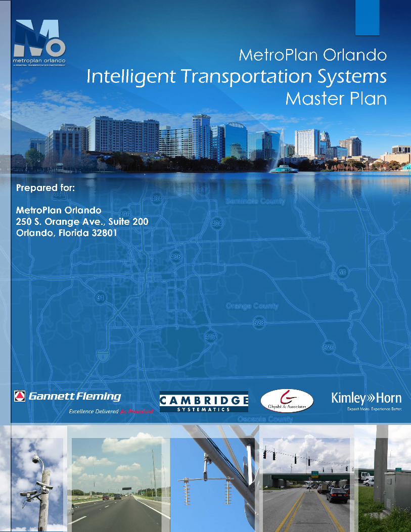

MetroPlan Orlando Intelligent Transportation System (ITS)
Master Plan
FINAL
Prepared For: MetroPlan Orlando 250 S. Orange Ave. #200 Orlando, Florida 32801 (407) 481-5672
May 2017
Cover map data provided as of 4/25/16 and 11/30/16 from MetroPlan Orlando, FDOT and City and County GIS Databases.
i
METROPLAN ORLANDO – INTELLIGENT TRANSPORTATION SYSTEM (ITS) MASTER PLAN
EXECUTIVE SUMMARY
MetroPlan Orlando is the metropolitan planning organization for Orange, Osceola, and Seminole Counties and is responsible for the transportation planning process in the tri-county area. According to the Tracking the Trends report, the Orlando Metropolitan Area is the 26th most populated Metropolitan Statistical Area (MSA) in the country with 2 million residents and had 66 million visitors in 2015.
The Intelligent Transportation System (ITS) Master Plan will evaluate current systems in the MetroPlan Orlando Area, determine future needs, and outline future ITS projects to improve traffic flow. The purpose of the Master Plan is to propose a system that improves efficiency, reliability and safety of the region’s multi-modal transportation system.
A series of Tasks were completed during the past 11 months that provided a deep understanding of the Stakeholders’ goals, objectives, needs, and strategies. The Regional ITS Architecture (RITSA) was evaluated and the Concept of Operations was prepared as part of this document. The draft task reports were previously submitted for review and are included in this document as the various sections were completed.
• Section 1-Task 1: ITS Vision, Goals and Objectives • Section 2-Task 2: Existing Conditions/Infrastructure/Inventory • Section 3-Task 3: Needs Assessment • Section 4-Task 4: Identification of Applicable ITS Strategies • Section 5-Task 5: Regional ITS Architecture (RITSA) • Section 6-Task 6: Concept of Operations
In addition to the tasks, two workshops were organized to include input from MetroPlan Orlando’s Transportation Systems Management & Operations (TSM&O) Advisory Committee. The first workshop was used to establish a vision, goals, and objectives for the ITS Master Plan and to complete an inventory of existing ITS devices in the MetroPlan Orlando area. The second workshop was organized to discuss and develop needs and applicable strategies that were then used to develop the proposed projects for future deployment.
The ITS technologies currently applied in the MetroPlan Orlando area include Closed Circuit Television Cameras (CCTV) cameras, Dynamic Message Signs (DMS), Bluetooth readers, Microwave Vehicle Detectors (MVDS), Automatic Vehicle Identification (AVI) readers, Transit Signal Priority (TSP), Adaptive Traffic Signal Control (ATSC), fiber optic cable, and communications equipment. The existing devices per County are summarized in Section 2.
Sections 3 and 4 described the various stakeholder needs and applicable strategies to meet those needs. Section 5 reviewed the RITSA based on the information gathered and summarized in Sections 2, 3 and 4. Section 6, the Concept of Operations, then built upon all the previous sections and provides an overview of the project/system to be deployed, details about the current system, identification of desired changes, operational issues of the existing and proposed devices and system components, as well as the relationships and responsibilities of the various agencies.
ii
METROPLAN ORLANDO – INTELLIGENT TRANSPORTATION SYSTEM (ITS) MASTER PLAN
Section 7 includes the ITS project scoring criteria and the ranking of future ITS projects. The future ITS projects were identified by matching the Stakeholder Survey results, the ITS strategies, needs, and goals with potential ITS and communications technologies addressing specific transportation, mobility, and safety-related issues within the MetroPlan Orlando area. All potential ITS projects identified in Section 7 were scored and ranked (prioritized) through the application of the methodology described in Section 7. One or more strategies may be included or addressed in one ITS project. In addition to the projects programmed in the Long Range Transportation Plan (LRTP), 34 potential ITS projects were identified. Each project also indicates the implementation timeline of 0 to 5 years or 6 to 10 years. The ITS Master Plan will serve as a guide for the development of future regional ITS projects.
i
METROPLAN ORLANDO – INTELLIGENT TRANSPORTATION SYSTEM (ITS) MASTER PLAN
Table of Contents Table of Contents ................................................................................................................... i
Table of Figures .................................................................................................................... iv
Table of Tables ..................................................................................................................... iv
Appendices ........................................................................................................................... v
List of Acronyms and Abbreviations ...................................................................................... vi
1. ITS Vision, Goals and Objectives ...................................................................................... 1
1.1 Challenges in Mainstreaming ITS (USDOT Report) ................................................................................. 1 1.2 Processes Used to Develop Vision, Goals & Objectives ......................................................................... 2 1.3 Vision Statement, Goals and Objectives ................................................................................................ 2 2 Existing Conditions Report .............................................................................................. 7
2.1 Seminole County ................................................................................................................................... 7 2.2 Osceola County ..................................................................................................................................... 7 2.3 Orange County .................................................................................................................................... 12 2.4 City of Orlando .................................................................................................................................... 14 2.5 LYNX ................................................................................................................................................... 17 2.6 Central Florida Expressway Authority ................................................................................................. 17 2.7 Florida Department of Transportation ................................................................................................ 17 2.8 Park & Ride Facilities ........................................................................................................................... 17 2.9 Traffic Management Centers In MetroPlan Orlando............................................................................ 17 3 Needs Assessment ........................................................................................................ 18
3.1 Needs Determination .......................................................................................................................... 18 3.1.1 Stakeholder Interview Needs ............................................................................................................ 18
3.1.2 Regional ITS Architecture Data Sharing Needs .................................................................................. 22
3.1.3 Additional Needs ............................................................................................................................... 24
3.2 Needs Summary .................................................................................................................................. 25 3.3 Needs Description ............................................................................................................................... 27
3.3.1 Travel and Traffic Management ........................................................................................................ 27
4 Applicable ITS Strategies ............................................................................................... 33
4.1 ITS Strategies Determination .............................................................................................................. 33 4.2 Applicable ITS Strategies ..................................................................................................................... 36
4.2.1 Active Traffic Management ............................................................................................................... 36
4.2.2 Advanced Parking Management ....................................................................................................... 38
4.2.3 Integrated Corridor Management ..................................................................................................... 39
4.2.4 Traveler Information ......................................................................................................................... 40
4.2.5 Dynamic Wayfinding ......................................................................................................................... 41
4.2.6 Traffic Control .................................................................................................................................... 42
4.2.7 Transit Signal Priority......................................................................................................................... 42
ii
METROPLAN ORLANDO – INTELLIGENT TRANSPORTATION SYSTEM (ITS) MASTER PLAN
4.2.8 Incident Management ....................................................................................................................... 43
4.2.9 Travel Demand Management ............................................................................................................ 43
4.2.10 Highway Rail Intersection .................................................................................................................. 43
4.2.11 Public Transportation Management ................................................................................................. 44
4.2.12 Public Travel Security ........................................................................................................................ 44
4.2.13 Electronic Payment Services .............................................................................................................. 45
4.2.14 Commercial Vehicle Operations ........................................................................................................ 45
4.2.15 Emergency Management .................................................................................................................. 46
4.2.16 Advanced Vehicle Systems ................................................................................................................ 47
4.2.17 Information Management ................................................................................................................. 49
4.2.18 Event Management ........................................................................................................................... 50
4.2.19 Wrong Way Driving Countermeasure ............................................................................................... 50
4.2.20 Bicycle and Pedestrian Innovative ITS Solutions ............................................................................... 50
4.2.21 Innovative Intersection Design .......................................................................................................... 52
4.2.22 Asset Management Database ........................................................................................................... 52
5 Regional ITS Architecture (RITSA) .................................................................................. 53
5.1 Purpose ............................................................................................................................................... 54 5.2 Current Service Packages in 2016 RITSA .............................................................................................. 56 5.3 Architecture Conformance .................................................................................................................. 58 5.4 Required Changes ............................................................................................................................... 60 6 Concept of Operations .................................................................................................. 62
6.1.1 Identification ..................................................................................................................................... 62
6.1.2 Document Overview .......................................................................................................................... 63
6.1.3 System Overview ............................................................................................................................... 63
6.2 Referenced Documentation ................................................................................................................ 64 6.3 Current System Situation .................................................................................................................... 65
6.3.1 Background, Objectives, and Scope .................................................................................................. 65
6.3.2 Operational Constraints .................................................................................................................... 65
6.3.3 Description of the Current System or Situation ................................................................................ 65
6.3.4 User Profiles ...................................................................................................................................... 69
6.3.5 Support Environment ........................................................................................................................ 70
6.4 Justification and Nature of the Changes .............................................................................................. 73 6.4.1 Justification for Changes ................................................................................................................... 73
6.4.2 Description of the Desired Changes .................................................................................................. 73
6.4.3 Change Priorities ............................................................................................................................... 74
6.4.4 Changes Considered but Not Included .............................................................................................. 74
6.4.5 Assumptions and Constraints ............................................................................................................ 74
iii
METROPLAN ORLANDO – INTELLIGENT TRANSPORTATION SYSTEM (ITS) MASTER PLAN
6.5 Concepts for the Proposed System ...................................................................................................... 75 6.5.1 Background, Objectives, and Scope .................................................................................................. 75
6.5.2 Operational Policies and Constraints ................................................................................................ 75
6.5.3 Description of the Proposed System ................................................................................................. 76
6.5.4 Modes of Operation .......................................................................................................................... 81
6.5.5 User Involvement and Interaction ..................................................................................................... 81
6.6 Operational Scenarios ......................................................................................................................... 81 6.7 Summary of Impacts ........................................................................................................................... 82 6.8 Analysis of the Proposed System ........................................................................................................ 83 6.9 Notes .................................................................................................................................................. 83 7 Prioritized ITS Projects .................................................................................................. 84
7.1 ITS Project Funding Considerations ..................................................................................................... 84 7.1.1 TIP Project Funding ............................................................................................................................ 84
7.1.2 Additional Potential Funding Sources ............................................................................................... 89
7.1.3 Programming ITS Projects into the FDOT Work Program.................................................................. 97
7.2 Transportation Improvement Program (TIP) Projects .......................................................................... 99 7.3 Prioritized Project List (PPL) ................................................................................................................ 99 7.4 ITS Scoring Methodology for Future ITS Deployment ........................................................................ 100
7.4.1 Planned Priority ............................................................................................................................... 105
7.4.2 Existing Volume to Capacity ............................................................................................................ 105
7.4.3 Stakeholder Survey .......................................................................................................................... 106
7.4.4 ITS Strategies and Needs ................................................................................................................. 106
7.4.5 ITS Plan Goals and Objectives .......................................................................................................... 107
7.4.6 Regional Connectivity ...................................................................................................................... 107
7.4.7 Safety ............................................................................................................................................... 107
7.4.8 Transit .............................................................................................................................................. 108
7.5 Future ITS Deployments .................................................................................................................... 108 7.6 Ranked Future ITS Projects ............................................................................................................... 111
7.6.1 Project Implementation and Monitoring ........................................................................................ 136
iv
METROPLAN ORLANDO – INTELLIGENT TRANSPORTATION SYSTEM (ITS) MASTER PLAN
Table of Figures
Figure 1: Seminole County Traffic Signals ................................................................................................... 8 Figure 2: Seminole County CCTV & DMS Locations ..................................................................................... 8 Figure 3: Seminole County Fiber Optic Lines ............................................................................................... 9 Figure 4: LYNX Bus Routes in Seminole County .......................................................................................... 9 Figure 5: Osceola County Traffic Signals .................................................................................................... 10 Figure 6: Osceola County CCTV & DMS Locations ..................................................................................... 10 Figure 7: Osceola County Fiber Optic Lines ............................................................................................... 11 Figure 8: LYNX Bus Routes in Osceola County ........................................................................................... 11 Figure 9: Orange County Traffic Signals ..................................................................................................... 12 Figure 10: Orange County CCTV & DMS Locations .................................................................................... 13 Figure 11: Orange County Fiber Optic Lines .............................................................................................. 13 Figure 12: LYNX Bus Routes in Orange County .......................................................................................... 14 Figure 13: City of Orlando Traffic Signals .................................................................................................. 15 Figure 14: City of Orlando CCTV and DMS Locations ................................................................................ 15 Figure 15: City of Orlando Fiber Optic Lines .............................................................................................. 16 Figure 16: LYNX Bus Routes in the City of Orlando ................................................................................... 16 Figure 17: Example Information Flow........................................................................................................ 54 Figure 18: Annotated Service Package ...................................................................................................... 55 Figure 19: Connected Vehicle Service Package ......................................................................................... 61 Figure 20: Systems Engineering “V” Diagram ............................................................................................ 62 Figure 21: Orange County ITS Project Share of TIP Funding (FY 2016/17-2020/21) ................................ 87 Figure 22: Osceola County ITS Project Share of TIP Funding (FY 2016/17-2020/21) ............................... 87 Figure 23: Seminole County ITS Project Share of TIP Funding (FY 2016/17-2020/21) ............................. 88 Figure 24: Tri-County Region ITS Project Share of TIP Funding (FY 2016/17-2020/21) ........................... 88 Figure 25: Criteria Point Breakdown ....................................................................................................... 101 Figure 26: Future ITS Projects .................................................................................................................. 121
Table of Tables
Table 1: Vision Statement, Goals, Objectives, and Measures ..............................................................5 Table 2: Stakeholder Needs Assessment Summary ............................................................................ 19 Table 3: Needs Summary Logical Groups ........................................................................................... 25 Table 4: Survey Questions and Results ............................................................................................. 33 Table 5: Complete List of Service Packages ....................................................................................... 56 Table 6: Service Package Conformance with Stakeholder Needs ........................................................ 58 Table 7: Referenced Documentation ................................................................................................. 64 Table 8: Summary of ITS Features ..................................................................................................... 65 Table 9: Existing MetroPlan Orlando ITS ........................................................................................... 67 Table 10: Staffing Resources ............................................................................................................. 70
v
METROPLAN ORLANDO – INTELLIGENT TRANSPORTATION SYSTEM (ITS) MASTER PLAN
Table 11: Staffing Resources ............................................................................................................. 72 Table 12: Federal Highway-User Tax Rates- Current and Enacted for the Future ................................. 89 Table 13: Local Sales Tax Implementation per County ....................................................................... 92 Table 14: Local Fuel Tax Implementation/Revenue per County .......................................................... 96 Table 15: Work mix and funding codes for ITS projects ...................................................................... 97 Table 16: Performance Measures taken from the MetroPlan Orlando 2040 LRTP CMP ..................... 102 Table 17: ITS Project Prioritization Scoring Methodology ................................................................. 102 Table 18: Future ITS Projects .......................................................................................................... 112 Table 19: Ranked Future ITS Projects .............................................................................................. 122 Table 20: Timeframe for Implementation of Future ITS Projects ...................................................... 129
Appendices
Appendix A: Business Case
Appendix B: Vision, Goals & Objectives Survey Questionaire
Appendix C:Applicable Regional ITS Architecture Needs
Appendix D: Regional ITS Architecture Data Sharing Needs Definitions
Appendix E: Existing Market Packages
Appendix F: TSMO Advisory Committee Roster
Appendix G: TSMO TIP and PPL Projects
Appendix H: ITS Project Scoring Criteria Data
vi
METROPLAN ORLANDO – INTELLIGENT TRANSPORTATION SYSTEM (ITS) MASTER PLAN
List of Acronyms and Abbreviations
4P ................................................................................... Priority Projects Programming Process
ADMS .............................................................................................. Arterial Dynamic Message Signs
AMBER .............................................................. America’s Missing: Broadcast Emergency Response
ASCT ........................................................................................ Adaptive Signal Control Technology
ATM ..................................................................................................... Active Traffic Management
ATMS ................................................................................... Advanced Traffic Management System
AVI ............................................................................................. Automatic Vehicle Identification
CCTV .......................................................................................................... Closed Circuit Television
CFI ................................................................................................ Continuous Flow Intersections
CFR .................................................................................................... Code of Federal Regulations
CFX ..................................................................................................... Central Florida Expressway
CMP ........................................................................................... Congestion Management Process
ConOps ............................................................................................................ Concept of Operations
CST ............................................................................................................................ Construction
CSW .............................................................................................................. Curve Speed Warning
DDI .............................................................................................. Diverging Diamond Interchange
DMS ............................................................................................................ Dynamic Message Sign
DSRC ............................................................................... Dedicated Short-Range Communications
EEBL .......................................................................................... Emergency Electronic Brake Lights
EMS ..................................................................................................... Emergency Medical Service
EVP .............................................................................................. Emergency Vehicle Preemption
FCW ...................................................................................................... Forward Collision Warning
FDOT .................................................................................... Florida Department of Transportation
FHWA ............................................................................................. Federal Highway Administration
FTA ......................................................................................................... Federal Transit Authority
FTE .................................................................................................. Florida’s Turnpike Enterprise
FSP .............................................................................................................. Freight Signal Priority
FY ................................................................................................................................ Fiscal Year
HAR .......................................................................................................... Highway Advisory Radio
IMA ................................................................................................. Intersection Movement Assist
vii
METROPLAN ORLANDO – INTELLIGENT TRANSPORTATION SYSTEM (ITS) MASTER PLAN
IMSA ............................................................................. International Municipal Signal Association
ISA ................................................................................................... Intelligent Speed Adaptation
ITS ......................................................................................... Intelligent Transportation Systems
I-Drive .................................................................................................................. International Drive
I-SIG .............................................................................................. Intelligent Traffic Signal System
JPO ................................................................................................................ Joint Program Office
LRTP ............................................................................................. Long Range Transportation Plan
MaaS ................................................................................................................ Mobility as a Service
MOD ................................................................................................................ Mobility on Demand
MPO ....................................................................................... Metropolitan Planning Organization
MVDS ..................................................................................... Microwave Vehicle Detection System
MSA .................................................................................................. Metropolitan Statistical Area
NTCIP ........................................................................ National Transportation Communications for
Intelligent Transportation System Protocol
OBE ............................................................................................................... On-Board Equipment
OPD ..................................................................................................... Orlando Police Department
PE .......................................................................................................... Preliminary Engineering
PeDM ............................................................................................. Probe-enabled Data Monitoring
PED-SIG ........................................................................... Mobile Accessible Pedestrian Signal System
PED-X ........................................................................... Pedestrian in Signalized Crosswalk Warning
PPL ..............................................................................................................Prioritized Project List
PTZ .................................................................................................................. Pan, Tilt, and Zoom
RCID ......................................................................................... Reedy Creek Improvement District
RLVW .................................................................................................... Red Light Violation Warning
RITSA ....................................................... Regional Intelligent Transportation System Architecture
ROW ............................................................................................................................ Right of Way
RSU ......................................................................................................................... Road Side Unit
RTMC ..................................................................................... Regional Traffic Management Center
TAC ................................................................................................ Technical Advisory Committee
TaaS .................................................................................................... Transportation-as-a-Service
TIP ................................................................................... Transportation Improvement Program
SISTA ..................................................... Statewide Intelligent Transportation System Architecture
viii
METROPLAN ORLANDO – INTELLIGENT TRANSPORTATION SYSTEM (ITS) MASTER PLAN
SWIFT ............................................................... South West Interagency Facility for Transportation
TAC .................................................................................................. Technical Advisory Committe
TMC .................................................................................................... Traffic Management Center
TSM&O .......................................................... Transportation Systems Management and Operations
TSP ............................................................................................................... Transit Signal Priority
USDOT ......................................................................... United States Department of Transportation
V2I ......................................................................................................... Vehicle to Infrastructure
V2V .................................................................................................................... Vehicle to Vehicle
VRU ............................................................................................................ Vulnerable Road Users
VTRFTV ................................................................. Vehicle Turning Right in Front of a Transit Vehicle
V/C ................................................................................................................. Volume to Capacity
1
METROPLAN ORLANDO – INTELLIGENT TRANSPORTATION SYSTEM (ITS) MASTER PLAN
1. ITS Vision, Goals and Objectives
The following section details the methodology and final outcome of the development of the ITS Vision, Goals and Objectives. In order to develop the vision, goals and objectives, the below documents were reviewed and discussed at a stakeholder workshop held on April 29, 2016.
• MetroPlan Orlando 2040 Long Range Transportation Plan (LRTP) Update • MetroPlan Orlando Transportation Improvement Plan (TIP) • MetroPlan Orlando ITS Early Deployment Plan • LYNX ITS Strategic Plan 2011 • Florida Department of Transportation (FDOT) Transportation System Management and Operation
(TSM&O) Plan • FDOT District 5 ITS Architecture/Systems Engineering Plan (SEMP)
A business case for investing in technology was developed showing that ITS strategies are a wise funding choice and have safety, mobility, travel reliability, environmental and social benefits. The overall annual monetized benefit associated with Intelligent Transportation Systems (ITS) in the Orlando Urban Area (Orange, Osceola, and Seminole Counties) was analyzed in the Business Case Report. The report is included in Appendix A.
The workshop was used to review the proposed vision statement, goals and objectives. In order to help facilitate discussions and develop concurrence, guidance was provided to the Steering Committee. The guidance and information discussion is summarized in Sections 1.3 to 1.5.
1.1 Challenges in Mainstreaming ITS (USDOT Report) The FHWA report, Integrating Intelligent Transportation System Within the Transportation Planning Process: An Interim Handbook, lists many challenges that also apply to the MetroPlan Orlando Master Plan, and have been considered when developing the ITS Vision, Goals and Objectives. The challenges include:
• Institutional participation. The main benefit of ITS is the sharing of information and data. Stakeholders must cooperate, coordinate and communicate to ensure optimal success of any ITS project.
• Technical compatibility between and among ITS projects. Various projects must be able to share and utilize information. An ITS architecture would ensure interoperability between and among ITS projects.
• Human resource needs and training. Deployment, operation, and maintenance of ITS requires special skills. Transportation agencies must make an investment in building the technical capacity of its employees to meet the integration, management and operations demands.
• Financial constraints and opportunities to involve the private sector. ITS could not be implemented in the mainstream without private-sector resources. Public agencies must find ways to engage and attract the private sector to partner in ITS efforts.
2
METROPLAN ORLANDO – INTELLIGENT TRANSPORTATION SYSTEM (ITS) MASTER PLAN
1.2 Processes Used to Develop Vision, Goals & Objectives The methodology used to develop the Vision, Goals and Objectives is listed below.
• Conducted ITS literature and documents review, including but not limited to: o USDOT ITS Strategic Plan 2015-2019 o Intelligent Transportation Society of America Strategic Plan o National and University ITS research materials
• Reviewed state, regional and MPO ITS plans in Florida and nationwide, including but not limited to: o Florida’s ITS Strategic Plan (FDOT) - October 2014 o FDOT District 5 ITS Architecture Update - April 2015 o MetroPlan Orlando 2040 Long Range Transportation Plan o MetroPlan Orlando Congestion Management Process – LRTP Technical Report 4 o MetroPlan Orlando Strategic Business Plan 2014 -2018 o Denver Regional Council of Governments ITS Master Plan o Metropolitan Washington Council of Governments ITS Strategic Plan o Orange County, CA ITS Strategic Deployment Plan o Nashville ITS Strategic Plan o First Coast MPO ITS Master Plan o Hillsborough County ITS Master Plan o Space Coast TPO ITS Master Plan o LYNX Vision 2030
• Developed and distributed survey questionnaire to ITS Steering Committee with follow-up communications, including but not limited to: o Formatted to capture ITS Steering Committee member ideas and suggestions; o Contained definitions of vision, goals, and objectives; o Included Florida and nationwide examples of vision, goals, and objectives; o Survey results and literature/document research used in developing draft vision, goals and
objectives.
1.3 Vision Statement, Goals and Objectives Guidance to Steering Committee: Think of the Vision statement as the purpose of ITS and what ITS should become.
• Survey responses included the following suggested vision statements:
o Use the latest technology to maximize the efficiency and safety of our existing infrastructure to facilitate the movement of people and goods;
o Maximize the use of Intelligent Transportation Systems investments region-wide to improve the safety and efficiency of all system users in an environmentally sensitive manner through the application of technology and the useful provision of information;
o Maximize the performance of the existing Transportation system by improving safety, efficiency, and reliability for all system users;

3
METROPLAN ORLANDO – INTELLIGENT TRANSPORTATION SYSTEM (ITS) MASTER PLAN
o Integration of information, communication and technology to improve the efficiency, safety, and sustainability of surface transportation.
• Established Vision Statement: o Maximize the transportation system performance by continually improving safety,
efficiency, and reliability for all system users through the application of technology
Guidance to Steering Committee: Consider a goal to be a way to achieve the ITS vision…a more defined purpose which provides direction for agency and community decisions. Survey responses included the following suggested goals:
• System Performance and Efficiency o Improve the performance of surface transportation o Maximize system efficiency (incorporation of connected vehicles) o Improve maintenance efficiency using asset management and remote monitoring /
troubleshooting capabilities o Upgrade infrastructure to adopt to changing traffic conditions and improve traffic flow
across jurisdictional boundaries o Detail the need not just for capital equipment projects, but also for staff and resources
to maintain installed systems into the future o Attempt to “see” into the future as to what new ITS strategies and equipment are
“around the corner” • Communicating Information to System Users
o Provide information to travelers on various transportation modes and route options o Provide timely and relevant information that empowers system users to make informed
choices o Improve customer service using a centralized call center and website
• Enhancing Safety o Enhance the safety and security for all transportation modes o Improve system safety (incorporation of connected vehicles)
• Environmental Protection and Quality of Life o Reduce environmental impacts (incorporation of connected vehicles) o Reduce fuel consumption by balancing traffic volumes across the network
Established Goals: • Goal A: Maximize the performance, efficiency, and reliability of the multi-modal
transportation system. • Goal B: Integrate information, communication and technology to empower system users to
make informed choices. • Goal C: Enhance the safety and security of the transportation system. • Goal D: Protect the environment and enhance the quality of life.
Guidance to Steering Committee: Consider an objective to be an attainable and measurable statement of the actions needed to carry out the plan.

4
METROPLAN ORLANDO – INTELLIGENT TRANSPORTATION SYSTEM (ITS) MASTER PLAN
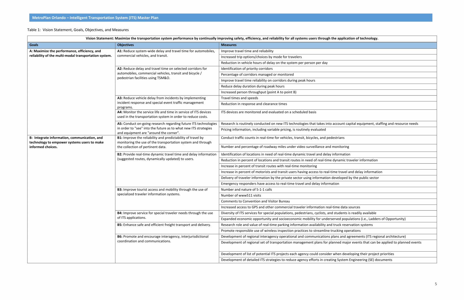
The Steering Committee’s response to the survey questionnaire included many recommended objectives and measures. The survey is included in Appendix B. Those survey responses, along with other possible options identified during the literature and documents research, were used to develop the following objectives and measures listed below under each of the four goals. Table 1 shows the final objectives and measures for each of the goals.
5
MetroPlan Orlando – Intelligent Transportation System (ITS) Master Plan
Table 1: Vision Statement, Goals, Objectives, and Measures
Vision Statement: Maximize the transportation system performance by continually improving safety, efficiency, and reliability for all systems users through the application of technology.
Goals Objectives Measures
A: Maximize the performance, efficiency, and reliability of the multi-modal transportation system.
A1: Reduce system-wide delay and travel time for automobiles, commercial vehicles, and transit.
Improve travel time and reliability Increased trip options/choices by mode for travelers Reduction in vehicle hours of delay on the system per person per day
A2: Reduce delay and travel time on selected corridors for automobiles, commercial vehicles, transit and bicycle / pedestrian facilities using TSM&O.
Identification of priority corridors Percentage of corridors managed or monitored Improve travel time reliability on corridors during peak hours Reduce delay duration during peak hours Increased person throughput (point A to point B)
A3: Reduce vehicle delay from incidents by implementing incident response and special event traffic management programs.
Travel times and speeds Reduction in response and clearance times
A4: Monitor the service life and time in service of ITS devices used in the transportation system in order to reduce costs.
ITS devices are monitored and evaluated on a scheduled basis
A5: Conduct on-going research regarding future ITS technologies in order to "see" into the future as to what new ITS strategies and equipment are "around the corner".
Research is routinely conducted on new ITS technologies that takes into account capital equipment, staffing and resource needs Pricing information, including variable pricing, is routinely evaluated
B: Integrate information, communication, and technology to empower systems users to make informed choices.
B1: Improve the reliability and predictability of travel by monitoring the use of the transportation system and through the collection of pertinent data.
Conduct traffic counts in real-time for vehicles, transit, bicycles, and pedestrians
Number and percentage of roadway miles under video surveillance and monitoring
B2: Provide real-time dynamic travel time and delay information (suggested routes, dynamically updated) to users.
Identification of locations in need of real-time dynamic travel and delay information Reduction in percent of locations and transit routes in need of real-time dynamic traveler information Increase in percent of transit routes with real-time monitoring Increase in percent of motorists and transit users having access to real-time travel and delay information Delivery of traveler information by the private sector using information developed by the public sector Emergency responders have access to real-time travel and delay information
B3: Improve tourist access and mobility through the use of specialized traveler information systems.
Number and nature of 5-1-1 calls Number of www511 visits Comments to Convention and Visitor Bureau Increased access to GPS and other commercial traveler information real-time data sources
B4: Improve service for special traveler needs through the use of ITS applications.
Diversity of ITS services for special populations, pedestrians, cyclists, and students is readily available Expanded economic opportunity and socioeconomic mobility for underserved populations (i.e., Ladders of Opportunity)
B5: Enhance safe and efficient freight transport and delivery. Research role and value of real-time parking information availability and truck reservation systems Promote responsible use of wireless inspection practices to streamline trucking operations
B6: Promote and encourage interagency, interjurisdictional coordination and communications.
Development of regional interagency operational and communications plans and agreements (ITS regional architecture) Development of regional set of transportation management plans for planned major events that can be applied to planned events
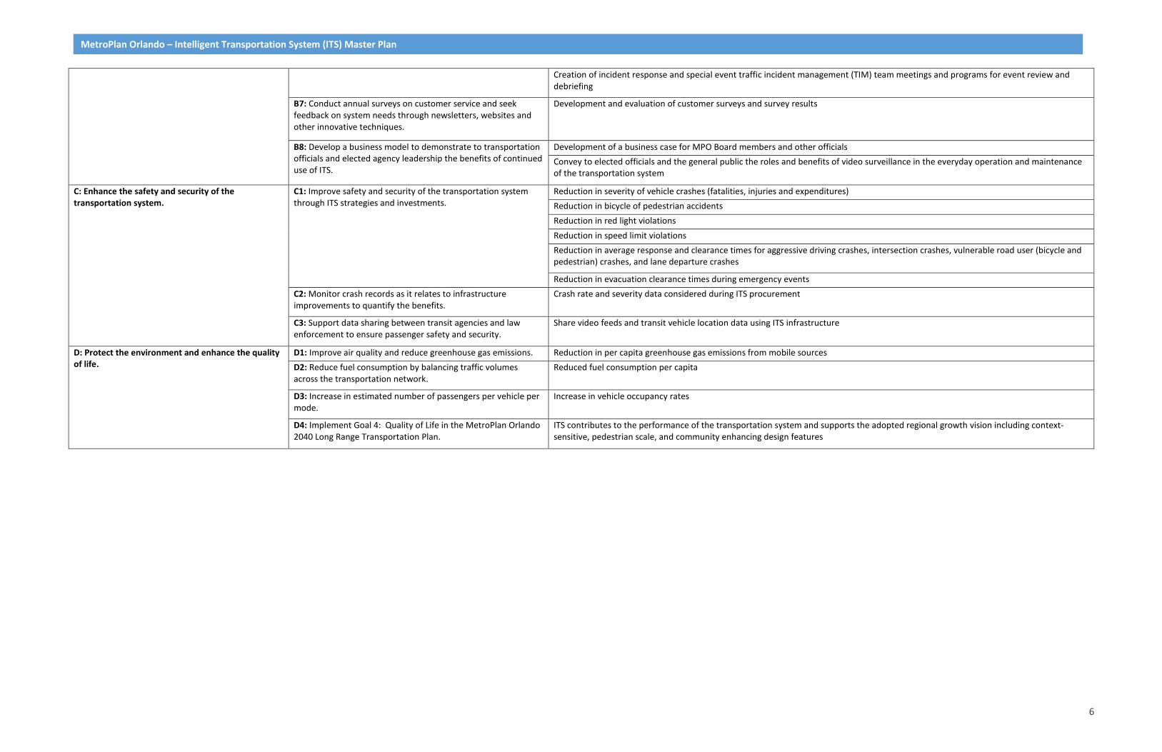
Development of list of potential ITS projects each agency could consider when developing their project priorities Development of detailed ITS strategies to reduce agency efforts in creating System Engineering (SE) documents
6
MetroPlan Orlando – Intelligent Transportation System (ITS) Master Plan
Creation of incident response and special event traffic incident management (TIM) team meetings and programs for event review and debriefing
B7: Conduct annual surveys on customer service and seek feedback on system needs through newsletters, websites and other innovative techniques.
Development and evaluation of customer surveys and survey results
B8: Develop a business model to demonstrate to transportation officials and elected agency leadership the benefits of continued use of ITS.
Development of a business case for MPO Board members and other officials Convey to elected officials and the general public the roles and benefits of video surveillance in the everyday operation and maintenance of the transportation system
C: Enhance the safety and security of the transportation system.
C1: Improve safety and security of the transportation system through ITS strategies and investments.
Reduction in severity of vehicle crashes (fatalities, injuries and expenditures) Reduction in bicycle of pedestrian accidents Reduction in red light violations Reduction in speed limit violations Reduction in average response and clearance times for aggressive driving crashes, intersection crashes, vulnerable road user (bicycle and pedestrian) crashes, and lane departure crashes
Reduction in evacuation clearance times during emergency events C2: Monitor crash records as it relates to infrastructure improvements to quantify the benefits.
Crash rate and severity data considered during ITS procurement
C3: Support data sharing between transit agencies and law enforcement to ensure passenger safety and security.
Share video feeds and transit vehicle location data using ITS infrastructure
D: Protect the environment and enhance the quality of life.
D1: Improve air quality and reduce greenhouse gas emissions. Reduction in per capita greenhouse gas emissions from mobile sources D2: Reduce fuel consumption by balancing traffic volumes across the transportation network.
Reduced fuel consumption per capita
D3: Increase in estimated number of passengers per vehicle per mode.
Increase in vehicle occupancy rates
D4: Implement Goal 4: Quality of Life in the MetroPlan Orlando 2040 Long Range Transportation Plan.
ITS contributes to the performance of the transportation system and supports the adopted regional growth vision including context-sensitive, pedestrian scale, and community enhancing design features
7
METROPLAN ORLANDO – INTELLIGENT TRANSPORTATION SYSTEM (ITS) MASTER PLAN
2 Existing Conditions Report
Inventories of existing ITS infrastructure for the City of Orlando and each of the three counties (as well as cities within Orange County and LYNX, FDOT and Central Florida Expressway (CFX)) were obtained through stakeholder interviews with officials from each municipality, as well as GIS information provided by each agency where available. It should be noted that inventories of ITS infrastructure continue to change and this report reflects information available at the time of stakeholder response.
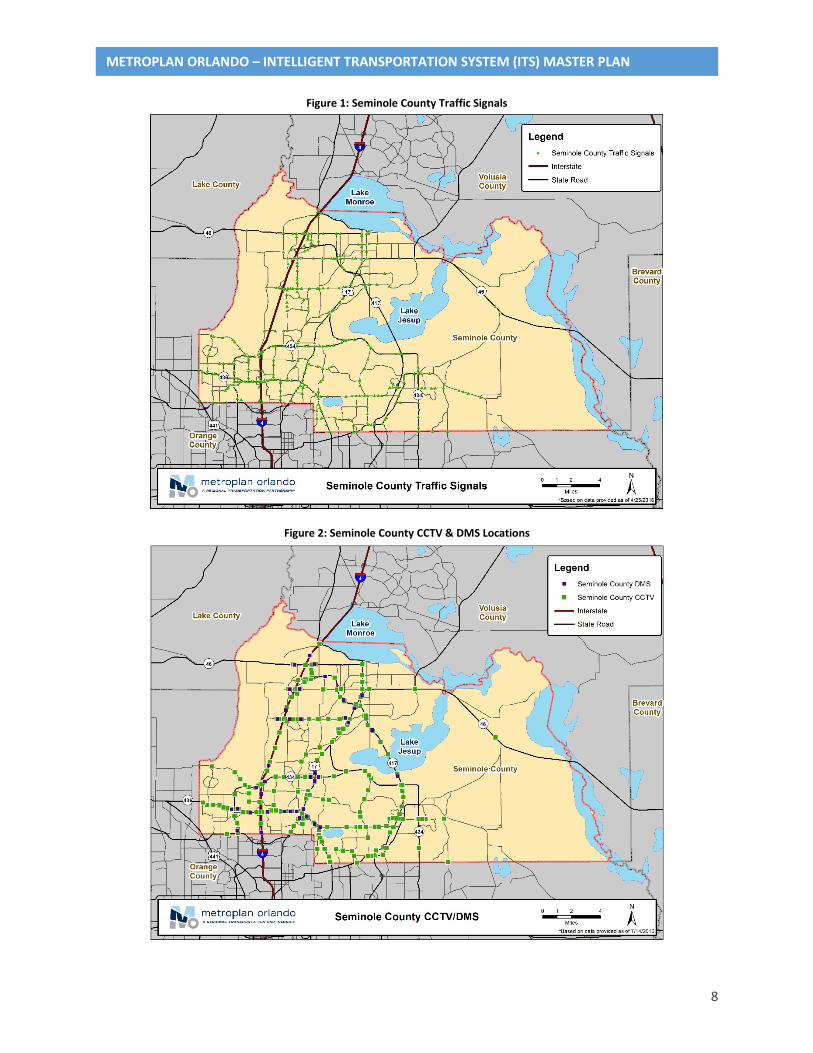
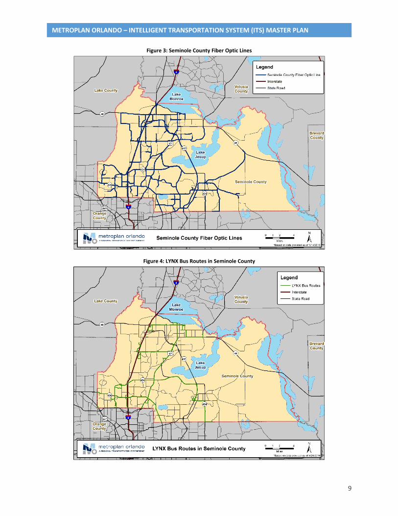
2.1 Seminole County Seminole County operates and maintains 385 traffic signals from a central TMC location. 282 of these signals are coordinated. The majority of the traffic signals (369) in the county communicate via fiber, yet a small number (12) communicate using radio signal. A staff of 9 technicians and 2 engineers oversee traffic signal maintenance. GIS files containing detailed traffic signal information and fiber lines are maintained and available through the county.
Other ITS deployments include upgraded cabinets, controllers (ATC) and switches, Bluetooth devices and rollout of adaptive signal control on select corridors. Equipment and hardware nearing the end of their useful life cycle include Variable/Dynamic Message Signs (DMS). Camera (CCTV) coverage is provided predominantly by FDOT cameras installed on state facilities, and adaptive control systems employ both video detection and in-ground loops. Traffic signals are equipped for Transit Signal Priority (TSP) and use Infrared detection for emergency preemption functions. Figures 1 through 4 show the ITS network through Seminole County.
Funding for ITS activities and signal system operations are provided by funds allocated by MetroPlan Orlando, the County sales tax and various maintenance agreements with FDOT and other local cities within the County.
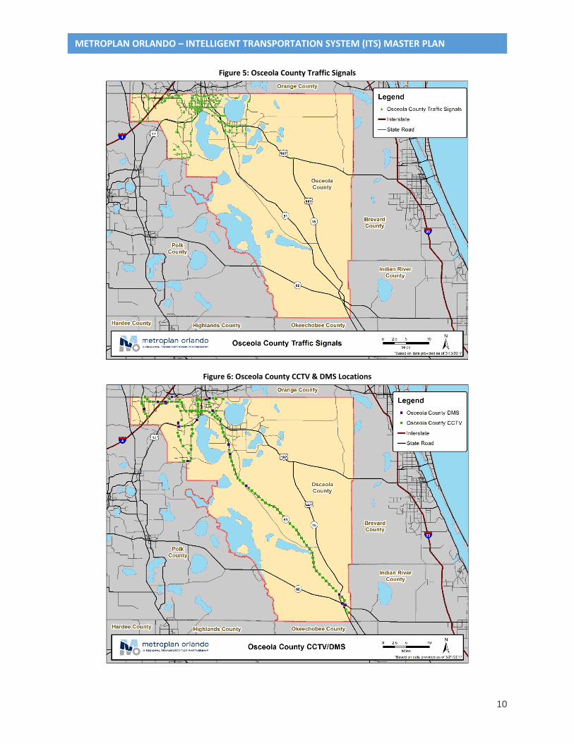
2.2 Osceola County Osceola County operates and maintains 116 signals which are interconnected on approximately 80 miles of fiber optic lines. In addition, the County’s ITS program includes 71 CCTVs, 6 DMS and 10 Bluetooth readers, and 18 miles of fiber optic cable along Poinciana Parkway. Operations and Maintenance staff for Osceola County’s system include one International Municipal Signal Association (IMSA) certified employees. Network maintenance is conducted by contract employees, and the Traffic Management Center (TMC) is operated by a staff of four (4) including engineers and operators. Osceola County uses Econolite controllers.
The City of Kissimmee performs preventative maintenance for the traffic signals within the City limits and the City of St. Cloud. GIS files containing detailed traffic signal information and fiber lines are maintained and available through the County. Each jurisdiction is responsible for operations and maintenance within their jurisdiction. All fiber and ITS related equipment is maintained and operated by the County.
Funding sources for the signal/ITS system include funds allocated through MetroPlan Orlando, various grants and other County funds. Figures 5 through 8 show the ITS network through Osceola County.
8
METROPLAN ORLANDO – INTELLIGENT TRANSPORTATION SYSTEM (ITS) MASTER PLAN
Figure 1: Seminole County Traffic Signals
Figure 2: Seminole County CCTV & DMS Locations
9
METROPLAN ORLANDO – INTELLIGENT TRANSPORTATION SYSTEM (ITS) MASTER PLAN
Figure 3: Seminole County Fiber Optic Lines
Figure 4: LYNX Bus Routes in Seminole County
10
METROPLAN ORLANDO – INTELLIGENT TRANSPORTATION SYSTEM (ITS) MASTER PLAN
Figure 5: Osceola County Traffic Signals
Figure 6: Osceola County CCTV & DMS Locations

11
METROPLAN ORLANDO – INTELLIGENT TRANSPORTATION SYSTEM (ITS) MASTER PLAN
Figure 7: Osceola County Fiber Optic Lines
Figure 8: LYNX Bus Routes in Osceola County
12
METROPLAN ORLANDO – INTELLIGENT TRANSPORTATION SYSTEM (ITS) MASTER PLAN
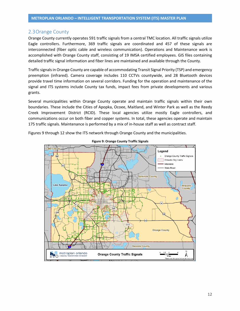
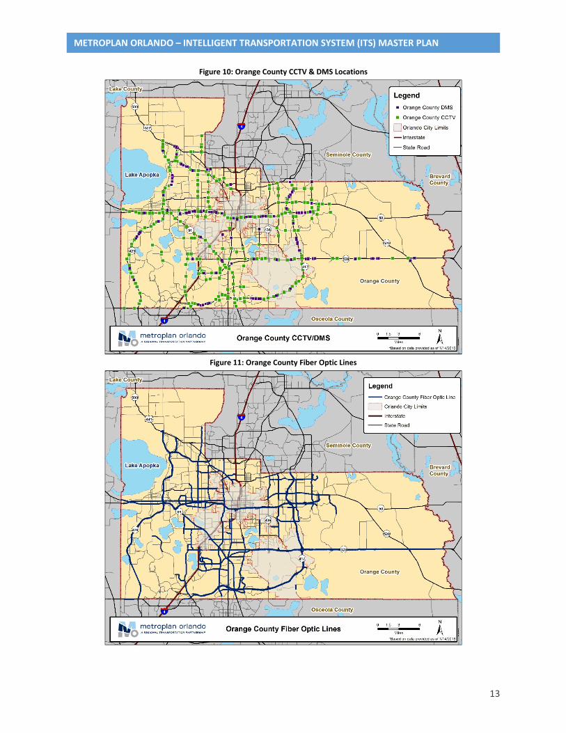
2.3 Orange County Orange County currently operates 591 traffic signals from a central TMC location. All traffic signals utilize Eagle controllers. Furthermore, 369 traffic signals are coordinated and 457 of these signals are interconnected (fiber optic cable and wireless communication). Operations and Maintenance work is accomplished with Orange County staff, consisting of 19 IMSA certified employees. GIS files containing detailed traffic signal information and fiber lines are maintained and available through the County.
Traffic signals in Orange County are capable of accommodating Transit Signal Priority (TSP) and emergency preemption (infrared). Camera coverage includes 110 CCTVs countywide, and 28 Bluetooth devices provide travel time information on several corridors. Funding for the operation and maintenance of the signal and ITS systems include County tax funds, impact fees from private developments and various grants.
Several municipalities within Orange County operate and maintain traffic signals within their own boundaries. These include the Cities of Apopka, Ocoee, Maitland, and Winter Park as well as the Reedy Creek Improvement District (RCID). These local agencies utilize mostly Eagle controllers, and communications occur on both fiber and copper systems. In total, these agencies operate and maintain 175 traffic signals. Maintenance is performed by a mix of in-house staff as well as contract staff.
Figures 9 through 12 show the ITS network through Orange County and the municipalities.
Figure 9: Orange County Traffic Signals
13
METROPLAN ORLANDO – INTELLIGENT TRANSPORTATION SYSTEM (ITS) MASTER PLAN
Figure 10: Orange County CCTV & DMS Locations
Figure 11: Orange County Fiber Optic Lines

14
METROPLAN ORLANDO – INTELLIGENT TRANSPORTATION SYSTEM (ITS) MASTER PLAN
Figure 12: LYNX Bus Routes in Orange County
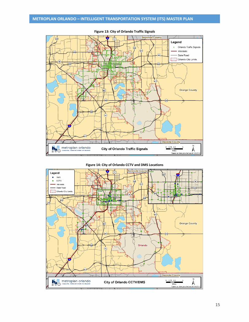
2.4 City of Orlando The City of Orlando operates and maintains 537 traffic signals within the City limits. The City uses Naztec controllers with approximately 85% of these signals interconnected. Communication is primarily through fiber optic lines, but several systems still use copper and radio signals. Current staff includes seven (7) TMC employees and ten (10) field maintenance staff. Additional ITS equipment includes 102 CCTVs, 11 DMSs and 85 Bluetooth readers (an additional 80 to 100 readers are planned within the next 5 years).
The City’s GIS files have good information on traffic signals but the data on communication lines is not up-to-date.
Funding sources include allocations through MetroPlan Orlando, FDOT and the City’s capital monies. Figures 13 through 16 show the ITS network through the City of Orlando.
15
METROPLAN ORLANDO – INTELLIGENT TRANSPORTATION SYSTEM (ITS) MASTER PLAN
Figure 13: City of Orlando Traffic Signals
Figure 14: City of Orlando CCTV and DMS Locations

16
METROPLAN ORLANDO – INTELLIGENT TRANSPORTATION SYSTEM (ITS) MASTER PLAN
Figure 15: City of Orlando Fiber Optic Lines
Figure 16: LYNX Bus Routes in the City of Orlando
17
METROPLAN ORLANDO – INTELLIGENT TRANSPORTATION SYSTEM (ITS) MASTER PLAN
2.5 LYNX LYNX, the Central Florida Regional Transportation Authority, serves the Central Florida area with fixed-bus routes and Bus Rapid Transit (LYMMO) in downtown Orlando. Average weekday ridership is in excess of 100,000 riders systemwide and most routes are served every 30 minutes. The fixed-bus routes are shown in Figures 4, 8, 12, and 16 above.
2.6 Central Florida Expressway Authority CFX has approximately 200 miles of fiber optic communications lines along the expressways under their jurisdiction. These expressways include SR 408, SR 414, SR 417, SR 429, SR 451, and SR 528. CFX also has 178 CCTVs, 93 DMSs, 400 AVIs, and 162 MVDS along these roads. These features are included in Figures 2, 3, 6, 7, 10, 11, and 14 above.
2.7 Florida Department of Transportation The Florida Department of Transportation (FDOT) has many miles of fiber optic communications lines and numerous CCTVs, DMSs, AVIs, MVDS, and Bluetooth devices on Interstate 4 and the various State Roads throughout the MetroPlan Orlando area. The exact quantities of these features are changing due to the ongoing I-4 Ultimate construction project. These features are included in Figures 2, 3, 6, 7, 10, 11, 14, and 15 above.
2.8 Park & Ride Facilities FDOT provides several Park & Ride facilities throughout the MetroPlan Orlando area, although there are no ITS features associated with these facilities. These lots serve as common meeting points for carpool or vanpool groups. In addition, several SunRail stations also provide Park & Ride Lots.
2.9 Traffic Management Centers In MetroPlan Orlando Separate Traffic Management Centers in the area include the FDOT District 5 Regional Traffic Management Center (RTMC) along with a TMC in each of the three counties (Seminole, Orange, Osceola), the City of Orlando, and CFX. Each of these TMC’s operate independently of one another, although camera feeds are shared to and from the FDOT RTMC. Camera feeds from the RTMC are also used in broadcasts by the local television stations.
18
METROPLAN ORLANDO – INTELLIGENT TRANSPORTATION SYSTEM (ITS) MASTER PLAN
3 Needs Assessment
The Needs Assessment was developed based on the information gathered from Task 1: ITS Vision, Goals and Objectives and Task 2: Existing Conditions/Infrastructure/Inventory (summarized in Sections 1 and 2 of this document), comments received from the Steering Committee, review of the Regional ITS architecture, and through the assessment of information provided by the Stakeholders. This Section is structured as follows: the Needs Determination section includes the needs from the sources above, the needs are then grouped, summarized in the Needs Summary section and defined in the Needs Description section. The Needs Assessment, in addition to the information from Task 1 and Task 2, was used to develop the ITS strategies as part of Task 4: Identification of Applicable ITS Strategies.
3.1 Needs Determination 3.1.1 Stakeholder Interview Needs
The following are is a list of the project Stakeholders:
• Seminole County • Osceola County • Orange County • City of Orlando • LYNX • CFX • FDOT District 5 • City of Apopka • City of Kissimmee
• City of Maitland • City of Ocoee • City of Winter Garden • City of Winter Park • Florida’s Turnpike • Reedy Creek Improvement District
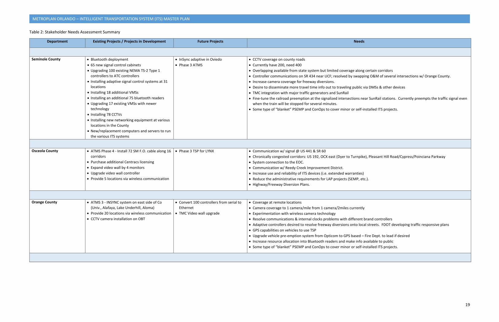
Table 2 summarizes the needs as indicated in the face-to-face meetings held as part of Tasks 1 and 2.
19
METROPLAN ORLANDO – INTELLIGENT TRANSPORTATION SYSTEM (ITS) MASTER PLAN
Table 2: Stakeholder Needs Assessment Summary
Department Existing Projects / Projects in Development Future Projects Needs
Seminole County • Bluetooth deployment • 65 new signal control cabinets • Upgrading 100 existing NEMA TS-2 Type 1
controllers to ATC controllers • Installing adaptive signal control systems at 31
locations • Installing 18 additional VMSs • Installing an additional 75 bluetooth readers • Upgrading 17 existing VMSs with newer
technology • Installing 78 CCTVs • Installing new networking equipment at various
locations in the County • New/replacement computers and servers to run
the various ITS systems
• InSync adaptive in Oviedo • Phase 3 ATMS
• CCTV coverage on county roads • Currently have 200, need 400 • Overlapping available from state system but limited coverage along certain corridors • Controller communications on SR 434 near UCF; resolved by swapping O&M of several intersections w/ Orange County. • Increase camera coverage for freeway diversions. • Desire to disseminate more travel time info out to traveling public via DMSs & other devices • TMC integration with major traffic generators and SunRail • Fine-tune the railroad preemption at the signalized intersections near SunRail stations. Currently preempts the traffic signal even
when the train will be stopped for several minutes. • Some type of “blanket” PSEMP and ConOps to cover minor or self-installed ITS projects.
Osceola County • ATMS Phase 4 - Install 72 SM F.O. cable along 16 corridors
• Purchase additional Centracs licensing • Expand video wall by 4 monitors • Upgrade video wall controller • Provide 5 locations via wireless communication
• Phase 3 TSP for LYNX • Communication w/ signal @ US 441 & SR 60 • Chronically congested corridors: US 192, OCX east (Dyer to Turnpike), Pleasant Hill Road/Cypress/Poinciana Parkway • System connection to the EOC. • Communication w/ Reedy Creek Improvement District. • Increase use and reliability of ITS devices (i.e. extended warranties) • Reduce the administrative requirements for LAP projects (SEMP, etc.). • Highway/Freeway Diversion Plans.
Orange County • ATMS 3 - INSYNC system on east side of Co (Univ., Alafaya, Lake Underhill, Aloma)
• Provide 20 locations via wireless communication • CCTV camera installation on OBT
• Convert 100 controllers from serial to Ethernet
• TMC Video wall upgrade
• Coverage at remote locations • Camera coverage to 1 camera/mile from 1 camera/2miles currently • Experimentation with wireless camera technology • Resolve communications & internal clocks problems with different brand controllers • Adaptive controllers desired to resolve freeway diversions onto local streets. FDOT developing traffic responsive plans • GPS capabilities on vehicles to use TSP • Upgrade vehicle pre-emption system from Opticom to GPS based – Fire Dept. to lead if desired • Increase resource allocation into Bluetooth readers and make info available to public • Some type of “blanket” PSEMP and ConOps to cover minor or self-installed ITS projects.
20
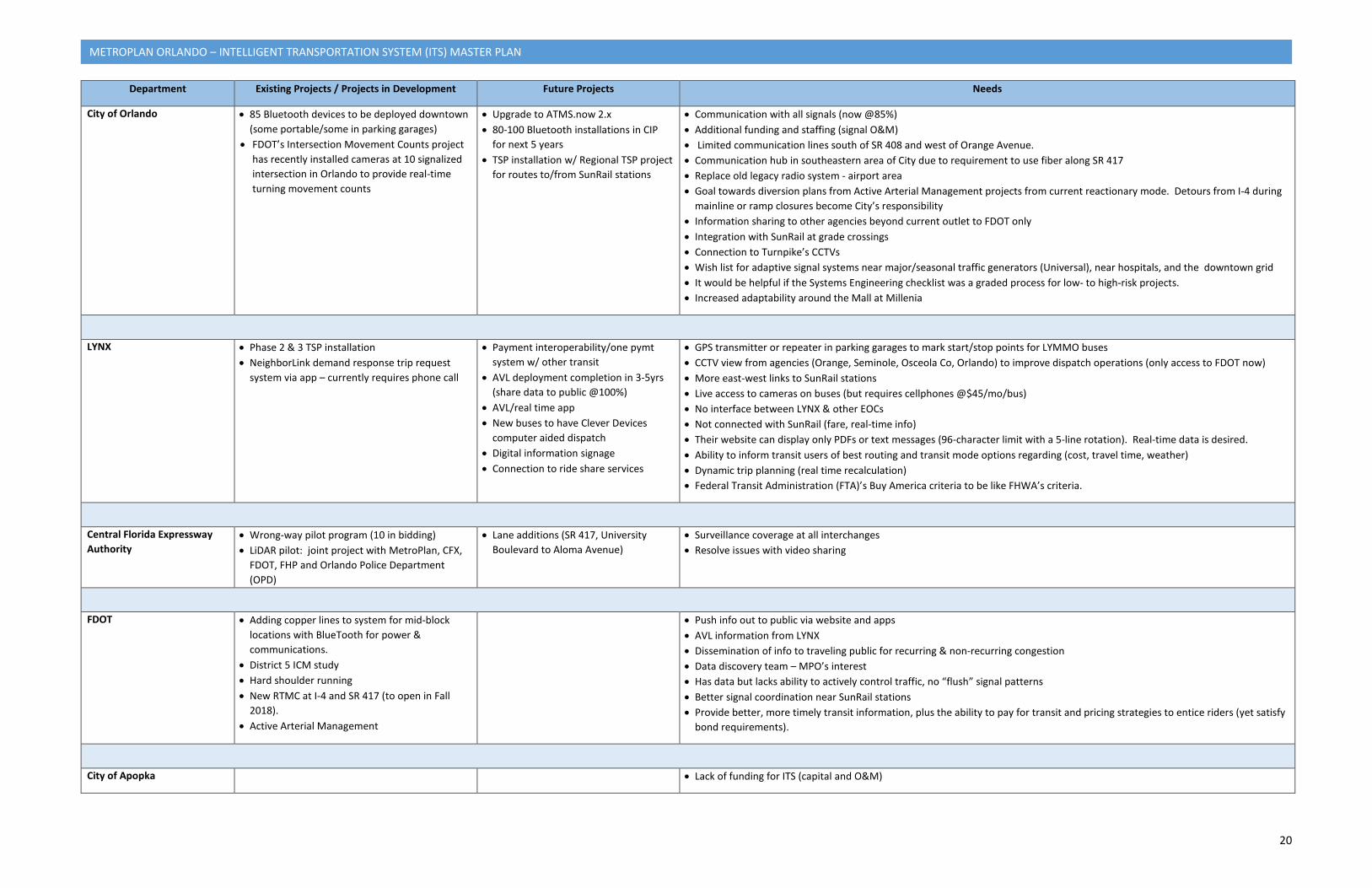
METROPLAN ORLANDO – INTELLIGENT TRANSPORTATION SYSTEM (ITS) MASTER PLAN
Department Existing Projects / Projects in Development Future Projects Needs
City of Orlando • 85 Bluetooth devices to be deployed downtown (some portable/some in parking garages)
• FDOT’s Intersection Movement Counts project has recently installed cameras at 10 signalized intersection in Orlando to provide real-time turning movement counts
• Upgrade to ATMS.now 2.x • 80-100 Bluetooth installations in CIP
for next 5 years • TSP installation w/ Regional TSP project
for routes to/from SunRail stations
• Communication with all signals (now @85%) • Additional funding and staffing (signal O&M) • Limited communication lines south of SR 408 and west of Orange Avenue. • Communication hub in southeastern area of City due to requirement to use fiber along SR 417 • Replace old legacy radio system - airport area • Goal towards diversion plans from Active Arterial Management projects from current reactionary mode. Detours from I-4 during
mainline or ramp closures become City’s responsibility • Information sharing to other agencies beyond current outlet to FDOT only • Integration with SunRail at grade crossings • Connection to Turnpike’s CCTVs • Wish list for adaptive signal systems near major/seasonal traffic generators (Universal), near hospitals, and the downtown grid • It would be helpful if the Systems Engineering checklist was a graded process for low- to high-risk projects. • Increased adaptability around the Mall at Millenia
LYNX • Phase 2 & 3 TSP installation • NeighborLink demand response trip request
system via app – currently requires phone call
• Payment interoperability/one pymt system w/ other transit
• AVL deployment completion in 3-5yrs (share data to public @100%)
• AVL/real time app • New buses to have Clever Devices
computer aided dispatch • Digital information signage • Connection to ride share services
• GPS transmitter or repeater in parking garages to mark start/stop points for LYMMO buses • CCTV view from agencies (Orange, Seminole, Osceola Co, Orlando) to improve dispatch operations (only access to FDOT now) • More east-west links to SunRail stations • Live access to cameras on buses (but requires cellphones @$45/mo/bus) • No interface between LYNX & other EOCs • Not connected with SunRail (fare, real-time info) • Their website can display only PDFs or text messages (96-character limit with a 5-line rotation). Real-time data is desired. • Ability to inform transit users of best routing and transit mode options regarding (cost, travel time, weather) • Dynamic trip planning (real time recalculation) • Federal Transit Administration (FTA)’s Buy America criteria to be like FHWA’s criteria.
Central Florida Expressway Authority
• Wrong-way pilot program (10 in bidding) • LiDAR pilot: joint project with MetroPlan, CFX,
FDOT, FHP and Orlando Police Department (OPD)
• Lane additions (SR 417, University Boulevard to Aloma Avenue)
• Surveillance coverage at all interchanges • Resolve issues with video sharing
FDOT • Adding copper lines to system for mid-block locations with BlueTooth for power & communications.
• District 5 ICM study • Hard shoulder running • New RTMC at I-4 and SR 417 (to open in Fall
2018). • Active Arterial Management
• Push info out to public via website and apps • AVL information from LYNX • Dissemination of info to traveling public for recurring & non-recurring congestion • Data discovery team – MPO’s interest • Has data but lacks ability to actively control traffic, no “flush” signal patterns • Better signal coordination near SunRail stations • Provide better, more timely transit information, plus the ability to pay for transit and pricing strategies to entice riders (yet satisfy
bond requirements).
City of Apopka • Lack of funding for ITS (capital and O&M)
21
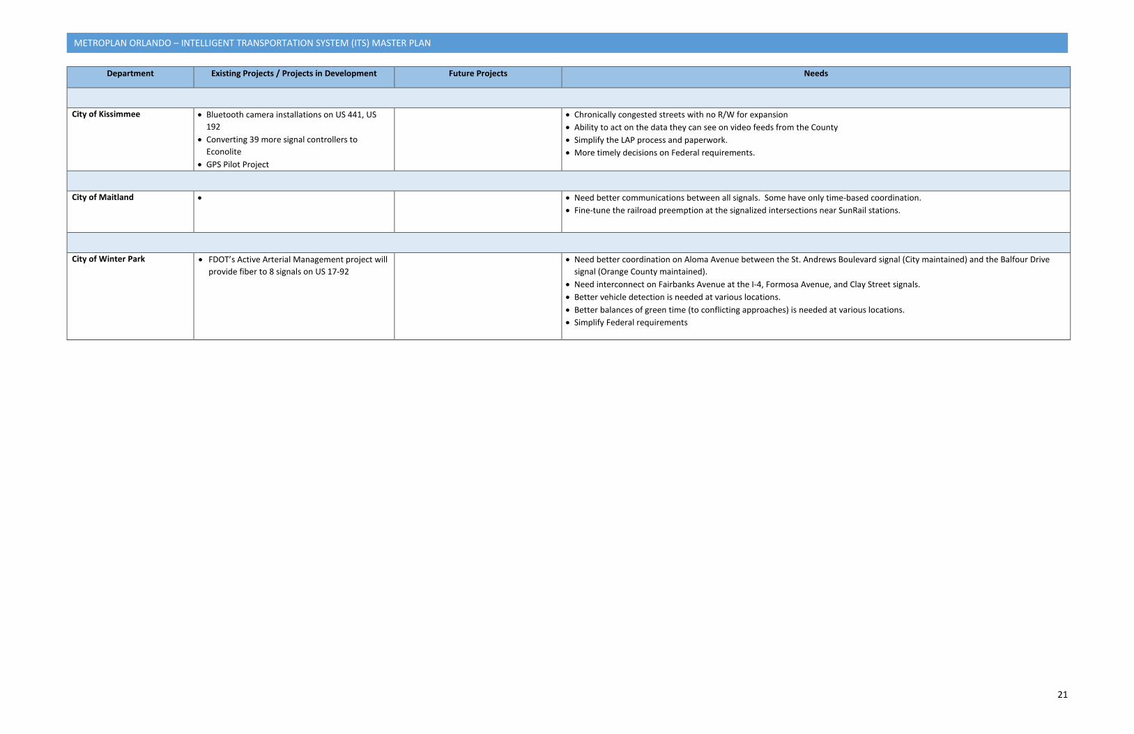
METROPLAN ORLANDO – INTELLIGENT TRANSPORTATION SYSTEM (ITS) MASTER PLAN
Department Existing Projects / Projects in Development Future Projects Needs
City of Kissimmee • Bluetooth camera installations on US 441, US 192
• Converting 39 more signal controllers to Econolite
• GPS Pilot Project
• Chronically congested streets with no R/W for expansion • Ability to act on the data they can see on video feeds from the County • Simplify the LAP process and paperwork. • More timely decisions on Federal requirements.
City of Maitland • • Need better communications between all signals. Some have only time-based coordination. • Fine-tune the railroad preemption at the signalized intersections near SunRail stations.
City of Winter Park • FDOT’s Active Arterial Management project will provide fiber to 8 signals on US 17-92
• Need better coordination on Aloma Avenue between the St. Andrews Boulevard signal (City maintained) and the Balfour Drive signal (Orange County maintained).
• Need interconnect on Fairbanks Avenue at the I-4, Formosa Avenue, and Clay Street signals. • Better vehicle detection is needed at various locations. • Better balances of green time (to conflicting approaches) is needed at various locations. • Simplify Federal requirements
22
METROPLAN ORLANDO – INTELLIGENT TRANSPORTATION SYSTEM (ITS) MASTER PLAN
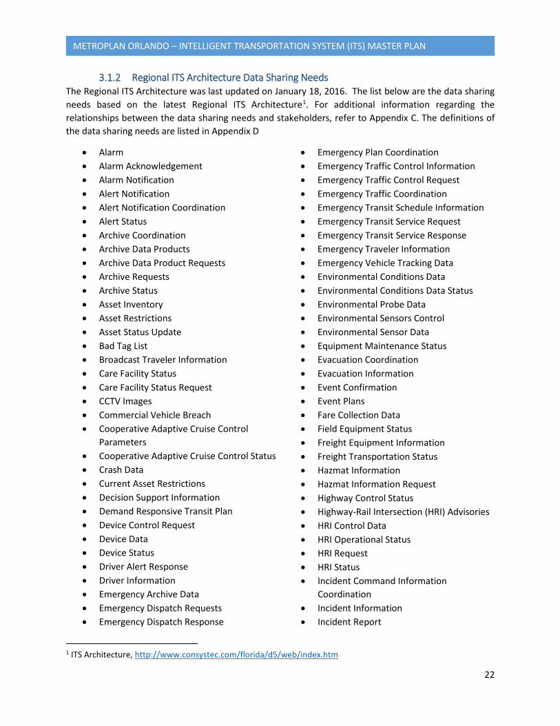
3.1.2 Regional ITS Architecture Data Sharing Needs The Regional ITS Architecture was last updated on January 18, 2016. The list below are the data sharing needs based on the latest Regional ITS Architecture1. For additional information regarding the relationships between the data sharing needs and stakeholders, refer to Appendix C. The definitions of the data sharing needs are listed in Appendix D
• Alarm • Alarm Acknowledgement • Alarm Notification • Alert Notification • Alert Notification Coordination • Alert Status • Archive Coordination • Archive Data Products • Archive Data Product Requests • Archive Requests • Archive Status • Asset Inventory • Asset Restrictions • Asset Status Update • Bad Tag List • Broadcast Traveler Information • Care Facility Status • Care Facility Status Request • CCTV Images • Commercial Vehicle Breach • Cooperative Adaptive Cruise Control
Parameters • Cooperative Adaptive Cruise Control Status • Crash Data • Current Asset Restrictions • Decision Support Information • Demand Responsive Transit Plan • Device Control Request • Device Data • Device Status • Driver Alert Response • Driver Information • Emergency Archive Data • Emergency Dispatch Requests • Emergency Dispatch Response
1 ITS Architecture, http://www.consystec.com/florida/d5/web/index.htm
• Emergency Plan Coordination • Emergency Traffic Control Information • Emergency Traffic Control Request • Emergency Traffic Coordination • Emergency Transit Schedule Information • Emergency Transit Service Request • Emergency Transit Service Response • Emergency Traveler Information • Emergency Vehicle Tracking Data • Environmental Conditions Data • Environmental Conditions Data Status • Environmental Probe Data • Environmental Sensors Control • Environmental Sensor Data • Equipment Maintenance Status • Evacuation Coordination • Evacuation Information • Event Confirmation • Event Plans • Fare Collection Data • Field Equipment Status • Freight Equipment Information • Freight Transportation Status • Hazmat Information • Hazmat Information Request • Highway Control Status • Highway-Rail Intersection (HRI) Advisories • HRI Control Data • HRI Operational Status • HRI Request • HRI Status • Incident Command Information
Coordination • Incident Information • Incident Report
23
METROPLAN ORLANDO – INTELLIGENT TRANSPORTATION SYSTEM (ITS) MASTER PLAN
• Incident Response Coordination • Incident Response Status • Incident Status • Infrastructure Monitoring Sensor Control • Infrastructure Monitoring Sensor Data • Intermodal Freight Archive Data • Intermodal Freight Event Information • Intermodal Freight Traffic Confirmation • Intersection Status • Local Signal Priority Request • Local Signal Preemption Request • Maintenance and Construction Dispatch
Information • Maintenance and Construction Dispatch
Status • Maintenance and Construction Equipment
Repair Status • Maintenance and Construction Fleet
Information • Maintenance and Construction Resource
Coordination • Maintenance and Construction Resource
Request • Maintenance and Construction Resource
Response • Maintenance and Construction Vehicle
Conditions • Maintenance and Construction Vehicle
Location Data • Maintenance and Construction Vehicle
Operational Data • Maintenance and Construction Work Plans • Multimodal Archive Data • Multimodal Crossing Status • Multimodal Information • Multimodal Service Data • On-Board Vehicle Data • On-Board Vehicle Request • Parking Demand Management Request • Parking Demand Management Response • Parking Information • Parking Lot Data Request • Parking Lot Inputs
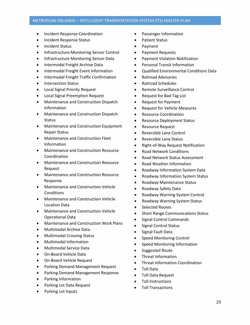
• Passenger Information • Patient Status • Payment • Payment Requests • Payment Violation Notification • Personal Transit Information • Qualified Environmental Conditions Data • Railroad Advisories • Railroad Schedules • Remote Surveillance Control • Request for Bad Tag List • Request for Payment • Request for Vehicle Measures • Resource Coordination • Resource Deployment Status • Resource Request • Reversible Lane Control • Reversible Lane Status • Right-of-Way Request Notification • Road Network Conditions • Road Network Status Assessment • Road Weather Information • Roadway Information System Data • Roadway Information System Status • Roadway Maintenance Status • Roadway Safety Data • Roadway Warning System Control • Roadway Warning System Status • Selected Routes • Short Range Communications Status • Signal Control Commands • Signal Control Status • Signal Fault Data • Speed Monitoring Control • Speed Monitoring Information • Suggested Route • Threat Information • Threat Information Coordination • Toll Data • Toll Data Request • Toll Instructions • Toll Transactions

24
METROPLAN ORLANDO – INTELLIGENT TRANSPORTATION SYSTEM (ITS) MASTER PLAN
• Track Status • Traffic Archive Data • Traffic Control Priority Request • Traffic Flow • Traffic Images • Traffic Information for Media • Traffic Metering Control • Traffic Metering Status • Traffic Probe Data • Traffic Sensor Control • Traffic Violation Notification • Traveler Information for Media • Transaction Status • Transit Archive Data • Transit and Fare Schedules • Transit Emergency Data • Transit Fare Coordination • Transit Fare and Passenger Status • Transit Fare Information • Transit Incident Information • Transit Information Request • Transit Information User Request • Transit Multimodal Information • Transit Schedule Adherence Information • Transit Schedule Information • Transit Service Coordination • Transit System Status Assessment
• Transit Traveler Information • Transit Traveler Request • Transit User Information • Transit Vehicle Conditions • Transit Vehicle Loading Data • Transit Vehicle Location Data • Transit Vehicle Operator Information • Transit Vehicle Schedule Performance • Transportation Information for Operations • Transportation System Status • Traveler Archive Data • Vehicle Intersection Safety Data • Vehicle Location and Motion • Vehicle Payment Information • Vehicle Payment Request • Vehicle Payment Update • Vehicle Platoon Coordination • Vehicle Profile • Vehicle Signage Data • Video Surveillance Control • Weather Information • Work Plan Coordination • Work Plan Feedback • Work Zone Information • Work Zone Status • Work Zone Warning Information • Work Zone Warning Status
3.1.3 Additional Needs The Stakeholder information was the basis for developing the initial ITS needs. Additional needs were generated through interaction with the Steering Committee members, from previous work with similar jurisdictions, and the Regional ITS Architecture. The additional needs are listed below:
• Expand existing traffic operations communications • Upgrade existing communications • Center-to-center link to neighboring agencies • Automatic detection of traffic equipment malfunction • Expand system detection • TMC equipment upgrade • Interagency incident management • Real time transit arrival and departure information • Improved traffic management in work zones
25
METROPLAN ORLANDO – INTELLIGENT TRANSPORTATION SYSTEM (ITS) MASTER PLAN
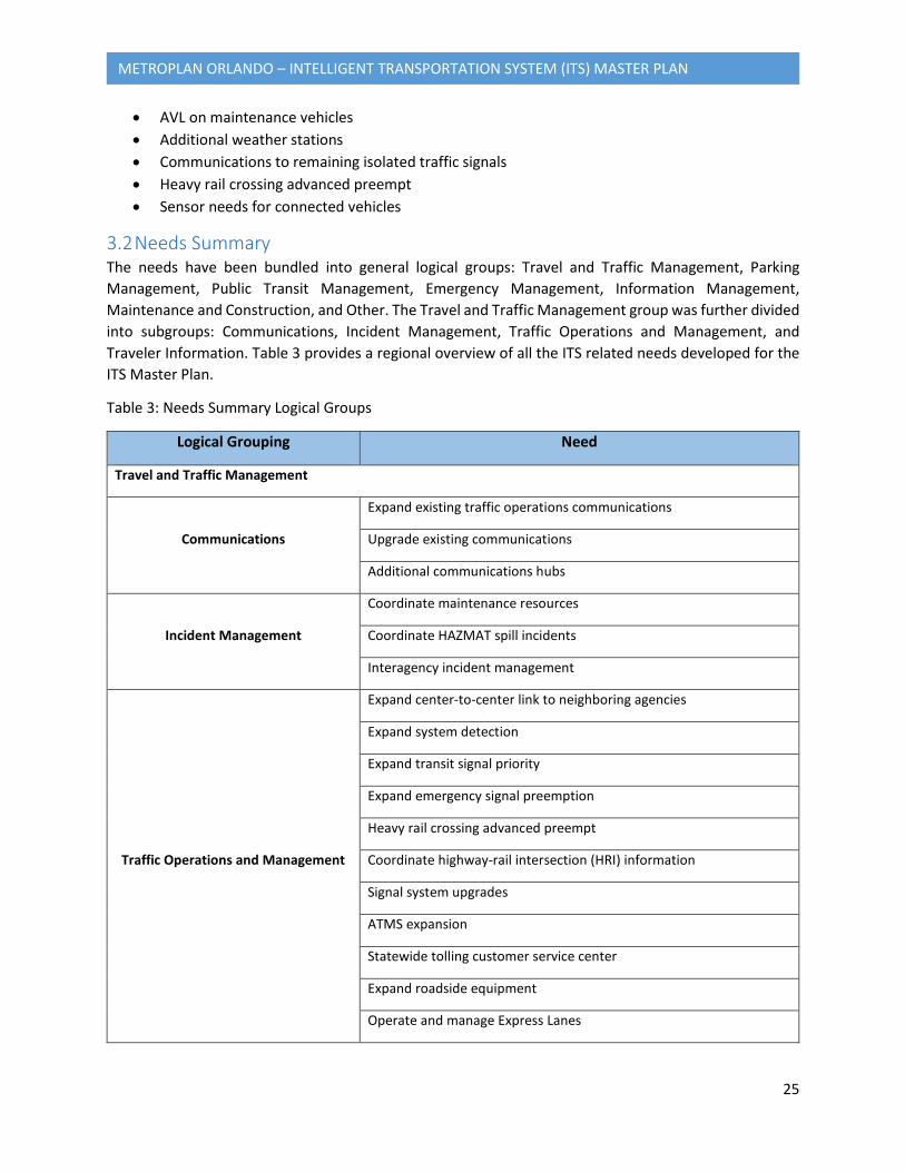
• AVL on maintenance vehicles • Additional weather stations • Communications to remaining isolated traffic signals • Heavy rail crossing advanced preempt • Sensor needs for connected vehicles
3.2 Needs Summary The needs have been bundled into general logical groups: Travel and Traffic Management, Parking Management, Public Transit Management, Emergency Management, Information Management, Maintenance and Construction, and Other. The Travel and Traffic Management group was further divided into subgroups: Communications, Incident Management, Traffic Operations and Management, and Traveler Information. Table 3 provides a regional overview of all the ITS related needs developed for the ITS Master Plan.
Table 3: Needs Summary Logical Groups
Logical Grouping Need
Travel and Traffic Management
Communications
Expand existing traffic operations communications
Upgrade existing communications
Additional communications hubs
Incident Management
Coordinate maintenance resources
Coordinate HAZMAT spill incidents
Interagency incident management
Traffic Operations and Management
Expand center-to-center link to neighboring agencies
Expand system detection
Expand transit signal priority
Expand emergency signal preemption
Heavy rail crossing advanced preempt
Coordinate highway-rail intersection (HRI) information
Signal system upgrades
ATMS expansion
Statewide tolling customer service center
Expand roadside equipment
Operate and manage Express Lanes
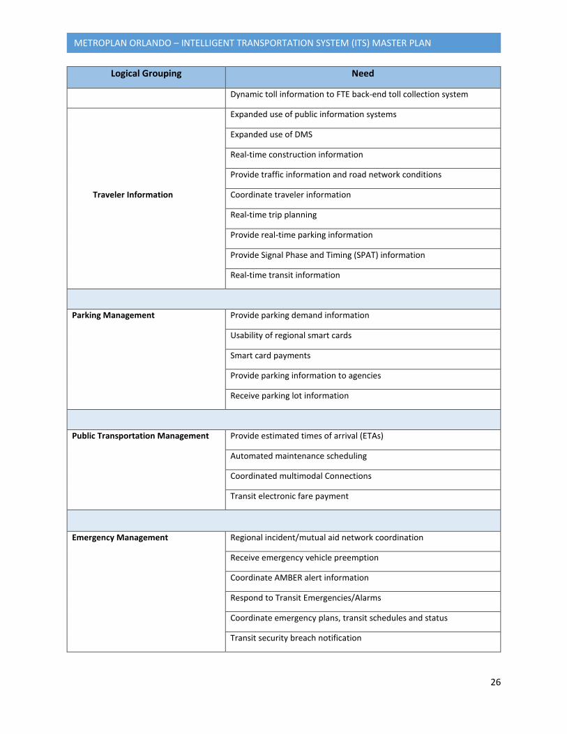
26
METROPLAN ORLANDO – INTELLIGENT TRANSPORTATION SYSTEM (ITS) MASTER PLAN
Logical Grouping Need
Dynamic toll information to FTE back-end toll collection system
Traveler Information
Expanded use of public information systems
Expanded use of DMS
Real-time construction information
Provide traffic information and road network conditions
Coordinate traveler information
Real-time trip planning
Provide real-time parking information
Provide Signal Phase and Timing (SPAT) information
Real-time transit information
Parking Management Provide parking demand information
Usability of regional smart cards
Smart card payments
Provide parking information to agencies
Receive parking lot information
Public Transportation Management Provide estimated times of arrival (ETAs)
Automated maintenance scheduling
Coordinated multimodal Connections
Transit electronic fare payment
Emergency Management Regional incident/mutual aid network coordination
Receive emergency vehicle preemption
Coordinate AMBER alert information
Respond to Transit Emergencies/Alarms
Coordinate emergency plans, transit schedules and status
Transit security breach notification
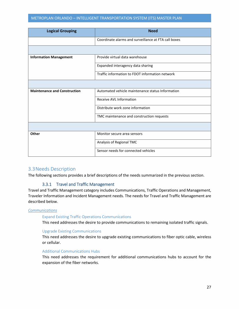
27
METROPLAN ORLANDO – INTELLIGENT TRANSPORTATION SYSTEM (ITS) MASTER PLAN
Logical Grouping Need
Coordinate alarms and surveillance at FTA call boxes
Information Management Provide virtual data warehouse
Expanded interagency data sharing
Traffic information to FDOT information network
Maintenance and Construction Automated vehicle maintenance status Information
Receive AVL Information
Distribute work zone information
TMC maintenance and construction requests
Other Monitor secure area sensors
Analysis of Regional TMC
Sensor needs for connected vehicles
3.3 Needs Description The following sections provides a brief descriptions of the needs summarized in the previous section.
3.3.1 Travel and Traffic Management Travel and Traffic Management category includes Communications, Traffic Operations and Management, Traveler Information and Incident Management needs. The needs for Travel and Traffic Management are described below.
Communications Expand Existing Traffic Operations Communications This need addresses the desire to provide communications to remaining isolated traffic signals.
Upgrade Existing Communications This need addresses the desire to upgrade existing communications to fiber optic cable, wireless or cellular.
Additional Communications Hubs This need addresses the requirement for additional communications hubs to account for the expansion of the fiber networks.
28
METROPLAN ORLANDO – INTELLIGENT TRANSPORTATION SYSTEM (ITS) MASTER PLAN
Incident Management Coordinate Maintenance Resources This need includes the coordination of maintenance resources for incident response with the county, city, FDOT, and CFX construction and maintenance systems.
Coordinate HAZMAT Spill Incidents This need includes receiving HAZMAT spill notifications from private commercial fleets and coordinating HAZMAT spill incident responses with county and/or local fire/EMS agencies.
Interagency Incident Management This need addresses the desire to perform network surveillance and verification of incidents on county and local roads, and send traffic/incident information and traffic images to county fire/EMS/sheriff agencies, the FHP, the county EOC, and local fire/EMS/police agencies. The video feeds to first responders and other incident management stakeholders could use a video sharing distribution system called Interagency Video and Event Data Distribution System (iVEEDS).
Traffic Operations and Management Expand Center-to-Center Link to Neighboring Agencies This need addresses the desire to have center-to-center links for sharing signal operations information with neighboring agencies.
Expand System Detection This need is to expand the detection system, collect vehicle probe information using roadside equipment and calculate travel times.
Expand Transit Signal Priority This need is to provide transit signal priority for regional transit providers using roadside devices.
Expand Emergency Signal Preemption This need is to provide emergency signal preemption for county and local fire/EMS agencies.
Heavy Rail Crossing Advanced Preempt This need is to provide heavy rail crossing advanced preemption.
Coordinate Highway-Rail Intersection (HRI) Information This needs addresses the coordination efforts for HRI signal adjustments, and the need to provide track status information (e.g., blockage) to rail operators and local traffic operations. This need addresses the signals in the vicinity of the Sunrail stations.
Signal System Upgrades This need is for upgrading select signal corridors to allow for FDOT to operate the corridor. Upgrades may include installation of Adaptive Signal Systems.
ATMS Expansion This need for expanding the Osceola County ATMS to obtain traffic images and traffic flow data from CCTVs and field sensors, and maintain operational control of its own field equipment.
29
METROPLAN ORLANDO – INTELLIGENT TRANSPORTATION SYSTEM (ITS) MASTER PLAN
Statewide Tolling Customer Service Center This need addresses the State of Florida’s desire to operate statewide tolling customer service center.
Expand Roadside Equipment This need addresses the desire to expand roadside equipment to gather additional data from environmental sensors, CCTV surveillance images, and probe data.
Operate and Manage Express Lanes This need is for the future operations and management of the Express Lanes.
Dynamic Toll Information to FTE Back-End Toll Collection System This need is for FDOT’s desire to provide dynamic toll information to FTE back-end toll collection system.
Traveler Information Expanded Use of Public Information Systems This need addresses the expanded use of public information systems maintained by the county, city, public transit, private companies, Florida 511, and the media, in order to provide real-time information to travelers via personal computing devices.
Expanded Use of DMS This need addresses the expanded use of DMS to provide traffic information to travelers. Additional DMS that may be used include ones operated and maintained by CFX.
Real-time Construction Information This need addresses how to provide real-time construction information to travelers via websites. Information that may be shared includes duration, location, closures and detours.
Provide Traffic Information and Road Network Conditions This need provides for the dissemination of traffic information and road network conditions to LYNX transit operations, LYNX paratransit, local emergency management providers, including local fire/EMS/police agencies, FHP, and the county sheriff.
Coordinate Traveler Information This need is in reference to the coordination and sharing of traveler information between all traveler information providers within the region. This need addresses the Transportation-as-a-Service (TaaS), also known as Mobility-as-a-Service (MaaS) or Mobility on Demand (MOD), as mobility solutions combining transportation services from public and private transportation providers.
Real-Time Trip Planning This need addresses the ability for LYNX to provide real-time trip planning capabilities for transit riders based on real-time travel conditions and transit availability.
Provide Real-Time Parking Information This need addresses Orange County’s desire to provide parking information from the OCCC parking facility to travelers using DMS devices while providing parking input to the facility to aide in the coordination/operation of traffic signals at the parking facility.

30
METROPLAN ORLANDO – INTELLIGENT TRANSPORTATION SYSTEM (ITS) MASTER PLAN
Provide Signal Phase and Timing (SPAT) Information This need addresses Seminole County’s desire to provide travelers with SSPAT information using connected Vehicle to Infrastructure (V2I) roadside equipment.
Real-Time Transit Information This need addresses LYNX’s desire to provide real-time transit information for transit riders. Parking
Management Provide Parking Demand Information FDOT, county and city may provide parking demand information to private/public parking facilities to determine parking capacity and traffic impacts.
Usability of Regional Smart Cards This need addresses the desire to provide usability of regional smart cards at facility payment instruments.
Smart Card Payments This need addresses the desire to establish a relationship with financial institutions for smart card payments.
Provide Parking Information to Agencies This need addresses the desire to provide parking information and parking lot reservation abilities to Florida 511 and private sector traveler information services. This need also addresses providing parking information to local area transit systems, including LYNX.
Receive Parking Lot Information This need addresses the City of Orlando’s desire to receive parking lot input from the TMCs in the cities of Daytona Beach, Ocala, and Orlando; the FDOT District 5 RTMC; and the Orange County TMC for coordination of traffic and signalization at parking facilities.
Provide Parking Information to Traveling Public This need addresses the City of Orlando’s desire to provide parking information to the traveling public.
Public Transportation Management The Public Transportation Management category includes needs related to transit agencies. This need also addresses MaaS as a mobility solutions by combining public transportation services. The needs for Public Transportation Management are described below.
Provide Airport Estimate Times of Arrival (ETAs) This need is to provide ETAs from the airport to the city for the purposes of multimodal coordination.
Automated Maintenance Scheduling This need is for LYNX to provide automated transit maintenance scheduling for all transit vehicles using automated vehicle conditions reporting.
31
METROPLAN ORLANDO – INTELLIGENT TRANSPORTATION SYSTEM (ITS) MASTER PLAN
Coordinated Multimodal Connections This need is to have coordinated multimodal connections for fixed-route transit vehicles with regional transit agencies and multimodal service providers.
Transit Electronic Fare Payment This need addresses the desire for LYNX and private bus companies to provide transit passengers with the ability to pay fares electronically on all fixed-route transit vehicles, including the ability to obtain a fare payment card at agency-owned transit kiosks or other kiosks.
Emergency Management The needs for Emergency Management are described below.
Receive Emergency Vehicle Preemption Local fire EMS/rescue departments to receive emergency vehicle preemption from the county and city traffic signals.
Coordinate AMBER Alert Information This need addresses the coordination of AMBER alert information and status to regional emergency management agencies, including the police and sheriff.
Respond to Transit Emergencies/Alarms This need allows for local police departments to respond to transit emergencies/alarms on transit vehicles or at transit facilities for ACCESS LYNX, LYNX transit operations, I-RIDE transit operations, and school buses.
Coordinate Emergency Plans, Transit Schedules and Status This need addresses the coordination of emergency plans, emergency transit schedules, and status of emergency transit systems with FDOT, county, city, EOCs, transit agencies, and private bus companies to provide emergency transit services for evacuations, fires, and disasters, including reentry.
Transit Security Breach Notification This need addresses the coordination of transit security breaches between both LYNX and private bus companies with local police.
Coordinate Alarms and Surveillance at FTA Call Boxes This need addresses the desire of regional public safety agencies to receive and coordinate alarms and secure area surveillance for Federal Transit Administration (FTA) customers at aid call boxes.
Information Management The needs for Information Management are described below.
Provide Virtual Data Warehouse This need will provide a data warehouse to archive the transportation statistics collected as part of the expanded interagency data sharing described below.
Expand Interagency Data Sharing This need refers to the automated exchange of data between agencies for enhanced traffic operation. The data exchange could include data from roadside equipment, transportation data
32
METROPLAN ORLANDO – INTELLIGENT TRANSPORTATION SYSTEM (ITS) MASTER PLAN
collection systems, transit information, adaptive signal control systems, environmental data, congestion maps, regional emergency and accident information, multimodal transportation services, and intermodal freight services. This needs also addresses providing traffic information as part of a coordinated effort to the FDOT statewide center-to-center information network and the central Florida TMC information network.
Traffic Information to FDOT Information Network This need addresses the desire to provide traffic information to the FDOT center-to-center information network.
Maintenance and Construction The needs for Maintenance and Construction are described below.
Automated Vehicle Maintenance Status Information This need provides for vehicles to automatically send maintenance status information to maintenance and construction operations and repair facilities.
Receive AVL Information from vehicles This need covers the installation of AVLs on maintenance and construction vehicles for FDOT, county, and city.
TMC Maintenance and Construction Requests This need addresses the desire to coordinate maintenance and construction requests from the TMC.
Distribute Work Zone Information This need allows for the sharing of work zone and asset restriction information between FDOT, county, city, LYNX, local emergency management agencies, private rail operations, the media, and multimodal service providers.
Other The needs described below have been identified but do not fall into the categories above.
Monitor Secure Area Sensors The Monitor Secure Area Sensors need will provide the ability to monitor and send report alert notifications to regional ISPs, FDOT maintenance systems, and regional emergency management agencies.
Analysis of Regional TMC This need is for further analysis of the desire to have an integrated Regional TMC.
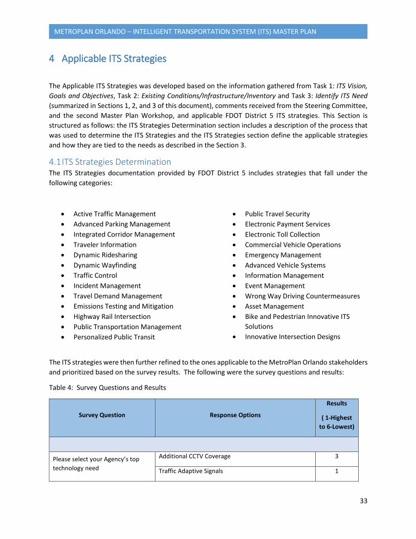
33
METROPLAN ORLANDO – INTELLIGENT TRANSPORTATION SYSTEM (ITS) MASTER PLAN
4 Applicable ITS Strategies
The Applicable ITS Strategies was developed based on the information gathered from Task 1: ITS Vision, Goals and Objectives, Task 2: Existing Conditions/Infrastructure/Inventory and Task 3: Identify ITS Need (summarized in Sections 1, 2, and 3 of this document), comments received from the Steering Committee, and the second Master Plan Workshop, and applicable FDOT District 5 ITS strategies. This Section is structured as follows: the ITS Strategies Determination section includes a description of the process that was used to determine the ITS Strategies and the ITS Strategies section define the applicable strategies and how they are tied to the needs as described in the Section 3.
4.1 ITS Strategies Determination The ITS Strategies documentation provided by FDOT District 5 includes strategies that fall under the following categories:
• Active Traffic Management • Advanced Parking Management • Integrated Corridor Management • Traveler Information • Dynamic Ridesharing • Dynamic Wayfinding • Traffic Control • Incident Management • Travel Demand Management • Emissions Testing and Mitigation • Highway Rail Intersection • Public Transportation Management • Personalized Public Transit
• Public Travel Security • Electronic Payment Services • Electronic Toll Collection • Commercial Vehicle Operations • Emergency Management • Advanced Vehicle Systems • Information Management • Event Management • Wrong Way Driving Countermeasures • Asset Management • Bike and Pedestrian Innovative ITS
Solutions • Innovative Intersection Designs
The ITS strategies were then further refined to the ones applicable to the MetroPlan Orlando stakeholders and prioritized based on the survey results. The following were the survey questions and results:
Table 4: Survey Questions and Results
Survey Question Response Options
Results
( 1-Highest to 6-Lowest)
Please select your Agency’s top technology need
Additional CCTV Coverage 3
Traffic Adaptive Signals 1
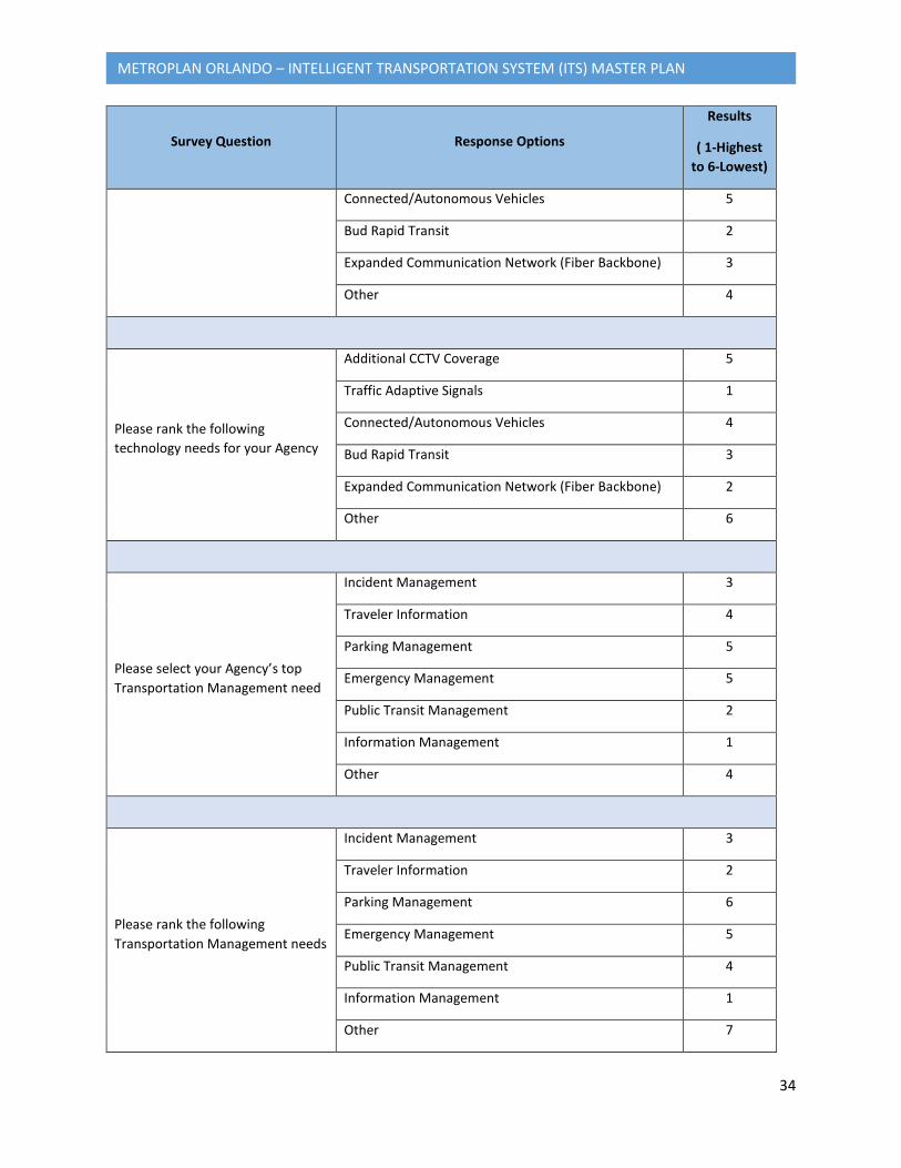
34
METROPLAN ORLANDO – INTELLIGENT TRANSPORTATION SYSTEM (ITS) MASTER PLAN
Survey Question Response Options
Results
( 1-Highest to 6-Lowest)
Connected/Autonomous Vehicles 5
Bud Rapid Transit 2
Expanded Communication Network (Fiber Backbone) 3
Other 4
Please rank the following technology needs for your Agency
Additional CCTV Coverage 5
Traffic Adaptive Signals 1
Connected/Autonomous Vehicles 4
Bud Rapid Transit 3
Expanded Communication Network (Fiber Backbone) 2
Other 6
Please select your Agency’s top Transportation Management need
Incident Management 3
Traveler Information 4
Parking Management 5
Emergency Management 5
Public Transit Management 2
Information Management 1
Other 4
Please rank the following Transportation Management needs
Incident Management 3
Traveler Information 2
Parking Management 6
Emergency Management 5
Public Transit Management 4
Information Management 1
Other 7
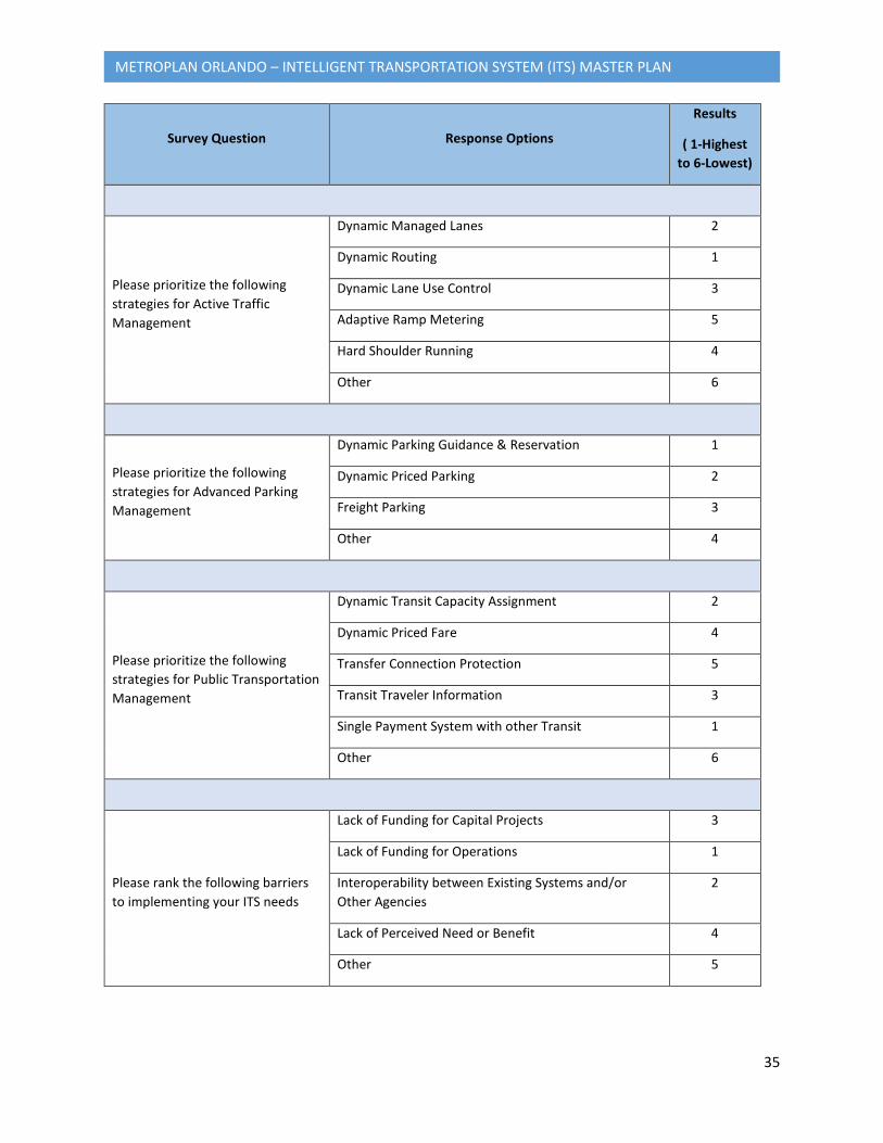
35
METROPLAN ORLANDO – INTELLIGENT TRANSPORTATION SYSTEM (ITS) MASTER PLAN
Survey Question Response Options
Results
( 1-Highest to 6-Lowest)
Please prioritize the following strategies for Active Traffic Management
Dynamic Managed Lanes 2
Dynamic Routing 1
Dynamic Lane Use Control 3
Adaptive Ramp Metering 5
Hard Shoulder Running 4
Other 6
Please prioritize the following strategies for Advanced Parking Management
Dynamic Parking Guidance & Reservation 1
Dynamic Priced Parking 2
Freight Parking 3
Other 4
Please prioritize the following strategies for Public Transportation Management
Dynamic Transit Capacity Assignment 2
Dynamic Priced Fare 4
Transfer Connection Protection 5
Transit Traveler Information 3
Single Payment System with other Transit 1
Other 6
Please rank the following barriers to implementing your ITS needs
Lack of Funding for Capital Projects 3
Lack of Funding for Operations 1
Interoperability between Existing Systems and/or Other Agencies
2
Lack of Perceived Need or Benefit 4
Other 5

36
METROPLAN ORLANDO – INTELLIGENT TRANSPORTATION SYSTEM (ITS) MASTER PLAN
4.2 Applicable ITS Strategies This section defines the applicable strategies and relates them back to the needs that were defined under Section 3. ITS strategies often require a high level of coordination and cooperation among multiple agencies in order to realize their maximum benefits. An outline of the roles and responsibilities of the MetroPlan Orlando stakeholder agencies is included in the Concept of Operations.
4.2.1 Active Traffic Management Active traffic management (ATM) is the ability to dynamically manage recurrent and non-recurrent congestion based on prevailing and predicted traffic conditions. Focusing on trip reliability, it maximizes the effectiveness and efficiency of the facility. It increases throughput and safety through the use of integrated systems with new technology, including the automation of dynamic deployment to optimize performance quickly and without delay that occurs when operators must deploy operational strategies manually. ATM approaches focus on influencing travel behavior with respect to lane/facility choices and operations. ATM strategies can be deployed singularly to address a specific need such as the utilizing adaptive ramp metering to control traffic flow or can be combined to meet system-wide needs of congestion management, traveler information, and safety resulting in synergistic performance gains. (Per FHWA)
Active Arterial Management The objective of an Active Arterial Management strategy is to maximize the cost-effectiveness of the facility. This is achieved by maximizing productivity (capacity) while minimizing cost (delay, stops). To achieve this objective, the operator of an arterial street must employ several tactics, including tactics related to:
• Arterial monitoring, • Speed and signal control,
• Geometric configuration, and • Demand modification.
Each tactic in turn consists of a combination of specific ATM measures designed to achieve the objective of that tactic. (Per TRB, NCHRP Synthesis 447, http://onlinepubs.trb.org/onlinepubs/nchrp/nchrp_syn_447.pdf)
Needs • Expand existing traffic operations communications • Expand system detection • Signal system upgrades • ATMS expansion • Expand roadside equipment • Expanded use of (arterial) DMS
Dynamic HOV and Managed Lanes This strategy involves dynamically changing the qualifications for driving in a high-occupancy vehicle (HOV) lane(s). HOV lanes (also known as carpool lanes or diamond lanes) are restricted traffic lanes reserved at peak travel times or longer for exclusive use of vehicles with a driver and one or more passengers, including carpools, vanpools and transit buses. The normal minimum occupancy level is 2 or
37
METROPLAN ORLANDO – INTELLIGENT TRANSPORTATION SYSTEM (ITS) MASTER PLAN
3 occupants. Many agencies exempt other vehicles, including motorcycles, charter buses, emergency and law enforcement vehicles, low emission vehicles, and/or single-occupancy vehicles paying a toll. In an Active Transportation and Demand Management (ATDM) approach, the HOV lane qualifications are dynamically changed based on real-time or anticipated conditions on both the HOV and general purpose lanes. Qualifications that can potentially be dynamically adjusted include the number of occupants (e.g., from 2 to 3 occupants), the hours of operation, and the exemptions (e.g., change from typical HOV operation to buses only). Alternatively, the HOV restrictions could be dynamically removed allowing general use of the previously managed lane. (Per FHWA, http://www.ops.fhwa.dot.gov/atdm/approaches/adm.htm)
Needs • Expand system detection • Operate and manage Express Lanes • Expanded use of DMS • Provide traffic information and road network conditions
Dynamic Lane Use Control This strategy involves dynamically closing or opening of individual traffic lanes as warranted and providing advance warning of the closure(s) (typically through dynamic lane control signs), in order to safely merge traffic into adjoining lanes. In an ATDM approach, as the network is continuously monitored, real-time incident and congestion data is used to control the lane use ahead of the lane closure(s) and dynamically manage the location to reduce rear-end and other secondary crashes. (Per FHWA, http://www.ops.fhwa.dot.gov/atdm/approaches/atm.htm)
Needs • Expand roadside equipment • Operate and manage Express Lanes • Expanded use of DMS
Dynamic Routing This strategy uses variable destination messaging to disseminate information to make better use of roadway capacity by directing motorists to less congested facilities. These messages could be posted on dynamic message signs in advance of major routing decisions. In an ATDM approach, real-time and anticipated conditions can be used to provide route guidance and distribute the traffic spatially to improve overall system performance. (Per FHWA, http://www.ops.fhwa.dot.gov/atdm/approaches/adm.htm)
Needs • Expand existing traffic operations communications • Expand roadside equipment
Queue Warning This strategy involves real-time displays of warning messages (typically on dynamic message signs and possibly coupled with flashing lights) along a roadway to alert motorists that queues or significant slowdowns are ahead, thus reducing rear-end crashes and improving safety. In an ATDM approach, as the traffic conditions are monitored continuously, the warning messages are dynamic based on the location and severity of the queues and slowdowns. (Per FHWA, http://www.ops.fhwa.dot.gov/atdm/approaches/atm.htm)
38
METROPLAN ORLANDO – INTELLIGENT TRANSPORTATION SYSTEM (ITS) MASTER PLAN
Needs • Expand existing traffic operations communications • Expand system detection • Expand roadside equipment • Expanded use of DMS
Adaptive Ramp Metering This strategy involves the installation of traffic signals on the freeway on-ramps to control the frequency of the vehicles entering the freeway which thereby minimizes the impact to the traffic flow on the freeway. Adaptive ramp metering utilizes time of day, traffic responsive or adaptive algorithms to coordinate the ramp with the adjacent arterial to maintain the corridor traffic flow. (Per FHWA, http://www.ops.fhwa.dot.gov/atdm/approaches/atm.htm)
Needs • Expand existing traffic operations communications • Expand system detection • Expand roadside equipment
4.2.2 Advanced Parking Management Advanced parking management is the dynamic management of parking facilities in a region to optimize performance and utilization of those facilities while influencing travel behavior at various stages along the trip making process: i.e., from origin to destination.
Dynamically managing parking can affect travel demand by influencing trip timing choices, mode choice, as well as parking facility choice at the end of the trip. This ATDM approach can also have a positive impact on localized traffic flow by providing real-time parking information to users and ensuring the availability of spaces to reduce circling around parking facilities. The overall goal is to help maximize the nation's transportation infrastructure investments, reduce congestion, and improve safety. (Per FHWA, http://www.ops.fhwa.dot.gov/atdm/approaches/apm.htm)
Needs • Provide parking demand information • Usability of regional smart cards • Smart card payments • Provide parking information to agencies • Receive parking lot information
Dynamic Parking Guidance and Reservation Dynamic Parking Guidance and Reservation provides travelers the ability to utilize technology to reserve a parking space at a destination facility on demand to ensure availability. In an Active Transportation and Demand Management (ATDM) approach, the parking availability is continuously monitored and system users can reserve the parking space ahead of arriving at the parking location. (Per FHWA, http://www.ops.fhwa.dot.gov/atdm/approaches/apm.htm)
Needs • Provide real-time parking information

39
METROPLAN ORLANDO – INTELLIGENT TRANSPORTATION SYSTEM (ITS) MASTER PLAN
• Provide parking demand information • Receive parking lot information • Real-time trip planning
Dynamic Priced Parking This strategy involves parking fees that are dynamically varied based on demand and availability to influence trip timing choice and parking facility or location choice in an effort to more efficiently balance parking supply and demand, reduce the negative impacts of travelers searching for parking, or to reduce traffic impacts associated with peak period trip making. In an ATDM approach, the parking availability is continuously monitored and parking pricing is used as a means to influence travel and parking choices and dynamically manage the traffic demand. (Per FHWA, http://www.ops.fhwa.dot.gov/atdm/approaches/apm.htm)
Needs • Provide real-time parking information • Provide parking demand information • Provide parking information to agencies • Receive parking lot information
4.2.3 Integrated Corridor Management This strategy focuses on institutional collaboration and aggressive, proactive integration of existing infrastructure along major corridors to generate improvements in the efficient movement of people and goods. Through an ICM approach, transportation professionals manage the corridor as a multimodal system and make operational decisions for the benefit of the corridor as a whole. In particular, the strategy involves distributing a corridor’s transportation demands to areas of underutilized capacity in the form of parallel roadways, single-occupant vehicles, and transit services that could be better leveraged to improve person throughput and reduce congestion. (Per FHWA, http://www.its.dot.gov/research_archives/icms/index.htm)
Needs • Interagency incident management • Expand center-to-center link to neighboring agencies • Expanded use of public information systems • Expanded use of DMS • Provide traffic information and road network conditions • Real-time trip planning • Provide estimated times of arrival (ETAs) • Coordinated multimodal Connections • Regional incident/mutual aid network coordination • Coordinate AMBER alert information • Respond to Transit Emergencies/Alarms • Coordinate emergency plans, transit schedules and status • Expanded interagency data sharing • Traffic information to FDOT information network • Receive AVL Information
40
METROPLAN ORLANDO – INTELLIGENT TRANSPORTATION SYSTEM (ITS) MASTER PLAN
• Real-time transit information
4.2.4 Traveler Information Predictive Traveler Information This strategy involves using a combination of real-time and historical transportation data to predict upcoming travel conditions and convey that information to travelers pre-trip and en-route (such as in advance of strategic route choice locations) in an effort to influence travel behavior. In an ATDM approach, predictive traveler information is incorporated into a variety of traveler information mechanisms (e.g., multi-modal trip planning systems, 511 systems, dynamic message signs) to allow travelers to make better informed choices. (Per FHWA, http://www.ops.fhwa.dot.gov/atdm/approaches/adm.htm)
Needs • Expand system detection • Expanded use of public information systems • Expanded use of DMS • Real-time trip planning • Real-time transit information
Pre-trip Travel Information The Pre-Trip Travel Information user service allows travelers to access a complete range of real-time multimodal transportation information at home, work, and other major sites where trips originate. Information on road network conditions, incidents, weather, and transit services, are conveyed through these systems to provide travelers with the latest conditions and opportunities in order to plan their travel. Based on this information, the traveler can select the best departure time, route and modes of travel, or perhaps decide not to make the trip at all. (Per http://www.iteris.com/itsarch/html/user/usr11.htm)
Needs • Expanded use of public information systems • Provide traffic information and road network conditions
En-route Driver Information Trip information regarding roadway conditions, traffic conditions, incidents, closures, detours, etc. is provided to the motorist via smart phone apps and other in vehicle devices such as GPS systems. Existing en-route information systems include electronic messages on DMS and Florida’s 511 system. These systems may have limitations in coverage as well as in the scope of the information that can be transmitted. Current en-route traveler information available via smart phone apps, including services from Google and WAZE, include travel time information and real-time alternate route suggestions based on current traffic conditions and reported incidents. Additional opportunities exist in further advancement of this strategy to develop en-route traveler information smart phone apps, customized for various types of motorists, including truck and transit drivers.
Needs • Expand existing traffic operation communications
41
METROPLAN ORLANDO – INTELLIGENT TRANSPORTATION SYSTEM (ITS) MASTER PLAN
• Upgrade existing communications • Expand system detection • Expanded use of public information systems • Expanded use of DMS • Provide traffic information and road network conditions • Real-time trip planning • Provide estimated times of arrival (ETAs)
Route Guidance Route guidance is currently provided to motorists on smart phones using apps such as Google and WAZE. They include directions as well as route selection choices based on trip length, travel time (based on Google’s measurement techniques), roadway classification, toll charges, etc. Additional opportunities exist in the development of route guidance technologies for transit users to assist them in pre-trip planning regarding mode and route selection based on fare, travel time, connection times, etc.
Needs • Provide traffic information and road network conditions • Real-time trip planning
Traveler Services Information Advanced traveler information systems use technologies that assemble and process travel-related data and disseminate useful information to travelers. These technologies include sensors for monitoring travel conditions, communications for sending and receiving information, data processing, geo-location technologies, microprocessors, and other technological advances that are fueling the rapid growth of traveler information systems in the United States and elsewhere. (Per FHWA, http://www.ops.fhwa.dot.gov/publications/manag_demand_tis/travelinfo.htm)
Needs • Expand system detection • Expand roadside equipment • Expanded use of public information systems • Expanded use of DMS • Real-time construction information • Provide traffic information and road network conditions • Coordinate traveler information • Real-time trip planning • Provide real-time parking information • Provide Signal Phase and Timing (SPAT) information • Provide parking demand information • Provide estimated times of arrival (ETAs) • Coordinated multimodal connections
4.2.5 Dynamic Wayfinding This is the practice of providing real-time parking-related information to travelers associated with space availability and location so as to optimize the use of parking facilities and minimize the time spent

42
METROPLAN ORLANDO – INTELLIGENT TRANSPORTATION SYSTEM (ITS) MASTER PLAN
searching for available parking. In an ATDM approach, the parking availability is continuously monitored and routing information to the parking space is provided to the user. (Per FHWA, http://www.ops.fhwa.dot.gov/atdm/approaches/apm.htm)
Needs • Provide parking demand information • Provide parking information to agencies • Receive parking information • Expanded use of DMS • Expand center-to-center link to neighboring agencies • Provide real-time parking information
4.2.6 Traffic Control According the Manual of Uniform Traffic Control Devices (MUTCD), 2009 Edition with 2012 updates, traffic control devices are defined as all signs, signals, markings, and other devices used to regulate, warn, or guide traffic, placed on, over, or adjacent to a street, highway, pedestrian facility, bikeway, or private road open to public travel by authority of a public agency or official having jurisdiction, or, in the case of a private road, by authority of the private owner or private official having jurisdiction. Adaptive Signal Control and Transit Signal Priority are two strategies that aid in the traffic control in arterials. Adaptive Signal Control This strategy continuously monitors arterial traffic conditions and the queuing at intersections and dynamically adjusts the signal timing. Adaptive signal control responds to fluctuations in traffic patterns by utilizing sensors for traffic data and algorithms. Traffic signal timings adapt to the changes in traffic along corridors. (Per FHWA, http://www.ops.fhwa.dot.gov/atdm/approaches/apm.htm)
Needs • Expand existing traffic operations communications • Upgrade existing communications • Additional communications hubs • Expand center-to-center link to neighboring agencies • Expand system detection • Expand emergency signal preemption • Signal system upgrades • ATMS expansion • Expand roadside equipment
4.2.7 Transit Signal Priority This strategy manages traffic signals by using sensors or probe vehicle technology to detect when a bus nears a signal controlled intersection, turning the traffic signals to green sooner or extending the green phase, thereby allowing the bus to pass through more quickly. In an ATDM approach, current and predicted traffic congestion, multi-agency bus schedule adherence information, and number of passengers affected, may all be considered to determine conditionally if, where, and when transit signal
43
METROPLAN ORLANDO – INTELLIGENT TRANSPORTATION SYSTEM (ITS) MASTER PLAN
priority may be applied. The MetroPlan Orlando region has different signal systems, TSP interoperability will be necessary. (Per FHWA, http://www.ops.fhwa.dot.gov/atdm/approaches/atm.htm)
Needs • Expand transit signal priority
4.2.8 Incident Management Incident management consists of a planned and coordinated multi-disciplinary process to detect, respond to, and clear traffic incidents and restore traffic flow as safely and quickly as possible. Applied effectively, incident management reduces the duration and impacts of traffic incidents and improves the safety of motorists, crash victims and emergency responders. (Per FHWA, http://www.ops.fhwa.dot.gov/plan4ops/traffic_incident.htm)
Needs • Coordinate maintenance resources • Coordinate HAZMAT spill incidents • Interagency incident management
4.2.9 Travel Demand Management The strategy involves managing both the "growth of" and periodic "shifts in" traffic demand as necessary elements of managing traffic congestion. Traffic demand is managed by providing travelers, regardless of whether they drive alone, with travel choices, such as work location, route, time, and mode. While the ultimate decision to select work location (e.g. work from home) or work time (e.g. flex time) is up to the motorist/employer, current strategies to influence travel demand include congestion pricing in managed lanes and providing incentives (e.g. signal optimized for thru traffic on an arterial) and disincentives (e.g. tolling) for particular modes or routes during peak times. Travel demand management techniques include congestion pricing, ridesharing, development of transit alternatives, promotion of non-motorized transportation such as cycling and pedestrian activities, telecommuting and land use management. (Per FHWA, http://www.ops.fhwa.dot.gov/tdm/)
Needs • Expand center-to-center link to neighboring agencies • Expand transit signal priority • Signal system upgrades • Operate and manage Express Lanes • Dynamic toll information to FTE back-end toll collection system
4.2.10 Highway Rail Intersection This field-to-field application area covers the interface between (rail) wayside equipment and roadside equipment at a highway rail intersection (HRI), providing the means to support coordinated operation of that equipment. This strategy includes the interface to wayside equipment that supports all types of rail, including light-rail transit, rapid-rail transit, commuter rail, freight, and inter-city passenger trains. This application area includes the interface between the Wayside Equipment terminator (representing the
44
METROPLAN ORLANDO – INTELLIGENT TRANSPORTATION SYSTEM (ITS) MASTER PLAN
train interface equipment, usually maintained by the railroad) and the Roadway Subsystem (representing the traffic control equipment in the vicinity of the grade crossing). (Per USDOT National ITS Architecture 7.1)
Needs • Heavy rail crossing advanced preempt • Coordinate HRI information • Positive Train Control
4.2.11 Public Transportation Management Dynamic Transit Capacity Assignment This strategy involves re-organizing schedules and adjusting assignments of assets (e.g., buses) based on real-time demand and patterns, to cover the most overcrowded sections of network. In an ATDM approach, real-time and predicted travel conditions can be used to determine the changes needed to the planned transit operations, thereby potentially reducing traffic demand and subsequent delays on roadway facilities. (Per FHWA, http://www.ops.fhwa.dot.gov/atdm/approaches/adm.htm)
Needs • Real-time trip planning • Coordinate traveler information • Coordinate multi-modal connection • Expand transit signal priority • Provide capacity for seasonal and unpredicted variation in transit demand
Transit Traveler Information Transit users are provided with real-time location and arrival/departure information of their transit vehicle. The information delivery can be via devices on board the transit vehicle such a display of next stops and current location (on a simplified LED line diagram) or on electronic message boards and video monitors at transit stop locations, providing information on next vehicle/train arrival and route number. Additional implementation of this strategy include installation of automatic vehicle location (AVL) system on all transit buses and trains and developing smart phone transit apps for information delivery.
Needs • Expand existing traffic operation communications • Provide estimated times of arrival (ETAs) • Real-time trip planning • Coordinate traveler information • Coordinate multi-modal connection
4.2.12 Public Travel Security Public Travel Security is a strategy for increasing the safety and security of travelers in public areas including public transit facilities, bridges, tunnels, parking facilities and (major) intersections and other roadway features. (Per USDOT National ITS Architecture 7.1)
45
METROPLAN ORLANDO – INTELLIGENT TRANSPORTATION SYSTEM (ITS) MASTER PLAN
Needs • Transit security breach notification • Coordinate alarms and surveillance at FTA call boxes • Monitor secure area sensors
4.2.13 Electronic Payment Services Regional Transit Payment System This strategy involves use of a single payment system (i.e. fare card, mobile payment) and a single fare structure on multiple transit services in the MetroPlan Orlando area, including LYNX, SunRail, I-Ride Trolley, etc. The strategy provides better integration between multiple transit networks reducing complexity and uncertainty of finding multi-modal connections by affording the transit user with fare and connection protection to their final destination.
Needs • Real-time trip planning • Coordinate traveler information • Coordinate multi-modal connection • Transit electronic fare payment
Electronic Transit Ticketing The strategy eliminates use of multiple fare payment methods upon entry into the transit vehicle and reduces the “dwell time” at stops for fare collection. The transit users may be required to furnish payment prior to entry into the transit vehicle (i.e. payment at SunRail station) or use electronic payment means (i.e. smart phone payment) or purchase a scannable fare card at the transit stop (in the case with buses). Electronic ticketing also provides the transit operator with a better tracking of transit demand for further optimization of routes.
Needs • Transit electronic fare payment • Coordinate traveler information • Coordinate multi-modal connection
4.2.14 Commercial Vehicle Operations Comprehensive technology systems designed to keep freight traffic flowing through States and across Interstate and international borders.
Hazardous Materials Security and Incident Response The Hazardous Materials Security and Incident Response is a strategy for utilizing a central hazardous materials database (Hazardous Materials Information Resource System (HMIRS) in order to efficiently address the hazardous materials involved.
Needs • Regional incident/mutual aid network coordination • Receive emergency vehicle preemption
46
METROPLAN ORLANDO – INTELLIGENT TRANSPORTATION SYSTEM (ITS) MASTER PLAN
• Coordinate emergency plans, transit schedules and status • Expanded use of DMS
4.2.15 Emergency Management Emergency Notification and Personal Security The Emergency Notification and Personal Security user service provides the ability for travelers to notify appropriate emergency response personnel regarding the need for assistance due to emergency or non-emergency situations. The notification can be initiated manually by the traveler, or it could be provided from a vehicle automatically on the occurrence of a crash. The service also provides for monitoring, threat alerts, and automated security system support in secure areas. Secure areas encompass physical areas related to travel including remote areas and critical transportation infrastructure. In addition, the service provides wide area alert to notify the traveling public in emergency situations such as child abductions, severe weather watches and warnings, natural and human-caused disasters, military operations, and civil emergencies where lives and/or property are at stake. Finally, the service prevents public distribution of traveler information that may impact individual privacy or public safety. Current implementation of this strategy include incorporating surveillance and automated alarms for sensitive bridge structures and use of DMS signs to display amber alerts. (Per, http://www.iteris.com/itsarch/html/user/usr51.htm)
Needs • Upgrade existing communications • Expand system detection • Expanded use of public information systems • Expanded use of DMS • Coordinate AMBER alert information • Respond to Transit Emergencies/Alarms • Transit security breach notification • Coordinate alarms and surveillance at FTA call boxes
Disaster Response and Evacuation This strategy involves developing interagency agreements and response plans for major emergencies and disasters requiring evacuations. The nature of the emergency may include a variety of scenarios including an active shooter situation, a bridge collapse, and threat of major weather events such as hurricanes. Evacuations may be localized in nature (i.e. for a bomb threat) or cover a larger regional area (i.e. for hurricane evacuations). Sub transportation strategies in response to these emergencies may include, information delivery (via smart phone apps, DMS, HAR, etc.), contraflow/reverse flow of traffic, and signal optimization.
Needs • Expand existing traffic operation communications • Coordinate maintenance resources • Interagency incident management • Operate and manage Express Lanes • Regional incident/mutual aid network coordination • Receive emergency vehicle preemption

47
METROPLAN ORLANDO – INTELLIGENT TRANSPORTATION SYSTEM (ITS) MASTER PLAN
• Respond to Transit Emergencies/Alarms • Coordinate emergency plans, transit schedules and status • Transit security breach notification
4.2.16 Advanced Vehicle Systems Connected Vehicles – In-vehicle Information The Connected Vehicles – In-vehicle Information is a strategy that will allow travelers information to be provided to motorists via their in-vehicle systems. Information that may be disseminated includes work zone traveler information, traffic signal status, speed limit information, school zone information and enhanced maintenance decision support.
Needs • Sensor needs for connected vehicles • Automated vehicle maintenance status information • Distribute work zone information
Connected Vehicles – Probe Vehicle Data The Connected Vehicles – Probe Vehicle Data is a strategy that gathers the information provided by the vehicles. The information may include vehicles speed, vehicles location and vehicle identification.
Needs • Provide virtual data warehouse • Expanded interagency data sharing • Receive AVL information
Automated Vehicle Operations Automated Vehicle Operation, or Autonomous Vehicles, enables vehicles to be operated autonomously with no human intervention. This strategy could be used by transit and private vehicles. In 2018, Tampa Hillsborough County Expressway Authority (THEA) will equip approximately 10 buses, 10 streetcars and 1,500 participants’ automobiles with wireless communication devices that can exchange traffic and safety information with other vehicles and with roadway infrastructure in Downtown Tampa. The results from this pilot project should be monitored closely by Central Florida transportation agencies.
Needs • Sensor needs for connected vehicles • Automated vehicle maintenance status information • Distribute work zone information • Real-time transit information
Intersection Collision Avoidance Systems Intersection Collision Avoidance employs high speed wireless communications, roadside and in-vehicle technology to warn drivers of any potential conflict at intersections. Unlike longitudinal and lateral collisions that occur in a single direction of traffic flow, most cases of intersection collisions involve vehicles in different directions crossing paths. This strategy is currently under research but it could have a great impact to the future of the safety of the arterials in the region.
48
METROPLAN ORLANDO – INTELLIGENT TRANSPORTATION SYSTEM (ITS) MASTER PLAN
Needs • Sensor needs for connected vehicles • Automated vehicle maintenance status information • Receive AVL Information • Expand roadside equipment
Smart City This strategy involves integration of innovative technologies into the transportation network. This strategy will address how emerging transportation data, technologies, and applications can be integrated with existing systems within a city to address transportation challenges. Smart Cities focus on improving mobility choices, improving the quality and reliability of transit services, enhancing pedestrian and bicycle infrastructure, and making better use of the space allocated to parking. (Per USDOT, https://www.transportation.gov/smartcity)
Needs • Sensor needs for connected vehicles • Expand existing traffic operations communications • Upgrade existing communications • Expand system detection • Expand transit signal priority • Expand emergency signal preemption • Signal system upgrades • Expand roadside equipment • Provide virtual data warehouse • Expanded interagency data sharing • Real-time transit information
Smart Corridor Smart Corridor is a strategy that involves the testing of a particular corridor with emerging technologies and incorporating multi-modal applications.
Needs • Expand existing traffic operations communications • Upgrade existing communications • Additional communications hubs • Interagency incident management • Expand center-to-center link to neighboring agencies • Expand system detection • Expand transit signal priority • Expand emergency signal preemption • Signal system upgrades • Expand roadside equipment • Expanded use of public information systems • Real-time construction information • Provide traffic information and road network conditions • Coordinate traveler information
49
METROPLAN ORLANDO – INTELLIGENT TRANSPORTATION SYSTEM (ITS) MASTER PLAN
• Real-time trip planning • Provide real-time parking information • Provide parking demand information • Provide virtual data warehouse • Expanded interagency data sharing • Monitor secure area sensors • Coordinated multimodal connections • Real-time transit information
4.2.17 Information Management Archived Data The Archived Data strategy is an information management system that collects, processes, documents, and stores real-time ITS data for use by a broad cross section of users. This strategy can provide a valuable tool for developing operational strategies, planning for operations, long-term planning, and policy and investment decision-making.
Needs • Provide virtual data warehouse • Expanded interagency data sharing
Data Management – Big Data and Transportation Data Analytics The Data Management of Big Data strategy is used to gather the big data generated by all the emerging technologies and performing analytics of the big data to improve mobility and safety.
Needs • Provide virtual data warehouse • Expanded interagency data sharing • Traffic information to FDOT information network
Performance Management (or Measurement) The ultimate purpose of operations performance measurement is not just reporting the performance of the system, but the development of actions that improve performance. In a data-driven decision environment, specific operational problems can be pinpointed and appropriate actions can be tailored to the problems.
Operations performance measurement can also be used to demonstrate the value of operations through a process of continuous evaluation. Once a performance program is in place, it is a simple matter to focus it on before and after conditions for implemented projects and policies. Continuous evaluation of newly implemented projects – and what is learned from them – will enable better investment decisions in the future. Examining what worked or failed, the reasons for success and failure, and modifications to the initial deployment to make it work is part of the learning process for operational performance management. (Per FHWA, http://ops.fhwa.dot.gov/publications/fhwahop12018/#s3)
Needs
50
METROPLAN ORLANDO – INTELLIGENT TRANSPORTATION SYSTEM (ITS) MASTER PLAN
• Provide virtual data warehouse • Expanded interagency data sharing • Traffic information to FDOT information network
4.2.18 Event Management This strategy involves advanced planning and coordination to develop and deploy the operational strategies, traffic control plans, protocols, procedures, in addition to identifying technologies needed to control traffic and share real-time information with other stakeholders on the day of the event. With the location, time, duration, and demand expected for a planned special event identified, public agencies can exploit this advanced information to minimize the effect these events may have on the general public, motorists, public agencies, and others service providers. (Per FHWA, http://ops.fhwa.dot.gov/eto_tim_pse/about/pse.htm)
Needs • Expand existing traffic operation communications • Expanded use of public information systems • Provide real-time parking information • Real-time transit information
4.2.19 Wrong Way Driving Countermeasure This strategy involves the use of different technologies to prevent wrong way drivers from getting into the freeway using the off ramps. Some of the existing wrong way countermeasures involve the use of detection systems linked to LED signs that alert drivers, the RTMC/TMC and highway patrol.
Needs • Expand existing traffic operations communications • Upgrade existing communications • Additional communications hubs • Interagency incident management • Expand center-to-center link to neighboring agencies • Expanded interagency data sharing • Expand system detection • Expand roadside equipment • Regional incident/mutual aid network coordination
4.2.20 Bicycle and Pedestrian Innovative ITS Solutions This strategy involves development and implementation of a Complete Streets Plan to modify conventional “incomplete street” designs to enhance viable transportation choices, foster alternative transportation options, and economic opportunities for residents. The concept of complete streets provides a guideline to design roadways that are safer for all users including bicyclists and pedestrians. As described in the “Dangerous by Design 2016” report, published by Smart Growth America, Florida has been ranked as one of the most dangerous states for biking and walking since 2009. In 2016, the Orlando/Kissimmee/Sanford metro area was ranked number three in the country using a Pedestrian Danger Index (PDI), which compares the number of local commuters who walk to work in relation to the
51
METROPLAN ORLANDO – INTELLIGENT TRANSPORTATION SYSTEM (ITS) MASTER PLAN
number of pedestrian deaths in a region. Various ITS technologies exist to improve the safety of pedestrians and bicyclists when crossing intersections by helping reduce crash rates. There are different ITS solutions for pedestrian safety including intelligent infrastructure and in-vehicle systems. Some of the ITS applications listed below are in the prototype and research stage; while others are currently available on the market. (Per http://www.vruits.eu/?q=Deliverables and https://smartgrowthamerica.org/introducing-dangerous-design-2016/)
• Blind Spot Detection for Cars and Trucks - Detects and warns for Vulnerable Road Users (VRUs) and objects in the blind spot of the car/truck.
• Intelligent Pedestrians Traffic Signal - Use of sensors such as an infra-red camera to determine the presence of pedestrians and adjusts the traffic signals accordingly.
• Intelligent Speed Adaptation (ISA) - Compares the current speed of the vehicle with the local posted speed limit and respond if the vehicle exceeds this posted limit.
• Red Light Camera/Speed Camera - The intended reaction is to prevent drivers from running the red light, and thereby reducing the chance of an accident.
• Intersection Safety - Assists the driver and VRU in avoiding common mistakes which may lead to typical intersection accidents. It covers these functions: left and right turn assistance and vehicles arriving perpendicular to VRUs at intersections.
• Pedestrian Detection System and Automatic Braking - The vehicle has a built-in system that continuously scans for VRUs that the vehicle might be in collision course with.
• Navigation systems for VRUs - Navigational support to cyclists, along with other information is also provided relating to cycling performance.
• Powered Two Wheeler (PTW) Oncoming vehicle info system - The system works based on radar/infrared sensors/camera. Gives a warning for a hazard or provides a view on a screen.
• VRU Beacon System - The VRU has a chip or tag that sends out a signal that can be detected by a device installed in vehicles.
• Cyclist digital bicycle rear-view mirror - Increase peripheral and rear viewing area of the cyclist without having to turn around to prevent potential accidents due to lack of vision.
• Roadside Pedestrian Presence - Detects that a pedestrian is close to a crossing (or bus stop) and warns upcoming motorized traffic with flashing lights or information on a display.
• Urban sensing system - Urban sensing systems can help to inform public service and infrastructure providers and other road users about issues and problems as well as dangerous situations in public places and traffic
• Night Vision and Warning – Use of infrared radiation from pedestrians, animals and roadsides features to give drivers an enhanced view of the situation ahead.
• Cyclists and Pedestrians Automatic Counting - This system helps to localize bicycle and pedestrian patterns and provides bicycle- and pedestrian-related traffic information.
• Information on vacancy on bicycle racks - By placing sensors in bicycle racks, active signs and Short Message Service (SMS) services can provide information on vacancy.
• Bicycle to car communication - The system informs/warns motorized traffic (especially car drivers) about cyclists on the road, in the vicinity of the vehicle and the cyclist of oncoming vehicle and be warned about the risk of collisions.
52
METROPLAN ORLANDO – INTELLIGENT TRANSPORTATION SYSTEM (ITS) MASTER PLAN
• Rider Monitoring System - The system aims to prevent accidents due to PTW rider distraction. The system monitors the condition and gaze of the driver and tries to keep him/her attended to the driving tasks.
• Crossing Adaptive Lighting - When the pedestrian/cyclist activates the system, through detection from an automated device, the lights are activated/brightened to light the cross walk
• Green Wave for Cyclists - The system provides cyclists with a speed advice to their smart phone. In case they follow the advice they are guaranteed a green light at the next signalized intersection.
Needs • Expand existing traffic operations communications • Upgrade existing communications • Expand system detection • Signal system upgrades • Expand roadside equipment • Expanded use of public information systems • Provide traffic information and road network conditions • Coordinate traveler information • Real-time trip planning • Coordinated multimodal Connections
4.2.21 Innovative Intersection Design This strategy involves review of intersection characteristics and roadway/intersections types and evaluation of potential intersection design options that are viable for intersection enhancement as opposed to just widening the roadways. Examples of innovative intersection include Continuous Flow Intersections (CFI), Thru-Turn Intersections, Diverging Diamond Interchange (DDI), and modern roundabouts.
Needs • Signal system upgrades • Upgrade existing communications
4.2.22 Asset Management Database ITS systems are comprised of a complex network of fiber optic cables, electrical cables, wireless communications, and an array of field devices. This strategy is a central location, or database, where assets are recorded and managed
Needs • Provide virtual data warehouse • Expanded interagency data sharing • Coordinate maintenance resources
53
METROPLAN ORLANDO – INTELLIGENT TRANSPORTATION SYSTEM (ITS) MASTER PLAN
5 Regional ITS Architecture (RITSA)
The National ITS Architecture (NITSA) provides a definitive and consistent framework to guide the planning and deployment of ITS projects. The program facilitates the ability of jurisdictions to operate collaboratively and to harness the benefits of a regional approach to transportation challenges. The FDOT Regional Intelligent Transportation Systems Architecture (RITSA) is an outline for transportation systems integration throughout the State of Florida. The architecture was developed in 2005 and updated in 2016 with input from key stakeholders, namely the transportation agencies within each District. The architecture represents a shared vision of how each agency’s systems will work together in the future to enable sharing of information and resources to provide a safer, more efficient, and more effective transportation system for travelers in the region. In addition to documenting the shared vision of stakeholders in the region, the Code of Federal Regulations Part 940 (CFR 940) requires a RITSA conforming to the National ITS Architecture for all ITS projects receiving federal funding.
The FDOT District 5 RITSA was last updated in 2016. After April 2005, federal regulation required all ITS projects to show conformance with their regional ITS architecture to be eligible for federal funding. In the instance where a project is not represented in a RITSA, the FDOT Change Management Process requires that any necessary changes to the architecture be documented and submitted to the Change Management Board for review and acceptance. The changes will then be incorporated during the next update of the regional ITS architecture.
The purpose of this Section is to:
• Identify current service packages consistent with the functional requirements and stakeholder
needs identified as part of this project
• Define gaps for systems in the region between the goals/objectives and the architecture
• Document architecture modifications to be submitted to the FDOT Change Management Board
The applicable service packages were identified based on the information gathered from Task 3: Identify ITS Need, Task 4: Identification of Applicable ITS Strategies (summarized in Sections 3 and 4 of this document), and comments received from the Steering Committee. This RITSA Section is structured as follows:
• Purpose – includes an explanation of the process for reviewing the RITSA architecture to identify
updates required based on the functionality defined in this project
• Current Service Packages – includes a description of the existing services in the RITSA architecture
documented on the FDOT website
• Architecture Conformance – documents the modifications or additional service packages that may
be considered for submittal to the FDOT Change Management Board for approval.
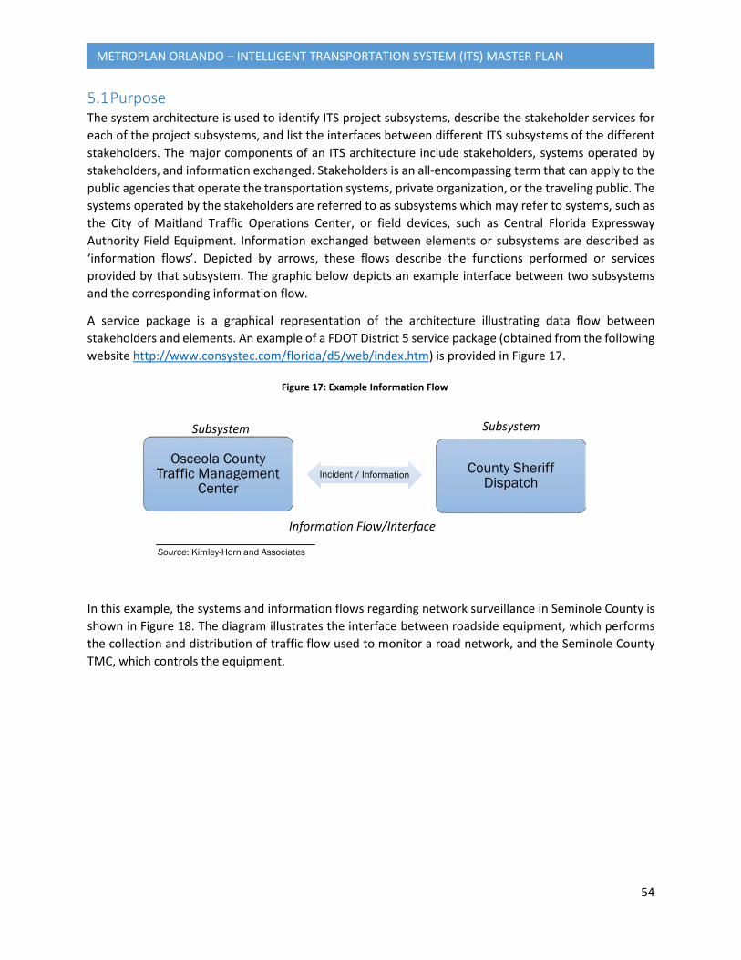
54
METROPLAN ORLANDO – INTELLIGENT TRANSPORTATION SYSTEM (ITS) MASTER PLAN
5.1 Purpose The system architecture is used to identify ITS project subsystems, describe the stakeholder services for each of the project subsystems, and list the interfaces between different ITS subsystems of the different stakeholders. The major components of an ITS architecture include stakeholders, systems operated by stakeholders, and information exchanged. Stakeholders is an all-encompassing term that can apply to the public agencies that operate the transportation systems, private organization, or the traveling public. The systems operated by the stakeholders are referred to as subsystems which may refer to systems, such as the City of Maitland Traffic Operations Center, or field devices, such as Central Florida Expressway Authority Field Equipment. Information exchanged between elements or subsystems are described as ‘information flows’. Depicted by arrows, these flows describe the functions performed or services provided by that subsystem. The graphic below depicts an example interface between two subsystems and the corresponding information flow.
A service package is a graphical representation of the architecture illustrating data flow between stakeholders and elements. An example of a FDOT District 5 service package (obtained from the following website http://www.consystec.com/florida/d5/web/index.htm) is provided in Figure 17.
In this example, the systems and information flows regarding network surveillance in Seminole County is shown in Figure 18. The diagram illustrates the interface between roadside equipment, which performs the collection and distribution of traffic flow used to monitor a road network, and the Seminole County TMC, which controls the equipment.
Osceola County Traffic Management
CenterCounty Sheriff
Dispatch
Subsystem Subsystem
Information Flow/Interface
Source: Kimley-Horn and Associates
Figure 17: Example Information Flow
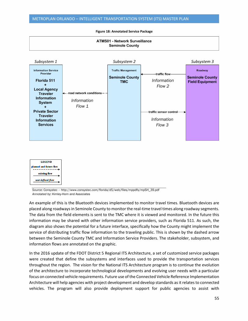
55
METROPLAN ORLANDO – INTELLIGENT TRANSPORTATION SYSTEM (ITS) MASTER PLAN
Figure 18: Annotated Service Package
An example of this is the Bluetooth devices implemented to monitor travel times. Bluetooth devices are placed along roadways in Seminole County to monitor the real-time travel times along roadway segments. The data from the field elements is sent to the TMC where it is viewed and monitored. In the future this information may be shared with other information service providers, such as Florida 511. As such, the diagram also shows the potential for a future interface, specifically how the County might implement the service of distributing traffic flow information to the traveling public. This is shown by the dashed arrow between the Seminole County TMC and Information Service Providers. The stakeholder, subsystem, and information flows are annotated on the graphic.
In the 2016 update of the FDOT District 5 Regional ITS Architecture, a set of customized service packages were created that define the subsystems and interfaces used to provide the transportation services throughout the region. The vision for the National ITS Architecture program is to continue the evolution of the architecture to incorporate technological developments and evolving user needs with a particular focus on connected vehicle requirements. Future use of the Connected Vehicle Reference Implementation Architecture will help agencies with project development and develop standards as it relates to connected vehicles. The program will also provide deployment support for public agencies to assist with
Subsystem 1 Subsystem 2 Subsystem 3
Information Flow 1
Information Flow 2
Information Flow 3
Source: Consystec – http://www.consystec.com/florida/d5/web/files/mppdfs/mpSH_39.pdf Annotated by: Kimley-Horn and Associates
56
METROPLAN ORLANDO – INTELLIGENT TRANSPORTATION SYSTEM (ITS) MASTER PLAN
development, maintenance, and improvement of their regional ITS architectures along with compliance with applicable Federal Highway Administration regulations.
Architecture compliance is key to providing eligibility for federal and regional funding opportunities. For Florida ITS project applications, agencies must demonstrate they comply and communicate any new requirements to the Change Management Board. This document provides guidance as to complying with these existing requirements and how the MetroPlan Orlando ITS Project strategies are applicable to the FDOT District 5 RITSA.
5.2 Current Service Packages in 2016 RITSA Service packages typically include several stakeholders and subsystems that work together to provide a service in the region. A review of the service packages included in the existing District 5 RITSA was performed to determine if the functions of the MetroPlan Orlando project were adequately represented. The table below contains a list of the generic ITS services, organized by functional area, which have at least one customized instance (a 'Service Package') in the FDOT District 5 Regional ITS Architecture.
Table 5: Complete List of Service Packages
Functional Area Service Package ITS Service
Traffic Management
ATMS01 Network Surveillance ATMS02 Traffic Probe Surveillance ATMS03 Traffic Signal Control ATMS04 Traffic Metering ATMS05 HOV Lane Management ATMS06 Traffic Information Dissemination ATMS07 Regional Traffic Management ATMS08 Traffic Incident Management System ATMS09 Transportation Decision Support and Demand Management ATMS10 Electronic Toll Collection ATMS13 Standard Railroad Grade Crossing ATMS15 Railroad Operations Coordination ATMS16 Parking Facility Management ATMS17 Regional Parking Management ATMS18 Reversible Lane Management ATMS19 Speed Warning and Enforcement(1) ATMS20 Drawbridge Management(1) ATMS24 Dynamic Roadway Warning
Maintenance and Construction
MC01 Maintenance and Construction Vehicle and Equipment Tracking MC02 Maintenance and Construction Vehicle Maintenance MC03 Road Weather Data Collection MC04 Weather Information Processing and Distribution MC07 Roadway Maintenance and Construction
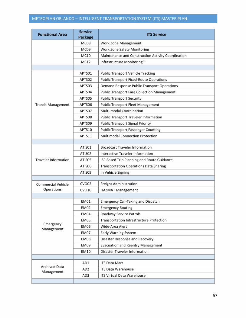
57
METROPLAN ORLANDO – INTELLIGENT TRANSPORTATION SYSTEM (ITS) MASTER PLAN
Functional Area Service Package ITS Service
MC08 Work Zone Management MC09 Work Zone Safety Monitoring MC10 Maintenance and Construction Activity Coordination MC12 Infrastructure Monitoring(1)
Transit Management
APTS01 Public Transport Vehicle Tracking APTS02 Public Transport Fixed-Route Operations APTS03 Demand Response Public Transport Operations APTS04 Public Transport Fare Collection Management APTS05 Public Transport Security APTS06 Public Transport Fleet Management APTS07 Multi-modal Coordination APTS08 Public Transport Traveler Information APTS09 Public Transport Signal Priority APTS10 Public Transport Passenger Counting APTS11 Multimodal Connection Protection
Traveler Information
ATIS01 Broadcast Traveler Information ATIS02 Interactive Traveler Information ATIS05 ISP Based Trip Planning and Route Guidance ATIS06 Transportation Operations Data Sharing ATIS09 In Vehicle Signing
Commercial Vehicle Operations
CVO02 Freight Administration CVO10 HAZMAT Management
Emergency Management
EM01 Emergency Call-Taking and Dispatch EM02 Emergency Routing EM04 Roadway Service Patrols EM05 Transportation Infrastructure Protection EM06 Wide-Area Alert EM07 Early Warning System EM08 Disaster Response and Recovery EM09 Evacuation and Reentry Management EM10 Disaster Traveler Information
Archived Data Management
AD1 ITS Data Mart AD2 ITS Data Warehouse AD3 ITS Virtual Data Warehouse
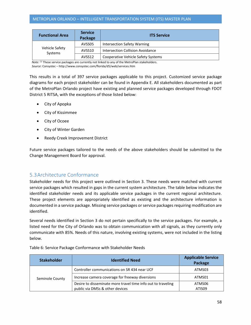
58
METROPLAN ORLANDO – INTELLIGENT TRANSPORTATION SYSTEM (ITS) MASTER PLAN
Functional Area Service Package ITS Service
Vehicle Safety Systems
AVSS05 Intersection Safety Warning AVSS10 Intersection Collision Avoidance AVSS12 Cooperative Vehicle Safety Systems
Note: (1) These service packages are currently not linked to any of the MetroPlan stakeholders. Source: Consystec – http://www.consystec.com/florida/d5/web/services.htm
This results in a total of 397 service packages applicable to this project. Customized service package diagrams for each project stakeholder can be found in Appendix E. All stakeholders documented as part of the MetroPlan Orlando project have existing and planned service packages developed through FDOT District 5 RITSA, with the exceptions of those listed below:
• City of Apopka
• City of Kissimmee
• City of Ocoee
• City of Winter Garden
• Reedy Creek Improvement District
Future service packages tailored to the needs of the above stakeholders should be submitted to the Change Management Board for approval.
5.3 Architecture Conformance Stakeholder needs for this project were outlined in Section 3. These needs were matched with current service packages which resulted in gaps in the current system architecture. The table below indicates the identified stakeholder needs and its applicable service packages in the current regional architecture. These project elements are appropriately identified as existing and the architecture information is documented in a service package. Missing service packages or service packages requiring modification are identified.
Several needs identified in Section 3 do not pertain specifically to the service packages. For example, a listed need for the City of Orlando was to obtain communication with all signals, as they currently only communicate with 85%. Needs of this nature, involving existing systems, were not included in the listing below.
Table 6: Service Package Conformance with Stakeholder Needs
Stakeholder Identified Need Applicable Service Package
Seminole County
Controller communications on SR 434 near UCF ATMS03
Increase camera coverage for freeway diversions ATMS01 Desire to disseminate more travel time info out to traveling public via DMSs & other devices
ATMS06 ATIS09
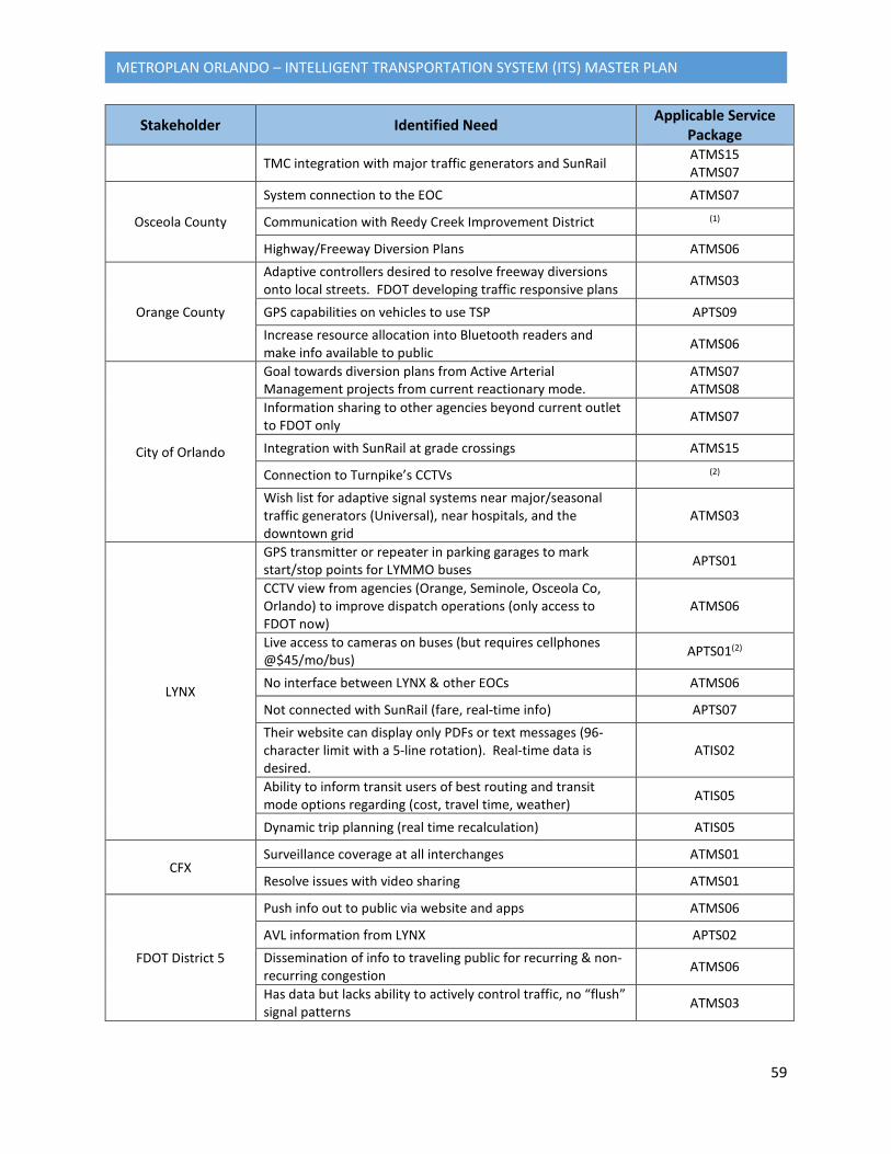
59
METROPLAN ORLANDO – INTELLIGENT TRANSPORTATION SYSTEM (ITS) MASTER PLAN
Stakeholder Identified Need Applicable Service Package
TMC integration with major traffic generators and SunRail ATMS15 ATMS07
Osceola County
System connection to the EOC ATMS07
Communication with Reedy Creek Improvement District (1)
Highway/Freeway Diversion Plans ATMS06
Orange County
Adaptive controllers desired to resolve freeway diversions onto local streets. FDOT developing traffic responsive plans ATMS03
GPS capabilities on vehicles to use TSP APTS09 Increase resource allocation into Bluetooth readers and make info available to public ATMS06
City of Orlando
Goal towards diversion plans from Active Arterial Management projects from current reactionary mode.
ATMS07 ATMS08
Information sharing to other agencies beyond current outlet to FDOT only ATMS07
Integration with SunRail at grade crossings ATMS15
Connection to Turnpike’s CCTVs (2)
Wish list for adaptive signal systems near major/seasonal traffic generators (Universal), near hospitals, and the downtown grid
ATMS03
LYNX
GPS transmitter or repeater in parking garages to mark start/stop points for LYMMO buses APTS01
CCTV view from agencies (Orange, Seminole, Osceola Co, Orlando) to improve dispatch operations (only access to FDOT now)
ATMS06
Live access to cameras on buses (but requires cellphones @$45/mo/bus) APTS01(2)
No interface between LYNX & other EOCs ATMS06
Not connected with SunRail (fare, real-time info) APTS07 Their website can display only PDFs or text messages (96-character limit with a 5-line rotation). Real-time data is desired.
ATIS02
Ability to inform transit users of best routing and transit mode options regarding (cost, travel time, weather) ATIS05
Dynamic trip planning (real time recalculation) ATIS05
CFX Surveillance coverage at all interchanges ATMS01
Resolve issues with video sharing ATMS01
FDOT District 5
Push info out to public via website and apps ATMS06
AVL information from LYNX APTS02 Dissemination of info to traveling public for recurring & non-recurring congestion ATMS06
Has data but lacks ability to actively control traffic, no “flush” signal patterns ATMS03
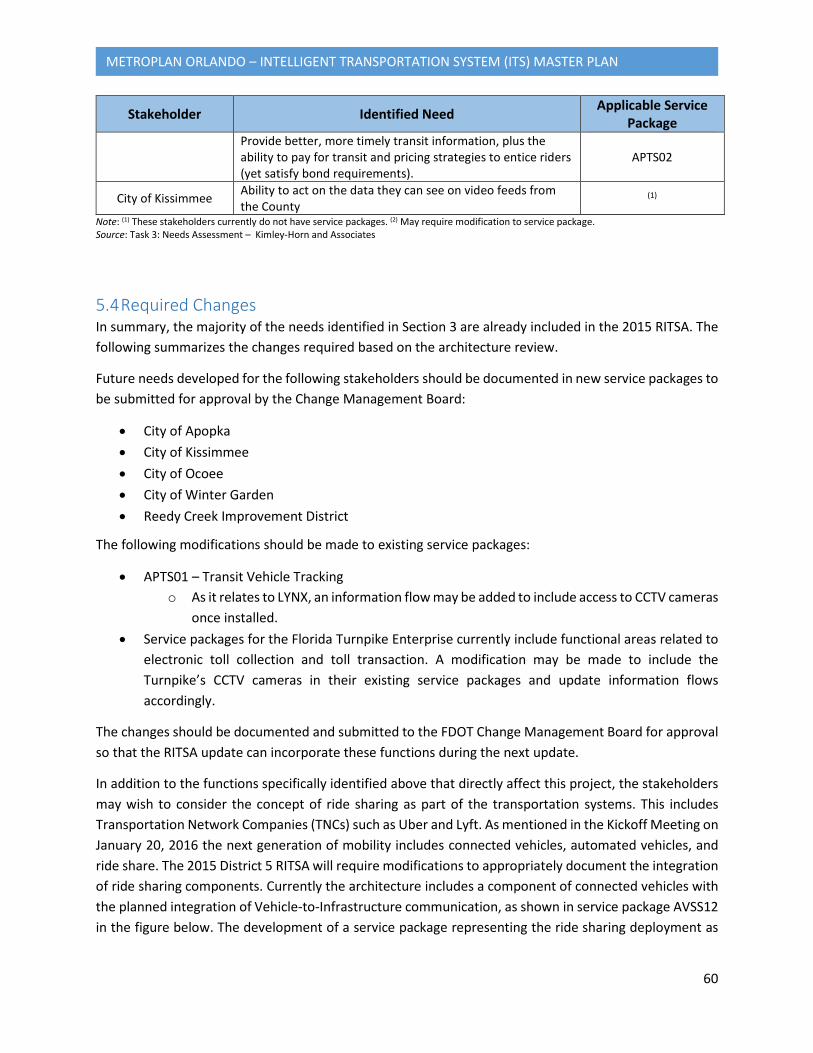
60
METROPLAN ORLANDO – INTELLIGENT TRANSPORTATION SYSTEM (ITS) MASTER PLAN
Stakeholder Identified Need Applicable Service Package
Provide better, more timely transit information, plus the ability to pay for transit and pricing strategies to entice riders (yet satisfy bond requirements).
APTS02
City of Kissimmee Ability to act on the data they can see on video feeds from the County
(1)
Note: (1) These stakeholders currently do not have service packages. (2) May require modification to service package. Source: Task 3: Needs Assessment – Kimley-Horn and Associates
5.4 Required Changes In summary, the majority of the needs identified in Section 3 are already included in the 2015 RITSA. The following summarizes the changes required based on the architecture review.
Future needs developed for the following stakeholders should be documented in new service packages to be submitted for approval by the Change Management Board:
• City of Apopka • City of Kissimmee • City of Ocoee • City of Winter Garden • Reedy Creek Improvement District
The following modifications should be made to existing service packages:
• APTS01 – Transit Vehicle Tracking o As it relates to LYNX, an information flow may be added to include access to CCTV cameras
once installed. • Service packages for the Florida Turnpike Enterprise currently include functional areas related to
electronic toll collection and toll transaction. A modification may be made to include the Turnpike’s CCTV cameras in their existing service packages and update information flows accordingly.
The changes should be documented and submitted to the FDOT Change Management Board for approval so that the RITSA update can incorporate these functions during the next update.
In addition to the functions specifically identified above that directly affect this project, the stakeholders may wish to consider the concept of ride sharing as part of the transportation systems. This includes Transportation Network Companies (TNCs) such as Uber and Lyft. As mentioned in the Kickoff Meeting on January 20, 2016 the next generation of mobility includes connected vehicles, automated vehicles, and ride share. The 2015 District 5 RITSA will require modifications to appropriately document the integration of ride sharing components. Currently the architecture includes a component of connected vehicles with the planned integration of Vehicle-to-Infrastructure communication, as shown in service package AVSS12 in the figure below. The development of a service package representing the ride sharing deployment as

61
METROPLAN ORLANDO – INTELLIGENT TRANSPORTATION SYSTEM (ITS) MASTER PLAN
an integrated capability will require additional coordination and direction from stakeholders, specifically to identify the desired information flows.
Figure 19: Connected Vehicle Service Package
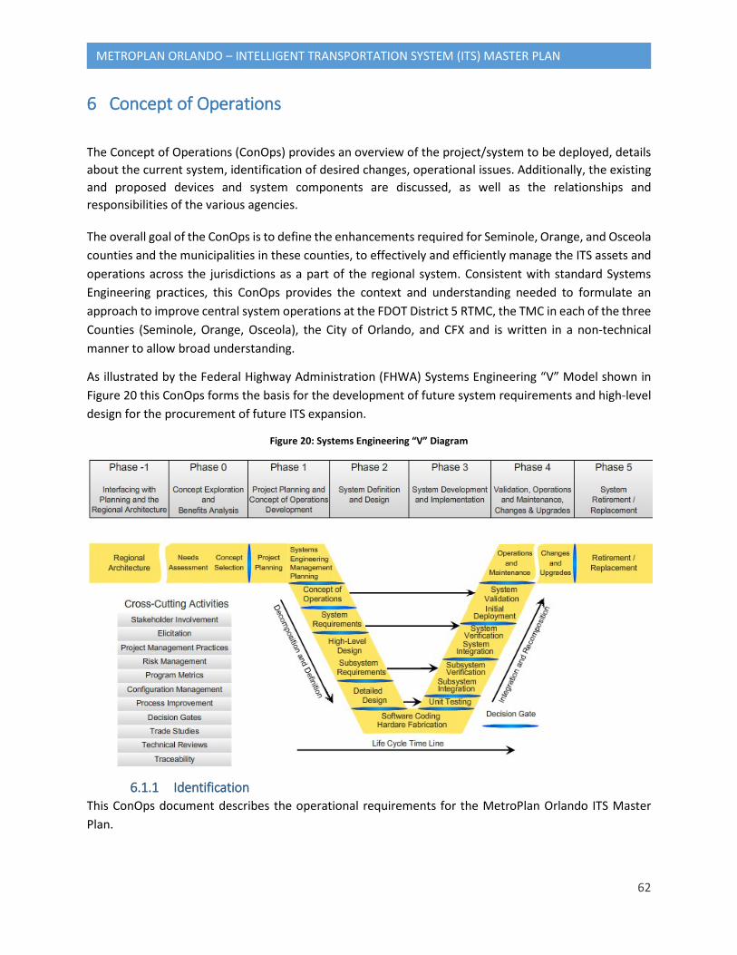
62
METROPLAN ORLANDO – INTELLIGENT TRANSPORTATION SYSTEM (ITS) MASTER PLAN
6 Concept of Operations
The Concept of Operations (ConOps) provides an overview of the project/system to be deployed, details about the current system, identification of desired changes, operational issues. Additionally, the existing and proposed devices and system components are discussed, as well as the relationships and responsibilities of the various agencies.
The overall goal of the ConOps is to define the enhancements required for Seminole, Orange, and Osceola counties and the municipalities in these counties, to effectively and efficiently manage the ITS assets and operations across the jurisdictions as a part of the regional system. Consistent with standard Systems Engineering practices, this ConOps provides the context and understanding needed to formulate an approach to improve central system operations at the FDOT District 5 RTMC, the TMC in each of the three Counties (Seminole, Orange, Osceola), the City of Orlando, and CFX and is written in a non-technical manner to allow broad understanding.
As illustrated by the Federal Highway Administration (FHWA) Systems Engineering “V” Model shown in Figure 20 this ConOps forms the basis for the development of future system requirements and high-level design for the procurement of future ITS expansion.
Figure 20: Systems Engineering “V” Diagram
6.1.1 Identification This ConOps document describes the operational requirements for the MetroPlan Orlando ITS Master Plan.
63
METROPLAN ORLANDO – INTELLIGENT TRANSPORTATION SYSTEM (ITS) MASTER PLAN
6.1.2 Document Overview The purpose of this document is to provide the project stakeholders with the operational concept for future ITS projects. This document is intended to communicate the operational needs of the stakeholders and presents an understanding of the operational expectations.
6.1.3 System Overview The MetroPlan Orlando ITS Master Plan includes the evaluation of the current systems, determination of the future needs, and the development of an implementation strategy for the future deployment and maintenance of the ITS within the planning area, Seminole, Orange, and Osceola counties. The MetroPlan Orlando ITS Master Plan ConOps will define the roles and responsibilities for maintenance, operation and management of ITS, will provide an overview of the project/system to be deployed; specific details as to the current system; the transportation situation being addressed; identification of any desired changes, assumptions, and constraints or operational issues; specifics on using/operating the project/system; methods to train and involve stakeholders; and requirements for project/system support and maintenance. The ConOps will also summarize the needs and preferences of each stakeholder and how they will interact and utilize the project/system.
The following outlines the roles and responsibilities for the system:
• Project Stakeholders – Stakeholders are involved in defining the goals, objectives, and requirements. The stakeholders within the MetroPlan Orlando area are represented by the TSMO and include the stakeholders below. The TSMO Roster is included in Appendix F and can be found at: https://www.metroplanorlando.com/wp-content/uploads/TSMO-Roster-2017-01.pdf
o Seminole County o Osceola County o Orange County o City of Orlando o LYNX o Central Florida Expressway Authority o FDOT District 5 o City of Apopka o City of Kissimmee o City of Maitland o City of Ocoee o City of Winter Garden o City of Winter Park o Florida’s Turnpike Enterprise (FTE) o Reedy Creek Improvement District
• Operating Centers – Agencies running central command operations utilizing central software,
local software, and hardware to control the ITS devices implemented as part of this project are: o FDOT District 5 RTMC

64
METROPLAN ORLANDO – INTELLIGENT TRANSPORTATION SYSTEM (ITS) MASTER PLAN
o Seminole TMC o Orange TMC o Osceola TMC o City of Orlando TMC o CFX o FTE TMC o Lynx Emergency TMC o Reedy Creek Improvement District (RCID) TMC
6.2 Referenced Documentation The following documents were used for the preparation of this document. In the event of a conflict between the contents of the documents referenced herein and the contents of this document, this document shall be considered the superseding document.
Table 7: Referenced Documentation
Document Date Contact
Statewide Intelligent Transportation System Architecture (SITSA) Update
December, 2015 Florida Department of Transportation Intelligent Transportation Systems Office 605 Suwannee Street, M.S. 90 Tallahassee, Florida 32399 Phone: (850) 410-5600
MetroPlan Orlando ITS Master Plan, Task 1: ITS Vision, Goals and Objectives
April, 2016 MetroPlan Orlando
315 E. Robinson Street, Suite 355
Orlando, Florida 32801-1949
Phone: (407) 481-5672
MetroPlan Orlando ITS Master Plan, Task 2: Existing Conditions/Infrastructure/Inventory
May, 2016 MetroPlan Orlando
315 E. Robinson Street, Suite 355
Orlando, Florida 32801-1949
Phone: (407) 481-5672
MetroPlan Orlando ITS Master Plan, Task 3: Needs Assessment
July, 2016 MetroPlan Orlando
315 E. Robinson Street, Suite 355
Orlando, Florida 32801-1949
Phone: (407) 481-5672
MetroPlan Orlando ITS Master Plan, Task 4: Identification of Applicable ITS Strategies
September, 2016 MetroPlan Orlando
315 E. Robinson Street, Suite 355
Orlando, Florida 32801-1949
65
METROPLAN ORLANDO – INTELLIGENT TRANSPORTATION SYSTEM (ITS) MASTER PLAN
Document Date Contact
Phone: (407) 481-5672
MetroPlan Orlando ITS Master Plan, Task 5: Regional ITS Architecture (RITSA)
September, 2016 MetroPlan Orlando
315 E. Robinson Street, Suite 355
Orlando, Florida 32801-1949
Phone: (407) 481-5672
6.3 Current System Situation This section of the ConOps describes the existing ITS devices. This section also describes the characteristics of the existing system and the issues that need to be addressed by the expanded system.
6.3.1 Background, Objectives, and Scope The MetroPlan Orlando region currently has existing ITS infrastructure consisting of various ITS sub-system components that connect via fiber optic network, copper interconnect and/or wirelessly along the region’s roadways. The overall system consisting of the existing ITS infrastructure and the future ITS infrastructure defined in this document should be considered part of the MetroPlan Orlando ITS Master Plan. The Objectives and goals were identified by the Steering Committee in Task 1: ITS Vision, Goals and Objectives. The goals are included in Section 1.
6.3.2 Operational Constraints The MetroPlan Orlando area’s roadway networks are congested and adding capacity to alleviate this congestion is not an option to keep up with the growth. The existing system, although considerable, is not sufficient to ease congestion throughout many areas of the region. The additional infrastructure and devices will provide the local agencies with the ability to more efficiently and effectively monitor traffic in real-time and relieve congestion through the use of the adaptive signal controllers and providing motorists with traffic information.
6.3.3 Description of the Current System or Situation Existing ITS Overview The MetroPlan Orlando area currently has existing ITS infrastructure consisting of various ITS components. Inventories of existing ITS infrastructure for the each of the three counties, the City of Orlando, the cities within Orange County, LYNX, FDOT, and CFX were summarized in Task 2. Table 8 shows the features of the existing system. This is the data collected from 15 agencies in three counties.
Table 8: Summary of ITS Features
Type Quantity
Signals 1,904
CCTVs 834
66
METROPLAN ORLANDO – INTELLIGENT TRANSPORTATION SYSTEM (ITS) MASTER PLAN
DMSs 196
MVDS or AVIs 1012
Bluetooths 212
Fiber Lines (miles) 1330
Copper Lines (miles) 3
Wireless/Radio 34
TSP Equipped 6 of 15 agencies
Emergency Vehicle Preemption (EVP) 7 of 15 agencies
TMC Staff (full-time equivalent) 25.5 + contracts
Field Maint. Staff (full-time equivalent) 53.5 + contracts
Seminole County: Seminole County operates and maintains the traffic signals (385) for all its municipalities.
Osceola County: Osceola County operates and maintains 116 traffic signals. Each city is responsible for operation and maintenance of their signals. The City of Kissimmee performs preventative maintenance of the signals within the City and County limits. Osceola County operates any online network devices from the City of Kissimmee. These all go back to the Osceola County TMC. City of Kissimmee has a workstation in their office that can view only.
Orange County: Orange County currently operates 591 traffic signals. The cities of Maitland, Apopka, Winter Park, Winter Garden, Ocoee, and the RCID maintain their own signals. The number of signals maintained by each City is listed in Table 3. The County maintains the signals in the other cities and the unincorporated areas, as well as those on the UCF campus and through the Central Florida Research Park.
City of Orlando: The City maintains 480 signals.
LYNX, the Central Florida Regional Transportation Authority, serves the Central Florida area with fixed-bus routes and Bus Rapid Transit (LYMMO) in downtown Orlando. Average weekday ridership is in excess of 100,000 riders system wide and most routes are served every 30 minutes. The service area includes Orange, Seminole and Osceola counties; an area of approximately 2,500 square miles with a resident population of more than 1.8 million people. Travelers can connect to and from Sunrail. Sunrail is a commuter rail system in the Greater Orlando area. Service began on May 1, 2014. Phase 1 comprises 31 miles with 12 stations connecting Volusia County and Orange County through Downtown Orlando. The trains operate Monday through Friday every half hour during morning and evening peak service and approximately every two hours during mid-day and evening service. Sunrail has an overall average of 3,800 paying riders per weekday. The Phase 2 south extension is expected to open early 2018 extending service to Poinciana in Osceola County.
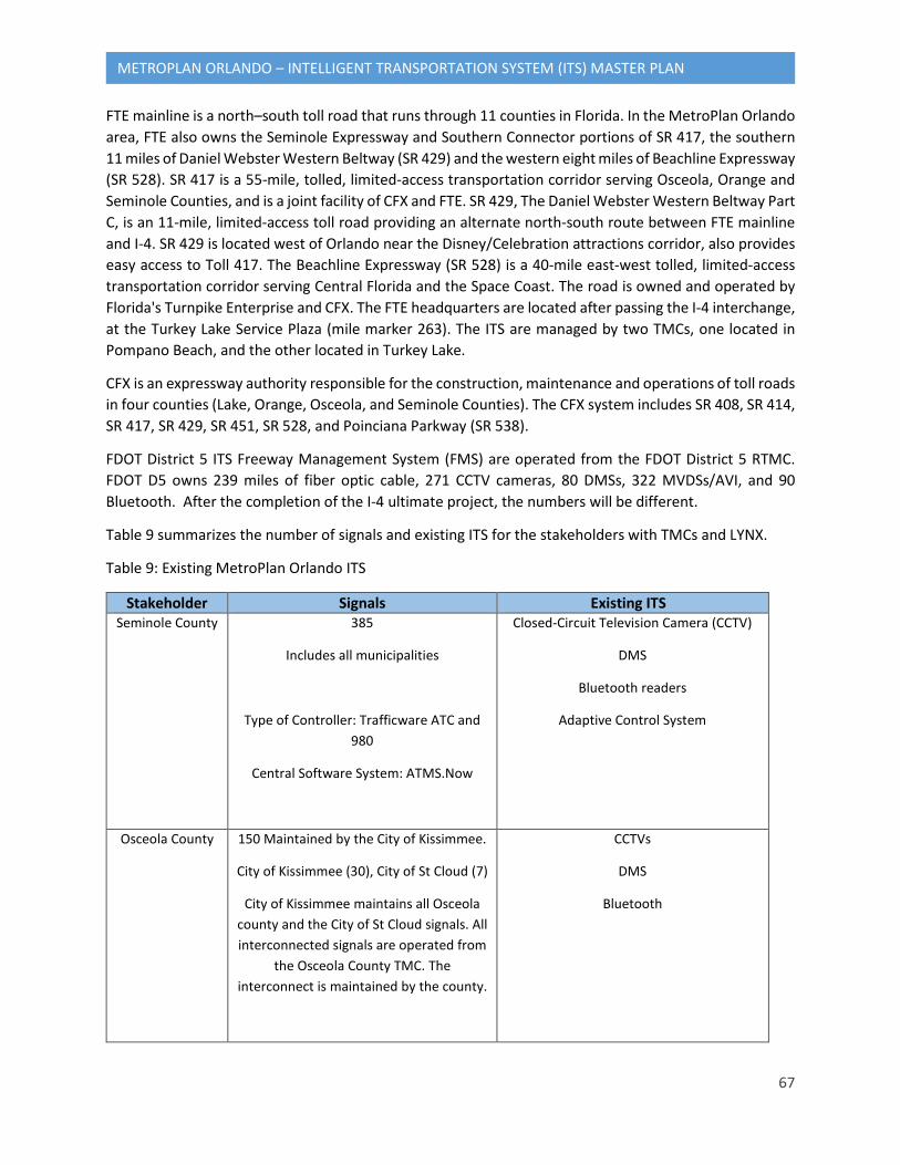
67
METROPLAN ORLANDO – INTELLIGENT TRANSPORTATION SYSTEM (ITS) MASTER PLAN
FTE mainline is a north–south toll road that runs through 11 counties in Florida. In the MetroPlan Orlando area, FTE also owns the Seminole Expressway and Southern Connector portions of SR 417, the southern 11 miles of Daniel Webster Western Beltway (SR 429) and the western eight miles of Beachline Expressway (SR 528). SR 417 is a 55-mile, tolled, limited-access transportation corridor serving Osceola, Orange and Seminole Counties, and is a joint facility of CFX and FTE. SR 429, The Daniel Webster Western Beltway Part C, is an 11-mile, limited-access toll road providing an alternate north-south route between FTE mainline and I-4. SR 429 is located west of Orlando near the Disney/Celebration attractions corridor, also provides easy access to Toll 417. The Beachline Expressway (SR 528) is a 40-mile east-west tolled, limited-access transportation corridor serving Central Florida and the Space Coast. The road is owned and operated by Florida's Turnpike Enterprise and CFX. The FTE headquarters are located after passing the I-4 interchange, at the Turkey Lake Service Plaza (mile marker 263). The ITS are managed by two TMCs, one located in Pompano Beach, and the other located in Turkey Lake.
CFX is an expressway authority responsible for the construction, maintenance and operations of toll roads in four counties (Lake, Orange, Osceola, and Seminole Counties). The CFX system includes SR 408, SR 414, SR 417, SR 429, SR 451, SR 528, and Poinciana Parkway (SR 538).
FDOT District 5 ITS Freeway Management System (FMS) are operated from the FDOT District 5 RTMC. FDOT D5 owns 239 miles of fiber optic cable, 271 CCTV cameras, 80 DMSs, 322 MVDSs/AVI, and 90 Bluetooth. After the completion of the I-4 ultimate project, the numbers will be different.
Table 9 summarizes the number of signals and existing ITS for the stakeholders with TMCs and LYNX.
Table 9: Existing MetroPlan Orlando ITS
Stakeholder Signals Existing ITS Seminole County 385
Includes all municipalities
Type of Controller: Trafficware ATC and 980
Central Software System: ATMS.Now
Closed-Circuit Television Camera (CCTV)
DMS
Bluetooth readers
Adaptive Control System
Osceola County 150 Maintained by the City of Kissimmee.
City of Kissimmee (30), City of St Cloud (7)
City of Kissimmee maintains all Osceola county and the City of St Cloud signals. All interconnected signals are operated from
the Osceola County TMC. The interconnect is maintained by the county.
CCTVs
DMS
Bluetooth
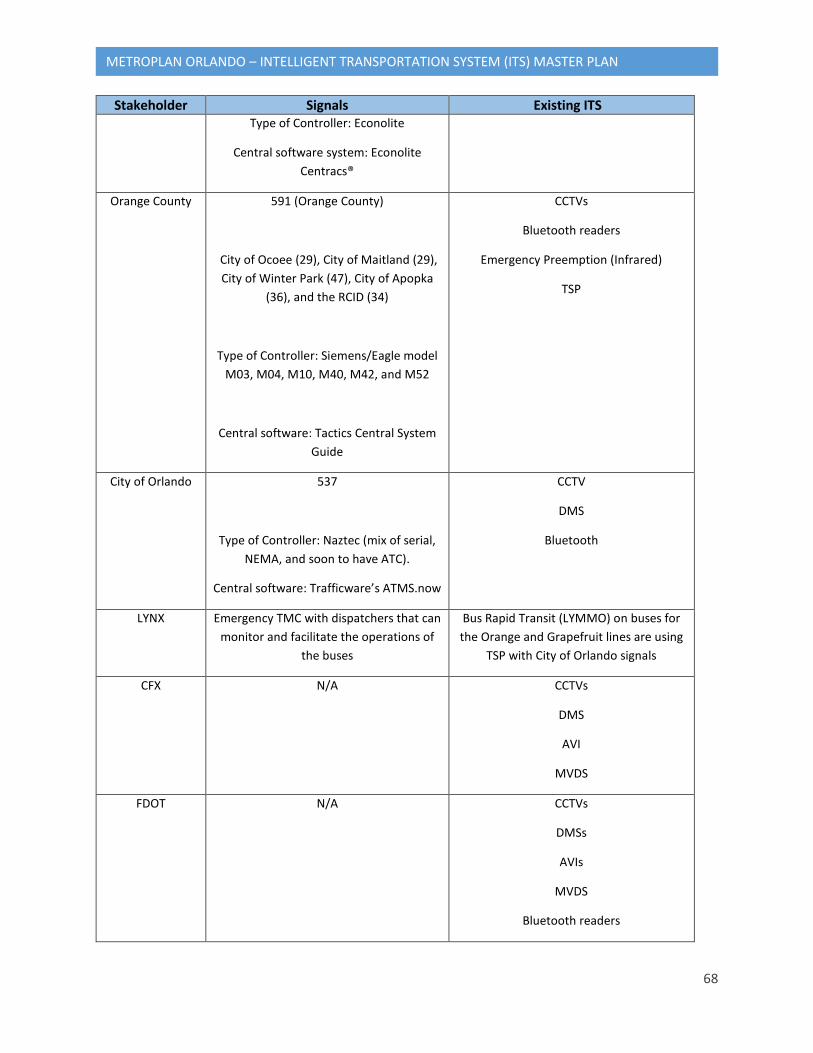
68
METROPLAN ORLANDO – INTELLIGENT TRANSPORTATION SYSTEM (ITS) MASTER PLAN
Stakeholder Signals Existing ITS Type of Controller: Econolite
Central software system: Econolite Centracs®
Orange County 591 (Orange County)
City of Ocoee (29), City of Maitland (29), City of Winter Park (47), City of Apopka
(36), and the RCID (34)
Type of Controller: Siemens/Eagle model M03, M04, M10, M40, M42, and M52
Central software: Tactics Central System Guide
CCTVs
Bluetooth readers
Emergency Preemption (Infrared)
TSP
City of Orlando 537
Type of Controller: Naztec (mix of serial, NEMA, and soon to have ATC).
Central software: Trafficware’s ATMS.now
CCTV
DMS
Bluetooth
LYNX Emergency TMC with dispatchers that can monitor and facilitate the operations of
the buses
Bus Rapid Transit (LYMMO) on buses for the Orange and Grapefruit lines are using
TSP with City of Orlando signals
CFX N/A CCTVs
DMS
AVI
MVDS
FDOT N/A CCTVs
DMSs
AVIs
MVDS
Bluetooth readers
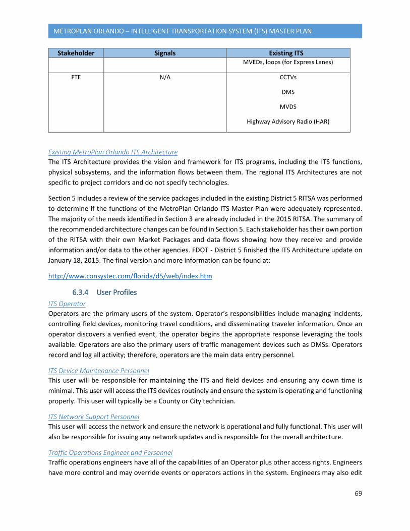
69
METROPLAN ORLANDO – INTELLIGENT TRANSPORTATION SYSTEM (ITS) MASTER PLAN
Stakeholder Signals Existing ITS MVEDs, loops (for Express Lanes)
FTE N/A CCTVs
DMS
MVDS
Highway Advisory Radio (HAR)
Existing MetroPlan Orlando ITS Architecture The ITS Architecture provides the vision and framework for ITS programs, including the ITS functions, physical subsystems, and the information flows between them. The regional ITS Architectures are not specific to project corridors and do not specify technologies.
Section 5 includes a review of the service packages included in the existing District 5 RITSA was performed to determine if the functions of the MetroPlan Orlando ITS Master Plan were adequately represented. The majority of the needs identified in Section 3 are already included in the 2015 RITSA. The summary of the recommended architecture changes can be found in Section 5. Each stakeholder has their own portion of the RITSA with their own Market Packages and data flows showing how they receive and provide information and/or data to the other agencies. FDOT - District 5 finished the ITS Architecture update on January 18, 2015. The final version and more information can be found at:
http://www.consystec.com/florida/d5/web/index.htm
6.3.4 User Profiles ITS Operator Operators are the primary users of the system. Operator’s responsibilities include managing incidents, controlling field devices, monitoring travel conditions, and disseminating traveler information. Once an operator discovers a verified event, the operator begins the appropriate response leveraging the tools available. Operators are also the primary users of traffic management devices such as DMSs. Operators record and log all activity; therefore, operators are the main data entry personnel.
ITS Device Maintenance Personnel This user will be responsible for maintaining the ITS and field devices and ensuring any down time is minimal. This user will access the ITS devices routinely and ensure the system is operating and functioning properly. This user will typically be a County or City technician.
ITS Network Support Personnel This user will access the network and ensure the network is operational and fully functional. This user will also be responsible for issuing any network updates and is responsible for the overall architecture.
Traffic Operations Engineer and Personnel Traffic operations engineers have all of the capabilities of an Operator plus other access rights. Engineers have more control and may override events or operators actions in the system. Engineers may also edit
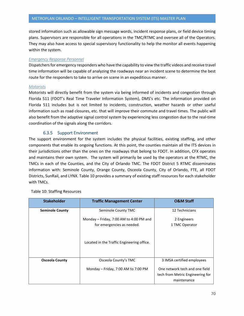
70
METROPLAN ORLANDO – INTELLIGENT TRANSPORTATION SYSTEM (ITS) MASTER PLAN
stored information such as allowable sign message words, incident response plans, or field device timing plans. Supervisors are responsible for all operations in the TMC/RTMC and oversee all of the Operators. They may also have access to special supervisory functionality to help the monitor all events happening within the system.
Emergency Response Personnel Dispatchers for emergency responders who have the capability to view the traffic videos and receive travel time information will be capable of analyzing the roadways near an incident scene to determine the best route for the responders to take to arrive on scene in an expeditious manner.
Motorists Motorists will directly benefit from the system via being informed of incidents and congestion through Florida 511 (FDOT’s Real Time Traveler Information System), DMS’s etc. The information provided on Florida 511 includes but is not limited to incidents, construction, weather hazards or other useful information such as road closures, etc. that will improve their commute and travel times. The public will also benefit from the adaptive signal control system by experiencing less congestion due to the real-time coordination of the signals along the corridors.
6.3.5 Support Environment The support environment for the system includes the physical facilities, existing staffing, and other components that enable its ongoing functions. At this point, the counties maintain all the ITS devices in their jurisdictions other than the ones on the roadways that belong to FDOT. In addition, CFX operates and maintains their own system. The system will primarily be used by the operators at the RTMC, the TMCs in each of the Counties, and the City of Orlando TMC. The FDOT District 5 RTMC disseminates information with: Seminole County, Orange County, Osceola County, City of Orlando, FTE, all FDOT Districts, SunRail, and LYNX. Table 10 provides a summary of existing staff resources for each stakeholder with TMCs.
Table 10: Staffing Resources
Stakeholder Traffic Management Center O&M Staff
Seminole County Seminole County TMC
Monday – Friday, 7:00 AM to 4:00 PM and for emergencies as needed.
Located in the Traffic Engineering office.
12 Technicians
2 Engineers 1 TMC Operator
Osceola County Osceola County’s TMC
Monday – Friday, 7:00 AM to 7:00 PM
3 IMSA certified employees
One network tech and one field tech from Metric Engineering for
maintenance
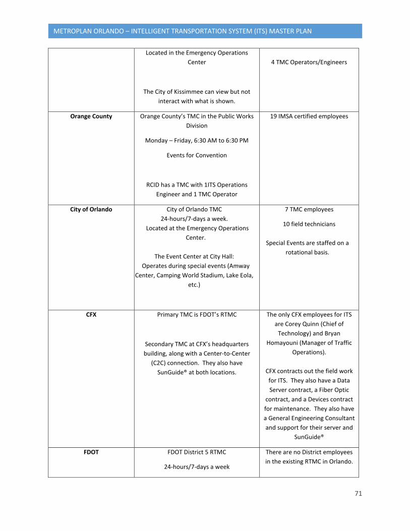
71
METROPLAN ORLANDO – INTELLIGENT TRANSPORTATION SYSTEM (ITS) MASTER PLAN
Located in the Emergency Operations Center
The City of Kissimmee can view but not interact with what is shown.
4 TMC Operators/Engineers
Orange County Orange County’s TMC in the Public Works Division
Monday – Friday, 6:30 AM to 6:30 PM
Events for Convention
RCID has a TMC with 1ITS Operations Engineer and 1 TMC Operator
19 IMSA certified employees
City of Orlando City of Orlando TMC 24-hours/7-days a week.
Located at the Emergency Operations Center.
The Event Center at City Hall:
Operates during special events (Amway Center, Camping World Stadium, Lake Eola,
etc.)
7 TMC employees
10 field technicians
Special Events are staffed on a rotational basis.
CFX Primary TMC is FDOT’s RTMC
Secondary TMC at CFX’s headquarters building, along with a Center-to-Center
(C2C) connection. They also have SunGuide® at both locations.
The only CFX employees for ITS are Corey Quinn (Chief of
Technology) and Bryan Homayouni (Manager of Traffic
Operations).
CFX contracts out the field work for ITS. They also have a Data Server contract, a Fiber Optic
contract, and a Devices contract for maintenance. They also have a General Engineering Consultant and support for their server and
SunGuide®
FDOT FDOT District 5 RTMC
24-hours/7-days a week
There are no District employees in the existing RTMC in Orlando.
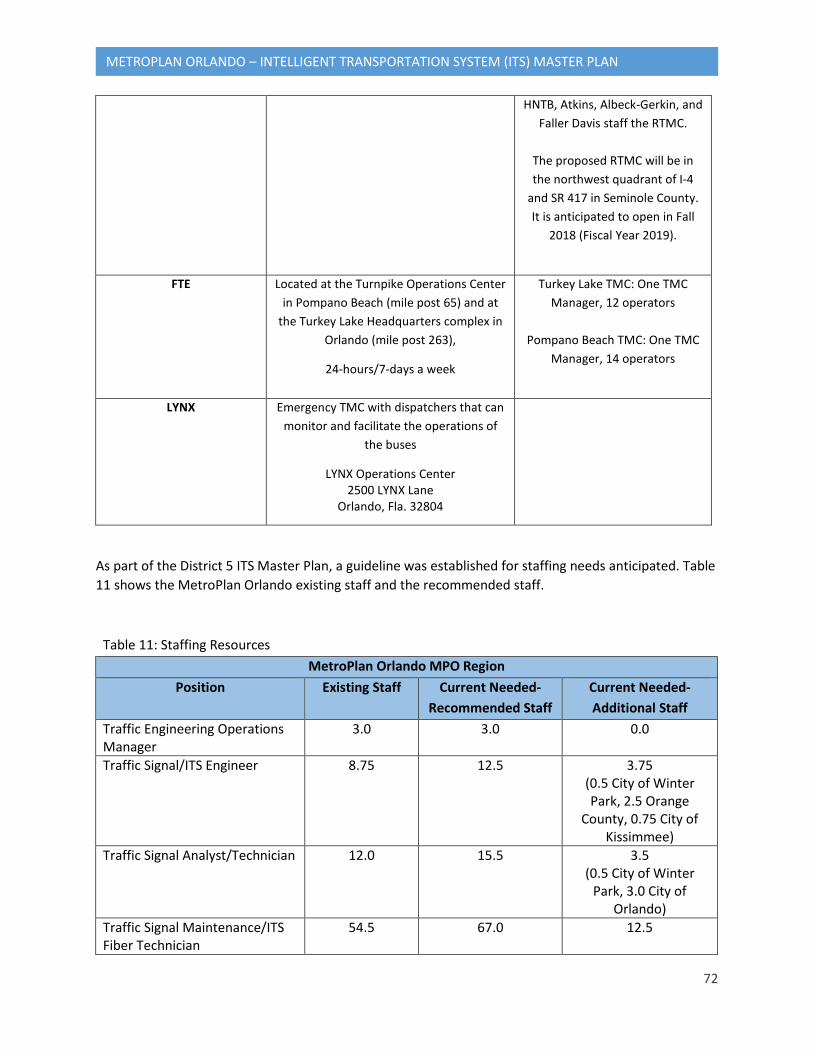
72
METROPLAN ORLANDO – INTELLIGENT TRANSPORTATION SYSTEM (ITS) MASTER PLAN
HNTB, Atkins, Albeck-Gerkin, and Faller Davis staff the RTMC.
The proposed RTMC will be in the northwest quadrant of I-4
and SR 417 in Seminole County. It is anticipated to open in Fall
2018 (Fiscal Year 2019).
FTE Located at the Turnpike Operations Center in Pompano Beach (mile post 65) and at
the Turkey Lake Headquarters complex in Orlando (mile post 263),
24-hours/7-days a week
Turkey Lake TMC: One TMC Manager, 12 operators
Pompano Beach TMC: One TMC
Manager, 14 operators
LYNX Emergency TMC with dispatchers that can monitor and facilitate the operations of
the buses
LYNX Operations Center 2500 LYNX Lane
Orlando, Fla. 32804
As part of the District 5 ITS Master Plan, a guideline was established for staffing needs anticipated. Table 11 shows the MetroPlan Orlando existing staff and the recommended staff.
Table 11: Staffing Resources MetroPlan Orlando MPO Region
Position Existing Staff Current Needed- Recommended Staff
Current Needed- Additional Staff
Traffic Engineering Operations Manager
3.0 3.0 0.0
Traffic Signal/ITS Engineer 8.75 12.5 3.75 (0.5 City of Winter Park, 2.5 Orange
County, 0.75 City of Kissimmee)
Traffic Signal Analyst/Technician 12.0 15.5 3.5 (0.5 City of Winter
Park, 3.0 City of Orlando)
Traffic Signal Maintenance/ITS Fiber Technician
54.5 67.0 12.5
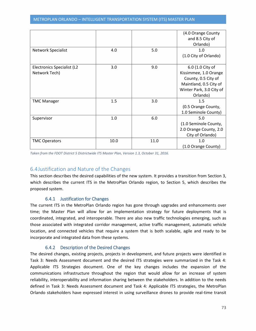
73
METROPLAN ORLANDO – INTELLIGENT TRANSPORTATION SYSTEM (ITS) MASTER PLAN
(4.0 Orange County and 8.5 City of
Orlando) Network Specialist 4.0 5.0 1.0
(1.0 City of Orlando)
Electronics Specialist (L2 Network Tech)
3.0 9.0 6.0 (1.0 City of Kissimmee, 1.0 Orange
County, 0.5 City of Maintland, 0.5 City of
Winter Park, 3.0 City of Orlando)
TMC Manager 1.5 3.0 1.5 (0.5 Orange County,
1.0 Seminole County) Supervisor 1.0 6.0 5.0
(1.0 Seminole County, 2.0 Orange County, 2.0
City of Orlando) TMC Operators 10.0 11.0 1.0
(1.0 Orange County)
6.4 Justification and Nature of the Changes This section describes the desired capabilities of the new system. It provides a transition from Section 3, which describes the current ITS in the MetroPlan Orlando region, to Section 5, which describes the proposed system.
6.4.1 Justification for Changes The current ITS in the MetroPlan Orlando region has gone through upgrades and enhancements over time; the Master Plan will allow for an implementation strategy for future deployments that is coordinated, integrated, and interoperable. There are also new traffic technologies emerging, such as those associated with integrated corridor management, active traffic management, automatic vehicle location, and connected vehicles that require a system that is both scalable, agile and ready to be incorporate and integrated data from these systems.
6.4.2 Description of the Desired Changes The desired changes, existing projects, projects in development, and future projects were identified in Task 3: Needs Assessment document and the desired ITS strategies were summarized in the Task 4: Applicable ITS Strategies document. One of the key changes includes the expansion of the communications infrastructure throughout the region that would allow for an increase of system reliability, interoperability and information sharing between the stakeholders. In addition to the needs defined in Task 3: Needs Assessment document and Task 4: Applicable ITS strategies, the MetroPlan Orlando stakeholders have expressed interest in using surveillance drones to provide real-time transit
Taken from the FDOT District 5 Districtwide ITS Master Plan, Version 1.3, October 31, 2016.
74
METROPLAN ORLANDO – INTELLIGENT TRANSPORTATION SYSTEM (ITS) MASTER PLAN
information, traffic conditions, and incidents; and video from TMCs to law enforcement and EMS vehicles access conditions en-route to incidents.
6.4.3 Change Priorities The priorities will be summarized under Prioritized ITS Master Plan project list. The list includes potential ITS projects that address deficiencies in the existing and planned infrastructure. The list of potential ITS projects was prioritized using screening criteria that will include the following factors:
• Mitigates an identified transportation problem • Improves dissemination of traffic related information • Implements a network of TMCs with potential to transition to a single TMC for the area • Reduces recurring and nonrecurring congestion • Improves safety of the transportation network • Sustainability • Regional impacts • Emerging technologies • “Big Data” • Transit • Freight • Strategic Intermodal System • Connectivity
6.4.4 Changes Considered but Not Included There are many enhancements that could be made in an effort to make the MetroPlan Orlando region as technologically advanced and robust as possible. The future projects will be developed following the FDOT 5-Year Work Program, RITSA, and MetroPlan Orlando ITS Master Plan keeping in mind that the factors such as funding, maintenance & operations personnel, and central system capabilities are a limitation. During the screening process as described in Section 4.3, some projects may not be included in the Master Plan.
6.4.5 Assumptions and Constraints This section describes the assumptions or constraints applicable to the changes and new features identified in this section. These assumptions and constraints will affect users during development and operation of the new or modified system. An assumption is a condition that is taken to be true. A constraint is an externally imposed limitation placed on the new or modified system or the processes used to develop or modify the system. The assumptions and constraints are listed below:
• It is assumed that all devices and any new central traffic control software to be installed will comply with the National Transportation Communications for Intelligent Transportation System Protocol (NTCIP) requirements and the ITS devices will be compatible with the SunGuide® and the ATMS software already in use by the local agencies.
75
METROPLAN ORLANDO – INTELLIGENT TRANSPORTATION SYSTEM (ITS) MASTER PLAN
• The various signal system software and signal controllers used by the stakeholders within the MetroPlan Orlando region presents a compatibility challenge when cross-network and cross-jurisdictional communications are required (e.g. for signal coordination).
• It is assumed that any future updates will be compatible with the existing system. The standardization of the traffic signal cabinet and controller will facilitate the operation and maintenance of the existing traffic signals.
• It is assumed that the current ITS field devices will remain in operation. There is not a major initiative to replace the ITS devices in the field. Therefore, the system should have the capability to operate all the devices currently in the field and accommodate for new devices as they are installed throughout the regions.
• All proposed ITS listed within this document are dependent on the programming of funding and the availability of funding at the start of Design and Construction. Funding levels will determine whether portions of the project must be removed and installed under future projects.
• Adding ITS devices does not add capacity to the roadway nor eliminate oversaturated conditions. • Any required Agreements will be executed between stakeholders to allow for information sharing. • If the plan is to have backup TMCs and allow for control to be shared during emergencies, the
pertinent agreements will need to be in place. • One of the major efforts will be to consider an entity to manage the transportation flow through
corridor(s) that run through several jurisdictions. This includes having a single TMC that would control all of the ITS devices to manage the transportation flow through a corridor that runs through several agencies.
6.5 Concepts for the Proposed System This section describes the proposed system based on the desired capabilities specified in Section 4 of this document. This section describes the proposed system at a high-level indicating the operational features or functionalities that are to be provided without specifying design details.
6.5.1 Background, Objectives, and Scope The expansion of the MetroPlan Orlando region ITS will provide traffic management, congestion management, traffic incident management, and traffic information assets and benefits to user agencies and the motoring public. The future system will include the expansion of communications network along with CCTV, ADMS, travel time, TSP, EVP, and adaptive signal control components throughout three counties and the cities within.
6.5.2 Operational Policies and Constraints Separate Traffic Management Centers in the area include the FDOT District 5 RTMC along with a TMC in each of the three counties (Seminole, Orange, Osceola), the City of Orlando, CFX, and FTE. Each of these TMC’s operate independently of one another, although camera feeds are shared to and from the FDOT RTMC. Camera feeds from the RTMC are also used in broadcasts by the local television stations. All new ITS facilities will become part of the existing system in which current operational policies will apply. The hours of operation of the RTMC and TMCs are listed in Table 12.
76
METROPLAN ORLANDO – INTELLIGENT TRANSPORTATION SYSTEM (ITS) MASTER PLAN
Section 4 identified the need to expand the interagency data sharing for enhanced traffic operations. The pertinent agreements will need to be in place to have backup TMCs and allow for control to be shared during emergencies.
6.5.3 Description of the Proposed System The ITS for MetroPlan Orlando stakeholders will be designed to be state-of-the-practice with virtual traffic signal control, traffic monitoring, and roadway surveillance for incident management and traveler information using multiple subsystems. The ITS needs were summarized in Section 3 and the ITS strategies were summarized in Section 4.
The subsystems include CCTV camera monitoring, DMS, MVDS’s, Bluetooth devices, and transit management all connected by a robust fiber optic system and an Ethernet network. The exact locations and quantities of each of these devices will be determined by stakeholder involvement, budget availability, and a more thorough design. Descriptions of the included systems are as follows:
Traffic Signals System Traffic signal hardware will continue to be connected to the existing ATMS and will be upgraded to be compatible with the signal management software, as applicable. All traffic signal upgrades will consist of the replacement of the traffic signal controller. Any traffic signals which are not already connected to the network will be interconnected using fiber optic communications along the corridor.
All users of the system will be able to observe the operation of a traffic signal; however, only the operating agency will have the authority to modify the traffic signal operation. In the future, each agency may choose to grant control authority to qualified regional operators. Agreements will need to be established between partnering agencies to allow for sharing of information.
Real-time data availability has the potential to transform how traffic signal systems are designed, implemented, operated, and monitored. Developing new systems that use data via Vehicle to Vehicle (V2V) and V2I communications to control signals to maximize flows in real-time can improve traffic conditions significantly. The Intelligent Traffic Signal System plays the role of providing the underlying functionality of operations by virtue of its control and connectivity with the TMCs or RTMC. This can be integrated into an over-arching system optimization application, accommodating transit signal priority, and preemption to maximize overall arterial network performance.
The following ITS Strategies apply to this system:
• Active Traffic Management (ATM) • Integrated Corridor Management • Traveler Information • Traffic Control • Incident Management • Travel Demand Management • Public Transportation Management • Commercial Vehicle Operations • Emergency Management
77
METROPLAN ORLANDO – INTELLIGENT TRANSPORTATION SYSTEM (ITS) MASTER PLAN
• Advanced Vehicle Systems • Information Management • Event Management
Adaptive Traffic Control System (ATCS) Adaptive systems are becoming a versatile tool for a traffic engineer to employ in order to provide improved traffic operations based on real-time traffic conditions on the roadway. There are many reasons an adaptive traffic control system may be desirable at select jurisdictions within the MetroPlan area. They include being able to manage tourist generated traffic demands beyond traditional peak periods experienced on most roadways. In an effort to improve traffic flow and reduce delay throughout the MetroPlan Orlando area, additional segments in the region would benefit from an adaptive traffic system. The available adaptive signal technologies have various strengths and weaknesses. Some are known to operate best on arterial networks whereas others are known for their adaptive operations in grid networks. Each adaptive control methodology is unique to some extent and it is difficult to perform a direct comparison of the specific features of each adaptive technology.
The following ITS Strategies apply to this system:
• ATM • Integrated Corridor Management • Traveler Information • Traffic Control • Incident Management • Travel Demand Management • Public Transportation Management • Commercial Vehicle Operations • Emergency Management • Advanced Vehicle Systems • Information Management • Event Management
Closed-Circuit Television Cameras System Video plays an important role in the operation of the network by providing the capability to monitor traffic, verify incidents, and verify operation of field components. CCTV cameras can provide the ability to see traffic situations from the computer monitor of the designated Employee(s) on a real-time basis, providing invaluable assistance in verifying the existence of traffic crashes and/or incidents prior to dispatching response crews (i.e., law enforcement, EMS and Fire and Rescue). CCTV cameras can monitor traffic flows along a corridor, enabling the designated operator(s) to select timing plans or adjust signal timings based upon the observed traffic flow patterns.
Additional CCTV cameras will be deployed throughout the network to provide enhanced video traffic surveillance. Task 3 shows which agencies are interested in adding CCTV cameras to their existing network. The deployed CCTV cameras throughout the network provide video traffic surveillance from the
78
METROPLAN ORLANDO – INTELLIGENT TRANSPORTATION SYSTEM (ITS) MASTER PLAN
local TMCs as well as the RTMC. All system users will be able to observe any CCTV camera on the network. As with all information sharing needs, agreements need to be established for the sharing of video streams.
The following ITS Strategies apply to this system:
• ATM • Advance Parking Management • Integrated Corridor Management • Traveler Information • Traffic Control • Incident Management • Travel Demand Management • Highway Rail Intersection • Public Transportation Management • Public Travel Security • Commercial Vehicle Operations • Emergency Management • Information Management • Event Management
Travel Time Detection System Travel Time Detection Systems involve collecting traffic information using various ITS technologies, and posting traffic reports onto the 511 Traveler Information System and DMSs to help drivers learn about upcoming traffic delays, alternate route information and travel times. This information helps the motorists to divert away from the congested roadway and use alternative routes.
A variety of travel time measurement systems have emerged as ideal mechanisms for constantly monitoring arterial performance, incident detection, and identification of irregular traffic patterns.
The expansion projects should consider installing traffic sensors on primary arterials in the long term, depending on technology advances over time and general industry standards. The sensor data could be used for a variety of applications, including: incident detection, congestion management, travel time information (via DMS or 511 systems), data collection, and performance measurement. Sensor technology will be a conduit to V2V and V2X with emergence of connected and autonomous vehicles. Additional data for these or any corridors could be obtained by acquiring third party data, which should be evaluated on a project specific basis at the time the data is desired.
The following ITS Strategies apply to this system:
• ATM • Integrated Corridor Management • Traveler Information • Traffic Control • Incident Management • Travel Demand Management
79
METROPLAN ORLANDO – INTELLIGENT TRANSPORTATION SYSTEM (ITS) MASTER PLAN
• Public Transportation Management • Commercial Vehicle Operations • Emergency Management • Advanced Vehicle Systems • Information Management • Event Management
Transit Signal Priority (TSP) and Emergency Vehicle Priority (EVP) System TSP strategies adjust signal timing at intersections to better accommodate transit vehicles. Connected vehicle technologies provide opportunities to significantly enhance current TSP system by:
• Providing more accurate estimates of prevailing traffic conditions at signalized intersections by integrating conventional loop detector data and wireless data;
• Allowing earlier detection and continuous monitoring of transit vehicles as they approach and progress through intersections; and
• Supporting more intelligent priority strategies that implement trade-offs between traffic and transit delay at intersections in a network.
In a connected vehicle environment, transit vehicles can transmit data characterizing the need for priority to the roadside infrastructure. It is now possible to provide differential priority, whereby different levels of priority can be granted to multiple transit vehicles depending on a number of factors, including prevailing traffic conditions, current status of the traffic signal controller, and the status of each transit vehicle.
Preemption is a tool for providing priority through an intersection controlled by a traffic signal control system. Preemption can be provided for different users with railroad and emergency vehicles being the most common uses. Emergency Vehicle Priority almost always consists of a receptor installed at or near the traffic signal control system. Upon detecting a request from an approaching emergency vehicle, the receptor places a request to the traffic signal control system controller. The controller contains logic for EVP and attempts to provide an exclusive green phase for the approach with the emergency vehicle while providing red phases for all other approaches. EVP configurations typically include a confirmation light installed at or near the traffic signal control system which provides information to the approaching emergency vehicle that an EVP request has been received by the controller.
The following ITS Strategies apply to this system:
• ATM • Integrated Corridor Management • Traveler Information • Traffic Control • Incident Management • Travel Demand Management • Highway Rail Intersection • Public Transportation Management • Commercial Vehicle Operations
80
METROPLAN ORLANDO – INTELLIGENT TRANSPORTATION SYSTEM (ITS) MASTER PLAN
• Emergency Management • Advanced Vehicle Systems • Information Management • Event Management
Traveler Information System Dynamic Message Signs and Advanced Dynamic Message Signs are typically used to provide motorists with real-time traffic information, travel time information, incident information, vehicle alerts (such as America’s Missing: Broadcast Emergency Response (AMBER) Alerts), safety related messages, and detour advisories in advance of key decision points along arterial roadways. Deployment of DMS’s will primarily be on limited access roadways, major arterials and evacuation routes. These signs will provide information on the status of the interstates and corridors so travelers can make informed decisions before committing to entering the roadway.
Both static and real-time information will be disseminated supporting pre-trip and en-route traveler information. Static traveler information is categorized as pre-trip traveler information, advising motorists of planned roadway activities, such as construction and maintenance activities, special events, regional emergencies, and hurricane evacuation information. Real-time traveler information can be disseminated as both pre-trip and en-route, warning motorists of recurring and non-recurring congestion impacting travel conditions and causing travel delay.
Other traveler information systems includes transit and parking information as well as real-time construction information and emergencies. LYNX has expressed the need for data sharing and inter-agency connectivity, data sharing, sharing of CCTV access, real-time traffic information.
The following ITS Strategies apply to this system:
• ATM • Advance Parking Management • Integrated Corridor Management • Traveler Information • Dynamic Wayfinding • Traffic Control • Incident Management • Travel Demand Management • Highway Rail Intersection • Public Transportation Management • Public Travel Security • Electronic Payment Service • Commercial Vehicle Operations • Emergency Management • Advanced Vehicle Systems • Information Management • Event Management
81
METROPLAN ORLANDO – INTELLIGENT TRANSPORTATION SYSTEM (ITS) MASTER PLAN
• Parking Management Integration
6.5.4 Modes of Operation The existing system will continue with the current modes of operations. There are only two TMCs that are open 24 hours a day/7 days a week, FDOT District 5 RTMC and the City of Orlando TMC. Therefore, after normal business hours, the FDOT District 5 RTMC should have control of the ITS systems in the MetroPlan Orlando area. The operational scenarios are described in Section 6.
6.5.5 User Involvement and Interaction Primary operations of the ITS devices will take place from the maintaining agency TMC. The Cities will have connectivity to the ITS devices within their jurisdiction. The RTMC operators will use the SunGuide® software to monitor and operate the components of the system that are owned by FDOT and will also have the capability to monitor the system from the RTMC. Interagency agreements should be developed to outline response plans for major emergencies, integrated corridor management, incident management, connected vehicles, performance management, and information management.
Future efforts could include the development of regional timing plans and agencies roles and responsibilities for operating ITS devices within their jurisdiction that are acceptable to all agencies. Once these plans are developed and approved, authority will be granted to qualified personnel to invoke these plans in response to incidents, accidents, evacuations, or other emergencies. Support Environment
The support environment for the ITS includes the physical facilities, existing and proposed staffing, and other components that enable its ongoing functions. The system will primarily be used by the operators at the RTMC and each TMC.
FDOT and the counties currently have an agreement for the maintenance of traffic signals, and some of the ITS devices. Most of the ITS devices in the region are maintained by the counties themselves. Furthermore, some of the Cities maintain the signals within their boundaries.
Access to the field devices will allow faster, more efficient and coordinated responses to incidents and emergencies. Depending on each agency’s individual needs, various levels of access and control for field devices can be provided in the future.
6.6 Operational Scenarios This section presents scenarios to describe how the system is expected to operate under a variety of conditions. The scenarios capture a day of the operational staff at the RTMC and TMCs in order to clearly illustrate the overall vision of how it can operate at maximum efficiency. The operational scenarios provided below are offered as examples, and are not intended to be exhaustive.
Normal Operations:
There is no delay in traffic flow and the operator would keep monitoring for any sort of incident or malfunction. There will be free flow of traffic and the detection systems show no sign of travel time delay.
82
METROPLAN ORLANDO – INTELLIGENT TRANSPORTATION SYSTEM (ITS) MASTER PLAN
The signalized intersections run under the same signal system plan until there is any an issue and the detection systems show an increase in travel time.
Incident Operations:
The system detects a potential incident, alerts the operator to the incident at a specific location and shows the operator the CCTV in the area. The operator will verify the incident and accept the alert. The system will generate incident information and distribute it to motorists. The system will present the operator with a Traffic Management Response Plan that may include signal system adjustment, CCTV, access control in the affected area, as well as a traveler information and notification plan. The operator will review the plans; modify the plan if necessary; and accept and apply the plan. The system will broadcast the event and carry out the plan. Video feeds will be shared with law enforcement, EMS and Fire and Rescue. Stakeholders will review the event and add response information. The response information could include files, such as pictures, to the incident log.
Equipment Malfunction:
The system detects a potential signal malfunction or outage, alerts the operator of the specific location, and shows the operator the CCTV in the area. The operator will verify the malfunction and accept the alert. The system will present the operator with the notification plan. The operator will review the plan, modify and accept the plan. If necessary, the video feeds will be shared with law enforcement, EMS and Fire and Rescue. The system and operator will carry out the plan in conjunction with maintenance personnel in the field that will be able to remotely access the system. Actions will then be taken regarding the equipment keeping the records organized.
6.7 Summary of Impacts The MetroPlan Orlando needs and the future ITS deployments described in this document will impact the system users in a variety of ways. In general, the primary impact will be providing additional capabilities and providing enhanced ease of use.
RTMC and TMC staff (administrators, supervisors, and operators) – The RTMC and the TMCs will have to commit new resources to administer, supervise and operate the system. Additional staff will be required to operate the system. All the jurisdictions will have to have more maintenance personnel to maintain the additional communications networks, field devices and front end systems so that operations are optimal and ITS elements are in good working order.
Travelers – The traveler may be considered the ultimate customer and consumer in the eventual deployment of the full ITS. The overall traveling public in the MetroPlan Orlando region could benefit from traveler information to the basic form of travel time and incident information. Currently, users can get information on the freeway through FDOT’s Freeway Management System (FMS) and on arterials through the RTMC. While difficult to determine, the expansion of the ITS and operations in the MetroPlan Orlando region can save millions of dollars in delay.
83
METROPLAN ORLANDO – INTELLIGENT TRANSPORTATION SYSTEM (ITS) MASTER PLAN
6.8 Analysis of the Proposed System The MetroPlan Orlando ITS Master Plan will prioritize the future ITS projects based on the needs and information identified in Task 1 – 5. The Master plan will include traffic control systems, ITS devices and communications network expansion in the MetroPlan Orlando region. The proposed ITS projects will provide real-time traffic information to improve safety by reducing response and clearance times, improve transportation system efficiency, improve traffic management during highway construction and maintenance activities, improve quality of life by improved traveler information and predictability of travel times, and improve public perception in Seminole, Osceola, and Orange counties and the Cities within.
6.9 Notes This Section is a high level document prepared in conformance to, and fully following the outline of, the ConOps template provided by the Florida DOT Statewide ITS Strategic Plan updated 2005. It is anticipated that subsequent updates to this document will be made and that notes and updated references will be made in this section.
84
METROPLAN ORLANDO – INTELLIGENT TRANSPORTATION SYSTEM (ITS) MASTER PLAN
7 Prioritized ITS Projects
The following section discusses the considerations for funding ITS projects, provides a list of potential projects that meet the needs and strategies defined in Sections 3 and 4, provides a methodology for scoring the future projects, and then prioritizes the various projects.
7.1 ITS Project Funding Considerations Project funding is a key component of ITS project implementation. It is important to secure project funding before a project can be programmed in the MPO TIP and in the FDOT Five-Year Work Program. This section is meant to provide an overview of potential funding sources that can be used for ITS projects and includes a review of funding sources that are currently being used in the TIP for programmed ITS projects, as well as an outline of other potential local, state, and federal sources.
7.1.1 TIP Project Funding The MetroPlan Orlando FY 2016/17-2020/21 TIP lists nine funding source categories for ITS projects. Of the nine, two are federal funding categories, six are state funding categories, and one is a local funding category. They are outlined as follows:
Federal Funding Categories
• Highway Safety Program (HSP)- $802,000 • STP over 200,000 Population (SU)- $16,095,000
State Funding Categories
• District Dedicated Revenue (DDR, DDRF)- $5,333,000 • In-House Product Support (DIH)- $250,000 • Statewide ITS (DITS)- $1,144,000 • Primary Highways and PTO (DS)- $3,251,000
Local Funding Categories
• Local Funds for Federal/State Projects (LF, LFD, LFF, LFP, LFR, LFRF)- $48,000
In the TIP, ITS projects receive the most funding from federal SU funds, which are allocated to jurisdictions based on population size. SU funds are Surface Transportation Program Funds for Transportation Management Areas over 200,000 people. ITS projects in the MetroPlan Orlando TIP are programmed to receive a total of approximately $16,095,000 in SU funds over the next five years. The second largest funding source for ITS projects in the TIP is the District Dedicated Revenue funds (DDR). DDR funds are those that are allocated to the District that are set asides for projects. ITS projects in the MetroPlan Orlando TIP are programmed to receive a total of approximately $5,333,000 in DDR funds over the next five years. The Tri-County region is also programmed to receive Primary Highways and PTO (DS) funds in the next five years; accruing to approximately $3,251,000 for ITS projects. Statewide ITS (DITS) funds provide a source of funding for ITS projects in the TIP. These funds are set aside for ITS projects, and are managed statewide by the FDOT Central Office. The total amount allocated by FDOT is $25,000,000 per
85
METROPLAN ORLANDO – INTELLIGENT TRANSPORTATION SYSTEM (ITS) MASTER PLAN
year. Of that $25,000,000, ITS projects in the MetroPlan Orlando TIP are programmed to receive a total of approximately $1,144,000 in DITS funds over the next five years.
The DITS funds are managed by the FDOT Central Office and programmed for projects that have been prioritized by the FDOT District Offices. The FDOT Central Office estimates that about 20% of all the FDOT Districts’ priority projects are able to be funded with DITS funds. The Central Office also notes that DITS funds can be supplemented with other funds and encourages the Districts and MPOs to seek other creative ways to fund ITS projects, such as first using the most restrictive funds and followed by those funds which have a larger number of allowable uses.
FDOT anticipates that by 2019, ITS deployment on the Interstate System will be completed. While replacement, maintenance, and operating costs for those deployed ITS Interstate projects will continue, the Department’s future ITS deployment program will begin to focus more and more on the non-Interstate portion of the State Highway System (arterials). “Routes of significance” (23 CFR Part 511, Subpart C) are non-Interstate roadways in metropolitan areas that are designated by States as meriting the collection and provision of information related to travel and traffic information. Factors to be considered in designating routes of significance include roadway safety, public safety, economic productivity, severity and frequency of congestion, and the utility of the highway to serve as a diversion route for congestion
locations. In identifying these routes States must apply the collaborative practices and procedures that are used in the statewide and metropolitan transportation planning processes.
Highway Safety Program (HSP) funds are used for ITS projects in the TIP. HSP funds are allocated to the states to improve highway safety and develop effective programs. ITS projects in the MetroPlan Orlando TIP are programmed to receive a
total of approximately $802,000 in HSP funds over the next five years. Other sources of funding for ITS projects as outlined in the TIP include In-House Product Support (DIH), with $250,000 allocated over the next five years, and Local Funds (LF), of which $48,000 has been set aside for ITS projects over the next 5 years. Local funds are provided by local sources to fund ITS projects. DIH funds are state funds that are allocated to projects conducted by FDOT and include: Preliminary Engineering, Right of Way Support,
RECOMMENDATION:
The MetroPlan Orlando TSMO Committee should continue to work with the FDOT District 5 in identifying and prioritizing ITS projects for DITS funding, and in finding creative approaches to fund ITS projects within its metropolitan area.
RECOMMENDATION:
The MetroPlan Orlando TSMO Committee should continue to work with the FDOT District 5 in identifying the non-Interstate roadways on the State Highway System and “Routes of Significance” which will serve as the basis for the future allocation of DITS funding.
86
METROPLAN ORLANDO – INTELLIGENT TRANSPORTATION SYSTEM (ITS) MASTER PLAN
Materials and Research and Traffic Operations projects, as outlined from 2016/17- 2020/212. Figures 21-23 outline the project funding for each county in the MetroPlan Orlando planning area for ITS projects, in addition to the tri-county area, as contained in the TIP for 2016/17- 2020/21. Figure 24 shows the tri-county area TIP funding.
2 FDOT Program and Resource Plan. Adopted July 1, 2016. http://www.fdot.gov/workprogram/pra/WhereStateFundsAreUsed.pdf
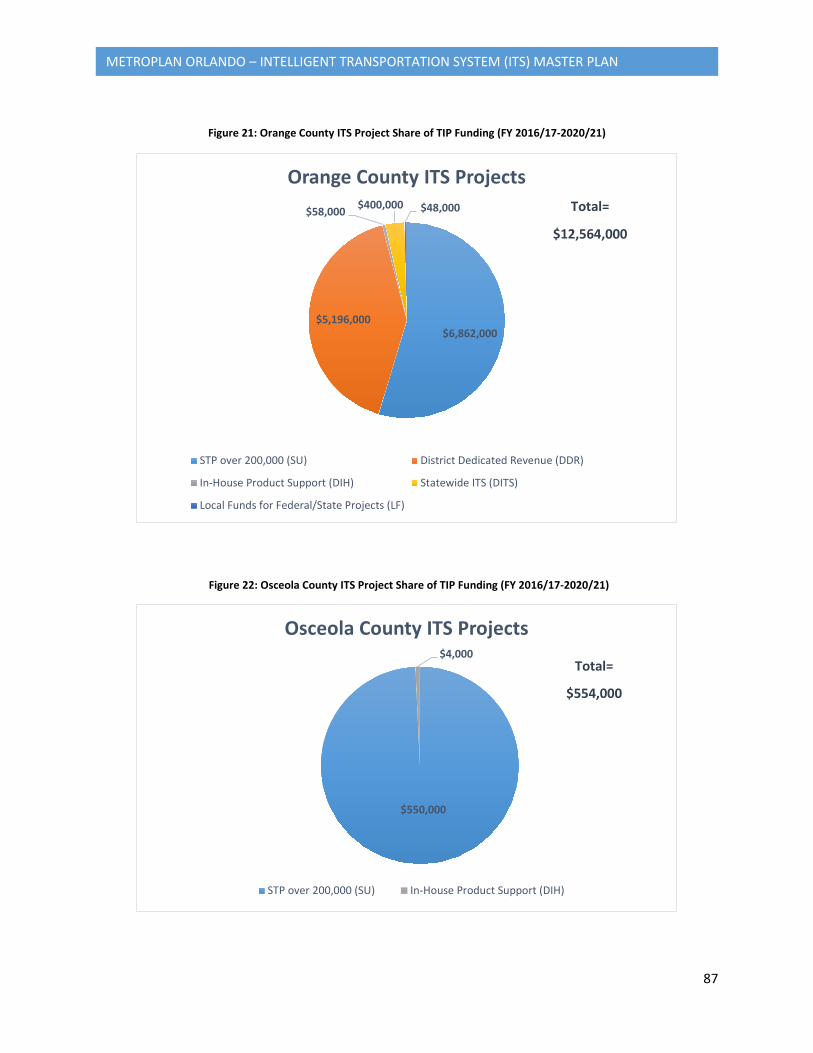
87
METROPLAN ORLANDO – INTELLIGENT TRANSPORTATION SYSTEM (ITS) MASTER PLAN
Figure 21: Orange County ITS Project Share of TIP Funding (FY 2016/17-2020/21)
$6,862,000 $5,196,000
$58,000 $400,000 $48,000
Orange County ITS Projects
STP over 200,000 (SU) District Dedicated Revenue (DDR)
In-House Product Support (DIH) Statewide ITS (DITS)
Local Funds for Federal/State Projects (LF)
Total=
$12,564,000
Figure 22: Osceola County ITS Project Share of TIP Funding (FY 2016/17-2020/21)
$550,000
$4,000
Osceola County ITS Projects
STP over 200,000 (SU) In-House Product Support (DIH)
Total=
$554,000
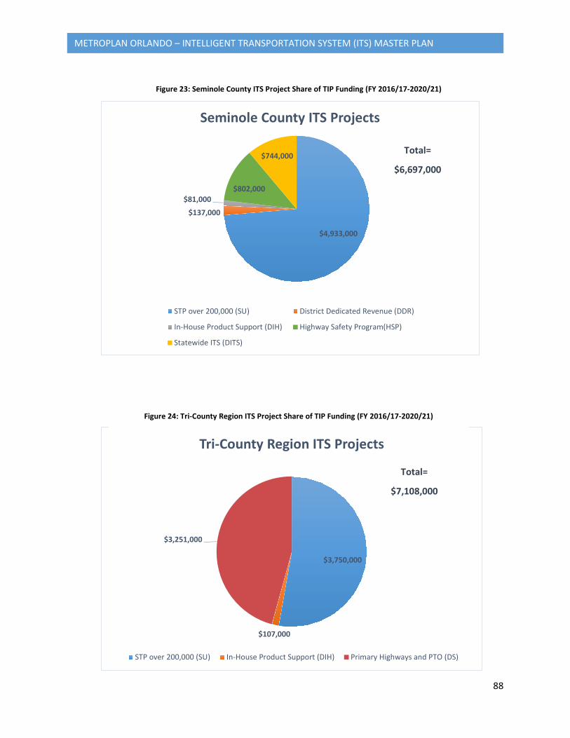
88
METROPLAN ORLANDO – INTELLIGENT TRANSPORTATION SYSTEM (ITS) MASTER PLAN
Figure 23: Seminole County ITS Project Share of TIP Funding (FY 2016/17-2020/21)
$3,750,000
$107,000
$3,251,000
Tri-County Region ITS Projects
STP over 200,000 (SU) In-House Product Support (DIH) Primary Highways and PTO (DS)
Total=
$7,108,000
Figure 24: Tri-County Region ITS Project Share of TIP Funding (FY 2016/17-2020/21)
$4,933,000
$137,000
$81,000 $802,000
$744,000
Seminole County ITS Projects
STP over 200,000 (SU) District Dedicated Revenue (DDR)
In-House Product Support (DIH) Highway Safety Program(HSP)
Statewide ITS (DITS)
Total=
$6,697,000
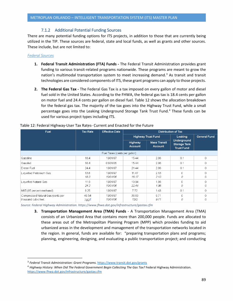
89
METROPLAN ORLANDO – INTELLIGENT TRANSPORTATION SYSTEM (ITS) MASTER PLAN
7.1.2 Additional Potential Funding Sources There are many potential funding options for ITS projects, in addition to those that are currently being utilized in the TIP. These sources are federal, state and local funds, as well as grants and other sources. These include, but are not limited to:
Federal Sources
1. Federal Transit Administration (FTA) Funds - The Federal Transit Administration provides grant funding to various transit-related programs nationwide. These programs are meant to grow the nation’s multimodal transportation system to meet increasing demand.3 As transit and transit technologies are considered components of ITS, these grant programs can apply to those projects.
2. The Federal Gas Tax - The Federal Gas Tax is a tax imposed on every gallon of motor and diesel fuel sold in the United States. According to the FHWA, the federal gas tax is 18.4 cents per gallon on motor fuel and 24.4 cents per gallon on diesel fuel. Table 12 shows the allocation breakdown for the federal gas tax. The majority of the tax goes into the Highway Trust Fund, while a small percentage goes into the Leaking Underground Storage Tank Trust Fund.4 These funds can be used for various project types including ITS.
3. Transportation Management Area (TMA) Funds - A Transportation Management Area (TMA) consists of an Urbanized Area that contains more than 200,000 people. Funds are allocated to these areas out of the Metropolitan Planning Program (MPP) which provides funding to aid urbanized areas in the development and management of the transportation networks located in the region. In general, funds are available for: “preparing transportation plans and programs; planning, engineering, designing, and evaluating a public transportation project; and conducting
3 Federal Transit Administration: Grant Programs. https://www.transit.dot.gov/grants 4 Highway History: When Did The Federal Government Begin Collecting The Gas Tax? Federal Highway Administration. https://www.fhwa.dot.gov/infrastructure/gastax.cfm
Source: Federal Highway Administration. https://www.fhwa.dot.gov/infrastructure/gastax.cfm
Table 12: Federal Highway-User Tax Rates- Current and Enacted for the Future
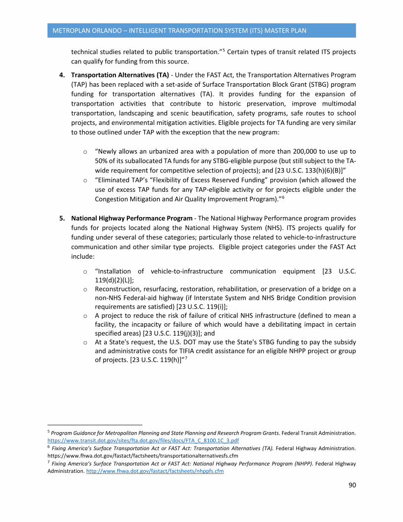
90
METROPLAN ORLANDO – INTELLIGENT TRANSPORTATION SYSTEM (ITS) MASTER PLAN
technical studies related to public transportation.”5 Certain types of transit related ITS projects can qualify for funding from this source.
4. Transportation Alternatives (TA) - Under the FAST Act, the Transportation Alternatives Program (TAP) has been replaced with a set-aside of Surface Transportation Block Grant (STBG) program funding for transportation alternatives (TA). It provides funding for the expansion of transportation activities that contribute to historic preservation, improve multimodal transportation, landscaping and scenic beautification, safety programs, safe routes to school projects, and environmental mitigation activities. Eligible projects for TA funding are very similar to those outlined under TAP with the exception that the new program:
o “Newly allows an urbanized area with a population of more than 200,000 to use up to 50% of its suballocated TA funds for any STBG-eligible purpose (but still subject to the TA-wide requirement for competitive selection of projects); and [23 U.S.C. 133(h)(6)(B)]”
o “Eliminated TAP’s “Flexibility of Excess Reserved Funding” provision (which allowed the use of excess TAP funds for any TAP-eligible activity or for projects eligible under the Congestion Mitigation and Air Quality Improvement Program).”6
5. National Highway Performance Program - The National Highway Performance program provides
funds for projects located along the National Highway System (NHS). ITS projects qualify for funding under several of these categories; particularly those related to vehicle-to-infrastructure communication and other similar type projects. Eligible project categories under the FAST Act include:
o “Installation of vehicle-to-infrastructure communication equipment [23 U.S.C. 119(d)(2)(L)];
o Reconstruction, resurfacing, restoration, rehabilitation, or preservation of a bridge on a non-NHS Federal-aid highway (if Interstate System and NHS Bridge Condition provision requirements are satisfied) [23 U.S.C. 119(i)];
o A project to reduce the risk of failure of critical NHS infrastructure (defined to mean a facility, the incapacity or failure of which would have a debilitating impact in certain specified areas) [23 U.S.C. 119(j)(3)]; and
o At a State's request, the U.S. DOT may use the State's STBG funding to pay the subsidy and administrative costs for TIFIA credit assistance for an eligible NHPP project or group of projects. [23 U.S.C. 119(h)]”7
5 Program Guidance for Metropolitan Planning and State Planning and Research Program Grants. Federal Transit Administration. https://www.transit.dot.gov/sites/fta.dot.gov/files/docs/FTA_C_8100.1C_3.pdf 6 Fixing America’s Surface Transportation Act or FAST Act: Transportation Alternatives (TA). Federal Highway Administration. https://www.fhwa.dot.gov/fastact/factsheets/transportationalternativesfs.cfm 7 Fixing America’s Surface Transportation Act or FAST Act: National Highway Performance Program (NHPP). Federal Highway Administration. http://www.fhwa.dot.gov/fastact/factsheets/nhppfs.cfm
91
METROPLAN ORLANDO – INTELLIGENT TRANSPORTATION SYSTEM (ITS) MASTER PLAN
6. Congestion Mitigation Air Quality Improvement Program (CMAQ) Funds - The Congestion Mitigation Air Quality Improvement Program provides grant funding to projects that contribute to the overall improvement of air quality through the reduction of emissions through congestion mitigation activities. Because many ITS projects contribute to congestion relief, many of them qualify for CMAQ funding.
7. National Highway Traffic Safety Administration (NHTSA) Grants - The National Highway Traffic Safety Administration (NHTSA) provides grant funding to states to develop and improve their highway traffic safety programs. “Under Section 405, NHTSA awards grants for occupant protection, state traffic safety information systems, impaired driving countermeasures, distracted driving, motorcyclist safety and state graduated driver licensing laws. Regional offices help states identify their highway safety problems using data, evaluate safety programs and activities, and provide technical assistance and training to state program managers.”8 ITS projects contribute to the improvement of highway traffic safety, and therefore certain projects qualify for funding from this source.
State Sources
1. FDOT Maintenance Agreements - Often times a local jurisdiction can enter into an agreement with FDOT, where FDOT will fund a project and once it is completed the local jurisdiction will be responsible for maintaining it.
2. Local Agency Program (LAP) Funds - This program provides federal funds to smaller jurisdictions including cities, towns, and counties for the planning and construction of transportation facilities. In order to receive Federal-Aid Highway Program funds, local agencies must go through a certification progress that determines whether they are qualified “to undertake and satisfactorily complete the work.”
3. Statewide Fuel Tax - The Statewide Fuel Tax is broken out into two components- the portion of the tax that is distributed to FDOT and the portion of the tax that is distributed to local governments. The portion that is distributed to local governments is broken out into three categories:
o Constitutional Fuel Tax- 2 cents per gallon tax on all fuels that can be used for “the
acquisition, construction, and maintenance of roads.” o County Fuel Tax- 1 cent per gallon tax on all fuels that can be used for “any legitimate
county transportation purpose.” o Municipal Fuel Tax- 1 cent per gallon tax on all fuels that can be used for “any legitimate
municipal transportation purpose.” 9
8 National Highway Traffic Safety Administration Highway Safety Grant Programs. United States Department of Transportation. https://www.nhtsa.gov/highway-safety-grants-program 9Florida’s Transportation Tax Resources: A Primer. Florida Department of Transportation Office of Comptroller-General Accounting Office, January, 2016. http://www.fdot.gov/comptroller/pdf/GAO/RevManagement/Tax%20Primer.pdf
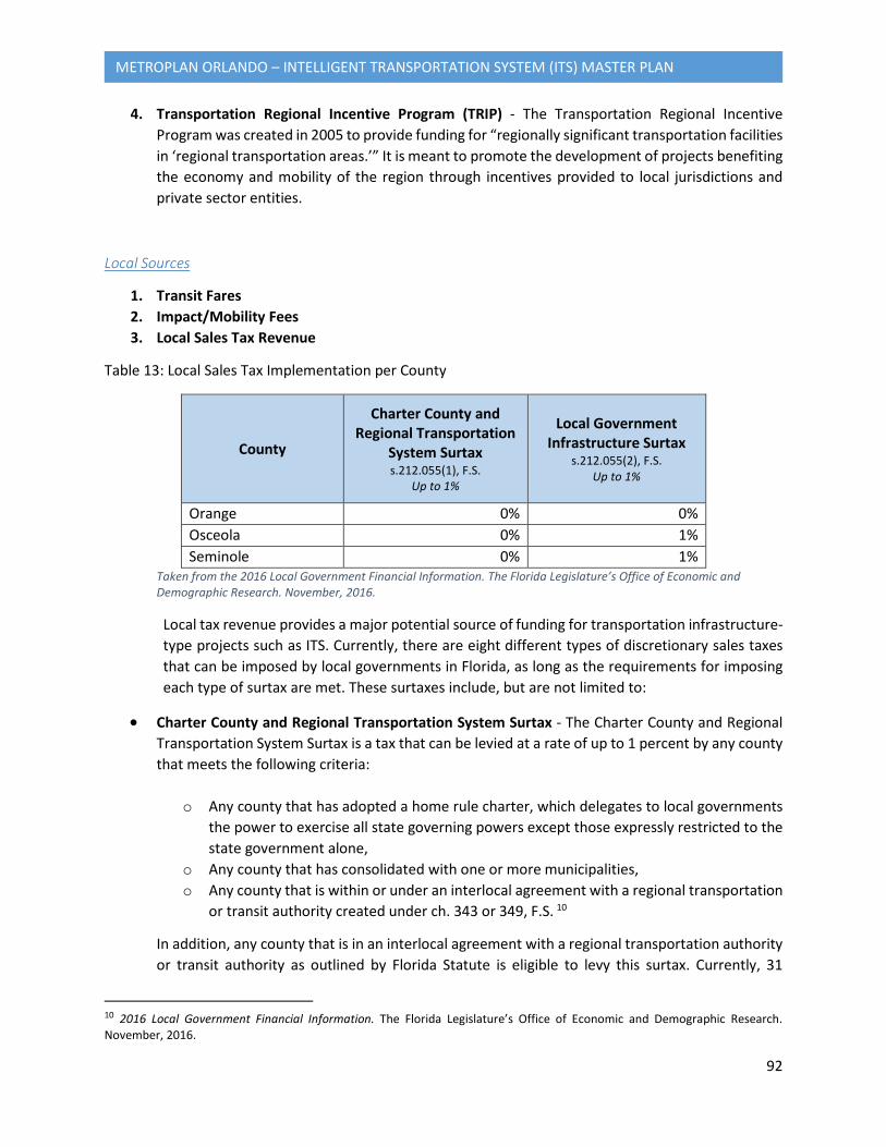
92
METROPLAN ORLANDO – INTELLIGENT TRANSPORTATION SYSTEM (ITS) MASTER PLAN
4. Transportation Regional Incentive Program (TRIP) - The Transportation Regional Incentive Program was created in 2005 to provide funding for “regionally significant transportation facilities in ‘regional transportation areas.’” It is meant to promote the development of projects benefiting the economy and mobility of the region through incentives provided to local jurisdictions and private sector entities.
Local Sources
1. Transit Fares 2. Impact/Mobility Fees 3. Local Sales Tax Revenue
Table 13: Local Sales Tax Implementation per County
County
Charter County and Regional Transportation
System Surtax s.212.055(1), F.S.
Up to 1%
Local Government Infrastructure Surtax
s.212.055(2), F.S. Up to 1%
Orange 0% 0% Osceola 0% 1% Seminole 0% 1%
Taken from the 2016 Local Government Financial Information. The Florida Legislature’s Office of Economic and Demographic Research. November, 2016.
Local tax revenue provides a major potential source of funding for transportation infrastructure-type projects such as ITS. Currently, there are eight different types of discretionary sales taxes that can be imposed by local governments in Florida, as long as the requirements for imposing each type of surtax are met. These surtaxes include, but are not limited to:
• Charter County and Regional Transportation System Surtax - The Charter County and Regional Transportation System Surtax is a tax that can be levied at a rate of up to 1 percent by any county that meets the following criteria:
o Any county that has adopted a home rule charter, which delegates to local governments the power to exercise all state governing powers except those expressly restricted to the state government alone,
o Any county that has consolidated with one or more municipalities, o Any county that is within or under an interlocal agreement with a regional transportation
or transit authority created under ch. 343 or 349, F.S. 10
In addition, any county that is in an interlocal agreement with a regional transportation authority or transit authority as outlined by Florida Statute is eligible to levy this surtax. Currently, 31
10 2016 Local Government Financial Information. The Florida Legislature’s Office of Economic and Demographic Research. November, 2016.
93
METROPLAN ORLANDO – INTELLIGENT TRANSPORTATION SYSTEM (ITS) MASTER PLAN
counties in Florida qualify to levy this surtax, including the three counties in the MetroPlan Orlando planning area.
According to the 2016 Local Government Financial Information Handbook, proceeds from this tax can be allocated for the following uses:
1. “Development, construction, equipment, maintenance, operation, supportive services, including a countywide bus system, on-demand transportation services, and related costs of a fixed guideway rapid transit system.”
2. “Remitted by the county’s governing body to an expressway or transportation authority created by law to be used at the authority’s discretion for the development, construction, operation, or maintenance of roads or bridges in the county, for the operation and maintenance of a bus system, for the operation and maintenance of on-demand transportation services, for the payment of principal and interest on existing bonds issued for the construction of such roads or bridges, and, upon approval of the county commission, such proceeds may be pledged for bonds issued to refinance existing bonds or new bonds issued for the construction of such roads or bridges.”
3. “Development, construction, operation, and maintenance of roads and bridges in the county; for the expansion, operation, and maintenance of bus and fixed guideway systems; for the expansion, operation, and maintenance of on-demand transportation services; and for the payment of principal and interest on bonds issued for the construction of fixed guideway rapid transit systems, bus systems, roads, or bridges; and such proceeds may be pledged by the county’s governing body for bonds issued to refinance existing bonds or new bonds issued for the construction of such fixed guideway rapid transit systems, bus systems, roads, or bridges and no more than 25 percent used for nontransit uses.”
4. “Used by the county for the planning, development, construction, operation, and maintenance of roads and bridges in the county; for the planning, development, expansion, operation, and maintenance of bus and fixed guideway systems; for the planning, development, construction, operation, and maintenance of on-demand transportation services; and for the payment of principal and interest on bonds issued for the construction of fixed guideway rapid transit systems, bus systems, roads, or bridges; and such proceeds may be pledged by the county’s governing body for bonds issued to refinance existing bonds or new bonds issued for the construction of such fixed guideway rapid transit systems, bus systems, roads, or bridges. Pursuant to an interlocal agreement entered into pursuant to ch. 163, F.S., the county’s governing body may distribute surtax proceeds to a municipality, or an expressway or transportation authority created by law to be expended for such purposes. Any county that has entered into interlocal agreements for the distribution of proceeds to one or more of its municipalities must
94
METROPLAN ORLANDO – INTELLIGENT TRANSPORTATION SYSTEM (ITS) MASTER PLAN
revise such agreements no less than every five years in order to include any municipalities created since the prior agreements were executed.”11
• Local Government Infrastructure Surtax - The Local Government Infrastructure Surtax is a tax that can be levied by any county with a majority vote of the county’s governing body and approved by voters, at a rate of between 0.5 and 1 percent. Currently, there are 18 counties levying this surtax and will see over $838 million in revenue. Osceola and Seminole Counties have currently enacted this tax at 1 percent. Orange County has not enacted this tax. The authorized uses of the proceeds include:
1. “To finance, plan, and construct infrastructure.” 2. “To acquire any interest in land for public recreation, conservation, or protection of natural resources or to prevent or satisfy private property rights claims resulting from limitations imposed by the designation of an area of critical state concern.” 3. “To provide loans, grants, or rebates to residential or commercial property owners who make energy efficiency improvements to their residential or commercial property, if a local government ordinance authorizing such use is approved by referendum.” 4. “To finance the closure of county or municipal-owned solid waste landfills that have been closed or are required to be closed by order of the DEP. Any use of the proceeds or interest for purposes of landfill closures before July 1, 1993, is ratified.” 12
11 2016 Local Government Financial Information. The Florida Legislature’s Office of Economic and Demographic Research. November, 2016. 12 2016 Local Government Financial Information. The Florida Legislature’s Office of Economic and Demographic Research. November, 2016.
95
METROPLAN ORLANDO – INTELLIGENT TRANSPORTATION SYSTEM (ITS) MASTER PLAN
4. Local Fuel Tax Revenue
• Ninth-Cent Fuel Tax - The Ninth-Cent Fuel Tax imposes a 1 cent tax on every gallon of motor or diesel fuel purchased within a county boundary. It can be enacted by any county through an “extraordinary vote” by the governing body or voter approval to levy the tax. This tax has been levied on all diesel fuel purchases in every county in the state since 1994. The authorized uses of the tax include:
1. “Public transportation operations and maintenance.” 2. “Roadway and right-of-way maintenance and equipment and structures used primarily for the storage and maintenance of such equipment.” 3. “Roadway and right-of-way drainage.” 4. “Street lighting installation, operation, maintenance, and repair.” 5. “Traffic signs, traffic engineering, signalization, and pavement markings installation, operation, maintenance, and repair.” 6. “Bridge maintenance and operation.” 7. “Debt service and current expenditures for transportation capital projects in the foregoing program areas, including construction or reconstruction of roads and sidewalks.” 13
If the county chooses not to levy the Ninth Cent tax on motor fuel, it still receives the proceeds from the diesel fuel tax. As shown in Table 14, Orange County has imposed a diesel fuel tax, and has received $1.16 million in realized revenues from that tax. However, Orange County has not imposed the Ninth Cent tax on motor fuel. Osceola and Seminole Counties have imposed a 1 cent motor fuel tax, in addition to the 1 cent diesel fuel tax. Osceola County will receive an estimated $2 million in revenues by September 2017, and Seminole County will receive an estimated $2.2 million in revenues by September 2017. If Orange County were to impose a Ninth Cent motor fuel tax, it would receive an estimated $6.7 million in revenues by September 2017. However, if Orange County votes to impose the motor fuel tax, it must do so by October to go into effect as of January 1st of the following year. The estimated revenues received could be allocated to fund ITS projects.
• 1-6 Cents Local Option Fuel Tax- The 1 to 6 Cents Local Option Fuel Tax is a tax of between 1 and 6 cents on every gallon of motor fuel sold within the county boundary. It can be imposed by a county through an ordinance passed by majority vote by the governing body or voter approval through a referendum. All counties in Florida have imposed this tax except for Franklin County. Orange, Seminole, and Osceola Counties have imposed this tax at a rate of 6 cents, as can be seen Table 14. Orange County receives $44 million in realized revenues from this tax, Osceola County receives $11 million, and Seminole County receives $12 million. The authorized uses for this tax include:
1. “Public transportation operations and maintenance.” 2. “Roadway and right-of-way maintenance and equipment and structures used primarily for the storage and maintenance of such equipment.”
13 2016 Local Government Financial Information. The Florida Legislature’s Office of Economic and Demographic Research. November, 2016.

96
METROPLAN ORLANDO – INTELLIGENT TRANSPORTATION SYSTEM (ITS) MASTER PLAN
3. “Roadway and right-of-way drainage.” 4. “Street lighting installation, operation, maintenance, and repair.” 5. “Traffic signs, traffic engineering, signalization, and pavement markings installation, operation, maintenance, and repair.” 6. “Bridge maintenance and operation.” 7. “Debt service and current expenditures for transportation capital projects in the foregoing program areas, including construction or reconstruction of roads and sidewalks.”
• 1 to 5 Cents Local Option Fuel Tax- The 1 to 5 Cents Local Option Fuel Tax is a tax of between 1 and 5 cents on every gallon of motor fuel sold within the county boundary. It can be imposed by the county by a majority plus one vote of the county’s governing body. All counties are eligible to levy this tax, however they are required to meet the Local Government Half-cent Sales Tax Program and County and Municipal Revenue Sharing Program requirements. Eligible projects for funding with this tax must address the requirements outlined in the county’s comprehensive plan capital improvement program, or must address immediate transportation problems. “Expenditures for the construction of new roads, the reconstruction or resurfacing of existing paved roads, or the paving of existing graded roads are deemed to increase capacity, and such projects can be included in the capital improvements element of an adopted comprehensive plan. Routine maintenance of roads is not considered an authorized expenditure.” Currently, Orange County and Seminole County do not levy this tax; leaving $31 million and $9.4 million in unrealized revenues. Osceola County does levy this tax at a rate of 5 cents; accruing to $8.7 million in revenues that can be used for ITS projects. 14
Table 14: Local Fuel Tax Implementation/Revenue per County
County Ninth-Cent
Fuel Tax
Countywide
Tax Revenues from Motor Fuel Ninth-
Cent Fuel Tax
1-6 Cents Local Option
Fuel Tax
Countywide Tax Revenues from 1-6 Cents Local Option
Fuel Tax
1-5 Cents Local
Option Fuel Tax
Countywide Tax Revenues
from 1-5 Cents Local Option Fuel
Tax Orange -- $1,160,692
(realized) $6,650,576
(unrealized)
$.06 $44,047,135 -- $30,991,331 (unrealized)
Osceola $.01 $2,037,483 $.06 $11,431,908 $.05 $8,713,371 Seminole $.01 $2,223,121 $.06 $12,482,963 -- $9,403,090
(unrealized) Taken from the 2016 Local Government Financial Information. The Florida Legislature’s Office of Economic and Demographic Research. November, 2016.
14 2016 Local Government Financial Information. The Florida Legislature’s Office of Economic and Demographic Research. November, 2016.
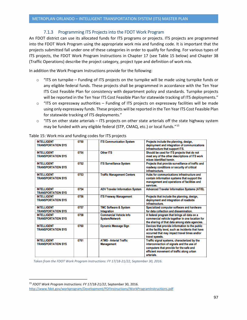
97
METROPLAN ORLANDO – INTELLIGENT TRANSPORTATION SYSTEM (ITS) MASTER PLAN
7.1.3 Programming ITS Projects into the FDOT Work Program An FDOT district can use its allocated funds for ITS programs or projects. ITS projects are programmed into the FDOT Work Program using the appropriate work mix and funding code. It is important that the projects submitted fall under one of these categories in order to qualify for funding. For various types of ITS projects, the FDOT Work Program Instructions in Chapter 17 (see Table 15 below) and Chapter 38 (Traffic Operations) describe the project category, project type and definition of work mix.
In addition the Work Program Instructions provide for the following:
o “ITS on turnpike – Funding of ITS projects on the turnpike will be made using turnpike funds or any eligible federal funds. These projects shall be programmed in accordance with the Ten Year ITS Cost Feasible Plan for consistency with department policy and standards. Turnpike projects will be reported in the Ten Year ITS Cost Feasible Plan for statewide tracking of ITS deployments.”
o “ITS on expressway authorities – Funding of ITS projects on expressway facilities will be made using only expressway funds. These projects will be reported in the Ten Year ITS Cost Feasible Plan for statewide tracking of ITS deployments.”
o “ITS on other state arterials – ITS projects on other state arterials off the state highway system may be funded with any eligible federal (STP, CMAQ, etc.) or local funds.”15
Table 15: Work mix and funding codes for ITS projects
15 FDOT Work Program Instructions: FY 17/18-21/22, September 30, 2016. http://www.fdot.gov/workprogram/Development/PDFInstructions/WorkProgramInstructions.pdf
Taken from the FDOT Work Program Instructions: FY 17/18-21/22, September 30, 2016.
98
METROPLAN ORLANDO – INTELLIGENT TRANSPORTATION SYSTEM (ITS) MASTER PLAN
It is important to note that certain types of ITS projects are fundable under the Work Program Budget and others are fundable under the Operating Budget. It is important to be sure project costs need to be allocated to the correct budget. Below are examples of projects that are fundable under each budget type.
Work Program Budget – Project Examples
• “Deployment of ITS field devices to include dynamic message signs (DMS), roadside sensors, CCTV cameras, and vehicle detection systems (VDS);”
• “Deployment of advanced traffic signal systems;” • “Deployment of weather system;” • “Deployment of probe data collection systems;” • “Deployment of communication infrastructure;” • “Deployment of connected vehicle (CV) technology (design may be eligible as long as it is for a specific
corridor);” • “Construction of TMCs;” • “Outfitting of TMCs with video wall, work station furniture, work station computer equipment,
servers, etc., pursuant to FAC 60A-1.017;” • “Operations of the TMCs;” • “Replacement of aging equipment, both field and TMC;” • “Software needed to operate TMCs including operational support by vendor (Note: Equipment
purchased that is not used exclusively for this purpose should be funded with operating budget);” o “Work station operating systems o Service operating system;” o “Database software (Oracle, etc.)” o “Security system software” o “Firewall software or Other specialized software”
• “Traveler Information Systems (511 system) to include operational support by the vendor;” • “ITS design work;” • “Construction, engineering and inspection (CEI) work to support the deployment of ITS;” • “General consultant activities to support the deployment of ITS;” • “Power needs for field devices.” 16
Operating Budget – Project Examples
• “Power needs for TMCs;” • “Janitorial services for TMCs;” • “Replacement of work station furniture;” • “TMC grounds upkeep (mowing and weed control);” • “Stand-alone service agreements;” • “TMC building maintenance.”
16 FDOT Work Program Instructions: FY 17/18-21/22. September 30, 2016. http://www.fdot.gov/workprogram/Development/PDFInstructions/WorkProgramInstructions.pdf
99
METROPLAN ORLANDO – INTELLIGENT TRANSPORTATION SYSTEM (ITS) MASTER PLAN
It is important to consult the FDOT Work Program Instructions for a complete and up-to-date set of guidelines for the programming and funding of ITS projects. 17
7.2 Transportation Improvement Program (TIP) Projects The MetroPlan Orlando's Fiscal Year (FY) 2016/17-2020/21 Transportation Improvement Program (TIP) identifies all federal and state funded transportation projects that have been scheduled for implementation in Orange, Seminole and Osceola Counties. The ITS projects included in the TIP are part of the Transportation Management and Operations (TSMO) priorities of MetroPlan Orlando, and have been drawn from MetroPlan Orlando's adopted LRTP and PPL. The TSMO category includes projects related to incident management, Transportation Demand Management, and other management and operations activities. The following criteria were considered in ranking these projects:
• Project cost (cannot exceed $4 million for all phases combined) • Amount of right-of-way needed • Significance of environmental impacts • Acceptance of the project by the affected local government • Ability to begin construction within 24 to 36 months • Availability of funding
The list of Transportation Systems Management & Operations (TSMO) projects included in the TIP is listed in Appendix G. These projects have been given a short-term priority as they are already programmed, and have been left out of the ranking process identified in Section 7.3.
7.3 Prioritized Project List (PPL) The FY 2021/22-2039/40 PPL, which was adopted by MetroPlan Orlando on September 14, 2016, includes projects that address identified needs in the MetroPlan Orlando LRTP. The MPO’s LRTP analyzes current and projected transportation needs over a period of 20 to 25 years, based on travel demand and projected population growth. The plan is updated every 5 years to include new data and information. Once needs are identified, projects are developed to address them. Projects are then prioritized, and ranked as well as unranked new projects are included in the PPL. TSMO projects are prioritized by the TSMO Advisory Committee based on factors that include:
• The project’s ability to reduce traffic congestion and/or improve safety, • The readiness of projects for implementation, • The cost and availability of funding for the projects, and • The balance of funding equity among the three counties
17 FDOT Work Program Instructions: FY 17/18-21/22. September 30, 2016. http://www.fdot.gov/workprogram/Development/PDFInstructions/WorkProgramInstructions.pdf
100
METROPLAN ORLANDO – INTELLIGENT TRANSPORTATION SYSTEM (ITS) MASTER PLAN
Unranked new projects can be added to the PPL via the online Project Application Tool that was created by MetroPlan Orlando, which streamlines the information gathering process and creates a Priority Projects Programming Process (4P) application that can be submitted to FDOT for the projects’ programming into FDOT’s Five Year Work Program. Once the final PPL is reviewed by the various committees, it is submitted for approval by the MetroPlan Orlando Board and then to FDOT. The FDOT Five Year Work Program is used by the MPO to develop its TIP for the following year. Once a project has been fully funded in the TIP, it is removed from the PPL. The remaining projects can then be moved to a higher priority and new projects can also be added.
7.4 ITS Scoring Methodology for Future ITS Deployment The ITS Scoring Methodology has been developed with a focus on linking the proposed projects with the goals and objectives of the ITS Master Plan that are identified in Section 1, as well as key stakeholder input in identifying strategies to address local priorities that has been incorporated into Section 4. To ensure concurrency between planning efforts, the goals and objectives included in this plan are in line with the priorities identified in the MetroPlan Orlando 2040 LRTP. The application of “efficient and cost-effective technology to developing and enhancing the regional transportation system” is identified as the ITS objective in the 2040 LRTP, and is further emphasized in the Congestion Management Process (CMP) component.
The CMP component of the 2040 LRTP links CMP objectives to identified performance measures by dominant mode. This matrix is outlined in Table 16. The performance measures have been identified based on local and state agency monitoring and analysis activities, and are in line with the federal requirements outlined in Public Law 114-94, the Fixing America’s Surface Transportation (FAST) Act. The performance measures identified in Table 16 have been incorporated into the project ranking criteria in Table 17 through the analysis of various parameters including existing volume to capacity on state roadway segments throughout the planning area. Other criteria have been identified through a review of similar ITS plans and studies, and have been modified based on local conditions.
The projects selected for evaluation have been gathered from the PPL and others have been identified based on needs listed in Section 3 of this plan and the District’s 5 RITSA. The intersection improvement projects were excluded from this ranking since most of the intersection improvements are assumed to be geometric improvements. The Traffic Signal Coordination project in the three counties was also removed from this ranking since this is an ongoing effort and the Technical Advisory Committee (TAC) recommends to include this project without a priority number. In addition to the prioritized projects included in the PPL, this Master Plan proposes new projects based on an analysis of needs identified in the stakeholder workshops, and an analysis of corridor-level congestion and crash counts. Through this analysis, the top 25 state roadway segments with the highest volume to capacity (presented as a percentage of the level of service) have been identified. In addition, an analysis of crash data on state roads was also conducted, and the top 10 state roadway corridors with the highest crash rates were identified. The roadways identified as a result of both the volume to capacity and crash data analyses were then used as the basis for the location of future projects. They have been listed in tables in Appendix G. The purpose of this
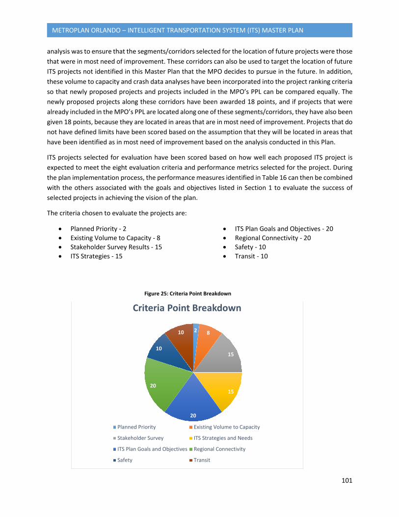
101
METROPLAN ORLANDO – INTELLIGENT TRANSPORTATION SYSTEM (ITS) MASTER PLAN
analysis was to ensure that the segments/corridors selected for the location of future projects were those that were in most need of improvement. These corridors can also be used to target the location of future ITS projects not identified in this Master Plan that the MPO decides to pursue in the future. In addition, these volume to capacity and crash data analyses have been incorporated into the project ranking criteria so that newly proposed projects and projects included in the MPO’s PPL can be compared equally. The newly proposed projects along these corridors have been awarded 18 points, and if projects that were already included in the MPO’s PPL are located along one of these segments/corridors, they have also been given 18 points, because they are located in areas that are in most need of improvement. Projects that do not have defined limits have been scored based on the assumption that they will be located in areas that have been identified as in most need of improvement based on the analysis conducted in this Plan.
ITS projects selected for evaluation have been scored based on how well each proposed ITS project is expected to meet the eight evaluation criteria and performance metrics selected for the project. During the plan implementation process, the performance measures identified in Table 16 can then be combined with the others associated with the goals and objectives listed in Section 1 to evaluate the success of selected projects in achieving the vision of the plan.
The criteria chosen to evaluate the projects are:
• Planned Priority - 2 • Existing Volume to Capacity - 8 • Stakeholder Survey Results - 15 • ITS Strategies - 15
• ITS Plan Goals and Objectives - 20 • Regional Connectivity - 20 • Safety - 10 • Transit - 10
2 8
15
15
20
20
10
10
Criteria Point Breakdown
Planned Priority Existing Volume to Capacity
Stakeholder Survey ITS Strategies and Needs
ITS Plan Goals and Objectives Regional Connectivity
Safety Transit
Figure 25: Criteria Point Breakdown
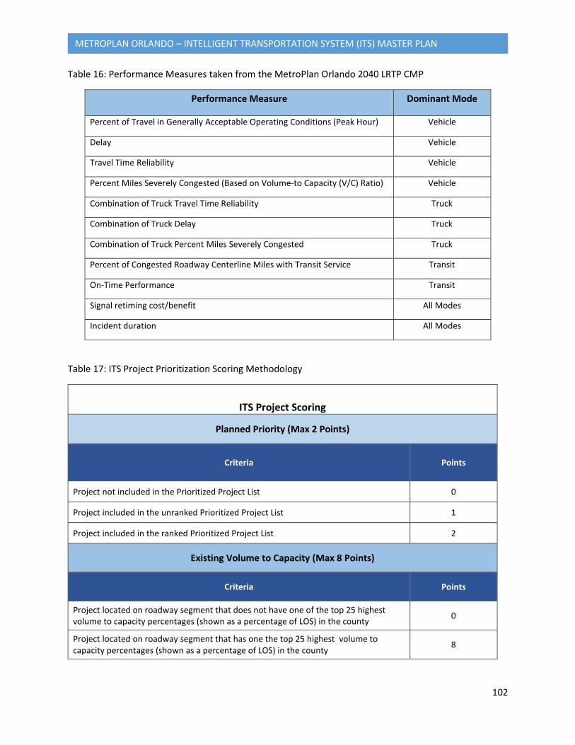
102
METROPLAN ORLANDO – INTELLIGENT TRANSPORTATION SYSTEM (ITS) MASTER PLAN
Table 16: Performance Measures taken from the MetroPlan Orlando 2040 LRTP CMP
Performance Measure Dominant Mode
Percent of Travel in Generally Acceptable Operating Conditions (Peak Hour) Vehicle
Delay Vehicle
Travel Time Reliability Vehicle
Percent Miles Severely Congested (Based on Volume-to Capacity (V/C) Ratio) Vehicle
Combination of Truck Travel Time Reliability Truck
Combination of Truck Delay Truck
Combination of Truck Percent Miles Severely Congested Truck
Percent of Congested Roadway Centerline Miles with Transit Service Transit
On-Time Performance Transit
Signal retiming cost/benefit All Modes
Incident duration All Modes
Table 17: ITS Project Prioritization Scoring Methodology
ITS Project Scoring
Planned Priority (Max 2 Points)
Criteria Points
Project not included in the Prioritized Project List 0
Project included in the unranked Prioritized Project List 1
Project included in the ranked Prioritized Project List 2
Existing Volume to Capacity (Max 8 Points)
Criteria Points
Project located on roadway segment that does not have one of the top 25 highest volume to capacity percentages (shown as a percentage of LOS) in the county 0
Project located on roadway segment that has one the top 25 highest volume to capacity percentages (shown as a percentage of LOS) in the county 8
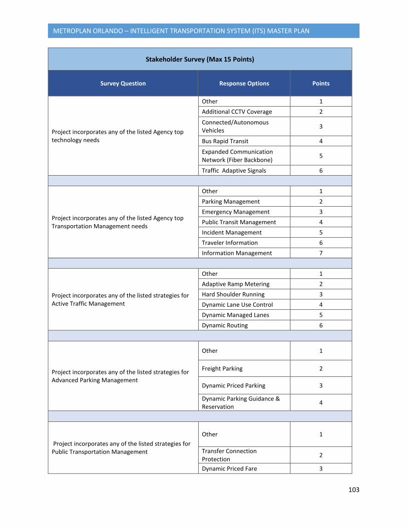
103
METROPLAN ORLANDO – INTELLIGENT TRANSPORTATION SYSTEM (ITS) MASTER PLAN
Stakeholder Survey (Max 15 Points)
Survey Question Response Options Points
Project incorporates any of the listed Agency top technology needs
Other 1 Additional CCTV Coverage 2
Connected/Autonomous Vehicles 3
Bus Rapid Transit 4
Expanded Communication Network (Fiber Backbone) 5
Traffic Adaptive Signals 6
Project incorporates any of the listed Agency top Transportation Management needs
Other 1 Parking Management 2 Emergency Management 3 Public Transit Management 4 Incident Management 5 Traveler Information 6 Information Management 7
Project incorporates any of the listed strategies for Active Traffic Management
Other 1 Adaptive Ramp Metering 2 Hard Shoulder Running 3 Dynamic Lane Use Control 4 Dynamic Managed Lanes 5 Dynamic Routing 6
Project incorporates any of the listed strategies for Advanced Parking Management
Other 1
Freight Parking 2
Dynamic Priced Parking 3
Dynamic Parking Guidance & Reservation 4
Project incorporates any of the listed strategies for Public Transportation Management
Other 1
Transfer Connection Protection 2
Dynamic Priced Fare 3
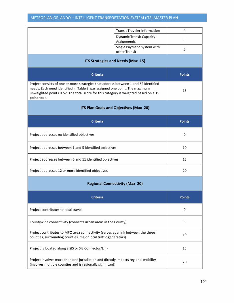
104
METROPLAN ORLANDO – INTELLIGENT TRANSPORTATION SYSTEM (ITS) MASTER PLAN
Transit Traveler Information 4
Dynamic Transit Capacity Assignments 5
Single Payment System with other Transit 6
ITS Strategies and Needs (Max 15)
Criteria Points
Project consists of one or more strategies that address between 1 and 52 identified needs. Each need identified in Table 3 was assigned one point. The maximum unweighted points is 52. The total score for this category is weighted based on a 15 point scale.
15
ITS Plan Goals and Objectives (Max 20)
Criteria Points
Project addresses no identified objectives 0
Project addresses between 1 and 5 identified objectives 10
Project addresses between 6 and 11 identified objectives 15
Project addresses 12 or more identified objectives 20
Regional Connectivity (Max 20)
Criteria Points
Project contributes to local travel 0
Countywide connectivity (connects urban areas in the County) 5
Project contributes to MPO area connectivity (serves as a link between the three counties, surrounding counties, major local traffic generators) 10
Project is located along a SIS or SIS Connector/Link 15
Project involves more than one jurisdiction and directly impacts regional mobility (involves multiple counties and is regionally significant) 20
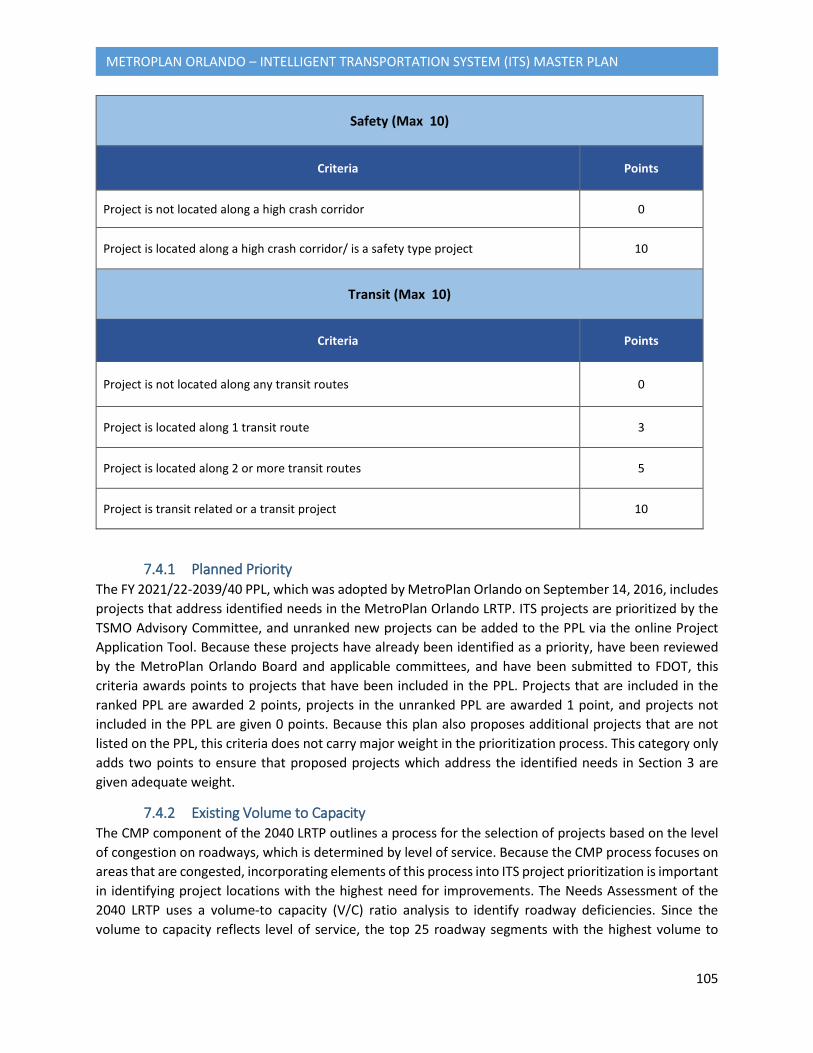
105
METROPLAN ORLANDO – INTELLIGENT TRANSPORTATION SYSTEM (ITS) MASTER PLAN
Safety (Max 10)
Criteria Points
Project is not located along a high crash corridor 0
Project is located along a high crash corridor/ is a safety type project 10
Transit (Max 10)
Criteria Points
Project is not located along any transit routes 0
Project is located along 1 transit route 3
Project is located along 2 or more transit routes 5
Project is transit related or a transit project 10
7.4.1 Planned Priority The FY 2021/22-2039/40 PPL, which was adopted by MetroPlan Orlando on September 14, 2016, includes projects that address identified needs in the MetroPlan Orlando LRTP. ITS projects are prioritized by the TSMO Advisory Committee, and unranked new projects can be added to the PPL via the online Project Application Tool. Because these projects have already been identified as a priority, have been reviewed by the MetroPlan Orlando Board and applicable committees, and have been submitted to FDOT, this criteria awards points to projects that have been included in the PPL. Projects that are included in the ranked PPL are awarded 2 points, projects in the unranked PPL are awarded 1 point, and projects not included in the PPL are given 0 points. Because this plan also proposes additional projects that are not listed on the PPL, this criteria does not carry major weight in the prioritization process. This category only adds two points to ensure that proposed projects which address the identified needs in Section 3 are given adequate weight.
7.4.2 Existing Volume to Capacity The CMP component of the 2040 LRTP outlines a process for the selection of projects based on the level of congestion on roadways, which is determined by level of service. Because the CMP process focuses on areas that are congested, incorporating elements of this process into ITS project prioritization is important in identifying project locations with the highest need for improvements. The Needs Assessment of the 2040 LRTP uses a volume-to capacity (V/C) ratio analysis to identify roadway deficiencies. Since the volume to capacity reflects level of service, the top 25 roadway segments with the highest volume to
106
METROPLAN ORLANDO – INTELLIGENT TRANSPORTATION SYSTEM (ITS) MASTER PLAN
capacity, which is shown as percentage of level of service, have been identified for each county, and can be found in Appendix G. A map showing the volume to capacity percentages of the all state roadway segments in the planning area, with the top 25 corridors identified for each county, can also be found in Appendix G. The segments were used as priority locations for recommended projects. Roadway segment V/C calculations were identified from the FDOT District 5 Level of Service (LOS) Summary Report 2015. The percentage represents the volume in relation to the total capacity. However, this criteria may not apply to all projects, such as projects that propose improvements to the Traffic Management Center, for example, and these projects are also considered a priority for the region. Therefore, this criteria only awards an extra 8 points for projects located along these segments to ensure that other projects that may also be considered a priority are ranked accordingly. Projects not located along these segments were given 0 points.
7.4.3 Stakeholder Survey ITS needs were identified based on the information gathered from Section 1, and Section 2, comments received from the Steering Committee, review of the RITSA, and Stakeholder input. The Needs Assessment in Section 3, in addition to the information from Sections 1 and 2, was used to develop the ITS strategies as part of Section 4. The ITS strategies were then further refined to those applicable to the MetroPlan Orlando stakeholders and prioritized based on the survey results. The surveys administered to the stakeholders asked them to identify their most needed improvements based on a number ranking. These results have been incorporated into the ITS project scoring methodology to ensure that stakeholder priorities are considered in the project prioritization process. Projects that incorporate technologies that address any of the associated strategies listed in the survey are granted the corresponding number of points based on the strategy’s original 1 to 6 needs ranking (1 being most needed, 6 being least needed). To award the most points to the most needed projects, projects with a ranking of 1 in the survey were granted the maximum amount of points and projects with the highest numbers (meaning lowest priority) in Table 4 were granted the least amount of points. The survey categories have been consolidated so that each response option appears only once. The last survey category “project addresses any of the listed barriers to implementing ITS needs” was also removed because the response options under this category are reflected through the previous survey responses. Each project may apply to more than one survey response, therefore the maximum unweighted number of points is 101. The total score for this category is weighted based on a 15 point scale; therefore the ratio between total points scored and maximum points is then multiplied by 15. The formula can be seen below:
𝑻𝑻𝑻𝑻𝑻𝑻𝑻𝑻𝑻𝑻 𝑷𝑷𝑻𝑻𝑷𝑷𝑷𝑷𝑻𝑻𝑷𝑷𝑴𝑴𝑻𝑻𝒙𝒙𝑷𝑷𝒊𝒊𝒊𝒊𝒊𝒊 𝑷𝑷𝑻𝑻𝑷𝑷𝑷𝑷𝑻𝑻𝑷𝑷
𝑿𝑿 𝟏𝟏𝟏𝟏 = 𝑾𝑾𝑾𝑾𝑷𝑷𝑾𝑾𝑾𝑾𝑻𝑻𝑾𝑾𝑾𝑾 𝑷𝑷𝑻𝑻𝑷𝑷𝑷𝑷𝑻𝑻𝑷𝑷
7.4.4 ITS Strategies and Needs The Applicable ITS Strategies were identified based on the information gathered from Sections 1, 2 and 3, comments received from the Steering Committee in the second Master Plan Workshop, and applicable FDOT District 5 ITS strategies. This criteria examines applicable strategies and relates them back to the needs that were defined in Section 3. In Section 4, strategies are listed with the identified needs they address, and for this criteria, strategies have been ranked based on that number of identified needs. Projects that incorporate the strategies are given points based on the number of addressed needs; if a project addresses a need in any particular strategy, then all the needs were considered. Projects may
107
METROPLAN ORLANDO – INTELLIGENT TRANSPORTATION SYSTEM (ITS) MASTER PLAN
apply to more than one strategy; therefore the maximum unweighted points is 52. The total score for this category is weighted based on a 15 point scale; therefore the ratio between the total points scored and the maximum points is then multiplied by 15. The formula can be seen below:
𝑻𝑻𝑻𝑻𝑻𝑻𝑻𝑻𝑻𝑻 𝑷𝑷𝑻𝑻𝑷𝑷𝑷𝑷𝑻𝑻𝑷𝑷𝑴𝑴𝑻𝑻𝒙𝒙𝑷𝑷𝒊𝒊𝒊𝒊𝒊𝒊 𝑷𝑷𝑻𝑻𝑷𝑷𝑷𝑷𝑻𝑻𝑷𝑷
𝑿𝑿 𝟏𝟏𝟏𝟏 = 𝑾𝑾𝑾𝑾𝑷𝑷𝑾𝑾𝑾𝑾𝑻𝑻𝑾𝑾𝑾𝑾 𝑷𝑷𝑻𝑻𝑷𝑷𝑷𝑷𝑻𝑻𝑷𝑷
7.4.5 ITS Plan Goals and Objectives To ensure that the projects identified further the goals and objectives of the plan, this criteria gives points to projects that address the identified objectives included Section 1. Goals and objectives represent the priorities of the region when developing a multi-modal transportation network, and it is important to incorporate them into the project prioritization process. If the project addresses 12 or more identified objectives it is given 20 points, if it addresses between 6 and 11 identified objectives it is given 15 points, and if it addresses between 1 and 5 identified objectives it is given 10 points. If a project does not incorporate any identified objectives, it is not given any points.
7.4.6 Regional Connectivity The MetroPlan Orlando regional transportation network plays a key role in the movement of people and freight throughout the state and nationwide. Due to its centralized location, the region serves as a major hub of economic activity. It is important for projects identified in this plan to contribute to the inter-connectivity of the MetroPlan Orlando region, and the movement of people and goods quickly and efficiently. This criteria awards points to projects based on their location and contribution to the regional transportation network. Projects that promote jurisdictional coordination across counties allow for increase collaboration and coordination, while contributing to economic growth and regional mobility. Therefore, projects that involve multiple jurisdictions while directly impacting regional mobility were awarded 20 points. In addition, the Strategic Intermodal System (SIS) consists of transportation facilities that have been identified as a high priority and play a key role in improving mobility and the economy throughout the state. Because the SIS has been identified as one of the highest transportation priorities in the state, projects located along a SIS or SIS connector/link are awarded 15 points. If a project contributes to regional mobility and aids in linking the three counties in the MPO planning area to each other, surrounding counties, or major traffic generators in the area it is given 10 points. If a project contributes to countywide connectivity and links urbanized areas within the county it is awarded 5 points. If the project contributes to local travel it is given 0 points.
7.4.7 Safety The improvement of safety and reduction of crash rates is a key priority statewide. Safety has been an established emphasis area of MetroPlan Orlando since 2005, and has been highlighted as a priority in the 2040 LRTP. The MPO maintains a crash database that provides incident reports for the entire region. This database was developed for the purposes of identifying key areas with high crash rates in order to develop projects that target those areas. ITS technology has played a key role in reducing crash rates, as well as alleviating congestion as a result of an incident. This criteria awards 10 points to projects that are located along state roads with the highest crash counts in 2015. This criteria also awards 10 points to a project if it is a safety type project that incorporates technologies to protect vulnerable road users. Using the MPO’s crash database, the top 10 corridors with the highest crash counts in 2015 were identified for each county

108
METROPLAN ORLANDO – INTELLIGENT TRANSPORTATION SYSTEM (ITS) MASTER PLAN
and have been mapped and included in Appendix G. In the tables, the total incident counts have been broken out into fatality and injury counts for each corridor. Projects that are not located on a corridor with the highest crash counts are awarded 0 points.
7.4.8 Transit Transit service is a key component in the development of a successful multimodal transportation network, and has been identified as a key priority by MetroPlan Orlando in the 2040 LRTP. The MPO has identified regional transit priorities based on an extensive analysis of population, employment, and land use data. ITS plays a key role the improvement of communication between transit facilities and the enhancement of transit reliability, and several transit-related ITS projects were included in the PPL. It is important to ensure that selected projects included in this plan further the transit vision of the region. Therefore, if a project is transit related or a transit agency project, it receives 10 points. In addition, locating projects along transit routes contributes to the improved efficiency and reliability of the network. Therefore, this criteria awards 5 points to projects that are located along 2 or more transit routes. If a project is located along 1 transit route, it is awarded 3 points, and if it is not located along any transit routes, it is given 0 points.
7.5 Future ITS Deployments The recommended projects have been organized by a variety of factors, including geographic area, deployment timeframe, or program area. These projects range from ITS element and communications deployment along a linear roadway to the development of information systems that enhance information sharing among multiple agencies. All of the projects will focus on addressing the needs identified in the stakeholder workshops through the development of proposed new projects as well as those already identified by the MPO as a priority in their TIP and Prioritized Project List (PPL).
The projects list includes projects that are ranked, unranked PPL, projects identified in the RITSA, and identified by the stakeholders. The desired changes, existing projects, projects in development, and some future projects were identified in Section 3 and the desired ITS strategies were summarized in Section 4. In addition to the needs and strategies defined in Sections 3 and 4, the MetroPlan Orlando stakeholders have expressed interest in using other technologies for long term projects such as:
Surveillance Drones Surveillance drones to provide real-time information on traffic conditions and incidents. Video Feeds Video feeds from TMCs to law enforcement and EMS vehicles to provide situational awareness while traveling to incidents. Mobility as a Service (MaaS) or Mobility on Demand (MOD) The MOD program is a new USDOT initiative between the ITS Joint Program Office (JPO) and the FTA.The FTA is currently researching MOD initiatives for multimodal, automated and accessible transportation system in which personalized mobility is a key feature. MOD will contribute to the system with connected travelers, infrastructure, innovative operations and personal mobility needs.
109
METROPLAN ORLANDO – INTELLIGENT TRANSPORTATION SYSTEM (ITS) MASTER PLAN
ITS Infrastructure for Emerging Technologies The MetroPlan Orlando area has some of the infrastructure necessary to start planning the future. In 2011, the City of Orlando hosted the 18th Annual ITS World Congress conference, where they displayed the capability of a CV environment. Roadside Units (RSU) were deployed for an FDOT’s Test Bed, with some vehicles equipped with On-Board Equipment (OBE) and DSCR technology. The ideas included in the D5 Master Plan can/should also be considered/expanded upon for the region. MetroPlan Orlando would like to develop an ITS infrastructure that to will accommodate the emerging automated and connected vehicles, by enhancing telecommunications and identifying new technologies that can prepare the area as a testbed for new technologies in transportation. One of the key changes includes the expansion of the communications infrastructure throughout the region that would allow for an increase of system reliability, interoperability and information sharing between the stakeholders. Some corridors in the region could serve as testbeds for data acquisition technologies, multi-modal Intelligent Traffic Signal System, RSUs, and OBEs. There are many products available in the market and others under development that could be tested such as Intelligent Traffic Signal System (I-SIG), Freight Signal Priority (FSP), and the combination of TSP and FSP applications. Also, there are other technologies available for decision making such as WayCare; an accident prediction application that uses historical and real time data to select the optimal preventative course of action. LYNX could look into testing driverless transit shuttles that use laser, radars, and other sensors to cover a specific route. In addition to sensors, the driverless shuttles use software to detect cyclists and pedestrians. The City of Orlando partnered with several local academic, private sector and government agencies to form the Central Florida Automated Vehicle (AV) Partnership. The Central Florida Automated Vehicle (AV) Partnership is developing a proposal to designate the Central Florida region as an Automated Vehicle (AV) Proving Ground by USDOT. Smart Corridor Pilot Testing The City of Orlando participated in the Smart City challenge organized by USDOT. Unfortunately, they were not selected for the grant. However, several strategies proposed in the application could be implemented and benefit the MetroPlan Orlando region. A long term project could be a Smart Corridor test along International Drive (I-Drive) since it is one of the region’s densely populated tourist destination. I-Drive is home to some Orlando’s major tourist attractions including SeaWorld, Discovery Cove, Aquatica Water Park, two Premium Outlets, Orange County Convention Center. The hotels in this corridor serve the over 5.4 million overnight annual guests. The I-Drive corridor supports an annual average daily traffic volume of 22,475 vehicles. This corridor presents a challenge in mobility both regionally and locally. The I-Drive corridor could benefit from multi-modal improvements that could be fused with upcoming technologies. The smart corridor could implement intelligent sensor base infrastructure such as lighting sensors, flooding sensors, and sensor-aided parking.
Pedestrian/Bicycle ITS solutions In 2015, the SR 500/US 441 corridor had the highest number of crashes including bicycle and pedestrian crashes in the region. Pedestrian/Bicycle strategies that have been identified as appropriate to the region include but are not limited to:
• Blind Spot Detection for Cars and Trucks --detects and warns for VRUs and objects in the blind spot of the car/truck.
• Intelligent Pedestrians Traffic Signal – use of sensors such as an infra-red camera to determine the presence of pedestrians and adjusts the traffic signals accordingly.
110
METROPLAN ORLANDO – INTELLIGENT TRANSPORTATION SYSTEM (ITS) MASTER PLAN
• ISA - Compares the current speed of the vehicle with the local posted speed limit and respond if the vehicle exceeds this posted limit.
• Red Light Camera/Speed Camera - the intended reaction is to prevent drivers to cross the red light, and thereby reducing the chance of an accident.
• Pedestrian Detection System and Automatic Braking - The vehicle has a built-in system that continuously scans for VRUs that the vehicle might be in collision course with.
• Navigation systems for VRU - navigational support to cyclists, along with other information is also provided relating to cycling performance.
We recommend that some of the technologies listed above are implemented as a test project on SR 500/US 441/S Orange Blossom Trail between Holden Avenue and I-4 since this segment had the most concentrated number of bicycle and pedestrian crashes in 2015. In addition, Orange County and Orlando identified additional locations that could benefit from innovative pedestrian safety projects. Advanced Traveler Information Systems Implement advanced traveler information systems using technologies that assemble and process travel-related data and disseminate useful information to travelers. These technologies include sensors for monitoring travel conditions, communications for sending and receiving information, data processing, geo-location technologies, microprocessors, and other technological advances that are fueling the rapid growth of traveler information systems in the United States and elsewhere. LYNX is already planning to expand the traveler information applications to provide real-time data dissemination to their users. Vehicle-to-Vehicle (V2V) and Vehicle-to-Infrastructure (V2I) (together referred to as V2X) technologies pose a great benefit to regional transportation through the improvement of safety and mobility, as well as reduction in emissions through the use of predictive driving patterns. The Applications for Environmental Real-Time Information Synthesis (AERIS) program will aid in the identification of environmentally friendly transportation choices, through the development of a library of real-time data analyzing the most efficient transportation routes and signal operational information to reduce emissions. As the technologies continue to develop, MetroPlan Orlando should reevaluate the possibility of including the technologies as a part of already defined projects and possibly as independent projects. Additionally, Seminole County has expressed the desire to provide travelers with SPAT information using connected V2I roadside equipment. This will be a long term project to inform drivers (via an in-vehicle display) about current signal status and potentially about the time remaining to the next phase. This system will work with Dedicated Short-Range Communications (DSRC)-equipped vehicles and intersections. DSRC provides immediate communication for safety applications while still maintaining individual privacy. In the short-term, DSRC is most likely to be incorporated into vehicles over the next ten years, according to FDOT. For the purposes of this Master Plan, we assumed that NHTSA will mandate factory-installed DSRC equipment onboard both light and heavy vehicles. Connected Vehicle (CV) Pilot Project One CV pilot for the MetroPlan Orlando planning area was added to the list as a long term project in the region to deploy a variety of V2V and V2I applications to relieve congestion, reduce collisions, and prevent wrong way entry at the freeway exits. CV technology should also enhance pedestrian safety, transit
111
METROPLAN ORLANDO – INTELLIGENT TRANSPORTATION SYSTEM (ITS) MASTER PLAN
operations and reduce conflicts between the region’s multimodal networks. The following connected Vehicle strategies that have been identified as appropriate to the region include but are not limited to:
• Curve Speed Warning (CSW) • Pedestrian in Signalized Crosswalk Warning (PED-X) • Red Light Violation Warning (RLVW) • Emergency Electronic Brake Lights (EEBL) • Forward Collision Warning (FCW) • Intersection Movement Assist (IMA) • Vehicle Turning Right in Front of a Transit Vehicle (VTRFTV) • Mobile Accessible Pedestrian Signal System (PED-SIG) • Intelligent Traffic Signal System (I-SIG) • Transit Signal Priority (TSP) • Probe-enabled Data Monitoring (PeDM)
7.6 Ranked Future ITS Projects The future ITS projects are listed in Table 18. Table 18 includes the project name and associated information. The list include ranked and unranked PPL projects as well as proposed new projects identified by the stakeholders. Figure 26 shows the future ITS projects in the region. All of the future projects have been ranked based on the outlined criteria in this section. Table 19 includes the project name, location, and rank based on associated scoring broken out by criteria category defined in Table 17. These projects and scoring criteria were reviewed by the Steering Committee; however, the criteria is only a recommendation for the MetroPlan Orlando area. The timeframes for implementation and cost estimates for the prioritized projects are shown in Table 20. For the purpose of this document an average of $60,000 per mile was estimated for new fiber optic cable, $6,000 per CCTV camera, $9,400 per BlueTooth reader, and $7,000 per MVDS. For adaptive signal system projects a cost of $51,000 per signal was used based on the 12 month FDOT Statewide unit cost average dated December 2016. This high level estimate is a preliminary cost for the projects. The cost for the projects proposed within the next five years is $41,117,200. The cost for the project proposed between six and ten years is $7,300,000. The total cost for the projects proposed in the ITS Master Plan is $48,417,200. Once the elements and the project limits are defined, a detailed estimate can be provided.
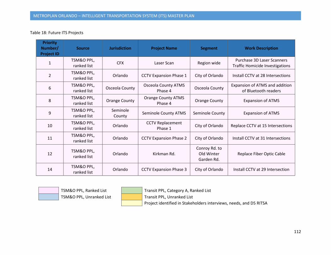
112
METROPLAN ORLANDO – INTELLIGENT TRANSPORTATION SYSTEM (ITS) MASTER PLAN
Table 18: Future ITS Projects
Priority Number/ Project ID
Source Jurisdiction Project Name Segment Work Description
1 TSM&O PPL, ranked list CFX Laser Scan Region wide Purchase 3D Laser Scanners
Traffic Homicide Investigations
2 TSM&O PPL, ranked list Orlando CCTV Expansion Phase 1 City of Orlando Install CCTV at 28 Intersections
6 TSM&O PPL, ranked list Osceola County Osceola County ATMS
Phase 4 Osceola County Expansion of ATMS and addition of Bluetooth readers
8 TSM&O PPL, ranked list Orange County Orange County ATMS
Phase 4 Orange County Expansion of ATMS
9 TSM&O PPL, ranked list
Seminole County Seminole County ATMS Seminole County Expansion of ATMS
10 TSM&O PPL, ranked list Orlando CCTV Replacement
Phase 1 City of Orlando Replace CCTV at 15 Intersections
11 TSM&O PPL, ranked list Orlando CCTV Expansion Phase 2 City of Orlando Install CCTV at 31 Intersections
12 TSM&O PPL, ranked list Orlando Kirkman Rd.
Conroy Rd. to Old Winter Garden Rd.
Replace Fiber Optic Cable
14 TSM&O PPL, ranked list Orlando CCTV Expansion Phase 3 City of Orlando Install CCTV at 29 Intersection
TSM&O PPL, Ranked List Transit PPL, Category A, Ranked List TSM&O PPL, Unranked List Transit PPL, Unranked List
Project identified in Stakeholders interviews, needs, and D5 RITSA
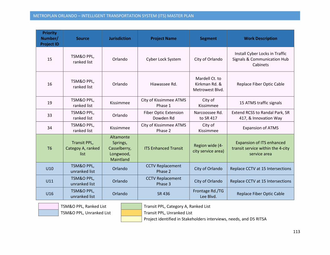
113
METROPLAN ORLANDO – INTELLIGENT TRANSPORTATION SYSTEM (ITS) MASTER PLAN
Priority Number/ Project ID
Source Jurisdiction Project Name Segment Work Description
15 TSM&O PPL, ranked list Orlando Cyber Lock System City of Orlando
Install Cyber Locks in Traffic Signals & Communication Hub
Cabinets
16 TSM&O PPL, ranked list Orlando Hiawassee Rd.
Mardell Ct. to Kirkman Rd. &
Metrowest Blvd. Replace Fiber Optic Cable
19 TSM&O PPL, ranked list Kissimmee City of Kissimmee ATMS
Phase 1 City of
Kissimmee 15 ATMS traffic signals
33 TSM&O PPL, ranked list Orlando Fiber Optic Extension
Dowden Rd Narcoossee Rd.
to SR 417 Extend RCSS to Randal Park, SR
417, & Innovation Way
34 TSM&O PPL, ranked list Kissimmee City of Kissimmee ATMS
Phase 2 City of
Kissimmee Expansion of ATMS
T6 Transit PPL,
Categoy A, ranked list
Altamonte Springs,
Casselberry, Longwood, Maintland
ITS Enhanced Transit Region wide (4-city service area)
Expansion of ITS enhanced transit service within the 4-city
service area
U10 TSM&O PPL, unranked list Orlando CCTV Replacement
Phase 2 City of Orlando Replace CCTV at 15 Intersections
U11 TSM&O PPL, unranked list Orlando CCTV Replacement
Phase 3 City of Orlando Replace CCTV at 15 Intersections
U16 TSM&O PPL, unranked list Orlando SR 436 Frontage Rd./TG
Lee Blvd. Replace Fiber Optic Cable
TSM&O PPL, Ranked List Transit PPL, Category A, Ranked List TSM&O PPL, Unranked List Transit PPL, Unranked List
Project identified in Stakeholders interviews, needs, and D5 RITSA

114
METROPLAN ORLANDO – INTELLIGENT TRANSPORTATION SYSTEM (ITS) MASTER PLAN
Priority Number/ Project ID
Source Jurisdiction Project Name Segment Work Description
U17 TSM&O PPL, unranked list Orlando Install Fiber Optic Cable
Dowden Rd. Lake District Ln./ Randal Park Blvd. Install Fiber Optic Cable
UT5 Transit PPL, unranked list LYNX
Intelligent Transportation
Systems/Customer Information
Systems/Travel Planning
Region wide Regional Transit Priority from LRTP
N1
Additional ITS projects identified
by the stakeholders
Orange County Osceola County
Seminole County
Active Arterial Management for US
17/92 US 192 to SR 46
Active Arterial Management for the number 1 most congested
corridor in the MetroPlan Orlando. The US 441 ITS
Deployment was identified in the RITSA as a future project.
N2
Additional ITS projects identified
by the stakeholders
Orange County Seminole
County Orlando
Active Arterial Management for SR 436/
Semoran Blvd MCO to I-4
Active Arterial Management for one of the most congested corridor in the MetroPlan
Orlando
N3
Additional ITS projects identified
by the stakeholders
Orange County Osceola County
US 192 Adaptive Signal System Phase 2
Avalon Rd. to Columbia Ave.
Install an Adaptive Signal System. Identified as priority by
Orange County.
TSM&O PPL, Ranked List Transit PPL, Category A, Ranked List TSM&O PPL, Unranked List Transit PPL, Unranked List
Project identified in Stakeholders interviews, needs, and D5 RITSA
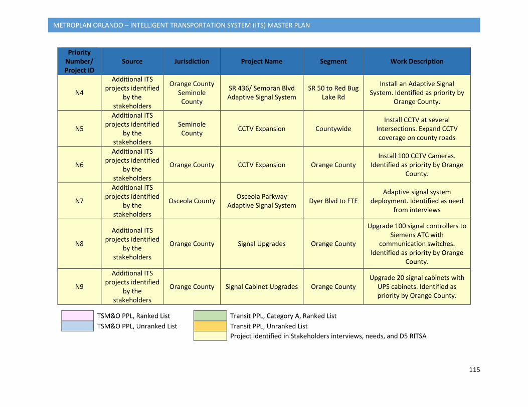
115
METROPLAN ORLANDO – INTELLIGENT TRANSPORTATION SYSTEM (ITS) MASTER PLAN
Priority Number/ Project ID
Source Jurisdiction Project Name Segment Work Description
N4
Additional ITS projects identified
by the stakeholders
Orange County Seminole County
SR 436/ Semoran Blvd Adaptive Signal System
SR 50 to Red Bug Lake Rd
Install an Adaptive Signal System. Identified as priority by
Orange County.
N5
Additional ITS projects identified
by the stakeholders
Seminole County CCTV Expansion Countywide
Install CCTV at several Intersections. Expand CCTV coverage on county roads
N6
Additional ITS projects identified
by the stakeholders
Orange County CCTV Expansion Orange County Install 100 CCTV Cameras.
Identified as priority by Orange County.
N7
Additional ITS projects identified
by the stakeholders
Osceola County Osceola Parkway Adaptive Signal System Dyer Blvd to FTE
Adaptive signal system deployment. Identified as need
from interviews
N8
Additional ITS projects identified
by the stakeholders
Orange County Signal Upgrades Orange County
Upgrade 100 signal controllers to Siemens ATC with
communication switches. Identified as priority by Orange
County.
N9
Additional ITS projects identified
by the stakeholders
Orange County Signal Cabinet Upgrades Orange County Upgrade 20 signal cabinets with
UPS cabinets. Identified as priority by Orange County.
TSM&O PPL, Ranked List Transit PPL, Category A, Ranked List TSM&O PPL, Unranked List Transit PPL, Unranked List
Project identified in Stakeholders interviews, needs, and D5 RITSA
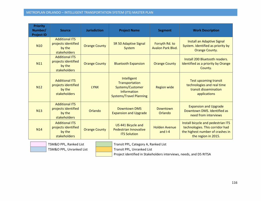
116
METROPLAN ORLANDO – INTELLIGENT TRANSPORTATION SYSTEM (ITS) MASTER PLAN
Priority Number/ Project ID
Source Jurisdiction Project Name Segment Work Description
N10
Additional ITS projects identified
by the stakeholders
Orange County SR 50 Adaptive Signal System
Forsyth Rd. to Avalon Park Blvd.
Install an Adaptive Signal System. Identified as priority by
Orange County.
N11
Additional ITS projects identified
by the stakeholders
Orange County Bluetooth Expansion Orange County Install 200 Bluetooth readers.
Identified as a priority by Orange County.
N12
Additional ITS projects identified
by the stakeholders
LYNX
Intelligent Transportation
Systems/Customer Information
Systems/Travel Planning
Region wide
Test upcoming transit technologies and real time
transit dissemination applications
N13
Additional ITS projects identified
by the stakeholders
Orlando Downtown DMS Expansion and Upgrade
Downtown Orlando
Expansion and Upgrade Downtown DMS. Identified as
need from interviews
N14
Additional ITS projects identified
by the stakeholders
Orange County US 441 Bicycle and
Pedestrian Innovative ITS Solution
Holden Avenue and I-4
Install bicycle and pedestrian ITS technologies. This corridor had
the highest number of crashes in the region in 2015.
TSM&O PPL, Ranked List Transit PPL, Category A, Ranked List TSM&O PPL, Unranked List Transit PPL, Unranked List
Project identified in Stakeholders interviews, needs, and D5 RITSA
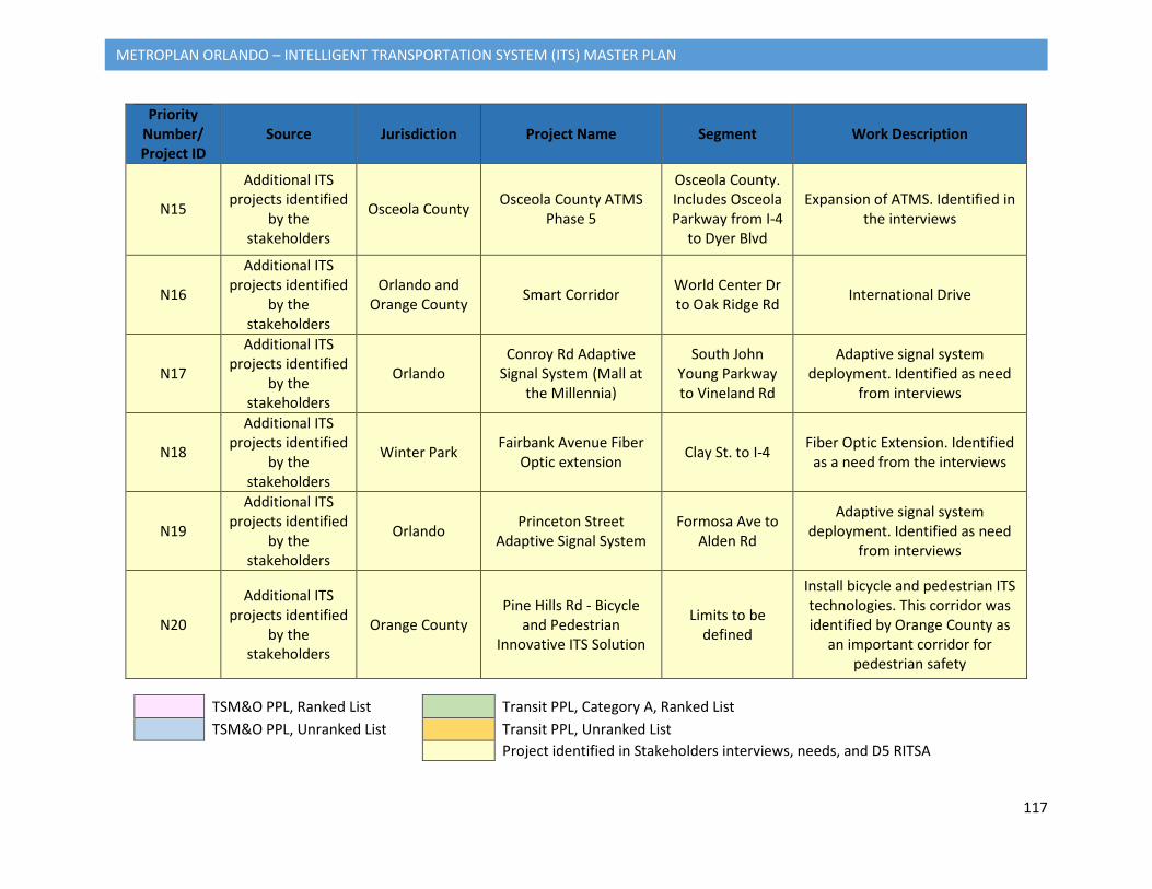
117
METROPLAN ORLANDO – INTELLIGENT TRANSPORTATION SYSTEM (ITS) MASTER PLAN
Priority Number/ Project ID
Source Jurisdiction Project Name Segment Work Description
N15
Additional ITS projects identified
by the stakeholders
Osceola County Osceola County ATMS Phase 5
Osceola County. Includes Osceola Parkway from I-4
to Dyer Blvd
Expansion of ATMS. Identified in the interviews
N16
Additional ITS projects identified
by the stakeholders
Orlando and Orange County Smart Corridor World Center Dr
to Oak Ridge Rd International Drive
N17
Additional ITS projects identified
by the stakeholders
Orlando Conroy Rd Adaptive
Signal System (Mall at the Millennia)
South John Young Parkway to Vineland Rd
Adaptive signal system deployment. Identified as need
from interviews
N18
Additional ITS projects identified
by the stakeholders
Winter Park Fairbank Avenue Fiber Optic extension Clay St. to I-4 Fiber Optic Extension. Identified
as a need from the interviews
N19
Additional ITS projects identified
by the stakeholders
Orlando Princeton Street Adaptive Signal System
Formosa Ave to Alden Rd
Adaptive signal system deployment. Identified as need
from interviews
N20
Additional ITS projects identified
by the stakeholders
Orange County Pine Hills Rd - Bicycle
and Pedestrian Innovative ITS Solution
Limits to be defined
Install bicycle and pedestrian ITS technologies. This corridor was identified by Orange County as
an important corridor for pedestrian safety
TSM&O PPL, Ranked List Transit PPL, Category A, Ranked List TSM&O PPL, Unranked List Transit PPL, Unranked List
Project identified in Stakeholders interviews, needs, and D5 RITSA
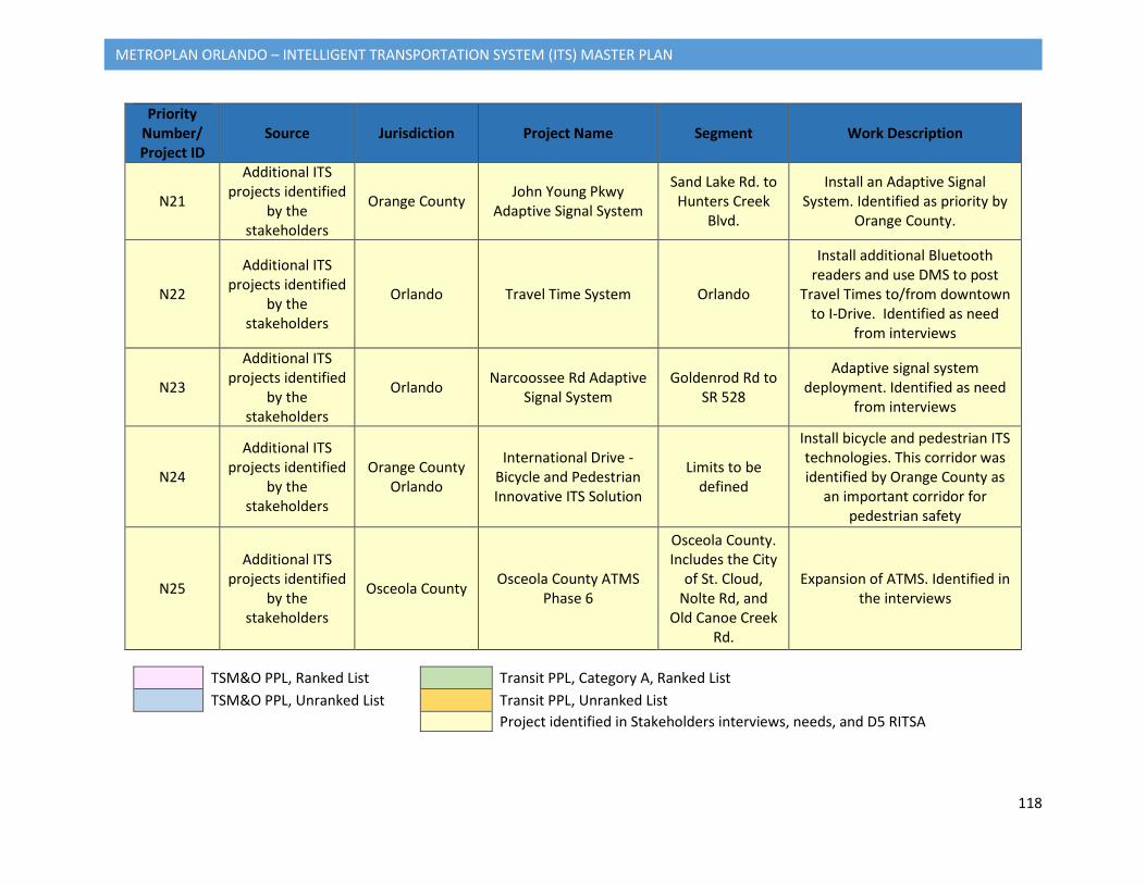
118
METROPLAN ORLANDO – INTELLIGENT TRANSPORTATION SYSTEM (ITS) MASTER PLAN
Priority Number/ Project ID
Source Jurisdiction Project Name Segment Work Description
N21
Additional ITS projects identified
by the stakeholders
Orange County John Young Pkwy Adaptive Signal System
Sand Lake Rd. to Hunters Creek
Blvd.
Install an Adaptive Signal System. Identified as priority by
Orange County.
N22
Additional ITS projects identified
by the stakeholders
Orlando Travel Time System Orlando
Install additional Bluetooth readers and use DMS to post
Travel Times to/from downtown to I-Drive. Identified as need
from interviews
N23
Additional ITS projects identified
by the stakeholders
Orlando Narcoossee Rd Adaptive Signal System
Goldenrod Rd to SR 528
Adaptive signal system deployment. Identified as need
from interviews
N24
Additional ITS projects identified
by the stakeholders
Orange County Orlando
International Drive - Bicycle and Pedestrian Innovative ITS Solution
Limits to be defined
Install bicycle and pedestrian ITS technologies. This corridor was identified by Orange County as
an important corridor for pedestrian safety
N25
Additional ITS projects identified
by the stakeholders
Osceola County Osceola County ATMS Phase 6
Osceola County. Includes the City
of St. Cloud, Nolte Rd, and
Old Canoe Creek Rd.
Expansion of ATMS. Identified in the interviews
TSM&O PPL, Ranked List Transit PPL, Category A, Ranked List TSM&O PPL, Unranked List Transit PPL, Unranked List
Project identified in Stakeholders interviews, needs, and D5 RITSA
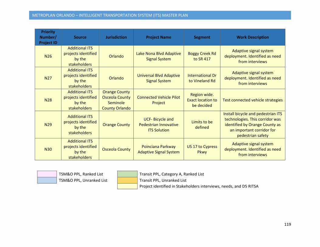
119
METROPLAN ORLANDO – INTELLIGENT TRANSPORTATION SYSTEM (ITS) MASTER PLAN
Priority Number/ Project ID
Source Jurisdiction Project Name Segment Work Description
N26
Additional ITS projects identified
by the stakeholders
Orlando Lake Nona Blvd Adaptive Signal System
Boggy Creek Rd to SR 417
Adaptive signal system deployment. Identified as need
from interviews
N27
Additional ITS projects identified
by the stakeholders
Orlando Universal Blvd Adaptive Signal System
International Dr to Vineland Rd
Adaptive signal system deployment. Identified as need
from interviews
N28
Additional ITS projects identified
by the stakeholders
Orange County Osceola County
Seminole County Orlando
Connected Vehicle Pilot Project
Region wide. Exact location to
be decided Test connected vehicle strategies
N29
Additional ITS projects identified
by the stakeholders
Orange County UCF- Bicycle and
Pedestrian Innovative ITS Solution
Limits to be defined
Install bicycle and pedestrian ITS technologies. This corridor was identified by Orange County as
an important corridor for pedestrian safety
N30
Additional ITS projects identified
by the stakeholders
Osceola County Poinciana Parkway Adaptive Signal System
US 17 to Cypress Pkwy
Adaptive signal system deployment. Identified as need
from interviews
TSM&O PPL, Ranked List Transit PPL, Category A, Ranked List TSM&O PPL, Unranked List Transit PPL, Unranked List
Project identified in Stakeholders interviews, needs, and D5 RITSA
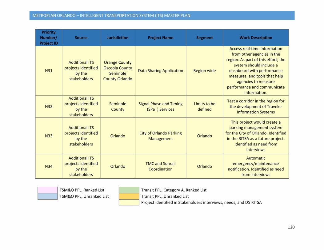
120
METROPLAN ORLANDO – INTELLIGENT TRANSPORTATION SYSTEM (ITS) MASTER PLAN
Priority Number/ Project ID
Source Jurisdiction Project Name Segment Work Description
N31
Additional ITS projects identified
by the stakeholders
Orange County Osceola County
Seminole County Orlando
Data Sharing Application Region wide
Access real-time information from other agencies in the
region. As part of this effort, the system should include a
dashboard with performance measures, and tools that help
agencies to measure performance and communicate
information.
N32
Additional ITS projects identified
by the stakeholders
Seminole County
Signal Phase and Timing (SPaT) Services
Limits to be defined
Test a corridor in the region for the development of Traveler
Information Systems
N33
Additional ITS projects identified
by the stakeholders
Orlando City of Orlando Parking Management Orlando
This project would create a parking management system
for the City of Orlando. Identified in the RITSA as a future project.
Identified as need from interviews
N34
Additional ITS projects identified
by the stakeholders
Orlando TMC and Sunrail Coordination Orlando
Automatic emergency/maintenance
notification. Identified as need from interviews
TSM&O PPL, Ranked List Transit PPL, Category A, Ranked List TSM&O PPL, Unranked List Transit PPL, Unranked List
Project identified in Stakeholders interviews, needs, and D5 RITSA
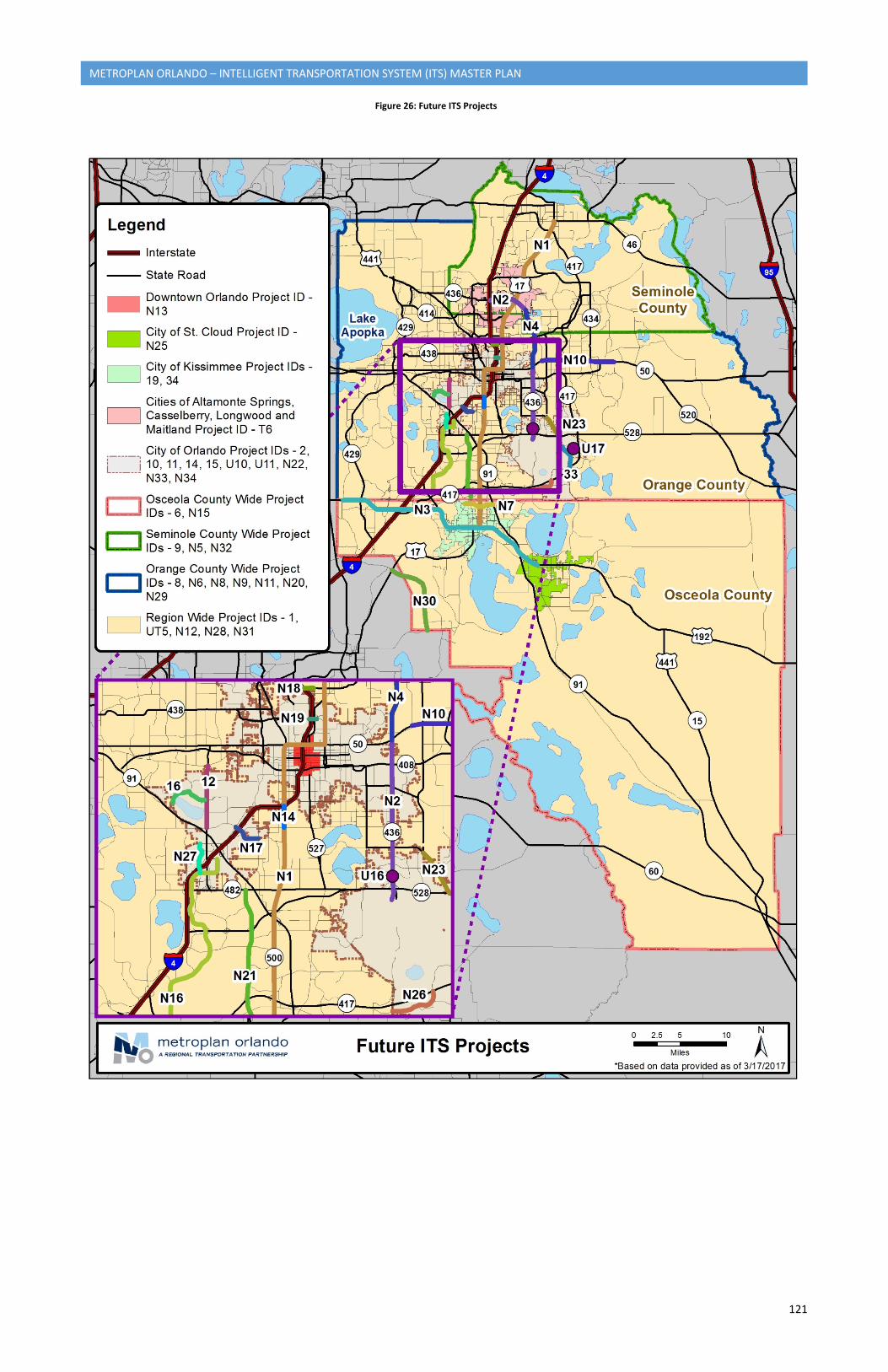
121
METROPLAN ORLANDO – INTELLIGENT TRANSPORTATION SYSTEM (ITS) MASTER PLAN
Figure 26: Future ITS Projects
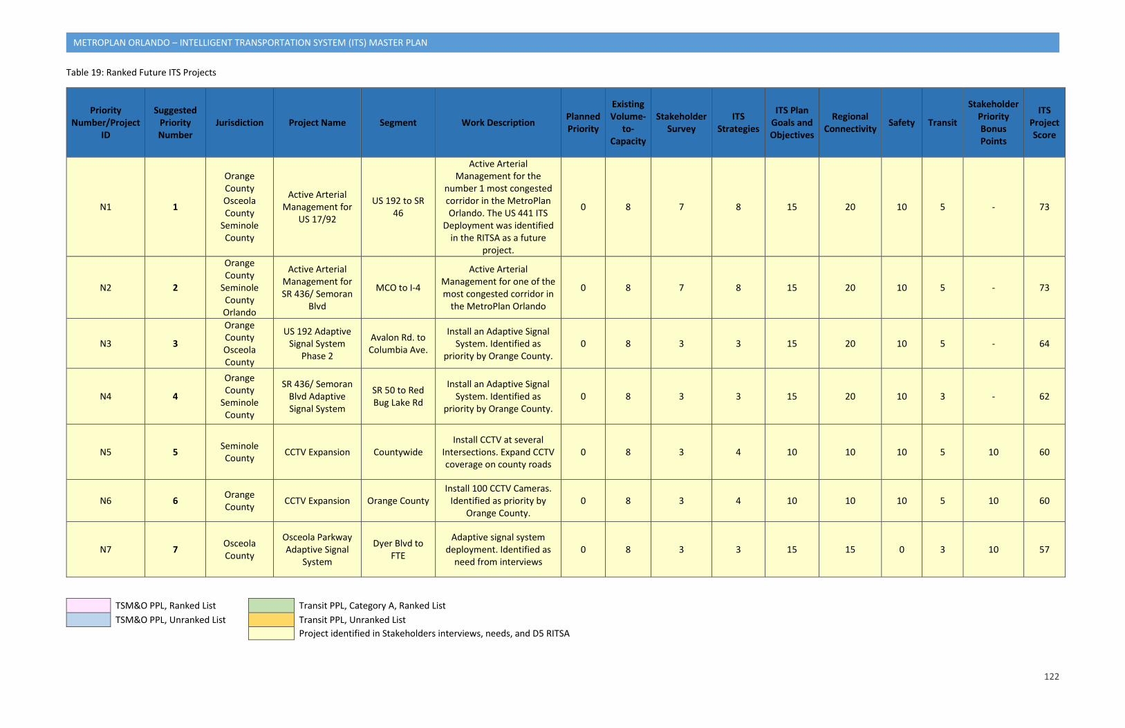
122
METROPLAN ORLANDO – INTELLIGENT TRANSPORTATION SYSTEM (ITS) MASTER PLAN
Table 19: Ranked Future ITS Projects
Priority Number/Project
ID
Suggested Priority Number
Jurisdiction Project Name Segment Work Description Planned Priority
Existing Volume-
to-Capacity
Stakeholder Survey
ITS Strategies
ITS Plan Goals and Objectives
Regional Connectivity Safety Transit
Stakeholder Priority Bonus Points
ITS Project Score
N1 1
Orange County Osceola County
Seminole County
Active Arterial Management for
US 17/92
US 192 to SR 46
Active Arterial Management for the
number 1 most congested corridor in the MetroPlan Orlando. The US 441 ITS
Deployment was identified in the RITSA as a future
project.
0 8 7 8 15 20 10 5 - 73
N2 2
Orange County
Seminole County Orlando
Active Arterial Management for SR 436/ Semoran
Blvd
MCO to I-4
Active Arterial Management for one of the most congested corridor in
the MetroPlan Orlando
0 8 7 8 15 20 10 5 - 73
N3 3
Orange County Osceola County
US 192 Adaptive Signal System
Phase 2
Avalon Rd. to Columbia Ave.
Install an Adaptive Signal System. Identified as
priority by Orange County. 0 8 3 3 15 20 10 5 - 64
N4 4
Orange County
Seminole County
SR 436/ Semoran Blvd Adaptive Signal System
SR 50 to Red Bug Lake Rd
Install an Adaptive Signal System. Identified as
priority by Orange County. 0 8 3 3 15 20 10 3 - 62
N5 5 Seminole County CCTV Expansion Countywide
Install CCTV at several Intersections. Expand CCTV coverage on county roads
0 8 3 4 10 10 10 5 10 60
N6 6 Orange County CCTV Expansion Orange County
Install 100 CCTV Cameras. Identified as priority by
Orange County. 0 8 3 4 10 10 10 5 10 60
N7 7 Osceola County
Osceola Parkway Adaptive Signal
System
Dyer Blvd to FTE
Adaptive signal system deployment. Identified as
need from interviews 0 8 3 3 15 15 0 3 10 57
TSM&O PPL, Ranked List Transit PPL, Category A, Ranked List TSM&O PPL, Unranked List Transit PPL, Unranked List
Project identified in Stakeholders interviews, needs, and D5 RITSA
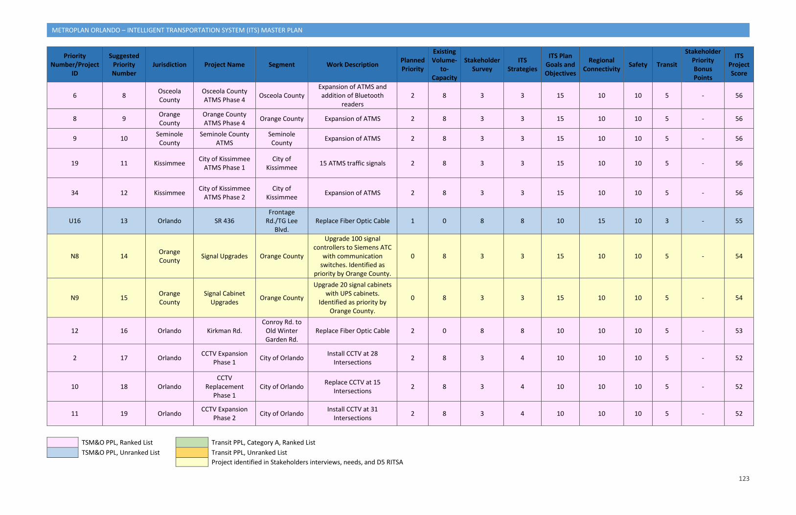
123
METROPLAN ORLANDO – INTELLIGENT TRANSPORTATION SYSTEM (ITS) MASTER PLAN
Priority Number/Project
ID
Suggested Priority Number
Jurisdiction Project Name Segment Work Description Planned Priority
Existing Volume-
to-Capacity
Stakeholder Survey
ITS Strategies
ITS Plan Goals and Objectives
Regional Connectivity Safety Transit
Stakeholder Priority Bonus Points
ITS Project Score
6 8 Osceola County
Osceola County ATMS Phase 4 Osceola County
Expansion of ATMS and addition of Bluetooth
readers 2 8 3 3 15 10 10 5 - 56
8 9 Orange County
Orange County ATMS Phase 4 Orange County Expansion of ATMS 2 8 3 3 15 10 10 5 - 56
9 10 Seminole County
Seminole County ATMS
Seminole County Expansion of ATMS 2 8 3 3 15 10 10 5 - 56
19 11 Kissimmee City of Kissimmee ATMS Phase 1
City of Kissimmee 15 ATMS traffic signals 2 8 3 3 15 10 10 5 - 56
34 12 Kissimmee City of Kissimmee ATMS Phase 2
City of Kissimmee Expansion of ATMS 2 8 3 3 15 10 10 5 - 56
U16 13 Orlando SR 436 Frontage
Rd./TG Lee Blvd.
Replace Fiber Optic Cable 1 0 8 8 10 15 10 3 - 55
N8 14 Orange County Signal Upgrades Orange County
Upgrade 100 signal controllers to Siemens ATC
with communication switches. Identified as
priority by Orange County.
0 8 3 3 15 10 10 5 - 54
N9 15 Orange County
Signal Cabinet Upgrades Orange County
Upgrade 20 signal cabinets with UPS cabinets.
Identified as priority by Orange County.
0 8 3 3 15 10 10 5 - 54
12 16 Orlando Kirkman Rd. Conroy Rd. to
Old Winter Garden Rd.
Replace Fiber Optic Cable 2 0 8 8 10 10 10 5 - 53
2 17 Orlando CCTV Expansion Phase 1 City of Orlando Install CCTV at 28
Intersections 2 8 3 4 10 10 10 5 - 52
10 18 Orlando CCTV
Replacement Phase 1
City of Orlando Replace CCTV at 15 Intersections 2 8 3 4 10 10 10 5 - 52
11 19 Orlando CCTV Expansion Phase 2 City of Orlando Install CCTV at 31
Intersections 2 8 3 4 10 10 10 5 - 52
TSM&O PPL, Ranked List Transit PPL, Category A, Ranked List TSM&O PPL, Unranked List Transit PPL, Unranked List
Project identified in Stakeholders interviews, needs, and D5 RITSA
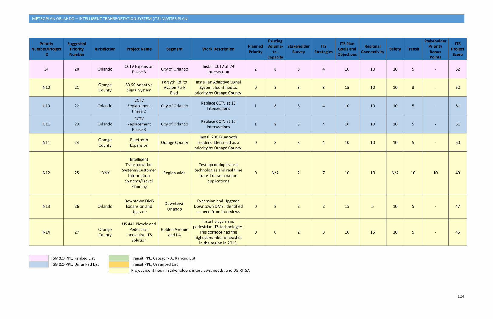
124
METROPLAN ORLANDO – INTELLIGENT TRANSPORTATION SYSTEM (ITS) MASTER PLAN
Priority Number/Project
ID
Suggested Priority Number
Jurisdiction Project Name Segment Work Description Planned Priority
Existing Volume-
to-Capacity
Stakeholder Survey
ITS Strategies
ITS Plan Goals and Objectives
Regional Connectivity Safety Transit
Stakeholder Priority Bonus Points
ITS Project Score
14 20 Orlando CCTV Expansion Phase 3 City of Orlando Install CCTV at 29
Intersection 2 8 3 4 10 10 10 5 - 52
N10 21 Orange County
SR 50 Adaptive Signal System
Forsyth Rd. to Avalon Park
Blvd.
Install an Adaptive Signal System. Identified as
priority by Orange County. 0 8 3 3 15 10 10 3 - 52
U10 22 Orlando CCTV
Replacement Phase 2
City of Orlando Replace CCTV at 15 Intersections 1 8 3 4 10 10 10 5 - 51
U11 23 Orlando CCTV
Replacement Phase 3
City of Orlando Replace CCTV at 15 Intersections 1 8 3 4 10 10 10 5 - 51
N11 24 Orange County
Bluetooth Expansion Orange County
Install 200 Bluetooth readers. Identified as a
priority by Orange County. 0 8 3 4 10 10 10 5 - 50
N12 25 LYNX
Intelligent Transportation
Systems/Customer Information
Systems/Travel Planning
Region wide
Test upcoming transit technologies and real time
transit dissemination applications
0 N/A 2 7 10 10 N/A 10 10 49
N13 26 Orlando Downtown DMS Expansion and
Upgrade
Downtown Orlando
Expansion and Upgrade Downtown DMS. Identified
as need from interviews 0 8 2 2 15 5 10 5 - 47
N14 27 Orange County
US 441 Bicycle and Pedestrian
Innovative ITS Solution
Holden Avenue and I-4
Install bicycle and pedestrian ITS technologies.
This corridor had the highest number of crashes
in the region in 2015.
0 0 2 3 10 15 10 5 - 45
TSM&O PPL, Ranked List Transit PPL, Category A, Ranked List TSM&O PPL, Unranked List Transit PPL, Unranked List
Project identified in Stakeholders interviews, needs, and D5 RITSA
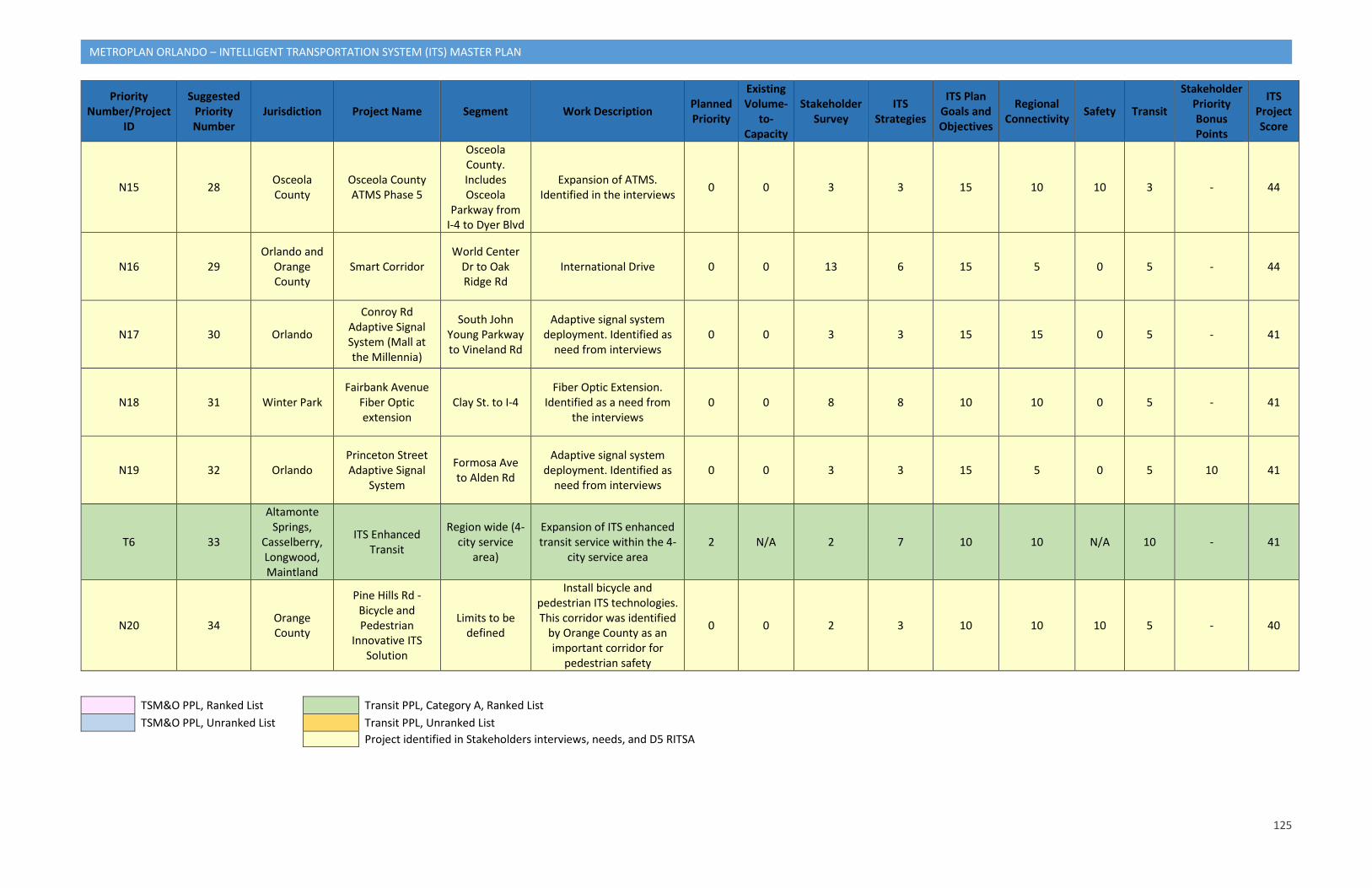
125
METROPLAN ORLANDO – INTELLIGENT TRANSPORTATION SYSTEM (ITS) MASTER PLAN
Priority Number/Project
ID
Suggested Priority Number
Jurisdiction Project Name Segment Work Description Planned Priority
Existing Volume-
to-Capacity
Stakeholder Survey
ITS Strategies
ITS Plan Goals and Objectives
Regional Connectivity Safety Transit
Stakeholder Priority Bonus Points
ITS Project Score
N15 28 Osceola County
Osceola County ATMS Phase 5
Osceola County. Includes Osceola
Parkway from I-4 to Dyer Blvd
Expansion of ATMS. Identified in the interviews 0 0 3 3 15 10 10 3 - 44
N16 29 Orlando and
Orange County
Smart Corridor World Center
Dr to Oak Ridge Rd
International Drive 0 0 13 6 15 5 0 5 - 44
N17 30 Orlando
Conroy Rd Adaptive Signal System (Mall at the Millennia)
South John Young Parkway to Vineland Rd
Adaptive signal system deployment. Identified as
need from interviews 0 0 3 3 15 15 0 5 - 41
N18 31 Winter Park Fairbank Avenue
Fiber Optic extension
Clay St. to I-4 Fiber Optic Extension.
Identified as a need from the interviews
0 0 8 8 10 10 0 5 - 41
N19 32 Orlando Princeton Street Adaptive Signal
System
Formosa Ave to Alden Rd
Adaptive signal system deployment. Identified as
need from interviews 0 0 3 3 15 5 0 5 10 41
T6 33
Altamonte Springs,
Casselberry, Longwood, Maintland
ITS Enhanced Transit
Region wide (4-city service
area)
Expansion of ITS enhanced transit service within the 4-
city service area 2 N/A 2 7 10 10 N/A 10 - 41
N20 34 Orange County
Pine Hills Rd - Bicycle and Pedestrian
Innovative ITS Solution
Limits to be defined
Install bicycle and pedestrian ITS technologies. This corridor was identified
by Orange County as an important corridor for
pedestrian safety
0 0 2 3 10 10 10 5 - 40
TSM&O PPL, Ranked List Transit PPL, Category A, Ranked List TSM&O PPL, Unranked List Transit PPL, Unranked List
Project identified in Stakeholders interviews, needs, and D5 RITSA
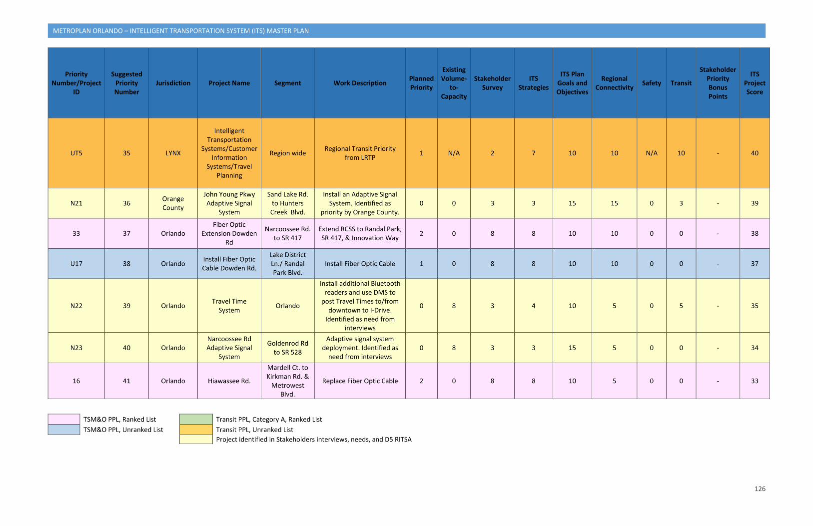
126
METROPLAN ORLANDO – INTELLIGENT TRANSPORTATION SYSTEM (ITS) MASTER PLAN
Priority Number/Project
ID
Suggested Priority Number
Jurisdiction Project Name Segment Work Description Planned Priority
Existing Volume-
to-Capacity
Stakeholder Survey
ITS Strategies
ITS Plan Goals and Objectives
Regional Connectivity Safety Transit
Stakeholder Priority Bonus Points
ITS Project Score
UT5 35 LYNX
Intelligent Transportation
Systems/Customer Information
Systems/Travel Planning
Region wide Regional Transit Priority from LRTP 1 N/A 2 7 10 10 N/A 10 - 40
N21 36 Orange County
John Young Pkwy Adaptive Signal
System
Sand Lake Rd. to Hunters Creek Blvd.
Install an Adaptive Signal System. Identified as
priority by Orange County. 0 0 3 3 15 15 0 3 - 39
33 37 Orlando Fiber Optic
Extension Dowden Rd
Narcoossee Rd. to SR 417
Extend RCSS to Randal Park, SR 417, & Innovation Way 2 0 8 8 10 10 0 0 - 38
U17 38 Orlando Install Fiber Optic Cable Dowden Rd.
Lake District Ln./ Randal Park Blvd.
Install Fiber Optic Cable 1 0 8 8 10 10 0 0 - 37
N22 39 Orlando Travel Time System Orlando
Install additional Bluetooth readers and use DMS to
post Travel Times to/from downtown to I-Drive.
Identified as need from interviews
0 8 3 4 10 5 0 5 - 35
N23 40 Orlando Narcoossee Rd Adaptive Signal
System
Goldenrod Rd to SR 528
Adaptive signal system deployment. Identified as
need from interviews 0 8 3 3 15 5 0 0 - 34
16 41 Orlando Hiawassee Rd.
Mardell Ct. to Kirkman Rd. &
Metrowest Blvd.
Replace Fiber Optic Cable 2 0 8 8 10 5 0 0 - 33
TSM&O PPL, Ranked List Transit PPL, Category A, Ranked List TSM&O PPL, Unranked List Transit PPL, Unranked List
Project identified in Stakeholders interviews, needs, and D5 RITSA
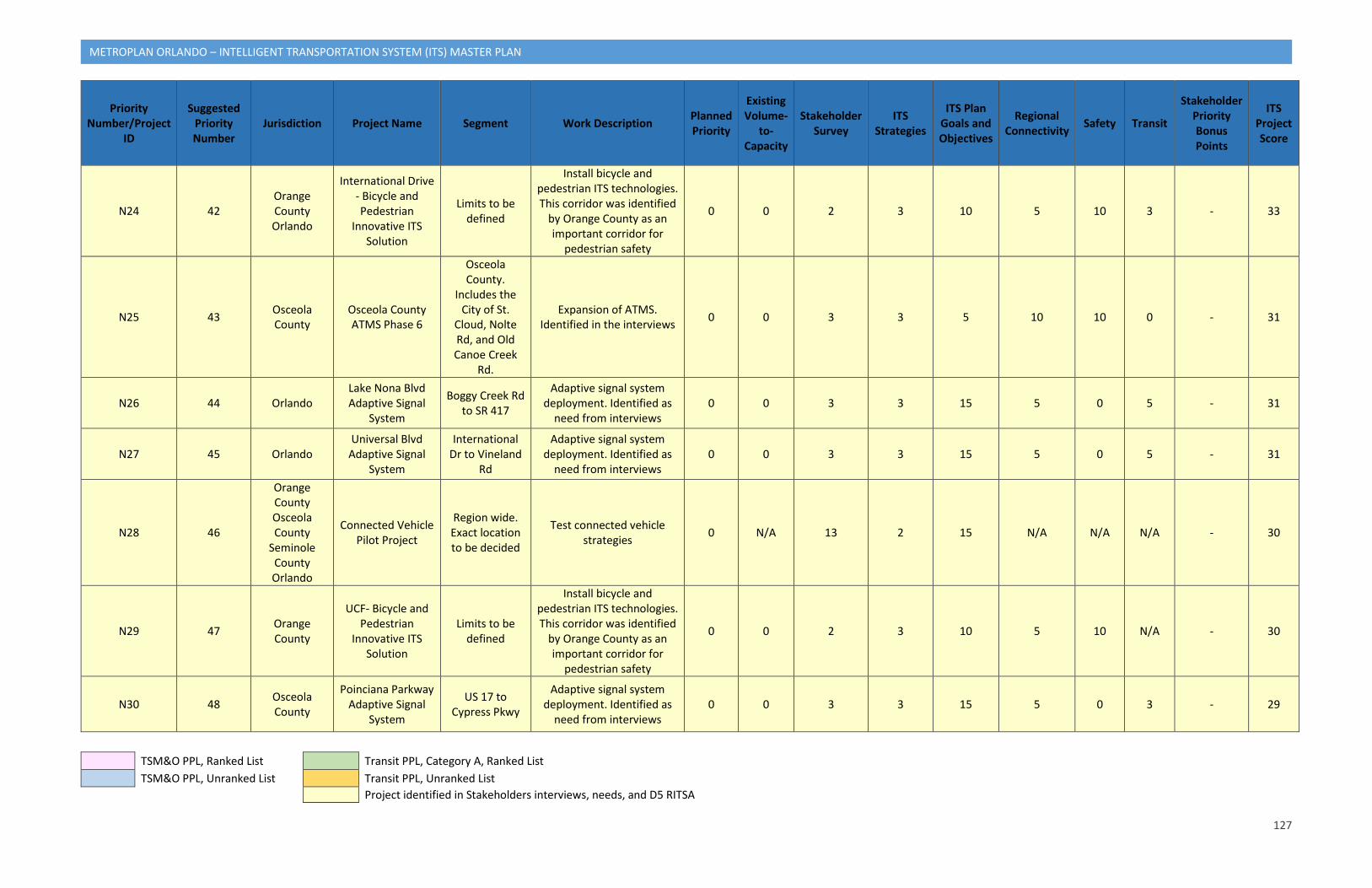
127
METROPLAN ORLANDO – INTELLIGENT TRANSPORTATION SYSTEM (ITS) MASTER PLAN
Priority Number/Project
ID
Suggested Priority Number
Jurisdiction Project Name Segment Work Description Planned Priority
Existing Volume-
to-Capacity
Stakeholder Survey
ITS Strategies
ITS Plan Goals and Objectives
Regional Connectivity Safety Transit
Stakeholder Priority Bonus Points
ITS Project Score
N24 42 Orange County Orlando
International Drive - Bicycle and Pedestrian
Innovative ITS Solution
Limits to be defined
Install bicycle and pedestrian ITS technologies. This corridor was identified
by Orange County as an important corridor for
pedestrian safety
0 0 2 3 10 5 10 3 - 33
N25 43 Osceola County
Osceola County ATMS Phase 6
Osceola County.
Includes the City of St.
Cloud, Nolte Rd, and Old Canoe Creek
Rd.
Expansion of ATMS. Identified in the interviews 0 0 3 3 5 10 10 0 - 31
N26 44 Orlando Lake Nona Blvd Adaptive Signal
System
Boggy Creek Rd to SR 417
Adaptive signal system deployment. Identified as
need from interviews 0 0 3 3 15 5 0 5 - 31
N27 45 Orlando Universal Blvd
Adaptive Signal System
International Dr to Vineland
Rd
Adaptive signal system deployment. Identified as
need from interviews 0 0 3 3 15 5 0 5 - 31
N28 46
Orange County Osceola County
Seminole County Orlando
Connected Vehicle Pilot Project
Region wide. Exact location to be decided
Test connected vehicle strategies 0 N/A 13 2 15 N/A N/A N/A - 30
N29 47 Orange County
UCF- Bicycle and Pedestrian
Innovative ITS Solution
Limits to be defined
Install bicycle and pedestrian ITS technologies. This corridor was identified
by Orange County as an important corridor for
pedestrian safety
0 0 2 3 10 5 10 N/A - 30
N30 48 Osceola County
Poinciana Parkway Adaptive Signal
System
US 17 to Cypress Pkwy
Adaptive signal system deployment. Identified as
need from interviews 0 0 3 3 15 5 0 3 - 29
TSM&O PPL, Ranked List Transit PPL, Category A, Ranked List TSM&O PPL, Unranked List Transit PPL, Unranked List
Project identified in Stakeholders interviews, needs, and D5 RITSA
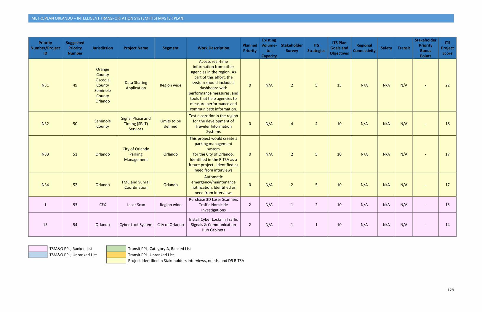
128
METROPLAN ORLANDO – INTELLIGENT TRANSPORTATION SYSTEM (ITS) MASTER PLAN
Priority Number/Project
ID
Suggested Priority Number
Jurisdiction Project Name Segment Work Description Planned Priority
Existing Volume-
to-Capacity
Stakeholder Survey
ITS Strategies
ITS Plan Goals and Objectives
Regional Connectivity Safety Transit
Stakeholder Priority Bonus Points
ITS Project Score
N31 49
Orange County Osceola County
Seminole County Orlando
Data Sharing Application Region wide
Access real-time information from other
agencies in the region. As part of this effort, the
system should include a dashboard with
performance measures, and tools that help agencies to measure performance and communicate information.
0 N/A 2 5 15 N/A N/A N/A - 22
N32 50 Seminole County
Signal Phase and Timing (SPaT)
Services
Limits to be defined
Test a corridor in the region for the development of
Traveler Information Systems
0 N/A 4 4 10 N/A N/A N/A - 18
N33 51 Orlando City of Orlando
Parking Management
Orlando
This project would create a parking management
system for the City of Orlando.
Identified in the RITSA as a future project. Identified as
need from interviews
0 N/A 2 5 10 N/A N/A N/A - 17
N34 52 Orlando TMC and Sunrail Coordination Orlando
Automatic emergency/maintenance notification. Identified as
need from interviews
0 N/A 2 5 10 N/A N/A N/A - 17
1 53 CFX Laser Scan Region wide Purchase 3D Laser Scanners
Traffic Homicide Investigations
2 N/A 1 2 10 N/A N/A N/A - 15
15 54 Orlando Cyber Lock System City of Orlando Install Cyber Locks in Traffic Signals & Communication
Hub Cabinets 2 N/A 1 1 10 N/A N/A N/A - 14
TSM&O PPL, Ranked List Transit PPL, Category A, Ranked List TSM&O PPL, Unranked List Transit PPL, Unranked List
Project identified in Stakeholders interviews, needs, and D5 RITSA
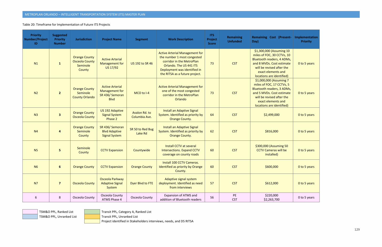
129
METROPLAN ORLANDO – INTELLIGENT TRANSPORTATION SYSTEM (ITS) MASTER PLAN
Table 20: Timeframe for Implementation of Future ITS Projects
Priority Number/Project
ID
Suggested Priority Number
Jurisdiction Project Name Segment Work Description ITS
Project Score
Remaining Unfunded
Remaining Cost (Present-Day)
Implementation Priority
N1 1
Orange County Osceola County
Seminole County
Active Arterial Management for
US 17/92 US 192 to SR 46
Active Arterial Management for the number 1 most congested
corridor in the MetroPlan Orlando. The US 441 ITS
Deployment was identified in the RITSA as a future project.
73 CST
$1,300,000 (Assuming 10 miles of FOC, 30 CCTVs, 10 Bluetooth readers, 4 ADMs, and 8 MVDs. Cost estimate
will be revised after the exact elements and
locations are identified)
0 to 5 years
N2 2 Orange County
Seminole County Orlando
Active Arterial Management for SR 436/ Semoran
Blvd
MCO to I-4
Active Arterial Management for one of the most congested corridor in the MetroPlan
Orlando
73 CST
$1,000,000 (Assuming 7 miles of FOC, 17 CCTVs, 5
Bluetooth readers, 3 ADMs, and 5 MVDs. Cost estimate
will be revised after the exact elements and
locations are identified)
0 to 5 years
N3 3 Orange County Osceola County
US 192 Adaptive Signal System
Phase 2
Avalon Rd. to Columbia Ave.
Install an Adaptive Signal System. Identified as priority by
Orange County. 64 CST $2,499,000 0 to 5 years
N4 4 Orange County
Seminole County
SR 436/ Semoran Blvd Adaptive Signal System
SR 50 to Red Bug Lake Rd
Install an Adaptive Signal System. Identified as priority by
Orange County. 62 CST $816,000 0 to 5 years
N5 5 Seminole County CCTV Expansion Countywide
Install CCTV at several Intersections. Expand CCTV coverage on county roads
60 CST $300,000 (Assuming 50 CCTV Cameras will be
installed) 0 to 5 years
N6 6 Orange County CCTV Expansion Orange County Install 100 CCTV Cameras.
Identified as priority by Orange County.
60 CST $600,000 0 to 5 years
N7 7 Osceola County Osceola Parkway Adaptive Signal
System Dyer Blvd to FTE
Adaptive signal system deployment. Identified as need
from interviews 57 CST $612,000 0 to 5 years
6 8 Osceola County Osceola County ATMS Phase 4 Osceola County Expansion of ATMS and
addition of Bluetooth readers 56 PE CST
$220,000 $2,263,700 0 to 5 years
TSM&O PPL, Ranked List Transit PPL, Category A, Ranked List TSM&O PPL, Unranked List Transit PPL, Unranked List
Project identified in Stakeholders interviews, needs, and D5 RITSA
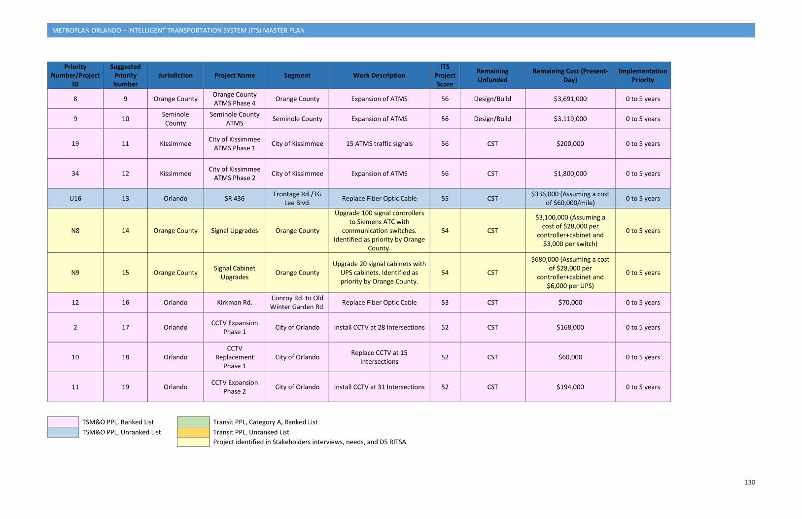
130
METROPLAN ORLANDO – INTELLIGENT TRANSPORTATION SYSTEM (ITS) MASTER PLAN
Priority Number/Project
ID
Suggested Priority Number
Jurisdiction Project Name Segment Work Description ITS
Project Score
Remaining Unfunded
Remaining Cost (Present-Day)
Implementation Priority
8 9 Orange County Orange County ATMS Phase 4 Orange County Expansion of ATMS 56 Design/Build $3,691,000 0 to 5 years
9 10 Seminole County
Seminole County ATMS Seminole County Expansion of ATMS 56 Design/Build $3,119,000 0 to 5 years
19 11 Kissimmee City of Kissimmee ATMS Phase 1 City of Kissimmee 15 ATMS traffic signals 56 CST $200,000 0 to 5 years
34 12 Kissimmee City of Kissimmee ATMS Phase 2 City of Kissimmee Expansion of ATMS 56 CST $1,800,000 0 to 5 years
U16 13 Orlando SR 436 Frontage Rd./TG Lee Blvd. Replace Fiber Optic Cable 55 CST $336,000 (Assuming a cost
of $60,000/mile) 0 to 5 years
N8 14 Orange County Signal Upgrades Orange County
Upgrade 100 signal controllers to Siemens ATC with
communication switches. Identified as priority by Orange
County.
54 CST
$3,100,000 (Assuming a cost of $28,000 per
controller+cabinet and $3,000 per switch)
0 to 5 years
N9 15 Orange County Signal Cabinet Upgrades Orange County
Upgrade 20 signal cabinets with UPS cabinets. Identified as priority by Orange County.
54 CST
$680,000 (Assuming a cost of $28,000 per
controller+cabinet and $6,000 per UPS)
0 to 5 years
12 16 Orlando Kirkman Rd. Conroy Rd. to Old Winter Garden Rd. Replace Fiber Optic Cable 53 CST $70,000 0 to 5 years
2 17 Orlando CCTV Expansion Phase 1 City of Orlando Install CCTV at 28 Intersections 52 CST $168,000 0 to 5 years
10 18 Orlando CCTV
Replacement Phase 1
City of Orlando Replace CCTV at 15 Intersections 52 CST $60,000 0 to 5 years
11 19 Orlando CCTV Expansion Phase 2 City of Orlando Install CCTV at 31 Intersections 52 CST $194,000 0 to 5 years
TSM&O PPL, Ranked List Transit PPL, Category A, Ranked List TSM&O PPL, Unranked List Transit PPL, Unranked List
Project identified in Stakeholders interviews, needs, and D5 RITSA
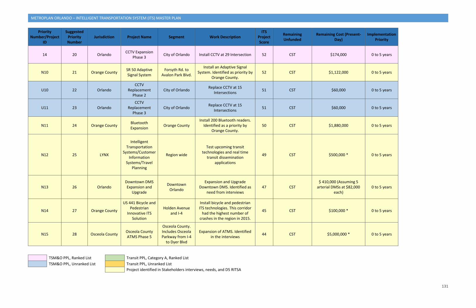
131
METROPLAN ORLANDO – INTELLIGENT TRANSPORTATION SYSTEM (ITS) MASTER PLAN
Priority Number/Project
ID
Suggested Priority Number
Jurisdiction Project Name Segment Work Description ITS
Project Score
Remaining Unfunded
Remaining Cost (Present-Day)
Implementation Priority
14 20 Orlando CCTV Expansion Phase 3 City of Orlando Install CCTV at 29 Intersection 52 CST $174,000 0 to 5 years
N10 21 Orange County SR 50 Adaptive Signal System
Forsyth Rd. to Avalon Park Blvd.
Install an Adaptive Signal System. Identified as priority by
Orange County. 52 CST $1,122,000 0 to 5 years
U10 22 Orlando CCTV
Replacement Phase 2
City of Orlando Replace CCTV at 15 Intersections 51 CST $60,000 0 to 5 years
U11 23 Orlando CCTV
Replacement Phase 3
City of Orlando Replace CCTV at 15 Intersections 51 CST $60,000 0 to 5 years
N11 24 Orange County Bluetooth Expansion Orange County
Install 200 Bluetooth readers. Identified as a priority by
Orange County. 50 CST $1,880,000 0 to 5 years
N12 25 LYNX
Intelligent Transportation
Systems/Customer Information
Systems/Travel Planning
Region wide
Test upcoming transit technologies and real time
transit dissemination applications
49 CST $500,000 * 0 to 5 years
N13 26 Orlando Downtown DMS Expansion and
Upgrade
Downtown Orlando
Expansion and Upgrade Downtown DMS. Identified as
need from interviews 47 CST
$ 410,000 (Assuming 5 arterial DMSs at $82,000
each) 0 to 5 years
N14 27 Orange County
US 441 Bicycle and Pedestrian
Innovative ITS Solution
Holden Avenue and I-4
Install bicycle and pedestrian ITS technologies. This corridor
had the highest number of crashes in the region in 2015.
45 CST $100,000 * 0 to 5 years
N15 28 Osceola County Osceola County ATMS Phase 5
Osceola County. Includes Osceola Parkway from I-4
to Dyer Blvd
Expansion of ATMS. Identified in the interviews 44 CST $5,000,000 * 0 to 5 years
TSM&O PPL, Ranked List Transit PPL, Category A, Ranked List TSM&O PPL, Unranked List Transit PPL, Unranked List
Project identified in Stakeholders interviews, needs, and D5 RITSA
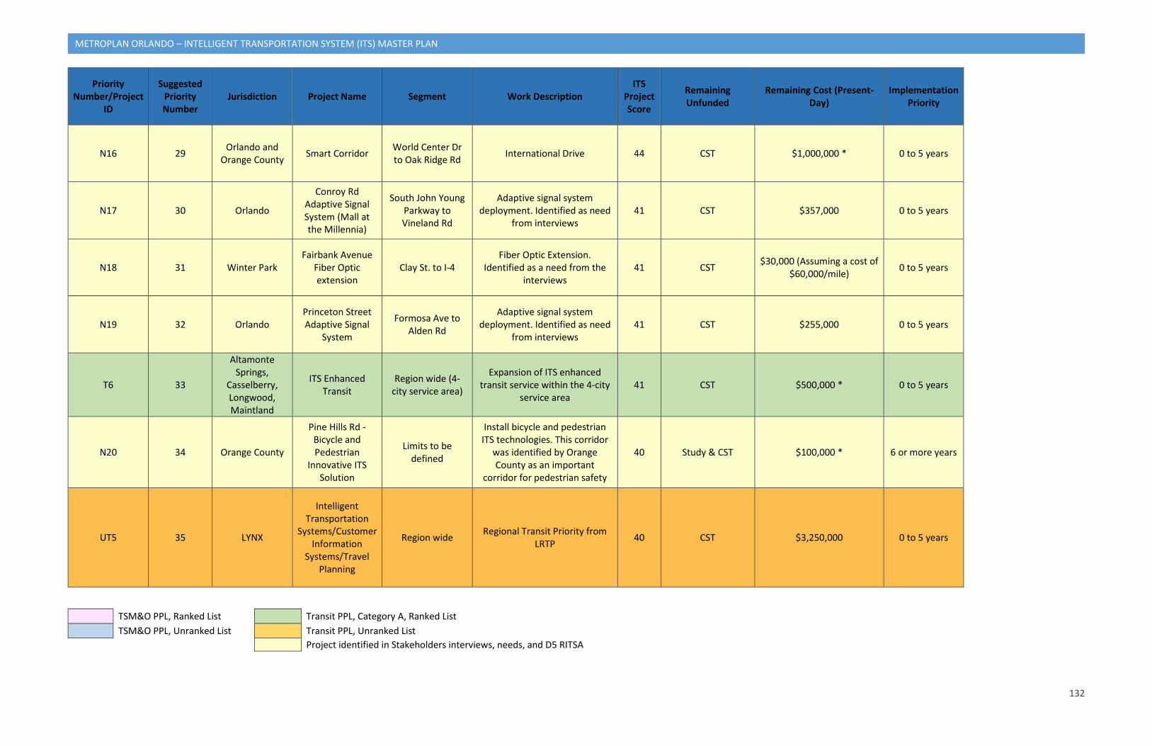
132
METROPLAN ORLANDO – INTELLIGENT TRANSPORTATION SYSTEM (ITS) MASTER PLAN
Priority Number/Project
ID
Suggested Priority Number
Jurisdiction Project Name Segment Work Description ITS
Project Score
Remaining Unfunded
Remaining Cost (Present-Day)
Implementation Priority
N16 29 Orlando and Orange County Smart Corridor World Center Dr
to Oak Ridge Rd International Drive 44 CST $1,000,000 * 0 to 5 years
N17 30 Orlando
Conroy Rd Adaptive Signal System (Mall at the Millennia)
South John Young Parkway to Vineland Rd
Adaptive signal system deployment. Identified as need
from interviews 41 CST $357,000 0 to 5 years
N18 31 Winter Park Fairbank Avenue
Fiber Optic extension
Clay St. to I-4 Fiber Optic Extension.
Identified as a need from the interviews
41 CST $30,000 (Assuming a cost of $60,000/mile) 0 to 5 years
N19 32 Orlando Princeton Street Adaptive Signal
System
Formosa Ave to Alden Rd
Adaptive signal system deployment. Identified as need
from interviews 41 CST $255,000 0 to 5 years
T6 33
Altamonte Springs,
Casselberry, Longwood, Maintland
ITS Enhanced Transit
Region wide (4-city service area)
Expansion of ITS enhanced transit service within the 4-city
service area 41 CST $500,000 * 0 to 5 years
N20 34 Orange County
Pine Hills Rd - Bicycle and Pedestrian
Innovative ITS Solution
Limits to be defined
Install bicycle and pedestrian ITS technologies. This corridor
was identified by Orange County as an important
corridor for pedestrian safety
40 Study & CST $100,000 * 6 or more years
UT5 35 LYNX
Intelligent Transportation
Systems/Customer Information
Systems/Travel Planning
Region wide Regional Transit Priority from LRTP 40 CST $3,250,000 0 to 5 years
TSM&O PPL, Ranked List Transit PPL, Category A, Ranked List TSM&O PPL, Unranked List Transit PPL, Unranked List
Project identified in Stakeholders interviews, needs, and D5 RITSA
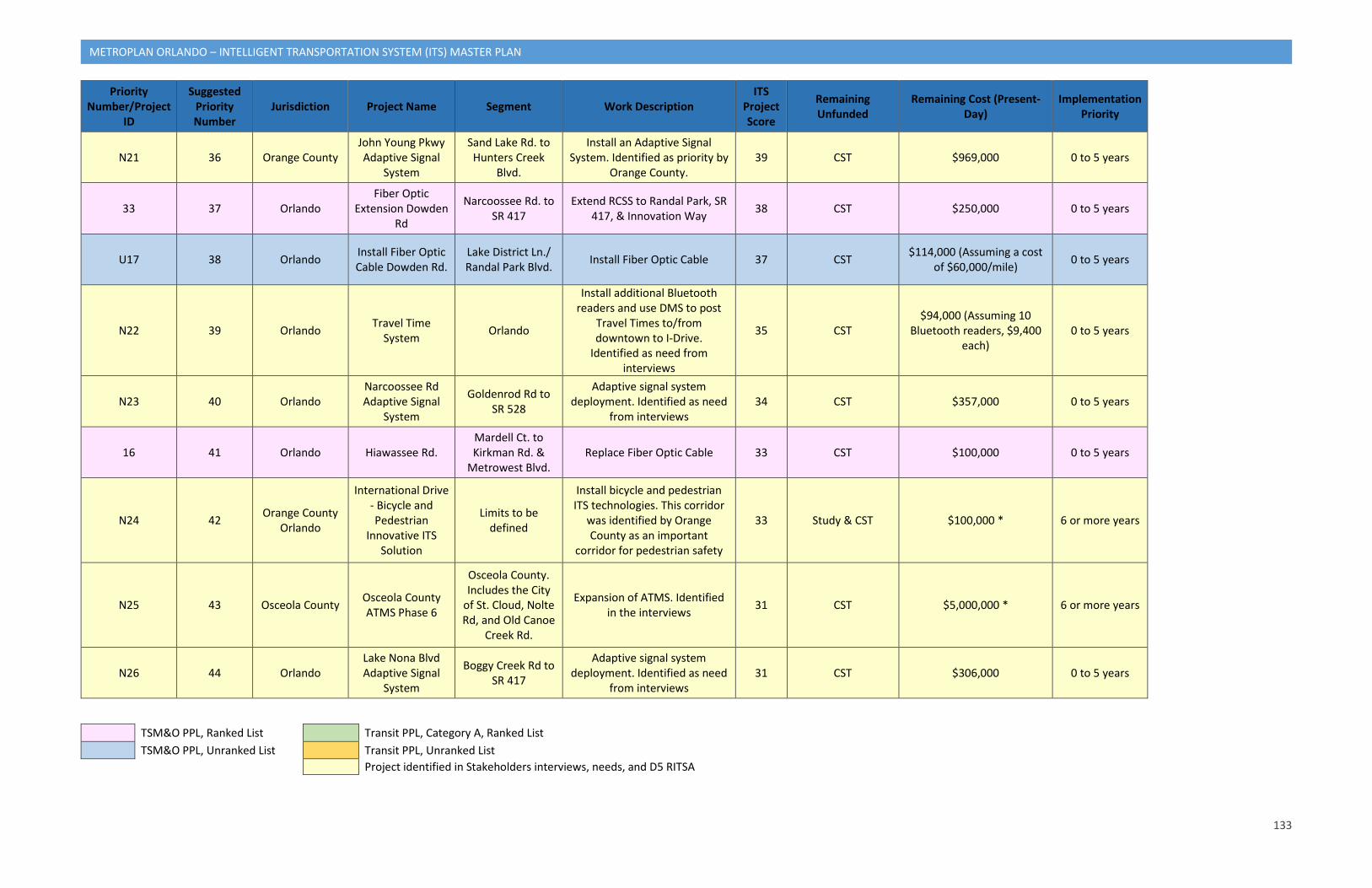
133
METROPLAN ORLANDO – INTELLIGENT TRANSPORTATION SYSTEM (ITS) MASTER PLAN
Priority Number/Project
ID
Suggested Priority Number
Jurisdiction Project Name Segment Work Description ITS
Project Score
Remaining Unfunded
Remaining Cost (Present-Day)
Implementation Priority
N21 36 Orange County John Young Pkwy Adaptive Signal
System
Sand Lake Rd. to Hunters Creek
Blvd.
Install an Adaptive Signal System. Identified as priority by
Orange County. 39 CST $969,000 0 to 5 years
33 37 Orlando Fiber Optic
Extension Dowden Rd
Narcoossee Rd. to SR 417
Extend RCSS to Randal Park, SR 417, & Innovation Way 38 CST $250,000 0 to 5 years
U17 38 Orlando Install Fiber Optic Cable Dowden Rd.
Lake District Ln./ Randal Park Blvd. Install Fiber Optic Cable 37 CST $114,000 (Assuming a cost
of $60,000/mile) 0 to 5 years
N22 39 Orlando Travel Time System Orlando
Install additional Bluetooth readers and use DMS to post
Travel Times to/from downtown to I-Drive.
Identified as need from interviews
35 CST $94,000 (Assuming 10
Bluetooth readers, $9,400 each)
0 to 5 years
N23 40 Orlando Narcoossee Rd Adaptive Signal
System
Goldenrod Rd to SR 528
Adaptive signal system deployment. Identified as need
from interviews 34 CST $357,000 0 to 5 years
16 41 Orlando Hiawassee Rd. Mardell Ct. to Kirkman Rd. &
Metrowest Blvd. Replace Fiber Optic Cable 33 CST $100,000 0 to 5 years
N24 42 Orange County Orlando
International Drive - Bicycle and Pedestrian
Innovative ITS Solution
Limits to be defined
Install bicycle and pedestrian ITS technologies. This corridor
was identified by Orange County as an important
corridor for pedestrian safety
33 Study & CST $100,000 * 6 or more years
N25 43 Osceola County Osceola County ATMS Phase 6
Osceola County. Includes the City
of St. Cloud, Nolte Rd, and Old Canoe
Creek Rd.
Expansion of ATMS. Identified in the interviews 31 CST $5,000,000 * 6 or more years
N26 44 Orlando Lake Nona Blvd Adaptive Signal
System
Boggy Creek Rd to SR 417
Adaptive signal system deployment. Identified as need
from interviews 31 CST $306,000 0 to 5 years
TSM&O PPL, Ranked List Transit PPL, Category A, Ranked List TSM&O PPL, Unranked List Transit PPL, Unranked List
Project identified in Stakeholders interviews, needs, and D5 RITSA
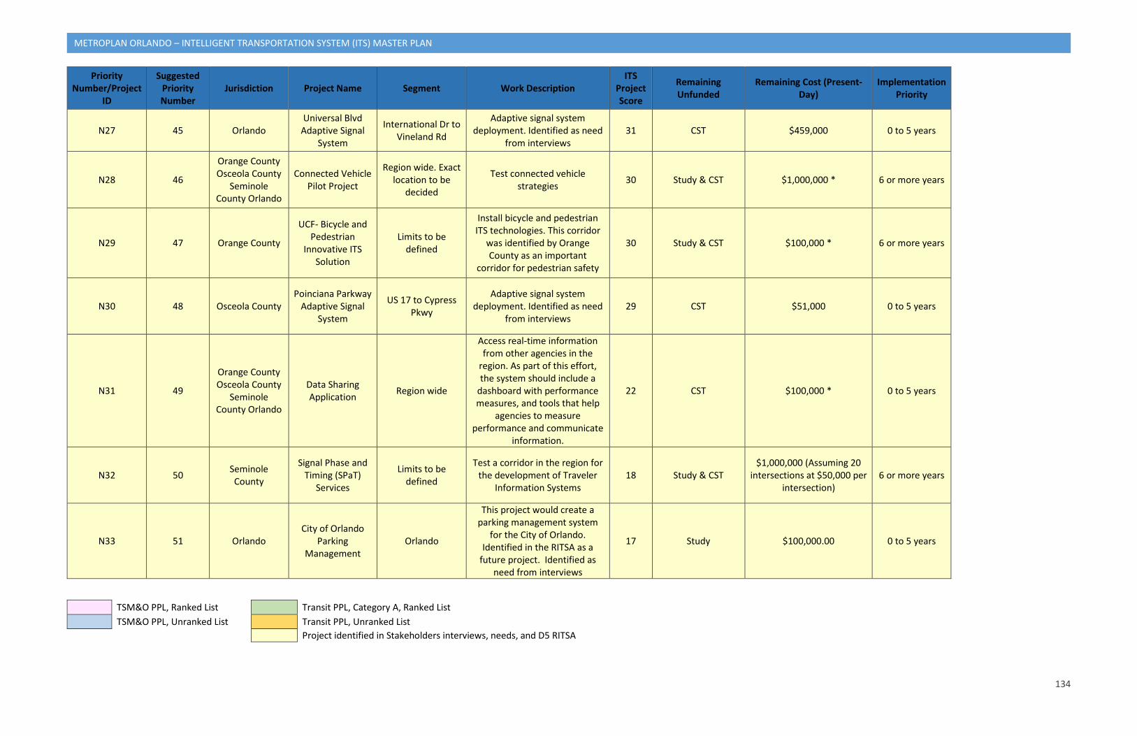
134
METROPLAN ORLANDO – INTELLIGENT TRANSPORTATION SYSTEM (ITS) MASTER PLAN
Priority Number/Project
ID
Suggested Priority Number
Jurisdiction Project Name Segment Work Description ITS
Project Score
Remaining Unfunded
Remaining Cost (Present-Day)
Implementation Priority
N27 45 Orlando Universal Blvd
Adaptive Signal System
International Dr to Vineland Rd
Adaptive signal system deployment. Identified as need
from interviews 31 CST $459,000 0 to 5 years
N28 46
Orange County Osceola County
Seminole County Orlando
Connected Vehicle Pilot Project
Region wide. Exact location to be
decided
Test connected vehicle strategies 30 Study & CST $1,000,000 * 6 or more years
N29 47 Orange County
UCF- Bicycle and Pedestrian
Innovative ITS Solution
Limits to be defined
Install bicycle and pedestrian ITS technologies. This corridor
was identified by Orange County as an important
corridor for pedestrian safety
30 Study & CST $100,000 * 6 or more years
N30 48 Osceola County Poinciana Parkway
Adaptive Signal System
US 17 to Cypress Pkwy
Adaptive signal system deployment. Identified as need
from interviews 29 CST $51,000 0 to 5 years
N31 49
Orange County Osceola County
Seminole County Orlando
Data Sharing Application Region wide
Access real-time information from other agencies in the
region. As part of this effort, the system should include a
dashboard with performance measures, and tools that help
agencies to measure performance and communicate
information.
22 CST $100,000 * 0 to 5 years
N32 50 Seminole County
Signal Phase and Timing (SPaT)
Services
Limits to be defined
Test a corridor in the region for the development of Traveler
Information Systems 18 Study & CST
$1,000,000 (Assuming 20 intersections at $50,000 per
intersection) 6 or more years
N33 51 Orlando City of Orlando
Parking Management
Orlando
This project would create a parking management system
for the City of Orlando. Identified in the RITSA as a
future project. Identified as need from interviews
17 Study $100,000.00 0 to 5 years
TSM&O PPL, Ranked List Transit PPL, Category A, Ranked List TSM&O PPL, Unranked List Transit PPL, Unranked List
Project identified in Stakeholders interviews, needs, and D5 RITSA
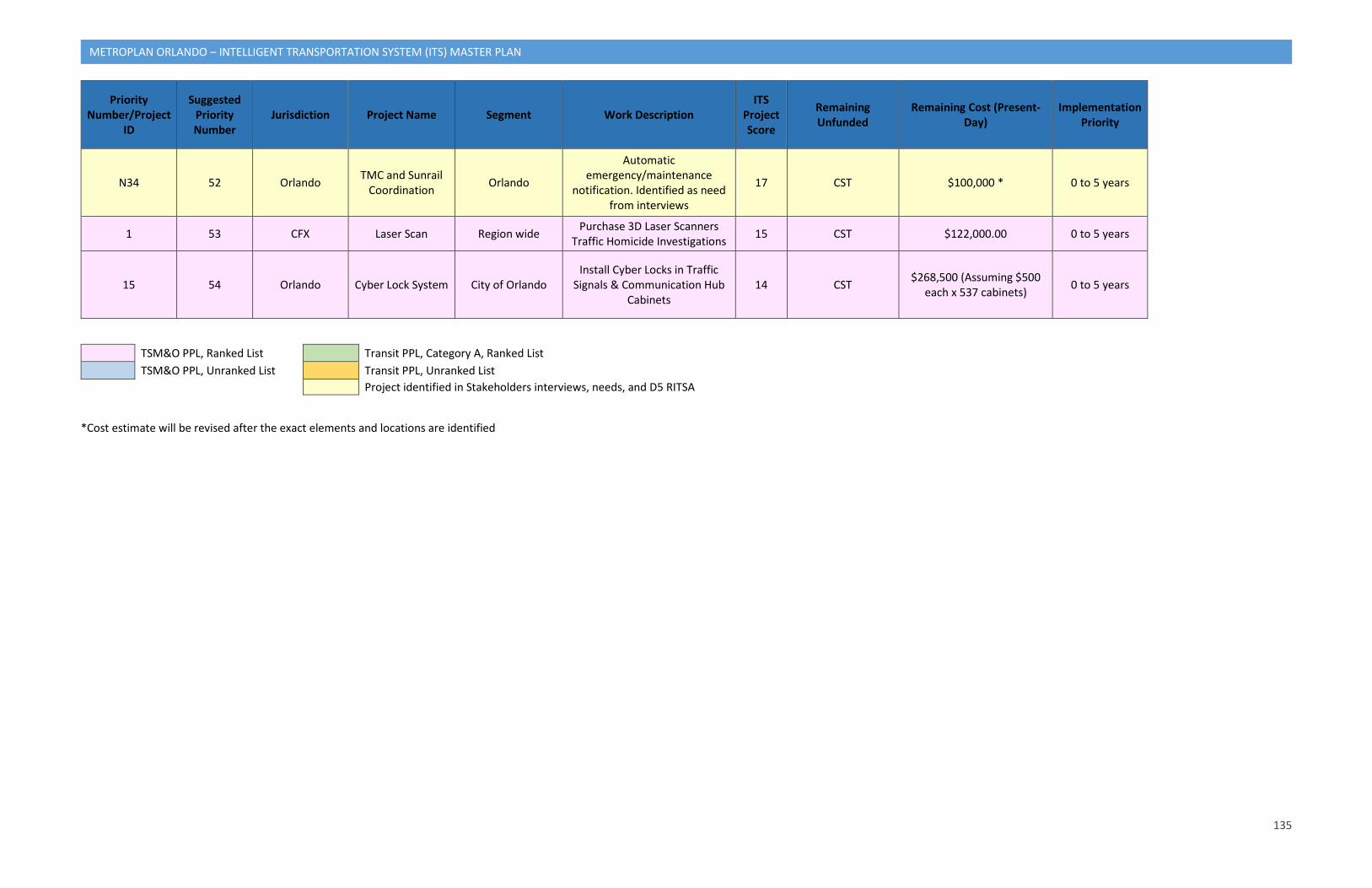
135
METROPLAN ORLANDO – INTELLIGENT TRANSPORTATION SYSTEM (ITS) MASTER PLAN
Priority Number/Project
ID
Suggested Priority Number
Jurisdiction Project Name Segment Work Description ITS
Project Score
Remaining Unfunded
Remaining Cost (Present-Day)
Implementation Priority
N34 52 Orlando TMC and Sunrail Coordination Orlando
Automatic emergency/maintenance
notification. Identified as need from interviews
17 CST $100,000 * 0 to 5 years
1 53 CFX Laser Scan Region wide Purchase 3D Laser Scanners Traffic Homicide Investigations 15 CST $122,000.00 0 to 5 years
15 54 Orlando Cyber Lock System City of Orlando Install Cyber Locks in Traffic
Signals & Communication Hub Cabinets
14 CST $268,500 (Assuming $500 each x 537 cabinets) 0 to 5 years
TSM&O PPL, Ranked List Transit PPL, Category A, Ranked List TSM&O PPL, Unranked List Transit PPL, Unranked List
Project identified in Stakeholders interviews, needs, and D5 RITSA
*Cost estimate will be revised after the exact elements and locations are identified
136
METROPLAN ORLANDO – INTELLIGENT TRANSPORTATION SYSTEM (ITS) MASTER PLAN
7.6.1 Project Implementation and Monitoring As outlined in the LRTP, the MPO plans to conduct a monitoring process to evaluate the success of the implementation of its CMP. The CMP report will be updated annually, along with new congestion maps, and will incorporate the performance measures identified in Table 16 as part of the monitoring process. The monitoring process for the LRTP CMP can be combined with the implementation and monitoring process for this plan, and the performance measures identified in Table 16 can be combined with the others associated with the goals and objectives listed in Section 1 to evaluate the success of selected projects in achieving the vision of this plan as well. Table 20 shows the recommended time frame for deploying projects in this plan. Each project indicates the implementation timeline of 0 to 5 years or 6 or more years.
The ITS Master Plan will serve as a guide for the development of future regional ITS projects. Using the scoring criteria defined in this section, a total of 54 projects were ranked. Out of the ranked 54 projects, 14 projects are from the ranked TSMO PPL, four are from the unranked TSMO PPL, one is from the ranked Transit PPL, one is from the unranked Transit PPL, and 34 are additional projects proposed based on the needs of the stakeholders and the V/C and crash count corridor analyses.
As future projects are developed, consideration for human resource needs, training, financial constraints and opportunities to involve the private sector need to be addressed by each jurisdiction/agency. Jurisdictions need to be fully committed to these items to make the ITS plan work. In addition, for all future projects the RITSA will need to be reviewed to ensure that service packages are updated or added, as needed, and submitted to the Change Management Board for approval to ensure that the RITSA update is incorporated. As stated in Section 5, based on the current information, new service packages will be needed for City of Apopka, City of Kissimmee, City of Ocoee, City of Winter Gardens, and the Reedy Creek Improvement District. In addition, the existing services packages APTS01 (Transit Vehicle Tracking) and the service packages for the Florida Turnpike enterprise should be modified.