mechanism of the montescaglioso landslide (southern italy ... · mechanism of the montescaglioso...
TRANSCRIPT

Mechanism of the Montescaglioso Landslide(Southern Italy) Inferred by Geological Surveyand Remote Sensing
Francesca Bozzano, Paolo Caporossi, Carlo Esposito,Salvatore Martino, Paolo Mazzanti, Serena Moretto,Gabriele Scarascia Mugnozza, and Antonio Michele Rizzo
AbstractMontescaglioso village is located in southern Italy (Matera, Basilicata region), on a hill top,at about 350 m a.s.l., along the left bank of the Bradano River. Several landslides involvedthis area, some of them classified as relict; the latest one occurred on December 3rd, 2013on the south-western slope of Montescaglioso hill. A review of the geological setting of thisslope is presented, aimed at defining the failure mechanism of the slope. Sub-pixelcross-correlation analysis based on SAR images was performed to infer the co-failuredisplacement pattern and A-DInSAR was carried out to detect the spatial-temporaldeformational pattern before and after the failure. The field surveys confirmed the main roleplayed by geological setting in structurally constraining the landslide mechanism and itscomplex kinematic, featured by three main distinct “kinematic blocks” with differentdirection of movement. The 3rd December landslide has been recognized as a partialreactivation along a slope affected by a long-lasting sequence of landslides, the last onetriggered by a transient action.
KeywordsLandslide !Montescaglioso ! COSMO-SkyMed ! Digital image correlation ! A-DInSAR
Introduction
The village of Montescaglioso (Basilicata region, SouthernItaly) is located on the top of a hill at about 350 m a.s.l.,along the left bank of the Bradano River. In this paper thelandslide occurred on the 3rd December 2013 involving thesouth western slope is dealt with. The landslide causedsevere damages to private houses, commercial buildings andmain infrastructures. Several studies were focused so far onthis event (Amanti et al. 2014; Manconi et al. 2014; Raspiniet al. 2015; Pellicani et al. 2016; Amanti et al. 2016), whichprovided a comprehensive description of the phenomenon.According to Amanti et al. (2014), Pellicani et al. (2016) andAmanti et al. (2016), the heavy and intense rainfall, affectedthe area since 30th November until 2nd December, can beregarded as the trigger of the landslide.
The geological setting of the area has been reconstructedby field surveys and tens of reliable borehole
F. Bozzano (&) ! P. Caporossi ! C. Esposito ! S. MartinoP. Mazzanti ! S. Moretto ! G.S. Mugnozza ! A.M. RizzoDepartment of Earth Sciences, “Sapienza” University of Rome,P.le Aldo Moro 5, 00185 Rome, Italye-mail: [email protected]
P. Caporossie-mail: [email protected]
C. Espositoe-mail: [email protected]
S. Martinoe-mail: [email protected]
P. Mazzantie-mail: [email protected]
S. Morettoe-mail: [email protected]
G.S. Mugnozzae-mail: [email protected]
A.M. Rizzoe-mail: [email protected]
© Springer International Publishing AG 2017M. Mikoš et al. (eds.), Advancing Culture of Living with Landslides,DOI 10.1007/978-3-319-53498-5_12
97

log-stratigraphies, investigating a depth ranging from 25 mdown to 66 m b.g.l. (Amanti et al. 2016). Based on thesedata, two litotechnical units inside the landslide slope havebeen distinguished: (i) a more shallow one (with a thicknessincreasing from 10 up to 40 m moving toward the landslidetoe), mainly consisting of sands and conglomerates and (ii) adeeper one, constituted by stiff gray silty clays, ascribable tothe Argille Subappennine Formation (Tropeano et al. 2002).
The landslide mechanism has been inferred by usingimaging techniques such as speckle tracking from SARimages and DTM analyses, performed by Raspini et al.(2015) and Amanti et al. (2014) respectively. The dis-placement values exceeded 10 m in wide portions of thelandslide mass; the maximum displacements (i.e. up to20 m) were recorded at the toe of the landslide.
Satellite interferometry data are available (Manconi et al.2014; Raspini et al. 2015), revealing a general pre-eventdisplacement rate in the order of few mm/year, with peaksbetween 8 and 12 mm/year.
Methods
In this study, we present a revision of the geological settingof the Montescaglioso hill, inferred by specifically per-formed geological surveys, to better constrain the failuremechanism of the slope.
Furthermore, analyses based on Synthetic Aperture Radarimages acquired by the COSMO-SkyMed Constellation,referred to the time period between 2011 and 2015, werecarried out.
The analyses of satellite SAR images aimed at charac-terizing the deformational pattern of the area in thepre-failure, co-failure and post-failure phases of the 3rdDecember landslide. With this aim, two different techniqueswere used: (1) the A-DInSAR (Advanced Differential Syn-thetic Amplitude Radar Interferometry) and (2) the DigitalImage Correlation (DIC) technique.
The A-DInSAR processing allowed us to monitor thedeformational behaviour of the slope before and after thefailure. The analyses were performed using the PS (Persis-tent Scatterers) technique (Ferretti et al. 2001) implementedin the SARPROZ software (SAR PROcessing tool by periZ,http://www.sarproz.com). This methodology enables toobtain the time series of displacement along the LOS (LineOf Sight) for those points considered as PS, characterized byhigh amplitude and phase stability.
Digital Image Correlation was used with the aim ofmonitoring the co-failure displacement. It represents anoptical-numerical measuring technique which offers uniqueopportunities for exploring full-field displacement anddeformation at the surface of objects. This is possiblethrough the comparison and the correlation of digital images
of the specimen surface, captured before and after defor-mation (Pan et al. 2008).
Geological and Geomorphological Setting
The Montescaglioso hill is part of the Bradanic Troughgeological context, which represents the Plio-Pleistoceneforedeep of southern Appennines. It is bounded by theApennine chain to the west and by the Apulian foreland tothe east (Boenzi et al. 1971; Balduzzi et al. 1982). Such ageological context is responsible for a complex geologicalsetting of the area, as it was involved in a multistep tectonicand sedimentary evolution. Based on field surveys, a revisedgeological map has been obtained (Fig. 1) by distinguishingthe following six geological units: (i) clays and silty clays,belonging to the Argille Subappennine Formation (Cal-abrian); (ii) sands, belonging to the Monte Marano Forma-tion (Calabrian); (iii) calcarenites, belonging to the MonteCastiglione Formation (Calabrian); (iv) conglomerates,which could be associated to the Irsina Conglomerate For-mation (Calabrian); (v) sands and conglomerates of marineterraces (Pleistocene); (vi) alluvial deposits related to theBradano river.
The Argille Subappennine Formation consists of marlyclays, clays and silty clays. In the study area, clays diptowards SW with an inclination of 20°. This is the maingeological formation of the Bradanic Trough zone, charac-terised by up to 4 km thickness and a strong lateral conti-nuity. The stratigraphic contact between the ArgilleSubappennine Formation and the overlapped deposits isclearly visible in the Montescaglioso hill.
The layered sands (Monte Marano Formation) outcrop ina small area and are in a stratigraphic contact with theArgille Subappennine; they pass laterally and upward to thecalcarenites ascribed to the Monte Castiglione Formation.The attitude of strata is concordant with the upper deposits:dip toward SW with an inclination of 15–20°. The formationthickness observed in the study area is few meters.
The calcarenites (Monte Castiglione Formation) consistin coarse grained deposits and biocalcrudites with a greatamount of fossils such as: pecten, ostrea, litotamni, lamel-libranches and gastropods. They are characterised by a veryclear layering of strata, about 15 cm thick and SW dippingwith an inclination of 15–20°. The thickness of the cal-carenites in the study area is about 30 m.
The conglomerates (Irsina Formation) are characterizedby heterometric and polygenic well rounded gravels con-sisting of limestone, chert, sandstone and igneous elementsof Apennine origin. They are generally characterised by asandy calcareous matrix and are interlayered with sandyyellow-brown levels. In the study area, the conglomeratedeposits outcrop near the cemetery (location in Fig. 2),
98 F. Bozzano et al.

Fig. 1 Geological map of the Montescaglioso hill and related geological cross sections A-A', B-B'
Mechanism of the Montescaglioso Landslide (Southern Italy) … 99

where they are arranged as a south-east dipping slab. Nev-ertheless, many blocks of conglomerate can be surveyed allalong the south-western slope of Montescaglioso hill. Theseblocks have an extremely variable volume, up to 10–100 m3.
Marine terrace deposits outcrop in the south-easternsector of the study area, forming a characteristic planarmorphology at the hill top. They are composed of sandpassing toward the top to bedded, poorly cemented con-glomerates. They represent the last marine depositionalevent before the south-eastward migration of the shoreline,due to the strong regional uplift that involved the BradanoTrough. This is documented by up to 18 paleo-shorelinesrecognised so far (Caputo et al. 2010) from Montescagliosohill to the Gulf of Taranto. The marine terrace depositsoutcropping in the Montescaglioso area can be consideredthe oldest among the 18 terraces documented in this area(Caputo et al. 2010).
The alluvial deposits, mapped in the south-westernsector of the area, are related to the Bradano river andconsist of heterogeneous deposits. They are connected tothe partial infilling of the previously formed deep valley,
during the well-known Late Pleistocene last glacial maxi-mum. Presumably, the thickness of the recent alluvialdeposits in the area is of some tens of meters (Boenzi et al.1971)
According to clear geomorphological evidences, as wellas to the IFFI project (Inventory of Landslide Phenomena inItaly) and previous studies (Manconi et al. 2014; Raspiniet al. 2015), the Montescaglioso area has been affected byseveral landslides before the 3rd December event. As shownin the geological map (Fig. 1), the Montescaglioso hill ischaracterised by many landforms ascribable to old land-slides. These landforms consist of scarps and counter-slope,tilted terraces or blocks chaotically dislodged respect to thepresent morphology of the hill. In particular, along thesouth-western slope, the strong effects of landslide processesdeveloping over time can be recognized. Indeed, this slope ischaracterized by colluvial deposits that mostly consist ofsands and debris with rounded gravel derived from the IrsinaConglomerate. Furthermore, colluvial deposits incorporatelarge-sized blocks of conglomerate, highlighting the ancientlandslide activity.
Fig. 2 Area involved in the 3rdDecember Montescagliosolandslide
100 F. Bozzano et al.

The 3rd December Montescaglioso Landslide
On December 3rd, 2013, a landslide occurred on thesouth-western slope of the Montescaglioso hill, over an areaabout 500,000 m2 wide. A maximum depth of 40 m for thefailure surface is presumed, with an estimated volume ofabout 8 millions of cubic meters (Pellicani et al. 2016)(Fig. 2).
The landslide shows a triangular-shaped area, which isdelimited by the main crown, at an elevation of about 200 ma.s.l., the foot, located in Capo Iazzo stream about at 100 ma.s.l., with a total length of 1200 m and a width of 800 m.
The intense rainfall, occurred between the 5th and 8thOctober 2013 and the 30th November and 2nd December2013, have been regarded as the trigger for the landslideevent (Manconi et al. 2014; Pellicani et al. 2016; Amantiet al. 2016). More in particular, the rain gauges located atGinosa (8 km east of Montescaglioso), recorded 246 mmin 68 h for the event of October and 151.60 mm in 56 h,between 02.00 PM of 30th November 2013 and 10.00 PMof 2nd December. Considering the intensity of the lastevent (cumulated rainfall of 151.60 mm), a return period ofabout 20–50 years can be attributed according to Pellicaniet al. (2016). Moreover, according to the same Authors, ifthe annual maximum daily precipitation is accounted for,the measured daily rainfall (125 mm) has a return periodranges from 20 to 100 years, depending on the stationsconsidered.
The 3rd December landslide had a complex manifesta-tion. The evidences of ground failures were collected at01.00 PM of the same day, in proximity of the main road(namely Piani Bradano road), for a length of about 500 m. Inthe following hours, several private houses have beendamaged, as proved by displacement up to 6 m of theirfoundations. However, some damages were documented bylocal witnesses in private areas the day before the eventlocalized at the toe of the landslide (Pellicani et al. 2016).The last phase of the movement (occurred in the nightbetween the 3rd and 4th December) was typified by a ret-rogressive style, causing a northward replacement of thelandslide area.
Results
A-DInSAR Analysis
The complete COSMO-SkyMed dataset is composed by 60SAR images, acquired in the ascending geometry during thetime interval between May 2011 and May 2015 (Fig. 3). Thesatellite has a right-looking configuration, the LOS anglewith respect to the North is 78 degrees and the incidenceangle is about 30°. The COSMO-SkyMed descending
dataset was discharged because it includes few images, bothfor the pre-failure and the post-failure period, with a dis-continuous temporal distribution.
Two different A-DInSAR analyses were performed:(1) the pre-failure and (2) the post-failure analysis.Pre-failure analysis was carried out by processing the imagesacquired before the landslide event.
The pre-failure dataset consists in 37 images, from May2011 to the December 3rd, 2013 (Fig. 3a). On the otherhand, post-failure analysis was performed taking the SARimages acquired after the landslide event, namely 23 images(Fig. 3b).
Regarding the pre-failure analysis, in accordance with theresults obtained by Raspini et al. (2015), the occurrence ofdisplacements were observed also outside the area involvedin the 3rd December landslide. The maximum displacementswere recorded where the hypermarket and the trafficroundabout were located (yellow circle in Fig. 3a). In theselocations the displacement average velocities range from 5 to10 mm/year. As already stated also by Raspini et al. (2015),the time series of displacement inside the landslide area donot show an evident and well defined acceleration phaseprior to the slope failure.
The post-failure analysis does not provide many mea-surement points inside the area involved in the 3rdDecember landslide, probably due to the remediation worksthat could have caused the loss of coherence in this area.However, the deformational behavior, outside the landslidebody is similar to the pre-failure one, highlighting the slowand persistent deformations affecting the south-western slopeof Montescaglioso hill.
DIC Analysis
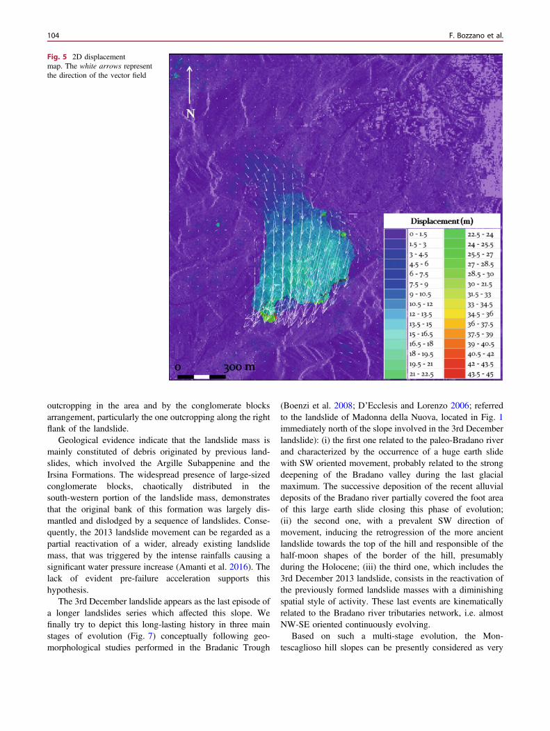
To retrieve the co-failure displacement pattern, in terms ofboth intensity and rate, 2D sub-pixel image-correlationanalysis was carried out. Such an application is based on theemployment of SAR amplitude images and, more in par-ticular, of the reflectivity maps obtained by computing theaverage time amplitude of the COSMO-SkyMed imagesacquired pre- and post-landslide occurrence in the ascendinggeometry (Fig. 4).
The images (with an average resolution of about3 m/pixel) have been managed in Co-Registration of Opti-cally Sensed Images and Correlation (COSI-Corr) (Leprinceet al. 2007), an open-source plug-in working in ENVIpackage software. The algorithm implemented in COSI-Corris based on a robust coarse-to-fine scheme and a sub-pixelmatching method with a theoretical precision of 1/50 pixel(Leprince et al. 2007).
In this study, a frequency correlator engine has been used,with a window size of 64 ! 64 pixels (192 ! 192 m) and a
Mechanism of the Montescaglioso Landslide (Southern Italy) … 101

sliding step of 2 pixels (6 m), and the displacement fields inEast/West and North/South directions with a ground sam-pling distance of 6 m have been obtained.
Figure 5 shows that the resulted horizontal displace-ments, ranging from 2 to 22 m, were reached during the 3rdDecember landslide, with a prevalent S-SW direction, in
agreement with Raspini et al. (2015). The here performedsub-pixel image-correlation analysis for the displacementmeasurements from satellite images (SAR reflectivity maps,in this case), i.e. without employing neither ground controlpoints nor external DEM, represents a further example of thetechnique suitability.
Fig. 3 Persistent scatterers derived from A-DInSAR analyses.a Pre-failure analysis. b Post-failure analysis. The negative valuesindicate movement away from the sensor (yellow-red color), while
positive values represent movement toward the sensor (blue color). Thetable shows the datasets used for the two analyses
102 F. Bozzano et al.

Interpretations
The mechanism of the Montescaglioso landslide wasreconstructed by using informations coming from geologicalsurvey, geomorphological observations and DIC analysis(Fig. 6). As shown in Fig. 6, the landslide is classified as acomplex movement (Varnes 1978) featured by four maindistinct “kinematic blocks” with different direction ofmovement and time succession:
• Block 1A, with a SSW main movement direction and aprevalent translational mechanism;
• Block 1B, characterized by a roto-translation mechanismtoward SSW;
• Block 2, with a SW direction;• Block 3, which represents the retrogressive evolution of
the block 1 with a translational mechanism along a SSEdirection.
As it regards the time stepping of the 3rd Decemberlandslide, the initial failure (step 1), which involved the main
road and constitutes the main landslide body, is featured byblock 1A and block 1B that moved more or less simultane-ously. A significant shallow groundwater circulation wasobserved within the moving blocks, presumably overfeed byintense rainfall and enhanced by the local hydrographicnetwork strongly modified by human interventions. Theslight difference in the direction of movement of blocks 1Aand 1B has been related to structural constraint due to thegeological setting of a large block of conglomerate (IrsinaFormation), that bounds the right flank of the block 1A and tothe presence of two creeks: Cinque Bocche and Capo Iazzo(Fig. 2). The following vertical adjustment of the landslidemass occurred after the main failure (step 2), involved theBlock 2 and originated a horst-and-graben type landform(Fig. 6). Finally, the movement of Block 3 (step 3) representsthe retrogressive evolution of the landslide, occurred duringthe night 3rd–4th December 2013.
The field survey confirms the main role played by geo-logical setting in constraining the landslide mechanism andits complex kinematic. The landslide appears to be struc-turally constrained by the dip direction of lithologies
Fig. 4 SAR reflectivity map ofpost-landslide dataset. Thelandslide area is highlighted inred
Mechanism of the Montescaglioso Landslide (Southern Italy) … 103
outcropping in the area and by the conglomerate blocksarrangement, particularly the one outcropping along the rightflank of the landslide.
Geological evidence indicate that the landslide mass ismainly constituted of debris originated by previous land-slides, which involved the Argille Subappenine and theIrsina Formations. The widespread presence of large-sizedconglomerate blocks, chaotically distributed in thesouth-western portion of the landslide mass, demonstratesthat the original bank of this formation was largely dis-mantled and dislodged by a sequence of landslides. Conse-quently, the 2013 landslide movement can be regarded as apartial reactivation of a wider, already existing landslidemass, that was triggered by the intense rainfalls causing asignificant water pressure increase (Amanti et al. 2016). Thelack of evident pre-failure acceleration supports thishypothesis.
The 3rd December landslide appears as the last episode ofa longer landslides series which affected this slope. Wefinally try to depict this long-lasting history in three mainstages of evolution (Fig. 7) conceptually following geo-morphological studies performed in the Bradanic Trough
(Boenzi et al. 2008; D’Ecclesis and Lorenzo 2006; referredto the landslide of Madonna della Nuova, located in Fig. 1immediately north of the slope involved in the 3rd Decemberlandslide): (i) the first one related to the paleo-Bradano riverand characterized by the occurrence of a huge earth slidewith SW oriented movement, probably related to the strongdeepening of the Bradano valley during the last glacialmaximum. The successive deposition of the recent alluvialdeposits of the Bradano river partially covered the foot areaof this large earth slide closing this phase of evolution;(ii) the second one, with a prevalent SW direction ofmovement, inducing the retrogression of the more ancientlandslide towards the top of the hill and responsible of thehalf-moon shapes of the border of the hill, presumablyduring the Holocene; (iii) the third one, which includes the3rd December 2013 landslide, consists in the reactivation ofthe previously formed landslide masses with a diminishingspatial style of activity. These last events are kinematicallyrelated to the Bradano river tributaries network, i.e. almostNW-SE oriented continuously evolving.
Based on such a multi-stage evolution, the Mon-tescaglioso hill slopes can be presently considered as very
Fig. 5 2D displacementmap. The white arrows representthe direction of the vector field
104 F. Bozzano et al.

Fig. 6 Kinematic map of theMontescaglioso landslide andrelated cross-sections A-A' B-B'
Mechanism of the Montescaglioso Landslide (Southern Italy) … 105

prone to landslide processes, reactivating portions of moreancient and complex landslide masses.
In our opinion, human interventions along these slopesshould take into account and/or guarantee the water drainageof the pre-existing landslide masses.
Acknowledgements The Authors would like to thank the ItalianSpace Agency (ASI) for providing the COSMO-SkyMed SAR imagesused in this study.
References
Amanti M, Chiessi V, Guarino P M, Spizzichino D, Troccoli A,Vizzini G, Fazio N L, Lollino P, Parise M, Vennari C (2016)Back-analysis of a large earth-slide in stiff clays induced by intenserainfalls. Proceedings of 12th international symposium of landslide,12–19 June 2016. Naples, Italy, pp 317–324
Amanti M, Chiessi V, Guarino P M, Spizzichino D, Troccoli A,Vizzini G (2014) ISPRA—Relazione finale frana di Montescaglioso(MT)
Balduzzi A, Casnedi R, Crescenti U, Tonna M (1982) IlPlio-Pleistocene nel sottosuolo del bacino pugliese (AvanfossaAppenninica). Geol Romana 21:1–28
Boenzi F, Caldara M, Capolongo D, Simone O. (2008). LatePleistocene-Holocene landscape evolution in Fossa Bradanica,Basilicata (southern Italy). Geomorphology 102(3–4):297–306
Boenzi F, Radina B, Ricchetti G, Valduga A (1971) Note illustrativedella Carta Geologica d’Italia, F° 201 Matera. Libreria dello stato.Piazza Verdi 10, Rome, Italy
Caputo R, Bianca M, D’Onofrio R (2010) Ionian marine terraces ofsouthern Italy: insights into the quaternary tectonic evolution of thearea. Tectonics, vol 29, TC4005. doi:10.1029/2009TC002625
D’Ecclesiis G, Lorenzo P (2006) Frane relitte nei depositi della fossabradanica: la frana di Madonna della Nuova (Montescaglioso,Basilicata). Giornale di Geologia Applicata 4 pp:257–262. doi:10.1474/GGA.2006-04.0-34.0162
Ferretti A, Prati C, Rocca F (2001) Permanent scatterers in SARinterferometry. IEEE Trans Geosci Remote Sens 39(1):8–20
Leprince S, Barbot S, Ayoub F, Avouac JP (2007) Automatic andprecise orthorectification, coregistration, and subpixel correlation ofsatellite images, application to ground deformation measurements.IEEE Trans Geosci Remote Sens 45(6)
Manconi A, Casu F, Ardizzone F, Bonano M, Cardinali M, De Luca C,Gueguen E, Marchesini I, Parise M, Vennari C, Lanari R,Guzzetti F (2014) Brief communication: rapid mapping of eventlandslides: the 3 December 2013 Montescaglioso landslide (Italy).Nat. Hazards Earth Syst Sci Discuss 2:1465–1479. doi:10.5194/nhessd-2-1465-2014
Pan B, Xie H, Wang Z, Qian K, Wang Z (2008) Study on subset sizeselection in digital image correlation for speckle patterns. OptExpress 16(10):7037–7048. doi:10.1364/OE.16.007037
Pellicani R, Spilotro G, Ermini R, Sdao F (2016) The largeMontescaglioso landslide of December 2013 after prolonged andsevere seasonal climate conditions. Proceedings of 12th interna-tional symposium of landslide, 12–19 June 2016. Naples, Italy,pp 1591–1597
Raspini F, Ciampalini A, Del Conte S, Lombardi L, Nocentini M,Gigli G, Ferretti A, Casagli N (2015) Exploitation of amplitude andphase of satellite SAR images for landslide mapping: the case ofMontescaglioso (South Italy). Remote Sens 7:14596–14576
Tropeano M, Sabato L, Pieri P (2002) The quaternary post-turbiditesedimentation in the south-Apennines foredeep (BradanicTrough-southern Italy). Boll Soc Geol It Spec 1:449–454
Varnes DJ (1978) Slope movements, type and process. In: Schuster RL,Krizel RJ (eds) Landslides analysis and control. Transp. Res.Board., Special report 176. Nat. Acad. Press., Washinghton, DC,pp 11–33
Fig. 7 Schematic evolution ofthe western slope ofMontescaglioso hill
106 F. Bozzano et al.