master plan mapoon
TRANSCRIPT

MAPOONMASTER PLAN
DEPARTMENT OF ABORIGINAL AND TORRES STRAIT ISLANDER PARTNERSHIPS
MAPOON • MASTER PLAN REPORT02
Project No.: 60536712AECOM in Australia and New Zealand is certified to ISO9001, ISO14001 AS/NZS4801 and OHSAS18001.
© AECOM Australia Pty Ltd (AECOM). All rights reserved.AECOM has prepared this document for the sole use of the Client and for a specific purpose, each as expressly stated in the document. No other party should rely on this document without the prior written consent of AECOM. AECOM undertakes no duty, nor accepts any responsibility, to any third party who may rely upon or use this document.
CLIENT
PREPARED BY
QUALITY INFORMATION
REVISION HISTORY
AECOM Australia Pty LtdLevel 3, 120 Bunda St, Cairns, QLD 4870PO Box 5971T +61 7 4222 6000 F +61 7 4222 6001www.aecom.comABN 20 093 846 925
Document Mapoon Master Plan ReportRef Project No.: 60536712
Date 15-August-2019Prepared by Brian Gibbs and Bronwyn van GoolReviewed by Joanna Blyth
Rev Revision Date DetailsAuthorisedName/Position Signature
A 21-June-2019 Draft Brian Gibbs Original signed
0 15-August-2019 Final Brian Gibbs
This document has been prepared based on the Client’s description of its requirements and AECOM’s experience, having regard to assumptions that AECOM can reasonably be expected to make in accordance with sound professional principles. AECOM may also have relied upon information provided by the Client and other third parties to prepare this document, some of which may not have been verified. Subject to the above conditions, this document may be transmitted, reproduced or disseminated only in its entirety.
Department of Aboriginal and Torres Strait Islander Partnerships
In partnership with - Mapoon Aboriginal Shire Council

MAPOON • MASTER PLAN REPORT 03
01. INTRODUCTION
05. STAKEHOLDER CONSULTATION
APPENDIX A. DETAILED PLANS
02. COMMUNITY OVERVIEW
06. CONCEPT DEVELOPMENT OPTIONS
03. INFRASTRUCTURE REVIEW 07.
PREFERRED OPTION
09. SUMMARY
04. PLANNING REVIEW
08. INFRASTRUCTURE REQUIREMENTS
10. REFERENCES
P5 P22
P54
P7
P25
P14
P36
P50
P18
P39
P52
Project BackgroundReport Purpose Overview
LocationCommunity and GovernanceLand Use and FacilitiesTenureDemographics
Areas of Interest Option Development Consultation Option - October 2018Consultation Option - April 2019
Sewerage StormwaterElectricity and Communications Water supplyTransport
Planning SchemeOverlays
AssumptionsSewerageStormwaterElectricity and CommunicationsEarthworksWaterRoads
APPENDIX B. INFRASTRUCTURE ASSESSMENT
P60

MAPOON • MASTER PLAN REPORT04
INTRODUCTION0104 MAPOON • MASTER PLAN REPORT
MAPOON • MASTER PLAN REPORT 05
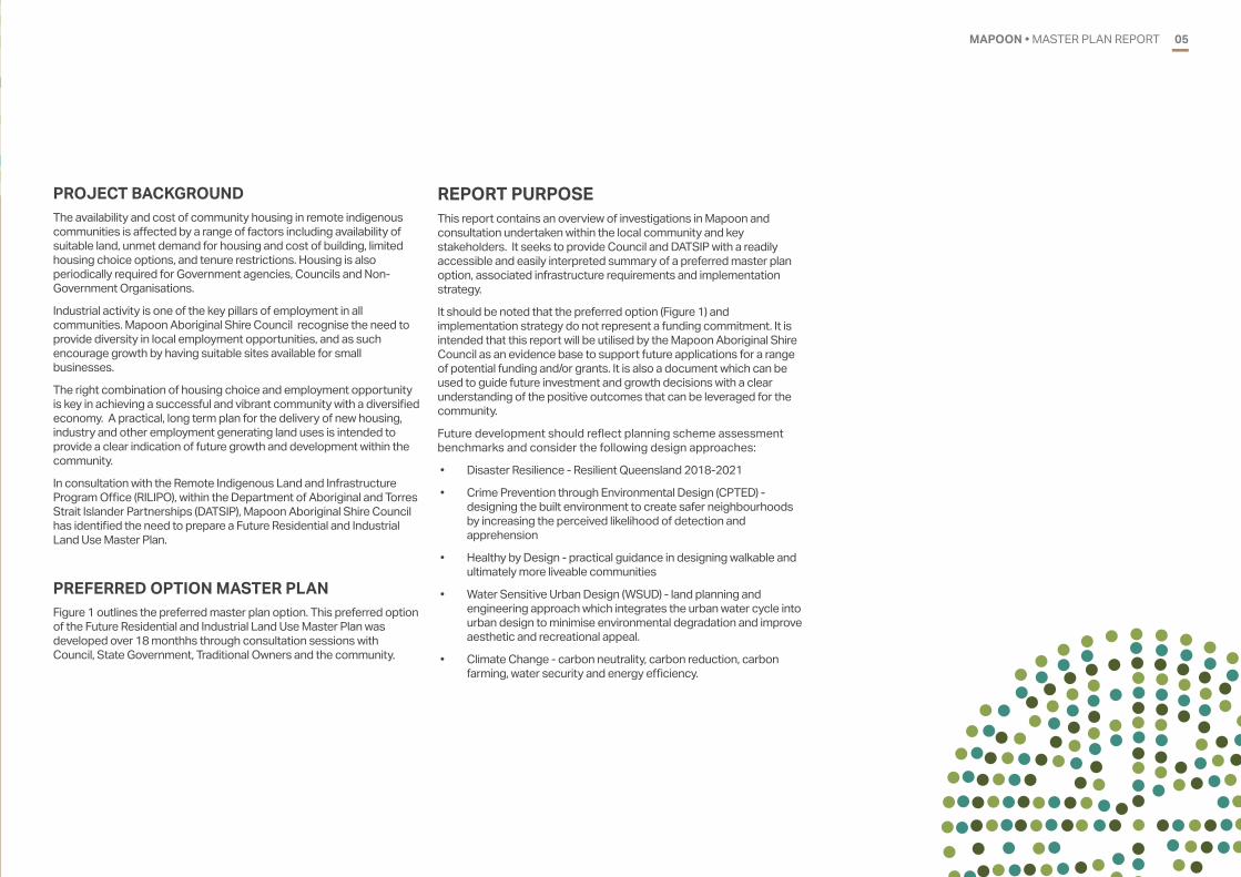
REPORT PURPOSEThis report contains an overview of investigations in Mapoon and consultation undertaken within the local community and key stakeholders. It seeks to provide Council and DATSIP with a readily accessible and easily interpreted summary of a preferred master plan option, associated infrastructure requirements and implementation strategy.
It should be noted that the preferred option (Figure 1) and implementation strategy do not represent a funding commitment. It is intended that this report will be utilised by the Mapoon Aboriginal Shire Council as an evidence base to support future applications for a range of potential funding and/or grants. It is also a document which can be used to guide future investment and growth decisions with a clear understanding of the positive outcomes that can be leveraged for the community.
Future development should reflect planning scheme assessment benchmarks and consider the following design approaches:
• Disaster Resilience - Resilient Queensland 2018-2021
• Crime Prevention through Environmental Design (CPTED) - designing the built environment to create safer neighbourhoods by increasing the perceived likelihood of detection and apprehension
• Healthy by Design - practical guidance in designing walkable and ultimately more liveable communities
• Water Sensitive Urban Design (WSUD) - land planning and engineering approach which integrates the urban water cycle into urban design to minimise environmental degradation and improve aesthetic and recreational appeal.
• Climate Change - carbon neutrality, carbon reduction, carbon farming, water security and energy efficiency.
PROJECT BACKGROUND The availability and cost of community housing in remote indigenous communities is affected by a range of factors including availability of suitable land, unmet demand for housing and cost of building, limited housing choice options, and tenure restrictions. Housing is also periodically required for Government agencies, Councils and Non-Government Organisations.
Industrial activity is one of the key pillars of employment in all communities. Mapoon Aboriginal Shire Council recognise the need to provide diversity in local employment opportunities, and as such encourage growth by having suitable sites available for small businesses.
The right combination of housing choice and employment opportunity is key in achieving a successful and vibrant community with a diversified economy. A practical, long term plan for the delivery of new housing, industry and other employment generating land uses is intended to provide a clear indication of future growth and development within the community.
In consultation with the Remote Indigenous Land and Infrastructure Program Office (RILIPO), within the Department of Aboriginal and Torres Strait Islander Partnerships (DATSIP), Mapoon Aboriginal Shire Council has identified the need to prepare a Future Residential and Industrial Land Use Master Plan.
PREFERRED OPTION MASTER PLANFigure 1 outlines the preferred master plan option. This preferred option of the Future Residential and Industrial Land Use Master Plan was developed over 18 monthhs through consultation sessions with Council, State Government, Traditional Owners and the community.

MAPOON • MASTER PLAN REPORT06
Cullen Point(6km north of town)
Waste Transfer Station(2km south of airport)
Farm Precinct / Retain land for future re-commencement of farm/ Equestrian facilities (e.g. shaded arena)
Western Precinct / 6,000m2 site for seniors independent living units. / 33 x 2,000m2 residential lots
Civic Precinct (north)/ New shared Council and Government Building/ Land and Sea Rangers/ Community Hall/ Memorial / Government Offices/ Art Centre/Multi-purpose Centre/ Tourist Centre
Expansion Precinct/ Land for long-term residential expansion/ 79 x 3,000m2 lots
Airport Precinct/ Preserve buffer for operation of airport/ Potential sealing of runway and facilities for passenger services/ Airside development (e.g. workers accomodation.
Civic Precinct (south) / Secure 50,000m2 site for long-term expansion of Council and other Government facilities/ Land and Sea Rangers/ Informal helipad/ Men’s and Women’s Centre
Central Precinct 1. Visitor accomodation & van park2. Church3. Staff accommodation4. Police Station
1.
2. 3.
Community Services Precinct1. Apunipima expansion (health)2. Early Learning Centre3. Aged Care Building and Accommodation
1.2.
3.
Waterfront Precinct 1. Waterfront parkland2. Pedestrian and cyclist circuit3. Waterfront commercial development (e.g. cafe)
Recreation precinct/ Splash pad/ Playground/ Skate park/ Parkland
1.2.
3.4.
Natural basin / catchment area / Not suitable for development
High Rise Precinct / 57 x 3,000m lots
Other considerations and aspirations/ Provision of footpaths and street lighting throughout township/ Create horse trails / hiking tracks
4.
Item
Sewage Treatment Plant
Cemetery
Industrial Precinct
Option
S1 - South of town
S2 - Airport precinct
S3 - Waste transfer station
C1 - Expansion precinct
I1- Airport Precinct
Benefits
Central location mid-way between exisitng town and expansion area (most efficient and cost-effective). Ability for cost-effective staging with initial connection to new lots. Reduced amenity / health concerns - sufficient buffer distance to residential uses. Eliminates amenity / health concerns.
Design, siting and size can be suitable for long term.
Removes traffic from town (exisiting and future).
/
/
/
/
/
Issues
Amenity and health concerns due to proximity to housing.
Increased cost of trunk mains, more costly during initial stages of future development. Significant distance from town - cost of trunk mains.
Distance from exisitng town and other cemterys.
Distance from town - reduced accessibility for workers.
/
/
/
/
/
S1
S2
S3
I1
C1
300 m
MAPOON
PREFERRED OPTION � 20 JUNE 2019
FOR DISCUSSION PURPOSES ONLY
COMMERCIAL
INDUSTRIAL
OPEN SPACE
RURAL
RESIDENTIAL
MED. DENSITY RES.
TOURISM
COMMUNITY
LONG TERM RESIDENTIAL
EXISTING UN�SURVEYED LOTS
PEDESTRIAN�CYCLE ROUTE
ROAD ACCESS
300m N
Residential Medium Density Residential TourismCommunity
Commercial Industrial Open SpaceRural
Long term residentialExisting un-surveyed lotsPedestrian/Cycle RouteRoad Access
FIGURE 1: PREFERRED OPTION

MAPOON • MASTER PLAN REPORT 07
02
COMMUNITY OVERVIEW02
07MAPOON • MASTER PLAN REPORT
MAPOON • MASTER PLAN REPORT08
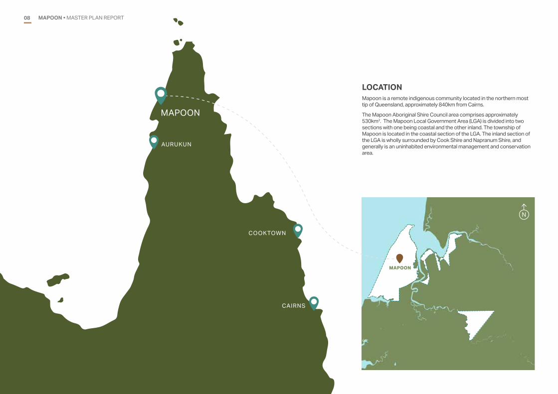
LOCATIONMapoon is a remote indigenous community located in the northern most tip of Queensland, approximately 840km from Cairns.
The Mapoon Aboriginal Shire Council area comprises approximately 530km2. The Mapoon Local Government Area (LGA) is divided into two sections with one being coastal and the other inland. The township of Mapoon is located in the coastal section of the LGA. The inland section of the LGA is wholly surrounded by Cook Shire and Napranum Shire, and generally is an uninhabited environmental management and conservation area.
MAPOON
N
MAPOON
COOKTOWN
CAIRNS
AURUKUN
MAPOON • MASTER PLAN REPORT 09
COMMUNITY AND GOVERNANCEThe Mapoon community is situated on the traditional lands of the Tjungundji people. A church mission was established near Trathalarrakwana or Cullen Point on 28 November 1891. Mapoon Mission was established under the name Batavia River Mission by Moravian missionaries on behalf of the Presbyterian Church of Australia, with Queensland Government financial assistance, on land reserved by the Government under the Crown Lands Act of 1884. Within a few years the mission became known as Mapoon, a Tjungundji word meaning ‘place where people fight on the sand-hills’. Mapoon is also known as Marpuna. As the influence of the mission widened in the surrounding lands, the reserve was extended south to the Mission River near Weipa. Some of the traditional owner groups who eventually came to live at Mapoon included the Mpakwithi, Taepithiggi, Thaynhakwith, Warrangku, Wimarangga and Yupungathi people.
Mapoon continued to be administered by the Presbyterian Church until 1963. The missionary in charge always carried the role of superintendent of the reserve as well as undertaking evangelical duties.
At a conference of church and government officials held at Mapoon in April 1954 a policy decision was made to close Mapoon and evacuate the people to Weipa or other stations, or to ‘assimilate those ready for exemption [from the Protection Act] into the Australian way of life elsewhere’. The residents of the community were not consulted about the decision but merely told that the closure had been decided. The population of Mapoon in 1954 was 285.
The Government commenced building a replacement community at Hidden Valley near Bamaga in 1961 and by mid-1962 nearly 100 people had moved to the community which became known as New Mapoon. Traditional owners became increasingly concerned about the Government’s attempts to remove them from their traditional lands and when the Church handed control of Mapoon to the Government in July 1963, they did their best to continue running the community with support from the residents of Weipa Mission.
On 14 November 1963, the Officer-in-Charge of Police at Thursday Island received official instructions from the Director of Native Affairs, Pat Killoran, to remove twenty-three Aboriginal residents from Mapoon to Bamaga. The leaders of the traditional owners were removed and taken to Red Island Point (now Seisia) to be settled at New Mapoon. Some of their houses at Mapoon were burnt to the ground to prevent their return.
Within six months the remaining seventy-one residents had left Mapoon. Many of the mission buildings, including the church, were demolished during 1964 by an Islander work party sent by the Director of Native Affairs. The only mission building left was the main mission house which remained standing until its destruction by termites in 1991.
After the 1964 closure, former residents led by traditional people such as Jean Jimmy continued to lobby for the re-opening of their community. In 1974 several families led by Jerry and Ina Hudson returned and ten years later the Marpuna Community Aboriginal Corporation was established. The Marpuna Corporation gradually built up the community at Rugapayn (Red Beach) to a stage where people were able to resettle permanently and government recognition followed.
On 26 April 1989 a Deed of Grant of Land in Trust (DOGIT) for ‘Aboriginal Reserve Purposes’ under the Land Act (Qld.) and covering 1,839 square kilometres, was handed over to the Mapoon people by the Queensland Government. The trustees included several traditional owners. The Mapoon lands continue to be administered by trustees appointed by the Queensland Government. The trustees work in conjunction with the Mapoon Aboriginal Shire Council regarding land administration matters.
On 25 March 2000, Queensland local government elections were held and the inaugural Mapoon Aboriginal Shire Council was formed. In January 2002 the Council moved into its new offices.
The Mapoon Aboriginal Shire Council is formed with an elected Mayor, and four elected Councillors, including the Deputy Mayor. The adminstrative branch of the council is lead by the Chief Executive Officer who is responsible for managing the day-to-day affairs of the community and council employees together with the elected representatives.

MAPOON • MASTER PLAN REPORT10
LAND USE AND FACILITIESThe township area of Mapoon is approximately 80 hectares in size and extends between Weipa Mapoon Road and Red Beach. Land use within the town is predominantly residential in nature and supported by community facilities and government administration. Other land uses and features include:
• Council administrative building
• Retail store
• Uniting Church
• Community centre
• Guest house and visitor accomodation
• Recreation centre and sports ground
• Mapoon Primary School
• Western Cape College
• Ranger office
• Primary health care centre
• Cullen Point boat ramp
• Airstrip
• Land and sea centre
• Ergon power station.
N

TENURELand within the Mapoon LGA, including the township area, is within the Northern Cape York #2 Native Title Claim Group Native Title Determination Area (QCD2014/011 / QUD156/2011). The Mokwiri Aboriginal Corporation is the Registered Native Title Body Corporate (RNTBC) for the determination area.
LGA BOUNDARYNATIVE TITLE DETERMINATION AREAFIGURE 2: MAPOON TOWNSHIP NATIVE TITLE DETERMINATION AREA
MAPOON • MASTER PLAN REPORT 11
N
MAPOON • MASTER PLAN REPORT12
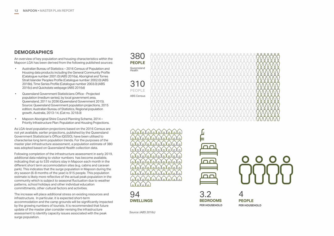
DEMOGRAPHICSAn overview of key population and housing characteristics within the Mapoon LGA has been derived from the following published sources:
• Australian Bureau of Statistics – 2016 Census of Population and Housing data products including the General Community Profile (Catalogue number 2001.0) (ABS 2016a), Aboriginal and Torres Strait Islander Peoples Profile (Catalogue number 2002.0) (ABS 2016b), Time Series Profile (Catalogue number 2003.0) (ABS 2016c) and Quickstats webpage (ABS 2016d)
• Queensland Government Statisticians Office - Projected population (medium series), by local government area, Queensland, 2011 to 2036 (Queensland Government 2015). Source: Queensland Government population projections, 2015 edition; Australian Bureau of Statistics, Regional population growth, Australia, 2013-14, (Cat no. 3218.0)
• Mapoon Aboriginal Shire Council Planning Scheme, 2014 – Priority Infrastructure Plan: Population and Housing Projections.
As LGA-level population projections based on the 2016 Census are not yet available, earlier projections, published by the Queensland Government Statistician’s Office (QGSO), have been utilised to characterise long term population trends. For the purposes of the master plan infrastructure assessment, a population estimate of 380 was adopted based on Queensland Health collection data.
Following completion of the infrastructure assessment in early 2019, additional data relating to visitor numbers has become available, indicating that up to 535 visitors stay in Mapoon each month in the different short term accommodation sites (e.g. cabins and caravan park). This indicates that the surge population in Mapoon during the dry season (6-8 months of the year) is 915 people. This population estimate is likely more reflective of the actual peak population in the community which is subject to seasonal fluctuation due to weather patterns, school holidays and other individual education committments, other cultural factors and activities.
The increase will place additional stress on existing resources and infrastructure. In particular, it is expected short-term accommodation and the camp grounds will be significantly impacted by the growing numbers of tourists. It is recommended that future update of the master plan consider revising the infrastructure assessment to identify capacity issues associated with the peak surge population.
PEOPLE
DWELLINGS BEDROOMSPER HOUSEHOLD
PEOPLEPER HOUSEHOLD
380
94 3.2 4
Queensland Health
PEOPLE310ABS Census
Source: (ABS 2016c)

35
45
30
40
25
20
15
10
5
00-4
years5-14
years15-19years
20-24years
25-34years
35-44years
45-54years
55-64years
65-74years
75-84years
85 years and over
MAPOON • MASTER PLAN REPORT 13
HOUSINGBased on the 2016 Census, there were a total of 81 occupied and 13 unoccupied private dwellings within the Mapoon LGA. Table 2 provides a summary of the key housing statistics for the area.
POPULATIONThe 2016 Census recorded the population of Mapoon to be 310 people. Graph 1 below illustrates the total population age structure based on the 2016 Census data. There is a large representation of children under the age of four, and people aged between 20-29. High-school age children are less represented, possibly due to students travelling outside the community to attend boarding school. When comparing the 2016 Census and 2011 Census data, there has been a considerable change in the age profile of the community, trending towards a younger population in 2016.
Table 1 benchmarks the 2016 ABS Census data against previous population projections published by the Queensland Government Statistician’s Office and Mapoon Aboriginal Shire Council (Planning Scheme).
TABLE 1: COMPARISON OF PROJECTION/RECORDS OVER TIME
TABLE 2: HOUSING CHARACTERISTICSGRAPH 1: POPULATION COUNT AND AGE STRUCTURE - 2016 CENSUS
ITEM DETAIL
DWELLING COUNT
Occupied 81
Unoccupied 13
Total 94
NUMBER OF BEDROOMS
1 bedroom 0
2 bedrooms 24
3 bedrooms 23
4 or more bedrooms 31
Number of bedrooms not stated 0
Average number of bedrooms per dwelling 3.2
Average number of people per household 3.3
TENURE
Rented 76
Other 4
Not stated 0
SOURCE 2011 2016 2021 2026 2031 2036
ABS Census 264 310 - - - -
QGSO medium series projections
281 312 319 327 333 338
Mapoon Planning Scheme
285 316 344 - - -
Source: (ABS 2016c) (Queensland Government 2015) (MASC 2014)
Source: (ABS 2016c) (Queensland Government 2015) (MASC 2014) Source: (ABS 2016c) (Queensland Government 2015) (MASC 2014)
MAPOON • MASTER PLAN REPORT14
INFRASTRUCTURE REVIEW03
14 • MASTER PLAN REPORT

MAPOON • MASTER PLAN REPORT 15
The following section provides an overview of the nature and capacity of existing infrastructure servicing the township.
SEWERAGEMapoon does not operate a sewerage system. All dwellings and buildings have septic tanks and trenches. All new buildings will require septic tanks and absorption trenches. It is proposed that a wastewater treatment plant will ultimately be constructed at Mapoon. An Average Dry Weather Flow (ADWF) of 270 L/EP/day was adopted for Mapoon based on FNQROC Regional Development Manual. The existing wastewater supply demands for Mapoon are outlined in Table 3.
STORMWATER
DESCRIPTION AVERAGE DRY WEATHER FLOW (L/S)
PEAK WET WEATHER FLOW (L/S)
Residential Lots 1.19 5.94
Non-Residential Loads 0.31 1.53
TOTAL 1.49 7.47
TABLE 3: EXISTING WASTEWATER SUPPLY DEMANDS
The land to the west of the township is relatively flat and includes heavily forested areas interspersed with wet swampy sections. This area generally drains to the swampy area to the west of the township through various natural drainage paths. The existing stormwater system within Mapoon consists of unlined table drains beside some roads and minimal stormwater roadway inlet gullies, culverts and underground piped drainage. Additional drainage pipe systems and kerb and channelling will be required to service any new township development and to maintain the drainage of flows from the township to the swampy area (and designed to comply with the FNQROC Regional Development Manual). Improving the stormwater system is a Council priority, aligning with the flexibility and adaptation principle of the Resilient Queensland 2018-2021 Strategy to reduce incidences of water pooling and flooding within the township.
ELECTRICITY SUPPLY & COMMUNICATIONSMapoon receives power from three Ergon Energy diesel generators located on Weipa Road, near the Council chambers. Electricity is supplied to the township by an overhead supply to the property boundary. An existing supply to new properties will be required.Communications is provided by optic fibre. An extension of existing conduiting to the frontage of new properties will be required. Provision of communication services to new development is considered a critical element to enable effective coordination during disaster recovery following severe weather events.
FIGURE 3: STORMWATER INFRASTRUCTURE300m N
DRAINAGE
CULVERT

FIGURE 4: WATER INFRASTRUCTURE
MAPOON • MASTER PLAN REPORT16
DESCRIPTION AVERAGE DAY (L/S)
PEAK DAY (L/S)
PEAK HOUR (L/S)
Residential Lots 2.64 5.94 11.88
Non-Residential Loads 0.51 1.15 5.13
TOTAL 3.15 7.08 17.00TABLE 4: EXISTING WATER SUPPLY DEMANDS
WATER SUPPLYWater supply infrastructure comprises the following elements.
Raw water source
• The raw water for Mapoon is drawn from groundwater bores located in an unconfined aquifer.
• There are a total of five bores, with the following details:
/ Bores 1, 2 and 4: 15 year old bores which provide a flow of 3 L/s each (each provides 25% of flow provided) with good reliability. Pumps are Grundfos submersible SP8A-12. The bores are 30 m deep
/ Bore 3: 10 year old bore which provides a flow of 3 L/s (25% of flow provided) with good reliability. Pumps are Grundfos submersible SP8A-12. The bore has a depth of 30 m
/ Bore 5: 10 year old backup bore which provides a flow of 1 L/s with good reliability. Pumps are Grundfos submersible SP38-12. The bore has a depth of 30 m.
Water Treatment Plant (WTP)
• The water treatment plant consists of the following processes
/ pH correction filter (soda ash dosing) with a capacity of 15 L/s
/ Disinfection, when used, is in the form of chlorine dosing (gas chlorination).
Rising mains
• The bores are connected to a common 100 mm diameter rising main which delivers flow to treatment and the reservoir.
Reservoirs
• Ground water reservoir: 220 kL concrete reservoir with a steel roof
• Elevated storage tanks: two elevated storage tanks (22.5 kL each) are located between the ground water storage and the reticulation. These are only used for water supply contingency planning (e.g. cyclones).
Pumps
• A Grundfos four pump set with variable speed drive to boost the supply from the ground level reservoir to the community and to ensure adequate pressures are provided
• Two transfer pumps are available to pump from the ground level reservoir to the elevated tanks.
Reticulation system
• Consists of polyvinyl chloride (PVC) and polyethelene (PE) pipe with diameters from 50-200 mm.
An average day demand of 600 L/EP/day was adopted for Mapoon.
The existing water supply demands are outlined in Table 4.
WATER MAIN
BORES 300m N
MAPOON • MASTER PLAN REPORT 17
FIGURE 5: ROAD INFRASTRUCTURE ROADS
300m N
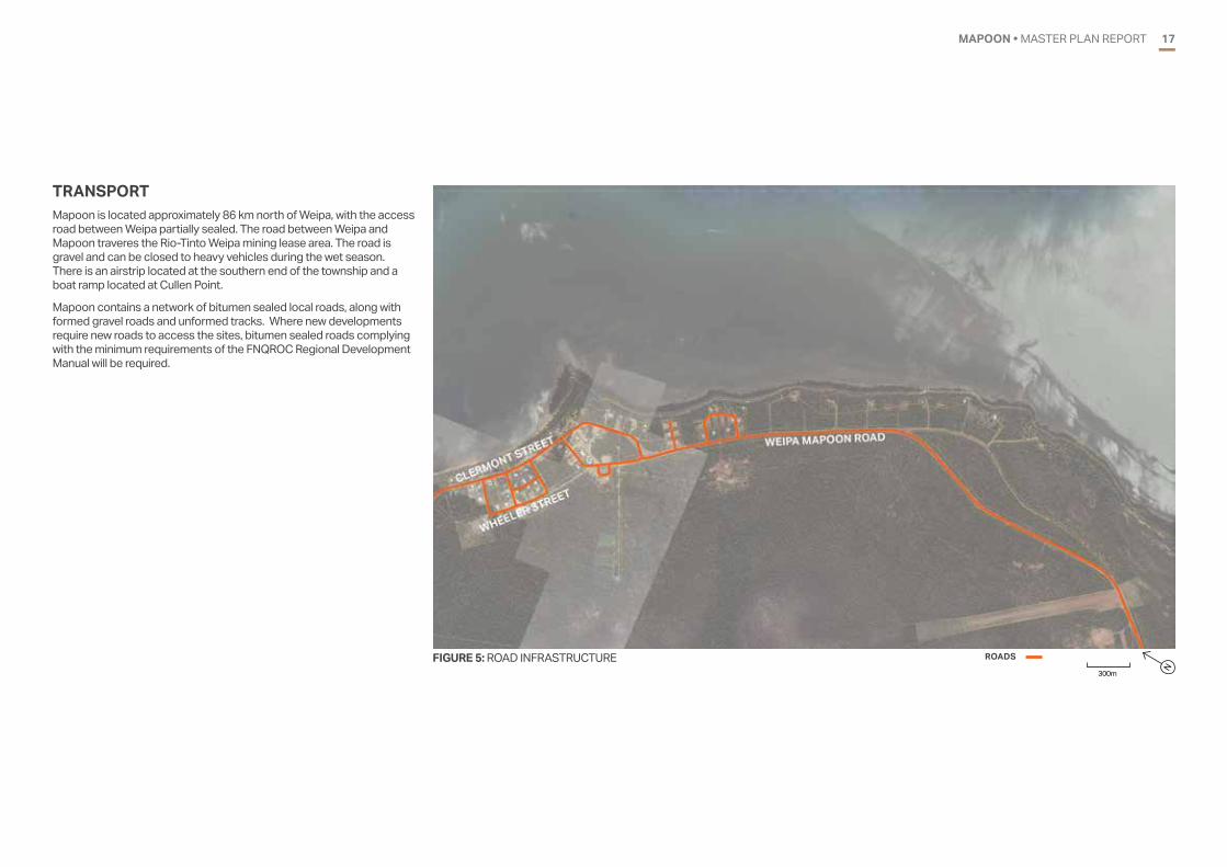
TRANSPORTMapoon is located approximately 86 km north of Weipa, with the access road between Weipa partially sealed. The road between Weipa and Mapoon traveres the Rio-Tinto Weipa mining lease area. The road is gravel and can be closed to heavy vehicles during the wet season. There is an airstrip located at the southern end of the township and a boat ramp located at Cullen Point.
Mapoon contains a network of bitumen sealed local roads, along with formed gravel roads and unformed tracks. Where new developments require new roads to access the sites, bitumen sealed roads complying with the minimum requirements of the FNQROC Regional Development Manual will be required.
MAPOON • MASTER PLAN REPORT18
PLANNING REVIEW0418 • MASTER PLAN REPORT

MAPOON • MASTER PLAN REPORT 19
FIGURE 6: ZONING PLAN ZONES Township Emerging Communities Environmental Management and Conservation
PRECINCTS (TOWNSHIP ZONE)Red BeachHigh Rise Airport Land and Industry
PRECINCTS (ENVIRONMENTAL MANAGEMENT AND CONSERVATION ZONE)Water Infrastructure
300mN
PLANNING SCHEMEDevelopment within the Mapoon Aboriginal Shire Council (MASC) LGA is subject to the provisions within the Mapoon Planning Scheme 2014. The scheme was adopted in February 2014, was prepared in accordance with the Queensland Planning Provisions (QPP) version 3.0 25 October 2013 and reflects the State Interests outlined in the State Planning Policy (SPP).
The preferred land use pattern for the township and surrounding areas is expressed in the zone map (Figure 2) which largely reflects the existing land use pattern with the following characteristics:
• Mapoon township is located on Andoom Road along Red Beach, and includes the Council office, Mapoon School, Health Centre, Store, Land and Sea Centre, Mapoon Uniting Church, Mapoon Community Centre and guest house/contractor accommodation.
• Infrastructure including Telstra, Ergon Power Generator and the town’s water supply are located east of the township.
• Residential lots are concentrated within the township, becoming sparsely located west along Andoom Road up to Cullen Point and east along Old Mapoon Road.
It is noted that two areas have been identified for future residential development including land located to the south-west of the current township on Cullen Point Road and south-east on Old Mapoon Road.

MAPOON • MASTER PLAN REPORT20
OVERLAYSThe Planning Scheme includes a range of overlay maps which highlight particular built form, environmental and physical matters that may affect development. These include:
• Wenlock River Basin Area overlay
• Flood Area overlay
• Coastal Hazard Area overlay
• Bushfire Hazard Area overlay.
These overlays have an effect at a development assessment level by triggering different levels of assessment and assessment criteria (codes). The following sections describe the extent of each overlay and implications for the master plan.
Wenlock River Basin Area
The Wenlock River Basin Area overlay does not apply to the township area.
Flood Area
The Flood Area overlay reflects the 1999 recorded flood level of 7.38m AHD at Red Beach. There is no flood data for the area south of the township approaching the airstrip. The peninsula extending north to Cullen Point and part of the exisitng township is within the 1999 recorded flood level. It is noted that this flooding impact extends across a large proportion of the bushland area on the western side of Weipa-Mapoon Road. It is evident that most of the “High Rise” area to the south of the township and land south-west of the sports field is not affected by the flood area. This area may be suitable for development subject to consideration of other constraints. Development within areas outside the available flood data may be appropriate subject to further hydraulic assessment and flood mitigation works.
Coastal Hazard Area
The Red Beach foreshore and sections of the township on the adjoining headland are within the erosion prone area and high storm tide area. Some sections of the township and residential areas west of Red Beach are also affected by medium storm tide. For the purposes of master planning, development of residential development on the eastern side of Weipa-Mapoon Road may be appropriate providing development areas are located landward of the coastal hazard areas.
FIGURE 7: NATURAL HAZARDS OVERLAY - FLOODING AND COASTAL PROTECTION FLOODING
1999 Recorded Flood Level COASTAL PROTECTIONErosion Prone AreaMedium Storm Tide Indundation AreaHigh Storm Tide Indundation Area
300mN

MAPOON • MASTER PLAN REPORT 21
Bushfire Hazard
The township is affected by bushfire risk, with the entirety of the area within the potential bushfire impact buffer or medium potential intensity areas. The township is covered by a Bushfire Hazard Exclusion Area, allowing development to occur outside the bounds of the Bushfire Hazard Building Code requirements.
FIGURE 8: NATURAL HAZARDS OVERLAY - BUSHFIRE
Summary
The environmental overlays presented in the Planning Scheme inform the future development of Mapoon township and surrounding areas. Key issues and opportunities include:
• The town and surrounding areas are not within the Wentlock River Basin Area overlay
• Opportunity to develop outside the flood and coastal hazard affected areas
• The entire township is within the Bushfire Hazard Exclusion Area which allows development to occur outside the bounds of the Bushfire Hazard Building Code requirements.
BUSHFIREMedium Potential IntensityPotential Bushfire Impact BufferBushfire Hazard Exclusion Area*
*Based on a Bushfire Hazard Risk Assessment completed in
respect of the Mapoon Township Area and Future Urban Area in
the Strategic Framework, this area is excluded from the bushfire
hazard risk area and associated bushfire hazard building code
requirements are not applicable in this area.300mN

MAPOON • MASTER PLAN REPORT22 22DOOMADGEE • MASTER PLAN REPORT
STAKEHOLDER CONSULTATION05
22 • MASTER PLAN REPORT

MAPOON • MASTER PLAN REPORT 23
TABLE 5: PROJECT MEETINGS
Return to Mapoon Shire Council Office or email: [email protected] Mapoon Aboriginal Shire Council: Participate in Planning Ahead for the Future of Mapoon
Mapoon Aboriginal Shire Council are looking for your ideas on what Mapoon township and Cullen Point area could look like in the future. Give us your suggestions and go in the draw for great giveaways if you also give us your: Address____________________________________________ and Telephone No. _________
Community Improvements:
Would you support any of these options for improving Mapoon Community?
New aged care facility; Multi-cultural centre; Children’s play areas in small parks; Outdoor basketball court; Recreation/park areas; Speed humps/speed control; Community gardens; more shops: bakery, butcher; More street lighting; Street numbers on houses; Exercise/walking tracks; Murals on buildings by local artists; More signage; Solar power plant. _________________________ _________________________ _________________________ _________________________
Cullen Point Improvements:
Would you support any of these options for improving the Cullen Point?
New boat ramp & jetty with pontoons; More camp sites; Powered camp sites; Sheltered areas with BBQ’s,
tables and seats; Fish cleaning benches; Wash bay area; Walkways along foreshore; Wheelchair accessible pathways; Table seats; Better signage; Painted panels of local history; Seats & shade along back beach.
_________________________ _________________________ _________________________ _________________________ _________________________ _________________________
Facilities/Services Improvements:
Would you support any of these options for improving services & facilities?
Monthly markets; Bi-annual Paanja festival; Annual fishing competition; Community caravan park; Youth centre; Community church; New cemetery; New airport terminal facility; More tourist accommodation
(locals to be employed); Tourism opportunities (employing
locals); More programs/activities at sport
and rec hall; Fishing/scenic/sunset tours conducted
by locals for people living in community without a boat.
__________________________ _________________________ _________________________
FIGURE 9: SURVEY FORM
OVERVIEW Development of the master plan has been guided by ongoing consultation with community stakeholders. Table 5 provides an overview of consultation activities for the project.
DATE LOCATION PARTICIPANTS DETAILS
12.02.2018 Mapoon Aboriginal Shire Council Office
Mayor Aileen Addo, Cr Pauline Smith, Cr Brendan Brown, Naseem Chetty – CEO, Tom Smith – Works Manager, Colleen Golledge – DATSIP, Jeremy Kingsford - DATSIP, Brian Gibbs – AECOM, Bronwyn Van Gool – AECOM
Introductory meeting to discuss scope and purpose of the master plan and identify initial key issues and areas of interest.
25.10.2018 & 26.10.2018
Various locations throughout Mapoon
Jeremy Kingsford - DATSIP, Biannka Brannigan - DATSIP
Community walk-around to explain draft master plan and seek feedback (refer to Figure 9 for a copy of survey form and Figure 10 of land use example poster).
11.04.2019 Mapoon Cafe
Jeremy Kingsford - DATSIP, Biannka Brannigan - DATSIP, Graeme Streeter - DATSIP
Community meeting to discuss master plan - in particular cemetery and Sewage Treatment Plant
July 2019 Mapoon Aboriginal Shire Council Office
Full Council Resolution to endorse master plan.

MAPOON • MASTER PLAN REPORT24
FIGURE 10: LAND USE EXAMPLES FOR COMMUNITY CONSULTATION
200m 400m
RESIDENTIAL LOW DENSITY - DETACHED HOUSE
RESIDENTIAL LOW DENSITY - DETACHED HOUSE
RESIDENTIAL MEDIUM DENSITY - UNITS
TOURISM - CARAVAN PARK
RECREATION / OPEN SPACE - PARK
RECREATION / OPEN SPACE - SPORTING FACILITIES
COMMERCIAL - SHOP AND OFFICE BUILDING
INDUSTRIAL - SHEDS / WORKSHOP
INDUSTRIAL - SHEDS / WORKSHOP / LAYDOWN
LAND USE EXAMPLES

MAPOON • MASTER PLAN REPORT 25
CONCEPT DEVELOPMENT06
25MAPOON • MASTER PLAN REPORT

MAPOON • MASTER PLAN REPORT26
AREAS OF INTEREST During the initial meeting with Councillors in Mapoon, a range of areas of interest were identified. This provided the basis and framework for subsequent options development for both infill development and greenfield expansion south along the coastline. The areas of interest and ideas included:
• High Rise Precinct
/ 8 - 10 residential subdivision clusters (exisitng un-sealed access and water distribution)
/ 40 - 60 houses depending on lot size
• Open space / playspace to be incorporated in each area
• Long term residential expansion – land located on either side of the road between High Rise Precinct and the Airport
• Potential area for new cemetery on western side of road opposite High Rise Precinct
• Airport Precinct
/ Preserve buffer area for operation of airport
/ Potential sealing of runway and facilities for passenger services
/ Airside development (e.g. workers accommodation)
• Industrial land and potential site for utilities (Council depot and Sewage Treatment Plant) on western side of Weipa Mapoon Road, at northern end of High Rise Precinct
• Civic Precinct (existing Council and Sea Rangers site)
/ New shared Council and Government building
/ Land and sea rangers
/ Multi-purpose centre / Community hall
/ Memorial
/ Government offices
• Secure land south of Council office and Sea Ranger site for long-term expansion of Council/Government facilities
• Splash pad and recreation facility for youth (e.g. skate park) to east of Council building
• Old farm site – potential for re-start
• Prepare precinct plan for the area north of the Council office for:
/ Visitor accommodation and caravan park
/ Church
/ Commercial complex with mix of tenancy sizes
• South of Sports Ground – residential development including Senior’s Accomodation and aged care
• Community services along Hudson Street:
/ Health Outreach Centre
/ Police Station and accommodation
/ Early learning centre
• Commercial development opportunity on site between coastline and Clermont Street
• Pedestrian circuit along waterfront and around the township including waterfront esplanade
• Cullen Point
/ New boat ramp
/ Jetty or pontoon
/ Freight facility (alternative to transport from Weipa).

MAPOON • MASTER PLAN REPORT 27
Area for new cemetery?
Council works depot and sewage treatment facility
Industrial land
Re-start farm?
Residential development including senior’s accomodation and aged care
Civic Precinct/ New shared Council and Government Building/ Land and Sea Rangers/ Multi-purpose centre / Community Hall/ Memorial / Government Offices
High Rise Precinct/ 8-10 residential subdivision clusters (exisitng un-sealed access and water distribution)/ 40 - 60 houses depending on lot size / Open space / playspace to be incorporated in each area
Long-term residential expansion
Airport Precinct/ Preserve buffer for operation of airport/ Potential sealing of runway and facilities for passenger services/ Airside development (e.g. workers accomodation)
Secure land for long-term expansion of Council / Government facilities
Precinct-plan for:1. Visitor accomodation & Van park2. Church3. Commercial complex with mix of tenancy sizes
1.
2.
3.
Community services1. Health Outreach Centre2. Police Station and Accomodation3. Early Learning Centre
1. 2.
3.
Waterfront commercial development opportunity
Pedestrian circuit including waterfront esplanade
Cullen Point / New boat ramp/ Jetty or pontoon/ Freight facility (alternative to transport from Weipa)
300 m
MAPOONCONTOURS � 1 METRE
FOR DISCUSSION PURPOSES ONLY
COMMERCIAL
RURAL
PEDESTRIAN�CYCLE ROUTE
ROAD ACCESS
RESIDENTIAL
TOURISM
COMMUNITY
OPEN SPACE
Splash pad and recreation facility for youth (e.g. skate park)
Residential Tourism Community Open Space
Commercial Rural Pedestrian/Cycle RouteRoad Access
300m N
FIGURE 11: AREAS OF INTEREST

MAPOON • MASTER PLAN REPORT28
OPTION DEVELOPMENT Following identification of the range of areas of interest and ideas, three (3) options were developed for further consideration by Council. These options each included a range of common items and different residential lot sizes / layouts within the High Rise Precinct.
The common features included:
• Recreation Precinct
/ Splash pad
/ Playground
/ Skate park
/ Parkland
• Civic Precinct (north)
/ New shared Council and Government Building
/ Land and Sea Rangers
/ Multi-purpose centre / Community Hall
/ Memorial
/ Government Offices
• Civic Precinct (south)
/ Secure 50,000m2 site for long-term expansion of Council and other Government facilities
• Waterfront Precinct
/ Waterfront parkland
/ Pedestrian and cyclist circuit
/ Waterfront commercial development
• Central Precinct
/ Visitor accommodation & Van park
/ Church
/ Commercial complex with mix of tenancy sizes
• Farm Precinct
/ Retain land for future re-commencement of farm
• Western Precinct
/ 6000m2 site for seniors independent living units
/ 5 x 2,000m2 residential lots
• Community Services Precinct
/ HACC
/ Police Station and Accommodation
/ Early Learning Centre
• Industry Precinct
/ Council works depot and sewage treatment facility on 20,000m2 site
/ 4 x 5,000m2 industrial lots
• New Cemetery Precinct
/ 20,000m2 site for future cemetery
• Expansion Precinct
/ Land for long-term residential expansion
• Airport Precinct
/ Preserve buffer for operation of airport
/ Potential sealing of runway and facilities for passenger services
/ Airside development (e.g. workers accommodation
• High Rise Precinct – Option 1
/ 58 x 3,000m2 residential lots
/ 3 x local parkland lots
• High Rise Precinct – Option 2
/ 71 x 3,000m2 residential lots
/ 4 x local parkland lots
• High Rise Precinct – Option 3
/ 75 x 3,000m2 residential lots
/ 3 x local parkland lots

MAPOON • MASTER PLAN REPORT 29
New Cemetery Precinct / 20,000m2 site for future cemetery
Industry Precinct / Council works depot and sewage treatment facility on 20,000m2 site/ 4 x 5,000m2 industrial lots
Farm Precinct / Retain land for future re-commencement of farm
Western Precinct / 6000m2 site for seniors independent living units. / 5 x 2,000m2 residential lots
Civic Precinct (north)/ New shared Council and Government Building/ Land and Sea Rangers/ Multi-purpose centre / Community Hall/ Memorial / Government Offices
Expansion Precinct/ Land for long-term residential expansion
Airport Precinct/ Preserve buffer for operation of airport/ Potential sealing of runway and facilities for passenger services/ Airside development (e.g. workers accomodation.
Civic Precinct (south) / Secure 50,000m2 site for long-term expansion of Council and other Government facilities
Central Precinct 1. Visitor accomodation & Van park2. Church3. Commercial complex with mix of tenancy sizes
1.
2.
3.
Community Services Precinct1. HACC2. Police Station and Accomodation3. Early Learning Centre
1.2.
3.
Waterfront Precinct / Waterfront parkland/ Pedestrian and cyclist circuit/ Waterfront commercial development
Recreation precinct/ Splash pad/ Playground/ Skate park/ Parkland
300 m
MAPOON
FOR DISCUSSION PURPOSES ONLY
COMMERCIAL
INDUSTRIAL
OPEN SPACE
RURAL
RESIDENTIAL
MED. DENSITY RES.
TOURISM
COMMUNITY
PEDESTRIAN�CYCLE ROUTE
ROAD ACCESS
High Rise Precinct (Option 1)/ 58 x 3,000m2 residential lots/ 3 x local parkland lots
CONCEPT OPTION 1
300m N
Residential Medium Density Residential TourismCommunity
Commercial Industrial Open SpaceRural
Pedestrian/Cycle RouteRoad Access
FIGURE 12: OPTION ONE

MAPOON • MASTER PLAN REPORT30
New Cemetery Precinct / 20,000m2 site for future cemetery
Industry Precinct / Council works depot and sewage treatment facility on 20,000m2 site/ 4 x 5,000m2 industrial lots
Farm Precinct / Retain land for future re-commencement of farm
Western Precinct / 6000m2 site for seniors independent living units. / 5 x 2,000m2 residential lots
Civic Precinct (north)/ New shared Council and Government Building/ Land and Sea Rangers/ Multi-purpose centre / Community Hall/ Memorial / Government Offices
Expansion Precinct/ Land for long-term residential expansion
Airport Precinct/ Preserve buffer for operation of airport/ Potential sealing of runway and facilities for passenger services/ Airside development (e.g. workers accomodation.
Civic Precinct (south) / Secure 50,000m2 site for long-term expansion of Council and other Government facilities
Central Precinct 1. Visitor accomodation & Van park2. Church3. Commercial complex with mix of tenancy sizes
1.
2.
3.
Community Services Precinct1. HACC2. Police Station and Accomodation3. Early Learning Centre
1.2.
3.
Waterfront Precinct / Waterfront parkland/ Pedestrian and cyclist circuit/ Waterfront commercial development
Recreation precinct/ Splash pad/ Playground/ Skate park/ Parkland
300 m
MAPOON
FOR DISCUSSION PURPOSES ONLY
COMMERCIAL
INDUSTRIAL
OPEN SPACE
RURAL
RESIDENTIAL
MED. DENSITY RES.
TOURISM
COMMUNITY
PEDESTRIAN�CYCLE ROUTE
ROAD ACCESS
High Rise Precinct (Option 2)/ 71 x 3,000m2 residential lots/ 4 x local parkland lots
CONCEPT OPTION 2
300m N
Residential Medium Density Residential TourismCommunity
Commercial Industrial Open SpaceRural
Pedestrian/Cycle RouteRoad Access
FIGURE 13: OPTION TWO

MAPOON • MASTER PLAN REPORT 31
New Cemetery Precinct / 20,000m2 site for future cemetery
Industry Precinct / Council works depot and sewage treatment facility on 20,000m2 site/ 4 x 5,000m2 industrial lots
Farm Precinct / Retain land for future re-commencement of farm
Western Precinct / 6000m2 site for seniors independent living units. / 5 x 2,000m2 residential lots
Civic Precinct (north)/ New shared Council and Government Building/ Land and Sea Rangers/ Multi-purpose centre / Community Hall/ Memorial / Government Offices
Expansion Precinct/ Land for long-term residential expansion
Airport Precinct/ Preserve buffer for operation of airport/ Potential sealing of runway and facilities for passenger services/ Airside development (e.g. workers accomodation.
Civic Precinct (south) / Secure 50,000m2 site for long-term expansion of Council and other Government facilities
Central Precinct 1. Visitor accomodation & Van park2. Church3. Commercial complex with mix of tenancy sizes
1.
2.
3.
Community Services Precinct1. HACC2. Police Station and Accomodation3. Early Learning Centre
1.2.
3.
Waterfront Precinct / Waterfront parkland/ Pedestrian and cyclist circuit/ Waterfront commercial development
Recreation precinct/ Splash pad/ Playground/ Skate park/ Parkland
300 m
MAPOON
FOR DISCUSSION PURPOSES ONLY
COMMERCIAL
INDUSTRIAL
OPEN SPACE
RURAL
RESIDENTIAL
MED. DENSITY RES.
TOURISM
COMMUNITY
PEDESTRIAN�CYCLE ROUTE
ROAD ACCESS
High Rise Precinct (Option 3)/ 75 x 3,000m2 residential lots/ 3 x local parkland lots
CONCEPT OPTION 3
300m N
Residential Medium Density Residential TourismCommunity
Commercial Industrial Open SpaceRural
Pedestrian/Cycle RouteRoad Access
FIGURE 14: OPTION THREE

MAPOON • MASTER PLAN REPORT32
CONSULTATION OPTION - OCTOBER 2018Following review of the three concept options, a consultation option was prepared to aid in engagement with the broader Mapoon community. This included the High Rise Precinct shown in the previous Option 3 layout (2,000m2 lots) and identified a natural basin / catchment area to the south of the farm which is unsuitable for development.
To help stimulate conversation and feedback, the consultation poster included the following questions for community members:
• Recreation Precinct
/ Are these the types of facilities that young people and families would use?
• Civic Precinct (north)
/ Should provision be made for further facilities? e.g. training and education
• Waterfront Precinct
/ Are there other uses and improvements that you would like to see along the foreshore?
• Central Precinct
/ What else would you like to see in this area?
/ More development or keep bushland?
• Farm Precinct
/ What kinds of crops could this area support / produce?
• Western Precinct
/ What kind of design would be good for seniors units? e.g. ground level, duplex, row houses etc
• Community Services Precinct
/ Is this the best location for community services and uses?
/ Are there any other services which should also be considered?
• Industry Precinct
/ Is there enough room for future industrial development?
/ Are these industrial lot sizes appropriate? Should they be
larger or smaller?
• New Cemetery Precinct
/ Is this the best place for a future cemetery or are there other locations?

MAPOON • MASTER PLAN REPORT 33
New Cemetery Precinct / 20,000m2 site for future cemetery
Is this the best place for a future cemetery or are there other locations?
Industry Precinct / Council works depot and sewage treatment facility on 20,000m2 site/ 4 x 5,000m2 industrial lots
Is there enough room for future industrial development?Are these industrial lot sizes appropriate? Should they be larger or smaller?
Farm Precinct / Retain land for future re-commencement of farm
What kinds of crops could this area support / produce?
Western Precinct / 6,000m2 site for seniors independent living units. / 5 x 2,000m2 residential lots
What kind of design would be good for seniors units? e.g. ground level, duplex, row houses etc
Civic Precinct (north)/ New shared Council and Government Building/ Land and Sea Rangers/ Multi-purpose centre / Community Hall/ Memorial / Government Offices
Should provision be made for further facilities? e.g. training and education
Expansion Precinct/ Land for long-term residential expansion
Airport Precinct/ Preserve buffer for operation of airport/ Potential sealing of runway and facilities for passenger services/ Airside development (e.g. workers accomodation.
Civic Precinct (south) / Secure 50,000m2 site for long-term expansion of Council and other Government facilities
Central Precinct 1. Visitor accomodation & van park2. Church3. Commercial complex with mix of tenancy sizes
What else would you like to see in this area? More development or keep bushland?
1.
2.
3.
Community Services Precinct1. HACC2. Police Station and Accomodation3. Early Learning Centre
Is this the best location for community services and uses?Are there any other services which should also be considered?
1.2.
3.
Waterfront Precinct 1. Waterfront parkland2. Pedestrian and cyclist circuit3. Waterfront commercial development
Are there other uses and improvements that you would like to see along the foreshore?
Recreation precinct/ Splash pad/ Playground/ Skate park/ Parkland
Are these the types of facilities which youth and families would use?
1.2.
3.
Natural basin / catchment area / Not suitable for development
300 m
MAPOON
FOR DISCUSSION PURPOSES ONLY
COMMERCIAL
INDUSTRIAL
OPEN SPACE
RURAL
RESIDENTIAL
MED. DENSITY RES.
TOURISM
COMMUNITY
PEDESTRIAN�CYCLE ROUTE
ROAD ACCESS
Note: examples of each land use type are shown on the land use imagery poster
High Rise Precinct/ 75 x 2,000m2 residential lots/ 3 x local parkland lots
What is the preferable size for new lots? The same, larger or smaller than exisitng?What kind of lot design do you prefer? Mixed amongst bushland and parks?
CONSULTATION OPTION
HAVE YOUR SAY!We are preparing a master plan for the future growth and development of Mapoon.
We would like to hear your thoughts, so take a feedback form and add your ideas and comments.
You can also email [email protected] to provide your feedback or request further information.
Notes:
MAPOON MASTER PLAN CONCEPT
300m N
Residential Medium Density Residential TourismCommunity
Commercial Industrial Open SpaceRural
Pedestrian/Cycle RouteRoad Access
FIGURE 15: MASTER PLAN CONCEPT MAP FOR CONSULTATION SESSION ONE

MAPOON • MASTER PLAN REPORT34
CONSULTATION OPTION - APRIL 2019Following feedback from the community, a revised option was prepared incorporating the following amendments:
• High Rise Precinct
/ Adopt larger lots (3,000m2) to align with existing residential lots
/ Remove lots from low-lying area to the south
/ Adjust layout to reflect existing un-surveyed residential lots
• Western Precinct
/ Expand further west to provide additional 14 x 2,000m2 residential lots
• Expansion Precinct
/ Identification of 52 x 3,000m2 residential lots with similar to layout to High Rise Precinct
• Other considerations and aspirations
/ Conduct investigation to identify suitable site for sewage treatment plant
/ Cemetery - seek further community feedback regarding new suitability of proposed location
/ Provision of footpaths and street lighting throughout township
/ Create horse trails / hiking tracks

MAPOON • MASTER PLAN REPORT 35
Industry Precinct / Council works depot and sewage treatment facility on 20,000m2 site/ 4 x 5,000m2 industrial lots
Farm Precinct / Retain land for future re-commencement of farm/ Equestrian facilities (e.g. shaded arena)
Western Precinct / 6,000m2 site for seniors independent living units. / 33 x 2,000m2 residential lots
Civic Precinct (north)/ New shared Council and Government Building/ Land and Sea Rangers/ Community Hall/ Memorial / Government Offices/ Art Centre/ Tourist Centre
Expansion Precinct/ Land for long-term residential expansion/ 85 x 3,000m2 lots
Airport Precinct/ Preserve buffer for operation of airport/ Potential sealing of runway and facilities for passenger services/ Airside development (e.g. workers accomodation.
Civic Precinct (south) / Secure 50,000m2 site for long-term expansion of Council and other Government facilities/ Land and Sea Rangers/ Informal helipad/ Men’s and Women’s Centre
Central Precinct 1. Visitor accomodation & van park2. Church3. Staff accommodation4. Police Station
1.
2. 3.
Community Services Precinct1. Apunipima expansion (health)2. Early Learning Centre3. Aged Care Building and Accommodation
1.2.
3.
Waterfront Precinct 1. Waterfront parkland2. Pedestrian and cyclist circuit3. Waterfront commercial development (e.g. cafe)4. Multi-purpose centre
Recreation precinct/ Splash pad/ Playground/ Skate park/ Parkland
1.2.
3.4.
Natural basin / catchment area / Not suitable for development
High Rise Precinct / 57 x 3,000m lots
Other considerations and aspirations/ Conduct investigation to identify suitable site for sewage treatment plant/ Cemetery - seek further community feedback regarding new location/ Provision of footpaths and street lighting throughout township/ Create horse trails / hiking tracks
4.
300 m
MAPOON
CONSULTATION OPTION � 11 APRIL 2019
FOR DISCUSSION PURPOSES ONLY
COMMERCIAL
INDUSTRIAL
OPEN SPACE
RURAL
RESIDENTIAL
MED. DENSITY RES.
TOURISM
COMMUNITY
LONG TERM RESIDENTIAL
EXISTING UN�SURVEYED LOTS
PEDESTRIAN�CYCLE ROUTE
ROAD ACCESS
Cullen Point(6km north of town)
Waste Transfer Station(2km south of airport)
300m N
Residential Medium Density Residential TourismCommunity
Commercial Industrial Open SpaceRural
Long term residentialExisting un-surveyed lotsPedestrian/Cycle RouteRoad Access
FIGURE 16: MASTER PLAN CONCEPT MAP FOR CONSULTATION SESSION TWO

MAPOON • MASTER PLAN REPORT36 36DOOMADGEE • MASTER PLAN REPORT
PREFERRED OPTION0736 • MASTER PLAN REPORT

MAPOON • MASTER PLAN REPORT 37
Following community engagement and feedback on the revised option, the preferred option was was prepared incorporating the following amendments:
• Waterfront Precinct
/ The multi-purpose centre was relocated to the Civic Precinct (north)
• Industrial Precinct
/ Remove industrial precinct from the central location on Weipa Mapoon Road
/ Airport Industrial Precinct removes heavy industrial traffic from the township
• Cemetery expansion
/ A single location was preferred on the south east edge of the township of an appropriate size and siting suitable for long term use
• Sewage Treatment
/ Three locations are identified for a sewage treatment plant to south of the township, in the Airport precinct and the Waste transfer station
/ On-site treatment remains a cost effective and acceptable approach providing there is no detrimental impact upon underlying groundwater resources.
A community engagement session was held in Mapoon at the Café from 1pm – 3pm on 11 April 2019. All members of the community were invited to attend and provide their feedback on the draft master plan, in particular locations for a future sewage treatment plant and cemetery. Approximately 20 - 30 community members attended the informal session, providing comments and suggestions. Key feedback included:
• Sewage treatment plant – strong desire to locate away from town, either near the airport or the waste facility to the south of town. On-site treatment (i.e. septic) may also be an acceptable approach providing there is no detrimental impact upon underlying groundwater resources
• Cemetery – it is important that a new site is selected on high ground (to avoid the water table). A potential location may be within the expansion precinct. Sites along Cullen Point Road and near the sports precinct are unsuitable due to cultural heritage significance and / or the high water table
• Cultural heritage clearance – development should include prior survey and clearance. This may involve the use of ground penetrating radar in addition to traditional ground survey given the likelihood of burials. It is noted that recent investigations elsewhere in Mapoon has identified unmarked burials from both the pre and post contact period.

MAPOON • MASTER PLAN REPORT38
Cullen Point(6km north of town)
Waste Transfer Station(2km south of airport)
Farm Precinct / Retain land for future re-commencement of farm/ Equestrian facilities (e.g. shaded arena)
Western Precinct / 6,000m2 site for seniors independent living units. / 33 x 2,000m2 residential lots
Civic Precinct (north)/ New shared Council and Government Building/ Land and Sea Rangers/ Community Hall/ Memorial / Government Offices/ Art Centre/Multi-purpose Centre/ Tourist Centre
Expansion Precinct/ Land for long-term residential expansion/ 79 x 3,000m2 lots
Airport Precinct/ Preserve buffer for operation of airport/ Potential sealing of runway and facilities for passenger services/ Airside development (e.g. workers accomodation.
Civic Precinct (south) / Secure 50,000m2 site for long-term expansion of Council and other Government facilities/ Land and Sea Rangers/ Informal helipad/ Men’s and Women’s Centre
Central Precinct 1. Visitor accomodation & van park2. Church3. Staff accommodation4. Police Station
1.
2. 3.
Community Services Precinct1. Apunipima expansion (health)2. Early Learning Centre3. Aged Care Building and Accommodation
1.2.
3.
Waterfront Precinct 1. Waterfront parkland2. Pedestrian and cyclist circuit3. Waterfront commercial development (e.g. cafe)
Recreation precinct/ Splash pad/ Playground/ Skate park/ Parkland
1.2.
3.4.
Natural basin / catchment area / Not suitable for development
High Rise Precinct / 57 x 3,000m lots
Other considerations and aspirations/ Provision of footpaths and street lighting throughout township/ Create horse trails / hiking tracks
4.
Item
Sewage Treatment Plant
Cemetery
Industrial Precinct
Option
S1 - South of town
S2 - Airport precinct
S3 - Waste transfer station
C1 - Expansion precinct
I1- Airport Precinct
Benefits
Central location mid-way between exisitng town and expansion area (most efficient and cost-effective). Ability for cost-effective staging with initial connection to new lots. Reduced amenity / health concerns - sufficient buffer distance to residential uses. Eliminates amenity / health concerns.
Design, siting and size can be suitable for long term.
Removes traffic from town (exisiting and future).
/
/
/
/
/
Issues
Amenity and health concerns due to proximity to housing.
Increased cost of trunk mains, more costly during initial stages of future development. Significant distance from town - cost of trunk mains.
Distance from exisitng town and other cemterys.
Distance from town - reduced accessibility for workers.
/
/
/
/
/
S1
S2
S3
I1
C1
300 m
MAPOON
PREFERRED OPTION � 20 JUNE 2019
FOR DISCUSSION PURPOSES ONLY
COMMERCIAL
INDUSTRIAL
OPEN SPACE
RURAL
RESIDENTIAL
MED. DENSITY RES.
TOURISM
COMMUNITY
LONG TERM RESIDENTIAL
EXISTING UN�SURVEYED LOTS
PEDESTRIAN�CYCLE ROUTE
ROAD ACCESS
300m N
Residential Medium Density Residential TourismCommunity
Commercial Industrial Open SpaceRural
Long term residentialExisting un-surveyed lotsPedestrian/Cycle RouteRoad Access
FIGURE 17: PREFERRED OPTION

MAPOON • MASTER PLAN REPORT 39
INFRASTRUCTURE REQUIREMENTS08
39MAPOON • MASTER PLAN REPORT

MAPOON • MASTER PLAN REPORT40
The following sections provide an overview of infrastructure requirements to support development of the master plan preferred concept.
ASSUMPTIONSGiven the long term nature of the master plan implementation, the following staging has been assumed for costing purposes:
• The early learning centre was assumed to be a child care centre with a maximum 30 pupils and 8 staff (allowing for growth in the region).
• Stage 1 - Development in the next 5 years:
/ Waterfront precinct
/ Community services precinct
/ Recreation precinct
/ Central precinct:
- Visitor accommodation and van park
- Church
/ Industrial precinct: 2 x 5,000 m2 lots
/ Western precinct:
- Seniors independent living units
- 5 x 2,000 m2 residential lots
/ High Rise precinct: 21 x 3,000 m2 lots
• Stage 2 - Development in 5 to 10 years:
/ Central precinct: commercial complex
/ Civic precinct (north)
/ Farm Precinct
/ Industrial precinct:
- 2 x 5,000 m2 lots
- Council works depot and sewage treatment facility
/ Western precinct: 10 x 2,000 m2 residential lots
/ High Rise precinct: 22 x 3,000 m2 lots
• Stage 3 - Development in 10 to 20 years:
/ Civic precinct (south)
/ Airport precinct
/ Western precinct: 18 x 2,000 m2 residential lots
/ High rise precinct: 14 x 3,000 m2 lots
• Stage 4 - Development beyond 20 years:
/ Expansion precinct
Further detailed information regarding assumptions and infrastructure requirements is provided in Appendix B.
absorption trenches until such time as a sewerage treatment plant is constructed in Mapoon.
The following sections describe the key characteristics of each type of system.
Secondary quality on-site septic system
Secondary quality effluent has these compliance characteristics:
• 90% of the samples taken over the test period shall have a BOD5 less than or equal to 20g/m3 with no sample greater than 30g/m3.
• 90% of the samples taken over the test period shall have total suspended solids less than or equal to 30g/m3 with no sample greater than 45 g/m3.
• Where disinfection is provided, 90% of the samples taken over the test period shall have thermotolerant coliform count (determined by either the most probably number of membrane filter technique) not exceeding 200 organisms per 100ml with no sample exceeding 1000 organisms per 100ml.
• Where chlorination is the disinfection process, the total chlorine concentration shall be greater than or equal to 0.5g.m3 and less than 2.0g/m3 in 4 out of 5 samples taken.
Advanced secondary on-site septic system
Advanced secondary quality effluent has these compliance characteristics:
• 90% of the samples taken over the test period shall have a BOD5 less than or equal to 10g/m3 with no sample greater than 20g/m3.
• 90% of the samples taken over the test period shall have total suspended solids less than or equal to 10g/m3 with no sample greater than 20g/m3.
• Where disinfection is provided, 90% of the samples taken over the test period shall have thermotolerant coliform count (determined by either the most probable number of membrane filter technique) not exceeding 10 organisms per 100ml with no sample exceeding 200 organisms per 100ml.
• Where chlorination is the disinfection process, the total chlorine concentration shall be greater than or equal to 0.5g/m3 and less than 2.0g/m3 in 4 out of 5 samples taken.
SEWERAGEMapoon does not currently have a sewage treatment plant or any associated sewerage infrastructure. Two scenarios were assessed for the master plan, on-site septic and reticulated sewer. While two options were identified for a Sewerage Treatment, One option explored converting the town to a reticulated sewerage network, with three locations for a treatment plant identified. The location closest to town was utilised for costing purposes. This option would represent the lowest cost due to proximity to town.
Sewage treatment plant
This option includes the construction of a sewage treatment plant to service the community is incorporated in the stage 2 (5 to 10 year) works. The treatment plant should be sized to accommodate the loads from the community once the proposed stage 4 development is complete. In addition to the sewage treatment plant, a sewerage network consisting of gravity sewers, pump stations and rising mains will be required.
On-site treatment
The alternative approach of implementing on-site septic systems for new development can utilise one of three approaches currently approved by the Department of Housing and Public Works (secondary quality, advanced secondary, advanced secondary with nutrient removal). Monitoring and testing existing groundwater will assist in determining the appropriate level of treatment system to be specified for new development,
New development will require the installation of a septic tank and

MAPOON • MASTER PLAN REPORT 41
300 m
MAPOONINFRASTRUCTURE � SEWERAGE
FOR DISCUSSION PURPOSES ONLY
PROPOSED (RETICULATED)Sewage Treatment PlantPump Station Rising mainGravity main - 300 diaGravity main - 225 diaGravity main - 150 dia
FIGURE 18: PROPOSED RETICULATED SEWERAGE AND TREATMENT
300m N
Sewage treatment plantPump stationRising mainGravity main - 300 diaGravity main - 225 diaGravity main - 150 dia
Advanced secondary with nutrient removal on-site septic system
Advanced secondary quality effluent with nutrient removal has these compliance characteristics:
• 90% of samples taken over the test period shall have a BOD5 less than or equal to 10g/m3 with no sample greater than 20g/m3.
• 90% of samples taken over the test period shall have total suspended solids less than or equal to 10 g/m3 with no sample greater than 20 g/m3.
• Where disinfection is provided, 90% of the samples taken over the test period shall have a thermotolerant coliform count (determined by either the most probable number of membrane filter technique) not exceeding 10 organisms per 100ml with no sample exceeding 200 organisms per 100ml.
• Where chlorination is the disinfection process, the total chlorine concentration shall be greater than or equal to 0.5g/m3 and less than 2.0g/m3 in 4 out of 5 samples taken.
• 90% of the samples, with 95% confidence limits taken over the test period shall have a total nitrogen concentration less than or equal to 10mg/l.
• 90% of the samples, with 95% confidence limits taken over the test periods shall have a total phosphorus concentration less than or equal to 5mg/l.

MAPOON • MASTER PLAN REPORT42
300 m
MAPOONINFRASTRUCTURE � STORMWATER
FOR DISCUSSION PURPOSES ONLY
EXISTINGDrainageCulvert
PROPOSEDDrainage Culvert
STORMWATERStormwater infrastructure will be required for the proposed development. The infrastructure is likely to include kerb and channel to direct flows into culverts and drainage channels. The costs for the stormwater will be dependent on the final site layout and earthworks design, however, infrastructure alignments and costs based on a high level assessment have been provided in this master planning document.
ELECTRICAL AND COMMUNICATIONSCommunications will require the installation of pits and conduits for the precincts located outside the existing community footprint. The length of conduit for the communications has assumed to be generally the same as the length of proposed new water mains. The electrical supply will require the installation of overhead supply and new poles for any sites located on new roads. Poles will be required every 80 metres and at changes in direction. The same alignment has been assumed for communications and electrical services.
FIGURE 19: MASTER PLAN INFRASTRUCTURE - STORMWATER
300m N
EXISTING Drainage Culvert
PROPOSED Drainage Culvert
MAPOON • MASTER PLAN REPORT 43
300 m
MAPOONINFRASTRUCTURE � EARTHWORKSFOR DISCUSSION PURPOSES ONLY
PROPOSEDCut to fillFill
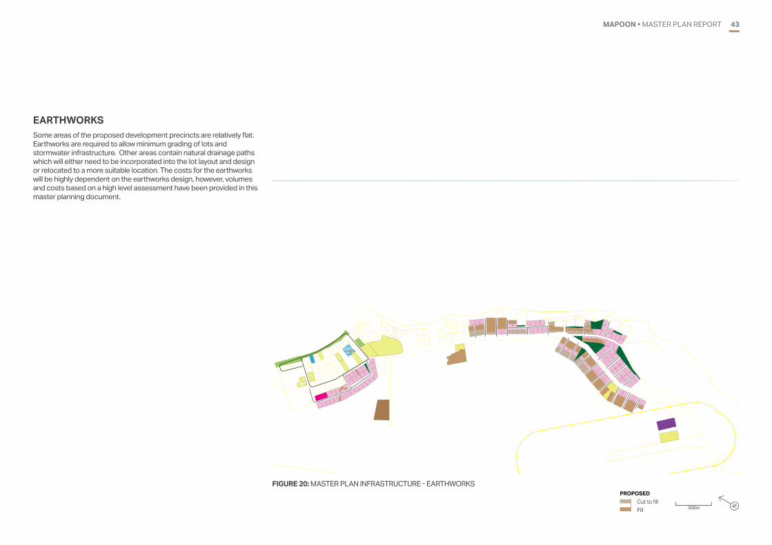
FIGURE 20: MASTER PLAN INFRASTRUCTURE - EARTHWORKS
300m N
PROPOSED Cut to fill Fill300 m
MAPOONINFRASTRUCTURE � EARTHWORKSFOR DISCUSSION PURPOSES ONLY
PROPOSEDCut to fillFill
EARTHWORKSSome areas of the proposed development precincts are relatively flat. Earthworks are required to allow minimum grading of lots and stormwater infrastructure. Other areas contain natural drainage paths which will either need to be incorporated into the lot layout and design or relocated to a more suitable location. The costs for the earthworks will be highly dependent on the earthworks design, however, volumes and costs based on a high level assessment have been provided in this master planning document.

MAPOON • MASTER PLAN REPORT44
300 m
MAPOONINFRASTRUCTURE � WATER SUPPLY
FOR DISCUSSION PURPOSES ONLY
EXISTINGMainsBores
PROPOSEDMain - 50 diaMain - 100 diaMain - 150 diaMain - 200 diaMain - 250 diaReservoir
WATER SUPPLYThe existing raw water bores do not have capacity to accommodate the increase in water demand in the new development areas identified in the master plan. Additional bores will be required to provide enough raw water for the community in the future, with the additional flows required for stages 3 and 4 of the proposed development. The abstraction licence for the bores may also need to be amended.
The existing reservoir does not provide sufficient capacity for the existing community, and additional storage will be required to service the existing community and accommodate the proposed development. The booster pump station at the reservoir will also require upgrade to maintain service pressures across the township, particularly to service the residential developments to the south of the township due to the long main length required to service these areas.
The existing trunk water mains will require replacement with larger water mains to accommodation the increased water supply demands, with the replacement mains ranging from 150 mm to 250 mm diameter. Additional water mains ranging from 50 mm to 100 mm diameter will be required to service the proposed development.
FIGURE 21: MASTER PLAN INFRASTRUCTURE - WATER SUPPLY EXISTING Mains Bores
PROPOSED Main - 50mm diameter Main - 100mm diameter Main - 150mm diameter Main - 200mm diameter Main - 250mm diameter Reservoir 300m N

MAPOON • MASTER PLAN REPORT 45
WEIPA MAPOON ROAD
WHEELER STREETCLERMONT STREET
300 m
MAPOONINFRASTRUCTURE � ROADS
FOR DISCUSSION PURPOSES ONLY
EXISTINGRoad
PROPOSEDRoadFIGURE 22: MASTER PLAN INFRASTRUCTURE - ROADS
EXISTING Road
PROPOSED Road 300m N
ROADSNew roads are required for the Central, Industrial, Western, High Rise and Expansion precincts. Minimum requirements of the FNQROC Regional Development Manual have been assumed for costing purposes.
It is expected than an upgrade of the electricity plant will be required to accommodate the proposed development.
MAPOON • MASTER PLAN REPORT46
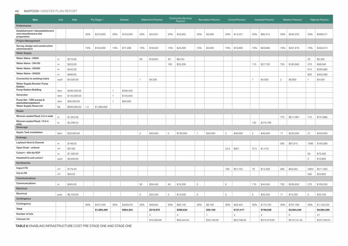
Item Unit Rate Pre Stage 1 General Waterfront Precinct Community Services Precinct Recreation Precinct Central Precinct Industrial Precinct Western Precinct Highrise Precinct
Preliminaries
Establishment / disestablishment and miscellaneous site preparation
20% $216,000 20% $103,050 20% $24,031 20% $32,665 20% $4,000 20% $14,521 20% $85,315 20% $349,225 20% $568,017
Project Management
Survey, design and construction administration 15% $162,000 15% $77,288 15% $18,023 15% $24,499 15% $3,000 15% $10,890 15% $63,986 15% $261,919 15% $426,013
Water Supply
Water Mains - DN50 m $210.60 90 $18,954 40 $8,424 25 $5,265Water Mains - DN100 m $252.00 100 $25,200 110 $27,720 730 $183,960 270 $68,040Water Mains - DN200 m $432.00 615 $265,680Water Mains - DN250 m $486.00 830 $403,380Connection to existing mains each $4,500.00 1 $4,500 1 $4,500 2 $9,000 1 $4,500Water Supply Booster Pump StationPump Station Building item $290,250.00 1 $290,250Generator item $135,000.00 1 $135,000Pump Set - VSD pumps & associated pipework item $90,000.00 1 $90,000
Water Supply Reservoir ML $900,000.00 1.2 $1,080,000Roads
Bitumen sealed Road, 5.5 m wide m $1,053.36 770 $811,087 710 $747,886Bitumen sealed Road, 12.0 m wide m $2,298.24 120 $275,789
Sewerage
Septic Tank Installation item $20,000.00 2 $40,000 5 $100,000 1 $20,000 2 $40,000 2 $40,000 11 $220,000 21 $420,000Drainage
Layback Kerb & Channel m $148.50 590 $87,615 1080 $160,380Open Drain - unlined m³ $37.80 22.5 $851 37.5 $1,418Culvert - 450 dia RCP m $1,260.00 60 $75,600Headwall to suit culvert each $3,600.00 3 $10,800Eartthworks
Import Fill m³ $176.40 180 $31,752 70 $12,348 366 $64,562 2900 $511,560Cut to Fill m³ $40.50 590 $23,895Communications
Communications m $405.00 90 $36,450 40 $16,200 0 0 110 $44,550 730 $295,650 270 $109,350Electrical
Electrical pole $6,750.00 3 $20,250 2 $13,500 0 0 3 $20,250 11 $74,250 5 $33,750Contingency
Contingency 30% $437,400 30% $208,676 30% $48,662 30% $66,146 30% $8,100 30% $29,404 30% $172,763 30% $707,180 30% $1,150,235Total $1,895,400 $904,264 $210,870 $286,634 $35,100 $127,417 $748,638 $3,064,449 $4,984,350
Number of lots 3 3 1 2 2 6 21Cost per lot $70,290.09 $95,544.54 $35,100.00 $63,708.69 $374,318.95 $510,741.45 $237,350.01
TABLE 6: ENABLING INFRASTRUCTURE COST PRE STAGE ONE AND STAGE ONE

MAPOON • MASTER PLAN REPORT 47
Item Unit Rate Central Precinct Civic Precinct Farm Precinct ndustrial Precinct Western Precinct High Rise Precinct
Preliminaries
Establishment / disestablishment and miscellaneous site preparation
20% $18,953 20% $24,000 20% $214,553 20% $614,550 20% $228,989 20% $405,158
Project Management
Survey, design and construction administration 15% $14,214 15% $18,000 15% $160,915 15% $460,912 15% $171,742 15% $303,869
Water Supply
Water Mains - DN50 m $210.60 560 $117,936Water Mains - DN100 m $252.00 220 $55,440 130 $32,760 450 $113,400 180 $45,360Water Mains - DN200 m $432.00 690 $298,080Connection to existing mains each $4,500.00 1 $4,500 1 $4,500 1 $4,500 1 $4,500
Roads
Bitumen sealed Road, 5.5 m wide m $1,053.36 410 $431,878 600 $632,016Bitumen sealed Road, 6.5 m wide m $1,244.88 15.5 $19,296Bitumen sealed Road, 12.0 m wide m $2,298.24 90 $206,842
Bitumen sealed Road, 4.5 m wide m $911.25 630 $574,088
Sewerage
Septic Tank Installation item $20,000.00 1 $20,000 6 $120,000 2 $40,000 3 $60,000 10 $200,000 22 $440,000Drainage
Layback Kerb & Channel m $148.50 530 $78,705 $258,390Reinforced concrete invert to open drain
linear m $189.00 130 $24,570
Open Drain - unlined m³ $37.80 15 $567 37.5 $1,418 48.75 $1,843Culvert - 450 dia RCP m $1,260.00 35 $44,100 20 $25,200 80 $100,800Headwall to suit culvert each $3,600.00 3 $10,800 1 $3,600 4 $14,400Eartthworks
Import Fill m³ $176.40 $2,593,080 180 $31,752 500 $88,200Cut to Fill m³ $40.50 $117,450 $44,145Communications
Communications m $405.00 0 0 560 $226,800 90 $36,450 450 $182,250 180 $72,900Electrical
Electrical pole $6,750.00 0 0 8 $54,000 3 $20,250 7 $47,250 4 $27,000Contingency
Contingency 30% $38,379 30% $48,600 30% $434,469 30% $1,244,463 30% $463,704 30% $820,445Total $166,308 $210,600 $1,882,700 $5,392,675 $2,009,383 $3,555,263
Number of lots 1 6 2 4 10 22Cost per lot $166,308.43 $35,100.00 $941,349.97 $1,348,168.67 $200,938.26 $161,602.87
TABLE 7: ENABLING INFRASTRUCTURE COST STAGE TWO

MAPOON • MASTER PLAN REPORT48
Item Unit Rate General Civic Precinct (South) Airport Precinct Western Precinct High Rise Precinct
Preliminaries
Establishment / disestablishment and miscellaneous site preparation
20% $224,280 20% $29,748 20% $599,081 20% $453,746 20% $296,507
Project Management
Survey, design and construction administration 15% $168,210 15% $22,311 15% $449,311 15% $340,310 15% $222,380
Water Supply
Water Mains - DN50 m $210.60 500 $105,300 660 $138,996 65 $13,689Water Mains - DN100 m $252.00 170 $42,840 1320 $332,640 40 $10,080Water Mains - DN150 m $306.00 1170 $358,020Connection to existing mains each $4,500.00 1 $4,500 1 $4,500 3 $13,500 2 $9,000
Water Supply Reservoir ML $900,000.00 0.84 $756,000Water Source Study item $90,000.00 1 $90,000Water Supply Bore - 20 m deep item $137,700.00 2 $275,400
Water Treatment upgrade - pH correction filter unit $4,500.00
Roads
Bitumen sealed Road, 5.5 m wide m $1,053.36 450 $474,012 420 $442,411Bitumen sealed Road, 6.5 m wide m $1,244.88 150 $186,732Sewerage
Septic Tank Installation item $20,000.00 3 $60,000 3 $60,000 18 $360,000 14 $280,000Drainage
Stormwater Pipe m $1,260.00 $1,675,800 560 $705,600Reinforced concrete invert to open drain
linear m $189.00 190 $35,910 60 $11,340
Open Drain - unlined m³ $37.80 $2,693 22.5 $851Culvert - 450 dia RCP m $1,260.00 30 $37,800Headwall to suit culvert each $3,600.00 1 $3,600Eartthworks
Import Fill m³ $176.40 180 $31,752Cut to Fill m³ $40.50 485 $19,643Communications
Communications m $405.00 0 2990 $1,210,950 0 0Electrical
Electrical pole $6,750.00 0 0 39 $263,250 0 0Contingency
Contingency 30% $344,547 30% $60,240 30% $1,213,139 30% $918,836 30% $600,426Total $1,858,437 $261,039 $5,256,934 $3,981,623 $2,601,846
Number of lots 3 1 18 14Cost per lot $87,012.90 $221,201.30 $185,846.13
TABLE 8: ENABLING INFRASTRUCTURE COST STAGE THREE

MAPOON • MASTER PLAN REPORT 49
Item Unit Rate General Expansion Precinct Sewerage System for whole of community
Preliminaries
Establishment / disestablishment and miscellaneous site preparation
20% $1,800 20% $2,661,542 20% $4,189,331
Project Management
Survey, design and construction administration 15% $1,350 15% $1,996,157 15% $3,141,998
Water Supply
Water Mains - DN150 m $306.00 1940 $593,640Connection to existing mains each $4,500.00 1 $4,500Water Supply Booster Pump Station
Water Treatment upgrade - pH correction filter unit $4,500.00 2 $9,000
Roads
Bitumen sealed Road, 5.5 m wide m $1,053.36 2390 $2,517,530Sewerage
Gravity Sewer - DN150 m $418.50 11500 $4,812,750Gravity Sewer - DN225 m $513.00 1700 $872,100Gravity Sewer - DN300 m $553.50 220 $121,770Rising main - DN100 m $306.00 2600 $795,600Rising main - DN150 m $378.00 600 $226,800Manhole no. $9,045.00 135 $1,221,075Sewage Pump Station item $627,750.00 7 $4,394,250Install Odour Control to Sewerage pump station item $31,500.00 7 $220,500
Septic Tank Installation item $20,000.00 85 $1,700,000Upgrade sewerage treament plant
"Pond 1- 3900m3" EP $5,137.60 1612 $8,281,811Drainage
Stormwater Pipe m $1,260.00 4900 $6,174,000Eartthworks
Import Fill m³ $176.40 7150 $1,261,260Cut to Fill m³ $40.50 2360 $95,580Communications
Communications m $405.00 0 1940 $785,700 0Electrical
Electrical pole $6,750.00 0 26 $175,500 0Contingency
Contingency 30% $945 30% $5,389,623 30% $8,483,396Total $13,095 $36,761,382
Number of lots 85Cost per lot $274,765.08
TABLE 9: ENABLING INFRASTRUCTURE COST STAGE FOUR AND SEWERAGE SYSTEM

MAPOON • MASTER PLAN REPORT5050DOOMADGEE • MASTER PLAN REPORT
SUMMARY0950 • MASTER PLAN REPORT

MAPOON • MASTER PLAN REPORT 51
TABLE 10: ENABLING INFRASTRUCTURE COST SUMMARY BY PRECINCT
STAGE ITEM COST YIELD COST PER LOT
Pre Stage
1
Establishment and site preparation
Survey, design and construction administration
Water Supply Reservoir
$1,895,400
Stage 1
General $904,264
Waterfront Precinct $210,870 3 $70,290
Community Services Precinct $286,634 3 $95,545
Recreation Precinct $35,100 1 $35,100
Central Precinct $127,417 2 $63,709
Industrial Precinct $748,638 2 $374,319
Western Precinct $3,064,449 6 $510,741
High Rise Precinct $4,984,350 21 $237,350
Stage 2
Central Precinct $166,308 1 $166,308
Civic Precinct (North) $210,600 6 $35,100
Farm Precinct $1,882,700 2 $941,350
Industrial Precinct $5,392,675 4 $1,348,169
Western Precinct $2,009,383 10 $200,938
High Rise Precinct $3,555,263 22 $161,603
Stage 3
General $1,858,437
Civic Precinct (South) $261,039 3 $87,013
Airport Precinct $5,256,934 1 $5,256,934
Western Precinct $3,981,623 18 $221,201
High Rise Precinct $2,601,846 14 $185,846
Stage 4
General $13,095
Expansion Precinct $23,355,032 85 $274,765
The preferred master plan identifies a range of development opportunities which provide Council with a clear set of options to progress future residential and non-residential development into the future. The right combination of housing choice and employment opportunity will promote a successful and vibrant community with a diversified and strong local economy.
The infrastructure assessment undertaken as part of this master plan considered two scenarios for the future treatment of sewage:
• Scenario 1 - continue provision of on-site septic.
• Scenario 2 - construct a centralised sewage treatment plant and install a reticulated sewerage network across the exisitng town and proposed expansion areas.
Due to the significant costs associated with a reticulated system, it is likely that future development will include the ongoing provision of on-site septic systems. Given the water supply for the town is from groundwater bores, it is recommended that ongoing monitoring of groundwater quality is undertaken. If required, higher standard treatment systems can be specified for new developments to ensure groundwater quality is maintained.
Due to the tropical climatic conditions and frequency of severe weather events experienced in Mapoon, the following matters are considered a priority for Council to ensure ongoing community health and safety:
• improve the existing stormwater system to align with the flexibility and adaptation principle of the Resilient Queensland 2018-2021 Strategy to reduces incidences of water pooling and flooding within the township
• ensure all new development sites are connected to the communications network to enable coordination before, during and after severe weather events.
Following completion of the infrastructure assessment in early 2019, additional data relating to visitor numbers has become available, indicating that up to 535 visitors stay in Mapoon each month. It is recommended that future update of the master plan consider revising the infrastructure assessment to identify potential capacity issues associated with the peak surge population. It may also be necessary to consider the future of provision of additional and/or enhanced short term accommodation facilities.
In addition to enabling infrastructure and funding, a range of further requirements and obligations will need to be met for each aspect of the master plan. These include:
• Address Native Title and ILUA
• Obtain planning approval in accordance with planning scheme
• Conduct appropriate cultural survey and obtain clearance TABLE 11: COST SUMMARY BY INFRASTRUCTURE TYPE
STAGE ITEM COST
Pre Stage
1Water Supply Reservoir $1,080,000
Stage 1
Water Supply Booster Pump Station $515,250
Water Supply $1,029,123
Roads $1,834,762
Septic Tanks $880,000
Drainage $336,663
Earthworks $644,117
Communications $502,200
Electrical $162,000
Stage 2
Water Supply $680,976
Roads $1,864,118
Septic Tanks $880,000
Drainage $564,392
Earthworks $2,874,627
Communications $518,400
Electrical $148,500
Stage 3
Water Supply $1,033,065
Roads $1,103,155
Septic Tanks $760,000
Drainage $2,473,594
Earthworks $51,395
Communications $1,210,950
Electrical $263,250
Stage 4
Water Supply $607,140
Roads $2,517,530
Drainage $6,174,000
Earthworks $1 356,840
Communications $785,700
Electrical $175,500
Sewerage System for whole township $36,761,382
The preferred master plan represents a long term guide for development throughout Mapoon. Council will consider indicative yields and enabling infrastructure costs when staging future development and infrastructure outlay. The yields and costs will also provide an important basis to inform discussions and negotiations with key agencies and stakeholders.

MAPOON • MASTER PLAN REPORT52
300m N
Residential Medium Density Residential TourismCommunity
Commercial Industrial Open SpaceRural
Long term residentialExisting un-surveyed lotsPedestrian/Cycle RouteRoad Access
FIGURE 23: PREFERRED OPTION STAGING Stage 1Stage 2Stage 3Stage 4

MAPOON • MASTER PLAN REPORT 5353DOOMADGEE • MASTER PLAN REPORT
REFERENCES1053 • MASTER PLAN REPORT

MAPOON • MASTER PLAN REPORT54
Australian Bureau of Statistics, 2016, ‘Mapoon (S) (LGA34830), General Community Profile’ (Catalogue number 2001.0), viewed 22 January 2018, https://quickstats.censusdata.abs.gov.au/census_services/getproduct/census/2016/communityprofile/LGA34830?opendocument
Australian Bureau of Statistics, 2016, ‘Mapoon (S) (LGA34830), Aboriginal and Torres Strait Islander Peoples Profile’ (Catalogue number 2002.0), viewed 22 January 2018, https://quickstats.censusdata.abs.gov.au/census_services/getproduct/census/2016/communityprofile/LGA34830?opendocument
Australian Bureau of Statistics, 2016, ‘Mapoon (S) (LGA34830), Time Series Profile’ (Catalogue number 2003.0), viewed 22 January 2018, https://quickstats.censusdata.abs.gov.au/census_services/getproduct/census/2016/communityprofile/LGA34830?opendocument
Australian Bureau of Statistics, 2016, ‘Mapoon (S) (LGA34830), 2016 Census Quick Stats’, viewed 22 January 2018, https://quickstats.censusdata.abs.gov.au/census_services/getproduct/census/2016/communityprofile/LGA34830?opendocument
Mapoon Aboriginal Shire Council, 2014, Mapoon Aboriginal Shire Council Planning Scheme.
Queensland Government, 2015, Projected Population, by local government area, Queensland, 2011 to 2036, viewed 26 September 2017, http://www.qgso.qld.gov.au/subjects/demography/ population-projections/tables/proj-pop-lga-qld/index.php

MAPOON • MASTER PLAN REPORT 5555DOOMADGEE • MASTER PLAN REPORT55 • MASTER PLAN REPORT
APPENDIX A.DETAILED PLANSA.

MAPOON • MASTER PLAN REPORT56
300 m
MAPOONINFRASTRUCTURE � SEWERAGE
FOR DISCUSSION PURPOSES ONLY
PROPOSED (RETICULATED)Sewage Treatment PlantPump Station Rising mainGravity main - 300 diaGravity main - 225 diaGravity main - 150 dia
FIGURE A1: MASTER PLAN INFRASTRUCTURE - SEWERAGE
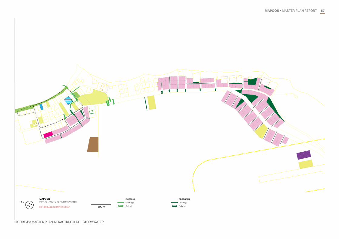
MAPOON • MASTER PLAN REPORT 57
FIGURE A2: MASTER PLAN INFRASTRUCTURE - STORMWATER
300 m
MAPOONINFRASTRUCTURE � STORMWATER
FOR DISCUSSION PURPOSES ONLY
EXISTINGDrainageCulvert
PROPOSEDDrainage Culvert

MAPOON • MASTER PLAN REPORT58
FIGURE A3: MASTER PLAN INFRASTRUCTURE - EARTHWORKS
300 m
MAPOONINFRASTRUCTURE � EARTHWORKSFOR DISCUSSION PURPOSES ONLY
PROPOSEDCut to fillFill

MAPOON • MASTER PLAN REPORT 59
FIGURE A4: MASTER PLAN INFRASTRUCTURE - WATER SUPPLY
300 m
MAPOONINFRASTRUCTURE � WATER SUPPLY
FOR DISCUSSION PURPOSES ONLY
EXISTINGMainsBores
PROPOSEDMain - 50 diaMain - 100 diaMain - 150 diaMain - 200 diaMain - 250 diaReservoir

MAPOON • MASTER PLAN REPORT60
FIGURE A5: MASTER PLAN INFRASTRUCTURE - ROADS
WEIPA MAPOON ROAD
WHEELER STREETCLERMONT STREET
300 m
MAPOONINFRASTRUCTURE � ROADS
FOR DISCUSSION PURPOSES ONLY
EXISTINGRoad
PROPOSEDRoad

MAPOON • MASTER PLAN REPORT 6161MAPOON • MASTER PLAN REPORT
APPENDIX B.INFRASTRUCTURE ASSESSMENTB.
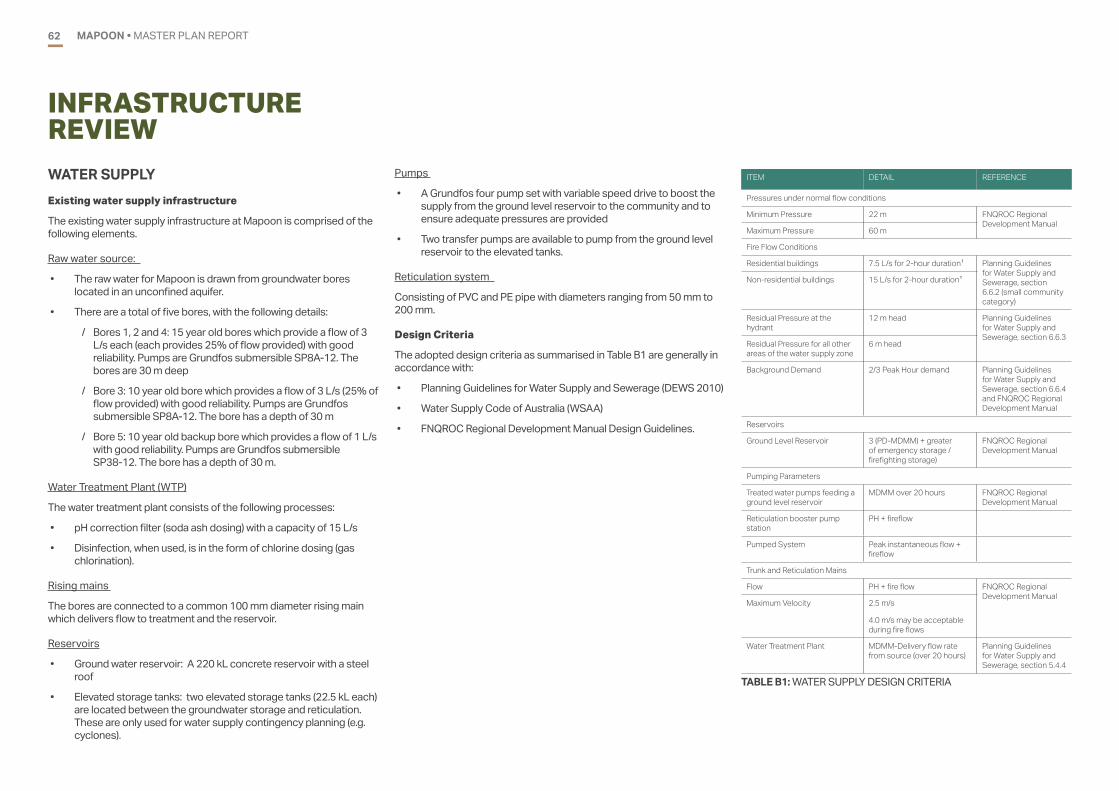
MAPOON • MASTER PLAN REPORT62
INFRASTRUCTURE REVIEW
ITEM DETAIL REFERENCE
Pressures under normal flow conditions
Minimum Pressure 22 m FNQROC Regional Development Manual
Maximum Pressure 60 m
Fire Flow Conditions
Residential buildings 7.5 L/s for 2-hour duration1 Planning Guidelines for Water Supply and Sewerage, section 6.6.2 (small community category)
Non-residential buildings 15 L/s for 2-hour duration1
Residual Pressure at the hydrant
12 m head Planning Guidelines for Water Supply and Sewerage, section 6.6.3
Residual Pressure for all other areas of the water supply zone
6 m head
Background Demand 2/3 Peak Hour demand Planning Guidelines for Water Supply and Sewerage, section 6.6.4 and FNQROC Regional Development Manual
Reservoirs
Ground Level Reservoir 3 (PD-MDMM) + greater of emergency storage / firefighting storage)
FNQROC Regional Development Manual
Pumping Parameters
Treated water pumps feeding a ground level reservoir
MDMM over 20 hours FNQROC Regional Development Manual
Reticulation booster pump station
PH + fireflow
Pumped System Peak instantaneous flow + fireflow
Trunk and Reticulation Mains
Flow PH + fire flow FNQROC Regional Development Manual
Maximum Velocity 2.5 m/s
4.0 m/s may be acceptable during fire flows
Water Treatment Plant MDMM-Delivery flow rate from source (over 20 hours)
Planning Guidelines for Water Supply and Sewerage, section 5.4.4
TABLE B1: WATER SUPPLY DESIGN CRITERIA
Pumps
• A Grundfos four pump set with variable speed drive to boost the supply from the ground level reservoir to the community and to ensure adequate pressures are provided
• Two transfer pumps are available to pump from the ground level reservoir to the elevated tanks.
Reticulation system
Consisting of PVC and PE pipe with diameters ranging from 50 mm to 200 mm.
Design Criteria
The adopted design criteria as summarised in Table B1 are generally in accordance with:
• Planning Guidelines for Water Supply and Sewerage (DEWS 2010)
• Water Supply Code of Australia (WSAA)
• FNQROC Regional Development Manual Design Guidelines.
WATER SUPPLYExisting water supply infrastructure
The existing water supply infrastructure at Mapoon is comprised of the following elements.
Raw water source:
• The raw water for Mapoon is drawn from groundwater bores located in an unconfined aquifer.
• There are a total of five bores, with the following details:
/ Bores 1, 2 and 4: 15 year old bores which provide a flow of 3 L/s each (each provides 25% of flow provided) with good reliability. Pumps are Grundfos submersible SP8A-12. The bores are 30 m deep
/ Bore 3: 10 year old bore which provides a flow of 3 L/s (25% of flow provided) with good reliability. Pumps are Grundfos submersible SP8A-12. The bore has a depth of 30 m
/ Bore 5: 10 year old backup bore which provides a flow of 1 L/s with good reliability. Pumps are Grundfos submersible SP38-12. The bore has a depth of 30 m.
Water Treatment Plant (WTP)
The water treatment plant consists of the following processes:
• pH correction filter (soda ash dosing) with a capacity of 15 L/s
• Disinfection, when used, is in the form of chlorine dosing (gas chlorination).
Rising mains
The bores are connected to a common 100 mm diameter rising main which delivers flow to treatment and the reservoir.
Reservoirs
• Ground water reservoir: A 220 kL concrete reservoir with a steel roof
• Elevated storage tanks: two elevated storage tanks (22.5 kL each) are located between the groundwater storage and reticulation. These are only used for water supply contingency planning (e.g. cyclones).
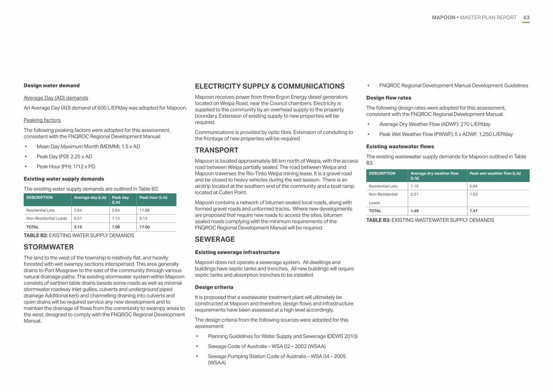
MAPOON • MASTER PLAN REPORT 63
Design water demand
Average Day (AD) demands
An Average Day (AD) demand of 600 L/EP/day was adopted for Mapoon.
Peaking factors
The following peaking factors were adopted for this assessment, consistent with the FNQROC Regional Development Manual:
• Mean Day Maximum Month (MDMM): 1.5 x AD
• Peak Day (PD): 2.25 x AD
• Peak Hour (PH): 1/12 x PD.
Existing water supply demands
The existing water supply demands are outlined in Table B2.
TABLE B2: EXISTING WATER SUPPLY DEMANDS
DESCRIPTION Average day (L/s) Peak day (L/s)
Peak hour (L/s)
Residential Lots 2.64 5.94 11.88
Non-Residential Loads 0.51 1.15 5.13
TOTAL 3.15 7.08 17.00
STORMWATERThe land to the west of the township is relatively flat, and heavily forested with wet swampy sections interspersed. This area generally drains to Port Musgrave to the east of the community through various natural drainage paths. The existing stormwater system within Mapoon consists of earthen table drains beside some roads as well as minimal stormwater roadway inlet gullies, culverts and underground piped drainage Additional kerb and channelling draining into culverts and open drains will be required service any new development and to maintain the drainage of flows from the community to swampy areas to the west, designed to comply with the FNQROC Regional Development Manual.
ELECTRICITY SUPPLY & COMMUNICATIONSMapoon receives power from three Ergon Energy diesel generators located on Weipa Road, near the Council chambers. Electricity is supplied to the community by an overhead supply to the property boundary. Extension of existing supply to new properties will be required.
Communications is provided by optic fibre. Extension of conduiting to the frontage of new properties will be required.
TRANSPORTMapoon is located approximately 86 km north of Weipa, with the access road between Weipa partially sealed. The road between Weipa and Mapoon traverses the Rio-Tinto Weipa mining lease. It is a gravel road and be closed to heavy vehicles during the wet season. There is an airstrip located at the southern end of the community and a boat ramp located at Cullen Point.
Mapoon contains a network of bitumen sealed local roads, along with formed gravel roads and unformed tracks. Where new developments are proposed that require new roads to access the sites, bitumen sealed roads complying with the minimum requirements of the FNQROC Regional Development Manual will be required.
SEWERAGEExisting sewerage infrastructure
Mapoon does not operate a sewerage system. All dwellings and buildings have septic tanks and trenches. All new buildings will require septic tanks and absorption trenches to be installed.
Design criteria
It is proposed that a wastewater treatment plant will ultimately be constructed at Mapoon and therefore, design flows and infrastructure requirements have been assessed at a high level accordingly.
The design criteria from the following sources were adopted for this assessment:
• Planning Guidelines for Water Supply and Sewerage (DEWS 2010)
• Sewage Code of Australia – WSA 02 – 2002 (WSAA)
• Sewage Pumping Station Code of Australia – WSA 04 – 2005 (WSAA)
• FNQROC Regional Development Manual Development Guidelines
Design flow rates
The following design rates were adopted for this assessment, consistent with the FNQROC Regional Development Manual:
• Average Dry Weather Flow (ADWF): 270 L/EP/day
• Peak Wet Weather Flow (PWWF): 5 x ADWF, 1,250 L/EP/day
Existing wastewater flows
The existing wastewater supply demands for Mapoon outlined in Table B3.
TABLE B3: EXISTING WASTEWATER SUPPLY DEMANDS
DESCRIPTION Average dry weather flow (L/s)
Peak wet weather flow (L/s)
Residential Lots 1.19 5.94
Non-Residential
Loads
0.31 1.53
TOTAL 1.49 7.47
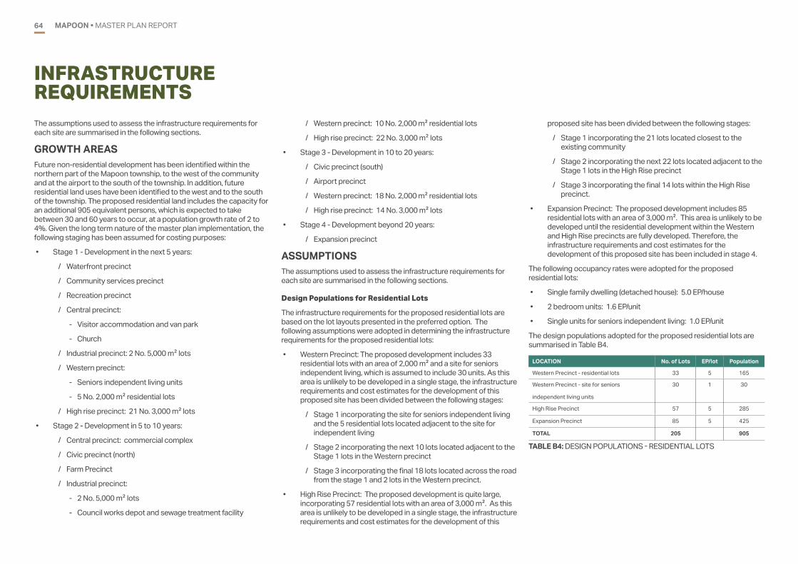
MAPOON • MASTER PLAN REPORT64
INFRASTRUCTURE REQUIREMENTSThe assumptions used to assess the infrastructure requirements for each site are summarised in the following sections.
GROWTH AREAS Future non-residential development has been identified within the northern part of the Mapoon township, to the west of the community and at the airport to the south of the township. In addition, future residential land uses have been identified to the west and to the south of the township. The proposed residential land includes the capacity for an additional 905 equivalent persons, which is expected to take between 30 and 60 years to occur, at a population growth rate of 2 to 4%. Given the long term nature of the master plan implementation, the following staging has been assumed for costing purposes:
• Stage 1 - Development in the next 5 years:
/ Waterfront precinct
/ Community services precinct
/ Recreation precinct
/ Central precinct:
- Visitor accommodation and van park
- Church
/ Industrial precinct: 2 No. 5,000 m2 lots
/ Western precinct:
- Seniors independent living units
- 5 No. 2,000 m2 residential lots
/ High rise precinct: 21 No. 3,000 m2 lots
• Stage 2 - Development in 5 to 10 years:
/ Central precinct: commercial complex
/ Civic precinct (north)
/ Farm Precinct
/ Industrial precinct:
- 2 No. 5,000 m2 lots
- Council works depot and sewage treatment facility
/ Western precinct: 10 No. 2,000 m2 residential lots
/ High rise precinct: 22 No. 3,000 m2 lots
• Stage 3 - Development in 10 to 20 years:
/ Civic precinct (south)
/ Airport precinct
/ Western precinct: 18 No. 2,000 m2 residential lots
/ High rise precinct: 14 No. 3,000 m2 lots
• Stage 4 - Development beyond 20 years:
/ Expansion precinct
ASSUMPTIONSThe assumptions used to assess the infrastructure requirements for each site are summarised in the following sections.
Design Populations for Residential Lots
The infrastructure requirements for the proposed residential lots are based on the lot layouts presented in the preferred option. The following assumptions were adopted in determining the infrastructure requirements for the proposed residential lots:
• Western Precinct: The proposed development includes 33 residential lots with an area of 2,000 m2 and a site for seniors independent living, which is assumed to include 30 units. As this area is unlikely to be developed in a single stage, the infrastructure requirements and cost estimates for the development of this proposed site has been divided between the following stages:
/ Stage 1 incorporating the site for seniors independent living and the 5 residential lots located adjacent to the site for independent living
/ Stage 2 incorporating the next 10 lots located adjacent to the Stage 1 lots in the Western precinct
/ Stage 3 incorporating the final 18 lots located across the road from the stage 1 and 2 lots in the Western precinct.
• High Rise Precinct: The proposed development is quite large, incorporating 57 residential lots with an area of 3,000 m2. As this area is unlikely to be developed in a single stage, the infrastructure requirements and cost estimates for the development of this
proposed site has been divided between the following stages:
/ Stage 1 incorporating the 21 lots located closest to the existing community
/ Stage 2 incorporating the next 22 lots located adjacent to the Stage 1 lots in the High Rise precinct
/ Stage 3 incorporating the final 14 lots within the High Rise precinct.
• Expansion Precinct: The proposed development includes 85 residential lots with an area of 3,000 m2. This area is unlikely to be developed until the residential development within the Western and High Rise precincts are fully developed. Therefore, the infrastructure requirements and cost estimates for the development of this proposed site has been included in stage 4.
The following occupancy rates were adopted for the proposed residential lots:
• Single family dwelling (detached house): 5.0 EP/house
• 2 bedroom units: 1.6 EP/unit
• Single units for seniors independent living: 1.0 EP/unit
The design populations adopted for the proposed residential lots are summarised in Table B4.
LOCATION No. of Lots EP/lot Population
Western Precinct - residential lots 33 5 165
Western Precinct - site for seniors
independent living units
30 1 30
High Rise Precinct 57 5 285
Expansion Precinct 85 5 425
TOTAL 205 905
TABLE B4: DESIGN POPULATIONS - RESIDENTIAL LOTS
MAPOON • MASTER PLAN REPORT 65
Design Populations for Proposed Non-Residential Land Uses
The following assumptions were adopted in determining the infrastructure requirements for the proposed non-residential lots.
Community Services Precinct
• HACC and hospice
/ The HACC was assumed to have a gross floor area (GFA) of 400 m2. Water and sewage flows were assumed based on the high end of the typical usage for a Public Building provided in the DEWS guidelines, as follows:
- A water usage of 600 L/day per 100 m2 of Gross Floor Area (GFA) was adopted (reference: Planning Guidelines for Water Supply and Sewerage (DEWS 2010), Table A, Public Building).
- A sewage usage of 450 L/day per 100 m2 of Gross Floor Area (GFA) was adopted (reference: Planning Guidelines for Water Supply and Sewerage (DEWS 2010), Table A, Public Building).
/ The hospice was assumed to be a residential care facility that provides medical care, nursing services and meals. A 6 bed facility was assumed for this site. Water and sewage flows for the hospice were assumed based on the high end of the typical usage for a Convalescent Home provided in the DEWS guidelines, as follows:
- A water usage of 1100 L/day per bed was adopted (reference: Planning Guidelines for Water Supply and Sewerage (DEWS 2010), Table A, Convalescent Home)
- A sewage usage of 450 L/day per bed was adopted (reference: Planning Guidelines for Water Supply and Sewerage (DEWS 2010), Table A, Convalescent Home).
• Police station and accommodation
/ A police station with a gross floor area of 500 m2 was adopted.
/ A typical equivalent population for shops and offices of 1.0 EP per 90 m2 of Gross Floor Area (GFA) was adopted to calculate water demands and sewage flows (reference: FNQROC Regional Development Manual – Design Guidelines).
/ The facility was assumed to contain on-site accommodation
for 4 police officers, consisting of single bedroom units. A population of 1.0 EP per unit was adopted.
• Early learning centre
/ The early learning centre was assumed to be a child care centre with a maximum of 30 students and 8 staff (allowing for growth in the region).
/ Water and sewage flows were assumed based on the high end of the typical usage for a Child Care Centre provided in the DEWS guidelines, as follows:
- A water usage of 70 L/day per staff and pupils was adopted (reference: Planning Guidelines for Water Supply and Sewerage (DEWS 2010), Table A, Child Care Centre).
- A sewage usage of 45 L/day per staff and pupils was adopted (reference: Planning Guidelines for Water Supply and Sewerage (DEWS 2010), Table A, Child Care Centre).
Waterfront Precinct
• Waterfront parkland
/ The waterfront parkland is assumed to include potential infrastructure such as a playground, park seating, picnic tables and water tap.
/ The pedestrian and cyclist circuit will pass through this area.
/ No amenities block will be provided.
/ One water main will be provided to the site to supply the water taps.
/ Lighting will be provided to the area.
/ Roads will not be located along the waterfront, only the pedestrian and cyclist paths. Stormwater will be allowed to drain naturally to the sea.
• Pedestrian and cyclist circuit
/ The pedestrian and cyclist circuit is proposed to run along the waterfront and around the northern portion of the community.
/ No water or sewerage services are required for this site
/ Waterfront commercial development
/ The waterfront commercial development was assumed to
consist of a café.
/ Water and sewerage flows for the café were assumed based on the low end of the typical usage for food services provided in the DEWS guidelines as follows, assuming a GFA of 100 m2:
- A typical water usage for food services of 1,200 L/day/100m2 GFA was adopted (reference: Planning Guidelines for Water Supply and Sewerage (DEWS 2010), Table A, Food Services)
- A typical sewage flow for food services of 900 L/d/100 m2 GFA was adopted (reference: Planning Guidelines for Water Supply and Sewerage (DEWS 2010), Table A, Food Services).
• Multi-purpose centre
/ The multi-purpose centre was assumed to have a gross floor area (GFA) of 500 m2
/ Due to the uncertain nature of the building usage, water and sewer demands were based on the high end of the typical range for water and sewage flows for a Public Building provided in the Planning Guidelines for Water Supply and Sewerage (DEWS 2010). The following values were adopted:
- A water usage of 600L/day per 100 m2 of Gross Floor Area (GFA) was adopted (reference: Planning Guidelines for Water Supply and Sewerage (DEWS 2010), Table A, Public Building)
- A sewage usage of 450L/day per 100 m2 of Gross Floor Area (GFA) was adopted (reference: Planning Guidelines for Water Supply and Sewerage (DEWS 2010), Table A, Public Building).
• Recreation Precinct
- The recreation precinct is expected to include a splash pad with a small kiosk and amenities block, parkland, a playground and a splash park.
• Splash Pad:
/ The splash pad was assumed to be a 200 m2 ground level fountain. It was assumed that the splash pad will be installed as a recirculating system. This will incorporate the following features:

MAPOON • MASTER PLAN REPORT66
- Drains to collect water from the wet areas
- Water treatment system to filter and treat water for the ground level fountain
- Holding tank to collect and store water
- Pumps to provide the required pressure to the water play equipment
/ It was assumed that the splash pad will be only operated during the day. 10 hours operation per day assumed for assessment.
/ Water usage for the splash pad is based on water top-up requirements, assumed to be up to 20% of daily water requirement, topped up over an 10 hour period
/ The total water requirement for the splash pad depends on the particular items installed at the site. Typical usages for each element were based on a flow range of 15 L/h to 40 L/h for a 10m2 area typical for water saving style fountains found in similar facilities. A water usage of 40 L/h/10m2 area was adopted for this project. For a 10 hour day, a total of 8 kL/day is required.
/ It was assumed that the splash pad will be installed as a recirculating system. Therefore, the water from the splash pad will be collected, filtered, treated and reused. The flow to the sewerage system will be limited to the backwash flow from the filters. It was assumed that the backwash flow is 10% of the total daily water supply requirement for the water park, to be discharged to the sewerage network over a 10 hour period.
• Kiosk:
/ Water and sewerage flows for the kiosk were assumed based on the low end of the typical usage for food services provided in the DEWS guidelines as follows, assuming a GFA of 20 m2:
- A typical water usage for food services of 1,200 L/day/100m2 GFA was adopted (reference: Planning Guidelines for Water Supply and Sewerage (DEWS 2010), Table A, Food Services)
- A typical sewage flow for food services of 900 L/d/100 m2 GFA was adopted (reference: Planning Guidelines for Water Supply and Sewerage (DEWS 2010), Table A, Food
Services).
• Amenities block:
/ The amenities block was assumed to contain male and female facilities, with change rooms, 3 x toilets, 3 x showers and hand basins in each. The water demands and sewage flows for the amenities block based on a peak flow generated during the concurrent use of 6 showers. Shower flow rates of 9 L/min were adopted, based on typical rates for 3 stars WELS rating showers.
• Playground/Parkland:
/ This site is assumed to include the provision of playground equipment, park seating and a water tap. Water usage from the tap is assumed to be negligible.
• Skate park:
/ The site is assumed to include a concrete skate park structure, seating and a water tap. Water usage from the tap is assumed to be negligible.
Civic precinct (north)
• The civic precinct (north) is expected to include Council, government and community facilities including a new shared Council and Government building, new Land and Sea Rangers building, community hall, memorial, government offices, art centre and tourist centre.
• The new shared Council and Government building was assumed to have a gross floor area (GFA) of 600 m2. Water and sewage flows were assumed based on the high end of the typical usage for a Public Building provided in the DEWS guidelines
• The new Land and Sea Rangers building was assumed to have a gross floor area (GFA) of 500 m2. Water and sewage flows were assumed based on the high end of the typical usage for a Public Building provided in the DEWS guidelines
• The Community Hall was assumed to have a gross floor area (GFA) of 600 m2. Water and sewage flows were assumed based on the high end of the typical usage for a Public Building provided in the DEWS guidelines
• The memorial is expected to include an outdoor area with a memorial located in it. Water and sewage services will not be
provided to this site.
• The Government offices are assumed to have a total gross floor area (GFA) of 600 m2. Water and sewage flows were assumed based on the high end of the typical usage for a Public Building provided in the DEWS guidelines
• The Art centre was assumed to have a gross floor area (GFA) of 600 m2. Water and sewage flows were assumed based on the high end of the typical usage for a Public Building provided in the DEWS guidelines
• The Tourist Centre was assumed to have a gross floor area (GFA) of 200 m2. Water and sewage flows were assumed based on the high end of the typical usage for a Public Building provided in the DEWS guidelines
• Water and sewage flows for the buildings in this precinct were as follows:
/ A water usage of 600 L/day per 100 m2 of Gross Floor Area (GFA) was adopted (reference: Planning Guidelines for Water Supply and Sewerage (DEWS 2010), Table A, Public Building).
/ A sewage usage of 450 L/day per 100 m2 of Gross Floor Area (GFA) was adopted (reference: Planning Guidelines for Water Supply and Sewerage (DEWS 2010), Table A, Public Building).
Civic precinct (south)
• The civic precinct (south) is expected to include land for the long term expansion of Council and government facilities, an informal helipad and a Men’s and Women’s centre.
• The land for the long term expansion of Council and government facilities is expected to be used for light industrial applications such as sheds/workshops and lay-down areas. Water and sewerage flows were assumed based on the low end of the typical usage for light industry provided in the DEWS guidelines as follows:
/ A typical water usage for light industrial applications of 10,000 L/day/ha was adopted (reference: Planning Guidelines for Water Supply and Sewerage (DEWS 2010), Table A, Light Industry).
• The informal helicopter landing site was assumed to include:
/ A 25 m by 25 m helicopter landing pad

MAPOON • MASTER PLAN REPORT 67
/ A 5 m safety buffer
/ Two 115m long obstacle clear zones
• The informal helicopter landing site is not expected to require any additional road, stormwater, water, sewerage, electrical or communications infrastructure in excess of the requirements for the surrounding site.
• The Men’s and Women’s centre was assumed to have a gross floor area (GFA) of 500 m2. Due to the uncertain nature of the building usage, water and sewer demands were based on the high end of the typical range for water and sewage flows for a Public Building provided in the Planning Guidelines for Water Supply and Sewerage (DEWS 2010). The following values were adopted:
/ A water usage of 600L/day per 100 m2 of Gross Floor Area (GFA) was adopted (reference: Planning Guidelines for Water Supply and Sewerage (DEWS 2010), Table A, Public Building).
/ A sewage usage of 450L/day per 100 m2 of Gross Floor Area (GFA) was adopted (reference: Planning Guidelines for Water Supply and Sewerage (DEWS 2010), Table A, Public Building).
Central precinct
• Visitor accommodation and caravan park
/ The visitor accommodation and caravan park was assumed to include a caretaker’s residence, amenities block, a combined total of 20 powered caravan sites and grassed camping sites, 10 one bedroom units and 5 two bedroom units..
/ The caretaker’s residence water demand and sewage flow was sized in line with residential demands.
/ The following water and sewage loads from the visitor accommodation and van park were adopted:
- 1.2 EP/site was adopted for powered caravan sites and grassed camping sites (reference: FNQROC Regional Development Manual – Design Guidelines).
- 1.2 EP/unit was adopted for one bedroom units.
- 1.6 EP/unit was adopted for two bedroom units.
• Church
/ The church was assumed to have a gross floor area (GFA) of 200 m2. Water and sewer demands were based on the high
end of the typical range for water and sewage flows for a Place of Worship provided in the Planning Guidelines for Water Supply and Sewerage (DEWS 2010). The following values were adopted:
- A water usage of 400L/day per 100 m2 of Gross Floor Area (GFA) was adopted (reference: Planning Guidelines for Water Supply and Sewerage (DEWS 2010), Table A, Place of Worship).
- A sewage usage of 180L/day per 100 m2 of Gross Floor Area (GFA) was adopted (reference: Planning Guidelines for Water Supply and Sewerage (DEWS 2010), Table A, Place of Worship).
• Commercial complex
/ The commercial complex was assumed to include a mix of tenancy sizes that are suitable for a variety of stores, including a hairdresser, takeaway and an internet café.
/ A typical equivalent population for shops and offices of 1.0 EP per 90 m2 of Gross Floor Area (GFA) was adopted to calculate water demands and sewage flows (reference: FNQROC Regional Development Manual – Design Guidelines).
/ The GFA was assumed to cover a total gross floor area of 500 m2. The remaining area of the lot was assumed to be utilised for building setbacks, awnings, off-street car parking and landscaping.
Industry precinct
• The industry precinct was assumed to include a Council works depot, sewage treatment plant and four 5,000 m2 industrial lots.
• The industrial area will be used for light industrial applications such as sheds/workshops and lay-down areas. It was assumed that a maximum of 10% of each site will be used for sheds and workshops.
• Water and sewerage flows were assumed based on the low end of the typical usage for light industry provided in the DEWS guidelines as follows:
- A typical water usage for light industrial applications of 10,000 L/day/ha was adopted (reference: Planning Guidelines for Water Supply and Sewerage (DEWS 2010), Table A, Light Industry).
Airport precinct
• The airport precinct will be developed to provide facilities for passenger services and some airside development.
• The facilities for passenger services is expected to incorporate a small terminal with check-in facilities, amenities, drinking taps and covered waiting areas. The facility was assumed to have a gross floor area (GFA) of 200 m2. Water and sewer demands were based on the high end of the typical range for water and sewage flows for a Public Building provided in the Planning Guidelines for Water Supply and Sewerage (DEWS 2010). The following values were adopted:
/ A water usage of 600L/day per 100 m2 of Gross Floor Area (GFA) was adopted (reference: Planning Guidelines for Water Supply and Sewerage (DEWS 2010), Table A, Public Building).
/ A sewage usage of 450L/day per 100 m2 of Gross Floor Area (GFA) was adopted (reference: Planning Guidelines for Water Supply and Sewerage (DEWS 2010), Table A, Public Building).
• The airside development is expected on include workers accommodation, with a total of 6 one bedroom units to be provided. A population of 1.0 EP/unit was adopted for the workers accommodation units
Farm precinct
• The farm precinct is expected to include a farm and equestrian facilities.
• The farm is expected to include land for growing crops and a caretakers residence. It was assumed that irrigation water will be sourced from an independent bore for the farm. Water supply to the caretakers residence will be provided from the potable water network. It was assumed that the farm would remain connected to its own septic system once the sewage network is constructed in Mapoon.
• The equestrian facilities are expected to included shaded areas, a small office and amenities block. Potable water is expected to be provided to the facility, with a septic tank to provide sewage treatment.
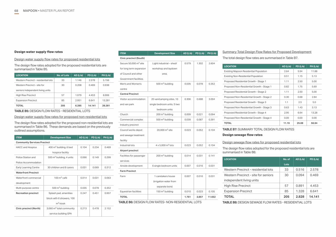
MAPOON • MASTER PLAN REPORT68
Design water supply flow rates
Design water supply flow rates for proposed residential lots
The design flow rates adopted for the proposed residential lots are summarised in Table B5.
LOCATION No. of Lots AD (L/s) PD (L/s) PH (L/s)
Western Precinct - residential lots 33 1.146 2.578 5.156
Western Precinct - site for
seniors independent living units
30 0.208 0.469 0.938
High Rise Precinct 57 1.979 4.453 8.906
Expansion Precinct 85 2.951 6.641 13.281
TOTAL 205 6.285 14.141 28.281
TABLE B5: DESIGN FLOW RATES - RESIDENTIAL LOTS
Design water supply flow rates for proposed non-residential lots
The design flow rates adopted for the proposed non-residential lots are summarised in Table B6. These demands are based on the previously outlined assumptions.
ITEM Development Size AD (L/s) PD (L/s) PH (L/s)
Civic precinct (South)
Secure 50,000 m2 site
for long term expansion
of Council and other
Government facilities
Light industrial – shed/
workshop and laydown
area.
0.579 1.302 2.604
Men's and Women's
centre
500 m2 building 0.035 0.078 0.352
Central Precinct
Visitor accommodation
and van park
20 van/camping sites, 10
single bedroom units, 5 two
bedroom units
0.306 0.688 3.094
Church 200 m2 building 0.009 0.021 0.094
Commercial complex 500 m2 building 0.039 0.087 0.391
Industry precinct
Council works depot
and sewage treatment
facility
20,000 m2 site 0.023 0.052 0.104
Industrial lots 4 x 5,000 m2 lots 0.023 0.052 0.104
Airport precinct
Facilities for passenger
services
200 m2 building 0.014 0.031 0.141
Airside development 6 single bedroom units 0.007 0.016 0.031
Farm Precinct
Farm 1 caretakers house
(irrigation water from
separate bore)
0.007 0.016 0.031
Equestrian facilities 150 m2 building 0.010 0.023 0.105
TOTAL 1.761 3.857 11.652
ITEM Development Size AD (L/s) PD (L/s) PH (L/s)
Community Services Precinct
HACC and Hospice 400 m2 building, 6 bed
hospice facility
0.104 0.234 0.469
Police Station and
Police Accommodation
500 m2 building, 4 units 0.066 0.149 0.299
Early Learning Centre 30 children and 8 carers 0.031 0.069 0.312
Waterfront Precinct
Waterfront commercial
development
100 m2 café 0.014 0.031 0.063
Multi-purpose centre 500 m2 building 0.035 0.078 0.352
Recreation precinct Splash pad, amenities
block with 6 showers, 100
m2 kiosk
0.247 0.451 0.957
Civic precinct (North) 3,060 m2 total community
service building GFA
0.213 0.478 2.152
TABLE B6: DESIGN FLOW RATES- NON-RESIDENTIAL LOTS
Summary Total Design Flow Rates for Proposed Development
The total design flow rates are summarised in Table B7.
LOCATION AD (L/s) PD (L/s) PH (L/s)
Existing Mapoon Residential Population 2.64 5.94 11.88
Existing Non-Residential Population 0.51 1.15 5.13
Proposed Residential Growth - Stage 1 1.11 2.50 5.00
Proposed Non-Residential Growth - Stage 1 0.82 1.75 5.69
Proposed Residential Growth - Stage 2 1.11 2.50 5.00
Proposed Non-Residential Growth - Stage 2 0.30 0.68 2.84
Proposed Residential Growth - Stage 3 1.1 2.5 5.0
Proposed Non-Residential Growth - Stage 3 0.63 1.43 3.13
Proposed Residential Growth - Stage 4 2.95 6.64 13.28
Proposed Non-Residential Growth - Stage 4 0.00 0.00 0.00
TOTAL 11.19 25.08 56.94
TABLE B7: SUMMARY TOTAL DESIGN FLOW RATESDesign sewage flow rates
Design sewage flow rates for proposed residential lots
The design flow rates adopted for the proposed residential lots are summarised in Table B8.
LOCATION No. of
Lots
AD (L/s) PD (L/s)
Western Precinct - residential lots 33 0.516 2.578Western Precinct - site for seniors independent living units
30 0.094 0.469
High Rise Precinct 57 0.891 4.453Expansion Precinct 85 1.328 6.641TOTAL 205 2.828 14.141
TABLE B8: DESIGN SEWAGE FLOW RATES - RESIDENTIAL LOTS

MAPOON • MASTER PLAN REPORT 69
Design water supply flow rates for proposed non-residential lots
The design flow rates adopted for the proposed non-residential lots are summarised in Table B9. These demands are based on the previously presented assumptions.
Item Development Size AD (L/s) PD (L/s)
Community Services Precinct
HACC and Hospice 400 m2 building, 6 bed
hospice facility
0.052 0.260
Police Station and Police
Accommodation
500 m2 building, 4 units 0.030 0.149
Early Learning Centre 30 children and 8 carers 0.020 0.099
Waterfront Precinct
Waterfront commercial
development
100 m2 café 0.010 0.052
Multi-purpose centre 500 m2 building 0.026 0.130
Recreation precinct Splash pad, amenities
block with 6 showers,
100 m2 kiosk
0.341 1.705
Civic precinct (North) 3060 m2 total community
service building GFA
0.159 0.797
Civic precinct (South)
Secure 50,000 m2 site for long
term expansion of Council and
other Government facilities
Light industrial – shed/
workshop and laydown
area.
0.579 2.894
Men's and Women's centre 500 m2 building 0.026 0.130
Central Precinct
Visitor accommodation and van
park
20 van/camping sites, 10
single bedroom units, 5
two bedroom units
0.138 0.688
Church 200 m2 building 0.004 0.021
Commercial complex 500 m2 building 0.017 0.087
Item Development Size AD (L/s) PD (L/s)
Industry precinct
Council works depot and sewage
treatment facility
20,000 m2 site 0.023 0.116
Industrial lots 4 x 5000 m2 lots 0.023 0.116
Airport precinct
Facilities for passenger services 200 m2 building 0.010 0.052
Airside development 6 single bedroom units 0.003 0.016
Farm Precinct
Farm 1 caretakers house
(irrigation water from
separate bore)
0.003 0.016
Equestrian facilities 150 m2 building 0.008 0.039
TOTAL 1.473 7.365
TABLE B9: DESIGN FLOW RATES- NON-RESIDENTIAL LOTS
TRANSPORTA review of the proposed developments identified that some of the proposed development sites are located adjacent to existing sealed roads. However, the remaining proposed development sites will require new bitumen sealed roads as listed in Table B10.
Description1 Infrastructure Requirement
Stage 1
Waterfront Precinct
No roads are to be constructed in
the waterfront precinct
Nil
Community Services, Recreation and Central Precincts
The existing roads are sealed, and
no new roads are required
Nil
Industrial Precinct
Road to the end of the first 2 lots New Industrial Access Street (12.0 m wide
sealed carriageway, 21.0 m wide road reserve),
approximately 120 m length
Description1 Infrastructure Requirement
Western Precinct
Road in front of seniors
independent living units and 5
adjacent residential lots
New Access Place (5.5 m wide sealed carriageway,
14.5 m wide road reserve), approximately 770 m
length
High Rise Precinct
Close 1 New Access Place (5.5 m wide sealed carriageway,
14.5 m wide road reserve), approximately 135 m
length
Close 2 New Access Place (5.5 m wide sealed carriageway,
14.5 m wide road reserve), approximately 205 m
length
Close 3 New Access Place (5.5 m wide sealed carriageway,
14.5 m wide road reserve), approximately 200 m
length
Street 4 New Access Place (5.5 m wide sealed carriageway,
14.5 m wide road reserve), approximately 170 m
length
Stage 2
Central Precinct
Road in front of the commercial
complex
New Access Street (6.5 m wide sealed carriageway,
15.5 m wide road reserve), approximately 340 m
length
Civic precinct (north)
The existing roads are sealed, and
no new roads are required
Nil
Farm Precinct
Road in to the farm New Rural road (4.5 m wide sealed carriageway,
5.5 m wide pavement, 20.0 m wide road reserve),
approximately 630 m length
Industrial Precinct
Extend the road to the end of the
proposed lots
New Industrial Access Street (12.0 m wide
sealed carriageway, 21.0 m wide road reserve),
approximately 90 m length
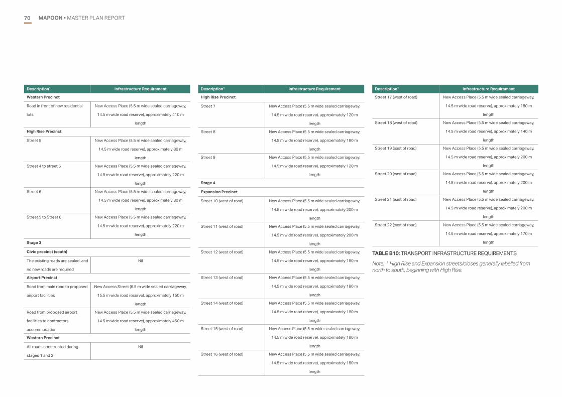
MAPOON • MASTER PLAN REPORT70
Description1 Infrastructure Requirement
Western Precinct
Road in front of new residential
lots
New Access Place (5.5 m wide sealed carriageway,
14.5 m wide road reserve), approximately 410 m
length
High Rise Precinct
Street 5 New Access Place (5.5 m wide sealed carriageway,
14.5 m wide road reserve), approximately 80 m
length
Street 4 to street 5 New Access Place (5.5 m wide sealed carriageway,
14.5 m wide road reserve), approximately 220 m
length
Street 6 New Access Place (5.5 m wide sealed carriageway,
14.5 m wide road reserve), approximately 80 m
length
Street 5 to Street 6 New Access Place (5.5 m wide sealed carriageway,
14.5 m wide road reserve), approximately 220 m
length
Stage 3
Civic precinct (south)
The existing roads are sealed, and
no new roads are required
Nil
Airport Precinct
Road from main road to proposed
airport facilities
New Access Street (6.5 m wide sealed carriageway,
15.5 m wide road reserve), approximately 150 m
length
Road from proposed airport
facilities to contractors
accommodation
New Access Place (5.5 m wide sealed carriageway,
14.5 m wide road reserve), approximately 450 m
length
Western Precinct
All roads constructed during
stages 1 and 2
Nil
Description1 Infrastructure Requirement
High Rise Precinct
Street 7 New Access Place (5.5 m wide sealed carriageway,
14.5 m wide road reserve), approximately 120 m
length
Street 8 New Access Place (5.5 m wide sealed carriageway,
14.5 m wide road reserve), approximately 180 m
length
Street 9 New Access Place (5.5 m wide sealed carriageway,
14.5 m wide road reserve), approximately 120 m
length
Stage 4
Expansion Precinct
Street 10 (west of road) New Access Place (5.5 m wide sealed carriageway,
14.5 m wide road reserve), approximately 200 m
length
Street 11 (west of road) New Access Place (5.5 m wide sealed carriageway,
14.5 m wide road reserve), approximately 200 m
length
Street 12 (west of road) New Access Place (5.5 m wide sealed carriageway,
14.5 m wide road reserve), approximately 180 m
length
Street 13 (west of road) New Access Place (5.5 m wide sealed carriageway,
14.5 m wide road reserve), approximately 180 m
length
Street 14 (west of road) New Access Place (5.5 m wide sealed carriageway,
14.5 m wide road reserve), approximately 180 m
length
Street 15 (west of road) New Access Place (5.5 m wide sealed carriageway,
14.5 m wide road reserve), approximately 180 m
length
Street 16 (west of road) New Access Place (5.5 m wide sealed carriageway,
14.5 m wide road reserve), approximately 180 m
length
Description1 Infrastructure Requirement
Street 17 (west of road) New Access Place (5.5 m wide sealed carriageway,
14.5 m wide road reserve), approximately 180 m
length
Street 18 (west of road) New Access Place (5.5 m wide sealed carriageway,
14.5 m wide road reserve), approximately 140 m
length
Street 19 (east of road) New Access Place (5.5 m wide sealed carriageway,
14.5 m wide road reserve), approximately 200 m
length
Street 20 (east of road) New Access Place (5.5 m wide sealed carriageway,
14.5 m wide road reserve), approximately 200 m
length
Street 21 (east of road) New Access Place (5.5 m wide sealed carriageway,
14.5 m wide road reserve), approximately 200 m
length
Street 22 (east of road) New Access Place (5.5 m wide sealed carriageway,
14.5 m wide road reserve), approximately 170 m
length
TABLE B10: TRANSPORT INFRASTRUCTURE REQUIREMENTS
Note: 1 High Rise and Expansion streets/closes generally labelled from north to south, beginning with High Rise.

MAPOON • MASTER PLAN REPORT 71
WATERAn assessment of the water supply infrastructure requirements to service the proposed future development was undertaken for the township. The assessment and infrastructure requirements are summarised in the following sections.
A summary of the elements of the existing Mapoon water supply system is provided in Table B11.
ITEM Existing
Capacity
Required
Capacity
Deficiency Stage
Upgrade
Required
Raw Water
Source- Bores
12 L/s (864
kL/day)
1.45 ML/day or
20.2 L/s (MDMM
over 20 hours)
0.59 ML/day or
8.2 L/s (MDMM
over 20 hours)
Stage 3
Raw Water
Treatment
15 L/s (1.08
ML/day)
1.45 ML/day or
20.2 L/s (MDMM
over 20 hours)
0.37 ML/day or
5.2 L/s (MDMM
over 20 hours)
Stage 4
Water Storage
- Ground
level storage
reservoir
220 kL 2.26 ML 2.24 Prior to
Stage 1
TABLE B11: MAPOON TRUNK WATER SUPPLY SYSTEM REQUIREMENTS FOR PROPOSED DEVELOPMENT
The water supply infrastructure requirements for the preferred option are summarised in Table B12.
Description Infrastructure Requirement
Prior to Stage 1
Trunk Infrastructure
Water Supply Reservoir 1.20 ML reservoir to be constructed adjacent to existing
reservoirs
Stage 1
Trunk Infrastructure
Pump Station Upgrade the Booster Pump Station located on outlet main
from the reservoirs. Variable speed required, maximum flow of
72 L/s to service ultimate PH flow plus fireflows
Waterfront Precinct
Water Reticulation 50 mm diameter water main from existing water main to
the waterfront precinct. Approximate 90 m total length of
main. Local small diameter water mains within the waterfront
precinct will be required between the supply point and the
location of water taps..
Community Services Precinct
Water Reticulation 100 mm diameter water main from existing 100 mm diameter
water main located in the easement to the street in front of
the sports hall. Approximate 100 m total length of main. 50
mm diameter water main from new 100 mm diameter water
main in front of the sports hall to the early learning centre.
Approximate 40 m total length of main.
Recreation and Central Precincts
Water Reticulation No new mains required.
Industrial Precinct
Water Reticulation 100 mm diameter water main from existing water main
on Weipa Mapoon Road to the end of the stage 1 lots.
Approximate 110 m total length of main.
Western Precinct
Water Reticulation 100 mm diameter water main from the existing water mains,
around the front of the proposed lots. Approximate 730 m
total length of main.
Description Infrastructure Requirement
High Rise Precinct
Trunk Mains 250 mm diameter water mains from reservoirs to the tee
connection at the road, and from the tee connection to the
proposed industrial precinct turn off. Approximate 830 m
total length of mains. 200 mm diameter water main on Weipa
Mapoon Road from the intersection with the proposed
industrial precinct to the southern end the High Rise precinct
stage 1 works. Approximate 615 m total length of mains.
Water Reticulation 100 mm diameter water main on close 1. Approximate 130 m
total length of mains. 100 mm diameter water main on close
3. Approximate 140 m total length of mains. 50 mm diameter
water main extension to the end of the proposed lots on
street 4. Approximate 25 m total length of mains. The house
connection to the existing lot at the end of the street will need
to be relocated to the end of this water main.
Stage 2
Central Precinct and Civic Precinct (North)
Water Reticulation No new mains required.
Farm Precinct
Water Reticulation 100 mm diameter from 250 mm diameter water main on
Weipa Mapoon Road along the front of the future Civic
Precinct (South) to the intersection with the road to the farm.
Approximate 220 m total length of main. 50 mm diameter
main along the road to the farm. Approximate 560 m total
length of main
Industrial Precinct
Water Reticulation 100 mm diameter water main extension to the end of the
industrial lots. Approximate 90 m total length of main. 100
mm diameter road crossing to service Council lot and sewage
treatment plant. Approximate 40 m length of main.

MAPOON • MASTER PLAN REPORT72
Description Infrastructure Requirement
Western Precinct
Water Reticulation 100 mm diameter water main from the existing water mains,
around the front of the proposed lots. Approximate 450 m
total length of main.
High Rise Precinct
Trunk Mains 200 mm diameter water main on Weipa Mapoon Road from
the northern end of the Stage 2 works to the southern end
of the intersection between Weipa Mapoon Road and the
access road for the southern end of the High Rise precinct.
Approximate 690 m total length of mains.
Water Reticulation 100 mm diameter water main on Street 4 and the street
between Street 4 and Street 5. Approximate 180 m total
length of mains.
Stage 3
Trunk Infrastructure
Water Supply Reservoir 0.84 ML reservoir to be constructed adjacent to existing
reservoirs
Raw Water Source Additional bores with a total water supply of 8.2 L/s required.
A raw water source study to be undertaken to identify suitable
sources, confirm the infrastructure requirements and develop
a design for the new water source.
Civic Precinct (South)
Water Reticulation 100 mm diameter water main on the west side of the precinct,
between the intersection with the road to the farm and the
existing water main in front of the Land and Sea centre.
Approximate 170 m total length of mains.
Description Infrastructure Requirement
Airport Precinct
Water Reticulation 150 mm diameter on Weipa Mapoon Road from the existing
water main to the southern end of the future Expansion
precinct. Approximate 1170 m total length of main. 100 mm
diameter main on Weipa Mapoon Road from the end of the
future Expansion Precinct to the proposed Airport facilities
for passenger services. Approximate 1320 m total length of
main. 50 mm diameter main between the proposed Airport
facilities and the proposed contractors accommodation.
Approximate 500 m total length of main
Western Precinct
Water Reticulation 100 mm diameter water main road crossings. Approximate
40 m total length of main. 50 mm diameter water main along
the front of the stage 3 lots. Approximate 660 m total length
of main.
High Rise Precinct
Water Reticulation 50 mm diameter water main extension to the end of the
proposed lots on street 7. Approximate 25 m total length of
mains. The house connection to the existing lot at the end of
the street will need to be relocated to the end of this water
main. 50 mm diameter water main extension to the end of the
proposed lots on street 7. Approximate 40 m total length of
mains. The house connection to the existing lot at the end of
the street will need to be relocated to the end of this water
main.
Stage 4
Trunk Infrastructure
Water Treatment Water treatment facilities to be upgraded to increase the total
capacity to 20.2 L/s.
Description Infrastructure Requirement
Expansion Precinct
Water Reticulation 100 mm diameter water mains to service each street coming
off Weipa Mapoon Road. Approximate 1940 m total length
of mains.
TABLE B12: WATER SUPPLY INFRASTRUCTURE REQUIREMENTS
SEWERAGEMapoon does not currently have a sewage treatment plant or any associated sewerage infrastructure. Two scenarios were assessed for the master plan, on-site septic and reticulated sewer. While two options were identified for a Sewerage Treatment , One option explored converting the town to a reticulated sewerage network, with three locations for a treatment plant identified. The location closest to town was utilised for costing purposes. This option would represent the lowest cost due to proximity to town.
This option includes the construction of a sewage treatment plant to service the community is incorporated in the stage 2 (5 to 10 year) works. The treatment plant should be sized to accommodate the loads from the community once the proposed stage 4 development is complete. In addition to the sewage treatment plant, a sewerage network consisting of gravity sewers, pump stations and rising mains will be required.
The alternative approach utilising on-site septic systems for new development can ulitilise one of three approaches currently approved by the Department of Housing and Public Works (secondary quality, advanced secondary, advanced secondary with nutrient removal). Monitoring and testing existing groundwater will assist in determining the appropriate level of treatment system to be specified for new development,
New development will require the installation of a septic tank and absorption trenches until such time as a sewerage treatment plant is constructed in Mapoon.
The master plan includes an option of a new sewage treatment plant. The construction of the sewage treatment plant will also require the construction of sewers, pump stations and rising mains to service the community. A high level review identified the following infrastructure that is likely to be required to service the existing community and the development proposed in this master plan:
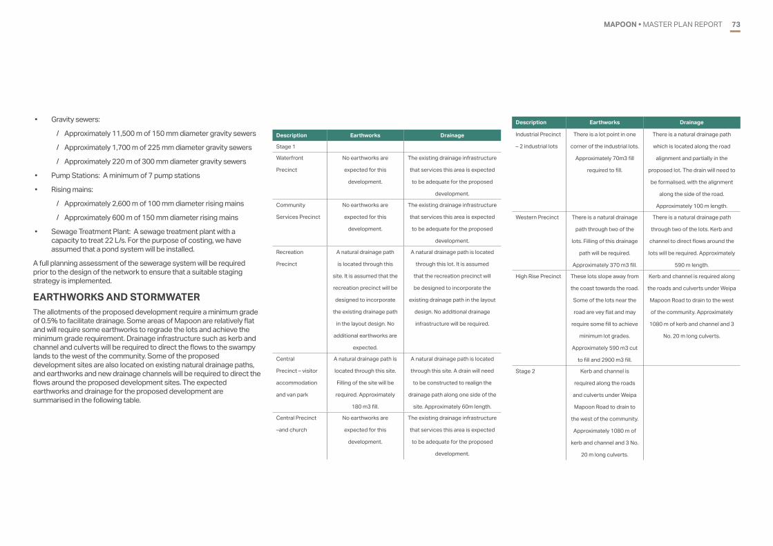
MAPOON • MASTER PLAN REPORT 73
Description Earthworks Drainage
Stage 1
Waterfront
Precinct
No earthworks are
expected for this
development.
The existing drainage infrastructure
that services this area is expected
to be adequate for the proposed
development.
Community
Services Precinct
No earthworks are
expected for this
development.
The existing drainage infrastructure
that services this area is expected
to be adequate for the proposed
development.
Recreation
Precinct
A natural drainage path
is located through this
site. It is assumed that the
recreation precinct will be
designed to incorporate
the existing drainage path
in the layout design. No
additional earthworks are
expected.
A natural drainage path is located
through this lot. It is assumed
that the recreation precinct will
be designed to incorporate the
existing drainage path in the layout
design. No additional drainage
infrastructure will be required.
Central
Precinct – visitor
accommodation
and van park
A natural drainage path is
located through this site.
Filling of the site will be
required. Approximately
180 m3 fill.
A natural drainage path is located
through this site. A drain will need
to be constructed to realign the
drainage path along one side of the
site. Approximately 60m length.
Central Precinct
–and church
No earthworks are
expected for this
development.
The existing drainage infrastructure
that services this area is expected
to be adequate for the proposed
development.
Description Earthworks Drainage
Industrial Precinct
– 2 industrial lots
There is a lot point in one
corner of the industrial lots.
Approximately 70m3 fill
required to fill.
There is a natural drainage path
which is located along the road
alignment and partially in the
proposed lot. The drain will need to
be formalised, with the alignment
along the side of the road.
Approximately 100 m length.
Western Precinct There is a natural drainage
path through two of the
lots. Filling of this drainage
path will be required.
Approximately 370 m3 fill.
There is a natural drainage path
through two of the lots. Kerb and
channel to direct flows around the
lots will be required. Approximately
590 m length.
High Rise Precinct These lots slope away from
the coast towards the road.
Some of the lots near the
road are vey flat and may
require some fill to achieve
minimum lot grades.
Approximately 590 m3 cut
to fill and 2900 m3 fill.
Kerb and channel is required along
the roads and culverts under Weipa
Mapoon Road to drain to the west
of the community. Approximately
1080 m of kerb and channel and 3
No. 20 m long culverts.
Stage 2 Kerb and channel is
required along the roads
and culverts under Weipa
Mapoon Road to drain to
the west of the community.
Approximately 1080 m of
kerb and channel and 3 No.
20 m long culverts.
• Gravity sewers:
/ Approximately 11,500 m of 150 mm diameter gravity sewers
/ Approximately 1,700 m of 225 mm diameter gravity sewers
/ Approximately 220 m of 300 mm diameter gravity sewers
• Pump Stations: A minimum of 7 pump stations
• Rising mains:
/ Approximately 2,600 m of 100 mm diameter rising mains
/ Approximately 600 m of 150 mm diameter rising mains
• Sewage Treatment Plant: A sewage treatment plant with a capacity to treat 22 L/s. For the purpose of costing, we have assumed that a pond system will be installed.
A full planning assessment of the sewerage system will be required prior to the design of the network to ensure that a suitable staging strategy is implemented.
EARTHWORKS AND STORMWATERThe allotments of the proposed development require a minimum grade of 0.5% to facilitate drainage. Some areas of Mapoon are relatively flat and will require some earthworks to regrade the lots and achieve the minimum grade requirement. Drainage infrastructure such as kerb and channel and culverts will be required to direct the flows to the swampy lands to the west of the community. Some of the proposed development sites are also located on existing natural drainage paths, and earthworks and new drainage channels will be required to direct the flows around the proposed development sites. The expected earthworks and drainage for the proposed development are summarised in the following table.

MAPOON • MASTER PLAN REPORT74
Description Earthworks Drainage
Central Precinct
– commercial
complex
There is a natural drainage
path through two of the
lots. It is recommended
that this site be designed
so that the buildings are
located to one side of the
natural drainage path,
with the drainage path
incorporated into the car
park design
There is a natural drainage path
through two of the lots. The carpark
design will need to incorporate a
drain and culverts to send flows
through the carpark and across
the road. Approximately 35 m to tal
length of culverts and 40 m of total
length of drain.
Civic Precinct
(north)
No earthworks are
expected for this
development.
The existing drainage infrastructure
that services this area is expected
to be adequate for the proposed
development.
Farm Precinct The farm site is reasonably
flat with existing drainage
paths within the site. No
earthworks are proposed
for the lot.
The existing drainage paths within
the area expected to be adequate
for the proposed development.
Industrial Precinct
– 2 industrial lots,
Council depot and
sewage treatment
plant
There is a large depression
across the majority of this
site, with depths of 1 to
2 m. The area will require
filling, with the exception of
the location of the sewage
treatment ponds. Some
cut will be required for the
formation of the sewage
treatment plant ponds.
Approximately 2,900 m3
cut to fill and 14,700 fill
required.
There is a natural drainage path
which is located along the road
alignment and within in the
proposed lots. The drain will
need to be formalised, with the
alignment along the side of the
road, extending from the drain
constructed in the stage 1 industrial
precinct works. Approximately 100
m length.
Description Earthworks Drainage
Western Precinct There is a natural drainage
path through two of the
lots. Filling of this drainage
path will be required.
Approximately 180 m3 fill.
There is a natural drainage
path through two of the lots.
An easement with a drain will
be required within the site, and
a culvert across the street.
Approximately 130 m length
of drain and 20 m long culvert.
Kerb and channel to direct flows
around the lots will be required.
Approximately 530 m length.
High Rise Precinct These lots slope away from
the coast towards the road.
Some of the lots near the
road are very flat and may
require some fill to achieve
minimum lot grades.
Approximately 1090 m3 cut
to fill and 500 m3 fill.
Kerb and channel is required along
the roads and culverts under Weipa
Mapoon Road to drain to the west
of the community. Approximately
1740 m of kerb and channel and 4
No. 20 m long culverts.
Stage 3 These lots slope away from
the coast towards the road.
Some of the lots near the
road are very flat and may
require some fill to achieve
minimum lot grades.
Approximately 1090 m3 cut
to fill and 500 m3 fill.
Kerb and channel is required along
the roads and culverts under Weipa
Mapoon Road to drain to the west
of the community. Approximately
1740 m of kerb and channel and 4
No. 20 m long culverts.
Description Earthworks Drainage
Civic Precinct
(South)
There is a natural drainage
path through part of the lot.
It is recommended that this
site be designed so that the
existing drainage path can
continue to service the lot.
There is a natural drainage path
through two of the lots. It is
recommended that this site be
designed so that the existing
drainage path can continue to
service the lot. A culvert will be
required to direct flow from the
natural drainage channel across
the road. Approximately 30 m total
length of culvert.
Airport Precinct Some localised fill may
be required for building
pads, however, no filling is
proposed generally over
the lot.
Drainage requirements will need
to be addressed at the time of the
building design to suit the building
locations and to ensure that flows
are not diverted on to the airstrip.
Western Precinct There are natural drainage
paths through some of the
lots. Drainage paths should
be incorporated into the
lot design as easements
between lots. Filling of
the drainage paths that
are not aligned with lot
boundaries will be required.
Approximately 180 m3 fill.
There is a natural drainage
path through two of the lots.
Three easements with drains
will be required within the site.
Approximately 190 m total length
of drain. Kerb and channel to
direct flows around the lots will be
required. Approximately 1330 m
length.

MAPOON • MASTER PLAN REPORT 75
Description Earthworks Drainage
High Rise Precinct The northern end of the
site is very flat and has
a natural drainage path
located through the site.
Relocation of the drain to
between the lots and cut to
fill of approximately 485 m3
is required. The southern
portion of the site has
sufficient grade and will not
require cut or fill.
The northern end of the site is very
flat and has a natural drainage path
located through the site. Relocation
of the drain to an easement
between the lots is required.
Approximately 60 m total length.
Kerb and channel to direct flows
around the lots will be required.
Approximately 560 m length.
Stage 4 The northern end of the
site is very flat and has
a natural drainage path
located through the site.
Relocation of the drain to
between the lots and cut to
fill of approximately 485 m3
is required. The southern
portion of the site has
sufficient grade and will not
require cut or fill.
The northern end of the site is very
flat and has a natural drainage path
located through the site. Relocation
of the drain to an easement
between the lots is required.
Approximately 60 m total length.
Kerb and channel to direct flows
around the lots will be required.
Approximately 560 m length.
Expansion
Precinct
This site generally drains
towards the west, with
some of the site flatter
than the minimum grade.
Earthworks including cut to
fill of approximately 2360
m3 and fill of approximately
7150 m3 is required.
Kerb and channel to direct flows
around the lots will be required.
Approximately 4900 m length.
Description Earthworks Drainage
Expansion
Precinct
This site generally drains
towards the west, with
some of the site flatter
than the minimum grade.
Earthworks including cut to
fill of approximately 2360
m3 and fill of approximately
7150 m3 is required.
Kerb and channel to direct flows
around the lots will be required.
Approximately 4900 m length.
Stage 4
Expansion
Precinct
This site generally drains
towards the west, with
some of the site flatter
than the minimum grade.
Earthworks including cut to
fill of approximately 2360
m3 and fill of approximately
7150 m3 is required.
Kerb and channel to direct flows
around the lots will be required.
Approximately 4900 m length.
TABLE B13: EARTHWORKS AND DRAINAGE REQUIREMENTS
ELECTRICITY SUPPLY AND COMMUNICATIONS Mapoon receives power from three Ergon Energy diesel generators located on Weipa Road, near the Council chambers. Electricity is supplied to the community by an overhead supply to the property boundary. Extension of existing supply to new properties will be required. For the purpose of this master planning document, we have assumed that the existing services in the high rise area have sufficient capacity for the new development.
It is likely that the capacity of the electrical supply for the community will be exceeded by the proposed development and that additional generators will be required.
Communications is provided by optic fibre. Extension of conduiting to the frontage of new properties will be required.
The proposed development outside of the existing community footprint will require the installation of new electrical and communications infrastructure to service the development. Communications will require the installation of pits and conduits. The length of conduit for the communications has assumed to be generally the same as the length of new water main required. The electrical supply will require the installation of overhead supply and new poles. Poles will be required every 80 m and at changes in direction. The same alignment has been assumed for communications and electrical services. Due to the extent of the proposed development, an upgrade to the power plant is also expected. The electricity supply and communications services required are summarised in Table B14.

MAPOON • MASTER PLAN REPORT76
Description Infrastructure Requirement
Stage 1
General Upgrade to the electrical generators.
Waterfront
Precinct
Approximately 90 m length of power supply mains to service the
waterfront parkland. The existing infrastructure will be able to
service the café and multi-purpose centre.
Community
Services Precinct
Approximately 40 m length of mains to service the new lots.
Recreation and
Central Precincts
The existing infrastructure will be able to service these precincts.
Industrial Precinct Approximately 110 m length of mains to service the new lots.
Western Precinct Approximately 730 m length of mains to service the new lots.
High Rise Precinct Approximately 270 m length of mains to service the new lots.
Stage 2
Central Precinct
and Civic Precinct
(North)
The existing infrastructure will be able to service these precincts.
Farm Precinct Approximately 560 m length of mains to service the precinct.
Industrial Precinct Approximately 90 m length of mains to service the new lots.
Western Precinct Approximately 450 m length of mains to service the new lots.
High Rise Precinct Approximately 180 m length of mains to service the new lots.
Stage 3
Civic Precinct
(South)
The existing infrastructure will be able to service this precinct.
Airport Precinct Approximately 2990 m length of mains to service the precinct.
Western Precinct The infrastructure from stages 1 and 2 will be able to service this
precinct.
High Rise Precinct The existing infrastructure will be able to service this precinct.
Stage 4
Expansion
Precinct
Approximately 1940 m length of mains to service the precinct.
TABLE B14: ELECTRICITY SUPPLY AND COMMUNICATIONS INFRASTRUCTURE REQUIREMENTS
AECOMAECOM AUSTRALIA PTY LTD
LEVEL 3, 120 BUNDA ST, CAIRNS, QLD 4870PO BOX 5971
T +61 7 4222 6000 F +61 7 4222 6001
WWW.AECOM.COMABN 20 093 846 925