manual on real property appraisal and assessment...
TRANSCRIPT


MANUAL ON REAL
PROPERTY APPRAISAL
AND
ASSESSMENT OPERATIONS
DEPARTMENT OF FINANCE
BUREAU OF LOCAL GOVERNMENT FINANCE
JANUARY 2006

MESSAGE
The “Manual on Real Property Appraisal and Assessment Operations” is an
attempt by the BLGF to compile and comprehensively translate the real property
appraisal and assessment parameters defined under the Local Government Code
into procedural details workable in a decentralized environment. It can be
considered as the first genuine effort to bring to the Assessors and local assessment
offices some clear and uniform guidelines in the classification, appraisal and
assessment of real property for taxation purposes. With this in place, the LGUs can
expect a uniform, effective and consistent discharge by the Assessors of their
functions.
The Assessors should adjust their procedures in accordance with the Manual since
the provisions have blended the existing processes with the new ideas to attain
fairness and equity in the distribution of the tax burden. While there may be some
abrupt changes in current assessment practices, these are temporary and will
eventually produce better and explainable results. It will enlighten taxpayers and
exact voluntary compliance.
The Manual was written for easy reading. The chapter arrangements are already in
accordance with the various stages outlined under the Code and examples were
likewise added to highlight components that are important to emphasize.
Perhaps, Local Chief Executive (LCEs) and other local elective officials may find
this Manual a valuable document as it will unveil real property assessment
operations. Given that the Sanggunians and the LCEs approve for adoption the
Schedule of Market Values, it should be critical to know the basis and techniques
functions and supervision of assessors, property classifications, valuation, taxability
and tax burden computations. Overall understanding of assessment operations will
greatly help decisions on this most important and stable source of local government
revenues.
While the fact remains that we need to be more pro-active in improving the real
property tax, it is but imperative to start with the appraisal and assessment
component. It is therefore proper that this Manual be given a fair and serious
treatment so that we can make the real property tax the platform of LGU revenue
raising effort.
MA. PRESENTACION R. MONTESA
BLGF-Executive Director
REPUBLIC OF THE PHILIPPINES
BUREAU OF LOCAL GOVERNMENT FINANCE DEPARTMENT OF FINANCE
8th Floor, EDPC Building, Bangko Sentral ng Pilipinas Complex
Roxas Boulevard, Manila 1004 * Telefax Nos. 527-2780 / 527-2790

MESSAGE
Sustaining the viability of Philippine decentralization requires the
mobilization of real property taxes as a meaningful source of local
taxes. While real property taxes remain to be a minor contributor to the
regular revenue stream of local government units (LGUs), this revenue
source offers great potential that is waiting to be tapped. In many of the
successful decentralization models, the real property tax is the principal
platform for raising revenues and influencing property development.
Optimizing the revenue take from this source would provide a solution
to the quest of LGUs in building capacity for their development needs.
Fundamental reforms in the real property tax structure and
administration however have to be pursued to attain the vision of LGUs
utilizing real property taxes and administration as the instrument not
only for gaining financial strength but for real property development in
their respective jurisdiction.
I see this Manual on Real Property Appraisal and Assessment as the
beginning of such comprehensive reform program. It will stimulate
uniformity in the interpretation of the real property tax as it provides
clear direction to the Assessors of the concepts and processes in real
property administration. This Manual should serve as a most useful
tool in guiding Assessors and for them to effectively educate their
constituents on the merits of a rational and responsive real property
assessment and appraisal system.
For the local elective officials, the Manual is an indispensable reading
for better understanding of the entire assessment process. At stake is
the decision for the adoption of the schedule of values which should be
well based given its implications on the financial future and governance
of the local government.
Making this Manual work will further require vertical integration
between the national and local regulatory framework. The Department
of Finance will be supportive in providing the appropriate policy
environment towards this end. LGUs, on the other hand, should work
more to undertake policy initiatives to update their regulatory regimes.
REPUBLIC OF THE PHILIPPINES
DEPARTMENT OF FINANCE Roxas Boulevard Corner Pablo Ocampo Sr. Street
Manila 1004

We are confident that through continued close cooperation between
national government and LGUs in modernizing the policy environment
in the real property sector, we will together realize our comment
development goals in uplifting the living conditions of our countrymen.
ROBERTO B. TAN
Undersecretary

ACKNOWLEDGEMENT
Writing a Manual is often the work of a number of people whose names generally
never appear on the cover. Yet, without their help and assistance, a project like this
would never come to fruition. We would like to recognize some special people who gave
so unselfishly of themselves and contributed their time and expertise in making this
Manual a reality. Their names appear at the end of this Manual.
May this Manual serve as the primary tool and reference of local assessment and
treasury officials, private practitioners and real property owners, on matters relating to
real property valuation and tax assessment.

Local Assessment Regulations No. 1-04_
October 01, 2004 SUBJECT : MANUAL ON REAL PROPERTY APPRAISAL AND
ASSESSMENT OPERATIONS
TO : All Regional Directors for Local Government Finance, Provincial,
City and Municipal Assessors and Treasurers; and others concerned.
In pursuance of Section 200 of R. A. 7160, otherwise known as the Local Government Code (LGC) of 1991, as implemented under Article 291 of the Implementing Rules and Regulations (IRR), the “Manual on Real Property Appraisal and Assessment Operations” is hereby issued to provide local assessment and treasury officials with guidelines that will enhance their knowledge and skills with the adoption of a uniform system of real property appraisal and assessment for taxation purposes.
This Manual has been prepared and designed to serve as an authoritative and convenient source of essential reference to aid local assessors in discharging their functions in accordance with the new concepts of real property appraisal and assessment envisioned in the Local Government Code of 1991. It provides an easy flow of information pertaining to the statutory, administrative, appraisal and assessment aspects of real property taxation with the end in view of attaining fairness and equity in the distribution of the tax burden.
The Manual consists of ten (10) chapters, as follows: Chapter I - Local Government Assessment Organizations Chapter II - Real Property Identification System Chapter III - General Revision of Real Property Assessments and Preparation of Schedule of Fair Market Value
Chapter IV - Real Property Appraisal for Taxation Purposes Chapter V - Assessment of Real Property Chapter VI - Real Property Assessment Records Management Chapter VII - Rules and Procedures for Appeals Filed before the Local Board of Assessment Appeals and the Central Board of Assessment Appeals Chapter VIII - Miscellaneous Provisions Chapter IX - Penal Provisions Chapter X - Final Provisions
Procedural deficiencies encountered by local assessors in the proper administration of the real property tax under the Local Government Code of 1991, have been remedied in this Manual. Accordingly, Regional Directors, Provincial, City and Municipal Assessors and Treasurers; and other concerned, are hereby enjoined to properly, efficiently and strictly implement this Manual in their respective jurisdiction.
JUANITA D. AMATONG
Secretary
REPUBLIC OF THE PHILIPPINES
DEPARTMENT OF FINANCE Roxas Boulevard Corner Pablo Ocampo Sr. Street
Manila 1004

FOREWORD
Pursuant to the provisions of Section 4, 3rd
paragraph, of EO 127, the Department of
Finance shall be responsible for the supervision of the revenue operations of all local
government units. The Bureau of Local Government Finance, pursuant to Section 33 of
the Revised Administrative Code of 1987, shall assist the Department of Finance in the
formulation and implementation of policies over local government revenue
administration and fund management. Likewise, BLGF shall exercise technical
supervision over the assessment operations of all local governments.
Section 201 of the Local Government Code of 1991 and Article 291 of its
Implementing Rules and Regulations (IRR) provide that the Department of Finance shall
promulgate the necessary rules and regulations for the classification, appraisal, and
assessment of real property. For this purpose, the Department of Finance (DOF) has
constituted a Committee composed of the officials and staff of the Bureau of Local
Government Finance (BLGF) and Provincial, City and Municipal Assessors to formulate
a Manual on Real Property Appraisal and Assessment Operations, which shall serve as a
guide for assessors all over the country.
This Manual is issued to provide local assessment and treasury officials, local
Sanggunians, the local Chief Executives, other local and national officials and all others
concerned with an integrated and updated reference in real property assessment
administration. The Manual will serve as a valuable and effective guide for the Assessors
in discharging their functions in accordance with the new concepts of property valuation
and assessment envisioned under the Local Government Code of 1991.
This Manual essentially covers the standard operations and procedures in the
classification, appraisal and assessment of real property for compliance of all local
assessors. It provides an easy flow of information pertaining to the statutory and
administrative aspects of real property tax administration with the end in view of
attaining fairness and equity in the distribution of the tax burden.
This Manual is divided into ten Chapters, as follows:
Chapter I - Local Government Assessment Organization
Chapter II - Real Property Identification System
Chapter III
- General Revision of Real Property Assessments and
Preparation of Schedule of Fair Market Values
Chapter IV - Real Property Appraisal for Taxation Purposes
Chapter V - Assessment of Real Property
Chapter VI - Real Property Assessment Records Management
Chapter VII
- Rules and Procedures for Appeals Filed before the Local
Board of Assessment Appeals and the Central Board of
Assessment Appeals
Chapter VIII - Miscellaneous Provisions
Chapter IX - Penal Provisions
Chapter X - Final Provisions
MA. PRESENTACION R. MONTESA
BLGF-Executive Director

TABLE OF CONTENTS
PAGE
FOREWORD………………………………………………………………………………
DEFINITION OF TERMS…………………………………………………………....….. 2
CHAPTER I
LOCAL GOVERNMENT ASSESSMENT ORGANIZATION ….……………......….. 11
SECTION 1. Local Assessment Personnel Administration………………….......….. 11
SECTION 2. Supervision Over Local Assessors…………………………….......….. 15
SECTION 3. Code of Ethics and Professional Conduct…………………………….. 16
SECTION 4. Delegation of Functions by Provincial Assessors to the Municipal
Assessors……………………………………………………………… 16
SECTION 5. Organizational Structure………………………………………......….. 18
SECTION 6. Coordination 4and Linkages of the Local Assessor with Officials of
Other Local and National Government Agencies…………………….. 31
CHAPTER II
REAL PROPERTY IDENTIFICATION SYSTEM…………………………….......….. 35
SECTION 1. The Property Identification Number (PIN)…………………………… 35
SECTION 2. Tax Mapping Operations……………………………………………… 44
FIGURE 7 Base Map…………………….…………………………………….….. 47
FIGURE 7-A Barangay Base Map……………………………………….............….. 53
FIGURE 3 Pre – Tax Map Control Roll……………………………………….….. 54
FIGURE 1 Standard Tax Map Format…………………………………………….. 59
FIGURE 1-A Title Page (Tax Map)…………………………………………………. 60
FIGURE 2 Conventional Symbols…………………………………………….….. 62
FIGURE 8 Section Index Map…………………………………………………. 65
FIGURE 6 Barangay Index Map………………………………………………... 66
FIGURE 4 Municipality Index Map………………………………………………. 67
FIGURE 5 City District Index Map………………………………………………. 68
FIGURE 9 Property Identification Map……………………………………….….. 69
FIGURE 10 Post – Tax Map Control Roll…………………………………………. 70
CHAPTER III
GENERAL REVISION OF REAL PROPERTY ASSESSMENTS AND
PREPARATION OF THE SCHEDULE OF FAIR MARKET VALUES…………….. 77
SECTION 1. General Revision of Assessments and Property Classification………. 77
SECTION 2. General Valuation Concepts and Principles……………………….…. 79
SECTION 3. Approaches to Value as used in Mass Appraisal…………………... 83
SECTION 4. The Role of Mass Appraisal in the Preparation of the Schedule of Fair
Market Values for Lands and Buildings………………...........………. 88
SECTION 5. Preparation of the Schedule of Fair Market Values……………….….. 101
CHAPTER IV
REAL PROPERTY APPRAISAL FOR TAXATION PURPOSES…………………… 110
SECTION 1. Fundamental Principles……………………………………………….. 110
SECTION 2. Rules in the Appraisal of Urban Lands……………………………….. 110
SECTION 3. Rules in the Appraisal of Agricultural and Other Lands……………… 112
SECTION 4. Land Valuation Techniques……………………………………….….. 115
SECTION 5. Requirements for the Appraisal of Land Declared for the First Time .. 116
SECTION 6. Rules in the Appraisal of Buildings……………………………….….. 117

SECTION 7. Rules in the Appraisal of Machinery and Equipment………………… 118
SECTION 8. Rules in the Appraisal of Special Purpose Properties………………… 122
CHAPTER V
ASSESSMENT OF REAL PROPERTY………………………………………………… 133
SECTION 1. Guiding Principles…………………………………………………….. 133
SECTION 2. Rules in the Assessment of Real Property…………………….......….. 137
SECTION 3. Listing of Real Property for the Imposition of Real Property
Tax…………………………………………………………………….. 139
SECTION 4. Exemptions from the Real Property Tax……………………………… 141
CHAPTER VI
REAL PROPERTY ASSESSMENT RECORDS MANAGEMENT………………….. 143
SECTION 1. Forms and Records……………………………………………......….. 143
SECTION 2. Codes Used in Assessment…………………………………………… 169
SECTION 3. Numbering System in Real Property Assessment Records
Management………………………………………………………… 170
CHAPTER VII
RULES AND PROCEDURES FOR APPEALS FILED BEFORE THE LOCAL
BOARD OF ASSESSMENT APPEALS AND THE CENTRAL BOARD OF
ASSESSMENT APPEALS……………………………………………………………….. 173
Rule 1. General Provisions……………………………………………………………….. 173
SECTION 1. Title…………………………………………………………………… 173
SECTION 2. Construction……………………………………………………….….. 173
Rule 2. Local Board of Assessments Appeals…………………………………………… 173
SECTION 1. Jurisdiction…………………………………………………….......….. 173
SECTION 2. Person Who May Appeal………………………………………….….. 173
SECTION 3. Conditions for Filing an Appeal……………………………….......….. 173
SECTION 4. Period of Appeal………………………………………………………. 174
SECTION 5. Parties in the Local Board…………………………………………….. 174
SECTION 6. Grounds for Appeal…………………………………………………… 174
SECTION 7. Requisites for Filing of Appeal……………………………………….. 174
SECTION 8. Nature of Proceedings………………………………………………… 174
SECTION 9. Effect of Appeal on Collection of Taxes……………………………… 175
SECTION 10. Period within which to Decided………………………………………. 175
SECTION 11. Service of Decision to Parties………………………………………… 175
SECTION 12. Revision of Assessment……………………………………….......….. 175
SECTION 13. Powers and Duties…………………………………………………….. 175
Rule 3. Central Boar of Assessment Appeals…………………………………………… 176
SECTION 1 Appellate Jurisdiction…………………………………………………. 176
SECTION 2 What may be Appealed……………………………………………….. 176
SECTION 3 Who may Appeal and When to Appeal……………………………….. 176
SECTION 4. How an Appeal may be taken………………………………………… 176
SECTION 5. Time to Answer or Comment………………………………….......….. 176
SECTION 6. Transmittal of Records and Appeal…………………………………… 176
SECTION 7. Effect of Appeal on Collection of Taxes…………………………..….. 176
SECTION 8. Withdrawal of Appeal………………………………………………… 177
SECTION 9. Period within which to Decide and Finality of Decision………….….. 177
SECTION 10. Decisions, Orders and Entry Relative to Appeal……………………… 177

SECTION 11. Petition for Reconsideration……………………………………….….. 177
SECTION 12. Opposition…………………………………………………………….. 177
SECTION 13. Action taken on Motion for Reconsideration………………….......….. 177
CHAPTER VIII
MISCELLANEOUS PROVISIONS………………………………………………….….. 178
SECTION 1. Provincial/City Appraisal Committee………………………………… 178
SECTION 2. Zonal Valuation……………………………………………………….. 183
SECTION 3. Land Use Planning…………………………………………….......….. 184
SECTION 4. Real Property Tax Administration (RPTA) Project…………………... 188
SECTION 5. Assessment Loan Revolving Fund (ALRF) ………………………….. 190
SECTION 6. Clarificatory Construction…………………………………………….. 195
CHAPTER IX
PENAL PROVISIONS…………………………………………………………………… 198
SECTION 1.………………………………………………………………………….….. 198
SECTION 2……………………………………………………………………………… 198
SECTION 3……………………………………………………………………………… 198
SECTION 4……………………………………………………………………………… 199
CHAPTER X
FINAL PROVISIONS…………………………………………………………….......….. 200
SECTION 1. Repealing Clause……………………………………………………… 200
SECTION 2. Separability Clause……………………………………………………. 200
SECTION 3. Effectivity Clause…………………………………………………….. 200
ANNEXES
ANNEX A BLGF Memorandum Circular No. 18-2004 ………………………….. 201
ANNEX B BLGF Memorandum Circular No. 15-2004 ………………………….. 205
ANNEX C BLGF Memorandum Circular No. 17-2003 ………………………….. 209
ANNEX D BLGF Memorandum Circular No. 13-2003 ………………………….. 213
ANNEX E BLGF Memorandum Circular No. 03-2003 ………………………….. 216
ANNEX F Peso per US Dollar Rate ……………………………………………… 218
ANNEX G BLGF Memorandum Circular No. 14-2005 ………………………….. 220
ATTACHMENTS
Attachment 1 Real Property Field Appraisal & Assessment Sheet for Land/
Other Improvements ……………………………………………… 230
Attachment 2 Real Property Field Appraisal & Assessment Sheet for Building .. 232
Attachment 3 Real Property Field Appraisal & Assessment Sheet for
Machinery ………………………………………………………… 234
Attachment 4 Tax Declaration of Real Property ………………………………… 236
Attachment 5 Tax Map Control Roll ……………………………………….…… 237
Attachment 6 Assessment Roll for Taxable Properties …………………….…… 238
Attachment 7 Assessment Roll for Exempt Properties …………………………. 239
Attachment 8 Ownership Record Card …………………………………………. 240
Attachment 9 Records of Assessment ………………………………………….. 241
Attachment 10 Notice of Assessment ……………………………………………. 242
Attachment 11 Sworn Statement of the True Current and Fair Market Value
of Real Properties ………………………………………………… 243
Attachment 12 Forms of the Preparation of the Schedule of Fair Market Values… 245

Historical Background of Real Property Taxation in the Philippines
During the encomienda system of the Spanish Era, there was no real property tax in the
Philippines. Taxes on land were levied primarily on the male tenant of 16-60 years old as
personal taxes or tributes rather than the real land taxes. They were paid generally in the form
of agricultural products for the privilege to work on the land of the encomiendas.
It was during the American Regime that real property taxation in the Philippines was
formally instituted. In 1901, Act Nos. 82 and 83 of the Philippine Commission organized the
municipal and provincial governments, respectively. These laws authorized the municipality
and the province to levy taxes on real properties. These taxes became the primary source of
locally-generated revenues. Likewise, Provincial and Municipal Board of Assessors were
created under the same law in each province and municipality. The Municipal Board was
charged with the assessing of real properties for taxation purposes while the Provincial Board
was authorized to levy an annual tax on the real property assessed value. The said Act also
charged the Provincial Treasurer of the supervision of the real property assessments and tax
collection.
Other laws affecting assessment and taxation of real property were enacted and were later
compiled and incorporated in the Administrative Code of 1916 under the Jones Law.
On December 5, 1932, Act No. 3995 “An Act Revising and Compiling the Assessment
Laws” was passed, which in effect repealed, compiled and incorporated into a single Body all
existing laws relating to the assessment and collection of real property taxes.
Then in July 1939, the National Assembly passed Commonwealth Act No. 470 repealing
Act No. 3995. CA No. 470 continued as the Assessment Law from 1940 until the birth of the
new society in 1972 when His Excellency, President Ferdinand E. Marcos initiated reforms in
real property tax administration under Presidential Decree (PD) Nos. 25 and 76.
On May 20, 1974, PD No. 464 entitled “The Real Property Tax Code” was promulgated
as the law governing the Real Property Tax Administration in the Philippines. The said law
was designed to upgrade the assessment techniques, procedures and practices in the country.
As provided under Section 8 of Batas Pambansa Blg. 337, dated February 10, 1983, the
Real Property Tax Code (PD 464) was recognized under the Local Government Code of
1983. Accordingly, PD 464, as amended, continued to be the governing laws relative to the
appraisal and assessment of real property for taxation purposes, as well as the levy collection
and administration of the real property tax until the year 1991 wherein Title II, Book II of the
Local Government Code (Republic Act No. 7160) has integrated the law on real property
taxation and repealed PD 464 in the process. Significant changes in the legal framework,
concepts and procedures embodied in the Local Government Code (LGC) will be
comprehensively discussed in this Manual.
The Present Role of the Local Assessor
The Local Assessor shall take charge of the discovery, classification, appraisal,
assessment and valuation of all real properties within his territorial jurisdiction which shall be
used as the basis for taxation. His duties include the preparation, installation and maintenance
of a system of tax mapping and records management and the preparation of a Schedule of
Fair Market Values of the different classes of real property within his territory.

2
DEFINITION OF TERMS
1. Abstraction Method – method of land valuation in the absence of vacant land sales,
whereby improvement values obtained from cost model are subtracted from sales prices
of improved parcels to yield residual land value estimates;
2. Acquisition Cost – for newly-acquired machinery not yet depreciated and appraised
within the year of its purchase, refers to the actual cost of the machinery to its present
owner, plus the cost of transportation, handling, and installation at the present site. The
cost may also include freight and insurance charges, brokerage, customs duties and
taxes;
3. Actual Use – refers to the purpose for which the property is principally or
predominantly utilized by the person in possession thereof;
4. Actually, Directly and Exclusively Used –
Actually used is defined as an act or fact in reality; “Actual is something real or
actually existing as opposed to something merely possible, or to something which is
presumptive or constructive.
Directly used is defined as that use without anything intervening proximately or without
an intervening agency or person.
Exclusively used means the primary or inherent use and does not preclude such
incidental uses as are directly connected with, essential to, and in furtherance of the
primary use. To illustrate, the primary use of a building may be for charitable or
religious or educational purpose. The exemption is not wholly or partly lost because on
occasion, the building or part of it is used for social purposes or let out to others for
entertainment;
5. Ad Valorem Tax – is a levy on real property determined on the basis of a fixed
proportion of the value of the property;
6. Agricultural Land – is land devoted principally to planting of trees, raising of crops,
livestock and poultry, dairying, salt making, inland fishing and similar aqua cultural
activities, and other agricultural activities, and is not classified as mineral, timberland,
residential, commercial or industrial land;
7. Appraisal – is the act or process of determining the value of a property as of a specific
date for a specific purpose. It may also be defined as the act of estimating the value of a
property. It is an estimate or opinion of value, usually market value or value as defined
by the appraiser. It is made as of a specific date and is a conclusion which results from a
logical and orderly analysis of facts.

3
8. Appraiser/Assessor – one who conducts appraisals; specifically, one who possesses the
necessary qualifications, ability and experience to execute or direct the appraisal of real
or personal property;
9. Arm‟s Length Transaction – a transaction freely arrived at in the open market,
unaffected by abnormal pressure or by the absence of normal competitive negotiation as
might be true in the case of a transaction between related parties;
10. Assessment – is the act or process of determining the value of a property or proportion
thereof subject to tax, including the discovery, listing, classification and appraisal of
properties;
11. Assessment Level - is the percentage applied to the market value to determine the
taxable value of the property;
12. Assessment Operations – is a means of assigning on every parcel of land and upon all
taxable improvements on such lands, a current and fair market value, an assessment
level to be able to arrive at an assessed value for each land and each improvement;
13. Assessed Value – is the market value of the property multiplied by the assessment
level. It is synonymous to taxable value;
14. Benchmark – is a reference point from which the value of other similar properties is
measured. To be consistent in determining the quality level of construction, quality
class benchmarks for class, age and type of structure shall be established.
15. Buildings – are permanent structures adhered to the land usually used for habitation ,
commercial and industrial purposes and for other various uses and not mere
superimpositions on the land like a “barong barong” or quonset fixtures;
16. Bundle of Rights – is the combination of rights associated with the ownership of real
property, e.g., the right to use, to sell, to lease, to give away, or to exercise all of these
rights;
17. Capitalization – is the process of converting into present value (or obtaining the
present worth of) a series of anticipated future periodic installment of net income;
18. Carport – an open-sided roofed automobile shelter that is usually formed by an
extension of the roof from the side of a building;

4
19. Cemetery – an “area or place where the dead are buried, a place of burial set apart
either by municipal authority or private enterprise for the internment of the dead, etc.,
and this includes whatever property is necessary for use of the cemetery such as paths,
ornamentation and the land within the cemetery limits acquired for but not yet actually
used for the burial of the dead;
20. Charitable Institutions – refer to any body of persons or trust established for
charitable purposes such as (1) relief of poverty; (2) advancement of education; (3)
advancement of religion; and (4) other purposes of a charitable nature beneficial to the
community. The word charitable in a legal sense includes every gift for a general
public use, to be applied consistent with existing laws, for benefit of an indefinite
number of persons, and designed to benefit them from an educational, religious, moral,
physical or social standpoint;
21. Church – is a building set apart for public worship; a place of worship of any religion;
22. Commercial Property – is property devoted principally for the object of profit and is
not classified as agricultural, industrial, mineral, timberland, or residential property;
23. Comprehensive Land Use Plan - refers to a document accompanied by maps and all
the taxable improvements on such lands, a current and fair market value, and
assessment level to be able to arrive at an assessed value for each land and each
improvement.
24. Consequential Benefits - the increase in the value of the other interests of the property
owner that can be attributed to the new use to which his former property will be put by
the expropriating authority.
25. Consequential Damages – damages to other interests of the owner that can be
attributed to the expropriation;
26. Convent – a building including the land it actually occupies and the adjacent ground or
vegetable garden for the use of the parish priest in the ordinary life. It is also defined as
a “monastery or nunnery.
27. Cooperative - is a duly registered association of persons with a common bond of
interest, who have voluntarily joined together to achieve a lawful common or social
economic end, making equitable contributions to the capital required and accepting a
fair share of the risks and benefits of the undertaking in accordance with universally
accepted cooperative principles;
28. Cost – is the amount of money necessary to produce, create or manufacture an item of
property;
5
29. Cost Approach – is also known as replacement or reproduction cost less depreciation.
Under this approach to value, the land is appraised as vacant. The land value is then
added to the depreciated cost of the improvements to arrive at an indication of value. It
is based on the “Theory of Substitution”.
30. Data Computerization – encompasses all activities leading to the establishment and
operationalization of a computer-assisted data base for Real Property Tax
Administration (RPTA) among which includes the familiarization/training of key
personnel, encoding and validation of data acquisition and installation of standard
RPTA system, generation of reports and preparation of complementary manual of
procedures.
31. Depreciation – is a loss in value brought about by physical deterioration and/or
obsolescence;
32. Depreciated Value – is the value remaining after deducting depreciation from the
acquisition cost;
33. Economic Life – is the estimated period over which it is anticipated that a machinery
may be profitably utilized;
34. Fair Market Value/Market Value – is the price at which a property may be sold by a
seller who is not compelled to sell and bought by a buyer who is not compelled to buy;
Market Value is the estimated amount for which a property should exchange on the date
of valuation between a willing buyer and a willing seller in arm‟s length transaction (a
transaction between independent, unrelated parties involving no irregularity) after
proper marketing wherein the parties had each acted knowledgeably, prudently, and
without compulsion;
35. Foreshore Land – a strip of land along the seashore, the use of which may or may not
be granted by the government to private persons or corporations;
36. Garage – a building or compartment of a building used for housing an automotive
vehicle;
37. Going Concern Value – value in use;
38. Highest and Best Use – the most probable use of a property which is physically
possible, appropriately justified, legally permissible, financially feasible and which
results in the highest value of the property being valued;
39. Horticultural Land – is land devoted to or cultivated for planting of vegetables,
flowers and other ornamental plants;

6
40. Improvement - is a valuable addition made on the property or an amelioration in its
condition, which is more than a mere repair or replacement of parts involving capital
expenditures and labor, intended to enhance its value, beauty or utility or to adapt it for
new or further purposes;
41. Income Approach – an appraisal technique used to estimate the market value of a
property on the basis of the income it produces or is capable of producing. The value is
estimated by capitalizing the estimated future income, either gross or net. This approach
is based on the theory that a property is worth what it will earn. Value is the present
worth of future benefits arising from the ownership;
42. Industrial Land – is land devoted principally to industrial activity as capital
investment and is not classified as agricultural, commercial, timber, mineral or
residential land;
43. Information and Education Campaign (IEC) – is the RPTA Information kit for the
use of LGU officials, assessors and treasurers in the RPTA Project;
44. Just Compensation – described as the just and complete equivalent of the loss which
the owner of the thing expropriated has to suffer by reason of the expropriation;
45. Land Use – refers to the manner of utilization of land, including its allocation,
development and management;
46. Land Use Conversion - refers to the act or process of changing the current use of a
piece of agricultural land into some other uses as approved by the Department of
Agrarian Reform (DAR);
47. Machinery – embraces machines, equipment, mechanical contrivances, instruments,
appliances or apparatus which may or may not be attached, permanently or temporarily
to the real property. It includes the physical facilities for production, the installations
and appurtenant service facilities, those which are mobile, self-powered or self-
propelled, and those not permanently attached to the real property which are actually,
directly and exclusively used to meet the needs of the particular industry, business or
activity and which by their very nature and purpose are designed for, or necessary to its
manufacturing, mining, logging, commercial, industrial or agricultural purposes,
without which such industry or facility cannot function;
48. Mangrove Land – is a term applied to the type of forest occurring on tidal flat along
the seacoast, extending along stream where the water is brackish;
49. Marsh Land – a tract of low-lying land usually under water;

7
50. Market Data Approach – is also known as the Comparative Approach. Traditionally,
an appraisal procedure in which the market value estimate is predicated upon prices
paid in actual market transactions and current listings. It is a process of analyzing sales
of similar recently sold properties in order to derive an indication of the most probable
sale prices of the property being appraised. The reliability of this technique is dependent
upon: a) the availability of comparable sales data; b) the verification of the sales data; c)
the degree of comparability or extent of adjustment necessary for time differences; and
d) the absence of non-typical conditions affecting the sales price;
51. Market Value – is the price agreed upon by the buyer and seller in the open market in
the usual and ordinary course of legal trade and competition; the price and value of the
article established or shown by sale, public or private, in the ordinary way of business;
the fair value of property is between one who desires to purchase and one who desires
to sell; the current price; the general or ordinary price for which property may be sold in
that locality.
52. Mass Appraisal – is the process of valuing a group of properties as of a given date
using standard methodology, employing common data, and allowing for statistical
testing;
53. Memorial Parks – are lands exclusively used as burial ground and developed for
profit;
54. Mineral Lands – are lands in which minerals, metallic or non-metallic, exist in
sufficient quantity or grade to justify the necessary expenditures to extract and utilize
such materials;
55. Mosque – is an Islamic place of public religious worship;
56. National Integrated Protected Areas Systems (NIPAS) – is the classification and
administration of all designated protected areas to maintain essential ecological
processes and life-support system, to preserve genetic diversity, to ensure sustainable
use of resources of forest therein, and to maintain their natural condition to the extent
possible;
57. Non-Profit Cemetery – is a cemetery owned and operated by the government, by
religious corporations, by associations and societies exclusively for its members and not
for profit;
In the case of a cemetery or a memorial park which is privately owned, developed and
operated for profit put, such shall be classified as commercial. However, lots/plots
already in the name of the buyer and/or already actually used as burial grounds shall
likewise be assessed and classified as commercial but considered exempt;
58. Orchard – is land specifically devoted to various fruit trees and plants;

8
59. Parsonage – is ministerial residence used in connection with any place of worship of
any denomination. It shall include the house appurtenant to a cathedral, to a synagogue,
or to a country-meeting house;\
60. Public Use - means public usefulness, utility, or advantage, or what is productive of
general benefit, so that any appropriating of private property by the State under its right
of eminent domain, for purposes of great advantage to the community, is a taking for
public use.
61. Real Estate – the physical land and all those items, which are attached to the land. It is
the physical, tangible entity which can be seen and touched, together with all the
additions on, above, or below the ground;
62. Real Property – includes all the rights, interests, and benefits related to the ownership
of real estate. Ownership of real estate is evidenced by a Certificate of Title, Free Patent
or Tax Declaration in the absence of Certificate of Title;
63. Real Property Tax Collection Operations - involves collection of all real property
taxes and penalties due and payable to the local government unit (LGU) through the
positive and total enforcement of tax laws and their penal provisions.
64. Reassessment – is the assigning of new assessed values to property, particularly real
estate, as the result of a general, partial, or individual reappraisal of the property;
65. Records Conversion and Management – is the establishment and maintenance of
permanent official records and files in the office of the Provincial, City or Municipal
Assessor so that an updated and regular listing of all properties is readily available. It
also serves as a basis for a more accurate collection of real property tax and establishes
the important link between assessment and tax collection operations.
66. Reclassification of Agricultural Lands – refers to the act of specifying how
agricultural lands shall be utilized for non-agricultural uses such as residential,
commercial or industrial, as embodied in the land use plan, subject to the requirements
and procedures for land use conversion. It also includes the reversion of non-
agricultural lands to agricultural use.
67. Religious Purpose – means a use of such property by a religious society or body of
persons as a stated place for public worship, Sunday schools and religious instructions;
68. Remaining Value – is the value corresponding to the remaining useful life of the
machinery;
69. Replacement Cost – is the cost of constructing a similar property which is equally
desirable and has the same utility as the one under appraisal;

9
70. Reproduction Cost – is the cost of constructing an exact replica of the building being
appraised based on current prices of labor and materials and contractor‟s practices;
71. Residential Land – is land principally devoted to habitation;
72. Residential Machinery – are those machines, equipment, appliances or apparatus
permanently attached to residential land and/or buildings;
73. Seminary Building – used by religious organization as a place for public worship and
the education for men for priesthood which mainly involves religious instructions, is
deemed considered used for religious purposes.
Moreover, a seminary is defined as a place or school where persons are instructed in
theology, such as the study for priesthood.
74. Special Classes of Real Property – all lands, buildings, and other improvements
thereon actually, directly and exclusively used for hospitals, cultural, or scientific
purposes, and those owned and used by local water districts, and government owned or
controlled corporations rendering essential public services in the supply and distribution
of water and/or generation and transmission of electric power shall be classified as
special;
75. Special Economic Zones – refers to selected areas which have the potential to be
developed into agro-industrial, industrial, tourist/recreational, commercial, banking,
investment and financial centers. An ecozone may contain any or all of the following:
industrial estates, export processing zones, free trade zones, and tourist recreational
centers;
76. Special Purpose Properties – are properties, which are designed, constructed and
developed for a specific use or purpose. By its very nature, this type of property is
rarely offered for sale in the open market except as part of a going concern. Because of
the special design and function, conversion of special purpose properties to other types
of development or application is generally not economically feasible;
77. Socialized Housing - refers to housing programs and projects covering houses and lots
or home lots only undertaken by the government or the private sector for the
underprivileged and homeless citizens which shall include sites and service
developments, long-term financing, liberalized terms on interest payments, and such
other benefits in accordance with R. A. 7279
78. Tax Map – is a graphic representation of a portion of the earth‟s surface drawn to scale
on standard size drawing material, having property lines and jurisdictional boundaries
delineated showing all parcels of real property and identifying each separate real
property ownership by a unique number. A tax map is also referred to as Property
Identification Map;

10
79. Tax Mapping – is a highly accurate method of field operations for identifying real
property units, defining property boundaries, determining actual use, and discovering
undeclared properties for taxation purposes.
80. Timberland – is land identified as forest or reserved area by the government, which
may or may not be granted to a concessionaire, licensee, lessee or permitee;
81. Tourism Development Areas – refer to specific sites for tourism development located
in areas identified as priorities in the national and regional tourism master plans, as well
as those designated through legislation and executive issuances as tourist zones which
can be developed into tourism estates or integrated resort, leisure and recreation
complexes, and other tourism-related facilities;
82. Useful Life – is the period of time over which the property may reasonably be expected
to perform the function for which it was designed or intended;
83. Utility – in general economic theory, is the capacity of an economic good to satisfy
human desires or needs;
84. Valuation, Date of – the date the conclusion or opinion rendered in an appraisal is
applicable and valid. The date of appraisal identifies the market conditions that existed
when the appraisal was made;
85. Value – the relationship between a thing desired and a potential purchaser. It also refers
to the present worth of future benefits arising out of ownership of property; a value
exists when an item of property has utility, is relatively scarce, arouses the desire of
potential buyer to buy and is backed by the purchasing power;
86. Watershed – refers to a catchments area or drainage basin from which the water of a
stream or stream system is drawn;
87. Zoning – is the delineation/division of a city/municipality into functional zones where
only specific land uses are allowed. It directs and regulates the use of all lands in the
community in accordance with an approved or adopted land use plan for the
city/municipality. It prescribes setback provisions, minimum lot sizes, building heights
and bulk;
88. Zoning Ordinance – refers to a local legislation approving the development
control/zoning plan and providing for the regulations and other conditions on the uses
of land.

11
CHAPTER I
LOCAL GOVERNMENT ASSESSMENT ORGANIZATION
SECTION1. – Local Assessment Personnel Administration
A. Appointment of Provincial, City and Municipal Assessors
1. Manner of Appointment – The Local Assessor shall be appointed by the Local Chief
Executive concerned, subject to the Civil Service law, rules and regulations.
All incumbent Assessors holding permanent appointment (appointed by the
President or the Secretary of Finance) shall continue in Office without need of further
appointment. The local chief executive may exercise his power to appoint the Assessor
only when permanent a vacancy occurs.
2. Nature of Position – The appointment of an assessor shall be mandatory for all
provincial, city and municipal governments.
3. Qualification Requirements – No person shall be appointed assessor unless he is a
citizen of the Philippines, a resident of the local government unit concerned, of good
moral character, a holder of a college degree preferably in civil or mechanical
engineering, law, commerce or any other related course from a recognized college or
university and a first grade civil service eligible or its equivalent. He must have
acquired experience in real property assessment work or in any related field for at least
five (5) years in the case of the city or provincial assessor, and three (3) years in the
case of the municipal assessor.
Experience in related field means actual work experience acquired from the Bureau
of Local Government Finance and its Regional Offices. Real property appraisal and
assessment in the assessor‟s office, as well as actual experience in the
appraisal/valuation of real property acquired in the private practice, shall be considered
functional experience in the assessment service.
No person shall be appointed or designated local Assessor if he does not possess the
minimum requirements for appointment as provided in the Local Government Code
(LGC).
B. Appointment of Assistant Assessor
1. Manner of Appointment – The Assistant Assessor may be appointed by the Local
Chief Executive concerned, subject to the Civil Service law, rules and regulations.
All incumbent Assistant Assessors holding permanent appointments shall continue
in office without need of further appointment. The local chief executive shall exercise
his power to appoint the assistant assessor only when a vacancy occurs.

12
2. Nature of Position – The appointment of an assistant assessor shall be optional for
provincial, city and municipal governments.
3. Qualification Requirements – No person shall be appointed assistant assessor unless
he is a citizen of the Philippines, a resident of the local government unit concerned, of
good moral character, a holder of a college degree preferably in civil or mechanical
engineering, law, commerce, or any related course from a recognized college or
university, and a first grade civil service eligible or its equivalent. He must have
acquired experience in real property assessment or in any related field for at least three
(3) years in the case of the assistant provincial or city assessor; and one (1) year in the
case of the assistant municipal assessor.
C. Duties, Functions and Responsibilities of Local Assessors
Assessors are encouraged to study and adhere to the Philippine Valuation Standards in
establishing basis for appraisal and assessment of real estate properties. The standards
have been prepared to assist government assessors and appraisers in the valuation of
properties for taxation purposes. Assessors and appraisers are responsible for ensuring
that property appraisal particularly for a tax purpose is accurate so that the tax burden will
be distributed equitably.
1. Major Functions
a. Establish a systematic method of assessment in the manner prescribed in this
manual and in accordance with the rules and regulations issued by the Secretary of
Finance;
b. Install and maintain a real property identification system in the manner prescribed in
this manual and in conformity with the standards prescribed by the Secretary of
Finance;
c. Prepare, install and maintain a system of tax mapping showing graphically all
properties subject to assessment in the province, city, or municipality and gather all
necessary data concerning the same;
d. Undertake a general revision of real property assessments every three (3) years;
e. Make frequent physical surveys to check and determine whether all real properties
within the locality are properly listed in the assessment rolls;
f. Appraise all real properties in accordance with the approved or duly enacted
Schedule of Fair Market Values pursuant to R. A. No. 7160, and conduct
frequent ocular inspections to determine if all properties are properly assessed;
g. Prepare Field Appraisal and Assessment Sheets (FAAS‟s) and issue Tax
Declarations for all newly discovered properties and transactions involving transfers
of ownership, subdivisions of land into two or more parcels, and/or consolidation of
two or more parcels into a single ownership, as well as other transactions involving
assessment of real property;

13
h. Enforce uniformly the exemptions from real property tax as prescribed in this
Manual
i. Apply the appropriate assessment levels prescribed by the Sanggunian concerned;
j. Keep a record of all transfers, leases and mortgages of real property, rentals,
insurance, cost of construction of buildings and other improvements on land, land
income and other source of data needed in the preparation of schedule of fair market
values as well as for other assessment purposes;
k. Cancel assessment in case of duplication of assessment on one property. However,
if any assessee or his representative shall object to the cancellation of the
assessment made in his name, such assessment shall not be cancelled but the fact
shall be noted on the field appraisal assessment sheet, tax declaration, assessment
rolls and other property books of records. Preference, however, shall be given to the
assessment of the person who has the best title to the property or, in default thereof,
of the person who is in actual possession of the property;
l. Eliminate from the assessment roll of taxable properties such properties which have
been destroyed or have suffered permanent loss of value by reason of storm, flood,
fire or other calamity; or being exempt properties that have been improperly
included in the same;
m. Decrease the assessment where the property previously assessed has suffered a
substantial loss of value by reason of physical and economic obsolescence; and
n. Increase the assessment where improvements and repairs have been made upon the
property subsequent to the last assessment.
2. Other Functions of Local Assessors
a. Declare and assess the property in the name of the defaulting owner, if known, or
against an unknown owner, as the case may be, in accordance with the provisions of
Title II, Book II of the Local Government Code, when any person, natural or
juridical, by whom real property is required to be declared, refuses or fails for any
reason to make such declaration within the time prescribed;
b. Prepare and maintain assessment rolls for taxable and for exempt real properties,
located within the territorial jurisdiction of the local government unit concerned,
except in cases where the assessor‟s records are computerized and the same are
directly and operationally connected to the Provincial, City or Municipal Treasurer
in the form of local area network (LAN);
c. Furnish the treasurer of the local government unit, on or before the thirty-first (31st)
day of December of each year, with a copy of the assessment roll for taxable and for
exempt properties which were newly assessed or reassessed and the value of such
properties, except in cases where the assessor‟s records are computerized and the
same are directly and operationally connected to the Provincial or City or Municipal
Treasurer in the form of LAN;

14
d. For the purpose of obtaining information on which to base the market value of any
real property, the assessor of the province, city or municipality or his deputy may
summon the owners of the properties affected or persons having legal interest
therein and their witnesses; administer oaths, and take depositions concerning the
property, its ownership, amount, nature, and value;
e. Recommend to the Sanggunian concerned amendments to correct errors and
inequalities of valuation in the Schedule of Fair Market Values;
f. The provincial, city, or municipal assessor shall, within thirty (30) days, give
written notice of such new or revised assessment to the person in whose name the
property is declared, when the real property is assessed for the first time or when an
existing assessment is increased or decreased;
g. In case the provincial or city assessor, or the municipal assessor within the Metro
Manila Area concurs with the decision of the Local Board of Assessment Appeals,
it shall be his duty to notify the owner of the property or the person having legal
interest therein of such fact using the form prescribed for the purpose. The owner of
the property or the person having legal interest therein or the assessor who is not
satisfied with the decision of the Board, may, within thirty (30) days after receipt of
the decision of the said Board, appeal to the Central Board of Assessment Appeals;
h. The provincial, city or municipal assessor shall make and keep an updated record of
all idle lands located within his jurisdiction. For purposes of collecting the tax on
idle land, the provincial, city or municipal assessor shall furnish a copy thereof to
the provincial, city or municipal treasurer who shall notify, on the basis of such
record, the owner of the property or person having legal interest therein of the
imposition of the additional tax;
i. The assessor concerned, upon the effectivity of the ordinance imposing special levy
pursuant to Section 241 of R. A. No. 7160, shall proceed to determine the annual
amount of special levy assessed against each parcel of land within the area
specifically benefited by the public works or improvements to be undertaken and
shall send to each landowner a written notice thereof by mail, personal service or
publication in appropriate cases;
j. The Provincial or City Assessor sits as Chairperson of the Appraisal Committee
except in Cities and Municipalities within the Metro Manila Area where the
Assessor sits as member pursuant to E.O. 329, as amended;
k. Whenever appointed by any Court resolving cases on property valuation, the Local
Assessor shall act as one of the Commissioners;
l. Annotate in the FAAS and in the tax declaration any encumbrance or adverse claim
over the subject property;
m. Attend personally or through a duly authorized representative all sessions of the
Local and Central Boards of Assessment Appeals and present any and all
information or record in his possession as may be required by the Board in
determining the correct assessment of the real property under appeals;

15
n. Issue upon request of the property owner or his authorized representative certificates
pertaining to, or certified copies of, the assessment records of real property and
other records relative to its assessment, after the presentation of the official receipt
evidencing full payment of realty tax for the current year and/or upon payment of a
service charge or fee fixed by the Local Sanggunian concerned; and
o. Exercise and perform such other powers, duties and functions as may be prescribed
by law and ordinance.
D. Duties and Responsibilities of Assistant Provincial, City and Municipal Assessors
The assistant assessor shall assist in performing the foregoing functions and perform
such other duties as may be assigned to him. Assignments or delegations of functions to
the Assistant Assessors must be in writing.
SECTION 2. – Supervision Over Local Assessors
A. Technical Supervision of the Department of Finance (DOF)
The Department of Finance through the Bureau of Local Government Finance
(BLGF) shall be responsible for the supervision of the revenue operations of local
government units, with the end in view of making them less dependent on funding from
the national government.
The BLGF shall exercise technical supervision and coordination over the treasury and
assessment operations of local governments; provide consultative services and technical
assistance to the local governments and the general public on real property assessments,
local taxation and other related matters; and exercise line supervision over its Regional
Offices and the Local Treasury and Assessment Services nationwide.
“Technical Supervision” includes the promulgation of the necessary rules and
regulations for the classification, appraisal, and assessment of real property, taxmapping,
general revision of real property assessments and records management pursuant to the
provisions of the Local Government Code. It includes the submission of the prescribed
reports to the DOF thru the BLGF for purposes of monitoring compliance with existing
laws, rules and regulations on the foregoing subject matter. The DOF thru the BLGF,
shall exercise the authority to examine and enforce compliance with the assessment laws,
rules and regulations.
For this purpose, the DOF and the BLGF shall, on a continuing basis, issue
guidelines, rulings and opinions on matters relating to the classification, appraisal and
assessment of real property and other issues relative thereto for the strict compliance of
all local assessors.

16
B. Technical Supervision of Provincial Assessors over Component City and Municipal
Assessors:
“Technical Supervision” includes the authority of the Provincial Assessor to review
actions taken by a subordinate official to determine compliance with existing pertinent
rules and regulations regarding the conduct of the day-to-day operations of officials or
offices concerned.
The Provincial Assessor, therefore, shall require the component City and Municipal
Assessors concerned to submit to him assessment reports and other assessment records or
forms for review and approval.
SECTION 3. – Code of Ethics and Professional Conduct
A. To promote and preserve the public trust inherent in the assessment service, assessor and
all assessment personnel must observe the highest standard of professional conduct ethics.
Assessors and their staff should at all times maintain high standard of honesty and
integrity and conduct their activities in a manner not detrimental to the government, the
public and to their profession.
1. It is unethical for assessors and all assessment personnel to conduct their professional
duties in a manner that could reasonably preclude the appearance of impropriety;
2. It is unethical for assessors and their staff knowingly to fail in the performance of
their duties according to applicable laws or in the uniform application of such laws
and regulations;
3. It is unethical to engage in misconduct of any kind that leads to a conviction for a
crime involving fraud, false statement or moral turpitude.
4. It is unethical to perform any appraisal or assessment not in compliance with
assessment laws and regulations;
5. Assessors shall ensure that any of their staff, persons or subordinates adhere to this
Code of Conduct;
SECTION 4. – Delegation of Functions by Provincial Assessors to the Municipal
Assessors
Sections 200 and 232 of the Local Government Code, provides that the real property tax
is, generally, a provincial imposition, therefore, it is the province that is vested with the
power to levy and administer the real property tax and not the municipality.
For reason of being a part of the provincial government, it is the Office of the Provincial
Assessor that shall perform such duties and functions as may be essential to the
administration of the real property tax.

17
Provincial Assessors have the authority to determine whether or not Municipal Assessors
within their territorial jurisdictions may be authorized to approve tax declarations covering
real properties within their respective municipalities.
Municipal Assessors, therefore, shall perform all the duties and functions related to the
classification, appraisal and assessment of real properties for taxation purposes within their
respective municipalities under the direct and immediate supervision of the Provincial
Assessor.
However, if the minimum personnel requirement of the Municipal Assessor‟s Office as
prescribed in this manual has been complied with, it is mandatory for the provincial assessor
to delegate functions to the concerned assessors, in accordance with Section 472 (b) (12) of
the Local Government Code.
In addition, the minimum equipment and funding requirements shall be considered in the
delegation of function. The BLGF is hereby authorized to determine and certify whether a
Municipal Assessor can qualify to be delegated with such authority on the basis of the
criteria, which shall be promulgated also by the BLGF.

18
SECTION 5. – Organizational Structure
As mandated under Section 472 of the Local Government Code, prescribed hereunder is a
minimum/model organizational structure and staffing pattern for the
Provincial/City/Municipal Assessor‟s Office.
ORGANIZATIONAL CHART OFFICE OF THE PROVINCIAL ASSESSOR
(Minimum)
*Optional
PROVINCIAL ASSESSOR
ASSESSMENT OPERATIONS
EVALUATION UNIT
ASSISTANT PROVINCIAL
ASSESSOR *
ADMINISTRATIVE AND
ASSESSMENT RECORDS
MANAGEMENT
DIVISION
TAX MAPPING
OPERATIONS
DIVISION
APPRAISAL
STANDARDS AND
EXAMINATION
DIVISION
MUNICIPAL ASSESSORS

19
Staffing Pattern OFFICE OF THE PROVINCIAL ASSESSOR
(Minimum)
No. of Position
Provincial Assessor (Mandatory) 1
Assistant Provincial Assessor* 1 2
-------
A. Assessment Operations Evaluation Unit
Assessment Evaluation Officer I, SG - 11 1
Assistant Statistician, SG – 8 *
Clerk, SG - 4 1 2
-------
B. Administrative and Assessment Records
Management Division
Assessment Records Officer III, SG – 15 1
Assessment Records Officer I, SG – 11 *
Assessment Clerk III, SG – 9 1
Data Encoder II, SG –8 *
Clerk III, SG – 6 1
Assessment Clerk I, SG –4 1
Storekeeper I, SG – 4 1
Clerk I, SG –3 1
Reproduction Machine Operator I, SG – 2 *
Book Binder I, SG –2 1
Driver I, SG – 3 * 7
-------
C. Assessment Standard and Examination Division
Property Appraiser II, SG –15 1
Property Appraiser I, SG – 11 1
Assessment Clerk II, SG –6 1
Assessment Clerk I, SG – 4 1 4
-------
D. Tax Mapping Operations Division
Tax Mapper II, SG –15 1
Information Systems Analyst I, SG – 12 *
Tax Mapper I, SG –11 1
Blueprint Machine Operator *
Draftsman, SG – 6 1
Tax Mapping Aide, SG – 4 *
Book Binder, SG –2 * 3
------- ------
Total 18
* Optional

20
ORGANIZATIONAL CHART
OFFICE OF THE PROVINCIAL ASSESSOR
(Recommended Maximum) **
* Optional
** Recommendatory, depending on the financial
capability of the province concerned
PROVINCIAL
ASSESSOR
ASSESSMENT OPERATIONS
EVALUATION UNIT
ADMIN.
DIVISION
ASSISTANT
PROVINCIAL ASSESSOR FOR
ADMINISTRATION *
ASSISTANT PROVINCIAL ASSESSOR FOR
OPERATION *
ASSESSMENT
RECORDS MANAGEMENT
DIVISION
TAX MAPPING OPERATIONS
DIVISION
PROPERTY VALUATION &
EXAMINATION
ASSESSMENT
STANDARD & EXAMINATION
DIVISION
MUNICIPAL
ASSESSOR
IT
DIVISION

21
Staffing Pattern OFFICE OF THE PROVINCIAL ASSESSOR
(Recommended Maximum) **
No. of Position
Provincial Assessor (Mandatory) 1
Assistant Provincial Assessor * 2 3
-------
A. Assessment Operations Evaluation Unit
Assessment Evaluation Officer IV, SG – 22 1
Assessment Evaluation Officer I, SG – 11 4
Data Entry Machine Operator II, SG – 8 1
Assistant Statistician, SG – 8 1
Assessment Clerk II, SG - 6 1 8
-------
B. Administrative Division
Administrative Officer IV, SG – 22 1
Administrative Officer I, SG – 11 1
Data Entry Machine Operator II, SG – 8 1
Storekeeper II, SG – 6 1
Clerk III, SG – 6 2
Clerk II, SG –4 2
Clerk I, SG –3 1
Messenger, SG – 2 1
Reproduction Machine Operator, SG – 2 1
Driver I, SG – 3 1 12
-------
C. Assessment Records Management Division
Assessment Records Officer IV, SG – 22 1
Assessment Records Officer III, SG – 18 1
Assessment Records Officer II, SG – 15 1
Assessment Records Officer I, SG – 11 2
Data Entry Machine Operator II, SG –8 2
Assessment Clerk III, SG – 8 1
Assessment Clerk II, SG –6 2
Assessment Clerk I, SG-4 2
Book Binder, SG – 2 1
Reproduction Machine Operator, SG – 2 1 14
-------
D. Tax Mapping Operations Division
Tax Mapper IV, SG –22 1
Information Technology Officer I, SG -19 1
* Optional
** Recommendatory depending on the financial
capability of the Province Concerned

22
Tax Mapper III, SG –18 1
Tax Mapper II, SG – 15 1
Tax Mapper I, SG - 11 2
Data Entry Machine Operator II, SG – 8 1
Blueprint Machine Operator, SG – 7 1
Draftsman I, SG – 6 2
Tax Mapping Aide, SG – 4 2
Book Binder, SG –2 1 13
-------
E. Property Valuation and Examination Division
Property Appraiser IV, SG –22 1
Property Appraiser III, SG –18 1
Property Appraiser II, SG –15 1
Property Appraiser I, SG –11 3
Assessment Clerk III, SG – 9 1
Data Entry Machine Operator II, SG –8 1
Assessment Examiner II, SG – 6 2
Assessment Examiner I, SG – 4 2 11
-------
F. Assessment Standards and Examination Division
Assessment Examiner IV, SG – 22 1
Assessment Examiner III, SG – 18 1
Assessment Examiner II, SG – 15 1
Assessment Examiner I, SG – 11 2
Assessment Clerk III, SG –9 1
Data Entry Machine Operator II, SG –8 1
Assessment Clerk II, SG – 6 1
Assessment Clerk I, SG -4 2 10
------- -------
G. Information Technology Division
Programmer V 1
Information Technology Officer I 1 2
-------- --------
Total 74

23
ORGANIZATIONAL CHART
OFFICE OF THE CITY ASSESSOR
(Minimum)
* Optional
CITY ASSESSOR
ASSESSMENT OPERATIONS
EVALUATION UNIT
ASST. CITY ASSESSOR *
ADMINISTRATIVE AND
ASSESSMENT RECORDS
MANAGEMENT
DIVISION
TAX MAPPING
OPERATIONS
DIVISION
APPRAISAL AND
ASSESSMENT
DIVISION

24
Staffing Pattern OFFICE OF THE CITY ASSESSOR
(Minimum)
No. of Position
City Assessor (Mandatory) 1
Assistant City Assessor * 1 2
-------
A. Assessment Operations Evaluation Division
Assessment Evaluation Officer I, SG - 11 1
Assistant Statistician, SG – 8 *
Clerk, SG - 4 1 2
-------
B. Administrative and Assessment Records
Management Division
Assessment Records Officer II, SG – 14 1
Assessment Records Officer I, SG – 11 *
Data Entry Machine Operator II, SG – 8 *
Assessment Clerk II, SG – 6 1
Clerk III, SG – 6 1
Assessment Clerk I, SG –4 1
Storekeeper I, SG – 4 1
Clerk I, SG – 3 1
Messenger, SG – 2 1
Reproduction Machine Operator, SG – 2 *
Book Binder, SG –2 *
Driver I, SG – 3 * 7
-------
C. Tax Mapping Operations Division
Tax Mapper II, SG –15 1
Tax Mapper I, SG –11 1
Data Entry Machine Operator II, SG – 8 *
Blueprint Machine Operator, SG – 7 *
Draftsman I, SG – 6 1
Tax Mapping Aide, SG – 4 1
Book Binder, SG –2 * 4
-------
D. Appraisal and Assessment Division
Property Appraiser II, SG – 15 1
Property Appraiser I, SG – 11 1
Assessment Clerk III, SG – 9 1
Data Entry Machine Operator II, SG – 8 *
Assessment Clerk III, SG – 6 *
Assessment Clerk II, SG – 4 1 4
-------- -------
Total 19
* Optional

25
ORGANIZATIONAL CHART
OFFICE OF THE CITY ASSESSOR
(Recommended Maximum) **
* Optional
** Recommendatory depending on the financial
capability of the city concerned
CITY
ASSESSOR
ASSESSMENT OPERATIONS EVALUATION UNIT
ADMIN.
DIVISION
ASSISTANT CITY
ASSESSOR FOR
ADMINISTRATION
ASSISTANT CITY ASSESSOR FOR
OPERATION
ASSESSMENT RECORDS
MANAGEMENT
DIVISION
TAX MAPPING
OPERATIONS
DIVISION
APPRAISAL
DIVISION
ASSESSMENT STANDARD &
EXAMINATION
DIVISION
IT
DIVISION

26
Staffing Pattern OFFICE OF THE CITY ASSESSOR
(Recommended Maximum) *
No. of Position
City Assessor (Mandatory) 1
Assistant City Assessor * 2 3
-------
A. Assessment Operations Evaluation Unit
Assessment Evaluation Officer IV, SG – 22 1
Assessment Evaluation Officer I, SG - 11 4
Data Entry Machine Operator II, SG – 8 1
Assistance Statistician, SG – 8 1
Assessment Clerk II, SG - 6 1 8
-------
B. Administrative Division
Administrative Officer IV, SG – 22 1
Administrative Officer I, SG – 11 1
Data Entry Machine Operator II, SG –8 1
Storekeeper I, SG – 6 1
Clerk III, SG – 6 1
Clerk II, SG –4 1
Clerk I, SG –3 1
Messenger, SG –2 1
Reproduction Machine Operator, SG – 2 1
Driver I, SG – 3 1 10
-------
C. Assessment Records Management Division
Assessment Records Officer IV, SG – 22 1
Assessment Records Officer III, SG – 18 1
Assessment Records Officer II, SG –15 1
Assessment Records Officer I, SG – 11 1
Data Entry Machine Operator II, SG –8 1
Assessment Clerk II, SG – 6 2
Assessment Clerk I, SG –4 2
Book Binder, SG – 2 1 11
-------
D. Tax Mapping Operations Division
Tax Mapper IV, SG –22 1
Information Technology Officer I, SG – 19 1
Tax Mapper III, SG –18 1
Tax Mapper II, SG – 15 1
* Optional

27
Tax Mapper I, SG – 11 2
Data Entry Machine Operator II, SG – 8 1
Blueprint Machine Operator, SG – 7 1
Draftsman, SG – 6 1
Tax Mapping Aide, SG – 4 2
Book Binder, SG –2 1 12
-------
E. Property Appraisal Division
Property Appraiser IV, SG – 22 1
Property Appraiser III, SG – 18 1
Property Appraiser II, SG – 15 1
Property Appraiser I, SG – 11 4
Assessment Clerk III, SG – 9 1
Data Entry Machine Operator II, SG – 8 1
Assessment Clerk II, SG – 6 1
Assessment Clerk I, SG – 4 2 12
-------
F. Assessment Standards and Examination Division
Assessment Examiner IV, SG – 22 1
Assessment Examiner III, SG – 18 1
Assessment Examiner II, SG – 15 1
Assessment Examiner I, SG – 11 4
Assessment Clerk III, SG – 9 1
Data Entry Machine Operator II, SG – 8 1
Assessment Clerk II, SG – 6 1
Assessment Clerk I, SG – 4 2 12
------- -------
Total 68
** Recommendatory depending on the financial
capability of the City Concerned

28
ORGANIZATIONAL CHART
OFFICE OF THE MUNICIPAL ASSESSOR
(Minimum)
* Optional
Staffing Pattern OFFICE OF THE MUNICIPAL ASSESSOR
(Minimum)
No. of Position
Municipal Assessor (Mandatory) 1
Assistant Municipal Assessor *
Tax Mapper I, SG – 11 1
Real Property Appraiser I, SG – 11 1
Assessment Clerk III, SG – 9 *
Assessment Clerk II, SG – 6 *
Draftsman I, SG – 6 *
Assessment Clerk I, SG – 4 1
Tax Mapping Aide, SG – 4 1
------
Total 5
*Optional
MUNICIPAL ASSESSOR
ASST. MUNICIPAL ASSESSOR *
ADMINISTRATIVE & ASSESSMENT RECORDS
MANAGEMENT UNIT
TAX MAPPING OPERATIONS UNIT
APPRAISAL AND ASSESSMENT UNIT

29
ORGANIZATIONAL CHART
OFFICE OF THE MUNICIPAL ASSESSOR
(Recommended Maximum) **
* Optional
** Recommendatory depending on the financial
capability of the municipality concerned
IT
DIVISION
MUNICIPAL ASSESSOR
ASST. MUNICIPAL ASSESSOR *
ADMINISTRATIVE
AND ASSESSMENT
RECORDS
MANAGEMENT DIVISION
TAX MAPPING
OPERATIONS DIVISION
APPRAISAL &
ASSESSMENT
DIVISION

30
Staffing Pattern OFFICE OF THE MUNICIPAL ASSESSOR
(Recommended Maximum) *
No. of Position
Municipal Assessor (Mandatory) 1
Assistant Municipal Assessor * 1 2
-------
A. Administrative and Assessment Record Division
Assessment Records Officer III, SG - 18 1
Assessment Records Officer II, SG - 15 1
Assessment Records Officer I, SG –11 1
Assessment Clerk III, SG – 9 1
Data Entry Machine Operator II, SG – 8 1
Assessment Clerk II, SG – 6 1
Assessment Clerk I, SG – 4 2
Reproduction Machine Operator, SG – 2 1
Driver I, SG – 3 1
Book Binder, SG – 2 1
Messenger, SG – 2 1 12
-------
B. Tax Mapping Operations Division
Tax Mapper III, SG – 18 1
Tax Mapper II, SG – 15 1
Tax Mapper I, SG – 11 2
Data Entry Machine Operator II, SG – 8 1
Drafsman, SG – 6 1
Assessment Clerk I, SG – 4 1
Tax Mapping Aide, SG – 4 1 8
-------
C. Appraisal and Assessment Division
Property Appraiser III, SG – 18 1
Property Appraiser II, SG – 15 1
Property Appraiser I, SG – 11 2
Assessment Clerk III, SG – 9 1
Data Entry Machine Operator II, SG – 8 1
Assessment Clerk II, SG – 6 1
Assessment Clerk, SG – 4 2 9
------- -------
Total 31
* Optional

31
SECTION 6. – Coordination and Linkages of the Local Assessor with Officials of Other
Local and National Government Agencies
It is incumbent upon the Local Assessor to maintain close coordination and cooperation
with the following officials/offices in the performance of his duties and functions. The local
assessor whenever necessary may request from these agencies
assistance/information/data/documents needed in the performance of their duties.
A. Office of the Local Treasurer
1. On the Assessment Roll
The Local Assessor shall furnish the Local Treasurer with a copy of the
Assessment Roll as basis for the collection of real property taxes and for updating the
Real Property Tax Account Register (RPTAR)/Real Property Tax Index Card (RPTIC),
except in cases where the assessor‟s records are computerized and the same are directly
and operationally connected to the Office of the Provincial, City, or Municipal
Treasurer in the form of LAN, in which case the assessment roll is readily available to
the Treasurer concerned.
2. On the Conduct of the Real Property Tax Administration (RPTA) Information
and Education Campaign (IEC) Program
Both the Local Assessor and Treasurer shall act as communication agents of the
RPTA-IEC Program.
3. On the Implementation of RPTA Projects
Both the Local Assessor and Treasurer shall be members of the RPTA Task Force
charged with the implementation of RPTA Projects including the conduct of the RPTA
– IEC Program.
4. On the Application of Remedies for the Collection of Real Property Tax
The assessor shall provide the correct information concerning the ownership and
assessed value of delinquent real property subject to civil action through the court or to
public auction by the treasurer.
5. On Records Keeping
The Assessor shall coordinate with the Treasurer in the aspect of record
management. Both of them shall use the same coding system in recording. In this
manner, the confusion in tracking down taxable property is avoided. If the Assessor‟s
Office uses numeric codes, like the Property Identification Number (PIN) and the
Assessment of Real Property Number (ARPN), the Treasurer‟s Office shall also use the
same PIN and ARPN.

32
B. Office of the Registrar of Deeds
To ascertain whether or not any real property entered in the Registry of Property has
escaped discovery and listing for the purpose of taxation, the Assessor shall secure every
year from the Registrar of Deeds, an abstract of the registry, which includes brief but
sufficient description of the real properties entered therein, their present owners, and the
dates of their most recent transfer or alienation accompanied by copies of corresponding
deeds of sale, donation, or partition, or other forms of alienation.
C. Official Issuing Building Permits or Certificates of Registration of Machinery
The Assessor shall secure from any public official or employee who may now or
hereafter be required by law or regulation to issue to any person a permit for the
construction, addition, repair, or renovation of a building, or permanent improvement on
land, or a certificate of registration for any machinery, including machines, mechanical
contrivances, and apparatus attached or affixed on land or to another real property, a copy
of such permit or certificate within thirty (30) days from its issuance.
D. Geodetic Engineers
The Assessor shall secure from Geodetic Engineers, public or private, free of charge,
a white or blue print copy of each of all approved original or subdivision plans or maps of
surveys executed by them within thirty (30) days from receipt of such plans from the
Lands Management Bureau, the Land Registration Authority, or the Housing and Land
Use Regulatory Board, as the case may be.
E. Notaries Public
The Assessor shall secure from the Notaries Public copies of all deeds of conveyance, such as sale, transfer, lease, or mortgage of real property.
F. National Agencies
1. Department of Agrarian Reform (DAR)
Data on Operation Land Transfer (OLT) in pursuance of the Comprehensive
Agrarian Reform Program (CARP), such as name of barangay, urban code, list of
landowners together with the names of tenant-beneficiaries and copies of CLOA issued.
2. Department of Environment and Natural Resources (DENR)
a. Complete listing of provinces, cities, municipalities, barangays and city districts
cadastrally surveyed, including parcellary maps of properties under OLT and such
other data or documents in the possession or custody of the Land Management Bureau
(LMB);
b. Copies of controlled/semi-controlled survey maps;

33
c. Copies of subdivision Plans approved by the LMB;
d. Copies of survey plans of Geodetic Engineers approved by the LMB; and
e. Copies of certifications covering areas declared as alienable and disposable.
3. Housing and Land Use Regulatory Board (HLURB)
Copy of comprehensive land use plans and supporting documents.
4. Bureau of Internal Revenue (BIR)
Copy of the Updated Schedule of Approved Zonal Valuation
5. Bangko Sentral ng Pilipinas (BSP)
Periodic Foreign Currency Conversion Rates for purposes of computing the
acquisition cost of machinery
6. Securities and Exchange Commission (SEC)
Copies of the Articles of Incorporation and By-laws of Corporations, etc.
7. Board of Investments/Department of Trade and Industry (BOI/DTI)
Price index for purposes of computing the market value of locally manufactured
machinery
8. Land Bank of the Philippines (LBP)
Certificate of full payment of real property covered by CLOAs/emancipation patents
9. Bureau of Customs (BOC)
Copies of the following for the purposes of the appraisal machinery:
a. Bills of lading
b. Letter of Credit
c. Purchase Invoice
10. Philippine Economic Zone Authority (PEZA)
List of real properties/enterprises registered within the zone

34
11. Bases Conversion and Development Authority (BCDA)
List of real properties affected by bases conversion
12. Cooperative Development Authority (CDA)
List of duly registered cooperatives
13. Department of Agriculture (DA)
Copy of the shot and medium term irrigation infrastructure development plan
14. National Commission on Indigenous People (NCIP)
a. Information on Land Ownership
b. Information on Ancestral Domain

35
CHAPTER II
REAL PROPERTY IDENTIFICATION SYSTEM
Property Identification Numbering System makes possible the accounting of every
parcel of land. When the numbering system is installed, no two parcels of land in the
Philippines would have the same identification number.
SECTION 1. – The Property Identification Number (PIN)
A. The installation of the Property Identification Numbering System shall be made in
accordance with the following guidelines:
1. The Province, City and Metro Manila Municipality Index Numbers - The first three
(3) digits (1st, 2nd and 3rd) in the Property Identification Number (PIN) shall be used to
identify the Province, the City or the Municipality within the Metro Manila Area. For
this purpose, each province, city and municipality within the Metro Manila Area is
assigned a specific index number, as follows:
LGU
Property
Index Number
(PIN)
NCR
Navotas Municipality 110
Pateros Municipality 121
San Juan Municipality 116
Caloocan City 113
Las Piñas City 125
Makati City 122
Malabon City 111
Mandaluyong City 118
Manila City 117
Marikina City 115
Muntinlupa City 126
Parañaque City 124
Pasay City 123
Pasig City 119
Quezon City 114
Taguig City 120
Valenzuela City 112
CAR
Abra 004
Apayao 077
Benguet 009
Kalinga 078
Ifugao 010
Mountain Province 006
Baguio City 102

36
REGION I
Ilocos Norte 003
Ilocos Sur 007
La Union 008
Pangasinan 013
Alaminos City 200
Candon City 199
Dagupan City 103
Laoag City 101
San Carlos City 104
San Fernando City 196
Urdaneta City 197
Vigan City 198
REGION II
Batanes 001
Cagayan 002
Isabela 011
Nueva Vizcaya 012
Quirino 067
Cauayan City 214
Santiago City 175
Tuguegarao City 182
REGION III
Aurora 073
Bataan 018
Bulacan 020
Nueva Ecija 014
Pampanga 019
Tarlac 017
Zambales 016
Angeles City 108
Balanga City 204
Cabanatuan City 107
San Fernando City 205
Gapan City 191
Malolos City 216
Olongapo City 109
Palayan City 106
San Jose del Monte 193
Science City of Muñoz 203
San Jose City 105
Tarlac City 206
REGION IV-A
Batangas 024
Cavite 022
Laguna 023
Quezon 015
Rizal 021

37
Antipolo City 177
Batangas City 132
Calamba City 192
Cavite City 127
Lipa City 131
Lucena City 133
San Pablo City 130
Sta. Rosa City1 220
Tagaytay City 129
Tanauan City 194
Trece Martires City 128
REGION IV-B
Marinduque 030
Occidental Mindoro 028
Oriental Mindoro 029
Romblon 033
Calapan City 188
REGION V
Albay 031
Camarines Norte 025
Camarines Sur 026
Catanduanes 027
Masbate 034
Sorsogon 032
Iriga City 136
Legazpi City 137
Ligao City 207
Naga City 135
Masbate City 209
Sorsogon City 189
Tabaco City 208
REGION VI
Aklan 038
Antique 040
Capiz 039
Guimaras 075
Iloilo 041
Negros Occidental 042
Palawan 066
Bacolod City 143
Bago City 144
Cadiz City 140
Escalante City 202
Himamaylan City 201
Iloilo City 139
Kabankalan City 176
La Carlota City 145
1 Latest city created
2 Latest province created

38
Passi City 183
Puerto Princesa City 134
Roxas City 138
Sagay City 174
San Carlos City 142
Silay City 141
Sipalay City 212
Talisay City 178
Victorias City 184
REGION VII
Bohol 047
Cebu 043
Negros Oriental 046
Siquijor 068
Bais City 147
Bayawan City 218
Canlaon City 146
Cebu City 152
Danao City 150
Dumaguete City 148
Lapu-lapu City 153
Mandaue City 151
Tagbilaran City 154
Talisay City 219
Tanjay City 217
Toledo City 149
REGION VIII
Biliran 074
Eastern Samar 037
Leyte 044
Northern Samar 035
Southern Leyte 045
Western Samar 036
Calbayog City 157
Maasin City 210
Ormoc City 155
Tacloban City 156
REGION IX
Basilan 072
Sulu 065
Tawi-Tawi 069
Zamboanga del Norte 050
Zamboanga del Sur 056
Zamboanga Sibugay2 080
Dapitan City 158
Dipolog City 165
Isabela City 213
2 Latest province created

39
Pagadian City 159
Zamboanga City 160
REGION X
Bukidnon 059
Camiguin 049
Misamis Occidental 051
Misamis Oriental 052
Lanao del Norte 057
Cagayan de Oro City 164
Gingoog City 163
Iligan City 169
Malaybalay City 215
Oroquieta City 166
Ozamis City 167
Tangub City 168
Valencia City 211
REGION XI
Compostella Valley 079
Davao del Norte 063
Davao del Sur 062
Davao Oriental 064
Davao City 172
Digos City 190
Samal City 179
Panabo City 195
Tagum City 180
REGION XII
Lanao del Sur 058
Maguindanao 070
North Cotabato 060
Sultan Kudarat 071
South Cotabato 061
Sarangani 076
Cotabato City 170
General Santos City 173
Kidapawan City 181
Koronadal City 187
Marawi City 171
Tacurong City 185
REGION XIII
Agusan del Norte 053
Agusan del Sur 054
Surigao del Norte 048
Surigao del Sur 055
Bislig City 186
Butuan City 162
Surigao City 161

40
2. The Municipality Index Number or City District Index Number - Following the
three digits which identify the province, the city and municipality within the Metro
Manila Area (MMA), are two (2) digits (4th and 5th) which identify the municipality in
the case of a province or the district in the case of a city.
a. Municipality Index Number - The municipalities in the province shall be
numbered consecutively beginning with “01” for the first municipality, after all
the municipalities are arranged alphabetically. (See Figure 4 for a typical
Municipality Index Map on page 62).
b. City District Index Number - The City Districts shall be numbered beginning
with “01” from the left uppermost district, moving from left to right, then down,
and right to left, following an inverted “S” pattern, repeating the left-right-down,
right-left-down process until all districts within the city will have been numbered.
3. Barangay Index Number - The next four (4) digits (6th, 7th, 8th and 9th) of the
Property Identification Number shall be used to identify the barangay. Barangays are
numbered beginning with “0001” for the Poblacion and continuing serially through all
barangays in alphabetical order, by municipality. (See Figure 6 for a typical Barangay
Index Map on page 61).
In cases where the poblacion consists of two or more barangays that were
designated numerically such as Poblacion I, Poblacion II, etc., the barangays shall be
numbered in like manner, i.e., 0001 for poblacion I, 0002 for poblacion II, etc.
However, if the barangays are designated by name as Poblacion Centro, Poblacion
West, etc., the barangays shall be numbered beginning with 0001 for the barangay
where the municipal building is located, followed serially through all the barangays
arranged in alphabetical order.
4. Section Index Number - Following the nine digits, are three (3) digits (10th, 11th and
12th) which shall identify the section. Sections shall be numbered starting with "001" at
the left uppermost section, thence moving from left to right, then down, and right to left,
following an inverted “S” pattern, repeating the left-right-down, right-left-down process
until all sections within the barangay shall have been numbered.
B. Fundamental Components of the PIN – The combination of the Index Numbers of the
Province/City/Municipality of MMA, Municipality/(outside MMA)District, barangay,
constitute the fundamental components (first nine digits) of a Property Identification
Number.
ILLUSTRATION:
a. For a property located in a Province:
000 00 0000
Province Municipality Barangay

41
b. For a property located in a City:
000 00 0000
City District Barangay
c. For a property located in a municipality of MMA:
000 00 0000
Mun. District Barangay
C. Permanent Parcel Number - Following the first twelve (12) digits in the property
identification number is a two-digit number “01” (13th and 14th) assigned to the left
uppermost parcel in a section. This number completes the PIN of fourteen (14) digits. The
rest of the parcels in the section shall be assigned two-digit numbers successively
following the assigned “01” number moving form left to right, then down then right to
left, then down, in an inverted “S” pattern, repeating the left-right-down, right-left-down
process until all parcels within the section shall have been numbered (See Figure 9 for a
typical Property Identification Map on page 69).
D. Permanent Property Identification Number (PIN) - With the inscription of the
permanent parcel (lot) number on the tax map, all needed information are available to
identify and describe all real properties in the mapped area. The numbering system is
now ready to bridge the gap between the real property in the field and office assessment
records. This is called the property identification numbering system.
The final and permanent property identification number assigned to a parcel of land in
the tax map shall consist of the following:
The 1st, 2nd and 3rd digits represent the Province or City or Municipality of MMA
Index Number; the 4th and 5th represent the Municipality (in a province) or District Index
Number; the 6th, 7th, 8th and 9th digits represent the Barangay Index Number; the 10th,
11th and 12th digits represent the Section Index Number; and, finally, the 13th and 14th
digits represent the permanent parcel number. Thus the complete number sequence of a
PIN is illustrated as follows:
000 00 0000 000 00
Prov/City/Mun. of MMA Mun. (outside MMA)/Dist. Bgy Sec. Parcel
Example:
The PIN of Lot (05) of Section (002) of Barangay (0005) at
Municipality (15) in the Province of (020) is:
020-15-0005-002-05
The PIN of Lot (35) of Section (001) of Barangay (0012), District of
(06) in City (132) is:
132-06-0012-001-35

42
1. PIN of a Building – A building which shall be separately assessed from the land should
bear the PIN of the land with a four (4)-digit postscript, i.e. 1001 for the first (1st)
building and 1002 for the second, 1003 for the second and so on.
In the case of condominium buildings, the permanent PIN of the condominium-units
shall bear the PIN of the said building (1001 for the first condominium building),
followed by the postscript (1) for the first (1st) unit, then (2) for the second (2
nd) unit,
and so on.
2. PIN of Machinery – A machinery which shall be separately assessed from the land or
building, should bear the PIN of the land with a four (4) digit postscript that is, 2001 for
the first (1st) machinery 2002 for the second and so on.
3. PIN of a Building or Machinery Owned by a Person Other than the Owner of the
Land - In case of a building constructed on a parcel of land owned by a person other
than the landowner, the permanent PIN of said building shall bear the PIN of the land
with a four (4)-digit postscript as prescribed above. However, the parcel number of the
land shall, this time, be enclosed in parenthesis to indicate that the owner of the building
is not the owner of the land where it is constructed: e.g. 020-15-0005-002-(05)-1001 for
the first-building; 020-15-0005-002-(05)-1002 for the second and 020-15-0005-002-
(05)-1003 for the third and so on.
Likewise, for machinery installed on a parcel of land owned by a person other than
the landowner, the permanent PIN of said machinery shall bear the same PIN of the land
with a four (4)-digit postscript as in the abovestated procedure with the parcel number of
the land similarly enclosed in parenthesis, e.g. 132-06-0012-001-(35)-2001 for the first
machinery installed, 132-06-0012-001-(35)-2002 for the second and 132-06-0012-001-
(35)-2003 for the third and so on.
The aforementioned four digit postscripts, in effect, shall replace the temporary
postfixes B-1, B-2, B-3, etc. for buildings and M-1, M-2, M-3, etc. for machinery as
indicated in the Pre-TMCR and FAAS of building and machinery.
4. PIN of Parcel Subdivision or Consolidation - In case of land subdivision resulting in
two (2) or more parcels, the PIN of the original parcel shall be retired while the newly
created lots shall be assigned consecutive numbers beginning with the number following
the highest parcel number in the section. These are indicated on the tax map and a new
FAAS shall be prepared for each of the resulting parcels. The appropriate PIN shall then
be placed on the corresponding FAAS, thereby completing the tie-up between the parcel
and FAAS, which necessitates the preparation and/or issuance of the corresponding
assessment records, thus, maintaining the integrity of the property identification
numbering system. The retirement of the PIN shall be noted on the Post-TMCR.
Likewise, in cases of consolidation of two or more existing parcels into a single
ownership, their original property identification numbers shall likewise be retired and the
resulting single parcel shall be assigned the next highest parcel number in the section.
The retirement of the PIN shall likewise be noted on the Post-TMCR.

43
The practice of retiring Index Numbers for subdivided or consolidated land parcels
and assigning new PINs to the new parcels provides history of physical and ownership
changes of the parcels and maintains the uniqueness of the PIN.
5. Index Numbers for New Barangays – In cases where the mother barangay is divided
into two or more barangays, the procedure is to similarly retire the original barangay
index number of said mother barangay and assign index numbers to the resulting new
barangays starting with the number following the highest Barangay Index Number
assigned in the municipality/city district, e.g. if the highest Barangay Index Number is
0021, the succeeding (new) Barangay Index Map shall be 0022, 0023 etc. following the
process of retiring the PIN of a parcel of land in case of a subdivision or a
consolidation.
ILLUSTRATION:
Barangay Don Jose of Sta. Rosa City, the mother barangay with Index Number
0001, was subdivided into four (4) newly-created barangays, namely: Don Jose East,
Don Jose North, Don Jose South and Don Jose West.
Assuming that a city is comprised of 21 barangays, each with an assigned Index
Number, Don Jose is numbered 0012 after all the barangays have been previously
numbered serially in alphabetical order. The last barangay, therefore, bears the Index
Number 0021.
Thus, the index number of the mother barangay (Don Jose) which is 0012, is
considered retired while the index numbers of the other barangays were retained.
Subsequently, the newly created barangays shall be numbered as follows:
0012 for Don Jose (retired)
0021 for the last barangay (highest index number of the City District prior to
the division of barangay Don Jose)
0022 for Barangay Don Jose East
0023 for Barangay Don Jose North
0024 for Barangay Don Jose South
0025 for Barangay Don Jose West

44
SECTION 2. – Tax Mapping Operations
Tax maps are the single most important tool in the real property assessment process. It is
not possible to establish an adequate real property tax record and accounting system without
tax maps, for they are the basic foundation of the system. They establish a permanent link
between the real properties in the field and the property assessment and tax records in the
office. They are indispensable in the discovery of property and the identification of property
ownership. They simplify the task of property description and tie together all property
records, including field appraisal and assessment sheets and assessment and tax rolls. They
also provide the public with vital real property information. Finally, tax maps make
possible the establishment of a property record system that is easily adapted to data
computerization.
A. Objectives of the Tax Mapping Operations
1. To establish a complete inventory of all real properties;
2. To provide a permanent link between real properties and office records;
3. To identify the ownership of every piece of real property; and
4. To account for the total land area of provinces, cities or municipalities.
B. Personnel Support
1. Staffing the Tax Mapping Division – In order to carry out effectively the tax mapping
operations, the Tax Mapping Division should be provided with the following minimum
regular positions:
a. Tax Mapping Division Chief - He shall supervise, coordinate and direct all
phases of the tax mapping operations. He must be a college graduate
preferably with engineering or land surveying background. In some cases, a
person with land surveying and cartography work experience from the Bureau
of Lands, Bureau of Coast and Geodetic Survey, Private Surveying Firms or
other agencies engaged in land surveys may be appointed to the position.
b. Tax Mapper - He shall serve as the team leader in tax mapping field operations.
He should have some college engineering background with demonstrated
leadership and supervisory capability.
c. Draftsmen - They shall be responsible for the preparation of all maps (from
base maps to final tax maps). They may assist in actual lot sketching work in
the field. A vocational graduate with substantial training or experience in
drafting or cartography may qualify for the position.
d. Tax Mapping Aide - He shall be responsible for the recording, cataloguing, and
cross referencing of all maps and related records of the tax mapping division.
A person who has completed at least two years college in engineering or related
courses may qualify for the position.

45
e. Book Binder - He shall be responsible for binding, filing and the safekeeping of
all maps and related records. He must be at least a high school graduate.
The foregoing minimum qualification requirements are subject to such
guidelines, rules and regulations on position classification and related personnel
matters by the authorities concerned.
C. Facility and Equipment Support
1. Facilities - An adequate work area for the preparation and storage of tax maps and
related files must be provided.
2. Equipment Support of Field Operations - Successful performance of the field phase
of the tax mapping operations depends, to a large extent, on the availability of the
necessary equipment support for mapping. Field operations normally require the use of
suitable vehicles to transport personnel, equipment and materials to and from the work
site.
Each year‟s budget of the province, city or municipality should make adequate
provision for all items of field and office equipment and tools, as well as office
supplies, including the necessary forms needed for tax mapping and recording.
The entire office support operations as it relates to the real property tax
administration program of the Assessor‟s Office must be specifically budgeted in order
that the needed items will be on hand ready for use when needed.
Tax mapping field teams should have access to the tools, equipment and materials
listed below:
a. Equipment and Instruments:
(1) Vehicle
(2) Magnetic Compass
(3) Transit
(4) Electronic Data Machine
(5) Range Finder
(6) Hand held GPS
(7) Stadia Rod
(8) Portable Calculator
(9) Steel Tape
(10) Drawing Instruments
(11) Map Boards
b. Materials:
(1) Engineering Controlled Land Survey Maps
(2) Rectified Aerial Photographs
(3) Tracing Papers

46
D. The Three (3) Phases of Tax Mapping Operations
The three phases of tax mapping are Pre-Field Operations, Field Operations and Post-
Field Operations.
1. Pre-Field Operations
a. Preparation of Base Maps – A base map covering a municipality, a city or a
portion of a municipality or a city is developed from reference maps and reference
materials. In the absence of reference maps and materials, the Assessor shall
conduct parcellary survey.
Base map preparation requires the coordination of all the sketch plans and
property information. The maps shall be conducted, updated and drawn to scale
showing political boundaries property lines, public and private improvements such as
roads, highways, railroad lines, irrigation network and natural features like rivers,
lakes etc. (See Figure 7 for a typical base map on page 47)
It is important that all engineering controlled maps are secured from the
Department of Environment and Natural Resources/Land Management Bureau/Land
Management Service (DENR/LMB/LMS).
(1) The sources of base data for base maps are the following:
(a) Engineering Controlled Land Surveys - The engineering controlled land
survey and all other existing maps covering the entire municipality or city shall
be consolidated. Such maps should be reasonably accurate and up-to-date and
be readily available. Since base maps are to be developed from various maps of
different scales, the same should be drawn to a standard scale for a barangay or

47

48
portion of a city or municipality. The scale to be selected should allow for
enough space for the necessary information for the property identification to be
indicated/inscribed.
The standard scale that may be considered in the preparation of the base
maps are:
Urban lands – 1:100 to 1:2,000
Rural lands – 1:2,000 to 1:10,000
Forested lands – 1:4,000 to 1:50,000
The original copy of the base maps (in tracing paper) shall be kept safely in
the Office and shall not be used as a working map for tax mapping purposes in the
field. Instead, several prints of the original base map shall be made to be used as
working maps.
Sources of Engineering Controlled Land Surveys are the following:
Isolated Land Survey Maps - maps of surveys conducted for isolated parcels of
land used for agricultural, residential, industrial, commercial, resettlements or
other purposes.
Public Land Survey Maps - maps of surveys for lands of public domain
conducted for the purpose of subdividing land within a designated area.
Private Land Survey Maps – maps of surveys conducted for lands claimed or
owned by individuals, partnerships, corporations or any other form of
organization.
Government Land Survey Maps – maps of surveys conducted for lands
administered by or belonging to the National Government.
Conversion Survey Maps – maps of surveys conducted for converting
graphical cadastral lots computed and plotted in a system of the cadastral
project.
Cadastral Land Survey Maps – maps of surveys conducted for extensive
areas consisting of several lots for cadastral registration proceedings, or for
purposes of locating property lines and improvements, and are primarily in
connection with the extent and ownership of land.
Geodetic Land Survey Maps – maps of surveys conducted for extensive
areas that take into account the curvature of the earth. They are used for
establishing the geographic positions of reference points of cadastral projects
and other extensive isolated surveys and that of the Coast and Geodetic
Survey Department of the National Mapping and Resource Information
Authority (NAMRIA) for the establishment and densification of geodetic
network.
Topographic Maps - maps showing the topography by contour lines of lands
vacant or under water or covered by man-made structures.

49
Road Network Maps - maps showing the location of the roadways.
Other relevant sources such as technical descriptions from Original
Certificates of Title (OCT) Decrees which can be taken from the Registrar of
Deeds (ROD) or Land Registration Authority (LRA).
(b) Rectified Aerial Photographs – Rectified aerial photographs can be used as
basis and source for base maps. They provide an excellent source of information
for parcellary mapping. The advantages of mapping with the aid of aerial
photographs are rapid coverage of large areas, accessible or inaccessible and
assurance in getting visible detail. Actual field inspection and personal
interviews with the owners or occupants of the land shall be made to obtain the
necessary information in identifying every parcel of land including its
corresponding corners and lines. Every identified corner and line of separate
parcel of land shall be plotted directly on the photo overlay and necessary data
shall be recorded in appropriate forms, continuing the operation until the aerial
photograph in use has been completely covered. The accomplished photo
overlay represents the base map for the area. Extreme care is necessary to make
sure there are no gaps in the area.
(c) Parcellary Survey - In the absence of engineering controlled land survey maps
and rectified aerial photographs, the Assessor concerned shall conduct an
original parcellary survey using either the Compass and Tape Method or the
Transit and Stadia Method.
i. The surveying team is composed of the following:
Instrumentman - Operates the Transit or Compass. To be designated as such
is a Tax Mapper.
Lineman - Establishes the loop traverse control stations and acts as
foresightman. To be designated as such is a Tax Mapper.
Chainmen - Measure the distance between traverse stations and/or property
boundary corners. To be designated as such are Tax Mapping Aides.
Guide - Assists the team in identifying the property owners and boundaries
of land parcels. To be designated as such usually by local executives are
usually barangay officials.
ii. The Procedures in parcellary survey are:
o Transit and Stadia Method: The transit is a surveying instrument used for
the purpose of measuring angles. The operation, use and maintenance of a
transit are an extensive subject, which is not covered in this manual. It is
assumed that a person in the Assessor‟s office is qualified to conduct training
of field personnel on this subject.

50
A bearing (a direction of a line) is the angle measured from any reference
line, such as magnetic or true meridian. Bearings are angles measured from
the north and the south towards the east or the west. They can never be
greater than 90 degrees. Bearings read in the advancing direction are forward
bearings; those in the opposite direction are back bearings. Computed
bearings are obtained by using a bearing and applying a direct deflection, or
other angles. Bearings, either magnetic or true are used in verifying old
surveys, in computations, on the maps and on deed descriptions.
An Azimuth is a clockwise angle measured from some reference line,
usually a meridian. Azimuths are advantageous in topographical surveys,
plotting, direction problems, and other work where the omission of the
quadrant letters and a range of angular values from 0 to 360 degrees simplify
the work.
The service of a geodetic engineer is necessary because of the highly
technical nature of the transit and stadia method.
The Compass and Tape Method: A parcellary survey may be undertaken by
the use of a lensatic or any other compass of similar quality and a tape. The
compass and tape are used to measure the direction and distance, respectively.
At each corner of the lot, the bearing (angle) toward the succeeding corner
of the same property shall be taken and recorded on the field notebook. The
distance from the occupied corner to the sighted corner will then be measured
by the tape and properly recorded. The recorded bearing and distance shall
then be plotted on a sketch map sheet, preferably a tracing paper, at a
convenient size to accommodate as much as possible all the parcels in a
barangay.
The same process shall be continued until all property boundary lines shall
have been plotted accordingly on the sketch map sheet.
Pertinent data needed in connection with tax mapping and appraisal and
assessment operations, shall be gathered and recorded on the proper forms
simultaneously with the parcellary survey.
b. Preparation of the Field Appraisal and Assessment Sheet (FAAS) – The Field
Appraisal and Assessment Sheet (FAAS) is prepared by copying from existing tax
declarations on file in the office all the information, except the classification, actual
use and the market and assessed values of the property. Only one FAAS shall be
prepared for each real property unit (rpu) declared under an existing and active Tax
Declaration.
(1) Segregation of FAAS‟s by Barangay – After the FAAS‟s have been prepared for
the entire municipality or city district, they shall be segregated by barangay. Those
FAAS‟s covering buildings, machinery or other improvements constructed or
installed on particular parcels of land, shall be attached to the corresponding
FAAS‟s of the land and placed in one file; while those covering buildings,
machinery or other improvements, the location of which have not been identified,
shall be placed in another file. FAAS‟s in each file shall be arranged in
alphabetical order by surname of the declared owner.

51
(2) Assigning Temporary Property Identification Number (PIN) on FAAS -
Following the arrangement of FAAS‟s as described in the preceding paragraph,
each FAAS of land shall now be assigned a Temporary PIN consecutively
beginning with the Index Number of the Municipality or City-District (00)
followed by the number 0001 for the first (1st) Barangay and another four (4)-digit
number for each FAAS within the same Barangay. It is important that a four (4)-
digit number shall be used for the Temporary PIN as this will readily distinguish it
from the two (2) digit number which will be assigned to each parcel of land as
PIN after the tax mapping operations has been completed. The complete
temporary PIN shall consist of the two (2)-digit Municipality/City-District Index
Number, the four (4)-digit Barangay Index Number and the four (4)-digit number
assigned to each FAAS. Thus, the first FAAS of the first (1st) Barangay in the first
(1st) municipality or district shall be 01-0001-0001, where 01 pertains to the Index
Number of the Municipality or City-District; 0001 identifies the Barangay Index
Number and 0001 identifies the FAAS. The PIN at this point is "Temporary"
because before field tax mapping operations, the number controls the FAAS only.
After the tax mapping operations, the start of the official records shall be linked
with the real properties they represent on a permanent basis. (See Figure 7-A for a
typical Barangay Base Map on page 53 in which land parcels are assigned
Temporary PIN in four (4) digits).
c. Assigning Temporary Property Identification Number of FAAS‟s Covering
Buildings and other Structures and Machinery - The following steps shall be
observed in assigning temporary PIN for FAAS‟s covering buildings and other
structures and machinery:
(1) FAAS‟s covering buildings and other structures on a particular parcel of land
whether owned by the landowner or any other person, shall be attached to the
FAAS of the land and assigned with a temporary PIN bearing the temporary PIN
of the land with postfix B1 for the first building or structure followed by B2 for
the second etc., e. g.
01-0001-0001B1; 01-0001-0001B2;
01-0001-0001B3, 01-0001-0001B4 etc.
(2) A FAAS covering machinery installed in a particular parcel of land whether
owned by the landowner or any other person, shall be attached to the FAAS of the
land and assigned a temporary PIN bearing the temporary PIN of the land with
postfix M1 for the first machinery, M2 for the second; etc., e. g.
01-0001-0001M1; 01-0001-0001M2
01-0001-0001M3; 01-0001-0001M4
(3) Those FAAS‟s covering buildings and other structures, and machinery, located on
land whose owners are not identified, shall be filed and placed in a separate folder
for proper identification and assignment of temporary PIN in the field in a manner
similar to the preceding paragraphs.

52
d. Preparation of the Pre-Tax Map Control Roll (Pre-TMCR) – The pre TMCR is
prepared from the data contained in the FAAS‟s tabulated in numerical order of the
temporary PIN. The TMCR facilitates the control of FAAS‟s in the field as well as
supplies the field with a systematic method of accounting for selected information.
(See Figure 3 for a Pre-TMCR on page 54)
Preliminary Tie-Up of FAAS and Parcels on Base Map – The success of the tax
mapping operations as a whole is largely dependent upon an initial attempt to link
office records and the corresponding parcels in the base map prior to actual field

53
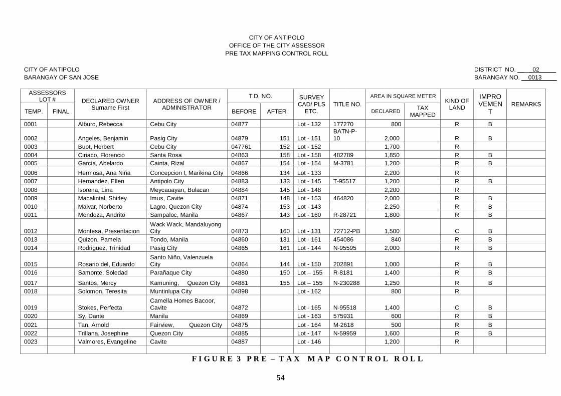
54
CITY OF ANTIPOLO
OFFICE OF THE CITY ASSESSOR
PRE TAX MAPPING CONTROL ROLL
CITY OF ANTIPOLO
DISTRICT NO. __ _02_____
BARANGAY OF SAN JOSE
BARANGAY NO. __0013 ____
ASSESSORS LOT # DECLARED OWNER
Surname First ADDRESS OF OWNER /
ADMINISTRATOR
T.D. NO. SURVEY CAD/ PLS
ETC. TITLE NO.
AREA IN SQUARE METER KIND OF
LAND
IMPROVEMEN
T REMARKS
TEMP. FINAL BEFORE AFTER DECLARED TAX
MAPPED
0001 Alburo, Rebecca Cebu City 04877 Lot - 132 177270 800 R B
0002 Angeles, Benjamin Pasig City 04879 151 Lot - 151 BATN-P-10 2,000 R B
0003 Buot, Herbert Cebu City 047761 152 Lot - 152 1,700 R
0004 Ciriaco, Florencio Santa Rosa 04863 158 Lot - 158 482789 1,850 R B
0005 Garcia, Abelardo Cainta, Rizal 04867 154 Lot - 154 M-3781 1,200 R B
0006 Hermosa, Ana Niña Concepcion I, Marikina City 04866 134 Lot - 133 2,200 R
0007 Hernandez, Ellen Antipolo City 04883 133 Lot - 145 T-95517 1,200 R B
0008 Isorena, Lina Meycauayan, Bulacan 04884 145 Lot - 148 2,200 R
0009 Macalintal, Shirley Imus, Cavite 04871 148 Lot - 153 464820 2,000 R B
0010 Malvar, Norberto Lagro, Quezon City 04874 153 Lot - 143 2,250 R B
0011 Mendoza, Andrito Sampaloc, Manila 04867 143 Lot - 160 R-28721 1,800 R B
0012 Montesa, Presentacion Wack Wack, Mandaluyong City 04873 160 Lot - 131 72712-PB 1,500 C B
0013 Quizon, Pamela Tondo, Manila 04860 131 Lot - 161 454086 840 R B
0014 Rodriguez, Trinidad Pasig City 04865 161 Lot - 144 N-95595 2,000 R B
0015 Rosario del, Eduardo Santo Niño, Valenzuela City 04864 144 Lot - 150 202891 1,000 R B
0016 Samonte, Soledad Parañaque City 04880 150 Lot – 155 R-8181 1,400 R B
0017 Santos, Mercy Kamuning, Quezon City 04881 155 Lot – 155 N-230288 1,250 R B
0018 Solomon, Teresita Muntinlupa City 04898 Lot - 162 800 R
0019 Stokes, Perfecta Camella Homes Bacoor, Cavite 04872 Lot - 165 N-95518 1,400 C B
0020 Sy, Dante Manila 04869 Lot - 163 575931 600 R B
0021 Tan, Arnold Fairview, Quezon City 04875 Lot - 164 M-2618 500 R B
0022 Trillana, Josephine Quezon City 04885 Lot - 147 N-59959 1,600 R B
0023 Valmores, Evangeline Cavite 04887 Lot - 146 1,200 R
F I G U R E 3 P R E – T A X M A P C O N T R O L R O L L

55
property identification. The procedure is called the preliminary tie-up. Required
for this process are inputs from the Pre-TMCR, the base map of the municipality or
of the individual barangays and, if available, the list of lot claimants which can be
secured from the Land Management Bureau or the Land Management Service. (See
Figure 7-A for a Barangay Base Map with assigned Temporary PINs on page 53).
The survey lot number and the necessary information for each FAAS reflected
in the Pre-TMCR shall be transferred to the base maps. The information includes;
the name of declarant, land areas as declared, a notation “T” for titled properties in
blue ink, and the 4-digit temporary property index number in red ink. Data from the
claimant‟s list may serve as an aid for purposes of validation and/or reconciliation
as to the name of the claimant and the area.
One of the important features of the Preliminary Tie-Up is the use of a technique
in identifying FAAS‟s (in the Pre-TMCR), which had already been linked with the
corresponding parcels. To tie-up a land parcel and its corresponding FAAS, a
check mark is made on the left side of the temporary PIN on the Pre-TMCR and
another on the base map. This signifies the preliminary tie-up done in the office.
This means that the ownership has to be verified during the field operation. If the
tie-up in the office is confirmed in the field thru an interview, then a second check
shall be marked on the right side of the temporary PIN in the Pre-TMCR.
It is always possible that not all prepared FAAS‟s can be tied-up with the
parcels in the base map. This requires actual verification in the field. It is also
possible that some parcels in the base maps may not be covered by tax declarations,
hence, undeclared by the owners, in which case, a new FAAS for each of these
parcels shall be prepared in the field after identifying the property.
e. The last step is the Preparation of the Work Plan and Schedule of Field Work -
In order to attain a maximum output and efficiency during the field operations, a
fieldwork program shall be prepared by the Chief of the Tax Mapping Division
together with the team leaders. The work program shall include points of
orientation, routes to be taken and the number of parcels to be covered in a given
period. The Chief Tax Mapper who shall accompany one crew daily on an alternate
basis can give supplementary instructions.
2. Field Operation Activities
a. Courtesy Call - Upon arrival in the field, and prior to the beginning of the work,
the Chief of the Tax Mapping Division together with all members of the team shall
confirm their arrival with the appropriate local officials. Crew members are
introduced to local officials so that they can be recognized as members of the
Assessor‟s staff. The Tax Mapping Division Chief as the team leader, should also
present and discuss the work plan and schedule with the local officials. He shall
requests for barangay guides and arranges a tentative schedule for periodic meetings
to keep them informed of work progress.

56
b. Final Briefing of Tax Mapping Team - It is important that before the tax mapping
team goes to the field, each member of the team shall receive instructions from the
assessor on his/her respective duties and responsibilities, as follows:
(1) Tax Mapper
(a) Leads the team in all phases of the operation
(b) Takes note of questions on boundaries and ownership of real properties
(c) Directs all mapping and information gathering activities
(d) Checks the Team‟s field accomplishment
(e) Takes custody of the Pre-TMCR and the FAAS‟s
(f) Responsible for assigning Temporary PIN
(g) Records all information necessary for appraisal and assessment of all real
properties
(2) Tax Mapping Aide
(a) Takes charge of the base maps
(b) Records the necessary information on the base maps (Temporary PIN, Title
(“T”), and check marks for properties tied up).
(c) Reflects partition or consolidation based on the approved plans from the Land
Management Bureau
(3) Barangay Guide
(a) Assists the team in identifying the ownership and property boundary lines
(b) Serves as liaison between the real property owners and the Tax Mapping Team
c. Field Work Activities
(1) Field interview with property owners or administrators
(2) Identification of property ownership
(3) Validation of property information based on approved plans
(4) Parcellary sketching in case of subdivision or consolidation
(5) Identification of conflicting areas/boundaries
(6) Final tie up of FAAS‟s in the PRE-TMCR with the tax mapped parcels on the
base map with red check mark on the right hand side of the Temporary PIN on
the PRE-TMCR
(7) Assignment of Temporary PIN in red ink on parcels on the base map. When
properly identified, a check mark is made to indicate that a pre-tie up has been
made and a “T” in blue ink indicates that the property is titled
(8) Determination of adjustment factors such as type of road, distance to all-weather
road, Poblacion, Market and Trading Centers

57
(9) For mixed classification such as agricultural and residential, the area for both
should total the area reflected on the base map
(10) New FAAS‟s shall be prepared for land declared for the first time
(11) Verify from the Bureau of Forestry whether the land is alienable and disposable
(12) Identification of buildings and other structures and/or machineries
constructed/installed on the land
Field activities should follow the work plan, but adjustments may be made
whenever necessary. These changes should be recorded in the daily
production/accomplishment report sheets and should be reported to the Tax
Mapping Division Chief.
The tax mapping team must familiarize themselves with the base maps, aerial
photos and original surveys. Combined with the method of inspection and
measurement, the team shall determine property boundary lines and corners. This is
done in close coordination with the owners or occupants of the properties. The
information gathered is verified from the base maps. Simultaneously, the team
completes the pre-TMCR and FAAS by recording in them the necessary
information relative to the property under survey. This process is repeated for
every parcel. For newly discovered property, a FAAS shall be prepared and a
temporary PIN next to the last temporary PIN in the Pre-TMCR is assigned.
d. Review of Field Work Accomplishment and Data Gathered – Following each
day's work, the tax mapping team leader examines the field work and identifies
those areas that need clarification. A partial checklist that may be used by the team
leader as a guide are as follows:
Has each team completed the assigned area?
Does each parcel contain a temporary PIN?
Are there gaps, or overlaps between assigned crew work areas?
Are there discrepancies found in barangay or municipal boundaries?
Is there a FAAS for each property?
Can clear accurate sketches be drawn from information gathered?
Are sketches north oriented?
Following a comprehensive review of all field work, the team leader makes the
decision as to whether or not the field operation has been successfully concluded.
If not, the teams shall be sent back to the area for the purpose of getting the specific
information that they have missed. Once the team leader feels certain that he has
secured sufficient information for the purpose of preparing tax maps and records,
the crew is ready to return to the Assessor's Office.

58
3. Post Field Operations
Upon returning from the field, the tax mapping operations enter into its final phase.
In this phase, the final tax maps are prepared, permanent property identification
numbers are assigned, land areas are calculated when necessary and the FAAS‟s are
completed.
The tax map shall be prepared from the validated base maps and/or parcellary
sketches done in the field. The size of the prescribed standard tax map is 35.5
centimeters by 50 centimeters (See Figure 1 on page 59 and Figure 1-A on page 60).
The size of the Index Maps should be the same as that of the Tax Map as they will be
bound together. The Index Maps shall be arranged in the following order: the
Provincial or City Index Maps followed by the Municipality Index Map (See Figure 4
for a typical Municipality Index Map on page 67), then the District Index Maps (See
Figure 5 for a typical District Index Map on page 68), the Barangay Index Maps (See
Figure 6 for a typical Barangay Index Map on page 66), then the section Index Map
(See Figure 8 for a typical Section Index Map on page 65), and lastly the Property

59

60

61
Identification Maps or Tax Map (See Figure 9 for a typical Property Identification Map
on page 69).
A. Activities
Sectioning - It is not ordinarily convenient to draw an entire barangay on one single
standard size of map. This inconvenience is caused by the input requirement of
presenting the information graphically to scale on the standard format as described
above. To avoid duplication of parcels, the section boundaries should be made to pass
along the property boundaries or along improvement lines if feasible. Sectioning of a
typical barangay is shown in Figure 8, illustrating how the standard size format is laid
over a typical barangay. Each Section is assigned a number, which is recorded on a
Section Index Map. (See Figure 8 for a typical Section Index Map on page 65).
The area covered by political boundary conflict shall be invariably indicated on the
barangay index map and shall be considered additional section/s of both barangays
claiming for it. Said section/s shall bear the last section index number/s of both
barangays. A status quo shall be observed for the issuance of the necessary assessment
records of real properties located in such barangays: the lots, buildings, machinery and
other improvements located within the conflict area shall continue to be listed in the
barangays where they are declared under the existing assessment records until the
conflict shall be settled.
(1) Drafting of Tax Maps - Field sketch information on the base maps shall be refined
and drawn in the appropriate section. The tracing must follow a standard as to weight
and types of lines, symbols and lettering. Information inscribed on the tax map shows
lot lines which represent property ownership boundaries and intersection of lot lines
which represent property owners. That area bounded on all sides represents a
separate land ownership. This process is repeated until each section has been
completely drawn to cover an entire barangay. Relevant information for adjoining
sections should be recorded to make sure that contiguous sections match.
(a) Standard Lines, Symbols and Lettering for use in Tax Maps. Tax maps are the
foundation of the assessor's record system and provide the description for the
assessments of all parcels of real property for taxation purposes. The maps
therefore should be neat, consistent and uniform in all designation.
i. The standard and uniform line designations shall be used for all property lines
and the standard set forth in the standard symbols as shown in Figure 2 shall be
consistently used (See Figure 2 for conventional symbols that an Assessor may
use on page 62).
ii. The standard lettering guides shall be used so that uniformity for the entire
country map system can be maintained.
(b) Use of Standard Designation for Political Boundaries. - Political boundaries
shall be shown on the map by standard designation.
i. Boundary lines for streets or roads shall be indicated along the center line of the
street or road.

62

63
ii. Boundary lines for river shall be indicated along the center line of the river.
iii. Boundary lines that fall along property lines shall be shown by a standard
symbol.
iv. Boundary Definition - All political boundaries within the province or city must
be definite and positively identified for they are the very foundation of the
property identification numbering system described.
Barangay boundaries in rural areas are generally defined by former barrio
boundaries. However, in the poblacion and other more urbanized areas, the new
barangay boundaries may not have been identified. These are the kind of
changes, which should be physically verified and charted before full tax
mapping operation is done in the field.
(c) Boundary Disputes
i. Boundary disputes involving two (2) or more barangays in the same city or
municipality shall be referred for settlement to the Sangguniang Panlungsod or
Sangguniang Bayan concerned.
ii. Boundary disputes involving two (2) or more municipalities within the same
province shall be referred for settlement to the Sangguniang Panglalawigan
concerned.
iii. Boundary disputes involving municipalities or component cities of different
provinces shall be jointly referred for settlement to the Sanggunians of the
provinces concerned.
iv. Boundary disputes involving a component city or municipality on the one hand
and a highly urbanized city or two (2) or more highly urbanized cities, on the
other hand, shall be jointly referred for settlement to the respective sanggunians
of the parties concerned.
v. Corollary thereto, concerned officials of all local political subdivisions of the
province/city/municipality should be informed on the steps necessary to resolve
boundary conflicts and the Provincial, City or Municipal Assessor concerned
should make strong representations for the reconciliation and resolution of such
conflicts at the earliest time possible.
In cases where questions on political boundary are resolved under this
authority, officials are encouraged to set boundaries along easily identifiable
existing natural or man-made land divisions (river courses, road-ways, etc.).
Further, insofar as possible, attempts should be made to set boundaries to
coincide with property lines that are contiguous to political boundaries.
vi. Unresolved Political Boundary Disputes. - The tax mapping operations
should proceed despite political boundary conflicts; however, the contested
areas shall be clearly defined in the final tax maps.

64
(2) Final Parcel Numbering on Tax Map. - After all the parcels have been drawn in the
section map, each separate parcel shall be assigned a 2-digit number. The City
Districts shall be numbered beginning with "01" from the left uppermost district,
thence moving from left to right, then down, and right to left, following an inverted
Figure 8 “S” pattern, repeating the left-right-down, right-left-down process until all
districts within the city have been numbered.
(3) Inscription of Permanent Property Identification Number on FAAS - After the
permanent property identification number has been assigned to each parcel, this
number shall be inscribed on the appropriate space of the corresponding FAAS.
Recording of the permanent PIN on the FAAS completes the final tying together of
the official records with the real property in the field.
(4) Drafting the Index Maps - After the completion of the tax maps, index maps shall
be prepared. These maps are important because they facilitate ready reference in
locating a particular tax map for a city or municipality. It also provides key
identification and control of all lands within the province, city or municipality, as
well as, district and barangay. The order of preparation of these maps is as follows:
(a) Section Index Maps - After the tax maps have been prepared, the section
index map of every barangay shall be prepared by consolidating all tax maps
comprising a barangay, showing therein the boundary lines of the section with its
corresponding index number. Since the size of the index map is the same as that of
the tax map, it is necessary that a larger scale be used (See Figure 8 for a typical
Section Index Map on page 65).
(b) Barangay Index Map - The Barangay Index Map is developed by
consolidating all section index maps. This map shows the boundary lines of each
barangay with its corresponding barangay index number. This map shall be drawn in
a standard map size. (See Figure 6 for a typical Barangay Index Map on page 66)
(c) Municipality Index Map or City District Index Map - These maps shall be
prepared by consolidating the barangay index maps. This map shows the boundary
lines of each municipality in the case of province, and district/barangay boundary
lines in the case of a city or municipality of MMA, both with its corresponding
municipality/district/barangay index number. The map size shall be the same as that
of the tax map. (See Figure 4 on page 67 for a typical Municipality Index Map and
Figure 5 for a typical City District Index Map on page 68).
(5) Preparation of the Tax Map Control Roll - A Post Tax Map Control Roll (TMCR)
shall be prepared for every tax map, based on the information entered in the pre-
TMCR accomplished by the field crew during the field operation. The parcel entries
are now arranged consecutively by PIN, entering parcel number 01 on the first line of
the control roll, unlike in the Pre-TMCR where the parcel entries are arranged in
alphabetical order of the names of the landowners in the barangay. The prescribed
standard format of the post-TMCR is shown in Figure 10. Since this control roll
shall be attached to the corresponding Tax map, it becomes necessary that its size
shall be the same as that of the standard tax map. Entries in the roll shall be under the
direct supervision of the Chief, Tax Mapping Division. The necessary number of
copies shall be made corresponding to the number of tax map prints. (See Figure 9 for
a typical Tax Map on page 69 and Figure 10 the for corresponding Post-TMCR on
page 70).

65

66

67

68

69

70
TAX MAP CONTROL ROLL Prov./City ___ANTIPOLO_______ (Index No. __177_) Mun./District: ______II_________ (Index No. __ 02__)
Barangay: ____SAN JOSE_________ (Index No.: ___0013____) Section Index No. ______003_______
ASSESSOR‟S
LOT NO. SURVEY LOT NO.
LAND NAME OF OWNER
(SURNAME, GIVEN NAME, M.I.) ARP NO. TD NO.
BLDG. /
STRUCTURE MACHINERY OTHER REMARKS
TITLE NO. AREA CLSS. CODE
01 PSD-1629 N-128177 3,863.0 R DE JESUS ANCLOTE REALTY
MGT. CORP. AA-002- 01428 AA-002- 01428 0 0
02 PSU-1629 N-3718 4,179.0 R REGINO, CEZSR & ROSALINDA AA-002-01429 AA-002-01429 1 0
03 (LRC) PSD-45614 371678 2,910.0 CEMETERY ONGSIAKO, PIERRE GALLEGO AA-002-01431 AA-002-01431 0 0
04 (LRC) PSD-45614 90.0 ROAD DE GALLEGO, CARIDAD AA-002-01432 AA-002-01432 0 0
05 PSD-45614 96.0 ROAD DE GALLEGO, CARIDAD AA-002-01433 AA-002-01433 0 0
06 (LRC) PSD-45614 353719 3,384.0 R MARQUEZ, FEDERICO &
MARIA CALUDIA A SPS AA-002-01434 AA-002-01434 0 0
07 PSD-04-006558 N-84406 562.0 R OLAYVAR, RAYMUNDO AA-002-01435 AA-002-01435 1 0
08 PSD-04-006558 181780 650.0 R GATLABAYAN, JOVITO C. AA-002-22466 AA-002-22466
1 0
09 PSD-04-006558 N-84407 250.0 R BUSTE, MANUEL J. AA-002-01439 AA-002-01439 0 0
10 PSD-04-006558 343975 250.0 R LICO, YOLANDA AA-002-01440 AA-002-01440 0 0
11 PSD-04-006558 N-84484 1,692.0 R LICO, DEMETRIO AA-002-01441 AA-002-01441 0 0
12 (LRC) PSD-04-
006558 292.0 ROAD DELOS REYES, VICTOR AA-002-01442 AA-002-01442 0 0
13 PSU-156417
177162 1,000.0 R SISON, RAMON AA-002-01446 AA-002-01446 1 0
14
PSU-04-002429
OCT N-P-7
601.0
R
SERRATO, FELIXBERTO
AA-002-01448
AA-002-01448
2
0
15
PSU-04-002337
160.0
R
CRISOSTOMO & LICO,
GAUDENCIO & IRENE
AA-002-01451
AA-002-01451
1
0
16
PSD-80344
R-18610
102.0
R
LINDO ET AL, ELSA A.
AA-002-23136
AA-002-23136
1
0
17
PSD-80344
172602-PA+
69.0
ROAD
LINDO, CATALINO
AA-002-01454
AA-002-01454
0
0
18
(LRA) PCN-1589
R-9292
4.702.0
C
CAMINA, EDGARDO
AA-002-23473
AA-002-23473
2
0
FIGURE 10. ACCOMPLISHED TAX MAP CONTROL ROLL
(the size should be the same as the size of a tax map)

71
(6) Calculation of Land Area - The final phase in the tax mapping operation is to calculate
the area of the parcel of land by geometric formulas, or by mechanical measure (planimeter
or other devices). When this information has been recorded on the FAAS, it shall be
forwarded to the assessment operation division or unit for purposes of appraisal and
assessment.
The sum total of the land areas of newly created parcels must be equal to the land area
of the original parcel(s) in cases where the area changes as in a subdivision or consolidation
of lots.
(7) Public Rights of Way - Public rights-of-way must also be accounted for on a land area
basis. As public rights-of-way increase, the volume of land area ownership must decrease
accordingly, and vice-versa. By maintaining an accurate accounting of streets or roads, the
same shall be considered as one parcel of land with an assigned parcel number within a
section.
Roads/streets shall be categorized as national, provincial, city, municipal or barangay
road. Each contiguous road/street of the same category shall be considered as one parcel
within a section. The road should be shown by standard designation, and road/street name
should be inscribed.
(8) Map Care and Storage - Considering that the province, city or municipality has made
substantial capital investments in the preparation of tax maps, it is necessary to protect tax
maps and/or aerial photographs. The best method of preserving and protecting original tax
maps from damage is to print several copies after the tax maps have been completed. The
original copy of the tax map should never be removed from the assessor‟s office except for
the purpose of making prints or accomplishing their comprehensive revision. Only when a
tax map section has been the subject of numerous changes (subdivisions, consolidation or
changes of area due to natural phenomenon) rendering the data illegible or not discernible,
necessitating the use of a smaller scale, should a tax map master be revised. Two complete
books of tax maps prints shall be prepared for the use of the Assessor's Office. These tax
map books shall be kept in the Tax Mapping Division and their use are as follows:
(a) One Tax Map Book is to be used exclusively for the purpose of cross- referencing
information from other information sources, such as cadastral lot numbers, benchmark
locations, existing monuments, etc. Under no circumstances should this information be
inscribed on tax map masters. Tax maps must be kept as clear as possible for the purpose of
rapid and accurate reading through the elimination of as much extraneous information
clutter as possible. Cadastral and similar information should be charted or kept on a
separate set of prints provided for this purpose and not on the tax map masters.
(b) The second book is to be used exclusively to record changes in land areas by inscribing
the new property ownership boundaries as they occur. They may be best described as the
"working" tax maps. It is this volume that is used by the Assessor's Office when dealing
with the public on matters requiring map reference. It is in observing the condition of these
prints that the decision is made when to revise or redraw the tax map master. Following
the revision or reconstruction of the tax map master, the appropriate number of prints
should be made and distributed, and the resulting new tax map master must be filed.

72
The set of tax map prints together with the post tax map control roll (TMCR) covering the
whole municipality or city shall be loosely bound in book form arranged in the following
order:
i. Municipality/District Index Map
ii. Barangay Index Map of the Municipality/District
iii. Section Index Map of the first Barangay
iv. Post Tax Map Control Roll of the 1st Section of the first Barangay
v. Tax Map (1st Section) of the first Barangay
vi. Post TMCR of 2nd Section
vii. Tax Map (2nd Section) of the same Barangay
The arrangement shall be made (steps iv-vii) up to the last section of the last
barangay in the municipality/city.
The set of original tax maps (in transparency sheet) together with the original TMCR shall
be arranged in similar manner, in loose leaves and securely filed in a map cabinet.
(9) Tax Map Maintenance - The Tax Mapping Division is responsible for the maintenance
of the tax maps and for the preservation of the integrity of the identification numbering
system. Tax map maintenance is defined as the technical revision of the tax map
document, as differentiated from the care and storage of tax maps.
(a) System Elements Affected by Change. - Any one or all of the following assessment
record forms may be affected by changes in ownership, value, or land area:
i. Tax Map including Tax Map Control Roll (TM and TMCR)
ii. Property Identification Number (PIN)
iii. Tax Declaration (TD)
iv. Assessment Roll (AR)
v. Real Property Field Appraisal and Assessment Sheet (FAAS)
vi. Property Ownership Card (POC)
vii. Tax Collection Record
The Tax Mapping Division is responsible for recording changes in the first two (2)
assessment record forms mentioned above. Changes affecting the other official records
are the responsibility of other divisions. Revision of tax maps and the property
identification numbering system occur as the result of changes in land area only.
(b) Changes in Land Area - There are four (4) kinds of land area changes which can
possibly occur; they are the subdivision of land (the division of land into smaller
ownerships); consolidation (combining two or more parcels thereby creating one large
single ownership); natural physical phenomenon such as shifting of river courses; and
road and irrigation canal construction, etc. These land changes require revision of
property identification number and sometimes revision of tax maps. All such changes

73
shall be reflected in new FAAS‟s which shall be referred to the Tax Mapping Division
and become the instrument which initiates appropriate action.
(c) Property Index Numbering in cases of Parcel Subdivision or Consolidation - In
case of a land subdivision, the PIN of the original parcel shall be retired while the newly
created lots shall be assigned consecutive numbers beginning with the number following
the highest parcel number in the section. These are then inscribed on the tax map and
indicated in the new FAAS‟s and the corresponding tax declarations are prepared for each
separate parcel. This completes the tie-up between parcel and tax declaration.
Likewise, in cases of consolidation of two or more existing parcels into a single
ownership, the PIN of the parcels affected shall be retired and the resulting single parcel
shall be assigned with a number following the highest parcel number in the section.
The practice of retiring index numbers for subdivided or consolidated parcels
provides a historical physical and ownership changes of the parcels involved.
E. Miscellaneous Provisions in Tax Mapping Operations
1. Tax Mapping Operations constitute the first of the several inter-related operations that must
be undertaken in order to install a Real Property Tax Administration (RPTA) System.
However, before the initial phase of tax mapping operations begins, it is necessary that
certain pre-requisite conditions shall be complied with.
2. When a particular parcel in a tax map is subdivided into numerous lots and if sketched
becomes too small for the inscription of data or the required data is no longer discernible
when inscribed, the subject subdivision shall be drawn on a separate section and the parcels
shall be numbered accordingly. This section forms an additional tax map of the barangay
and shall be given a section number next to the last section in the barangay. Proper notation
shall be made on the original parcel.
3. No enlargement of parcel arising from consolidation etc. shall be reflected in the map
master. The draftsmen should always see to it that the scale used shall allow for necessary
information/data to be conveniently inscribed on the map in cases of changes in area due to
subdivisions, consolidation etc.
4. The revision of tax map(s) shall be made either after the end of the year or during general
revision of property assessments. Revision of a tax map refers to the assigning of new
numbers to parcels within an individual tax map or section, barangay, or district maps.
An individual tax map shall be revised when about 50% of the parcels had been affected
due to subdivision etc. and apparently making the parcel numbers cluttered or no longer
discernible.

74
In the case of a real property whose owner is not known, the name of the actual
occupant shall be indicated on the line provided for "Administrator" which shall be
superimposed by the word "Occupant" including the address in order that any notice
regarding the said property shall be sent thru the occupant.
A road or an irrigation canal, which still appears to be owned by the registered owner
and which traverses a parcel of land, the boundaries of which are shown by designated lines,
shall be considered a separate parcel.
However, if the property owner insists in writing that the affected area be recorded as
part of the said parcel, the same shall not be deducted from the area of such land. It shall
remain an integral part of the land and still considered as one parcel.
5. When an easement the use of which is restricted by the declared owner, is granted over or
through a parcel of land and annotated in the title certificate, the boundaries shall be drawn
in standard lines. Thus, the same shall be considered a separate parcel.
6. In cases where a parcel of land traversed by barangay boundary line within a municipality
or city, the portion that has a bigger area will bear the PIN of the subject parcel of land,
provided, however, that an annotation shall be made as illustrated hereunder:
Barangay Area Assessed Value
"A" 5,000 sq.m. P1,000,000
"B" 3,000 sq.m. 600,000
7. Two or more contiguous parcels of land owned by a single owner may be considered as one
parcel if the property owner insists/requests in writing to declare the same as one
assessment for real property taxation purposes.
8. The extent of railroad track, which shall be an enclosed figure shall be considered as one
parcel of land in every tax map.
9. A building that is standing on two or more lots will bear the PIN of the lot where the area
occupied by the building is larger.
10. The portions of a parcel of land that is traversed by a municipal or city boundary line shall
constitute separate parcels in the LGUs where they are located.
11. Adjacent boundaries such as section number, lot number and lines within a municipality or
city shall be indicated on the tax map and be shown by its standard designation and
lettering.

75
12. The boundary lines and names of adjoining local government unit shall be indicated in the
tax map and shown by its standard designation and lettering (refer to Figure 2 for the
common symbols used on page 62).
13. When the mineral rights to a parcel of land is in the name of a person other the one with that
of the surface right, the surface right shall possess the PIN of such parcel of land and the
mineral right shall bear the PIN of the surface right and a four (4) – digit number starting
with “3” (as 3001) will be added to it.
14. Where the tax map is not yet installed in an LGU, the identification for real property units
(RPUs) shall be through the transactions, where each RPU within the barangay in a
municipality must be distinctly marked.
a. The marking shall correspond to the numbering of the daily transactions Assessment of
Real Property Number (ARPN) assigned to the FAAs and the corresponding tax
declaration of the RPU, the number shall be as follows:
(1) In case of a province:
01-0000-00000
01 - refers to the 1st municipality after all the municipalities in the province shall
have been arranged alphabetically and consequently numbered
chronologically.
0000 - refers to the designated number of the barangay which should also be
arranged alphabetically before they are numbered chronologically. However,
Barangay Poblacion should always be assigned the number "0001" and
followed thereafter by the first barangay as arranged.
00000 - refers to the series/number of daily assessment/reassessment transactions
consecutively numbered starting with “00001” for the first transaction at the
start of the General Revision of Assessments of Real Property until the last
transaction and shall again start with 00001 when a General Revision of
Assessment of Real Property (GRARP) shall be undertaken.
(2) In case of a city:
01-0000-00000
01 - refers to the district number after all the districts within the city shall have
been assigned their respective number.
0000 - refers to the designated number of barangay which should also be arranged
alphabetically before they are numbered chronologically. However, Barangay
Poblacion should always be assigned the number "0001"and thereafter
followed by the first barangay as arranged.

76
00000 - refers to the series/number of daily assessment/reassessment transactions
numbered consecutively starting with “00001” for the first transaction of the General
Revision of the Assessments of Real Property until the last transaction and start again
when succeeding General Revision of Assessment of Real Property (GRARP) shall be
undertaken.
15. The entire office support operation as it relates to the real property tax administration
program of the LGU must be specifically budgeted in order that needed items shall be on
hand and ready for use when needed. The following are the items that will be needed and
for which the LGU budget should make special provisions:
Drafting tables with adjustable tops
Drafting tables
Tracing tables
Large map tables
Desk and Chairs
Map filing cabinets
Filing cabinets
Light tables
Standard drafting and mapping instruments:
Drafting Machine
Pantograph
Planimeter
Scales (metric)
Drafting Sets
Lettering sets
Triangles
T-squares
Straight Edge
Standard drafting and mapping supplies:
Tracing Paper
Drafting Film
Ink
Erasers
Etc.
Forms: (Sufficient quantities)
FAAS
Tax Mapped Control Roll
Property Record Form
Property Ownership Card
Tax Declaration
Real Property Tax Order of Payment
The goal of the foregoing is to provide adequate tools, equipment and supplies for
each draftsman and technician in order that tax-mapping work may be expedited.

77
CHAPTER III
GENERAL REVISION OF REAL PROPERTY ASSESSMENTS AND
PREPARATION OF THE SCHEDULE OF FAIR MARKET VALUES
SECTION 1. – General Revision of Assessments and Property Classification
The Provincial, City or Municipal Assessor shall undertake a general revision of real property
assessments once every three (3) years, which shall commence upon the enactment of the Schedule
of Fair Market Values (SFMV) into an ordinance by the sanggunian concerned.
For this purpose, the Provincial Assessors, the City Assessors and the Municipal Assessors of
the Metropolitan Manila Area shall prepare the Schedule of Fair Market Values for the different
kinds and classes of real property within the territorial jurisdiction of the province, city or
municipality in accordance with this manual.
In the case of the Metro-Manila Area, the assessor of each assessment district shall meet,
discuss and harmonize their respective Schedules of Fair Market Values.
However, if there is no sufficient time or resources to complete the general revision work for all
real property units (RPUs) within the territorial jurisdiction of a particular local government unit, a
partial revision may be undertaken by kind or class of real property.
For example:
a. By Kind:
1st year - All Lands
2nd
year - All other real properties
b. By Class:
1st year - All Commercial and Industrial Properties
2nd
year - All Other Classes of Properties
A. Purposes of the General Revision of Real Property Assessments
1. A general revision of real property assessments serves two important purposes in addition to
its primary purpose of equalizing and updating valuation as follows:
a. The real properties that have been “lost” from the tax rolls are rediscovered and
b. It enables the assessor to purge the rolls of the double assessments of properties that have
accumulated through the years. It has the same purpose as the periodic physical inventory
conducted by a business establishment.

78
A general revision of real property assessments shall be considered completed after all the
field work in the municipality, province or city have been completed and corresponding Field
Appraisal and Assessment Sheets (FAAS‟s) of all properties have been prepared and duly
approved; and the data recorded in the records of assessments. Subsequently, written notices
of revised assessments shall be sent to real property owners.
Appraisal/Assessment Calendar - For the purpose of the general revision of real property
assessments the appraisal and assessment process and its component activities shall be governed by
the calendar herein prescribed, as follows:
ACTIVITY
LGU Official(s)
Responsible
PERIOD
1. Acceptance of sworn
statements declaring the
true values of real property
to be filed by real property owners/administrators.
The Provincial and City
Assessor and Municipal
Assessors of the
municipalities within the
Metro Manila Area.
Jan. 1 to June 30 of
the first year.
2. Analysis of data that have
been gathered and
preparation of the
preliminary Schedule of Fair Market Values.
The Provincial and City
Assessor and Municipal
Assessors of municipalities
within the Metro Manila
Area.
July 1 to September
30 of the first year.
3. Preparation of final
Schedules of Fair Market
Values
The Provincial and City
Assessor and Municipal
Assessors of municipalities
within the Metro Manila.
Not later than
October 15 of the
first year
4. Submission of the Schedule
of Fair Market Values to
the Sanggunian concerned
and conduct of public hearings.
The Provincial and City
Assessors and Municipal
Assessors of municipalities
within the Metropolitan
Manila Area
Not later than
October 30 of the
first year
5. Enactment of Ordinance
adopting the Schedules of Fair Market Values
The Sangguniang
Panlalawigan or
Panglungsod or
Sangguniang Bayan
concerned.
Not later than
January 31 of the
second year.
6. Publication of the
Schedules in a newspaper
of general circulation in the
locality or posting in the
Provincial Capitol, City or
Municipal Hall and in two
other conspicuous public places.
The Provincial and City
Assessors and Municipal
Assessors of municipalities
within the Metro Manila
Area
Not later than
February 28 of the
second year.

79
7. Preparation of Field
Appraisal and Assessment
Sheets, Tax Declarations
and Notices of Assessment
and mailing or delivering of
said notices to property owners.
The Provincial and City
Assessor and Municipal
Assessors of municipalities
the within Metro Manila
Area
Not later than
September 31 of the
second year.
8. Preparation of Assessment
Rolls and the copies thereof
sent to Provincial, City and Municipal Treasurers.
Provincial and City
Assessors and Municipal
Assessors of municipalities
within the Metro Manila
Area
Not later than
November 30 of the
second year.
9. Effectivity of the revised Real Property Assessments.
Provincial, City or
Municipal Assessors
Not later than
January 1st of the
third year.
SECTION 2 – General Valuation Concepts and Principles
This Section discusses the various concepts and principles on land and property valuation.
These concepts and principles are generally or internationally accepted and recognized by
appraisers and assessors throughout the world. It is important that assessors and appraisers have
common understanding of the fundamentals that underpin the valuation discipline for uniformity
and consistency in the valuation practice.
A. Land and Property Concept
1. Land is one of the major factors of production which is supplied by nature without the aid of
man. Land may include not only the earth surface, both land and water, but also anything that
is attached to the earth‟s surface, including all natural resources in their original state, such as
mineral deposits, wildlife, and timber.
2. Valuation of land as if vacant or of land and improvements on the land or for the benefit of
the land is an economic concept. Whether vacant or improved, land is also referred to as real
estate. Value is created by the real estate‟s utility, or capacity to satisfy the needs and wants of
human societies. Contributing to its value are the real estate‟s general uniqueness, durability,
potential, features of location, relatively limited supply, and the specific usefulness of a given
site.
3. All appraisals are concerned with property. Property refers to the inherent rights of ownership
and future benefits of tangible and intangible assets and is taken to mean any right or interest
reflecting a source or attribute of wealth. The word property, used without further
qualifications, may refer to real property, personal property; or other types of property such as
businesses and financial interests, or a combination thereof. Personal property pertains to
movable physical assets. Anything that is not part of real estate is personal property. Realty
consists of land and all improvements on and to the land. This term is synonymous with real
estate. Real property consists of rights in realty.

80
4. The distinction between real property (rights in realty) and realty (the physical thing) is
significant, in that it is the real property rights that are transferred and valued in the market
and not the real estate.
5. The basic rights of private ownership of property include possession, control, enjoyment,
disposition or use, exclusion, plus the right not to exercise any of the above rights. The term
used to describe the full set of private ownership rights is “bundle”. The “bundle of rights
theory” states that these rights are both divisible and separable, i.e. they may be exchanged in
whole or in part. In every appraisal, it is necessary to identify what rights, or what part of the
total bundle, are appraised, i.e., which property rights are to be appraised.
B. Concept of Market Value
Market value is not determined, it is estimated. It is estimated through the application of
valuation methods and procedures that reflect the nature of the property and the circumstances
under which the given property would most likely trade in the (open) market. The most
common methods used to estimate Market Value include the cost approach, market data/sales
comparison approach, and the income capitalization approach, including discounted cash flow
analysis.
1. Value exists when an item of property has utility, is relatively scarce, arouses the desire of
potential buyer to buy and is backed by purchasing power. Value is an economic concept
referring to the amount most likely to be agreed upon by buyers and sellers in an open
market transaction. The economic concept of value reflects the market‟s view of the
benefits that accrue to one who owns the goods or receives the services as of the effective
date of valuation.
2. There are many types of value. In valuing property, it is of utmost importance that the
appraisers and the assessors use the type of value appropriate in the particular appraisal
engagement. Any change in the type and definition of the value can have material effect on
the conclusion of value assigned to property for the specific purpose. For real estate
appraisal the most common type of value is market value.
3. Market value is the estimated amount for which a property should exchange on the date of
valuation between a willing buyer and a willing seller in an arm‟s length transaction (a
transaction between independent, unrelated parties involving no irregularity) after proper
marketing wherein the parties had each acted knowledgeably, prudently, and without
compulsion.
4. The concept of market value reflects the collective actions and reactions of buyers and
sellers in a typical open market. It is usually the basis for valuing real estate property
particularly for taxation purposes.
5. Market value may also be expressed as the amount at which ownership of the appraised
property might be justified by a prudent investor or alternatively as the present worth of
future benefits of ownership. Implicit in this definition is the consummation of a sale as of a
specified date and the passing of title from seller to buyer under conditions whereby:

81
a. Buyer and seller are typically motivated
b. Both parties are well-informed or well-advised and each is acting in what he considers
his own best interest.
c. A reasonable time is allowed for exposure in the open market
d. Payment is made in cash or its equivalent
e. Financing if any, is on terms generally available in the relevant market place at the
specified date and is typical for the type of property in its market.
f. The price represents a normal consideration for the property sold, unaffected by special
financing amounts or terms, services, fees, costs or credits incurred in the transactions.
6. It is important to emphasize that market value is an objective estimate of the identified
rights of ownership under the Bundle of Rights Theory and as of the specific date of
appraisal. It is a market-supported estimate developed in accordance with the Philippine
Valuation Standards
C. Forces Influencing Value
1. Social Forces
a. Population growth and decline
b. Shift in population density
c. Changes in family size
d. Attitudes toward education and social activities
e. Attitudes toward architectural design and utility
f. Other factors emerging from human social instincts, ideas and yearning
2. Economic Forces
a. Natural resources- quantity, quality, location, rate of depletion
b. Commercial and industrial trends
c. Employment trends and wage levels
d. Availability of money and credit
e. Price level interest rates, tax burdens
f. Other factors affecting purchasing power
3. Governmental or Political Forces
a. Zoning Laws
b. Building Codes
c. Police and fire regulations
d. Rent controls, special use permits, credit control
e. Government sponsored housing and guaranteed mortgage loans
f. Monetary policies affecting free use of real estate including taxation

82
4. Physical or Environmental Forces
a. Climate
b. Soil fertility
c. Mineral resources
d. Community factors – transportation, proximity of schools, churches, parks and recreation
areas.
e. Flood control and soil conservation
f. Soil characteristics (subsoil)
D. Economic Principles Relating to the Market Value
These economic principles, which have evolved from economic doctrine, are generally
accepted as having direct effect on the concept of market value. It must be emphasized that
these principles can rarely, if ever, be considered in isolation. It is typical to use these
principles in an interrelated manner since they accompany one another.
1. Principle of Supply and Demand – value is determined by the interaction of the forces of
supply and demand in the appropriate market as of the date of appraisal
2. Principle of Highest and Best Use – it is the use from among all reasonable, probable, and
legal uses that is found to be physically possible, appropriately justified, and financially
feasible and which results in the maximum property value.
3. Principle of Substitution – states that a prudent purchaser would pay no more for a
property than the cost of acquiring an equally desirable substitute in the market. Substitution
may take the form of:
- Acquiring an existing property with the same utility (basis for the market approach), or
- Producing a substitute property with the same utility (basis for the cost approach), or
- Acquiring investment which will produce an income stream of the same size with the
same risk (basis for the income approach)
4. Principle of Contribution – the value of an agent in production or a component of a
property depends on how much it contributes to the whole, or how much its absence
detracts from the value of the whole.
5. Principle of Competition – holds that profit tends to breed competition and excess profit
tends to ruinous competition.

83
6. Principle of Increasing and Decreasing Returns – when successive increments of one or
more factors in production are added to a fixed amount of the factors, there is a resulting
enhancement in income up to a point of maximum returns. Any incremental addition
thereafter results in a diminishment of income.
7. Principle of Balance - balance among the factors of production is achieved at the point of
diminishing returns, which is the point of maximum value.
8. Principle of Change – change is inevitable and constantly occurring
9. Principle of Anticipation – value is created by the expectations of benefits to be derived in
the future. Value is dependent on the future, not the past: Past experience is useful for
indications of future trends and conditions that it may provide.
10. Principle of Conformity – maximum value is realized when a reasonable degree of
homogeneity and compatibility is present. Over improvement, under improvement or
misplaced improvement may be reasonable for non-conformity within a property or its
environment. This principle works in conjunction with:
Progression – between dissimilar properties of the same type, the value of the lesser
property is enhanced by the presence of the superior.
Regression – between dissimilar properties of the same type, value of superior property is
affected adversely by the presence of the inferior.
SECTION 3. – Approaches to Value as used in Mass Appraisal
A. The Cost Approach
The cost approach is based on the proposition that, an informed purchaser would pay no
more for a property than the cost of producing a substitute property with the same utility as the
subject property.
The starting point of the cost approach is the assembly of property facts in an appraisal
inventory and the accumulation of cost data in the price governing factors. These are combined
in the cost estimating process to develop a reproduction cost new (RCN) or cost of replacement
(COR).
Reproduction Cost New (RCN) is the cost of producing or constructing the property in
like kind at current prices using the same materials, construction or manufacturing
standards, design layout, and quality of workmanship.

84
Cost of Replacement (COR) is the cost of producing or constructing a property of
equivalent utility at current prices using modern materials according to modern standards,
design and layout.
Inherent in the total RCN and COR are direct and indirect costs. The combination
of these two cost components is a required consideration to appropriately reflect property in
use.
Direct costs are all element costs which are directly incurred in the purchasing and
placing of the property unit in use.
Indirect costs are all element costs which are incurred, but not directly assignable to
the placing of the property unit in use.
1. Estimating RCN and COR
a. Although numerous alternative cost-estimating methods are available to develop cost of
reproduction new, four particular approaches are most commonly employed: 1) the quantity
survey method, 2) the unit-in-place method, 3) the index method, and 4) the comparative
method.
(1) The Quantity Survey method – In this method, the computation is made of the quantity and
quality of all materials used and of all categories of labor hours required, to which unit cost
figures are applied to arrive at a total cost estimate for materials and labor. To this,
estimates are added for architectural and engineering design fees, licenses and fees and
contractors- overhead, profits and fees.
(2) The Unit-in-Place method – In this method, the unit costs for various property components
are developed, using workable units such as the square meter, linear meter, or other
appropriate basic unit of measurement, and applied to recorded unit quantities.
(3) The Index Method – In this method, the cost is estimated by applying an adjustment factor,
determined from a pertinent index, to original cost. This is sometimes referred to as trending
method. An index is a mechanism for showing the relative changes in the price or cost of
specific items or groups of items over a period of time.
(4) The Comparative Method – In this method, the cost is estimated from known construction
cost of similar property expressed in terms of units of size or capacity (e.g. per square meter
of floor area).
2. Development of Value
The cost approach considers that the maximum value of a property to a knowledgeable and
prudent investor would be the amount required to erect or construct a new facility of equal
utility. Because the subject property is not new, it is necessary to reduce the current cost new
for physical deterioration and functional and economic obsolescence attributed to the property
at the date of appraisal.

85
From the standpoint of sound appraisal theory, the Reproduction Cost New (RCN) is
usually the first step in the application of the cost approach. However, the development of the
RCN is warranted only if that is the most practical and economical approach which would be
undertaken by the prudent investor. If reproduction is not physically possible because specific
materials of construction are no longer available or not technically feasible due to advances in
the state of the art within the industry, the proper basis becomes the cost of replacement.
It is important to note that utilizing the replacement approach automatically eliminates the
excess capital cost of the existing facilities, which is a measure of one form of functional
obsolescence existing within the property. These penalties reflect the loss in value as compared
to the potential value of the property if it were new and unused.
3. Other Land Improvements (OLI)
a. The cost approach uses actual costs for estimating the OLI suitable to support an
improvement. These costs are added to the value of the land to provide an estimate of value
for the residential lot. This approach requires extensive cost data gathering. Contractors and
property owners are contacted to provide actual costs of developing the residential lots.
Major items of cost are:
Site preparation Property Wall / Fencing
Filling Roadway Development
Land Retaining Walls Gravel / sealed driveways
Landscaping
b. Costs involved in estimating OLI can be obtained from contractors working in the area who
perform the various types of work involved. It would be of help to keep a list of these
contractors in a file so they can be contacted yearly to update the cost data.
c. All costs of developing a residential lot must be included in the valuation study. Inaccurate
estimates of residential lots development value will result in an incorrect land value. These
incorrect values will be carried forward and will distort improvement value residuals for the
benchmarks and create inaccurate conclusions on building depreciation.
d. Depreciation is loss in value brought about by physical deterioration or wear and tear,
functional obsolescence and economic obsolescence.
(1) Physical Deterioration is the loss in value resulting from wear and tear in operation and
exposure to the elements.
(2) Functional Obsolescence is the loss in value within the property as a result of the
development of new technology. This includes such things as changes in design, materials,
or process resulting in overcapacity, inadequacy, excess construction, lack of utility or
excess variable operating costs.

86
(3) Economic (or Environmental) Obsolescence is the loss in value resulting from influences
external to the property itself. Economic obsolescence may be the result of a number of
causes such as changes in the local economy, including shifting property use pattern, legal
changes, including legislation ordinances, zoning and administrative orders, and the
encroachment of objectionable influences.
It should be noted that at any given point in time, anyone of the elements of physical
deterioration, or functional or economic obsolescence can be considered either “curable or
incurable”. Curable conditions are those which can be corrected economically through repairs
or replacement, or a specific expenditure made to eliminate a deficiency. Incurable conditions
reflect a gradual loss in value over time resulting in a present condition, state, or level of
operations which is not economically feasible without a complete property replacement.
Correction requires expenditure which would be out of the question because of the overall
economics in operation of the property being appraised.
Unlike physical deterioration and functional obsolescence which can be best measured by
the cost approach, economic obsolescence, can only be measured indirectly against
indications of value provided by the market and income approaches.
The determination of an estimate of fair market value by the cost approach, as described
above, generally follows these steps:
Current Reproduction Cost New, of Replaceable Property
Less: Physical Deterioration: Curable and Incurable
Less: Functional Obsolescence
Less: Economic Obsolescence; Generally Incurable
Plus: Value of Land
Results in: Indicated Fair Market Value
B. The Market Data Approach
1. The market data or comparative approach is that approach in appraisal analysis which is based
on the proposition that an informed purchaser would pay no more for a property than the cost
of acquiring an existing property with the same utility.
2. The market approach is particularly applicable when there is an active market with sufficient
quantities of reliable data which are verifiable by authoritative sources. The market approach
is relatively unreliable in an inactive market or in estimating the value of property wherein
there is no true comparison.
3. As in the cost approach, the starting point of the market data approach is the assembly of
property facts in the appraisal inventory and accumulation of market data in the form of
current market sales and offerings. These are combined in the valuation process to develop an
estimate of fair market value.

87
4. Information obtained during the inspection of the property should include age, size location
and other factors pertinent to a comparison with a property exchanging in the market.
Analogous to the situation of the reproduction and replacement costs, the market analysis may
be made on a direct or comparative basis.
Direct matching is the comparison of property with an identical or nearly identical property
exchanging in the market.
Comparable matching is the comparison of a property with a similar property exchanging in
the market.
Comparison is an estimation of two or more items to established similarities and
dissimilarities of various attributes.
After market data have been accumulated, adjustments must be made on the indicated
selling prices for differences in physical characteristics, market condition and terms of sale.
An adjustment is an amount which is added to or subtracted from the selling price of a
comparable property to reflect the value of differences identified between the comparative
property and the subject property.
The adjustment process considers, among other factors, physical characteristics, utility, time
of sale, location, condition of sale, and terms of financing, if any. All adjustments are made
from the comparable property to the subject property; i.e., the selling price of the comparable
property is adjusted for differences relative to the subject property.
C. The Income Approach
In the Income Approach, an estimate is made of the prospective economic benefits of
ownership. This approach is predicated on the proposition that an informed purchaser would
pay no more for a property than the cost of obtaining an income stream of the same size and
embodying the same risk as that involved in the subject property.
The income approach is particularly applicable when the future benefits of ownership
may reasonably be estimated in the light of related risks to be incurred. The approaches selected
must be supported by the facts and circumstances of the case on hand. The applicability
of any approach in a given valuation problem depends on the character of the problem,
the type of the property involve, the nature of the market and, of course, the availability of the
required data of appropriate quality and in sufficient quantity.

88
1. Steps involved in translating the net income projection into a value indication
a. Estimate potential gross income;
b. Estimate and deduct a vacancy and collection loss allowance to derive the effective gross
income;
c. Estimate and deduct expenses of operation to derive net operating income (net income
before recapture);
d. Estimate remaining economic life of the duration and pattern of the projection income
stream;
e. Select an applicable capitalization method and technique;
f. Develop the appropriate rate or rates;
g. Complete the necessary computations to derive an economic value indication by the
income approach.
2. Capitalization Process
a. Capitalization defined – Capitalization is the mathematical process that translates or converts
net income into an indication of value.
b. The formula to derive capital value may be expressed by the following:
I
V = – Where:
R V – Value
I – Net Income
Before recapture
R – Capitalization rate
D. Reconciliation of the Three Approaches to Value
Reconciliation is the final step in estimating value. It is the process of relating the data
gathered, developing the three standard approaches to value, analyzing and weighing the
strengths and weaknesses of each approach, and determining which approach is best supported.
Ultimately, the most relied upon approach will be the most defendable and best supported
approach. The other two approaches provide additional support.
SECTION 4. – The Role of Mass Appraisal in the Preparation of the Schedule of Fair Market
Values for Lands and Buildings
Government does not have the time, money and men to conduct appraisals with the expected
detail and preciseness as in the appraisal of individual property for private purposes; thus assessors
employ the process of mass appraisal in their revaluation work for taxation purposes.

89
Mass Appraisal
Appraisal made on an individual basis generally involve direct comparison between sales and
subject. In mass appraisal, a large volume of data, including sales, income, expenses and
construction costs is processed. These data are developed into base unit values for each property
type within an appraisal area. When the base unit is applied to a specific property and appropriately
adjusted, mass appraisal takes on the nature of direct comparison.
In developing mass appraisal, an appraiser must be aware of, understand, and correctly employ
those recognized methods and techniques necessary to produce credible mass appraisals.
A. Mass Appraisal of Land
The market value of the land shall be listed separately from all buildings, structures and
improvements for real property taxation purposes. This requires a separate land valuation.
1. Determining Land Sub-Classifications (Market Area Analysis)
a. The appraisal staff needs to be familiar with the area to be appraised. This is because in
the mass appraisal system, the classifications of lands (market areas) and sub-market areas
within it must be defined. A market area is a group of properties that share important
characteristics and are often identified by a physical, geographic boundary (such as a
street or river), or by a group of properties that react similarly to market influences.
b. On the basis of the various influences on value, residential, commercial, and industrial
lands located within the contiguous urban areas of the city or municipality may be sub-
classified into first, second, third or more classes. The schedule of base unit market value
per square meter shall be determined and fixed for each sub-class. The number of sub-
classes for each class of urban lands shall be left to the discretion of the provincial and
city assessors, and the municipal assessors of municipalities within Metro Manila Area
depending upon the existing variations of value factors on such land and to suit the actual
physical development and conditions prevailing in a city or municipality.
c. For lots located in the population centers of barangays separate from the contiguous areas,
the schedule of unit land value for a barangay street shall be established independently on
the basis of street sales value.
d. Land Sub-Classifications (market areas and sub market areas) should be labeled on Land
Value Maps, field records, and in the computer files using identifiers. The market area
identifier provides a basis for selective value adjustments indicated by the study and
assists in the analysis for appraisal.

90
(1) The identifier is used for:
(a) Comparison between similar sub-classifications (market areas); and is a means of
combining sales data by consolidating market areas, when necessary. A market area
should contain a sufficient number of properties so adequate sales samples could be
gathered. Studies are conducted and compiled by market area/sub market area to
establish the basis for:
Land values;
Improvements values; and
Market adjustments.
(b) The Assessor or Appraiser shall oversee the development of the land sub-classification
(market areas and sub-market area) identifiers and appropriate market area studies.
2. Collection, Confirmation, and Organization of Sales Data
a. Once the land sub-classifications (market areas) have been identified, the collection of sales
data begins. Obtain a listing of property sales from the office records and other sources.
Sales that have occurred during the previous 12 months usually are sufficient to provide the
necessary data for appraisal analysis. In some areas, there is a need to use sales from the
previous two or three years. However, these sales have to be adjusted for time. The analysis
shall contain a list of properties that have been sold and resold.
b. Analyze the property data to obtain a time adjustment. Apply it to property sales to provide a
uniform basis from which to adjust for different property characteristics. All vacant land
sales should be confirmed to determine whether or not the sale is an arm‟s length transaction,
and if all value considerations have been reported in the selling price. Verification should be
made with one of the principals of the sale (the buyer or the seller) or the real estate broker.
It is also essential to know the condition of the property at the time of the sale.
c. All sales shall be recorded on the Land Value Maps and analysis spreadsheets. A field
inspection of sold properties is important to check amenities or potential adjustments to the
land value. These include view, location, size, shape, access, topography, elevation, etc.
These items should be noted on the confirmation sheet for later analysis. These sales will be
compared with the base unit to develop adjustments. The technique to develop time-
adjustment factors is rooted in the traditional sales comparison approach to value. Similar
properties are identified that have sold at different times, the other sale is adjusted to the more
recent sale to account for any physical differences between the properties, and then any
remaining difference is attributed to time.
To verify sales information:
Confirm the sale price;
Determine if the sale was an arms‟ length transaction;
Identify the date of sale or the date the price was agreed upon;
Find out terms of the sale;
Inquire if any addition or improvement was made to the property after the sale; and
Inspect the property.

91
3. Land Values in Areas of Limited Sales
In areas where there are too few land sales to develop reliable base units and adjustments
through usual procedures, other methods must be considered. To be viable, information for
developing land values must use sufficient information to produce the same level of confidence
that a potential buyer would require before making their own informed purchase decisions.
Though limited sales create special challenges for an Assessor, several methods are
available that can produce satisfactory results. The following discussion is a review of these
procedures.
a. Expand the sample of sales by extending it historically.
Analyze those sales that would ordinarily be considered too old to be useful value
indicators in a more active market. Sales used in the last reappraisal of the assigned area,
should be evaluated for use in the current reappraisal, regardless of whether the level of unit
values turns out to be reliable. The level of adjustments assigned for variations from the
base unit may still remain valid.
b. Expanding the sample of sales by extending geographically
The same rationale that justifies a re-examination of older sales also justifies looking at
neighboring communities and even into adjacent LGU‟s for sales information. To support
the study, other sources could provide information that affects the highest and best use
analysis and the final value conclusion for the land appraised. Compare your study with
the following information from other areas:
Rent levels
Area demographic studies
Analysis of private sector appraisals
Analysis of Gov‟t Agency appraisals
Analysis of Bank lending appraisals
Listing of properties offered for sale
by owners or professional brokers
c. Review of land sales that were rejected as not “Open Market”
Sales involving religious, charitable, or governmental agencies as grantor or grantee are
routinely rejected. Frequently, such organizations‟ involvement in real estate sales lacks
typical motivation, so the sale is not considered a normal, arm‟s length transaction.
However, additional verification may reveal individual sales appropriate for consideration
in developing land values. Sales between business associates, sales from financial
institutions that gained title to the property through foreclosure, and sales with no peso
consideration stated on the date and purchase contract could prove valuable with additional
verification of their terms and conditions. Even though these sales may be considered
tainted, they may still be helpful in developing land value conclusions.

92
d. Consultation with property experts who are familiar with the area.
These experts include real estate brokers, bankers, property managers, private
appraisers, and appraisers of other governmental agencies. Talk to owners and lessees may
also be consulted on about land values. There is a need to find out about pending sales that
are not yet on public record. A current listing file with a brief analysis of the implied unit
value, including differences in price due to amenities and location should be maintained.
Rumors about sales that failed to be completed, and refused offers should be investigated.
Anything that will give evidence of land value should be considered. Developing and
maintaining discussions with other area real estate experts draws from the collective
wisdom of the entire community. This lends support to final land value conclusions and
would bring others into an active role in their development. After the land study is
completed, the conclusions should be reviewed with the experts who were contacted for the
study, review your conclusions with the experts who were contacted while developing the
study. This lends additional support to the conclusions and offers a check on their
reasonableness.
4. Developing Adjustments
Since no two parcels of land are identical, it is likely that adjustments will have to be made
when valuing other properties. Typical adjustments to land are size, view, location, shape,
elevation, topography, and access. Always develop the most supportable adjustment first, the
next most supportable second, etc. Develop the adjustments through careful market analysis.
One common method is matched pairs. Matched pair analysis requires that sales are similar in
all but one characteristic. For example, two very similar lots in the same market area sell, one
with a view and one without a view. The peso difference between these two sales is considered
as one market indication for view. Since one sale does not make a market, it requires a
succession of these matched pairs to validate a view adjustment.
Plotting sales on a graph will help identify other factors that may affect value such as view,
location, access, elevation, zoning, and topography. For example, one sale property may be
fairly typical with the exception of an excellent view. Another sale property may have a
topography or access problem. The indicated price per square meter differences for properties
with special features or problems will be a guide to adjustments to use on properties with
similar conditions.
5. Using land value maps to plot the land sales and facts affecting value
If sales activity has been sporadic in the area, a land value map can be very helpful in
displaying the big picture. Even when there are no sales, a land value map can help one form
reasonable judgments about the physical boundaries of various levels of land value. The map
shall be marked with anything believed to affect property value within its boundaries. These
might include:
a. Zone boundaries: Commercial
Industrial
High-density residential
Low-density residential

93
b. Traffic flow patterns: Open Spaces / Parks / Recreation
Major arterials & Surface
Feeder streets & Surface
Direction of traffic
Number of lanes
Location of street lights
Distance to Schools
c. Patterns of land use: Central Business District (CBD)
Industrial uses
Residential areas
New development / subdivision
d. Listings:
Comparable Properties
6. Tentative boundaries for unit base land values
On the Land Value Map, the various factors that affect land value should be noted. After
making tentative assignments for these and ensuring that they are reclassified in a reasonable
way into the surrounding other sub-classifications, the conclusions shall be reviewed and
discuss with other real estate professionals in the area. Reviewing value assignments this way
provides corroboration and another check against overlooking important elements that affect
value.
7. Analyzing land leases
Land leases can be converted into a unit of comparison by capitalizing the annual rent with
an appropriate rate. Land leases are sometimes negotiated on a net lease basis, so that gross
income is also net income. All that is needed to convert the rent into a land value indication is
an appropriate land capitalization rate.
B. Mass Appraisal of Residential Buildings and Other Structures
1. Inspecting the Property
a. Preliminary.
Each Field Appraisal & Assessment Sheet (FAAS) shall be reviewed to check the
accuracy of the Property Identification Number (PIN) in areas where a cadastral survey has
been completed and the Assessment of Real Property (ARP) number as well as he tax map
listing. The address and physical location of the property must also be matched to the tax
map.

94
b. Interior inspection and inventory.
Where possible, an interview with the owner for property information will be helpful,
history, and sales information. During the interior inspection, room inventory, layout,
functional utility, and quality of materials and construction, as well as any deferred
maintenance shall be noted. These features shall be recorded also on the FAAS sheets.
c. Exterior inspection and inventory.
During the inspection of the exterior, the quality of materials and workmanship, basic
design of the house, and any item relating to its physical condition should also be noted.
d. Measure Residential improvement and plotting diagram.
The residential improvement shall be measured, as well as all outbuildings, and yard
improvements such as driveways and retaining walls. These measurements shall be plotted
on a permanent diagram sheet (FAAS), keeping the outbuildings and yard improvements in
proper relationship to the residential improvement on the permanent diagram sheet.
2. Establishing the Market Area (Building Sub-Classifications)
The market area is a group of properties that share important characteristics. A market area
is typically a distinct group of properties that is often identified by a geographic (physical)
boundary, or a group of properties that reacts in a similar manner to market influences.
3. Estimating Cost Approach New
a. Building construction costs can be obtained from local contractors, engineers, and other
industry professionals.
b. Costs of minor improvements, such as property walls / fences and swimming pools, etc., can
provide essential data for keeping appraisals accurate and uniform. It is important to maintain
a list of contacts for such information so the data can be updated annually.
c. Actual construction costs will be more readily obtainable than sales of property where the
costs can be abstracted. All items of costs both direct and indirect should be included.
(1) Other important market information sources include Local building costs such as;
(a) Material prices and labor rates;
(b) Price comparison of builders‟ model homes;

95
(c) Interviews with builders, Engineers, Real Estate Brokers and private sector appraisers on
cost trends; and
(d) Information from neighboring LGUs
The information gathered shall include a cross-section of the market, and a variety of
builders and sources shall be contacted. Useful information can be obtained from contractors
by providing them with models of houses and asking what it would cost to build them.
Crosschecking between contractors and tracking changes from year to year provides support
for the conclusions reached.
(2) The table below shows the prevailing reproduction cost new, of various types of structures
based on a cost study as of May 2005. Groupings of sub-classification of structure may also
be made based on those specified below:
PREVAILING COST OF REPRODUCTION, NEW
Average Useful Lives of Buildings in Metro Manila
Type of Structure
Recommended RCN
Range (Php sq. m.) Useful Life
(years) Minimum Maximum
A. Residential
1. Low Cost
a. Homesite or Mass housing
b. SSS/GSIS/DBP Housing Project 6,800 8,400 25
2. Semi-concrete 8,400 10,200 30
3. Mid-Class, Concrete-Framed 8,500 13,400 30
4. First Class, Concrete-Framed 13,400 21,300 35
4. Depreciation Benchmarks
(a) The next step in the pre-appraisal set-up is to establish market depreciation factors for the
reappraisal area (depreciation benchmarks and depreciation schedules).
(b) Depreciation, as discussed under Cost Approach, can be divided into three categories:
(1) Physical deterioration;
(2) Functional obsolescence; and
(3) External obsolescence (externalities).

96
(c) Accrued depreciation: The loss of value from replacement cost new to present value. Accrued
depreciation measures loss in value from physical deterioration, functional, and external
obsolescence.
(d) The Assessor or supervising appraiser is responsible for conducting and documenting the study.
Depreciation benchmarks should be documented by improvement type and by class.
5. Present Condition
After the house has been classified and the replacement cost, new, has been determined, the
present condition (remaining percent good) shall be estimated. The present condition (percent
good) is the key to the market-related cost approach. The present condition ties the cost
approach to the market by measuring the present condition (remaining percent good) after all
forms of depreciation have been determined.
a. The steps creating a depreciation benchmark are as follows:
1. If necessary, adjust the sales price for such things as time, personal property, and
additions after the sale;
2. Estimate the price paid for the land using the Schedule of Fair Market Value for each
property being studied;
3. Measure and compute replacement cost using local cost factors. Note any functional or
external obsolescence;
4. Subtract the price paid for the land and Other Land Improvements (OLI) from the adjusted
sales price to arrive at an indicated total improvement value;
5. Subtract the depreciated value of OLI to find the house and attached carport / garage value
only; and
6. Divide the residual house and carport / garage value by the COR to arrive at the present
condition (percent good) indicated by the market.
Example of measuring Present Condition (percent good):
Adjusted sale price P1,150,000.00 Land sale price (including OLI) – 200,000.00 Total improvement residual 950,000.00 Depreciated value of minor improvements - 20,000.00 Residual house and carport / garage P 930,000.00 RCN house and carport / garage P1,070,000.00 Percent good 87%

97
The present condition is 87 percent good in this example. It represents the remaining
percent good of the improvement after the market has accounted for physical depreciation and
functional and external obsolescence.
6. Depreciation Schedules
a. Once the depreciation benchmarks are completed, the indications of market value Current
Condition (percent good) must be combined into a depreciation schedule. To produce an
accurate depreciation schedule, only the benchmarks of properties that are typical to the
neighborhood shall be used. Sales of properties that exhibit a high degree of deferred
maintenance, unusual functional obsolescence, that have been recently remodeled, or had a
change of use shall not be included.
b. There are two methods to develop depreciation schedules.
(1) In the first method, the preliminary depreciation benchmarks are tabulated to give a range
for each class, type, and age then choose the proper percent good for each actual age
grouping. From this base information, a depreciation schedule for all actual ages can be
developed.
(2) The second and preferred method is developed by plotting the Current Conditions (percent
goods) on a graph. The vertical axis represents Current Condition (percent good) and the
horizontal axis represents actual age. After the typical sales are plotted on the graph, the
depreciation curve to represent the centerline of the plotted sales shall be drawn. From this
graph, a depreciation schedule can be developed.
c. The next step is a quality control measure. An appraisal of the sales used in the depreciation
study applying the indicated percent good from the new depreciation schedule. This will give
a new appraised value that, when divided by the sale price, provides a ratio comparison
between the new appraised value and the sale price.
New Appraised Value ÷ Sale Price = Ratio
These ratios can be used to ensure that schedules are performing correctly.
7. Adjustments
a. Once the typical depreciation schedules are completed, the non-typical sales are plotted and
compared to establish their relationship to the base schedule. When plotting the non-typical
sales, these sales shall be differentiated so they are easily recognized.
One such adjustment would be for houses with more or less than typical maintenance.
This adjustment is referred to as effective age. Effective age is derived from how the market
reacts to properties that are different from the typical house in the market area.

98
b. The steps to develop an adjustment are:
(1) Plot non-typical sales on a scatter graph.
(2) Select a representative point from the non-typical sales.
(3) Establish the relationship from the normal depreciation schedule to the selected
representative point.
For example, a 30-year-old house was recently remodeled and reconditioned. The comparison
of 30-year-old recently remodeled houses to the base depreciation schedule shows that these houses
sell the same as 20-year-old houses. The actual age is 30 years, but the effective age is 20 years. In
other words, the condition of this property is like a 20-year-old house and is selling like a 20-year-
old house. Effective age allows an appraiser to group remodeled and/or reconditioned house into
the appropriate age grouping.
8. Land Value Maps
a. Pertinent information shall be placed on the Land Value Maps so that the appraisers and
supervisors have an index to the benchmarks and market data. In this way, each appraiser and
supervisor will have a ready, visual display of the market data on each Land Value Map.
b. The information placed on the maps includes the benchmarks, all sales, recent asking prices,
offers, zoning, road information, statistical building class, depreciation (percent good), and
other appraisal data deemed necessary. These data help establish equity and uniformity.
They also serve as an effective review tool.
c. An improvement symbol for each property is placed on the Land Value Map to reflect the
proper relationship to the property boundaries.
9. Re-appraisal of properties that need to be physically inspected
a. Now that land values, land schedules, LCS Factors, class benchmarks, and depreciation
benchmarks have been developed and the field maps are noted with the details, the pre-
appraisal set-up is complete. To begin the appraisal, the staff shall be equipped with the
following items:
1. Market Area and Sub Market Area land schedule;
2. Class benchmark book;
3. Depreciation guide;
4. Land Value Map;
5. Market Area and Sub Market Area Map;
6. Field Records
7. Measuring tape;
8. Official Photo Identification & business cards;
9. Camera and film;
10. Clip board;

99
Each property shall be physically inspected where possible. This shall include both interior
inspection and exterior inspection a walk around the structure. The property owner‟s security
arrangements may preclude a full inspection and the records should be noted accordingly.
Where new construction is involved, all efforts shall be made to inspect and measure up to
obtain details.
10. Inspection Levels
a. The level of property inspection depends on the quality of the field records (FAAS‟s) and
various other factors such as:
1. Years of last re-appraisal/revision of assessment;
2. Level of new construction;
3. Local changes;
4. Higher than normal appeal activity;
5. Inconsistent or incorrect classification of buildings or land;
6. Changes in the market area such as area redevelopment, increased density, use or zoning;
7. The need to redefine market area boundaries and establish new benchmarks;
8. Change in market preferences for factors such as house style/age, lot size, market area
characteristics, traffic patterns, etc;
9. Changes in building costs because of changes in code requirements, new materials/designs,
etc; and
10. Changes in market perception from positive or negative factors;
b. Correcting appraisal deficiencies generally requires some level of physical inspection of the
property. Different levels of inspection will be required depending upon the reason(s) found
for the deficiency. The following are generally accepted definitions for the various levels of
inspections:
1. Level 1. A full inspection is made with an attempt to make a full interior inspection.
2. Level 2. An exterior inspection is made. No attempt at an interior inspection is made unless
a major change to the property is detected.
3. Level 3. A street inspection is conducted. (Drive-by inspection only, unless a major change
to the property is detected.)
4. Level 4. No on-site inspection is made. Market data are analyzed to determine changes in
the market so that the properties should be adjusted to Market Value. Values are modified
by applying line adjustments or by recalculation of the basic tables developed from re-
appraisal studies. There is attempt to conduct at an interior inspection is made unless a
major change to the property is detected.
11. Quality Control Measures
After appraising a map group of properties, give all completed work are given to the
Assessor or the Supervising Appraiser. The supervisor conducts a field review of the appraisals
to ensure that accuracy and uniformity are maintained within the map group, as well as among

100
appraisers and all other map groups. At this point, the final responsibility for uniformity and
equity rests with the Assessor and or the Supervising Appraiser.
The supervisor‟s field review shall be conducted as soon as possible after receiving the
completed appraisals. Adjustments or corrections can be made before the appraiser completes
other map groups.
In conducting the field review, the supervisor shall check appraisals in relation to the
benchmarks. Land and depreciation schedules shall be developed for the neighborhood. This
will require an occasional interior and exterior physical inspection to review accuracy of
property data, improvement class, current condition (percent good) selection, and land base
factors. If errors are found, more properties should be inspected. The errors should be
documented and reviewed with the appraiser so that corrective action can be taken.
C. Mass Appraisal of Commercial Properties
1. Whether valuing commercial, industrial or residential property, similar information and
methods can be used for collecting and analyzing data to establish base benchmarks and units
of comparison. However, because commercial property includes a variety of building designs
and construction materials as well as differences in quality, the program used must encompass
these variations.
2. Information is needed to measure the income-producing potential of commercial properties
that are primarily bought and sold for that purpose. Data gathered relating to rentals, typical
income and expense items for each class and supportable capitalization rates for each kind of
property being appraised is desirable.
3. With proper planning, the necessary information can be obtained to establish base
benchmarks to set up an inventory of properties for the development of schedules. The data
collection is important to the process and the Assessor‟s staff may need to do this in the
course of making inspections where the data are insufficient.
PREVAILING COST OF REPRODUCTION COST NEW
Average Useful Lives of Buildings in Metro Manila
Type of Structure
Recommended RCN
Range (Php sq. m.) Useful Life
(years) Minimum Maximum
A. Office/Commercial
1. Timber-Framed 6,800 9,200 30
2. Semi-Concrete 8,400 13,400 30
3. Reinforced Concrete/Steel-Framed
(below 5-storey)
9,200
16,000
40
4. Reinforced Concrete/Steel-Framed
Up to 5-storey 16,000 20,600 45
6 to 10-storey 20,600 28,200 50
11-storey and up 28,200 44,500 50
B. Industrial (Lofty Structures)
1. Timber-Framed (Open sided) 2,000 4,000 25
2. Timber-Framed (CHB Walls) 5,900 7,800 30
3. Steel/Concrete-Framed (Open sided) 3,500 6,100 35
4. Steel/concrete-Framed

101
(G.I. Sheets Walls) 6,100 7,300 40
5. Steel/Concrete-Framed (CHB Walls) 7,800 11,000 45
4. Mass Appraisal Procedures for Commercial Properties
a. The steps for conducting a mass appraisal program for Commercial property are:
1. Establish a base valuation date;
2. Identify the reappraisal area;
3. Collect market area data (sales, asking prices, zoning, utilities, neighborhood influences,
etc.);
4. Establish land values:
- Base unit values, and
- Adjustments to the base units;
5. Establish quality class benchmarks;
6. Conduct a local cost study;
7. Conduct a market depreciation study;
8. Analyze any income and expense data obtained
9. Develop capitalization rates:
10. Develop market approach base standards;
11. Field inspect properties in the Market Area;
12. Compute the market-related cost approach value;
13. Compute the income approach value;
14. Compute the market approach value;
15. Reconcile the three approaches to value; and
16. Conduct a review to reconcile the results.
SECTION 5. – Preparation of the Schedule of Fair Market Values
Before any general revision of real property assessment is made pursuant to the provision of
Title II, Book II of Local Government Code, there shall be prepared schedule of fair market values
by the provincial, city and the municipal assessors of the municipalities within Metro Manila Area
for the different classes of real property situated in their respective local government units for
enactment of an ordinance by the sanggunian concerned. The Schedule of Fair Market Values shall
be published in a newspaper of general circulation in the province, city or municipality concerned,
or in the absence thereof, shall be posted in the provincial capitol, city or municipal hall and in two
other conspicuous places therein. In the case of Metro Manila Area, the assessor of each assessment
district shall meet, discuss, compare and harmonize their respective Schedule of Fair Market
Values.
The “Miscellaneous Provisions” may contain a provision authorizing the assessor to classify,
value and assess real property independently of the schedule in cases where such real property is
not specifically included in the approved Schedule of Fair Market Values.
A. Establishing a Base Valuation Date
The Schedule of Fair Market Value prepared shall prescribed the base valuation date as
January 1 of the first year of the general revision of assessments.

102
The base valuation date provides a predetermined point in time at which all time
adjustments can be aimed. All the sales used in the pre-appraisal set-up should be adjusted to
the base valuation date to reflect either inflationary or recessionary trends in the market.
Time adjustments can be made by using either resale properties or a comparable sales
analysis of similar properties. The time adjustment studies should be conducted as close to the
base valuation date as possible. These adjustments are expressed as a percent increase or
decrease for an appropriate period. If re-sales are not available, the trends can be determined
by further analysis. Sales occurring after the base valuation date must be considered in the
final analysis conducted at the end of the appraisal program. Any changes in value levels as
reflected by those sales are recognized by adjusting the completed appraisals to base valuation
date. Additionally, during the yearly maintenance program when new construction is picked
up, always refer back the base valuation date and use the same base standards. Compensate for
any changes in market value levels occurring after the original base valuation date by applying
subsequent yearly adjustments.
B. Approaches to Value and Mass Appraisal as the Basis of Preparation of the SFMV:
Generally, the three (3) approaches to value, as discussed in this Manual, shall be the basis
in the preparation of the Schedule of Fair Market Value
C. The Format of the Schedule of Fair Market Value
1. For purposes of uniformity the Schedule of Fair Market Values shall be prepared and
submitted in the format prescribed in Attachment 12 including the forms which will be used
to support its preparations namely;
a. GR Form 1. Office Order/Schedule of Base Unit Market Values for Residential,
Commercial and Industrial Land (including Land Value Map)
b. GR Form 2. Criteria for Sub-Classification of Urban Lands
c. GR Form 3. Statement of Sales Values of Residential, Commercial and Industrial Lands
d. GR Form 4. Tabulation of Sales Values for each Class of Residential, Commercial and
Industrial Lands
e. GR Form 5. Computation for the Unit Base Market Value of Urban Land
f. GR Form 6. Schedule of Unit Base Market Value for Agricultural Lands
g. GR Form 7. Statement of Sales Values of Agricultural Lands
h. GR Form 8. Tabulation of Sales Values for each Class of Agricultural Lands
i. GR. Form 9. Computation for the Unit Base Market Value of Agricultural Lands
j. GR Form 10. Schedule of Base Unit Cost for Building (Including Classification of
Buildings/Structures and Type of Construction)
k. GR Form 11. Schedule of Depreciation
l. GR Form 12. Schedule of Unit Cost for Extra Items
m. Computation for Unit Costs of Buildings
n. Miscellaneous Provision

103
D. Classification of Buildings/Structures
Buildings shall be generally classified in accordance with the structural designs for which
they were intended regardless of their actual use, such as residential, commercial, industrial, or
farmhouse. The classification system shall embrace only such structure as are commonly found
in the local government unit (lgu).
1. Under the use design classification, building may be grouped into the following:
a. RESIDENTIAL BUILDINGS:
(1) Single Detached
(2) Duplex
(3) Apartments or Row Houses
(4) Town Houses
(5) Condominiums
b. COMMERCIAL BUILDINGS:
(1) Office
(2) Bank
(3) Theater
(4) Hotel/ Motel
(5) Parking Buildings
(6) etc
c. INDUSTRIAL BUILDINGS:
(1) Factory
(2) Warehouses or Bodega
d. AGRICULTURAL STRUCTURES
(1) Barn
(2) Poultry House
(3) Stable
(4) Hog house
(5) Greenhouse
2. For purposes of establishing the schedule of base unit construction costs, each type of
building shall be further grouped in accordance with the kind and quality of material, used
in the construction, such as Type I-A to C; Type II-A to D; Type III-A to IV. Standard base
specifications shall then be prepared and defined, at the same time describing each type.

104
The residential building type improvement class in the market-related cost approach is
based on quality class benchmarks developed for the area. The class of a residential
building is determined by comparing its construction quality (materials and workmanship)
with the base specifications developed for the area. To properly classify the house and
maintain uniformity with other LGU appraisers, compare the subject to benchmarked homes
for the area.
a. Types of Construction
For purposes of this Manual and so as to be consistent with the provisions of the
Building Code, all buildings shall be classified or identified according to the following
types:
Type I Buildings shall be of wood construction. The structural elements may be
any of the materials permitted as follows: Nipa houses and similar
structures falling under this type.
Type II Buildings shall be of wood construction with protective fire-resistant
materials and one-hour fire resistive throughout: Except, that permanent
non-bearing partitions may use fire-retardant treated wood within the
framing assembly.
Third group wooden structural framings, floorings and sidings, and G.I.
roofing but structural members are substandard.
Third group wooden structural framings, floorings and sidings, and G.I.
roofing
Type III Buildings shall be of masonry and wood construction. Structural elements
may be any of the materials permitted by the said National Building Code:
Provided, that the building shall be one-hour fire resistive throughout.
Exterior wall shall be of incombustible fire-resistive construction.
Third Group wooden structural framings, floorings and sidings, and G.I.
roofing, but structural members are sub-standard.
Third Group wooden structural framings, floorings and sidings, and G.I.
roofing.
First Group wooden post, girders, girts, windowsills and head, apitong
floor joists and roof framing, tanguile floorings and sidings, and G.I.
roofing.
First Group wooden structural framings, floorings, and walls on the first
floor, and tanguile walls on the second floor, and G.I. roofing.
First group wooden structural framings, walls and G.I. roofing.

105
Type IV Buildings shall be of steel, iron, concrete, or masonry construction. Walls,
ceiling, and permanent partitions shall be of incombustible fire resistive
construction: Except, that permanent non-bearing partitions of one-hour
fire-resistive construction may use fire-retardant treated wood within the
framing assembly.
a. Concrete columns, beams and walls – but wooden floor joists,
flooring and roof framings and G.I. roofing; even if walls are in
CHB, kitchen and T & B are in reinforced concrete slabs.
b. Concrete columns and beams – but hollow block walls and G.I.
roofings.
Type V Buildings shall be fire-resistive. The structural elements shall be of steel,
iron, concrete, or masonry construction. Walls, ceiling, and permanent
partitions shall be of incombustible fire-resistive construction.
a) Structural steel and reinforced concrete columns and beams.
b) Columns beams, walls, floors and roofs all reinforced concrete.
c) Walls are hollow blocks reinforced concrete or tile roofing
b. Extra Items as Component Parts of Buildings:
1. Carport …………………… ____% of Base Unit Construction Cost (BUCC)
2. Mezzanine ……………….. ____% BUCC plus additional cost for finishing.
3. Porch ………………..……. ____% BUCC plus additional cost for finishing.
4. Balcony ……………..……. ____% of BUCC plus additional cost for finishing.
5. Garage ……………….…… ____% of Base Unit Value
6. Terrace:
Covered ……… _____% of BUCC plus additional cost for finishing
Open ………….. _____% of BUCC plus additional cost for finishing.
7. Roof Deck:
Penthouse …….. ______% of BUCC plus additional cost for finishing.
Covered ……….. ______% of BUCC plus additional cost for finishing.

106
8. Basement:
Residential …….. ____% of BUCC plus additional cost for
finishing.
High Rise-Bldg. plus _____% of BUCC plus additional cost for
finishing.
9. Pavement…………………….
Tennis Court ….. P___per sq. meter
Concrete ………. ____per sq. meter
10 cm. thick …….. per sq. meter
15 cm. thick ……. per sq. meter
20 cm. Thick …… per sq. meter
10. Floor Finishings ……………………...
Marble Slabs ………………. per sq. meter
Marble Tiles ………………. per sq. meter
Narra ………………………. per sq. meter
Narra/Fancy
Wood Tiles ………………… per sq. meter
Ordinary Wood
Tiles ……………………….. per sq. meter
Vinyl Tiles ………………… per sq. meter
Washout Pebbles ………….. per sq. meter
Unglazed Tiles …………….. per sq. meter
Granite ……………………. per sq. meter
11. Special glass panels/sidings per sq. meter
(a) CHB Fence…………………………
With Steel Gate………... per sq.meter
With Finishing ………… per sq.meter
With Iron Grills ……….. per sq.meter
C. Procedures in the Approval of the Schedule of Fair Market Values
1. Legal Basis:
a. Procedure for Approval of Ordinance Prescribing the Schedule of Fair Market Values and
Revenue Measures and their Effectivity – The procedure for approval of local tax
ordinances and revenue measures shall be in accordance with the provisions of R.A. No.

107
7160: Provided, That public hearings shall be conducted for the purpose prior to the
enactment thereof: Provided, further, That any question on the constitutionality or legality
of tax ordinances or revenue measures may be raised on appeal within thirty (30) days from
the effectivity thereof to the Secretary of Justice who shall render a decision within sixty
(60) days from the date of receipt of the appeal: Provided, however, That such appeal shall
not have the effect of suspending the effectivity of the ordinance and the accrual and
payment of tax, fee, or charge levied therein: Provided, finally, That within thirty (30) days
after receipt of the decision or the lapse of the sixty-day period without the Secretary of
Justice acting upon the appeal, the aggrieved party may file appropriate proceedings with a
court of competent jurisdiction.
b. Publication of Tax Ordinance and Revenue Measures. – (a) Within ten (10) days after their
approval, certified true copies of all provincial, city and municipal tax ordinances or
revenue measures shall be published in full for three (3) consecutive days in a newspaper of
local circulation: Provided, however, That in provinces, cities and municipalities where
there are no newspapers of local circulation, the same shall be posted in at least two (2)
conspicuous and publicly accessible places.
2. Technical Aspect:
The SFMV shall be prepared on the basis of the standard approaches to value, such as the
market or sales, the cost or the income approach. Consideration is made on the data gathered
from mortgages, insurance, rentals and such other appraisal information available to the
assessors, which are evaluated and tabulated in the prescribed forms.
The ordinance of the SFMV for the general revision of real property assessments shall
include the legally approved assessment levels and the percentages of adjustments applicable
to determine the market values of real properties for purposes of real property taxation.
D. Procedure for the Approval of Ordinance Prescribing the Schedule of Fair Market
Values, Revenue Measures and their Effectivity
1. The procedure for approval of local tax ordinances and revenue measures shall be in
accordance with the provisions of R.A. No. 7160;
2. Provided, That public hearings shall be conducted for the purpose prior to the enactment
thereof;
3. Provided further, That any question on the constitutionality or legality of tax ordinances or
revenue measures may be raised on appeal within thirty (30) days from the effectivity thereof
to the Secretary of Justice who shall render a decision within sixty (60) days from the date of
receipt of the appeal;
4. Provided, however, That such appeal shall not have the effect of suspending the effectivity of
the ordinance and the accrual and payment of tax, fee or charge levied therein;
5. Provided, finally, That within thirty (30) days after receipt of the decision, or the lapse of the
sixty-day period without the Secretary of Justice acting upon the appeal, the aggrieved party
may file appropriate proceedings with a court of competent jurisdiction.

108
E. Publication of the Schedule of Fair Market Values
Upon completion of the SFMV, the same shall be forwarded to the Sanggunian of the
province, city or municipalities in Metro Manila for deliberation and series of public hearings.
Within ten days after approval, the SFMV shall be published in a newspaper of general
circulation for three (3) consecutive days or in the absence, thereof, in the local newspaper, or
shall be posted in the provincial capitol, city or municipal hall and in two other conspicuous
places therein.
F. Applicability of the Schedule
Real property shall be valued for taxation purposes on the basis of the Schedule of Fair
Market Values prepared for the province, city or municipality. As far as properly applicable,
such schedule shall be controlling, except where the property to be assessed is not of the same
kind as classified in the schedule, or where the value is not fixed. The same shall be valued at
its market value independent of said schedule.
G. Amendment of the Schedule of Fair Market Values
The provincial, city or municipal assessor may recommend to the Sanggunian concerned
amendments to correct errors in the Schedule of Fair Market Values. The Sanggunian
concerned shall, by ordinance, act upon the recommendation within ninety (90) days from
receipt thereof.
H. Reassessment Due to General Revision
Reassessment of real properties covered by general revision shall be strictly made in
accordance with the approved SFMV.
1. Individual property adjustments pursuant to the approved SFMV shall be consistently
enforced;
2. Stripping method for land, which depth exceeds the established standard for a particular
class of property, shall be consistently adhered to;
3. For lands bounded by two parallel streets, the value of the last strip shall not be lower than
the market value per square meter of the abutting street;
4. Value adjustments based on factors not specified in the SFMV, such as but not limited to
the shape, topography and blighted status of lands that adversely affect the value of the
property being assessed, shall be applied;
5. In case of buildings, machinery and other structures, already covered by existing
assessments, the Reproduction/Replacement Cost New Less Depreciation (RCNLD)
approach shall be applied.

109
6. All assessments or re-assessments made after the first (1st) day of January of any year shall
take effect on the first (1st) day of January of the succeeding year: Provided, however, That
the reassessment of real property due to its partial or total destruction, or to a major change
in its actual use, or to any great or sudden inflation or deflation of real property values, or to
the gross illegality of the assessment when made or any other abnormal cause, shall be
made within ninety (90) days from the date any such cause or causes occurred, and shall
take effect at the beginning of the quarter next following the reassessment; Provided further,
that real property declared for the first time shall be assessed for taxes for the period during
which it would have been liable but in no case for more than ten (10) years (plus the current
year), prior to the date of initial assessment: Provided, however, That such taxes shall be
computed on the basis of the applicable schedule of values in force during the
corresponding period. If such taxes are paid on or before the end of the quarter following
the date the notice of assessment was received by the owner or his representative, no
interest for delinquency shall be imposed thereon; otherwise, such taxes shall be subject to
an interest at the rate of two percent (2%) per month or a fraction thereof from the date of
the receipt of the assessment until such taxes are fully paid.

110
CHAPTER IV
REAL PROPERTY APPRAISAL FOR TAXATION PURPOSES
SECTION 1. – Fundamental Principles
The classification, appraisal and assessment of real property for taxation purposes shall be
governed by the provisions of R.A. No.7160 and its implementing rules and regulations and other
pertinent laws, with the end in view of attaining methodical, efficient and consistent compliance
thereof to achieve equity in the distribution of tax burden. The following fundamental principles
shall be observed:
1. Real property shall be appraised at its current and fair market value based on the duly approved
or enacted Schedule of Fair Market Values;
2. Real property shall be classified for assessment purposes on the basis of its actual use;
3. Real property shall be assessed on the basis of a uniform classification within each local
government unit;
4. The appraisal, assessment, levy, and collection of real property tax shall not be let to any private
person; and
5. The appraisal and assessment of real property shall be equitable.
SECTION 2. – Rules in the Appraisal of Urban Lands
A. Rectangular Lots
1. The value of rectangular lots shall be computed as follows:
a. Rectangular lots within the standard depth - To find the value of a rectangular lot within the
standard depth, multiply the base unit value by its area.
b. Stripping method and standard depth
(1) It is a recognized fact that an urban land tapers from street frontage to the rear. The
nearest portion or strip to the street has the highest value and the value of each successive
parallel strip across a given lot decreases as the distance to the street increases. This
brings about the necessity of adopting a standard depth for each residential land.
The standard depth may be established after a careful study of various lot depths in the
locality. For instance if, the dominant or prevailing lot depth among the residential lots in
the city or municipality is 20 meters, this depth may be fixed as the standard depth for
residential lands within that locality.

111
(2) Appraisal by Stripping Method shall be adopted where the length of the land exceeds the
established depth for residential area, as determined by the local assessor and indicated in
the Schedule of Fair Market Value. The Stripping Method shall not be applied on
commercial and industrial properties.
(3) Stripping method shall not apply to corner lots.
(4) For lands bounded by 2 streets that are not considered corner lots, the higher street value
shall be applied, provided that the value per square meter for the last strip shall not be
lower than the value per square meter of lots in the other street.
Subdivision lots are not subject to stripping
(5) Corner lots shall be valued with percentage increment as determined by the local assessor
and incorporated in the duly enacted SFMV, provided that only the lot along the street
with the highest value will be considered for the application of corner influence referred
hereto. Provided further, that an alley or callejon shall not be considered as a factor for
the value adjustment hereof.
(6) Roads or streets in urban subdivisions, unless already donated or turned over to the barrio
(barangay), municipality or city, shall be listed in the name of the subdivision owner and
shall be valued on the basis of the cost of cementing, asphalting or paving them with
gravel and sand per square meter.
c. Adjustment for Frontage
(1) The adjustment value for frontage shall be added to the valuation of all commercial lots
fronting streets or roads. The same is applied by multiplying the length of frontage of the
subject property in linear meters by 50% of the unit base value applicable thereof.
(2) Value Adjustments based on factors not specified in the SFMV, such as but not limited to
the shape, topography, and blighted status of lands that adversely affect the value of the
property being assessed, shall be applied.
(3) Rectangular lots whose depth exceeds the standard depth- The following computation
illustrates how a rectangular lot whose depth exceeds the standard depth shall be valued.
Suppose a residential lot 20 by 50 meters is located along a street with an assigned
base unit value of P200.00 per sq.m. and the standard depth for residential land in the
locality is 20.00 meters.
Strip
Width/Depth
Area
Unit Val.
% Adj.
Adjusted
Unit Value
Market
Value
1st 20 x 20m 400 P200.00 100% P200. 00 P80,000.00
2nd
20 x 20 400 P200.00 80% P160.00 P64,000.00
3rd
20 x 10 200 P200.00 60% P120.00 P24,000.00
TOTAL 1,000 sq.m. P168,000.00

112
(4) Rear (Interior) Rectangular Lot - To find the value of an interior rectangular lot, extend
first its two (2) opposite sides forming a combination of the subject lot and the
hypothetical rectangular lot supposedly formed, and compute its value. This value less the
value of the hypothetical rectangular lot computed also as in Rule 1(a) is the value of the
subject rectangular lot.
d. Triangular Lots
(1) Triangular lot with its base on the street - To find the value of a triangular lot with its
base on the street, first compute as a rectangular lot (as in Rule 1-a) then take two-thirds
(2/3) of the resulting value.
(2) Triangular lot with its apex on the street - To find the value of a triangular lot with
apex on street, first compute as rectangular lot (as in Rule 1-a), then take one-third (1/3) of
the resulting value.
(3) Trapezoidal Lots - To find the value of a trapezoidal lot, compute the values of the
rectangular and triangular portions separately, according to the rules hereof and take the
sum of the computed values for the total value.
(4) Irregular Lot - Reduce the irregular lot to the nearest equivalent rectangular, triangular
and trapezoidal sectors and apply the foregoing rules in computing the lot values.
The established unit value (in the SFMV) along a particular street in an urban area
shall be the controlling value irrespective of the actual use thereof.
SECTION 3. – Rules in the Appraisal of Agricultural and Other Lands
A. Agricultural Lands
1. The unit base value per hectare prescribed in the SFMV is multiplied by the area of the
agricultural land to arrive at the market value for the different kinds and sub-classes of
agricultural lands. R.A. No. 7160 has no specific provisions on the valuation and assessment
of plants and trees. Apparently, the kind of plants and trees determine the classification and
value of agricultural land. The aggregate value arrived at is subject to the applicable
adjustments expressed in percentage for: (a) Type of road along/nearest the property and (b)
location of property, such as, distance from the public road from the poblacion or trading
center.
2. The computation of values begins with the determination of the area, productivity and sub-
class or sub-classes of an agricultural land. In the case of a parcel of land utilized or planted
to various agricultural crops, such as, rice, corn, coconut, etc. (if practicable, the boundaries
between each sub-class shall be plotted or sketched on the map) and the corresponding area
thereof be determined. Each area so determined shall be multiplied by the applicable unit
base value. The resulting values for each sub-class so computed are summed up to obtain the
total base market value of the parcel. To arrive at a final value, the total base market value is
multiplied by the adjustment percentage value as discussed in the succeeding paragraphs.

113
3. Adjustment Factors1
a. The following are the percentages of adjustments for the valuation of agricultural lands:
(1) Type of Road % Adjustment
(a) Provincial or National Road No Deduction
(b) For all weather Roads 3% Deduction
(c) Along Dirt Road 6% Deduction
(d) For no road outlet 9% Deduction
(2) Location
Distance in Kms. To: (a) All weather Road (b) Local trading
center
(Poblacion)
0 to 1 0 +5%
Over 1 to 3 -2% 0%
Over 3 to 6 -4% -2%
Over 6 to 9 -6% -4%
Over 9 -8% -6%
b. The distance of a property from all-weather roads, railroad stations, landing places along sea
coasts and from a trading center or poblacion shall be measured from corner of the lot or
parcel nearest to such roads or centers.
All-weather roads include national, provincial, municipal and all other public roads
traversable by trucks, cars and other forms of vehicles under any kind of weather.
ILLUSTRATIONS:
Assume that a five (5) hectare irrigated riceland, capable of producing 204 cavans of
palay per hectare annually, has a unit base value of P150,000.00 per hectare Assume
further that the riceland is over 3 kms. from an all weather road and trading center or
poblacion.
Percentage
Adjustment
SFMV
Unit Base Value 100% P150,000.00
Area 5 hectares
Base Market Values (BMV) P750,000.00
Adjustments:
a) no road outlet -9%
b) distance to all weather road -4%
c) distance to trading center -2%
Total Percentage Adjustment -15%
% Adjustment to BMV 85%
Adjusted Market Value P637.500.00

114
4. Values of improvement such as plants and trees shall be considered in the preparation of the
Schedule of Values for agricultural lands. This is supported by the decided case entitled
“Manila Railroad company vs. Aguilar” (35 Phil. 118), where the Supreme Court ruled that:
“when the land preferably intended for the raising of a given crop or for the planting of trees
of a certain kind, although these or the crop be deemed improvements to the land they shall
not be appraised apart from the land as they are an integral part thereof and their value is
inherent or forms a part of that of the land.” However if it shall be proven that the ownership
of the land is different from that of the improvement, a separate valuation and assessment
shall be made in the names of their respective owners.
5. Agricultural land convertible into residential subdivisions or industrial land shall be classified
and valued as agricultural until such time that they shall have been actually converted and
developed into such. This rule shall also apply to lands already approved by proper
authorities as subdivision but have not yet been actually developed for the purpose.
As soon as a portion of the subdivision is finally divided, converted and developed into
residential lots, the same shall be valued like similar lots in the locality. Portions of the
subdivisions not yet developed and converted into residential, commercial or industrial lot
shall remain to be classified and valued as agricultural
B. Timber and Forest Lands
Timber and forest lands belonging to the Republic of the Philippines or any of its political
subdivisions, the beneficial use of which have been granted to a taxable person, shall be
subject to the real property tax. For this purpose, said lands shall be appraised and assessed
yearly against the beneficial user at the market value of the marketable timber on the basis of
the annual volume of timber “actually cut” from the operational area, during the preceding
year, regardless of the annual total “allowable cut” indicated in the lease agreement.
C. Mineral Lands
1. Mineral lands are those lands in which minerals exist in sufficient quantity or grade to justify
the necessary expenditures to be incurred in extracting and utilizing such minerals.
2. Mineral Lands are further classified as follows:
a. Metallic mineral lands - these are lands which contain any of the metallic elements or
minerals, or their combination such as gold, silver, platinum, tin, chromium, iron,
manganese, copper, nickel, lead, zinc, tungsten and the like.
b. Non-Metallic mineral lands - are lands which contain all other deposits not covered by the
above-defined metallic elements or minerals.
3. Mineral Lands shall be appraised yearly against the beneficial user or concessionaire on the
basis of the value of extracted mineral.
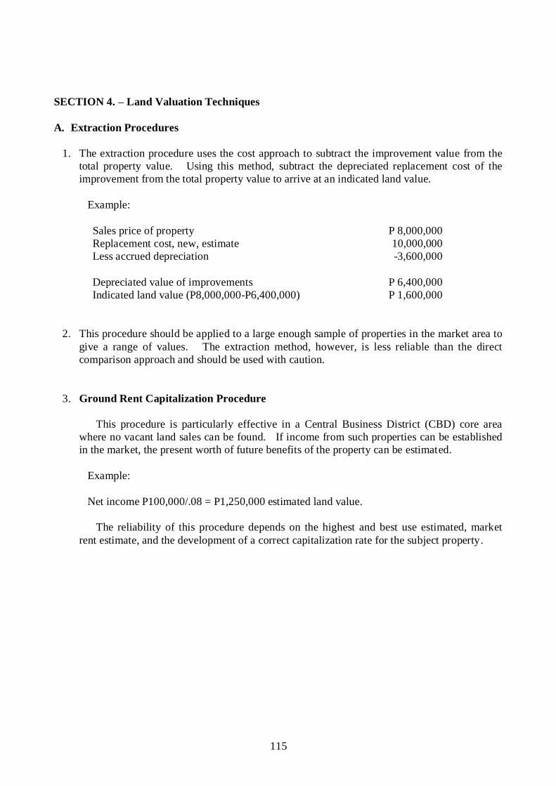
115
SECTION 4. – Land Valuation Techniques
A. Extraction Procedures
1. The extraction procedure uses the cost approach to subtract the improvement value from the
total property value. Using this method, subtract the depreciated replacement cost of the
improvement from the total property value to arrive at an indicated land value.
Example:
Sales price of property P 8,000,000
Replacement cost, new, estimate 10,000,000
Less accrued depreciation -3,600,000
Depreciated value of improvements P 6,400,000
Indicated land value (P8,000,000-P6,400,000) P 1,600,000
2. This procedure should be applied to a large enough sample of properties in the market area to
give a range of values. The extraction method, however, is less reliable than the direct
comparison approach and should be used with caution.
3. Ground Rent Capitalization Procedure
This procedure is particularly effective in a Central Business District (CBD) core area
where no vacant land sales can be found. If income from such properties can be established
in the market, the present worth of future benefits of the property can be estimated.
Example:
Net income P100,000/.08 = P1,250,000 estimated land value.
The reliability of this procedure depends on the highest and best use estimated, market
rent estimate, and the development of a correct capitalization rate for the subject property.

116
SECTION 5. – Requirements for the Appraisal of Land Declared for the First Time
A. For Untitled Property:
1. A survey plan prepared by a duly licensed Geodetic Engineer duly approved by the Land
Management Bureau (LMB) of the Department of Environment and Natural Resources
(DENR);
2. A certification from the Community Environment and Natural Resources Office (CENRO),
stating among others, that the land is within the alienable and disposable area;
3. An affidavit of ownership and/or Sworn Statement declaring the Market Value of Real
Property filed by the owner/administrator; Affidavit that the applicant is in long, continuous
and notorious possession of the property.
4. A certification from the barangay captain that the declarant is the present possessor and
occupant of the land and the certification of the adjoining owners duly sworn to by the
barangay captain and/or the municipal mayor;
5. An ocular inspection/investigation report by the assessor or his authorized representative;
In cases of newly discovered lands wherein the possessor/occupant whose rights can not
be established, the foregoing requirements under (1) to (5) hereof, shall likewise apply;
In case of lands of the public domain occupied and possessed by National Cultural
Communities prior to July 4, 1955, a certification from National Commission for Indigenous
Peoples (NCIP) shall be submitted.
In case of an untitled property being claimed by two or more persons whether natural or
juridical a tax declaration shall be issued for each claimants.
B. For Titled Property:
1. A certified true copy of free patent, homestead or miscellaneous sales application must be
submitted;
2. A certified true copy of the title issued by the Registrar of Deeds, certifying among others,
that the original copy of which is intact and existing in the said registry; and
3. Approved survey plan

117
SECTION 6. – Rules in the Appraisal of Buildings
Buildings are considered immovable provided they are more or less of a permanent structure,
substantially adhered to the land, and not mere superimpositions on the land like barong-barongs or
quonset fixtures and provided there is the intent of permanent annexation. Note that the law uses
the term “adhered” and not “superimposed.” This is true, whether the building is built on one‟s own
land, or on rented land. The reason is clear: the law on this point does not distinguish as to who
built or owns the building. (Civil Code of the Philippines, 14th
Ed., Vol. II, p. 9, Paras)
A. Requirements in the Appraisal of Buildings and Other Structures
1. The appraisal of buildings shall be in accordance with the approved Schedule of Base Unit
Construction Cost (SBUCC) for buildings, which is an integral part of the SFMV, and
supported by the following:
(a) Copy of the approved building permit, building plan, and/or Certificate of Completion or
Certificate of Occupancy permit from local officials concerned;
(b) Notice of the date of inspection, if the owner/administrator is not around during the
discovery;
(c) Report of inspection of the building/structure; and
(d) Accomplished affidavit of ownership or Sworn Statement of the market value of the
property, in the absence of a building permit or Certificates required under Item (a) above.
2. Procedures in the Appraisal of Buildings and Other Structures
a. For the appraisal of buildings and other structures, the SBUCC shall be used. The SBUCC
refers to the base unit construction cost of buildings per square meter including the
additional items as may be determined by the assessor. It should conform with the structural
designs, types and other amenities in accordance with Sec. 401 of R.A. No. 1096, otherwise
known as the National Building Code of the Philippines.
(1) In case of a two (2)-storey building used both for residential and commercial or industrial
purposes, the same shall be classified and valued in accordance with the Schedule of Base
Unit Construction Cost and shall be appraised on the basis of the principal or predominant
use of such building.
(2) Historical or vintage building, the life span of which had surpassed the estimated
economic life, shall be appraised independently from the ordinary course of the
established procedures hereof.
Bowling alleys shall be initially valued separately from the principal building but its
appraisal/assessment shall finally form as part of that of the whole building, except the
machinery, which shall be covered by a separate appraisal and assessment.

118
SECTION 7. – Rules in the Appraisal of Machinery and Equipment
A. Machinery and equipment, collectively, constitute a general classification of property other than
real estate. Machinery includes installation and support facilities for processing or
manufacturing of products, from raw materials to finished goods.
B. Valuation Methodology
The two approaches commonly used in the appraisal of machinery and equipment are the
Market Approach and the Cost Approach discussed in the preceding chapter
1. Two major elements of cost that enter into arriving at the proper estimate of cost of
reproduction cost, new, are the Direct Costs and Indirect Costs.
a. Direct Costs are those elements of cost directly related to the acquisition and installation
of the unit, such as the basic cost, freight charges, insurance, bank charges and
commission, duties and taxes, other landing charges and handling and cost of
transportation to site.
b. Indirect Costs are those elements of cost not directly related to the acquisition of a specific
item of the property but with relation to the installation and acquisition of the entire
property, such as, design and engineering, technical know-how, and pre-operating
expenses.
2. Pricing and estimating cost of reproduction, new of machinery and equipment involve
consideration of all elements of cost, such as:
Cost of basic machine
Cost of auxiliaries and/or optional accessories
Freight from source to the site
Insurance
Bank charges
Documentation
Brokerage, arrastre and heavy lifts
Customs duties and taxes
Installation which includes controls and wirings, electrical and mechanical connections,
millwright work and foundation.
3. Estimating Reproduction Cost New (RCN) by trending and/or indexing (based on original
acquisition cost)
a. For Imported Machinery
RCN = Original Cost x Current Exchange Rate x Trending Factor
Ex. Rate at acquisition Date
(The Assessor must be able to detect whether the equipment is new or second hand)
(Trend Factor – Kemper International Replacement Value Cost Trend)

119
b. For Locally Manufactured Machinery:
RCN = Original Cost x Local Index (from) NEDA
c. Appraisal of Machinery for Tax Purposes
1. The appraisal of machinery for tax purposes shall be based on its actual cost to the
owner. To support the actual cost, the declared value or sworn statement from the
owner or responsible officer in case of a corporation, shall be secured to form as an
integral part of the appraisal report.
2. For imported brand new machinery, the market value shall be based on its acquisition
cost, which is the actual cost to the owner when the same is not yet depreciated or
appraised within the year of its purchase, plus the costs of freight, insurance, bank and
other charges, brokerage, arrastre and handling, duties and taxes, plus the cost of
inland transportation, handling and installation charges at the present site. The cost in
foreign currency shall be converted to peso cost on the basis of the foreign currency
exchange rates when such machinery was actually purchased as fixed by the Bangko
Sentral ng Pilipinas (BSP).
3. By the expressed provision of the Local Government Code, the acquisition cost of the
machinery shall be based on the actual cost to the owner when it was acquired. The
cost in foreign currency shall be converted to peso cost based on the foreign exchange
rate then prevailing when the same was acquired.
4. In all other cases the cost in foreign currency of imported machinery shall be
converted to peso equivalent based on exchange rates fixed by the BSP at the time of
acquisition and apply a depreciation allowance of not exceeding 5% per year.
FORMULA:
RCN = OC x FC2 x PI x REL
FC1 EL
Where:
RCN = Reproduction/Replacement Cost New
OC = Original Cost (or Acquisition Cost)
FC1 = Foreign Currency Exchange Rate at Time of Acquisition
FC2 = Foreign Currency Exchange Rate during Reassessment
EL = Economic Life
REL = Remaining Economic Life
*PI = Price Index
* optional, to be used only when information is available

120
ILLUSTRATION:
Valuations of Cummins-Onan – 1,500 kw Generator Set
Acquisition Cost in 1998 = $170,000 (CIF Mla.)
To compute in peso:
$170,000 x 38.750 (1998 dollar exchange rate) x 1.05 x 1.1 = Php 7,608,562.50
Say = Php 7,609,000.00
To compute to present value:
Php 7,609,000 x 1.1466 x 55.988
38.750
= Php12,605,000 (Reproduction Cost New)
5. In case of doubt as to the declared value of machinery as indicated in the sworn
declaration of the owner, confirmation may be made by securing documents from
Bureau of Customs (BOC), Bureau of Internal Revenue (BIR), Securities and
Exchange Commission (SEC) and other agencies of the government.
ILLUSTRATION:
Assume that in 2003, several pieces of machinery worth US200, 000.00 were
installed in a factory building. Freight and insurance charges were US20,000.00. Peso
expenses for brokerage, arrastre and handling, customs duties, etc., amounted to
PhP2,000,000.00
Appraisal could be:
US200,000,[email protected] = Php10,840,660.00
US20,[email protected] = 1,084,066.00
Brokerage, arrastre, etc. = 2,000,000.00
Market Value = Php13,924,726.00
Assessmentt Level = 80%
ASSESSED VALUE = Php 11, 139,, 780.00
NOTE: Indicated figures are rough estimates.
Reappraisal of machinery by Reproduction Cost New Less Depreciation (RCNLD)
shall be based on the formula established for the purpose.
ILLUSTRATION :
Assume that a machinery from U.S.A. was acquired, installed and in operation in
February 1999 at total original converted cost of P10,000,000.00. Reappraisal was
made in December 2003 to take effect in 2004.

121
Dollar Exchange Rate at the time of operation – P25.0282 to 1.00 dollar
Dollar Exchange Rate at the time of appraisal – P40.6232 to 1.00 dollar
Estimated Economic Life – 30 years
RCNLD = 10,000,000 x 54.2033 x 26
39.0890 30
= 10,000,00 x 1.3867 x .08666
= P1,201,714.00
Say P1, 201, 714.00
Assessment Level - 80%
Assessed Value P961, 371.36
Say P961, 370.00
6. Section 225 of the Local Government Code provides that depreciation allowance for
machinery shall be made at a rate not exceeding five percent (5%) of its original cost
or its replacement or reproduction cost, as the case may be, for each year of use:
Provided, however, that the remaining value for all kinds of machinery shall be fixed
at not less than twenty percent (20%) of such original, replacement, or reproduction
cost for so long as the machinery is useful and in operation.
7. Appraisal of Rail-Tracks (e.g MRT) shall be based on cost approach or income
approach, whichever is applicable, the total market value of which shall be
apportioned or pro-rated between the local government units they traverse.
8. Transmission Lines, Transmission Towers, Cell Sites and the likes shall be assessed
like all other machineries and taxes thereon shall be paid to the local government unit
where they are constructed. Transmission lines including the posts shall be appraised
on the basis of its total value using the cost or income approach and the total market
value shall also be apportioned or pro-rated between the local government units where
these lines traverse.
9. Submerged pipe lines for natural gas, water, etc., shall be appraised on the basis of the
cost or income approach, the total market value thereof shall be apportioned or pro-
rated between the local government units they traverse.
10. Reservoir, dams, tailing ponds, piers and wharves shall be appraised on the basis of
the cost approach. Provided, however, that the cost of pilings on ports must be given
additional consideration.
d. Guideline in Estimating Depreciation by the Observed Condition Method
Very Good Condition (80%-100%) – This term describes an item of equipment in excellent
condition capable of being used to its fully specified utilization and for its designed purpose
without being modified and not requiring any repairs or abnormal maintenance at the time of
inspection or within the foreseeable future.

122
Good Condition (55%-75%) – This term describes those items of equipment which have
been modified or repaired and are being used at or near their fully specified utilization but the
effects of age and/or utilization in the foreseeable future.
Fair Condition (35%-50%) – This term describes those items of equipment which are being
used at some point below their fully specified utilization because of the effects of age and/or
application and which require general repairs and some replacement of minor elements in the
foreseeable future to raise their level of utilization or near their original specifications.
Poor Condition (15%-30%) – This term is used to describe those items of equipment which
can only be used at some point well below their fully specified utilization and it is not
possible to realize full capability in their current condition without extensive repairs and/or
the replacement of major elements in the very near future.
Scrap Condition (0%-10%) – This term is used to describe those items of equipment which
are no longer serviceable and which cannot be utilized to any practical degree regardless of
the extent of the repairs or modifications to which they may be subjected (beyond economical
repair). This condition applies to items of equipment which have been used for 100%
technologically or functionally obsolescent.
SECTION 8. – Rules in Appraisal of Special Purpose Properties
A. Special purpose properties are properties which are designed, constructed and developed for a
specific use or purpose. By its very nature this type of property is rarely offered for sale in the
open market except as part of a going concern. Due to the special design and the function,
conversion of special purpose properties to other types of development or application is
generally not economically feasible.
B. In valuing special purpose properties, it is the Appraiser‟s/ Assessor‟s responsibility to
gather pertinent data and information and develop sound reasoning from the market to support
conclusions of value. While all the appraisal methods can be considered, the Cost Approach to
value is commonly applied in the appraisal of special purpose properties.
C. Valuation of Special Purpose Properties
1. GOLF COURSE
a. The components of golf course are:
(1) Fairway What type of grass are used? Are the irrigation and drainage system
adequate?

123
(2) Greens What is the type of grass planted in terms of smoothness, speed,
receptiveness, size, availability of hole placements, and undulation.
(3) Bunkers Are they strategically placed? Are they of consistent playability? Is
there too much or not enough land? Do they drain adequately?
(4) Roughs Is the rough penal, and is it well-maintained? What type of grass is on
the rough, and is it watered?
(5) Other Facilities Is the practice range large enough and, is it well-maintained? Are the
practice greens similar to the greens on the course? Are the clubhouse
and teaching facilities adequate?
b. The focus of on-site inspection of an existing golf course is the maintenance practices. This
requires the examination of manual or automatic watering, gang mowed or tri-prelexed
greens, approach maintenance, rough maintenance, and bunker appearance. Golf course
evaluation should highlight its strengths as well as its deficiencies.
c. Valuation
The valuation of a golf course, like any other property, requires consideration of each of
the three (3) approaches to value. However, because of the very nature of the special land
development the Cost Approach is considered applicable. Golf courses are rarely placed in
the market for sale. For this reason and because of lack of the market comparables, the
market data approach is not applicable at least for the valuation of the land in its raw nature.
d. Cost Approach
The cost approach can be a reliable indication of value for most type of golf courses.
The land is treated as raw land with all the development added thereto. Land valuation is
accomplished by sales comparison method using any potential comparable raw land for golf
course development. The estimate of the cost of construction vary greatly based on the type
development derived and for which the specific target market is to be built.
For instance, for a championship course, cost per hole, according to the international
quantity surveying company of Davis Langdon & Seah Philippines, Inc., in their Philippines
2004, DLS Handbook, would be in the vicinity of Php16 million to Php20 million per hole,
depending on exclusion or inclusion of fairway construction and rough hydroseeding. This
is not to mention, considerations to topography, hazards, irrigation system and design. It is
also important how much earth moving is necessary and to what specifications the greens
and bunkers are made of Depreciation of golf course improvements can be best estimated
through observation, coupled with data gathered from the administrator regarding the cost to
cure the expected life of improvements. Clubhouse, maintenance buildings and equipment
are also included.

124
e. Income Approach
The income approach to value can be an indicator of value for a golf facility.
Capitalization of the income is generally accomplished through the usual methods either
direct or yield capitalization with rates developed by the appropriate technique. A great deal
of attention should be given to future income projections. This should include a survey of
competitive golf courses that takes into account green fees, cart fees, average number of
rounds played, and possible reserve generated from the driving range, restaurant and Pro
Shop. Expenses include maintenance, salaries and cost of goods sold, equipment
replacement budget in addition to other typical property expenses.
A sample of an income approach summary is presented as follows:
Gross Income Estimated (yearly)
Green Fees Php 17,450,000
Cart Rental 2,590,000
Restaurant 8,570,000
Pro Shop 880,000
Other Income
Practice Range,
Tournament fees Php 1,000,000
Php 30,490,000
Cost of Sale / Expenses
Maintenance Budget Php 10,250,000
Admin. / Salaries 3,320,000
Miscellaneaneous 760,000
Pro Shop 80,000
Restaurant 4,280,000
Carts & Eqpt. 1,100,000
Php 19,790,000
Annual Net Operating Income Php 10,700,000
Capitalization Rate – 10%
Income
Value estimate = ----------- = Php 10,700,000 = 107,000.000
Rate 10%
Conclusion
The valuation of a golf course is similar to other appraisal problems with regards to general
procedures. It is imperative that an appraiser should obtain a thorough knowledge of the golf
industry and develop a familiarity with the game and course design in order to accurately
identify the quality level of the golf course being appraised.

125
2. MEMORIAL PARK- CEMETERY
a. A cemetery is a “Special Use” property because it is adapted for a particular purpose. It may
be a non-profit or a profit enterprise.
b. Non-profit cemeteries are usually church-affiliated. National and Municipal Cemeteries are
also included in this category.
c. A profit cemetery is an investment property.
d. Development of cemeteries generally follows three patterns:
1. Monument cemeteries – marked by stone memorials like the churchyard burial grounds.
2. Lawn cemetery – stretches of land, almost bare except for markers.
3. Garden memorial park – modification of the lawn cemetery. It is distinguished by
sculptural and architectural features centered in its section or garden which achieves
individuality and removes the monotony of long stretches of lawn.
e. Profit cemeteries are appraised using the Income Approach. Especially significant is
cemetery appraisal in the knowledge of planning, development, operation and
administration. Forecast of future earnings is an essential phase of the valuation process.
There is usually a legal requirement to reserve a portion of gross plot sales for the perpetual
care of the burial sites.
Standard size of burial plots --- 4 grave plots – 4.25m x 2.50m
Or single graves – 1.0m x 2.50m
Saleable area (grave plots) is about 65% to 70% of gross land area.
f. Important factors in the appraisal of cemeteries
(1) Location – must be within easy reach
(2) Land characteristics – ideally, gently undulating terrain with subsoil condition permitting
natural drainage and economical excavation
(3) Population trend – appraiser must ascertain area population, religious affiliation and total
available burial space in the area.
(4) Sales program and prices of lots – pre-need sales; price increases as the cemetery matures
particularly due to attractive developments and good maintenance.
(5) Management – ability to build and maintain good public relations.

126
(6) Fiscal operations –
a. Source of income –
principally sale of plots
additionally, sale of bronze memorials, interment services,
investment of perpetual care fund.
b. Expenses –
cost of plot, sales including commissions
care and maintenance
perpetual care obligation
administration
g. Appraisal of cemeteries, being investment properties, makes use of the Income Approach.
Net income (derived from source of income less expenses as itemized above) is converted
into value by a capitalization process (Net income divided by Capitalization rate equals
value).
h. Valuing individual plots in a cemetery or memorial park can be made using the Market Data
or Comparative Approach. The value of the grave plots is indicated by how much
comparable plots in similar memorial parks are being bought and sold in the open market.
3. HOSPITALS
a. Hospitals are generally considered special purpose property. Because hospitals are not
usually offered for sale in the open market, the Market Data approach is not applicable. The
Income approach may not also give a good indication of value due to the factors to be
considered in arriving at the net income, such as, laboratory tests, doctors professional fees,
X-rays, ultra sound technicians, examinations, etc., which are not necessarily part of the
income of the hospital.
b. The Cost approach to value is generally used in the appraisal of hospitals. Land is appraised
as if vacant by the use of the Market Data approach. The value of the land is based on sales
and asking prices of similar lands within the vicinity of the property.
c. In value the buildings and other land improvements, as well as the laboratory and hospital
equipment, the cost of reproduction, new, is first estimated, based on how much similar
properties in brand new condition, can be constructed or acquired. Depreciation resulting
from wear and tear and physical and economic obsolescence is then deducted to arrive at the
current market value of the improvements and the value of land added to indicate the value
of the hospital.
Because of the nature of its operation, hospital beds are considered as part of the
building, not as furniture. Similarly, hospital equipment are also considered as part of the
hospital building. However, these items of property will not necessarily follow the
economic life of the building.

127
4. SCHOOLS
a. The appraisal of schools, colleges and universities is similar to the procedure in appraising
hospitals. The Cost approach is used in valuing these properties.
b. As in the valuation of hospitals, classroom desks, chairs, tables and blackboard and other
similar illustration boards are considered as part of the school building. Cost of reproduction
new is estimated based on current building construction costs and prices of similar furniture
in brand new condition, and depreciation deducted based on the respective economic life of
the properties, and value of land using the market data approach added to arrive at the value
of the school.
5. GASOLINE STATIONS
Gasoline stations are usually owned by the oil company selling the gasoline and other oil
products. The land is more often leased by the oil company on a medium to long term basis.
All improvements on the land are owned, installed and constructed by the oil company. The
standard improvements on a typical gas station consist of transfer pumps, underground tanks,
service facilities including car lifts and the building.
In valuing the land, the market data or comparative approach is used. The income
approach is not generally employed because the rentals paid for the lease of the land are
considered above prevailing rentals for similar lands for the reason that most of the oil
companies are willing to pay a premium based on their survey of the volume of vehicles in
the area.
For the improvements, the basis for valuing the equipment, including transfer pumps and
underground tanks, is the cost of acquiring and installing similar facilities in brand new
condition, and depreciated based on current condition of the property. The costs of these
facilities can be obtained from the records of the oil company itself if the traditional sources
of information like the manufacturer‟s local representatives or distributors are not available.
6. APPRAISAL OF MALLS (SHOPPING CENTER)
Shopping Center – a group of commercial establishments, planned, developed, owned and
managed as a unit with the street parking provided on the property.
Four (4) Elements to be given special emphasis in appraising of shopping malls:
1. The property must be valued as an aggregate (whole) and not as separate individual store
due to the following reason:
a. Common parking area
b. Favored position of department store around which the center is planned and built.

128
2. A Market Survey must be prepared since rents are usually based on a percentage of sales
in addition to a minimum guarantee. A market survey to determine the types of stores to
be included in the center, to estimate volume of sales of each store, store area required,
and percentage rents to be required under store leases.
3. Sales of commercial properties in the vicinity cannot be used as basis of valuation of the
center.
4. Valuation of land must be based on capitalization of annual residential net income.
Land Value – capitalization of residual net income.
Gross rental
Less: allowance for vacancy, management fees, insurance, maintenance real
estate tax.
Less: interest charges and depreciation of building
= net income contributable to land
Building Value – CRN less depreciation
7. APPRAISAL OF CONDOMINIUMS
a. Section 2 of Philippine Condominium Law defines condominium as an interest in real
property consisting of separate interest in a unit in a residential condominium or commercial
building and an undivided interest in common, directly or indirectly, in the land on which it
is located and in other common areas of the building. Briefly stated, it is a form of
ownership less than the whole. Each co-owner enjoys absolute ownership in his separate
unit and owns jointly, in direct proportion to his holding the common areas designated in
the property.
b. Valuation – All three Standard Approaches to value, Cost Income Approach and Market
Approach may be used in estimating the value of a condominium project.
c. Cost Approach
The approach sets the upper limit of values.
(1) Estimate land value (as vacant)
(2) Estimate cost to construct building
(3) Add
(a). Sales expenses including cost to convert the building into a condominium and
(b). Developers profit
d. Income Approach
Test the economic soundness of an investment property.
Value = net income ÷ capitalization rate

129
e. Market Value Approach
Based on how much comparable condominium projects are selling in the area market.
In valuing individual condominium unit, the Market Data Approach is the appropriate
method to use.
ILLUSTRATION:
D. A 10-storey Commercial building owned by a Corporation erected on a 1,000 square
meter parcel of land.
Building Dimension: Width - 20 meters
Length - 30 meters
10-Storey Building
Basement Gross Area - 600 square meters
Open Parking Area - 400 square meters
Foundation - Reinforced Steel Concrete
Space for one elevator shafts - 4.00 square meters
4.00 sq. meters x 4 elevators =16.00 square meters
All Floors Reinforced Steel/Concrete
Ground Floor – Granite
Exterior Walls – Reinforced Concrete w/ colored glass paneling
All Other amenities – 1st Class
f. Recapitulation of the Area & Computation of Value:
Total Land Area - 1,000 square meters
Building Ground Floor Area - 600 square meters
Space for elevator shaft - 16 square meters
DESCRIPTION AREA UNIT
VALUE
ADJUST
-MENT
NO. OF
UNITS
MARKET VALUE
Foundation 600 Php1,000 - 10 Php6,000,000.00
Basement 584 15,000 - 8,760,000.00
Ground Floor 584 15,000 + 2,000 1 9,928,000.00
2nd
Floor 584 15,000 + 1,000 1 9,344,000.00
3rd
to 10th
Floor (replica of 2nd
Floor) 8 74,752,000.00
Php108,784,000.00
Add: parking Space 400 sq. m. @ Php5,000 2,000,000.00
TOTAL MARKET VALUE Php110,784,000.00
Assume that the 10-storey building in the preceding illustration was constructed under
R.A. No. 4726, otherwise known as The Condominium Act. Assume further that the
ground and the 2nd
floors were both sold to a single Corporation for its sole use; while the
3rd
to the 10th were divided into ten (10) separate units, consisting of 40.00 square meters
each. Common areas are provided from the ground floor up to 10th
floor.

130
7
RECAPITULATON OF SEAPARATE AND COMMON AREAS:
DESCRIPTION SEPARATE UNIT COMMON AREA
Ground Floor 566 square meter
4 Elevator shaft spaces and
alleys
16.00 square meters
Space for stairway 6.00 square meters
Alley to elevator and stairway 12.00 square meters
2nd
Floor 566 square meters
4 Elevator shaft spaces and
alleys
16.00 square meters
Space for stairway 6.00 square meters
Alley to elevator and stairway
12.00 square meters
TOTAL AREA 1,132 SQ. M. 68.00 SQ. M.
3rd
Floor 400 square meters
4 Elevator shaft spaces and
alleys
16.00 square meters
Space for stairway 6.00 square meters
Hallways, terrace, etc. 166.00 square meters
TOTAL AREA 400 SQ. M. 188.00 SQ. M.
Designated Floor
No. of Units
Total Area
Separate Unit
Total Common Area
3rd
10 400 square meters 188 square meters
4th
10 400 188
5th
10 400 188
6th
10 400 188
7th
10 400 188
8th
10 400 188
9th
10 400 188
10th
10 400 188
TOTAL 80 3,200 square meters 1,504 square meters
g. Rules for Appraising and Assessing Condominiums:
(1) Depending upon the enabling or master deed of the Condominium project, each separate
unit should be appraised independently, whether or not the Condominium Certificate of
Title is in the name of the corporation or individual person;
(2) Each separate unit shall have the same Unit Base Value. Number of rooms, toilet and
bath and other internal amenities are important factors to consider for a more objective
valuation;
(3) The common areas in the building should be appraised and assessed in the name of the
Condominium Corporation or Association;

131
(4) Indivisible portions of the Condominium building such as corridors, lobby, stairs, etc,
shall be considered as among the common areas or common elements and shall be
appraised and assessed as such;
(5) Town house shall also be appraised and assessed in accordance with the above-mentioned
provisions on the assessment and appraisal of condominiums;
(6) The capital equipment such as machinery, elevators, water pumps and tanks of the
condominium project shall be listed and assessed aggregately in the name of the
Condominium Corporation or Association;
(7) Parking spaces not sold to respective unit owners in the building shall be considered as
included in the common areas, therefore assessed and declares in the name of the
developer-owner or Condominium Corporation or Association, as the case may be, for
taxation purposes. No separate tax declaration shall be issued for the purpose of declaring
for taxation purposes individual parking areas situated within a condominium building.
h. Appraisal of Buildings and Other Structures Previously Valued and Assessed
(1) Buildings and other structures subject to reappraisal and reassessment must be revalued in
accordance with the current SBUCC.
(2) The loss in value or depreciation due to physical, functional or economic obsolescence
must be considered in one application, or a combination of two or all of the three methods
depending upon the building condition.
(3) Since depreciation is definite to occur in any man-made structure due to use, degree of
maintenance, changing economic conditions and several obtaining factors, the rule on
Reproduction Cost Less Depreciation (RCNLD) must be consistently applied every time a
reappraisal is made.
ILLUSTRATION:
Physical Depreciation (Wear and Tear) – Straight Line Method
Assume the building (house) was constructed in 1994.
Only minor repairs were made
Estimated Economic Life - 25 years
New SBUCC for 2000 - Php6,000.00 per sq. m.

132
COMPUTATION OF VALUE
DESCRIPTION
AREA
(SQ. M.)
UNIT VALUE
PECENTAGE
ADJUSTMENT
ADJUSTED
MARKET VALUE
Two-Bedrooms 18.00 Php6,000.00 + 20% Php129,600.00
Living Room 16.00 6,000.00 + 30% 124,800.00
Dining & Kitchen 17.00 6,000.00 + 30% 132,600.00
Toilet & Bath 9.00 6,000.00 + 10% 59,400.00
Php446,400.00
Open Terrace &
Carport 30.00 3,000.00 90,000.00
Total Reproduction
Cost New
Php536,400.00
Less: Depreciation
(6/25=24%)
128,736.00
Market Value (Rev.) 407,664.00
Assessment Level 20%
81,532.00
ASSESSED VALUE Php81,530.00
(4) Loss in value if applied due to functional obsolescence shall be categorized and measured
into curable or incurable deterioration. Curable if the functional obsolescence can be
remedied by the introduction of improvements that will not affect the structural base of
the building, otherwise it is incurable.
(5) Loss in value due to economic obsolescence regarded as incurable shall be measured by
sales comparison or rent loss.
(6) A Depreciation Table developed to rationalize the degree of maintenance, e.g. Poor,
Average or Excellent must be in consonance with the model shown hereunder.
SCHEDULE OF DEPRECIATION
I II-A II-B III-A,B III-C,D III-E IV-A IV-B V-A V-B V-C
1st - 5yrs. 5.2% 5.0% 5.0% 4.0% 4.0% 3.0% 2.6% 2.4% 2.2% 2.0% 1.8%
2nd - 5yrs. 4.6% 4.2% 4.0% 3.6% 3.5% 2.5% 2.3% 2.2% 2.0% 1.8% 1.4%
3rd - 5yrs. 4.0% 3.6% 3.4% 3.2% 3.0% 2.5% 2.2% 2.0% 1.7% 1.5% 1.2%
4th – 5yrs 3.4% 3.2% 3.0% 3.0% 2.5% 2.0% 2.0% 1.7% 1.3% 1.2% 1.0%
AFTER 3.2% 3.2% 3.0% 2.5% 2.0% 2.0% 1.6% 1.4% 1.1% 1.0% 1.0%
20 YRS.
RESI- DUAL 10.0% 12.0% 15.0% 20.0% 28.0% 30.0% 33.0% 35.0% 37.0% 40.0% 40.0%
VALUE
For an excess in the above rates of annual depreciation, bigger rate may be applied in extra
ordinary cases, that is, if properly presented and described as in the following instances:
1) Damage due to catastrophe (earthquake, fire, deluge)
2) Heavily damaged due to pest (e.g. termite)
3) Established defects in construction.
4) Obsolescence

133
CHAPTER V
ASSESSMENT OF REAL PROPERTY
SECTION 1. – Guiding Principles
A. Classification of Real Property for Assessment Purposes
1. For purposes of assessment, real property shall be classified as residential, agricultural,
commercial, industrial, mineral, timberland and special.
2. Real property shall be classified, valued and assessed on the basis of its actual use regardless
of where located, whoever owns it, and whoever uses it. Actual use refers to the purpose for
which the property is principally or predominantly utilized by the person in possession of the
property.
3. Actual use is the determining factor in applying the appropriate percentage or level of
assessment to the market value of the property computed on the basis of the Schedule of Base
Market Values for land or the Schedule of Base Unit Construction Costs for buildings and
improvements and should not be construed as a criterion for the classification and valuation of
real property.
B. Assessment Levels
The assessment levels to be applied to the market value of real property to determine its
assessed value shall be fixed by ordinance of the Sangguniang Panlalawigan, Sangguniang
Panlungsod or Sangguniang Bayan of a municipality within Metropolitan Manila Area (MMA),
at the rates not exceeding the following:
1. On Lands:
CLASS ASSESSMENT LEVELS
Residential 20%
Agricultural 40%
Commercial 50%
Industrial 50%
Mineral 50%
Timberland 20%
2. On Buildings and Other Structures:
a. Residential
FAIR MARKET VALUE ASSESSMENT LEVELS
Over Not Over
P 175,000.00 0%
P 175,000.00 P 300,000.00 10%
300,000.00 500,000.00 20%
500,000.00 750,000.00 25%
750,000.00 1,000,000.00 30%

134
1,000,000.00 2.000,000.00 35%
2,000,000.00 5,000,000.00 40%
5,000,000.00 10,000,000.00 50%
10,000,000.00 60%
b. Agricultural
FAIR MARKET VALUE ASSESSMENT LEVELS
Over Not Over
P 300,000.00 25%
P 300,000.00 500,000.00 30%
500,000.00 750,000.00 35%
750,000.00 1,000,000.00 40%
1,000,000.00 2.000,000.00 45%
2,000,000.00 50%
c. Commercial or Industrial
FAIR MARKET VALUE ASSESSMENT LEVELS
Over Not Over
P 300,000.00 30%
P 300,000.00 500,000.00 35%
500,000.00 750,000.00 40%
750,000.00 1,000,000.00 50%
1,000,000.00 2,000,000.00 60%
2,000,000.00 5,000,000.00 70%
5,000,000.00 10,000,000.00 75%
10,000,000.00 80%
d. Timberland
FAIR MARKET VALUE ASSESSMENT LEVELS
Over Not Over
P 300,000.00 45%
P 300,000.00 500,000.00 50%
500,000.00 750,000.00 55%
750,000.00 1,000,000.00 60%
1,000,000.00 2,000,000.00 70%
2,000,000.00
3. On Machineries
CLASS ASSESSMENT LEVELS
Agricultural 40%
Residential 50%
Commercial 80%
Industrial 80%

135
4. Special Classes:
Assessment levels for all lands, buildings, machineries and other improvements:
Actual Use Assessment Levels
Cultural 15%
Scientific 15%
Hospital 15%
Local Water Districts 10%
Government-owned or
controlled corporations
engaged in the supply
and/or generation and
transmission of electric
power
10%
5. Maximum Assessment Levels
The Local Government Code provides for the maximum assessment levels for all types
of property, hence, there is a need for the Sangguniang Panlalawigan, Sangguniang
Panlungsod or the Sangguniang Bayan of a municipality within MMA to enact an ordinance
fixing the assessment levels for the local government. Two major considerations in this
policy decision are the amount of revenue the local government needs to generate from real
property taxes for its operations and delivery of public service and the level of tax burden
sharing that the LGU would like to impose on its constituents.
The assessment levels for the different classes of real property may be increased or
decreased at rates to be fixed by ordinance of the sangguniang panlalawigan, sangguniang
panlungsod, or sangguniang bayan of a municipality within the MMA, provided, however,
that in no case shall such increase or decrease of the assessment levels be made effective in
between general revision of assessment periods.
The local assessor is in the best position to help or guide the Sanggunian in fixing the
assessment levels since he is most knowledgeable on the effects of setting the assessment at
a certain level. Thus, in the preparation of a new Schedule of Fair Market Values for
purposes of a general revision of real property assessments, the assessor may also conduct
studies that would show the revenue impact and tax burden of various assessment levels to
enable the members of the Sanggunian to arrive at a more informed decision.
C. Assessment of Property Subject to Back Taxes
Real property declared for the first time shall be assessed for the period during which it
would have been liable but in no case for more than ten (10) years prior to the date of initial
assessment: Provided, however, that such taxes shall be computed on the basis of the
applicable schedule of values in force during the corresponding period. Provided further that
the total tax liability shall include the current year in addition to the ten (10) years back taxes.
If such taxes are paid on or before the end of the quarter next following the date the notice of
assessment was received by the owner or his representative, no interest for delinquency shall be
imposed thereon; otherwise, such taxes shall be subject to an interest at the rate of two percent
(2%) per month or a fraction thereof until such taxes are fully paid.

136
D. Notice of New or Revised Assessments
1. When real property is assessed for the first time or when an existing assessment is increased
or decreased, the provincial, city or municipal assessor shall within thirty (30) days give
written notice of such new or revised assessment to the person in whose name the property is
declared. The notice may be delivered personally or by registered mail or through the
assistance of the punong barangay in the last known address of the person to be served.
2. Although the real property tax is levied against real property, it is the owner who pays the tax.
Before the tax liability is fixed, the property owner is entitled to a hearing on the assessment
of the property; notice and hearing constitute part of the due process (not strictly judicial) in
taxation. If the owner is not satisfied with the action of the assessor in the assessment of the
property, the said owner can resort to the appeals process provided in this manual. If he does
not appeal within the said period, he will be deprived of his right to be heard by the Board of
Assessment Appeals.
a. The written notice together with the owner‟s copy of the tax declaration shall be addressed
to the person in whose name the property is declared. It may be delivered personally or to
the occupant in possession of the property, or by mail to the last known address of the
owner or thru the assistance of the punong barangay.
b. If personally delivered to the owner or person in possession of the property, the person
serving the notice shall secure the signature of the owner or occupant on the duplicate copy
of the notice, with a notation of the date when notice was served and whether recipient is
the owner or occupant of the property. If assistance of the punong barangay is secured, the
signature should appear on the duplicate copy of the notice.
c. If the notice of assessment is sent through the mail, the notice of assessment and owner‟s
copy of the tax declaration shall be registered with a return card.
The duplicate copies of the notice of assessments signed by owners or occupants of the
property and the return registry returned cards shall be filed in the office of the provincial,
city or municipal assessor. These are important in ascertaining whether appeals filed by
owners of real property are filed within the reglamentary period of sixty days from date of
receipt of such notices.
d. The notice of assessment and owner‟s copy of the tax declaration shall be delivered or
mailed to property owners within thirty days from the entry of the tax declarations covering
the assessment of property in the records of assessment.
e. The sending of the notice of assessment to the taxpayers is mandatory to include the validity
of the assessment made.

137
E. Effect of Appeals on the Payment of Real Property Tax
Appeal on assessments of real property made under the provisions of the Local Government
Code shall in no case suspend the collection of the corresponding realty taxes on the property
involved as assessed by the provincial or city assessor, without prejudice to subsequent
adjustment depending upon the final outcome of the appeal.
SECTION 2. – Rules in the Assessment of Real Property
A. All real properties, whether taxable or exempt, shall be appraised at the current and fair market
value prevailing in the locality where the property is situated.
B. The appraisal of real property shall be based on the latest Schedule of Fair Market Values
(SFMV) prepared by the Provincial Assessor, the City Assessor, or Municipal Assessor of
Municipality within the MMA, as embodied in an Ordinance passed by the Sangguniang
Panlalawigan, Sangguniang Panlungsod or Sangguniang Bayan of MMA municipalities.
C. Appraisal of real property declared for the first time shall be listed, classified and valued on the
basis of the SFMV (either for land or building), and shall be subject to back taxes (if applicable)
of not exceeding ten (10) years from the year of initial assessment. Thus, the property shall be
liable to tax payment for a maximum of eleven (11) years including the current year. The
schedule of values applicable for the corresponding periods shall be controlling.
ILLUSTRATION:
(A) Land - Declared in 2003. Assume all supporting documents are submitted.
Basic Data:
Area - 10,000 square meters
Condition- Planted to fruit bearing trees Php
SFMV - 1993 - P20.00 per ha.
- 1994 - P50.00 per ha.
- 2000 - P110.00 per ha.
COMPUTATION OF VALUE
DESCRIPTION AREA SFMV MARKET VALUE
Orchard 10,000 sq.m. Php 20.00 Php 200,000.00
10,000 50.00 500,000.00
10,000 110.00 1,100,000.00
ASSESSMENT LEVEL ASSESSED VALUE EFFECTIVITY
40% P80,000.00 1993
40% P200,000.00 1994-1999
40% P440,000.00 2000-2003

138
D. Rules for the Assessment of Lands
1. Lands actually and principally used for residential, agricultural, commercial, industrial or
mineral purposes shall be classified and valued according to the schedule of unit base market
values and assessed at their corresponding levels of assessment, which shall be fixed through
an ordinance by the Sanggunian concerned.
2. Lands located in areas of mixed land uses such as residential with commercial or industrial,
the predominant use of the lands in that area shall govern the classification, valuation and
assessment thereof. If the predominant use is residential, all lands in that area shall be
assessed as residential; if the predominant use is commercial or industrial, all lands in that
area shall be assessed as such.
3. A lot or parcel of land classified and appraised as commercial or industrial occupied by a
building used both for residential and commercial or industrial purposes shall be assessed on
the basis of the predominant use of the building or buildings. If the predominant use of the
building is residential, the assessment level fixed thereon for residential land shall be applied
on the market value of the lot or parcel determined on the basis of the schedule of base market
values; if industrial or commercial, the assessment level for industrial or commercial shall be
applied on the basis of the schedule of base market values.
4. Vacant lands shall be assessed like similar lands in the locality.
5. Lands owned by local water districts and government-owned or controlled corporations
rendering essential public services in the supply and distribution of water and/or generation
and transmission of electric power, located in residential, commercial or industrial area shall
be assessed as special property at ten percent (10%) assessment level applied to the market
value.
If those special classes of lands are, however, located in areas of mixed land uses, such as
residential with commercial or industrial, the predominant use of the lands in that area of
those special classes of land shall be assessed at the corresponding levels of assessment.
6. Lands actually, directly and exclusively used for religious, charitable or educational purposes
located in residential, commercial or industrial areas shall be assessed as residential,
commercial or industrial, as the case may be.
If those lands actually, directly and exclusively used for religious, charitable or
educational purposes are, however, located in an area of mixed land uses, such as residential
with commercial or industrial, the predominant use of the lands in that area shall govern the
assessment of those lands used for religious, charitable or education purposes.

139
E. Reclassifying Land to Other Uses
1. The following are the procedures in reclassifying land to other uses:
a. Land converted into other uses, e.g. agricultural to residential, residential to commercial,
made known to the assessor in writing by the owner shall be inspected for confirmation of
the actual condition/use of the property;
b. A report of the actual condition of the property and the recommendation thereof shall be
rendered by the responsible personnel of the Provincial or City Assessor‟s Office or, in the
case of a province, by the Municipal Assessor. Such report shall be submitted within fifteen
(15) working days after inspection in accordance with the policy as may be prescribed by
the Provincial or City Assessor;
c. Among others, the report may contain information regarding tangible land improvement,
e.g. land leveling and compaction, construction of road networks, drainage and other
relevant land amenities;
d. In all other cases, Local Finance Circular No. 3-92 dated September 11, 1992 shall be
controlling in reclassifying agricultural lands to non-agricultural uses; and
e. A duly approved Zoning Ordinance also serves as basis in the reclassification of lands.
SECTION 3. – Listing of Real Property for the Imposition of Real Property Tax
A. Preparation and Maintenance of Assessment Roll. The provincial, city and municipal
assessor shall prepare and maintain an assessment roll (see Attachment 6) wherein all taxable
real properties located within his province, city or municipality, shall be listed; except in cases
where the assessor‟s records are computerized and the same are directly and operationally
connected to the Provincial, City or Municipal Treasurer in the form of Local Area Network
(LAN). A separate roll shall be prepared for exempt properties, for ready reference.
1. Real property shall be listed and valued in the name of the owner or administrator or anyone
having legal interest in the property;
2. The undivided real property of a deceased person may be listed and valued in the name of the
estate, or the heirs and devisees without designating them individually; and undivided real
property other than that owned by the deceased may be listed and valued in the name of one
or more co-owners; Provided, That such heirs or co-owners shall be liable severally for all
obligations imposed by the Code and for the payment of the real property tax with respect to
the undivided property;

140
3. The real property of a corporation, partnership, or association shall be entered and assessed in
the same manner as that of an individual;
4. Real property owned by the Republic of the Philippines, its political subdivisions and any
government-owned or controlled corporations so exempt by its charter, the beneficial use of
which has been granted for consideration or otherwise to a taxable person, shall be listed for
purposes of taxation in the name of the grantee, or the public entity if such property has been
acquired for resale or lease.
B. Cancellation of Assessments in Case Several Assessments are Made on One Property
1. In case several assessments are made on one and the same property, the duty of the assessor is
to cancel all the assessments, except the one properly made; However, if any assessee or his
representative shall object to the cancellation of the assessment made in his name, such
assessment shall not be cancelled but the fact shall be noted on the Field Appraisal and
Assessment Sheet (FAAS), tax declaration, assessment rolls and other property books of
record. Preference, however, shall be given to the assessment of the person who has the best
title to the property, or in default, thereof, of the person who has possession of the property.
2. When two persons have declared in their names the same property or a portion thereof and
were issued corresponding tax declarations, a notation shall be made on the face of each tax
declaration and the corresponding FAAS‟s the fact that the property or part thereof is also
declared in the name of the other person.
a. Thus, if Mr. A declared a property which is also declared in the name of Mr. B. there shall
be noted on the face of the field appraisal and assessment sheet and tax declaration of Mr. A
the following:
“Property is also declared in the name of Mr. B under Tax Declaration No ____”
A similar notation shall also be made on the face of the Tax Declaration of Mr. B as
“Property is also declared in the name of Mr. A under Tax Declaration No. _____”.
b. If Mr. B declared only a portion of the land declared in the name of Mr. A, there shall be
noted on the face of the FAAS and corresponding tax declaration of the latter, “Portion of --
---(hectares or square meters) is also declared in the name of Mr. B under Tax Declaration
No. ____”. In the same manner, a notation “Also declared in the name of Mr. A under Tax
Declaration No. ___ “ shall be made on the face of the FAAS and tax declaration of Mr. B.
Those notations shall also be made on the assessment rolls and other records where both
tax declarations are recorded.
Cancellation of either tax declaration under the first example shall be made only upon
written request of one of the declared owners. If one party presents his certificate of title or
evidence of his ownership to the property, the provincial, city or municipal assessor shall
not immediately cancel the declaration of the other party, in which case, the assessor shall
notify the latter of the request of the other declarant. If he refuses, the tax declaration shall
not be cancelled.

141
c. If under the second example, Mr. B, the declared owner of the small area, requested the
cancellation of his tax declaration, the assessor shall cancel said tax declaration. At the same
time, the notation “Portion of ____ hectares or square meters is also declared in the name of
Mr. B,” on the face of the tax declaration issued in the name of Mr. A shall be deleted. A
revised tax declaration shall then be issued.
d. If neither party consents to the cancellation of his tax declaration, the tax declaration of the
party with the best title, or the party in possession of the property, shall serve as the
principal tax declaration. In case of the second example, the tax declaration covering the
whole property shall serve as the principal record.
SECTION 4. - Exemptions from the Real Property Tax
A. The following are exempt from real property tax:
1. Constitutional provisions: Charitable institutions, churches and parsonages or convents
appurtenant thereto, mosques, and non-profit cemeteries, and all lands, buildings and
improvements actually, directly and exclusively used for religious, charitable, or educational
purposes shall be exempt from taxation.
2. Statutory provisions:
a. Real property owned by the Republic of the Philippines or any of its political subdivisions
except when the beneficial use thereof has been granted, for consideration or otherwise, to a
taxable person;
b. The exemption shall cover properties owned by the Republic of the Philippines or any of its
political subdivision such as provinces, cities, municipalities and barangays the beneficial
use of which has not been granted for consideration or otherwise, to a taxable person;
c. Under this provision, real property owned by the Republic of the Philippines or any of its
political subdivisions (provinces, cities, municipalities and barangays) shall be declared in
the name of the Republic of the Philippines or such political subdivision, with the beneficial
user listed as administrator.
“Private or patrimonial property of the state” is a property over which the State has the
same rights as private individuals in relation to their own property, subject only to the
administrative laws and regulations in the exercise of such rights.
Public lands may be declared as private property of the State as soon as they are available
for alienation or disposition, such alienation or disposition of public lands for agricultural,
residential, commercial, industrial and other similar purposes, and for reservation for town
sites and for public and quasi-public uses.
“Private property of provinces, cities and municipalities” are those other than property for
public use consisting of roads, streets, the squares, public waters, promenades, and public
works for public service paid for by provinces, cities and municipalities;

142
3. Charitable institutions, churches, parsonages or convents appurtenant thereto, mosques,
nonprofit or religious cemeteries and all lands, buildings, and improvements actually, directly,
and exclusively used for religious or charitable or educational purposes;
4. All machineries and equipment that are actually, directly and exclusively used by local water
districts and government-owned or controlled corporations engaged in the supply and
distribution of water and/or generation and transmission of electric power;
5. All real property owned by duly registered cooperatives as provided for under R.A 6938;
6. However, Electric Cooperatives registered with the National Electrification Administration
(NEA) under P.D. No. 269, as amended, are not covered by the herein exemption pursuant to
the Supreme Court EN BANC Decision, G.R. No. 14307 PHILRECA Case promulgated on
April 10, 2003;
7. Machinery and equipment used for pollution control and environmental protection;
B. Except as provided herein, any exemption from payment of real property tax previously granted
to, or presently enjoyed by, all persons, whether natural or juridical, including all government-
owned or-controlled corporations are hereby withdrawn upon the effectivity of the Code (R.A.
7160). Thus, real property owned by government-owned or-controlled corporations is now
taxable whether or not there is beneficial user.
C. If property is taxable on January 1, it is liable to taxation for the whole year even if afterwards,
it becomes exempt. In the same manner, if the property is exempt on January 1, it is exempt
for the whole year even if it becomes taxable afterwards.
D. Proof of Exemption of Real Property from Taxation
1. Every person by or for whom real property is declared, who shall claim tax exemption for
such property shall file with the provincial, city, or municipal assessor within thirty (30) days
from the date of the declaration of real property sufficient documentary evidence in support of
such claim including corporate charters, title of ownership, articles of incorporation, by-laws,
contracts, affidavits, certifications and mortgage deeds, and other similar documents.
2. If the required evidence is not submitted within the period herein prescribed, the property
shall be listed as taxable in the assessment roll. However, if the property shall be given to be
tax exempt, the same shall be dropped from the assessment roll.
3. Exemptions are never presumed. The burden is on a claimant to establish clearly his right to
exemption and an alleged grant of exemption will be strictly construed and cannot be made by
inference or implication but must be beyond reasonable doubt. Since taxation is the rule and
exemption the exception, the intention to exempt must to be expressed in clear and
unambiguous terms.

143
CHAPTER VI
REAL PROPERTY ASSESSMENT RECORDS MANAGEMENT
SECTION 1. – Forms and Records
Assessment forms/records are categorized as follows: (A) the technical real property assessment
records which are prepared and maintained by the technical units or personnel of the Assessor‟s
Office; and (B) the non-technical real property assessment records which are prepared and
maintained by the administrative or non-technical units or personnel of the Assessor‟s Office.
A. The Technical Real Property Assessment Records – The primary and principal real property
assessment records/forms are the following:
Real Property Field Appraisal and Assessment Sheet (FAAS) for Land and Other
Improvements (Attachment 1)
Real Property Field Appraisal and Assessment Sheet (FAAS) for Buildings and other
Structures (Attachment 2)
Real Property Field Appraisal and Assessment Sheet (FAAS) for Machinery (Attachment 3)
Tax Declaration (TD) of Real Property (Attachment 4)
Tax Map Control Roll (TMCR) (Attachment 5)
(1) Real Property Field Appraisal and Assessment Sheet
The FAAS shall be prepared for every real property unit. It shall contain all information
needed in appraising real property including the sketch of the land or the floor plan of the
building. It enables an Assessor to keep constant account of all real property units in a
locality. The FAAS when approved is the source of information for all other assessment
records.
a. Title of the form: Field Appraisal and Assessment Sheet
(1) Field Appraisal and Assessment Sheet (FAAS) for Land and Other
Improvements
(2) Field Appraisal and Assessment Sheet (FAAS) for Buildings and other
Structures
(3) Field Appraisal and Assessment Sheet (FAAS) for Machinery

144
b. Purpose of the form:
To serve as the primary and principal record of all real property information that is
necessary for real property tax assessment.
c. Assessor responsible in accomplishing the form:
(1) The Municipal Assessor, subject to the approval of the Provincial Assessor. The Provincial
Assessor, however, may delegate the authority to approve appraisals and assessments to the
Municipal Assessor.
(2) City Assessors and Municipal Assessors of municipalities within the Metro Manila Area.
d. Number of copies to be prepared and Office where they are filed:
Number of copies Type of copy Office where filed
1 copy original The Municipal Assessor‟s
Office of municipalities
within the Metro Manila Area
1 copy original City Assessor‟s Office
2 copies original Provincial Assessor‟s
Office
duplicate Municipal Assessor‟s
Office in municipalities
outside the MMA
e. Frequency in Preparing the FAAS
A FAAS is prepared each time there is an assessment transaction.
f. Manner of filing FAAS‟s and assigning ARP Numbers.
(1) In LGUs that have been tax mapped or are undertaking Real Property Tax Administration
(RPTA) projects, the FAAS‟s in a completely tax mapped barangay shall be arranged
according to the sequence of their Property Identification Number (PIN). The
Assessment of Real Property Numbers (ARPN) are then assigned to the FAAS‟s and the
corresponding tax declarations, after which the numbers are entered in the Records of
Assessment (ROA). Subsequent FAAS‟s are numbered chronologically and entered in the
ROA.

145
(2) In LGUs that have not been tax mapped, the FAAS‟s and the corresponding tax
declarations are first segregated by barangay, then arranged alphabetically by surname of
the property owners after which they are assigned ARP numbers and then recorded in the
ROA. Subsequent FAAS‟s are numbered chronologically.
(3) The FAAS of a building which shall be filed next to the FAAS of the land, on which they
are located regardless of whoever owns the land, shall bear the PIN of that land with the
appropriate suffix such as 1001 for the first building, 1002 for the second and so on.
(4) The FAAS of machinery that shall be filed next to the FAAS of the building where it is
installed, shall bear the PIN of the land with the appropriate suffix such as 2001 for the
first machinery, 2002 for the second and so on. In cases where two or more buildings are
constructed on the land and the machinery is installed in one of the buildings, the FAAS
of the machinery shall be filed next to the FAAS of the building where it is installed.
g. Instructions on the manner of accomplishing the FAAS
(1) Field Appraisal and Assessment Sheet (FAAS) for Land:
(a) Transaction Code: Indicate the code of the transaction necessitating the assessment or
reassessment of the property which may be any of the following:
RANK
TRANSACTION
CODE
1 Subdivision SD
2 Consolidation CS
3 Discovery/New Declaration DC
4
Reassessment due to Physical
Change caused by erosion or
when the property is traversed
by road etc.
PC
5
Reassessment due to a dispute
in Assessed Value or
reassessment to correct an
error in the assessment of the
property due to wrong
information, erroneous
documents, etc.
DP
6 Reassessment due to partial
destruction of the property
DT
7 Transfer/Segregation TR
8 Reclassification RC
9 General Revision GR

146
(b) ARP No.: Indicate the Assessment of Real Property Number assigned to the property
assessed.
(c) PIN: Indicate the designated Property Identification Number (14 digits) of the land, as
recorded in the TMCR.
(d) OCT/TCT/CLOA No., Survey No., Lot No. and Blk. No.: Indicate the Original
Certificate of Title (OCT) number, the Transfer Certificate of Title (TCT) number or the
Certificate of Land Ownership Award (CLOA) number of the lot and the date of entry
as indicated in the title; the survey plan number such as Cad –774, Psd – 10011, its
designated lot number (e.g., Lot 1104) and/or block number (e.g., Blk. 2) as verified
and/or as validated.
(e) Owner: Indicate the name of the declared owner with his or her middle name or initial,
mailing address, Taxpayer‟s Identification Number (TIN) and telephone number.
(f) Administrator/Beneficial User: Indicate the name of the Administrator(s) or Beneficial
User(s) including their respective mailing address(es) Taxpayer‟s Identification
Number(s) (TIN), and telephone number(s).
- The Administrator referred to is the person authorized by the owner to manage his
property.
- The Beneficial User refers to that person who has been granted the use of or
permitted to use government property and who is liable for the payment of real
property taxes under Section 234(a) of RA No. 7160.
(g) Property Location: Indicate the complete description of the location of the property the
number and/or name of street, name of the barangay, district, municipality and the
province or city.
(h) Property boundaries : Indicate in the appropriate space the adjoining properties that
bound the subject land, to wit:
If tax mapped, indicate the assessor‟s lot number and the corresponding survey lot
number of the adjoining properties enclosed in parenthesis e.g. 09 (50) where 09 is
the Assessor‟s and (50) is the survey number. In case the property is bounded by a
parcel of land located in another municipality, indicate the survey lot number, if
available and the name of the municipality.
If not tax mapped but surveyed, indicate the cadastral lot numbers/survey lot
numbers and/or the names of the owners of the parcels of land bounding the subject
parcel. In case the subject parcel of land is bounded by parcel(s) of land located in
another municipality, indicate also the name of the municipality.
If not surveyed, state the name of the owner(s) as indicated in the tax declaration(s)
of the parcel(s) bounding the subject property.

147
In the case of street, river, etc. state the name of such street, road, river, etc.
bounding the subject property.
Sources of information:
- The section map or base map, if tax mapped;
- The survey plan if not tax mapped but is surveyed,
- The certificate of title; if titled,
(i) Land Sketch: The plan or sketch of the lot shall be indicated in the space provided.
(j) Land Appraisal: All the required information for appraisal shall be reflected on the
space provided, to wit:
Classification: Indicate the property classification such as Residential, Agricultural,
Commercial, Industrial, Mineral, Special or Timber/Forest land (RACIMST).
Sub-Classification: Indicate the sub-classification code of the property adopted by the
Assessor‟s Office as embodied in the Schedule of Fair Market Values such as R-1 for
1st class residential, C-2 for 2
nd class commercial, etc.
Area: Indicate the area of the land in hectares, in the case of an agricultural land; or in
square meters, in the case of an urban land.
Unit Value: Indicate the base unit value for the land in accordance with the approved
Schedule of Fair Market Values.
Base Market Value: Indicate Base Market Value by multiplying the land area by its
unit value.
(k) Other Improvements:
Kind: Indicate the kind(s) of improvement(s) (productive and non productive) aside
from buildings and other structures.
Total Number: Indicate the total number of other improvements
Unit Value: Indicate the base unit value for other improvements in accordance with
the approved Schedule of Fair Market Values.
Base Market Value: Indicate Base Market Value by multiplying the land area by its
unit value.
(l) Market Value Adjustment: adjustments shall be recorded as called for in each column,
to wit:
Base Market Value: Indicate the total base market value as arrived at in “Land
Appraisal”.

148
Adjustment factors: Indicate the adjustment factors applied to the subject property
as provided for in the approved Schedule of Fair Market Values such as the
following:
- Sunken or low area
- Accessibility to market or poblacion, indicating the distance to such
- Presence of or nearness to a blighted area
- Corner influence
- Location (whether along a road or not, indicating the kind of road as well as the
distance to the road)
Percent (%) Adjustment: Indicate the percent adjustment as fixed in the approved
Schedule of Fair Market Value, either to be added to, or deducted from, the base market
value. For instance, apply 10% adjustment factor for corner influence.
Value adjustment: Indicate the corresponding adjustment by multiplying the percent
adjustment by the base market value as provided for in the Schedule of Market Value.
Example, if the base market value is P400,000 and 10% adjustment is allowed for
corner influence, the total adjustment will be P400,000 multiplied by 10% or P40,000.
Market value: Indicate the amount arrived at by adding or deducting the value
adjustments to/from the base market value. In the above (Value Adjustment) example,
the 10% Value Adjustment of P40, 000 is added to the P400, 000 Base Market Value of
the subject property, and the result is the Market Value, which is P 440,000.
(m) Property Assessment:
Actual Use: Indicate the actual use of the property such as residential, commercial,
industrial, agricultural, mineral, special or timber/forest land.
Market value: Indicate the market value (rounded to the nearest tens) as determined
under “Market Value”.
Assessment level: Indicate the assessment level, that is consistent with the actual use
of the property as fixed in the LGU ordinance.
Assessed value: Indicate the value arrived at as the product of the market value and
the assessment level.
Taxable: Mark the “Taxable” box with an “X”, if the property is Taxable pursuant to
the provisions of existing law(s).
Exempt: Mark the “Exempt” box with an “X” if the property is exempt from payment
of real property tax, pursuant to Sec. 234 of the Local Government Code of 1991 or as
expressly provided under other laws.
Effectivity of Assessment/Reassessment: State the year or quarter of the year when
the assessment/reassessment shall take effect as basis for the collection of taxes.

149
(n) Appraised/Assessed By: and Recommending Approval: The person authorized to conduct
the appraisal and assessment and the Assessor recommending approval of the assessment
who is usually the municipal or assistant municipal assessor or the person authorized to
recommend approval shall affix their signatures over their printed name on the
appropriate space provided.
(o) Approved by: The approving officer (City Assessor, Municipal Assessor of Metro Manila
or the Provincial Assessor, as the case may be) shall affix his/her signature over the
printed name. The Provincial Assessor, however, may delegate the authority to approve
assessments to the Municipal Assessors under his jurisdiction.
(p) Memoranda: Indicate any of the causes that brought about the assessment/reassessment
of real property in the space provided, such as the reason for the assessment or
reassessment of the subject property a general revision of assessments; implementation of
an RPTA project; or any other legal cause.
(q) Date of Entry in the Record of Assessment: and By – Indicate the date the assessment was
recorded in the Record of Assessment and state the name of the person who recorded the
entry.
(r) Record of Superseded Assessment: Indicate the appropriate information in the space
provided, which are needed for cross referencing, to wit:
Record of Superseded Assessment: Enter in the space provided the PIN, ARP
No., Total Assessed Value, Previous Owner and Effectivity of Assessment of
the subject property as indicated in the cancelled record and page number of
the Assessment Roll where it is recorded.
Recording Person: The person who entered the information shall initial on the
space provided and indicates the date the information was recorded.
(2) Field Appraisal and Assessment Sheet (FAAS) for Building:
(a) Transaction Code: Indicate the transaction code.
(b) ARP No: Indicate the Assessment of Real Property Number (ARPN) assigned and the
corresponding PIN.
(c) Owner: Indicate the name of the owner with the corresponding mailing address.
(d) TIN/Telephone No.: Indicate the Taxpayer‟s Identification Number of the declared owner
as verified as well as the telephone number.
(e) Administrator/Beneficial User: Indicate the name of the Administrator(s) or Beneficial
User(s) including their respective Taxpayer‟s Identification Number(s) (TIN), mailing
address(es) and telephone number(s).
- The Administrator referred to is the person authorized by the owner to manage his
property.

150
- The Beneficial User refers to that person who has been granted the use of or permitted
to use government property and who is liable for the payment of real property taxes
under Section 234(a) of RA No. 7160.
(f) Building Location: Indicate the location of the building by entering the house number or
postal address, street name, name and index number of the barangay or district, name and
index number of the municipality, province or city.
(g) Land Reference: Indicate the land owner‟s name, survey number, OCT/TCT/CLOA No.,
Lot no., Block no., TD No./ARPN and area of the land on which the building or structure
is erected.
(h) General Description: Indicate the Kind of building, structural type, building permit no.
and date of issue, in cases of condominiums, indicate the Condominium Certificate of
Title (CCT) No. dates the certificates of completion/occupancy were issued, date of
construction/completion, date the building was occupied, building age, no. of storeys,
areas of first, second, third, fourth floors as the case may be and total floor area.
(i) Building Plan/Floor Plan: Attach the building floor plan or sketch of the floor plan. A
photograph of the building may also be attached.
(j) Structural Materials (Checklist)
Under the structural characteristics, describe the building materials used which shall be
stated as follows:
STRUCTURE PARTS MATERIALS
Foundation Reinforced Concrete
Plain Concrete
Columns Steel
Reinforced Concrete
Wood
Beams Reinforced Concrete
Wood
Steel
Roof Framing Steel
Wood
Roofing G.I. Sheet
Asbestos
Ceramic Tiles
Concrete Deck
Aluminum
Long Span
Nipa/Anahaw/Cogon

151
Exterior Walls Plain Concrete
Wood
G.I. Sheets
CHB
Reinforced Concrete
Build-a-wall
Bamboo
Sawali
Flooring Plain Cement
Wood
Marble
Tiles
Reinforced Concrete for
upper floors
Doors Steel
Aluminum
Wood
Glass
Grills
Plastic door for
indoor use
Ceiling Wood
Lawanit
Asbestos
Duraflex
Windows Steel
Aluminum
Wood
Glass
Grills
Stairs Steel
Reinforced Concrete
Wood
Partition Reinforced Concrete
Concrete Hollow Blocks
GI Sheets
Wood
Wall Finish Cement Plaster
Wooden panels
Electrical Conduit PVC Conduit
Metal Molding
Wood Molding
Open Wiring
BX

152
Toilet and Bath Tiles
Marble
Plain Cement
Plumbing and Sewers Steel Pipes
PVC
Concrete Pipes
Asbestos Pipes
In case there will be additional standard materials that will be introduced, the Assessor
shall properly enumerate them. Additional fixtures in the structure of the building must
also be identified.
(k) Additional Items: Indicate additional items such as fence, gates, garage, balcony, terrace,
basement, mezzanine and others.
(l) Property Appraisal: Indicate in the space provided all computations with the proper
application of depreciation rates as prescribed in the approved SFMV to obtain the market
value.
(m)Property Assessment: Indicate the actual use, market value, assessment level and assessed
value.
(n) Taxable: Mark the “Taxable” box with an “X” if the property is taxable pursuant to the
provisions of existing law(s).
(o) Exempt: Mark the “Exempt” box with an “X” if the property is exempt from payment of
real property tax pursuant to Section 234 of the Local Government Code of 1991 or as
expressly provided under other law(s).
(p) Appraised/Assessed By and Recommending Approval: The person authorized to conduct
the appraisal and assessment and the person authorized to recommend approval of the
assessment who is usually the municipal or assistant municipal assessor shall affix their
signatures over their printed name on the appropriate space provided.
(q) Approved by: The approving officer (City Assessor, Municipal Assessor of Metro Manila
or the Provincial Assessor, as the case may be) shall affix his/her signature over the
printed name. The Provincial Assessor, however, may delegate the authority to the
Municipal Assessors under his jurisdiction to approve assessments.
(r) Memoranda: Indicate any of the causes that brought about the assessment/reassessment of
the real property in the space provided, such as the reason for the assessment or
reassessment of the subject property as: general revision of assessments; or
implementation of an RPTA project; or any other legal cause.
(s) Date of Entry in the Record of Assessments: and By: - Indicate the date the assessment
was recorded in the Record of Assessment and indicate the name of the person who
recorded the entry.

153
(t) Record of Superseded Assessment: Indicate the appropriate information in the space
provided, which are needed for cross referencing, to wit:
- Record of Superseded Assessment: Enter in the space provided the PIN,
ARP No., Total Assessed Value, Previous Owner and Effectivity of
Assessment of the subject property as indicated in the cancelled record and
page number of the Assessment Roll where it is recorded.
- Recording Person: The person who entered the information shall initial on
the space provided and indicates the date the information was recorded.
(3) Field Appraisal and Assessment Sheet (FAAS) for Machinery:
(a) Transaction Code: Indicate the code of the transaction necessitating the assessment or
reassessment of the property.
(b) ARP No:, PIN: Indicate the assessment real property number (ARPN) with its
corresponding property index number (PIN).
(c) Owner:, Address:. TIN:, Telephone No.: Indicate the name of the owner of the machinery
the complete mailing address, Tax payer‟s Identification Number and telephone number.
(d) Administrator:, Address:, TIN:, Telephone No.: Indicate the name of the Administrator,
complete address, TIN and telephone number.
(e) Property Location: Indicate the location of the property by entering the number and street
name, name and index number of the barangay/district, name of the municipality/province
or city where it is installed. Indicate also the name of the owners of the land and/or
building with the corresponding PIN.
(f) Property Appraisal: Indicate the kind, type and classification of the machinery, including
the brand name/model together with its unit capacity in horse power.
Describe the condition of the machinery and indicate the date when it was acquired.
Economic Life – indicate the estimated and the remaining years of operational economic
life of the machinery.
Indicate the date of installation and the date of commercial operation of the machinery.
Indicate the acquisition/original cost plus the additional cost which includes freight and
insurance charges; brokerage, arrastre and handling; customs duties and taxes; cost of
inland transportation and handling; and significant installation charges at the present site.
154
Indicate the market value. Newly acquired machinery shall be determined on the basis of
its original acquisition cost plus additional costs of installation. The cost of old machinery
shall be equivalent to the replacement cost at the time of appraisal of the machinery less
accumulated depreciation which is equivalent to the depreciated current market value.
(g) Property Assessment:
Actual Use: Indicate the actual utilization of the Machinery, whether agricultural,
commercial, etc. (RACIMST).
Market Value: Indicate the market value which is the original acquisition cost for any
newly acquired Machinery. For old machinery the market value is determined through
replacement cost at the time of appraisal less depreciation.
Assessment Level: Indicate the assessment level applied on the market value to obtain the
assessed value.
Assessed Value: Indicate the assessed value arrived at by multiplying the market value by
the assessment level.
Taxable: Mark the “Taxable” box with an “X” if the property is taxable pursuant to the
provision(s) of the existing law(s).
Exempt: Mark the “Exempt” box with an “X” if the property is exempt from payment of
real property tax, pursuant to Section 234 of the Local Government Code of 1991 or as
provided under other laws.
Effectivity of Assessment/Reassessment: Indicate the year of the effectivity of the
assessment or reassessment.
(h) Appraised/Assessed By: and Recommending Approval: The person authorized to conduct
the appraisal and assessment and the assessor authorized to recommend approval of the
assessment shall affix their signatures over their printed name on the spaces provided.
(i) Approved by: The approving officer (City Assessor, Municipal Assessor of the
municipalities of Metro Manila Area or the Provincial Assessor, as the case may be) shall
affix his/her signature over the printed name. The Provincial Assessor, however, may
delegate the authority to approve assessments to the Municipal Assessors under his
jurisdiction.
(j) Memoranda: Indicate any of the causes that brought about the assessment/reassessment of
the real property in the space provided, such as the reason for the assessment or
reassessment of the subject property as: general revision of assessments; implementation
of an RPTA project; or any other legal cause.
(k) Date of Entry in the Record of Assessment: and By: – Indicate the date the assessment
was recorded in the Record of Assessment and indicate the name of the person who
recorded the entry.

155
(l) Record of Superseded Assessment:
- In cases where the machinery has been transferred to another locality or whose ownership
has been transferred or when machinery is reappraised for any other reason the following
information shall be indicated in the spaces provided:
PIN
ARPN
TDN
Total Assessed Value
Previous Owner
Effectivity of Assessment of the subject property as indicated in the record of
cancelled assessments.
- Recording Person: The person who entered the information shall initial on the space
provided and indicates the date the information was recorded.
2. Tax Declaration of Real Property
a. Title of the form: Tax Declaration (TD)
b. Purpose of the form: To establish a permanent assessment record and provide the property
owner with information relative to the assessment of his/her property.
c. Assessor responsible in accomplishing the form:
(1) The Provincial Assessor, however, he may delegate to the Municipal Assessor concerned,
including its approval.
(2) The City Assessor, and
(3) The Municipal Assessor of the Metro Manila Area.
d. Number of copies to be prepared:
Number of copies Type of copy Recipient/ Office where filed
2 copies original Assessor‟s Office of the Municipalities
within the Metro Manila Area
duplicate Property Owner
2 copies original City Assessor‟s Office
duplicate Property Owner
3 copies original Prov‟l. Assessor‟s Office
duplicate Property Owner
Triplicate Assessor‟s Office of the Municipalities
outside Metro Manila

156
e. Numbering System Used:
The TD Number which is the ARP Number shall follow the numbering system prescribed
in this manual.
f. Preparing the Tax Declaration of Real Property
A tax declaration shall be prepared for every real property unit (RPU) when
- a general revision of assessments is conducted.
- a property is newly discovered or is declared for the first time.
- there is a change in area,
- there is a change in classification,
- there is a change in ownership,
- there is a physical change in the property, and
- there is change in location, in cases of machinery.
g. Manner of Filing
The TD shall be filed by barangay following the sequence of the TDN.
h. Instruction in the Manner of Accomplishing the Tax Declaration
All information to be entered in the Tax Declaration form shall be extracted from the
corresponding FAAS.
(1) TD No.: Indicate the TD number which is also the FAAS number.
(2) Property Identification No. (PIN): Indicate PIN assigned to the subject property.
(3) Owner: Indicate the name of the property owner in the same manner as in the FAAS,
his/her mailing address, telephone number and Tax Payer‟s Identification Number (TIN).
(4) Administrator/Beneficial User: Indicate the name of the administrator Beneficial User, if
any, as well as the mailing address, telephone number and Tax Payer‟s Identification
Number (TIN).
(5) Location of Property - Indicate the building number, if any, the name of the street, the
name of the barangay, municipality/district and province or city.
(6) OCT/TCT/CCT/CLOA No.: Survey No.; and Block No. - Indicate, as far as practicable,
the Title number and the date of entry, the survey plan no., lot no., and block number.
(7) Boundaries: Indicate the appropriate description of lots etc. bounding the subject property
as appearing in the FAAS.
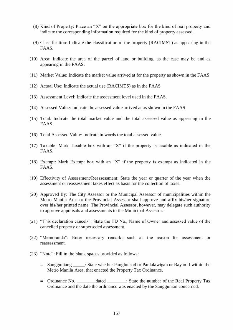
157
(8) Kind of Property: Place an “X” on the appropriate box for the kind of real property and
indicate the corresponding information required for the kind of property assessed.
(9) Classification: Indicate the classification of the property (RACIMST) as appearing in the
FAAS.
(10) Area: Indicate the area of the parcel of land or building, as the case may be and as
appearing in the FAAS.
(11) Market Value: Indicate the market value arrived at for the property as shown in the FAAS
(12) Actual Use: Indicate the actual use (RACIMTS) as in the FAAS
(13) Assessment Level: Indicate the assessment level used in the FAAS.
(14) Assessed Value: Indicate the assessed value arrived at as shown in the FAAS
(15) Total: Indicate the total market value and the total assessed value as appearing in the
FAAS.
(16) Total Assessed Value: Indicate in words the total assessed value.
(17) Taxable: Mark Taxable box with an “X” if the property is taxable as indicated in the
FAAS.
(18) Exempt: Mark Exempt box with an “X” if the property is exempt as indicated in the
FAAS.
(19) Effectivity of Assessment/Reassessment: State the year or quarter of the year when the
assessment or reassessment takes effect as basis for the collection of taxes.
(20) Approved By: The City Assessor or the Municipal Assessor of municipalities within the
Metro Manila Area or the Provincial Assessor shall approve and affix his/her signature
over his/her printed name. The Provincial Assessor, however, may delegate such authority
to approve appraisals and assessments to the Municipal Assessor.
(21) “This declaration cancels”: State the TD No., Name of Owner and assessed value of the
cancelled property or superseded assessment.
(22) “Memoranda”: Enter necessary remarks such as the reason for assessment or
reassessment.
(23) “Note”: Fill in the blank spaces provided as follows:
= Sangguniang _____: State whether Panglunsod or Panlalawigan or Bayan if within the
Metro Manila Area, that enacted the Property Tax Ordinance.
= Ordinance No. ________dated ________: State the number of the Real Property Tax
Ordinance and the date the ordinance was enacted by the Sanggunian concerned.

158
3. Tax Map Control Roll (TMCR) -
a. Title of the Form: Tax Map Control Roll (TMCR)
b. Purpose of the form:
(1) It is the basic document in controlling the PIN in each section map.
(2) It is also used as a reference in real property appraisal and assessment.
c. Offices responsible in preparing and maintaining the TMCR:
- The City Assessor‟s Office
- The Assessor‟s Office in municipalities within the Metro Manila Area
- The Provincial Assessor‟s Office, but such responsibility may be delegated to the Municipal
Assessors thru an office order duly issued for the purpose. However, both offices of the
provincial assessor and the municipal assessor concerned shall each maintain their
respective copies of the TMCRs and the corresponding tax maps.
d. Number of copies to be prepared:
(1) One original copy and one print copy of TMCR shall be prepared in municipalities of Metro
Manila Area and all cities.
(2) In cases of Municipalities outside Metro Manila Area, the original copy and two print
copies shall be prepared. One print copy for the Provincial Assessor‟s Office and another
print copy for the Municipal Assessor‟s Office. The original copy and the map master shall
remain with the Provincial Assessor‟s Office except when it is the municipality that fully
funded the Tax Mapping project in which the case the Municipal Assessor‟s Office keeps
the original and a print copy of both TMCR and map master.
e. Frequency in preparing the Tax Map Control Roll
The Tax Map Control Roll (Post) shall be prepared separately for each of the section maps
and for newly created section maps. Extra sheets may be allowed for listing as need arises.
f. Manner of Filing:
a) TMCRs shall be filed with the corresponding tax maps by barangay.
b) The original copy of the TMCR shall be filed with the original tax map (map master) and
kept in the
- Office of the City Assessor;
- Office of the Municipal Assessor in municipalities within the Metro Manila Area; and
- Office of the Provincial Assessor

159
g. Instructions on the manner of preparing the TMCR
(1) Province/City: Indicate the name of the province or city followed by the corresponding index
number enclosed in parenthesis;
(2) Municipality/District: State the name of the municipality/city district followed by the index
number enclosed also in parenthesis.
(3) Barangay and Section: State the name of the barangay and its index number and the section
index number.
(4) Assessor‟s Lot No.: Indicate the assessor‟s lot number which is the number assigned to an
individual lot.
(5) Survey/Lot No.: Indicate the Survey No., such as Cad-775 or Psd-10011; and/or lot number
and the block number.
(6) Land:
- Title No. - State the OCT, TCT or CLOA number for the initial entry. If there is a change
in the title number, simply indicate the new TCT Number.
- Area - Indicate the area in hectares (e.g. 0.02970 ha) for agricultural and mineral/timber
lands; and in square meters for residential, commercial or industrial lands.
- Class. Code - State the classification code such as “R” for Residential, “A” for Agricultural,
etc.
(7) Name of Owner: Indicate the complete name of the property owner, surname first followed by
the given name, then the middle initial, for the initial entry. In case of change of ownership,
enter the name of the new owner.
(8) ARP No.: Indicate the assigned Assessment of Real Property Number of the property.
(9) TD No.: Indicate the Tax Declaration Number which is the ARPN.
(10) Building/Structure: Indicate the number of buildings/structures that are erected on the lot.
(11) Machinery: Indicate an “X” mark if the machinery has been installed in the building.
(12) Others: Indicate the kind of improvement, other than building or machinery found on the
property.
(13) Remarks: State any explanatory remarks regarding the property that led to the subsequent
assessment or reassessment such as subdivision, duplication of assessment etc. (Transaction
code may be used such as “SD” for subdivision.

160
B. The Non-Technical Real Property Assessment Records. – The non-technical records are
secondary real property assessment records/forms which consist of the following:
The Assessment Roll (AR) for Taxable Real Properties (Attachment 6);
The Assessment Roll (AR) for Exempt Properties (Attachment 7);
The Ownership Record Card (ORC), (Attachment 8);
The Record of Assessment (ROA) (Attachment 9); and
The Notice of Assessment (NA) (Attachment 10)
1. The Assessment Roll
a. Title of the form: Assessment Roll (AR)
b. Purpose of the form:
To serve as a permanent listing of all assessments of real property made.
To provide the Treasurer with the basis for updating and validating real property tax
records.
c. Offices responsible in preparing the form:
Office of the City Assessor
Office of the Municipal Assessor within the municipalities of Metro Manila Area
Office of the Provincial Assessor
The Provincial Assessor may delegate the responsibility of preparing the Assessment
Roll to the Municipal Assessors under his jurisdiction through an office order.
d. Frequency in the preparation of the Assessment Roll:
Initially, the Assessment Roll is prepared during the conduct of a general revision of
real property assessments. Thereafter, a quarterly supplemental update shall be prepared,
furnishing the Treasurer concerned a copy until the next general revision, except in cases
where the assessor‟s records are computerized and the same are directly and operationally
connected to the Office of the Provincial or City or Municipal Treasurer in the form of
Local Area Network (LAN).

161
e. Number of copies to be prepared and the office where they are filed
Number of Copies Type of Copy Office where filed
Municipalities within
Metro Manila:
2 copies Original Municipal Assessor‟s
Office
Duplicate Municipal Treasurer‟s
Office
Cities:
2 copies Original City Assessor‟s Office
Duplicate City Treasurer‟s Office
Municipalities outside of
Metro Manila:
4 copies Original Prov‟l. Assessor‟s Office
Duplicate Mun. Treasurer‟s Office
Triplicate Mun. Assessor‟s Office
Quadruplicate Prov‟l. Treasurer‟s Office
f. Manner of Filing:
The Assessment Roll is filed by barangay together with the supplemental update
which shall be in the same form.
g. Instructions on the manner of Preparing the Assessment Roll
All pertinent information to be entered in this record shall be extracted from the
FAAS.
(1) Assessment Roll for Taxable Properties:
(a) Page No.: Indicate the page number of the sheet, which is the barangay index no.
followed by the sheet number. For instance, barangay “A” has an Index No. 0001 and
the assessment roll consist of 4 sheets, the first sheet bears the page no. 0001-1,
second sheet will bear the page no. 0001-2 and so on.
(b) General Revision CY _________: Indicate the year when the general revision is
undertaken and the subsequent assessments are made using the same Schedule of Fair
Market Values.
(c) Province/City - Indicate the name of the Province or City followed by the Index No.
(d) Municipality/District: Indicate the name of the municipality/district followed by the
Index No.

162
(e) Barangay and Section: Indicate the name of the barangay and its Index Number as
well as the Section Index Number.
(f) Date Prepared: Indicate the date when entries were made in the assessment roll.
(g) ARP No.: Indicate the Assessment of Real Property Number assigned to the property
as stated in the FAAS.
(h) TD No.: Indicate the tax declaration number.
(i) PIN: Indicate only the Assessor‟s Lot number which is the 2-digit number assigned to
the land including the four 4-digit suffixes for buildings or machinery, if any.
(j) Lot/Block No.: Indicate the Lot Number and Block No.
(k) Property Owner: Indicate the name of the property owner with the surname written
first followed by the first/given name and the middle initial.
(l) Address of Property Owner: Indicate the full address of the property owner.
(m) Kind: Indicate the code of the kind of property as stated in the FAAS such as “L” for
Land, “B” for Building and “M” for Machinery.
(n) Classification: Indicate the Classification Code of the subject property, i.e. R for
residential, etc. (RACIMST).
(o) Assessed value: Indicate the assessed value as stated in the FAAS under “Property
Assessment.”
(p) Previous ARPN and TDN: Indicate the superseded ARPN and TDN as shown in the
Record of Superseded Assessment.
(q) Effectivity: Indicate the year or quarter when the assessment took effect.
(r) Remarks: Indicate any explanatory remark regarding the property that led to the
subsequent assessment such as subdivision, duplication of assessment etc.
(Transaction Code may be used such as “SD” for subdivision etc.)
(2) Assessment Roll For Exempt Properties:
(a) Page No.: Indicate the page number of the sheet, which is the barangay index code
followed by the sheet number. For instance, barangay “A” has an Index No. 0001 and
the assessment roll consists of 4 sheets, the first sheet bears the page no. 0001-1,
second sheet will bear the page no. 0001-2 and so on.
(b) General Revision CY _________: Indicate the year when the general revision is
undertaken and the subsequent assessments made using the same Schedule of Fair
Market Values.
(c) Province/City: Indicate the name of the Province or City followed by the Index No.

163
(d) Municipality/District: Indicate the name of the municipality/district followed by the
Index No.
(e) Barangay and Section: Indicate the name of the barangay and the Index Number as
well as the Section Index Number.
(f) Date Prepared: Indicate the date when entries were made initially in the assessment
roll.
(g) ARP No.: Indicate the Assessment of Real Property Number assigned to the property
as stated in the FAAS.
(h) TD No.: Indicate the tax declaration number.
(i) PIN: Indicate only the Assessor‟s Lot number which is the 2-digit number assigned to
the land including the four 4-digit suffixes for buildings or machinery, if any.
(j) Lot/Block No.: Indicate the Lot Number and Block No.
(k) Property Owner: Indicate the name of the property owner with the surname written
first followed by the first/given name and the middle initial.
(l) Address of Property Owner: Indicate the full address of the property owner.
(m) Kind: Indicate the kind code of property as stated in the FAAS such as “L” for land,
“B” for building and “M” for machinery.
(n) Classification: Indicate the Classification Code of the subject property, i.e. “R” for
Residential, etc. (RACIMST).
(o) Assessed Value: Indicate the assessed value as stated in the FAAS under “Property
Assessment.”
(p) Legal Basis of Exemption: State the legal basis for the exemption from real property
tax.
(q) Effectivity: Indicate the year or quarter when the assessment took effect.
(r) Remarks: Indicate any explanatory remark pertaining to the property as in parcel
subdivision, duplication of assessment, etc. which resulted in the subsequent
assessment or reassessment of the subject property. (Transaction Code may be used
such as “SD” for subdivision).

164
3. Ownership Record Card
a. Title of the form: Ownership Record Card (ORC)
b. Purpose of the form:
To expedite the sending of assessment notices to persons owning real property(ies) in a
municipality, city or province.
To serve as a basis for the periodic preparation and sending of demand letters to property
owners;
To determine the total real property ownership/holdings of individuals or corporations in a
local government unit;
c. Office responsible in preparing the ORC:
City Assessor‟s Office
Municipal Assessor‟s Office
Provincial Assessor‟s Office
The Municipal Assessor in municipalities outside the Metro Manila Area shall prepare the
ORC by listing all properties owned by a person located within the municipality. A copy shall
be submitted to the Provincial Assessor who shall in turn consolidate and prepare an
alphabetical listing of all properties province-wide.
d. Number of copies prepared and offices where copies are filed:
Number of copies Type of copy Office where copy is filed
1 copy original Assessor‟s Office of municipalities
within the Metro Manila Area
1 copy original City Assessor‟s Office
1 copy original Provincial Assessor‟s Office
for the consolidated list of properties owned by
a person province-wide
2 copies original Municipal Assessor‟s
Office in municipalities
outside of Metro Manila Area
duplicate Provincial Assessor‟s Office

165
e. Frequency in preparing the form:
- An ORC shall be prepared for every property owner in the municipality/city/province.
- It shall be initially prepared when a person declares/acquires a property in a locality for the
first time.
- It shall be updated whenever the person acquires a property in that locality.
f. Manner of Filing:
The ORC shall be filed in alphabetical order of the surnames of property owners by
municipality, city or province.
g. Instructions on the manner of preparing the ORC
The information to be indicated in this record shall be extracted from the FAAS and shall
be as follows:
1. Name of Owner: Indicate the name of the owner, surname first followed by given name
and middle initial.
2. Address and Tel. No.: Indicate the complete address of the property owner and his/her
telephone number.
3. TIN: Indicate the Taxpayer‟s Identification Number of the declared owner.
4. Date Prepared: Indicate the date the ORC was initially prepared.
5. Prov./City/Mun.: Indicate the name of the Local Government Unit followed by the Index
No.
6. Date of Entry: Indicate the date (Month/day/year) when entry was made.
7. Kind: Indicate the kind code, “L” for land, “B” for building and “M” for machinery as
indicated in the FAAS/TD.
8. Class. Code: Indicate the classification code of the property such as R (residential), A
(Agricultural), C (commercial), I (industrial), M (Mineral), S (Special), and T (Timber) as
indicated in the FAAS.
9. PIN: Indicate the Barangay Index No., the Section Index No. and the Assessor‟s lot No. of
the property in the case of a municipality/city record, but in the case of Provincial Record,
include the Municipality Index No.
10. Title No.: Indicate the OCT, TCT, CCT or CLOA number.
11. Lot/Block No.: Indicate the Lot No. and Block No. under the survey plan as shown in the
FAAS.

166
12. ARPN/TDN; Indicate the Assessment of Real Property Number/Tax Declaration Number
as stated in the FAAS. Previous Owner: Indicate the name of the previous owner.
13. Location of Property: Indicate the building number, if any, and name of street and
barangay, in the case of municipality/city records. In the case of the provincial records,
include the name of the municipality.
14. Area: Indicate the land area in square meters or hectares as stated in the FAAS. In the
case of structures, indicate the total floor area of the building.
15. Market value: Indicate the Market Value as stated in the FAAS.
16. Assessed Value: Indicate the assessed value as stated in the FAAS.
17. Remarks: Indicate any explanatory remark pertaining to the property as in parcel
subdivision, duplication of assessment, etc. which resulted in the subsequent assessment
or reassessment of the subject property. (Transaction Code may be used as “SD” for
subdivision)
4. Record of Assessments of Real Properties
a. Title of the form: Record of Assessments (ROA)
b. Purpose of the form:
To record the assessment transactions and serve as source of statistical data for
reporting.
c. Offices responsible for preparing the Record of Assessments:
Provincial Assessor‟s Office
City Assessor‟s Office
Municipal Assessor‟s Office
d. Number of copies to be prepared
The concerned assessor shall prepare one copy of the form.
e. Frequency of preparation:
The ROA shall be prepared and updated every time an assessment transaction is made.
f. Manner of Filing:
The Record of Assessments shall be filed by barangay arranged alphabetically.

167
g. Instructions on the manner of Preparing the Record of Assessment.
(1) Page Number: Indicate the page number of the ROA.
(2) Province/City: State the name of the province or city followed by the index number.
(3) Municipality/District: State the name of the municipality or district followed by the
index number.
(4) Barangay: State the name of the barangay followed the index number.
(5) Section: Indicate the section number.
(6) Date: Indicate the date the assessment transaction is recorded.
(7) ARP No.: Indicate the Assessment of Real Property Number.
(8) TD No.: Indicate the Tax Declaration number.
(9) Name of Owner: State the complete name of the declared owner.
(10) PIN: Indicate only the Assessor‟s Lot Number which is in two digits.
(11) Location: State the complete property location; the house number and street name,
barangay or district.
(12) Classification: Indicate the classification of the property (RACIMTS).
Land Area: Indicate the land area of the property.
Market Value: Indicate the market value of the taxable and exempt land, buildings or
machinery.
Assessed Value: Indicate the assessed value of the taxable and exempt land, building
or machinery.
Year Taxes Begin: For taxable properties, indicate the effectivity of the taxes as
reflected in the FAAS.
(13) Transaction Code: Indicate the kind of assessment transaction. For assessment or
reassessment involving two (2) or more transactions, the highest rank among the
transactions shall be indicated. Refer to Transaction Code and Ranking in Section I of
this Chapter.
5. Notice of Assessment of Real Properties
a. Title of the form: Notice of Assessment (NA) (Attachment 10)

168
b. Purpose of the form:
To notify the property owner of the market value and assessed value of his/her
property/properties.
To satisfy the due process provision on real property tax assessment under Section 226 of
R.A. 7160.
c. Offices responsible for accomplishing the NA:
Provincial Assessor‟s Office
City Assessor‟s Office
Office of the Municipal Assessor of MMA
In the case of a province, the Provincial Assessor may delegate such responsibility to the
Municipal Assessor.
d. Number of copies to be accomplished:
Two copies shall be prepared by the assessor concerned, the original to be sent to the
declared owner and the duplicate for office file.
e. Frequency in Accomplishing the Notice of Assessment:
It shall be prepared when assessments are made for the first time, when general revision of
assessments are conducted, or when the existing assessment is increased or decreased or when
there is an update in the FAAS and the Tax Declaration arising from change of declared
owner or his address, or correction/change of property location.
f. Manner of Filing:
NA shall be filed according to the sequence of the NA numbers by city or municipality
g. Instruction on the Manner of Accomplishing the Notice of Assessment.
(1) NA Number: Indicate the assigned NA Number.
(2) Property Owner: State the name and address of the declared property owner.
(3) Date: Indicate the date when prepared.
(4) Fill-in the blank space with the year when the taxes on the property accrue.
(5) ARPN/TDN: State the ARPN and the TDN as shown in the FAAS.
(6) PIN: Indicate the Property Identification Number.
(7) Location: Indicate the location of the property.
(8) Classification: Indicate the classification of the property using the appropriate code
(RACIMST).

169
(9) Market Value: State the market value as stated in the FAAS.
(10) Assessed Value: State the assessed value.
(11) Total: State the total amount for market value and assessed value.
(12) Assessor: The Provincial/City/Municipal Assessor or his duly authorized representative
shall affix his/her signature.
(13) Date delivered or mailed: State the date the NA was delivered or mailed.
SECTION 2. – Codes Used in Assessment
The Codes which are used in the assessment records in the Assessor‟s Office are as follows:
A. Kind Code – The Kind Code refers to the code which are used for the different kinds of real
properties, viz:
Kind of Property Code
Land L
Building and Other Structure B
Machinery M
B. Classification Code – The Classification Code refers to the code which are used for the
different classifications of real property on the basis of: (1) the approved schedule of fair market
values – for lands, buildings and other structures, prepared in pursuance of the provisions of
Section 2.1.1 of R.A. No. 7160; and (2) the degree of utilization and/or the ordinance enacted
by the sanggunian concerned strictly in accordance with Section 20 of the said Act, in line with
the decision rendered by the Office of the President under OP Case No. 96-C-6424 dated March
29, 1996. The following classification codes used are as follows:
Property Classification Code
Residential R
Agricultural A
Commercial C
Industrial I
Mineral M
Timberland/Forest T
Special:
Hospital SH
Cultural SC
Scientific SS
Local Water District SW
Corporation engaged in
Generation/distribution of electric
Power SG

170
C. Update or Transaction Code – The Update or Transaction Code refers to the code, which
shall be used to identify the kind of transaction for which the assessment or reassessment of real
property is being made. The transaction, its rank and the corresponding code is covered in
Section I-A of this Chapter under the instructions on the manner of accomplishing the FAAS.
D. Use Code: The Use Code refers to the code of the classification of the property as it is actually
used. The actual use of the property determines the assessment level applicable on the property.
The use code are as follows:
Use Code
Residential AR
Commercial AC
Industrial AI
Agricultural AA
Mineral AM
Timberland/Forest ATF
Hospital ASH
Cultural ASC
Scientific ASS
Local Water District ASLWD
Charitable ACH
Religious ARE
Recreational ARC
Educational AED
Cemetery ACT
Park ARK
Government:
National ANG
Provincial APG
City ACG
Municipality AMG
Barangay ABG
Corporation AGOCC
SECTION 3. – Numbering System in Real Property Assessment Records Management
The numbering system in real property assessment records management are: (a) the Property Index
Numbering System; (b) the Assessment of Real Property/Tax Declaration Numbering System and
(c) the Notice of Assessment Numbering System. However, LGUs with existing numbering system
shall maintain the status quo until such time that they will conduct general revision of property
assessments in order to minimize the cost of revising assessment records.
A. The Property Identification Numbering System. – This is covered in Chapter II, Sections 1
& 2.

171
B. The Assessment of Real Property/Tax Declaration Numbering System – A system for the
numbering of Assessment of Real Property (ARP) and for the Tax Declaration (TD), is hereby
prescribed. Such numbers (for the ARP and TD) will be assigned to every assessment of real
property unit (RPU), which shall be indicated in the space provided for in the forms/records
prescribed under this Manual. The initial numbering shall be done every time a general
revision of real property assessments is conducted, or in some instances, during the
implementation of a Real Property Tax Administration (RPTA) Project.
1. The ARP/TD No. shall be as follows:
a. For Provinces
00 0000 00000
Mun. Barangay Assessment Count
The Municipality and the Barangay Index numbers – The first two (2)-digit number
represents the index number of the municipality; and the next four (4) digit number
represents the index number of the barangay.
The Assessment Count – The last five (5)-digit number represents the assessment number
assigned to every RPU starting with 00001 for the first RPU assessed and 00100 for the
one hundredth RPU assessed and recorded for the barangay, and so on.
b. For Cities (outside Metro Manila Area) –
00 0000 00000
District Barangay Assessment Count
The District Index Number – The first two digit number represents the index number of
the district.
The Barangay Index Number – The next four (4) – digit number represents the index
number of the barangay as may be determined based on the procedure assigning barangay
index numbers for barangays in the tax mapping operations; and
The Assessment Count – The last five (5)-digit number represents the assessment number
assigned to every RPU.
c. For Cities and Municipalities within Metro Manila Area –
AA or A 00 0000 00000
General Revision Mun./District Barangay Assessment Count
The General Revision Indicator – The number of times the LGU has undertaken a general
revision since the effectivity of the Local Government Code of 1991, i.e., AA or A for the
first one conducted immediately after January 1, 1992; and BB or B for the second general
revision of real property assessments, and so on;

172
The Municipality/City District Index Numbers – The two digits represent the index
number of the municipality or city district;
The Barangay Index Number – This shall be the four (4)-digit number of a barangay.
The Assessment Count – The last five (5) digit numbers shall represent the assessment
number assigned to each RPU.
2. Installation of the ARP Numbering System – The process of installing the ARP Numbering
System in a city or municipality is as follows:
a. For a Tax Mapped Municipality/City – The Field Appraisal Assessment Sheets
(FAAS‟s) together with the corresponding tax declarations (TDs) are arranged by PIN;
which are subsequently filed by barangay. Thereupon, the ARP Number, are then
assigned to the FAAS and TD so arranged starting with “00001”.
b. For a Municipality/City Not Tax Mapped – The FAAS‟s together with the
corresponding TDs are first segregated by barangay, which shall also be arranged as in a
tax mapped municipality or city, that is, “0001” for Barangay “Poblacion” and the
remaining barangays are arranged in alphabetical order. The FAAS‟s and the
corresponding TDs, which are filed by barangay, are then arranged in alphabetical order
by the owners‟ surname, and the ARP Numbers are then assigned to such FAAS and
TD.
3. The Notice of Assessment Numbering System – The Notices of Assessment (NAs) are
likewise numbered in such a way that no two Notices of Assessments issued shall bear
identical numbers. The NAs are numbered in the following manner.
a. For Municipalities Outside the Metropolitan Manila Area. – The numbering structure of
the Notices of Assessments for municipalities outside the MMA shall be as follows:
00000 ______________
Prov/Mun. NA Count
where: The first three (3) digits of the five (5)-digit number represent the index number
of the province; the next two (2) digits represent the index number of the
municipality; and the succeeding numbers represent the NA count. The first NA
is assigned the number “1” and the second is assigned the number “2”, and so
on.
b. For all Cities and Municipalities within the Metropolitan Manila Area: The Numbering
structure of the NA for cities and municipalities within the MMA shall be as follows:
000 _______________
City/Mun. NA Count
where: The first three (3)-digit number represents the index number of a city or a
municipality within the MMA; The succeeding numbers shall represent the NA
count. The first NA is assigned the number 1 and the second is assigned the
number 2, and so on.

173
CHAPTER VII
RULES AND PROCEDURES FOR APPEALS FILED BEFORE THE LOCAL
BOARD OF ASSESSMENT APPEALS AND THE CENTRAL BOARD OF
ASSESSEMENT APPEALS
RULE 1. General Provisions
SECTION 1. Title. - These rules shall be known as the Rules of Procedures of the Local Board of
Assessment Appeals and Central Board of Assessment Appeals in line with the provisions of
Section 226 and 230, Chapter 3, title II, Book II of R.A. No. 716 otherwise known as the Local
Government Code of 1991).
SECTION 2. Construction. - These rules shall be liberally construed in order to promote their
objectives and to assist the parties in obtaining just, expeditious and inexpensive determination of
every action relative to the appraisal/assessment and collection of real property taxes.
RULE 2. Local Board of Assessment Appeals
SECTION 1. Jurisdiction. - The Local Board shall have original jurisdiction to hear and decide
appeals of owners/administrators of real property from the action of the Provincial or City
Assessors, or the Municipal Assessors in the Metro Manila Area, in the assessment of their real
properties, and from the action of the Provincial or City Treasurers, or Municipal Treasurers in the
Metro Manila Area, regarding collection of real property taxes, special levies, or other real property
taxes under Title Two, Book II of R.A. No. 7160.
Section 2. Person Who May Appeal. - Any owner or administrator of real property, or any person
having legal interest therein, who is not satisfied with the action of the provincial, city or municipal
assessor in the appraisal/assessment of his property may appeal to the Local Board of Assessment
Appeals of the province or city, or municipality within the Metro Manila Area, where the property
is located. A real property taxpayer who is aggrieved by the decision, action or inaction of the
provincial, city or municipal treasurer over excessive realty tax paid under protest, or on claim for
refund of illegally or erroneously collected real property tax, including special levies on real
property, may likewise appeal to the Local Board as provided in this rules.
SECTION 3. Conditions for Filing an Appeal. - No protest or appeal shall be entertained unless
the Taxpayer first pays the real property tax. There shall be annotated on the tax receipts the words
“PAID UNDER PROTEST”.
Provided, that, in cases where the delinquency is a 100% of the tax paid in previous years, the
Taxpayer may opt, in lieu of cash, to post a surety bond to of the tax which is the subject of the
appeal; Provided, further, that the remaining 50% shall be paid and shall be distributed in
accordance with the provisions of the Implementing Rules and Regulations (IRR) of the Local
Government Code.

174
SECTION 4. Period of Appeal. (a) The owner, administrator or person who is not satisfied with
the assessment of his property may, within sixty (60) days from the date of receipt of the written
notice of assessment, appeal to the Local Board concerned.
Any real property taxpayer who is aggrieved by the decision, action or inaction of the
provincial or city treasurer, or municipal treasurer within the Metropolitan Manila Area, on his
written claim for refund or credit may appeal to the Local Board concerned as follows:
A. If, within sixty (60) days from the date or receipt by the treasurer concerned of the written
claim for refund or credit for tax paid under protest, the treasurer concerned fails to make
any decision thereon, the appeal may be made within sixty (60) days from the date of
receipt by the treasurer concerned of the said written claim for refund or credit; or
B. If, within sixty (60) days from the date of receipt by the treasurer concerned of the written
claim for refund or credit for tax paid under protest the treasurer concerned denies the said
claim, the appeal may be made within sixty (60) days from the date of receipt by the
taxpayer concerned of the said treasurer‟s decision denying the said claim.
SECTION 5. Parties in the Local Board. - The real property owner or person making the appeal
shall be referred to as the “Petitioner” and the Provincial or City Assessor or Treasurer, or the
Municipal Assessor or Treasurer within the Metropolitan Manila Area, shall be referred to as the
“Respondent”.
SECTION 6. Grounds for Appeal. - Any action of the Provincial, City or Municipal Assessor in
the assessment of real property, and any action or inaction of the Provincial or City Treasurer, or
Municipal Treasurer, on the taxpayer‟s claim for refund of taxes paid under protest, or on claims
for reduction or adjustment of taxes paid or for tax credits on illegally or erroneously collected
realty taxes and such other real property taxes or special levies under title Two, Book II of Republic
Act No. 7160, may be appealed before the Local Board concerned.
SECTION 7. Requisites for Filing of Appeal - The appeal shall be effected by filing, within the
reglementary period, with the Local Board concerned a petition under oath which shall state the
action of the provincial, city or municipal assessor or treasurer appealed from, the grounds relied
upon, the arguments in support thereof, and the date the petitioner received the written notice of
assessment or revised assessment or tax declaration with a written notice of assessment. For this
purpose, the Secretary of the Local Board may assist the petitioner in the filing of the appeal for
purposes of substantial compliance with the aforementioned requirements.
SECTION 8. Nature of Proceedings – The proceedings before the Local Board shall be
conducted solely for the purpose of ascertaining the truth without necessarily adhering to the
technical rules applicable in judicial proceedings.

175
SECTION 9. Effect of Appeal on Collection of Taxes. – An appeal shall not suspend the
collection of the corresponding realty taxes on the real property subject of the appeal as assessed by
the provincial, city or municipal assessor, without prejudice to subsequent adjustment depending
upon the outcome of the appeal. An appeal may be entertained but the hearing thereof shall be
deferred until the corresponding taxes due on the real property subject of the appeal shall have been
paid under protest or the petitioner shall have posted a surety bond, subject to the following
conditions:
A. The amount of the bond shall be paid in accordance with the prescribed rate pursuant to
Section 3 of this Rule;
B. The bond must be accompanied by a certification from the Insurance Commissioner (a) that
the surety company is duly authorized to issue such bond; (b) that the surety bond is
approved by and registered with said Commission; and (c) that the amount
covered by the surety bond is within the writing capacity of the surety company; and
C. The amount of the bond in excess of the surety company‟s writing capacity, if any, must be
covered by Reinsurance Binder, in which case, a certification to this effect must likewise
accompany the surety bond.
SECTION 10. Period within which to Decide – The Local Board shall decide the appeal within
one hundred twenty (120) days from the date of receipt of such appeal. The Board, after hearing,
shall render its decision based on substantial evidence or such relevant evidence on record as a
reasonable mind might accept as adequate to support the conclusion.
SECTION 11. Service of Decision to Parties – The Local Board Secretary shall furnish the
parties to a case each with a copy of the decision of the Local Board. Where the parties are
represented by counsel, serving the decision to the party‟s counsel is deemed proper service to the
party.
SECTION 12. Revision of Assessment – In case the Provincial or City Assessor concurs in the
revision of the assessment, it shall be his/her duty to notify the petitioner of such fact using the
form prescribed for the purpose.
SECTION 13. Powers and Duties – In the exercise of its appellate jurisdiction, the Local Board
shall have the power to summon witnesses, administer oaths, take depositions, and issue subpoena
and subpoena duces tecum and conduct ocular inspections of the real properties in question.
The Local Board shall conduct hearings on all appealed cases and render decisions thereon
within the periods prescribed by law. It shall likewise inform the Central Board of any new matter
or issue not provided for in these rules, and submit to the latter such reports or information as the
Central Board may require from time to time.

176
RULE 3. CENTRAL BOARD OF ASSESSMENT APPEALS
SECTION 1. Appellate Jurisdiction. – The Central Board shall have exclusive jurisdiction to
hear and decide all appeals from the decisions, orders and resolutions of the Local Boards
involving contested assessments of real properties, claims for tax refund and/or tax credits or
overpayments of taxes.
SECTION 2. What may be Appealed. – All decisions, resolutions, and orders of Local Boards
in cases involving (1) contested assessments of real properties, (2) claims for refund of taxes
overpaid and claims for tax credits, and (3) protests against special levies may be appealed to the
Central Board of Assessment Appeals as prescribed herein.
SECTION 3. Who may Appeal and When to Appeal. – Any party in a case before the Local
Board who feels aggrieved by the decision, resolution or order of the said Local Board may, within
thirty (30) days from and after receipt of the said decision, resolution or order, appeal to the Central
Board.
SECTION 4. How an Appeal maybe Taken. – An appeal shall be taken by filing a written
notice of appeal, and the appeal itself, personally or by registered mail, with the Local Board which
rendered the decision, resolution or order appealed from, or directly with the Central Board or with
the latter‟s field office in the area where the real property in question is located, after serving a
copy each of the notice of appeal and the appeal upon the adverse party or the latter‟s attorney.
The appeal shall state clearly and distinctly the decision, resolution or order appealed from, the
date when appellant received a copy thereof, the grounds relied upon, and the arguments in support
thereof.
SECTION 5. Time to Answer or Comment. – The appellee may, within ten (10) days from and
after receipt of the appeal, file his answer or comment thereto after service of a copy of said
answer/comment upon the appellant.
SECTION 6. Transmittal of Records and Appeal. – Within ten (10) days from receipt of the
notice of appeal or from receipt of the notice from the Central Board to the effect that an appeal has
been filed, whichever comes first, the Local Board which rendered the decision or order appealed
from shall transmit to the Central Board the complete original records of the case, together with
transcripts of stenographic notes, if any. The records, with pages duly numbered from the earliest
document to the latest, shall be accompanied by a certification to the effect that the same constitute
the original and complete records of the case involved.
SECTION 7. Effect of Appeal on the Collection of Taxes. - An appeal shall not suspend the
collection of the corresponding realty taxes on the real property subject of the appeal as assessed by
the assessor concerned without prejudice to subsequent adjustment depending upon the final
outcome of the appeal.

177
SECTION 8. Withdrawal of Appeal. – The Appellant may withdraw his appeal at any time
before the resolution thereof by the Central Board by filing a written notice of withdrawal with the
Central Board which shall enter a memorandum thereof upon the docket of the case. The parties
thereto shall forthwith be advised in writing by the Central Board of such withdrawal. No further
proceedings shall be taken on the appeal, the withdrawal having the same effect as that of dismissal
of the appeal.
SECTION 9. Period within which to Decide and Finality of Decision. – The Central Board
shall decide cases brought before it on appeal within twelve (12) months from the date of receipt
thereof. A decision by the Central Board shall become final and executory fifteen (15) days after
receipt thereof by the appellant or appellee, as the case may be. If a petition for reconsideration is
filed on time, said decision, as may be modified by a resolution on such petition, shall become final
and executory fifteen (15) days after receipt by the appellant or appellee, as the case may be, of a
copy of said resolution.
SECTION 10. Decisions, Orders and Entry Relative to Appeals. – All decisions of the Central
Board determining the merits of the case brought before it on appeal shall be in writing and signed
by the members of said Board, stating clearly and distinctly the facts and the law on which they are
based, and filed with the Secretary of the Board.
As soon as it becomes final, the decision or order shall be entered in the Book of Entries of
Decisions with a notation on the dispositive portion of the decision or order.
SECTION 11. Petition for Reconsideration. – The Central Board shall, with like jurisdiction,
resolve petitions for reconsideration of its decisions, resolutions or orders. An aggrieved party may
file a motion for reconsideration within fifteen (15) days from the date he receives the Central
Board‟s decision, resolution or order sought to be reconsidered, furnishing the adverse party with a
copy of such motion: Provided, That only one petition for reconsideration shall be entertained.
SECTION 12. Opposition. – The adverse party may file his opposition to the motion for
reconsideration within ten (10) days from the date he receives a copy of the said motion.
SECTION 13. Action taken on Motion for Reconsideration. – The motion for reconsideration,
as well as the opposition thereto, which shall embody all the arguments in support thereof, shall be
set by the Central Board Secretary for hearing on the next “Motion Day”. Upon the expiration of
the period set forth in the preceding section of this Rule without any opposition having been filed,
the motion for reconsideration shall be considered submitted for resolution by the Central Board,
unless the Board deems it necessary to hear oral arguments, in which case, the Central Board shall
issue the proper order.

178
CHAPTER VIII
MISCELLANEOUS PROVISIONS
SECTION 1. – Provincial/City Appraisal Committees
Executive Order No. 132 dated December 22, 1987 as amended, authorizes the creation of an
Appraisal Committee in a Province and City. The Provincial/City Appraisal Committee is tasked
generally to determine the market value of a real property to be acquired by the government for
public purpose.
Article III, Section 9 of the 1987 Constitution provides that “Private property shall not be taken
for public use without just compensation”.
Whenever a private property is subject to acquisition by the government for public use, that
property is referred to the Provincial/City Appraisal Committee for it to determine the market
value.
A. Composition of the Appraisal Committee
1. Provincial/City Appraisal Committee
Provincial /City Assessor – Chairperson
Provincial/City Engineer -- Member
Provincial/City Treasurer --- Member
In a province where there is no position for Provincial Engineer, the Public Works Engineer
or the Highways District Engineer shall sit as member.
2. Metro Manila Area
a. City Appraisal Committee
MMDA Chairperson - Chairperson
City Assessor - Member
City Treasurer - Member
City Engineer - Member
DPWH District Engineer - Member
b. Municipal Appraisal Committee
MMDA Chairperson - Chairperson
DPWH District Engineer - Member
Municipal Assessor - Member
Municipal Engineer - Member
Municipal Treasurer - Member

179
B. Requisites for a Valid Exercise of the Power of Eminent Domain by Local Government
Units
1. An ordinance authorizing the local chief executive to subject the property to the LGU‟s power
of eminent domain or to expropriation;
2. The power of eminent domain shall be exercised for public use, purpose or welfare for the
benefit of the poor and the landless;
3. There shall be payment of just compensation; and
4. A valid and definite offer to buy the property must have been previously made to the owner
but that the offer was not accepted (Pimentel, 1993).
C. Public Use, Purpose or Welfare
The following shall be considered among others as public use, purpose or welfare:
1. Socialized housing;
2. Construction or extension of roads, streets, sidewalks, viaducts, bridges, ferries, levees,
wharves, or piers;
3. Construction or improvement of public buildings maintained and operated by the government
for public use such as nurseries, health centers, or hospitals, buildings for research, breeding,
or dispersal centers for animals;
4. Establishment of parks, playgrounds, or plazas;
5. Establishment of public market places;
6. Construction of artesian wells or water supply systems;
7. Establishment of cemeteries or crematories;
8. Establishment of drainage systems, cesspools, or sewerage systems;
9. Construction of irrigation canals or dams;
10. Establishment of nurseries, health centers, or hospitals; and
11. Establishment of abattoirs.
12. Building of research, breeding, or dispersal centers for animals.

180
D. Modes of Acquisition of Real Property
1. Acquisition through Negotiated Sale – As an initial step, the government implementing
agency/instrumentality concerned shall negotiate with the owner of the land that is needed for
the project for the purchase of the said land, including improvements thereon. In the
determination of the price to be paid, the Department of Finance and the Provincial/City
Assessors shall extend full assistance and coordination with the personnel of the concerned
government implementing agency in the valuation of current market value declared by the
owner or administrator of the land, or such current market value as determined by the
assessor, whichever is lower, prior to the negotiation
A.O. No. 50, as amended by R. A. No. 8974, provides that the zonal value shall be the
basis of the offer to acquire property for public purpose less the additional 10% increase in the
existing zonal value. However, both A. O. No. 50 and R. A. No. 8974 do not provide for the
basis and procedure in the acquisition of buildings and improvements as well as the valuation
of machinery and equipment to be affected by the project nor do they apply to the acquisition
of properties by the local government for public purpose. It is, therefore, necessary that an
appraisal committee be created in Local Government Units for the appraisal of properties to
be acquired for public purposes. It is but proper that a building and an improvement must be
appraised taking into consideration the following factors:
1. The rise of the building and improvement affected.
2. The materials used
3. The age or depreciation of the building plus other factors such as economic and legal
obsolesce.
2. Expropriation – If a negotiation fails to acquire a private property for public use, purpose, or
welfare through purchase, the LGU may expropriate said property through a resolution of the
sanggunian authorizing its chief executive to initiate expropriation proceedings.
The local chief executive shall cause the provincial, city or municipal attorney concerned
or, in his absence, the provincial or city prosecutor, to file expropriation proceedings in the
proper court in accordance withy the Rules of Court and other pertinent laws.
The LGU may immediately take possession of the property upon filing of expropriation
proceedings and upon making a deposit with the proper court of at least fifteen percent (15%)
of the fair market value of the property based on the current tax declaration of the property to
be expropriated.
The amount to be paid for the expropriated property shall be determined by the proper
court, based on the fair market value at the time of the taking of the property.
In order to facilitate the immediate judicial determination of just compensation during the
expropriation proceedings, the expropriating agency or its duly authorized assessor in
appraising the market value of the private property that is subject to expropriation must
consider, among others, the well established factors and the following relevant standards:
a) The classification and use for which the property is suited;

181
b) The developmental costs for improving the land;
c) The value declared by the owners;
d) The current selling price of similar lands in the vicinity;
e) The reasonable disturbance compensation for the removal and/or demolition of certain
improvements on the land and for the value of improvements thereon;
f) The size, shape or location, Field Appraisal and Assessment Sheet, Tax Declaration and
zonal valuation of the land;
g) The price of the land as manifested in the ocular findings, oral as well as documentary
evidence presented; and
h) Such facts and events so as to enable the affected property owners to have sufficient funds
to acquire similarly-situated lands of approximate areas as those acquired from them by
the government, and thereby rehabilitate themselves as early as possible.
E. Activities Preparatory to Acquisition of Property (E.O. 1035)
l. Feasibility Studies
Feasibility studies shall be undertaken for all major projects, and such studies shall, in
addition to the usual technical, economical operational aspects, include the social, political,
cultural and environmental impact of the project.
2. Information Campaign
Every agency, office and instrumentality of the government proposing to implement a
development project which requires the acquisition of private real property or right thereon
shall first make consultations with the local government officials, including the regional
development councils having jurisdiction over the area where the project will be undertaken,
to elicit their support and assistance for the smooth implementation of the project. The
implementing agency/instrumentality concerned with the assistance of the local government
officials and representatives of the Office of the Media Affairs shall conduct an extensive
public information campaign among the local inhabitants that will be affected by the project
to acquaint them with the objectives and benefits to be derived from the project and thus
avoid any resistance or objection to the acquisition of the subject property.
3. Detailed Engineering Surveys
The implementing government agency/instrumentality concerned shall undertake detailed
engineering, including parcellary surveys to indicate the location and size of the sites and to
determine ownership of the land to be acquired, including the status of such land.

182
4. Project Cost/Funding
The estimated cost of a project shall have the following distinct components:
a. Pre-investment cost which shall include the cost of undertaking the feasibility study and
public information campaign;
b. Investment cost which shall include the cost of detailed engineering, cost of the property
to be acquired and cost of construction and construction supervision.
The programming and budgeting of funds for the pre-investment and pre-construction
phases, carried out in that order, shall be undertaken well in advance of the scheduled
commencement of construction. The implementing agencies/instrumentalities concerned shall
include in their respective annual budgetary proposal provisions to finance these preparatory
activities. The Office of the Department of Budget and Management (DBM) shall consider
such proposals in the light of the foregoing. In the case of departments handling
infrastructure, the necessary outlays for each phase of the pre-implementation activities shall
be made a distinct component of the annual infrastructure program which shall be released by
the DBM as scheduled.
F. Procedures to be followed in the Acquisition of Private Property for Public Use (Rule VI
[Eminent Domain] Rules and Regulations Implementing the Local Government Code of
1991):
1. In acquiring private property for public use or purpose, the LGU shall first establish the
suitability of the property to be acquired for the use intended, then proceed to obtain from the
proper authorities the necessary locational clearance and other requirements imposed under
existing laws, rules and regulations;
2. The offer to buy private property for public use or purpose shall be in writing. It shall specify
the property sought to be acquired, the reasons for its acquisition, and the price offered;
3. If the owner or owners accept the offer in its entirety, a contract of sale shall be executed and
payment forthwith made;
4. If the owner or owners are willing to sell their property but at a price higher than that offered
to them, the local chief executive shall call them to a conference for the purpose of reaching
an agreement on the selling price. The chairman of the appropriation or finance committee of
the sanggunian, or in his absence, any member of the sanggunian duly chosen as its
representative, shall participate in the conference. When an agreement is reached by the
parties, a contract of sale shall be drawn and executed; and
5. The contract of sale shall be supported by the following documents:
a. Resolution of the sanggunian authorizing the local chief executive to enter into a contract
of sale. The resolution shall specify the terms and conditions to be embodied in the
contract;

183
b. Ordinance appropriating the amount specified in the contract; and
c. Certification of the local treasurer as to availability of funds together with a statement that
such fund shall not be disbursed or spent for any purpose other than to pay for the
purchase of the property involved.
SECTION 2. – Zonal Valuation
A. Background
Zonal valuation for revenue/tax purposes is a relatively new concept in Philippine taxation.
It was adopted and made effective in 1998.
Before 1998, real property valuation for the national gains tax, income tax and transfer tax
was based on the valuation that was done at the local government for its annual real property
tax collection. This local government valuation of real property uses only a fraction of the
market value as basis for computing the tax due from each real property owner.
Realizing the great potentials from real property valuation as a source of more revenues, the
taxing arm of the government (Bureau of Internal Revenue) has given more attention to land
valuation at the national level. The land valuation procedure approximates the current market
value but which is based on the guiding principles of taxation.
B. Legal Basis
Section 6(E) of the National Internal Revenue Code (NIRC) of 1997 which took effect on
January 1, 1998 provides the authority for zonal valuation. The NIRC empowers the
Commissioner of the Bureau of Internal Revenue (BIR) to:
1. Divide the Philippines into zones or areas; and
2. Determine the market value (MV) of real properties in each zone/area.
The same authority for zonal valuation, however, provides safeguards for the protection of
real property owners:
1. That consultations shall be conducted and be made with competent appraisers from both the
public and private sector and;
2. For purposes of computing the internal revenue tax, the value of the property shall be either
the zonal value or the value shown in the Schedule of Fair Market Values (SFMV) of the
Provincial/City Assessors, whichever is higher.

184
C. Objectives
1. To establish a realistic value of real properties as a basis for computing internal revenue tax;
and
2. To minimize the use of discretion in determining the tax base.
D. Zonal Valuation Process
The determination of zonal values is done by committees which are composed of different
agencies that are involved in land administration/management at the national and revenue
district levels. The zonal values are submitted for approval by the Secretary of Finance.
The details of the procedural steps on how the values are arrived at are found in Revenue
Memorandum Order No. 56-89.
E. Zonal Value and Market Value
The general standards for valuation of real property for tax purpose is the market value
which is defined in this manual. Zonal value is a value set by the government for internal
revenue tax purposes derived from a diversified valuation procedure adopted by the committees
or recommending body. The zonal values take effect after approval by the Secretary of
Finance. These zonal values remain in force until the subsequent revision/amendment.
F. Taxes Affected by Zonal Values
There are four (4) types of taxes that can be collected from the transfer, exchange or
disposition of real properties. These are the Capital Gains Tax, Estate Tax, Donor‟s Tax and
Documentary Stamp Tax.
SECTION 3. – Land Use Planning
A. Legal Basis
Section 20 (c) of the Local Government Code (LGC) and Article 41 of it‟s Implementing
Rules and Regulations (IRR) provide that “the local government units shall, in conformity with
existing laws, continue to prepare their respective comprehensive land use plans enacted
through zoning ordinances which shall be the primary and dominant bases for the future use of
land resources: provided that the requirements for food production, human settlement and
industrial expansion shall be taken into consideration in the preparation of such plans”. The
comprehensive land use plan shall also be the basis for “reclassification of agricultural lands”.

185
B. Objectives
The primary objective of land use planning is to ensure the wise use of land and its
protection from critical environmental areas. Land use planning will bring about the:
1. Productivity of the land through modernization of agricultural technology;
2. Increase of productivity per unit area;
3. Utilization of land in accordance with it‟s sustainability for continuous production;
4. Protection, preservation and rehabilitation of critical environmental areas and watersheds;
5. Prohibit population pressure on protected land areas; and
6. Regulate conversion of prime agricultural lands for urban development.
C. Responsibility for Land Use Planning
1. Cities and municipalities shall prepare their respective comprehensive land use plans
(CLUPs) through the City or Municipal Planning and Development Office (CPDO/MPDO).
2. The MPDO is responsible for the determination, development and formulation of the
municipal land use plan consistent with the provincial and national land use policy. CLUPs
of municipalities shall be approved by their Sanggunian.
2.1 The Municipal Assessor provides the maps, classification and actual use of real
properties in the municipality.
3. The MPDO submits its CLUP to the Provincial Planning and Development Office (PPDO) for
review and approval.
4. In the same manner, the CPDO prepares its CLUP and submits it to its Sanggunian for
approval.
5. Both the PPDO and CPDO submit their CLUPs to the Regional Land Use Committee for
approval. All copies of CLUPs are submitted to The National Economic Development
Authority (NEDA) which is the lead agency for land use planning.
D. Conversion of Agricultural Lands to Non-Agricultural Uses
The Department of Agrarian Reforms (DAR) is mandated to approve or disapprove
applications for conversion, restructuring or readjustment of agricultural lands into non-
agricultural uses pursuant to Section 4 (j) of E.O. No. 129-A, series of 1987. It is vested with
the exclusive authority to approve or disapprove applications for conversion of agricultural
lands for residential, commercial, industrial, and other land uses. Action on applications for
land use conversion on individual landholding shall remain as the responsibility of the DAR,
which shall utilize as its primary reference, documents on the comprehensive land use plans and
accompanying ordinances passed upon and approved by the local government units concerned,
together with the National Land Use Policy pursuant to R.A. No. 6657 and E.O. No. 129-A.

186
1. The following may apply for conversion:
a. Owners of private agricultural lands or other persons duly authorized by the landowners.
b. Farmer-beneficiaries of the Agrarian Reform Program after the lapse of five (5) years
from award, reckoned from the date of registration of their landholdings, and who have
fully paid their obligations and are qualified under A.O. No. 07, Series of 1997 issued by
DAR, or persons duly authorized by it.
c. Government agencies, including government-owned or controlled corporations.
This shall cover all private agricultural lands as defined herein regardless of tenurial
arrangement and commodity produced. It shall also include all untitled
agricultural lands and agricultural lands reclassified by LGUs into non-agricultural uses
after June 15, 1988, pursuant to M.C. No. 54, Series of 1993 of the Office of the President
and those proposed to be used for livestock, poultry and swine-raising.
2. The following criteria were adopted as bases for the approval of applications for conversion:
a. Agricultural lands classified or zonified for non-agricultural uses by LGUs and approved by
the HLURB before June 15, 1988 shall be governed by DAR Administrative Order No. 6,
Series of 1994.
b. Conversion may be allowed if at the time of the application, the lands are reclassified as
commercial, industrial, residential or other non-agricultural uses in the new or revised town
plans promulgated by the local government unit and approved by the HLURB or by the
Sangguniang Panlalawigan (SP) after June 15, 1988 in accordance with Section 20 of R.A.
7160, as implemented by M.C. No. 54, and E.O. No. 72, Series of 1993 of the Office of the
President.
c. If the city/municipality does not have a comprehensive development/land use plan and
zoning ordinance duly approved by the HLURB/SP but the dominant use of the area
surrounding the land subject of the application for conversion is no longer agricultural or if
the proposed use is similar to, or compatible with the dominant use of the surrounding areas
as determined by the DAR, conversion may be granted.
E. The following areas shall be classified as highly restricted from conversion:
1. Lands classified as Highly Restricted from Conversion in the Network of Protected Areas for
Agriculture as delineated by the DA, as follows:
a. Irrigable lands without irrigation project with firm funding commitments;
b. Agro-industrial croplands, or lands presently planted to Industrial crops that support the
economic viability of existing agricultural infrastructure and agro-based enterprises; and.

187
c. Highlands, or areas located in elevations of 500 meters or above and have the
potential for growing semi temperate and usually high value crops.
2. Lands issued a Notice of Acquisition/Valuation under the agrarian reform program or subject
of a perfected agreement between the landowner and the beneficiaries under the Voluntary
Land Transfer (VLT) or Direct Payment Scheme (DPS) under CARP; and
3. Areas identified as environmentally critical as determined by the DENR, pursuant to P.D. 1586
(1987) and it‟s implementing rules and regulations.
4. Lands falling under this classification may only be converted upon compliance with existing
laws and submission of the following:
a. Social Benefit-Cost Analysis approved by the DA; and
b. Environmental Impact Assessment (EIA) and/or
c. Environmental Clearance Certificate (ECC).
F. The following areas shall not be subject to or are non-negotiable for conversion:
1. Protected areas designated under the National Integrated Protected Areas (NIPAS), including
watershed and recharged areas of aquifers, as determined by the Department of
Environment and Natural Resources (DENR, pursuant to R.A. 7586 (1992).
2. All irrigated lands, as delineated by the DA and/or the National Irrigation Authority (NIA)
under the Network of Protected Areas for Agriculture where water is available to support
rice and other crop production, and all irrigated lands where water is not available for rice
and other crop production but are within areas programmed for irrigation facility
rehabilitation by the DA and the NIA, pursuant to Presidential Administrative Order No. 20
(1992):
For this purpose, the Network of Protected Areas for Agriculture (as of 1991), as
determined by the DA and/or NIA shall serve as guide in determining non-negotiable areas.
a. All irrigable lands already covered by irrigation project with firm funding commitments,
as delineated by the DA and/or NIA;
b. All agricultural lands with irrigation facilities operated by private organizations; and
c. In all cases, applicants for conversion involving lands protected from and non-
negotiable for conversion shall not be given due course.

188
G. Environmental Critical Areas – refer to areas declared by law as:
1. areas for national parks, watershed reserves, wildlife preserves, and sanctuaries;
2. areas set aside as aesthetic potential tourist spots;
3. areas which constitute the habitat for endangered or threatened species of indigenous
Philippine wildlife (flora and fauna);
4. areas of unique historic, archaeologic, or scientific interests;
5. areas which are traditionally occupied by cultural communities and tribes;
6. areas with critical slopes;
7. areas frequently visited and/or hard hit by natural calamities (geologic hazards, floods,
typhoon and volcanic activities);
8. areas classified as prime agricultural lands;
9. recharged areas of aquifers;
10. water bodies;
11. mangrove areas;
12. coral reefs;
13. mossy and virgin forests;
14. river banks; and
15. swamp forests and marshlands
SECTION 4. – Real Property Tax Administration (RPTA) Project
A. Objectives of the RPTA
1. RPTA Project was designed to develop real property tax to its fullest potential as a major
local revenue source with the following specific objectives:
a. To evolve a comprehensive system of real property appraisal that will ensure a realistic
property valuation for taxation purposes;
b. To establish uniform assessment methods and procedures to standardize property values
in each LGU;
c. To ensure that the ad valorem tax on real property shall be just, uniform and equitable;

189
d. To adopt the necessary measures that will promote maximum tax collection efficiency at
the local levels;
e. To provide for optimum utilization by the local government for the proceeds from the real
property tax collection;
f. To formulate an adopt policies and procedures to improve technical skills and develop
reasonable standards of performance in the local assessment and treasury services.
B. Major Components of the RPTA Project
1. RPTA project is composed of 3 (three) major components which integrate the following
technical and administrative processes:
a. Tax Mapping
b. Records Conversion
c. Tax Collection
C. Role of the Local Chief Executive in the RPTA Project
The Local Chief Executives, being heads of LGUs will be directly involved in the initial
planning, implementation and monitoring of the RPTA Project and shall be responsible for
disseminating information about the RPTA Project to their constituents.
D. RPTA Project Costing
1. The RPTA Project Total Cost shall be shared by the national government through
grant/national assistance and the LGU concerned as follows:
a. To determine the required funding requirements of an RPTA project, the LGU has to
determine the total number of Real Property Units (RPUs) in its jurisdiction.
b. The standard costing set by BLGF in 2005 is Php 125.00/rpu to cover the cost of the
RPTA project.
Sample Computation:
A Local government unit with 10,000 rpus, the total project cost is:
Tax Mapping 10,000 x Php 60.00 = Php 600,000.00
Records Conversion 10,000 x 40.00 = 400,000.00
Tax Collection 10,000 x 25.00 = 250,000.00
_____________
Total RPTA Project Cost Php1,250,000.00
============

190
SECTION 5. – Assessment Loan Revolving Fund (ALRF)
An Assessment Loan Revolving Fund (ALRF) was created pursuant to P.D. 1002, which
provides as follows:
“Assessment Loan Revolving Fund. – The sum of fifty million pesos is hereby
appropriated out of the unallocated balance of internal revenue allotments to local
governments, after distribution of their individual shares pursuant to Section One of
Presidential Decree No.144, as amended, to constitute an Assessment Loan Revolving Fund for
financing tax-mapping projects, periodic revision of assessments, and other real property
assessment programs of provinces, cities and municipalities. Such fund shall be administered
by the Secretary of Finance and shall be loaned without interest to provinces, cities and
municipalities, under such terms and conditions as he may impose.”
A. The local government unit that may avail of the ALRF
All provinces, cities and municipalities can avail of the loan from the P50-M Assessment
Loan Revolving Fund to finance any of the following programs/projects:
1. Tax Mapping Project
2. General Revision of Real Property Assessments
3. Other real property assessment programs
B. The government agency that administers the ALRF
The P50-M ALRF is administered by the Bureau of Local Government Finance,
Department of Finance (BLGF-DOF) available as loan to the province, city or municipality at
an amount not exceeding their borrowing capacity as Certified by the BLGF, payable in five (5)
equal annual installments without interest.
C. Requirements for application for loan from the ALRF
The loan application by the province, city or municipality shall be filed in the BLGF, 8th
Floor, EDPC Building, Bangko Sentral ng Pilipinas Complex, Roxas Blvd., Manila. The Loan
application shall be accompanied by the following documents:
1. A resolution of the Sangguniang Panlalawigan, Sangguniang Panlungsod or Sangguniang
Bayan, authorizing the Provincial Governor, City or Municipal Mayor to enter into a loan
agreement with the Department of Finance, indicating the amount of loan desired and the
specific project to be undertaken (MOF Assessment Regulations No.4-77 dated May 23,
1977).
2. A Project Study and Action Plan (PSAP).

191
D. Release of Loan Proceeds
The proceeds of the loan shall be released to the Provincial/City/Municipal Treasurer
concerned in the following manner:
1st Release – 50% of the approved loan to be used primarily for the purchase and acquisition of
supplies and materials, furniture and equipment, base maps and other expenses
necessary in the initial stage of project implementation.
2nd
Release – 30% of the approved loan.
a. Submission of the Report of Actual Accomplishments of the Project duly certified by the
Assessor concerned.
b. Submission of the Report of Actual Expenditure covering the 1st release jointly signed by
the Assessor and the Treasurer;
c. Favorable recommendation by the representative of the BLGF-DOF (Central Office), who
evaluated the Project in the field.
3rd
Release – 20% of the approved loan.
a. Requirements for release of the loan proceeds:
(1) Certification by the Assessor concerned that the project financed by the loan is at least
75% completed and duly attested by the Governor/Mayor;
(2) Submission of the Actual Accomplishment of the project duly certified by the assessor;
(3) Submission of the report of actual expenditures covering the 2nd
release jointly signed
by the assessor and treasurer; and
(4) Favorable recommendation by the representatives of the BLGF – Central Office.
E. Terms and Conditions of the Loan
The terms and conditions of the loan are defined in the Contract of Loan executed by and
between the DOF and the Provincial Governor/City Mayor/Municipal Mayor. A sample of the
Contract is shown hereunder:

192
C O N T R A C T O F L O A N
KNOW ALL MEN BY THESE PRESENTS:
This is a CONTRACT OF LOAN executed by and between the
………………………………………………, represented by the …………………… …………..,
hereinafter known as the PARTY OF THE FIRST PART and the Republic of the Phil ippines,
represented by the Department of Finance, Administrator of the Assessment Loan Revolving Fund,
established by virtue of Presidential Decree No.1002, hereinafter known as the PARTY OF THE
SECOND PART.
- W I T N E S S E T H -
That the PARTY OF THE FIRSYT PART having submitted to the PARTY OF THE
SECOND PART all the required supporting papers incident to the application of loan.
NOW, THEREFORE, for and in consideration of the foregoing premises, the PARTY OF
THE SECOND PART hereby grants and approves a loan in the amount of
………………………………………….., Philippine Currency, out of the Assessment Loan
Revolving Fund to the …………………………………… and that the PARTY OF FIRST PART
hereby accepts said loan subject to the following terms and conditions:
1. That the proceed of the loan shall be expended on the basis of the estimated costs of the project
as itemized in the Project Study and Action Plan submitted by the
borrower…………………………….. which Plan is hereby made an integral part hereof as
Annex “A”.
2. That the initial release of the proceeds of the loan shall be approximately 50% hereof, the date
of release and the amount thereof shall be scheduled and determined by the Department of
Finance.
3. That the prosecution of the project shall be started not later than sixty days from the date of
receipt of the amount covering the first release of the loan.
4. That the project shall not be let to any private person.
5. That the second and last releases of the portions of the loan, shall be subject to a prior
submission of “progress report” to the Executive Director, Bureau of Local Government
Finance, copy furnished the Accounting Division, both of the Department of Finance, duly
verified by the representatives of the BLGF-DOF who personally inspected the project;

193
6. That the period of repayment of the annual proceeds of the loans shall be for five (5) years in
equal annual amortization, to commence on or before the end of December of the year
following the year of completion of the project until the same have been fully paid and
liquidated; Provided, however, That if the project is not finished even after the full release of
the loan, the repayment shall commence on or before the end of December of the year following
the year of the last release of the loan.
7. That the completion of the project, for purposes of determining the running of the period of
repayment, shall be certified by the BLGF-DOF representative who inspected and evaluated the
project;
8. That in case the borrower ______________________ concerned fails to pay the annual
amortization when due, the same shall automatically be deducted from its share from the
internal revenue allotment of the borrower _______________ ______________, which
allotment is hereby made as a guaranty of the repayment of whatever loan released;
9. That the proceeds of the loan, or any portion thereof, shall in no case be used, temporarily or
otherwise, for any other purpose by the borrower _________________________ except for the
financing and implementation of the project described hereunder:
That the PARTY OF THE SECOND PART reserves the right to rescind this contract
whenever public interest so demands.7
IN WITNESS WHEREOF, the parties have hereunto set their hands at Manila, Philippines,
on this ………….. day of ………………………, 2000.
PARTY OF THE FIRST PART PARTY OF THE SECOND PART
Represented by: Represented by:
……………………………………… ………………………………………
SIGNED IN THE PRESENCE OF:
……………………………. ………………………………

194
A C K N O W L E D G M E N T
REPUBLIC OF THE PHILIPPINES)
C I T Y O F M A N I L A) S.S.
BEFORE ME, a Notary Public for and in the City of Manila, personally appeared
……………………………………….. representing the PARTY OF THE FIRST PART with
Community Tax Certificate No. ……………….., issued on ……………………….., at
……………………………….. and………………………………….. representing the PARTY OF
THE SECOND PART, with Community Tax Certificate No………………., issued on
………………………. At ……………………………., known to me and to me known to be the
same persons who executed the foregoing document denominated as a “Contract of Loan” and who
acknowledged having executed the same of their own free will and deed.
The fore going document consisting of three (3) pages including this page wherein the
acknowledgment appears are duly signed by the parties and their instrumental witnesses on the left
hand margin thereof.
IN WITNESS WHEREOF, I have hereunto set my hand and notarial seal in the City of
Manila, Philippines, this………… day of ………………………, 2000.
NOTARY PUBLIC
BOOK NO…………… Until December 31, 200………
PAGE NO……………… PTR No………………………….
BOOK NO. …………… Issued on ………………………..
SERIES OF 2001 At ………………………………

195
SECTION 6. - Clarificatory Construction
A. On the seeming conflict between Sections 226 and 252 of the Local Government Code,
particularly on the prescriptive period within which a taxpayer may file an appeal
1. Section 226. Local Board of Assessment Appeals - Any owner or person having legal
interest in the property who is not satisfied with the action of the provincial, city or
municipal assessor in the assessment of his property may, within sixty (60) days from the
date of receipt of the written notice of assessment, appeal to the Board of Assessment
Appeals of the province or city by filing a petition under oath in the form prescribed for
the purpose, together with copies of the tax declarations and such affidavits or documents
submitted in support of the appeal.
2. Section 252. Payment under Protest - No protest shall be entertained unless the
taxpayer first pays the tax. There shall be annotated on the tax receipts the words “paid
under protest”. The protest in writing must be filed within thirty (30) days from payment
of the tax with the provincial, city treasurer or municipal treasurer, in the case of a
municipality within the Metro Manila Area, who shall decide the protest within sixty (60)
days from receipt of the protest.
(b) The tax or a portion thereof paid under protest shall be held in trust by the treasurer
concerned.
(c) In the event that the protest is finally decided in favor of the taxpayer, the amount or
portion of the tax protested shall be refunded to the protestant, or applied as tax credit
against his existing or future tax liability.
In the event that the protest is denied or upon the lapse of the sixty-day period prescribed in
subparagraph (a), the taxpayer may avail of the remedies as provided for in Chapter 3, Title Two,
Book II (“Assessment Appeals”), of the code.
There seems to be a conflict on the period within which a taxpayer is given the right to file an
appeal on the assessment made by the assessor on his property. For this reason, assessors should
always invoke the prescribed period of filing an appeal under Section 226 of the Code in view of
the following considerations, viz:
a. Section 226 is found under Chapter III, entitled: “Assessment Appeals”, while Section 252 is
under Chapter VI, entitled: “Collection of Real Property Tax,” both of R.A. No. 7160. Thus the
prescribed period within which to appeal must strictly conform with Section 226 thereof, that is,
within sixty (60) days from the date of receipt of the written Notice of Assessment.
b. If the property owner made his appeal on the basis of the above cited Section 252, his protest
may only be acted upon if the reglamentary period as provided for under Section 226 has not
yet prescribed.
c. An appeal as a result of protest filed pursuant to Section 252, without due consideration on the
prescriptive period of filing an appeal as provided for under Section 226, will render the latter
provision nugatory for it may allow the taxpayer the right to appeal even beyond the statutory
period of appeal.

196
B. Classification should not be construed as a criterion for purposes of valuation
Lands shall be appraised on the basis of the unit base value in a particular location as
indicated in the duly approved or enacted Schedule of Fair Market Values pursuant to Section
5, Chapter III hereof, disregarding momentarily, its actual use. The application of the correct
assessment level then follows after such appraisal has been made. Thus, the task of classifying
the property based on the actual or predominant use of the land in case the area is vacant, is
necessary for the purpose of applying the correct or appropriate assessment level, and in some
cases the correct application of tax rate, which shall be used to compute the assessed value and
the tax due.
C. Commencement of Exemption/Taxability
If a property is exempt on the tax day (January 1), then it shall remain exempt for the entire
year even if it becomes taxable after that tax day. In the same manner, if the property is taxable
on the tax day (January 1), then it shall likewise remain taxable for that whole year even though
it becomes exempt afterwards.
D. The applicable Schedule of Fair Market Values in case back taxes are imposed
Real properties declared for the first time shall be assessed on the basis of the approved
Schedule of Fair Market Values (SFMV) in force during the period(s) such assessments should
have been made and not solely on the current SFMV when the initial assessment was made
specially when back taxes must be imposed on the property. If general revision(s) has (had)
been conducted for the corresponding periods after such initial assessment have been made,
then the assessment should likewise have to be correspondingly revised to similarly apply, and
conform with the applicable SFMV then kin force for such particular periods.
E. Date of effectivity of assessment or reassessment
All assessments or reassessments made after the first (1st) day of January of any year shall
take effect on the first (1st) day of January of the succeeding year. However, the reassessment
of real property due to its partial or total destruction, or to a major change in its actual use, or to
any great and sudden inflation or deflation of real property values of the assessment when made
or to any other abnormal cause, shall be made within ninety (90) days from the date any such
cause or causes occurred, and shall take effect at the beginning of the quarter next following the
reassessment.
This provision shall apply to all existing assessments of real properties, which taxes, by
operation of law, should be paid annually. In case of change of ownership, or when there is
subdivision or consolidation of properties, the effective date or the commencement of taxes
thereon shall be on the 1st day of January of the succeeding year and the current assessment
shall have been fully paid.

197
F. When penalties/interests are imposed on back taxes
A real property declared for the first time shall be assessed for taxes for the period during
which it would have been liable but in no case for more than ten (10) years prior to the date of
initial assessment: Provided, however, That such taxes shall be computed on the basis of the
applicable law in force during the corresponding period.
If such taxes are paid on or before the end of the quarter following the date the notice of
assessment was received by the owner or his representative, no interest for delinquency shall be
imposed thereon otherwise, such taxes shall be subject to an interest at the rate of two percent
(2%) per month or a fraction thereof from the date of the receipt of the assessment until such
taxes are fully paid.
G. Payment of realty taxes as condition precedent to the filing of an assessment
appeal/protest
Appeals on assessments of real property made under the provisions of the Code shall, in no
case, suspend the collection of the corresponding realty taxes on the property involved as
assessed by the provincial or city assessor, without prejudice to subsequent adjustment
depending upon the final outcome of the appeal.
The appeal on assessment mentioned under the provisions of the Code where realty taxes
should first be paid before jurisdiction may be acquired thereon refers to the appeals on the real
property assessments made by the assessor pursuant to the provisions of Section 226 and
Section 252 both of R. A. No. 7160 on the filing of protest and in cases where questions of law,
legality of the law or ordinance or constitutionality of the law is being raised.

198
CHAPTER IX
PENAL PROVISIONS
The Local Government Code provides penalties for violations of its provisions. The following
provisions are applicable to local officials involved in assessment operations:
SECTION 1. – Any local official and any person or persons dealing with him who violate the
prohibitions provided in Section 89 of Book I of the Local Government Code (LGC), shall be
punished with imprisonment of from six (6) months and one (1) day to six (6) years, or a fine of
not less than Three Thousand Pesos (P3, 000.00) nor more than Ten Thousand Pesos (P10,
000.00), or both imprisonment and fine, at the discretion of the court.
SECTION 2. – The same Section 89 of the Code enumerates the following prohibited business and
pecuniary interest:
1) Engaging in any business transaction with the local government unit in which he is an official
or employee or over which he has the power of supervision, or with any of its authorized
boards, officials, agents or attorneys, whereby money is to be paid, or property of any other
thing of value is to be transferred, directly or indirectly, out of the resources of the local
government unit to such person or firm;
2) Holding such interest in any cockpit or other games licensed by a local government unit;
3) Purchasing any real estate or other property forfeited in favor of such local government unit
for unpaid taxes or assessment, or by virtue of a legal process at the instance of the said local
government unit;
4) Being a surety for any person contracting or doing business with the local government unit for
which a surety is required; and
5) Possessing or using any public property of the local government unit for private purpose.”
SECTION 3. – Any officer charged with the duty of assessing real property who willfully fails
to assess, or who intentionally omits from the assessment or tax roll any real property which he
knows to be taxable, or who willfully or negligently underassesses any real property, or who
intentionally violates or fails to perform any duty imposed upon him by law relating to the
assessment of taxable real property shall, upon conviction, be punished by a fine of not less
than One Thousand Pesos (P1, 000.00) nor more than Five Thousand Pesos (P5,000.00), or by
imprisonment of not less than one (1) month nor more than six (6) months, or both such fine
and imprisonment, at the discretion of the court.
The same penalty shall be imposed upon any officer charged with the duty of collecting the
tax due on real property who willfully or negligently fails to collect the tax and institute the
necessary proceedings for the collection of the same.

199
Any other officer required by this Code to perform acts relating to the administration of the
real property tax or to assist the assessor or treasurer in such administration, who willfully fails
to discharge such duties shall, upon conviction, be punished by a fine of not less than Five
Hundred Pesos (P500.00) nor more than Five Thousand Pesos (P5, 000.00) or imprisonment of
not less than one (1) month nor more than six (6) months, or both such fine and imprisonment,
at the discretion of the court (Sec. 517, RA 7160).
SECTION 4. – Any government official who intentionally and deliberately delays the
assessment of real property or the filing of any appeal against its assessment shall, upon
conviction, be punished by a fine of not less than Five Hundred Pesos (P500.00) nor more than
Five Thousand Pesos (P5, 000.00), or by imprisonment of not less than one (1) month nor more
than six (6) months, or both such fine and imprisonment, at the discretion of the court” (Sec.
518, RA 7160).

200
CHAPTER X
FINAL PROVISIONS
SECTION 1. Repealing Clause – All rules, regulations and orders inconsistent with the
provisions hereof are hereby repealed or modified accordingly.
SECTION 2. Separability Clause – If for any reason or reasons, any part or provision of this
Manual shall be held to be unconstitutional or invalid, other parts or provisions hereof which are
not affected thereby shall continue to be in full force and effect.
SECTION 3. Effectivity Clause – This Assessment Manual shall take effect immediately.
JUANITA D. AMATONG
Secretary

201
Annex A
BLGF MEMORANDUM CIRCULAR NO. 18-2004
December 20, 2004
T O : All Regional Directors for Local Government Finance; Provincial
City and Municipal Assessors and Treasurers; and Others
Concerned.
SUBJECT : Payment of Capital Gains Tax Prior to the Issuance/Transfer of Tax
Declarations of Real Properties Conveyed Whether Previously Registered
or Unregistered.
For the information and guidance of all concerned, quoted hereunder in toto is the
opinion/ruling rendered by this Bureau as embodied in its letter dated October 27, 2004, copy
attached, addressed to Mr. Peter D. Baluyan, OIC-Regional Director, BLGF Regional Office,
Region I, re. request of Honorable Commissioner Guillermo L. Parayno, Jr., Bureau of Internal
Revenue (BIR), Quezon City, to issue a directive concerning the issuances made by Mr. Orlando
Mina (then OIC-Regional Director of Region I), that “Tax Declaration can be issued immediately
without necessarily requiring the payment of Capital Gains Tax, upon compliance/submission of
other reasonable requirements in order to facilitate collection of real property taxes,” to wit:
“This refers to the letter dated June 15, 2004 of Honorable Commissioner
Guillermo L. Parayno, Jr., Bureau of Internal Revenue (BIR), Quezon City,
requesting the Bureau of Local Government Finance (BLGF) to issue a directive
concerning the letters both dated April 29, 2004, of Mr. Orlando Mina (then OIC-
Regional Director thereat), addressed to the OIC-Provincial Assessor of Ilocos Sur
for dissemination to all Municipal Assessors within his jurisdiction, and to the City
Assessor of Urdaneta City, wherein he quoted the Decision of the Supreme Court
(SC) Case promulgated on April 9, 2003, entitled Chua vs. Court of Appeals, G.R.
No. 119255, which is reproduced hereunder:
„On Capital Gains Tax.
„The buyer has more interest in having the capital gains tax paid
immediately since this is a pre-requisite to the issuance of a new Torrens
title in his name. Nevertheless, as far as the government is concerned,
the capital gains tax remains a liability of the seller since it is a tax on
the seller‟s gain from the sale of the real estate. Payment of the capital
gains tax, however, is not a pre-requisite to the transfer of ownership to
buyer. The transfer of ownership takes effect upon the signing and
notarization of the deed of absolute sale. The recording of the sale with
the proper Registry of Deeds and the transfer of the certificate of title in
the name of the buyer are necessary only to bind third parties to the

202
transfer of ownership. As between the seller and the buyer, the transfer
of ownership takes effect upon the execution of a public instrument
conveying the real estate. Registration of titles, does not confer
ownership on the buyer. Such registration or issuance of a new
certificate of title is not one of the modes of acquiring ownership. (CHUA
vs. COURT OF APPEALS, G.R. 119255, 9 April 2003)”, IBP Journal,
Vol. XXIX, Nol I, 1st and 2nd Quarters 2003, p. 163.‟”
“Based on the foregoing portion of the SC Decision, Mr. Mina made the
following directive to the Provincial Assessor of Ilocos Sur:
“From the aforequoted decision on Capital Gains Tax, it can be deduced
very clearly that Tax Declaration can be issued immediately without necessarily
requiring the payment of Capital Gains Tax, upon compliance/submission of other
reasonable requirements in order to facilitate collection of real property taxes.”
(Underscoring supplied)
“Relatedly, and in compliance with the same directive he issued, the
Provincial Assessor of La Union issued a memorandum dated May 27, 2004 to all
the Municipal Assessors under his jurisdiction, directing them, that: „effective
immediately, all transactions on unregistered properties involving transfer shall be
acted upon with dispatch without the need of requiring Certificate Authorizing
Registration (CAR) from the BIR nor registration with the Registry of Deeds.‟
“Hence, the Honorable Commissioner reacted with the following arguments,
to wit:
“1. There is no dispute that as a matter of civil law, the payment of the capital
gains tax is not a pre-requisite to the transfer of ownership from the seller to
the buyer. But that does not mean that the taxes attendant to that transfer
will no longer be paid or that the government officials involved in the
process of transfer of ownership no longer ensure the collection of taxes;
“2. P.D. No. 1529 provides that no deed, conveyance, mortgage, lease or other
voluntary instruments affecting untitled lands shall be valid, except as
between the parties, unless the instrument shall have been entered in the
Primary Entry Book and the Registration Book for properties covered by Act
3344 of the Registry of Deeds. Thus, no registration of any document
transferring such untitled property shall be effected by the City or Municipal
Assessor‟s Office unless proof is presented that the document of transfer has
already passed through the Register of Deeds; and
“3. Revenue Regulations No. 24-02 makes it a duty of City and Municipal
Assessors to indicate at the back of newly issued Tax Declaration the
information contained in the TCL/CAR such as the CAR Number, date of

203
issuance of CAR, TIN of the transferor, name of transferor, type of taxes
paid, the amount, official receipt number/validation number and their
respective dates. The TIN of the transferee shall also be indicated on the
face of the newly issued tax declaration.
“We agree with the Honorable Commissioner.
“A careful reading of the abovementioned SC Decision reveals that it
pertains to the case involving the sale of real estate wherein the Court, among
others, held that: “Payment of the capital gains tax, however, is not a pre-
requisite to the transfer of ownership to the buyer,” which this Bureau believes
has no bearing on the validity of the Deed of Sale effected by both parties.
However, in reading the full text of the said SC Decision, it can be deduced that
the Court likewise ruled that, in the transfer of title, the payment of capital gains
tax is a pre-requisite in the issuance of new title.
“The Court further clarified that:
“Customarily, in the absence of a contrary agreement, the
submission by an individual seller to the buyer of the following papers
would complete a sale of real estate: (1) owner‟s duplicate copy of the
Torrens title; (2) signed deed of absolute sale; (3) tax declaration; and
(3) latest realty tax receipt. The buyer can retain the amount for the
capital gains tax and pay it upon authority of the seller, or the seller
can pay the tax, depending on the agreement of the parties.
(Underscoring ours)
“Evidently, after the sale of real estate, depending on the agreement
between the buyer and the seller, it is necessary to pay the corresponding capital
gains tax to the BIR for the issuance of the Certificate Authorizing Registration
(CAR) for presentation to and as a requirement of the Register of Deeds for the
transfer of the title of the subject property from the former owner to the new
owner.
“Relatedly, the BLGF under the 2nd
Indorsement dated May 26, 1993,
copy enclosed, treating on a similar subject matter, made the following
clarification:
„Accordingly, unless the Deed of Sale executed …, conveying the
… real properties … is finally registered with the Register of Deeds …,
that Office could not effect the cancellation and transfer of the … tax
declarations.
„It is understood that the … requirements …, should likewise be
complied with, viz:

204
„1. That the real property taxes due on the subject lot be fully paid;
„2. That the corresponding tax on the transfer of ownership has been
paid;
„3. That the certification of payment of the capital gains tax issued by the
Bureau of Internal Revenue is presented to that Office.‟
(Underscoring ours)
“Clearly, therefore, the issuance/transfer of tax declarations of real
properties conveyed, whether previously registered or unregistered would
require the payment of the capital gains tax.
“In view hereof, and although this Office recognizes the good intentions
of Mr. Mina, of facilitating the immediate collection of local taxes, i.e., real
property taxes, as expressed under your letter dated June 23, 2004 addressed to
Atty. Jose Mario C. Bunag, Deputy Commissioner, Legal and Inspection Group,
BIR, we believe that the issuance of tax declarations on the basis of deeds of
conveyance not registered with the Registry of Deeds and without prior
payment of the capital gains tax is BEREFT OF ANY LEGAL BASIS.
“We would like to remind that internal revenues which include the
capital gains tax being collected by the BIR are the very sources of the Internal
Revenue Allotment (IRA) to which a great majority of the LGUs rely heavily.
A considerable decline in the collection efficiency of the BIR will surely affect
the IRA allocation of LGUs.
“In view of the foregoing, you are hereby ADVISED TO RECALL the
abovementioned letters dated April 29, 2004 and other similar issuances in this
regard, of the then OIC-Regional Director; and TO ORDER the Provincial
Assessor of La Union, San Fernando City TO DESIST from implementing the
subject Memorandum dated May 27, 2004.”
Accordingly, issuance/transfer of tax declarations of real properties conveyed, whether
previously registered or unregistered would require, aside from the payment of the corresponding
realty tax and transfer tax, the payment of the capital gains tax, to the Bureau of Internal Revenue
(BIR).
The Provincial Assessors and Treasurers are hereby instructed to disseminate the contents
of this Circular, including the attachments, to the Municipal Assessors and Treasurers within their
respective jurisdiction.
MA. PRESENTACION R. MONTESA
Executive Director

205
Annex B
BLGF MEMORANDUM CIRCULAR NO. 15-2004
October 25, 2004
T O : All Regional Directors for Local Government Finance; Provincial,
City and Municipal Assessors and Treasurers; and Others
Concerned.
SUBJECT : Reversal of the Real Property Tax Exemption Previously Granted to
GLOBE Telecommunications (GLOBE for brevity) in line with the
Supreme Court (SC) Decision (G.R. No. 143867) dated August 22, 2001, and
the Central Board of Assessment Appeals (CBAA) Decision (Case No. V-17)
dated January 31, 2002.
For the information and guidance of all concerned, quoted hereunder are the pertinent
portions of the opinion/ruling rendered by this Bureau as embodied under its 1st Indorsement dated
September 27, 2004, copy attached, re. reversal of the real property tax exemption previously
granted to GLOBE in line with the abovementioned SC Decision entitled: “Philippine Long
Distance Telephone Company, Inc. (PLDT), vs. City of Davao and Adelaida Barcelona in her
capacity as the City Treasurer of Davao City;” and the CBAA Decision, entitled: “Smart
Communications, Inc., vs. City Assessor of San Carlos City and Local Board of Assessment
Appeals of San Carlos City,” to wit:
“The subject BLGF opinion is likewise the subject of the Decision of the Central
Board of Assessment Appeals (CBAA), (copy attached) under Case No. V-17 entitled
“Smart Communications Inc., vs. City Assessor of San Carlos City and Local Board of
Assessment Appeals of San Carlos City, wherein the CBAA held as follows:
„The opinion of the BLGF did not expressly state that Globe was
exempted from payment of the real property tax but, by saying that “all real
properties of the corporation not directly, actually and exclusively used in
the telecommunication operations or services shall be subject to the real
property taxes” it, nevertheless, seemed to convey that Globe was indeed
exempt from payment of said tax.
„The above-quoted pronouncement by the Supreme Court
notwithstanding (G.R. No. 143867), we are at a loss as to the basis of
BLGF‟s opinion as far as it concerned the real property tax. We venture to
say that the same opinion may have been based on the tax provision
common to telecommunications franchises. SMART was granted a
franchise under R.A. 7294 which lapsed into law on March 27, 1992,
Section 9 of which reads as follows:

206
“x x x.
„With due respect, the BLGF might have misconstrued
the phrase “exclusive of this franchise” as to include real
property as part of its franchise. We find this interpretation
erroneous. In jurisprudence, a franchise as a right and
privilege is regarded as property, separate and distinct from
the property, which the corporation itself may acquire. As
property, a franchise is of great value to the corporation and its
members. (Fletcher‟s Cyclopedia of the Law of Private
Corporation, Vol. 6A, pages 427-428, citing Horn Silver Min.
Co. vs. New York, 143 U.S. 305 36 L. Ed. 164, 12 Sup. Ct.-403;
City of Campbell vs. Arkansas – Missouri Power Co., 55F (2d)
560, as cited in the City Government of Batangas vs. Republic
Telephone Company, Inc., CA-G.R. CV No. 21897, January 21,
1992.)”
„We hasten to add that a franchise as a right and
privilege is not even a real property for purposes of the real
property tax. The tax provision aforequoted (Sec. 9, R.A. 7294)
states that “The grantee, its successor or assigns shall be liable to
pay the same taxes on their real estate, buildings and personal
property, exclusive of this franchise.” This could only mean
that the grantee shall be liable to pay taxes on all its personal
properties, excluding the franchise itself.‟(Emphasis ours)
“Relatedly, Globe might have misconstrued the phrase “ipso facto” provision of its
franchise, which is common to all telecommunications franchises, as exemption on the
payment of real property tax. x x x.:
“x x x.
“Under the Supreme Court Decision, G.R. No. 143867, dated August 22, 2001, in
the case “Philippine Long Distance Telephone Company, Inc.(PLDT), vs. City of Davao
and Adelaida Barcelona in her capacity as the City Treasurer of Davao City”, the Court
explained:
„The fact is that the term “exemption” in Sec. 23 is too general. A
cardinal rule in statutory construction is that legislative intent must be
ascertained from a consideration of the statute as a whole and not merely of a
particular provision. For, taken in the abstract, a word or phrase might easily
convey a meaning which is different from the one actually intended. A general
provision may actually have a limited application if read together with other
provisions. Hence, a consideration of the law itself in its entirety and the
proceedings of both Houses of Congress is in order.”

207
„x x x.
„R.A. No. 7925 is thus a legislative enactment designed to set the
national policy on telecommunications and provide the structures to implement
it to keep up with the technological advances in the industry and the needs of
the public. The thrust of the law is to promote gradually the deregulation of
the entry, pricing, and operations of all public telecommunications entities and
thus promote a level playing field in the telecommunications industry. There
is nothing in the language of Sec. 23 nor in the proceedings of both the House
of Representative and the Senate in enacting R.A. No. 7925 which shows that
it contemplates the grant of tax exemptions to all telecommunications entities,
including those whose exemptions had been withdrawn by the LGC.
„What this Court said in Asiatic Petroleum Co. v. Llanes applies
mutatis mutandis to this case: „When exemption is claimed, it must be shown
indubitably to exist. At the outset, every presumption is against it. A well-
founded doubt is fatal to the claim. It is only when the terms of the concession
are too explicit to admit fairly of any other construction that the proposition
can be supported.‟ In this case, the word „exemption” in Sec. 23 of R.A. No.
7925 could contemplate exemption from certain regulatory or reporting
requirements, bearing in mind the policy of the law.‟ (Underscoring for
emphasis)
„x x x.
„In sum, it does not appear that, in approving Sec. 23 of R.A. No. 7925,
Congress intended it to operate as a blanket tax exemption to all
telecommunications entities. X X X” (Underscoring supplied)
“x x x.
“Lastly, quoted below is a portion of the Supreme Court Decision (G.R. No.
120082, September 11, 1996) in the case entitled “Mactan Cebu International Airport
Authority vs. Ferdinand J. Marcos, in his capacity as Presiding Judge of the RTC, Cebu
City:
„As a general rule, the power to tax is an incident of sovereignty and is
unlimited in its range, acknowledging in its very nature no limits, so that
security against its abuse is to be found only in the responsibility of the
legislative which imposes the tax on the constituency who are to pay it. x x x
. Verily, taxation is a destructive power, which interferes with the personal,
and property rights of the people and takes from them a portion of their
property for the support of the government. Accordingly, tax statutes must be
construed strictly against the government and liberally in favor of the taxpayer.
But since taxes are what we pay for civilized society, or are the lifeblood of the
nation, the law frowns against exemptions from taxation and statutes granting
tax exemptions are thus construed stricticissimi juris against the taxpayer and

208
liberally in favor of the taxing authority. A claim of exemption from tax
payments must be clearly shown and based on language in the law too plain to
be mistaken. Elsewise stated, taxation is the rule, exemption therefrom is the
exception.‟ (Underscoring ours)
“Viewed in the light of all the foregoing and based on the Decisions of the Supreme
Court and the CBAA, the Bureau of Local Government Finance (BLGF) believes and so
holds that Globe is liable to pay real property tax. This Bureau‟s opinion expressed in its
letter dated February 24, 1998, with regard to exemption from payment of real property
tax on real properties of Globe, is hereby reversed.” (Underlining supplied)
Accordingly, the subject real properties owned by GLOBE and SMART
Telecommunications and all other telecommunication companies similarly situated are now subject
to real property tax. Likewise, the opinion rendered by this Bureau in its 1st Indorsement dated
May 21, 2001, and other earlier and subsequent opinions expressed on the matter with regard to
real property tax exemption of SMART and GLOBE Telecommunications in view of the IPSO
FACTO provision (most favored treatment clause), are hereby declared of no force and effect.
The Provincial Assessors and Treasurers are hereby instructed to disseminate the contents
of this Circular, including the attachments, to the Municipal Assessors and Treasurers within their
respective jurisdiction.
MA. PRESENTACION R. MONTESA
Executive Director

209
Annex C
BLGF MEMORANDUM CIRCULAR NO. 17-2003
October 8, 2003
T O :
All Regional Directors for Local Government Finance; Provincial, City
and Municipal Assessors and Treasurers; and Others Concerned.
SUBJECT : Decision/Resolution of the Supreme Court on the case of PHILIPPINE
PORTS AUTHORITY (PPA), Petitioner, versus THE CITY OF
ILOILO, Respondent, under G.R. No. 109791, on the petition for
review on certiorari assailing the Decision of the Regional Trial Court
of Iloilo City, Branch 39, dated February 26, 1993 in Civil Case No.
18477 filed by PPA.
For the information and guidance of all concerned, quoted hereunder are the pertinent
portions of the decision rendered by the Supreme Court, First Division, under G.R. No. 109791 on
July 14, 2003, with respect to the liability of PPA for the payment of real property tax to the City of
Iloilo, pertinent portions of which provide, to wit:
“x x x.
“We also note that petitioner failed to raise the issue of ownership during the
pre-trial. In its petition, it insists that to determine liability for real property tax, the
ownership of the property must first be ascertained. In the pre-trial order, however,
to which petitioner did not object, nowhere was the issue of ownership included in
the stipulated factual or legal issues.
“x x x.
“The trial court correctly ruled that for the assessed period of 1984 to 1988,
petitioner‟s exemption from real property taxes was withdrawn by P.D. No. 1931, at
least for the period of 1984 to 1986.”
“x x x.”
“It can thus be seen from the foregoing that petitioner, as a government-owned or
controlled corporation, enjoyed an exemption from real property taxes.”
“On June 11, 1984, however, P.D. 1931 effectively withdrew all tax
exemption privileges granted to government-owned or controlled corporations as
stated in Section 1 thereof, which reads:”
“Sec. 1. The provisions of special or general law to the contrary
notwithstanding, all exemptions from the payment of duties, taxes, fees,
imposts and other charges heretofore granted in favor of government-owned
or controlled corporations including their subsidiaries, are hereby
withdrawn.”

210
“x x x.
“Under the same law, the exemption can be restored in special cases through an
application for restoration with the Secretary of Finance, which, notably, petitioner
did not avail.
“Subsequently, Executive Order (E.O.) No. 93 was enacted on December 17,
1986 restoring tax exemptions provided under certain laws, one of which is the Real
Property Tax Code. The pertinent portion of said law provides:
“SECTION 1.The provisions of any general or special law to the contrary
notwithstanding, all tax and duty incentives granted to government and
private entities are hereby withdrawn, except:
xxx xxx. xxx
“e) those conferred under four basic codes namely:
“(i) the Tariff and Customs Code, as amended;
“(ii) the National Internal Revenue Code, as amended;
“(iii) the Local Tax Code, as amended;
“(iv) the Real Property Tax Code, as amended”;
[Emphasis supplied]
“The abovecited laws, therefore, indicate that petitioner‟s tax exemption
from real property taxes was withdrawn by P.D. 1931 effective June 11, 1984, but
was subsequently restored by virtue of E.O. 93, starting December 17, 1986. Hence,
petitioner is liable for real property taxes on its warehouse, computed from the last
quarter of 1984 up to December 1986.
“Petitioner points out that its exercise of regulatory functions as decreed by
its charter places it within the category of an „agency or instrumentality of the
government,‟ which, according to Basco, is beyond the reach of local taxation.
“Reliance in the abovecited case unavailing considering that P.D. 1931 was
never raised therein, and given that the issue in said case focused on the
constitutionality of P.D. 1869, the charter of PAGCOR. The said decision did not
absolutely prohibit local governments from taxing government instrumentalities. In
fact we stated therein:

211
“The power of local government to „impose taxes and fees‟ is always
subject to „limitations‟ which Congress may provide by law. Since P.D.
1869 remains an „operative‟ law until „amended, repealed or revoked‟ …its
„exemption clause‟ remains an exemption to the exercise of the power of
local governments to impose taxes and fees.
“Furthermore, in the more recent case of Mactan Cebu International Airport
Authority v. Marcos, where the Basco case was similarly invoked for tax
exemption, we stated: „[N]othing can prevent Congress from decreeing that even
instrumentalities or agencies of the Government performing governmental functions
may be subject to tax. Where it is done precisely to fulfill a constitutional mandate
and national policy, no one can doubt its wisdom.‟ The fact that tax exemptions of
government-owned or controlled corporations have been expressly withdrawn by
the present Local Government Code clearly attests against petitioner‟s claim of
absolute exemption of government instrumentalities from local taxation.
“Petitioner also contends that the term „government-owned or controlled
corporations‟ referred in P.D. 1931 covers only those not performing governmental
functions. This argument is without legal basis for it reads into the law a distinction
that is not there. It runs contrary to the clear intent of the law to withdraw from all
units of the government, including government-owned or controlled corporations,
their exemptions from taxes. Had it been otherwise, the law would have said so.”
“Moreover, the trial court correctly pointed out that if indeed petitioner were
not subject to local taxation, petitioner‟s charter would not have specifically
provided for its exemption from the payment of real property tax. Its exemption
therein therefore proves that it was only an exception to the general rule of
taxability of petitioner. Given that said privilege was withdrawn by subsequent law,
petitioner‟s claim for exemption from real property taxes for the entire assessed
period fails.
“We affirm the finding of the lower court on petitioner‟s liability for
business taxes for the lease of its building to private corporations. During the trial,
petitioner did not present any evidence to refute respondent‟s proof of petitioner‟s
income from the lease of its property. Neither did it present any proof of exemption
from business taxes. Instead, it emphasized its charter provisions defining its
functions governmental in nature. It averred that it allowed port users to occupy
certain premises within the port area only to ensure order and convenience in
discharging its governmental functions. It hence claimed that it is not engaged in
business, as the act of leasing out its property was not motivated by profit, but by its
duty to manage and control port operations.
“The argument is unconvincing. As admitted by petitioner, it leases out its
premises to private persons for „convenience‟ and not necessarily as part of its
governmental function of administering port operations. In fact, its charter classifies
such act of leasing out port facilities as one of petitioner‟s corporate
powers. Any income or profit generated by an entity, even of a corporation
organized without any intention of realizing profit in the conduct of its activities, is
subject to tax. What matters is the established fact that it leased out its building to

212
ten private entities from which it regularly earned substantial income. Thus, in the
absence of any proof of exemption therefrom, petitioner is liable for the assessed
business taxes.
“In closing, we reiterate that in taxing government-owned or controlled
corporation, the State ultimately suffers no loss. In National Power Corp.v.
Presiding Judge, RTC, Br. XXV, we elucidated:
„Actually, the State has no reason to decry the taxation of
NAPOCOR‟s properties, as and by way of real property taxes. Real property
taxes, after all, form part and parcel of the financing apparatus of the
Government in development and nation-building, particularly in the local
government level.
„xxx xxx xxx.‟
„To all intents and purposes, real property taxes are funds taken by
the State with one hand and given to the other. In no measure can the
government be said to have lost anything.
“Finally, we find it appropriate to restate that the primary reason for the
withdrawal of tax exemption privileges granted to government-owned and
controlled corporations and all other units of government was that such privilege
resulted in serious tax base erosion and distortions in the tax treatment of similarly
situated enterprises, hence resulting in the need for these entities to share in the
requirements of development, fiscal or otherwise, by paying the taxes and other
charges due from them.”
Accordingly, and with the above pronouncements of the Supreme Court and the provision
of the last paragraph of Section 234 of the Local Government Code of 1991, (R.A. No. 7160) this
Bureau believes that the issue on the real property tax liability of PPA is now settled with finality.
PPA is therefore, liable to pay real property tax to the city government of Iloilo and all local
government units similarly situated. BLGF Memorandum Circular No. 2-95 dated February 1,
1995, instructing treasurers of local government units to hold in abeyance all real property tax
collection activities against PPA, pending the Supreme Court‟s resolution on the subject case, is
now considered moot and academic.
The Provincial Assessors and Treasurers are hereby instructed to disseminate the contents
of this Circular, including the attachment, to the Municipal Assessors and Treasurers within their
respective jurisdictions.
MA. PRESENTACION R. MONTESA
Executive Director

213
Annex D
BLGF MEMORANDUM CIRCULAR NO. 13-2003
August 13, 2003
T O : All Regional Directors for Local Government Finance; Provincial,
City and Municipal Assessors and Treasurers; and Others
Concerned.
SUBJECT : EN BANC Decision of the Supreme Court re. G.R. No. 143076, entitled
“PHILIPPINE RURAL ELECTRIC COOPERATIVES ASSOCIATION,
INC. (PHILRECA); AGUSAN DEL NORTE ELECTRIC
COOPERATIVE, INC. (ANECO); ILOILO I ELECTRIC
COOPERATIVE, INC. (ILECO I); and ISABELA I ELECTRIC
COOPERATIVE, INC. (ISELCO I), Petitioners, versus THE
SECRETARY, DEPARTMENT OF INTERIOR AND LOCAL
GOVERNMENT, and THE SECRETARY, DEPARTMENT OF
FINANCE, Respondents.”
For the information and guidance of all concerned, quoted hereunder are the pertinent
portions of EN BANC Decision promulgated by the Supreme Court under G.R. No. 143076 on
June 10, 2003, DENYING the Petition filed by PHILRECA, an association of 119 electric
cooperatives throughout the country, et. al., (Seeking to annul as unconstitutional Sections 193 and
234 of R.A. No. 7160, otherwise known as the Local Government Code of 1991), thereby
LIFTING the Temporary Restraining Order (TRO) it issued on July 25, 2000, to wit:
“x x x.
“Petitioners argue that the above provisions of the Local Government Code
are unconstitutional for violating the equal protection clause. Allegedly, said
provisions duly discriminate against petitioners who are duly registered cooperatives
under P.D. No. 269, as amended, and not under R.A. No. 6938 or the Cooperative
Code of the Philippines. They stress that cooperatives registered under R.A. No.
6938 are singled out for tax exemption privileges under the Local Government
Code. They maintain that electric cooperatives registered with the NEA under P.D.
No. 269, as amended, and electric cooperatives registered with the Cooperative
Development Authority (CDA) under R.A. No. 6938 are similarly situated for the
following reasons: a) petitioners are registered with the NEA which is a government
agency like the CDA; b) petitioners, like CDA-registered cooperatives, operate for
service to their member-consumers; and c) prior to the enactment of the Local
Government Code, petitioners, like CDA-registered cooperatives, were already tax-
exempt. Thus, petitioners contend that to grant tax exemptions from local
government taxes, including real property tax under Sections 193 and 234 of the
Local Government Code only to registered cooperatives under R.A. No. 6938 is a
violation of the equal protection clause.

214
“x x x.
“We hold that there is reasonable classification under the Local Government
Code to justify the different tax treatment between electric cooperatives covered by
PD. No. 269, as amended, and electric cooperatives under R.A. No. 6938.
“First, substantial distinctions exist between cooperatives under P.D. No.
269, as amended, and cooperatives under R.A. No. 6938. These distinctions are
manifest in at least two material respects which go into the nature of cooperatives
envisioned by R.A. N. 6938 and which characteristics are not present in the type of
cooperative associations created under P.D. No. 269, as amended.
“x x x.
“Second, the classification of tax-exempt entities in the Local Government
Code is germane to the purpose of the law. The Constitutional mandate that every
local government unit shall enjoy local autonomy, does not mean that the exercise of
power by local governments is beyond regulation by Congress. Thus, while each
government unit is granted the power to create its own sources of revenue, Congress,
in light of its broad power to tax, has the discretion to determine the extent of the
taxing powers of local government units consistent with the policy of local
autonomy.
“Section 193 of the Local Government Code is indicative of the legislative
intent to vest broad taxing powers upon local government units and to limit
exemptions from local taxation to entities specifically provided therein. Section 193
provides:
“x x x.
“The above provision effectively withdraws exemptions from local taxation
enjoyed by various entities and organizations upon effectivity of the Local
Government Code except for a) local water districts; b) cooperatives duly
registered under R.A. No. 6938; and c) non-stock and non-profit hospitals and
educational institutions. Further, with respect to real property taxes, the Local
Government Code again specifically enumerates entities which are exempt
therefrom and withdraws exemptions enjoyed by all other entities upon the
effectivity of the code. Thus, Section 234 provides:
“x x x.
“While we understand petitioners predicament brought about by the
withdrawal of their local tax exemption privileges under the Local Government
Code, it is not the province of this Court to go into the wisdom of legislative
enactments. Courts can only interpret laws. The principle of separation of powers
prevents them from re-inventing the laws.

215
“Finally, Sections 193 and 234 of the Local Government Code permit
reasonable classification as these exemptions are not limited to existing conditions
and apply equally to all members of the same class. Exemptions from local taxation,
including real property tax, are granted to all cooperatives covered by R.A. No.
6938 and such exemptions exist for as long as the Local Government Code and the
provisions therein on local taxation remain good law.”
It is now clear, therefore, that only electric cooperatives duly registered with the
Cooperative Development Authority (CDA) with an accumulated reserves and undivided net
savings of not more than Ten Million Pesos (P10,000,000.00), are exempt from the payment of
real property tax pursuant to Section 62(1) of R.A. No. 6938, also known as the Cooperative Code
of the Philippines, as implemented under DOF-CDA Joint Circular No. 1-90 dated November 7,
1990, and the provisions of Section 234(d) of the LGC, which provides as follows:
“Art. 62. Tax and Other Exemptions. – Cooperatives transacting business
with both members and non-members shall not be subject to tax on their transactions
to members. Notwithstanding the provisions of any law or regulation to the
contrary, such cooperatives dealing with non-members shall enjoy the following
exemption:
“(1) Cooperatives with accumulated reserves and undivided net savings
of not more than Ten Million Pesos (P10,000,000.00) shall be
exempt from national, city, provincial, municipal or barangay tax of
whatever name and nature.”
It may be worth noting further that, in addition to the exemption from the payment of real
property taxes, the said cooperatives are exempt from the payment of local taxes, fees or charges as
provided under Section 133(n) of the same Code (R.A. No. 7160). However, subject cooperatives
are still liable to the payment of service charges or rentals for the use of property and equipment or
public utilities by local governments such as charges for actual consumption of water, electric
power, toll fees for the use of public roads and bridges and the like in line with BLGF
Memorandum Circular No. 02-97 dated March 18, 1997.
The Provincial Assessors and Treasurers are hereby instructed to disseminate the contents
of this Circular, including the attachment, to the Municipal Assessors and Treasurers within their
respective jurisdictions.
MA. PRESENTACION R. MONTESA
Executive Director

216
Annex E
BLGF Memorandum Circular No. 03-2003
January 28, 2003
TO : All Regional Directors for Local Government Finance; District
Assessors of Metropolitan Manila; Provincial, City and Municipal
Assessor; and Others Concerned
SUBJECT : “Extent of “Franking Privilege” Granted to Local Assessors‟
Offices Under Section 282 of R.A. No. 7160, also known as the
Local Government Code of 1991.”
For the information and guidance of all concerned, quoted hereunder are the pertinent portions of
Circular Nos. 96-35 and 96-42 dated October 7, 1996 and November 13, 1996, respectively, Office of
the Postmaster General, clarifying the Franking Privilege of the Land Registration Commission, to wit:
Circular No. 96-35:
“In view of the provisions of Section 35 of Republic Act No. 7354, which provides
that “x x x. All franking privileges authorized by law are hereby repealed, except those
provided for under Commonwealth Act No. 265, Republic Acts Numbered 69, 180, 1414
and 5059, the Corporation may continue the franking privilege under Circular No. 35
dated October 24, 1977 and that of the Vice President, under such arrangements and
conditions as may obviate abuse or unauthorized use thereof, and as a result of the
Supreme Court decision in Phil. Judges Association versus Hon. Pete Prado, et. al. (G.R.
No. 105371, 11November 1993) which explicitly states that, “Circular No. 92-28 is SET
ASIDE insofar as it withdraws the franking privilege from the Supreme Court, the Court
of Appeals, the Regional Trial Courts, the Municipal Trial Courts, the Municipal Circuit
Trial Courts and the National Land Registration Authority and its Register of Deeds, to
all of which offices the said privilege shall be RESTORED,” and in order to perk up our
revenues, only the following offices, agencies, or entities shall be, henceforth, granted
franking privileges:
“AGENCIES/ENTITIES AUTHORITY EXTENT OF PRIVILEGE
“x x x.
“10. Land Registration
Commission and its
Register of Deeds
P.D. 1529;
Circular No. 57
dtd 25 Oct.
1979; G.R.
105371 (P.J.A.
vs. Prado, et.al.
Free of all domestic postal
charges only on any letter or
packet containing official
communication of the LRC or
any of its Registry of Deeds.”

217
Circular No. 96-42:
“As Circular No. 96-35, dated 07 October 1996, failed to include the Office
of the Provincial/City and Municipal Assessor/s, it is directed that the franking
privilege granted to the Land Registration Commission shall include the
Provincial, City and Municipal Assessors Office PROVIDED that the contents of
their mail consists only of Tax Declarations and/or Notices of Assessment solely
addressed to the Land Registration Commission which must likewise be indicated
at the lower left side of the letter-envelope”
In view hereof, and inasmuch as the Franking Privilege provided for under Section 282 of
R.A. No. 7160 has already been repealed by Section 35 of R.A. No. 7354, the exemption from
postal charges previously granted to local assessors‟ offices can no longer be enjoyed by them; the
privilege having been limited to the copies of tax declarations and/or notices of assessment solely
addressed or sent to the Land Registration Commission.
The District Assessors of Metropolitan Manila and all Provincial Assessors are hereby
instructed to disseminate the contents of this Circular, including the attachments, to the Municipal
Assessors within their respective jurisdictions.
MA. PRESENTACION R. MONTESA
Executive Director

218
Annex F
PESOS PER US DOLLAR RATE*
1965-2004
YEAR
AVERAGE RATE
1965 3.9010
1766 3.8955
1967 3.1952
1968 3.9159
1969 3.9292
1970 6.0246
1971 6.4317
1972 6.6748
1973 6.7563
1974 6.7879
1975 7.2479
1976 7.4402
1977 7.4028
1978 7.3658
1979 7.3776
1980 7.5114
1981 7.8957
1982 8.5400
1983 11.1127
1984 16.8987
1985 18.6073
1986 20.3867
1987 20.5677
1988 21.0947
1989 21.7367
1990 24.3105
1991 27.4786
1992 25.5125
1993 27.1198
1994 26.4172
1995 25.7144
1996 26.2157
1997 29.4707
1998 40.8931
1999 39.0890
2000 44.1938
2001 50.9927

219
YEAR
AVERAGE RATE
2002 51.6036
2003 54.2033
2004 55.9408**
* Bankers‟ Association of the Philippines (BAP) reference rates from 13 December 1984 to 3 August 1992; weighted average
rate under the Philippine Dealing System (PDS) starting August 4, 1992.
Source: Reference Exchange Rate Bulletin,
Treasury Department, Bangko Sentral ng Pilipinas
** Average Dollar Exchange Rate for the months of January to July 2004 only

220
Annex G
BLGF MEMORANDUM CIRCULAR NO. 14-2005
September 9, 2005
TO : All Regional Directors for Local Government Finance; Provincial,
City and Municipal Assessors and Treasurers; and Others
Concerned.
SUBJECT : Clarification on the Taxability of Electric Cooperatives (ECs)
registered under the National Electrification Authority (NEA), in
line with the Supreme Court Decision re PHILRECA Case (G.R.
No. 143076).
For the information and guidance of all concerned, quoted hereunder, in part, is the
opinion/ruling rendered by this Bureau as embodied in its 1st Indorsement dated April 6, 2005, copy
attached, addressed to the City Assessor and the City Treasurer, both of Naga City, re. request of
the President, Camarines Sur II Electric Cooperative (CASURECO) for a ruling on the validity of
the real property tax imposition of the City Government of Naga on the real properties of the said
electric cooperative, to wit:
“. . . . The real property tax exemption of electric cooperatives under
Presidential Decree (P.D.) No. 269 or the National Electrification Administration
Decree, as amended by P.D. No. 1645, was then specifically provided for under
Section 40(g) of P.D. No. 464, the Real Property Tax Code, as amended (the
applicable law then prevailing), which provides, as follows:
„SEC. 40. Exemption from Real Property Tax. – The exemption
shall be as follows:
„x x x.
„(g) Real property exempt under other laws.‟
“Evidently, CASURECO is exempt from the payment of real property tax for
the years 1985-1991. Consequently, the cooperative should not have been subject to
any penalties/interest for the corresponding period.
“Likewise, we agree on the second issue raised that CASURECO II is also
exempt for the period starting March 19, 1993 up to May 4, 1997, in line with the
clarification made by Atty. Niel A. Santillan, Executive Director, CDA, as embodied
under his letter dated January 28, 2005, copy enclosed, which reads, as follows:

221
„In the light of the foregoing and to set the record straight, this
Authority hereby states that CASURECO II including other electric
cooperatives which failed to permanently register with CDA are only
exempted from paying the taxes imposed under the LGC from the
time they were issued a Certificate of Provisional Registration by
CDA (1993-1994) up to the time their provisional registration
expired in May 4, 1997.‟
“In view hereof, and in line with the abovementioned Supreme Court
Decision on PHILRECA Case, CASURECO II, with its provisional registration with
the CDA is exempt from the payment of real property tax from 1993 up to 1997.
“With regard to the third and fourth issues, it may be worth emphasizing that
electric cooperatives are not GOCCs but Cooperatives which are governed by R.A.
No. 6938. Hence, although NEA, a GOCC, is covered by the exemption proviso of
Section 234 (c) of the Code, the exemption on its machineries and equipment cannot
be extended to NEA-registered electric cooperatives, like CASURECO II.
Likewise, the land, buildings and other improvements owned by them are not
considered “Special Classes” of real properties covered under Section 216 of the
same Code.
“In this connection, attention is invited to the 2nd
Indorsement dated
November 12, 2004, copy also enclosed, of this Bureau, treating on a similar subject
matter, which ruled in part, as follows:
„At the outset, it is informed that the exemption from real
property tax of Rural Electric Cooperative is distinct and separate from
the exemption of Government-Owned or Controlled Corporations
(GOCCs). The provision of law, specifically for machineries and
equipment actually, directly and exclusively for GOCCs engaged in the
generation and transmission of electric power is found under Sec. 234(c)
of the Local Government Code of 1991 (R.A. No. 7160); while Electric
Cooperatives are governed by Section 234(d) of the same code. Sections
234(c) and (d) are quoted below: „SEC. 234. Exemptions from Real Property Tax. – The
following are exempted from payment of real property tax:
„x x x.
„(c) All machineries and equipment that are
actually, directly and exclusively used by local water
districts and government-owned or controlled
corporations engaged in the supply and distribution of
water and/or generation and transmission of electric
power;

222
„(d) All real property owned by duly registered
cooperatives as provided for under R.A. No. 6938;
„x x x.‟
„The said property falls under the classification of „commercial‟
and therefore the assessment level to be applied should be that which was
fixed by ordinance of the sangguniang panlalawigan of the province for
“commercial” properties but not exceeding the assessment levels
provided for under Section 218 of the code.‟
“In the same vein, therefore, although CASURECO II is a NEA-registered
electric cooperative, all its real properties are subject to real property tax beginning
1998. It follows further that, the applicable assessment level for the subject real
properties of CASURECO II would now be that which was fixed by an Ordinance of
the Sangguniang Panlalawigan of Camarines Sur for “Commercial” properties but
not exceeding the assessment level provided for under the abovementioned Section
218 of R.A. No. 7160.
“However, other equipment/machines, including air conditioning units
(window and package type), small generating sets and other mechanical devices of
the same nature which are considered falling under the category of machinery of
general purpose use should not be considered real properties in line with the
clarification under Article 290(o) of the Implementing Rules and Regulations of
R.A. No. 7160. (2nd
Indorsement dated January 30, 2001 of this Bureau) (copy also
enclosed)
“On the other hand, attention is also invited to
Section 255 of the same Code (R.A No. 7160) which
provides, as follows:
„SEC. 255. Interests on Unpaid Real Property Tax. - In case
of failure to pay the basic real property tax x x x, shall subject the
taxpayer to the payment of interest at the rate of two percent (2%) per
month on the unpaid amount or a fraction thereof, until the delinquent tax
shall have been fully paid: Provided, however, That in no case shall the
total interest on the unpaid tax or portion thereof exceed thirty-six (36)
months.‟ (Underscoring ours)

223
“As to issue no. 5, this Bureau agrees . . . that the Code specifies a maximum
limitation on interests on real property tax delinquencies of up to 36 months or not
exceeding 72 % of the taxes
“With regard to the application of the SMV for the appraisal of real
properties of CASURECO (issue no. 6), we also find it logical and fair that that
Office should have applied the applicable SMV in force during the corresponding
period.
“Lastly, considering the TRO issued on July 25, 2000 by the Supreme Court
in relation to the PHILRECA Case (G.R. No. 143076) and considering further the
Resolution of the said Court En Banc dated August 5, 2003 (Denying with Finality
the Motion for Reconsideration), no interests for the real property taxes due for the
said period shall be imposed on electric cooperatives, including CASURECO.”
This Bureau would like to emphasize, however, that Cooperatives created under P.D. No.
269, as amended by P.D. No. 1645, are given three (3) years within which to qualify and register
with the CDA, after which, the provisions of P.D. No. 1645, which expand the powers of the NEA
over electric cooperatives, would no longer apply.
Accordingly, the real properties of ECs registered and controlled by the NEA are:
1. Exempt from the payment of real property tax prior to the effectivity of R.A. No.
7160, also known as the Local Government Code of 1991;
2. Exempt from the payment of real property tax for the period of its Provisional
Registration with the Cooperative Development Authority (CDA);
3. Not covered by the exemption proviso provided under Section 234( c) of the Code,
granting exemption to NEA‟s machineries and equipment in view of the fact that
ECs are not GOCCs but Cooperatives which are governed by R.A. No. 6938;
4. Not considered falling under “Special Classes” of real properties provided under
Section 216 of the same Code;
5. Subject to the applicable assessment level fixed by the local sanggunian concerned
for “Commercial” properties but not exceeding the assessment level provided for
under Section 218 of the Code;
6. Subject to a maximum interest of up to 36 months or 72% of the taxes on its real
property tax delinquencies;
7. Subject to the applicable SMV in force during the period of its delinquency; and

224
8. Not subject to interest and penalties during the period covered by the subject TRO
issued by the Supreme Court in connection with the said PHILRECA Case.
The Provincial Assessors and Treasurers are hereby instructed to disseminate the contents
of this Circular, including the attachments, to the Municipal Assessors and Treasurers within their
respective jurisdiction.
MA. PRESENTACION R. MONTESA
Executive Director

225
1st
Indorsement
April 6, 2005
Respectfully referred to the City Assessor and the City Treasurer, both of Naga City.
This pertains to the letter dated November 10, 2004 of Mr. Roman C. Borja, President,
Camarines Sur II Electric Cooperative, Inc. (CASURECO), seeking a ruling on the validity of the
real property tax imposition of the City Government of Naga City on the real properties of the said
electric cooperative.
The request was apparently made in view of the Summary of Real Property Tax
Delinquencies of CASURECO, as of December, 2004 issued by the City Treasurer thereat for its
fifteen (15) real properties located in Brgy. Del Rosario, same city, amounting to Seventeen Million
Three Hundred Sixty-Two Thousand Eight Hundred Thirty-Two and 25/100 (P17,362,832.25).
The subject real properties were assessed for taxation purposes for the following periods, to wit:
No T.D. NO. KIND/CLASS PERIOD COVERED
1 01-11-3208-1 Industrial Land 1985-2004
2 01-11-0309-1 Industrial Bldg. -do-
3 01-11-0311-1 Res. Bldg. -do-
4 01-11-0307-1 Industrial Bldg. -do-
5 01-11-0308-1 Industrial Bldg. -do-
6 01-11-0310-1 Industrial Bldg. -do-
7 01-11-0320-1 Comm. Bldg. 1999-2004
8 01-11-0318-1 Comm. Bldg. -do-
9 01-11-0319-1 Comm. Bldg. -do-
10 01-11-0317-1 Comm. Bldg. -do-
11 01-11-0313-1 Comm. Machinery 1997-2004
12 01-11-0312-1 Comm. Bldg. -do-
13 01-11-0316-1 Comm. Bldg. 1992-2004
14 01-11-0314-1 Comm. Bldg. 1998-1004
15 01-11-0315-1 Comm. Bldg. 2000-2004
In this regard, Mr. Borja contends that there is a need to re-assess and re-compute the real
property taxes due on the above properties taking into consideration the following arguments:
1. CASURECO is exempt from the payment of real property tax prior to the effectivity of
R.A. No. 7160, the Local Government Code (LGC) of 1991, pursuant to P.D. No. 464 and
FIRB Resolution No. 24-87;

226
2. The said electric cooperative is also exempt from real property tax imposition for the period
March 19, 1993 to May 4, 1997 in view of its provisional registration with the Cooperative
Development Authority (CDA);
3. Being registered with and under the control of the National Electrification Administration
(NEA), the assessed values of CASURECO‟s real properties (lands and buildings) should only
be subject to ten percent (10%) assessment level pursuant to Sections 216 and 218(d) of the
LGC;
4. Machineries and equipment including air-conditioning units of the said electric cooperative are
likewise exempt from the payment of real property tax pursuant to Section 234(c) of the LGC;
5. Section 255 of the same Code provides that interest charges must not exceed 72%;
6. The approved Schedule of Market Values (SMV) applicable during the period to which the
subject real properties should have been appraised, must prevail;
7. No interest for delinquency must be imposed for the period 2000-2003 in view of the
Temporary Restraining Order (TRO) issued by the Supreme Court in connection with the
PHILRECA Case.
Anent the first issue, this Bureau agrees with Mr. Borja. The real property tax exemption of
electric cooperatives under Presidential Decree (P.D.) No. 269 or the National Electrification
Administration Decree, as amended by P.D. No. 1645, was then specifically provided for under
Section 40(g) of P.D. No. 464, the Real Property Tax Code, as amended (the applicable law then
prevailing), which provides, as follows:
“SEC. 40. Exemption from Real Property Tax. – The exemption shall be as
follows:
“x x x. “(g) Real property exempt under other laws.”
Evidently, CASURECO is exempt from the payment of real property tax for the years 1985-
1991. Consequently, the cooperative should not have been subject to any penalties/interest for the
corresponding period.
Likewise, we agree on the second issue raised that CASURECO II is also exempt for the
period starting March 19, 1993 up to May 4, 1997, in line with the clarification made by Atty. Niel
A. Santillan, Executive Director, CDA, as embodied under his letter dated January 28, 2005, copy
enclosed, which reads, as follows:
“In the light of the foregoing and to set the record straight, this Authority hereby
states that CASURECO II including other electric cooperatives which failed to
permanently register with CDA are only exempted from paying the taxes imposed
under the LGC from the time they were issued a Certificate of Provisional
Registration by CDA (1993-1994) up to the time their provisional registration expired
in May 4, 1997.”

227
In view hereof, and in line with the abovementioned Supreme Court Decision on
PHILRECA Case, CASURECO II, with its provisional registration with the CDA is exempt from
the payment of real property tax from 1993 up to 1997.
With regard to the third and fourth issues, it may be worth emphasizing that electric
cooperatives are not GOCCs but Cooperatives which are governed by R.A. No. 6938. Hence,
although NEA, a GOCC, is covered by the exemption proviso of Section 234 (c) of the Code, the
exemption on its machineries and equipment cannot be extended to NEA-registered electric
cooperatives, like CASURECO II. Likewise, the land, buildings and other improvements owned by
them are not considered “Special Classes” of real properties covered under Section 216 of the same
Code.
In this connection, attention is invited to the 2nd
Indorsement dated November 12, 2004,
copy also enclosed, of this Bureau, treating on a similar subject matter, which ruled in part, as
follows:
“At the outset, it is informed that the exemption from real property tax of
Rural Electric Cooperative is distinct and separate from the exemption of
Government-Owned or Controlled Corporations (GOCCs). The provision of law,
specifically for machineries and equipment actually, directly and exclusively for
GOCCs engaged in the generation and transmission of electric power is found under
Sec. 234(c) of the Local Government Code of 1991 (R.A. No. 7160); while Electric
Cooperatives are governed by Section 234(d) of the same code. Sections 234(c) and
(d) are quoted below:
„SEC. 234. Exemptions from Real Property Tax. – The following are
exempted from payment of real property tax:
„x x x.
„(c) All machineries and equipment that are actually, directly and
exclusively used by local water districts and government-owned or
controlled corporations engaged in the supply and distribution of water
and/or generation and transmission of electric power;
„(d) All real property owned by duly registered cooperatives as
provided for under R.A. No. 6938;
„x x x.‟

228
“The said property falls under the classification of “commercial” and
therefore the assessment level to be applied should be that which was fixed by
ordinance of the sangguniang panlalawigan of the province for “commercial”
properties but not exceeding the assessment levels provided for under Section 218 of
the code.”
In the same vein, therefore, although CASURECO II is a NEA-registered electric
cooperative, all its real properties are subject to real property tax beginning 1998. It follows further
that, the applicable assessment level for the subject real properties of CASURECO II would now be
that which was fixed by an Ordinance of the Sangguniang Panlalawigan of Camarines Sur for
“Commercial” properties but not exceeding the assessment level provided for under the
abovementioned Section 218 of R.A. No. 7160.
However, other equipment/machines, including air conditioning units (window and package
type), small generating sets and other mechanical devices of the same nature which are considered
falling under the category of machinery of general purpose use should not be considered real
properties in line with the clarification under Article 290(o) of the Implementing Rules and
Regulations of R.A. No. 7160. (2nd
Indorsement dated January 30, 2001 of this Bureau) (copy also
enclosed)
On the other hand, attention is also invited to Section 255 of the same Code (R.A No. 7160)
which provides, as follows:
“SEC. 255. Interests on Unpaid Real Property Tax. - In case of failure to
pay the basic real property tax x x x, shall subject the taxpayer to the payment of
interest at the rate of two percent (2%) per month on the unpaid amount or a fraction
thereof, until the delinquent tax shall have been fully paid: Provided, however, That
in no case shall the total interest on the unpaid tax or portion thereof exceed thirty-
six (36) months. (Underscoring ours)
As to issue no. 5, this Bureau agrees with Mr. Borja that the Code specifies a maximum
limitation on interests on real property tax delinquencies of up to 36 months or not exceeding 72 %
of the taxes
With regard to the application of the SMV for the appraisal of real properties of
CASURECO (issue no. 6), we also find it logical and fair that that Office should have applied the
applicable SMV in force during the corresponding period.
Lastly, considering the TRO issued on July 25, 2000 by the Supreme Court in relation to the
PHILRECA Case (G.R. No. 143076) and considering further the Resolution of the said Court En
Banc dated August 5, 2003 (Denying with Finality the Motion for Reconsideration), no interests for
the real property taxes due for the said period shall be imposed on electric cooperatives, including
CASURECO.

229
Relatedly, information is requested on the status of LBAA Case No. 2000-33 mentioned by
Mr. Borja in his letter dated October 7, 2004 to the Honorable Mayor of Naga City, with respect to
correct tax assessment (interests and surcharges). If findings warrant that the said LBAA Case was
withdrawn, the said City Assessor is hereby instructed to re-assess the subject real properties of the
said electric cooperative in accordance with the above discussions. Likewise, the said City
Treasurer is hereby instructed to re-compute the corresponding real property tax delinquencies due
thereon, on the basis of the same discussions above.
This Bureau, by way of comment, would like to emphasize that the jurisdiction of the
LBAA is purely on questions affecting the assessment of real property particularly where owners
are not satisfied with the assessment made by the Provincial/City Assessor concerned (Section 226
of R.A. No. 7160). Thereafter, the issue on correct tax computation should be addressed to the
Treasurer concerned (Section 253 of the same Code); once the issue on exemption of CASURECO
has been determined and settled.
Report of action taken hereon soonest will be appreciated.
MA. PRESENTACION R. MONTESA
Executive Director

230
REAL PROPERTY FIELD APPRAISAL & ASSESSMENT SHEET- LAND / OTHER IMPROVEMENTS
TRANSACTION CODE __________
ARP No. PIN:
OCT/TCT/CLOA No.____________ Dated: _______ Survey No. ________ Lot No. ______ Blk: _____
Owner: Address: Tel No.:
TIN:
Administrator/Beneficial User: Address: Tel No.:
TIN:
PROPERTY LOCATION
No./Street:
Brgy/District.:
Municipality:
Province/City:
PROPERTY BOUNDARIES
North:
Land Sketch:
(Not necessarily drawn to scale)
East:
South:
West:
LAND APPRAISAL
Classification Sub-Classification Area Unit Value Base Market Value
P
Total Total P
OTHER IMPROVEMENTS
Kind Total Number Unit Value Base Market Value
Total Total P

231
MARKET VALUE
Base Market Value Adjustment Factors % Adjustment Value Adjustment Market Value
P P P
4
P Totals % P P
PROPERTY ASSESSMENT
Actual Use Market Value Assessment Level Assessed Value
P P
Total P Total P
Taxable
Exempt
Effectivity of Assessment/Reassessment:
_______
Qtr.
_______
Yr.
APPRAISED/ASSESSED BY: RECOMMENDING APPROVAL:
Name Date Name Date
APPROVED BY:
Provincial/City/Municipal Assessor Date
MEMORANDA:
Date of Entry in the Record of Assessment: _____________ By: ______________________ Name
RECORD OF SUPERSEDED ASSESSMENT
PIN:
ARP No. TD No.
Total Assessed Value:
Previous Owner:
Effectivity of Assessment:
AR Page No.:
Recording Person: Date _____________________________________ ____________________

232
Attachment 2
REAL PROPERTY FIELD APPRAISAL & ASSESSMENT SHEET – BUILDING & OTHER IMPROVEMENTS
TRANSACTION CODE ______
ARP No.
PIN:
OWNER: Address: Tel. No.
TIN
Administrator/Beneficial User: Address: Tel. No.
TIN:
BUILDING LOCATION LAND REFERENCE
No./Street
Owner:
Brgy./District:
OCT/TCT/CLOA No. Survey No. Lot No. Blk. No.
Municipality:
TD/ARP No.
Province/City:
Area:
GENERAL DESCRIPTION
Kind of Bldg.: Bldg. Age:
Structural Type: No. of Storeys:
Bldg. Permit No. Date Issued: Area of 1st flr.:
Condominium Certificate of Title (CCT) Area of 2nd flr.:
Certificate of Completion Issued On: Area of 3rd flr.:
Certificate of Occupancy Issued On: Area of 4th flr.:
Date Constructed/Completed:
Date Occupied: Total Floor Area:
FLOOR PLAN Attach the building plan or sketch of floor plan. A photograph may also be attached if necessary STRUCTURAL MATERIALS (Checklists)
ROOF
FLOORING
1ST
Flr.
2nd
Flr.
3rd
Flr.
4th
Flr. Walls & Partitions
1ST
Flr.
2nd
Flr.
3rd
Flr.
4th
Flr.
Reinforced Concrete Reinforced Concrete (for upper floors)
Reinforced Concrete
Tiles Plain Cement Plain Cement
G.I. Sheet Marble Wood
Aluminum Wood CHB
Asbestos Tiles G.I. Sheet
Long Span Others (Specify) Build-a-wall
Concrete Desk Sawali
Nipa/Anahaw/Cogon Bamboo
Others (Specify) Others (Specify)

233
ADDITIONAL ITEMS: (Use additional sheet if necessary)
PROPERTY APPRAISAL Unit Construction Cost: P ________________ / sq.m. Building Core: (Use additional Sheets if necessary) Sub-Total: P _______________________________
Cost of Additional Items: Sub-Total Total Construction Cost: P __________________
Depreciation Rate: Total % Depreciation:
Depreciation Cost: P Market Value: P
PROPERTY ASSESSMENT
Actual Use Market Value Assessment Level Assessed Value
P P
Taxable
Exempt
Effectivity of Assessment/Reassessment:
_________
Qtr.
________
_ Yr.
APPRAISED/ASSESSED BY: RECOMMENDING APPROVAL:
Name Date Name Date
APPROVED BY:
Provincial/City/Municipal Assessor Date
MEMORANDA:
Date of Entry in the Record of Assessment: ________________ By: _____________ Name
RECORD OF SUPERSEDED ASSESSMENT
PIN:
ARP No. TD No.
Total Assessed Value:
Previous Owner:
Effectivity of Assessment:
Recording Person: Date __________________________________ ____________________

234
Attachment 3
REAL PROPERTY FIELD APPRAISAL & ASSESSMENT SHEET - MACHINERY TRANSACTION CODE ______
ARP No.
PIN:
OWNER: Address: Tel. No.
TIN:
Administrator: Address: Tel. No.
TIN:
PROPERTY LOCATION
No./Street:
Brgy/District.:
Municipality:
Province/City:
Land Owner : PIN:
Building Owner :
PIN:
PROPERTY APPRAISAL
KIND OF MACHINERY
(Use add’l. sheets if necessary)
Brand & Model
Capacity/ HP
Date Acquired
Condition When
Acquired (New or Second Hand)
Economic Life (No. of Years)
Year Installed
Year of Initial
Operation
Estimated
Remaining
Original Cost
Conversion Factor
RCN
No. of Years Used
Rate of Depreciation
Total Depreciation
Depreciated Value
%
Value
P
P
P TOTALS P P

235
PROPERTY ASSESSMENT
Actual Use Market Value Assessment Level Assessed Value
P P
P P
Taxable Exempt
Effectivity of Assessment/Reassessment:
_______
Qtr.
_______
Yr.
APPRAISED/ASSESSED BY: RECOMMENDING APPROVAL:
Name Date Name Date
APPROVED BY:
Provincial/City/Municipal Assessor Date
MEMORANDA:
Date of Entry in the Record of Assessment: ______________ By: ___________________ Name
RECORD OF SUPERSEDED ASSESSMENT
PIN:
ARP No. TD No.
Total Assessed Value:
Previous Owner:
Effectivity of Assessment:
Recording Person: Date _____________________________________ ____________________

236
Attachment 4
TAX DECLARATION OF REAL PROPERTY
TD No. _________________________________ Property Identification No. ______________________________
Owner: _____________________________________________________________TIN:_______________________________ Address: _____________________________________________________ Telephone No. _____________________ Administrator/Beneficial User: __________________________ __________ TIN:______________________________ Address: _____________________________________________________ Telephone No. ______________________ Location of Property : _____________________________________________________________________________
(Number and Street) (Barangay/District) (Municipality& Province/City) OCT/TCT/CLOA No. ______________________________ Survey No.____________________________________ CCT___________________________________________ Lot No. ______________________________________ Dated: __________________________________________ Blk. No. ______________________________________ Boundaries: North: _____________________________ South: _________________________________ East: ______________________________ West: __________________________________
KIND OF PROPERTY ASSESSED: LAND MACHINERY Brief Description: ______________________
BUILDING Others: No. of Storeys: ____________________________ Specify: _______________________________
Brief Description: ___________________________
Classification
Area
Market Value
Actual Use
Assessment Level
Assessed Value
Php % Php
%
%
%
Total Php Php
Total Assessed Value _____________________________________________________________________________________
(Amount in Words)
Taxable Exempt
Effectivity of Assessment/Reasssessment:
_________
Qtr.
_________
Yr.
APPROVED BY: _____________________________________________ _____________
Provincial./City/Municipal Assessor Date This declaration cancels TD No. _______________________ Owner: ______________________________ Previous A.V. Php _____________ Memoranda: ____________________________________________________________________________________
______________________________________________________________________________________________________________________________________________________________________________________________ _______________________________________________________________________________________________
Notes: This declaration is for real property taxation purposes only and the valuation indicated herein are based on the schedule of unit market values prepared for the purpose and duly enacted into an Ordinance by the Sangguniang ________________ under Ordinance No.
______________________ dated ______________________, 20_____. It does not and cannot by itself alone confer any ownership or legal title to the property.

237
Attachment 5
TAX MAP CONTROL ROLL Prov./City ____________________ (Index No. ______)
Mun./District: _________________ (Index No. ______)
Barangay: _____________________ (Index No.: ___________) Section Index No. ________________
ASSESSOR‟S
LOT NO.
SURVEY LOT
NO.
LAND
NAME OF OWNER
(Surname, Given, M. I.)
ARP
NO.
TD
NO.
BLDG./
STRUCTURE
MACHINERY
OTHERS
(IDENTIFY)
REMARKS
TITLE
NO.
AREA
CLASS.
CODE
Attachment 6

238
Page No. _______
ASSESSMENT ROLL Taxable Properties
(General Revision Year________)
PROV./CITY: ____________________________________ (Index No. ________)
MUN./DISTRICT: ________________________________ (Index No. ________)
BARANGAY: __________________________________ (Index No. ________) Date Prepared: _______________
SECTION: ______________________________________ (Index No. ________)
ARPN
T. D.
NO.
PIN
LOT/
BLOCK
NO.
PROPERTY
OWNER
ADDRESS OF
PROPERTY
OWNER
K I N
D
CLASSIFI-CATION
ASSESSED
VALUE
PREVIOUS
EFFECTIVITY
REMARKS
ARPN TD No.
Attachment 7

239
Page No. _______
ASSESSMENT ROLL Exempt Properties
(General Revision Year________)
PROV./CITY: ____________________________________ (Index No. ________)
MUN./DISTRICT: ________________________________ (Index No. ________)
BARANGAY: __________________________________ (Index No. ________) Date Prepared: _______________
SECTION: ______________________________________ (Index No. ________)
ARPN
T. D.
NO.
PIN
LOT/
BLOCK
NO.
PROPERTY
OWNER
ADDRESS OF
PROPERTY
OWNER
K
I
N
D
CLASSIFI-CATION
ASSESSED
VALUE
LEGAL
BASIS
EFFECTIVITY
REMARKS

240
Attachment 8
OWNERSHIP RECORD CARD
Name of Owner:___________________________________________________________________________
(Surname), (First/Given Name) (Middle Initial)
Address:____________________________________________________________________ Date Prepared: ___________________________
(Date Card Initially Prepared)
Tel. No. _____________________ TIN: ________________________________
Prov./City/Mun.: _________________________________ (Index No. ____________)
DATE
OF ENTRY
K
I
ND
CLASS. CODE
PIN
TITLE No.
LOT/
BLOCK No.
ARP
No.
TD No.
PREVIOUS OWNER
LOCATION OF PROPERTY
AREA
(Sq.m./ Has.)
MARKET VALUE
ASSESSED VALUE
REMARKS
P P
TOTAL P P

241
Attachment 9
Page No. ________
RECORD OF ASSESSMENT
Province/City of ___________ (Index No. _______)
Mun./District ______________ (Index No. _______)
Barangay: _________________ Index No.:___________________ Section:_________________
DATE ARPN
TD
NO.
NAME OF OWNER PIN LOCATION
C L A S I F I C A T I O N : ___________________________
TRANSACTION
CODE TAXABLE
YEAR
TAXES
BEGIN
EXEMPT
LAND
AREA
MARKET
VALUE
ASSESSED
VALUE
LAND
AREA
MARKET
VALUE
ASSESSED
VALUE
L B M L B M L B M L B M
Balance Forwarded
SUB-TOTAL P P P P

242
Attachment 10
REPUBLIC OF THE PHILIPPINES
CITY/MUNICIPALITY OF _______________________________
PROVINCE OF __________________________________
NOTICE OF ASSESSMENT
(NA no.)
_______________, 20 ___
(Property Owner)
(Address)
Sir/Madam :
This is to inform you that the real property(ies) indicated hereunder is (are) assessed for the year 2 _________ in this City/Municipality and ownership of which is/are stated in your name for taxation purposes, (as well as for subsequent years until you are informed of any charges).
A R P No. TDN P I N Location Classification Market Value Assessed Value
TOTAL
________________________
Provincial/ City/Municipal Assessor
Note:
1. This serves as the Notice to the declarant in pursuance of Section 223 of RA 7160, otherwise known as the Local Government Code of 1991, for which the
due process of provision on real property tax assessment under section 226 of the said Code may be availed of.
2. Kindly inform the Assessor's Office of any inconsistency as to the actual ARP No., TDN, PIN, location and classification of the above properties you may
have discovered in this notice.
3. Please present this Notice to the Office of the Treasurer when payment is made.

243
Attachment 11
SWORN STATEMENT INDEX NO. ______
SWORN STATEMENT OF THE TRUE CURRENT AND FAIR MARKET VALUE OF REAL PROPERTIES
(Taxable or Exempt)
(Required under Section 202/203 of Republic Act No. 7160) I, _____________________________________________, of legal age, _______________________________________________ and with postal address at (Citizenship) (Civil Status)
_________________________________________________, after having been duly sworn to in accordance with law hereby depose and say :
1. That I am the ______________________________________ of the following real properties, (lands, buildings, machineries or other improvements) (Owner or Administrator or Authorized Representative)
located in the city/municipality of ______________________________________________, province of ___________________________________________________
owned by _________________________________________________________ of which the description and true current and fair market value/s are as follows: (State Name of Owner/s if filed by administrative or authorized representative)
A. LAND (Residential, Commercial, Industrial, Agricultural, Special)
Existing
Tax Dec. No.
Lot No.
Block No.
Cadastral/ PLS No.
Title
Area
Ha./Sq.M.
Classification
(Res.,Agr., Com., etc.)
Location of Property (St./Dist./Barangay)
Total Current and Fair Market Value
B. BUILDING AND OTHER STRUCTURES
Existing
Tax Dec. No.
Total Floor Area in (Sq.M.)
No.
Storey
General
Description
Year
Completed/ Occupied
Actual Use
Owner of Lot Where
Bldg. Is Located
Location of Property
(No./St./Dist/Barangay)
True Current and Fair Market Value

244
C. MACHINERIES
Existing
Description
Date
Original
Cost of
Value
Location of Property
True Current and
Tax Dec. No. Acquired Commenced Operation
Acquisition Cost
Installation on Site
of Depreciation (St/Dist/Barangay) Fair Market Value
OTHER IMPROVEMENTS (Perennial Trees/Plants)
Existing
Kinds of Trees/
No. of Trees/
Annual Product
No. of Trees/
True Current and Fair Market Value
Tax Dec. No. Plants
Hec./ Productive per Tree/Plant Hec. & Ages Non-Productive
Productive
Non-Productive
2. That I am executing this sworn statement in compliance with Republic Act No. 7160
IN WITNESS WHEREOF, I have hereunto affixed my signature this _____ day of _____________________, _______ at ___________________, if thumbmarks require signatures of two (2) witnesses: ______________________________ Signature _________________________ ____________________________ (Witness) (Witness) TIN _______________________
SUBSCRIBED AND SWORN to before me this ____ day of ____________, 19 __, affiant exhibiting his/her Community Tax Certificate No. A-_____________
issued on __________________ at _____________________, Philippines.
______________________________ (Signature of Administering Officer)
TIN ______________________ Note:
1) Include in this sworn statement only real property owned or administered by the affiant in one municipality or city.
2) Prepare three (3) copies and after having been subscribed to by the affiant, submit the same to the Provincial, City, Municipal Assessor, or Municipal Deputy Assessor or Ex-Officio Deputy Assessor of the province, city or municipality where the property is
located; the original and duplicate to be retained by receiving office and the triplicate to be returned to the affiant after receipt thereof has been duly acknowledge.
3) Write “NEW” under column “Existing Tax Dec. No.” for property not previously declared.
4) Original acquisition cost of Machinery ……..

245
GR FORM NO. 1
Republic of the Philippines
DEPARTMENT OF FINANCE
OFFICE OF THE PROVINCIAL/CITY ASSESSOR
Province/City/Municipality of _______________________________
OFFICE ORDER NO.____________
______________________________
Date
Pursuant to section 212 of Republic act no. 7160, otherwise known as the Local Government Code of
1991 and its Implementing Rules and Regulations, the following Schedule of Fair Market Values
(Schedule of Base Unit Market Values for Lands and Schedule of Base Unit Construction Cost for
Buildings and other Structures) are hereby prescribed as the basis for the classification, appraisal and
assessment of real properties located in the City/Municipality of ____________________________, in
connection with the ___________ General Revision of Real Property Assessment and Classification
mandated under section 219 of the same code.
I. SCHEDULE OF BASE UNIT MARKET VALUES FOR RESIDENTIAL
COMMERCIAL AND INDUSTRIAL LANDS
2003 2006
Location, Avenue, Street, etc. Market Value per
sq.meter
Market Value per
sq.meter
Sub-classification
ABC AVENUE
From Valdez St.
To Neptune St.
(West Side)
R-1
From Neptune St.
To Anza St. (East
Side)
From A. Mendoza St.
To E. Zobel St.
R-2
C-1
XYZ AVENUE
From Angono St.
To Zobel St.
C-2
From E. Zobel St.
To A. Bonifacio St.
C-3

246
Continuation of GR FORM NO. 1
STANDARD DEPTH:
(1) For Residential Lands = _____________Meters
(2) For Commercial Lands = _____________Meters
CORNER INFLUENCE:
(1) For Residential Lands = _____________%
(2) For Commercial Lands = _____________%
Note: Under column “Sub-Classification” the following symbols
Should be used:
R-1 for 1st Class Residential based on the criteria for sub-classification.
R-2 for 2nd
Class Residential based on the criteria for sub-classification.
R-3 for 3rd
Class Residential based on the criteria for sub-classification.
C-1 for 1st Class Commercial based on the criteria for sub-classification.
C-2 for 2nd
Class Commercial based on the criteria for sub-classification.
C-3 for 3rd
Class Commercial based on the criteria for sub-classification.

247
Attachment 12
GR FORM NO. 2
SUB-CLASSIFICATION CRITERIA
(Urban Lands)
A. COMMERCIAL LANDS
I. FIRST CLASS COMMERCIAL LANDS –
a) Located along concrete road;
b) Where the highest trading, social (or educational activities of the City / Municipality take place);
c) Where concrete or high grade commercial or business buildings are situated;
d) Where vehicular and pedestrian traffic flow are exceptionally busy;
e) Apparently commands the highest commercial land value in the city or municipality.
II. SECOND CLASS COMMERCIAL LANDS –
a) Along concrete or asphalted road;
b) Where trading, social (or educational) activities are considerably high, but fall short from that of the First Class Commercial Lands;
c) Where semi-concrete commercial or business buildings are situated;
d) Where vehicular and pedestrian traffic flow are considerably busy, but fall short from that of the First Class Commercial Lands;
e) Commands lesser value than the First Class Commercial Lands.

248
Continuation of GR FORM NO. 2
III. THIRD CLASS COMMERCIAL LANDS –
a) Along concrete or asphalted road;
b) Where trading, social (or educational) activities are significantly less than the Second Class Commercial Lands;
c) Where average grade commercial or business buildings are situated;
d) Where vehicular and pedestrian traffic follow are fairly busy;
e) Commands lesser value than the Second Class Commercial Lands.
IV. FOURTH CLASS COMMERCIAL LANDS –
a) Along all weather road;
b) Where trading, social (or educational) activities are significantly low but predominant;
c) Where mixed Commercial and Residential buildings are situated;
d) Where vehicular and pedestrian traffic flow are regularly less busy;
e) Commands lesser value than the Third Class Commercial Lands.

249
Continuation of GR FORM NO. 2
B. RESIDENTIAL LANDS
I. FIRST CLASS RESIDENTIAL LANDS –
a) Along concrete road;
b) Where high grade apartment or residential buildings are predominantly situated;
c) Where public utility transportation facilities are exceptionally regular towards major trading centers;
d) Located next to a commercially classified lands;
e) Where water, electric, and telephone facilities are available;
f) Commands the highest residential land value in the city / municipality;
g) Free from squatters.
II. SECOND CLASS RESIDENTIAL LANDS –
a) Along concrete or asphalted road;
b) Where semi-high grade apartments or residential buildings are predominantly situated.
c) Where public utility transportation facilities are fairly regular towards major trading centers;
d) Located next to First Class Residential Lands;
e) Where public utility transportation facilities are fairly regular towards major trading centers;
f) Commands lesser value than the First Class Residential Lands
g) Free from Squatters.

250
Continuation of GR FORM NO. 2
III. THIRD CLASS RESIDENTIAL LANDS –
a) Along all-weather road;
b) Where average grade residential buildings are predominantly situated;
c) Where public utility transportation facilities are regular towards major trading centers;
d) Located next to Second Class Residential Lands;
e) Where water and electric facilities are available;
f) Commands lesser value than Second Class Residential Lands.
IV. FOURTH CLASS RESIDENTIAL LANDS –
a) Along all-weather road;
b) Where low-grade residential buildings are predominantly situated;
c) Located next to Third Class Residential Lands;
d) Where public Utility transportation facilities are irregular;
e) Where water facilities are commonly pump wells;
f) Commands Lesser value than Third Class Residential Lands.

251
Continuation of GR FORM NO. 2
V. FIFTH CLASS RESIDENTIAL LANDS –
a) Along all-weather road;
b) Where residential Buildings are still scarcely constructed;
c) Where public water and electric facilities are readily available;
d) Farthest residential lands from the trading centers;
e) Transportation Facilities are exceptionally irregular;
f) Predominantly undeveloped residential area.
VI. RESIDENTIAL LAND SUBDIVISIONS
Residential Land Subdivisions are classified according to the degree or extent of development and facilities, regardless of location from the trading
center of the city / municipality. Therefore, their respective schedule of base market value shall be independently established based from the sales
analysis of the lots therein. The unit market value for subdivision lots shall not, under any circumstance, be less than adjoining lands classified in
accordance with the above criteria for sub-classification.

252
Continuation of GR FORM NO. 2
B. INDUSTRIAL LANDS
I. FIRST CLASS INDUSTRIAL LANDS –
a) Along concrete or asphalted road;
b) Located within a distance of not more than 10,000 meters to the major trading centers of the city / municipality;
c) Where the vicinity is extensively used for industrial purposes;
d) Commands the highest industrial land value in the city / municipality.
II. SECOND CLASS INDUSTRIAL LANDS -
a) Along concrete or asphalted public road, pier, seacoast, or navigable river;
b) Located Within a distance of more than 10,000 meters but not beyond 50,000 meters to the major trading centers of the city /
municipality;
c) Where the vicinity is extensively used for industrial purposes;
d) Commands lesser land value than first class Industrial Lands.
III. THIRD CLASS INDUSTRIAL LANDS
a) Located more than 50,000 meters to the major trading centers of the city or municipality;
b) Where the vicinity is extremely used for industrial purposes;
c) Commands lesser land value than Second Class Industrial Lands.

253
GR FORM NO. 3
STATEMENT OF SALES VALUES OF RESIDENTIAL, COMMERCIAL, & INDUSTRIAL LANDS
City/Municipality of:__________________
Tax Dec. or Index No.
(1)
Lot No.
(2)
Location
(Street/Block/Dist./Bgy.)
(3)
Kind of Land
(Res/Comm/Ind)
(4)
Sub-class
(1st,etc)
(5)
Sales
Value
(6)
Area
(Sq.M.)
(7)
Sales Val.
Per sq.m
(8)
Year of
Trans.
(9)
Document
File No.
(10)

254
GR FORM NO. 4
TABULATIONS OF SALES VALUES FOR EACH CLASS OF RESIDENTIAL, COMMERCIAL & INDUSTRIAL LANDS
TAKEN FROM GR FORM NO. 3
LAND: _____________________________________________
(Residential, Commercial, Industrial) CLASS: __________________
Year of Transaction
(1)
Tax Declaration or Index
Number
(2)
Lot Number
(3)
Unit Sales Value
(4)
Adjusted Unit Sales
Value
(5)
Prepared by: Checked by: NOTED by:
__________________________ __________________________ __________________________
(Prov/City Assessor)

255
GR FORM NO. 5
COMPUTATION FOR THE UNIT BASE MARKET VALUE
URBAN LANDS
LAND: ___________________________________ CLASS:__________
(Residential/Commercial/Industrial)
Arrange the unit sales value under column 5 of GR FORM NO. 4 from the lowest to the highest:
No. Unit Sales Value No. Unit Sales Value
-------------------- ------------------------- ----------- ---------------------------
T O T A L. . . . .
1. AVERAGE = ______________
2. MEDIAN = ______________
TOTAL = ______________
÷2
3. UNIT BASE MARKET VALUE = P ________/sq.
Note: The same process shall be followed in determining the Unit Base Market Value of other classes.

256
GR FORM NO. 6
II. SCHEDULE OF BASE UNIT MARKET VALUES FOR AGRICULTURAL LANDS
LANDS: Class and Base Unit Market Value
(Per Hectare)
1st 2
nd 3
rd 4
th
Rice land, unirrigated
Rice land, irrigated
Rice land, upland
Corn land
Coconut land
Sugar land
Tobacco land
Fishpond
Nipa land, etc.
Bamboo land

257
Continuation of GR FORM NO. 6
PRODUCTIVITY CLASSIFICATION:
(1) RICE LAND, IRRIGATED:
1st Class – Lands capable of producing ________ cavanes of palay
annually per hectare.
2nd
Class – Lands capable of producing ____ to ____ cavanes of palay
annually per hectare
3rd
Class – Lands capable of producing ____ to ____ cavanes of palay
annually per hectare.
4th
Class – Lands capable of producing less than ____ cavanes of palay
annually per hectare.

258
GR FORM NO. 7
STATEMENT OF SALES VALUES OF AGRICULTURAL LANDS
City / Municipality of: _______________________________ Province of:____________________
Tax Dec. or
Index No.
(1)
Lot No.
(2)
Location
(Barangay/Barrio)
(3)
Kind
(Rice, Coco,
etc.)
(4)
Sub-Class
(1st, etc)
(5)
Sales
Value
(6)
Area
(Hec.)
(7)
Sales Val.
Per Hec.
(8)
Year of
Trans.
(9)
Document
File No.
(10)
Prepared by: Checked by: Noted by:
________________________________ _______________________________ ________________________
(Provincial/City Assessor)

259
GR FORM NO. 8
TABULATION OF SALES VALUES FOR EACH CLASS OF AGRICULTURAL LAND
TAKEN FROM GR FORM NO. 7
Land: _______________________________ CLASS:_________________
(Rice irrig., corn, etc.)
Year of
Transaction
(1)
Tax
Declaration
or Index
No.
(2)
Lot
Number
(3)
Unit Sales
Value
(4)
LOCATION / ADJUSTMENT
FACTORS
Percentage
Value
(8)
Adjusted
Value
(9) Type of
Road
(5)
Distance to
Road
(6)
Poblacion
(7)
Prepared by: Checked by: Noted by:
_________________________ _________________________ ________________________
(Prov/City Assessor)

260
GR FORM NO. 9
COMPUTATION FOR THE UNIT BASE MARKET VALUE
AGRICULTURAL LANDS
LAND: _________________________________
CLASS:___________
(Rice irrig., corn, etc.)
Arrange the unit sales value under column 9 of GRFORM NO. 8 from the lowest to the highest:
No. Unit Sales Value No. Unit Sales Value
------------ ------------------------- ----------- --------------------------
T O T A L . . . . . .
1. AVERAGE = ____________
2. MEDIAN = ____________
TOTAL = ____________
÷2
Note: The same process shall be followed in determining the Unit base Market Vales of other agricultural lands.

261
GR FOM NO. 10
SCHEDULE OF BASE UNIT CONSTRUCTION COST FOR BUILDINGS
A. BASE UNIT VALUE
Type of
Bldg.
(1)
Single
Detached
Nipa Hut
(2)
Duplex
(3)
Apartments
Row Houses
Townhouses
(4)
Boarding
Houses/
Lodging
Houses/
Hotels/Motels
(5)
Accessoria/
Garage/
Quarters/
Laundry
Houses/
Guard
Houses/
ETC.
(6)
School
Buildings
Churches
Assembly
Houses
(7)
Hospitals
Office/Parking
Buildings
Banks
Condominiums
(8)
Theater
Market
Shopping
Centers/Malls
Restaurants
(9)
Factories
Warehouses
Bodegas
Storage
Industrial
Buildings
(10)
Barn,
Poultry
Houses,
Stables,
Hog
Houses,
Green
Houses
I-A
I-B
I-C
II-A
II-B
II-C
III-A
III-B
III-C
III-D
III-E
IV

262
GR FORM NO. 11
B. SCHEDULE OF DEPRECIATION
1ST
5
Years
2nd
5
Years
3rd
5
Years
4th
5
Years
5th
5
Years
Residential
Value
P.A
1-A
1-B
P.A
1-C
P.A
II-A
P.A
II-B
P.A
II-C
P.A
III-A-B
P.A
III-C-D
P.A +
IV
In the excess of the above rate of annual depreciation, bigger rate
May be granted for extra ordinary causes, if properly presented and
Described as in the case of the following:
1. Damage due to catastrophy (earthquake, fire, deluge)
2. Heavily damaged due to pest (termite, anay or pest)
3. Established defects of construction.
4. Obsolescence

263
GR FORM NO. 12
C. EXTRA ITEMS AS COMPONENT PARTS OF BUILDINGS:
1. Carport ……………………
____% of Base Unit Construction
Cost (BUCC)
2. Mezzanine ………………..
____% BUCC plus additional cost
for finishing.
3. Porch ………………..…….
____% BUCC plus additional cost
for finishing.
4. Balcony ……………..…….
____% of BUCC plus additional
cost for finishing.
5. Garage ……………….……
____% of Base Unit Value
6. Terrace:
Covered ……… _____% of BUCC plus additional cost for finishing
Open ………….. _____% of BUCC plus additional cost for finishing.
7. Roof Deck:
Penthouse …….. ______% of BUCC plus additional cost for finishing.
Covered ……….. ______% of BUCC plus additional cost for finishing.
8. Basement:
Residential …….. ____% of BUCC plus additional cost for
finishing.
High Rise-Bldg. plus _____% of BUCC plus additional cost for
finishing.
9. Pavement…………………….
Tennis Court ….. P___per sq. meter
Concrete ………. ____per sq. meter
10 cm. thick …….. per sq. meter
15 cm. thick ……. per sq. meter
20 cm. Thick …… per sq. meter

264
Continuation GR FOM NO. 12
10. Floor Finishings
……………………...
Marble Slabs ………………. per sq. meter
Marble Tiles ………………. per sq. meter
Narra ………………………. per sq. meter
Narra/Fancy
Wood Tiles ………………… per sq. meter
Ordinary Wood
Tiles ……………………….. per sq. meter
Vinyl Tiles ………………… per sq. meter
Washout Pebbles ………….. per sq. meter
Unglazed Tiles …………….. per sq. meter
Granite ……………………. per sq. meter
11. Special glass panels/sidings
per sq. meter
(b) CHB Fence…………………………
With Steel Gate………... per sq.meter
With Finishing ………… per sq.meter
With Iron Grills ……….. per sq.meter
12. Wallings:
a) Use the same rate of the floor finishings in a, b, c, and I, as indicated above……
b) Double walling (Ordinary Plywood)
c) Double Walling (Narra Panelling)
d) Glazed White Tiles..
e) Glazed Color Tiles..
f) Fancy Tiles………..
g) Synthetic Rubble….
h) Bricks……………..
13. Ceiling: (below Concrete Floor)
a) Ordinary Plywood…
b) Luminous Ceiling….
c) Acoustic……………
d) Special Finish……...

265
14. Excess Heights:
a) Residential and Commercial
b) Bodega and Factory.
15. Extra T&B – Ordinary Finish
16. Foundation……………
17. Piles…………………..
18. Painting………………
19. Second-Hand Materials

266

267
BLGF OFFICIALS (Central and Regional Offices) :
1. Ms. Ma. Presentacion R. Montesa – Executive Director
2. Atty. Angelina M. Magsino – Former Executive Director
3. Mr. Benjamin A. Geronimo – Former Executive Director
4. Ms. Helen T. Navarro – Former Deputy Executive Director
5. Atty. Flosie Fanlo-Tayag – ICO-Deputy Executive Director for Admin.
6. Mr. Erlito R. Pardo – Former Deputy Executive Director
7. Mr. Norberto G. Malvar – ICO-Deputy Executive Director for Operation
8. Ms. Elizabeth V. Legaspi – Former Director I, PMS
9. Engr. Jose Arnold Tan – ICO-Director, FOG/PES
10. Atty. Voltaire C. Bicomong – Former OIC-Director, FOG/PES
11. Mr. Edilberto E. Torrijos – Former OIC-Director, IAO
12. Mr. Eduardo L. del Rosario – OIC-Regional Director, Region IV-A
13. Mr. Edmundo T. Dasig – Former Regional Director, Region IV
14. Engr. Santiago F. Sotelo – Former Regional Director, Region VIII
15. Ms. Mercy N. Santos – Division Chief, PASS
16. Mr. Andrito C. Mendoza – Division Chief, EXEC
17. Ms. Perfecta Stokes – Acting Division Chief, ADMIN
18. Ms. Ami Mary Magdalene Salva – Acting Division Chief, PLANS
City Assessors of Metro Manila :
1. Atty. Benjamin Angeles – City Assessor, Pasig City
2. Ms. Soledad Samonte – City Assessor, Parañaque City
3. Mr. Ruben Guinooban – Former City Assessor, Mandaluyong City
4. Mr. Florencio Ciriaco, Jr. – Former City Assessor, Muntinlupa City
Local Assessment Officials:
1. Mr. Lamberto Parra - Retired Provincial Assessor, Cavite
2. Mr. Roberto C. Rebodos - Retired Municipal Assessor, Manaoag, Pangasinan
3. Mr. Banggay Alwis - Municipal Assessor, Bakun, Benguet
4. Mr. Nestor Quiambao - Provincial Assessor, Pangasinan
5. Mr. Albino Apostol - Municipal Assessor, Ilagan, Isabela
6. Mr. Jorge Pasion - Provincial Assessor, Nueva Ecija
7. Mr. Mario Creag - Provincial Assessor, Palawan
8. Mr. Danilo Estacio (Deceased) - Provincial Assessor, Baler, Aurora
9. Mr. Lauro Andaya - Retired Provincial Assessor, Batangas
10 Ms. Nelly Gomez - Municipal Assessor, Sta. Rosa, Laguna
11. Mr. David Serrano, Jr. - Municipal Assessor, Sta. Elena, Camarines Norte
12. Mr. Nelson Parreño - City Assessor, Iloilo City
13. Mr. Palermo Lugo - Provincial Assessor, Cebu
14. Mr. Rafael Iriarte - Provincial Assessor, Leyte

268
15. Mr. Nehemy Moran - Provincial Assessor, Zamboanga del Sur
16. Mr. Julio Mosqueda - Provincial Assessor, Misamis Oriental
17. Mr. Rocaya C. Enarciso - Municipal Assessor, El Salvador, Misamis Oriental
18. Mr. Marcelino Rubia - Provincial Assessor, Davao Oriental
19. Mr. Kanguan Pendi - Provincial Assessor, Maguindanao
20. Mr. Paquito Gipal - Provincial Assessor, Surigao del Norte
21. Ms. Carmelaine G. Tugas - OIC/Assistant Regional Director, CARAGA
22. Ms. Erlinda A. Estepa - Retired Provincial Assessor, Benguet
23. Mr. Porfirio P. Magnaye - Provincial Assessor, Quezon
24. Ms. Milagros Azarcon - Retired Provincial Assessor, Aklan
25. Ms. Merlita V. Caelian - Provincial Assessor, Negros Occidental
26. Mr. Oscar Baraquero - Retired Provincial Assessor, Rizal
Private Practitioners/Appraisers Group:
1. Mr. Hamish McDonald - Valuation Standard Adviser
2. Mrs. Ellen D. Hernandez - Valuation Standard Adviser
3. Ms. Lina D. Isorena - Executive Director, NTRC
4. Engr. Hernando Caluag - Valuation Standard Adviser
5. Mr. Abelardo Garcia - Vice-President, Cuervo Appraisers
6. Mr. Bert Buot - President of IPREA
7. Ms. Teresita Solomon - Supervising Tax Specialist,
Local Finance Branch, NTRC
Secretariat/Facilitators :
1. Ms. Mercy N. Santos – Division Chief, PASS Division
2. Mr. Estelito C. Sangalang – Acting Division Chief, LASS Division
3. Ms. Luz R. Lapid – Property Appraiser III
4. Ms. Josephine R. Perez – Clerk III
5. Ms. Sharon Rose A. Poblacion – Administrative Aide VI
6. Mr. Daniel C. Santos – Project Evaluation Officer III
7. Ms. Anabelle C. Garrido – Training Specialist II
8. Ms. Cristina M. Mejia – Administrative Assistant I
9. Mr. Tomas R. Carillo – Tax Specialist II
10. Mr. Jovito V. Almonte, Jr. – Property Appraiser I
11. Mr. Cesar F. Parel – Clerk III
12. Ms. Jocelyn G. Carlos – Property Appraiser II
13. Roderic R. Rañeses – Project Property & Supply Officer