managing irrigation for environmentally …publications.iwmi.org/pdf/h_19733.pdfdecision support...
TRANSCRIPT

REPORT NO. P-4
MANAGING IRRIGATION FOR ENVIRONMENTALLY SUSTAINABLE AGRICULTURE
IN PAKISTAN
DECISION SUPPORT SYSTEMS - SINDH
INCEPTION REPORT
Prepared by
Abdul Hakeem Khan Field Research Engineer
September 1996
Hyderabad Office PAKISTAN NATIONAL PROGRAM
INTERNATIONAL IRRIGATION MANAGEMENT INSTITUTE
8 14733 c I

TABLE OF CONTENTS
Tables and Figures . . . . . . . . . . . . . . . . . . . . . . . . . . . . . . . . . . . . . . . . . . . . . . iii
Annexes . . . . . . . . . . . . . . . . . . . . . . . . . . . . . . . . . . . . . . . . . . . . . . . . . . . . . . iv
Chapter 1: Introduction . . . . . . . . . . . . . . . . . . . . . . . . . . . . . . . . . . . . . . . . . . . 1 Background . . . . . . . . . . . . . . . . . . . . . . . . . . . . . . . . . . . . . . . . . 1 Decision Support Systems . . . . . . . . . . . . . . . . . . . . . . . . . . . . . . 2 Irrigation Management Information System . . . . . . . . . . . . . . . . . . . 4 Main Features of l M l S . . . . . . . . . . . . . . . . . . . . . . . . . . . . . . . . . 5 Data Required to Operate IMlS . . . . . . . . . . . . . . . . . . . . . . . . . . . 5
Chapter 2: Nara Canal . . . . . . . . . . . . . . . . . . . . . General Description . . . . . . . . . . . . . Nara Canal Bed Retrogression . . . . .
. . . . . . . . . . . . . . . . 6
. . . . . . . . . . . . . . . . 6
. . . . . . . ) . . . . . . . . 8
Chapter 3: Jamrao Canal . . . . . . . . . . . . . . . . . . . . . . . . . . . . . . . . . . . . . . . . 10 General Description . . . . . . . . . . . . . . . . . . . . . . . . . . . . . . . . . . 10 Remodelling And Twinning Of Jamrao Canal . . . . . . . . . . . . . . . . 12 Sedimentation In Jamrao Canal . . . . . . . . . . . . . . . . . . . . . . . . . . 13 Sediment Exclusion and Settling Basin For Jarnrao Canal . . . . . . . . . . . . . . . . . . . . . . . . . . . . . . . . . . . . . . . 14
15 Jamrao Canal (RD 291 to 443) . . . . . . . . . . . . . . . . . . . . . . . . . . 15 Distributaries And Minors Off-taking From Jamrao Canal . . . . . . . . . . . . . . . . . . . . . . . . . . . . . . . . . . . . . . . 18 Mirpur Distributary . . . . . . . . . . . . . . . . . . . . . . . . . . . . . . . . . . . 19 Doso Dharoro Distributary . . . . . . . . . . . . . . . . . . . . . . . . . . . . . . 20 Kahu Visro Minor . . . . . . . . . . . . . . . . . . . . . . . . . . . . . . . . . . . . 20 Kahu Minor . . . . . . . . . . . . . . . . . . . . . . . . . . . . . . . . . . . . . . . . 20 Sanro Distributary . . . . . . . . . . . . . . . . . . . . . . . . . . . . . . . . . . . 21 Bareji Distributary . . . . . . . . . . . . . . . . . . . . . . . . . . . . . . . . . . . 21 West Branch Canal (RD 0 to 143) . . . . . . . . . . . . . . . . . . . . . . . . 22 Distributaries And Minors Off-taking From West Branch . . . . . . . . . . . . . . . . . . . . . . . . . . . . . . . . . . . . . . . 22 Lakhakhi Distributary . . . . . . . . . . . . . . . . . . . . . . . . . . . . . . . . . 23 Bhittaro Minor . . . . . . . . . . . . . . . . . . . . . . . . . . . . . . . . . . . . . . . 24 Sangro Distributary . . . . . . . . . . . . . . . . . . . . . . . . . . . . . . . . . . . 25 Daulatpur Minor . . . . . . . . . . . . . . . . . . . . . . . . . . . . . . . . . . . . . 25 Belaro Minor . . . . . . . . . . . . . . . . . . . . . . . . . . . . . . . . . . . . . . . 26
Chapter 4: Mirpurkhas Sub-division . . . . . . . . . . . . . . . . . . . . . . . . . . . . . . . . .
I

Chapter 5: Operation. Data Collection And Transmission in Mirpurkhas Sub-division . . . . . . . . . . . . 27
Chapter 6: Issues . . . . . . . . . . . . . . . . . . . . . . . . . . . . . . . . . . . . . . . . . . . . . 31 Sedimentation Issues . . . . . . . . . . . . . . . . . . . . . . . . . . . . . . . . . 31 Operational Management Issues . . . . . . . . . . . . . . . . . . . . . . . . . 32 Maintenance Issues . . . . . . . . . . . . . . . . . . . . . . . . . . . . . . . . . . 33 Social Issues . . . . . . . . . . . . . . . . . . . . . . . . . . . . . . . . . . . . . . . 34
References . . . . . . . . . . . . . . . . . . . . . . . . . . . . . . . . . . . . . . . . . . . . . . . . . . 35

Tables
Table 1: Canals Being Supplied Water From the Nara Canal , . . . . . . . . . . . 8
Table 2: Cross Regulators in Mirpurkhas Sub-division . . . . . . , . . , . , . , . , , 17
Table 3: Distributaries and Minors Off-taking From Jamrao Canal . , . , . . . . 18
Table 4: Distributaries and Minors Off-taking From West Branch Canal . , . . 23
Figures
Figure 1: Fordwah Eastern Sadiqia and Jamaro Canal Systems . . , . . . . . . . . 3
Figure 2: Location of Nara Canal, and thef Jamrao Canal (Sindh Province) . . . . . . . . . . . . . . . . . . . . . . 7
Figure 3: Jamrao Canal, its Offtaking Chennels . . . . . . . . . . . . . . . . . . . . . . 11
Figure 4: Proposed Nara Canal Telecommunication System . . , , . , . . . , , , . 16
iii

Annexure
A: Jamrao Canal
Direct Outlets . . . . . . . . . . . . . . . . . . . . . . . . . . . . . . . . . . . . . . . . . . . . . . . . . 35 Mirpur Distributary . . . . . . . . . . . . . . . . . . . . . . . . . . . . . . . . . . . . . . . . . . . . . 36 Mirpur Minor . . . . . . . . . . . . . . . . . . . . . . . . . . . . . . . . . . . . . . . . . . . . . . . . . . 38 Piro Minor . . . . . . . . . . . . . . . . . . . . . . . . . . . . . . . . . . . . . . . . . . . . . . . . . . . . 38 Doso Dharoro Distributary . . . . . . . . . . . . . . . . . . . . . . . . . . . . . . . . . . . . . . . . 39 Kahu Visro Minor . . . . . . . . . . . . . . . . . . . . . . . . . . . . . . . . . . . . . . . . . . . . . . 40 Kahu Minor . . . . . . . . . . . . . . . . . . . . . . . . . . . . . . . . . . . . . . . . . . . . . . . . . . 41 Sanro Distributary . . . . . . . . . . . . . . . . . . . . . . . . . . . . . . . . . . . . . . . . . . . . . . 42 Bareji Distributary . . . . . . , . . . . . . . . . . . . . . . . . . . . . . . . . . . . . . . . . . . . . . . . 43
B: West Branch Canal
Direct Outlets . . . . . . . . . . . . . . . . . . . . . . . . . . . . . . . . . . . . . . . . . . . . . . . . . 44 Lakhakhi Distributary . . . . . . . . . . . . . . . . . . . . . . . . . . . . . . . . . . . . . . . . . . . . 46 Bhittaro Minor . . . . . . . . . . . . . . . . . . . . . . . . . . . . . . . . . . . . . . . . . . . . . . . . . 48 Sangro Distributary . . . . . . . . . . . . . . . . . . . . . . . . . . . . . . . . . . . . . . . . . . . . . 49 Jarwari Minor . . . . . . . . . . . . . . . . . . . . . . . . . . . . . . . . . . . . . . . . . . . . . . . . . 51 Chahu Minor . . . . . . . . . . . . . . . . . . . . . . . . . . . . . . . . . . . . . . . . . . . . . . . . . 52 Daulatpur Minor . . . . . . . . . . . . . . . . . . . . . . . . . . . . . . . . . . . . . . . . . . . . . . . 53 Khumbri Sub-Minor . . . . . . . . . . . . . . . . . . . . . . . . . . . . . . . . . . . . . . . . . . . . . 54 Mithro Minor . . . . . . . . . . . . . . . . . . . . . . . . . . . . . . . . . . . . . . . . . . . . . . . . . . 54 Bellaro Distributary . . . . . . . . . . . . . . . . . . . . . . . . . . . . . . . . . . . . . . . . . . . . . 55
. .
iv

Chapter I
INTRODUCTION
BACKGROUND
Pakistan is basically an agricultural country where about 80 percent of the population depends on agriculture. Irrigation has been practiced for centuries in this part of the world, either by constructing inundation canals which drew water during the flood season in the rivers, artisan wells or shallow wells. With the advent of modern technology, perennial canals were constructed to ensure irrigation water supplies. These canals are now supplemented by tubewells as well. These tubewells have either been installed by the government as a part of the Salinity Control and Reclamation Project (SCARP) or by the farming community itself in order to increase agricultural production. About 40 percent of the total irrigation water is estimated to be provided by tubewells in the Punjab which in several cases lift marginal quality water.
In order to assess and to suggest measures for minimizing the environmental impacts associated with irrigation operations, a five year research project was undertaken by the International Irrigation Management Institute (IIMI), Pakistan in Punjab. The same project was initiated in Sindh as well but could not be continued due to law and order problems. The findings of the project have enhanced awareness among the responsible institutions and have defined a number of management interventions to mitigate the problems of waterlogging and salinity. To see whether irrigated agriculture can be sustained without any further damage to the environment, another research project (phase II of the previous project) has been undertaken with financial support from the Government of The Netherlands. The project is entitled "Managing Irrigation for Environmentally Sustainable Agriculture in Pakistan". The overall objectives of the project are:
to expand the institutional capacity to effectively manage the solutions;
* to maximize the role of farmers and rural communities in irrigation management for increasing agricultural production; and
to develop and implement a set of improved management strategies and techniques which can reduce the aggravating effects of irrigation on waterlogging and salinity
1

This project has been divided into the following three broad components
1. Operational Management;
2. Institutional Development; and
3. Salinity Management
This report is concerned with the first component (i.e. Operational Management) of the project. This component is divided into two subcomponents:
(i)
(ii)
operational management at the main system level; and
operational ,management at the watercourse level.
Operational management at the main system level is being implemented in the Fordwah Eastern Sadiqia Irrigation System in Punjab and the Jamrao Irrigation Systeni in Sind in collaboration with the respective Provincial Department of Irrigation and Power. The location of the Fordwah Eastern Sadiqia Irrigation System and the Jamrao Irrigation System is shown in Figure 1.
The focus of activities to be undertaken during this study in Sind will be management issues at the main system level in Mirpurkhas Sub-division of the Jamrao Irrigation Division, later, this research will be extended to other subdivisions in the Jamrao Irrigation Division. The research activities under this subcomponent will try to bring about improvements in main system management through the introduction of Decision Support Systems (DSS) developed by the collaborative efforts of CEMAGREF (French national research organization for agriculture, water and forests) and IIMI.
DECISION SUPPORT SYSTEMS
Decision Support Systems (DSS) can be defined as a "set of tools and procedures which, if properly used by the management of a particular system, would enhance the quality of decision-making processes in that system." These tools and procedures facilitate the decision-making of irrigation managers so that they can accomplish the water management tasks that are required to be achieved. CEMAGREF and IlMl have developed, adapted and demonstrated practical application of decision support technology. This provides a more comprehensive understanding of overall conditions and provide support in making management decisions in a more systematic and coordinated way. This computer-based tool, if properly used, with appropriate, reliable and timely data allows an accurate assessment of existing operational conditions of the irrigation system. This also allows managers to make an accurate prediction of the likely consequences of different alternatives.
2

!I c 1
3

Normally, flow data collected in each of the irrigation canal command areas is recorded periodically throughout the day and reported on daily basis. However, the lack of proper procedures to analyze and evaluate this information leads to less than optimal operating conditions in these canal systems. Sometimes, solutions are sought by rehabilitating or modernizing the structures, or in transferring operational responsibilities to the users. Some managers prefer to introduce DSS to enhance management capabilities. These various options have been tried in isolation, or in combination, with more or less success in many irrigation systems. The introduction of DSS alone, or when combined with other management interventions, potentially addresses operating problems in a more comprehensive and efficient way.
There is general acceptance that at least main system level data are required on a daily basis for the proper management of water in an irrigation system. As a decision maker, the irrigation manager wants to make timely appropriate judgements based on available information. Typically, they collect data, store these data in registers, and perform a limited number of computations manually. Processing these data on a daily basis is a tedious job and an irrigation manager would rarely perform this task unless provided with proper facilities for this purpose. This important data quickly becomes useless it can be retrieved and analyzed quickly.
IRRIGATION MANAGEMENT INFORMATION SYSTEM (IMIS)
IMlS is a simple and flexible computer-based decision support system which assists the irrigation manager in the process of managing the main canal via facilitating the entering of daily data, discharge computations and verification, easy storage and retrieval of data, and the performance evaluation of the system.
IMlS has been developed and adapted by CEMAGREF and IlMl in different irrigation environments since 1991. This technology was introduced in the Kirindi Oya Irrigation System of Sri Lanka where it was tested in collaboration with the Irrigation Department (ID). The introduction of IMlS was welcomed by the ID Sri Lanka who accepted it as a useful and powerful decision support tool and expanded its use to several other irrigation systems. An example in Pakistan is the Fordwah Eastern Sadiqia Irrigation System, Punjab, where IMlS is being implemented.
4

Main Features of IMlS
The principal characteristics of IMlS are:
Simple and flexible decision support tool; Database mainly consists of permanent and dynamic data; User friendly with a menu driven system computer software; Easy way of daily data entering and processing; Computes the results as indicators (hydraulic performance); Can view system-wide water distribution; and dBASE 111 modular programming approach that facilitates users developing their own programs &then adding them to the main program.
Data Rewired to Operate IMlS
Two types of data are required to run the IMlS computer software: (1) permanent or semi-permanent; and (2) dynamic. Permanent data is needed only once (unless there is any physical change in the irrigation system) at the time of developing IMlS for a particular system, while the dynamic data is required on a daily basis. Typical informations contained in each type of data set are listed below.
1. Permanent or semi-permanent data
hydraulic structures dimensions crest elevations of flow control structures design discharge culturable command area upstream gauge zero elevation downstream gauge zero elevation discharge rating for each hydraulic flow control structure
2. Dynamic data
daily upstream and downstream gauge readings and gate openings
5

Chapter 2
NARA CANAL
GENERAL DESCRIPTION
The Eastern Nara, which is a part of an old River, was an inundation canal with its source of supply from the foot of the Punjab hills. After traversing Bahawalpur, it used to enter into the present Nara Canal a few miles downstream of its present head. In those days, the lndus River used to overflow in Bahawalpur and Sind Province above Rohri and the spillovers used to enter the Nara River. Bunds were constructed by the Bahawalpur state authorities to protect their lands against floods and spillovers, which reduced the flood intensities into the Nara River. Similarly, due to low flows in the lndus River in certain years, the Nara River did not get much water. Therefore, the Nara supply channel was excavated in 1858-59 to directly supply water from the lndus River. The supply channel was excavated by 2.5 feet in 1884-85 and by a further 3.5 feet in 1893.
The Sukkur Barrage, completed in 1932, serves to maintain water levels in the lndus River in order to permit irrigation flows to be diverted into a total of seven canals off- taking on both sides of the barrage. Nara Canal is the largest of the off-taking canals, and is located on the left bank furthest upstream from the barrage. With the completion of the barrage, the new Nara Canal Head Regulator was connected to the existing channel by a new head reach canal some 8 miles long. Figure 2 shows the location of Nara Canal and the boundary of the Jamrao Canal command area. The new head reach canal had the following design section:
Bed Width 346 feet Full supply depth 11.5 feet Design slope 1 in 13000 Mean velocity 3.3 ft/sec
Most of the 8 mile reach was excavated entirely in cut, while much of the downstream channel was left untouched. A number of meander loops were cut off to straighten the old river channel, thus reducing its length and steepening the natural gradient. The Nara Canal has no cross regulator in a length of 109 miles from the head regulator to the Jamrao Weir, but there are a number of road and rail bridges crossing over the canal.
6

F i g u r e 2: L o c a t i o n of Nara Canal and the Jamrao Canal (Sindh Prov ince ]
7
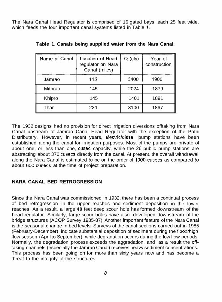
The Nara Canal Head Regulator is comprised of 16 gated bays, each 25 feet wide, which feeds the four important canal systems listed in Table 1.
Table 1. Canals being supplied water from the Nara Canal.
Mithrao
Khipro
Year of regulator on Nara construction
Canal (miles)
Jamrao
145 2024 1879
145 1401 1891
Thar 22 1 3100 1867
The 1932 designs had no provision for direct irrigation diversions offtaking from Nara Canal upstream of Jamrao Canal Head Regulator with the exception of the Patni Distributary. However, in recent years, electricldiesel pump stations have been established along the canal for irrigation purposes. Most of the pumps are private of about one, or less than one, cusec capacity, while the 26 public pump stations are abstracting about 370 cusecs directly from the canal. At present, the overall withdrawal along the Nara Canal is estimated to be on the order of 1000 cusecs as compared to about 600 cusecs at the time of project preparation.
NARA CANAL BED RETROGRESSION
Since the Nara Canal was commissioned in 1932, there has been a continual process of bed retrogression in the upper reaches and sediment deposition in the lower reaches As a result, a large 40 feet deep scour hole has formed downstream of the head regulator. Similarly, large scour holes have also developed downstream of the bridge structures (ACOP Survey 1985-87). Another important feature of the Nara Canal is the seasonal change in bed levels. Surveys of the canal sections carried out in 1985 (February-December) indicate substantial deposition of sediment during the floodlhigh flow season (April to September), while degradation occurs during the low flow periods. Normally, the degradation process exceeds the aggradation. and as a result the off- taking channels (especially the Jamrao Canal) receives heavy sediment concentrations. This process has been going on for more than sixty years now and has become a threat to the integrity of the structures
8

Remedial measures, like dumping stones at the scour holes and constructing brushwood groynes, have been undertaken from time-to- time but their effectiveness has been quite limited. The idea of providing falls at suitable locations along the canal has also been floated several times in order to reduce flow velocities and consequently the bed retrogression.
This idea is going to be materialized under the LBOD Stage-I Project where provision has been made for the remodelling of Nara Canal. Under this Project, two fall structures will be provided at RDs 25 and 135. Simultaneously, with the construction of these falls, improvements to the embankments, where necessary, will also be provided in order to provide stability for increasing the flows to 20,000 cusecs. The increased supplies will be used for two purposes
i)
ii)
to bring more area under cultivation, and
to store the surplus supplies in Chotiari Reservoir for irrigation in the Lower Nara Canal command area during deficient water supply periods.
The Chotiari reservoir, having a live storage of 0.80 million acre-feet (maf) is under construction and will be filled in 3 to 4 years time (probably upto the year 2001) depending upon the availability of watei supplies from Nara. Ranto Canal will be used for filling the reservoir.
9

Chapter 3
JAMRAO CANAL
GENERAL DESCRIPTION
The Jamrao Canal was proposed in 1867 for the first time and the survey work was finally sanctioned in 1872, which was completed in two years. However, the construction of the Canal was put in abeyance due to the following objections raised by Generals Fife and Marriman in February 1874:
1. The large volume of water to be withdrawn from the lndus River may affect the rest of the Sindh Province; and
Doubts were raised as to the profitability of the Project; 2.
The project was again reconsidered in November 1891 after the recommendations of the Sindh Irrigation Committee appointed by the Government of Bombay. The project was finally sanctioned and the construction work started in November 1894. Figure 3 shows the Jamrao Canal comman area, major offtakes and the boundaries of the irrigation sub-divisions.
As originally designed and sanctioned, the Jamrao Canal bed width was 125 feet and the full supply depth was 8 feet to carry a flow of 3,200 cusecs with a mean velocity of 3.1 feet per second . There was a depression from Mile 10 to 13; therefore, an 8-foot fall was introduced at Mile 7.5 in order to keep the canal banks in cut (rather than fill) in this depression. The bed width was reduced to 104 feet below the fall. The upper part of the canal was excavated in pure sand where a bed slope of 1 in 5000 was provided.
As soon as the canal was opened and the full water supply level achieved, the surface velocity was recorded to be 4 feet per second due to which the canal banks began to scour in the upper reach. The banks were allowed to scour till the water surface width of 200 feet was reached . To limit the top water surface width to 200 feet, brushwood groynes were installed 50 feet apart along the banks. The huge scouring in the upper 7 miles filled the depression below the fall due to which the canal bed above and below the fall came to the same level. Then the canal banks from Mile 9.5 to Mile 12.5 were raised by 3.5 feet.
*M;. Gibbie (XEN Jamrao Canal 1904) has written a note which says that "if a proper survey of the area to be irrigated had been carried out beforehand, it is certain that the falls would have been omitted entirely. The minors would have been constructed on the best possible alignment and large villages and long watercourses would have been avoided."
10

F i g u r e 3: Jamrao Canal , i t s O f f t a k i n g Chennels 11
,

After the construction of Sukkur Barrage in 1932, the mode of regulation for Jamrao Canal was changed. Water supplies were considered to be a more reliable and dependable due to availability of adequate supplies from the Nara Canal. Rotational closure in the distribution system was considerably reduced and more areas brought under cultivation. The Shahu and Dim branches, which had been lift irrigation channels, were converted to gravity flow. To feed these two off-taking channels, water levels had to be raised in the main canal by ponding between two cross regulators, which resulted in heavy sedimentation and a rise in the bed level. A silting tank, which had its entry at Mile 1 and exit at Mile 6, was constructed in 1947 which absorbed sufficient sediment but could not improve the performance of the canal. Another silting tank was constructed in 1949, but with the same results.
The total culturable command area (CCA) of Jamrao Canal in 1932 was 8.6 lakh acres out of which approximately 34,000 acres have been transferred to Mithrao Canal. However, some new area of about 63,000 acres has been brought under the Jamrao command for which two minors (Sadrat 1 and 2) have been sanctioned, Similarly, an area of 14,000 acres from the tails of the Rohri Canal system have also been transferred to the Jamrao system. At present, the total CCA is about 8,92,000 acres. The length of the main canal is 124 miles, while the network of distributaries and minors is 426 miles in length. From the management point of view, the Jamrao Canal and its distribution system has been divided into five sub-divisions as shown in Figure
3. These sub-divisions are:
1.
2.
3.
Khadro Sub-division (from RD 0 to 163);
Jhol Sub-division (from RD 163 to 291);
Mirpurkhas Sub-division (from RD 291 to 448 of Jamrao and RD 0 to 143 of West Branch);
Kot Ghulam Muhammad Sub-division (from RD 448 to 602 of Jamrao Canal); and
Digri Sub-division (RD 143 to 303 of West Branch)
4.
I 5.
REMODELLING AND TWINNING OF JAMRAO CANAL
The existing Jamrao Canal did not have sufficient capacity for the proposed increased flows resulting from the remodelling of Nara Canal, which will be approximately 50 to 60 percent higher than the current flows. Therefore, it was essential to either enlarge the existing channel or construct a new parallel channel to convey the proposed
12

increased water supplies. Enlarging the existing canal would require an approximate increase in the water surface with of 25 percent (typically from 150 to 190 feet) which would be difficult to achieve both in terms of earthwork and remodelling of existing structures, but would also cause disruption to water supplies for some time. Increasing the capacity by lining the existing sections would also involve long closures, which would not be desirable. So, twinning, or constructing a new unlined parallel canal along the existing Jamrao Canal alignment was preferred
Initially, it was considered that the new canal would be constructed along the right side of Jamrao Canal, thus commanding the area on the right bank, with the existing Jamrao Canal irrigating the lefl bank. This arrangement, however, could not be adopted for two reasons;
i) the water requirements of the right bank command area are estimated to be 1700 cusecs, while that of the left bank command are about 3,500 cusecs, almost double of the right bank which will cause problems in the layout of the vortex tube silt excluder.
the MirpurkhaslKot Ghulam Muhammad railway line runs adjacent to the right bank of Jamrao Canal downstream of RD 408, thereby precluding twinning of the right bank dver this section.
ii)
Therefore, it was decided that the new parallel canal would be constructed along the right side of the existing Jamrao Canal from the head to RD 291.4 and on the lefl side from RD 291.4 to RD 442.6, which is the limit of the remodelled area. The construction of Twin Jamrao Canal and the remodelling of the existing Jamrao Canal was been completed in June 1994, but the Twin Jamrao Canal cannot be put into operation as long as the remodelling of the Nara Canal is not completed so that the increased flows could be provided.
SEDIMENTATION IN JAMRAO CANAL
The Jamrao Canal has been faced with sedimentation problems from the day operations began. As soon as it reached the full supply level after its opening in 1901, the sides in the upper 7 miles started scouring until the top width was 200 feet instead of the designed 125 feet. The actual velocity was 4 feet per second instead of the designed 3.1 feet per second. All of the eroded material filled the depression between miles 9.5 and 12.5 to an extent that the fall provided upstream of the depression also disappeared due to sediment deposition. The effects were observed upto Mile 30. Continuous sediment-loaded flows from the parent Nara Canal went on causing a continual reduction in the design capacity of Jamrao Canal. This resulted in serious complaints about water shortages from users in 1905, just 4-5 years afler its opening.
13

After the construction of Sukkur Barrage in 1932, sediment flows increased considerably due to scouring in,-the Nara Canal head reach. Two silting tanks were constructed in 1947 and 1949, respectively, in the head reach in order to provide sediment-free water downstream. Although the tanks trapped a substantial amount of sGdiment, they did not affect the performance of the canal very much. The Development and Research Division of the Irrigation Department carried out sediment studies in Jamrao Canal before and after the construction of Sukkur Barrage. The pre- barrage analyses show 1150 silt grains per cubic feet, while the post-barrage (1938) figures are 1857 grains per cubic feet (i.e nearly 61% more).
During 1947-48 the banks of Jamrao Canal from Miles 9 to 13 were raised and sediment clearance was conducted to provide a bed slope of 1 in 8333 . The canal operated satisfactorily for a short period of time, but steady sediment deposition resulted in the gradient becoming 1 in 5000. Banks were raised during 1969-70 so that the system could be run at full supply discharge to meet shortage of water caused by sedimentation of the bed. Different proposals were framed from time-to-time regarding the remodelling and sediment problems, but effective measures were not taken until 1976 when two dredgers were employed in the head reach from RD 0 to 90 to work round the year for about 8 hours a day to flush out the incoming sediment. However, at present, the bed level of Jamrao Canal has risen by about 8 feet when compared with the original design. Some improvements regarding banks and structures were introduced during the implementation of the Irrigation System Rehabilitation Project (ISRIP) during the 1980s.
Sediment Exclusion and Settlinq Basin for Jamrao Canal
In order to prevent further aggradation of Jamrao Canal, facilities having a sediment trapping efficiency of 80 percent have been proposed to be provided at the head. Under the remodelling project of Jamrao Canal, two sets of vortex tubes will be provided at the heads of Jamrao as well as Twin Jamrao canals, which will extract some of the heavy sediment load. The water extracted from both the vortex tubes will be discharged into a low area on the right side of Twin Jamrao Canal, which would be bunded to form a settling basin of about 250 acres. The design of Twin Jamrao Canal allows for re-use of water extracted by the vortex tubes. Sediment free water will be allowed to enter this canal at the settling basin outlet regulator.
14

Chapter 4
MIRPURKHAS SUB-DIVISION
Under the Left Bank Outfall Drain (LBOD) Stage-I project, IlMl is undertaking pilot studies to test the viability of farmer-managed irrigated agriculture at the distributary or minor level so that more efficient and equitable management of canal water and drainage facilities can be achieved. These three pilot sites are located in three districts: namely, Nawabshah, Sanghar and Mirpurkhas. The three pilot sites are located under the canal command areas of Rohri, Nara and Jamrao, respectively. Under the "Operational Management at Main System Level Sub-component" of the Dutch funded project, a Decision Support System (DSS) would be established upstream from each of the pilot areas. Initially. Mirp,urkhas Sub-division of Jamrao Canal has been selected for this study, which would later on be extended to other pilot areas. The site selected is ideally suited for a DSS study from the operational management standpoint. The Jamrao System has been recently remodelled where all the gauges, rating tables and previous discharge calibrations have been disturbed and need to be redone. Because of the remodelling and the twinning process of the Jamrao Canal, the communication system has also been disturbed/demolished.
Mirpurkhas is the third sub-division of Jamrao Canal which comprises of the Jamrao Canal (from RD 291 to 443), West Branch (from RD 0 to 143) and their distribution system in the given reaches. Figure 4 shows the schematic layout of this sub-division.
JAMRAO CANAL (RD 291 TO 443)
The design discharge of Jamrao Canal below the West Branch Head Regulator at RD 291 is 1250 cusecs. However, sometimes the actual flows are higher than design flows during the peak demand period. The Jamrao Irrigation System has been remodelled, whereby improvements to cross regulator structures, embankments and off-takes have been provided. New staff gauges both upstream and downstream of the cross regulators and head regulators have been mounted. There are three cross regulators in this part of the Mirpurkhas Sub-division, including the upstream turnover regulator. The system below RD 443 to the tail (the Jhilori cross regulator and its upstream off- taking channels i.e. Dabco, Puran & Degan included) fall under the Kot Ghulam Muhammad Sub-division. The location of these regulators and the off-taking channels are given below in Table 2.
15

Figure 4: Proposed Nara Canal Control and Telecommunication System
. i

Table 2. Cross-regulators in Mirpurkhas Sub-division.
Location (RD)
29 1
343
regulator
(Mira Mori)
No. of Gate Width Off-taking channels Gates (ft)
8 10 .
7 10 Mirpur, Doso Dharoro
78-mile X-reg. 408 5 10 Sanro, Bareji
There are two minors which are drawing directly from the main canal. These minors are:
1 .
2.
Kahu Visro Minor diverting 32 cusecs at RD 383 on the right side; and
Kahu Minor diverting 34.4 cusecs at RD 389 on the left side.
Every cross regulator or head regulator has been provided with new gauges both upstream and downstream of each flow control structure. Although the gauges are new, most of them have become rusted or obliterated. The Mile 78 cross-regulator has been provided with a silt ejector below each gate. All of the radial gates for the cross regulators are manually operated with automatic circular scales for gate opening readings. Usually, all the gates are symmetrically operated by the tindal (gauge reader). In case that some of the gates have to be closed, then the side gates are closed first.
The old channel below the Mile 78 cross-regulator has been abandoned and replaced by a new channel constructed between RD 408 and 443 to improve water delivery. Wooden groynes on both sides of the new channel have been built in order to develop strong berms. At some points, trees have been cut and put in the canal to narrow the cross-section to avoid sediment deposition in certain reaches. Direct observations in 1996 have shown that a depth of about 2 to 4 feet of sediment has been carried away by the increased velocities.
During the peak demand period (May to July), the system is run above the full supply level and most of the offtakes extract more than their design discharge. Since the embankments were raised during remodelling, the system has enough capacity to carry surplus water supplies.
17

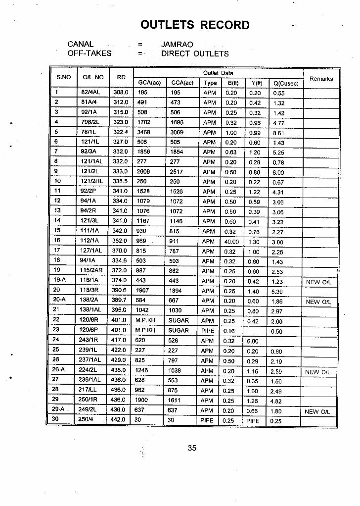
All the distributaries and minors taking-off from Jamrao Canal have been provided with proper gates at the head regulators, which facilitates proper regulation of the distribution system. During the remodelling of the system, additions have been made to the top of the outlet structures to allow increased flows because of the Nara Canal remodelling. However, no changes have been made in the sizes of these outlets. In all, there are 34 direct outlets (APM) in this part of the Mirpurkhas Sub-division. Because of the tampering that frequently occurs, the design parameters for most of the outlets have changed.
DISTRIBUTARIES AND MINORS OFF-TAKING FROM JAMRAO CANAL
There are four distributaries, two minors and thirty-four outlets drawing directly from the Jamrao Canal in this reach. Besides, there are four minors which are fed by the distributaries. During the remodelling of the system, new outlets have been constructed mostly in the head reaches of some distributarieslminors with higher crest levels. These are supposed to run when increased flows are available through the Twin Jamrao Canal. The main features regarding these channels are given Table 3.
S.NO
1
Table 3. Distributaries and minors off-taking from Jamrao Canal.
Name of Parent Channel Off-take Q GCA CCA Disty/Minor (RD) ( c W (ac) (ac)
Mirpur Dy. Jamrao 343 64 20965 20693
3
4
5
2 IMirpur Mr. I Mirpur Dy. I 331 3.51 8241 787
Piro Mr. Mirpur Dy.
Doso Dharoro Dy. Jamrao 343 76.5 23574 22373
Old Doso Mr. Doso Dharoro Dy. 30 5 1512 1467
8
9
6 I Kahu Visro Mr. I Jamrao I 3831 181 58981 5838
Sanro Dy. Jamrao 408 70 18349 18100
Sanro Mr. Sanro Dy. 10 25 6486 6470
7 IKahu Mr. I Jamrao I 3851 44.51 151371 14984
10 Bareji Dy. Jamrao 408 65 27179 25409
18

Sometimes, the system is short of water supplies and a rotation schedule in the distribution system is implemented. However, the implementation is most of the times selective, both spatially as well as temporally.
Mirpur Distributary
This is the first distributary in the Mirpurkhas Sub-division taking-off from Jamrao Canal at RD 343 upstream of the Mile 69 cross regulator. The head regulator consists of three gates, which has been constructed during the remodelling of the main canal. Both the upstream and downstream gauges have been mounted on the head regulator structure, but are difficult to read due to rusting. The embankments and the cross section (in some reaches) of the ten-mile-long distributary have been improved in 1993/94 as a part of the remodelling project. New outlets having higher sill levels than the old ones were also constructed, specially in the head reach, to cater for increased flows after the Nara Canal remodelling. These outlets are supposed to replace the old ones; however, their operation seems difficult because the farmers would definitely prefer to have the existing outlets in order to have more water, or they may run both of the outlets simultaneously.
The distributary has almost a straight alignment with two cross regulators at RDs 15 and 33. Both the regulators are in good working condition. They have been provided in order to ensure sufficient water supplies to the two minors, Piro and Mirpur. All the outlets are APM type, except the tail cluster where open flumes have been provided. The tail cluster of four open flumes has recently been constructed, but have been tampered. Similarly, many other outlets have also been tampered or broken.
Mirpur Distributary has sufficient head to draw adequate supplies of water to serve its command area. Normally, the tail is operating. The tail reach frequently experiences sediment deposition which is periodically removed by the farmers themselves. The total or partial closure of outlets is also practiced whenever needed.
Piro Minor takes-off from Mirpur Distributary on the left side at RD 15 upstream of the first cross regulator. The head regulator structure is broken and water supplies have no hinderance to enter into the minor. There is heavy vegetation all along both sides of this minor which also has weak embankments. The minor has been poorly maintained and its banks are many times vulnerable to breaches and illegal cuts. In many cases, the outlets are broken and tampered with.
The staff gauges at the cross regulators are broken and need to be replaced. No record of these readings is maintained. At present, the traditional process of developing rating curves and tables in the Irrigation Department for control structures has also stopped. Therefore, the regulating structures of this distributary have not been calibrated after its improvement.
19

Doso Dharoro Distributary.
This distributary also takes-off from the Jamrao Canal at RD 343 on the left side in front of the Mirpur Distributary. The head regulator consists of three vertical gates which were constructed during the remodelling of the main canal in 1993194 and has been provided with gauges both the upstream and the downstream sides. These gauges have become obliterated; however, approximate readings are collected daily.
The :hannel has a good cross-section throughout its length. Chances of overtopping and breaches are almost nil. The Old Doso Minor which is taking-off on the left side at RD 30 is fed through an open flume to supply 5 cusecs of water for 1467 acres. The condition of this minor is quite bad as compared with the distributary itself. Also, this minor has drawn little attention regarding its maintenance. There is thick vegetative growth on both sides which makes it difficult to conduct a survey or make any measurements.
Some of the new outlets in the head reach, which are supposed to be operated after increased water supplies are made available through the Twin Jamrao Canal, are running and the old ones have been abandoned. Some of the outlets are tampered. The On-Farm Water Management staff have done a considerable job in this area by lining a majority of the watercourses.
Kahu Visro Minor
This is a small minor taking-off directly from the main canal on the right side at RD 383 to serve an area of 5,838 acres through eight outlets. The one-gated head regulator, channel cross section and embankments have been improved as a part of the remodelling project. The new outlets have replaced the old ones as the bed level has risen due to sediment deposition to such an extent that operating the new outlets is preferred.
Water level information is gathered daily and sent to Mirpurkhas office through darogha. A direct telephone line has been provided for the transmission of Kahu Visro and Kahu Minors’ data/messages but has not been in working order for sometime.
Kahu Minor.
This minor is taking-off at RD 385 on the left bank of Jamrao Canal through a head regulator having three vertical gates. The design discharge is 44.5 cusecs to cover a culturable command area of about 15,000 acres. Generally, the physical condition of the channel is good. Sediment clearance has been done in July 1996 with the help of a dragline which has dumped the sediment on the banks and the service road (inspection path) from where it is falling back into the minor. This sediment removal has improved the channel capacity for extra water supplies as well as allowing water to reach tail outlets.
20

A majority of the traditional APM or open flume type outlets are tampered or broken. A cpuple of them are completely dismantled, where temporary structures have been eiecied by the farmers according to their needs. Partial or total closure of outlets is also practiced by the farmers during rains or time periods when there is no demand for water.
Sanro Distributary
This distributary is taking-off from the Jamrao Canal on right side at RD 408 upstream of the Mile 78 cross regulator. The physical condition is not bad, however, at some points it is very poor. Banks and berms are weak; spillovers, leakages and breaches are expected to happen at full supply levels and during heavy rainfall periods. The trespassing and bathing by animals is one of the major causes for the miserable condition of this channel. Poor upkeep associated with the carelessness of farmers has added to the deteriorating performance of the system. The,physical condition of the inspection path has also worsened due to jungle, vegetation and the excavated sediment piled on the banks.
New outlets have been provided in the head reach, but are inoperative at present. The outlets are APM, pipe or open flume types, where the majority have been interfered with.
The figures of the upstream and downstream gauges fixed at head regulator have become obliterated due to rusting; however, the approximated head data is collected daily and sent to Mirpurkhas by the Mile 78 cross regulator tindal through darogha. A direct telephone link provided at the Mile 78 cross regulator is used to inform the Sub- divisional Office about the water levels in the system. Whenever, the telephone line is out of order, the darogha for this section communicates the information to the concerned office himself.
Bareii Distributary
This is the last distributary of Mirpurkhas Sub-division emanating from Jamrao Canal at RD 408 on the left side. The head regulator comprises of three vertical gates which were constructed during the remodelling of the main canal in 1993194. The regulator is in good working order and is working without having any problem. In general, the eight mile long distributary has a good channel prism which is free of weeds and has enough freeboard to accommodate extra water supplies. There are a few weak points caused by cattle trespassing where breaches may take place during high flows or rains. The removal of sediment deposits is carried out, specially in the tail reach, whenever required by the water users.
21

Water is supplied to the farms through APM or open flume type outlets to cover a culturable command area of 14,318 acres. The tail reach is in cutting where lift irrigation is also practiced. Lift pumps generate considerable fluctuations in the distributary water level, which affects the downstream command area. In many cases, the outlets are tampered or broken and extract excess supplies, which results in inadequate water at the tail during peak periods. However, during slack periods, when the upstream outlets are closed, the tail area is flooded.
The numbers on the gauges at the head can no longer be read, which requires repainting or replacement. Similarly, the regulator also needs to be calibrated for proper regulation of the system.
WEST BRANCH RD 0 TO 143
West Branch Canal is the largest off-take from Jamrao Canal having a design capacity of 900 cusecs which takes-off the main canal at RD 291 on the right side to cover a culturable command area of 230,800 acres. Unlike the main Jamrao Canal, no significant change is observed in cross-section or any other hydraulic structure of this branch. However, the service road has been improved in some reaches and sediment removal was carried out during 1992.
The head regulator is comprised of three old gates which are most of the times completely open to allow maximum deliveries downstream. The downstream gauge has been fixed in a stilling well, but is incomplete and difficult to read. There is only one cross regulator at RD 38 along the 30-mile reach in Mirpurkhas Sub-division, which is called the Jhando Mari Cross Regulator. The upstream gauge at Jhando Mari cross- regulator is in two pieces of 8 and 2.5 feet, while there is no downstream gauge.
The channel has very thick vegetation on the banks, especially the right bank. An interesting feature of the West Branch Canal is that all the distributaries and minors in the Mirpurkhas Sub-division jurisdiction are off-taking from the left bank. The command area of West Branch Canal is seriously waterlogged and saline; therefore, domestic water needs are also dependent on canal water.
DISTRIBUTARIES AND MINORS OFF-TAKING FROM THE WEST BRANCH
The distribution system of the West Branch Canal consists of two distributaries, three mindrs and sixty-two outlets drawing water directly from the West Branch in this reach. Besides these, there are three minors or sub-minors which are fed by these channels. The major information regarding these channels is given in Table 4.
22

S.NO Name of Parent Off-take DistylMinor Channel (RD)
.------------------- 1 Lakhakhi Disty West Branch 38
Q (cus) GCA CCA (ac) (ac)
64 17826 17723
6 IDaulatpur Minoi
2
3
4
5
Bellaro Minor
Bhittaro Minor West Branch 69 27 4628 4512
Sangro Disty West Branch 88 105 30806 29029
Jarwari Minor Sangro Dy. 10 24 7562 7178
Chahu Minor Sangro Dy. 29 36 10278 9948
West Branch
West Branch
Bellaro Minor
The total number of outlets diverting water directly from the West Branch Canal in the reach from RD 0 to 143 is 62. Many of them have been broken or tampered with by the farmers. At a couple of locations in this branch, twin outlets have been constructed below the old ones in order to have more water. They are larger in size and would be able to draw more water because of increased head. The closure of outlets by water users is a common phenomenon on this canal. At several points sandbags, bushes and bricks have been observed near the outlets, which are used to close them either fully or partially whenever required.
The general physical condition of the channel from the West Branch Canal Head Regulator to the Jhando Mari Cross Regulator (RD 38) is poor. There is vegetation like a jungle on both sides; the service road is very bad at several places; and there are few bridges for crossing over to the other side.
Rotation in the distribution system is practiced whenever the need arises. The duration and frequency is dependent upon the season and the flow situation in the parent channel.
Lakhakhi Distributary
This is the first major off-take from the West Branch Canal which occurs on the left side. The head regulator consists of one gate which is located at RD 38 of West Branch, upstream of Jhando Mari Cross-Regulator. Although the physical condition of the head regulator is poor, it is working properly. Generally, the channel is in extremely bad condition with the exception of a couple of small reaches. At several locations
23

along the channel, the embankments are very weak, and the berms and the freeboard have also disappeared. Direct irrigation from the distributary without a proper outlet is possible due to weak banks. Heavy jungle has grown on both sides, especially the right side, which could provide protection to illegal cuts by the users. The command area is comparatively heavily populated, therefore, animals trespassing, specially buffaloes, are also contributing to the miserable condition of the channel.
Little attention has been paid to the maintenance of this distributary (maybe due to law and order problem in this area). At some locations, the jungle has encroached upon the service road while at other places, the culverts have collapsed and there is difficulty traveling along the channel. Similarly, sediment removed from the channel has been deposited on the banks, where it can again be transported into the channel, especially during the monsoon season.
The gauge in the main canal at Jhando Mari Cross Regulator is used to regulate flows into Lakhakhi distributary. Although the gauge is mounted in pieces, the experience of the gauge reader allows a good approximation of water levels both for the main canal as well as the distributary. There is no downstream gauge. The telecommunication system all along the West Branch Canal has been disrupted many years ago and has not been put back into operation so far. The collected informationlmessages are transmitted normally by the darogha himself.
Due to scouring in'kara Canal, the Jamrao Canal and its distribution system receives tons of sediment load every year. Lakhakhi distributary also gets its due share of sediment, which along other factors contributes to water shortages in the tail area.
Bhittaro Minor
The four-mile long Ehittaro minor is fed through a rectangular orifice on the left bank of the West Branch of Jamrao Canal. Excess flows are being diverted because of good working head and a modular flow condition. Similarly, the outlets are also overdrawing and that is why outlet closures by farmers are observed on this minor. The tail is normally operating full, but gets flooded when the upstream outlets are closed. Overall, the channel cross-section is good, with some vegetation near the head and the tail reaches.
Ehittaro Minor serves its command area through 9 outlets, out of which 7 are APM and 2 are open flumes. Extra supplies are available to farmers because most of them have been tampered. There is no gauge at any point from head to tail of this minor for proper regulation of irrigation water.
The command area is heavily saline and waterlogged, which will take sometime to get reclaimed due to drainage facilities being provided under the Left Bank Outfall Drain Stage-I Project.
24

Sanqro Distributarv
This is the third major off-take on the West Branch Canal. The supplies are managed through a two-gated head regulator at RD 88 of the West Branch Canal. The head regulator is working satisfactorily and always runs under a submerged flow condition.
The channel all along the length is in good working condition, sufficient freeboard and berms are available, except near the head, where excess flows will overtop the banks on both sides. Portions of the middle and tail reaches has been desilted recently. Jungle has grown on both sides of the distributary in the middle reach, which disrupts the inspection path at some points. The tail reach is heavily vegetated which causes sediment deposition that requires frequent clearance. The tail cluster has three open flume type outlets, which have been provided with gates, probably by farmers, a bit downstream of the head structure.
Sangro Distributary has two cross regulators,.one at RD 10 and another at RD 29 where two minors, Jarwari and Chahu, are off-taking on the left and right banks, respectively. The head regulator of Jarwari Minor is functioning well, however, it is difficult to know the amount of flow being delivered to the minor as no mechanism is available on the spot to observe water levels at this location. Overall, the Jarwari Minor cross-section is good, except for small reaches near dwellings where animals are trespassing and qther uses have damaged the embankments. Some points are vegetated, but the flow is not affected. The tail 'reach passes through a part of Mirpurkhas town where it supplies water with two outlets for drinking as well as other municipal purposes. The small reach having four outlets below the water supply schemes are usually short of water because it is not allowed to flow downstream as long as it is needed by the municipality.
The head regulator of Chahu Minor is in good working condition. The channel is almost free of vegetation, does not have weak points where breaches or leakages will occur, has enough freeboard and strong berms.
Like the rest of the Jamrao system, most of the outlets have lost their original size and shape due to farmers interference and lack of management. Similarly other hydraulic parameters have also been affected due to sedimentation and interventions by water users. The distributary head has a downstream gauge, while there is no gauge at any point all along the minor.
Daulatuur Minor
The Daulatpur Minor originates from the West Branch at RD 115 having a design flow capacity of 49 cusecs to serve a culturable command area of 13,500 acres. The head regulator consists of two old gates which are working properly. Both the upstream and downstream gauges have been provided.
25

The physical condition of the channel is good, the cross section is in satisfactory condition, with the exception of some points near an abadi due to cattle trespassing. There is almost no vegetation which could disturb the flow but sediment has deposited in some reaches. Sediment removal has been carried out in the tail reach to improve water delivery to the tail outlets. The command area on both sides is saline and waterlogged. Ground water is extremely brackish and the people have to rely on canal water for all of their needs. The outlets are tampered. Usually the tail is receiving water.
Belaro Minor
This is the last minor of Mirpurkhas Sub-division off-taking from the West Branch at RD 143. The head regulator comprises one gate which is leaking from the bottom as well as from the sides, even when it is closed. The cross section of the minor looks good but there are serious sedimentation problems. Sediment clearance is frequently conducted, but the tail still experiences water shortages. Another reason for tail shortage is the ‘wider than design’ section in this reach, where sediment deposits rapidly accrues due to low flow velocities. The tampering of outlets is a common practice here as well. The inspection path in the middle reach is in extremely bad condition due to jungle on the embankment and a couple of collapsed culverts, while that of the tail reach is quite good.
26

Chapter 6
OPERATION, DATA COLLECTION AND TRANSMISSION IN MIRPURKHAS SUB-DIVISION
Sukkur Barrage is the second to last barrage on the lndus River. Nara Canal and ultimately Jamrao Canal, can obtain surplus supplies as long as the channel capacity is not a constraint. The design discharge of Jamrao Canal at the head is 3,400 cusecs; however, it actually draws about 4,000 cusecs. The management tries to push as much water as possible to the main canal, as well as the distribution system. Sometimes, water spills over the berms during the peak demand period, but still farmers’ thirst for water is not quenched and always they press for larger water supplies.
Usually, the Mitho Machi Cross Regulator is adjusted according to the requirements immediately upstream and that of the West Branch Canal. The operation of this cross regulator is quite infrequent as there is no other off-take just above this regulator which would necessitate its frequent operation, except the West Branch Canal Head Regulator. Cross regulators at RD 343 and 408 are regularly operated according to the requirements of the upstream off-taking channels. The operation of West Branch Head Regulator is guided by water levels in the main canal and the requirements of the distribution system. The West Branch Canal also has to provide the required supplies of Digri Sub-division at RD 143. The frequency of gate adjustments is not high as the system is usually run at full supply level. Similar is the case with the Jhando Mari Cross Regulator where it has to serve the Lakhakhi Distributary which is the only major off- take upstream.
Management of the distribution of water for irrigation is achieved by adjusting gates of the regulators. Gate adjustments are made on the basis of information received concerning water levels in the canals and on the basis of historic supply pattern. The beauty of the Jamrao Canal irrigation system is that all of the distributaries and minors have been provided with gated head regulators, which makes the operation and regulation quite easy. As a normal practice, all of the off-takes are operated at full supply discharge as long as permitted by the flow condition in the main canal. Otherwise, rotational closure is resorted to among the off-takes. However, the implementation of rotational schedule is a bit selective both spatially as well as temporally because of external influence.
The direct outlets are operated by the farmers themselves according to their needs. Because the majority of the outlets are tampered and higher than design head is available, the outlets are drawing more than their due share of water. Sandbags and weedslbushes are used for (partial or total) plugging of the outlets when the demand is slack.
27

The primary oojective of equitable water disribution to all offtakes can be achieved through constant monitoring and maintaining the flow records at each control point. As described earlier, the gauges are read daily and transmitted to Mirpurkhas through a telephone or darogha, usually once a day. Water levels at the Mitho Machi Cross Regulator and that at the West Branch Canal Head Regulator are transferred to Mirpurkhas through a public telephone in the morning. The radial gates have automatic circular scales for gate openings; however, these are not recorded. No record is maintained at site. Water levels at the Mile 69 cross regulator and its off-taking channels are recorded in the morning and sent to Mirpurkhas through a darogha. Staff gauge readings at the Mile 78 cross regulator and its off-taking channels are also communicated through a darogha. Although a telephone line has been provided at this structure, it remains inoperative most of the time.
Regulation and operation data at the head regulators of distributaries and minors is also gathered daily and transmitted to Mirpurkhas. Water level readings at the cross regulators are collected by the gauge reader of the respective regulator while the others are taken by (sub)darogha and communicated to the concerned office. At present, the Jamrao Canal lacks the facilities for quick information transfer from the field to headquarters. With the exception of a couple of control structures where a telephone facility is available (direct line or through public call office), messageslinformation are transmitted manually to Mirpurkhas. The telephonic/telegraphic system of Jamrao Canal was destroyed during the remodelling of the channel and has not been replaced so far. Efforts are underway to build a modern telecommunication system along the Nara Canal irrigation system by the end of 1997, which will link all of the important control points and the sub-divisional headquarters directly.
The proposed Nara Canal Control and Telecommunication Project will provide automated base line flow data at key regulators from Sukkur Barrage throughout the Nara Command, including the Jamrao Canal. All of the data will be relayed through the network either automatically or manually to a Regional Information Center (RIC) to be located at Mirpurkhas. As shown in Figure 4, the Nara Canal Control and Telecommunication Project will consist of:
flow monitoring stations at 10 sites within the Nara Canal Command, involving the measurement of water levels, gate openings, andlor flow velocity using ultrasonic techniques;
installation of a telecommunication network, based on VHF radios located at a total of 64 fixed sites and 28 mobile units, for the transmission of voice and data; and
the installation of computer systems for the storage and analysis of data, linked via the radio system to the flow monitoring sites.
28
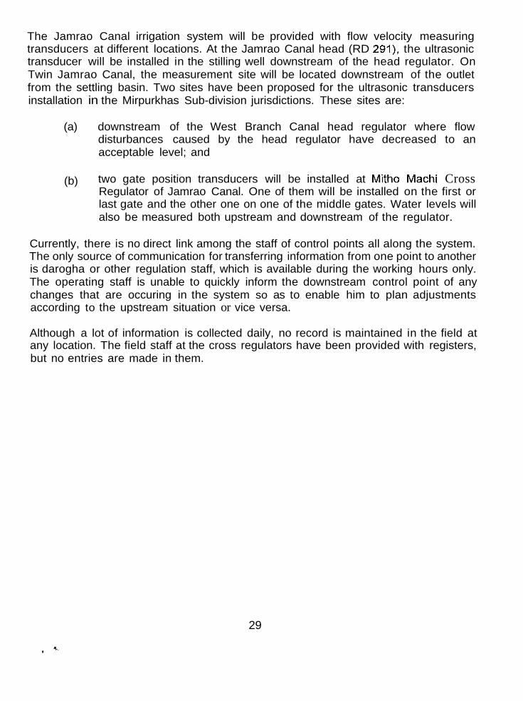
The Jamrao Canal irrigation system will be provided with flow velocity measuring transducers at different locations. At the Jamrao Canal head (RD 291), the ultrasonic transducer will be installed in the stilling well downstream of the head regulator. On Twin Jamrao Canal, the measurement site will be located downstream of the outlet from the settling basin. Two sites have been proposed for the ultrasonic transducers installation in the Mirpurkhas Sub-division jurisdictions. These sites are:
(a) downstream of the West Branch Canal head regulator where flow disturbances caused by the head regulator have decreased to an acceptable level; and
(b) two gate position transducers will be installed at Mitho Machi Cross Regulator of Jamrao Canal. One of them will be installed on the first or last gate and the other one on one of the middle gates. Water levels will also be measured both upstream and downstream of the regulator.
Currently, there is no direct link among the staff of control points all along the system. The only source of communication for transferring information from one point to another is darogha or other regulation staff, which is available during the working hours only. The operating staff is unable to quickly inform the downstream control point of any changes that are occuring in the system so as to enable him to plan adjustments according to the upstream situation or vice versa.
Although a lot of information is collected daily, no record is maintained in the field at any location. The field staff at the cross regulators have been provided with registers, but no entries are made in them.
29

Chapter 6
ISSUES
From the above study, it can be easily concluded that Mirpurkhas Sub-division is confronted with different types of issues. These issues are:
1. Sedimentation; 2. Operational Management; 3. Maintenance; and 4. Social.
1. SEDIMENTATION ISSUES
The most important problem in the Jamrao Canal irrigation system is sedimentation. The Jamrao Canal and its offtakes are faced with serious sedimentation problems from the day operations began in 1901. The embankments in the upper seven miles had eroded to such an extent that the top width was 200 feet instead of the designed 125 feet. The situation was further aggravated after the contruction of Sukkur Barrage in 1932, when sediment loaded water was passed into Jamrao Canal due to scouring in the upper reach of Nara Canal.
Different remedial measures have been taken to control sediment deposition in the main canal and its distribution system, but have proved ineffective. The two sediment settling tanks constructed in the head reach in 1947-49 could not improve the performance of the system either. Similarly, two dredgers were provided in 1974-76 to remove sediment in the head reach (RD 0-go), but still the bed level has risen by about 8 feet due to sediment deposition. This has changed the hydraulics of the channel. Outlets are overdrawing water due to increased working head. Sediment removal from distributaries, minors and even watercourses have to be conducted frequently. In some cases, the off-takes are not drawing their fair share of sediment due to design flaws, which also affects other channels.
The proposed construction of two fall structures at RDs 25 and 135 on Nara Canal, and the provision of vortex tubes with settling basin at the head of Jamrao Canal under the NaralJamrao Canals Remodelling Project, may prove helpful. The construction of fall structures on Nara Canal will help in controlling the scouring of the channel bed, while the vortex tubes and the settling basin are supposed to trap considerable amounts of sediment at Jamrao Canal head.
..
30

2. OPERATIONAL MANAGEMENT ISSUES
The Mirpurkhas Sub-division of Jamrao Canal starts at the bifurcation of the main canal into Jamrao and West Branch canals at RD 291. The water supply is received from Jhol Sub-division and feeds Kot Ghulam Muhammad Sub-division at RD 443 of Jamrao Canal and Digri Sub-division at RD 143 of West Branch Canal. Knowing the water balance of the Mirpurkhas Sub-division is essential, both at the head (inflow) as well as tail (outflow). However, at present, it is quite difficult to have this information because none of the control points have been actually calibrated after the remodelling of Jamrao Canal. New gauges had been mounted at all the important structures, but have become obliterated, which makes it difficult to collect accurate water level data at cross regulators.
Although no structural changes were introduced into the West Branch Canal which would have necessitated their recalibration, but the old rating tables have not been revised either for a long time. The changes in bed and full supply levels affected by sediment deposition have necessitated re-establishment of these rating curves and tables.
At present, it is quite difficult to accurately estimate the water balance for Mirpurkhas Sub-division. Due to the construction of new cross regulators, the old discharge ratings have been rendered invalid. However, no field measurements have been carried out so far to establish new ratings according to the new benchmarks. The management does not know exactly how much is being received into the sub-division and how much is leaving.
For equitable distribution of water, it is necessary to know the amount of water drawn by each off-take along the canal. The newly constructed head regulators for distributaries and minors of Jamrao Canal are being operated to make sure that each off-take is running full without knowing whether it is drawing its due share, because the rating tables are not available. Similarly, a majority of the outlets have lost their original dimensions due to farmers interventions, so that they are overdrawing water most of the time.
A staff gauge is essential in the regulation of the irrigation systems of Pakistan, but the gauges in this sub-division have either become rusted or are nonexistent at all. Likewise, an efficient communication system to transmit important information and messages is also essential for an efficient irrigation system. The telephone line which was disrupted due to the construction/ remodelling activities has not been replaced SO far. Other direct lines are also not working in many cases. The manual transfer of information is time consuming, arduous and uneconomical.
31
3. MAINTENANCE ISSUES
An irrigation system will not be able to carry its design discharges unless it is consistently maintained. The old cross regulators and head regulators along the Jamrao Canal in Mirpurkhas Sub-division have been replaced with new ones as a part of the Jamrao Canal Remodeeling Project during 1993-94, and presently have no serious repairs and maintenance problem so far. The head regulator of West Branch Canal has been poorly maintained and would not be able to meet the increased requirements of the system when larger water supplies are available from Nara Canal after its remodelling. Similarly, the head regulators of distributaries and minors on West Branch Canal are working satisfactorily, but their physical condition is poor, especially the head regulator of Bellaro Minor.
The' main canals (Jamrao and West Branch) are not faced with any serious maintenance problems. Jamrao Canal is new and does not need any immediate maintenance, but the West Branch Canal has very thick vegetation, especially on the right bank. The distribution system has critical maintenance problems. Direct observations of the channel cross-sections and longitudinal sections reveal that the physical conditions are no longer close to design. The cross-sections of most of the channels have enlarged in many reaches and the embankments have severely eroded in several places throughout the length. Sediment deposition is common throughout the system and as a result, the full supply water levels are higher than designed in the upper reaches.
The tampered/broken outlet structures are the most critical issue in the distribution system of this sub-division, which deserves preferential treatment. Over-drawals (caused by tampering and sediment deposition) by these outlets in the upper reaches deprive the water users of their due share in the lower reaches during peak demand periods on the one hand, and flood them when the outlets are closed (partially or fully) during slack demand periods on the other hand.
Weak and poor banks throughout the distribution system are causing breaches, leakages and even illegal (direct) irrigation from the channels. Vegetation in the channel and on the banks, along with sediment deposition, contribute to the deteriorating performance of the system.
The condition of the service roads along the West Branch Canal and some of the distributaries is deplorable. In some cases (e.g. Lakhakhi Distributary), it is even difficult to travel along the channels to conduct surveys and take measurements due to the thick vegetation and poor maintenance. At some points, the desilted material has been dumped on the road.
c
32

4. SOCIAL ISSUES
Water users were considered to be managing irrigation water below the outlet. However, they seem to have taken over the outlets and to some extent the head regulators of the distributaries and minors as well. In most cases, the outlets are operated by the farmers themselves. Water is running when needed and closed (without informing the Irrigation Department) when they do not need water. The most serious aspect of this issue is the illegal alteration of outlets by water users. More than 50 percent of the outlets in Mirpurkhas Sub-division have been interfered with by farmers to alter them according to their requirements.
Frequent transfers of managers are also affecting the performance of the system. Whenever an engineer starts to understand and control the system, he is transferred. The newcomer takes his own time to know and control the system. Political and individual influence and pressure is another important factor that contributes to the poor performance of the irrigation system.
Decisions are made at the highest level without consulting the field staff, who are the most knowledgeable people about the problems of a system. This top-down approach does not help much in solving the problems. Similarly, few opportunities are available to the operation and maintenance staff for equipping them with the state-of-the-art technology that could improve the performance of their system.
33

REFERENCES
Completion Report of the Lloyd (Sukkur) Barrage and Canal Construction scheme, Sindh 1933; Volume VI, Eastern Nara Canal System.
Field Notes by Executive Engineers of Jamrao Canal; Irrigation and Power Department, Sindh
IlMl Pakistan, 1995. Inception Report and Implementation Plan, Pilot Project for Farmer-managed Irrigated Agriculture Under the LBOD Stage-I Project.
IlMl Pakistan, 1994. Project Document; Managing Irrigation for Environmentally Sustainable Agriculture in Pakistan.
Irrigation and Power Department, Sindh 1993. Irrigation Manual Volume 2.
Irrigation and Power Department Sindh, November 1995. Nara Canal Control and Telecommunication Project, Tender Documents Volume 2.
Irrigation and Power Department, Sindh. Outlets Registers of Jamrao Canal and West Branch Canal (Mirpurkhas Sub-division).
Sir M MacDonald and Partners Limited, National Engineering Services Pakistan (Private) Limited and Associated Consulting Engineers ACE (Private) Limited. LBOD Stage-I Project, May 1995. Nara Canal Remodelling (Draft), Predesign Note for Reformatted Approach.
Sir M MacDonald and Partners Limited, National Engineering Services Pakistan (Private) Limited and Associated Consulting Engineers ACE (Private) Limited. LBOD Stage-I Project, April 1994. Nara/Jamrao Remodelling.
34