maintenance dredging at stirling naval base garden … dredging at stirling naval base garden island...
TRANSCRIPT

Maintenance Dredging at Stirling Naval Base Garden Island WA
Referral Support Document
Department of Defence
9 November 2015
Revision: 0
Reference: 248842

Project 248842 File Referral Support Document Rev 0.doc 9 November 2015 Revision 0
Document control record
Document prepared by:
Aurecon Australasia Pty Ltd
ABN 54 005 139 873
Level 5, 863 Hay Street Perth WA 6000 Australia
T F E W
+61 8 6145 9300 +61 8 6145 5020 [email protected] aurecongroup.com
A person using Aurecon documents or data accepts the risk of:
a) Using the documents or data in electronic form without requesting and checking them for accuracy against the original hard copy version.
b) Using the documents or data for any purpose not agreed to in writing by Aurecon.
Document control
Report title Referral Support Document
Document ID 248842-C10252-D2-REP-001
Project number 248842
File path N:\Admin\E&A\Projects\Dept of Defence\WA - Base Services Contract\FY2014_2015\Projects\HMAS Stirling Maintenance Dredging\Referral documents\REFERRAL SUPPORTING DOCUMENT\Referral Support Document Rev B.docx
Client Department of Defence Client contact Miss Georgia Davies
Rev Date Revision details/status Prepared by Author Verifier Approver
A 28 August 2015 Draft issued for review M Petrie I LeProvost I LeProvost P Everson
B 13 October 2015 Incorporating client comments M Petrie I LeProvost I LeProvost P Everson
0 9 November 2015 For Issue M Petrie I LeProvost I LeProvost P Everson
Current revision 0
Approval
Author signature Approver signature
Name Ian LeProvost Name Paul Everson
Title Senior Principal Environmental Scientist
Title Environment Leader

Project 248842 File Referral Support Document Rev 0.doc 9 November 2015 Revision 0 Page i
Contents Maintenance Dredging at Stirling Naval Base Garden Island WA 1
1 Introduction 4
1.1 This Document 4
1.2 The Proposal and Proponent 4
1.3 Environmental Studies Undertaken 6
2 Project Description 9
2.1 Location and volumes to be dredged 9
2.2 Nature of material to be dredged 15
2.3 Proposed spoil disposal locations 16
2.4 Proposed dredging and spoil disposal methods 18
2.5 Timing and Duration of works 19
2.6 Key Proposal Characteristics 20
3 Stakeholder Consultations and Outcomes 22
4 Assessment of Preliminary Environmental Factors 29
4.1 Benthic Communities and Habitat 29
4.2 Marine Environmental Quality 34
4.3 Marine Fauna 35
4.4 Conclusion 37
5 Environmental Management 42
6 References 44
Appendices
Appendix A
Sediment Characterisation and Contaminant Assessment
Appendix B
Benthic Habitat Survey
Appendix C
Ecology of the Little Penguins of Garden Island
Appendix D
Seagrass Risk Assessment
Appendix E
Tidal currents at Dredge Areas
Appendix F
Additional Stakeholder Consultation Information
Appendix G
DoD DEPA Environmental Protection Measures

Project 248842 File Referral Support Document Rev 0.doc 9 November 2015 Revision 0 Page ii
Figures
Figure 1 Project location showing HMAS Stirling, Careening Bay, Armaments Wharf and the
naval waters boundary 5 Figure 2 Location of Little Penguin nesting sites at HMAS Stirling 7 Figure 3 Careening Bay maintenance dredging locations in relation to seagrass, Little Penguin
nesting sites, Little Penguin rafting areas and offshore disposal sites 10 Figure 4 Armaments Wharf maintenance dredging locations in relation to seagrass and offshore
disposal sites 11 Figure 5 Careening Bay Dredge Areas A- C 12 Figure 6 Careening Bay Dredge Area E (Small Boat Harbour) 13 Figure 7 Armaments Wharf, Sulphur Bay Dredge Area F-G 14 Figure 8 Maritime zones in Australian waters showing Cockburn Sound is internal waters
(Source: Commonwealth of Australia, Geoscience Australia 2010 www.ga.gov.au) 18 Figure 9 BHD with cutter head and floating pipeline 19 Figure 10 BHD (left) and SHB (right) 19 Figure 11 BPPH transects undertaken in Careening Bay 32 Figure 12 BPPH transects undertaken in Sulphur Bay 33 Figure 13 Localised scale of turbidity plume generated by previous dredging works at
Armaments Wharf. Source: DALSE 2003a 34
Tables
Table 1 Summary of specialist studies undertaken 6
Table 2 Dredging volumes at each sub areas 9
Table 3 Estimate of dredging duration for each dredging area 20
Table 4 Key Proposal Characteristics 21
Table 5 Assessment Table as per EAG 14 (EPA 2015a) 38
Project 248842 File Referral Support Document Rev 0.doc 9 November 2015 Revision 0 Page 3
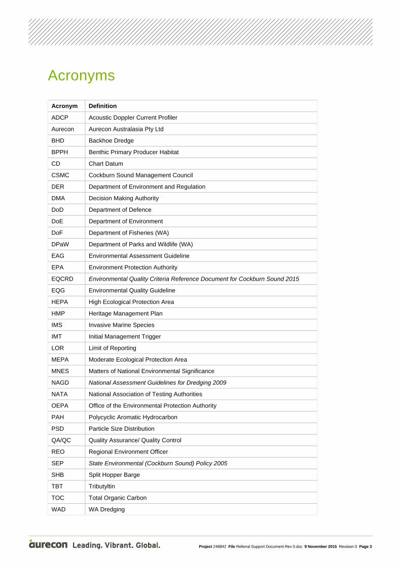
Acronyms
Acronym Definition
ADCP Acoustic Doppler Current Profiler
Aurecon Aurecon Australasia Pty Ltd
BHD Backhoe Dredge
BPPH Benthic Primary Producer Habitat
CD Chart Datum
CSMC Cockburn Sound Management Council
DER Department of Environment and Regulation
DMA Decision Making Authority
DoD Department of Defence
DoE Department of Environment
DoF Department of Fisheries (WA)
DPaW Department of Parks and Wildlife (WA)
EAG Environmental Assessment Guideline
EPA Environment Protection Authority
EQCRD Environmental Quality Criteria Reference Document for Cockburn Sound 2015
EQG Environmental Quality Guideline
HEPA High Ecological Protection Area
HMP Heritage Management Plan
IMS Invasive Marine Species
IMT Initial Management Trigger
LOR Limit of Reporting
MEPA Moderate Ecological Protection Area
MNES Matters of National Environmental Significance
NAGD National Assessment Guidelines for Dredging 2009
NATA National Association of Testing Authorities
OEPA Office of the Environmental Protection Authority
PAH Polycyclic Aromatic Hydrocarbon
PSD Particle Size Distribution
QA/QC Quality Assurance/ Quality Control
REO Regional Environment Officer
SEP State Environmental (Cockburn Sound) Policy 2005
SHB Split Hopper Barge
TBT Tributyltin
TOC Total Organic Carbon
WAD WA Dredging

Project 248842 File Referral Support Document Rev 0.doc 9 November 2015 Revision 0 Page 4
1 Introduction
1.1 This Document This document presents an Environmental Review of a maintenance dredging project in the vicinity of Garden Island, WA. It supports a referral to the Office of the Environmental Protection Authority (OEPA) in accordance with Section 38(1) of the Environmental Protection Act 1986. Its purpose is to assist the EPA determine whether or not the proposal requires formal assessment. The document is structured in the format of an API Category A Environmental Review Report in accordance with guidance provided in Environmental Assessment Guideline 14 (EPA 2015a).
1.2 The Proposal and Proponent The Proposal is to undertake maintenance dredging adjacent to five existing wharves which are located within the Stirling Naval Base on Garden Island in Western Australia (Figure 1). Four of the wharves are located in Careening Bay at the southern end of the Island. The fifth wharf is the Armaments Wharf located in Sulphur Bay on the north-eastern end of the Island (Figure 1).
The purpose of the dredging is to return the berths adjacent to the wharves to design navigable depth by removing fine sediments which have accumulated since the berths were last dredged. The total volume of material to be excavated is very small (~ 7,380m3). All proposed dredging and spoil disposal works will take place within Naval Waters to which public access is restricted.
Key Proposal characteristics are summarised in Table 4 which is presented at the end of the Project Description in Section 2 of this document.
The Proponent is the Department of Defence (DoD) represented by the Director Estate and Facility Services, Gavin Nicholls.

Project 248842 File Referral Support Document Rev 0.doc 9 November 2015 Revision 0 Page 5
Figure 1 Project location showing HMAS Stirling, Careening Bay, Armaments Wharf and the naval waters boundary

Project 248842 File Referral Support Document Rev 0.doc 9 November 2015 Revision 0 Page 6
1.3 Environmental Studies Undertaken Table 1 summarises the range of studies and surveys that have been undertaken by Defence contractor and consultant Aurecon Australia (Aurecon) to assist in design of dredging works and enable assessment of environmental significance of works. A summary of the scope of works undertaken and key findings is presented below the table.
Table 1 Summary of specialist studies undertaken
Specialist study Study Team Expertise
Sediment sampling survey (field survey and report) – Appendix A
Aurecon/ Gardline Contaminated sites lead and marine scientists
BPPH (field survey and report) – Appendix B
Geo Oceans Industry leaders in BPPH mapping and reporting
Little Penguin Ecology (literature review) – Appendix C
Dr. Belinda Cannell Little Penguin subject expert
Seagrass Risk Assessment (literature review) – Appendix D
Dr. Julia Phillips (Aurecon) Seagrass specialist
Current Monitoring in main dredge areas – Appendix E
Aurecon Coastal Engineer
Dredging Method Statement – Section 1.3.5 & Section 2 of this document
WA Dredging Dredging Contractor
1.3.1 Sediment characterisation study by Aurecon
The sediments in the berthing areas to be dredged were sampled in accordance with guidance provided in the National Assessment Guidelines for Dredging (NAGD 2009), and subsequently analysed for contaminant status and sediment characteristics (PSD etc.) at a NATA registered laboratory. Results were then interpreted by reference to screening criteria provided in the Environmental Quality Criteria Reference Document for Cockburn Sound 2015 (EQCRD) (EPA 2015b) and the NAGD 2009.
The aim of the study was to physically and chemically characterise sediments within Careening Bay and Sulphur Bay to assess their suitability for dredging and to determine their contaminant status and suitability for unconfined disposal into deep waters of Cockburn Sound. A total of 28 samples were collected from all areas to be dredged, including three intralab duplicates for QA/QC purposes and three replicates from the dredge area considered likely to be the most contaminated.
Details of sampling methodology, QA/QC procedures and all results of the study are presented in Appendix A and findings are summarised in Section 2.0 of this document.
1.3.2 Benthic Habitat Survey by Geo Oceans Pty Ltd
The study was undertaken in two phases. The initial component of the study was undertaken via a remote sensing classification of the benthic habitats visible from multi-band satellite imagery, followed by a benthic habitat towed camera survey to ground-truth the predicted habitat boundaries from the remote sensing study. Marine habitat distribution maps were subsequently produced which present the distribution of seagrasses, shallow (<10m) nearshore sands, and deep (>10m) offshore fine sediments. The report also presents a review of historical habitat mapping for Cockburn Sound plus a number of photographs showing the habitat types in the vicinity of proposed dredging and spoil disposal locations (Appendix B).

Project 248842 File Referral Support Document Rev 0.doc 9 November 2015 Revision 0 Page 7
1.3.3 A Review of current knowledge on the Ecology of the Little Penguin Colony at Garden Island by Dr Belinda Cannell
A colony (~ 600 individuals including ~ 150 breeding pairs) of Little Penguins (Eudyptula minor) inhabit the rock wall that stabilises the shoreline of Careening Bay (Refer Figure 2 for location of nesting sites). The report (Appendix C) describes the annual and daily cycles of the penguin colony, their travelling route to fishing areas and their arrival points at the colony. In summary, penguins leave the colony before dawn and return after sunset and most feed in waters up to 5km east of Careening Bay. Peak activity period is between April and January, February and March being the period of least activity and these are the months when the penguins are least prone to disturbance.
Figure 2 Location of Little Penguin nesting sites at HMAS Stirling
1.3.4 A Review of the Effects of Shading on Seagrasses by Dr Julia Phillips
There is a recorded history of seagrass habitat loss in Cockburn Sound and as a result the Sound has been designated a category F classification in EAG 3 for Protection of Benthic Primary Producer Habitats in WA’s Marine Environment (EPA 2009) where the EPA’s environmental objective is to ensure no net loss of benthic primary producer habitat and where possible, to generate a net gain in area.
Dredging and spoil disposal activities release fine sediments to the water column which create turbidity downstream and can reduce light availability to the seafloor. Light is a key resource and is critical for the growth and survival of seagrasses. Dredging can alter the light available to seagrasses, with reports of sublethal and lethal effects on seagrasses due to prolonged exposure to elevated turbidity and siltation resulting from dredging activities.
Given that seagrasses occur in nearshore waters adjacent to some of the proposed dredging areas, the available information on the effects of shading on seagrasses was reviewed to determine the potential scale of risk posed by the proposal (Appendix D). In summary, the review found that the timing, intensity and duration of the onset of reduced light availability are important factors in seagrass survival (and recovery), which in turn will be influenced by the natural seasonal variation in

Project 248842 File Referral Support Document Rev 0.doc 9 November 2015 Revision 0 Page 8
carbohydrate reserves and minimum light requirements. Evidence in the literature suggests that all species (P. sinuosa, P. australis and A. antarctica) growing in the project area will be able to withstand short durations (3 months or less) of moderate to heavy shading events, regardless of the timing of the onset of reduced light availability (Appendix D).
1.3.5 Analysis of Dredging and Spoil Disposal Work Methods appropriate for the proposed project by WA Dredging Pty Ltd (WAD) and Aurecon
WA Dredging Pty Ltd (WAD) were appraised of the scale and location of excavation required by DoD and invited by Aurecon to prepare a cost efficient Work Method Statement to undertake the works. Results are presented in Section 2.0 of this document. Two alternative work methods are possible. The preferred method is use of a small cutter suction dredge with direct disposal to adjacent spoil disposal ground via a floating pipeline and downpipe with spreader plate to the seafloor. The alternative is use of a Backhoe Dredge (BHD) loading a Split Hopper Barge (SHB) alongside, which will then sail to the existing disposal ground at the Armaments Wharf. Both options are presented in this document as the Dredging Contractor has not been engaged and the availability of dredging equipment is unknown.
1.3.6 ADCP Current data collection in Dredge Areas by Aurecon
Measurements and assessment of tidal currents at the two dredging sites has been undertaken over a 17 day period, to inform the project on the magnitude and direction of tidal currents, and to provide information to support any dredging impact assessment. Measurements of tidal currents have been undertaken by the deployment of an Acoustic Doppler Current Profiler (ADCP) in both Careening Bay and Sulphur Bay in the vicinity of the proposed dredging sites. A desktop assessment of the likelihood of tidal currents re-mobilising the dredge material disposed into deeper water nearby on the seabed has also been undertaken. The report (Appendix E) summarises the ADCP deployment, the tidal current data, the results analysis of the tidal current data at each of the two dredging sites and the desktop assessment of dredge disposal material being re-mobilised on the seabed. Findings are discussed in Section 4.1 of this document.

Project 248842 File Referral Support Document Rev 0.doc 9 November 2015 Revision 0 Page 9
2 Project Description
2.1 Location and volumes to be dredged The location of the berths and areas requiring excavation is shown in Figure 3 and Figure 4. Figure 3 shows that there are four areas within Careening Bay (Areas A, B, C, E) requiring maintenance dredging. The figure also shows the distribution of seagrass and sand habitats and known nesting sites and rafting areas for the Little Penguin. Figure 4 shows that there are two areas needing excavation in the vicinity of the Armaments Wharf (Areas F and G) and also shows the distribution of seafloor habitats in the vicinity. Figure 4 also shows the Naval Waters boundary within which all works will be conducted. Further detail on the location and footprint of the accumulated sediments requiring excavation in each dredging area is provided in Figures 5, 6 and 7 (coloured green).
Table 2 presents the volumes to be dredged at each location (A-G).
Table 2 Dredging volumes at each sub areas
Dredge location Design Depth (m CD) Volume including 30% contingency [m3]
Dredge Area A -11.0 250 Dredge Area B -11.0 1110 Dredge Area C -11.0 280 Dredge Area E -3.5 260 Dredge Area F -13.0 1770 Dredge Area G -11.0 3710 Gross Total volume to be dredged 7,380m3
*Note: Dredge Area D was adjacent to the slipway in Careening Bay but has been removed from the proposed dredging program The majority of the maintenance dredging volume (~ 5,480m3) is located at the Armaments Wharf in Sulphur Bay. Only ~1900m3 requires excavation from the four berths in Careening Bay. Dredge volumes estimated in Table 2 include a 30% contingency to account for changes since the last hydrographic survey (Areas A, B, C and E in 2011 and areas F and G in 2015) and to account for batter slopes.
It should be noted that both dredging areas have been previously dredged. The berth and turning area on the south side of the Armaments Wharf was originally dredged in 1972 when the natural seafloor levels of 7.5m to 8.5m CD were deepened to 11m CD. These areas were subsequently deepened to 13m CD in July 2003 by the removal of some 3,300m3 of limestone rock and 5,500m3 of fine sands over a 7 day period by a medium size cutter suction dredge (DALSE 2003a). Two dredging programmes have occurred within Careening Bay. Original works were conducted in 1973. Further works were undertaken in the mid 1990’s when the wharf areas were deepened to 11m CD. The spoil from the latter works brought ashore and used for land reclamation on Garden Island. No adverse impacts of previous dredging works have been recorded.
Both dredging areas occur within the broader Cockburn Sound which is unique in having WA’s only State Environmental (Cockburn Sound) Policy (SEP 2005) to protect its environmental quality. The SEP establishes a range of environmental quality objectives and criteria for Cockburn Sound and does this by designating the level of environmental protection required in different parts of the Sound. According to the EQCRD (2015), Careening Bay on Garden Island is considered “Highly disturbed” and has been designated a Moderate Ecological Protection Area (MEPA) which means that criteria are set to the 90% species protection guideline trigger level in accordance with ANZECC & ARMCANZ (2000). Sulphur Bay however is considered to be relatively undisturbed and has been designated a High Ecological Protection Area (HEPA) which means that criteria are set to the 99% species protection guideline trigger level in accordance with ANZECC & ARMCANZ (2000).

Project 248842 File Referral Support Document Rev 0.doc 9 November 2015 Revision 0 Page 10
Figure 3 Careening Bay maintenance dredging locations in relation to seagrass, Little Penguin nesting sites, Little Penguin rafting areas and offshore disposal sites

Project 248842 File Referral Support Document Rev 0.doc 9 November 2015 Revision 0 Page 11
Figure 4 Armaments Wharf maintenance dredging locations in relation to seagrass and offshore disposal sites

Project 248842 File Referral Support Document Rev 0.doc 9 November 2015 Revision 0 Page 12
Figure 5 Careening Bay Dredge Areas A- C

Project 248842 File Referral Support Document Rev 0.doc 9 November 2015 Revision 0 Page 13
Figure 6 Careening Bay Dredge Area E (Small Boat Harbour)

Project 248842 File Referral Support Document Rev 0.doc 9 November 2015 Revision 0 Page 14
Figure 7 Armaments Wharf, Sulphur Bay Dredge Area F-G

Project 248842 File Referral Support Document Rev 0.doc 9 November 2015 Revision 0 Page 15
2.2 Nature of material to be dredged As indicated in Section 1.3.1 the sediments in the berthing areas to be dredged were sampled and subsequently analysed for contaminant status and physical sediment characteristics (PSD, TOC, etc.). Results were then interpreted by reference to screening criteria provided in the Environmental Quality Criteria Reference Document for Cockburn Sound 2015 (EPA 2015b) and the NAGD 2009.
The aim of the study was to physically and chemically characterise sediments within Careening Bay and Sulphur Bay to assess their suitability for dredging and to determine their contaminant status and suitability for unconfined disposal into deep waters of Cockburn Sound. Details of sampling methodology, QA/QC procedures and all results of the study are presented in Appendix A.
The following conclusions can be drawn from the sediment quality assessment:
1. All locations sampled as part of this investigation comprised of fine to coarse sandy silt with some clay, sub angular gravel, shell fragments and occasional strands of decaying vegetation in the form of seagrass. An analysis of the PSD of the material to be dredged from each site is presented in Appendix E (Section 4.2). Typically the sediments at the dredge sites within both bays are generally fine sand with a median grain size of ~0.16mm. There are however some differences in the proportions of material fractions present. The Careening Bay dredging material contains ~92% sand with ~8% of clayey silts, while the Armament Wharf material is more widely graded, containing ~76% gravelly-sand with ~11% of silt and ~13% of clay. Such material is very suitable for dredging by cutter suction dredge,
2. No visual or olfactory evidence of contamination or anthropogenic material was observed during the processing of sediment samples collected during this investigation;
3. Reported concentrations of metals, petroleum hydrocarbons, and polycyclic aromatic hydrocarbons (PAH) were all below the EQCRD 2015 and NAGD 2009 screening criteria for all samples except the PAHs Acenaphthene and Fluorene at sampling location A1, which were slightly elevated, but well below the re-sampling trigger for a MEPA. Monocyclic aromatic hydrocarbons (benzene, toluene, etc.,) were all below the limit of reporting (LOR) and Total Organic Carbon (TOC) was very low in all samples;
4. The material to be dredged is therefore considered clean and suitable for unconfined ocean disposal. Most material will be dredged from the Armaments Wharf and will be disposed of in deeper waters 200m southeast of the existing spoil ground (Figure 4);
5. Organotins (TBT) however exceeded the EQCRD 2015 screening criteria in 12 of 28 samples and exceeded the NAGD 2009 screening criteria in 13 of the 28 samples collected. Based on the laboratory analytical results, TBT concentrations were highest but not uniformly distributed in dredge areas A and B in Careening Bay and while within these areas TBT concentrations were generally reported to exceed the EQCRD 2015 and the NAGD 2009 screening levels, only two of the sample sites (A1 and B4) reported concentrations of TBT that also exceeded the Cockburn Sound EQG re-sampling trigger. The TBT concentrations reported in the other dredge areas were mostly below both the EQCRD 2015 and the NAGD 2009 screening criteria, and those few that were above, were still well below the Cockburn Sound EQG re-sampling trigger;
6. Sampling results show that about two-thirds (~1300m3) of the material to be excavated from Careening Bay (Dredge Areas A and B) has elevated levels of TBT which is presumed to be a legacy of the use of antifouling paints containing this material in the past. In accordance with NAGD 2009, and the Manual of Standard Operating Procedures for Environmental Monitoring against the Cockburn Sound Environmental Quality Criteria (2003-4) (EPA 2005) elutriate testing was subsequently undertaken to determine the bioavailability and potential impact of release of dissolved TBT on water quality should this material be mobilised during dredging. The results of

Project 248842 File Referral Support Document Rev 0.doc 9 November 2015 Revision 0 Page 16
elutriate testing did not exceed Initial Management Triggers (IMT) established for Moderate Ecological Protection Areas (MEPA) by the EQCRD 2015. While there is a requirement for an assessment of the potential for bioavailability in sediment pore water such testing was not undertaken as the results of the elutriate testing of combined samples from areas A and B confirmed that the TBT within the samples is unlikely to be bioavailable if disturbed. It is likely that the majority of TBT is present in paint flakes and therefore not readily soluble. Therefore the results of the elutriate testing have been used as a proxy for the likely potential impact on sediment pore water in this circumstance and follows the guidance of NAGD 2009 as to the utility of this approach.
7. Consequently all the material proposed for dredging from areas A and B is considered to also be suitable for unconfined ocean disposal and it is proposed that disposal of this small volume of material will be back into deep (>15m) waters of Careening Bay (Figure 3).
2.3 Proposed spoil disposal locations The locations proposed for disposal of the small volumes of spoil that require excavation are also shown on Figure 3 and Figure 4. Most of the spoil will be generated at the Armaments Wharf in Sulphur Bay and it is proposed to relocate this material approximately 200m southeast of the existing spoil ground. The existing spoil ground is located approximately 200m to the northeast of the end of the wharf (Figure 4). The original spoil ground was established in June 2003 when approximately 12,500m3 of sand and limestone rock was dredged by the Cutter Suction Dredge “Wombat” over a 7 day period to deepen the berth from 11m CD to 13m CD (DALSE 2003a). This original spoil ground location was selected following an assessment of a range of disposal options (including onshore disposal), which concluded that disposal to the sea-bed immediately offshore of the Armaments Jetty was the most environmentally acceptable option for the following reasons (DALSE 2003b):
It was time and cost effective;
It would avoid impacting upon threatened terrestrial vegetation communities;
It would not reduce beach or offshore amenity or affect public access; and
Turbidity generated would be located offshore at some distance from seagrass meadows.
The proposed spoil disposal locations have been selected on the basis of:
having similar seabed substrate (primarily fine sands) to the material to be excavated;
being remote from sensitive receptors (to minimise impact of turbidity on seagrass beds); and
having sufficient depth to be stable and retentive of the material disposed at that site.
Coordinates for proposed spoil disposal locations:
Careening Bay proposed spoil disposal location: 32°10’31’’S, 115°40’57’’E
Sulphur Bay proposed spoil disposal location: 32°13’50’’S, 115°41’54’’E
The proposed disposal site at the Armaments Wharf is located approximately 200m southeast of the existing spoil ground and is in deeper water where the substrates are similar to those to be dredged (fine sand and silt) (Refer Appendix B, Figure 20). Placing this material into deeper waters will ensure it remains stable at the disposal site. This location is also further removed from adjacent seagrass beds, the nearest of which occur some 400m away.

Project 248842 File Referral Support Document Rev 0.doc 9 November 2015 Revision 0 Page 17
The location proposed for the disposal of ~ 1900m3 of fine sands and silts to be dredged from berths in Careening Bay (Figure 3) is just inside the 15m CD contour southeast of the main dredging area “B”. This proposed spoil ground location is well within Naval Waters and within the Cockburn Sound SEP (2005) MEPA Boundary for Careening Bay. The seafloor at this location is comprised of bioturbated fine sands and silts (refer Figure 18 Appendix B). It is also remote from sensitive receptors, the nearest seagrass beds occurring some 300m away.
Note that it is not proposed to apply to the Commonwealth Department of the Environment for a Sea Dumping Permit in accordance with the requirements of Section 19 of the Environment Protection (Sea Dumping) Act 1981. This is because ‘The Sea Dumping Act does not apply where dumping is to occur entirely in Internal Waters, within the limits of a State or the Northern Territory.’ (Section 2.2 of the NAGD 2009). According to the maritime boundaries detailed on Geoscience Australia’s website (Geoscience Australia 2010 – Figure 8) the waters of Cockburn Sound are classed entirely as internal waters. It should be noted that a Sea Dumping Permit was not obtained in 2003 when the existing spoil ground in Sulphur Bay (Figure 4) was originally established (DALSE 2003b).

Project 248842 File Referral Support Document Rev 0.doc 9 November 2015 Revision 0 Page 18
Figure 8 Maritime zones in Australian waters showing Cockburn Sound is internal waters (Source: Commonwealth of Australia, Geoscience Australia 2010 www.ga.gov.au)
Note: black line shows Australia’s territorial sea baseline
2.4 Proposed dredging and spoil disposal methods WAD reviewed a range of dredging options and recommended the use of a Backhoe Dredge (BHD) fitted with a conventional “Jaden Rose” cutter head (Figure 9 – BHD with cutter head and BHD with floating pipeline) which is designed for efficient dredging of non-cohesive and liquid soil types by reducing the amount of spill significantly. Additional suction power can be fitted to this head which enables the slurry to be pumped a short distance through a floating pipeline (Figure 9). The slurry can then either be disposed directly to the seafloor via downpipe and spreader plate, or pumped into a Split Hopper Barge (SHB) for transport to spoil disposal ground and subsequent release from the base

Project 248842 File Referral Support Document Rev 0.doc 9 November 2015 Revision 0 Page 19
of the barge (Figure 10 – BHD and SHB). Typical slurry pumps have the ability to process up to 134m3 per operating hour.
The most time and cost efficient method is that which does not require the use of an SHB. An SHB is only required if approval cannot be obtained to dispose of the material excavated from Careening Bay berths into deeper waters of Careening Bay, or if a BHD with cutter head is not available to undertake the works.
Figure 9 BHD with cutter head and floating pipeline
Figure 10 BHD (left) and SHB (right)
2.5 Timing and Duration of works Precise start and finish dates are not yet available but the Navy has indicated that their preferred timing (for reasons of low port operational requirements) is February – March 2016. Conversely, December and January are not preferred as this is traditionally a period of high port operational requirement. Spring (September – November) is not favoured by the WA Department of Parks and Wildlife because that is the peak breeding season for the Little Penguin. Spring is also not favoured by the WA Department of Fisheries because this is the crab and snapper spawning period, both of which fisheries in Cockburn Sound are currently in decline (refer Section 3.0 Stakeholder Consultation).

Project 248842 File Referral Support Document Rev 0.doc 9 November 2015 Revision 0 Page 20
Hence the works could occur at any time of the year from February to August, but are unlikely to occur during Spring and will not occur during December and January.
Given the small volume of material to be excavated, the duration of works will be short irrespective of which disposal method is utilised. It is anticipated that excavation and disposal works at both locations will be no longer than two weeks in total duration and is likely to be no more than a few days at each location. Table 3 presents an estimate of duration of dredging at each dredging area depending on disposal method. If all material goes into a SHB for disposal at the existing spoil ground near the Armaments Wharf the total works would be completed in approximately 9 x 10 hour days with much of that time taken up by the SHB sailing to and from the existing spoil ground in the north east corner of Sulphur Bay with material dredged from both the armaments wharf and also from the dredge sites in Careening Bay. However if the proposed disposal ground in Careening Bay is approved then the dredge spoil can be directly disposed of by pumping material via floating pipeline with a reduction in the time required for the works to a total of six days – two days in Careening Bay and four days at Sulphur Bay. There are obvious cost benefits to being able to do this, as well as environmental benefits.
Table 3 Estimate of dredging duration for each dredging area
Dredge location Design Depth (m CD) and volume to be excavated (Xm3)
Operating hours required for dredging and direct disposal via floating pipeline
Approximate operating hours required for dredging and disposal via SHB at Armaments Wharf spoil ground
Dredge Area A -11.0 (250) 2 hrs 5 hrs Dredge Area B -11.0 (1110) 8 hours 22 hrs Dredge Area C -11.0 (280) 2 hours 5 hrs Dredge Area E -3.5 (260) 2 hours 5 hrs Dredge Area F -13.0 (1770) 13 hours 15 hrs Dredge Area G -11.0 (3710) 28 hours 30 hrs
2.6 Key Proposal Characteristics The key proposal characteristics that capture all key features of the proposal relevant to the EP Act are detailed in Table 4 below. These key proposal characteristics are consistent with EAG1 Environmental Assessment Guideline for Defining the Key Characteristics of a Proposal (EPA 2012).

Project 248842 File Referral Support Document Rev 0.doc 9 November 2015 Revision 0 Page 21
Table 4 Key Proposal Characteristics
Summary of Proposal
Proposal title Maintenance dredging at Stirling Naval Base Garden Island WA
Proponent name Department of Defence
Short description Dredging of berths adjacent five existing wharves which are located within the Stirling Naval Base. Four of the wharves are located in Careening Bay (Figure 3). The fifth is the Armaments Wharf located in Sulphur Bay (Figure 4). Disposal of up to 7,500m3 of spoil in deep waters in the vicinity of the wharves.
Physical Elements
Element Location Proposed extent
Dredging in Careening Bay Dredge areas A,B,C and E shown in Figure 3
A total volume of up to 1900m3
within the areas shown on Figure 3
Disposal of spoil in Careening Bay Indicative spoil ground location shown in Figure 3
Up to 1900m3 to be disposed in deep water (>15m) at location shown on Figure 3
Dredging at Sulphur Bay Dredge areas F and G shown in Figure 4
A total volume of up to 5,500m3
within the areas F and G shown on figure 4
Disposal of spoil in Sulphur Bay Indicative spoil ground location shown in Figure 4
Up to 5500m3 to be disposed in deep water (>15m) at location shown on Figure 4
Operational Elements
Element Location Proposed extent
Timing of works Careening Bay and Sulphur Bay Works to avoid December January period. Preferred timing is February - March 2016, but may occur later in year. Works to also avoid Spring (September-November) as this is crab and snapper spawning period. Works could occur at any time of the year from February- August

Project 248842 File Referral Support Document Rev 0.doc 9 November 2015 Revision 0 Page 22
3 Stakeholder Consultations and Outcomes The importance of stakeholder consultation is recognised by the Navy which has identified the following key stakeholders for consultation:
Office of the Environmental Protection Authority (OEPA)
Cockburn Sound Management Council (CSMC)
Department of Parks and Wildlife (DPaW)
Department of Fisheries (DoF)
Department of Environmental Regulation
Commonwealth Department of Environment (DoE) – consultation with DoE managed by DoD directly
Fremantle Ports
Department of Transport
Blue Lagoon Mussels
Fremantle Sailing Club
The Cruising Yacht Club of WA
Cockburn Power Boats Association
Mangles Bay Fishing Club
Recfishwest
Western Australian Fishing Industry Council
Rockingham Wild Encounters
Consultation was undertaken with each of the stakeholders listed above (either by phone or meeting) and stakeholder consultation outcomes are summarised in Table below. Additional information on stakeholder consultations is provided in Appendix F. Key DMA’s will be notified once the dates and method of dredging have been confirmed and again once the works have been completed. A Notice to Mariners will be provided to the Department of Transport at least 21 days prior to commencement of works.

Project 248842 File Referral Support Document Rev 0.doc 9 November 2015 Revision 0 Page 23
Table 5 Stakeholder consultation summary
Stakeholder Date Topics/Issues raised Proponent response/outcome
Office of the Environmental Protection Authority
24 June 2015 Pre-referral meeting with OEPA
Discussion of sensitive receptors, relevant environmental issues, environmental investigations undertaken and proposed management measures. Proponent asked for guidance on preferred stakeholder consultation process. OEPA had no strong opinion on the stakeholder consultation process, however they suggested CSMC were engaged prior to submission of referral document. OEPA requested confirmation and justification of why sea dumping permit is not required to be included in referral documents. OEPA suggested inclusion of section in referral to confirm that dredging can occur year round with minimal impact on penguins. OEPA suggested confirmation that existing spoil ground is stable.
Proponent engaged CSMC prior to referral submission along with numerous other stakeholders. Proponent included section in referral document providing justification of why sea dumping permit is not required. Referral Support Document includes information on dredging occurring all year round with minimal impact on Little Penguins. Appropriate management measures to mitigate impacts also included. Tidal current monitoring and spoil stability assessment undertaken at each spoil disposal ground and included in Referral Support Document.
Cockburn Sound Management Council
2 July 2015 Meeting with CSMC chair and coordinator
Discussion of sensitive receptors, relevant environmental issues, environmental investigations undertaken and proposed management measures.
No action required. No issues raised by the stakeholder but CSMC would like a copy of the Sediment Characterisation Report. Stakeholder has no objections to the proposal.

Project 248842 File Referral Support Document Rev 0.doc 9 November 2015 Revision 0 Page 24
Stakeholder Date Topics/Issues raised Proponent response/outcome
Department of Parks and Wildlife
30 July 2015, Meeting at DPaW office with WA Marine Monitoring Program Leader and research scientists
Discussion of sensitive receptors, relevant environmental issues, environmental investigations undertaken and proposed management measures, especially in relation to Little Penguins. Stakeholder raised concern around timing of proposed dredging works being delayed. February/March 2016 best time to undertake dredging due to limited penguin activity. Expressed concern if dredging slips to penguin nesting season (April - November). Stakeholder suggested taking aerial photographs during dredging to show plume movement/extent, particularly at Sulphur Bay. Stakeholder suggested collaboration between DPaW seagrass team (who undertake seagrass monitoring for CSMC) and DoD habitat mapping survey team prior to compliance monitoring to come up with a suitable sampling design and look into sharing seagrass condition data.
Preference for dredging to be undertaken February/March 2016 to avoid penguin nesting season (April - November) and have minimal impact on Little Penguins. WA expert on Little Penguins Belinda Cannell confirmed that proposed management actions (works to commence 1 hour after sunrise and cease 1 hour before dusk and avoiding mooring equipment in Careening Bay rafting area overnight) will minimise interference with the penguins' daily nocturnal migrations. Should there be slippage in timing of the works into the autumn period (April-June) when penguins from both Garden Island and nearby Penguin Island forage predominantly in the northern part of Cockburn Sound, it would be preferable to undertake works at Sulphur Bay during the night-time to minimise impacts on water clarity during daylight foraging activity since penguins rely on eyesight to catch their prey. Proponent to investigate feasibility of taking aerial photographs of dredge plume during dredging and disposal at Sulphur Bay. Collaboration between habitat mapping survey team and DPaW seagrass team to come up with suitable sampling design prior to compliance monitoring of seagrass noted.

Project 248842 File Referral Support Document Rev 0.doc 9 November 2015 Revision 0 Page 25
Stakeholder Date Topics/Issues raised Proponent response/outcome
Department of Fisheries
29 July 2015, Meeting at Fisheries Head Office with Biosecurity and Environment team
30 July 2015, Phone call, followed up with email to DoF crab fishery specialist (Dr Nick Caputi)
Discussion of sensitive receptors, relevant environmental issues, environmental investigations undertaken and proposed management measures, especially in relation to Cockburn Sound crab fishery and invasive marine species. Stakeholder requested Proponent also contact DoF crab fishery specialist, Recfishwest and WAFIC to discuss proposed works. Snapper and crab spawn in Cockburn Sound from September - January. Preference for dredging works to be undertaken outside this spawning period to minimise impact on snapper and crab spawning because both fisheries are in decline (preferred time: February - August). Stakeholder requested downpipe linked to floating pipeline during dredging to facilitate disposal of sediment at seafloor and minimise plume. Need to ensure that dredging equipment is free of invasive marine species. Use DoF Vessel Check tool (as soon as dredge vessel known). Decontamination of dredging equipment will be required at end of works. If floating pipeline is used it needs to be clean of fouling.
Additional stakeholders contacted as requested. Preference for dredging to take place from February - August to avoid snapper and crab spawning period in Cockburn Sound. Works in Sulphur Bay will not be undertaken during the spring snapper and crab spawning period of September - January. Requirement for downpipe to be used during dredging noted. Use of DoF Vessel Check tool noted. Certification will be required from the dredge contractor that all dredging equipment is clean of marine pests in accordance with requirements of DoF Vessel Check. Decontamination at end of dredge works noted. Floating pipeline free of fouling noted.

Project 248842 File Referral Support Document Rev 0.doc 9 November 2015 Revision 0 Page 26
Stakeholder Date Topics/Issues raised Proponent response/outcome
Department of Environmental Regulation
27 July 2015 Phone call with Director of Environmental Services
Discussion of sensitive receptors, relevant environmental issues, environmental investigations undertaken and proposed management measures. Stakeholder raised a concern about historical sandblasting activities at Careening Bay near the small boat slipway and the potential for this area to be contaminated by anti-fouling paints.
No action required. The area near the small boat slipway is not being dredged. Discussion of sediment characterisation study to explain that while there were some high levels of TBT recorded beneath a couple of wharves in Careening Bay, the elutriate tests returned concentrations below the appropriate (MEPA) screening level criteria specified in the Environmental Quality Criteria Reference Document 2015 for Cockburn Sound and material was considered suitable for unconfined disposal in deep waters of Careening Bay.
Department of Transport
27 July 2015 Phone call with Marine Branch, Safety and Navigation
Discussion of sensitive receptors, relevant environmental issues, environmental investigations undertaken and proposed management measures. Stakeholder raised issue of notifying recreational boat users about the restriction of access to the Armaments Jetty during dredging works period.
Notice to Mariners to be issued to DoT 21 days prior to commencement of dredging.
Fremantle Ports
29 July 2015 Meeting at Fremantle Ports with Deputy Harbour Master, Hydrographic Coordinator and Environmental Manager
Discussion of sensitive receptors, relevant environmental issues, environmental investigations undertaken and proposed management measures. Noted that all dredging and disposal works will be in Naval waters. Stakeholder raised December/January period as high recreational boat use time on water, best to avoid this period if possible.
No action required. December/January already determined to be non-preferred time for dredging by Navy.
Blue Lagoon Mussels
22 & 27 July 2015 Phone call with owners, followed up with email (24 & 27 July 2015)
Discussion of sensitive receptors, relevant environmental issues, environmental investigations undertaken and proposed management measures. Information also sent via email to disseminate to other personnel.
No action required. No issues or topics raised by the stakeholder.

Project 248842 File Referral Support Document Rev 0.doc 9 November 2015 Revision 0 Page 27
Stakeholder Date Topics/Issues raised Proponent response/outcome
Fremantle Sailing Club
21 July 2015 Phone call, followed up with email (22 July 2015)
Information on sensitive receptors, relevant environmental issues, environmental investigations undertaken and proposed management measures sent via email to disseminate to club members.
No action required. No issues or topics raised by the stakeholder
The Cruising Yacht Club of WA
21 July 2015 Phone call, followed up with email (22 July 2015)
Information on sensitive receptors, relevant environmental issues, environmental investigations undertaken and proposed management measures sent via email to disseminate to club members.
No action required. No issues or topics raised by the stakeholder.
Cockburn Power Boats Association
21 July 2015 Phone call, followed up with email (22 July 2015)
Discussion of sensitive receptors, relevant environmental issues, environmental investigations undertaken and proposed management measures. Information also sent via email to disseminate to club members.
No action required. No issues or topics raised by the stakeholder.
Mangles Bay Fishing Club
21 July 2015 Phone call, followed up with email (22 July 2015)
Discussion of sensitive receptors, relevant environmental issues, environmental investigations undertaken and proposed management measures. Information also sent via email to disseminate to club members. Stakeholder didn't have any concerns due to dredging being undertaken within Naval Waters by Department of Defence.
No action required. No issues or topics raised by the stakeholder.
Recfishwest 30 July 2015 Phone call, followed up with email
Discussion of sensitive receptors, relevant environmental issues, environmental investigations undertaken and proposed management measures. Information also sent via email to disseminate to members.
Stakeholder has no objection to the proposal.
Request for minimising restriction of access for recreational boaters and for minimising dredging activities on the weekends where possible noted.
WAFIC 30 July 2015 Phone call, followed up with email
Discussion of sensitive receptors, relevant environmental issues, environmental investigations undertaken and proposed management measures. Information also sent via email to disseminate to members.
No response received from stakeholder
No action required. No issues or topics raised by the stakeholder.

Project 248842 File Referral Support Document Rev 0.doc 9 November 2015 Revision 0 Page 28
Stakeholder Date Topics/Issues raised Proponent response/outcome
Rockingham Wild Encounters
13 August 2015 Phone call, followed up with email
Discussion of sensitive receptors, relevant environmental issues, environmental investigations undertaken and proposed management measures. Information also sent via email to disseminate to members.
No action required. No issues or topics raised by the stakeholder.

Project 248842 File Referral Support Document Rev 0.doc 9 November 2015 Revision 0 Page 29
4 Assessment of Preliminary Environmental Factors In accordance with guidance provided in EAG 8 and 9 (EPA 2013 a and b), and EAG 16 (EPA 2015c), the following environmental factors have been identified for assessment of potential impact significance.
Benthic Communities and Habitat
Marine Environmental Quality and
Marine Fauna
Each of these factors is addressed below.
4.1 Benthic Communities and Habitat The EPA’s objective for this aspect is to maintain the structure, function, diversity and viability of benthic communities and habitats at local and regional scales. As indicated earlier in Section 2.1, Garden Island provides the western shore of Cockburn Sound, the environmental values of which are protected by the State Environmental (Cockburn Sound) Policy 2005 (SEP 2005). The environmental values for the protected area under this policy are:
a) Ecosystem health (an ecological value); b) Fishing and aquaculture (social values); c) Recreation and aesthetics (a social value); d) Cultural and spiritual values (social values); and e) Industrial water supply (a social value).
The environmental values require protection from the effects of pollution, environmental harm, and waste discharges and deposits. The last four values listed above are social values and are considered in Section 4.2. Ecosystem health is applicable for this factor and is addressed below.
Seagrass health is considered a barometer of ecosystem health and as such, maintaining existing seagrass is one of the primary objectives for Cockburn Sound. As indicated earlier in Section 1.3 there is a recorded history of seagrass habitat loss in Cockburn Sound and as a result the Sound has been designated a category F classification in EAG 3 (EPA 2009) where the EPA’s environmental objective is to ensure no net loss of benthic primary producer habitat and where possible, to generate a net gain in area. Seagrass meadows adjacent to the eastern shore of the Island represent the most significant remnant of seagrass in Cockburn Sound. However even these meadows are currently showing signs of stress. According to the recently released State of Cockburn Sound Report 2014 (CSMC 2015) meadows in shallow waters near the northern end of the Island and adjacent the naval base settlement north of Colpoy’s Point are thinning, whilst meadows in deep water are expanding. The cause of the thinning is not known but does not appear to be linked to nutrient enrichment. Hence it is important to ensure that the proposal does not result in the further loss or thinning of seagrass habitat.
Figure 11 and Figure 12 indicate the presence and absence of seagrass along the survey route and confirm that there are no seagrasses present in any of the areas proposed for dredging, nor in the areas proposed for spoil disposal. Hence there will be no direct loss of seagrass habitat as a result of the proposal.
Potential indirect impacts on seagrass health are possible as a result of light shading, smothering by sediments released during the works and sedimentation from remobilised spoil. The predominant grain size in all dredging areas is fine sands (median size 0.16mm). The Careening Bay dredging material contains ~92% sand with ~8% of clayey silts, while the Armament Wharf material is more widely graded containing ~76% gravelly-sand with ~11% of silt and ~13% of clay (refer Appendix A).
Project 248842 File Referral Support Document Rev 0.doc 9 November 2015 Revision 0 Page 30
The fine sands are expected to settle quickly after release, but the silts and clays are likely to stay in suspension for some time.
Mathematical modelling was undertaken for the previous dredging impact assessment in 2003 (DALSE 2003b) to examine the potential extent of the turbid plume and the footprint of sedimentation in the vicinity of the Armaments Wharf. It should be noted that that dredging campaign involved a much larger and more powerful dredge than is proposed for this project, and also required the cutting of some 3,300m3 of limestone rock which results in the release of large quantities of fine material. This modelling suggested that maximum concentrations of suspended sediment in the water column would not exceed 15 mg/L.
Some sedimentation was expected to occur in areas of seagrass meadows although the average thickness of deposition in these areas were likely to be less than 0.1 mm, except at the edges of the meadows where sedimentation was predicted to be up to 1 mm. The actual plume extent was found to be highly dependent on the prevailing wind conditions and during southeasterly winds the plume was predicted to extend to the northern tip of Garden Island. However, it should be noted that the suspended solid load would soon reach background levels within Cockburn Sound of approximately 5 mg/L. Plumes were predicted to sink from the water column within 12 to 18 hours after the cessation of discharge. Thus, any location on the seabed was not expected to experience continuously elevated turbidity levels, and turbidity should dissipate within hours of cessation of the operation. The above predictions were subsequently confirmed when the model was validated by turbidity and sedimentation monitoring data collected during the dredging works campaign (DALSE 2003a).
As indicated earlier in Section 1.3.4, water turbidity caused by dredging can alter the light available to seagrasses, with reports of indirect sublethal and lethal effects on seagrasses due to prolonged exposure to elevated turbidity and siltation resulting from dredging activities. Current monitoring at Sulphur Bay (Appendix E) indicates that tidal currents disperse parallel to shore in this area, and as such it is likely that turbid plumes will disperse over the seagrass beds to the north of the Armaments Wharf at times during the dredge excavation operation.
The scale and nature of the plumes will vary depending on the dredging method used by the selected contractor. If a Backhoe Dredge with cutter suction adaption and floating disposal pipeline is used it is anticipated that one localised plume will be generated primarily at the disposal ground. Figure 13 presents an oblique aerial photograph taken during the previous dredging works at the Armaments Jetty in July 2003 and shows the localised scale of the plume emanating from the spoil disposal activity (DALSE 2003b). If a Backhoe Dredge with grab attachment and disposal into an SHB is used, plume generation will be intermittent and will only occur when material is excavated and when it is discharged from the SHB. This method would result in intermittent pulses of turbidity.
Neither of these alternatives is considered a significant risk to seagrass health. Evidence in the literature (Appendix D) suggests that all species (P. sinuosa, P. australis and A. antarctica) growing in the project area will be able to withstand short durations (3 months or less) of moderate to heavy shading events. Given that the proposed dredging works will be completed within a maximum of 7 days at each main location (Careening Bay and Sulphur Bay) and may require only 6 days in total if direct disposal to the proposed disposal ground in Careening Bay can be undertaken, the risk of sublethal, let alone lethal indirect impacts on shallow water seagrasses adjacent the proposed dredging areas is negligible.
The risk of smothering of adjacent seagrass beds is also considered negligible given the predominant grain sizes, small volumes, short duration of works, separation distance from nearest beds and previous modelling predictions of less than 0.1 mm. Such rates of sedimentation to seagrass beds are very low and would readily be accommodated by these seagrasses in the natural environment (DALSE 2003a).
Project 248842 File Referral Support Document Rev 0.doc 9 November 2015 Revision 0 Page 31
The stability of the sediment after disposal at the two proposed spoil grounds has been assessed in Appendix E. A summary of this assessment is as follows:
It is likely that an initial period of material movement may occur, as the material settles and disperses adjacent to the pumped outfall point. Once the dredged material has settled onto the seabed and stabilised after any initial material movements, environmental forces can re-mobilise the sediments. Typically waves in shallow water and moderate tidal currents can mobilise bed material, depending on the size and nature of the sediments. Sediments are mobilised when the bed shear stresses from forces exceed the critical shear stress required to mobilise the bed material.
A wave analysis has not been undertaken, but given the very protected nature of both sites from swell and storm waves, and the relatively deep water depths compared to ambient small wave heights and wave lengths, waves are most unlikely to mobilise sediment during ambient conditions.
An analysis of the bed shear stresses generated by tidal currents at the site has been undertaken to assess the likelihood of mobilisation of dredged material at the disposal location. This analysis found that given the low tidal current velocities, moderate water depth and sandy nature of the material, regular or significant mobilisation of the disposed dredge material is not expected during ambient conditions at either of the two disposal sites as long as the dredging process is such that the material placed at the disposal site is not segregated. It is possible that some of the finer silts or clays may be mobilised by periods of the strongest tidal currents above 0.2m/s, if the silt and clay fraction of spoil material become segregated from the remainder of the sediments. However it is assumed that the material will be dredged and disposed on the seabed in a relatively undisturbed form, avoiding segregation and fluidisation of the material (Appendix E).
Given the above, and the depth and location of the proposed spoil grounds and their distance from the nearest shallow water seagrass beds, it is considered that they pose negligible sedimentation risk to those seagrasses which occur in the vicinity of the disposal areas.
It is therefore concluded that the project poses no significant risk to benthic primary producer habitats in Cockburn Sound. It is therefore not a key factor requiring detailed assessment by the EPA. Given the very low risk of adverse impact and the fact that the proposal is not a significant dredging project, it is considered that the guidance in EAG 7 (EPA 2011) for Marine Dredging Proposals does not apply as it is clear that EAG 7 only applies to significant dredging proposals. Therefore plume dispersion modelling has not been undertaken. It is however proposed to undertake the following monitoring activities;
Maintenance of hourly record of turbid plume dispersal direction – to confirm which habitats and parts of Cockburn Sound are exposed to water turbidity from works;
Opportunistic oblique aerial photography of plume dispersion particularly at Sulphur Bay; and
Pre and post monitoring of condition of nearest seagrass beds in Sulphur Bay – to confirm that no loss of habitat has occurred.

Project 248842 File Referral Support Document Rev 0.doc 9 November 2015 Revision 0 Page 32
Figure 11 BPPH transects undertaken in Careening Bay

Project 248842 File Referral Support Document Rev 0.doc 9 November 2015 Revision 0 Page 33
Figure 12 BPPH transects undertaken in Sulphur Bay

Project 248842 File Referral Support Document Rev 0.doc 9 November 2015 Revision 0 Page 34
Figure 13 Localised scale of turbidity plume generated by previous dredging works at Armaments Wharf. Source: DALSE 2003a
4.2 Marine Environmental Quality Water quality in most parts of Cockburn Sound, including waters along the eastern shore of Garden Island, and within Careening Bay is considered by the CSMC to meet the relevant guidelines (CSMC 2015). In fact water quality is believed to be improving over time and is best exemplified by an increase in light penetration which has allowed seagrass meadows to extend into deeper waters (CSMC 2015). However, the southern section of Cockburn Sound continues to show signs of nutrient enrichment. Both Chlorophyll a and light attenuation guidelines were exceeded in this part of the Sound during 2014, and dissolved oxygen concentration was also below guideline levels on a number of occasions (CSMC 2015).
The EPA’s objective for this aspect is to maintain the quality of water, sediment and biota so that the environmental values, both ecological and social are protected. Ecological values have been addressed in the preceding section. The social values are identified in the SEP 2005 as being:
a) Fishing and aquaculture (social values); b) Recreation and aesthetics (a social value); c) Cultural and spiritual ( social values); and d) Industrial water supply (a social value).
As indicated earlier, the proposed dredging works will occur within Naval Waters where public access in recreational boats is restricted around naval facilities and will be “enforced” during the period of dredging and disposal works. Hence no recreational boating or fishing occurs in the waters where works are proposed. Similarly these waters do not support aquaculture or industrial water supply infrastructure. They are not known to support indigenous cultural or spiritual values, but Cliff Point to the south of the Armaments Wharf is a recognised heritage area because it was used as a base by the first permanent European settlers in 1829 for approximately six months prior to receiving a land allocation (DALSE 2003).

Project 248842 File Referral Support Document Rev 0.doc 9 November 2015 Revision 0 Page 35
As indicated in Section 2.2, a sediment characterisation study has been completed to determine the suitability of dredged material for unconfined disposal into deep waters of Cockburn Sound (Appendix A). Environmental quality criteria from both the National Assessment Guidelines for Dredging 2009 and the EQC Reference Document for Cockburn Sound March 2015 were used to assess suitability for disposal. Results indicated that sediments were mostly uncontaminated except for TBT, where a high level of contamination exists in sediments adjacent some of the wharves in Careening Bay. However subsequent elutriate testing of composite samples of these sediments reported concentrations below the Initial Management Trigger applicable to both MEPA’s and HEPA’s. Hence the material was considered suitable for disposal into deep water.
Given the low contaminant concentrations in most of the sediment to be dredged, the very small volumes of contaminated sediments, the extremely short duration of the proposed works, and the restricted public access to the waters in their vicinity, it is considered that the proposal does not pose a significant risk to marine water quality in Cockburn Sound.
It is also unlikely that the deposition of the contaminated material will impact marine environmental quality via release or mobilisation of sediments containing TBT from the proposed spoil grounds. The sites chosen are located in relatively deep water where sediments are likely to be stable. In addition the results of the elutriate testing of the most contaminated material indicated that TBT in the sediments was not readily soluble, and is likely bound in paint flakes. The contaminated material to be disposed of at the proposed disposal ground in Careening Bay (material from areas A and B) would also be buried beneath material dredged from areas C and E. The risk of bioavailability via sediment pore water is therefore considered to be negligible. Any potential for bioavailability via sediment porewater or via the surface of the sediment/water interface would be also short-lived given the small volume of contaminated material involved and the intention to bury the majority of this material beneath sediments dredged from areas without high levels of TBT.
Marine Environmental Quality is therefore not considered to be a key factor requiring detailed assessment by the EPA. Given the low risk posed to water quality from this project it is not intended to prepare an Environmental Quality Management Plan for the works. However it is proposed to collect water samples from immediately downstream the spoil discharge at onset of works in each bay to confirm that EQCRD criteria are not being exceeded. The direction and extent of plume dispersal will also be recorded on a routinely basis during works. The CSMC has water quality monitoring sites located about 2km north and south of the Armaments Jetty dredging area and a seagrass monitoring site about 1 km north in Luscombe Bay. If the plume extent intersects with any of the CSMC monitoring sites then the CSMC will be informed to assist them with the interpretation of their monitoring data for State-of-the-Sound assessments.
4.3 Marine Fauna The EPA’s objective for this aspect is to maintain the diversity, geographic distribution and viability of marine fauna at the species and population levels. Protected species known to inhabit Cockburn Sound include the Little Penguin (Eudyptula minor), the Fairy Tern (Sterna nereis), the Australian Sea-lion (Neophoca cinerea) and the Bottlenose Dolphin (Tursiops truncatus). Of the marine species listed, only the Little Penguin is potentially at risk from the proposed action in that it is known to nest within the rock wall of Careening Bay and transit through the Bay during its nocturnal daily migrations to foraging grounds in Cockburn Sound. Fairy Terns are also known to nest on Colpoys Point which is located to the immediate East of Careening Bay (GML 2013). These seabirds also forage in Cockburn Sound by diving for observed prey. Australian Sea-lions are known to haul out on Carnac Island located about 4 km north of Garden Island, and are not regular visitors to the proposed work areas. A local population of Bottlenose Dolphins is resident within the Sound and supports a dolphin experience ecotourism venture.

Project 248842 File Referral Support Document Rev 0.doc 9 November 2015 Revision 0 Page 36
Little penguins are recognised as having the highest relative threat and conservation status of all marine fauna in the Perth metropolitan region (Appendix C). However they appear to have developed a stable colony on Garden Island in Careening Bay since the naval base was established, and the location of nesting sites and shore access points is known. It is also known that the penguins leave the colony before dawn and return after sunset, though generally remain at sea for several days during incubation. They feed throughout Cockburn Sound during incubation, and the southern half of the Sound while raising chicks, when they return each evening. Their movement away from the colony each morning tends to be strongly directional towards the fishing grounds. Their behaviour on their return to the colony in the evening is different in that they tend to gather or “raft” a few hundred metres offshore, in the area adjacent to and extending approximately 200m past, the Diamantina Wharf (Refer Figure 3 and Appendix C). The largest colony in WA is located approximately 10km south, at Penguin Island. Some of the penguins from Penguin Island also feed in Cockburn Sound while breeding. Penguins foraging during incubation will remain in Cockburn Sound for many days, and feed throughout the Sound. However those raising chicks feed in the northern half of the Sound and generally return to Penguin Island the same night.
Mitigation measures to minimise potential for interaction with the colony have been recommended by Dr Belinda Cannel (Appendix C). Dredging works in Careening Bay will only be undertaken during daylight hours and the known “rafting area” near Diamantina Wharf will be avoided. Hence dredging works should not interfere with the daily foraging routine of the penguins as works will not be active when penguins are transiting through the area. Dredging works in Sulphur Bay will be undertaken throughout the night if dredging is to occur during April – August, from evening Civil Twilight to morning Civil Twilight, when the penguins will not be foraging. Furthermore, the target timing for the works is February - March when penguins are least abundant at the colony and therefore least prone to disturbance. It is also proposed to maintain a marine fauna watch during the works and temporarily cease works in the unlikely event that marine fauna swim into harm’s way. The Marine Fauna Watch will be implemented in a manner similar to conditions 9.1 to 9.6 of Ministerial Statement 974 for the Mangles Bay Marina Project but will focus on Little Penguins as they are the species most at potential risk from the works.
Given both the daily and likely seasonal timing of works and their very short duration in Careening Bay (2-4 days), and Sulphur Bay (4-6 days) plus the fact that the proposed spoil grounds are unlikely to encompass primary penguin fishing areas, it is considered that the proposed project poses negligible risk to the maintenance of the colony at Careening Bay, and that at Penguin Island. Fairy terns are also considered to be at low risk from the proposal for the same reasons and because they fly to foraging grounds rather than swim. In addition the nesting area on Colpoy’s Point will be avoided by dredging contractors.
It is considered that the proposal therefore does not pose a significant risk to protected marine fauna in Cockburn Sound and it is therefore not a key factor requiring detailed assessment by the EPA.
Given the above conclusion it is not proposed to refer this proposal to the Commonwealth Department of Environment (DoE) under the EPBC Act, because the proposal is considered most unlikely to have a significant impact on a Matter of National Environmental Significance, in this instance a listed marine species.
Cockburn Sound also supports a mussel aquaculture industry, commercial crab fishery and recreational snapper fishery. The mussel farming venture is located in the southern part of the Sound to the east of Southern Flats and in the vicinity of the WA Grain Terminal on the Kwinana foreshore. The nearest mussel beds are approximately 2.5 km from the proposed spoil disposal area in Careening Bay. The beds may be exposed to elevated levels of water turbidity for a short period during works in Careening Bay. However as indicated in Section 4.2, the plume will not be

Project 248842 File Referral Support Document Rev 0.doc 9 November 2015 Revision 0 Page 37
contaminated. The operators of the farm (Blue Lagoon Mussels) have been consulted and have expressed no concern with the project.
Cockburn Sound is the largest of the very few protected marine embayments along the lower west coast of Western Australia. It has been recognised as playing an integral role in the life history strategies of many marine species, including the highly valued snapper Pagrus auratus and blue swimmer crab Portunus pelagicus. Currently, the adult stocks of snapper in the West Coast Bioregion and blue swimmer crabs in Cockburn Sound are at depleted levels, most likely a result of high fishing pressure and below average recruitment in recent years for both species. Both species spawn in spring to summer and the northern part of the sound is a known spawn aggregation area thanks to the occurrence of a large gyre in water movement (Wakefield et al. 2009).
Consultations with the Department of Fisheries (Refer Section 3.0) indicated that both fisheries are currently being managed in an effort to increase recruitment to local stocks and as such have been closed to recreational fishers for the past few years and are likely to be closed again this summer. Department officers expressed a concern that sediments released from the works at Sulphur Bay may induce egg mortality locally and it would be preferable to avoid the spring to summer period (September to January) if possible. Whilst the likelihood of localised turbid waters having a measurable effect on spawn numbers is considered low, DoD has agreed to avoid dredging at Sulphur Bay during the spring to summer period.
Given the above commitment, and the low risk posed to mussel, snapper and crab stocks in Cockburn Sound from this small dredging project, it is considered that the project will result in no significant impact on key marine fisheries in Cockburn Sound.
Departmental officers also advised that there had been a recent incursion of the Asian Green Mussel, an invasive marine species (IMS), at Henderson in the northeast of Cockburn Sound. Since introduction of IMS is a potential risk to fisheries in Cockburn Sound it will be necessary to ensure that all dredging equipment brought to site is free of IMS by interrogating the Departments “Vessel Check” tool as soon as the dredge is selected and undertaking vessel and equipment inspections if necessary.
4.4 Conclusion It should be clear from the preceding sections and Table 5 below that the proposed project is not a significant dredging project and can be managed to ensure that it will not have any significant environmental impacts. It is a short term project involving the excavation and disposal of a very small volume of largely uncontaminated sediments from areas adjacent wharves that have been previously dredged.
The very short duration of works at each location (irrespective of dredging method used) and the short term and localised nature of consequent water turbidity generated by the works, presents minimal risk of impact on adjacent seagrasses.
The proposed target timing of the works and timing restrictions on the works will minimise potential for adverse impact on the Little Penguins and the snapper and crab fisheries of Cockburn Sound;
The proposed Marine fauna watch will ensure that listed marine species resident in Cockburn Sound are most unlikely to be injured by the works;
The uncontaminated status of sediments presents minimal risk to water quality in Cockburn Sound and recreational fisheries (bearing in mind all works are within Naval Waters where public access is restricted).
Given that the proposal is most unlikely to have a significant impact on the environment and values of Cockburn Sound it is considered that it readily meets the EPA’s objectives for the key factors assessed. As such it does not require formal assessment by the EPA.

Project 248842 File Referral Support Document Rev 0.doc 9 November 2015 Revision 0 Page 38
Table 5 Assessment Table as per EAG 14 (EPA 2015a)
Inherent Impact Environmental Aspect Mitigation Actions Proposed Regulatory mechanisms for ensuring mitigation
Anticipated Outcome
Preliminary key Environmental factor – Benthic Communities and Habitat
Potential impact is loss of, or damage to seagrass beds adjacent to proposed works
Context
State Environmental (Cockburn Sound) Policy 2005
Ecosystem Health a key value. Seagrass health a key monitoring parameter for CSMC
EAG 3 Protection of BPPH in WA seeks no net loss in Cockburn Sound
Habitat survey confirms that no seagrass habitat is present in proposed dredging and disposal areas
Impact assessment confirms that the risk of indirect impacts is negligible
No direct impacts anticipated
No indirect impacts anticipated
None required other than to use the proposed spoil grounds which have been located at least 300m away from nearest seagrass beds
Environmental approval required from EPA to approve proposed dredging and spoil disposal locations. Commonwealth DoE Sea Dumping Act has no jurisdiction in Cockburn Sound.
No adverse impacts to seagrass BPPH adjacent Stirling Naval Base wharves
Preliminary key Environmental factor – Marine Environmental Quality
Potential impact is localised TBT contamination of waters and sediments in Careening Bay from spoil disposal activities
Context

Project 248842 File Referral Support Document Rev 0.doc 9 November 2015 Revision 0 Page 39
Inherent Impact Environmental Aspect Mitigation Actions Proposed Regulatory mechanisms for ensuring mitigation
Anticipated Outcome
State Environmental (Cockburn Sound) Policy 2005 (SEP 2005)
Designated values: • Fishing and aquaculture • Recreation and aesthetics • Cultural and spiritual values and • Industrial water supply Careening Bay is designated a MEPA; Sulphur Bay a HEPA in SEP 2005.
None of these values believed to occur in proposed dredging and disposal areas owing to existence of Naval Waters boundary outside works areas.
None required. Works area will be patrolled by Navy during works to restrict access to recreational boaters
No adverse impact to designated values of Cockburn Sound anticipated
EQC Reference Document for Cockburn Sound 2015 (This Document specifies EQG’s and EQS’s for HEPA’s and MEPA’s)
Sediment Characterisation study (Appendix A) has confirmed that whilst a small volume of some sediments in Careening Bay are contaminated by TBT, Elutriate testing has confirmed that they are suitable for disposal offshore in deep waters of Cockburn Sound.
None required Environmental approval required from EPA) to approve proposed dredging and spoil disposal locations. Commonwealth DoE Sea Dumping Act has no jurisdiction in Cockburn Sound.
No adverse impact to designated values of Cockburn Sound anticipated

Project 248842 File Referral Support Document Rev 0.doc 9 November 2015 Revision 0 Page 40
Inherent Impact Environmental Aspect Mitigation Actions Proposed Regulatory mechanisms for ensuring mitigation
Anticipated Outcome
National Assessment Guidelines for Dredging 2009 (This document specifies screening criteria to assist in determining the suitability of sediments for unconfined disposal in the marine environment
Screening against these guidelines has also confirmed that sediments are suitable for disposal offshore in deep waters of Cockburn Sound.
EAG 15 Protecting the Quality of WA Marine Environment
EQMP not required given short duration and low risk to Cockburn Sound values
Preliminary key Environmental factor – Marine Fauna
Potential Impacts
disturbance of protected marine fauna by works
injury or mortality of protected marine fauna by interaction with works, or by oil spill caused by works
reduction of crab and snapper spawning success in Cockburn Sound if works undertaken during Spring
introduction of Invasive marine species on dredging equipment brought to site.
Context
State Wildlife Conservation Act 1950
Little Penguin and Australian Sea-lion protected
EPBC ACT 1999 (MNES)
Little Penguin, fairy tern, Bottlenose Dolphin and Australian Sea-lion listed marine species under MNES known to be resident in Cockburn Sound
A marine fauna watch will be implemented and works will temporarily cease in the unlikely event that any of the above species swim into harm’s way.
No adverse impacts anticipated to Fairy Tern, Australian Sea-lion and Bottlenose Dolphin

Project 248842 File Referral Support Document Rev 0.doc 9 November 2015 Revision 0 Page 41
Inherent Impact Environmental Aspect Mitigation Actions Proposed Regulatory mechanisms for ensuring mitigation
Anticipated Outcome
An oil spill contingency plan will be prepared by the dredge contractor and linked to the Stirling Base Plan to ensure responsibilities for action are clear
Potential exists for disturbance of Little Penguin colony resident in Careening Bay
Timing of works to target Feb-March period when penguins least abundant.
Works in Careening Bay to be conducted during daylight hours only (one hour after daylight and cease one hour before dusk) and avoid dusk rafting area in Careening Bay.
If dredging slips to April-August period, works at Sulphur Bay will be conducted during night time hours only.
Works will not be undertaken during spring when nesting and rearing hatchlings is at its peak.
Environmental approval required from EPA to approve proposed dredging and spoil disposal operations
No adverse impacts anticipated
Fish Resources Management Act 1994 (Manages conservation of fish resources and habitats including their protection from Invasive marine species)
No fisheries occur within Naval waters adjacent wharves. Invasive marine species have previously been recorded in Cockburn Sound and in Careening Bay
Invasive marine species inspection of dredging equipment required prior to entering Naval Waters. DoF vessel biofouling risk assessment tool - Vessel Check to be applied
Works approval required from local regulator (DoF) to approve use of proposed dredging and spoil disposal equipment in Cockburn Sound
No adverse impacts anticipated
Snapper and crab spawning areas in Cockburn Sound during spring to summer period
Slight potential exists for reduction of spawning success resulting from turbidity induced mortality
No dredging works to be undertaken between September-January– peak snapper and crab spawning period
No adverse impacts anticipated

Project 248842 File Referral Support Document Rev 0.doc 9 November 2015 Revision 0 Page 42
5 Environmental Management A Heritage Management Plan (HMP) was prepared for Garden Island in 2013 (GML 2013). This Plan sits under the Defence Heritage Strategy and is the key document used by the Department of Defence to determine and implement controls for specific uses of HMAS Stirling and Garden Island. The HMP identifies Natural Heritage Values on the island and provides recommendations for their management and conservation, while guiding ongoing Defence operations.
Under Commonwealth environmental legislation and the Defence Environment Policy, responsibility for appropriately managing the heritage values of Garden Island rests with all Defence personnel, contractors and other site users. Thus this Referral Support Document is in alignment with the HMP and its requirements.
This Referral Support Document evaluates the potential environmental impacts, the significance of these impacts and provides relevant management and mitigation measures to minimise impacts. Monitoring and mitigation measures proposed for this project include:
A Benthic Communities and Habitat
Use identified spoil ground locations – which have been selected for their depth and distance from nearest seagrass beds.
Maintenance of record of turbid plume dispersal direction and extent – to confirm which habitats are exposed to water turbidity from works.
Opportunistic aerial photography of plumes during works
Pre and post monitoring of condition of nearest seagrass beds– to confirm that no loss of habitat has occurred.
B Marine Environmental Quality
Burial of TBT contaminated sediments from area A and B by sediments from Area C and E in Careening Bay
C Marine Fauna
Maintenance of a marine fauna watch - to record marine fauna abundance and behaviour in the vicinity of the dredging works and temporarily cease works in the unlikely event that protected marine fauna swim into harm’s way.
Preparation of an Oil Spill Contingency Plan – for dealing with refuelling or hydraulic fluid spills in the unlikely event that they occur.
Restriction of timing of works to February –August period - to avoid disturbance of Careening Bay Little Penguin colony during nesting and chick rearing period, and to avoid affecting success of snapper and crab spawning event
Maintenance of daylight working hours and avoidance of evening “rafting area” near Diamantina Wharf– to avoid interfering with the daily penguin migration to and from feeding grounds in Cockburn Sound.
Maintenance of night time working hours in Sulphur Bay if dredging necessary between April-August – to avoid interruption of penguins from both Penguin and Garden islands foraging in the vicinity of Sulphur Bay during daylight hours.
Preparation of an Invasive Marine Species Risk Assessment – for the dredging equipment that is ultimately awarded the contract to undertake the works. Certification will be required from the successful contractor that all dredging equipment brought to site is clean of marine pests in

Project 248842 File Referral Support Document Rev 0.doc 9 November 2015 Revision 0 Page 43
accordance with requirements of the WA Department of Fisheries risk assessment certificate via Vessel Check.
Floating pipeline – if a floating pipeline is used it must be clean of fouling (either a new pipeline or pipeline that has been out of the water in a yard for at least two months) to ensure it is free of invasive marine species.
Decontamination of dredge vessel at end of dredging program – dredge vessel must undergo decontamination process at the end of the proposed works to ensure noxious fish in the area aren't transported elsewhere.
Clauses in the dredge contract will include a number of the above management requirements as appropriate.
An Environment Review document based on the contents of this RSD has been reviewed by the DoD Directorate of Environmental Protection and Assessment (DoDDEPA) who have subsequently set the approval conditions for the proposal specified in Appendix G. These conditions must be implemented by the Project Office when this proposal is undertaken.

Project 248842 File Referral Support Document Rev 0.doc 9 November 2015 Revision 0 Page 44
6 References ANZECC & ARMCANZ (2000) Australian and New Zealand guidelines for fresh and marine water quality. National Water Quality Management Strategy Paper No. 4, Australian and New Zealand Environment and Conservation Council and Agriculture and Resource Management Council of Australia and New Zealand, Canberra, ACT.
(DALSE 2003a) DA Lord Science and Engineering (2003) Dredging at Armaments Jetty HMAS Stirling, Garden Island WA; Contract Completion Report; Report to Defence Corporate Services & Infrastructure, in association with Jesz Fleming & Associates Pty Ltd.
DALSE (2003b) HMAS Stirling Naval Base Dredging of Armaments Jetty (WA990865) Environmental Impact Assessment and Dredging Environmental Management Plan. DAL Science and Engineering Pty Ltd. Prepared for Department Corporate Services and Infrastructure, June 2003.
EPA (2005) Manual of Standard Operating Procedures for Environmental Monitoring against Cockburn Sound EQC (2003-4). ). A supporting document to the State Environmental (Cockburn Sound) Policy 2013. Environmental Protection Authority Report No. 21, Perth, WA, January 2005.
GeoScience Australia (2010) Australia's Maritime Jurisdiction off Southwestern Western Australia. http://www.ga.gov.au/metadata-gateway/metadata/record/gcat_69507, Commonwealth of Australia, GeoScience Australia 2010
EPA (2009) Environmental Assessment Guideline (EAG3) for Protection of Benthic Primary Producer Habitats in Western Australia’s Marine Environment. Environmental Protection Authority, Perth, WA, December 2009.
EPA (2011) Environmental Assessment Guideline (EAG 7) for Marine Dredging Proposals. Environmental Protection Authority, Perth, WA, September 2011.
EPA (2012) Environmental Assessment Guideline (EAG 1) for Defining the Key Characteristics of a Proposal. Environmental Protection Act 1986. Environmental Protection Authority, Perth, WA, May 2012.
EPA (2013a) Environmental Assessment Guideline (EAG 8) for Environmental factors and objectives. Environmental Protection Authority, Perth, WA, June 2013.
EPA (2013b) Environmental Assessment Guideline (EAG 9) for Application of a significance framework in the environmental impact assessment process, Focusing on the key environmental factors. Environmental Protection Authority, Perth, WA, June 2013.
EPA (2015a) Environmental Assessment Guideline (EAG 14) for Preparation of an API – Category A. Environmental Review Document. Environmental Protection Authority, Perth, WA, January 2015.
EPA (2015b) Environmental Quality Criteria Reference Document for Cockburn Sound (2015). A supporting document to the State Environmental (Cockburn Sound) Policy 2013. Environmental Protection Authority, Perth, WA, March 2015.
EPA (2015c) Environmental Assessment Guideline (EAG 16) for Referral of a proposal under s38 of the Environmental Protection Act 1986. Environmental Protection Authority, Perth, WA, January 2015.
CSMC (2015). The State of Cockburn Sound 2014. Annual report released by Cockburn Sound Management Council, June 2015.

Project 248842 File Referral Support Document Rev 0.doc 9 November 2015 Revision 0 Page 45
GML (2013) Garden Island Western Australia, Heritage Management Plan. Godden Mackay Logan Pty Ltd. Prepared for the Directorate of Heritage and Biodiversity Conservation (DHBC), Defence Support Group, Department of Defence, January 2013.
NAGD (2009) National Assessment Guidelines for Dredging. Commonwealth of Australia, Canberra, 2009.
SEP (2005) State Environmental (Cockburn Sound) Policy 2005, Western Australia, State Environmental Policy Series 01, 34p. Government of Western Australia, January 2005.
Wakefield, C.B., Johnston, D.J., Harris, D.C. and Lewis,P.(2009) A preliminary investigation of the potential impacts of the proposed Kwinana Quay development on the commercially and recreationally important fish and crab species in Cockburn Sound. Prepared for Fremantle Ports; Fisheries Research Report No. 186, July 2009

Project 248842 File Referral Support Document Rev 0.doc 9 November 2015 Revision 0 Page 46
Appendix A Sediment Characterisation and Contaminant Assessment

Sediment Characterisation Report, Garden Island
Sediment Investigation – HMAS Stirling
Department of Defence
17 July 2015
Revision: A
Reference: 243418

Project 243418 File HMAS Stirling Sediment Report_Rev A.doc 17 July 2015 Revision A
Document control record
Document prepared by:
Aurecon Australasia Pty Ltd
ABN 54 005 139 873
Level 5, 863 Hay Street Perth WA 6000 Australia
T F E W
+61 8 6145 9300 +61 8 6145 5020 [email protected] aurecongroup.com
A person using Aurecon documents or data accepts the risk of:
a) Using the documents or data in electronic form without requesting and checking them for accuracy against the original hard copy version.
b) Using the documents or data for any purpose not agreed to in writing by Aurecon.
Document control
Report title Sediment Investigation – HMAS Stirling
Document ID Project number 243418
File path N:\Admin\E&A\Projects\Dept of Defence\WA - Base Services Contract\FY2014_2015\Projects\HMAS Stirling Maintenance Dredging\SEDIMENT INVESTIGATION REPORT\HMAS Stirling Sediment Report_Rev A.doc
Client Department of Defence Client contact Georgia Davies
Rev Date Revision details/status Prepared by Author Verifier Approver
A 17 July 2015 Draft CD CD NP PE
Current revision A
Approval
Author signature Approver signature
Name Chris Donnetti Name Paul Everson
Title Contaminated Site Lead Title Environment Leader

Project 243418 File HMAS Stirling Sediment Report_Rev A.doc 17 July 2015 Revision A
Sediment Characterisation Report, Garden Island
Date 17 July 2015 2014
Reference 243418 Revision A
Aurecon Australasia Pty Ltd
ABN 54 005 139 873
Level 5, 863 Hay Street Perth WA 6000 Australia
T F E W
+61 8 6145 9300 +61 8 6145 5020 [email protected] aurecongroup.com

Project 243418 File HMAS Stirling Sediment Report_Rev A.doc 17 July 2015 Revision A Page I
Executive summary
Background This sediment investigation report has been prepared by Aurecon Australasia (Pty Ltd) for the Department of Defence (DoD) in support of the proposed maintenance dredging programme for HMAS Stirling at Garden Island, Western Australia (Figure 1).
The proposed maintenance dredging is required to remove approximately 7,400m3 of accumulated sediments from berths located adjacent to Garden Island wharves and return these areas to navigable depth so vessels can continue to access the HMAS Stirling, Fleet Base West Naval Base.
Approximately 1,900m3 of material is to be excavated from four berths within Careening Bay (Figure 2 and Figure 3) and approximately 5,480m3 from the Armaments Wharf at Sulphur Bay (Figure 4).
A baseline sediment sampling survey was undertaken between the 28 April and 1 May 2015 at all proposed dredging locations. This sediment sampling survey was undertaken in accordance with guidance presented in the Environmental Quality Criteria Reference Document for Cockburn Sound (EQCRD 2015) and the National Assessment Guidelines for Dredging (NAGD 2009). Sample handling and analysis was undertaken in general accordance with the requirements of the Manual of Standard Operating Procedures for Environmental Monitoring against the Cockburn Sound Environmental Quality Criteria (2003-2004) (MSOP 2005) and the National Environment Protection (Assessment of Contaminated Sites) Measure 1999 (amendment 1, 2013) (NEPM) (2013), and the State Environmental (Cockburn Sound) Policy 2013 (SEP 2013) and supporting documents.
The aim of the study was to physically and chemically characterise sediments within Careening Bay and Sulphur Bay to assess their suitability for dredging and to determine spoil disposal options. A total of 28 samples were collected from all areas to be dredged, including three intralab duplicates for QA/QC purposes and three replicates from the dredge area considered likely to be the most contaminated.
The following conclusions can be drawn from the sediment quality assessment: 1. All locations sampled as part of this investigation comprised of fine to coarse sandy silt with some
clay, sub angular gravel, shell fragments and occasional strands of decaying vegetation in the form of seagrass. An analysis of the PSD of the material to be dredged from each site is presented in Appendix E (Section 4.2). Typically the sediments at the dredge sites within both bays are generally fine sand with a median grain size of ~0.16mm. There are however some differences in the proportions of material fractions present. The Careening Bay dredging material contains ~92% sand with ~8% of clayey silts, while the Armament Wharf material is more widely graded, containing ~76% gravelly-sand with ~11% of silt and ~13% of clay. Such material is very suitable for dredging by cutter suction dredge,
2. No visual or olfactory evidence of contamination or anthropogenic material was observed during the processing of sediment samples collected during this investigation;
3. Reported concentrations of metals, petroleum hydrocarbons, and polycyclic aromatic hydrocarbons (PAH) were all below the EQCRD 2015 and NAGD 2009 screening criteria for all samples except the PAHs Acenaphthene and Fluorene at sampling location A1, which were slightly elevated, but well below the re-sampling trigger. Monocyclic aromatic hydrocarbons (benzene, toluene, etc.,) were all below the limit of reporting (LOR) and Total Organic Carbon (TOC) was very low in all samples;

Project 243418 File HMAS Stirling Sediment Report_Rev A.doc 17 July 2015 Revision A Page II
4. The majority of the material to be dredged is therefore considered clean and therefore suitable for unconfined ocean disposal. Most material will be dredged from the Armaments Wharf and will be disposed in deep water near the existing spoil ground which is located approximately 200 m northeast of the seaward end of the Wharf (Figure 5);
5. Organotins (TBT) however exceeded the EQCRD 2015 screening criteria in 12 of 28 samples and exceeded the NAGD 2009 screening criteria in 13 of the 28 samples collected. Based on the laboratory analytical results, TBT concentrations were highest but not uniformly distributed in dredge areas A and B in Careening Bay and while within these areas TBT concentrations were generally reported to exceed the EQCRD 2015 and the NAGD 2009 screening levels, only two of the sample sites (A1 and B4) reported concentrations of TBT that also exceeded the Cockburn Sound EQG re-sampling trigger. The TBT concentrations reported in the other dredge areas were generally below both the EQCRD 2015 and the NAGD 2009 screening criteria, and those few that were above, were still well below the Cockburn Sound EQG re-sampling trigger;
6. Sampling results show that about two-thirds (~1300m3) of the material to be excavated from Careening Bay (Dredge Areas A and B) has elevated levels of TBT which is presumed to be a legacy of the use of antifouling paints containing this material in the past. In accordance with NAGD 2009, and the Manual of Standard Operating Procedures for Environmental Monitoring against the Cockburn Sound Environmental Quality Criteria (2003-4) (MSOP 2005) elutriate testing was subsequently undertaken to determine the bioavailability and potential impact of release of dissolved TBT on water quality should this material be mobilised during dredging. The results of elutriate testing did not exceed Initial Management Triggers (IMT) established for Moderate Ecological Protection Areas (MEPA) by the EQCRD 2015. While there is a requirement for an assessment of the potential for bioavailability in sediment pore water such testing was not undertaken as the results of the elutriate testing of combined samples from areas A and B confirmed that the TBT within the samples is unlikely to be bioavailable if disturbed. It is likely that the majority of TBT is present in paint flakes and therefore not readily soluble. Therefore the results of the elutriate testing have been used as a proxy for the likely potential impact on sediment pore water in this circumstance and follows the guidance of NAGD 2009 as to the utility of this approach.
7. Consequently all the material proposed for dredging from areas A and B is considered to also be suitable for unconfined ocean disposal in Careening Bay and it is proposed that disposal of this small volume of material will be back into deep (>15m) waters of Careening Bay (Figure 6).

Project 243418 File HMAS Stirling Sediment Report_Rev A.doc 17 July 2015 Revision A Page I
Contents 1 Introduction 1
1.1 This Document 1
1.2 Location of work 1
1.3 Dredging locations and volumes 8
1.4 Objectives 8
1.5 Scope of works 8
1.6 Relevant legislation, standards and guidelines 10
1.7 Statement of limitations 11
2 Potential Contaminant Sources and Existing Data 13
2.1 Existing Sediment Data 13
2.2 Site history 13
2.3 Site condition and surrounding environment 14
3 Sampling and Analysis Protocol 16
3.1 Sample Design 16
3.2 Data Quality Objectives 20
3.3 Data Quality Indicators 22
4 Fieldwork Methodology 24
4.1 Programme 24
4.2 Site Investigation rationale 24
4.3 Health and Safety 25
4.4 Sample Analysis 25
4.5 Quality Assurance and Quality Control 26
5 Sediment Sampling 27
5.1 Sediment Sampling 27
5.2 General Sediment Conditions 27
5.3 Visual evidence of contamination 29
5.4 Site investigation photographs 29
6 Laboratory Results 30
6.1 Sediment Analytical Results 30
6.2 Statistical Analysis 30
6.3 Normalisation of organics data 30
6.4 Comparison of results to Screening Criteria 31
6.5 Elutriate results 34
7 Data Validation 36
7.1 Sampling and laboratory QA/QC 36
7.2 Data quality review 36
7.3 Analytical data validation summary 38

Project 243418 File HMAS Stirling Sediment Report_Rev A.doc 17 July 2015 Revision A Page II
8 Conclusions 39
8.1 Conclusions 39
9 References 41
Appendices Appendix A
Field Sampling Logs
Appendix B
Sediment Core Logs
Appendix C
Laboratory Analytical Results
Appendix D
Results Tables
Appendix E
Survey Photos
Figures
Figure 1 HMAS Stirling, Careening Bay, Armaments Wharf and Naval Waters boundary around
Garden Island 2
Figure 2 Careening Bay Dredge Areas A- C 3
Figure 3 Careening Bay Dredge Areas D-E (Small Boat Harbour) 4
Figure 4 Armaments Wharf, Sulphur Bay Dredge Area F-G 5
Figure 5 Armaments Wharf, Sulphur Bay dredge areas, existing and indicative spoil ground 6
Figure 6 Careening Bay dredge areas and indicative spoil ground 7
Tables
Table 1.1 Scope of works 9
Table 3.1 Sampling Plan 18
Table 3.2 Sampling Analysis Quality Plan (SAQP) 18
Table 3.3 Data Quality Objectives 20
Table 3.4 Data Quality Indicators for the Site 22
Table 4.1 Sampling methodology 24
Table 5.1 Sediment sample site locations and core lengths 27
Table 5.2 Sediment classification based on particle size for each sub sample and averaged
for each bay (Careening Bay and Sulphur Bay) 28
Table 6.1 PAH exceedances by sample location (normalised to 1% TOC) 31
Table 6.2 TBT exceedances by sample location (normalised to 1% TOC according to
Cockburn Sound EQCRD 2015 normalisation guidelines 32

Project 243418 File HMAS Stirling Sediment Report_Rev A.doc 17 July 2015 Revision A Page III
Table 6.3 TBT exceedances by sample location (normalised to 1% TOC according to NAGD
2015 normalisation guidelines 32
Table 6.4 TBT exceedances following sub-sampling and re-analysis (normalised to 1% TOC) 33
Table 6.5 Summary of the elutriate testing of composite samples for TBT from Dredge Areas
A (A1, A2 and A3) and B (B1, B2, B3 and B4) 35
Table 7.1 Field duplicates 37
Table 7.2 RPD exceedances 37

Project 243418 File HMAS Stirling Sediment Report_Rev A.doc 17 July 2015 Revision A Page IV
Acronyms Acronym Definition
ANZECC Australian and New Zealand Environment and Conservation Council
ARMCANZ Agriculture and Resources Management Council of Australia and New Zealand
Aurecon Aurecon Australasia Pty Ltd
BPPH Benthic Primary Producer Habitat
BTEX Benzene, toluene, ethylbenzene, xylene
CHL Commonwealth Heritage List
CoC Chain of Custody
CSM Conceptual Site Model
CSMC Cockburn Sound Management Council
DoD Department of Defence
DQI Data Quality Indicator
DQO Data Quality Objective
EPA Environment Protection Authority
ESL Environmental Screening Level
EQCRD Environmental Quality Criteria Reference Document for Cockburn Sound 2015
EQG Environmental Quality Guideline
EQS Environmental Quality Standard
FBW Fleet Bay West
HEPA High Environment Protection Area
IMT Initial Management Triggers
LOR Limit of reporting
MEPA Moderate Environment Protection Area
MSOP Manual of Standard Operating Procedures for Environmental Monitoring against the Cockburn Sound Environmental Quality Criteria (2003-2004) 2005
NAGD National Assessment Guidelines for Dredging 2009
NATA National Association of Testing Authorities
NEPM National Environment Protection (Assessment of Contaminated Sites) Measure 1999
PAH Polycyclic aromatic hydrocarbon
PCB Polychlorinated biphenyl
PSD Particle Size Distribution
QA Quality Assurance
QC Quality Control
RAN Royal Australian Navy
RPD Relative percent deviation

Project 243418 File HMAS Stirling Sediment Report_Rev A.doc 17 July 2015 Revision A Page V
RNE Register of the National Estate
SAQP Sampling Analysis Quality Plan
SEP State Environmental (Cockburn Sound) Policy 2013
STP Sewage Treatment Plant
SWMS Safe Work Method Statement
TOC Total Organic Carbon
TBT Tributyltin
TRH Total recoverable hydrocarbon
UCL Upper Confidence Limit
UCSS Unified Soil Classification System
UST Underground Storage Tank

Project 243418 File HMAS Stirling Sediment Report_Rev A.doc 17 July 2015 Revision A Page 1
1.1 This Document This sediment investigation report has been prepared by Aurecon Australasia Pty Ltd (Aurecon) for the Department of Defence (DoD) in support of the proposed maintenance dredging programme for HMAS Stirling at Garden Island, Western Australia (Figure 1).
The proposed maintenance dredging is required to remove approximately 7,400m3 of accumulated sediments from berths located adjacent to Garden Island wharves and return these areas to navigable depth so vessels can continue to access the HMAS Stirling, Fleet Base West Naval Base.
Approximately 1,900m3 of material is to be excavated from four areas consisting of berthing pockets and turning circles within Careening Bay (Figure 2 and Figure 3) and approximately 5,480m3 from two areas at the Armaments Wharf at Sulphur Bay (Figure 4).
A baseline sediment sampling survey was undertaken between the 28 April and 1 May 2015 at all proposed dredging locations.
This sediment sampling survey was undertaken in accordance with guidance presented in the Environmental Quality Criteria Reference Document for Cockburn Sound (EQCRD 2015) and the National Assessment Guidelines for Dredging (NAGD 2009) and sample handling and analysis was undertaken in general accordance with the requirements of the Manual of Standard Operating Procedures for Environmental Monitoring against the Cockburn Sound Environmental Quality Criteria (2003-2004) (MSOP 2005) and the National Environment Protection (Assessment of Contaminated Sites) Measure 1999 (amendment 1, 2013) (NEPM 2013). The aim of the study was to physically and chemically characterise sediments within Careening Bay and Sulphur Bay to assess their suitability for dredging and to determine spoil disposal options.
1.2 Location of work HMAS Stirling, also known as Fleet Base West (FBW), is the Royal Australian Navy's (RAN) base located on Garden Island, approximately 35 kilometres south of Perth in Western Australia. It provides operational and logistical support to the RAN surface fleet, submarines and aircraft stationed in Western Australia and is the largest naval establishment of the RAN. The base population includes more than 2,300 active duty members, 600 defence civilians and 500 long-term contractors and is home to five ANZAC Class Frigates, six Collins Class Submarines and one Supply Vessel. HMAS Stirling is named after Admiral Sir James Stirling of the Royal Navy and first Governor of Western Australia. Garden Island is approximately 13km2 in area, of which HMAS Stirling occupies approximately 3.75km2 or 28% of that area. The location of HMAS Stirling is shown in Figure 1.
The base was constructed during the early 1970’s when all berths were originally dredged to design depth (-11m CD). Then in 2003, the berth pocket on the southern side of the Armaments Wharf was deepened to -13m CD by removal of some 12,500m3 of material by the Cutter Suction Dredge “Wombat”. This capital dredging was undertaken over a period of 3-4 days and all spoil was disposed offshore in deep waters located some 200m NE of the seaward end of the wharf (refer Figure 5) (DALS&E 2003).
1 Introduction

Project 243418 File HMAS Stirling Sediment Report_Rev A.doc 17 July 2015 Revision A Page 2
Figure 1 HMAS Stirling, Careening Bay, Armaments Wharf and Naval Waters boundary around Garden Island

Project 243418 File HMAS Stirling Sediment Report_Rev A.doc 17 July 2015 Revision A Page 3
Figure 2 Careening Bay Dredge Areas A- C

Project 243418 File HMAS Stirling Sediment Report_Rev A.doc 17 July 2015 Revision A Page 4
Figure 3 Careening Bay Dredge Areas D-E (Small Boat Harbour)

Project 243418 File HMAS Stirling Sediment Report_Rev A.doc 17 July 2015 Revision A Page 5
Figure 4 Armaments Wharf, Sulphur Bay Dredge Area F-G

Project 243418 File HMAS Stirling Sediment Report_Rev A.doc 17 July 2015 Revision A Page 6
Figure 5 Armaments Wharf, Sulphur Bay dredge areas, existing and indicative spoil ground

Project 243418 File HMAS Stirling Sediment Report_Rev A.doc 17 July 2015 Revision A Page 7
Figure 6 Careening Bay dredge areas and indicative spoil ground

Project 243418 File HMAS Stirling Sediment Report_Rev A.doc 17 July 2015 Revision A Page 8
1.3 Dredging locations and volumes The estimated dredging volumes are based on the most recent bathymetry surveys of the berths adjacent to the naval base wharves. The most recent bathymetry survey at Armaments Wharf, Sulphur Bay was undertaken in 2015 while the most recent survey for Careening Bay was in 2011. A total of approximately 7,380m3 of sediments is required to be excavated to return berths and turning circles to design depth. This volume includes a 30% margin for potential additional sediment deposition in Careening Bay since 2011 and represents the predicted upper estimate for dredge volumes. Through comparison of post dredge data and the most recent hydrographic surveys, the overlying sediments requiring removal have been calculated to be no more than 800 mm in thickness within any of the areas to be dredged. Dredging will be undertaken within the following six sub-areas (Figure 2, Figure 3 and Figure 4):
Dredge Area A – Careening Bay (~250m3);
Dredge Area B – Careening Bay (~1,110m3);
Dredge Area C – Careening Bay (~280m3);
Dredge Area E – Careening Bay (~260m3);
Dredge Area F – Armaments Wharf, Sulphur Bay (~1,770m3); and
Dredge Area G – Armaments Wharf, Sulphur Bay (~3,710m3);
*Please note that a proposed Dredge Area D in Careening Bay was recently removed from this scope of works at the request of DoD, however sediment sampling was still conducted in this area for characterisation purposes and the results of the assessment of sediments in Area D are presented in this report for completeness.
1.4 Objectives The aim of this assessment is to understand the level of environmental risk associated with the mobilisation and disposal of the sediments to be dredged and to recommend appropriate management measures to mitigate these risks during dredging operations.
The principle objectives are therefore to:
Provide sufficient data to characterise physical and chemical properties of the sediment and assess the nature and extent of potential sediment contamination in the areas to be dredged (A to G);
Undertake a tier 1 qualitative environmental risk assessment based on a comparison of the reported laboratory analytical results from the sediment samples collected during the investigation against the EQCRD 2015 and the NAGD 2009 assessment criteria;
Provide sufficient data to enable the management of potential environmental risks during dredging operations, should this be required based on the laboratory results; and
Provide sufficient data to assess the suitability of material for offshore disposal, in accordance with the NAGD 2009 and the NEPM 2013.
1.5 Scope of works The scope of works for the Sediment Investigation was to facilitate the key actions presented in Table 1.1 and discussed in more detail in Section 4.0.

Project 243418 File HMAS Stirling Sediment Report_Rev A.doc 17 July 2015 Revision A Page 9
Table 1.1 Scope of works
Key action Description
Field work Completion of intrusive works involving the sampling of benthic sediments from Careening and Sulphur Bay using a combination of vibracore and/or Day grab, deployed from a shallow draft vessel to collect samples of sediment for characterisation and subsequent sea disposal assessment purposes;
Collection of field data and sediment samples (at approximate depths of 0.0-1.0 m penetration into the seabed sediment) from randomly selected locations within each of the dredge pockets in line with the requirements of NAGD 2009; and
Collection of sea water samples for elutriate analysis, should this be required based on comparison of the analytical results against the screening criteria outlined in Table 3 of the EQCRD 2015 and Table 2 of the NAGD 2009.
Laboratory analysis
Analysis of sediment samples (including duplicates), and triplicates for a range of parameters commonly found in harbour sediments and refined based on a review of site specific data presented in previous sediment studies undertaken around Garden Island;
Analysis of sediment samples for basic sediment characteristics which included Particle Size Distribution (PSD) to quantitatively assess the physical nature of the bed sediments;
Elutriate analysis of selected sediment samples where elevated contaminant concentrations are detected in sediment, above the Cockburn Sound Environmental Quality Guidelines (EQG) 2015 and the NAGD 2009 screening levels in sediment samples to assess the possibility of sea disposal for the material.
Assessment of site investigation results
Comparison of reported laboratory analytical results with the Cockburn Sound EGQ and NAGD 2009 Screening levels outlined in Table 3 of the EQCRD 2015 and Table 2 of the NAGD2009 (the assessment criteria);
Discussions of the results of sampling and subsequent analysis, including an initial assessment of the potential risks and impacts to the marine environment;
Tier 1 risk assessment based on exceedances of the relevant assessment criteria;
Assessment of whether selected sediment samples require elutriate analysis based on whether the total concentrations reported by the laboratory exceed the screening level for any substance and subsequent scheduling of elutriate analysis; and
Identify remaining data gaps and uncertainties, and the requirement for further assessment/investigation (If required); and
Assess the need for site management options during dredging operations and disposal options for the material based on the laboratory analytical results.
Reporting Prepare stand-alone document that contains sufficient information to support informed decisions on material management during dredging operations and which provides disposal options for the excavated material.

Project 243418 File HMAS Stirling Sediment Report_Rev A.doc 17 July 2015 Revision A Page 10
1.6 Relevant legislation, standards and guidelines The following policies, guidelines and standards have been used as guidance for the sediment characterisation study:
State Environmental (Cockburn Sound) Policy 2013;
Environmental Quality Criteria Reference Document for Cockburn Sound (2015);
NAGD (2009) National Assessment Guidelines for Dredging;
ANZECC & ARMCANZ (2000) Australian and New Zealand guidelines for fresh and marine water quality; and
National Environment Protection (Assessment of Contaminated Sites) Measure 1999 (amendment 1, 2013) (NEPM) (2013).
A range of options must be considered for the disposal of the sediments to be dredged from the areas in Careening Bay and those options include potential sea dumping of the dredged material. The key guidance for sea dumping of dredged material in Commonwealth and State waters is the National Assessment Guidelines for Dredging 2009. For any proposed sea dumping of material to the west of Garden Island for example these dumping guidelines apply and set out the requirements for adequate characterisation of the sediments to be dumped. A key component of the requirements for sea dumping under the NAGD is also the need to secure a sea dumping permit from the Commonwealth. For the option of sea dumping with the waters of Cockburn Sound (east of Garden Island) however, the NAGD do not apply as the area is classified as internal state waters according to the maritime boundaries detailed on Geoscience Australia’s website (Geoscience Australia 2008). It is also the case that for sea dumping within internal waters a sea dumping permit is not required (NAGD 2009). Therefore as Cockburn Sound is designated internal waters of the State, any proposed sea dumping within this area is covered by the requirements of the SEP2013 and supporting documents. Thus the key guidance documents for any potential sea dumping of dredged material from this project vary dependent on the location of likely disposal sites within or outside the internal waters of the Sound. Both the EQCRD 2015 and NAGD 2009 are based on the ANZECC & ARMCANZ (2000) Australian and New Zealand guidelines for fresh and marine water quality and are therefore closely aligned in terms of the requirements for sediment characterisation. There are however some differences between the two guidelines.
For the purposes of sediment characterisation it has been assumed reference to both sets of guidelines is therefore required to allow determination of whether the material to be dredged is suitable for unconfined disposal by sea dumping either inside the Sound (the preferred option) or potentially outside the Sound.
Therefore the Cockburn Sound Guidelines (EQG) screening criteria and EQG re-sampling triggers have been used with the NAGD screening levels and sediment quality high values used as a secondary guideline.
1.6.1 Adopted Screening Criteria The screening criteria adopted for this Sediment Investigation (in order of priority) are as follows:
Environmental Quality Criteria Reference Document for Cockburn Sound (2015);
Environmental Quality Guideline screening criteria (based on ISQG-low from ANZECC and ARMCANZ (2000));
Environmental Quality Guideline re-sampling trigger (based on ISQG-high from ANZECC and ARMCANZZ (2000)).
The National Assessment Guidelines for Dredging (2009);
Screening levels are based on the ISQG-Low values in ANZECC/ARMCANZ 2000; and
Sediment high values based on ISQG-high values in ANZECC/ARMCANZ 2000.

Project 243418 File HMAS Stirling Sediment Report_Rev A.doc 17 July 2015 Revision A Page 11
1.6.2 Adopted Initial Management Triggers (IMT) for High Protection and Moderate Protection Areas
Initial Management Triggers (IMT) for toxicants in water described in Table 2B of the EQCRD 2015 have been adopted to assist in assessing the urgency of implementing a management response in areas where a contamination event has occurred.
Careening Bay on Garden Island is considered to be ‘highly disturbed’ and has been designated a moderate level of ecological protection (MEPA) under the SEP 2013 where according to the EQCRD 2015, application of the default 90% species protection guideline trigger levels for toxicants in water is required, and application of the ISQG-low guideline trigger levels for toxicants in sediments is required.
Armaments Jetty in Sulphur Bay is considered ‘slightly’ disturbed and has been designated a high level of ecological protection (HEPA) under the SEP 2013 where according to the EQCRD 2015, application of 99% species protection guideline trigger levels for toxicants in water is required, and application of the ISQG-low guideline trigger levels for toxicants in sediments is required.
1.7 Statement of limitations Aurecon performed the services in a manner consistent with the normal level of care and expertise exercised by members of the environmental profession. No warranties express or implied, are made.
The outcome of this report is limited to information supplied for the activities associated with the scope of works only. It is intended that this assessment provides a description of the identified sediment contamination and recommendations on how to address and manage any contamination issues at the location in question.
Sediments, soil and rock formations are often variable, resulting in heterogeneous distribution of contaminants across a site. Contaminant concentrations may be estimated at chosen sample locations, however, conditions between sample sites can only be inferred on a basis of geological and hydrological conditions and the nature and the extent of identified contamination. Boundaries between zones of variable contamination are often indistinct, and therefore interpretation is based on available information and the application of professional judgement. Aurecon uses best judgement acquired from working on similar sites and makes recommendations based solely on the results obtained.
We note that this report has been prepared for the use of Department of Defence only and is based on information provided by them. Aurecon takes no responsibility and disclaims all liability whatsoever for any loss or damage that Department of Defence may suffer as a result of using or relying on any such information or recommendations contained in this report, except to the extent Aurecon expressly indicates in this report that it has verified the information to its satisfaction. This report does not provide a complete assessment of the environmental status of the site, and it is limited to the scope defined herein. Should further information become available regarding the conditions at the site, including previously unknown likely sources of contamination, Aurecon reserves the right to review the report in the context of the additional information.
Since Aurecon has no control over the cost of labour, material, equipment or services furnished by other or over contractors methods of determining prices or over competitive bidding or market conditions, any indications of costs is made on the basis of Aurecon’s experience and qualifications and represents its best judgement as an experienced and qualified professional consultant, familiar with the relevant industry, but Aurecon cannot and does not give guarantee that proposal, bids or actual costs will not vary from cost indications given.
The findings, observations and conclusions expressed by Aurecon are not, and should not be considered as an opinion concerning the commercial feasibility of the property or asset. The report may contain various remarks about and observations on legal documents and arrangements such as

Project 243418 File HMAS Stirling Sediment Report_Rev A.doc 17 July 2015 Revision A Page 12
contracts, supply arrangements, leases, licences, permits and authorities. A consulting engineer can make remarks and observations about the technical aspects and implications of those documents and general remarks and observations of a non-legal nature about the context of those documents. However, as a consulting engineer, Aurecon is not qualified, cannot express and should not be taken as in any way expressing any opinion or conclusion about the legal status, validity, enforceability, effect, completeness or effectiveness of those arrangements or documents or whether what is provided for is effectively provided for. They are matters for legal advice.

Project 243418 File HMAS Stirling Sediment Report_Rev A.doc 17 July 2015 Revision A Page 13
2.1 Existing Sediment Data Aurecon were provided with a number of previous reports pertaining to HMAS Stirling; however only selected reports provided limited information with regards to sediment quality and potential sources of contamination. These were as follows:
HLA July 2005 - Stage 1 Environmental Investigation, HMAS Stirling, Western Australia, Department of Defence Ref: D1022801_STIRLRPT_04Jul05.doc;
ENSR AECOM 2009 - Stage 2 Environmental Investigation, Fleet Base West – Garden Island, WA Ref: D1101406_FNLRPT_2Sep09; and
DA Lord Science and Engineering (2003) - HMAS Stirling Naval Base Dredging of Armaments Jetty; Environmental Impact Assessment and Dredging Environmental Management Plan.
2.1.1 Sediment Characteristics and Chemicals of Concern Based on a review of the reports listed above, the marine bed sediments around Garden Island are reported to exhibit the following characteristics and contain the following chemicals of concern:
Fine to medium sands with an average calcium carbonate content of 75% and a total organic content of 6%;
Metal concentrations were reported to be below screening criteria;
PCBs, TPH, BTEX and PAH concentrations were below the limit of reporting for most samples analysed; and
TBT concentrations were reported to be above the Environmental Quality Criteria Reference Document for Cockburn Sound (2015) screening criteria - 5 µg/Sn/kg for 50% of the samples analysed. As such TBT was considered to be a chemical of concern.
2.2 Site history Garden Island has important cultural values dating back to 17th Century Dutch exploration. Sites include the Captain Stirling’s first settlement site (prior to relocating to the Swan River Colony) in 1829, WWII coastal defence emplacements and two shipwrecks in Careening Bay (URS, 2000). The Commonwealth acquired all private land on the property of Garden Island in April and May 1915 and December 1916. Commonwealth ownership and management responsibility also includes an area of 3.6 ha where the Causeway joins the mainland at Cape Peron. (URS, 2000). The present Naval Establishment is the culmination of a number of attempts to establish a major naval facility on the west coast of Australia, the first attempt being in 1910 and centred on the suburb now known as Naval Base. Additionally from the post Second World War period until the mid-1950s, a number of ships of the RAN Reserve Fleet were moored in Careening Bay. The construction of HMAS Stirling began in the early 1970s and has continued to this day, with development being undertaken in stages (URS, 2000).
2 Potential Contaminant Sources and Existing Data

Project 243418 File HMAS Stirling Sediment Report_Rev A.doc 17 July 2015 Revision A Page 14
2.3 Site condition and surrounding environment
2.3.1 Site layout
The site provides support for a large portion of Australia’s Naval forces and Defence activities in the western region. A number of ANZAC and Oliver Hazard Perry (Adelaide) Class frigates (and associated helicopter support units) and the Australian Naval Submarine Group (which operates six Collins Class submarines) are located at the site. Other strategic support and auxiliary Defence marine vessels, including the supply vessel HMAS WESTRALIA, are also based at the site, some of which are operated under contract by Defence Maritime Services (URS, 2001). The site is also used by the Australian Army as waterborne training centre and often hosts visiting US naval vessels. The majority of Defence activity is concentrated in the south eastern portion of the site around Careening Bay. This area is generally divided into the main wharf and workshop areas consisting of a slipway and small boats harbour, incorporating hardstand areas, administration and store areas, messes, accommodation and amenities. The Helicopter Support Facility is located to the south of Careening Bay. Other facilities located to the north of the Careening Bay area include (from South to North) sewage treatment plants (STPs) and irrigation area, a former landfill, the Fire and Damage Control Ground (fire training area (School of Survivability and Ship Safety – West), the Torpedo Maintenance Facility (TMF), the Kalkara launch site, TMF (Explosives), the ADI Explosives Ordnance Depot and Demolition Ground, and the Armament Wharf in Sulphur Bay. The remainder of the island is largely undisturbed bushland. The conservation significance of this bushland has been recognised at both the Commonwealth and state levels by its inclusion on the Commonwealth Heritage List (CHL), the Register of the National Estate (RNE) and in Perth’s Bush Forever Plan (URS, 2001). HMAS Stirling also incorporates approximately 2,500 ha of surrounding Controlled Naval Waters and 3.6 ha of Commonwealth land at Cape Peron. Aurecon notes that the history of the site as a Naval Facility and past and current potentially contaminating site uses have the potential to impact on the marine bed sediments surrounding Garden Island. This is principally from the use of organotin antifouling paints (TBT) on vessel hulls before its use was banned in Australia in 2008 and based on the conceptual site model (CSM) outlined in the Stage 1 report (HLA 2005) and the results of the Stage 2 Investigation (ENSR-AECOM 2009), the following sources may also have had an adverse environmental impact on the marine environment:
Known Fuel spills (Powerhouse) and leaks from Underground Storage Tanks (USTs) located in various parts of the site;
Priority 1 USTs;
Seepage and Leakage from the various onsite – STPs and;
Fire Training Area.
2.3.2 Surrounding water uses Cockburn Sound is the most heavily used body of water in WA. It is used for yachting, commercial and recreational fishing, aquaculture, industrial water supply, and navigation and loading of export vessels. The Sound also receives treated and cooling wastewaters from a number of industries and utilities located along its industrial eastern foreshore. The Sound used to support extensive seagrass meadows in shallow (>10m) waters around its borders, but during the 1970’s much of the seagrass (~70%) along the eastern shores was lost as a result of light shading caused by nutrient enrichment of the water body. Remnant seagrass beds now occur only on the southern shores of the Sound in the vicinity of Rockingham, on the eastern shores of Garden Island, and on Parmelia Bank to the North.

Project 243418 File HMAS Stirling Sediment Report_Rev A.doc 17 July 2015 Revision A Page 15
The Sound is now managed by the Cockburn Sound Management Council (CSMC) which was established in 2000 by the State Government of WA. In 2005 the State Government released the State Environmental (Cockburn Sound) Policy (2005). The SEP defines environmental quality objectives and specific quality criteria against which to audit environmental performance. In the same year, the CSMC released its Environmental Management Plan for Cockburn Sound and its catchment. The State Environmental (Cockburn Sound) Policy was revised in 2013 (SEP 2013). In 2009, the Environmental Protection Authority issued an Environmental Assessment Guideline for Protection of Benthic Primary Producer habitats (BPPH) in WA’s marine environment (EAG 3). Cockburn Sound is specifically identified in this EAG as a degraded area where a substantial portion of BPPH has already been lost. The EPA’s objective in Cockburn Sound is to ensure no net loss of the remaining seagrass habitat and where possible, to generate a net gain.
2.3.3 Geology, Sediments and Soils
2.3.3.1 Geology
The geology at Garden Island predominantly comprises the Tamala Limestone, which forms part of the late Tertiary – Quaternary Kwinana Group formation. The Tamala Limestone contains various proportions of fine to medium grained quartz sand, fine to medium grained shell fragments, and minor clayey lenses. The limestone contains numerous solution channels and cavities, particularly in the zone where the watertable fluctuates, and in some areas exhibits karst structures. The Tamala Limestone is underlain by the Osborne Formation, which consists of a basal, weakly consolidated, comparatively thick sandstone section (Henley Sandstone Member) in the south of the island, and a siltstone-shale sequence (Kardinya Shale Member) in the north of the island. Depths to the Osborne Formation may range from 10 to 250 metres below ground level (mbgl). The Osborne Formation is unconformably underlain by the Pinjar Member and the Mariginiup Member of the Leederville Formation (Davidson, 1995).
2.3.3.2 Sediments and soils
Cockburn Sound is a large, low energy waterway and the majority of the Sound comprises a large, relatively flat, deep water central basin around 18 to 20m deep (Skene et al. 2005). It is a quiet, accreting bay and although carbonate sediment has been accumulating in Cockburn Sound during the last 7,000 years, the sheltering effect of Garden Island has restricted the ingress of carbonate sand that has piled up in sand banks on the northern and southern margins of the sound (Semeniuk & Searle 1987, Searle & Semeniuk 1988). Marine sediments within the Careening and Sulphur Bay areas of Garden Island typically comprise light grey, relatively uniform, moderately fine to coarse grained, calcareous sand with varying proportions of shell gravel (fragments and whole shell) sea grass fibre and decaying sea grass fragments. Both Careening Bay and Sulphur Bay lie on the eastern side of Garden Island and are protected from the predominant westerly swells, but may be exposed to some wave driven suspension of sediments during summer – when the fetch from easterlies is sufficient to generate waves. However, tidal and current data gathered at both Careening Bay and Sulphur Bay indicate that disposal of material at the proposed spoil disposal sites (>-15m AHD) is not expected to lead to post deposition migration of the spoil (Aurecon 2015).

Project 243418 File HMAS Stirling Sediment Report_Rev A.doc 17 July 2015 Revision A Page 16
3.1 Sample Design Based on the most recent bathymetry surveys (2015 for Armaments Wharf Sulphur Bay, 2011 for Careening Bay) the volume and location of materials to be dredged were calculated as detailed in Section 1.3.
Removal of a total of approximately 7,380m3 of sediments is proposed for the maintenance dredging works to achieve the required depth for vessels berthing in Careening and Sulphur Bay. Reference to Table 6 of the NAGD 2009 suggests that a minimum number of six sample locations is typically required for assessment of contaminant status for up to 10,000m3 of sediment.
The Sampling Analysis Quality Plan (SAQP) originally identified seven berthing areas where maintenance dredging was required. In accordance with Appendix D of the NAGD 2009 an assessment was made of the potential for contaminated sediments to be present within each of the seven berthing areas based on physical conditions at each site, information on the nature of the sediments present, total volumes of material to be removed, historical use and identification of potential sources of contaminants. Each of the areas was designated as either ‘probably contaminated’ and ‘probably clean’ and following the rationale of Appendix D (NAGD 2009) the total number of samples was reduced such that sediment samples were collected at a total of 22 sites. The results of the sediment analyses confirm the initial classification of the seven areas into ‘probably contaminated’ and ‘probably clean’ was accurate.
As recommended in the NAGD 2009, the proposed sampling sites were selected by a stratified random site selection process. That is:
The total dredge area comprises seven sub-areas each identified by the results of a bathymetric survey;
The number of sample sites within each sub-area was determined by the estimated dredge volume for that sub-area;
A 5 m x 5 m grid was overlaid onto detailed maps of each of the seven sub-areas (Areas A-G). The size of the grid ensured there were at least five times the number of grid squares as the number of sampling locations required for each area;
Squares were randomly selected using the random number generator function of Microsoft Excel;
Sample sites were then located at the centre of each selected square; and
Each sub-area was allocated at least one site (the actual minimum number of samples collected was three with four samples being collected in Area B as it was suspected that this would be the most contaminated area based on a review of previous reports for the site).
During the collection of samples from sites it was sometimes necessary to modify the locations of sites when:
a sample site was located over areas where hard substrate was present, in which case the next random number in the series was selected sequentially until the required number of sites within each sub-area had been sampled, and
when a sample site(s) could not be surveyed because of vessels berthed over the area to be sampled.
3 Sampling and Analysis Protocol

Project 243418 File HMAS Stirling Sediment Report_Rev A.doc 17 July 2015 Revision A Page 17
In accordance with the NAGD 2009, sediments were sampled from all seven discreet dredge sub-areas with primary samples taken from 22 sample sites (Figure 2, Figure 3 and Figure 4). In addition to the samples taken at each site a further three dredge replicates were taken from sites B1 (DRT1, DRT2, DRT3) and another three intralab duplicate samples (QC1 to QC3) were collected for Quality Control and Quality Assurance purposes bringing to 28 the total number of samples collected and analysed. An outline summary of the samples collected from each dredge sub-area is presented in Table 3.1 with the full sampling and analysis quality plan outlined in Table 3.2.

Project 243418 File HMAS Stirling Sediment Report_Rev A.doc 17 July 2015 Revision A Page 18
Table 3.1 Sampling Plan
Sample Site / ID Site A
(A1, A2,A3)
Site B
(B1, B2, B3 and B4)
Site C
(C1, C2 and C3)
Site D
(D1, D2, D3 and D4)
Site E
(E1, E2 and E3)
Site F
(F1, F2, F3)
Site G
(G1, G2 and G3
Totals
Primary Samples 3 4 3 4 3 3 3 22
Intralab duplicates - 1 - - - 1 1 3
Dredging Triplicates - 3 - - - - - 3
Totals 3 8 3 3 3 4 4 28
Table 3.2 Sampling Analysis Quality Plan (SAQP)
Analytes SAMPLE NUMBERS INCLUDING QA/QC
Site A
(A1, A2,A3)
Site B
(B1*, B2, B3 and B4)
Site C
(C1, C2 and C3)
Site D
(D1, D2, D3 and D4)
Site E
(E1, E2 and E3)
Site F**
(F1, F2, F3)
Site G***
(G1, G2 and G3
Antimony 3 8 3 3 3 4 4
Arsenic 3 8 3 3 3 4 4
Cadmium 3 8 3 3 3 4 4
Chromium 3 8 3 3 3 4 4
Lead 3 8 3 3 3 4 4
Mercury 3 8 3 3 3 4 4
Nickel 3 8 3 3 3 4 4
Silver 3 8 3 3 3 4 4
Total Petroleum Hydrocarbons (TPH) / Total Recoverable Hydrocarbons (TRH)
3 8 3 3 3 4 4

Project 243418 File HMAS Stirling Sediment Report_Rev A.doc 17 July 2015 Revision A Page 19
Analytes SAMPLE NUMBERS INCLUDING QA/QC
Site A
(A1, A2,A3)
Site B
(B1*, B2, B3 and B4)
Site C
(C1, C2 and C3)
Site D
(D1, D2, D3 and D4)
Site E
(E1, E2 and E3)
Site F**
(F1, F2, F3)
Site G***
(G1, G2 and G3
Speciated Poly Cyclic Aromatic Hydrocarbons (PAH)
3 8 3 3 3 4 4
Organotins (including TBT)
3 8 3 3 3 4 4
Total Organic Carbon (ToC)
3 8 3 3 3 4 4
Moisture 3 8 3 3 3 4 4
Particle Size Distribution (PSD) Sieve Plus Hydrometer method
3 7 3 3 3 3 3
Notes:
*QC1 – Corresponding duplicate is sample B4
**QC2 – Corresponding duplicate is sample F1
***QC3 – Corresponding duplicate is sample G1
Dredging replicates - DRT1, DRT2 and DRT3 were collected at sample location B1 using a Day Grab sample.

Project 243418 File HMAS Stirling Sediment Report_Rev A.doc 17 July 2015 Revision A Page 20
3.2 Data Quality Objectives Data Quality Objectives (DQOs) are qualitative and quantitative statements derived from the outputs of the first six steps of the seven steps DQO process that:
Clarify the study objective;
Define the most appropriate type of data to collect;
Determine the most appropriate conditions from which to collect data; and
Specify tolerable limits on decision errors which will be used as the basis for establishing the quantity and quality of data needed to support the decision.
The DQO process (AS4482.1-2005) follows a systematic approach for defining the criteria that a data collection design should satisfy, including the number of samples and when, where and how to collect these samples. DQOs are employed to develop a scientific and resource-effective data collection design to assure decision makers that the type, quantity and quality of environmental data are appropriate for the intended application. In addition, decision makers will guard against committing sources to data collection efforts that do not support defensible decisions.
The DQOs for this Sediment Investigation have been developed to define the type and quality of data required to achieve the objectives stated in Section 1.4. The DQOs were selected with reference to relevant guidelines published by NAGD 2009 and NEPM 2013, which define minimum data requirements and quality control procedures.
The DQOs have been prepared in line with the DQO process outlined principally in the NAGD 2009 and the NEPM 2013 (Schedule B2).
These matters are addressed in the seven-step DQO approach presented in Table 3.3.
Table 3.3 Data Quality Objectives
Process Response
Step 1: State the Problem
The purpose of the sediment Investigation is to characterise sediments in the berthing pockets proposed to be excavated as part of the proposed maintenance dredging works, to enable the development of management strategies during dredging (if required) and for disposal of dredged spoil.
Previous investigations have determined that historical activities within and around the harbour have resulted in contamination of the bed sediments in the harbour.
Step 2: Identify the Decision
The aim of the investigation is to collect sediment data to draw informed conclusions regarding the current physical and chemical status of the sediment within the proposed areas designated for dredging so that management and disposal options can be determined.
The primary decisions requiring determination include:
Do the findings of the investigation provide an understanding on the concentrations of contaminants of concern within the proposed dredge areas?
Does the data collected support decision making around ocean or land disposal of dredge spoil?
Is there sufficient data on the distribution and characteristics of the sediment contamination to assess the potential environmental risks associated with dredging operations and disposal of dredged spoil and allow the recommendation of appropriate management measures?
Is there sufficient data to enable remedial strategies to be developed, if required?

Project 243418 File HMAS Stirling Sediment Report_Rev A.doc 17 July 2015 Revision A Page 21
Process Response
Step 3: Identify the Inputs to the Decision
Historical data
Site condition data (sediment, water depth etc.)
Laboratory analysis of sediment samples
Comparison of the results with relevant assessment criteria
Assessment of the type and location of contamination
Use of the DQO Process
Project detailed design
Step 4: Define the Boundaries of the Study
Spatial boundaries - The investigation boundary is limited to the proposed dredge areas defined on Figures 2, 3 and 4, which are located in Careening and Sulphur Bays, within the HMAS Stirling Naval Base, Garden Island, Western Australia/
The investigation area covers approximately 16,165m2 at Careening Bay and 19,020m2 at Sulphur Bay.
The vertical extent will be limited to 2.0 m depth or to the extent of the unconsolidated sediment profile (whichever is the shallower unless refusal is met) within the proposed dredge areas as shown on Figures, 2, 3 and 4.
Concentration of contamination
Matrices (sediments and harbour water)
Step 5: Develop a Decision Rule
Adopted decision rules for this investigation are as follows:
Field and laboratory data quality indicators (DQIs) meeting acceptable limits for precision accuracy, representativeness comparability and completeness then the data can be relied on
The EQCRD 2015 and NAGD 2009 guidelines refer to ‘screening criteria’ and ‘screening levels’: A screening level for a contaminant is the concentration of a contaminant above which further investigation and evaluation will be required for the purpose of determining whether the material is suitable for ocean disposal.
Based on the above, the assessment program has been designed to:
Assess risk posed by potential site contamination to the marine environment assuming ocean disposal within Cockburn Sound is the preferred option for the dredge spoil. The assessment will be completed through comparison of sediment analyses against Tables 2, 3 and 4 (EQCRD 2015, NAGD 2009)
Based on the laboratory analytical results, determine whether the sediments once excavated could be disposed to sea (ocean disposal) which is the preferred option or to land (landfill) disposal following dredging. The assessment will be completed through comparison of sediment analyses against EQCRD 2015, NAGD 2009. There would also be a need to refer to Western Australia Department of Environment (2005) “Landfill Waste Classification and Waste Definition 1996 (As Amended December 2009)” guidelines in the event it was concluded if sea disposal is not a viable option.
Step 6: Specify Tolerable Limits on Decision Errors
The acceptable limits on decision errors to be applied in the investigation and the manner of addressing possible decision errors have been developed based on the DQIs of precision, sensitivity (ensuring LOR’s are low enough to meet the assessment criteria and therefore decision purposes) accuracy, representativeness, comparability and completeness, and are presented in Section 3.3.
The potential for significant decision errors will be minimised by completing a robust QA/QC program and by completing an investigation that has an appropriate sampling and analytical density for the purposes of the investigation.

Project 243418 File HMAS Stirling Sediment Report_Rev A.doc 17 July 2015 Revision A Page 22
Process Response
Step 7: Optimise the Design for Obtaining Data
The sampling design was optimised by the following:
Undertaking a review of past and present investigations undertaken at the Site;
Targeting the proposed dredge area;
Targeting potential contaminants of concern;
Use of available information, Site observations and understanding sediment conditions
Sampling strategy to be developed consistent with AS4482.1-2005, EQCRD 2015, NAGD 2009 and NEPM 2013. Nominated samples judged as being representative will be submitted for contaminant and leachate analysis to assess potential sediment contamination;
Pre classification of sediments in accordance with EQCRD 2015, NAGD 2009 to determine whether sea disposal for the excavated dredge spoil would be a viable option;
Samples are to be analysed by a National Association of Testing Authorities (NATA) Accredited Laboratory within approved sample holding times;
The use of rigorous QA/QC procedures in field and laboratory; and
Adherence to Aurecon’s Standard Operating Procedures for investigation of contaminated sites
3.3 Data Quality Indicators The DQIs for the assessment are presented in Table 3.4.
Table 3.4 Data Quality Indicators for the Site
DQI Field Laboratory Acceptability limits
Completeness Site sediments within Dredge boxes A-F identified to require dredging to meet the requirements for berthing of vessels in Careening and Sulphur Bays are required to be assessed for disposal purposes. The dredge areas subsequently require intrusive investigation to include sampling of sediments at random locations within each dredge pocket to the depth of the unconsolidated sediment.
Appropriate sampling procedures to be used
Experienced field team to undertake the sediment investigation
Correct documentation to be completed
All required samples analysed
Appropriate methods
Appropriate Limits of reporting (LORs)
Sample documentation correct
Sample holding times in compliance
As per EQCRD 2015, NAGD 2009

Project 243418 File HMAS Stirling Sediment Report_Rev A.doc 17 July 2015 Revision A Page 23
DQI Field Laboratory Acceptability limits
Comparability Correct sample procedures used at each location
Experienced field team
Same type (medium, volume and sampling technique) of samples collected
Same analytical methods used
Appropriate LORs
Samples submitted to the same NATA accredited laboratory
Analytical data is presented in the same unit
As per EQCRD 2015, NAGD 2009
Representativeness Appropriate media sampled
All media identified (i.e. sediment)
All required samples analysed
As per EQCRD 2015, NAGD 2009
Precision Correct sample procedures used at each location
Collection of appropriate Quality Assurance (QA)/Quality Control (QC) samples
Analysis of:
Duplicate samples (1 per 10 samples collected)
Laboratory duplicate samples
Dredging replicates
Relative percent deviation (RPD) of 30-50%
Accuracy Sampling procedures appropriate and complied with
Collection of appropriate QA/QC samples at the frequencies recommended in the EQCRD 2015, NAGD 2009 and NEPM 2013
Analysis of:
Method blanks
Laboratory surrogate spikes
Laboratory control samples
Reference material
Non-detect for contaminants of concern
70-130%

Project 243418 File HMAS Stirling Sediment Report_Rev A.doc 17 July 2015 Revision A Page 24
4 Fieldwork Methodology 4.1 Programme Samples were collected from the survey vessel MV Linni between 28 April and 1 May 2015 by a suitably qualified Environmental Scientist.
4.2 Site Investigation rationale
4.2.1 Introduction The sediment investigation was designed to assist in identifying the nature and extent of potential sediment contamination and to determine disposal options for the material excavated by the proposed dredging activities. Field data collection and sampling
The sampling methodology is summarised in Table 4.1.
Table 4.1 Sampling methodology
Activity Details
Service Clearance All sample locations were cleared for services and underground pipes by Defence prior to sampling.
Sediment sampling methodology
Sampling was undertaken using either a Vibrocore or Day grab sampler (subject to the seabed conditions experienced). Details of the type of equipment that was utilised at each sampling location is shown in Seabed Sampling Log Sheet presented in Appendix A and photographs of equipment set up are detailed in Appendix E (Plates 1-3). Photographs of each sample taken are also shown in Appendix E.
Core samples were taken by deploying the vibrocore over the stern of the vessel using a hiab crane and tag lines to assist (Appendix E, Plate 1-2). The vibrocore was lowered to the seabed and a sample attempt made. Once the sample was collected the vibrocore was winched back to the surface and positioned on the back deck using the hiab. Samples were photographed and then cores opened. Each sample was inspected to ensure it was of the desired quality. Core samples were capped, labelled and stored in an upright position for analysis.
Day grab samples were taken by lifting the grab over the stern of the vessel using a hiab and tag lines to assist (Appendix E, Plate 3). The grab was lowered to the seabed and sample taken. Once the sample was taken the grab was winched back to the surface and positioned onto the back deck with the hiab. Once the grabs were retrieved on board the vessel, the sample retrieved was visually inspected via the grab hatch to determine the volume, nature and the characteristics of the sediment collected. Only after visual inspection of the sample within the grab was undertaken, the jaws were opened and the sample deposited into a pre-cleaned catch tray and sediments were transferred to a stainless steel mixing bowl for homogenising and to capture photographs. Each sample was inspected to ensure it was of the desired quality. Grab samples were stored in the appropriate containers for further analysis and storage.
In the event that no sample was taken (using either method) then a subsequent attempt was made at the same location. If no sample was achieved after three consecutive attempts the site was deemed incompatible with that piece of sampling equipment. For this to happen, evidence of hard material or damage to the cutter was observed and noted.
Sediment Logging Sediment logging was based on appearance of material collected by core and grab in

Project 243418 File HMAS Stirling Sediment Report_Rev A.doc 17 July 2015 Revision A Page 25
Activity Details
general accordance with the Unified Soil Classification System (UCSS) and AS1726-1993: Geotechnical Site Investigations. Sediment logs are presented in Appendix B.
Sediment Sampling for analysis of potential contaminants
A total of 28 sediment samples (including three duplicate samples and three replicate samples) were collected from 22 locations for contamination and particle size distribution analysis. At each area, sampling by vibrocore was attempted in the first instance to sample to depth of refusal. If a representative sample was unable to be obtained using the vibrocore the Day grab was deployed. Samples collected using the vibrocore had a penetration extent ranging from approximately 0.4 m – 1.5 m (Table 5.1). All sediment samples once collected were homogenised to ensure that the sub-sample collected for analysis were representative of the sediments to the extent of the core/consolidated material.
A fresh pair of disposable nitrile gloves was used for handling each sample to minimise the opportunity for cross contamination. Samples were placed in 250 mL unpreserved glass jars supplied for chemical analysis and 500ml plastic bags for PSD analysis. All sample bags and jars were supplied by the laboratory and then transferred to a cooler box filled with ice after sampling. Sample jars were filled to minimise headspace before sealing. Samples were placed on ice in and transported to a NATA accredited laboratory (ALS) at the end of each survey day.
Decontamination To prevent cross-contamination of samples, all sampling equipment was thoroughly decontaminated using deionised water and Decon 90 solution (a phosphate-free decontamination detergent) and rinsed with distilled water between each sampling interval.
A fresh pair of disposable nitrile gloves was worn by personnel for the collection of each sample from each sample location.
Quality Control (QC) Samples
QC samples comprised of the collection of duplicate samples and dredging replicates (refer Section 3.1).
4.3 Health and Safety Safe Work Method Statements (SWMS) and “Take 5” Risk Assessments were completed prior to commencement of field work. All works were completed without incidents or near misses.
4.4 Sample Analysis All samples were submitted to the NATA accredited laboratory, ALS Laboratory Group (ALS) in Malaga, Perth for analysis.
Selected sediment samples were scheduled for the following analytes:
metals (antimony, arsenic, cadmium, chromium, copper, lead, mercury, nickel and silver)
Organotins including (TBT)
Total Organic Carbon (TOC)
Total Recoverable Hydrocarbons (TRH)
Total Petroleum Hydrocarbons (TPH)
PAHs
BTEX
PSD; and

Project 243418 File HMAS Stirling Sediment Report_Rev A.doc 17 July 2015 Revision A Page 26
Moisture.
4.5 Quality Assurance and Quality Control QA/QC procedures are designed to both increase sample data quality and help interpret discrepancies in results.
Fieldwork was conducted in accordance with industry-accepted standards and quality assured procedures. Methods were compatible with the requirements of the MSOP 2005. Field quality control included rigorous sample collection, decontamination procedures (where appropriate), and sample documentation.
As each sample was collected it was labelled with a unique sample identifier, the initials of the scientist, the date and the project number. All sample jars were filled leaving no headspace and placed immediately into ice-filled cooler boxes. All samples were transported in ice-filled coolers to prevent degradation of organic compounds. Chain of Custody (CoC) documentation was completed, with data including sample identification, date sampled, matrix type, preservation method, analyses required and name of sampler. Samples were delivered to the nominated NATA accredited laboratory at the end of each day during the field program.
An evaluation of field and Laboratory QA/QC procedures is presented in Section 7 of this report.

Project 243418 File HMAS Stirling Sediment Report_Rev A.doc 17 July 2015 Revision A Page 27
5.1 Sediment Sampling To characterise the material proposed for dredging (excavation) a number of randomly distributed sites were selected based on the most recent bathymetric survey of the site (2013) as outlined in Section 3. Sample Cores were collected from 17 of the 22 sites with the remaining 5 sites sampled using a Day grab. A summary of the sediment sample sites and core lengths is provided in Table 5.1.
Table 5.1 Sediment sample site locations and core lengths
Site Coordinates Core penetration depth (m)
A1 377140 E 6433626 N 1.17
A2 377099 E 6433582 N 0.99
A3 377094 E 6433579 N 0.79
B1 377042 E 6433554 N 1.43
B2 377002 E 6433590 N 1.32
B3 376880 E 6433706 N 1.36
B4 376862 E 6433715 N 1.33
C1 376824 E 6433588 N 0.86
C2 376814 E 6433622 N 0.70
C3 376829 E 6433637 N 0.60
D1 376390 E 6433370 N Grab
D2 376390 E 6433352 N Grab
D3 376385 E 6433336 N Grab
E1 376326 E 6433215 N 1.02
E2 376337 E 6433209 N 0.77
E3 376326 E 6433201 N 0.84
F1 375449 E 6439330 N 0.41
F2 375497 E 6439300 N Grab
F3 375537 E 6439291 N Grab
G1 375489 E 6439281 N 0.43
G2 375503 E 6439257 N 1.50
G3 375469 E 6439254 N 0.59
Field sampling sheets including descriptions of day grab samples and core samples are presented in Appendix A. Sediment logs of the samples collected by vibrocore with detailed descriptions of each sediment profile encountered during the investigation are presented in Appendix B.
5.2 General Sediment Conditions A general summary description of sediments encountered is presented in Table 5.2.
5 Sediment Sampling

Project 243418 File HMAS Stirling Sediment Report_Rev A.doc 17 July 2015 Revision A Page 28
All locations sampled comprised of light brown to grey fine to coarse sandy silt with some clay, angular to sub rounded gravel, shell fragments and occasional strands of decaying vegetation in the form of seagrass. Particle size distribution (PSD) of the collected samples was undertaken at ALS Laboratory, Malaga. A summary of the sediment sample classifications is presented in Table 5.2. Composition of each material type (clay, silt, sand and gravel) has been averaged for Careening Bay and Sulphur Bay to compare the sediment composition between the two bays. Typically the sediments at both bays are fine sand with a median grain size of ~0.16mm. A difference in the material composition was found between the two bays. The Careening Bay samples contained on average ~92% sand with ~8% of clayey silts, while the Armament Wharf material is more widely graded, containing ~76% gravelly-sand with ~11% of silt and ~13% of clay. The sample G3 at Armament Wharf also has a larger fraction of gravel in the gravelly sand.
Table 5.2 Sediment classification based on particle size for each sub sample and averaged for each bay (Careening Bay and Sulphur Bay)
Location Material breakdown (%)
Clay (<2µm)
Silt (2‐60µm)
Sand (0.06‐2mm)
Gravel (2‐60mm)
Careening Bay- Area A
A1 7% 7% 86% <1%
A2 7% 2% 91% <1%
A3 7% 4% 89% <1%
Careening Bay- Area B
B1 2% 1% 97% <1%
B2 7% 5% 88% <1%
B3 11% 6% 82% 1%
B4 6% 4% 90% <1%
Careening Bay- Area C
C1 7% 5% 88% <1%
C2 8% 5% 87% <1%
C3 6% 3% 91% <1%
Careening Bay- Area D- not being
dredged
D1 4% 1% 94% 1%
D2 4% 1% 93% 2%
D3 4% 1% 95% <1%
Careening Bay- Area E
E1 3% 2% 94% 1%
E2 3% 2% 92% 3%
E3 5% 1% 93% 1%
Careering Bay Average
NA 5% 3% 91% 1%
Armament Wharf- Area F
F1 9% 9% 69% 13%
F2 13% 9% 76% 2%
F3 18% 17% 62% 3%
Armament Wharf- Area G
G2 14% 10% 71% 5%
G3 13% 6% 56% 25%
Armament Wharf, Sulphur Bay
Average (Excl. G3) NA 13% 11% 70% 6%
Table notes: G1 was not analysed for PSD as the sample size was not large enough for analysis to occur.
PSD results for DRT samples are detailed in Appendix C.

Project 243418 File HMAS Stirling Sediment Report_Rev A.doc 17 July 2015 Revision A Page 29
5.3 Visual evidence of contamination No visual signs of contamination were identified during the sediment investigation and there was no evidence of anthropogenic material or inclusions observed in any of the samples collected.
5.4 Site investigation photographs Photographs of equipment set up and each of the samples taken are presented in Appendix E.

Project 243418 File HMAS Stirling Sediment Report_Rev A.doc 17 July 2015 Revision A Page 30
6.1 Sediment Analytical Results A detailed summary of the laboratory analytical results showing comparisons to screening criteria identified in Section 1.6.1 is provided in Appendix D. Contaminant concentrations detected above the selected assessment criteria are highlighted in yellow.
Laboratory results of sediments elutriate and QA/QC testing are provided in Appendix C.
6.2 Statistical Analysis For each analyte, the NAGD 2009 states that the mean and 95% Upper Confidence Limit (95% UCL) concentrations for each dredging sub-area should be calculated. The 95% UCL should then be compared against the Guideline Screening and Maximum Levels, in accordance with Appendix A of NAGD 2009.
With the exception of Area B which has 4 sampling sites within it, all other areas have 3 sampling sites within them to enable sediment characterisation. The minimum number of samples considered to be required for the reliable calculation of the upper 95% confidence limit is 8. The small size of the total volume of material to be removed, the close proximity of all the dredge sub-areas, the similar physical setting and the relative homogeneity of the sediment characteristics means there is a case for pooling all samples for calculation of a 95% UCL. The results of the analyses however show considerable differences both within and between each of the sub-areas for the contaminants of interest and therefore each area has been treated as a discreet body of sediment. The actual laboratory results for each of the contaminants of interest was therefore used for comparison against the screening levels.
6.3 Normalisation of organics data Sediment tributyltin (TBT), polycyclic aromatic hydrocarbons (PAHs), total petroleum hydrocarbons (TPHs) and benzene, toluene, ethlybenzene and xylene (BTEX) levels were standardised to 1% total organic carbon (TOC) prior to reporting unless concentrations were less than the limit of reporting (LoR). TOC concentrations were generally very low across all samples (range: 0.1 – 0.84%). Contaminant concentrations were standardised to 1% TOC as follows:
1) Using Cockburn Sound EQCRD 2015 normalisation guidelines (for screening levels):
IF TOC ≥ 0.5 but <10% the contaminant concentration was multiplied by 1/TOC%;
TOC outside this range, normalisation was not undertaken.
2) In line with NAGD 2009 normalisation guidelines (potential for offshore disposal of sediments):
IF TOC >0.2 but <10% the contaminant concentration was multiplied by 1/TOC%;
TOC ≤ 0.2% in sediment the contaminant concentration was multiplied by 5 (i.e. 1/0.2).
6 Laboratory Results

Project 243418 File HMAS Stirling Sediment Report_Rev A.doc 17 July 2015 Revision A Page 31
6.4 Comparison of results to Screening Criteria
6.4.1 Metals The concentrations of all metals (lead, nickel, arsenic, cadmium, chromium, copper silver and antimony) in all samples (Appendix D) were reported to be well below the relevant EQCRD 2015 and NAGD 2009 Screening Criteria.
6.4.2 Total Organic Carbon All the sediment samples collected during the investigation (Appendix D) had very low percentages of organic carbon (0.1-0.84%).
6.4.3 Petroleum hydrocarbons Following normalisation to 1% TOC, the concentrations of petroleum hydrocarbons in all samples analysed (Appendix D) were reported to be well below the NAGD 2009 screening level. Note that the EQCRD 2015 does not provide a screening criterion for total petroleum hydrocarbons.
6.4.4 Monocyclic aromatic hydrocarbons The concentrations of benzene, toluene, ethyl benzene, xylene in all samples analysed (Appendix D) were reported to be below the limit of reporting (LOR).
6.4.5 Polycyclic aromatic hydrocarbons Following normalisation to 1% TOC (using both methods described in Section 6.3), the concentrations of polycyclic aromatic hydrocarbons in all samples analysed (Appendix D) were reported to be below the EQCRD 2015 and NAGD 2009 Screening Criteria except for Acenaphthene and Fluorene at one sample site (A1) detailed in Table 6.1 below.
Table 6.1 PAH exceedances by sample location (normalised to 1% TOC)
Sample Location
Analyte Cockburn Sound EQG screening
criteria
(µg/kg)
Cockburn Sound EQG re-sampling trigger*
(µg/kg)
Analyte concentration
(µg/kg)
A1 Acenaphthylene 16 500 36
A1 Fluorene 19 540 26
Table notes: *Cockburn Sound EQG re-sampling trigger based on ANZECC & ARMCANZ 2000 – ISQG High
6.4.6 Organotins (Tributyltin) Following normalisation to 1% TOC as per the EQCRD 2015, the concentrations of TBT for 12 of the 28 samples analysed for TBT exceeded the Cockburn Sound EQG screening criteria (TBT value of 5
µgSn/kg) and 2 of those 12 also exceeded the Cockburn Sound EQG re-sampling trigger. A summary of the locations and exceedances is provided in Table 6.2.
After normalisation to 1% as per the NAGD 2009, the concentrations of TBT were also compared to the NAGD 2009 screening criteria (TBT value of 9 µgSn/kg) and for 13 of the 28 samples analysed TBT exceeded the NAGD 2009 screening criteria and 6 of these 13 samples exceeded the ANZECC & ARMCANZ ISQG-High value. A summary of the locations and exceedances is provided in Table 6.3.

Project 243418 File HMAS Stirling Sediment Report_Rev A.doc 17 July 2015 Revision A Page 32
Table 6.2 TBT exceedances by sample location (normalised to 1% TOC according to Cockburn Sound EQCRD 2015 normalisation guidelines
Sample Location
Cockburn Sound EQG screening criteria
(µgSn/kg)
Cockburn Sound EQG re-sampling trigger*
(µgSn/kg)
TBT (µgSn/kg)
A1 5 70 348
A2 5 70 8.2
A3 5 70 8.80
B1 5 70 9.2
B2 5 70 47.30
B3 5 70 27.17
B4 5 70 16600
DRT1 (B1) 5 70 10.00
DRT2 (B1) 5 70 28.70
DRT3 (B1) 5 70 33.00
C1 5 70 6.18
QC1 (B4) 5 70 59.60
Table notes:
*Cockburn Sound EQG re-sampling trigger based on ANZECC & ARMCANZ 2000 – ISQG High Bold – Concentration exceeds Cockburn Sound EQG screening criteria Red – Concentration exceeds Cockburn Sound EQG re-sampling trigger/ ANZECC & ARMCANZ (2000) Interim Sediment Quality Guideline-High Table 6.3 TBT exceedances by sample location (normalised to 1% TOC according to NAGD 2015 normalisation
guidelines
Sample Location
NAGD 2009
(µgSn/kg)
ANZECC & ARMCANZ 2000 ISQG - High
(µgSn/kg)
TBT (µgSn/kg)
A1 9 70 348
A2 9 70 20.5
A3 9 70 18.33
B1 9 70 46
B2 9 70 102.83
B3 9 70 27.17
B4 9 70 16600
DRT1 (B1) 9 70 33.33
DRT2 (B1) 9 70 124.78
DRT3 (B1) 9 70 143.48
E1 9 70 12.5
G1 9 70 12.0
QC1 (B4) 9 70 175.29
Table notes: Bold – Concentration exceeds NAGD 2009 screening criteria Red – Concentration exceeds ANZECC & ARMCANZ (2000) Interim Sediment Quality Guideline-High

Project 243418 File HMAS Stirling Sediment Report_Rev A.doc 17 July 2015 Revision A Page 33
6.4.7 Sub sampling and re-analysis of sediment samples for TBT Tributylin (TBT) concentrations were normalised to 1% TOC in accordance with the requirements of both EQCRD 2015 (range of 0.5 – 10% TOC) and NAGD 2009 (range of 0.2 – 10% TOC, if <0.2, contaminant concentration multiplied x 5) as detailed in Section 6.3. The (TBT) concentrations reported for samples A1 (348 µgSn/kg) and B4 (16,600 µgSn/kg) were considered to be significantly greater than the TBT concentrations reported for any of the other samples analysed and in particular other samples analysed from within dredge areas A and B. The reported analytical results for these samples (A1 and B4) were considered to be potentially erroneous, representing outliers. The NAGD 2009 Guidelines note that TBT concentrations in sediment often show such heterogeneity within and between samples and set out a process for dealing with outliers. Following that process the laboratory (ALS Brisbane) was requested to homogenise any sample volume remaining for each of the samples A1 and B4, and reanalyse for TBT (3 new sub samples from B4 and 3 new sub samples from A1). The results of the re-analysis are provided in Table 6.3.
The results of the re-analysis indicated that all sub samples of A1 and B4 exceeded the Cockburn Sound EQG re-sampling trigger (which is based on the ANZECC & ARMCANZ ISQG-High value) and is aligned with the ISQG high value provided in the NAGD 2009. The results for A1 show some consistency between the original estimate of the TBT concentration based on the first sample analysed and the subsequent subsample results of A1 (1) and A1 (2) but sub sample A1 (3) reports a higher concentration of TBT. Following the process set out in the guidelines then either the original concentration estimate for A1 could be used for comparison against the screening levels or an average concentration derived from the results of the 3 sub samples. Using either approach still leads to an exceedance of the Cockburn Sound EQG re-sampling trigger.
For the reanalysis of the B4 sample result, the subsequent sub sampling reveals much lower estimates of the TBT concentration suggesting that the initial B4 result is an outlier and can be discarded in favour of an average based upon the TBT concentrations reported for the 3 sub samples. The NAGD 2009 states that such results are not uncommon for TBT in sediments where the TBT may be largely held within paint flakes leading to highly patchy and variable TBT results. The average concentration of TBT in the B4 sub samples was therefore calculated to be 188 µgSn/kg which is still well above the Cockburn Sound EQG re-sampling trigger (Table 6.3).
Table 6.4 TBT exceedances following sub-sampling and re-analysis (normalised to 1% TOC)
Sample Location
Cockburn Sound EQG screening
criteria
(µgSn/kg)
NAGD 2009
(µgSn/kg)
Cockburn Sound EQG re-sampling
trigger*
(µgSn/kg)
TBT concentration
(µgSn/kg)
Average of sub samples
TBT concentration (µgSn/kg)
A1 (1) 5 9 70 374 502
A1 (2) 5 9 70 398
A1 (3) 5 9 70 734
B4 (1) 5 9 70 262 188
B4 (2) 5 9 70 208
B4 (3) 5 9 70 94
Table notes:
*Cockburn Sound EQG based on ANZECC & ARMCANZ 2000 – ISQG High Bold – Concentration exceeds NAGD 2009 Screening Level (CA 2009) & Cockburn Sound EQG Red – Concentration exceeds Cockburn Sound EQG re-sampling trigger/ ANZECC & ARMCANZ (2000) Interim Sediment Quality Guideline-High 1 TBT Results have been normalised to 1% of the Total Organic Carbon Content of the sample – according to EQCRD 2015 & NAGD 2009 normalisation guidelines
Project 243418 File HMAS Stirling Sediment Report_Rev A.doc 17 July 2015 Revision A Page 34
As some of the samples from areas A and B were in exceedance of the screening level for TBT (Appendix D) and samples A1 and B4 reported concentrations greater than both the Cockburn Sound EQG re-sampling trigger and the NADG ISQG - high for TBT, elutriate analysis was required to investigate the potential bioavailability of TBT in the water column if the contaminated sediments were mobilised during dredging. Elutriate testing was undertaken for the ‘worst case’ areas (A1 & B4). It was decided not to undertake elutriate analyses for other dredge areas where only a slight exceedance of Cockburn Sound EQG 2015 and NAGD 2009 screening criteria occurred (e.g. C1, E1, G1 – Table 6.1 and Table 6.2) because while the EQG was exceeded, the concentrations were substantially below the EQG re-sampling trigger and NAGD 2009 ISQG -high. The general similarity of the sediments contaminated with TBT in both Careening and Sulphur Bay based on the PSD analyses and low levels of TOC was considered sufficient to conclude the behaviour of material in the water column would be similar across all contaminated samples and therefore those samples with the highest concentrations were used in elutriate testing.
6.5 Elutriate results Following the NAGD Guidelines, composite samples from each of the two dredge sub-areas (A and B) were subjected to elutriate testing to investigate the potential bioavailability of TBT in the water column. The laboratory combined samples A1, A2 A3 and A4 into a single composite sample, representative of area A. Samples B1, B2, B3 and B4 were also combined to create a composite sample that was representative of dredge area B.
The concentrations of TBT reported from the elutriate testing of composite samples were dredge area A (0.004µgSn/L) and dredge area B (0.019µgSn/L). Careening Bay is designated a Moderate Ecological Protection Area (MEPA). Reference to Table 2B in the EQCRD 2015 indicates that the management trigger for bioavailable contaminant concentrations in water within a MEPA is 0.05µgSn/L. The elutriate results for TBT’s in Careening Bay are well below this level (Table 6.5) and as such the sediments are deemed suitable for unconfined disposal in the marine environment under both sets of guidelines.

Project 243418 File HMAS Stirling Sediment Report_Rev A.doc 17 July 2015 Revision A Page 35
Table 6.5 Summary of the elutriate testing of composite samples for TBT from Dredge Areas A (A1, A2 and A3) and B (B1, B2, B3 and B4)
Analyte Number of samples tested
Measured TBT concentrations
(µgSn/L) 1
EQCRD 2015 – Table 2B moderate
protection/ (µgSn/L)
Number of
exceedances
Elutriate Testing for TBT
Tributyl Tin (ngSn/L) (A samples)
1 <0.004 0.05 0
Tributyl Tin (ngSn/L) (B samples)
1 0.019 0.05 0
Table notes: 1 TBT Results are based on elutriate testing uses a dilution of 1:4, wet sediment: added seawater The most recent State of Cockburn Sound Report (2013) was reviewed to determine background TBT levels. Organometallics (including TBT) in sediments were not sampled in Cockburn Sound by CSMC in 2013 (CSMC 2013). TBT levels have not been monitored since 2007, when levels were well below the Cockburn Sound EQG (CSMC 2013). For the ‘MEPA outside harbours area’ (which includes Careening Bay and the proposed sediment disposal location) the report card comparison for 2003 – 2013 indicates that since 2008 TBT sediment levels have been classified ‘M’ for ‘Monitor’ and the action for this classification is to continue to monitor since TBT is below EQG (CSMC 2013).

Project 243418 File HMAS Stirling Sediment Report_Rev A.doc 17 July 2015 Revision A Page 36
7 Data Validation 7.1 Sampling and laboratory QA/QC Sediment investigation aims to collect and analyse representative samples that adequately characterise the sediments to be dredged. Single samples plus a percentage of replicates are adequate for initial sampling.
QA/QC procedures relevant to the this investigation were carried out in general accordance with the requirements of NAGD 2009 and where relevant, compatible with the requirements of the MSOP 2005, NEPM (2013) Schedule B(2) Guideline on Data Collection, Sample Design and Reporting – Section 4 and Schedule B(3) Guideline on Laboratory Analysis of Potentially Contaminated Sites and Aurecon’s Standard Operating Procedures for Contaminated Site Investigation.
Aurecon considers that adequate QA has been achieved by meeting the following DQOs:
Maintenance of sample integrity (sampling and analytical equipment decontamination, minimisation of cross contamination of samples, cross checking of sample identities, duplicate sampling and analytical data evaluation)
Method accuracy (field and laboratory procedures)
Data precision (laboratory instrumentation checks and record review, laboratory quality control analysis
To ensure that the results of the investigation were valid and defensible, work was carried out according to industry-accepted standards by experienced environmental scientists and in accordance with Aurecon’s Standard Operating Procedures for Contaminated Site Investigations.
Field QC procedures for the investigation included:
Rigorous sample collection
Collection of two duplicate samples (one duplicate per 10 primary samples)
Collection of one trip blank per day
Handling and transfer protocols
The laboratory selected for carrying out all the laboratory analyses was ALS, which is accredited and certified by NATA to carry out each analysis. Internal laboratory QC procedures include duplicate sample analysis and an assessment of laboratory holding times.
Laboratory results of QA/QC testing show that the laboratory data is representative of conditions at sample locations, and therefore can be relied upon for the purpose of this investigation.
7.2 Data quality review
7.2.1 Relative percent difference Data validation of duplicate samples was undertaken by calculation of the RPD from the mean. RPDs for the samples are calculated using the formula:
RPD % = [(Result no. 1 – Result no. 2) / mean result] x 100
RPD data are used to determine the precision/reproducibility of results. The precision of laboratory analytical results is deemed to be suitable if RPD values fall within the following:
RPD <= 30%;

Project 243418 File HMAS Stirling Sediment Report_Rev A.doc 17 July 2015 Revision A Page 37
RPD >30% where the analysed result <10 times Limit of Reporting (LOR); or
RPD <= 50% where the analysed result >10 times LOR and <20 times LOR.
In total, three duplicate (intra-laboratory) samples were collected for analysis, equivalent to an approximate rate of one duplicate for every ten samples collected.
Additionally 3 field replicates (DRT1, DRT2 and DRT3) were collected (using the Day Grab) at the sample location (B1) during the field program in line with the requirements of NAGD 2009 to determine the precision/reproducibility of results.
Field replicates should agree within an RPD (or for three or more samples at the one location, the relative standard deviation, RSD) of ±50 per cent, although they may not always do so where the sediments are very heterogeneous or greatly differing in grain size.
Error! Reference source not found.provides details of the duplicate samples collected during the investigation.
Table 7.1 Field duplicates
Primary Sample Duplicate sample
B1 DRT1
B1 DRT2
B1 DRT3
B4 QC1
F1 QC2
G1 QC3
RPDs were calculated and reported within criteria with the exception of the following presented in Table 7.2.
Table 7.2 RPD exceedances
Analyte Laboratory results (mg/kg)
Duplicate results (mg/kg) RPD (%)
B1
Copper 2 20.6 (DRT1) 13.9 (DRT2) 15.4 (DRT3)
164.60 (DRT1) 149.69 (DRT2) 154.02 (DRT3)
TBT 9.2 10 (DRT1) 9.2 (DRT2) 33 (DRT3) 66.67 (DRT1) 66.67 (DRT2) 112.08 (DRT3)
B4
Dibutyltin 1340 4 198.1
Tributyltin 8330 59.6 197.16
F1
The RPDs did not exceed 30% for the selected analytes
G1
The RPDs did exceed 30% for Arsenic, TRH C10-C16 and C16-C34 however this was deemed acceptable as the result was <10x LOR

Project 243418 File HMAS Stirling Sediment Report_Rev A.doc 17 July 2015 Revision A Page 38
There were six RPD exceedances of the recommended target RPD percentage identified. These exceedances are likely due to the inherent heterogeneity of the surface sediment, resulting in primary samples containing variable contaminant concentrations to the counterpart secondary samples. Higher variations can also be expected for samples with low analyte concentrations. Based on this, Aurecon deems the exceedances in Table 7.2 as acceptable.
7.3 Analytical data validation summary In summary, data assessment (refer Appendix C) examined laboratory results, CoC documentation, and field QA/QCs. The following comments can be viewed as an overall summary of the quality of the analytical component for this project:
Sample integrity and container requirements were documented as acceptable for all samples
Holding time compliances were documented as acceptable for all samples with the exception of TBT for the re-analysis of Samples A1 and B4 which exceeded the holding time for extraction by 4 days, however given that these samples reported concentrations of TBT up to 3X greater than the Cockburn Sound EQG re-sampling trigger value despite the holding time breach, this is not considered to affect the reliability of the results.
Holding time breaches were also reported for the elutriate samples which exceeded the recommended holding time for extraction by 11 days. Given these samples were refrigerated at the laboratory for this period, coupled with the fact that TOC concentrations were reported to be low (and therefore limited in terms of binding TBT to the sediment matrix) for all samples analysed, this is not considered to affect the reliability of the results.
The method blanks were documented as below the LOR for all analytes indicating that contamination was not added during the laboratory analysis
Matrix spike duplicate recovery % R values indicated that sample accuracy was mostly acceptable for the samples
Laboratory surrogate recovery % R values and laboratory control spike recovery % R values were mostly considered acceptable indicating that laboratory accuracy was acceptable for the samples
Laboratory duplicate RPD (% RPD) results indicated that sample precision was acceptable all analytes
All laboratory QA/QC method blanks were reported to have analytical concentrations below the laboratory detection limits and thus found to be acceptable
Based on the RPDs and the QA/QC report, the analytical results are considered representative of the concentration of the parameters within the sediment. It is therefore likely that the QA procedures implemented were acceptable in minimising cross contamination during sampling and transportation to the analytical laboratory.
Aurecon deems the quality of the analytical component for this project acceptable.

Project 243418 File HMAS Stirling Sediment Report_Rev A.doc 17 July 2015 Revision A Page 39
8.1 Conclusions The following conclusions can be drawn from the sediment quality assessment:
All locations sampled as part of this investigation comprised of fine to coarse sandy silt with some clay, sub angular gravel, shell fragments and occasional strands of decaying vegetation in the form of seagrass. An analysis of the PSD of the material to be dredged from each site is presented in Appendix E (Section 4.2). Typically the sediments at the dredge sites within both bays are generally fine sand with a median grain size of ~0.16mm. There are however some differences in the proportions of material fractions present. The Careening Bay dredging material contains ~92% sand with ~8% of clayey silts, while the Armament Wharf material is more widely graded, containing ~76% gravelly-sand with ~11% of silt and ~13% of clay. Such material is very suitable for dredging by cutter suction dredge.
No visual or olfactory evidence of contamination or anthropogenic material was observed during the processing of sediment samples collected during this investigation.
Reported concentrations of metals, petroleum hydrocarbons, and polycyclic aromatic hydrocarbons (PAH) were all below the EQCRD 2015 and NAGD 2009 screening criteria for all samples except the PAHs Acenaphthene and Fluorene at sampling location A1, which were slightly elevated, but well below the re-sampling trigger. Monocyclic aromatic hydrocarbons (benzene, toluene, etc.,) were all below the limit of reporting (LOR) and Total Organic Carbon (TOC) was very low in all samples.
The majority of the material to be dredged is therefore considered clean and therefore suitable for unconfined ocean disposal. Most material will be dredged from the Armaments Wharf and will be disposed in deep water near the existing spoil ground which is located approximately 200 m northeast of the seaward end of the Wharf (Figure 5).
Organotins (TBT) however exceeded the EQCRD 2015 screening criteria in 12 of 28 samples and exceeded the NAGD 2009 Screening Criteria in 13 of the 28 samples collected. Based on the laboratory analytical results, TBT concentrations were highest but not uniformly distributed in dredge areas A and B in Careening Bay and while within these areas TBT concentrations were generally reported to exceed the EQCRD 2015 and the NAGD 2009 screening levels, only two of the sample sites (A1 and B4) reported concentrations of TBT that also exceeded the Cockburn Sound EQG re-sampling trigger. The TBT concentrations reported in the other dredge areas were generally below both the EQCRD 2015 and the NAGD 2009 Screening Criteria, and those few that were above, were still well below the Cockburn Sound EQG re-sampling trigger;
Sampling results show that about two-thirds (~1300m3) of the material to be excavated from Careening Bay (Dredge Areas A and B) has elevated levels of TBT which is presumed to be a legacy of the use of antifouling paints containing this material in the past. In accordance with NAGD 2009, and the Manual of Standard Operating Procedures for Environmental Monitoring against the Cockburn Sound Environmental Quality Criteria (2003-4) (MSOP 2005) elutriate testing was subsequently undertaken to determine the bioavailability and potential impact of release of dissolved TBT on water quality should this material be mobilised during dredging. The results of elutriate testing did not exceed Initial Management Triggers (IMT) established for Moderate Ecological Protection Areas (MEPA) by the EQCRD 2015. While there is a requirement for an assessment of the potential for bioavailability in sediment pore water such testing was not undertaken as the results of the elutriate testing of combined samples from areas A and B confirmed that the TBT within the samples is unlikely to be bioavailable if disturbed. It is likely that the majority of TBT is present in paint flakes and therefore not readily soluble. Therefore the results of the elutriate testing have been used as a proxy for the likely potential impact on sediment pore water in this circumstance and follows the guidance of NAGD 2009 as to the utility of this approach.
8 Conclusions

Project 243418 File HMAS Stirling Sediment Report_Rev A.doc 17 July 2015 Revision A Page 40
Consequently all the material proposed for dredging from areas A and B is considered to also be suitable for unconfined ocean disposal in Careening Bay and it is proposed that disposal of this small volume of material will be back into deep (>15m) waters of Careening Bay (Figure 6).

Project 243418 File HMAS Stirling Sediment Report_Rev A.doc 17 July 2015 Revision A Page 41
9 References
ANZECC & ARMCANZ (2000) Australian and New Zealand guidelines for fresh and marine water quality. National Water Quality Management Strategy Paper No. 4, Australian and New Zealand Environment and Conservation Council and Agriculture and Resource Management Council of Australia and New Zealand, Canberra, ACT.
Aurecon Australasia Pty Ltd (2015) ADCP tidal currents and dredge disposal summary – HMAS Stirling Maintenance Dredging Program. Appendix D of Maintenance Dredging at Stirling Naval Base Garden Island WA – Referral Support Document. Prepared for the Department of Defence, July 2015.
CSMC (2013) State of Cockburn Sound Report 2013. Cockburn Sound Management Council.
(DALS&E 2003) DA Lord Science and Engineering (2003) HMAS Stirling Naval Base Dredging of Armaments Jetty; Environmental Impact Assessment and Dredging Environmental Management Plan; Report to Defence Corporate Services & Infrastructure, in association with Jesz Fleming & Associates Pty Ltd.
Davidson, W.A. (1995) Hydrogeology and Groundwater Resources of the Perth Region, Western Australia. Western Australia Geological Survey, Bulletin 142.
ENSR AECOM (2009) Stage 2 Environmental Investigation, Fleet Base West – Garden Island, WA, Department of Defence.
EPA (2015). Environmental Quality Criteria Reference Document for Cockburn Sound (2015). A supporting document to the State Environmental (Cockburn Sound) Policy 2005. Environmental Protection Authority, Perth, WA, March 2015.
EPA (2005a) Manual of Standard Operating Procedures for Environmental Monitoring against the Cockburn Sound Environmental Quality Criteria (2003 – 2004). A supporting document to the State Environmental (Cockburn Sound) Policy 2005. Environmental Protection Authority Report 21, Perth, WA, January 2005.
EPA (2005b) Environmental Management Plan for Cockburn Sound and its Catchment. Department of Environment, Perth, WA, 2005.
HLA (2005) Stage 1 Environmental Investigation, HMAS Stirling, Western Australia, Department of Defence, July 2005.
NAGD (2009) National Assessment Guidelines for Dredging. Commonwealth of Australia, Canberra, 2009.
NEPM (2013) National Environment Protection (Assessment of Site Contamination) Measure 1999, (amendment 1, 2013), National Environment Protection Council, Canberra.
Searle, D.J. and Semeniuk, V. (1988) Petrology and origin of beach sand along the Rottnest Shelf coast, southwestern Australia. Journal of the Royal Society of Western Australia, 70(4): 119- 128.
Semeniuk, V. and Searle, D.J. (1987) The Bridport Calcilutite. Journal of the Royal Society of Western Australia, 70(1): 25-27.
SEP (2013) DRAFT State Environmental (Cockburn Sound) Policy 2013, Western Australia, State Environmental Policy Series 01, 30p. Government of Western Australia, 2013.
Skene, D., Ryan, D., Brooke, B., Smith, J. and Radke, L. (2005). The Geomorphology and Sediments of Cockburn Sound. Geoscience Australia, Record 2005/10. 88pp.

Project 243418 File HMAS Stirling Sediment Report_Rev A.doc 17 July 2015 Revision A Page 42
URS Australia (2000) Environmental Management Plan for HMAS Stirling and Garden Island. Prepared for Department of Defence, July 2000.