long island rail road expansion project - a modern li · pdf filecover sheet and general...
TRANSCRIPT

Long Island Rail Road Expansion ProjectFloral Park to Hicksville
Draft SEQRA Scoping Document
May 5, 2016

How to Comment on the Draft Scoping Document
PROJECT SCOPING MEETINGS
Four public scoping meetings will be held to provide opportunities for the public to comment on the Draft
Scoping Document. Please attend one of the sessions at your convenience.
Tuesday, May 24, 2016 from 11:00 AM to 2:00 PM at The Inn at New Hyde Park, located at 214
Jericho Turnpike, New Hyde Park, NY 11040.
Tuesday, May 24, 2016 from 6:00 PM to 9:00 PM at Hofstra University, in the Mack Student
Center’s Student Theatre, located at 1000 Fulton Ave, Hempstead, NY 11549.
Wednesday, May 25, 2016 from 11:00 AM to 2:00 PM at the “Yes We Can” Community Center,
located at 141 Garden St, Westbury, NY 11590.
Wednesday, May 25, 2016 from 6:00 PM to 9:00 PM at Antun’s, located at 244 W. Old Country
Road, Hicksville, NY 11801.
PROJECT INFORMATION CENTER
There is a LIRR Expansion Project Information Center in the Mineola Station adjacent to the south platform
waiting room. This information center will provide opportunities for people to review the scoping document
and ask questions on Tuesdays and Wednesdays from 11:00 AM to 7:00 PM, Thursdays and Fridays from
7:00 AM to 3:00 PM, and Saturdays from 10:00 AM to 3:00 PM.
PUBLIC COMMENTS
Comments on this document can be submitted until the close of the Scoping period on June 13, 2016 at
5:00 PM. All comments received during this period will become part of the public record and will be
considered as part of the project studies. We welcome your input throughout the project duration.
Additional comment periods will be established as the project proceeds.
Comments can be submitted during the public scoping meetings, via the project website
(www.AModernLI.com), or by mail to the following address:
Edward M. Dumas, Vice President—Market Development & Public Affairs
Long Island Rail Road Expansion Project
MTA Long Island Rail Road, MC 1131
Jamaica Station Building
Jamaica, NY 11435

TOC-1 May 5, 2016
Table of Contents
A. Introduction/Project Summary .............................................................................................. 1 Introduction ................................................................................................................................ 1 Background ................................................................................................................................ 2 Project Purpose and Need ........................................................................................................... 2
Congestion and Delays Along Existing LIRR Main Line ...................................................... 3 Intra-Island, Reverse Peak and Reverse Direction Service Limitations ................................. 3 Grade Crossings ..................................................................................................................... 3 Project Purpose ....................................................................................................................... 4
Planning Context and Project History ........................................................................................ 4 Freight Operations ...................................................................................................................... 5 Description of the Proposed Project ........................................................................................... 5
Station Improvements and Modifications .............................................................................. 6 Grade Crossings ..................................................................................................................... 7
B. Required Actions .................................................................................................................... 11
C. Required Elements of the EIS ............................................................................................... 11 Organization and Expected Content of the DEIS ..................................................................... 12
Cover Sheet and General Information .................................................................................. 12 Project Description ............................................................................................................... 12 Land Use, Community Character, and Public Policy ........................................................... 13 Socioeconomic Analysis ...................................................................................................... 14 Environmental Justice .......................................................................................................... 15 Visual and Aesthetic Resources ........................................................................................... 16 Historic and Archaeological Resources ............................................................................... 17 Natural Resources ................................................................................................................ 18 Contaminated Materials ....................................................................................................... 18 Infrastructure and Utilities.................................................................................................... 19 Transportation ...................................................................................................................... 20 Air Quality............................................................................................................................ 23 Noise and Vibration ............................................................................................................. 24 Construction Impacts ............................................................................................................ 25 Cumulative and Secondary Impacts ..................................................................................... 28 Safety and Security ............................................................................................................... 28 Electromagnetic Fields ......................................................................................................... 28 Climate Change/Sustainability ............................................................................................. 28 Alternatives .......................................................................................................................... 29 Irreversible and Irretrievable Commitments of Resources ................................................... 30 Unavoidable Adverse Impacts.............................................................................................. 30
D. Public Outreach...................................................................................................................... 30
E. SEQRA Process ...................................................................................................................... 30
APPENDIX A: GRADE CROSSING OPTIONS CONSIDERED BUT DISCARDED

TOC-2 May 5, 2016
List of Figures
Following page:
Figure 1 Long Island Rail Road System ............................................................................. 2 Figure 2 Project Area .......................................................................................................... 2 Figure 3 Existing Grade Crossings ..................................................................................... 4 Figure 4 LIRR Expansion Project Track Schematic ........................................................... 6 Figure 5 Covert Avenue Grade Crossing Existing Conditions ......................................... 31 Figure 6 Covert Avenue Grade Crossing Two-Way Underpass with Sidewalk,
LIRR Tracks Raised Several Feet ...................................................................... 31 Figure 7 Rendering: Covert Avenue Grade Crossing Two-Way Underpass with
Sidewalk, LIRR Tracks Raised Several Feet ..................................................... 31 Figure 8 Rendering: Covert Avenue Grade Crossing Two-Way Underpass with
Sidewalk, LIRR Tracks Raised Several Feet ..................................................... 31 Figure 9 South 12th Street Grade Crossing Existing Conditions ..................................... 31 Figure 10 South 12th Street Grade Crossing Option 1: Permanent Crossing Closure
with Pedestrian Bridge ....................................................................................... 31 Figure 11 Rendering: South 12th Street Grade Crossing Option 1: Permanent
Crossing Closure with Pedestrian Bridge ........................................................... 31 Figure 12 South 12th Street Grade Crossing Option 2: One-Way Underpass
with Sidewalk ..................................................................................................... 31 Figure 13 Rendering: South 12th Street Grade Crossing Option 2: One-Way
Underpass with Sidewalk ................................................................................... 31 Figure 14 New Hyde Park Road Grade Crossing Existing Conditions .............................. 31 Figure 15 New Hyde Park Road Grade Crossing Option 1: Five-Lane Underpass
with Kiss and Ride Northeast of Tracks ............................................................. 31 Figure 16 Rendering: New Hyde Park Road Grade Crossing Option 1: Five-Lane
Underpass with Kiss and Ride Northeast of Tracks ........................................... 31 Figure 17 New Hyde Park Road Grade Crossing Option 2: Four-Lane Underpass
with Kiss and Ride Southeast of Tracks ............................................................. 31 Figure 18 Rendering: New Hyde Park Road Grade Crossing Option 2: Four-Lane
Underpass with Kiss and Ride Southeast of Tracks ........................................... 31 Figure 19 Main Street Grade Crossing Existing Conditions .............................................. 31 Figure 20 Main Street Grade Crossing Option 1: Permanent Crossing Closure
with Pedestrian Bridge ....................................................................................... 31 Figure 21 Rendering: Main Street Grade Crossing Option 1: Permanent Crossing
Closure with Pedestrian Bridge .......................................................................... 31 Figure 22 Main Street Grade Crossing Option 2: One-Way Underpass with
Pedestrian Bridge ............................................................................................... 31 Figure 23 Rendering: Main Street Grade Crossing Option 2: One-Way Underpass
with Pedestrian Bridge ....................................................................................... 31

List of Figures
TOC-3 May 5, 2016
Figure 24 Willis Avenue Grade Crossing Existing Conditions .......................................... 31 Figure 25 Willis Avenue Grade Crossing Scenario 1A: Two-Way Underpass with
Sidewalk ............................................................................................................. 31 Figure 26 Rendering: Willis Avenue Grade Crossing Scenario 1A: Two-Way
Underpass with Sidewalk .................................................................................... 31 Figure 27 Rendering: Willis Avenue Grade Crossing Scenario 1A: Two-Way
Underpass with Sidewalk .................................................................................... 31 Figure 28 Willis Avenue Grade Crossing Option 1B: Two-Way Underpass
with Sidewalk ..................................................................................................... 31 Figure 29 Rendering: Willis Avenue Grade Crossing Option 1B: Two-Way
Underpass with Sidewalk .................................................................................... 31 Figure 30 Willis Avenue Grade Crossing Option 2: One-Way Underpass ......................... 31 Figure 31 Rendering: Willis Avenue Grade Crossing Option 2: One-Way Underpass ...... 31 Figure 32 School Street Grade Crossing Existing Conditions ............................................ 31 Figure 33 School Street Grade Crossing Scenario 1A: Two-Way Underpass
and Tracks Raised Several Feet .......................................................................... 31 Figure 34 Rendering: School Street Grade Crossing Scenario 1A: Two-Way
Underpass and Tracks Raised Several Feet ........................................................ 31 Figure 35 School Street Grade Crossing Scenario 1B: Two-Way Underpass
and Tracks Raised Several Feet .......................................................................... 31 Figure 36 Rendering: School Street Grade Crossing Scenario 1B: Two-Way
Underpass and Tracks Raised Several Feet ........................................................ 31 Figure 37 Rendering: School Street Grade Crossing Scenario 1B: Two-Way
Underpass and Tracks Raised Several Feet ........................................................ 31 Figure 38 Urban Avenue Grade Crossing Existing Conditions .......................................... 31 Figure 39 Urban Avenue Grade Crossing Scenario 1A: Two-Way Underpass
with Tracks Raised Several Feet ......................................................................... 31 Figure 40 Rendering: Urban Avenue Grade Crossing Scenario 1A: Two-Way
Underpass with Tracks Raised Several Feet ....................................................... 31 Figure 41 Urban Avenue Grade Crossing Scenario 1B: Two-Way Underpass
with Tracks Raised Several Feet ......................................................................... 31 Figure 42 Rendering: Urban Avenue Grade Crossing Scenario 1B: Two-Way
Underpass with Tracks Raised Several Feet ....................................................... 31

1 May 5, 2016
Long Island Rail Road Expansion Project Scoping Document
A. INTRODUCTION/PROJECT SUMMARY
INTRODUCTION
The Metropolitan Transportation Authority’s (MTA) Long Island Rail Road (MTA LIRR or LIRR) is proposing the Main Line Expansion Project from Floral Park to Hicksville (the “Proposed Project” or “LIRR Expansion Project”). The Proposed Project is a key element of Governor Andrew Cuomo’s transportation infrastructure initiatives and is a strategic component of a comprehensive plan to transform and expand New York’s vital regional transportation infrastructure and to enhance Long Island’s economy, environment and future. The Proposed Project extends approximately 9.8 miles between the Floral Park and Hicksville stations, where five branches converge carrying 41 percent of LIRR’s daily ridership. The addition of a third track would increase track capacity through the corridor making it easier to run trains. This would improve service reliability and make transit more attractive, with the further goal of getting travelers out of cars, reducing traffic congestion, and reducing adverse environmental impacts.
This 9.8 mile stretch also includes seven street-level train crossings (“grade crossings”) where road traffic must stop each time a train passes. Eliminating these grade crossings though grade separation (e.g., underpasses) or potentially, in one or two cases, closure (with consideration of public input), is anticipated to substantially reduce noise, traffic congestion, delays, and air pollution, and greatly improve safety for residents, motorists, and pedestrians.
The LIRR Expansion Project represents a fresh approach to bringing the third track to fruition. Governor Cuomo has said that this project will set the standard for positive community engagement, with outreach being modeled on the successful efforts he ordered as part of the replacement for the Tappan Zee Bridge. While prior third track proposals required extensive property acquisitions to accommodate a widened right-of-way, by contrast, the Proposed Project would install a third track within the existing LIRR right-of-way. This approach to the construction of the third track within the existing LIRR right-of-way completely eliminates the need for any residential takings. Furthermore, grade crossing separation would be completed using an expedited design-build approach to shorten the construction period and avoid the need to build diversion roads, as had been contemplated in prior proposals. This new approach would dramatically reduce the need for property acquisitions (with a goal of fewer than 10 full commercial property acquisitions and with the further goal of relocating affected businesses with State assistance in the same communities) and would seek to build community consensus around proposed grade separation options.
The Proposed Project includes the following major components: installation of a third track within the existing LIRR right-of-way; elimination of all seven grade crossings along the affected main line corridor; various station improvements and modifications; and other related railroad infrastructure improvements. An Environmental Impact Statement (EIS) is being

Long Island Rail Road Expansion Project Scoping Document
2 May 5, 2016
prepared for the Proposed Project in accordance with the New York State Environmental Quality Review Act (SEQRA). MTA LIRR is the lead state agency for SEQRA. The New York State Department of Transportation (NYSDOT) is an involved agency for approval of the work associated with the elimination of the grade crossings. If approved, the project is expected to begin construction in 2017 with the goal of completing it by approximately 2020 or earlier depending upon private construction company responses to a competitive design-build contract procurement that will consider an expedited construction schedule as one criterion.
BACKGROUND
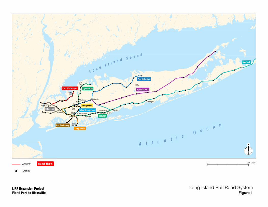
The MTA is North America’s largest transportation network, serving a population of 15.2 million people in a 5,000-square-mile area that extends from New York City to Long Island, the southeastern portion of New York State, and Connecticut. The MTA is a public-benefit corporation with five operating agencies—MTA New York City Transit, MTA Metro-North Railroad, MTA Bus Company, MTA Bridges and Tunnels, and MTA LIRR. MTA LIRR was founded in 1834. It is the busiest commuter railroad in North America, currently carrying approximately 304,000 customers each weekday on approximately 750 daily trains. The MTA LIRR system comprises over 700 miles of track on eleven different branches (see Figure 1). It extends 120 miles from Montauk, Long Island to Pennsylvania Station in Manhattan. MTA LIRR serves 124 stations in Nassau, Suffolk, Queens, Brooklyn, and Manhattan, providing service to over 87 million customers each year.
The LIRR’s Main Line serves as the central artery of the commuter rail system in Nassau and Suffolk Counties. At various points east of Jamaica, five LIRR branches split off from the Main Line—the Hempstead, Oyster Bay, Port Jefferson, Ronkonkoma, and Montauk Branches. The number of tracks along the Main Line corridor varies: it primarily has four tracks west of Floral Park, but narrows to two tracks east of Floral Park through to Hicksville. The Main Line is also used by the New York & Atlantic Railway for freight service.
PROJECT PURPOSE AND NEED
The Proposed Project addresses the heavily utilized two-track Main Line segment between Floral Park and Hicksville (see Figure 2). This busy portion of the Main Line services the Hempstead, Ronkonkoma, and Port Jefferson Branches; some Montauk Branch trains; and all Oyster Bay Branch trains. This approximately 9.8-mile segment services approximately 107,000 riders on an average weekday. This two track portion of the corridor is problematic for several reasons, including:
• Severe congestion during peak periods • Frequent delays with rippling effects to other branches due to bottlenecks caused by
emergency repair, a disabled train or other disruptions that would not allow trains to bypass during peak periods
• Insufficient track capacity to operate both eastbound and westbound service during peak periods
• Safety concerns related to railroad traffic, roadway traffic, and pedestrians at grade crossings
• Traffic delays due to grade crossings
!!! !
!!
!! !
!! !!! !
!!!
!
!
!
!!!
!! ! ! !!!
! !!
!
!
!
!
!
!!!
! !
! !
!
!!
!
!
! !
!
!
!
!
!!
!!
!!
!
!!
!
!
!
!
!
!
!! ! !
!!
!!!
!
!!
!!!!
!!!!
!!
! ! !! ! ! ! !! ! !
!
!
!! ! ! !
!
!
!
!!
!
!
!
!
!
A t l a n t i cO c e a n
L o n gI s l a n d S o u n d
Hicksville
Montauk
Babylon
West Hempstead
Port Jefferson
Hempstead
City Zone
Far Rockaway
Long Beach
Port Washington Oyster BayRonkonkoma
Jamaica
Babylon
LakeGrove
Lindenhurst
Massapequa Park
Patchogue
FloralPark
Freeport
GardenCity
GlenCove
GreatNeck
LongBeach
Lynbrook
Mineola
New York
Rockville CentreValley
Stream
Westbury
0 20 MilesBranch NameBranch
! Station
LIRR Expansion Project
Floral Park to Hicksville
Long Island Rail Road SystemFigure 1

!(
!(!( !( !(
!(
!(
!(
!(
!(
!(
!(
!(
!(
!(
!(
!(
!(
!(
!(
!(
!(
!(
!(
Port Washington
Branch
Hempstead
Branch
West Hempstead
Branch
Oyster Bay
Branch
Ronkonkoma
Branch
Port Jefferson
Branch
Floral Park
New Hyde Park
Merillon Avenue
Mineola
Carle Place
Westbury
Hicksville
0 2 Miles
LIRR Expansion Project
Floral Park to Hicksville
Project AreaFigure 2
5/2/2016
LIRR Main Line
Station Name ! LIRR Station

Long Island Rail Road Expansion Project Scoping Document
3 May 5, 2016
CONGESTION AND DELAYS ALONG EXISTING LIRR MAIN LINE
The existing LIRR Main Line segment between Floral Park and Hicksville comprises two tracks, and currently serves more than 220 trains on a typical weekday. Given the volume of train traffic along this Main Line segment, it frequently becomes congested during a normal rush hour. Moreover, in the event of a bottleneck caused by an emergency repair or disabled train, conditions can range from severely constrained to immobilized, creating significant delays. Moreover, due to the heavy train volumes and the two-track configuration, the LIRR has very few options to route service around a disabled train or track outage, compounding delays and affecting thousands of train riders.
The LIRR is projecting a substantial increase in service levels by the year 2040. This projected increase is due to a variety of factors, including: regional ridership growth; a desire to increase reverse peak and intra-island service opportunities; and planned future service growth to Manhattan terminals. If left unaddressed, this existing chokepoint will result in increasing congestion, delays, additional gate-down time, and passenger crowding in the future.
INTRA-ISLAND, REVERSE PEAK AND REVERSE DIRECTION SERVICE LIMITATIONS
In addition to operational constraints, the two-track Main Line limits LIRR’s ability to offer a broader range of services. The heavy demand for directional peak-period service (Manhattan-bound service in the morning rush hours and Long Island-bound service in the evening rush hours) requires full use of both tracks and restricts other services such as intra-island service; and reverse direction travel (operating reverse from the peak direction). The use of both tracks in the peak direction and no reverse service during peak periods is referred to as “2 and 0 operation.” The result is no eastbound service for one and a half hours in the morning peak period and no westbound service for one hour in the evening peak period. LIRR anticipates increasing demand for intra-island travel and reverse peak travel—services that the current Main Line configuration cannot support during critical times of the day.
GRADE CROSSINGS
Along the LIRR Main Line segment between Floral Park and Hicksville are seven locations where the east-west rail line crosses the street bed of a north-south vehicular roadway (see Figure 3). These locations are as follows:
• New Hyde Park/Garden City - Covert Avenue - South 12th Street - New Hyde Park Road
• Mineola - Main Street - Willis Avenue
• Westbury/New Cassel - School Street - Urban Avenue
Grade crossings adversely impact traffic and train operations, neighborhood quality-of-life, as well as vehicle, pedestrian and bicyclist safety. Under normal conditions grade crossings add automobile traffic congestion due to gate-down time. When incidents occur at or near grade

!(
!(!( !( !(
!(
!(
!(
!(
!(
!(
!(
!(
!(
!(
!(
!(
!(
!(
!(
!(
!(
!(
!(
!?!?
!?
!?!?
!?
!?
Port Washington
Branch
Hempstead
Branch
Oyster Bay
Branch
Ronkonkoma
Branch
Port Jefferson
Branch
Covert Avenue
South 12th Street
New Hyde Park Road
Main Street
Willis Avenue
School Street
Urban Avenue
West Hempstead
Branch
Floral Park
New Hyde Park
Merillon Avenue
Mineola
Carle Place
Westbury
Hicksville
0 2 Miles
LIRR Expansion Project
Floral Park to Hicksville
Existing Grade CrossingsFigure 3
5/2/2016
!? Grade Crossings
!( LIRR Stations
LIRR Main Line
To Babylonand
MontaukBranches
Long Island Rail Road Expansion Project Scoping Document
4 May 5, 2016
crossings that affect operation of gates and/or bells, grade crossings also can slow train travel because trains must approach the grade crossing at a reduced speed. In addition, train horns that must be blown at grade crossings, and bells when that ring when gates are down create noise in the adjacent communities. They also increase risk to pedestrian, bicycle and automobile safety. Grade crossings also raise safety concerns related to response times for emergency vehicles that may need to cross the tracks.
Accordingly, the desired option from a safety, quality-of-life, and traffic flow standpoint is to eliminate the grade crossings through grade-separating the two modes of transportation (e.g., building a roadway underpass) or potentially, in one or two cases with consideration of public input, closure of the grade crossing.
PROJECT PURPOSE
The primary purpose of the LIRR Expansion Project is to improve rail service, reliability, and public safety along the LIRR Main Line segment between Floral Park and Hicksville by constructing a third track and by eliminating grade crossings. The goals and objectives of the Proposed Project are as follows:
• Reduce delays to commuters from Main Line congestion and rippling effects - Improve on-time performance on all branches - Add resiliency and accelerate recovery time from unplanned service disruptions - Reduce train delays due to roadway incidents or accidents near grade crossings
• Add operational flexibility eastbound and westbound - Improve mobility with additional intra-island service - Improve mobility with additional reverse peak service - Facilitate scheduled and unscheduled maintenance
• Provide additional track capacity to accommodate projected system-wide service growth • Improve public safety and roadway conditions
- Eliminate Main Line grade crossings - Enhance north-south vehicular and pedestrian connectivity in communities along the
Main Line - Reduce traffic delays due to grade crossings
• Reduce noise and improve neighborhood quality-of-life - Reduce noise from train horns - Reduce noise from crossing-gate warning bells
PLANNING CONTEXT AND PROJECT HISTORY
Separate from the Proposed Project, LIRR is moving forward with the following regional transportation projects and plans:
• East Side Access • Double Track Project from Farmingdale to Ronkonkoma
Long Island Rail Road Expansion Project Scoping Document
5 May 5, 2016
• Jamaica Capacity Improvements Project, which streamlines the Jamaica track layout, while upgrading and modernizing the switch and signal system, (including installation of higher-speed switches)
• Expansion of the electric car storage yard in Ronkonkoma • The addition of pocket tracks along the Port Washington and Babylon Branches • Huntington/Port Jefferson Branch yard site selection, preliminary design and
environmental review Beginning in 2005, a project similar in intent to the Proposed Project (known as the Main Line Corridor Improvements Project) but with a substantially greater number of property acquisitions was considered. That project included the installation of a third track between Queens Village and Hicksville within a significantly widened right-of-way. That project also proposed grade-separation of up to five grade crossings, but required a large number of residential and commercial acquisitions and community disruption. That project is no longer being pursued because it entailed a substantial number of full commercial and residential property acquisitions, multiple partial property acquisitions to accommodate a widened right-of-way, and a lengthy construction schedule within downtown areas.
The Proposed Project is being advanced based on input received at numerous stakeholder meetings, with the intent of minimizing disruption to the local communities in the vicinity of the project limits. By remaining within the existing LIRR right-of-way, the Proposed Project would avoid residential property acquisitions and greatly reduce, in comparison to the 2005 initiative, the number of commercial acquisitions. Unlike the earlier proposal, it would eliminate all grade crossings, thereby enhancing vehicular and pedestrian traffic safety. Finally, the construction schedule of the Proposed Project, both for the overall Proposed Project and for construction work on individual grade crossings, has been reduced substantially. Overall, the Proposed Project presents a significantly enhanced approach to solving infrastructure deficiencies on the LIRR Main Line.
FREIGHT OPERATIONS
New York & Atlantic Railway (NY&A) is the contracted freight operator along the LIRR system. Current NY&A operations typically include three round-trip freight trains per day along the Main Line which always run during off-peak hours - a significant reduction from historic peak levels. Since NY&A operations are not currently capacity-constrained, the additional third main line track proposed by the Proposed Project would not increase freight traffic along the corridor. With or without the Proposed Project, it is anticipated that rail freight demand on Long Island would not increase significantly, and any increase (should it occur due to a change in market conditions) in service would be during the off-peak periods similar to current operations.
DESCRIPTION OF THE PROPOSED PROJECT
As previously stated, the LIRR Expansion Project from Floral Park to Hicksville extends approximately 9.8 miles from the Village of Floral Park to the Hamlet of Hicksville and entails the following major components: installation of additional track to complete a continuous third Main Line track; elimination of seven grade crossings; various station improvements and modifications, and other related railroad infrastructure improvements. More specifically, the Proposed Project would include the following elements:
• Installation of a third Main Line track from Floral Park Station to Hicksville (see Figure 4)

5.5.16
Figure 4LIRR Expansion ProjectFloral Park to Hicksville
LIRR Expansion Project Track Schematic

Long Island Rail Road Expansion Project Scoping Document
6 May 5, 2016
• Elimination of seven existing grade crossings within the project limits to provide grade-separated crossings or potentially, in one or two cases, full closures to vehicular traffic, with the nature of the modification to be based on NYSDOT design criteria, consideration of construction impacts and duration, traffic impacts, and input from the community
• Construction of retaining walls along portions of the corridor • Modifications to passenger rail stations and parking (e.g., modified and improved
platforms, passenger shelters, Americans with Disabilities Act (ADA) enhancements, and parking modifications including new parking facilities at the New Hyde Park and Mineola stations)
• Modifications to railroad infrastructure including signal systems, substations, culverts, interlockings, crossovers, sidings, track bed, power systems, communications and signals
• Utility relocations, including electric, signal, communications, gas, water, sewer, and storm sewer systems
The Proposed Project would support current service plans as well as longer term post-ESA Project service plans. The Proposed Project would accommodate significant improvements to intra-island and reverse peak service.
The Proposed Project would result in a consistent three-track segment capability of the LIRR Main Line, substantial additional operational flexibility, improved safety, and a more resilient and reliable commuter rail network. Construction of the entire Proposed Project would take approximately three to four years, depending on the precise schedule proposed by the design-build contractor; however, in any given location, construction activities would occur over a much shorter period. Construction of the Proposed Project would entail varying temporary disruptions to rail service, certain passenger rail stations, and local traffic operations. Expedited construction techniques for both the construction of the third track segments as well as the grade crossing eliminations would result in shorter construction periods of the Proposed Project. Expedited construction methods at grade crossings that include complete temporary road closure would target approximately six months for construction. Expedited construction measures at grade crossings that include only partial temporary road closure would target approximately nine months for construction at grade crossings. The Proposed Project would not result in greater train speeds; the current maximum authorized speed (MAS) of 80 miles per hour (mph) would be maintained.
STATION IMPROVEMENTS AND MODIFICATIONS
The Proposed Project would include various station improvements and modifications in order to accommodate the third track; enhance ADA accessibility; enhance pedestrian access; and improve platforms and passenger waiting areas. No major station modifications would be made at Floral Park or Hicksville stations as part of the Proposed Project. Hicksville Station Improvements, a separate project that already has secured capital program funding and for which construction will start shortly, includes platform reconstruction and new platform amenities (elevator and escalator replacement).

Long Island Rail Road Expansion Project Scoping Document
7 May 5, 2016
GRADE CROSSINGS
The Draft Environmental Impact Statement (DEIS) will consider a number of potential options for each grade crossing listed below based on design criteria; impacts on traffic; construction impacts and duration and other environmental considerations; and the satisfaction of the Project Purpose and Need. The selection of a particular option also will consider the input received from the public and elected officials for the municipalities where the grade crossing is located. Various other concepts (e.g., one-way and two-way overpass concepts) were considered and dismissed from further analysis, as explained in Appendix A.
Unlike the project considered in 2005, the LIRR Expansion Project does not require the substantial number of property acquisitions at the grade crossings or the disruption to local communities through extended construction periods. The LIRR Expansion Project avoids these concerns through re-designing the grade crossing separations in response to community input.
The modifications to the grade crossings would be designed to accommodate emergency vehicles, snow plows, and truck traffic. Sidewalks or pedestrian bridges are proposed to allow for pedestrian and first responder access. Figure 6 through Figure 42 show existing aerial images for each location as well as the design options outlined below. Appendix A includes a description of other options considered at each grade crossing and the reasons why they were eliminated from further consideration.
Covert Avenue Crossing (see Figure 5) Covert Avenue—Two-Way Underpass with Sidewalk, LIRR Tracks Raised Several Feet
The Covert Avenue crossing would be reconstructed to provide a two-lane grade-separated underpass with a sidewalk on the east side (see Figures 6 through Figure 8). It would require raising the LIRR tracks approximately five feet in order to keep Second Avenue and Third Avenue open to through-traffic and avoid the acquisition of residential property. This option would provide a one-way service road connecting Covert Avenue northbound traffic to Third Avenue and Covert Avenue southbound traffic to Second Avenue.
The existing access from Covert Avenue to the commercial building at the northeast corner of Covert and Second Avenues would be restricted, potentially requiring acquisition. Minor reconstruction to Second Avenue, Third Avenue, Wayne Avenue, and driveways would be necessary.
The following construction staging scenarios will be explored for this location:
Scenario 1: Full closure of Covert Avenue, Second Avenue, and Third Avenue during construction.
Scenario 2: Maintenance of one-way northbound traffic on Covert Avenue during construction. Diversion of southbound Covert Avenue traffic to South 12th Street and New Hyde Park Road, which are less than ¼ mile and ½ mile east of Covert Avenue respectively. This option would have a longer construction duration.
South 12th Street Crossing (see Figure 9) South 12th Street—Option 1: Permanent Crossing Closure with Pedestrian Bridge
This option would permanently close South 12th Street to vehicular traffic across the LIRR tracks and provide an ADA-compliant pedestrian bridge over the tracks with ramps landing along Second Avenue and Third Avenue (see Figure 10 and Figure 11). The pedestrian
Long Island Rail Road Expansion Project Scoping Document
8 May 5, 2016
bridge would connect to a proposed parking structure on the southwest corner of South 12th Street and span over Third Avenue and the LIRR tracks. The crossing vehicle traffic would divert to Covert Avenue and New Hyde Park Road, which are less than ¼-mile away on either side of the tracks and would be grade-separated.
South 12th Street—Option 2: One-Way Underpass with Sidewalk
This option would construct a one-way grade-separated southbound underpass with a sidewalk on the east side (see Figure 12 and Figure 13). It would provide a one-way service road connecting northern South 12th Street traffic to Second Avenue and southern South 12th Street traffic to Third Avenue.
This option would result in the loss of approximately eight on-street parking spaces along South 12th Street and would re-route South 12th Street northbound traffic onto other roads in the area. The adjacent crossing streets are less than ¼-mile away on either side of the tracks.
New Hyde Park Road Crossing (see Figure 14)
New Hyde Park Road—Option 1: Five-Lane Underpass with Kiss and Ride northeast of Tracks
The New Hyde Park Road crossing would be reconstructed as a five-lane grade-separated underpass with sidewalks on the east and west sides of the underpass (see Figure 15 and Figure 16). It would provide a dedicated left turn lane from southbound New Hyde Park Road to Clinch Avenue. Reconstruction of Clinch Avenue, Greenridge Avenue, Plaza Avenue, and Second Avenue would be necessary to improve safety. Pedestrian access from Garden City to the LIRR Station would be provided via a pedestrian crossing parallel to and south of the tracks.
This option would require the acquisition of the commercial building at the northwest corner of New Hyde Park Road and Plaza Avenue. The space created with this acquisition would be used to connect Second Avenue to Plaza Avenue, providing a dedicated left turn lane from northbound New Hyde Park Road to Plaza Avenue, providing space for a Kiss and Ride area, allowing for a safe and convenient location to drop off and pick up railroad passengers; the remaining space would be used for parking, drainage and stormwater management practices.
New Hyde Park Road—Option 2: Four-Lane Underpass with Kiss and Ride southeast of Tracks
This option would entail the construction of a four-lane grade-separated underpass with sidewalks on the east and west sides of the underpass (see Figure 17 and Figure 18). The left lane of the southbound New Hyde Park Road traffic would be shared with left turn onto Clinch Avenue. Similarly, the left lane of the northbound New Hyde Park Road traffic would be shared with left turn onto Plaza Avenue. This option would involve construction of a Kiss and Ride area on the southwest side of New Hyde Park Road. This option would not require the acquisition of any buildings. Under this option, Second Avenue would not access (connect to) New Hyde Park Road.

Long Island Rail Road Expansion Project Scoping Document
9 May 5, 2016
Main Street Crossing (see Figure 19) Main Street—Option 1: Permanent Crossing Closure with Pedestrian Bridge
This option would permanently close Main Street to vehicular traffic across the LIRR tracks and provide a pedestrian bridge over the LIRR tracks with elevators (see Figure 20 and Figure 21). The pedestrian bridge would connect to a proposed parking structure on the LIRR property at the southwest corner of Main Street and span over LIRR tracks. The crossing vehicle traffic would divert to Mineola Boulevard and Willis Avenue, which are less than ¼-mile away on either side of the tracks.
Main Street—Option 2: One-Way Underpass with Pedestrian Bridge
This option would construct a one-way grade-separated northbound traffic underpass and provide a pedestrian bridge over the LIRR tracks with elevators (see Figure 22 and Figure 23). The pedestrian bridge would connect to a proposed parking structure on the LIRR property at the southwest corner of Main Street and span over the LIRR tracks. This option would provide a one-way service road connecting Front Street to northbound Main Street and southern Main Street traffic to eastbound Front Street. On-street parking would be maintained in front of the east side businesses.
On the north side of the tracks, two four foot wide sidewalks would be constructed. This reduced width would allow for the construction of the underpass without the acquisition of the commercial building on the northwest side of the tracks.
Southbound crossing vehicle traffic would be diverted to Mineola Boulevard and Willis Avenue, which are less than ¼ mile away on either side of the tracks.
Willis Avenue Crossing (see Figure 24) Willis Avenue—Option 1: Two-Way Underpass
A two-way grade-separated underpass with a pedestrian bridge and elevators would be constructed. It would provide a one-way service road either on the west side or east side of Willis Avenue connecting northern Willis Avenue traffic to Hinck Way eastbound and to businesses located between the LIRR Main Line and spur. This option would maintain traffic on Front Street eastbound to Willis Avenue southbound, and would create a parking garage between Main Street and Willis Avenue in place of the existing municipal lot.
The following access scenarios will be explored for this location:
Scenario 1A: The existing access from Willis Avenue to the commercial building at the northeast corner of Willis Avenue and Second Street would be restricted. This scenario also would require reconstructing Second Street and the parking area at the northwest corner of Second Street and Willis Avenue. A traffic signal would be required at the intersection of Willis Avenue and Third Street for merging traffic (see Figures 25 through Figure 27).
Scenario 1B: This scenario would preserve access from Willis Avenue to the commercial building at the northeast corner with substantial driveway modification and accepting a lower traffic operational level of service at the Second Street intersection (see Figure 28 and Figure 29).
Long Island Rail Road Expansion Project Scoping Document
10 May 5, 2016
Willis Avenue—Option 2: One-Way Underpass
This option would construct a one-way southbound grade-separated underpass with pedestrian bridge and elevators (see Figure 30 and Figure 31). It would provide a one-way service road connecting northern Willis Avenue traffic to Hinck Way eastbound and to businesses located between the LIRR Main Line and spur. This option would maintain traffic on Front Street eastbound to Willis Avenue southbound, and would create a parking garage between Main Street and Willis Avenue in place of the existing municipal lot. This option would allow the commercial building at the northeast corner of Willis Avenue and Second Street to maintain access to Willis Avenue.
School Street Crossing (see Figure 32) School Street—Two-Way Underpass and Tracks Raised Several Feet
The School Street crossing would be reconstructed as a two-way grade-separated underpass with a sidewalk on the east side. Railroad Avenue would be reconstructed to maintain access to School Street. Acquisition of a narrow strip of land would be required from the commercial property on the southeast corner of the intersection of School Street and the LIRR tracks to build a service road to maintain access to the business.
This would require raising the LIRR tracks approximately three feet in order to avoid the acquisition of a residential property to the southeast of School Street. It also would require the acquisition of the commercial property at the northeast quadrant due to the elimination of access to School Street.
The following property access options will be explored for this location:
Scenario 1A: This scenario would relocate the access of the commercial property on the northwest corner of the intersection of School Street and the LIRR tracks to Union Avenue and the commercial property on the northeast corner of the intersection of School Street and the LIRR tracks to Grant Street (see Figure 33 and Figure 34).
Scenario 1B: This scenario would maintain access of both Jamaica Ash and the Law Office on School Street (see Figure 35 through Figure 37).
Urban Avenue Crossing (see Figure 38) Urban Avenue—Two-Way Underpass with Tracks Raised Several Feet
This option would construct a two-lane grade-separated underpass with a sidewalk on the west side. Railroad Avenue would bridge over the underpass and remain connected. It would require raising the LIRR tracks approximately three feet in order to avoid impacting residential properties at the north side of Broadway and acquiring an additional property on the south end of Urban Avenue. The driveway of the residential property northeast of the tracks would require reconstruction to provide access to Railroad Avenue. Two commercial properties at the southwest quadrant would be acquired due to the elimination of access to Urban Avenue.
The following access scenarios will be explored for this location:
Scenario 1A: The commercial property in the southeast quadrant would be accessible via a new access road (see Figure 39 and Figure 40).
Long Island Rail Road Expansion Project Scoping Document
11 May 5, 2016
Scenario 1B: The commercial property in the southeast quadrant would require reconstructed access from Urban Avenue (see Figure 41 and Figure 42).
B. REQUIRED ACTIONS
• Potential property acquisition by MTA or NYSDOT, if necessary (with the goal of fewer than 10 full commercial property acquisitions)
• Empire State Development (ESD) to provide assistance to affected businesses to relocate within their communities where feasible
• NYSDOT approval of modifications to the roadway network • NYSDOT approval of petition to alter grade crossings pursuant to §91 of the New York
Railroad Law • LIRR issuance of SEQRA Findings and final determination relating to the Proposed
Project • New York State Department of Environmental Conservation (NYSDEC) State Pollutant
Discharge Elimination System (SPDES) General Permit for Construction Activity (GP-0-15-002)
• New York State Office of Parks, Recreation and Historic Preservation (OPRHP) consultation on parks and historic resources
• Consultation with the following entities with regard to aspects of the work within each locality: - Nassau County - Town of North Hempstead - Town of Oyster Bay - Village of Floral Park - Village of New Hyde Park - Village of Garden City - Village of Mineola - Village of Westbury
C. REQUIRED ELEMENTS OF THE EIS Both the draft and the final EIS shall comprise the following components:
• A description of the Proposed Project and a definition of its Study Area; • A Problem Statement and Purpose and Need; • A discussion of alternatives to the Proposed Project; • A statement of existing environmental conditions within the Study Area; • An analysis of the potential environmental impacts of the Proposed Project, including its
short-term, long-term, indirect and cumulative impacts; • A description of mitigation measures proposed to minimize or avoid any significant
adverse environmental impacts of the Proposed Project;

Long Island Rail Road Expansion Project Scoping Document
12 May 5, 2016
• An identification of any irreversible and irretrievable commitments of resources that would be attributable to implementation of the Proposed Project; and
• An identification of any significant adverse environmental impacts that cannot be avoided if the Proposed Project is implemented.
ORGANIZATION AND EXPECTED CONTENT OF THE DEIS
COVER SHEET AND GENERAL INFORMATION
The Cover Sheet shall identify: the Proposed Project; its location; the name, address, and phone number of the Lead Agency; the name, address, and phone number of the Preparer of the EIS including a Contact Person; the document as a Draft Environmental Impact Statement; the Date of Acceptance of the DEIS by the Lead Agency; and the date of the Public Hearing and the closing of the Public Comment Period.
Additional information, to be provided following the Cover Sheet, shall include: the name(s) and address(es) of the LIRR contacts; and the name(s) and address(es) of all consultants involved in the Proposed Project and their respective roles.
The DEIS shall include a list of all Involved and Interested Agencies to which copies of the DEIS and supporting material will be distributed.
A Table of Contents followed by a List of Tables and List of Figures, as well as an Executive Summary, shall be provided.
PROJECT DESCRIPTION
A. Project Identification
1. The introduction will identify the document as the Draft Environmental Impact Statement for the Proposed LIRR Expansion Project and describe the location of the Proposed Project.
B. Project Description
1. Project Corridor/Study Area—Information collected and presented in the DEIS will relate principally to the Main Line “Project Corridor” (also referred to as the “Study Area.”) The Project Corridor comprises the railroad right-of-way, station areas, and grade crossings from Floral Park to Hicksville and an approximately ¼-mile buffer along the right-of-way and ½-mile area around the station areas and grade crossings. Certain analyses, such as those for indirect impacts and environmental justice, may require information from an expanded Study Area. Other analyses may require a narrower Study Area.
2. Project Description—The DEIS will include all information necessary to describe the LIRR Expansion Project and its component parts. Information to be provided will include a description of the proposed plan, including the third track alignment, station modifications, and grade separation measures as well as construction phasing. The Project Description will set forth the environmental setting of the Project Corridor sufficient to understand the potential impacts of the Proposed Project and the alternatives.

Long Island Rail Road Expansion Project Scoping Document
13 May 5, 2016
The DEIS will support the narrative description of the Proposed Project and the Project Corridor with graphic depictions (e.g. site plans and Geographic Information Systems “GIS” mapping of resources). To ensure a realistic understanding of the scope of the Proposed Project, the DEIS will include renderings representative of project elements to show what the improvements would look like from view corridors within communities along the Project Corridor.
3. Project Purpose and Need—The DEIS will describe the purpose and need of the LIRR Expansion Project as stated above.
4. Analysis Framework—The DEIS will assess two future analysis years: 2020, when the Proposed Project is expected to be completed and operational; and, 2040, reflecting 20 years after estimated time of completion, thereby accounting for impacts of the Proposed Project over a longer period of time. For each subject area, the DEIS will evaluate a future baseline condition that accounts for any changes anticipated between existing conditions and the analysis years.
C. Summary of All Approvals Required and Responsible Agencies
This section will identify all of the approvals required by various State, County, and Local agencies.
D. Definition of Specific Terms
This section will provide definitions for acronyms or technical terms used in the EIS including definitions of what constitutes an adverse impact and what constitutes a significant adverse impact.
LAND USE, COMMUNITY CHARACTER, AND PUBLIC POLICY
A. Introduction
The goal of the Proposed Project is to be consistent with community plans and land use laws and regulations, even though the MTA LIRR, as a state agency, is not obligated to comply with local land use and zoning regulations or comprehensive plans. The DEIS will describe the existing character of the communities within the Project Corridor, and consider the potential beneficial and adverse impacts on that character as a result of the Proposed Project.
B. Land Use, Community Character, and Public Policy
1. Existing Conditions—The DEIS will describe existing land uses and community character within the Project Corridor. The DEIS will include the location of, and community access to, police, fire, and emergency medical resources; hospitals; schools; parks and open spaces; and places of worship. The DEIS also will summarize the relevant portions of applicable Comprehensive Plans and other land use and environmental regulations and policies. Specific plans or policy components addressing transportation or transit in general, or the LIRR in particular, will be highlighted.
2. Potential Impacts of the Proposed Project—Based on an analysis of future baseline conditions, the DEIS will describe the compatibility of the Proposed Project with land uses and community character within the Study Area and assess potential impacts to land use patterns or community character. The DEIS will assess the compatibility of the Proposed Project with the State Smart Growth Public Infrastructure Policy Act.

Long Island Rail Road Expansion Project Scoping Document
14 May 5, 2016
3. Mitigation Measures—If potential significant adverse impacts are identified, the DEIS will evaluate feasible and practical measures to avoid, minimize, or mitigate impacts.
SOCIOECONOMIC ANALYSIS
A. Introduction
The DEIS will include an assessment of potential socioeconomic impacts related to the LIRR Expansion Project. This assessment will consider economic conditions within the Study Area and how those conditions might be impacted as a result of the Proposed Project. The analysis will address commercial property displacements or relocations required, the tax implications of any such displacements or relocations, impacts to individual businesses, and impacts to the business climate in the Study Area in general. The DEIS will assess whether the removal of the grade crossings would affect roadway access to nearby properties and general mobility within parts of communities. The socioeconomic conditions assessment will consider whether any of the commercial property acquisitions and changes in roadway access could have direct or indirect adverse impacts on population, housing, and economic activities within the affected areas.
B. Socioeconomics
1. Existing Conditions—The DEIS will describe existing socioeconomic conditions within the Study Area, describe the character of properties that comprise the Study Area, and identify business districts in that Study Area.
2. Potential Impacts of the Proposed Project—Based on an analysis of future baseline conditions, the DEIS will assess the Proposed Project’s potential impacts to the Study Area in terms of socioeconomics. It is anticipated that most of the Proposed Project improvements would take place within the existing right-of-way established for the LIRR. However, some commercial property acquisition would be necessary to construct the Proposed Project. Most of the areas where this commercial property acquisition may be necessary would be in areas surrounding stations and where roadways, bridges, and underpasses cross the LIRR right-of-way.
The analysis will identify the commercial properties for which full acquisition would be required (currently estimated at fewer than 10), as well as commercial properties where partial acquisitions are necessary but where the goal will be to minimize the impacts on the affected businesses. The analysis will identify the ownership and characterize existing uses of those commercial properties. The analysis also will describe the compensation and relocation assistance that would be provided to displaced businesses by ESD and NYSDOT, with priority given to relocation within the same town or village where the displaced business currently operates. For the potential displacement of commercial uses, if any, the analysis will consider whether the Proposed Project would displace a business that is unusually important because its products or services are uniquely dependent on its location, or that serves a population uniquely dependent on its services in its present location. The analysis will estimate the potential loss of tax revenues in the jurisdictions where the properties are located (i.e., municipality, school district, and Nassau County) and whether the potential losses in tax revenues could adversely affect the ability of the jurisdiction(s) to provide municipal services.
The socioeconomic analysis will estimate the fiscal and economic benefits of the construction of the Proposed Project. The construction benefits analysis will be based on

Long Island Rail Road Expansion Project Scoping Document
15 May 5, 2016
the IMPLAN (IMpact Analysis for PLANing) input-output modeling system. The following benefits that would occur during the overall construction period in Nassau County, and Suffolk County, and the State will be estimated:
i. Direct employment (in full-time equivalents) created by the capital investment and indirect employment created by purchases of other goods and services during the construction period.
ii. Wages and salaries generated by the direct and indirect employment.
iii. Taxes generated during the construction period, including payroll taxes, corporate and business taxes, and miscellaneous taxes.
iv. The total economic output, or the total demand for goods and services created by construction of the Proposed Project.
A qualitative description of potential socioeconomic benefits from operations will also be provided.
3. Mitigation Measures—If significant adverse socioeconomic impacts are identified, the DEIS will evaluate feasible and practical measures to avoid, minimize, or mitigate impacts.
ENVIRONMENTAL JUSTICE
A. Introduction
An environmental justice analysis is conducted to identify and address adverse and disproportionate impacts on minority and low-income communities. The proposed LIRR Expansion Project would extend across three municipalities in Nassau County with varying concentrations of minority and low-income communities. Based on NYSDEC thresholds, potential environmental justice communities in the Project Corridor will be evaluated. The environmental justice analysis will address and identify potential adverse and disproportionate impacts on these communities as well as other environmental justice communities within the Study Area. The analysis will consider all technical analysis areas included in the DEIS for a determination of impacts, recognizing that the impacts within minority or low-income populations may be different from impacts on the general population.
The analysis will be prepared using NYSDEC Commissioner Policy 29 (CP-29), Environmental Justice and Permitting as a guidance tool. The methodology set forth in CP-29 involves: (1) identifying potential adverse environmental impacts and the area to be affected (i.e., establishing a study area); (2) determining whether potential adverse environmental impacts are likely to affect a potential environmental justice area (i.e., whether low-income and/or minority populations are present in the study area); and (3) identifying whether potential adverse environmental impacts of the proposed action would disproportionately affect low-income and minority populations. As recommended by the CP-29 guidance, the environmental justice analysis will also: (4) identify the potential for cumulative environmental burdens in the Study Area; and (5) seek public participation from the affected community.

Long Island Rail Road Expansion Project Scoping Document
16 May 5, 2016
B. Environmental Justice
1. Existing Conditions—Because the Proposed Project is linear, and falls within a densely developed portion of Nassau County, the environmental justice study area has been chosen to include the census block groups that either intersect the Project Corridor or have a majority of their geographic area within a ¼-mile from the Proposed Project.
For this analysis, data on race, ethnicity, and poverty status will be gathered from the U.S. Census Bureau’s American Community Survey (ACS) 2010–2014 5-Year Estimates. For comparison purposes, data also will be compiled for the Study Area as a whole and Nassau County. Based on census data and CP-29 guidance, potential environmental justice areas are identified as follows:
Minority Communities: CP-29 guidance defines minorities to include American Indians or Alaskan Natives, Asian and Pacific Islanders, African Americans or Black persons, and Hispanic persons. This environmental justice analysis also will consider minority populations to include persons who identified themselves as being either “some other race” or “two or more races.” According to CP-29 guidance, a “minority community” is present when 51.1 percent or more of the population is minority. Low-Income Communities: The percent of individuals living below the poverty level in each census block group is used to identify low-income communities. CP-29 defines a low-income community to be any area where the low-income population (i.e., percent living below the poverty threshold) is equal to or greater than 23.59 percent of the total.
2. Potential Impacts of the Proposed Project—Based on an analysis of future baseline conditions, the DEIS will analyze potential impacts to environmental justice communities and determine if such impacts are disproportionate and adverse.
3. Mitigation Measures—If disproportionate and significant adverse impacts to environmental justice populations are identified, the DEIS will evaluate feasible and practical measures to avoid, minimize, or mitigate the impacts.
VISUAL AND AESTHETIC RESOURCES
A. Introduction
An analysis of potential impacts to visual and aesthetic resources will be conducted following the methodology of NYSDEC Program Policy, DEP-00-2, Assessing and Mitigating Visual Impacts. The DEIS will identify sensitive receptors as they are defined in DEP-00-2, including designated open spaces, historic resources, and natural or scenic areas. Potential visual impacts would follow DEP-00-2 guidance on evaluating visual impacts and aesthetic impacts as they are defined in DEP-00-2.
1. Existing Conditions—The DEIS will identify sensitive receptors within the Project Corridor and characterize views of the Main Line right-of-way, station areas, and grade crossings from identified sensitive receptors. The DEIS will also characterize prevalent land-forms, vegetative cover, and illuminated and non-illuminated areas along the Project Corridor.
2. Potential Impacts of the Proposed Project—Based on an analysis of future baseline conditions, the DEIS will assess potential visual and aesthetic impacts of the Proposed Project from identified sensitive receptors within the Project Corridor. The DEIS will include representative renderings of proposed project elements.
Long Island Rail Road Expansion Project Scoping Document
17 May 5, 2016
3. Mitigation Measures—If significant adverse impacts to visual and aesthetic resources are identified, the DEIS will evaluate feasible and practical measures to avoid, minimize, or mitigate impacts.
HISTORIC AND ARCHAEOLOGICAL RESOURCES
A. Introduction
The New York State Historic Preservation Act (NYSHPA) requires that historic and archaeological resources be afforded varying levels of protection depending upon the quality of the resources and the nature of any potential impact. An analysis of impacts to these resources, completed in consultation with the State Historic Preservation Officer (SHPO), would be undertaken as part of the DEIS.
B. Historic Resources
1. Existing Conditions—Using information from the SHPO and from local government historians, the DEIS will identify and describe any historic resources that are included in or eligible for inclusion in the State or National Register of Historic Places (S/NR) that are within 100 feet of the railroad right-of-way or within 500 feet of any grade crossing or station. Any such resources would be described textually, shown photographically, and included in GIS mapping.
2. Potential Impacts of the Proposed Project—Based on an analysis of future baseline conditions, the DEIS will describe potential impacts to identified historic resources resulting from implementation of the Proposed Project.
3. Mitigation Measures—If significant adverse impacts to historic resources are identified, measures to mitigate the impacts would be developed in consultation with appropriate agencies.
C. Archaeological Resources
1. Existing Conditions—Using information from prior site studies as well as information contained on the OPRHP online research tool, the Cultural Resource Information System (CRIS), which allows the approved user to access known archaeological site locations, and sensitivity maps, an archaeological assessment of the area of potential effect (APE), will be prepared. Through completion of the assessment the DEIS will determine if the Study Area is likely to contain archaeological resources. If, preliminarily, it appears that such resources are likely to occur in the Study Area, an archaeological subsurface testing survey would be developed to test for the presence or absence of archaeological resources. Consultation with the OPRHP is an essential part of the compliance process under SEQRA, and would enable the DEIS to better identify any areas of archaeological significance within the Study Area that would merit further consideration and analysis.
2. Potential Impacts of the Proposed Project—Based on an analysis of future baseline conditions, the DEIS will assess potential impacts to archaeological resources, if any, resulting from implementation of the Proposed Project.
3. Mitigation Measures—If significant adverse impacts to archaeological resources are identified, measures to mitigate the impacts would be developed in consultation with appropriate agencies.
Long Island Rail Road Expansion Project Scoping Document
18 May 5, 2016
NATURAL RESOURCES
A. Introduction
The majority of the Project Corridor passes through heavily developed portions of Nassau County. Natural resources are limited throughout much of the Project Corridor, but some sections are vegetated and contain natural features, or are immediately adjacent to areas with sensitive natural resources (e.g., Garden City Bird Sanctuary). The natural resources that potentially may be impacted by implementation of the Proposed Project include various types of vegetative communities, wildlife and habitat, and special status species. The DEIS will contain an analysis of potential impacts to these resources.
B. Natural Resources
1. Existing Conditions—The DEIS will characterize the existing condition of natural resources, including wetlands, floodplains, farmland soils, groundwater and sole source aquifers, aquatic resources, plants, wildlife, and threatened and endangered species in the Study Area on the basis of reconnaissance surveys as well as existing information that is available in published literature, government databases, and other sources (e.g., NYSDEC freshwater wetland maps, U.S. Fish and Wildlife Service (USFWS) National Wetlands Inventory (NWI) maps and IPaC System list of federally threatened and endangered species, Federal Emergency Management Agency (FEMA) Flood Insurance Rate Maps, NYSDEC Breeding Bird Survey and Herp Atlas Project, New York Natural Heritage Program database of federally and state-listed species). Identified resources will be depicted textually and graphically.
2. Potential Impacts of the Proposed Project—Based on an analysis of future baseline conditions, the DEIS will assess potential impacts from the Proposed Project to natural resources where they occur within or in the vicinity of the Proposed Project’s limits of disturbance along the Project Corridor. Direct and indirect impacts from both construction and operation of the Proposed Project will be assessed by considering the effects of stormwater runoff and changes in impervious surface coverage on the quality and recharge of the sole source aquifer, effects of vegetation clearing on plant and wildlife communities and threatened and endangered species, and the effects of noise disturbances to wildlife, including threatened and endangered species. Potential impacts to wetlands, floodplains, prime farmland soils, and aquatic resources also will be evaluated.
3. Mitigation Measures—If significant adverse impacts to natural resources are identified, the EIS will evaluate feasible and practical measures to avoid, minimize, or mitigate the impacts.
CONTAMINATED MATERIALS
A. Introduction
Considering the heavily developed character and mix of land uses in the Study Area, the existence of contaminated soils and groundwater will be evaluated in the DEIS. The DEIS will identify the methodology for addressing any such contaminated soils if known to exist in the Study Area or discovered during construction.

Long Island Rail Road Expansion Project Scoping Document
19 May 5, 2016
B. Contaminated Materials
1. Existing Conditions—A Phase I Environmental Site Assessment (ESA) will be prepared to evaluate the potential for environmental impacts in the Study Area. The Phase I ESA will be prepared in general accordance with the American Society for Testing and Materials (ASTM) 1527-13 guidelines. Using the information obtained from the Phase I ESA, the DEIS will identify known locations of contamination and types of contaminants likely to be found where ground disturbance and new development would occur as part of the Proposed Project.
2. Potential Impacts of the Proposed Project—Based on an analysis of future baseline conditions, the DEIS will identify potential impacts of the Proposed Project with respect to hazardous and non-hazardous contaminated materials.
3. Mitigation Measures—If significant adverse impacts related to hazardous and non-hazardous contaminated materials are identified, the DEIS will include a preliminary evaluation of potential feasible and practical measures to avoid, minimize, or mitigate the impacts.
INFRASTRUCTURE AND UTILITIES
A. Introduction
The DEIS will identify existing water supply, sanitary wastewater, and storm water infrastructure, and the electricity and natural gas utilities serving the existing LIRR stations and within areas of potential construction activity.
B. Water/Wastewater
1. Existing Conditions—The DEIS will describe existing water supply and sanitary sewer infrastructure serving the existing stations, where mapping is available.
2. Potential Impacts of the Proposed Project—Based on an analysis of future baseline conditions, the DEIS will identify any potential impacts to water and wastewater services.
3. Mitigation Measures—If significant adverse impacts in terms of water/wastewater are identified, the DEIS will evaluate feasible and practical measures to avoid, minimize, or mitigate impacts.
C. Energy Usage (Electricity and Gas)
1. Existing Conditions—The DEIS will describe existing electricity and gas service and infrastructure location and conditions within the Study Area.
2. Potential Impacts of the Proposed Project—Based on an analysis of future baseline conditions, the DEIS will quantify anticipated electricity and gas demand from the construction and operation of the Proposed Project and determine if the anticipated demand will exceed available network capacity.
3. Mitigation Measures—If significant adverse impacts in terms of energy usage are identified, the DEIS will evaluate feasible and practical measures to avoid, minimize, or mitigate impacts.
Long Island Rail Road Expansion Project Scoping Document
20 May 5, 2016
D. Stormwater Management
1. Existing Conditions—The DEIS will describe the existing drainage patterns at LIRR tracks, crossings, and station areas within the Project Corridor, and any stormwater collection and treatment systems currently serving these facilities.
2. Potential Impacts of the Proposed Project—The Proposed Project would require implementation of drainage systems to properly control stormwater flow. The DEIS will describe the elements of the drainage systems to be included to manage stormwater flows along the railroad right-of-way, at station areas, and at grade crossings.
3. Mitigation Measures—The DEIS will discuss possible methods for mitigating stormwater impacts that may result from the Proposed Project.
TRANSPORTATION
A. Introduction
The DEIS will address passenger rail operations in the corridor and will evaluate both positive and adverse impacts. The DEIS will consider whether the Proposed Project would create adverse impacts on vehicular traffic, parking, pedestrian connectivity, or traffic safety once it is built and operational. In addition, the DEIS will discuss how the Proposed Project would provide substantial transportation benefits to Long Island, including an assessment of potential beneficial impacts on rail service, vehicular traffic, pedestrian and traffic safety and emergency response. Should adverse impacts be identified, the DEIS will then further evaluate the ability of additional transportation system improvements to mitigate those impacts. The DEIS will provide an overview of the regional transportation network in the Main Line corridor and an assessment of existing conditions, Future Without the Proposed Project conditions, and Future With the Proposed Project conditions.
B. LIRR Service, Operations, and Ridership
The DEIS will describe existing LIRR service along the Main Line corridor focusing on frequency of service for each of the stations from Floral Park through Hicksville, and describe how the frequency of train service would be expected to change under Future Without the Proposed Project and Future With the Proposed Project conditions. It will describe existing rail operations and capacity constraints in the corridor with two-track operation; identify the number and duration of crossing gate activations at each of the seven grade crossing locations and the percentage of time that gates are in the “down position”; identify the existing ridership at each of the stations from Floral Park through Hicksville and projected ridership increases; and describe projected operational benefits to LIRR service and riders with the Proposed Project in place.
C. Bus Service
The DEIS will describe the bus routes serving each of the stations from Floral Park through Hicksville and bus routes that parallel the corridor and which provide alternative transit service to the LIRR and their frequencies of service.
D. Vehicular Traffic
Traffic analyses will be conducted in the New Hyde Park, Mineola, and Westbury/New Cassel areas that may be affected by grade crossing eliminations, to evaluate potentially improved traffic flow as well as potential increases in traffic generated by new station

Long Island Rail Road Expansion Project Scoping Document
21 May 5, 2016
ridership, or both. For the New Hyde Park and Mineola station areas, these effects would be produced by both grade crossing eliminations and new station ridership under projected future conditions. For the Westbury/New Cassel area, these effects would be primarily produced by grade crossing eliminations, but could also include effects nearer to the station. Should projections indicate that other Main Line stations would have substantial ridership increases as a result of increased Main Line service, they will be addressed in the DEIS as well.
1. Existing Conditions—The DEIS will define traffic study areas, and specific traffic count and analysis locations at New Hyde Park, Mineola, and Westbury/New Cassel as listed below. Final determination of the traffic analysis locations will be made once station ridership projections are completed for the Build condition; others may be added while some may no longer be needed.
New Hyde Park - New Hyde Park Road and Jericho Turnpike - New Hyde Park Road and Second Avenue - New Hyde Park Road and Clinch Avenue and Greenridge Avenue - New Hyde Park Road and Stewart Avenue - Covert Avenue and Jericho Turnpike - Covert Avenue and Second Avenue - Covert Avenue and Third Avenue - Covert Avenue and Stewart Avenue - South 12th Street and Jericho Turnpike - South 12th Street and Second Avenue - South 12th Street and Third Avenue - South 12th Street and Stewart Avenue
Mineola - Main Street and First Street - Main Street and Second Street - Main Street and Front Street/Station Plaza (north side of tracks) - Main Street and Front Street (south side of tracks) - Main Street and Third Street - Main Street and Old Country Road - Willis Avenue and First Street - Willis Avenue and Second Street - Willis Avenue and Front Street - Willis Avenue and Third Street - Willis Avenue and Old Country Road - Mineola Boulevard and First Street - Mineola Boulevard and Second Street - Mineola Boulevard and Old Country Road - Roslyn Road and Second Street - Roslyn Road and Old Country Road
Westbury/New Cassel - School Street and Union Avenue - School Street and Railroad Avenue

Long Island Rail Road Expansion Project Scoping Document
22 May 5, 2016
- School Street and Old Country Road - Urban Avenue and Prospect Avenue - Urban Avenue and Broadway - Urban Avenue and Railroad Avenue - Urban Avenue and Main Street - Urban Avenue and Old Country Road - Grand Boulevard and Old Country Road Traffic counts and physical inventories will be collected at each of the above intersections during weekday morning, midday, and evening peak periods. Where recent traffic counts are available, they will be used. In addition to traffic counts, queue lengths and delays will be recorded for each intersection affected by LIRR grade crossing operations.
The DEIS will identify the weekday morning and evening peak hours to be analyzed and present traffic volume maps for each of the three study areas. For the Mineola area, weekday midday analyses will also be conducted.
The DEIS will evaluate existing traffic conditions for each of the intersections being analyzed using appropriate and accepted industry software such as Synchro and provide summary tables showing existing volume-to-capacity (v/c) ratios, average vehicle delays, and levels of service for each intersection analyzed.
2. Potential Impacts of the Proposed Project—Based on an analysis of future baseline conditions, the DEIS will develop future traffic volumes with and without the Proposed Project in place. This will include changes in traffic patterns that would occur as a result of grade crossing eliminations, additional station ridership (if any) projected by the LIRR, proposed parking facilities at New Hyde Park and Mineola, and potential reductions and/or additions in on-street or off-street parking created by the Proposed Project. It will evaluate conditions for the intersections being analyzed based on additional LIRR train operations, reductions in gate-down time with the Proposed Project, and increases in gate-down time without the Proposed Project in place, additional station-oriented traffic and/or changed traffic patterns and on intersection geometric improvements needed to support grade crossing eliminations.
The DEIS will identify potential adverse traffic impacts based on criteria used on other major transportation projects such as the LIRR East Side Access Project, and identify where traffic benefits would occur based on improved traffic flow effectuated by grade crossing eliminations.
In addition, the DEIS will evaluate emergency vehicle response times at each of the three study areas under existing conditions, Future Without the Proposed Project condition, and the decrease in delay in the Future With the Proposed Project conditions with all seven grade crossings eliminated.
3. Mitigation Measures—Should significant adverse impacts be identified, measures to mitigate those impacts will be identified and evaluated. Such measures could include roadway or intersection re-striping to increase capacity, other measures to increase intersection traffic capacity, new traffic signals at currently unsignalized intersections, signal phasing and timing modifications, intersection channelization improvements, turn prohibitions or other measures. The DEIS will identify the jurisdictions responsible for implementing such measures.

Long Island Rail Road Expansion Project Scoping Document
23 May 5, 2016
E. Parking
1. Existing Conditions—The DEIS will inventory the supply of existing parking within public parking lots and garages that serve LIRR commuters at affected stations, and inventory on-street parking locations that are also used by LIRR commuters and current posted parking regulations at those stations. This will include the location, capacity, and utilization of these parking facilities on weekdays.
2. Potential Impacts of the Proposed Project—Based on an analysis of future baseline conditions, the DEIS will determine changes in parking supply and demand. This will include any station area or other on-street or off-street parking reductions and/or additions resulting from the Proposed Project and any grade crossing eliminations, and will also include new parking facilities that would be built as part of the Proposed Project. The DEIS will address net changes in parking supply at the stations, net changes in parking demand, and residential or commercial parking losses that may result from the Proposed Project. Should parking shortfalls be found to result from the Proposed Project, means of augmenting parking will be identified
F. Pedestrian Connectivity
The DEIS will identify pedestrian access patterns at the New Hyde Park, Merillon Avenue Mineola, Carle Place, and Westbury station areas and at the seven existing grade crossing locations. This will consist of the volumes of pedestrians that cross from one side of the LIRR tracks to the other during the weekday morning and evening peak periods. Midday pedestrian access patterns and volumes will also be addressed for Mineola. It will determine the extent to which pedestrian crossing volumes would increase under the Future Without the Proposed Project condition. The DEIS will assess how pedestrian crossings would be improved under the Future With the Proposed Project condition, primarily due to grade crossing eliminations. The DEIS will provide descriptions as to how and where pedestrians would cross from one side of the LIRR tracks to the other and identify any connectivity issues. Safety considerations will be addressed under “Vehicular and Pedestrian Safety” below.
G. Vehicular and Pedestrian Safety
The DEIS will present crash history analyses at each of the seven grade crossings considered for elimination and at nearby intersections affected by grade crossing operations. Ten years of crash records will be evaluated at the seven grade crossings; three years of crash records will be evaluated at additional key roadway segments and intersections. The DEIS will then assess the potential reduction in crashes and improvement in safety that could occur with grade crossing eliminations with the Proposed Project and identify additional safety-related measures that have the potential to improve conditions and reduce the number of crashes at the key roadway segments and intersections in the three study areas.
AIR QUALITY
A. Introduction
The DEIS will assess potential impacts to air quality associated with mobile sources (vehicles) and stationary sources related to the Proposed Project. Because the Proposed

Long Island Rail Road Expansion Project Scoping Document
24 May 5, 2016
Project would not increase diesel locomotives for passenger or freight rail service no analysis of potential impacts from additional diesel locomotives is necessary.
The DEIS will describe existing ambient air quality in the Study Area based on data obtained from NYSDEC’s Ambient Air Quality Monitoring Network and the latest NYSDEC information regarding the status of the State Implementation Plan (SIP) and attainment status. The DEIS will describe potential changes to air quality that are expected independent of the Proposed Project.
B. Stationary Source Analysis
The DEIS will qualitatively assess the potential for any significant adverse impacts from stationary sources, if applicable, including parking garages, related to motor vehicles.
C. Mobile Source Carbon Monoxide (CO) Hot Spot Analysis
The need for a CO microscale analysis will be determined using the procedures in the NYSDOT Environmental Manual (TEM). If needed, the CO microscale analysis will be conducted using the procedures in the TEM and U.S. Environmental Protection Agency (USEPA) models and guidance.
D. The DEIS will consider the applicability of the USEPA’s Clean Air Act transportation conformity regulations to the Proposed Project.
E. Mitigation Measures—If significant adverse air quality impacts are identified, the DEIS will evaluate feasible and practical measures to avoid, minimize, or mitigate the impacts.
F. Mobile Source Air Toxics (MSATs) Analysis
Potential impacts in terms of MSATs will be conducted by following the Federal Highway Administration (FHWA) 2012 guidance developed for the National Environmental Policy Act (NEPA) review process for highway projects and FHWA 2016 quantitative MSAT analysis guidance, if applicable to the Proposed Project, based on the annual average daily traffic (AADT) forecasts within the roadway network in the Study Area.
If a quantitative analysis is triggered, emissions for severe primary MSATs will be predicted using the Motor Vehicle Emission Simulator (MOVES) 2014a for existing and future conditions under both the Without the Proposed Project and With the Proposed Project options.
NOISE AND VIBRATION
A. Introduction
The DEIS will contain an assessment of the Proposed Project’s potential beneficial and adverse impacts relating to noise and vibrations. Beneficial impacts relating to noise could result from grade crossing elimination because it would eliminate use of train horns and grade crossing warning bells while adverse noise and vibration impacts could result from increased train traffic in peak hours. A noise study will identify sensitive land uses (e.g., residences, open spaces, and places of worship - also referred to as “receptors”) that could be affected by noise and vibration resulting from the Proposed Project.

Long Island Rail Road Expansion Project Scoping Document
25 May 5, 2016
B. Noise and Vibration
1. Existing Conditions—The DEIS will determine existing noise levels and noise characteristics within the Study Area by conducting field measurements of existing noise levels at sensitive receptor locations (e.g., adjoining residences). At residences and other Federal Transit Administration (FTA) Category 2 receptors, measurements will be conducted during various times of the day to document the baseline 24-hour day-night noise levels (Ldn). Similarly, peak-hour equivalent noise levels (Leq) would be measured at non-residential or institutional receptors (FTA Categories 1 and 3 receptors) such as laboratories, outdoor amphitheaters, schools, libraries, and places of worship. All measurements will be made using a Type II noise analyzer or better and will include A-weighted noise levels (Ldn or Leq) for comparison with applicable criteria. Where necessary, measurements will be supplemented by mathematical model results to determine an appropriate base of existing noise levels. The DEIS will determine existing vibration levels attributable to current uses within the Study Area based on default FTA guidelines or from the previous measurements conducted along the Project Corridor in 2008 (if available).
2. Potential Impacts of the Proposed Project—Based on an analysis of future baseline conditions, the DEIS will determine noise and vibration levels at each noise-sensitive receptor location within the applicable FTA screening distance. FTA Transit Noise and Vibration Impact Assessment guidelines and methodologies will be used. The predicted noise and vibration levels will be compared with the FTA’s relative increase criteria to determine the potential for impacts. It should be noted that since proposed grade separations would create underpasses at existing grade crossings, vehicular noise would be expected to decrease, according to FHWA Procedure for Abatement of Highway Traffic Noise and Construction Noise (23 CFR 772). As a result of grade separation, train noise would also decrease, given that trains would no longer be required to sound their horns at these locations and warning signals would no longer sound.
3. Mitigation Measures—If significant adverse noise impacts are identified, the DEIS will identify, evaluate and recommend measures to reduce noise and vibration impacts to within acceptable levels if necessary.
CONSTRUCTION IMPACTS
The Proposed Project would be designed to minimize construction impacts by expediting the construction schedule. Expedited construction techniques would result in shorter construction periods. Expedited construction methods at grade crossings that include complete temporary road closure would target approximately six months for construction. Expedited construction measures at grade crossings that include only partial temporary road closure would target approximately nine months for construction.
The construction assessment will describe the construction schedule and logistics for major project elements, discuss anticipated on-site activities, and provide estimates of the number of construction workers and truck deliveries. This assessment also will identify and describe potential construction staging, storage and parking areas, and potential construction easements (although the responsibility for identification of these areas and all related permitting ultimately resides with the selected contractor), safety and security measures to protect the public during construction, potential disruption to station access and existing LIRR service, and expected construction work hours.

Long Island Rail Road Expansion Project Scoping Document
26 May 5, 2016
The DEIS will describe potential construction-related impacts and measures to be taken to minimize impacts to potentially affected properties throughout the duration of construction. In particular, the DEIS will consider:
• The construction schedule, timeline, and an estimate of activity on-site for each phase, and for any overlap between construction phases.
• The potential locations of illustrative staging areas for construction equipment and materials.
• Potential construction worker parking locations and operation. • Potential construction equipment locations and operation, and impacts to the local street
system, including street-cleaning necessitated by construction-related dirt and debris. • Temporary impacts to the traffic network resulting from construction activity. This
assessment will consider increases in vehicle trips from construction workers and equipment and potential impacts from truck traffic, as well as impacts from diversions caused by temporary full or partial temporary closures of grade crossings.
• Potential air quality impacts from mobile source emissions from construction equipment and worker and delivery vehicles and fugitive dust emissions, and potential mitigation measures that may be required by the Construction Management Protocol to be drafted in correlation with the construction contract.
• Potential noise impacts from each phase of construction activity. • The potential need to temporarily relocate utility infrastructure. • The quantity of construction waste expected to be generated, and the means for
disposing of that waste. This chapter will focus on technical areas where construction activities have the potential to result in significant adverse impacts, and where such impacts are identified mitigation measures will be identified and discussed. Technical areas to be assessed include:
Land Use, Community Character, and Public Policy The DEIS will assess whether the Proposed Project would have the potential to impact the affected area’s neighborhood character during construction.
Economic Conditions and Displacement Construction of the Proposed Project would require temporary closures of roadways and pedestrian routes. The DEIS will discuss planned efforts to minimize these impacts through shortened closures and stream-lined construction techniques, and will assess effects on local business operations as a result of construction activities in the corridor.
Historic and Archaeological Resources Any S/NR listed or eligible resources within 100 feet of proposed construction zones will be identified. The potential for the Proposed Project to result in construction-related impacts to these resources will be analyzed. Elements of Construction Protection Plans, if required, to mitigate potential impacts to any potentially affected resource will be described.
Long Island Rail Road Expansion Project Scoping Document
27 May 5, 2016
Open Space and Recreation Resources The DEIS will document the potential construction-related impacts (including potential air quality, construction noise, and other safety concerns) to public open space and recreation resources in the Study Area.
Natural Resources The DEIS will assess direct and indirect impacts from construction of the Proposed Project by considering the effects of stormwater runoff and changes in impervious surface coverage on the quality and recharge of the sole source aquifer, effects of vegetation clearing on plant and wildlife communities and threatened and endangered species, and the effects of noise disturbances to wildlife, including any threatened and endangered species. Potential impacts to wetlands, floodplains, prime farmland soils, and aquatic resources will also be evaluated.
Hazardous Materials The DEIS will assess the regulatory requirements and effects of the proposed construction activities on any potential hazardous and non-hazardous contaminated materials, including the temporary disturbance, storage, and removal of potentially hazardous soils and sediments. The DEIS will also describe the typical measures to be used during construction to avoid potential exposure to hazardous materials by construction workers and the general public.
Infrastructure and Utilities Utility lines including electric, signal, communications, gas, water, sewer, and storm water systems may need to be relocated within portions of the Project Corridor. The DEIS will address the potential utility services disruptions during the relocation of utility lines.
Transportation The DEIS will evaluate whether conditions during the Proposed Project’s construction period would create adverse impacts on vehicular traffic, parking, pedestrian connectivity, and/or traffic safety. The DEIS will evaluate conditions during the peak construction impact condition at each of the grade crossings to be improved. The DEIS will identify the general construction activities that will occur and their approximate durations. For each location, the following will be presented in the DEIS:
1. Street or access closures that would occur as construction is underway. This may include temporary full or partial closure of grade crossings, use of parking areas for construction staging purposes, and use of traffic lanes for construction delivery vehicle activity.
2. Volume of construction worker trips and construction vehicle trips expected, their trip arrival and departure patterns, and the resulting increase in traffic volumes at a select set of intersections.
3. Potential impacts that construction period activities would have on intersection levels of service for the peak periods, adverse traffic impacts, and traffic measures that would be needed to mitigate those impacts.
4. Number of on-street and/or off-street parking spaces, if any, that would be temporarily lost during construction.
5. Substantial changes to pedestrian connectivity, if any, during the construction period, such as the need to temporarily divert pedestrian crossings to other locations, and the

Long Island Rail Road Expansion Project Scoping Document
28 May 5, 2016
nature of temporary pedestrian facilities that would be provided during construction. Potential improvements will be identified.
Air Quality Potential air quality impacts from mobile source emissions from construction equipment and worker and delivery vehicles and fugitive dust emissions will be determined for representative locations based on the expected types and durations of construction, such as ballast track laying, station improvements, and grade-crossing improvements. The estimated project level annual PM10 and PM2.5 non-road construction equipment emissions will be compared to an annual threshold of 15 tons per year established by NYSDOT in the TEM to determine potential impact significance. All work will be considered in the context of the proposed construction schedule, and worst-case (peak) conditions on an annual basis will be identified and analyzed. Mitigation measures for potential adverse construction-related air quality impacts will be discussed as appropriate.
Noise and Vibration Potential noise impacts from each phase of construction will be determined using the FTA general assessment based on equipment and activity levels likely to be used during construction. If exceedances of the Proposed Project impact criteria are predicted, potential feasible mitigation measures would be identified.
CUMULATIVE AND SECONDARY IMPACTS
Cumulative impacts are those that result from a project in conjunction with other past, present and reasonably foreseeable future actions. Secondary impacts are indirect impacts of a project that are removed in time and/or place from the project itself, e.g., additional development made possible by a project. The DEIS will contain an assessment of the Proposed Project’s cumulative and secondary impacts and benefits for all applicable resources.
SAFETY AND SECURITY
The DEIS will present safety and security aspects of the Proposed Project. Design criteria and railroad procedures intended to ensure passenger and public safety will be discussed. Safety benefits due to the elimination of grade crossings and the anticipated benefits to rail passengers, vehicular passengers, pedestrians, and cyclists will be analyzed in the Transportation section (described above) and cross-referenced in this chapter. Any additional enhancements to current safety and security measures (e.g., improved signage or lighting) will be presented. Safety and security risks to construction workers and to the public during the construction period will be disclosed in the Construction section (described above). The Proposed Project would not result in any increases in freight traffic.
ELECTROMAGNETIC FIELDS
The DEIS will qualitatively evaluate the potential for the Proposed Project to increase electric and magnetic fields (EMF) along the corridor. Recent scientific literature regarding EMF exposure will be reviewed and summarized.
CLIMATE CHANGE/SUSTAINABILITY
One of the goals of the Proposed Project is to improve commuter rail service on Long Island and thus reduce dependence on vehicular use. Achievement of that goal has the potential to decrease

Long Island Rail Road Expansion Project Scoping Document
29 May 5, 2016
greenhouse gas (GHG) emissions associated with transportation, compared to the Future Without the Proposed Project. The DEIS would also consider increases to GHG emissions from increased train service that would not otherwise occur. However, such increase would likely be offset by any shift of commuters from private vehicles to rail that would result in a reduction in vehicle miles traveled (VMT) and thus reduce GHG emissions. Some energy and ensuing GHG emissions would also be associated with construction vehicle engines and the extraction, production, and delivery of construction materials. All of these changes will be evaluated qualitatively in the DEIS, following the NYSDEC Program Policy, issued July 2009, Assessing Energy Use and Greenhouse Gas Emissions in Environmental Impact Statements.
The DEIS will also discuss state, local, and MTA policies with respect to sustainability and GHG emission reduction goals, and evaluate the Proposed Project’s consistency with those policies and goals. Measures to minimize energy use and reduce GHG emissions during project construction and operation will be discussed.
In addition, the Proposed Project would constitute a major public investment in infrastructure with a useful life on a timescale at which the effects of climate change may become more substantial. Therefore, effects of climate change that could affect the Proposed Project into the future will be discussed in the DEIS, and the design and operational measures that will be included as part of the Proposed Project to make it resilient to projected future climate conditions will be discussed.
ALTERNATIVES
Part 617.9(5)(v) of SEQRA regulations requires that a DEIS describe and evaluate “the range of reasonable alternatives to the action that are feasible, considering the objectives and capabilities of the project sponsor.” In addition to the Proposed Project, the following alternatives will be evaluated and compared in the EIS:
• No Action Alternative—assumes no improvements in the Project Corridor other than those planned by others, associated with other projects, or implemented as part of routine maintenance; serves as the baseline condition against which the potential benefits and impacts of the Proposed Project are evaluated.
• Reconfigured Grade Crossings Alternative—up to two of the existing grade crossings would be closed while the remaining locations would be converted to grade-separated configurations. The provision of the third track operations and related station improvements would be the same as for the Proposed Project.
• Transportation System Management Alternative(s)—including a combination of operational and equipment modifications (e.g., bus rapid transit, double-decker trains, limited rail passing sidings) to achieve project goals and objectives in lieu of a continuous third Main Line track.
Project planning will also consider other reasonable options to providing a third track, including elevated track sections. Such options would be addressed as an alternative in the DEIS if found to be practical, feasible, and consistent with project goals and objectives.
The DEIS will also identify and discuss potential alternatives considered and dismissed during the project planning effort. These potential alternatives, which were dismissed as being unreasonable (e.g., did not meet the purpose and need of the Proposed Project; involved impacts to residential properties); will not be examined in detail. However, each alternative identified below will be described and the reason it was rejected will be discussed. Such potential alternatives include:

Long Island Rail Road Expansion Project Scoping Document
30 May 5, 2016
• A track alignment concept developed as part of a prior study (the “2008 Main Line Corridor Improvement Project”) that requires the acquisition of residential properties
• A track alignment concept entailing a third new rail track entirely to the north of the existing Main Line and requiring acquisition of residential properties
• A track alignment concept entailing a third new rail track entirely to the south of the existing Main Line and requiring acquisition of residential properties
IRREVERSIBLE AND IRRETRIEVABLE COMMITMENTS OF RESOURCES
The DEIS will identify irreversible and irretrievable commitments of environmental resources that would be associated with the Proposed Project should it be implemented.
UNAVOIDABLE ADVERSE IMPACTS
The DEIS will identify those adverse environmental impacts that cannot be avoided or adequately mitigated if the Proposed Project is implemented.
D. PUBLIC OUTREACH To ensure a comprehensive and inclusive public outreach effort for the Proposed Project, the MTA LIRR will develop and implement a Public Involvement Plan (PIP) to engage stakeholders (including a broad range of individuals and organizations, such as community groups, elected and appointed officials, and business and/or commercial entities) located within or having interests within the Project Corridor. The public outreach effort will inform stakeholders about the project alternatives, solicit their feedback, and communicate the potential project benefits and impacts.
To effectively engage the various stakeholders throughout the Proposed Project, various communication tools will be employed, including the use of a website (www.AModernLI.com) and press releases to reach individual residents, employers, and employees living and/or working within the vicinity of the Project Corridor. In addition, the use of posters at train stations, seat drop brochures on LIRR seats, visual media content appropriate for social media display, newsletters and project brochures will be produced and widely distributed throughout the Project Corridor.
The Project Team will maintain a project office, or Project Information Center (PIC), in the Mineola Station adjacent to the south platform waiting room. The PIC will be staffed Tuesday through Saturday during the scoping period for customers and residents to learn about the Proposed Project and provide scoping comments. The PIC schedule will be available on the Proposed Project website, www.AModernLI.com. The PIC will have displays, exhibits, and interactive elements. The MTA LIRR will determine and coordinate additional outreach and events including tours, educational events, and community meetings.
E. SEQRA PROCESS SEQRA outlines a process for completing a DEIS, receiving public input, and preparing a Final EIS (FEIS). MTA LIRR, as SEQRA Lead Agency, will comply with the procedural requirements of SEQRA by:
• Issuing a Positive Declaration; • Engaging in public scoping and agency consultation;

Long Island Rail Road Expansion Project Scoping Document
31 May 5, 2016
• Preparing a DEIS; • Issuing a Notice of Completion and scheduling a Public Hearing; • Distributing the DEIS in both print and electronic forms; • Conducting a Public Hearing; • Preparing a FEIS that responds to substantive comments; • Issuing a Notice of Completion of the FEIS; and • Issuing a Statement of Findings that summarizes the environmental analysis conducted
for the Proposed Project and allowing the LIRR to make a decision.
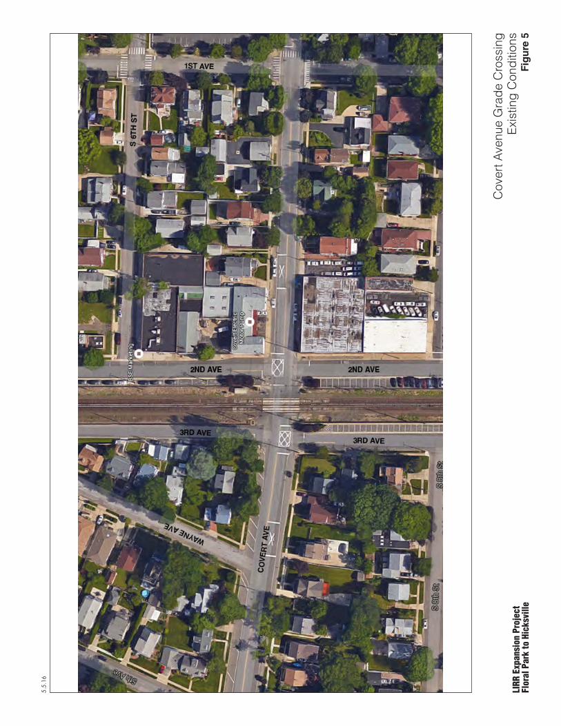
5.5.16
LIRR
Exp
ansi
on P
roje
ctFl
oral
Par
k to
Hic
ksvi
lle
Cov
ert A
venu
e G
rade
Cro
ssin
gEx
istin
g C
ondi
tions
Fig
ure
5

5.5.16
LIRR
Exp
ansi
on P
roje
ctFl
oral
Par
k to
Hic
ksvi
lle
Cov
ert A
venu
e G
rade
Cro
ssin
gTw
o-W
ay U
nder
pass
with
Sid
ewal
k, L
IRR
Tra
cks
Rai
sed
Seve
ral F
eet
Source: New York State Department of Transportation
N
Fig
ure
6
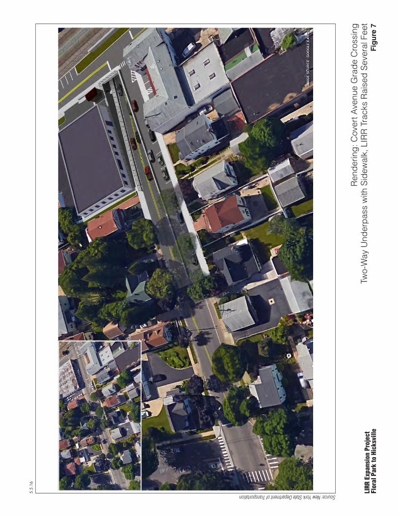
5.5.16
LIRR
Exp
ansi
on P
roje
ctFl
oral
Par
k to
Hic
ksvi
lle
Ren
derin
g: C
over
t Ave
nue
Gra
de C
ross
ing
Two-
Way
Und
erpa
ss w
ith S
idew
alk,
LIR
R T
rack
s R
aise
d Se
vera
l Fee
t
Source: New York State Department of Transportation
Fig
ure
7
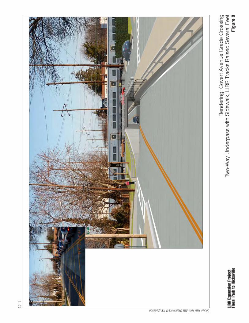
5.5.16
LIRR
Exp
ansi
on P
roje
ctFl
oral
Par
k to
Hic
ksvi
lle
Ren
derin
g: C
over
t Ave
nue
Gra
de C
ross
ing
Two-
Way
Und
erpa
ss w
ith S
idew
alk,
LIR
R T
rack
s R
aise
d Se
vera
l Fee
t
Source: New York State Department of Transportation
Fig
ure
8

5.5.16
LIRR
Exp
ansi
on P
roje
ctFl
oral
Par
k to
Hic
ksvi
lle
Sout
h 12
th S
treet
Gra
de C
ross
ing
Exis
ting
Con
ditio
nsFi
gu
re 9

5.5.16
LIRR
Exp
ansi
on P
roje
ctFl
oral
Par
k to
Hic
ksvi
lle
Sout
h 12
th S
treet
Gra
de C
ross
ing
Opt
ion
1: P
erm
anen
t Cro
ssin
g C
losu
re w
ith P
edes
trian
Brid
ge
Source: New York State Department of Transportation
N
Fig
ure
10
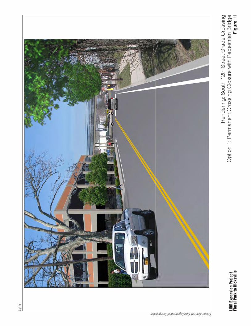
5.5.16
LIRR
Exp
ansi
on P
roje
ctFl
oral
Par
k to
Hic
ksvi
lle
Ren
derin
g: S
outh
12t
h St
reet
Gra
de C
ross
ing
Opt
ion
1: P
erm
anen
t Cro
ssin
g C
losu
re w
ith P
edes
trian
Brid
ge
Source: New York State Department of Transportation
Fig
ure
11

5.5.16
LIRR
Exp
ansi
on P
roje
ctFl
oral
Par
k to
Hic
ksvi
lle
Sout
h 12
th S
treet
Gra
de C
ross
ing
Opt
ion
2: O
ne-W
ay U
nder
pass
with
Sid
ewal
k
Source: New York State Department of Transportation
N
Fig
ure
12

5.5.16
LIRR
Exp
ansi
on P
roje
ctFl
oral
Par
k to
Hic
ksvi
lle
Ren
derin
g: S
outh
12t
h St
reet
Gra
de C
ross
ing
Opt
ion
2: O
ne-W
ay U
nder
pass
with
Sid
ewal
k
Source: New York State Department of Transportation
Fig
ure
13

5.5.16
LIRR
Exp
ansi
on P
roje
ctFl
oral
Par
k to
Hic
ksvi
lle
New
Hyd
e Pa
rk R
oad
Gra
de C
ross
ing
Exis
ting
Con
ditio
nsFi
gu
re 1
4

5.5.16
LIRR
Exp
ansi
on P
roje
ctFl
oral
Par
k to
Hic
ksvi
lle
New
Hyd
e Pa
rk R
oad
Gra
de C
ross
ing
Opt
ion
1: F
ive-
Lane
Und
erpa
ss w
ith K
iss
and
Rid
e N
orth
east
of T
rack
s
Source: New York State Department of Transportation
N
Fig
ure
15
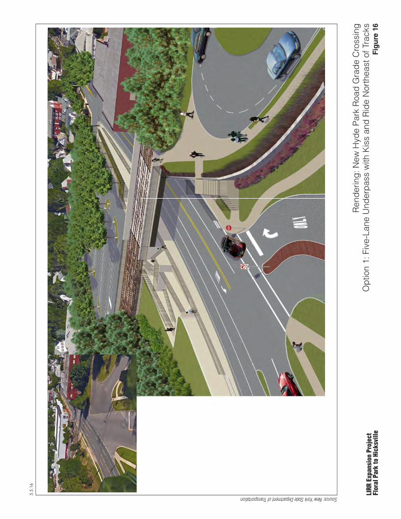
5.5.16
LIRR
Exp
ansi
on P
roje
ctFl
oral
Par
k to
Hic
ksvi
lle
Ren
derin
g: N
ew H
yde
Park
Roa
d G
rade
Cro
ssin
gO
ptio
n 1:
Fiv
e-La
ne U
nder
pass
with
Kis
s an
d R
ide
Nor
thea
st o
f Tra
cks
Source: New York State Department of Transportation
Fig
ure
16

5.5.16
LIRR
Exp
ansi
on P
roje
ctFl
oral
Par
k to
Hic
ksvi
lle
New
Hyd
e Pa
rk R
oad
Gra
de C
ross
ing
Opt
ion
2: F
our-L
ane
Und
erpa
ss w
ith K
iss
and
Rid
e S
outh
east
of T
rack
s
Source: New York State Department of Transportation
Fig
ure
17
N

5.5.16
LIRR
Exp
ansi
on P
roje
ctFl
oral
Par
k to
Hic
ksvi
lle
Ren
derin
g: N
ew H
yde
Park
Roa
d G
rade
Cro
ssin
gO
ptio
n 2:
Fou
r-Lan
e U
nder
pass
with
Kis
s an
d R
ide
Sou
thea
st o
f Tra
cks
Source: New York State Department of Transportation
Fig
ure
18

5.5.16
LIRR
Exp
ansi
on P
roje
ctFl
oral
Par
k to
Hic
ksvi
lle
Mai
n St
reet
Gra
de C
ross
ing
Exis
ting
Con
ditio
nsFi
gu
re 1
9

5.5.16
LIRR
Exp
ansi
on P
roje
ctFl
oral
Par
k to
Hic
ksvi
lle
Mai
n St
reet
Gra
de C
ross
ing
Opt
ion
1: P
erm
anen
t Cro
ssin
g C
losu
re w
ith P
edes
trian
Brid
ge
Source: New York State Department of Transportation
N
Fig
ure
20

5.5.16
LIRR
Exp
ansi
on P
roje
ctFl
oral
Par
k to
Hic
ksvi
lle
Ren
derin
g: M
ain
Stre
et G
rade
Cro
ssin
gO
ptio
n 1:
Per
man
ent C
ross
ing
Clo
sure
with
Ped
estri
an B
ridge
Source: New York State Department of Transportation
Fig
ure
21
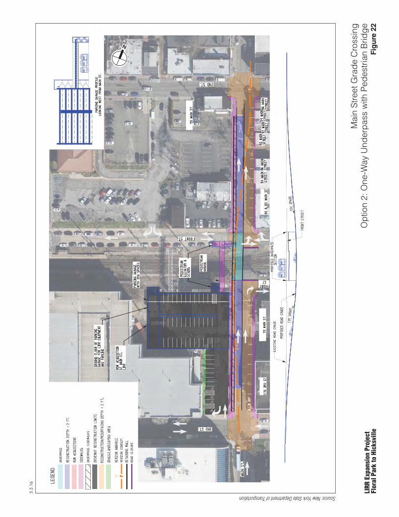
5.5.16
LIRR
Exp
ansi
on P
roje
ctFl
oral
Par
k to
Hic
ksvi
lle
Mai
n St
reet
Gra
de C
ross
ing
Opt
ion
2: O
ne-W
ay U
nder
pass
with
Ped
estri
an B
ridge
Source: New York State Department of Transportation
N
Fig
ure
22

5.5.16
LIRR
Exp
ansi
on P
roje
ctFl
oral
Par
k to
Hic
ksvi
lle
Ren
derin
g: M
ain
Stre
et G
rade
Cro
ssin
gO
ptio
n 2:
One
-Way
Und
erpa
ss w
ith P
edes
trian
Brid
ge
Source: New York State Department of Transportation
Fig
ure
23
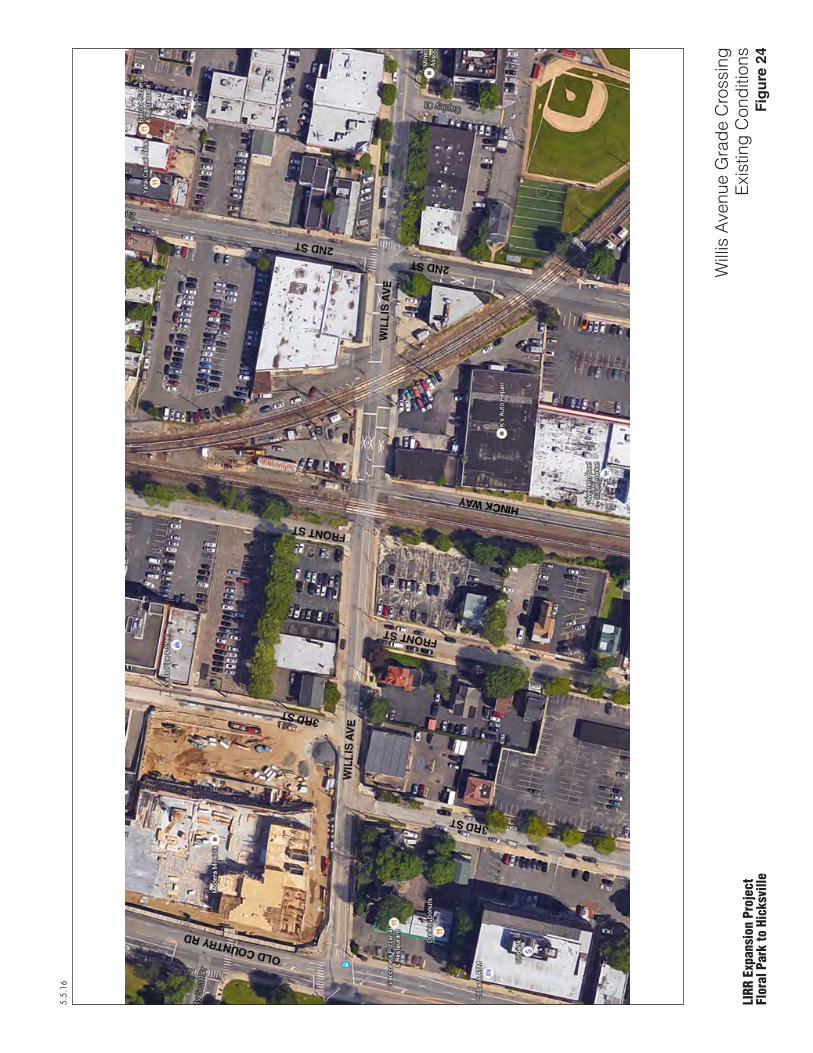
5.5.16
LIRR
Exp
ansi
on P
roje
ctFl
oral
Par
k to
Hic
ksvi
lle
Will
is A
venu
e G
rade
Cro
ssin
gEx
istin
g C
ondi
tions
Fig
ure
24

5.5.16
LIRR
Exp
ansi
on P
roje
ctFl
oral
Par
k to
Hic
ksvi
lle
Will
is A
venu
e G
rade
Cro
ssin
gSc
enar
io 1
A: T
wo-
Way
Und
erpa
ss w
ith S
idew
alk
Source: New York State Department of Transportation
N
Fig
ure
25

5.5.16
LIRR
Exp
ansi
on P
roje
ctFl
oral
Par
k to
Hic
ksvi
lle
Ren
derin
g: W
illis
Ave
nue
Gra
de C
ross
ing
Scen
ario
1A
: Tw
o-W
ay U
nder
pass
with
Sid
ewal
k
Source: New York State Department of Transportation
Fig
ure
26
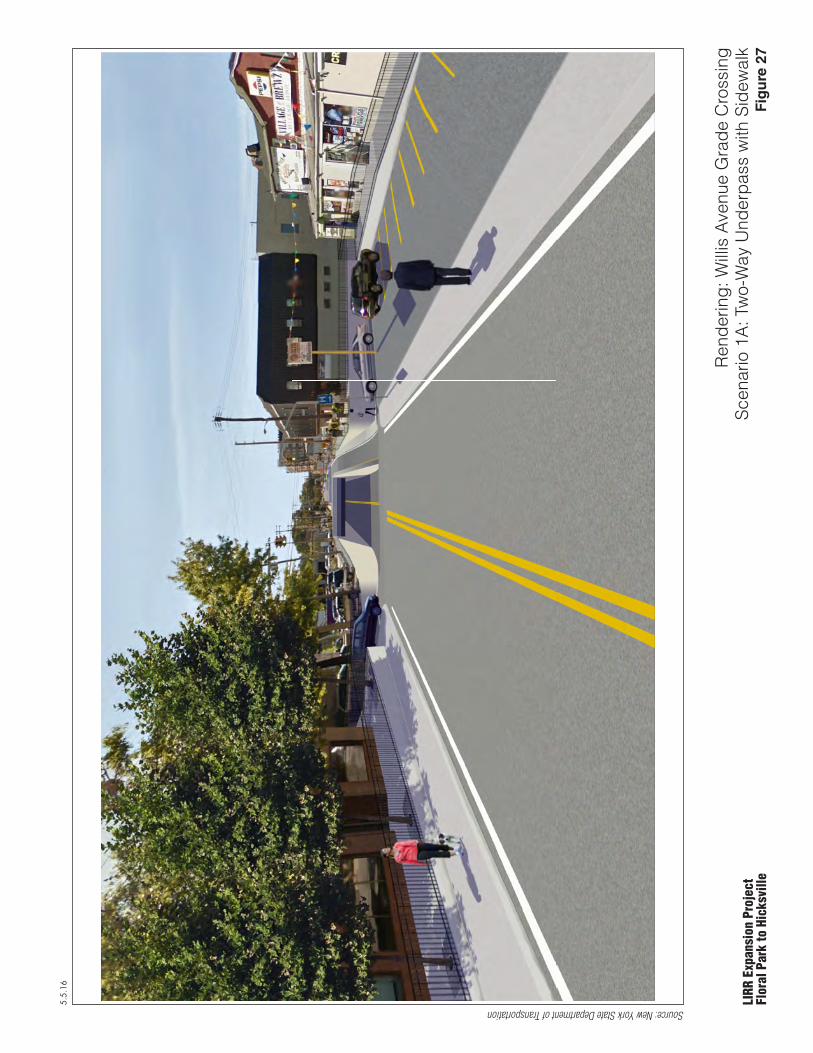
5.5.16
LIRR
Exp
ansi
on P
roje
ctFl
oral
Par
k to
Hic
ksvi
lle
Ren
derin
g: W
illis
Ave
nue
Gra
de C
ross
ing
Scen
ario
1A
: Tw
o-W
ay U
nder
pass
with
Sid
ewal
k
Source: New York State Department of Transportation
Fig
ure
27
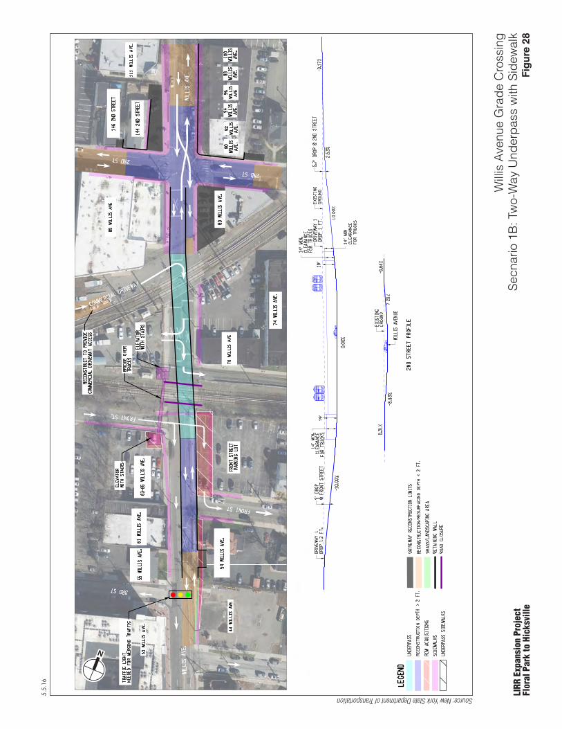
5.5.16
LIRR
Exp
ansi
on P
roje
ctFl
oral
Par
k to
Hic
ksvi
lle
Will
is A
venu
e G
rade
Cro
ssin
gSe
cnar
io 1
B: T
wo-
Way
Und
erpa
ss w
ith S
idew
alk
Source: New York State Department of Transportation
N
Fig
ure
28

5.5.16
LIRR
Exp
ansi
on P
roje
ctFl
oral
Par
k to
Hic
ksvi
lle
Ren
derin
g: W
illis
Ave
nue
Gra
de C
ross
ing
Scen
ario
1B
: Tw
o-W
ay U
nder
pass
with
Sid
ewal
k
Source: New York State Department of Transportation
Fig
ure
29
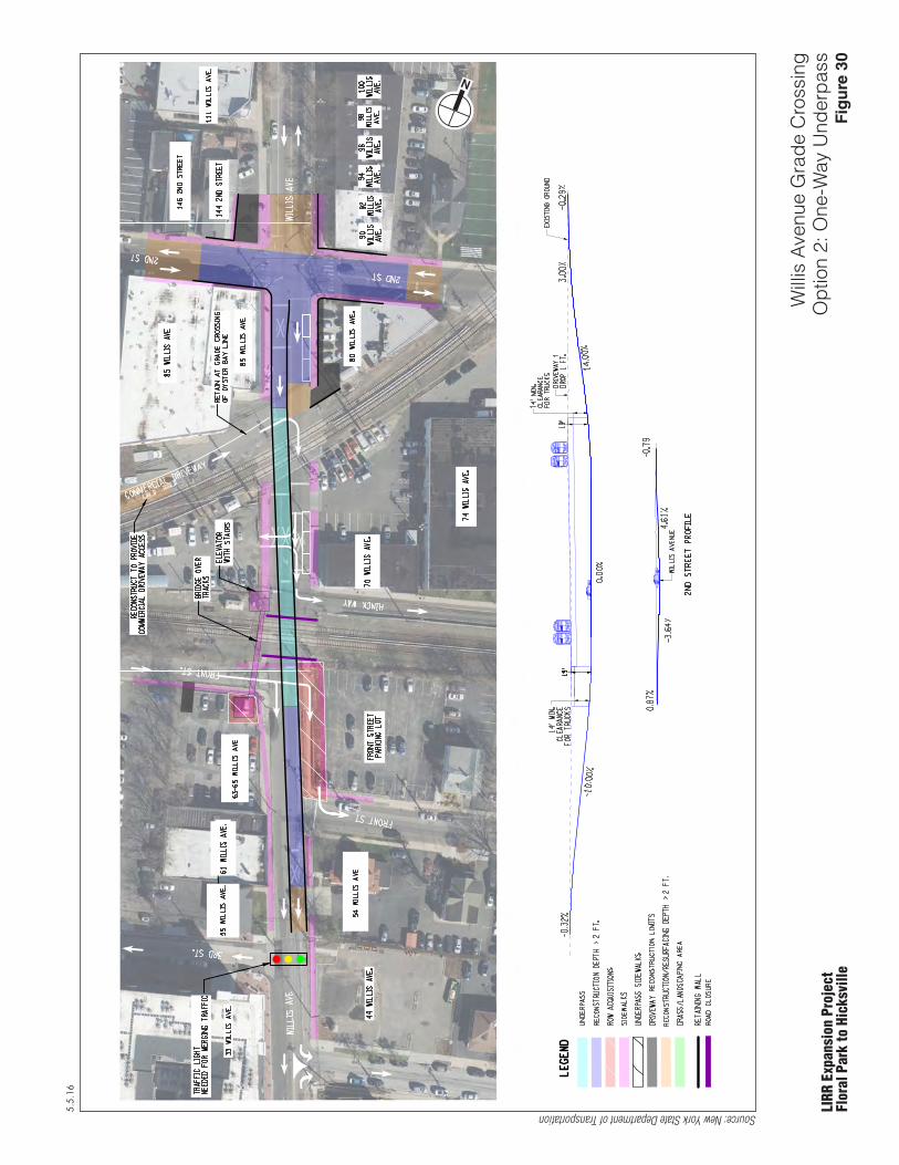
5.5.16
LIRR
Exp
ansi
on P
roje
ctFl
oral
Par
k to
Hic
ksvi
lle
Will
is A
venu
e G
rade
Cro
ssin
gO
ptio
n 2:
One
-Way
Und
erpa
ss
Source: New York State Department of Transportation
N
Fig
ure
30
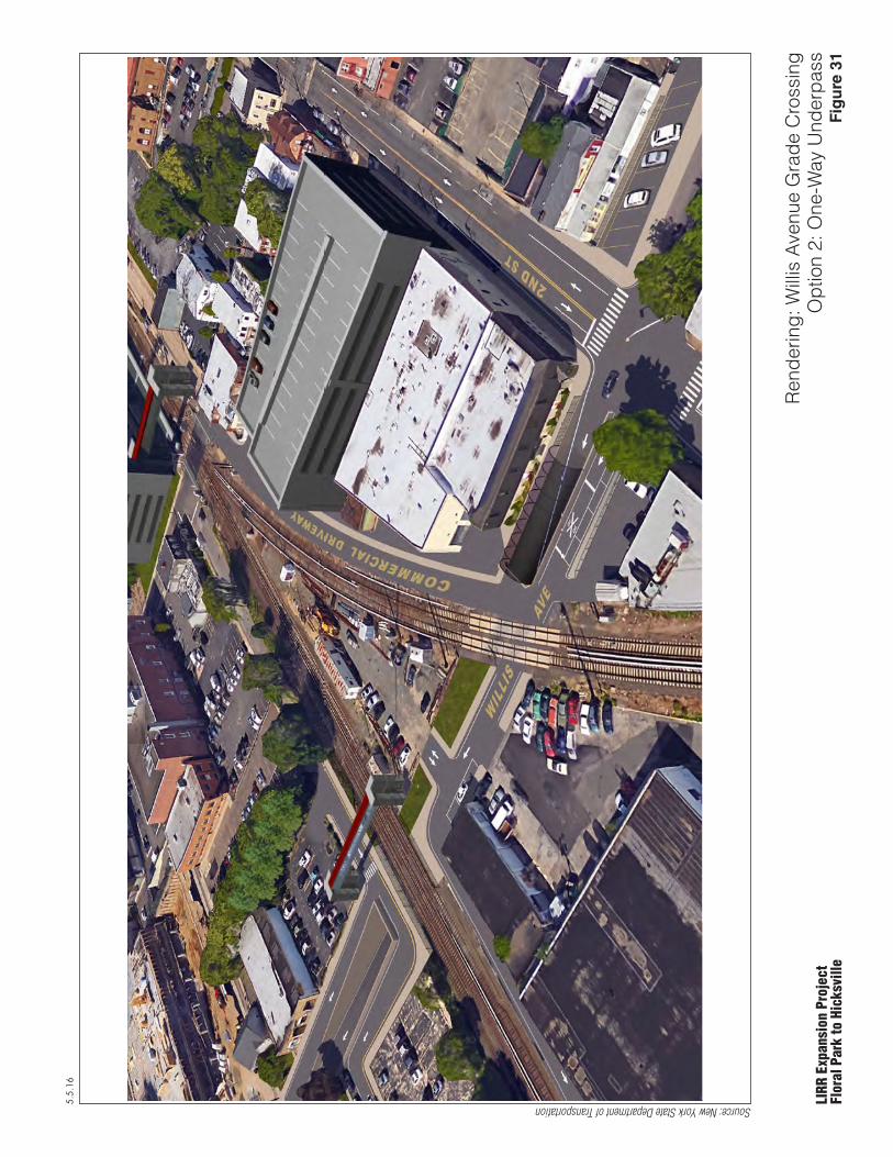
5.5.16
LIRR
Exp
ansi
on P
roje
ctFl
oral
Par
k to
Hic
ksvi
lle
Ren
derin
g: W
illis
Ave
nue
Gra
de C
ross
ing
Opt
ion
2: O
ne-W
ay U
nder
pass
Source: New York State Department of Transportation
Fig
ure
31

5.5.16
LIRR
Exp
ansi
on P
roje
ctFl
oral
Par
k to
Hic
ksvi
lle
Scho
ol S
treet
Gra
de C
ross
ing
Exis
ting
Con
ditio
nsFi
gu
re 3
2

5.5.16
LIRR
Exp
ansi
on P
roje
ctFl
oral
Par
k to
Hic
ksvi
lle
Scho
ol S
treet
Gra
de C
ross
ing
Scen
ario
1A
: Tw
o-W
ay U
nder
pass
and
Tra
cks
Rai
sed
Seve
ral F
eet
Source: New York State Department of Transportation
N
Fig
ure
33
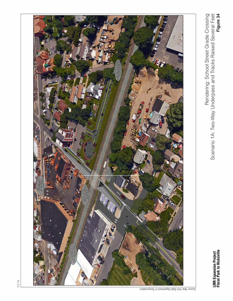
5.5.16
LIRR
Exp
ansi
on P
roje
ctFl
oral
Par
k to
Hic
ksvi
lle
Ren
derin
g: S
choo
l Stre
et G
rade
Cro
ssin
gSc
enar
io 1
A: T
wo-
Way
Und
erpa
ss a
nd T
rack
s R
aise
d Se
vera
l Fee
t
Source: New York State Department of Transportation
Fig
ure
34
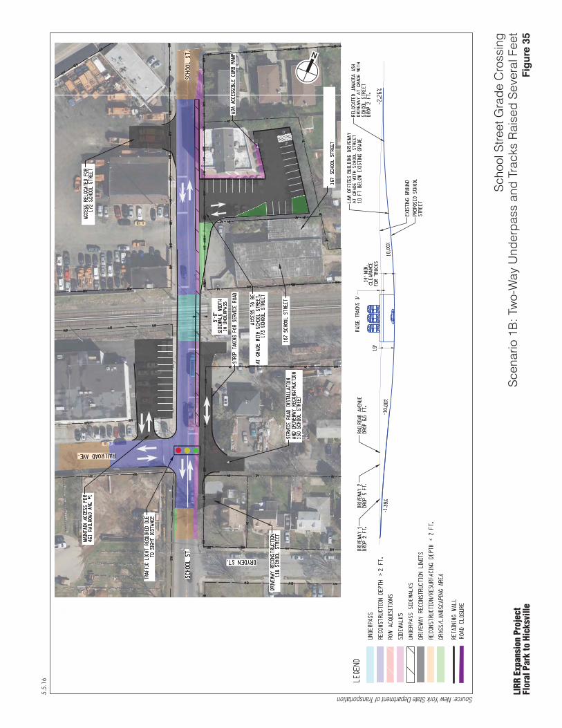
5.5.16
LIRR
Exp
ansi
on P
roje
ctFl
oral
Par
k to
Hic
ksvi
lle
Scho
ol S
treet
Gra
de C
ross
ing
Scen
ario
1B
: Tw
o-W
ay U
nder
pass
and
Tra
cks
Rai
sed
Seve
ral F
eet
Source: New York State Department of Transportation
N
Fig
ure
35

5.5.16
LIRR
Exp
ansi
on P
roje
ctFl
oral
Par
k to
Hic
ksvi
lle
Ren
derin
g: S
choo
l Stre
et G
rade
Cro
ssin
gSc
enar
io 1
B: T
wo-
Way
Und
erpa
ss a
nd T
rack
s R
aise
d Se
vera
l Fee
t
Source: New York State Department of Transportation
Fig
ure
36

5.5.16
LIRR
Exp
ansi
on P
roje
ctFl
oral
Par
k to
Hic
ksvi
lle
Ren
derin
g: S
choo
l Stre
et G
rade
Cro
ssin
gSc
enar
io 1
B: T
wo-
Way
Und
erpa
ss a
nd T
rack
s R
aise
d Se
vera
l Fee
t
Source: New York State Department of Transportation
Fig
ure
37

5.5.16
LIRR
Exp
ansi
on P
roje
ctFl
oral
Par
k to
Hic
ksvi
lle
Urb
an A
venu
e G
rade
Cro
ssin
g Ex
istin
g C
ondi
tions
Fig
ure
38

5.5.16
LIRR
Exp
ansi
on P
roje
ctFl
oral
Par
k to
Hic
ksvi
lle
Urb
an A
venu
e G
rade
Cro
ssin
g Sc
enar
io 1
A: T
wo-
Way
Und
erpa
ss w
ith T
rack
s R
aise
d Se
vera
l Fee
t
Source: New York State Department of Transportation
N Fig
ure
39
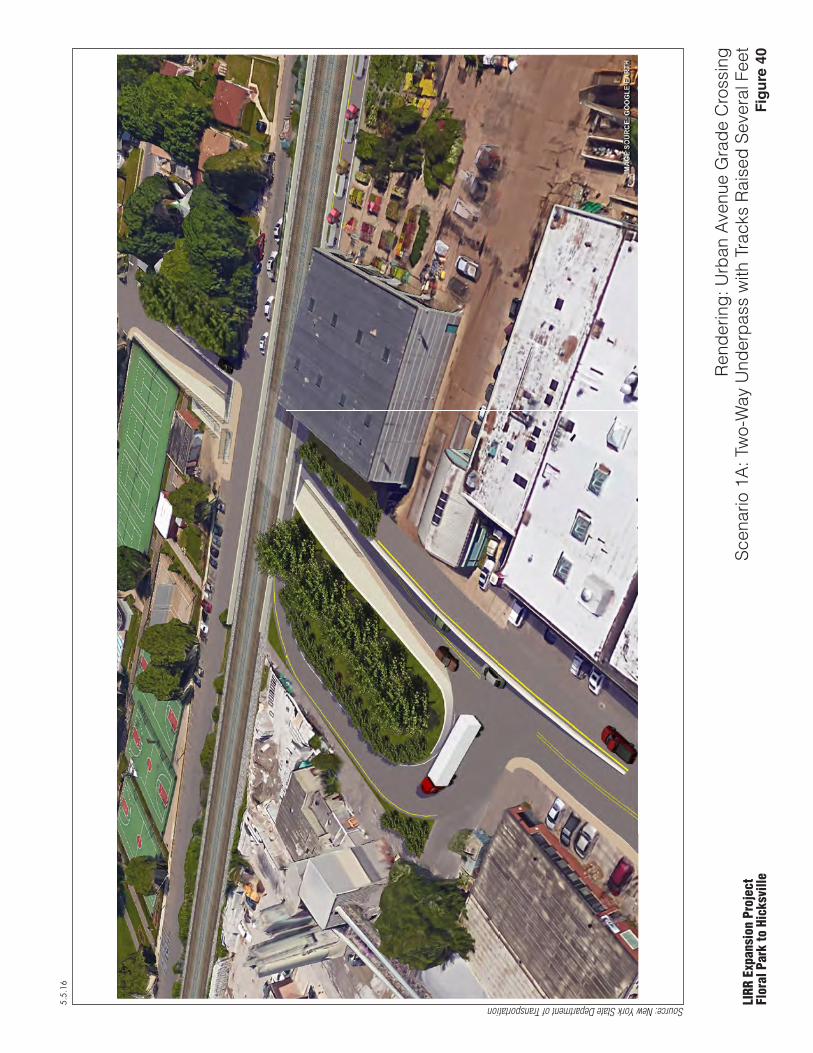
5.5.16
LIRR
Exp
ansi
on P
roje
ctFl
oral
Par
k to
Hic
ksvi
lle
Ren
derin
g: U
rban
Ave
nue
Gra
de C
ross
ing
Scen
ario
1A
: Tw
o-W
ay U
nder
pass
with
Tra
cks
Rai
sed
Seve
ral F
eet
Source: New York State Department of Transportation
Fig
ure
40
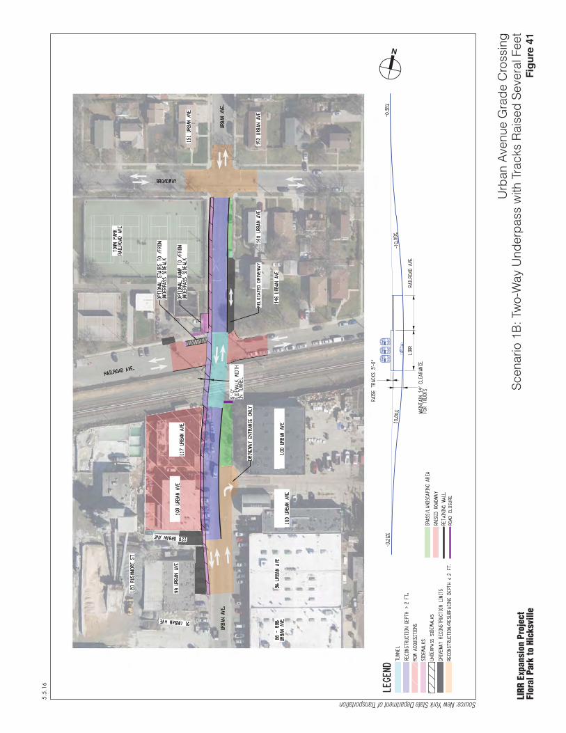
5.5.16
LIRR
Exp
ansi
on P
roje
ctFl
oral
Par
k to
Hic
ksvi
lle
Urb
an A
venu
e G
rade
Cro
ssin
g Sc
enar
io 1
B: T
wo-
Way
Und
erpa
ss w
ith T
rack
s R
aise
d Se
vera
l Fee
t
Source: New York State Department of Transportation
N
Fig
ure
41
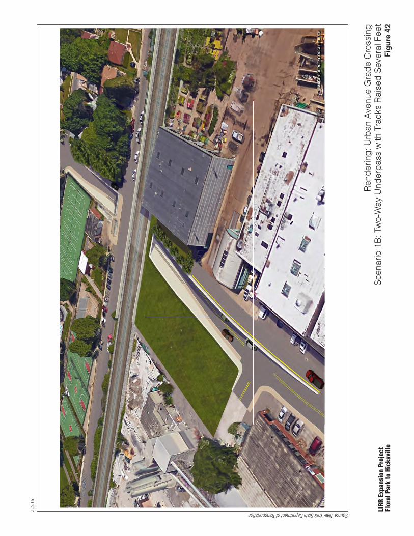
5.5.16
LIRR
Exp
ansi
on P
roje
ctFl
oral
Par
k to
Hic
ksvi
lle
Ren
derin
g: U
rban
Ave
nue
Gra
de C
ross
ing
Scen
ario
1B
: Tw
o-W
ay U
nder
pass
with
Tra
cks
Rai
sed
Seve
ral F
eet
Source: New York State Department of Transportation
Fig
ure
42
Appendix A Grade Crossing Options Considered but Discarded

Long Island Rail Road Main Line Expansion Scoping Document
A-1 May 5, 2016
Mun
icip
ality
Loca
tion
Build Option # Description LIRR Track Elevation Reason for Elimination of Option
New
Hyd
e Pa
rk
Cove
rt A
venu
e
1 Two-way Underpass Raise Tracks Several feet This option is considered feasible and is discussed in the Scoping Document. 2 Two-way Underpass Maintain Existing Acquisition of one residential property.
3 One-way Underpass Maintain Existing Covert Avenue would carry southbound traffic only. Diverted northbound traffic would create long queues and poor levels of service at various intersections in the area.
4 One-way Overpass Maintain Existing Visual impact from overpass structure to properties in close proximity. Covert Avenue would carry southbound traffic only. Diverted northbound traffic would create long queues and poor levels of service at various intersections in the area.
5 Two-way Overpass Maintain Existing Acquisition of two residential properties. Visual impact from overpass structure to properties in close proximity.
6 Permanent Crossing Closed Maintain Existing Permanently diverted traffic would create long queues and poor levels of service at various intersections in the area.
Sout
h 12
th S
tree
t 1 Permanent Crossing Closure with Pedestrian Bridge Maintain Existing This option is considered feasible and is discussed in the Scoping Document. 2 One-way Underpass with Sidewalk Maintain Existing This option is considered feasible and is discussed in the Scoping Document. 3 Two-way Underpass with Sidewalk Maintain Existing Residential property acquisitions required at 3 locations. 4 Pedestrian Underpass Along S. 12th Street, LIRR Crossing Closed Maintain Existing Residential property acquisition required at 4 locations.
5 Two-way Overpass with Sidewalk Maintain Existing Residential property acquisition required at 8 locations. Visual impact from overpass structure to properties in close proximity.
6 One-way Overpass with Sidewalk Maintain Existing Visual impact from overpass structure to properties in close proximity.
New
Hyd
e Pa
rk R
oad
1 Five Lane Underpass with Kiss and Ride Northwest of Tracks Maintain Existing This option is considered feasible and is discussed in the Scoping Document. 2 Four Lane Underpass with Kiss and Ride Southwest of Tracks Maintain Existing This option is considered feasible and is discussed in the Scoping Document.
3 Two-way Underpass, 3 Lanes and 2 Lanes Maintain Existing This option does not have four lanes of through traffic which allow for improved level of service.
4 Two-way Overpass, 4 Lanes Maintain Existing Visual impact from overpass structure to properties in close proximity . Requires the closure of Plaza Ave. and Clinch Ave. which has substantial impacts on traffic and loss of access.
5 Two-way Overpass, 3 Lanes and 2 Lanes Maintain Existing Visual impact from overpass structure to properties in close proximity. Requires the closure of Plaza Ave. and Clinch Ave. This option does not have four lanes of through traffic which allow for improved level of service.
6 Permanent Crossing Closed Maintain Existing Permanently diverted traffic would create long queues and poor levels of service at various intersections in the area.

Long Island Rail Road Main Line Expansion Scoping Document
A-2 May 5, 2016
Mun
icip
ality
Loca
tion
Build Option # Description LIRR Track Elevation Reason for Elimination of Option
Min
eola
Mai
n St
reet
1 Permanent Crossing Closure with Pedestrian Bridge Maintain Existing This option is considered feasible and is discussed in the Scoping Document. 2 One-way Underpass with Pedestrian Bridge Maintain Existing This option is considered feasible and is discussed in the Scoping Document. 3 Pedestrian Underpass Maintain Existing Loss of retail on-street parking along Main Street.
4 Two-way Underpass Maintain Existing Loss of retail on-street parking along Main Street. Low traffic volumes indicate that 2 directional traffic does not need to be maintained.
5 Two-way and One-way Overpass Maintain Existing Require the closure of 2nd Street and 3rd Street, and the existing access from Main Street to many commercial properties would be impacted. Visual impact from overpass structure to properties in close proximity
Will
is A
venu
e
1A Two-way Underpass, north of the intersection shift to the east Maintain Existing This option is considered feasible and is discussed in the Scoping Document. 1B Two-way Underpass, north of the intersection shift to the west Maintain Existing This option is considered feasible and is discussed in the Scoping Document. 2 One-way Underpass Maintain Existing This option is considered feasible and is discussed in the Scoping Document.
3 One-way Extended Underpass Maintain Existing Extending underpass under 2nd Street, extends the underpass walls further north on Willis Ave. This will require the acquisition of 2 commercial properties.
4 Two-way Overpass Maintain Existing Requires the acquisition of 6 commercial properties. Visual impact from overpass structure to properties in close proximity.
5 Permanent Crossing Closed Maintain Existing Permanently diverted traffic would create long queues and poor levels of service at various intersections in the area.
Wes
tbur
y
Scho
ol S
tree
t
1A Two-way Underpass* Raise Tracks Several feet This option is considered feasible and is discussed in the Scoping Document. 1B Two-way Underpass* Raise Tracks Several feet This option is considered feasible and is discussed in the Scoping Document. 2 Two-way Underpass Maintain Existing Greater residential and commercial properties impact than option 1.
3 One-way Underpass Raise Tracks Several feet Permanently diverted traffic would create long queues and poor levels of service at various intersections in the area.
4 One-way Overpass Maintain Existing Visual impact from overpass structure to residential properties. Permanently diverted traffic would create long queues and poor levels of service at various intersections in the area.
5 Two-way Overpass Maintain Existing One residential acquisition will be required. Requires the closure of Railroad Avenue and Dryden Street. Visual impact from overpass structure to properties in close proximity.
6 Permanent Crossing Closed Maintain Existing Permanently diverted traffic would create long queues and poor levels of service at various intersections in the area.
Urb
an A
venu
e
1A Two-way Underpass* Raise Tracks Several feet This option is considered feasible and is discussed in the Scoping Document. 1B Two-way Underpass* Raise Tracks Several feet This option is considered feasible and is discussed in the Scoping Document.
2 One-way Underpass Maintain Existing Permanently diverted traffic would create long queues and poor levels of service at various intersections in the area.
3 One-way Overpass Maintain Existing Visual impact from overpass structure to residential properties. Permanently diverted traffic would create long queues and poor levels of service at various intersections in the area. Requires the closure of Broadway.
4 Two-way Overpass Maintain Existing Visual impact from overpass structure to residential properties. Requires the closure of Broadway.
5 Permanent Crossing Closed Maintain Existing Permanently diverted traffic would create long queues and poor levels of service at various intersections in the area.
Notes: The discarded options shown in this table were results of discussion with community leaders and could be considered as feasible alternatives based on further community input. *Scenarios 1A and 1B for School Street and Urban Avenue provide different options for maintaining access to adjacent commercial properties. Indicates Alternatives that were not eliminated and are discussed in the Scoping Document
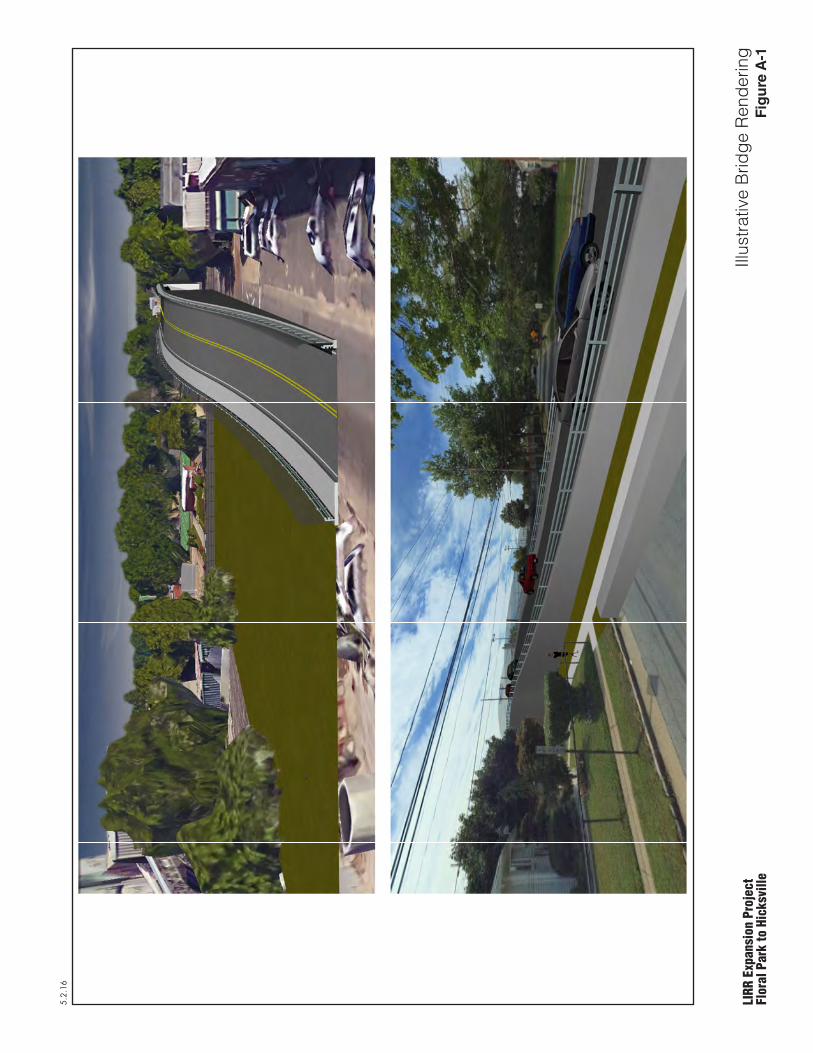
5.2.16
LIRR
Exp
ansi
on P
roje
ctFl
oral
Par
k to
Hic
ksvi
lleIll
ustra
tive
Brid
ge R
ende
ring
Fig
ure
A-1