leon creek watershed master plan phase i - final report€¦ · leon creek watershed master plan...
TRANSCRIPT

Leon Creek Watershed Master PlanPhase I - Final ReportPrepared for:San Antonio River AuthorityOctober 2008


October 2008 Leon Creek Watershed Master Planpage i
ContentsExecutive Summary ....................................................................................................................... iii
Introduction..................................................................................................................................... 1
Purpose...................................................................................................................................... 1
Study Area.................................................................................................................................. 1
Data Collection................................................................................................................................ 1
Site Reconnaissance .................................................................................................................. 2
Level of Flood Protection Analysis ................................................................................................ 3
Building Structures...................................................................................................................... 3
Methodology......................................................................................................................... 3
Findings ............................................................................................................................... 4
Roadway Crossings .................................................................................................................... 4
Methodology......................................................................................................................... 4
Findings ............................................................................................................................... 5
Damage Centers......................................................................................................................... 6
Methodology......................................................................................................................... 6
Findings ............................................................................................................................... 6
Workshop No. 1.......................................................................................................................... 6
Flood Mitigation Alternatives ......................................................................................................... 7
Selection..................................................................................................................................... 7
RSWF Project Development ....................................................................................................... 8
Analysis of Impacts................................................................................................................... 10
Cost Estimates ......................................................................................................................... 13
Regulatory Analysis .................................................................................................................. 14
Methodology....................................................................................................................... 14
Regulatory Requirements ................................................................................................... 14
RSWF Projects................................................................................................................... 14
Regulatory Analysis Summary............................................................................................ 22
Multi-Use Objective Analysis..................................................................................................... 24
Workshop No. 2........................................................................................................................ 24
Evaluation of Alternatives.......................................................................................................... 24
Discussion of Results................................................................................................................ 28
Conclusions and Recommendations........................................................................................... 30

October 2008 Leon Creek Watershed Master Planpage ii
Tables
Table 1 GIS Data Collection............................................................................................................ 2
Table 2 Building Structure Analysis Results Summary ................................................................ 4
Table 3 Roadway Structure Analysis Results Summary............................................................... 5
Table 4 Damage Reduction per Acre-Foot of Storage Needed ..................................................... 6
Table 5 RSWF Project Alternatives ................................................................................................ 8
Table 6 Flowrate Reductions at Highway 90................................................................................ 11
Table 7 Summary of Impacts for 100-Year Existing Storm Event ............................................... 12
Table 8 RSWF Project Cost Estimates ......................................................................................... 13
Table 9 Regulatory Requirements and Authorizing Agencies .................................................... 14
Table 10 Summary of Regulatory Requirements......................................................................... 23
Table 11 Prioritization Matrix........................................................................................................ 27
Appendices
Appendix A Map Exhibits, Workshop Notes, and Cost Estimates
Appendix B Site Reconnaissance Data and Regulatory Requirements
Appendix C Damage Center Sheets and Tables
Appendix D Constraints Maps
Appendix E RSWF Project Evaluation Results
Appendix F Multi-Use Objective Matrices
Appendix G Response to Stakeholder Comments

October 2008 Leon Creek Watershed Master Planpage iii
Executive SummaryThe San Antonio River Authority (SARA) authorized TCB INC. (TCB) to conduct Phase I of the LeonCreek Watershed Master Plan with the ultimate objective of developing a comprehensive watershedmaster plan for the entire Leon Creek Watershed in Bexar County tailored to the uniquecharacteristics and issues in the watershed. The primary objectives of the first phase were:
Identify major flooding reaches within the Leon Creek main channel and major tributarychannel areas.
Select appropriate flood mitigation target locations and evaluate appropriate Regional StormWater Facility (RSWF) Projects.
Identify opportunities for multi-use objectives for chosen RSWF projects. Prioritize identified alternatives.
For the first objective an analysis was performed to identify the existing level of flooding for privateproperty and public infrastructure using the latest draft Digital Flood Insurance Rate Map (DFIRM)models from FEMA. Cost estimates were created for expected damages to buildings and residentialstructures based on the predicted flood frequency models and U.S. Army Corps of Engineers(USACE) depth-damage curves. Statistically, the estimated annual damages for the entire watershedapproximately totaled $3,064,000. Additionally, a classification of roadway crossings in thewatershed as “safe” or “unsafe” was developed using approved City of San Antonio (COSA) criteriaand based on the depth of flooding approximations and predicted velocities of flows over theroadways. The number of unsafe roadway crossings ranged from 99 to 203 for the 10-year and 500-year frequency storm events, respectively. Based on this comprehensive flood risk level analysis forthe entire watershed, concentrated areas of major flood risk which created clusters of affectedbuildings and structures were identified as “damage centers” for planning and prioritization purposes.Twenty-four damage centers were identified, and the estimated annual damages captured within thedamage centers totaled $2,497,000.
The damage centers were presented to SARA, Bexar County, and COSA (the Stakeholders) in aworkshop conducted May 27, 2008. The overall objectives of the workshop included: selection of upto ten damage centers which warranted further analysis based on presented data, determination ofthe level of flood protection desired at each of the selected damage centers, a general discussion ofpotential new RSWF sites, and selection of previously identified or proposed RSWF projects toinclude in the subsequent evaluation under the Phase I study. The Stakeholders selected thefollowing:
Damage Center 2 on Huebner Creek, Damage Centers 4 and 16 on Culebra Creek, Damage Center 5-A on Slick Ranch Creek, Damage Centers 6-A and 6-B on French Creek (to be evaluated together), Damage Centers 6-C and 15 on the middle reach of Leon Creek, Damage Center 7-B on Maverick Creek, and Damage Centers 11 and 12 on Helotes Creek.
The estimated annual damages for the ten selected damage centers totaled $1,358,000. Theselected previously identified RSWF projects were LC-14: Chimenea Creek RSWF, LC-15: HuebnerCreek RSWF, Culebra Creek RSWF, Government Canyon RSWF, and the Quarry at the Rim RSWF.
The Stakeholders selected the damage centers listed above based on estimates of damages for eachdamage center and the anticipated size requirement for a potential structure. Discussion alsoincluded other potential flood mitigation strategies and possible changes to damage estimates arisingfrom the DFIRM appeals process. As a result, some of the damage centers that were not selected,including those located in the upper and lower regions of Leon Creek, were left for consideration infuture phases of this study.

October 2008 Leon Creek Watershed Master Planpage iv
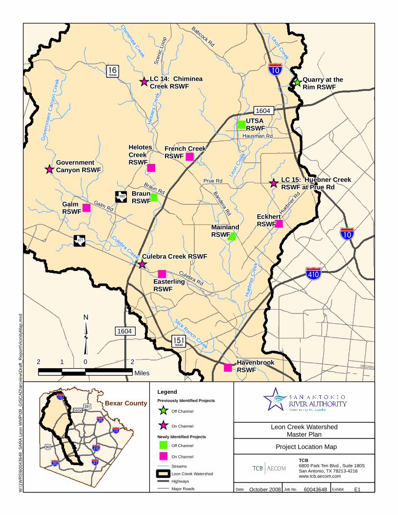
Subsequent review of each of the contributing subwatersheds for each damage center wasconducted to identify potential sites for RSWFs which could reduce flood damages within the primarydamage center (Exhibit E1). The primary damage center is classified as the damage centerimmediately downstream of an RSWF. For each RSWF, preliminary hydrologic and hydraulicanalyses were performed. A flood damage reduction estimate and a planning-level construction costestimate were developed for each RSWF. Additionally, an assessment was made for each RSWF toconsider whether the site had the potential to be used for other multi-use objectives such as for parks,recreation, open space, wildlife habitat or other public purposes, and initial environmental permittingassessments were performed for each site. The results from these analyses were consolidated into aqualitative evaluation matrix based on the Bexar Regional Watershed Management projectprioritization ranking factors. The final result of the performance assessment for each RSWF issummarized in Table E1 below.
Table E1 RSWF Evaluation Results Summary
Project Name Damage Center* Performance
Government Canyon RSWF N/A High
LC-14: Chimenea Creek RSWF N/A High
Helotes Creek RSWF DC 12 High
LC-15: Huebner Creek RSWF atPrue Rd
N/A High
Quarry at the Rim N/A Medium
Havenbrook RSWF DC 5-A Medium
Easterling RSWF DC 4 Medium
Galm RSWF DC 16 Medium
Braun RSWF DC 11 Medium
Culebra Creek RSWF N/A Low
UTSA RSWF DC 7-B Low**
Mainland RSWF DC 15 Low
French Creek RSWF DC 6-A and 6-B Low
Eckhert RSWF DC 2 Low*No RSWF site for Damage Center 6-C was developed due to the level of development andgeographic restrictions in the area.**The results for UTSA RSWF were limited due to the limits of the DFIRM hydraulic models.
"
"
"
"
"
"
"
"
"
_̂
_̂
_̂
_̂
_̂
!"̀$
%&i(
It
A¬
Aç
CÛGalm Rd
Braun Rd Bandera Rd
Prue Rd
Hausman Rd
Culebra Rd
?o
GovernmentCanyon RSWF
LC 14: ChimineaCreek RSWF
Quarry at theRim RSWF
GalmRSWF
BraunRSWF
HelotesCreekRSWF
French CreekRSWF
UTSARSWF
LC 15: Huebner CreekRSWF at Prue Rd
EckhertRSWFMainland
RSWF
EasterlingRSWF
Culebra Creek RSWF
HavenbrookRSWF
Scen
ic L
oop
Babcock Rd
Huebn
er Rd
Marbach Rd
1604
1604
!"̀$
%&i(
Gov
ernm
ent C
anyo
n C
reek
Chimenea Creek
Leon Creek
Hel
otes
Cre
ek
Culebra Creek
Slick Ranch Creek
Hue
bner
Cre
ek
Leon
Cre
ek
Leon Creek WatershedMaster Plan
October 2008 60043648 ExhibitDate
TCB6800 Park Ten Blvd., Suite 180SSan Antonio, TX 78213-4216www.tcb.aecom.com
Job No.
Project Location Map
E1
!"̀$
!"d$
+£
!"̀$
)t%&i(
!"e$!"d$
Bexar County1604
2 0 21
Miles
³LegendPreviously Identified Projects
_̂ Off Channel
_̂ On Channel
Newly Identified Projects
" Off Channel
" On Channel
Streams
Leon Creek Watershed
Highways
Major RoadsW:\1
WR
S\6
0043
648_
SAR
A L
eon
WM
P\0
9_G
ISC
AD\a
rcvi
ew\D
raft_
Rep
ort\V
icin
ityM
ap.m
xd

October 2008 Leon Creek Watershed Master Planpage 1
Introduction
Purpose
The Leon Creek Watershed in Bexar County, Texas, has repeatedly experienced significant floodingproblems during high rainfall and runoff conditions. There were notable events as recently as 1998and 2002 which inundated major highways and flooded many structures within the Leon CreekWatershed. Two other regional storm water facility studies have been performed in regions of theLeon Creek Watershed. COSA’s “Upper Leon Creek Regional Storm Water Facility PreliminaryPhase A Study” considered RSWF options within the Leon Creek watershed upstream of IH 10 andBoerne Stage Road. Bexar County’s “Regional Detention Pond Location Study, Leon CreekWatershed” evaluated four RSWF sites within the watershed. Neither study provided a mechanismfor comparing results and prioritizing projects across the entire watershed. Without comprehensivewatershed planning, flood problems would likely increase as land uses change and the watershedbecomes more urban. This report documents completion of Phase I in a study envisioned toultimately develop a comprehensive watershed master plan for the Leon Creek Watershed. Phase Iof the study examined both on- and off-channel RSWF projects with the purpose of minimizingflooding impacts in the watershed.
Objectives of this phase included:
Identify major flooding reaches within the Leon Creek main channel and major tributarychannel areas.
Select appropriate flood mitigation target locations and evaluate appropriate Regional StormWater Facility (RSWF) Projects.
Identify opportunities for multi-use objectives for chosen RSWF projects. Prioritize identified alternatives.
Study Area
The Leon Creek Watershed is located in the western portion of Bexar County, Texas. It spans nearlythe length of the entire county from north to south and includes approximately 237 square miles.Presently, the watershed is under increased developmental pressures as growth occurs in COSA andunincorporated Bexar County. The watershed drains into the Medina River, then into the San AntonioRiver, and ultimately into the Gulf of Mexico. Current land use in the steeply sloped upper reachestends to be undeveloped and/or rangeland. Progressing southward, topography becomes less steepand land use in the watershed transitions to suburban residential and highly urbanized includingportions of San Antonio to the west of downtown. Towards the southern portion of the watershed,land use becomes progressively less developed and topography becomes comparatively flatter(Appendix A, Exhibit 1).
Portions of the watershed are within the Edwards Aquifer Recharge and Contributing Zones, asdefined in Title 30 Texas Administrative Code (TAC) § 213.3 and 30 TAC § 213.22 (Appendix A,Exhibit 2).
Data CollectionHydrologic and hydraulic models and all associated data and spreadsheets used to develop the latestFEMA DFIRMs for the entire Leon Creek Watershed were obtained from the Bexar RegionalWatershed Management (BRWM) Program. In addition, a variety of spatial data was collected in
October 2008 Leon Creek Watershed Master Planpage 2
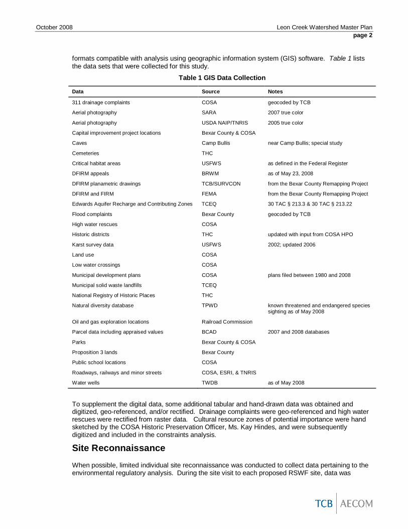
formats compatible with analysis using geographic information system (GIS) software. Table 1 liststhe data sets that were collected for this study.
Table 1 GIS Data Collection
Data Source Notes
311 drainage complaints COSA geocoded by TCB
Aerial photography SARA 2007 true color
Aerial photography USDA NAIP/TNRIS 2005 true color
Capital improvement project locations Bexar County & COSA
Caves Camp Bullis near Camp Bullis; special study
Cemeteries THC
Critical habitat areas USFWS as defined in the Federal Register
DFIRM appeals BRWM as of May 23, 2008
DFIRM planametric drawings TCB/SURVCON from the Bexar County Remapping Project
DFIRM and FIRM FEMA from the Bexar County Remapping Project
Edwards Aquifer Recharge and Contributing Zones TCEQ 30 TAC § 213.3 & 30 TAC § 213.22
Flood complaints Bexar County geocoded by TCB
High water rescues COSA
Historic districts THC updated with input from COSA HPO
Karst survey data USFWS 2002; updated 2006
Land use COSA
Low water crossings COSA
Municipal development plans COSA plans filed between 1980 and 2008
Municipal solid waste landfills TCEQ
National Registry of Historic Places THC
Natural diversity database TPWD known threatened and endangered speciessighting as of May 2008
Oil and gas exploration locations Railroad Commission
Parcel data including appraised values BCAD 2007 and 2008 databases
Parks Bexar County & COSA
Proposition 3 lands Bexar County
Public school locations COSA
Roadways, railways and minor streets COSA, ESRI, & TNRIS
Water wells TWDB as of May 2008
To supplement the digital data, some additional tabular and hand-drawn data was obtained anddigitized, geo-referenced, and/or rectified. Drainage complaints were geo-referenced and high waterrescues were rectified from raster data. Cultural resource zones of potential importance were handsketched by the COSA Historic Preservation Officer, Ms. Kay Hindes, and were subsequentlydigitized and included in the constraints analysis.
Site Reconnaissance
When possible, limited individual site reconnaissance was conducted to collect data pertaining to theenvironmental regulatory analysis. During the site visit to each proposed RSWF site, data was

October 2008 Leon Creek Watershed Master Planpage 3
collected to assess impacts to environmental resources including jurisdictional waters of the UnitedStates, archaeological resources, and others, as described in the Regulatory Analysis section of thisreport. Data sheets and photographs from the site reconnaissance are included in Appendix B.
Level of Flood Protection AnalysisTo identify major flooding reaches within the Leon Creek main channel and major tributary channelareas, an analysis was performed of the existing level of flood protection for private property andpublic infrastructure. This was done by first identifying the buildings and roadways in the mappedDFIRM floodplain, then determining the extent of flooding during the 10-, 50-, 100-, and 500-yearstorm events under existing conditions and the 100-year storm event under ultimate conditions. Fromthe extent of flooding calculations, it was possible to estimate the value of damages to buildings andto classify the roadways as safe or unsafe. For planning and prioritization purposes, GIS was used toidentify clusters of affected buildings, which were designated as damage centers based on density.
Building Structures
The first part of the Level of Flood Protection Analysis was an evaluation of damages to residentialand commercial buildings. To complete the evaluation, buildings located in the floodplain weremarked, the depth of flooding was calculated, and the value of flood damages was estimated as afunction of depth.
MethodologyUsing the draft DFIRM floodplain and 2007 aerial photos, a point shapefile was created to show thebuildings in the floodplain. Structures that appeared to be sheds, garages or similar outbuildingswere not included. The ground surface elevations for each point were extracted from the 30-meter2005 Digital Elevation Model (DEM). Finished floor elevations above the ground surface wereestimated from site reconnaissance of areas identified as damage centers (see section below).These values ranged from 0.5 feet to 2 feet above natural ground. The final building elevations wereestimated as the ground surface elevation plus the finished floor elevation.
Water surface elevations were taken from the DFIRM HEC-RAS models for each detail study stream.Using HEC-GeoRAS, the cross-section data for each stream were used to create TriangulatedIrregular Networks (TINs) which were then converted to rasters. This procedure resulted in a watersurface elevation raster for each storm event for each stream. The water surface elevations werethen extracted at each building point for each storm event. At the confluences of streams, the BaseFlood Elevation data from the DFIRM study was checked against the water surface elevation rastersfor both streams to identify the source of flooding. Because water surface elevations could not bedetermined where hydraulic models were not available, buildings in approximate zones were notincluded in the Level of Flood Protection Analysis.
With the building elevations and the water surface elevations determined at each building point, thedepth of flooding could be calculated for each storm event by simple subtraction. The Level of FloodProtection classification was assigned based on the highest frequency storm event to cause flooding.The categories were “<10,” “10-50,” “50-100,” “100-500,” and “>500.” For example, if a building wasflooded by the 50-year storm event, it was classified “10-50.” The classification system did notinclude ultimate conditions. These data were later used in the Damage Center analysis.
The depth of flooding calculations were then used to estimate the value of damages for each stormevent. Depth-damage relationships were taken from Depth-Damage Relationships for Structures,Contents, and Vehicles and Content-to-Structure Value Ratios (CSVR) in Support of the

October 2008 Leon Creek Watershed Master Planpage 4
Donaldsonville to the Gulf, Louisiana, Feasibility Study (USACE Report)1. Damage estimates werecalculated only for the structure and contents for each parcel; vehicle damage estimates were notincluded in this study. The depth-damage relationships as defined in the USACE Report were basedon structure values. For this study, the 2007 Bexar County Appraisal District (BCAD) parcelimprovement value was used as an estimate of the total value of the structures on each property.Each parcel was assigned the depth of flooding for each storm event from the building pointcontained within the parcel polygon. If a parcel contained more than one building, the depth valueswere assigned from only one building to avoid duplication. Annual damages were estimated bytaking the sum of the damages multiplied by the storm’s probability for the 10-, 50-, 100- and 500-year storm events, as shown in the following equation:
5001005010 002.001.002.01.0 DDDDAD
Where
eventstormyearXforDamagesDDamagesAnnualAD
X
Because mobile home values are separate from parcel data and not included in the shapefile, thedamage to mobile homes was not automatically included in the damage estimate procedure asdescribed above. During the Damage Center evaluation (described below), it was observed thatDamage Center 10 had a high concentration of mobile homes. In order to estimate the damage valuefor those buildings, the depth-damage relationship for mobile homes from the USACE Report wasapplied using the depths for each point and an assumed structure value of $20,000. This value fell inthe mid-range of a random selection of mobile home values from the BCAD website. The totaldamage estimates were included in the Damage Center summary.
FindingsThe results of the Building Structure analysis are summarized in Table 2. Estimated annual damagesfor the entire watershed total $3,064,000.
Table 2 Building Structure Analysis Results Summary
Storm Event 10-year 50-year 100-year 500-year100-yearFuture
No. of Buildings inthe Floodplain 303 970 1,699 3,541 2,583
Est. Damages fromFlooding $7,855,000 $45,773,000 $87,775,000 $242,771,000 $153,233,000
Roadway Crossings
The second part of the Level of Flood Protection Analysis was an evaluation of roadway crossings.The depth of flooding and the velocity of flow over the roadways in the floodplain were determined,and each roadway was classified as “safe” or “unsafe”.
MethodologyThe roadway crossing analysis was performed for all crossings modeled as bridges or culvertcrossings in the DFIRM HEC-RAS models. The analysis did not include low water crossings.
1 USACE New Orleans District, 2006. The study area is within the Ft. Worth District; however, at thetime of this study, depth-damage curves from the Ft. Worth District were not available for use.Therefore, the New Orleans District curves were the best available.

October 2008 Leon Creek Watershed Master Planpage 5
The depth of overtopping data could be taken directly from the HEC-RAS output variable “Weir MaxDepth.” The Weir Max Depth variable describes the distance from the energy grade line elevation atthe structure to the baseline elevation. The energy grade line elevation is the water surface elevationplus the velocity head and describes the water surface elevation that would result if an obstructionwas placed in the flow path of the water overtopping the roadway; therefore, it was deemedappropriate for this analysis.
In general, when the energy grade elevation was calculated to be above the baseline elevation, adepth of overtopping was reported. However, there were a few cases when these depths weremanually set to zero. This was done when the overtopping depth occurred in an overbank area thatwould typically be considered an ineffective flow area but was not set to “ineffective” in the model dueto efforts to eliminate crossing of profiles in the DFIRM multiple profile runs. Manual reset of thedepth to zero also occurred when the energy grade elevation was calculated to be above the baselineelevation, but the water surface elevation was calculated to be below the bridge low chord. In thiscase, it was assumed that there was no blockage of flow under the bridge which could cause thewater surface to rise to the energy grade elevation, and therefore no overtopping of the roadwaywould occur.
The velocity of flow overtopping the roadway structure was calculated by dividing the flow over theweir (as calculated by HEC-RAS) by the HEC-RAS calculated weir flow area. In cases when theroadway structure was highly-overtopped (the ratio of the depth of water over the minimum weirelevation to the height of the energy grade line over the minimum weir elevation exceeded 0.95), thereported velocity was the cross-section velocity calculated by the HEC-RAS model for the upstreaminternal bridge cross-section. The velocity calculation in this instance was the total flow divided by theflow area, which was reduced by the area of the bridge and/or pier obstructions.
Using the depth of overtopping and the flow velocity, each crossing was classified as “safe” or“dangerous” based on Figure 504-2 from COSA’s Unified Development Code.
For reference purposes, water surface elevations were calculated at each roadway crossing byadding the depth of overtopping to the baseline elevation. To establish a baseline elevation, theminimum weir flow elevation from the HEC-RAS model was used. Typically, this elevation is thelowest point in the roadway deck above the stream/creek crossing. However, the HEC-RAS modelalso uses a lower ground point elevation if one exists in the overbanks of the bridge cross-section. Inthese cases, it is assumed that the roadway deck follows the grade of the ground in the overbanks.The minimum weir flow elevation is also impacted by the presence of ineffective flow areas in theoverbanks of the structure cross-section, and so may be different for lower design storm flows thanthe larger design storm flows. Due to the complexity and variability of the minimum weir flowelevation reported by HEC-RAS, the baseline elevation may not necessarily be equal to the “Min ElWeir Flow” elevation reported by the HEC-RAS model.
FindingsThe results of the Roadway Crossings analysis are summarized in Table 3.
Table 3 Roadway Structure Analysis Results Summary
Storm Event 10-year 50-year 100-year 500-year100-yearFuture
No. RoadwaysOvertopped 118 172 185 220 204
No. UnsafeRoadways 99 154 167 203 182

October 2008 Leon Creek Watershed Master Planpage 6
Damage Centers
For the final part of the Level of Flood Protection Analysis, the density of buildings in the floodplainwas used to identify damage centers. The building and roadway evaluation results were summarizedfor each damage center, and preliminary hydrological analyses were performed for each to estimatethe volume and flowrate reductions necessary to reduce flooding and damages.
MethodologyUsing the results from the building structure analysis, maps were created showing the density offlooded buildings for each storm event. The 18 most concentrated areas for the 500-year storm eventwere selected as damage centers and were assigned numbers. Some of the damage centers fellacross multiple streams. These were subdivided and assigned letters in addition to their numbers.The final set of 24 damage centers is shown in Exhibit 3 of Appendix A.
To estimate the potential benefits of flowrate reduction as well as the storage volume required toachieve those reductions, the effects of reducing the peak flowrate from each storm event to the peakflowrate of the next lower intensity storm event were considered. For each damage center, theupstream HMS node from the DFIRM study was identified. Areally reduced hydrographs wereproduced for each hydronode using the methodology described in the Leon Watershed HydrologyDFIRM Database Technical Support Data Notebook. The volume required to reduce the peakflowrate was estimated as the difference in area between the hydrograph and that of the next lowerintensity storm event. The benefits of peak flowrate reduction were calculated as the differencebetween the damages for the storm event being evaluated and the next lower intensity storm event.
FindingsThe Damage Center sheets (Appendix C) summarize the building and roadway structure data,volume reduction estimates, and potential benefits for each damage center. Most of the damagecenters have an existing level of flood protection of “<10”. Damage Centers 3-A, 3-B, 4, 6-A, 6-C, 15,and 16 have an existing level of flood protection of “10-50”, and Damage Center 11 has an existinglevel of flood protection of “100-500”. Based on the average potential benefits and storage volumeestimates for all storm events, the damage centers can be categorized as having low, medium or highdamage reduction per acre-foot of storage needed, as shown in Table 4.
Table 4 Damage Reduction per Acre-Foot of Storage NeededCategory Damage Centers
Low (Less than $1000/ac-ft) 3-A, 3-B, 5-B, 9, 10, 6-C, 18-B
Medium (Between $1000/ac-ft and $4000/ac-ft) 6-A, 6-B, 7-A, 7-B, 11, 12, 14, 15, 16, 18-A
High (More than $4000/ac-ft) 1, 2, 4, 5-A, 8, 13, 17
Workshop No. 1
A workshop was held on May 27, 2008, with participants from SARA, Bexar County, COSA, and TCB.At the workshop, the methodology and findings from the Level of Flood Protection Analysis werepresented, and the workshop participants selected ten damage centers for further evaluation. Theparticipants also identified five existing RSWF projects to be included in the evaluation. The selecteddamage centers were 2, 4, 5-A, 6-A and 6-B (together), 6-C, 7-B, 11, 12, 15, and 16. The selectedexisting RSWF projects were LC-14: Chimenea Creek RSWF, LC-15: Huebner Creek RSWF,Culebra Creek RSWF, Government Canyon RSWF, and the Quarry at the Rim RSWF. Theseprojects are described in the following section.

October 2008 Leon Creek Watershed Master Planpage 7
Some of the damage centers listed as having high damage reduction potential per acre-foot ofstorage needed in Table 4 were not selected for further evaluation, including Damage Centers 1, 8,13, and 17. They were not selected for various reasons. Damage Centers 1 and 8 were left asalternates. LOMRs and appeals are expected for Damage Center 1 that would potentially change theextents of the mapped floodplain in the area, and the damage calculations for Damage Center 8 werethought to be skewed by the values for an apartment complex where only some of the buildings wereaffected yet the calculations included the value for all the buildings. Damage Center 13 appeared tobe a better candidate for a natural waterway conveyance project. There is a LOMR for DamageCenter 17 which is expected to surface in the DFIRM appeals process that would eliminate the needfor further mitigation in that area.
A summary of Workshop 1 is included in Appendix A.
Flood Mitigation Alternatives
Selection
After identification of damage centers for further study by the Stakeholders from Workshop No. 1, theselection process for candidate RSWF sites began. The selection process was facilitated by GISanalysis of constraints data collected earlier in the study phase (Table 1).
The identified damage centers were overlaid on Environmental Constraints Map sheets and MDP andNDD Map sheets (Appendix D). The maps were then screened for suitable undeveloped land(candidate sites) adjacent to each channel upstream of the identified damage center. Some damagecenters had undeveloped land in close proximity, while others had undeveloped land much furtherupstream. Once undeveloped areas were identified based on 2007 aerial photography and 2008BCAD data, the candidate sites were screened according to the constraints maps. High priority ofavoidance was given to candidate sites with the following criteria:
Karst invertebrate species habitat: zones 1 and 2 Historic districts NRHP sites Cemeteries USFWS critical habitat (as defined and published in the Federal Register)
Additionally, the Texas Parks and Wildlife Department (TPWD) Natural Diversity Database (NDD)was reviewed for any known sightings of threatened and/or endangered species that may haveoccurred on or near a candidate site. The remaining constraints were then avoided to the extentpracticable, so that at least one candidate site was available to meet the needs of each identifieddamage center.
At the conclusion of candidate site selection, the RSWF site alternatives listed in Table 5 wereselected for further analysis. Exhibit 4 of Appendix A shows the location of each RSWF alternativeevaluated for the Leon Creek watershed in this study phase.

October 2008 Leon Creek Watershed Master Planpage 8
Table 5 RSWF Project Alternatives
RSWF Project Name Type Damage Center
LC 14: Chimenea Creek RSWF Previously identified N/A
Quarry at the Rim Previously identified N/A
Government Canyon RSWF Previously identified N/A
Helotes Creek RSWF Newly identified DC 12
French Creek RSWF Newly identified DC 6-B
UTSA RSWF Newly identified DC 7-B
Galm RSWF Newly identified DC 16
Braun RSWF Newly identified DC 11
LC 15: Huebner Creek RSWF at Prue Rd Previously identified N/A
Eckhert RSWF Newly identified DC 2
Mainland RSWF Newly identified DC 15
Culebra Creek RSWF Previously identified N/A
Easterling RSWF Newly identified DC 4
Havenbrook RSWF Newly identified DC 5-A
RSWF Project Development
Using the contours developed for the Bexar County DFIRM project, storage areas were delineated inGIS. Volume calculations were based on site topography or by assuming excavation with 3:1 sideslopes. Some offline channel ponds were modeled assuming that a pilot channel would beconstructed in the middle of the pond to maximize the pond volume. The pilot channel was assumedto have a 0.5 percent grade with the pond bottom sloped at a one percent grade from the pilotchannel. Discharge was calculated for broad-crested weirs, staged weirs or pipe and weircombinations. Outlet structures were optimized for the 100-year ultimate storm event. The data frompreviously identified RSWF projects came from sources as described below. A brief description ofeach RSWF project follows2:
LC-14: Chimenea Creek RSWF – This is a previously identified RSWF project from theBexar County Flood Control Program and would be located on Chimenea Creek upstreamof Scenic Loop. Data for this project, including stage-storage-discharge data, wereextracted from a report prepared by others.3
Quarry at the Rim RSWF – This is a previously identified RSWF project from COSA.Minimal data has been developed for this project. Data received was limited to themaximum storage capacity (6,347.2 acre-feet). For planning purposes, a 300-foot weir wasincorporated to limit spills into the quarry to the maximum capacity as provided by COSA.This RSWF project involves off-channel storage along main stem Leon Creek upstream ofLoop 1604N.
Government Canyon RSWF – This potential RSWF project was previously identified byBexar County and would be located within the Government Canyon State Park. Data forthis RSWF project, including stage-storage-discharge data, were extracted from a reportprepared by others.3
2 Initially, a project was being developed to reduce flooding in Damage Center 6C, but due to limitations of available property,construction constraints, and other projects being evaluated upstream, no project was developed specifically for the damagecenter.3 “Regional Detention Pond Location Study, Leon Creek Watershed” dated July 2006 (HNTB report).

October 2008 Leon Creek Watershed Master Planpage 9
Helotes Creek RSWF – This potential on-channel RSWF location, which is west of Texas16 and Loop 1604N, was selected to reduce damages in Damage Center 12. Currently, aquarry operation is ongoing in this location. The RSWF project would involve theconstruction of an online dam with a storage capacity of 2,600 acre-feet. The outfallstructure, which consists of a staged weir, would have a 50-foot opening at grade to aheight of 10 feet and an additional 100-foot opening from 10 to 28 feet.
French Creek RSWF – This potential on-channel RSWF location was selected to reducedamages in Damage Centers 6-A and 6-B. The RSWF would have a storage capacity ofapproximately 95 acre-feet and be located just upstream of Loop 1604N. The preliminaryoutfall structure would be an existing roadway with four of the existing 15 8-foot by 5-footconcrete box culverts closed to restrict flow.
UTSA RSWF – This off-channel RSWF site, which is southeast of Babcock Road and Loop1604N, was selected to reduce damages in Damage Center 7-B. The RSWF would have astorage capacity of approximately 115 acre-feet. The RSWF outfall structure would consistof a six-inch pipe and a 480-foot weir with a height of 11 feet.
Galm RSWF – This on-channel RSWF site, which is east of Galm Road, was selected toreduce damages in Damage Center 16. The RSWF would require excavation to increasethe storage capacity to 270 acre-feet, and the outfall structure, which consists of a stagedweir, would have a 100-foot opening at grade.
Braun RSWF – This off-channel RSWF site, which is located west of Braun Road and Loop1604W, was selected to reduce damages in Damage Center 11. The RSWF would have astorage capacity of approximately 200 acre-feet. The outfall structure would consist of an18-inch pipe and an 800-foot weir at a height of 10 feet.
LC-15: Huebner Creek RSWF – This is a previously identified RSWF project from theBexar County Flood Control Program located upstream of Prue Road at Huebner Creek.Data were supplied by Bexar County from the project, “The Reconstruction of Prue Roadfrom Jade Heights to Woodwater Way.”
Eckhert RSWF – This on-channel RSWF site, which is located just upstream of theHuebner Creek and Huebner Creek Tributary A confluence, was selected to reducedamages in Damage Center 2. The RSWF would have a storage capacity of approximately100 acre-feet. The outfall structure would be an existing roadway with two of the existing12 10-foot by 6-foot concrete box culverts closed to restrict flow.
Mainland RSWF – This off-channel RSWF site was selected to reduce damages inDamage Center 15 and is located just north of Bandera and Ebert. The RSWF storagecapacity would be approximately 180 acre-feet. The outfall structure would consist of a six-inch pipe and a 1,300-foot weir at a height of 12 feet.
Culebra Creek RSWF – This is a previously identified RSWF project from COSA locatedjust east of Loop 1604W at Culebra Creek. Data for this RSWF site were provided byCOSA.
Easterling RSWF – This on-channel RSWF site, which is located just downstream of theCulebra Creek RSWF, was selected to reduce damages in Damage Center 4. The RSWFstorage capacity would be approximately 1,500 acre-feet. The outfall structure, whichconsists of a staged weir, would have a 100-foot opening at grade to a height of 26 feetand an additional 1000-foot opening from 26 to 32 feet.
Havenbrook Detention – This on-channel RSWF site, which is located southeast of Texas151 and Loop 410W, was selected to reduce damages in Damage Center 5-A. Theestimated storage capacity is approximately 350 acre-feet. The outfall structure, whichconsists of a staged weir, would have a 50-foot opening at grade to a height of 12 feet andan additional 450-foot opening above 12 feet to a height of 16 feet.

October 2008 Leon Creek Watershed Master Planpage 10
Analysis of Impacts
To evaluate the impacts of the RSWF projects, each one was incorporated into the DFIRM hydrologymodel. The resulting peak flowrates were used to repeat the level of flood protection analysis, asdescribed above, for each RSWF site.
It was necessary to make some modifications to the DFIRM HMS model to incorporate the RSWFs.Seven of the RSWF sites were located in the middle of sub-basins, and it was necessary to divide thesub-basins in the model. In these cases, the areas and times of concentration were recalculated.Other parameters were copied from the parent sub-basins. Reach elements were divided as well,and the new storage-discharge data was calculated as a percentage of the parent reach storage-discharge based on the relative length of each sub-reach. The procedure to incorporate the RSWFs’stage-storage-discharge data varied according to whether the pond was on-channel or off-channel.
The on-channel RSWFs were modeled using reservoir elements appropriately located in the basinmodels. Each reservoir was assigned the corresponding elevation-storage and storage-dischargetables based on the pond design as described above.
The off-channel RSWFs were modeled in HEC-RAS using the unsteady state simulation option. TheBexar County DFIRM HEC-RAS models were modified to only contain cross sections between theHMS junction upstream of the pond and the HMS junction downstream of the pond. Within the HEC-RAS model, cross sections were interpolated using the RAS function at a maximum distance of 150feet to allow for model stabilization. Flow files were created for the 10-, 50-, 100-, 500-, and 100-yearultimate storm events using the upstream junction hydrographs obtained from the HEC-HMS model.Areal reduction was accounted for in the flow hydrographs used in the hydraulic model. Downstreamboundary conditions were set to normal depth and determined using the downstream profile from theDFIRM HEC-RAS model. Two scenarios were simulated for each storm event: a geometry filewithout the pond and one with the pond. The “without pond” geometry was simply the DFIRMgeometry with interpolated cross sections. The “with pond” geometry (a copy of the “without pond”geometry) included a lateral weir modeled as a lateral structure, a culvert outlet structure and astorage area representing the pond. Once the two scenarios were computed, the difference betweenthem was calculated as a differential hydrograph. Because the time-to-peak from the HEC-RASoutput and the time-to-peak in HEC-HMS did not line up, the differential hydrograph was then shiftedto line up peak-to-peak with the outflow reach-routing-hydrograph from HMS before subtracting itfrom the outflow reach-routing-hydrograph to obtain a modified reach-routing-hydrograph. Thisprocess resulted in showing only the impacts of the pond itself without the impacts of the reachstorage. The modified reach-routing-hydrograph was placed back into the HMS basin model.
Each RSWF was simulated individually, and one model run simulated the Leon Creek Watershedwith all the on-channel sites. The resulting peak flowrates were used to determine the impacts oneach RSWF’s primary damage center. The results from the on-channel RSWF simulations could beused to estimate impacts farther downstream. However, the combination of importing hydrographsfrom HEC-RAS and the external areal reduction procedure limited the applicability of the off-channelRSWF simulations for downstream analysis. For any point with a contributing area greater than thecontributing area of the RSWF, it would be necessary to run the unsteady model for each index area.
During Workshop No. 1, the participants discussed the inaccurate future conditions parameterassumptions for Government Canyon State Park in the DFIRM ultimate conditions hydrology model.Corrected parameters were approximated for the affected sub-basins. If greater than 50 percent ofthe sub-basin fell within the state park boundaries, the parameters were changed to match existingconditions; otherwise the ultimate conditions parameters were left unchanged. The baseline modelversion using these parameters was referred to as “Modified Future.” RSWF project impacts forultimate conditions were compared to the results from this version.
The new flowrates were entered in the flow data for the DFIRM RAS models, and the RAS resultswere exported to GIS. New water surface elevation rasters were created and used to estimatedamages for each damage center, and new roadway analysis was performed following the procedure

October 2008 Leon Creek Watershed Master Planpage 11
described above. Unlike in the original Level of Flood Protection Analysis, damages were notestimated for the entire watershed.
Again, following up on discussion from the first workshop, channel improvements were incorporatedin the Slick Ranch Creek HEC-RAS model (used for the analysis of Havenbrook RSWF). The datafor the new geometry were provided by COSA. Reported impacts for the RSWF project werecompared to the results from the modified version of the model.
The hydrologic effectiveness of UTSA RSWF was indeterminate at the downstream analysis points,due to the controlling influence of the overflow between Maverick Creek and Huesta Creek TributaryA. Unsteady state hydraulic models indicated a large reduction in the peak discharge in MaverickCreek was possible immediately below the pond location, but these reductions were of similarmagnitude to the spill from Maverick Creek to Huesta Creek Tributary A, meaning that much of thereduction of flooding impacts would occur in Huesta Creek Tributary A or in the overflow areas, whichare not fully depicted in the DFIRM one-dimensional hydraulic models. It is likely that flood reductionsresult from this proposed site, but due to the complex flows in the Maverick-Huesta area, accurateevaluation would benefit from two-dimensional analysis techniques.
Results are presented in tables and exhibits in Appendix E. The tables show the impacts on peakflowrates, roadways and buildings for the primary damage center and downstream damage centersfor each RSWF project. The exhibits show the primary damage centers with the DFIRM 100-yearexisting floodplain and the 100-year existing floodplain with the RSWF in place. Table 6 comparesthe impacts of each RSWF project on flowrates at Highway 90. A summary of the impacts of eachRSWF project on its primary downstream damage center for the 100-year existing storm event isshown in Table 7.
Table 6 Flowrate Reductions at Highway 90100-Year Existing 100-Year Future
Flow Rate Reduction Flow Rate ReductionRSWF Project
CFS CFS % CFS CFS %
Base Model 108,744 124,352
LC-14: Chimenea Creek RSWF 105,359 3,385 3% 120,205 4,147 3%
Quarry at the Rim RSWF 105,813 2,931 3% 122,498 1,854 1%
Government Canyon RSWF 98,283 10,461 10% 118,594 5,758 5%
Helotes Creek RSWF 98,222 10,522 10% 116,795 7,557 6%
French Creek RSWF 108,962 -217 0% 124,337 15 0%
UTSA RSWF * * * * * *
Galm RSWF 106,808 1,936 2% 121,829 2,523 2%
Braun RSWF * * * * * *
LC-15: Huebner Creek RSWF 108,871 -127 0% 124,385 -32 0%
Eckhert RSWF 108,761 -17 0% 124,402 -49 0%
Mainland RSWF * * * * * *
Culebra Creek RSWF 108,744 0 0% 122,627 1,725 1%
Easterling RSWF 101,641 7,104 7% 119,596 4,756 4%
Havenbrook RSWF 109,892 -1,148 -1% 125,895 -1,543 -1%
All On-Channel Sites 75,049 33,695 31% 95,372 28,980 23%
*Downstream impacts of off-channel RSWF sites were not evaluated due to modeling limitations.

October 2008 Leon Creek Watershed Master Planpage 12
Table 7 Summary of Impacts for 100-Year Existing Storm Event
Peak Flowrate (cfs) No. Buildings inFloodplain No. Unsafe Roadways Estimated Damages Estimated Annual Damages
RSWF Project NamePrimaryDamageCenter
Existing W. RSWF Reduction % Reduction Existing W. RSWF Existing W. RSWF Existing W. RSWF Reduction % Reduction Existing W. RSWF Reduction % Reduction
LC-14: Chimenea Creek RSWF DC 18B 19,298 11,868 7,430 38.5% 24 6 4 4 $1,098,403 $529,372 $569,031 51.8% $46,137 $14,098 $32,039 69.4%
Quarry at the RIM RSWF DC 6C 34,728 32,976 1,752 5.0% 27 22 1 1 $1,813,703 $949,794 $863,909 47.6% $36,310 $25,369 $10,941 30.1%
Government Canyon RSWF DC 16 25,030 13,143 11,887 47.5% 40 15 1 1 $3,076,276 $865,481 $2,210,795 71.9% $108,306 $29,012 $79,294 73.2%
Helotes Creek RSWF DC 12 28,147 23,226 4,921 17.5% 28 19 0 0 $453,080 $159,958 $293,122 64.7% $19,475 $8,321 $11,154 57.3%
French Creek RSWF DC 6B 16,655 16,096 559 3.4% 12 8 1 1 $679,270 $600,638 $78,632 11.6% $17,178 $14,339 $2,839 16.5%
UTSA RSWF DC 7B 9,862 - - - 21 - 2 - $1,532,205 - - - $38,688 - - -
Galm RSWF DC 16 25,030 24,614 416 1.7% 40 40 1 1 $3,076,276 $3,047,114 $29,162 0.9% $108,306 $107,598 $708 0.7%
Braun RSWF DC 11 29,619 28,809 810 2.7% 0 0 0 0 $0 $0 $0 - $9,730 $8,625 $1,105 11.4%
LC-15: Huebner Creek RSWF DC 13 5,847 5,236 611 10.4% 40 25 3 2 $2,447,840 $1,844,593 $603,247 24.6% $98,236 $71,937 $26,299 26.8%
Eckhert RSWF DC 2 14,892 14,524 368 2.5% 120 108 5 5 $5,724,663 $5,306,662 $418,001 7.3% $212,417 $202,087 $10,330 4.9%
Mainland RSWF DC 15 45,847 46,312 -465 -1.0% 119 121 0 0 $5,647,770 $5,792,961 -$145,191 -2.6% $117,407 $120,268 -$2,861 -2.4%
Culebra Creek RSWF DC 4 58,759 57,928 831 1.4% 210 199 4 4 $12,133,892 $11,527,691 $606,201 5.0% $280,988 $267,390 $13,598 4.8%
Easterling RSWF DC 4 58,759 57,574 1,185 2.0% 210 193 4 4 $12,133,892 $11,327,838 $806,054 6.6% $280,988 $256,983 $24,005 8.5%
*Slick Ranch Creek Channel Improvements DC 5A 12,307 - - - 311 180 1 1 $11,557,744 $7,432,699 $4,125,045 35.7% $491,955 $350,877 $141,078 28.7%
**Havenbrook RSWF DC 5A 12,307 11,791 516 4.2% 180 172 1 1 $7,432,699 $6,982,658 $450,041 6.1% $350,877 $323,685 $27,192 7.7%*Slick Ranch Creek Channel Improvements are not being evaluated as part of this study. Data is provided for use as reference for the baseline for Havenbrook Detention.**These results are compared to Slick Ranch Creek Channel Improvements.

October 2008 Leon Creek Watershed Master Planpage 13
Cost Estimates
Planning-level cost estimates were developed for the newly identified RSWF projects. Theseestimates included costs for excavation and fill, materials, land acquisition, and contingency. Unitprices from the current COSA list (last updated February 2007) were used when applicable. Costestimates for the previously identified RSWF projects were converted to 2008 dollars for comparison.Cost estimate totals are shown in Table 8, and cost summaries are included in Appendix A.
Excavation and fill volumes were calculated using topographic data and the pond designs. A unitprice of $26 per cubic yard was assumed for excavation based on experience with recent projects.Where additional fill would be necessary, it was estimated to cost $5 per cubic yard.
For the on-channel sites Easterling RSWF, Havenbrook RSWF, Helotes RSWF, and Galm RSWF,the structures were designed to span the floodplain with stormwater passing through a spillway. Thecost estimates were prepared for structures made of roller compacted concrete with a concrete shell.
For the on-channel sites Eckhert RSWF and French Creek RSWF, existing roads were planned asoutfall structures, restricting flow by closing some of the culvert openings. The materials estimatesincluded those necessary for closing the appropriate number of openings.
For the off-channel sites UTSA RSWF, Braun RSWF and Mainland RSWF, materials were calculatedfor side flow inflow weirs and outlet pipes.
Land acquisition estimates used land values from 2008 BCAD. If a site would occupy more than 60percent of a parcel, the entire land value was used. If less than 60 percent of the parcel would beaffected, a percentage of the land value was included.
A contingency was calculated as 20 percent of the total cost.
The Flood Reduction Ratio was calculated by estimating the present value of the benefits over a 50year project life assuming a rate equal to the current federal interest rate (2%). The benefits includedin this calculation were limited to the reduction in estimated annual damages contained within thedamage centers downstream of each RSWF site. They did not include estimates for loss of life,vehicle damage, infrastructure damage, rescue operations, modifications to bridge and roadwaydesign criteria, or quantification of environmental benefits or multi-use potential. Some of these werequalitatively evaluated in the Evaluation of Alternatives section below.
Table 8 RSWF Project Cost Estimates
RSWF Project Name Estimated Cost Flood Reduction Ratio
LC-14: Chimenea Creek RSWF $41,312,000 0.07
Quarry at the Rim $2,790,000 0.35
Government Canyon RSWF $40,839,000 0.29
Helotes Creek RSWF $13,713,600 0.44
French Creek RSWF $13,137,600 0.02
UTSA RSWF $15,380,700 -
Galm RSWF $18,636,000 0.07
Braun RSWF $16,479,600 0.00
LC-15: Huebner Creek RSWF at Prue Rd $6,073,000 1.21
Eckhert RSWF $19,132,800 0.02
Mainland RSWF $8,289,600 0.00
Culebra Creek RSWF - -
Easterling RSWF $54,893,200 0.05
Havenbrook RSWF $24,876,000 0.03

October 2008 Leon Creek Watershed Master Planpage 14
Regulatory Analysis
This section provides a preliminary assessment of potential regulatory requirements for the fivepreviously identified and nine newly identified RSWF project alternatives under consideration withinthe Leon Creek Watershed.
This analysis represents a preliminary assessment of regulatory requirements. Regulatoryrequirements may change with time and/or as more detailed RSWF project designs are produced.During project design phases, environmental planners should be involved to ensure that appropriateregulatory requirements are addressed for each RSWF site.
MethodologyField investigations of 14 RSWF sites were conducted in July 2008. These sites are shown onExhibit 1 of Appendix B. Field staff conducted a preliminary reconnaissance of existing conditions foreach of the sites and associated creeks. The investigation consisted of measuring the ordinary highwater mark (OHWM) at typical cross sections and making other observations pertaining to water,topography, hydrology, vegetation, and wildlife resources. Adjacent land uses were also noted.Reconnaissance data and photographs were documented for each RSWF project. The data sheetsare indexed in Appendix B. Based on the site reconnaissance and project descriptions, potentialimpacts and regulatory requirements were identified for each RSWF project.
Regulatory RequirementsDuring the development of this report, the reconnaissance data sheets and photographs wereassessed to ascertain the regulatory requirements that would be needed to continue with theimplementation of the RSWF projects. The Phase I potential RSWF sites were assessed for whichregulations would be applicable for each RSWF project based on the specific project proposed forthat site. Table 9 presents the applicable regulatory requirements and the agency that authorizesthem. Appendix B presents detailed descriptions of the regulatory requirements.
Table 9 Regulatory Requirements and Authorizing Agencies
Regulatory Requirement Agency
Section 404 of the Clean Water Act U.S. Army Corps of Engineers
Section 401 of the Clean Water Act (Tier I & II) Texas Commission on Environmental Quality
Section 10 of the Endangered Species Act U.S. Fish and Wildlife Service
Texas Pollutant Discharge Elimination System Texas Commission on Environmental Quality
Section 303(d) of the Clean Water Act Texas Commission on Environmental Quality
Section 106 of the National Historic Preservation Act Texas Historical Commission
The Antiquities Code of Texas (Archaeology and/orStanding Structures)
Texas Historical Commission
Water Pollution Abatement Plan/Contributing Zone Plan Texas Commission on Environmental Quality
Tree Ordinance City of San Antonio
Phase I Environmental Site Assessment Not applicable—Due Diligence
RSWF ProjectsExisting conditions, project descriptions, and regulatory requirements for each RSWF project aredetailed within this section of the report.

October 2008 Leon Creek Watershed Master Planpage 15
LC-14: Chimenea Creek RSWF
Existing Conditions
LC-14: Chimenea Creek RSWF is a previously identified project. The site proposed is located eastof SH 16 and west of Scenic Loop Road. The site can only be accessed by private roads, whichincludes Madla Ranch and Frank Madla Roads. The adjacent land uses consist of open space andresidential uses. Chimenea Creek flows southeast through the center of the proposed area anddrains to Helotes Creek, approximately one mile downstream. The proposed detention area issituated on private property consisting of several family homes and lands. The area consists of largeforested hills and flat parcels of cleared land. The vegetation of the area is mainly an oak-juniperforest and agricultural land. At Scenic Loop Road, the OHWM of Chimenea Creek is approximately300 feet wide.
Potential Impacts/Regulatory Requirements
The field reconnaissance (see data sheets and photographs in Appendix B) and project descriptionwere assessed to determine potential regulatory requirements for the proposed RSWF project. Inaddition, maps of the Edwards Aquifer and karst zones were reviewed. The potential regulatoryrequirements for LC-14: Chimenea Creek RSWF are anticipated to be the following:
Possible Nationwide Permit (NWP pursuant to Section 404 (NWPs 43 and 13) Certification under Section 401 (erosion and sediment control BMPs) Karst Features Terrain Survey since project located in Zone 1/3 (near critical habitat unit) Contributing Zone Plan ESA (potential Golden-cheeked warbler habitat) Notification to THC pursuant to the Antiquities Code of Texas (potential cemetery) Coordination with THC (several family-owned farmsteads on property) Tree Ordinance Compliance
Quarry at the Rim RSWF
Existing Conditions
Quarry at the Rim RSWF is a previously identified RSWF project. It is currently an active quarry nearIH 10 and Loop 1604. A break exists in the earth between the quarry and the Leon Creek watershed.Currently, the operator appears to try to prevent water from flowing in with earthen material as abarrier.
Potential Impacts/Regulatory Requirements
The Quarry at the Rim RSWF is a previously identified RSWF project. The field reconnaissance (seedata sheets and photographs in Appendix B) and project description were assessed to determinepotential regulatory requirements for the proposed RSWF project. In addition, maps of the EdwardsAquifer and karst zones were reviewed. The potential regulatory requirements are anticipated to bethe following:
Possible Nationwide Permit (NWP pursuant to Section 404 (NWPs 43 and 13) Certification under Section 401 (erosion and sediment control BMPs) TPDES Construction General Permit Karst Features Terrain Survey since project located in Zone 2 Water Pollution Abatement Plan (EARZ) Notification to THC pursuant to the Antiquities Code of Texas Tree Ordinance Compliance Phase I Environmental Site Assessment

October 2008 Leon Creek Watershed Master Planpage 16
Government Canyon RSWF
Existing Conditions
Government Canyon RSWF is a previously identified RSWF project. It would be located withinGovernment Canyon State Natural Area (GCSNA), an approximately 8,622-acre area purchased byTPWD in 1993, in cooperation with Edwards Aquifer Authority (EAA), San Antonio Water System(SAWS), the Trust for Public Land, the federal government Land and Conservation Fund and laterCOSA. The GCNSA serves as a management area for karst invertebrate and other endangeredspecies habitat. It lies on the Balcones Escarpment, an area of canyons that define the easternboundary on the Edwards Plateau.
Potential Impacts/Regulatory Requirements
Government Canyon RSWF is a previously identified RSWF project. The field reconnaissance (seedata sheets and photographs in Appendix B) and project description were assessed to determinepotential regulatory requirements for the proposed RSWF project. In addition, maps of the EdwardsAquifer and karst zones were reviewed. The potential regulatory requirements for GovernmentCanyon RSWF are anticipated to be the following:
Possible Nationwide Permit (NWP pursuant to Section 404 (NWPs 43 and 13) Certification under Section 401 (erosion and sediment control BMPs) TPDES Construction General Permit Karst Features Terrain Survey since project is in Zone 1 ESA (potential Golden-cheeked warbler habitat) Water Pollution Abatement Plan (EARZ) Notification to THC pursuant to the Antiquities Code of Texas Tree Ordinance Compliance Coordination with TPWD, EAA and other stakeholder entities Compliance with the National Environmental Policy Act Compliance with TPWD’s Karst Management and Maintenance Plan
Helotes Creek RSWF
Existing Conditions
Helotes Creek RSWF is a newly identified RSWF site. The proposed site is located west of Loop1604, south of SH 16, and east of FM 1560. The site is presently used as a quarry and the adjacentland uses consist of industrial use and open space. A school (O’Connor High School) is locatednortheast of the site. Helotes Creek flows through the site. Since the project team did not enter theactive industrial site, the hydrology and other observations were not conducted. The OHWM ofHelotes Creek at SH 16 was measured at approximately 120 feet.
Potential Impacts/Regulatory Requirements
The field reconnaissance (see data sheets and photographs in Appendix B) and project descriptionwere assessed to determine potential regulatory requirements for the proposed RSWF project. Inaddition, maps of the Edwards Aquifer and karst zones were reviewed. The potential regulatoryrequirements for Helotes Creek RSWF are anticipated to be the following:
Possible Nationwide Permit (NWP pursuant to Section 404 (NWPs 43 and 13) Certification under Section 401 (erosion and sediment control BMPs) TPDES Construction General Permit Karst Features Terrain Survey since project located in Zone 3 Water Pollution Abatement Plan (EARZ) Tree Ordinance Compliance

October 2008 Leon Creek Watershed Master Planpage 17
Phase 1 Environmental Site Assessment
French Creek RSWF
Existing Conditions
French Creek RSWF is a newly identified RSWF site. The proposed site is located west of Loop1604 and approximately a half mile north of SH 16. The adjacent land uses consist of residential andcommercial uses. A utility easement, approximately 120 feet in width, bisects the area. FrenchCreek flows southeast and flows east of the proposed site. The culvert at Loop 1604 consists of 158-foot by 5-foot box culverts. The proposed RSWF area consists of dense ashe-juniper forest andmore diverse riparian vegetation (i.e., oaks, sumac, and cedar elm). A potential karst feature wasnoted during the field investigation; verification by a qualified individual would be required. Near theproposed site, French Creek consisted of drainage channels and dense vegetation at a lower gradethan surrounding areas. However, the creek scoured down to the bedrock as it nears Loop 1604.The OHWM was measured at 65 feet near the proposed site.
Potential Impacts/Regulatory Requirements
The field reconnaissance (see data sheets and photographs in Appendix B) and project descriptionwere assessed to determine potential regulatory requirements for the proposed RSWF project. Inaddition, maps of the Edwards Aquifer and karst zones were reviewed. The potential regulatoryrequirements for French Creek RSWF are anticipated to be the following:
Possible Nationwide Permit (NWP pursuant to Section 404 (NWPs 43 and 13) Certification under Section 401 (erosion and sediment control BMPs) Karst Features Terrain Survey since project located in Zone 2 Water Pollution Abatement Plan (EARZ) TPDES Construction General Permit Notification to THC pursuant to the Antiquities Code of Texas Tree Ordinance Compliance Phase I Environmental Site Assessment
UTSA RSWF
Existing Conditions
UTSA RSWF is a newly identified RSWF project. The proposed site is located south of Loop 1604,east of Babcock Road, and north of UTSA Boulevard. The adjacent land uses consist of institutionaland residential uses. Maverick Creek flows south and is situated west of the proposed site. Theculvert at UTSA Boulevard consists of 8 10-foot by 5-foot box culverts. The proposed RSWF areaconsists of dense oak-ashe juniper forest and more diverse in stream and riparian vegetation (i.e.,cedar elm, willow, and oaks). The OHWM was measured at 60 feet near proposed site.
Potential Impacts/Regulatory Requirements
The field reconnaissance (see data sheets and photographs in Appendix B) and project descriptionwere assessed to determine potential regulatory requirements for the proposed RSWF project. Inaddition, maps of the Edwards Aquifer and karst zones were reviewed. The potential regulatoryrequirements for UTSA RSWF are anticipated to be the following:
Possible Nationwide Permit (NWP pursuant to Section 404 (NWPs 43 and 13) Certification under Section 401 (erosion and sediment control BMPs) Karst Features Terrain Survey since project located in Zone 1/2 Water Pollution Abatement Plan (EARZ) TPDES Construction General Permit Notification to THC pursuant to the Antiquities Code of Texas

October 2008 Leon Creek Watershed Master Planpage 18
Tree Ordinance Compliance Phase I Environmental Site Assessment
Galm RSWF
Existing Conditions
Galm RSWF is a newly identified RSWF project. The proposed site is near the southeast side ofGalm Road and approximately one mile west of FM 1560. The adjacent land uses consist of openspace, parkland, and residential uses. Government Canyon State Natural Area is located northwestof the proposed site. A tributary to Culebra Creek flows southwest across the northeast corner of theproposed site.
The proposed RSWF area consists of various different ecological systems including a flat agriculturalparcel presently supporting grasses and other herbaceous vegetation, a depressed area supportingmainly sunflowers, ashe-juniper and mesquite forests as well as more diverse forest systemssupporting large oaks, cedar elm, yaupon holly, sumac, and other native species. The creekbed ofthe tributary to Culebra Creek is forested as are all the other small tributaries/drainage systems thatflow through the proposed site. A drainage area linking the main stem of the Creek with thedepression conveys stormwater from the creek during large storm events. When the depressionreaches capacity, it drains into another tributary, which is evidenced by the accumulation of debris onthe opposite end from the main stem tributary overflow. The OHWM of the tributary to Culebra Creekwas measured at 40 feet.
Potential Impacts/Regulatory Requirements
The field reconnaissance (see data sheets and photographs in Appendix B) and project descriptionwere assessed to determine potential regulatory requirements for the proposed RSWF project. Inaddition, maps of the Edwards Aquifer and karst zones were reviewed. The potential regulatoryrequirements for Galm RSWF are anticipated to be the following:
Possible Nationwide Permit (NWP pursuant to Section 404 (NWPs 43 and 13) Certification under Section 401 (erosion and sediment control BMPs) TPDES Construction General Permit Karst Features Terrain Survey required since project located in Zone 3 ESA (potential Golden-cheeked warbler habitat) Notification to THC pursuant to the Antiquities Code of Texas Tree Ordinance Compliance Phase I Environmental Site Assessment
Braun RSWF
Existing Conditions
Braun RSWF is a newly identified RSWF project. The proposed site is located west of Loop 1604and south of Braun Road. The adjacent land uses consist of open space, agriculture and residentialuses. The northwestern boundary consists of a row of houses along Cactus Valley Street. HelotesCreek flows southeast along the northeastern boundary of the proposed area. The Creek wasgenerally dry; however, under the bridge at Braun Road, there was standing water at time ofreconnaissance. The area consists of agricultural land with a utility easement bisecting the northwestarea of the proposed site. Along Helotes Creek is a riparian zone of forest (i.e., cedar elm, pecan,and oak) that extends approximately 150 feet toward the site at a gradual upward grade. An area oftrees exists within the northwest corner of the site. The OHWM of Helotes Creek adjacent to the siteis approximately 25 feet.

October 2008 Leon Creek Watershed Master Planpage 19
Potential Impacts/Regulatory Requirements
The field reconnaissance (see data sheets and photographs in Appendix B) and project descriptionwere assessed to determine potential regulatory requirements for the proposed RSWF project. Inaddition, maps of the Edwards Aquifer and karst zones were reviewed. The potential regulatoryrequirements for Braun RSWF are anticipated to be the following:
Possible Nationwide Permit (NWP pursuant to Section 404 (NWPs 43 and 13) Certification under Section 401 (erosion and sediment control BMPs) Karst Features Terrain Survey since project located in Zone 3 TPDES Construction General Permit Notification to THC pursuant to the Antiquities Code of Texas Tree Ordinance Compliance Phase 1 Environmental Site Assessment
LC-15: Huebner Creek RSWF at Prue Road
Existing Conditions
LC-15: Huebner Creek RSWF at Prue Road is a previously identified RSWF project locatedapproximately 1.5 miles west of the intersection of Prue Road and Fredericksburg Road. The creekcrossing is situated between the Jade Oaks subdivision on the west and the Woodridge Villagesubdivision to the east. COSA has a drainage easement upstream of Prue Road that was created aspart of the Woodridge Village subdivision. The area is urbanized and within COSA.
Potential Impacts/Regulatory Requirements
The field reconnaissance (see data sheets and photographs in Appendix B) and project descriptionwere assessed to determine potential regulatory requirements for the proposed RSWF project. Inaddition, maps of the Edwards Aquifer and karst zones were reviewed. The potential regulatoryrequirements for LC-15: Huebner Creek RSWF are anticipated to be the following:
Possible Nationwide Permit (NWP pursuant to Section 404 (NWPs 43 and 13) Certification under Section 401 (erosion and sediment control BMPs) TPDES Construction General Permit Karst Features Terrain Survey since project is very close to Zone 3 Notification to THC pursuant to the Antiquities Code of Texas Tree Ordinance Compliance
Eckhert RSWF
Existing Conditions
Eckhert RSWF is a newly identified RSWF project. The proposed site is located on the northeastcorner of Huebner and Eckhert Roads and adjacent to (west of) a tributary to Huebner Creek. Theadjacent land uses consist of undeveloped, multi-family residential and commercial properties. Thearea is at a higher grade than the surrounding roadways and consists of herbaceous vegetation andminimal trees around the perimeter. Huebner Creek is downgradient as well and is situated to thewest of the proposed detention site. At the time of the field reconnaissance, Huebner Creek hadflowing water. The OHWM was measured at approximately 100 feet and the nearest culvertconsisted of 12 10-foot by 6-foot boxes.
Potential Impacts/Regulatory Requirements
The field reconnaissance (see data sheets and photographs in Appendix B) and project descriptionwere assessed to determine potential regulatory requirements for the proposed RSWF project. In

October 2008 Leon Creek Watershed Master Planpage 20
addition, maps of the Edwards Aquifer and karst zones were reviewed. The potential regulatoryrequirements for Eckhert RSWF are anticipated to be the following:
Possible Nationwide Permit (NWP pursuant to Section 404 (NWPs 43 and 13) Certification under Section 401 (erosion and sediment control BMPs) TPDES Construction General Permit Section 303(d): Segment 1906 of the Lower Leon Creek is impaired Karst Features Terrain Survey since project located in Zone 3 Notification to THC pursuant to the Antiquities Code of Texas Tree Ordinance Compliance Phase I Environmental Site Assessment
Mainland RSWF
Existing Conditions
Mainland RSWF is a newly identified RSWF project. The proposed site is located southeast ofMainland Road and southwest of Bandera Road. The site contains herbaceous vegetation and isgenerally flat. A new commercial facility and parking areas are located southwest of the site and maybe within the proposed site. A 32-inch pipe drains the main portion of the site to the southwestbehind the new facility into another open space. The site is situated approximately 20 feet higherthan Leon Creek and its floodplain, which flows along the southeast boundary of the site. Theadjacent land uses consist of open space, commercial and residential uses.
Potential Impacts/Regulatory Requirements
The field reconnaissance (see data sheets and photographs in Appendix B) and project descriptionwere assessed to determine potential regulatory requirements for the proposed RSWF project. Inaddition, maps of the Edwards Aquifer and karst zones were reviewed. The potential regulatoryrequirements for Mainland RSWF are anticipated to be the following:
Possible Nationwide Permit (NWP pursuant to Section 404 (NWPs 43 and 13) Certification under Section 401 (erosion and sediment control BMPs) TPDES Construction General Permit Karst Features Terrain Survey since project located in Zone 3 Section 303(d): Segment 1906 of the Lower Leon Creek is impaired Notification to THC pursuant to the Antiquities Code of Texas Tree Ordinance Compliance Phase I Environmental Site Assessment
Culebra Creek RSWF
Existing Conditions
Culebra Creek RSWF is a previously identified RSWF project. The proposed site is located on thenortheastern corner of the intersection of Culebra Road and Loop 1604 in western Bexar County.The project includes construction of an RSWF at the confluence of Culebra and Helotes Creek.
Potential Impacts/Regulatory Requirements
The field reconnaissance (see data sheets and photographs in Appendix B) and project descriptionwere assessed to determine potential regulatory requirements for the proposed RSWF project. Inaddition, maps of the Edwards Aquifer and karst zones were reviewed. The potential regulatoryrequirements for the project are anticipated to be the following:
Possible Nationwide Permit (NWP pursuant to Section 404 (NWPs 43 and 13)

October 2008 Leon Creek Watershed Master Planpage 21
Certification under Section 401 (erosion and sediment control BMPs) TPDES Construction General Permit Karst Features Terrain Survey since project located in Zone 3 Notification to THC pursuant to the Antiquities Code of Texas Tree Ordinance Compliance
Easterling RSWF
Existing Conditions
Easterling RSWF is a newly identified RSWF project. The proposed site is located to the south ofCulebra Road, approximately one mile east of Loop 1604. The adjacent land uses consist ofcommercial, residential, and open space. Culebra Creek flows from the southwest corner to thenortheast corner of the proposed site. The main stem of the creek is separate from at least two otherchannels that parallel the main stem of Culebra Creek. Drainage from Culebra Road has createdvarious tributaries flowing into the main stem.
The proposed RSWF area consists of herbaceous vegetation and wooded areas of oak, cedar elm,Ashe juniper and other native species. Healthy riparian vegetation is apparent along the main stem,and giant ragweed is common throughout the area. At the time of the field reconnaissance, CulebraCreek had flowing water in certain portions of the waterway. The OHWM was measured at 80 feetnear Easterling Road and 300 feet at the southern boundary of the site. The proposed area conveysand holds water during storm events.
Potential Impacts/Regulatory Requirements
The field reconnaissance (see data sheets and photographs in Appendix B) and project descriptionwere assessed to determine potential regulatory requirements for the proposed RSWF project. Inaddition, maps of the Edwards Aquifer and karst zones were reviewed. The potential regulatoryrequirements for Easterling RSWF are anticipated to be the following:
Possible Nationwide Permit (NWP pursuant to Section 404 (NWPs 43 and 13) Certification under Section 401 (erosion and sediment control BMPs) Karst Features Terrain Survey since project located in Zone 3 TPDES Construction General Permit Notification to THC pursuant to the Antiquities Code of Texas Tree Ordinance Compliance Phase I Environmental Site Assessment
Havenbrook RSWF
Existing Conditions
Havenbrook RSWF is a newly identified RSWF project. The proposed site is located south of SH 151just east of IH 410. The adjacent land uses consist of residential and open space (parkland). SlickRanch Creek flows southeast and is situated near the northeast corner of the proposed site. Theproposed RSWF area consists of agricultural land with areas of dense wooded regions. A few largeoak trees were observed in an island in center of the area and in a wooded area of the northeastcorner of the site. At the time of the field reconnaissance, Slick Ranch Creek had flowing water andin-stream vegetation of willow and ash. The OHWM was measured at 120 feet near intersection withSH 151.
Potential Impacts/Regulatory Requirements
The field reconnaissance (see data sheets and photographs in Appendix B) and project descriptionwere assessed to determine potential regulatory requirements for the proposed RSWF project. In

October 2008 Leon Creek Watershed Master Planpage 22
addition, maps of the Edwards Aquifer and karst zones were reviewed. The potential regulatoryrequirements for Havenbrook RSWF are anticipated to be the following:
Possible Nationwide Permit (NWP pursuant to Section 404 (NWPs 43 and 13) Certification under Section 401 (erosion and sediment control BMPs) TPDES Construction General Permit Section 303(d): Segment 1906 of the Lower Leon Creek is impaired Notification to THC pursuant to the Antiquities Code of Texas Tree Ordinance Compliance Phase I Environmental Site Assessment
Regulatory Analysis SummaryTable 10 presents a summary of the RSWF projects and the associated potential regulatoryrequirements. Future detailed RSWF project design information should be developed as each RSWFproject progresses to update and more accurately assess permitting and other regulatoryrequirements.
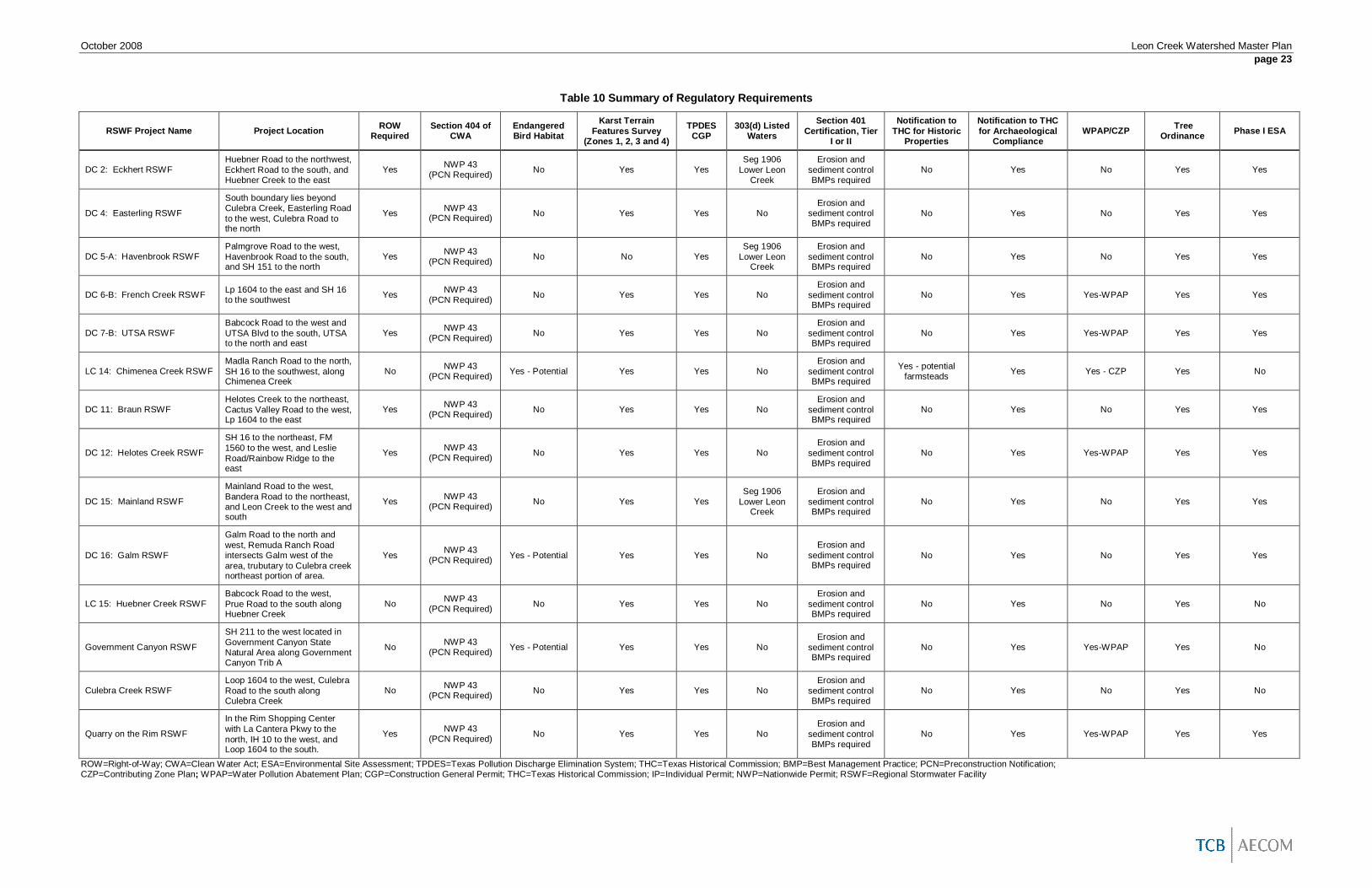
October 2008 Leon Creek Watershed Master Planpage 23
Table 10 Summary of Regulatory Requirements
RSWF Project Name Project Location ROWRequired
Section 404 ofCWA
EndangeredBird Habitat
Karst TerrainFeatures Survey
(Zones 1, 2, 3 and 4)
TPDESCGP
303(d) ListedWaters
Section 401Certification, Tier
I or II
Notification toTHC for Historic
Properties
Notification to THCfor Archaeological
ComplianceWPAP/CZP Tree
Ordinance Phase I ESA
DC 2: Eckhert RSWFHuebner Road to the northwest,Eckhert Road to the south, andHuebner Creek to the east
Yes NWP 43(PCN Required) No Yes Yes
Seg 1906Lower Leon
Creek
Erosion andsediment controlBMPs required
No Yes No Yes Yes
DC 4: Easterling RSWF
South boundary lies beyondCulebra Creek, Easterling Roadto the west, Culebra Road tothe north
Yes NWP 43(PCN Required) No Yes Yes No
Erosion andsediment controlBMPs required
No Yes No Yes Yes
DC 5-A: Havenbrook RSWFPalmgrove Road to the west,Havenbrook Road to the south,and SH 151 to the north
Yes NWP 43(PCN Required) No No Yes
Seg 1906Lower Leon
Creek
Erosion andsediment controlBMPs required
No Yes No Yes Yes
DC 6-B: French Creek RSWF Lp 1604 to the east and SH 16to the southwest Yes NWP 43
(PCN Required) No Yes Yes NoErosion and
sediment controlBMPs required
No Yes Yes-WPAP Yes Yes
DC 7-B: UTSA RSWFBabcock Road to the west andUTSA Blvd to the south, UTSAto the north and east
Yes NWP 43(PCN Required) No Yes Yes No
Erosion andsediment controlBMPs required
No Yes Yes-WPAP Yes Yes
LC 14: Chimenea Creek RSWFMadla Ranch Road to the north,SH 16 to the southwest, alongChimenea Creek
No NWP 43(PCN Required) Yes - Potential Yes Yes No
Erosion andsediment controlBMPs required
Yes - potentialfarmsteads Yes Yes - CZP Yes No
DC 11: Braun RSWFHelotes Creek to the northeast,Cactus Valley Road to the west,Lp 1604 to the east
Yes NWP 43(PCN Required) No Yes Yes No
Erosion andsediment controlBMPs required
No Yes No Yes Yes
DC 12: Helotes Creek RSWF
SH 16 to the northeast, FM1560 to the west, and LeslieRoad/Rainbow Ridge to theeast
Yes NWP 43(PCN Required) No Yes Yes No
Erosion andsediment controlBMPs required
No Yes Yes-WPAP Yes Yes
DC 15: Mainland RSWF
Mainland Road to the west,Bandera Road to the northeast,and Leon Creek to the west andsouth
Yes NWP 43(PCN Required) No Yes Yes
Seg 1906Lower Leon
Creek
Erosion andsediment controlBMPs required
No Yes No Yes Yes
DC 16: Galm RSWF
Galm Road to the north andwest, Remuda Ranch Roadintersects Galm west of thearea, trubutary to Culebra creeknortheast portion of area.
Yes NWP 43(PCN Required) Yes - Potential Yes Yes No
Erosion andsediment controlBMPs required
No Yes No Yes Yes
LC 15: Huebner Creek RSWFBabcock Road to the west,Prue Road to the south alongHuebner Creek
No NWP 43(PCN Required) No Yes Yes No
Erosion andsediment controlBMPs required
No Yes No Yes No
Government Canyon RSWF
SH 211 to the west located inGovernment Canyon StateNatural Area along GovernmentCanyon Trib A
No NWP 43(PCN Required) Yes - Potential Yes Yes No
Erosion andsediment controlBMPs required
No Yes Yes-WPAP Yes No
Culebra Creek RSWFLoop 1604 to the west, CulebraRoad to the south alongCulebra Creek
No NWP 43(PCN Required) No Yes Yes No
Erosion andsediment controlBMPs required
No Yes No Yes No
Quarry on the Rim RSWF
In the Rim Shopping Centerwith La Cantera Pkwy to thenorth, IH 10 to the west, andLoop 1604 to the south.
Yes NWP 43(PCN Required) No Yes Yes No
Erosion andsediment controlBMPs required
No Yes Yes-WPAP Yes Yes
ROW=Right-of-Way; CWA=Clean Water Act; ESA=Environmental Site Assessment; TPDES=Texas Pollution Discharge Elimination System; THC=Texas Historical Commission; BMP=Best Management Practice; PCN=Preconstruction Notification;CZP=Contributing Zone Plan; WPAP=Water Pollution Abatement Plan; CGP=Construction General Permit; THC=Texas Historical Commission; IP=Individual Permit; NWP=Nationwide Permit; RSWF=Regional Stormwater Facility

October 2008 Leon Creek Watershed Master Planpage 24
Multi-Use Objective Analysis
Multi-use objectives were identified by coordinating with urban and environmental planners toevaluate suitable use objectives and screening criteria within the Leon Creek Watershed. To aid theevaluation, a review of example projects and guidance was conducted – including projects by HarrisCounty Flood Control District, which has actively pursued multi-use projects in highly urbanizedwatersheds. Based on the coordination and example project review, a multi-use objective matrix wasdeveloped for each RSWF project that was evaluated in this study. The matrices list a variety ofpotential uses for each RSWF site as well as screening criteria (features). The features weredeveloped to qualitatively evaluate the suitability of each site for the various uses. Distance plays amajor role in suitability for certain uses because the use must be compatible with surrounding landuse (e.g. a park that is accessible within a residential community would make more sense than a parkcompletely surrounded by industrial activity). The matrices in Appendix F present a preliminarysuitability evaluation for each RSWF site to aid in qualitatively ranking the RSWF projects relative toeach other.
Workshop No. 2
A second workshop was held July 23, 2008, with participants from SARA, Bexar County, COSA,USACE – Fort Worth District, and TCB. At the workshop, the methodology and preliminary findingsof the RSWF project analysis, cost estimate development, regulatory analysis, and multi-useobjective evaluation were presented. Discussion followed after which participants compiled a list ofaction items for refining the RSWF site analysis, preparing final documents for Phase I, and preparingthe scope of work for Phase II.
The action items related to the current phase included:
1. Clarify the results for Havenbrook RSWF to show the impacts from the RSWF and theimpacts from channel improvements.
2. Evaluate the change in status of roadway crossing safety.3. Screen for economic value.4. Consider mapping the revised floodplain.
The action items related to Phase II included:
1. Further define the Quarry at the Rim RSWF project.2. Consider recharge features for sites.3. Identify bridge improvement options especially for Damage Centers 4 and 5-A.4. Look at selective clearing for high Manning’s “n” values in channels.
The items in the first list have been addressed in this report. The items in the second list will beincluded in the final recommendations.
A summary of Workshop 2 is included in Appendix A.
Evaluation of Alternatives
The final evaluation of the RSWF projects followed the BRWM standardized priority ranking matrix toconsolidate the results of each analysis described above. The matrix is shown in Table 11. For eachcriterion, the project was ranked qualitatively as “High,” “Medium,” or “Low” according to the following:
Hydraulic/hydrologic significance or impact – This was ranked based on a combination of thereduction in peak flowrate and the reduction in the number of annual damages.
o Low – Peak flowrate reductions were less than 5 percent along the stream passingthrough the primary damage center.
o Medium – Peak flowrate reductions were between 5 and 15 percent along the streampassing through the primary damage center. RSWF sites with less than 5 percent

October 2008 Leon Creek Watershed Master Planpage 25
peak flowrate reductions but with Estimated Annual Damage reductions greater than$20,000 also ranked “Medium”.
o High – Peak flowrate reductions were greater than 15 percent along the streampassing through the primary damage center. RSWF sites with 5 to 15 percent peakflowrate reductions but with Estimated Annual Damage reductions greater than$100,000 also ranked “High”.
Public safety – Reduction of the number of roadways classified “dangerous”.
o Low – No roadways changed classification as a result of the RSWF project.o Medium – One or two roadways changed classification as a result of the RSWF
project.o High – More than two roadways changed classification as a result of the RSWF
project.
Benefit/cost ratio – RSWF projects were ranked based on their Flood Reduction Ratios. ForFlood Reduction Ratios less than 0.1, RSWF projects were ranked “Low.” For FloodReduction Ratios between 0.1 and 0.5, RSWF projects were ranked “Medium,” and for FloodReduction Ratios greater than 0.5, RSWF projects were ranked “High.”
Element of a comprehensive watershed plan – The RSWF projects were ranked “Low” if theyonly provided local benefits, “Medium” if they provided benefits along the primary streamreach, and “High” if they provided benefits along multiple stream reaches.
Dependency on other projects – No RSWF projects considered in this study would bedependent on other projects. All were ranked “High.”
Mobility or effects on transportation system – This would be based on the length of time theroadways were out of service. This was not evaluated as part of this study.
Sustainability or low operations and maintenance cost – Most of the RSWF projects will havesimilar operations and maintenance costs. The off-channel RSWF sites were ranked“Medium” because they are anticipated to require less frequent clean-outs. The on-channelRSWF sites were ranked “Low.”
Level of protection provided – An RSWF project was ranked “Medium” if the primary damagecenter’s Level of Flood Protection improved one level with the RSWF.
Funding sources – This was not evaluated as part of this study.
Promote orderly development or improve economic development/redevelopment potential –The RSWF projects were ranked based on the area removed from the 100-year floodplain.As can be seen in Appendix E, most of the RSWF projects reduced the floodplain too little toimprove development potential, so those RSWF sites were ranked “Low.” The RSWF sitesthat had some visible impact on the floodplain were ranked “Medium.”
Beneficial neighborhood impacts – Aside from parks and environmental potential which wereaccounted for elsewhere, it is expected that RSWF projects would have negativeneighborhood impacts. The RSWF sites in this study were ranked “High” if they were notlocated near a neighborhood. They were ranked “Medium” if they were close to aneighborhood on one side, and they were ranked “Low” if they were close to neighborhoodson more than one side.
Water quality enhancement – The RSWF projects were scored relative to each other onsuitability for water quality enhancement techniques such as wet bottom water quality pondsand vegetation to improve water quality. An RSWF project was ranked “Low” if conditionswere highly constrained or would make it difficult to achieve (e.g., upstream with no base flowto help support a wet bottom pond and/or vegetation). “Medium” represented averagesuitability, with minor inputs, and “High” represented an unconstrained situation and/or near a303(d) impaired water that would benefit from water quality enhancement.

October 2008 Leon Creek Watershed Master Planpage 26
Time to implement or construct – The RSWF projects are expected to have similarimplementation times. All were ranked “Medium.”
Permitting resistance or difficulty – RSWF projects were ranked as they related to each other.If an RSWF project was expected to be more difficult or time-consumptive than average forthe group, it received a rating of low. If an RSWF project appeared to be less time-consuming to permit and require fewer permits, it received a higher score.
Environmental or habitat enhancement – RSWF projects were ranked “Low” if the RSWF sitewas highly constrained or if habitat enhancement would be difficult to implement due todevelopment and connectivity. “Medium” RSWF sites had average suitability andconnectivity. “High” RSWF sites were very suitable and connected locations.
Potential for recreation/open space/connectivity for linear parks – RSWF sites were rankedas they related to each other. RSWF sites were ranked “Low” if they were not suitable forrecreation or distant from places such as residential areas, schools, or other parks (forconnectivity). “Medium” met some of the criteria, and locations with a “High” rating were nearpeople and/or connected directly to adjacent parks and green space.

October 2008 Leon Creek Watershed Master Planpage 27
Table 11 Prioritization Matrix
BRWM CriteriaChimenea
Creek RSWFQuarry at theRim RSWF
GovernmentCanyon RSWF
Helotes CreekRSWF
French CreekRSWF UTSA RSWF Galm RSWF Braun RSWF Huebner
Creek RSWF Eckhert RSWF MainlandRSWF
Culebra CreekRSWF
EasterlingRSWF
HavenbrookRSWF
Hydraulic/hydrologic significance or impact H M H H L M L H L L M M M
Public Safety H M M M L L L M L L L L L
Flood Reduction Ratio (Substituted for BRWMBenefit/Cost Ratio) L M M M L L L H L L * L L
Element of comprehensive watershed plan M L H H L L M L M L L L M L
Dependency on other projects H H H H H H H H H H H H H H
Mobility or effects on transportation system - - - - - - - - - - - - - -
Sustainability or low operations & maintenancecost L M L L L M L M L L M L L L
Level of protection provided L L L L L L M L L L L L L
Funding sources - - - - - - - - - - - - - -
Promote orderly development or improveeconomic development/redevelopmentpotential
M L M L L L L L L L L L L L
Beneficial neighborhood impacts H H H M M M H M L L M M M M
Water quality enhancement M L M L L L L L L L L L L M
Time to implement or construct M M M M M M M M M M M M M M
Permitting resistance or difficulty L M L M M M M H H H M H H H
Environmental or habitat enhancement M L M L L L L L L L L L L M
Potential for Recreation/OpenSpace/Connectivity for linear parks H L H M M M M M M M M M H M
Total No. Low 4 6 3 5 9 4 7 7 6 10 8 7 7 6
Total No. Medium 5 6 6 6 4 5 5 5 4 2 5 4 4 6
Total No. High 5 2 5 3 1 1 2 2 4 2 1 2 3 2
0
2
4
6
8
10
12
14
ChimeneaCreek RSWF
Quarry at theRim RSWF
GovernmentCanyonRSWF
Helotes CreekRSWF
French CreekRSWF
UTSA RSWF Galm RSWF Braun RSWF HuebnerCreek RSWF
EckhertRSWF
MainlandRSWF
Culebra CreekRSWF
EasterlingRSWF
HavenbrookRSWF
Total No. LowTotal No. MediumTotal No. High

October 2008 Leon Creek Watershed Master Planpage 28
Discussion of Results
From the priority ranking matrix results, the following could be determined regarding each individualRSWF site:
Government Canyon RSWF – This was the highest ranking RSWF site. It produced thehighest flowrate reductions and flood mitigation impacts. It did receive a notable “Low”ranking for permitting resistance because it is located within Government Canyon StateNatural Area which serves as a management area for karst invertebrate and otherendangered species habitat. Any project development would have to be coordinated withTPWD and other interested parties, and special mitigation strategies would most likely berequired for implementation. The multi-use analysis of this site indicated potential for habitatenhancement and water quality enhancement.
LC-14: Chimenea Creek RSWF – This was the second highest ranking RSWF site. It alsoresulted in the most improvement to roadway safety with reduced flooding to severallocations along Scenic Loop Road. Because much of the flooding along Helotes Creekoccurs only during lower frequency storm events, the annual damage reduction estimate forthis site was low, causing a lower rating for Flood Reduction Ratio. This site ranked aboveaverage for multi-use potential with opportunities for water quality enhancement, habitatenhancement, and recreational uses such as mountain bike trails and picnic areas.
Helotes Creek RSWF – This RSWF site had the second best results for flow reductions andflood mitigation impacts after Government Canyon RSWF. Its ranking was slightly lower thansome others because of limited potential for multi-use objectives related to environmental andwater quality enhancement and only medium potential for recreational uses (sports fields or adog park).
LC-15: Huebner Creek RSWF – While the magnitude of flowrate reduction resulting from thissite was only average, the reduction in damages was high because of the urbanized nature ofthe area along Huebner Creek. The flow reductions and impacts from this RSWF siteoccurred on Huebner Creek itself with effects diminishing beyond the confluence with LeonCreek because of the relative timing of peaks on the two creeks. One of the low rankingsgiven to this RSWF site was for “Beneficial Neighborhood Impacts.” The ranking system forthis criterion was based on the assumption that construction activities would cause a negativereaction from the neighborhood, but negative impact of construction activities might have lowimportance if the neighborhood supports the project.
Quarry at the Rim RSWF – Based on the available storage capacity of this site, it wasexpected to rank higher in this analysis. The moderate performance was due to low rankingsfor multi-use objectives and only medium flood mitigation impacts. The flood mitigationimpacts were not high because of the distance to next downstream damage center where thepeak flowrate is driven by the middle reach of Leon Creek. The Quarry at the Rim RSWF islocated in the upper reach of Leon Creek which produces a smaller, later peak than thedownstream reaches (further discussion of regional peak behavior is included below).
Havenbrook RSWF – This RSWF site did add beneficial impacts to the flood mitigationimpacts resulting from Slick Ranch Creek Channel Improvements. It also ranked well formulti-use objectives including water quality enhancement and recreational uses due to itsproximity to an existing park.
Easterling RSWF – The flood mitigation impacts of this RSWF site were fair, and it has goodpotential for multi-use objectives. However, a large amount of excavation would be requiredto meet the necessary storage capacity, raising the cost of the project and lowering itsranking.
Galm RSWF – This RSWF site resulted in moderate flood mitigation impacts reaching intothe lower Leon Creek area. It had some multi-use potential as a dog park. The area would

October 2008 Leon Creek Watershed Master Planpage 29
require some excavation to increase storage capacity, though not as much as EasterlingRSWF.
Braun RSWF – This RSWF site ranked medium for multi-use potential but showed low floodmitigation impacts. To some extent the measured impact was limited because the damagesin the downstream damage center occur during the 500-year and 100-year ultimate stormevents, so the impacts during the higher frequency storm events did not result in reduceddamages. Impacts further downstream could not be evaluated because of model limitations.
Culebra Creek RSWF – This RSWF project was designed as a peak shaving facility, and assuch it only impacted flooding for the 500-year existing and the 100-year ultimate stormevents, lowering its ranking in the matrix. Since an estimated cost was not provided with theproject data, the related criterion could not be evaluated.
UTSA RSWF – This RSWF site would have to be simulated using two-dimensional analysistechniques in order to determine its flood mitigation potential. Its results for other rankingcriteria were average, including some multi-use potential as sports fields or a dog park.
Mainland RSWF – This RSWF site had low flood mitigation potential. The location of theRSWF site and its primary damage center (Damage Center 15) in the middle reach of mainstem Leon Creek meant that a large storage capacity would be required in order to make anoticeable impact on downstream flooding. Space for the required amount of storage is notavailable due to the level of development in this part of the watershed.
French Creek RSWF – As with the RSWF projects on Huebner Creek, the impacts from thisRSWF site diminished after the confluence of French Creek and Leon Creek. It had mediummulti-use potential as a sports field or a dog park.
Eckhert RSWF – Alone, this RSWF site had low flood mitigation impacts. In the simulationwith all RSWF sites, it had some additive benefits in combination with Huebner Creek RSWFwithin the Huebner Creek damage centers. It also had multi-use potential as a picnic areawith walking trails.
In this evaluation, all criteria were weighted equally, regardless of whether they were related to thisproject’s primary objective (flood mitigation) or a secondary objective (multi-use opportunities). Theserankings should be considered preliminary until a final weighted quantitative ranking of each RSWFproject is performed by the BRWM.
From the results of the individual RSWF sites and the combination of all on-channel RSWF sites,some characteristics of Leon Creek could be determined. The flood flow regime is influenced by fourareas of the watershed: upper Leon Creek (upstream of Loop 1604), middle Leon Creek (downstreamof Loop 1604 and upstream of the confluence with Culebra Creek), Culebra Creek, and lower LeonCreek (downstream of the confluence with Culebra Creek.
At locations in lower Leon Creek like the bridge at Highway 90, the peak is driven by flows on CulebraCreek. RSWF sites on Culebra Creek and all contributing streams (Government Canyon Creek,Helotes Creek, Chimenea Creek, etc.) had the greatest flood reduction impacts. Besides reducingthe peak flowrates, these sites yielded the additional benefit of delaying the peaks. Withoutdetention, the Culbera Creek peak coincides with the peak from middle Leon Creek. The RSWF sitesin the Culebra Creek area caused the peak to shift, reaching Leon Creek as the middle Leon Creekpeak was falling. As a result, the peak flowrates in lower Leon Creek were reduced by more than thepeak flowrate reduction on Culebra Creek itself. This can be seen in the results from Helotes CreekRSWF in Tables 6 and 7. The RSWF reduced the peak flowrate passing through Damage Center 12(on Helotes Creek) by 4,921 cfs while reducing the peak flowrate at Highway 90 (on lower LeonCreek) by 10,522 cfs.
The peak from middle Leon Creek also contributes to the high peak on lower Leon Creek. However,the peak from this area is difficult to control with detention because it develops from several lessconcentrated contributing streams, and less space is available for construction and storage. In

October 2008 Leon Creek Watershed Master Planpage 30
addition, RSWF projects on the main stem of Leon Creek in this reach or further downstream wouldbe ineffective due to the high volume of water being passed during large storm events. Naturalwaterway conveyance (NWWC) projects in this area could help move the middle Leon Creek peakthrough the lower reaches ahead of the Culebra Creek peak.
The peak from upper Leon Creek is later than the peaks from middle Leon Creek and Culebra Creekand therefore has a minimal contribution to the peak flowrate on lower Leon Creek. Like the Quarryat the Rim RSWF, any sites located in upper Leon Creek would have limited impacts south of UTSA.Because the peak from upper Leon Creek is later than the driving peak downstream, any activity thatwould shorten the travel time (such as increased development or NWWC) has potential to causenegative downstream impacts by causing a peak-on-peak situation like the one that currently existswith the middle Leon Creek and Culebra Creek peaks.
Because flooding in lower Leon Creek is driven by regions upstream of the confluence with CulebraCreek, RSWF sites on contributing streams below that point, like Huebner Creek and Slick RanchCreek, only impact flooding on the contributing streams themselves. At the same time, the onlysolution to flooding on those streams and others like French Creek, upper Leon Creek, etc. would beprojects in their respective drainage areas despite their limited potential for downstream benefits.
Conclusions and RecommendationsIn Phase I of the Leon Creek Watershed Master Plan project, stream reaches were identified alongthe main channel and major tributary channels which experience major flooding, potential RSWFprojects were evaluated for flood mitigation potential and multi-use objective opportunities, and thealternative RSWF projects were qualitatively ranked regarding public desirability and economicfeasibility.
The more severely impacted damage centers were on Huebner Creek, lower Culebra Creek, lowerSlick Ranch Creek, the confluence of Huesta and Maverick Creeks, and in several locations on themain channel of Leon Creek. There were two damage centers in the upper region, one in the lower,and others which were concentrated close to the confluences with French Creek, Culebra Creek, andHuebner Creek. There were also some damage centers of lesser density on Helotes and FrenchCreeks.
Some of the major flooding reaches are expected to change during the DFIRM appeals processbecause of recently approved LOMRs that were not included in the Bexar County DFIRM RemappingStudy. That study includes LOMRs approved up to late 2005. LOMRs approved by FEMA after thatcutoff date are not reflected in the DFIRM models, and will be incorporated into the DFIRM modelsduring the resolution period after the 90-day protest/appeal period. The expected changes for thesereaches were considered when selecting the damage centers for further evaluation.
At Workshop No. 1, SARA, COSA and Bexar County selected the following for potential RSWF sites:
Damage Center 2 on Huebner Creek, Damage Centers 4 and 16 on Culebra Creek, Damage Center 5-A on Slick Ranch Creek, Damage Centers 6-A and 6-B on French Creek (to be evaluated together), Damage Centers 6-C and 15 on the middle reach of Leon Creek, Damage Center 7-B on Maverick Creek, and Damage Centers 11 and 12 on Helotes Creek.
They also selected the following previously identified projects to be evaluated with the potential newprojects:
LC-14: Chimenea Creek RSWF LC-15: Huebner Creek RSWF

October 2008 Leon Creek Watershed Master Planpage 31
Culebra Creek RSWF Government Canyon RSWF The Quarry at the Rim RSWF
Each project was evaluated and configured to maximize storage and peak flowrate reductions.Helotes Creek RSWF (for Damage Center 12) and existing projects Government Canyon RSWF,Chimenea Creek RSWF and Huebner Creek RSWF had the greatest impact on peak flowrates anddamage reductions.
Opportunities for establishing multi-use objectives were also considered for each site, includinghabitat enhancement, water quality enhancement, sports fields, picnic areas, trails, and temporaryparking. Havenbrook RSWF (for Damage Center 5-A) and existing projects Government CanyonRSWF and Chimenea Creek RSWF had the greatest multi-use potential.
A prioritization matrix was developed based on the ranking factors used by the BRWM Program,which includes the objectives discussed above as well as benefit/cost data, construction andsustainability considerations, transportation and neighborhood impacts, and funding, development,and planning concerns. Helotes Creek RSWF and Easterling RSWF (for Damage Centers 12 and 4,respectively) and existing projects Government Canyon RSWF, Chimenea Creek RSWF, HuebnerCreek RSWF, and the Quarry at the Rim RSWF had the highest un-weighted qualitative rankings.Implementing these projects would substantially alleviate flooding in the major flooding reaches alongHuebner Creek, Helotes Creek, Culebra Creek, and lower Leon Creek. Problem areas would stillexist along upper and middle Leon Creek, French Creek, and the confluence of Huesta and MaverickCreeks.
The project developed for Damage Center 7-B on Maverick Creek (UTSA RSWF) may have greaterimpacts on flooding in the area than identified in this study, including at the confluence of Huesta andMaverick Creeks. The scope of this phase of the study was limited to evaluating RSWF projectsbased on existing hydrologic and hydraulic models. A more sophisticated simulation model would berequired to adequately predict the back-and-forth spills between Maverick Creek and Huesta CreekTributary A in the damage center’s area.
Flood flow regimes in the Leon Creek watershed present some unique challenges in identifying andevaluating potential RSWF projects to mitigate flood related damages. Peak water surface elevationsand flow rates in the upper Leon Creek watershed (upstream of Loop 1604) are essentially driven byrunoff from the upper basin. The middle Leon Creek watershed (below Loop 1604 to just upstream ofconfluence with Culebra Creek) experiences peak water surface elevations and flow rates which areprimarily created by runoff from the middle reaches of the watershed. Likewise, the peak watersurface elevations and flow rates in the lower reach of Leon creek (below Culebra Creek confluence)are caused by the peak in the middle reach of Leon Creek combined with the peak from CulebraCreek. RSWF projects, if not properly planned, could result in increased peak flows downstream ofthe immediate area benefitting from the facility due to changing the timing of the peak flows, alsocalled “peak shifting”. This study evaluated the whole watershed for each potential RSWF project toallow for the evaluation of both positive and negative potential downstream impacts. However, thestudy did not evaluate each project combination, rather each project was evaluated individually and asimulation was conducted with all projects in place. Results of the evaluation with all projects in placeshow that the peak flowrate at Highway 90 can be reduced from 108,700 cfs to 75,000 cfs and from124,400 cfs to 95,400 cfs for the 100-year storm event under existing and ultimate conditions,respectively. Results of the evaluation of each individual RSWF site indicate that analyzed RSWFprojects in the Leon Creek watershed can substantially reduce flood related damages, reduce theneed for roadway improvements, and reduce the potential for flood related deaths. Each of thepotential RSWF projects evaluated not only reduced flood related damages to structures but alsoreduced the number of roadway crossings downstream of the projects that are classified asdangerous according the COSA UDC classification.
The qualitative prioritization matrix that was prepared for Phase I of this study provides a mechanismfor the stakeholders to select and implement prospective projects for CIP Programs. These potentialflood mitigation RSWF projects should also be further ranked quantitatively using weighted ranking

October 2008 Leon Creek Watershed Master Planpage 32
criteria developed by the BRWM. It is also recommended that the BRWM quantitatively rank thepreviously unranked projects. The following paragraphs describe the recommended actions andprovide suggested actions or tasks for subsequent phases of this watershed master plan.
Based on the qualitative matrix created for this study, the projects identified with the most benefitswere, in order of preliminary ranking:
Government Canyon RSWF, LC-14: Chimenea Creek RSWF, Helotes Creek RSWF, LC-15: Huebner Creek RSWF, Quarry at the RIM RSWF, Havenbrook RSWF, Easterling RSWF, Galm RSWF, and Braun RSWF.
Projects providing the greatest flood reduction benefits were:
Government Canyon RSWF, Helotes Creek RSWF, LC-14: Chimenea Creek RSWF, LC-15: Huebner Creek RSWF, Easterling RSWF, Galm RSWF, Quarry at the RIM RSWF, Havenbrook RSWF, and Culebra Creek RSWF.
However, the other RSWF sites which were identified in this phase of the Leon Creek WatershedMaster Plan will provide flood reduction benefits in the immediate region surrounding the projects. Inaddition to flood damage reduction benefits, each of the potential RSWF projects have other potentialbenefits to the community such as reduced downstream roadway damages and transportation relatedCIPs (i.e. bridge, roadway improvement, and low water crossing project design criteria could bereduced), water quality benefits, parks and recreation potential, etc. Both LC-14: Chimenea CreekRSWF and LC-15: Huebner Creek RSWF are currently included in the Bexar County Flood ControlProgram as planned projects over the next ten years. Each of the other identified RSWF projectsshould be quantitatively ranked by the BRWM Program and should be considered as potential futureRSWF projects when funding becomes available. Where applicable, the local stakeholders shouldalso consider using public/private participation agreements to enhance the future development ofthese projects.
In addition to these proposed RSWF projects, other flood mitigation project alternatives should beevaluated for each of the identified damage centers. Other flood mitigation project alternatives to beconsidered should include, but not necessarily be limited to, natural waterway conveyance (NWWC)improvements, channel rectification, existing floodplain buyouts, levees, flood control by-passstructures, bridge crossing improvements, and selective clearing programs for high manning’s “n” inchannels. Some identified damage centers were expected to have a reduced flood risk as a result ofDFIRM appeals; the results of the DFIRM appeals should be verified for those damage centers. Inaddition to flood mitigation, future master planning phases should also consider combining waterquality, aquifer recharge, and other potential multi-use objectives with flood risk mitigation.Subsequent phases of the master plan could also be designed to better define some of the morecomplex floodwater detention projects such as the Quarry at the Rim RSWF.