lecture #16 (april 5, 2010, monday) tropical storms...
TRANSCRIPT

Tropical Storms & Hurricanes
Part 1
Lecture #16 (April 5, 2010, Monday)
August
1992
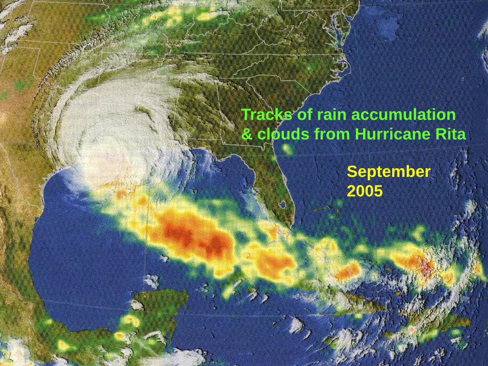
Tracks of rain accumulation
& clouds from Hurricane Rita
September
2005

Tropical Cyclones Around the Globe
―Hurricane―: N. Atlantic Ocean, NE Pacific Ocean, SE Pacific Ocean
―Typhoon―: NW Pacific Ocean
―Severe tropical cyclone―: SW Pacific Ocean, SE Indian Ocean
―Eevere cyclonic storm―: N Indian Ocean
―Tropical cyclone―: SW Indian Ocean
Why
none
here?
Why
none
here?

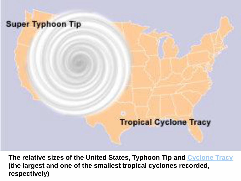
The relative sizes of the United States, Typhoon Tip and Cyclone Tracy
(the largest and one of the smallest tropical cyclones recorded,
respectively)
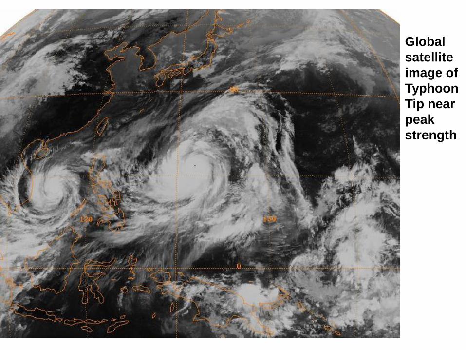
Global
satellite
image of
Typhoon
Tip near
peak
strength

Typhoon Tip
at its record
peak intensity
Category 5 on
October 12,
1979
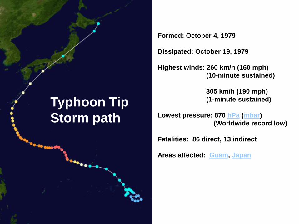
Formed: October 4, 1979
Dissipated: October 19, 1979
Highest winds: 260 km/h (160 mph)
(10-minute sustained)
305 km/h (190 mph)
(1-minute sustained)
Lowest pressure: 870 hPa (mbar)
(Worldwide record low)
Fatalities: 86 direct, 13 indirect
Areas affected: Guam, Japan
Typhoon Tip
Storm path
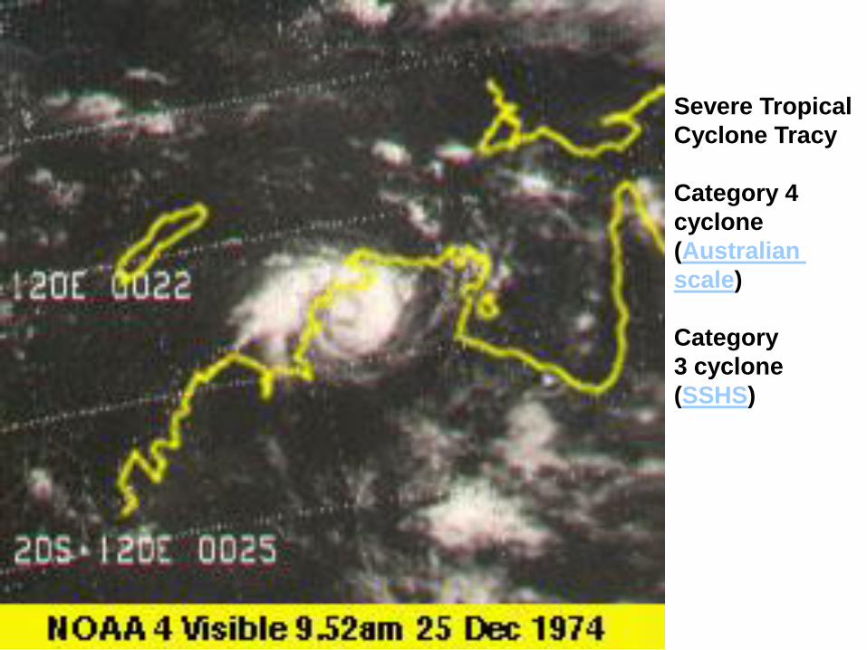
Severe Tropical
Cyclone Tracy
Category 4
cyclone
(Australian
scale)
Category
3 cyclone
(SSHS)
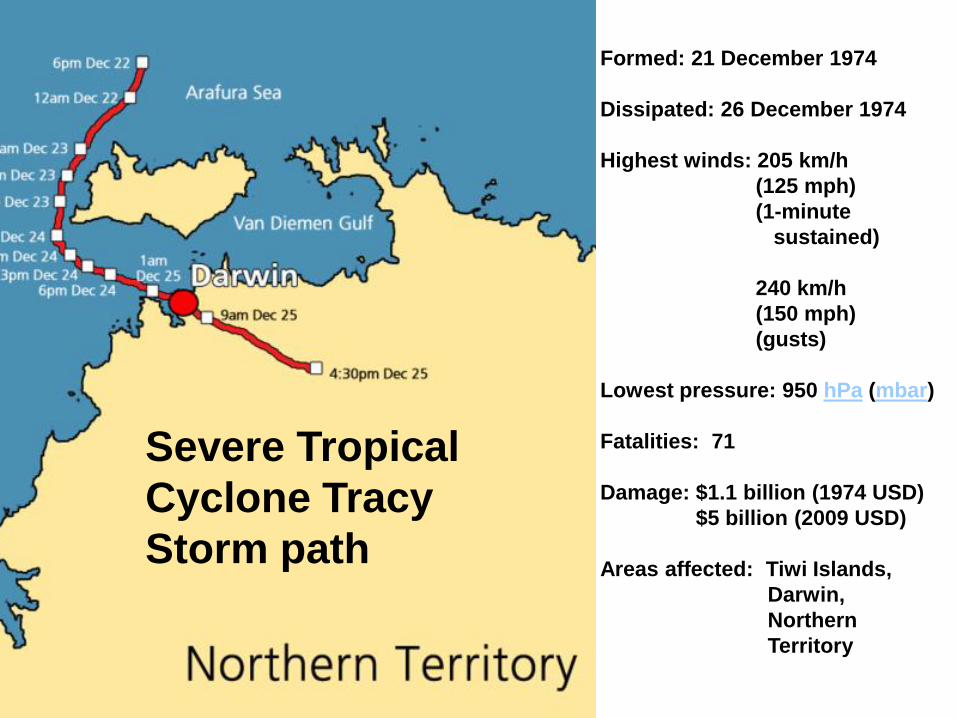
Formed: 21 December 1974
Dissipated: 26 December 1974
Highest winds: 205 km/h
(125 mph)
(1-minute
sustained)
240 km/h
(150 mph)
(gusts)
Lowest pressure: 950 hPa (mbar)
Fatalities: 71
Damage: $1.1 billion (1974 USD)
$5 billion (2009 USD)
Areas affected: Tiwi Islands,
Darwin,
Northern
Territory
Severe Tropical
Cyclone Tracy
Storm path

Devastation brought by Cyclone Tracy
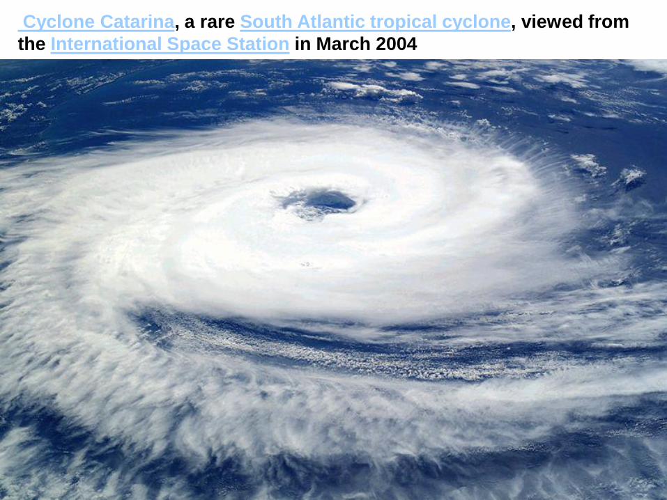
Cyclone Catarina, a rare South Atlantic tropical cyclone, viewed from
the International Space Station in March 2004
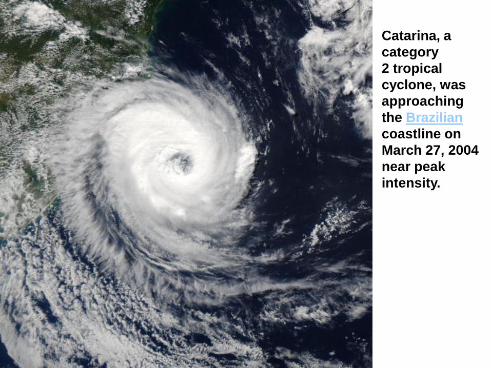
Catarina, a
category
2 tropical
cyclone, was
approaching
the Brazilian
coastline on
March 27, 2004
near peak
intensity.

Cyclone Catarina
at landfall
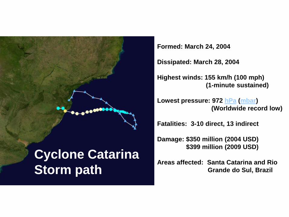
Formed: March 24, 2004
Dissipated: March 28, 2004
Highest winds: 155 km/h (100 mph)
(1-minute sustained)
Lowest pressure: 972 hPa (mbar)
(Worldwide record low)
Fatalities: 3-10 direct, 13 indirect
Damage: $350 million (2004 USD)
$399 million (2009 USD)
Areas affected: Santa Catarina and Rio
Grande do Sul, Brazil
Cyclone Catarina
Storm path
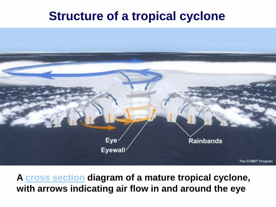
Structure of a tropical cyclone
A cross section diagram of a mature tropical cyclone,
with arrows indicating air flow in and around the eye

Hurricane Structure
Eye
wall
Northern
Hemisphere
L
H
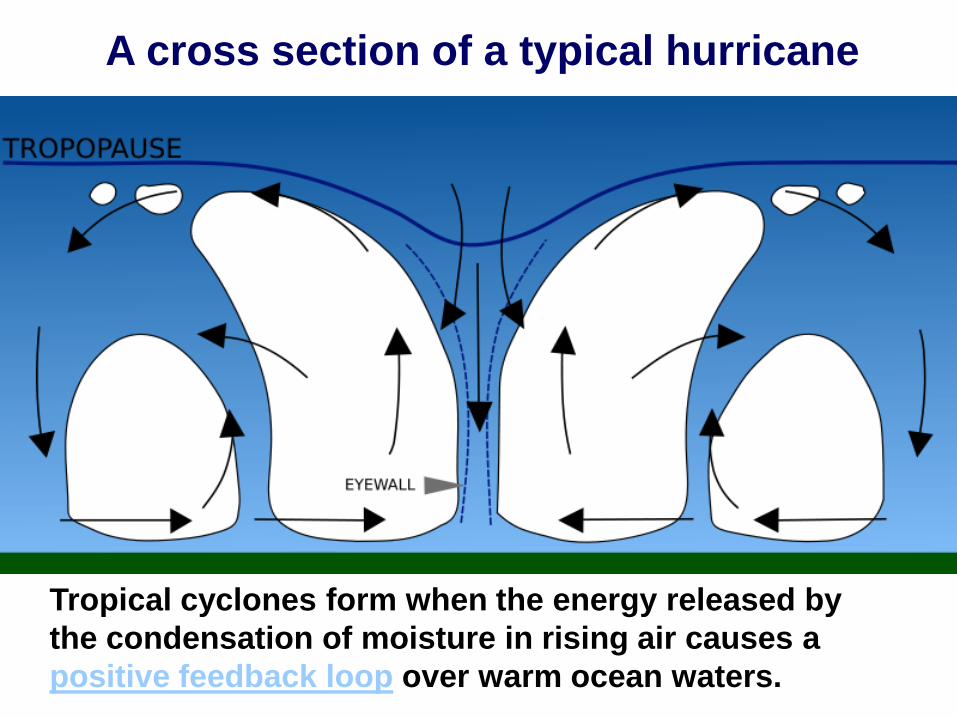
A cross section of a typical hurricane
Tropical cyclones form when the energy released by
the condensation of moisture in rising air causes a
positive feedback loop over warm ocean waters.
A cross section of a typical hurricane
?
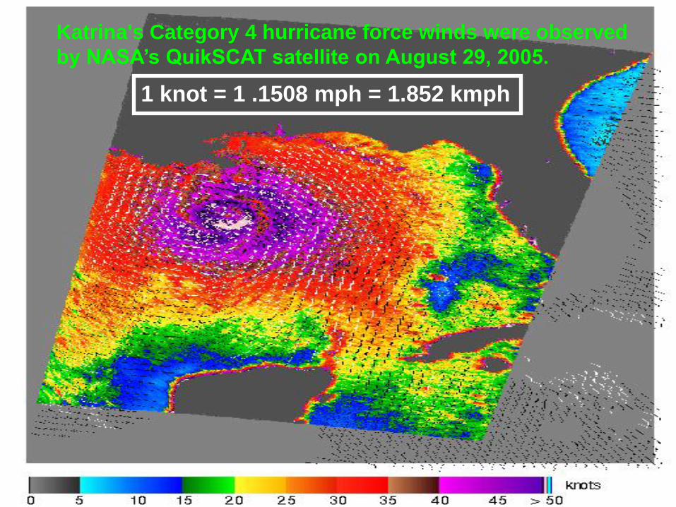
Katrina's Category 4 hurricane force winds were observed
by NASA’s QuikSCAT satellite on August 29, 2005.
1 knot = 1 .1508 mph = 1.852 kmph
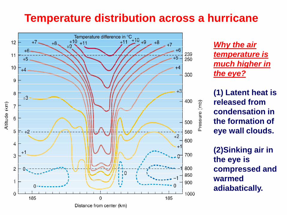
Temperature distribution across a hurricane
Why the air
temperature is
much higher in
the eye?
(1) Latent heat is
released from
condensation in
the formation of
eye wall clouds.
(2)Sinking air in
the eye is
compressed and
warmed
adiabatically.
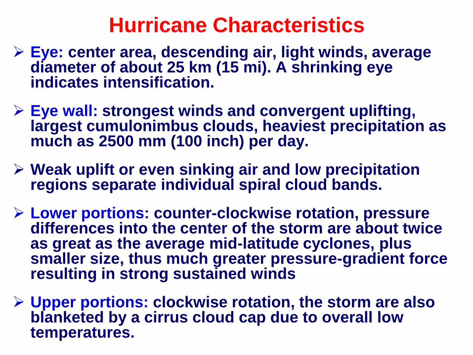
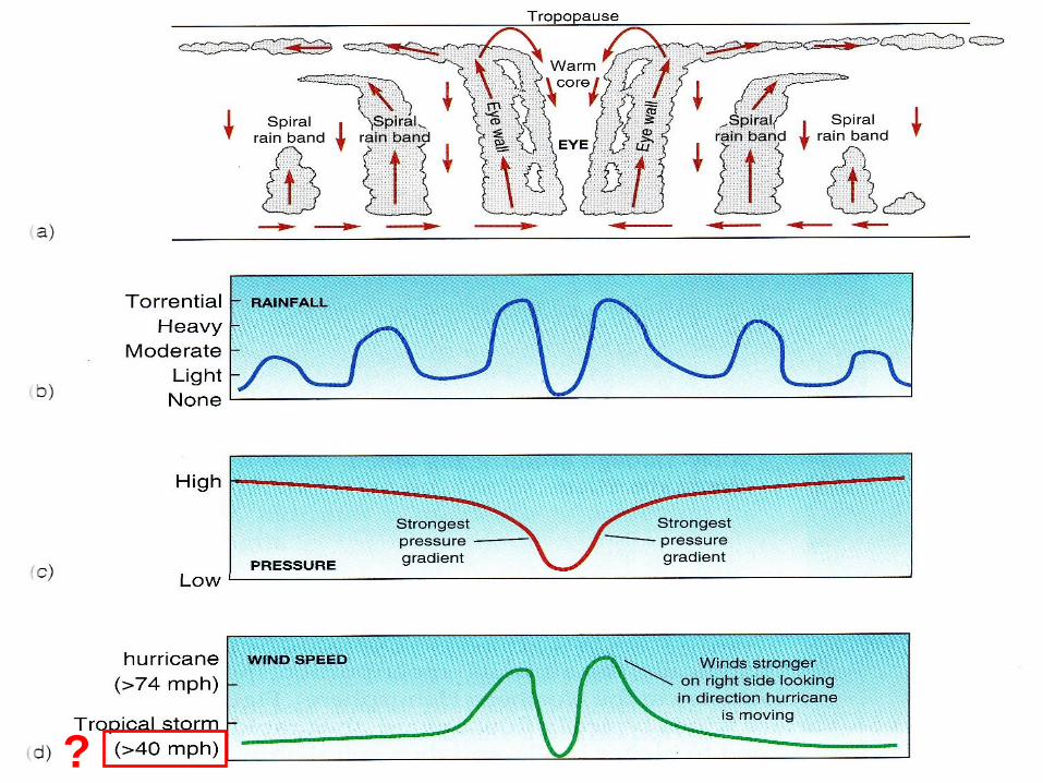
Eye: center area, descending air, light winds, average diameter of about 25 km (15 mi). A shrinking eye indicates intensification.
Eye wall: strongest winds and convergent uplifting, largest cumulonimbus clouds, heaviest precipitation as much as 2500 mm (100 inch) per day.
Weak uplift or even sinking air and low precipitation regions separate individual spiral cloud bands.
Lower portions: counter-clockwise rotation, pressure differences into the center of the storm are about twice as great as the average mid-latitude cyclones, plus smaller size, thus much greater pressure-gradient force resulting in strong sustained winds
Upper portions: clockwise rotation, the storm are also blanketed by a cirrus cloud cap due to overall low temperatures.
Hurricane Characteristics

Unlike mid-latitude cyclones, hurricanes are warm-core lows due to warm ocean surfaces.
As air converges into the surface low pressure center, adiabatic cooling due to expansion keeps the horizontal temperature differences moderate towards the eye.
Horizontal pressure gradient decreases slowly with altitude in the eye due to pressure decreases more slowly with increasing altitude in the warm core.
At about 400 mb (7.5 km), pressures within the storm are approximate the same as outside pressure.
From 400 mb to the tropopause, pressures within the storm exceed those outside upper portion of the storm rotates anticyclonically while lower portions rotate cyclonically.
Hurricane Characteristics
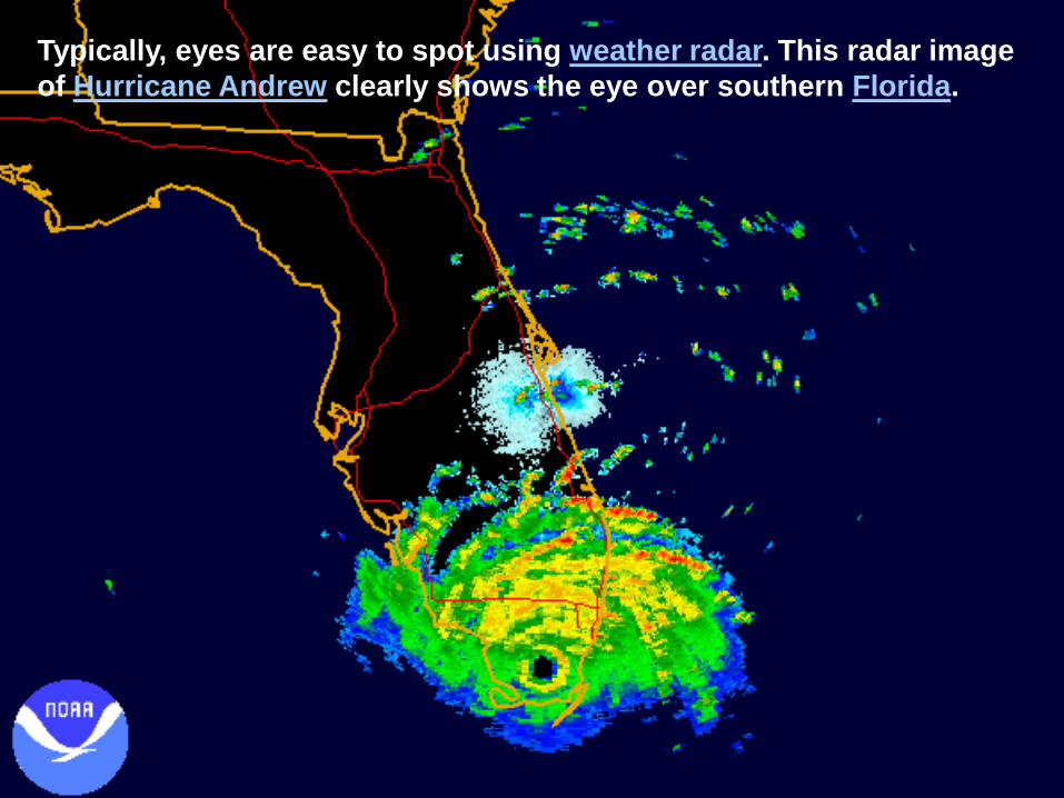
Typically, eyes are easy to spot using weather radar. This radar image
of Hurricane Andrew clearly shows the eye over southern Florida.
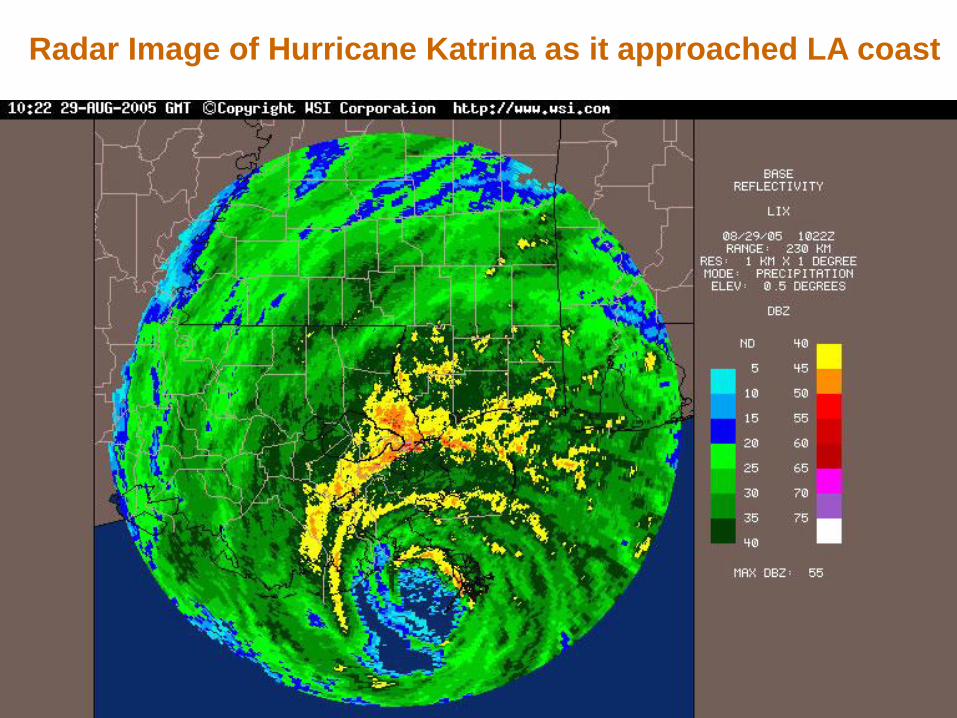
Radar Image of Hurricane Katrina as it approached LA coast

Eye
Eye wall
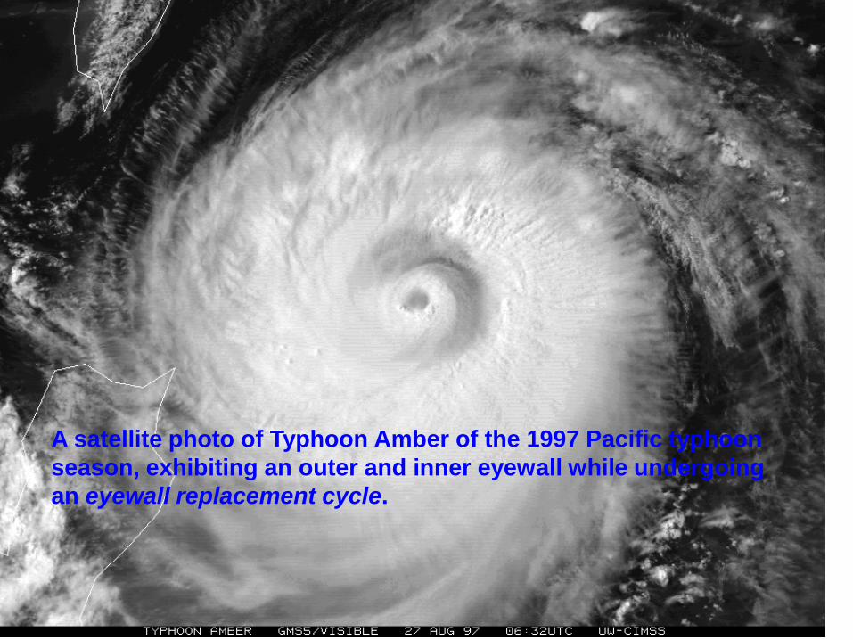
A satellite photo of Typhoon Amber of the 1997 Pacific typhoon
season, exhibiting an outer and inner eyewall while undergoing
an eyewall replacement cycle.
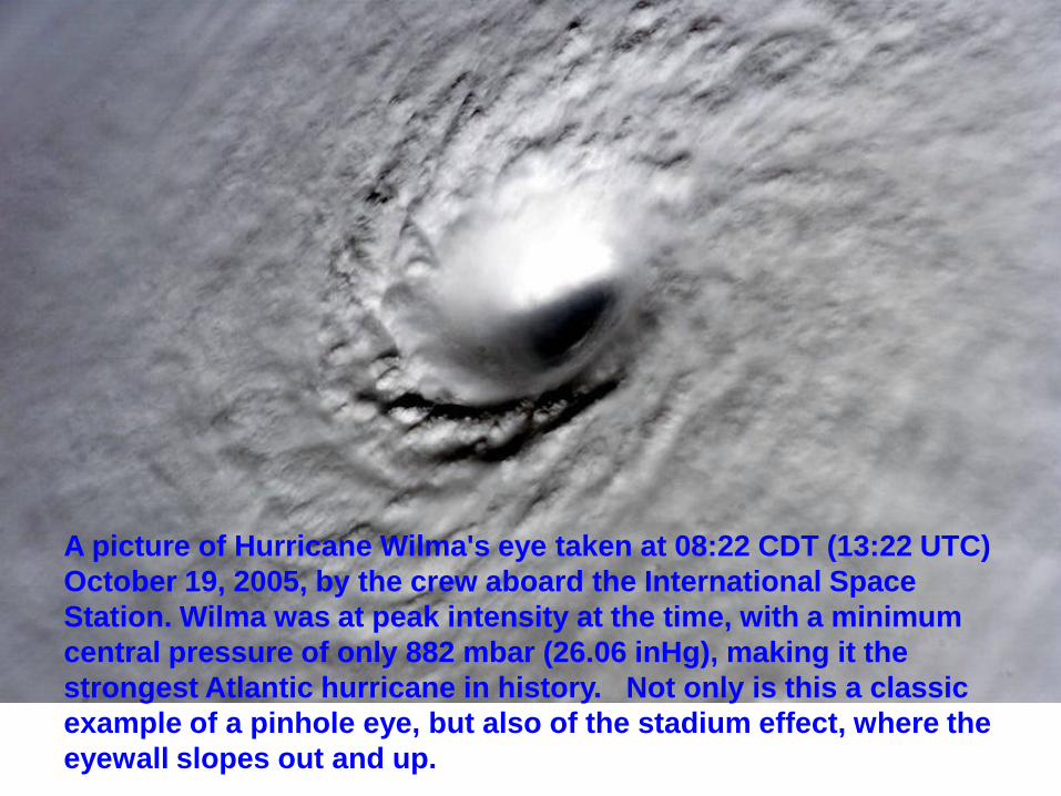
A picture of Hurricane Wilma's eye taken at 08:22 CDT (13:22 UTC)
October 19, 2005, by the crew aboard the International Space
Station. Wilma was at peak intensity at the time, with a minimum
central pressure of only 882 mbar (26.06 inHg), making it the
strongest Atlantic hurricane in history. Not only is this a classic
example of a pinhole eye, but also of the stadium effect, where the
eyewall slopes out and up.
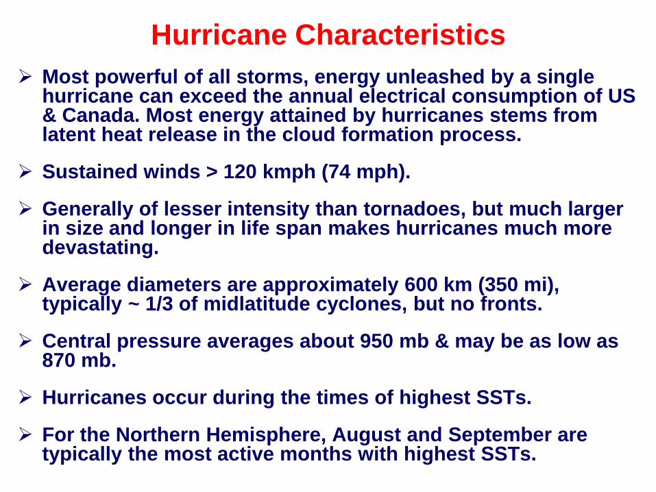
Most powerful of all storms, energy unleashed by a single hurricane can exceed the annual electrical consumption of US & Canada. Most energy attained by hurricanes stems from latent heat release in the cloud formation process.
Sustained winds > 120 kmph (74 mph).
Generally of lesser intensity than tornadoes, but much larger in size and longer in life span makes hurricanes much more devastating.
Average diameters are approximately 600 km (350 mi), typically ~ 1/3 of midlatitude cyclones, but no fronts.
Central pressure averages about 950 mb & may be as low as 870 mb.
Hurricanes occur during the times of highest SSTs.
For the Northern Hemisphere, August and September are typically the most active months with highest SSTs.
Hurricane Characteristics
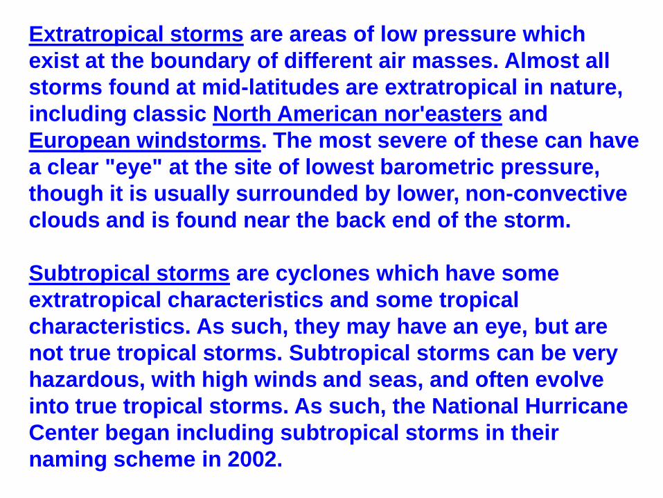
Extratropical storms are areas of low pressure which
exist at the boundary of different air masses. Almost all
storms found at mid-latitudes are extratropical in nature,
including classic North American nor'easters and
European windstorms. The most severe of these can have
a clear "eye" at the site of lowest barometric pressure,
though it is usually surrounded by lower, non-convective
clouds and is found near the back end of the storm.
Subtropical storms are cyclones which have some
extratropical characteristics and some tropical
characteristics. As such, they may have an eye, but are
not true tropical storms. Subtropical storms can be very
hazardous, with high winds and seas, and often evolve
into true tropical storms. As such, the National Hurricane
Center began including subtropical storms in their
naming scheme in 2002.
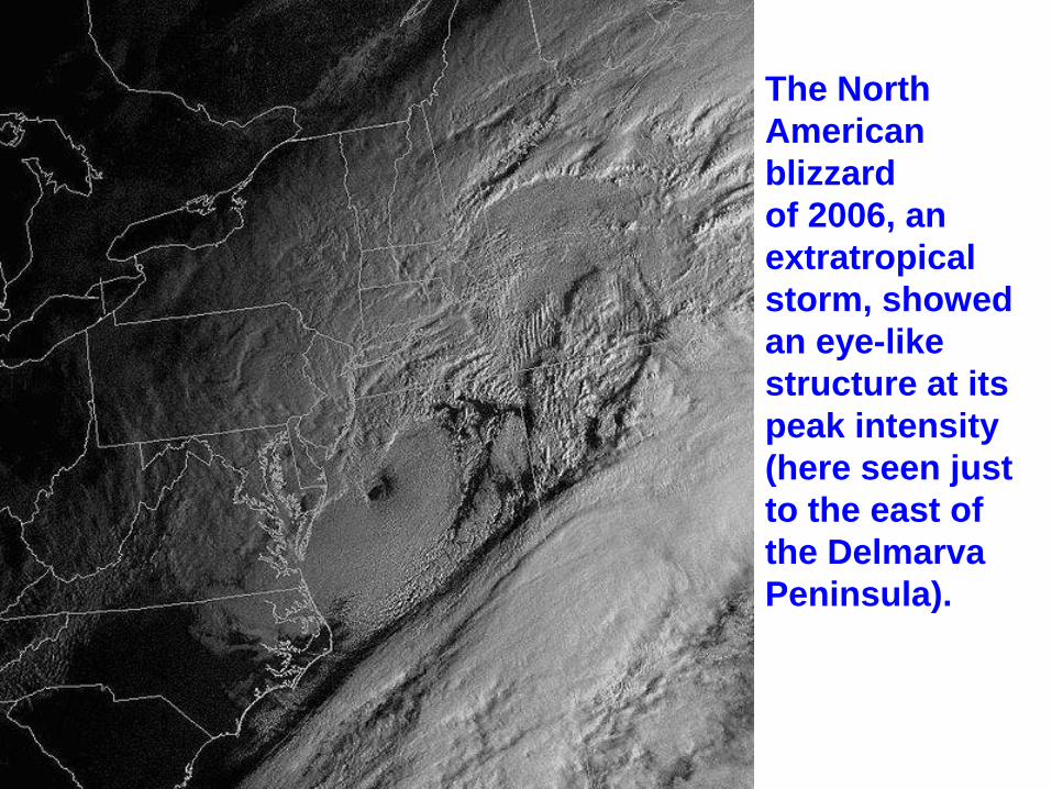
The North
American
blizzard
of 2006, an
extratropical
storm, showed
an eye-like
structure at its
peak intensity
(here seen just
to the east of
the Delmarva
Peninsula).
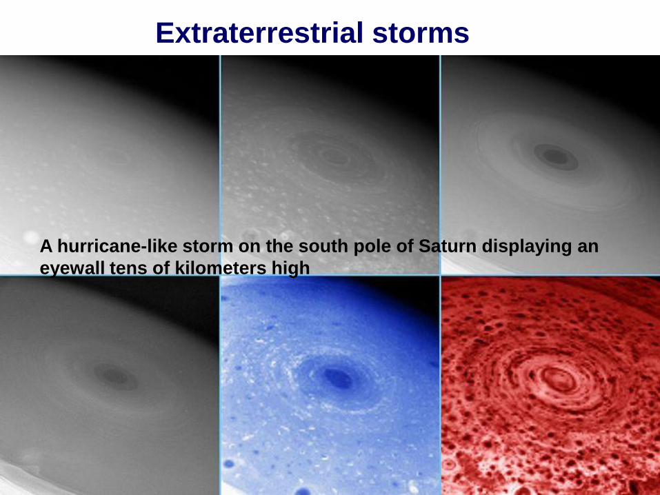
Extraterrestrial storms
A hurricane-like storm on the south pole of Saturn displaying an
eyewall tens of kilometers high
Tropical cyclogenesis is the technical term describing the
development and strengthening of a tropical cyclone in
the atmosphere.
The mechanisms through which tropical cyclogenesis
occurs are distinctly different from those through which
mid-latitude cyclogenesis occurs.
Tropical cyclogenesis involves the development of a
warm-core cyclone, due to significant convection in a
favorable atmospheric environment.
An average of 86 tropical cyclones of tropical storm
intensity form annually worldwide, with 47 reaching
hurricane/typhoon strength, and 20 becoming intense
tropical cyclones (at least Category 3 intensity on the
Saffir-Simpson Hurricane Scale or SSHS).
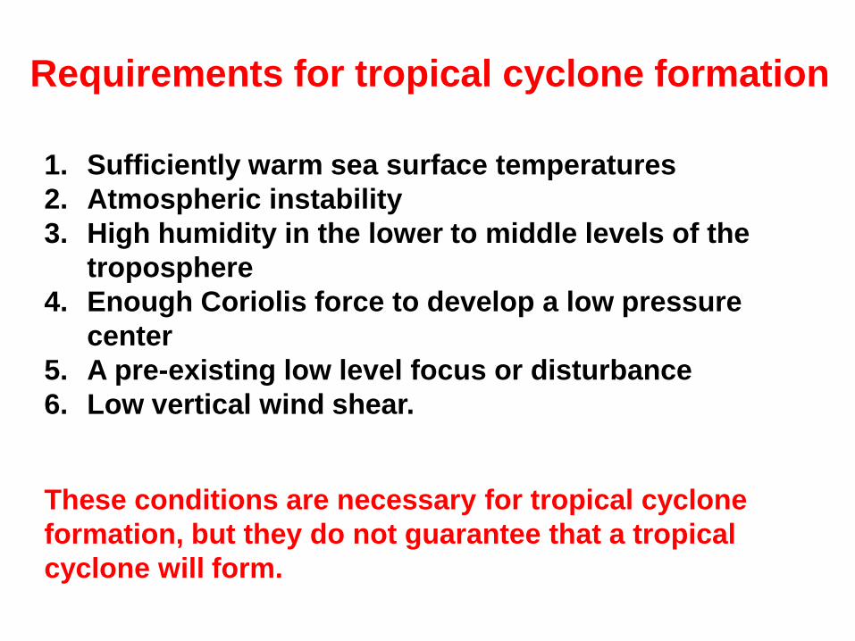
Requirements for tropical cyclone formation
1. Sufficiently warm sea surface temperatures
2. Atmospheric instability
3. High humidity in the lower to middle levels of the
troposphere
4. Enough Coriolis force to develop a low pressure
center
5. A pre-existing low level focus or disturbance
6. Low vertical wind shear.
These conditions are necessary for tropical cyclone
formation, but they do not guarantee that a tropical
cyclone will form.
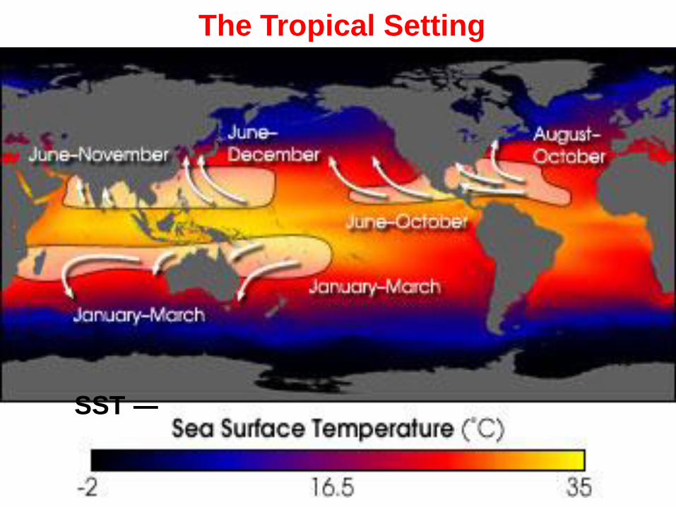
SST ―
The Tropical Setting

The Tropical Setting
Depth of 26 °C isotherm on October 1, 2006
Normally, an ocean temperature of 26.5°C (79.7°F)
spanning through at least a 50-m depth is considered the
minimum to maintain the special mesocyclone that is the
tropical cyclone.
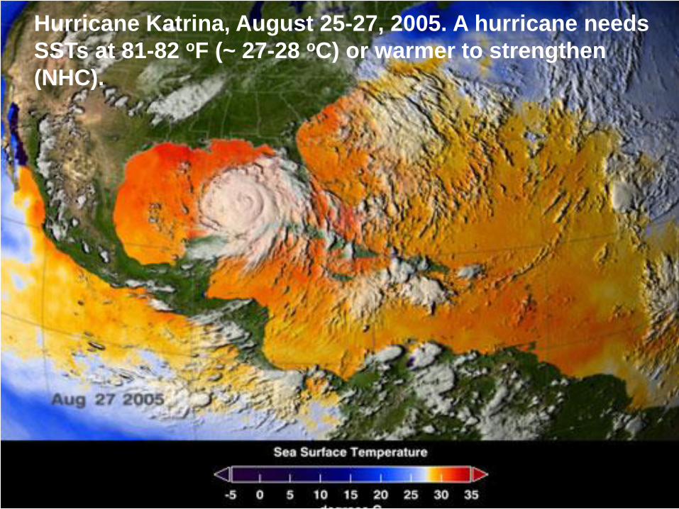
Hurricane Katrina, August 25-27, 2005. A hurricane needs
SSTs at 81-82 oF (~ 27-28 oC) or warmer to strengthen
(NHC).

On rare
occasions,
tropical
storms may
form or
strengthen in
mid-latitudes.
Hurricane Vince
formed in the
temperate
subtropics
during the 2005
Atlantic season
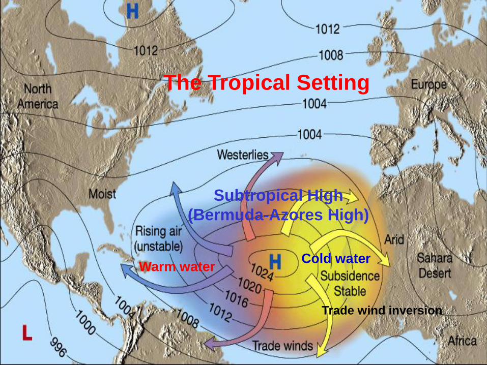
Subtropical High
(Bermuda-Azores High)
The Tropical Setting
Warm waterCold water
Trade wind inversion
An easterly wave
Hurricane Formation
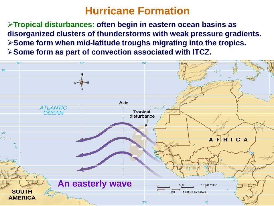
Tropical disturbances: often begin in eastern ocean basins as
disorganized clusters of thunderstorms with weak pressure gradients.
Some form when mid-latitude troughs migrating into the tropics.
Some form as part of convection associated with ITCZ.
An
easterly
wave
Hurricane Formation
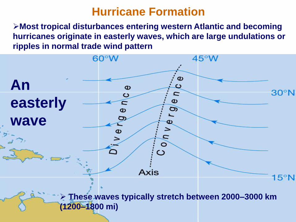
Most tropical disturbances entering western Atlantic and becoming
hurricanes originate in easterly waves, which are large undulations or
ripples in normal trade wind pattern
These waves typically stretch between 2000–3000 km
(1200–1800 mi)
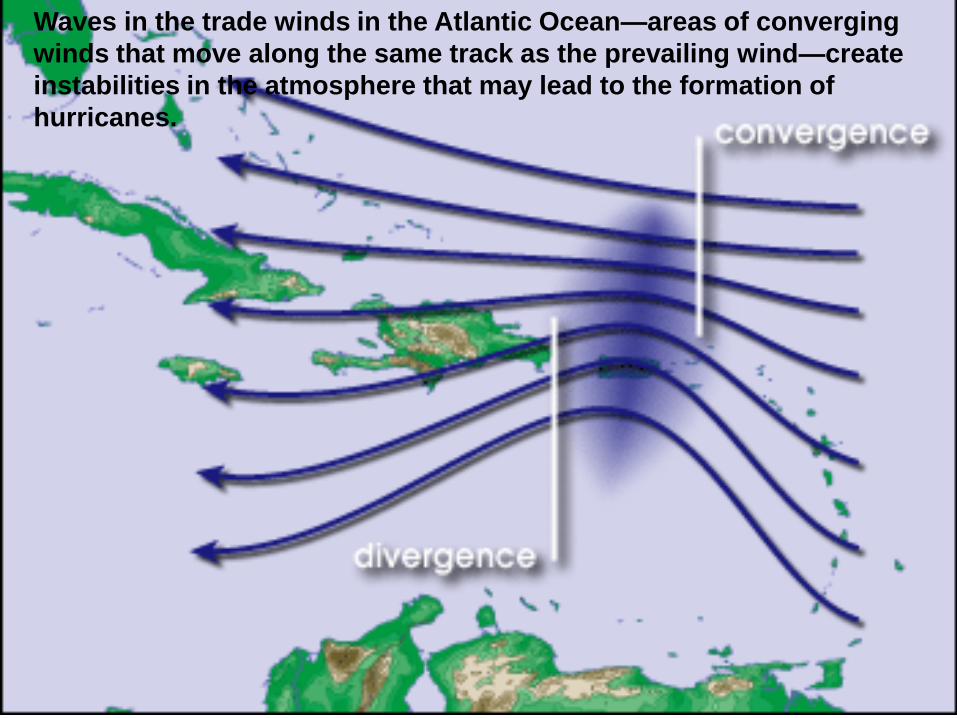
Waves in the trade winds in the Atlantic Ocean—areas of converging
winds that move along the same track as the prevailing wind—create
instabilities in the atmosphere that may lead to the formation of
hurricanes.
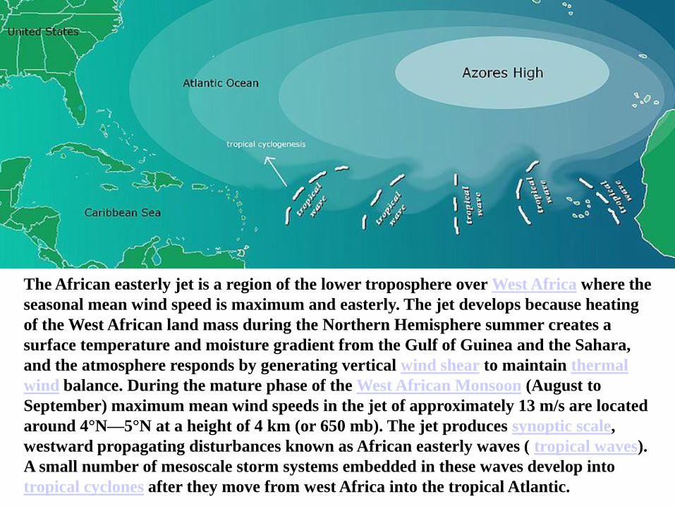
The African easterly jet is a region of the lower troposphere over West Africa where the
seasonal mean wind speed is maximum and easterly. The jet develops because heating
of the West African land mass during the Northern Hemisphere summer creates a
surface temperature and moisture gradient from the Gulf of Guinea and the Sahara,
and the atmosphere responds by generating vertical wind shear to maintain thermal
wind balance. During the mature phase of the West African Monsoon (August to
September) maximum mean wind speeds in the jet of approximately 13 m/s are located
around 4°N—5°N at a height of 4 km (or 650 mb). The jet produces synoptic scale,
westward propagating disturbances known as African easterly waves ( tropical waves).
A small number of mesoscale storm systems embedded in these waves develop into
tropical cyclones after they move from west Africa into the tropical Atlantic.
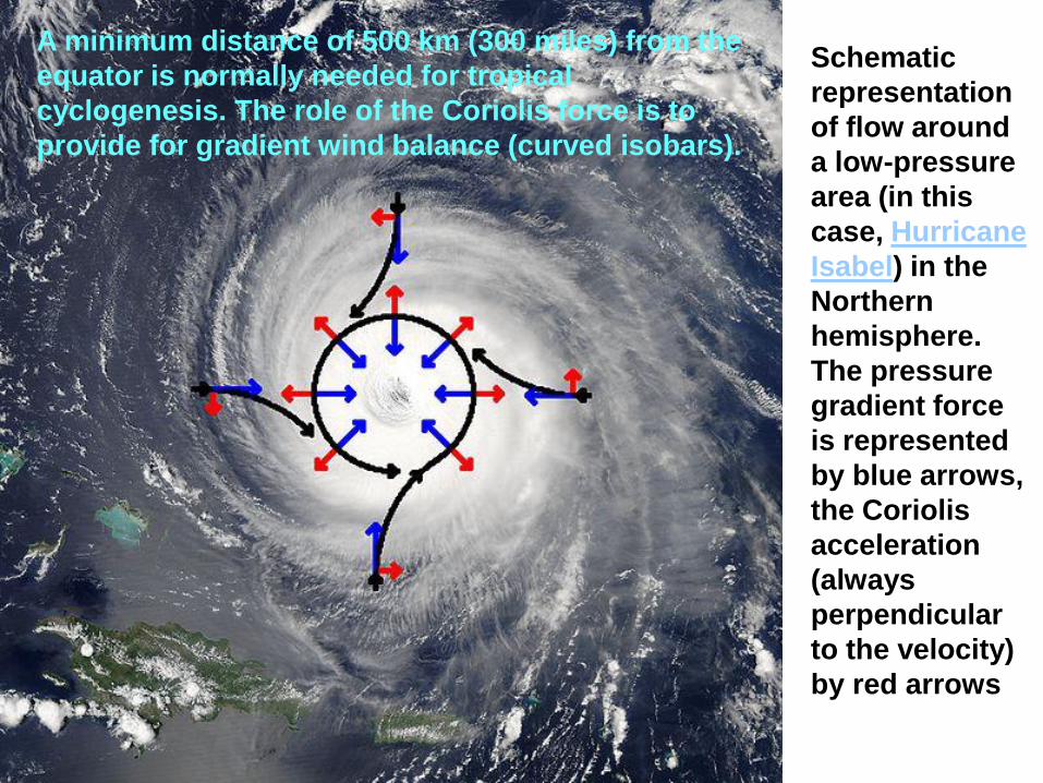
Schematic
representation
of flow around
a low-pressure
area (in this
case, Hurricane
Isabel) in the
Northern
hemisphere.
The pressure
gradient force
is represented
by blue arrows,
the Coriolis
acceleration
(always
perpendicular
to the velocity)
by red arrows
A minimum distance of 500 km (300 miles) from the
equator is normally needed for tropical
cyclogenesis. The role of the Coriolis force is to
provide for gradient wind balance (curved isobars).
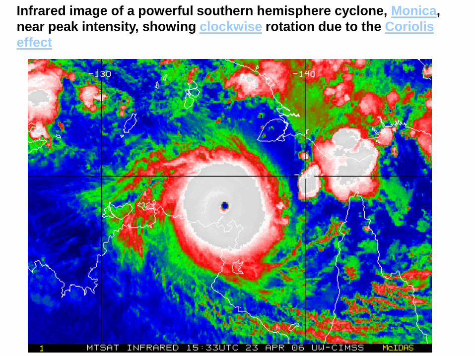
Infrared image of a powerful southern hemisphere cyclone, Monica,
near peak intensity, showing clockwise rotation due to the Coriolis
effect
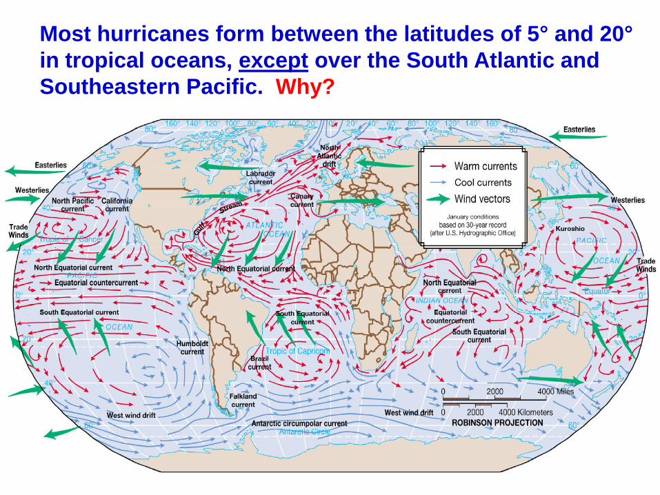
Most hurricanes form between the latitudes of 5° and 20°
in tropical oceans, except over the South Atlantic and
Southeastern Pacific. Why?
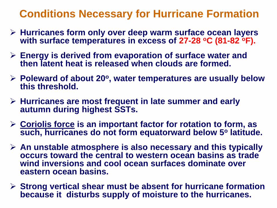
Hurricanes form only over deep warm surface ocean layers with surface temperatures in excess of 27-28 oC (81-82 oF).
Energy is derived from evaporation of surface water and then latent heat is released when clouds are formed.
Poleward of about 20o, water temperatures are usually below this threshold.
Hurricanes are most frequent in late summer and early autumn during highest SSTs.
Coriolis force is an important factor for rotation to form, as such, hurricanes do not form equatorward below 5o latitude.
An unstable atmosphere is also necessary and this typically occurs toward the central to western ocean basins as trade wind inversions and cool ocean surfaces dominate over eastern ocean basins.
Strong vertical shear must be absent for hurricane formation because it disturbs supply of moisture to the hurricanes.
Conditions Necessary for Hurricane Formation