lecture 1: introduction
DESCRIPTION
Introduction to lecture Satellite navigationTRANSCRIPT

GNSS:
FACTS, MYTHS AND HOLLYWOOD
Lecture 1.1
SGU 4823
SATELLITE NAVIGATION
1 AzmiHassan SGU 4823 Sem.1 2012

GUNSMOKE
Main Cast:
JAMES ARNESS..........................Matt Dillon
MILBURN STONE............Galen "Doc" Adams
AMANDA BLAKE..Kitty Russell (1955-1974)
DENNIS WEAVERChester Goode (1955-1964) KEN
CURTIS..........Festus Haggen (1964-1975) BURT
REYNOLDS….Quint Asper (1962-1965)
2 AzmiHassan SGU 4823 Sem.1 2012

CALLING CARD
HAVE GUN WILL TRAVEL
3 AzmiHassan SGU 4823 Sem.1 2012

HAVE COORDINATE WILL TRAVEL
4 AzmiHassan SGU 4823 Sem.1 2012

Don’t be confused with different types of satellites …….
5 AzmiHassan SGU 4823 Sem.1 2012

Communications
Navigation
Geodesy and Mapping
Meteorology
Satellite Tracking
Anti-Satellite Weapons
Ballistic Missile Defense
Imagery Intelligence
Signals Intelligence
Measurement &
Signature Intelligence
Wide Area / Ocean
Surveillance
Missile Warning
MILITARY SATELLITES
6 AzmiHassan SGU 4823 Sem.1 2012
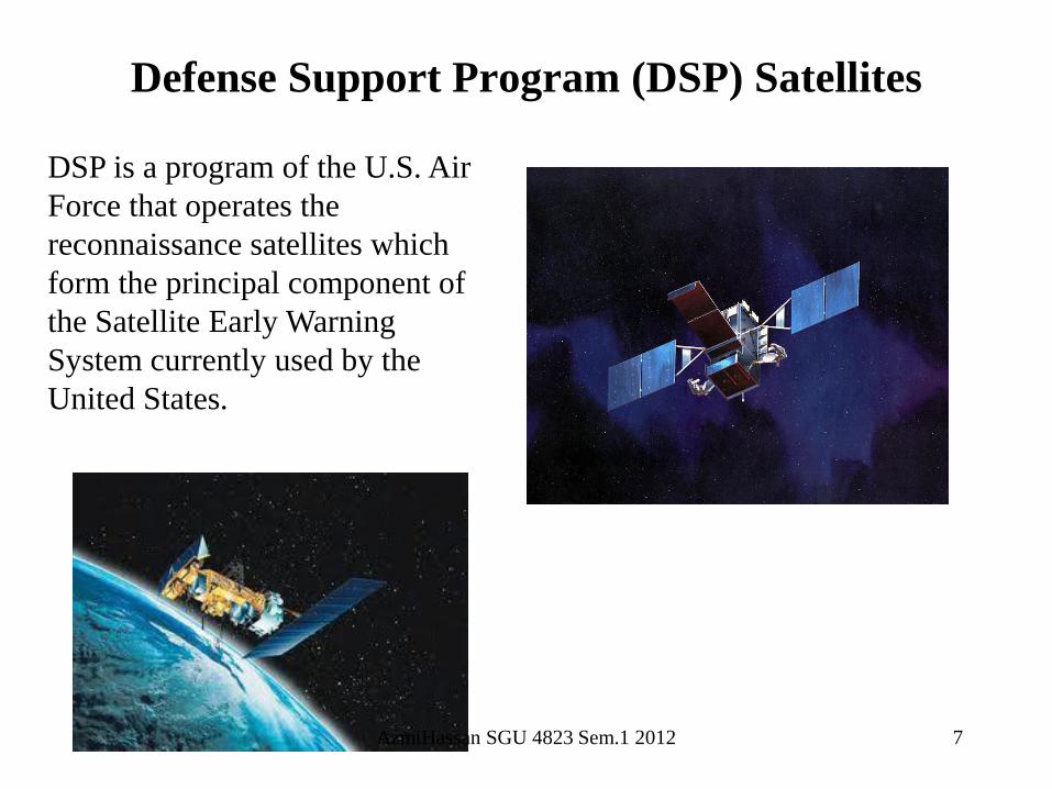
Defense Support Program (DSP) Satellites
DSP is a program of the U.S. Air
Force that operates the
reconnaissance satellites which
form the principal component of
the Satellite Early Warning
System currently used by the
United States.
7 AzmiHassan SGU 4823 Sem.1 2012

Defense Satellete Communications System
(DSCS)
DSCS is a military satellite
constellation placed in
geosynchronous orbit to provide high-
volume, secure voice and data
communications
8 AzmiHassan SGU 4823 Sem.1 2012

IKONOS is a commercial earth
observation satellite, and was the first
to collect publicly available high-
resolution imagery at 1- and 4-meter
resolution. It offers multispectral (MS)
and panchromatic (PAN) imagery
9 AzmiHassan SGU 4823 Sem.1 2012

IKONOS 5 METER
10 AzmiHassan SGU 4823 Sem.1 2012

IKONOS 1 METER
11 AzmiHassan SGU 4823 Sem.1 2012

HOLLYWOOD MYTHS ?
12 AzmiHassan SGU 4823 Sem.1 2012

13 AzmiHassan SGU 4823 Sem.1 2012

The Wide Area Augmentation System
(WAAS) is an air navigation aid developed by
the Federal Aviation Administration to augment
the Global Positioning System (GPS), with the
goal of improving its accuracy, integrity, and
availability. Essentially, WAAS is intended to
enable aircraft to rely on GPS for all phases of
flight, including precision approaches to any
airport within its coverage area
The Local Area Augmentation
System (LAAS) is an all-weather
aircraft landing system based on real-
time differential correction of the
GPS signal. Local reference receivers
located around the airport send data
to a central location at the airport.
14 AzmiHassan SGU 4823 Sem.1 2012

Cops Use Satellite
to Track Suspect
Unwitting Truck
Driver Leads Police
to Graves
Expert: GPS in Peterson Case Had Glitches
Tuesday September 14, 2004 2:46 AM
By BRIAN SKOLOFF
REDWOOD CITY, Calif. (AP) - Satellite
navigation devices used to track Scott Peterson's
car after his wife's disappearance sometimes
developed glitches, once indicating he was
driving 30,000 mph.
NOT A MYTH THOUGH
15 AzmiHassan SGU 4823 Sem.1 2012

INTELLIGENT
TRANSPORTATION SYSTEM
16 AzmiHassan SGU 4823 Sem.1 2012

17 AzmiHassan SGU 4823 Sem.1 2012

WHERE IS MY BUS ?
18 AzmiHassan SGU 4823 Sem.1 2012

19 AzmiHassan SGU 4823 Sem.1 2012


22 AzmiHassan SGU 4823 Sem.1 2012

GPS RECEIVER, NOTEBOOK
AND A KANCHIL
23 AzmiHassan SGU 4823 Sem.1 2012

KANCHIL TRACKING SYSTEM
24 AzmiHassan SGU 4823 Sem.1 2012

ROUTE GUIDANCE
SIMPANG JALAN SEGGET
200 METER
PUSING KANAN
25 AzmiHassan SGU 4823 Sem.1 2012

KLIA LIMOUSINE – 10 Years Ago
• The Bump/Hump
26 AzmiHassan SGU 4823 Sem.1 2012

KLIA LIMOUSINE - TODAY
27 AzmiHassan SGU 4823 Sem.1 2012

• Soil Mapping (DoA)
• Yield Mapping (Mardi, RSAM, DoA)
• Rice Advance Technology (Mardi, DoA)
• Nutrient Management (Mardi, RSAM)
• Integrated Pest & Weed Management (DoA)
• Water Management (Mardi, JPS)
28 AzmiHassan SGU 4823 Sem.1 2012

SMART COMMUNICATION
ILLUSTRATION BY
NADIRA AZMI (11 YRS)
29 AzmiHassan SGU 4823 Sem.1 2012

TODAY – IT’S THE NORM
30 AzmiHassan SGU 4823 Sem.1 2012

GPS GOLF CADDY
GPS to provide the golfer advice on how best
to play the next hole
PULAI SPRINGS
31 AzmiHassan SGU 4823 Sem.1 2012

SMART GUIDANCE FOR THE
BLIND
32 AzmiHassan SGU 4823 Sem.1 2012

MILITARY APPLICATIONS
33 AzmiHassan SGU 4823 Sem.1 2012

The GPS was
designed as a dual-
use system with the
primary purpose of
enhancing the
effectiveness of U.S.
and allied military
forces.
34 AzmiHassan SGU 4823 Sem.1 2012

SMART MISSILES
DESERT STORM – 8 %
ALLIED FORCE – 35 %
ENDURING FREEDOM – 60 %
IRAQI FREEDOM – 70 %
35 AzmiHassan SGU 4823 Sem.1 2012

SMART BOMBS AND PRECISION WARFARE
36 AzmiHassan SGU 4823 Sem.1 2012

TACTICAL TOMAHAWK MISSILES
Posses the capability
to reprogram the
missile while in-flight
to strike any of 15
preprogrammed
alternate targets or
redirect the missile to
any GPS target
coordinates.
37 AzmiHassan SGU 4823 Sem.1 2012

B52 BOMBER
38 AzmiHassan SGU 4823 Sem.1 2012

JOINT DIRECT ATTACK MUNITION PROGRAM
The Joint Direct Attack Munition program (JDAM) was born from Operation Desert Storm shortfall.
Eventhough the Persian Gulf War was dubbed as the first ‘space war’, the precision guided bombs used produced a dismal results. Only 40% of the bombs dropped hit the intended targets.
39 AzmiHassan SGU 4823 Sem.1 2012

JDAM
40 AzmiHassan SGU 4823 Sem.1 2012

BEWARE OF PITFALLS
TECHNO-HIKER GETS LOST AS
BATTERIES FAIL IN WOODS
Published on 06/28/96.
SOURCE: By Tony Chamberlain, Globe
Staff
OOPS! WHERE’S MY MAP?
Published on 08/27/96.
SOURCE: By Indira A.R.
Lakshmanan, Globe Staff
41 AzmiHassan SGU 4823 Sem.1 2012

Horror stories of these smart bombs gone astray are not new
and well documented.
Questions are being asked how smart and accurate are these
bombs?
Collateral damage is damage that is unintended or incidental
to the intended outcome.
The term originated in the United States military, but it has
since expanded into broader use.
BOMBING BLUNDERS
42 AzmiHassan SGU 4823 Sem.1 2012

BOMBING BLUNDERS
YUGOSLAVIA WAR
OPERATION ALLIED FORCE
NATO CARRIED OUT AROUND 33,000
CAMPAIGN FLIGHTS OVER 78 DAYS OF WAR.
43 AzmiHassan SGU 4823 Sem.1 2012

BOMBING BLUNDERS (YUGOSLAVIA WAR)
5 APRIL: HOMES HIT.
CAUSE OF ERROR:
MISSILES FALL SHORT
First major NATO blunder when
an attack on a barracks resulted
in missiles striking a residential
area.Three missiles fell 600m
short of their target.
44 AzmiHassan SGU 4823 Sem.1 2012

BOMBING BLUNDERS (YUGOSLAVIA WAR)
12 APRIL: TRAIN DESTROYED.
CAUSE OF ERROR: TIMING
NATO raid on a railway bridge hit a
passenger train, killing 10. The
Belgrade-Salonika train had been
crossing the bridge near Leskovac,
southern Serbia as the air-launched
missile released several miles away
reached its target."You can see if you
were focusing right on your job as a
pilot how suddenly that train
appeared. It was really unfortunate."
45 AzmiHassan SGU 4823 Sem.1 2012

BOMBING BLUNDERS (YUGOSLAVIA WAR)
1 MAY: BUS BOMBING
CAUSE OF ERROR: PILOT DID NOT SEE VEHICLE
46 AzmiHassan SGU 4823 Sem.1 2012

BOMBING BLUNDERS (YUGOSLAVIA WAR)
7 MAY: CHINESE EMBASSY HIT
CAUSE OF ERROR: MISTAKEN IDENTITY
In the biggest mistake of the campaign
to date, Washington admitted that an
out-of-date map used by its intelligence
operations had led Nato to launch
missiles at the Chinese embassy in
Belgrade, killing three people, injuring a
further 20. Nato said that the intended
target had been the Yugoslav Federal
directorate of Supply and Procurement
200 yards away.
47 AzmiHassan SGU 4823 Sem.1 2012

BOMBING BLUNDERS (YUGOSLAVIA WAR)
Nato said that the intended target had
been the Yugoslav Federal directorate of
Supply and Procurement 200 yards
away.
48 AzmiHassan SGU 4823 Sem.1 2012

BOMBING BLUNDERS (YUGOSLAVIA WAR)
WRONG
MAPS ?
49 AzmiHassan SGU 4823 Sem.1 2012

BOMBING BLUNDERS
AFGHANISTAN WAR
OPERATION ENDURING FREEDOM
60 % OF MISSILE DEPLOYED ARE PRECISION GUIDED
50 AzmiHassan SGU 4823 Sem.1 2012

BOMBING BLUNDERS (AFGHANISTAN WAR)
7TH DAY OF OPERATION
• F 18 HORNET DROP 900 KG SMART BOMBS
• INTENDED TARGET: KABUL AIRPORT
• LANDED: 2 KM AWAY
51 AzmiHassan SGU 4823 Sem.1 2012

BOMBING BLUNDERS (AFGHANISTAN WAR)
52 AzmiHassan SGU 4823 Sem.1 2012

BOMBING BLUNDERS (AFGHANISTAN WAR)
US SOLDIERS KILLED BY B-52 BOMB
Three American special forces killed when
an American B-52 aircraft accidentally
bombed them.
US Central Command said five Afghan
anti-Taleban fighters had also been killed
when the 900-kilogram smart bomb was
dropped north of the Taleban stronghold of
Kandahar.
US Joint Chief of Staff John Stufflebeem
told reporters that the bomb dropped about
100m from the US troops who were under
heavy fire from Taleban forces at the time.
53 AzmiHassan SGU 4823 Sem.1 2012

BOMBING BLUNDERS (AFGHANISTAN WAR)
54 AzmiHassan SGU 4823 Sem.1 2012

BOMBING BLUNDERS
IRAQ WAR
OPERATION IRAQI FREEDOM
70 % OF MISSILE DEPLOYED ARE PRECISION GUIDED
55 AzmiHassan SGU 4823 Sem.1 2012

BOMBING BLUNDERS (IRAQ WAR)
AL NASSER MARKET BAGHDAD
56 AzmiHassan SGU 4823 Sem.1 2012

BOMBING BLUNDERS (IRAQ WAR)
US HALTS TOMAHAWK
LAUNCHES OVER SAUDI
ARABIA
57 AzmiHassan SGU 4823 Sem.1 2012

PALESTINE ISRAEL CONFLICT
Israelis torn over Gaza attack
58 AzmiHassan SGU 4823 Sem.1 2012

59
British Force Forward Base,
Basra, Iraq
(Before and After)
AzmiHassan SGU 4823 Sem.1 2012

60
Mumbai Terrorist Attack
There has been approach to the High Court seeking a ban on
Google Earth, Wikimapia and other sites not blessed by Indian
security officials.
The petition states that Google Earth is against the objective of
the Indian National Security Act since the website gives users
‘minute details’ and provides photographs, as well as
‘extremely accurate navigational coordinates’.
AzmiHassan SGU 4823 Sem.1 2012
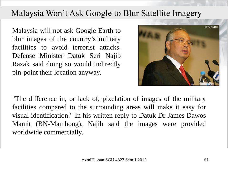
"The difference in, or lack of, pixelation of images of the military
facilities compared to the surrounding areas will make it easy for
visual identification." In his written reply to Datuk Dr James Dawos
Mamit (BN-Mambong), Najib said the images were provided
worldwide commercially.
Malaysia will not ask Google Earth to
blur images of the country’s military
facilities to avoid terrorist attacks.
Defense Minister Datuk Seri Najib
Razak said doing so would indirectly
pin-point their location anyway.
Malaysia Won’t Ask Google to Blur Satellite Imagery
61 AzmiHassan SGU 4823 Sem.1 2012