land expropriation for road construction (year 2)pdf.usaid.gov/pdf_docs/pnadi730.pdf · land...
TRANSCRIPT

Regional Infrastructure Program, 2001–2005
A USAID Initiative in South East Europe
Land Expropriation for Road Construction (Year 2)
Albania December 2002
04.029.03
Land Expropriation Assistance for Roads Table of Contents
Table of Contents
CHAPTER I – EXECUTIVE SUMMARY ................................................................................ 1
CHAPTER 2: INTRODUCTION................................................................................................ 3
CHAPTER 3: PROJECT GOALS AND OBJECTIVES.......................................................... 4
CHAPTER 4: LEGAL ASPECTS OF LAND EXPROPRIATION......................................... 5 4.1 REGISTRATION ISSUES ..................................................................................................... 5 4.2 NOTIFICATION ............................................................................................................... 10 4.3 EXPROPRIATION COMMISSION ....................................................................................... 11 4.4 INVOLUNTARY RESETTLEMENT ..................................................................................... 12
CHAPTER 5: BUILDING TECHNICAL CAPACITY IN THE EXPROPRIATION DEPARTMENT .......................................................................................................................... 18
5.1 INFORMATION SYSTEM REQUIREMENTS DEFINITION ..................................................... 18 5.2 OFFICE AUTOMATION TECHNOLOGY ............................................................................. 18 5.3 DEVELOPMENT OF DOCUMENT MANAGEMENT PROCESS FOR EXPROPRIATION
DEPARTMENT................................................................................................................. 18 5.4 SELECTION AND IMPLEMENTATION OF TECHNOLOGY.................................................... 19
CHAPTER 6: DIGITAL SPATIAL REFERENCING ........................................................... 20 6.1 DIGITAL ORTHOPHOTO MAPS ........................................................................................ 20 6.2 DIGITAL CONVERSION OF REGISTRATION INDEX MAPS................................................. 20 6.3 DIGITAL SUBDIVISION PLANS ........................................................................................ 21
CHAPTER 7: EDUCATION AND TRAINING ...................................................................... 22 7.1 PROPOSED TRAINING COURSE CATALOG FOR THE EXPROPRIATION DEPARTMENT
STAFF ............................................................................................................................ 22 7.2 ASSISTANCE WITH CURRICULUM UPGRADING FOR EDUCATION INSTITUTIONS.............. 22 7.3 QUALITY CONTROL FRAMEWORK.................................................................................. 22
CHAPTER 8: REVISION OF EXPROPRIATION MANUAL AND CADASTRAL ZONES ATLAS........................................................................................................................... 23
8.1. LAND EXPROPRIATION PROCEDURES MANUAL ............................................................. 23 8.2. CADASTRE ZONE ATLAS SHOWING STATUS OF FIRST REGISTRATION ........................... 23
CHAPTER 9: RECOMMENDATIONS................................................................................... 24 9.1 LEGAL RECOMMENDATIONS .......................................................................................... 24 9.2 TECHNICAL RECOMMENDATIONS .................................................................................. 25 9.3 INSTITUTIONAL RECOMMENDATIONS............................................................................. 25
USAID SEE Regional Infrastructure Program - i - Booz Allen Hamilton
Land Expropriation Assistance for Roads Table of Contents
ANNEXES ................................................................................................................................ 27
ANNEX I...................................................................................................................................... 28
ANNEX II .................................................................................................................................... 34
ANNEX III................................................................................................................................... 54
ANNEX IV................................................................................................................................... 61
ANNEX V .................................................................................................................................... 97
ANNEX VI................................................................................................................................. 205
ANNEX VII ............................................................................................................................... 238
USAID SEE Regional Infrastructure Program - ii - Booz Allen Hamilton

Land Expropriation Assistance for Roads List of Tables and Figures
List of Tables and Figures
Figure 1: Atlas Map
Figure 2: Atlas Map
Figure 3: Atlas Map – Sheet 1
Figure 4: Atlas Map – Sheet 2
Figure 5: Atlas Map – Sheet 3
Figure 6: Atlas Map – Sheet 4
Figure 7: Atlas Map – Sheet 5
Figure 8: Atlas Map – Sheet 6
Figure 9: Atlas Map – Sheet 7
Figure 10: Atlas Map – Sheet 8
Figure 11: Atlas Map – Sheet 9
Figure 12: Atlas Map – Sheet 10
Figure 13: Atlas Map – Sheet 11
Figure 14: Atlas Map – Sheet 12
Figure 15: Atlas Map – Sheet 13
Figure 16: Atlas Map – Sheet 14
Figure 17: Atlas Map – Sheet 15
Figure 18: Atlas Map – Sheet 16
Figure 19: Process of Expropriation Program
Figure 20: Sample of Registration Index Map
Table 1: Status of First Registration along the Albanian National Highway Corridors
Table 2: Quality Control Framework
USAID SEE Regional Infrastructure Program - iii - Booz Allen Hamilton

Land Expropriation Assistance for Roads Executive Summary
CHAPTER I – EXECUTIVE SUMMARY
Activity A-11 under the Regional Infrastructure Program (RIP)
Albania assisted the Government of Albania to improve the processes used to acquire land for the facilitation of the construction and reconstruction of roads in the National Roads Network. The Ministry of Transport and Telecommunications (MoTT) is responsible for acquiring land and uses several institutions and organizations to determine the land boundaries, identify and notify the owners of the intention to expropriate the land, prepare the relevant documentation, evaluate the land, approve the acquisition and compensate the owners. The present processes can be improved and made more efficient through improvements to the legislation (laws and regulations), compliance with existing legislation, introduction of technology, and improvements in the institutional arrangement including academic, public and private institutions. The tasks carried out under Activity A-11 assisted the Expropriation Department of the General Roads Directorate (GRD) with ways and means to resolve these issues. The existing expropriation legislation was reviewed and several recommendations are presented that if implemented, will improve the functioning of the laws. A procedures manual to guide the staff of the Expropriation Department and others who perform expropriation activities was prepared and later updated to ensure that standard procedures and processes are followed by all stakeholders. The Expropriation Department focused its energies on identifying the properties for expropriation, determining the physical size and shape of the properties, and presenting the information to the Expropriation Commission for approval to expropriate and to provide compensation to the owners. A final step in completing and formalizing the transfer of the ownership rights from the landowner to the state is the registration of the property in the Immovable Property Registration System (IPRS). This step has not been taken for any properties that have been expropriated for roads construction and rehabilitation anywhere in Albania. Expropriation for road related works commenced in 1994 and to date it is estimated that approximately 7,000 properties have been expropriated and are unregistered. In some cases, such as for the road between Tirana and Vore, the documentation that is needed as evidence that legal expropriation took place is missing. Activity A-11 addressed the issue of non-registration of the properties and assisted the Expropriation Department to develop procedures to correct the situation. Special procedures were developed and a joint order between the IPRS and the MoTT to implement the procedures was formalized. Two pilot projects were prepared and implemented to define and to demonstrate a process to clear up the backlog of unregistered properties and to legalize the transfer ownership rights to the state. One pilot site was selected in an area where all the necessary documents to provide evidence of legal expropriation could be located and presented to the IPRS for registration. A second site was selected for an area where the legal documentation is missing and other means of creating evidence were introduced. The A-11 team developed digital map products that showed the road and where it overlapped the old road and any areas that it crossed sections of private property. These digital products were created by combining aerial photography and the
USAID SEE Regional Infrastructure Program - 1 - Booz Allen Hamilton

Land Expropriation Assistance for Roads Executive Summary
Registration Index Maps (RIM). A description of the process, the technology and the products are provided in section six of this report. The procedures were tested on the first site and the results were satisfactory to all parties. The test for the second site (where the documentation is missing) was prepared and completed, now is awaiting for a legal decision from the highest level, to finalize the registration. The technical procedures that were developed to prepare the evidence have been widely accepted and both the Expropriation Department and IPRS are recommending that it be accepted as standard practice for future expropriation. The issue of training the Expropriation Department was addressed and a Training Course Catalog for a training program to provide technical and management training was prepared and presented to the Director of GRD. The framework is meant to provide a guide for course content, to establish priorities for staff and management training and to provide a sense of the level of effort required for each course. A framework was developed to establish a Quality Control (QC) program in the Expropriation Department (see Appendix VII). The implementation of a QC program in the Expropriation Department would not only improve the quality of the products and services offered by the department but would also provide the administration with supporting documentation to justify the implementation of new technology, training programs, and improved processes and procedures. The experience gained by the Expropriation Department and the A-11 Team over the duration of the work provided a base to create many recommendations to further improve the expropriation procedures and processes that would lead to a more effective and efficient property acquisition. The recommendations are presented in three groups: legal, technical, and institutional. This is done such that the Expropriation Department can clearly focus on the acquisition of the appropriate resources for the implementation of each set of recommendations independently. Activity A-11 was the continuation of Activity A-1-2-3 that started in March 2001. Activity A-11 was successfully concluded in November 2002 and this Final Report was conducted in December 2002
USAID SEE Regional Infrastructure Program - 2 - Booz Allen Hamilton

Land Expropriation Assistance for Roads Introduction
CHAPTER 2: INTRODUCTION
Albania assisted the Government of Albania to improve the process used to acquire land for the facilitation of the construction and rehabilitation of roads in the National Roads Network. The MoTT is responsible for acquiring land and uses several institutions and organizations to determine the land boundaries, identify and notify the owners of the intention to expropriate the land, prepare the relevant documentation, evaluate the land, approve the acquisition and compensate the owners. The present processes can be improved and made more efficient through improvements to the legislation (laws and regulations), compliance with existing legislation, introduction of technology, and improvements in the institutional arrangement including academic, public and private institutions. The tasks carried out under the Activity A-11 assisted the Expropriation Department of the GRD with ways and means to resolve these issues.
USAID SEE Regional Infrastructure Program - 3 - Booz Allen Hamilton

Land Expropriation Assistance for Roads Project Goals and Objectives
CHAPTER 3: PROJECT GOALS AND OBJECTIVES
The goals and broad objectives of Activity A-11 were: 1. To assist the GRD with the revision of existing procedures and the development and
implementation of new policies and procedures for acquiring property and for preparing documents to enable registration of the properties in the IPRS;
2. To create the internal capacity to implement projects and to develop and sustain new programs; and
3. To introduce modern technology and methodologies for information management, project management, quality control and project monitoring and evaluation within the GRD.
The more specific objectives were: • To develop procedures for registration of the backlog of expropriation decisions; • To introduce digital methods to produce technical documents in support of expropriation of
private properties and to facilitate registration of the documents in the IPRS within the timeframe specified in the legislation;
• To provide the Expropriation Department with the capacity to reduce the time taken to conduct expropriation of immovable property;
• To implement quality control in the production of expropriation documents and to reduce the number of errors;
• To develop a training course catalog for training courses that need to be provided to the Expropriation Department in order to develop and sustain the capacity necessary to perform its responsibilities for acquisition of immovable property for road corridors; and
• To provide a simple information management system in the GRD that would allow the management and control of the documents handled by them.
To meet these project goals and objectives a series of tasks reported on in this document were defined, prepared, and implemented over the duration of the project.
USAID SEE Regional Infrastructure Program - 4 - Booz Allen Hamilton

Land Expropriation Assistance for Roads Legal Aspects of Land Expropriation
CHAPTER 4: LEGAL ASPECTS OF LAND EXPROPRIATION
4.1 Registration Issues
One of the most important outstanding issues, with respect to land expropriation, facing the MoTT is the non-registration of expropriation decisions in the IPRS. The laws in Albania require that any transfer of ownership to be registered in the IPRS before the change of ownership rights is legal. To date, the MoTT has not registered any expropriation decision since expropriation for road corridors commenced in 1994. Thus, the State does not have legal title to the land that has been expropriated for the national road system. During the course of 2002, the A-11 team compiled and assessed data concerning unregistered expropriation decisions. Several difficulties were encountered, in particular a lack of legal documentation that is required for registration purposes. The GRD does not have a comprehensive archive and many documents prior to 1999 are missing. Nevertheless, with the knowledge of the GRD and IPRS staff technical and legal information was derived from available documentation. New technology, through the use of digital archives and orthophoto maps, was introduced as a mechanism to determine some of the missing information. Based on existing legal documents, from the period 1999-2001, there have been 4,000 expropriations with a value of more than US$10 million. If one considers the expropriations that were made from 1994-1999 and in 2002, it is estimated that there have been a total of more than 7,000 expropriations conducted throughout the country. Since none of the expropriations have been legally registered, several millions of dollars of investments from international donors and the Albanian government remain unsecured. In order to assist the MoTT and the GRD in creating procedures for registration of both past and future expropriations, two pilot road sections were selected; Tirana-Vore and the road through the village of Karbunara in the Lushnje Rrogozhine road. The Tirana-Vore section is located on the main highway connecting Tirana to Durres. The old, existing road was widened into a four-lane road. Expropriation to accommodate the widening began in 1994. No legal documentation to support the expropriation is currently available. The A-11 team made an extensive search of several organizations in an attempt to find the documents but all efforts failed. The Karbunara section is a new road. Expropriation began in 1999 and complete legal documentation exists. These two sections represent the spectrum from relatively easy to extremely difficult cases and registration procedures have been developed accordingly. These procedures have been accepted by the IPRS and will be applied for the registration of all outstanding expropriation decisions.
4.1.1 Legal Requirements for Registration According to Law 7843, On Registration of Immovable Property (1994) all immovable property in Albania must be registered in the IPRS (see Appendix VI).
USAID SEE Regional Infrastructure Program - 5 - Booz Allen Hamilton

Land Expropriation Assistance for Roads Legal Aspects of Land Expropriation
Article 8 states: “Each volume of the Register Book in the immovable property registry shall include a register for each publicly owned immovable property and a register for each privately owned immovable property.” Article 11 - Required Registration:
“Any contract or other document affecting rights to immovable properties shall be presented for registration no later than thirty days from the time the instrument or other document is executed.” Article 38 - The Registration of Transfer of Ownership by Law, by Judgment of the Court, or by Administrative Acts: “Where the State or any physical or legal person has become entitled to the right of ownership of any immovable property, has contracted a lease or has acquired a mortgage based on a law, court decisions or any administrative agency, the Registrar shall, on the application of any interested person supported by such evidence as the Registrar may require, register the State, physical or legal person as the proprietor.”
Thus, publicly owned property must be registered in the IPRS and the government must follow the legally defined procedures for transacting a property, including when acquiring ownership through expropriation.
4.1.2 Responsibility for Registration- Administrative Structure The existing administrative structures for registration of expropriation decisions within the MoTT, the proposed structures within the GRD, how the structures relate to the IPRS and some of the administrative issues that have been identified are presented in the following sections of the report.
Within the Ministry of Transport and Telecommunications
In a meeting with the MoTT Vice Minister and the Head of the Legal Department of the MoTT in April, 2002, the A-11 team recommended that the Ministry assign the responsibility for registration of expropriation decisions to a specific entity in the MoTT. The legal advisor explained that there is no specific unit within the MoTT designated by law to register expropriation decisions. However, it is understood that the Ministry has assigned the responsibility to the GRD. In April 2002, the General Director of the GRD presented a new administrative structure and discussed it with the A-11 team. The new structure includes a sector within the Expropriation Department titled “Transcription Sector” which will have 4 people. Although registration has legal implications and should normally be the responsibility of the legal department, the Expropriation Departament staff indicated that they know more about the IPRS and registration requirements than the GRD legal staff. Even if the legal department agreed to perform the registration, it would be difficult and time consuming to train them in registration procedures.
USAID SEE Regional Infrastructure Program - 6 - Booz Allen Hamilton

Land Expropriation Assistance for Roads Legal Aspects of Land Expropriation
The A-11 team agreed with this assessment and, continued to support the Expropriation Department in developing the procedures for registration. It was proposed that the Transcription Sector be responsible for registration. The General Director expressed his willingness to write the job descriptions for the Transcription Sector according to the recommendations of the A-11 Team and to involve the consultants in the hiring process. However, subsequently the General Director has been replaced and the restructuring has not taken place. If the restructuring takes place, it is imperative that any new personnel are trained on the IPRS laws and regulations.
Relationship with IPRS
Throughout the A-11 Team consultancy several issues were discussed with the Chief Registrar of the IPRS. The first issue had to do with the administrative procedures for registration. All Registration Index Maps (RIM),and the Kartelas as legal documents pertaining to a property are kept in the respective local IPRS offices. To legally register an expropriation decision, it is necessary to present an application and copies of all documentation to the relevant IPRS office. Any information needed to prepare for expropriation such as (RIM) and ownership lists, must be obtained from the respective District IPRS Offices. Note: The IPRS was created in 1994 on the basis of Law 7843 in order to provide a comprehensive cartographic and legal registry for all immovable property in Albania, whether public or private, urban or rural. The IPRS is a parcel-based system. Each property is identified with a unique number that is reflected on the Registration Index Map and the registration Kartela. The Registration Index Map defines the geographic position and location of a property and the Kartela reflects all ownership and other real rights to a property.
4.1.3 Technical Documents Needed for Registration
Availability of Documents
Two pilot road sections were chosen in order to define the proper procedures for registration; the road section Tirana-Vore and the road through the village of Karbunara in Lushnje Rrogozhine road. These two sections were chosen because First Registration of the cadastral zones for these areas has been completed. The IPRS Registrars for these zones are very experienced and were able to provide helpful insight and alternatives throughout the document preparation and application for registration process. The Tirana-Vore section was originally expropriated in 1994. As the team set out to find the maps and other documentation, it became clear that locating documents, especially for those expropriations done prior to 2000, is very difficult since no detailed or complete archive exists in the GRD.
Quality
There is difficulty in ascertaining whether the documents on file in the Expropriation Department are the initial design plans or the ‘as-built’ plans. For registration purposes, the ‘as-built’ plan is required. The version of the plans presented to the A-11 Team was identified through the personal knowledge of the engineers working in the GRD, not through a clear recording or archive system.
USAID SEE Regional Infrastructure Program - 7 - Booz Allen Hamilton

Land Expropriation Assistance for Roads Legal Aspects of Land Expropriation
One of the easiest ways to link the information from the road corridor design plans to the IPRS RIMs is by using the national grid coordinates. However, no coordinates are available for the GRD documents. Therefore, it is necessary to produce alternative procedures for linking the two sets of data. In areas where the proper technical and legal documentation was not available it was necessary to recreate the information. A new methodology using aerial photography and Geographic Information Systems (GIS) was used to produce the information. Aerial photography of the road corridors was completed in 2001. Through the use of orthophoto maps, missing information was created using the following steps (see Section six for more detail & Appendix III): 1. Scan RIM 2. Produce Orthophoto maps 3. Geo- reference RIM to Orthophoto map 4. Digitize RIM 5. Digitize the body of the road 6. Overlay RIM onto Orthophoto (Step 1 added to Step 2) 7. Create final RIM
4.1.4 Procedures for Registration of Past Expropriation Decisions This section describes the current legal requirements and procedures for registration of an expropriation decision. The A-11 Team has worked with the GRD and IPRS offices to draft simplified procedures for registration of the expropriated properties and to formally transfer ownership from the private owners to the State. In the following section, these simplified procedures will be defined.
Legal Requirements The first step for expropriating land and transferring ownership to the state is found in Law 7843, Article 22- Transfers of Part of the Immovable Property: “No part of the immovable property included in a register shall be transferred unless the proprietor has first subdivided the immovable property, in accordance with the law, and new registers have been opened in respect of each subdivided portion of the immovable property.” When the government wants to expropriate a section of land for a road, that section must be a separate parcel, uniquely identifiable on both the (RIM) and Kartela. Thus, if the government is expropriating only a portion of a parcel, the original parcel must be subdivided into the parcel that will be expropriated and the parcel that will remain in private ownership. Each new parcel will receive a unique identification number and Kartela and the expropriation transfer act will then be registered on the appropriate Kartela. Only after these steps are followed is the land legally transferred to the state. The following documentation must be submitted to the relevant district IPRS office for an approval to subdivide land parcels:
1. A written request for the subdivision. 2. A survey by a licensed engineer that reflects the new boundaries of the parcels.
USAID SEE Regional Infrastructure Program - 8 - Booz Allen Hamilton

Land Expropriation Assistance for Roads Legal Aspects of Land Expropriation
Recommended Simplified Procedures
The lengthy procedures for registering a transaction that involves parcel subdivisions and new registrations are time consuming and will pose a significant time and financial burden on both the IPRS and MoTT/GRD. In practical terms, it will prohibit the MoTT from fulfilling the requirements and the properties will remain unregistered. Since the integrity of the IPRS relies on having complete, up-to date and accessible information about property, allowing the thousands of expropriation decisions to remain unregistered would harm the IPRS. Furthermore, international donors such as USAID and the EU have invested over $25 million in creating the IPRS. Allowing the Government of Albania to absolve itself of its responsibilities of building and retaining the integrity of the IPRS may have ramifications on further donor support to the IPRS and the land market in general. Through discussions with the Lushnje and Tirana Registrars and field trips to the two pilot areas, proposals for a more simple and cost effective registration procedure were developed. Resulting from A-11 efforts a Joint Order agreeing between the MoTT and the IPRS to implement the proposed procedures was signed on July 26, 2002. The Order recognizes the importance of registering expropriation decisions and reflects the commitment of both parties to proceed with registration and outlines the procedures for completing the registration process. (See Appendix-I Joint Order between MoTT & IPRS) The Chief Registrar agreed to make an exception to the strict legal requirements for transfer of ownership and also agreed to a reduced fee structure. A Guideline for Registration of Expropriation Decisions, where legal documentation is complete, was then issued by the Chief Registrar. (See Appendix I- Guideline for Registration of Expropriation Decisions). In September, the A-11 Team and GRD presented all documents required for registration of 54 expropriated properties in the Karbunara (Lushnje- Rrogozhine road) pilot zone. The IPRS office in Lushnje tested the simplified registration procedures in the Karbunara Pilot and now the road is successfully registered in the name of the state. A problem remains for those zones where legal documentation is missing, as is the case in the second pilot, road Tirana-Vore. In October, 2002, the A-11 Team met with the Chief Registrar, the IPRS Legal Advisor and the Tirana 1 Registrar to discuss registration of the road and expropriation decisions in the Tirana-Vore pilot. Early in the process, the lack of legal documentation was identified as an impediment to registration. Through the use of new technology such as digital photogrammetry, the information was recreated and presented to the IPRS for discussion. From the technical standpoint the information is acceptable and can be easily integrated into the cartographic sector of the IPRS. However, the fact that there is no copy of the expropriation decision remains a problem. As a result of the October meeting and to resolve the problem, the following steps will be taken: 1. The Expropriation Department will submit all available information to the IPRS 2. The IPRS will open a file for the information presented 3. The IPRS will send a formal request to legalize the information to the MoTT, Ministry of
Agriculture and Food (MoAF), Council of Ministers, Project Management Unit (PMU)/IPRS, Local Government (Komuna and District) and the Savings Bank (who made the payments for compensation).
USAID SEE Regional Infrastructure Program - 9 - Booz Allen Hamilton

Land Expropriation Assistance for Roads Legal Aspects of Land Expropriation
4. If any of these entities is able to supply a copy of the decision, the registration will proceed.
If no information is found, the IPRS will send a formal request to the Legal Department in the Council of Ministers asking how to proceed and offer the solution found by RIP.
Although this decision is not the full registration foreseen by the A-11 Team, it is a prudent step by the Chief Registrar. Since no document to verify that the expropriation was legal is available to support the registration application, the Chief Registrar must act appropriately to protect the integrity of the IPRS. The information, especially the new RIM showing the road, will be available and will be a useful reference tool in the Tirana office. Full registration will have to wait until the legal basis is provided.
4.1.5 Procedures for Registration of Future Expropriation Decisions In the future, registration of expropriation decisions should be done based on Law 7843. Through the implementation of the Expropriation Procedures Manual and the use of the new technology developed during the Tirana-Vore pilot phase, all necessary legal and technical documentation can be produced and submitted to the IPRS in a timely and cost effective manner. Additional technical assistance is necessary to help the Expropriation Department systematically implement the procedures defined in the manual and to introduce the use of the new technology into the Expropriation Department. Through the project these concepts have been defined and it has been clearly demonstrated that the skills and technology currently exists in the private sector in Albania. 4.2 Notification
According to Law 8561, On Expropriation, Article 14, Notification of Application for Expropriation, states:
“Within 10 days from the date of entering into the agreement with the applicant for expropriation, the competent ministry begins fulfilling the procedures of direct notification to each owner or joint owner of the private properties sought to be expropriated or devalued as well as to third persons related to their compensation. Together with the procedures of notification, the competent minister also performs those of publication of the request for expropriation in a public interest.”
Article 15, Publication of Application for Expropriation in a Public Interest, states:
“To make it possible to protect the rights and interests of third persons in or because of the private property sought to be expropriated, at the same time as the notification of the application for expropriation in a public interest pursuant to point 1 of article 14 of this law, the competent ministry publishes the expropriation application in the Official Journal, in a newspaper with national circulation and in a local newspaper for a one week period.”
In addition, Council of Ministers Decision 127 (March, 2000) contains the notification form that is to be sent to each owner. The idea behind the law is to give formal notice to individuals that expropriation will take place and to present the offer for compensation. Although property
USAID SEE Regional Infrastructure Program - 10 - Booz Allen Hamilton

Land Expropriation Assistance for Roads Legal Aspects of Land Expropriation
owners do not have the right to dispute the decision for expropriation, according to Article 24, they have 30 days from the time of notification to dispute the amount of compensation. The Expropriation Department has expressed concern about the difficulty of trying to send personal notification to all property owners. Although the law states that the Expropriation Commission is responsible for sending the notices, the burden is presently (informally) with the Expropriation Department. Considering the lack of a comprehensive and reliable postal system in Albania and the difficulty in finding the owners (many of whom live abroad), the legislated procedures have not been followed. Furthermore, the Expropriation Department is of the opinion that the fieldwork during the design phase and the gathering of ownership documentation gives the property owner ample notification that expropriation will take place at some point in the future. Therefore, it seems that individual notification is most important for the purposes of identifying the exact time the expropriation will take place and the amount of compensation that is offered. In order to fulfill these two important aspects, a formal letter of notification should be sent to the local government units (Kommuna and Village). These notices should be displayed for the public to see. In conjunction with the publication in the national newspapers, adequate notification can be provided even if it does not comply with the formal requirements of the law. 4.3 Expropriation Commission
The A-11 Team reviewed the mandate and functions of the Expropriation Commission. The review concluded that the Expropriation Commission performs a valuable function as a body that oversees the expropriation process and provides a conscious judgment of the need and the cost of performing the expropriation. There are a few procedural changes that could be implemented that would bring operational efficiencies to the Expropriation Commission’s job. Otherwise no change in the mode of operation of the Expropriation Commission is necessary in order to conduct real property expropriation in Albania. There has been concern expressed by the Expropriation Department of the GRD that, although according to the regulations of the Expropriation legislation it is the Expropriation Commission’s responsibility to provide notification of expropriation to the property owners, the Expropriation Department ultimately must undertake this function. Some recommendations are provided in Section 4.2 above to resolve this problem. Decision Number 126, (March, 2000) provides for the creation of Expropriation Commission and defines the composition and work procedures of the Commission. The Expropriation Commission is to be chaired by the Deputy Minister of the competent Ministry, which in this case is the MoTT. The Expropriation Commission is to consist of no less than 5 members. Decision Number 147 (March, 2000) lays out “the rules and manner of functioning of the Expropriation Commission. According to the Decision:
The chairman, at his/her discretion, can call specialist(s) (in addition to the Commission members; these specialists have no right to vote on motions) to the meetings to give explanations and clarification on any issues.
USAID SEE Regional Infrastructure Program - 11 - Booz Allen Hamilton

Land Expropriation Assistance for Roads Legal Aspects of Land Expropriation
The minister of the competent ministry has the right to send a Commission decision back to the Commission for re-examination “for lawful causes and with good reason” although lawful causes and good reason are not defined on the regulations. A technical secretary is assigned to the Commission at the time of creation of the Commission. The defined duties and responsibilities of the technical secretary cover the majority of the duties assigned to the Commission under Decision 126.
It is not clear in Decisions Number 126 and Number 147 how frequently the Expropriation Commission is required to meet nor is there a clear definition of the types of decisions they are expected to make. The duties are defined but these are administrative duties and can be performed by the technical secretary. These duties are predetermined and established and are not based on any decisions of the Commission. Nevertheless, the Expropriation Commission fulfills an important role in the evaluation and monitoring of the expropriation process. In particular, the monitoring role of the Expropriation Commission should be enhanced, with random review of GRD work done to ensure the integrity of the information. 4.4 Involuntary Resettlement
Involuntary resettlement of people affected by infrastructure projects has become an important issue with the international donor community, in particular with the World Bank. In 2001, the World Bank issued two guidelines, OP 4.12 and BP 4.12, which contain some of the main principles and procedures for resettlement of persons affected by expropriation. In April, 2002, the World Bank issued a Handbook for Preparing a Resettlement Action Plan (Handbook) in order to provide guidance in designing and implementing resettlement action plans. The basic principles of the policy are: 1. Involuntary Resettlement should be avoided. 2. Where Involuntary Resettlement is unavoidable, all people affected by it should be
compensated fully and fairly for lost assets. 3. Involuntary Resettlement should be conceived as an opportunity for improving the
livelihoods of the affected people. And 4. All people affected by Involuntary Resettlement should be consulted and involved in the
resettlement planning. A brief review of the main principles found in the World Bank documents was made and relevant portions of the Guidelines and Handbook were assessed for discrepancies with Albanian legislation or policies. In general, Albanian law conforms to World Bank policy. Only with respect to OP 4.12 (15) is there a potential problem with Albanian legislation, however, in the case of the Durres Port, special action by the Government of Albania was taken in order to comply with donor policy.
4.4.1 General Review In reference to expropriation of property with corresponding cash compensation, the World Bank Guideline OP 4.12 (December, 2001) states:
USAID SEE Regional Infrastructure Program - 12 - Booz Allen Hamilton

Land Expropriation Assistance for Roads Legal Aspects of Land Expropriation
“...12. Payment of cash compensation for lost assets may be appropriate where: ... (b) active markets for land, housing, and labor exist, displaced persons use such markets, and there is sufficient supply of land and housing;...
Albania has an increasingly active market in immovable property. There are no major legal impediments to the land market that prevent displaced persons from purchasing alternative land with the compensation received from the government as a result of the expropriation process. Furthermore, Law 8561, On Expropriations and Temporary Takings of Private Property for a Public Interest (1999), and corresponding Council of Ministers Decisions define the procedures for expropriation. Of particular relevance is Council of Ministers Decision 138 (2000) that requires compensation to be based on the fair market value of similar property:
“1. The valuation of a site shall be set as the average of purchases and sales at the Immovable Property Registration Office (IPRO). The average of purchases and sales shall be set based on the interested region where the expropriation for a public interest is realized. The time period for calculating the average shall not be longer than the three months preceding the date when the application is made...”
Although Albanian Legislation generally complies with World Bank policy requirements, there is one area where Albanian law where problems may arise in future donor funded projects. Guideline OP 4.12 (December, 2001) states:
“...15. Criteria for Eligibility. Displaced persons may be classified in one of the following three groups: ... (c) those who have no recognizable legal right or claim to the land they are occupying. 16. Persons covered under paragraph 15(a) and (b) are provided compensation for the land they lose, and other assistance in accordance with paragraph 6. Persons covered under paragraph 15(c) are provided resettlement assistance in lieu of compensation for the land they occupy, and other assistance, as necessary, to achieve the objectives set out in this policy, if they occupy the project area prior to a cut-off date established by the borrower... “
OP 4.12 embodies the principle that a lack of legal land title does not disqualify people from resettlement assistance. When a review of relevant Albanian legislation is made, some discrepancies with this principle are noted. Specifically, according to Law 8405, On Urban Planning (1998), under the section titled ‘Illegal Buildings And The Arbitrary Occupation Of Sites’, Article 76 states:
“Buildings without permits are considered illegal. The mortgaging or registration of these buildings in immovable property registers is prohibited. For the benefit of the implementation of urban plans, no indemnity or expropriation shall be made for illegal buildings, neither by state organs nor by the private persons who are implementing urban plans approved by the competent organs.”
The rationale behind the provisions in Law 8405 is clear when one considers the situation in Albania. Since 1991, there has been a mass migration of people from the mountainous and rural zones to the urban areas. The state, and even the increasingly open land market, was unable to
USAID SEE Regional Infrastructure Program - 13 - Booz Allen Hamilton

Land Expropriation Assistance for Roads Legal Aspects of Land Expropriation
provide housing for the large influx of people. As a result, people have occupied both state and privately owned land and illegally built houses without the benefit of urban planning or adequate infrastructure. Law 8405 is a mechanism that allows the state to conduct urban planning without having to compensate the recent squatters. Nevertheless, Law 8405 Article 76 is not incompliance with World Bank policy. However, Albania does have some experience in resettlement assistance to persons who illegally occupy land. The development plan for the Durres Port was hindered by a number of families illegally occupying the Port property. Over a 2-year period, the Albanian Government addressed the issue of resettlement for the families and passed special legislation pertaining to the Port situation. (See 4.4.3 below for a detailed description of Durres Port resettlement issues and resolutions). But the Durres Port problem was approached on an ad hoc basis. When another situation involving resettlement arises, the process will have to begin all over again without the benefit of policies, guidelines or legislation. It is highly recommended that a basic set of guidelines that incorporate past experience, relevant legislation and practical solutions be developed and adopted by ministries for future use.
4.4.2 Legal Framework of a Resettlement Plan The Handbook requires that all World Bank financed projects that involve involuntary resettlement complete a Resettlement Action Plan (RAP) that contains the following:
1. ID project impacts and affected populations. 2. A legal framework for land acquisition and compensation. 3. A compensation framework. 4. A description of resettlement assistance. 5. A detailed budget. 6. An implementation schedule. 7. A description of organizational responsibilities. 8. A framework for public consultation, participation. 9. A description for redress of grievances. And 10. A framework for monitoring and evaluation. Point Two above requires an analysis of the relevant legal framework. Although a full legal analysis should be completed at a later date, a brief description of Albanian legislation that can affect resettlement is given below. The Handbook defines the following four areas as a requisite part of the legal framework analysis: 1. The scope of the power of Eminent Domain and the nature of compensation associated with
it, both the procedures for assessing compensation values and the schedule for making compensation payments.
2. The legal and administrative procedures applicable, including the appeals process and the normal time for such procedures.
3. Land Titling and Registration Procedures. And
USAID SEE Regional Infrastructure Program - 14 - Booz Allen Hamilton

Land Expropriation Assistance for Roads Legal Aspects of Land Expropriation
4. Laws and regulations relating to the agencies responsible for implementing resettlement and
those related to land compensation, consolidation, land use, environment, water use and social welfare.
For Points one and two - the scope of the power of Eminent Domain and the schedule for making compensation payments- there are several laws and Council of Minister’s Decisions that are relevant to the process. In 1998, Parliament approved the Constitution. Protection of property rights is one of the most important issues covered. Article 41 states:
“...The law may provide for expropriations or limitations in the exercise of a property right only for public interests. The expropriations or limitations of a property right that are equivalent to expropriation are permitted only against fair compensation...”
The 1998 Albanian Constitution provides adequate protection of property rights. Article 41 is especially important for the expropriation process that is occurring for large infrastructure projects, especially for the improvement of the national road network and the large Corridor 8 highway that connects the port city of Durres to Istanbul, Turkey. In addition, Law 8561, On Expropriations And Temporary Takings Of Private Property For A Public Interest (1999), and four Council of Ministers Decisions define the procedures for expropriation of immovable property, valuation, notification, appeals and payment disbursements. Although some areas of the law could be improved, in general, the law meets international standards and has been implemented in an acceptable manner. Regarding Point 3, Land Titling and Registration Procedures, Law 7843, On Registration of Immovable Property (1994) sets out the legal requirements and procedures for valid registration and transfer of ownership. Finally, concerning Point 4, laws and regulations relating to the agencies responsible for implementing resettlement, land compensation, consolidation, land use, environment, water use and social welfare the following applies: Albania does not have any specific law for resettlement. The recent example for resettling people affected by infrastructure projects was done on an ad hoc basis and required a special Council of Ministers Decision. Land Consolidation, land use, environment and water use fall under the direction of the Ministry of Agriculture and Food and the new Ministry of Environment. Law 8934, On Protecting the Environment, (September, 2002) was just passed and will have ramifications on future planning and infrastructure projects. Social Welfare issues are under the responsibility of the Ministry of Labor and Social Support.
4.4.3 Case Study- Durres Port The Durres Port Authority (DPA) is in the process of implementing a master plan for improving and expanding the port facilities. One of the impediments to the implementation of the master plan was a large group of illegal settlers on the Port property. The process of resettling the families continued over a five year period. A brief description of the process is described below.
USAID SEE Regional Infrastructure Program - 15 - Booz Allen Hamilton

Land Expropriation Assistance for Roads Legal Aspects of Land Expropriation
The first family to settle on the port property arrived in the early 1980s. The government was unable to provide housing for the Port workers and their families (approximately 20 families total) and allowed them to settle on the Port grounds “temporarily”. These families were never provided with permanent housing and with the political changes in the last decade, more families arrived in Durres and settled illegally on the Port property. Some families occupied existing buildings while other built their own homes. The problem was recognized in 1993 but no action was taken until 1996-1997. Some families moved when they were offered money by the government but most families chose to stay. The government then forcibly destroyed approximately five homes but the process stopped, probably due to intervention from the donor community and the social instability of that time. The government made several lists of the families before the final list was approved. The final list was made in 2000. Many governmental entities were included in the process of resettlement including the DPA, the Durres National Housing Agency, the Ministry of Local Government (MoLG), The MoTT, the Municipality of Durres etc. The initial legislation used to support the resettlement process was Law 8030 (1993), On Homelessness. Procedures were set up and documents required from the families were defined. In total, the families had to provide the DPA with nine documents from various government agencies (i.e. the Cadastre office, the Hipoteke office, the National Housing Agency, the local government, the Urban Planning office, the Civil Registry etc.). In 2000, the families were then certified by the Municipality as ‘homeless’ and eligible to receive assistance. However, the legal officers at the Prefekt level refused to co-sign the Municipality’s certification on the grounds that the families could not be retroactively declared homeless. At this point the process was stalled. Finally, the Council of Ministers issued a decision granting special government funds to rehabilitate an old warehouse formerly used for the tobacco industry. The MoAF transferred the warehouse property to the Durres Housing Agency. The site was rehabilitated and the families were moved to the new location in September, 2002. Families were given rental contracts from the Durres Housing Agency. The Head of the Family was required to sign a Declaration that stated the family agreed to move voluntarily and it identified the number of family members and the proposed size of the apartment. Some of the families are unhappy with the new site because the standards used to assign space were the former communist standards. Thus, a family with 2-5 persons received a one-room apartment while a family with 6+ members received a two-room apartment. In September 2002, the DPA provided trucks to the families and moved them to the new location. The properties on the DPA site were immediately destroyed in order to prevent the families from returning or new families entering. Nevertheless, some new families have entered onto DPA property. The DPA has notified these families that they will be forcibly evicted by the local authorities. In addition to the problem over the size of apartments offered to the families, other concerns have emerged. It has been the general policy of the National Housing Agency to privatize apartments and drastically reduce the amount of property owned by the state. However, the former cigarette warehouse property cannot be privatized to the occupants because the property is subject to Law 7698, On Restitution of Property to Ex-owners, (1993). A Restitution
USAID SEE Regional Infrastructure Program - 16 - Booz Allen Hamilton

Land Expropriation Assistance for Roads Legal Aspects of Land Expropriation
Commission Decision as been issued that grants the ex-owner the right to pre-purchase the property if/when the state decides to privatize it. The current situation infringes on both the rights of the involuntary re-settlers as well as the rights of the ex-owner. The best solution would be for the state to formally expropriate the property, compensate the ex-owner and then privatize the apartments to the occupants. A second problem has been identified related to the further expansion of the port according to the master plan. Specific areas have been designated for the expansion of the port. The DPA will implement legislation relating to expropriation for that area, however, a significant number of properties were built illegally. Thus, the DPA will be faced with the same issue of relocation in the near future. Legal owners will receive compensation for their property, however, according to Law 8405, On Urban Planning (1998), owners of illegal buildings are not eligible for compensation. Nevertheless the donor policy on involuntary resettlement will force the DPA to provide alternative housing and business opportunities for a significant number of families and extensive private investment, both legal and illegal.
USAID SEE Regional Infrastructure Program - 17 - Booz Allen Hamilton

Land Expropriation Assistance for Roads Building Technical Capacity in the Expropriation Department
CHAPTER 5: BUILDING TECHNICAL CAPACITY IN THE EXPROPRIATION DEPARTMENT
The technical capacity of the Expropriation Department is weak and needs support in order to improve the efficiency of the operations. The weakness is due to the lack of technology and the skills to appropriately apply technology to the operations of the organization. Activity A-11 intended to provide technical assistance to help develop the technical skills and information management system development and implementation. It must be noted that no funding was intended for the supply of hardware and software. All implementation of training and system development was to be done on GRD provided hardware and software. 5.1 Information System Requirements Definition
The project attempted to assist the GRD with the implementation of an information system for managing and maintaining the data used to operate the office. The General Director of GRD agreed to cooperate and to provide access to data and information that would allow the development and implementation of the system. The General Director also shared a plan that would include the purchase and implementation of 60 computers for the GRD. The computers would be networked and would allow for data sharing and information dissemination between departments. Consultants and local information technology specialists commenced initial work on the system requirements definition. However, after several visits to the GRD and some initial preparation the work was suspended. RIP was informed that the General Director was replaced and that the priorities of the GRD were changed with the appointment of the new General Director. As a result of the change in priorities the information system was no longer in the new operational plan for the GRD. The initiative was suspended and no further work was done. The new Director General was briefed on the intent of the project and the offer of technical assistance was once again made by RIP. However, the General Director did not respond with any request for assistance. 5.2 Office Automation Technology
As part of the information technology system development the A-11 Project intended to scope out the technology necessary to automate some of the routine office functions such as preparation of spreadsheets for expropriation of properties, completion of forms and reports, etc. though the implementation of a database management system. This objective was linked to the overall corporate information system development and was suspended when the system development ceased. 5.3 Development of Document Management Process for Expropriation Department
The development of a document management process for the Expropriation Department was linked to the overall information technology system development for the GRD. The document management system was prepared but has not been implemented. It was postponed indefinitely when the information technology system development was postponed. However a simple Document Management System was developed and installed at the MoTT.
USAID SEE Regional Infrastructure Program - 18 - Booz Allen Hamilton

Land Expropriation Assistance for Roads Building Technical Capacity in the Expropriation Department
5.4 Selection and Implementation of Technology
The information system requirements were not completed. Therefore, no technology is required since no implementation was to take place.
USAID SEE Regional Infrastructure Program - 19 - Booz Allen Hamilton

Land Expropriation Assistance for Roads Digital Spatial Referencing
CHAPTER 6: DIGITAL SPATIAL REFERENCING
The Project introduced the use of digital spatial referencing technology for locating property boundaries, determining the relationship of the boundaries to the road corridor limits and preparing subdivision plans for the expropriated properties. The tools used for digital spatial referencing consists of digital photogrammetry, geographic information systems, database management tools, digital scanners, and modern surveying and mapping technology. To demonstrate the use of the technology the Expropriation Department was given a copy of an orthophoto map on which the property boundaries were shown as an overlay. The technical staff took the orthophoto map to the field and is using it as a tool to locate the property boundaries and to determine the properties that need to be expropriated to construct the service road along the road from Tirana to Vore. 6.1 Digital Orthophoto Maps
Orthophoto maps or what is more commonly referred to as “orthophotos” are aerial photographs that have been rectified to correct for distortions caused by camera movements during flight and that have been mathematically corrected to compensate for image displacements caused by terrain relief. The A-11 Team prepared digital orthophotos of the section of the road between Tirana and Vore. The aerial photographs for the area of interest were obtained from the PMU/IPRS. The aerial photographs clearly show the road and adjacent properties. The aerial photographs were scanned to convert them to digital format such that they can be used in a software program (Softcopy Photo) to produce digital orthophoto maps. During the rectification process the coordinates of points in the photographs are referenced to their corresponding points in the ground coordinate system (National Geodetic Network). This allows for the determination of the geographic location of objects such as streets, roads, buildings, etc. in the photo image. The road is easily identified on the orthophotos and the coordinates of the center line were digitized to establish its location. The width of the road was obtained from the Expropriation Department and using an “offset from the center line procedure” the coordinates of the limits of the road were determined. The limits were plotted on the orthophotos and a polygon representing the road was created. 6.2 Digital Conversion of Registration Index Maps
Copies of the RIMs produced at a scale of 1:2500 were obtained from the IPRS. The RIMs show the land parcel boundaries, streets, roads and other physical features such as streams and railroads. The index maps were scanned; the parcel boundaries were digitized, extracted from the index maps, and overlaid on the digital orthophotos. The road polygon and the parcel boundaries were highlighted on the digital orthophotos. The road polygon was transferred to the digital RIMs. The area of overlap between the individual parcel boundaries and the road polygon is the area that is accepted as the amount of property expropriated from each property. A new copy of the RIMs showing the road was printed for submission to the IPRS as evidence of the expropriation and as supporting
USAID SEE Regional Infrastructure Program - 20 - Booz Allen Hamilton

Land Expropriation Assistance for Roads Digital Spatial Referencing
documentation that will be used as evidence to change the legal status of the IPRS RIMs and the Kartelas. It should be noted that there are approximately 1,500 cadastral zones in Albania that have digital cadastral data for both the Kartelas and the RIM. The data is available to anyone wishing to purchase a copy from the Central IPRS Office in Tirana. 6.3 Digital Subdivision Plans
According to the Law On Registration Immovable Property, a subdivision plan must be prepared by a licensed surveyor for each parcel that is subdivided into tow or more parts and a copy of the plan must accompany the registration application prior to acceptance of the application for the subdivided property into the IPRS. The design contractors prepare the road design in digital format using AutoCAD. The digital RIM, in conjunction with the digital engineering design drawings, will enable the Expropriation Department to prepare digital subdivision plans of the land parcels affected by expropriation. The highway design can be overlaid and spatially referenced to the RIM. The section of the property that falls within the limits of the designed highway corridor is the amount of land that must be expropriated and transferred to the state. The area of the property can be digitally calculated, outlined, extracted, and pasted into a document to create a subdivision plan that can be used to compensate the owner and to register the expropriation in the IPRS.
USAID SEE Regional Infrastructure Program - 21 - Booz Allen Hamilton

Land Expropriation Assistance for Roads Education and Training
CHAPTER 7: EDUCATION AND TRAINING
The A-11 Team effort, was the development of a Training Course Catalog for use in the GRD. The catalog contains a list of courses, topics to be covered in the course, course duration, course venue, etc. A copy of the catalog is attached as Appendix II of this report. 7.1 Proposed Training Course Catalog for the Expropriation Department Staff
A proposed Training Course Catalog for the Expropriation Department was prepared and presented to the GRD Director for use at such time when sufficient funding is available to pay for training. The proposed training program includes training in office management, basic computer skills, legislation related to immovable property expropriation, and quality control procedures. The Training Course Catalog is attached as Appendix II. 7.2 Assistance with Curriculum Upgrading for Education Institutions
Some effort was made to work with the educational institutions to upgrade the educational programs. The A-11 Team met with officials of the University of Tirana and discussed the curriculum for land management and land use planning. One lecture on land administration and land management was presented during the implementation of A-11. 7.3 Quality Control Framework
The A-11 Team provided assistance to the Expropriation Department to develop a framework for a Quality Control program. The framework was developed in order to have Quality Control for the steps in the process carried out by the Expropriation Department when expropriating immovable property for the creation of a road corridor. The implementation of a quality control program in the Expropriation Department would not only improve the quality of the products and services offered by the department but would also provide the administration with supporting documentation to justify the implementation of new technology, training programs, and improved processes and procedures. (See Appendix VII).
USAID SEE Regional Infrastructure Program - 22 - Booz Allen Hamilton

Land Expropriation Assistance for Roads Revision of Expropriation Manual
CHAPTER 8: REVISION OF EXPROPRIATION MANUAL AND CADASTRAL ZONES ATLAS
8.1. Land Expropriation Procedures Manual
The Land Expropriation Procedures Manual has been revised and updated to reflect new procedures that have been developed to accommodate mass registration of the backlog of expropriated properties that should have been registered at the time they were expropriated. These expropriations, estimated to be in excess of 5,000 properties, were done between the years 1994 and 2001. It is estimated that as much as US$12,000,000 has been spent by the Government of Albania to the purchase of immovable property since 1994. It is important to register these properties and transfer the ownership rights to the State in order to secure the investment made by the Government. (See Appendix V). 8.2. Cadastre Zone Atlas Showing Status of First Registration
An Atlas showing the status of first registration for all cadastre zones along the National Roads Network in the Republic of Albania was prepared. This is a document should be updated yearly as the first registration of the cadastre zones along the National Roads Network progresses. If first registration is completed for the cadastre zone for which expropriation is to take place it is easy for the Expropriation Department to determine the ownership of the land by researching the records in the IPRS. If first registration is not completed the Department must rely on field research, local knowledge, or documents provided by the local citizens. The Expropriation Department can refer to the Atlas and determine immediately if first registration is completed. A copy of the Atlas was also provided to the USAID contractor that will be continuing first registration of the non registered properties in Albania. It will assist the contractor to determine the areas of priority for first registration. The Atlas is provided as Appendix IV of this report.
USAID SEE Regional Infrastructure Program - 23 - Booz Allen Hamilton

Land Expropriation Assistance for Roads Recommendations
CHAPTER 9: RECOMMENDATIONS
The recommendations are grouped and presented according to the legal, technical or institutional nature of the activities to be undertaken to implement them. This is done such that the Expropriation Department can clearly focus on the acquisition of the appropriate resources for the implementation of each set of recommendations independently. 9.1 Legal Recommendations
The legal recommendations are further broken into subsets of legal problems.
9.1.1 Registration 1. There is a large backlog of expropriated properties that must be registered on the IPRS. The
Expropriation Department does not have enough experience and resources to do the registration. Therefore, legal and technical assistance should continue to help develop and implement an Action Plan for registration of the backlog of expropriations;
2. The registration pilot projects conducted under Activity A-11 were limited in scope and covered only a small sample of the properties that must be registered. Consequently, it is highly likely that several problems will arise that have not been covered to date. Continued assistance should be provided to help further refine the procedures for registration of cases with unique problems such as missing information; and
3. The Expropriation Department staff has not had formal training in registration related activities. Therefore, formal training should be provided to them to better prepare the staff to conduct expropriation and registration procedures. This should be a high priority when considering training for the staff.
9.1.2 Notification 1. Presently, the Expropriation Department does the notification but according to the
regulations it is the responsibility of the Expropriation Commission. The MoTT should formally assign the responsibility for preparing and distributing notification of expropriation activities.
2. The decentralization of authority for the management of local resources such as immovable property puts the burden of formally managing all lands within the limits of the regional governments. The Expropriation Commission should provide formal notice of expropriation directly to the Local Government; and
3. Many citizens do not have access to radio, television or newspaper which is the standard medium used to provide notification of expropriation of property. Notices should be posted in public buildings frequented by local citizens in order to ensure that all citizens, including those who do not have access to other forms of notification, will be aware that expropriation activity will be taking place in their area.
USAID SEE Regional Infrastructure Program - 24 - Booz Allen Hamilton

Land Expropriation Assistance for Roads Recommendations
9.2 Technical Recommendations
Activity A-11 demonstrated new technology and new methodologies for the production of expropriation documents in the Expropriation Department. The department is not capable of implementing these technologies and methodologies with its current human and financial resources. To better establish these it is recommended that at least six months of technical assistance be provided to GRD on use of new technological approaches such as Computer Aided Design, GIS, and Orthorectified aerial photography. The capacity in GRD for planning, monitoring and evaluation functions is very limited at the present time. There is a need to introduce technology and to provide training for the staff to effectively operate and maintain the technology.
The Expropriation Procedures Manual prepared by the A-11 team with assistance from the Expropriation Department should be tested through application of the procedures to a section of road where expropriation will take place. It is recommended that: 1. A Pilot Project should be designed and implemented to:
• conduct expropriation according to the procedures laid out in the Manual of Procedures for Expropriation;
• train Expropriation Department staff in the use of the Manual; • train Expropriation Department staff in legislation associated with expropriation and
registration of property; and • deliver documentation for expropriated properties to the IPRS within the 30 day period
after expropriation is conducted as per in the legislation; and 2. The Expropriation Department should request resources to implement digital technology into
its operations to be compatible with the technology used by the design contractors and to improve its efficiency in dealing with design drawings and for preparing documentation in support of expropriation.
9.3 Institutional Recommendations
9.3.1 Resettlement 1. Frequently citizens occupy land illegally and construct homes. Although, these constructions
are illegal the State can not evict a family and leave them without shelter. The law presently does not provide direction on how to handle these situations. The issue of resettlement of informal property occupants should be addressed in the legislation such that there is a standard approach and it will not be necessary to establish a process on a case by case basis as is currently the situation.
2. A standard framework for future resettlement issues should be developed to prevent the ad hoc treatment of the issue and to help reduce the amount of time needed to complete the process, thus preventing unnecessary delay in beginning an infrastructure project. And
USAID SEE Regional Infrastructure Program - 25 - Booz Allen Hamilton

Land Expropriation Assistance for Roads Recommendations
3. Many other pieces of legislation touch on the issue of social responsibility for housing and
poverty alleviation. It is important to understand the interaction of the various legislative acts and their impact on expropriation, social responsibilities for housing and urban and rural development. A complete legal review of relevant legislation should be undertaken and should be used as part of the standard documentation for Resettlement Action Plans.
9.3.2 The Transcription Sector
The Transcription Sector within the GRD needs to be properly staffed and trained in order to fulfill the requirements for registration of all past and future expropriation decisions.
USAID SEE Regional Infrastructure Program - 26 - Booz Allen Hamilton
Land Expropriation Assistance for Roads List of Annexes
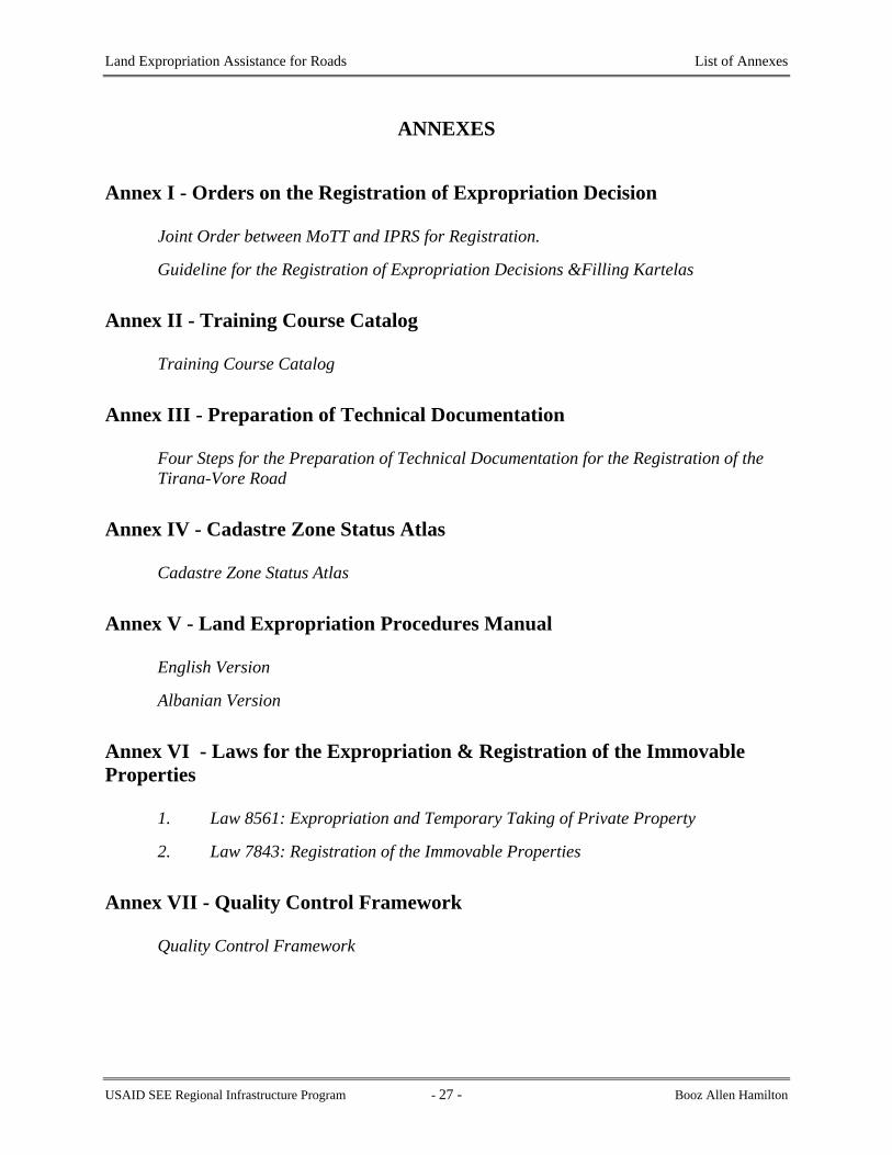
ANNEXES
Annex I - Orders on the Registration of Expropriation Decision
Joint Order between MoTT and IPRS for Registration.
Guideline for the Registration of Expropriation Decisions &Filling Kartelas
Annex II - Training Course Catalog
Training Course Catalog
Annex III - Preparation of Technical Documentation
Four Steps for the Preparation of Technical Documentation for the Registration of the Tirana-Vore Road
Annex IV - Cadastre Zone Status Atlas
Cadastre Zone Status Atlas
Annex V - Land Expropriation Procedures Manual
English Version
Albanian Version
Annex VI - Laws for the Expropriation & Registration of the Immovable Properties
1. Law 8561: Expropriation and Temporary Taking of Private Property
2. Law 7843: Registration of the Immovable Properties
Annex VII - Quality Control Framework
Quality Control Framework
USAID SEE Regional Infrastructure Program - 27 - Booz Allen Hamilton

Land Expropriation Assistance for Roads Annex I
ANNEX I
ORDERS ON THE REGISTRATION OF THE EXPROPRIATION DECISIONS
Joint Order Between MoTT and IPRS Guidelines on Registration of Expropriation Decision and Filling the Kartelas
USAID SEE Regional Infrastructure Program - 28 - Booz Allen Hamilton

Land Expropriation Assistance for Roads Annex I
REPUBLIKA E SHQIPERISE REPUBLIKA E SHQIPERISE MINISTRIA E TRANSPORTIT DHE ZYRA QENDRORE E REGJISTRIMIT TELEKOMUNIKACIONIT TE PASURIVE TE PALUAJTSHME
NR.________PROT. NR.____________PROT.
ORDER
Nr. ______ dated 26.07.2002
FOR WORK PROCEDURES FOR EXPROPRIATION AND REGISTRATION IN
THE IMMOVABLE PROPERTY REGISTRATION SYSTEM OFFICES In order to create better working conditions for the process of expropriation of roads, to determine a better relationship between the two institutions as well as to register expropriation decisions for those Cadastral Zones that have entered the IPRS, based on Article 4 of Law 7843, On Registration of Immovable Property (1994), and Law 8561, On Expropriation and Temporary Takings of Private Property in the Public Interest, (1999), WE ORDER For immovable property subject to expropriation for defined road axis, the General Roads Directorate (GRD) shall present a request for cartographic and ownership information to the relevant District IPRS using Standard Form 1 (attached). For the above-mentioned properties, the IPRS Office shall, within 10 days, provide the GRD with the following documentation:
1. Copy of Registry Index Map (RIM) 2. Copy of 3rd printing list by parcel number 3. Any other information that can assist the GRD for expropriation (origin of property
ownership, state owned property etc.) Within the GRD, the engineer responsible for the road segment shall work with the transcription department personnel to complete the following steps:
USAID SEE Regional Infrastructure Program - 29 - Booz Allen Hamilton

Land Expropriation Assistance for Roads Annex I
a. Update the copy of the RIM by drawing the axis and boundaries of the road according to the
design plans.
It is important that the GRD personnel use the “As Built” engineering drawings to update the RIM because the original design plans may have changes.
b. The transcription personnel of the GRD will then update the 3rd printing lists. Individual
parcels are identified by the Parcel Index Number (PIN) on the RIM. The corresponding number on the 3rd printing list of parcels should be located and the area of the property that has been expropriated (according to the Decision for Expropriation) should be noted next to the number that reflects the original surface area of the property.
After the Council of Ministers Decision has been issued, as soon as the copy of the RIM and 3rd printing list have been updated by the GRD team, the following documents will be submitted to the IPRS District Office for registration:
1. The Copy of the RIM with the road segment presented on it 2. The Council of Ministers Decision for Expropriation 3. A copy of the “As Built” engineering drawings that reflect the field work for
expropriation and includes the information for the parcel boundaries and other information gathered during the survey process.
All Council of Ministers Decisions for expropriations issued up to 31.07.2002 shall be registered in the respective IPRS offices.
The deadline for registration is 31.12.2002 The GRD and District IPRS are responsible for implementing this order. Signed:
Vice Minister Chief Registrar Sadetin Stankaj Gavrosh Pogace
USAID SEE Regional Infrastructure Program - 30 - Booz Allen Hamilton

Land Expropriation Assistance for Roads Annex I
REPUBLIKA E SHQIPERISE
Zyra Qëndrore e Regjistrimit të Pasurive të Paluajtshme
Adresa: Rr: “Jordan Misja” ish godina e Elektronikës; Tel +355/4/233713; Fax: +355/4/234419;
Guidelines on
Registration of Expropriation Decision and Filling the Kartelas Tiranë, 10/09//2002 Based on Joint Order Nr. ______, dated 26/07/02 between the Ministry of Transport and Telecommunications and the Central Office of the Immovable Property Registration System, District Registration Offices will register expropriation decisions for the national highways according to the documentation defined in the above-mentioned Order. In this Instruction the documents that the General Roads Directorate (GRD) must present to the District Immovable Property Registration Offices (IPRO) are defined as well as the cases and manner for recording information on the Immovable Property Registration Kartelas. Documents that the GRD presents to the District IPRO:
1. Official Request for Registration from the General Director of the GRD. 2. The working list of property expropriations, stamped with the GRD seal. 3. A copy of the Council of Ministers Decision for Expropriation, stamped with the GRD
seal on each page. 4. A copy of the updated Registration Index Map (RIM), signed by the GRD engineer
responsible for that road segment and stamped with the GRD seal. 5. A copy of the As-Built design plans, stamped with the GRD seal on each page.
Steps to be completed by the IPRS: Case 1
For cases where the existing road is widened or where the new road does not bisect the original parcel
USAID SEE Regional Infrastructure Program - 31 - Booz Allen Hamilton

Land Expropriation Assistance for Roads Annex I
1. The land parcel where the expropriation occurs will retain the same Parcel Index Number (PIN) and the new information (surface area) will be recorded on the original Kartela. The change in the surface area will be reflected in Section B of the Kartela on the next available line used for updating. The IPRS archive number for the Decision for Expropriation will be noted on the Reference line.
2. a. For cases when the road is widened, the existing Kartela for the road retains the
same PIN and the new information (surface area) will be recorded on the original Kartela. The change in the surface area will be reflected in Section B of the Kartela on the next available line used for updating. The IPRS archive number for the Decision for Expropriation will be noted on the Reference line.
b. For cases where the new road segment does not bisect the original parcel, the road
segment will be assigned a new PIN according to IPRS rules, a new Kartela will be opened and the road will be registered in the name of the State. (or in more detail according to the forthcoming rules under Laws 8743 and 8744 relating to public property and transfer to local government).
3. In the “Special Notes” section of the original Kartela, a brief description of the area that
was expropriated in favor of the state will be recorded along with a reference to the new PIN and volume and page number of the new Kartela.
Case 2
For Cases where the road segment bisects the original parcel:
1. The land parcel where expropriation occurs (the largest piece of the land parcel) will
retain the same PIN and the new information (surface area) will be recorded on the original Kartela. The change in the surface area will be reflected in Section B of the Kartela on the next available line used for updating. The IPRS archive number for the Decision for Expropriation will be noted on the Reference line.
2. The road segment will be assigned a new PIN according to IPRS rules, a new Kartela will
be opened and the road will be registered in the name of the State. (or in more detail according to the forthcoming rules under Laws 8743 and 8744 relating to public property and transfer to local government).
3. The new (smaller) parcels that have been created by the division of the original parcel
and the new road parcel will be assigned a new PIN according to IPRS rules, a new Kartela will be opened and the parcel will be registered in the name of the private owner(s).
In the “Special Notes” section of the original Kartela, a brief description with the details of the expropriation will be noted:
USAID SEE Regional Infrastructure Program - 32 - Booz Allen Hamilton

Land Expropriation Assistance for Roads Annex I
a. The area of the expropriation that has been transferred into state ownership with a reference to the new PIN and the volume and page number of the Kartela.
b. The area of the new (smaller) parcel with a reference to the new PIN and the volume and page number of the Kartela.
The ‘Application for Registration of Property’ will be used to register expropriation decisions. The ‘Application for Registration of Property’ will be completed only for the road and any adjacent canals. For those properties affected by the road, the application for sub-division shall be used. If the volume of work is large, it is not necessary to fill out an application for each property, rather one application shall be used for all parcels with the same base number. According to the agreement between the IPRS and the Ministry of Transport and Telecommunications, the final date for registering expropriated property as of 31/07/02 will be 31/12/02. After this date, the provisions regarding late fees according to the Law On Registration of Immovable Property will be applied. Signed, Gavrosh POGACE Chief Registrar
USAID SEE Regional Infrastructure Program - 33 - Booz Allen Hamilton

Land Expropriation Assistance for Roads Annex II
ANNEX II
TRAINING COURSE CATALOG
USAID SEE Regional Infrastructure Program - 34 - Booz Allen Hamilton

Land Expropriation Assistance for Roads Annex II
U.S. Agency for International Development
RIP - ALBANIA
Balkans RegionalInfrastructure Program
for Water and Transport
Booz | Allen | Hamilton
TTRRAAIINNIINNGG CCOOUURRSSEECCAATTAALLOOGG
This training course catalog has been developed to
meet the current training needs of the ExpropriationDepartment of the General Roads Directorate
November 2002
USAID SEE Regional Infrastructure Program - 35 - Booz Allen Hamilton

Land Expropriation Assistance for Roads Annex II
INTRODUCTION
This proposed training framework contains a course catalog that has been prepared by the Regional Infrastructure Program (RIP) for the benefit of the Expropriation Department (ED) of the General Roads Directorate (GRD) under the Ministry of Transport and Telecommunications (MoT&T). The Catalog presents a list of courses along with course descriptions, general content, course scope, and other information necessary to prepare and deliver the courses whenever financial resources are available to the ED. For nearly two years the RIP has been providing assistance to the ED in an effort to improve the processes and procedures used to acquire property to facilitate the rehabilitation and reconstruction of the National Roads Network in Albania. Over the course of the various consultancies provided, the need for training in the ED is the most common thread running through the conclusions and recommendations. The courses contained in this catalog have been selected as a result of reviewing the consultant reports and identifying the most frequently referenced gaps in knowledge and skills of the staff. In each of the consultancies the ED staff has been consulted and has provided input into the training needs. This catalog reflects these needs. The courses in the catalog have been grouped in five categories and assigned a group identification letter according to the following scheme:
Category Group Identification Letter Expropriation Procedures A Office Management B Basic Computing Skills C Property Legislation D Computer Graphics E
Each course in the group is given a sequential number. For Example, on page 1 the Category “Expropriation Procedures” is assigned group A and the course “Office Research and Data Collection” is assigned the number 1. Therefore, the Course Identification Number is A_1. The course catalog, as presented, is intended to identify course requirements and gives an overview only of the content, duration and scope. It is important to understand that these elements, and others listed in the tables, for each course should be reviewed and revised as necessary in order to better reflect the specific concepts and to meet the requirements of the targeted audience at the time of course delivery. It should also be noted that requirements for training may change over the interim period between the preparation of the material presented here and the delivery of the courses and that other courses may need to be added to the training program.
EC Expropriation Commission ED Expropriation Department GRD General Roads Directorate IPRS Immovable Property Registration System MoT&T Ministry of Transport and Telecommunications QC Quality Control
USAID SEE Regional Infrastructure Program - 36 - Booz Allen Hamilton

Land Expropriation Assistance for Roads Annex II
Expropriation Department, General Roads Directorate
Proposed Training Framework Course Catalog
Category: Expropriation Procedures Course Name & ID No: Office Research and Data Collection; A-1 Rational: Much of the data necessary to commence and support expropriation procedures are available in the institutions such as the Immovable Property Registration System (IPRS) and the Commune administration centers. The Expropriation Department (ED) staff must be familiar with the sources of information and how to access the information Description
Information on the expropriation related data contents, location, contact persons, data media types and formats, and information access policies of the IPRS, commune center, Ministry of Transport & Telecommunications MoT&T)
Levels/Scope Level: Introductory; (It is recommended that this course be repeated frequently to provide up-to-date information and ideas gained as a result of ongoing practice) Scope: Limited to issues pertaining to expropriation information access and acquisition
Objectives
At the end of the training, trainees will be able to determine the relevant source of data for expropriation and how to access and acquire the data
Main Activities Training sessions in the GRD, visits to IPRS, and local communes offices
Instructional Materials Prepared lecture notes, Expropriation Procedures Manual Support Materials
Expropriation forms, design drawings, registration office materials (kartelas, index maps, certificates)
Evaluation/Completion Procedures
Certificate at completion course
Location / Venue
GRD offices, and/or GRD meeting room with visits to IPRS and Commune centers
Intended Audience Management/Technical/Support Staff of the GRD Selection Criteria Offered only to Expropriation Department staff
Duration: Several days (2 – 3 days) Format Workshops, and field trips Instructors
Local specialists (maybe need some assistance from international specialists)
Scheduling High Priority Estimated Cost
Cost of delivering the course will be per trainee or as a lump sum to be determined prior to delivery
USAID SEE Regional Infrastructure Program - 37 - Booz Allen Hamilton
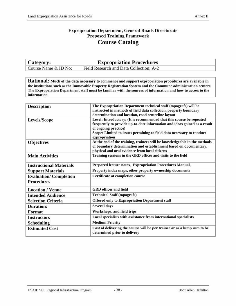
Land Expropriation Assistance for Roads Annex II
Expropriation Department, General Roads Directorate
Proposed Training Framework Course Catalog
Category: Expropriation Procedures Course Name & ID No: Field Research and Data Collection; A-2 Rational: Much of the data necessary to commence and support expropriation procedures are available in the institutions such as the Immovable Property Registration System and the Commune administration centers. The Expropriation Department staff must be familiar with the sources of information and how to access to the information Description
The Expropriation Department technical staff (topografs) will be instructed in methods of field data collection, property boundary determination and location, road centerline layout
Levels/Scope Level: Introductory; (It is recommended that this course be repeated frequently to provide up-to-date information and ideas gained as a result of ongoing practice) Scope: Limited to issues pertaining to field data necessary to conduct expropriation
Objectives
At the end of the training, trainees will be knowledgeable in the methods of boundary determination and establishment based on documentary, physical and oral evidence from local citizens
Main Activities Training sessions in the GRD offices and visits to the field
Instructional Materials Prepared lecture notes, Expropriation Procedures Manual, Support Materials Property index maps, other property ownership documents Evaluation/ Completion Procedures
Certificate at completion course
Location / Venue GRD offices and field Intended Audience Technical Staff (topografs) Selection Criteria Offered only to Expropriation Department staff Duration: Several days Format Workshops, and field trips Instructors Local specialists with assistance from international specialists Scheduling Medium Priority Estimated Cost
Cost of delivering the course will be per trainee or as a lump sum to be determined prior to delivery
USAID SEE Regional Infrastructure Program - 38 - Booz Allen Hamilton

Land Expropriation Assistance for Roads Annex II
Expropriation Department, General Roads Directorate
Proposed Training Framework Course Catalog
Category: Expropriation Procedures Course Name & ID No: Expropriation Application Preparation; A-3 Rational: Applications to the Ministry of Transport for approval to expropriate properties are often incomplete and or inaccurate. This training is to train the support staff of the Expropriation Department to properly complete and verify the accuracy of information in the application forms Description
The Expropriation Department support staff will be trained to properly complete and verify the accuracy of information in the application forms.
Levels/Scope Level: Introductory; This course should be mandatory for all new staff commencing employment at the ED Scope: Preparation of forms
Objectives
At the end of the training, support staff in the Expropriation Department will be able to accurately prepare applications for submission to the Ministry of Transport and the Expropriation Commission
Main Activities Training sessions in the GRD Expropriation Department office
Instructional Materials Expropriation Procedures Manual Support Materials Expropriation forms Evaluation/ Completion Procedures
Certificate at completion course
Location / Venue GRD office Intended Audience Support Staff Selection Criteria Offered only to Expropriation Department staff Duration: One day Format One on one in GRD office Instructors MoT&T Monitoring Department staff Scheduling Medium priority Estimated Cost Cost of delivering the course will be per trainee or as a lump sum to be
determined prior to delivery
USAID SEE Regional Infrastructure Program - 39 - Booz Allen Hamilton

Land Expropriation Assistance for Roads Annex II
Expropriation Department, General Roads Directorate
Proposed Training Framework Course Catalog
Category: Expropriation Procedures Course Name & ID No: Registration Procedures; A-4 Rational: To create awareness within the GRD of the IPRS registration procedures and processes to work more efficiently with the IPRS for registration of the expropriated properties Description
The Expropriation Department technical staff responsible for preparation of registration of the expropriated properties will be trained in the process and process used at the IPRS to register the properties
Levels/Scope Level: Introductory Scope: Preparation of registration requests and supporting documents
Objectives
To make the staff of the Expropriation Department aware of the registration procedures in the IPRS such that they can better appreciate the need for preparation of documents in a particular format, standard and sequence for submission to the IPRS for registration
Main Activities
Expropriation Department will observe and note the registration procedures and requirements for registering property at the IPRS.
Instructional Materials Copy of procedures developed for Registration Pilot Sites
Support Materials IPRS application for registration forms and procedures documentation Evaluation/ Completion Procedures
Certificate at completion of the course
Location / Venue IPRS office Intended Audience Expropriation Department Support/technical Staff Selection Criteria Expropriation Department staff involved in registration of expropriated
properties Duration: Three days Format Observation of IPRS registration staff performing duties in IPRS office Instructors IPRS registration staff Scheduling High Priority Estimated Cost Cost of delivering the course will be per trainee or as a lump sum to be
determined prior to delivery
USAID SEE Regional Infrastructure Program - 40 - Booz Allen Hamilton

Land Expropriation Assistance for Roads Annex II
Expropriation Department, General Roads Directorate
Proposed Training Framework Course Catalog
Category: Expropriation Procedures Course Name & ID No: Notification Procedures; A-5 Rational: To ensure registration procedures are properly followed and the property owners are given notification according to the legislation Description
The Expropriation Legislation and all regulations will be examined and presented to the trainees to demonstrate the step by step process for effective notification to property owners
Levels/Scope Level: Introductory Scope: Training of Expropriation Commission Technical Secretary in the regulations, and the procedures for the preparation and distribution of notices of expropriation to appropriate media
Objectives
To prepare the Expropriation Commission support staff in the proper procedures, media outlets, and scheduling of expropriation notices
Main Activities Introducing the regulations and procedures for notification
Instructional Materials Expropriation Law and regulations
Support Materials No supporting materials Evaluation/ Completion Procedures
Certificate at completion course
Location / Venue Ministry of Transport Infrastructure Department Intended Audience Expropriation Commission support staff (technical secretary) Selection Criteria People that support the activities of the Expropriation Commission Duration: One day Format Workshop Instructors MoT&T Legal Specialist Scheduling Low priority Estimated Cost Cost of delivering the course will be per trainee or as a lump sum to be
determined prior to delivery
USAID SEE Regional Infrastructure Program - 41 - Booz Allen Hamilton

Land Expropriation Assistance for Roads Annex II
Expropriation Department, General Roads Directorate
Proposed Training Framework Course Catalog
Category: Office Management Course Name & ID No: Client/Customer Service; B-1 Rational: The staff of Expropriation Department must deal with clients on a daily basis but have not been trained in client/customer relations and how to deal with clients. Consequently, the client frequently leaves unsatisfied and have not received the advice, information, or other service for which the Department is responsible to provide Description
A one day training session on meeting, greeting customers, determining what service they require, information/documents that can be released and the cost of each, and making all possible efforts to ensure the customer receive the service due
Levels/Scope Level: Introductory; This course should be mandatory for all new employees of the ED Scope: Training in standard service provision by public sector agencies.
Objectives To prepare the Expropriation Department staff to provide quality and courteous service to the clients
Main Activities Lecturing to staff and role playing as client/customer and staff to demonstrate responses to queries, etc
Instructional Materials Customer service guide books or text books
Support Materials No particular supporting materials Evaluation/ Completion Procedures
Certificate at completion of the course material
Location / Venue Expropriation Department Intended Audience Expropriation Department staff Selection Criteria People that serve the general public, contractors, etc Duration: One day Format Workshop Instructors Private sector trainers in customer service Scheduling Low Priority Estimated Cost Cost of delivering the course will be per trainee or as a lump sum to be
determined prior to delivery
USAID SEE Regional Infrastructure Program - 42 - Booz Allen Hamilton

Land Expropriation Assistance for Roads Annex II
Expropriation Department, General Roads Directorate
Proposed Training Framework Course Catalog
Category: Office Management Course Name & ID No: Work & Workplace Management & Organization; B-2 Rational: The Expropriation Department staff has not had training in office work organization. They are specialists in the technical fields associated with surveying, mapping, construction and engineering but need some training in work organization and how to implement and manage efficient work flow
Description
A two day training session; the first day on work planning and management; the second day on office organization and management
Levels/Scope Level: Introductory Scope: Should focus on work planning, organizing and management in the workplace
Objectives To train the ED staff and management to better organize their work and be more effective in delivering daily tasks and recording level of effort for various tasks
Main Activities Lecturing and demonstrating organizational structuring
Instructional Materials Office Management Reference Books
Support Materials Office documents and work assignments Evaluation/Completion Procedures
Certificate at the completion of the course
Location / Venue Expropriation Department Intended Audience All Expropriation Department staff Selection Criteria Management/Technical/support responsibilities Duration: 2 days Format Workshop/Seminar Instructors Management consultants Scheduling High priority Estimated Cost Cost of delivering the course will be per trainee or as a lump sum to be
determined by supplier
USAID SEE Regional Infrastructure Program - 43 - Booz Allen Hamilton

Land Expropriation Assistance for Roads Annex II
Expropriation Department, General Roads Directorate
Proposed Training Framework Course Catalog
Category: Office Management Course Name & ID No: Personnel Management; B-3 Rational: The Expropriation Department staff has not had training in office work organization. They are specialists in the technical fields associated with surveying, mapping, construction and engineering but need some training in work organization and how to implement and manage efficient work flow
Description
A three day training session for managers that address the issues of managing personnel, including selecting, motivating, disciplining, and rewarding employees
Levels/Scope Level: Introductory Scope: Should focus on personnel management for public sector employees.
Objectives To train the ED management to better manage the staff and provide direction in ways that bring measurable results and accountability
Main Activities Lecturing.
Instructional Materials Organizational Behavior and Personnel management reference books
Support Materials Personnel management case studies Evaluation/ Completion Procedures
Certificate at completion of the course materials
Location / Venue Any location that such a course is offered Intended Audience Expropriation Department management Selection Criteria Offer to anyone that has a management role in the Department Duration: 3 days Format Workshop/Seminar Instructors Management consultants Scheduling High priority Estimated Cost Cost of delivering the course will be per trainee or as a lump sum to be
determined prior to delivery
USAID SEE Regional Infrastructure Program - 44 - Booz Allen Hamilton

Land Expropriation Assistance for Roads Annex II
Expropriation Department, General Roads Directorate
Proposed Training Framework Course Catalog
Category: Office Management Course Name & ID No: Project Planning and Management; B-4 Rational: The management of the ED has to plan the tasks, resources, and scheduling for expropriation activities associated with road construction projects. The management needs to understand and be knowledgeable in good project planning and management practices
Description
The course will focus on determining project tasks, setting priorities for undertaking tasks, setting schedules, assigning resources, and tracking progress of projects
Levels/Scope Level: Introductory Scope: Concentrated on topics and activities directly related to ED responsibilities
Objectives To provide the ED staff with the skills to plan and manage projects such that the budget and schedule will be met
Main Activities Lecturing
Instructional Materials Microsoft Project Manuals
Support Materials Project requirement documents Evaluation/Completion Procedures
Certificate at the completion of the course material
Location / Venue Any location that such a course is offered Intended Audience ED management Selection Criteria Offer to anyone that has a management role in the Department Duration: 3 days Format Workshop/Seminar Instructors Project management consultants Scheduling High priority Estimated Cost Cost of delivering the course will be per trainee or as a lump sum to be
determined prior to delivery
USAID SEE Regional Infrastructure Program - 45 - Booz Allen Hamilton

Land Expropriation Assistance for Roads Annex II
Expropriation Department, General Roads Directorate
Proposed Training Framework Course Catalog
Category: Office Management Course Name & ID No: Quality Control; B-5 Rational: There is presently no quality control process in place in the ED. There is a need to establish a quality control program to prevent errors and to increase the quality of documents produced by the Expropriation Department
Description A study of office operations, procedures for quality improvement, and methods for developing a long-term quality improvement strategy
Levels/Scope Level: Introductory Scope: Quality control of office documents
Objectives To improve the quality of products and documents prepared by the GRD.Main Activities Lecturing
Instructional Materials QC manuals/text books
Support Materials Case studies of QC projects Evaluation/Completion Procedures
Certificate at the completion of the course
Location / Venue Any location that such a course is offered Intended Audience ED management Selection Criteria Offer to anyone that has a management role in the Department Duration: 3 days Format Workshop/Seminar Instructors Quality Control specialists Scheduling Medium priority Estimated Cost Cost of delivering the course will be per trainee or as a lump sum to be
determined prior to delivery
USAID SEE Regional Infrastructure Program - 46 - Booz Allen Hamilton

Land Expropriation Assistance for Roads Annex II
Expropriation Department, General Roads Directorate
Proposed Training Framework Course Catalog
Category: Basic Computing Skills Course Name & ID No: Introduction to Basic Computing; C-1 Rational: Many of the staff members in the ED have not had training in the basics operation and fundamentals of computer technology
Description The course will introduce the student to the basics of the Windows operating system, basic terminology (drives, memory, hardware components) adding and removing software, basic file structures and organization, basic system performance and maintenance
Levels/Scope Level: Introductory Scope: This course should be limited to providing computer users with the information to start and navigate successfully through the Windows operating system
Objectives To provide the computer user with the skill and confidence to operate personal computers using a Windows operating system
Main Activities Lecturing and hands on practice of the material presented in the lectures
Instructional Materials Windows User manuals and system guides
Support Materials Samples of documents prepared by GRD Evaluation/Completion Procedures
Certificate at the completion of the course
Location / Venue Any location that such a course is offered Intended Audience Expropriation Department staff Selection Criteria All staff that will use a computer to perform assigned duties at the GRD Duration: 2 days Format Workshop/Seminar Instructors Computer consultants Scheduling Medium priority Estimated Cost Cost of delivering the course will be per trainee or as a lump sum to be
determined prior to delivery
USAID SEE Regional Infrastructure Program - 47 - Booz Allen Hamilton

Land Expropriation Assistance for Roads Annex II
Expropriation Department, General Roads Directorate
Proposed Training Framework Course Catalog
Category: Basic Computing Skills Course Name & ID No: Introduction to MS Office tools; C-2 Rational: The support staff at the ED must prepare correspondence, reports, applications, and other operational documents that require the use of MS Word and MS Excel. It is important that the appropriate training is provided in word processing and spreadsheet preparation to ensure more efficient use of computer technology and to create accurate and professional looking materials
Description The course will introduce the student to the fundamental functions of MS Word and MS Excel such as formatting documents, creating tables, creating diagrams, creating formulas, producing graphs, linking sheets
Levels/Scope Level: Introductory Scope: This course should be tailored to concentrate on providing the students with the knowledge to use the tools to produce documents and to conduct functions specific to the ED
Objectives To provide the ED staff with the skills to efficiently use the standard word processing and spreadsheet tools contained in MS Office
Main Activities Lecturing and hands on practice of the material presented in the lectures
Instructional Materials MS Office User manuals
Support Materials Examples of Word, Excel documents prepared by ED Evaluation/Completion Procedures
Certificate at the completion of the course
Location / Venue Any location that such a course is offered Intended Audience Expropriation Department staff Selection Criteria All staff that will use a computer to perform assigned duties at the ED Duration: 3 days Format Workshop/Seminar Instructors Computer consultants Scheduling Medium priority Estimated Cost Cost of delivering the course will be per trainee or as a lump sum to be
determined prior to delivery
USAID SEE Regional Infrastructure Program - 48 - Booz Allen Hamilton
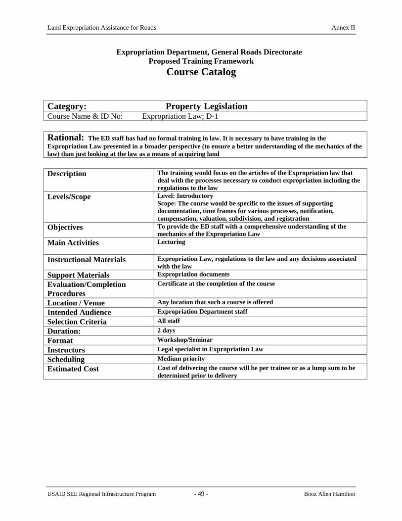
Land Expropriation Assistance for Roads Annex II
Expropriation Department, General Roads Directorate
Proposed Training Framework Course Catalog
Category: Property Legislation Course Name & ID No: Expropriation Law; D-1 Rational: The ED staff has had no formal training in law. It is necessary to have training in the Expropriation Law presented in a broader perspective (to ensure a better understanding of the mechanics of the law) than just looking at the law as a means of acquiring land
Description The training would focus on the articles of the Expropriation law that deal with the processes necessary to conduct expropriation including the regulations to the law
Levels/Scope Level: Introductory Scope: The course would be specific to the issues of supporting documentation, time frames for various processes, notification, compensation, valuation, subdivision, and registration
Objectives To provide the ED staff with a comprehensive understanding of the mechanics of the Expropriation Law
Main Activities Lecturing
Instructional Materials Expropriation Law, regulations to the law and any decisions associated with the law
Support Materials Expropriation documents Evaluation/Completion Procedures
Certificate at the completion of the course
Location / Venue Any location that such a course is offered Intended Audience Expropriation Department staff Selection Criteria All staff Duration: 2 days Format Workshop/Seminar Instructors Legal specialist in Expropriation Law Scheduling Medium priority Estimated Cost Cost of delivering the course will be per trainee or as a lump sum to be
determined prior to delivery
USAID SEE Regional Infrastructure Program - 49 - Booz Allen Hamilton

Land Expropriation Assistance for Roads Annex II
Expropriation Department, General Roads Directorate
Proposed Training Framework Course Catalog
Category: Property Legislation Course Name & ID No: Urban and Rural Planning Legislation; D-2 Rational: The GRD staff has had no formal training in law. It is necessary to have training in the Urban and Rural Planning Law in order for the staff to understand the interconnectivity of the planning and zoning legislation and regulations and how it can impact on the expropriation process and acquisition of the property for highway corridors
Course Identification No. D-2
Description The training would focus on the articles of the Urban and Planning Law that regulate land use, address property valuation, and that address illegal construction
Levels/Scope Level: Introductory Scope: The course would be specific to the issues of valuation, land use planning and illegal use of land
Objectives To provide the GRD staff with a basic knowledge of the Urban and Rural Planning Law and how it applies to expropriation
Main Activities Lecturing
Instructional Materials Urban and Rural Planning Law, regulations to the law and any decisions associated with the law
Support Materials Expropriation documents Evaluation/ Completion ProceduCertificate at the completion of the course Location / Venue Any location that such a course is offered Intended Audience Expropriation Department staff Selection Criteria All staff Duration: 1 day Format Workshop/Seminar Instructors Legal specialist Scheduling Medium priority Estimated Cost Cost of delivering the course will be per trainee or as a lump sum to be
determined prior to delivery
USAID SEE Regional Infrastructure Program - 50 - Booz Allen Hamilton

Land Expropriation Assistance for Roads Annex II
Expropriation Department, General Roads Directorate
Proposed Training Framework Course Catalog
Category: Property Legislation Course Name & ID No: Law on Immovable Property Registration; D-3 Rational: The GRD staff has had no formal training in law. It is necessary to have training in the Law on Immovable Property Registration in order to understand the requirements of the law as it relates to the registration of expropriated immovable property
Description The training would focus on the articles of the Law on Immovable Property Registration that deal with the types of property information provided under the law and the processes and requirements for registration of property
Levels/Scope Level: Introductory Scope: The course would be specific to the issues of information contained in the Immovable Property Registration System, subdivision requirements, and registration requirements
Objectives To provide the GRD staff with a basic knowledge of the Law on Immovable Property Registration and how it applies to expropriation
Main Activities Lecturing
Instructional Materials Law on Immovable Property Registration, regulations to the law and any decisions associated with the law
Support Materials Expropriation documents Evaluation/Completion Procedures
Certificate at the completion of the course
Location / Venue Any location that such a course is offered Intended Audience Expropriation Department staff Selection Criteria All staff Duration: 2 days Format Workshop/Seminar Instructors Legal specialist Scheduling Medium priority Estimated Cost Cost of delivering the course will be per trainee or as a lump sum to be
determined prior to delivery
USAID SEE Regional Infrastructure Program - 51 - Booz Allen Hamilton

Land Expropriation Assistance for Roads Annex II
Expropriation Department, General Roads Directorate
Proposed Training Framework Course Catalog
Category: Computer Graphics Course Name & ID No: AutoCAD; E-1 Rational: The design engineers prepare and deliver all design drawings in AutoCAD format. The ED must have the capability to accept and check these drawings in digital format
Description The course will concentrate on operating AutoCAD to check and verify road design drawings and to define, delimit and prepare subdivision plans for expropriated properties
Levels/Scope Level: Introductory Scope: Limited to training in the functions of AutoCAD specific to expropriation department needs for digital graphics
Objectives To provide the ED staff with a knowledge to be able to check computer generated design drawings and to make suggested revisions or modifications as necessary
Main Activities Lecturing and hands on demonstrations
Instructional Materials AutoCAD Operators Manual,
Support Materials Design drawings of road sections Evaluation/Completion Procedures
Certificate at the completion of the course
Location / Venue In ED office environment or trainer’s facilities Intended Audience Expropriation Department technical staff Selection Criteria All staff Duration: 5 days Format Workshop/Seminar Instructors AutoCAD specialist Scheduling Medium priority Estimated Cost Cost of delivering the course will be per trainee or as a lump sum to be
determined prior to delivery
USAID SEE Regional Infrastructure Program - 52 - Booz Allen Hamilton

Land Expropriation Assistance for Roads Annex II
Expropriation Department, General Roads Directorate
Proposed Training Framework Course Catalog
Category: Computer Graphics Course Name & ID No: Geographic Information Systems (GIS); E-2 Rational: The property index maps from the Immovable Property Registration System are in digital format for more than 50% of the Cadastre Zones of Albania. In order to use these digital property maps on conjunction with the digital engineering design drawings it is necessary to use GIS technology. Therefore, the technical staff of the ED must be knowledgeable in the functionality of basic GIS
Description The course will concentrate on the functions of a GIS that will help the ED of the GRD determine property limits and ownership information necessary to facilitate expropriation
Levels/Scope Level: Introductory Scope: Training will be limited to displaying polygons, attributes, and doing basic queries with a GIS
Objectives To provide the ED staff with the knowledge to overlay design drawings onto property index maps and verify or determine areas to be expropriated
Main Activities Lecturing and hands on demonstrations
Instructional Materials GIS Operators Manual
Support Materials Design drawings of road sections; digital property index maps Evaluation/Completion Procedures
Certificate at the completion of the course
Location / Venue In ED office environment or trainer’s facilities Intended Audience Expropriation Department technical staff Selection Criteria All staff Duration: 5 days Format Workshop/Seminar Instructors GIS specialist Scheduling Medium priority Estimated Cost Cost of delivering the course will be per trainee or as a lump sum to be
determined prior to delivery
USAID SEE Regional Infrastructure Program - 53 - Booz Allen Hamilton

Land Expropriation Assistance for Roads Annex III
ANNEX III
FOUR STEPS FOR THE PREPARATION OF TECHNICAL DOCUMENTATION FOR THE REGISTRATION OF THE
TIRANA-VORE ROAD
USAID SEE Regional Infrastructure Program - 54 - Booz Allen Hamilton

Land Expropriation Assistance for Roads Annex III
Digital Orthophotos for theTirana-Vore Pilot Registration Site
The Problem Documents necessary to support the transfer of ownership of property rights for the construction of the Autostrade from Tirana-Vore are missing and consequently the property transaction cannot be registered in the Immovable Property Registration System (IPRS). Digital orthophotos of the section of the Autostrade have been created as a tool to support the legal transfer of the property rights. Digital orthophotos are produced by scanning the original aerial photograph or can be derived directly by using digital cameras or other digital imaging devices such as multi-spectral scanners on remote sensing satellites. The Ministry of Transport and Telecommunications has expropriated many private properties to build or rehabilitate the national highway corridors in Albania. However, these expropriated properties have not been registered in the IPRS. According to the laws of Albania no immovable property transaction is complete (in other words the ownership rights to the property are not legally transferred) until the property records in the Immovable Property Registration System (IPRS) have been updated to reflect the change of ownership. Therefore, no property transactions involving expropriation of properties for highway construction or rehabilitation to date have been legally completed and the ownership rights still remain with the property owners who were already compensated. The Expropriation Department (ED) of the General Roads Directorate (GRD), with the aid of the RIP A-11, is attempting to rectify this problem by collecting the necessary property documents for registration and presenting them to the IPRS for registration. The Tirana-Vore Autostrade presents a special problem for the ED because the supporting documentation necessary to present to the IPRS are not available. The ED has held discussion with the IPRS and has arrived at an agreement that will allow the Autostrade to be registered and the property records to be updated. The Agreement requires that the ED provide copies of the Council of Ministers decisions that approve the expropriation of the properties and a set of IPRS Property Index Maps showing the Autostrade. The Process The RIP has contracted a local consultant to prepare digital orthophotos of the section of the Autostrade between Tirana and Vore. The consultant has acquired the aerial photographs of the area of interest from the First Registration Project Management Unit. The aerial photographs clearly show the Autostrade and adjacent properties. The contractor scanned the aerial photographs to convert them to digital format such that they can be used in a software program (Softcopy Photo) to produce digital orthophotographs. Orthophotographs or what is more commonly referred to as “orthophotos” are aerial photographs that have been rectified to correct for distortions caused by camera movements during flight and that have been mathematically corrected to compensate for image displacements caused by terrain relief. During the rectification process the photographs are referenced to the ground coordinate system (National Geodetic Network), which allows for the determination of the location of objects such
USAID SEE Regional Infrastructure Program - 55 - Booz Allen Hamilton

Land Expropriation Assistance for Roads Annex III
as streets, roads, buildings, etc. in the photo image. The Autostrade is easily identified on the orthophotos and the coordinates of the centerline were digitized to establish its location. The width of the Autostrade was obtained from the ED and using an “offset from the center line procedure” the coordinates of the limits were determined. The limits were plotted on the orthophotos and a polygon representing the Autostrade was created. The contractor acquired copies of the IPRS property index maps, which are produced at a scale of 1:2500. The property index maps show the land parcel boundaries, streets, roads and other physical features such as streams and railroads. The index maps were scanned, the parcel boundaries were digitized, extracted from the index maps, and overlaid on the digital orthophotos. The Autostrade polygon and the parcel boundaries were highlighted on the orthophoto. The Autostrade polygon was transferred to the digital property index maps. The area of overlap between the individual parcel boundaries and the Autostrade polygon is the area that is accepted as the amount of property expropriated from each property. A new copy of the property index maps showing the Autostrade was printed for submission to the IPRS as evidence of the expropriation and as supporting documentation that will be used as evidence to change the legal status of the IPRS index maps and the individual property Kartelas.
USAID SEE Regional Infrastructure Program - 56 - Booz Allen Hamilton

Land Expropriation Assistance for Roads Annex III
USAID SEE Regional Infrastructure Program - 57 - Booz Allen Hamilton

Land Expropriation Assistance for Roads Annex III
USAID SEE Regional Infrastructure Program - 58 - Booz Allen Hamilton

Land Expropriation Assistance for Roads Annex III
USAID SEE Regional Infrastructure Program - 59 - Booz Allen Hamilton

Land Expropriation Assistance for Roads Annex III
USAID SEE Regional Infrastructure Program - 60 - Booz Allen Hamilton

Land Expropriation Assistance for Roads Annex IV
ANNEX IV
CADASTRE ZONE STATUS ATLAS
USAID SEE Regional Infrastructure Program - 61 - Booz Allen Hamilton

Land Expropriation Assistance for Roads Annex IV
Introduction
This atlas has been prepared to illustrate the status of the private property registration in the cadastral zones though which the national roads network passes or touches. Registration in the Immovable Property Registration System provides evidence of ownership rights to immovable property, and hence, identification and proof of entitlement to compensation when the property, or some portion of it, is expropriated by the state for “the good of the public” such as for the provision of transportation corridors. The process of First Registration started in Albania around 1990 after a massive process of privatization. It consists of registering the property rights to the land based on the “Parcel” principle. For the purpose of First Registration, the territory of Albania is divided in cadastral zones. One Cadastral Zone is one village. During the First Registration, for each Cadastral Zone, Index Maps and Kartelas are produced. Kartela is the legal document where the property rights are registered. Index Maps show the geographical position of the parcel. Index maps and Kartelas are linked with a unique number in each Cadastral Zone. The status of First Registration for each cadastral zones are shown in the periodical Bulletin prepared by the Project Management Unit (PMU) of the IPRS. The PMU has performed the First Registration for a large part of the geographical area of Albania, both in rural and urban cadastral zones. The continuation of the First Registration process requires provision of information from the Ministry of Transport and Telecommunication (MTT) and the General Road Directorate (GRD), to the Immovable Property Registration Offices (IPRS). This way, the IPRS will give the necessary priority to planning and completion of the First Registration in the cadastral zones with interest in road infrastructure development. The Regional Infrastructure Program (RIP) has supported the preparation of a Road Corridor’s Scheme and some map sheets (in total 16), which all together are compiled into an Album. This is the first time that this document has been presented to IPRS in order to set up priorities for planning the First Registration. This Album should be presented at the beginning of each year to IPRS. Presenting the Album, will result in better cooperation between the institutions dealing with property registration. The First Registration of the Immovable Properties has been accomplished in more than 2000 cadastral zones (out of a total of 3046 zones), while the other zones are in different status of registration. In every map sheet presented in the Album, the numbers of cadastral zones are marked with black color, while status of the First Registration is marked with other colors (refer to the legend in each map sheet). The black squares presented at maps in pages 1and 2, show the 16 map sheets together, while the boundaries between cadastral zones are approximate. The Album contains a table listing the status of First Registration by cadastral zone The cadastral zones are represented by a unique number and name, while the status of first registration could be one of the following:
1. In IPRS. 2. Parcel book and Registration Index Map is finished. 3. Fieldwork has started. 4. First registration has not started.
USAID SEE Regional Infrastructure Program - 62 - Booz Allen Hamilton
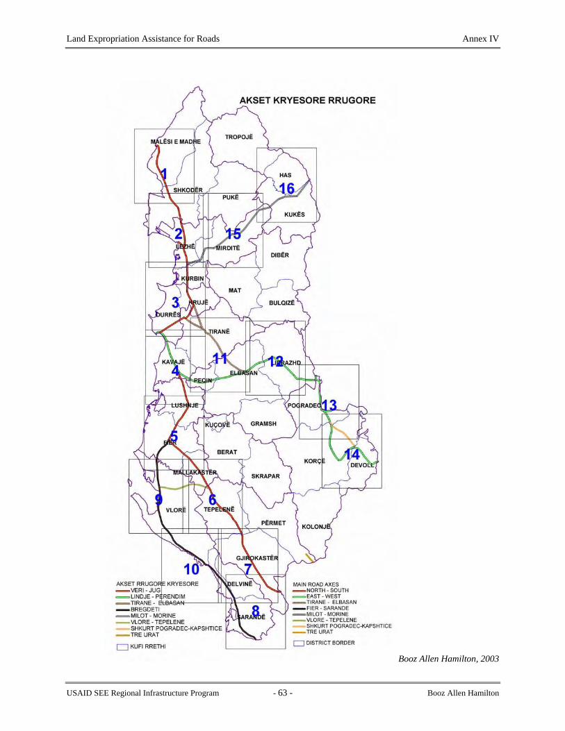
Land Expropriation Assistance for Roads Annex IV
Booz Allen Hamilton, 2003
USAID SEE Regional Infrastructure Program - 63 - Booz Allen Hamilton

Land Expropriation Assistance for Roads Annex IV
Booz Allen Hamilton, 2003
USAID SEE Regional Infrastructure Program - 64 - Booz Allen Hamilton

Land Expropriation Assistance for Roads Annex IV
Booz Allen Hamilton, 2003
USAID SEE Regional Infrastructure Program - 65 - Booz Allen Hamilton

Land Expropriation Assistance for Roads Annex IV
Booz Allen Hamilton, 2003
USAID SEE Regional Infrastructure Program - 66 - Booz Allen Hamilton

Land Expropriation Assistance for Roads Annex IV
Booz Allen Hamilton, 2003
USAID SEE Regional Infrastructure Program - 67 - Booz Allen Hamilton

Land Expropriation Assistance for Roads Annex IV
Booz Allen Hamilton, 2003
USAID SEE Regional Infrastructure Program - 68 - Booz Allen Hamilton

Land Expropriation Assistance for Roads Annex IV
Booz Allen Hamilton, 2003
USAID SEE Regional Infrastructure Program - 69 - Booz Allen Hamilton

Land Expropriation Assistance for Roads Annex IV
Booz Allen Hamilton, 2003
USAID SEE Regional Infrastructure Program - 70 - Booz Allen Hamilton

Land Expropriation Assistance for Roads Annex IV
Booz Allen Hamilton, 2003
USAID SEE Regional Infrastructure Program - 71 - Booz Allen Hamilton

Land Expropriation Assistance for Roads Annex IV
Booz Allen Hamilton, 2003
USAID SEE Regional Infrastructure Program - 72 - Booz Allen Hamilton

Land Expropriation Assistance for Roads Annex IV
Booz Allen Hamilton, 2003
USAID SEE Regional Infrastructure Program - 73 - Booz Allen Hamilton

Land Expropriation Assistance for Roads Annex IV
Booz Allen Hamilton, 2003
USAID SEE Regional Infrastructure Program - 74 - Booz Allen Hamilton

Land Expropriation Assistance for Roads Annex IV
Booz Allen Hamilton, 2003
USAID SEE Regional Infrastructure Program - 75 - Booz Allen Hamilton

Land Expropriation Assistance for Roads Annex IV
Booz Allen Hamilton, 2003
USAID SEE Regional Infrastructure Program - 76 - Booz Allen Hamilton

Land Expropriation Assistance for Roads Annex IV
Booz Allen Hamilton, 2003
USAID SEE Regional Infrastructure Program - 77 - Booz Allen Hamilton

Land Expropriation Assistance for Roads Annex IV
USAID SEE Regional Infrastructure Program - 78 - Booz Allen Hamilton

Land Expropriation Assistance for Roads Annex IV
Booz Allen Hamilton, 2003
USAID SEE Regional Infrastructure Program - 79 - Booz Allen Hamilton

Land Expropriation Assistance for Roads Annex IV
Booz Allen Hamilton, 2003
USAID SEE Regional Infrastructure Program - 80 - Booz Allen Hamilton

Land Expropriation Assistance for Roads Annex IV
Table 1: Status of First Registration along the Albanian National Highway Corridors
Cadastral ZoneZ NUMBER Cadastral Zone NAME DISTRICT STATUS 1269 Bregas DELVINE IN IPRS
2864 Palavli (Qafe Dardhe) DELVINE INDEX MAP + PARCEL BOOK FINISHED
3832 Vrion DELVINE FIRST REGISTRATION HAS NOT STARTED
1059 Baban DEVOLL IN IPRS
1183 Bicke DEVOLL IN IPRS
1187 Bilisht 1 DEVOLL IN IPRS
1202 Bitincke DEVOLL IN IPRS
1355 Cangonj DEVOLL IN IPRS
1453 Daullas DEVOLL IN IPRS
2081 Kapshtice DEVOLL IN IPRS
2305 Kuc DEVOLL IN IPRS
3056 Proger DEVOLL IN IPRS
3528 Stropan DEVOLL IN IPRS
3637 Tren DEVOLL INDEX MAP + PARCEL BOOK FINISHED
3787 Vishocice DEVOLL IN IPRS
3822 Vranisht DEVOLL IN IPRS
1031 Arapaj DURRES IN IPRS
1186 Bilalas DURRES IN IPRS
1242 Borake DURRES IN IPRS
1727 Gjepalaj DURRES IN IPRS
1914 Guzaj DURRES IN IPRS
2100 Karpen DURRES IN IPRS
2101 Karrec DURRES IN IPRS
2255 Koxhas DURRES IN IPRS
2574 Maliq Muco DURRES IN IPRS
2585 Maminas DURRES IN IPRS
2591 Manskuri DURRES IN IPRS
2675 Metalle DURRES IN IPRS
3215 Rashbull DURRES IN IPRS
3225 Rreth DURRES IN IPRS
3245 Rubjeke DURRES IN IPRS
3255 Sallmone DURRES IN IPRS
3369 Shijak DURRES FIELD WORK IS NOT STARTED
3385 Shkallnur DURRES IN IPRS
8517 Spitalle DURRES IN IPRS
3542 Sukth i Ri DURRES FIELD WORK IS NOT STARTED
3852 Xhafzotaj DURRES IN IPRS
8515 DURRES IN IPRS
8516 DURRES IN IPRS
8514 DURRES INDEX MAP + PARCEL BOOK FINISHED
1079 Balez ELBASAN IN IPRS
1085 Balldre ELBASAN IN IPRS
1258 Bradashesh ELBASAN IN IPRS
USAID SEE Regional Infrastructure Program - 81 - Booz Allen Hamilton

Land Expropriation Assistance for Roads Annex IV
Cadastral ZoneZ NUMBER Cadastral Zone NAME DISTRICT STATUS 1285 Broshke ELBASAN IN IPRS
1303 Buqes ELBASAN IN IPRS
1389 Cerrik ELBASAN INDEX MAP + PARCEL BOOK FINISHED
1621 Fikas ELBASAN INDEX MAP + PARCEL BOOK FINISHED
1834 Gracen ELBASAN FIELD WORK IS NOT STARTED
1919 Hajdaraj ELBASAN IN IPRS
1991 Jagodine ELBASAN IN IPRS
1999 Jatesh ELBASAN INDEX MAP + PARCEL BOOK FINISHED
2083 Karakullak ELBASAN IN IPRS
2124 Katund i Ri ELBASAN INDEX MAP + PARCEL BOOK FINISHED
2190 Kodras ELBASAN IN IPRS
2256 Kozan ELBASAN IN IPRS
2296 Kryezjarrth ELBASAN IN IPRS
2346 Kusarth ELBASAN IN IPRS
2355 Labinot-Fushe ELBASAN FIELD WORK IS NOT STARTED
2511 Lugaj ELBASAN IN IPRS
2583 Mamel ELBASAN FIELD WORK IS NOT STARTED
2654 Mengel ELBASAN FIELD WORK IS NOT STARTED
2703 Mjekes ELBASAN IN IPRS
2706 Mlize ELBASAN FIRST REGISTRATION HAS NOT STARTED
2741 Muriqan ELBASAN IN IPRS
2743 Murras ELBASAN IN IPRS
2855 Pajenge ELBASAN FIELD WORK IS NOT STARTED
2857 Pajun ELBASAN INDEX MAP + PARCEL BOOK FINISHED
2876 Paper ELBASAN INDEX MAP + PARCEL BOOK FINISHED
2948 Petresh ELBASAN IN IPRS
3021 Polis i Vogel ELBASAN INDEX MAP + PARCEL BOOK FINISHED
3022 Polis-Kale ELBASAN INDEX MAP + PARCEL BOOK FINISHED
3161 Recan ELBASAN IN IPRS
3346 Shengjin ELBASAN FIELD WORK IS NOT STARTED
3371 Shijon ELBASAN IN IPRS
3419 Shtemaj ELBASAN IN IPRS
3445 Shushice e Madhe ELBASAN IN IPRS
3577 Terbac ELBASAN FIELD WORK IS NOT STARTED
3674 Ulem ELBASAN INDEX MAP + PARCEL BOOK FINISHED
3677 Ullishtas ELBASAN INDEX MAP + PARCEL BOOK FINISHED
3702 Valas ELBASAN IN IPRS
3764 Vidhas ELBASAN INDEX MAP + PARCEL BOOK FINISHED
3827 Vreshtas ELBASAN INDEX MAP + PARCEL BOOK FINISHED
3856 Xherje ELBASAN IN IPRS
3864 Xibrake ELBASAN INDEX MAP + PARCEL BOOK FINISHED
8526 ELBASAN FIELD WORK IS NOT STARTED
8527 ELBASAN FIELD WORK IS NOT STARTED
8521 ELBASAN INDEX MAP + PARCEL BOOK FINISHED
8522 ELBASAN INDEX MAP + PARCEL BOOK FINISHED
USAID SEE Regional Infrastructure Program - 82 - Booz Allen Hamilton
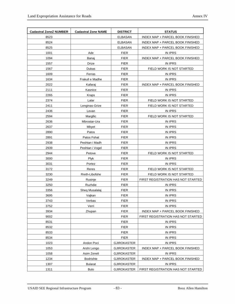
Land Expropriation Assistance for Roads Annex IV
Cadastral ZoneZ NUMBER Cadastral Zone NAME DISTRICT STATUS 8523 ELBASAN INDEX MAP + PARCEL BOOK FINISHED
8524 ELBASAN INDEX MAP + PARCEL BOOK FINISHED
8525 ELBASAN INDEX MAP + PARCEL BOOK FINISHED
1001 Ade FIER IN IPRS
1094 Banaj FIER INDEX MAP + PARCEL BOOK FINISHED
1557 Drize FIER IN IPRS
1567 Dukas FIER FIELD WORK IS NOT STARTED
1609 Ferras FIER IN IPRS
1634 Frakull e Madhe FIER IN IPRS
2022 Kafaraj FIER INDEX MAP + PARCEL BOOK FINISHED
2111 Kasnice FIER IN IPRS
2265 Kraps FIER IN IPRS
2374 Lalar FIER FIELD WORK IS NOT STARTED
2411 Lenginas-Grize FIER FIELD WORK IS NOT STARTED
2436 Levan FIER IN IPRS
2594 Margllic FIER FIELD WORK IS NOT STARTED
2636 Mbrostar-Ura FIER IN IPRS
2637 Mbyet FIER IN IPRS
2890 Patos FIER IN IPRS
2891 Patos Fshat FIER IN IPRS
2938 Peshtan i Madh FIER IN IPRS
2939 Peshtan i Vogel FIER IN IPRS
2944 Petove FIER FIELD WORK IS NOT STARTED
3000 Plyk FIER IN IPRS
3031 Portez FIER IN IPRS
3172 Reres FIER FIELD WORK IS NOT STARTED
3230 Rreth-Libofshe FIER FIELD WORK IS NOT STARTED
3249 Rusinje FIER FIRST REGISTRATION HAS NOT STARTED
3250 Ruzhdie FIER IN IPRS
3356 Sheq Musalalaj FIER IN IPRS
3695 Vajkan FIER IN IPRS
3743 Verbas FIER IN IPRS
3752 Verri FIER IN IPRS
3934 Zhupan FIER INDEX MAP + PARCEL BOOK FINISHED
9002 FIER FIRST REGISTRATION HAS NOT STARTED
8531 FIER IN IPRS
8532 FIER IN IPRS
8533 FIER IN IPRS
8534 FIER IN IPRS
1023 Andon Poci GJIROKASTER IN IPRS
1053 Arshi Lengo GJIROKASTER INDEX MAP + PARCEL BOOK FINISHED
1058 Asim Zeneli GJIROKASTER IN IPRS
1234 Bodrishte GJIROKASTER INDEX MAP + PARCEL BOOK FINISHED
1307 Bularat GJIROKASTER IN IPRS
1311 Bulo GJIROKASTER FIRST REGISTRATION HAS NOT STARTED
USAID SEE Regional Infrastructure Program - 83 - Booz Allen Hamilton

Land Expropriation Assistance for Roads Annex IV
Cadastral ZoneZ NUMBER Cadastral Zone NAME DISTRICT STATUS 1369 Cepun GJIROKASTER IN IPRS
1476 Dervican GJIROKASTER IN IPRS
1487 Dhuvjan GJIROKASTER IN IPRS
1544 Drino GJIROKASTER FIRST REGISTRATION HAS NOT STARTED
1551 Drite GJIROKASTER IN IPRS
1592 Erind GJIROKASTER IN IPRS
1640 Frashtan GJIROKASTER IN IPRS
1723 Gjate GJIROKASTER IN IPRS
1779 Gline GJIROKASTER IN IPRS
1803 Goranxi GJIROKASTER IN IPRS
1808 Gorice GJIROKASTER IN IPRS
1846 Grapsh GJIROKASTER IN IPRS
1936 Haskove GJIROKASTER IN IPRS
1970 Humelice GJIROKASTER INDEX MAP + PARCEL BOOK FINISHED
1971 Hundekuq GJIROKASTER IN IPRS
2007 Jorgucat GJIROKASTER IN IPRS
2030 Kakavije GJIROKASTER IN IPRS
2032 Kakoz GJIROKASTER IN IPRS
2094 Karjan GJIROKASTER IN IPRS
2133 Kellez GJIROKASTER IN IPRS
2357 Labove e Madhe GJIROKASTER IN IPRS
2360 Labove e Vogel GJIROKASTER INDEX MAP + PARCEL BOOK FINISHED
2392 Lazarat GJIROKASTER FIELD WORK IS NOT STARTED
2444 Libohove GJIROKASTER INDEX MAP + PARCEL BOOK FINISHED
2512 Lugar GJIROKASTER IN IPRS
2609 Mashkullore GJIROKASTER IN IPRS
2695 Mingul GJIROKASTER IN IPRS
2781 Nepravishte GJIROKASTER FIRST REGISTRATION HAS NOT STARTED
2810 Nokove GJIROKASTER IN IPRS
2867 Palokaster GJIROKASTER INDEX MAP + PARCEL BOOK FINISHED
2930 Peshkepi e Poshtme GJIROKASTER IN IPRS
2931 Peshkepi e Siperme GJIROKASTER IN IPRS
3135 Radat GJIROKASTER IN IPRS
3421 Shtepez GJIROKASTER INDEX MAP + PARCEL BOOK FINISHED
3480 Sofratike GJIROKASTER IN IPRS
3579 Terbuq GJIROKASTER IN IPRS
3580 Terihat GJIROKASTER IN IPRS
3701 Valare GJIROKASTER IN IPRS
3711 Vanister GJIROKASTER IN IPRS
3820 Vrahogoranxi GJIROKASTER IN IPRS
3833 Vrisera GJIROKASTER IN IPRS
3907 Zervat GJIROKASTER IN IPRS
8541 GJIROKASTER IN IPRS
8542 GJIROKASTER IN IPRS
8543 GJIROKASTER IN IPRS
USAID SEE Regional Infrastructure Program - 84 - Booz Allen Hamilton

Land Expropriation Assistance for Roads Annex IV
Cadastral ZoneZ NUMBER Cadastral Zone NAME DISTRICT STATUS 1510 Domaj-Has HAS IN IPRS
1740 Gjinaj HAS IN IPRS
2760 Myc-Has HAS IN IPRS
3012 Pogaj HAS FIRST REGISTRATION HAS NOT STARTED
3073 Pus i Thate HAS IN IPRS
3961 Agonas KAVAJE IN IPRS
1212 Blerimaj KAVAJE IN IPRS
1397 Cete KAVAJE IN IPRS
1791 Golem KAVAJE IN IPRS
1794 Golemas KAVAJE IN IPRS
1814 Gose e Madhe KAVAJE IN IPRS
1815 Gose e Vogel KAVAJE IN IPRS
1932 Harizaj KAVAJE IN IPRS
1947 Helmes KAVAJE IN IPRS
2071 Kanaparaj KAVAJE IN IPRS
2140 Kercukaj KAVAJE FIELD WORK IS NOT STARTED
2291 Kryemedhenj KAVAJE IN IPRS
2399 Lekaj KAVAJE IN IPRS
2538 Luz i Madh KAVAJE IN IPRS
2539 Luz i Vogel KAVAJE IN IPRS
2721 Momel KAVAJE IN IPRS
3101 Qerret KAVAJE IN IPRS
3204 Rrakull KAVAJE IN IPRS
3231 Rrikaj KAVAJE IN IPRS
3235 Rrogozhine Fshat KAVAJE INDEX MAP + PARCEL BOOK FINISHED
3234 Rrogozhine Qytet KAVAJE IN IPRS
3427 Shtodher KAVAJE IN IPRS
3450 Sinaballaj KAVAJE IN IPRS
3554 Synej KAVAJE IN IPRS
3600 Tilaj KAVAJE IN IPRS
3817 Vorrozen KAVAJE IN IPRS
3939 Zikularaj KAVAJE IN IPRS
3940 Zikxhafaj KAVAJE IN IPRS
8551 KAVAJE IN IPRS
8552 KAVAJE IN IPRS
1101 Barc KORCE IN IPRS
1145 Belorta KORCE IN IPRS
1189 Biranj KORCE IN IPRS
1274 Bregas KORCE IN IPRS
1310 Bulgarec KORCE IN IPRS
1321 Burimas KORCE IN IPRS
1403 Ciflig KORCE IN IPRS
1491 Dishnice KORCE IN IPRS
1667 Fshat Maliq KORCE IN IPRS
1886 Gurabardhe KORCE IN IPRS
USAID SEE Regional Infrastructure Program - 85 - Booz Allen Hamilton

Land Expropriation Assistance for Roads Annex IV
Cadastral ZoneZ NUMBER Cadastral Zone NAME DISTRICT STATUS 1900 Gurishte KORCE IN IPRS
2028 Kakac KORCE IN IPRS
2159 Kloce KORCE IN IPRS
2307 Kuc i Zi KORCE IN IPRS
2445 Libonik KORCE IN IPRS
2521 Lumalas KORCE IN IPRS
2560 Malavec KORCE IN IPRS
2573 Maliq KORCE IN IPRS
2631 Mborje KORCE IN IPRS
2641 Melcan KORCE IN IPRS
2783 Nevicisht KORCE IN IPRS
2815 Novosele KORCE IN IPRS
2965 Pirg KORCE IN IPRS
2984 Plase KORCE INDEX MAP + PARCEL BOOK FINISHED
3005 Poceste KORCE IN IPRS
3010 Podgorie KORCE IN IPRS
3359 Sheqeras KORCE IN IPRS
3417 Shqitas KORCE IN IPRS
3496 Sovjan KORCE IN IPRS
3553 Symize KORCE IN IPRS
3660 Turan KORCE IN IPRS
3716 Vashtemi KORCE IN IPRS
3736 Veliterne KORCE IN IPRS
3803 Vlocisht KORCE IN IPRS
3830 Vreshtas KORCE IN IPRS
3903 Zemblak KORCE IN IPRS
3952 Zvezde KORCE IN IPRS
3953 Zvirine KORCE IN IPRS
8561 KORCE IN IPRS
8562 KORCE IN IPRS
8563 KORCE IN IPRS
8564 KORCE IN IPRS
1042 Arrameras KRUJE INDEX MAP + PARCEL BOOK FINISHED
1185 Bilaj KRUJE IN IPRS
1247 Borizane KRUJE INDEX MAP + PARCEL BOOK FINISHED
1332 Bushnesh KRUJE IN IPRS
1475 Derven KRUJE IN IPRS
1664 Fushe Kruje KRUJE IN IPRS
1665 Fushe Kruje Fshat KRUJE IN IPRS
1934 Hasan KRUJE IN IPRS
2182 Koder Thumane KRUJE IN IPRS
2385 Larushk KRUJE IN IPRS
2537 Luz KRUJE IN IPRS
2742 Murqine KRUJE IN IPRS
3096 Qereke KRUJE IN IPRS
USAID SEE Regional Infrastructure Program - 86 - Booz Allen Hamilton

Land Expropriation Assistance for Roads Annex IV
Cadastral ZoneZ NUMBER Cadastral Zone NAME DISTRICT STATUS 3183 Rinas KRUJE IN IPRS
3562 Tapize KRUJE IN IPRS
3599 Thumane KRUJE IN IPRS
1114 Bardhoc KUKES IN IPRS
1115 Bardhoc i Ri KUKES IN IPRS
1176 Breg-Lume KUKES IN IPRS
1543 Drinas KUKES IN IPRS
1653 Fusharre KUKES IN IPRS
1726 Gjegjan KUKES IN IPRS
1819 Gostile KUKES IN IPRS
2039 Kalimash KUKES IN IPRS
2208 Kolsh KUKES IN IPRS
2315 Kukes KUKES IN IPRS
2584 Mamez KUKES IN IPRS
2724 Morine KUKES IN IPRS
2759 Myc-Mamez KUKES IN IPRS
2912 Porbreg KUKES IN IPRS
3335 Shemri KUKES IN IPRS
3425 Shtiqen KUKES IN IPRS
3551 Surroj KUKES IN IPRS
3976 Droje KURBIN IN IPRS
2365 Fshat Lac KURBIN IN IPRS
1676 Fushe-Mamurras KURBIN INDEX MAP + PARCEL BOOK FINISHED
1677 Fushe-Milot KURBIN INDEX MAP + PARCEL BOOK FINISHED
1768 Gjorm KURBIN IN IPRS
1812 Gorre KURBIN IN IPRS
1890 Gurrez KURBIN IN IPRS
2580 Mal-Bardhe KURBIN IN IPRS
2889 Patok KURBIN INDEX MAP + PARCEL BOOK FINISHED
3412 Shperdhet 1 KURBIN IN IPRS
3441 Shullaz KURBIN IN IPRS
1086 Balldren LEZHE IN IPRS
1087 Balldren i Ri LEZHE IN IPRS
1096 Baqel LEZHE IN IPRS
1099 Barbulloje LEZHE IN IPRS
1168 Berzan LEZHE FIRST REGISTRATION HAS NOT STARTED
1220 Blinisht LEZHE IN IPRS
1434 Dajc LEZHE IN IPRS
1533 Dragush LEZHE IN IPRS
1685 Gajush LEZHE IN IPRS
1716 Gjader LEZHE IN IPRS
1721 Gjashe LEZHE FIRST REGISTRATION HAS NOT STARTED
1783 Gocaj LEZHE IN IPRS
1986 Ishull Lezhe LEZHE IN IPRS
1987 Ishull Shengjin LEZHE IN IPRS
USAID SEE Regional Infrastructure Program - 87 - Booz Allen Hamilton

Land Expropriation Assistance for Roads Annex IV
Cadastral ZoneZ NUMBER Cadastral Zone NAME DISTRICT STATUS 2029 Kakarriq LEZHE IN IPRS
2053 Kallmet i Madh LEZHE FIELD WORK IS NOT STARTED
2180 Koder Mulliri LEZHE IN IPRS
2187 Kodhel LEZHE IN IPRS
2246 Koterr LEZHE IN IPRS
2441 Lezhe LEZHE INDEX MAP + PARCEL BOOK FINISHED
2569 Mali Shengjin LEZHE FIRST REGISTRATION HAS NOT STARTED
2604 Markatomaj LEZHE IN IPRS
2660 Merqi LEZHE FIRST REGISTRATION HAS NOT STARTED
2964 Piraj LEZHE IN IPRS
2995 Pllan LEZHE IN IPRS
3181 Rile LEZHE IN IPRS
3202 Rraboshte LEZHE IN IPRS
3126 Shengjin LEZHE FIELD WORK IS NOT STARTED
3351 Shenkoll LEZHE IN IPRS
3641 Tresh LEZHE IN IPRS
3901 Zejmen LEZHE IN IPRS
8631 LEZHE IN IPRS
1046 Arrez LIBRAZHD IN IPRS
1063 Babje LIBRAZHD IN IPRS
1169 Berzheshte LIBRAZHD IN IPRS
1443 Dardhe LIBRAZHD IN IPRS
1517 Dorez LIBRAZHD IN IPRS
1527 Dragostunje LIBRAZHD IN IPRS
1821 Gostime LIBRAZHD IN IPRS
1905 Gurre LIBRAZHD IN IPRS
1967 Hotolisht LIBRAZHD IN IPRS
2096 Karkavec LIBRAZHD IN IPRS
2248 Kotodesh LIBRAZHD IN IPRS
2446 Librazhd LIBRAZHD IN IPRS
2696 Mirake LIBRAZHD IN IPRS
2970 Pishkash Verri LIBRAZHD IN IPRS
2924 Prrenjas LIBRAZHD IN IPRS
2925 Prrenjas Fshat LIBRAZHD IN IPRS
3120 Qukes Shkumbin LIBRAZHD IN IPRS
3121 Qukes Skenderbej LIBRAZHD IN IPRS
3203 Rrajce LIBRAZHD IN IPRS
3216 Rrashtan LIBRAZHD IN IPRS
3499 Spathare LIBRAZHD IN IPRS
3603 Togez LIBRAZHD IN IPRS
3683 Urake LIBRAZHD FIELD WORK IS NOT STARTED
3725 Velcan LIBRAZHD IN IPRS
3843 Vulcan LIBRAZHD IN IPRS
3859 Xhyre LIBRAZHD IN IPRS
1033 Ardenice LUSHNJE FIELD WORK IS NOT STARTED
USAID SEE Regional Infrastructure Program - 88 - Booz Allen Hamilton

Land Expropriation Assistance for Roads Annex IV
Cadastral ZoneZ NUMBER Cadastral Zone NAME DISTRICT STATUS 1197 Bishqethem LUSHNJE IN IPRS
1295 Bubullime LUSHNJE IN IPRS
1381 Cerme e Siperme LUSHNJE IN IPRS
1582 Dushk i Madh LUSHNJE INDEX MAP + PARCEL BOOK FINISHED
1583 Dushk Peqin LUSHNJE IN IPRS
1724 Gjaze LUSHNJE INDEX MAP + PARCEL BOOK FINISHED
1789 Golem LUSHNJE IN IPRS
3981 Golem i Vogel LUSHNJE IN IPRS
1813 Gorre LUSHNJE IN IPRS
1841 Gramsh LUSHNJE IN IPRS
1922 Halilaj LUSHNJE IN IPRS
2020 Kadiaj LUSHNJE IN IPRS
2060 Kamcisht LUSHNJE IN IPRS
2087 Karbunare e Poshtme LUSHNJE IN IPRS
2207 Kolonje LUSHNJE IN IPRS
2218 Konjat LUSHNJE IN IPRS
2286 Krutje e Poshtme LUSHNJE IN IPRS
2287 Krutje e Siperme LUSHNJE IN IPRS
2527 Lumth LUSHNJE IN IPRS
2966 Pirre LUSHNJE IN IPRS
2999 Plug LUSHNJE IN IPRS
3208 Rrapez Fshat LUSHNJE IN IPRS
3209 Rrapez Sektor LUSHNJE IN IPRS
3268 Saver LUSHNJE IN IPRS
3312 Shakuj LUSHNJE IN IPRS
3508 Stankarburare LUSHNJE IN IPRS
3590 Thanasaj LUSHNJE FIELD WORK IS NOT STARTED
3916 Zhame Sektor LUSHNJE INDEX MAP + PARCEL BOOK FINISHED
3915 Zhame-Fshat LUSHNJE FIELD WORK IS NOT STARTED
3936 Zhyme LUSHNJE IN IPRS
8571 LUSHNJE IN IPRS
1010 Aliaj MALESI E MADHE INDEX MAP + PARCEL BOOK FINISHED
1238 Bogic Palvar MALESI E MADHE INDEX MAP + PARCEL BOOK FINISHED
1244 Boric i Madh MALESI E MADHE INDEX MAP + PARCEL BOOK FINISHED
1245 Boric i Vogel MALESI E MADHE INDEX MAP + PARCEL BOOK FINISHED
1465 Demiraj MALESI E MADHE IN IPRS
1493 Dober MALESI E MADHE INDEX MAP + PARCEL BOOK FINISHED
1766 Gjorme MALESI E MADHE IN IPRS
1802 Goraj-Budishe MALESI E MADHE IN IPRS
1836 Gradec MALESI E MADHE FIRST REGISTRATION HAS NOT STARTED
1864 Grile MALESI E MADHE IN IPRS
1870 Grude-Fushe MALESI E MADHE INDEX MAP + PARCEL BOOK FINISHED
1964 Hot MALESI E MADHE IN IPRS
1989 Ivanaj MALESI E MADHE IN IPRS
1998 Jaran MALESI E MADHE INDEX MAP + PARCEL BOOK FINISHED
USAID SEE Regional Infrastructure Program - 89 - Booz Allen Hamilton

Land Expropriation Assistance for Roads Annex IV
Cadastral ZoneZ NUMBER Cadastral Zone NAME DISTRICT STATUS 2220 Koplik MALESI E MADHE IN IPRS
2221 Koplik i Siperm MALESI E MADHE INDEX MAP + PARCEL BOOK FINISHED
2299 Ktosh MALESI E MADHE INDEX MAP + PARCEL BOOK FINISHED
2668 Meshqerre MALESI E MADHE INDEX MAP + PARCEL BOOK FINISHED
2827 Omaraj MALESI E MADHE IN IPRS
2977 Pjetroshan MALESI E MADHE INDEX MAP + PARCEL BOOK FINISHED
3045 Premal MALESI E MADHE INDEX MAP + PARCEL BOOK FINISHED
3154 Rapsh-Starje MALESI E MADHE IN IPRS
3841 Vukpalaj MALESI E MADHE IN IPRS
1024 Anebreg MALLAKASTER FIELD WORK IS NOT STARTED
1090 Ballsh MALLAKASTER IN IPRS
1135 Bejar MALLAKASTER INDEX MAP + PARCEL BOOK FINISHED
1143 Belishove MALLAKASTER IN IPRS
3985 Belistan MALLAKASTER FIRST REGISTRATION HAS NOT STARTED
1438 Dames MALLAKASTER INDEX MAP + PARCEL BOOK FINISHED
1539 Drenove MALLAKASTER FIELD WORK IS NOT STARTED
1555 Drizar MALLAKASTER FIELD WORK IS NOT STARTED
1566 Dukas MALLAKASTER IN IPRS
1730 Gjerbes MALLAKASTER IN IPRS
1857 Greshice MALLAKASTER INDEX MAP + PARCEL BOOK FINISHED
1858 Greshice e Re MALLAKASTER INDEX MAP + PARCEL BOOK FINISHED
1945 Hekal MALLAKASTER FIELD WORK IS NOT STARTED
2038 Kalenje MALLAKASTER IN IPRS
2076 Kapaj MALLAKASTER IN IPRS
2104 Kash MALLAKASTER INDEX MAP + PARCEL BOOK FINISHED
2270 Kremenar MALLAKASTER FIELD WORK IS NOT STARTED
2350 Kute MALLAKASTER FIELD WORK IS NOT STARTED
2384 Lapulec MALLAKASTER FIELD WORK IS NOT STARTED
2388 Lavdan MALLAKASTER IN IPRS
2556 Malas MALLAKASTER IN IPRS
2788 Ngracie MALLAKASTER FIELD WORK IS NOT STARTED
2802 Ninesh MALLAKASTER FIELD WORK IS NOT STARTED
3689 Usoje MALLAKASTER IN IPRS
3789 Visoke MALLAKASTER FIELD WORK IS NOT STARTED
1190 Bisak MIRDITE IN IPRS
1221 Blinisht MIRDITE IN IPRS
1304 Bukmire MIRDITE FIELD WORK IS NOT STARTED
1313 Bulshar MIRDITE IN IPRS
1513 Domgjon MIRDITE INDEX MAP + PARCEL BOOK FINISHED
1600 Fan MIRDITE IN IPRS
1601 Fang MIRDITE IN IPRS
1618 Fierze MIRDITE IN IPRS
1666 Fushe-Lumth MIRDITE IN IPRS
1713 Geziq MIRDITE IN IPRS
1717 Gjakez MIRDITE IN IPRS
USAID SEE Regional Infrastructure Program - 90 - Booz Allen Hamilton

Land Expropriation Assistance for Roads Annex IV
Cadastral ZoneZ NUMBER Cadastral Zone NAME DISTRICT STATUS 1877 Gryke Orosh MIRDITE IN IPRS
1893 Guri Bardhe MIRDITE IN IPRS
1912 Gurth-Spac MIRDITE IN IPRS
1944 Hebe MIRDITE IN IPRS
2005 Jezull MIRDITE IN IPRS
2121 Katund i Ri MIRDITE IN IPRS
2162 Klos MIRDITE IN IPRS
2181 Koder Rreshen MIRDITE IN IPRS
2186 Koder-Spac MIRDITE IN IPRS
2214 Konaj MIRDITE IN IPRS
2320 Kullaxhi MIRDITE IN IPRS
2442 Lgjin MIRDITE IN IPRS
2553 Malaj i Siperm MIRDITE INDEX MAP + PARCEL BOOK FINISHED
2610 Mashterkore MIRDITE IN IPRS
2737 Munaze MIRDITE IN IPRS
2738 Munelle MIRDITE INDEX MAP + PARCEL BOOK FINISHED
2768 Nderfan MIRDITE IN IPRS
2769 Nderfushe MIRDITE IN IPRS
2779 Nenshejt MIRDITE IN IPRS
2943 Petoq MIRDITE IN IPRS
2980 Plenete MIRDITE IN IPRS
2933 Pshqesh MIRDITE IN IPRS
3171 Reps MIRDITE INDEX MAP + PARCEL BOOK FINISHED
3214 Rrasfik MIRDITE IN IPRS
3229 Rreth i Siperm MIRDITE IN IPRS
3244 Rubik MIRDITE INDEX MAP + PARCEL BOOK FINISHED
3259 Sang MIRDITE INDEX MAP + PARCEL BOOK FINISHED
3413 Shperdhaze MIRDITE IN IPRS
3433 Shtrungaj MIRDITE IN IPRS
3573 Tene MIRDITE IN IPRS
3598 Thirre MIRDITE IN IPRS
3721 Va-Shkjeze MIRDITE IN IPRS
3857 Xhuxhe MIRDITE IN IPRS
3883 Zall-Xhuxhe MIRDITE IN IPRS
1195 Bishqem PEQIN IN IPRS
1196 Bishqem Fushe PEQIN IN IPRS
1275 Bregas PEQIN IN IPRS
1361 Caushaj PEQIN INDEX MAP + PARCEL BOOK FINISHED
1365 Cengelaj PEQIN IN IPRS
1416 Copanaj PEQIN IN IPRS
1536 Drangaj PEQIN IN IPRS
1607 Fatish PEQIN IN IPRS
1872 Grykesh i Madh PEQIN IN IPRS
1878 Grykesh i Vogel PEQIN IN IPRS
2093 Karine PEQIN IN IPRS
USAID SEE Regional Infrastructure Program - 91 - Booz Allen Hamilton

Land Expropriation Assistance for Roads Annex IV
Cadastral ZoneZ NUMBER Cadastral Zone NAME DISTRICT STATUS 2103 Karthneke PEQIN IN IPRS
2191 Kodras PEQIN IN IPRS
2338 Kurtaj PEQIN IN IPRS
2393 Lazarej PEQIN IN IPRS
2418 Leqit PEQIN INDEX MAP + PARCEL BOOK FINISHED
2490 Lolaj PEQIN IN IPRS
2856 Pajove PEQIN IN IPRS
2892 Paulesh PEQIN FIELD WORK IS NOT STARTED
2908 Peqin PEQIN IN IPRS
2921 Perparim PEQIN IN IPRS
3238 Rrozej PEQIN IN IPRS
3239 Rrumbullake PEQIN IN IPRS
3367 Sheze e Madhe PEQIN IN IPRS
3368 Sheze e Vogel PEQIN IN IPRS
3623 Trash PEQIN IN IPRS
3686 Urucaj PEQIN IN IPRS
3715 Vashaj PEQIN FIELD WORK IS NOT STARTED
1068 Bacallek POGRADEC IN IPRS
1298 Bucimas POGRADEC IN IPRS
1317 Buqeze POGRADEC IN IPRS
1387 Cerrave POGRADEC IN IPRS
1711 Geshtenjas POGRADEC IN IPRS
1832 Grabovice POGRADEC IN IPRS
1873 Grunjas POGRADEC IN IPRS
1903 Gurras POGRADEC IN IPRS
3665 Hudenisht POGRADEC IN IPRS
2420 Leshnice POGRADEC IN IPRS
2457 Lin POGRADEC IN IPRS
2648 Memelisht POGRADEC IN IPRS
2973 Piskupat POGRADEC IN IPRS
3047 Pretushe POGRADEC IN IPRS
3167 Remenj POGRADEC IN IPRS
3529 Stropcke POGRADEC IN IPRS
3664 Tushemisht POGRADEC IN IPRS
3745 Verdove POGRADEC IN IPRS
8581 POGRADEC IN IPRS
8582 POGRADEC IN IPRS
2713 Mollkuqe PUKE FIRST REGISTRATION HAS NOT STARTED
1013 Aliko SARANDE INDEX MAP + PARCEL BOOK FINISHED
1253 Borsh SARANDE INDEX MAP + PARCEL BOOK FINISHED
1404 Ciflik SARANDE IN IPRS
1421 Corraj SARANDE FIRST REGISTRATION HAS NOT STARTED
1430 Cuke SARANDE FIELD WORK IS NOT STARTED
1547 Dritas SARANDE IN IPRS
1722 Gjashte SARANDE INDEX MAP + PARCEL BOOK FINISHED
USAID SEE Regional Infrastructure Program - 92 - Booz Allen Hamilton

Land Expropriation Assistance for Roads Annex IV
Cadastral ZoneZ NUMBER Cadastral Zone NAME DISTRICT STATUS 2217 Konispol SARANDE FIELD WORK IS NOT STARTED
2518 Lukove SARANDE FIRST REGISTRATION HAS NOT STARTED
2677 Metoq SARANDE FIRST REGISTRATION HAS NOT STARTED
2747 Mursi SARANDE FIRST REGISTRATION HAS NOT STARTED
2806 Nivice SARANDE FIRST REGISTRATION HAS NOT STARTED
2963 Piqeras SARANDE FIRST REGISTRATION HAS NOT STARTED
3089 Qazim Pali SARANDE FIRST REGISTRATION HAS NOT STARTED
3149 Rahulle SARANDE IN IPRS
3262 Sarande SARANDE IN IPRS
3265 Sasaj SARANDE FIRST REGISTRATION HAS NOT STARTED
3316 Shales SARANDE IN IPRS
3330 Shelegar SARANDE FIRST REGISTRATION HAS NOT STARTED
3338 Shen Vasil SARANDE FIRST REGISTRATION HAS NOT STARTED
3382 Shkalle SARANDE IN IPRS
3488 Sopik SARANDE IN IPRS
3692 Vagalat SARANDE IN IPRS
3845 Vurg i Ri SARANDE IN IPRS
3846 Xarre SARANDE FIRST REGISTRATION HAS NOT STARTED
1105 Bardhaj SHKODER IN IPRS
1209 Bleran SHKODER IN IPRS
1482 Dheu i Lehte SHKODER IN IPRS
1495 Dobrac SHKODER IN IPRS
1684 Gajtan SHKODER IN IPRS
1690 Ganjolle SHKODER IN IPRS
1790 Golem SHKODER IN IPRS
1898 Guri i Zi SHKODER FIELD WORK IS NOT STARTED
1920 Hajmel SHKODER IN IPRS
1965 Hot i Ri SHKODER IN IPRS
2008 Juban SHKODER IN IPRS
2015 Kac SHKODER IN IPRS
2236 Kosmac SHKODER IN IPRS
2302 Kuc SHKODER IN IPRS
2702 Mjede SHKODER IN IPRS
2763 Narac SHKODER IN IPRS
2778 Nenshat SHKODER IN IPRS
2851 Pacram SHKODER IN IPRS
2975 Pistull SHKODER IN IPRS
3168 Renc SHKODER IN IPRS
3334 Shelqet SHKODER IN IPRS
3428 Shtoj i Ri SHKODER IN IPRS
3429 Shtoj i Vjeter SHKODER IN IPRS
3498 Spathare SHKODER IN IPRS
3506 Stajke SHKODER IN IPRS
3838 Vukatane SHKODER INDEX MAP + PARCEL BOOK FINISHED
3949 Zues SHKODER IN IPRS
USAID SEE Regional Infrastructure Program - 93 - Booz Allen Hamilton

Land Expropriation Assistance for Roads Annex IV
Cadastral ZoneZ NUMBER Cadastral Zone NAME DISTRICT STATUS 8592 SHKODER IN IPRS
8593 SHKODER IN IPRS
8594 SHKODER IN IPRS
8597 SHKODER INDEX MAP + PARCEL BOOK FINISHED
1021 Amanikaj TEPELENE IN IPRS
1130 Becisht TEPELENE FIRST REGISTRATION HAS NOT STARTED
1149 Bence TEPELENE FIRST REGISTRATION HAS NOT STARTED
1439 Damez TEPELENE IN IPRS
1529 Dragot TEPELENE IN IPRS
1565 Dukaj TEPELENE IN IPRS
1961 Hormove TEPELENE IN IPRS
1980 Iliras TEPELENE IN IPRS
2049 Kallemb TEPELENE IN IPRS
2062 Kamcisht TEPELENE IN IPRS
2173 Koder TEPELENE IN IPRS
2234 Koshtan TEPELENE IN IPRS
2259 Krahes i Poshtem TEPELENE IN IPRS
2260 Krahes i Siperm TEPELENE IN IPRS
2361 Lap Martalloz TEPELENE IN IPRS
2405 Lekel TEPELENE IN IPRS
2541 Luzat TEPELENE IN IPRS
2582 Mamaj TEPELENE IN IPRS
2646 Memaliaj TEPELENE INDEX MAP + PARCEL BOOK FINISHED
2647 Memaliaj Fshat TEPELENE IN IPRS
2698 Mirine TEPELENE IN IPRS
3111 Qesarat TEPELENE IN IPRS
3574 Tepelene TEPELENE INDEX MAP + PARCEL BOOK FINISHED
3602 Toc TEPELENE IN IPRS
3719 Vasjar TEPELENE IN IPRS
3932 Zhulaj TEPELENE IN IPRS
1006 Ahmetaq TIRANE IN IPRS
1066 Babrru TIRANE IN IPRS
1167 Berxulle TIRANE IN IPRS
1170 Berzhite TIRANE IN IPRS
1433 Daias-Barabas TIRANE IN IPRS
1498 Dobresh TIRANE IN IPRS
1514 Domje TIRANE IN IPRS
1549 Dritas (Tapize) TIRANE IN IPRS
1573 Durisht TIRANE IN IPRS
1604 Farke e Madhe TIRANE IN IPRS
1605 Farke e Vogel TIRANE IN IPRS
1622 Fikas-Mangull TIRANE IN IPRS
1977 Ibe e Poshtme TIRANE INDEX MAP + PARCEL BOOK FINISHED
1978 Ibe e Siperme TIRANE FIRST REGISTRATION HAS NOT STARTED
2066 Kamez TIRANE IN IPRS
USAID SEE Regional Infrastructure Program - 94 - Booz Allen Hamilton

Land Expropriation Assistance for Roads Annex IV
Cadastral ZoneZ NUMBER Cadastral Zone NAME DISTRICT STATUS 2105 Kashar TIRANE IN IPRS
2119 Katund i Ri TIRANE IN IPRS
2183 Koder Vore TIRANE IN IPRS
3125 Krrabe TIRANE IN IPRS
2345 Kus TIRANE IN IPRS
2372 Laknas TIRANE IN IPRS
2510 Lug Shalqize TIRANE IN IPRS
2529 Lunder TIRANE IN IPRS
2596 Marikaj TIRANE IN IPRS
2605 Marqinet TIRANE IN IPRS
2679 Mezez TIRANE IN IPRS
2690 Mihajas Cirme TIRANE IN IPRS
2704 Mjull Bathore TIRANE IN IPRS
2726 Mucaj TIRANE IN IPRS
2735 Mullet TIRANE IN IPRS
2752 Mushqeta TIRANE IN IPRS
2884 Paskuqan TIRANE IN IPRS
3049 Preze TIRANE IN IPRS
3091 Qeha-Shytaj TIRANE IN IPRS
3266 Sauk TIRANE IN IPRS
3292 Selite TIRANE IN IPRS
3319 Sharge TIRANE IN IPRS
3974 Shtiqen-Mujaj TIRANE IN IPRS
3127 Vore TIRANE IN IPRS
3865 Yrshek TIRANE IN IPRS
3866 Yzberish TIRANE IN IPRS
8150 TIRANE IN IPRS
8160 TIRANE IN IPRS
8190 TIRANE IN IPRS
8210 TIRANE IN IPRS
8220 TIRANE IN IPRS
8240 TIRANE IN IPRS
8250 TIRANE IN IPRS
8260 TIRANE IN IPRS
8270 TIRANE IN IPRS
8310 TIRANE IN IPRS
8320 TIRANE IN IPRS
8330 TIRANE IN IPRS
8350 TIRANE IN IPRS
8360 TIRANE IN IPRS
8370 TIRANE IN IPRS
8380 TIRANE IN IPRS
8280 TIRANE INDEX MAP + PARCEL BOOK FINISHED
1012 Aliban VLORE IN IPRS
1173 Bestrove VLORE IN IPRS
USAID SEE Regional Infrastructure Program - 95 - Booz Allen Hamilton
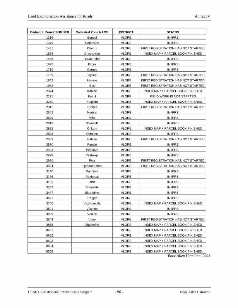
Land Expropriation Assistance for Roads Annex IV
Cadastral ZoneZ NUMBER Cadastral Zone NAME DISTRICT STATUS 1316 Bunavi VLORE IN IPRS
1379 Cerkovine VLORE IN IPRS
1481 Dhermi VLORE FIRST REGISTRATION HAS NOT STARTED
1524 Drashovice VLORE INDEX MAP + PARCEL BOOK FINISHED
1568 Dukat Fshat VLORE IN IPRS
1625 Fitore VLORE IN IPRS
1710 Gernec VLORE IN IPRS
1739 Gjolek VLORE FIRST REGISTRATION HAS NOT STARTED
1952 Himare VLORE FIRST REGISTRATION HAS NOT STARTED
1982 Ilias VLORE FIRST REGISTRATION HAS NOT STARTED
2074 Kanine VLORE INDEX MAP + PARCEL BOOK FINISHED
2171 Kocul VLORE FIELD WORK IS NOT STARTED
2280 Kropisht VLORE INDEX MAP + PARCEL BOOK FINISHED
2311 Kudhes VLORE FIRST REGISTRATION HAS NOT STARTED
2662 Mertiraj VLORE IN IPRS
2689 Mifol VLORE IN IPRS
2813 Novosele VLORE IN IPRS
2832 Orikum VLORE INDEX MAP + PARCEL BOOK FINISHED
2838 Oshtime VLORE IN IPRS
2863 Palase VLORE FIRST REGISTRATION HAS NOT STARTED
2870 Panaje VLORE IN IPRS
2903 Penkove VLORE IN IPRS
2929 Peshkepi VLORE IN IPRS
2960 Pilur VLORE FIRST REGISTRATION HAS NOT STARTED
3094 Qeparo Fshat VLORE FIRST REGISTRATION HAS NOT STARTED
3140 Radhime VLORE IN IPRS
3176 Rexhepaj VLORE IN IPRS
3185 Risili VLORE IN IPRS
3362 Sherishte VLORE IN IPRS
3467 Skrofotine VLORE IN IPRS
3621 Tragjas VLORE IN IPRS
3760 Vezhdanisht VLORE INDEX MAP + PARCEL BOOK FINISHED
3801 Vllahine VLORE IN IPRS
3809 Vodice VLORE IN IPRS
3844 Vuno VLORE FIRST REGISTRATION HAS NOT STARTED
3858 Xhyherine VLORE INDEX MAP + PARCEL BOOK FINISHED
8601 VLORE INDEX MAP + PARCEL BOOK FINISHED
8602 VLORE INDEX MAP + PARCEL BOOK FINISHED
8603 VLORE INDEX MAP + PARCEL BOOK FINISHED
8604 VLORE INDEX MAP + PARCEL BOOK FINISHED
8605 VLORE INDEX MAP + PARCEL BOOK FINISHED Booz Allen Hamilton, 2003
USAID SEE Regional Infrastructure Program - 96 - Booz Allen Hamilton

Land Expropriation Assistance for Roads Annex V
ANNEX V
LAND EXPROPRIATION PROCEDURES MANUAL
English Version Albanian Version
USAID SEE Regional Infrastructure Program - 97 - Booz Allen Hamilton

Land Expropriation Assistance for Roads Annex V
USAID SEE Regional Infrastructure Program
Edition II A
November - 2002
- 98 - Booz Allen Hamilton

Land Expropriation Assistance for Roads Annex V
Figure 19: PROCESS OF EXPROPRIATION PROGRAM
Plot proposed highway route on property maps
Offer made to property owner (owner can reject offer and appeal only on the grounds of the amount of compensation offered)
GRD Expropriation Dept..
Expropriation notice to owners & effected third parties (within 10 days of approving application) and publication in public media for 1 week period
Land ExpropriationCommission (LEC)
Prepare & submit applicationto MoT Monitoring Sector
Agreement signed between LEC and GRD to proceed with expropriation
GRD commences process for compensating property owners
Order to acquire propertyfor highway corridor
Council of Ministers (COM)
Collect property information(maps, certificates, tapi) fromIPRS or other sources
Identify cadastre zonesto be effected by corridor
Identify private property tobe acquired for road corridor
Determine property locationand area to be expropriated(field survey, other sources)
Determine value of property& estimate of compensation
Verify application complies with Expropriation Law (all documents and information provided are complete and correct)
Yes
Application approved
Monitoring Sector (MS)
No
W ritten notice to GRD of application acceptance
Expropriation notice published in local media
Determination/verification of value & compensation
Audit of valuation andcompensation process
Expropriation proposal prepared & submitted to COM for approval
Expropriation proposal examined by COM
NoYes
Proposal approved
EC notifies GRD of approval
EC prepares to return deposited funds
Decision by COM
Immovable PropertyRegistration system (IPRS)
GRD prepares & submits expropriated property documents for registration in IPRS
Registration of thedocuments in the IPRSlegally transfers ownershiprights to the State
Booz Allen Hamilton, 2003
USAID SEE Regional Infrastructure Program - 99 - Booz Allen Hamilton

Land Expropriation Assistance for Roads Annex V
Note:
Official Letter for the Approval of the Manual by the Ministry of Transport and Telecommunications. The signed original is in the Albanian section of the Manual.
REPUBLIC OF ALBANIA
Ministry of Transport and
Telecommunications
General Directorate of Programming and Monitoring
No. 4151 Prot. Tirana, November 19, 2002
SUBJECT: ON THE USE OF THE EXPROPRIATION MANUAL
THE GENERAL ROAD DIRECTORATE T I R A N E
This is a respond to your letter no. 5487, dated October 18th, 2002, through which you have required the officializing of the Expropriation Manual, prepared by the Technical Agency of RIP-Albania and the Expropriation Department of GRD. Based on your considerations on the Manual, which is a summary of the legislation on expropriation and in particular of the law no. 8561, dated December 22nd, 1999 “On expropriation and taken in temporary use of the private property for public interest”, we fully agree that this document will serve as a supporting material and a basic document to follow step by step legal procedures, in order to perform expropriation for public interest. This will help to speed up the process of expropriation and perform it within the time frame, preceding the road construction process. ___________________ SPARTAK POCI M I N I S T E R
USAID SEE Regional Infrastructure Program - 100 - Booz Allen Hamilton

Land Expropriation Assistance for Roads Annex V
ANNEX V - TABLE OF CONTENTS
1. INTRODUCTION 2. PRELIMINARY STEPS TO PREPARE FOR EXPROPRIATION 3. SURVEYING, MAPPING AND LAND SUBDIVISION 4. PREPARATION OF DESIGN DOCUMENTS 5. SUBMISSION OF DESIGN DOCUMENTS TO GENERAL ROADS DIRECTORATE 6. PROVISIONS FOR DESIGN CHANGES BY SUPERVISION CONTRACTOR 7. PREPARATION OF APPLICATION FOR EXPROPRIATION
USAID SEE Regional Infrastructure Program - 101 - Booz Allen Hamilton

Land Expropriation Assistance for Roads Annex V
Procedures Expropriation Manual for the Expropriation of Property in Albania
Edition II A
1. Introduction This manual is prepared to provide guidelines and procedures for those involved in the expropriation of properties to create a corridor for upgrading existing roads or for the construction of new roads (hereinafter referred to as “road development”) in the road network of Albania. The procedures and processes described in this manual are the same, and must be followed in the same manner, for all road development projects regardless of whether they are for upgrading an existing road or for constructing a new road. Expropriation of private property is a common and necessary occurrence when development of infrastructure for “public good” takes place. When the decision is made to upgrade an existing road or to construct a new road plans are prepared to carry out the route location and design. The plans indicate if the existing corridor is adequate to contain the upgrade or construction of the road without encroaching on or crossing private property. If the upgrading or construction must encroach on or cross private property, it is necessary to acquire a portion of the property from the owner. The method used to acquire the property is known as Expropriation. This manual is based on Law 8561, dated December 22, 1999 “On Expropriation and Temporary Taking of Private Property for a Public Interest” (Appendix I). This is the primary legislation governing the procedures and processes for expropriation of private property in Albania. Because expropriation of private property infringes on private property rights, the manual is guided by Law 7843, “On Registration of Immovable Property” (1994) (Appendix I) for issues related to the determination of property rights and interest. Law No. 7843 governs the administration of immovable property rights and interests in Albania. The preparation of this manual is the result of the combined efforts between the consultant and the Expropriation Department of the (General Road Directorate (GRD). This document represents version II A of the manual. Its preparation generated a very productive dialog among the professionals working with land acquisition and many issues were identified during the dialog. Some of the issues were resolved during the discussions, but there are others that will take some time and co-ordination between government agencies. These issues will have to be resolved by the Ministry of Transport and Telecommunication (MoTT) in co-ordination with the Ministry of Local Government (MoLG), Ministry of Agriculture and Food (MoAF), and Immovable Property Registration System (IPRS). The conclusion was that the manual was basically completed and there was no need to wait to resolve these issues before the issuing of this version.
USAID SEE Regional Infrastructure Program - 102 - Booz Allen Hamilton

Land Expropriation Assistance for Roads Annex V
2. Preliminary Steps to Prepare for Expropriation
Some preliminary steps must be taken to allow the expropriation process to take place in an efficient and effective manner. These preliminary steps are not strictly part of a typical expropriation process but should be strictly followed in advance of expropriation of property for road development. 2.1 Initial Involvement of Expropriation Department The Expropriation Department must be notified by the MoTT, as soon as the MoTT decides that road development, at the National Level, will take place. This will allow the Expropriation Department time to plan for the resources (human, technical and financial) that it will need to assign to the expropriation tasks when the project commences. It will also provide the Expropriation Department with some advanced notice to work with the IPRS offices and obtain the registration status of properties in the area to be affected (see Section 2.4). 2.2 Review of Terms-of-Reference and Tender Documents The Expropriation Department must be involved in the formulation of the Terms-of-Reference (ToR) or tender documents that are prepared for the intention of soliciting proposals or bids in the selection of the designing company. The Expropriation Department must ensure that the specifications and ToR for all activities related to expropriation are complete and accurate. The Expropriation Department verifies its review and show its approval by signing the documents. The documents must be signed and dated by the Director of the Expropriation Department, and must be submitted to the General Director of GRD for signature and seal. 2.3 Notification to Local Authorities The Expropriation Department must contact the local government authorities and inform them that road development will take place in a given district. The local government authorities must then inform the “head” of the communes through which the road development will take place. The “head” of the respective communes can then take the appropriate action to:
a. impose construction controls to prevent any new construction or other developments that will likely obstruct or delay the planned road construction or upgrading program;
b. amend any urban plans to accommodate for any proposed changes to the road corridor; and
c. give local property owners advanced notification of potential expropriation activities (see section 10 for notification procedures).
This approach could save the Government of Albania considerable time and cost for property expropriation, demolition and removal of illegal construction, and delays in road construction. 2.4 Meet with Local Immovable Property Registration System Officials
USAID SEE Regional Infrastructure Program - 103 - Booz Allen Hamilton

Land Expropriation Assistance for Roads Annex V
The Expropriation Department must meet with the local IPRS officials to determine the registration status of properties as soon as the designing company starts its activity. The Expropriation Department, through IPRS, will arrange to gain access to any property information as required. The Expropriation Department, in the role of co-ordinator and based on the ToR, provides all property ownership information to the design contractor. The IPRS provides the best source of legal evidence of ownership to immovable property. Registration of a property in the IPRS ensures that a person has the right to enjoyment of the property within the laws of Albania. Complete ownership information and information on other real rights for a property can be obtained through a copy of the Registry Index Map (RIM) and the Kartela (See Appendix V). The 3rd printing list includes in succinct manner all the information provided by kartelas within cadastral zone. The 3rd printing list may not contain latest ownership information since not all IPRS offices maintain the 3rd Printing list after it has been confirmed correct and the properties are First Registered. Therefore, it will be necessary to ask the Registrar about the policy for updating the registers, in the zones of road development interest. (Note: Not all properties have been registered in the IPRS to date. The process of First Registration is an ongoing effort of the Project Management Unit (PMU)/IPRS. The PMU has a plan that provides for the First Registration of all Cadastral Zones over a given period*. The PMU is able to prioritise First Registration in order to accommodate the First Registration of Cadastral Zones in areas of road development. First Registration procedures take approximately eight months and include a 90-day public display period. The longer the period of notification that can be given to the PMU/IPRS the easier it will be to adjust its plans for First Registration. First Registration activities can be co-ordinated through the Central PMU/IPRS office located in Tirana). 2.5 Agreement Between Expropriation Department and Design Contractor The design contractor must meet with the Expropriation Department as soon as the contract is awarded and prior to commencing work on the design contract. The Expropriation Department must assign a staff member as a primary contact person to work with a person assigned by the design contractor for the duration of the design contract. The Expropriation Department representative will be the primary contact with the design contractor for all issues related to property during the design and construction phase of the road development. The Expropriation Department representative will ensure that the design contractor has access to all available property information for the contract area (The contract area is defined as the area in which the road construction, for which the contractor is responsible, will take place). The Expropriation Department and the design contractor will prepare and agree upon a schedule for specific deliverables including, but not limited to, property information, project status reports, and progress meetings.
*First Registration is expected to be complete for all of Albania by mid 2004. There will be no need for this step after that time.
USAID SEE Regional Infrastructure Program - 104 - Booz Allen Hamilton

Land Expropriation Assistance for Roads Annex V
If the contract area has completed First Registration in the IPRS the Expropriation Department representative must get the appropriate property information from the IPRS and make it available to the design contractor prior to commencing any field data collection. The information must be made available to the design contractor according to a mutually agreed schedule. If the area of the contract has not gone through First Registration in the local IPRS, the Expropriation Department representative must prepare a plan to gather all possible property information from other sources. The Expropriation Department will work with the local authorities and any other sources of property information such as the local property owners, notaries, village elders, visible evidence of boundaries, etc. to gather the most current property ownership information. The Expropriation Department must provide the property information to the design contractor according to a mutually agreed schedule. The Expropriation Department must also contact the central PMU/IPRS office in Tirana in order to arrange for First Registration procedures to begin on a priority basis. The arrangement must be made as soon as possible in order to ensure that First Registration is completed and payment of compensation can be made to property owners without delay. (See Section 10.2.3). (Note: The issue of requiring First Registration to be completed must be resolved between GRD, MoTT, and the Central Office of the IPRS (for those zones where the First Registration is not completed at the time the designing company starts its activity).
2.5.1 Responsibilities of the Expropriation Department
The Expropriation Department undertakes to perform the following tasks over the duration of the contract: 1. Acquire all available property information, in support to the Preliminary Design Layout for
the contract area, from the local IPRS office and deliver it to the design contractor within 1 month from the commencement date of the Preliminary Design Contract.
2. In the case when First Registration has not been completed, acquire all available property
information for the contract area from the local administration office(s) and deliver it to the design contractor within 1 month from the commencement of the Preliminary Design Contract.
3. Assist the design contractor with access to private property for the purposes of gathering data
to:
• prepare topographic maps; • define property boundaries; • prepare the design of the road according to design specifications; and • identify owners based on IPRS information and verified by evidence gathered in the
field.
USAID SEE Regional Infrastructure Program - 105 - Booz Allen Hamilton

Land Expropriation Assistance for Roads Annex V
4. Review design documents to check proposed expropriation plans and provide feedback to the
design contractor within 2 weeks from the date of receiving the documents. 5. Monitor the designing contractor activity progress in terms of expropriation, and participate
in the project’s monthly meetings; and. 6. When necessary, Expropriation Department can call for a special meeting with the design
contractor. These meetings can be held at a mutually agreed location.
2.5.2 Responsibilities of Design Contractor
The design contractor undertakes to perform the following tasks over the duration of the contract: 1. Do field surveying (or where possible and feasible substitute with aerial photography), and
prepare of topographic maps for the road corridor to be developed; 2. Deliver preliminary design documents to the Technical Department and Expropriation
Department for review and comments; 3. Prepare monthly progress reports and submit them to the Technical and Expropriation
Departments, and the management units responsible for managing the project;**
4. Attend monthly progress meetings that would include the GRD Expropriation and Technical
departments, and the management units responsible for managing the project; and 5. Advise the Expropriation Department at once of any problems encountered with property
matters that may impede expropriation progress.
3. Surveying, Mapping and Land Subdivision The design contractor is responsible for all field surveying and the preparation of topographic mapping for the road corridor to be upgraded or constructed. 3.1 Standards and Specifications for Surveying and Mapping All surveying and mapping undertaken for road development work must conform to the “Guidelines for Minimum Requirements for Field Surveys and Investigations”. Refer to Appendix III for a copy of these Guidelines. The Guidelines provide detailed instructions on the process to be used, the data to be collected and the format and content of the topographic maps that are prepared for the purposes of road design and property expropriation.
** Monthly reports should be distributed by e-mail whenever and to whomever possible.
USAID SEE Regional Infrastructure Program - 106 - Booz Allen Hamilton

Land Expropriation Assistance for Roads Annex V
All standards and specifications for surveying and mapping are included in the Guidelines and will be provided in the ToR section of the tender documents. Thus selected design contractor is then already familiar with the surveying and mapping requirements when the contract is signed. 3.2 Subdivision of Immovable Properties The first step for expropriating land and transferring ownership to the state is found in Law no. 7843, Article 22- Transfers of Part of the Immovable Property: “No part of the immovable property included in a register shall be transferred unless the proprietor has first subdivided the immovable property, in accordance with the law, and new registers have been opened in respect of each subdivided portion of the immovable property.” When an immovable property is divided into two or more immovable properties this action constitutes subdivision. To register the newly created immovable properties a survey plan of the properties must be provided at the time of application for registration (Article 21 of “Law no. 7843 (dated 13.07.94) On the Registration of Immovable Property”). (See Section 13).
4. Preparation of Design Documents The design contractor must prepare the design documents according to the format and standards defined in the contract documents (refer to specifications). The property to be expropriated must be identified and shown on the design drawings in a standard format as per specifications (See Appendix IV “Final Designs, Tender Documents and Supervision of Construction for Road Corridors”). The information must be presented in such a format that it can be unambiguously interpreted and used by the Expropriation Department as the basis for preparing expropriation documents. 4.1 Contents of Design Documents The contents of the design documents are defined in the contract specifications and must be strictly followed. (See Appendix IV, Section 3.1.3, Subsection xii,).
4.2 Format of Design Documents The format of the design documents is defined in the contract specifications and must be strictly followed. (See Appendix IV, Section 3.1.3, Subsection xii,).
5. Submission of Design Documents to General Roads Directorate The design contractor must present the design documents to the Technical Department and Expropriation Department. These departments check the documents for compliance to specifications and design criteria as per their respective mandates. If the Technical Department discovers any errors or omissions in the design documents that will impact on the expropriation of property, it must report these to the Expropriation Department.
USAID SEE Regional Infrastructure Program - 107 - Booz Allen Hamilton

Land Expropriation Assistance for Roads Annex V
5.1 Expropriation Department of the General Road Directorate The Expropriation Department has the responsibility for acquiring the right of way for the national road corridors for Albania. Therefore, the Expropriation Department must review the design documents for compliance with both the expropriation and the property ownership legislation of Albania. The Expropriation Department must check and approve both the preliminary design and the final design documents for compliance with the expropriation legislation. The Expropriation Department checks the design documents to:
• verify that all private properties along the route have been identified and included in
the proposed properties for expropriation; • verify that the areas of the properties to be expropriated are correct; • determine that the property proposed for expropriation is adequate to accommodate
the road corridor; • determine if the proposed property for expropriation is not larger than is required to
accommodate the road corridor; and • verify that public property along the road corridor is not included in the proposed
property for expropriation. When the final design documents are checked and approved, the Expropriation Department proceeds with the expropriation of the property
6. Provisions for Design Changes by Supervision Contractor The supervision contractor is responsible for reviewing all existing design documents and, where considered necessary, revise the documents and prepare final design documents. The process to be used by the supervision contractor is described in Appendix IV, Section 3.1 “Final Designs, Tender Documents and Supervision of Construction for Road Corridors”.
6.1 Rationale for Design Changes The supervision contractor must check the design documents and verify that the design is satisfactory and that the road can be constructed. The final design is prepared on the basis of a review of the preliminary design. The supervision contractor reviews the design, carries out additional field surveys and investigation necessary to complete and/or modify the design or prepare the final design. The final design shall be complete and in sufficient detail that the construction can be carried out without the need for any further designs or construction drawings. 6.2 Input by Expropriation Department
USAID SEE Regional Infrastructure Program - 108 - Booz Allen Hamilton

Land Expropriation Assistance for Roads Annex V
The supervision contractor must inform the Expropriation Department of any intended/proposed design changes immediately upon completion of the verification of the design documents and at the completion of the field inspection. 6.3 Submission of Proposed Changes to Expropriation Department The supervision contractor must inform the Expropriation Department of any proposed design changes within 2 months after being awarded the supervision contract or within a period of time not more than 50% of the mobilization time of the construction contractor. After this period, no other proposal for expropriation in that road segment is accepted
7. Preparation of Application for Expropriation Once the design team has completed the fieldwork and the GRD is satisfied with the survey and other design documents, the Expropriation Department must complete the application for expropriation. A list of the properties to be expropriated is prepared by the Expropriation Department. The list includes the names of the owners, their addresses, and the dimensions and the area of the property to be expropriated. The applications for expropriation of all property in a given section of road or a particular contract are prepared and sent to the MoTT for submission to the Expropriation Commission of the MoTT. The checklist should be used to ensure that all property and ownership information is obtained and the proper forms are completed before the application is submitted to the MoTT. 7.1 Property Information Required in Application for Expropriation To ensure that the expropriation is carried out in a timely manner and according to the legislation and regulations, it is necessary to provide all the information required by the Commission and others involved in the expropriation process. The following information must be provided when the application is submitted to the MoTT. Documents to be provided as per Council of Ministers Decision 127 (see Appendix VI):
1. Projects approved in the respective institutions. 2. Legal argumentation for the public interest of the expropriation and the reason the
expropriation is being done. 3. Documents that verify the preliminary valuation of the objects to be expropriated. 4. The amount of compensation contemplated for each owner. 5. The authorizations and licenses approved by the competent organs for the realization of
the project. 6. The time periods and manners of realizing the project by the applicant himself or with
third parties. 7. A list of the owners of the private properties to be expropriated. 8. A list of the owners whose private property is devalued because of the expropriation.
USAID SEE Regional Infrastructure Program - 109 - Booz Allen Hamilton

Land Expropriation Assistance for Roads Annex V
9. A list of the third persons that are to be compensated for their rights over private property
that is being expropriated. And 10. An indicating map in the scale 1:1000 or1: 2500.
For points 7-9 above, explanations and necessary data for each of them shall be presented, projections about the valuation of the properties and the rights, the addresses and last known residences of the owners and the respective third persons. 7.2 Owners Personal Information, for all persons having a right to the property The information concerning the legal owners is important for the purpose of notification of expropriation. (See Section 10.1) Personal information can be collected in the field and verified by the IPRS information. The following information should be included on the appropriate Form:
• Full names (family and given) for all people holding rights to the property. • Civic address (street name and no., apartment no.). And • Mailing address (post office box, postal code, etc.).
7.3 Preparation of a list of Property Owners A list of property owners and the area of land that will be expropriated must be completed according to the appropriate Form. The ownership information that is gathered in the field must be verified with the ownership information registered in the IPRS. If there are discrepancies in the two sources of information, the parties must be notified in order to resolve the problem. The easiest way to verify the information is during the fieldwork of the design phase. If transactions have occurred but the new owners have not registered the contracts in the IPRS, they will have time to complete the legal procedures for registration. Compensation will not be given until an owner is legally registered in the IPRS. 7.4 Properties with Unidentified Owners When the owner of the private property that is to be expropriated is not identified, the MoTT should apply in court for the transfer of these properties to state ownership. The MoTT must pay all the court expenses.
8. Quality Control of Data/Information for Application The Expropriation Department must ensure that the applications that are submitted to the MoTT are free of errors or omissions. Quality control procedures must be put in place in the department that will ensure that all documents produced are of a specified standard. The following sections will set the quality control standards for the preparation and submission of applications for the expropriation of property for roads in Albania.
USAID SEE Regional Infrastructure Program - 110 - Booz Allen Hamilton

Land Expropriation Assistance for Roads Annex V
8.1 Standard Forms and Documents for Submission of Information The application for expropriation of property must be prepared on standard forms that have been developed by the Expropriation Department and approved by the MoTT. The supporting documents, prescribed in the laws and regulations, must be numbered and attached in a sequential order for each application submitted to the MoTT. The Expropriation Department must complete a checklist of all documents prescribed by the law and the regulations. The checklist must be signed and dated by the ED staff person that completed it, and signed by the Expropriation Department Director. 8.2 Standard Approach for Preparing Financial Data All financial data submitted in support of expropriation must be prepared in Microsoft Excel spreadsheet or equivalent spreadsheet software and must be set up in a standard spreadsheet with standard settings for all numbers whether entered manually or created by a formula. 8.3 Check on Accuracy of Information The Expropriation Department must assign someone to be responsible for checking that all applications are completed accurately and that all of the supporting documents as per the law and regulations are included in the application. The responsible person must verify that signing a form and placing a copy of the form on file did the check on the application. 8.4 Approval of Documents Before Submission to MoTT The Director of the Expropriation Department must sign all applications for expropriation. The signature of the Director verifies that the application is a legitimate document on which to carry out expropriation procedures.
9. Submission of applications to the Expropriation Commission Applications for expropriation of property for road development must be submitted to the MoTT for approval. 9.1 Review of Application by MoTT Applications received by the MoTT for expropriation of property are reviewed by the MoTT - Directory of the Project Monitoring (DoPM) staff and are submitted to the Expropriation Commission. The applications are checked for accuracy of information and completeness. DoPM staff ensures that all required supporting documents (as per Article 10 of Law 8561) are contained in the application and checks that all forms are correctly completed. The DoPM staff checks:
• that all documents are included as per expropriation law;
USAID SEE Regional Infrastructure Program - 111 - Booz Allen Hamilton

Land Expropriation Assistance for Roads Annex V
• that the documents are dated and signed by the staff in charge; • the calculations of the estimated compensation; • the calculations of areas of the properties; and • the list of property owners.
9.2 Errors or Omissions in Applications If the Expropriation Commission finds that any required documents are missing, any documents are incomplete or are incorrectly completed the application is sent back to the Expropriation Department for revisions. The MoTT designates a specific time period in which the application must be returned complete with the missing documents or corrections made. The Expropriation Department must provide the missing documents or make the necessary corrections and resubmit the application to the MoTT within the designated time period. The Ministry immediately notifies the GRD that the application has been accepted, and a Memorandum of Understanding (MoU) between the MoTT and GRD is signed within 10 days. 9.3 Approval of Application by the Expropriation Commission When the DoPM staff of the MoTT is satisfied that the application is complete and accurate, it is submitted to the Expropriation Commission to carry out the expropriation procedures.
10. Notification 10.1 Notification to Property Owners The individual notification process is designed to inform property owners of the government’s intent to expropriate all or part of their property, the timeframe for the expropriation and the amount of money that is offered for their property. In addition to individual notification, the MoTT must also publish the list of properties that will be expropriated and the names of owners in both a national and local newspaper for a period of one week. The local and nation wide publishing give notice to third parties who may have claims against the information obtained by the design teams or Expropriation Commission. The Expropriation Commission is responsible for publishing the list of owners (based on the Law Nr. 8561 Article 21, Paragraph 2 (dh) “Decision for Expropriation”). The payment for publishing list of owners is done through the GRD budget.
10.1.1 Notification Process
Once the MoTT has accepted the application for expropriation, direct notification to the property owners must begin within 10 days. Property owners must be individually notified using the approved Notice Form.
USAID SEE Regional Infrastructure Program - 112 - Booz Allen Hamilton

Land Expropriation Assistance for Roads Annex V
In addition, those physical or juridical persons that have rights registered in Sections D and E of the registration Kartela must also be notified. (See Section 7.5). The involvement of the local government is critical for the timeliness and completeness of the notification. The Expropriation Commission shall complete the Notification Form. (See Law N. 8561, Article 14 and the Normative Act DCM 126, Date 23.03.2000, Paragraph 3). In co-operation with the local government authorities, the notification must be personally delivered to the recipient or his/her headquarters, residence or postal address. If personal notification is not possible, written notification is acceptable if it is sent by registered letter. If the interested person refuses to accept delivery of the notification, then the person charged with making the notification makes an appropriate note on the notification and when it is possible verifies it with the signature of two witnesses present.
10.1.2 Notification Period
In co-operation with the Local Government, the Expropriation Commission should complete the appropriate forms and assure that the forms are delivered within 30 days. Note: This procedure must be discussed and approved by the MoTT and the MoLG. The exact date of individual notification must be noted in order to verify the number of days that owners and other interested parties have to either accept or submit claims against the expropriation decision.
10.1.3 Property Owners Acknowledging Notification
After individual notification is complete, owners have 15 days to either submit a claim against the information contained in the notification or to accept the government’s proposal. After the list of properties has been published in the national and local newspapers, third parties have 15 days to submit claims to the MoTT. Claims are submitted to the Expropriation Commission, a second copy of which is given to the Expropriation Department.
10.1.4 Property owners that can not be contacted
When the owner or other interested party does not have a domicile, residence or temporary home in the Republic of Albania or cannot otherwise be contacted, the notification of the document is done by posting a copy in the neighbourhood, commune or place where the object is located, through Expropriation Commission in cooperation with the Local Government. 10.2 Valuation of Property Decision 138 (23.03.2000) sets out the technical criteria for valuation of property that is to be expropriated. When the district IPRS office has recorded recent sales of land, the valuation of a property is determined by calculating the average of purchases and sales. When the district IPRS
USAID SEE Regional Infrastructure Program - 113 - Booz Allen Hamilton

Land Expropriation Assistance for Roads Annex V
has not recorded recent sales, data from other district offices must be used to calculate the appropriate amount of compensation.
10.2.1 Technical Criteria for Valuation
If the District IPRS office where the property is located has recorded sales transactions in the 3 months preceding the date when the application is made, then the valuation of a property is calculated based on the average of purchases and sales in that office. The Expropriation Department shall complete the Form of Request for Property Valuation Information to the district IPRS office. The IPRS office is required to respond to the request within 5 days from the official submission of the application. The document issued by the IPRS is an official document, formulated in writing and signed by the Registrar. If the District IPRS office where the property is located has not recorded sales transactions in the three months preceding the date when the application is made, then the valuation of a property is calculated based on the method of direct comparison, with purchases and sales of other regions. The exact formula for calculations are found in Council of Ministers Decision 138 (23.02.2000) (See Appendix VI).
10.2.2 Computation of Compensation
A new law was recently passed that must be considered. Law 8752, On Creation and Functioning of Structures For Land Administration And Protection (26.03.2001) assigns new responsibilities to the former Cadastral Offices. Article 12(f) states:
“The Land Administration and Protection Section in the District will have the following functions for the land that it has under its administration as a multipurpose cadastre:.... To make the valuation of the agriculture land, forests, pastures, meadows for the purposes of expropriation, taxation, etc.”
Although this law has not yet been implemented, the offices for Land Administration and Protection will have to assess land values in the future. Until the law is implemented and the new Land Administration and Protection offices are functioning, valuation of agricultural land will continue to be based on transaction recorded in the IPRS office.
10.2.3 Payment of Compensation (process and schedule)
The amount of compensation that is to be given to the owner(s) or third parties must be made available within three months of the decision for expropriation or, if the amount of compensation is appealed in court, within three months of the final court decision. When the procedures for notification and publication of the application for expropriation are complete but the owner of the private property that is to be expropriated is not found, the competent ministry continues the procedures of expropriation and the amount of compensation that belongs to the expropriated owner is deposited in a bank
USAID SEE Regional Infrastructure Program - 114 - Booz Allen Hamilton

Land Expropriation Assistance for Roads Annex V
11. Submission of Applications to Council of Ministers for Approval 11.1 Documentation Required by the Council of Ministers The following documents must accompany the proposal for expropriation to the Council of Ministers: 1. A summary statement of the purpose, reason and need for expropriation, the time period for
beginning and concluding the expropriation as well as the time period for beginning and concluding the work or realization of the purpose of the expropriation.
2. A preliminary valuation of the objects of expropriation and the measure of compensation that
is contemplated for each private owner. 3. Appropriate licenses and approvals from the competent organs according to the law, in
accordance with the nature and type of the project that is sought to be realized. 4. Official documents that verify the manner of realizing the project by the applicant for
expropriation himself or with third parties, as well as the respective time periods. 5. A final list of the owners of the properties that are expropriated or devalued and the
respective official documents of ownership, as well as a list of the third persons whose rights are to be compensated because of the expropriation.
6. The documentation of valuation of the properties that are expropriated and devalued, of the
rights of third parties related to them and of the amount of compensation proposed, with the respective arguments.
12. Appeal of Expropriation Decision
7. Documents verifying the expenses of the procedure of expropriation.
11.2 Decision of the Council of Ministers If all of the requirements for expropriation are fulfilled, the Council of Ministers will approve the Application for Expropriation. The decision will be published in the Official Gazette. The MoTT must notify the owners and other third parties of the decision to expropriate
12.1 Appeal Process
12.1.1 Grounds for Appeal
Owners and other parties with interests in the property have the right to appeal the decision for expropriation in court within 30 days from receiving notice. An appeal is allowed only as to the amount of compensation specified in the decision. An appeal against a decision of the Council of
USAID SEE Regional Infrastructure Program - 115 - Booz Allen Hamilton

Land Expropriation Assistance for Roads Annex V
Ministers for the expropriation does not suspend the implementation of the decision and the procedure for registration of the property in the IPRS office.
12.1.2 Time Limitations
Owners or third parties with interest in the property that is to be expropriated can appeal the amount of compensation for expropriation. The appeal must be presented to the competent court within 30 days from the time of notification. If no appeal is presented within the specified time, the decision of the Council of Ministers for the expropriation is final and becomes an executable document.
12.1.3 Effects of Appeal
An appeal shall not stop the expropriation process, the implementation of the project or the registration in the IPRS. The Expropriation Department must continue with the proper registration procedures as soon as the Decision for Expropriation is issued.
13. Official Transfer of Ownership of Expropriated Property and Registration in the IPRS
Once the decision for expropriation has been approved by the Council of Ministers, the property must be registered in the IPRS in the name of the State, under the administration of the MoTT. Until registration in the IPRS is complete, the state is not the legal owner of the property. The IPRS was created in 1994 on the basis of Law 7843 in order to provide a comprehensive cartographic and legal register for all immovable property in Albania. The IPRS is a parcel-based system. Each property is identified with a unique number that is reflected on the RIM and the registration Kartela. The RIM defines the geographic position and location of a property and the Kartela reflects all ownership and other real rights to a property. All immovable property, whether urban, rural, private or public, and other real rights must be registered in the IPRS. 13.1 Application for Registration in the IPRS It is very important to have good cooperation and to offer periodic status reports to the district IPRS. Initial contact with the district Registrar should be made at the time a decision is made to improve the road and the maps and ownership information is requested from the IPRS office. The periodic status reports allow the Registrar to prepare for registration of the expropriation decision. It also allows the Expropriation Department to update the official ownership lists to reflect new transactions. A copy of the Application for Expropriation that is sent to the Council of Ministers should be sent to the IPRS in order to facilitate registration once the final decision is made.
USAID SEE Regional Infrastructure Program - 116 - Booz Allen Hamilton

Land Expropriation Assistance for Roads Annex V
13.2 Documents to Accompany Application for Registration in IPRS
In order to register expropriation decisions for those Cadastral Zones that have completed the process of First Registration the following steps should be taken:
• Copy of 3rd printing list by parcel number
The first step for expropriating land and transferring ownership to the state defined in Law 7843 is found in Article 22:
“No part of the immovable property included in a register shall be transferred unless the proprietor has first subdivided the immovable property, in accordance with the law, and new registers have been opened in respect of each subdivided portion of the immovable property.”
According to Law 7843 and IPRS regulations, the following documentation should normally be submitted to the relevant district IPRS office for a subdivision:
1. A written request for the subdivision. And 2. A survey by a licensed engineer that reflects the new boundaries of the parcels.
However, the IPRS has acknowledged the difficulty of following this procedure in the case of expropriation for the national road network. Therefore, on 07.26.2002 a joint order was signed between the Chief Registrar and the Vice Minister of MoTT in order to facilitate cooperation between the two government entities. The following special procedures were approved in order to register expropriation decisions for the national road network. These procedures will be considered an exception to the formal requirements of Law 7843, On Registration of Immovable Property, relating to subdivision and consolidation of properties. (See appendix II).
1. For immovable property subject to expropriation for defined road corridors, the
Expropriation Department shall present a request for cartographic and ownership information to the relevant District IPRS using Standard Form 1 (See appendix 2, Joint Order between MoTT and IPRS). For the above-mentioned properties, the IPRS Office shall, within 10 days, provide the Expropriation Department with the following documentation:
• Copy of RIM
• Any other information that can assist the Expropriation Department for expropriation (origin of property ownership, state owned property etc.).
USAID SEE Regional Infrastructure Program - 117 - Booz Allen Hamilton

Land Expropriation Assistance for Roads Annex V
Within the Expropriation Department, the engineer responsible for the road segment shall work with the transcription department personnel to complete the following steps: a. Update the copy of the RIM by drawing the axis and boundaries of the road according
to the design plans. It is important that the Expropriation Department personnel use the “As Built” engineering drawings to update the RIM because the original design plans may have changes.
2.
b. The transcription personnel of the Expropriation Department will then update the 3rd printing lists. Individual parcels are identified by the Parcel Index Number (PIN) on the RIM. The corresponding number on the 3rd printing list of parcels should be located and the area of the property that has been expropriated (according to the Decision for Expropriation) should be noted next to the number that reflects the original surface area of the property.
After the Council of Ministers Decision has been issued, as soon as the copy of the RIM and 3rd printing list have been updated by the Expropriation Department team, the following documents will be submitted to the IPRS District Office for registration:
• The Copy of the RIM with the road segment presented on it. (See Appendix V) • The Council of Ministers Decision for Expropriation. • A copy of the “As Built” engineering drawings that reflect the field work for
expropriation and includes the information for the parcel boundaries and other information gathered during the survey process.
13.3 Statutory Period for Registration After Expropriation
Law no. 8561, On Expropriations and Temporary Takings of Private Property for Public Interest (dated December 22, 1999) Article 25 states private properties that have been expropriated are to be:
“… registered by the competent Ministry within 30 days from the date when the decision of the Council of Ministers for expropriation was taken”. Law 7843, On Registration of Immovable Property, Article 11 states: “Any contract or other document affecting rights to immovable properties shall be presented for registration no later than thirty days from the time the instrument or other document is executed”.
Based on the requirements of these two laws, the Expropriation Department must submit the application for registration of the expropriation decision as well as the accompanying documents within 30 days after the decision for expropriation is made.
USAID SEE Regional Infrastructure Program - 118 - Booz Allen Hamilton

Land Expropriation Assistance for Roads Annex V
13.4 Penalty for not Registering Within Statutory Period Law 7843, On Registration of Immovable Property Article 12 states:
14.2 Transportation and Accommodation for Field Visits
Under the present arrangement with the donors the cost of data collection in the filed is covered in the design contract. However, this arrangement may (certainly will change over time) change and the Government of Albania will absorb the cost.
“Where an instrument is presented more than thirty days after the date of the execution of the instrument, then, in addition to the registration fee, an additional fee equal to ten per cent of the registration fee shall be payable for each day which has elapsed since such date”. By the Joint Order between MoTT and IPRS the penalty is not applied for registration presented by 31.12.2002. (See Appendix II, Joint Order between MoTT and IPRS).
14. Determining the Cost of Expropriation
The cost of expropriating property must be determined and included as a “cost centre” or a “line item” in the budget for road development projects. The typical costs associated with the expropriation of a property are described in this section. 14.1 Purchasing Information from the IPRS The primary evidence of ownership of property is found in the registers at the IPRS offices. The ownership information must be collected from the IPRS and provided to the Expropriation Commission as evidence of ownership to determine who will be compensated for the property. The IPRS must recover the cost of providing the information.
Over the duration of the expropriation process, it will be necessary to make several visits to the field. The cost associated with vehicle operation and maintenance and the cost of accommodations while in the field must be determined and included in the expropriation budget. 14.3 Collecting Field Data Under the present arrangement with the donors the cost of data collection in the filed is covered in the design contract. However, this arrangement may (certainly will change over time) change and the cost will be absorbed by the Government of Albania. 14.4 Preparing Survey Plans
USAID SEE Regional Infrastructure Program - 119 - Booz Allen Hamilton

Land Expropriation Assistance for Roads Annex V
14.5. Operating Cost of Expropriation Commission Article 4, Decision No. 126 dated March 2000 “On the Composition and Work Procedures of the Special Committee for Expropriation states:
“The compensation of the members of the special commission is set in the order of the Minister that creates the commission”. 14.5.1. Evaluating Property
The regulations that govern the operations of the EC assign the responsibility for valuation to the Commission. See Appendix 6 for the Commission’s guidelines for evaluation.
14.5.2 Notification of Expropriation to Property Owners
The Expropriation Commission is responsible for providing notification to property owners and third parties that may be affected by the property expropriation. The notification consists of mailing notices, posting notices in the local districts, and publishing notices in newspapers with national distribution. 14.6 Compensation to Expropriated Property Owners The compensation for property expropriation that is paid to the property owners comes from the budget of the GRD. These costs must be determined and included on the GRD budget.
14.6.1 Preparation of Payment Documents
As soon as Decision of the Council of Ministers is approved, the General Secretary of the Council of Minister sent this decision at the MoTT. The MoTT sent a copy of this decision at the GRD. After receiving a copy of the decision, the Expropriation Department, starts the preparation for the Expropriation Department, starts the preparation for payments, formulating owners’ lists. Problems faced during expropriation process, are recording in a special column of these lists. Such problems are i.e. owners in conflict, owners, which properties are in the first registration process. These lists together with an official note, are signed by General Director of GRD, and than are sent to the programming and Planning and Programming Department (PPD) of the GRD. This Department sent at the MoTT, a request for funds disbursement as planned in the budget for a certain road segment.
14.6.2 Fund’s transfer at the local Bank
Funds to be used for expropriation purposes are approved by the Ministry of Finance (MoF) at the beginning of each year as part of the budged estimated for MoTT. As soon as MoTT received the request for funds from GDR, authorizes the bank to make such funds available. The budged branch authorized the treasure branch to open funds for expropriation purposes. The PPD of the GRD, after receiving the official answer from MoTT, formulates this official request with owners lists attached. This official request is sent to the financial office of GRD. This office
USAID SEE Regional Infrastructure Program - 120 - Booz Allen Hamilton

Land Expropriation Assistance for Roads Annex V
authorized the treasure branch for funds transfer to the local banks. The Financial office provides the owners list to the treasury. The treasury branch makes funds available to the respective local banks owners, whose names are in the list with draw the money from the local Bank. The local bank can froze the money, in case when owners have conflict problems as described above. 14.7 Registering the Property in the IPRS There are established fees for the various steps of registering immovable property in the IPRS. These fees are approved by the Council of Ministers. However, in order to facilitate registration of the backlog of expropriation decisions the Chief Registrar has issued a special order for procedures and reduced fee structure. (See Appendix II)
USAID SEE Regional Infrastructure Program - 121 - Booz Allen Hamilton

Land Expropriation Assistance for Roads Annex V
ANNEX V - Appendices
Appendix I - Laws on Expropriation and Registration of the Immovable Properties
Law 8561: Expropriation and Temporary Takings of Private Property for Public Interests
Law 7843: Registration of the Immovable Properties Appendix II - Orders on the Registration of the Expropriation Decision
Joint Order Between MoTT and IPRS
Guidelines on Registration of Expropriation Decision and Filling the Kartelas Appendix III - Guidelines for Minimum Requirements for Field Surveys and Investigations
Guidelines for Minimum Requirements for Field Surveys and Investigations Appendix IV -Sample of Final Design, Tender Documents and Supervisions of Construction for Road Corridors
Sample of Final Design, Tender Documents and Supervisions of Construction for Road Corridors
Appendix V -Registration Index Map and Kartela, Basic Registration Elements
Sample of Registration Index Map
Kartela
USAID SEE Regional Infrastructure Program - 122 - Booz Allen Hamilton

Land Expropriation Assistance for Roads Annex V
Appendix VI - Government Decision, Supporting the Expropriation Process
Decision of the Council of Ministers, No. 138 dated March 23, 2000
Decision of the Council of Ministers, No. 127 dated March 23, 2000
USAID SEE Regional Infrastructure Program - 123 - Booz Allen Hamilton

Land Expropriation Assistance for Roads Annex V
ANNEX V - Appendix I
Laws on Expropriation and Registration of the Immovable Properties
Law 8561: Expropriation and Temporary Takings of Private Property for Public Interests
Law 7843: Registration of the Immovable Properties
USAID SEE Regional Infrastructure Program - 124 - Booz Allen Hamilton

Land Expropriation Assistance for Roads Annex V
LAW No. 8561, dated 22.12.1999 ON EXPROPRIATIONS AND TEMPORARY TAKINGS OF PRIVATE PROPERTYFOR A PUBLIC
INTEREST
In reliance on articles 41, 78 and 83 point 1 of the Constitution, on the proposal of the Council of Ministers,
THE ASSEMBLY
OF THE REPUBLIC OF ALBANIA DECIDED:
CHAPTER I GENERAL PROVISIONS OBJECT OF THE LAW
Article 1
This law regulates the right of the state to expropriate or take for temporary use for a public interest the properties of private natural or juridical persons, as well as the protection of the rights and interests of the respective owners.
Article 2 Natural and juridical private persons have the right to respect for the property that they own. The expropriation of private properties is done only for a public interest, under conditions when the public interest prevails over the private interests of their owners, in accordance with the conditions prescribed by the law and general principles of international law. The right of expropriation and temporary taking of private property is exercised for a public interest that cannot be realized or protected in another manner, only for the reasons and with respect for the procedures expressly set out in this law, to the extent that is essential for the realization of the purpose of the expropriation and in any case against fair compensation.
Article 3 Expropriation and temporary taking of private property is realized in compliance with the conditions and procedures specified in this law while guaranteeing transparency, the equality of citizens and the protection of their property rights and interests.
Article 4 Expropriation and temporary taking of private property shall be done while respecting, and compensating in value, in accordance with the law, the rights of third parties in the private
USAID SEE Regional Infrastructure Program - 125 - Booz Allen Hamilton

Land Expropriation Assistance for Roads Annex V
properties that are expropriated, as well as devaluation because of the expropriation of other private properties that are not the object of the expropriation.
CHAPTER II EXPROPRIATION
Article 5
Meaning of Expropriation When the realization or protection of public interests cannot be achieved without exercising the rights of ownership over movable or immovable properties that are privately owned, the Council of Ministers, on the application of the requesting subject in favor of whom the expropriation is to be done, on the proposal of the minister who is competent under this law, decides on the expropriation of these properties. When the expropriation is done on the application of a private juridical subject, the competent minister, in the capacity of legal representative of state property, is authorized by this law, on the preliminary application of this subject, to make the transfer of ownership of the properties expropriated by the state in favor of the private subject who has applied for expropriation, on the condition that the realization of the building or investment for a public interest for which the expropriation was performed has been verified according to law.
When the private applicant does not seek the transfer of property in his favor, the property remains in favor of the state.
The objects expropriated for the reasons contemplated in points “a,” “b,” “d,” “dh,” and “ë” of article 8 of this law remain in each case in the ownership of the state.
Article 6 The Rights and Privileges of the Owner of the Private Property that is Expropriated
In cases when the owner has died or been declared missing and a certificate of inheritance has not been issued, the competent ministry has the right to submit a request for the issuance of a certificate of inheritance in the competent court, if such a request has not been presented or the interested parties refuse to present it.
When at the end of the procedures and time periods contemplated in this law related to the notification and publication of the application for expropriation, the owner of the private property sought to be expropriated is not found, the competent ministry continues the procedures of expropriation, and the amount of compensation that belongs to the expropriated owner is deposited in a bank for the account of the latter. When the owner of the private property sought to be expropriated is not known, applying article 172 of the Civil Code, the competent minister is authorized by this law to apply in court for the
USAID SEE Regional Infrastructure Program - 126 - Booz Allen Hamilton

Land Expropriation Assistance for Roads Annex V
transfer of these properties to state ownership. The judicial expenses and those of representation are chargeable to and prepaid by the applicant for expropriation. When the owner of the private property undertakes the realization of the public interest and the purpose for which expropriation is sought by a private juridical subject contemplated in letters “c” and “ç” of article 8 of this law, fulfilling the same legal conditions and guarantees for meeting the respective time periods, expropriation is not permitted. When the owners of private properties, through a written declaration, give consent and accept the passage of ownership of these properties in favor of the state, in accordance with the conditions offered by the competent ministry through a direct notification or publication of the request for expropriation for a public interest, the procedure of expropriation for these properties is considered completed. An expropriated owner or his heirs enjoy a priority right to purchase in the case when their properties that have been the object of expropriation, or the projects or investments realized on them, are put up for sale or are alienated in any manner by the state or the private subject who is the beneficiary of the expropriation.
Article 7 Objects of Expropriation
Reason for Expropriation
For the realization of national or local projects and investments, in the function of protection of the environment, health, culture and public education, as well as infrastructure, in the service and interest of the public.
The objects of expropriation are real properties in the form of land, buildings of every kind of a permanent nature, as well as the movable properties indicated in letters “e” and “ë” of article 8 of this law.
Article 8
In the function of the public interest, expropriation may be done for the following reasons:
For the realization of obligations of the state that come from treaties and international multilateral conventions. For the realization of programs, projects and investments contemplated in international agreements that extend into the territory of several states, to which our state is a party. For the realization of projects and investments that present national or local territorial extent or interest in the field of transportation of every kind, energy, telecommunications, water works of every kind, in the service and interest of the public.
For the realization of programs and investments in the field of national defense.
USAID SEE Regional Infrastructure Program - 127 - Booz Allen Hamilton

Land Expropriation Assistance for Roads Annex V
For the protection of monuments and immovable objects of a nature that is archaeological, historical, cultural and scientific, when these purposes, by the very nature of the objects, cannot be realized by a private owner, because of his objective inability or subjective position, with the consequence of a real risk of failure of realization, damage or hindrance to their functioning. For the protection of movable property with a historical, archaeological, cultural or scientific value, in cases when, even with the performance of the obligations of the organs that are competent according to law, these objects risk being damaged or disappearing. For cases when movable and immovable objects, for objective reasons or force majeure, create a permanent risk to public health and security, to the extent that, despite all the assistance of the state, these risks cannot be avoided by their owner.
Article 9 Subject in Favor of Whom Expropriation is Done
Expropriation may be done in favor of the state and of public or private, local or foreign juridical persons, for the realization by them of a project, investment or object of theirs that, in each case in accordance with this law, presents a public interest. A private juridical person may present an application for expropriation in the public interest only connected with the reasons for expropriation contemplated in letters “c” and “ç” of article 8 of this law.
Article 10 Application for Expropriation and Accompanying Documents
The subject in favor of whom the expropriation is done shall present an application for expropriation to the ministry that is competent pursuant to law. The application shall be accompanied by the following documentation:
e. Appropriate licenses and approvals from the competent organs according to the law, in accordance with the nature and type of the project that is sought to be realized.
a. Official documents that attest its status and registration as a juridical person.
b. Necessary plans, approved according to law, as well as the respective legal
arguments about the public interest connected with the realization of these projects.
c. Documentation related to the source and guarantee of the financial funds necessary for the realization of the project, including those for expropriation or because of devaluation.
d. A preliminary valuation of the objects of expropriation and the measure of
compensation that is contemplated for each private owner.
USAID SEE Regional Infrastructure Program - 128 - Booz Allen Hamilton

Land Expropriation Assistance for Roads Annex V
f. Official documents that verify the manner of realizing the project by the applicant for expropriation himself or with third parties, as well as the respective time periods.
g. A list of the owners of the private properties as to which expropriation is sought, a
list of the owners of private properties that are devalued because of the expropriation and a list of the third persons who should be compensated for their rights to the private properties that are sought to be expropriated, together with explanations and data necessary for each of them, with the respective estimates of the valuation of these properties and rights, as well as the addresses and last known residence of the respective owners and third persons.
h. Documents that verify the reason for the expropriation, according to article 8 of this
law. In cases where the applicant for expropriation is a state organ or state institution created by separate law, the documents contemplated by letters “a” and “c” of this article are not submitted. Detailed regulations related to the content and standards that are to be respected in the compilation and presentation of the documentation that accompanies an application for expropriation for a public interest are set by normative act of the Council of Ministers.
Article 11
Ministry Competent for Expropriation Applications for expropriation are submitted to the ministry that covers the respective activity, while the proposing to the Council of Ministers for the approval of the application for expropriation is made by the respective ministry.
The competent ministry performs necessary verifications about the applicant in whose favor expropriation is sought, about the documentation presented, about the reason for expropriation and
On the submission of the application for expropriation for a public interest, the competent minister orders the setting up of a special commission for following and accomplishing the procedures of expropriation. The members of the commissions shall be employees or independent experts, with experience and special qualification in the juridical, economic and engineering field, who, in any case, shall not be related by blood or marriage to the person being expropriated or have any kind of interests with the parties interested in the expropriation. The rules about the composition and the working procedures of the special commission on expropriations are set by normative act of the Council of Ministers.
Article 12 Return without Action and Refusal of the Application
USAID SEE Regional Infrastructure Program - 129 - Booz Allen Hamilton

Land Expropriation Assistance for Roads Annex V
he also administers the documents of ownership for the objects of expropriation, carrying out on-site investigations if necessary.
Within 10 days from the date of notification of acceptance of an application for expropriation, an agreement is entered into between the applicant in favor of whom the expropriation is sought and the competent ministry as to the mutual rights and obligations related to the expropriation procedure. If the applicant is a private subject, this agreement is done by notarial act.
When the documentation submitted by the applicant is not complete or accurate, the competent ministry immediately returns the application for expropriation and the documentation accompanying it according to this article to the applicant without action, designating a special time period for the appropriate completions. When the application and accompanying documentation are not submitted complete in the designated time period, or are found to be unsupported, because of the absence of a reason or of the conditions of expropriation according to this law, the application is refused by the ministry and the applicant for expropriation is notified immediately.
The applicant for expropriation has the right to appeal in court within 30 days of receiving notification.
The judicial examination is done in accordance with the legal provisions for the adjudication of administrative disputes in the Code of Civil Procedure.
Article 13 Acceptance of the Application
On the completion of the necessary verifications, as well as the procedures contemplated in article 12 of this law, when the application and respective accompanying documentation are supported in the conditions and criteria of this law, the competent ministry decides on the acceptance of the application for expropriation, immediately notifying, in writing, the applicant in favor of whom the expropriation is sought.
In the agreement document, the parties undertake the fulfillment of the obligations set or specified in this law in the respective time periods. The agreement document is executable. The agreement document is invalid if, at the time it is signed, the documents that accompany the application for expropriation according to this law are not attached.
Article 14 Notification of Application for Expropriation
Within 10 days from the date of entering into the agreement with the applicant for expropriation, the competent ministry begins fulfilling the procedures of direct notification to each owner or joint owner of the private properties sought to be expropriated or devalued as well as to third persons related to their compensation. Together with the procedures of notification, the
USAID SEE Regional Infrastructure Program - 130 - Booz Allen Hamilton

Land Expropriation Assistance for Roads Annex V
competent minister also performs those of publication of the request for expropriation in a public interest. Detailed regulations about the manner of notification, its content and the respective procedures are set by normative act of the Council of Ministers.
Article 15 Publication of Application for Expropriation in a Public Interest
To make it possible to protect the rights and interests of third persons in or because of the private property sought to be expropriated, at the same time as the notification of the application for expropriation in a public interest pursuant to point 1 of article 14 of this law, the competent ministry publishes the expropriation application in the Official Journal, in a newspaper with national circulation and in a local newspaper for a one week period. Third persons have the right, no later than 15 days from the date the time periods of publication expire pursuant to this article, to submit their claims accompanied by the relevant documents to the competent ministry. When the claims of third persons about ownership as well as the about the expropriation conditions offered are verified to be legally supported, the competent ministry proceeds with the expropriation, while also respecting these rights.
Article 16 Judicial Conflicts and Submission of Claims
The competent minister may not request the Council of Ministers to take a decision of expropriation before a one month time period from the day of conclusion of the procedures and time periods of direct notification of the owner who is expropriated and the publication of the application for expropriation according to this law.
The bringing of lawsuits or a judicial examination of a civil question connected with private property that is sought to be expropriated does not constitute a lawful reason to seek, or for the court to order, the interruption or suspension of the procedures of expropriation according to this law. The court or the competent ministry shall immediately notify one another about these cases. The competent ministry is obligated, at the completion of the procedure of expropriation, to put the amount of compensation for the private property expropriated or devalued in a special bank account. The amount of compensation is paid to or put at the disposition of the person who determined by the final court decision, after the competent ministry has been notified. Within 15 days from the date of notification according to this law or of the time period of publication of the application for expropriation, the owner, joint owners or third persons shall notify the competent ministry, also indicating whether they accept the voluntary transfer of the property on the conditions it has offered.
USAID SEE Regional Infrastructure Program - 131 - Booz Allen Hamilton

Land Expropriation Assistance for Roads Annex V
Within 15 days from receipt of the answer by the notifying person, but in any case not before one month has passed from the last date of the time period for publication of the request for expropriation for a public interest, the competent ministry, in the cases when the notifying parties have accepted the conditions offered by it or it has found the claims presented by them to be correct, in the sphere of expropriation and with the authority of the organ that makes the expropriation, carries out with the notifying party, as the case may be, the actions for transfer of ownership in favor of the state, against compensation or payment of the amount of compensation for the devaluation of the private properties or the rights of third parties because of the expropriation. With the fulfillment of the reciprocal obligations, the procedure of expropriation of these private properties is considered to be completed. With the consent of the competent minister, the above actions may be performed even after the above-mentioned time periods, as if the proposal for expropriation had been submitted to the Council of Ministers, so long as the latter has not yet decided on the expropriation.
Article 17
Valuation of Objects Expropriated At the conclusion of the procedures contemplated in articles 14 and 15 of this law, the special commission set up by the competent minister performs the actions for determining the final valuation as well as for computing the amount of compensation of the objects expropriated. In valuing the private properties that are expropriated, the other properties that are devalued or the rights of third persons that are to be compensated because of the expropriation, according to their nature, the initial value, the amortization, the purpose for which they are destined, the location of the object, and the change of the index of market prices and money are taken into account. Other technical criteria for valuation and the computation of the amount of compensation for private property that is expropriated, properties that are devalued and the other rights of third persons according to this law are set by the Council of Ministers.
Article 18 Compensation for the Value of the Devaluation of the Property
Compensation is given for the value of the devaluation of property in cases when the expropriation for a public interest is accompanied with the devaluation of a part of the property that is not expropriated or of property located near that which is expropriated. The cases, manners and calculations of the amount of compensation are set by instruction of the Council of Ministers.
Article 19 Calculation of the Payment
USAID SEE Regional Infrastructure Program - 132 - Booz Allen Hamilton

Land Expropriation Assistance for Roads Annex V
On the basis of the value that results from the final valuation of the objects that are expropriated, the amount of the respective computation is calculated, in the measure of its full value.
c) A final list of the owners of the properties that are expropriated or devalued and the respective official documents of ownership, as well as a list of the third persons whose rights are to be compensated because of the expropriation.
Article 20 The Proposal for Expropriation
At the conclusion of the preliminary procedures for expropriation, the competent minister submits the proposal for expropriation to the Council of Ministers, accompanied by this documentation: a) A summary statement of the purpose, reason and need for expropriation, the time period for beginning and concluding the expropriation as well as the time period for beginning and concluding the work or realization of the purpose of the expropriation. b) The documents required in letters “a” through “dh” of article 10 of this law.
d) The documentation of valuation of the properties that are expropriated and devalued, of the rights of third parties related to them and of the amount of compensation proposed, with the respective arguments.
Documents verifying the expenses of the procedure of expropriation.
Article 21 The Expropriation Decision
When the proposal is found to be well grounded in law and in fact, the Council of Ministers decides on expropriation. The decision of expro priation shall contain:
a. The purpose and legal reason for expropriation;
b. the private properties that are expropriated and the respective owners;
c. the amount of compensation for the owners who are expropriated, for the owners of the properties that are devalued, for third persons who are compensated for their rights because of the expropriation as well as the time period and manner of paying them;
d. the time period for beginning and ending the expropriation and the organ or subject that will start using the expropriated private properties;
e. the time period for beginning and ending the work for the project and the investment or for the realization of the purpose of the expropriation;
USAID SEE Regional Infrastructure Program - 133 - Booz Allen Hamilton

Land Expropriation Assistance for Roads Annex V
f. the value of the expenses of the procedure of expropriation charged to the applicant for
expropriation.
When there are many objects and joint owners, the data required according to letters “b” and “c” of this article are reflected in a special attachment as an integral part of the decision. In cases when the expropriation is applied for by a private subject, the properties expropriated pass to the ownership of the state. The transfer of the ownership of these properties in favor of the private subject who has applied for expropriation is done only when the latter has realized, in accordance with law, the purpose and cause of the expropriation for a public interest. Having the quality of an implementing regulation, the decision of expropriation of the Council of Ministers enters into force immediately. The decision is also published in the Official Journal.
Article 22 Refusal of the Application for Expropriation
When an expropriation according to an application accepted by the competent ministry is refused by the Council of Ministers, the competent ministry returns to the applicant for expropriation all funds deposited for the expropriation procedure.
Article 23
Payment of Compensation because of the Expropriation The amount of compensation that is, respectively, given to or put at the disposition of the person who is expropriated, the owner or third person who is damaged, within the time period indicated in letter “c” of article 21 of this law and, in every case, no later than three months from the end of the time period or from the date when the court decision has become final, according to point 2 of article 16 and article 24 of this law.
Article 24 Appeal of the Decision
The decision of the Council of Ministers on expropriation is made known by the competent ministry directly to the owners who are expropriated, the owners of properties that are devalued by the expropriation and third persons whose rights are compensated because of the expropriation who, only as to the amount of compensation specified in the decision, have the right to appeal in court within 30 days from receiving notice. An appeal against a decision of the Council of Ministers for the expropriation does not suspend the implementation of the decision and the respective procedure of registration of the property expropriated. As to the amount of compensation for expropriation, if an appeal in court is not taken within the 30 day time period according to this law, the decision of the Council of Ministers for the expropriation becomes an executable document.
USAID SEE Regional Infrastructure Program - 134 - Booz Allen Hamilton

Land Expropriation Assistance for Roads Annex V
The judicial examination is done in accordance with the legal provisions connected with the adjudication of administrative disagreements of the Code of Civil Procedure.
Article 25 New Registration of Expropriated Properties
In cases when the private properties that have been expropriated are to be registered according to law, this registration shall be done by the competent ministry within 30 days from the date when the decision of the Council of Ministers for expropriation was taken.
Article 26
2.
Invalidity of Expropriation
1. When the subject in favor of whom the expropriation was done does not begin or conclude the works for the projects and investments or for the accomplishment of the purpose for which the expropriation was performed within three months from the date of the end of the respective terms set in the decision of the Council of Ministers, the expropriation is considered invalid. Within the three month term mentioned above, on its own initiative or on the reasoned request of the subject in favor of whom the expropriation was done, the Council of Ministers may decide to extend the time period for beginning and concluding the works or the realization of the purpose of the expropriation.
When the subject in favor of whom the expropriation was done uses the private properties that were expropriated or performs actions in conflict with the reason for and purpose of expropriation, as well as when he changes the purpose for which these properties or the projects and investments realized over them are destined before the conclusion of the period for keeping the destined purpose set in the decision of expropriation, if the Council of Ministers does not decide within a three month period that the state shall undertake the realization of the purpose of and reason for the expropriation for a public interest, this expropriation is considered invalid.
3. An expropriation is considered invalid if during the time periods contemplated in article
23 of this law, the payment of, or the putting at the disposition of, the amount of compensation according to this law for the account of the owners who are expropriated as well as the owners and third persons who are damaged because of the expropriation is not done.
4. In the cases of invalidity of expropriation contemplated in points 1, 2 and 3 of this article,
on the application of the respective owners, the private properties that were expropriated are returned to them with full rights as at the moment of expropriation and, on the other hand, the owners who were expropriated are obliged to return, in advance, the amount of compensation that was paid to them because of the expropriation in value or by compensating this value with property in kind.
USAID SEE Regional Infrastructure Program - 135 - Booz Allen Hamilton

Land Expropriation Assistance for Roads Annex V
5. In addition to what is provided in point 4 of this article, the owners who were
expropriated, as well as the owners and third persons damaged because of the expropriation, have the right to seek from the subject in favor of whom the expropriation was done compensation of the damages caused because of the expropriation.
CHAPTER IV TAKING OF PROPERTY FOR TEMPORARY USE
Article 27
Taking the property of private natural and juridical persons for temporary use is done for the needs of works and services in the function of a public interest, in compliance with the conditions and cases that are expressly set out in this law, as well as for meeting needs and emergencies because of force majeure events or a state of emergency or war.
Article 28
Taking for temporary use of private property may also be done for the needs of realizing the projects or investments for a public interest for which a decision of expropriation has been taken, to secure necessary temporary roads for transport, for setting up construction sites and warehouses, for opening channels to change water courses, for the installation of necessary engineering networks, as well as for other essential needs in the function of these projects and investments for a public interest.
Article 29 In force majeure events or a state of emergency or war, the taking for temporary use is done only when meeting them is not guaranteed or the time or circumstances do not permit the use of the means that the state or competent organ or respective juridical subject who is charged by law has at its disposition, or the means are insufficient.
Article 30 Taking property for temporary use is done for those objects, to that extent and for so long as the lawful cause continues and, in any case, against a set compensation.
Article 31
1. A request for taking objects of private property for temporary use is done, respectively, by the central or local state organs or interested juridical person and is directed to the chairman of the respective municipality or commune, who give their opinion and send it to the prefect for approval.
USAID SEE Regional Infrastructure Program - 136 - Booz Allen Hamilton

Land Expropriation Assistance for Roads Annex V
2. When the temporary taking is for the needs of central state organs or of projects being
realized for the account of the state at the national level, the respective request shall be presented to the minister charged with or competent for the realization of the construction or service or for meeting the force majeure event, state of emergency or war.
Article 32
A request for temporary taking of property shall contain:
- a description of the property that will be taken for temporary use; - the reason and time period of the temporary taking of property; - the compensation offered.
Article 33
A temporary taking of private property may not last after the removal of the lawful reason and, in any case, not more than two years from the date the objects were taken for temporary use.
Article 35
Article 34 In cases of need and urgency and when the circumstances will not wait, the taking of objects of private property and using them for the reasons contemplated in this law may be done immediately by the competent state organ, or by any state employee, but within 24 hours, the request shall be presented to the competent organ and the respective procedures completed.
The official document for a temporary taking of property shall contain the object taken for temporary use, a description of it, the lawful reason, the time period and the amount of the respective compensation. The document for a temporary taking is an executable document.
Article 36 1. Taking of objects into delivery and the return of the objects is done in every case by
separate official document in which are reflected the legal basis, the characteristics of the object and its actual condition, against the signature of the owner. In his absence, these actions are done in the presence of two witnesses.
2. In cases when the owner refuses to hand over his private property, the rules for execution
of executable documents are applied and, in special cases, it is taken directly. 3. At the time of the return of the property taken for temporary use, the owner has the right
to request their return in the prior condition or with a counterpayment for the damages caused.
USAID SEE Regional Infrastructure Program - 137 - Booz Allen Hamilton

Land Expropriation Assistance for Roads Annex V
4. When the owner refuses to accept the return of the private property taken for temporary
use, it is kept in safekeeping for the account of the owner, and the expenses are charged to him.
Article 37
1. The owner has the right to bring a suit in court against an immediate taking for temporary
use, according to article 34 of this law, against the respective decision of the competent organ and also about the amount of compensation and the manner and condition of return of the object, within 30 days from receiving notice.
2. For other disagreements that arise about temporary taking of private property, the owner
has the right to turn to the court within 30 days from receiving knowledge.
Article 39
CHAPTER V FINAL AND TRANSITIONAL PROVISIONS
Article 38
For procedures of expropriation as to which, according to article 7 of law nr. 7848 dated July 25, 1994 “On expropriations for a public interest, as well as for the taking of real property for temporary use,” publication of the application for the promulgation of the expropriation of real property for a public interest has been made by the Council of Ministers, the provisions of law nr. 7848 dated July 25, 1994 shall apply.
Law nr. 7848 dated July 25, 1994 “On expropriations for a public interest, as well as for the taking of real property for temporary use,” and every other provision that conflicts with this law, is repealed.
Article 40 This law is effective March 1, 2000.
USAID SEE Regional Infrastructure Program - 138 - Booz Allen Hamilton

Land Expropriation Assistance for Roads Annex V
Law no. 7843 dated July 13, 1994
ON THE REGISTRATION OF IMMOVABLE PROPERTY
"instrument" includes any ownership document, court judgment, legal state agency document or other document requiring or capable of registration under this Act;
- Updated through Law 8090, dated 1996 - On the basis of Article 16 of Law No. 7491, dated April 29, 1991, on the main dispositions of the Constitution, "on proposal of the Council of Ministers",
THE PEOPLE'S ASSEMBLY OF THE REPUBLIC OF ALBANIA
DECIDED:
PART I
PRELIMINARY
Article 1. Definitions
In this Act the following definitions shall apply: "Chief Registrar" means a person appointed who assures that the Registrars of the immovable property registries throughout the country manage their Registries in accordance with the law; "court" means the place which resolves disputes concerning immovable property;
"immovable property" means land, water sources, buildings as well as other immovable objects defined in relevant legal acts; "immovable property registration zone" means a local subdivision or geographic area designated by the Council of Ministers in collaboration with the Chief Registrar for purposes of registration of immovable property under this or any other law;
"proprietor" means the person whose name is registered under this Act as the owner of immovable property; "the register" means the page of the volume of the Register Book which is kept for each immovable property;
USAID SEE Regional Infrastructure Program - 139 - Booz Allen Hamilton

Land Expropriation Assistance for Roads Annex V
"to register" means to make an entry, note or record in the register kept under the provisions of this Act; "Register Book" means the set of all registers for immovable properties in a specific immovable property registration area; "Registrar" means the person responsible for the Immovable Property Registry of a defined administrative sector; "Registry" means the immovable property registry office established under this Act; "Registry Index Map" means the map or series of maps referred to in Part III of this Act; "restriction" means an order of the Registrar to restrict the registration and/or dealing of a particular immovable property; "restrictive agreement" means a documented restriction on the use of immovable property; "survey" means the determination of the boundaries of an immovable property;
"survey plan" means the document that shows the boundaries of an immovable property which is owned, leased or held in use.
PART II
ORGANIZATION OF THE IMMOVABLE PROPERTY REGISTRATION SYSTEM
Article 2 Immovable Property Registries
There shall be established and maintained in each administrative center of the Immovable Property Registration zone defined under the authority of the Council of Ministers, an Immovable Property Registry, which is a juridical person, in which there shall be kept:
a. Immovable Property Registers, in accordance with the provisions of Part II of this Act; b. A Registry Index Map of the administrative zone, in accordance with the provisions of Part
III of this Act;
c. All contracts of transfer, court judgments, mortgages, inheritances, and other legal documents which affect rights to immovable property as well as survey plans of immovable properties, indices of these records and other records necessary for the operation of an immovable property registry;
USAID SEE Regional Infrastructure Program - 140 - Booz Allen Hamilton

Land Expropriation Assistance for Roads Annex V
d. All the information which is not prohibited by law, such as that of the kartela, registration
indexes maps and submitted documents for registration are made available to any person who requests them.
Article 3
Chief Registrar The Chief Registrar and his deputies who are nominated by the Council of Ministers direct the registration of the immovable properties throughout territory of the Albanian Republic. The authorities of the Chief-Registrar are equal to the authorities of the members of the Council of Ministry. In the absence of the Chief Registrar, for whatever reason, of the Chief Registrar may designate a Deputy Registrar to exercise any of the powers vested in the Chief Registrar by this Act. The Chief Registrar of Immovable Properties of the Republic of Albania organizes and directs the Central Office of Immovable Property Registration and up to the full functioning of the registration system it depends on the Council of Ministers. The Central Office of Immovable Property Registration is a juridical person, it has its seal and it is located in Tirana.
b) require any person to produce any ownership, lease, in use or mortgage document and any other document and survey plan relating to the immovable property, and that person shall be obligated to produce it;
Article 4 The Registrar
The Chief Registrar nominates the Registrar, the Assistant Registrar and approves the organizational structure of registration offices to administer the registration system, according to the provisions of this law, in a registration zone of immovable properties.
The Registrar for each immovable property registration area shall be responsible to the Chief Registrar for the maintenance of records and all other aspects of the administration of his/her registry.
Article 5 Powers of the Registrar
The Registrar may exercise the following powers in addition to any other powers conferred on him/her by this Act: a) issue certificates of ownership or lease or of any other interest recorded on a
Register of immovable property to a person who makes such a request and is entitled to such a certificate;
USAID SEE Regional Infrastructure Program - 141 - Booz Allen Hamilton

Land Expropriation Assistance for Roads Annex V
c) summon any person to appear before him/her or a person delegated by him/her
and give any information or explanation respecting immovable property, a contract of lease or a mortgage; present ownership documents, certificate or other document or survey plan relating to the immovable property, contract of lease or mortgage in question, and that person shall appear and give the requested information or explanation;
d) suspend registration if not having complete or delivered any instrument,
certificate or other document, survey plan, information or explanation required to be produced or given is withheld or any act required to be performed under this Act is not performed;
dh) administer and verify the above information; e) By the authorization of the Chief Registrar, the Registrar has the right to fine any
person who submits incorrect information, in order to pay off the registration office for the expenses it had in the process of correcting this incorrect information.
Article 6
Seal of the Registry There shall be a seal for the Registry. Every document issued by this office should contain its seal.
Article 7 Liability of Registry Officers
The Chief Registrar and any Registrar shall not, nor shall any other officer of the Registry, be liable to any documented action in respect of any act or matter done or omitted to be done in good faith in the exercise of the powers and duties under this Act, or any regulations made under it. Such officers shall be subject to the prescribed penalties for violations of law.
Article 8 The Immovable Property Register
Each volume of the Register Book in the immovable property registry shall include a register for each publicly owned immovable property and a register for each privately owned immovable property.
Article 9 Effect of Registration
Once an immovable property has valid registration, every subsequent transaction involving rights to it shall be registered in conformity with the provisions of this act.
USAID SEE Regional Infrastructure Program - 142 - Booz Allen Hamilton

Land Expropriation Assistance for Roads Annex V
The registration of an immovable property gives a person as individual, co-owner, or as representative of a family the right to enjoy the immovable property in conformity with the law. Every proprietor acquiring any immovable property, contract of lease or mortgage shall be deemed to have had notice of every entry in the Registry relating to the immovable property, contract of lease or mortgage.
Article 10 Priority of Registration
Registration priority is defined according to the order in which the instruments that led to their registration are properly presented to the Registrar, irrespective of the dates of execution of the instruments and notwithstanding that the actual entry in the register may be delayed.
Article 11 Required Registration
Any contract or other document affecting rights to immovable properties shall be presented for registration no later than thirty days from the time the instrument or other document is executed.
Article 12 Delay in Registration
Where an instrument is presented more than thirty days after the date of the execution of the instrument, then, in addition to the registration fee, an additional fee equal to ten per cent of the registration fee shall be payable for each day which has elapsed since such date. Every juridical and physical person, whose rights over immovable properties are affected by the instrument, will pay this fee.
Article 13 Power to Compel Registration
If the Registrar is satisfied that any person has intentionally failed to register any instrument which is registered under this Act, the Registrar may by notice in writing order such person to present such instrument for registration, and thereupon the registration fee and any additional fee payable shall become due and shall be payable by such person whether the instrument is presented for registration or not.
Article 14 Stay of Registration
A person proposing to deal with registered immovable property, with the consent in writing of the proprietor, may apply to the Registrar for the suspension of any other transactions or actions concerning this property. If this application for suspension is approved, the registration of any
USAID SEE Regional Infrastructure Program - 143 - Booz Allen Hamilton
Land Expropriation Assistance for Roads Annex V
instrument affecting the immovable property shall be stayed for a period (hereinafter referred to as the suspension period) of fifteen days from the time at which the Registrar approved application for the suspension, and a note shall be made in the kartela accordingly. If within the suspension period the person who has requested the suspension presents a properly executed instrument for registration, such instrument shall have priority over any other instrument that may be presented for registration during the suspension period.
Article 15 Registration of Co-Proprietors of Immovable Properties
The Registrar may cause to be made a survey of any immovable property for the purposes of this Act and, after informing every person affected thereby, may cause the Registry Index Map to be corrected as a result of the mentioned survey.
Every instrument that certifies the ownership of two or more persons, and its registration in the Registry must show the identity and where possible the appropriate share of each co-proprietor.
PART III
MAPS, PARCELS AND BOUNDARIES
Article 16 Registry Index Map
The Registrar shall be responsible for and maintain a map or series of maps, to be called the Registry Index Map for the immovable property registration area covered by that Registry.
The Registry Index Map shall show the boundaries and geographical locations of immovable properties as well as other features. The immovable properties have a unique identification number, the same number being used to identify the immovable properties on their registers and on the Registry Index Map. A survey plan may be filed of a particular immovable property to augment the information available from the registry index map, and the filing of the survey plan shall be noted in the register.
Article 17 Correction of the Registry Index Map and New Editions
The Registrar may correct any error in the Registry Index Map that does not affect the interest of any person.
USAID SEE Regional Infrastructure Program - 144 - Booz Allen Hamilton

Land Expropriation Assistance for Roads Annex V
The Registrar, may at any time, direct the preparation of a new Registry Index Map or any part thereof, and there may be omitted from the Map any matter which the Registrar considers obsolete.
Article 18 Boundaries
The Registry Index Map indicates the approximate boundaries, areas and location of the immovable properties. When the parties to a dispute concerning a boundary or boundaries agree to resolve the dispute, the Registrar shall record the agreement on the Registry Index Map and on the affected registers, and shall file the agreement signed by the parties to the dispute. Where any uncertainty or dispute arises as to the position of any boundary, and the parties to the dispute cannot agree concerning such boundary, the Registrar shall instruct them to present the dispute to the competent court within fifteen (15) days, and shall make a notation on the Register. If there is no petition to the court within the specified time, the Registrar shall make the appropriate notation.
Article 19
Maintenance of Boundary Features Every proprietor of immovable property shall maintain in good order any features that demarcate the proprietor's boundaries. The Registrar may in writing order the demarcation within a specified time of any boundary in such manner as he/she may direct. The Registrar decides which of adjoining proprietors shall be responsible for the care and maintenance of any feature demarcating a common boundary, and the person so identified will have the responsibility. Within 30 days the proprietors have the right to appeal in court against the order of the Registrar. If within this period of time there is no exercise of this right, the order is considered as accepted.
Article 20 Interference with Boundary Features
Any person convicted of illegally modifying or damaging any boundary whether or not any penalty is imposed upon him/her, shall be liable to pay the cost of restoring the boundary feature, and such cost shall be considered as a civil debt by any person responsible for the maintenance of the feature.
USAID SEE Regional Infrastructure Program - 145 - Booz Allen Hamilton

Land Expropriation Assistance for Roads Annex V
Article 21
Combinations and Subdivisions Where contiguous immovable properties are owned by the same proprietor and are subject in all respects to the same rights and obligations, the Registrar, on application by the proprietor, may combine those properties by closing the registers relating to them and opening a new register or registers and revising the Registry Index Map in respect of the immovable property or properties resulting from the combination.
First Registration
Upon the written application of the proprietor or successors for the division of an immovable property into two or more immovable properties, the Registrar shall effect the division by closing the register relating to the subdivided immovable property and opening new registers and revising the Registry Index Map in respect of the new immovable properties resulting from the division, and recording in the new registers all existing entries appearing in the closed register. The Registrar, on the application of the proprietors of contiguous immovable properties who are desirous of changing the boundaries of their properties, and with the consent in writing of all other persons in whose name any right in such properties is registered, may cancel the registers relating to such properties and update the registers and Registry Index Map in accordance with the revised layout; In case that the Registrar determines that the proposed reparcellation involves substantial changes of ownership which should be effected by transfers, the Registrar may in his/her discretion refuse to effect such reparcellation. The Registrar must not allow any transfer that deletes legal rights. Where a proprietor wishes to subdivide his/her immovable property, the Registrar shall require the proprietor to submit a survey plan of the proposed subdivisions prepared by a licensed surveyor and certified by the appropriate authority as conforming with the requirements of law.
Article 22 Transfers of Part of the Immovable Property
No part of the immovable property included in a register shall be transferred unless the proprietor has first subdivided the immovable property, in accordance with the law, and new registers have been opened in respect of each subdivided portion of the immovable property.
PART IV
FIRST REGISTRATION OF AN IMMOVABLE PROPERTY
Article 23
USAID SEE Regional Infrastructure Program - 146 - Booz Allen Hamilton

Land Expropriation Assistance for Roads Annex V
The first registration of any immovable property shall require the preparation of a Register in accordance with the provisions of this Act, and in accordance with the provisions of any other Act that define ownership or agreements or obligations which exist for the immovable property.
Article 24 Manner of First Registration
The Registrar, a person or any group designated by the Chief Registrar shall require that the ownership and boundaries of each property to be registered shall be documented, using the following criteria: a) Ownership and boundaries of immovable properties shall be considered as
properly defined by a title issued under law 7501 of 19.7.1991, contracts of sale under law 7652 of 23.12.1992, decisions of the Commissions of Restitution under law 7698 of 15.4.1993, other laws, other official instruments which confer private ownership, and Court decisions legally approved or issued after 19 July, 1991.
Article 26
b) For those individuals, families and legal persons, private or state, who possess the property in conformity with law and do not hold any ownership document under Paragraph a, are obliged to present to the Registrar an application for registration of ownership. This application shall contain a notarized, personal declaration of ownership, a survey plan of the immovable property, and notarized declarations from neighbors and other persons as to the correctness of the boundaries and as certified copies of different documents which support the application for registration.
c) Provisional registration shall be prepared from the information produced from a)
and b).
Article 25 Public Notice
A public display of the provisional registration shall take place for 90 days in a prominent and relevant place for public examination within the geographic zone where the properties are located. Notice shall also be provided for that 90-day period in a public manner designed to notify individuals who might make a claim to the immovable properties in question. During that display period all errors or claims shall be made known to the Registrar in writing. No claim presented after that 90-day period will be accepted.
Legalization of First Registration
USAID SEE Regional Infrastructure Program - 147 - Booz Allen Hamilton

Land Expropriation Assistance for Roads Annex V
Under the first paragraph of Article 25, following the public display period, all immovable properties for which there are no pending claims of error shall be given valid registration and from this moment certificates of ownership and other certificates which may be requested regarding the content of the registers and the index maps, may be issued by the Registrar.
Article 27 Resolution of Conflicting Claims in First Registration
The Registrar shall consult with the parties making claims about the information contained in the Registers or in the Registry Index Map to clarify and correct any errors and resolve any disputes. Such corrections and resolutions shall be made in a notarized document. Any disputes already resolved by any legally constituted commission or court precludes any further action by the Registrar. Any disputes that cannot be resolved in this way with the agreement of the parties involved shall be referred to the competent Court, and a notation placed on the relevant Registers concerning the existence of the disputes and the Court to which the disputes have been referred.
PART V
CERTIFICATES AND SEARCHES
Article 28 Certificates of Ownership and Lease
The Registrar shall, if requested by a proprietor of immovable property or a lessee where no certificate of ownership or certificate of lease has been issued, issue to the proprietor a certificate of ownership or a certificate of lease in the prescribed form showing all information in the register affecting that immovable property or contract of lease. For any immovable property registered in the appropriate Kartela for ownership, mortgaging or for different contracts that are carried out on this property, only one certificate Shall be issued. A certificate of ownership, lease or mortgage shall be only prima facie evidence of the matters shown therein, while ownership, lease or mortgage shall be subject to all entries in the register whether they are shown on the certificate or not. The date of issue of a certificate of ownership, lease, or mortgage shall be noted in the register.
Article 29 Lost or Destroyed Certificates
If a certificate issued to a person under Article 28, he/she may apply to the Registrar in the Registry where the immovable property is located for the issuance of a new certificate, and shall produce evidence to satisfy the Registrar of the loss or destruction of the previous certificate.
USAID SEE Regional Infrastructure Program - 148 - Booz Allen Hamilton

Land Expropriation Assistance for Roads Annex V
If the Registrar is satisfied with the evidence as to the loss or destruction of the certificate, and after the publication of such notice as the Registrar may think fit, the Registrar may issue a new certificate.
Evidence
THE REGISTRATION OF THE CONTRACTS OF BUYING AND SELLING, LEASING, MORTGAGING, AND OF ACTS OF TAKING THE LAND "IN OWNERSHIP" AND "IN USE"AND OF OTHER INTERESTS
IN IMMOVABLE PROPERTIES
When a lost certificate is found, it shall be delivered to the Registrar for cancellation.
Article 30 Inspections and Copies
Any person can examine and consult any register and can request a certified copy of it, a part of the Registry Index Map, any filed instrument or survey plan deposited in the Registry, by presenting a written request by paying the appropriate fees.
Article 31
A copy certified by the Registrar of the Register or part of the Registry Index Map or any survey plan or instrument filed in the registry shall be acceptable with the same value as the original in all actions and questions regarding it and for all persons or parties until the contrary is proved.
Article 31a
The contract of selling of an immovable property is registered in the relevant Article of the immovable property kartela.
PART VI
Article 32 Registration of Contracts of Sale and Lease
A contract for the sale of an immovable property shall be registered in the appropriate Article of the relevant Register.
A contract of lease for an immovable property for a period less than one year need not be registered. Any other contract of lease for an immovable property must be registered by noting it in the proper Article of the Register of the lessor's immovable property. If a contract of lease is for a part of a state owned immovable property and has duration of one (1) year or longer, a separate Register shall be created for each part of the immovable property and a notation made on the Registry Index Map.
USAID SEE Regional Infrastructure Program - 149 - Booz Allen Hamilton

Land Expropriation Assistance for Roads Annex V
Article 33
Article 34
Article 35
Article 36
Article 37
Registration of Mortgages The mortgage shall be completed by its registration in the appropriate Article of the register of the immovable property, or part of it, which is used as security for the mortgage and the registration of the person in whose favor it is created as its proprietor and by filing the instrument.
Registration of Legal Mortgages The Registrar shall enter legal mortgages resulting from sale contracts in the appropriate Article of the Register of the affected immovable property that the seller owned.
Satisfaction of a Mortgage The Registrar, based on a written request prepared in the appropriate form required by law shall order that the mortgage be cancelled from the register of immovable property when the necessary acts required by relevant law or regulations to satisfy the mortgage are performed. Any request for cancellation of a mortgage must be accompanied by the document that justifies the cancellation and is signed by the Registrar.
Registration of In Use Titles A separate register shall be created and a notation made on the Registry Index Map for any "in use" title pertaining to state owned immovable property. The holder of the in use title shall be noted in the appropriate Article of the register and the state shall be noted as the Proprietor.
The Registration of Immovable Property Acquired by Prescription
Registration of immovable property acquired by prescription is accomplished by presenting to the Registrar a copy of the decision of the court that has declared that ownership has been achieved through prescription. The Registrar, shall, in accordance with the decision of the court, register the immovable property in the name of the person who has acquired ownership by prescription.
Article 38 The Registration of Transfer of Ownership by Law,
by Judgment of the Court, or by Administrative Acts
USAID SEE Regional Infrastructure Program - 150 - Booz Allen Hamilton

Land Expropriation Assistance for Roads Annex V
Where the State or any physical or legal person has become entitled to the right of ownership of any immovable property, has contracted a lease or has acquired a mortgage based on a law, court decisions or any administrative agency, the Registrar shall, on the application of any interested person supported by such evidence as the Registrar may require, register the State, physical or legal person as the proprietor.
b) any person in whose favor an order has been made for the sale of an undivided share in the immovable property in execution of a court decision.
Registration of Powers of Attorney
Registration of Instruments Completed Abroad
PART VII
The proprietor of an immovable property may record a servitude through the presentation to the Registrar of the act of the creation of the servitude in the form required by law, which specifies:
Article 39 The Registration of a Partition of Co-Owned Immovable Property
If all the co-proprietors agree through a notarial act, partition of immovable property owned by them may be made.
An application for the partition of co-owned immovable property may be made in the prescribed form to the Registrar by: a) any one or more of the proprietors; or
Partition shall be completed according to the procedure set out in Article 21.
Article 40
Upon the application of the person giving the power of attorney to another person, or the holder of the power of attorney, such power of attorney shall be entered in the ownership Article of the Register of the immovable property in question, and the original shall be stored in the archive.
Article 41
All relevant instruments prepared abroad, when presented for registration, shall be translated and legalized according to law.
SERVITUDES, RESTRICTIVE AGREEMENTS, AND AGREEMENTS
Article 42 Registration of Servitudes
USAID SEE Regional Infrastructure Program - 151 - Booz Allen Hamilton

Land Expropriation Assistance for Roads Annex V
a) the nature of the servitude, the period for which it is granted and any conditions or
restrictions intended to affect its enjoyment; and b) the immovable property or part of it affected by the servitude.
Article 43
Article 44
A restriction may last:
The instrument in legal form that applies for servitude shall be filed and shall include a survey plan sufficient to describe the location and extent of such servitude. The registration of the servitude shall be completed by its notation in the appropriate Article of the register of the immovable property affected.
Registration of Restrictive Agreements Where an instrument contains a Restrictive Agreement and is presented to the Registrar, the Registrar shall note the restrictive agreement in the appropriate Article of the register of the immovable property burdened by the restrictive agreement, either by entering particulars of the agreement or by referring to the instrument containing the agreement, and shall file the instrument.
Registration of Restrictions For the prevention of any fraud or improper dealing, the Registrar may order that a restriction be recorded in the appropriate Article of an affected immovable property. This order may be given either with or without the application of any person interested in the immovable property, contract of lease or mortgage after directing inquiries to be made and notices to be served and hearing of such persons as the Registrar thinks fit. That restriction shall prohibit or restrict transactions involving the immovable property.
a) for a particular period; or b) until the occurrence of a particular event; or c) until the making of a further order.
The Registrar shall order a restriction to be entered on the Register in any case where it appears to the Registrar that the power of the proprietor to deal with the immovable property, contract of lease or mortgage is restricted.
Article 45 Notice and Effect of Restrictions
Upon the entry of a restriction, the Registrar shall give notice in writing to the proprietor affected thereby.
USAID SEE Regional Infrastructure Program - 152 - Booz Allen Hamilton

Land Expropriation Assistance for Roads Annex V
So long as any restriction remains registered, no instrument that is inconsistent with it shall be registered except by court decision or by the order of the Registrar.
Article 46
The owner affected by the restriction has the right of appeal to a court, which will decide the case.
Upon presentation of a request and appropriate documents by the person in whose favor the servitude has been granted, or upon the presentation of a request by the parties to the restrictive agreement in the prescribed form, the appropriate registration is done.
Article 48
a) in the case of errors or omissions not materially affecting the interest of any proprietor;
Upon proof of the change of the name or address of any proprietor, the Registrar shall, on the written application of the proprietor make an entry in the register to record the change.
Removal and Variation of Restrictions Upon application by any interested person based on a notarized instrument certifies that there is no reason for the restriction being placed on the immovable property, the Registrar may order the removal or variation of a restriction.
Article 47
Release and Modification of Servitudes, and Restrictive Agreements
PART VIII
RECTIFICATION AND COMPENSATION
Rectification by the Registrar The Registrar may rectify the register or any instrument presented for registration in the following cases:
b) where any person has presented a certified copy of the court decision which proves that he/she has acquired ownership by prescription;
c) in any case and at any time with the consent of all persons interested; or d) where, upon resurvey, a dimension or area shown in the register or on the registry
index map is found to be incorrect, but in such case the Registrar shall first give notice to all persons appearing on the register who are interested or affected by the Registrar's intention so to rectify.
The Chief Registrar, if so requested, may review the decision of the Registrar concerning the rectification of the register.
USAID SEE Regional Infrastructure Program - 153 - Booz Allen Hamilton

Land Expropriation Assistance for Roads Annex V
Article 49 Procedure for Requesting Compensation
Upon the request of any interested party, the Registrar shall make a rapid decision as to whether any right to compensation should be awarded for damages caused, which resulted from incorrect information. Upon approval by the Chief Registrar, the awarded compensation for the damages caused will be defined.
Article 50 Amount of Compensation
When compensation is awarded in respect of any loss relating to any interest in immovable property, it shall be calculated in accordance with the Regulations to this Act.
PART IX
Any person aggrieved by a decision, direction, order, determination or award of the Registrar, which has been reviewed by the Chief Registrar, may, within thirty days of the rendering of the final decision, direction, order, determination or award by the Chief Registrar, give notice to the Registrar in the prescribed form of the intention to appeal to the appropriate court against the decision, direction, order, determination or award.
DECISIONS OF REGISTRARS AND APPEALS
Article 51 Power of Registrar to Make a Statement
For any claim or dispute presented to the Chief Registrar concerning the exercise of the duties of any Registrar, the Chief Registrar is required, before making a decision, to request in writing the statement of the Registrar.
Article 52 Appeals
On receipt of a notice of appeal, the Registrar shall prepare and send to the appropriate court, with an information copy to the Chief Registrar and to the appellant, and to any other person appearing to the Registrar from a review of the register to be affected by the appeal, a brief statement of the question in issue. Where an aggrieved party requires the Registrar to make a statement for the opinion of the court, such party shall deposit with the Registrar such sum as the Registrar shall consider sufficient to meet the costs of the document compilation.
USAID SEE Regional Infrastructure Program - 154 - Booz Allen Hamilton

Land Expropriation Assistance for Roads Annex V
Article 53
Effect of Appeal A note that an appeal to the Chief Registrar or to the court is pending shall be made in the register affected by the appeal and any disposition shall be subject to such notice.
PART X
FEES AND OFFENSES
Article 54 Fees
PART XI
The Council of Ministers shall issue legal rules for the application of the provisions of this law.
Fees shall be payable in respect of certificates for immovable properties, certificates of leases, certified copies, searches, survey plans, printed forms and all other matters connected with registration. The Registrar shall refuse registration until the fees are paid.
At the end of each financial year, the income in excess of the budget of the Registration Office goes to the central office budget.
Article 55 Offenses
Any declaration or action that is contradictory with Articles 11, 19, 24, 44, or 45 is an offense. When the offense does not constitute a penal act, the Registrar shall apply a fine from 5,000 Lekë to 50,000 Lekë. An appeal against the decision of the Registrar must be presented within 5 days from the day of the notification of the fine in the court of the district where the offense occurred. The review of the administrative offenses and administrative decisions are made under the "Law of Administrative Offenses".
MISCELLANEOUS
Article 56 Rules
USAID SEE Regional Infrastructure Program - 155 - Booz Allen Hamilton

Land Expropriation Assistance for Roads Annex V
Article 57
Beginning Operation of a Registry The date for entering into operation of any Registry under this law is defined by a decision of the Council of Ministers. Upon beginning to function of a Registry, all existing instruments and documents under Article 24 from all appropriate agencies from before the approval of this law shall pass to the administration of the Registry.
Article 58
All dispositions that are contrary to this Law are repealed.
Article 59 This law enters into effect fifteen days after its publication in the Fletoren Zyrtare.
USAID SEE Regional Infrastructure Program - 156 - Booz Allen Hamilton

Land Expropriation Assistance for Roads Annex V
ANNEX V - Appendix II
Orders on the Registration of the Expropriation Decision
Joint Order Between MoTT and IPRS Guidelines on Registration of Expropriation Decision and Filling the Kartelas
USAID SEE Regional Infrastructure Program - 157 - Booz Allen Hamilton

Land Expropriation Assistance for Roads Annex V
REPUBLIKA E SHQIPERISE REPUBLIKA E SHQIPERISE MINISTRIA E TRANSPORTIT DHE ZYRA QENDRORE E REGJISTRIMIT TELEKOMUNIKACIONIT TE PASURIVE TE PALUAJTSHME
NR.________PROT. NR.____________PROT.
3. Any other information that can assist the GRD for expropriation (origin of property ownership, state owned property etc.)
ORDER
Nr. ______ dated 26.07.2002
FOR WORK PROCEDURES FOR EXPROPRIATION AND REGISTRATION IN
THE IMMOVABLE PROPERTY REGISTRATION SYSTEM OFFICES
In order to create better working conditions for the process of expropriation of roads, to determine a better relationship between the two institutions as well as to register expropriation decisions for those Cadastral Zones that have entered the IPRS, based on Article 4 of Law 7843, On Registration of Immovable Property (1994), and Law 8561, On Expropriation and Temporary Takings of Private Property in the Public Interest, (1999), WE ORDER
For immovable property subject to expropriation for defined road axis, the General Roads Directorate (GRD) shall present a request for cartographic and ownership information to the relevant District IPRS using Standard Form 1 (attached). For the above-mentioned properties, the IPRS Office shall, within 10 days, provide the GRD with the following documentation:
1. Copy of Registry Index Map (RIM) 2. Copy of 3rd printing list by parcel number
Within the GRD, the engineer responsible for the road segment shall work with the transcription department personnel to complete the following steps:
USAID SEE Regional Infrastructure Program - 158 - Booz Allen Hamilton

Land Expropriation Assistance for Roads Annex V
a. Update the copy of the RIM by drawing the axis and boundaries of the road according to
the design plans.
After the Council of Ministers Decision has been issued, as soon as the copy of the RIM and 3rd printing list have been updated by the GRD team, the following documents will be submitted to the IPRS District Office for registration:
The GRD and District IPRS are responsible for implementing this order.
Vice Minister Chief Registrar
It is important that the GRD personnel use the “As Built” engineering drawings to update the RIM because the original design plans may have changes.
b. The transcription personnel of the GRD will then update the 3rd printing lists. Individual
parcels are identified by the Parcel Index Number (PIN) on the RIM. The corresponding number on the 3rd printing list of parcels should be located and the area of the property that has been expropriated (according to the Decision for Expropriation) should be noted next to the number that reflects the original surface area of the property.
1. The Copy of the RIM with the road segment presented on it 2. The Council of Ministers Decision for Expropriation 3. A copy of the “As Built” engineering drawings that reflect the field work for
expropriation and includes the information for the parcel boundaries and other information gathered during the survey process.
All Council of Ministers Decisions for expropriations issued up to 31.07.2002 shall be registered in the respective IPRS offices.
The deadline for registration is 31.12.2002
Signed:
Sadetin Stankaj Gavrosh Pogace
USAID SEE Regional Infrastructure Program - 159 - Booz Allen Hamilton

Land Expropriation Assistance for Roads Annex V
USAID SEE Regional Infrastructure Program - 160 - Booz Allen Hamilton
3. A copy of the Council of Ministers Decision for Expropriation, stamped with the GRD seal on each page.
Steps to be completed by the IPRS:
For cases where the existing road is widened or where the new road does not bisect the
Guidelines on
Registration of Expropriation Decision and Filling the Kartelas
Tiranë, 10/09//2002 Based on Joint Order Nr. ______, dated 26/07/02 between the Ministry of Transport and Telecommunications and the Central Office of the Immovable Property Registration System, District Registration Offices will register expropriation decisions for the national highways according to the documentation defined in the above-mentioned Order. In this Instruction the documents that the General Roads Directorate (GRD) must present to the District Immovable Property Registration Offices (IPRO) are defined as well as the cases and manner for recording information on the Immovable Property Registration Kartelas.
Documents that the GRD presents to the District IPRO:
1. Official Request for Registration from the General Director of the GRD. 2. The working list of property expropriations, stamped with the GRD seal.
4. A copy of the updated Registration Index Map (RIM), signed by the GRD engineer responsible for that road segment and stamped with the GRD seal.
5. A copy of the As-Built design plans, stamped with the GRD seal on each page.
Case 1
original parcel
REPUBLIKA E SHQIPERISE
Zyra Qëndrore e Regjistrimit të Pasurive të Paluajtshme
Adresa: Rr: “Jordan Misja” ish godina e Elektronikës; Tel +355/4/233713; Fax: +355/4/234419;

Land Expropriation Assistance for Roads Annex V
The land parcel where the expropriation occurs will retain the same Parcel Index Number (PIN) and the new information (surface area) will be recorded on the original Kartela. The change in the surface area will be reflected in Section B of the Kartela on the next available line used for updating. The IPRS archive number for the Decision for Expropriation will be noted on the Reference line.
a. For cases when the road is widened, the existing Kartela for the road retains the
same PIN and the new information (surface area) will be recorded on the original Kartela. The change in the surface area will be reflected in Section B of the Kartela on the next available line used for updating. The IPRS archive number for the Decision for Expropriation will be noted on the Reference line.
b. For cases where the new road segment does not bisect the original parcel, the road
segment will be assigned a new PIN according to IPRS rules, a new Kartela will be opened and the road will be registered in the name of the State. (or in more detail according to the forthcoming rules under Laws 8743 and 8744 relating to public property and transfer to local government).
In the “Special Notes” section of the original Kartela, a brief description of the area that was expropriated in favor of the state will be recorded along with a reference to the new PIN and volume and page number of the new Kartela.
Case 2
For Cases where the road segment bisects the original parcel:
The land parcel where expropriation occurs (the largest piece of the land parcel) will retain the same PIN and the new information (surface area) will be recorded on the original Kartela. The change in the surface area will be reflected in Section B of the Kartela on the next available line used for updating. The IPRS archive number for the Decision for Expropriation will be noted on the Reference line.
The road segment will be assigned a new PIN according to IPRS rules, a new Kartela will be opened and the road will be registered in the name of the State. (or in more detail according to the forthcoming rules under Laws 8743 and 8744 relating to public property and transfer to local government). The new (smaller) parcels that have been created by the division of the original parcel and the new road parcel will be assigned a new PIN according to IPRS rules, a new Kartela will be opened and the parcel will be registered in the name of the private owner(s).
In the “Special Notes” section of the original Kartela, a brief description with the details of the expropriation will be noted:
USAID SEE Regional Infrastructure Program - 161 - Booz Allen Hamilton
Land Expropriation Assistance for Roads Annex V
a. The area of the expropriation that has been transferred into state ownership with a
reference to the new PIN and the volume and page number of the Kartela. b. The area of the new (smaller) parcel with a reference to the new PIN and the
volume and page number of the Kartela.
If the volume of work is large, it is not necessary to fill out an application for each property, rather one application shall be used for all parcels with the same base number.
Signed,
The ‘Application for Registration of Property’ will be used to register expropriation decisions. The ‘Application for Registration of Property’ will be completed only for the road and any adjacent canals. For those properties affected by the road, the application for sub-division shall be used.
According to the agreement between the IPRS and the Ministry of Transport and Telecommunications, the final date for registering expropriated property as of 31/07/02 will be 31/12/02. After this date, the provisions regarding late fees according to the Law On Registration of Immovable Property will be applied.
Gavrosh POGACE Chief Registrar
USAID SEE Regional Infrastructure Program - 162 - Booz Allen Hamilton

Land Expropriation Assistance for Roads Annex V
ANNEX V - Appendix III
Guidelines for Minimum Requirements for Field Surveys and Investigations
Guidelines for Minimum Requirements for Field Surveys and Investigations
USAID SEE Regional Infrastructure Program - 163 - Booz Allen Hamilton

Land Expropriation Assistance for Roads Annex V
Guideline for Minimum Requirements for Field Surveys and Investigations
Topographical Survey
Permanent markers are also o be established in the road center-line at not more than five hundred meter intervals. These points have to be referenced clear of the road but not more than 10 meters outside the road reserve.
Preferred Road Alignment The center-line of the proposed road alignment is to be surveyed nd recorded both horizontally and vertically. The center-line survey is to be controlled by a Control Survey, using GPS, Triangulation, Traversing arid Precise Leveling or a suitable combination of these methods Both, horizontal and vertical control, have to be bases or. the Albanian National Grid System. The Topographical Institute in Tirana can provide the required basic data.
The Control Survey has to be referenced with substantial permanent benchmarks not more than 1 kilometer apart. These must be placed outside the road reserve and at places, where damage to them is unlikely. In general, all benchmark established under this contract shall be permanently marked; Location Sketches have to provided for all benchmarks. Horizontal control must have an accuracy of I in 10 000. Vertical control points must be established by terrestrial leveling to an accuracy of +-/- 0.003m per km.
Cross-sections are to be taken at a minimum of 25 meters intervals and at closer intervals, where necessary, due to curves and variations of the topography. The cress-sections shall be at right angles to the center-line of the road, and extend at least 10 meters beyond, the edge of the proposed earthworks on both sides of the road. The cross-section is shall record the level arid position of all changes of slope, and the edges of existing pavement, hard shoulders, footpaths and formation on both sides. All topographical details and features are to be recorded. These include, but. are not limited to road pavement, have shoulders, embankment fill, earth cuttings, bridges, cross drainage structures, side drains, open water courses, side slope protection works., irrigation channel: and structures, flood protection works, retaining walls, acoustic walls, steel guard rails or concrete new-jersey barriers, trees, buildings, railways, utility services (e.g. electric power poles, telephone poles, gas mains, water supply mains, sewerage reticulation., storm water drainage, irrigation etc), junctions with roads, footpaths, areas of ground failure and existing borrow pits.
In addition all visible indications of property boundaries are to be surveyed ( e.g. walls, precast walls, fences, furrows, ditches and field or cultivation boundaries)- The type of cultivation and/or use of land is to be recorded as well. Where it is proposed to follow the existing alignment, the measurements taken for the cross-sections as detailed herein, should also include significant local changes in width of pavement
USAID SEE Regional Infrastructure Program - 164 - Booz Allen Hamilton
Land Expropriation Assistance for Roads Annex V
and information. These should include, but should not be limited to local areas of pavement widening in urban areas and areas of information failure. All readings and measurements are to be recorded in Field Books and Level Books (which may be printouts of total-station data recordings) in a form that is easily interpreted by an experienced draughtsman. Where appropriate, sketches are to be included After the detailed design is complete and approved, the contractor will present to the Contracting Authority a technical report in regard to the side-survey. This report must contain the following, documentation:
• location sketches for all permanent bench marks
Where the preferred road alignment requires the construction of a new bridge or culvert, a detailed site survey is required in order to determine the following:
• the hydrology of the water course or channel
• the structure may be suitable in its existing condition, and would therefore be retained
• a technical report • a table of all control points and permanent bench marks with final co-ordinates and or
levels • GPS and triangulation diagrams (1: 10 000) and traverse diagrams (1 : 5000)
• the calculations and adjustments for GPS, triangulation, traversing and precise leveling • all field books and notes • all relevant information in digital form either on floppy disk or CD • the complete topographical mapping in digital form on floppy disk or CD.
This report with all documentation will remain the property of the Contracting Authority. 1 Sites of Proposed New Bridges and Drainage Structures:
• the location of the structure • the location of foundations • the arrangement of bridge spans
At least one permanent benchmark shall be established at tl,e sites of it-situ culvert; ' . each bridge site, at least two permanent benchmarks are required 2. Evaluation of 1?risting Bridges and Drainage Structures:
A thorough evaluation of all-existing bridges and drainage structures on the pre ('crred alignment shall be carried out, in order to determine their condition and suitability for uxe on the new road. The possible alternatives for each structure are:
• the structure may require some minor remedial works in order to ensure its safety and structural stability before inclusion into the proposed new works
USAID SEE Regional Infrastructure Program - 165 - Booz Allen Hamilton

Land Expropriation Assistance for Roads Annex V
• the structure is not suitable because of either low load bearing capacity, inadequate width, poor condition, of super structure, inadequate foundation, unacceptable hydrological restriction of water channel etc, and should therefore be replaced.
If available, design and as-built drawings, and construction records are to be reviewed to confirm the safety and structural stability of the structure. Adequacy of foundations are to be confirmed by sub-surface investigations.
• the condition of the structure,
• the adequacy of the pipe opening(s) for a flood with a return period of 10 years
4. Location and Relocation of the Existing Services:
The evaluation of bridges and box culverts shall determine the following:
• the load bearing capacity of the structure, • the width of the carriageway and footpaths,
• the remedial measures that are necessary to ensure its safety and structural stability • the clearance of the superstructure above the level of a flood with a return period of 50
years The evaluation of pipe culverts shall determine the following:
• the load bearing capacity, • the length and proposed extension, if necessary, • the height of fill, and proposed raising, if any, • the remedial measures that arc necessary to ensure its safety and structural stability,
3. Geotechnical Investigation: 3.1 Bridge Sites:
Sub-surface investigations for both new and existing bridges are required in order to determine the suitability of the soils for foundation of the bridges. For existing bridges boreholes are required adjacent to the location of all abutments and piers, to a depth necessary to confirm that the soil is suitable for founding the bridge. The borehole log should be compared to any available information obtained regarding the design and construction of the bridge. For proposed new structures boreholes are required at the locations of all abutments and piers, and to a depth necessary to confirm that the soil is suitable for founding the bridge, and for the design of the sub-structure.
A detailed investigation is required to locate all services and/or utilities in the vicinity of the r referred alignment, in order that their possible relocation can be determined. These services and/or utilities will include, but not limited to:
USAID SEE Regional Infrastructure Program - 166 - Booz Allen Hamilton

Land Expropriation Assistance for Roads Annex V
• electricity supply, • gas supply, • communications, • water supply, • sewerage reticulation,
1. Staking out the road centerline and boundaries of the land neecr d for the new upgraded facility and to be expropriated
The pegs are to be numbered and painted red.
• irrigation works, • storm water drainage.
If' the relocation of a service is necessary in order to facilitate the construction of the proposed new road, a detailed topographical survey of the propose-0 new location to where the service will be relocated is required.
5. Land Expropriation Plans & Schedules There are three main tasks that must be completed to allow the exp-opriation procedure to commence. They are
2. Preparation of Land Expropriation Plans 3. Preparation of Land Expropriation Schedules detailing the owner's name and address,
area of land to be acquired, inventory of contents and rates 5.1 Setting Out
All survey work under this contract is to be based on the Albanian National Grid system. Only in exceptional circumstances and with the written approval of the GRD permanent beacons in another Coordinate system may be used. The center-line of the road will be marked out or. site using suitable material according to circumstance (steel-nails, steel-pegs, wooden poles etc.) at a minimum of 50 m intervals.
The expropriation boundaries will be marked with 1.0 m high, 50 mm square, timber posts painted white. The pests will clearly define the limit of each plot of land to be expropriated and will be placed at a minimum of 50 m. Coordinates for all expropriation maps in relation to the road center-line. The staking of the center-line as well as the boundary markers will be handed over to the representative of the GRID Land Expropriation Department. If so required and agreed, handover can also take place in sections.
The size of the various properties to be expropriated is to be measured in the field and the survey information is to be recorded in an appropriate form, preferably, on a field copy of the expropriation plans
USAID SEE Regional Infrastructure Program - 167 - Booz Allen Hamilton

Land Expropriation Assistance for Roads Annex V
5.2 Land Expropriation Plans Land Expropriation Plans have previously been prepared for some sections of the road but these are incomplete and will need to be checked and updated. The Land Expropriation details will have to be included on the official land registry maps.
For those areas where the,-e are not current land registry maps, the Consultant is to prepare new Land Expropriation flans at a scale: 1:500 or 1:1000 as appropriate and agreed. The names of respective owners, the survey information of expropriated areas and the revised surface areas will be included on the plans All boundary points of the expropriated property are to be coordinated. The Land Expropriation Plans also have to contain the basic information required for the expropriation of buildings, structures, walls, fixtures, trees and other effected property. The contractor has to survey the position of these items and plot them on the drawings. The type of cultivation and/or use is to be recorded as well.
The Contractor should also define the properties, fixtures and respective owners that bound properties to be expropriated (East-West-North-South property) and could possibly by affected by construction activities. In preparing the Land Expropriation Plans, the Contractor show: take into consideration the Technical Standards for Surveys and Mapping and should apply current standards. 5.3 Land Expropriation Schedules
Land Expropriation. Schedule will have to be prepared in accordance with the forms approved by the GRD Land Expropriation Department. They have to detail the owner's name and address, the area of land to be acquired and an inventory of the contents. The Schedules are to be prepared in liaison with the local Immovable Property Registration Office, the Local Authorities, Land Registration Department and the relevant Urban Planning Department of each District. Where the identity of the owner can not be determined, the surface area of the property and the registration number of the. Land Registry have to be identified. The overall work to be performed by the Contractor is subject to the Approval of the Employer.
USAID SEE Regional Infrastructure Program - 168 - Booz Allen Hamilton

Land Expropriation Assistance for Roads Annex V
ANNEX V - Appendix IV
Sample of Final Design, Tender Documents and Supervisions of Construction for Road Corridors
Sample of Final Design, Tender Documents and Supervisions of Construction for Road Corridors
USAID SEE Regional Infrastructure Program - 169 - Booz Allen Hamilton
Land Expropriation Assistance for Roads Annex V
Terms of Reference
Contents
2. Objectives of the Assignment
3. 1 Phase 1 - Design Revision, Detailed Final Design and Tender Documentation
3.2.2 Contract Negotiations and Award
3.3.1 General Services to be provided by the Consultant's Design Staff
3.4.1 Construction Period
4.1 Project Location
1. Background Information
3 Scope of the Work
3.1.1 Revision of the Existing Design
3.1.2 Additional Site Survey and investigations 3.1.3 Detailed Final Design and Cost Estimates
3. 2 Phase 2 - Pre-tender and Tendering Period and Contract Negotiations and
Award
3.2. 1 Pre-tender and Tendering Period
3. 3 Phase 3 - Continuing Design Input during the Construction Period
3.4 Phase 4 - Contract Administration and Supervision of the Construction Contract
3.4.2 Defects Liability Period 4. Logistics and Timing
4.2 The Contracting Authority 4.3 Timetable 4.4 Logistics
USAID SEE Regional Infrastructure Program - 170 - Booz Allen Hamilton

Land Expropriation Assistance for Roads Annex V
5. Required Outputs and Reporting
5. 1 Design Review; Detailed Final Design and Tender Documentation 5. 2 Pre-tender and Tendering Period 5.3 Continuing Design Input during the Construction Period
6.1 Indicative Composition of the Design Team
The Gjirokaster to Tepelene Road is part of the North-South Corridor. This section of road is planned to be upgraded with funds from the European Union Phare Programme and the European Investment Bank. It is approximately 24 kilometers in length. It starts approximately 3 kilometers north of the town of Gjirokaster, and finishes at the southern end of Tepelene (see attached location map)
5.4 Contact Administration and Supervision of the Construction Contract 5.4.1 Cons ruction Period 5.4.2 Defects Liability Period
5.5 Submission of Reports 6. Required Inputs
6.2 Indicative Composition of the Supervision Team 6.3 Eligibility 6.4 Costs of the Consultant's Assignment
Background Information The Government of Albania is implementing a major programme of upgrading and expansion of the country's transport infrastructure and is receiving considerable support from several donors for this purpose. In particular, the current major investment programme is supported by the EU Phare Programme and the European Investment Bank. It involves major construction works on the East-West and the North-South Corridors.
The road south of Gjirokaster, to Kakavije on the Greek border, is currently being upgraded to a two-lane highway through the European Union Phare Programme. In addition it is proposed to construct either a bypass round Gjirokaster town, or to up.grade the existing road through Gjirokaster, in order to link these two sections of road However the final alignment has not yet been decided or designed.
A conceptual study to determine the preferred road alignment north of Tepelene to link with Fier will be carried out in a separate study. There are existing- roads from Tepelene to Fier and from Tepelene to Vlora. In addition there is a possible alternative route through theVjosa valley, which would connect with the Vlora-Pier Road.
USAID SEE Regional Infrastructure Program - 171 - Booz Allen Hamilton

Land Expropriation Assistance for Roads Annex V
A detailed preliminary design for the Gjirokaster to Tepelene road has been prepared in electronic form by Hellenconsult, Consulting Engineers from Greece. However, this design is not considered to be complete for construction purposes. The main ommision are the lack of invert levels for the culverts and the provision of culvert inlet and outlet structures. his essential that each bridge and culvert site should be individually assessed, and that inlet and outlet structures be provided where required. In general the road alignment itself is considered to be satisfactory, however some deviations may be recommended for either technical or financial reasons. It is the purpose of this assignment to review this design, carry cut any additional surveys and investigations as considered necessary in order to complete and/or modify the design, prepare the final design and tender documentation. The final design shall be complete and in sufficient detail that the construction can be carried out without the need for any further designs a construction drawings. If compatible with funding arrangements the selected Consultant will also supervise the construction of the Works.
• Preparation of the Detailed Final Design and Tender Documents for project construction.
The preliminary design generally follows and upgrades the existing road, which is located on the western bank on the Drinos River. Some deviations from the existing alignment have been proposed. The road north of Gjirokaster traverses the plains of the Drinos River and its tributary, the Belices River for a distance of approximately 12 kilometers. The remaining section is through mountainous terrain, adjacent to Drinos River. Phase1: Design Revision, Detailed Final Design and Tender Documentation (5 months)
• Review of the existing design, the surveys and investigations ccriied out, and any other data pertaining to the project.
• Determination, organization and execution of any additional surveys and investigations
which are considered necessary to complete the design.
Phase 2: Pre-tender and Tendering Period (nominal 3-month period)
• Technical assistance during the Tendering Period, evaluation of Lenders received for tire construction of the and recommendations for the awarding of the contracts.
• Assistance in Contract negotiations, advice and preparation of the Contract Documents. Phase 3: Continuation of Design Input during the Construction Period
• Continuing general support, advice and clarifications as may be required from time to time during the Construction Period.
USAID SEE Regional Infrastructure Program - 172 - Booz Allen Hamilton

Land Expropriation Assistance for Roads Annex V
• Rectification of any discovered deficiencies in the drawings and specifications and reporting, of same, as required
Phase 4: Contract Administration and Supervision of the Works Contract (15 months)
The Consultant shall review the existing design documents, revise as necessary, and prepare the final design and tender documents. It is essential that the Final Design is complete and in sufficient detail that the construction can be carrried out without the need for any further designs and construction drawings.
• Determination, organization and execution of any additional investigations which maybe required.
The Consultant's Services shall follow sound enginecrinand economic practices and the Work shall comprise, the services described herein.
• Contract Administration and Supervision of the construction of the Works, including
monitoring of physical progress, technical compliance and financial status of the Contracts and reporting of same, issuing of Interim Payment Certificates, agreeing factual aspects of Contractor's claims and issuing of the Completion and Taking-over Certificates
• Issue of the Maintenance Defects Inspection Reports, preparation of Final Account
including avouchment and settlement of any outstanding Contractor's claims.
3.1 Phase L - Design Revision, Detailed Final Design and Tender Documentation The Contracting Authority will make available to the Consultant all existing design documents, including those in computerized format and drawing prepared by third parties for the project so far, as well as standard specification and conditions of contract used by the Contracting Authority on its adjacent projects.
This phase of the assignment will be divided into the following sub-phases:
• Review of the existing preliminary design, investigations and other data.
• Preparation and finalization, after necessary revisions, of Design and Tender Documents for project construction.
Land acquisition details shall be prepared as soon as practicable, in order to facilitate expropriation procedures, and in any case these details shall be submitted with the draft design report. Close liaison with the expropriation department of the Contracting Authority is essential during the assignment in order to identify optimal solutions providing the best 'balance of technical and other project considerations.
3.1.1 Revision of the Existing Design i) Revision of Existing Design
USAID SEE Regional Infrastructure Program - 173 - Booz Allen Hamilton

Land Expropriation Assistance for Roads Annex V
The Consultant shall review the existing design and tender documents in detail, including assessment of the adopted design criteria, specifications and standards. The Consultant shall, advise as to the accuracy and suitability for issuing the documents for tendering and subsequent construction. In particular this will include identifying deficiencies and omissions to enable the works to be constructed without the need for any further designs and construction drawings during the Construction Period. The Consultant shall propose appropriate solutions to any such deficiencies and omissions, and shall incorporate these to the design and tender documentation subject to approval of the Contracting Authority.
• design life, projected traffic volumes and road capacity requirements,
• adjacent land use, and
• design of intersections, access to adjacent land, lay-bys, parking areas, walkways etc,
• specific designs of culvert inlet and outlet structures.
• pavement line mar king and reflectors,
ii) Safety Audit and Value Engineering Review
Issues to be addressed in the design review will include the following: Planning:
• carriageway width, • design speed, • existing hydrological considerations, e g design flood levels of rivers, streams, water
courses and the adjacent land areas, • geometric criteria for road alignment, intersections and access to adjacent properties,
trafic management systems and road safety,
• land acquisition. Engineering:
• design parameter„ and standards for horizontal and vertical alignment
• geotechnical investigation including the availability of suitable construction materials, • design of carriageway pavement and shoulders, • preliminary and final design of bridges, • standard designs for culverts and cross drainage structures,
• design and detailing of retaining walls, • reinforcing steel bar bending schedules, • design of stormwater drainage, • review of the provision of new services and/or relocation and protection of existing
services such as electricity, communications, water supply, sewerage, irrigation, etc,
• road signage, • road lighting, and • cost estimates.
The Consultant shall carry out a safety audit of the design and advise the Contracting Authority of any improvements to elements of the design or highway furniture that may be required to remove potential hazards for road users after construction. The Consultant shall couple this audit
USAID SEE Regional Infrastructure Program - 174 - Booz Allen Hamilton

Land Expropriation Assistance for Roads Annex V
with a value engineering review, and recommend any changes to the design and specification that would provide value for money on the project Particular attention should be given to the junctions of side roads. iii) Modifications to the Design All modifications, if any, which the Consultant proposes as the basis of revision of the existing design and inclusion in the final design .shall be submitted to the Contracting Authority for approval.
• hydrological investigations its considered relevant,
supplied by subcontractors, the material and all the equipment needed to perform the surveys and site investigation works shall be made available.
iv) Surveys and Site Investigations The Consultant shall review all the existing reports on surveys, site investigations and materials that have been prepared. The Consultant shall determine any additional surveys and/or site investigations which he deems are necessary to per form the designs adequately and efficiently, and to assure the safety of the designs, the structural stability of the project and its components, .and the economic sizing there of for the approval of the Contracting Authority. Additional surveys fir the relocation of services shall also be included.
3.1.2 Additional Site Surveys and Investigations i) Programme of Field Work The Consultant shall prepare a detailed programme for site investigaton works in the field and the laboratories which will enable him to perform his designs adequately and effliciently, and assure the safety of his designs, the structural stability of the project and its components, and the economic sizing thereof
ii) Surveys and Site Investigations The Consultant shall determine and agree with the Contracting Authority the exact extern of the required surveys and investigations, which shall include, but is not limited to, file following:
• topographic survey, • geotechnical investigations,
• investigation of construction materials, and in particular for embankment fill, pavement structure, concrete production and asphalt production, and other construction materials
iii) Equipment and Materials The Consultant shall assure himself that, along with the equipment and materials to be
iv) Results of Survey and Field Investigations The results of surveys and investigations shall be recorded, analyzed, and interpreted by the Consultant in order to make recommendations in respect of design parameters, construction methods and quality control. The conclusions and recommendations shall be submitted to the Contracting Authority in the form of a report after all the surveys and investigation works are completed
USAID SEE Regional Infrastructure Program - 175 - Booz Allen Hamilton

Land Expropriation Assistance for Roads Annex V
v) Materials Report
The Consultant shall prepare the final designs, contract drawings, cost estimates and tender documents on the basis of the existing design detailed and finalized its necessary. The final design, specifications, bills of quantities and drawings shall include complete civil works, architectural, structural, mechanical and electrical design details an; drawings for all components of the work in sufficient detail that the construction can be carried out without the need for any further design or drawings modifications. It shall include steel reinforcement schedules.
• sections of the road that are constructed over poor ground or weak soils.
iii) Utilization of Existing Bridges and Drainage Structure.
The Consultant shall prepare a report on the construction materials that ,ire available and suitable for inclusion in the Works including locations of quarries and borrow pits and approximate quantities of aggregate, sand etc, available. This report shall include analysis of the methods of construction, and will contribute to tire preparation of the construction Specifications. 3.1.3 Detailed Final Design and Cost Estimates
i.) Utilization of the Existing Alignment The Consultant should take advantage, as much as practically feasible, of the existing alignment, and should closely investigate the following factors:
• inadequate shoulder width, • sub-standard horizontal and vertical curves, • sections of the road that are lined with trees, which may warrant preservation, • the condition of existing bridges and culverts,
ii) Utilization of the Existing Pavement If the Consultant plans to incorporate part of the existing pavement into the new road, he shall carry out a comprehensive condition survey of the existing pavement in order to assess its load bearing capacity. Coring and deflection surveys at selected locations should substantiate visual inspection for feasibility purposes. The Consultant will prepare a simple line diagram, which will fully illustrate all relevant data relating to :he rehabilitation or reconstruction of the existing pavement, including existing pavement distress where applicable.
If the Consultant plans to retain any existing bridge or drainage structure, a thorough evaluation must be undertaken to assess the load bearing capacity of those structures. Ideally, bridge widths and culvert lengths should be to the same standard as the proposed new structures. However, there fray be structures with insufficient width for the final design that are in good structural condition, and their replacement or improvement cannot be economically justified. There may also be some structures that could be retained after remedial measures are taken. The retention, repair, extension or replacement of existing strictures must be clearly identified and justified. iv) Culverts and Drainage Structures
USAID SEE Regional Infrastructure Program - 176 - Booz Allen Hamilton

Land Expropriation Assistance for Roads Annex V
The Consultant shall review the hydraulic and hydraulic design of all the culverts and cross drainage structures. Existing structures should be utilized where possible. However, provision for the movement of traffic during construction is essential, and may necessitate the construction of a structure. The provision of inlet and outlet structures will be necessary, particularly in mountainous terrain where drop structures at the inlets, and scour protection at the outlets, may be necessary.
In some locations new, retaining walls and slope protection works will be required Complete structural designs and construction details of all necessary new works shall be prepared so that construction can proceed without the aced for any addition, design and drawings.
vii) Bypassing of Urban Areas
viii) Location, Relocation and Protection of Existing Utilities
v) Retaining Wall, and Slope Protection There are many retaining walls and other structures along the roadway, which mad be utilized in the final design. The Consultant shall satisfy himself of the adequacy and structural strength of such Structures.
vi) Adjacent Side Roads It is necessary to ensure that proper consideration is given to the design of the inter sections with all adjacent side roads. Particular attention shall be given to major junctions where turning larks should be provided for safety. It may be preferable to relocate the junction of some side roads for safety or economic reasons.
Special attention must be given to sections of the road that require or will benefit from alternative alignments. The Consultant shall carefully assess the costs and benefits of proposing such new alignments. In so far as is feasible, alternative shall be designed to bypass urban areas.
It is essential that all utilities, such as electric power, telecommunications, water, sewerage and irrigation are located. The Consultant shall contact all of the Utility Authorities to identify their existing and proposed future requirements. The Consultant shall then prepare detailed proposals and drawings for any necessary relocation and/or protection of the existing services for inclusion in the construction contracts. ix) List of Local authorities Close liaison with all local and, in particular, municipal authorities that will be affected by the construction of the new road is essential. The Consultant shall establish a list of Local Authorities that may be affected by the project. This list should be as ,comprehensive as is practically possible and shall be updated as the Study progresses.
x) Additional Site Investigations The Consultant shall execute and evaluate any additional surveys and/or site investigation which he deems are necessary to perform the designs adequately and efficiently and to assure the safety of the designs, the structural stability of the project and its components, and the economic sizing
USAID SEE Regional Infrastructure Program - 177 - Booz Allen Hamilton

Land Expropriation Assistance for Roads Annex V
thereof for the approval of the Contracting Authority. Additional survey for relocation of services shall also be included. xi) Designs and Cost Estimates The Consultant shall prepare final design, construction drawings and cost estimates covering the above mentioned aspects, based on the approved design.
The Consultant shall assist the Contracting Authority to establish the land ownership within the required construction corridor. The Consultant shall prepare all necessary land acquisition maps and ownership listing in accordance with the requirements of the GRD Land Expropriation Department.
The outputs of the final designs will be a basis for the preparation of title tender and the contract documents for the project implementation.
xii) Standard of Designs and Drawings All designs will be prepared according to acceptable European standarts. Drawings shall be prepared using a CAD program such as AutoCAD, and shall be presented in standard A1 size format, and in electronic Format. iii) Land Acquisition Maps
xiv) Bills of Quantities The Consultant shall prepare all necessary Bills of Quantities in an approved standard CESMM3 format.
xv) Form of Cost Estimates The Consultant's cost estimate shall be in the form of a priced Bill of Quantities, and shall be confidential. xvi) Tender and Contract Documents
xvii) Tender Documents Based on the cost estimates, the extent of the work that can be implemented within the allocated funds will be determined- The Consultant shall prepare Tender Dossiers for the designated works, based on the FIDICC Conditions of Contract for \y orks of Civil Engineering Construction, (4th Edition 1987, reprinted in 1988 with editorial amendments and in 1992 with further amendments).
The Tender Dossiers shall comply with the of the European Commission, and shall include:
• Instructions to Tenders (provided by the Contracting Authority), • Specifications (General and Particular), • Bills of Quantities and Schedules of Prices, • General Conditions of Contract (FIDIC), • Conditions of Particular Application (provided by the Contracting Authority), • Forms of Tender, Agreement, Bonds and Securities (provided by the Contracting
Authority), • Drawings.
USAID SEE Regional Infrastructure Program - 178 - Booz Allen Hamilton

Land Expropriation Assistance for Roads Annex V
3.2 Phase 2 - Pre-tender and Tendering Period, and Contract Negotiations and Award The Consultant shall continue to provide technical consultancy services throughout the pretendering and tendering period, including contract negotiations, preparation of the Contract Documents, up until signing of the contract. 3.2.1 Pre-tender and Tendering Period i) Advice to the Contracting Authority The Consultant shall advise as to tender documents, tender procedures, and estimates of costs for the carrying out of the works. ii) Pre-Tender Site Visits and Meetings The Consultant shall participate in pre-tender site and meetings. iii) Advice to the Prospective Tenders The Consultant shall prepare replies to tenders queries, as may be required. iv) Addenda to Tender Documents The Consultant shall prepare any necessary addenda to the Tender Documents. 3.2.2 Contract Negotiations and Award i) Evaluation of Tenders The Consultant shall assist and advise the Contracting Authority in the evaluation of the tenders received for the construction of the Works, and make recommendations for the awarding of the contracts. ii) Contract Negotiations The Consultant shall assist and advise the Contracting Authority during Contract Negotiation Meetings and prepare minutes of those meetings. iii) Preparation and Signature or the Contract Documents The Consultant shall assist and advise in the preparation of the contract documents for the accepted tenders, incorporating all agreed addenda, for signature by title Contracting Authority and the selected contractors. 3.3 Phase 3 - Continuing- Design Input during the Construction Period As part of the contract the Consultant and his design staff will be required to give general support, advice and clarifications during the construction period. In addition and during the construction period the Consultant may be required to rectify any discovered deficiencies the designs, drawings and specifications (including reporting).
USAID SEE Regional Infrastructure Program - 179 - Booz Allen Hamilton

Land Expropriation Assistance for Roads Annex V
3.3.1 General Services. to be provided by the Consultant's Design Staff i) Interpretation and Clarification of the Designs and Drawings The Consultant's Design Staff shall assist and advise the Contracting Authority, the Engineer and the Contractor in the interpretation and clarification of the designs and drawings arid shall participate in such meetings as may be necessary for this purpose. All queries and correspondence to and from the Design Staff shall be in writing and shall be transmitted through the Engineer. The Design Staff shall reply as soon as possible, but no later than 1 week, to all such written queries and shall carry out any necessary modification and/or amendment to the construction designs and drawings no later than 2 weeks. ii) Deficiencies and Omissions in the Designs and Drawings The Consultant shall be held liable for the consequences of all discover ed deficiencies and omissions in the designs and drawings. All necessary modifications or amendments of the designs and drawings, or the preparation of additional designs and drawings to cover such deficiencies and omissions, shall be the responsibility of the Consultant. The Consultant shall prepare any such modifications, amendments and/or additional drawings and designs within 1 month after the request for such necessary additional work has been received (including, reporting as necessary). iii) Payment The Consultants shall receive no additional payment for Continuing Design Input during Construction Period, the cost of which is deemed to be included -n the Consultant's Lump Sum Price for the detailed design. 3.4 Phase 4 - Contract Administration and Supervision of the Works Contract
The Works Contracts shall be based on the FIDIC Conditions of Contract (4th Edition 1S67, reprinted in 19S8 with editorial amendments, and in 1992 with further amendments).
The Consultant shall be appointed to carry out the duties of the Engineer and the Engineers Representative in accordance with and as specified in the FIDIC Conditions of Contract, from the Commencement of the Works to the issue of the Defects Liability Certificate. 3.4.1 Construction Period i) Approval of the Contracting Authority The Consultant shall take particular note of the requirement of the Engineer to obtain the specific approval of the Contracting Authority before taking any of the actions as detailed in the Conditions of Particular Application
USAID SEE Regional Infrastructure Program - 180 - Booz Allen Hamilton
Land Expropriation Assistance for Roads Annex V
ii) Contractor's Work Programme The Consultant shall assess the Contractor's Work Programme, particularly his proposed mobilisation of plant and equipment to the Site, and the deployment of Subcontractors. The Consultant shall approve the Contractor's Work Programme when he is satisfied that it is realistic and can be achieved.
iii) Monitoring the Progress of the Works The Consultant shall monitor the actual progress of the Works by preparing progress chats at the end of each month, and comparing the actual progress with the anticipated progress as detailed in the approved Work Programme. The Consultant shall review the total project expenditure each month, and prepare forecasts for the funds required to complete the Woks. iv) Monitoring of the Financial Resources Notwithstanding the monthly reporting requirements, the Consultant shall immediately advise the Contracting Author sty of any potential cost savings, and also if he considers that the construction costs arc likely to exceed the available budget. v) Monitoring the Quality of the Works The Consultant shall carry out inspections of the Works on Site as considered necessary to check the satisfactory performance of the Contractor, and to ensure that the execution of the Works is in accordance with the Contract Documents and sound engineering practice. It may necessitate tile inspection and testing of any materials and manufactured products the will be incorporated in the Works.
vi) Surveys, Investigations and Setting Out of the Work; The Consultant shall check and approve all of the Contractor's surveys, investigations and setting out of the Works. vii) Performance Bonds, Insurance Policies, Indemnities. Certificates etc The Consultant .shall check and confirm in writing to the Contracting Authority the adequacy and authenticity of all bonds, insurance policies, indemnities, certificates , etc for which the Contractor is liable for under the Conditions of Contract and the Phare Regulations. viii) Interim Payment Certificates The Consultant shall check the Contractor's measurement and calculation of the quantity of the Works completed that is included in the Interim Payment Certificate in accordance with the Conditions of Contract. ix) Unscheduled Works Items For any unscheduled items of work that may arise, the Consultant shall negotiate the costs with the Contractor and make appropriate recommendations to the Contracting Authority.
USAID SEE Regional Infrastructure Program - 181 - Booz Allen Hamilton

Land Expropriation Assistance for Roads Annex V
x) On-site Tests during construction The Consultant shall instruct the Contractor to carry out any on-site tests, including load tests, as may be considered necessary to confirm the adequacy of the Works. The Consultant shall supervise such tests, record the test measurements and verify the adequacy or otherwise of the results.
• Notify and instruct the Contractor accordingly of all defects found.
xi) Construction Reports and As-built Drawings The Consultant shall submit to the Contracting Authority on the completion of the Works; all geotechnical reports, construction records and maintenance manuals, including as-built drawings, as necessary for the satisfactory maintenance of the completed project. xii) Completion and Taking-over Certificates The Consultant shall prepare and submit to the Contracting Authority the Completion Certificate and the Taking-over Certificates. xiii) Contractor's Claims The Consultant shall evaluate and assist the Contracting Authority on all the Contractor's Claims, including processing of the claims to their conclusion during the Contract Period. xiv) Contractual Disputes If the Contracting Authority and the Contractor are unable to resolve any disputes or differences of opinion concerning the execution of the Works, as provided for in the Contract Documents, the Consultant shall make recommendations for the appointment of an arbitrator to settle such disputes. 3.4.2 Defects Liability Period The Consultant shall ensure that the Contractor fulfill his contractual obligations during the Defects Liability Period, including rectifying all defects in the Works, in a timely manner. i) Inspections during the Defects Liability Period.` The Consultant shall carry out regular in inspections during the Defect Liability Period. On the expiry of the Defects Liability Period, the Consultant shall issue the Defects Liability Certificate in accordance with the FIDIC Conditions of Contract.
In addition to inspection of the Works on expiry of the Defects Liability Period, the Consultant shall undertake three intermediate inspections at approximately three-monthly intervals during the Defects Liability Period. In the event that the Employer calls the Consultant to the Works to deal with a particular defect at another time this shall be deemed to be one of the intermediate inspections. In addition to dealing with any particular defect all intermediate inspections shall cover the entire Works. The Consultant shall:
• Report on the status of the Works and on the operation and maintenance of the Works to date.
USAID SEE Regional Infrastructure Program - 182 - Booz Allen Hamilton

Land Expropriation Assistance for Roads Annex V
ii) Final Inspection on expiry of the Defects Liability Period The final inspection on expiry of the Defects Liability Period shall be carried out in the presence of a representative from the Contractor and the Contracting Authority. The inspections shall be carried out by the Assistant Resident Civil Engineer (assisting the Project Manager), and either the Project Director (the "Engineer") or the Project Manager (the "Engineer's Representative"). 4. Logistics and Timing 4.l Project Location
The project is located on the North-South Corridor between the towns of Gjirokastra and Tepelene, in the south of Albania at a distance of approximately 220 km from Tirana (see Project Location Map). 4.2 The Contracting Authority The PAO of the EU Phare Programme Management Unit (PMU) in the Ministry of Transport is the Employer or Contracting Authority for the Phare road construction and consultant sere ices contracts. The General Roads Directorate (GRD) is the Employer's Representative. The Consultant shall liaise with the Contracting Authority in Tirana on a regular basis to be agreed, and as and when requested. 4.3 Timetable The Consultant shall prepare his time schedule to complete the tasks outlined in these Terms of Reference, which will cover the design, tendering, construction, and the defects liability periods. The main implementation milestones are as detailed herein
i) Design Review, Detailed Final Design and Tender Documentation The Consultant shall submit the following reports and documents during the design phase of the project. which it is expected will be completed within a period of five months.
• Design Review Report, including recommendations for additional fieldwork and modifications to the existing design, to be submitted within a maximum period of o weeks after commencement of services.
• Reports on all Surveys and Investigations that have been carried out in order to finalize the Detailed Design and Specifications to be submitted 2 weeks after the completion of all such works; which must be completed in time for final design.
• Draft Detailed Design and Tender Documents (including Final Design Report) to be submitted within a maximum period of 6 weeks after receipt of approval of Design Review.
• Report by the Contracting Authority and the EC Delegation in Tirana. • Final Detailed Design and Tender Documents to be submitted within a maximum period
of weeks after receipt of Draft Detailed Design and Tender Documentation by the Contracting Authority and the EC Delegation in Tirana.
USAID SEE Regional Infrastructure Program - 183 - Booz Allen Hamilton

Land Expropriation Assistance for Roads Annex V
The Contracting Authority shall approve, or otherwise, all reports within 2 weeks of receipt from the Consultant. ii) Pre-tender and Tendering Period The Consultant shall submit the following reports and document:, during the pre-tender and tendering period, which it is expected will be completed within a period of three months.
• When the Consultant's services are required during; the Pre-tender and Tendering Periods he shall submit a report within a maximum period of 2 weeks of each occasion, detailing the purpose, effectiveness and output of the services provided together with all the necessary backup documentation.
• The Consultant shall submit a report on the evaluation of the tenders received for the construction of the Works, including recommendations for the awarding of the contracts, within a maximum period of 2 weeks of the closing of Tenders.
• The Consultant shall assist and advise the Contracting, Authority during Contract • Negotiation Meetings and submit minutes of those meetings within a maximum period of
I week of each such meeting. • The Consultant shall prepare the Contract Documents for the accepted tender, within a
maximum period of 2 weeks of receipt of a written instruction from the Contracting Authority.
iii) Continuing Design Input during the Construction Period During the 15 month Construction Period the Consultant shall submit a detailed report within a maximum of 1 week following am necessary intervention for general support, advice, clarification and/or rectification of deficiencies or omissions in the designs, drawings and specifications during the construction period. iv) Contract Administration and Supervision of the Construction Contract During the 15 month Construction Period the Consultant shall submit Monthly Report giving details of Works progress and Contractor's performance including: Supervision Consultants and Contractors personnel details; Plant equipment and materials details; Sub-contractor s and Suppliers; Design Matters; Construction Progress; Financial Progress; Variation Orders, Claims, Meetings and Health and Safety Matters. Upon completion of Works contract the Consultant shall prepare a Completion Report including: copies or Taking-over Certificate(s); "as-built" drawings; Cost Analysis; Overview of the Works progress, Details of Permits required for Construction of the Works; Site Safety Procedures, Overview of Contractor's Working Practices and Resources; Overview of Materials Quality and Workmanship Standards; Details or any Technical Difficulties encountered together with solutions to same and an Appraisal of the Design of the Works and the Preparation of the Contract Documents. In addition to the Completion Report the Consultant shall prepare a comprehensive Quality Assurance Dossier containing all original requests for inspections, approvals, test forms and certificates relating to the construction of the Works and the materials and manufactured products incorporated into the Worms.
USAID SEE Regional Infrastructure Program - 184 - Booz Allen Hamilton

Land Expropriation Assistance for Roads Annex V
iv) Defects Liability Period During the 12 months Defects Liability Period the Consultant shall prepare a Status Report within two week; of carrying out each of the three-monthly into mediate inspections required The Status Reports shall detail all defects found and remedial measures proposed. The Consultant shall prepare a Final Report after the issue of the Defects Liability Certificate. The Final Report shall be an enhanced Status Report, and shall contain details of all remedial undertaken by the Contractor. 4.4 Logistics i) Design Review, Detailed Final Design and Tender Documentation Pre-tender and Tendering Period and Continuing Design Input during the Construction Period. The Consultant shall meet the full costs for the supply of the Design Team which will include travel, remuneration, insurance, medical aid, accommodation, offices and facilities, transport, communications and all else necessary for the competent operation of the Team. Costs shall include administrative and technical support from the Consultant's head office, and supervision and administration costs for site surveys and investigations. ii) Contract Administration and Supervision of Works Contract. Under the provisions of the Construction Contracts, the Contractors will provide the necessary facilities, including cleaning and maintertance thereof for the cxclusive use of the Supervision Team. The Consultant shall include the provision of all such facilities Contract Documents for the construction of the Works. These include: A lockable site office with sufficient floor area for the effective and efficient operation of the Supervision Team. The office shall include both natural and artificial lighting, provision of electricity and telephone connections.
• Office furniture and equipment that shall include, but not necessarily be limited to: - office desks and chairs - tiling cabinets - clothes locker - heating equipment - - telecommunications equipment computer hardware - printers and scanners - photocopiers - binding machines - separate washroom and toilet
• Sufficient vehicles for the effective and efficient operation of the Supervision Team. The vehicles shall be new four-wheel drive vehicles for the exclusive: use of the Engineer's staff. The vehicles shall be air-conditioned. The Contractor shall be responsible for taxing and insuring the vehicles, the provision of drivers, all running consumables, servicing, maintenance and repairs
The Consultant shall be responsible for the provision of all living accommodation, including hard and soft furnishings, and utility services for the use of his staff.
USAID SEE Regional Infrastructure Program - 185 - Booz Allen Hamilton

Land Expropriation Assistance for Roads Annex V
The Consultant, shall be responsible for the provision of any office accommodation, equipment and vehicles in addition to that provided by the Contractor Linder the Works Contractor(s).
i) Design Review Report
- Summary Report.
The Consultant shall be responsible for the provision of all consumables he requires forte operation of the Site Office.
Required Outputs and Reporting All documents and reports will be produced in the English language Documents and reports will be submitted for approval to the Contracting Authority and the EC Delegation in Tirana 5. 1 Design Review, Detailed Final Design and Tender Documentation
The Consultant shall prepare and submit the Design Review Report setting forth the following: • review of existing design, • initial findings, • additional investigations and surveys required, • problems encountered or foreseen, and • any other relevant information
ii) Surveys and Investigations The Consultant shall prepare and submit reports on all additional surveys and investigations that were carried out in order to finalize the Detailed Design and Specifications, including recommendations to modify the existing design for the Contracting Authority's approval. The materials report on construction materials that are available, and suitable for inclusion the works shat; be clearly marked "For information only", and shall not form part of the Tender Documents. iii) Draft Design Report and Draft Tender Documents The Drag Design Report and Draft Tender Documents shall be submitted to the Contracting Authority and shall generally be organized as follows:
- Review of preliminary design and adopted design criteria, standards and specifications. - Review and record of all field surveys and site investigations, test results and - interpretations thereof. - Draft Final Design including design computations, drawings, reinforcing steel bar
schedules etc and including all culverts, bridges and other strictures. - Land acquisition maps and ownership listing. - Cost estimate; - Draft Tender Documents
USAID SEE Regional Infrastructure Program - 186 - Booz Allen Hamilton

Land Expropriation Assistance for Roads Annex V
iv) Final Design Report and Final Tender Documents A Final Design Report and Final Tender Documents, incorporating revisions if any, to the Draft Design Report and Draft Tender Documents, shall be submitted to the Contracting Authority 5.2 Pre-tender and Tendering Period i) Pre-tender and Tendering Reports When the Consultant's services are required during the Pre-tender and Tendering Periods: He shall prepare a report of each occasion, detailing the purpose, effectiveness and output of the services provided, together with all the necessary backup documentation. Tender Evaluation Report Me Consultant shall prepare a report on the evaluation of the tenders received for the construction or the Works, including, recommendations for the awarding of to contracts. iii) Contract Negotiations The Consultant shall assist and advise the Contracting Authority during Contract Negotations Meeetings and prepare minutes of those meetings. iv) Contract Documents The Consultant shall prepare the Contract Documents for the accepted tenders, for title signature of the Contracting Authority and the Contractor(s). 5.3 Continuing Design Input during the Construction Period The Consultant shall submit a detailed report within n maximum of 1 week following any necessary intervention for general support, advice, clarification and for awarding of the contract. 5.4 Contract Administration and Supervision of the Works Contract i) Monthly Reports. The Consultant shall submit concise reports on a monthly basis to the Contracting Authority and the EC Delegation in Tirana. The reports shall be in an agree format, and shall be submitted no later than the seventh day of the month following the reporting period. The key issues to be addressed in the monthly report shall include, but not be limited to: Safety
• An update of accidents at work, and appraisal of the safety of the Contractor's working practices and how safety transgression may be remedied.
Quality
• A summary of the Contractor’s and materials, and any problems related there are with recommendations s for improvements. • A summary of all samples and tests carried out on materials, plant and the Works.
USAID SEE Regional Infrastructure Program - 187 - Booz Allen Hamilton

Land Expropriation Assistance for Roads Annex V
Progress
• A summary of the progress of the Works, with particular reference to the major activities and those on the "critical path" for completion. The report shall detail delays and difficulties encountered, and proposed measures to alleviate them.
• A copy of the Contractor's approved Works Programme marked up to show actual progress to date shall be included in the reports.
• A summary of the work carried out under the Supervision n Consultant's other duties, review of proposed changes to the design of the Works, and their revision.
• Specific progress details shall be presented both in tabulated form show in g a comparison between the actual and the scheduled progress previous to the month under review and for the month under review, and also in graphical form from the commencement of the Works (i. e. "S Curve").
• A schedule of the Contractor’s labour, staff equipment and materials resources with an updated appraisal as to whether or not these are adequate to complete the Contract on time.
Contract Administration and Cost
A revised projection of the final cost of the Work which takes into consideration the following: • the value of the interim payment certificates to date • anticipated increases or decreases in the Bill or Quantities • the valuation of any variation order issued on the Contract • substantiation and evaluation of any claims submitted by the Contractor • the cost implications of any time overruns with or without extensions of time being
granted to the Contractor • The Value of the completed Works shall be presented in graphical form showing
comparison between the actual and scheduled values from the commencement of the Works (i.e. a "S Curve”)
• Tabulated summaries of. - Site instruction issued to date - Variation orders issued to date - Claims notified by the Contractor Interim Payment Certificates by the Engineer,
clearly showing the date on which the Contractor has received payment, the repayment on any Advance Payment, and the amount of Retention Monies withheld from payment. Provisional Sums and Contingencies used to date
- Authorised Day works to date - Other contractual issues, e.g. claims made on insurance policies
• A copy of the latest Interim Payment Certificate • The Minutes of the Monthly Site Meeting and any other meeting attached as an appendix.
Activities of the Supervision Consultant
• An appraisal of the working relationship with the Contracting Authority and with the Contractor which details any specific administrative, supervision or inspection problems encountered, and recommendations on how these may be overcome
USAID SEE Regional Infrastructure Program - 188 - Booz Allen Hamilton

Land Expropriation Assistance for Roads Annex V
• A summary of the supervision staff and any other relevant information, such as visit to the Site by the Contracting, Authority, the Engineer, meetings held, the availability of facilities. etc.
• A summary of the disbursements made to the Supervision Consultant ii) Monthly Site Meetings and other Meetings The Consultant shall prepare minutes of the monthly site meetings and all other meetings Irrespective of the requirements to include the minutes of all meetings in the Monthly Report the minutes of all meetings shall be available for distribution within 24 hours of the meeting.
• verified “as-built drawings” showing all revision to the design of the Works,
• an overview of site safety procedures , any problems in this respect and recommendation for improvements,
iii) Completion Report On completion of the Works Contract (that is, upon the issue of the Taking-over Certificate), the Consultant shall prepare a Completion Report, and submit to the Contracting Authority and the EC Delegation in Tirana. The Completion Report shall contain
• copies of the Taking over Certificate,
• a complete analysis of the cost of the completed Works, • an overview of the actual progress of the Works, including details of reasons for delays
and/or extensions of time, • commissioning reports for the various mechanical and electrical components of the
Works, • details of all permits required for the construction of the Works,
• an overview of the Contractor's working practices and resources, • an assessment of the quality of materials and workmanship, any problems in this regard, • and recommendations for improvements, • details of technical difficulties encountered and how these were resolved, • details of administrative difficulties encountered and how these were overcome, and • an appraisal of the strength and weakness of design of the Woks and the Contract • Documents, including the design details and drawings, bills of quantities, general and • particular specifications and the Conditions of Particular Application, with • recommendations on how improvements can he made for time contracts
iv) Quality Assurance Dossier In addition to the Completion Report, the Consultant shall prepare and submit comprehensive Quality Assurance Dossier containing all original requests for inspections, approvals; test forms and certificates relating to the construction of the works, and to the materials and manufactured product incorporated into the Works. Documentation in QA dossier shall include,
• all manufacturer’s test certificate for material, • performance test certificates and warranty agreements where applicable for mechanical
and electrical components of the Works. • test results and approvals for
- earthworks (grading, compaction etc) - granular pavement materials (grading, compaction),
USAID SEE Regional Infrastructure Program - 189 - Booz Allen Hamilton

Land Expropriation Assistance for Roads Annex V
- bituminous pavement material, (bitumen, aggregates, mix designs stability etc) - concrete (cement, aggregates, mix designs, strength, formwork, reinforcing steel), - pipe culverts (strength, trenching, bedding, backfill etc), and - manufactured products (ie. bridge components, pre-cast concrete components,
guardrails street lights. road signs etc).
Defect Liability Period i) Status Report During the Defect Liability Period the Consultant shall prepare and submit a coatis Status Report at approximately three monthly intervals, within 2 weeks of carrying out each of the three intermediate inspections required. The Status Report shall detail all defects found. remedial measures proposed, and the Contractor's response thereto the Status Report shall also report on the condition of the Works, particularly in respect the operation and maintenance by the beneficiary, and any bad practices in this regard.
ii) Final Report
i) Number of Copies of Reports
- Final Design Report and Tender Documentation
The Consultant shall prepare and submit a Final Report to the Contracting Authority and the EC Delegation after the issue of the Defects Liability Certificate. The Final Report shall be an enhanced Status Report, and shall contain details of all remedial works carried out by the Contractor to rectify any defect found. The Final Report shall comment on and make recommendations,with regard to the Beneficiary’s operation and maintenance pratices . The Final Report shall also contain a summary of the Final Statement for all work done in accordance with the Contract. 5.5 Submission of Reports
The Consultant shall submit the following number of copies of reports to the Contracting Authority:
Report
- Design Review Report - Draft Design Report and Tender Documentation
All other reports, minutes, dossiers, etc, indicates in the foregoing shall be submitted in four copies (unless otherwise directed), subject to the following. ii) Copies of Report, to EC Delegation In addition two copies of all reports shall be submitted to the EC Delegation in Tirana.
USAID SEE Regional Infrastructure Program - 190 - Booz Allen Hamilton

Land Expropriation Assistance for Roads Annex V
iii) Sources of Information Sources of information are to be referenced throughout, and a full list of all personnel and organizations (including addresses and telephone numbers) with whom meetings and discussions were held is to be included iv) Format of Tender Documents Three copies of all Tender Documents shall be submitted. In addition an electronic copy of all tender documents shall be submitted on CD ROM. Text shall be submitted in MS Word format, Bills of Quantities in MS Excel format, and drawings in AutoCAD or compatible format 6. Required Inputs 6.1 Indicative Composition of the Design Team
The Consultant shall provide a suitably qualified Design Team to carry out the studies and design and the Consultant shall make his own estimates of the man-months required, including work at head office and in the project area. The fields of expertise of the specialists shall cover the following • Highways Engineering • Bridge/ Structural Design • Hydrology/ Drainage • Geotechnical Engineering", • Materials Engineering • Quantity Surveying • Land Surveying The Consultant will appoint a Project Manager / Co-ordinator who shall be responsible for management and c o-ordination of all project activities. The Project Manager / Co-ordinator should hold a professional qualification in project related discipline. He/she should have a minimum of 15 years work experience in related areas and proven leadership/managerial skills with at least 5 years as project manager. Fluency in spoken and written English s is required. The Project Manager/Co-ordinator also cover specialist input, as may be appropriate within his/her overall management activities and fields of expertise. The specialists should be professionally qualified in their field of expertise and have a minimum of 10 years professional work experience relevant to the scope of work to be assigned. Suitably qualified and experience specialists may cover store than one field of expertise.
6.2 Indicative Composition of the Supervision Team The Consultant shall provide an experienced construction supervision and contract administration team, which may be a combination of international and local specialists with
USAID SEE Regional Infrastructure Program - 191 - Booz Allen Hamilton

Land Expropriation Assistance for Roads Annex V
proven technical competence and experience in the supervision of highway and bridge construction works under FIDIC Conditions of Contract in developing countries. The following key personnel are considered to be essential for the proper execution of the assignment: • Project Director • Project Manager • Materials Engineer • Quantity Surveyor • Assistant Resident Civil Engineer • Clerks of Works or Inspectors The Consultant at his discretion may suggest an alternative position that he considers should benefit the assignment. A Project Director shall be provided on a part-time basis during the supervision of the Construction. His/her role will be that of the "Engineer" under the FIDIC Conditions of Contract, and in this position it is anticipated that his/her input will not be less than three working days per month during the construction period of the Works. He/she shall be a Principal and/or a longstanding permanent employee of the Consulting Company. Failure the Consulting Company to comply with this requirement will result in the rejection of the proposal. He/he shall have the minimum of twenty (20) years professional experience relevant to the scope of work to be undertaken and shall also has five (5) years relevant developing country experience His/her duties shall include the periodic review of the Work Contractor Performance. He/she shall be responsible for the efficient and professional operation of the supervision Team, and liaison with the Contracting Authority at the high level. A Project Manager shall be provided on a full time basis during the construction of the Works. His/her role shall be that of the "Engineer's Representative" under the FIDIC Condition of Contract. He/she shall preferably be an established permanent employee of Consulting Company. He/she shall be the Manager /Co-ordinator of the Site Supervision Team. He/she shall be responsible for any revisions to the design of the Works, and for all reporting. He/she shall have a minimum of fifteen (15) years professional experience relate to the scope of work to be undertaken, and shall have at least two (2) years relevant developing country experience. A Materials Engineer and Quantity Surveyor shall be provided on a full time basis during construction of the Works. They shall preferably be established permanent employees of Consulting Company. They shall each have a minimum of five (5) years professional experience relevant to the scope of work to be undertaken. An Assistant Resident Civil Engineer shall be provided to assist the Project Manager on d time basis. He/she shall have a recognized degree in civil engineering, and a minimum of i (5) years professional experience. He/she shall have particular experience in highway and bridge construction, including the survey and the setting out of each works Clerks of Works, or Inspectors, shall be provided for each major element of the Works shall have adequate relevant experience in construction supervision, and shall assist in the checking and recording of construction activities covering highway and bridge construction.
USAID SEE Regional Infrastructure Program - 192 - Booz Allen Hamilton

Land Expropriation Assistance for Roads Annex V
The Consultant may identify the need, from time to time, for Short Term Specialists to as the Site Supervision Team in various disciplines such as materials testing, measurements; surveying claim, etc. The Specialists shall have a minimum of ten (10) years professional experience relevant to the scope of the work to be undertaken, and shall have at least two years relevant regional experience. The Consultant shall make his own estimates of the on the months required for such Short Term Specialist, including assignment, in the project area in the head office. 6.3 Eligibility All staffing proposals shall be supported by Curriculum Vitae for the proposed staff member. All personnel shall be citizens of countries within the European Union or the Phare region. 6.4 Costs of the Consultant's Assignment i) The Consultant to meet the Full Costs of the Consultant's Assignment The Consultant shall meet the full costs for the supply of the design Team and the supervision team, which will include all travel, remuneration, insurance, emergency medical aid, accommodation, offices and facilities (other than those included in the Works Contract during supervision), communications and all else necessary for the competent operation of tile teams. Costs shall include administrative and technical support from the Consultant's head office.
The Consultant’s Tender Price shall be fully inclusive of his costs of Supervising and administering the subcontracts for surveys and site investigations. ii) Payment for Services Provided Payment shall be on the basis of a Lump Sum Price for all activities in Phases 1, 2 and 3. Payment for Phase shall be on a Unit Fee basis, iii) Schedule of Fee and Expenses Details of the costs and payments schedule for the Lump Sum Price and` Unit Fee components shall be set out as required in Clause 4.2 of the Instruction to Tenders.
iv) Breakdown of Costs of Lump Sum Items The Consultant shall provide a non-contracted breakdown of prices for the Lump Sum Price for information purposes only.
USAID SEE Regional Infrastructure Program - 193 - Booz Allen Hamilton

Land Expropriation Assistance for Roads Annex V
ANNEX V – Appendix V
REGISTRATION INDEX MAP AND KARTELA, BASIC REGISTRATION ELEMENTS
Sample of Registration Index Map Kartela
USAID SEE Regional Infrastructure Program - 194 - Booz Allen Hamilton

Land Expropriation Assistance for Roads Annex V
Figure 20: Sample of Registration Index Map
USAID SEE Regional Infrastructure Program - 195 - Booz Allen Hamilton

Land Expropriation Assistance for Roads Annex V
Kartela
The registration Kartela provides all of the legal information on ownership and other real rights. The Kartela is divided into 5 Sections. Section A- Property Identification
• Cadastral Zone Number
• Liens
• Property identification number • Address of the property
Section B - Description of the Property
• Type of Property • Area (in square metres)
Section C- Ownership Information
• Name(s) of Owner(s)- in the case of agricultural land, only the name of the Head of Family is registered.
• Address of Owner(s) • Amount of money paid (if the land has been transacted)
Section D- Rights on the Use of the Property
• Leases • Servitude • Use Rights • Restrictive Agreements
Section E- Restrictions
• Mortgages
• Restrictions • Court Decisions
All parties that have rights found in Sections C, D and E of the Kartela must be notified of the pending expropriation process.
USAID SEE Regional Infrastructure Program - 196 - Booz Allen Hamilton

Land Expropriation Assistance for Roads Annex V
ANNEX V – Appendix VI
GOVERNMENT DECISION, SUPPORTING THE EXPROPRIATION PROCESS
Decision of the Council of Ministers, No. 138 dated March 23, 2000 Decision of the Council of Ministers, No. 127 dated March 23, 2000
USAID SEE Regional Infrastructure Program - 197 - Booz Allen Hamilton

Land Expropriation Assistance for Roads Annex V
REPUBLIC OF ALBANIA
Council of Ministers
DECISION
Nr. 138 dated March 23, 2000
The average of purchases and sales shall be set based on the interested region where the expropriation for a public interest is realized.
ON
THE TECHNICAL CRITERIA OF VALUATION AND COMPUTATION OFTHE AMOUNT OF COMPENSATION FOR PRIVATE PROPERTY THAT IS EXPROPRIATED FOR A PUBLIC INTEREST, PROPERTY
THAT IS DEVALUED AND THE RIGHTS OF THIRD PERSONS
In reliance on article 100 of the Constitution of the Republic of Albania and articles 17 and 18 of law nr. 8561 dated
December 22, 1999 “On expropriations and temporary takings of property for a public interest,” on the proposal of the Ministry of Public Works and the Ministry of Food and Agriculture, the Council of Ministers
D E C I D E D
1. The valuation of a site shall be set as the average of purchases and sales at the Office of the Registry of Real Property (ORRP).
The time period for calculating the average shall not be longer than the 3 months preceding the date when the application is made.
The ORRP is obligated to make a declaration of the average of purchases and sales within 5 days from the official submission of the application by the subjects interested in expropriation for a public interest.
The document issued by the ORRP is an official document, formulated in writing and signed by the responsible person of the ORRP. A copy of it is kept at the ORRP.
In cases when indices of purchase and sale are lacking in the interested region for expropriations for public interests, the valuation shall be specified with the method of direct comparison, with purchases and sales of other regions according to the following criteria:
USAID SEE Regional Infrastructure Program - 198 - Booz Allen Hamilton

Land Expropriation Assistance for Roads Annex V
a) Of the location of the property (classified according to Council of Ministers decision nr.
722 dated November 19, 1998 ‘On the approval of the city planning regulations’) - touristic - urban - suburban - rural
b) Of the engineering suitability of the site to support the building structure. 2. For residences, the valuation shall be set as the average of sales and purchases, determined
by the ORRP, according to the procedure in the case of a site.
- In cases when indices of purchases and sales are lacking, the valuation shall be determined by the method of building cost, using as a basis the prices of the National Entity of Residences.
3. For objects of construction, industrial objects, agricultural objects etc., the valuation shall be
determined by the method of building cost by the competent ministry, specifically: - the prices are taken as the market average. - amortization shall be deducted from the valuation.
4. The valuation to be done according to form nr. 1 attached to this decision. [Tr. note: it was
not attached]. 5. For agricultural land, plants, fruit trees, forests, pastures, meadows, wooded lands and lands
with permanent seedlings, the valuation shall be established as the average of purchases and sales that ORRP has, according to the procedure for the case of a site.
In cases when indices of purchases and sales, declared in writing by ORRP, are lacking, the subjects interested in the expropriation request the structures of the respective Ministry to make a technical evaluation and calculation of the compensation for the private property that is sought to be expropriated. The criteria of technical valuation and calculation of the compensation for private property shall be taken:
- For agricultural land (in the meaning of the evaluation as a factor of production in relation to natural fertility), without cultivated plants.
a) The category of the land, according to how good the land is that the Directorates of Food and Agriculture have [Tr. note: the words “data about” how good the land is have inadvertently been dropped].
b) Being under water or above water, irrigation that is specified by the water director, in the sphere of the system of irrigation for the zone.
c) The distance from urban centers, which is specified according to the “Regulations of City Planning”.
USAID SEE Regional Infrastructure Program - 199 - Booz Allen Hamilton

Land Expropriation Assistance for Roads Annex V
- For fruit trees, the valuation will be made with the cost method (investment mad and expenses incurred). The valuation is realized for number of roots (fruit trees, olives, citrus fruit, grapes), for a surface area (square meter, dynym, hectare), for vineyards, nurseries and strawberry fields.
The actual investments made and the totality of expenses are taken as the basis for the valuation, while reflecting the amounts of annual depreciation, health depreciation and other indices that are set by special Instruction of the Ministry of Food and Agriculture. - For crops in the fields the valuation shall be done on the basis of expected productivity, valued at the market prices. The criteria of valuation for forests, meadows, pastures and agricultural lands shall be as follows:
a) How good the wooded and pasture lands, forests and meadows are, and the holding capacity of pastures and meadows.
b) The environmental and ecological value and the function of the wooded and pasture land (productive, protective, touristic, protected zone, etc.)
c) The geographic location (seaside, hilly zone, mountainous zone) and closeness to or distance from residential centers, depending on the function.
ç) The value of the wood and non-wood material, medicinal plants, conifers and wild fauna. d) The level of investments and infrastructure.
This decision is effective after publication in the “Official Journal.”
USAID SEE Regional Infrastructure Program - 200 - Booz Allen Hamilton

Land Expropriation Assistance for Roads Annex V
REPUBLIC OF ALBANIA
COUNCIL OF MINISTERS
DECISION
Nr. 127 dated March 23, 2000
ON THE CONTENT AND PROCEDURES OF SUBMITTING AN APPLICATION AND
THE NOTIFICATION OF EXPROPRIATIONS AND TEMPORARY TAKINGS OF PRIVATE PROPERTY FOR A PUBLIC INTEREST
In reliance on article 100 of the Constitution of the Republic of Albania and articles 10 and 14 of law nr. 8561 dated December 22, 2000, “On expropriations and temporary
takings of property for a public interest,” on the proposal of the Ministry of Public Works, the Council of Ministers
D E C I D E D
1. The subject in favor of whom an expropriation is done shall submit to the competent ministry an application for expropriation, which shall be accompanied by the documentation provided in form Nr. 1 and the standard documents attached to this decision.
2. A notification of expropriations and temporary taking of private property for a public interest
is done on the basis of form Nr. 2 attached to this decision.
3. The notification shall contain the object that is being built, the address of the applicant, the object that is being expropriated, the address of the object that is being expropriated, a list of the names of those being expropriated, details of the object that is being expropriated (the zone, city, object, area, volume), the time period during which the expropriation shall begin as well as the applicant. The report of experts about the physical condition of the object that is being expropriated or taken for temporary use is also attached to the notification.
4. A written notification is considered given, if it is personally delivered to the recipient or if it
is delivered to his headquarters, residence or postal address; if from an investigation of the circumstances that is possible, none of these cases is verified, the written notification is considered given if it has been sent by registered letter or any other means whereby the attempt to deliver the notification to the last known address of the headquarters, the residence or the postal address is recorded. If the interested person refuses to accept delivery of the notification, then the person charged with making the notification makes an appropriate note on the notification and when it is possible verifies it with the signature of two witnesses present.
5. A notification is considered received the day it is delivered.
USAID SEE Regional Infrastructure Program - 201 - Booz Allen Hamilton

Land Expropriation Assistance for Roads Annex V
6. When the interested party does not have a domicile, residence or temporary home in the
Republic of Albania or has not selected a residence or has not designated a representative, the notification of the document is done by posting a copy in the neighborhood, commune or place where the object is located.
This decision is effective upon its publication in the Official Journal.
APPLICATION FOR EXPROPRIATION
Object to be expropriated_______________________________________________________ To the Ministry________________________________________________________ Applicant_____________________________________________________________ Address of applicant____________________________________________________ Documents that verify the juridical status of the applicant. Projects approved in the respective institutions. Legal argumentation for the public interest of the expropriation and the reason the expropriation is being done. Financial document for guarantee of the funds for the realization of the project, expropriation and devaluation. Documents that verify the preliminary valuation of the objects to be expropriated. The amount of compensation contemplated for each owner. The authorizations and licenses approved by the competent organs for the realization of the project. The time periods and manners of realizing the project by the applicant himself or with third parties. A list of the owners of the private property. A list of the owners whose private property is devalued because of the expropriation. A list of the third persons who are to be compensated for their rights over private property that is being expropriated. For the three points above, explanations and necessary data for each of them shall be presented, projections about the valuation of the properties and the rights, the addresses and last known residences of the owners and the respective third persons. An indicating map in the scale 1:1000 or 1:2500. The office of the registration of real property shall confirm the lists of the owners within 10 days.
USAID SEE Regional Infrastructure Program - 202 - Booz Allen Hamilton

Land Expropriation Assistance for Roads Annex V
An indicating map in residential centers in the scale 1:500.
USAID SEE Regional Infrastructure Program - 203 - Booz Allen Hamilton
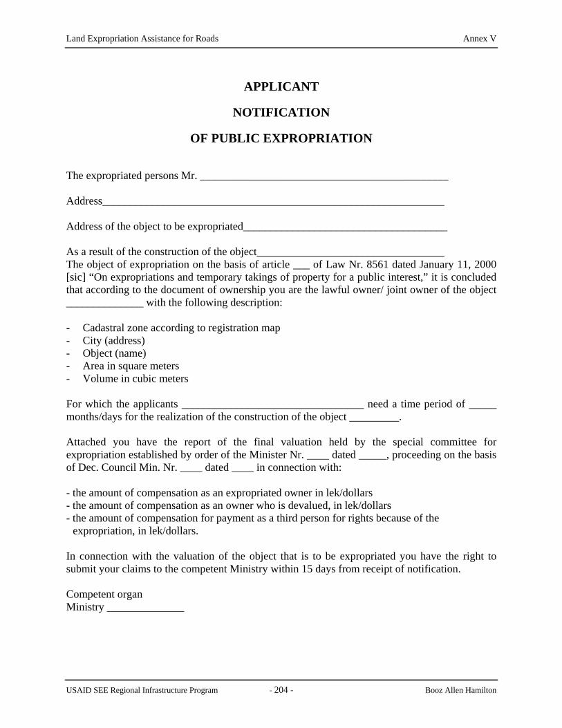
Land Expropriation Assistance for Roads Annex V
APPLICANT
NOTIFICATION
OF PUBLIC EXPROPRIATION
The expropriated persons Mr. _____________________________________________ Address______________________________________________________________
Address of the object to be expropriated_____________________________________ As a result of the construction of the object__________________________________ The object of expropriation on the basis of article ___ of Law Nr. 8561 dated January 11, 2000 [sic] “On expropriations and temporary takings of property for a public interest,” it is concluded that according to the document of ownership you are the lawful owner/ joint owner of the object ______________ with the following description:
- Cadastral zone according to registration map - City (address) - Object (name) - Area in square meters - Volume in cubic meters For which the applicants _________________________________ need a time period of _____ months/days for the realization of the construction of the object _________. Attached you have the report of the final valuation held by the special committee for expropriation established by order of the Minister Nr. ____ dated _____, proceeding on the basis of Dec. Council Min. Nr. ____ dated ____ in connection with: - the amount of compensation as an expropriated owner in lek/dollars - the amount of compensation as an owner who is devalued, in lek/dollars - the amount of compensation for payment as a third person for rights because of the
expropriation, in lek/dollars. In connection with the valuation of the object that is to be expropriated you have the right to submit your claims to the competent Ministry within 15 days from receipt of notification. Competent organ Ministry ______________
USAID SEE Regional Infrastructure Program - 204 - Booz Allen Hamilton

Land Expropriation Assistance for Roads Annex VI
ANNEX VI
LAWS ON EXPROPRIATION AND REGISTRATION OF THE IMMOVABLE PROPERTIES
Law 8561: Expropriation and Temporary Takings of Private Property for Public Interests
Law 7843: Registration of the Immovable Properties
USAID SEE Regional Infrastructure Program - 205 - Booz Allen Hamilton

Land Expropriation Assistance for Roads Annex VI
LAW No. 8561, dated 22.12.1999 ON EXPROPRIATIONS AND TEMPORARY TAKINGS OF PRIVATE
PROPERTY FOR A PUBLIC INTEREST
In reliance on articles 41, 78 and 83 point 1 of the Constitution, on the proposal of the Council of Ministers,
THE ASSEMBLY
OF THE REPUBLIC OF ALBANIA DECIDED:
CHAPTER I
GENERAL PROVISIONS
Object of the Law
Article 1 This law regulates the right of the state to expropriate or take for temporary use for a public interest the properties of private natural or juridical persons, as well as the protection of the rights and interests of the respective owners.
Article 2 1. Natural and juridical private persons have the right to respect for the property that they own.
The expropriation of private properties is done only for a public interest, under conditions when the public interest prevails over the private interests of their owners, in accordance with the conditions prescribed by the law and general principles of international law.
2. The right of expropriation and temporary taking of private property is exercised for a public interest that cannot be realized or protected in another manner, only for the reasons and with respect for the procedures expressly set out in this law, to the extent that is essential for the realization of the purpose of the expropriation and in any case against fair compensation.
Article 3
Expropriation and temporary taking of private property is realized in compliance with the conditions and procedures specified in this law while guaranteeing transparency, the equality of citizens and the protection of their property rights and interests.
Article 4 Expropriation and temporary taking of private property shall be done while respecting, and compensating in value, in accordance with the law, the rights of third parties in the private
USAID SEE Regional Infrastructure Program - 206 - Booz Allen Hamilton

Land Expropriation Assistance for Roads Annex VI
properties that are expropriated, as well as devaluation because of the expropriation of other private properties that are not the object of the expropriation.
CHAPTER II EXPROPRIATION
Article 5
Meaning of Expropriation When the realization or protection of public interests cannot be achieved without exercising the rights of ownership over movable or immovable properties that are privately owned, the Council of Ministers, on the application of the requesting subject in favor of whom the expropriation is to be done, on the proposal of the minister who is competent under this law, decides on the expropriation of these properties. 1. When the expropriation is done on the application of a private juridical subject, the
competent minister, in the capacity of legal representative of state property, is authorized by this law, on the preliminary application of this subject, to make the transfer of ownership of the properties expropriated by the state in favor of the private subject who has applied for expropriation, on the condition that the realization of the building or investment for a public interest for which the expropriation was performed has been verified according to law.
2. When the private applicant does not seek the transfer of property in his favor, the property remains in favor of the state.
3. The objects expropriated for the reasons contemplated in points “a,” “b,” “d,” “dh,” and “ë” of article 8 of this law remain in each case in the ownership of the state.
Article 6
The Rights and Privileges of the Owner of the Private Property that is Expropriated 1. In cases when the owner has died or been declared missing and a certificate of inheritance has
not been issued, the competent ministry has the right to submit a request for the issuance of a certificate of inheritance in the competent court, if such a request has not been presented or the interested parties refuse to present it.
2. When at the end of the procedures and time periods contemplated in this law related to the notification and publication of the application for expropriation, the owner of the private property sought to be expropriated is not found, the competent ministry continues the procedures of expropriation, and the amount of compensation that belongs to the expropriated owner is deposited in a bank for the account of the latter.
3. When the owner of the private property sought to be expropriated is not known, applying
article 172 of the Civil Code, the competent minister is authorized by this law to apply in
USAID SEE Regional Infrastructure Program - 207 - Booz Allen Hamilton

Land Expropriation Assistance for Roads Annex VI
court for the transfer of these properties to state ownership. The judicial expenses and those of representation are chargeable to and prepaid by the applicant for expropriation.
4. When the owner of the private property undertakes the realization of the public interest and
the purpose for which expropriation is sought by a private juridical subject contemplated in letters “c” and “ç” of article 8 of this law, fulfilling the same legal conditions and guarantees for meeting the respective time periods, expropriation is not permitted.
5. When the owners of private properties, through a written declaration, give consent and accept
the passage of ownership of these properties in favor of the state, in accordance with the conditions offered by the competent ministry through a direct notification or publication of the request for expropriation for a public interest, the procedure of expropriation for these properties is considered completed.
6. An expropriated owner or his heirs enjoy a priority right to purchase in the case when their
properties that have been the object of expropriation, or the projects or investments realized on them, are put up for sale or are alienated in any manner by the state or the private subject who is the beneficiary of the expropriation.
Article 7
Objects of Expropriation The objects of expropriation are real properties in the form of land, buildings of every kind of a permanent nature, as well as the movable properties indicated in letters “e” and “ë” of article 8 of this law.
Article 8 Reason for Expropriation
In the function of the public interest, expropriation may be done for the following reasons:
a) For the realization of obligations of the state that come from treaties and international multilateral conventions.
For the realization of programs, projects and investments contemplated in international agreements that extend into the territory of several states, to which our state is a party. For the realization of projects and investments that present national or local territorial extent or interest in the field of transportation of every kind, energy, telecommunications, water works of every kind, in the service and interest of the public. For the realization of national or local projects and investments, in the function of protection of the environment, health, culture and public education, as well as infrastructure, in the service and interest of the public. For the realization of programs and investments in the field of national defense.
USAID SEE Regional Infrastructure Program - 208 - Booz Allen Hamilton

Land Expropriation Assistance for Roads Annex VI
For the protection of monuments and immovable objects of a nature that is archaeological, historical, cultural and scientific, when these purposes, by the very nature of the objects, cannot be realized by a private owner, because of his objective inability or subjective position, with the consequence of a real risk of failure of realization, damage or hindrance to their functioning. For the protection of movable property with a historical, archaeological, cultural or scientific value, in cases when, even with the performance of the obligations of the organs that are competent according to law, these objects risk being damaged or disappearing. For cases when movable and immovable objects, for objective reasons or force majeure, create a permanent risk to public health and security, to the extent that, despite all the assistance of the state, these risks cannot be avoided by their owner.
Article 9 Subject in Favor of Whom Expropriation is Done
1. Expropriation may be done in favor of the state and of public or private, local or foreign
juridical persons, for the realization by them of a project, investment or object of theirs that, in each case in accordance with this law, presents a public interest.
2. A private juridical person may present an application for expropriation in the public interest
only connected with the reasons for expropriation contemplated in letters “c” and “ç” of article 8 of this law.
Article 10
Application for Expropriation and Accompanying Documents
e) A preliminary valuation of the objects of expropriation and the measure of compensation that is contemplated for each private owner.
1. The subject in favor of whom the expropriation is done shall present an application for
expropriation to the ministry that is competent pursuant to law. The application shall be accompanied by the following documentation:
b) Official documents that attest its status and registration as a juridical person.
c) Necessary plans, approved according to law, as well as the respective legal arguments
about the public interest connected with the realization of these projects.
d) Documentation related to the source and guarantee of the financial funds necessary for the realization of the project, including those for expropriation or because of devaluation.
f) Appropriate licenses and approvals from the competent organs according to the law, in
accordance with the nature and type of the project that is sought to be realized.
USAID SEE Regional Infrastructure Program - 209 - Booz Allen Hamilton

Land Expropriation Assistance for Roads Annex VI
g) Official documents that verify the manner of realizing the project by the applicant for
expropriation himself or with third parties, as well as the respective time periods.
h) A list of the owners of the private properties as to which expropriation is sought, a list of the owners of private properties that are devalued because of the expropriation and a list of the third persons who should be compensated for their rights to the private properties that are sought to be expropriated, together with explanations and data necessary for each of them, with the respective estimates of the valuation of these properties and rights, as well as the addresses and last known residence of the respective owners and third persons.
i) Documents that verify the reason for the expropriation, according to article 8 of this law.
2. In cases where the applicant for expropriation is a state organ or state institution created by
separate law, the documents contemplated by letters “a” and “c” of this article are not submitted.
Article 12
3. Detailed regulations related to the content and standards that are to be respected in the
compilation and presentation of the documentation that accompanies an application for expropriation for a public interest are set by normative act of the Council of Ministers.
Article 11
Ministry Competent for Expropriation 1. Applications for expropriation are submitted to the ministry that covers the respective
activity, while the proposing to the Council of Ministers for the approval of the application for expropriation is made by the respective ministry.
2. On the submission of the application for expropriation for a public interest, the competent
minister orders the setting up of a special commission for following and accomplishing the procedures of expropriation.
3. The members of the commissions shall be employees or independent experts, with
experience and special qualification in the juridical, economic and engineering field, who, in any case, shall not be related by blood or marriage to the person being expropriated or have any kind of interests with the parties interested in the expropriation.
4. The rules about the composition and the working procedures of the special commission on
expropriations are set by normative act of the Council of Ministers.
Return without Action and Refusal of the Application 1. The competent ministry performs necessary verifications about the applicant in whose favor
expropriation is sought, about the documentation presented, about the reason for expropriation
USAID SEE Regional Infrastructure Program - 210 - Booz Allen Hamilton

Land Expropriation Assistance for Roads Annex VI
and he also administers the documents of ownership for the objects of expropriation, carrying out on-site investigations if necessary.
2. When the documentation submitted by the applicant is not complete or accurate, the
competent ministry immediately returns the application for expropriation and the documentation accompanying it according to this article to the applicant without action, designating a special time period for the appropriate completions.
3. When the application and accompanying documentation are not submitted complete in the
designated time period, or are found to be unsupported, because of the absence of a reason or of the conditions of expropriation according to this law, the application is refused by the ministry and the applicant for expropriation is notified immediately.
4. The applicant for expropriation has the right to appeal in court within 30 days of receiving
notification.
5. The judicial examination is done in accordance with the legal provisions for the adjudication of administrative disputes in the Code of Civil Procedure.
Article 13
Acceptance of the Application
1. On the completion of the necessary verifications, as well as the procedures contemplated in article 12 of this law, when the application and respective accompanying documentation are supported in the conditions and criteria of this law, the competent ministry decides on the acceptance of the application for expropriation, immediately notifying, in writing, the applicant in favor of whom the expropriation is sought.
2. Within 10 days from the date of notification of acceptance of an application for
expropriation, an agreement is entered into between the applicant in favor of whom the expropriation is sought and the competent ministry as to the mutual rights and obligations related to the expropriation procedure. If the applicant is a private subject, this agreement is done by notarial act.
3. In the agreement document, the parties undertake the fulfillment of the obligations set or
specified in this law in the respective time periods. The agreement document is executable. 4. The agreement document is invalid if, at the time it is signed, the documents that accompany
the application for expropriation according to this law are not attached.
Article 14
Notification of Application for Expropriation
1. Within 10 days from the date of entering into the agreement with the applicant for expropriation, the competent ministry begins fulfilling the procedures of direct notification to
USAID SEE Regional Infrastructure Program - 211 - Booz Allen Hamilton

Land Expropriation Assistance for Roads Annex VI
each owner or joint owner of the private properties sought to be expropriated or devalued as well as to third persons related to their compensation. Together with the procedures of notification, the competent minister also performs those of publication of the request for expropriation in a public interest.
2. Detailed regulations about the manner of notification, its content and the respective
procedures are set by normative act of the Council of Ministers.
Article 15 Publication of Application for Expropriation in a Public Interest
1. To make it possible to protect the rights and interests of third persons in or because of the
private property sought to be expropriated, at the same time as the notification of the application for expropriation in a public interest pursuant to point 1 of article 14 of this law, the competent ministry publishes the expropriation application in the Official Journal, in a newspaper with national circulation and in a local newspaper for a one week period.
2. Third persons have the right, no later than 15 days from the date the time periods of
publication expire pursuant to this article, to submit their claims accompanied by the relevant documents to the competent ministry.
3. When the claims of third persons about ownership as well as the about the expropriation
conditions offered are verified to be legally supported, the competent ministry proceeds with the expropriation, while also respecting these rights.
Article 16
Judicial Conflicts and Submission of Claims 1. The competent minister may not request the Council of Ministers to take a decision of
expropriation before a one month time period from the day of conclusion of the procedures and time periods of direct notification of the owner who is expropriated and the publication of the application for expropriation according to this law.
2. The bringing of lawsuits or a judicial examination of a civil question connected with private
property that is sought to be expropriated does not constitute a lawful reason to seek, or for the court to order, the interruption or suspension of the procedures of expropriation according to this law. The court or the competent ministry shall immediately notify one another about these cases. The competent ministry is obligated, at the completion of the procedure of expropriation, to put the amount of compensation for the private property expropriated or devalued in a special bank account. The amount of compensation is paid to or put at the disposition of the person who determined by the final court decision, after the competent ministry has been notified.
3. Within 15 days from the date of notification according to this law or of the time period of
publication of the application for expropriation, the owner, joint owners or third persons shall
USAID SEE Regional Infrastructure Program - 212 - Booz Allen Hamilton

Land Expropriation Assistance for Roads Annex VI
notify the competent ministry, also indicating whether they accept the voluntary transfer of the property on the conditions it has offered.
4. Within 15 days from receipt of the answer by the notifying person, but in any case not before
one month has passed from the last date of the time period for publication of the request for expropriation for a public interest, the competent ministry, in the cases when the notifying parties have accepted the conditions offered by it or it has found the claims presented by them to be correct, in the sphere of expropriation and with the authority of the organ that makes the expropriation, carries out with the notifying party, as the case may be, the actions for transfer of ownership in favor of the state, against compensation or payment of the amount of compensation for the devaluation of the private properties or the rights of third parties because of the expropriation. With the fulfillment of the reciprocal obligations, the procedure of expropriation of these private properties is considered to be completed.
5. With the consent of the competent minister, the above actions may be performed even after
the above-mentioned time periods, as if the proposal for expropriation had been submitted to the Council of Ministers, so long as the latter has not yet decided on the expropriation.
Article 17 Valuation of Objects Expropriated
1. At the conclusion of the procedures contemplated in articles 14 and 15 of this law, the special
commission set up by the competent minister performs the actions for determining the final valuation as well as for computing the amount of compensation of the objects expropriated.
2. In valuing the private properties that are expropriated, the other properties that are devalued
or the rights of third persons that are to be compensated because of the expropriation, according to their nature, the initial value, the amortization, the purpose for which they are destined, the location of the object, and the change of the index of market prices and money are taken into account.
3. Other technical criteria for valuation and the computation of the amount of compensation for
private property that is expropriated, properties that are devalued and the other rights of third persons according to this law are set by the Council of Ministers.
Article 18
Compensation for the Value of the Devaluation of the Property 1. Compensation is given for the value of the devaluation of property in cases when the
expropriation for a public interest is accompanied with the devaluation of a part of the property that is not expropriated or of property located near that which is expropriated.
2.
The cases, manners and calculations of the amount of compensation are set by instruction of the Council of Ministers.
USAID SEE Regional Infrastructure Program - 213 - Booz Allen Hamilton

Land Expropriation Assistance for Roads Annex VI
Article 19
Calculation of the Payment On the basis of the value that results from the final valuation of the objects that are expropriated, the amount of the respective computation is calculated, in the measure of its full value.
Article 20 The Proposal for Expropriation
At the conclusion of the preliminary procedures for expropriation, the competent minister submits the proposal for expropriation to the Council of Ministers, accompanied by this documentation: a) A summary statement of the purpose, reason and need for expropriation, the time period for beginning and concluding the expropriation as well as the time period for beginning and concluding the work or realization of the purpose of the expropriation. b) The documents required in letters “a” through “dh” of article 10 of this law. c) A final list of the owners of the properties that are expropriated or devalued and the respective official documents of ownership, as well as a list of the third persons whose rights are to be compensated because of the expropriation. ç) The documentation of valuation of the properties that are expropriated and devalued, of the rights of third parties related to them and of the amount of compensation proposed, with the respective arguments.
Documents verifying the expenses of the procedure of expropriation.
Article 21 The Expropriation Decision
When the proposal is found to be well grounded in law and in fact, the Council of Ministers decides on expropriation. 1. The decision of expropriation shall contain:
a. the purpose and legal reason for expropriation;
b. the private properties that are expropriated and the respective owners;
c. the amount of compensation for the owners who are expropriated, for the owners of the properties that are devalued, for third persons who are compensated for their rights because of the expropriation as well as the time period and manner of paying them;
d. the time period for beginning and ending the expropriation and the organ or subject that will start using the expropriated private properties;
USAID SEE Regional Infrastructure Program - 214 - Booz Allen Hamilton

Land Expropriation Assistance for Roads Annex VI
e. the time period for beginning and ending the work for the project and the investment or for the realization of the purpose of the expropriation;
f. the value of the expenses of the procedure of expropriation charged to the applicant for expropriation.
3. When there are many objects and joint owners, the data required according to letters “b” and “c” of this article are reflected in a special attachment as an integral part of the decision.
4. In cases when the expropriation is applied for by a private subject, the properties
expropriated pass to the ownership of the state. The transfer of the ownership of these properties in favor of the private subject who has applied for expropriation is done only when the latter has realized, in accordance with law, the purpose and cause of the expropriation for a public interest.
Payment of Compensation because of the Expropriation
5. Having the quality of an implementing regulation, the decision of expropriation of the
Council of Ministers enters into force immediately. The decision is also published in the Official Journal.
Article 22
Refusal of the Application for Expropriation When an expropriation according to an application accepted by the competent ministry is refused by the Council of Ministers, the competent ministry returns to the applicant for expropriation all funds deposited for the expropriation procedure.
Article 23
The amount of compensation that is, respectively, given to or put at the disposition of the person who is expropriated, the owner or third person who is damaged, within the time period indicated in letter “c” of article 21 of this law and, in every case, no later than three months from the end of the time period or from the date when the court decision has become final, according to point 2 of article 16 and article 24 of this law.
Article 24 Appeal of the Decision
1 The decision of the Council of Ministers on expropriation is made known by the competent
ministry directly to the owners who are expropriated, the owners of properties that are devalued by the expropriation and third persons whose rights are compensated because of the expropriation who, only as to the amount of compensation specified in the decision, have the right to appeal in court within 30 days from receiving notice.
USAID SEE Regional Infrastructure Program - 215 - Booz Allen Hamilton
Land Expropriation Assistance for Roads Annex VI
2 An appeal against a decision of the Council of Ministers for the expropriation does not
suspend the implementation of the decision and the respective procedure of registration of the property expropriated.
2 When the subject in favor of whom the expropriation was done uses the private properties that were expropriated or performs actions in conflict with the reason for and purpose of expropriation, as well as when he changes the purpose for which these properties or the projects and investments realized over them are destined before the conclusion of the period for keeping the destined purpose set in the decision of expropriation, if the Council of Ministers does not decide within a three month period that the state shall undertake the realization of the purpose of and reason for the expropriation for a public interest, this expropriation is considered invalid.
3 As to the amount of compensation for expropriation, if an appeal in court is not taken within the 30 day time period according to this law, the decision of the Council of Ministers for the expropriation becomes an executable document.
4 The judicial examination is done in accordance with the legal provisions connected with the
adjudication of administrative disagreements of the Code of Civil Procedure.
Article 25 New Registration of Expropriated Properties
In cases when the private properties that have been expropriated are to be registered according to law, this registration shall be done by the competent ministry within 30 days from the date when the decision of the Council of Ministers for expropriation was taken.
Article 26 Invalidity of Expropriation
1 When the subject in favor of whom the expropriation was done does not begin or conclude
the works for the projects and investments or for the accomplishment of the purpose for which the expropriation was performed within three months from the date of the end of the respective terms set in the decision of the Council of Ministers, the expropriation is considered invalid. Within the three month term mentioned above, on its own initiative or on the reasoned request of the subject in favor of whom the expropriation was done, the Council of Ministers may decide to extend the time period for beginning and concluding the works or the realization of the purpose of the expropriation.
3 An expropriation is considered invalid if during the time periods contemplated in article 23
of this law, the payment of, or the putting at the disposition of, the amount of compensation according to this law for the account of the owners who are expropriated as well as the owners and third persons who are damaged because of the expropriation is not done.
4 In the cases of invalidity of expropriation contemplated in points 1, 2 and 3 of this article, on
the application of the respective owners, the private properties that were expropriated are
USAID SEE Regional Infrastructure Program - 216 - Booz Allen Hamilton

Land Expropriation Assistance for Roads Annex VI
returned to them with full rights as at the moment of expropriation and, on the other hand, the owners who were expropriated are obliged to return, in advance, the amount of compensation that was paid to them because of the expropriation in value or by compensating this value with property in kind.
5 In addition to what is provided in point 4 of this article, the owners who were expropriated,
as well as the owners and third persons damaged because of the expropriation, have the right to seek from the subject in favor of whom the expropriation was done compensation of the damages caused because of the expropriation.
CHAPTER IV TAKING OF PROPERTY FOR TEMPORARY USE
Article 27
Taking the property of private natural and juridical persons for temporary use is done for the needs of works and services in the function of a public interest, in compliance with the conditions and cases that are expressly set out in this law, as well as for meeting needs and emergencies because of force majeure events or a state of emergency or war.
Article 30
Article 28
Taking for temporary use of private property may also be done for the needs of realizing the projects or investments for a public interest for which a decision of expropriation has been taken, to secure necessary temporary roads for transport, for setting up construction sites and warehouses, for opening channels to change water courses, for the installation of necessary engineering networks, as well as for other essential needs in the function of these projects and investments for a public interest.
Article 29 In force majeure events or a state of emergency or war, the taking for temporary use is done only when meeting them is not guaranteed or the time or circumstances do not permit the use of the means that the state or competent organ or respective juridical subject who is charged by law has at its disposition, or the means are insufficient.
Taking property for temporary use is done for those objects, to that extent and for so long as the lawful cause continues and, in any case, against a set compensation.
Article 31
USAID SEE Regional Infrastructure Program - 217 - Booz Allen Hamilton

Land Expropriation Assistance for Roads Annex VI
1 A request for taking objects of private property for temporary use is done, respectively, by
the central or local state organs or interested juridical person and is directed to the chairman of the respective municipality or commune, who give their opinion and send it to the prefect for approval.
2 When the temporary taking is for the needs of central state organs or of projects being
realized for the account of the state at the national level, the respective request shall be presented to the minister charged with or competent for the realization of the construction or service or for meeting the force majeure event, state of emergency or war.
Article 32
2 In cases when the owner refuses to hand over his private property, the rules for execution of executable documents are applied and, in special cases, it is taken directly.
A request for temporary taking of property shall contain:
- a description of the property that will be taken for temporary use; - the reason and time period of the temporary taking of property; - the compensation offered.
Article 33
A temporary taking of private property may not last after the removal of the lawful reason and, in any case, not more than two years from the date the objects were taken for temporary use.
Article 34 In cases of need and urgency and when the circumstances will not wait, the taking of objects of private property and using them for the reasons contemplated in this law may be done immediately by the competent state organ, or by any state employee, but within 24 hours, the request shall be presented to the competent organ and the respective procedures completed.
Article 35 The official document for a temporary taking of property shall contain the object taken for temporary use, a description of it, the lawful reason, the time period and the amount of the respective compensation. The document for a temporary taking is an executable document.
Article 36 1 Taking of objects into delivery and the return of the objects is done in every case by separate
official document in which are reflected the legal basis, the characteristics of the object and its actual condition, against the signature of the owner. In his absence, these actions are done in the presence of two witnesses.
USAID SEE Regional Infrastructure Program - 218 - Booz Allen Hamilton

Land Expropriation Assistance for Roads Annex VI
3 At the time of the return of the property taken for temporary use, the owner has the right to
request their return in the prior condition or with a counterpayment for the damages caused. 4 When the owner refuses to accept the return of the private property taken for temporary use,
it is kept in safekeeping for the account of the owner, and the expenses are charged to him.
Article 37
1 The owner has the right to bring a suit in court against an immediate taking for temporary use, according to article 34 of this law, against the respective decision of the competent organ and also about the amount of compensation and the manner and condition of return of the object, within 30 days from receiving notice.
2 For other disagreements that arise about temporary taking of private property, the owner has
the right to turn to the court within 30 days from receiving knowledge.
FINAL AND TRANSITIONAL PROVISIONS
CHAPTER V
Article 38
For procedures of expropriation as to which, according to article 7 of law nr. 7848 dated July 25, 1994 “On expropriations for a public interest, as well as for the taking of real property for temporary use,” publication of the application for the promulgation of the expropriation of real property for a public interest has been made by the Council of Ministers, the provisions of law nr. 7848 dated July 25, 1994 shall apply.
Article 39 Law nr. 7848 dated July 25, 1994 “On expropriations for a public interest, as well as for the taking of real property for temporary use,” and every other provision that conflicts with this law, is repealed.
Article 40 This law is effective March 1, 2000.
USAID SEE Regional Infrastructure Program - 219 - Booz Allen Hamilton

Land Expropriation Assistance for Roads Annex VI
LAW NO. 7843 DATED JULY 13, 1994
ON THE REGISTRATION OF IMMOVABLE PROPERTY
On the basis of Article 16 of Law No. 7491, dated April 29, 1991, on the main dispositions of the Constitution, "on proposal of the Council of Ministers",
- Updated through Law 8090, dated 1996 -
THE PEOPLE'S ASSEMBLY
OF THE REPUBLIC OF ALBANIA
DECIDED:
PART I
PRELIMINARY
Article 1 Definitions
In this Act the following definitions shall apply: "Chief Registrar" means a person appointed who assures that the Registrars of the immovable property registries throughout the country manage their Registries in accordance with the law; "court" means the place which resolves disputes concerning immovable property; "immovable property" means land, water sources, buildings as well as other immovable objects defined in relevant legal acts; "immovable property registration zone" means a local subdivision or geographic area designated by the Council of Ministers in collaboration with the Chief Registrar for purposes of registration of immovable property under this or any other law; "instrument" includes any ownership document, court judgment, legal state agency document or other document requiring or capable of registration under this Act; "proprietor" means the person whose name is registered under this Act as the owner of immovable property;
"the register" means the page of the volume of the Register Book which is kept for each immovable property;
USAID SEE Regional Infrastructure Program - 220 - Booz Allen Hamilton

Land Expropriation Assistance for Roads Annex VI
"to register" means to make an entry, note or record in the register kept under the provisions of this Act; "Register Book" means the set of all registers for immovable properties in a specific immovable property registration area; "Registrar" means the person responsible for the Immovable Property Registry of a defined administrative sector; "Registry" means the immovable property registry office established under this Act; "Registry Index Map" means the map or series of maps referred to in Part III of this Act; "restriction" means an order of the Registrar to restrict the registration and/or dealing of a particular immovable property; "restrictive agreement" means a documented restriction on the use of immovable property; "survey" means the determination of the boundaries of an immovable property; "survey plan" means the document that shows the boundaries of an immovable property which is owned, leased or held in use.
PART II
ORGANIZATION OF THE IMMOVABLE PROPERTY REGISTRATION SYSTEM
Article 2 Immovable Property Registries
There shall be established and maintained in each administrative center of the Immovable Property Registration zone defined under the authority of the Council of Ministers, an Immovable Property Registry, which is a juridical person, in which there shall be kept: a. Immovable Property Registers, in accordance with the provisions of Part II of this Act; b. A Registry Index Map of the administrative zone, in accordance with the provisions of Part III
of this Act; c. All contracts of transfer, court judgments, mortgages, inheritances, and other legal documents
which affect rights to immovable property as well as survey plans of immovable properties, indices of these records and other records necessary for the operation of an immovable property registry;
USAID SEE Regional Infrastructure Program - 221 - Booz Allen Hamilton

Land Expropriation Assistance for Roads Annex VI
d. All the information which is not prohibited by law, such as that of the kartela, registration
indexes maps and submitted documents for registration are made available to any person who requests them.
a) issue certificates of ownership or lease or of any other interest recorded on a Register of immovable property to a person who makes such a request and is entitled to such a certificate;
Article 3
Chief Registrar The Chief Registrar and his deputies who are nominated by the Council of Ministers direct the registration of the immovable properties throughout territory of the Albanian Republic. The authorities of the Chief-Registrar are equal to the authorities of the members of the Council of Ministry. In the absence of the Chief Registrar, for whatever reason, of the Chief Registrar may designate a Deputy Registrar to exercise any of the powers vested in the Chief Registrar by this Act. The Chief Registrar of Immovable Properties of the Republic of Albania organizes and directs the Central Office of Immovable Property Registration and up to the full functioning of the registration system it depends on the Council of Ministers. The Central Office of Immovable Property Registration is a juridical person, it has its seal and it is located in Tirana.
Article 4 The Registrar
The Chief Registrar nominates the Registrar, the Assistant Registrar and approves the organizational structure of registration offices to administer the registration system, according to the provisions of this law, in a registration zone of immovable properties. The Registrar for each immovable property registration area shall be responsible to the Chief Registrar for the maintenance of records and all other aspects of the administration of his/her registry.
Article 5 Powers of the Registrar
The Registrar may exercise the following powers in addition to any other powers conferred on him/her by this Act:
USAID SEE Regional Infrastructure Program - 222 - Booz Allen Hamilton

Land Expropriation Assistance for Roads Annex VI
b) require any person to produce any ownership, lease, in use or mortgage document
and any other document and survey plan relating to the immovable property, and that person shall be obligated to produce it;
c) summon any person to appear before him/her or a person delegated by him/her and give any information or explanation respecting immovable property, a contract of lease or a mortgage; present ownership documents, certificate or other document or survey plan relating to the immovable property, contract of lease or mortgage in question, and that person shall appear and give the requested information or explanation;
d) suspend registration if not having complete or delivered any instrument,
certificate or other document, survey plan, information or explanation required to be produced or given is withheld or any act required to be performed under this Act is not performed;
dh) administer and verify the above information; e) By the authorization of the Chief Registrar, the Registrar has the right to fine any
person who submits incorrect information, in order to pay off the registration office for the expenses it had in the process of correcting this incorrect information.
Article 6
Seal of the Registry There shall be a seal for the Registry. Every document issued by this office should contain its seal.
Article 7 Liability of Registry Officers
The Chief Registrar and any Registrar shall not, nor shall any other officer of the Registry, be liable to any documented action in respect of any act or matter done or omitted to be done in good faith in the exercise of the powers and duties under this Act, or any regulations made under it. Such officers shall be subject to the prescribed penalties for violations of law.
Article 8 The Immovable Property Register
Each volume of the Register Book in the immovable property registry shall include a register for each publicly owned immovable property and a register for each privately owned immovable property.
Article 9 Effect of Registration
USAID SEE Regional Infrastructure Program - 223 - Booz Allen Hamilton

Land Expropriation Assistance for Roads Annex VI
Once an immovable property has valid registration, every subsequent transaction involving rights to it shall be registered in conformity with the provisions of this act.
Stay of Registration.
The registration of an immovable property gives a person as individual, co-owner, or as representative of a family the right to enjoy the immovable property in conformity with the law. Every proprietor acquiring any immovable property, contract of lease or mortgage shall be deemed to have had notice of every entry in the Registry relating to the immovable property, contract of lease or mortgage.
Article 10 Priority of Registration
Registration priority is defined according to the order in which the instruments that led to their registration are properly presented to the Registrar, irrespective of the dates of execution of the instruments and notwithstanding that the actual entry in the register may be delayed.
Article 11 Required Registration
Any contract or other document affecting rights to immovable properties shall be presented for registration no later than thirty days from the time the instrument or other document is executed.
Article 12 Delay in Registration
Where an instrument is presented more than thirty days after the date of the execution of the instrument, then, in addition to the registration fee, an additional fee equal to ten per cent of the registration fee shall be payable for each day which has elapsed since such date.
Every juridical and physical person, whose rights over immovable properties are affected by the instrument, will pay this fee.
Article 13 Power to Compel Registration
If the Registrar is satisfied that any person has intentionally failed to register any instrument which is registered under this Act, the Registrar may by notice in writing order such person to present such instrument for registration, and thereupon the registration fee and any additional fee payable shall become due and shall be payable by such person whether the instrument is presented for registration or not.
Article 14
USAID SEE Regional Infrastructure Program - 224 - Booz Allen Hamilton

Land Expropriation Assistance for Roads Annex VI
A person proposing to deal with registered immovable property, with the consent in writing of the proprietor, may apply to the Registrar for the suspension of any other transactions or actions concerning this property. If this application for suspension is approved, the registration of any instrument affecting the immovable property shall be stayed for a period (hereinafter referred to as the suspension period) of fifteen days from the time at which the Registrar approved application for the suspension, and a note shall be made in the kartela accordingly. If within the suspension period the person who has requested the suspension presents a properly executed instrument for registration, such instrument shall have priority over any other instrument that may be presented for registration during the suspension period.
Article 15 Registration of Co-Proprietors of Immovable Properties
Every instrument that certifies the ownership of two or more persons, and its registration in the Registry must show the identity and where possible the appropriate share of each co-proprietor.
PART III MAPS, PARCELS AND BOUNDARIES
Article 16
Registry Index Map The Registrar shall be responsible for and maintain a map or series of maps, to be called the Registry Index Map for the immovable property registration area covered by that Registry. The Registry Index Map shall show the boundaries and geographical locations of immovable properties as well as other features. The immovable properties have a unique identification number, the same number being used to identify the immovable properties on their registers and on the Registry Index Map. A survey plan may be filed of a particular immovable property to augment the information available from the registry index map, and the filing of the survey plan shall be noted in the register.
Article 17 Correction of the Registry Index Map and New Editions
The Registrar may cause to be made a survey of any immovable property for the purposes of this Act and, after informing every person affected thereby, may cause the Registry Index Map to be corrected as a result of the mentioned survey.
USAID SEE Regional Infrastructure Program - 225 - Booz Allen Hamilton

Land Expropriation Assistance for Roads Annex VI
The Registrar may correct any error in the Registry Index Map that does not affect the interest of any person. The Registrar, may at any time, direct the preparation of a new Registry Index Map or any part thereof, and there may be omitted from the Map any matter which the Registrar considers obsolete.
Article 18 Boundaries
The Registry Index Map indicates the approximate boundaries, areas and location of the immovable properties. When the parties to a dispute concerning a boundary or boundaries agree to resolve the dispute, the Registrar shall record the agreement on the Registry Index Map and on the affected registers, and shall file the agreement signed by the parties to the dispute. Where any uncertainty or dispute arises as to the position of any boundary, and the parties to the dispute cannot agree concerning such boundary, the Registrar shall instruct them to present the dispute to the competent court within fifteen (15) days, and shall make a notation on the Register. If there is no petition to the court within the specified time, the Registrar shall make the appropriate notation.
Article 19 Maintenance of Boundary Features
Every proprietor of immovable property shall maintain in good order any features that demarcate the proprietor's boundaries. The Registrar may in writing order the demarcation within a specified time of any boundary in such manner as he/she may direct. The Registrar decides which of adjoining proprietors shall be responsible for the care and maintenance of any feature demarcating a common boundary, and the person so identified will have the responsibility. Within 30 days the proprietors have the right to appeal in court against the order of the Registrar. If within this period of time there is no exercise of this right, the order is considered as accepted.
Article 20 Interference with Boundary Features
Any person convicted of illegally modifying or damaging any boundary whether or not any penalty is imposed upon him/her, shall be liable to pay the cost of restoring the boundary feature, and such cost shall be considered as a civil debt by any person responsible for the maintenance of the feature.
USAID SEE Regional Infrastructure Program - 226 - Booz Allen Hamilton

Land Expropriation Assistance for Roads Annex VI
Article 21 Combinations and Subdivisions
Where contiguous immovable properties are owned by the same proprietor and are subject in all respects to the same rights and obligations, the Registrar, on application by the proprietor, may combine those properties by closing the registers relating to them and opening a new register or registers and revising the Registry Index Map in respect of the immovable property or properties resulting from the combination. Upon the written application of the proprietor or successors for the division of an immovable property into two or more immovable properties, the Registrar shall effect the division by closing the register relating to the subdivided immovable property and opening new registers and revising the Registry Index Map in respect of the new immovable properties resulting from the division, and recording in the new registers all existing entries appearing in the closed register. The Registrar, on the application of the proprietors of contiguous immovable properties who are desirous of changing the boundaries of their properties, and with the consent in writing of all other persons in whose name any right in such properties is registered, may cancel the registers relating to such properties and update the registers and Registry Index Map in accordance with the revised layout; In case that the Registrar determines that the proposed reparcellation involves substantial changes of ownership which should be effected by transfers, the Registrar may in his/her discretion refuse to effect such reparcellation. The Registrar must not allow any transfer that deletes legal rights. Where a proprietor wishes to subdivide his/her immovable property, the Registrar shall require the proprietor to submit a survey plan of the proposed subdivisions prepared by a licensed surveyor and certified by the appropriate authority as conforming with the requirements of law.
Article 22 Transfers of Part of the Immovable Property
No part of the immovable property included in a register shall be transferred unless the proprietor has first subdivided the immovable property, in accordance with the law, and new registers have been opened in respect of each subdivided portion of the immovable property.
USAID SEE Regional Infrastructure Program - 227 - Booz Allen Hamilton

Land Expropriation Assistance for Roads Annex VI
First Registration
Notice shall also be provided for that 90-day period in a public manner designed to notify individuals who might make a claim to the immovable properties in question.
PART IV: FIRST REGISTRATION OF AN IMMOVABLE PROPERTY
Article 23
The first registration of any immovable property shall require the preparation of a Register in accordance with the provisions of this Act, and in accordance with the provisions of any other Act that define ownership or agreements or obligations which exist for the immovable property.
Article 24 Manner of First Registration
The Registrar, a person or any group designated by the Chief Registrar shall require that the ownership and boundaries of each property to be registered shall be documented, using the following criteria: a) Ownership and boundaries of immovable properties shall be considered as
properly defined by a title issued under law 7501 of 19.7.1991, contracts of sale under law 7652 of 23.12.1992, decisions of the Commissions of Restitution under law 7698 of 15.4.1993, other laws, other official instruments which confer private ownership, and Court decisions legally approved or issued after 19 July, 1991.
b) For those individuals, families and legal persons, private or state, who possess the property in conformity with law and do not hold any ownership document under Paragraph a, are obliged to present to the Registrar an application for registration of ownership. This application shall contain a notarized, personal declaration of ownership, a survey plan of the immovable property, and notarized declarations from neighbors and other persons as to the correctness of the boundaries and as certified copies of different documents which support the application for registration.
c) Provisional registration shall be prepared from the information produced from a)
and b).
Article 25 Public Notice
A public display of the provisional registration shall take place for 90 days in a prominent and relevant place for public examination within the geographic zone where the properties are located.
USAID SEE Regional Infrastructure Program - 228 - Booz Allen Hamilton

Land Expropriation Assistance for Roads Annex VI
During that display period all errors or claims shall be made known to the Registrar in writing. No claim presented after that 90-day period will be accepted.
Article 26 Legalization of First Registration
Under the first paragraph of Article 25, following the public display period, all immovable properties for which there are no pending claims of error shall be given valid registration and from this moment certificates of ownership and other certificates which may be requested regarding the content of the registers and the index maps, may be issued by the Registrar.
Article 27 Resolution of Conflicting Claims in First Registration
The Registrar shall consult with the parties making claims about the information contained in the Registers or in the Registry Index Map to clarify and correct any errors and resolve any disputes. Such corrections and resolutions shall be made in a notarized document. Any disputes already resolved by any legally constituted commission or court precludes any further action by the Registrar. Any disputes that cannot be resolved in this way with the agreement of the parties involved shall be referred to the competent Court, and a notation placed on the relevant Registers concerning the existence of the disputes and the Court to which the disputes have been referred.
PART V CERTIFICATES AND SEARCHES
Article 28
Certificates of Ownership and Lease The Registrar shall, if requested by a proprietor of immovable property or a lessee where no certificate of ownership or certificate of lease has been issued, issue to the proprietor a certificate of ownership or a certificate of lease in the prescribed form showing all information in the register affecting that immovable property or contract of lease. For any immovable property registered in the appropriate Kartela for ownership, mortgaging or for different contracts that are carried out on this property, only one certificate Shall be issued. A certificate of ownership, lease or mortgage shall be only prima facie evidence of the matters shown therein, while ownership, lease or mortgage shall be subject to all entries in the register whether they are shown on the certificate or not. The date of issue of a certificate of ownership, lease, or mortgage shall be noted in the register.
USAID SEE Regional Infrastructure Program - 229 - Booz Allen Hamilton

Land Expropriation Assistance for Roads Annex VI
Article 29 Lost or Destroyed Certificates
If a certificate issued to a person under Article 28, he/she may apply to the Registrar in the Registry where the immovable property is located for the issuance of a new certificate, and shall produce evidence to satisfy the Registrar of the loss or destruction of the previous certificate. If the Registrar is satisfied with the evidence as to the loss or destruction of the certificate, and after the publication of such notice as the Registrar may think fit, the Registrar may issue a new certificate. When a lost certificate is found, it shall be delivered to the Registrar for cancellation.
Article 30 Inspections and Copies
Any person can examine and consult any register and can request a certified copy of it, a part of the Registry Index Map, any filed instrument or survey plan deposited in the Registry, by presenting a written request by paying the appropriate fees.
Article 31 Evidence
A copy certified by the Registrar of the Register or part of the Registry Index Map or any survey plan or instrument filed in the registry shall be acceptable with the same value as the original in all actions and questions regarding it and for all persons or parties until the contrary is proved.
Article 31a The contract of selling of an immovable property is registered in the relevant Article of the immovable property kartela.
PART VI
THE REGISTRATION OF THE CONTRACTS OF BUYING AND SELLING, LEASING, MORTGAGING, AND OF ACTS OF TAKING THE LAND "IN OWNERSHIP" AND "IN USE"AND OF OTHER INTERESTS
IN IMMOVABLE PROPERTIES
Article 32 Registration of Contracts of Sale and Lease
A contract for the sale of an immovable property shall be registered in the appropriate Article of the relevant Register.
USAID SEE Regional Infrastructure Program - 230 - Booz Allen Hamilton

Land Expropriation Assistance for Roads Annex VI
A contract of lease for an immovable property for a period less than one year need not be registered. Any other contract of lease for an immovable property must be registered by noting it in the proper Article of the Register of the lessor's immovable property. If a contract of lease is for a part of a state owned immovable property and has duration of one (1) year or longer, a separate Register shall be created for each part of the immovable property and a notation made on the Registry Index Map.
The Registrar shall enter legal mortgages resulting from sale contracts in the appropriate Article of the Register of the affected immovable property that the seller owned.
Article 33
Registration of Mortgages The mortgage shall be completed by its registration in the appropriate Article of the register of the immovable property, or part of it, which is used as security for the mortgage and the registration of the person in whose favor it is created as its proprietor and by filing the instrument.
Article 34 Registration of Legal Mortgages
Article 35
Satisfaction of a Mortgage The Registrar, based on a written request prepared in the appropriate form required by law shall order that the mortgage be cancelled from the register of immovable property when the necessary acts required by relevant law or regulations to satisfy the mortgage are performed. Any request for cancellation of a mortgage must be accompanied by the document that justifies the cancellation and is signed by the Registrar.
Article 36 Registration of In Use Titles
A separate register shall be created and a notation made on the Registry Index Map for any "in use" title pertaining to state owned immovable property. The holder of the in use title shall be noted in the appropriate Article of the register and the state shall be noted as the Proprietor.
Article 37 The Registration of Immovable Property
Acquired by Prescription
Registration of immovable property acquired by prescription is accomplished by presenting to the Registrar a copy of the decision of the court that has declared that ownership has been achieved through prescription.
USAID SEE Regional Infrastructure Program - 231 - Booz Allen Hamilton

Land Expropriation Assistance for Roads Annex VI
The Registrar, shall, in accordance with the decision of the court, register the immovable property in the name of the person who has acquired ownership by prescription.
Article 38 The Registration of Transfer of Ownership by Law, by Judgment of the Court, or by Administrative Acts Where the State or any physical or legal person has become entitled to the right of ownership of any immovable property, has contracted a lease or has acquired a mortgage based on a law, court decisions or any administrative agency, the Registrar shall, on the application of any interested person supported by such evidence as the Registrar may require, register the State, physical or legal person as the proprietor.
Article 39 The Registration of a Partition of Co-Owned Immovable Property
If all the co-proprietors agree through a notarial act, partition of immovable property owned by them may be made. An application for the partition of co-owned immovable property may be made in the prescribed form to the Registrar by:
Partition shall be completed according to the procedure set out in Article 21.
a) any one or more of the proprietors; or b) any person in whose favor an order has been made for the sale of an undivided
share in the immovable property in execution of a court decision.
Article 40
Registration of Powers of Attorney Upon the application of the person giving the power of attorney to another person, or the holder of the power of attorney, such power of attorney shall be entered in the ownership Article of the Register of the immovable property in question, and the original shall be stored in the archive.
Article 41 Registration of Instruments Completed Abroad
All relevant instruments prepared abroad, when presented for registration, shall be translated and legalized according to law.
PART VII
USAID SEE Regional Infrastructure Program - 232 - Booz Allen Hamilton

Land Expropriation Assistance for Roads Annex VI
SERVITUDES, RESTRICTIVE AGREEMENTS, AND AGREEMENTS
Article 42
Registration of Servitudes The proprietor of an immovable property may record a servitude through the presentation to the Registrar of the act of the creation of the servitude in the form required by law, which specifies:
Registration of Restrictive Agreements
a) the nature of the servitude, the period for which it is granted and any conditions or restrictions intended to affect its enjoyment; and
b) the immovable property or part of it affected by the servitude. The instrument in legal form that applies for servitude shall be filed and shall include a survey plan sufficient to describe the location and extent of such servitude. The registration of the servitude shall be completed by its notation in the appropriate Article of the register of the immovable property affected.
Article 43
Where an instrument contains a Restrictive Agreement and is presented to the Registrar, the Registrar shall note the restrictive agreement in the appropriate Article of the register of the immovable property burdened by the restrictive agreement, either by entering particulars of the agreement or by referring to the instrument containing the agreement, and shall file the instrument.
Article 44 Registration of Restrictions
For the prevention of any fraud or improper dealing, the Registrar may order that a restriction be recorded in the appropriate Article of an affected immovable property. This order may be given either with or without the application of any person interested in the immovable property, contract of lease or mortgage after directing inquiries to be made and notices to be served and hearing of such persons as the Registrar thinks fit. That restriction shall prohibit or restrict transactions involving the immovable property. A restriction may last: a) for a particular period; or b) until the occurrence of a particular event; or c) until the making of a further order.
USAID SEE Regional Infrastructure Program - 233 - Booz Allen Hamilton

Land Expropriation Assistance for Roads Annex VI
The Registrar shall order a restriction to be entered on the Register in any case where it appears to the Registrar that the power of the proprietor to deal with the immovable property, contract of lease or mortgage is restricted.
Article 45
Notice and Effect of Restrictions Upon the entry of a restriction, the Registrar shall give notice in writing to the proprietor affected thereby. So long as any restriction remains registered, no instrument that is inconsistent with it shall be registered except by court decision or by the order of the Registrar.
Article 46 Removal and Variation of Restrictions
Upon application by any interested person based on a notarized instrument certifies that there is no reason for the restriction being placed on the immovable property, the Registrar may order the removal or variation of a restriction. The owner affected by the restriction has the right of appeal to a court, which will decide the case.
Article 47 Release and Modification of Servitudes, and Restrictive Agreements
Upon presentation of a request and appropriate documents by the person in whose favor the servitude has been granted, or upon the presentation of a request by the parties to the restrictive agreement in the prescribed form, the appropriate registration is done.
PART VIII
RECTIFICATION AND COMPENSATION
Article 48 Rectification by the Registrar
The Registrar may rectify the register or any instrument presented for registration in the following cases: a) in the case of errors or omissions not materially affecting the interest of any
proprietor; b) where any person has presented a certified copy of the court decision which
proves that he/she has acquired ownership by prescription; c) in any case and at any time with the consent of all persons interested; or
USAID SEE Regional Infrastructure Program - 234 - Booz Allen Hamilton

Land Expropriation Assistance for Roads Annex VI
d) where, upon resurvey, a dimension or area shown in the register or on the registry
index map is found to be incorrect, but in such case the Registrar shall first give notice to all persons appearing on the register who are interested or affected by the Registrar's intention so to rectify.
Upon proof of the change of the name or address of any proprietor, the Registrar shall, on the written application of the proprietor make an entry in the register to record the change. The Chief Registrar, if so requested, may review the decision of the Registrar concerning the rectification of the register.
Article 49 Procedure for Requesting Compensation
Power of Registrar to Make a Statement
Upon the request of any interested party, the Registrar shall make a rapid decision as to whether any right to compensation should be awarded for damages caused, which resulted from incorrect information. Upon approval by the Chief Registrar, the awarded compensation for the damages caused will be defined.
Article 50 Amount of Compensation
When compensation is awarded in respect of any loss relating to any interest in immovable property, it shall be calculated in accordance with the Regulations to this Act.
PART IX DECISIONS OF REGISTRARS AND APPEALS
Article 51
For any claim or dispute presented to the Chief Registrar concerning the exercise of the duties of any Registrar, the Chief Registrar is required, before making a decision, to request in writing the statement of the Registrar.
Article 52 Appeals
Any person aggrieved by a decision, direction, order, determination or award of the Registrar, which has been reviewed by the Chief Registrar, may, within thirty days of the rendering of the final decision, direction, order, determination or award by the Chief Registrar, give notice to the Registrar in the prescribed form of the intention to appeal to the appropriate court against the decision, direction, order, determination or award.
USAID SEE Regional Infrastructure Program - 235 - Booz Allen Hamilton

Land Expropriation Assistance for Roads Annex VI
On receipt of a notice of appeal, the Registrar shall prepare and send to the appropriate court, with an information copy to the Chief Registrar and to the appellant, and to any other person appearing to the Registrar from a review of the register to be affected by the appeal, a brief statement of the question in issue. Where an aggrieved party requires the Registrar to make a statement for the opinion of the court, such party shall deposit with the Registrar such sum as the Registrar shall consider sufficient to meet the costs of the document compilation.
Article 53
Effect of Appeal
PART X
At the end of each financial year, the income in excess of the budget of the Registration Office goes to the central office budget.
A note that an appeal to the Chief Registrar or to the court is pending shall be made in the register affected by the appeal and any disposition shall be subject to such notice.
FEES AND OFFENSES
Article 54 Fees
Fees shall be payable in respect of certificates for immovable properties, certificates of leases, certified copies, searches, survey plans, printed forms and all other matters connected with registration. The Registrar shall refuse registration until the fees are paid.
Article 55 Offenses
Any declaration or action that is contradictory with Articles 11, 19, 24, 44, or 45 is an offense. When the offense does not constitute a penal act, the Registrar shall apply a fine from 5,000 Lekë to 50,000 Lekë. An appeal against the decision of the Registrar must be presented within 5 days from the day of the notification of the fine in the court of the district where the offense occurred. The review of the administrative offenses and administrative decisions are made under the "Law of Administrative Offenses".
USAID SEE Regional Infrastructure Program - 236 - Booz Allen Hamilton

Land Expropriation Assistance for Roads Annex VI
PART XI
MISCELLANEOUS
Article 56 Rules
The Council of Ministers shall issue legal rules for the application of the provisions of this law.
Article 57 Beginning Operation of a Registry
The date for entering into operation of any Registry under this law is defined by a decision of the Council of Ministers. Upon beginning to function of a Registry, all existing instruments and documents under Article 24 from all appropriate agencies from before the approval of this law shall pass to the administration of the Registry.
Article 58 All dispositions that are contrary to this Law are repealed.
Article 59 This law enters into effect fifteen days after its publishing in the Fletoren Zyrtare.
USAID SEE Regional Infrastructure Program - 237 - Booz Allen Hamilton

Land Expropriation Assistance for Roads Annex VII
ANNEX VII
QUALITY CONTROL FRAMEWORK
Quality Control Framework Expropriation Department, General Roads Directorate
USAID SEE Regional Infrastructure Program - 238 - Booz Allen Hamilton

Land Expropriation Assistance for Roads Annex VII
USAID SEE Regional Infrastructure Program - 239 - Booz Allen Hamilton
U.S. Agency for International Development RIP - ALBANIA
Balkans RegionalInfrastructure Program
for Water and Transport
Booz | Allen | Hamilton
QQUUAALLIITTYY CCOONNTTRROOLLFFRRAAMMEEWWOORRKK
This framework has been developed to meet thecurrent quality control needs of the Expropriation
Department of the General Roads Directorate
November 2002

Land Expropriation Assistance for Roads Annex VII
Introduction
The implementation of a quality control program in the Expropriation Department would not only improve the quality of the products and services offered by the department but would also provide the administration with supporting documentation to justify the implementation of new technology, training programs, and improved processes and procedures. The A-11 provided assistance to the Expropriation Department to develop a framework for a Quality Control (QC) program. The framework was developed to QC the steps in the process carried out by the Expropriation Department when expropriating immovable property for the creation of a road corridor. This includes the steps taken by the Monitoring Department of the Ministry of Transport and Telecommunications and by the Council of Ministers. Each step is documented in column 1 of the framework. The respective entity, as well as the level of staff in the entity that are responsible for taking each step, are identified in column 2. This is to ensure that there is no uncertainty of who is responsible for, and therefore, who is to be held accountable for the respective actions. All of the possible errors or omissions that are likely to be committed during the conducting of each step should be documented in column 3. The appropriate action to ensure that the error or omission does not occur must be documented in column 4. The completed framework then becomes the checklist that must be followed to ensure that quality is maintained throughout each step in the entire expropriation process.
USAID SEE Regional Infrastructure Program - 240 - Booz Allen Hamilton

Land Expropriation Assistance for Roads Annex VII
Table 2: Quality Control Framework
Expropriation Action Responsibility Potential Error Source Corrective/Preventative Action
Expropriation Department (ED) MoT&T official Notification from MoT&T that road
section will be rehabilitated or constructed. GRD official
ED Director Determine if expropriation of land is necessary ED technical staff Collect property information documents and data
ED technical staff (IPRS)
ED technical staff Present property information to Design
Contractor Representative of Design Contractor
Collect field data on property to be expropriated
ED technical staff & Design Contractor
Stake property boundaries and road corridor boundaries in field
ED technical staff & Design Contractor
Draw property boundaries on engineering design drawings
ED technical staff & Design Contractor
Analyze engineering design drawings for necessary expropriation ED technical staff
USAID South East Europe Regional Infrastructure Program - 241 - Booz Allen Hamilton

Land Expropriation Assistance for Roads Annex VII
Expropriation Action Responsibility Potential Error Source Corrective/Preventative Action Prepare calculations of property areas to be expropriated ED technical staff
Prepare plans of properties to be expropriated ED technical staff
Prepare estimates of property values ED technical staff Prepare application to MoT&T for approval to expropriate ED technical staff
Submit application to MoT&T Monitoring Department ED technical staff
Ministry of Transport and Telecommunications (M0T&T)
Review, approve/reject application for expropriation
Monitoring Dept. staff
Submit application to Expropriation Commission (EC)
Monitoring Dept. staff
Review application for completeness and rational for expropriation
Expropriation Commission
Submit expropriation application with EC recommendations to Council of Ministers (COM)
Technical Secretary to EC
Issue notification of expropriation to property owners
Technical Secretary to EC
USAID South East Europe Regional Infrastructure Program - 242 - Booz Allen Hamilton

Land Expropriation Assistance for Roads Annex VII
Expropriation Action Responsibility Potential Error Source Corrective/Preventative Action
Council of Ministers (COM) Approve/reject application for expropriation COM
Notification of COM decision to EC COM
Expropriation Department (ED) Proceed with payment of compensation to property owners ED staff
Prepare documents for submission to IPRS ED staff
Deliver documents to the IPRS ED staff
Booz Allen Hamilton, 2003
USAID South East Europe Regional Infrastructure Program - 243 - Booz Allen Hamilton