l. · concentrated in and around the crossover sector of the existing resource, where a significant...
TRANSCRIPT

L.
Strategic Minerals Corporation N.L. Suite 12, Lvl 11, 11 Ventnor Avenue www.stratmin.com.au ASX Code: SMC Western Australia, 6005 [email protected] ACN: 008 901 380 P.O. Box 66 (08) 6141 3500 ABN: 35 008 901 380 Floreat Forum. WA 6014 (08) 6141 3599
1st December 2017 ASX Release
Woolgar Gold Project, Queensland (Strategic Minerals Corporation N. L. (Strategic) 100%)
Further Results of 2017 Drill Program at BVS in Woolgar
The Company is pleased to announce the results of the second batch of ten reverse circulation (RC)
drill holes of the ongoing infill drill program at the BVS prospect on the Woolgar Project, including1:
LR0307 100 metres at 1.67 g/t gold from 120 to 220 metres ▪ including 20 metres at 3.34 g/t gold from 145 to 165 metres ▪ and 4 metres at 4.71 g/t gold from 173 to 177 metres
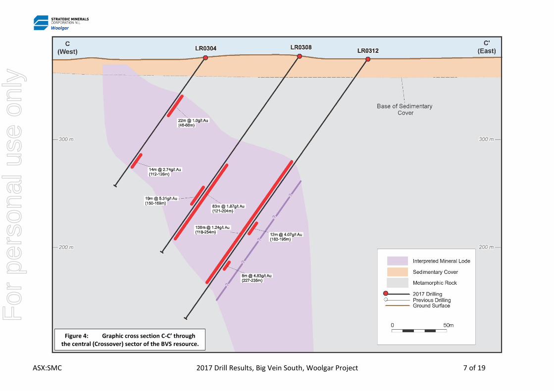
LR0308 83 metres at 1.87 g/t gold from 121 to 204 metres ▪ including 19 metres at 5.31 g/t gold from 150 to 169 metres
LR0309 50 metres at 3.23 g/t gold from 116 to 166 metres LR0310 133 metres at 1.08 g/t gold from 132 to 265 metres LR0311 23 metres at 1.35 g/t gold from 167 to 190 metres
o and 9 metres at 0.76 g/t gold from 209 to 218 metres o and 27 metres at 1.22 g/t gold from 255 to 282 metres o and 11 metres at 2.76 g/t gold from 319 to 330 metres
LR0312 136 metres at 1.24 g/t gold from 118 to 254 metres ▪ including 12 metres at 4.07 g/t gold from 183 to 195 metres ▪ and 8 metres at 4.83 g/t gold from 227 to 235 metres
LR0313 6 metres at 3.16 g/t gold from 148 to 154 metres o and 92 metres at 1.00 g/t gold from 195 to 287 metres
▪ including 7 metres at 2.57 g/t gold from 238 to 245 metres o and 7 metres at 1.41 g/t gold from 322 to 329 metres
LR0314 3 metres at 2.13 g/t gold from 131 to 134 metres o and 67 metres at 2.47 g/t gold from 165 to 232 metres
▪ including 20 metres at 4.49 g/t gold from 170 to 190 metres ▪ and 5 metres at 7.34 g/t gold from 210 to 215 metres
o and 4 metres at 3.5 g/t gold from 265 to 269 metres LR0315 12 metres at 1.15 g/t gold from 114 to 126 metres
o and 74 metres at 1.44 g/t gold from 136 to 210 metres ▪ including 7 metres at 3.63 g/t gold from 155 to 162 metres
LR0316 74 metres at 1.42 g/t gold from 105 to 179 metres ▪ including 7 metres at 4.98 g/t gold from 137 to 144 metres ▪ and 12 metres at 1.81 g/t gold from 167 to 179 metres
o and 4 metres at 1.67 g/t gold from 190 to 194 metres
1 For a summary of significant intersections for all 10 drillholes, please refer to Appendix Two: Summary of second batch of ten RC drill
intersections for 2017, as at 29th November 2017. All intersection widths are length weighted averages. All widths are Intersection or Apparent Widths. Some low-grade intervals greater than 6m are included here for concise reporting of broader intercepts. These are detailed in Appendix Two.
F
or p
erso
nal u
se o
nly

ASX:SMC 2017 Drill Results, Big Vein South, Woolgar Project 2 of 19
All ten holes announced here, totalling 2,808 metres, are located in the central “Crossover” sector of the Big Vein South (BVS) resource, and continue the focus on infilling the existing resource and testing for any near-surface extension in the Crossover sector at the BVS resource2. All drillholes intersected mineralisation.
In total, during 2017, 22 RC and 8 diamond (DD) holes were drilled for a total of 6,332 metres. All drill programs have now been completed. Further results will be released once these have been received and QAQC completed.
2017 Drill Program Update
The 2017 program includes both RC and diamond drilling aimed at fulfilling multiple technical objectives, which are required to make an initial assessment of the viability of the BVS resource:
The RC program has been completed and comprises 4,720 metres in 22 drillholes;
o Twenty of these are infill holes to decrease the spacing between existing drillholes, aimed at both upgrading the category of the existing resource, if justified, and increase the confidence and precision of the resource modelling. This was concentrated in and around the Crossover sector of the existing resource, where a significant volume of higher-grade resource has been delineated at moderate depths, bound by two cross-cutting faults.
o The shallower drillholes also tested the potential for near-surface mineralisation. Modelling of the resource indicated that there was potential for the mineralisation to extend closer to surface with obvious positive potential for the resource economics. These generally intercepted relatively narrow and low-grade mineralisation, confirming that the high-grade material does not reach surface in this sector.
o Two additional holes infill in the northern portion of the existing resource (Big Vein Central), aimed at testing potentially open mineralisation between broader-spaced drillholes.
The DD phase has been completed and comprised eight holes for 1,612 metres with the objectives of:
o Geotechnical assessment: to assist open pit wall design and mine planning.
o Metallurgical testwork: to provide a more detailed assessment of the metallurgic factors affecting recovery and overall deposit economics.
o Resource Upgrade: the diamond holes are designed to complement the RC holes. These will both increase confidence in the resource grades, form and orientation of the mineralisation, resource dimensions and twin existing holes to check the accuracy of the RC samples.
o Waste rock and Acid Rock Drainage assessment: to help define the potential waste management and environmental aspects of the deposit.
The DD program was designed to maximise the return from every metre drilled with most holes generating information in support of at least two or more of the objectives above.
Eighteen out of 22 RC holes have now been released. The remaining four were the last holes
2 For details of the 2017 resource, please refer to “Resource Update for Big Vein South” published on the 1st March 2017, available at
www.stratmin.com.au
For
per
sona
l use
onl
y

ASX:SMC 2017 Drill Results, Big Vein South, Woolgar Project 3 of 19
to be completed and will be released once all results have been returned and processed.
The eight diamond holes have all been sent to laboratories for processing and analysis. Five of these have been sent for additional processing prior to geochemical sampling, which is expected to take one month. These will also be released once analysis and processing is complete which is likely to occur toward the end of the first Quarter of 2018.
All these results, along with the geotechnical study, will be incorporated into an updated resource estimation which is likely to occur in the second Quarter of 2018.
In the New Year, further sampling will be conducted for metallurgical and acid rock drainage studies.
Laif Allen McLoughlin
EXECUTIVE CHAIRMAN
COMPETENT PERSON STATEMENT
The information in the report to which this statement is attached that relates to Exploration Results is based on information compiled by Alistair Grahame, a Competent Person who is a Member of The Australian Institute of Geoscientists. Mr Grahame is a full-time employee of Strategic Mineral Corporation NL. Mr Grahame has sufficient experience that is relevant to the style of mineralisation and type of deposit under consideration and to the activity being undertaken to qualify as a Competent Person as defined in the 2012 Edition of the ‘Australasian Code for Reporting of Exploration Results, Mineral Resources and Ore Reserves’. Mr Grahame consents to the inclusion in the report of the matters based on his information in the form and context in which it appears.
For
per
sona
l use
onl
y

ASX:SMC 2017 Drill Results, Big Vein South, Woolgar Project 4 of 19
Appendix One: Plans and Sections
Figure 1: Location map of the Woolgar Project showing the location of the ten drill holes in relation to the BVS resource, further 2017 drill holes and major prospects. Most drilling is to west with mineralisation dipping to east.
For
per
sona
l use
onl
y

ASX:SMC 2017 Drill Results, Big Vein South, Woolgar Project 5 of 19
Figure 2: Graphic cross section A-A’ through the central (Crossover) sector of the BVS resource.
For
per
sona
l use
onl
y

ASX:SMC 2017 Drill Results, Big Vein South, Woolgar Project 6 of 19
Figure 3: Graphic cross section B-B’ through the central (Crossover) sector of the BVS resource.
For
per
sona
l use
onl
y
ASX:SMC 2017 Drill Results, Big Vein South, Woolgar Project 7 of 19
Figure 4: Graphic cross section C-C’ through the central (Crossover) sector of the BVS resource.
For
per
sona
l use
onl
y

ASX:SMC 2017 Drill Results, Big Vein South, Woolgar Project 8 of 19
Figure 5: Graphic cross section D-D’ through the central (Crossover) sector of the BVS resource.
For
per
sona
l use
onl
y

ASX:SMC 2017 Drill Results, Big Vein South, Woolgar Project 9 of 19
.5
Figure 6: Graphic cross section E-E’ through the central (Crossover) sector of the BVS resource.
74m @ 1.44g/t Au (136-210m)
(
7m @ 3.63g/t Au (155-162m)
(
For
per
sona
l use
onl
y

ASX:SMC 2017 Drill Results, Big Vein South, Woolgar Project 10 of 19
Figure 7: Graphic cross section F-F’ through the central (Crossover) sector of the BVS resource.
For
per
sona
l use
onl
y

ASX:SMC 2017 Drill Results, Big Vein South, Woolgar Project 11 of 19
Figure 8: Graphic cross section G-G’ through the central (Crossover) sector of the BVS resource.
For
per
sona
l use
onl
y

ASX:SMC 2017 Drill Results, Big Vein South, Woolgar Project 12 of 19
Appendix Two: Summary of second batch of ten RC drill intersections for 2017, as at 29th November 2017.
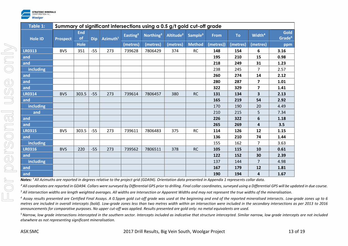
Table 1: Summary of significant intersections using a 0.5 g/t gold cut-off grade
Hole ID Prospect
End of Dip Azimuth¹
Easting² Northing² Altitude² Sample³ From To Width⁴ Gold
Grade⁵
Hole (metres) (metres) (metres) Method (metres)) (metres) (metres) ppm
LR0307 BVS 231.5 -55 273 739559 7806467 380 RC 50 54 4 0.56
and 120 220 100 1.67
including 145 165 20 3.34
and 173 177 4 4.71
LR0308 BVS 244 -55 273 739530 7806421 380 RC 121 127 6 1.02
and 135 169 34 3.41
including 150 156 6 10.69
and 161 169 8 4.37
and 179 204 25 1.15
LR0309 BVS 202 -55 273 739480 7806379 380 RC 116 166 50 3.23
LR0310 BVS 303.5 -55 273 739577 7806362 380 RC 95 98 3 1.63
and 132 150 18 0.89
and 156 168 12 0.43
and 176 185 9 1.23
and 202 227 25 1.71
and 243 265 22 2.74
LR0311 BVS 351 -55 273 739618 7806334 380 RC 167 190 23 1.35
and 209 218 9 0.76
and 255 282 27 1.22
and 319 330 11 2.76
LR0312 BVS 297.5 -55 273 739594 7806409 380 RC 118 135 17 0.63
and 142 147 5 1.82
and 160 254 94 1.56
including 183 195 12 4.07
and 227 235 8 4.83
For
per
sona
l use
onl
y
ASX:SMC 2017 Drill Results, Big Vein South, Woolgar Project 13 of 19
Table 1: Summary of significant intersections using a 0.5 g/t gold cut-off grade
Hole ID Prospect
End of Dip Azimuth¹
Easting² Northing² Altitude² Sample³ From To Width⁴ Gold
Grade⁵
Hole (metres) (metres) (metres) Method (metres)) (metres) (metres) ppm
LR0313 BVS 351 -55 273 739628 7806429 374 RC 148 154 6 3.16
and 195 210 15 0.98
and 218 249 31 1.23
including 238 245 7 2.57
and 260 274 14 2.12
and 280 287 7 1.01
and 322 329 7 1.41
LR0314 BVS 303.5 -55 273 739614 7806457 380 RC 131 134 3 2.13
and 165 219 54 2.92
including 170 190 20 4.49
and 210 215 5 7.34
and 226 322 6 1.18
and 265 269 4 3.5
LR0315 BVS 303.5 -55 273 739611 7806483 375 RC 114 126 12 1.15
and 136 210 74 1.44
including 155 162 7 3.63
LR0316 BVS 220 -55 273 739562 7806511 378 RC 105 115 10 0.61
and 122 152 30 2.39
including 137 144 7 4.98
and 167 179 12 1.81
and 190 194 4 1.67 Notes: ¹ All Azimuths are reported in degrees relative to the project grid (GDA94). Orientation data presented in Appendix 1 represents collar data.
² All coordinates are reported in GDA94. Collars were surveyed by Differential GPS prior to drilling. Final collar coordinates, surveyed using a Differential GPS will be updated in due course. 3 All intersection widths are length weighted averages. All widths are Intersection or Apparent Widths and may not represent the true widths of the mineralisation. 4 Assay results presented are Certified Final Assays. A 0.5ppm gold cut-off grade was used at the beginning and end of the reported mineralised intersects. Low-grade zones up to 6 metres are included in overall intercepts (bold). Low-grade zones less than two metres width within an intersection were included in the secondary intersections as per 2013 to 2016 announcements for comparative purposes. No upper cut-off was applied. Results presented are gold only: no metal equivalents are used. 5 Narrow, low grade intersections intercepted in the southern sector. Intercepts included as indicative that structure intercepted. Similar narrow, low grade intercepts are not included elsewhere as not representing significant mineralisation.
For
per
sona
l use
onl
y

ASX:SMC 2017 Drill Results, Big Vein South, Woolgar Project 14 of 19
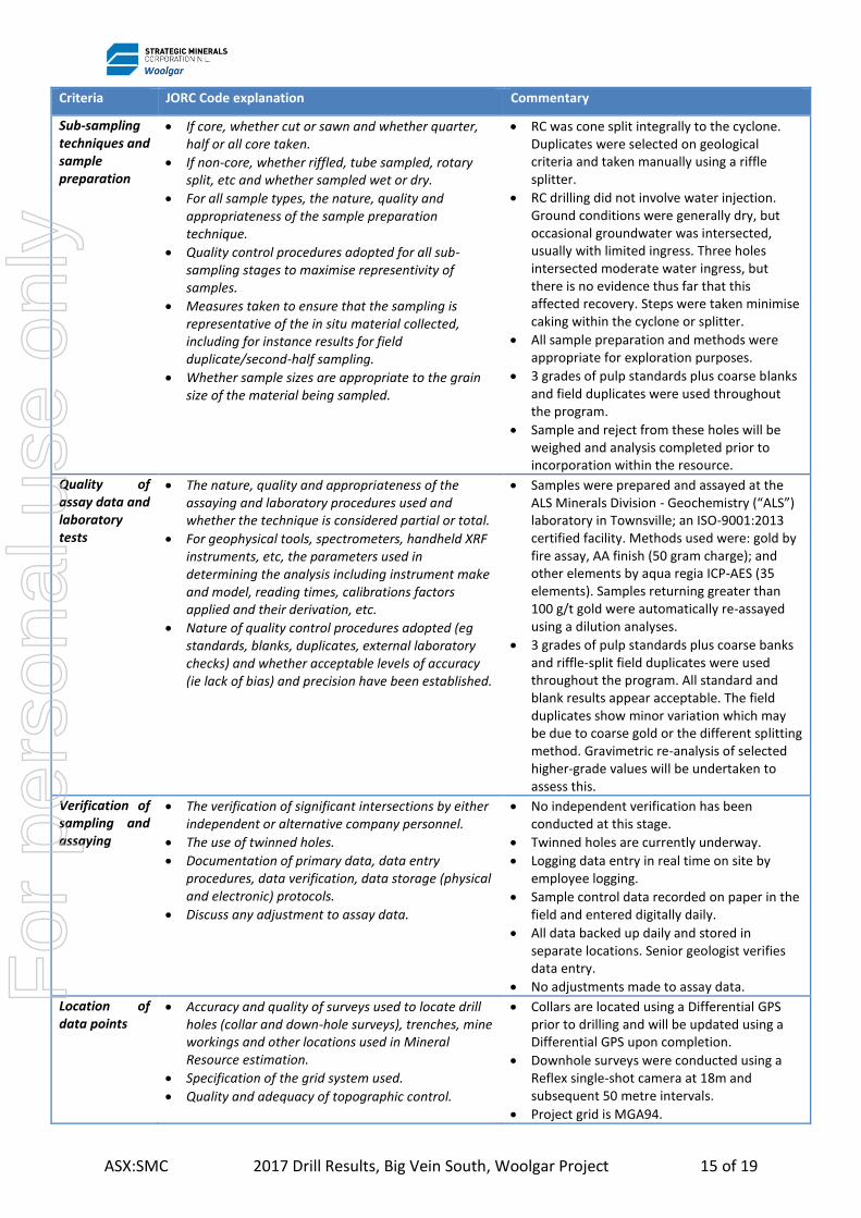
Appendix Three JORC Code, 2012 Edition – Table 1 report template Section 1 Sampling Techniques and Data (Criteria in this section apply to all succeeding sections.)
Criteria JORC Code explanation Commentary
Sampling techniques
• Nature and quality of sampling (eg cut channels, random chips, or specific specialised industry standard measurement tools appropriate to the minerals under investigation, such as down hole gamma sondes, or handheld XRF instruments, etc). These examples should not be taken as limiting the broad meaning of sampling.
• Include reference to measures taken to ensure sample representivity and the appropriate calibration of any measurement tools or systems used.
• Aspects of the determination of mineralisation that are Material to the Public Report.
• In cases where ‘industry standard’ work has been done this would be relatively simple (eg ‘reverse circulation drilling was used to obtain 1 m samples from which 3 kg was pulverised to produce a 30 g charge for fire assay’). In other cases more explanation may be required, such as where there is coarse gold that has inherent sampling problems. Unusual commodities or mineralisation types (eg submarine nodules) may warrant disclosure of detailed information.
• Reverse circulation drilling with face hammer. Sample intervals were 1.0m.
• RC sampling was carried out by the drilling contractor using a cone-splitter integral with the recovery cyclone.
• Up to 4 kg was pulverised to produce a 50 g charge for fire assay and 35 element ICP.
• Some moderate variation is noted in field duplicates, which may be due to resampling techniques (riffle vs. cone-cyclone splits) or minor coarse gold “nugget effect”. This may be higher or lower, is always low to moderate variation and proportional to the grade, and shows no systematic evidence of skewing. Screen fire assaying of higher grade samples is undertaken as standard to determine this. The original (rig-sampled) assay is reported for all instances of duplicates, rather than a selective system.
Drilling techniques
• Drill type (eg core, reverse circulation, open-hole hammer, rotary air blast, auger, Bangka, sonic, etc) and details (eg core diameter, triple or standard tube, depth of diamond tails, face-sampling bit or other type, whether core is oriented and if so, by what method, etc).
• See above.
Drill sample recovery
• Method of recording and assessing core and chip sample recoveries and results assessed.
• Measures taken to maximise sample recovery and ensure representative nature of the samples.
• Whether a relationship exists between sample recovery and grade and whether sample bias may have occurred due to preferential loss/gain of fine/coarse material.
• All samples and rejects are weighed after drilling. This has yet to be completed, but is incorporated prior to resource estimation.
• Any anomalies in sample size during drilling were brought to the driller’s attention and appropriate steps taken.
• Samples were collected in an integral cyclone recovery and cone splitter. Duplicates were taken manually using a riffle splitter and selected on geological criteria.
• At this stage, there is no obvious relationship between recovery and grade. Detailed analysis is pending prior to incorporation into future resource estimates.
Logging • Whether core and chip samples have been geologically and geotechnically logged to a level of detail to support appropriate Mineral Resource estimation, mining studies and metallurgical studies.
• Whether logging is qualitative or quantitative in nature. Core (or costean, channel, etc) photography.
• The total length and percentage of the relevant intersections logged.
• 100% of RC chips were logged on site using a qualitive system logged by a competent geologist with sufficient experience.
• All RC chips have been photographed.
For
per
sona
l use
onl
y
ASX:SMC 2017 Drill Results, Big Vein South, Woolgar Project 15 of 19
Criteria JORC Code explanation Commentary
Sub-sampling techniques and sample preparation
• If core, whether cut or sawn and whether quarter, half or all core taken.
• If non-core, whether riffled, tube sampled, rotary split, etc and whether sampled wet or dry.
• For all sample types, the nature, quality and appropriateness of the sample preparation technique.
• Quality control procedures adopted for all sub-sampling stages to maximise representivity of samples.
• Measures taken to ensure that the sampling is representative of the in situ material collected, including for instance results for field duplicate/second-half sampling.
• Whether sample sizes are appropriate to the grain size of the material being sampled.
• RC was cone split integrally to the cyclone. Duplicates were selected on geological criteria and taken manually using a riffle splitter.
• RC drilling did not involve water injection. Ground conditions were generally dry, but occasional groundwater was intersected, usually with limited ingress. Three holes intersected moderate water ingress, but there is no evidence thus far that this affected recovery. Steps were taken minimise caking within the cyclone or splitter.
• All sample preparation and methods were appropriate for exploration purposes.
• 3 grades of pulp standards plus coarse blanks and field duplicates were used throughout the program.
• Sample and reject from these holes will be weighed and analysis completed prior to incorporation within the resource.
Quality of assay data and laboratory tests
• The nature, quality and appropriateness of the assaying and laboratory procedures used and whether the technique is considered partial or total.
• For geophysical tools, spectrometers, handheld XRF instruments, etc, the parameters used in determining the analysis including instrument make and model, reading times, calibrations factors applied and their derivation, etc.
• Nature of quality control procedures adopted (eg standards, blanks, duplicates, external laboratory checks) and whether acceptable levels of accuracy (ie lack of bias) and precision have been established.
• Samples were prepared and assayed at the ALS Minerals Division - Geochemistry (“ALS”) laboratory in Townsville; an ISO-9001:2013 certified facility. Methods used were: gold by fire assay, AA finish (50 gram charge); and other elements by aqua regia ICP-AES (35 elements). Samples returning greater than 100 g/t gold were automatically re-assayed using a dilution analyses.
• 3 grades of pulp standards plus coarse banks and riffle-split field duplicates were used throughout the program. All standard and blank results appear acceptable. The field duplicates show minor variation which may be due to coarse gold or the different splitting method. Gravimetric re-analysis of selected higher-grade values will be undertaken to assess this.
Verification of sampling and assaying
• The verification of significant intersections by either independent or alternative company personnel.
• The use of twinned holes.
• Documentation of primary data, data entry procedures, data verification, data storage (physical and electronic) protocols.
• Discuss any adjustment to assay data.
• No independent verification has been conducted at this stage.
• Twinned holes are currently underway.
• Logging data entry in real time on site by employee logging.
• Sample control data recorded on paper in the field and entered digitally daily.
• All data backed up daily and stored in separate locations. Senior geologist verifies data entry.
• No adjustments made to assay data.
Location of data points
• Accuracy and quality of surveys used to locate drill holes (collar and down-hole surveys), trenches, mine workings and other locations used in Mineral Resource estimation.
• Specification of the grid system used.
• Quality and adequacy of topographic control.
• Collars are located using a Differential GPS prior to drilling and will be updated using a Differential GPS upon completion.
• Downhole surveys were conducted using a Reflex single-shot camera at 18m and subsequent 50 metre intervals.
• Project grid is MGA94.
For
per
sona
l use
onl
y
ASX:SMC 2017 Drill Results, Big Vein South, Woolgar Project 16 of 19
Criteria JORC Code explanation Commentary
• A DEM is used for planning and modelling. This has proven adequate for the low relief.
Data spacing and distribution
• Data spacing for reporting of Exploration Results.
• Whether the data spacing and distribution is sufficient to establish the degree of geological and grade continuity appropriate for the Mineral Resource and Ore Reserve estimation procedure(s) and classifications applied.
• Whether sample compositing has been applied.
• Planned intercept spacings were approximately 25m. This is considered suitable for the resource infill nature of this program.
• Exploration results only presented here. Data density will be studied in detail in the future for resource purposes.
• No compositing was used in the field. 1m sample intervals were analysed. The reported intersections are simple length weighted averages based on apparent widths.
Orientation of data in relation to geological structure
• Whether the orientation of sampling achieves unbiased sampling of possible structures and the extent to which this is known, considering the deposit type.
• If the relationship between the drilling orientation and the orientation of key mineralised structures is considered to have introduced a sampling bias, this should be assessed and reported if material.
• All sample widths presented are Intersection or Apparent Widths and do not represent the true widths of the mineralisation. The mineralisation is thought to be plunging at approximately 70°, steepening to sub-vertical below approximately 200m.
• Drilling is orientated perpendicular to the strike of the structure and all holes dip -50 to
-55°. There is no evidence for a sampling bias beyond that of the tangential angle.
Sample security
• The measures taken to ensure sample security. • RC samples are collected in calico bags, sealed in sacks of five and loaded into pallet containers for transport to Townsville by a private courier.
• A paper trail, including the contents of individual sacks is maintained.
Audits or reviews
• The results of any audits or reviews of sampling techniques and data.
• Sample technique is reviewed frequently. The use of standards and blanks was optimized for this program.
Section 2 Reporting of Exploration Results (Criteria listed in the preceding section also apply to this section.)
Criteria JORC Code explanation Commentary
Mineral tenement and land tenure status
• Type, reference name/number, location and ownership including agreements or material issues with third parties such as joint ventures, partnerships, overriding royalties, native title interests, historical sites, wilderness or national park and environmental settings.
• The security of the tenure held at the time of reporting along with any known impediments to obtaining a licence to operate in the area.
• The Woolgar project is comprised of 5 wholly owned EPMs, which are formally incorporated under project status.
• 9 MLs overly the project. These are wholly owned by Strategic Minerals.
• A further EPM, EPM 26263, is held adjacent to the project, but has not yet been formally incorporated.
• There is no known impediment to operations in the area.
License No Date
Granted Area/Sub
Blocks Interest
Comments
ML 2728 01/06/89 128 Ha 100% Granted
ML 2729 01/06/89 128 Ha 100% Granted
ML 2739 01/06/89 128 Ha 100% Granted
ML 2642 01/02/89 405 Ha 100% Granted
ML 2793 08/08/91 146.4 Ha 100% Granted
ML 90044 27/04/95 29.2 Ha 100% Granted
For
per
sona
l use
onl
y

ASX:SMC 2017 Drill Results, Big Vein South, Woolgar Project 17 of 19
Criteria JORC Code explanation Commentary
ML 90122 02/09/04 350.90
Ha 100% Granted
ML 90123 18/11/04 124.70
Ha 100% Granted
ML 90238 19/09/17 883.5 Ha 100% Granted
EPM 9599 01/09/93 32 SB 100% Granted
EPM 11886 21/04/04 23 SB 100% Granted
EPM 14060 21/04/04 46 SB 100% Granted
EPM 14209 21/04/04 49 SB 100% Granted
EPM 13942 09/11/06 3 SB 100% Granted
EPM 26263 05/12/16 100 SB 100% Granted
Exploration done by other parties
• Acknowledgment and appraisal of exploration by other parties.
• Little recent work had been carried out in the Lower Camp area prior to the commencement of the progressive RC programs by SMC in 2011. The current project management reviewed this and found them acceptable as a basis for exploration.
Geology • Deposit type, geological setting and style of mineralisation.
• The Lower Camp hosts a mesothermal style of mineralisation.
• At BVS, it is shear hosted within the regional-scale Woolgar Fault Zone where this is deflected locally by a secondary, cross-cutting structure.
• It consists of quartz and quartz-carbonate veins, stylobreccias, tectonic breccias, stockworks and veinlets.
• Gold mineralisation is associated with disseminated pyrite, and lesser galena, sphalerite and pyrrotite, that occur within strongly phyllic altered, sheared and brecciated schists, gneisses, dolerite dykes, granites, granitoids, silicified breccias and veins.
• The mineralisation is strongly associated with a phyllic alteration.
Drill hole Information
• A summary of all information material to the understanding of the exploration results including a tabulation of the following information for all Material drill holes: o easting and northing of the drill hole
collar o elevation or RL (Reduced Level –
elevation above sea level in metres) of the drill hole collar
o dip and azimuth of the hole o down hole length and interception
depth o hole length.
• If the exclusion of this information is justified on the basis that the information is not Material and this exclusion does not detract from the understanding of the report, the Competent Person should clearly explain why this is the case.
• For drilling data, see Appendix 2, Table 1. Summary of significant intersections using a 0.5 g/t gold cut-off grade of this report.
• None of this information has been excluded.
Data aggregation • In reporting Exploration Results, weighting averaging techniques,
• All intersection widths are length weighted averages. A 0.5ppm gold cut-off grade was used at the beginning and
For
per
sona
l use
onl
y

ASX:SMC 2017 Drill Results, Big Vein South, Woolgar Project 18 of 19
Criteria JORC Code explanation Commentary
methods maximum and/or minimum grade truncations (eg cutting of high grades) and cut-off grades are usually Material and should be stated.
• Where aggregate intercepts incorporate short lengths of high grade results and longer lengths of low grade results, the procedure used for such aggregation should be stated and some typical examples of such aggregations should be shown in detail.
• The assumptions used for any reporting of metal equivalent values should be clearly stated.
end of the reported mineralised intersects. Normally low-grade zones up to two metres width were included in the overall intersections, although locally low grade zones up to six metres width may be included in the overall intersections where these were considered sufficiently wide as to justify their incorporation. In the secondary intersections, low-grade zones less than two metres width were included where significant high-grade material occurred adjacent. No upper cut-off was applied. Details of intersections and higher-grade lens are included and shown in graphic sections, see Appendices One and Two.
• The mesothermal mineralisation is gold dominated and no metal equivalents are used.
Relationship between mineralisation widths and intercept lengths
• These relationships are particularly important in the reporting of Exploration Results.
• If the geometry of the mineralisation with respect to the drill hole angle is known, its nature should be reported.
• If it is not known and only the down hole lengths are reported, there should be a clear statement to this effect (eg ‘down hole length, true width not known’).
• All sample widths presented are Intersection or Apparent Widths and do not represent the true widths of the mineralisation. The mineralisation is thought to be plunging between 50 and 70° near surface and approximately vertical at depth.
• These drillholes dip -50° to -55°.
• All holes are drilled 280° GDA94, which is perpendicular to the estimated average strike of the mineralisation.
• There is no evidence for a sampling bias beyond that of the tangential angle.
Diagrams • Appropriate maps and sections (with scales) and tabulations of intercepts should be included for any significant discovery being reported These should include, but not be limited to a plan view of drill hole collar locations and appropriate sectional views.
• Location and prospect maps, and a long-section showing pierce points compared to the existing grade-thickness plot are included in the main body of the text.
Balanced reporting
• Where comprehensive reporting of all Exploration Results is not practicable, representative reporting of both low and high grades and/or widths should be practiced to avoid misleading reporting of Exploration Results.
• Summary intercepts of all eight holes in this announcement are included, including those with minimal intercepts.
• Minor intercepts of low grades and widths (≤1 g/t x ≤3m) adjacent to significant intercepts are not reported since these are considered relatively insignificant. These were included where they were the only anomalous intercepts in a hole, or where similar intercepts in multiple adjacent holes may indicate secondary structures. All results will be included in a future resource estimate.
• Drill results are outstanding for a further ten RC drill holes from the BVS resource. Diamond drilling has recently commenced on this resource.
Other substantive exploration data
• Other exploration data, if meaningful and material, should be reported including (but not limited to): geological observations; geophysical survey results; geochemical survey results; bulk samples – size and method of treatment; metallurgical test results; bulk density, groundwater, geotechnical and rock characteristics; potential deleterious or contaminating substances.
• Recent geophysical surveys have been reported previously. Detailed analysis and interpretation of these results is undertaken on a continuous basis.
• A soil sampling survey and an MMI orientation survey have been undertaken over select targets in the Lower Camp and beyond. These results will be reported separately. The orientation survey is to test the applicability of sampling and analytical techniques and is not expected to provide significant results in terms of target identification at this stage.
• RC sample reject material has been set aside for further metallurgical work. Further detailed metallurgical studies
For
per
sona
l use
onl
y

ASX:SMC 2017 Drill Results, Big Vein South, Woolgar Project 19 of 19
Criteria JORC Code explanation Commentary
are being incorporated in the ongoing diamond drilling program.
• No geotechnical data is collected from RC drilling. Four geotechnical drillholes are incorporated within the diamond drilling program. Analysis from these holes and the additional resource diamond holes will be incorporated in the subsequent study. No prior independent appraisal has been made of the data from previous DDH drilling.
• A groundwater monitoring program is underway.
• An acid rock generation study will be undertaken based on results from both the ongoing diamond drill program and the existing RC data.
• Both positive and negative interpretations of these results have been discussed openly. No further deleterious technical, statutory or social issues are known.
Further work • The nature and scale of planned further work (eg tests for lateral extensions or depth extensions or large-scale step-out drilling).
• Diagrams clearly highlighting the areas of possible extensions, including the main geological interpretations and future drilling areas, provided this information is not commercially sensitive.
• Diamond drilling is currently ongoing. Further RC drilling may be conducted, depending on the results of the current programs and logistical constraints.
For
per
sona
l use
onl
y