station depths
DESCRIPTION
Depths of london tube stationsTRANSCRIPT
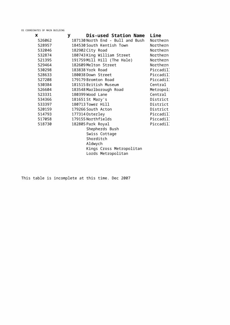
OS COORDINATES OF MAIN BUILDING
x y Dis-used Station Name Line Local Authority526062 187130 North End - Bull and Bush Northern Barnet528957 184530 South Kentish Town Northern Camden532046 182902 City Road Northern Islington532874 180743 King William Street Northern City of London521395 191759 Mill Hill (The Hale) Northern Barnet529464 182609 Melton Street Northern Camden530298 183838 York Road Piccadilly Islington528633 180038 Down Street Piccadilly Westminster527208 179179 Bromton Road Piccadilly Kensington and Chelsea530384 181515 British Museum Central Camden526604 183548 Marlborough Road MetropolitaWestminster523331 180399 Wood Lane Central Hammersmith and Fulham534366 181651 St Mary's District Tower Hamlets533397 180713 Tower Hill District City of London520159 179266 South Acton District Ealing514793 177314 Osterley Piccadilly Hownslow517058 179155 Northfields Piccadilly Hownslow518730 182805 Park Royal Piccadilly Ealing
Shepherds BushSwiss CottageShorditchAldwychKings Cross MetropolitanLords Metropolitan
This table is incomplete at this time. Dec 2007
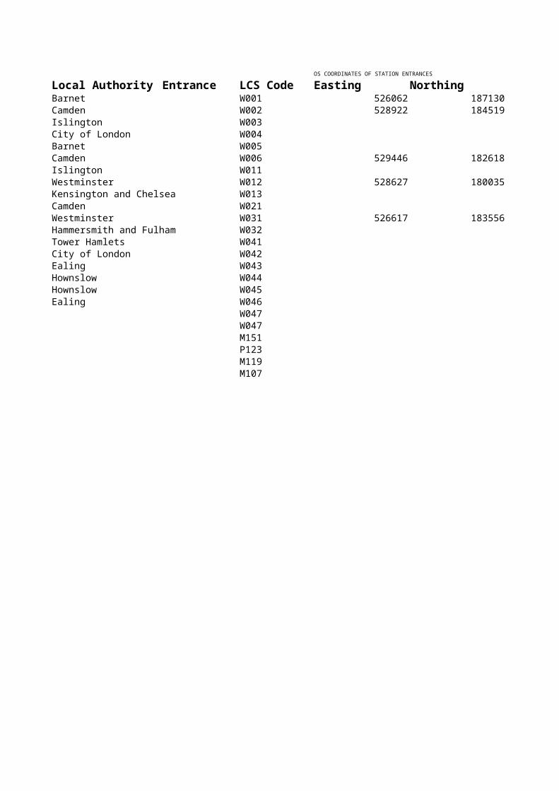
OS COORDINATES OF STATION ENTRANCES Height above sea level
Entrance LCS Code Easting Northing OS 6fig ref LevelW001 526062 187130 99W002 528922 184519 29W003 20W004 10W005 63W006 529446 182618 23W011 28W012 528627 180035 12
Kensington and Chelsea W013 8W021 24W031 526617 183556 50
Hammersmith and Fulham W032 6W041 13W042 13W043 10W044 28W045 24W046 31W047W047M151P123M119M107
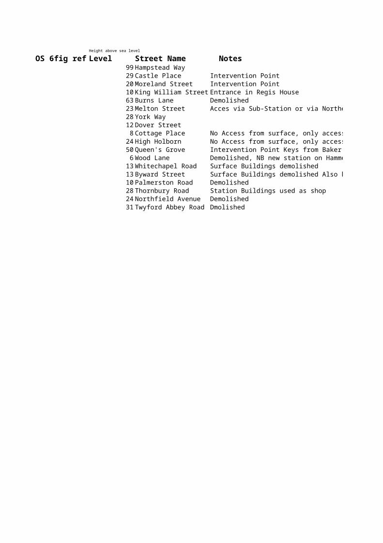
Street Name NotesHampstead WayCastle Place Intervention PointMoreland Street Intervention PointKing William Street Entrance in Regis HouseBurns Lane DemolishedMelton Street Acces via Sub-Station or via Northern Line PlatformsYork WayDover StreetCottage Place No Access from surface, only access from tube tunnelsHigh Holborn No Access from surface, only access from tube tunnelsQueen's Grove Intervention Point Keys from Baker Street StationWood Lane Demolished, NB new station on Hammersmith & City Lines to be named Wood LaneWhitechapel Road Surface Buildings demolished Byward Street Surface Buildings demolished Also known as Mark Lane StationPalmerston Road Demolished Thornbury Road Station Buildings used as shopNorthfield Avenue DemolishedTwyford Abbey Road Dmolished
Demolished, NB new station on Hammersmith & City Lines to be named Wood Lane
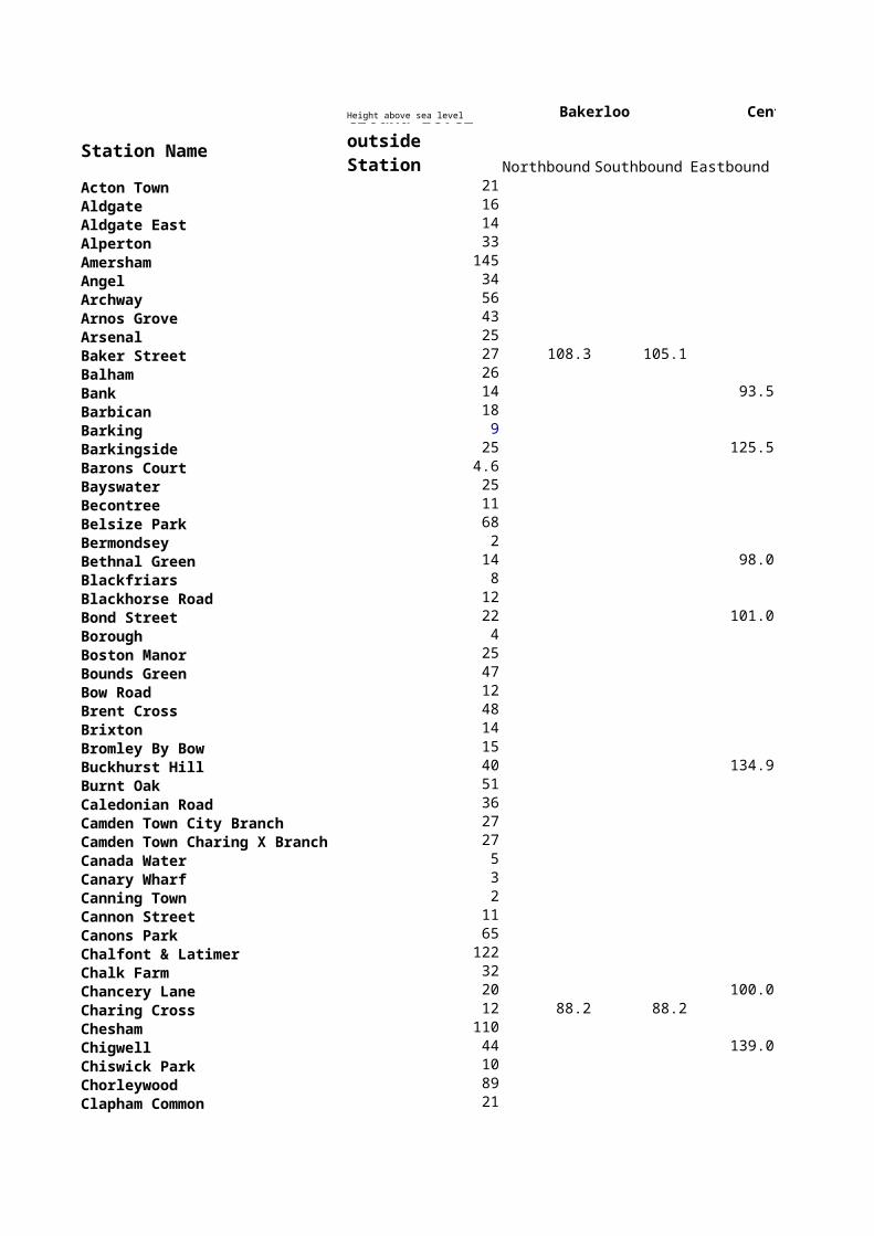
Height above sea level Bakerloo Central
Station NameNorthbound Southbound Eastbound
Acton Town 21 Aldgate 16 Aldgate East 14 Alperton 33 Amersham 145 Angel 34 Archway 56 Arnos Grove 43 Arsenal 25 Baker Street 27 108.3 105.1 Balham 26 Bank 14 93.5Barbican 18 Barking 9 Barkingside 25 125.5Barons Court 4.6 Bayswater 25 Becontree 11 Belsize Park 68 Bermondsey 2 Bethnal Green 14 98.0Blackfriars 8 Blackhorse Road 12 Bond Street 22 101.0Borough 4 Boston Manor 25 Bounds Green 47 Bow Road 12 Brent Cross 48 Brixton 14 Bromley By Bow 15 Buckhurst Hill 40 134.9Burnt Oak 51 Caledonian Road 36 Camden Town City Branch 27 Camden Town Charing X Branch 27 Canada Water 5 Canary Wharf 3 Canning Town 2 Cannon Street 11 Canons Park 65 Chalfont & Latimer 122 Chalk Farm 32 Chancery Lane 20 100.0Charing Cross 12 88.2 88.2 Chesham 110 Chigwell 44 139.0Chiswick Park 10 Chorleywood 89 Clapham Common 21
Ground Level outside Station
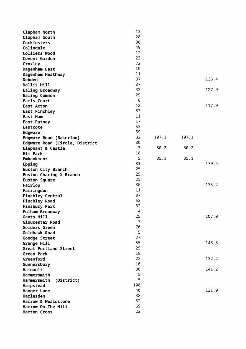
Clapham North 13 Clapham South 28 Cockfosters 98 Colindale 49 Colliers Wood 12 Covent Garden 23 Croxley 72 Dagenham East 10 Dagenham Heathway 11 Debden 37 136.4Dollis Hill 37 Ealing Broadway 33 127.9Ealing Common 29 Earls Court 8 East Acton 12 117.9East Finchley 83 East Ham 11 East Putney 17 Eastcote 53 Edgware 59 Edgware Road (Bakerloo) 32 107.1 107.1 Edgware Road (Circle, District, H & 30 Elephant & Castle 3 80.2 80.2 Elm Park 18 Embankment 5 85.1 85.1 Epping 81 179.5Euston City Branch 25 Euston Charing X Branch 25 Euston Square 25 Fairlop 30 135.2Farringdon 11 Finchley Central 87 Finchley Road 52 Finsbury Park 32 Fulham Broadway 4 Gants Hill 25 107.0Gloucester Road 7 Golders Green 70 Goldhawk Road 5 Goodge Street 27 Grange Hill 55 148.8Great Portland Street 29 Green Park 18 Greenford 22 132.2Gunnersbury 10 Hainault 36 141.2Hammersmith 5 Hammersmith (District) 5 Hampstead 108 Hanger Lane 40 131.9Harlesden 38 Harrow & Wealdstone 52 Harrow On The Hill 69 Hatton Cross 22
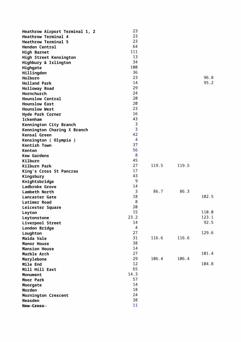
Heathrow Airport Terminal 1, 2 & 3 23 Heathrow Terminal 4 23 Heathrow Terminal 5 23Hendon Central 64 High Barnet 111 High Street Kensington 13 Highbury & Islington 34 Highgate 100 Hillingdon 36 Holborn 23 96.8Holland Park 14 95.2Holloway Road 29 Hornchurch 24 Hounslow Central 20 Hounslow East 20 Hounslow West 23 Hyde Park Corner 16 Ickenham 43 Kennington City Branch 3 Kennington Charing X Branch 3 Kensal Green 42 Kensington ( Olympia ) 4 Kentish Town 37 Kenton 56 Kew Gardens 8 Kilburn 45 Kilburn Park 27 119.5 119.5 King's Cross St Pancras 17 Kingsbury 43 Knightsbridge 9 Ladbroke Grove 14 Lambeth North 3 86.7 86.3 Lancaster Gate 18 102.5Latimer Road 8 Leicester Square 20 Leyton 15 110.0Leytonstone 23.2 123.1Liverpool Street 14 92.5London Bridge 4 Loughton 27 129.6Maida Vale 31 116.6 116.6 Manor House 38 Mansion House 14 Marble Arch 27 101.4Marylebone 29 106.4 106.4 Mile End 12 104.8Mill Hill East 65 Monument 14.3 Moor Park 57 Moorgate 14 Morden 18 Mornington Crescent 24 Neasden 38 New Cross 11
New Cross Gate 13 Newbury Park 19 117.0North Acton 33 124.4North Ealing 36 North Greenwich 2 North Harrow 51 North Wembley 48 Northfields 24 Northolt 43 137.8Northwick Park 56 Northwood 77 Northwood Hills 71 Notting Hill Gate 28 97.1Oakwood 88 Old Street 17 Osterley 30 Oval 4 Oxford Circus 27 104.7 104.7 100.6Paddington 25 109.3 109.3 Park Royal 47 Parsons Green 3 Perivale 20 126.6Piccadilly Circus 19 93.8 93.8 Pimlico 5 Pinner 54 Plaistow 9 Preston Road 45 Putney Bridge 4 Queens Park 38 Queensbury 48 Queensway 27 103.1Ravenscourt Park 5 Rayners Lane 55 Redbridge 12 106.7Regent's Park 28 104.2 102.2 Richmond 8 Rickmansworth 58 Roding Valley 31 131.2Rotherhithe 2 Royal Oak 27 Ruislip 46 Ruislip Gardens 37 141.5Ruislip Manor 44 Russell Square 23 Seven Sisters 11 Shadwell 11 Shepherd's Bush (Central) 6 89.8Shepherd's Bush Market (Hammersm 6 Shoreditch 13 Sloane Square 6 Snaresbrook 22 127.4South Ealing 24 South Harrow 61 South Kensington 7
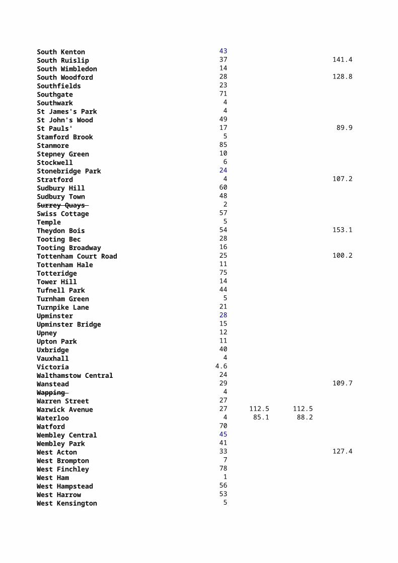
South Kenton 43 South Ruislip 37 141.4South Wimbledon 14 South Woodford 28 128.8Southfields 23 Southgate 71 Southwark 4 St James's Park 4 St John's Wood 49 St Pauls' 17 89.9Stamford Brook 5 Stanmore 85 Stepney Green 10 Stockwell 6 Stonebridge Park 24 Stratford 4 107.2Sudbury Hill 60 Sudbury Town 48 Surrey Quays 2 Swiss Cottage 57 Temple 5 Theydon Bois 54 153.1Tooting Bec 28 Tooting Broadway 16 Tottenham Court Road 25 100.2Tottenham Hale 11 Totteridge 75 Tower Hill 14 Tufnell Park 44 Turnham Green 5 Turnpike Lane 21 Upminster 28 Upminster Bridge 15 Upney 12 Upton Park 11 Uxbridge 40 Vauxhall 4 Victoria 4.6 Walthamstow Central 24 Wanstead 29 109.7Wapping 4 Warren Street 27 Warwick Avenue 27 112.5 112.5 Waterloo 4 85.1 88.2 Watford 70 Wembley Central 45 Wembley Park 41 West Acton 33 127.4West Brompton 7 West Finchley 78 West Ham 1 West Hampstead 56 West Harrow 53 West Kensington 5
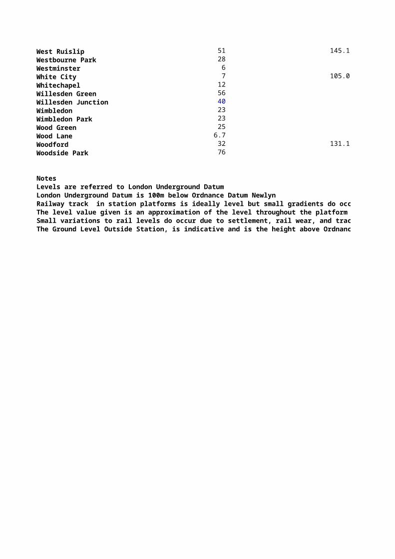
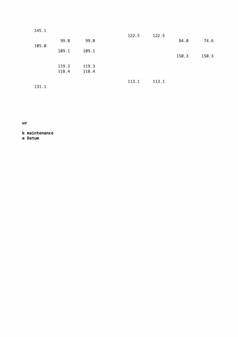
West Ruislip 51 145.1Westbourne Park 28 Westminster 6 White City 7 105.0Whitechapel 12 Willesden Green 56 Willesden Junction 40 Wimbledon 23 Wimbledon Park 23 Wood Green 25 Wood Lane 6.7Woodford 32 131.1Woodside Park 76
NotesLevels are referred to London Underground DatumLondon Underground Datum is 100m below Ordnance Datum NewlynRailway track in station platforms is ideally level but small gradients do occurThe level value given is an approximation of the level throughout the platformSmall variations to rail levels do occur due to settlement, rail wear, and track maintenanceThe Ground Level Outside Station, is indicative and is the height above Ordnance Datum
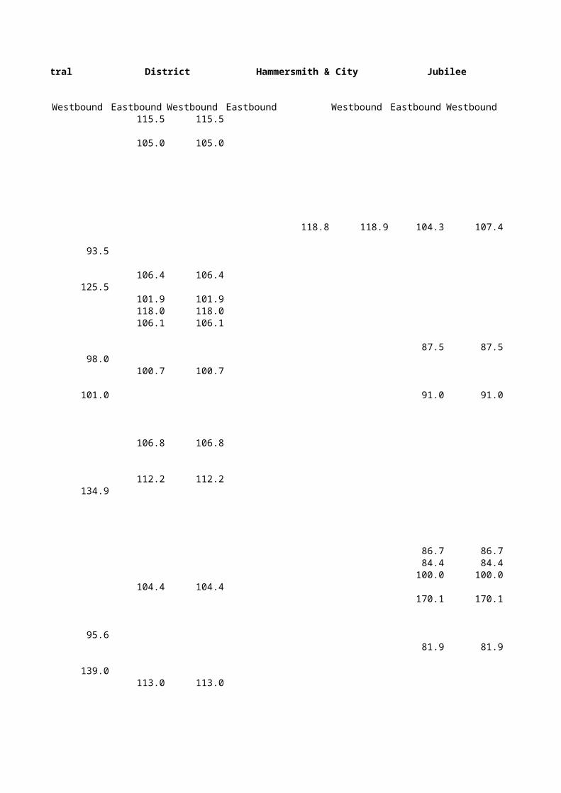
Central District Hammersmith & City Jubilee
Westbound Eastbound Westbound Eastbound Westbound Eastbound Westbound 115.5 115.5 105.0 105.0 118.8 118.9 104.3 107.4
93.5 106.4 106.4
125.5 101.9 101.9 118.0 118.0 106.1 106.1 87.5 87.5
98.0 100.7 100.7
101.0 91.0 91.0 106.8 106.8 112.2 112.2
134.9 86.7 86.7 84.4 84.4 100.0 100.0 104.4 104.4 170.1 170.1
95.6 81.9 81.9
139.0 113.0 113.0
106.4 106.4 106.2 106.2
136.4 139.4 139.4
127.9 127.9 127.9 124.0 124.0 102.2 102.2
117.9 105.7 105.7 125.0 125.0 124.8 124.8 124.8 124.8 112.3 112.3 99.6 99.6
179.5 118.1 118.1
135.2 148.7 148.7 98.7 98.7
110.1 100.0 100.0 111.0 111.0
148.8 87.0 87.0
132.2 106.0 106.0
141.2 104.4 104.4 100.4 100.4
131.9
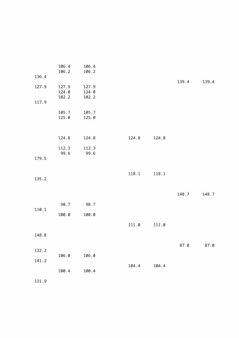
107.3 107.3
96.7 95.2
118.2 118.2 102.1 102.1 106.0 106.0 152.2 152.2 138.3 138.3 119.4 119.4
102.5 114.0 114.0
110.0 123.1
92.5 76.8 76.8
129.6 105.0 105.0
101.4
104.9 104.7 104.7 106.2 106.2 132.2 132.2
117.0 124.4
86.5 86.5
137.8
102.6 119.4 119.4
100.6 118.8 118.8 122.4 122.4 108.0 108.0
126.6 102.4 102.4 111.0 111.0 151.2 151.2
103.1 111.0 111.0
106.9 107.0
131.2 121.0 121.0
141.5
89.8 111.9 111.9 97.6 97.6
127.4 100.0 100.0
141.4
128.8
117.0 117.0 79.5 79.5 98.2 98.2 131.7 131.2
95.3 111.4 111.4 176.8 176.8 102.8 102.8
107.2 104.0 104.0 140.1 140.1 99.2 99.2
153.1
100.2 106.9 107.0 110.9 110.9 119.2 119.2 119.3 119.3 106.3 106.3 105.3 105.3 97.0 97.0
109.6 74.0 74.0 136.7 136.7
127.4 102.0 102.1 104.7 104.7 101.2 101.2 150.5 150.5 99.4 99.3
145.1 122.5 122.5
99.0 99.0 84.0 74.6105.0
109.1 109.1 150.3 150.3 119.3 119.3 118.4 118.4
113.1 113.1131.1
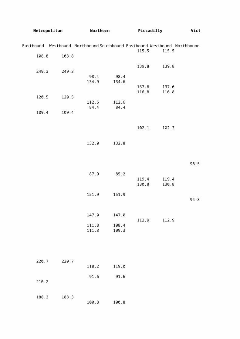
Metropolitan Northern Piccadilly Victoria
Eastbound Westbound Northbound Southbound Eastbound Westbound Northbound Southbound 115.5 115.5
108.8 108.8 139.8 139.8
249.3 249.3 98.4 98.4 134.9 134.6 137.6 137.6 116.8 116.8
120.5 120.5 112.6 112.6 84.4 84.4
109.4 109.4 102.1 102.3 132.0 132.8 96.5 96.4 87.9 85.2 119.4 119.4 130.8 130.8 151.9 151.9 94.8 94.8 147.0 147.0 112.9 112.9 111.8 108.4 111.8 109.3
220.7 220.7 118.2 119.0 91.6 91.6
210.2
188.3 188.3 100.8 100.8
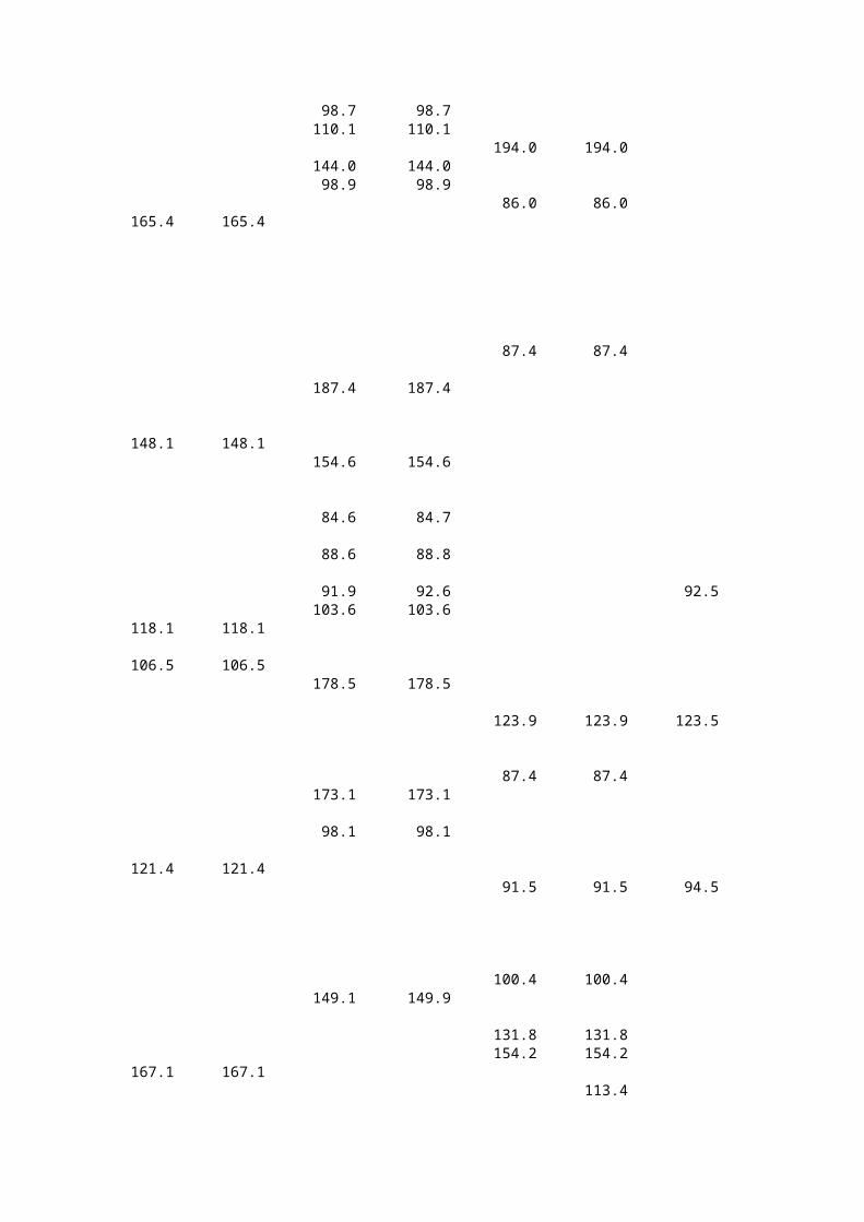
98.7 98.7 110.1 110.1 194.0 194.0 144.0 144.0 98.9 98.9 86.0 86.0
165.4 165.4 87.4 87.4 187.4 187.4
148.1 148.1 154.6 154.6 84.6 84.7 88.6 88.8 91.9 92.6 92.5 92.5 103.6 103.6
118.1 118.1
106.5 106.5 178.5 178.5 123.9 123.9 123.5 123.4 87.4 87.4 173.1 173.1 98.1 98.1
121.4 121.4 91.5 91.5 94.5 95.3 100.4 100.4 149.1 149.9 131.8 131.8 154.2 154.2
167.1 167.1 113.4
109.6 112.9
110.3 110.3 161.5 161.5 198.4 198.4 117.8 117.9 162.7 162.7
136.7 136.7 88.3 81.9 115.4 115.4 124.9 124.9 125.8 125.8 117.7 117.7 88.9 88.9
138.1 138.1 87.1 84.4 86.9 84.6 135.4 135.4 115.9 112.9 149.4 149.4
109.1 109.1 88.9 88.9 94.4 94.4 99.9 99.9 86.7 86.7 93.5 93.5 86.8 86.8
107.4 107.4 80.4 80.4 119.5 119.5 170.8 170.8
161.5 161.5 108.5 108.5 88.7 88.8
113.6 113.6 108.7 108.7
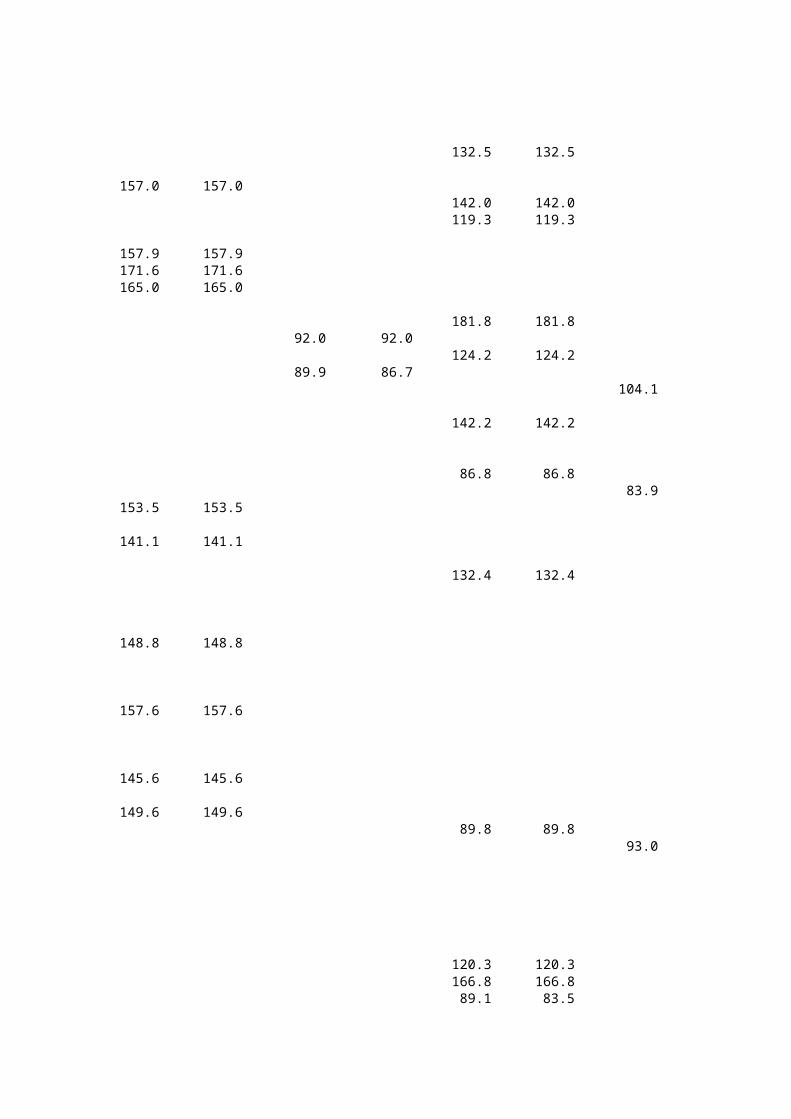
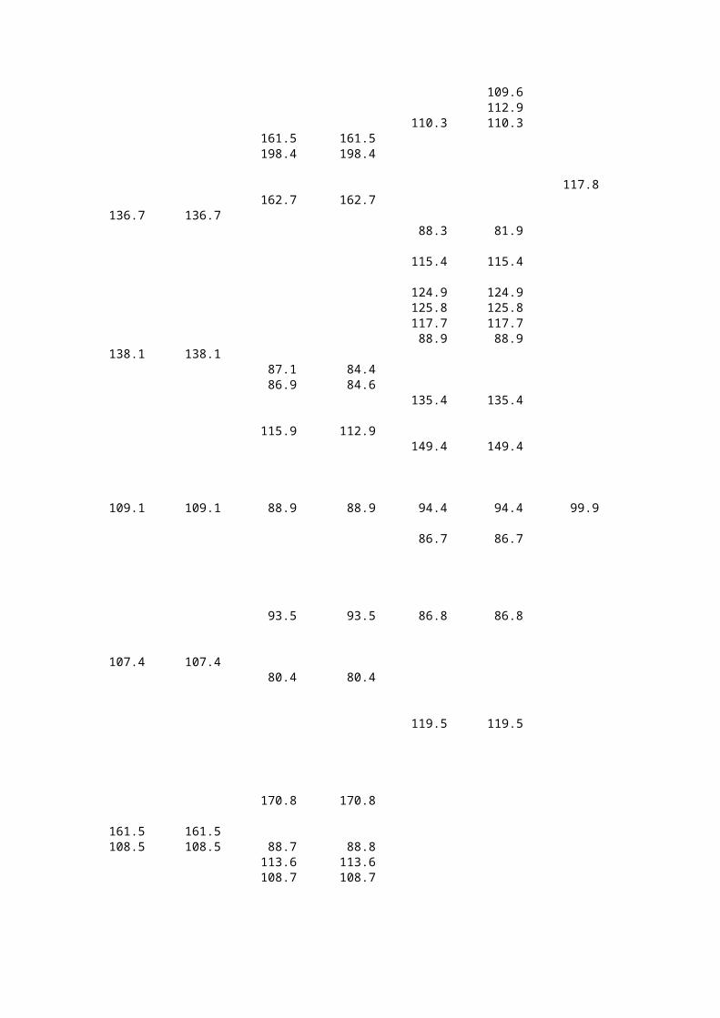
132.5 132.5
157.0 157.0 142.0 142.0 119.3 119.3
157.9 157.9 171.6 171.6 165.0 165.0
181.8 181.8 92.0 92.0 124.2 124.2 89.9 86.7 104.1 104.1 142.2 142.2 86.8 86.8 83.9 83.9
153.5 153.5
141.1 141.1 132.4 132.4
148.8 148.8
157.6 157.6
145.6 145.6
149.6 149.6 89.8 89.8 93.0 93.0 120.3 120.3 166.8 166.8 89.1 83.5

146.4 146.4 101.3 101.3 160.2 160.2 92.2 92.4 92.2 92.4 131.5 131.5 154.2 154.2 147.6 147.6 111.6 111.6 103.2 103.2 94.3 94.3 91.8 91.7 173.8 173.8 125.0 121.6 106.3 106.3
140.1 140.1 86.3 86.3 85.2 85.2 106.9 106.7 101.7 101.6 96.1 96.1 82.8 82.8
164.8 164.8 138.5 138.5 177.3 177.3
157.5 157.5
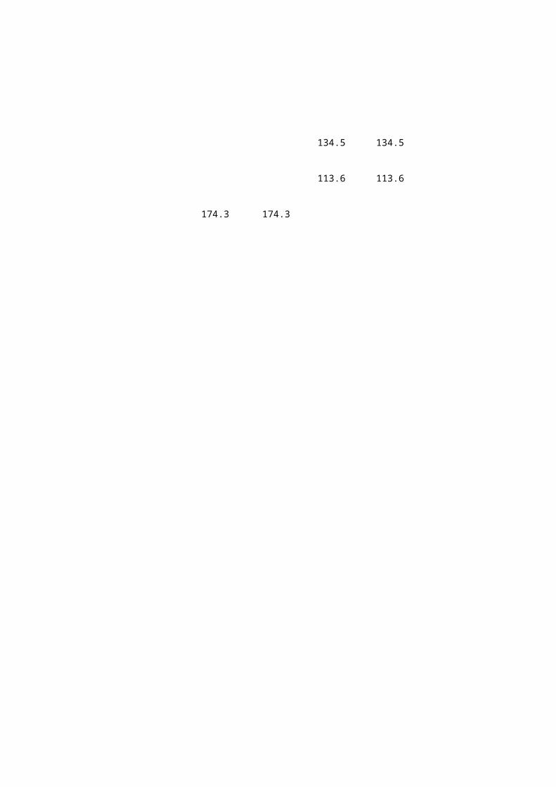
134.5 134.5 113.6 113.6
174.3 174.3
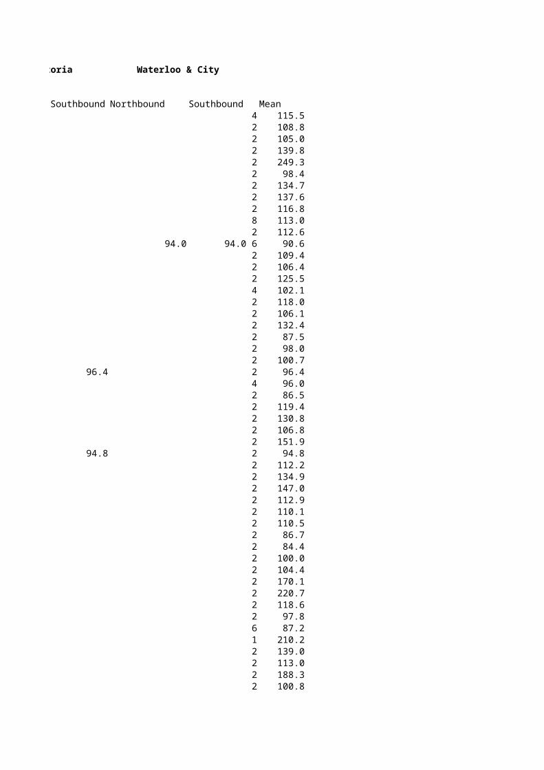
Waterloo & City
Northbound Southbound Mean 4 115.5 2 108.8 2 105.0 2 139.8 2 249.3 2 98.4 2 134.7 2 137.6 2 116.8 8 113.0 2 112.6
94.0 94.0 6 90.6 2 109.4 2 106.4 2 125.5 4 102.1 2 118.0 2 106.1 2 132.4 2 87.5 2 98.0 2 100.7 2 96.4 4 96.0 2 86.5 2 119.4 2 130.8 2 106.8 2 151.9 2 94.8 2 112.2 2 134.9 2 147.0 2 112.9 2 110.1 2 110.5 2 86.7 2 84.4 2 100.0 2 104.4 2 170.1 2 220.7 2 118.6 2 97.8 6 87.2 1 210.2 2 139.0 2 113.0 2 188.3 2 100.8
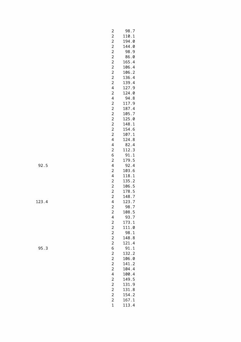
2 98.7 2 110.1 2 194.0 2 144.0 2 98.9 2 86.0 2 165.4 2 106.4 2 106.2 2 136.4 2 139.4 4 127.9 2 124.0 4 94.8 2 117.9 2 187.4 2 105.7 2 125.0 2 148.1 2 154.6 2 107.1 4 124.8 4 82.4 2 112.3 6 91.1 2 179.5 4 92.4 2 103.6 4 118.1 2 135.2 2 106.5 2 178.5 2 148.7 4 123.7 2 98.7 2 108.5 4 93.7 2 173.1 2 111.0 2 98.1 2 148.8 2 121.4 6 91.1 2 132.2 2 106.0 2 141.2 2 104.4 4 100.4 2 149.5 2 131.9 2 131.8 2 154.2 2 167.1 1 113.4
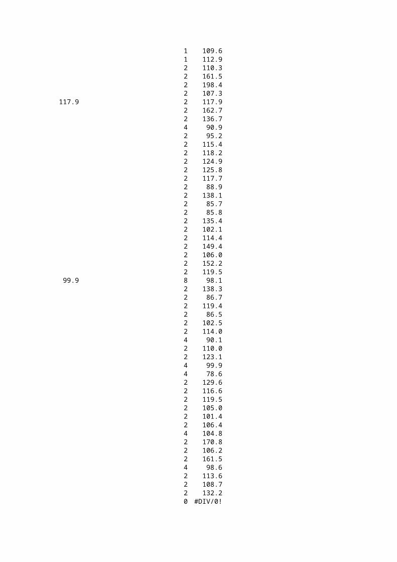
1 109.6 1 112.9
2 110.3 2 161.5 2 198.4 2 107.3 2 117.9 2 162.7 2 136.7 4 90.9 2 95.2 2 115.4 2 118.2 2 124.9 2 125.8 2 117.7 2 88.9 2 138.1 2 85.7 2 85.8 2 135.4 2 102.1 2 114.4 2 149.4 2 106.0 2 152.2 2 119.5 8 98.1 2 138.3 2 86.7 2 119.4 2 86.5 2 102.5 2 114.0 4 90.1 2 110.0 2 123.1 4 99.9 4 78.6 2 129.6 2 116.6 2 119.5 2 105.0 2 101.4 2 106.4 4 104.8 2 170.8 2 106.2 2 161.5 4 98.6 2 113.6 2 108.7 2 132.2 0 #DIV/0!
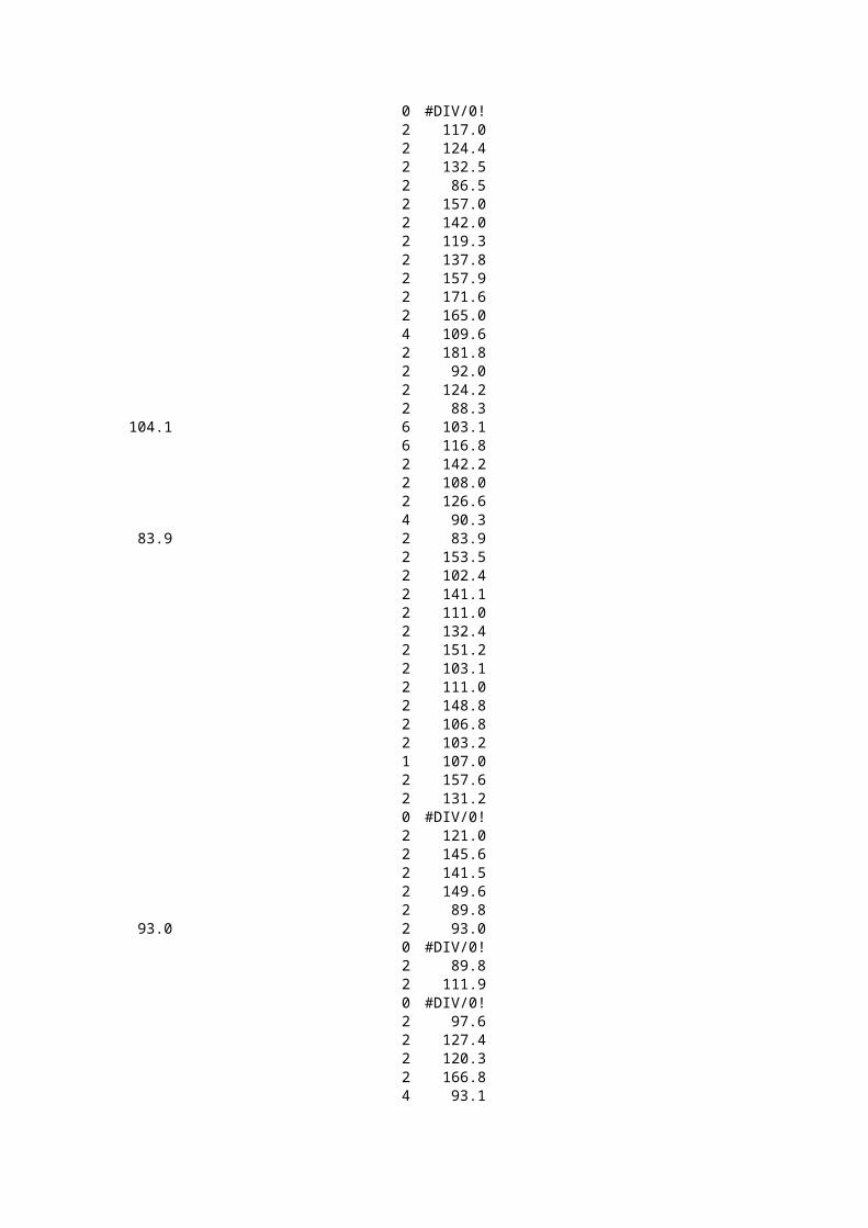
0 #DIV/0! 2 117.0 2 124.4 2 132.5 2 86.5 2 157.0 2 142.0 2 119.3 2 137.8 2 157.9 2 171.6 2 165.0 4 109.6 2 181.8 2 92.0 2 124.2 2 88.3 6 103.1 6 116.8 2 142.2 2 108.0 2 126.6 4 90.3 2 83.9 2 153.5 2 102.4 2 141.1 2 111.0 2 132.4 2 151.2 2 103.1 2 111.0 2 148.8 2 106.8 2 103.2 1 107.0 2 157.6 2 131.2 0 #DIV/0! 2 121.0 2 145.6 2 141.5 2 149.6 2 89.8 2 93.0 0 #DIV/0! 2 89.8 2 111.9 0 #DIV/0! 2 97.6 2 127.4 2 120.3 2 166.8 4 93.1
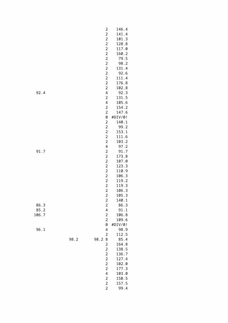
2 146.4 2 141.4 2 101.3 2 128.8 2 117.0 2 160.2 2 79.5 2 98.2 2 131.4 2 92.6 2 111.4 2 176.8 2 102.8 4 92.3 2 131.5 4 105.6 2 154.2 2 147.6 0 #DIV/0! 2 140.1 2 99.2 2 153.1 2 111.6 2 103.2 4 97.2 2 91.7 2 173.8 2 107.0 2 123.3 2 110.9 2 106.3 2 119.2 2 119.3 2 106.3 2 105.3 2 140.1 2 86.3 4 91.1 2 106.8 2 109.6 0 #DIV/0! 4 98.9 2 112.5
98.2 98.2 8 85.4 2 164.8 2 138.5 2 136.7 2 127.4 2 102.0 2 177.3 4 103.0 2 150.5 2 157.5 2 99.4
2 145.1 2 122.5 4 89.1 2 105.0 2 109.1 2 150.3 2 134.5 2 119.3 2 118.4 2 113.6
2 113.1 2 131.1 2 174.3
Station Name
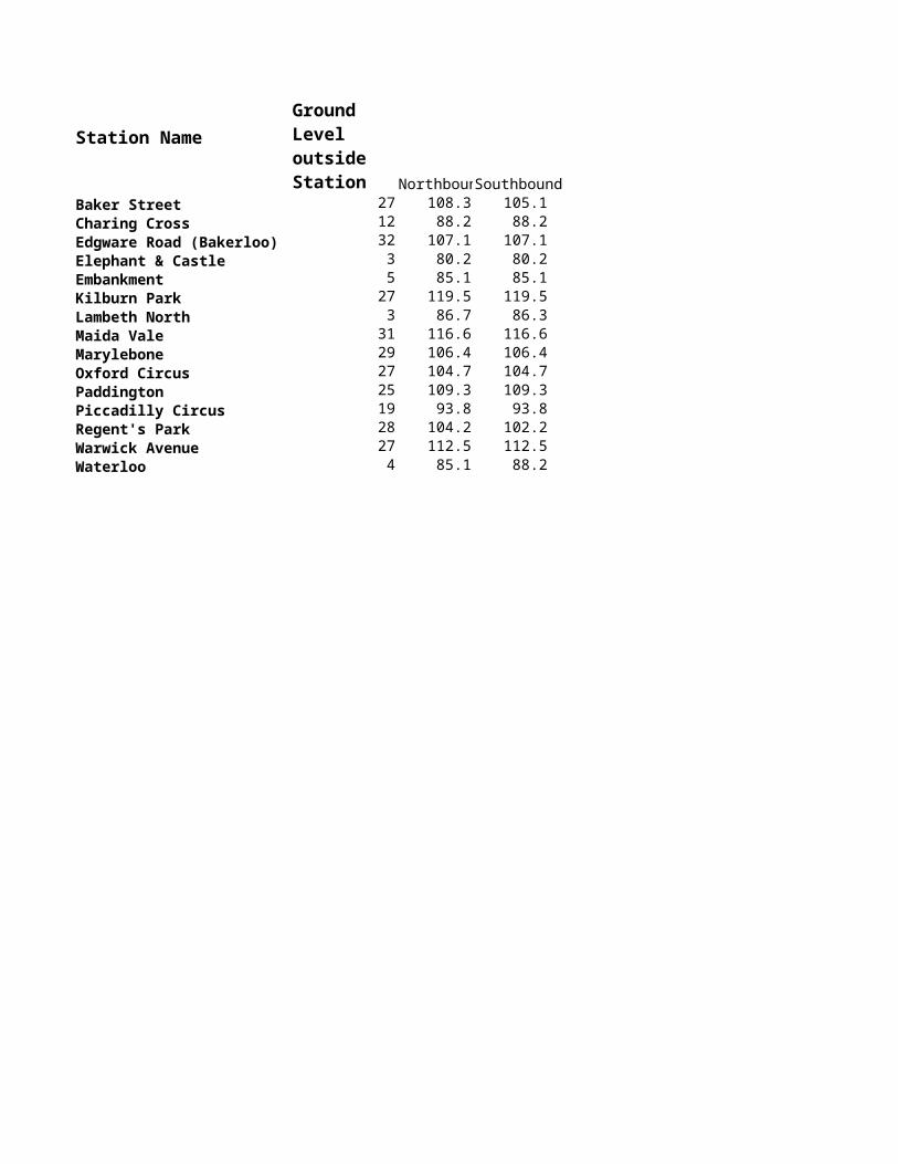
NorthbounSouthboundBaker Street 27 108.3 105.1Charing Cross 12 88.2 88.2Edgware Road (Bakerloo) 32 107.1 107.1Elephant & Castle 3 80.2 80.2Embankment 5 85.1 85.1Kilburn Park 27 119.5 119.5Lambeth North 3 86.7 86.3Maida Vale 31 116.6 116.6Marylebone 29 106.4 106.4Oxford Circus 27 104.7 104.7Paddington 25 109.3 109.3Piccadilly Circus 19 93.8 93.8Regent's Park 28 104.2 102.2Warwick Avenue 27 112.5 112.5Waterloo 4 85.1 88.2
Ground Level outside Station
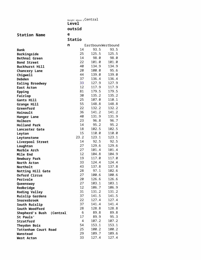
Height above sea Central
Station Name
EastboundWestboundBank 14 93.5 93.5Barkingside 25 125.5 125.5Bethnal Green 14 98.0 98.0Bond Street 22 101.0 101.0Buckhurst Hill 40 134.9 134.9Chancery Lane 20 100.0 95.6Chigwell 44 139.0 139.0Debden 37 136.4 136.4Ealing Broadway 33 127.9 127.9East Acton 12 117.9 117.9Epping 81 179.5 179.5Fairlop 30 135.2 135.2Gants Hill 25 107.0 110.1Grange Hill 55 148.8 148.8Greenford 22 132.2 132.2Hainault 36 141.2 141.2Hanger Lane 40 131.9 131.9Holborn 23 96.8 96.7Holland Park 14 95.2 95.2Lancaster Gate 18 102.5 102.5Leyton 15 110.0 110.0Leytonstone 23.2 123.1 123.1Liverpool Street 14 92.5 92.5Loughton 27 129.6 129.6Marble Arch 27 101.4 101.4Mile End 12 104.8 104.9Newbury Park 19 117.0 117.0North Acton 33 124.4 124.4Northolt 43 137.8 137.8Notting Hill Gate 28 97.1 102.6Oxford Circus 27 100.6 100.6Perivale 20 126.6 126.6Queensway 27 103.1 103.1Redbridge 12 106.7 106.9Roding Valley 31 131.2 131.2Ruislip Gardens 37 141.5 141.5Snaresbrook 22 127.4 127.4South Ruislip 37 141.4 141.4South Woodford 28 128.8 128.8Shepherd's Bush (Central) 6 89.8 89.8St Pauls' 17 89.9 95.3Stratford 4 107.2 107.2Theydon Bois 54 153.1 153.1Tottenham Court Road 25 100.2 100.2Wanstead 29 109.7 109.6West Acton 33 127.4 127.4West Ruislip 51 145.1 145.1White City 7 105.0 105.0Woodford 32 131.1 131.1
Ground Level outside Station
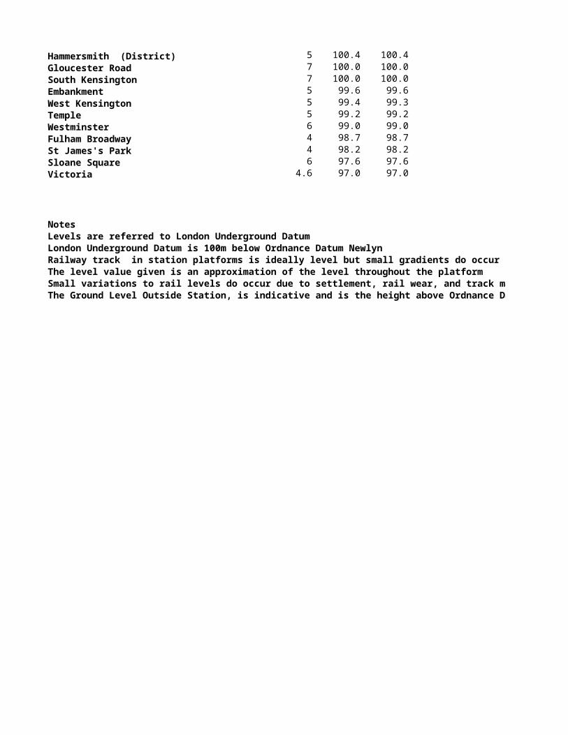
Height above sea level
Station NameEastboundWestbound
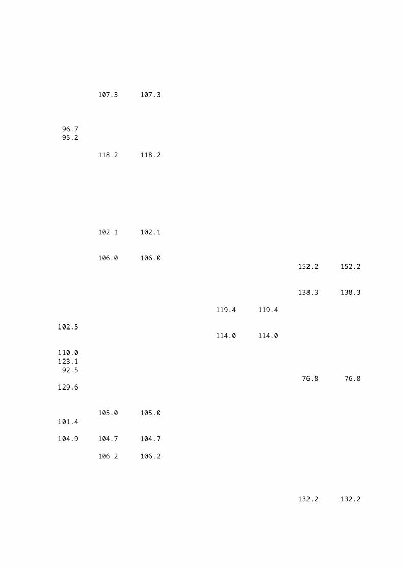
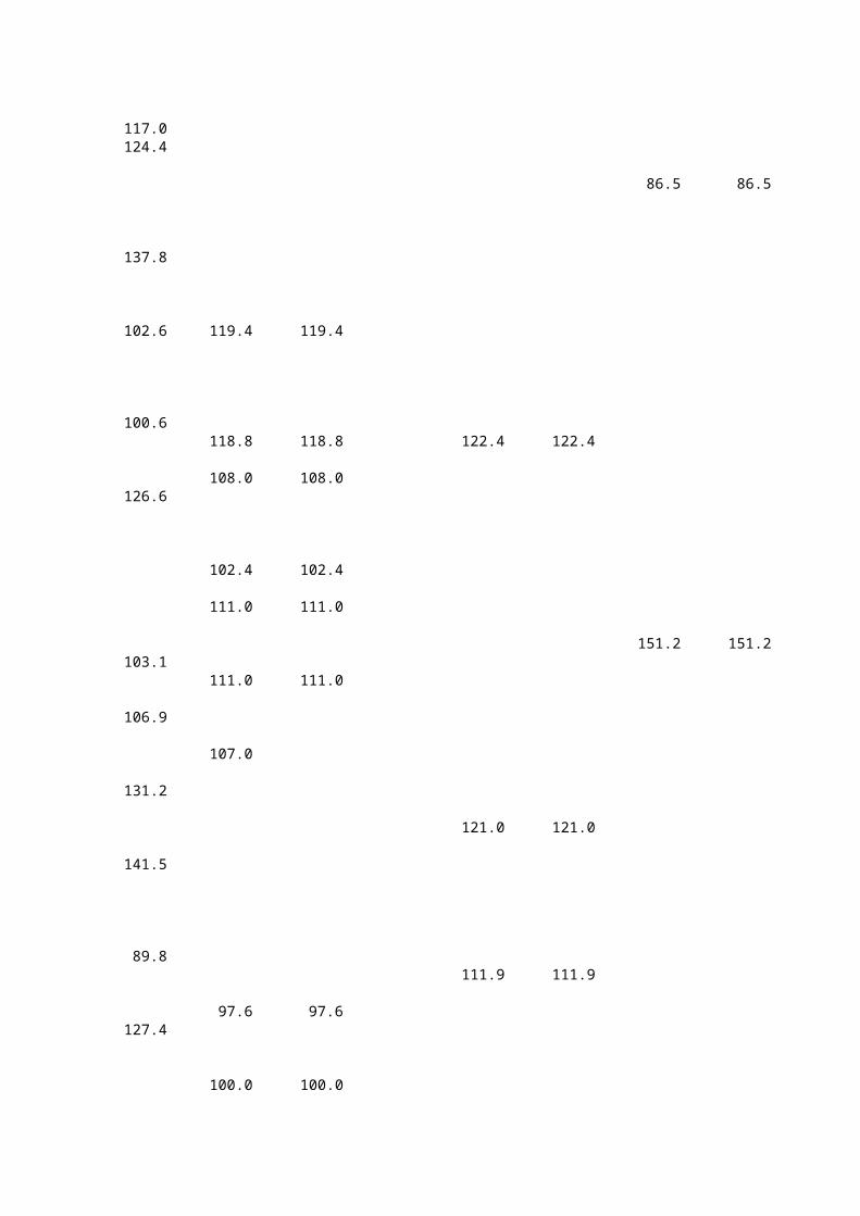
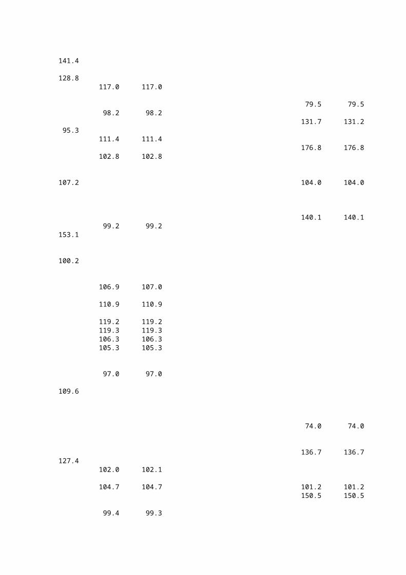
Ealing Broadway 33 127.9 127.9East Putney 17 125.0 125.0Edgware Road (Circle, District, H & 30 124.8 124.8Ealing Common 29 124.0 124.0Notting Hill Gate 28 119.4 119.4Upminster Bridge 15 119.3 119.3Wimbledon 23 119.3 119.3Upminster 28 119.2 119.2Paddington 25 118.8 118.8Wimbledon Park 23 118.4 118.4Hornchurch 24 118.2 118.2Bayswater 25 118.0 118.0Southfields 23 117.0 117.0Acton Town 21 115.5 115.5Chiswick Park 10 113.0 113.0Elm Park 18 112.3 112.3Bromley By Bow 15 112.2 112.2Stamford Brook 5 111.4 111.4Putney Bridge 4 111.0 111.0Ravenscourt Park 5 111.0 111.0Turnham Green 5 110.9 110.9Whitechapel 12 109.1 109.1Parsons Green 3 108.0 108.0High Street Kensington 13 107.3 107.3Tower Hill 14 106.9 107.0Bow Road 12 106.8 106.8Barking 9 106.4 106.4Dagenham East 10 106.4 106.4Upney 12 106.3 106.3Dagenham Heathway 11 106.2 106.2Monument 14.3 106.2 106.2Becontree 11 106.1 106.1Gunnersbury 10 106.0 106.0Kew Gardens 8 106.0 106.0East Ham 11 105.7 105.7Upton Park 11 105.3 105.3Aldgate East 14 105.0 105.0Mansion House 14 105.0 105.0Mile End 12 104.7 104.7West Ham 1 104.7 104.7Cannon Street 11 104.4 104.4Stepney Green 10 102.8 102.8Plaistow 9 102.4 102.4Earls Court 8 102.2 102.2Kensington ( Olympia ) 4 102.1 102.1West Brompton 7 102.0 102.1Barons Court 4.6 101.9 101.9Blackfriars 8 100.7 100.7Hammersmith (District) 5 100.4 100.4Gloucester Road 7 100.0 100.0South Kensington 7 100.0 100.0Embankment 5 99.6 99.6
Ground Level outside Station
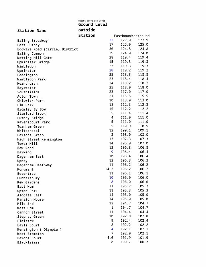
West Kensington 5 99.4 99.3Temple 5 99.2 99.2Westminster 6 99.0 99.0Fulham Broadway 4 98.7 98.7St James's Park 4 98.2 98.2Sloane Square 6 97.6 97.6Victoria 4.6 97.0 97.0
NotesLevels are referred to London Underground DatumLondon Underground Datum is 100m below Ordnance Datum NewlynRailway track in station platforms is ideally level but small gradients do occurThe level value given is an approximation of the level throughout the platformSmall variations to rail levels do occur due to settlement, rail wear, and track maintenanceThe Ground Level Outside Station, is indicative and is the height above Ordnance Datum
Height above sea level Hammersmith & City
Station NameEastboundWestbound
Baker Street 27 118.8 118.9Edgware Road (Circle, District, H & 30 124.8 124.8Euston Square 25 118.1 118.1Goldhawk Road 5 111.0 111.0Hammersmith 5 104.4 104.4Ladbroke Grove 14 119.4 119.4Latimer Road 8 114.0 114.0Paddington 25 122.4 122.4Royal Oak 27 121.0 121.0Shepherd's Bush Market (Hammersm 6 111.9 111.9Westbourne Park 28 122.5 122.5Wood Lane 6.7 113.1 113.1
NotesLevels are referred to London Underground DatumLondon Underground Datum is 100m below Ordnance Datum NewlynRailway track in station platforms is ideally level but small gradients do occurThe level value given is an approximation of the level throughout the platformSmall variations to rail levels do occur due to settlement, rail wear, and track maintenanceThe Ground Level Outside Station, is indicative and is the height above Ordnance Datum
Ground Level outside Station
Height above sea level Jubilee
Station NameEastboundWestbound
Baker Street 27 104.3 107.4Bermondsey 2 87.5 87.5Bond Street 22 91.0 91.0Canada Water 5 86.7 86.7Canary Wharf 3 84.4 84.4Canning Town 2 100.0 100.0Canons Park 65 170.1 170.1Charing Cross 12 81.9 81.9Dollis Hill 37 139.4 139.4Finchley Road 52 148.7 148.7Green Park 18 87.0 87.0Kilburn 45 152.2 152.2Kingsbury 43 138.3 138.3London Bridge 4 76.8 76.8Neasden 38 132.2 132.2North Greenwich 2 86.5 86.5Queensbury 48 151.2 151.2Southwark 4 79.5 79.5St John's Wood 49 131.7 131.2Stanmore 85 176.8 176.8Stratford 4 104.0 104.0Swiss Cottage 57 140.1 140.1Waterloo 4 74.0 74.0Wembley Park 41 136.7 136.7West Ham 1 101.2 101.2West Hampstead 56 150.5 150.5Westminster 6 84.0 74.6Willesden Green 56 150.3 150.3
NotesLevels are referred to London Underground DatumLondon Underground Datum is 100m below Ordnance Datum NewlynRailway track in station platforms is ideally level but small gradients do occurThe level value given is an approximation of the level throughout the platformSmall variations to rail levels do occur due to settlement, rail wear, and track maintenanceThe Ground Level Outside Station, is indicative and is the height above Ordnance Datum
Ground Level outside Station
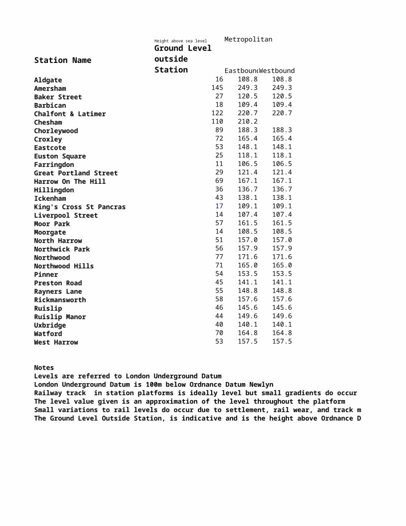
Height above sea level Metropolitan
Station NameEastboundWestbound
Aldgate 16 108.8 108.8Amersham 145 249.3 249.3Baker Street 27 120.5 120.5Barbican 18 109.4 109.4Chalfont & Latimer 122 220.7 220.7Chesham 110 210.2 Chorleywood 89 188.3 188.3Croxley 72 165.4 165.4Eastcote 53 148.1 148.1Euston Square 25 118.1 118.1Farringdon 11 106.5 106.5Great Portland Street 29 121.4 121.4Harrow On The Hill 69 167.1 167.1Hillingdon 36 136.7 136.7Ickenham 43 138.1 138.1King's Cross St Pancras 17 109.1 109.1Liverpool Street 14 107.4 107.4Moor Park 57 161.5 161.5Moorgate 14 108.5 108.5North Harrow 51 157.0 157.0Northwick Park 56 157.9 157.9Northwood 77 171.6 171.6Northwood Hills 71 165.0 165.0Pinner 54 153.5 153.5Preston Road 45 141.1 141.1Rayners Lane 55 148.8 148.8Rickmansworth 58 157.6 157.6Ruislip 46 145.6 145.6Ruislip Manor 44 149.6 149.6Uxbridge 40 140.1 140.1Watford 70 164.8 164.8West Harrow 53 157.5 157.5
NotesLevels are referred to London Underground DatumLondon Underground Datum is 100m below Ordnance Datum NewlynRailway track in station platforms is ideally level but small gradients do occurThe level value given is an approximation of the level throughout the platformSmall variations to rail levels do occur due to settlement, rail wear, and track maintenanceThe Ground Level Outside Station, is indicative and is the height above Ordnance Datum
Ground Level outside Station
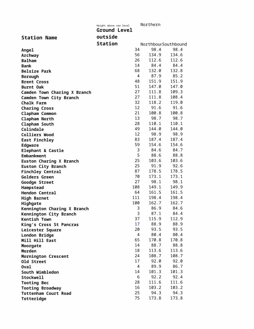
Height above sea level Northern
Station NameNorthbounSouthbound
Angel 34 98.4 98.4Archway 56 134.9 134.6Balham 26 112.6 112.6Bank 14 84.4 84.4Belsize Park 68 132.0 132.8Borough 4 87.9 85.2Brent Cross 48 151.9 151.9Burnt Oak 51 147.0 147.0Camden Town Charing X Branch 27 111.8 109.3Camden Town City Branch 27 111.8 108.4Chalk Farm 32 118.2 119.0Charing Cross 12 91.6 91.6Clapham Common 21 100.8 100.8Clapham North 13 98.7 98.7Clapham South 28 110.1 110.1Colindale 49 144.0 144.0Colliers Wood 12 98.9 98.9East Finchley 83 187.4 187.4Edgware 59 154.6 154.6Elephant & Castle 3 84.6 84.7Embankment 5 88.6 88.8Euston Charing X Branch 25 103.6 103.6Euston City Branch 25 91.9 92.6Finchley Central 87 178.5 178.5Golders Green 70 173.1 173.1Goodge Street 27 98.1 98.1Hampstead 108 149.1 149.9Hendon Central 64 161.5 161.5High Barnet 111 198.4 198.4Highgate 100 162.7 162.7Kennington Charing X Branch 3 86.9 84.6Kennington City Branch 3 87.1 84.4Kentish Town 37 115.9 112.9King's Cross St Pancras 17 88.9 88.9Leicester Square 20 93.5 93.5London Bridge 4 80.4 80.4Mill Hill East 65 170.8 170.8Moorgate 14 88.7 88.8Morden 18 113.6 113.6Mornington Crescent 24 108.7 108.7Old Street 17 92.0 92.0Oval 4 89.9 86.7South Wimbledon 14 101.3 101.3Stockwell 6 92.2 92.4Tooting Bec 28 111.6 111.6Tooting Broadway 16 103.2 103.2Tottenham Court Road 25 94.3 94.3Totteridge 75 173.8 173.8Tufnell Park 44 125.0 121.6Warren Street 27 101.7 101.6Waterloo 4 82.8 82.8West Finchley 78 177.3 177.3
Ground Level outside Station
Woodside Park 76 174.3 174.3
NotesLevels are referred to London Underground DatumLondon Underground Datum is 100m below Ordnance Datum NewlynRailway track in station platforms is ideally level but small gradients do occurThe level value given is an approximation of the level throughout the platformSmall variations to rail levels do occur due to settlement, rail wear, and track maintenanceThe Ground Level Outside Station, is indicative and is the height above Ordnance Datum
Height above sea level Piccadilly
Station NameEastboundWestbound
Acton Town 21 115.5 115.5Alperton 33 139.8 139.8Arnos Grove 43 137.6 137.6Arsenal 25 116.8 116.8Barons Court 4.6 102.1 102.3Boston Manor 25 119.4 119.4Bounds Green 47 130.8 130.8Caledonian Road 36 112.9 112.9Cockfosters 98 194.0 194.0Covent Garden 23 86.0 86.0Earls Court 8 87.4 87.4Finsbury Park 32 123.9 123.9Gloucester Road 7 87.4 87.4Green Park 18 91.5 91.5Hammersmith (District) 5 100.4 100.4Harlesden 38 131.8 131.8Harrow & Wealdstone 52 154.2 154.2Hatton Cross 22 113.4Heathrow Airport Terminal 1, 2 & 3 23 109.6Heathrow Terminal 4 23 112.9Heathrow Terminal 5 23 110.3 110.3Holborn 23 88.3 81.9Holloway Road 29 115.4 115.4Hounslow Central 20 124.9 124.9Hounslow East 20 125.8 125.8Hounslow West 23 117.7 117.7Hyde Park Corner 16 88.9 88.9Kensal Green 42 135.4 135.4Kenton 56 149.4 149.4King's Cross St Pancras 17 94.4 94.4Knightsbridge 9 86.7 86.7Leicester Square 20 86.8 86.8Manor House 38 119.5 119.5North Ealing 36 132.5 132.5North Wembley 48 142.0 142.0Northfields 24 119.3 119.3Oakwood 88 181.8 181.8Osterley 30 124.2 124.2Park Royal 47 142.2 142.2Piccadilly Circus 19 86.8 86.8Queens Park 38 132.4 132.4Russell Square 23 89.8 89.8South Ealing 24 120.3 120.3South Harrow 61 166.8 166.8South Kensington 7 89.1 83.5South Kenton 43 146.4 146.4Southgate 71 160.2 160.2Stonebridge Park 24 131.5 131.5Sudbury Hill 60 154.2 154.2Sudbury Town 48 147.6 147.6Turnpike Lane 21 106.3 106.3
Ground Level outside Station
Wembley Central 45 138.5 138.5Willesden Junction 40 134.5 134.5Wood Green 25 113.6 113.6
NotesLevels are referred to London Underground DatumLondon Underground Datum is 100m below Ordnance Datum NewlynRailway track in station platforms is ideally level but small gradients do occurThe level value given is an approximation of the level throughout the platformSmall variations to rail levels do occur due to settlement, rail wear, and track maintenanceThe Ground Level Outside Station, is indicative and is the height above Ordnance Datum

Height above sea level Victoria
Station NameNorthbounSouthbound
Blackhorse Road 12 96.5 96.4Brixton 14 94.8 94.8Euston City Branch 25 92.5 92.5Finsbury Park 32 123.5 123.4Green Park 18 94.5 95.3Highbury & Islington 34 117.8 117.9King's Cross St Pancras 17 99.9 99.9Oxford Circus 27 104.1 104.1Pimlico 5 83.9 83.9Seven Sisters 11 93.0 93.0Stockwell 6 92.2 92.4Tottenham Hale 11 91.8 91.7Vauxhall 4 86.3 86.3Victoria 4.6 85.2 85.2Walthamstow Central 24 106.9 106.7Warren Street 27 96.1 96.1
NotesLevels are referred to London Underground DatumLondon Underground Datum is 100m below Ordnance Datum NewlynRailway track in station platforms is ideally level but small gradients do occurThe level value given is an approximation of the level throughout the platformSmall variations to rail levels do occur due to settlement, rail wear, and track maintenanceThe Ground Level Outside Station, is indicative and is the height above Ordnance Datum
Ground Level outside Station
Height above sea level Waterloo & City
Station NameNorthbounSouthbound
Bank 14 94.0 94.0Waterloo 4 98.2 98.2
NotesLevels are referred to London Underground DatumLondon Underground Datum is 100m below Ordnance Datum NewlynRailway track in station platforms is ideally level but small gradients do occurThe level value given is an approximation of the level throughout the platformSmall variations to rail levels do occur due to settlement, rail wear, and track maintenanceThe Ground Level Outside Station, is indicative and is the height above Ordnance Datum
Ground Level outside Station