jeppesen sydney, nsw, australia sector a s yjeppesen 112.1 sys y 1000' gps reference waypoint...
TRANSCRIPT

JEPPESEN
S Y112.1 SY
112.1 SY
.DME.or.GPS.ARRIVAL.
GPS REFERENCE WAYPOINT SY VOR
1400'
DME USING SY DME
MDA
FAF
Descent angle 372 478 531 637 743 849Gnd speed-Kts 70 90 100 120 140 160
3.00^MAP at VOR
IAF
1500' 1700'3000'
5000'3.00^
2370' 3005' 8000'
3 OCT 08
124^
237^
7
43
DSYDNEY
S YS33 56.6 E151 10.8
(MAP)
5
NO
T TO
SCA
LE
CHANGES:
21'Apt. Elev
10-2
SECTOR AVOR
SYDNEY, NSW, AUSTRALIA
(IAF)
(FAF)
C
D
A
B
2700'
3D
0725
MISSED APPROACH:
-(KINGSFORD SMITH) INTLSYDNEY Approach (R) North 124.4 South 128.3
120.5
ATIS
Rwy 16L/34R 124.7SYDNEY Tower: Rwy 16R/34L & 07/25
Ground: East of Rwy 16R/34L
West of Rwy 16R/34L
121.7126.5
Trans alt: 10000'Trans level: FL 110
Apt Elev: 1 hPa (9979')Alt Set: hPa
16L
34R
16R
34L
No Circling East of Rwy 16R &North of Rwy 25 beyond D3 SY.
Climb on track to 3000'.
DIRECTOR
27
17
10
4.0 km
5.0 km
2.4 km
(1379')MDA(H)
112.1 118.55 126.25 428
16L/34R, 07/25 at night.No Circling Approach to Rwys
MSASY VOR
Within 25 NM2100' Within 10 NM
CIRCLE-TO-LAND
2.01400'ALTITUDE
270
NM to VOR 3.01730'
4.02050'
5.02370'
6.02685'
7.03005'
8.03320'
9.03640'
10.03960'
11.04275'
12.04595'
13.04910'
13.35000'
VOR
17107543
42
42
MSA. | JEPPESEN, 2004, 2008. ALL RIGHTS RESERVED.
PA
NS O
PS 4
West126.1 East125.3
You created this PDF from an application that is not licensed to print to novaPDF printer (http://www.novapdf.com)

JEPPESEN
S Y112.1 SY
.DME.or.GPS.ARRIVAL.
GPS REFERENCE WAYPOINT SY VOR
1000'
DME USING SY DME
MDA
3000'
FAFIAF
3000'
Gnd speed-Kts 70 90 100 120 140 1603.14^
MAP at VOR
3.14^
Descent angle
27 17
5000'
42
8000'
389 500 556 667 778 889
3 OCT 08
MSA.
NO
T TO
SCA
LE
CHANGES:
A
B
C
D
Apt. Elev
VOR
6
DSYDNEY
112.1 SYS YS33 56.6 E151 10.8
(MAP)
SECTOR B
SYDNEY, NSW, AUSTRALIA
(FAF)
(IAF)
3D
0725
289^
123^
MISSED APPROACH:
10-2A
-(KINGSFORD SMITH) INTLSYDNEY Approach (R) North 124.4 South 128.3
120.5
ATIS
Rwy 16L/34R 124.7SYDNEY Tower: Rwy 16R/34L & 07/25
Ground: East of Rwy 16R/34L
West of Rwy 16R/34L
121.7126.5
Trans alt: 10000'Trans level: FL 110
Apt Elev: 1 hPa (9979')Alt Set: hPa
21'
16R
16L
34L34R
Climb on track to 3000'.
1017
27
2.4 km
4.0 km
5.0 km
MDA(H) (979')
112.1 118.55 126.25 428
No Circling East of Rwy 16R &North of Rwy 25 beyond D3 SY.
No Circling Approach to Rwys16L/34R, 07/25 at night.
2700' MSASY VOR
Within 25 NM2100' Within 10 NM
12.05000'ALTITUDE
0
NM to VOR 11.04665'
10.04335'
9.04000'
8.03665'
7.03335'
6.03000'
5.02665'
4.02335'
3.02000'
2.01665'
1.01335'
0.01000'
10 6
VOR
CIRCLE-TO-LAND
42
| JEPPESEN, 2004, 2008. ALL RIGHTS RESERVED.
PA
NS O
PS 4
DIRECTOR West 126.1 East 125.3
You created this PDF from an application that is not licensed to print to novaPDF printer (http://www.novapdf.com)

JEPPESEN
112.1 SYS Y
1000'
GPS REFERENCE WAYPOINT SY VOR
.DME.or.GPS.ARRIVAL.
DME USING SY DME
MDA
1730'
FAF IAF
3000'
3.00^
Descent angle 372 478 531 637 743 849Gnd speed-Kts 70 90 100 120 140 160
3.00^MAP at VOR
3000'
1500'
2717
5000'
42
8000'
14 NOV 08 .Eff.20.Nov.
Procedure altitudes.
NO
T TO
SCA
LE
CHANGES:
A
B
C
D
2.4 km
4.0 km
5.0 km
21'Apt. Elev
VOR
SECTOR C
288^
238^
5D
SYDNEY112.1 SYS Y
S33 56.6 E151 10.8
(MAP)
SYDNEY, NSW, AUSTRALIA
(FA
F)
(IA
F)
MDA(H) (979')
9
MISSED APPROACH:
10-2B
-(KINGSFORD SMITH) INTL
3D
0725
SYDNEY Approach (R) North 124.4 South 128.3
120.5
ATIS
Rwy 16L/34R 124.7SYDNEY Tower: Rwy 16R/34L & 07/25
Ground: East of Rwy 16R/34L
West of Rwy 16R/34L
121.7126.5
Trans alt: 10000'Trans level: FL 110
Apt Elev: 1 hPa (9979')Alt Set: hPa
16L
34R
16R
34L
Climb on track to 3000'.
DIRECTOR East 125.3 126.1West
271710
of Rwy 16R & North of Rwy 25.
No Circling Approach to Rwys16L/34R, 07/25 at night.
112.1 118.55 126.25 428
CIRCLE-TO-LAND
2.71000'ALTITUDE
0
NM to VOR
VOR
1095
2700'
2100' Within 10 NM
3.01100'
4.01410'
5.01730'
6.02050'
7.02370'
8.02690'
9.03000'
10.03320'
11.03640'
12.03960'
13.04280'
14.04590'
15.04910'
15.35000'
42
PA
NS O
PS
| JEPPESEN, 2004, 2008. ALL RIGHTS RESERVED.
MSASY VOR
No Circling beyond D3 SY East
You created this PDF from an application that is not licensed to print to novaPDF printer (http://www.novapdf.com)

JEPPESEN
AT OR BELOW
AT OR ABOVEAT OR ABOVE
EXPECTEXPECT
LOST COMMS COMMSLOST COMMSLOST COMMSLOST LOST
LOST
COMMS
COMMS
LOST
COMMSLOST COMMSLOST COMMSLOST COMMSLOST LOST
YSSY
within 10 NM2100'
Intl
Sydney-
159^
4200T
23
158^
2700T
5
2700T
7
121^
2700T11
155^
2100T8
2100T
12
181^
2700T
9
2700T
8
155^
2700T
7
(KingsfordSmith)
.RNAV.STAR.
D43 SY
D20 SY
D15 SY
D8 SY
14 NOV 08.Eff.20.Nov.
EXPEC
T vectors
to final
SPEED:
CHANGES:
TRANS LEVEL: FL 110TRANS ALT: 10000'
10-2C
ATIS
MSASY VOR
BOREE
SYDNEY, NSW, AUSTRALIA
-(KINGSFORD SMITH) INTL
BEROW
S33 36.8 E151 07.0
ARRIVAL
For RWY 34L:
9000'
SYDNEY Approach (R) North 124.4
Squawk 7600.PROCEDURE IN IMCCOMMUNICATIONS FAILURE:
Comply with vertical navigation
Cross BEROW at or below 9000'. TrackFrom BOREE track 159^ to BEROW.
most suitable approach in accordance
112.1 118.55 126.25 428
2700'
GPS permitted in lieu of DMEReference waypoint SY VOR
MAX IAS 250 KT BELOW 10000'
| JEPPESEN, 1994, 2008. ALL RIGHTS RESERVED.
BOREE FOUR ARRIVAL
158^ to OVILS.
Track 158^ to JENTL.Turn RIGHT, track 181^ to ZONKA.Cross ZONKA at or above 6000'.Track 181^ to DUDOK. Turn LEFT,track 155^ to NASHO. Track 155^,EXPECT RADAR vectors to final.
For RWY 34R:Turn LEFT, track121^ to MAJAR. Turn RIGHT, track155^ to DIPPA. Cross DIPPA at or
vectors to final.
NOTE:
above 6000'. Track 155^ toJAKLN. Track 155^, EXPECT RADAR
DSYDNEY
112.1 SYS YS33 56.6 E151 10.8
S33 14.2 E151 02.6
JENTL
S33 42.1 E151 08.0
OVILS
S33 48.7 E151 09.3
MAJARS33 49.6 E151 17.4
DIPPAS33 57.5 E151 19.4
6000'
ZONKAS33 57.5 E151 06.8
6000'
DUDOKS34 04.8 E151 04.6
NASHOS34 11.7 E151 06.4
RADAR vectors
JAKLNS34 08.8 E151 22.4
to track downwind until reaching 2000'.For ILS Rwy 34R PRM, EXPECT
For RWYS 07, 16L/R, 25:
Lost comms.
requirements, but not below MSA. Track via the latest STAR clearanceto the nominated runway, then fly the
with EMERGENCY PROCEDURES.
Track 158^ to SY VOR. EXPECTRADAR vectors to final.
to final RADAR vectorsto final
NOT TO SCALE
You created this PDF from an application that is not licensed to print to novaPDF printer (http://www.novapdf.com)

JEPPESEN
AT OR BELOW
EXPECT
COMMS
LOST
COMMSLOST COMMSLOST COMMSLOST COMMSLOST COMMSLOST COMMSLOST COMMSLOST COMMSLOST
COMMS
LOST
7000'
SYDNEY
112.1 SYSYS33 56.6 E151 10.8
D
within 10 NM2100'
YSSY
.STAR.
RADAR vectors tofinal approach course
17 AUG 12 .Eff.23.Aug.
SYDNEY Approach (R)
170^
350^
MOUNT SANDON (MSO):
YAKKAS33 11.5 E151 13.4
SINGLETON
290 SGTSGTS32 33.1 E151 15.5
MOUNT SANDON326 MSOMSO
S31 23.2 E151 24.7175^
70
6600T
From MSO NDB TO CAA NDB:Track 175^ to SGT NDB. Turn LEFTtrack 170^ to YAKKA. Track 170^ to CAANDB. Then follow arrival instructions.
MO
UNT S
ANDO
N(M
SO)
SPEED:
CHANGES:
10-2D
ATIS
ARRIVAL
CALGA
392 CAAS33 24.2 E151 12.7
20
2200T
2200T
12
R350
^D
Sydney-
LANOL
(Kingsford Smith)Intl
124.4112.1 118.55 126.25 428
MSASY VOR
2700'
| JEPPESEN, 1994, 2012. ALL RIGHTS RESERVED.
TRANS LEVEL: FL 110TRANS ALT: 10000'
SYDNEY, NSW, AUSTRALIA-(KINGSFORD SMITH) INTL
S33 36.6 E151 12.0
CAA
NOT TO SCALE
GNSS permitted in lieu of DMEReference waypoint SY VOR
COMMUNICATIONS FAILURE: PROCEDURE IN IMCSquawk 7600.Comply with vertical navigation requirements, but not below MSA. Track via the latest STAR clearance to the nominated runway, then flythe most suitable approach in accordance with EMERGENCY PROCEDURES.
MAX IAS 250 KT BELOW 10000'
TRANSITIONS
CALGA EIGHT ARRIVAL[CALGA8]
From CAA NDB track SY R-350 to LANOL.Cross LANOL at or below 7000'. Track SY R-350^ to SY VOR. EXPECT RADAR vectors
2900T
13
3600T
38
D45
Procedure revised, renumbered.
SY 30 DME.to final approach course when inside
You created this PDF from an application that is not licensed to print to novaPDF printer (http://www.novapdf.com)

JEPPESEN
AT OR BELOW
AT OR ABOVE
EXPECT
EXPECT
LOST COMMS COMMSLOST COMMSLOST COMMSLOST LOST
COMMS
LOST
COMMS
LOST
COMMSLOST COMMSLOST COMMSLOST COMMSLOST LOST
Intl WHALE
MARLN
Sydney-(Kingsford Smith)
9000'
SYDNEY Approach (R) North 124.4South 128.3
PRAWN
S33 57.8 E151 22.8
102700T 25
1500T
264^
within 10 NM2100'
187^
2100T
5
155^2
100T
6
JAKLNS34 08.8 E151 22.4
6000'
MANFAS34 02.6 E151 20.8
265^
S33 59.1E151 34.7
S34 02.1E152 04.0
D10 SY
D45 SY
D20 SY
YSSY
RADAR vectors tofinal approach course
RADAR vectors tofinal approach course
.RNAV.STAR.
SHARK
S34 04.9E152 33.9
D70 SY
083^
263^
17 AUG 12 .Eff.23.Aug.
SPEED:
CHANGES:
TRANS LEVEL: FL 110TRANS ALT: 10000'
ATIS
DSYDNEY
112.1 SYS33 56.6 E151 10.8
ARRIVAL
112.1 118.55 126.25 428
Squawk 7600.PROCEDURE IN IMCCOMMUNICATIONS FAILURE:
Comply with vertical navigation
GPS permitted in lieu of DMEReference waypoint SY VOR
MSASY VOR
2700'
| JEPPESEN, 1994, 2012. ALL RIGHTS RESERVED.
From MARLN track 264^ to WHALE.Cross WHALE at or below 9000'.
Cross PRAWN at or above 6000'.Turn LEFT, track 187^ to MANFA.Turn LEFT, track 155^ to JAKLN.Track 155^, EXPECT RADAR vectorsto final.
NOTE:track downwind until reaching 2000'.
final.
EXPECT RADAR vectors to final. Track 264^ to SY VOR.
Track 264^ to PRAWN. Cross PRAWNat or above 6000'. Track 265^ toSY VOR. EXPECT RADAR vectors to
10-2E
SYDNEY, NSW, AUSTRALIA-(KINGSFORD SMITH) INTL
SY
RWY 25:
RWYS 07, 16L/R, 34L:
RWY 34R: Track 264^ to PRAWN.
For ILS Rwy 34R, EXPECT to
NOT TO SCALE
requirements, but not below MSA.Track via the latest STAR clearance tothe nominated runway, then fly the mostsuitable approach in accordance withEMERGENCY PROCEDURES.
NOTE: Tracking via SHARK subjectto ATC clearance.
MARLN EIGHT ARRIVAL[MARLN8]MAX IAS 250 KT BELOW 10000'
None.You created this PDF from an application that is not licensed to print to novaPDF printer (http://www.novapdf.com)

JEPPESEN
AT OR BELOW
EXPECT
LOST COMMS COMMSLOST COMMSLOST COMMSLOST
LOST
COMMS
COMMS
LOST
COMMS
LOST
COMMS
LOST
LOST COMMS
Sydney-
7000'2100T
D
within 10 NM2100'
RADAR vectors tofinal approach course
YSSY
.STAR.
(Kingsford Smith)Intl
14 NOV 08
SPEED:
CHANGES:
TRANS LEVEL: FL 110TRANS ALT: 10000'
ATIS
ARRIVAL
EXPECT RADAR vectors to final approach
DSYDNEY
112.1 SYS33 56.6 E151 10.8
R242^
S34 01.9 E150 47.0MITSA
D20
10
14
062^
GLENFIELD
428 GLFGLFS33 59.2 E150 58.6
3700T
3700T
Cross MITSA at or below 7000'.
SYDNEY Approach (R) South 128.3
From ODALE track SY R-242 to SY VOR.
ODALE
D34
10
Squawk 7600.PROCEDURE IN IMCCOMMUNICATIONS FAILURE:
Comply with vertical navigation
suitable approach in accordance with
112.1 118.55 126.25 428
ODALE THREE ARRIVAL
course when inside D20 SY.
GPS permitted in lieu of DMEReference waypoint SY VOR
S34 05.4E150 31.1
MSASY VOR
2700'
MAX IAS 250 KT BELOW 10000'
| JEPPESEN, 1994, 2008. ALL RIGHTS RESERVED.
10-2F
SYDNEY, NSW, AUSTRALIA
-(KINGSFORD SMITH) INTL
SY
NOT TO SCALE
Lost comms.
requirements, but not below MSA.Track via the latest STAR clearance to thenominated runway, then fly the most
EMERGENCY PROCEDURES.
.Eff.20.Nov.
You created this PDF from an application that is not licensed to print to novaPDF printer (http://www.novapdf.com)

JEPPESEN
AT OR BELOW
AT OR ABOVE
EXPECT
EXPECT
LOST COMMS COMMSLOST COMMSLOST COMMSLOST LOST
LOST
COMMS
COMMS
LOST
COMMSLOST COMMSLOST COMMSLOST COMMSLOST LOST
9000'
within 10 NM2100'
121^2700T5
155^
2700T
7
6000'D20 SY
D10 SY
D42 SY
SYDNEY Approach (R) South YSSY
RADAR vectors tofinal approach course
.RNAV.STAR.
RADAR vectors tofinal approach course
14 NOV 08
SPEED:
10
049^
23
4000
T
Sydney-
TAMMI
E150 49.7
2700
T
RIVET
E150 25.8S34 16.8
SYDNEYD 112.1 SYS33 56.6 E151 10.8
CHANGES:
BOOGI
S34 06.1
Squawk 7600.PROCEDURE IN IMCCOMMUNICATIONS FAILURE:
Comply with vertical navigation
most suitable approach in accordance
ARRIVAL
Cross TAMMI at or below 9000'.
GPS permitted in lieu of DMEReference waypoint SY VOR
MSASY VOR
2700'
| JEPPESEN, 1994, 2008. ALL RIGHTS RESERVED.
DUDOKS34 04.8 E151 04.6
NASHOS34 11.7 E151 06.4
From RIVET track 049^ to TAMMI.
6000'. Turn RIGHT, track 121^ toDUDOK. Turn RIGHT, track 155^ toNASHO. Track 155^. EXPECT RADARvectors to final.
S34 01.4E151 00.3
10-2G
ATIS
128.3
RIVET NINE ARRIVAL
112.1 118.55 126.25 428
MAX IAS 250 KT BELOW 10000'
TRANS LEVEL: FL 110TRANS ALT: 10000'
SYDNEY, NSW, AUSTRALIA-(KINGSFORD SMITH) INTL
(Kingsford Smith)Intl
SY
to the nominated runway, then fly the
RWY 07:
RWYS 16L/R, 25:
RWYS 34L/R:
Track 049^ toBOOGI. Cross BOOGI at or above
Track 049^ toBOOGI. Cross BOOGI at or above
EXPECT RADAR vectorsto final.
NOT TO SCALE
6000'. Track 049^ to SY VOR. EXPECT RADAR vectors to final.
Lost comms.
requirements, but not below MSA. Track via the latest STAR clearance
with EMERGENCY PROCEDURES.
.Eff.20.Nov.
You created this PDF from an application that is not licensed to print to novaPDF printer (http://www.novapdf.com)

MANDATORY
MANDATORY
MANDATORY
MANDATORY
MANDATORY
MANDATORY
CAUTION
CAUTION
COMMSLOST COMMSLOST COMMSLOST COMMSLOST COMMSLOST COMMSLOST COMMSLOST COMMSLOST
COMMS
LOST
COMMS
LOST
YSSY
On recognition of communication failure Squawk 7600.
MAX IAS 250 KT BELOW 10000'
MAINTAIN
proceed in accordance with the latest ATC route clearance acknowledged.MAINTAIN
last assigned vector for two minutes and, if necessary, climbto minimum safe altitude to terrain clearance, then
GRAD = Minimum Required Climb Gradient
.SID(R).
2100' within 10 NM
JEPPESENSTANDARD INSTRUMENT
DEPARTURE (RADAR)1 MAR 13 .Eff.7.Mar.
[SY4]SPEED:
CHANGES:
ALL RUNWAYSTRANS LEVEL: FL 110TRANS ALT: 10000'
10-3
SYDNEY, NSW, AUSTRALIA
75 100 150 200 250 300Gnd speed-Kts
3.3% V/V (fpm) 251 334 501 668 835 1003
4.7% V/V (fpm) 357 476 714 952 1190 1428
155^
242^
335^
062^
D112.1 SYSYDNEY
S33 56.6 E151 10.8S Y
-(KINGSFORD SMITH) INTL
155^
126.5
Sydney-(Kingsford Smith) Intl
133.8
123.0Departure (R) North & East
5.6% V/V (fpm) 425 567 851 1134 1418 1701
335^
500'GRAD 4.7% to 1500'
GRAD 4.7% to 1500'
500'GRAD 3.3%
(4.7% to 1000')
GRAD 3.3%
NOT TO SCALE
GRAD 3.3%(5.6% to 2500')
GRAD 3.3%(4.7% to 1000')
RWY 25:
RWY 07: GRAD 4.7% to 1500',
A
turn to assigned heading. EXPECT
(JETS) 800'(NON-JETS) 600'
(JETS) 1500'(NON-JETS) 800'
(JETS) 800'(NON-JETS) 600'
(JETS) 800'(NON-JETS) 600'
2700'
A
MSA SY VOR
PARALLEL RUNWAY OPSDO NOT TURN TOWARDS
OTHER RUNWAY
PARALLEL RUNWAY OPSDO NOT TURN TOWARDS
OTHER RUNWAY
SPECIAL REQUIREMENT.
RWY 34R:3.3%. Track 335^. At 500' turn to assign-
ACFT cleared via ENTRA or KAMBA-AWLM - See SPECIAL REQUIREMENT.
A
REACH
SPECIAL REQUIREMENT
REACH REACH
FL 180FL 220
byby
FL 270 by
47 DME SY60 DME SY90 DME SY
FOR ACFT CLEARED VIA ENTRA-BANDA:
IF UNABLE TO COMPLY ADVISE ATC.
FL 130 :At or aboveREACH FL 130 by 45 DME SY
FOR ACFT CLEARED VIA KAMBA-WLM:
SPECIAL REQUIREMENT.RWY 16L:
A
to 1000'). Track 155^. At 500'turn to assigned heading.
GRAD 3.3% (4.7%
RWY 16R:to 1000'). Track 155^.
turn to assigned heading. EXPECT
GRAD 3.3% (4.7%
via ENTRA or KAMBA-WLM - SeeASPECIAL REQUIREMENT.
RWY 34L: GRAD 3.3%. Track 335^.
| JEPPESEN, 1998, 2013. ALL RIGHTS RESERVED.
GRAD 3.3% (5.6% to 2500').
cleared via ENTRA or KAMBA-WLM - See
turn to assigned heading (NO RIGHT TURN BELOW 1500'). EXPECT
SYDNEY Clearance
South, West & Northwest 129.7
RADAR vectors. ACFT cleared viaENTRA or KAMBA-WLM - See
EXPECT RADAR vectors. ACFTcleared via ENTRA or KAMBA - WLM - See SPECIAL REQUIREMENT.
RADAR vectors. ACFT cleared
Track 242^. At 800' (NOT BEFORE 1500'
heading. EXPECT RADAR vectors. ACFT
RADAR vectors. ACFT cleared via ENTRAor KAMBA-WLM - See SPECIALREQUIREMENT. A
ed heading. EXPECT RADAR vectors.
SYDNEY FOUR DEPARTURE (RADAR)
West of RWY 16R/34L
Ground East of RWY 16R/34L 121.7
then 3.3%. Track 062^.At 600' (800' for Jet ACFT)
At 600' (800' for Jet ACFT)
for Jet ACFT) turn to assigned
At 600' (800' for Jet ACFT)
GRAD 4.7% to 1500', then
GNSS permitted in lieu of DMEReference waypoint SY VOR
Procedure renumbered, navdata ident, GPS replaced by GNSS.You created this PDF from an application that is not licensed to print to novaPDF printer (http://www.novapdf.com)

CAUTION
AT OR ABOVE
AT OR ABOVE
AT
YSSY
2100' within 10 NM
JEPPESEN .RNAV.SID.
KEVIN
JULIA
WOL
S34 08.2E151 22.3
D15 SY
128^
15
18
218^
226^
100^
128^
DIRECT
7
S34 14.9E151 19.5
ABBEYS34 24.2E151 05.7
1 MAR 13 .Eff.7.Mar.
MAX IAS 250 KT BELOW 10000'SPEED:
JETS ONLY
CHANGES:
TRANS LEVEL: FL 110TRANS ALT: 10000'
SYDNEY, NSW, AUSTRALIA
75 100 150 200 250 300Gnd speed-Kts
3.3% V/V (fpm) 251 334 501 668 835 1003
4.7% V/V (fpm) 357 476 714 952 1190 1428
D112.1 SYSYDNEY
S33 56.6 E151 10.8S Y
-(KINGSFORD SMITH) INTL
Sydney-
(Kingsford Smith) Intl
NOT TO SCALE
GPS permitted in lieu of DMEReference waypoint SY VOR
2700'
MSA SY VOR
PARALLEL RUNWAY OPS
RWY 16L:
10-3A
ABBEY TWO DEPARTURE RUNWAY 16L
155^
6000'
10000'
WOLLONGONG
239 WOLS34 33.5 E150 47.5
Track 155^. At 500' turn
LEFT track 100^ to intercept and track
500'
DO NOT TURN RIGHT
Minimum required climb gradient 4.7% to 1000', then 3.3%.
SY VOR R-128^ to KEVIN (D15 SY). After passing KEVIN (D15 SY) and 6000'
| JEPPESEN, 2010, 2012. ALL RIGHTS RESERVED.
turn RIGHT track direct to JULIA. Cross
JULIA at or above 10000'. Track 218^to ABBEY. Turn RIGHT, track 226^ to
turn RIGHT
[ABBEY2]
None.
WOL NDB, then as cleared.
126.5
133.8
123.0Departure (R) North & East
SYDNEY Clearance
South, West & Northwest 129.7
West of RWY 16R/34L
Ground East of RWY 16R/34L 121.7
You created this PDF from an application that is not licensed to print to novaPDF printer (http://www.novapdf.com)

JEPPESEN
CAUTION
EXPECT
YSSY
D15
Botany Bay Heads
A
SY
6 DM
E
155^
GPS permitted in lieu of DMEReference waypoint SY VOR
within 10 NM
.SID.20 AUG 10 .Eff.25.Aug.1600Z.
Chart reindexed.
10-3A-1
SPEED:
CHANGES:CHANGES:
TRANS LEVEL: FL 110
SYDNEY, NSW, AUSTRALIA
-(KINGSFORD SMITH) INTL
TRANS ALT: 10000'
1003
300
16411367
835
250200
668
1094820
501
150100
334
547
75
251
410
Gnd speed-Kts
3.3% V/V (fpm)
RWY 16L:
133.8
128^
S34 08.2 E151 22.3KEVIN
112.1 SYS33 56.6 E151 10.8
D SYSYDNEY
(Kingsford Smith) IntlSydney-
Track 155^. As soon as practicable turnLEFT. Track visually through Botany Bay Heads.Intercept and track SY R-128 by SY 6 DME. EXPECTRADAR vectors at or before KEVIN (D15 SY).
126.5 when Clearance inop.Ground
For aircraft cleared via ENTRA - See SPECIALREQUIREMENT .
129.7123.0
South, West & Northwest
Departure (R) North & East
RUNWAY 16L
BOTANY BAY SIX DEPARTURE (VISUAL)
A SPECIAL REQUIREMENT
REACH FL 180
IF UNABLE TO COMPLY ADVISE ATC.
REACH FL 220REACH FL 270
byby by
SY 47 DMESY 60 DMESY 90 DME
FOR ACFT CLEARED VIA ENTRA-BANDA:
MAX IAS 250 KT BELOW 10000'
NOT TO SCALE
2700'
5.4% V/V (fpm)
Minimum required climb gradient 5.4% to 700' then 3.3%.
| JEPPESEN, 1997, 2010. ALL RIGHTS RESERVED.
PARALLEL RUNWAY OPS
DO NOTTURN RIGHT
2100'SY VOR
MSA
SYDNEY Clearance
RADAR vectorsat or before
KEVIN (D15 SY)
You created this PDF from an application that is not licensed to print to novaPDF printer (http://www.novapdf.com)

JEPPESEN
MANDATORY
MANDATORY
CAUTION
CAUTION
195^
243^
208^
4
10
8
1419
.SID.
S34 13.6 E151 00.0
D30
MAX IAS 250 KT BELOW 10000'
YSSY
WOLL
ONGONG
S34 19.8 E150 47.1CORDO
12
210^
RWY 34L (NON-JETS):
CAUTION:
CAUTION:
RADAR
D19
(WOL)
TRANSITIONS:
TRANSITIONS:
CLIFF
Parallel runway operations
follow transition instructions.
CORDO
CORD
O
At 600' turn RIGHT. Intercept and
thence as cleared.
turn LEFT track 210^. Intercept and track
transition instructions.SY R-243 to GLF NDB then follow
RADAR: At GLF NDB continue tracking SYR-243 EXPECT vectors to cleared route.
track SY R-195 to CLIFF then
DEPARTURE: CLIFF THREE
CLIFF T
HREE
GLE
NFIEL
D (GLF
) SIX
DEPARTURE: GLENFIELD (GLF) SIX
within 10 NM
CORDO:
WOL:
CORDO:
WOL:
From CLIFF track to WOL NDB,
From CLIFF (D19 SY) turn RIGHTtrack 227^ to CORDO, thence as cleared.
from GLF NDB. Intercept and track SYR-208 to CORDO (D30 SY), thence ascleared.
from GLF NDB. Intercept SY R-195. Trackto WOL NDB, thence as cleared.
- DO NOT TURN LEFT. Track 155^.
At GLF NDB turn LEFT, track 170^
At GLF NDB turn LEFT, track 170^
Parallel runway operations - DO NOT TURN RIGHT. Track 335^. At 600'
10 NMDirect distance from Sydney-(Kingsford Smith) Intl(Rwy 34L) to: GLF
9 JUL 10
SPEED:
NON-JETS ONLY
NOT TO SCALE
CHANGES:
155^
335^
GLF428 GLFS33 59.2 E150 58.6
GLENFIELD
170^
WOLLONGONG
WOL239 WOLS34 33.5 E150 47.5
195^
126.5
TRANS LEVEL: FL 110TRANS ALT: 10000'
SYDNEY, NSW, AUSTRALIA
-(KINGSFORD SMITH) INTL
10-3B133.8
RWY 16R (NON-JETS):
129.7when Clearance inop.Ground
Departure (R) South
600'
227^
Sydney-(Kingsford Smith)
Intl
SYDNEY
112.1 SYS33 56.6 E151 10.8
D
600'
PARALLEL RUNWAY OPS
DO NOTTURN RIGHT
E150 57.8
turn LEFT
turn RIGHT
195^
75 100 150 200 250 300Gnd speed-Kts
3.3% V/V (fpm) 251 334 501 668 835 1003
4.7% V/V (fpm) 357 476 714 952 14281190
S34 17.2
PARALLEL RUNWAY OPS
DO NOTTURN LEFT
Minimum required climb gradient 3.3%
GPS permitted in lieu of DMEReference waypoint SY VOR
2700'
S34 09.0E150 58.2 MSA
SY VOR2100'
SY
(Rwy 16R: 4.7% to 1000').
GLENFIELD (GLF) SIX DEPARTURECLIFF THREE DEPARTURE
| JEPPESEN, 1996, 2010. ALL RIGHTS RESERVED.
RUNWAYS 16R, 34L SOUTH
SYDNEY Clearance
Clearance frequency.You created this PDF from an application that is not licensed to print to novaPDF printer (http://www.novapdf.com)

JEPPESEN
MANDATORY
EXPECT
Track 155^. At 800' turn RIGHT
.SID.
168^
D15
MAX IAS 250 KT BELOW 10000'
YSSY
SUNRISE TO SUNSET)(4.7% TO 1000'
vectors at or before DEBOS (D15 SY).to intercept SY R-168. EXPECT RADAR
155^
within 10 NM
MINIMUM REQUIREDCLIMB GRADIENT 3.3%
9 JUL 10
Clearance frequency.
SPEED:
R354
^
R025^MINIMUM ALTITUDE
FORRADAR VECTORING
D112.1 SYSYDNEY
S33 56.6 E151 10.8S Y
2100'
Sydney-(Kingsford Smith) Intl
CHANGES:
TRANS LEVEL: FL 110TRANS ALT: 10000'
NOT TO SCALE
RWY 16R:
75 100 150 200 250 300Gnd speed-Kts
3.3% V/V (fpm) 251 334 501 668 835 1003
SYDNEY, NSW, AUSTRALIA
-(KINGSFORD SMITH) INTL
DEBOS
10-3C133.8
800'
126.5128.3
when Clearance inop.Ground
Departure (R)
turn RIGHT
RUNWAY 16R
357 476 714 952 1190 1428 4.7% V/V (fpm)
to 1000' sunrise to sunset).Minimum required climb gradient 3.3% (4.7%
GPS permitted in lieu of DMEReference waypoint SY VOR
2700'
| JEPPESEN, 1996, 2010. ALL RIGHTS RESERVED.
2100'SY VOR
MSA
SYDNEY Clearance
RADAR vectorsat or before
DEBOS (D15 SY)
S34 11.6 E151 10.6
CURFEW FOUR DEPARTURE
You created this PDF from an application that is not licensed to print to novaPDF printer (http://www.novapdf.com)

JEPPESEN
CAUTION
KATOOMBA &RICHMOND
TRANSITIONS
YSSY
MAX IAS 250 KT BELOW 10000'
(4.7% to 1000').
152^283^
324^
155^
KAMPI
S34 09.7E151 13.2
DEENA
S34 06.4E151 12.1
DUNESS34 01.6
E151 10.5
WOLLONGONG (WOL)
KATOOMBA (KAT)38
RICHM
OND (RIC
)
26
6000'turn RIGHT
170^
D5
KATOOMBA (KAT):
3
TRANSITIONS
RICHMOND (RIC):
WOLLONGONG (WOL):
After passing
Minimum required climb gradient 3.3%
.RNAV.SID.
within 10 NM
to KAT NDB, thence as cleared.until past 6000' then turn RIGHT, track to GLF NDB. From GLF NDB track 283^
until past 6000' then turn RIGHT, track to GLF NDB. From GLF NDB track 324^to RIC NDB, thence as cleared.
At DEENA track 152^ to KAMPI. From KAMPI turn RIGHTtrack 209^ to WOL NDB, thence as cleared.
DEENA &
209^
At DEENA, turn RIGHT if through 6000', OR track 152^
At DEENA, turn RIGHT if through 6000', OR track 152^
32
RUNWAY 16R
(SY R-161/D10)
(SY R-159/D13)
9 JUL 10
JETS ONLY
SPEED:
CHANGES:
TRANS LEVEL: FL 110TRANS ALT: 10000'
SYDNEY, NSW, AUSTRALIA
75 100 150 200 250 300Gnd speed-Kts
3.3% V/V (fpm) 251 334 501 668 835 1003
D112.1 SYSYDNEY
S33 56.6 E151 10.8
-(KINGSFORD SMITH) INTL
10-3D
4.7% V/V (fpm)
126.5133.8
129.7
when Clearance inop.Ground
DEPARTURE
357 476 714 952 1190 1428
CAUTION: Parallel runway operations - DO NOT TURN LEFT.
123.0South, West & Northwest
KATOOMBA
233 KATS33 42.6 E150 18.0
GLENFIELD
428 GLFS33 59.2 E150 58.6
RICHMOND
347 RICS33 35.8 E150 46.6
WOLLONGONG
239 WOLS34 33.5 E150 47.5
MSASY VOR
2700'
Sydney-(Kingsford Smith)
Intl
NOT TO SCALE
2100'
PARALLEL RUNWAY OPSDO NOT TURN LEFT
DEENA FOUR DEPARTURE
Track 155^. As soon as practicable turn RIGHT, track direct to DUNES (D5 SY).From DUNES turn LEFT track 152^ to DEENA, then follow transition instructions.
GLF
WOL
SYRIC
KAT
| JEPPESEN, 1998, 2010. ALL RIGHTS RESERVED.
Departure (R) North & East
SYDNEY Clearance
Clearance frequency.You created this PDF from an application that is not licensed to print to novaPDF printer (http://www.novapdf.com)

JEPPESEN
MANDATORY
CAUTION
YSSY
4.7% to 1500' thence 3.3%.
A
ENTRA
S33 35.0 E151 41.8
D34
038^
MAX IAS 250 KT BELOW 10000'
A
HALASS33 50.9 E151 15.7
023^
D7
060^
See SPECIAL REQUIREMENT .
335^
D47 WLM
RUNWAY 34R
.SID.
Minimum required climb gradient
within 10 NM
9 JUL 10
JETS ONLY
SPEED:
CHANGES:
TRANS LEVEL: FL 110TRANS ALT: 10000'
SYDNEY, NSW, AUSTRALIA
75 100 150 200 250 300Gnd speed-Kts
3.3% V/V (fpm) 251 334 501 668 835 1003
D112.1 SYSYDNEY
S33 56.6 E151 10.8S Y
-(KINGSFORD SMITH) INTL
NOT TO SCALE
10-3E
Sydney-
(Kingsford Smith) Intl
4.7% V/V (fpm)
126.5133.8
123.0when Clearance inop.Ground
DEPARTURE
357 476 714 952 1190 1428
CAUTION: Parallel runway operations - DO NOT TURN LEFT.
Departure (R) North
Track 335^. At 500' turn RIGHT intercept SY R-023. Track to HALAS(D7 SY). At HALAS turn RIGHT, track 060^ to intercept SY R-038.Track to ENTRA (D34 SY) thence as cleared.
500'turn RIGHT
TAC-80WILLIAMTOWN
(113.3) WLMW L MS32 47.8 E151 50.0
D
A SPECIAL REQUIREMENT
REACH FL 180
IF UNABLE TO COMPLY ADVISE ATC.
REACH FL 220REACH FL 270
byby by
47 DME SY60 DME SY90 DME SY
FOR ACFT CLEARED VIA ENTRA-BANDA:
GPS permitted in lieu of DMEReference waypoint SY VOR
2700'
| JEPPESEN, 2000, 2010. ALL RIGHTS RESERVED.
MSASY VOR
2100'
PARALLEL RUNWAY OPS
DO NOTTURN LEFT
SYDNEY Clearance
ENTRA TWO DEPARTURE
Clearance frequency.You created this PDF from an application that is not licensed to print to novaPDF printer (http://www.novapdf.com)

JEPPESEN
MANDATORY
YSSY
.SID.
ENTRA
S33 35.0 E151 41.8D34
038^
MAX IAS 250 KT BELOW 10000'
RADAR066^
A
WOLLONGONG
S34 33.5 E150 47.5WOL239 WOL
FISHAS33 54.6E151 22.6
062^
027^
ENTRA
066^
(4.7% to 1000').
WOLLONGONG (W
OL)
D10
D47 WLM
Minimum required climb gradient 3.3%
within 10 NM
9 JUL 10
JETS ONLY
SPEED:
CHANGES:
TRANS LEVEL: FL 110TRANS ALT: 10000'
SYDNEY, NSW, AUSTRALIA
75 100 150 200 250 300Gnd speed-Kts
3.3% V/V (fpm) 251 334 501 668 835 1003
-(KINGSFORD SMITH) INTL
NOT TO SCALE
10-3F
Sydney-
(Kingsford Smith) Intl
4.7% V/V (fpm)
DEPARTURE
357 476 714 952 1190 1428
TRANSITIONSRADAR:
WOLLONGONG (WOL):
(D10 SY) then follow transition instructions.
At FISHA (D10 SY) turn RIGHT. Track direct to WOLNDB, thence as cleared.ENTRA: At FISHA (D10 SY) turn LEFT. Track direct to ENTRA (approx 027^),thence as cleared. See SPECIAL REQUIREMENT . A
D112.1 SYSYDNEY
S33 56.6 E151 10.8S Y
126.5133.8
129.7123.0
South, West & Northwest
when Clearance inop.Ground
Departure (R) North & East
At FISHA (D10 SY) CONTINUE tracking SY R-066. EXPECT RADAR vectors to cleared route.
800'turn RIGHT
Track 062^. At 800' turn RIGHT intercept and track SY R-066 to FISHA
TAC-80WILLIAMTOWN
(113.3) WLMW L MS32 47.8 E151 50.0
D
RUNWAY 07
A SPECIAL REQUIREMENT
REACH FL 180
IF UNABLE TO COMPLY ADVISE ATC.
REACH FL 220REACH FL 270
byby by
47 DME SY60 DME SY90 DME SY
FOR ACFT CLEARED VIA ENTRA-BANDA:
GPS permitted in lieu of DMEReference waypoint SY VOR
2700'
| JEPPESEN, 1997, 2010. ALL RIGHTS RESERVED.
MSASY VOR
2100'
SYDNEY Clearance
FISHA FOUR DEPARTURE
Clearance frequency.You created this PDF from an application that is not licensed to print to novaPDF printer (http://www.novapdf.com)

JEPPESEN
MANDATORY
NON-RNAVEQUIPPED AIRCRAFT
AFTER PASSING
MANDATORY
CAUTION
CHANGES:
KAMBA
D30
TRANS ALT: 10000'
46
MAX IAS 250 KT BELOW 10000'
TRANS LEVEL: FL 110
133.8126.5
123.0Departure (R) North
when Clearance inop. YSSY -(KINGSFORD SMITH) INTL
SYDNEY, NSW, AUSTRALIA.SID.
Ground
360^
45
14
S33 29.7E151 26.0
GRAD 3.3%(4.7% to 1000')
D16
A
WILLIAM
TOW
N (W
LM)
WEST M
AIT
LAND
(WM
D)
will be RADAR monitoredand given track
corrections if necessary
A
013^
SHORES33 42.2E151 18.6
360^
GRAD 3.3%(4.7% to 1000')
GRAD 3.3% (4.7% to 1000').Track 062^. At 600' turn LEFT intercept
Parallel runway operations
RUNWAYS 07 & 16L
SY 15 DME
SY 7
DME
Sydney-(Kingsford Smith)
Intl
GPS permitted in lieu of DMEReference waypoint SY VOR
SY R-040. After passing D5 SY AND afterpassing 2000' turn LEFT. Track 360^ intercept
then follow transition instruction.SY R-013 by SY 15 DME. Track to KAMBA
GRAD = Minimum Required Climb Gradient
SYDNEY Clearance
SEE SPECIAL REQUIREMENT ABOVE.
9 JUL 10
Clearance frequency.
SPEED:
NON-JETS ONLY
10-3G
080^
NOT TO SCALE
WILLIAMTOWN
365 WLMW L MS32 48.2 E151 49.7
TAC-80WILLIAMTOWN
(113.3) WLMW L MS32 47.8 E151 50.0
D
224 WMD
WEST MAITLAND
S32 45.3 E151 32.0
W M DW M D114.6 WMD
S32 45.3 E151 31.9
75 100 150 200 250 300Gnd speed-Kts
3.3% V/V (fpm) 251 334 501 668 835 1003
4.7% V/V (fpm) 357 476 714 952 14281190
500' turn LEFT
155^
S33 56.6 E151 10.8S Y112.1 SYDSYDNEY
CAUTION:
turn LEFT track 360^ intercept SY R-013 by
TRANSITIONSWEST MAITLAND (WMD):
WILLIAMTOWN (WLM):
At KAMBA (D30 SY)track direct to WMD VOR, thence as cleared.
At KAMBA (D30 SY)track direct to WLM NDB, thence as cleared.
062^040
^
turn LEFT
S33 53.6 E151 15.6D5 SY
2000'passingafterD5 SY AND
600' turn LEFT
RWY 07:
RWY 16L: GRAD 3.3% (4.7% to 1000'). Track 155^. At 500' turn LEFT track 080^. At D7 SY
Minimum required climb gradients:
2700'
MSA SY VOR2100' within 10 NM
SPECIAL REQUIREMENT
IF UNABLE TO COMPLY ADVISE ATC.
FL 130 :At or aboveREACH FL 130 by 45 DME SY
KAMBA FOUR DEPARTURE
KAMBA (D30 SY) then follow transition instruction.
PARALLEL RUNWAY OPS
DO NOTTURN RIGHT
Rwys 07 & 16L: 4.7% to 1000' thence 3.3%.
FOR ACFT CLEARED VIA KAMBA-WLM:
| JEPPESEN, 1995, 2010. ALL RIGHTS RESERVED.
DEPARTURE:
You created this PDF from an application that is not licensed to print to novaPDF printer (http://www.novapdf.com)

JEPPESEN
CAUTION
YSSY
RUNWAY 16R
(4.7% to 1000').
152^
155^
KAMPI
S34 09.7E151 13.2
DUNESS34 01.6
E151 10.5
RA
DAR
170^
D5
8
Minimum required climb gradient 3.3%
For ACFT cleared via ENTRA see SPECIAL REQUIREMENT. A
MAX IAS 250 KT BELOW 10000'
.RNAV.SID.
(SY R-159/D13)
9 JUL 10
Clearance frequency.
JETS ONLY
SPEED:
CHANGES:
TRANS LEVEL: FL 110TRANS ALT: 10000'
SYDNEY, NSW, AUSTRALIA
75 100 150 200 250 300Gnd speed-Kts
3.3% V/V (fpm) 251 334 501 668 835 1003
D112.1 SYSYDNEY
S33 56.6 E151 10.8S Y
-(KINGSFORD SMITH) INTL
NOT TO SCALE
10-3H
Sydney-
(Kingsford Smith) Intl
4.7% V/V (fpm)
DEPARTURE
357 476 714 952 1190 1428
CAUTION: Parallel runway operations - DO NOT TURN LEFT.
2700'
MSA SY VORwithin 10 NM2100'
A SPECIAL REQUIREMENT
REACH FL 180
IF UNABLE TO COMPLY ADVISE ATC.
REACH FL 220REACH FL 270
byby by
47 DME SY60 DME SY90 DME SY
FOR ACFT CLEARED VIA ENTRA-BANDA:
PARALLEL RUNWAY OPS
DO NOTTURN LEFT
KAMPI ONE DEPARTURE
| JEPPESEN, 1998, 2010. ALL RIGHTS RESERVED.
Track 155^. As soon as practicable turn RIGHT track direct to DUNES (D5 SY). At DUNES turn LEFT track 152^ to KAMPI. At KAMPI continue tracking 152^EXPECT RADAR vectors to cleared route.
126.5 when Clearance inop.Ground
SYDNEY Clearance
Departure (R) North & East
South, West & Northwest 129.7123.0
133.8
You created this PDF from an application that is not licensed to print to novaPDF printer (http://www.novapdf.com)

JEPPESEN
MANDATORY
AFTER PASSING CAUTION
10-3J .SID.
YSSY
448 597 896 1195 17921494
MAX IAS 250 KT BELOW 10000'
FOR: KAT
FOR: WOLTrack 260^. After passing 7000', turn LEFT. Track direct to GLF NDB.
335^
290^260^
SY 10 D
ME
35
182^
KATOOMBA (KAT)ONE
WO
LLONG
ONG
(WO
L)
At SY 10 DME turn LEFT.Track 335^. At 800' turn LEFT. Track 290^ to SY 10 DME.CAUTION:
NIN
E
within 10 NM
Parallel runway operations - DO NOT TURN RIGHT.
Track direct to KAT NDB, thence via cleared route.
From GLF NDB track 182^ to WOL NDB,thence via cleared route.
9 JUL 10
JETS ONLY
SPEED:
SYDNEY
112.1 SYS33 56.6 E151 10.8
D
S Y
GLF428 GLFS33 59.2 E150 58.6
GLENFIELD
CHANGES:
TRANS LEVEL: FL 110TRANS ALT: 10000'
SYDNEY, NSW, AUSTRALIA
-(KINGSFORD SMITH) INTL
NOT TO SCALE
126.5133.8
75 100 150 200 250 300Gnd speed-Kts
3.3% V/V (fpm) 251 334 501 668 835 1003
5.9% V/V (fpm)
129.7when Clearance inop.Ground
KAT233 KATS33 42.6 E150 18.0
KATOOMBA
RWY 34L SOUTHWEST
800' turn LEFT
turn LEFT7000'
RWY 34L (JET):
WOL239 WOLS34 33.5 E150 47.5
WOLLONGONG
Sydney-(Kingsford Smith)
Intl
GPS permitted in lieu of DMEReference waypoint SY VOR
2700'
| JEPPESEN, 1998, 2010. ALL RIGHTS RESERVED.
Minimum required climb gradient 3.3% (5.9% to 2500').
MSASY VOR
2100'
PARALLEL RUNWAY OPS
DO NOTTURN RIGHT
Departure (R) South
SYDNEY Clearance
WOLLONGONG (WOL) NINE DEPARTURE KATOOMBA (KAT) ONE DEPARTURE
Clearance frequency.You created this PDF from an application that is not licensed to print to novaPDF printer (http://www.novapdf.com)

JEPPESEN
MANDATORYON PASSING
CAUTION
YSSY
.SID.
128^
TRANSITIONSRADAR:
ENTRA:
A
KEVIN
E151 22.3S34 08.2
D15
ENTRA
S33 35.0 E151 41.8
038^
080^
A
(4.7% to 1000').
D34
RUNWAY 16L
D47 WLM
ENTRA
See SPECIAL REQUIREMENTS .
Minimum required climb gradient 3.3%
RADAR
within 10 NM
MAX IAS 250 KT BELOW 10000'
9 JUL 10
JETS ONLY
SPEED:
CHANGES:
TRANS LEVEL: FL 110TRANS ALT: 10000'
SYDNEY, NSW, AUSTRALIA
75 100 150 200 250 300Gnd speed-Kts
3.3% V/V (fpm) 251 334 501 668 835 1003
D112.1 SYSYDNEY
S33 56.6 E151 10.8S Y
-(KINGSFORD SMITH) INTL
NOT TO SCALE
10-3K
Sydney-(Kingsford Smith) Intl
500'
4.7% V/V (fpm)
126.5133.8
129.7123.0
South, West & Northwest
when Clearance inop.Ground
Departure (R) North & East
DEPARTURE
357 476 714 952 1190 1428
CAUTION:
At KEVIN (D15 SY) CONTINUE tracking SY R-128. EXPECT RADAR vectors to cleared route.
LEFT track direct to ENTRA, thence as cleared.
10000'turn LEFTturn LEFT
TAC-80WILLIAMTOWN
(113.3) WLMW L MS32 47.8 E151 50.0
D
At KEVIN (D15 SY) turn LEFT track 080^. On passing 10000' turn
A SPECIAL REQUIREMENT
REACH FL 180
IF UNABLE TO COMPLY ADVISE ATC.
REACH FL 220REACH FL 270
byby by
47 DME SY60 DME SY90 DME SY
FOR ACFT CLEARED VIA ENTRA-BANDA:
R-128 to KEVIN (D15 SY) then follow transition instructions.Track 155^. At 500' turn LEFT track 100^ intercept and track SY
KEVIN THREE DEPARTURE
GPS permitted in lieu of DMEReference waypoint SY VOR
155^
100^
128^
2700'
| JEPPESEN, 1998, 2010. ALL RIGHTS RESERVED.
2100'SY VOR
MSA
PARALLEL RUNWAY OPS
DO NOTTURN RIGHT
Parallel runway operations - DO NOT TURN RIGHT.
SYDNEY Clearance
Clearance frequency.You created this PDF from an application that is not licensed to print to novaPDF printer (http://www.novapdf.com)

JEPPESEN
AFTER PASSING
MANDATORY
CAUTION
YSSY
.SID.
RADAR:
WOLLONGONG (WOL):
WOLLONGONG
S34 33.5 E150 47.5WOL239 WOL
075^
MARUBS33 55.9 E151 28.9
144^
335^
A
RADAR
075^D15
A
turn RIGHT
WOLLONGONG (WOL)
(4.7% to 1000').Minimum required climb gradient 3.3%
within 10 NM
MAX IAS 250 KT BELOW 10000'
A
9 JUL 10
JETS ONLY
SPEED:
CHANGES:
TRANS LEVEL: FL 110TRANS ALT: 10000'
SYDNEY, NSW, AUSTRALIA
75 100 150 200 250 300Gnd speed-Kts
3.3% V/V (fpm) 251 334 501 668 835 1003
D112.1 SYSYDNEY
S33 56.6 E151 10.8S Y
-(KINGSFORD SMITH) INTL
NOT TO SCALE
10-3L
Sydney-(Kingsford Smith) Intl
4.7% V/V (fpm) 357 476 714 952 1190 1428
126.5133.8
129.7123.0
South, West & Northwest
when Clearance inop.Ground
Departure (R) North & East
TRANSITIONS
DEPARTURE
Then follow transition instructions.
vectors to cleared route.At MARUB (D15 SY) turn RIGHT track 144^. After
passing 10000' turn RIGHT track to WOL NDB, thence as cleared.
10000'
500'
CAUTION: Parallel runway operations - DO NOT TURN LEFT.
turn RIGHT
RUNWAY 34R
GPS permitted in lieu of DMEReference waypoint SY VOR
2700'
| JEPPESEN, 1998, 2010. ALL RIGHTS RESERVED.
2100'SY VOR
MSA
PARALLEL RUNWAY OPS
DO NOTTURN LEFT
At MARUB (D15 SY) continue tracking SY R-075. EXPECT RADAR
Track 335^. At 500' turn RIGHT intercept and track SY R-075 to MARUB.
MARUB THREE DEPARTURE
SYDNEY Clearance
a. MAX IAS in turn 180 KTb. MIN Angle Of Bank 25^
REQUIREMENT:
Clearance frequency.You created this PDF from an application that is not licensed to print to novaPDF printer (http://www.novapdf.com)

JEPPESEN
MANDATORY
CAUTION
10-3M .SID.
YSSY
MAX IAS 250 KT BELOW 10000'
335^
SY 12 DME
A
CAUTION:
RADAR:
RICHMOND (RIC):
RA
DA
R
RICHMOND (RIC)
within 10 NM
Parallel runway operations - DO NOT TURN RIGHT.
9 JUL 10
JETS ONLY
SPEED:
SYDNEY
112.1 SYS33 56.6 E151 10.8
D
S Y
CHANGES:
TRANS LEVEL: FL 110TRANS ALT: 10000'
SYDNEY, NSW, AUSTRALIA
-(KINGSFORD SMITH) INTL
NOT TO SCALE
126.5133.8
75 100 150 200 250 300Gnd speed-Kts
3.3% V/V (fpm) 251 334 501 668 835 1003
5.6% V/V (fpm) 425 567 851 1134 17011418
Sydney-(Kingsford
IntlSmith)
129.7South, West & Northwest
when Clearance inop.
123.0North & East
Ground
Departure (R)
DEPARTURE
1500'turn LEFT
RIC347 RICS33 35.8 E150 46.6
RICHMOND
TRANSITION
For aircraft cleared via ENTRA - See SPECIAL REQUIREMENT . AAfter passing SY 12 DME, EXPECT RADAR vectors to cleared route.
Track to RIC NDB, thence as cleared.
RUNWAY 34L
A SPECIAL REQUIREMENT
REACH FL 180
IF UNABLE TO COMPLY ADVISE ATC.
REACH FL 220REACH FL 270
byby by
47 DME SY60 DME SY90 DME SY
FOR ACFT CLEARED VIA ENTRA-BANDA:
GPS permitted in lieu of DMEReference waypoint SY VOR
2700'
| JEPPESEN, 2001, 2010. ALL RIGHTS RESERVED.
2100'SY VOR
MSA
Minimum required climb gradient 3.3% (5.6% to 2500').
PARALLEL RUNWAY OPS
DO NOTTURN RIGHT
SYDNEY Clearance
RICHMOND (RIC) TWO DEPARTURE
Track 335^. At 1500' turn LEFT, track direct RIC NDB, then followtransition instruction.
Clearance frequency.You created this PDF from an application that is not licensed to print to novaPDF printer (http://www.novapdf.com)

SYDNEY, NSW, AUSTRALIA-(KINGSFORD SMITH) INTL
YSSY/SYD JEPPESEN+.NOISE.
NOISE ABATEMENT PROCEDURES
PREFERRED RUNWAYSa. 2300-0600 LT (applicable to all aircraft)
b. 0600-0700 LT Mon-Sat and 0600-0800 LT Sun
c. 0700-2245 LT Mon-Fri, 0700-2200 LT Sat and 0800-2200 LT Sun
d. 2200-2245 LT Sat and Sun
e. 2245-2300 LT
Jet noise abatement climb procedures apply for the following runways:
Runway 16R 2300-0600 HR local time
Runways 34L and 34R at other times.
SUMMER (Oct-Mar): Local Time minus 11 HOURS = UTCWINTER: Local Time minus 10 HOURS = UTC
Landing Take-off1. Runway 34L Runway 16R
Landing Take-off1. Runway 34L Runway 16L2. Runway 34L Runways 16L and 16R3. Runways 34L and 34R Runway 25
Runway 25 Runways 16L and 16RRunway 07 Runways 16L and 16R
4. Runways 16L and 16R Runways 16L and 16R
Runways 34L and 34R Runways 34L and 34R5. Runway 07 or 25 Runway 07 or 25
Landing Take-off1. Runway 34L Runway 16L2. Runway 07 Runways 16L and 16R
Runways 34L and 34R Runway 25Runway 25 Runways 16L and 16R
3. Runways 16L and 16R Runways 16L and 16RRunways 34L and 34R Runways 34L and 34R
4. Runway 07 or 25 Runway 07 or 25
Landing Take-off1. Runway 34L Runway 16L2. Runway 34L Runways 16L and 16R3. Runway 25 Runways 16L and 16R4. Runway 07 Runways 16L and 16R5. Runways 34L and 34R Runway 256. Runways 16L and 16R Runways 16L and 16R
Runways 34L and 34R Runways 34L and 34R7. Runway 07 or 25 Runway 07 or 25
Landing Take-off
1. Runway 34L Runway 16L2. Runway 34L Runways 16L and 16R3. Runway 25 Runways 16L and 16R
Runway 07 Runways 16L and 16R4. Runways 16L and 16R Runways 16L and 16R
10-410 FEB 06
| JEPPESEN SANDERSON, INC., 1999, 2006. ALL RIGHTS RESERVED.You created this PDF from an application that is not licensed to print to novaPDF printer (http://www.novapdf.com)

SYDNEY, NSW, AUSTRALIA-(KINGSFORD SMITH) INTL
YSSY/SYD JEPPESEN+.NOISE.
NOISE ABATEMENT PROCEDURESThe departure procedure to be used on a specific departure should satisfy the noiseabatement objectives of the aerodrome operator in alleviating noise either close tothe aerodrome or distant from the aerodrome. Examples of such procedures are given inPANS-OPS Vol. I, Part V, Chapter 3 (NADP 1 and NADP2).
Operators of aircraft which have engines with a by-pass ratio greater than 3.5:1 mayuse the procedure detailed below as an alternative:
a. climb at V2+10KT to V2+20KT - or body angle limit speed; and
b. maintain take-off power to a height above the aerodrome of 1000ft:
c. then maintaining a positive rate of climb, accelerate to zero flap minimum safemaneuvering speed (VZF) retracting flap on schedule;
d. then reduce to normal climb power/thrust; and
Note: For aeroplanes with slow flap retraction, reduce power/ thrust at anintermediate flap setting.
e. continue climb at not greater than VZF+10KT to a height above the aerodrome of3000ft:
f. accelerate smoothly to en route climb speed; and
g. maintain runway heading unless required to do otherwise in accordance with a SIDor specific ATC instruction.
Notwithstanding the wind requirement cited in Jeppesen NOISE ABATEMENT PROCE-DURES, the following maximum crosswind / downwind components apply to ATC nomi-nated runways:
For jet arrivals, ATC will not nominate runways other than 16R or 34L when the run-ways are wet with a downwind component.
PREFERRED FLIGHT PATHS
a. Arriving AircraftThese procedures will apply to all aircraft between 1900 and 0700 local time.
NOTE: For arriving jet aircraft landing Runways 34L/R, preferred flight path pro-cedures apply at all times.
1. Arriving jet aircraft landing Runway 07 will not be permitted to descend below3000' over built-up areas until aligned with the runway centerline prior to GLF.For arriving jet aircraft landing Runway 25, preferred flight path proceduresapply. Further, to assist with noise reduction in the Sydney Terminal Area, it isrecommended that, as far as is practicable and to the extent that ATC speedcontrol requirements permit, pilots delay the deployment of flaps until opera-tionally required.
2. Other arriving aircraft will not be permitted to descend below 2000' over built-up areas until aligned with the runway centerline.
3. ATC will route aircraft over less noise-sensitive areas to the various runwayswhenever possible. Frequent use will be made of seaward tracking during thenight hours.
b. Departing AircraftATC will route departing jet aircraft via Standard Instrument Departures which,where applicable, are contained within designated flight corridors, and other air-craft over less noise sensitive areas.
DRY RWYS - Max crosswind 20 kts / Max downwind 5 ktsWET RWYS - Max crosswind 20 kts / No downwind
- Max crosswind 15 kts / Max downwind 5 kts
10-4A10 FEB 06
| JEPPESEN SANDERSON, INC., 1999, 2006. ALL RIGHTS RESERVED.You created this PDF from an application that is not licensed to print to novaPDF printer (http://www.novapdf.com)

SYDNEY, NSW, AUSTRALIA-(KINGSFORD SMITH) INTL
YSSY/SYD JEPPESEN+.NOISE.
NOISE ABATEMENT PROCEDURES
TRAINING FLIGHTSNOTE: Pilots intending to conduct airwork, other than ILS training, in the SydneyTerminal Area must obtain preflight briefing and approval from Sydney ATC,Phone 02 9556 6875 or 9556 6564.
a. Training is not permitted at Sydney except as set out in the following paragraphs.
b. At any time, arriving scheduled aircraft may be permitted to carry out a practiceILS or LOC approach at the conclusion of each leg of flights to Sydney, providedthat:
1. the pilot-in-command has stated that the approach is required for license renewal purposes; or
2. the aircraft lands straight ahead and does not use a runway other than the run-way currently in use, merely for the purpose of carrying out the practice.
c. All training is at the discretion of ATC as traffic and workload permit.
d. ILS training is also available at Richmond, NSW. See Richmond, NSW 10-4 for condi-tions.
e. Flying Operations Inspector test and check flights are permitted on any of the aidsin the Sydney Terminal Area, subject to appropriate warning and ATC traffic han-dling capacity.
f. No helicopter training is permitted to or from the heliport.
g. Airline companies may carry out aircraft checking and testing flights, other thanunder asymmetric conditions, but these will be limited to two circuits by any onecompany in one day.
h. Military aircraft on practice ILS or LOC approach must intercept the LOC at orabove 3000 feet.
CURFEWa. Introduction
The Sydney Airport Curfew Act 1995, the Sydney Airport Curfew Regulations andthe Air Navigation (Aerodrome Curfew) Regulations regulate movements at Sydney(Kingsford-Smith) Aerodrome between 2300-0600 hours local time. Additionalrestrictions apply daily between 2245-2300 hours local time, and on Saturdays andSundays between 0600-0700 and 2200-2300 hours local time.
The Act contains provisions for severe penalties for any unauthorized operationsbetween the above times and for failure to provide information or the provision offalse information.
Specific operators have some concessions which are not listed here.
b. Restrictions Applicable to all Aircraft
The restrictions listed in this paragraph are applicable to all aircraft, including pro-peller driven aircraft, over 34,000kg MTOW. There are some concessions for speci-fied classes of aircraft which are listed in the section titled 'Concessions forInternational Aircraft'.
10-4B
| JEPPESEN, 1999, 2010. ALL RIGHTS RESERVED.
12 NOV 10.Eff.18.Nov.
You created this PDF from an application that is not licensed to print to novaPDF printer (http://www.novapdf.com)

SYDNEY, NSW, AUSTRALIA-(KINGSFORD SMITH) INTL
YSSY/SYD JEPPESEN+.NOISE.
NOISE ABATEMENT PROCEDURES
c. Group of Aircraft that can Operate
Only the following aircraft may take off or land at Sydney Aerodrome between2300 and 0600 hours local time:
1. Propeller-driven aircraft with a MTOW of 34,000kg (74,957 lbs) or less thatmeet the noise level requirements of ICAO Annex 16, Volume 1, Part II, Chapter3, 5, 6 or 10 (as appropriate to the aircraft classification).
2. The following types of aircraft:
d. Available Runways
All aircraft permitted to operate during the curfew period, and during therestricted times around the curfew period, must use the following runways, unlessthe provisions of paragraphs e. or f. apply:1. for landing:
(a) 0600-0700 local time & 2200-2300 local time (Sat & Sun) only Rwy 34L, unlessanother runway is nominated by Air Traffic Control;
(b) 2300-0600 local time (Daily) only Rwy 34L;2. for take-off:
(a) 0600-0700 local time & 2200-2245 local time (Sat & Sun) only Rwys 16R or16L, unless another runway is nominated by Air Traffic Control;
(b) 2245-2300 local time (Daily) only Rwys 16R or 16L;
(c) 2300-0600 local time (Daily) only Rwy 16R, south of the intersection of taxi-way G.
NOTE: Aircraft that receive a taxi clearance prior to the commencement of thecurfew period (2300 local time ) but subsequently depart after the commence-ment of the curfew MAY use the full length of the runway and are not required toreposition south of the intersection of Rwy 16R and taxiway G.
(d) If an aircraft receives taxi clearance prior to 2300, it may take off from Rwy16R even though the departure time may be within the curfew period.
e. Exemptions
These restrictions to operations do not apply to a flight under the following circum-stances:1. The aircraft is being used for or in connection with:
(a) a search and rescue operation;
(b) a medical emergency;
(c) a natural disaster;
2. the pilot of the aircraft has declared an in-flight emergency;
BAe 125-800B; *Gulfstream VBeech 400A/Beechjet 400A/Hawker 400XP
Hawker 800XP/850XP/Horizon
Canadair Challenger 300/601/604
HS 125-700B
Cessna 680 Learjet 31A/35/36/40/45XR/60Cessna Citation 500/525/550/560/650/750
Legacy EMB-135
Falcon 10/50/50EX/200/900/900C/900EX/2000/2000EX
Mitsubishi MU-300
*Global Express Premier 1/1A*Global 5000 Westwind 1124*Gulfstream IV/SP/G300/G350/G400/G450/G500/G550*Must have a maximum take-off weight of 34,000kg (74,957 lbs) or less
10-4C
| JEPPESEN, 1999, 2007. ALL RIGHTS RESERVED.
12 NOV 10.Eff.18.Nov.
You created this PDF from an application that is not licensed to print to novaPDF printer (http://www.novapdf.com)

SYDNEY, NSW, AUSTRALIA-(KINGSFORD SMITH) INTL
YSSY/SYD JEPPESEN+.NOISE.
NOISE ABATEMENT PROCEDURES
3. the aircraft has insufficient fuel to be diverted to another airport;4. there is an urgent need for the aircraft to land or take-off;
(a) to ensure the safety or security of the aircraft or any person; or
(b) to avoid damage to property.
f. Dispensations
Dispensation from these conditions requires the approval of the Minister for Trans-port. The Minister, or a delegate of the Minister, may approve operations in excep-tional circumstances having regard to the guidelines for approval of dispensations.
Requests for dispensations and copies of the guidelines should be made via tele-phone 1300 307 288 or email to: [email protected].
g. Reverse Thrust During the Curfew Period
Pilots of aircraft must use the minimum reverse thrust necessary for the safe oper-ation of the aircraft. Pilots of aircraft shall not plan to land at Sydney if any unser-viceability in the aircraft would mean that reverse thrust greater than reverse idlemust be used.
If the pilot of an aircraft uses reverse thrust that is greater than idle reversethrust, the operator must, no later than 7 days after landing, give a reverse thrustreturn including the following details:
1. the date and time,2. the aircraft registration, operator and type,3. the engine type, and4. the reason why reverse thrust greater than at idle power was used.
The return is to be lodged with Airservices Australia at the following address:Manager, Environment MonitoringAirservices AustraliaGPO Box 367, Canberra ACT 2601
or a facsimile sent to: (02) 6268 4201.
Notification of the use of reverse thrust greater than at idle power will not beissued to operators by Airservices.
h. Missed Approaches During the Curfew Period
If the pilot of an aircraft landing at Sydney Aerodrome during a curfew periodmakes a missed approach, the operator must, no later than 7 days after theattempted landing, give a missed approach return including the following details:1. date and time;
2. the aircraft registration, operator and type;3. the reasons for the missed approach, including the wind conditions prevailing at
the time; and4. the downwind limits for landing as specified in the aircraft's flight manual.
The return is to be lodged with Airservices Australia at the following address:Manager, Environment OperationsAirservices AustraliaGPO Box 367, Canberra ACT 2601
or a facsimile sent to: (02) 6268 4201.
Notification of missed approach incidents will not be issued to operators by Airser-vices.
10-4D
| JEPPESEN, 1999, 2010. ALL RIGHTS RESERVED.
28 MAY 10.Eff.3.Jun.
You created this PDF from an application that is not licensed to print to novaPDF printer (http://www.novapdf.com)

SYDNEY, NSW, AUSTRALIA-(KINGSFORD SMITH) INTL
YSSY/SYD JEPPESEN+.NOISE.
NOISE ABATEMENT PROCEDURES
i. Classification of Aircraft
The operator is responsible for classifying an aircraft in accordance with ICAOAnnex 16. Operators may obtain this information by writing to the Manager, Envi-ronment Monitoring, at the address shown in paragraph g.
CONCESSIONS FOR INTERNATIONAL AIRCRAFT
Operators are permitted to operate an aircraft engaged in an international operationthat meets the noise level requirements of ICAO Annex 16, Volume I, Part II, Chapter3, and that is engaged in the transport of passengers or persons generally for hire orreward to or from Sydney Aerodrome, provided that the total number of flights for alloperators does not exceed the following quota;
- no more than twenty four landings between 0500 and 0600 local time in any oneweek.
Slot allocation to operate within the quota can be obtained from:
Airport Coordination Australia Pty. Ltd.3/1227 Sydney International TerminalP.O. Box 332Mascot NSW 1460
Telephone: (02) 9313 5469
Facsimile: (02) 9313 4210
SITA: HDQACXH
E-mail: [email protected]
DESIGNATED FLIGHT CORRIDORS
a. Introduction
The Air Navigation (Aerodrome Flight Corridors) Regulations regulate flight corri-dors used by jet aircraft at Sydney (Kingsford-Smith) Aerodrome. The Regulationscontain provisions for penalties for contravention or failure to comply with the rel-evant designated flight corridor.
b. Use of Flight Corridors
Arriving and departing jet aircraft must fly within, and not deviate from, theappropriate designated flight corridor for the runway, except when instructed orapproved otherwise by ATC for safety reasons. During curfew hours, this require-ment applies to ALL aircraft.
c. Designated Flight Corridors
The Sydney Airport Jet Instrument Arrival and Departure flight corridors designatedfor the runways are depicted on the following pages.
10-4E
| JEPPESEN, 1999, 2010. ALL RIGHTS RESERVED.
28 MAY 10.Eff.3.Jun.
You created this PDF from an application that is not licensed to print to novaPDF printer (http://www.novapdf.com)

NOISE ABATEMENT PROCEDURES
Bondi
Maroubra
LaneCoveRyde
Parramatta
Ashfield
Marrickville
Rockdale
Sutherland
Cronulla
Botany
Mascot
SYDNEYCBD
Kurnell
32
311
1
1
ParramattaRiver
.NOISE.
Leichhardt
FLIGHT CORRIDOR A (Runway 34L-landing approach)
19 APR 96 SYDNEY, NSW, AUSTRALIA-(KINGSFORD SMITH) INTL
10-4F
16L
S33 58.0E151 10.7
S33 57.9E151 10.9
CHANGES:
JEPPESEN
S34 02.6E151 11.6
16R
34L
34R
S34 02.5E151 12.3
Flight CorridorA
| JEPPESEN SANDERSON, INC., 1995, 1996. ALL RIGHTS RESERVED.Northern Flight Corridor B cancelled.You created this PDF from an application that is not licensed to print to novaPDF printer (http://www.novapdf.com)

NOISE ABATEMENT PROCEDURES
Bondi
Maroubra
Chatswood
LaneCoveRyde
Parramatta
Burwood
Ashfield
Marrickville
Rockdale
Sutherland
Cronulla
Botany
Mascot
SYDNEYCBD
Kurnell
32
311
1
1
ParramattaRiver
.NOISE.
Leichhardt
FLIGHT CORRIDOR C (Runway 34R-landing approach)
19 APR 96 SYDNEY, NSW, AUSTRALIA-(KINGSFORD SMITH) INTL
10-4G
16L
C
S34 02.3E151 12.9
CHANGES:
JEPPESEN
16R
34L
34RS33 58.4E151 11.5
E151 11.7S33 58.3
S34 02.5E151 12.3
Flight Corridor
| JEPPESEN SANDERSON, INC., 1995, 1996. ALL RIGHTS RESERVED.Northern Flight Corridor D cancelled.You created this PDF from an application that is not licensed to print to novaPDF printer (http://www.novapdf.com)

NOISE ABATEMENT PROCEDURES
Bondi
Maroubra
Chatswood
LaneCoveRyde
Parramatta
Burwood
Ashfield
Marrickville
Rockdale
Sutherland
Cronulla
Botany
Mascot
SYDNEYCBD
Kurnell
32
311
1
1
ParramattaRiver
.NOISE.
Leichhardt
FLIGHT CORRIDOR E[Runway 16L-departure after take-off (IFR flight)]
19 APR 96 SYDNEY, NSW, AUSTRALIA-(KINGSFORD SMITH) INTL
10-4H
16L
CHANGES:
JEPPESEN
16R
34L 34R
S33 58.4E151 11.5
S33 58.3E151 11.7
E151 15.0S33 59.5
S34 00.6E151 16.6
S34 03.3E151 12.8
RADIUS ARC6.3 NM
E151 11.3S34 00.6
FlightCorridor
E
| JEPPESEN SANDERSON, INC., 1995, 1996. ALL RIGHTS RESERVED.Northern Flight Corridor F cancelled.You created this PDF from an application that is not licensed to print to novaPDF printer (http://www.novapdf.com)

NOISE ABATEMENT PROCEDURES
Bondi
Maroubra
Chatswood
LaneCoveRyde
Parramatta
Burwood
Ashfield
Marrickville
Rockdale
Sutherland
Cronulla
Botany
Mascot
SYDNEYCBD
Kurnell
32
311
1
1
Parr mat aRiver
FLIGHT CORRIDOR G
.NOISE.
ta
Leichhardt
[Runway 16R-departure after take-off (IFR flight)]
19 APR 96 SYDNEY, NSW, AUSTRALIA-(KINGSFORD SMITH) INTL
10-4J
16L
G
S34 00.5E151 09.4
S34 02.9E151 13.9
S33 58.0E151 10.7 S33 57.9
E151 10.9
CHANGES:
JEPPESEN
S34 04.8E151 09.1
16R
34L
Flight Corridor
Chart reindexed. | JEPPESEN SANDERSON, INC., 1995, 1996. ALL RIGHTS RESERVED.You created this PDF from an application that is not licensed to print to novaPDF printer (http://www.novapdf.com)

YSSY/SYD JEPPESEN
CHANGES:
SYDNEY, NSW, AUSTRALIA-(KINGSFORD SMITH) INTL
ARRIVALS
**ALL RUNWAY CROSSINGS REQUIRE A SPECIFIC CLEARANCE**
16R/34L, 16L/34R**RouteVia B
16R/34L, 16L/34R**Route
DOM1 (Bays 1-10)
Via B, B2
16R/34L, 16L/34R** Via B, C1Route
Taxiway C (Bays 16-19)
16R/34L, 16L/34R**RouteVia B, F
16R/34L, 16L/34R**Route
Taxiway C (Bays 49, 53, 55)
Via B, B3
16R/34L, 16L/34R**RouteVia B, B4
Taxiway C (Bays 57, 59)
16R/34L, 16L/34R**RouteVia B, B4, C2
DOM5 (All Bays)
16R/34L, 16L/34R**RouteVia B, G
** Supplementary Information for aircraft landing 16L/34R**
Route
34R (Exit U1, L)
16L34R (Exit T2)
Remain on TWR frequency until west of TWY S then contact Ground.Do not proceed beyond the Taxi-Holding Position Sign without specific ATC clearance.
Arrival Runway
Arrival Runway
Taxiway C (Bays 11-13)
B1 Apron (Bays 20-24, 83-85)
Arrival Runway
Arrival Runway
Arrival Runway
Arrival Runway
Arrival Runway
DOM6 (Bays 98, 99)
DOM4 (Bays 90-94)DOM3B (Bays F13-F16)DOM3A (Bays F7-F12)
Arrival Runway
Arrival RunwayVia T, L
Via U, U1, LVia L
10-6
| JEPPESEN, 2007, 2013. ALL RIGHTS RESERVED.
STANDARD DOMESTIC TAXI ROUTES
16R/34L, 16L/34R**RouteVia B, G, DOM2
Arrival Runway
For A330-200: DOM2 (Bay 39, 45)
1 MAR 13.Eff.7.Mar.
DOM2 Except A330-200 (Bays 52, 54, 56, 58, 31, 33, 35, 39, 41)
16R/34L, 16L/34R**RouteArrival Runway
DOM2 (Bays 43, 45A)
Via B, B4
DOM3 (Bays 32, 34, 36, 38, 40, 42, 44, 44A, F1-F6)
DOM2 and DOM3 Text.
.TAXI.
You created this PDF from an application that is not licensed to print to novaPDF printer (http://www.novapdf.com)

YSSY/SYD JEPPESEN
CHANGES:
SYDNEY, NSW, AUSTRALIA-(KINGSFORD SMITH) INTL
**ALL RUNWAY CROSSINGS REQUIRE A SPECIFIC CLEARANCE**
DEPARTURES
DEP RWY16R16L
DEP RWY Route34L - Prop34L - Jet
34R
RouteVia B1Via B1, C, B10
Via B1, C, B10Via B1, C, L, A, A6
Via B1, C, B10, S, T, T6
DEP RWY Route16R16L
DEP RWY34L - Prop34L - Jet
34R
RouteAs instructed by ATCVia C, B10
Via C, B10Via C, L, A, A6
Via C, B10, S, T, T6
DEP RWY16R16L
DEP RWY Route34L - Prop34L - Jet
34R
Route
Via DOM2, C, B10Via DOM2, C, B10Via DOM2, C, L, A, A6
Via DOM2, C, B10, S, T, T6
DEP RWY16R
DEP RWY Route34L - Prop34L - Jet
34R
Route
16LVia G then as instructed by ATCVia G, C, B10
Via G, C, B10Via G, C, L, A, A6
Via G, C, B10, S, T, T6
DEP RWY16R
DEP RWY Route34L - Prop34L - Jet
34R
Route
16LVia G then as instructed by ATCVia G, C, B10
Via G, C, B10Via G, C, L, A, A6
Via G, C, B10, S, T, T6
DOM4 (Bays 90, 94)DOM5 (All Bays)DOM6 (Bays 98, 99)
(Note: Applicable only to aircraft with wingspans of 200' (61m) or less)
B1 Apron (Bays 20-24, 83-85)
DOM1 (Bays 1-10)Taxiway C (Bays 11-19, 49, 53, 55, 57, 59)
DOM3A (Bays F7-F12)DOM3B (Bays F13-F16)
10-6A
STANDARD DOMESTIC TAXI ROUTES
| JEPPESEN, 2007, 2013. ALL RIGHTS RESERVED.
.Eff.7.Mar.
Via B4 then as instructed by ATC
DEP RWY16R
16L
DEP RWY RouteRoute
Via DOM2, C, B10
For A330-200: DOM2 (Bays 39, 45)
Via DOM2, G, B then asinstructed by ATC
34L Via DOM2, C, L, A, A6
34R Via DOM2, C, B10, S, T, T6
DEP RWY16R
16L
DEP RWY Route34L - Prop
34L - Jet
34R
Route
Via DOM2, C, B10
Via DOM2, C, B10
Via DOM2, C, L, A, A6
Via DOM2, C, B10, S, T, T6
DOM2 Except A330-200 (Bays 52, 54, 56, 58, 31, 33, 35, 39)
Via C2, B4, then as instructed by ATC
1 MAR 13
DOM2 (Bays 41, 43, 45A)
DOM3 (Bays 32, 34, 36, 38, 40, 42, 44, 44A, F1-F6)
DOM2 and DOM3 Text.
.TAXI.
You created this PDF from an application that is not licensed to print to novaPDF printer (http://www.novapdf.com)

Inte
rsec
tion
dep
artu
res
Rwy
16R/
34L
from
Tw
y B3
, Tw
y B4
and
Twy
B10
rest
ricte
d to
118
' (36
m) M
axim
um w
ings
pan.
Twy
T1 is
not
ava
ilabl
e to
airc
raft
exi
ting
Run
way
34R
.Tw
y T1
is n
ot a
vaila
ble
to a
ircra
ft o
n Tw
y T.
Spec
ific
Airc
raft
Res
tric
tion
s
Com
pass
ano
mal
y fo
r tur
bopr
op a
ircra
ft o
n in
ters
ecti
onde
part
ure
Rwy
16R
at T
wy
F Ea
st, T
wy
B3 a
nd T
wy
G Ea
st.
Rwy
16L
- hea
ding
Sou
th ri
ght
turn
ont
o Tw
y T5
not
ava
ilabl
e.
GROU
ND C
ONTR
OL
Apt
Elev
SYDN
EY C
lear
ance
133.
812
1.7
121.
712
6.5
Wes
t of R
wy
16R/
34L
SYDN
EY D
epar
ture
(R)
120.
5Rw
y 16
R/34
L an
d 07
/25
124.
7Rw
y 16
L/34
R12
9.7
118.
412
3.0
Rte
Nort
h &
East
Rte
Sout
h, W
est,
Nor
thw
est
Tow
er
SYDN
EY G
roun
dEa
st o
f Rw
y 16
R/34
L
Rte
Sout
h, W
est,
Nor
thw
est
outs
ide
15 N
M S
ydne
y
13^E
Grou
nd
whe
n Cl
eara
nce
inop
30m
112.
111
8.55
126.
2542
8AT
IS
Twy
B-Tw
y C-
Twy
B10-
Nort
hbou
ndSo
uthb
ound
FOR
PARK
ING
POSI
TIO
NS S
EE
FOR
PARK
ING
POSI
TIO
NS S
EE
12,999' 3962m
30m
8301
'
DOM
6
DOM
5
| J
EPPE
SEN,
198
7, 2
013.
ALL
RIG
HTS
RESE
RVED
.
JEPPES
EN
FOR
PARK
ING
POSI
TIO
NSSE
E 10
-9B
10-9
C3
10-9
C1
33-58
151-10
151-11
151-12
151-13
Twy
B6 -
left
tur
n on
to T
wy
B5 n
ot a
vaila
ble.
Twy
T1 -
turn
ing
onto
Tw
y U
not
avai
labl
e.
Rwy
16R
- hea
ding
Sou
th ri
ght
turn
ont
o Tw
y A2
not
avai
labl
e.
Rwy
16L
- hea
ding
Sou
th ri
ght
turn
ont
o Tw
y L,
T2,
and
U1
not
Rwy
34R
- lef
t tu
rn o
nto
Twy
T4, T
5 or
T3
not
avai
labl
e.
33-57
Twy
DOM
2 - h
eadi
ng N
orth
- rig
ht t
urn
onto
Tw
y B4
not
ava
ilabl
e.
wit
h 98
' (30
m) m
ax w
ings
pan.
avila
ble
exce
pt T
2 su
nris
e to
sun
set
only
to
non-
jet
airc
raft
Twy
L-
East
boun
d be
twee
n
Wes
tbou
nd b
etw
een
the
follo
win
g ta
xiw
ay ro
utes
app
ly:
1. U
nles
s di
rect
ed o
ther
wis
e by
ATC
,
Rwy
34L
- rig
ht t
urn
onto
Tw
y B5
not
ava
ilabl
e.
A340
-600
, A38
0-80
0, B
777-
300,
Ant
onov
AN1
24 a
nd B
747-
800
airc
raft
Oper
atio
ns f
or A
ircra
ft O
pera
tion
s Re
stric
ted
docu
men
t.op
erat
iona
l res
tric
tion
s an
d sp
ecif
ic t
axi r
oute
s ap
ply.
Con
tact
Aer
odro
me
Twy
C an
d Rw
y 16
L/34
R
Rwy
16L/
34R
and
Twy
B
Rem
ain
on T
ower
fre
quen
cyun
til W
est
of T
wy
S th
enco
ntac
t gr
ound
.Do
not
pro
ceed
bey
ond
the
Taxi
-Hol
ding
Pos
itio
n Si
gnw
itho
ut s
peci
fic
ATC
clea
ranc
e.
Airc
raft
tur
ning
from
Tw
y G
into
Twy
G2 u
sem
inim
um p
ower
.
CAUT
ION
RWY
INCU
RSIO
NHO
T SP
OT
CAUT
ION
RWY
INCU
RSIO
N HO
T SP
OT
exce
pt A
330-
200
airc
raft
ope
rati
ng t
o an
d fr
om B
ay 3
9.Tw
y DO
M2
Nort
h of
Tw
y B4
rest
ricte
d to
max
118
' (36
m) w
ings
pan
Rwy 16R/34L
Twy
DOM
2 - l
eft
turn
ont
o Tw
y G
rest
ricte
d to
max
118
' (36
m) w
ings
pan.
Twy
L, T
1, T
2, T
3, a
nd T
5 - l
eft
turn
ont
o Tw
y T
not
avai
labl
e.Tw
y T
- hea
ding
Nor
th ri
ght
turn
ont
o Tw
y L,
T1,
T2,
T3,
and
T5
not
ava
ilabl
e.
Twy
DOM
3 re
stric
ted
to m
ax 1
18' (
36m
) win
gspa
n ex
cept
A33
0-20
0
24 M
AY 1
3.E
ff.3
0.May
.
airc
raft
ope
rati
ng t
o an
d fr
om B
ay 4
0.
Note
s.
Rwy
7/25
Rwy 16R/34L
T
T3
T4
T6
T5
T2
U1
U
TT1L
Twy
B8 -
Turn
ing
into
Tw
y B7
and
Tw
y B9
not
ava
ilabl
e.Tw
y B9
- Tu
rnin
g in
to T
wy
B7 a
nd T
wy
B8 n
ot a
vaila
ble.
Twy
A2 -
no e
ntry
fro
m T
wy
A or
Tw
y J.
Twy
B - h
eadi
ng S
outh
- rig
ht t
urn
onto
Tw
y B2
not
ava
ilabl
e.
Twy
B - t
urni
ng in
to T
wy
B9 n
ot a
vaila
ble.
Twy
B2 -
Wes
t en
d - r
ight
tur
n on
to T
wy
B1 n
ot a
vaila
ble.
Twy
B2 -
head
ing
East
- le
ft t
urns
ont
o Tw
ys B
and
C n
ot a
vaila
ble.
Twy
B1 -
Wes
t en
d - l
eft
turn
ont
o Tw
y B2
not
ava
ilabl
e.
Twy
C - h
eadi
ng S
outh
- rig
ht t
urn
onto
Tw
y B2
not
ava
ilabl
e.IN
TL N
ORTH
ERN
APRO
NIN
TL E
ASTE
RN A
PRON
INTL
WES
TERN
APR
ONIN
TL S
OUTH
ERN
APRO
N4321
A340
-600
/B77
7-30
0/ER
Ope
rati
onal
Res
tric
tion
:Tw
y T1
rest
ricte
d to
171
' (52
m) m
axim
um w
ings
pan.
6 7
8
!
5
Elev
14'
190'
178'
61'
CONT
ROL
TOW
ER
A6
AA5
C
G4E
BG
CDO
M 4
INTE
RNA
TIO
NAL
HELI
1
10-9
21'
2438m
335^
34R
Elev
20'
171'
ARE
ADO
MES
TIC HE
LICO
PTER
ARE
A
CHAN
GES:
SYDN
EY, NS
W, AU
STRA
LIA
Elev
13'
98'
Stop
way
YSSY
/SYD
S33
56.8
E15
1 10
.6
Elev
16'
2530
m
G
G2
BA
B4
B6B5
B3
G
INTL
3
INTE
RNA
TIO
NAL
2
B
G1
JY
H
98'
INTL
2
INTL 5
INTL 6
CARG
O
1
34
G
TERM
INA
L
Y
INTL 4 H
Stop
way
GD
C
B4DOM 2
DOM 3
G
C FF
B2B1
F
BC1
B
Elev
8'
AA1A IN
TL 1
DOM
1
DOM 1
ARP
A
AA3
A4
B8
A
B
CB
VO
R
L
K
B9KA2
B10
Elev
16'
7999'
S
B7
L
G25 24
2^
07 062^
0 020
040
060
080
010
00
1000
2000
3000
4000
1200
Feet
Meters
155^
16R
155^
16L
-(KI
NGSF
ORD
SMIT
H) IN
TL
133'
34L
335^
71'
DOM 3B
DOM 3A
B10 L
C
C2
Twy
B7 -
left
tur
n on
to T
wy
K no
t av
aila
ble.
Twy
B7 -
right
tur
n on
to T
wy
B8 n
ot a
vaila
ble.
Twy
B7 -
turn
ing
on T
wy
B9 n
ot a
vaila
ble.
Twy
B5 -
right
tur
n on
to T
wy
B6 n
ot a
vaila
ble.
Twy
B5 -
left
tur
n on
to R
wy
16R/
34L
not
avai
labl
e.
Twys
T2,
T3,
T5
and
U re
stric
ted
to a
ircra
ft w
ith
less
tha
n 59
' (18
m) w
heel
bas
e an
d m
axim
um 1
18'
(36m
) win
gspa
n du
e to
49'
(15m
) wid
e tw
y.
Twy
T5 -
turn
ing
onto
Tw
y T4
not
ava
ilabl
e.
Twy
U1 -
turn
ing
onto
Tw
y U
not
avai
labl
e.
avai
labl
e.Tw
y T4
- tu
rnin
g on
to T
wy
T5 n
ot a
vaila
ble.
Twy
T4 -
left
tur
n on
to T
wy
T6 n
ot a
vaila
ble.
A
Twy
F W
est
rest
ricti
ons
- B74
7/B7
67 t
ype
airc
raft
- Tw
y no
t av
aila
ble
for
Whe
n ai
rcra
ft a
re e
xiti
ng R
wy
34L
on T
wy
A2,
airc
raft
nor
thbo
und
on T
wy
A m
ust
hold
sho
rt o
f
Twy
A2, A
3, A
4, A
5 - l
eft
turn
ont
o Tw
y A
not
avai
labl
e.
Twy
C2 -
rest
ricte
d to
max
118
' (36
m) w
ings
pan.
Twy
B5 a
nd T
wy
B6 n
ot a
vaila
ble
to a
ircra
ft a
bove
48,
502
lbs
(22,
000
kg) M
TOW
. Max
tire
pre
ssur
e 20
3 PS
I (14
00 k
Pa).
Twy
G - l
eft
turn
ont
o Tw
y B4
rest
ricte
d to
max
118
' (36
m) w
ings
pan.
5
Twy
A2 -
left
tur
n on
to R
wy
16R/
34L
not
avai
labl
e.
6
7
9
Twy
B4 -
right
tur
n on
to T
wy
G re
stric
ted
to m
ax 1
18' (
36m
) win
gspa
n.
8
0
9
"
!
Twy
G - r
ight
tur
n on
to T
wy
DOM
2 re
stric
ted
to m
ax 1
18' (
36m
)w
ings
pan.
suns
et t
o su
nris
e.In
ters
ecti
on d
epar
ture
s Rw
y 16
L fr
om T
wy
T1 n
ot a
vaila
ble
Twy
A2 a
t in
term
edia
te h
oldi
ng p
osit
ion
mar
king
shor
t of
Tw
y J
or N
orth
of
Rwy
07/2
5.an
d ai
rcra
ft s
outh
boun
d on
Tw
y A
mus
t ho
ld
A3, A
4 an
d A5
not
ava
ilabl
e.Tw
y A
- hea
ding
Nor
th ri
ght
turn
ont
o Tw
y A2
,
airc
raft
due
to
wei
ght
limit
atio
ns.
Twy
B an
d Tw
y C,
bet
wee
n Rw
y 07
/25
and
Twy
B10,
not
ava
ilabl
e to
A38
0
to T
wy
F or
Tw
y B3
due
to
jet
blas
t on
apr
on.
DC-1
0/M
D-11
typ
e ai
rcra
ft u
nder
pow
er n
ot p
erm
itte
d to
tur
n fr
om T
wy
C
Pilo
ts o
f ai
rcra
ft la
rger
tha
n B7
37/A
320
type
s to
exe
rcis
e ca
utio
n at
all
twy
inte
rsec
tion
s w
hen
taxi
ing
on T
wy
B be
twee
n Tw
y B3
and
Rw
y 07
/25
oron
Tw
y A.
Whe
n ai
rcra
ft la
rger
tha
n B7
37/A
320
type
s ar
e ho
ldin
g sh
ort
of
behi
nd d
ue t
o in
suff
icie
nt w
ing
tip
clea
ranc
e.th
e as
soci
ated
rwy,
no
airc
raft
larg
er t
han
B737
/A32
0 ty
pes
shou
ld t
axi
Twy
T6, L
, B10
and
T a
vaila
ble
whe
n va
cati
ng rw
y. F
or a
ircra
ft v
acat
ing
Rwy
34R
from
Tw
y B1
0, le
ft t
urn
onto
Tw
y S,
the
n rig
ht t
urn
onto
Tw
y L,
then
via
Tw
y A.
7
0
"
"
inte
rsec
tion
dep
artu
res
or t
axiin
g Ea
st t
owar
ds R
wy
16R/
34L.
Airc
raft
und
erto
w p
erm
itte
d.
and
right
ont
o Tw
y B1
0 or
dep
art
from
Tw
y L.
Take
-off
Rw
y 16
L ta
xi ro
ute
avai
labl
e vi
a Tw
y L
- lef
t tu
rn o
nto
Twy
S
avai
labl
e fo
r lan
ding
s.
In c
ircum
stan
ces
whe
re n
o ot
her r
wy
is a
vaila
ble,
Rw
y 16
L/34
R is
B
AG B
C B10
L
A4
A
AB
G
H
A
#
#
L
Twy
B4 -
head
ing
Nort
h - l
eft
turn
ont
o on
to T
wy
C re
stric
ted
to m
ax11
8' (3
6m) w
ings
pan.
Twy
C be
twee
n Tw
y F
and
Twy
B4 re
stric
ted
to 1
98.2
' (60
.4m
) max
win
gspa
n.
Twy
C - h
eadi
ng N
orth
- rig
ht t
urn
onto
Tw
y B4
rest
ricte
d to
max
118'
(36m
) win
gspa
n.Tw
y C
betw
een
Twy
F an
d Tw
y B4
spe
ed re
stric
tion
max
20
kts
appl
ies
to a
ll ai
rcra
ft a
bove
171
' (52
m) w
ings
pan.
Twy
T6 -
right
tur
n on
to T
wy
T4 n
ot a
vaila
ble.
Twy
T3 a
nd T
4 rig
ht t
urn
onto
Rw
y 16
L/34
R no
t
Twy
C be
twee
n Tw
y B2
and
Tw
y F
is re
stric
ted
to a
ircra
ft w
ith
max
14
8' (4
5m) w
ings
pan
whe
n an
airc
raft
wit
h a
win
gspa
n gr
eate
r tha
n 21
3' (6
5m) i
s op
erat
ing
on T
wy
B be
twee
n Tw
y B2
and
Tw
y F.
HS1
HS2
You created this PDF from an application that is not licensed to print to novaPDF printer (http://www.novapdf.com)

YSSY/SYD
| JEPPESEN, 1998, 2013. ALL RIGHTS RESERVED.
JEPPESEN
clearance.All aircraft must provide their parked position/gate number to ATC on acknowledgement of airways
2
HIALS
REIL
2
2
2
2
2
2
PAPI (angle 3.0^, MEHT 53')
PAPI (angle 3.0^, MEHT 53')
23
3
RVR
RVR
RVR
RVR
RVR
RVR
Not applicable to all LOC/DME & VOR/DME procedures except LOC/DME Rwy 34L and VOR Rwy 34L.
CAUTION required during turns as normal clearance to pavement edge may not be available.
Taxiway intersection markings are not provided at all taxiway intersections. Where provided, taxiwayintersection markings are not lit.
Aircraft under tow, when crossing a runway in use, have equal priority to other aircraft.
Jet aircraft under power not permitted to make 180^ turns on taxiways and aprons.
Circling approach to Rwy 16L/34R at night is not permitted.
2
1
1
None.
24 MAY 13 .Eff.30.May.
GENERAL
SYDNEY, NSW, AUSTRALIA-(KINGSFORD SMITH) INTL
CHANGES:
10-9A
CAUTION: Birds in vicinity of airport.
Pilots of four engine aircraft are to exercise caution when applying power on outboard engines while taxiing.
Access to corporate aviation apron restricted to 48,502 lbs (22,000 kg) MTOW/98' (30m)
One engine only permitted to start prior to push back (rear mounted engines, not permitted to start on
maximum wingspan and below. Aircraft in excess of this are to contact Aerodrome operations
aprons) until aircraft is located at tow bar disconnect point. Aircraft to use minimum power whilstentering and exiting aprons.
Other
A
B
C
D
FOR FILING AS ALTERNATE
ADDITIONAL RUNWAY INFORMATIONUSABLE LENGTHS
45m148'
RWY
45m148'
25
All Rwys
TAKE-OFF
ThresholdLANDING BEYOND
3586m
3668m
2207m7240'
7969' 2429m
07
1 Eng
4 Eng2, 3 &
4 Eng2, 3 &
Other
800m
300'-
Single pilot acft without auto-feathering.
300'-
STANDARD
550m
With RL & either CL or RCLM
Acft not above 5700 kg & not capable of Engine out climb gradient of 1.9%.
WIDTH
3877m
45m148'
16R
34L
16L
34R
6217'
6851'
1895m
2088m
11,765'12,720'
2207m7241'
7874' 2400m
Standby power available.
Standby power available.
HIRL
HIRL
12,034'
grooved
2.0 km
2.0 km
7097' 2163m
HIRL REIL
HIRL
HIRL CL HIALS
HIRL CL
Standby power available.
1
1
4
4
1 1
1 1
4 4
4 4 4
PAPI (angle 3.0^, MEHT 64')
PAPI (angle 3.0^, MEHT 64')
PAPI (angle 3.0^, MEHT 64')
PAPI
(angle 3.0^, MEHT 64')
Glide Slope TAKE-OFF
700'-2.5 km1189'-4.4 km
1479'-6.0 km
1479'-7.0 km
1479'-7.0 km
GLS Rwy 07GLS Rwy 16LGLS Rwy 16R
GLS Rwy 25GLS Rwy 34LGLS Rwy 34R
prior to arrival for parking arrangements. Maximum 112' (34m) wingspan available to Bay 96 only.
grooved
grooved
GBAS (Ground Based Augmentation System) in test mode only.
Special
350m.For CASA Approved Operators, all rwys are capable of supporting take-offs with not less thanRVR/RV
You created this PDF from an application that is not licensed to print to novaPDF printer (http://www.novapdf.com)

YSSY/SYD
1*
2*2A
3*
4*
8*
9*
10*
24*25*
30*
32*
34*
36* 37*
35*
33*
31*
51*
53*
57*
58*59*
60*61*
63*
56*
54*
50
12*
11*
85
7475
* Nose-in guidance
PIER C
PIER B
INTL 2
INTL 3
INTL 1
INTL 4
INTL 5
INTL 6
Rw
y 1
6R-3
4L
Rwy 07-25
TAXIWAY B1 APRON
5*
84
7271
available to facilitate passengers or freight.No refueling facilities available. B777-300 and A340-600 parking is not permitted.
83
55*
73
5A
Acft to pushback to the North then tow forward to disconnectat twy intersection line. Departing acft cannot turn right
JEPPESEN
4A
All aircraft must provide theirparked position/gate numberto ATC on acknowledgementof airways clearance.
5B
onto Twy B2 at Twys B or C and vice versa.
S33-55.8
S33-56
S33-56.3
S33-56.4
S33-56.1
S33-55.9
S33-55.6
S33-55.8
S33-56
S33-56.3
S33-56.4
S33-56.1
S33-55.7
S33-55.9
S33-56.6
S33-56.7
E151-09.8 E151-10.2E151-09.9 E151-10.0 E151-10.1 E151-10.3 E151-10.4
E151-10.2E151-09.9 E151-10.0 E151-10.1 E151-10.4
2021
22
23
Simultaneous access to Intl bays 9,10, and 24 by all aircraft types not permitted.
CAUTIONRWY INCURSION
HOT SPOT
29 MAR 13
None.
All aircraft under tow. Apron is to be usedfor layover parking only. Apron is not
TAXIWAY J STAND-OFF APRON
S33-56.2S33-56.2
CHANGES:
SYDNEY, NSW, AUSTRALIA-(KINGSFORD SMITH) INTL
INTERNATIONALTERMINAL
CARGOINTERNATIONAL
G
G2
G1
H
A
G Y
JA2
H
Y
G
G
B6
B5
B4
B3
F
B
F
B2
B1
C
C1
A
A
A
A
A1B1
10-9B
B
K
| JEPPESEN, 1987, 2013. ALL RIGHTS RESERVED.
HS1
You created this PDF from an application that is not licensed to print to novaPDF printer (http://www.novapdf.com)

BAY No. COORDINATES
YSSY/SYD
INTERNATIONAL APRON PARKING BAY INFORMATION
CAPACITY NOSE-INGUIDANCE
122A3
5A
10
12
30
3132333435
3637505153
545556
83
10 B747-400
ELEV (ft)
S33 55.8 E151 10.0S33 55.8 E151 10.0S33 55.8 E151 10.0
1111
B747-400AN-124 MARSHALLED
S33 55.9 E151 10.0 11 B747-400S33 55.9 E151 10.1 11 B747-400
S33 55.9 E151 10.1 11
S33 56.1 E151 10.1 11S33 56.2 E151 10.1 11
S33 56.0 E151 10.2 11
S33 56.2 E151 10.2 11 B747-400S33 56.2 E151 10.1 11 B747-300
S33 56.2 E151 10.1 10 B747-400S33 56.3 E151 10.1 11 B747-400S33 56.3 E151 10.2 10 B747-400S33 56.3 E151 10.1 11 B747-400S33 56.3 E151 10.2 11 B747-400
S33 56.4 E151 10.1 11 B747-400S33 56.3 E151 10.2 11 B747-400S33 56.3 E151 09.9 11 MARSHALLEDS33 56.3 E151 09.9 11 B747-400S33 56.3 E151 10.0 11 B747-400
S33 56.3 E151 09.9 11S33 56.4 E151 10.0 11S33 56.4 E151 09.9 11 B747-400
S33 56.4 E151 10.0 11 B747-400
S33 56.4 E151 09.9 11 B747-400
S33 56.4 E151 09.8 11
S33 55.6 E151 10.5 7 MARSHALLED
NOTE: Magnetic anomalies evident near apron structure.
11 S33 56.1 E151 10.2 11
25
APISAPIS
APIS
APISAPIS
APIS
APIS
APIS
SAFEGATE DGS
SAFEGATE DGS
APIS
S33 56.7 E151 10.3 16
S33 56.7 E151 10.2 16 B747-400
B747-400
74, 75
SAFEGATE DGS
SAFEGATE DGS
SAFEGATE DGS
S33 56.7 E151 10.2 16 B747-40073 MARSHALLED
S33 56.4 E151 10.0 115758
S33 55.9 E151 10.1 115 SAFEGATE DGSSAFEGATE DGS
JEPPESEN
SAFEGATE DGS
SAFEGATE DGSS33 56.4 E151 09.8 11 SAFEGATE DGS
S33 56.1 E151 10.1 11 B747-4008
9
61 A38863
APIS
SAFEGATE DGS
APISAPIS
SAFEGATE DGSA388A388B763
B737/A320
B737/A320S33 56.7 E151 10.3 16 B747-40071
72 A388
S33 55.9 E151 10.1 11
4
4A MARSHALLED
SAFEGATE DGSSAFEGATE DGS
SAFEGATE DGS
APIS
59, 60
B737-800
5B S33 55.9 E151 10.1 11 B737/A320 MARSHALLED
A388
A388
S33 55.7 E151 10.5 7 BAE146 MARSHALLED
S33 55.7 E151 10.5 7 MARSHALLED
1124
20, 21
DHC8-300
B747-400
S33 56.2 E151 10.2 A388 SAFEGATE DGS
84, 85 S33 55.7 E151 10.5 7 B747-400 MARSHALLED
S33 55.7 E151 10.5 7 MARSHALLED2223 BAE146
SAFEGATE DGS
AN-124A388
B737-800
MARSHALLEDMARSHALLED
MARSHALLED
29 MAR 13
SAFEGATE DGS
CHANGES:
SYDNEY, NSW, AUSTRALIA-(KINGSFORD SMITH) INTL10-9C
| JEPPESEN, 2003, 2013. ALL RIGHTS RESERVED.Parking bay 54.You created this PDF from an application that is not licensed to print to novaPDF printer (http://www.novapdf.com)

YSSY/SYD JEPPESEN
S33
56.0
S33
56.1
S33
56.2
E151
11.
0E1
51 1
0.7
E151
10.
6E1
51 1
0.8
E151
10.
9
49 53 55
57 59
58
56
545231
33 35
39
43
4545
A
403836
34
3232A
34A
36B
F1 F2
F5 F6
F9 F8 F7F7A
F10
F11
F12
F13F14
F15
F16
E151
10.
6E1
51 1
0.9
E151
11.
0
S33
56.0
S33
56.1
S33
56.2
12 APR 13
42 4444
A
F4F4
B
F4A
F5B
F5A
F6B
F6A
31B
31A
33B
33A
35A
39A
39B
52A
54A
F3F3
A
SYDNEY, NSW, AUSTRALIA-(KINGSFORD SMITH) INTL
CHANGES:
10-9C-1
| JEPPESEN, 2003, 2013. ALL RIGHTS RESERVED.
DO
M 2
DO
M 3
DO
M 3
AD
OM
3B
C
C
C
F
B3
B4
B
B4
G
G
G
C2
D
36B added, 36A removed.You created this PDF from an application that is not licensed to print to novaPDF printer (http://www.novapdf.com)

YSSY/SYD
DOMESTIC APRON PARKING BAY INFORMATION
BAY No. COORDINATES CAPACITY
49
5759
35
52
58
32
F3
B767-300S33 56.0 E151 10.6S33 56.1 E151 10.6 B767-300
S33 56.1 E151 10.8
S33 56.1 E151 10.8S33 56.2 E151 10.8
S33 56.1 E151 10.7
S33 56.1 E151 10.8
S33 56.2 E151 10.8
S33 56.1 E151 10.9S33 56.1 E151 10.9S33 56.1 E151 10.9
S33 56.1 E151 10.6S33 56.2 E151 10.6 MARSHALLED
6
639
7
7S33 56.1 E151 10.7
S33 56.2 E151 10.7 7 MARSHALLED
8
7
F1, F2 MARSHALLEDMARSHALLEDMARSHALLED
ACCESS FROM TWY C
ACCESS FROM TAXILANE DOM2
ACCESS FROM TAXILANE DOM3
6
111111
NOTE: Magnetic anomalies evident near terminal structure.
S33 56.1 E151 10.8 63133
CENTERLINE + SIDEMARKER
SAFEGATE DGS
SAFEGATE DGS
B737-700
B737-800
B737-800
38S33 56.2 E151 10.8 740
SAFEGATE DGS
S33 56.1 E151 10.7 75456
SAFEGATE DGS
APIS
SAFEGATE DGS
SAFEGATE DGS
S33 56.2 E151 11.0 14F13, F14S33 56.2 E151 11.0 14
NOSE IN GUIDANCEELEV(ft)
JEPPESEN
DHC8-300DHC8-300
MARSHALLEDMARSHALLED
SAAB 340+1012
MARSHALLED
MARSHALLEDMARSHALLED
14
1311
10F7
SAAB 340+
F8SAAB 340+14F9
F7A
F10
F11F12
DHC8-300
SAAB 340+SAAB 340+
MARSHALLEDMARSHALLEDMARSHALLEDMARSHALLED
S33 56.2 E151 11.1 14 DHC8-300 MARSHALLEDF15F16
DHC8-300
DHC8-300
77
87
APIS
SAFEGATE DGS
APIS
ACCESS FROM TAXILANE DOM3A
ACCESS FROM TAXILANE DOM3B
S33 56.2 E151 10.9S33 56.2 E151 10.9S33 56.2 E151 10.9S33 56.2 E151 10.9S33 56.2 E151 11.0
S33 56.2 E151 11.0S33 56.2 E151 11.0
S33 56.2 E151 10.9S33 56.2 E151 10.9
MARSHALLEDMARSHALLED
1212 B737-800
F3A
SAAB 340
S33 56.2 E151 10.9 MARSHALLED10 SAAB 340
SAAB 340
SAFEGATE DGS
S33 56.2 E151 10.7 743 MARSHALLED
S33 56.2 E151 10.8 745A SAFEGATE DGSS33 56.2 E151 10.8 7 SAFEGATE DGS45
SAFEGATE DGSB737-800
A330-200B737-800
S33 56.1 E151 10.6 B767-3008 APIS5355
A-320
B737-800B737-800A330-200
B737-800B737-800B737-800
B737-800
S33 56.1 E151 10.8 834 SAFEGATE DGSS33 56.1 E151 10.8 736 SAFEGATE DGS
A-320A-320A-320
A330-200
12 APR 13
S33 56.1 E151 10.8 8 SAAB 340S33 56.1 E151 10.8 8S33 56.1 E151 10.8 7
32A34A36B
SAAB 340MARSHALLEDMARSHALLEDMARSHALLED
S33 56.2 E151 10.8 8S33 56.2 E151 10.8 8S33 56.2 E151 10.8 844A
A330-200MARSHALLED
4244
A-320
A-320
SAFEGATE DGSSAFEGATE DGS
DHC6
S33 56.2 E151 10.9 MARSHALLED11 SAAB 340
S33 56.2 E151 10.9S33 56.2 E151 10.9
MARSHALLEDMARSHALLED
1011 B737-800
B737-800
F4F4A
F4B, F5A/BF5F6
F6A/B
ATR 72
SYDNEY, NSW, AUSTRALIA-(KINGSFORD SMITH) INTL
CHANGES:
10-9C-2
| JEPPESEN, 2003, 2013. ALL RIGHTS RESERVED.36B added, 36A removed.You created this PDF from an application that is not licensed to print to novaPDF printer (http://www.novapdf.com)
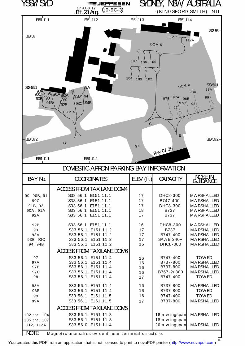
JEPPESENYSSY/SYD
DOMESTIC APRON PARKING BAY INFORMATION
BAY No. COORDINATES CAPACITY
17
ELEV (ft)
S33 56.1 E151 11.1
MARSHALLED
S33 56.1 E151 11.4
S33 56.1 E151 11.4
98 B747-400
NOTE:
G4G
E
91 93
94
98
99
MARSHALLED
MARSHALLED
MARSHALLED
1716
S33 56.1 E151 11.2S33 56.1 E151 11.2
Magnetic anomalies evident near terminal structure.
G
ACCESS FROM TAXILANE DOM4
ACCESS FROM TAXILANE DOM6
98A99A
99 S33 56.1 E151 11.5 B747-400S33 56.1 E151 11.5 MARSHALLED
98A
99A
DOM 6
DOM 4
DOM 5
Rwy 07-25
S33-56.1
S33-56.2
S33-56
S33-56
S33-56.1
E151-11.2E151-11.1 E151-11.3 E151-11.4
E151-11.2E151-11.1
90, 90B, 91
91B, 92
DHC8-300
S33 56.1 E151 11.1 MARSHALLED18 B73790A, 91AS33 56.1 E151 11.1 17 B737 MARSHALLED92A
92B S33 56.1 E151 11.1 16 MARSHALLEDDHC8-300S33 56.1 E151 11.2 17 B737 MARSHALLED93S33 56.1 E151 11.2 17 MARSHALLED93A B747-400
93B, 93C SAAB 340+94, 94B DHC8-300
ACCESS FROM TAXILANE DOM5
S33 56.1 E151 11.3S33 56.1 E151 11.3S33 56.0 E151 11.4
MARSHALLED
MARSHALLED
102 thru 104105 thru 107112, 112A
18m wingspan18m wingspan20m wingspan
90A
90B91B
91A
93A
94B
93B
93C
102103104
107 106 105
112112A
92A
92B
92
S33 56.1 E151 11.1 17 DHC8-300 MARSHALLED
S33-56.2
98B
97
97B 97A
97C
S33 56.1 E151 11.497 TOWEDS33 56.1 E151 11.497A
1616
B747-400
S33 56.1 E151 11.497B 16 MARSHALLEDS33 56.1 E151 11.497C 16 MARSHALLEDB767-2/300
17 TOWED
16S33 56.1 E151 11.498B 16 TOWED
1617
TOWED
MARSHALLEDB737-800B737-800
B737-800B737-800
B737-800
17 AUG 12
GUIDANCENOSE IN
9090C
S33 56.1 E151 11.1 17 B747-400 MARSHALLED90C
.Eff.23.Aug.
SYDNEY, NSW, AUSTRALIA-(KINGSFORD SMITH) INTL
CHANGES:
10-9C-3
| JEPPESEN, 2003, 2012. ALL RIGHTS RESERVED.Bay 90C added.You created this PDF from an application that is not licensed to print to novaPDF printer (http://www.novapdf.com)

SYDNEY, NSW, AUSTRALIA- (KINGSFORD SMITH) INTL
YSSY/SYD JEPPESEN+
PARALLEL RUNWAY USAGEINDEPENDENT VISUAL APPROACHESAircraft may be processed via an ILS approach until visual, then cleared for an independent visual approach. Notification will be by the ATIS using the phrase 'EXPECT ILS APPROACH THEN INDEPENDENT VISUAL APPROACH WHEN VISUAL. ' When visual, the pilot will be cleared for a visual approach and will be required to comply with the pilot responsibilities for independent visual approaches as described in the ATC section.RADIO FAILURE PROCEDURES - INDEPENDENT VISUAL APPROACHES In the event of a radio failure (or blocked frequency) on the Director frequency, pilots must comply with the following actions:a. On Pilot Navigation (IF VISUAL)
^ SQUAWK 7600 immediately.^ Track to intercept final at a maximum 30^ prior to the IAF for the nominated
runway.^ DO NOT PASS THROUGH FINAL OF THE NOMINATED RUNWAY.
b. On a Radar Assigned Heading^ SQUAWK 7600;^ Maintain the assigned vector for no longer than 2 minutes;^ Track as required to join final for the nominated runway at a maximum 30^ inter-
cept to commence final.^ DO NOT PASS THROUGH FINAL OF THE NOMINATED RUNWAY.
Pilots should attempt to call on the alternate Director frequency (126.1/125.3). Attempts should also be made on the Tower frequency.
ARRIVALSa. If unable to participate in an ILS PRM approach, pilots must notify ATC prior to 120
DME Sydney (or, if departing within 120 DME Sydney, on first contact with ATC).b. Aircraft up to and including A300/B767 size may be processed to land on either of
the parallel runways 16L/R or 34L/R.c. A330 type aircraft operating domestic legs may be processed to land on either of
the parallel Rwys 16L/R or 34L/R.d. Aircraft landing Rwy 16R require approval to vacate to the left on Twys F, B3 & B4.e. Aircraft landing Rwy 16L/34R are to remain on Tower freq 124.7 until west of Twy
S.f. Aircraft landing Rwy 34R and vacating Twy T2 are to taxi via Twy U and U1 unless
otherwise advised.g. Aircraft landing Rwy 07/25 require approval to vacate on Twy C.h. All arriving aircraft are required to advise parking bay on first contact with Sydney
Ground.DEPARTURES
Departures shall normally be cleared in the order in which they are ready for takeoff, except that deviations may be made from this order to facilitate the maximum number of departures with the least average delay.a. Intersection departures by jet aircraft on Rwy 34L are NOT PERMITTED due to noise
abatement requirements.b. Rwy 16R for departures to the South, West and Northwest, and departures from the
Intl Terminal.c. Rwy 16L for departures to the North and East.d. Rwy 34L for departures to the West, Northwest and non-jets to the South, and
departures from the Intl Terminal.e. Rwy 34R for departures to the North and domestic jets to the South.
NOTE:1. Aircraft which operationally require use of either Rwy 16L/34R or Rwy 07/25
must notify ATC at Clearance Delivery stage.2. International departures including B767 aircraft and below may request or be
offered a departure from Rwy 16L/34R at the Clearance Delivery stage.3. Domestic Jet departures to the South may be assigned Rwy 16L for traffic
management purposes.
10-9D12 NOV 10
.Eff.18.Nov.
| JEPPESEN, 2000, 2010. ALL RIGHTS RESERVED.You created this PDF from an application that is not licensed to print to novaPDF printer (http://www.novapdf.com)

JEPPESENYSSY/SYD 12 NOV 10 10-9E
The Visual Docking Guidance Systems used at Sydney are Nose-In-Guidance(NIG) systems which provide both azimuth and stopping information for specificaircraft types. There are three systems in use.
- Position Identification Light- Aerobridge Retracted Indicator- Centerline Guidance Light- Side Marker Board- Side Marker Light
PositionIdentification Light
28
Nose Wheel Guide Lines
Aerobridge RetractedIndicator Lights
Side Marker Light(International)
747
Side Marker Board (Intl)
Side Marker Light (Dom)or
Lower Centerline
Guidance Light
UpperCenterline
Guidance Light
Aircraft should use the following elements for docking:
SYDNEY, NSW, AUSTRALIA-(KINGSFORD SMITH) INTL
.AIRPORT.
AIRCRAFT TYPES CENTERLINE LIGHT STOP
DomesticAll types
Centerline Guidance Light Side Marker Light
InternationalAll types except wide body
Side Marker BoardLower Centerline GuidanceLight
InternationalDC-10, B-767, L-1011,A300B
Intermediate CenterlineGuidance Light
Side Marker Board
InternationalB-747
Upper Centerline GuidanceLight
Side Marker Light
NOTE:
2. Heights of the Centerline Guidance Lights are:a. Lower: up to 5mb. Intermediate: 5 to 7.5mc. Upper: above 7.5m
and hence only the Lower Centerline Guidance light is provided.1. Some International docking positions are not equipped for wide body aircraft
The first NIG system contains five elements whose locations are shown in thefigure below.
Visual Docking Guidance System
VISUAL DOCKING GUIDANCE SYSTEMS.Eff.18.Nov.
| JEPPESEN, 2000, 2010. ALL RIGHTS RESERVED.You created this PDF from an application that is not licensed to print to novaPDF printer (http://www.novapdf.com)

| JEPPESEN SANDERSON, INC., 2000, 2006. ALL RIGHTS RESERVED.
JEPPESENYSSY/SYD10 FEB 06 10-9F
SYDNEY, NSW, AUSTRALIA-(KINGSFORD SMITH) INTL
The following is a brief description of the system:
a. The Position Identification Light indicates the number of the docking positionand has white numerals on a black background outlined in green neon tubing
b. The Aerobridge Retracted Indicator consists of two lights. The green lightindicates the Aerobridge is in the fully retracted position. The red lightindicates that the Aerobridge is not fully retracted or that an element of thevisual guidance docking system is unserviceable.
c. The Centerline Guidance Light provides azimuth information and is alignedwith the left pilot position. The unit emits RED/GREEN light beams and thesignals are interpreted as follows:
Red/Green Green/Green Green/Red
Aircraft is to the leftof the centerline
Aircraft is on thecenterline
Aircraft is to the rightof the centerline
d. The slats on the side Marker Board indicate the stopping position for eachtype of aircraft. Approaching the position, the slat will show GREEN; at thestopping position, the slat will show BLACK; and beyond that position RED.
e. There are two Side Marker Light systems that indicate the stopping position.
Domestic (All Types)
1. Approaching the position, a preliminary dull GREEN light will showthrough the arrow-shaped aperture which also exhibits a cross bar.
2. As the aircraft moves forward, the intensity of the green light increases
point.3. As the aircraft continues, the bar of the stop signal disappears and the
arrow-head starts to reduce in size.4. When the arrow-head disappears, two white bars appear one above the
other indicating the stopping position. In some installations, two sets ofbars are provided one for the B727 the other for the B737.
Dull Green IntenseGreen
Green WhiteB747 Stop
Red
RedWhite
B727 Stop &B737 Stop
WhiteB727/737
Stop
GreenGreenDC9 StopGreen
Intense
International (For B747 Aircraft only)
This is the same as the domestic system described above except that thereis only one set of white bars and no bar around the arrow-head.
The above system is installed at Sydney (Kingsford Smith) Airport at the follwinglocations:
at night.
Dull Green
a. International Terminal - Bays 20, 22, 23, 24, 25, 35, 36, 37, 51, 53, 54, 58 and59.
Side Marker Lights (Domestic) (DC-9, B-727 and 737)
Side Marker Lights (International) (B747)
VISUAL DOCKING GUIDANCE SYSTEMS
until it becomes a bright arrow-head T shape which is the DC9 stopping
5. If the stopping position is passed then a single RED bar appears.
You created this PDF from an application that is not licensed to print to novaPDF printer (http://www.novapdf.com)

SYDNEY, NSW, AUSTRALIA- (KINGSFORD SMITH) INTL
YSSY/SYD JEPPESEN+
VISUAL DOCKING GUIDANCE SYSTEMS
| JEPPESEN SANDERSON, INC., 2000, 2006. ALL RIGHTS RESERVED.
b. Domestic Terminal - Bays 49, 53, 55, 33, 35, 39, 52, 36, 38 and 40.
AIRCRAFT POSITIONING AND INFORMATION SYSTEM (APIS)
The second NIG system in use at Sydney Intl is installed on International Terminalbays 1, 2, 3, 4, 6, 8, 9, 10, 11, 12, 30, 32, 34, 55, 56, 57, 60, 61 and 63.
The APIS is based on a centerline guidance sub-display. The steering and stop indica-tion is provided from a display unit mounted on a pole in front of the cockpit in linewith the left hand pilot seat. The parking bay position identification is mounted ontop of the guidance pole.
On approach to the parking position, the pilot will see the display box face showingtwo rows of yellow alpha-numeric characters on a black background across the top, anilluminated closing rate 'thermometer ' at lower left, and an illuminated azimuthguidance display at lower right. The alpha-numeric characters on the top row shouldbe flashing.
The following is the sequence of APIS operation from initial approach to STOP:
a. Identify the correct aircraft parking bay position.
b. Ensure that the aerobridge retraction light indicates green.
c. Follow the taxi-in line and watch the centerline beacon.
d. Check that the correct aircraft type is flashing and that the door number is shown(where applicable).
e. About 20m before STOP, the aircraft type display goes steady and the door numberdisappears.
f. Follow the azimuth guidance display. The black arrow heads indicate which direc-tion to steer for the centerline. When the aircraft is properly aligned in azimuth,the black vertical bar will be displayed.
g. The full closing rate 'thermometer ' indicates at least 13m to STOP.
h. When the aircraft reaches 13m to STOP, the 'thermometer ' bar lights begin tomove from the bottom to the top.
i. The deletion of each 'thermometer ' bar indicates about one-half meter progres-sion.
j. When the STOP position is reached, all the closing rate 'thermometer ' lightsextinguish and the lower display indicates STOP. If the aircraft is correctlyparked, the top display indicates OK.
k. If the aircraft overshoots the limit for correct parking, the top display indicatesTOO FAR (alternating TOO then FAR).
l. The entire display automatically shuts down after some seconds.
NOTE: When the last row of lights of the closing rate 'thermometer ' is extin-guished and the word STOP is displayed, the aircraft should be at a standstill.
10-9G10 FEB 06
You created this PDF from an application that is not licensed to print to novaPDF printer (http://www.novapdf.com)

| JEPPESEN SANDERSON, INC., 2000, 2006. ALL RIGHTS RESERVED.
JEPPESENYSSY/SYD10 FEB 06 10-9H
SYDNEY, NSW, AUSTRALIA-(KINGSFORD SMITH) INTL
VISUAL DOCKING GUIDANCE SYSTEMS
a
c
dsteer right
steer left
laser sensor
on line
APIS Diagram
a. Display: ACFT type, OK or TOO/FAR.
b. Display: Door Number or STOP.
c. Centerline Beacon: Steering guidance.
d. 'Thermometer': Closing rate indication - stopping guidance.
NOTE: The lettering is yellow on a black background. The 'thermometer' is yellow and goes black from bottom to top. The centerline beacon is a central black bandsurrounded by yellow.
alternates
b
You created this PDF from an application that is not licensed to print to novaPDF printer (http://www.novapdf.com)

SYDNEY, NSW, AUSTRALIA- (KINGSFORD SMITH) INTL
YSSY/SYD JEPPESEN+
VISUAL DOCKING GUIDANCE SYSTEMS
| JEPPESEN SANDERSON, INC., 2000, 2006. ALL RIGHTS RESERVED.
SAFEGATE DOCKING GUIDANCE SYSTEM (SAFEGATE DGS)
The third NIG system in use at Sydney Intl is the Safegate Docking Guidance System,which is installed on Bays 31 and 33 of the International Terminal, and Sydney Domes-tic Terminal (Bays 31, 32 and 34). Its operation is based on laser scanning of theincoming aircraft. The complete system consists of the following three elements:
1. Position Identification Unit (Bay Marker);
2. Aerobridge Retracted Indicator Light; and
3. DGS NIG Unit.
System Description
The Position Identification Unit gives clear indication of the parking bay for the air-craft. It consists of large white numerals on a dark background (illuminated at nightby green neon lights).
The Aerobridge Retraction Indicator Light, mounted on the aerobridge, gives an earlywarning of the state of aerobridge location. Green indicates a fully retracted aero-bridge position or a safe pre-parked position; red indicates that the aerobridge is outof position and the pilot should not proceed with parking the aircraft.
The NIG unit, mounted on the Terminal wall, consists of two components which supplythe following information to the pilot:
a. The top alphanumeric information display which shows aircraft type designationand other message information as necessary in yellow.
b. The azimuth and centerline guidance displays in red and yellow, and the ClosingRate Bar in yellow.
Aircraft Types
The aircraft types which can utilize the system are displayed as follows:
System Operation
The following is the sequence of system operation from initial approach to STOP:
a. The pilot identifies the correct parking bay position.
b. The pilot ensures that the aerobridge retraction light is green.
c. The pilot observes that the rising vertical yellow arrows are indicating the systemis activated and searching for the approaching aircraft.
NOTE: The pilot must not enter the stand area unless the rising vertical arrowsare displayed.
d. The pilot follows the taxi-in line and checks that the correct aircraft type is dis-played in yellow.
NOTE: The pilot must not enter the stand area unless the correct aircraft typeis displayed.
Type DisplayBoeing 777, 767, 747, 737
McDonnell Douglas MD-11, DC-10
Airbus Industries 340, 330, 310, 300
British Aerospace 146
Lockheed L1011
10-9J10 FEB 06
You created this PDF from an application that is not licensed to print to novaPDF printer (http://www.novapdf.com)

SYDNEY, NSW, AUSTRALIA- (KINGSFORD SMITH) INTL
YSSY/SYD JEPPESEN+
VISUAL DOCKING GUIDANCE SYSTEMS
| JEPPESEN SANDERSON, INC., 2000, 2006. ALL RIGHTS RESERVED.
e. On successful capture of the aircraft, the vertical arrows are replaced by the yel-low T-shaped Closing Rate Bar.
NOTE: The pilot must not proceed to the bridge unless the arrows have beensuperseded by the Closing Rate Bar.
f. A vertical yellow arrow shows the aircraft position in relation to the centerline.
g. A flashing red arrow indicates the direction to turn to return to the centerline.
NOTE: If the aircraft is approaching faster than the accepted speed, the systemwill show SLOW DOWN as a warning.
h. The display of the yellow digital closing rate countdown will start when the air-craft is 20 meters from the STOP position.
NOTE: If the detected aircraft is lost prior to 12 meters to STOP, the displaywill show WAIT. The docking will continue as soon as the system detects theaircraft again.
i. When the aircraft is 12 metres from the STOP position, the Closing Rate Bar willdecrease in size from the bottom by one row of lights per 0.5 meters closing rate.
NOTE: If the detected aircraft is lost after 12 meters to STOP, the display willshow STOP and ID FAIL. Assistance must then be sought from the ground engi-neers.
j. When the correct STOP position is reached, the display shows STOP and red lightswill be lit.
k. When the aircraft has parked, OK will be displayed.
l. If the aircraft has overshot the position, TOO FAR will be displayed.
m. When ground engineers have placed the chocks at the nosewheel, they will manu-ally change the display to CHOCK ON.
n. During heavy rain or fog, the visibility for the docking system might be reduced.When the system is activated and in capture mode, the display will deactivate therising vertical arrows and show DOWN GRADE. This text will be superseded by theClosing Rate Bar once the aircraft is detected.
NOTE: The pilot must not continue the approach to the bridge unless the DOWNGRADE text has been superseded by the Closing Rate Bar.
Ground engineers have access to emergency push-buttons to deactivate the system.When an emergency stop is activated, the display will show STOP. The ground engi-neers will then be required to complete the docking manually once the emergency sit-uation is cleared.
10-9K10 FEB 06
You created this PDF from an application that is not licensed to print to novaPDF printer (http://www.novapdf.com)

| JEPPESEN SANDERSON, INC., 2000, 2006. ALL RIGHTS RESERVED.
JEPPESENYSSY/SYD10 FEB 06 10-9L
SYDNEY, NSW, AUSTRALIA-(KINGSFORD SMITH) INTL
Aircraft Type(Yellow)
RisingVerticalArrows
(Yellow)
Turn DirectionArrow (Red)
Closing RateBar (Yellow)
Position Arrow(Yellow)
Digital ClosingRate (Yellow)
(Yellow)
(Red)
(Yellow)
(Red)
(Yellow)
(Yellow)
(Red)
Gate ClearSearching for Aircraft
Aircraft CapturedAircraft Left of Centerline
Closing Rate Aircraft LostWait
Stop PositionReached
Docking Complete
Safegate Docking Guidance System
VISUAL DOCKING GUIDANCE SYSTEMS
You created this PDF from an application that is not licensed to print to novaPDF printer (http://www.novapdf.com)

| JEPPESEN SANDERSON, INC., 2000, 2005. ALL RIGHTS RESERVED.
SYDNEY, NSW, AUSTRALIA-(KINGSFORD SMITH) INTL
YSSY/SYD JEPPESEN+.ILS.PRM.
ILS PRM USER INSTRUCTIONS
ATTENTION ALL USERS of ILS PRM (PRECISION RUNWAY MONITOR)
PILOT REQUIREMENTS:Before conducting a simultaneous close parallel ILS PRM approach, pilots must have completed training approved by CASA, including:
1. Viewing the PRM video 'ILS PRM Approaches - A Pilot's Approach';
2. Familiarization with the ILS PRM approach procedures published herein or equiva-lent operational documents (See Jeppesen AIR TRAFFIC CONTROL AUSTRALIA,RULES AND PROCEDURES , PARALLEL INSTRUMENT APPROACHES; or Jeppesen AUS-TRALIA DOMESTIC MANUAL, AIR TRAFFIC CONTROL, DEPARTURE, APPROACH ANDLANDING PROCEDURES, PARALLEL RUNWAY OPERATIONS).
3. Familiarization with the breakout procedure and phraseology; and
4. Completion of an examination conducted by the operator's training and checking organization or chief pilot holding instrument renewal approval or flying training school holding instrument training approval.
Pilots who complete the training through other than a company training and checking organization or chief pilot must obtain log book endorsement by the training organization.
Simulator training in breakout procedures is not mandatory but is strongly recommended, particularly in aircraft fitted with automated flight guidance systems.
If unable to participate in an ILS PRM approach, pilots MUST notify ATC prior to120 DME SY (or if departing from within 120 DME SY on first contact with ATC).
ATIS: The ATIS will advise when ILS PRM approaches are in progress.
APPROACH CHARTS: There are now two (2) ILS approach charts for each parallel runway. ENSURE THAT YOU USE THE ILS PRM CHART.
DUAL VHF REQUIREMENTS: To avoid blocked transmission, each runway will have both a TWR and a PRM frequency. The TWR and PRM controllers will transmit on both frequencies. PILOTS MUST transmit on the TWR frequency ONLY, but LISTEN TO BOTH. It is important that the volume of both frequencies is set to the same level so that transmissions are heard on at least one frequency if the other is blocked.
NOTE: Pilots must have the relevant PRM frequency selected prior to transfer toaerodrome control. It is important the PRM frequency volume is preset prior tothis transfer.
AUTOPILOT COUPLED APPROACHES: It is recommended that ILS PRM approaches are flown with the aircraft autopilot coupled whenever practicable.
TCAS SELECTION: Pilots may select TCAS in the TA MODE or maintain RA MODE on receipt of instructions to contact the Tower.
New PRM video reflecting these changes is available online at:
http://www.airservicesaustralia.com/pilotcentre/projects/prm/changesprm.asp.
HAND FLY A BREAKOUT: When issued with Breakout instructions from an ILS PRM approach, time is critical. ALL BREAKOUT procedures MUST BE HAND FLOWN. In exceptional circumstances a descending breakout may be given but the assigned altitude will not be below the applicable minimum vectoring altitude (MVA).
11-02 DEC 05
You created this PDF from an application that is not licensed to print to novaPDF printer (http://www.novapdf.com)

| JEPPESEN SANDERSON, INC., 2000, 2005. ALL RIGHTS RESERVED.
SYDNEY, NSW, AUSTRALIA-(KINGSFORD SMITH) INTL
YSSY/SYD JEPPESEN+.ILS.PRM.
ILS PRM USER INSTRUCTIONS
DEVIATIONS: The ILS PRM radar display indicates when an aircraft's track will take it into the NO TRANSGRESSION ZONE (NTZ) within the next ten (10) seconds if no course alteration is made. In this situation an ADVISORY will be issued by the PRM controller to the aircraft. The phraseology will be:
'RADAR INDICATES YOU ARE DEVIATING LEFT (OR RIGHT) OF THE LOCALIZER COURSE'
Pilots are not expected to acknowledge a deviation advisory but should compare localizer course tracking indications and use the indicator most consistent with the controller's advice. The PRM controller is not expected to provide an indication of displacement from the applicable localizer course. On receipt of a deviation advisory, pilots should promptly adjust aircraft heading to avoid penetrating the NTZ and regain the localizer course.
BREAKOUT:If an aircraft enters the NTZ, it is mandatory for the PRM controller to issue a breakout instruction to that aircraft plus any affected aircraft on the adjacent localizer course. Breakout phraseology will be:
'BREAKOUT ALERT, (callsign) TURN LEFT (or RIGHT) IMMEDIATELY HEADING (3 digits), CLIMB (or DESCEND) TO (altitude)'
11-0A2 DEC 05
You created this PDF from an application that is not licensed to print to novaPDF printer (http://www.novapdf.com)

JEPPESEN
Bankstown
YM(D)-556A
YM(D)-539A
YM(R)-555C/D
YM(R)-555A/B
YM(D)-539B
YM(R)-405AYM(R)-405B
YM(R)-521
YM(R)-555C/DYM(R)-521
3 DME SY
70 90 100 120 140 160
B
D
CIRCLE-TO-LANDSTRAIGHT-IN LANDING RWY
MaxKts100
135
180
205
MDA(H)
600'MDA(H)270'DA(H) (584')(254')
1000'(979')-5.0 km
-4.0 km(979')1000'
710'(689')-2.4 km
1.5 km 3.3 km
No CirclingBeyond D3.0 SYEast of Rwy 16R
& North of Rwy 25
07
16R
0725
16L
34L
34R
A
C
Gnd speed-Kts
MISSED APCH:
SYDNEY, NSW, AUSTRALIA-(KINGSFORD SMITH) INTL 11-1
ATIS SYDNEY Approach (R) Director
LOC
109.9ISY
FinalApch Crs
062^
GSOM
1300'
ILSDA(H)
270'(254')
Apt Elev 21'RWY 07 16'
120.5 124.7Rwy 16L/34R 121.7East of Rwy 16R/34L
062^2000'
(1284') 2700'
Ground
West of Rwy 16R/34L 126.5SYDNEY Tower
D10.5 SY
D4.7 SY
PA
NS O
PS 4
SY
D10.5 SY
D4.7 SY
Rwy Elev: 1 hPaAlt Set: hPa Trans level: FL 110 Trans alt: 10000'
421'820'
438'
531'
GS 3.00^ 377 484 538 646 753 861
YSSY/SYD
112.1 118.55 126.25 428
MSA SY VOR2100'
within 10 NM
REIL
SY DME
ALTITUDE
9.02670'
8.0 7.0 6.0 5.0 4.0 2.52350' 2030' 1710' 1390' 1070' 600'750'
3.0
05
510
BRIE
FIN
G S
TRIP
TM
739'
D1.3 SY
D1.3 SYc
Track 062^. Climb to 2000' or as directed by ATC.
MAP at MM/D1.3 SY
GLF NDB HOLDING
Flashing White
(GS out)LOC
DAY NIGHT
NA
1. SY DME REQUIRED (LOC Only). 2. GPS permitted in lieu of DME. Referencewaypoint SY VOR.
ILS
34-00
151-00 151-10
34-05
33-55
870'
1085'
641'
LOC (GS out) DME
North 124.4 South 128.3 East 125.3West 126.1
Rwy 16R/34L & 07/25
PAPI
| JEPPESEN, 1998, 2010. ALL RIGHTS RESERVED.
ILS-Y or LOC-Y Rwy 075 MAR 10.Eff.11.Mar.
10.13000'
Recommended altitudes, TCH.
D3.0SY
D 112.1 SYSYDNEY
062^
062^ 109.9 ISY
OM
062^
062^
I S Y
1first reached.
(IAF)
LIMITS: 1 min or D15.0 SY,
S Y
GLENFIELD
428 GLFGLF
13000 D7.0
CHANGES:
M
SY
D3.0
062^
TCH 51'
OMNDB
3000'
RWY 07 16'
1300'
3.5 2.3700'
2000'
D7.0SY
0.61.71.7
900'
GS
242^MM
MM
312^
132^
242^
ILS DME
You created this PDF from an application that is not licensed to print to novaPDF printer (http://www.novapdf.com)

JEPPESEN
Bankstown
YM(D)-556A
YM(D)-539A
YM(R)-555C/D
YM(R)-555A/B
YM(D)-539B
YM(R)-405AYM(R)-405B
YM(R)-521
YM(R)-555C/DYM(R)-521
3 DME SY
70 90 100 120 140 160
B
D
CIRCLE-TO-LANDSTRAIGHT-IN LANDING RWY
MaxKts100
135
180
205
MDA(H)
600'MDA(H)270'DA(H) (584')(254')
1000'(979')-5.0 km
-4.0 km(979')1000'
710'(689')-2.4 km
1.5 km 3.3 km
No CirclingBeyond D3.0 SYEast of Rwy 16R
& North of Rwy 25
07
16R
0725
16L
34L
34R
A
C
Gnd speed-Kts
MISSED APCH:
SYDNEY, NSW, AUSTRALIA-(KINGSFORD SMITH) INTL 11-2
ATIS SYDNEY Approach (R) Director
LOC
109.9ISY
FinalApch Crs
062^
GSOM
1300'
ILSDA(H)
270'(254')
Apt Elev 21'RWY 07 16'
120.5 124.7Rwy 16L/34R 121.7East of Rwy 16R/34L
062^2000'
(1284') 2700'
Ground
West of Rwy 16R/34L 126.5SYDNEY Tower
D9.8 ISY
D4.1 ISY
PA
NS O
PS 4
D9.8 ISY
D4.1 ISY
Rwy Elev: 1 hPaAlt Set: hPa Trans level: FL 110 Trans alt: 10000'
421'820'
438'
531'
GS 3.00^ 377 484 538 646 753 861
YSSY/SYD
112.1 118.55 126.25 428
MSA SY VOR2100'
within 10 NM
REIL
ALTITUDE
9.0
2880'
8.0 7.0 6.0 5.0 4.0 2.0
2560' 2240' 1920' 1600' 1280' 650'970'
3.0
05
510
BRIE
FIN
G S
TRIP
TM
739'
D0.7 ISY
D0.7 ISYc
Track 062^. Climb to 2000' or as directed by ATC.
MAP at MM/D0.7 ISY
GLF NDB HOLDING
Flashing White
(GS out)LOC
DAY NIGHT
NA
ILS
34-00
151-00 151-10
34-05
33-55
870'
1085'
641'
LOC (GS out) DME
North 124.4 South 128.3 East 125.3West 126.1
Rwy 16R/34L & 07/25
PAPI
ILS-Z or LOC-Z Rwy 07
1. ISY DME REQUIRED (LOC Only).
ISY
ISY DME 9.4
3000'
1.9
600'
| JEPPESEN, 2008, 2010. ALL RIGHTS RESERVED.
5 MAR 10.Eff.11.Mar.
Recommended altitudes, TCH.
D2.4ISY
D 112.1 SYSYDNEY
062^
062^ 109.9 ISY
OM
062^
062^
I S Y
1first reached.
(IAF)
S Y
GLENFIELD
428 GLFGLF
13000 D6.4
CHANGES:
M
D2.4
062^
TCH 51'
OMNDB
3000'
RWY 07 16'
1300'
3.4 2.3700'
2000'
D6.4
0.61.71.7
900'
GS
242^MM
MM
312^
132^
242^
ILS DME
ISY
ISY
LIMITS: 1 min or D15.0 ISY,
You created this PDF from an application that is not licensed to print to novaPDF printer (http://www.novapdf.com)

JEPPESEN
Bankstown
YM(R)-405B YM(R)-473YM(D)-539A
YM(R)-468
YM(D)-539B
YM(R)-405A
YM(D)-556A
YM(R)-555A/B
YM(R)-493
(IAF)1
1
125^
D0.3
D12.2
16R
07
25
16L
34L
34R
Aircraft will be RADAR vectoredto intercept final approach.
D5.2
D2.7
D12.2 D5.2
D2.7
D0.3
155^ 600'
2700'
MSA SY VOR
-(KINGSFORD SMITH) INTL 11-3ATIS
North 124.4
SYDNEY Approach (R)
South 128.3 East 125.3
Director
West 126.1
126.5West of Rwy 16R/34L
Ground
121.7East of Rwy 16R/34L
SYDNEY Tower
LOC
110.9Apch Crs
Final
155^ 1920'
GS
(1904') 220'DA(H)
ILS
(204')
Apt Elev 21'
16'ISS
MISSED APCH:
125^. Climb to 3000' or as directed by ATC.
RWY 16L
PA
NS O
PS 4
SYDNEY, NSW, AUSTRALIA
MANDATORY 125^ 3000'
ALTITUDE
BRIE
FIN
G S
TRIP
TM
Rwy Elev: 1 hPaAlt Set: hPa Trans level: FL 110 Trans alt: 10000'
155^
3440'10.0
3120'9.0 8.0
2800'7.0
2480'6.0
2170'5.2
1920'4.0
1530'3.01210'
2.0 1.0 0.8890' 560' 480'
421'
438'
GS 3.00^
33-50
34-00 151-00 151-10 151-20
YSSY/SYD
739'
112.1 118.55 126.25 428
2100'within 10 NM
HIALS
NA
11.84000'
Track 155^. At MANDATORY 600', turn LEFT track
(GS out)LOC 11.0
3760'
1. SY DME REQUIRED.
Rwy 16R/34L &07/25 120.5
05
510
LT
Rwy 16L/34R 124.7
1085'
641'
1074'
PAPIPAPI
D5.2 SY
RVR 550mVIS 0.8 km
ILS-Y or LOC-Y Rwy 16L.Eff.25.Aug.
SY
SY
SY
SY DME
SY SY
SY
SY
3. Holding as directed by ATC.2. GPS permitted in lieu of DME. Reference waypoint SY VOR.
867'
426'
1
1Airbus A380 ILS operations; cancel ILS DA, use LOC MDA.
19 AUG 11
| JEPPESEN, 2010, 2011. ALL RIGHTS RESERVED.
372 478 531 637 743 849
TCH, procedure altitude, recommended altitudes.
D 112.1 SYSYDNEY
S Y
155^
I S S
Gnd speed-Kts 70 90 100 120 140 160
C
D
FULL
STRAIGHT-IN LANDING RWY
HIALS outHIRL out HIALS out480'MDA(H)220'DA(H) (464')(204')
2.4 km1.5 km
16L No Circling
RWY 16L 16'
TCH 51'
0.6
4000' 155^
1000'2.57.0 2.4
1700'
1920'GS
155^ 110.9 ISS
B
A
CIRCLE-TO-LAND
A
B
C
D
ILS DME LOC (GS out) DME
CHANGES:
1.5 km1.2 km
SY
MAP at D0.3 SY
ILS DME
You created this PDF from an application that is not licensed to print to novaPDF printer (http://www.novapdf.com)

JEPPESEN
Bankstown
YM(R)-405B YM(R)-473
YM(D)-539A
YM(D)-539BYM(R)-405A
YM(D)-556A
YM(R)-555A/B
YM(R)-468YM(R)-493
MISSED APCH:
-(KINGSFORD SMITH) INTL 11-4
LOC
110.9ISS
FinalApch Crs155^
GS
1920'(1904')
ILSDA(H)
220'(204')
Apt Elev 21'
ATIS SYDNEY Approach (R) Director
124.4North 128.3South 125.3East126.1West
121.7East of Rwy 16R/34L
GroundWest of Rwy 16R/34L
126.5SYDNEY Tower
KROPP
2700'
MSA SY VOR
155^
HIALS
125^
NA
16'
CAUTION: SIMULTANEOUS CLOSE PARALLEL OPERATIONS
1
1
MONITORPRM 133.95
SEE 11-0 FOR ILSPRM REQUIREMENTS
CAUTION:SIMULTANEOUS CLOSEPARALLEL OPERATIONS
RWY 16L
SYDNEY, NSW, AUSTRALIA
TCH 51'
0.6
05
510
BRIE
FIN
G S
TRIP
TM
MANDATORY600'
LT
125^ 3000'
16R
07
25
16L
34L
34R
421'
438'
GS 3.00^ 372 478 531 637 743 849
YSSY/SYD
112.1 118.55 126.25 428
GS
2100'within 10 NM
739'
vectored to IAF.Aircraft will be RADAR
34-00151-00 151-10 151-20
Rwy 16R/34L120.5& 07/25Rwy 16L/34R 124.7
1085'
641'
1074'
PAPI PAPI
D5.2 SY
RVR 550mVIS 0.8 km
3. See 11-0 for
ILS-Y PRM Rwy 16L.Eff.25.Aug.
1. SY DME REQUIRED. 2. Dual VHF communications required.
D11.9 SY
SY
867'
426'
5. Holding as directed by ATC."ILS PRM USER INSTRUCTIONS". 4. GPS permitted in lieu of DME. Reference waypoint SY VOR.
19 AUG 11
| JEPPESEN, 2010, 2011. ALL RIGHTS RESERVED.TCH, procedure altitude, recommended altitudes.
33-50
155^ 110.9 ISS
D 112.1 SYSYDNEY
S Y
155^
155^I S S
Gnd speed-Kts 70 90 100 120 140 160
CIRCLE-TO-LAND
A
B
C
D
HIALS outHIRL outFULL
STRAIGHT-IN LANDING RWY16L
1.2 km 1.5 km
(204')DA(H)
3760'11.0
KROPP(IAF)
D5.2
RWY 16L
155^ D0.3
1920'
D5.2
4000'
6.7 4.9
D0.3
16'
A
B
C
D
PA
NS O
PS 4
ILSNo Circling
10.03440'
9.03120'
8.02800'
7.02480'
6.02170'
5.21920'
4.01530'
3.01210'
2.0890'
1.0560'
0.3220'ALTITUDE
11.84000'
Alt Set: hPa Rwy Elev: 1 hPa Trans level: FL 110 Trans alt: 10000'
Track 155^. At MANDATORY 600', turn LEFT track
CHANGES:
220'
D11.9 SY
SY
SY
SY DME
SY
ILS DME
125^. Continue climb to 3000' or as directed by ATC.
You created this PDF from an application that is not licensed to print to novaPDF printer (http://www.novapdf.com)

JEPPESEN
Bankstown
YM(R)-405B YM(R)-473YM(D)-539A
YM(R)-468
YM(D)-539B
YM(R)-405A
YM(D)-556A
YM(R)-555A/B
YM(R)-493
(IAF)1
1
125^
D0.6
D13.0
16R
07
25
16L
34L
34R
Aircraft will be RADAR vectoredto intercept final approach.
D6.0
D3.5
D13.0 D6.0
D3.5
D0.6
155^ 600'
2700'
MSA SY VOR
-(KINGSFORD SMITH) INTL 11-5ATIS
North 124.4
SYDNEY Approach (R)
South 128.3 East 125.3
Director
West 126.1
126.5West of Rwy 16R/34L
Ground
121.7East of Rwy 16R/34L
SYDNEY Tower
LOC
110.9Apch Crs
Final
155^ 1920'
GS
(1904') 220'DA(H)
ILS
(204')
Apt Elev 21'
16'ISS
MISSED APCH:
125^. Climb to 3000' or as directed by ATC.
ISS
ISS
ISS
ISS ISS
ISS
ISS
RWY 16L
PA
NS O
PS 4
2. Holding as directed by ATC.
SYDNEY, NSW, AUSTRALIA
MANDATORY 125^ 3000'
ALTITUDE
ISS DME
BRIE
FIN
G S
TRIP
TM
Rwy Elev: 1 hPaAlt Set: hPa Trans level: FL 110 Trans alt: 10000'
155^
3520'11.0
3200'10.0 9.0
2880'8.0
2560'7.0
2240'6.0
1920'5.0
1610'4.01290'
3.0 2.0 1.5970' 650' 480'
421'
438'
GS 3.00^ 377 478 531 637 743 849
33-50
34-00 151-00 151-10 151-20
YSSY/SYD
739'
112.1 118.55 126.25 428
2100'within 10 NM
HIALS
NA
12.54000'
Track 155^. At MANDATORY 600', turn LEFT track
(GS out)LOC 12.0
3830'
1. ISS DME REQUIRED.
Rwy 16R/34L &07/25 120.5
05
510
LT
Rwy 16L/34R 124.7
1085'
641'
1074'
PAPIPAPI
| JEPPESEN, 1998, 2011. ALL RIGHTS RESERVED.
D6.0 ISS
1 Airbus A380 ILS operations: cancel ILS DA, use LOC MDA.
1
RVR 550mVIS 0.8 km
ILS-Z or LOC-Z Rwy 16L.Eff.25.Aug.
867'
426'
19 AUG 11
TCH, procedure altitude, recommended altitudes.
D 112.1 SYSYDNEY
S Y
155^
I S SILS DME
Gnd speed-Kts 70 90 100 120 140 160
C
D
FULL
STRAIGHT-IN LANDING RWY
HIALS outHIRL out HIALS out480'MDA(H)220'DA(H) (464')(204')
2.4 km1.5 km
16L No Circling
RWY 16L 16'
TCH 51'
0.4
4000' 155^
1000'2.57.0 2.9
1700'
1920'GS
155^ 110.9 ISS
ISS
MAP at D0.6 ISS
B
A
CIRCLE-TO-LAND
A
B
C
D
ILS DME LOC (GS out) DME
CHANGES:
1.5 km1.2 km
You created this PDF from an application that is not licensed to print to novaPDF printer (http://www.novapdf.com)

JEPPESEN
Bankstown
YM(R)-405B YM(R)-473
YM(D)-539A
YM(D)-539BYM(R)-405A
YM(D)-556A
YM(R)-555A/B
YM(R)-468YM(R)-493
MISSED APCH:
-(KINGSFORD SMITH) INTL 11-6
LOC
110.9ISS
FinalApch Crs
155^
GS
1920'(1904')
ILSDA(H)
220'(204')
Apt Elev 21'
ATIS SYDNEY Approach (R) Director
124.4North 128.3South 125.3East126.1West
121.7East of Rwy 16R/34L
GroundWest of Rwy 16R/34L
126.5SYDNEY Tower
KROPP
2700'
MSA SY VOR
155^
HIALS
125^
NA
16'
CAUTION: SIMULTANEOUS CLOSE PARALLEL OPERATIONS
1
1
MONITORPRM 133.95
SEE 11-0 FOR ILSPRM REQUIREMENTS
CAUTION:SIMULTANEOUS CLOSEPARALLEL OPERATIONS
D12.6 ISS
ISS
RWY 16L
SYDNEY, NSW, AUSTRALIA
TCH 51'
0.4
05
510
BRIE
FIN
G S
TRIP
TM
MANDATORY600'
LT
125^ 3000'
16R
07
25
16L
34L
34R
421'
438'
GS 3.00^ 372 478 531 637 743 849
YSSY/SYD
112.1 118.55 126.25 428
GS
2100'within 10 NM
739'
vectored to IAF.Aircraft will be RADAR
34-00151-00 151-10 151-20
Rwy 16R/34L120.5& 07/25Rwy 16L/34R 124.7
1085'
641'
1074'
PAPI PAPI
D6.0 ISS
| JEPPESEN, 1998, 2011. ALL RIGHTS RESERVED.
RVR 550mVIS 0.8 km
1. ISS DME REQUIRED. 2. Dual VHF communications required."ILS PRM USER INSTRUCTIONS". 4. Holding as directed by ATC.
3. See 11-0 for
ILS-Z PRM Rwy 16L.Eff.25.Aug.
867'
426'
19 AUG 11
TCH, procedure altitude, recommended altitudes.
33-50
155^ 110.9 ISS
D 112.1 SYSYDNEY
S Y
155^
155^I S S
Gnd speed-Kts 70 90 100 120 140 160
CIRCLE-TO-LAND
A
B
C
D
HIALS outHIRL outFULL
STRAIGHT-IN LANDING RWY16L
1.2 km 1.5 km
(204')DA(H)
3830'12.0
KROPP(IAF)
D6.0
RWY 16L
155^ D0.6
1920'
D6.0
4000'
6.6 5.4
D0.6
16'
ISS DME
A
B
C
D
ILS DME
ISS
ISS
ISS
D12.6 ISS
PA
NS O
PS 4
ILSNo Circling
11.03520'
10.03200'
9.02880'
8.02560'
7.02240'
6.01920'
5.01610'
4.01290'
3.0970'
2.0650'
1.0330'
0.6220'ALTITUDE
12.54000'
Alt Set: hPa Rwy Elev: 1 hPa Trans level: FL 110 Trans alt: 10000'
Track 155^. At MANDATORY 600', turn LEFT track125^. Continue climb to 3000' or as directed by ATC.
CHANGES:
220'
You created this PDF from an application that is not licensed to print to novaPDF printer (http://www.novapdf.com)

JEPPESEN
Bankstown
323^YM(R)-405B YM(R)-473
YM(D)-539A
YM(R)-468
YM(D)-539B
YM(D)-556A
YM(R)-555A/B
YM(R)-405A
YM(R)-493
170^
Y
25
E3 D M S16R
07
34L
16L
34R
D12.0(IAF)
1
304^
05
510
-(KINGSFORD SMITH) INTL 11-7
155^170^ 3000'
(IAF)
SYDNEY, NSW, AUSTRALIA
1
SY
D1.7 SY
SY
D4.8 SY D1.7 SY
D10.0SY
MANDATORY600'
RT
MISSED APCH:
LOC
109.5IKS
FinalApch Crs
155^
GS
1700'(1692')
ILSDA(H)
220'(212')
Apt Elev 21'
ATIS SYDNEY Approach (R) Director
124.4North 128.3South 125.3East126.1West
120.5 124.7Rwy 16L/34R 121.7East of Rwy 16R/34L
Ground
West of Rwy 16R/34L 126.5
SYDNEY Tower
2700'
MSA SY VOR
8'
Rwy 16R/34L &07/25
Rwy 16R
BRIE
FIN
G S
TRIP
TM
151-00 151-10 151-20
421'
438'
GS 3.00^
YSSY/SYD
112.1 118.55 126.25 428
2100'within 10 NM
739'
D4.8 SY
1. SY DME (LOC ONLY) REQUIRED. 2. GPS permitted in lieu of DME. Referencewaypoint SY VOR. 3. Holding as advised by ATC.
1085'
641'
1074'
HIALS
ILS or LOC Rwy 16R
304^SY
PAPI PAPI
| JEPPESEN, 1998, 2012. ALL RIGHTS RESERVED.
VIS
km0.8
550mRVR
867'
426'
12 DMEArc SY
372 478 531 637 743 849
2 MAR 12 .Eff.8.Mar.
LOC minimums.
D6.0
ILS
155^ 109.5 IKS
OM
D S Y
155^
155^I K S
Gnd speed-Kts 70 90 100 120 140 160
CIRCLE-TO-LAND
MaxKts100
135
180
205
MDA(H)HIALS out
& North of Rwy 25
A
B
C
D 1000' (979')-5.0 km1000' (979')-4.0 km
710' (689')-2.4 km
HIALS outHIRL outFULL
STRAIGHT-IN LANDING RWY 16R
1.5 km
220' (212')DA(H) 450'MDA(H) (442')
D6.0
SYDNEY
112.1 SY
12DME
3000ARC
CHANGES:
8'
TCH 50'Rwy 16R
155^
1300'1700'
D6.03000'1310'
OM
6.0 1.2
M C
3.1
VORD12.0
No Circling Beyond D3.0SY VOR East of Rwy 16R
5000'
Aircraft may be RADAR vectored to interceptfinal approach.
SY
SY
MAP at MM/D1.7 SY
0.9
PA
NS O
PS 4
D10.03000'10.1SY DME
Alt Set: hPa Rwy Elev: 0 hPa Trans level: FL 110 Trans alt: 10000'
33-50
2650'9.0
2340'8.0
2020'7.0
1700'6.0
1380'5.0
1060'4.0 3.0
740'
GS
ALTITUDE
GS 1700'
2.1450'
Climb to 3000' or as directed by ATC.Track 155^, at MANDATORY 600', turn RIGHT track 170^.
(GS out)LOC
ILS LOC (GS out) DME
33-45
33-55MM
MM
1.5 km1.2 km
3000'
2.4 km
You created this PDF from an application that is not licensed to print to novaPDF printer (http://www.novapdf.com)

JEPPESEN
Bankstown
YM(R)-405BYM(R)-473
YM(D)-539A
YM(D)-539B
YM(D)-556A
YM(R)-555A/B
YM(R)-405A
YM(R)-555C/D
155^
155^
(IAF)
SEE 11-0 FOR ILSPRM REQUIREMENTS
CAUTION:SIMULTANEOUS CLOSEPARALLEL OPERATIONS
1 Aircraft will be RADARvectored to IAF.
D4.7 SY17
0^
MISSED APCH:
-(KINGSFORD SMITH) INTL 11-8
ATIS SYDNEY Approach (R) Director
LOC
109.5IKS
FinalApch Crs155^
GSOM
1310'
ILSDA(H)
220'(212')
Apt Elev 21'Rwy 16R
121.7East of Rwy 16R/34L
2700'
GroundWest of Rwy 16R/34L
126.5
8'
70 90 100 120 140 160
B
D
FULL
STRAIGHT-IN LANDING RWY
HIALS outHIRL out
220'DA(H) (212')
1.5 km 1.2 km
A
C
Gnd speed-Kts
CATHY
16R
TCH 50'
120.5 124.7Rwy 16L/34R
SYDNEY TowerMONITOR
PRM 119.45Rwy 16R/34L
& 07/25
CAUTION: SIMULTANEOUS CLOSE PARALLEL OPERATIONS
MSA SY VOR
D10.1 SY
SYDNEY, NSW, AUSTRALIA
B
D
A
C
CIRCLE-TO-LAND
NA
155^600'
MANDATORY170^ 3000'
34-00
151-00 151-10 151-20
739' 421'
438'
16R
07
25
16L
34L
34R
GS 3.00^
2100'within 10 NM
112.1 118.55 126.25 428
ALTITUDE 3000'10.1SY DME
2650'9.0
2340'8.0
2020'7.0
1700'6.0
1380'5.0
1060'4.0 1.4
220'
05
510
RT
YSSY/SYD
D1.7 SY
(1302')
3. Holding as advised by ATC. 4. GPS permitted in lieu of DME. Reference waypoint SY VOR.
ILS
ILS PRM Rwy 16R
1085'641'
1074'
HIALS
BRIE
FIN
G S
TRIP
TM
PAPI PAPI
| JEPPESEN, 1998, 2012. ALL RIGHTS RESERVED.
North 124.4 South 128.3 West126.1 East 125.3
RVR 550mVIS 0.8 km
1. Dual VHF communications required. 2. See 11-0 for "ILS PRM USER INSTRUCTIONS".
Track 155^, at MANDATORY 600' turn RIGHT, track 170^.Continue climb to 3000' or as directed by ATC.
867'
426'
3.0 2.0740' 420'
None.
372 478 531 637 743 849
2 MAR 12 .Eff.8.Mar.
OM
CATHY
D 112.1 SYSYDNEY
S Y
155^ 109.5 IKSI K S
1D10.1 SY
ILS
CHANGES:
Rwy 16R
155^1310'3000'
5.4 3.0
OMmc
8'
D4.7 SY
D1.7 SY
0.9
PA
NS O
PS 4
33-50
No Circling
Alt Set: hPa Rwy Elev: 0 hPa Trans alt: FL 110 Trans alt: 10000'
GS
MM
MM
You created this PDF from an application that is not licensed to print to novaPDF printer (http://www.novapdf.com)

Bankstown
YM(R)-405AYM(R)-405B
YM(R)-473
YM(R)-521
YM(D)-539A
YM(D)-539B
YM(R)-555C/DYM(R)-521
MISSED APCH:
ATIS SYDNEY Approach (R) Director
124.4North
128.3South
125.3East
126.1West
121.7East of Rwy 16R/34L
Ground
West of Rwy 16R/34L 126.5
2700'
MSA SY VOR
LOC
109.7
FinalApch Crs
242^ 1610'DA(H)
Apt Elev 21'
Rwy 25 20'
Track 242^. Climb to 3000' or as directed by ATC.
270'
3 DME SY
242^
(250')
1
242^3000'
ISWGS
1 Aircraft will be RADAR vectoredto intercept final approach.
ISW
ISW
ISWISW
(IAF)
ILS DME
242^ 109.7 ISW
242^
D3.2D2.2
D1.2
ISWISW
ISW
Gnd Speed-Kts 70 90 100 120 140 160
MAP at D1.2 ISW
16R
0725
34L
16L
34R
ILS
2. Holding as directed by ATC.
11-9
33-50
34-00
151-00 151-10 151-20
739'421'
438'
531'
1000'
GS 3.00^ 372 478 531 637 743 849
No CirclingBeyond D3.0 SYEast of Rwy 16R
& North of Rwy 25
ALTITUDE
1.8580'
2.0970'650'3.0 4.0
1290' 1610'5.0
1920'6.0
2240'7.0 8.0
2560' 2880'9.0
3000'9.4ISW DME
112.1 118.55 126.25 428
2100'within 10 NM
JELLI
YSSY/SYD
D10.0 ISW
D10.0 ISW
I S W
(1590')
SYDNEY Tower
Rwy 16R/34L & 07/25 120.5 124.7Rwy 16L/34R
(GS out)LOC
DAY NIGHT
NA
1. ISW DME REQUIRED.
05
510
BRIE
FIN
G S
TRIP
TM
1085'641'
1085'
PAPI
2.2710'
| JEPPESEN, 2000, 2012. ALL RIGHTS RESERVED.
D5.0 ISW
JEPPESEN
7 DEC 12
3.21030'
.Eff.13.Dec.
None.
D 112.1 SYSYDNEY
S Y D1.2
SYDNEY, NSW, AUSTRALIA-(KINGSFORD SMITH) INTL
CHANGES:
MDA(H) 580'(560')
1.5 km
STRAIGHT-IN LANDING RWY 25 CIRCLE-TO-LAND
MaxKts100
135
180
205
MDA(H)
1000'(979')-5.0 km
-4.0 km(979')1000'
710'(689')-2.4 km
D
C
B
A
D2.2
D3.2D5.0
TCH 48'
1.0 5.01.020' 1.8
1000'
D5.0
0.9710'
242^ 3000'1610'ISW
DA(H) 270'(250')
3.2 km
Rwy 25
1500'
PA
NS O
PS
JELLI
Alt Set: hPa Rwy Elev: 1 hPa Trans level: FL 110 Trans alt: 10000'
GS
ILS DME LOC (GS out) DME
ILS or LOC Rwy 25
GS 1030'GS
710'
You created this PDF from an application that is not licensed to print to novaPDF printer (http://www.novapdf.com)

YM(D)-556A
Bankstown
YM(R)-405B
YM(D)-539A
YM(D)-539B
YM(R)-405A
163^
YM(R)-555C/D
YM(R)-485A
YM(R)-555A/B
YM(R)-521
YM(R)-555C/DYM(R)-521
D0.4D2.4
421'
438'
MISSED APCH:
-(KINGSFORD SMITH) INTL
LOC
110.1ISN
FinalApch Crs
335^
GS
1290'(1276')
ILSDA(H)
270'(256')
Apt Elev 21'
14'
D0.4 D2.4
335^500' 320^ 3000'
ATIS SYDNEY Approach (R) Director
124.4North 128.3South 125.3East126.1West
120.5 124.7Rwy 16L/34R 121.7East of Rwy 16R/34L
Ground
West of Rwy 16R/34L126.5SYDNEY Tower
2700'
MSA SY VOR
SYDNEY, NSW, AUSTRALIA
OM
Rwy 34L
Rwy 07/25Rwy 16R/34L &
No CirclingBeyond D3.0 SY East of
Rwy 16R & North of Rwy 25
D4.0 ISN
SYEDM 3
GS 3.00^ 372 478 531 637 743 849
YSSY/SYD
112.1 118.55 126.25 428
2100'within 10 NM
MANDATORY
D4.9
D5.9
D14.0
178^
16 DMEArc
4000
SY
D4.0 ISN
34-00
34-10
151-00 151-20 151-30
952'
531'
588'
890'
SOSIJ
1. ISN DME REQUIRED.
05
510
15
D14.0 SY
Arc16 DME
SY178^
1085'
870'White
Flashing 641'
LT
BRIE
FIN
G S
TRIP
TM
PAPI
YS
JEPPESEN
7 DEC 12 11-10
New Procedure.
.Eff.13.Dec. ILS-Z or LOC-Z Rwy 34L
ISN ISN D12.9 ISN
ISN
ISN
ISNISN
| JEPPESEN 2012. ALL RIGHTS RESERVED.
D 112.1 SYSYDNEY
S Y(IAF)
Gnd speed-Kts 70 90 100 120 140 160
A
B
C
D 205
180
135
100
KtsMax
MDA(H)
-5.0 km(979')1000'(979')-4.0 km1000'
-2.4 km(689')710'2.2 km1.5 km
CIRCLE-TO-LAND
400'(386')MDA(H)
STRAIGHT-IN LANDING RWY 34L
270'(256')DA(H)
CHANGES:
TCH 52'
M
1.6 7.02.014'
1900'
1.0
1530'
D5.9
0.2
650'
OM
0.9
335^
Rwy 34L
1290'
5000' ISN
4000'
16R
0725
34L34R
16L
PA
NS O
PS
GS
320^. Climb to 3000' or as directed by ATC.Track 335^. At MANDATORY 500' turn LEFT track
Rwy Elev: 1 hPaAlt Set: hPa Trans level: FL 110 Trans alt: 10000'
GS 1900'
SOSIJ
OM
335^ 110.1 ISNI S N
(IAF)
335^
1
1to intercept final approach.
(GS out)
VOR
780'2.4
400'1.2
620'2.0 6.0
1930'7.0
2240'8.0
2560'10.03200'940'
3.0 4.0 4.9 5.0 5.91290' 1580' 1610' 1900'ALTITUDE
LOC
ILS DME LOC (GS out) DME
4000'
3520'11.0
3840'12.0
4000'12.5
D4.9ISN
D12.9 ISN
2. Holding as directed by ATC.
ILS DME
Aircraft will be RADAR vectored
ISN DME
MAP at D0.4 ISN
320^
You created this PDF from an application that is not licensed to print to novaPDF printer (http://www.novapdf.com)

Bankstown
YM(D)-539A
YM(R)-555C/D
YM(R)-555A/B
YM(R)-521
YM(R)-485A
YM(R)-521
YM(R)-555C/D
531'
MISSED APCH:
-(KINGSFORD SMITH) INTL
LOC
110.1ISN
FinalApch Crs335^
GSOM
1290'(1276')
ILSDA(H)
270'(256')
Apt Elev 21'14'
SIZZL
D0.4
2700'
MSA SY VOR
CAUTION: SIMULTANEOUS CLOSE PARALLEL OPERATIONS
SYDNEY, NSW, AUSTRALIA
D9.4 ISND4.0 ISN
335^
Rwy 34L
05
510
BRIE
FIN
G S
TRIP
TMATIS
North 124.4 South 128.3SYDNEY Approach (R)
East 125.3West 126.1Director
Ground
East of Rwy 16R/34L 121.7West of Rwy 16R/34L 126.5PRM 119.45MONITOR
124.7SYDNEY Tower
Rwy 16L/34R120.5Rwy 16R/34L &Rwy 07/25
GS 3.00^
YSSY/SYD
112.1 118.55 126.25 428
2100'
D0.4
SEE 11-0 FOR ILSPRM REQUIREMENTS
CAUTION:SIMULTANEOUS CLOSEPARALLEL OPERATIONS
D4.0 ISN
SIZZLD9.4 ISN
34-00
151-00 151-10 151-20
531'
890'
within 10 NM
33-55
34-05
335^500' 320^ 3000'
MANDATORY
LT
PAPI
JEPPESEN
11-11
3. See 11-0 for "ILS PRM
372 478 531 637 743 849
7 DEC 12.Eff.13.Dec. ILS-Z PRM Rwy 34L
ISN
New Procedure.
438'
641'
| JEPPESEN, 2012. ALL RIGHTS RESERVED.
1. ISN DME REQUIRED. 2. Dual VHF communications required.USER INSTRUCTIONS". 4. Holding as directed by ATC.
ISN
NOT AUTHORIZED
Gnd speed-Kts 70 90 100 120 140 160
A
B
C
D
1.5 km
CIRCLE-TO-LANDSTRAIGHT-IN LANDING RWY 34L
270'(256')DA(H)
A
B
C
D
CHANGES:
TCH 52'
M
5.43.614' 0.2
OM
Rwy 34L
3000'1290'
2516R
07
34L
16L
34R
No Circling
Alt Set: hPa Rwy Elev: 1 hPa Trans level: FL 110 Trans alt: 10000'
GS
OM
D 112.1 SYSYDNEY
335^ 110.1 ISN
S Y
I S N
335^
1 Aircraft will be RADAR vectored to IAF.
(IAF)
1
270'0.8
ALTITUDE 330'1.0
650'2.0
970'3.0 4.0 5.0
1290' 1610'6.0
1930'7.0
2240'8.0
2560'
ILS DME
Track 335^. At MANDATORY 500' turn LEFT track320^. Climb to 3000' or as directed by ATC.
9.43000'
9.02880'
588'
ILS DME
ISN DME
PA
NS O
PS
320^
You created this PDF from an application that is not licensed to print to novaPDF printer (http://www.novapdf.com)

YM(D)-556A
Bankstown
YM(R)-405B
YM(D)-539A
YM(D)-539B
YM(R)-405A
163^
YM(R)-555C/D
YM(R)-485A
YM(R)-555A/B
YM(R)-521
YM(R)-521YM(R)-555C/D
D1.5D3.5SY
421'
438'
MISSED APCH:
-(KINGSFORD SMITH) INTL
LOC
110.1ISN
FinalApch Crs
335^
GS
1290'(1276')
ILSDA(H)
270'(256')
Apt Elev 21'
14'
D1.5 D3.5
335^500' 320^ 3000'
ATIS SYDNEY Approach (R) Director
124.4North 128.3South 125.3East126.1West
120.5 124.7Rwy 16L/34R 121.7East of Rwy 16R/34L
Ground
West of Rwy 16R/34L126.5SYDNEY Tower
2700'
MSA SY VOR
SYDNEY, NSW, AUSTRALIA
OM
Rwy 34L
Rwy 07/25Rwy 16R/34L &
SY SY
No CirclingBeyond D3.0 SY East of
Rwy 16R & North of Rwy 25
D5.1 SY
SYEDM 3
GS 3.00^ 372 478 531 637 743 849
YSSY/SYD
112.1 118.55 126.25 428
2100'within 10 NM
MANDATORY
D6.0
D7.0
D14.0
178^
16 DMEArc
4000
SY
SY
SY
SY
D5.1 SY
34-00
34-10
151-00 151-20 151-30
952'
531'
588'
890'
SOSIJ
1. SY DME REQUIRED.
D14.0 SY
05
510
15
D14.0 SY
Arc16 DME
SY178^
1085'
870'White
Flashing 641'
LT
BRIE
FIN
G S
TRIP
TM
PAPI
YS
| JEPPESEN, 1998, 2012. ALL RIGHTS RESERVED.
JEPPESEN
7 DEC 1211-12.Eff.13.Dec. ILS-Y or LOC-Y Rwy 34L
Chart reindexed, procedure title.
D 112.1 SYSYDNEY
S Y(IAF)
Gnd speed-Kts 70 90 100 120 140 160
A
B
C
D 205
180
135
100
KtsMax
MDA(H)
-5.0 km(979')1000'(979')-4.0 km1000'
-2.4 km(689')710'2.2 km1.5 km
CIRCLE-TO-LAND
400'(386')MDA(H)
STRAIGHT-IN LANDING RWY 34L
270'(256')DA(H)
CHANGES:
TCH 52'
M
1.6 7.02.014'
1900'
1.0
1530'
D7.0
0.2
650'
OM
0.9
D6.0 335^
Rwy 34L
1290'
5000'
SY SY
4000'
MAP at D1.5 SY
16R
0725
34L34R
16L
PA
NS O
PS
GS
320^. Climb to 3000' or as directed by ATC.Track 335^. At MANDATORY 500' turn LEFT track
Rwy Elev: 1 hPaAlt Set: hPa Trans level: FL 110 Trans alt: 10000'
GS 1900'
SOSIJ
OM
335^ 110.1 ISNI S N
(IAF)
335^
1
1to intercept final approach.
(GS out)
VOR
780'3.5
400'2.3
620'3.0 10.0
2850'11.03170'
12.03490'
13.64000'940'
4.0 5.0 6.0 7.0 8.01260' 1580' 1900' 2210'ALTITUDE
SY DMELOC
Reference waypoint SY VOR.
ILS DME LOC (GS out) DME
D14.0 SY
4000'
13.03810'
2. Holding as directed by ATC. 3. GNSS permitted in lieu of DME.
ILS DME
Aircraft will be RADAR vectored
320^
You created this PDF from an application that is not licensed to print to novaPDF printer (http://www.novapdf.com)

Bankstown
YM(R)-521
YM(D)-539A
YM(R)-555C/D
YM(R)-555A/B
YM(R)-485A
YM(R)-521YM(R)-555C/D
MISSED APCH:
-(KINGSFORD SMITH) INTL
LOC
110.1ISN
FinalApch Crs335^
GSOM
1290'(1276')
ILSDA(H)
270'(256')
Apt Elev 21'14'
SIZZL
D1.5
2700'
MSA SY VOR
CAUTION: SIMULTANEOUS CLOSE PARALLEL OPERATIONS
SYDNEY, NSW, AUSTRALIA
D10.5 SYD5.1 SY
SY
335^
Rwy 34L
05
510
BRIE
FIN
G S
TRIP
TMATIS
North 124.4 South 128.3SYDNEY Approach (R)
East 125.3West 126.1Director
Ground
East of Rwy 16R/34L 121.7West of Rwy 16R/34L 126.5PRM 119.45MONITOR
124.7SYDNEY Tower
Rwy 16L/34R120.5Rwy 16R/34L &Rwy 07/25
GS 3.00^
YSSY/SYD
112.1 118.55 126.25 428
2100'
D1.5
SEE 11-0 FOR ILSPRM REQUIREMENTS
CAUTION:SIMULTANEOUS CLOSEPARALLEL OPERATIONS
SY
D5.1 SY
SIZZLD10.5 SY
34-00
151-00 151-10 151-20
438'
531'
588'
890'
641'
within 10 NMReference waypoint SY VOR.
33-55
34-05
335^500' 320^ 3000'
MANDATORY
LT
PAPI
| JEPPESEN, 1998, 2012. ALL RIGHTS RESERVED.
JEPPESEN
11-13
1. SY DME REQUIRED. 2. Dual VHF communications required. 3. See 11-0 for "ILS PRM
372 478 531 637 743 849
7 DEC 12ILS-Y PRM Rwy 34L.Eff.13.Dec.
USER INSTRUCTIONS". 4. Holding as directed by ATC. 5. GNSS permitted in lieu of DME.
Chart reindexed, procedure title.
NOT AUTHORIZED
Gnd speed-Kts 70 90 100 120 140 160
A
B
C
D
1.5 km
CIRCLE-TO-LANDSTRAIGHT-IN LANDING RWY 34L
270'(256')DA(H)
A
B
C
D
CHANGES:
TCH 52'
M
5.43.614' 0.2
OM
Rwy 34L
3000'1290'
2516R
07
34L
16L
34R
No Circling
Alt Set: hPa Rwy Elev: 1 hPa Trans level: FL 110 Trans alt: 10000'
GS
OM
D 112.1 SYSYDNEY
335^ 110.1 ISN
S Y
I S N
335^
1 Aircraft will be RADAR vectored to IAF.
(IAF)
1
270'1.9
ALTITUDE
SY DME
300'2.0
620'3.0
940'4.0 5.0 6.0
1260' 1580'7.0
1900'8.0
2210'9.0
2530'
ILS DME
Track 335^. At MANDATORY 500' turn LEFT track320^. Climb to 3000' or as directed by ATC.
10.53000'
10.02850'
ILS DME
PA
NS O
PS
320^
You created this PDF from an application that is not licensed to print to novaPDF printer (http://www.novapdf.com)

Bankstown
YM(R)-521
YM(D)-539A
YM(R)-555C/D
YM(R)-555A/B
YM(R)-485A
YM(R)-555C/DYM(R)-521
SUZAND5.0
D2.5
D1.5
IKN
IKN
IKN
-(KINGSFORD SMITH) INTL
335^
SYDNEY, NSW, AUSTRALIA
16R
07
25
16L
34L
34R
600'MANDATORY 070^ 2000'
LOC
070^. Climb to 2000' or as directed by ATC.Track 335^. At MANDATORY 600' turn RIGHT trackMISSED APCH:
109.3IKN
335^Apch Crs
Final
2240'(2227')
GS
270'(257')
DA(H)ILS
Rwy 34R 13'
Apt Elev 21'
ATIS
North 124.4 South 128.3
SYDNEY Approach (R)
East 125.3West 126.1
Director
Ground
East of Rwy 16R/34L 121.7West of Rwy 16R/34L 126.5
SYDNEY Tower
GS 3.00^Gnd speed-Kts 70 90 100 120 140 160
REIL
05
510
RT
YSSY/SYD
112.1 126.25 428
Rwy 16L/34R 124.7 Rwy 16R/34L & 07/25 120.5
D1.5
D2.5
D5.0
D7.0
SUZAN
IKN
IKN
IKN
IKN
438'
531'
588'
890'
118.55
1. IKN DME REQUIRED.
641'
34-00
151-00 151-10 151-20
33-55
34-05
BRIE
FIN
G S
TRIP
TM
D10.0 IKN
D10.0 IKN
2700'
PAPI
D7.0 IKN
11-14
| JEPPESEN, 1998, 2012. ALL RIGHTS RESERVED.
JEPPESEN
ILS-Z or LOC-Z Rwy 34R7 DEC 12
372 478 531 637 743 849
.Eff.13.Dec.
None.
PA
NS O
PS
NOT AUTHORIZED
B
500'MDA(H)DA(H) (487')
2.7 km
TCH 50'
2.5 3.01.013'
1900'
1.5 km
2.0
1000'
D7.0
1.3540'
335^
STRAIGHT-IN LANDING RWY
(257')270'
Rwy 34R
34R
3000'
D
C
A
IKN
MAP at D1.5 IKN
CHANGES:
No Circling
2. Holding as directed by ATC.
MSA SY VOR
GS 2240'
Alt Set: hPa Trans level: FL 110 Trans alt: 10000' 2100'within 10 NM
335^
D 112.1 SYSYDNEY
335^ 109.3 IKN
S Y
I K N
(IAF)
335^
1
070^
ILS DME
final approach.vectored to interceptAircraft will be RADAR1
LOCALTITUDE
IKN DME(GS out)
2.0640'
3.0960'
4.01280'
6.01920'
7.02240'
8.02560'
9.02870'
9.43000'
CIRCLE-TO-LAND
B
D
C
A
ILS DME LOC (GS out) DME
5.01600'
1.5500'
Rwy Elev: 0 hPa
You created this PDF from an application that is not licensed to print to novaPDF printer (http://www.novapdf.com)

Bankstown
YM(R)-405A YM(R)-405B
YM(R)-521
YM(D)-539A
YM(R)-555C/D
YM(R)-555A/B
YM(R)-485A
YM(R)-555C/DYM(R)-521
D0.8
SONIAD6.3 IKN
IKN
D4.0IKN
070^
MISSED APCH:
-(KINGSFORD SMITH) INTL
LOC
109.3IKN
FinalApch Crs335^
GS
1280'(1267')
ILSDA(H)
270'(257')
Apt Elev 21'13'
ATIS SYDNEY Approach (R) Director
124.4North 128.3South 125.3East126.1West
121.7East of Rwy 16R/34L
Ground
West of Rwy 16R/34L 126.5SYDNEY Tower
CAUTION: SIMULTANEOUS CLOSE PARALLEL OPERATIONS
MONITORPRM 133.95
SONIA
D0.8
D6.3 IKN
IKN
IKN
335^
Rwy 34R
SYDNEY, NSW, AUSTRALIA
REIL
BRIE
FIN
G S
TRIP
TM
11-15
335^600'
MANDATORY 070^ 2000'
SEE 11-0 FOR ILSPRM REQUIREMENTS
CAUTION:SIMULTANEOUS CLOSEPARALLEL OPERATIONS
D4.0 IKN
421'
438'
531'
588'
GS 3.00^ 372 478 531 637 743 849
34-00
151-00 151-10 151-20
739'
335^
YSSY/SYD
2700'
Rwy 16L/34R 124.7Rwy 16R/34L &Rwy 07/25 120.5
112.1 118.55 126.25 428
16R
07
25
16L
34L
34R
1085'
641'
33-55
34-05
05
510
RT
MSA SY VOR2100'
within 10 NM
PAPI
| JEPPESEN, 1998, 2012. ALL RIGHTS RESERVED.
JEPPESEN
ILS-Z PRM Rwy 34R
1. IKN DME REQUIRED. 2. Dual VHF communications required. by ATC. 4. See 11-0 for "ILS PRM USER INSTRUCTIONS".
3. Holding as directed
7 DEC 12.Eff.13.Dec.
None.
NOT AUTHORIZED
D 112.1 SYSYDNEY
335^ 109.3 IKN
S Y
I K N(IAF)
335^ 1
ILS DME
1
Gnd speed-Kts 70 90 100 120 140 160
A
B
C
D
1.5 km
CIRCLE-TO-LANDSTRAIGHT-IN LANDING RWY 34R
270'(257')DA(H)
270'0.8
ALTITUDE
A
B
C
D
CHANGES:
TCH 50'
2.33.213' 0.6Rwy 34R
2000'D4.0
IKN DME
vectored to IAF.Aircraft will be RADAR
070^. Continue climb to 2000' or as directed by ATC.
ILS DME
Alt Set: hPa Rwy Elev: 0 hPa Trans level: FL 110 Trans alt: 10000'
Track 335^. At MANDATORY 600' turn RIGHT track
330'1.0
640'2.0
960'3.0 4.0 5.0
1280' 1600'6.0
1920'
GS1280'
6.32000'
No Circling
PA
NS O
PS
You created this PDF from an application that is not licensed to print to novaPDF printer (http://www.novapdf.com)

Bankstown
YM(R)-521
YM(D)-539A
YM(R)-555C/D
YM(R)-555A/B
YM(R)-485A
YM(R)-555C/DYM(R)-521
SUZAND6.6
D4.1
D3.2
-(KINGSFORD SMITH) INTL
335^
SYDNEY, NSW, AUSTRALIA
16R
07
25
16L
34L
34R
600'MANDATORY 070^ 2000'
LOC
070^. Climb to 2000' or as directed by ATC.Track 335^. At MANDATORY 600' turn RIGHT trackMISSED APCH:
109.3IKN
335^Apch Crs
Final
2240'(2227')
GS
270'(257')
DA(H)ILS
Rwy 34R 13'
Apt Elev 21'
ATIS
North 124.4 South 128.3
SYDNEY Approach (R)
East 125.3West 126.1
Director
Ground
East of Rwy 16R/34L 121.7West of Rwy 16R/34L 126.5
SYDNEY Tower
GS 3.00^Gnd speed-Kts 70 90 100 120 140 160
REIL
05
510
RT
YSSY/SYD
112.1 126.25 428
Rwy 16L/34R 124.7 Rwy 16R/34L & 07/25 120.5
D3.2
D4.1
D6.6
D8.6
SUZAN
438'
531'
588'
890'
118.55
1. SY DME REQUIRED.
641'
34-00
151-00 151-10 151-20
33-55
34-05
BRIE
FIN
G S
TRIP
TM
2700'
PAPI
D8.6 SY
11-16
JEPPESEN
ILS-Y or LOC-Y Rwy 34R
SY
SY
SY
SY
D11.6 SY
D11.6 SY
SY
SY
SY
| JEPPESEN, 2010, 2012. ALL RIGHTS RESERVED.
372 478 531 637 743 849
7 DEC 12.Eff.13.Dec.
Chart reindexed.
PA
NS O
PS
NOT AUTHORIZED
B
500'MDA(H)DA(H) (487')
2.7 km
TCH 50'
2.5 3.00.913'
1900'
1.5 km
2.0
1000'
D8.6
1.4540'
335^
STRAIGHT-IN LANDING RWY
(257')270'
Rwy 34R
34R
3000'
D
C
A
CHANGES:
No Circling
MSA SY VOR
GS 2240'
Alt Set: hPa Trans level: FL 110 Trans alt: 10000'2100'
within 10 NM
335^
D 112.1 SYSYDNEY
335^ 109.3 IKN
S Y
I K N
(IAF)
335^
1
070^
final approach.vectored to interceptAircraft will be RADAR1
LOCALTITUDE(GS out)
4.1810'
5.0 6.01410'
7.01730'
8.02050'
9.02360'
10.0 11.03000'
CIRCLE-TO-LAND
B
D
C
A
ILS DME LOC (GS out) DME
6.61600'
3.2500'
Rwy Elev: 0 hPa
3. Holding as directed by ATC.2. GPS permitted in lieu of DME. Reference waypoint SY VOR.
MAP at D3.2 SY
SY DME 8.62240'1090' 2680'
SYGS 1600'
GS 810'
ILS DME
You created this PDF from an application that is not licensed to print to novaPDF printer (http://www.novapdf.com)

Bankstown
YM(R)-405A YM(R)-405B
YM(R)-521
YM(D)-539A
YM(R)-555C/D
YM(R)-555A/B
YM(R)-485A
YM(R)-555C/DYM(R)-521
D2.4
SONIAD7.9 SY
D5.6
070^
MISSED APCH:
-(KINGSFORD SMITH) INTL
LOC
109.3IKN
FinalApch Crs335^
GS
1280'(1267')
ILSDA(H)
270'(257')
Apt Elev 21'13'
ATIS SYDNEY Approach (R) Director
124.4North 128.3South 125.3East126.1West
121.7East of Rwy 16R/34L
Ground
West of Rwy 16R/34L 126.5SYDNEY Tower
CAUTION: SIMULTANEOUS CLOSE PARALLEL OPERATIONS
MONITORPRM 133.95
SONIA
D2.4
D7.9 SY
335^
Rwy 34R
SYDNEY, NSW, AUSTRALIA
REIL
BRIE
FIN
G S
TRIP
TM
11-17
335^600'
MANDATORY 070^ 2000'
SEE 11-0 FOR ILSPRM REQUIREMENTS
CAUTION:SIMULTANEOUS CLOSEPARALLEL OPERATIONS
D5.6 SY
421'
438'
531'
588'
GS 3.00^
34-00
151-00 151-10 151-20
739'
335^
YSSY/SYD
2700'
Rwy 16L/34R124.7Rwy 16R/34L &Rwy 07/25 120.5
112.1 118.55 126.25 428
16R
07
25
16L
34L
34R
1085'641'
33-55
34-05
05
510
RT
MSA SY VOR2100'
within 10 NM
PAPI
JEPPESEN
ILS-Y PRM Rwy 34R
1. SY DME REQUIRED. 2. Dual VHF communications required.
USER INSTRUCTIONS".of DME. Reference waypoint SY VOR. 4. Holding as directed by ATC. 5. See 11-0 for "ILS PRM
3. GPS permitted in lieu
SY
SY
SY
SY
| JEPPESEN, 2010, 2012. ALL RIGHTS RESERVED.
372 478 531 637 743 849
7 DEC 12.Eff.13.Dec.
Chart reindexed.
NOT AUTHORIZED
D 112.1 SYSYDNEY
335^ 109.3 IKN
S Y
I K N(IAF)
335^
1
1
Gnd speed-Kts 70 90 100 120 140 160
A
B
C
D
1.5 km
CIRCLE-TO-LANDSTRAIGHT-IN LANDING RWY 34R
270'(257')DA(H)
270'2.4
ALTITUDE
A
B
C
D
CHANGES:
TCH 50'
2.33.213' 0.6Rwy 34R
2000'D5.6
vectored to IAF.Aircraft will be RADAR
070^. Continue climb to 2000' or as directed by ATC.
ILS DME
Alt Set: hPa Rwy Elev: 0 hPa Trans level: FL 110 Trans alt: 10000'
Track 335^. At MANDATORY 600' turn RIGHT track
450'3.0
770'4.0 5.0 5.6 6.0
1280' 1410'7.0
1730'
GS1280'
7.92000'
No Circling
SY DME
1090'
ILS DME
PA
NS O
PS
You created this PDF from an application that is not licensed to print to novaPDF printer (http://www.novapdf.com)

YM(R)-405A YM(R)-405B
YM(R)-521
YM(D)-556A
YM(D)-539A
YM(D)-539B
YM(R)-555C/D
YM(R)-555A/B
YM(R)-555C/DYM(R)-521
Bankstown
(IAF)GLENFIELD428 GLFGLF
SSYWF
SSYWMSSYWH
3.0
062^
062^
242^
062^ 2.2 NMto SSYWM
3.0 NMto SSYWF
3000
YSSY/SYD12-1
SYDNEY, NSW, AUSTRALIA-(KINGSFORD SMITH) INTL
JEPPESEN
MISSED APCH:
BRIE
FIN
G S
TRIP
TM
ATIS SYDNEY Approach (R)North South West East
Director
SYDNEY Tower GroundRwy 16R/34L & 07/25 Rwy 16L/34R West of Rwy 16R/34L East of Rwy 16R/34L
112.1 118.55 126.25 428 124.4 128.3 126.1 125.3
120.5 124.7 126.5 121.7
Trans alt: 10000'Trans level: FL 110Alt Set: hPa Rwy Elev: 1 hPa
RNAV
FinalApch Crs
062^
Procedure AltSSYWF
1330'(1314')
MDA(H)
580'(564')
Apt Elev
Rwy 07
21'
16'
MSA SY VOR
2700'
SYDNEY112.1 SYSYD
2000' or as directed by ATC.
1. Max IAS for initial 210 Kts. within 10 NM2100'
05
510
580'(564')
3 DME SY16R
0725
16L
34L
34R
MDA(H)
MDA(H)DAY NIGHT
NA
Gnd speed-Kts 70 90 100 120 140 160
MAP at SSYWM
Descent Angle [3.00^] 372 478 531 637 743 849 D SSYWHREILPAPI
33-55
34-00
151-00 151-10
151-20
34-05
1
1 LIMITS: 1 Min or D15.0,first reached.
GLF NDB HOLDING
Rwy 07 16'
NDB
3.0 NMto SSYWF
SSYWF2.2 NMto SSYWM SSYWM
3000'
5.2 NMto SSYWF
2290'
1330'
770'[3.00^]
[TCH 50']
2000'
1300'700' MDA
2.7 3.0 1.8 2.2
062^
RNAV-Z (GNSS) Rwy 07
| JEPPESEN, 2009, 2013. ALL RIGHTS RESERVED.
4.09.7 0
Track direct to SSYWH, then track 062^. Climb to
None.
PA
NS O
PS
24 MAY 13.Eff.30.May.
421'
641'1085'
870'
739'
CHANGES:
3.2 km
STRAIGHT-IN LANDING RWY 07 CIRCLE-TO-LAND
MaxKts100
135
180
205 1000'(979')-5.0 km
-4.0 km(979')1000'
710'(689')-2.4 km
No CirclingBeyond D3.0 SYEast of Rwy 16R
& North of Rwy 25
A
B
C
D
ALTITUDE
242^
132^
312^
NM to NEXT WPT 5.23000' 2610'
4.02290'3.0 2.0
1980' 1660'1.0
1330'3.0
1020'2.2 1.6SSYWF770' 580'
SSYWM
You created this PDF from an application that is not licensed to print to novaPDF printer (http://www.novapdf.com)

YM(R)-405AYM(R)-405B
YM(R)-473
YM(D)-556A
YM(D)-539A
YM(D)-539B
YM(R)-555A/B
Bankstown
WestmeadHospital
YSSY/SYD12-2
SYDNEY, NSW, AUSTRALIA-(KINGSFORD SMITH) INTL
JEPPESEN
MISSED APCH:
BRIE
FIN
G S
TRIP
TM
ATIS SYDNEY Approach (R)North South West East
Director
SYDNEY Tower GroundRwy 16R/34L & 07/25Rwy 16L/34R West of Rwy 16R/34L East of Rwy 16R/34L
112.1 118.55 126.25 428 124.4 128.3 126.1 125.3
120.5124.7 126.5 121.7
Trans alt: 10000'Trans level: FL 110Alt Set: hPa Rwy Elev: 1 hPa
RNAV
FinalApch Crs
155^
Procedure AltSSYNF
1930'(1914')
MDA(H)
480'(464')
Apt Elev 21'
16'
MSA SY VOR
2700'
1. Max IAS for initial 210 Kts. within 10 NM2100'
05
510
480'
Gnd speed-Kts 70 90 100 120 140 160
MAP at SSYNM
Descent Angle [3.00^] 372 478 531 637 743 849PAPI
16'
SSYNF3.0 NMto SSYNM SSYNM
4000'
4.4 NMto SSYNI
1930'[3.00^]
[TCH 50']
2000'1800'
MDA4.6 2.0 2.8 3.0
155^
Rwy 16L
KROPP
1020'
Rwy 16L1000'
SSYNI
2560'
HIALS
PAPI155^600'
MANDATORY
KROPP
SSYNI
SSYNF
SSYNM
SSYNH
(IAF)
3.0 NMto SSYNM
155^
125^
155^
MISSEDAPCH FIXNOT TO SCALE
SSYNM direct SSYNH125^/7.0 NM
SYDNEY112.1 SYSYD
33-50
34-00
151-00 151-10 151-20
D SSYNHLT
(464')MDA(H)
RNAV-Z (GNSS) Rwy 16L
| JEPPESEN, 2009, 2013. ALL RIGHTS RESERVED.
Track 155^, at MANDATORY 600' turn LEFT, track directto SSYNH, then track 125^. Climb to 3000' or as directed by ATC.
12.4
NOTAUTHORIZED
5.8 0
24 MAY 13
PA
NS O
PS
.Eff.30.May.
Circling minimums.
421'
641'
1074'
1085'
867'
426'
739'
CHANGES:
2.6 km
STRAIGHT-IN LANDING RWY CIRCLE-TO-LAND
A
B
C
D
ALTITUDE NM to NEXT WPT 4.4
4000'
16L
A
B
C
D
HIALS out
4.03840'
3.03520'
2.03200'
5.01660'1930'
1.02240'2560'
1.02880'
1.33.01020'
4.01340'
SSYNI SSYNF 2.0700' 480'
SSYNM
You created this PDF from an application that is not licensed to print to novaPDF printer (http://www.novapdf.com)

JEPPESEN
[3.00^]
[TCH 50']
YM(R)-405B
YM(R)-473
YM(R)-521
YM(D)-556A
YM(D)-539A
YM(D)-539B
YM(R)-555C/D
YM(R)-555A/B
Bankstown
YM(R)-555C/DYM(R)-521
YM(R)-405A
YSSY/SYD12-3
SYDNEY, NSW, AUSTRALIA-(KINGSFORD SMITH) INTL
MISSED APCH:
BRIE
FIN
G S
TRIP
TMPA
NS O
PS 4
ATIS SYDNEY Approach (R)North South West East
Director
SYDNEY Tower GroundRwy 16R/34L & 07/25 Rwy 16L/34R West of Rwy 16R/34L East of Rwy 16R/34L
112.1 118.55 126.25 428 124.4 128.3 126.1 125.3
120.5 124.7 126.5 121.7
Trans alt: 10000'Trans level: FL 110Alt Set: hPa Rwy Elev: 0 hPa
RNAV
FinalApch Crs
155^
Procedure AltSYDNF
1700'(1692')
MDA(H)
520'(512')
Apt Elev 21'
MSA SY VOR
2700'
1. Max IAS for initial 210 Kts. within 10 NM2100'
05
510
3 DME SY16R
0725
16L
34L
34R
Gnd speed-Kts 70 90 100 120 140 160
MAP at SYDNM
Descent angle [3.00^] 372 478 531 637 743 849PAPI
SYDNF3.0 NMto SYDNM SYDNM
3000'1700'
1600'
MDA4.1 2.2 3.0
155^
Rwy 16R
CATHY
1010'
Rwy 16R1000'
PAPI155^600'
MANDATORY
SYDNM direct SYDNH170^/5.0 NM
SYDNEY
112.1 SYSYD
SYDNH
8'
520'(512')
MDA(H)
MDA(H)
8'
CATHY
SYDNF
SYDNM
SYDNH
(IAF)
155^
155^17
0^33-50
34-00
151-00 151-20
421'
438'
531'
641'
739'
1074'
1085'
867'
RT DHIALS
3.0 NMto SYDNM
3 DME SY16R
0725
16L
34L
34R
520'(512')
MDA(H)
MDA(H)
RNAV-Z (GNSS) Rwy 16R
| JEPPESEN, 2009, 2011. ALL RIGHTS RESERVED.
to SYDNH, then track 170^. Climb to 3000' or as directed by ATC.Track 155^, at MANDATORY 600' turn RIGHT, track direct
9.3 5.2 0
19 AUG 11.Eff.25.Aug.
Straight-in visibility.
426'
151-10
CHANGES:
No CirclingBeyond D3.0 SYEast of Rwy 16R
& North of Rwy 25
ALTITUDE NM to NEXT WPT 4.1
3000'
2.9 km
STRAIGHT-IN LANDING RWY CIRCLE-TO-LAND
MaxKts100
135
180
205 1000'(979')-5.0 km
-4.0 km(979')1000'
710'(689')-2.4 kmA
B
C
D
HIALS out
4.02980'
3.02660'
1.02020' 1700'
2.02340'
4.01330'
3.01010'
5.01650'
1.42.0SYDNF700' 520'
SYDNM
16R No CirclingBeyond D3.0 SYEast of Rwy 16R
& North of Rwy 25
STRAIGHT-IN LANDING RWY CIRCLE-TO-LAND
MaxKts100
135
180
205 1000'(979')-5.0 km
-4.0 km(979')1000'
710'(689')-2.4 kmA
B
C
D
HIALS out
16R
You created this PDF from an application that is not licensed to print to novaPDF printer (http://www.novapdf.com)

JEPPESEN
YM(R)-405AYM(R)-405B
YM(R)-473
YM(R)-521
YM(D)-539A
YM(D)-539B
YSSY/SYD12-4
SYDNEY, NSW, AUSTRALIA-(KINGSFORD SMITH) INTL
MISSED APCH:
BRIE
FIN
G S
TRIP
TMPA
NS O
PS 4
ATIS SYDNEY Approach (R)North South West East
Director
SYDNEY Tower GroundRwy 16R/34L & 07/25 Rwy 16L/34R West of Rwy 16R/34L East of Rwy 16R/34L
112.1 118.55 126.25 428 124.4 128.3 126.1 125.3
120.5 124.7 126.5 121.7
Trans alt: 10000'Trans level: FL 110Alt Set: hPa Rwy Elev: 1 hPa
RNAV
FinalApch Crs
242^
Procedure AltSSYEF
1590'(1570')
MDA(H)
520'(500')
Apt Elev
Rwy 25
21'
20'
MSA SY VOR
2700'
SYDNEY
112.1 SYSYD
Track direct to SSYEH, thence track 242^. Climb to3000' or as directed by ATC.
1. Max IAS for initial 210 Kts. within 10 NM2100'
05
510
520'(500')
3 DME SY16R
0725
16L
34L
34R
MDA(H)
MDA(H)DAY NIGHT
NA
Gnd speed-Kts 70 90 100 120 140 160
MAP at SSYEM
Descent angle [3.00^] 372 478 531 637 743 849 D SSYEHPAPI
Rwy 25 20'
SSYEF2.0 NMto SSYEMSSYEM
3000'
4.4 NMto SSYEF
1590'
710' [3.00^]
[TCH 50'] 1500'680'MDA
5.12.82.0
242^
JELLI
JELLI
SSYEFSSYEM
SSYEH
(IAF)
242^
242^
33-50
34-00
151-10 151-20
421'
438'
641'
739'
1074'
1085'
to SSYEM2.0 NM
3.0
RNAV-Z (GNSS) Rwy 25
| JEPPESEN, 2009, 2011. ALL RIGHTS RESERVED.
4.8 9.90
19 AUG 11.Eff.25.Aug.
None.CHANGES:
2.8 km
STRAIGHT-IN LANDING RWY 25 CIRCLE-TO-LAND
MaxKts100
135
180
205 1000'(979')-5.0 km
-4.0 km(979')1000'
710'(689')-2.4 km
No CirclingBeyond D3.0 SYEast of Rwy 16R
& North of Rwy 25
A
B
C
D
ALTITUDE NM to NEXT WPT 1.4 2.0
1590'4.0
1340'3.0
1030'3.0
2550'2.0
2240'1.0
1920'4.4
3000'4.0
2870'SSYEF
710'520'SSYEM
You created this PDF from an application that is not licensed to print to novaPDF printer (http://www.novapdf.com)

YM(R)-521
YM(R)-555C/D
YM(R)-485A
YM(R)-555C/DYM(R)-521
YM(R)-555C/D
YSSY/SYD12-5
SYDNEY, NSW, AUSTRALIA-(KINGSFORD SMITH) INTL
JEPPESEN
MISSED APCH:
BRIE
FIN
G S
TRIP
TM
ATIS SYDNEY Approach (R)North South West East
Director
SYDNEY Tower GroundRwy 16R/34L & 07/25 Rwy 16L/34R West of Rwy 16R/34L East of Rwy 16R/34L
112.1 118.55 126.25 428 124.4 128.3 126.1 125.3
120.5 124.7 126.5 121.7
Trans alt: 10000'Trans level: FL 110Alt Set: hPa Rwy Elev: 1 hPa
RNAV
FinalApch Crs
335^
Procedure AltSYDSF
1900'(1886')
MDA(H)
450'(436')
Apt Elev 21'
MSA SY VOR
2700'
1. Max IAS for initial 210 Kts. within 10 NM2100'
05
510
Gnd speed-Kts 70 90 100 120 140 160
MAP at SYDSM
Descent Angle[3.00^] 372 478 531 637 743 849PAPI
Rwy 34L
335^ 500'MANDATORY
SYDSM direct SYDSH320^/5.0 NM
SYDNEY
112.1 SYSYD
SYDSH
450'(436')MDA(H)
MDA(H)
D
14'
LT
14'
4.0 NMto SYDSF
SYDSF3.0 NMto SYDSMSYDSM
4000'
6.6 NMto SYDSF
3180'
1900'
[3.00^]
[TCH 50']
2700'
1600'850'MDA
2.94.02.83.0
335^
Rwy 34L
1020'
SOSIJ
SOSIJ
SYDSF
SYDSM
SYDSH
(IAF)
335^
320^
MISSEDAPCH FIX
34-00
34-10151-00 151-10 151-20
to SYDSM3.0 NM
4.0 NMto SYDSF
RNAV-Z (GNSS) Rwy 34L
| JEPPESEN, 2009, 2013. ALL RIGHTS RESERVED.
Track 335^, at MANDATORY 500' turn LEFT, track directto SYDSH, then track 320^. Climb to 3000' or as directed by ATC.
335^
3
DME SY16R
0725
16L
34L
34R
DME SY16R
07 16L
34L
5.8 12.70
24 MAY 13
PA
NS O
PS
.Eff.30.May.
None.
641'
CHANGES:
ALTITUDE NM to NEXT WPT
2.4 km
STRAIGHT-IN LANDING RWY CIRCLE-TO-LAND
MaxKts100
135
180
205 1000'(979')-5.0 km
-4.0 km(979')1000'
710'(689')-2.4 kmA
B
C
D
34L
1.2 2.0 3.01020'
1.02220'1900'1660'1340'
5.04.0 5.03500'3180'2860'2540'
3.0 4.02.04000'3820'6.66.0SYDSF
700'450'SYDSM
Beyond D3.0 SYEast of Rwy 16R
& North of Rwy 25
No Circling
You created this PDF from an application that is not licensed to print to novaPDF printer (http://www.novapdf.com)

YM(R)-405A
YM(R)-521
YM(D)-539A
YM(R)-555C/D
YM(R)-485A
YM(R)-521YM(R)-555C/D
YM(R)-405B
Bankstown
24 MAY 13YSSY/SYD12-6
SYDNEY, NSW, AUSTRALIA-(KINGSFORD SMITH) INTL
JEPPESEN
MISSED APCH:
BRIE
FIN
G S
TRIP
TM
ATIS SYDNEY Approach (R)North South West East
Director
SYDNEY Tower GroundRwy 16R/34L & 07/25Rwy 16L/34R West of Rwy 16R/34L East of Rwy 16R/34L
112.1 118.55 126.25 428 124.4 128.3 126.1 125.3
120.5124.7 126.5 121.7
Trans alt: 10000'Trans level: FL 110Alt Set: hPa Rwy Elev: 0 hPa
RNAV
FinalApch Crs
335^
Procedure AltSSYSF
2240'(2227')
MDA(H)
550'(537')
Apt Elev 21'
MSA SY VOR
2700'
within 10 NM2100'
05
510
Gnd speed-Kts 70 90 100 120 140 160
MAP at SSYSM
Descent Angle [3.00^] 372 478 531 637 743 849PAPI
Rwy 34R
335^ 600'MANDATORY
SSYSM direct SSYSH030^/6.0 NM
SYDNEY
112.1 SYSYD
SSYSH
550'(537')MDA(H)
D
13'
13'
SSYSF3.0 NMto SSYSMSSYSM
3000'
2.4 NMto SSYSF
2240'
[3.00^]
[TCH 50']1900'
850'MDA3.03.83.0
335^
Rwy 34R
1020'
SUZAN
REILRT
SUZAN
SSYSF
SSYSM
(IAF)
to SSYSM3.0 NM
335^
070^
335^
33-55
34-00
151-00 151-10 151-20
34-05
1. Max IAS for initial 210 Kts, for missed approach: 190 Kts.
SSYSH
RNAV-Z (GNSS) Rwy 34R
| JEPPESEN, 2009, 2013. ALL RIGHTS RESERVED.
Track 335^, at MANDATORY 600' turn RIGHT, track directto SSYSH, then track 070^. Climb to 2000' or as directed by ATC.
NOTAUTHORIZED
6.8 9.80
.Eff.30.May.
PA
NS O
PS
Circling minimums.
421'
641'1085'
CHANGES:
ALTITUDE NM to NEXT WPT
3.0 km
STRAIGHT-IN LANDING RWY CIRCLE-TO-LAND
A
B
C
D
34R
A
B
C
D
1.5550'
2.0700'
3.0 6.05.04.0 2.42.01.03000'2880'2560'
SSYSF2240'1970'1660'1340'1020'
SSYSM
You created this PDF from an application that is not licensed to print to novaPDF printer (http://www.novapdf.com)

JEPPESEN
YM(R)-405A YM(R)-405B
YM(R)-521
YM(D)-556A
YM(D)-539A
YM(D)-539B
YM(R)-555C/D
YM(R)-555A/B
Bankstown
YM(R)-555C/DYM(R)-521
(IAF)GLENFIELD428 GLFGLF
SSYWF
SSYWM062^
062^
242^
062^3000
22 JUN 12YSSY/SYD SYDNEY, NSW, AUSTRALIA-(KINGSFORD SMITH) INTL
MISSED APCH:
BRIE
FIN
G S
TRIP
TM
ATIS SYDNEY Approach (R)North South West East
Director
SYDNEY Tower GroundRwy 16R/34L & 07/25 Rwy 16L/34R West of Rwy 16R/34L East of Rwy 16R/34L
112.1 118.55 126.25 428 124.4 128.3 126.1 125.3
120.5 124.7 126.5 121.7
Trans alt: 10000'Trans level: FL 110Alt Set: hPa Rwy Elev: 1 hPa
FinalApch Crs
062^SSYWF
1340'(1324')
DA(H)
(984')
Apt Elev
Rwy 07
21'
16'
MSA SY VOR
2700'
SYDNEY112.1 SYSYD
within 10 NM2100'
05
510
3 DME SY16R
0725
16L
34L
34R
MDA(H)
Gnd speed-Kts 70 90 100 120 140 160372 478 531 637 743 849
SSYWMREILPAPI
421'
438'
531'
641'
870'
739'
1085'
FlashingWhite
33-55
34-00
151-00 151-10
151-20
34-05
1
1 LIMITS: 1 Min or D15.0,first reached.
GLF NDB HOLDING
Rwy 07 16'
NDB
SSYWF
SSYWM
3000'1340'
5.7
062^
4.09.7 0
12-40 GLS Rwy 07
LAAS
Ch 22790G-07A
Minimum Alt
1000'
At SSYWM track 062^. Climb to 2000' or asdirected by ATC.
Glide Path Angle 3.00^
MAP at DA
062^
TCH 51'
LAAS
Ch 22790 G-07Ag 0 7 a
GLS
DA(H)1000'(984')
GLS
(FAP)
(FAP)
| JEPPESEN, 2011, 2012. ALL RIGHTS RESERVED.None.
PA
NS O
PS
CHANGES:
5.6 km
STRAIGHT-IN LANDING RWY 07 CIRCLE-TO-LAND
MaxKts100
135
180
205
No CirclingBeyond D3.0 SYEast of Rwy 16R
& North of Rwy 25
A
B
C
D
242^
132^
312^
4.0
1000'(979')-5.0 km
You created this PDF from an application that is not licensed to print to novaPDF printer (http://www.novapdf.com)

JEPPESEN
YM(R)-405AYM(R)-405B
YM(R)-473
YM(D)-556A
YM(D)-539A
YM(D)-539B
YM(R)-555A/B
Bankstown
WestmeadHospital
YSSY/SYD SYDNEY, NSW, AUSTRALIA-(KINGSFORD SMITH) INTL
MISSED APCH:
BRIE
FIN
G S
TRIP
TM
ATIS SYDNEY Approach (R)North South West East
Director
SYDNEY Tower GroundRwy 16R/34L & 07/25Rwy 16L/34R West of Rwy 16R/34L East of Rwy 16R/34L
112.1 118.55 126.25 428 124.4 128.3 126.1 125.3
120.5124.7 126.5 121.7
Trans alt: 10000'Trans level: FL 110Alt Set: hPa Rwy Elev: 1 hPa
FinalApch Crs
155^SSYNF
1930'(1914')
DA(H)
(984')
Apt Elev 21'
16'
MSA SY VOR
2700'
within 10 NM2100'
05
510
DA(H)
Gnd speed-Kts 70 90 100 120 140 160372 478 531 637 743 849
PAPI
16'
SSYNF
SSYNM
4000'
1930'
6.7 5.8
155^
Rwy 16L
KROPP
Rwy 16L
HIALS
PAPI 125^600'
NOT BELOW
KROPP
SSYNF
SSYNM
(IAF)
155^
125^
155^
SYDNEY112.1 SYSYD
33-50
34-00
151-00 151-10 151-20
421'
438'
641'
739'
1074'
1085'
867'
659'
(984')
12.5
NOTAUTHORIZED
5.8 0
22 JUN 12
426'
12-41 GLS Rwy 16L
LAAS
Ch 20735G-16B
Minimum Alt GLS
Track 155^. Not below 600' turn LEFT, track 125^. Climbto 3000' or as directed by ATC.
TCH 51'
155^LT
Glide Path Angle 3.00^
MAP at DA
1000'GLS
LAAS
Ch 20735 G-16Bg 1 6 b
1000'
(FAP)
(FAP)
1. Aircraft will be radar vectored to intercept final approach. 2. Holding as advisedby ATC.
| JEPPESEN, 2011, 2012. ALL RIGHTS RESERVED.MSA.
PA
NS O
PS
CHANGES:
4.7 km
A
B
C
D
16L
A
B
C
D
STRAIGHT-IN LANDING RWY CIRCLE-TO-LAND
HIALS out
You created this PDF from an application that is not licensed to print to novaPDF printer (http://www.novapdf.com)

JEPPESEN
YM(R)-405B
YM(R)-473
YM(R)-521
YM(D)-556A
YM(D)-539A
YM(D)-539B
YM(R)-555C/D
YM(R)-555A/B
Bankstown
YM(R)-555C/DYM(R)-521
YM(R)-405A
WestmeadHospital
YSSY/SYD SYDNEY, NSW, AUSTRALIA-(KINGSFORD SMITH) INTL
MISSED APCH:
BRIE
FIN
G S
TRIP
TM
ATIS SYDNEY Approach (R)North South West East
Director
SYDNEY Tower GroundRwy 16R/34L & 07/25 Rwy 16L/34R West of Rwy 16R/34L East of Rwy 16R/34L
112.1 118.55 126.25 428 124.4 128.3 126.1 125.3
120.5 124.7 126.5 121.7
Trans alt: 10000'Trans level: FL 110Alt Set: hPa Rwy Elev: 0 hPa
FinalApch Crs
155^SYDNF
1700'(1692')
DA(H)
(992')
Apt Elev 21'
MSA SY VOR
2700'
within 10 NM2100'
05
510
3 DME SY16R
0725
16L
34L
34R
SYDNF
SYDNM
3000'1700'
4.1 5.2
Rwy 16R
CATHY
Rwy 16R
SYDNEY112.1 SYSYD
8'
MDA(H)
DA(H)
8'
CATHY
SYDNF
SYDNM
(IAF)
155^
155^
170^
33-50
34-00
151-00 151-20
421'
438'
531'
641'
739'
1074'
1085'
867'
3 DME SY16R
0725
16L
34L
34R
(992')
MDA(H)
9.3 5.2 0
22 JUN 12
426'
151-10
12-42 GLS Rwy 16R
LAAS
Ch 21146G-16A
Minimum Alt GLS
TCH 50'
155^
NOT BELOW600' 170^
HIALS
PAPI PAPI
RT
Gnd speed-Kts 70 90 100 120 140 160372 478 531 637 743 849Glide Path Angle 3.00^
MAP at DA
1000'GLS
Track 155^. Not below 600' turn RIGHT, track 170^. Climbto 3000' or as directed by ATC.
1000'
LAAS
Ch 21146 G-16Ag 1 6 a
(FAP)
155^
(FAP)
1. Aircraft will be radar vectored to intercept final approach. 2. Holding as advisedby ATC.
| JEPPESEN, 2011, 2012. ALL RIGHTS RESERVED.MSA.
PA
NS O
PS
CHANGES:
No Circling
4.7 km
MaxKts100
135
180
205
A
B
C
D
HIALS out
Beyond D3.0 SYEast of Rwy 16R
& North of Rwy 25
STRAIGHT-IN LANDING RWY CIRCLE-TO-LAND
MaxKts100
135
180
205
A
B
C
D
HIALS out
16R
1000'(979')-5.0 km
You created this PDF from an application that is not licensed to print to novaPDF printer (http://www.novapdf.com)

JEPPESEN
YM(R)-405AYM(R)-405B
YM(R)-473
YM(R)-521
YM(D)-539A
YM(D)-539B
YSSY/SYD SYDNEY, NSW, AUSTRALIA-(KINGSFORD SMITH) INTL
MISSED APCH:
BRIE
FIN
G S
TRIP
TM
ATIS SYDNEY Approach (R)North South West East
Director
SYDNEY Tower GroundRwy 16R/34L & 07/25 Rwy 16L/34R West of Rwy 16R/34L East of Rwy 16R/34L
112.1 118.55 126.25 428 124.4 128.3 126.1 125.3
120.5 124.7 126.5 121.7
Trans alt: 10000'Trans level: FL 110Alt Set: hPa Rwy Elev: 1 hPa
FinalApch Crs
242^SSYEF
1590'(1570')
DA(H)
(980')
Apt Elev
Rwy 25
21'
20'
MSA SY VOR
2700'
SYDNEY112.1 SYSYD
within 10 NM2100'
05
510
3 DME SY16R
0725
16L
34L
34R
MDA(H)
SSYEMPAPI
Rwy 25 20'
SSYEF
SSYEM
3000'
1590'
5.14.8
242^
JELLI
JELLI
SSYEFSSYEM
(IAF)
242^
242^
33-50
34-00
151-10 151-20
421'
438'
641'
739'
1074'
1085'
4.8 9.90
22 JUN 12 12-43 GLS Rwy 25
LAAS
Ch 21557G-25A
Minimum Alt
1000'
GLS
At SSYEM track 242^. Climb to 3000' or as directedby ATC.
TCH 48'
(FAP)
(FAP)
242^
Gnd speed-Kts 70 90 100 120 140 160372 478 531 637 743 849Glide Path Angle 3.00^
MAP at DA
DA(H)1000'(980')
LAAS
Ch 21557 G-25Ag 2 5 a
GLS
1. Aircraft will be radar vectored to intercept final approach. 2. Holding as advisedby ATC.
426'
| JEPPESEN, 2011, 2012. ALL RIGHTS RESERVED.None.
PA
NS O
PS
CHANGES:
5.6 km
CIRCLE-TO-LAND
MaxKts100
135
180
205
No CirclingBeyond D3.0 SYEast of Rwy 16R
& North of Rwy 25
A
B
C
D
1000'(979')-5.0 km
STRAIGHT-IN LANDING RWY 25
You created this PDF from an application that is not licensed to print to novaPDF printer (http://www.novapdf.com)

JEPPESEN
YM(R)-521
YM(R)-555C/D
YM(R)-485A
YM(R)-555C/DYM(R)-521
YM(R)-555C/D
Bankstown
YM(D)-539A
YSSY/SYD SYDNEY, NSW, AUSTRALIA-(KINGSFORD SMITH) INTL
MISSED APCH:
BRIE
FIN
G S
TRIP
TM
ATIS SYDNEY Approach (R)North South West East
Director
SYDNEY Tower GroundRwy 16R/34L & 07/25 Rwy 16L/34R West of Rwy 16R/34L East of Rwy 16R/34L
112.1 118.55 126.25 428 124.4 128.3 126.1 125.3
120.5 124.7 126.5 121.7
Trans alt: 10000'Trans level: FL 110Alt Set: hPa Rwy Elev: 1 hPa
FinalApch Crs
335^SYDSF
1900'(1886')
DA(H)
(986')
Apt Elev 21'
MSA SY VOR
2700'
within 10 NM2100'
05
510
Rwy 34L
SYDNEY112.1 SYSYD
MDA(H)
14'
14'
SYDSF
SYDSM
4000'1900'
6.95.8
335^
Rwy 34L
SOSIJ
SOSIJ
SYDSF
SYDSM
(IAF)
335^
320^
34-00
34-10151-00 151-10 151-20
588'
890'
641'
438'
531'
335^
5.8 12.70
22 JUN 12 12-44 GLS Rwy 34L
LAAS
Ch 21968G-34A
Minimum Alt
1000'
GLS
Track 335^. Not below 500' turn LEFT, track 320^. Climbto 3000' or as directed by ATC.
(FAP)
TCH 52'
Gnd speed-KtsGlide Path Angle 3.00^
MAP at DA
70372 478
90 160849743
140120637531
100
PAPI 335^
NOT BELOW500' 320^
LT
(FAP)
LAAS
Ch 21968 G-34Ag 3 4 a
DA(H) 1000'(986')
GLS
1. Aircraft will be radar vectored to intercept final approach. 2. Holding as advisedby ATC.
3
DME SY16R
0725
16L
34L
34R
DME SY16R
07 16L
34L
MSA. | JEPPESEN, 2011, 2012. ALL RIGHTS RESERVED.
PA
NS O
PS
CHANGES:
5.6 km
STRAIGHT-IN LANDING RWY CIRCLE-TO-LAND
MaxKts100
135
180
205
A
B
C
D
34L
1000'(979')-5.0 km
Beyond D3.0 SYEast of Rwy 16R
& North of Rwy 25
No Circling
You created this PDF from an application that is not licensed to print to novaPDF printer (http://www.novapdf.com)
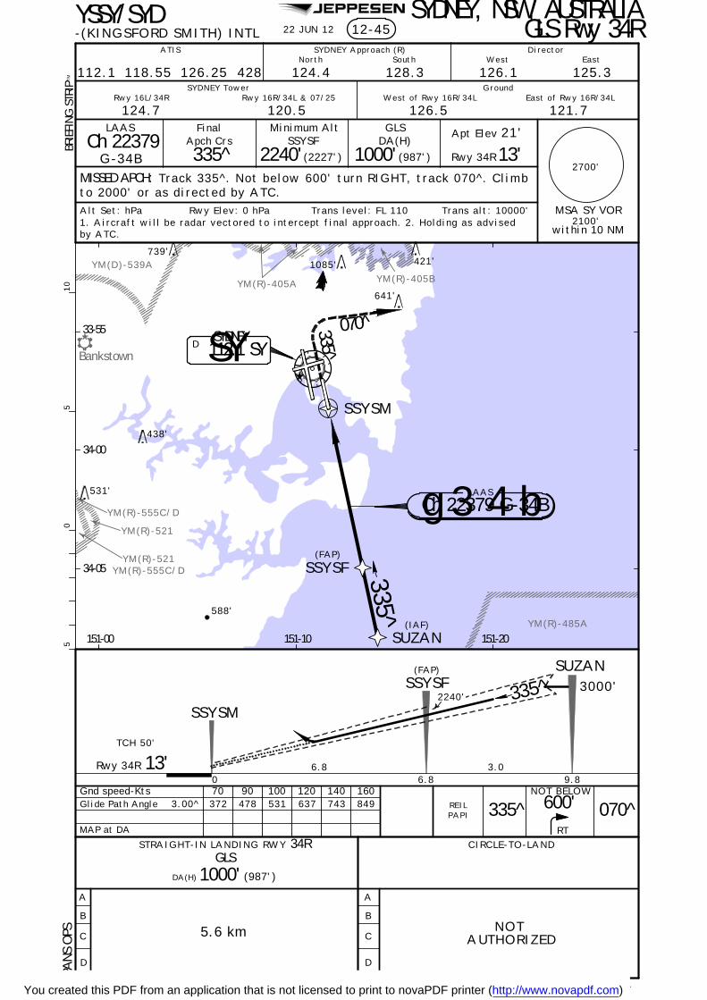
JEPPESEN
YM(R)-405A
YM(R)-521
YM(D)-539A
YM(R)-555C/D
YM(R)-485A
Bankstown
YM(R)-521YM(R)-555C/D
YM(R)-405B
22 JUN 12YSSY/SYD SYDNEY, NSW, AUSTRALIA-(KINGSFORD SMITH) INTL
MISSED APCH:
BRIE
FIN
G S
TRIP
TM
ATIS SYDNEY Approach (R)North South West East
Director
SYDNEY Tower GroundRwy 16R/34L & 07/25Rwy 16L/34R West of Rwy 16R/34L East of Rwy 16R/34L
112.1 118.55 126.25 428 124.4 128.3 126.1 125.3
120.5124.7 126.5 121.7
Trans alt: 10000'Trans level: FL 110Alt Set: hPa Rwy Elev: 0 hPa
FinalApch Crs
335^SSYSF
2240'(2227')
DA(H)
(987')
Apt Elev 21'
MSA SY VOR
2700'
within 10 NM2100'
05
510
PAPI
Rwy 34R
SYDNEY112.1 SYSYD
13'
13'
SSYSF
SSYSM
3000'2240'
3.06.8
335^
Rwy 34R
SUZAN
REIL
SUZAN
SSYSF
SSYSM
(IAF)
335^
070^335^
33-55
34-00
151-00 151-10 151-20
34-05
421'
438'
531'
588'
641'
739'1085'
NOTAUTHORIZED
6.8 9.80
12-45 GLS Rwy 34R
LAAS
Ch 22379G-34B
Minimum Alt
1000'
GLS
Track 335^. Not below 600' turn RIGHT, track 070^. Climbto 2000' or as directed by ATC.
TCH 50'
DA(H) 1000' (987')
GLS
(FAP)
(FAP)
Gnd speed-KtsGlide Path Angle
MAP at DA
3.00^ 849160140
743637120100
5314789070
372335^
NOT BELOW600' 070^
RT
LAAS
Ch 22379 G-34Bg 3 4 b
1. Aircraft will be radar vectored to intercept final approach. 2. Holding as advisedby ATC.
| JEPPESEN, 2011, 2012. ALL RIGHTS RESERVED.None.
PA
NS O
PS
CHANGES:
5.6 km
CIRCLE-TO-LAND
A
B
C
D
A
B
C
D
STRAIGHT-IN LANDING RWY 34R
You created this PDF from an application that is not licensed to print to novaPDF printer (http://www.novapdf.com)

JEPPESEN
[TCH 50']
[3.00^]
Bankstown
YM(R)-405AYM(R)-405B
YM(R)-521
YM(D)-556A
YM(D)-539A
YM(D)-539B
YM(R)-555C/D
YM(R)-555A/B
YM(R)-555C/D
YM(R)-521
[FF~7]
[MA~7]
[FF~7]
[MA~7]
SYDNEY, NSW, AUSTRALIA-(KINGSFORD SMITH) INTL 13-1
MISSED APCH:
ATIS SYDNEY Approach (R) Director
124.4North
128.3South
VOR
112.1
FinalApch Crs
062^ 2030'
MDA(H)
650'(634')
Apt Elev 21'
Rwy 07 16'
Track 062^. Climb to 2000' or as directed by ATC .
120.5 124.7Rwy 16L/34R
(2014') 2700'
GroundSYDNEY Tower
650'(634')3 DME SY16R
0725
16L
34L
34R
MDA(H)
062^2000'
MDA(H)
Rwy 16R/34L & 07/25
Rwy 07
SY D7.0
MSA SY VOR
YSSY/SYD
112.1 118.55 126.25 428
2100'within 10 NM
062^
Gnd speed-Kts 70 90 100 120 140 160Descent angle [3.00^] 372 478 531 637 743 849
700'2000'
MDA
05
510
Procedure Alt
1
1 Limits: 1 Min or D15.0,first reached.
421'
870'
820'
438'
531'
588'
739'
34-00
151-00 151-10
REIL
BRIE
FIN
G S
TRIP
TM
641'
DAY NIGHT
NA
1. SY DME REQUIRED.
VOR Rwy 07
VOR DME
Flashing White
1085'
33-55
34-05
East of Rwy 16R/34L
121.7126.5West of Rwy 16R/34L
125.3East
126.1West
PAPI
| JEPPESEN, 1998, 2012. ALL RIGHTS RESERVED.Notes.
9 NOV 12 .Eff.15.Nov.
PA
NS O
PS
CHANGES:
ALTITUDE
SY DME 9.0 8.0 6.0 5.0 4.0 2.72670' 2350' 1710' 1400' 1080' 650'
3.6 km
STRAIGHT-IN LANDING RWY 07 CIRCLE-TO-LAND
MaxKts100
135
180
205 1000'(979')-5.0 km
-4.0 km(979')1000'
710'(689')-2.4 km
No CirclingBeyond D3.0 SYEast of Rwy 16R
& North of Rwy 25
A
B
C
D
MAP at D2.0
16'
VOR
D2.0
NDB
3000'D10.5 D7.0
2030'
3.5 4.0 1.2
D3.0
1.0
Alt Set: hPa Rwy Elev: 1 hPa Trans level: FL 110 Trans alt: 10000'
3.0760'2030'
7.0
2. GNSS permitted in lieu of DME. Reference waypoint SY VOR.
760'
D112.1 SYSYDNEY
GLF NDB/D10.5 HOLDING
242^
132^
312^
S Y
062^D7.0
D2.0
062^
D3.0
D10.5GLF
GLENFIELD(IAF)
428 GLF
3000
062^
242^
You created this PDF from an application that is not licensed to print to novaPDF printer (http://www.novapdf.com)

JEPPESEN
Bankstown
YM(R)-405B YM(R)-473
YM(R)-521
YM(D)-539A
YM(D)-539B
YM(R)-555A/B
YM(R)-555C/D
YM(D)-556A
YM(R)-405A
[TCH 50']
[3.00^]
YM(R)-555C/DYM(R)-521
[MA16R]
[MA16R]
[FD16R]
[FD16R]
3 DME YS
MISSED APCH:
-(KINGSFORD SMITH) INTL 13-2
VOR
112.1SY
FinalApch Crs
146^D6.0
(1692')
MDA(H)
580'(572')
Apt Elev 21'
8'
ATIS SYDNEY Approach (R) Director
124.4North 128.3South
120.5 124.7Rwy 16L/34R
GroundSYDNEY Tower
2700'
MSA SY VOR
170^3000'
146^
SYDNEY, NSW, AUSTRALIA
Rwy 16R
170^
16R
2516L
34R34L
07
2. Holding as directed by ATC.
Rwy 16R/34L & 07/25
34-00
151-10 151-20
1700'
421'
438'
531'
YSSY/SYD
739'
112.1 118.55 126.25 428
2100'within 10 NM
146^
3. GPS permitted in lieu of DME. Reference waypoint SY VOR.
Gnd speed-Kts 70 90 100 120 140 160
05
510
RT
BRIE
FIN
G S
TRIP
TM
Procedure Alt
Descent angle [3.00^] 372 478 531 637 743 849
641'
VOR Rwy 16R
1. SY DME REQUIRED.
VOR DME
1074'
1085'
West 126.1 East 125.3
West of Rwy 16R/34L 126.5 East of Rwy 16R/34L 121.7
PAPI PAPI
HIALS
| JEPPESEN, 1998, 2012. ALL RIGHTS RESERVED.
9 NOV 12
None.
.Eff.15.Nov.
D6.0
D10.0
D2.0
(IAF)Aircraft will beRADAR vectored toIAF.
11
CIRCLE-TO-LAND
MaxKts100
135
180
205
MDA(H)
1000'(979')-5.0 km-4.0 km(979')1000'
No CirclingBeyond D3.0 SYEast of Rwy 16R
& North of Rwy 25
MAP at D2.0
ABC
D
710' (689')-2.4 km
STRAIGHT-IN LANDING RWY 16R
(572')580'MDA(H)
HIALS out
3.2 km
ALTITUDE
SY DME 9.02650' 2010'
7.01060'4.0
1380'5.0 3.0
580'2.5
D 112.1 SYSYDNEY
S Y
CHANGES:
Turn RIGHT track 170^ climb to 3000' or asdirected by ATC.
VOR
Rwy 16R 8'1.2
D2.0
4.0
D6.01700'
4.0
D10.03000'
740'
33-50
Alt Set: hPa Rwy Elev: 0 hPa Trans level: FL 110 Trans alt: 10000'
1700'MDA
3000'10.0
2330'8.0
1700'6.0
PA
NS O
PS
You created this PDF from an application that is not licensed to print to novaPDF printer (http://www.novapdf.com)

JEPPESEN
[TCH 50']
[3.00^]
YM(R)-405A
YM(R)-405B
YM(R)-521
YM(D)-539A
YM(R)-555C/D
YM(D)-539B
Bankstown
YM(R)-473
YM(R)-521
[MA25]
[MA25]
[FF25]
[FF25]
13-3
MISSED APCH:
ATIS SYDNEY Approach (R) Director
124.4North 128.3South
120.5 124.7Rwy 16L/34R
GroundSYDNEY Tower
2700'
MSA SY VOR
VOR
112.1SY
FinalApch Crs
236^D7.0
2130'(2110')
MDA(H) Apt Elev 21'
RWY 25 20'
Track 236^, climb to 3000' or as directed by ATC .
580'
3 DME SY
Rwy 16R/34L & 07/25
(560')
236^3000'
MAP at D1.5
16R
25
16L
34R34L
07
YSSY/SYD
112.1 118.55 126.25 428
236^
3. GPS permitted in lieu of DME. Reference waypoint SY VOR.
Gnd speed-Kts 70 90 100 120 140 160
Procedure Alt
Descent angle [3.00^] 372 478 531 637 743 849
BRIE
FIN
G S
TRIP
TM
236^
068^
079^
236^
CAT A & B
CAT C & D
1
083^
263^
421'
438'
531'
739'
3000
33-50
34-00
151-00 151-10 151-20
ALTITUDE
SY DME 2.1580'
3.0860'
4.01180'
5.01500'
6.01810'
7.02130'
05
510
2100'within 10 NM
1
1. SY DME REQUIRED. 2. Max IAS for initial: 210 kts.
VOR DME
1085'
1074'
641'
126.1 East 125.3West
East of Rwy 16R/34L 121.7West of Rwy 16R/34L 126.5
19 AUG 11
PAPI
| JEPPESEN, 1998, 2011. ALL RIGHTS RESERVED.Circling minimums.
.Eff.25.Aug.SYDNEY, NSW, AUSTRALIA
-(KINGSFORD SMITH) INTL
CHANGES:
D3.5
1.0 3.5
D1.5
1.1
D2.5
710'20'RWY 25 1.0
MDA(H) 580'(560')
3.2 km
STRAIGHT-IN LANDING RWY 25 CIRCLE-TO-LAND
MaxKts100
135
180
205
MDA(H)
1000' (979')-5.0 km
-4.0 km(979')1000'
710' (689')-2.4 km
No CirclingBeyond D3.0 SYEast of Rwy 16R
& North of Rwy 25
D
C
B
A
PA
NS O
PS 4
Alt Set: hPa Rwy Elev: 1 hPa Trans level: FL 110 Trans alt: 10000'
MDA
1020'710'
D7.0
2130'
068^ CAT A & B
079^ CAT C & D
VOR3000'
D112.1 SYSYDNEY
S Y
D7.0
D7.0
D1.5D2.5
D3.5
(IAF)
Aircraft may be RADAR vectored to FAF.
153^
D7.0
263^
333^SY VORHOLDING
VOR Rwy 25
D7.01000'
You created this PDF from an application that is not licensed to print to novaPDF printer (http://www.novapdf.com)

JEPPESEN
[TCH 47']
[3.00^]
Bankstown
YM(R)-405A
YM(R)-405B
YM(R)-521
YM(D)-556A
YM(D)-539A
YM(R)-555C/D
YM(R)-555A/B
D10.5
YM(R)-485A
YM(D)-539B
YM(R)-555C/D
YM(R)-521
[MA34L]
[MA34L]
[FD34L]
[FD34L]
3 DME SY
MISSED APCH:
-(KINGSFORD SMITH) INTL 13-4
VOR
112.1SY
FinalApch Crs
340^D7.0
1890'(1876')
MDA(H)
410'(396')
Apt Elev 21'
14'
SYDNEY, NSW, AUSTRALIA
ATIS SYDNEY Approach (R) Director
124.4North 128.3South
120.5 124.7Rwy 16L/34R
GroundSYDNEY Tower
Rwy 16R/34L & 07/25
2700'
MSA SY VOR
320^3000'
RWY 34L
16R
25
16L
34R34L
07
2. Holding as directed by ATC.
YSSY/SYD
112.1 118.55 126.25 428
2100'within 10 NM3. GPS permitted in lieu of DME. Reference waypoint SY VOR.
Gnd speed-Kts 70 90 100 120 140 160
340^
Procedure Alt
SY DME
ALTITUDE 930'4.0 5.0 6.0 7.03.0
610'410' 1250' 1570' 1890'
05
510
BRIE
FIN
G S
TRIP
TM
LTDescent angle [3.00^] 372 478 531 637 743 849
Aircraft will be RADARvectored to IAF.
1
1
438'
531'
588'
34-00
151-00 151-10 151-20
3.5770'
8.02210'
9.02530'
10.02840'
10.53000'
VOR Rwy 34L
1. SY DME REQUIRED.
VOR DME
1085'
33-55
34-05
641'
East 125.3West 126.1
East of Rwy 16R/34L 121.7West of Rwy 16R/34L 126.5
2.2
19 AUG 11
PAPI
| JEPPESEN, 1998, 2011. ALL RIGHTS RESERVED.Procedure altitude.
.Eff.25.Aug.
MAP at D2.0
A
B
C
D
MDA(H) 410'(396')
STRAIGHT-IN LANDING RWY
2.1 km
34L CIRCLE-TO-LAND
MaxKts100
135
180
205
MDA(H)
1000' (979')-5.0 km
-4.0 km(979')1000'
710' (689')-2.4 km
No CirclingBeyond D3.0 SYEast of Rwy 16R
& North of Rwy 25
CHANGES:
D11.0
3000'
4.0
1890'
D7.0
2.0
1050'
D5.0
650'
D3.5D2.0
1.50.714'RWY 34L
VOR
1.5
Turn LEFT, track 320^. Climb to 3000' or as directedby ATC.
PA
NS O
PS 4
Alt Set: hPa Rwy Elev: 1 hPa Trans level: FL 110 Trans alt: 10000'
MDA
1600'
1250'
770'
D7.0
D3.5
D2.0
340^ (IAF)
D11.0
D5.0
D 112.1 SYS YSYDNEY
320^
You created this PDF from an application that is not licensed to print to novaPDF printer (http://www.novapdf.com)

Chart changes since cycle 10-2013
ADD = added chart, REV = revised chart, DEL = deleted chart.ACT PROCEDURE IDENT INDEX REV DATE EFF DATE
SYDNEY, NS (KINGSFORD SMITH INTL - YSSY)REV AIRPORT, AIRPORT INFO 10-9 24 May 2013 30 May 2013REV AIRPORT INFO (CONTD), TAK... 10-9A 24 May 2013 30 May 2013REV RNAV Z (GNSS) RWY 07 12-1 24 May 2013 30 May 2013REV RNAV Z (GNSS) RWY 16L 12-2 24 May 2013 30 May 2013REV RNAV Z (GNSS) RWY 34L 12-5 24 May 2013 30 May 2013REV RNAV Z (GNSS) RWY 34R 12-6 24 May 2013 30 May 2013
Revision Letter For Cycle 11-2013Printed on 20 Jun 2013Page 1(c) JEPPESEN SANDERSON, INC., 2013, ALL RIGHTS RESERVED
jep=JEPPESEN
JeppView for Windows
You created this PDF from an application that is not licensed to print to novaPDF printer (http://www.novapdf.com)

TERMINAL CHART CHANGE NOTICES
Chart Change Notices for Airport YSSY
Type: TerminalEffectivity: TemporaryBegin Date: ImmediatelyEnd Date: Until Further Notice
(10-9B) Due to construction Bay 75 and Southern section of Twy J closed UFN.
Chart Change Notices for Country AUS
Type: GeneralEffectivity: PermanentBegin Date: 20100603End Date: No end date
Commencing with the 3 JUN 10 effective date the CTAF (R) concept for Australia will be retired and replaced by CTAF. This is expected to be phased in over the next few months. Jeppesen will process CTAF changes on an as revise basis along with more flight critical revision activity.
Terminal Chart Change NoticesPage 1 - Printed on 20 Jun 2013Notice: After 06 Jun 2013, 0000Z, this data may no longer be valid
(c) JEPPESEN SANDERSON, INC., 2013, ALL RIGHTS RESERVED
jep=JEPPESEN
JeppView for Windows
You created this PDF from an application that is not licensed to print to novaPDF printer (http://www.novapdf.com)