jacquie gilson, executive director, ann & sandy cross ... corridors... · jacquie gilson,...
TRANSCRIPT

Jacquie Gilson, Executive Director, Ann & Sandy Cross Conservation Area and Director, Foothills Land Trust
(With slides by Michael Quinn, Chris Selvig, Jonathon Schmidt of Miistakis Institute)

Wildlife Corridors AKA “Landscape Connectivity”
2008 Connectivity Study Methods Results Conclusions
What can you do? Break (at 7:30) Foothills Land Trust Discussion (end by 9:00)

“Wildlife Corridor” implies a linear area used solely for wildlife and for their travel
Better terms to use: “Linkage zones” - areas that support low densities of
wildlife populations, often as seasonal residents –not just movement corridors
“Habitat Connectivity” - implies maintaining the connections between remaining natural areas (habitat patches) for a variety of benefits to humans and wildlife

•Wildlife already exist on the landscape and meet their needs in a variety of ways.•The problems occur when we fragment the landscape, making it harder for them to meet their needs. •Protected areas and linkages are human constructs- ways for us to try to maintain the ecological features of the landscape while still using it to meet our needs.
Key Point #1- Habitat and connectivity already exist


•Maintaining these features on the landscape provides many ecological functions that benefit humans, i.e., ecological infrastructure:
Natural and essential structures and functions that provide all the goods and services that living things need to survive – life support systems
•Clean water, clean air, carbon storage, nutrient cycling, space for food production, climate regulation, pollination, etc…
Key Point #2- they are not just for wildlife
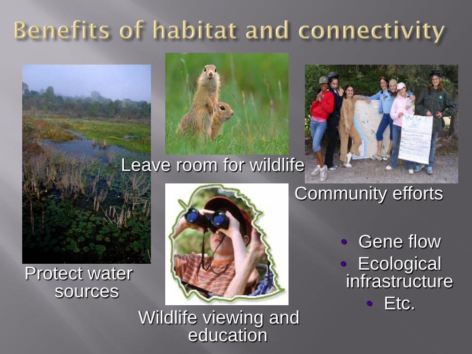
Protect water sources
Wildlife viewing and education
Leave room for wildlifeCommunity efforts
• Gene flow• Ecological infrastructure
• Etc.

Habitat patches and connectivity must be planned out.
Key Point #3- they won’t just happen
They will be different depending on whose needs are being met.
Requires study of what currently exists and how elements work together to provide ecological infrastructure.
There are no right sizes or shapes- depends on what we want the landscape to look like and how intact we want it to be.

Do we want habitat and corridors to maintain these species on the landscape?
If so, consider their needs and current use of the landscape.

Maintaining habitat and connectivity for these species will help a multitude of other species too.

Consider both terrestrial and aquatic ecosystems when planning habitat reserves and connectors.

Consider human needs for food, water, shelter and space too (but not exclusively).
We need space for safety from wildlife.

•Corridors/linkages are just one of many different conservation strategies.
•Other strategies include:•protecting habitat patches as core reserves and buffering them with areas of low human use, in a landscape of sustainable use•undertaking regional visioning and planning with sustainability in mind•using conservation design of subdivisions and sustainable housing options•educating all ages•encouraging conservation actions by landowners•doing habitat improvements, etc.
Key Point #4- they are not the only solution

One of the best arguments for wildlife corridors is that the original landscape was
largely interconnected, but then fragmented by human activities;
reconnection will move the situation slightly back toward the original state.
Reed Noss, 1997

Undertaken spring 2007 to spring 2008 Research objectives:
Identify & map important wildlife habitat & movement areas in the region surrounding the Cross Conservation Area
Research methods:1. Literature reviews2. Landscape analysis (maps, GIS, remote sensing)3. Wildlife camera research (10 motion-sensed
cameras)Partners:


Field researchers Chris Selvig and Jonathan Schmidtdeployed & monitored the cameras
Locations were determined and based on a number of criteria including: Knowledge gathered from
previous wildlife studies Regional wildlife habitat Local vegetation &
riparian areas Proximity to various types
of land uses Evidence of wildlife Landowner permission

I. Identify potential movement areas through air photos
II. Contact landownerIII. Discuss wildlife patterns with
landowner(s)IV. Identify visible wildlife use
through field surveysV. Place cameraVI. Monitor & collect imagesVII. Record data
I.
III.
IV.
Camera Process

86 camera locations 39,259 camera hours 128,308 images 3,593 unique
movements 12 mammal species


The fact that we have cougars, black bears, elk, etc. on the doorstep of 1 million+ people is an indicator of environmental health
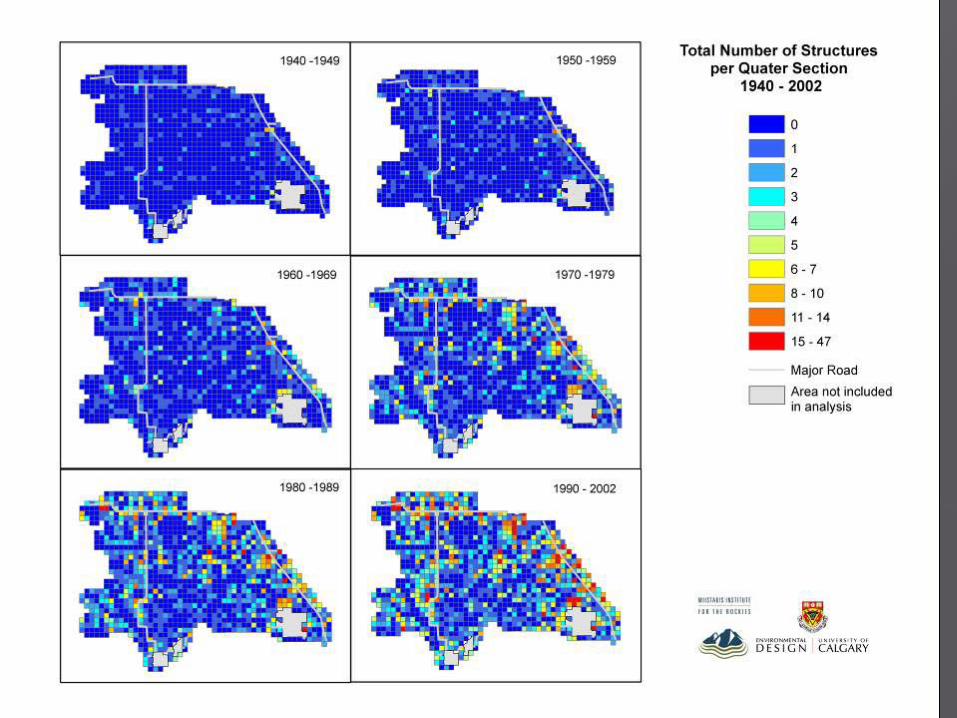
There are functional corridors, but also clear barrier effects, e.g., connections across Highway 22 and 22X will be critical
The decisions we make in the next decade will determine the fate of ecological infrastructure in this region
The lines on the map DO NOT imply absolute protection, but DO indicate
areas for special planning and management.

Finalized report in June 2008. Available to all on website and for purchase at ASCCA.
Presented to ASCCA Board, public and MD Foothills Council and report sent to Minister Morton.
Placed Jon’s award winning video on website. Attended award night with info on study and ASCCA.
Offered education sessions on relevant topics in partnership with local groups.
Provided connectivity talks and walks for school visitors to ASCCA.
Supporting Foothills Land Trust- local conservation option.

Encourage regional planning, including use of Area Concept or Area Structure plans

Consider conservation design of subdivisions over conventional design.
From Conservation Design for Subdivisions, R.G. Arendt,1996
Conventional Design

From Conservation Design for Subdivisions, R.G. Arendt,1996

Encourage regional planning, including use of area concept or structure plans and conservation design of subdivisions.
Allow unobstructed wildlife use and movement in places where wildlife are seen on a regular basis.
Reduce fencing and create habitat for wildlife through native plants.
Allow for a buffer between human use and wildlife habitat. Officially establish corridors or habitat reserves through:
designate extra Environmental Reserve if developing land donation/sale of land or easement to Foothills Land
Trust- hold that thought until after break! Other ideas to be discussed…
