iv.20 visual resources - u.s. fish and wildlife … iv/iv.20...each alternative, including proposed...
TRANSCRIPT

Draft DRECP and EIR/EIS CHAPTER IV.20 VISUAL RESOURCES
Vol. IV of VI IV.20-1 August 2014
IV.20 VISUAL RESOURCES
The analysis in this chapter addresses potential impacts to visual resources from the No
Action Alternative and implementation of the various action alternatives of the Desert
Renewable Energy Conservation Plan (DRECP). The analysis includes impacts from covered
renewable energy and transmission development activities, the Reserve Design, and Bureau
of Land Management (BLM) Land Use Plan Amendment (LUPA) decisions proposed under
each alternative, including proposed Visual Resource Management (VRM) Classes.
The DRECP would encourage the development and operation of covered renewable energy
facilities and transmission lines within Development Focus Areas (DFAs). The VRM Class
designations on BLM-administered lands indicate the level of visual change allowed.
The primary consideration in quantifying visual impacts at a programmatic and plan level
of analysis is the extent to which the visual resource elements described in Volume III,
Chapter III.20, Visual Resources, are affected by the proposed DFAs, transmission, and
reserve design conservation land designations and management.
IV.20.1 Approach to Impact Analysis
IV.20.1.1 General Methods
Visual impacts from development on BLM-administered lands are analyzed using BLM’s
VRM system. This approach considers scenic quality, viewer sensitivity, and distance zones
when conducting a Visual Resource Inventory (VRI). The VRI describes existing conditions
but does not prescribe management actions. BLM considers information from the inven-
tory when assigning VRM classifications to specific geographic areas.
Specific projects or sites resulting from a proposed planning direction are not identified
or under review in this programmatic Environmental Impact Report/Environmental
Impact Statement (EIR/EIS). On BLM lands, the approach to analysis of visual impacts
used in the EIR/EIS identifies the amount of BLM land that would fall under various VRI
and VRM classifications for each alternative and the extent to which those lands are or
would be under conservation management or available for development. This approach is
used to understand the potential impact on visual resources and their differences under
each alternative.
On non-BLM lands, visual impacts from development are analyzed using a somewhat differ-
ent approach, one that considers visual quality, viewer concern and exposure, and overall
visual sensitivity from key observation points. Factors include visual contrast, project
dominance, view blockage, and overall visual change. As with BLM-administered lands, a
proxy is used to represent the amount of land on which visual impacts could occur. This

Draft DRECP and EIR/EIS CHAPTER IV.20 VISUAL RESOURCES
Vol. IV of VI IV.20-2 August 2014
analysis identifies the acreage in the DFA under each alternative that potentially would be
available for development of renewable energy facilities.
Future projects constructed pursuant to Plan approval will be reviewed when they are pro-
posed, on a case-by-case basis and on a site-specific scale, to determine their consistency
with the adopted VRM objectives of the applicable land use plan.
IV.20.1.2 CEQA Standards of Significance
Appendix G of the California Environmental Quality Act (CEQA) Guidelines identifies four
standards for determining the significance of impacts to aesthetics from a project. Impacts
could be considered significant if the project would:
Have a substantial adverse effect on a scenic vista.
Substantially damage scenic resources, including trees, rock outcroppings, and
historic buildings within a State Scenic Highway.
Substantially degrade the existing visual character or quality of the site and
its surroundings.
Create a new source of substantial light or glare, which will adversely affect day or
nighttime views in the area.
These CEQA standards of significance are subsumed under the broader impact statements
applied to the visual impact analysis of each alternative (e.g., see Section IV.20.3.2.1, Plan-
wide Impacts of Implementing the DRECP: Preferred Alternative). These impact statements
(1) identify the short-term and long-term diminution of scenic quality resulting from
project implementation and (2) consider impacts on scenic vistas, scenic resources along
State Scenic Highways, the visual character and quality of a site and its surroundings, and
the introduction of light and glare, among other factors.
IV.20.2 Typical Impacts Common to All Action Alternatives
This section describes visual impacts typically associated with solar, wind, and geothermal
energy development, and transmission requirements (rights-of-way, major transmission
lines, generator tie-lines [i.e., electrical lines connecting energy facilities to the larger elec-
tric grid], and substations). The impact of a given project would depend upon the intensity
of project-specific resource development, including energy type, technologies used, site
layout, scale, location, impact minimization strategies employed, timing and degree of dis-
turbance, complexity of the facilities, and other factors analyzed at the project level.
The analysis in this programmatic EIR/EIS draws on information in other environmental
documents. Typical effects of renewable energy development on visual resources were

Draft DRECP and EIR/EIS CHAPTER IV.20 VISUAL RESOURCES
Vol. IV of VI IV.20-3 August 2014
evaluated by reviewing the Programmatic Environmental Impact Statement for Solar
Energy Development in Six Southwestern States (Solar PEIS), the Wind Energy Develop-
ment Programmatic Environmental Impact Statement (Wind Energy PEIS), and the Pro-
grammatic Environmental Impact Statement for Geothermal Leasing in the Western United
States (Geothermal PEIS). In these documents, potential effects from actions similar to
those that might occur under the DRECP alternatives were assessed.
Visual impacts can be divided into short-term impacts, generally associated with site char-
acterization and active construction and decommissioning activities, and longer-term
impacts that result from the visible physical changes wrought by construction, including
site alterations, the physical presence of facilities, and facility operation. For purposes of
analysis, short-term visual impacts are considered to occur and be present for no more
than 5 years. These impacts are associated with visible construction activities and mate-
rial/equipment staging and would cease once construction is completed. Long-term visual
impacts extend beyond a 5-year period, when construction has been completed and opera-
tions are ongoing.
IV.20.2.1 Impacts of Renewable Energy and Transmission Development
Impacts can occur at various phases of a project: site characterization, construction and
decommissioning, and operation and maintenance. Many types of impacts on visual resources
are common among renewable energy projects, regardless of the technology employed.
Visual changes due to utility-scale renewable energy and transmission development activities
result from a range of actions or activities, including:
Disturbance of ground surface.
Alteration or removal of vegetation and landforms.
Introduction of structures (e.g., energy collection and generation units, buildings,
towers, and ancillary facilities).
New or upgraded roads.
New or upgraded utilities and/or rights-of-way (e.g., widening of rights-of-way,
addition of transmission lines, and upgrading of transmission capacity).
Presence and movement of workers, vehicles, and equipment.
Visible emissions (e.g., dust and water vapor plumes).
Reflectance, glare, and lighting.

Draft DRECP and EIR/EIS CHAPTER IV.20 VISUAL RESOURCES
Vol. IV of VI IV.20-4 August 2014
IV.20.2.1.1 Impacts of Site Characterization
Site characterization activities can introduce visual impacts due to:
Contrasts in form, line, color, and texture resulting from vegetation clearing and sur-
face disturbance (if required for activities such as meteorological tower and access
road construction and drilling of temperature gradient wells).
Presence of trucks and other vehicles and equipment.
Presence of idle or dismantled equipment and litter, if allowed to remain on the site.
During site characterization, ruts, windblown dust, and visible vegetation damage may
occur from cross-country vehicle traffic if existing or new roads are not used. Soil distur-
bance can lead to growth of invasive species or erosion of soil, both of which could intro-
duce contrasts in line, color, and texture, primarily for foreground and near-middle ground
views. Site characterization visual impacts, such as occur with the presence of equipment
and vehicles, are short-term. However, impacts due to road construction, erosion, landform
alteration, or vegetation clearing may be visible for an extended period.
IV.20.2.1.2 Impacts of Construction and Decommissioning
Construction and decommissioning activities can introduce contrast in form, line, color,
and texture resulting from:
Vegetation clearing and ground disturbance needed to prepare project sites and
laydown/staging areas.
Road building and improvement.
Night lighting.
Debris.
Physical presence of project elements (solar energy collectors, wind turbines, geo-
thermal generating plants, and support facilities).
Presence and movement of vehicles, equipment, and workers.
Dust and other visible emissions.
Construction visual impacts vary in intensity, frequency, and duration during construction
and, later, decommissioning. For a utility-scale project, these activities may last several years.
Solar project visual impacts vary based on the technology used, but they have a number of
common features, including extensive grading to prepare areas for installing solar-collector
or focusing arrays. This creates color and texture contrasts between existing soil and vege-
Draft DRECP and EIR/EIS CHAPTER IV.20 VISUAL RESOURCES
Vol. IV of VI IV.20-5 August 2014
tation conditions and the disturbed, unvegetated project footprint. Clearing also creates
opportunities for visible windblown dust clouds to occur. Numerous vehicles are required
to deliver and install the arrays, resulting in movement, dust, and the presence of the vehi-
cles themselves. Often, temporary structures are installed or erected for component assem-
bly and finishing and to provide project site offices.
For wind energy projects, large cranes and other equipment would be needed to construct
foundations and assemble and mount towers, nacelles (turbine housings), and rotors. This
equipment would be especially visible near the activity and from a middle distance.
Construction equipment would produce emissions and may create visible exhaust plumes.
The disturbed footprint of individual turbines typically would be small, but for a field of
turbines can be extensive. Collectively, multiple turbines would create a visual impact due
to the size of their vertical and rotating elements and from required night safety lighting.
For geothermal projects, facilities to capture and use the geothermal resource would be
constructed. Needed infrastructure can include roads, sump pits, production-size wells,
injection wells, well field equipment, power plant facilities, pipelines, and transmission lines.
For all renewable energy projects, decommissioning the project and restoring the site to
pre-project condition would entail removing structures and equipment, earthwork (re-
contouring, grading, scarifying), and revegetation (stabilizing surfaces, seeding/planting,
and providing temporary irrigation, if needed). Restoration might not be possible in all
cases. The contours of restored areas might not be identical to pre-project conditions.
Under the arid conditions generally found in the Plan Area, disturbed soils can create a
visual contrast that persists for many years, until vegetation could begin to disguise past
disturbance. Without proper management, invasive plant species may colonize reclaimed
areas, producing contrasts in color and texture noticeable for many years. Unsuccessful
restoration of previously cleared areas could erode soil, collapse slopes, and create gullies,
which could result in or continue long-term adverse visual impacts.
IV.20.2.1.3 Impacts of Operations and Maintenance
The operation and maintenance of renewable energy projects and associated electricity
transmission lines, roads, and rights-of-way would have long-term adverse visual effects.
Among these are land scarring, introduction of structural contrast and industrial elements
into natural settings, view blockage, and skylining (silhouetting of elements against the
sky). All renewable energy facilities would include enclosed and open workspaces, exterior
lighting around buildings, access roads, fencing, and parking areas. Built structures (build-
ings, piping, fencing, collector arrays, etc.) would introduce industrial elements into the
landscape and contrast with surrounding undisturbed areas in form, line, color, and
texture. They also can block views and create skylining, depending on their dimensions and

Draft DRECP and EIR/EIS CHAPTER IV.20 VISUAL RESOURCES
Vol. IV of VI IV.20-6 August 2014
location relative to the viewer. The need for security and safety lighting could contribute to
light pollution in areas where night lighting is otherwise absent or minimal. Light impacts
include skyglow, off-site light trespass, and glare. Another impact common to renewable
energy facilities is dust generated by vehicle movement within a site or along a right-of-
way or access road. Without proper disturbed soil management strategies, wind can
mobilize dust from project sites and create visible plumes or clouds of dust.
Solar
Some impacts are common to all utility-scale solar projects, regardless of the technology
employed. Solar projects introduce strong geometric shapes and repeated linear elements
into the visual environment. Typically, these projects have a large footprint and are in open
and relatively flat settings with little to no vegetative or other screening. Valley floor loca-
tions are visible from nearby mountains and elevated viewpoints. Solar energy collectors
rely on mirrored or glass surfaces that are highly reflective and produce glare (U.S. Depart-
ment of Energy 2013). In addition to the collector or reflector arrays, solar projects can
include other components with reflective surfaces, such as array support structures, steam
turbine generators, piping, fencing, and transmission towers and conductors. Under certain
viewing conditions, these surfaces give rise to specular reflections (glint and glare) visible
to stationary or moving observers from long distances, and can constitute a major source of
visual impact. Glint and glare from photovoltaic facilities are typically lower than solar
concentrating facilities using trough, power tower, and solar dish technologies that employ
mirrors and lenses. During the life of a solar project, panels, towers, troughs, and associated
structures may need to be upgraded or replaced, creating visual impacts similar to impacts
occurring during initial construction and assembly.
Solar energy projects also vary in their visual impacts because of the different technologies
employed. Solar technologies include both concentrating solar power systems (which gene-
rate power using focused sunlight to either heat liquid to drive a turbine or generate elec-
tricity directly) and traditional photovoltaic systems. For example:
Parabolic trough systems comprise rows of trough-shaped mirrors that direct solar
insolation to a receiver tube running along the axis of the trough. Solar trough facili-
ties have a relatively low profile when viewed from a distance, but a high potential
for glare because they rely on reflected, focused light from large mirrors. Reflectivity
varies widely during daylight hours based on sun angle but can be highly visible
from elevated viewpoints.
Power tower systems consist of thousands of ground-mounted sun-tracking mirrors
that direct sunlight to a receiver atop a tall tower, where a liquid is heated then
piped to a ground-based steam generator. Power tower projects have greater visual

Draft DRECP and EIR/EIS CHAPTER IV.20 VISUAL RESOURCES
Vol. IV of VI IV.20-7 August 2014
impacts over larger areas than photovoltaic or thermal trough technologies because
of their high vertical profile (i.e., one or more towers rising 300 to 700 feet above
ground level with brightly glowing reflections at the receiver location), power plant,
cooling towers, steam plumes, and highly visible and pulsing day/night aircraft
safety beacons.
Photovoltaic technologies differ from concentrated solar technologies; instead of
concentrating sunlight to generate heat, they use panels to convert solar energy
directly to electrical current (BLM 2013). Photovoltaic projects generally have lower
visual impacts than the other solar technologies because of the comparatively low
profile of the collector arrays and the lower reflectance from photovoltaic panels, as
compared with mirrors used in other technologies. They do not have cooling towers,
plumes, or power plants and do have fewer lights and low worker activity. Still,
some panels can be reflective, especially when seen from higher elevations, and can
be visible for long distances (up to 20 miles). Power conversion units (inverters)
associated with these facilities can also cause visual contrasts (U.S. Department of
Energy 2013). Because photovoltaic facilities do not require the generation infra-
structure of other solar technologies (turbines, boilers), they are visually simpler
and associated with lower visual contrasts (BLM 2013).
Concentrated photovoltaic systems work like simple photovoltaic technologies, but
they include lenses to focus the sun’s rays on photovoltaic cells to generate more
electricity than standard photovoltaic systems.
Wind
Wind energy projects would be highly visible because of the large vertical towers and
rotating turbines that would be erected in an area where there are few, if any, comparable
tall structures in the generally strongly horizontal landscapes typical of BLM lands in the
Plan Area. Visibility and contrast would be heightened at locations where they these struc-
tures are sited along mesas or ridgelines, silhouetting them against the sky. Additionally,
strong nighttime visual contrasts would occur from aviation warning lighting on the towers
(BLM 2013). Wind turbines may create visually incongruous “industrial” associations for
viewers, particularly in a predominantly natural landscape. Their moving blades attract
visual attention. Depending on the time of day, the shadows of tall turbine towers extend
great distances across the landscape, in a sundial effect. The direction and length of this
effect varies with the relative position of the sun in various seasons and at different times
of the day, with morning and evening producing the longest shadows. The regular periodic
interruption of sunlight by rotating turbine blades may produce a strobe-like effect,
flickering alternating light and shadow over the area where the shadow is cast. During the
life of a wind project, towers, nacelles, and rotor blades may need to be upgraded or
replaced, creating visual impacts similar to impacts occurring during initial construction
Draft DRECP and EIR/EIS CHAPTER IV.20 VISUAL RESOURCES
Vol. IV of VI IV.20-8 August 2014
and assembly. Collectively, multiple turbines would create a visual impact due to the num-
bers in close proximity to each other, their vertical and rotating elements, and the required
night aviation safety lighting.
Geothermal
Visual impacts associated with the operation and maintenance of geothermal energy proj-
ects largely derive from ground disturbance and the visibility of industrial power plants,
wells, pipes, steam plumes, and transmission lines.
Transmission
Visual impacts associated with the operation and maintenance of transmission facilities
include the visual contrast of the transmission lines, support structures, and access road-
ways, as well as the occasional vehicle, equipment, and helicopter use along the transmission
right-of-way or at substations, and the presence of workers conducting inspections or
making repairs. Roads used for access are kept relatively free of vegetation. These features in
the landscape can result in a strong visual contrast in form, line, color, and texture. Visibility
and contrast would be heightened where towers and other structures are sited along mesas
or ridgelines, resulting in skylining. Lattice towers are considered less visually obtrusive in
natural landscape than monopoles when not close to sensitive viewing locations, because
they are more transparent against background textures and colors (BLM 2013).
IV.20.2.2 Impacts of the Reserve Design
In general, the DRECP reserve design and associated Conservation and Management
Actions (CMAs) would encourage projects to be located within the DFAs, thereby
concentrating effects on visual resources in these areas. The avoidance, minimization, com-
pensation, conservation, and management actions required to achieve the conservation
strategy would reduce the proliferation of impacts on visual resources to some extent by
encouraging development in specific areas and not in others, in contrast to permitting dis-
persed development throughout the Plan Area.
While the reserve design and CMAs vary among the action alternatives, there are simi-
larities among all alternatives. The Reserve Design Lands (comprising existing conserva-
tion areas, the BLM LUPA Conservation Designations, and the Conservation Planning Areas
[CPAs]) would limit or exclude renewable energy development in these areas, thereby
protecting visual resources in large areas of the desert.
Visual resources are enhanced when desert areas are protected other reasons, such as for
species and habitat protection. For example, the legislative and/or legal restrictions rele-
vant to existing conservation areas direct that they be managed for the benefit of Covered

Draft DRECP and EIR/EIS CHAPTER IV.20 VISUAL RESOURCES
Vol. IV of VI IV.20-9 August 2014
Species. These protective actions afford visual resource protections to these areas as well
by limiting or excluding development.
The proposed BLM LUPA Conservation Designations are administrative designations
intended to reduce or expand National Landscape Conservation System (NLCS) lands,
Areas of Critical Environmental Concern (ACECs), and wildlife allocation designations on
BLM-administered land. In addition to other resource values, relatively high levels of scenic
quality and visual resources typically are associated with these areas.
Under the DRECP, not all conserved areas would be on existing public land. Conservation
areas not otherwise protected in the reserve design by BLM designations are lands that
would be conserved through acquisition or conservation easements from willing sellers of
lands within the mapped CPAs. Conservation of these lands would be part of the compensa-
tion required for allowing various project impacts to occur. CPAs, acquisition agreements,
and conservation easements would have restrictions limiting development and ground dis-
turbing activities, thereby protecting or enhancing habitat for Covered Species. Such limita-
tions would benefit visual resources as well.
The CMAs are critical components of the conservation strategy for the DRECP and serve to
avoid and minimize impacts and contribute to the assembling of the reserve design through
compensation for the loss of biological and other resources. CMAs would generally reduce
the severity of impacts to visual resources by requiring impact avoidance and minimization
measures for siting, design, construction, and decommissioning of renewable energy facilities.
BLM-specific CMAs for VRM include measures that apply Plan-wide, measures specific to
DFAs, DRECP Study Areas (Future Assessment Areas, Special Analysis Areas, and DRECP
Variance Lands), and transmission corridors, and a detailed set of visual resource best
management practices (BMPs). The BMPs incorporate the measures identified in Best Man-
agement Practices for Reducing Visual Impacts of Renewable Energy Facilities on
BLM-Administered Lands (BLM 2013). This publication identifies 122 BMPs that can be
used to avoid or reduce potential visual impacts associated with the siting, design,
construction, operation, and decommissioning of utility-scale renewable energy generation
facilities, including wind, solar, and geothermal facilities. The BMPs were compiled from a
variety of sources, including guidance documents developed by various federal and state
agencies; existing environmental analyses, including programmatic and project-specific
environmental impact statements and assessments; professional practice literature; con-
sultations with landscape architects, engineers, and renewable energy professionals; and
field observations of existing renewable energy facilities and facilities under construction.
Draft DRECP and EIR/EIS CHAPTER IV.20 VISUAL RESOURCES
Vol. IV of VI IV.20-10 August 2014
In addition to technology-specific BMPs, more general BMPs for design, construction, oper-
ation, and decommissioning activities include the following:
Visual impact analysis and mitigation planning
Facility siting and design
Structure design and materials selection
Materials surface treatments
Lighting design and operation
Avoiding unnecessary disturbance
Soil management and erosion control
Vegetation management
Interim and long-term reclamation
“Good housekeeping” practices
Together, these VRM CMAs provide a comprehensive framework of guidelines and spe-
cifications under which visual impacts would be avoided where possible and minimized
and/or mitigated to the extent practicable. They would avoid or reduce visual contrast in
form, line, color, and texture using a range of techniques, such as sensitive siting, revegeta-
tion, recontouring to match existing terrain characteristics, or painting facility components
to blend with the landscape.
BLM-specific CMAs for other resources could also benefit visual resources. These include
CMAs applicable to
Air resources (stringent dust control requirements).
Trails and travel (protecting views by buffering trails and managing travel routes
and corridors).
Cultural resources (prioritizing protection of visual resources on landscapes consid-
ered culturally significant to Native Americans).
Lands and realty (acquisition and protection of visual resources of
conservation lands).
Livestock grazing (protection and restoration of scenic riparian and wetland systems).
Recreation (maintenance and/or enhancement of naturalness).
Soil and water (protection of scenic qualities of water systems, riparian, and
wetland habitat, and soil surfaces).

Draft DRECP and EIR/EIS CHAPTER IV.20 VISUAL RESOURCES
Vol. IV of VI IV.20-11 August 2014
Appendix H provides a detailed listing of CMAs.
Collectively, the proposed reserve design and conservation actions would increase the
amount of conserved land, thereby protecting scenic values in those areas. Conservation
would protect visual values by protecting natural, cultural, or other resources with associ-
ated visual values.
IV.20.2.3 Impacts of BLM Land Use Plan Decisions
IV.20.2.3.1 Impacts of Renewable Energy Development and Transmission on BLM Lands
The typical visual impacts from the various renewable energy and transmission technolo-
gies on BLM lands would be the same as those described in Section IV.20.2.1, Impacts of
Renewable Energy and Transmission Development. However, the specific locations in
which energy and transmission development will be allowed will be driven by LUPA
decisions, which may encourage or restrict development in some areas.
IV.20.2.3.2 Impacts of BLM Land Designations and Management Actions
Because the BLM LUPA land designations would be managed to protect ecological, historic,
cultural, scenic, scientific, and recreation resources and values, they also would confer
general protection for visual resources. While other land uses are allowed within these
areas, these uses must be compatible with the resources and values that the land des-
ignation is intended to protect.
Designation of VRM Classes, as proposed under all of the action alternatives, would estab-
lish visual management objectives for all BLM land areas in the Plan Area. VRI and the VRM
system provide a framework for managing visual resources on BLM-administered lands.
Included in this system is a mechanism for identifying visual resource values, minimizing
the impacts of surface-disturbing activities on visual resources, and maintaining the scenic
value of land tracts for the future.
Land designations protect visual resources by imposing restrictions on renewable energy
development and limiting the amount of surface disturbance allowed. For example, pro-
posed NLCS lands have disturbance caps of from 0.25% to 1%, ACECs exclude renewable
energy and have disturbance caps of from 0.1% to 1%, and wildlife allocations and Special
Recreation Management Areas (SRMAs) exclude renewable energy facilities. Another
benefit to visual resources of land designations is the buffering of National Trails with Trail
Management Corridors 0.25 to 10 miles in width. Disturbance caps and corridor widths
vary by alternative.

Draft DRECP and EIR/EIS CHAPTER IV.20 VISUAL RESOURCES
Vol. IV of VI IV.20-12 August 2014
Details on allowable uses and management within NLCS lands are in the proposed LUPA
description in Volume II. Details on the goals, objectives, allowable uses, and management
actions for each ACEC and SRMA unit are presented in the LUPA worksheets in Appendix H.
IV.20.2.4 Impacts of Natural Community Conservation Plan and General Conservation Plan
The Natural Community Conservation Plan (NCCP), administered by the California Depart-
ment of Fish and Wildlife, would apply to state special-status species throughout the Plan
Area. The General Conservation Plan (GCP), administered by the U.S. Fish and Wildlife Ser-
vice, would apply to federal special-status species on nonfederal lands, a subset of the
entire Plan Area.
IV.20.2.4.1 Natural Community Conservation Plan
The impacts of renewable energy development permitted under the NCCP would be the
same as those defined for the Plan-wide impacts, including the typical impacts described in
Section IV.20.2, Typical Impacts Common to All Action Alternatives, and for each alterna-
tive as described in this chapter.
IV.20.2.4.2 General Conservation Plan
The types of impacts resulting from renewable energy development permitted under the
GCP would be the same as those defined for the Plan-wide impacts, including the typical
impacts described in Section IV.20.2. However, the locations where these impacts would
occur would vary by alternative. Any differences in these impacts that result from the loca-
tional differences are described for each alternative.
IV.20.3 Impact Analysis by Alternative
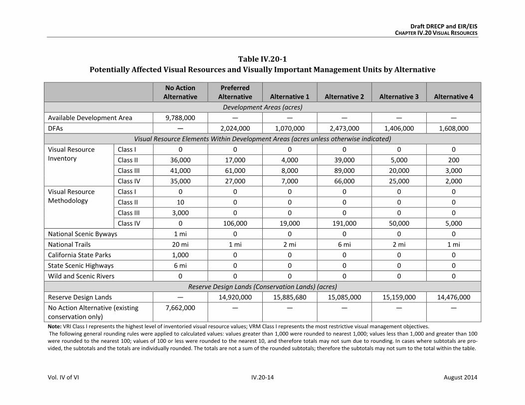
This section presents the impact analysis for the No Action Alternative, the Preferred Alter-
native and Alternatives 1 through 4. Table IV.20-1 summarizes the amount of visually sen-
sitive area occurring under each alternative. For reference, columns from this table are
repeated in the discussion of each alternative to compare the Preferred Alternative with
the No Action Alternative and then with Alternatives 1 through 4.
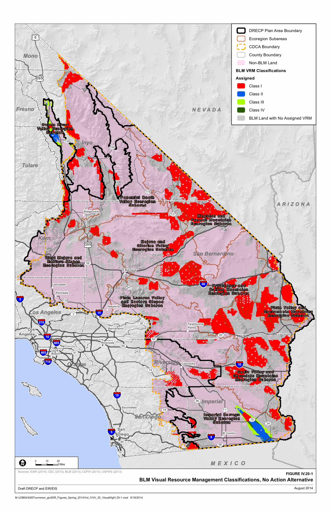
IV.20.3.1 No Action Alternative
The No Action Alternative assumes the state’s renewable energy goals would be achieved
without implementing the DRECP and that mitigation for visual resource impacts from
renewable energy and transmission projects in the Plan Area would occur on a project-by-
Draft DRECP and EIR/EIS CHAPTER IV.20 VISUAL RESOURCES
Vol. IV of VI IV.20-13 August 2014
project basis in a pattern and manner similar to past and ongoing projects and under
applicable laws and regulations.
Under the No Action Alternative, the BLM would not designate new VRM Classes for the
California Desert Conservation Area (CDCA). Under the CDCA plan, visual resources are
addressed through the multiple-use classes, and these designations would remain as they
are currently. In accordance with BLM policy, all wilderness areas and wilderness study
areas (WSAs) are managed as VRM Class I and would continue as VRM Class I under the No
Action Alternative (Figure IV.20-1, BLM VRM Classifications, No Action Alternative).
The No Action Alternative would continue the existing VRM policies or designations in the
CDCA Plan, Bishop Resource Management Plan (RMP), and Imperial Sand Dunes Recreation
Area Management Plan (RAMP) applicable to the Plan Area and the CDCA outside the Plan
Area. (No goals and objectives or management actions were identified for visual resources
under the Caliente RMP.) No new or modified BLM LUPA Conservation Designations would
be implemented, except as they may be required of individual projects. In the absence of
specific resource decisions, management would occur (1) on BLM lands based on existing
federal law, regulations, and BLM policy and guidance and (2) on nonfederal lands based
on applicable federal, state, and local laws, regulations, and plans.
Under the No Action Alternative, visual impacts of future renewable energy development
would be similar to those from current development patterns and technology mixes:
Solar development would be emphasized in the Cadiz Valley and Chocolate Moun-
tains and the Imperial Borrego Valley ecoregion subareas; wind development in the
West Mojave and Eastern Slopes ecoregion subarea; and geothermal in the Imperial
Borrego Valley ecoregion subarea.
One new transmission line is estimated to extend from Imperial Substation to
Sycamore Substation in San Diego.
Solar PEIS Variance Lands would be available for development, as would other lands.
Conservation would continue on existing protected lands (Legislatively and Legally
Protected Areas) and existing areas managed by the BLM for the conservation of
resource values (existing ACECs or wilderness areas), but additional conservation
areas would not be designated.
Draft DRECP and EIR/EIS CHAPTER IV.20 VISUAL RESOURCES
Vol. IV of VI IV.20-14 August 2014
Table IV.20-1
Potentially Affected Visual Resources and Visually Important Management Units by Alternative
No Action
Alternative Preferred
Alternative Alternative 1 Alternative 2 Alternative 3 Alternative 4
Development Areas (acres)
Available Development Area 9,788,000 — — — — —
DFAs — 2,024,000 1,070,000 2,473,000 1,406,000 1,608,000
Visual Resource Elements Within Development Areas (acres unless otherwise indicated)
Visual Resource Inventory
Class I 0 0 0 0 0 0
Class II 36,000 17,000 4,000 39,000 5,000 200
Class III 41,000 61,000 8,000 89,000 20,000 3,000
Class IV 35,000 27,000 7,000 66,000 25,000 2,000
Visual Resource Methodology
Class I 0 0 0 0 0 0
Class II 10 0 0 0 0 0
Class III 3,000 0 0 0 0 0
Class IV 0 106,000 19,000 191,000 50,000 5,000
National Scenic Byways 1 mi 0 0 0 0 0
National Trails 20 mi 1 mi 2 mi 6 mi 2 mi 1 mi
California State Parks 1,000 0 0 0 0 0
State Scenic Highways 6 mi 0 0 0 0 0
Wild and Scenic Rivers 0 0 0 0 0 0
Reserve Design Lands (Conservation Lands) (acres)
Reserve Design Lands — 14,920,000 15,885,680 15,085,000 15,159,000 14,476,000
No Action Alternative (existing conservation only)
7,662,000 — — — — —
Note: VRI Class I represents the highest level of inventoried visual resource values; VRM Class I represents the most restrictive visual management objectives. The following general rounding rules were applied to calculated values: values greater than 1,000 were rounded to nearest 1,000; values less than 1,000 and greater than 100 were rounded to the nearest 100; values of 100 or less were rounded to the nearest 10, and therefore totals may not sum due to rounding. In cases where subtotals are pro-vided, the subtotals and the totals are individually rounded. The totals are not a sum of the rounded subtotals; therefore the subtotals may not sum to the total within the table.
!(
!(
!(
!(
!(
!(
!(
!(
!(
!(
!( !(
!(
!(
§̈¦10
§̈¦405
§̈¦605
§̈¦210
§̈¦15
§̈¦710
§̈¦15
§̈¦10
§̈¦8
§̈¦5
§̈¦40
§̈¦5
£¤6
£¤395
£¤395
UV190
UV58
UV178
UV127
UV78
UV2
UV91
UV86
UV98
UV136
UV168
UV247
UV34
UV74
UV94
UV60
UV138
UV75
UV243
UV62
UV111
UV62
UV38
UV78
Inyo
San Bernardino
Kern
Riverside
Imperial
Tulare
San Diego
Los Angeles
Mono
Fresno
Orange
M E X I C O
O w e n s R i v e r
V a l l e y E c o r e g i o nS u b a r e a
P a n a m i n t D e a t h
V a l l e y E c o r e g i o nS u b a r e a
W e s t M o j a v e a n d
E a s t e r n S l o p e sE c o r e g i o n S u b a r e a
M o j a v e a n d
S i l u r i a n V a l l e yE c o r e g i o n S u b a r e a
K i n g s t o n a n d
F u n e r a l M o u n t a i n sE c o r e g i o n S u b a r e a
P r o v i d e n c e a n d
B u l l i o n M o u n t a i n sE c o r e g i o n S u b a r e a
P i n t o L u c e r n e V a l l e y
a n d E a s t e r n S l o p e sE c o r e g i o n S u b a r e a
P i u t e V a l l e y a n d
S a c r a m e n t o M o u n t a i n sE c o r e g i o n S u b a r e a
C a d i z V a l l e y a n d
C h o c o l a t e M o u n t a i n sE c o r e g i o n S u b a r e a
I m p e r i a l B o r r e g o
V a l l e y E c o r e g i o nS u b a r e a
Escondido
Lancaster
Palmdale
Long
Beach
Ridgecrest
Barstow
Hesperia
Riverside
SanBernardino
Twentynine
Palms
Coachella
El Centro
San
Diego
Los
Angeles
A R I Z O N AA R I Z O N A
N E V A D AN E V A D A
!(
!(
!(
!(
!(
!(
!(
!(
!(
!(
!( !(
!(
!(
§̈¦10
§̈¦405
§̈¦605
§̈¦210
§̈¦15
§̈¦710
§̈¦15
§̈¦10
§̈¦8
§̈¦5
§̈¦40
§̈¦5
£¤6
£¤395
£¤395
UV190
UV58
UV178
UV127
UV78
UV2
UV91
UV86
UV98
UV136
UV168
UV247
UV34
UV74
UV94
UV60
UV138
UV75
UV243
UV62
UV111
UV62
UV38
UV78
Inyo
San Bernardino
Kern
Riverside
Imperial
Tulare
San Diego
Los Angeles
Mono
Fresno
Orange
M E X I C O
O w e n s R i v e r
V a l l e y E c o r e g i o nS u b a r e a
P a n a m i n t D e a t h
V a l l e y E c o r e g i o nS u b a r e a
W e s t M o j a v e a n d
E a s t e r n S l o p e sE c o r e g i o n S u b a r e a
M o j a v e a n d
S i l u r i a n V a l l e yE c o r e g i o n S u b a r e a
K i n g s t o n a n d
F u n e r a l M o u n t a i n sE c o r e g i o n S u b a r e a
P r o v i d e n c e a n d
B u l l i o n M o u n t a i n sE c o r e g i o n S u b a r e a
P i n t o L u c e r n e V a l l e y
a n d E a s t e r n S l o p e sE c o r e g i o n S u b a r e a
P i u t e V a l l e y a n d
S a c r a m e n t o M o u n t a i n sE c o r e g i o n S u b a r e a
C a d i z V a l l e y a n d
C h o c o l a t e M o u n t a i n sE c o r e g i o n S u b a r e a
I m p e r i a l B o r r e g o
V a l l e y E c o r e g i o nS u b a r e a
Escondido
Lancaster
Palmdale
Long
Beach
Ridgecrest
Barstow
Hesperia
Riverside
SanBernardino
Twentynine
Palms
Coachella
El Centro
San
Diego
Los
Angeles
A R I Z O N AA R I Z O N A
N E V A D AN E V A D A
DRECP Plan Area Boundary
Ecoregion Subareas
CDCA Boundary
County Boundary
Non-BLM Land
BLM VRM Classifications
Assigned
Class I
Class II
Class III
Class IV
BLM Land with No Assigned VRM
M:\JOBS4\6287\common_gis\EIR_Figures_Spring_2014\Vol_IV\IV_20_Visual\figIV.20-1.mxd 8/18/2014
FIGURE IV.20-1
BLM Visual Resource Management Classifications, No Action Alternative
0 2010
MilesI
Draft DRECP and EIR/EIS
Sources: ESRI (2014); CEC (2013); BLM (2013); CDFW (2013); USFWS (2013)
August 2014

Draft DRECP and EIR/EIS CHAPTER IV.20 VISUAL RESOURCES
Vol. IV of VI IV.20-16 August 2014
INTENTIONALLY LEFT BLANK

Draft DRECP and EIR/EIS CHAPTER IV.20 VISUAL RESOURCES
Vol. IV of VI IV.20-17 August 2014
IV.20.3.1.1 Impacts Within the Entire Plan Area in No Action Alternative
IV.20.3.1.1.1 Impacts and Mitigation for Renewable Energy and Transmission Development
in No Action Alternative
Impacts
There are more than 9.7 million acres of Available Development Areas (ADAs) in the Plan
Area under the No Action Alternative, resulting in a projected 123,000 acres of long-term
disturbance (see Table IV.1-1). ADAs include both federal and nonfederal lands and repre-
sent nearly half of the entire Plan Area. Visual impacts associated with this scale of devel-
opment would be dispersed across the Plan Area in accordance with allowances within
existing BLM multiple-use classes and County plans.
Current development patterns emphasize solar in the Cadiz Valley and Chocolate Moun-
tains and the Imperial Borrego Valley ecoregion subareas; wind in the West Mojave and
Eastern Slopes ecoregion subarea; and geothermal in the Imperial Borrego Valley
ecoregion subarea.
Impacts to visual resources in various areas under the No Action Alternative are as follows
(see Appendix R2.20, Table R2.20-1 for additional detail):
There are approximately 36,000 acres of VRI Class II lands, 41,000 acres of VRI Class
III lands, and 35,000 acres of VRI Class IV lands within ADAs under the No Action
Alternative. Protection of the scenic values identified for these lands would continue
to be through the application of current CDCA multiple-use class guidelines or from
existing VRM assignments under existing management plans.
Approximately 10 acres of BLM land in ADAs are VRM Class II, and 3,000 acres are
VRM Class III under the No Action Alternative. These lands would continue to be
managed according to their VRM classifications. New VRM Classes would not be
assigned under the No Action Alternative. VRM objectives would be applied only to
existing classified lands, wilderness areas (VRM I), and WSAs (VRM Class I).
Less than 1 mile of Bradshaw Trail National Back Country Byway is within an ADA.
Approximately 20 miles of National Scenic and Historic Trails are within ADAs,
potentially affecting the visitor experience of people using those trails. Under the No
Action Alternative, no Trail Management Corridors would be established along these
trails, although buffering of trails could be imposed on a case-by-case basis during
project review and approval.
Approximately 900 acres of California State Park lands are within ADAs.
Draft DRECP and EIR/EIS CHAPTER IV.20 VISUAL RESOURCES
Vol. IV of VI IV.20-18 August 2014
ADAs do not include any portion of National Parks or Preserves or segments of State
Scenic Highways under the No Action Alternative.
ADAs do not include any designated or eligible Wild and Scenic River corridors
under the No Action Alternative.
Under the No Action Alternative, there would be a high potential for visual impacts to occur
where land available for facility development abuts or is visible from Legislatively and
Legally Protected Areas. These include Mojave National Preserve, Death Valley National
Park, Joshua Tree National Park, numerous Congressionally designated wilderness areas,
and the west side of the Imperial Sand Dunes Recreation Area.
The impacts to visual resources resulting from the No Action Alternative are as follows.
Impact VR-1: Visibility of activities, materials, equipment, dust, and construction night
lighting would result in short-term diminished scenic quality.
Pre-construction activities and equipment visible from residences, public roads, and public
preserves would result in short-term diminished scenic quality for viewers. Examples
include road upgrading, damage to or removal of native vegetation, construction of
meteorological towers, drilling of temperature gradient wells, vehicles, and lighting.
During construction and decommissioning, activities and equipment visible from residences,
public roads, and public preserves would result in short-term diminished scenic quality for
viewers. Examples include dust and exhaust emissions, removal of vegetation during site
clearing, contouring and grading, use of vehicles and equipment, mobilization and
demobilization activities, material delivery and staging, assembly of components, site light-
ing, and construction of and later removal of structures.
Impact VR-2: The presence of Plan components would create long-term visual contrast
with surrounding undeveloped land and result in long-term diminished scenic quality.
The continued presence of equipment, structures, fencing, roads, lighting, and other ele-
ments required to operate a facility would have a long-term adverse effect on the visible
landscape. Areas of persistent surface and vegetation disturbance and the presence of
structures would create visual contrast in form, line, color, and texture as compared with
pre-project conditions. Depending on viewer location, physical elements introduced by a
project could block views or create skylining. Even after project removal and site reclama-
tion are completed, visual contrast would remain. Restoring the natural, pre-disturbance
visual character of a desert environment is extremely difficult, can take decades, and often
is unsuccessful. Therefore, surface and vegetation disturbance would create long-term
visual impacts due to the persistence of scars in arid and semi-arid landscapes.
Draft DRECP and EIR/EIS CHAPTER IV.20 VISUAL RESOURCES
Vol. IV of VI IV.20-19 August 2014
Renewable energy projects, particularly utility-scale solar facilities, would create new
sources of light and/or glare that would affect daytime and nighttime views and result in
long-term impairment of scenic quality. Depending on the technology, solar facilities use a
multitude of mirrored surfaces that can be sources of glint (a brief flash of light) or glare
(light bright enough to cause annoyance or discomfort) (BLM 2013). Solar facilities are
capable of causing off-site glare that may cause annoyance, discomfort, or in certain cir-
cumstances, ocular damage. In some instances, the glare can be bright enough to cause a
viewer to close their eyes in reaction (Sullivan, et al. 2012).
Glint and glare are safety concerns, particularly with regard to vehicle operators and pilots
for whom even momentary blindness is a human safety threat. Recently, the Federal
Aviation Administration received complaints in which glare was identified as a flight haz-
ard because it allegedly impaired the ability of the pilot to fully scan the sky for other
aircraft (The Press-Enterprise 2014). Two pilot complaints of adverse visual impacts from
the Ivanpah Solar Electric Generating System were received by the California Energy Com-
mission from the Clark County Department of Aviation (Spectrus 2014).
Glare from solar receivers also adversely affects the views and visitor experience of recrea-
tionists and can be seen from wilderness areas at distances less than 5 miles (California
Energy Commission 2013).
Glint and glare from wind and geothermal facilities is a concern as well. Glare and glinting
from white wind turbine blades increases their contrast with the surrounding natural land-
scape. If geothermal facilities and pipe networks are not painted or coated appropriately to
reduce reflectance and blend with the landscape, their surfaces may be highly visible.
The structure, size, and industrial character of utility-scale renewable energy and transmis-
sion facilities during their operation and maintenance—as well as any associated glare,
reflectivity, and lighting—would visually contrast with surrounding undeveloped land and
result in long-term diminished scenic quality.
Laws and Regulations
Existing laws and regulations would reduce the impacts of renewable energy
development projects in the absence of the DRECP. Relevant regulations are presented in
the Regulatory Setting in Volume III. Note that because this EIR/EIS addresses
amendments to BLM’s land use plans, these plans are addressed separately and are not
included in this section. The requirements of relevant regulations would reduce impacts
through the following mechanisms:
Federal Land Policy and Management Act of 1976 – This act mandates public
lands be managed in a manner that will protect the quality of the scenic (visual)
values of these lands.
Draft DRECP and EIR/EIS CHAPTER IV.20 VISUAL RESOURCES
Vol. IV of VI IV.20-20 August 2014
Solar PEIS – Numerous design features have been adopted by BLM that would
avoid, minimize, and/or mitigate potential impacts on visual resources from solar
energy development (see Appendix W). It is assumed that these or similar design
features would apply to all renewable energy and transmission projects developed
within the Plan Area. These design features include various actions listed as num-
bers VR-1 through VR-4 in the Solar PEIS to reduce visual impacts (BLM and Depart-
ment of Energy 2010):
o VR1-1: Requires assessing conformance to VRM Class designations and iden-
tifying visual resource conflicts. Among the actions to be taken are consulting
with BLM; factoring VRI Class values into project planning and design; including
a qualified professional with VRM experience on the development team; consult-
ing the local public to identify important visual resources in the area; consulting
on viewshed protection with managers responsible for areas with special desig-
nations; evaluating impacts on historic trails; considering landscape setting
observed from National Parks, National Historic Sites, and similar areas; using
topographical data of engineering-design quality and digital terrain mapping for
project planning and design; preparing simulations depicting project facilities as
seen from key observation points and visual resource–sensitive locations; con-
ducting public outreach to disseminate visual resource information; and per-
forming visual mitigation planning and design based on field assessments and
other means.
o VR2-1: Requires consideration of siting and design to minimize glint and glare
and taking appropriate actions. These actions include identifying glint and glare
effects, assessing and quantifying these effects to determine potential safety and
visual impacts, and having qualified people conduct such assessments. Methods
to minimize glint and glare include limiting use of signs; using reflective or
luminescent markers instead of permanent lighting; minimizing off-site visibility
of signs and lighting; using nonglare materials and appropriate colors; mitigating
or offsetting visual impact by reclaiming unnecessary roads, removing abandoned
buildings, using undergrounding utility lines, and rehabilitating and revegetating
disturbed areas; and other actions determined in consultation with the BLM.
o VR2-2: Requires solar facilities be sited and designed to minimize night-sky
effects. Identification of night-sky effects is to include assessing and quantifying
potential lighting impacts and conducting assessments by using qualified indi-
viduals. Methods to minimize night-sky effects include using minimum intensity
lighting of an appropriate color consistent with safety needs, prohibiting strobe
lighting except where it is required for safety; shielding all permanent lighting
unless otherwise required for safety; mounting lighting so that light is downward
focused; controlling lighting with timers, sensors, and dimmers; and using

Draft DRECP and EIR/EIS CHAPTER IV.20 VISUAL RESOURCES
Vol. IV of VI IV.20-21 August 2014
vehicle-mounted lights for nighttime maintenance work rather than permanently
mounted lighting.
o VR2-3: Requires that the siting and design of solar and related facilities explore
and document means to reduce visual dominance in the viewshed and that the
project comply with VRM Class objectives. Methods include conforming with
VRM Class objectives (through use of BLM Handbook H-8431-1); determining
the extent of the viewshed and selecting key observation points where people
are expected to be observing the landscape; integrating visual design elements
into plans, details, drawings, and specifications; and siting the facility to mini-
mize the profile of all structures. Ways to minimize visual dominance include
using existing topography and vegetation as screening; considering visual design
elements when clearing vegetation and doing earthwork; siting projects outside
of key observation point viewsheds; avoiding locating facilities near visually
prominent landscape features; avoiding skylining of structures; designing linear
features to follow natural land contours rather than straight lines; locating linear
features at the edges of natural lines of transition between vegetation types and
topography; using alternative means of access in visually sensitive areas to
preserve landscape conditions; minimizing vegetation and ground disturbance;
reducing cut and fill; shaping, staining, and vegetating excavations to conform
with local conditions; creating natural-looking earthwork forms; repeating char-
acteristics of naturally occurring openings in vegetation for roads, structures,
and similar elements; burying linear utilities and lines along roads or paths;
selecting appropriate materials and surface treatments for structures to reduce
visual contrast; using nonspecular conductors and nonreflective coatings on
transmission lines; minimizing signage; delineating construction limits and mini-
mizing area of surface disturbance; salvaging vegetation and topsoil for reuse;
and removing stakes and flagging after construction.
o VR2-4: Requires preconstruction meetings with the BLM and designated spe-
cialists to coordinate the VRM mitigation strategy. This includes a review of final
design and construction documents with regard to visual impacts and mitigation.
o VR3-1: Requires the project developer to monitor compliance with VRM mitiga-
tion requirements and consult with the BLM during operations and maintenance.
Maintaining visual resource design elements would include maintaining
revegetated surfaces until self-sustaining; keeping facilities in good repair and
repainting as necessary; restoring lands as soon as possible after disturbance;
controlling dust and noxious weeds; and operating so as to avoid high-intensity
light (glare) being reflected off site.

Draft DRECP and EIR/EIS CHAPTER IV.20 VISUAL RESOURCES
Vol. IV of VI IV.20-22 August 2014
o VR4-1: Requires immediate reclamation of the site after construction. Methods
for minimizing visual contrast during reclamation and decommission include
undertaking treatments such as thinning and feathering vegetation at project
edges, enhancing contouring, salvaging landscape materials, and revegetating;
restoring the project area to predevelopment visual conditions and the inven-
toried visual quality rating; removing aboveground and near-ground-level struc-
tures; contouring soil borrow areas and other features to approximate natural
slopes; using native vegetation to establish form, line, color, and texture con-
sistent with the surrounding undisturbed landscape; distributing stockpiled
topsoil to disturbed areas and replanting; and removing or burying gravel or
other surface treatments.
Existing VRM policies or designations – These incorporate those in the CDCA
Plan, Bishop RMP, Imperial Sand Dunes RAMP, and other BLM guidance, including:
o BLM’s Manual 8400 – VRM system addresses BLM’s basic responsibility to
identify and protect the quality of the scenic (visual) values on all BLM lands.
The VRM system requires visual design considerations be incorporated into
all surface-disturbing projects regardless of size or potential impact.
Guidance on visual management for renewable energy projects is in BLM’s Best
Management Practices for Reducing Visual Impacts of Renewable Energy Facilities on
BLM-Administered Lands (BLM 2013). These BMPs provide a comprehensive set of
strategies for avoiding and reducing visual impacts associated with renewable
energy generation facilities and ancillary components, such as electric transmission,
roads, and structures. They also address project siting and design and other key
activities that can have a major effect on visual quality. Examples include mitigation
planning, structure design and materials selection, paint colors, material surface
treatments, lighting practices, and soils and vegetation management.
Mitigation
Many visual impact mitigation measures applicable to existing renewable energy projects
would be adopted and applied to future projects under the No Action Alternative (see
Appendix W and the previous discussion under Laws and Regulations). Examples of gen-
eral visual impact mitigation measures applicable to any project implemented in the
absence of Plan approval include:
Modifying facility designs, colors, locations, and materials to reduce visibility
and contrast.
Adjusting site configurations and harmonizing earthwork with local topographic
forms and contours.

Draft DRECP and EIR/EIS CHAPTER IV.20 VISUAL RESOURCES
Vol. IV of VI IV.20-23 August 2014
Treating structure surfaces to reduce contrast and glare.
Minimizing lighting overall, using fixtures that minimize night-sky impacts and
down-focus fixtures.
Avoiding unnecessary ground disturbance beyond what is required for the project.
Controlling dust and erosion.
Restoring and managing disturbed land and vegetation.
Restoring and reclaiming areas as soon as feasible.
Examples of visual mitigation measures applicable to solar projects include development
and implementation of a glint and glare mitigation and monitoring plan; screening of solar
collectors from roads; retaining vegetation beneath solar collector arrays; prohibiting com-
mercial signs, logos, or messages on towers and arrays; and using visually compatible color
treatments and nonreflective materials for support structures and other components. In
addition to direct reduction in visual quality, visual quality degradation can compromise
the integrity of historical resources or traditional cultural places. In cases where such
visual impacts occur, compensatory mitigation can include requiring research, field
inventories, worker training, and other efforts specific to the resource and groups affected.
Examples of visual mitigation measures for wind energy projects include siting to reduce
visibility, clustering turbines, creating visual order and unity among groups of turbines,
using radar-activated visual warning systems to reduce night-sky impacts, prohibiting
signs and messages on towers, keeping turbines clean and in good repair, and promptly
removing disused or abandoned equipment and parts.
Examples of visual mitigation measures specific to geothermal energy projects include using
air-cooled systems (to avoid plumes that water-cooled systems may generate under some
conditions), minimizing drill rig and well-test facility lighting, and screening of pipelines.
IV.20.3.1.1.2 Impacts from Reserve Design in the No Action Alternative
There would be no reserve design under the No Action Alternative. Renewable energy proj-
ects would be evaluated and approved on a case-by-case basis with project-specific mitiga-
tion requirements imposed by the responsible agencies. In the absence of approval of a
DRECP action alternative, there would be continued protection of existing Legislatively and
Legally Protected Areas, such as parks and wilderness areas, under existing laws
and regulations.
It is assumed that under the No Action Alternative, mitigation requirements would include
conservation actions to offset resource impacts to particular resources, such as protected
Draft DRECP and EIR/EIS CHAPTER IV.20 VISUAL RESOURCES
Vol. IV of VI IV.20-24 August 2014
species. These measures would include land acquisition, conservation easements, or other
agreements that would set aside and protect areas, which would increase the amount of
conserved land under the No Action Alternative compared with the current amount of con-
served land. Such conservation actions would reduce the potential for long-term adverse
impacts to visual resources to occur or persist on lands being conserved or restored as part
of biological or other resource mitigation requirements.
Tables in Appendix R2 quantify the amount of visual resource elements of concern occur-
ring within existing protected areas (Legislatively and Legally Protected Areas, Military
Expansion Mitigation Lands, and BLM ACECs). Under the No Action Alternative, existing
protected areas and BLM Conservation Designations would provide ongoing conservation
of resources, including visual resources; however, there would be no reserve design estab-
lished to guide where BLM Conservation Designations might be established in the future or
where reserves and conservation areas could be assembled to offset the effects of renew-
able energy or transmission development. Any additional conservation associated with
renewable energy or transmission development would derive solely from the mitigation
requirements imposed on a project-by-project basis.
Existing conservation areas in the No Action Alternative cover approximately 7.7 million
acres of the Plan Area. Conserved and protected lands include wilderness areas, Military
Expansion Mitigation Lands, and ACECs as well as portions of National Scenic and Historic
Trails, Scenic Highways, and Wild and Scenic Rivers. Visual resources in these areas would
continue to benefit from the policies and requirements applicable to the conservation of
these lands. (See Appendix Table R2.20-2, for detailed data.) The amount and location of
any additional conserved lands that might be added to the total through mitigation
acquisition would be determined on a project-by-project basis as impacts become known
and offsets required.
IV.20.3.1.2 Impacts on BLM Lands of Existing BLM Land Use Plans in No Action Alternative
The No Action Alternative would continue the existing visual management policies set forth
in the CDCA Plan, Bishop RMP, and Imperial Sand Dunes RAMP. (The Caliente RMP does not
include goals and objectives or management actions specifically identified for visual
resources.) The Bishop RMP and Imperial Sand Dunes RAMP each have assigned VRM
Classes, which would continue to set objectives for visual resource management in
those plan areas.
Under the No Action Alternative, existing BLM land use plans within the Plan Area would
continue to apply and renewable energy development would be allowed in certain land
designations, including Solar Energy Zones and Solar PEIS Variance Lands. In addition, as
Draft DRECP and EIR/EIS CHAPTER IV.20 VISUAL RESOURCES
Vol. IV of VI IV.20-25 August 2014
has been the case for previous individual solar, wind, and transmission projects on BLM
land, new projects would be approved along with project-specific LUPAs, if required. In all
cases, BLM’s policies and guidance for visual impact assessment and impact reduction
would apply.
Existing BLM plans identify various land designations and associated management actions
for existing protected areas, such as ACECs, SRMAs, and National Scenic and Historic Trails.
Protective measures in these designations offer a level of protection for visual resources
under the No Action Alternative.
Under the No Action Alternative, solar energy development on BLM-administered land
would be subject to the Solar PEIS. The Solar PEIS created a comprehensive set of updated
and revised policies and procedures, including standards for visual resource management,
and established categories of lands excluded from utility-scale solar development. Both
actions could help protect visual resources within the Plan Area.
The Wind PEIS Record of Decision (December 2005) established policies, BMPs, and mini-
mum mitigation requirements for wind development on BLM land. However, the Wind PEIS
did not amend BLM plans in the Plan Area. Therefore, under the No Action Alternative,
wind energy development within the Plan Area would be under the existing CDCA Plan;
and wind energy right-of-way applications would continue to be considered on a case-by-
case basis. (The Bishop and Caliente RMPs do not address wind energy.)
The following summarizes the key aspects of visual impacts on BLM lands under existing
BLM Land Use Plans in the No Action Alternative. These include visual resources within
BLM conservation lands (i.e., existing SRMAs and ACECs). Table R2.20-3 in Appendix R2
includes detailed information. The following are within existing SRMAs and/or ACECs:
3.3 million acres of VRI classified lands
898,000 acres of VRM classified lands
23 miles of the Bradshaw Trail National Back Country Byway
157 miles of National Trails
22 miles of the Amargosa River
Currently, VRM Classes are assigned only for the Bishop Field Office and the Imperial Sand
Dunes RAMP. As well, under BLM policy, VRM Class I is assigned to wilderness areas and
WSAs. This would not change under the No Action Alternative. Generally, a low correlation
between the VRM Classes and the underlying VRI Classes results in a greater potential for
adverse impacts to visual quality (e.g., VRI Class II or III lands managed to meet the objec-
tives of VRM Class IV). Conversely, impacts would most likely be reduced by alternatives
Draft DRECP and EIR/EIS CHAPTER IV.20 VISUAL RESOURCES
Vol. IV of VI IV.20-26 August 2014
proposing visual resource management that either closely corresponds to the VRI classes
or proposes a more restrictive (higher) class designation (e.g., VRI Class III lands managed
to meet the objectives of VRM Class II.)
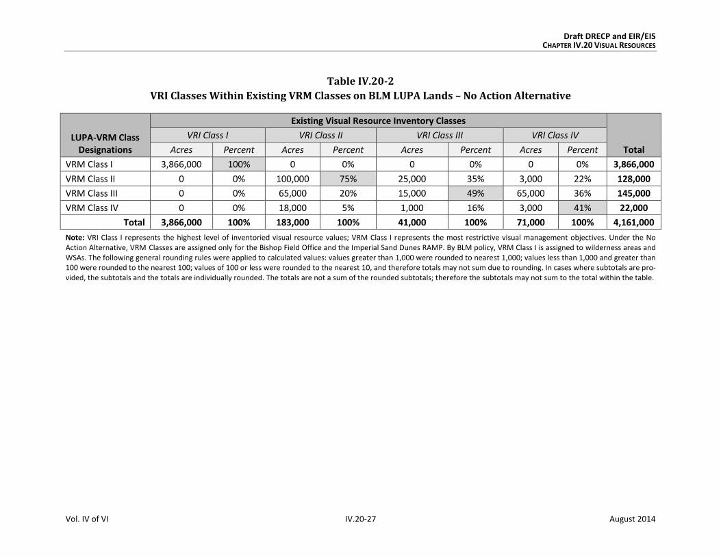
Under the No Action Alternative, VRI Class lands within the VRM Classes on BLM LUPA
lands would be as shown in Table IV.20-2.
The following summarizes the key points from this comparison of VRI Classes and existing
VRM Classes under the No Action Alternative:
By BLM policy, all existing VRI Class I lands in the Plan Area are assigned VRM Class
I for management purposes. This is due to wilderness areas and WSAs being desig-
nated VRM Class I. The breakdown by VRI Classification is as follows:
o VRI I: 100% of VRI Class I lands, including wilderness areas and WSAs, would
continue to be managed as VRM Class I, reflecting a high level of
management protection.
o VRI II: 75% of VRI Class II lands would continue to be managed as VRM Class II,
reflecting a moderately high level of management protection. Approximately
20% would continue to be managed as VRM Class III and 5% as VRM Class IV.
o VRI III: More than 84% of VRI Class III lands would continue to be managed as
VRM Class III or as II, reflecting a moderate to high level of management protec-
tion. Approximately 35% would continue to be managed to meet VRM Class II
objectives, which restrict visual contrast and affect more than VRM Class III
does. Approximately 16% would be managed as VRM Class IV, which allows for
more visual contrast and impact than VRM Class III objectives allow.
o VRI Class IV: More than 58% of VRI Class IV lands would continue to be man-
aged as VRM Class II or III; 41% would continue to be managed as VRM Class IV.
Draft DRECP and EIR/EIS CHAPTER IV.20 VISUAL RESOURCES
Vol. IV of VI IV.20-27 August 2014
Table IV.20-2
VRI Classes Within Existing VRM Classes on BLM LUPA Lands – No Action Alternative
LUPA-VRM Class Designations
Existing Visual Resource Inventory Classes
Total
VRI Class I VRI Class II VRI Class III VRI Class IV
Acres Percent Acres Percent Acres Percent Acres Percent
VRM Class I 3,866,000 100% 0 0% 0 0% 0 0% 3,866,000
VRM Class II 0 0% 100,000 75% 25,000 35% 3,000 22% 128,000
VRM Class III 0 0% 65,000 20% 15,000 49% 65,000 36% 145,000
VRM Class IV 0 0% 18,000 5% 1,000 16% 3,000 41% 22,000
Total 3,866,000 100% 183,000 100% 41,000 100% 71,000 100% 4,161,000
Note: VRI Class I represents the highest level of inventoried visual resource values; VRM Class I represents the most restrictive visual management objectives. Under the No Action Alternative, VRM Classes are assigned only for the Bishop Field Office and the Imperial Sand Dunes RAMP. By BLM policy, VRM Class I is assigned to wilderness areas and WSAs. The following general rounding rules were applied to calculated values: values greater than 1,000 were rounded to nearest 1,000; values less than 1,000 and greater than 100 were rounded to the nearest 100; values of 100 or less were rounded to the nearest 10, and therefore totals may not sum due to rounding. In cases where subtotals are pro-vided, the subtotals and the totals are individually rounded. The totals are not a sum of the rounded subtotals; therefore the subtotals may not sum to the total within the table.

Draft DRECP and EIR/EIS CHAPTER IV.20 VISUAL RESOURCES
Vol. IV of VI IV.20-28 August 2014
IV.20.3.1.3 Impacts of Natural Community Conservation Plan in No Action Alternative
The NCCP would apply to all lands within the Plan Area. In the absence of Plan implementa-
tion, the NCCP would not be approved; and no incidental take permits would be issued
under the NCCP. Projects would continue to be considered by the appropriate lead agency
on an individual basis. The impacts that would occur in the absence of the NCCP would be
the same as those described in Section IV.20.3.1.1.1, Impacts and Mitigation for Renewable
Energy and Transmission Development in No Action Alternative, (Plan-wide analysis).
IV.20.3.1.4 Impacts of General Conservation Plan in No Action Alternative
As described in Appendix M, the GCP would apply to nonfederal lands in the Plan Area. In
the absence of Plan implementation, the GCP would not be approved; and no incidental
take permits would be issued under the GCP. Projects would continue to be considered by
the appropriate lead agency on an individual basis. The impacts that would occur in the
absence of the GCP would be the same as those described in Section IV.20.3.1.1.1 (Plan-wide
analysis) but would be specific to nonfederal lands.
IV.20.3.1.5 Impacts Outside the Plan Area in No Action Alternative
It is feasible to characterize existing visual conditions in identified transmission
corridors, but project-level analyses would be required to determine specific future
projects’ impacts on visual resources. The methodology used for project-level analyses
would vary depending on the agency with jurisdiction over the land involved. Analyses of
visual impacts on BLM lands use BLM’s VRM system (described in detail in Volume III,
Section III.20.1.1.2). For facilities on lands administered by the Angeles, San Bernardino,
and Cleveland National Forests, the analytical approach is described in the U.S. Forest
Service’s Scenery Management System. For projects subject to CEQA, the analysis would
address the criteria established in the CEQA Guidelines to determine the significance of
impacts to aesthetics and visual resources.
Development or enhancement of transmission and substation facilities outside the Plan
Area would occur in a variety of remote, rural, suburban, and urban settings. In general, the
visual character of a landscape is defined by the amount and type of development found
within the setting, natural variations in topography, and the density and height of vegeta-
tion. Color, hue, and contrast are important variables to be considered in any analysis. The
geographic area from which a transmission line or substation would be visible is referred
to as the facility’s viewshed; this is primarily determined by the surrounding land elevation
relative to the facility location and the landforms, structures, or vegetation that would
block views that otherwise would exist. A facility’s effective viewshed is limited by dis-

Draft DRECP and EIR/EIS CHAPTER IV.20 VISUAL RESOURCES
Vol. IV of VI IV.20-29 August 2014
tance; with increased distance between a facility and a viewer, atmospheric moisture and
particles affect the visibility and distinctness of the facility. The perceived color, contrast,
and size of a facility relative to its surroundings diminish; and the facility becomes
indistinct and blends into the background.
Transmission lines and substations differ in their visible elements, how they are situated in
the landscape, and the duration of views. Transmission lines are linear facilities that intro-
duce rhythmic, repeating elements across a landscape. These ribbon-like facilities extend
many miles. They consist of stand-alone tower structures ranging from 100 to 160 feet
high. Although it varies by terrain, spacing can be uniform, typically 4 to 5 per mile for 500-
kilovolt lines and 7 to 10 per mile for 230-kilovolt lines. Depending on tower types, they
may require a permanently cleared area beneath them. They also may require new access
roads to and along their rights-of-way, and stub roads extended from those roads to tower
sites if they do not already exist.
In contrast to transmission lines, substations are confined, single-site facilities. Outside the
Plan Area, such facilities receiving renewable power are expected to be sited at or near
existing 500/230-kilovolt substations. Large substations can include pads that extend over
dozens of acres, with additional space for access roads, water tanks, and buffers. For exam-
ple, the DRECP Transmission Technical Group assumed that 176 acres would be required
for a high transmission substation to incorporate the disturbance from additional infra-
structure. Circuit breakers, disconnect switches, transformers, capacitors, and associated
equipment, as well as control or equipment buildings and firewalls, are typical ground-
level elements of a substation. Dead-end structures used to loop lines in and out of the sub-
station, busses, and overhead structures above the equipment and facilities are also
situated on the substation pad. Typically, these are lattice- or tubular-steel components
with cross members.
IV.20.3.1.5.1 Impacts of Transmission Outside the Plan Area
Outside the Plan Area, additional transmission lines would be needed to deliver the addi-
tional renewable energy to load centers (areas of high demand). It is assumed that
transmission outside the Plan Area would use existing transmission corridors that run
between the Plan Area and existing substations in the more populated coastal areas of the
state. Existing substations would serve as the portals for the power to be transmitted from
the desert to load centers. These portals include Whirlwind, Vincent, Lugo, Devers,
Suncrest, and Imperial substations. These are the same under the No Action Alternative,
the Preferred Alternative, and Alternatives 1 through 4. Likewise, the transmission
corridors outside the Plan Area are the same for all alternatives. Therefore, at a
programmatic level, there is no difference among the alternatives based on transmission
outside the Plan Area. The actual corridors used and the number and type of transmission
Draft DRECP and EIR/EIS CHAPTER IV.20 VISUAL RESOURCES
Vol. IV of VI IV.20-30 August 2014
lines installed would depend upon the ultimate location of generation facilities in the Plan
Area. Any transmission projects proposed outside the Plan Area would need a project-
specific environmental review.
Existing corridors contain transmission towers, conductors, and access roads; therefore, a
degree of visual impact already is present. The type and degree of visual impacts in these
corridors would vary based on whether the area through which the corridor passes is
undeveloped or urbanized.
There are relatively open landscapes between the substations acting as portals from the
Plan Area to the urbanized areas where the electrical demand exists. This open landscape is
in a mix of public and private ownership. In Southern California, the transition from open
landscapes to urban landscapes can be abrupt. Areas subject to BLM or U.S. Forest Service
jurisdiction would require project-by-project analysis under their respective visual man-
agement protocols. Areas subject to state or local jurisdiction would be subject to project-
by-project analysis by the California Public Utilities Commission, which has authority over
high-voltage transmission lines.
Impacts to visual resources from construction of transmission lines outside the Plan Area
would be as follows:
Impact VR-1: Visibility of activities, materials, equipment, dust, and construction night
lighting would result in short-term diminished scenic quality.
Pre-construction activities and equipment would be visible to observers in the vicinity of
the work would result in short-term diminished scenic quality for viewers. Examples
include access road upgrading, damage to or removal of native vegetation, and presence
and movement of vehicles, dust, and lighting. This would be true for both open landscapes
and urbanized areas.
Impact VR-2: The presence of plan components would create long-term visual contrast
with surrounding undeveloped land and result in long-term diminished scenic quality.
Transmission towers and conductors would have an adverse effect on the visible land-
scape. Areas of persistent surface and vegetation disturbance, such as access roads and
tower footprints, and the presence of structures would create visual contrast with existing
conditions. Depending on viewer location, physical elements introduced by a project could
create skylining. These effects would be similar to those of existing lines. Surface and vege-
tation disturbance would create long-term visual impacts due to the persistence of scars in
arid and semi-arid landscapes. The presence of towers, roads, and other elements required
to operate a transmission facility would have a long-term effect on visual resources.

Draft DRECP and EIR/EIS CHAPTER IV.20 VISUAL RESOURCES
Vol. IV of VI IV.20-31 August 2014
Notably, transmission lines create long linear features in the landscape visible from a con-
siderable distance in flat terrain.
In open landscapes through which portions of these corridors pass, such as national forests
or the desert, visual contrast would remain even after decommissioning and removal of
facilities. Restoring the natural, pre-disturbance visual character of an arid or semi-arid
environment is difficult, can take decades, and is not always successful. Surface and vegeta-
tion disturbance would create long-term visual impacts due to the persistence of scars in
arid and semi-arid landscapes.
In urbanized areas, the lines would be in existing transmission corridors mostly
surrounded by urban development. The presence of buildings and vegetation would tend
to block long sightlines to the transmission structures, limiting the area from which they
could be seen. If new towers are located near existing towers, this would increase the num-
ber of industrial-like elements visible within the urban setting. However, this would be an
incremental increase over existing conditions and not a radical departure. In some cases,
existing transmission lines would be replaced with upgraded towers and conductors. This
would exchange one set of visual impacts for another similar set, potentially reducing the
number of towers visible but possibly introducing taller towers into the view.
Visual impacts from the construction and operation of transmission lines outside the Plan
Area would be reduced by application of various mitigation measures. Generally, applicable
measures to lessen impacts include controlling dust, aligning tower locations so they are
adjacent, locating towers so they do not skyline on ridges, and using nonreflective
(nonspecular) surface treatments. The level of significance of the impacts can be deter-
mined only through a detailed analysis of proposed actions at specific locations.
IV.20.3.1.5.2 Impacts of Existing BLM Land Use Plans Outside the Plan Area
Under the No Action Alternative, the existing BLM CDCA land use plan would continue to be
implemented on CDCA lands; and renewable energy projects would still be developed
through BLM’s existing policies. Impacts on visual resources would be of the types described
in Section IV.20.2.1 with similar mitigation measures being included on a case-by-case
basis. Existing land designations—such as existing protected areas, ACECs, SRMAs, and
National Scenic and Historic Trails—would continue to be managed to protect their associ-
ated scenic values and visual resources.
The following summarizes the key aspects of the visual resource elements occurring on BLM
land designations outside the Plan Area (see Table R2.20-4 in Appendix R2 for detailed data).
VRI Classes: Approximately 233,000 acres of VRI lands are within existing SRMAs
and/or ACECs outside the Plan Area.

Draft DRECP and EIR/EIS CHAPTER IV.20 VISUAL RESOURCES
Vol. IV of VI IV.20-32 August 2014
VRM Classes: Approximately 138,000 acres of VRM lands are within existing SRMAs
and/or ACECs outside the Plan Area.
National Scenic Byways: Approximately 6 miles of the Bradshaw Trail National
Back Country Byway are within existing SRMAs and/or ACECs outside the Plan Area.
National Scenic and Historic Trails: No segments of National Scenic and Historic
Trails are within existing SRMAs and/or ACECs outside the Plan Area.
Wild and Scenic Rivers: No segments of Wild and Scenic Rivers are within existing
SRMAs and/or ACECs outside the Plan Area.
IV.20.3.1.6 CEQA Significance Determination: No Action Alternative
Section IV.20.1.2, CEQA Standards of Significance, identifies four criteria to apply when
determining if there are significant impacts from a project under CEQA. These criteria are
included as part of the more general impacts identified in this section as VR-1 and VR-2.
The visual impacts and their associated significance determinations for the No Action Alter-
native are as follows:
VR-1: Visibility of activities, materials, equipment, dust, and construction night
lighting would result in short-term diminished scenic quality. Existing prescriptive
measures for avoiding, reducing, and mitigating short-term visual impacts, as required
under existing laws and regulations and described previously, would reduce short-term
visual effects. However, to fully mitigate these impacts to less than significant levels,
additional mitigation would be necessary. These measures, defined in Section IV.20.3.1.1.1,
include controlling dust, screening construction yards, and minimizing night lighting. If
fully and successfully implemented, these combined measures would reduce short-term
impacts to less than significant levels in most cases.
VR-2: The presence of plan components would create long-term visual contrast with
surrounding undeveloped land and result in long-term diminished scenic quality.
Long-term visual impacts would be significant and unavoidable, even with the application
of mitigation. The size and industrial character of utility-scale renewable energy and trans-
mission facilities would create visual contrast with the surrounding landscape and result in
long-term diminished scenic quality for viewers. Even with application of mitigation mea-
sures (such as use of earth-tone surface treatments, minimization of roads, and alternate
site layouts), the extensive alteration of the physical landscape and presence of numerous
manmade structures extending over considerable acreage would create a long-term signifi-
cant impact on visual resources.
Draft DRECP and EIR/EIS CHAPTER IV.20 VISUAL RESOURCES
Vol. IV of VI IV.20-33 August 2014
Prescriptive measures for avoiding, reducing, and mitigating long-term construction, oper-
ations, and decommissioning visual impacts, as required under existing laws and regula-
tions, would have limited effectiveness, even if fully implemented. For example:
Tall and brightly illuminated power tower receivers would be highly visible over a
great distance, introducing a tall vertical element into the landscape and creating a
strong visual contrast to existing conditions. In addition, a solar project would dis-
turb large areas of ground surface, creating visual contrast; and operations would
contribute to glare, light pollution, and diminished night-sky darkness, resulting in
diminished scenic quality.
Tall and night-illuminated wind turbines and support structures would be highly
visible and create strong visual contrast, resulting in diminished scenic quality.
Towers, nacelles, and rotors may need to be upgraded or replaced, thereby
repeating initial visual impacts of construction and assembly.
Geothermal facilities and steam plumes would create a strong visual contrast and
result in diminished scenic quality.
Although photovoltaic projects would generally have lower visual impacts than the
other technologies because of the lower profile of collector arrays, reflective glass
plates would create glare, attracting visual attention and creating a strong visual
contrast under certain light conditions, resulting in diminished scenic quality.
Increased structure contrast, industrial character, tower and conductor reflectivity,
maintenance access, and skylining associated with additional transmission lines
would result in long-term diminished scenic quality for viewers. New substation
facilities would introduce strong visual contrast in line, form, texture, and color
when located in nonindustrial surroundings. Cleared and maintained access roads
would open views of scarring, especially down the length of the right-of-way, and
introduce changes in form, line, color, and texture.
Additional mitigation, if required on a case-by-case, site-specific basis, could reduce these
long-terms impacts, but not to less than significant levels.
IV.20.3.2 Preferred Alternative
The Preferred Alternative includes more than 2 million acres where development could
occur within DFAs and nearly 15 million acres of Reserve Design Lands (comprising more
than 7 million acres of Existing Conservation, 6 million acres of BLM LUPA Conservation
Designations, and more than 1 million acres of CPAs). (See Table IV.1-1)
Effects of the Preferred Alternative on baseline conditions, including transmission develop-
ment and BLM LUPA decisions outside of the DRECP area, are described in the following
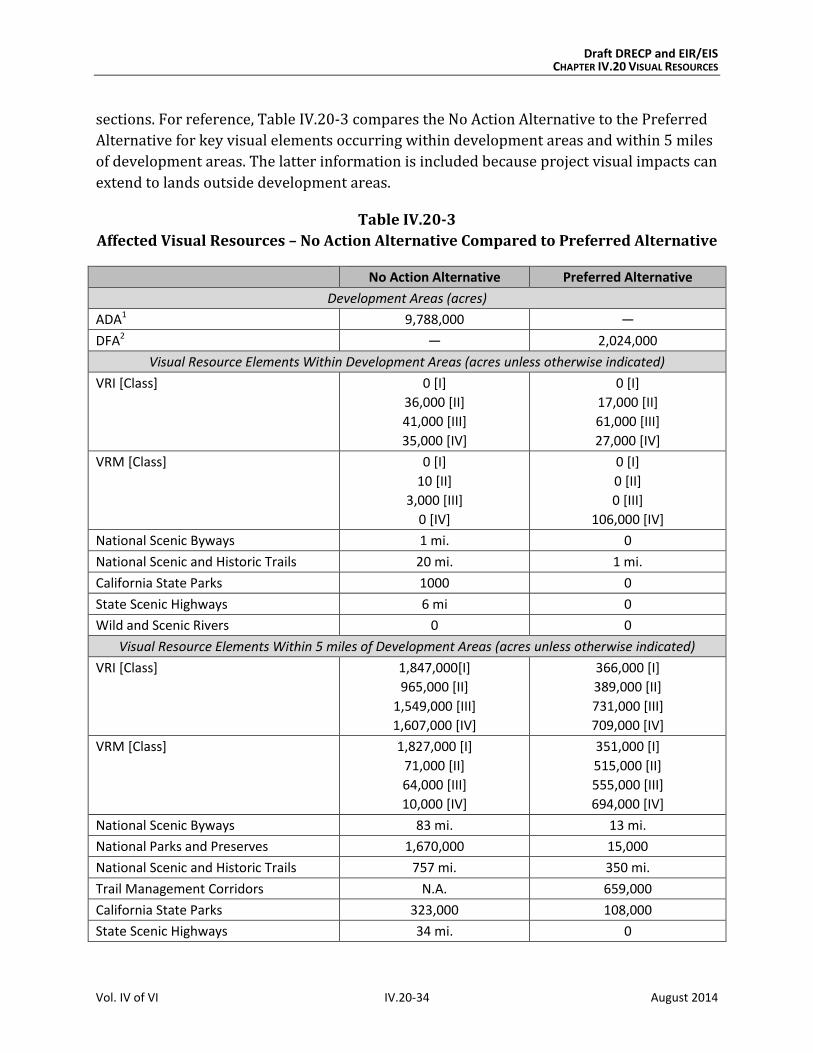
Draft DRECP and EIR/EIS CHAPTER IV.20 VISUAL RESOURCES
Vol. IV of VI IV.20-34 August 2014
sections. For reference, Table IV.20-3 compares the No Action Alternative to the Preferred
Alternative for key visual elements occurring within development areas and within 5 miles
of development areas. The latter information is included because project visual impacts can
extend to lands outside development areas.
Table IV.20-3
Affected Visual Resources – No Action Alternative Compared to Preferred Alternative
No Action Alternative Preferred Alternative
Development Areas (acres)
ADA1 9,788,000 —
DFA2 — 2,024,000
Visual Resource Elements Within Development Areas (acres unless otherwise indicated)
VRI [Class] 0 [I]
36,000 [II]
41,000 [III]
35,000 [IV]
0 [I]
17,000 [II]
61,000 [III]
27,000 [IV]
VRM [Class] 0 [I]
10 [II]
3,000 [III]
0 [IV]
0 [I]
0 [II]
0 [III]
106,000 [IV]
National Scenic Byways 1 mi. 0
National Scenic and Historic Trails 20 mi. 1 mi.
California State Parks 1000 0
State Scenic Highways 6 mi 0
Wild and Scenic Rivers 0 0
Visual Resource Elements Within 5 miles of Development Areas (acres unless otherwise indicated)
VRI [Class] 1,847,000[I]
965,000 [II]
1,549,000 [III]
1,607,000 [IV]
366,000 [I]
389,000 [II]
731,000 [III]
709,000 [IV]
VRM [Class] 1,827,000 [I]
71,000 [II]
64,000 [III]
10,000 [IV]
351,000 [I]
515,000 [II]
555,000 [III]
694,000 [IV]
National Scenic Byways 83 mi. 13 mi.
National Parks and Preserves 1,670,000 15,000
National Scenic and Historic Trails 757 mi. 350 mi.
Trail Management Corridors N.A. 659,000
California State Parks 323,000 108,000
State Scenic Highways 34 mi. 0

Draft DRECP and EIR/EIS CHAPTER IV.20 VISUAL RESOURCES
Vol. IV of VI IV.20-35 August 2014
Table IV.20-3
Affected Visual Resources – No Action Alternative Compared to Preferred Alternative
No Action Alternative Preferred Alternative
Wild and Scenic Rivers 23 mi. 0
Reserve Design Lands (Conservation Lands) (acres)
Reserve Design Lands N.A. 14,984,000
Existing Conservation 7,662,000 (included in above acres) 1 Applies only to No Action Alternative
2 Applies only to action alternatives.
Note: The following general rounding rules were applied to calculated values: values greater than 1,000 were rounded to nearest 1,000; values less than 1,000 and greater than 100 were rounded to the nearest 100; values of 100 or less were rounded to the nearest 10, and therefore totals may not sum due to rounding. In cases where subtotals are provided, the subtotals and the totals are individually rounded. The totals are not a sum of the rounded subtotals; therefore the subtotals may not sum to the total within the table.
IV.20.3.2.1 Plan-Wide Impacts of Implementing the DRECP: Preferred Alternative
IV.20.3.2.1.1 Plan-Wide Impacts and Mitigation Measures from Renewable Energy and
Transmission Development
Impact Assessment
Under the Preferred Alternative, DFAs are areas within which the Covered Activities associ-
ated with solar, wind, and geothermal development and operation would be permitted.
Under the Preferred Alternative, renewable energy related activities covered by the Plan
would be confined to DFAs, resulting in a projected 145,000 acres of long-term disturbance
(See Table IV.1-1.) The DFAs are geographically dispersed in the Imperial Valley, eastern
Riverside, Lucerne Valley, Barstow, and Tehachapi areas, with smaller DFAs along the U.S.
395 corridor and near Hidden Hills. Solar energy is the largest renewable energy technol-
ogy type in most counties, but wind also is prominent in Riverside and San Bernardino
counties. Under the Preferred Alternative, geothermal development would have Covered
Activities only in Imperial and Inyo counties. Transmission development and operation
would be permitted both within and outside of DFAs.
The distribution of DFAs under the Preferred Alternative is far less widespread than the
broad distribution of ADAs under the No Action Alternative. Characteristics of the Pre-
ferred Alternative are as follows:
Ecoregion subareas that would have the smallest DFAs include Kingston and
Funeral Mountains, Mojave and Silurian Valley, Owens River Valley, and Providence
and Bullion Mountains.

Draft DRECP and EIR/EIS CHAPTER IV.20 VISUAL RESOURCES
Vol. IV of VI IV.20-36 August 2014
Visual impacts from solar would be primarily in two ecoregion subareas: West
Mojave and Eastern Slopes, and Cadiz Valley and Chocolate Mountains.
Visual impacts from wind energy would be mostly in two ecoregion subareas: West
Mojave and Eastern Slopes, and Pinto Lucerne Valley and Eastern Slopes.
Visual impacts from geothermal energy would be in two ecoregion subareas: Impe-
rial Borrego Valley and Owens River Valley.
The following summarizes the key points in comparing the Preferred Alternative’s visual
impacts from renewable energy and transmission development to those of the No Action
Alternative (see Appendix R2, Table R2.20-5 for detailed data):
VRI Classes: Under the Preferred Alternative, there would be approximately 17,000
acres of VRI Class II lands, 61,000 acres of VRI Class III lands, and 27,000 acres of
VRI Class IV lands within DFAs. Per the CMAs for visual resources, these 78,000
acres of VRI Class II and III lands within DFAs would be managed as VRM Class IV
and thereby could sustain a degradation of underlying scenic values as identified by
BLM’s completed visual inventories (described in Volume III). Approximately
13,000 acres of transmission would occur on inventoried lands.
Under the No Action Alternative, 36,000 acres of VRI Class II, 41,000 acres of VRI
Class III, and 35,000 acres of VRI Class IV lands occur in ADAs and approximately
the same amount of transmission.
VRM Classes: Unlike the No Action Alternative, the Preferred Alternative would
have VRM Classes assigned under it; and VRM objectives would be applied to all
BLM lands. Under the Preferred Alternative, all DFAs on BLM land would be desig-
nated as VRM Class IV (106,000 acres); therefore there would be no VRM Class I, II,
or III lands in DFAs (Figure IV.20-2, Proposed BLM VRM Classifications, Preferred
Alternative). Approximately 13,000 acres of transmission would occur, the majority
of which would be on VRM Class III and IV lands.
Under the No Action Alternative, which does not assign new VRM Classes, there are
3,000 acres of VRM Class II or III lands in ADAs and approximately 40 acres of trans-
mission on those lands.
National Parks and Preserves: As with the No Action Alternative, the footprint of
renewable energy projects would not directly affect these lands under the Preferred
Alternative, but project facilities and activities that are visible from National Parks
and Preserves would diminish scenic quality for viewers in those conservation
areas, where expectations for scenic quality are typically high.
National Scenic Byways: No segments of the Bradshaw Trail National Back Country
Byway would be within DFAs under the Preferred Alternative.

Draft DRECP and EIR/EIS CHAPTER IV.20 VISUAL RESOURCES
Vol. IV of VI IV.20-37 August 2014
National Scenic and Historic Trails: Under the Preferred Alternative, approxi-
mately 1 mile of the Old Spanish National Historic Trail alignment would be within a
wind energy DFA. Under the No Action Alternative, approximately 20 miles of
National Scenic and Historic Trails would be within ADAs for solar and wind.
As with National Parks and Preserves, renewable energy project facilities and activi-
ties visible from National Trails could diminish scenic quality for trail users, where
expectations for scenic quality are typically high. However, under the Preferred
Alternative, Trail Management Corridors would be established along National Scenic
and Historic Trails, generally at a width of 5 miles from the centerline of the trail, for
a total width of 10 miles (see Section IV.20.2.2, Impacts of the Reserve Design).
State Scenic Highways: There would be no segments of State Scenic Highways
within DFAs or ADAs under the Preferred Alternative or the No Action Alternative.
Proximity of Visual Resources to DFAs. Visual resource elements within 5 miles of
development areas can be compared between the Preferred Alternative and the No
Action Alternative. This information is summarized in Table IV.20-3. The Preferred
Alternative has far fewer visual resource elements within 5 miles of DFAs, as com-
pared with the same 5-mile distance from ADAs under the No Action Alternative.
One example of this is the acres of VRI Class I lands: nearly 1,850,000 acres are
within 5 miles of development areas under the No Action Alternative compared with
366,000 acres under the Preferred Alternative. There is more than 100 times the
National Parks and Preserves acreage within 5 miles of development areas under
the No Action Alternative as there would be under the Preferred Alternative.
This 5-mile distance is particularly important for visual resources, because 5 miles
is typically used as a measure of foreground and middleground distance zones, where
management activities and changes in the landscape might be viewed in detail. The
outer boundary of this distance zone is defined as the point where the texture and
form of individual plants are no longer apparent in the landscape (BLM 1984).
The visual impacts resulting from the Preferred Alternative are:
Impact VR-1: Visibility of activities, materials, equipment, dust, and construction night
lighting would result in short-term diminished scenic quality.
Preconstruction activities and equipment visible from residences, public roads, and public
preserves would result in short-term diminished scenic quality for viewers. Examples
include road upgrading, damage to or removal of native vegetation, construction of meteor-
ological towers, drilling of temperature gradient wells, vehicles, and lighting.

Draft DRECP and EIR/EIS CHAPTER IV.20 VISUAL RESOURCES
Vol. IV of VI IV.20-38 August 2014
During construction and decommissioning, activities and equipment visible from residences,
public roads, and public preserves would result in short-term diminished scenic quality for
viewers. Examples include dust and exhaust emissions, removal of vegetation during site
clearing, contouring and grading, presence of vehicles and equipment, mobilization and
demobilization activities, material delivery and staging, assembly of components, site light-
ing, and construction of and later removal of structures.
Impact VR-2: The presence of project components and disturbance would result in
long-term diminished scenic quality.
The continued presence of equipment, structures, fencing, roads, and other elements
required to operate a facility would have a long-term adverse effect on the visible land-
scape. Areas of persistent surface and vegetation disturbance and the presence of struc-
tures would create visual contrast in form, line, color, and texture compared to pre-project
conditions. Depending on viewer location, physical elements introduced by a project could
block views or create skylining. Even after project removal and site reclamation are com-
pleted, visual contrast would remain. Restoring the natural, pre-disturbance visual charac-
ter of a desert environment is extremely difficult, can take decades, and often is unsuccess-
ful. Therefore, surface and vegetation disturbance would create long-term visual impacts
due to the persistence of scars in arid and semi-arid landscapes.
The structure, size, and industrial character of utility-scale renewable energy and transmis-
sion facilities during their operation and maintenance—as well as any associated glare,
reflectivity, and lighting—would visually contrast with surrounding undeveloped land and
result in long-term diminished scenic quality.
Impacts in Study Area Lands
Study Area Lands refer to three categories of lands shown on alternative maps: Future
Assessment Areas (FAAs), Special Analysis Areas (SAAs) and DRECP Variance Lands.
Future Assessment Areas (FAAs). Lands within FAAs are neither reserve lands nor DFAs;
they are simply areas that are deferred for future assessment. The future assessment will
determine their suitability for renewable energy development or ecological conservation. If
renewable energy development occurs on FAA lands, a BLM LUPA would not be required.
FAAs for each alternative are included and located as shown in Table IV.1-2 and Figure II.3-1.
The FAAs represent areas where renewable energy development or inclusion in the
reserve design could be implemented through an amendment to the DRECP, but additional
assessment would be needed.

!(
!(
!(
!(
!(
!(
!(
!(
!(
!(
!( !(
!(
!(
§̈¦10
§̈¦405
§̈¦605
§̈¦210
§̈¦15
§̈¦710
§̈¦15
§̈¦10
§̈¦8
§̈¦5
§̈¦40
§̈¦5
£¤6
£¤395
£¤395
UV190
UV58
UV178
UV127
UV78
UV2
UV91
UV86
UV98
UV136
UV168
UV247
UV34
UV74
UV94
UV60
UV138
UV75
UV243
UV62
UV111
UV62
UV38
UV78
Inyo
San Bernardino
Kern
Riverside
Imperial
Tulare
San Diego
Los Angeles
Mono
Fresno
Orange
M E X I C O
O w e n s R i v e r
V a l l e y E c o r e g i o nS u b a r e a
P a n a m i n t D e a t h
V a l l e y E c o r e g i o nS u b a r e a
W e s t M o j a v e a n d
E a s t e r n S l o p e sE c o r e g i o n S u b a r e a
M o j a v e a n d
S i l u r i a n V a l l e yE c o r e g i o n S u b a r e a
K i n g s t o n a n d
F u n e r a l M o u n t a i n sE c o r e g i o n S u b a r e a
P r o v i d e n c e a n d
B u l l i o n M o u n t a i n sE c o r e g i o n S u b a r e a
P i n t o L u c e r n e V a l l e y
a n d E a s t e r n S l o p e sE c o r e g i o n S u b a r e a
P i u t e V a l l e y a n d
S a c r a m e n t o M o u n t a i n sE c o r e g i o n S u b a r e a
C a d i z V a l l e y a n d
C h o c o l a t e M o u n t a i n sE c o r e g i o n S u b a r e a
I m p e r i a l B o r r e g o
V a l l e y E c o r e g i o nS u b a r e a
Escondido
Lancaster
Palmdale
Long
Beach
Ridgecrest
Barstow
Hesperia
Riverside
SanBernardino
Twentynine
Palms
Coachella
El Centro
San
Diego
Los
Angeles
A R I Z O N AA R I Z O N A
N E V A D AN E V A D A
!(
!(
!(
!(
!(
!(
!(
!(
!(
!(
!( !(
!(
!(
§̈¦10
§̈¦405
§̈¦605
§̈¦210
§̈¦15
§̈¦710
§̈¦15
§̈¦10
§̈¦8
§̈¦5
§̈¦40
§̈¦5
£¤6
£¤395
£¤395
UV190
UV58
UV178
UV127
UV78
UV2
UV91
UV86
UV98
UV136
UV168
UV247
UV34
UV74
UV94
UV60
UV138
UV75
UV243
UV62
UV111
UV62
UV38
UV78
Inyo
San Bernardino
Kern
Riverside
Imperial
Tulare
San Diego
Los Angeles
Mono
Fresno
Orange
M E X I C O
O w e n s R i v e r
V a l l e y E c o r e g i o nS u b a r e a
P a n a m i n t D e a t h
V a l l e y E c o r e g i o nS u b a r e a
W e s t M o j a v e a n d
E a s t e r n S l o p e sE c o r e g i o n S u b a r e a
M o j a v e a n d
S i l u r i a n V a l l e yE c o r e g i o n S u b a r e a
K i n g s t o n a n d
F u n e r a l M o u n t a i n sE c o r e g i o n S u b a r e a
P r o v i d e n c e a n d
B u l l i o n M o u n t a i n sE c o r e g i o n S u b a r e a
P i n t o L u c e r n e V a l l e y
a n d E a s t e r n S l o p e sE c o r e g i o n S u b a r e a
P i u t e V a l l e y a n d
S a c r a m e n t o M o u n t a i n sE c o r e g i o n S u b a r e a
C a d i z V a l l e y a n d
C h o c o l a t e M o u n t a i n sE c o r e g i o n S u b a r e a
I m p e r i a l B o r r e g o
V a l l e y E c o r e g i o nS u b a r e a
Escondido
Lancaster
Palmdale
Long
Beach
Ridgecrest
Barstow
Hesperia
Riverside
SanBernardino
Twentynine
Palms
Coachella
El Centro
San
Diego
Los
Angeles
A R I Z O N AA R I Z O N A
N E V A D AN E V A D A
DRECP Plan Area Boundary
Ecoregion Subareas
CDCA Boundary
County Boundary
Non-BLM Land
BLM VRM Classifications
Class I
Class II
Class III
Class IV
M:\JOBS4\6287\common_gis\EIR_Figures_Spring_2014\Vol_IV\IV_20_Visual\figIV.20-2.mxd 8/18/2014
FIGURE IV.20-2
Proposed BLM Visual Resource Management Classifications, Preferred Alternative
0 2010
MilesI
Draft DRECP and EIR/EIS
Sources: ESRI (2014); CEC (2013); BLM (2013); CDFW (2013); USFWS (2013)
August 2014
Draft DRECP and EIR/EIS CHAPTER IV.20 VISUAL RESOURCES
Vol. IV of VI IV.20-40 August 2014
INTENTIONALLY LEFT BLANK
Draft DRECP and EIR/EIS CHAPTER IV.20 VISUAL RESOURCES
Vol. IV of VI IV.20-41 August 2014
Because most of the FAAs are presented as “undesignated areas” in the action alternatives,
there would be no difference between the FAAs in the Preferred Alternative except that
renewable development in an FAA would not require a BLM LUPA; so the environmental
review process would be somewhat simpler than if the location were left undesignated.
Special Analysis Areas (SAAs). There are two areas defined as SAAs, representing areas
subject to ongoing analysis. These areas (in the Silurian Valley and just west of U.S. 395 in
Kern County) have high value for renewable energy development, ecological and cultural
conservation, and recreation. SAA lands are expected to be designated in the Final EIR/EIS
as either DFAs or included in the Reserve Design/Conservation Designation. Visual
resource elements within the SAAs of the Preferred Alternative include approximately
35,000 acres of VRI Class II, III, and IV lands and 35,000 acres of VRM Class III and IV lands.
No VRI Class I lands or VRM Class I or II lands are within SAAs.
DRECP Variance Lands. DRECP Variance Lands represent the BLM Solar PEIS Variance
Lands as screened for the DRECP and EIR/EIS based on BLM screening criteria. Covered
Activities could be permitted for NCCP purposes only through an NCCP plan amendment.
However, development of renewable energy on Variance Lands would not require a BLM
LUPA; so the environmental review process would be somewhat simpler than if the loca-
tion were left undesignated. Per CMAs for visual resources, development of DRECP
Variance Lands would be required to conform to the visual management objectives
of VRM Class III.
Impact Reduction Strategies and Mitigation
The implementation of the Preferred Alternative would result in landscape-scale
conservation of desert lands as well as the development of renewable energy generation
and transmission facilities on other lands. The impacts of the renewable energy
development covered by the Preferred Alternative would be lessened in a number of
ways. The Preferred Alternative would incorporate CMAs for each alternative, including
specific biological reserve design components and LUPA components. In addition, the
implementation of existing laws, orders, regulations, and standards would reduce the
impacts of project development.
Conservation and Management Actions
The conservation strategy for the Preferred Alternative (presented in Volume II, Section
II.3.1.2) defines specific actions that would reduce the impacts of this alternative. The con-
servation strategy includes a definition of the reserve design and specific CMAs for the
Preferred Alternative. While the CMAs were developed for BLM lands only, this analysis
assumes that all CMAs would be applied to nonfederal lands as well.

Draft DRECP and EIR/EIS CHAPTER IV.20 VISUAL RESOURCES
Vol. IV of VI IV.20-42 August 2014
Specific visual resource CMAs have been developed. These visual resource CMAs apply to
the Preferred Alternative and all action alternatives and are summarized here:
CMAs for the entire Plan Area:
o Ensure that development within each area with a VRM Class designation meets
the VRM objectives described above as measured through a visual contrast
rating process.
o Ensure that transmission facilities are designed and located to meet the VRM
Class objectives for the area in which they are located. Transmission lines routed
through approved corridors where they do not meet VRM Class objectives will
require RMP amendments to establish a conforming VRM objective. All reason-
able effort must be made to reduce visual contrast of these facilities to meet the
VRM Class before pursing RMP amendments. This includes changes in routing,
using lattice towers (as opposed to monopoles), color treating facilities using an
approved color from the BLM Environmental Color Chart CC-001 (dated June 2008
or June 2013)(as opposed to galvanized metal) on towers and support facilities,
and employing other BMPs to reduce contrast. Such efforts will be retained even if
an RMP amendment is determined to be needed. Visual resource BMPs that
reduce adverse visual contrast will be applied in VRM Class conforming situations.
CMAs for DFAs and DRECP Study Area Lands:
o Manage all DFAs as VRM Class IV to allow for industrial-scale development.
Employ BMPs to reduce visual contrast of facilities.
o Manage all Variance Lands as VRM Class III.
o Require development to incorporate visual design standards and include latest
BMPs (from Solar, Wind, West Wide Energy Corridor, and Geothermal PEISs, the
Best Management Practices for Reducing Visual Impacts of Renewable Energy
Facilities on BLM-Administered Lands, and other programmatic BMP documents).
o Encourage development in a planned fashion within DFAs (e.g., similar to the
planned unit development concept used for urban design, i.e., in-fill vs. scattered
development, use of common road networks, generator tie-lines, use of similar
support facility designs materials, colors, etc.) to avoid industrial sprawl.
o Require regional mitigation for visual impacts for public lands outside of DFAs
but open to consideration for energy development (Variance Lands etc.). Mitiga-
tion will be based on the VRI Class and the underlying visual values (scenic
quality, sensitivity, and distance zone) for the development area as it stands at
the time the Record of Decision is signed for the DRECP. Compensation may
involve reclamation of visual impacts present within other areas designated as

Draft DRECP and EIR/EIS CHAPTER IV.20 VISUAL RESOURCES
Vol. IV of VI IV.20-43 August 2014
BLM VRM class I or II lands (so that they are no longer visible in the long-term),
mitigation on BLM lands inventoried as having equal to or greater visual
resource values, or amending RMPs for lands within VRM Class III or IV to a
higher level of protection (VRM Class I or II) for areas that are visually intact
with no cultural modifications and have visual resource inventoried values that
are equal to or greater in value and delineate a protective visual ACEC around
the compensatory mitigated area. The following mitigation ratios will be applied:
VRI Class II 2:1 ratio
VRI Class III 1:1 ratio
VRI Class IV no mitigation required
o Require compensatory mitigation on public lands developed within DFAs at one-
half the level of lands outside of DFAs;
VRI Class II 1:1 ratio
VRI Class III 2:1 ratio
VRI Class IV, no mitigation required
o Require additional mitigation measures where projects affect viewsheds of spe-
cially designated areas (e. g., National Scenic and Historic Trails, National Parks,
etc.) as discussed under those programs (See CMAs assigning VRM Class II for
National Scenic and Historic Trail Management Corridors.)
Required visual resource BMPs. All development within and outside the DFAs will
abide by the BMPs addressed in Reducing Visual Impacts of Renewable Energy Facili-
ties on BLM-Administered Lands, including, but not limited to the following:
o Transmission
Color treat monopoles Shadow Gray per the BLM Environmental Color Chart
CC001 unless the local Field Office VRM specialist selects a more effective color.
Lattice towers and conductors will have nonspecular qualities.
Lattice towers will be located a minimum of ¾ mile away from key observa-
tion points such as roads, scenic overlooks, trails, campgrounds, navigable
rivers, and other areas people tend to congregate and located against a land-
scape backdrop when topography allows.
o Solar – Color treat all facilities Shadow Gray from the BLM Environmental Color
Chart CC001 unless a more effective color is selected by the Field Office VRM
specialist, including but not limited to:
Concentrated solar thermal parabolic trough panel backs
Draft DRECP and EIR/EIS CHAPTER IV.20 VISUAL RESOURCES
Vol. IV of VI IV.20-44 August 2014
Solar power tower heliostats
Solar power towers
Cooling towers
Power blocks
o Wind – Color treat all facilities Shadow Gray with the exception of the wind tur-
bine and towers 200 vertical feet or more.
o Night Sky – BMPs to minimize impacts to night sky including light shielding will
be employed.
CMAs for ACECs and SRMAs:
o Manage Alabama Hills SRMA and Manzanar ACEC to conform to VRM
Class II standards.
CMA for lands managed for wilderness characteristics:
o Manage the areas as VRM Class II
These visual resource CMAs provide a comprehensive framework of state-of-the-art guide-
lines and specifications through which visual impacts would be avoided where possible,
minimized, and/or mitigated to the extent practicable.
Laws and Regulations
Similar to the No Action Alternative, existing laws and regulations will reduce certain impacts
of Plan implementation. Relevant regulations are presented in the Regulatory Setting in
Volume III. The requirements of relevant laws and regulations are summarized in
Section IV.20.3.1.1.1.
Mitigation Measures
The visual impact avoidance and reduction strategies in existing guidance, including Reduc-
ing Visual Impacts of Renewable Energy Facilities on BLM-Administered Lands, are
detailed and comprehensive. The CMAs proposed under the DRECP (see Appendix H)
provide additional detail and direction. These represent state-of-the-art visual impact
avoidance and mitigation as they apply to the Plan Area; no additional mitigation has
been developed.
IV.20.3.2.1.2 Impacts of the Reserve Design
The reserve design area under the Preferred Alternative would total nearly 15 million
acres, which is approximately 70% of the Plan Area. This would result in the protection of

Draft DRECP and EIR/EIS CHAPTER IV.20 VISUAL RESOURCES
Vol. IV of VI IV.20-45 August 2014
visual resources in this portion of the Plan Area because of the limitations on development
incorporated in existing laws and regulations and in the CMAs associated with the Reserve
Design. Nearly half of the reserve design under the Preferred Alternative would be
Legislatively and Legally Protected Areas and Military Expansion Mitigation Lands that cur-
rently are under Conservation Designations.
Approximately 30% (6,118,000 acres) of the Preferred Alternative reserve design would be
composed of BLM LUPA Conservation Designations, including NLCS lands, ACECs, and
wildlife allocations.
Approximately 8% of the reserve design area under the Preferred Alternative is composed
of CPAs. The CPAs would include 1,139,000 acres of private and public land located outside
of existing Conservation Designations, including BLM LUPA Conservation Designations.
These CPAs would be part of mitigation to meet DRECP biological goals and objectives and
would be acquired from willing sellers. The conservation protections afforded the CPAs
also would protect visual resources.
There would be 14,920,000 acres of Reserve Design Lands under the Preferred Alternative,
whereas no equivalent reserve system would be established under the No Action Alterna-
tive. Key points in comparing the Preferred Alternative visual impacts of the reserve design
with those of the No Action Alternative are identified in Table R2.20-6 in Appendix R2.20
and summarized as follows:
VRI Classes: The Reserve Design Lands for the Preferred Alternative would include
100% of VRI Class I lands and approximately 74% of VRI Class II lands, 67% of VRI
Class III lands, and 72% of Class IV lands. Under the No Action Alternative, 100% of
VRI Class I lands, 24% of VRI Class II lands, 25% of Class III lands, and 22% of VRI
Class IV lands would be in conservation.
VRM Classes: Approximately 100% of VRM Class I lands, 83% of VRM Class II
lands, 79% of VRM Class III lands, and 38% of VRM Class IV lands would be in the
Reserve Design. More than 4 million acres of these lands are in BLM LUPA
Conservation Designations.
In the No Action Alternative, 100% of the VRM Class I lands are in conservation; but
very little (<1%) of VRM Classes II, III, and IV are in conservation lands.
National Parks and Preserves: The National Parks and Preserves would have
100% of their land areas in the Reserve Design Lands under both the Preferred
Alternative and No Action Alternative.
National Scenic Byways: Under the Preferred Alternative, approximately 51% of
the Bradshaw Trail National Back Country Byway and 15% of State Route (SR) 190
Draft DRECP and EIR/EIS CHAPTER IV.20 VISUAL RESOURCES
Vol. IV of VI IV.20-46 August 2014
would be in the Reserve Design. This provides a higher or similar level of protection
of visual and scenic values as in conservation under the No Action Alternative (33%
and 15% respectively.)
National Scenic and Historic Trails: Under the Preferred Alternative, approxi-
mately 4% of the Juan Bautista de Anza National Historic Trail, 58% of the Old
Spanish National Historic Trail, and 40% of the Pacific Crest National Scenic Trail
alignments would be in the Reserve Design.
Under the No Action Alternative, approximately 43% of the Juan Bautista de Anza
National Historic Trail, 46% of the Old Spanish National Historic Trail, and 32% of
the Pacific Crest National Scenic Trail alignments are in conservation.
The Preferred Alternative provides a lower level of conservation of the Juan Bautista
de Anza National Historic Trail alignment and a higher level of conservation of the
Old Spanish National Historic Trail and Pacific Crest National Scenic Trail align-
ments than the No Action Alternative.
California State Parks: Under the Preferred Alternative, most California State
Park land would be in Reserve Design Lands. This would vary by individual park
or preserve; but most parks would have more than 90% in existing conservation
areas, BLM LUPA designations, or CPAs. Exceptions are the (1) Desert
Cahuilla/Freeman Project (4%), (2) Picacho State Recreation Area (SRA) (78%),
and (3) Salton Sea SRA (86%).
Under the No Action Alternative, the extent of California State Parks under existing
conservation varies due to land ownership and management considerations. While
most of the California State Park lands are in conservation (95%), several have less
in conservation (e.g., Picacho SRA, Red Rock Canyon State Park, and Salton Sea SRA).
State Scenic Highways: Approximately 15% of SR 190 but no portion of the SR 78
and U.S. 395 alignments would be in Reserve Design Lands, compared to similar
portions under the No Action Alternative.
Wild and Scenic Rivers: 100% of the designated Amargosa Wild and Scenic River
corridor as well as the eligible Surprise Canyon Creek and Mojave River segments
would be within the reserve design under both the Preferred Alternative and No
Action Alternative.
IV.20.3.2.2 Impacts of DRECP Land Use Plan Amendment on BLM Land: Preferred Alternative
This section addresses two components of effects of the BLM LUPA: the streamlined
development of renewable energy and transmission on BLM land under the LUPA and the
impacts of the amended land use plans themselves.
Draft DRECP and EIR/EIS CHAPTER IV.20 VISUAL RESOURCES
Vol. IV of VI IV.20-47 August 2014
IV.20.3.2.2.1 Impacts from Renewable Energy and Transmission Development on BLM Land
The visual impacts of DFAs on VRI and VRM lands for the Preferred Alternative would be
the same as those described in Section IV.20.3.2.1 for the Plan-wide analysis.
IV.20.3.2.2.2 Impacts of Changes to BLM Land Designations
The DRECP LUPA Preferred Alternative would establish VRM classes for all lands in the
CDCA. (Currently, only the Bishop RMP and the Imperial Sand Dunes RAMP have VRM
Classes designated. In accordance with BLM policy, all wilderness areas and WSAs are
managed as VRM Class I.) It also would (1) designate new NLCS lands; (2) designate new
ACECs and expand and reduce existing ACECs; (3) designate new SRMAs and expand and
reduce existing SRMAs; (4) create buffer corridors along National Scenic and Historic
Trails; (5) manage lands with wilderness characteristics to protect those characteristics;
and (6) designate new wildlife allocations. The BLM LUPA also would replace existing
multiple-use classes.
The VRM Classes and BLM land designations proposed under the Preferred Alternative
would offer protective measures that would avoid or reduce visual impacts. CMAs for
visual resources would be established and implemented. The BLM-specific CMAs proposed
under the Preferred Alternative would be the same for all action alternatives. These visual
resource CMAs and the restrictions and protective measures of the land designations pro-
vide a framework of guidelines and specifications through which visual impacts would be
avoided where possible, minimized, and/or mitigated to the extent practicable.
Under the Preferred Alternative, Trail Management Corridors would be established along
National Scenic and Historic Trails, at a width of generally 5 miles from the centerline of the
trail, for a total width of 10 miles. As discussed in Volume II, Section II.3.2.2.2, these Trail
Management Corridors would be managed as components of the BLM’s NLCS. Where
National Trails overlap other NLCS lands, the more protective CMAs or land use allocations
would apply. All Trail Management Corridors would be designated as VRM Class II, except
within approved transmission corridors (VRM Class III) and DFAs (VRM Class IV). How-
ever, state-of-the-art VRM BMPs for renewable energy would be employed commensurate
with the protection of nationally significant scenic resources and cultural landscapes to
minimize the level of intrusion and protect trail settings.
The following summarizes the key points of the impacts of changes to BLM land designa-
tions on visual resource elements under the Preferred Alternative (see Appendix R2, Table
R2.20-7 for detailed, quantitative data and analysis):
SRMAs: There would be the potential for recreational activities or facilities allowed
in SRMAs to affect scenic values, particularly those of the VRI Class I and II lands
(approximately 274,000 acres) with which they coincide.

Draft DRECP and EIR/EIS CHAPTER IV.20 VISUAL RESOURCES
Vol. IV of VI IV.20-48 August 2014
NLCS: The management of these lands that have nationally significant ecological,
cultural, and scientific values would offer additional protection of intactness and
scenic quality, particularly to the VRI Class I, II, III, and IV lands (3.6 million acres)
with which they coincide.
ACECs: The special management measures given to protect the important historic,
cultural, and scenic values of these areas would generally benefit visual resources,
particularly the VRI Class II, III, and IV lands (1.4 million acres) with which
they coincide.
Wildlife Allocation Areas: The management of these areas must be compatible
with protection and enhancement of wildlife and plant habitat and would generally
benefit visual resources, particularly the VRI Class III and IV lands (approximately
18,000 acres) with which they coincide.
Lands Managed for Wilderness Characteristics: Management strategies to pro-
tect wilderness characteristics would benefit visual resources, particularly the VRI
Class II, III, and IV lands (approximately 299,000 acres) with which they coincide.
Trail Management Corridors: One effect of the 10-mile-wide corridors would be
to provide a higher level of protection (VRM Class II objectives) to approximately
50 acres of VRM Class III and IV lands that would otherwise be managed under
less restrictive visual management objectives. Importantly, the Trail Management
Corridors would provide a consistent framework for protecting and managing
scenic values along National Scenic and Historic Trails within National and
California state park lands. Trail Management Corridors are not established under
the No Action Alternative.
The Preferred Alternative would assign VRM classes to all BLM lands within the Plan Area.
Generally, a low correlation between the VRM classes and the underlying VRI classes (e.g.,
VRI Class II or III lands managed to meet the objectives of VRM Class IV) would result in
greater adverse impacts to visual quality. Conversely, impacts would most likely be less for
alternatives proposing visual management that either closely corresponds to the VRI
classes or proposing a more restrictive (higher) class designation (e.g., proposing VRM
Class II management of VRI Class III lands).
Under the Preferred Alternative, VRI Class lands within the proposed VRM Classes on BLM
LUPA lands would be as indicated in Table IV.20-4. Key effects of VRM classifications on
VRI lands under the Preferred Alternative are summarized here:
VRM Designations: The majority of inventoried lands would be designated as VRM
Class I, II, or III. Less than 10% would be designated as VRM Class IV.
o VRI Class I: 100% of VRI Class I lands would be managed as VRM Class I,
reflecting a high level of management protection.

Draft DRECP and EIR/EIS CHAPTER IV.20 VISUAL RESOURCES
Vol. IV of VI IV.20-49 August 2014
o VRI Class II: Approximately 75% of VRI Class II lands would be managed as VRM
Class II or I, reflecting a moderate to high level of management protection.
Approximately 20% would be managed as VRM Class III, and approximately 5%
would be managed as VRM Class IV.
o VRI Class III: More than 80% of VRI Class III lands would be managed as VRM
Class III, II, or I, reflecting a moderate to high level of management protection.
Approximately 35% would be managed to meet VRM Class II objectives, which
restrict visual contrast and impact more than the VRM Class III objectives do.
Approximately 49% would be managed as VRM Class III, and 16% would be
managed as VRM Class IV, which allows for more visual contrast and impact than
the VRM Class III objectives.
o VRI Class IV: Approximately 58% of VRI Class IV lands would be managed as
VRM Class I, II, or III; 41% would be managed as VRM Class IV.
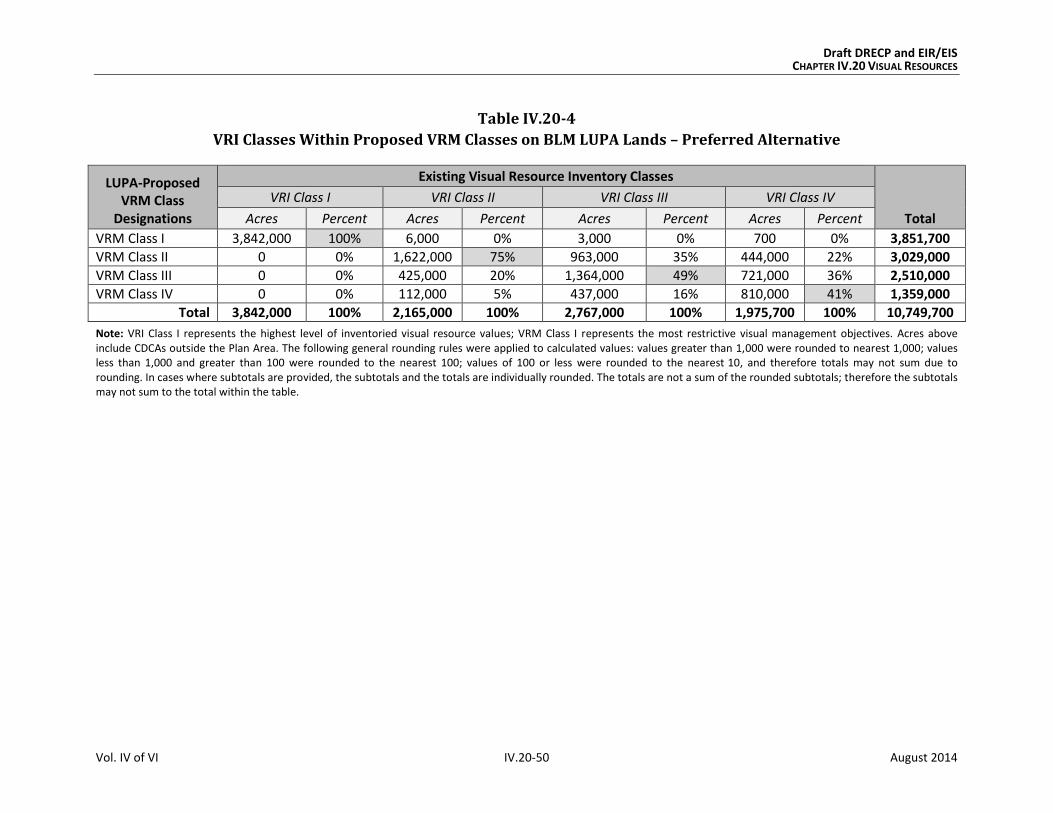
Draft DRECP and EIR/EIS CHAPTER IV.20 VISUAL RESOURCES
Vol. IV of VI IV.20-50 August 2014
Table IV.20-4
VRI Classes Within Proposed VRM Classes on BLM LUPA Lands – Preferred Alternative
LUPA-Proposed VRM Class
Designations
Existing Visual Resource Inventory Classes
Total
VRI Class I VRI Class II VRI Class III VRI Class IV
Acres Percent Acres Percent Acres Percent Acres Percent
VRM Class I 3,842,000 100% 6,000 0% 3,000 0% 700 0% 3,851,700
VRM Class II 0 0% 1,622,000 75% 963,000 35% 444,000 22% 3,029,000
VRM Class III 0 0% 425,000 20% 1,364,000 49% 721,000 36% 2,510,000
VRM Class IV 0 0% 112,000 5% 437,000 16% 810,000 41% 1,359,000
Total 3,842,000 100% 2,165,000 100% 2,767,000 100% 1,975,700 100% 10,749,700
Note: VRI Class I represents the highest level of inventoried visual resource values; VRM Class I represents the most restrictive visual management objectives. Acres above include CDCAs outside the Plan Area. The following general rounding rules were applied to calculated values: values greater than 1,000 were rounded to nearest 1,000; values less than 1,000 and greater than 100 were rounded to the nearest 100; values of 100 or less were rounded to the nearest 10, and therefore totals may not sum due to rounding. In cases where subtotals are provided, the subtotals and the totals are individually rounded. The totals are not a sum of the rounded subtotals; therefore the subtotals may not sum to the total within the table.

Draft DRECP and EIR/EIS CHAPTER IV.20 VISUAL RESOURCES
Vol. IV of VI IV.20-51 August 2014
Compared to the No Action Alternative, the Preferred Alternative would result in a higher
potential for retaining the integrity of the inventoried visual resource values and, conse-
quently, a lower level of potential visual impact to those values compared with the No
Action Alternative. The designation of VRM Classes throughout the CDCA would have the
value of providing the level of visual change allowed prior to an area being considered for
projects that would introduce change. Currently, VRM Classes are designated only for the
Bishop Field Office, the Imperial Sand Dunes RAMP, wilderness areas, and WSAs.
Under the proposed CMAs, all DFAs would be managed as VRM Class IV lands to allow for
utility-scale development. In those cases, implementation or incorporation of BMPs
would still be required to reduce the visual contrast levels of proposed facilities to the
extent practicable.
IV.20.3.2.3 Impacts of Natural Community Conservation Plan: Preferred Alternative
The analysis of Covered Activities under the NCCP is equivalent to the Plan-wide analysis of
the interagency alternatives. Reserve design features and other conservation actions under
the NCCP alternatives represent more detailed categories of the reserve design under the
interagency Plan-wide alternatives. These NCCP differences in reserve design features do
not affect nonbiological resources analyzed in this document, and the analysis of reserve
design and conservation and management actions under the NCCP is therefore equivalent
to the Plan-wide analysis of the interagency alternatives. The visual impacts of the NCCP for
the Preferred Alternative would be the same as those defined in Section IV.20.3.2.1 for the
Plan-wide analysis.
IV.20.3.2.4 Impacts of General Conservation Plan
The visual impacts of the GCP for the Preferred Alternative would be similar to those
defined in Section IV.20.3.2.1 for the Plan-wide analysis, but they would occur on
nonfederal lands only.
IV.20.3.2.5 Impacts Outside the Plan Area
IV.20.3.2.5.1 Impacts of Transmission Outside the Plan Area
The impacts of transmission outside the Plan Area would be the same under all alternatives.
These are as described for the No Action Alternative in Section IV.20.3.1.5.1, Impacts of
Transmission Outside the Plan Area.

Draft DRECP and EIR/EIS CHAPTER IV.20 VISUAL RESOURCES
Vol. IV of VI IV.20-52 August 2014
IV.20.3.2.5.2 Impacts of BLM LUPA Decisions Outside the Plan Area
Under the proposed BLM LUPA, changes outside the Plan Area would include the designa-
tion of NLCS lands, ACECs, National Scenic and Historic Trails Management Corridors, VRM
classes, and new land allocations to replace multiple-use classes on CDCA lands.
The VRM Classes and other BLM land designations proposed under the Preferred Alterna-
tive would benefit visual resources to the extent that they offer protective measures that
would avoid or reduce visual impacts. CMAs for visual resources would be established and
implemented. The BLM-specific CMAs for the Preferred Alternative would be the same for all
action alternatives. These visual resource CMAs and the restrictions and protective measures
of the land designations provide guidelines and specifications through which visual impacts
would be avoided where possible, minimized, and/or mitigated to the extent practicable.
The following summarizes the key points of the impacts of changes to BLM land designa-
tions on visual resource elements, outside the Plan Area, under the Preferred Alternative
(see Appendix R2, Table R2.20-8 for detailed, quantitative data and analysis):
Proposed NLCS: The management of these lands that have nationally significant
ecological, cultural, and scientific values would offer additional protection of intact-
ness and scenic quality.
Existing and Proposed ACECs: The special management measures given to protect
the important historic, cultural, and scenic values of these areas would generally
benefit visual resources, particularly the VRM Class II, III, and IV lands (approximately
207,000 acres) with which they coincide.
Trail Management Corridors: The primary effect of these 10-mile-wide corridors
would be to provide a consistent framework for protecting and managing scenic
values along National Scenic and Historic Trails within National and California State
park lands. As with all action Alternatives, the Trail Management Corridors would
be managed to meet the visual management objectives of VRM Class II.
IV.20.3.2.6 CEQA Significance Determination for the Preferred Alternative
The significance determinations for short-term and long-term impacts are described in
Section IV.20.3.1.1.1 for the No Action Alternative. Section IV.20.1.2 identifies four
criteria to apply when determining if there are significant impacts from a project under
CEQA. These criteria are included as part of the more general impacts identified in this
section as VR-1 and VR-2.
Draft DRECP and EIR/EIS CHAPTER IV.20 VISUAL RESOURCES
Vol. IV of VI IV.20-53 August 2014
The visual impacts and their associated significance determinations for the Preferred Alter-
native are as follows:
Impact VR-1: Visibility of activities, materials, equipment, dust, and construction night
lighting would result in short-term diminished scenic quality.
Activities and equipment visible from residences, public roads, and public preserves would
result in short-term diminished scenic quality for viewers. Examples of short-term impacts
are dust and exhaust emissions, presence of vehicles and equipment, mobilization and
demobilization activities, material delivery and staging, outdoor assembly of components,
temporary site lighting, and temporary trailers and structures.
The presence of vehicles and equipment, worker activity on a site, and the use of tempo-
rary trailers during construction are unavoidable; and short-term visual impacts end with
the end of construction. Because they are time-limited and are typical of any construction
project, they create less than significant impacts.
High daytime temperatures in the desert may make steel too hot for safe handling and pose
a health and safety risk to workers. During periods of very high daytime temperatures,
some work at night may be required, such as assembling steel lattice transmission towers.
This would require night lighting in the work area. Intense artificial lighting can have a sig-
nificant adverse effect on the desert night sky and on the night visual environment.
Implementation of Mitigation Measure AQ-1a (from Chapter IV.2, Air Quality) would con-
trol fugitive dust. Also, implementation of appropriate CMAs would address most other
short-term impacts, except night construction lighting.
Impact VR-2: The presence of plan components would create long-term visual contrast
with surrounding undeveloped land and result in long-term diminished scenic quality.
Long-term impacts to visual resources for the Preferred Alternative would be significant
and unavoidable, as described in detail for the No Action Alternative (Section IV.20.3.1.6,
CEQA Significance Determination: No Action Alternative). Changes in line, form, and color
introduced by large-scale development and the contrast of such development with sur-
rounding conditions create unmitigable degradation of views. The CMAs that apply to the
Preferred Alternative would reduce the impact on visual resources, but not to a less than
significant level.
Draft DRECP and EIR/EIS CHAPTER IV.20 VISUAL RESOURCES
Vol. IV of VI IV.20-54 August 2014
IV.20.3.2.7 Comparison of the Preferred Alternative with No Action Alternative
Chapter IV.27 presents a comparison of all action alternatives and the No Action Alterna-
tive across all disciplines. This section summarizes the comparison of the Preferred Alter-
native with the No Action Alternative.
IV.20.3.2.7.1 Preferred Alternative Compared with No Action Alternative for Plan-wide DRECP
Similar types of visual impacts are expected to occur under both the Preferred and No
Action Alternatives, based on the assumptions that California’s renewable energy goals
would be achieved in both cases. The impacts would vary in geographic distribution and in
the mitigation measures applied to them. Importantly, the Preferred Alternative by desig-
nation of DFAs would concentrate development in smaller and less sensitive areas,
whereas development under the No Action Alternative is not similarly constrained.
Geographic Distribution. Under the Preferred Alternative, the eastern-northeastern por-
tion of the Plan Area, where there are large areas set aside as National Parks, Preserves,
and wilderness areas, has the lowest concentration of DFAs. As a result, fewer renewable
energy projects would be visible from extensive areas of existing or proposed conservation.
from a scenery management perspective, the concentration of development, especially
when facilities are visually intrusive, could increase localized adverse impacts as compared
with the No Action Alternative., which would continue to allow renewable energy develop-
ment across a larger area of the desert. However, under the Preferred Alternative, overall
impacts would be much lower, because the visual integrity of the large-scale open desert
landscapes would not be as compromised by concentrated development in DFAs as it
would be by the more widely dispersed development of the No Action Alternative.
The severity of visual impacts depends partly on the number of potential viewers. More
intense wind and solar project development in the West Mojave area, which has a large
DFA in the Preferred Alternative, would add to the existing visual disturbance experienced
by residents in the Mojave, Lancaster, and Palmdale areas due to extensive wind and solar
development in those areas. Similarly, the DFA around Victorville, Adelanto, and Lucerne
Valley surrounds another of the more densely populated areas of the Plan Area.
The severity of visual impacts also relates to expectations of viewers who are seeking to
enjoy the undeveloped desert environment. The areas of the eastern Plan Area are sensi-
tive because they contain the Mojave National Preserve, Death Valley National Monument,
and several BLM Wilderness Areas. The Preferred Alternative generally avoids develop-
ment in these areas, except for the Pahrump Valley. However, the Preferred Alternative
does include solar development in the entire East Riverside Solar Energy Zone, which is
visible from Joshua Tree National Park as well from BLM Wilderness Areas.
Draft DRECP and EIR/EIS CHAPTER IV.20 VISUAL RESOURCES
Vol. IV of VI IV.20-55 August 2014
Extent of Potential Renewable Energy Development. The area in which development
could occur under the No Action Alternative is five times greater than the area of DFAs
under the Preferred Alternative (9.8 million acres of ADAs under No Action Alternative
compared with 2 million acres of DFAs in the Preferred Alternative). The more constrained
development within the DFAs of the Preferred Action would result in a much smaller areas
of the desert from which renewable energy development would create visual impacts.
Conservation. Conservation under the No Action Alternative would be limited to the exist-
ing 7.7 million acres currently conserved. Under the Preferred Alternative, there would be
nearly 15 million acres of conservation lands in the Reserve Design, or nearly twice the
amount of land in conservation.
In summary, the composition and structure of the Preferred Alternative would provide far
greater opportunities for the avoidance, reduction, and minimization of visual impacts than
the No Action Alternative.
IV.20.3.2.7.2 Preferred Alternative Compared with No Action Alternative for the BLM Land
Use Plan Amendment
VRM Classes have been assigned to BLM lands within the Bishop RMP and Imperial Sand
Dunes RAMP and by BLM policy to wilderness areas and WSAs. This would be the situation
under the No Action Alternative. The Preferred Alternative would assign VRM Classes to all
BLM lands within the CDCA, including those outside the Plan Area. This would provide a
unifying framework and an established system for addressing visual resources throughout
the desert and would eliminate the need to address visual resources under multiple-use
classes, which would be replaced by the LUPA. Additionally, because the Preferred Alterna-
tive proposes 10-mile-wide Trail Management Corridors, which would not occur under the
No Action Alternative, the scenic values and viewer experience along National Scenic and
Historic Trails would have a much greater level of protection under the Preferred Alterna-
tive than under the No Action Alternative.
IV.20.3.2.7.3 Preferred Alternative Compared with No Action Alternative for NCCP
The visual impacts of the NCCP for the Preferred Alternative are the same as those defined
in Section IV.20.3.2.1 for the Plan-wide analysis. As a result, the comparison of the
Preferred Alternative with the No Action Alternative for the NCCP is the same as described
previously for Plan-wide DRECP.
IV.20.3.2.7.4 Preferred Alternative Compared with No Action Alternative for the GCP
The visual impacts of the GCP for the Preferred Alternative would be similar to those defined
in Section IV.20.3.2.1 for the Plan-wide analysis, but they would occur on nonfederal lands

Draft DRECP and EIR/EIS CHAPTER IV.20 VISUAL RESOURCES
Vol. IV of VI IV.20-56 August 2014
only. In the absence of Plan implementation, the GCP would not be approved; and the visual
impacts of projects would continue to be evaluated by the appropriate lead agency on an
individual basis.
IV.20.3.3 Alternative 1
Alternative 1 includes 1,070,000 acres of DFAs and 15,037,000 acres of Reserve Design
Lands (comprising existing Conservation, BLM LUPA Conservation Designations, and
CPAs). For reference, Table IV.20-5 compares the Preferred Alternative to Alternative 1 for
key visual elements.
Table IV.20-5
Affected Visual Resources – Preferred Alternative Compared to Alternative 1
Preferred Alternative Alternative 1
Development Areas (acres)
DFAs 2,024,000 1,070,000
Visual Resource Elements Within Development Areas (acres unless otherwise indicated)
VRI [Class] 0 [I]
17,000 [II]
61,000 [III]
27,000 [IV]
0 [I]
4,000[II]
8,000 [III]
7,000 [IV]
VRM [Class] 0 [I]
0 [II]
0 [III]
106,000 [IV]
0 [I]
0 [II]
0 [III]
19,000 [IV]
National Scenic Byways 0 0
National Scenic and Historic Trails 1 mi. 2 mi.
California State Parks 0 0
State Scenic Highways 0 0
Wild and Scenic Rivers 0 0
Visual Resource Elements Within 5 miles of Development Areas (acres unless otherwise indicated)
VRI [Class] 366,000 [I]
389,000 [II]
731,000 [III]
709,000 [IV]
160,000 [I]
303,000 [II]
509,000 [III]
478,000 [IV]
VRM [Class] 366,000 [I]
515,000 [II]
555,000 [III]
694,000 [IV]
160,000 [I]
285,000 [II]
516,000 [III]
466,000 [IV]
National Scenic Byways 13 mi. 7 mi.
National Parks and Preserves 15,000 15,000

Draft DRECP and EIR/EIS CHAPTER IV.20 VISUAL RESOURCES
Vol. IV of VI IV.20-57 August 2014
Table IV.20-5
Affected Visual Resources – Preferred Alternative Compared to Alternative 1
Preferred Alternative Alternative 1
National Scenic and Historic Trails 350 mi. 212 mi.
Trail Management Corridors 659,000 40,000
California State Parks 108,000 104,000
State Scenic Highways 0 0
Wild and Scenic Rivers 0 0
Reserve Design Lands (Conservation Lands) (acres)
Reserve Design Lands 14,920,000 15,037,000
Note: The following general rounding rules were applied to calculated values: values greater than 1,000 were rounded to nearest 1,000; values less than 1,000 and greater than 100 were rounded to the nearest 100; values of 100 or less were rounded to the nearest 10, and therefore totals may not sum due to rounding. In cases where subtotals are provided, the subtotals and the totals are individually rounded. The totals are not a sum of the rounded subtotals; therefore the subtotals may not sum to the total within the table.
IV.20.3.3.1 Plan-wide Impacts of Implementing the DRECP: Alternative 1
IV.20.3.3.1.1 Plan-wide Impacts and Mitigation Measures from Renewable Energy and
Transmission Development
Impact Assessment
Under Alternative 1, renewable energy related activities covered by the Plan would be
confined to just more than 1 million acres of DFAs, resulting in 148,000 acres of long-term
disturbance (see Table IV.1-1). This represents approximately 3,000 acres more long-term
disturbance than could occur under the Preferred Alternative.
The DFAs in Alternative 1 are focused in the Imperial Valley, Lucerne Valley, and Barstow
area. Alternative 1 has fewer DFAs in eastern Riverside and the Tehachapi area and very
small DFAs along the U.S. 395 corridor.
Approximately 1,070,000 acres would be within DFAs under Alternative 1 compared with
2,024,000 acres under the Preferred Alternative, representing a more confined area in
which visual impacts would occur. Alternative 1 would affect primarily three ecoregion
subareas, compared to five under the Preferred Alternative.
Visual impacts from solar development would be concentrated in three ecoregion
subareas: (1) Imperial Borrego Valley, (2) Pinto Lucerne Valley and Eastern Slopes,
and (3) West Mojave and Eastern Slopes.
Visual impacts from wind energy development would be in two ecoregion subareas:
(1) West Mojave and Eastern Slopes and (2) Pinto Lucerne Valley and Eastern Slopes.

Draft DRECP and EIR/EIS CHAPTER IV.20 VISUAL RESOURCES
Vol. IV of VI IV.20-58 August 2014
Visual impacts from geothermal energy would occur in the Imperial Borrego Valley
ecoregion subarea, whereas in the Preferred Alternative they would be in the Impe-
rial Borrego Valley and the Owens River Valley ecoregion subareas.
The following summarizes the key points in comparing the visual impacts from renewable
energy and transmission development under Alternative 1 with those of the Preferred
Alternative (see Appendix R2, Table R2.20-9 for detailed, quantitative data and analysis):
VRI Classes: Under Alternative 1, there would be no VRI Class I lands, 4,000 acres of
VRI Class II lands, 8,000 acres of VRI Class III lands, and 7,000 acres of VRI Class IV
lands within DFAs. Per the CMAs for visual resources, these 12,000 acres of VRI
Class II and III lands within DFAs would be managed as VRM Class IV and thereby
sustain a potential degradation of underlying scenic values. Approximately 12,000
acres of transmission would occur on inventoried lands, compared with 13,000
acres under the Preferred Alternative.
A much larger amount of VRI Class II and III lands within DFAs would be managed
as VRM IV under the Preferred Alternative than under Alternative 1. This reflects a
potential degradation of underlying scenic values under Alternative 1 but to a lesser
extent than under the Preferred Alternative.
VRM Classes: As with the Preferred Alternative, there would be no VRM Class I, II,
or III lands in DFAs under Alternative 1 (Figure IV.20-3, Proposed BLM VRM Classifi-
cations, Alternative 1). This is because all DFAs would be managed as VRM IV under
all action alternatives. Approximately 12,000 acres of transmission would occur on
VRM-classified lands, compared with a slightly larger amount of 13,000 acres under
the Preferred Alternative.
National Parks and Preserves: These lands would not be within the DFA footprint
under Alternative 1 or the Preferred Alternative. Although the footprint of renew-
able energy projects would not directly affect these lands, project facilities and
activities that are visible from National Parks and Preserves would diminish scenic
quality for viewers in those conservation areas, where expectations for scenic
quality are typically high.
National Scenic Byways: No segments of the Bradshaw Trail National Back
Country Byway would be within DFAs under either Alternative 1 or the
Preferred Alternative.
National Scenic and Historic Trails: Approximately 2 miles of the Old Spanish
National Historic Trail alignment would be within DFAs under both Alternative 1
and the Preferred Alternative.
Draft DRECP and EIR/EIS CHAPTER IV.20 VISUAL RESOURCES
Vol. IV of VI IV.20-59 August 2014
State Scenic Highways: No segments of State Scenic Highways would be within
DFAs under Alternative 1 or the Preferred Alternative.
Wild and Scenic Rivers: 100% of the designated Amargosa Wild and Scenic River
corridor as well as the eligible Surprise Canyon Creek and Mojave River segments
would be within the reserve design under both Alternative 1 and the
Preferred Alternative.
Proximity of Visual Resources to DFAs. Table IV.20-5 shows that Alternative 1
has generally fewer visual resource elements within 5 miles of DFAs than the Pre-
ferred Alternative. One example of this is the area of VRI Class I: there are 366,000
acres under the Preferred Alternative compared with 160,000 acres under Alterna-
tive 1. For Trail Management Corridors, there would be more than 15 times as many
acres within this 5-mile distance under the Preferred Alternative than there would
be under Alternative 1.
The visual impacts resulting from Alternative 1 are:
Impact VR-1: Visibility of activities, materials, equipment, dust, and construction night
lighting would result in short-term diminished scenic quality.
Preconstruction activities and equipment visible from residences, public roads, and public
preserves would result in short-term diminished scenic quality for viewers. Examples
include road upgrading, damage to or removal of native vegetation, construction of
meteorological towers, drilling of temperature gradient wells, vehicles, and lighting.
During construction and decommissioning, activities and equipment visible from residences,
public roads, and public preserves would result in short-term diminished scenic quality for
viewers. Examples include dust and exhaust emissions, removal of vegetation during site
clearing, contouring and grading, presence of vehicles and equipment, mobilization and
demobilization activities, material delivery and staging, assembly of components, site light-
ing, and construction of and later removal of structures.
Impact VR-2: The presence of plan components would create long-term visual contrast
with surrounding undeveloped land and result in long-term diminished scenic quality.
The continued presence of equipment, structures, fencing, roads and other elements
required to operate a facility would have a long-term adverse effect on the visible land-
scape. Areas of persistent surface and vegetation disturbance and the presence of struc-
tures would create visual contrast in form, line, color, and texture compared with pre-
project conditions. Depending on viewer location, physical elements introduced by a proj-
ect could block views or create skylining. Even after project removal and site reclamation
are completed, visual contrast would remain. Restoring the natural, pre-disturbance visual
Draft DRECP and EIR/EIS CHAPTER IV.20 VISUAL RESOURCES
Vol. IV of VI IV.20-60 August 2014
character of a desert environment is extremely difficult, can take decades, and often is
unsuccessful. Therefore, surface and vegetation disturbance would create long-term visual
impacts due to the persistence of scars in arid and semi-arid landscapes.
The structure, size, and industrial character of utility-scale renewable energy and transmis-
sion facilities during their operation and maintenance—as well as any associated glare,
reflectivity, and lighting—would visually contrast with surrounding undeveloped land and
result in long-term diminished scenic quality.
Impacts in Study Area Lands
Study Area Lands refer to three categories of lands shown on alternative maps: Future
Assessment Areas (FAAs), Special Analysis Areas (SAAs) and DRECP Variance Lands.
Future Assessment Areas (FAAs). Alternative 1 has no FAAs identified, therefore there
would be no associated impacts to visual resources.
Special Analysis Areas (SAAs). There are two areas defined as SAAs, representing areas
subject to ongoing analysis. These areas (located in the Silurian Valley and just west of U.S.
395 in Kern County) have high value for renewable energy development, ecological and
cultural conservation, and recreation. SAA lands are expected to be designated in the Final
EIR/EIS as DFAs or included in the Reserve Design/Conservation Designation.
Under Alternative 1, the SAAs would be designated as conservation, which would be gene-
rally beneficial to visual resources. Impacts would be the same as those explained for the
Plan-wide reserve design in Section IV.20.3.2.1.2, Impacts of the Reserve Design.
DRECP Variance Lands. DRECP Variance Lands represent the BLM Solar PEIS Variance
Lands as screened for the DRECP and EIR/EIS based on BLM screening criteria. Covered
Activities could be permitted for NCCP purposes only through an NCCP plan amendment.
However, development of renewable energy on Variance Lands would not require a BLM
LUPA; so the environmental review process would be somewhat simpler than if the loca-
tion were left undesignated.
Under Alternative 1, Variance Lands include 37,000 acres, development of which would
conform to the visual management objectives of VRM Class II.
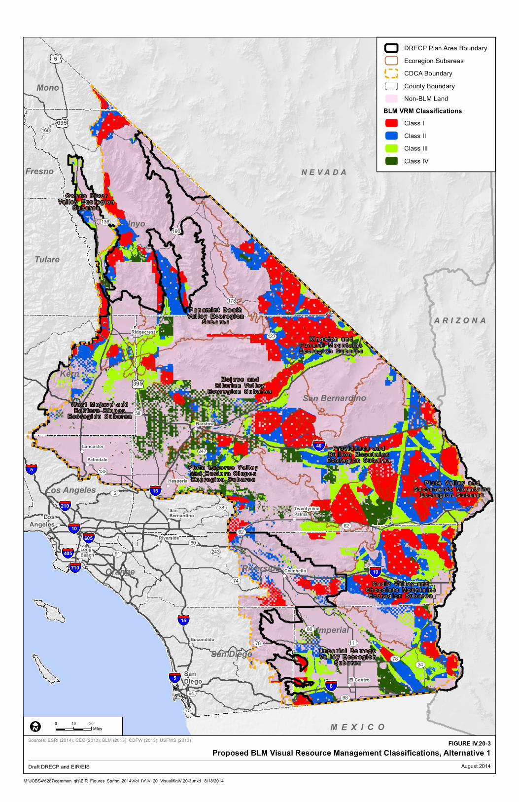
!(
!(
!(
!(
!(
!(
!(
!(
!(
!(
!( !(
!(
!(
§̈¦10
§̈¦405
§̈¦605
§̈¦210
§̈¦15
§̈¦710
§̈¦15
§̈¦10
§̈¦8
§̈¦5
§̈¦40
§̈¦5
£¤6
£¤395
£¤395
UV190
UV58
UV178
UV127
UV78
UV2
UV91
UV86
UV98
UV136
UV168
UV247
UV34
UV74
UV94
UV60
UV138
UV75
UV243
UV62
UV111
UV62
UV38
UV78
Inyo
San Bernardino
Kern
Riverside
Imperial
Tulare
San Diego
Los Angeles
Mono
Fresno
Orange
M E X I C O
O w e n s R i v e r
V a l l e y E c o r e g i o nS u b a r e a
P a n a m i n t D e a t h
V a l l e y E c o r e g i o nS u b a r e a
W e s t M o j a v e a n d
E a s t e r n S l o p e sE c o r e g i o n S u b a r e a
M o j a v e a n d
S i l u r i a n V a l l e yE c o r e g i o n S u b a r e a
K i n g s t o n a n d
F u n e r a l M o u n t a i n sE c o r e g i o n S u b a r e a
P r o v i d e n c e a n d
B u l l i o n M o u n t a i n sE c o r e g i o n S u b a r e a
P i n t o L u c e r n e V a l l e y
a n d E a s t e r n S l o p e sE c o r e g i o n S u b a r e a
P i u t e V a l l e y a n d
S a c r a m e n t o M o u n t a i n sE c o r e g i o n S u b a r e a
C a d i z V a l l e y a n d
C h o c o l a t e M o u n t a i n sE c o r e g i o n S u b a r e a
I m p e r i a l B o r r e g o
V a l l e y E c o r e g i o nS u b a r e a
Escondido
Lancaster
Palmdale
Long
Beach
Ridgecrest
Barstow
Hesperia
Riverside
SanBernardino
Twentynine
Palms
Coachella
El Centro
San
Diego
Los
Angeles
A R I Z O N AA R I Z O N A
N E V A D AN E V A D A
!(
!(
!(
!(
!(
!(
!(
!(
!(
!(
!( !(
!(
!(
§̈¦10
§̈¦405
§̈¦605
§̈¦210
§̈¦15
§̈¦710
§̈¦15
§̈¦10
§̈¦8
§̈¦5
§̈¦40
§̈¦5
£¤6
£¤395
£¤395
UV190
UV58
UV178
UV127
UV78
UV2
UV91
UV86
UV98
UV136
UV168
UV247
UV34
UV74
UV94
UV60
UV138
UV75
UV243
UV62
UV111
UV62
UV38
UV78
Inyo
San Bernardino
Kern
Riverside
Imperial
Tulare
San Diego
Los Angeles
Mono
Fresno
Orange
M E X I C O
O w e n s R i v e r
V a l l e y E c o r e g i o nS u b a r e a
P a n a m i n t D e a t h
V a l l e y E c o r e g i o nS u b a r e a
W e s t M o j a v e a n d
E a s t e r n S l o p e sE c o r e g i o n S u b a r e a
M o j a v e a n d
S i l u r i a n V a l l e yE c o r e g i o n S u b a r e a
K i n g s t o n a n d
F u n e r a l M o u n t a i n sE c o r e g i o n S u b a r e a
P r o v i d e n c e a n d
B u l l i o n M o u n t a i n sE c o r e g i o n S u b a r e a
P i n t o L u c e r n e V a l l e y
a n d E a s t e r n S l o p e sE c o r e g i o n S u b a r e a
P i u t e V a l l e y a n d
S a c r a m e n t o M o u n t a i n sE c o r e g i o n S u b a r e a
C a d i z V a l l e y a n d
C h o c o l a t e M o u n t a i n sE c o r e g i o n S u b a r e a
I m p e r i a l B o r r e g o
V a l l e y E c o r e g i o nS u b a r e a
Escondido
Lancaster
Palmdale
Long
Beach
Ridgecrest
Barstow
Hesperia
Riverside
SanBernardino
Twentynine
Palms
Coachella
El Centro
San
Diego
Los
Angeles
A R I Z O N AA R I Z O N A
N E V A D AN E V A D A
DRECP Plan Area Boundary
Ecoregion Subareas
CDCA Boundary
County Boundary
Non-BLM Land
BLM VRM Classifications
Class I
Class II
Class III
Class IV
M:\JOBS4\6287\common_gis\EIR_Figures_Spring_2014\Vol_IV\IV_20_Visual\figIV.20-3.mxd 8/18/2014
FIGURE IV.20-3
Proposed BLM Visual Resource Management Classifications, Alternative 1
0 2010
MilesI
Draft DRECP and EIR/EIS
Sources: ESRI (2014); CEC (2013); BLM (2013); CDFW (2013); USFWS (2013)
August 2014

Draft DRECP and EIR/EIS CHAPTER IV.20 VISUAL RESOURCES
Vol. IV of VI IV.20-62 August 2014
INTENTIONALLY LEFT BLANK

Draft DRECP and EIR/EIS CHAPTER IV.20 VISUAL RESOURCES
Vol. IV of VI IV.20-63 August 2014
Impact Reduction Strategies and Mitigation
The implementation of Alternative 1 would result in conservation of some desert lands as
well as the development of renewable energy generation and transmission facilities on
other lands. The visual impacts of the renewable energy development covered by the Plan
would be lessened in several ways. The Plan incorporates CMAs for each alternative,
including specific biological reserve design components and LUPA components. In addition,
the implementation of existing laws, orders, regulations, and standards would reduce the
impacts of project development.
Conservation and Management Actions
The conservation strategy for Alternative 1 (presented in Volume II, Section II.3.1.1)
defines specific actions that would reduce the impacts of this alternative. The conservation
strategy includes a definition of the reserve design and specific CMAs for the Preferred
Alternative. While the CMAs were developed for BLM lands only, this analysis assumes that
all CMAs would be applied also to nonfederal lands.
Specific visual resource CMAs have been developed and apply to the Preferred Alternative
and all action alternatives. They are summarized in Section IV.20.3.2.1.1, Plan-wide Impacts
and Mitigation Measures from Renewable Energy and Transmission Development. These
CMAs for VRM include measures that apply Plan-wide, measures specific to DFAs and Study
Area Lands, and a detailed set of visual resource BMPs that apply to all action alternatives.
The BMPs incorporate the measures identified in Best Management Practices for Reducing
Visual Impacts of Renewable Energy Facilities on BLM-Administered Lands. These visual
resource CMAs provide a comprehensive framework of guidelines and specifications through
which visual impacts would be avoided where possible, minimized, and/or mitigated to the
extent practicable.
Laws and Regulations
Similar to the No Action Alternative, existing laws and regulations will reduce certain
impacts of Plan implementation under Alternative 1. Relevant regulations are presented in
the Regulatory Setting in Volume III. The requirements of relevant laws and regulations as
related to impact reduction are summarized in Section IV.20.3.1.1.1.
Mitigation Measures
The visual impact avoidance and reduction strategies in existing guidance, such Reducing
Visual Impacts of Renewable Energy Facilities on BLM-Administered Lands, are detailed and
comprehensive. The CMAs proposed under the DRECP (see Appendix H) provide additional

Draft DRECP and EIR/EIS CHAPTER IV.20 VISUAL RESOURCES
Vol. IV of VI IV.20-64 August 2014
detail and direction. These represent state-of-the-art visual impact mitigation as it applies
to the Plan Area; no additional mitigation is feasible.
IV.20.3.3.1.2 Impacts from Reserve Design
There would be approximately 15 million acres of Reserve Design Lands under both Alter-
native 1 and the Preferred Alternative. In general, visual resource elements would benefit
from the conservation policies and requirements of these lands. Alternative 1 has approxi-
mately the same amount of BLM LUPA Conservation Designations as the Preferred Alterna-
tive, with an emphasis on ACECs and wildlife allocations.
The following summarizes the key points in visual impacts of the reserve design for Alter-
native 1 compared with those of the Preferred Alternative (see Appendix R2, Table R2.20-10
for detailed data):
VRI Classes: Alternative 1 would have 100% of VRI Class I lands, 74% of VRI Class II
lands, 67% of VRI Class III lands, and 71% of VRI Class IV lands in Reserve Design
Lands, compared to similar amounts (100%, 74%, 67%, and 72% respectively)
under the Preferred Alternative.
VRM Classes: 100% of VRM Class I lands, 81% of VRM Class II lands, 65% of VRM
Class III lands, and 66% of the VRM Class IV lands would be in the Reserve Design
Lands under Alternative 1, compared with 100% of VRM Class I lands, 83% of VRM
Class II lands, 79% of VRM Class III lands, and 38% of VRM Class IV lands under the
Preferred Alternative.
National Parks and Preserves: The National Parks and Preserves would have
100% of their land areas in the reserve design under Alternative 1 and under the
Preferred Alternative.
National Scenic Byways: Under Alternative 1, approximately 50% of the Bradshaw
Trail National Back Country Byway and 11% of SR 190 would be in the Reserve
Design. This provides a similar level of protection of visual and scenic values as
would occur under the Preferred Alternative (51% and 15% respectively).
National Scenic and Historic Trails: Under Alternative 1, approximately 54% of
the Juan Bautista de Anza National Historic Trail, 58% of the Old Spanish National
Historic Trail, and 41% of the Pacific Crest National Scenic Trail alignments in the
Plan Area would be in the Reserve Design.
Under the Preferred Alternative, approximately 4% of the Juan Bautista de Anza
National Historic Trail, 58% of the Old Spanish National Historic Trail, and 40% of
the Pacific Crest National Scenic Trail alignments would be in conservation.

Draft DRECP and EIR/EIS CHAPTER IV.20 VISUAL RESOURCES
Vol. IV of VI IV.20-65 August 2014
California State Parks: As with the Preferred Alternative, most California State
Park lands would be in Reserve Design Lands under Alternative 1. This would vary
by individual park or preserve; but most parks would have more than 90% in either
existing conservation areas, BLM LUPA designations, or CPAs. Exceptions are the (1)
Desert Cahuilla/Freeman Project (4%), (2) Picacho SRA (78%), and (3) Salton Sea
SRA (86%). Similar amounts and percentages of California State Park lands would
be in Reserve Design Lands under the Preferred Alternative.
State Scenic Highways: Approximately 16% of SR 190 but no portion of the SR 78
and U.S. 395 alignments would be in Reserve Design Lands, compared with similar
portions under the Preferred Alternative.
Wild and Scenic Rivers: 100% of the Amargosa Wild and Scenic River, and all
eligible segments of Surprise Canyon Creek and the Mojave River, would be within
the reserve design under Alternative 1 and the Preferred Alternative.
IV.20.3.3.2 Impacts of DRECP Land Use Plan Amendment on BLM Land: Alternative 1
This section addresses two components of effects of the BLM LUPA: the streamlined
development of renewable energy and transmission on BLM land under the LUPA, and the
impacts of the amended land use plans themselves.
IV.20.3.3.2.1 Impacts from Renewable Energy and Transmission Development on BLM Land
The visual impacts of DFAs on VRI and VRM lands for Alternative 1 would be the same as
those defined in Section IV.20.3.3.1 for the Plan-wide analysis. VRM Class I lands would not
exist within DFAs. However, renewable energy development on DFA lands would be visible
to viewers on adjacent lands outside of DFAs.
IV.20.3.3.2.2 Impacts of Changes to BLM Land Designations
The DRECP LUPA for Alternative 1 would establish VRM classes for all lands in the CDCA.
(Currently, only the Bishop RMP and the Imperial Sand Dunes RAMP have VRM Classes
designated. In accordance with BLM policy, all wilderness areas and WSAs are managed
as VRM Class I.) It also would (1) designate new NLCS lands; (2) designate new ACECs
and expand and reduce existing ACECs; (3) designate new SRMAs and expand and reduce
existing SRMAs; (4) create management corridors along National Scenic and Historic
Trails; (5) manage lands with wilderness characteristics to protect those characteristics;
and, (6) designate new wildlife allocations. The BLM LUPA would also replace the existing
multiple-use classes.
Draft DRECP and EIR/EIS CHAPTER IV.20 VISUAL RESOURCES
Vol. IV of VI IV.20-66 August 2014
The VRM Classes and other BLM land designations proposed under Alternative 1 would
extend protective measures to these areas that would avoid or reduce visual impacts. As
with the Preferred Alternative, CMAs for visual resources would be established and imple-
mented. The BLM-specific CMAs proposed under the Preferred Alternative would be the
same for all action Alternatives. Together, these visual resource CMAs and the restrictions
and protective measures of the land designations provide a mutually supportive frame-
work of guidelines and specifications through which visual impacts would be avoided
where possible, minimized, and/or mitigated to the extent practicable.
Under Alternative 1, Trail Management Corridors would be established along National
Scenic and Historic Trails, at a width of generally 0.25 miles from the centerline of the trail,
for a total width of 0.5 miles (compared with the 20 times greater total width of 10 miles
under the Preferred Alternative). As discussed in Volume II, Section II.3.2.2.2, these Trail
Management Corridors would be managed as components of the BLM’s NLCS. Where
National Trails overlap other NLCS lands, the more protective CMAs or land use allocations
would apply. All Trail Management Corridors would be designated as VRM Class II, except
within approved transmission corridors (VRM Class III) and DFAs (VRM Class IV). How-
ever, state-of-the-art VRM BMPs for renewable energy would be employed commensurate
with the protection of nationally significant scenic resources and cultural landscapes to
minimize the level of intrusion and protect trail settings.
The following summarizes the key points of the impacts of changes to BLM land designa-
tions on visual resource elements under Alternative 1 (see Appendix R2, Table R2.20-11 for
detailed, quantitative data and analysis):
SRMAs: There would be the potential for recreational activities or facilities allowed
in SRMAs to affect scenic values, particularly those of the VRI Class I and II lands
with which they coincide (approximately 285,000 acres, similar to the
Preferred Alternative).
NLCS: The management of these lands that have nationally significant ecological,
cultural, and scientific values would offer additional protection of intactness and
scenic quality, particularly to the VRI Class I, II, III, and IV lands with which they
coincide (1.5 million acres, compared to 3.6 million acres under the
Preferred Alternative).
ACECs: The special management measures given to protect the important historic,
cultural, and scenic values of these areas would generally benefit visual resources,
particularly the VRI Class II, III, and IV lands with which they coincide (2.8 million
acres, compared with 1.4 million acres under the Preferred Alternative).

Draft DRECP and EIR/EIS CHAPTER IV.20 VISUAL RESOURCES
Vol. IV of VI IV.20-67 August 2014
Wildlife Allocation Areas: The management of these areas must be compatible
with protection and enhancement of wildlife and plant habitat and would generally
benefit visual resources, particularly the VRI Class III and IV lands with which they
coincide (approximately 528,000 acres, compared with a much smaller area of
18,000 acres under the Preferred Alternative).
Lands Managed for Wilderness Characteristics: No lands managed for wilder-
ness characteristics would be managed to protect wilderness characteristics under
Alternative 1. Under the Preferred Alternative, these lands would be managed as
VRM Class II. Other management strategies to protect the wilderness characteristics
of these lands would benefit visual resources, particularly the VRI Class II, III, and IV
lands with which they coincide (approximately 299,000 acres).
Trail Management Corridors: The primary effect of these 0.5-mile wide corridors
under Alternative 1 would be to provide a consistent framework for protecting and
managing scenic values along National Scenic Trails within National and California
State park lands. As with the Preferred Alternative, the Trail Management Corridors
would be managed to meet the visual management objectives of VRM Class II.
Alternative 1 would assign VRM classes to all BLM lands within the Plan Area. Generally, a
low correlation between the VRM classes and the underlying VRI classes would result in
greater adverse impacts to visual quality (e.g., VRI Class II or III lands managed to meet
the objectives of a VRM Class IV). Conversely, impacts would most likely be minimized by
alternatives proposing visual management that either closely corresponds to the VRI
classes, or proposing a more restrictive (higher) class designation (e.g., VRM Class II
proposed for VRI Class III lands).
Under Alternative 1, VRI Class lands within the proposed VRM Classes on BLM LUPA lands
would be as indicated in Table IV.20-6. Key points of the effects of VRM classifications on
VRI lands under Alternative 1 are summarized here:
VRM designations: As with the Preferred Alternative, the majority of lands would be
designated as VRM Class I, II, or III; and approximately 15% would be designated as
VRM Class IV.
VRI Class I: As with the Preferred Alternative, 100% VRI Class I lands would be man-
aged as VRM Class I, reflecting a high level of management protection.
VRI Class II: As with the Preferred Alternative, more than 75% of VRI Class II lands
would be managed as VRM Class II or I, reflecting a moderately high level of man-
agement protection. Approximately 22% would be managed as VRM Class III or IV,
which allows for more visual contrast and impact than the VRM Class II objectives
allow over the affected acres.

Draft DRECP and EIR/EIS CHAPTER IV.20 VISUAL RESOURCES
Vol. IV of VI IV.20-68 August 2014
VRI Class III: Nearly 91% of VRI Class III lands would be managed as VRM Class
III, II, or I, reflecting a high correlation and level of management protection. Approx-
imately 35% would be managed to meet VRM Class II objectives, which restrict
visual contrast and impact more than VRM Class III. Approximately 9% would be
managed as VRM Class IV, which allows for more visual contrast and impact than
the VRM Class III objectives allow.
VRI Class IV: Approximately 43% of VRI Class IV lands would be managed as VRM
Class III, II, or I, reflecting more restrictive management than the VRM Class IV
objectives allow; and approximately 57% would be managed as VRM Class IV.
Compared with the Preferred Alternative, Alternative 1 would result in a similar but
somewhat higher level of correlation between VRI values and the proposed VRM
Classes. Overall, visual resource protection would benefit under Alternative 1 by the
designation of VRM Classes throughout the CDCA.
Under the proposed CMAs, all DFAs would be managed as VRM Class IV lands to
allow for utility-scale development. In those cases, implementation or incorporation
of BMPs would still be required to reduce the visual contrast levels of proposed
facilities to the extent practicable.
IV.20.3.3.3 Impacts of Natural Community Conservation Plan: Alternative 1
The impacts of the NCCP for Alternative 1 would be the same as those defined in
Section IV.20.3.2.1 for the Plan-wide analysis.
IV.20.3.3.4 Impacts of General Conservation Plan
The visual impacts of the GCP for Alternative 1 would be similar to those defined in
Section IV.20.3.2.1 for the Plan-wide analysis, but they would occur on nonfederal
lands only.
IV.20.3.3.5 Impacts Outside the Plan Area
IV.20.3.3.5.1 Impacts of Transmission Outside the Plan Area
The impacts of transmission outside the Plan Area would be the same under all
alternatives. These are as described for the No Action Alternative in
Section IV.20.3.1.5.1.
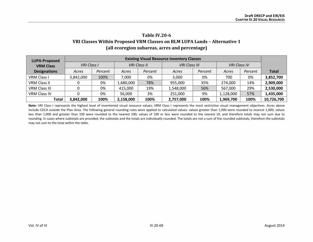
Draft DRECP and EIR/EIS CHAPTER IV.20 VISUAL RESOURCES
Vol. IV of VI IV.20-69 August 2014
Table IV.20-6
VRI Classes Within Proposed VRM Classes on BLM LUPA Lands – Alternative 1
(all ecoregion subareas, acres and percentage)
LUPA-Proposed VRM Class
Designations
Existing Visual Resource Inventory Classes
Total
VRI Class I VRI Class II VRI Class III VRI Class IV
Acres Percent Acres Percent Acres Percent Acres Percent
VRM Class I 3,842,000 100% 7,000 0% 3,000 0% 700 0% 3,852,700
VRM Class II 0 0% 1,680,000 78% 955,000 35% 274,000 14% 2,909,000
VRM Class III 0 0% 415,000 19% 1,548,000 56% 567,000 29% 2,530,000
VRM Class IV 0 0% 56,000 3% 251,000 9% 1,128,000 57% 1,435,000
Total 3,842,000 100% 2,158,000 100% 2,757,000 100% 1,969,700 100% 10,726,700
Note: VRI Class I represents the highest level of inventoried visual resource values; VRM Class I represents the most restrictive visual management objectives. Acres above include CDCA outside the Plan Area. The following general rounding rules were applied to calculated values: values greater than 1,000 were rounded to nearest 1,000; values less than 1,000 and greater than 100 were rounded to the nearest 100; values of 100 or less were rounded to the nearest 10, and therefore totals may not sum due to rounding. In cases where subtotals are provided, the subtotals and the totals are individually rounded. The totals are not a sum of the rounded subtotals; therefore the subtotals may not sum to the total within the table.

Draft DRECP and EIR/EIS CHAPTER IV.20 VISUAL RESOURCES
Vol. IV of VI IV.20-70 August 2014
IV.20.3.3.5.2 Impacts of BLM LUPA Decisions Outside the Plan Area
Under the proposed BLM LUPA, the changes outside the Plan Area would include the desig-
nation of NLCS lands, ACECs, National Scenic and Historic Trails Management Corridors,
VMR Classes, and new land allocations to replace multiple-use classes on CDCA lands.
The VRM Classes and other BLM land designations proposed under Alternative 1 would
extend protective measures that would avoid or reduce visual impacts. CMAs for visual
resources would be established and implemented. The BLM-specific CMAs for Alternative 1
would be the same as for all action alternatives. These visual resource CMAs and the restric-
tions and protective measures of the land designations provide a framework of guidelines
and specifications through which visual impacts would be avoided where possible, mini-
mized, and/or mitigated to the extent practicable.
The following summarizes the key points of the impacts of changes to BLM land designa-
tions on visual resource elements, outside the Plan Area, under Alternative 1 (see Appen-
dix R2, Table R2.20-12 for detailed, quantitative data and analysis):
Proposed NLCS: The management of these lands that have nationally significant
ecological, cultural, and scientific values would offer additional protection of intact-
ness and scenic quality.
Existing and Proposed ACECs: The special management measures given to protect
the important historic, cultural, and scenic values of these areas would generally
benefit visual resources, particularly the VRM Class II, III, and IV lands with which
they coincide (approximately 123,000 acres, compared with a larger area of 207,000
acres under the Preferred Alternative).
Trail Management Corridors: The primary effect of these 0.5-mile-wide corridors
would be to provide a consistent framework for protecting and managing scenic
values along National Scenic and Historic Trails within National and California State
park lands. As with the Preferred Alternative, the Trail Management Corridors
would be managed to meet the visual management objectives of VRM Class II.
IV.20.3.3.6 CEQA Significance Determination for Alternative 1
The visual impacts and their associated significance determinations for Alternative 1 are
as follows:
VR-1: Visibility of activities, materials, equipment, dust, and construction night light-
ing would result in short-term diminished scenic quality. Activities and equipment
visible from residences, public roads, and public preserves would result in short-term
Draft DRECP and EIR/EIS CHAPTER IV.20 VISUAL RESOURCES
Vol. IV of VI IV.20-71 August 2014
diminished scenic quality for viewers. This would be less than significant with implementa-
tion of appropriate CMAs.
VR-2: The presence of plan components would create long-term visual contrast with
surrounding undeveloped land and result in long-term diminished scenic quality.
Long-term impacts to visual resources for Alternative 1 would be significant and unavoid-
able, as described in detail for the No Action Alternative in Section IV.20.3.1.6. Impacts
would be significant because of the changes in line, form, and color introduced by large-
scale development and the contrast of any such development with surrounding conditions.
The CMAs relevant to Alternative 1 would reduce the impact on visual resources but not to
a less than significant level.
IV.20.3.3.7 Comparison of Alternative 1 with the Preferred Alternative
Chapter IV.27 presents a comparison of all action alternatives and the No Action Alterna-
tive across all disciplines. This section summarizes the comparison of Alternative 1 with
the Preferred Alternative.
IV.20.3.3.7.1 Alternative 1 Compared with Preferred Alternative for Plan-wide DRECP
Although similar visual impacts would occur under both Alternative 1 and the Preferred
Alternative, based on the assumption that California’s renewable energy goals would be
achieved in any case, the impacts would vary in key ways:
Geographic Distribution. As with the DFAs of the Preferred Alternative, the DFAs under
Alternative 1 are restricted in distribution and concentrated in areas considered less
environmentally sensitive. DFAs under Alternative 1 are focused in the Imperial Valley,
Lucerne Valley, and Barstow area. Alternative 1 has fewer DFAs in eastern Riverside and
the Tehachapi area than the Preferred Alternative and very small DFAs along the
U.S. 395 corridor.
The severity of visual impacts depends partly on the number of potential viewers. Alterna-
tive 1 has a smaller DFA in the more populated West Mojave area. As a result, less new
development would be added to the existing visual disturbance experienced by residents in
the Mojave, Lancaster, and Palmdale areas due to extensive wind and solar development in
those areas.
The severity of visual impacts also relates to expectations of viewers for pristine desert
vistas. The eastern and northeastern parts of the Plan Area are sensitive because they con-
tain the Mojave National Preserve, Death Valley National Monument, and several BLM Wil-
derness Areas. Alternative 1 completely avoids development in these areas, and does not
include SAAs or FAAs near these LLPAs.

Draft DRECP and EIR/EIS CHAPTER IV.20 VISUAL RESOURCES
Vol. IV of VI IV.20-72 August 2014
Extent of Potential Renewable Energy Development. Although the geographic distribu-
tion of DFAs is generally similar under Alternative 1 and the Preferred Alternative, the
scale and extent of the DFAs vary. The DFAs under the Preferred Alternative are nearly
twice as large as those of Alternative 1 (2,024,000 acres of DFAs for the Preferred Alterna-
tive compared with 1,070,000 acres for Alternative 1). The smaller DFAs would result in
more concentrated development under Alternative 1, with renewable energy projects
being visible from far fewer areas than with the Preferred Alternative.
Conservation. Alternative 1 has slightly more acreage in the reserve design than the Pre-
ferred Alternative, and slightly less land in CPAs. The conservation strategy emphasizes
avoidance of impacts to visually sensitive areas.
In summary, the composition and structure of Alternative 1 would provide greater oppor-
tunities for the avoidance, reduction, and minimization of visual impacts from renewable
energy development but would result in greater impacts from transmission corridors, com-
pared with the Preferred Alternative.
IV.20.3.3.7.2 Alternative 1 Compared with Preferred Alternative for the BLM
Land Use Plan Amendment
The BLM LUPA under Alternative 1 would assign VRM Classes to all BLM lands within the
CDCA, including those outside the Plan Area, as would the Preferred Alternative. For both
alternatives, this would provide a unifying framework and an established system for
addressing visual resources.
The key difference is that Alternative 1 would have far fewer VRI Class II and III lands
(12,000 acres) in DFAs than would the Preferred Alternative (78,000 acres). This differ-
ence in the potential area of land disturbance impacts would result in a much smaller area
of land potentially subject to visual impacts under Alternative 1 than under the Preferred
Alternative. However, because Alternative 1 proposes 0.5-mile-wide Trail Management
Corridors, compared with the much greater 10-mile-wide corridors under the Preferred
Alternative, the scenic values and viewer experience along National Scenic and Historic
Trails would have a lower level of protection under Alternative 1 than under the
Preferred Alternative.
IV.20.3.3.7.3 Alternative 1 Compared with Preferred Alternative for NCCP
The visual impacts of the NCCP for Alternative 1 are the same as those defined in Section
IV.20.3.2.1 for the Plan-wide analysis. As a result, the comparison of Alternative 1 with the
Preferred Alternative for the NCCP is the same as described for Plan-wide DRECP.

Draft DRECP and EIR/EIS CHAPTER IV.20 VISUAL RESOURCES
Vol. IV of VI IV.20-73 August 2014
IV.20.3.3.7.4 Alternative 1 Compared with Preferred Alternative for the GCP
The visual impacts of the GCP for Alternative 1 and the Preferred Alternative would be sim-
ilar to those defined in Section IV.20.3.2.1 for the Plan-wide analysis, but they would occur
on nonfederal lands only.
IV.20.3.4 Alternative 2
Alternative 2 includes 2,473,000 acres of DFAs and 15,085,000 acres of Reserve Design
Lands. For reference, Table IV.20-7 compares the Preferred Alternative to Alternative 2 for
key visual elements.
Table IV.20-7
Affected Visual Resources – Preferred Alternative Compared to Alternative 2
Preferred Alternative Alternative 2
Development Areas (acres)
DFAs 2,024,000 2,473,000
Visual Resource Elements Within Development Areas (acres unless otherwise indicated)
VRI [Class] 0 [I]
17,000 [II]
61,000 [III]
27,000 [IV]
0 [I]
39,000[II]
89,000 [III]
66,000 [IV]
VRM [Class] 0 [I]
0 [II]
0 [III]
106,000 [IV]
0 [I]
0 [II]
0 [III]
191,000 [IV]
National Scenic Byways 0 0
National Scenic and Historic Trails 1 mi. 6 mi.
California State Parks 0 0
State Scenic Highways 0 0
Wild and Scenic Rivers 0 0
Visual Resource Elements Within 5 miles of Development Areas (acres unless otherwise indicated)
VRI [Class] 366,000 [I]
389,000 [II]
731,000 [III]
709,000 [IV]
686,000 [I]
691,000 [II]
1,133,000 [III]
941,000 [IV]
VRM [Class] 366,000 [I]
515,000 [II]
555,000 [III]
694,000 [IV]
686,000 [I]
1,088,000 [II]
859,000 [III]
759,000 [IV]
National Scenic Byways 13 mi. 13 mi.

Draft DRECP and EIR/EIS CHAPTER IV.20 VISUAL RESOURCES
Vol. IV of VI IV.20-74 August 2014
Table IV.20-7
Affected Visual Resources – Preferred Alternative Compared to Alternative 2
Preferred Alternative Alternative 2
National Parks and Preserves 15,000 33,000
National Scenic and Historic Trails 350 mi. 395 mi.
Trail Management Corridors 659,000 1,586,000
California State Parks 108,000 121,000
State Scenic Highways 0 0
Wild and Scenic Rivers 0 0
Reserve Design Lands (Conservation Lands) (acres)
Reserve Design Lands 14,920,000 15,085,000
Note: The following general rounding rules were applied to calculated values: values greater than 1,000 were rounded to nearest 1,000; values less than 1,000 and greater than 100 were rounded to the nearest 100; values of 100 or less were rounded to the nearest 10, and therefore totals may not sum due to rounding. In cases where subtotals are provided, the subtotals and the totals are individually rounded. The totals are not a sum of the rounded subtotals; therefore the subtotals may not sum to the total within the table.
IV.20.3.4.1 Plan-wide Impacts of Implementing the DRECP: Alternative 2
IV.20.3.4.1.1 Plan-wide Impacts and Mitigation Measures from Renewable Energy and
Transmission Development
Impact Assessment
Under Alternative 2, renewable energy related activities covered by the Plan are confined
to 2.5 million acres of DFAs, resulting in 134,000 acres of long-term disturbance (see
Volume IV, Table IV.1-1). This represents approximately 11,000 more acres of long-term
disturbance than could occur under the Preferred Alternative.
The DFAs are geographically dispersed in the Imperial Valley including areas south of
Chocolate Mountains, eastern Riverside, the Lucerne Valley, the Barstow area, the Tehach-
api area, along the U.S. 395 corridor, the Silurian Valley, and near Hidden Hills.
Transmission development and operation activities would be permitted both inside and
outside of the DFAs.
Approximately 2,473,000 acres would be within DFAs under Alternative 2, compared with
2,024,000 acres under the Preferred Alternative. This larger area of land within DFAs
(approximately 450,000 acres more) represents a higher potential for visual impacts under
Alternative 2 than under the Preferred Alternative.

Draft DRECP and EIR/EIS CHAPTER IV.20 VISUAL RESOURCES
Vol. IV of VI IV.20-75 August 2014
Visual impacts from solar and wind development would be dispersed, with expanded
wind opportunities.
Visual impacts from geothermal energy would occur in the Imperial Borrego Valley and
Owens River Valley ecoregion subareas, as they would under the Preferred Alternative.
The following summarizes the key points in comparing the visual impacts from renewable
energy and transmission development under Alternative 2 to those of the Preferred Alter-
native (see Appendix R2, Table R2.20-13 for detailed data):
VRI Classes: There would approximately 39,000 acres of VRI Class II lands, 89,000
VRI Class III lands, and no VRI Class I lands within DFAs under Alternative 2. Per the
CMAs for visual resources, these 128,000 acres of VRI Class II and III lands within
DFAs would be managed as VRM IV and thereby sustain a potential degradation of
underlying scenic values. Approximately 12,000 acres of transmission would occur
on inventoried lands, compared with 13,000 acres under the Preferred Alternative.
A smaller amount of VRI Class II and III lands within DFAs would be managed as
VRM IV under the Preferred Alternative (78,000 acres) than under Alternative 2
(128,000 acres). This reflects a greater potential for degradation of underlying
scenic values under Alternative 2 than under the Preferred Alternative.
VRM Classes: As with the Preferred Alternative, there would be no VRM Class I, II,
or III lands in DFAs under Alternative 2 (Figure IV.20-4, Proposed BLM VRM Classifi-
cations, Alternative 2).
National Parks and Preserves: These lands would not be within the DFA footprint
under Alternative 2 or the Preferred Alternative. Although the footprint of renew-
able energy projects would not directly affect these lands, project facilities and
activities that are visible from National Parks and Preserves would diminish scenic
quality for viewers in those conservation areas, where expectations for scenic quality
are typically high.
National Scenic Byways: No segments of the Bradshaw Trail National Back Country
Byway would be within DFAs under either Alternative 2 or the Preferred Alternative.
National Scenic and Historic Trails: Approximately 6 miles of the Old Spanish
National Historic Trail alignment would be within DFAs under Alternative 2, as com-
pared with 2 miles under Preferred Alternative.
California State Parks: As with the Preferred Alternative, no California State Park
lands would be within DFAs under Alternative 2. Approximately 160 acres of trans-
mission would occur on these lands, as compared with 180 acres under the
Preferred Alternative.

Draft DRECP and EIR/EIS CHAPTER IV.20 VISUAL RESOURCES
Vol. IV of VI IV.20-76 August 2014
State Scenic Highways: No segments of State Scenic Highways would be within
DFAs under Alternative 2 or the Preferred Alternative.
Wild and Scenic Rivers: No portion of designated or eligible Wild and Scenic Rivers
would be within DFAs under Alternative 2 or the Preferred Alternative.
Proximity of Visual Resources to DFAs. Under Alternative 2, visual resource
elements within 5 miles of proposed DFAs can be compared with those under the
Preferred Alternative, as summarized in Table IV.20-7. Alternative 2 has generally
more visual resource elements within 5 miles of DFAs than the Preferred Alternative.
One example of this is the acres of VRI Class I: 366,000 acres under the Preferred
Alternative compared with 686,000 acres under Alternative 2. For Trail Management
Corridors, there are more than twice as many acres in this proximity under Alterna-
tive 2 than there would be under the Preferred Alternative.
The visual impacts resulting from Alternative 2 are:
Impact VR-1: Visibility of activities, materials, equipment, dust, and construction night
lighting would result in short-term diminished scenic quality.
Preconstruction activities and equipment visible from residences, public roads, and public
preserves would result in short-term diminished scenic quality for viewers. Examples
include road upgrading, damage to or removal of native vegetation, construction of meteoro-
logical towers, drilling of temperature gradient wells, vehicles, and lighting.
During construction and decommissioning, activities and equipment visible from residences,
public roads, and public preserves would result in short-term diminished scenic quality for
viewers. Examples include dust and exhaust emissions, removal of vegetation during site
clearing, contouring and grading, presence of vehicles and equipment, mobilization and
demobilization activities, material delivery and staging, assembly of components, site light-
ing, and construction of and later removal of structures.
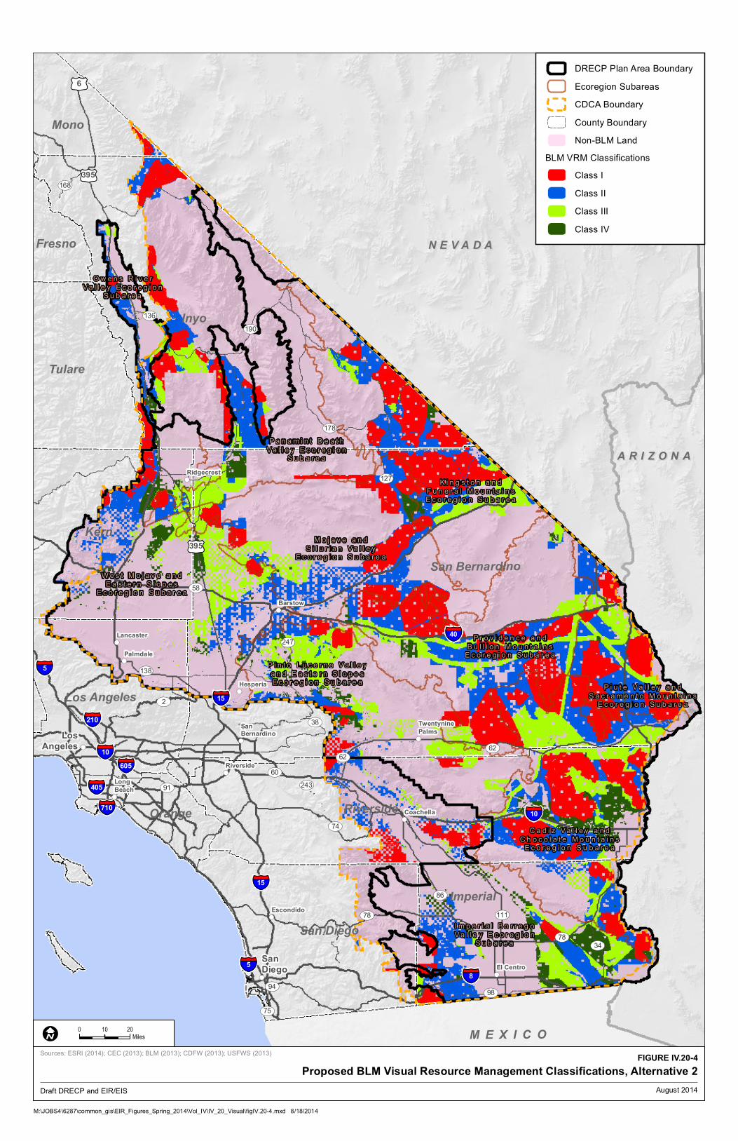
!(
!(
!(
!(
!(
!(
!(
!(
!(
!(
!( !(
!(
!(
§̈¦10
§̈¦405
§̈¦605
§̈¦210
§̈¦15
§̈¦710
§̈¦15
§̈¦10
§̈¦8
§̈¦5
§̈¦40
§̈¦5
£¤6
£¤395
£¤395
UV190
UV58
UV178
UV127
UV78
UV2
UV91
UV86
UV98
UV136
UV168
UV247
UV34
UV74
UV94
UV60
UV138
UV75
UV243
UV62
UV111
UV62
UV38
UV78
Inyo
San Bernardino
Kern
Riverside
Imperial
Tulare
San Diego
Los Angeles
Mono
Fresno
Orange
M E X I C O
O w e n s R i v e r
V a l l e y E c o r e g i o nS u b a r e a
P a n a m i n t D e a t h
V a l l e y E c o r e g i o nS u b a r e a
W e s t M o j a v e a n d
E a s t e r n S l o p e sE c o r e g i o n S u b a r e a
M o j a v e a n d
S i l u r i a n V a l l e yE c o r e g i o n S u b a r e a
K i n g s t o n a n d
F u n e r a l M o u n t a i n sE c o r e g i o n S u b a r e a
P r o v i d e n c e a n d
B u l l i o n M o u n t a i n sE c o r e g i o n S u b a r e a
P i n t o L u c e r n e V a l l e y
a n d E a s t e r n S l o p e sE c o r e g i o n S u b a r e a
P i u t e V a l l e y a n d
S a c r a m e n t o M o u n t a i n sE c o r e g i o n S u b a r e a
C a d i z V a l l e y a n d
C h o c o l a t e M o u n t a i n sE c o r e g i o n S u b a r e a
I m p e r i a l B o r r e g o
V a l l e y E c o r e g i o nS u b a r e a
Escondido
Lancaster
Palmdale
Long
Beach
Ridgecrest
Barstow
Hesperia
Riverside
SanBernardino
Twentynine
Palms
Coachella
El Centro
San
Diego
Los
Angeles
A R I Z O N AA R I Z O N A
N E V A D AN E V A D A
!(
!(
!(
!(
!(
!(
!(
!(
!(
!(
!( !(
!(
!(
§̈¦10
§̈¦405
§̈¦605
§̈¦210
§̈¦15
§̈¦710
§̈¦15
§̈¦10
§̈¦8
§̈¦5
§̈¦40
§̈¦5
£¤6
£¤395
£¤395
UV190
UV58
UV178
UV127
UV78
UV2
UV91
UV86
UV98
UV136
UV168
UV247
UV34
UV74
UV94
UV60
UV138
UV75
UV243
UV62
UV111
UV62
UV38
UV78
Inyo
San Bernardino
Kern
Riverside
Imperial
Tulare
San Diego
Los Angeles
Mono
Fresno
Orange
M E X I C O
O w e n s R i v e r
V a l l e y E c o r e g i o nS u b a r e a
P a n a m i n t D e a t h
V a l l e y E c o r e g i o nS u b a r e a
W e s t M o j a v e a n d
E a s t e r n S l o p e sE c o r e g i o n S u b a r e a
M o j a v e a n d
S i l u r i a n V a l l e yE c o r e g i o n S u b a r e a
K i n g s t o n a n d
F u n e r a l M o u n t a i n sE c o r e g i o n S u b a r e a
P r o v i d e n c e a n d
B u l l i o n M o u n t a i n sE c o r e g i o n S u b a r e a
P i n t o L u c e r n e V a l l e y
a n d E a s t e r n S l o p e sE c o r e g i o n S u b a r e a
P i u t e V a l l e y a n d
S a c r a m e n t o M o u n t a i n sE c o r e g i o n S u b a r e a
C a d i z V a l l e y a n d
C h o c o l a t e M o u n t a i n sE c o r e g i o n S u b a r e a
I m p e r i a l B o r r e g o
V a l l e y E c o r e g i o nS u b a r e a
Escondido
Lancaster
Palmdale
Long
Beach
Ridgecrest
Barstow
Hesperia
Riverside
SanBernardino
Twentynine
Palms
Coachella
El Centro
San
Diego
Los
Angeles
A R I Z O N AA R I Z O N A
N E V A D AN E V A D A
DRECP Plan Area Boundary
Ecoregion Subareas
CDCA Boundary
County Boundary
Non-BLM Land
BLM VRM Classifications
Class I
Class II
Class III
Class IV
M:\JOBS4\6287\common_gis\EIR_Figures_Spring_2014\Vol_IV\IV_20_Visual\figIV.20-4.mxd 8/18/2014
FIGURE IV.20-4
Proposed BLM Visual Resource Management Classifications, Alternative 2
0 2010
MilesI
Draft DRECP and EIR/EIS
Sources: ESRI (2014); CEC (2013); BLM (2013); CDFW (2013); USFWS (2013)
August 2014

Draft DRECP and EIR/EIS CHAPTER IV.20 VISUAL RESOURCES
Vol. IV of VI IV.20-78 August 2014
INTENTIONALLY LEFT BLANK
Draft DRECP and EIR/EIS CHAPTER IV.20 VISUAL RESOURCES
Vol. IV of VI IV.20-79 August 2014
Impact VR-2: The presence of plan components would create long-term visual contrast
with surrounding undeveloped land and result in long-term diminished scenic quality.
The continued presence of equipment, structures, fencing, roads and other elements
required to operate a facility would have a long-term adverse effect on the visible land-
scape. Areas of persistent surface and vegetation disturbance and the presence of struc-
tures would create visual contrast in form, line, color, and texture as compared with pre-
project conditions. Depending on viewer location, physical elements introduced by a proj-
ect could block views or create skylining. Even after project removal and site reclamation
are completed, visual contrast would remain. Restoring the natural, pre-disturbance visual
character of a desert environment is extremely difficult, can take decades, and often is
unsuccessful. Therefore, surface and vegetation disturbance would create long-term visual
impacts due to the persistence of scars in arid and semi-arid landscapes.
The structure, size, and industrial character of utility-scale renewable energy and transmis-
sion facilities during their operation and maintenance—as well as any associated glare,
reflectivity, and lighting—would visually contrast with surrounding undeveloped land and
result in long-term diminished scenic quality.
Impacts in Study Area Lands
Study Area Lands refer to three categories of lands shown on alternative maps: Assessment
Areas (FAAs), Special Analysis Areas (SAAs) and DRECP Variance Lands.
Future Assessment Areas (FAAs). Lands within FAAs are neither reserve lands nor DFAs;
they are simply areas that are deferred for future assessment. The future assessment will
determine their suitability for renewable energy development or ecological conservation. If
renewable energy development occurs on FAA lands, a BLM LUPA would not be required.
FAAs for each alternative are included and located as shown in Table IV.1-2 and Figure
II.5-1. The FAAs represent areas where renewable energy development or inclusion in the
reserve design could be implemented through an amendment to the DRECP, but additional
assessment would be needed.
Because most of the FAAs are presented as “undesignated areas” in the action alternatives,
there would be no difference between the FAAs in the Preferred Alternative except that
renewable development in an FAA would not require a BLM LUPA; so the environmental
review process would be somewhat simpler than if the location were left undesignated.
Development of the 109,000 acres of FAAs under Alternative 2 would be subject to all
visual resource CMAs identified by the Preferred Alternative and would be required to
meet the visual management objectives of the underlying VRM Class. The exception is the

Draft DRECP and EIR/EIS CHAPTER IV.20 VISUAL RESOURCES
Vol. IV of VI IV.20-80 August 2014
FAA south of the Imperial Sand Dunes, which would become a DFA under this alternative
and would be managed as VRM Class IV accordingly.
Special Analysis Areas (SAAs). Designating the SAAs as DFAs would result in impacts sim-
ilar to those identified for the DFAs for the Plan-wide impacts, all of which would be man-
aged to meet VRM Class IV objectives.
DRECP Variance Lands. There would be no DRECP Variance Lands under Alternative 2.
Impact Reduction Strategies and Mitigation
The implementation of the Plan would result in conservation of some desert lands as well
as the development of renewable energy generation and transmission facilities on other
lands. The impacts of the renewable energy development covered by the Plan would be
lessened in several ways. First, the Plan incorporates CMAs for each alternative, including
specific biological reserve design components and LUPA components. In addition, the
implementation of existing laws, orders, regulations, and standards would reduce the
impacts of project development.
Conservation and Management Actions
The conservation strategy (presented in Volume II, Section II.3.1.1) defines specific actions
that would reduce the impacts of this alternative. The conservation strategy includes a
definition of the reserve design and specific CMAs for the Preferred Alternative. While the
CMAs were developed for BLM lands only, this analysis assumes that all CMAs would be
applied also to nonfederal lands.
BLM-specific CMAs for VRM include measures that apply Plan-wide, measures specific to
DFAs and Plan Areas, and a detailed set of visual resource BMPs that apply to all action
alternatives. The BMPs incorporate the measures identified in Best Management Practices
for Reducing Visual Impacts of Renewable Energy Facilities on BLM-Administered Lands.
Together, these visual resource CMAs provide a comprehensive framework of guidelines
and specifications through which visual impacts would be avoided where possible, mini-
mized, and/or mitigated to the extent practicable.
Laws and Regulations
Similar to the No Action Alternative, existing laws and regulations will reduce certain
impacts of Plan implementation. Relevant regulations are presented in the Regulatory
Setting in Volume III. The requirements of relevant laws and regulations are summarized in
Section IV.20.3.1.1.1.

Draft DRECP and EIR/EIS CHAPTER IV.20 VISUAL RESOURCES
Vol. IV of VI IV.20-81 August 2014
Mitigation Measures
The visual impact avoidance and reduction strategies in existing guidance, such Reducing
Visual Impacts of Renewable Energy Facilities on BLM-Administered Lands, are detailed
and comprehensive. The CMAs proposed under the DRECP (see Appendix H) provide
additional detail and direction. These represent state-of-the-art visual impact mitigation as
it applies to the Plan Area; no additional mitigation is feasible.
IV.20.3.4.1.2 Impacts from Reserve Design
There would be 15 million acres of Reserve Design Lands under Alternative 2 and under
the Preferred Alternative. This represents a generally equivalent level of conservation to
the Preferred Alternative. In general, visual resource elements would benefit from the
conservation policies and requirements applicable to these lands. Alternative 2 has
slightly more acres of BLM LUPA Conservation Designations than the Preferred
Alternative and the most acres of NLCS, SRMAs, and National Scenic and Historic Trail
corridors of all action alternatives.
The following summarizes the key points in visual impacts of the reserve design for Alter-
native 2 compared with those of the Preferred Alternative (see Appendix R2, Table R2.20-14
for detailed data):
VRI Classes: Alternative 2 would have 100% of VRI Class I lands, 79% of VRI Class II
lands, 73% of VRI Class III lands, and 73% of VRI Class IV lands in Reserve Design
Lands, compared with similar amounts (100%, 74%, 67%, and 72%, respectively)
under the Preferred Alternative.
VRM Classes: 100% of VRM Class I lands, 86% of VRM Class II lands, 87% of VRM
Class III lands, and 1% of the VRM Class IV lands would be in the Reserve Design
Lands under Alternative 2, compared with 100% of VRM Class I lands, 83% of VRM
Class II lands, 79% of VRM Class III lands, and 38% of VRM Class IV lands under the
Preferred Alternative. Alternative 2 would have a much smaller amount of VRM
Class IV lands in the reserve design than the Preferred Alternative.
National Parks and Preserves: The National Parks and Preserves would have
100% of their land areas in the reserve design under Alternative 1 and under the
Preferred Alternative.
National Scenic Byways: Under Alternative 2, approximately 51% of the Bradshaw
Trail National Back Country Byway and 15% of SR 190 would be in the Reserve
Design. This provides the same level of protection of visual and scenic values as
would occur under the Preferred Alternative.
National Scenic and Historic Trails: Under Alternative 2, approximately 4% of the
Juan Bautista de Anza National Historic Trail, 58% of the Old Spanish National His-
Draft DRECP and EIR/EIS CHAPTER IV.20 VISUAL RESOURCES
Vol. IV of VI IV.20-82 August 2014
toric Trail, and 51% of the Pacific Crest National Scenic Trail alignments in the Plan
Area would be in the Reserve Design. This provides a similar level of protection of
visual and scenic values as would occur under the Preferred Alternative (4%, 58%,
and 40%, respectively).
California State Parks: Under Alternative 2, most California State Park lands would
be in Reserve Design Lands. This would vary by individual park or preserve; but
most parks would have more than 90% in existing conservation areas, BLM LUPA
designations, or CPAs. Exceptions are the (1) Desert Cahuilla/Freeman Project (4%),
(2) Picacho SRA (78%), and (3) Salton Sea SRA (86%). Similar but slightly smaller
amounts and percentages of California State Park lands would be in Reserve Design
Lands under the Preferred Alternative.
State Scenic Highways: Approximately 15% of SR 190 but no portion of the SR 78
and U.S. 395 alignments would be in Reserve Design Lands, compared with similar
portions under the Preferred Alternative.
Wild and Scenic Rivers: 100% of the Amargosa Wild and Scenic River, and all
eligible segments of Surprise Canyon Creek and the Mojave River, would be within
the reserve design under Alternative 2 and the Preferred Alternative.
IV.20.3.4.2 Impacts of DRECP Land Use Plan Amendment on BLM Land: Alternative 2
This section addresses two components of effects of the BLM LUPA: the streamlined
development of renewable energy and transmission on BLM land under the LUPA, and the
impacts of the amended land use plans themselves.
IV.20.3.4.2.1 Impacts from Renewable Energy and Transmission Development on BLM Land
The visual impacts of DFAs on VRI and VRM lands for Alternative 2 would be the same as
those defined in Section IV.20.3.4.1, Plan-wide Impacts of Implementing the DRECP: Alter-
native 2, for the Plan-wide analysis.
IV.20.3.4.2.2 Impacts of Changes to BLM Land Designations
The DRECP LUPA for Alternative 2 would establish VRM classes for all lands in the CDCA.
(Currently, only the Bishop RMP and the Imperial Sand Dunes RAMP have VRM Classes des-
ignated. In accordance with BLM policy, all wilderness areas and WSAs are managed as
VRM Class I). It would also (1) designate new NLCS lands, (2) designate new ACECs and
expand and reduce existing ACECs, (3) designate new SRMAs and expand and reduce exist-
ing SRMAs, (4) create buffer corridors along National Scenic and Historic Trails, and (5)
manage lands with wilderness characteristics to protect those characteristics. The BLM
LUPA would also replace the multiple-use classes.
Draft DRECP and EIR/EIS CHAPTER IV.20 VISUAL RESOURCES
Vol. IV of VI IV.20-83 August 2014
The VRM Classes and other BLM land designations proposed under Alternative 2 would
offer protective measures that would avoid or reduce visual impacts. As with the Preferred
Alternative, CMAs for visual resources would be established and implemented. The BLM-
specific CMAs proposed under the Preferred Alternative would be the same for all action
alternatives. Together, these visual resource CMAs and the restrictions and protective mea-
sures of the land designations provide a framework of guidelines and specifications
through which visual impacts would be avoided where possible, minimized, and/or miti-
gated to the extent practicable.
Under Alternative 2, Trail Management Corridors would be established along National
Scenic and Historic Trails, at a width of generally 10 miles from the centerline of the trail,
for a total width of 20 miles (compared with a narrower 10 miles total width under the Pre-
ferred Alternative). These Trail Management Corridors would be managed as components
of the BLM’s NLCS. Where National Trails overlap other NLCS lands, the more protective
CMAs or land use allocations would apply. All Trail Management Corridors would be desig-
nated as VRM Class II, except within approved transmission corridors (VRM Class III) and
DFAs (VRM Class IV). However, state-of-the-art VRM BMPs for renewable energy would be
employed commensurate with the protection of nationally significant scenic resources and
cultural landscapes to minimize the level of intrusion and protect trail settings.
The following summarizes the key points of the impacts of changes to BLM land designations
on visual resource elements under Alternative 2 (see Appendix R2, Table R2.20-15 for
detailed, quantitative data and analysis):
SRMAs: There would be the potential for recreational activities or facilities allowed
in SRMAs to affect scenic values, particularly those of the VRI Class I and II lands
with which they coincide (approximately 251,000 acres, compared with a slightly
larger amount of 274,000 acres under the Preferred Alternative).
NLCS: The management of these lands that have nationally significant ecological,
cultural, and scientific values would offer additional protection of intactness and
scenic quality, particularly to the VRI Class I, II, III, and IV lands (5.3 million acres,
compared with a smaller amount of 3.6 million acres under the Preferred Alterna-
tive) with which they coincide.
ACECs: The special management measures given to protect the important historic,
cultural, and scenic values of these areas would generally benefit visual resources,
particularly the VRI Class II, III, and IV lands with which they coincide (approxi-
mately 115,000 acres, compared with a much larger area of 1.4 million acres under
the Preferred Alternative).
Wildlife Allocation Areas: The management of these areas must be compatible
with protection and enhancement of wildlife and plant habitat and would generally
benefit visual resources, particularly the VRI Class III and IV lands with which they
Draft DRECP and EIR/EIS CHAPTER IV.20 VISUAL RESOURCES
Vol. IV of VI IV.20-84 August 2014
coincide (approximately 204,000 acres, as compared with a much smaller area of
18,000 acres under the Preferred Alternative).
Lands Managed for Wilderness Characteristics: Under Alternative 2 and all other
action alternatives, these lands would be managed as VRM Class II. Other manage-
ment strategies to protect the wilderness characteristics of lands would benefit
visual resources, particularly the VRI Class II, III, and IV lands with which they
coincide (approximately 317,000 acres, compared with 299,000 acres under the
Preferred Alternative).
Trail Management Corridors: As with the Preferred Alternative, under Alternative
2 the Trail Management Corridors would be managed to meet the visual manage-
ment objectives of VRM Class II. The primary effect of the 20-mile wide corridors
under Alternative 2 would be to provide a consistent framework for protecting and
managing scenic values along National Scenic and Historic Trails within National
and California State park lands.
Alternative 2 would assign VRM classes to all BLM lands within the Plan Area. Generally, a
low correlation between the VRM classes and the VRI classes would result in greater
adverse impacts to visual quality (e.g., VRI Class II or III lands being managed as VRM
Class IV). Conversely, impacts would most likely be minimized by alternatives proposing
visual management that either closely corresponds to the VRI classes or proposes a more
restrictive (higher) class designation (e.g., VRM Class II proposed for VRI Class III lands).
Under Alternative 2, VRI Class lands within the proposed VRM Classes on BLM LUPA lands
would be as indicated in Table IV.20-8.
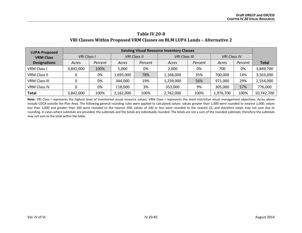
Draft DRECP and EIR/EIS CHAPTER IV.20 VISUAL RESOURCES
Vol. IV of VI IV.20-85 August 2014
Table IV.20-8
VRI Classes Within Proposed VRM Classes on BLM LUPA Lands – Alternative 2
LUPA-Proposed VRM Class
Designations
Existing Visual Resource Inventory Classes
Total
VRI Class I VRI Class II VRI Class III VRI Class IV
Acres Percent Acres Percent Acres Percent Acres Percent
VRM Class I 3,842,000 100% 5,000 0% 2,000 0% 700 0% 3,849,700
VRM Class II 0 0% 1,695,000 78% 1,168,000 35% 700,000 14% 3,563,000
VRM Class III 0 0% 344,000 19% 1,239,000 56% 971,000 29% 2,554,000
VRM Class IV 0 0% 118,000 3% 353,000 9% 305,000 57% 776,000
Total 3,842,000 100% 2,162,000 100% 2,762,000 100% 1,976,700 100% 10,742,700
Note: VRI Class I represents the highest level of inventoried visual resource values; VRM Class I represents the most restrictive visual management objectives. Acres above include CDCA outside the Plan Area. The following general rounding rules were applied to calculated values: values greater than 1,000 were rounded to nearest 1,000; values less than 1,000 and greater than 100 were rounded to the nearest 100; values of 100 or less were rounded to the nearest 10, and therefore totals may not sum due to rounding. In cases where subtotals are provided, the subtotals and the totals are individually rounded. The totals are not a sum of the rounded subtotals; therefore the subtotals may not sum to the total within the table.
Draft DRECP and EIR/EIS CHAPTER IV.20 VISUAL RESOURCES
Vol. IV of VI IV.20-86 August 2014
Key points of the effects of VRM classification on VRI lands under Alternative 2 are
summarized here:
VRM designations: The majority of lands would be designated as VRM Class I, II, or
III. Less than 10% would be designated as VRM Class IV.
VRI Class I: As with the Preferred Alternative, all VRI Class I lands would be managed
as VRM Class I, reflecting a high level of management protection.
VRI Class II: As with the Preferred Alternative, more than 75% of VRI Class II lands
would be managed as VRM Class II or I, reflecting a moderately high level of manage-
ment protection. Approximately 22% would be managed as VRM Class III or IV, which
allows for more visual contrast and impact than the VRM Class II objectives allow.
VRI Class III: More than 90% of VRI Class III lands would be managed as VRM Class
III, II, or I, reflecting a high correlation and level of management protection. Approx-
imately 35% would be managed to meet VRM Class II objectives, which restrict
visual contrast and impact more than VRM Class III. Approximately 9% would be
managed as VRM Class IV, which allows for more visual contrast and impact than
the VRM Class III objectives allow.
VRI Class IV: Approximately 43% of VRI Class IV lands would be managed as VRM
Class III, II, or I; 57% would be managed as VRI Class IV.
Compared with the Preferred Alternative, Alternative 2 would result in a similar but
somewhat higher level of correlation between VRI values and the proposed VRM Classes,
resulting in a similar potential for retaining the integrity of the inventoried visual resource
values. Overall, visual resource protection would benefit under Alternative 2 by the desig-
nation of VRM Classes throughout the CDCA.
Under the proposed CMAs, all DFAs would be managed as VRM Class IV lands to allow for
utility-scale development. In those cases, implementation or incorporation of BMPs
would still be required to reduce the visual contrast levels of proposed facilities to the
extent practicable.
IV.20.3.4.3 Impacts of Natural Community Conservation Plan: Alternative 2
The impacts of the NCCP for Alternative 2 would be the same as those defined in Section
IV.20.3.2.1 for the Plan-wide analysis.
IV.20.3.4.4 Impacts of General Conservation Plan
The impacts of the GCP for Alternative 2 would be similar to those defined in Section
IV.20.3.2.1 for the Plan-wide analysis, but they would occur on nonfederal lands only.

Draft DRECP and EIR/EIS CHAPTER IV.20 VISUAL RESOURCES
Vol. IV of VI IV.20-87 August 2014
IV.20.3.4.5 Impacts Outside the Plan Area
IV.20.3.4.5.1 Impacts of Transmission Outside the Plan Area
The impacts of transmission outside the Plan Area would be the same under all
alternatives. These are as described for the No Action Alternative in Section IV.20.3.1.5.1.
IV.20.3.4.5.2 Impacts of BLM LUPA Decisions Outside the Plan Area
Under the proposed BLM LUPA, the changes outside the Plan Area would include the desig-
nation of NLCS lands, ACECs, National Scenic and Historic Trails Management Corridors,
VRM classes, and new land allocations to replace multiple-use classes on CDCA lands.
The VRM Classes and other BLM land designations proposed under Alternative 2 would
extend protective measures to these areas that would avoid or reduce visual impacts. CMAs
for visual resources would be established and implemented. The BLM-specific CMAs for
Alternative 2 would be the same as for all action alternatives. These visual resource CMAs
and the restrictions and protective measures of the land designations provide a framework
of guidelines and specifications through which visual impacts would be avoided where pos-
sible, minimized, and/or mitigated to the extent practicable.
The following summarizes the key points of the impacts of changes to BLM land designa-
tions on visual resource elements, outside the Plan Area, under Alternative 2 (see Appen-
dix R2, Table R2.20-16 for detailed, quantitative data and analysis):
Proposed NLCS: The management of these lands that have nationally significant
ecological, cultural, and scientific values would offer additional protection of intact-
ness and scenic quality.
Existing and Proposed ACECs: The special management measures given to protect
the important historic, cultural, and scenic values of these areas would generally
benefit visual resources, particularly the VRM Class II, III, and IV lands with which
they coincide (approximately 203,000 acres, compared to a similar amount of area
under the Preferred Alternative).
Trail Management Corridors: The primary effect of these 20-mile-wide corridors
would be to provide a consistent framework for protecting and managing scenic
values along National Scenic and Historic Trails within National and California State
park lands. As with the Preferred Alternative, the Trail Management Corridors
would be managed to meet the visual management objectives of VRM Class II.

Draft DRECP and EIR/EIS CHAPTER IV.20 VISUAL RESOURCES
Vol. IV of VI IV.20-88 August 2014
IV.20.3.4.6 CEQA Significance Determination for Alternative 2
The significance determinations for short-term and long-term impacts are described in
Section IV.20.3.1.1.1 for the No Action Alternative. Section IV.20.1.2 identifies four
criteria to apply when determining if there are significant impacts from a project under
CEQA. These criteria are included as part of the more general impacts identified in this
section as VR-1 and VR-2.
The visual impacts and their associated significance determinations for Alternative 2
are as follows:
VR-1: Visibility of activities, materials, equipment, dust, and construction night
lighting would result in short-term diminished scenic quality. Activities and
equipment visible from residences, public roads, and public preserves would result in
short-term diminished scenic quality for viewers. This would be less than significant with
implementation of appropriate CMAs.
VR-2: The presence of plan components would create long-term visual contrast with
surrounding undeveloped land and result in long-term diminished scenic quality.
Long-term impacts to visual resources for Alternative 2 would be significant and unavoid-
able, as described in detail for the No Action Alternative (Section IV.20.3.1.6). Impacts
would be significant because of the changes in line, form, and color introduced by large-
scale development and the contrast of any such development with surrounding conditions.
Although the CMAs for Alternative 2 would reduce the impact on visual resources, they
would not reduce it to a less than significant level.
IV.20.3.4.7 Comparison of Alternative 2 with Preferred Alternative
Chapter IV.27 presents a comparison of all action alternatives and the No Action Alterna-
tive across all disciplines. This section summarizes the comparison of Alternative 2 with
the Preferred Alternative.
IV.20.3.4.7.1 Alternative 2 Compared with Preferred Alternative for Plan-wide DRECP
Although similar visual impacts would occur under both Alternative 2 and the Preferred
Alternative, the impacts would vary in key ways:
Geographic Distribution. As with the DFAs of the Preferred Alternative, the DFAs under
Alternative 2 are restricted in distribution and concentrated in areas considered less envi-
ronmentally sensitive. DFAs under Alternative 2 are geographically dispersed in the Impe-
rial Valley including south of Chocolate Mountains, eastern Riverside, the Lucerne Valley,
the Barstow area, the Tehachapi area, the U.S. 395 corridor, the Silurian Valley, and near

Draft DRECP and EIR/EIS CHAPTER IV.20 VISUAL RESOURCES
Vol. IV of VI IV.20-89 August 2014
Hidden Hills. A greater proportion of wind energy would be developed, solar and wind
would be dispersed, and geothermal development would occur in the Imperial Borrego
Valley ecoregion subarea. There would be less protection of Fremont Valley, Ridgecrest,
Silurian Valley, and south of Chocolate Mountains than in the alternative-specific reserve
design for the Preferred Alternative.
The severity of visual impacts depends partly on the number of potential viewers. Alterna-
tive 2 has larger DFAs than the Preferred Alternative in and near the populated West
Mojave area. As a result, greater amounts of wind and solar development would be added
to the existing visual disturbance experienced by residents in the Mojave, Lancaster, and
Palmdale areas due to extensive wind and solar development in those areas. Alternative 2
also includes DFAs similar to those of the Preferred Alternative in the areas surrounding
Victorville, Adelanto, and Lucerne Valley.
The severity of visual impacts also relates to expectations of viewers for pristine desert
vistas. The eastern and northeastern parts of the Plan Area are sensitive because they con-
tain the Mojave National Preserve, Death Valley National Monument, and several BLM Wil-
derness Areas. Alternative 2 DFAs would encourage development in the Pahrump Valley
and the Silurian Valley, both of which offer currently undeveloped approaches to Death
Valley. The large DFA in the East Riverside area (close to Joshua Tree National Park and
BLM Wilderness Areas) is the same as in the Preferred Alternative.
Extent of Potential Renewable Energy Development. Although the geographic distribu-
tion of DFAs is similar under Alternative 2 and the Preferred Alternative, the total size of
the DFAs varies. The DFAs would be approximately 450,000 acres smaller under the
Preferred Alternative (2,024,000 acres compared with 2,473,000 acres for Alternative 2).
The larger DFAs in Alternative 2 would result in renewable projects being visible to more
viewers than those of the Preferred Alternative.
Conservation. Alternative 2 has a similar amount of land in the reserve design and in CPAs
as the Preferred Alternative. The conservation strategy emphasizes compensation.
In summary, the composition and structure of Alternative 2 would provide similar oppor-
tunities for the avoidance, reduction, and minimization of visual impacts from renewable
energy development, including those from transmission corridors, compared with the Pre-
ferred Alternative. The 20-mile width of Trail Management Corridors under Alternative 2 is
twice that of the Preferred Alternative and therefore would better protect views and visitor
experience along National Scenic and Historic Trails.

Draft DRECP and EIR/EIS CHAPTER IV.20 VISUAL RESOURCES
Vol. IV of VI IV.20-90 August 2014
IV.20.3.4.7.2 Alternative 2 Compared With Preferred Alternative for the BLM Land
Use Plan Amendment
The BLM LUPA under Alternative 2 would assign VRM Classes to all BLM lands within the
CDCA, as would the Preferred Alternative. For both alternatives, this would provide a
unifying framework and an established system for addressing visual resources.
The key difference is that Alternative 2 would have more acres of VRI Class II and III lands
(approximately 128,000 acres) in DFAs than would the Preferred Alternative (78,000 acres).
This difference in the potential area of land disturbance impacts is critical and would result
in a larger amount of land potentially subject to visual impacts under Alternative 2 than
under the Preferred Alternative. However, because Alternative 2 proposes 20-mile-wide
Trail Management Corridors compared with the smaller 10-mile-wide corridors under the
Preferred Alternative, the scenic values and viewer experience along National Scenic and
Historic Trails would have a greater level of protection under Alternative 2.
IV.20.3.4.7.3 Alternative 2 Compared with Preferred Alternative for NCCP
The impacts of the NCCP for Alternative 2 are the same as those defined in Section
IV.20.3.2.1 for the Plan-wide analysis. As a result, the comparison of Alternative 2 with the
Preferred Alternative for the NCCP is the same as described above for Plan-wide DRECP.
IV.20.3.4.7.4 Alternative 2 Compared with Preferred Alternative for the GCP
The visual impacts of the GCP for Alternative 2 and the Preferred Alternative would be sim-
ilar to those defined in Section IV.20.3.2.1 for the Plan-wide analysis, but they would occur
on nonfederal lands only.
IV.20.3.5 Alternative 3
Alternative 3 includes 1,406,000 acres of DFAs and 15,159,000 acres of Reserve Design
Lands. For reference, Table IV.20-9 compares the Preferred Alternative to Alternative 3 for
key visual elements.

Draft DRECP and EIR/EIS CHAPTER IV.20 VISUAL RESOURCES
Vol. IV of VI IV.20-91 August 2014
Table IV.20-9
Affected Visual Resources – Preferred Alternative Compared to Alternative 3
Preferred Alternative Alternative 3
Development Areas (acres)
DFAs 2,024,000 1,406,000
Visual Resource Elements Within Development Areas (acres unless otherwise indicated)
VRI [Class] 0 [I]
17,000 [II] 61,000 [III]
27,000 [IV]
0 [I]
5,000[II] 20,000 [III]
25,000 [IV]
VRM [Class] 0 [I]
0 [II]
0 [III]
106,000 [IV]
0 [I]
0 [II]
0 [III]
50,000 [IV]
National Scenic Byways 0 0
National Scenic and Historic Trails 1 mi. 2 mi.
California State Parks 0 0
State Scenic Highways 0 0
Wild and Scenic Rivers 0 0
Visual Resource Elements Within 5 miles of Development Areas (acres unless otherwise indicated)
VRI [Class] 366,000 [I]
389,000 [II] 731,000 [III]
709,000 [IV]
206,000 [I]
406,000 [II] 715,000 [III]
701,000 [IV]
VRM [Class] 366,000 [I]
515,000 [II]
555,000 [III]
694,000 [IV]
191,000 [I]
652,000 [II]
696,000 [III]
434,000 [IV]
National Scenic Byways 13 mi. 7 mi.
National Parks and Preserves 15,000 15,000
National Scenic and Historic Trails 350 mi. 295 mi.
Trail Management Corridors 659,000 525,000
California State Parks 108,000 108,000
State Scenic Highways 0 0
Wild and Scenic Rivers 0 0
Reserve Design Lands (Conservation Lands) (acres)
Reserve Design Lands 14,920,000 15,159,000
Note: The following general rounding rules were applied to calculated values: values greater than 1,000 were rounded to nearest 1,000; values less than 1,000 and greater than 100 were rounded to the nearest 100; values of 100 or less were rounded to the nearest 10, and therefore totals may not sum due to rounding. In cases where subtotals are provided, the subtotals and the totals are individually rounded. The totals are not a sum of the rounded subtotals; therefore the subtotals may not sum to the total within the table.
Draft DRECP and EIR/EIS CHAPTER IV.20 VISUAL RESOURCES
Vol. IV of VI IV.20-92 August 2014
IV.20.3.5.1 Plan-wide Impacts of Implementing the DRECP: Alternative 3
IV.20.3.5.1.1 Plan-wide Impacts and Mitigation Measures from Renewable Energy and
Transmission Development
Impact Assessment
Under Alternative 3, renewable energy related activities covered by the Plan are confined
to 1.4 million acres of DFAs, resulting in 150,000 acres of long-term disturbance (see
Volume IV, Table IV.1-1). This represents approximately 5,000 more acres of long-term
disturbance than could occur under the Preferred Alternative.
The DFAs are focused in the Imperial Valley, Lucerne Valley, Barstow area, and Tehachapi
area. It has fewer DFAs in eastern Riverside and small DFAs along the U.S. 395 corridor and
near Searles Lake.
Transmission development and operation activities would be permitted both inside and
outside of the DFAs.
Approximately 1,406,00 acres would be within DFAs under Alternative 3, compared with
2,024,000 acres under the Preferred Alternative. This smaller area of land within DFAs
(approximately 600,000 acres fewer) represents a much lower potential for visual impacts
under Alternative 3 than under the Preferred Alternative.
Alternative 3 would primarily affect four ecoregion subareas, compared with five under the
Preferred Alternative.
Visual impacts from solar development would be dispersed, with emphasis in the
Imperial Borrego Valley and the West Mojave and Eastern Slopes ecoregion subareas.
Visual impacts from wind development would be primarily in the Pinto Lucerne Valley
and Eastern Slopes and the West Mojave and Eastern Slopes ecoregion subareas.
Visual impacts from geothermal energy would occur in the Imperial Borrego Valley and
Owens River Valley ecoregion subareas, the same as under the Preferred Alternative.
The following summarizes the key points in comparing the visual impacts from renewable
energy and transmission development under Alternative 3 with those of the Preferred
Alternative (see Appendix R2. Table R2.20-17 for detailed data):
VRI Classes: There would be no VRI Class I lands, 5,000 acres of VRI Class II lands,
20,000 acres of VRI Class III lands, and 7,000 acres of VRI Class IV lands within DFAs
under Alternative 3. Per the CMAs for visual resources, these 25,000 acres of VRI

Draft DRECP and EIR/EIS CHAPTER IV.20 VISUAL RESOURCES
Vol. IV of VI IV.20-93 August 2014
Class II and III lands within DFAs would be managed as VRM Class IV and thereby
sustain a potential degradation of underlying scenic values.
A much larger amount of VRI Class II and III lands within DFAs would be managed
as VRM Class IV under the Preferred Alternative than under Alternative 3. This
reflects a potential for degradation of underlying scenic values under Alternative 3,
but to a lesser extent than under the Preferred Alternative.
VRM Classes: As with the Preferred Alternative, there would be no VRM Class I, II,
or III lands in DFAs under Alternative 3 (Figure IV.20-5, Proposed BLM VRM Classifi-
cations, Alternative 3). Approximately 12,000 acres of transmission would occur on
VRM Classified lands compared with a slightly larger amount of 13,000 acres under
the Preferred Alternative.
National Parks and Preserves: These lands would not be within the DFA footprint
under Alternative 3 or the Preferred Alternative. Although the footprint of renew-
able energy projects would not directly affect these lands, project facilities and
activities that are visible from National Parks and Preserves would diminish scenic
quality for viewers in those conservation areas, where expectations for scenic
quality are typically high.
National Scenic Byways: No segments of the Bradshaw Trail National Back
Country Byway would be within DFAs under either Alternative 3 or the
Preferred Alternative.
National Scenic and Historic Trails: Approximately 2 miles of the Old Spanish
National Historic Trail alignment would be within DFAs under Alternative 3 com-
pared with 1 mile under the Preferred Alternative.
California State Parks: As with the Preferred Alternative, no California State Park
lands would be within DFAs under Alternative 3. Approximately 230 acres of trans-
mission would occur on these lands, compared with 180 acres under the
Preferred Alternative.
State Scenic Highways: No segments of State Scenic Highways would be within
DFAs under Alternative 1 or the Preferred Alternative.
Wild and Scenic Rivers: No portion of designated or eligible Wild and Scenic Rivers
would be within DFAs under Alternative 3 or the Preferred Alternative.
Proximity of Visual Resources to DFAs. Under Alternative 3, visual resource ele-
ments within 5 miles of proposed DFAs can be compared with those under the Pre-
ferred Alternative, as summarized in Table IV.20-9. Alternative 3 has generally fewer
visual resource elements within 5 miles of DFAs than the Preferred Alternative. One
example of this is the acres of VRI Class I: 366,000 acres under the Preferred Alter-

Draft DRECP and EIR/EIS CHAPTER IV.20 VISUAL RESOURCES
Vol. IV of VI IV.20-94 August 2014
native compared with 306,000 acres under Alternative 3. For Trail Management
Corridors, there is a similarly sized area within this 5-mile proximity under the Pre-
ferred Alternative as under Alternative 3.
The visual impacts resulting from Alternative 3 are numbered and summarized here:
Impact VR-1: Visibility of activities, materials, equipment, dust, and construction night
lighting would result in short-term diminished scenic quality.
Preconstruction activities and equipment visible from residences, public roads, and public
preserves would result in short-term diminished scenic quality for viewers. Examples
include road upgrading, damage to or removal of native vegetation, construction of
meteorological towers, drilling of temperature gradient wells, vehicles, and lighting.
During construction and decommissioning, activities and equipment visible from residences,
public roads, and public preserves would result in short-term diminished scenic quality for
viewers. Examples include dust and exhaust emissions, removal of vegetation during site
clearing, contouring and grading, presence of vehicles and equipment, mobilization and
demobilization activities, material delivery and staging, assembly of components, site light-
ing, and construction of and later removal of structures.
Impact VR-2: The presence of plan components would create long-term visual contrast
with surrounding undeveloped land and result in long-term diminished scenic quality.
The continued presence of equipment, structures, fencing, roads, and other elements required
to operate a facility would have a long-term adverse effect on the visible landscape. Areas
of persistent surface and vegetation disturbance and the presence of structures would
create visual contrast in form, line, color, and texture as compared with pre-project condi-
tions. Depending on viewer location, physical elements introduced by a project could block
views or create skylining. Even after project removal and site reclamation are completed,
visual contrast would remain. Restoring the natural, pre-disturbance visual character of a
desert environment is extremely difficult, can take decades, and often is unsuccessful.
Therefore, surface and vegetation disturbance would create long-term visual impacts due
to the persistence of scars in arid and semi-arid landscapes.
The structure, size, and industrial character of utility-scale renewable energy and transmis-
sion facilities during their operation and maintenance—as well as any associated glare,
reflectivity, and lighting—would visually contrast with surrounding undeveloped land and
result in long-term diminished scenic quality.

!(
!(
!(
!(
!(
!(
!(
!(
!(
!(
!( !(
!(
!(
§̈¦10
§̈¦405
§̈¦605
§̈¦210
§̈¦15
§̈¦710
§̈¦15
§̈¦10
§̈¦8
§̈¦5
§̈¦40
§̈¦5
£¤6
£¤395
£¤395
UV190
UV58
UV178
UV127
UV78
UV2
UV91
UV86
UV98
UV136
UV168
UV247
UV34
UV74
UV94
UV60
UV138
UV75
UV243
UV62
UV111
UV62
UV38
UV78
Inyo
San Bernardino
Kern
Riverside
Imperial
Tulare
San Diego
Los Angeles
Mono
Fresno
Orange
M E X I C O
O w e n s R i v e r
V a l l e y E c o r e g i o nS u b a r e a
P a n a m i n t D e a t h
V a l l e y E c o r e g i o nS u b a r e a
W e s t M o j a v e a n d
E a s t e r n S l o p e sE c o r e g i o n S u b a r e a
M o j a v e a n d
S i l u r i a n V a l l e yE c o r e g i o n S u b a r e a
K i n g s t o n a n d
F u n e r a l M o u n t a i n sE c o r e g i o n S u b a r e a
P r o v i d e n c e a n d
B u l l i o n M o u n t a i n sE c o r e g i o n S u b a r e a
P i n t o L u c e r n e V a l l e y
a n d E a s t e r n S l o p e sE c o r e g i o n S u b a r e a
P i u t e V a l l e y a n d
S a c r a m e n t o M o u n t a i n sE c o r e g i o n S u b a r e a
C a d i z V a l l e y a n d
C h o c o l a t e M o u n t a i n sE c o r e g i o n S u b a r e a
I m p e r i a l B o r r e g o
V a l l e y E c o r e g i o nS u b a r e a
Escondido
Lancaster
Palmdale
Long
Beach
Ridgecrest
Barstow
Hesperia
Riverside
SanBernardino
Twentynine
Palms
Coachella
El Centro
San
Diego
Los
Angeles
A R I Z O N AA R I Z O N A
N E V A D AN E V A D A
!(
!(
!(
!(
!(
!(
!(
!(
!(
!(
!( !(
!(
!(
§̈¦10
§̈¦405
§̈¦605
§̈¦210
§̈¦15
§̈¦710
§̈¦15
§̈¦10
§̈¦8
§̈¦5
§̈¦40
§̈¦5
£¤6
£¤395
£¤395
UV190
UV58
UV178
UV127
UV78
UV2
UV91
UV86
UV98
UV136
UV168
UV247
UV34
UV74
UV94
UV60
UV138
UV75
UV243
UV62
UV111
UV62
UV38
UV78
Inyo
San Bernardino
Kern
Riverside
Imperial
Tulare
San Diego
Los Angeles
Mono
Fresno
Orange
M E X I C O
O w e n s R i v e r
V a l l e y E c o r e g i o nS u b a r e a
P a n a m i n t D e a t h
V a l l e y E c o r e g i o nS u b a r e a
W e s t M o j a v e a n d
E a s t e r n S l o p e sE c o r e g i o n S u b a r e a
M o j a v e a n d
S i l u r i a n V a l l e yE c o r e g i o n S u b a r e a
K i n g s t o n a n d
F u n e r a l M o u n t a i n sE c o r e g i o n S u b a r e a
P r o v i d e n c e a n d
B u l l i o n M o u n t a i n sE c o r e g i o n S u b a r e a
P i n t o L u c e r n e V a l l e y
a n d E a s t e r n S l o p e sE c o r e g i o n S u b a r e a
P i u t e V a l l e y a n d
S a c r a m e n t o M o u n t a i n sE c o r e g i o n S u b a r e a
C a d i z V a l l e y a n d
C h o c o l a t e M o u n t a i n sE c o r e g i o n S u b a r e a
I m p e r i a l B o r r e g o
V a l l e y E c o r e g i o nS u b a r e a
Escondido
Lancaster
Palmdale
Long
Beach
Ridgecrest
Barstow
Hesperia
Riverside
SanBernardino
Twentynine
Palms
Coachella
El Centro
San
Diego
Los
Angeles
A R I Z O N AA R I Z O N A
N E V A D AN E V A D A
DRECP Plan Area Boundary
Ecoregion Subareas
CDCA Boundary
County Boundary
Non-BLM Land
BLM VRM Classifications
Class I
Class II
Class III
Class IV
M:\JOBS4\6287\common_gis\EIR_Figures_Spring_2014\Vol_IV\IV_20_Visual\figIV.20-5.mxd 8/18/2014
FIGURE IV.20-5
Proposed BLM Visual Resource Management Classifications, Alternative 3
0 2010
MilesI
Draft DRECP and EIR/EIS
Sources: ESRI (2014); CEC (2013); BLM (2013); CDFW (2013); USFWS (2013)
August 2014

Draft DRECP and EIR/EIS CHAPTER IV.20 VISUAL RESOURCES
Vol. IV of VI IV.20-96 August 2014
INTENTIONALLY LEFT BLANK

Draft DRECP and EIR/EIS CHAPTER IV.20 VISUAL RESOURCES
Vol. IV of VI IV.20-97 August 2014
Impacts in Study Area Lands
Study Area Lands refer to three categories of lands shown on alternative maps: Future
Assessment Areas (FAAs), Special Analysis Areas (SAAs) and DRECP Variance Lands.
Future Assessment Areas (FAAs). Lands within FAAs are neither reserve lands
nor DFAs; they are simply areas that are deferred for future assessment. The future
assessment will determine their suitability for renewable energy development or
ecological conservation. If renewable energy development occurs on FAA lands, a
BLM LUPA would not be required. FAAs for each alternative are included and located
as shown in Table IV.1-2 and Figure II.6-1. The FAAs represent areas where
renewable energy development or inclusion to the reserve design could be
implemented through an amendment to the DRECP, but additional assessment
would be needed.
Because most of the FAAs are presented as “undesignated areas” in the action alternatives,
there would be no difference between the FAAs in the Preferred Alternative except that
renewable development in an FAA would not require a BLM LUPA, so the environmental
review process would be somewhat simpler than if the location were left undesignated.
Development of the 11,000 acres of FAAs under Alternative 3 would be subject to all visual
resource CMAs identified by the Preferred Alternative and would be required to meet the
visual management objectives of the underlying VRM Class. The exception is the FAA south
of the Imperial Sand Dunes, which would become a DFA under Alternative 3 and would be
managed as VRM Class IV accordingly.
Special Analysis Areas (SAAs). Under Alternative 3, the SAAs would be designated as con-
servation, which would be generally beneficial to visual resources. Impacts would be the
same as those explained for the Plan-wide reserve design in Section IV.20.3.2.1.2, Impacts
of the Reserve Design.
DRECP Variance Lands. There would be no DRECP Variance Lands under Alternative 3.
Impact Reduction Strategies and Mitigation
The implementation of Alternative 3 would result in conservation of some desert lands as
well as the development of renewable energy generation and transmission facilities on
other lands. The impacts of renewable energy development covered by the Plan would be
lessened in several ways. First, the Plan incorporates CMAs for each alternative, including
specific biological reserve design components and LUPA components. In addition, the
implementation of existing laws, orders, regulations, and standards would reduce the
impacts of project development.

Draft DRECP and EIR/EIS CHAPTER IV.20 VISUAL RESOURCES
Vol. IV of VI IV.20-98 August 2014
Conservation and Management Actions
The conservation strategy for Alternative 3 (presented in Volume II, Section II.3.1.1)
defines specific actions that would reduce the impacts of this alternative. The conservation
strategy includes a definition of the reserve design and specific CMAs for the Preferred
Alternative. While the CMAs were developed for BLM lands only, this analysis assumes that
all CMAs would be applied also to nonfederal lands.
Specific visual resource CMAs have been developed and apply to the Preferred Alternative
and all action alternatives. They are summarized in Section IV.20.3.2.1.1.
Laws and Regulations
Similar to the No Action Alternative, existing laws and regulations will reduce certain
impacts of Plan implementation. Relevant regulations are presented in the Regulatory
Setting in Volume III. The requirements of relevant laws and regulations are summarized in
Section IV.20.3.1.1.1.
Mitigation Measures
The visual impact avoidance and reduction strategies in existing guidance, such Reducing
Visual Impacts of Renewable Energy Facilities on BLM-Administered Lands, are detailed and
comprehensive. The CMAs proposed under the DRECP (see Appendix H) provide additional
detail and direction. These represent state-of-the-art visual impact mitigation as it applies
to the Plan Area; no additional mitigation is feasible.
IV.20.3.5.1.2 Impacts from Reserve Design
There would be approximately 15 million acres of Reserve Design Lands under Alterna-
tive 3 and under the Preferred Alternative. This represents a generally equivalent level of
conservation to the Preferred Alternative. In general, visual resource elements would be
beneficially affected by the conservation policies and requirements of these lands. Alterna-
tive 3 has more acres of BLM LUPA Conservation Designations than the Preferred Alterna-
tive and has the least number of acres of SRMAs of all action alternatives.
The following summarizes the key points in comparing Alternative 3 visual impacts of the
reserve design with those of the Preferred Alternative (see Appendix R2, Table R2.20-18
for detailed, quantitative data and analysis):
VRI Classes: Alternative 3 would have 100% of VRI Class I lands, 74% of VRI Class II
lands, 71% of VRI Class III lands, and 73% of VRI Class IV lands in the Reserve

Draft DRECP and EIR/EIS CHAPTER IV.20 VISUAL RESOURCES
Vol. IV of VI IV.20-99 August 2014
Design Lands, compared to similar amounts (95%, 80%, 72%, and 74%, respec-
tively) under the Preferred Alternative.
VRM Classes: 100% of VRM Class I lands, 85% of VRM Class II lands, 79% of VRM
Class III lands, and 8% of the VRM Class IV lands would be in the Reserve Design
Lands under Alternative 3, compared with 100% of VRM Class I lands, 83% of VRM
Class II lands, 79% of VRM Class III lands, and 38% VRM Class IV lands under the
Preferred Alternative.
National Parks and Preserves: The National Parks and Preserves would have
100% of their land areas in the reserve design under Alternative 3 and under the
Preferred Alternative.
National Scenic Byways: Under Alternative 3, approximately 46% of the Bradshaw
Trail National Back Country Byway and 11% of SR 190 would be in the Reserve
Design. This provides a lower level of protection of visual and scenic values than
would occur under the Preferred Alternative (51% and 15% respectively).
National Scenic and Historic Trails: Under Alternative 3, approximately 53% of
the Juan Bautista de Anza National Historic Trail, 58% of the Old Spanish National
Historic Trail, and 41% of the Pacific Crest National Scenic Trail alignments would
be in the Reserve Design.
Under the Preferred Alternative, approximately 4% of the Juan Bautista de Anza
National Historic Trail, 58% of the Old Spanish National Historic Trail, and 40% of
the Pacific Crest National Scenic Trail alignments would be in conservation.
California State Parks: As with the Preferred Alternative, most California State
Park lands would be in Reserve Design Lands under Alternative 3. This would vary
by individual park or preserve; but most parks would have more than 90% in exist-
ing conservation areas, BLM LUPA designations, or CPAs. Exceptions are the (1)
Desert Cahuilla/Freeman Project (4%), (2) Picacho SRA (78%), and (3) Salton Sea
SRA (86%). Similar amounts and percentages of California State Park lands would
be in Reserve Design Lands under the Preferred Alternative.
State Scenic Highways: Approximately 16% of SR 190 but no portion of the SR 78
and U.S. 395 alignments would be in Reserve Design Lands, compared to similar
portions under the Preferred Alternative.
Wild and Scenic Rivers: 100% of the Amargosa Wild and Scenic River and 100% of
the eligible segments of Surprise Canyon Creek and the Mojave River would be
within the reserve design under Alternative 3 and the Preferred Alternative.
Draft DRECP and EIR/EIS CHAPTER IV.20 VISUAL RESOURCES
Vol. IV of VI IV.20-100 August 2014
IV.20.3.5.2 Impacts of DRECP Land Use Plan Amendment on BLM Land: Alternative 3
This section addresses two components of effects of the BLM LUPA: the streamlined
development of renewable energy and transmission on BLM land under the LUPA, and the
impacts of the amended land use plans themselves.
IV.20.3.5.2.1 Impacts from Renewable Energy and Transmission Development on BLM Land
The visual impacts of DFAs on VRI and VRM lands for Alternative 3 would be the same as
those defined in Section IV.20.3.5.1, Plan-wide Impacts of Implementing the DRECP: Alter-
native 3, for the Plan-wide analysis.
IV.20.3.5.2.2 Impacts of Changes to BLM Land Designations
The DRECP LUPA Alternative 3 would establish VRM classes for all lands in the CDCA. (Cur-
rently, only the Bishop RMP and the Imperial Sand Dunes RAMP have VRM Classes desig-
nated. In accordance with BLM policy, all wilderness areas and WSAs are managed as VRM
Class I.) It would also (1) designate new NLCS lands, (2) designate new ACECs and expand
and reduce existing ACECs, (3) designate new SRMAs and expand and reduce existing
SRMAs, (4) create buffer corridors along National Scenic and Historic Trails, and (5) man-
age lands with wilderness characteristics to protect those characteristics. The BLM LUPA
would also replace the multiple-use classes.
The VRM Classes and other BLM land designations proposed under Alternative 3 would
benefit visual resources to the extent that they offer protective measures that would avoid
or reduce visual impacts. As with the Preferred Alternative, CMAs for visual resources would
be established and implemented. The BLM-specific CMAs proposed under the Preferred
Alternative would be the same as for all action alternatives. These visual resource CMAs
and the restrictions and protective measures of the land designations provide a mutually
supportive framework of guidelines and specifications through which visual impacts would
be avoided where possible, minimized, and/or mitigated to the extent practicable.
Under Alternative 3, Trail Management Corridors would be established along National Scenic
and Historic Trails, at a width of generally 5 miles from the centerline of the trail, for a total
width of 10 miles (compared to the same total width of 10 miles under the Preferred Alter-
native). As discussed in Volume II, Section II.3.2.2.2, these Trail Management Corridors
would be managed as components of the BLM’s NLCS. Where National Trails overlap other
NLCS lands, the more protective CMAs or land use allocations would apply. All Trail Man-
agement Corridors would be designated as VRM Class II, except within approved transmis-
sion corridors (VRM Class III) and DFAs (VRM Class IV). However, state-of-the-art VRM
BMPs for renewable energy would be employed commensurate with the protection of

Draft DRECP and EIR/EIS CHAPTER IV.20 VISUAL RESOURCES
Vol. IV of VI IV.20-101 August 2014
nationally significant scenic resources and cultural landscapes to minimize the level of
intrusion and protect trail settings.
The following summarizes the key points of the impacts of changes to BLM land designa-
tions on visual resource elements under Alternative 3 (see Appendix R2, Table R2.20-19 for
detailed, quantitative data and analysis):
SRMAs: There would be the potential for recreational activities or facilities allowed
in SRMAs to affect scenic values, particularly those of the VRI Class I and II lands
with which they coincide (approximately 280,000 acres, compared to the same
amount under the Preferred Alternative).
NLCS: The management of these lands that have nationally significant ecological,
cultural, and scientific values would offer additional protection of intactness and
scenic quality, particularly to the VRI Class I, II, III, and IV lands with which they
coincide (3.5 million acres, compared to a similar amount of 3.6 million acres under
the Preferred Alternative).
ACECs: The special management measures given to protect the important historic,
cultural, and scenic values of these areas would generally benefit visual resources,
particularly the VRI Class II, III, and IV lands with which they coincide (approxi-
mately 1.7 million acres, compared with a smaller area of 1.4 million acres under the
Preferred Alternative).
Wildlife Allocation Areas: The management of these areas must be compatible
with protection and enhancement of wildlife and plant habitat and would generally
benefit visual resources, particularly the VRI Class III and IV lands with which they
coincide (approximately 13,000 acres, compared with a larger amount of 18,000
acres under the Preferred Alternative).
Lands Managed for Wilderness Characteristics: Under Alternative 3 and all other
action alternatives, these lands would be managed as VRM Class II. Other manage-
ment strategies to protect the wilderness characteristics of lands would benefit
visual resources, particularly the VRI Class II and IV lands with which they coincide
(approximately 375,000 acres, compared with 299,000 acres under the
Preferred Alternative).
Trail Management Corridors: As with the Preferred Alternative, the Trail Manage-
ment Corridors would be managed to meet the visual management objectives of
VRM Class II under Alternative 3. The primary effect of these 10-mile-wide corridors
would be to provide a higher level of protection (VRM Class II objectives) to approx-
imately 332,000 acres of VRM Class III and IV lands that would otherwise be managed
under less restrictive visual management objectives
Draft DRECP and EIR/EIS CHAPTER IV.20 VISUAL RESOURCES
Vol. IV of VI IV.20-102 August 2014
Alternative 3 would assign VRM classes to all BLM lands within the Plan Area. The relation-
ship between the proposed management classes and the underlying existing inventory
classes is discussed in this section.
Under Alternative 3, VRI Class lands within the proposed VRM Classes on BLM LUPA lands
would be as indicated in Table IV.20-10.
Key points of the effects of VRM classifications on VRI lands under Alternative 3 are
summarized here:
VRM designations: The majority of lands would be designated as VRM Class I, II, or
III. Less than 10% would be designated as VRM Class IV.
VRI Class I: All of VRI Class I lands would be managed as VRM Class I, reflecting a
high level of management protection.
VRI Class II: As with the Preferred Alternative, more than 75% of VRI Class II
lands would be managed as VRM Class II or I, reflecting a moderately high level of
management protection. Approximately 24% would be managed as VRM Class III
or IV, which allows for more visual contrast and impact than the VRM Class II
objectives allow.
VRI Class III: Approximately 88% of VRI Class III lands would be managed as VRM
Class III or II, reflecting a high correlation and level of management protection.
Approximately 39% would be managed to meet VRM Class II objectives, which
restrict visual contrast and impact more than VRM Class III. Approximately 12%
would be managed as VRM Class IV, which allows for more visual contrast and
impact than the VRM Class III objectives allow.
VRI Class IV: Approximately 85% of VRI Class IV lands would be managed as VRM
Class III, II, or I; 15% would be VRM Class IV.
Compared to the Preferred Alternative, Alternative 3 would result in a similar level of
correlation between VRI values and the proposed VRM Classes. An exception to this is the
management of VRI Class IV lands. A higher percentage of these areas would be managed as
VRM Class III, II, or I under Alternative 3 than under the Preferred Alternative. Overall,
visual resource protection would benefit under Alternative 3 by the designation of VRM
Classes throughout the CDCA.
Under the proposed CMAs, all DFAs would be managed as VRM Class IV lands to allow for
industrial-scale development. In those cases, implementation or incorporation of BMPs
would still be required to reduce the visual contrast levels of proposed facilities to the
extent practicable.
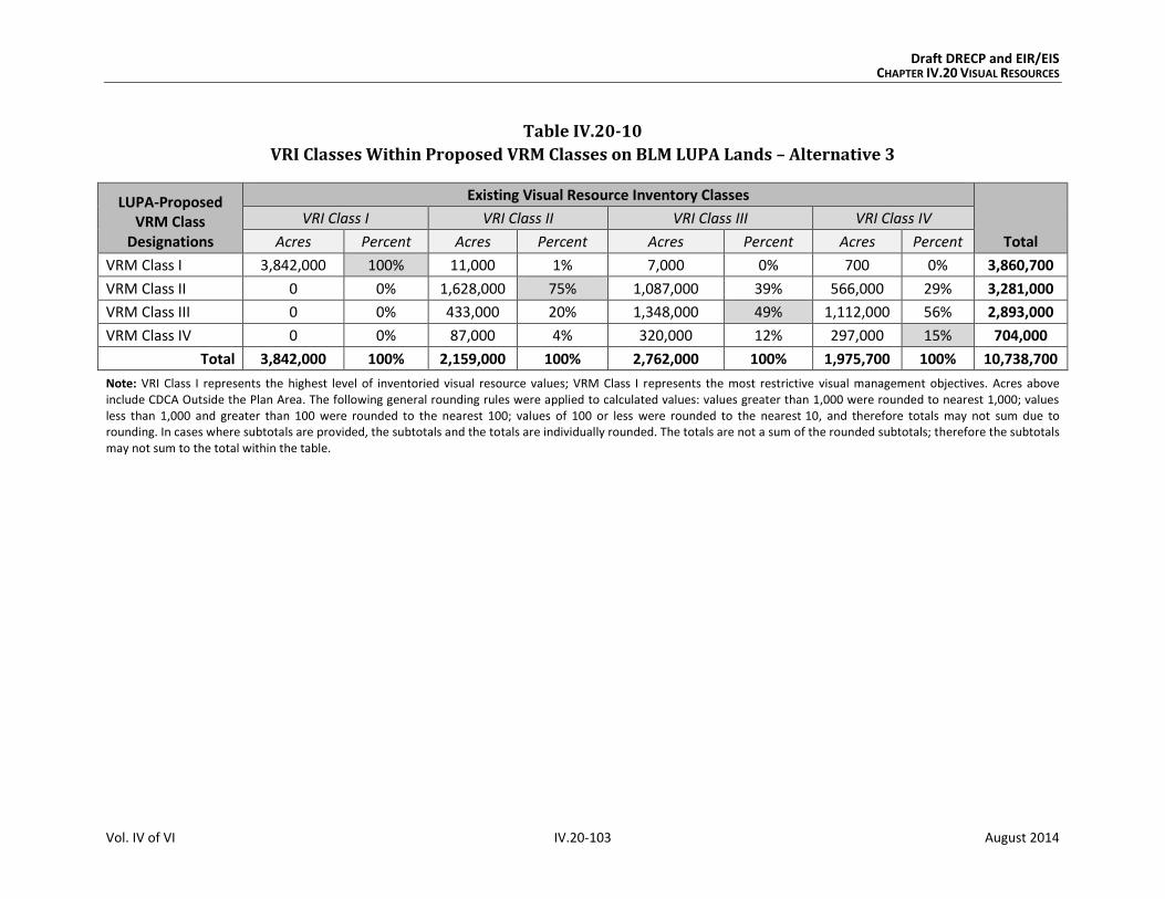
Draft DRECP and EIR/EIS CHAPTER IV.20 VISUAL RESOURCES
Vol. IV of VI IV.20-103 August 2014
Table IV.20-10
VRI Classes Within Proposed VRM Classes on BLM LUPA Lands – Alternative 3
LUPA-Proposed VRM Class
Designations
Existing Visual Resource Inventory Classes
Total
VRI Class I VRI Class II VRI Class III VRI Class IV
Acres Percent Acres Percent Acres Percent Acres Percent
VRM Class I 3,842,000 100% 11,000 1% 7,000 0% 700 0% 3,860,700
VRM Class II 0 0% 1,628,000 75% 1,087,000 39% 566,000 29% 3,281,000
VRM Class III 0 0% 433,000 20% 1,348,000 49% 1,112,000 56% 2,893,000
VRM Class IV 0 0% 87,000 4% 320,000 12% 297,000 15% 704,000
Total 3,842,000 100% 2,159,000 100% 2,762,000 100% 1,975,700 100% 10,738,700
Note: VRI Class I represents the highest level of inventoried visual resource values; VRM Class I represents the most restrictive visual management objectives. Acres above include CDCA Outside the Plan Area. The following general rounding rules were applied to calculated values: values greater than 1,000 were rounded to nearest 1,000; values less than 1,000 and greater than 100 were rounded to the nearest 100; values of 100 or less were rounded to the nearest 10, and therefore totals may not sum due to rounding. In cases where subtotals are provided, the subtotals and the totals are individually rounded. The totals are not a sum of the rounded subtotals; therefore the subtotals may not sum to the total within the table.
Draft DRECP and EIR/EIS CHAPTER IV.20 VISUAL RESOURCES
Vol. IV of VI IV.20-104 August 2014
IV.20.3.5.3 Impacts of Natural Community Conservation Plan: Alternative 3
The impacts of the NCCP for Alternative 3 would be the same as those defined in Section
IV.20.3.2.1 for the Plan-wide analysis.
IV.20.3.5.4 Impacts of General Conservation Plan: Alternative 3
The impacts of the GCP for Alternative 3 would be similar to those defined in Section
IV.20.3.2.1 for the Plan-wide analysis, but they would occur on nonfederal lands only.
IV.20.3.5.5 Impacts Outside the Plan Area
IV.20.3.5.5.1 Impacts of Transmission Outside the Plan Area
The impacts of out of Plan Area transmission would be the same under all alternatives.
These are as described for the No Action Alternative in Section IV.20.3.1.5.1.
IV.20.3.5.5.2 Impacts of BLM LUPA Decisions Outside the Plan Area
Under the proposed BLM LUPA, the changes outside the Plan Area would include the desig-
nation of NLCS lands, ACECs, National Scenic and Historic Trails Management Corridors,
VRM Classes, and new land allocations to replace multiple-use classes on CDCA lands.
The VRM Classes and other BLM land designations proposed under Alternative 3 would
extend protective measures to these areas that would avoid or reduce visual impacts. CMAs
for visual resources would be established and implemented. The BLM-specific CMAs for
Alternative 3 would be the same as for all action alternatives. Together, these visual resource
CMAs and the restrictions and protective measures of the land designations provide a
framework of guidelines and specifications through which visual impacts would be avoided
where possible, minimized, and/or mitigated to the extent practicable.
The following summarizes the key points of the impacts of changes to BLM land designations
on visual resource elements, outside the Plan Area, under Alternative 3 (see Appendix R2,
Table R2.20-20 for detailed, quantitative data and analysis):
Proposed NLCS: The management of these lands that have nationally significant
ecological, cultural, and scientific values would offer additional protection of intact-
ness and scenic quality.
Existing and Proposed ACECs: The special management measures given to protect
the important historic, cultural, and scenic values of these areas would generally
benefit visual resources, particularly the VRM Class II, III, and IV lands with which
they coincide (approximately 202,000 acres, compared to a similar area of 210,000
acres under the Preferred Alternative).

Draft DRECP and EIR/EIS CHAPTER IV.20 VISUAL RESOURCES
Vol. IV of VI IV.20-105 August 2014
Trail Management Corridors: The primary effect of 10-mile-wide corridors under
Alternative 3 would be to provide a consistent framework for protecting and man-
aging scenic values along National Scenic Trails within National and California State
park lands. As with the Preferred Alternative, the Trail Management Corridors would
be managed to meet the visual management objectives of VRM Class II.
IV.20.3.5.6 CEQA Significance Determination for Alternative 3
The significance determinations for short-term and long-term impacts are described in Sec-
tion IV.20.3.1.1.1 for the No Action Alternative. Section IV.20.1.2 identifies four criteria to
apply when determining if there are significant impacts from a project under CEQA. These
criteria are included as part of the more general impacts identified in this section as
VR-1 and VR-2.
The visual impacts and their associated significance determinations for Alternative 3 are
as follows:
VR-1: Visibility of activities, materials, equipment, dust, and construction night
lighting would result in short-term diminished scenic quality. Activities and
equipment visible from residences, public roads, and public preserves would result in
short-term diminished scenic quality for viewers. This would be less than significant with
implementation of appropriate CMAs.
VR-2: The presence of plan components would create long-term visual contrast with
surrounding undeveloped land and result in long-term diminished scenic quality.
Long-term impacts to visual resources for Alternative 3 would be significant and unavoid-
able, as described in detail for the No Action Alternative (Section IV.20.3.1.6). Impacts
would be significant because of the changes in line, form, and color introduced by large-
scale development and the contrast of any such development with surrounding conditions.
Although the CMAs relevant to Alternative 3 would reduce the impact on visual resources,
they would not reduce it to a less than significant level.
IV.20.3.5.7 Comparison of Alternative 3 with Preferred Alternative
Chapter IV.27 presents a comparison of all action alternatives and the No Action Alterna-
tive across all disciplines. This section compares Alternative 3 with the Preferred Alternative.
IV.20.3.5.7.1 Alternative 3 Compared with Preferred Alternative for Plan-wide DRECP
Although similar visual impacts would occur under both Alternative 3 and the Preferred
Alternative, the impacts would vary in key ways:
Geographic Distribution. As with the DFAs of the Preferred Alternative, the DFAs under
Alternative 3 are restricted in distribution and concentrated in areas considered less envi-
Draft DRECP and EIR/EIS CHAPTER IV.20 VISUAL RESOURCES
Vol. IV of VI IV.20-106 August 2014
ronmentally sensitive. Similar to the Preferred Alternative, DFAs under Alternative 3 are
focused in the Imperial Valley, Lucerne Valley, Barstow area, and Tehachapi area. Alterna-
tive 3 has fewer DFAs in eastern Riverside and very small DFAs along the U.S. 395 corridor
and near Searles Lake.
The severity of visual impacts depends partly on the number of potential viewers. Alterna-
tive 3 has smaller DFAs than the Preferred Alternative in and near the populated West
Mojave area. As a result, somewhat reduced amounts of wind and solar development would
be expected by residents in the Mojave, Lancaster, and Palmdale areas. Alternative 3 also
includes DFAs similar to those of the Preferred Alternative in the areas surrounding
Victorville, Adelanto, and Lucerne Valley.
The severity of visual impacts also relates to expectations of viewers seeking pristine
desert vistas. The eastern and northeastern parts of the Plan Area are sensitive because
they contain the Mojave National Preserve, Death Valley National Monument, and several
BLM Wilderness Areas. Alternative 3 has no DFAs in these areas. The Preferred Alterna-
tive’s large DFA in the East Riverside area (close to Joshua Tree National Park and BLM Wil-
derness Areas) is substantially smaller under Alternative 3.
Extent of Potential Renewable Energy Development. Although the geographic distribu-
tion of DFAs is generally similar under Alternative 3 and the Preferred Alternative, the
size of the DFAs varies among these alternatives. The DFAs are 620,000 acres larger
under the Preferred Alternative (2,024,000 acres of DFAs versus 1,406,000 acres under
Alternative 3. Because the Preferred Alternative has larger areas of DFAs within which
development could be located, these projects could be visible from more areas of the
desert than under Alternative 3.
Conservation. Alternative 3 has slightly more acreage in the reserve design than the Pre-
ferred Alternative and more land identified in CPAs. Thus, Alternative 3 could provide
more land in conservation than the Preferred Alternative. These would be lands in which
scenic values would benefit from the management and restrictions that would apply to
those conserved areas. The conservation strategy is similar to that of the Preferred Alterna-
tive with emphasis on avoidance and compensation.
In summary, the composition and structure of Alternative 3 would provide greater oppor-
tunities for the avoidance, reduction, and minimization of visual impacts from renewable
energy development.

Draft DRECP and EIR/EIS CHAPTER IV.20 VISUAL RESOURCES
Vol. IV of VI IV.20-107 August 2014
IV.20.3.5.7.2 Alternative 3 Compared With Preferred Alternative for the BLM Land
Use Plan Amendment
The BLM LUPA under Alternative 3 would assign VRM Classes to all BLM lands within the
CDCA, including those outside the Plan Area, as would the Preferred Alternative. For both
alternatives, this would provide a unifying framework and an established system for
addressing visual resources.
The key difference is that Alternative 3 would have a smaller amount of VRI Class II and III
lands (approximately 25,000 acres) in DFAs than would the Preferred Alternative (78,000
acres). This difference in the potential area of land disturbance impacts would result in fewer
areas potentially subject to visual impacts under Alternative 3 than under the Preferred
Alternative. Because Alternative 3 and the Preferred Alternative both propose 10-mile-wide
Trail Management Corridors, the scenic values and viewer experience along National Scenic
and Historic Trails would have a similar level of protection under each alternative.
IV.20.3.5.7.3 Alternative 3 Compared With Preferred Alternative for NCCP
The impacts of the NCCP for Alternative 3 are the same as those defined in Section
IV.20.3.2.1 for the Plan-wide analysis. As a result, the comparison of Alternative 3 with the
Preferred Alternative for the NCCP is the same as described for Plan-wide DRECP.
IV.20.3.5.7.4 Alternative 3 Compared With Preferred Alternative for the GCP
The visual impacts of the GCP for Alternative 3 and the Preferred Alternative would be sim-
ilar to those defined in Section IV.20.3.2.1 for the Plan-wide analysis, but they would occur
on nonfederal lands only.
IV.20.3.6 Alternative 4
Alternative 4 includes 1,608,000 acres of DFAs and 14,476,000 acres of Reserve Design
Lands. For reference, Table IV.20-11 compares the Preferred Alternative to Alternative 4
for key visual elements.
Table IV.20-11
Affected Visual Resources – Preferred Alternative Compared to Alternative 4
Preferred Alternative Alternative 4
Development Areas (acres)
DFAs 2,024,000 1,608,000
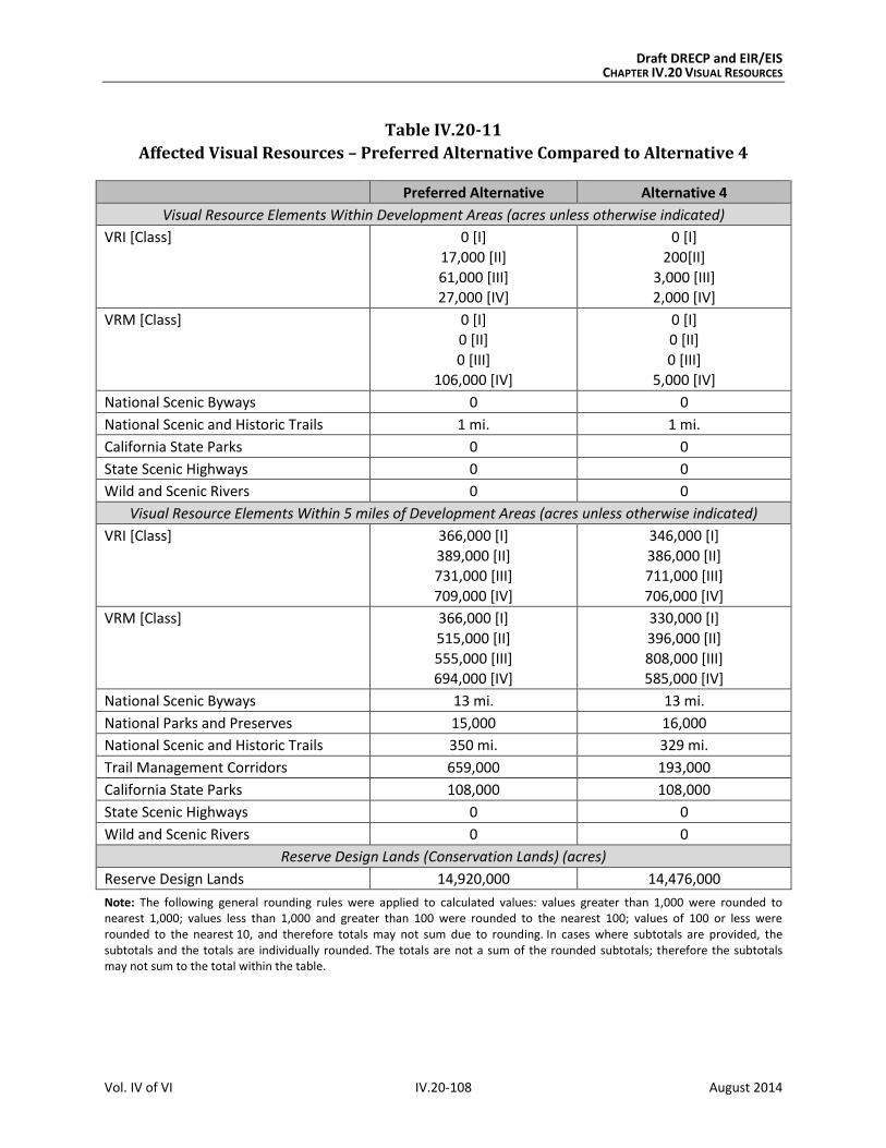
Draft DRECP and EIR/EIS CHAPTER IV.20 VISUAL RESOURCES
Vol. IV of VI IV.20-108 August 2014
Table IV.20-11
Affected Visual Resources – Preferred Alternative Compared to Alternative 4
Preferred Alternative Alternative 4
Visual Resource Elements Within Development Areas (acres unless otherwise indicated)
VRI [Class] 0 [I]
17,000 [II]
61,000 [III] 27,000 [IV]
0 [I]
200[II]
3,000 [III] 2,000 [IV]
VRM [Class] 0 [I] 0 [II]
0 [III]
106,000 [IV]
0 [I] 0 [II]
0 [III]
5,000 [IV]
National Scenic Byways 0 0
National Scenic and Historic Trails 1 mi. 1 mi.
California State Parks 0 0
State Scenic Highways 0 0
Wild and Scenic Rivers 0 0
Visual Resource Elements Within 5 miles of Development Areas (acres unless otherwise indicated)
VRI [Class] 366,000 [I]
389,000 [II]
731,000 [III]
709,000 [IV]
346,000 [I]
386,000 [II]
711,000 [III]
706,000 [IV]
VRM [Class] 366,000 [I]
515,000 [II]
555,000 [III]
694,000 [IV]
330,000 [I]
396,000 [II]
808,000 [III]
585,000 [IV]
National Scenic Byways 13 mi. 13 mi.
National Parks and Preserves 15,000 16,000
National Scenic and Historic Trails 350 mi. 329 mi.
Trail Management Corridors 659,000 193,000
California State Parks 108,000 108,000
State Scenic Highways 0 0
Wild and Scenic Rivers 0 0
Reserve Design Lands (Conservation Lands) (acres)
Reserve Design Lands 14,920,000 14,476,000
Note: The following general rounding rules were applied to calculated values: values greater than 1,000 were rounded to nearest 1,000; values less than 1,000 and greater than 100 were rounded to the nearest 100; values of 100 or less were rounded to the nearest 10, and therefore totals may not sum due to rounding. In cases where subtotals are provided, the subtotals and the totals are individually rounded. The totals are not a sum of the rounded subtotals; therefore the subtotals may not sum to the total within the table.
Draft DRECP and EIR/EIS CHAPTER IV.20 VISUAL RESOURCES
Vol. IV of VI IV.20-109 August 2014
IV.20.3.6.1 Plan-wide Impacts of Implementing the DRECP: Alternative 4
IV.20.3.6.1.1 Plan-wide Impacts and Mitigation Measures from Renewable Energy and
Transmission Development
Impact Assessment
Under Alternative 4, renewable energy related activities covered by the Plan are confined
to 1.6 million acres of DFAs, resulting in 148,000 acres of long-term disturbance (see Table
IV.1-1). This represents a slightly larger amount of long-term disturbance than could occur
under the Preferred Alternative.
The DFAs are focused in the Imperial Valley, Lucerne Valley, Barstow area, and Tehachapi
area. It has fewer DFAs in eastern Riverside and very small DFAs along the U.S. 395 cor-
ridor and near Searles Lake.
Approximately 1,608,000 acres would be within DFAs under Alternative 4, as compared
with 2,024,000 acres under the Preferred Alternative. This smaller area of land within
Alternative 4 DFAs (approximately 400,000 acres less) means that development would be
more concentrated in a smaller area, so the visual impacts of renewable energy projects
would be less widespread than under the Preferred Alternative.
Alternative 4 would primarily affect four ecoregion subareas, compared with five under the
Preferred Alternative.
Visual impacts from solar development would dispersed, with emphasis in two eco-
region subareas: (1) Imperial Borrego Valley and (2) West Mojave and Eastern Slopes.
Visual impacts from wind development would be in two ecoregion subareas: (1)
Pinto Lucerne Valley and Eastern Slopes and (2) West Mojave and Eastern Slopes.
Visual impacts from geothermal energy would occur in in two ecoregion subareas:
(1) Imperial Borrego Valley and (2) Owens River Valley, the same as under the Pre-
ferred Alternative.
The following summarizes the key points in comparing the visual impacts from renewable
energy and transmission development under Alternative 4 to those of the Preferred Alter-
native (see Appendix R2, Table R2.20-21 for detailed, quantitative data and analysis):
VRI Classes: There would be approximately 200 acres of VRI Class II lands, 3,000
acres of VRI Class III lands, 2,000 acres of VRI Class IV lands, and no VRI Class I lands
within DFAs under Alternative 4. Per the CMAs for visual resources, these 3,200
acres of VRI Class II and III lands within DFAs would be managed as VRM Class IV
and thereby sustain a potential degradation of underlying scenic values. Approxi-

Draft DRECP and EIR/EIS CHAPTER IV.20 VISUAL RESOURCES
Vol. IV of VI IV.20-110 August 2014
mately 14,000 acres of transmission would occur on inventoried lands, compared
with 13,000 acres under the Preferred Alternative.
A much smaller amount of VRI Class II and III lands within DFAs would be
managed as VRM Class IV under Alternative 4 (3,200 acres) than under the
Preferred Alternative (78,000 acres). This reflects a potential for degradation of
underlying scenic values under Alternative 4 but to a far lesser extent than under
the Preferred Alternative.
VRM Classes: As with the Preferred Alternative, there would be no VRM Class I, II,
or III lands in DFAs under Alternative 4 (Figure IV.20-6, Proposed BLM VRM
Classifications, Alternative 4). Approximately 14,000 acres of transmission would
occur on VRM lands, compared with a smaller amount of 13,000 acres under the
Preferred Alternative.
National Parks and Preserves: These lands would not be within the DFA footprint
under Alternative 4 or the Preferred Alternative. Although the footprint of renew-
able energy projects would not directly affect these lands, project facilities and
activities that are visible from National Parks and Preserves would diminish scenic
quality for viewers in those conservation areas, where expectations for scenic
quality are typically high.
National Scenic Byways: No segments of the Bradshaw Trail National Back Country
Byway would be within DFAs under either Alternative 4 or the Preferred Alternative.
National Scenic and Historic Trails: Approximately 1 mile of the Old Spanish
National Historic Trail would be within DFAs under both Alternative 4 and the Pre-
ferred Alternative.
California State Parks: As with the Preferred Alternative, no California State Park
lands would be within DFAs under Alternative 4. Approximately 160 acres of
transmission would occur on these lands, compared with 180 acres under the
Preferred Alternative.
State Scenic Highways: No segments of State Scenic Highways would be within
DFAs under Alternative 4 or the Preferred Alternative.
Wild and Scenic Rivers: No portion of designated or eligible Wild and Scenic Rivers
would be within DFAs under Alternative 4 or the Preferred Alternative.
Under Alternative 4, approximately 690,000 of DFA lands occur within 5 miles of
Legislatively and Legally Protected Areas in the Plan Area, compared with approxi-
mately 883,000 acres of DFA lands under the Preferred Alternative.
Proximity of Visual Resources to DFAs. Under Alternative 4, visual resource ele-
ments within 5 miles of proposed DFAs can be compared with those under the
Preferred Alternative, as summarized in Table IV.20-11. Alternative 4 has similar

Draft DRECP and EIR/EIS CHAPTER IV.20 VISUAL RESOURCES
Vol. IV of VI IV.20-111 August 2014
amounts of visual resource elements within 5 miles of DFAs as the Preferred
Alternative. An exception is Trail Management Corridors. There is less than one-
third the acres of corridors under Alternative 4 compared with the acres under the
Preferred Alternative.
The visual impacts resulting from Alternative 4 are:
Impact VR-1: Visibility of activities, materials, equipment, dust, and construction night
lighting would result in short-term diminished scenic quality.
Preconstruction activities and equipment visible from residences, public roads, and public
preserves would result in short-term diminished scenic quality for viewers. Examples
include road upgrading, damage to or removal of native vegetation, construction of
meteorological towers, drilling of temperature gradient wells, vehicles, and lighting.
During construction and decommissioning, activities and equipment visible from residences,
public roads, and public preserves would result in short-term diminished scenic quality for
viewers. Examples include dust and exhaust emissions, removal of vegetation during site
clearing, contouring and grading, presence of vehicles and equipment, mobilization and
demobilization activities, material delivery and staging, assembly of components, site light-
ing, and construction of and later removal of structures.
Impact VR-2: The presence of plan components would create long-term visual contrast
with surrounding undeveloped land and result in long-term diminished scenic quality.
The continued presence of equipment, structures, fencing, roads, and other elements required
to operate a facility would have a long-term adverse effect on the visible landscape. Areas
of persistent surface and vegetation disturbance and the presence of structures would
create visual contrast in form, line, color, and texture compared to pre-project conditions.
Depending on viewer location, physical elements introduced by a project could block views
or create skylining. Even after project removal and site reclamation are completed, visual
contrast would remain. Restoring the natural, pre-disturbance visual character of a desert
environment is extremely difficult, can take decades, and often is unsuccessful. Therefore,
surface and vegetation disturbance would create long-term visual impacts due to the
persistence of scars in arid and semi-arid landscapes.
The structure, size, and industrial character of utility-scale renewable energy and transmission
facilities during their operation and maintenance—as well as any associated glare, reflectivity,
and lighting—would visually contrast with surrounding undeveloped land and result in
long-term diminished scenic quality.
Draft DRECP and EIR/EIS CHAPTER IV.20 VISUAL RESOURCES
Vol. IV of VI IV.20-112 August 2014
Impacts in Study Area Lands
Study Area Lands refer to three categories of lands shown on alternative maps: Assessment
Areas (FAAs), Special Analysis Areas (SAAs) and DRECP Variance Lands.
Future Assessment Areas (FAAs). Alternative 4 has no FAAs identified, therefore there
would be no associated impacts to visual resources.
Special Analysis Areas (SAAs). Designating the SAAs as conservation would have no impact
to this resource. Impacts would be the same as those explained for the Plan-wide reserve
design in Section IV.20.3.2.1.2, Impacts of the Reserve Design. Portions of the SAAs are
shown as DRECP Variance Lands in Alternative 4, but the majority of these areas would be
conservation lands (near U.S. 395) and undesignated areas (near Fort Irwin).
DRECP Variance Lands. DRECP Variance Lands represent the BLM Solar PEIS Variance
Lands as screened for the DRECP and EIR/EIS based on BLM screening criteria. Covered
Activities could be permitted for NCCP purposes only through an NCCP plan amendment.
However, development of renewable energy on Variance Lands would not require a BLM
LUPA; so the environmental review process would be somewhat simpler than if the loca-
tion were left undesignated.
Under Alternative 4, Variance Lands include 588,000 acres, development of which would
conform to the visual management objectives of VRM Class II.
Impact Reduction Strategies and Mitigation
The implementation of Alternative 4 would result in conservation of some desert lands as
well as the development of renewable energy generation and transmission facilities on
other lands. The impacts of the renewable energy development covered by the Plan would
be lessened in several ways. First, the Plan incorporates CMAs for each alternative, including
specific biological reserve design components and LUPA components. In addition, the imple-
mentation of existing laws, orders, regulations, and standards would reduce the impacts of
project development.

!(
!(
!(
!(
!(
!(
!(
!(
!(
!(
!( !(
!(
!(
§̈¦10
§̈¦405
§̈¦605
§̈¦210
§̈¦15
§̈¦710
§̈¦15
§̈¦10
§̈¦8
§̈¦5
§̈¦40
§̈¦5
£¤6
£¤395
£¤395
UV190
UV58
UV178
UV127
UV78
UV2
UV91
UV86
UV98
UV136
UV168
UV247
UV34
UV74
UV94
UV60
UV138
UV75
UV243
UV62
UV111
UV62
UV38
UV78
Inyo
San Bernardino
Kern
Riverside
Imperial
Tulare
San Diego
Los Angeles
Mono
Fresno
Orange
M E X I C O
O w e n s R i v e r
V a l l e y E c o r e g i o nS u b a r e a
P a n a m i n t D e a t h
V a l l e y E c o r e g i o nS u b a r e a
W e s t M o j a v e a n d
E a s t e r n S l o p e sE c o r e g i o n S u b a r e a
M o j a v e a n d
S i l u r i a n V a l l e yE c o r e g i o n S u b a r e a
K i n g s t o n a n d
F u n e r a l M o u n t a i n sE c o r e g i o n S u b a r e a
P r o v i d e n c e a n d
B u l l i o n M o u n t a i n sE c o r e g i o n S u b a r e a
P i n t o L u c e r n e V a l l e y
a n d E a s t e r n S l o p e sE c o r e g i o n S u b a r e a
P i u t e V a l l e y a n d
S a c r a m e n t o M o u n t a i n sE c o r e g i o n S u b a r e a
C a d i z V a l l e y a n d
C h o c o l a t e M o u n t a i n sE c o r e g i o n S u b a r e a
I m p e r i a l B o r r e g o
V a l l e y E c o r e g i o nS u b a r e a
Escondido
Lancaster
Palmdale
Long
Beach
Ridgecrest
Barstow
Hesperia
Riverside
SanBernardino
Twentynine
Palms
Coachella
El Centro
San
Diego
Los
Angeles
A R I Z O N AA R I Z O N A
N E V A D AN E V A D A
!(
!(
!(
!(
!(
!(
!(
!(
!(
!(
!( !(
!(
!(
§̈¦10
§̈¦405
§̈¦605
§̈¦210
§̈¦15
§̈¦710
§̈¦15
§̈¦10
§̈¦8
§̈¦5
§̈¦40
§̈¦5
£¤6
£¤395
£¤395
UV190
UV58
UV178
UV127
UV78
UV2
UV91
UV86
UV98
UV136
UV168
UV247
UV34
UV74
UV94
UV60
UV138
UV75
UV243
UV62
UV111
UV62
UV38
UV78
Inyo
San Bernardino
Kern
Riverside
Imperial
Tulare
San Diego
Los Angeles
Mono
Fresno
Orange
M E X I C O
O w e n s R i v e r
V a l l e y E c o r e g i o nS u b a r e a
P a n a m i n t D e a t h
V a l l e y E c o r e g i o nS u b a r e a
W e s t M o j a v e a n d
E a s t e r n S l o p e sE c o r e g i o n S u b a r e a
M o j a v e a n d
S i l u r i a n V a l l e yE c o r e g i o n S u b a r e a
K i n g s t o n a n d
F u n e r a l M o u n t a i n sE c o r e g i o n S u b a r e a
P r o v i d e n c e a n d
B u l l i o n M o u n t a i n sE c o r e g i o n S u b a r e a
P i n t o L u c e r n e V a l l e y
a n d E a s t e r n S l o p e sE c o r e g i o n S u b a r e a
P i u t e V a l l e y a n d
S a c r a m e n t o M o u n t a i n sE c o r e g i o n S u b a r e a
C a d i z V a l l e y a n d
C h o c o l a t e M o u n t a i n sE c o r e g i o n S u b a r e a
I m p e r i a l B o r r e g o
V a l l e y E c o r e g i o nS u b a r e a
Escondido
Lancaster
Palmdale
Long
Beach
Ridgecrest
Barstow
Hesperia
Riverside
SanBernardino
Twentynine
Palms
Coachella
El Centro
San
Diego
Los
Angeles
A R I Z O N AA R I Z O N A
N E V A D AN E V A D A
DRECP Plan Area Boundary
Ecoregion Subareas
CDCA Boundary
County Boundary
Non-BLM Land
BLM VRM Classifications
Class I
Class II
Class III
Class IV
M:\JOBS4\6287\common_gis\EIR_Figures_Spring_2014\Vol_IV\IV_20_Visual\figIV.20-6.mxd 8/18/2014
FIGURE IV.20-6
Proposed BLM Visual Resource Management Classifications, Alternative 4
0 2010
MilesI
Draft DRECP and EIR/EIS
Sources: ESRI (2014); CEC (2013); BLM (2013); CDFW (2013); USFWS (2013)
August 2014

Draft DRECP and EIR/EIS CHAPTER IV.20 VISUAL RESOURCES
Vol. IV of VI IV.20-114 August 2014
INTENTIONALLY LEFT BLANK

Draft DRECP and EIR/EIS CHAPTER IV.20 VISUAL RESOURCES
Vol. IV of VI IV.20-115 August 2014
Conservation and Management Actions
The conservation strategy for Alternative 4 (presented in Volume II, Section II.3.1.1)
defines specific actions that would reduce the impacts of this alternative. The conservation
strategy includes definition of the reserve design and specific CMAs for the Preferred
Alternative. While the CMAs were developed for BLM lands only, this analysis assumes that
all CMAs would be applied also to nonfederal lands.
Specific visual resource CMAs have been developed and apply to the Preferred Alternative
and all action alternatives. They are summarized in Section IV.20.3.2.1.1. These CMAs for
VRM include measures that apply Plan-wide, measures specific to DFAs and Study Area
Lands, and a detailed set of visual resource BMPs that apply to all action alternatives. The
BMPs incorporate the measures identified in Best Management Practices for Reducing
Visual Impacts of Renewable Energy Facilities on BLM-Administered Lands. These visual
resource CMAs provide a comprehensive framework of guidelines and specifications
through which visual impacts would be avoided where possible, minimized, and/or miti-
gated to the extent practicable.
Laws and Regulations
Similar to the No Action Alternative, existing laws and regulations will reduce certain impacts
of Plan implementation. Relevant regulations are presented in the Regulatory Setting in
Volume III. The requirements of relevant laws and regulations that would reduce the
severity of visual impacts are summarized in Section IV.20.3.1.1.1.
Mitigation Measures
The visual impact avoidance and reduction strategies in existing guidance, such Reducing
Visual Impacts of Renewable Energy Facilities on BLM-Administered Lands, are detailed and
comprehensive. The CMAs proposed under the DRECP (see Appendix H) provide additional
detail and direction. These represent state-of-the-art visual impact mitigation as it applies
to the Plan Area; no additional mitigation is feasible.
IV.20.3.6.1.2 Impacts from Reserve Design
The following summarizes the key points in comparing Alternative 4 visual impacts of the
reserve design to those of the Preferred Alternative (see Appendix R2, Table R2.20-22 for
detailed, quantitative data and analysis):
VRI Classes: Alternative 4 would have 100% of VRI Class I lands, 66% of VRI Class II
lands, 62% of VRI Class III lands, and 65% of VRI Class IV lands in the Reserve

Draft DRECP and EIR/EIS CHAPTER IV.20 VISUAL RESOURCES
Vol. IV of VI IV.20-116 August 2014
Design Lands, compared with slightly larger amounts (100%, 74%, 67%, and 72%
respectively), under the Preferred Alternative.
VRM Classes: 100% of VRM Class I lands, 81% of VRM Class II lands, 59% of VRM
Class III lands, and 54% of the VRM Class IV lands would be in the Reserve Design
Lands under Alternative 4, compared with 100% of VRM Class I lands, 83% of VRM
Class II lands, 79% of VRM Class III lands, and 38% of VRM Class IV lands under the
Preferred Alternative.
National Parks and Preserves: The National Parks and Preserves would have
100% of their land areas in the reserve design under Alternative 4 and under the
Preferred Alternative.
National Scenic Byways: Under Alternative 4, approximately 39% of the
Bradshaw Trail National Back Country Byway and 15% of SR 190 would be in the
Reserve Design. This provides a similar or slightly lower level of protection of
visual and scenic values than would occur under the Preferred Alternative (51%
and 15% respectively).
National Scenic and Historic Trails: Under Alternative 4, approximately 53% of
the Juan Bautista de Anza National Historic Trail, 55% of the Old Spanish National
Historic Trail, and 41% of the Pacific Crest National Scenic Trail alignments would
be in the Reserve Design. This provides a similar or higher level of protection of
visual and scenic values than would occur under the Preferred Alternative (4%,
58%, and 40%, respectively).
California State Parks: As with the Preferred Alternative, most California State
Park lands would be in Reserve Design Lands under Alternative 4. This would vary
by individual park or preserve; but most parks would have more than 95% in exist-
ing conservation areas, BLM LUPA designations, or CPAs. Exceptions are the (1)
Desert Cahuilla/Freeman Project (4%), (2) Picacho SRA (74%), and (3) Salton Sea
SRA (86%). Similar amounts and percentages of California State Park lands would
be in Reserve Design Lands under the Preferred Alternative.
State Scenic Highways: Approximately 15% of SR 190 but no portion of the SR 78
or U.S. 395 alignments would be in Reserve Design Lands, compared to similar por-
tions under the Preferred Alternative.
Wild and Scenic Rivers: 100% of the Amargosa Wild and Scenic River corridor as
well as the eligible Surprise Canyon Creek and Mojave River segments would be
within the reserve design under Alternative 4 and the Preferred Alternative.
Draft DRECP and EIR/EIS CHAPTER IV.20 VISUAL RESOURCES
Vol. IV of VI IV.20-117 August 2014
IV.20.3.6.2 Impacts of DRECP Land Use Plan Amendment on BLM Land: Alternative 4
This section addresses two components of effects of the BLM LUPA: the streamlined
development of renewable energy and transmission on BLM land under the LUPA and the
impacts of the amended land use plans themselves.
IV.20.3.6.2.1 Impacts from Renewable Energy and Transmission Development on BLM Land
The visual impacts of DFAs on VRI and VRM lands for Alternative 4 would be the same as
those defined in Section IV.20.3.6.1, Plan-wide Impacts of Implementing the DRECP: Alter-
native 4, for the Plan-wide analysis.
IV.20.3.6.2.2 Impacts of Changes to BLM Land Designations
The DRECP LUPA Alternative 4 would establish VRM Classes for all lands in the CDCA. (Cur-
rently, only the Bishop RMP and the Imperial Sand Dunes RAMP have VRM Classes desig-
nated. In accordance with BLM policy, all wilderness areas and WSAs are managed as VRM
Class I.) It would also (1) designate new NLCS lands; (2) designate new ACECs and expand
and reduce existing ACECs; (3) designate new SRMAs and expand and reduce existing
SRMAs; and (4) create buffer corridors along National Scenic and Historic Trails. The BLM
LUPA would also replace the multiple-use classes.
The VRM Classes and other BLM land designations proposed under Alternative 4 would
offer protective measures that would avoid or reduce visual impacts. As with the
Preferred Alternative, CMAs for visual resources would be established and implemented.
The BLM-specific CMAs proposed for the Preferred Alternative would be the same as for
all action alternatives. These visual resource CMAs and the restrictions and protective
measures of the land designations provide a framework of guidelines and specifications
through which visual impacts would be avoided where possible, minimized, and/or
mitigated to the extent practicable.
Under Alternative 4, Trail Management Corridors would be established along National
Scenic and Historic Trails, at a width of generally 1 mile from the centerline of the trail, for
a total width of 2 miles (as compared to a much larger total width of 10 miles under the
Preferred Alternative). As discussed in Volume II, Volume II, Section II.3.2.2.2, these Trail
Management Corridors would be managed as components of the BLM’s NLCS. Where
National Trails overlap other NLCS lands, the more protective CMAs or land use allocations
would apply. All Trail Management Corridors would be designated as VRM Class II, except
within approved transmission corridors (VRM Class III) and DFAs (VRM Class IV). How-
ever, state-of-the-art VRM BMPs for renewable energy would be employed commensurate
Draft DRECP and EIR/EIS CHAPTER IV.20 VISUAL RESOURCES
Vol. IV of VI IV.20-118 August 2014
with the protection of nationally significant scenic resources and cultural landscapes to
minimize the level of intrusion and protect trail settings.
The following summarizes the key points of the impacts of changes to BLM land designa-
tions on visual resource elements under Alternative 4 (see Appendix R2, Table R2.20-23 for
detailed, quantitative data and analysis):
SRMAs: There would be the potential for recreational activities or facilities allowed
in SRMAs to affect scenic values, particularly those of the VRI Class I and II lands
with which they coincide (approximately 310,000 acres, similar to the area under
the Preferred Alternative).
NLCS: The management of these lands that have nationally significant ecological,
cultural and scientific values would offer additional protection of intactness and
scenic quality, particularly to the VRI Class I, II, III, and IV lands with which they
coincide (approximately 2.7 million acres, compared with a larger area of 3.6 million
acres under the Preferred Alternative).
ACECs: The special management measures given to protect the important historic,
cultural, and scenic values of these areas would generally benefit visual resources,
particularly the VRI Class II, III, and IV lands with which they coincide (approxi-
mately 1.6 million acres, compared with a smaller amount of 1.4 million acres under
the Preferred Alternative).
Wildlife Allocation Areas: The management of these areas must be compatible
with protection and enhancement of wildlife and plant habitat and would generally
benefit visual resources, particularly the VRI Class III and IV lands with which they
coincide (approximately 267,000 acres, compared with a smaller amount of 18,000
acres under the Preferred Alternative).
Lands Managed for Wilderness Characteristics: These lands would be managed
as VRM Class II. Other management strategies to protect the wilderness character-
istics of these lands would benefit visual resources, particularly the VRI Class II, III,
and IV lands with which they coincide (approximately 255,000 acres under
Alternative 4, compared with a much smaller area of 18,000 acres under the
Preferred Alternative).
Trail Management Corridors: The primary effect of the 2-mile-wide corridors
under Alternative 4 would be to provide a consistent framework for protecting and
managing scenic values along National Scenic Trails within National and California
State park lands. As with the Preferred Alternative, the Trail Management Corridors
would be managed to meet the visual management objectives of VRM Class II.

Draft DRECP and EIR/EIS CHAPTER IV.20 VISUAL RESOURCES
Vol. IV of VI IV.20-119 August 2014
Alternative 4 would assign VRM classes to all BLM lands within the Plan Area. Under Alter-
native 4, VRI Class lands within the proposed VRM Classes on BLM LUPA lands would be as
indicated in Table IV.20-12.
The following summarizes the key points of the effects of VRM classifications on VRI lands
under Alternative 4:
VRM designations: The majority of lands would be designated as VRM Class I, II, or
III, and 11% would be designated as VRM Class IV.
VRI Class I: As with the Preferred Alternative, 100% of VRI Class I lands would be
managed as VRM Class I, reflecting the highest level of management and visual
resource protection.
VRI Class II: As with the Preferred Alternative, more than 70% of VRI Class II lands
would be managed as VRM Class II or I, reflecting a moderately high level of manage-
ment protection. Approximately 29% would be managed as VRM Class III or IV, which
allows for more visual contrast and impact than the VRM Class II objectives allow.
VRI Class III: Approximately 89% of VRI Class III lands would be managed as VRM
Class III, II, or I, reflecting a high correlation and level of management protection.
Approximately 25% would be managed to meet VRM Class II objectives, which
restrict visual contrast and impact more than VRM Class III does. Approximately
10% would be managed as VRM Class IV, which allows for more visual contrast and
impact than the VRM Class III objectives.
VRI Class IV: More than 58% of VRI Class IV lands would be managed as VRM Class
III, II, or I; 42% would be VRM Class IV.
Compared to the Preferred Alternative, Alternative 4 would result in a similar level of
correlation between VRI values and the proposed VRM Classes. An exception to this is the
management of VRI Class III lands. A higher percentage of these areas would be managed
as VRM Class III, II, or I under Alternative 4 than under the Preferred Alternative. The desig-
nation of VRM Classes throughout the CDCA would have the value of providing the level of
visual change allowed prior to an area being considered for actions that would introduce
change. Currently, VRM Classes are designated only for the Bishop Field Office and the
Imperial Sand Dunes RAMP.
Under the proposed CMAs, all DFAs would be managed as VRM Class IV lands, to allow for
utility-scale development. In those cases, implementation or incorporation of BMPs
would still be required to reduce the visual contrast levels of proposed facilities to the
extent practicable.

Draft DRECP and EIR/EIS CHAPTER IV.20 VISUAL RESOURCES
Vol. IV of VI IV.20-120 August 2014
Table IV.20-12
VRI Classes Within Proposed VRM Classes on BLM LUPA Lands – Alternative 4
LUPA-Proposed VRM Class
Designations
Existing Visual Resource Inventory Classes
Total
VRI Class I VRI Class II VRI Class III VRI Class IV
Acres Percent Acres Percent Acres Percent Acres Percent
VRM Class I 3,842,000 100% 6,000 0% 3,000 0% 1,000 0% 3,852,000
VRM Class II — 0% 1,532,000 71% 696,000 25% 272,000 14% 2,500,000
VRM Class III — 0% 534,000 25% 1,775,000 64% 867,000 44% 3,176,000
VRM Class IV — 0% 87,000 4% 286,000 10% 837,000 42% 1,210,000
Total 3,842,000 100% 2,159,000 100% 2,760,000 100% 1,977,000 100% 10,738,000
Note: VRI Class I represents the highest level of inventoried visual resource values; VRM Class I represents the most restrictive visual management objectives. Acres above include CDCA outside the Plan Area. The following general rounding rules were applied to calculated values: values greater than 1,000 were rounded to nearest 1,000; values less than 1,000 and greater than 100 were rounded to the nearest 100; values of 100 or less were rounded to the nearest 10, and therefore totals may not sum due to rounding. In cases where subtotals are provided, the subtotals and the totals are individually rounded. The totals are not a sum of the rounded subtotals; therefore the subtotals may not sum to the total within the table.

Draft DRECP and EIR/EIS CHAPTER IV.20 VISUAL RESOURCES
Vol. IV of VI IV.20-121 August 2014
IV.20.3.6.3 Impacts of Natural Community Conservation Plan: Alternative 4
The impacts of the NCCP for Alternative 4 would be the same as those defined in Section
IV.20.3.2.1 for the Plan-wide analysis.
IV.20.3.6.4 Impacts of General Conservation Plan: Alternative 4
The impacts of the GCP for Alternative 4 would be similar to those defined in Section
IV.20.3.2.1 for the Plan-wide analysis, but they would occur on nonfederal lands only.
IV.20.3.6.5 Impacts Outside the Plan Area
IV.20.3.6.5.1 Impacts of Transmission Outside the Plan Area
The impacts of transmission outside the Plan Area would be the same under all
alternatives. These are as described for the No Action Alternative in Section IV.20.3.1.5.1.
IV.20.3.6.5.2 Impacts of BLM LUPA Decisions Outside the Plan Area
Under the proposed BLM LUPA, the changes outside the Plan Area would include the desig-
nation of NLCS lands, ACECs, National Scenic and Historic Trails Management Corridors,
VRM Classes, and new land allocations to replace multiple-use classes on CDCA lands.
The VRM Classes and other BLM land designations proposed under Alternative 4 would
extend protective measures to these areas that would avoid or reduce visual impacts. CMAs
for visual resources would be established and implemented. The BLM-specific CMAs for
Alternative 4 would be the same as for all action alternatives. These VRM CMAs and the
restrictions and protective measures of the land designations provide a framework of guide-
lines and specifications through which visual impacts would be avoided where possible,
minimized, and/or mitigated to the extent practicable.
The following summarizes the key points of the impacts of changes to BLM land designations
on visual resource elements, outside the Plan Area, under Alternative 4 (see Appendix R2,
Table R2.20-24 for detailed, quantitative data and analysis):
Proposed NLCS: The management of these lands that have nationally significant
ecological, cultural, and scientific values would offer additional protection of intact-
ness and scenic quality, particularly the VRM Class II, III, and IV lands with which
they coincide (approximately 162,000 acres, compared with a larger area of
215,000 acres under the Preferred Alternative).
Existing and Proposed ACECs: The special management measures given to protect
the important historic, cultural, and scenic values of these areas would generally

Draft DRECP and EIR/EIS CHAPTER IV.20 VISUAL RESOURCES
Vol. IV of VI IV.20-122 August 2014
benefit visual resources, particularly the VRM Class II, III, and IV lands with which
they coincide (approximately 203,000 acres, compared to a similar amount of
207,000 acres under the Preferred Alternative).
Trail Management Corridors: The primary effect of these 2-mile-wide corridors
under Alternative 4 would be to provide a consistent framework for protecting and
managing scenic values along National Scenic Trails within National and California
State park lands. As with the Preferred Alternative, the Trail Management Corridors
would be managed to meet the visual management objectives of VRM Class II.
IV.20.3.6.6 CEQA Significance Determination for Alternative 4
The significance determinations for short-term and long-term impacts are described in Sec-
tion IV.20.3.1.1.1 for the No Action Alternative. Section IV.20.1.2 identifies four criteria to
apply when determining if there are significant impacts from a project under CEQA. These
criteria are included as part of the more general impacts identified in this section as VR-1
and VR-2. The visual impacts and their associated significance determinations for Alterna-
tive 4 are as follows:
VR-1: Visibility of activities, materials, equipment, dust, and construction night
lighting would result in short-term diminished scenic quality. Activities and
equipment visible from residences, public roads, and public preserves would result in
short-term diminished scenic quality for viewers. This would be less than significant with
implementation of appropriate CMAs.
VR-2: The presence of plan components would create long-term visual contrast with
surrounding undeveloped land and result in long-term diminished scenic quality.
Long-term impacts to visual resources for Alternative 4 would be significant and unavoid-
able, as described in detail for the No Action Alternative (Section IV.20.3.1.6). Impacts
would be significant because of the changes in line, form, and color introduced by large-
scale development and the contrast of any such development with surrounding conditions.
Although the CMAs relevant to Alternative 4 would reduce the impact on visual resources,
they would not reduce it to a less than significant level.
IV.20.3.6.7 Comparison of Alternative 4 with Preferred Alternative
Chapter IV.27 presents a comparison of all action alternatives and the No Action Alterna-
tive across all disciplines. This section summarizes the comparison of Alternative 4 with
the Preferred Alternative.
Draft DRECP and EIR/EIS CHAPTER IV.20 VISUAL RESOURCES
Vol. IV of VI IV.20-123 August 2014
IV.20.3.6.7.1 Alternative 4 Compared with Preferred Alternative for Plan-wide DRECP
Although similar visual impacts would occur under both Alternative 4 and the Preferred
Alternative, based on the assumption that California’s renewable energy goals would be
achieved in any case, the impacts would vary in key ways:
Geographic Distribution. As with the Preferred Alternative, visual impacts of DFAs under
Alternative 4 would be concentrated in areas considered less environmentally sensitive.
DFAs under Alternative 4 would be geographically dispersed on public and private lands
with an assumption of somewhat more solar and less wind project development than the
Preferred Alternative. Solar energy development would be concentrated in one ecoregion
subarea, the Cadiz Valley and Chocolate Mountains, as opposed to two under the Preferred
Alternative; and there would be less development overall in the Imperial Borrego Valley
ecoregion subarea.
The severity of visual impacts depends partly on the number of potential viewers. Alterna-
tive 4 has DFAs similar to the Preferred Alternative in and near the populated West Mojave
area. Alternative 4 also includes DFAs similar to those of the Preferred Alternative in the
areas surrounding Victorville, Adelanto, and Lucerne Valley.
The severity of visual impacts also relates to expectations of viewers seeking pristine
desert vistas. The eastern and northeastern parts of the Plan Area are sensitive because
they contain the Mojave National Preserve, Death Valley National Monument, and several
BLM Wilderness Areas. Alternative 4 includes the Pahrump Valley DFA, but not the SAA
and FAA that are near the Mojave National Preserve. Both the Preferred Alternative and
Alternative 4 have a large DFA in the East Riverside area (close to Joshua Tree National
Park and BLM Wilderness Areas). Alternative 4 also includes DRECP Variance Lands, pri-
marily in the eastern part of the Plan Area.
Extent of Potential Renewable Energy Development. Although the geographic distribu-
tion of DFAs would be generally similar under both Alternative 4 and the Preferred Alter-
native, the scale and extent of the DFAs vary. DFAs are approximately 400,000 larger under
the Preferred Alternative (2,024,000 acres of DFAs) than under Alternative 4 (1,608,000
acres of DFAs). This smaller area within which development could occur would result in
fewer areas potentially subject to visual impacts under Alternative 4 than under the Pre-
ferred Alternative.
Conservation. Alternative 4 has a similar amount of land in the reserve design as the
Preferred Alternative, and more land identified in CPAs. Thus, Alternative 4 would
potentially provide similar amounts of land in conservation as the Preferred Alternative,
lands in which scenic values would benefit from the management and restrictions that

Draft DRECP and EIR/EIS CHAPTER IV.20 VISUAL RESOURCES
Vol. IV of VI IV.20-124 August 2014
would apply to those conserved areas. An exception is that Alternative 4 would provide
less than one-third the amount of land in Trail Management Corridors as compared with
the Preferred Alternative.
In summary, the composition and structure of Alternative 4 would provide similar oppor-
tunities for the avoidance of, and compensation for, visual impacts from renewable energy
development but would result in greater impacts from transmission corridors compared
with the Preferred Alternative.
IV.20.3.6.7.2 Alternative 4 Compared with Preferred Alternative for the BLM Land
Use Plan Amendment
The BLM LUPA under Alternative 4 would assign VRM Classes to all BLM lands within the
CDCA, including those outside the Plan Area, as would the Preferred Alternative. For both
alternatives, this would provide a unifying framework and an established system for
addressing visual resources.
Alternative 4 would have far fewer acres of VRI Class II and III lands in DFAs (approximately
3,200 acres) compared with the Preferred Alternative (78,000 acres). This would result in
a lower potential for visual impacts under Alternative 4 than under the Preferred Alternative.
A key difference is that Alternative 4 proposes 2-mile-wide Trail Management Corridors
compared with the much greater 10-mile-wide corridors under the Preferred Alternative.
In this regard, the scenic values and viewer experience along National Scenic Trails would
have a greater level of protection under the Preferred Alternative than under Alternative 4.
IV.20.3.6.7.3 Alternative 4 Compared with Preferred Alternative for NCCP
The impacts of the NCCP for Alternative 4 are the same as those defined in Section
IV.20.3.2.1 for the Plan-wide analysis. As a result, the comparison of Alternative 4 with the
Preferred Alternative for the NCCP is the same as described for Plan-wide DRECP.
IV.20.3.6.7.4 Alternative 4 Compared with Preferred Alternative for the GCP
The visual impacts of the GCP for Alternative 4 and the Preferred Alternative would be sim-
ilar to those defined in Section IV.20.3.2.1 for the Plan-wide analysis, but they would occur
on nonfederal lands only.