issn 2009-4086 national parks and wildlife service · the overall aim of the habitats directive is...
TRANSCRIPT
Conservation Objectives Series
National Parks and Wildlife Service
Errit Lough SAC 000607
ISSN 2009-4086
18 Dec 2017 Page 1 of 10 Version 1
National Parks and Wildlife Service,Department of Culture, Heritage and the Gaeltacht,
7 Ely Place, Dublin 2, Ireland.
Web: www.npws.ieE-mail: [email protected]
Citation:
ISSN 2009-4086Series Editor: Rebecca Jeffrey
NPWS (2017) Conservation Objectives: Errit Lough SAC 000607. Version 1. National Parks and Wildlife Service, Department of Culture, Heritage and the Gaeltacht.
18 Dec 2017 Page 2 of 10 Version 1
Introduction
European and national legislation places a collective obligation on Ireland and its citizens to maintain habitats and species in the Natura 2000 network at favourable conservation condition. The Government and its agencies are responsible for the implementation and enforcement of regulations that will ensure the ecological integrity of these sites.
A site-specific conservation objective aims to define favourable conservation condition for a particular habitat or species at that site.
Favourable conservation status of a habitat is achieved when: • its natural range, and area it covers within that range, are stable or increasing, and • the specific structure and functions which are necessary for its long-term maintenance exist and are likely to continue to exist for the foreseeable future, and • the conservation status of its typical species is favourable.
The favourable conservation status of a species is achieved when: • population dynamics data on the species concerned indicate that it is maintaining itself on a long-term basis as a viable component of its natural habitats, and • the natural range of the species is neither being reduced nor is likely to be reduced for the foreseeable future, and • there is, and will probably continue to be, a sufficiently large habitat to maintain its populations on a long-term basis.
The overall aim of the Habitats Directive is to maintain or restore the favourable conservation status of habitats and species of community interest. These habitats and species are listed in the Habitats and Birds Directives and Special Areas of Conservation and Special Protection Areas are designated to afford protection to the most vulnerable of them. These two designations are collectively known as the Natura 2000 network.
The maintenance of habitats and species within Natura 2000 sites at favourable conservation condition will contribute to the overall maintenance of favourable conservation status of those habitats and species at a national level.
1. The targets given in these conservation objectives are based on best available information at the time of writing. As more information becomes available, targets for attributes may change. These will be updated periodically, as necessary.2. An appropriate assessment based on these conservation objectives will remain valid even if the targets are subsequently updated, providing they were the most recent objectives available when the assessment was carried out. It is essential that the date and version are included when objectives are cited.3. Assessments cannot consider an attribute in isolation from the others listed for that habitat or species, or for other habitats and species listed for that site. A plan or project with an apparently small impact on one attribute may have a significant impact on another.4. Please note that the maps included in this document do not necessarily show the entire extent of the habitats and species for which the site is listed. This should be borne in mind when appropriate assessments are being carried out.5. When using these objectives, it is essential that the relevant backing/supporting documents are consulted, particularly where instructed in the targets or notes for a particular attribute.
Notes/Guidelines:
18 Dec 2017 Page 3 of 10 Version 1
Qualifying Interests
Errit Lough SAC
* indicates a priority habitat under the Habitats Directive
000607
3140 Hard oligo-mesotrophic waters with benthic vegetation of Chara spp.
18 Dec 2017 Page 4 of 10 Version 1
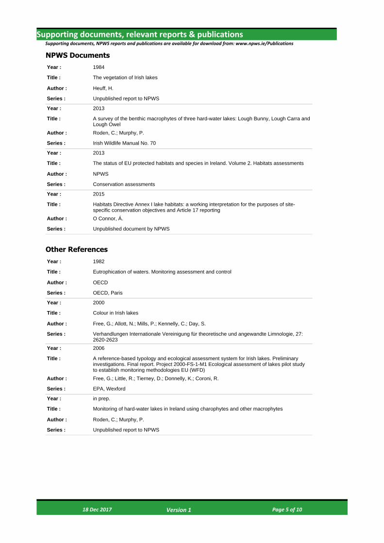
Supporting documents, relevant reports & publications
Year : 1982
Title : Eutrophication of waters. Monitoring assessment and control
Author : OECD
Series : OECD, Paris
Year : 2000
Title : Colour in Irish lakes
Author : Free, G.; Allott, N.; Mills, P.; Kennelly, C.; Day, S.
Series : Verhandlungen Internationale Vereinigung für theoretische und angewandte Limnologie, 27: 2620-2623
Year : 2006
Title : A reference-based typology and ecological assessment system for Irish lakes. Preliminary investigations. Final report. Project 2000-FS-1-M1 Ecological assessment of lakes pilot study to establish monitoring methodologies EU (WFD)
Author : Free, G.; Little, R.; Tierney, D.; Donnelly, K.; Coroni, R.
Series : EPA, Wexford
Year : in prep.
Title : Monitoring of hard-water lakes in Ireland using charophytes and other macrophytes
Author : Roden, C.; Murphy, P.
Series : Unpublished report to NPWS
Supporting documents, NPWS reports and publications are available for download from: www.npws.ie/Publications
Year : 1984
Title : The vegetation of Irish lakes
Author : Heuff, H.
Series : Unpublished report to NPWS
Year : 2013
Title : A survey of the benthic macrophytes of three hard-water lakes: Lough Bunny, Lough Carra and Lough Owel
Author : Roden, C.; Murphy, P.
Series : Irish Wildlife Manual No. 70
Year : 2013
Title : The status of EU protected habitats and species in Ireland. Volume 2. Habitats assessments
Author : NPWS
Series : Conservation assessments
Year : 2015
Title : Habitats Directive Annex I lake habitats: a working interpretation for the purposes of site-specific conservation objectives and Article 17 reporting
Author : O Connor, Á.
Series : Unpublished document by NPWS
Other References
NPWS Documents
18 Dec 2017 Page 5 of 10 Version 1

Spatial data sourcesYear : 2008
Title : OSi 1:5000 IG vector dataset
GIS Operations : WaterPolygons feature class clipped to the SAC boundary. Expert opinion used to identify Annex I habitat and to resolve any issues arising
Used For : 3140 (map 2)
18 Dec 2017 Page 6 of 10 Version 1
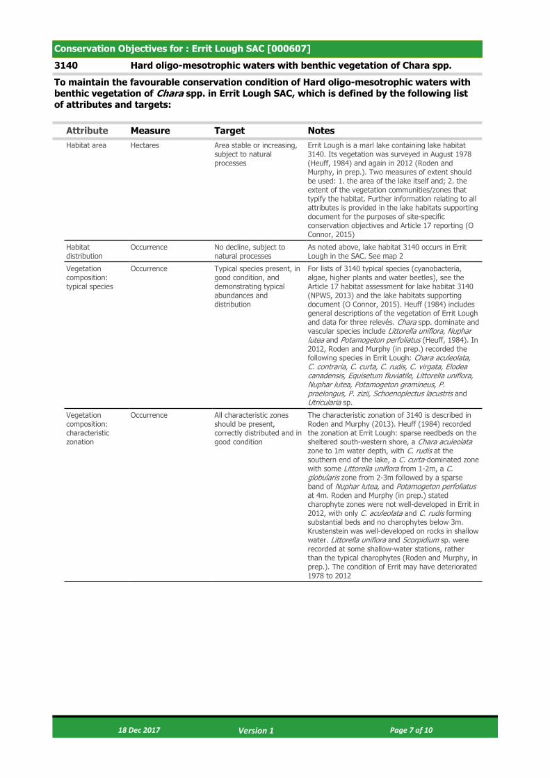
Conservation Objectives for : Errit Lough SAC [000607]
3140 Hard oligo-mesotrophic waters with benthic vegetation of Chara spp.
To maintain the favourable conservation condition of Hard oligo-mesotrophic waters with benthic vegetation of Chara spp. in Errit Lough SAC, which is defined by the following list of attributes and targets:
Attribute Measure Target NotesHabitat area Hectares Area stable or increasing,
subject to natural processes
Errit Lough is a marl lake containing lake habitat 3140. Its vegetation was surveyed in August 1978 (Heuff, 1984) and again in 2012 (Roden and Murphy, in prep.). Two measures of extent should be used: 1. the area of the lake itself and; 2. the extent of the vegetation communities/zones that typify the habitat. Further information relating to all attributes is provided in the lake habitats supporting document for the purposes of site-specific conservation objectives and Article 17 reporting (O Connor, 2015)
Habitat distribution
Occurrence No decline, subject to natural processes
As noted above, lake habitat 3140 occurs in Errit Lough in the SAC. See map 2
Vegetation composition: typical species
Occurrence Typical species present, in good condition, and demonstrating typical abundances and distribution
For lists of 3140 typical species (cyanobacteria, algae, higher plants and water beetles), see the Article 17 habitat assessment for lake habitat 3140 (NPWS, 2013) and the lake habitats supporting document (O Connor, 2015). Heuff (1984) includes general descriptions of the vegetation of Errit Lough and data for three relevés. Chara spp. dominate and vascular species include Littorella uniflora, Nuphar lutea and Potamogeton perfoliatus (Heuff, 1984). In 2012, Roden and Murphy (in prep.) recorded the following species in Errit Lough: Chara aculeolata, C. contraria, C. curta, C. rudis, C. virgata, Elodea canadensis, Equisetum fluviatile, Littorella uniflora, Nuphar lutea, Potamogeton gramineus, P. praelongus, P. zizii, Schoenoplectus lacustris and Utricularia sp.
Vegetation composition: characteristic zonation
Occurrence All characteristic zones should be present, correctly distributed and in good condition
The characteristic zonation of 3140 is described in Roden and Murphy (2013). Heuff (1984) recorded the zonation at Errit Lough: sparse reedbeds on the sheltered south-western shore, a Chara aculeolata zone to 1m water depth, with C. rudis at the southern end of the lake, a C. curta-dominated zone with some Littorella uniflora from 1-2m, a C. globularis zone from 2-3m followed by a sparse band of Nuphar lutea, and Potamogeton perfoliatus at 4m. Roden and Murphy (in prep.) stated charophyte zones were not well-developed in Errit in 2012, with only C. aculeolata and C. rudis forming substantial beds and no charophytes below 3m. Krustenstein was well-developed on rocks in shallow water. Littorella uniflora and Scorpidium sp. were recorded at some shallow-water stations, rather than the typical charophytes (Roden and Murphy, in prep.). The condition of Errit may have deteriorated 1978 to 2012
18 Dec 2017 Page 7 of 10 Version 1
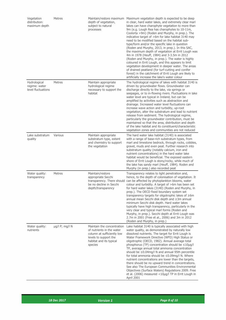
Vegetation distribution: maximum depth
Metres Maintain/restore maximum depth of vegetation, subject to natural processes
Maximum vegetation depth is expected to be deep in clear, hard water lakes, and extremely clear marl lakes can have charophyte vegetation to more than 9m (e.g. Lough Rea has charophytes to 10-11m, Coolorta >9m) (Roden and Murphy, in prep.). The indicative target of >6m for lake habitat 3140 may need to be modified based on the habitat sub-type/form and/or the specific lake in question (Roden and Murphy, 2013, in prep.). In this SAC, the maximum depth of vegetation at Errit Lough was 4m in 1978 (Heuff, 1984) and 3-3.5m in 2012 (Roden and Murphy, in prep.). The water is highly coloured in Errit Lough, and this appears to limit vegetation development in deeper water. The areas of drained peatland (for turf-cutting and conifer forest) in the catchment of Errit Lough are likely to artificially increase the lake's water colour
Hydrological regime: water level fluctuations
Metres Maintain appropriate hydrological regime necessary to support the habitat
The hydrological regime of lakes with habitat 3140 is driven by groundwater flows. Groundwater can discharge directly to the lake, via springs or seepages, or to in-flowing rivers. Fluctuations in lake water level are typical in Ireland, but can be amplified by activities such as abstraction and drainage. Increased water level fluctuations can increase wave action and turbidity, up-root vegetation, alter the substratum and lead to nutrient release from sediment. The hydrological regime, particularly the groundwater contribution, must be maintained so that the area, distribution and depth of the lake habitat and its constituent/characteristic vegetation zones and communities are not reduced
Lake substratum quality
Various Maintain appropriate substratum type, extent and chemistry to support the vegetation
The hard water lake habitat (3140) is associated with a range of base-rich substratum types, from marl and limestone bedrock, through rocks, cobbles, gravel, muds and even peat. Further research into substratum quality (notably calcium, iron and nutrient concentrations) in the hard water lake habitat would be beneficial. The exposed eastern shore of Errit Lough is stony/rocky, while much of the lake has sandy marl (Heuff, 1984). Roden and Murphy (in prep.) also recorded peat
Water quality: transparency
Metres Maintain/restore appropriate Secchi transparency. There should be no decline in Secchi depth/transparency
Transparency relates to light penetration and, hence, to the depth of colonisation of vegetation. It can be affected by phytoplankton blooms, water colour and turbidity. A target of >6m has been set for hard water lakes (3140) (Roden and Murphy, in prep.). The OECD fixed boundary system set transparency targets for oligotrophic lakes of ≥6m annual mean Secchi disk depth and ≥3m annual minimum Secchi disk depth. Hard water lakes typically have high transparency, particularly in the very clear and typical marl forms (Roden and Murphy, in prep.). Secchi depth at Errit Lough was 2.7m in 2001 (Free et al., 2006) and 3m in 2012 (Roden and Murphy, in prep.)
Water quality: nutrients
μg/l P; mg/l N Maintain the concentration of nutrients in the water column at sufficiently low levels to support the habitat and its typical species
Lake habitat 3140 is typically associated with high water quality, as demonstrated by naturally low dissolved nutrients. The target for Errit Lough is Water Framework Directive (WFD) High Status or oligotrophic (OECD, 1982). Annual average total phosphorus (TP) concentration should be ≤10μg/l TP, average annual total ammonia concentration should be ≤0.04mg/l N and annual 95th percentile for total ammonia should be ≤0.09mg/l N. Where nutrient concentrations are lower than the targets, there should be no upward trend in concentrations. See also The European Communities Environmental Objectives (Surface Waters) Regulations 2009. Free et al. (2006) measured <10μg/l TP in Errit Lough in April 2001
18 Dec 2017 Page 8 of 10 Version 1

Water quality: phytoplankton biomass
μg/l Chlorophyll a Maintain appropriate water quality to support the habitat, including high chlorophyll a status
Lake habitat 3140 is associated with high water quality, as demonstrated by naturally low algal growth. As for nutrients, the default target is WFD High Status or oligotrophic (OECD, 1982). Average growing season (March-October) chlorophyll a concentration must be <5.8μg/l. Annual average chlorophyll a concentration should be <2.5μg/l and the annual peak should be <8.0μg/l. Where chlorophyll a concentrations are lower than the targets, there should be no upward trend in phytoplankton biomass. See also The European Communities Environmental Objectives (Surface Waters) Regulations 2009. Free et al. (2006) measured 6.3μg/l chlorophyll a in Errit Lough in April 2001
Water quality: phytoplankton composition
EPA phytoplankton composition metric
Maintain appropriate water quality to support the habitat, including high phytoplankton composition status
The Environmental Protection Agency (EPA) has developed a phytoplankton composition metric for nutrient enrichment of Irish lakes. As for other water quality indicators, the default target for lake habitat 3140 is WFD high status
Water quality: attached algal biomass
Algal cover and EPA phytobenthos metric
Maintain trace/absent attached algal biomass (<5% cover) and high phytobenthos status
Nutrient enrichment can favour epiphytic and epipelic algae that can out-compete the submerged vegetation. The cover abundance of attached algae in hard water lakes (3140) should, therefore, be trace/absent (<5% cover). EPA phytobenthos status can be used as an indicator of changes in attached algal biomass. As for other water quality indicators, the default target for lake habitat 3140 is high phytobenthos status
Water quality: macrophyte status
EPA macrophyte metric (The Free Index)
Maintain high macrophyte status
Nutrient enrichment can favour more competitive submerged macrophyte species that out-compete the typical and characteristic species for hard water lakes (3140). The EPA monitors macrophyte status for WFD purposes using the ‘Free Index’. The target for lake habitat 3140 is high status or an Ecological Quality Ratio (EQR) for lake macrophytes of ≥0.90, as defined in Schedule Five of the European Communities Environmental Objectives (Surface Waters) Regulations 2009
Acidification status
pH units; mg/l Maintain appropriate water and sediment pH, alkalinity and cation concentrations to support the habitat, subject to natural processes
The specific requirements of lake habitat 3140, in terms of water and sediment pH, alkalinity and cation concentration, have not been fully determined. Acidification is not considered a threat to lake habitat 3140; however, eutrophication can lead to at least temporary increases in pH to toxic levels (>9/9.5 pH units). Maximum pH should be <9.0 pH units, in line with the surface water standards. See Schedule Five of the European Communities Environmental Objectives (Surface Waters) Regulations 2009
Water colour mg/l PtCo Restore appropriate water colour to support the habitat
Increased colour decreases light penetration and reduces the area of macrophyte habitat, particularly at the lower euphotic depths. Higher colour also appears to favour angiosperms over charophytes in hard water lakes (Roden and Murphy, in prep.). The primary source of increased colour in Ireland is peatland disturbance. No habitat-specific or national standards for water colour exist. Studies have shown median colour concentrations in Irish lakes of 38mg/l PtCo (Free et al., 2000) and 33mg/l PtCo (Free et al., 2006). Lake habitat 3140 is typically associated with very clear waters and expected colour would be <10mg/l PtCo or, more likely, <5mg/l PtCo. Free et al. (2006) recorded colour of 46mg/l PtCo in Errit Lough and Roden and Murphy (in prep.) noted high water colour in 2012, a very shallow euphotic zone, low Secchi depth and stated peat-staining from disturbed bogland may have reduced water transparency
18 Dec 2017 Page 9 of 10 Version 1
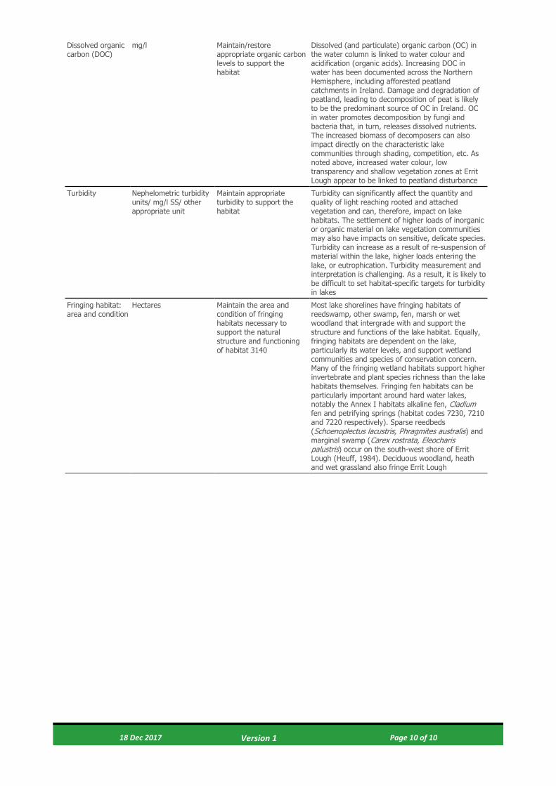
Dissolved organic carbon (DOC)
mg/l Maintain/restore appropriate organic carbon levels to support the habitat
Dissolved (and particulate) organic carbon (OC) in the water column is linked to water colour and acidification (organic acids). Increasing DOC in water has been documented across the Northern Hemisphere, including afforested peatland catchments in Ireland. Damage and degradation of peatland, leading to decomposition of peat is likely to be the predominant source of OC in Ireland. OC in water promotes decomposition by fungi and bacteria that, in turn, releases dissolved nutrients. The increased biomass of decomposers can also impact directly on the characteristic lake communities through shading, competition, etc. As noted above, increased water colour, low transparency and shallow vegetation zones at Errit Lough appear to be linked to peatland disturbance
Turbidity Nephelometric turbidity units/ mg/l SS/ other appropriate unit
Maintain appropriate turbidity to support the habitat
Turbidity can significantly affect the quantity and quality of light reaching rooted and attached vegetation and can, therefore, impact on lake habitats. The settlement of higher loads of inorganic or organic material on lake vegetation communities may also have impacts on sensitive, delicate species. Turbidity can increase as a result of re-suspension of material within the lake, higher loads entering the lake, or eutrophication. Turbidity measurement and interpretation is challenging. As a result, it is likely to be difficult to set habitat-specific targets for turbidity in lakes
Fringing habitat: area and condition
Hectares Maintain the area and condition of fringing habitats necessary to support the natural structure and functioning of habitat 3140
Most lake shorelines have fringing habitats of reedswamp, other swamp, fen, marsh or wet woodland that intergrade with and support the structure and functions of the lake habitat. Equally, fringing habitats are dependent on the lake, particularly its water levels, and support wetland communities and species of conservation concern. Many of the fringing wetland habitats support higher invertebrate and plant species richness than the lake habitats themselves. Fringing fen habitats can be particularly important around hard water lakes, notably the Annex I habitats alkaline fen, Cladium fen and petrifying springs (habitat codes 7230, 7210 and 7220 respectively). Sparse reedbeds (Schoenoplectus lacustris, Phragmites australis) and marginal swamp (Carex rostrata, Eleocharis palustris) occur on the south-west shore of Errit Lough (Heuff, 1984). Deciduous woodland, heath and wet grassland also fringe Errit Lough
18 Dec 2017 Page 10 of 10 Version 1

© Ordnance Survey Ireland
Map Version 1Date: Nov 2017
MAP 1:ERRIT LOUGH SAC
CONSERVATION OBJECTIVESSAC DESIGNATION
Map to be read in conjunction with the NPWS Conservation Objectives Document.
The mapped boundaries are of an indicative and general nature only. Boundaries of designated areas are subject to revision.Ordnance Survey of Ireland Licence No EN 0059216. © Ordnance Survey of Ireland Government of Ireland
Níl sna teorainneacha ar na léarscáileanna ach nod garshuiomhach ginearálta. Féadfar athbhreithnithe a déanamh ar theorainneacha na gceantarcomharthaithe. Suirbhéarachta Ordonáis na hÉireann Ceadúnas Uimh EN 0059216. © Suirbhéarachta Ordonáis na hÉireann Rialtas na hÉireann
±0 100 200 300 400Meters
SITE CODE:SAC 000607 ; version 3. CO. ROSCOMMON
Legend
Errit Lough SAC 000607
Aghamore
Ballyhaunis
SAC 000607
CO. MAYO
CO. ROSCOMMON

Map Version 1Date: Nov 2017
SITE CODE:SAC 000607; version 3.CO. ROSCOMMON
The mapped boundaries are of an indicative and general nature only. Boundaries of designated areas are subject to revision.Ordnance Survey of Ireland Licence No EN 0059216. © Ordnance Survey of Ireland Government of Ireland
Níl sna teorainneacha ar na léarscáileanna ach nod garshuiomhach ginearálta. Féadfar athbhreithnithe a déanamh ar theorainneacha na gceantarcomharthaithe. Suirbhéarachta Ordonáis na hÉireann Ceadúnas Uimh EN 0059216. © Suirbhéarachta Ordonáis na hÉireann Rialtas na hÉireann
Map to be read in conjunction with the NPWS Conservation Objectives Document.
MAP 2:ERRIT LOUGH SAC
CONSERVATION OBJECTIVESINDICATIVE LAKE HABITATS ±0 125 250 375 500Meters
Legend
3140 Hard oligo-mesotrophic waters with benthic vegetation of Chara spp.
Errit Lough SAC 000607
OSi Discovery Series County Boundary