habitats regulation assessment screening report – … · 2016-01-07 · ... and epping forest...
TRANSCRIPT

Report Submitted to London Borough of Haringey
Submitted by AECOM Scott House Alençon Link Basingstoke Hampshire RG21 7PP United Kingdom
Habitats Regulations Assessment Screening Report – Tottenham Area Action Plan (Publication Version December-January 2015)

AECOM Habitats Regulation Assessment Screening Report – Tottenham Area Action Plan (Publication Version
December-January 2015)
Page i
London Borough of Haringey Council November/2015
Prepared by: Isla Hoffmann Heap Checked by: James Riley Ecologist Associate Director Approved by: James Riley Associate Director
Rev No Comments Checked by
Approved by
Date
0 Draft for Client Comments JR TH 06/11/15 1 Final for consultation JR JR 10/11/15
Scott House, Alençon Link, Basingstoke, Hampshire, RG21 7PP, United Kingdom Telephone: 01256 310 200 Website: http://www.aecom.com 47076094 10/11/2015

AECOM Habitats Regulation Assessment Screening Report – Tottenham Area Action Plan (Publication Version
December-January 2015)
Page ii
London Borough of Haringey Council November/2015
Limitations AECOM Infrastructure & Environment UK Limited (“AECOM”) has prepared this Report for the sole use of The London Borough of Haringey Council (“Client”) in accordance with the Agreement under which our services were performed. No other warranty, expressed or implied, is made as to the professional advice included in this Report or any other services provided by AECOM. This Report is confidential and may not be disclosed by the Client nor relied upon by any other party without the prior and express written agreement of AECOM. The conclusions and recommendations contained in this Report are based upon information provided by others and upon the assumption that all relevant information has been provided by those parties from whom it has been requested and that such information is accurate. Information obtained by AECOM has not been independently verified by AECOM, unless otherwise stated in the Report. The methodology adopted and the sources of information used by AECOM in providing its services are outlined in this Report. The work described in this Report was undertaken in September and November 2015 and is based on the conditions encountered and the information available during the said period of time. The scope of this Report and the services are accordingly factually limited by these circumstances. Where assessments of works or costs identified in this Report are made, such assessments are based upon the information available at the time and where appropriate are subject to further investigations or information which may become available. AECOM disclaim any undertaking or obligation to advise any person of any change in any matter affecting the Report, which may come or be brought to AECOM’s attention after the date of the Report. Certain statements made in the Report that are not historical facts may constitute estimates, projections or other forward-looking statements and even though they are based on reasonable assumptions as of the date of the Report, such forward-looking statements by their nature involve risks and uncertainties that could cause actual results to differ materially from the results predicted. AECOM specifically does not guarantee or warrant any estimate or projections contained in this Report. Unless otherwise stated in this Report, the assessments made assume that the sites and facilities will continue to be used for their current purpose without significant changes.
Copyright © This Report is the copyright of AECOM Infrastructure & Environment UK Limited. Any unauthorised reproduction or usage by any person other than the addressee is strictly prohibited.

AECOM Habitats Regulation Assessment Screening Report – Tottenham Area Action Plan (Publication Version
December-January 2015)
Page iii
London Borough of Haringey Council November/2015
Contents
1 Introduction .................................................................................................................................................................. 4 1.1 Background to the project...................................................................................................................................... 4 1.2 Current legislation ................................................................................................................................................. 4 1.3 Scope of the Project .............................................................................................................................................. 5 1.4 This Report ............................................................................................................................................................ 7
2 Methodology ................................................................................................................................................................ 8 2.1 Introduction ............................................................................................................................................................ 8 2.2 HRA Task 1 - Likely Significant Effects (LSE) ....................................................................................................... 8 2.3 Confirming Other Plans and Projects That May Act In Combination ..................................................................... 9
3 Pathways of Impact ................................................................................................................................................... 11 3.1 Introduction .......................................................................................................................................................... 11 3.2 Disturbance (from Recreational and Construction Activities) ............................................................................... 11 3.3 Urbanisation ........................................................................................................................................................ 15 3.4 Atmospheric Pollution .......................................................................................................................................... 15 3.5 Water abstraction ................................................................................................................................................ 17 3.6 Water quality ....................................................................................................................................................... 18
4 Screening Assessment ............................................................................................................................................. 21 4.2 Disturbance (from Recreational and Construction Activities) ............................................................................... 21 4.3 Urbanisation ........................................................................................................................................................ 22 4.4 Atmospheric pollution .......................................................................................................................................... 22
5 Conclusion ................................................................................................................................................................. 24 Appendix A. Background of Internationally Designated Sites ............................................................................ A-1 Appendix B. Figures .......................................................................................................................................... B-1 Figure 1: Locations of Internationally Designated Sites ..................................................................................... B-1 Figure 2: Tottenham Area Action Plan ............................................................................................................... B-3 Figure 3: Tottenham Area Action Plan Site Allocations ..................................................................................... B-5 Appendix C. Screening Table ............................................................................................................................ C-1
List of Tables TABLE 1: HOUSING LEVELS TO BE DELIVERED IN NEIGHBOURING AUTHORITIES 9 TABLE 2: MAJOR ROADS WITHIN 200M OF LEE VALLEY SPA AND RAMSAR SITE 16 TABLE 3: CRITICAL LOADS OF SPA AND RAMSAR FEATURES AND EXISTING NITROGEN DEPOSITION RATES UPON
FEATURES. 17 TABLE 4: CHANGE IN AM PEAK HOUR [08.00 – 09.00] 23
List of Figures FIGURE 1: THE LEGISLATIVE BASIS FOR APPROPRIATE ASSESSMENT 5 FIGURE 2- FOUR-STAGE APPROACH TO HABITATS REGULATIONS ASSESSMENT 8 FIGURE 3: TRAFFIC CONTRIBUTION TO CONCENTRATIONS OF POLLUTANTS AT DIFFERENT DISTANCES FROM A ROAD
(SOURCE: DFT) 16
AECOM Habitats Regulation Assessment Screening Report – Tottenham Area Action Plan (Publication Version
December-January 2015)
Page 4
London Borough of Haringey Council November/2015
1 Introduction
1.1 Background to the project
AECOM has been appointed by London Borough of Haringey (referred to as “Haringey Council” and “the Authority”) to assist in undertaking a Habitats Regulations Assessment (HRA) of the potential effects of the Tottenham Area Action Plan (Publication Version December-January 2015) (known henceforth as the “AAP”) on the Natura 2000 network and Ramsar sites in support of the Haringey’s Local Plan: Strategic Policies documents.
1.1.1 The Haringey Local Plan: Strategic Policies document was formally adopted by the Full Council on 18th March 2013. The Local Plan, along with the saved UDP policies (Unitary Development Plan), sets out a vision and key policies for the future development within the Borough from 2013 through to the end of the plan period (2026). It provides special policies outlining local and strategic development within the Borough, including housing, employment, leisure, and retail provision. In support of the Local Plan, in 2010 a Habitats Regulations Assessment was undertaken1. In February 2015, an update to Haringey’s Strategic Policies (Alterations to Strategic Policies document) was published for public consultation. The Alterations to Strategic Policies document reflected the increase in the Borough’s strategic housing delivery target of 19,802 net new dwellings 2011- 2026; new Growth Areas; strategic improvements to, or renewal of, Haringey’s housing estates; an additional Locally Significant Industrial Site; and Local Employment Areas. As part of the Local Plan process a Site Allocations DPD has also been published. HRA has been undertaken of these documents (subject to consultation), which screened out most impact pathways, with the residual likely significant effect remaining of disturbance to internationally designated features from construction activities2. . These HRA documents will be used as a basis for this assessment. These documents undertook Habitats Regulations Assessment (HRA) of the following internationally designated sites: The Lee Valley Ramsar Site; The Lee Valley SPA; and Epping Forest SAC.
1.1.2 The objective of this assessment is to:
• identify any aspects of the Tottenham Area Action Plan (Publication Version December-January 2015) that would cause an adverse effect on the integrity of Natura 2000 sites, otherwise known as European sites or internationally designated sites (Special Areas of Conservation (SACs), Special Protection Areas (SPAs) and, as a matter of Government policy, Ramsar sites3), either in isolation or in combination with other plans and projects; and
• to advise on appropriate policy mechanisms for delivering mitigation where such effects are identified.
1.2 Current legislation
1.2.1 The need for Habitats Regulations Assessment (HRA) is set out within Article 6 of the EC Habitats Directive 1992, and interpreted into British law by the Conservation of Habitats and Species Regulations 2010. The ultimate aim of the Directive is to “maintain or restore, at favourable conservation status, natural habitats and species of wild fauna and flora of Community interest” (Habitats Directive, Article 2(2)). This aim relates to habitats and species, not the internationally designated sites themselves, although the sites have a significant role in delivering favourable conservation status.
1.2.2 Within the UK, Protected Areas for nature conservation include, those established under National legislation (e.g. Sites of Special Scientific Interest (SSSI)), areas established under European Union Directives/European initiatives (including the Natura 2000 network of sites), and protected areas established under Global Agreements (e.g. Ramsar sites).
1.2.3 With relevance to this report, Special Protection Areas (SPAs) are strictly protected sites classified in accordance with Article 4 of the EC Birds Directive 1979. They are classified for rare and vulnerable
1 Hyder. (2010). London Borough of Haringey Pre-submission Core Strategy Habitats Regulations Assessment. http://www.haringey.gov.uk/sites/haringeygovuk/files/habitats_regulations_assessment.pdf [Accessed 23/09/15] 2 AECOM (2015). Habitats Regulations Assessment Screening Report – Alterations to Haringey’s Strategic Policies AECOM (2015). Habitats Regulations Assessment Screening Report - 3 Wetlands of International Importance designated under the Ramsar Convention 1979

AECOM Habitats Regulation Assessment Screening Report – Tottenham Area Action Plan (Publication Version
December-January 2015)
Page 5
London Borough of Haringey Council November/2015
birds (as listed on Annex I of the Directive), and for regularly occurring migratory species. Special Areas of Conservation (SAC) are strictly protected sites designated under Article 3 of the EC Habitats Directive, which requires the establishment of a European network of important high-quality conservation sites that will make a significant contribution to conserving the 189 habitat types and 788 species identified in Annexes I and II of the Directive (as amended)4. The listed habitat types and species are those considered to be most in need of conservation at a European level (excluding birds). Ramsar sites are wetlands of international importance designated under the Ramsar Convention.
1.2.4 The Conservation of Habitats and Species Regulations 2010 require that land use plans are subject to Appropriate Assessment (AA) where they are likely to have a significant effect on a Natura 2000 site.
1.2.5 The Habitats Directive applies the precautionary principle to protected areas; plans and projects can only be permitted having ascertained that there will be no adverse effect on the integrity of the site(s) in question. In the case of the Habitats Directive, potentially damaging plans and projects may still be permitted if there are no alternatives to them and there are Imperative Reasons of Overriding Public Interest (IROPI) as to why they should go ahead. In such cases, compensation will be necessary to ensure the overall integrity of the site network is maintained.
1.2.6 In order to ascertain whether or not site integrity will be affected, a Habitats Regulations Assessment should be undertaken of the plan or project in question:
Figure 1: The Legislative Basis for Appropriate Assessment
1.2.7 Over the years the phrase ‘Habitats Regulations Assessment’ has come into wide currency to describe the overall process set out in the Conservation of Habitats and Species Regulations from screening through to Imperative Reasons of Overriding Public Interest (IROPI). This has arisen in order to distinguish the process from the individual stage described in the law as an ‘appropriate assessment’. Throughout this report we use the term Habitats Regulations Assessment for the overall process.
1.3 Scope of the Project
1.3.1 There is no pre-defined guidance that dictates the physical scope of a HRA of a supporting Local Plan document. Therefore, in considering the physical scope of the assessment, we were guided primarily
4 http://jncc.defra.gov.uk/
Habitats Directive 1992 Article 6 (3) states that: “Any plan or project not directly connected with or necessary to the management of the site but likely to have a significant effect thereon, either individually or in combination with other plans or projects, shall be subject to appropriate assessment of its implications for the site in view of the site's conservation objectives.” Conservation of Habitats and Species Regulations 2010 (as amended) The Regulations state that: “A competent authority, before deciding to … give any consent for a plan or project which is likely to have a significant effect on a European site … shall make an appropriate assessment of the implications for the site in view of that sites conservation objectives… The authority shall agree to the plan or project only after having ascertained that it will not adversely affect the integrity of the European site”.

AECOM Habitats Regulation Assessment Screening Report – Tottenham Area Action Plan (Publication Version
December-January 2015)
Page 6
London Borough of Haringey Council November/2015
by the identified impact pathways rather than by arbitrary ‘zones’. Current guidance suggests that the following European sites be included in the scope of assessment:
• All sites within the Local Plan area boundary; and • Other sites shown to be linked to development within the Borough boundary through a known
‘pathway’.
1.3.2 Briefly defined, pathways are routes by which a change in activity provided within the Alterations to Strategic Policies 2011-2026 document can lead to an effect upon an internationally designated site. In terms of the second category of designated site listed above, guidance from the former Department of Communities and Local Government states that the HRA should be ‘proportionate to the geographical scope of the [plan policy]’ and that ‘an AA need not be done in any more detail, or using more resources, than is useful for its purpose’ (CLG, 2006, p.6). More recently, the Court of Appeal5 ruled that providing the Council (competent authority) was duly satisfied that proposed mitigation could be ‘achieved in practice’ to satisfied that the proposed development would have no adverse effect, then this would suffice. This ruling has since been applied to a planning permission (rather than a Core Strategy)6. In this case the High Court ruled that for ‘a multistage process, so long as there is sufficient information at any particular stage to enable the authority to be satisfied that the proposed mitigation can be achieved in practice it is not necessary for all matters concerning mitigation to be fully resolved before a decision maker is able to conclude that a development will satisfy the requirements of reg 61 of the Habitats Regulations’.
1.3.3 No Internationally designated sites are located within the London Borough of Haringey’s boundary.
1.3.4 The following internationally designated sites considered within the Habitats Regulations Assessment of Haringey’s draft DMP are located within 20km of the London Borough of Haringey’s authority boundary, and as such could potentially have impact pathways present resulting from the draft DMP:
• Lee Valley SPA and Ramsar site; • Epping Forest SAC; • Richmond Park SAC; • Wimbledon Common SAC; and • Wormley-Hoddesdonpark Woods SAC.
1.3.5 During an initial sieving exercise to screen out internationally designated sites (e.g. no realistic impact pathways present), the following internationally designated sites can be sieved out from further assessment due to the distances involved.
• Wormley-Hoddesdonpark Woods SAC located 12.9km from the borough boundary; • Richmond Park SAC located 14.3km from the borough boundary, and; • Wimbledon Common SAC located 14.7km from the borough boundary.
1.3.6 These sites are not considered further within this document.
1.3.7 There are three internationally designated sites that are located within a sufficiently close distance that the presence of impact pathways linking to Haringey’s draft DMP cannot be screened out. These are:
• Lee Valley SPA and Ramsar site, located immediately adjacent to the London Borough to the east; and,
• Epping Forest SAC, located 3km east from London Borough
1.3.8 Details of Lee Valley SPA and Ramsar site and Epping Forest SAC can be found in Appendix A. Appendix B, Figure 1 illustrates the location of the internationally designated site in relation to the London Borough of Haringey’s boundary and Areas/ Sites noted within the AAP.
1.3.9 The remainder of this document considers potential for likely significant effects from impact pathways resulting from the Tottenham AAP upon the following internationally designated sites:
• Lee Valley SPA and Ramsar site • Epping Forest SAC
5 No Adastral New Town Ltd (NANT) v Suffolk Coastal District Council Court of Appeal, 17th February 2015 6 High Court case of R (Devon Wildlife Trust) v Teignbridge District Council, 28 July 2015

AECOM Habitats Regulation Assessment Screening Report – Tottenham Area Action Plan (Publication Version
December-January 2015)
Page 7
London Borough of Haringey Council November/2015
1.4 This Report
1.4.1 Section 2 of this report summarises the methodology for the assessment. Section 3 identifies the possible pathways by which adverse effects on European protected sites could arise. Section 4 considers each aspect of the AAP, assessing possible pathways upon internationally designated sites that may be vulnerable and determining likely significant effects. The screening exercise concludes by either screening out any possible impacts or by determining that mitigation or avoidance measures are required. Where mitigation strategies are deemed necessary, potential approaches are discussed. In combination effects with other plans on each internationally designated site are also considered within Section 4. Background information on all the internationally designated sites discussed in this report is presented within Appendix A. Figure 1 of Appendix B presents a map showing all internationally important wildlife sites discussed.

AECOM Habitats Regulation Assessment Screening Report – Tottenham Area Action Plan (Publication Version
December-January 2015)
Page 8
London Borough of Haringey Council November/2015
2 Methodology
2.1 Introduction
2.1.1 This HRA has been carried out in the continuing absence of formal central Government guidance, although general EC guidance on HRA does exist7. The former Department for Communities and Local Government released a consultation paper on the Appropriate Assessment of Plans in 20068. As yet, no further formal guidance has emerged. However, Natural England has produced its own internal guidance9 as has the RSPB10. Both of these have been referred to alongside the guidance outlined in Section 1.2 in undertaking this HRA.
2.1.2 Figure 2 below, outlines the stages of HRA according to current draft CLG guidance. The stages are essentially iterative, being revisited as necessary in response to more detailed information, recommendations and any relevant changes to the plan until no significant adverse effects remain.
Source: CLG, 2006
Figure 2- Four-Stage Approach to Habitats Regulations Assessment
2.2 HRA Task 1 - Likely Significant Effects (LSE)
2.2.1 Following evidence gathering, the first stage of any Habitats Regulations Assessment is a Likely Significant Effect (LSE) test - essentially a risk assessment to decide whether the full subsequent stage known as Appropriate Assessment is required. The essential question is:
”Is the Plan, either alone or in combination with other relevant projects and plans, likely to result in a significant effect upon European sites?”
2.2.2 The objective is to ‘screen out’ those plans and projects that can, without any detailed appraisal, be said to be unlikely to result in significant adverse effects upon internationally designated sites, usually
7 European Commission (2001): Assessment of plans and projects significantly affecting Natura 2000 Sites: Methodological Guidance on the Provisions of Article 6(3) and 6(4) of the Habitats Directive. 8 CLG (2006) Planning for the Protection of European Sites, Consultation Paper 9 http://www.ukmpas.org/pdf/practical_guidance/HRGN1.pdf 10 Dodd A.M., Cleary B.E., Dawkins J.S., Byron H.J., Palframan L.J. and Williams G.M. (2007) The Appropriate Assessment of Spatial Plans in England: a guide to why, when and how to do it. The RSPB, Sandy.
HRA Task 1: Likely significant effects (‘screening’) –identifying whether a plan is ‘likely to have a significant effect’ on a European site
HRA Task 2: Ascertaining the effect on site integrity – assessing the effects of the plan on the conservation objectives of any European sites ‘screened in’ during HRA Task 1
HRA Task 3: Mitigation measures and alternative solutions – where adverse effects are identified at HRA Task 2, the plan should be altered until adverse effects are cancelled out fully
Evidence Gathering – collecting information on relevant European sites, their conservation objectives and characteristics and other plans or projects.

AECOM Habitats Regulation Assessment Screening Report – Tottenham Area Action Plan (Publication Version
December-January 2015)
Page 9
London Borough of Haringey Council November/2015
because there is no mechanism for an adverse interaction with internationally designated sites. This stage is the subject of Chapter 4 of this report (See Appendix C, Table 1 for the screening table).
2.2.3 The level of detail in land use plans concerning developments that will be permitted under the plans will never be sufficient to make a detailed quantification of adverse effects. Therefore, we have again taken a precautionary approach (in the absence of more precise data) assuming as the default position that if an adverse effect cannot be confidently ruled out, avoidance or mitigation measures must be provided. This is in line with the former Department of Communities and Local Government guidance that the level of detail of the assessment, whilst meeting the relevant requirements of the Habitats Regulations, should be ‘appropriate’ to the level of plan or project that it addresses.
2.3 Confirming Other Plans and Projects That May Act In Combination
2.3.1 It is a requirement of the Regulations that the impacts of any land use plan being assessed are not considered in isolation but in combination with other plans and projects that may also be affecting the internationally designated site(s) in question.
2.3.2 It is neither practical nor necessary to assess the ‘in combination’ effects of the Local Plan within the context of all other plans and projects within this area of England. For the purposes of this assessment, we have determined that, due to the nature of the identified impacts, the key other plans and projects relate to the additional housing, transportation and commercial/industrial allocations proposed for neighbouring and nearby authorities over the lifetime of the Local Plan. A good place to start is the London Plan (2015)11
2.3.3 In considering the potential for regional housing development on internationally designated sites, the primary consideration for many sites is the impact of visitor numbers – i.e. recreational pressure. Other pathways of impact described in more detail in Chapter 3 include disturbance from construction activities, urbanisation, water quality and water quantity, and air quality. Whilst these are also strongly related to housing provision, the actual geographic impact must also be considered within the context of relevant infrastructure.
Table 1: Housing Levels to be Delivered in Neighbouring Authorities
Local Authority Total housing (taken from the London Plan, 201512) Minimum ten year target 2015-2025
Total housing (taken from the London Plan, 2015) Annual monitoring target 2015-2025
London Borough of Barnet 23,489 2,349 London Borough of Camden 8,892 889 London Borough of Enfield 7,976 798 London Borough of Islington 12,641 1,264 London Borough of Hackney 15,988 1,599 London Borough of Waltham Forest 8,620 862
2.3.4 There are other plans and projects that are relevant to the ‘in combination’ assessment and the following have all been taken into account in this assessment:
Plans • London Borough of Haringey Local Plan: Strategic Policies. Adopted March 2013. • London Borough of Haringey Local Plan: Alterations to Strategic Policies. September 2015
(not yet subject to consultation). • London Borough of Haringey Local Plan: Draft Development Management Policies.
September 2015 (not yet subject to consultation). • London Borough of Haringey Local Plan: Site Allocations DPD. September 2015 (not yet
subject to consultation). • The London Plan. The Spatial Development Strategy for London. Consolidated with Alterations
Since 2011. Published March 2015. 11 Mayor of London (March, 2015). The London Plan. The Spatial Development Strategy for London. Consolidated with Alterations Since 2011. Also referred to as Further Alterations to the London Plan (FALP) 12 Ibid

AECOM Habitats Regulation Assessment Screening Report – Tottenham Area Action Plan (Publication Version
December-January 2015)
Page 10
London Borough of Haringey Council November/2015
• The London Plan. Sub Regional Development Framework – North London. Published May 2006. • The London Plan. Sub Regional Development Framework – Central London. Published May
2006. • North London Waste Plan. This is currently in preparation; the draft is due for consultation in
‘Summer/ Autumn 2015’. • London Borough of Barnet Local Plan Core strategy DPD. Adopted September 2012. • London Borough of Camden Core Strategy. Adopted November 2010. • London Borough of Enfield Core Strategy. Adopted November 2010. • London Borough of Islington Core Strategy. Adopted February 2011. • London Borough of Hackney Core Strategy: Local Development framework. Adopted
December 2010. • London Borough of Waltham Forest Local Plan Core Strategy. Adopted March 2012 • Walthamstow Wetlands. Planning permission granted 2014.
2.3.5 When undertaking this part of the assessment it is essential to bear in mind the principal intention behind the legislation i.e. to ensure that those projects or plans which in themselves have minor impacts are not simply dismissed on that basis, but are evaluated for any cumulative contribution they may make to an overall significant effect. In practice, in combination assessment is therefore of greatest relevance when the plan would otherwise be screened out because its individual contribution is inconsequential.

AECOM Habitats Regulation Assessment Screening Report – Tottenham Area Action Plan (Publication Version
December-January 2015)
Page 11
London Borough of Haringey Council November/2015
3 Pathways of Impact
3.1 Introduction
3.1.1 In carrying out an HRA it is important to determine the various ways in which land use plans can impact on internationally designated sites by following the pathways along which development can be connected with internationally designated sites, in some cases many kilometres distant. Briefly defined, pathways are routes by which a change in activity associated with a development can lead to an effect upon an internationally designated site. Following the HRA of the Local Plan in 2010 and the Alterations to Strategic Policies document and Site Allocations DPD in 2015 and a brief sieve of the AAP, the following impact pathways are considered within this document.
3.1.2 Impact pathways for consideration are:
• Disturbance (from recreational and construction activities) • Urbanisation • Atmospheric pollution • Water abstraction • Water quality
3.2 Disturbance (from Recreational and Construction Activities)
3.2.1 Recreational use of an internationally designated site and construction activities within close proximity of an internationally designated site have potential to:
• Cause damage through mechanical/ abrasive damage and nutrient enrichment; • Cause disturbance to sensitive species, particularly ground-nesting birds and wintering wildfowl;
and • Prevent appropriate management or exacerbate existing management difficulties.
Recreational pressure 3.2.2 Different types of internationally designated sites are subject to different types of recreational
pressures and have different vulnerabilities. Studies across a range of species have shown that the effects from recreation can be complex.
Mechanical/abrasive damage and nutrient enrichment
3.2.3 Most types of terrestrial internationally designated site can be affected by trampling, which in turn causes soil compaction and erosion. Walkers with dogs contribute to pressure on sites through nutrient enrichment via dog fouling and also have potential to cause greater disturbance to fauna as dogs are less likely to keep to marked footpaths and move more erratically. Motorcycle scrambling and off-road vehicle use can cause serious erosion, as well as disturbance to sensitive species.
3.2.4 There have been several papers published that empirically demonstrate that damage to vegetation in woodlands and other habitats can be caused by vehicles, walkers, horses and cyclists:
• Wilson & Seney (1994)13 examined the degree of track erosion caused by hikers, motorcycles, horses and cyclists from 108 plots along tracks in the Gallatin National Forest, Montana. Although the results proved difficult to interpret, it was concluded that horses and hikers disturbed more sediment on wet tracks, and therefore caused more erosion, than motorcycles and bicycles.
13 Wilson, J.P. & J.P. Seney. 1994. Erosional impact of hikers, horses, motorcycles and off road bicycles on mountain trails in Montana. Mountain Research and Development 14:77-88

AECOM Habitats Regulation Assessment Screening Report – Tottenham Area Action Plan (Publication Version
December-January 2015)
Page 12
London Borough of Haringey Council November/2015
• Cole et al (1995a, b)14 conducted experimental off-track trampling in 18 closed forest, dwarf scrub and meadow and grassland communities (each tramped between 0 – 500 times) over five mountain regions in the US. Vegetation cover was assessed two weeks and one year after trampling, and an inverse relationship with trampling intensity was discovered, although this relationship was weaker after one year than two weeks indicating some recovery of the vegetation. Differences in plant morphological characteristics were found to explain more variation in response between different vegetation types than soil and topographic factors. Low-growing, mat-forming grasses regained their cover best after two weeks and were considered most resistant to trampling, while tall forbs (non-woody vascular plants other than grasses, sedges, rushes and ferns) were considered least resistant. Cover of hemicryptophytes and geophytes (plants with buds below the soil surface) was heavily reduced after two weeks, but had recovered well after one year and as such these were considered most resilient to trampling. Chamaephytes (plants with buds above the soil surface) were least resilient to trampling. It was concluded that these would be the least tolerant of a regular cycle of disturbance.
• Cole (1995c)15 conducted a follow-up study (in 4 vegetation types) in which shoe type (trainers or walking boots) and trampler weight were varied. Although immediate damage was greater with walking boots, there was no significant difference after one year. Heavier tramplers caused a greater reduction in vegetation height than lighter tramplers, but there was no difference in effect on cover.
• Cole & Spildie (1998)16 experimentally compared the effects of off-track trampling by hiker and horse (at two intensities – 25 and 150 passes) in two woodland vegetation types (one with an erect forb understorey and one with a low shrub understorey). Horse traffic was found to cause the largest reduction in vegetation cover. The forb-dominated vegetation suffered greatest disturbance, but recovered rapidly. Higher trampling intensities caused more disturbance.
3.2.5 The total volume of dog faeces deposited on sites can be surprisingly large. For example, at Burnham Beeches National Nature Reserve over one year, Barnard17 estimated the total amounts of urine and faeces from dogs as 30,000 litres and 60 tonnes respectively. The specific impact on Epping Forest has not been quantified from local studies; however, the fact that habitats for which the SAC is designated appear to be subject already to excessive nitrogen deposition, suggests that any additional source of nutrient enrichment (including uncollected dog faeces) will make a cumulative contribution to overall enrichment. Any such contribution must then be considered within the context of other recreational sources of impact on sites.
Disturbance
3.2.6 Concern regarding the effects of disturbance on birds stems from the fact that they are expending energy unnecessarily and the time they spend responding to disturbance is time that is not spent feeding18. Disturbance therefore risks increasing energetic output while reducing energetic input, which can adversely affect the ‘condition’ and ultimately the survival of the birds. In addition, displacement of birds from one feeding site to others can increase the pressure on the resources available within the remaining sites, as they have to sustain a greater number of birds19.
14 Cole, D.N. 1995a. Experimental trampling of vegetation. I. Relationship between trampling intensity and vegetation response. Journal of Applied Ecology 32: 203-214 Cole, D.N. 1995b. Experimental trampling of vegetation. II. Predictors of resistance and resilience. Journal of Applied Ecology 32: 215-224 15 Cole, D.N. (1995c) Recreational trampling experiments: effects of trampler weight and shoe type. Research Note INT-RN-425. U.S. Forest Service, Intermountain Research Station, Utah 16 Cole, D.N., Spildie, D.R. (1998) Hiker, horse and llama trampling effects on native vegetation in Montana, USA. Journal of Environmental Management 53: 61-71 17 Barnard, A. (2003) Getting the Facts - Dog Walking and Visitor Number Surveys at Burnham Beeches and their Implications for the Management Process. Countryside Recreation, 11, 16 - 19 18 Riddington, R. et al. 1996. The impact of disturbance on the behaviour and energy budgets of Brent geese. Bird Study 43:269-279 19 Gill, J.A., Sutherland, W.J. & Norris, K. 1998. The consequences of human disturbance for estuarine birds. RSPB Conservation Review 12: 67-72

AECOM Habitats Regulation Assessment Screening Report – Tottenham Area Action Plan (Publication Version
December-January 2015)
Page 13
London Borough of Haringey Council November/2015
3.2.7 The potential for disturbance may be less in winter than in summer, in that there are often a smaller number of recreational users. In addition, the consequences of disturbance at a population level may be reduced because birds are not breeding. However, winter activity can still cause important disturbance, especially as birds are particularly vulnerable at this time of year due to food shortages, such that disturbance which results in abandonment of suitable feeding areas through disturbance can have severe consequences. Several empirical studies have, through correlative analysis, demonstrated that out-of-season (October-March) recreational activity can result in quantifiable disturbance:
• Underhill et al20 counted waterfowl and all disturbance events on 54 water bodies within the South West London Water bodies Special Protection Area and clearly correlated disturbance with a decrease in bird numbers at weekends in smaller sites and with the movement of birds within larger sites from disturbed to less disturbed areas.
• Evans & Warrington21 found that on Sundays total water bird numbers (including shoveler and gadwall) were 19% higher on Stocker’s Lake LNR in Hertfordshire, and attributed this to displacement of birds resulting from greater recreational activity on surrounding water bodies at weekends relative to week days.
• Tuite et al22 used a large (379 site), long-term (10-year) dataset (September – March species counts) to correlate seasonal changes in wildfowl abundance with the presence of various recreational activities. They found that on inland water bodies shoveler was one of the most sensitive species to disturbance. The greatest impact on winter wildfowl numbers was associated with sailing/windsurfing and rowing.
• Pease et al23 investigated the responses of seven species of dabbling ducks to a range of potential causes of disturbance, ranging from pedestrians to vehicle movements. They determined that walking and biking created greater disturbance than vehicles and that gadwall were among the most sensitive of the species studied.
• In a three-year study of wetland birds at the Stour and Orwell SPA, Ravenscroft24 found that walkers, boats and dogs were the most regular source of disturbance. Despite this, the greatest responses came from relatively infrequent events, such as gun shots and aircraft noise Birds seemed to habituate to frequent ‘benign’ events such as vehicles, sailing and horses, but there was evidence that apparent habituation to more disruptive events related to reduced bird numbers – i.e. birds were avoiding the most frequently disturbed areas. Disturbance was greatest at high tide and on the Orwell, but birds on the Stour showed greatest sensitivity.
3.2.8 A number of studies have shown that birds are affected more by dogs and people with dogs than by people alone, with birds flushing more readily, more frequently, at greater distances and for longer. In addition, dogs, rather than people, tend to be the cause of many management difficulties, notably by worrying grazing animals, and can cause eutrophication near paths. Nutrient-poor habitats such as heathland are particularly sensitive to the fertilising effect of inputs of phosphates, nitrogen and potassium from dog faeces25 .
3.2.9 Underhill-Day26 summarises the results of visitor studies that have collected data on the use of semi-natural habitat by dogs. In surveys where 100 observations or more were reported, the mean percentage of visitors who were accompanied by dogs was 54.0%.
3.2.10 However the outcomes of many of these studies need to be treated with care. For instance, the effect of disturbance is not necessarily correlated with the impact of disturbance, i.e. the most easily disturbed species are not necessarily those that will suffer the greatest impacts. It has been shown that, in some cases, the most easily disturbed birds simply move to other feeding sites, whilst others may remain (possibly due to an absence of alternative sites) and thus suffer greater impacts on their
20 Underhill, M.C. et al. 1993. Use of Waterbodies in South West London by Waterfowl. An Investigation of the Factors Affecting Distribution, Abundance and Community Structure. Report to Thames Water Utilities Ltd. and English Nature. Wetlands Advisory Service, Slimbridge 21 Evans, D.M. & Warrington, S. 1997. The effects of recreational disturbance on wintering waterbirds on a mature gravel pit lake near London. International Journal of Environmental Studies 53: 167-182 22 Tuite, C.H., Hanson, P.R. & Owen, M. 1984. Some ecological factors affecting winter wildfowl distribution on inland waters in England and Wales and the influence of water-based recreation. Journal of Applied Ecology 21: 41-62 23 Pease, M.L., Rose, R.K. & Butler, M.J. 2005. Effects of human disturbances on the behavior of wintering ducks. Wildlife Society Bulletin 33 (1): 103-112. 24 Ravenscroft, N. (2005) Pilot study into disturbance of waders and wildfowl on the Stour-Orwell SPA: analysis of 2004/05 data. Era report 44, Report to Suffolk Coast & Heaths Unit.

AECOM Habitats Regulation Assessment Screening Report – Tottenham Area Action Plan (Publication Version
December-January 2015)
Page 14
London Borough of Haringey Council November/2015
population27 . A literature review undertaken for the RSPB28 also urges caution when extrapolating the results of one disturbance study because responses differ between species and the response of one species may differ according to local environmental conditions. These facts have to be taken into account when attempting to predict the impacts of future recreational pressure on internationally designated sites.
3.2.11 Disturbing activities are on a continuum. The most disturbing activities are likely to be those that involve irregular, infrequent, unpredictable loud noise events, movement or vibration of long duration (such as those often associated with construction activities). Birds are least likely to be disturbed by activities that involve regular, frequent, predictable, quiet patterns of sound or movement or minimal vibration. The further any activity is from the birds, the less likely it is to result in disturbance.
3.2.12 The factors that influence a species response to a disturbance are numerous, but the three key factors are species sensitivity, proximity of disturbance sources and timing/duration of the potentially disturbing activity.
3.2.13 It should be emphasised that recreational use is not inevitably a problem. Many internationally designated sites are also nature reserves managed for conservation and public appreciation of nature. The Lee Valley Regional Park that encompasses the SPA and Ramsar sites is such an example. At these sites, access is encouraged and resources are available to ensure that recreational use is managed appropriately.
3.2.14 Where increased recreational use is predicted to cause adverse impacts on a site, avoidance and mitigation should be considered. Avoidance of recreational impacts at internationally designated sites involves location of new development away from such sites; Local Development Frameworks (and other strategic plans) provide the mechanism for this. Where avoidance is not possible, mitigation will usually involve a mix of access management, habitat management and provision of alternative recreational space.
• Access management – restricting access to some or all of a internationally designated site - is not usually within the remit of the Council and restriction of access may contravene a range of Government policies on access to open space, and Government objectives for increasing exercise, improving health etc. However, active management of access may be possible, for example as practised on nature reserves.
• Habitat management is not within the direct remit of the Council. However the Council can help to set a framework for improved habitat management by promoting cross-authority collaboration and S106 funding of habitat management. Provision of alternative recreational space can help to attract recreational users away from sensitive internationally designated sites, and reduce pressure on the sites. For example, some species for which internationally designated sites have been designated are particularly sensitive to dogs, and many dog walkers may be happy to be diverted to other, less sensitive, sites. However the location and type of alternative space must be attractive for users to be effective. In the case of both Epping Forest and Lee Valley SPA and Ramsar sites, dog-walking, walking and cycling are likely to be the major site usages, and so alternative space needs to cater for this.
25 Shaw, P.J.A., K. Lankey and S.A. Hollingham (1995) – Impacts of trampling and dog fouling on vegetation and soil conditions on Headley Heath. The London Naturalist, 74, 77-82. 26 Underhill-Day, J.C. (2005). A literature review of urban effects on lowland heaths and their wildlife. Natural England Research Report 623. 27 Gill et al. (2001) - Why behavioural responses may not reflect the population consequences of human disturbance. Biological Conservation, 97, 265-268 28 Woodfield & Langston (2004) - Literature review on the impact on bird population of disturbance due to human access on foot. RSPB research report No. 9.

AECOM Habitats Regulation Assessment Screening Report – Tottenham Area Action Plan (Publication Version
December-January 2015)
Page 15
London Borough of Haringey Council November/2015
3.2.15 The Lee Valley SPA and Ramsar site lies immediately adjacent to the London Borough of Haringey and Epping Forest SAC is located 3km from the Borough, as such they are theoretically vulnerable, to the effects of recreational pressure and/ or disturbances from construction activities resulting from development within Haringey.
3.2.16 It is therefore necessary to perform an initial screening exercise to determine if the Tottenham AAP document contains policy measures that could lead to a likely significant effects, either alone or ‘in combination’ with other plans and projects, through recreational pressure, on these internationally designated sites.
3.3 Urbanisation
3.3.1 This impact is closely related to recreational pressure, in that they both result from increased populations within close proximity to sensitive sites. Urbanisation is considered separately as the detail of the impacts is distinct from the trampling, disturbance and dog-fouling that results specifically from recreational activity. The list of urbanisation impacts can be extensive, but core impacts can be singled out:
• Increased fly-tipping - Rubbish tipping is unsightly but the principle adverse ecological effect of tipping is the introduction of invasive non-native species with garden waste. Non-native species can in some situations, lead to negative interactions with habitats or species for which internationally designated sites may be designated. Garden waste results in the introduction of invasive non-native species precisely because it is the ‘troublesome and over-exuberant’ garden plants that are typically thrown out29. Non-native species may also be introduced deliberately or may be bird-sown from local gardens.
• Cat predation - A survey performed in 1997 indicated that nine million British cats brought home 92 million prey items over a five-month period30. A large proportion of domestic cats are found in urban situations, and increasing urbanisation is likely to lead to increased cat predation
3.3.2 The most detailed consideration of the link between relative proximity of development to internationally designated sites and damage to interest features has been carried out with regard to the Thames Basin Heaths SPA.
3.3.3 After extensive research, Natural England and its partners produced a ‘Delivery Plan’ which made recommendations for accommodating development while also protecting the interest features of the internationally designated site. This included the recommendation of implementing a series of zones within which varying constraints would be placed upon development. While the zones relating to recreational pressure expanded to 5km (as this was determined from visitor surveys to be the principal recreational catchment for this internationally designated site), that concerning other aspects of urbanisation (particularly predation of the chicks of ground-nesting birds by domestic cats) was determined at 400m from the SPA boundary. The delivery plan concluded that the adverse effects of any development located within 400m of the SPA boundary could not be mitigated since this was the range over which cats could be expected to roam as a matter of routine and there was no realistic way of restricting their movements, and as such, no new housing should be located within this zone.
3.3.4 As such, screening is undertaken to determine whether Haringey’s Alterations to Strategic Policies document contains policy measures that could lead to likely significant effects upon Lee Valley internationally designated site, either alone or ‘in combination’ with other plans and projects, through impacts of urbanisation.
3.4 Atmospheric Pollution
3.4.1 The main pollutants of concern for internationally designated sites are oxides of nitrogen (NOx), ammonia (NH3) and sulphur dioxide (SO2). NOx can have a directly toxic effect upon vegetation. In addition, greater NOx or ammonia concentrations within the atmosphere will lead to greater rates of nitrogen deposition to soils. An increase in the deposition of nitrogen from the atmosphere to soils is generally regarded to lead to an increase in soil fertility, which can have a serious deleterious effect on the quality of semi-natural, nitrogen-limited terrestrial habitats.
29 Gilbert, O. & Bevan, D. 1997. The effect of urbanisation on ancient woodlands. British Wildlife 8: 213-218. 30 Woods, M. et al. 2003. Predation of wildlife by domestic cats Felis catus in Great Britain. Mammal Review 33, 2 174-188

AECOM Habitats Regulation Assessment Screening Report – Tottenham Area Action Plan (Publication Version
December-January 2015)
Page 16
London Borough of Haringey Council November/2015
Local air pollution
3.4.2 According to the Department of Transport’s Transport Analysis Guidance, “Beyond 200m, the contribution of vehicle emissions from the roadside to local pollution levels is not significant”31. This is therefore the distance that has been used throughout this HRA in order to determine whether internationally designated sites are likely to be significantly affected by development under the Local Plan.
Figure 3: Traffic Contribution to Concentrations of Pollutants at Different Distances from a Road (Source: Dft)
3.4.3 Lee Valley internationally designated site lies within 200m of two major roads (A503 and A1055) that are likely to be regularly used by vehicle journeys within the Borough as a result of the increased population, and potentially other development plans. As such, it can be concluded that air quality should be included within the scope of this assessment. The location of these roads in relation to the internationally designated sites is illustrated in Appendix B, Figure 1.
Table 2: Major Roads Within 200m of Lee Valley SPA and Ramsar site
Road Proximity to Lee Valley SPA and Ramsar site
A503
The A503 bisects the designated site. The A503 is adjacent to Low Maynard and High Maynard Reservoir (located north of the road), and 10m from Reservoir No. 4, and 70m of Reservoir No. 2 (located south of the road) for a distance of approximately 470m.
A1055 The A1055 is located west of the internationally designated site. At its closest the road is located 180m from the site.
3.4.4 Whilst Epping Forest SAC is located within 200m of major roads, due to the convoluted routes for traffic from Haringey to take to Epping Forest SAC, it is unlikely that links exist between the Haringey DMP and Epping Forest SAC via the an air quality impact pathway. Air quality in relation to Epping Forest SAC is not discussed further.
31 http://www.dft.gov.uk/webtag/documents/expert/unit3.3.3.php#013; accessed 13/04/12

AECOM Habitats Regulation Assessment Screening Report – Tottenham Area Action Plan (Publication Version
December-January 2015)
Page 17
London Borough of Haringey Council November/2015
Table 3: Critical Loads of SPA and Ramsar Features and Existing Nitrogen Deposition Rates Upon Features.
If hilighted in red, the feature is already in exceedance of its Critical Load. If hi-lighted in orange, the feature is within its Critical Load limits. If hi-lighted in green, the feature is not below Critical Load limits. Site Site Feature Critical Load (kg
N/ha/ya) 32 Average current levels of N deposition (kg N/ha/ya)33
Lee Valley SPA
Wintering bittern 15-30 (Critical load class: rich fen)
16.2834
Migratory gadwall (Standing open water) No comparable habitat with established critical load estimate available.
No Critical Load has been assigned to the EUNIS classes for meso/eutrophic systems. These systems are often P limited (or N/P co-limiting), therefore decisions should be taken at a site specific level. Furthermore, consideration should also be given to other sources of N, i.e. discharges to water, diffuse agricultural pollution etc.
Migratory shoveler
Lee Valley Ramsar
Whorled water-milfoil 3-10 (Critical Load Class: standing open water and canals: mesotrophic standing waters)
16.28
Waterboatman Micronecta minutissima
(Standing open water) No comparable habitat with established critical load estimate available.
No Critical Load has been assigned to the EUNIS classes for meso/eutrophic systems. These systems are often P limited (or N/P co-limiting), therefore decisions should be taken at a site specific level. Furthermore, consideration should also be given to other sources of N, i.e. discharges to water, diffuse agricultural pollution etc.
Northern shoveler Gadwall
3.5 Water abstraction
3.5.1 London is generally an area of high water stress. Development within the London Borough of Haringey (and therefore Tottenham) will increase water demand.
3.5.2 Haringey lies within Thames Water’s supply area, specifically their London Resource Zone. Approximately 80% of London’s water supplies come from surface water of the rivers Thames and Lee via reservoirs, and 20% from groundwater sources situated beneath the London Boroughs from the confined chalk aquifer35. Water supply for Thames Water’s London Resource Zone does involve some abstraction from the Lee Valley Reservoirs (including Walthamstow Reservoirs), which are also subject to an agreement to (if necessary) supply Essex and Suffolk Water with up to 91Ml/day average bulk transfer. Negotiations are currently being undertaken to reduce this transfer quantity to
32 www.APIS.ac.uk [accessed 13/10/15] 33 www.APIS.ac.uk [accessed 13/10/15] 34 This is an average from 5km grid squares that cover the designated site. As such, these levels do not necessarily reflect exact levels within the parts of the SPA and Ramsar sites where the bittern and whorled water-milfoil are found. 35 Thames Water. (2015) Thames Water Final Water Resources Management Plan 2015 – 2040 http://www.thameswater.co.uk/wrmp/Section_0.pdf [Accessed 16/10/15]

AECOM Habitats Regulation Assessment Screening Report – Tottenham Area Action Plan (Publication Version
December-January 2015)
Page 18
London Borough of Haringey Council November/2015
Essex and Suffolk Water to no less than 60 Ml/d in the period January to March and 75 Ml/d for the remainder of the year. The bulk supply is provided from the King George and William Girling Reservoirs (these reservoirs are not located within the Lee Valley internationally designated site, but are likely to be linked to the reservoirs within the designated site) in the Lee Valley, potentially supported by abstraction directly from the River Lee at defined intakes, if required.
3.5.3 Within the London Catchment Abstraction Management Strategy document36, the Environment Agency identifies that within AP8 (the section of the River Lee between Enfield Lock to the north and the Tidal Thames to the south) ‘New consumptive surface water abstractions in the Lower Lee catchment will be considered only at times of very high flows. Abstraction at very high flows will not provide a reliable source of water as they may not occur every year. Applicants may need to invest in a water storage reservoir to store water when it’s available. Abstractions that are considered to be non-consumptive or small scale consumptive licences that result in an overall net benefit to the water environment may be considered beyond the stated restrictions, subject to a local impact assessment.’
3.5.4 With no other schemes in place, increased residential and employment development as a result of Haringey’s Alteration to Strategic Policies document could lead to a need for damaging levels of abstraction from the Lee Valley SPA/Ramsar when considered cumulatively with all other new development in the London WRZ and further north in Hertfordshire that would ordinarily entail water supply from the Lee Valley. However, Thames Water have implemented a major water supply project in London which involves abstraction and desalination of water from the tidal River Thames (the Thames Gateway Water Treatment Plant), such that damaging levels of abstraction from the River Lee to supply the London Borough of Haringey or other parts of London should be avoidable. The Revised Draft Water Resources Management Plan for the London area37determined that if no action was taken, then the London WRZ supply demand balance would be in deficit of between 55.4ML/d by 2015 and up to 291.7Ml/d by 2030. This was taking into account housing forecasts from then existing Local Plan documents at that time. Thames Water proposes to address this imbalance through a number of changes. These are: demand management, leakage reduction, a new raw water trading agreement with RWE N Power in 2015 and small ground water schemes. Ultimately it is the Environment Agency that is the competent authority that determines licences for abstraction, thus it is not the responsibility of the Council to determine if levels of water abstraction will not lead to likely significant effects. The HRA for the 2013 London Plan38 deferred screening of impacts resulting from the provision of increased housing within the Plan period to ‘lower tier HRAs’, placing the responsibility at a lower level, such as a Borough level.
3.5.5 The London Borough of Haringey Council has been consulting with Thames Water regarding the issue of water supply. It is understood that there is no suggestion that the total quantum of development proposed within Haringey’s combined Alterations to Strategic Policies document and the adopted Local Plan cannot be accommodated within existing provisions, but there is recognition that the provision of new mains connections could take some time to implement. The Council will work with Thames Water in updating Haringey’s Infrastructure Delivery Plan. As such, it can be determined that no likely significant effects upon the Lee Valley SPA and Ramsar site will result as a consequence of Haringey’s Alterations to Strategic Policies document. This is not discussed further within this document.
3.6 Water quality
3.6.1 Wastewater from Haringey is processed in Sewage Treatment Works (STWs). Discharges from STWs into watercourses such as Salmons Brook and the River Lee have potential to impact upon the Lee Valley SPA and Ramsar site. STWs that treat water from the London Borough of Haringey include Deephams STW and Beckton STW. These have both recently been subject to major improvement schemes by Thames Water to increase their capacities. Thames Water are undertaking a range of works across London to improve its sewage treatment network, increasing its capacity and improving the water quality within waterways such as the River Lee and the River Thames.
36 Environment Agency. (2013) London Abstraction Licencing Strategy https://www.gov.uk/government/uploads/system/uploads/attachment_data/file/289888/LIT_2545_705985.pdf [Accessed 16/10/15] 37 Ibid. 38 Mayor of London (October, 2009). Habitats Regulations Assessment Screening Report. Consultation draft replacement London Plan (Spatial Development Strategy for Greater London. https://www.london.gov.uk/sites/default/files/archives/uploads-hra-final-report-oct09.pdf [Accessed 20/10/15]

AECOM Habitats Regulation Assessment Screening Report – Tottenham Area Action Plan (Publication Version
December-January 2015)
Page 19
London Borough of Haringey Council November/2015
3.6.2 Deephams STW: Planning Permission has been granted for the upgrade to the Deephams STW within the London Borough of Enfield, for completion in 2018. The planned upgrade will help increase capacity and improve water quality39 within Salmons Brook (where water is discharged into) and the River Lee (Salmons Brook flows into the River Lee). These improvement works will enable Thames Water to treat greater quantities of wastewater to a higher standard than is currently the case.
3.6.3 Beckton STW: This is being expanded by ‘60 per cent to enable it to deal with the increased volumes of sewage and allow for a ten per cent population increase until 2021 so it can:
• Fully treat increased flows during heavy rainfall, which currently discharge into the River Thames when the site becomes overloaded to prevent streets and homes from flooding.
• Treat additional storm flows from the Lee Tunnel, a new four-mile sewer which will capture storm sewage that currently overflows into the River Lee when the sewerage system gets overwhelmed during heavy rainfall.
• Accommodate additional flows from the proposed Thames Tideway Tunnel.’40
3.6.4 Beckton STW discharges in the tidal stretches of the River Thames, located downstream from the River Lee SPA and Ramsar site. As such, there are no impact discharge pathways present to the River Lee SPA and Ramsar site. 41 A pathway does exist, in the sense that this project will reduce sewerage outflows into the River Lee, thus improving water quality within the River Lee. This is a positive impact pathway that will not result in detrimental likely significant effects upon the Lee Valley SPA and Ramsar site.
3.6.5 Lee Tunnel: The Lee Tunnel is currently under construction. It will tackle discharges from London’s largest Combined Sewerage Overflow (CSO) at Abbey Mills Pumping Station in Stratford, which accounts for 40 per cent of the total discharge. It will help prevent more than 16 million tonnes of sewage mixed with rainwater overflowing into the River Lee each year, by capturing it and transferring it to Beckton Sewage Treatment Works42. This is expected to be operational by the end of 2015. A pathway does exist, in the sense that this project will reduce sewerage outflows into the River Lee, thus improving water quality within the River Lee. This is a positive impact pathway that will not result in detrimental likely significant effects upon the Lee Valley SPA and Ramsar site.
3.6.6 Thames Tideway Tunnel: It is planned that construction works will commence in 2016. The tunnel will be a sewer the width of three London buses, which will run up to 20 miles from west to east London. It is designed to reduce the amount of raw sewage overflow into the Thames (currently this happens up to 60 times a year). ‘The Thames Tideway Tunnel will deal with this problem for at least the next 100 years. It will connect up to the 34 most polluting sewer overflows, as identified by the Environment Agency, to capture sewage which would otherwise spill into the river Thames, before transferring it to our Beckton sewage works to be treated.’43 Ultimately, this project will improve water quality of the River Thames, downstream of the Lee Valley SPA and Ramsar site. This project does not contain impact pathways that link with the Lee Valley SPA and Ramsar site.
39 Thames Water. (2015). Planning Permission Granted. http://www.thameswater.co.uk/deephams/16659.htm [Accessed 19/10/15] Thames Water. (2014). A630 Deepham Sewage Works Upgrade. Project Overview report. Phase 2 Public Consultation Version. 40 Thames Water. (2015). Sewage Works upgrades: Beckton Sewage treatment Works http://www.thameswater.co.uk/about-us/10098.htm [Accessed 19/10/15] 41 According to the Environment Agency’s Stage 3 Appropriate Assessment for the Thames Estuary and Marshes SPA/Ramsar site, that lies downstream from Beckton, current consented discharges do not have a significant adverse impact upon the Thames Estuary & Marshes SPA, with the exception of slightly elevated levels of elemental copper (Cu) derived from pipes at Reading and Slough. Moreover, development within Haringey will take place at a time when a range of water quality improvements to the Thames Tideway as a whole will be implemented through various Thames Water/Environment Agency schemes including the interception and storage of wastewater from a large number of Combined Sewer Overflows (CSO’s) in London and expansions to the treatment capacity of Thames Water’s Sewage treatment Works, including at Beckton which will enable them to treat greater quantities of wastewater to a higher standard than is currently the case. As such, the overall water quality of the River Thames should actually improve over the delivery period. 42 Thames Water. (2015). Lee Tunnel. http://www.thameswater.co.uk/about-us/10113.htm [Accessed 19/10/15] 43 Thames Water. (2015). Thames Tideway Tunnel. http://www.thameswater.co.uk/about-us/10115.htm [Accessed 19/10/15]

AECOM Habitats Regulation Assessment Screening Report – Tottenham Area Action Plan (Publication Version
December-January 2015)
Page 20
London Borough of Haringey Council November/2015
3.6.7 In conclusion, the Deephams STW, Beckton STW and Lee Tunnel will all result in improvements to water quality downstream of these STWs within the River Lee and thus the Lee Valley SPA and Ramsar site. These works have been designed to cope with future increases in sewage resulting from future increases in sewage output.
3.6.8 The provision for the increases in housing supply of 19,802 net new dwellings through to the end of Haringey’s Plan period (2026) (including a minimum 10,000 identified within the Tottenham AAP) and an increase in Local Employment Areas outlined within Haringey’s Alterations to Strategic policies document and the Tottenham AAP, have potential to increase the sewage output from within the Tottenham. The projects noted above will improve the capacity of the STWs and improve the quality of the water discharged. However, no data is available to determine exact capacities.
3.6.9 As noted in the previous section, the HRA for the 2013 London Plan44 deferred screening of impacts from increased sewage resulting from the provision of increased housing within the AAP to ‘lower tier HRAs’, placing the responsibility at a lower level, such as a Borough level. The London Borough of Haringey Council has been in discussions with Thames Water regarding the issue of dealing with waste water. It is understood that there is no suggestion that the total quantum of development proposed within Haringey’s combined Alterations to Strategic Policies (which includes the quantum of development identified within Tottenham AAP) document and the adopted Local Plan cannot be accommodated within existing provisions, but there is recognition that the provision of new mains connections could take some time to implement. The Council will work with Thames Water in updating Haringey’s Infrastructure Delivery Plan. As such, it can be determined that no likely significant effects upon the Lee Valley SPA and Ramsar site will result as a consequence the Tottenham AAP. This is not discussed further within this document.
Location specific site runoff
3.6.10 The Walthamstow Reservoirs portion of the Lee Valley SPA and Ramsar site lies in close proximity to the A503, and therefore there is potential for point source pollution events to arise from accidental spillages from increases in the number of vehicles on this route resulting from the Tottenham AAP. In reality the implementation by transport operators of measures to avoid point source pollution is not the responsibility of the Council, and it is also likely that the levels of development promoted within the Plan will lead to a minimal increase in risk of such events occurring, given that the likelihood of a catastrophic spillage event may already be considered low. The River Lee and River Lee Navigation separate the reservoirs from most development identified within the Tottenham AAP, and do not in themselves form a part of the SPA or Ramsar within Haringey, whilst it is noted that these will be connected to the reservoirs of the SPA and Ramsar site. Standard construction methodologies and standard operational phase requirements include provisions to ensure no runoff leaves the site.
3.6.11 In conclusion, no internationally designated sites are susceptible to reduced water quality through STW discharges or direct run-off arising from development within the Tottenham AAP, and therefore such considerations are not considered further within this HRA.
44 Ibid

AECOM Habitats Regulation Assessment Screening Report – Tottenham Area Action Plan (Publication Version
December-January 2015)
Page 21
London Borough of Haringey Council November/2015
4 Screening Assessment
4.1.1 As a first step, an initial screening exercise was undertaken in order to identify any Policies within the AAP that required more detailed screening and discussion. This exercise is set out in Appendix C Table 1. The initial screening of Tottenham AAP policies identified policies that contain a potential linking pathway that could result in a likely significant effect upon Lee Valley SPA and Ramsar site and/ or Epping Forest SAC. Where pathways have already been considered and screened out for all development cumulatively across Haringey (i.e. in the HRA of the Alterations of Strategic Policies) they are not listed below. Rather, this assessment focusses on potential for site-specific effects from individual development sites. The following policies within Tottenham AAP document have potential to result in likely significant effects upon the internationally designated sites and are therefore subject to a more detailed discussion of likely significant effects in this chapter:
• AAP4: Employment • AAP11: Infrastructure • TH1: District Centre in Tottenham Hale • TH8: Hale Village • TH9: Hale Wharf • NT3: Northumberland Park North • NT4: Northumberland Park
4.1.2 These policies identify specific sites located within relatively close proximity to the Lee Valley SPA/Ramsar site within Tottenham.
4.1.3 Impact pathways upon Epping Forest SAC considered further include:
• Disturbance (from recreational and construction activities);
4.1.4 Impact pathways upon Lee Valley SPA and Ramsar site considered further include:
• Urbanisation; • Disturbance (from recreational and construction activities); • Air quality; • Water abstraction; and • Water quality.
4.2 Disturbance (from Recreational and Construction Activities)
Recreational activities
4.2.1 AAP3: Housing provides for 10,000 net new dwellings to the end of the Plan period (2026). At the higher tier, the HRA for Haringey’s adopted Strategic Policies document45 and Alterations to Strategic Policies document determined no likely significant effects upon either Lee Valley SPA and Ramsar site and Epping Forest SAC resulting from an increase in recreational pressure resulting from the 19, 802 net new dwellings provided for within the policies.
4.2.2 There are no other potential impact pathways present between Epping Forest SAC and the Tottenham AAP. This internationally designated site can be screened out from further assessment.
Construction Activities
4.2.3 Disturbances from construction activities such as noise and visual disturbances have potential to result in likely significant effects upon internationally designated sites such as the Lee Valley SPA and Ramsar site features (wintering bittern, and migratory gadwall and shoveler).
4.2.4 Tottenham AAP includes for the provision of development within close proximity to the Lee Valley internationally designated site, including various sites mentioned in Policy AAP4 (Employment), TH8: (Hale Village), TH9: (Hale Wharf), NT3: (Northumberland Park North), and NT4: (Northumberland Park), the closest being located within 30m of the designated site (see Figure 1 for locations).
45 Ibid

AECOM Habitats Regulation Assessment Screening Report – Tottenham Area Action Plan (Publication Version
December-January 2015)
Page 22
London Borough of Haringey Council November/2015
4.2.5 Lee Valley internationally designated site is located within an urban area so will already be subject to existing levels of visual disturbance and noise and vibrations. However, impacts from construction and operational activities in close proximity to the designated site still have potential to impact upon the site’s features.
4.2.6 AAP6 (Urban Design and Character including Tall Buildings), provides for protection from likely significant effects upon the Lee Valley sites as follows:
4.2.7 AAP6: I ‘Where proposals fall within 500m of a Special Protection Area/ RAMSAR areas, specific measures should be set out to ensure there is no adverse effect on ecological integrity. Applicants are encouraged to engage with Natural England during pre-application discussions.’
4.2.8 This hook policy (AAP6) provides protection for the Lee Valley sites from development and given the development background it is very likely that any proposed development site can be delivered in such a way that adverse noise impacts do not take place on the SPA/Ramsar site, given the existing background levels and with specific mitigation as needed following pre-application discussions. As such, this impact pathway can be screened out as the AAP provides an adequate policy framework to protect the SPA/Ramsar site.
In-combination with other projects and plans
4.2.9 As detailed above, access to the Walthamstow reservoirs is by key-holder only, and access is controlled by a permit basis, so the exposure of the reservoirs to human activity is very limited, and is managed. As a result, it can be concluded that recreational disturbance will not result in a likely significant effect alone or in-combination with other projects or plans.
4.3 Urbanisation
4.3.1 This impact is closely related to recreational pressure, in that urbanisation and recreational pressure both result from increased populations (including industrial and employment sites) within close proximity to sensitive sites. As such, Epping Forest SAC (located 3km from the London Borough of Haringey) is not linked to this impact pathway resulting from the Tottenham AAP.
4.3.2 Given that the Lee Valley SPA and Ramsar sites lie immediately adjacent to Tottenham, it is theoretically vulnerable, from a geographic perspective, to the effects of urbanisation from development within Tottenham. Lee Valley SPA and Ramsar site is ecologically vulnerable, (via direct habitat degradation). However, it is unlikely that the SPA and Ramsar site’s designated features would be directly vulnerable to urbanisation impacts, as they are species that favour aquatic environments. In addition, the features are unlikely to suffer from significant cat predation or fly tipping as the River Lee (River Lea) and River Lee Navigation flows along the eastern extent of Tottenham, between Tottenham and Lee Valley SPA and Ramsar acting as a barrier to the dispersal of cats from Haringey. In addition to this, Waltham Wetlands project will provide for greater public access to the site via a small network of routes. However, this will be restricted by walkways and vegetation planting. The project will not provide for increased vehicular access by the public within the designated site, thus reducing the likelihood of activities such as fly-tipping within the designated site. As such, this impact pathway can be screened out.
In-combination with other projects and plans 4.3.3 As noted above, the Waltham Reservoirs are separated from Tottenham by the presence of the River
Lee, and River Lee Navigation. The eastern boundary of the reservoirs is separated from the London Borough of Walthamstow by the Lee Flood Relief Channel, which also prevents urbanisation impacting upon the Lee Valley designated sites. As such, likely significant effects both alone and in-combination with other projects and plans can be screened out.
4.4 Atmospheric pollution
4.4.1 Changes in air quality will occur wherever ‘affected roads’ are identified and increases in airborne pollutants from car exhausts and construction activities are possible. Effects of these increases are limited to areas within 200m of the road (DMRB, Volume 1146). The Air Pollution Information System (APIS) website provides details of critical loads of atmospheric pollution which if exceeded could lead to habitat damage. At this stage it is worth noting that both the breeding bittern (SPA feature) and the
46 Design Manual for Roads and Bridges Volume 11 Section 3 part 1 air quality – procedure for assessing impacts.

AECOM Habitats Regulation Assessment Screening Report – Tottenham Area Action Plan (Publication Version
December-January 2015)
Page 23
London Borough of Haringey Council November/2015
whorled water-milfoil (Ramsar feature) are not present within the Walthamstow reservoirs parcel of the Lee Valley internationally designated sites (as identified within SSSI citations). These two species are present within the northern parcel of the Lee Valley internationally designated sites, associated with the Turnford and Cheshunt Pits SSSI located approximately 9.5km north (in a straight line) from the London Borough of Haringey. As such, due to the distance involved, the air quality impact pathway to these vulnerable features cannot be linked to Haringey’s Alterations to Strategic policies document and no likely significant effects will arise.
4.4.2 No critical loads are provided for the habitat ‘open standing water’ (water boatman, shoveler and gadwall features rely upon this habitat) to allow for an assessment. The APIS website states that ‘No Critical Load has been assigned to the EUNIS classes for meso/eutrophic systems. These systems are often phosphorus limited; therefore decisions should be taken at a site specific level’. In this case, no likely significant effects are anticipated since the Walthamstow reservoirs associated with the Lee Valley SPA and Ramsar site, like most freshwater environments, are essentially phosphate limited, rather than nitrogen limited, meaning that it is phosphate availability that controls the growth of macrophytes and algae. The main source of phosphates is from wastewater, agriculture and mining. As such, these features (the water boatman, gadwall and shoveler) are not sensitive to pathways linked to air quality and there is no potential for likely significant effects to arise as a result of Haringey’s Alterations to Strategic Policies document.
4.4.3 Further to this, transport modelling has been undertaken by the Council for the preparation of the Tottenham Area Action Plan (AAP). It is acknowledged that the numbers in the table are only AM peak flows so it is not possible to calculate AADT. However, the figures provided take into account all expected growth (not just that provided within the Tottenham AAP) and does provide a broad indication of whether flows are likely to go up or down as a result of the AAP and if so, to what degree. Tottenham is located adjacent to the SPA and Ramsar site. Results of the Transport modelling are illustrated in Table 4.
Table 4: Change in AM peak hour [08.00 – 09.00]
Road section Do minimum Do something Change % change Ferry Lane (A503) 2100 1700 -400 -19 Watermead Way (A1055)
2280 1920 -360 -16
High Road, south Tottenham (A10)
2160 2230 +70 +3
Tottenham High Road
3130 2970 -160 -5
4.4.4 Table 4 illustrates that, taking into account all expected growth within Haringey and the surrounding authorities, AM peak flows will decrease by 19% on the A503 (the road that passes through the SPA and Ramsar site) over the plan period. Similarly, a 16% decrease is expected on the A1055 (the road located within 200m of the SPA and Ramsar site). The traffic modelling indicates that rather than resulting in a net increase in traffic flows along these sensitive roads (A503 and A1055); and hence reduced air quality, development over the plan period will in fact result in a decrease in transport flows along these sensitive routes in close proximity to the Lee Valley SPA and Ramsar site, and has potential to improve air quality along these sensitive transport routes.
In-combination with other projects and plans 4.4.5 As noted above, features that have potential to be sensitive to increases in air pollution are not
present within the Waltham Reservoirs portion of the Lee Valley SPA and Ramsar site. As such, there are no impact pathways present that will act alone or in combination, resulting in likely significant effects upon the Lee Valley SPA and Ramsar site. As such, this impact pathway can be screened out.

AECOM Habitats Regulation Assessment Screening Report – Tottenham Area Action Plan (Publication Version
December-January 2015)
Page 24
London Borough of Haringey Council November/2015
5 Conclusion
5.1.1 It can be concluded that the Tottenham Area Action Plan will not result in a likely significant effect on any European sites either alone or in combination with other projects and plans.

AECOM Habitats Regulation Assessment Screening Report – Tottenham Area Action Plan (Publication Version
December-January 2015)
Page A-1
London Borough of Haringey Council November/2015
Appendix A. Background of Internationally Designated Sites
A.1 Lee Valley SPA and Ramsar site
A.1.1 Introduction
The Lee Valley SPA is located to the north-east of London, where a series of wetlands and reservoirs occupy about 20 km of the valley. The site comprises embanked water supply reservoirs, sewage treatment lagoons and former gravel pits that support a range of man-made, semi-natural and valley bottom habitats. These wetland habitats support wintering wildfowl, in particular Gadwall Anas strepera and Shoveler Anas clypeata, which occur in numbers of European importance. Areas of reedbed within the site also support significant numbers of wintering Bittern Botaurus stellaris. Lee Valley SPA is split into two sections, a northern and a southern. The southern section is located adjacent to the eastern boundary of the London Borough of Haringey. It contains Walthamstow Reservoir SSSI and Walthamstow Marshes SSSI. The northern section is located approximately 9.5km north of the Borough which contains Turnford and Chestnut Pits SSSI.
A.1.2 Qualifying Features
The site qualifies as an SPA for the following Annex I species:
• Wintering bittern Botaurus stellaris. 6 individuals representing at least 6.0% of the wintering population in Great Britain (5 year peak mean, 1992/3-1995/6)
• Migratory gadwall Anas strepera. 515 individuals representing at least 1.7% of the wintering Northwestern Europe population (5 year peak mean 1991/2 - 1995/6)
• Migratory shoveler Anas clypeata. 748 individuals representing at least 1.9% of the wintering Northwestern/Central Europe population (5 year peak mean 1991/2 - 1995/6)
The site qualifies under the following Ramsar criterion
Criterion 2: The site supports the nationally scarce plant species:
• whorled water-milfoil Myriophyllum verticillatum and the rare or vulnerable invertebrate Micronecta minutissima (a water-boatman).
Criterion 6: Species/populations occurring at levels of international importance.
Species with peak counts in spring/autumn:
• Northern shoveler, Anas clypeata, (NW & C Europe) 287 individuals, representing an average of 1.9% of the GB population (5 year peak mean 1998/9- 2002/3)
Species with peak counts in winter:
• Gadwall, Anas strepera strepera, (NW Europe) 445 individuals, representing an average of 2.6% of the GB population (5 year peak mean 1998/9-2002/3)
A.1.3 Conservation Objectives of the SPA
Ensure that the integrity of the site is maintained or restored as appropriate, and ensure that the site contributes to achieving the aims of the Wild Birds Directive, by maintaining or restoring; the extent and distribution of the habitats of the qualifying features.
• The structure and function of the habitats of the qualifying features • The supporting processes on which the habitats of the qualifying features rely • The population of each of the qualifying features, and, • The distribution of the qualifying features within the site.
A.1.4 Environmental Vulnerabilities
• Water quality: eutrophication from waste water. This is being addressed by AMP3 funding under the urban Waste Water Treatment Directive

AECOM Habitats Regulation Assessment Screening Report – Tottenham Area Action Plan (Publication Version
December-January 2015)
Page A-2
London Borough of Haringey Council November/2015
• Water quantity: over extraction of surface water for public consumption, notably during drought periods. This is managed via Environment Agency Review of Consents.
• Recreational pressure: this is managed by zoning of waterbodies within the Lee Valley Regional Park.
A.2 Epping Forest SAC
A.2.1 Introduction
Epping Forest is one of only a few remaining large-scale examples of ancient wood-pasture in lowland Britain and has retained habitats of high nature conservation value including ancient semi-natural woodland, old grassland plains and scattered wetland. The semi-natural woodland is particularly extensive, forming one of the largest coherent blocks in the country. Most is characterised by groves of over-mature pollards and these exemplify all three of the main wood-pasture types found in Britain: beech-oak, hornbeam-oak and mixed oak. The Forest plains are also a major feature and contain a variety of unimproved acid grasslands which have become uncommon elsewhere in Essex and the London area. In addition, Epping Forest supports a nationally outstanding assemblage of invertebrates, a major amphibian interest and an exceptional breeding bird community.
A.2.2 Qualifying Features
The site is designated as an SAC for the following features:
Annex I habitats:
• Atlantic acidophilous beech forests with Ilex and sometimes also Taxus in the shrublayer (Quercion robori-petraeae or Ilici-Fagenion); Beech forests on acid soils
• Northern Atlantic wet heaths with Erica tetralix
• European dry heaths
Annex II species:
• Stag beetle Lucanus cervus
A.2.3 Conservation Objectives of the SAC
Ensure that the integrity of the site is maintained or restored as appropriate, and ensure that the site contributes to achieving the Favourable Conservation Status of its Qualifying Features, by maintaining or restoring;
• The extent and distribution of qualifying natural habitats and habitats of qualifying species • The structure and function (including typical species) of qualifying natural habitats • The structure and function of the habitats of qualifying species • The supporting processes on which qualifying natural habitats and the habitats of qualifying
species rely • The populations of qualifying species, and, • The distribution of qualifying species within the site.
A.2.4 Environmental Vulnerabilities
• Habitat management: After neglect of the pollard cycle for over 100 years, re-pollarding of ancient beech trees was started in the early 1990s, and creation of maiden pollards was begun in 1995.
• Atmospheric pollution • Lack of deadwood

AECOM Habitats Regulation Assessment Screening Report – Tottenham Area Action Plan (Publication Version
December-January 2015)
Page B-1
London Borough of Haringey Council November/2015
Appendix B. Figures
Figure 1: Locations of Internationally Designated Sites

A503
A1055
Haringey
Barnet
Enfield
Waltham Forest
Camden
HackneyIslington
BrentNewham
Tower HamletsCity of Westminster
City of Westminster
Purpose of Issue
Project Title
Drawing Title
Drawn Checked
Scott HouseAlençon Link, BasingstokeHampshire, RG21 7PPTelephone (01256) 310200Fax (01256) 310201www.aecom.com
AECOM
DateApproved
RevDrawing Number
FIGURE 1 00
THIS DOCUMENT HAS BEEN PREPARED PURSUANT TO AND SUBJECT TO THETERMS OF AECOM'S APPOINTMENT BY ITS CLIENT. AECOM ACCEPTS NO LIABILITY
FOR ANY USE OF THIS DOCUMENT OTHER THAN BY ITS ORIGINAL CLIENT ORFOLLOWING AECOM'S EXPRESS AGREEMENT TO SUCH USE, AND ONLY FOR THE
PURPOSES FOR WHICH IT WAS PREPARED AND PROVIDED.
AECOM Internal Project No. Scale @ A347076094 1:50,000S. Masnikosa J. Waters I. Hoffman 10/11/2015
Client
File Na
me:Z:\
TEMP
\Haring
ey HR
A\GIS\
projec
t_files
\MXD\1
50925_
Figure
1_EnvD
esigna
tions_S
M_v00
.mxd
±1 0 1 2 3 4 5 km
LEGENDHaringey Borough BoundaryLondon Borough BoundaryEpping Forest Special Area ofConservationLee Valley Ramsar SiteLee Valley Special ProtectionAreaA Road
HARINGEY COUNCILENVIRONMENTAL DESIGNATIONS
HARINGEY HRA
DRAFT
HARINGEY COUNCIL
THIS DRAWING IS TO BE USED ONLY FOR THE PURPOSE OFISSUE THAT IT WAS ISSUED FOR AND IS SUBJECT TO AMENDMENT
CopyrightReproduced from Ordnance Survey digital map data © Crown copyright 2015. All rights reserved. Licence number 0100031673

AECOM Habitats Regulation Assessment Screening Report – Tottenham Area Action Plan (Publication Version
December-January 2015)
Page B-3
London Borough of Haringey Council November/2015
Figure 2: Tottenham Area Action Plan

A503
A1055
Purpose of Issue
Project Title
Drawing Title
Drawn Checked
Scott HouseAlençon Link, BasingstokeHampshire, RG21 7PPTelephone (01256) 310200Fax (01256) 310201www.aecom.com
AECOM
DateApproved
RevDrawing Number
FIGURE 2 00
THIS DOCUMENT HAS BEEN PREPARED PURSUANT TO AND SUBJECT TO THETERMS OF AECOM'S APPOINTMENT BY ITS CLIENT. AECOM ACCEPTS NO LIABILITY
FOR ANY USE OF THIS DOCUMENT OTHER THAN BY ITS ORIGINAL CLIENT ORFOLLOWING AECOM'S EXPRESS AGREEMENT TO SUCH USE, AND ONLY FOR THE
PURPOSES FOR WHICH IT WAS PREPARED AND PROVIDED.
AECOM Internal Project No. Scale @ A347076094 1:15,000S. Masnikosa J. Waters I. Hoffman 10/11/2015
Client
File Na
me:Z:\
TEMP
\Haring
ey HR
A\GIS\
projec
t_files
\MXD\1
50925_
Figure
2_Totte
nham_
SM_v0
1.mxd
±0.2 0 0.2 0.4 0.6 0.8 1 km
HARINGEY COUNCILTOTTENHAM AREA ACTION PLAN
HARINGEY HRA
DRAFT
HARINGEY COUNCIL
THIS DRAWING IS TO BE USED ONLY FOR THE PURPOSE OFISSUE THAT IT WAS ISSUED FOR AND IS SUBJECT TO AMENDMENT
CopyrightReproduced from Ordnance Survey digital map data © Crown copyright 2015. All rights reserved. Licence number 0100031673
LEGENDHaringey Borough BoundaryLondon Borough Boundary
Lee Valley Ramsar SiteLee Valley Special ProtectionAreaBruce Grove NeighbourhoodAreaNorth TottenhamNeighbourhood AreaSeven Sisters/ West greenRoad and Tottenham GreenNeighbourhood AreaTottenham HaleNeighbourhood AreaA RoadExisting Green Grid RouteProposed Green Grid Route
Tottenham Area Action Plan

AECOM Habitats Regulation Assessment Screening Report – Tottenham Area Action Plan (Publication Version
December-January 2015)
Page B-5
London Borough of Haringey Council November/2015
Figure 3: Tottenham Area Action Plan Site Allocations

A503
A1055
SA65
SS3
SS2
SS5
SS6
SS4
NT6 NT5
NT7
BG3
BG4
TH8 TH9
TG3
TH3
TG2
TH2
NT3
NT4
TH6TH5
TH13TH12
TH11
TH4
TH7BG2
TH8
NT2
NT2
NT2
TG1
BG 1
SS 1
TH 1 Purpose of Issue
Project Title
Drawing Title
Drawn Checked
Scott HouseAlençon Link, BasingstokeHampshire, RG21 7PPTelephone (01256) 310200Fax (01256) 310201www.aecom.com
AECOM
DateApproved
RevDrawing Number
FIGURE 3 00
THIS DOCUMENT HAS BEEN PREPARED PURSUANT TO AND SUBJECT TO THETERMS OF AECOM'S APPOINTMENT BY ITS CLIENT. AECOM ACCEPTS NO LIABILITY
FOR ANY USE OF THIS DOCUMENT OTHER THAN BY ITS ORIGINAL CLIENT ORFOLLOWING AECOM'S EXPRESS AGREEMENT TO SUCH USE, AND ONLY FOR THE
PURPOSES FOR WHICH IT WAS PREPARED AND PROVIDED.
AECOM Internal Project No. Scale @ A347076094 1:15,000S. Masnikosa J. Waters I. Hoffman 10/11/2015
Client
File Na
me:Z:\
TEMP
\Haring
ey HR
A\GIS\
projec
t_files
\MXD\1
50925_
Figure
3_Totte
nham_
SM_v0
1.mxd
±0.2 0 0.2 0.4 0.6 0.8 1 km
HARINGEY COUNCILTOTTENHAM AREA ACTION PLAN
SITE ALLOCATIONS
HARINGEY HRA
DRAFT
HARINGEY COUNCIL
THIS DRAWING IS TO BE USED ONLY FOR THE PURPOSE OFISSUE THAT IT WAS ISSUED FOR AND IS SUBJECT TO AMENDMENT
CopyrightReproduced from Ordnance Survey digital map data © Crown copyright 2015. All rights reserved. Licence number 0100031673
LEGENDHaringey Borough BoundaryLondon Borough BoundaryTottenham Area ActionTown CentreSite AllocationLee Valley Ramsar SiteLee Valley Special ProtectionAreaA Road

AECOM Habitats Regulation Assessment Screening Report – Tottenham Area Action Plan (Publication Version December-January 2015)
Page C-1
London Borough of Haringey Council November/2015
Appendix C. Screening Table
Policies identified in green have been screened from any further assessment due to a lack of realistic impact pathways.
Policies identified in orange have been screened in for further assessment as there is potential for impact pathways to affect internationally designated sites, resulting in likely significant effects.
Policy Description HRA Implications (Screening)
AAP1: Regeneration / Masterplanning
A. The Council expects all development proposals in the AAP area to come forward comprehensively to meet the wider objectives of the AAP. To ensure comprehensive and coordinated development is achieved, masterplans will be required to accompany development proposals which form part of a Site Allocation included in this Plan. Applicants will be required to demonstrate how the proposal: 1. Contributes to delivering the objectives of the Site,
Neighbourhood Area, and wider AAP. 2. Will integrate and complement successfully with existing and
proposed neighbouring developments 3. Optimizes development outcomes on the site
B. The Council will direct development to Growth Areas and Areas of Change, and will support planning applications which accord to the delivery of Neighbourhood Objectives, and site requirements Site Allocations. Planning applications for development within the Tottenham AAP area which promote the positive regeneration of Tottenham, in line with the principles of the Strategic Regeneration Framework.
C. The Council will take a proactive approach to working with landowners, the Mayor of London, the local community and other interested parties to help deliver the changes needed in Tottenham to meet the shared vision for the regeneration of Tottenham.
D. Development proposals will be expected to maximise the use of public and private sector investment to provide a range of types and sizes of homes, create mixed and balanced communities within neighbourhoods, create economic opportunities for local residents and businesses, improve and enhance the local environment, and reduce carbon emissions and adapt to climate change, in accordance with the other policies of this AAP and Haringey’s Local Plan.
This is effectively a development management policy relating to regeneration and masterplanning. This policy identifies Growth Areas and Areas of Change located within close proximity to Lee Valley SPA and Ramsar site. Impact pathways identified include: • Urbanisation; • Disturbance (from recreational and construction activities); • Air quality; • Water abstraction; and • Water quality. Growth Areas and Areas of Change have already been subject to HRA under a higher tier analysis at the Local Plan level.
AAP 2: Supporting
A. The Council will support land assembly to achieve comprehensive development, and will use compulsory purchase powers, only where
No HRA implications.

AECOM Habitats Regulation Assessment Screening Report – Tottenham Area Action Plan (Publication Version December-January 2015)
Page C-2
London Borough of Haringey Council November/2015
Policy Description HRA Implications (Screening)
Site Assembly
necessary, to assemble land for development within the Tottenham AAP area where:
a. Landowners and developers can demonstrate that they have: i. A viable, deliverable and Local Plan compliant scheme; and ii. Have made all reasonable attempts to acquire, or secure an
option over, the land/building(s) needed, through negotiation. b. Comprehensive redevelopment of the assembled site is required
to deliver the site’s allocation as prescribed in Section 5 (including the requirements of a Masterplan where stated in the Plan) of this AAP; and
c. The development proposed for the assembled site would contribute to the delivery of the Tottenham AAP objectives.
B. Where compulsory purchase is necessary, applicants will be required to demonstrate how the associated costs impact upon development viability.
This is a development management policy relating to site assembly. It does not define any location or quantum of development. There are no impact pathways present.
AAP3 Housing
A. To improve the diversity and choice of homes and support mixed and balanced communities in Tottenham, the Council will seek the delivery of 10,000 additional new homes across the Tottenham AAP area in order to meet housing needs, contribute to mixed and balanced communities and to improve the quality of homes;
B. The Council will expect affordable housing to be provided in accordance with Policy SP2 of the Local Plan: Strategic Policies and DM13 of the Development Management DPD, with the exception of the affordable tenure split (DM13 A(c)) which in the Tottenham AAP area should be provided at 60% intermediate accommodation and 40% affordable rented accommodation;
C. Development proposals incorporating a housing element will be expected to provide the housing in accordance with the minimum capacities, set out in the Site Allocations in this AAP. Higher densities and capacities may be acceptable in appropriate locations, close to town centres, in areas with good local facilities and amenities and in areas well served by public transport, providing the other policies of this AAP and Haringey’s Local Plan are not compromised.
D. To better address the concerns of viability in delivering wholesale renewal on Haringey’s housing estates in Tottenham (as listed in Alt53 of the Local Plan Strategic Policies), the Council will support higher density mixed tenure development, as a mechanism to a. improve the quality and range of affordable housing options, b. better address housing needs in Haringey; c. secure a more balanced community; and d. increase housing delivery in Tottenham.
This policy provides for 10,000 additional new homes within the Tottenham AAP area. Impact pathways identified include: • Urbanisation; • Disturbance (from recreational and construction activities); • Air quality; • Water abstraction; and • Water quality. The Amendment to Haringey Strategic Policies provides for 19,802 new dwellings throughout Haringey, including the 10,000 in the Tottenham area. Impacts from the 19,802 new dwellings were screened out within the HRA of the amendment to Strategic Policies. Whilst impact pathways do exist, these have therefore been screened out from further consideration at a higher tier (Local Plan level).

AECOM Habitats Regulation Assessment Screening Report – Tottenham Area Action Plan (Publication Version December-January 2015)
Page C-3
London Borough of Haringey Council November/2015
Policy Description HRA Implications (Screening)
AAP4 Employment
A. Within the Tottenham AAP area, the Council will facilitate the regeneration and renewal of selected Designated Employment Areas (DEAs) through a reconfiguration of the local employment offer in order to intensify land uses, maximise the amount of business floorspace and premises, and to increase the number and variety of jobs. This will be achieved by: a. Re-classifying some of the area’s Designated Employment Areas; b. Protecting where appropriate industrial areas from inappropriate
development as set out in SP8 and DM37; c. Supporting development proposals for enabling led mixed-use
schemes, in line with Local Plan Policy DM38; d. Supporting development proposals for B1 Office uses in Tottenham
Hale; e. Supporting additional employment uses to be created along the High
Rd f. Intensification of industrial uses on the borough’s stock of SIL; and g. Effective enforcement of non-employment or non-conforming uses
which if retained would be of detriment to the area’s employment stock.
B. The Council will support local residents to access local and London-wide jobs through the ongoing collection of planning contributions towards providing training courses in line with SP9.
C. Employment Areas within Tottenham are designated as follows: Brantwood Road, N17 North East Tottenham N17 Marsh Lane, N17 Willoughby Lane, N17 Lindens/Roseberry Works Milmead and Lockwood, N17 Ashley Road South Hale Wharf South Tottenham, N15 Fountayne Road Rangemoor Road, N15 Constable Crescent
A number of the identified Employment Areas (such as Marsh Lane and Hale Wharf) are within 500m of the Lee Valley SPA/ Ramsar site. As such there is potential for likely significant effects via the following pathways:
• Disturbance (from recreational and construction activities); • Air quality; and • Water quality.
AAP5 Conservation and Heritage
A. The Council will seek to strengthen the character and local identity of Tottenham by sustaining and enhancing heritage assets, their setting and the wider historic environment. Proposals for new development will be required to:
No HRA implications. This relates to conservation and heritage.
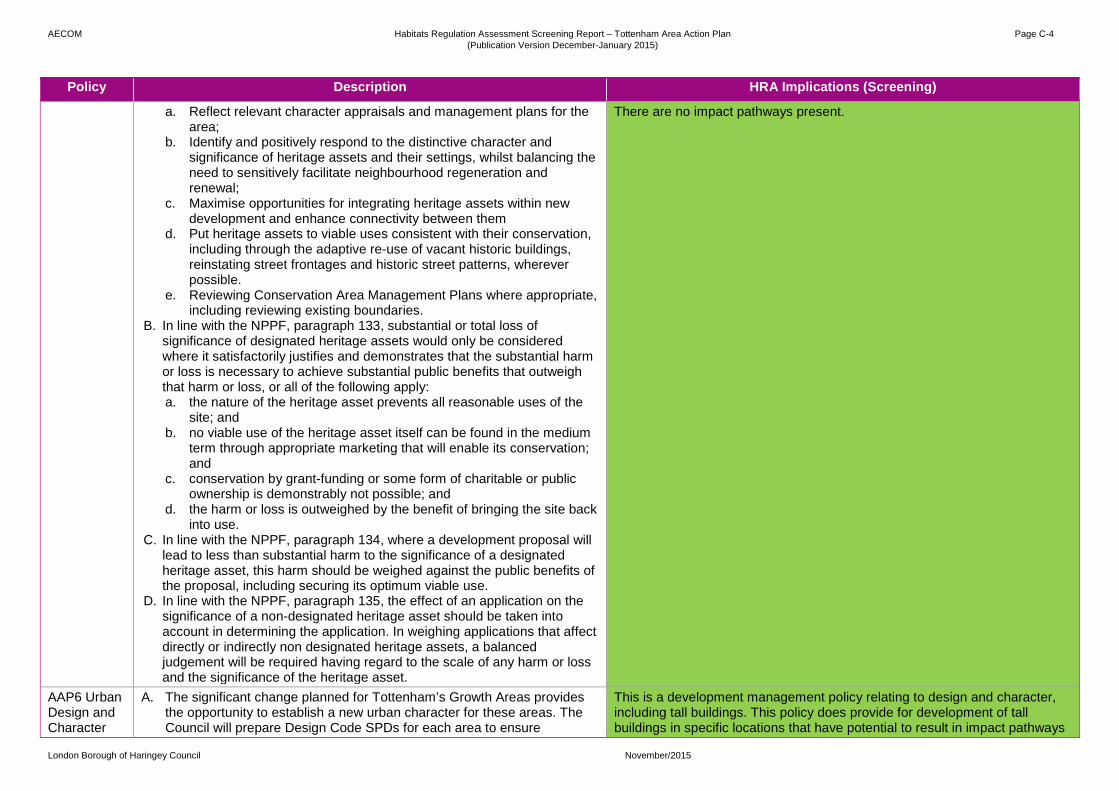
AECOM Habitats Regulation Assessment Screening Report – Tottenham Area Action Plan (Publication Version December-January 2015)
Page C-4
London Borough of Haringey Council November/2015
Policy Description HRA Implications (Screening)
a. Reflect relevant character appraisals and management plans for the area;
b. Identify and positively respond to the distinctive character and significance of heritage assets and their settings, whilst balancing the need to sensitively facilitate neighbourhood regeneration and renewal;
c. Maximise opportunities for integrating heritage assets within new development and enhance connectivity between them
d. Put heritage assets to viable uses consistent with their conservation, including through the adaptive re-use of vacant historic buildings, reinstating street frontages and historic street patterns, wherever possible.
e. Reviewing Conservation Area Management Plans where appropriate, including reviewing existing boundaries.
B. In line with the NPPF, paragraph 133, substantial or total loss of significance of designated heritage assets would only be considered where it satisfactorily justifies and demonstrates that the substantial harm or loss is necessary to achieve substantial public benefits that outweigh that harm or loss, or all of the following apply: a. the nature of the heritage asset prevents all reasonable uses of the
site; and b. no viable use of the heritage asset itself can be found in the medium
term through appropriate marketing that will enable its conservation; and
c. conservation by grant-funding or some form of charitable or public ownership is demonstrably not possible; and
d. the harm or loss is outweighed by the benefit of bringing the site back into use.
C. In line with the NPPF, paragraph 134, where a development proposal will lead to less than substantial harm to the significance of a designated heritage asset, this harm should be weighed against the public benefits of the proposal, including securing its optimum viable use.
D. In line with the NPPF, paragraph 135, the effect of an application on the significance of a non-designated heritage asset should be taken into account in determining the application. In weighing applications that affect directly or indirectly non designated heritage assets, a balanced judgement will be required having regard to the scale of any harm or loss and the significance of the heritage asset.
There are no impact pathways present.
AAP6 Urban Design and Character
A. The significant change planned for Tottenham’s Growth Areas provides the opportunity to establish a new urban character for these areas. The Council will prepare Design Code SPDs for each area to ensure
This is a development management policy relating to design and character, including tall buildings. This policy does provide for development of tall buildings in specific locations that have potential to result in impact pathways

AECOM Habitats Regulation Assessment Screening Report – Tottenham Area Action Plan (Publication Version December-January 2015)
Page C-5
London Borough of Haringey Council November/2015
Policy Description HRA Implications (Screening)
including Tall Buildings
consistency of design across the area, and that a framework for high quality design is achieved.
B. In line with DM6, Tottenham Hale and North Tottenham as growth areas, and the area directly adjacent to Seven Sisters Station have been identified as being potentially suitable for the delivery of tall buildings. Further details of these developments will be in accordance with the relevant Site Allocations, and proposals should follow the guidance set out Tall Buildings SPD.
C. The appropriate height of development sites within Tottenham will be guided by the principles in Local Plan Policy DM1, and DM6, the reorientation of Tottenham Hale from an urban to a central area, the policy below, and the Site Allocations included in the Neighbourhood Areas Chapter.
D. The Council expects the highest density development to be located adjacent to public transport nodes, and in Growth Areas and Areas of Change. At their boundary, development is expected to transition between these areas and the suburban areas of the AAP through appropriate transition/scaling of heights.
E. The recommendations of the Urban Characterisation Study will ensure the height of new buildings respond and help to define the surrounding character, whilst optimising opportunities for intensification and regeneration in order to help create legible neighbourhoods.
F. Taller buildings will be appropriate along (parts of) Tottenham High Road, Park Lane, Lordship Lane, Northumberland Park, Broad Lane, Lawrence Road, West Green Road, Seven Sisters Road, Monument Way, Ferry Lane, and within existing mid-rise residential areas, responding to the prevailing mid-rise character, and in some cases promoting intensification, increasing heights from low-rise to mid-rise where appropriate.
G. Retained suburban areas will be protected from inappropriate development, with taller development only being permitted where it can be demonstrated that the existing character of the area will not be compromised.
H. The impact of new development, and particularly tall buildings should be considered against the requirements to protect Local Views as asset out in DM5: Locally significant views and vistas.
I. Where proposals fall within 500m of a Special Protection Area/ RAMSAR areas, specific measures should be set out to ensure there is no adverse effect on ecological integrity. Applicants are encouraged to engage with Natural England during pre-application discussions.
linking to Lee Valley SPA and Ramsar site. However, this is overall a positive policy providing protection for internationally designated sites. Point I states: ‘Where proposals fall within 500m of a Special Protection Area/ RAMSAR areas, specific measures should be set out to ensure there is no adverse effect on ecological integrity. Applicants are encouraged to engage with Natural England during pre-application discussions.’ In relation to ensuring no likely significant effects result from the Tottenham AAP, this is a positive ‘hook’ policy.
AAP7 A. The Council will support future improvements in the levels of public No HRA implications.

AECOM Habitats Regulation Assessment Screening Report – Tottenham Area Action Plan (Publication Version December-January 2015)
Page C-6
London Borough of Haringey Council November/2015
Policy Description HRA Implications (Screening)
Transport transport accessibility and capacity across the Tottenham AAP area. The Council expects development proposals to: a. Seek improvements to connectivity and permeability for pedestrians
whilst minimising the likelihood of conflicts with vehicular traffic. b. Consider opportunities for improving walking and cycling across the
AAP area, which could include the introduction of a wider cycling and walking network; and
c. Promote where appropriate, traffic calming, pedestrian accessibility enhancements, road safety measures and cycle facilities such as on street cycle parking;
B. Developments proposed within 1km of a proposed Crossrail 2 station should show how they meet the requirements of Policy SA1.
C. Parking provision will be expected to be delivered in accordance with Policy DM32 of the Development Management DPD; and
D. In line with Haringey’s Local Plan policies, the London Plan, the Local Implementation Plan [LIP] and the Mayor’s Transport Strategy, the Council will work with its partners to promote and support the delivery of key infrastructure proposals to support the regeneration of Tottenham which are set out in the Neighbourhood Area wide section of this AAP.
E. The Council will support applications which enhance the transport interchange between Tube, train bus, and pedestrian/cycling modes at Tottenham’s transport interchanges.
F. Sites required for the construction of Crossrail 2 safeguarding will be protected as necessary. The Department for Transport and TfL should be consulted with regards planning applications on any formalised Crossrail alignment.
G. In order to maximise the utility of Seven Sisters station, development which can enhance pedestrian and cycling routes to and from the station will be supported.
H. The Council supports the addition of a Cycle Superhighway that passes runs from THFC to the City, and this will be required to be produced in a manner that adds legibility to the urban realm in this area.
This is a positive policy in that it provides to improve public transport links and cycling/ walking network. There are no impact pathways present.
AAP8: Development along Tottenham High Rd
A. Development on Tottenham High Rd will be supported where it is demonstrated to positively enhance the overall character and setting of Tottenham High Rd.
B. The High Road has a number of District and Local Centres along its length, and uses within these will be in line with DM42 and DM43.
C. Development will be expected to provide active frontages onto the High Rd between designated centres to provide activity along its length. A wide range of non-A1 or C class uses will be supported here.
D. Due to the excellent public transport connections, and in order to manage
This is effectively a development management policy relating to Tottenham High Road. It specifically notes that Class C (residential/ HMO/ hotels) will not be supported. This policy supports car-free development and the Cycle Superhighway 1. Tottenham High Road is located more than 1km from the from the Lee Valley SPA and Ramsar site.

AECOM Habitats Regulation Assessment Screening Report – Tottenham Area Action Plan (Publication Version December-January 2015)
Page C-7
London Borough of Haringey Council November/2015
Policy Description HRA Implications (Screening)
flow on the High Rd, car-free development will be supported. Developments that help to optimize the benefits of Cycle Superhighway 1, including through the design of the site, and the incorporation of cycle parking facilities, will be supported.
E. Development which positively enhances the distinctive character and setting of neighbouring and nearby buildings, and produces improved views along the High Road, including long views from other parts of the High Rd, and from adjacent streets, will be supported.
F. Opportunities to create new space for enterprise and commercial uses to the rear properties fronting the High Rd will be permitted. Where a site with a back of High Rd frontage is redeveloped, an employment ground floor use will be sought.
AAP9: Tottenham Green Grid
A. In areas identified as deficient in access to open space and nature, a high priority will be afforded to opportunities to enhance access through on-site provision or contributions to the implementation of relevant Tottenham Green Grid projects.
B. Development proposals for sites adjoining the Green Grid will need to take account of the route and ensure that opportunities are taken to provide new developments which address the route along its built edges.
C. The principles included in the Council’s Green & Open Spaces Strategy should be adhered to in the creation of the Green Grid.
Whilst this policy provides for new ‘Green Grid’ routes adjacent Lee Valley SPA and Ramsar site. However, these routes do not pass directly into the SPA and Ramsar site, are located along existing ‘Blue Ribbon’ routes and are separated from the designated site by the presence of the River lee and the Lee Navigation, and is screened from the designed site by tall vegetation.
AAP10: Meanwhile Uses
The Council will support, through the granting of temporary planning consents, and where appropriate, time-limited Local Development Orders, “meanwhile” uses on allocated development sites which are not expected to come forward in the short term. Such uses will be required to demonstrate how they contribute to the vibrancy of the immediate area and support the delivery of the development outcomes and vision as set out in this Plan.
No HRA implications. This is a development management policy relating to ‘meanwhile uses’. There are no impact pathways present.
AAP11: Infrastructure
A. The Council will plan positively to introduce improved facilities in Tottenham which meets the overall needs of the population, including meeting existing deficits, as well as the needs of new developments.
B. The Council will actively seek to introduce tertiary employment operators into the Tottenham area to ensure local residents have excellent options to gain skills to access the London jobs market.
C. New primary and secondary provision to match growth will be created in the growth areas of Tottenham Hale and North Tottenham. This will principally be at the new Harris Academy on Ashley Rd in Tottenham Hale, and within the Northumberland Park masterplan regeneration area in North Tottenham.
D. The council will work with developers and construction companies to create local employment opportunities through:
This is a development management policy relating to infrastructure. This policy identifies the Growth Areas of Tottenham Hale and North Tottenham (including Northumberland Park). Impact pathways present include:
• Urbanisation; • Disturbance (from recreational and construction activities); • Air quality; • Water abstraction; and • Water quality.

AECOM Habitats Regulation Assessment Screening Report – Tottenham Area Action Plan (Publication Version December-January 2015)
Page C-8
London Borough of Haringey Council November/2015
Policy Description HRA Implications (Screening)
i. Ensuring local labour can access construction jobs ii. Creating apprenticeships iii. Ensuring contributions towards local skills regeneration are gained
when employment floorspace is lost on a site. SS1: Seven Sisters and West Green Rd District Centre
A. The Council will support planning applications for development within the Seven Sisters and West Green Rd District Centre as indicated in Map X to promote the positive regeneration of the area.
B. Development proposals will be resisted where they involved the amalgamation of individual shop units, in order to preserve the historical streetscape rhythm and preserve opportunities for independent traders.
C. To retain the viability of the shopping area, the primary retail frontages will be adjusted as follows:-
i. The primary frontage will be transferred to secondary shopping frontage between 70 to 126a (even), and 51-95 (odd) West Green Road to support the consolidation and intensification of the town centre uses.
D. Active town centre uses including retail, restaurant/café, leisure, commercial or community facilities will be required on all ground floor street frontages;
E. Small floor plate units a near the underground station are appropriate to create activity and vibrancy and security;
F. The Council will require the retention of the Seven Sisters Market in the area.
G. Council will support retention, repair and reinstatement of historic shop fronts and facades including innovative and creative branding opportunities to celebrate the area’s independent and multi cultural shops;
H. A high quality urban realm will be created around Seven Sisters station. I. Unauthorised and incorrectly implemented planning consents in the
centre will be a focus for enforcement action to ensure high quality of design is maintained.
This is a development management policy relating to Seven Sisters and West Green Road District Centres. At their closest these are located more than 700m from Lee Valley SPA and Ramsar site.
SS2: Lawrence Road
Mixed use development with commercial uses at ground floor level and residential above.
No HRA implications. No impact pathways present. NB: See in-combination assessment section.
SS3: Brunel Walk and Turner Avenue
Potential masterplanned housing estate renewal opportunity to improve the quality and utility of the housing stock on the site.
SS4: Gourley
Comprehensive mixed use redevelopment in accordance with a site wide masterplan providing new employment space and residential use.

AECOM Habitats Regulation Assessment Screening Report – Tottenham Area Action Plan (Publication Version December-January 2015)
Page C-9
London Borough of Haringey Council November/2015
Policy Description HRA Implications (Screening)
Triangle
SS5: Wards Corner
Mixed use development providing town centre uses at ground floor level, including a replacement market, with the potential for residential use above.
SS6: Apex House & Seacole Court
Mixed use development with town centre uses at ground floor level and residential above.
TG1: Tottenham Green’s Civic Heart
Development which serves to consolidate and improve access to community facilities in the Tottenham Green area will be supported. A. Permissible uses on sites surrounding the Green will include community
facilities, and secondary town centre uses such as restaurant and café use.
B. Developments will positively enhance the setting of the listed buildings including Holy Trinity Church and that of Tottenham Green as an Open Space, closing street frontages where appropriate; improve footfall and activity along Town Hall Approach Road, and will be of a scale consistent with the existing buildings in the area.
C. Tottenham Green itself will be enhanced, with opportunities to use the Green for public events such as markets and fetes supported.
No HRA implications. Whilst this policy defines an area, it does not identify any specific development types that could result in impact pathways linking to internationally deigned sites. It provides for improvement to green space at Tottenham Green, the Holy Trinity Church. Improvements to green space is a positive policy as it encourages people to use local green space amenities, rather than utilizing sensitive internationally designated sites. There are no impact pathways present.
TG2: Tottenham Chances & Nicholson Court
Mixed use development which creates an enhanced community use, with residential infill.
No HRA implications. No impact pathways present. NB: See in-combination assessment section.
TG3: Tottenham Police Station and Reynardson Court
Subject to reprovision of the Police Station locally, conversion of the existing police station to include commercial space for SME and start up businesses. Redevelopment of Reynardson Court, and the car park to the rear, for improved housing stock and improved/enhanced open space.
BG1: Bruce Grove and Tottenham High Road District Centre
1. The Council will adjust the designated retail frontages to ensure that there is a consolidation of retail uses on Tottenham High Rd;
2. For the Bruce Grove area frontage, uses will be permitted that enable a character area that promotes a cafe and restaurant type environment.
3. An improved public realm to encourage pedestrian activity, this including where possible pavement widening measures;
4. Residential units behind ground floor could be acceptable provided they are carefully designed to allow overlooking on to the public realm without compromising the use of the town centre unit.
This is a development management policy that relates to frontages and character. It aims to improve the public realm. It does provide for residential development, however, no quantum is identified within this policy.
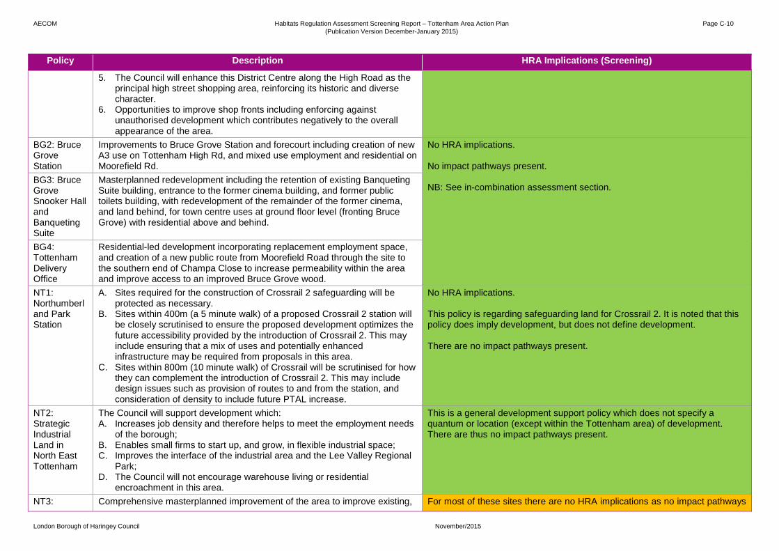
AECOM Habitats Regulation Assessment Screening Report – Tottenham Area Action Plan (Publication Version December-January 2015)
Page C-10
London Borough of Haringey Council November/2015
Policy Description HRA Implications (Screening)
5. The Council will enhance this District Centre along the High Road as the principal high street shopping area, reinforcing its historic and diverse character.
6. Opportunities to improve shop fronts including enforcing against unauthorised development which contributes negatively to the overall appearance of the area.
BG2: Bruce Grove Station
Improvements to Bruce Grove Station and forecourt including creation of new A3 use on Tottenham High Rd, and mixed use employment and residential on Moorefield Rd.
No HRA implications. No impact pathways present. NB: See in-combination assessment section.
BG3: Bruce Grove Snooker Hall and Banqueting Suite
Masterplanned redevelopment including the retention of existing Banqueting Suite building, entrance to the former cinema building, and former public toilets building, with redevelopment of the remainder of the former cinema, and land behind, for town centre uses at ground floor level (fronting Bruce Grove) with residential above and behind.
BG4: Tottenham Delivery Office
Residential-led development incorporating replacement employment space, and creation of a new public route from Moorefield Road through the site to the southern end of Champa Close to increase permeability within the area and improve access to an improved Bruce Grove wood.
NT1: Northumberland Park Station
A. Sites required for the construction of Crossrail 2 safeguarding will be protected as necessary.
B. Sites within 400m (a 5 minute walk) of a proposed Crossrail 2 station will be closely scrutinised to ensure the proposed development optimizes the future accessibility provided by the introduction of Crossrail 2. This may include ensuring that a mix of uses and potentially enhanced infrastructure may be required from proposals in this area.
C. Sites within 800m (10 minute walk) of Crossrail will be scrutinised for how they can complement the introduction of Crossrail 2. This may include design issues such as provision of routes to and from the station, and consideration of density to include future PTAL increase.
No HRA implications. This policy is regarding safeguarding land for Crossrail 2. It is noted that this policy does imply development, but does not define development. There are no impact pathways present.
NT2: Strategic Industrial Land in North East Tottenham
The Council will support development which: A. Increases job density and therefore helps to meet the employment needs
of the borough; B. Enables small firms to start up, and grow, in flexible industrial space; C. Improves the interface of the industrial area and the Lee Valley Regional
Park; D. The Council will not encourage warehouse living or residential
encroachment in this area.
This is a general development support policy which does not specify a quantum or location (except within the Tottenham area) of development. There are thus no impact pathways present.
NT3: Comprehensive masterplanned improvement of the area to improve existing, For most of these sites there are no HRA implications as no impact pathways

AECOM Habitats Regulation Assessment Screening Report – Tottenham Area Action Plan (Publication Version December-January 2015)
Page C-11
London Borough of Haringey Council November/2015
Policy Description HRA Implications (Screening)
Northumberland Park North
and create new, residential neighbourhoods through the delivery of a major estate regeneration programme that will include the provision of additional high quality housing with an increased range of types, sizes, and tenures, improvements to existing housing stock, new public spaces and new community infrastructure. Town Centre uses will be encouraged on the High Rd and Northumberland Park.
present. NB: See in-combination assessment section. NT3 and NT4 are located within 200m of the SPA and SAC and have HRA implications. Impact pathways present include:
• Disturbance (from recreational and construction activities); • Air quality; and • Water quality.
.
NT4: Northumberland Park
Comprehensive masterplanned improvement of the area to improve existing, and create new, residential neighbourhoods through the delivery of a major estate regeneration programme that will include the provision of additional high quality housing with an increased range of types, sizes, and tenures, improvements to existing housing stock, new public spaces and new community infrastructure.
NT5: High Road West
Masterplanned, comprehensive development creating a new residential neighbourhood and a new leisure destination for London. The residential led mix use development will include a new high quality public square and an expanded local shopping centre, as well as an uplift in the amount and quality of open space and improved community infrastructure.
NT6: North of White Hart Lane
Masterplanned comprehensive residential-led mixed use development with the potential to accommodate community uses, improve accessibility, and enhance the White Hart Lane retail frontage.
NT7: Tottenham Hotspur Stadium
A. Redevelopment of existing football stadium to increase match day capacity, with the introduction of residential, commercial, education, community, leisure and hotel uses, and improved public realm across the site.
B. The Council will support a mix of leisure uses around Tottenham Stadium to ensure it is a destination on match and non-match days;
C. Development will contribute to creating a wider commercial and visitor destination for the area;
D. Walking and cycling are important modes of transport around the Stadium, and links will be encouraged, particularly between nearby stations at White Hart Lane and Northumberland Park, and the Stadium;
E. New health uses will be incorporated into the Stadium TH1: District Centre in Tottenham Hale
A. The Council will support planning applications for development within the Tottenham Hale District Centre as indicated in Map X to promote the positive regeneration of Tottenham Hale.
B. Comprehensive development will be required to meet the overarching aims of this policy, and principles set out in any future masterplanning
Tottenham Hale District Centre is located approximately 400m from the Lee Valley SPA and Ramsar site, west of the rail line. However, this is effectively a development management policy. It supports retail, leisure, community and residential development.

AECOM Habitats Regulation Assessment Screening Report – Tottenham Area Action Plan (Publication Version December-January 2015)
Page C-12
London Borough of Haringey Council November/2015
Policy Description HRA Implications (Screening)
document to provide: a. A substantially improved public realm that unifies the streets and
spaces around the former gyratory, improves access to Tottenham Hale Station, and prioritises pedestrian and cyclist circulation and safety;
b. A new urban form – consistent with the areas status and accessibility; c. Attractive and functional public spaces located around the gyratory; d. Incorporate permeable surfaces, green space and trees.
C. A range of retail, leisure or community facilities on ground floor frontages, with residential or office above;
D. Small-scale units and kiosks near the underground station, to create activity and vibrancy and security;
E. Uses which are considered appropriate for Tottenham Hale are consistent with National Planning Policy Framework town centre uses.
Impact pathways present include:
• Disturbance (from recreational and construction activities); • Air quality; and • Water quality
TH2: Tottenham Hale Station
Creation of a new station interchange, with:
A. A station environment which supports excellent and efficient public transport facilities
B. New residential and/or commercial development above the station, creating the centre of a new District Centre at Tottenham Hale.
C. Enabling over the longer term of sites to be developed for the creating of new rail projects linked to the STAR and/or Crossrail 2 schemes.
D. Creation of a new urban square enclosed by activities which help to attract people and increase dwell times, act as a new high quality point of arrival, departure and interchange, , and acts as a focus for Tottenham Hale District Centre
E. Links into routes which are easy, safe and pleasant for people to move through, as set out in the District Centre Framework and Streets & Spaces Strategy, Supports east-west and north-south movement
For most of these sites there are no HRA implications as no impact pathways present. NB: See in-combination assessment section. TH8 and TH9 are located within 200m of the SPA and SAC and have HRA implications. Impact pathways present include:
• Disturbance (from recreational and construction activities); • Air quality; and • Water quality.
TH3:
Tottenham Hale Retail Park
Comprehensive redevelopment to form part of the new Tottenham Hale District Centre along with adjoining sites to the north. New road layout, including a fine graining of the street layout, creating town centre uses at ground and first floor levels, with residential and commercial uses above.
TH4: Station Square West
Comprehensive redevelopment incorporating new District Centre uses at ground and first floor levels, including a hotel use, with residential and commercial above. Creation of a high quality public realm including the extension of Ashley Rd as the primary route through the site.
TH5: Station Comprehensive redevelopment of the southern end of Ashley Road for

AECOM Habitats Regulation Assessment Screening Report – Tottenham Area Action Plan (Publication Version December-January 2015)
Page C-13
London Borough of Haringey Council November/2015
Policy Description HRA Implications (Screening)
Square North
ground floor town centre uses with a mix of residential and employment above, forming part of the new District Centre.
TH6: Ashley Road South Employment Area
Creation of an employment led mixed use quarter north of a new District Centre, creation of a new east-west route linking Down Lane Park and Hale Village, and enhanced Ashley Rd public realm. Residential use will be permitted to cross subsidise improvements to employment stock.
TH7: Ashley Road North
New residential development complementing the amenity of Down Lane Park, and the extension of Ashley Rd as a pedestrian and cycling connection north through to Park View Rd. Creation of new educational facility.
TH8: Hale Village
Completion of Hale Village reflecting the current planning permission and masterplan, with a new mixed use tower consisting of town centre uses at ground floor, with residential, and potentially a hotel above.
TH9: Hale Wharf
Comprehensive redevelopment to provide a mix of uses, with replacement employment, new residential and a leisure destination linked to the Lee Valley Regional Park.
TH10: Welbourne Centre & Monument Way
Comprehensive redevelopment of the Welbourne Centre for secondary town centre uses (which could include a health centre) at ground floor level, and residential above. Limited new residential development to the south of Chesnut Estate.
TH11: Fountayne Road
Potential development to increase accessibility and provide increased employment floorspace and warehouse living accommodation.
TH12: Herbert Road
Potential redevelopment of the sites for commercial-led mixed use development with residential.
TH13: Constable Crescent
Potential development to increase accessibility, provide increased employment floorspace and warehouse living accommodation.

About AECOM AECOM (NYSE: ACM) is a global provider of professional technical and management support services to a broad range of markets, including transportation, facilities, environmental, energy, water and government. With approximately 100,000 employees around the world, AECOM is a leader in all of the key markets that it serves. AECOM provides a blend of global reach, local knowledge, innovation, and collaborative technical excellence in delivering solutions that enhance and sustain the world’s built, natural, and social environments. A Fortune 500 company, AECOM serves clients in more than 100 countries and has annual revenue in excess of $6 billion. More information on AECOM and its services can be found at www.aecom.com.
Scott House Alençon Link Basingstoke Hampshire RG21 7PP United Kingdom +44 1256 310200