inside mitigation program reductions, the threat and ... · are key in leveraging a few federal...
TRANSCRIPT

News & Views April 2012 1
ASSOCIATION OF STATE FLOODPLAIN
MANAGERS
Dedicated to reducing flood losses
and protecting
floodplain resources . . .
INSIDE
Pre-Disaster Mitigation Program
From the Chair
Director’s Desk
Definition of Term:
Residual Risk
Spotlight on American Rivers
Top Ten Flood Facts
Conference Updates
Social Media
Proceedings
Foundation
Simulator
Engaging the Public: Simulators
Science Services
Great Lakes Coastal Flood Study
Digital Coast
FEMA
Washington Report
Legislative & Policy Priorities
Publications, Video, Web
Around the World
Grants, Projects
Calendar
Vol. 25, No. 2 April 2012 August 2010Colorado Makes Big Commitment to Flood Resilience
Mitigation Program Reductions, the Threat and Hazard
Identification Risk Assessment (THIRA), and the Rise
of the National Preparedness Grant Program (NPGP)
Larry Larson, P.E., CFM, Executive Director, ASFPM
Chad Berginnis, CFM, Associate Director, ASFPM
For those of us who believe that community sustainability and resilience depend on implementing mitigation at every opportunity, these are tough times. The latest blow to mitigation is the Federal Emergency Management Association (FEMA) FY13 budget proposal from the Administration. Not only did flood mapping, the foundation of every mitigation activity a community undertakes, see another proposed cut - but the Pre-Disaster Mitigation (PDM) program is proposed to be eliminated. While the PDM program has not been huge in dollars, between $36-150 million per year, it has provided a cost share incentive for states and communities of all sizes to engage in mitigation efforts. If the federal government hopes for states and locals to do more mitigation, these incentives are key in leveraging a few federal dollars into effective mitigation. The Association of State Floodplain Managers (ASFPM) has weighed in on the FEMA FY13 budget, recommending the restoration of cuts in mapping and that PDM not be eliminated. You can see ASFPM’s detailed comments on the web here. The FEMA position seems to assume that pre-disaster mitigation projects and planning will still happen per being eligible under the new combined grant program, National Preparedness Grant Program (NPGP). ASFPM has reviewed the vision and guidelines for the NPGP, and we find it difficult to believe that anything other than preparedness activities for terrorism will make it through the criteria. In further discussions with the Department of Homeland Security (DHS), it was confirmed that planning will not be eligible under NPGP and that natural hazard mitigation projects could not be funded because the grants are directed by the 911 Commission
Act, which is focused on terrorism. Click here for further information on this. The bottom line is that it is difficult to see how any mitigation project would have a chance of being funded using these criteria. Contrary to the DHS budget statement, PDM is still a high demand program, and this proves increasingly so as more communities gain experience with mitigation, mitigation planning, and projects.
Continued on page 25
CONFERENCE REGISTRATION
Saturday, May 5, 2012
Late registration fees will apply to all registrations submitted after May 5.
If you plan to attend, send yours now! Click Here

News & Views April 2012 2
From the Chair
Sally McConkey, P.E., D.WRE, CFM
Greetings! The ASFPM Board held its annual retreat February 21-23, in Fort Worth, Texas. We were treated to warm weather and lots of excellent barbeque. One of the tasks tackled was to begin formulating the FY 2013 Goals and Objectives which will be finalized and adopted when the Board meets at the Annual Conference. The Goals and Objectives adopted by the Board at the Annual Conference guide the efforts of the Executive Office, the Officers, and ASFPMs Policy Committees for the next year. The Goals and Objective adopted for FY12 can be viewed on the ASFPM web site. Two board committees were also formed, one to look at long term financial planning and the other to review our Chapter interactions. ASFPM has initiated quarterly one hour calls (via WebEx) for State Floodplain Managers and State Hazard Mitigation Officers and staff. The purpose of the calls is to provide a facilitated forum for change of information between State Floodplain Managers and Hazard Mitigation Officers, and to identify issues that might be taken up by ASFPM. Call topics are determined by polling State Floodplain Managers and Hazard Mitigation Officers. The topic of the first call, held in December 2011, was Digital Products and Tools. We had a lively conversation which was followed up with a survey to explore both the positives and needed improvements. The results of that survey were presented to FEMA at the Operating Partners Meeting in February 2012. (The Operating Partners Meeting is a quarterly meeting of the ASFPM, National Association of Flood & Stormwater Management Agencies, and Federal Emergency Management Agency Headquarters representatives.) You can access the survey summary of results here. The second call was held in March 2012 and the topic was Risk MAP Roll Out. Experiences of state staff with the new Risk MAP approach and products were discussed, as well as future goals and measures of progress. The next call will be held June 13, 2012, at noon Central Time. Our Chapter numbers are growing! The Kansas Association for Floodplain Management (KAFM) became the 32nd Chapter to join ASFPM in November 2011. The Tennessee Association of Floodplain Management (TN AFPM) became the 33rd chapter to join ASFPM in February 2012. Welcome KAFM and TN AFPM! The ASFPM Annual National Conference is right around the corner. It will be a week of great opportunity to learn and network. Monday will be devoted to ASFPM Policy Committee meetings. Don’t miss these meetings! Come and share your expertise and experience. Sincerely, Sally

News & Views April 2012 3
From the Director’s Desk Larry A. Larson, P.E., CFM Executive Director, ASFPM While attending the recent World Water Forum in France, I was struck by the difference in attitude, regarding residual risk behind levees, of people from around the world compared to those of us in the U.S. Citizens of most other nations do not view levees as providing total safety from floods, but rather as providing relief from some events but not all flood events. Importantly, they see the need to take other measures in combination with levees, for example, elevating structures behind levees, flood insurance, evacuation and emergency action plans and allowing the river to reconnect with its natural floodplain during major events. This raises some challenges to floodplain management professionals in the U.S. What are we doing or not doing that leads to our citizens’ refusal to believe they are still at risk when living behind levees? Or, more importantly, what causes them to not take any actions that could reduce their risk to either loss of life or financial ruin? Take financial ruin as an example: Flood insurance is the only insurance that would make the disaster-struck citizens whole, or close to it, should the levee overtop or fail. Yet, people act as if buying flood insurance is a bigger risk than the chance of flooding. We can use facts and statistics to show otherwise, but it seems to make no difference to them. It cannot be that they do not believe insurance provides financial protection, given that the vast majority have invested in auto and home insurance where the probability of financial ruin is far less. It cannot be that they think the levee will not overtop or fail, because that happens to levees around the country every year—there have been hundreds of such events. Perhaps people in this country believe the federal government will come in with disaster relief, following a flood, and make them whole. But that is not true. Disaster relief provides an average of less than $5000 per family after an event, and this amount would not begin to cover the losses to a home in a deep floodplain where the structure is likely to be a total loss. Is it because we tell people that areas behind an “adequate” levee are not required to buy flood insurance, therefore, it must be safe or the government would not allow them to live there? Is it because community leaders usually do not tell people behind a levee there is residual risk because those leaders think it will impact property values? If that is the case, does that mean those leaders put tax revenue ahead of public safety? If asked that question directly, most would say they do not, but somehow that comparison does not pop up during the decision making process. Does our system of disaster relief, tax structure, and other incentives, mean those who live at risk pay very little of that risk - with it mostly covered by the general taxpayers? What about the 94% of the nation’s population that do not live in flood risk areas or residual risk areas? Why aren’t they objecting to these perverse laws, incentives, and programs that allow a few to make money off of development in high risk areas, whereas most of the costs are picked up by them: the 94%? Are we, as professionals, only talking to the 6% and not to the 94%, leaving the latter in ignorant bliss? These issues should give all of us pause, and reason to think and rethink how we do our jobs to identify, manage, and mitigate flood risk. As our population grows (and we are projected to be one of the fastest growing nations in the world this century) our challenges to manage flood risk will grow even faster.
LAL
*Click here to access Larry Larson’s World Water Forum 2012 Powerpoint presentation .
News & Views April 2012 4
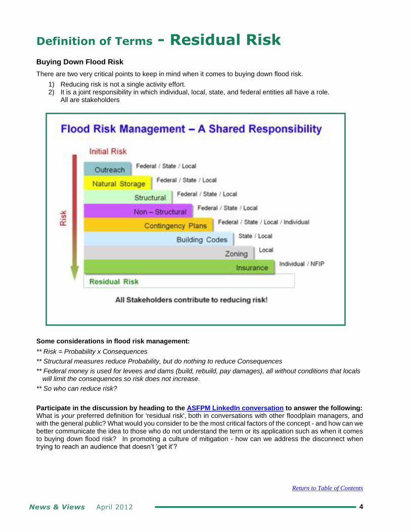
Definition of Terms - Residual Risk
Buying Down Flood Risk
There are two very critical points to keep in mind when it comes to buying down flood risk.
1) Reducing risk is not a single activity effort. 2) It is a joint responsibility in which individual, local, state, and federal entities all have a role.
All are stakeholders
Some considerations in flood risk management:
** Risk = Probability x Consequences
** Structural measures reduce Probability, but do nothing to reduce Consequences
** Federal money is used for levees and dams (build, rebuild, pay damages), all without conditions that locals will limit the consequences so risk does not increase.
** So who can reduce risk?
Participate in the discussion by heading to the ASFPM LinkedIn conversation to answer the following: What is your preferred definition for 'residual risk', both in conversations with other floodplain managers, and with the general public? What would you consider to be the most critical factors of the concept - and how can we better communicate the idea to those who do not understand the term or its application such as when it comes to buying down flood risk? In promoting a culture of mitigation - how can we address the disconnect when trying to reach an audience that doesn’t ‘get it’?
Return to Table of Contents

News & Views April 2012 5
Spotlight on - American Rivers
Written and Submitted By American Rivers
For more than a decade, American Rivers has led a national effort to restore rivers through dam removal. Between 40 and 60 dams are now removed each year in the U.S., and we have documented more than 1,000 dam removals nationwide. These efforts have provided tremendous ecological benefits, including restored fish passage, water quality, and native river habitat. As a result, dam removal is often viewed as being driven by the fish hugger contingent. In actual fact, the option of dam removal is most frequently considered and pursued because it eliminates an economic burden and addresses a public safety concern. The typical dam is removed because it has fallen into disrepair, and the cost of repair exceeds the public or private benefit it provides. Most dams that are removed today are former industrial dams (such as mill dams) that are no longer serving their original purpose. It is far less common that dams are removed that provide flood control, hydropower, or water supply.
American Rivers’ involvement with dam removals varies from direct project management to policy advocacy efforts, based on the needs of individual states and our community partners. Our River Restoration Program is staffed with scientists and planners who provide a range of services and have cumulatively worked on hundreds of dam removal projects. We also work to expand funding available for dam removal, have trained hundreds of professionals to manage projects, and work in partnership with state and federal agencies to clarify governing regulations and expand agency capacity to complete more effective dam removal projects.
Through our work in communities across the country, we see firsthand the shockingly poor condition of so many dams, and the areas downstream that are at risk of dam failure. We’ve had innumerable conversations with dam owners, residents, elected officials, and even zoning and planning officials who believe their dam provides flood control. In most cases this is a fallacy, a very dangerous fallacy, and one which contributes to poor land use decisions and poor communication of risk to people located in harm’s way. Most dams were not built to provide flood control: water flowing into the impoundment equals water over the dam at a similar rate.
Regulated dams have hazard classifications which are determined by the damage their uncontrolled failure would have on downstream areas. Factors considered include potential for loss of life, as well as damage to properties, critical infrastructure and the environment. A dam’s hazard classification determines the dam owner’s regulatory requirements, and also impacts the level of enforcement action an agency may take to resolve safety concerns. Contrary to popular belief, a dam’s hazard classification has nothing to do with its actual condition or state of repair.
The area downstream of a dam that would be affected by its failure is typically referred to as the dam breach inundation zone. This area may extend well beyond the regulated floodplain, creating an area of “residual risk.” Just as seen behind levees, poor land use decisions in residual risk areas increase the likelihood of loss of life and property damage. And, as with levees, this risk is too often unknown to residents until an emergency arises.
American Rivers works with many communities who have experienced recurring dam-related emergencies and are now exploring dam removal as a permanent solution. We find that once communities explore the option they often decide in favor of removal. A well-known example is the near-failure of the Whittenton Mill Dam in Taunton, Massachusetts.
During heavy rains in October 2005, the Whittenton Mill Dam was considered in imminent danger of failure and sending a six-foot flood wave down the Mill River and through downtown Taunton. This forced the evacuation of 2,000 people and the closure of businesses and schools for several days. None of the residents evacuated knew that they were living and working downstream of a dangerous dam. Most of the evacuation zone was beyond the regulated floodplain. Emergency crews spent hundreds of thousands of taxpayer dollars in a temporary fix, which involved dumping tons of rock on the downstream face of the dam. But, the temporary fix has not provided a permanent solution. The rock dam began deteriorating soon afterwards with scour occurring around the side of the rock structure, and is once again at risk of failing.
Continued on page 6

News & Views April 2012 6
American Rivers…… continued from page 5
A diverse coalition of partners, including American Rivers, has been working to remove the Whittenton Mill Dam once and for all. The project is designed, permit applications are under review, and the actual removal could take place in the fall of 2012, if the project is fully funded. The cost of removing the dam is less than the cost of the temporary fix. This project is one of three dam removal projects now planned or underway on the Mill River. The community-based river-wide effort will provide numerous benefits. Not only will fisheries and river habitat be restored, public safety will be improved and the City of Taunton will have more natural resilience during storm events. Of course, the removal of the dams will not eliminate the threat of future flooding. But it will eliminate the possibility of a sudden manmade flood disaster.
It is encouraging to see more floodplain managers, public safety officials, land use planners and emergency managers embracing the option of dam removal as a tool for meeting the objectives of a safe and resilient community. The partnership of interests that has united around the Mill River restoration effort in Taunton is an excellent example of how a variety of objectives can be met through dam removal.
Photo Credit and Print Permissions Belong to American Rivers: Whittenton Mill Pond Dam, showing emergency repairs, 2006. Dam is slated for removal in 2012.
There is a glaring disparity, however. For too long, dam removal projects have been overwhelmingly and generously financed by programs focusing on environmental restoration. There are indeed significant ecological benefits from dam removal, so these investments are appropriate and have paid off repeatedly. However, geographic and species-specific requirements of these programs also restrict the places that are eligible for funding. Given the considerable hazard mitigation benefits that can be provided through dam removal, funding from hazard mitigation programs is notably absent. American Rivers calls on federal and state hazard mitigation and disaster assistance funding programs to allow dam removal as an eligible expense. Dam removal eliminates a manmade hazard, while simultaneously restoring the natural and beneficial functions of rivers and floodplains. This is a wise investment, and one that will benefit our communities, our environment and future generations.
Continued on page 7

News & Views April 2012 7
Top Ten Flood Facts from American Rivers
1) Floods are the most common natural hazards in the United States. 2) Floodplains provide roughly 25 percent of all land-based ecosystem service benefits yet they represent just 2 percent of Earth’s land surface. 3) Wetlands in the United States save more than $30 billion in annual flood damage repair costs. 4) Over the past century, we have experienced more intense and frequent storms. 5) Damages from flood losses have increased to an average $10 billion per year. 6) In 2011 alone, there were 58 Federal flood disaster declarations, covering 33 different states. 7) A homeowner with a 30-year mortgage in a 100-year flood area has a 1 in 4 chance that such a flood will occur and more than double the chance of being damaged by a flood than by a fire. 8) Roughly 17% of all the urban land in the United States is located in the “100-year” or high risk flood zone. 9) Flood mitigation practices that reduce the loss of life and damages to properties provide $5 in benefits for every dollar invested. 10) Levees can and do fail - often with catastrophic consequences.
Please see the American Rivers Top Ten Flood Facts for more detailed information.
American Rivers…… continued from page 6 Photo Credit and Print Permissions Belong to American Rivers: Many communities are opting to remove unsafe dams, such as Clarksburg, MA which removed the Briggsville Dam in 2010.
Learn how communities across the country are increasing their resilience through river restoration. View our video “Restoring America’s Rivers: Preparing for the Future” at www.AmericanRivers.org/DVD. For
more on river restoration through dam removal, visit www.AmericanRivers.org/RestoringRivers. American Rivers works to protect and restore the nation’s rivers and streams. Rivers connect us to each other, nature, and future generations. Since 1973, American Rivers has fought to preserve these connections, helping protect and restore more than 150,000 miles of rivers through advocacy efforts, on-the-ground projects, and the annual release of America’s Most Endangered Rivers®.

News & Views April 2012 8
ASFPM Conference Update
ASFPM 36th
Annual National Conference May 20 – 25, 2012 | San Antonio Marriott Rivercenter | San Antonio, TX With less than a month until we convene in San Antonio for the world’s premier flood conference, your ASFPM conference team is hard at work and the late registration date is quickly approaching. Are you ready? Make plans to join us for a great week filled with state-of-the-art training, outstanding plenary sessions, intriguing field tours, and, of course, just a bit of Texas-sized fun. Additional information is available on our national conference website, see www.asfpmconference.org. If you have any questions, please contact ASFPM Conferences & Special Events Planner Chad Ross at [email protected]. Thanks and we’ll see you in San Antonio!
Conference Committee Meeting Reminder
ASFPM would like to remind our 2012 ASFPM Annual National Conference attendees that the Monday Committee Meetings will be open to everyone. Please feel free to attend any that are of particular interest to you! The Committee meetings present the best "one stop shopping" for detailed information about national policies in your areas of interest. Not only will you learn the current status and developments in policy areas, but you will have an opportunity to influence those policies should you wish to get more involved. All ASFPM committees are open to all and welcome people who wish to simply attend to learn or who wish to get involved.
Conference Social Media
ASFPM 36
th Annual National Conference - On Facebook and Twitter
To fans of the ASFPM Facebook Page, have you considered joining the ‘ASFPM 36th Annual National
Conference Event’? See who else will be in attendance or select ‘going’ to let others know you’ll be there!
Tweeting the 2012 ASFPM Conference New this year, ASFPM will be utilizing Twitter as an additional means by which to reach our conference attendees! To get connected, click @ASFPMConf and hit ‘Follow’.
Conference Proceedings
2012 ASFPM Conference Proceedings - Due! Deadline: June 22, 2012 ASFPM Conference Presenters intending to submit a Technical Paper for the 2012 Conference Proceedings, please watch your inbox for updated content submission guidelines.

News & Views April 2012 9
ASFPM Foundation
The 2012 ASFPM Conference is fast approaching and that means we are rounding up items for ASFPM Foundation’s TENTH Annual Silent Auction! Every year, through your generous donations, we have been able to collect several thousand dollars for the support of worthy causes. The ASFPM Foundation serves as an advocate and a voice for you – the practitioner, supplier, or service provider – through its support of ASFPM and its long-range planning mission. This year is no different, and we are counting on your contributions to help the Foundation reach its goals toward sustainable floodplain management in the nation.
The Silent Auction is a fun way for you to help provide financial support to the ASFPM Foundation. And it is a fun way for you to get a tax deduction for your donation! We understand that in these economic times many are not able to do as much as they would like to do, but we really do need your help. Any size donation is greatly appreciated. You or a group of peers (from your employer, chapter, friends, whatever!) should easily be able to find something of value that somebody else wants and will bid on. Or put your talents to work and create something artsy / craftsy to offer up. You could even consider re-gifting a present you received but cannot use.
We have found that the unique, the local, and the handmade items generate a great deal of interest so here is a list of things you might consider:
· Photography – scenery is popular, matted and plastic wrapped but not framed sells better because it fits in a suitcase!
· sports or backpacking equipment (lightweight, hand-held, easy to pack)
· electronic gadgetry is always highly sought after
· local food and/or wine gathered in a collapsible container (those baskets are hard to take on the plane!)
· dolls or toys
· needlework, beading, painting (on a small canvas, a scarf, quilt, or a bag)
· jewelry (handmade or with artist's background)
· woodworking (bowls, frames, boxes, toys)
· pottery or sculpture funny (as in last year's "Red Neck Beauty Spa Kit)
· books that are unique to water issues or a collection that is autographed
OFFERINGS ARE BEING ACCEPTED NOW! To make your 2012 tax-deductible donation to the Silent Auction, please provide the following information to the Silent Auction Coordinator - Luci Sherwood:
o Description of Item (and number of each unit donated if applicable)
o Fair Market Value (include any shipping costs)
o Your phone, email, mailing address, and company or affiliation
o When and how the item will available for table placement (this takes place on Monday May 21st)
o Name and address for donation acknowledgement letter, if applicable
For shipping / delivery information please go to the Auction page on the Foundation website. Still have questions? Contact Luci at [email protected] or ASFPM Outreach and Events Manager, Diane Brown, at [email protected] or 608-441-3003. Thank you for your support!
Additional ASFPM Foundation information is available on the website: http://www.asfpmfoundation.org/

News & Views April 2012 10
FloodManager Interactive Simulator Updates
“FloodManager” is a serious computer game/simulator. It was conceived to teach decision-makers the primary floodplain management principles they can apply to their community to increase resilience against flood disasters and to guide and steward development in their community in a manner that provides the most benefits while adhering to the tenets and practices of No Adverse Impact (NAI). Economic development via property and sales tax revenues is a community’s lifeblood, for both individuals and local government, so floodplains and other critical resource areas continue to be developed but without the long-term foresight of knowing and planning for the consequences. “FloodManager” walks local decision-makers through various options regarding the use and development of floodplains as they grow a typical town. Then, after a selected period of time and exposure to random flood events, the consequences of those decisions can be viewed and analyzed.
The Foundation raised $15,000 to develop Version 3.0 of “FloodManager”, adding several avatar characters to explain the game and enhance the interactive experience, which were unveiled at the ASFPM 2011 in Louisville. The Foundation is continuing the implementation stage by engaging stakeholders such as Cooperating Technical Partners (CTPs) in hosting workshops. Of primary importance is getting this learning tool into the appropriate agencies and offices where it will be put to the most productive use. Likely, this distribution will be through State Floodplain Managers and Hazard Mitigation Officers and through the ASFPM State Chapters. Attendees at most official ASFPM conferences and events will have the opportunity to view the most current version of FloodManager. At many venues, it will be demonstrated by an ASFPM Foundation member or representative. Viewers are invited to provide written comments and suggestions to the Foundation by email to Curtis Beitel at [email protected].
Screen shot of flood manager game - Courtesy of Curtis Beitel

News & Views April 2012 11
ASFPM Foundation’s FloodManager Simulation Presented to FEMA
On November 17th, 2011, Curtis Beitel and Grant Smith, on behalf of the ASFPM Foundation, presented FloodManager at a periodic professional development seminar at FEMA HQs, coordinated through FEMA’s Risk Analysis Division. The presentation was well received. Several suggestions for improvements were collected and possibilities for further coordination and cooperation in the future were discussed.
The Foundation received validation that the FloodManager simulation is consistent with the Risk MAP program. Challenges for the future will continue to be finding more volunteers inside the Foundation to communicate the availability of this great tool to expose floodplain managers, community officials – the decision makers at the community level – to the simulation as an enjoyable yet educational tool to prompt mitigation action as communities co-located with floodplains make development decisions. If you are interested in learning more, please contact Curtis or Grant, and visit the site for access to the completely free FloodManager simulation. All you have to do to use it is enter your email address so you can be notified when updates occur.
FloodManager Simulation: http://www.floodmanager.org/game/
Curtis Beitel: [email protected] 817-333-2817
Grant Smith: [email protected] 703-849-0100
Sponsorship opportunities to fund the future growth and use of “FloodManager” are still available. The sponsor’s logos will be displayed prominently in the opening screen and user’s manual of the next version. Please contact Foundation Development Chair Dale Lehman (301-258-9780) or any Foundation Trustee if you are interested!
Engaging the Public - Simulators Continued…
WARD’s Stormwater Floodplain Simulation System The Stormwater floodplain simulation system is a large scale and visually striking model featuring a clear acrylic tank, a colorful resin landform insert, three different headwater trays and two rainmaker trays to simulate several real world flood scenarios that students can recreate and modify. This new model offers a real opportunity to educate children and adults alike about the dangers and impact of development and human activity in the floodplain. For more information, please see here. Multiple videos of the simulation system in use are available on the Flood Risk Education in Schools Facebook page.
Stream Model and Video at BYU’s College of Physical and Mathematical Sciences February 29, 2012, BYU held a Stream Table Open House to showcase their new Stream Table, Em4, from Little River Research and Design. Interested in seeing how this worked? Click here or here.
Return to Table of Contents
News & Views April 2012 12
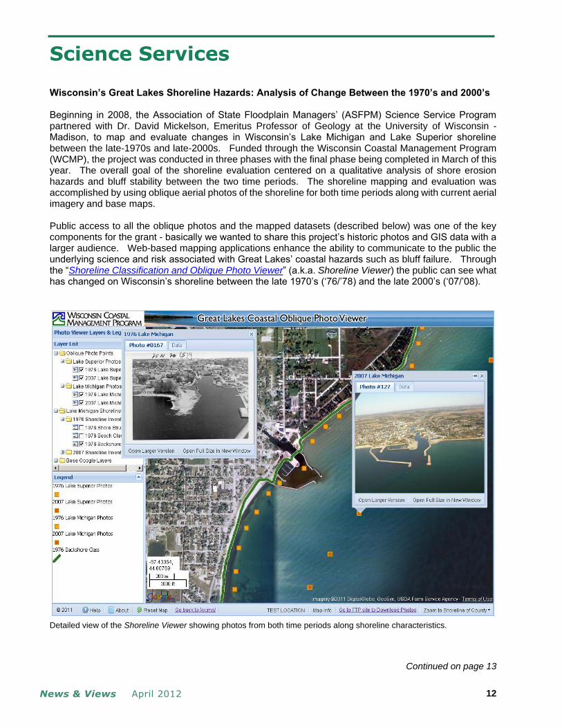
Science Services
Wisconsin’s Great Lakes Shoreline Hazards: Analysis of Change Between the 1970’s and 2000’s Beginning in 2008, the Association of State Floodplain Managers’ (ASFPM) Science Service Program partnered with Dr. David Mickelson, Emeritus Professor of Geology at the University of Wisconsin - Madison, to map and evaluate changes in Wisconsin’s Lake Michigan and Lake Superior shoreline between the late-1970s and late-2000s. Funded through the Wisconsin Coastal Management Program (WCMP), the project was conducted in three phases with the final phase being completed in March of this year. The overall goal of the shoreline evaluation centered on a qualitative analysis of shore erosion hazards and bluff stability between the two time periods. The shoreline mapping and evaluation was accomplished by using oblique aerial photos of the shoreline for both time periods along with current aerial imagery and base maps. Public access to all the oblique photos and the mapped datasets (described below) was one of the key components for the grant - basically we wanted to share this project’s historic photos and GIS data with a larger audience. Web-based mapping applications enhance the ability to communicate to the public the underlying science and risk associated with Great Lakes’ coastal hazards such as bluff failure. Through the “Shoreline Classification and Oblique Photo Viewer” (a.k.a. Shoreline Viewer) the public can see what has changed on Wisconsin’s shoreline between the late 1970’s (‘76/’78) and the late 2000’s (‘07/’08).
Detailed view of the Shoreline Viewer showing photos from both time periods along shoreline characteristics.
Continued on page 13

News & Views April 2012 13
Oblique Photo Viewer…… continued from page 12
Significant work went into converting, capturing, analyzing, and storing the aerial photos and all the associated GIS datasets required for the shoreline mapping effort. In 1976, black-and-white oblique air photos of Wisconsin’s Great Lakes shoreline were taken by the Wisconsin Department of Natural Resources as part of a major bluff erosion project led by Dr. Mickelson. In 2007 ASFPM and Dr. Mickelson submitted a proposal to WCMP that included: (1) acquiring new oblique aerial imagery for the entire Wisconsin shoreline; (2) mapping within a GIS the shoreline characteristics for both time periods and; (3) developing a web-based mapping tool that allowed easy access and viewing of the photos and shoreline characteristics. The 1970s oblique photos were scanned and converted to digital images. Next, each digital image was manually geo-located – a process used to locate the approximate location of where the photo was taken – allowing the digital image to be linked to a specific map location. Approximately 3,000 photos of 1970s vintage were processed in this manner. In 2007 and 2008, oblique digital photos were taken for all of Wisconsin’s Lake Superior and Lake Michigan shorelines. The 2007/08 photographs were geo-located automatically and with minimal processing the GIS datasets were generated. Over 7,800 photos of 2000 vintage were processed this way.
Oblique photos from 1976 (top) and 2007 (bottom) showing the same shoreline reach. In 1976 this bluff was unstable and susceptible to wave impacts that could result in significant slumps and slides.
Continued on page 14

News & Views April 2012 14
Oblique Photo Viewer…… continued from page 13
Next the shoreline characteristics were mapped for each time period using three classification components: (1) beach description, (2) backshore description, and (3) structure type. A standardized data model was developed within the GIS database to allow consistent data entry of the shoreline characteristics. For the most part shoreline classification work was done mile by mile, with all six classifications – 3 for each time period – being completed for a single reach before moving down the shoreline. Shoreline characteristics were explored and/or evaluated for approximately 575 miles of shoreline for Lake Michigan, including Door County Peninsula and Green Bay, and approximately 237 miles of shoreline for Lake Superior, including Madeline Island. The last major component of the project was the development of the web-based mapping tool or Shoreline Viewer, which is currently being hosted by the Science Service Program at ASFPM. As described previously, the Shoreline Viewer provides easy access for viewing and comparing the oblique photos and shoreline characteristics between the late 1970s and the late 2000s. Finally, limited analysis of the shoreline conditions between both time periods was conducted but a full analysis and report of results was not part of the original funding and has not been formatted for the general distribution. In the near future, we plan to submit a proposal that would perform a comprehensive analysis of shoreline changes. Additional proposed work would extend the capabilities of the Shoreline Viewer to allow download of larger datasets (e.g. entire county oblique photo sets) and include additional oblique photos from other sources such as a county or from FEMA’s current Great Lakes Coastal Flood Study program – as part of FEMA’s coastal flood study, high resolution oblique imagery is being captured for the entire Great Lakes shoreline. For more information about this project, please contact Jeff Stone, Project Manager at the Association of State Floodplain Managers (ASFPM). [email protected], 608-274-0123
Great Lakes Coastal Flood Study Releases First Quarterly Newsletter The Great Lakes Coastal Flood Study (GLCFS) has released their first quarterly newsletter. This newsletter announces the technical workshops across the Great Lakes Basin that will seek feedback from technical experts regarding the GLCFS. Please visit this website for more information on the GLCFS efforts and upcoming workshops. To directly access the newsletter, please click here.
Storm Surge and Wave Modeling Fact Sheet Released As of February 27, 2012, the Great Lakes Coastal Flood Study announced the release of a new fact sheet. This fact sheet summarizes the storm surge and wave modeling processes used for the Great Lakes Coastal Flood Study. Click here to access the Storm Surge and Wave Modeling Fact Sheet. Further fact sheets are available at the GLCFS Fact Sheet Page.
Return to Table of Contents

News & Views April 2012 15
The Digital Coast - More than Just Data
http://www.csc.noaa.gov/digitalcoast/

News & Views April 2012 16

News & Views April 2012 17
News & Views April 2012 18
Washington Report -Meredith R. Inderfurth, Washington Liaison
Next Up: Appropriations for Fiscal Year 2013 and Flood Insurance Reauthorization The Congress resumed legislative activity on April 16
th after a two week Spring Recess. Both House and
Senate Appropriations Committees had indicated plans for earlier-than-usual mark-up of appropriations bills for FY13, and all indications are that they are actively following those plans. Since returning from the recess, 4 of the 12 regular appropriations bills are ready for consideration on the Senate floor, and 2 of the 12 are ready for House floor consideration. Authorization for the National Flood Insurance Program (NFIP) is fast approaching its latest expiration date of May 31
st. The path forward is not at all clear. On April 23
rd, the Federal Emergency Management
Agency (FEMA) formally asked the Congress to pass a two year extension of the program. Appropriations The bills ready for House floor consideration are the Energy and Water bill and the Commerce, Justice, Science bill. Those ready for Senate floor consideration are the Agriculture bill (S. 2375 and S. Rept. 112-163), the Energy and Water bill (S. 2465 and S. Rept. 112-164), the Commerce, Justice, Science bill (S. 2323 and S. Rept. 112-158) and the Transportation/HUD bill (S. 2322 and S. Rept. 112-157). Budget overall guidance numbers for the appropriations process differ between the House and Senate by about $19 billion. The Senate is utilizing the numbers adopted last summer in the legislation adjusting the debt ceiling while the House passed a Budget Resolution (H.ConRes 112) on March 29
th establishing new
guidance at the lower figure. Since the recess, both House and Senate Appropriations Committees have released their allocations for each subcommittee (302B allocations) based on those differing overall budget numbers. Not surprisingly, there is considerable speculation about how expeditiously the appropriations process can be completed given this complication in the context of the upcoming elections. The full House Appropriations Committee marked up the Energy and Water Appropriations bill (bill number not yet available) on April 25
th. That bill provides funds for the Army Corps of Engineers as well as the
Department of Energy. The full Senate Appropriations Committee approved its Energy and Water bill on April 26
th. Overall, the House bill provides $32.1 billion and the Senate bill provides $33.4 billion. The
House committee approved, by a 29-20 vote, an amendment offered by Rep. Denny Rehberg (R-MT) which would prevent the Corps from finalizing guidance jointly developed by the Corps and Environmental Protection Agency (EPA) clarifying the definition of “navigable waters” under the Clean Water Act. It is anticipated that a similar amendment will be offered to the Interior and Environment Appropriations bill which funds EPA. The Senate bill does not include such an amendment. That bill includes an amendment offered by Senators Sherrod Brown (D-OH) and Dan Coats (R-IN) to support Corps efforts to develop ways to prevent Asian Carp entrance into the Great Lakes. The committee defeated, on the vote of 14-15, an amendment by Senator Roy Blunt (R-MO) to shift $40 million from Missouri River environmental conservation and habitat restoration to flood control construction projects. Other appropriations bills are expected to be marked up in the coming weeks. ASFPM submitted Outside Witness Testimony on the budget proposal for the Department of Homeland Security and FEMA. That testimony, as well as Outside Witness Testimony on the US Army Corps of Engineers budget request, is posted on the ASFPM website.
Continued on page 19

News & Views April 2012 19
Washington Legislative Report…… continued from page 17
On the DHS/FEMA request, ASFPM’s testimony made 4 points:
1. great concern about yet another reduction in the flood mapping budget, noting the essential importance of risk identification to flood hazard mitigation and the flood insurance program
2. strong objection to elimination of the Pre-Disaster Mitigation program 3. concern about folding 16 grant programs ranging from terrorism to mitigation into one large National
Preparedness Grant Program (NPGP), about the lack of detail accompanying the plan and about the lack of consultation with stakeholder groups
4. appreciation for doubling funds available from the National Flood Insurance Fund for the Flood Mitigation Assistance, Severe Repetitive Loss and Repetitive Flood Claims programs.
During visits with committee staff and personal staff of committee members, it seemed apparent to ASFPM representatives that there is considerable hesitation across party lines about approving the proposed NPGP, at least without considerable further development of the details.
Flood Insurance With one month left before the NFIP could once again expire, the manner of providing for continued operation is not yet clear. Both the House Committee on Financial Services and the Senate Banking Committee are optimistic that they can complete action on the reauthorization and reform bills that have been working their way through the legislative process. Meanwhile, FEMA’s Administrator, Craig Fugate, sent a letter to the committee Chairmen and Ranking Minority Members on April 23rd asking for a two year clean reauthorization of the program. Senator David Vitter (R-LA) has just introduced a bill providing for a 7 month program extension.
Completing action on the reauthorization and reform bills (H.R. 1309 and S. 1940) is still possible, but problematic. The House passed its bill last summer and passed it again in April as part of a budget reconciliation package. The Senate Banking Committee reported out its bill, but it has not yet been considered on the Senate floor. To wrap up the work on those bills would necessitate Senate passage followed by House-Senate Conference committee deliberations to resolve differences, acceptance of the Conference Report on the House and Senate floors, and then the President’s signature.
Both bills would provide for a 5 year program reauthorization along with a number of reforms. Many of those reforms are very similar and even identical in both bills, but other reform measures are very different. A notable example is that the Senate bill provides for mandatory purchase of flood insurance in residual risk areas behind levees while the House bill (through an amendment) directs that FEMA not map residual risk areas behind levees.
During visits with committee staff and staff of committee members on April 26th
, ASFPM representatives urged that the program not be permitted to lapse, noting the difficulties caused for the housing, building, insurance, and real estate industries, as well as for state and local officials when the program has endured several periods of hiatus in the recent past. It was clear that committee staff and other Congressional staff are very much aware of the importance of avoiding yet another program lapse.
Other Legislation to Watch
Farm Bill
The Senate Agriculture Committee marked up its 2012 Farm Bill on April 26th after being postponed for a
day in an effort to address regional crop differences and issues. The House Agriculture Committee has launched a series of hearings in preparation for marking up its version.
The Senate Farm bill as reported out of committee would save $23 billion over 10 years and reauthorize Agriculture programs for 5 years. Current authorization is set to expire on September 30
th. The bill
restructures commodity programs and farm subsidies, consolidates 23 conservation programs into 13 (reducing spending by $6 billion over 10 years) and eliminates almost 100 program authorizations. More information about the Farm Bill, including the text, is available by going to: www.agriculture.senate.gov and going to the Farm Bill page.
The House Agriculture Committee held a hearing on the conservation programs of the Department of Agriculture on April 26
th.
Continued on page 20
News & Views April 2012 20
Washington Legislative Report…… continued from page 19
FEMA Reauathorization The House Transportation and Infrastructure reported out a bill (H.R. 2903) on March 8
th which
reauthorizes the Federal Emergency Management Agency (FEMA) for the next two years. Title II of the bill focuses on amendments to the Stafford Act (disaster assistance). Among its other provisions, it reauthorizes the Emergency Management Assistance Compact grants (EMAC) and reauthorizes the National Dam Safety Program. It also requires FEMA to establish criteria within 180 days for state administration of the Hazard Mitigation Grant Program (HMGP). Additionally, it sets up a pilot program for revised procedures for Public Assistance (Section 406 of the Stafford Act). Committee staff have indicated their expectation that this bill could be considered soon on the House floor.
Flood Insurance for Farmers Act H.R. 4020, introduced in late February by Representative John Garamendi (D-CA), would create a new agricultural zone for flood insurance purposes. It would allow premiums at a Zone X rate in agricultural areas where levees are not accredited. It would also eliminate floodproofing building standards in the new zone. The bill has been referred to the House Committee on Financial Services. Committee staff doubt that the measure can be taken up during this session because it was introduced after the House had already passed its flood insurance bill.
Levees on FEMA Buy-Out Land Senator John Hoeven (R-ND) introduced S. 2039, a bill to allow a state or local government to construct levees on land bought out under FEMA hazard mitigation programs and designated as open space. After being introduced in February, the bill was almost immediately brought up on the Senate floor and passed under Unanimous Consent. The measure is now awaiting consideration by the House Transportation and Infrastructure Committee. ASFPM has sent a letter to the Chairman and Ranking Minority Member of the Committee expressing concern about the bill and explaining the reasons for concern.
Halting Guidance on Definition of “Navigable Waters” Chairman John Mica (F-FL) of the House Transportation and Infrastructure Committee along with Ranking Member Nick Rahall (D-WVA), Water Resources Subcommittee Chairman Bob Gibbs (R-OH), Agriculture Committee Chairman Frank Lucas (R-OK) and Ranking Member Collin Peterson (D-MN), introduced H.R.4965. The measure would halt finalization of joint guidance from the Army Corps of Engineers and EPA on the definition of “navigable waters” under the Clean Water Act. The proposed guidance is under consideration at the Office of Management and Budget at present. A similar bill was introduced in the Senate (S. 2245).
Coalitions Most coalitions in which ASFPM participates have been actively meeting as Congressional activity has moved into high gear.
Congressional Hazards Caucus Alliance The Alliance has met several times this year and has already sponsored several Congressional briefings on various disaster related topics. The Alliance is interested in working with ASFPM and the American Society of Civil Engineers (ASCE) to sponsor a briefing on levee issues later this spring.
Flood Map Coalition The coalition met on April 12
th for a full briefing on the status of the RiskMAP program and future plans.
Stafford Coalition The Stafford Coalition has met twice so far this year. Most recently, the coalition met with Republican and Democratic staff of the House Transportation and Infrastructure to discuss the FEMA Reauthorization bill, H.R. 2903.
USGS Coalition The coalition has met several times this year, most recently to discuss development of outside witness testimony on the USGS budget request. USGS Director, Marcia McNutt, will meet with the coalition on May 9
th.
Referenced legislation can be viewed by going to: http://thomas.loc.gov and typing the bill number, title, or subject.

News & Views April 2012 21
ASFPM 2012 Legislative and Policy Priorities Passed and Available Online On February 22, 2012, the ASFPM Board passed the ASFPM 2012 Legislative and Policy Priorities. Items include:
Overarching Policy Issues National Flood Insurance Program (NFIP) Reform Water Resources Development Act (WRDA-USACE authorities) Stafford Act Any New Jobs and/or Infrastructure Bill Appropriations/Budgets Other Possible Legislation in 2012 Flood Risk Management, including Managing Catastrophic Losses Coastal Policy and Programs Comprehensive National Water Policy Levee Risk Management and Levee Systems Mapping--- Risk MAP Mitigation Tax Provisions
For more, please see ASFPM 2012 Legislative and Policy Priorities on ASFPM’s website. This document is available at National Policy and Programs > Working with Congress ASFPM Releases Statement on President Obama’s 2013 Budget Request for FEMA On March 8, 2012, ASFPM released a statement on President Obama’s 2013 budget request for FEMA. In its statement, the Association of State Floodplain Managers indicated there should be no additional cuts to the flood mapping program due to extensive cuts in FY12, preservation of FEMA’s only pre-disaster all hazard mitigation program which is targeted for elimination with funding at least equivalent to FY12, and the delay in creation of the National Preparedness Grant Program (NPGP). ASFPM has called for much more extensive partner engagement to discuss purpose of the NPGP and questions the efficacy of including mitigation programs in one that is focused on terrorism and preparedness – at the expense of hazard mitigation. ASFPM notes that it is mitigation, more so than preparedness, response, and recovery, that serves to reduce or eliminate long term costs and damages due to hazard events - and ASFPM is concerned, given the trend of increasing damages in the United States, that the Administration is choosing to make significant cuts in hazard mitigation programs. To access the statement, please click the following link: Statement on the Hazard Mitigation Programs in the FY2013 Budget Including the Proposed Elimination of the Pre-Disaster Mitigation Program ASFPM Provides Outside Witness Testimony - FEMA FY13 Budget The President's proposed FY2013 budget eliminates the Federal Emergency Management Agency's (FEMA's) Pre-Disaster Mitigation (PDM) Grant Program and makes additional cuts to the flood mapping program from last year. ASFPM provided Outside Witness Testimony to the Subcommittee on Homeland Security, House Committee on Appropriations regarding the FY13 Budget. Our Testimony expressed deep concern over eliminating PDM and the additional mapping cuts in FY13, commented on the new proposed National Preparedness Grant Program (NPGP), and supported streamlining and funding increases to flood mitigation grant programs under the NFIP. Click the following to access the ASFPM’s Outside Witness Testimony before the Subcommittee on Homeland Security, House Committee on Appropriations. ASFPM Provides Outside Witness Testimony - U.S. Army Corps of Engineers FY13 Budget On March 30, 2012, the Association of State Floodplain Managers was pleased to provide Outside Witness Testimony to the Subcommittee on Energy and Water, House Committee on Appropriations regarding the USACE FY13 Budget Request. ASFPM called attention to several small programs which have a significant impact in helping states and communities manage their flood risk. Those programs are Flood Plain Management Services (FPMS), Planning Assistance to States (PAS), and Silver Jackets. ASFPM also expressed strong support for on-going and expanded work to develop a national levee inventory. Click the following to access the ASFPM’s Outside Witness Testimony before the Subcommittee on Energy and Water, House Committee on Appropriations.

News & Views April 2012 22
Publications, Video, the Web
Silver Jackets Newsletter As of April, 2012, the Silver Jackets have released their quarterly newsletter, The Buzz. Included in this issue is an announcement welcoming Mr. Ray Alexander to the position of Deputy Chief of Homeland Security, Flood Risk Management, and Critical Infrastructure within the HQUSACE Civil Works Directorate. Prior to his permanent appointment, Mr. Alexander served as Acting Deputy Chief and was the HQUSACE Deputy Chief of Operations before that. Mr. David Miller was recently appointed the FEMA Associate Administrator for Federal Insurance and Mitigation after having served as the Administrator of the Iowa Division of Homeland Security and Emergency Management from 2004-2011 where he served as the Governor’s Authorized Representative (GAR) for eleven President-declared major disasters. Look for an exclusive interview with Mr. Miller in an upcoming News & Views. Meet “Disaster” and “Preparedness” From Kansas City, the Metropolitan Emergency Managers Committee recently produced a fun little video which seeks to emphasize the need for preparing before disaster strikes. Styled similarly to the Mac vs. PC advertisements, popular a few years ago, it is a creative use of YouTube for reaching the public. Check it out here. Florida’s State Floodplain Office Releases National Flood Safety Week Video As part of National Flood Safety Awareness Week, the Florida Division of Emergency Management’s State Floodplain Office released a very informative video on flood risks in Florida and how best to prepare. To watch the video, click here. Examining the Role of Government Assistance for Disaster Victims: A Review of H.R. 3042 Howard Kunreuther recently testified at the hearing for Examining the Role of Government Assistance for Disaster Victims: A Review of H.R. 3042. This hearing was conducted by the Committee on Small Business Subcommittee on Economic Growth, Tax and Capital Access. Howard offered excellent testimony to members of the Subcommittee on potential consequences of the legislation, and the role of insurance and other policy tools to reduce future losses. His five points on NFIP reform were brief, to the point, and spot on. Watch the video to see for yourself and access the written testimony here. Information on the House Committee on Small Business, Subcommittee on Economic Growth, Tax and Capital Access is available here. NOAA’s Coastal Mapping Program Offers Huge Taxpayer Benefits For every dollar American taxpayers spend on NOAA’s National Geodetic Survey (NGS) Coastal Mapping Program, they receive more than $35 in benefits, according to a recent independent socio-economic scoping study. The program provides critical baseline data for accurately mapping America’s official shoreline - important for national security, maritime shipping and navigation, and provides geographical reference data needed to manage, develop, conserve and protect coastal resources. The study demonstrates the program’s contributions in marine safety, geographic information, resource management, and emergency response and the wide range of economic and societal activities it supports. “This is a great investment for taxpayers,” said David Kennedy, assistant NOAA administrator for the National Ocean Service. “The coastal mapping program FY11 budget of $6.8 million brought about $241 million annually in both direct and secondary economic benefits, as well as non-economic benefits such as those related to safety and the environment.” Click here for full press release. ASFPM LinkedIn Discussion on Residual Risk Please join the discussion by posting your comments to the ASFPM discussion on LinkedIn! For additional background, click here. ASFPM LinkedIn and Facebook Discussions on the Top Ten Books for Floodplain Managers Have you weighed in with your ‘best of the best’ floodplain management resources? Or checked back to see what others have recommended? Works may be geared to the general public, the general floodplain industry, or to a specific technical element of your work. As we receive your feedback, we will be pulling together a recommended Top Ten Reading List for Floodplain Managers. If you are not able to participate on Facebook or LinkedIn, please submit your suggestions to Katrien at [email protected].

News & Views April 2012 23
Recommended Reading Emergency Management: The American Experience 1900 - 2010, Claire B. Rubin This book offers a definitive history of emergency management in the United States over the last century, covering the major U.S. disasters and their outcomes with particular focus on governmental response. As Emergency Management has evolved, continuing to expand for 80 of the last 105 years, many changes have occurred in both the public management systems and the expectations of state and local government officials and the general public. This book offers a chronological and unique analytic approach in how it focuses on the changes, and it is intended to answer two key questions: Why did the federal government get involved in emergency management? Why and how has that role changed? The book is available from the disasterbookstore.com website. For further reading, check out Claire’s excellent blog, Recovery Diva. Flood Risk Perception in lands “protected” by 100-year levees Jessica Ludy and G. Matt Kondolf An excellent paper supporting ASFPM’s positions on residual risk areas. This paper surveys residents for their awareness of their risk of flooding. For more information, read the abstract here or access the paper through Natural Hazards. A direct link to the paper is available here. FEMA Floodplains Available in Google Earth FEMA offers two applications that allow users to access information from the National Flood Hazard Layer (NFHL) in Google Earth. The FEMA NFHL allows users to view custom combinations of flood hazard information, including flood hazard zones, floodways, Coastal Barrier Resources System and otherwise Protected Area units, community boundaries and names, base flood elevations, and more. Stay Dry is a simpler, focused application that provides basic flood hazard map information from the NFHL for an address. You can download installation instructions for FEMA NFHL using Google Earth at the FEMA Map Service Center.
Around the World Australia March 19, 2012, the Australian insurance industry supported findings of a newly released Queensland Floods Commission of Inquiry report, backing calls for flood mitigation measures. The devastating Queensland floods of 2011 served as a harsh “wake-up call” and Council Chief Executive, Rob Whelan, said that any repeat of last year’s floods in the same communities would be a “failure of mitigation, not a failure of insurance.” For more, click here. The Netherlands Adaptation: How the Dutch make ‘room for the river’ by redesigning downtown. The Dutch have a long history of fighting the sea, and with much of the country technically below sea level. Their approach has included, though not been limited to, building higher dikes. However, as sea levels rise, the country has begun to accept that more drastic measures are necessary, and so they have begun moving many of the dikes back to make room for swelling rivers. Nijmegen, the oldest city in the Netherlands, has been recognized for the gargantuan task of moving the country’s biggest river. To read more on this, please visit the E&E story here. Further efforts, including a video of how the Dutch are working to keep the water at bay, are outlined here. Thailand JBA Risk Management recently launched the first nationwide flood model for Thailand, in order to help insurers and reinsurers to quantify their exposures. Read here for more on this story.
Return to Table of Contents

News & Views April 2012 24
Grant and Project Opportunities USDA Community Forest and Open Space Conservation Program – $1.35 million Deadline: May 15, 2012 Eligible Entities: Local governments, federally recognized tribes, non-profit entities. The purpose of the Community Forest program is to establish community forests by protecting forest land from conversion to non-forest uses and provide community benefits such as sustainable forest management, environmental benefits including clean air, water, and wildlife habitat; benefits from forest-based educational programs; benefits from serving as models of effective forest stewardship; and recreational benefits secured with public access. Eligible entities may apply for grants to establish community forests through fee-simple acquisition of private forest land. Individual grant applications may not exceed $400,000 and all applicants must demonstrate a 50 percent match of the total project cost. For more information, visit the USDA funding notice page. IAEM Scholarship Deadline: May 15, 2012 The International Association of Emergency Managers (IAEM) Scholarship Program was established to nurture, promote and develop disaster preparedness and resistance by furthering the education of students studying the field of emergency management, disaster management or a related program. The purpose of the program is to assist the profession by identifying and developing students with the intellect and technical skills that can advance and enhance emergency management or disaster management. Scholarships are awarded to full-time students pursuing an associate or diploma, the number and amount of scholarship awards varies from year-to-year. More information available here. Coastal and Estuarine Research Federation 2012 - Call for Abstracts Deadline: May 24, 2012 The Coastal and Estuarine Research Federation as issued a call for abstracts for its first special conference in South America, which will be held on November 11th-14th in Mar del Plata, Argentina. With the theme, The Changing Coastal and Estuarine Environment: A Comparative Approach, comparison focuses specifically on temperate, coastal systems within Southern and Northern Hemispheres. Conference organizers invite abstracts for presentations on one of the following six specific topics: changing baseline populations; land-sea couplings in rapidly changing environments; fisheries exploitation; impacts of UV on coastal waters; acidification of coastal waters; and warmer climate, increased freshwater use on land and the hydrodynamics of estuaries. Read further… National Weather Service Annual Meeting - Call for Abstracts Deadline: May 25, 2012 Submit abstracts for oral presentations by 25 May 2012 and abstracts for poster presentations by 29 June 2012. Abstracts should be sent via the online form and will be published as submitted. Presenters will be notified via e-mail regarding disposition of their abstracts by 20 July 2012. A preliminary agenda will be posted on the NWA web site by early August for presenters to review and proofread. Undergraduate and graduate students can apply to become eligible for monetary awards given for the best oral presentations and posters. Follow this link for more. Natural Disaster Management – Graduate Course University of Iceland Earthquake Engineering Research Centre Selfoss, Iceland Deadline: Open until filled This course provides an introductory overview of the disaster cycle, and examines local, national, and international roles in disaster management. Topics include multidisciplinary disaster cycle management, risk analysis, cost-benefit analyses of mitigation projects, and contingency planning for rescue, relief, and recovery. Following completion of the course, students will be able to lead or participate in multidisciplinary disaster management projects. Course runs from May 30 through June 22, 2012. Cost and Registration: $2,037, open until filled. Click here for more.

News & Views April 2012 25
Pre-Disaster Mitigation Program…… continued from page 1
Unfortunately, what we are seeing is a much larger effort to begin redefining priorities for the various hazards communities face, and to then associate funding priorities with these new priorities. This redefinition begins with changing the process for risk assessment. For example, the new concept that DHS and FEMA are rolling out, called the Threat and Hazard Identification Risk Assessment (THIRA), now puts “threats” on equal footing with hazards and risks. This concern is exemplified in the following comment from those supporting the new grant program in FEMA: “In the end, it should come down to the simple formula for Risk Management, where Risk = Threat x Vulnerability x Consequences.” However, as many of you know, the classic formula is actually Risk = Probability x Vulnerability x Consequences. ASFPM submits that it is inaccurate to use “threat” in the formula, per it inserting “threat” regardless of whether it has a probability or not. Under mitigation planning, we have been doing risk assessments this way for a while now – arguably since the Disaster Mitigation Act of 2000, which used the process of Hazard Identification Risk Assessment (HIRA) absent threat. Love ‘em or hate ‘em, we can at least say that through a risk assessment based approach, where probabilistic determinations must be made, one can justify investments of scarce resources and it gives a solid way to identify priority funding areas. Not so, if THIRA does not attach a probability to a given threat. In fact, the THIRA guidance under the Comprehensive Preparedness Guide 201: Thread and Hazard Identification and Risk Assessment Guide (CPG 201 document) makes the following statement, “The specificity gained by complex probabilistic modeling and analysis is lost when trying to apply the results across the complex landscape of prevention, protection, mitigation, response, and recovery.” So, if somebody deems that a threat exists, even if the probability is unable to be determined or is near zero, it has the potential to score high. Under such a scenario, certainly the greatest threat of all is a gigantic asteroid hitting the earth! Should that, then, be the funding priority? Of course not, and we specifically chose an absurd example in order to better highlight how this is the kind of lessened rigor the concept of risk assessment a THIRA introduces. It is ironic that traditional risk assessment has worked for many years to support the entire spectrum of emergency management and has worked in communities large and small. Now, suddenly, we seem to be replacing it with another model – one that is untested and unproven. The CPG 201 document goes on to say “These methodologies most often focus on a single threat or hazard type and a small area or fixed facility.” While it is true that risk assessment traditionally focuses on one hazard (although there has been much more emphasis recently on analyzing multiple hazards and cascading effects), the authors surely could not have been unaware of the risk assessments that have been part of mitigation planning and which do a credible job in covering much larger areas. Many questions remain:
What is a “threat”? Is it anything deemed harmful to a community? CPG 201 defines a threat as “resulting from the intentional actions of an adversary.” But what are the sideboards on making that determination?
What are we going to do with the existing risk assessments and mitigation plans? How can a THIRA inform a risk assessment for a natural hazard? FEMA informs us they are working to integrate THIRA processes with HIRA processes. But until that is done in such a way that those of us doing mitigation can better understand how it will impact all mitigation activities, many will continue to have doubts, and will be unable to support the new combined grants. It would seem important to have key processes like this available before proposing changing the existing system.
If we throw out probabilistic modeling how do we make accurate assessments of impacts? What are the implications of having a much less disciplined approach to risk assessment?
Does the nation need to be prepared for possible terrorism? Yes, but it needs to be even more prepared to reduce its risk for natural disasters, as these reliably occur year in and year out, and in fact, almost week in and week out. America has experienced two significant terrorism events in 17 years: Oklahoma City in 1995 and September 11 in 2001, claiming a total of about 3,100 victims. However, in those same 17 years, the nation lost over 5,000 people to floods, hurricanes, and tornadoes. Furthermore, over that same time period, the nation absorbed a staggering $455 billion in property damage losses from these natural hazards - as compared to approximately $19 billion for the two terrorist attacks. Given that these numbers reveal natural disasters as deadlier and causing significantly more damage, what makes better sense for making Americans safer: terrorist attacks that might happen or natural hazards that will?
Continued on page 26

News & Views April 2012 26
Pre-Disaster Mitigation Program…… continued from page 25
It is unfortunate that we have come to a “terrorism vs. natural disasters” discussion, but the loss of ability to help communities mitigate damages and loss of lives from natural disasters leaves a dilemma in our nation’s effort to reduce risk to flooding and other natural disasters. It seems to us that combing grants for both terrorism and natural hazards may not serve either one very well, and keeping them separate has value to the nation. It may be time to get back to the basics of managing emergencies. The traditional approach of emergency management, in which there was a focus on the four primary phases of preparedness, response, recovery and mitigation, served the nation well - especially in responding to acts of terrorism. While all four phases should be integrated, there is a core competency and capability for each that must be maintained. One phase cannot be subsumed by another. If you have similar concerns, you may wish to weigh in with decision makers or submit comments via the FEMA Grant Programs Directorate interactive website. This can be done at: www.fema.ideascale.com. Additionally, we urge you to share your thoughts with us by sending them to [email protected].
Calendar
FEMA’s Emergency Management Institute (EMI) 2011 - 2012 Continuing Education Opportunities There are seats available for floodplain management courses at EMI that have been pre-approved for Continuing Education Credits (CECs) for CFMs. EMI courses are offered at the Emmitsburg, MD campus and are FREE for local and state government employees. FEMA reimburses travel expenses and provides housing for state and local government employees attending EMI courses. Attendees or their employers pay for the campus meal ticket (about $100 per week). You can find the EMI Course Schedule and application materials on the EMI website.
E273 Managing Floodplain Development thru NFIP June 11-14, 2012 (12 Core CECs) E194 Adv. Floodplain Mgmt. Concepts Aug. 27-30, 2012 (12 Core CECs) E273 Managing Floodplain Development thru NFIP Sept. 24-27, 2012 (12 Core CECs)
Hydroinformatics Conference The next Hydroinformatics Conference will be held in Hamburg, Germany, July 14-18, 2012. Topics on the agenda will include disaster mitigation, hydrological modeling, hydraulic modeling, climate change impacts, developments of flood and drought early warning systems, socio-economic aspects of hydroinformatics realising active stakeholder participation, and more. For more information go to http://www.hic2012.org/.
Restore America’s Estuaries (RAE) 6th National Conference on Coastal and Estuarine Habitat Restoration October 20-24, 2012 Healthy coastal and estuarine habitats are critical not only to the environment and the national economy, but to regional and local economies, as well. Because human and natural systems are interdependent, restoration strengthens and reinforces the social, economic, and environmental ties that bind communities together. Healthy coastal ecosystems mean jobs, new and better economic opportunities, and the prosperity and stability important in the troubling economic times and high unemployment rates our nation faces. For additional information, please see: Conference Prospectus and Call for Proposals: Dedicated Sessions, Presentations, and Posters
Return to Table of Contents

News & Views April 2012 27
ASFPM Calendar
The events listed below are only the highlights of events of interest to floodplain managers. A complete list of flood-related training, conferences, and other meetings, including ALL the workshops
and conferences of State Chapters and associations is always posted at http://www.floods.org/n_calendar/calendar.asp
May 20–25, 2012: 36TH ANNUAL CONFERENCE OF THE ASSOCIATION OF STATE FLOODPLAIN MANAGERS, San Antonio, Texas. Contact (608) 274-0123 or see http://www.floods.org
June 9–14, 2013: 37TH ANNUAL CONFERENCE OF THE ASSOCIATION OF STATE FLOODPLAIN MANAGERS, Hartford, Connecticut. Contact (608) 274-0123 or see http://www.floods.org
June 1–6, 2014: 38TH ANNUAL CONFERENCE OF THE ASSOCIATION OF STATE FLOODPLAIN MANAGERS, Seattle, Washington. Contact (608) 274-0123 or see http://www.floods.org
May 31–June 5, 2015: 39TH ANNUAL CONFERENCE OF THE ASSOCIATION OF STATE FLOODPLAIN MANAGERS, Atlanta, Georgia. Contact (608) 274-0123 or see http://www.floods.org
Are you looking for training opportunities to earn CECs for your CFM? If so, be sure to check out our web
calendar, which already has LOTS of training opportunities listed for 2012! You can search the calendar by
state using the directions below. Or you can use the category drop down menu to search by category.
http://www.floods.org/n-calendar/calendar.asp
Go to the calendar and click on the search feature icon at the top of the calendar. Type your state’s
initials in parenthesis (for example “(WI)”) into the search field and it will pull all the events (training,
conferences, etc.) that are currently listed on the calendar for your state. What a great way to find
upcoming training for CECs! The only events without a state listed in the event title are EMI courses
which are all held in Emmitsburg, MD.

News & Views April 2012 28
Questions, items for publication, and other editorial matters should be directed to: ASFPM 2809 Fish Hatchery Rd., Ste. 204 Madison, WI 53713 (608) 274-0123 (phone) -0696 (fax) [email protected] Deadline is the 18th day of odd-numbered months. For address changes and member services, contact the ASFPM Executive Office at the address in the box above.
ASSOCIATION OF STATE FLOODPLAIN MANAGERS OFFICERS
CHAIR Sally McConkey, P.E., W.DRE, CFM INRS Illinois State Water Survey 2204 Griffith Dr. Champaign, IL 61820 217-333-5482 fax: 217-333-2304 [email protected] VICE CHAIR
Bill Nechamen, CFM NY State Dept. Env. Consv. 625 Broadway Ave., 4
th Floor
Albany, NY 12233 518-402-8146 fax: 518-402-9029 [email protected]
SECRETARY Alan J. Giles, CFM Georgia DNR/Floodplain Management 4220 International Pkwy, Ste 101 Atlanta, GA 30354 404-362-2612 fax: 404-362-2757 [email protected] TREASURER
John Crofts, CFM Utah Division of Emergency Management 1110 State Office Bldg. Salt Lake City, UT 84114 801-538-3332 fax: 801-538-3772 [email protected]
Executive Director Larry Larson, P.E., CFM ASFPM Executive Office [email protected]
Associate Director Chad Berginnis, CFM ASFPM Executive Office [email protected]
ASSOCIATE DIRECTOR -OPERATIONS Ingrid Danler, CFM ASFPM Executive Office [email protected]
ASSOCIATION of STATE FLOODPLAIN MANAGERS 2809 Fish Hatchery Road, Suite 204 Madison, WI 53713 (608) 274-0123 fax: (608) 274-0696 [email protected]
http://www.floods.org
News & Views is published six times each year by the Association of State Floodplain Managers, Inc., and is paid for by member dues. Copyright ©2012 by the ASFPM. Reproduction with credit permitted for individual ASFPM-authored articles. Information and opinions contained herein do not necessarily reflect the views of the Board of Directors.