index to executive committee minutes #9/07 friday ... · index to executive committee minutes #9/07...
TRANSCRIPT

INDEX TO
EXECUTIVE COMMITTEE MINUTES #9/07
Friday, November 2, 2007
MINUTESMinutes of Meeting #8/07, held on October 12, 2007 924
CORRESPONDENCEO'Connor, Gerri Lynn, Chair, TRCA, and Doug Beynon, Chair, OCETA Board of Directors
re: Cancellation of Environment Canada's Funding Support of the Toronto Region Sustainability Program 924
GREENLANDS ACQUISITION PROJECT FOR 2006-2010Flood Plain and Conservation Component, Don River Watershed
The Canadian National Institute for the Blind, CFN 39869 932Flood Plain and Conservation Component, Duffins Creek Watershed
Glen Major Angling Club, CFN 37200 929Flood Plain and Conservation Component, Rouge River Watershed
Tovtel Enterprises Inc., CFN 39906 935
REQUEST FOR EXCHANGE OF LANDDuke of Richmond Developments Inc., CFN 39919 938
ONTARIO REGULATION 166/061A Pine Ridge Avenue, City of Vaughan 9712 Orchard Crest Road, City of Toronto 10114 Doner Street, Town of Whitchurch-Stouffville 10154 Rosalie Avenue, City of Toronto 9515 Elm Street, Town of Markham 10156 Hill Top Trail, Town of Whitchurch-Stouffville 9826-1790 Finch Avenue, City of Pickering 10097 McNeilage Court, Town of Ajax 101415 Bonnyview Drive, City of Toronto 95415 Dorian Avenu, City of Toronto 101116 Donino Avenue, City of Toronto 96516 Glenayr Road, City of Toronto 101319 Riverview Heights, City of Toronto 947

21 Mantiou Drive, Township of King 100621 Montessor Drive, City of Toronto 96421 True Davidson Drive, City of Toronto 101321 Valecrest Drive, City of Toronto 101022 Platinum Avenue, Town of Richmond Hill 101522 York Valley Crescent, City of Toronto 95823 Heritage Hill Drive, Town of Markham 97624 Wellesbourne Crescent, City of Toronto 101225 Wycliffe Avenue, City of Vaughan 97235 Timberlane Drive, City of Toronto 101339 Denver Crescent, City of Toronto 101242 Hawkesbury Drive, City of Toronto 96243 Sagebrush Lane, City of Toronto 96043 Sunnydale Drive, City of Toronto 101150 Foxtrail Crescent, City of Vaughan 101454 Fishleigh Drive, City of Toronto 101358 Ridgevalley Crescent, City of Toronto 95660 Brule Gardens, City of Toronto 101262 Springbrook Gardens, City of Toronto 98976 Main Street Unionville South, Town of Markham 97881 King Street West, Town of Caledon 100085 Lake Promenade, City of Toronto 101087 Donwoods Drive, City of Toronto 96194 Montgomery Road, City of Toronto 101195 Thornridge Drive, City of Vaughan 99695 Wells Hill Avenue, City of Toronto 96996 West Deane Park Drive, City of Toronto 1010102 North Drive, City of Toronto 950108 Boulton Drive, City of Toronto 968142 Citation Drive, City of Toronto 1012161 Hedgerow Lane, City of Vaughan 973164 Edenbridge Drive, City of Toronto 949168 Weldrick Road East, Town of Richmond Hill 981231 Victoria Street, Town of Caledon 975272 Riverside Drive, City of Toronto 1010504 Rougemount Drive, City of Pickering 9465612 Bethesda Road, Town of Whitchurch-Stouffville 1016997772 Ontario Ltd. 1015Ajax, Town of 997Barrett Developments Limited, City of Brampton 986Bayview Construction, Town of Richmond Hill 979Black Marlin Management Ltd. 957Block 12 Properties Inc. 992Caledon Inn, The 1014Ebrahim Properties 988Kennedy Road, Town of Caledon 999King, Township of 1008Loblaw Properties Limited 1002Markland Wood Country Club 953
Maxim Group Building Restoration Inc. 983Mississauga, City of 943Mount Pleasant Group of Cemetaries 994Pickering, City of 944Port Mark Investments Ltd. 941Richmond Hill, Town of 1004Rosedale Golf Club 963Stouf Con Ten Holdings Limited 984Toronto French School 1016Villa Nicolini Inc. 1017, 1019Warehouse Properties Limited 967Weston Golf and Country Club 991
ALTERRA-FINER (BRAMPTON) LTD.11 George Street, City of Brampton, CFN 36733.06 1022
ROUGE PARKLittle Rouge East (formerly Markham East) Lands Strategic Land Use Plan 1029
SOLAR-BEE LAKE LUNG FOR HEART LAKEAward of Contract 1030

MEETING OF THE EXECUTIVE COMMITTEE #9/07November 2, 2007
The Executive Committee Meeting #9/07, was held in the South Theatre, Black Creek Pioneer Village, on Friday, November 2, 2007. The Chair Gerri Lynn O'Connor, called the meeting to order at 11:15 a.m..
PRESENTMaria Augimeri Vice ChairDavid Barrow MemberSuzan Hall MemberColleen Jordan MemberGerri Lynn O'Connor ChairRichard Whitehead Member
ABSENTRob Ford MemberRon Moeser Member
RES.#B130/07 - MINUTES
Moved by: Maria AugimeriSeconded by: Suzan Hall
THAT the Minutes of Meeting #8/07, held on October 12, 2007, be approved. CARRIED
_________________________________________
CORRESPONDENCE
(a) A letter dated October 29, 2007, from Gerri Lynn O'Connor, Chair, TRCA and Doug Beynon, Chair, OCETA Board of Directors, in regard to Cancellation of Environment Canada's Funding Support of the Toronto Region Sustainability Program.
924

RES.#B131/07 - CORRESPONDENCE
Moved by: Maria AugimeriSeconded by: Colleen Jordan
THAT Chair Gerri Lynn O'Connor be authorized to sign Correspondence (a) with the support of the Executive Committee.
CARRIED
925

CORRESPONDENCE (A)DRAFT FOR DISCUSSION
5 Shoreham Drive, 2070 Hadwen Road, Unit 201ADownsview, Ontario M3N 1S4 Mississauga, Ontario L5K 2C9Ph: (416) 661-6600 Ph: (905) 822-4133Fax: (416) 661-6898 Fax: (905) 822-3558
October 29, 2007
Cécile ClérouxAssistant Deputy MinisterEnvironment CanadaEnvironmental Stewardship Branch351 St Joseph BlvdGatineau, Quebec K1A 0H3
Re: Cancellation of Environment Canada’s Funding Support of the Toronto RegionSustainability Program (TRSP)
Dear Ms. Cléroux:
We would like to respond to your letter of September 27, 2007 to the Ontario Centre for Environmental Technology Advancement that replies to the letter from Brian Denney, CAO of Toronto and Region Conservation Authority (TRCA) and Dr. Ed Mallett, CEO of the Ontario Centre for Environmental Technology Advancement, dated September 4, 2007.
In your letter, you explained that Environment Canada, in this fiscal year, is operating under budgetary constraints that have meant that not all commitments could be honoured. On September 25, 2007, Environment Minister John Baird, assured “all Canadians that priority programs related to all areas of the environment are maintained," and that Environment Canada does have “flexibility regarding its budgetary support for programs of environmental importance”. We hope that, in light of this indication of flexibility, further consideration can be given to the payment of our TRSP program expenses for fiscal year 2007 – 2008.
Every year since the commencement of the agreement to support the TRSP, through a Contribution Agreement, the Standard Practice has been as follows:
The program operates under an umbrella agreement with an understanding that funding was to be available from 2004 – 2009;
TRCA and OCETA were actively encouraged by Environment Canada to promote the building of a partnership network based on the assumption of multi-year funding and continuous yearly service delivery;
Monthly Milestone Reports and Annual Reports were to be provided to Environment Canada and have been provided continuously up to October 2007;
Annual Contribution Agreements were usually executed in the third quarter of the fiscal year but were made applicable to cover costs from April 1st through to the end of the fiscal year;
A Ministerial right to terminate funding was included in each Contribution Agreement that required payment of costs incurred up to the official date of termination.
926

Letter to C. Cléroux, ADM Environment Canada
In Response to Environment Canada Letter of September 27, 2007
In your letter you stated “We appreciate that each year, until Environment Canada is in a position to confirm its funding commitments, organizations such as yours are unable to incur expenses on the expectation of pending funds”.
If Environment Canada’s position was that OCETA and TRCA were “unable” to incur expenses on the expectation of pending funds then it would have been logical that the annual Contribution Agreements would have been structured to only cover costs from the date of execution to the fiscal year end. The Standard Practice that was in place was for Contribution Agreements to include payment for the period up to the signing date. This reflected the recognition by Environment Canada that there is a need for OCETA and TRCA to maintain on-going delivery to ensure program success.
Environment Canada officials always informally advised that there is no guarantee of funding until the Contribution Agreement was signed and this year, as in previous years, they provided this advice to OCETA and TRCA. However, Environment Canada never formally, nor informally, notified OCETA and TRCA to cease with operating the program until a signed Contribution Agreement was in place.
Given the Standard Practice that had been established, and in absence of formal notice of cancellation, OCETA and TRCA continued to provide the program services and to develop new government partnerships on the assumption that the terms and conditions of the previous Contribution Agreement would apply until the next agreement was signed. Environment Canada received the benefits from the program delivery from April 1, 2007 in the form of monthly milestone reports. Under the principle of detrimental reliance we believe that Environment Canada is obligated to pay for the benefits it has received.
The termination clause in the Contribution Agreement states that in the event of a decision to terminate:
“Additionally, either the Recipient or the Minister may terminate this Agreement on one (1) month written notice to the other Party. Payment for incurred costs and non-reversible commitments by the Recipient for the purposes set out in Clause 2 will be covered by the Minister”.
It remains the position of TRCA’s Executive Committee and OCETA’s Boards of Directors, that Environment Canada should, “pay for incurred costs and non-reversible commitments by the Recipient” as per the attached invoice that was included with the letter dated September 4, 2007.
Sincerely,TRCA Executive Committee OCETA Board of Directors
Gerri-Lynn O’Connor Doug BeynonChair Chairman of the Board
927

Letter to C. Cléroux, ADM Environment Canada
In Response to Environment Canada Letter of September 27, 2007
TRCA Executive Committee: OCETA Board of Directors:Gerri Lynn O’Connor
ChairDoug Beynon
PresidentUnisearch Associates Inc.
Maria AugimeriVice ChairCouncillor, City of Toronto
Howard GoodfellowPresidentTenova Goodfellow Inc.
David BarrowMayor, Town of Richmond Hill
Dusanka FilipovichPresident & CEOBlue-Zone Technologies Ltd.
Rob FordCouncillor, City of Toronto
Deborah (Deb) Martin-Downs Director, Ecology Toronto and Region Conservation Authority
Suzan HallCouncillor, City of Toronto
Robert KerrPresidentBOSS online Inc.
Colleen JordanRegional Councillor, Town of Ajax
Megan JamiesonDirectorICLEI Canada Office
Ron MoeserCouncillor, City of Toronto
Dr. Andrew SzonyiFirst Nations, Independent Contractor and Professional Corporate Director
Richard WhiteheadRegional Councillor, Town of Caledon
Yves DeslandesActing Director GeneralInstitute for Chemical Process and Environmental TechnologyNational Research Council - Canada
Michael FaganInterim Managing DirectorOntario Centres of ExcellenceCentre for Earth and Environmental Technologies
Derek WebbDirector Technology and Emerging MarketsBIOREM Technologies Inc.
Richard MorrisManaging PartnerCity of Toronto
Copy: Michael Horgan, Environment CanadaCynthia Wright, Environment CanadaKevin Jones, OCETAFred Granek, OCETA
Enc. _________________________________________
928

SECTION I - ITEMS FOR AUTHORITY ACTION
RES.#B132/07 - GREENLANDS ACQUISITION PROJECT FOR 2006-2010Flood Plain and Conservation Component, Duffins Creek WatershedGlen Major Angling Club, CFN 37200. Acquisition of a limited easement, located west of the Seventh Concession Road, north of the Uxbridge Pickering Town Line, Township of Uxbridge, Regional Municipality of Durham, under the "Greenlands Acquisition Project for 2006-2010", Flood Plain and Conservation Component, Duffins Creek watershed.
Moved by: Richard WhiteheadSeconded by: Suzan Hall
THE EXECUTIVE COMMITTEE RECOMMENDS THAT a limited easement, for future trail purposes, containing 8.89 hectares (21.97 acres), more or less, consisting of an irregular shaped parcel of vacant land, said land being Part of Lot 4, Concession 6, Township of Uxbridge, in the Regional Municipality of Durham, further described as being Part 1 on Plan 40R-24982, situated west of the Seventh Concession Road, north of the Uxbridge Pickering Town Line be purchased from the Glen Major Angling Club (GMAC);
THAT the limited easement with the GMAC be premised on the following basis;
(a) the purchase price be $100.00;
(b) the term of the limited easement will be 20 years with no right for renewal;
(c) Toronto and Region Conservation Authority (TRCA) is responsible for the cost of the survey and reasonable legal fees;
(d) any other terms and conditions deemed appropriate by TRCA's solicitor;
THAT the Authority extend their appreciation and thanks to the Glen Major Angling Club for the limited easement for future trail purposes;
THAT Gardiner, Roberts, Barristers and Solicitors, be instructed to complete the transaction at the earliest possible date. All reasonable expenses incurred incidental to the closing for land transfer tax, legal costs and disbursements are to be paid;
AND FURTHER THAT the appropriate TRCA officials be authorized and directed to take whatever action may be required to give effect thereto, including the obtaining of necessary approvals and the execution of any documents.
BACKGROUNDResolution #A260/05 at Authority Meeting #9/05, held on November 25, 2005, approved the Greenlands Acquisition Project for 2006-2010.
929

In this instance, it is TRCA's intent to acquire a 20 year limited easement from the GMAC for future trail/public use over the subject property. This parcel of land will allow for the creation of a trail that will connect two sections of the TRCA-owned Glen Major Forest. This north-south trail will provide an additional route for recreational users, which, will in turn alleviate pressure on a heavily used trail to the west. This trail will also provide users the opportunity to experience an extraordinary natural area. The subject property is also part of the Uxbridge Forest Kames Environmentally Significant Area.
Negotiations have been conducted with Mr. Douglas Turner, Q.C., Barrister and Solicitor, representing the property owners (GMAC) and as a result the TRCA has entered into an agreement which is conditional on the necessary approvals.
Attached is a sketch showing the location of the subject lands.
RATIONALEThe subject property falls within the TRCA's approved master plan for acquisition for the Duffins Creek watershed as outlined in the approved Greenlands Acquisition Project for 2006-2010. The acquisition of a limited easement will complement TRCA's land holdings in the Duffins headwaters and will provide an improved trail link between two portions of the Glen Major Forest.
TAXES AND MAINTENANCETRCA shall be responsible for all realty taxes levied against the subject lands and for the maintenance of the subject property. Based on the realty taxes paid on adjacent TRCA-owned lands, it is estimated that the annual taxes for the property would be approximately $500.00. Since TRCA maintains lands in this vicinity the addition of the subject parcel of land would not significantly impact TRCA's maintenance costs at this location. The TRCA shall be solely responsible for all costs associated with the installation and maintenance of any future trail development.
FINANCIAL DETAILSAll expenditures for this acquisition including survey and legal fees are to be charged to the TRCA land acquisition capital account.
Report prepared by: Tom Campitelli, extension 5335Email: [email protected] Information contact: Ron Dewell, extension 5245 or Tom Campitelli, extension 5335Emails: [email protected] or [email protected]: September 21, 2007Attachments: 1
930

Attachment 1
_________________________________________
931

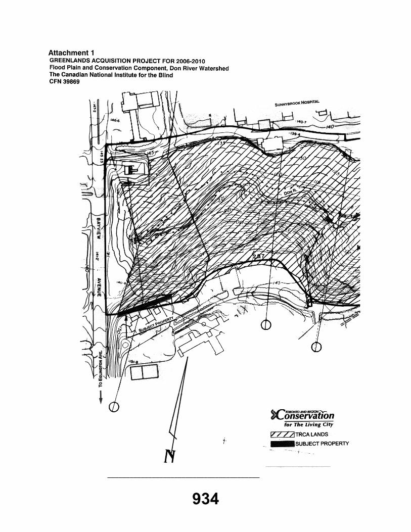
ES.#B133/07 - GREENLANDS ACQUISITION PROJECT FOR 2006-2010Flood Plain and Conservation Component, Don River WatershedThe Canadian National Institute for the Blind, CFN 39869. Purchase of property located east of Bayview Avenue, north of Kilgour Road (rear of 1929 Bayview Avenue), City of Toronto (North York Community Council Area), under the "Greenlands Acquisition Project for 2006-2010", Flood Plain and Conservation Component, Don River watershed.
Moved by: Richard WhiteheadSeconded by: Suzan Hall
THE EXECUTIVE COMMITTEE RECOMMENDS THAT 0.037 hectares (0.090 acres), more or less, of vacant land, being Part of Block 3 on Registered Plan 66M-2405, Part of Block 6 on Registered Plan 66M-2423, and Part of Lots 2 and 3, Concession 2 EYS, designated as Parts 10 to 21 on Plan 66R-22434, City of Toronto (North York Community Council Area), located east of Bayview Avenue, north of Kilgour Road (rear of 1929 Bayview Avenue), be purchased from The Canadian National Institute for the Blind;
THAT the purchase price be $2.00;
THAT Toronto and Region Conservation Authority (TRCA) receive conveyance of the land free from encumbrance, subject to existing service easements, and a Limiting Distance Agreement over Block 6 to restrict the construction of any buildings or structures over this portion of the lands;
THAT the firm of Gardiner Roberts LLP, Barristers & Solicitors, be instructed to complete the transaction at the earliest possible date. All reasonable expenses incurred incidental to the closing for land transfer tax, legal costs, and disbursements are to be paid;
AND FURTHER THAT the appropriate TRCA officials be authorized and directed to execute all necessary documentation required.
CARRIEDBACKGROUNDResolution #A260/05 at Authority Meeting #9/05, held on November 25, 2005, approved the Greenlands Acquisition Project for 2006-2010.
Negotiations have been conducted with Ms. Eugenia Bilokin of Blake, Cassels & Graydon LLP, Barristers & Solicitors, on behalf of The Canadian National Institute for the Blind.
Attached is a plan showing the location of the subject lands.
932

RATIONALEThe subject property falls within TRCA's approved master plan for acquisition for the Don River watershed as outlined in the approved Greenlands Acquisition Project for 2006-2010. Through the review of a Site Plan Control application for redevelopment of this site, TRCA staff established the limits of the open space lands (i.e. Parts 10 to 21 on Plan 66R-22434) which are comprised of a 5 metre tableland buffer of the Burke Brook valley corridor, a tributary of the West Don River.
TAXES AND MAINTENANCEIt is proposed that the lands be turned over to the City of Toronto for management.
FINANCIAL DETAILSFunds for the costs related to this purchase are available in the TRCA land acquisition capital account.
Report prepared by: George Leja, extension 5342Emails: [email protected] Information contact: George Leja, extension 5342 or Ron Dewell, extension 5245Emails: [email protected], [email protected]: October 12, 2007Attachments: 1
933
Attachment 1
_________________________________________
934

RES.#B134/07 - GREENLANDS ACQUISITION PROJECT FOR 2006-2010Flood Plain and Conservation Component, Rouge River WatershedTovtel Enterprises Inc., CFN 39906. Acquisition of a property located at 12479 Highway 48, north of Main Street and east of Highway No. 48, Town of Whitichurch-Stouffville, Regional Municipality of York, under the "Greenlands Acquisition Project for 2006-2010", Flood Plain and Conservation Component, Rouge River watershed.
Moved by: Richard WhiteheadSeconded by: Suzan Hall
THE EXECUTIVE COMMITTEE RECOMMENDS THAT 12.1 hectares (29.8 acres), more or less, of vacant land being Plan of Subdivision of Part of Lot 2, Concession 8 and designated as Blocks 2, 7 and 11 on draft M-Plan, prepared by Randy-Pentek & Edward Surveying Ltd., OLS under file #06-056, Town of Whitichurch-Stouffville, Regional Municipality of York, located at 12479 Highway 48, north of Main Street, east of Highway No. 48, Town of Whitichurch-Stouffville, Regional Municipality of York, be purchased from Tovtel Enterprises Inc.;
THAT the purchase price be $2.00;
THAT Toronto and Region Conservation Authority (TRCA) receive conveyance of the land free from encumbrance, subject to existing service easements;
THAT the firm of Gardiner Roberts LLP, Barristers & Solicitors, be instructed to complete the transaction at the earliest possible date. All reasonable expenses incurred incidental to the closing for land transfer tax, legal costs, and disbursements are to be paid by TRCA;
AND FURTHER THAT the appropriate TRCA officials be authorized and directed to execute all necessary documentation required.
CARRIEDBACKGROUNDResolution #A60/05 at Authority Meeting #9/05, held on November 25, 2005, approved the Greenlands Acquisition Project for 2006-2010.
Negotiations have been conducted with Ms. Elaine Crossland of Geranium Corporation.
As a condition of the subdivision approval, Tovtel Enterprises Inc. is to transfer the valleylands to TRCA.
935
Attached is a plan showing the location of the subject lands.
RATIONALEThe subject lands are identified as valleylands and fall within TRCA's approved master plan for acquisition for the Rouge River watershed as outlined in the approved Greenlands Acquisition Project for 2006-2010.
TAXES AND MAINTENANCEOn December 10, 2004, the Ontario government announced a regulation that expands the environmental criteria for lands that are eligible to receive a property tax exemption for the 2009 taxation year. Based on a preliminary review of the new criteria, it would appear that these lands will be eligible for the exemption. The addition of the subject parcel of land will not significantly impact TRCA's maintenance costs at this location.
FINANCIAL DETAILSFunds for the costs related to this purchase are available in the TRCA land acquisition capital account.
Report prepared by: Edlyn Wong, extension 5711Emails: [email protected] Information contact: Edlyn Wong, extension 5711, Ron Dewell, extension 5245Emails: [email protected], [email protected]: October 09, 2007Attachments: 1
936

Attachment 1
_________________________________________
937

RES.#B135/07 - REQUEST FOR EXCHANGE OF LANDDuke of Richmond Developments Inc., CFN 39919. Receipt of a request from Duke of Richmond Developments Inc. for an exchange of land to resolve a design deficiency with a stormwater management facility within the Duke West - Phase 3 residential subdivision, located east of Bathurst Street and south of Jefferson Sideroad, Town of Richmond Hill, Regional Municipality of York, Rouge River watershed.
Moved by: Richard WhiteheadSeconded by: Suzan Hall
THE EXECUTIVE COMMITTEE RECOMMENDS THAT WHEREAS Toronto and Region Conservation Authority (TRCA) is in receipt of a request from Duke of Richmond Developments Inc. for TRCA to enter into an exchange of lands to resolve a design deficiency with a stormwater management facility within the Duke West - Phase 3 residential subdivision, being Part of Lot 59, Concession 1 WYS, Town of Richmond Hill, Regional Municipality of York, located east of Bathurst Street and south of Jefferson Sideroad;
WHEREAS it is in the opinion of TRCA that it is in the best interest of TRCA in furthering its objectives, as set out in Section 20 of the Conservation Authorities Act, to proceed with the land exchange in this instance;
THEREFORE LET IT BE RESOLVED THAT TRCA enter into an exchange of lands with Duke of Richmond Developments Inc. on the following basis:
(a) Duke of Richmond Developments Inc. will convey to TRCA parcels of land containing 0.03 hectares (0.07 acres), more or less, described as Parts 1, 2 and 3 on a Plan of Survey prepared by Rady-Pentek & Edward Surveying Ltd., under their Job No. 04-092 dated September 19, 2007;
(b) TRCA will convey to Duke of Richmond Developments Inc. a parcel of land containing 0.03 hectares (0.07 acres), more or less, described as Part 4 on a Plan of Survey prepared by Rady-Pentek & Edward Surveying Ltd.;
(c) Completion of this sale is subject to any Planning Act approval that may be required;
(d) Duke of Richmond Developments Inc. is to pay all legal, survey and other costs, including any fees required for municipal approvals (e.g. consent to sever) as deemed necessary by the Town of Richmond Hill;
THAT the sale be subject to the Minister of Natural Resources in accordance with Section 21(2) of the Conservation Authorities Act, R.S.O. 1990, Chapter C.27, as amended, if required;
938

AND FURTHER THAT the appropriate TRCA officials be authorized and directed to take whatever action may be required to give effect hereto, including the obtaining of necessary approvals and the execution of any documents.
CARRIEDBACKGROUNDThe subject TRCA property was acquired from Duke of Richmond Developments Inc. on June 8, 2005 under the Natural Heritage Lands Protection and Acquisition Project for 2001-2005.
Attached is a plan showing the location of the subject lands.
At the time of acquisition, it was anticipated that the outlet and outfall from the Pond 10 stormwater management (SWM) facility would be located entirely within Block 432 of the Duke West - Phase 3 lands, as was originally established by the Functional Servicing Plan for the Duke of Richmond subdivision.
RATIONALEAt the detailed design stage, it was determined that a larger pond outlet area was required, in accordance with a SWM Pond Design Brief, dated August 22, 2007, which has been reviewed and accepted by TRCA technical staff. Essentially, the new outlet and outfall (i.e. Part 4 on Draft Plan of Survey) is needed to provide increased stormwater storage capacity within the Pond 10 SWM facility. Duke of Richmond Developments Inc. has offered to convey to TRCA an equal area of table land buffer adjacent to a valley corridor of a headwater tributary of the Rouge River (i.e. Parts 1, 2 & 3 on Draft Plan of Survey) in exchange for the land required for the larger pond outlet and outfall. Furthermore, the Town of Richmond Hill is in agreement with this land exchange and is prepared to accept conveyance of Block 432 once the SWM facility has been constructed to the satisfaction of the town's Engineering Department and Phase 3 of the subdivision has received final registration.
TAXES AND MAINTENANCENo increase in taxes is expected as part of this land exchange. The Town of Richmond Hill will be responsible for maintenance of the Block 432 SWM facility once all construction / restoration has been completed and a permanent easement has been registered in favour of the town as part the Duke West - Phase 3 development.
FINANCIAL DETAILSDuke of Richmond Developments Inc. is to pay all legal, survey, and other costs resulting from this transaction.
Report prepared by: George Leja, extension 5342Emails: [email protected] Information contact: George Leja, extension 5342 or Ron Dewell, extension 5245Emails: [email protected], [email protected]: October 17, 2007Attachments: 1
939

Attachment 1
_________________________________________
940

SECTION II - ITEMS FOR EXECUTIVE ACTION
RES.#B136/07 - APPLICATIONS FOR PERMITS PURSUANT TO ONTARIO REGULATION 166/06Development, Interference with Wetlands and Alterations to Shorelines and Watercourses. Pursuant to Ontario Regulation 166/06, written permission from the Authority is required for:
a) straightening, changing, diverting or interfering in any way with the existing channel of a river, creek, stream or watercourse, or for changing or interfering in any way with a wetland;
b) development, if in the opinion of the authority, the control of flooding, erosion, dynamic beaches or pollution or the conservation of land may be affected by the development.
A permit may be refused through a Hearing Process, if in the opinion of the Authority, the control of flooding, erosion, dynamic beaches, pollution or the conservation of land is affected.
Moved by: David BarrowSeconded by: Richard Whitehead
THAT permits be granted in accordance with Ontario Regulation 166/06 for the applications (8.1.1 - 8.1.33, inclusive, and 8.1.73 - 8.1.75, inclusive) which are listed below.
CARRIEDCITY OF BRAMPTON
8.1.1 PORT MARK INVESTMENTS LTD.To construct, reconstruct, erect or place a building or structure, site grade, temporarily or permanently place, dump or remove any material, originating on the site or elsewhere and alter a watercourse on Part Lot 8, Concession 9 NDS, in the City of Brampton, Humber River Watershed as located on the property owned by Port Mark Investments Ltd..
The purpose is to permit works within a regulated area to facilitate the construction of a stormwater management pond and outfall.
The permit will be issued for the period of November 2, 2007 to November 1, 2009 in accordance with the following documents and plans which form part of this permit:
sheet no. 21, Stormwater Management Facility Grading, prepared by Rand Engineering, dated June 2007, received by TRCA October 12, 2007;sheet no. 22, SWM Facility Details - inlet storm sewer, prepared by Rand Engineering, dated June 2007, received by TRCA October 12, 2007;sheet no. 23, SWM Facility Details - bypass storm sewer, prepared by Rand Engineering, dated June 2007, received by TRCA October 12, 2007;sheet no. 24, SWM Facility Details - outlet storm sewer, prepared by Rand Engineering, dated June 2007, received by TRCA October 12, 2007;
941
sheet no. 25, SWM Facility Details - quality control storm sewers, prepared by Rand Engineering, dated June 2007, received by TRCA October 12, 2007;sheet no. 26, Stormwater Management Facility Sections, prepared by Rand Engineering, dated June 2007, received by TRCA October 12, 2007;sheet no. 27, SWM Facility Details - bypass chamber, prepared by Rand Engineering, dated June 2007, received by TRCA October 12, 2007;sheet no. 28, SWM Facility Details - storm manhole 22 inlet structure, prepared by Rand Engineering, dated June 2007, received by TRCA October 12, 2007;sheet no. 29, Storm Outlet Details, prepared by Rand Engineering, dated June 2007, received by TRCA October 12, 2007;drawing no. SWM-1, SWM Pond Topsoil and Seeding Plan, prepared by MBTW Group, dated January 2007, last revised October 10, 2007, received by TRCA October 12, 2007;drawing no. SWM-2, SWM Pond BLK# 185 Planting Plan, prepared by MBTW Group, dated January 2007, last revised October 10, 2007, received by TRCA October 12, 2007;drawing no. SWM-3, SWM Pond Planting Details and Notes, prepared by MBTW Group, dated January 2007, last revised October 10, 2007, received by TRCA October 12, 2007.
RATIONALEThe application was reviewed by staff on the basis of the following information:
Proposal:The purpose of this application is to permit works within a regulated area to facilitate the construction of a stormwater management pond and outfall located west of McVean Drive and South of Castlemore Road, in the City of Brampton. These works are required to construct the approved stormwater management facilities associated with a draft approved residential subdivision, referred to as the Riverstone Phase II Community (also know as the 'Robinson' property). The stormwater management pond is located on the tableland portion of the site, and provides both water quantity and quality controls. The proposed outfall is located within the valley, and has been designed based on natural outfall design principles. TRCA technical staff have confirmed that the proposed works will not adversely impact any floodplain, geoenvironmental, and/or fisheries related matters. However, please note that a letter of advice on behalf of Fisheries and Oceans Canada (DFO) will be prepared prior to the issuance of this permit.
Control of Flooding:The works associated with the construction of the stormwater outfall will be located within the Regional Storm Floodplain associated with the adjacent valley system. However, TRCA technical staff are satisfied that these works will not adversely impact the flows and/or conveyance of floodwaters.
Pollution:Appropriate erosion and sediment controls have been proposed with this application, and will be maintained throughout all phases of construction.
942
Dynamic Beaches:Not applicable
Erosion:There are no geotechnical and/or slope stability concerns associated with this project.
Conservation of Land:No significant vegetation will be removed as a result of construction. However, as previously noted the stormwater water management pond and outfall are designed based on natural design principles including enhancement plantings and natural outfall channel design. There are no fisheries related concerns with this proposal.
PlantingsAll disturbed areas will be re-vegetated with native and non-invasive enhancement plantings consistent with TRCA's post-construction restoration guidelines.
Policy Guidelines:This proposal is in conformity with Section 4.3 - Infrastructure and Servicing, of the Authority's Valley and Stream Corridor Management Program
CFN: 38872 - Application #: 091/07/BRAMReport Prepared by: Joshua Campbell, extension 5386For information contact: Joshua Campbell, extension 5386Date: October 24, 2007
CITY OF MISSISSAUGA
8.1.2 CITY OF MISSISSAUGATo alter a watercourse located at 705 Matheson Boulevard, in the City of Mississauga, Etobicoke Creek Watershed as located on the property owned by City of Mississauga.
The purpose is to alter a watercourse located at 705 Matheson Boulevard, in the City of Mississauga, Etobicoke Creek Watershed as located on the property owned by City of Mississauga.
The permit will be issued for the period of November 2, 2007 to November 1, 2009 in accordance with the following documents and plans which form part of this permit:
Sheet 1 - Hershey Centre Relief Storm Sewer, STN 0+000 to STN 0+240, prepared by the City of Mississauga, revised June 2007, received by TRCA October 5, 2007;Sheet 2 - Hershey Centre Relief Storm Sewer, STN 0+240 to STN 0+342, prepared by the City of Mississauga, revised September 2007, received by TRCA October 5, 2007.
RATIONALEThe application was reviewed by staff on the basis of the following information:
943

Proposal:The purpose is to alter a watercourse to undertake the construction of a relief storm sewer and headwall to convey drainage from the Iceland Arena parking lot to the Timberlea watercourse. A 1500 mm relief storm sewer is proposed to convey drainage the Timberlea watercourse. This design is based on the Timberlea Boulevard Drainage Study, City of Mississauga, Class Environmental Assessment (EA), June 2005 and the Addendum to the Class EA September 2006. These documents have been reviewed and approved by TRCA.
Control of Flooding:TRCA engineering staff has reviewed the proposal and determined that the proposed works will have no impact to the control of flooding.
Pollution:Standard sediment and erosion control measures will be implemented and maintained for the duration of construction and until the site is stabilized and restored in order to prevent construction generated sediment from entering the watercourse.
Dynamic Beaches:Not applicable
Erosion:There will be no geotechnical/slope stability issues associated with the proposal.
Conservation of Land:With erosion and sedimentation plans in effect the potential for a harmful alteration, disruption or destruction (HADD) of fish habitat will be mitigated and a Letter of Advice will be written by TRCA staff on behalf of Fisheries and Oceans Canada (DFO).
PlantingsAll disturbed areas will be restored with native/non-invasive species following construction to provide a net environmental gain.
Policy Guidelines:This proposal complies with Section 4.3 - Infrastructure and Servicing of the Authority's Valley and Stream Corridor Management Program.
CFN: 39580 - Application #: 543/07/MISSReport Prepared by: Laura James, extension 5723For information contact: Laura James, extension 5723Date: October 23, 2007
CITY OF PICKERING
8.1.3 CITY OF PICKERINGTo site grade and temporarily or permanently place, dump or remove any material, originating on the site or elsewhere on (Douglas Avenue/Front Road/Wharf Road), in the City of Pickering, Frenchman's Bay Watershed as located on the property owned by City of Pickering.
944

The purpose is to undertake development by site grading and temporarily placing fill material within a Regulated Area.
The permit will be issued for the period of November 2, 2007 to November 1, 2009 in accordance with the following documents and plans which form part of this permit:
Drawing No. G-101, General Notes, prepared by SRM Associates, dated May 2007, engineer's stamp signed September 25, 2007, received by TRCA on October 1, 2007;Drawing No. P-101, Wharf Street, prepared by SRM Associates, dated May 2007, engineer's stamp signed September 25, 2007, received by TRCA on October 1, 2007;Drawing No. P-102, Sanitary easement, prepared by SRM Associates, dated May 2007, engineer's stamp signed September 25, 2007, received by TRCA on October 1, 2007;Drawing No. P-103, Front Road, prepared by SRM Associates, dated May 2007, engineer's stamp signed September 25, 2007, received by TRCA on October 1, 2007;Drawing No. P-104, Front Road, prepared by SRM Associates, dated May 2007, engineer's stamp signed September 25, 2007, received by TRCA on October 1, 2007;Drawing No. P-106, Douglas Ave., prepared by SRM Associates, dated May 2007, engineer's stamp signed September 25, 2007, received by TRCA on October 1, 2007;Drawing No. P-107, Pine Creek, prepared by SRM Associates, dated May 2007, engineer's stamp signed September 25, 2007, received by TRCA on October 1, 2007.
RATIONALEThe application was reviewed by staff on the basis of the following information:
Proposal:The applicant seeks permission to undertake development by grading and temporarily placing fill material within several Regulated Areas associated with Pine Creek and Frenchman's Bay. The proposed works involve the replacement of an existing sanitary sewer main with a larger main in order to accommodate a new residential development known as San Francisco by the Bay. This linear project in the Bay Ridges Neighbourhood of Pickering is to extend from Douglas Park in the north to a point southerly at the intersection of Liverpool Road and Wharf Street. A trench is to be excavated along the length of the sewer to be replaced. This excavation is to take place primarily along existing residential streets. However, a portion of the work is to take place within Douglas Park, which is adjacent to the valleylands of the Pine Creek.
Control of Flooding:No works are proposed within the Regional Storm Flood Plain. The control of flooding will not be affected.
Pollution:Sediment and Erosion Controls are to surround the works and are depicted on the drawings.
Dynamic Beaches:Not applicable
945

Erosion:There are no geotechnical or slope stability concerns associated with the proposed works.
Conservation of Land:As the majority of works are to take place within existing roadways or an active parklands, no significant vegetation is to be removed as part of the proposed works.
PlantingsSince no vegetation is to be removed, plantings were not made a requirement of this proposal.
Policy Guidelines:The proposal is consistent with Section 4.3., Infrastructure and Servicing, of the TRCA's Valley and Stream Corridor Management Program.
CFN: 39872 - Application #: 763/07/PICKReport Prepared by: Chris Jones, extension 5718For information contact: Chris Jones, extension 5718Date: October 23, 2007
8.1.4 504 ROUGEMOUNT DRIVETo change a building or structure so that it alters its use or potential use, increases its size or increases the number of dwelling units and site grade on Lot 99, 100, Plan 283, (504 Rougemount Drive), in the City of Pickering, Rouge River Watershed.
The purpose is to construct a new single storey addition and garage within a Regulated Area of the Rouge River Watershed.
The permit will be issued for the period of November 2, 2007 to November 1, 2009 in accordance with the following documents and plans which form part of this permit:
Drawing Number A-1, Site Plan, prepared by Barry C. McFarquhar, dated September 4, 2007, received September 17, 2007
RATIONALEThe application was reviewed by staff on the basis of the following information:
Proposal:The proposal consists of a single storey garage addition to the existing house. The rear of the property is adjacent to the Rouge River Valley. As the proposed addition is located at the side of the existing house there are no works being located closer to the valley. Further, the existing house and proposed addition are located approximately 10 metres from the valley.
Control of Flooding:The proposed works are not located within the Regional Storm Floodplain.
946

Pollution:Sediment fencing will be in place throughout the duration of construction in order to ensure that sediment will not enter the watercourse.
Dynamic Beaches:Not applicable
Erosion:There are no geotechnical issues associated with this application.
Conservation of Land:There will be no significant vegetation removed as part of this proposal.
PlantingsNo plantings are required as part of this application.
Policy Guidelines:This proposal is consistent with Section 4.2.2 C, Minor Additions, of the Authority's Valley and Stream Corridor Management Program (VSCMP).
CFN: 39790 - Application #: 710/07/PICKReport Prepared by: Shannon McNeill, extension 5744For information contact: Steve Heuchert, extension 5311Date: October 23, 2007
CITY OF TORONTO (ETOBICOKE YORK COMMUNITY COUNCIL AREA)
8.1.5 19 RIVERVIEW HEIGHTSTo construct, reconstruct, erect or place a building or structure and site grade on, (19 Riverview Heights), in the City of Toronto (Etobicoke York Community Council Area), Humber River Watershed.
The purpose is to develop within the Regulated Area of the Humber River Watershed in order to facilitate the construction of a veranda addition to the front of the existing dwelling, a deck to the rear of the existing dwelling and a replacement retaining wall at the top of bank in the rear yard of the property.
The permit will be issued for the period of November 2, 2007 to November 1, 2009 in accordance with the following documents and plans which form part of this permit:
Drawing No. A1, Site Plan, prepared by J.W. Birdsell Architect, dated October 2, 2007, received on October 24, 2007;Drawing No. A5, Proposed Elevations, prepared by J.W. Birdsell Architect, dated October 2, 2007, received on October 24, 2007;Drawing No. A6, Veranda Details, prepared by J.W. Birdsell Architect, dated October 2, 2007, received on October 24, 2007;
947

Drawing No. A7, Rear Deck Walk Out, prepared by J.W. Birdsell Architect, dated October 2, 2007, received on October 24, 2007;Drawing unnumbered, Retaining Wall Design Detail, prepared by A. Krishnar, P.Eng., Undated, received on October 17, 2007.
RATIONALEThe application was reviewed by staff on the basis of the following information:
Proposal:The purpose is to develop within the Regulated Area of the Humber River Watershed in order to facilitate the construction of veranda addition to the front of the existing dwelling, a deck to the rear of the existing dwelling and a replacement retaining wall at the top of bank in the rear yard at 19 Riverview Heights. The subject site is located west of Weston Road, north of Lawrence Avenue West and adjacent to Cruckshank Park.
Control of Flooding:The site is not located within a Regional Storm Flood Plain and the proposal will have no impact on the storage and/or conveyance of floodwaters.
Pollution:A temporary sediment control fence will be installed to prevent construction debris from entering the valley.
Dynamic Beaches:Not applicable.
Erosion:A geotechnical slope and stability report has been reviewed and approved by TRCA geotechnical engineering staff and the proposal will be constructed in accordance with the recommendations of this report. The proposed deck is adequately set back from the stable top of bank.
Conservation of Land:No significant vegetation will be removed as a result of construction.
PlantingsNo plantings are required as part of this application.
Policy Guidelines:The proposal is consistent with Section 4.2.2., Development and Redevelopment/Intensification within Non-Established Communities/Highly Urbanized Areas, of the TRCA's Valley and Stream Corridor Management Program.
CFN: 39333 - Application #: 361/07/TORReport Prepared by: Nicole Moxley, extension 5284For information contact: Steve Heuchert, extension 5311Date: October 24, 2007
948

8.1.6 164 EDENBRIDGE DRIVETo construct, reconstruct, erect or place a building or structure, site grade and temporarily or permanently place, dump or remove any material, originating on the site or elsewhere on Lot 19, Plan 789, (164 Edenbridge Drive), in the City of Toronto (Etobicoke York Community Council Area), Humber River Watershed.
The purpose is to construct a new two storey dwelling and swimming pool, and site grade within a Regulated Area of the Humber River Watershed. The existing dwelling will be demolished.
The permit will be issued for the period of November 2, 2007 to November 1, 2009 in accordance with the following documents and plans which form part of this permit:
Drawing No. A1.0, Site Plan/Project Statistics/Building Section, prepared by Eugene Kuan Architect, Revision No. 9, revised on May 31, 2007, received on October 23, 2007;Drawing No. A3.1, West and East Elevation, prepared by Eugene Kuan Architect, dated October 2006, Revision No. 1, revised on October 7, 2006, received on October 23, 2007;Drawing No. A3.2, North and South Elevation, prepared by Eugene Kuan Architect, dated October 2006, Revision No. 1, revised on October 7, 2006, received on October 23, 2007;Drawing No. L-1, Existing conditions, Tree Survey, & Tree Protection, prepared by Quinn Design Associates, dated February 25, 2005, Revision No. 2, revised on February 13, 2007, received on October 23, 2007;Drawing No. L-2, Grading Plan, prepared by Quinn Design Associates, dated February 25, 2005, Revision No. 2, revised on February 13, 2007, received on October 23, 2007;Drawing No. L-3, Hard Landscape Layout Plan, prepared by Quinn Design Associates, dated February 25, 2005, Revision No. 2, revised on February 13, 2007, received on October 23, 2007;Drawing No. L-4, Planting Plan, prepared by Quinn Design Associates, dated February 25, 2005, Revision No. 2, revised on February 13, 2007, received on October 23, 2007;Drawing No. L-5, Details, prepared by Quinn Design Associates, dated February 25, 2005, Revision No. 2, revised on February 13, 2007, received on October 23, 2007.
RATIONALEThe application was reviewed by staff on the basis of the following information:
Proposal:The proposal is to construct a new two-storey dwelling and swimming pool, and site grade within a Regulated Area of the Humber River. The existing dwelling will be demolished. The subject property is located east of Royal York Road and south of Eglinton Avenue West. All works are sufficiently setback from the creek that traverses the rear of the subject property.
Control of Flooding:The proposal is not located within a Regional Storm Floodplain and therefore will not impact the storage or conveyance of flood waters.
949

Pollution:A sediment control fence will be installed and maintained during construction to prevent debris from entering the adjacent creek.
Dynamic Beaches:Not applicable.
Erosion:Not applicable.
Conservation of Land:TRCA geo-technical staff have reviewed the geo-technical report submitted by the applicant and confirm that there are no slope stability concerns. There will be no impact on significant natural features. The City of Toronto will be undertaking an Environmental Assessment to identify the preferred option for rehabilitating the tributary of the Humber River that traverses the rear of the subject property. A 4.5 metre construction easement has been provided in advance of the Environmental Assessment to any future creek rehabilitation works to allow for construction access in the future.
PlantingsNative and non-invasive species will be planted.
Policy Guidelines:The proposal is consistent with Section 4.2.2.D., Replacement Structures, and 4.2.2.E., Property Improvements and Ancillary Structures, of the Authority's Valley and Stream Corridor Management Program.
CFN: 35256 - Application #: 089/04/TORReport Prepared by: Steve Heuchert, extension 5311For information contact: Steve Heuchert, extension 5311Date: October 23, 2007
8.1.7 102 NORTH DRIVETo construct, reconstruct, erect or place a building or structure on Part Lot 56, Plan 965, (102 North Drive), in the City of Toronto (Etobicoke York Community Council Area), Humber River Watershed.
The purpose is to develop within the Regulated Area of the Humber River watershed in order to facilitate the development of a ground floor addition to the rear of the existing 1.5 storey dwelling.
The permit will be issued for the period of November 2, 2007 to November 1, 2009 in accordance with the following documents and plans which form part of this permit:
Drawing No. A1.2, Site Plan, prepared by Hicks Partnership Inc., dated August 27, 2007, Revision No. 5, revised on September 6, 2007, received on September 7, 2007.
950

RATIONALEThe application was reviewed by staff on the basis of the following information:
Proposal:The purpose is to develop within the Regulated Area of the Humber River watershed in order to facilitate the development of a ground floor addition to the rear of the existing 1.5 storey dwelling. The subject site is located south of Eglinton Avenue West, east of Royal York Road, and north of a tributary of the Humber River.
Control of Flooding:The site is not located within a Regional Storm Flood Plain and the proposal will have no impact on the storage and/or conveyance of floodwaters.
Pollution:A temporary sediment control fence will be installed to prevent construction debris from entering the valley and stream corridor.
Dynamic Beaches:Not applicable.
Erosion:There are no geotechnical concerns associated with this application.
Conservation of Land:No significant vegetation will be removed as a result of construction.
PlantingsNo plantings are required as a part of this application. Urban Forestry guidelines pertaining to tree protection and maintenance during construction will be implemented.
Policy Guidelines:The proposal is consistent with Section 4.2.2.C., Minor Additions, of the TRCA's Valley and Stream Corridor Management Program.
CFN: 39754 - Application #: 672/07/TORReport Prepared by: Nicole Moxley, extension 5284For information contact: Steve Heuchert, extension 5311Date: October 24, 2007
8.1.8 4 ROSALIE AVENUETo construct, reconstruct, erect or place a building or structure on Lot 201, Plan 3855, (4 Rosalie Avenue), in the City of Toronto (Etobicoke York Community Council Area), Humber River Watershed.
The purpose is to develop within a Regulated Area of the Humber River watershed in order to facilitate the construction of a single-storey addition to the rear of an existing dwelling to be used for storage.
951

The permit will be issued for the period of November 2, 2007 to November 1, 2009 in accordance with the following documents and plans which form part of this permit:
Drawing unnumbered, Site Plan, prepared by the property owner, undated, received September 12, 2007;Drawing unnumbered, East Elevations, prepared by the property owner, undated, received September 12, 2007;Drawing unnumbered, West Elevation, prepared by the property owner, undated, received September 12, 2007;Drawing unnumbered, North Elevation, prepared by the property owner, undated, received September 12, 2007;Drawing unnumbered, Detail "D", prepared by the property owner, undated, received September 12, 2007.
RATIONALEThe application was reviewed by staff on the basis of the following information:
Proposal:The proposed works consist of a single-storey addition to the rear of an existing dwelling to be used as a greenhouse and storage. The subject property is located within the Regional Flood Plain of the Humber River, north of Wilson Avenue, and west of Jane Street in the City of Toronto.
Control of Flooding:The proposed addition is non-habitable, is minor in nature and will not result in unacceptable impacts to flood storage and/or conveyance.
Pollution:The subject property is well removed from the watercourse and therefore sediment fencing is not required.
Dynamic Beaches:Not applicable.
Erosion:There are no geotechnical concerns associated with this application.
Conservation of Land:No significant vegetation will be removed as a result of construction.
PlantingsNo plantings are required as part of this application.
Policy Guidelines:This proposal is consistent with Section 4.2.2., Development and Redevelopment/Intensification within Non-Established Communities/Highly Urbanized Areas, of the TRCA's Valley and Stream Corridor Management Program.
952

CFN: 39775 - Application #: 694/07/TORReport Prepared by: Nicole Moxley, extension 5284For information contact: Steve Heuchert, extension 5311Date: October 23, 2007
8.1.9 MARKLAND WOOD COUNTRY CLUBTo construct, reconstruct, erect or place a building or structure, site grade, temporarily or permanently place, dump or remove any material, originating on the site or elsewhere and alter a watercourse on (245 Markland Drive), in the City of Toronto (Etobicoke York Community Council Area), Etobicoke Creek Watershed.
The purpose is to remove three existing on-line ponds contained by stop log structures on Renforth Creek and realign and rehabilitate Renforth Creek. Realignment and renovations are also proposed for Holes 12 through 15.
The permit will be issued for the period of November 2, 2007 to November 1, 2009 in accordance with the following documents and plans which form part of this permit:
Letter of Undertaking, prepared by Markland Wood Country Club, dated and received October 22, 2007.
RATIONALEThe application was reviewed by staff on the basis of the following information:
Proposal:It is proposed to remove three existing on-line ponds contained by stop log structures (fish barriers) on Renforth Creek. Sediment will be removed from the existing ponds and the ponds filled. Renforth Creek will be realigned and rehabilitated for a distance of approximately 350 metres. The applicant will be implementing natural channel design to improve the appearance and function of Renforth Creek. The existing creek is lined in sections with gabion baskets and armour stone which will be removed and replaced with natural stone bed and banks. Some regrading work within the new creek channel will be required to create a natural channel form with new pools and riffles situated in several locations. It is expected that the removal of the ponds and stop log structures and rehabilitation of the creek will resolve a long standing violation on the subject property under Lakes and Rivers Improvement Act (LRIA) . It is our understanding that the applicant has applied for a permit to the Ministry of Natural Resources under the LRIA for the removal of the stop log structures.
In conjunction with the channel works, the applicant will be realigning and renovating Holes 12 through 15 which are located in the vicinity of the Renforth Creek. The renovation works include site grading work to realign and reshape fairways, tees and cart paths and well as the removal and replacement of a pedestrian/golf cart bridge.
953

Control of Flooding:The proposed works are located within the Regional Storm Floodplain, however the works will not affect the storage or conveyance of flood waters.
Pollution:Silt fencing and coffer dams will be secured around all construction areas to prevent the migration of construction generated sediment into the watercourse.
Dynamic Beaches:Not applicable
Erosion:There are no geotechnical issues with the proposed works.
Conservation of Land:All filled and disturbed areas will be stabilized and revegetated following construction. No significant resource features will be impacted by the proposed works. There will be no impact to fisheries as all work will be conducted in the dry. The proposed works will have no impact to fisheries and will not result in a HADD. A Letter of Advice will be issued on behalf of DFO.
PlantingsNew riparian plantings of native trees and shrubs will line both sides of the Renforth Creek. The width of the riparian planting zone is expected to range from 5 and 10 metres from the top of the creek bank depending on the proximity of the creek to the play areas of the golf course.
Policy Guidelines:The proposal complies with Section 4.4.2 (H) Existing Resource-Based Uses - of the Authority's Valley and Stream Corridor Management Program.
CFN: 39700 - Application #: 629/07/TORReport Prepared by: Mark Rapus, extension 5259For information contact: Mark Rapus, extension 5259Date: October 23, 2007
8.1.10 15 BONNYVIEW DRIVETo change a building or structure so that it alters its use or potential use, increases its size or increases the number of dwelling units on Lot 52, Plan 2234, (15 Bonnyview Drive), in the City of Toronto (Etobicoke York Community Council Area), Waterfront Watershed.
The purpose is to develop within a Regulated Area of the Mimico Creek watershed in order to facilitate the construction of a second storey addition and attached garage addition to the existing dwelling. The existing detached garage is to be demolished.
The permit will be issued for the period of November 2, 2007 to November 1, 2009 in accordance with the following documents and plans which form part of this permit:
954

Drawing No. 0, Site Plan Proposed, prepared by Voytek S. Architect, undated, received on September 11, 2007;Drawing No. 5, Front El. Proposed, prepared by Voytek S. Architect, undated, received on September 11, 2007;Drawing No. 6, Rear El. Proposed, prepared by Voytek S. Architect, undated, received on September 11, 2007;Drawing No. 7, Side El. (South) Proposed, prepared by Voytek S. Architect, undated, received on September 11, 2007;Drawing No. 8, Side El. (North) Proposed, prepared by Voytek S. Architect, undated, received on September 11, 2007.
RATIONALEThe application was reviewed by staff on the basis of the following information:
Proposal:The purpose is to develop within a Regulated Area of the Mimico Creek watershed in order to facilitate the construction of a second storey addition and attached garage addition to the existing dwelling. The existing detached garage is to be demolished. The works are being constructed within the regulatory flood plain.
Control of Flooding:The property is partially located within a regulatory flood plain. The majority of the additions will not be constructed within the flood plain and therefore will not have an impact on the storage and/or conveyance of flood waters.
Pollution:Sediment fencing is not required as the proposed works are adequately set back from the valley and stream corridor.
Dynamic Beaches:Not applicable.
Erosion:There are no geotechnical concerns associated with the proposed development. An additional permit as per Ontario Regulation 166/06 will be required if the existing retaining wall to the rear of the existing detached garage is to be restored.
Conservation of Land:No significant vegetation will be removed as a result of construction.
PlantingsGuidelines as per City of Toronto Urban Forestry Division pertaining to tree protection and maintenance during demolition and construction will be implemented.
955
Policy Guidelines:This proposal is consistent with Section 4.2.2., Development and Redevelopment/Intensification within Non-Established Communities/Highly Urbanized Areas, of the TRCA's Valley and Stream Corridor Management Program.
CFN: 39727 - Application #: 651/07/TORReport Prepared by: Nicole Moxley, extension 5284For information contact: Steve Heuchert, extension 5311Date: October 23, 2007
8.1.11 58 RIDGEVALLEY CRESCENTTo construct, reconstruct, erect or place a building or structure, site grade and temporarily or permanently place, dump or remove any material, originating on the site or elsewhere on Lot 31, Plan 3515, (58 Ridgevalley Crescent), in the City of Toronto (Etobicoke York Community Council Area), Humber River Watershed.
The purpose is to develop within a Regulated Area of the Humber River watershed in order to facilitate the construction of a new two-storey single family detached dwelling. The existing single-storey dwelling is to be demolished.
The permit will be issued for the period of November 2, 2007 to November 1, 2009 in accordance with the following documents and plans which form part of this permit:
Drawing No. 1 of 1, Siting and Grading Plan, prepared by Viljoen Architect Inc., dated July 3, 2007, received on September 12, 2007;Drawing No. 4 of 9, Left Side Elevation, prepared by Viljoen Architect Inc., dated August 2007, received on September 12, 2007;Drawing No. 5 of 9, Front Elevation, prepared by Viljoen Architect Inc., dated August 2007, received on September 12, 2007;Drawing No. 6 of 9, Right Side Elevation, prepared by Viljoen Architect Inc., dated August 2007, received on September 12, 2007;Drawing No. 7 of 9, Rear Elevation, prepared by Viljoen Architect Inc., dated August 2007, received on September 12, 2007.
RATIONALEThe application was reviewed by staff on the basis of the following information:
Proposal:The purpose is to develop within a Regulated Area of the Humber River watershed in order to facilitate the construction of a new two-storey single family detached dwelling. The existing single-storey dwelling is to be demolished.
Control of Flooding:The site is not located within a Regional Storm flood plain and the proposal will have no impact on the storage and/or conveyance of floodwater.
956

Pollution:Sediment fencing is not required as the proposed works are adequately set back from the valley and stream corridor.
Dynamic Beaches:Not applicable.
Erosion:There are no geotechnical concerns associated with this application.
Conservation of Land:The appropriate tree protection fencing will be installed.
PlantingsGuidelines as per City of Toronto Urban Forestry Division pertaining to tree protection and maintenance during demolition and construction will be implemented.
Policy Guidelines:This proposal is consistent with Section 4.2.2., Development and Redevelopment/Intensification within Non-Established Communities/Highly Urbanized Areas, of the TRCA's Valley and Stream Corridor Management Program.
CFN: 39772 - Application #: 690/07/TORReport Prepared by: Nicole Moxley, extension 5284For information contact: Steve Heuchert, extension 5311Date: October 23, 2007
CITY OF TORONTO (NORTH YORK COMMUNITY COUNCIL AREA)
8.1.12 BLACK MARLIN MANAGEMENT LTD.To construct, reconstruct, erect or place a building or structure on Lot 54, Plan 2395, (70 Sandringham Drive), in the City of Toronto (North York Community Council Area), Don River Watershed as located on the property owned by Black Marlin Management Ltd..
The purpose is to develop within a Regulated Area of the Don River watershed to facilitate construction of a new two-storey dwelling at 70 Sandringham Drive. The existing dwelling is to be demolished.
The permit will be issued for the period of November 2, 2007 to November 1, 2009 in accordance with the following documents and plans which form part of this permit:
Drawing No. A-1, Site Plan, prepared by Daniel Meneguzzi Design Inc., dated June 2006, received by TRCA September 20, 2007;Drawing No. L-2, Landscape Plan, prepared by Daniel Meneguzzi Design Inc., dated June 2006, received by TRCA September 20, 2007;
957

Drawing No. G-1, Grading Plan, prepared by Daniel Meneguzzi Design Inc., dated June 2006, received by TRCA September 20, 2007.
RATIONALEThe application was reviewed by staff on the basis of the following information:
Proposal:The proposed works include construction of a new two-storey dwelling and landscaping works at 70 Sandringham Drive in the City of Toronto. The site is located west of Yonge Street, south of Highway 401. The existing dwelling is to be demolished.
Control of Flooding:The proposed works are not located in the floodplain.
Pollution:Sediment control fencing will be installed prior to commencement of any construction or grading works, and will remain in place until the proposed works have been completed and any exposed areas have been stabilized.
Dynamic Beaches:Not applicable
Erosion:There are no geotechnical concerns associated with this application.
Conservation of Land:No significant vegetation will be removed as a result of construction. Appropriate tree protection fencing will be installed.
PlantingsNative tree shrubs and seed mix will be planted.
Policy Guidelines:This proposal is consistent with Section 4.2.2.D, Replacement Structures, of the TRCA's Valley and Stream Corridor Management Program.
CFN: 39851 - Application #: 751/07/TORReport Prepared by: Michelle Stafford, extension 5250For information contact: Steve Heuchert, extension 5311Date: October 23, 2007
8.1.13 22 YORK VALLEY CRESENTTo construct, reconstruct, erect or place a building or structure and site grade on Lot 19, Plan 5982, (22 York Valley Crescent), in the City of Toronto (North York Community Council Area), Don River Watershed.
958
The purpose is to develop within a Regulated Area of the Don River watershed to facilitate construction of a new single family dwelling at 22 York Valley Crescent in the City of Toronto. The existing dwelling is to be demolished.
The permit will be issued for the period of November 2, 2007 to November 1, 2009 in accordance with the following documents and plans which form part of this permit:
Drawing No. A-1, Site Plan, prepared by ManArch Design, dated August 2007, revised October 5, 2007, received on October 16, 2007;Drawing No. A1.1, Site Grading Plan, prepared by H. Piller Corporation Ltd., dated October 8, 2007, received on October 16, 2007.
RATIONALEThe application was reviewed by staff on the basis of the following information:
Proposal:The proposed works include construction of a new two-storey dwelling. The site is located south of York Mills Road, east of Yonge Street. Although the site is partially located in the Hoggs Hollow Special Policy Area (SPA), the proposed works are located outside of the SPA limit. The existing dwelling is to be demolished.
Control of Flooding:The site is partially located in the floodplain. The proposed works will be floodproofed to the Regional Storm Flood event.
Pollution:Sediment fencing is not required as the proposed works are located in the valley and are adequately set back from the watercourse.
Dynamic Beaches:Not applicable
Erosion:There are no geotechnical concerns associated with this application.
Conservation of Land:The proposed works are further set back from the toe-of-slope than the existing dwelling. The appropriate tree protection fencing will be installed.
PlantingsNo plantings are required as part of this project.
Policy Guidelines:This proposal is consistent with Section 4.2.2.D, Replacement Structures, of the TRCA's Valley and Stream Corridor Management Program.
959

CFN: 39937 - Application #: 807/07/TORReport Prepared by: Michelle Stafford, extension 5250For information contact: Steve Heuchert, extension 5311Date: October 23, 2007
8.1.14 43 SAGEBRUSH LANETo change a building or structure so that it alters its use or potential use, increases its size or increases the number of dwelling units and temporarily or permanently place, dump or remove any material, originating on the site or elsewhere on Lot 176, Plan 5544, (43 Sagebrush Lane), in the City of Toronto (North York Community Council Area), Don River Watershed.
The purpose is to develop in the Regulated Area of the Don River watershed to facilitate construction of a two-storey addition to the rear of the existing dwelling at 43 Sagebrush Lane in the City of Toronto. The subject property is located south of York Mills Road, east of the Don Valley Parkway.
The permit will be issued for the period of November 2, 2007 to November 1, 2009 in accordance with the following documents and plans which form part of this permit:
Drawing No. A2.01, Site Plan OBC Matrix and Key Plan, prepared by Taylor Smyth Architects, dated June 14, 2007, received by TRCA October 12, 2007
RATIONALEThe application was reviewed by staff on the basis of the following information:
Proposal:The proposed works include construction of a two-storey addition to the rear of the existing two-storey dwelling at 43 Sagebrush Lane in the City of Toronto. The subject property is located south of York Mills Road, east of the Don Valley Parkway.
Control of Flooding:The site is not located within the Regional Storm Floodplain.
Pollution:Sediment control fencing will be erected in the form of tree hoarding prior to commencement of any construction or grading works and will remain in place until the proposed works have been completed.
Dynamic Beaches:Not applicable
Erosion:There are no geotechnical concerns associated with this application.
960

Conservation of Land:The proposed works are adequately set back from top of bank. The appropriate tree protection fencing will be installed.
PlantingsNative tree shrubs and seed mix will be planted along top of bank.
Policy Guidelines:The proposal is consistent with Section 4.2.2, Development and Redevelopment/Intensification within Non-Established Communities/Highly Urbanized Areas, of the TRCA's Valley and Stream Corridor Management Program.
CFN: 39044 - Application #: 152/07/TORReport Prepared by: Michelle Stafford, extension 5250For information contact: Steve Heuchert, extension 5311Date: October 23, 2007
8.1.15 87 DONWOODS DRIVETo construct, reconstruct, erect or place a building or structure on Lot 39, Plan 2405, (87 Donwoods Drive), in the City of Toronto (North York Community Council Area), Don River Watershed.
The purpose is to develop within a Regulated Area of the Don River watershed to facilitate construction of a new two-storey dwelling. The existing dwelling is to be demolished.
The permit will be issued for the period of November 2, 2007 to November 1, 2009 in accordance with the following documents and plans which form part of this permit:
Drawing No. A1, Site Plan, prepared by Rowan Stanciu Ltd., dated September 14, 2007, received by TRCA September 28, 2007
RATIONALEThe application was reviewed by staff on the basis of the following information:
Proposal:The proposed works include construction of a new two-storey dwelling at 87 Donwoods Drive in the City of Toronto. The site is located south of York Mills Road, east of Yonge Street. The existing dwelling is to be demolished.
Control of Flooding:The proposed works are not located in the Regional Storm Floodplain.
Pollution:Sediment fencing is not required as the proposed works are adequately set back from the watercourse
961

Dynamic Beaches:Not applicable
Erosion:There are no geotechnical concerns associated with this application.
Conservation of Land:The appropriate tree protection fencing will be installed.
PlantingsNative tree shrubs and seed mix will be planted on site.
Policy Guidelines:The proposal is consistent with Section 4.2.2.D, Replacement Structures, of the TRCA's Valley and Stream Corridor Management Program.
CFN: 39860 - Application #: 752/07/TORReport Prepared by: Michelle Stafford, extension 5250For information contact: Steve Heuchert, extension 5311Date: October 23, 2007
8.1.16 42 HAWKSBURY DRIVETo construct, reconstruct, erect or place a building or structure on Lot 64, Plan 4847, (42 Hawksbury Drive), in the City of Toronto (North York Community Council Area), Don River Watershed.
The purpose is to develop within a Regulated Area of the Don River watershed to facilitate construction of a new dwelling. The existing dwelling is to be demolished.
The permit will be issued for the period of November 2, 2007 to November 1, 2009 in accordance with the following documents and plans which form part of this permit:
Drawing No. A1, Site Plan, prepared by Rowan Stanciu Ltd., dated August 17, 2007, received by TRCA August 23, 2007
RATIONALEThe application was reviewed by staff on the basis of the following information:
Proposal:The proposed works consist of construction of a new two-storey dwelling and rear deck at 42 Hawksbury Drive in the City of Toronto. The site is located east of Bayview Avenue and north of Sheppard Avenue East. The existing single-family dwelling is to be demolished.
Control of Flooding:The proposed structure will be floodproofed to the Regional Storm Flood event.
962

Pollution:Sediment fencing is not required as the proposed works are adequately set back from the watercourse.
Dynamic Beaches:Not applicable
Erosion:A geotechnical letter of opinion has been reviewed and approved by TRCA geotechnical engineering staff and the proposed works will be adequately set back from the top of bank.
Conservation of Land:No significant vegetation will be removed as a result of construction.
PlantingsNo plantings are required as part of this project.
Policy Guidelines:The proposal is consistent with Section 4.2.2.D, Replacement Structures, of the TRCA's Valley and Stream Corridor Management Program.
CFN: 39684 - Application #: 616/07/TORReport Prepared by: Michelle Stafford, extension 5250For information contact: Steve Heuchert, extension 5311Date: October 23, 2007
8.1.17 ROSEDALE GOLF CLUBTo temporarily or permanently place, dump or remove any material, originating on the site or elsewhere on (1901 Mount Pleasant Road), in the City of Toronto (North York Community Council Area), Don River Watershed as located on the property owned by Rosedale Golf Club.
The purpose is to place fill within a Regulated Area of the Don River Watershed.
The permit will be issued for the period of November 2, 2007 to November 1, 2009 in accordance with the following documents and plans which form part of this permit:
Drawing Number ASC, Access Plan, prepared by Rosedale Golf Club, dated November 5, 2006, received October 12, 2007
RATIONALEThe application was reviewed by staff on the basis of the following information:
963

Proposal:The purpose of the application is place fill within a Regulated Area in order to construct a berm. The berm will be located adjacent to an irrigation pond which will be dredged to provide the fill material for construction of the berm. The berm will be approximately 30 metres by 100 metres and 1.5 metres in height. The berm will be created adjacent to vegetation but there will be no fill placed within the drip line of the vegetation.
Control of Flooding:The proposed works are not located within the Regional Storm Floodplain.
Pollution:Sediment fencing will be in place throughout the duration of construction to ensure that no sediment will be placed within the drip line of the vegetation.
Dynamic Beaches:Not applicable
Erosion:There are no geotechnical issues associated with this application.
Conservation of Land:The berm will be sodded once complete in order to maintain its stability.
PlantingsAll seed mixtures will be consistent with TRCA's guidelines.
Policy Guidelines:This proposal is consistent with Section 4.2.2 E, Property Improvements and Ancillary Structures, of the Authority's Valley and Stream Corridor Management Program (VSCMP).
CFN: 39632 - Application #: 583/07/TORReport Prepared by: Shannon McNeill, extension 5744For information contact: Steve Heuchert, extension 5311Date: October 23, 2007
8.1.18 21 MONTRESSOR DRIVETo construct, reconstruct, erect or place a building or structure on Lot 378, Plan M-866, (21 Montressor Drive), in the City of Toronto (North York Community Council Area), Don River Watershed.
The purpose is to develop within a Regulated Area of the Don River watershed to facilitate construction of a new dwelling. The existing dwelling is to be demolished.
The permit will be issued for the period of November 2, 2007 to November 1, 2009 in accordance with the following documents and plans which form part of this permit:
964

Drawing No. A-1, Site Plan, prepared by M-Arch Design Group Inc., dated August 2007, received on August 22, 2007.
RATIONALEThe application was reviewed by staff on the basis of the following information:
Proposal:The proposed works include construction of a new dwelling and in-ground swimming pool at 21 Montressor Drive in the City of Toronto. The site is located west of Bayview Avenue, north of York Mills Road. The existing dwelling is to be demolished.
Control of Flooding:The proposed works are not located in the Regional Storm Floodplain.
Pollution:A sediment control fence will be erected before commencement of any construction or grading works and will remain in place until the proposed works have been completed and any exposed areas will have been stabilized.
Dynamic Beaches:Not applicable
Erosion:There are no geotechnical concerns associated with this application.
Conservation of Land:No significant vegetation will be removed as a result of construction.
PlantingsNo plantings are required as part of this project.
Policy Guidelines:This proposal is consistent with Section 4.2.2.D, Replacement Structures, of the TRCA's Valley and Stream Corridor Management Program.
CFN: 39672 - Application #: 606/07/TORReport Prepared by: Michelle Stafford, extension 5250For information contact: Steve Heuchert, extension 5311Date: October 23, 2007
8.1.19 16 DONINO AVENUETo construct, reconstruct, erect or place a building or structure on Lot 72, Plan 2343, (16 Donino Avenue), in the City of Toronto (North York Community Council Area), Don River Watershed.
965

The purpose is to develop within the Regulated Area of the Don River watershed to facilitate construction of a new two-storey dwelling. The existing dwelling is to be demolished.
The permit will be issued for the period of November 2, 2007 to November 1, 2009 in accordance with the following documents and plans which form part of this permit:
Drawing No. 01, Site Plan & Information, prepared by PAAR Architecture & Interior Design Inc., undated, received on staff October 12, 2007;Drawing No. 06, Landscape Plan, prepared by Urban Forest Associates Inc., dated August 27, 2007, redlined by City of Toronto staff October 11, 2007, received on October 12, 2007.
RATIONALEThe application was reviewed by staff on the basis of the following information:
Proposal:The proposed works include construction of a new two-storey dwelling with basement and subbasement at 16 Donino Avenue in the City of Toronto. The site is located south of York Mills Road, east of Yonge Street. The existing dwelling is to be demolished.
Control of Flooding:The site is not located in the Regional Storm Floodplain.
Pollution:A sediment control fence will be erected before commencement of any construction or grading works and will remain in place until the proposed works have been completed and any exposed areas have been stabilized.
Dynamic Beaches:Not applicable
Erosion:There are no geotechnical concerns associated with this application.
Conservation of Land:The appropriate tree protection fencing will be installed.
PlantingsNative tree shrubs and seed mix will be planted along the slope and a ravine stewardship plan will be implemented for the site.
Policy Guidelines:The proposal is consistent with Section 4.2.2., Development and Redevelopment/Intensification within Non-Established Communities/Highly Urbanized Areas, of the TRCA's Valley and Stream Corridor Management Program.
966

CFN: 39926 - Application #: 794/07/TORReport Prepared by: Michelle Stafford, extension 5250For information contact: Steve Heuchert, extension 5311Date: October 23, 2007
CITY OF TORONTO (SCARBOROUGH COMMUNITY COUNCIL AREA)
8.1.20 WAREHOUSE PROPERTIES LIMITEDTo construct, reconstruct, erect or place a building or structure and site grade on (25 Metropolitan Road), in the City of Toronto (Scarborough Community Council Area), Highland Creek Watershed as located on the property owned by Warehouse Properties Limited.
The purpose is to construct a new commercial building and grade within a Regulated Area of the Highland Creek Watershed.
The permit will be issued for the period of November 2, 2007 to November 1, 2009 in accordance with the following documents and plans which form part of this permit:
Drawing Number A101, Site Plan, prepared by ADG Architectural Design Group, dated December 2006, received October 9, 2007;Drawing Number L1, Landscape Plan, prepared by Nak Design Group, dated March 21, 2007, received October 9, 2007.
RATIONALEThe application was reviewed by staff on the basis of the following information:
Proposal:The purpose of the application is to construct a new commercial building within a Regulated Area of the Highland Creek. The subject property is located at the head waters of the Highland Creek. There is a remnant stream located at the rear of the property. This feature has been determined by TRCA ecology staff to provide flow to the Highland Creek and will be maintained and enhanced.
Control of Flooding:The works are not located within the Regional Storm Floodplain.
Pollution:Sediment fencing will be in place throughout the duration of construction.
Dynamic Beaches:Not applicable
Erosion:There are no erosion issues associated with this application.
967
Conservation of Land:The feature located on site will be maintained. The applicant will be planting around the extent of the feature to provide improved function of the feature and a net ecological gain.
PlantingsAll plantings will be in accordance with TRCA's guidelines.
Policy Guidelines:This proposal is consistent with Section 4.2.2 G, Infilling, of the Authority's Valley and Stream Corridor Management Program (VSCMP).
CFN: 39347 - Application #: 369/07/TORReport Prepared by: Shannon McNeill, extension 5744For information contact: Steve Heuchert, extension 5311Date: October 23, 2007
CITY OF TORONTO (TORONTO AND EAST YORK COMMUNITY COUNCIL AREA)
8.1.21 108 BOULTON DRIVETo construct, reconstruct, erect or place a building or structure on (108 Boulton Drive), in the City of Toronto (Toronto and East York Community Council Area), Don River Watershed.
The purpose is to develop within a Regulated Area of the Don River watershed in order to facilitate the construction of a two-storey residential dwelling. The existing dwelling is to be demolished.
The permit will be issued for the period of November 2, 2007 to November 1, 2009 in accordance with the following documents and plans which form part of this permit:
Drawing unnumbered, Proposed Site Plan, prepared by Lorne Rose, undated, received on September 12, 2007.
RATIONALEThe application was reviewed by staff on the basis of the following information:
Proposal:The purpose is to develop within a TRCA Regulated Area in order to facilitate the construction of a two-storey residential dwelling. The existing dwelling is to be demolished. The subject site is located within the Don River watershed, north of Dupont Street, and west of Avenue Road.
Control of Flooding:This site is not located within a Regional Storm flood plain and the proposal will have no impact on the storage and/or conveyance of floodwaters.
968

Pollution:Sediment fencing is not required as the proposed works are adequately set back from the valley corridor.
Dynamic Beaches:Not applicable.
Erosion:There are no geotechnical concerns associated with this application.
Conservation of Land:The proposed works are located on flat tableland within the developed valley lands. Staff have visited the site and determined that there are no significant resource features or geotechnical/slope stability issues associated with this project. The appropriate tree protection fencing will be installed.
PlantingsNative tree shrubs and seed mix will be planted along the top of the bank and recommendations in the report pertaining to tree protection during demolition and construction will be implemented.
Policy Guidelines:This proposal is consistent with Section 4.2.2., Development and Redevelopment/Intensification within Non-Established Communities/Highly Urbanized Areas, of the TRCA's Valley and Stream Corridor Management Program.
CFN: 39765 - Application #: 680/07/TORReport Prepared by: Nicole Moxley, extension 5284For information contact: Steve Heuchert, extension 5311Date: October 23, 2007
8.1.22 95 WELLS HILL AVENUETo construct, reconstruct, erect or place a building or structure on Lot 2, 3, Plan D-1379, (95 Wells Hill Avenue), in the City of Toronto (Toronto and East York Community Council Area), Don River Watershed.
The purpose is to develop within a Regulated Area of the Don River watershed in order to facilitate the construction of a three-storey single family dwelling with a below grade integral garage. The existing dwelling is to be demolished.
The permit will be issued for the period of November 2, 2007 to November 1, 2009 in accordance with the following documents and plans which form part of this permit:
Drawing unnumbered, Site Plan, prepared by Drew Laszlo Architect, undated, received on October 2, 2007;Drawing unnumbered, Front Elevation, prepared by Drew Laszlo Architect, undated, received on October 2, 2007;
969

Drawing unnumbered, Rear Elevation, prepared by Drew Laszlo Architect, undated, received on October 2, 2007;Drawing unnumbered, Side (West) Elevation, prepared by Drew Laszlo Architect, undated, received on October 2, 2007;Drawing unnumbered, Side (East) Elevation, prepared by Drew Laszlo Architect, undated, received on October 2, 2007;Drawing No. L.1, Landscape Plan, prepared by Drew Laszlo Architect, dated July 12, 2007, Revision No. 1, revised on July 17, 2007, received on October 2, 2007.
RATIONALEThe application was reviewed by staff on the basis of the following information:
Proposal:The purpose is to develop within a Regulated Area of the Don River watershed in order to facilitate the construction of a three-storey single family dwelling with a below grade integral garage. The existing dwelling is to be demolished.
Control of Flooding:The site is not located within a regional storm flood plain and the proposal will have no impact on the storage and/or conveyance of floodwaters.
Pollution:Sediment fencing is not required as the proposed works are adequately set back from the valley corridor.
Dynamic Beaches:Not applicable.
Erosion:There are no geotechnical concerns associated with this application.
Conservation of Land:The appropriate tree protection fencing will be installed.
PlantingsGuidelines as per City of Toronto Urban Forestry Division pertaining to tree protection and maintenance during demolition and construction will be implemented.
Policy Guidelines:The proposal is consistent with Section 4.2.2., Development and Redevelopment/Intensification within Non-Established Communities/Highly Urbanized Areas, of the TRCA's Valley and Stream Corridor Management Program.
CFN: 39895 - Application #: 777/07/TORReport Prepared by: Nicole Moxley, extension 5284For information contact: Steve Heuchert, extension 5311Date: October 23, 2007
970

CITY OF VAUGHAN
8.1.23 1A PINE RIDGE AVENUETo construct, reconstruct, erect or place a building or structure, site grade and temporarily or permanently place, dump or remove any material, originating on the site or elsewhere on Lot 11, Plan M-116, (1A Pine Ridge Avenue), in the City of Vaughan, Humber River Watershed.
The purpose is to construct an in-ground swimming pool in the rear yard of an existing single-family lot within the Regulated Area of the Humber River Watershed.
The permit will be issued for the period of November 2, 2007 to November 1, 2009 in accordance with the following documents and plans which form part of this permit:
Letter prepared by Anna Larsen, dated October 1, 2007 and date stamp received by TRCA October 12, 2007;Site Sketch, prepared by Out-on-a-Limb Tree Services Inc., date stamp received by TRCA October 12, 2007;Letter prepared by Out-on-a-Limb Tree Services Inc., date stamp received by TRCA October 12, 2007; Site Plan, Drawing No.1, prepared by A. Larsen, date stamp received by TRCA October 12, 2007 and redline revised to October 23, 2007.
RATIONALEThe application was reviewed by staff on the basis of the following information:
Proposal:The purpose is to construct an in-ground swimming pool in the rear yard of an existing single-family lot within the Regulated Area of the Humber River Watershed, on a property municipally known as 1A Pine Ridge Avenue. The pool will be located at the base (toe of slope) of the existing valley.
Control of Flooding:The proposed pool is located outside of the floodplain, therefore there will be no impact on the storage and/or conveyance of floodwaters.
Pollution:Sediment fencing is not required since there is no watercourse in the vicinity of the proposed works.
Dynamic Beaches:Not applicable
Erosion:A site visit conducted by TRCA staff on October 19, 2007, determined that there are no geotechnical issues associated with the proposal.
971

Conservation of Land:This is a residential neighbourhood situated within a valley and the area proposed for construction is a well manicured area. A vegetated feature along the rear of the lot leads up towards the valley wall. The proposed works are located well back from the toe of slope and feature. Appropriate fencing will be provided in order to delineate the work area to ensure the protection of the rear portion of the site. No vegetation will be removed as a result of the construction.
PlantingsNo plantings are required as part of this application.
Policy Guidelines:The proposal is consistent with Section 4.2.2 E) Property Improvements and Ancillary Structures of TRCA's Valley and Stream Corridor Management Program.
CFN: 39573 - Application #: 536/07/VAUGReport Prepared by: Bill Kiru, extension 5306For information contact: Bill Kiru, extension 5306Date: October 24, 2007
8.1.24 25 WYCLIFFE AVENUETo change a building or structure so that it alters its use or potential use, increases its size or increases the number of dwelling units on Lot 13, Concession 7 Lot 30, Plan M2023, (25 Wycliffe Avenue), in the City of Vaughan, Humber River Watershed.
The purpose is to construct a 9.9 square metre laundry room addition to an existing single detached dwelling within a Regulated Area of the Humber River Watershed at 25 Wycliffe Avenue, in the City of Vaughan.
The permit will be issued for the period of November 2, 2007 to November 1, 2009 in accordance with the following documents and plans which form part of this permit:
Site Plan prepared by Henry W. Chiu Architect dated August 20, 2007, received by the TRCA October 3, 2007;Plans & Elevation & Section drawing prepared by Henry W. Chiu Architect dated August 20, 2007, received by the TRCA October 3, 2007.
RATIONALEThe application was reviewed by staff on the basis of the following information:
Proposal:The purpose is to construct an addition to an existing dwelling within a Regulated Area of the Humber River Watershed. The proposed works are located approximately 19 metres away from the Regional Storm Flood Plain which is located beyond the front boundary of the subject property and approximately 20 metres from the toe of a shallow valley feature located within the rear portion of the subject property.
972

Control of Flooding:The proposal will not be located within the Regional Storm Flood Plain. There will be no impact on the storage or conveyance of flood waters.
Pollution:Sediment controls are not required as the proposed works are sufficiently set back from any natural features.
Dynamic Beaches:Not applicable.
Erosion:A site visit conducted by TRCA staff on October 17, 2007 determined that there are no geotechnical issues associated with the proposed addition.
Conservation of Land:As a watercourse will not be impacted by the proposal, no fisheries concerns will result. There are no other significant natural features on, or adjacent to, the site that may be negatively impacted by the project.
PlantingsAll disturbed areas will be restored to the existing sodded condition and will not affect any significant natural features.
Policy Guidelines:The proposal is consistent with Section 4.2.2 C) - Minor Additions - of the Authority's Valley and Stream Corridor Management Program.
CFN: 39923 - Application #: 803/07/VAUGReport Prepared by: Anthony Sun, extension 5618For information contact: Bill Kiru, extension 5306Date: October 19, 2007
8.1.25 161 HEDGEROW LANETo construct, reconstruct, erect or place a building or structure on Lot 8, Plan M1775, (161 Hedgerow Lane), in the City of Vaughan, Humber River Watershed.
The purpose is to construct an inground pool, patio and two pergolas within a Regulated Area of the Humber River Watershed at 161 Hedgerow Lane, in the City of Vaughan.
The permit will be issued for the period of November 2, 2007 to November 1, 2009 in accordance with the following documents and plans which form part of this permit:
973

Site and Landscaping Plan prepared by Reeves Landscape Division, dated August 17, 2007, received by the TRCA October 16, 2007, redline revised to indicate removal of excess fill material upon completion of works and sediment control fencing to be erected and maintained along the western property boundary.
RATIONALEThe application was reviewed by staff on the basis of the following information:
Proposal:The purpose is to construct an inground pool, patio with fenced perimeter and two pergola structures within a Regulated Area of the Humber River Watershed.
Control of Flooding:The proposal will not be located within the Regional Storm Flood Plain. There will be no impact on the storage or conveyance of flood waters.
Pollution:Sediment control fencing to be installed and maintained during the construction of the pool and patio along the western property boundary to prevent sediment loading into the drainage area and neighbouring property.
Dynamic Beaches:Not applicable.
Erosion:A site visit conducted by TRCA staff on October 15, 2007 determined that there are no geotechnical issues associated with the proposed pool and patio locations.
Conservation of Land:As a watercourse will not be impacted by the proposal, no fisheries concerns will result. There are no other significant natural features on, or adjacent to, the site that may be negatively impacted by the project.
PlantingsAll disturbed areas will be sodded or landscaped and will not affect any significant natural features.
Policy Guidelines:The proposal is consistent with Section 4.2.2 E) - Property Improvements and Ancillary Structures - of the Authority's Valley and Stream Corridor Management Program.
CFN: 39894 - Application #: 779/07/VAUGReport Prepared by: Anthony Sun, extension 5618For information contact: Bill Kiru, extension 5306Date: October 19, 2007
974

TOWN OF CALEDON
8.1.26 231 VICTORIA STREETTo change a building or structure so that it alters its use or potential use, increases its size or increases the number of dwelling units on Lot 150, ALBION, (231 Victoria Street), in the Town of Caledon, Humber River Watershed.
The purpose is to undertake works within a TRCA Regulated Area of the Humber River Watershed to facilitate the construction of a addition to an existing residential dwelling.
The permit will be issued for the period of November 2, 2007 to November 1, 2009 in accordance with the following documents and plans which form part of this permit:
Drawing A0, prepared by J. Sammut dated September 26, 2007, stamped received by TRCA Planning and Development October 16, 2007.
RATIONALEThe application was reviewed by staff on the basis of the following information:
Proposal:The purpose of this proposal is to undertake works within a TRCA Regulated Area of the Humber River Watershed in order to facilitate the construction of an addition to an existing residential dwelling. The subject property is located within the Village of Bolton, outside of the Bolton Special Policy Area (SPA). The area to which this application applies is void of any significant vegetation, and there are no geoenvironmental or fisheries related concerns with the proposed works.
Control of Flooding:The subject property is located outside of the Regulatory Floodplain. As such, no adverse impacts to the flows and/or conveyance of floodwaters are anticipated.
Pollution:Appropriate erosion and sediment controls (i.e., silt fence) have been proposed with this application, and will be maintained throughout all phases of construction.
Dynamic Beaches:Not applicable.
Erosion:There are no geotechnical and/or slope stability concerns related to this application.
Conservation of Land:The area to which this application applies is currently a manicured lawn. As such, no significant vegetation will be removed as a result of construction. In addition, there are no fisheries related concerns associated with this proposal.
975

PlantingsAll disturbed areas will be re-vegetated with native and non-invasive enhancement plantings consistent with TRCA's post-construction restoration guidelines.
Policy Guidelines:This proposal is in conformity with Section 4.2.2 (C) - Minor Additions of the Authority's Valley and Stream Corridor Management Program (VSCMP).
CFN: 39936 - Application #: 804/07/CALReport Prepared by: Lisa Stern, extension 5370For information contact: Joshua Campbell, extension 5386Date: October 24, 2007
TOWN OF MARKHAM
8.1.27 23 HERITAGE HILL DRIVETo construct, reconstruct, erect or place a building or structure on Lot 6, Plan, (23 Heritage Hill Drive), in the Town of Markham, Rouge River Watershed.
The purpose is to undertake works within a TRCA Regulated Area of the Rouge River Watershed in order to facilitate the construction of a new residential dwelling.
The permit will be issued for the period of November 2, 2007 to November 1, 2009 in accordance with the following documents and plans which form part of this permit:
Drawing Lot Drainage & House Siting Plan, prepared by E.W Bowyer dated October 11, 2007, stamped received by TRCA Planning & Development October 19, 2007;Drawing A1 - Basement Floor Plan, prepared by BHV Consultants dated October 2006, stamped received by TRCA Planning & Development October 18, 2007;Drawing A2 - Ground Floor Plan, prepared by BHV Consultants dated October 2006, stamped received by TRCA Planning & Development October 18, 2007;Drawing A3 - Second Floor Plan, prepared by BHV Consultants dated October 2006, stamped received by TRCA Planning & Development October 18, 2007;Drawing A4 - Roof Framing Plan, prepared by BHV Consultants dated October 2006, stamped received by TRCA Planning & Development October 18, 2007;Drawing A5 - Elevations, prepared by BHV Consultants dated October 2006, stamped received by TRCA Planning & Development October 18, 2007;Drawing A6 - Elevations, prepared by BHV Consultants dated October 2006, stamped received by TRCA Planning & Development October 18, 2007;Drawing A7 - Section A-A and Details, prepared by BHV Consultants dated October 2006, stamped received by TRCA Planning & Development October 18, 2007;Outlined Specifications, prepared by BHV Consultants dated October 2006, stamped received by TRCA Planning & Development October 18, 2007.
RATIONALEThe application was reviewed by staff on the basis of the following information:
976
Proposal:The purpose of this applications is to undertake works within a TRCA Regulated Area to facilitate the construction of a residential home located at 23 Heritage Hill Drive, in the Town of Markham. The subject property is an existing undeveloped lot within an established residential subdivision. Previously (December 2005), TRCA staff had provided the applicant with correspondence indicating that the development of these lands did not affect the interests of the TRCA. However, recent updates to our flood maps indicate that due to the undersizing of the culvert crossing Major Mackenzie Drive East, the floodlines in this area have significantly increased. As a result, the entire site is now located within the Regulatory Storm Floodplain. In consideration of our previous determination on this property, and considering the characteristics of the floodplain in this area (low velocity and shallow), TRCA staff feel the construction of a residential dwelling on this property is appropriate subject to meeting standard floodproofing criteria. In this regard, the proposed dwelling will be constructed such that it is located above the Regulatory Storm Floodplain, and safe access to the property will be provided. There are no anticipated floodplain, geoenvironmental, ecological, or fisheries related concerns with this application.
Control of Flooding:The proposed works are located within the Regional Storm Floodplain. However, as noted above the proposed residential dwelling will be located above the Regional Storm Floodplain elevation. TRCA water resources staff have confirmed that no impacts to the storage and/or conveyance of flood waters are anticipated as a result of these works.
Pollution:Appropriate erosion and sediment controls (i.e., silt fence) have been proposed with this application, and will be maintained throughout all phases of construction.
Dynamic Beaches:Not applicable
Erosion:There are no geotechnical and/or slope stability concerns related to this application.
Conservation of Land:No significant vegetation will be removed as a result of construction.
PlantingsAll disturbed areas will be re-vegetated with native and non-invasive enhancement plantings consistent with TRCA's post-construction restoration guidelines.
Policy Guidelines:This proposal is consistent with Section 4.1 - New Development - of the Authority's Valley and Stream Corridor Management Program (VSCMP).
CFN: 39789 - Application #: 709/07/MARKReport Prepared by: Lisa Stern, extension 5370For information contact: Joshua Campbell, extension 5386Date: October 24, 2007
977

8.1.28 76 MAIN STREET UNIONVILLE SOUTHTo construct, reconstruct, erect or place a building or structure on (76 Main Street Unionville South), in the Town of Markham, Rouge River Watershed.
The purpose is to undertake works within a TRCA Regulated Area of the Rouge River Watershed in order to facilitate the construction of a 25.2 square metre (271.26 sq. ft.) garage structure adjacent to an existing residential dwelling.
The permit will be issued for the period of November 2, 2007 to November 1, 2009 in accordance with the following documents and plans which form part of this permit:
Site Plan, Drawing No. S01, prepared by G. Forte, dated June 2007, stamped received by TRCA Planning & Development staff on June 25, 2007;Wall Section, Drawing No. SK1, prepared by Aspenwood Engineering, dated August 21, 2007, stamped received by TRCA Planning & Development staff on October 4, 2007;Garage Plan , Drawing No. C01, prepared by Aspenwood G. Forte, dated August 21, 2007, stamped received by TRCA Planning & Development staff on October 4, 2007.
RATIONALEThe application was reviewed by staff on the basis of the following information:
Proposal:The purpose of this proposal is to undertake works within a TRCA Regulated Area of the Rouge River Watershed in order to facilitate the construction a 25.2 square metre (271.26 sq. ft.) garage structure. The subject property is located within the Unionville Special Policy Area (SPA). The proposed garage will be floodproofed to the Regional Storm Floodplain, in accordance with SPA criteria. In addition, the proposed structure has been designed to withstand water flow velocities expected during the Regional Storm Event. The location of the proposed garage is void of any significant natural features and no geotechnical or fisheries related concerns are anticipated.
Control of Flooding:The proposed works are located within the Regional Floodplain. TRCA Water Resources staff have confirmed that this proposal will not have any significant impacts to the storage and/or conveyance of flood waters.
Pollution:Appropriate erosion and sediment controls (i.e., silt fence) have been proposed with this application, and will be maintained throughout all phases of construction.
Dynamic Beaches:Not applicable.
Erosion:There are no geotechnical and/or slope stability concerns associated with this project.
978

Conservation of Land:The proposed construction area is currently an existing driveway. As such, no significant vegetation will be removed as a result of this project. There are no fisheries related concerns associated with this project.
PlantingsAs no vegetation is to be removed by the proposed works, plantings have not been required at this time.
Policy Guidelines:This proposal is in conformity with Section 4.2.1. (B) - Development Guidelines for Development/Redevelopment within Designated Two Zone Areas or Special Policy Areas - of the Authority's Valley and Stream Corridor Management Plan (VSCMP).
CFN: 39319 - Application #: 344/07/MARKReport Prepared by: Jason Wagler, extension 5743For information contact: Quentin Hanchard, extension 5324Date: October 24, 2007
TOWN OF RICHMOND HILL
8.1.29 BAYVIEW CONSTRUCTIONTo construct, reconstruct, erect or place a building or structure, site grade and temporarily or permanently place, dump or remove any material, originating on the site or elsewhere on Lot 34, Plan 169, (39 Sylvan Crescent), in the Town of Richmond Hill, Humber River Watershed as located on the property owned by Bayview Construction.
The purpose is to undertake works within a TRCA Regulated Area of the Humber River Watershed in order to construct a new 300 square metre (3,229 sq. ft.) single-family residential dwelling on an existing vacant lot of record.
The permit will be issued for the period of November 2, 2007 to November 1, 2009 in accordance with the following documents and plans which form part of this permit:
Grading/Erosion and Sediment Control Plan, Drawing No. ESC-1, prepared by SCS Consulting Group Ltd., dated August 2007, Revision No. 1, revised on August 31, 2007, stamped received by TRCA Planning & Development staff on September 20, 2007.
RATIONALEThe application was reviewed by staff on the basis of the following information:
979

Proposal:The purpose of this application is to undertake works within a TRCA Regulated Area of the Humber River Watershed in order to facilitate the construction of a new 300 square metre (3,229 sq. ft.) single-family residential dwelling on an existing vacant lot of record located at 39 Sylvan Crescent, in the Town of Richmond Hill. The front portion of the lot adjacent to Sylvan Crescent is within the Regional Storm Floodplain. Through previous correspondence related to a severance application to create the subject parcel of land staff supported the creation of this lot. Subsequently, a permit pursuant to Ontario Regulation 158 (Permit #C-99144) was obtained on August 13, 1999, to construct a single-family dwelling within the floodplain on the subject property. Construction did not commence for this development and this permit has since lapsed. The subject property is to be regraded such that the proposed dwelling is to be located outside of the Regional Storm Floodplain. TRCA water resources staff have confirmed that the dwelling will be floodproofed, able to withstand expected flood velocities, and will not impact the storage and/or conveyance of flood waters.
Control of Flooding:The proposed works are located within the Regional Floodplain. As noted above, TRCA Water Resources staff have confirmed that this proposal will not have any significant impacts to the storage and/or conveyance of flood waters.
Pollution:Appropriate erosion and sediment controls (i.e., silt fence) have been proposed with this application, and will be maintained throughout all phases of construction.
Dynamic Beaches:Not applicable.
Erosion:There are no geotechnical and/or slope stability concerns associated with this project.
Conservation of Land:The proposed construction area is a manicured lawn. As such, no significant vegetation will be removed as a result of this project. There are no fisheries related concerns associated with this project.
PlantingsAs no vegetation is to be removed by the proposed works, plantings have not been required at this time.
Policy Guidelines:This proposal is in conformity with Section 4.1.1 - New Urban Development, of the Authority's Valley and Stream Corridor Management Program (VSCMP).
CFN: 39925 - Application #: 802/07/RHReport Prepared by: Jason Wagler, extension 5743For information contact: Quentin Hanchard, extension 5324Date: October 24, 2007
980

8.1.30 168 WELDRICK ROAD WESTTo construct, reconstruct, erect or place a building or structure on Part Lot 94, Plan 1923, (168 Weldrick Road West), in the Town of Richmond Hill, Don River Watershed.
The purpose is to undertake works within a TRCA Regulated Area to permit the construction of a new residential dwelling and associated driveway.
The permit will be issued for the period of November 2, 2007 to November 1, 2009 in accordance with the following documents and plans which form part of this permit:
Drawing Site Plan, prepared by C. Stanciu dated October 10, 2007, stamped received by TRCA Planning and Development October 22, 2007.
RATIONALEThe application was reviewed by staff on the basis of the following information:
Proposal:The purpose of this proposal is to undertake works within a TRCA Regulated Area of the Rouge River Watershed to facilitate the construction of a residential home located at 168 Weldrick Road West, in the Town of Richmond Hill. A portion of the subject property is located within the Regional Storm Floodplain associated with a Tributary of the Rouge River. The works associated with this application are proposed to be located entirely outside of the floodplain, and the new dwelling will be sufficiently setback from the hazardlands. There are no floodplain, geoenvironmental, ecological, or fisheries related concerns with this application.
Control of Flooding:The proposed works are located outside of the Regional Storm Floodplain. As such, there are no anticipated impacts to the storage and/or conveyance of flood waters.
Pollution:Appropriate erosion and sediment controls (i.e., silt fence) have been proposed with this application, and will be maintained throughout all phases of construction.
Dynamic Beaches:Not applicable
Erosion:There are no geotechnical and/or slope stability concerns related to this application.
Conservation of Land:No significant vegetation will be removed as a result of the proposed construction.
PlantingsAll disturbed areas will be re-vegetated with native and non-invasive enhancement plantings consistent with TRCA's post-construction restoration guidelines.
981

Policy Guidelines:This proposal is consistent with Section 4.1 - New Development - of the Authority's Valley and Stream Corridor Management Program (VSCMP).
CFN: 39944 - Application #: 813/07/RHReport Prepared by: Lisa Stern, extension 5370For information contact: Quentin Hanchard, extension 5324Date: October 24, 2007
TOWN OF WHITCHURCH-STOUFFVILLE
8.1.31 6 HILL TOP TRAILTo construct, reconstruct, erect or place a building or structure on Part Block 41, Plan 65M-2412, (6 Hill Top Trail), in the Town of Whitchurch-Stouffville, Duffins Creek Watershed.
The purpose is to construct a new single family residential home within a Regulated Area of the Duffins Creek Watershed.
The permit will be issued for the period of November 2, 2007 to November 1, 2009 in accordance with the following documents and plans which form part of this permit:
Site Plan, dated October 12, 2007, prepared by C-K Kenneth Chow Architect, received October 12, 2007.
RATIONALEThe application was reviewed by staff on the basis of the following information:
Proposal:The purpose of the application is to build a new single family residential house and accessory structures on the subject property. The property is regulated due to the wetland located on the property. As the lot is an existing lot of record, TRCA staff worked with the applicant to enforce best efforts to protect the wetland when siting the house. The house location is approximately 30 metres from the wetland.
Control of Flooding:The subject property is not located within the Regional Floodplain.
Pollution:Sediment fencing will be in place throughout the duration of construction in order to ensure that sediment will not enter the wetland.
Dynamic Beaches:Not applicable
982

Erosion:There are no geotechnical issues associated with this application.
Conservation of Land:There will be no significant vegetation removed as part of this application.
PlantingsNo plantings are required as part of this application.
Policy Guidelines:This proposal is consistent with Section 4.2.2 G ,Infilling, of the Authority's Valley and Stream Corridor Management Program (VSCMP).
CFN: 39616 - Application #: 568/07/WSReport Prepared by: Shannon McNeill, extension 5744For information contact: Bill Kiru, extension 5306Date: October 23, 2007
8.1.32 MAXIM GROUP BUILDING RESTORATION INC.To construct, reconstruct, erect or place a building or structure, site grade and temporarily or permanently place, dump or remove any material, originating on the site or elsewhere on Lot 4, (Gordon Collins Drive), in the Town of Whitchurch-Stouffville, Rouge River Watershed as located on the property owned by Maxim Group Building Restoration Inc..
The purpose is to undertake site grading and permanently place fill materials within a Regulated Area.
The permit will be issued for the period of November 2, 2007 to November 1, 2009 in accordance with the following documents and plans which form part of this permit:
Drawing No. A-002, Site Plan, Key Plan, Site Statistics and OBC Matrix, prepared by Mark Nawrocki Architect, dated March 2007, Revision No. 8, revised on October 11, 2007, received by TRCA on October 12, 2007;Drawing No. GR, Lot 4 - Site Servicing and Grading, prepared by Masongsong Associates Engineering Limited, dated August 2007, Revision No. 1, revised on August 24, 2007, received by TRCA on October 12, 2007.
RATIONALEThe application was reviewed by staff on the basis of the following information:
983

Proposal:The applicant seeks permission to undertake site grading and permanently place fill material within a Regulated Area. The grading and filling is proposed in order to implement a site plan for a new office and warehouse complex. The development is located within a new industrial subdivision in the northwest quadrant of the community of Gormley. This lot is adjacent to the valleylands of the Berczy Creek and based on its proximity falls partially within a Regulated Area. As part of the site plan approval process, TRCA staff negotiated a 10 metre no development or grading setback from the westerly lot line to further protect the adjacent valleylands.
Control of Flooding:The proposed works are outside of the Regional Storm Flood Plan and will therefore have no impact on the conveyance or storage of flood waters.
Pollution:The grading plan submitted in support of this proposal provides for the erection of a sediment and erosion control fence between the valleyland and the area to be disturbed.
Dynamic Beaches:Not applicable
Erosion:There are no geotechnical or slope stability issues associated with this proposal.
Conservation of Land:The 10 metre setback will prevent grading from taking place within the adjacent woodlands and valleylands of the Berczy Creek thereby ensuring that the significant natural heritage features on and adjacent to the site are protected.
PlantingsA planting plan is to be implemented as part of the site plan approval process at the municipal level.
Policy Guidelines:This proposal is consistent with Section 4.1.1 -New Urban Development- of TRCA's Valley and Stream Corridor Management Program.
CFN: 39880 - Application #: 767/07/WSReport Prepared by: Chris Jones, extension 5718For information contact: Chris Jones, extension 5718Date: October 23, 2007
8.1.33 STOUF CON TEN HOLDINGS LIMITEDTo site grade and temporarily or permanently place, dump or remove any material, originating on the site or elsewhere on, (Stouffville Creek Valley System, South of Hoover Park Drive), in the Town of Whitchurch-Stouffville, Duffins Creek Watershed as located on the property owned by Stouf Con Ten Holdings Limited.
984

The purpose is to undertake site grading and permanently place fill material within a Regulated Area in order to construct a recreational trail.
The permit will be issued for the period of November 2, 2007 to November 1, 2009 in accordance with the following documents and plans which form part of this permit:
Drawing L-12/T-01, Valleyland Trail Layout Plan, prepared by The MBTW Group, dated August 2004, Revision No. 5, revised on October 9, 2007, received by TRCA on October 11, 2007, red-line revised by TRCA staff on October 18, 2007;Drawing L-11/D-02, Paving, Mailbox and Metal Feature Details, prepared by The MBTW Group, dated August 2004, Revision No. 5, revised on October 9, 2007, received by TRCA on October 11, 2007;Drawing L-07/D-03, Fencing Details, prepared by The MBTW Group, dated August 2004, Revision No. 5, revised on October 9, 2007, received by TRCA on October 11, 2007.
RATIONALEThe application was reviewed by staff on the basis of the following information:
Proposal:The applicant seeks permission to undertake grading and permanently place fill material within a Regulated Area in order to construct a recreational trail. The trail is to be located within the valleylands of the Stouffville Creek in the southeast portion of the community of Stouffville. The works form part of a residential development known as Mantle or Country Walk. A section of the trail system will have two trails that will run parallel to the watercourse above the top of bank with one crossing connection between the two within the valleylands. A pedestrian bridge is proposed to cross the Stouffville Creek, however the detailed design of the bridge has not been finalized and does not form part of the permit proposal at this time. TRCA staff intend to include the bridge as part of this permit via a permit revision once the detailed design of the bridge has been completed.
Control of Flooding:All grades for the trail are to remain at or near there present elevations. As a result, there will be no impact to the conveyance or storage of flood waters.
Pollution:The plans provide for the erection of a sediment control fence around all areas to be disturbed during trail construction.
Dynamic Beaches:Not applicable
Erosion:There are no geotechnical or erosion issues associated with the proposed trail. The proposed crossing location, and the trail connections to it, have been located along a relatively straight portion of the Stouffville Creek. Staff will ensure that the crossing size and design will respect the meander belt/active erosion area of the creek.
985
Conservation of Land:During an on-site investigation of the trail alignment, TRCA staff ensured that the trail right of way will not pass through any significant natural heritage features.
PlantingsPlantings have been provided along the trail alignment through the approval of previous permits. These previous permits have included planting plans for the two adjacent stormwater management ponds and infrastructure crossings.
Policy Guidelines:This proposal is consistent with Section 4.3 -Infrastructure and Servicing- of TRCA's Valley and Stream Corridor Management Program.
CFN: 39914 - Application #: 790/07/WSReport Prepared by: Chris Jones, extension 5718For information contact: Chris Jones, extension 5718Date: October 23, 2007
THE FOLLOWING PERMIT APPLICATIONS WERE ERRATA ITEMS:
RES.#B137/07 - APPLICATIONS FOR PERMITS PURSUANT TO ONTARIO REGULATION 166/06 - ERRATA APPLICATIONS
Moved by: David BarrowSeconded by: Richard Whitehead
THAT permits be granted in accordance with Ontario Regulation 166/06 for the applications (8.1.34 - 8.1.47, inclusive) that had been scheduled on the agenda as errata items for which all the required information was received and finalized as listed below.
CARRIEDCITY OF BRAMPTON
8.1.34 BARRETT DEVELOPMENTS LIMITEDTo construct, reconstruct, erect or place a building or structure, site grade, temporarily or permanently place, dump or remove any material, originating on the site or elsewhere and alter a watercourse on Lot 8, Concession 9 NDS, in the City of Brampton, Humber River Watershed as located on the property owned by Barrett Developments Limited.
The purpose is to permit works within a regulated area to facilitate the construction of a bridge.
The permit will be issued for the period of November 2, 2007 to November 1, 2009.
General Arrangement, Drawing No. S-1, prepared by D.K. Horgan, Candevcon Limited, dated January 18, 2006, last revised October 18, 2007, stamped received by TRCA Planning and Development October 25, 2007;
986

Grading Plan, Sheet No. G3A, prepared by D.K. Horgan, Candevcon Limited, dated March 10, 2006, last revised October 18, 2007, stamped received by TRCA Planning and Development October 25, 2007;Pannahill Drive STA. 0+000 to STA. 0+200, Sheet No. P8A, prepared by D.K. Horgan, Candevcon Limited, dated October 18, 2007, stamped received by TRCA Planning and Development October 25, 2007.
RATIONALEThe application was reviewed by staff on the basis of the following information:
Proposal:The purpose of this application is to permit works within a regulated area to facilitate the construction of a bridge to be located near the north-west corner of the Cottrelle Boulevard extension and The Gore Road, in the City of Brampton. The proposed bridge is a component of a master planned community with the Bram East Area 'G' planning area referred to as the 'Barrett Subdivision'. The bridge will cross a tributary to the West Humber River, known as 'The Gore Road Tributary'. The structure has been designed to respect the estimated erosion thresholds for the watercourse, and is sized to convey the Regional Storm flows as well as allow for wildlife passage. This design includes 3 cells each spanning approximately 11 metres, for a total structure length of approximately 35 metres.
In addition to this, landscape enhancement plans have been submitted which propose to increase vegetative cover throughout this area, as well as reduce the likelihood of slope instability and channel erosion. Although there are no fisheries related concerns with this application, a letter of advice on behalf of Fisheries and Oceans Canada (DFO) will be issued prior to the release of this application.
Control of Flooding:A portion of the proposed works are located within the Regional Storm floodplain. However, TRCA technical staff are satisfied that the proposed works and infrastructure will have no adverse impacts on the storage and conveyance of floodwaters.
Pollution:Appropriate erosion and sediment controls have been proposed with this application, and will be implemented and maintained throughout all phases of construction.
Dynamic Beaches:Not applicable
Erosion:As previously noted, the proposed bridge has been designed to span the average meander belt width for this system. In addition, it is not anticipated that any adverse impacts to any other natural channel processes will occur. As such, TRCA technical staff are satisfied that the geomorphic components of this application are satisfactory.
987

Conservation of Land:No significant vegetation will be removed as a result of the proposed construction. However, a comprehensive revegetation and planting plan for the surrounding area has been proposed. The intent of the planting plan is to provide for a renaturalized corridor, as well as to provide for additional terrestrial habitat. Although there are no fisheries related concerns with this proposal, a letter of advice on behalf of DFO will be issued.
PlantingsAll proposed restoration/stabilization plantings and seed mixes will be native and non-invasive, as well as consistent with TRCA's post construction restoration guidelines.
Policy Guidelines:This proposal is in conformity with Section 4.3 - Infrastructure and Servicing - of the Authority's Valley and Stream Corridor Management Plan (VSCMP).
CFN: 39357 - Application #: 375/07/BRAMReport Prepared by: Joshua Campbell, extension 5386For information contact: Joshua Campbell, extension 5386Date: October 24, 2007
8.1.35 EBRAHIM PROPERTIESTo site grade on Part Block B, Plan 633, (376 Orenda Road), in the City of Brampton, Etobicoke Creek Watershed as located on the property owned by Ebrahim Properties.
The purpose is to undertake works within a TRCA Regulated Area of the Etobicoke Creek Watershed in order to facilitate new paving works and minor grading on the subject property.
The permit will be issued for the period of November 2, 2007 to November 1, 2009.
Letter of Undertaking, prepared by Jakman Engineering Ltd., dated October 31, 2007, to address all outstanding engineering related issues.
RATIONALEThe application was reviewed by staff on the basis of the following information:
Proposal:The purpose of this application is to undertake works within a TRCA Regulated Area of the Etobicoke Creek Watershed in order to facilitate minor grading works and paving on the subject property. The subject property contains an existing industrial office complex and is located adjacent to a tributary of the Etobicoke Creek. The proposed minor grading works are required in order to improve parking lot drainage on the subject property. In addition to the grading works, a new oil and grit separator in the receiving catchbasin will be installed to provide water quality treatment prior to outleting flows into the adjacent Etobicoke Creek. TRCA previously issued a permit on July 26, 2002, under Ontario Regulation 158 for similar works on this property (#C-02232), however, this permit has lapsed. The proposed works are
988

located within the Regional Storm Floodplain, however, TRCA water resources staff have confirmed that no adverse impacts to the storage and/or conveyance of flood waters will result. In addition, there are no geotechnical or ecology related concerns with this proposal.
Control of Flooding:The proposed works are located within the Regional Storm Floodplain. As noted above, TRCA water resources staff have confirmed that no impacts to the storage and/or conveyance of flood waters are anticipated.
Pollution:Appropriate erosion and sediment controls (i.e., silt fence) have been proposed with this application, and will be maintained throughout all phases of construction.
Dynamic Beaches:Not applicable.
Erosion:There are no geotechnical and/or slope stability concerns associated with this project.
Conservation of Land:No significant vegetation will be removed as a result of construction. There are no fisheries related concerns with this proposal.
PlantingsAll disturbed areas will be re-vegetated with native and non-invasive enhancement plantings consistent with TRCA's post-construction restoration guidelines.
Policy Guidelines:This proposal is in conformity with Section 4.3- Infrastructure and Servicing, of the Authority's Valley and Stream Corridor Management Program.
CFN: 39748 - Application #: 663/07/BRAMReport Prepared by: Jason Wagler, extension 5743For information contact: Quentin Hanchard, extension 5324Date: October 24, 2007
CITY OF TORONTO (ETOBICOKE YORK COMMUNITY COUNCIL AREA)
8.1.36 62 SPRINGBROOK GARDENSTo construct, reconstruct, erect or place a building or structure and temporarily or permanently place, dump or remove any material, originating on the site or elsewhere on Part Block A, Plan 4064, (62 Springbrook Gardens), in the City of Toronto (Etobicoke York Community Council Area), Mimico Creek Watershed.
The purpose is to develop within a Regulated Area of the Mimico Creek watershed in order to facilitate the construction of an outdoor pool in the rear yard of the existing dwelling.
989

The permit will be issued for the period of November 2, 2007 to November 1, 2009.
Drawing A-1, Site Plan, prepared by Jameson Pool Landscape Inc., dated October 5, 2007, received on October 25, 2007.
RATIONALEThe application was reviewed by staff on the basis of the following information:
Proposal:The purpose is to develop within a Regulated Area of the Mimico Creek watershed in order to facilitate the construction of an outdoor pool in the rear yard of the existing dwelling.
Control of Flooding:The property is located within a regulatory flood plain however, as the pool will be constructed at grade, there will be no impact to the storage and/or conveyance of flood waters.
Pollution:Sediment fencing is not required as the proposed works are adequately set back from the watercourse.
Dynamic Beaches:Not applicable.
Erosion:There are no geotechnical concerns associated with this application.
Conservation of Land:No significant vegetation will be removed as a result of construction.
PlantingsNo plantings are required as part of this application.
Policy Guidelines:The proposal is consistent with Section 4.2.2., Development and Redevelopment/Intensification within Non-Established Communities/Highly Urbanized Areas of the TRCA's Valley and Stream Corridor Management Program.
CFN: 39933 - Application #: 793/07/TORReport Prepared by: Nicole Moxley, extension 5284For information contact: Steve Heuchert, extension 5311Date: October 23, 2007
990

8.1.37 WESTON GOLF AND COUNTRY CLUBTo construct, reconstruct, erect or place a building or structure, site grade, temporarily or permanently place, dump or remove any material, originating on the site or elsewhere and alter a watercourse on Lot 22, 23, 24, Concession B, C, (50 St. Philips Road), in the City of Toronto (Etobicoke York Community Council Area), Humber River Watershed as located on the property owned by Weston Golf and Country Club.
The purpose is to undertake site grading, permanently placing fill materials and altering a watercourse in order to facilitate the construction of two irrigation ponds.
The permit will be issued for the period of November 2, 2007 to November 1, 2009.
Drawing Number LG-1, General Layout Plan, dated December 1, 2006, revised October 3, 2007, prepared by Schollen & Company Inc., received October 9, 2007;Drawing Number SP-1, Site Protection and Erosion Control Plan, dated December 1, 2006, revised October 3, 2007, prepared by Schollen & Company Inc., received October 9, 2007;Drawing Number LP-1, Planting Plan, dated December 1, 2006, revised October 3, 2007, prepared by Schollen & Company Inc., received October 9, 2007;Drawing Number LD-1, Landscape Details, dated December 1, 2006, revised October 3, 2007, prepared by Schollen & Company Inc., received October 9, 2007;Drawing Number 06.11 - 101, Overall Grading, Servicing and Irrigation Pond Plan, dated October 1, 2007, prepared by Braun Consulting Engineers, received October 9, 2007;Drawing Number 06.11 - 102, Channel Plan/Profile and Sections, dated October 1, 2007, prepared by Braun Consulting Engineers, received October 9, 2007;Drawing Number 06.11 - 103, Sections, dated October 1, 2007, prepared by Braun Consulting Engineers, received October 9, 2007;Drawing Number 06.11 - 104, Pumphouse Grading, CN Section & Section C-C, dated October 1, 2007, prepared by Braun Consulting Engineers, received October 9, 2007;Drawing Number 06.11 - 105, Detail and Servicing Notes, dated October 1, 2007, prepared by Braun Consulting Engineers, received October 9, 2007.
RATIONALEThe application was reviewed by staff on the basis of the following information:
Proposal:The proposal consists of site grading, permanently placing fill materials and altering a watercourse in order to facilitate the expansion of an existing pond and construct another irrigation pond. The purpose of the two irrigation ponds is to meet the requirements of a Ministry of the Environment (MOE) Permit to Take Water application. A study conducted by Weston Golf Club determined that there is no available groundwater to use for irrigation purposes and an alternative strategy was devised to take water from the Humber River. Currently, there is a small tributary that traverses the property west of the Humber River. This tributary consists of a series of pipes and man-made channels throughout the golf course. The proposal consists of realigning the watercourse and creating a natural channel through a
991

portion of the golf course. This channel will connect to the irrigation pond to provide water for storage.
Control of Flooding:Any run-off from a 100 year storm will be directed overland towards the Humber River. The proposed pumphouse placed within the Regional Storm Floodplain has been reviewed by TRCA technical staff and the pumphouse will not impact the storage or conveyance of flood waters. Further, the pumphouse will be flood proofed to the Regional Storm Flood elevation.
Pollution:Sediment fencing will be in place throughout the duration of construction in order to ensure that sediment will not enter the watercourse.
Dynamic Beaches:Not applicable.
Erosion:There are no geotechnical issues associated with this application.
Conservation of Land:The naturalized channel will be constructed to TRCA's standards. Following construction there will be extensive vegetation planted to enhance shading and contribute to water quality improvement. Further, the perimeter of the ponds will be naturalized and provide an enhanced buffer along the Humber River.
PlantingsAll plantings will be in accordance with TRCA's guidelines.
Policy Guidelines:This proposal is consistent with Section 4.2.2.H., Existing Resource-based Uses, of the TRCA's Valley and Stream Corridor Management Program (VSCMP).
CFN: 38607 - Application #: 813/06/TORReport Prepared by: Shannon McNeill, extension 5744For information contact: Steve Heuchert, extension 5311Date: October 24, 2007
CITY OF VAUGHAN
8.1.38 BLOCK 12 PROPERTIES INC.To construct, reconstruct, erect or place a building or structure, site grade, temporarily or permanently place, dump or remove any material, originating on the site or elsewhere and alter a watercourse on Lot 23, Concession 2, northeast of Major MacKenzie Drive and Dufferin Street (Lady Valentina Drive), in the City of Vaughan, Don River Watershed as located on the property owned by Block 12 Properties Inc.
992

The purpose is to site grade, alter a watercourse, temporarily or permanently place, dump or remove any material, and construct a structure in order to install a temporary construction access road at the location of the future Lady Valentina Drive, in Planning Block 12, in the City of Vaughan.
The permit will be issued for the period of November 2, 2007 to November 1, 2009.
Letter of Undertaking - outstanding issues to be satisfactorily addressed prior to issuance of permit, prepared by Schaeffers Consulting Engineers, dated September 24, 2007, received September 26, 2007.
RATIONALEThe application was reviewed by staff on the basis of the following information:
Proposal:The proposal is to conduct site grading works, alter a watercourse, temporarily or permanently place, dump or remove fill material and construct a structure within a Regulated Area and Regional Storm Flood Plain of the East Don River. The proposed works involve the installation of a temporary culvert crossing at Swale 1 in Planning Block 12, in the City of Vaughan. The proposed culvert crossing will allow for construction vehicles to access portions of Block 12 in order to carry out grading works at the future location of Lady Valentina Drive.
Planning Block 12 is bounded by Major Mackenzie Drive to the south, Dufferin Street to the west, Teston Road to the north and to the east by Bathurst Street. The proposed work location is generally situated east of Dufferin Street, north of Major Mackenzie Drive, within Draft Approved Plan of Subdivision 19T-99V08 (Andridge Homes Ltd.). The proposed works are in accordance with the approved Block 12 Master Environmental Servicing Plan (MESP).
The temporary construction culvert crossing (800 mm diameter CSP) represents the first phase of works at Lady Valentina Drive. A permanent culvert crossing is proposed to be installed in 2008 as part of a future phase. An associated application for a permit under O.Reg. 166/06 has been received by TRCA staff for the permanent crossing. At this time, TRCA technical staff is reviewing this application and related technical information/studies.
The watercourse at this location is generally dry for most of the year, and is poorly defined. It does not provide direct fish habitat. Nonetheless, it provides flows and nutrients to downstream habitat within the East Don River system. Construction work will be carried out in the dry for approximately 2 weeks. Coffer dams will be installed upstream and downstream of the crossing location, to isolate the work site. If required, a pumping system will be implemented to divert watercourse flows.
Control of Flooding:The access road will be temporary in nature. However, it has been designed to convey the 10-year storm flow without causing any flooding impacts to the nearby properties (vacant). There will be no impacts to the storage or conveyance of flood waters on Swale 1.
993

Pollution:Erosion and sediment control measures will be implemented prior to the start of construction and maintained for the duration of the works.
Dynamic Beaches:Not applicable.
Erosion:Erosion on site will be minimized through the implementation of the aforementioned erosion and sediment control measures.
Conservation of Land:There are no geotechnical/slope stability issues associated with the proposed works. The works will not involve any vegetation removal. Given the minimal disruption to the watercourse, a Letter of Advice will be issued on behalf of Fisheries and Oceans Canada (DFO).
PlantingsAs vegetation removal is not proposed as part of the works, plantings will not be required for this phase of work.
Policy Guidelines:This proposal complies with Section 4.3 - Infrastructure and Servicing, of the Authority's Valley and Stream Corridor Management Program.
CFN: 39879 - Application #: 768/07/VAUGReport Prepared by: Kevin Huang, extension 5307For information contact: Kevin Huang, extension 5307Date: October 24, 2007
8.1.39 MOUNT PLEASANT GROUP OF CEMETERIESTo construct, reconstruct, erect or place a building or structure, site grade and temporarily or permanently place, dump or remove any material, originating on the site or elsewhere on Part Lot 2, 3, Concession 4; Plan 65R-14601, PART 1, (7241 Jane Street), in the City of Vaughan, Humber River Watershed as located on the property owned by Mount Pleasant Group of Cemeteries.
The purpose is to permit development within a Regulated Area of the Humber River Watershed at 7241 Jane Street, in the City of Vaughan, to facilitate the construction of a two-storey expansion to an existing mausoleum with associated asphalt driveway and concrete sidewalk.
The permit will be issued for the period of November 2, 2007 to November 1, 2009.
SK01, Beechwood Cemetery - Proposed Mausoleum Development Erosion and Sediment Control Plan, dated October 26, 2007, received by the TRCA on October 29, 2007;OPSD - 219.130, Heavy Duty Silt Fence Barrier, dated February 1, 1996, received by the TRCA on October 29, 2007;
994

A1/18, Site Plan, prepared by Martin Frenette Architect, revised July 15, 2007, received by the TRCA on October 29, 2007;C1, Site Servicing Plan and General Notes, prepared by Martin Frenette Architect, revised October 17, 2007, received by the TRCA on October 29, 2007; C2, Site Grading Plan and Notes, prepared by Martin Frenette Architect, revised October 17, 2007, received by the TRCA on October 29, 2007.
RATIONALEThe application was reviewed by staff on the basis of the following information:
Proposal:The proposal involves the construction of a two-storey, 4020 square-metre expansion (gross) to an existing 4540 square-metre mausoleum. The proposed mausoleum addition is the next phase in the multi-phase development of the cemetery. Only a portion of the proposed building will be situated within the Regulated Area. The new asphalt driveway and concrete sidewalk serving the western side of the new building addition will, for the most part, be within the Regulated Area and approximately 2 metres from the Regional Storm flood plain. The proposed works will occur in an area that is currently manicured by the operators of the cemetery. There is an existing asphalt road between the new development and the valley corridor to the west.
Control of Flooding:The proposed development will not be located within the Regional Storm flood plain. There will be no impact on the storage or conveyance of flood waters.
Pollution:Sediment control fencing will be installed and maintained throughout construction to prevent sediment from entering the adjacent valley system.
Dynamic Beaches:Not applicable.
Erosion:There will be no geotechnical/slope stability issues associated with the proposed development.
Conservation of Land:As the watercourse will not be impacted by the proposal, no fisheries concerns will result. There are no other significant natural features on, or adjacent to, the site that may be negatively impacted by the project.
PlantingsThe proposed works will not affect any significant natural features. All disturbed areas will be restored upon completion of the project.
Policy Guidelines:The proposal is consistent with Section 4.2 - Existing Development - of the Authority's Valley and Stream Corridor Management Program.
995
CFN: 39874 - Application #: 772/07/VAUGReport Prepared by: Coreena Smith, extension 5269For information contact: Coreena Smith, extension 5269Date: October 23, 2007
8.1.40 95 THORNRIDGE DRIVETo construct, reconstruct, erect or place a building or structure and alter a watercourse on Lot 55, Plan 4061, (95 Thornridge Drive), in the City of Vaughan, Don River Watershed.
The purpose is to develop within the Regulated Area of the Don River Watershed in order to facilitate the construction of a new two-storey residential dwelling and swimming pool.
The permit will be issued for the period of November 2, 2007 to November 1, 2009.
Survey Plan, prepared by P. Salna Company Ltd., dated October 9, 2007 and date stamp received by TRCA October 10, 2007;Site Plan, Drawing No. 95 Thorn-SP, dated July 3, 2007 and date stamp received by TRCA October 10, 2007, redline revised by TRCA dated October 23, 2007;Landscape Riparian Buffer Planting Plan, Drawing No. L-1, prepared by Landscape Planning Limited, dated July 23, 2007 and revised to October 22, 2007;Flood Plain Analysis Letter, prepared by Clarifica, dated October 25, 2007;Flood Plain Analysis Report, prepared by Clarifica, dated June 27, 2007.
RATIONALEThe application was reviewed by staff on the basis of the following information:
Proposal:The proposal is to develop within the Regulated Area of the Don River Watershed in order to facilitate the construction of a new two-storey residential dwelling and swimming pool. The current one-storey dwelling will be demolished.
Control of Flooding:The new dwelling and swimming pool will not be located within the Regional Storm Floodplain, as such there will be no impacts on the storage or conveyance of flood waters.
Pollution:A temporary sediment control fence will be installed and maintained during construction to prevent construction debris from impacting the swale and associated floodplain.
Dynamic Beaches:Not applicable
Erosion:There are no geotechnical / slope stability concerns associated with this application.
996
Conservation of Land:There will be no significant vegetation removed as part of this application.
PlantingsThe proposed works will not affect any significant natural features on or adjacent to the site. All disturbed areas will be regraded and planted.
Policy Guidelines:The proposal is consistent with Section 4.2.2 D)- Replacement Structures of TRCA's Valley and Stream Corridor Management Program.
CFN: 39736 - Application #: 657/07/VAUGReport Prepared by: Bill Kiru, extension 5306For information contact: Bill Kiru, extension 5306Date: October 24, 2007
TOWN OF AJAX
8.1.41 TOWN OF AJAXTo site grade and temporarily or permanently place, dump or remove any material, originating on the site or elsewhere on Part Lot 3, 4, 5, Concession 3 Block 178, Plan 40M-2347, Part Block 179, Plan 40M-2347, (Williamson Drive and Gillett Drive), in the Town of Ajax, Carruthers Creek Watershed as located on the property owned by Town of Ajax.
The purpose is to undertake site grading and permanently place fill material within a Regulated Area.
The permit will be issued for the period of November 2, 2007 to November 1, 2009.
Drawing No. EX-1, Block 178 Open Space & Block 179 Community Park Existing Condition, Demolition and Tree Protection Plan, prepared by The MBTW Group, dated May 2007, Revision No. 7, Revised on October 22, 2007, received by TRCA on October 22, 2007;Drawing L-3, Block 178 Open Space & Block 179 Community Park Planting and Seeding Plan, prepared by The MBTW Group, dated May 2007, Revision No. 7, Revised on October 22, 2007, received by TRCA on October 22, 2007;Drawing L-4, Bissland Drive Bridge Crossing Grading & Block 178/184 Restoration Planting Plan, prepared by The MBTW Group, dated May 2007, Revision No. 8, Revised on October 30, 2007, received by TRCA on October 30, 2007;Drawing No. D-1, Plant List & Details, prepared by The MBTW Group, dated May 2007, Revision No. 7, Revised on October 22, 2007, received by TRCA on October 22, 2007;Drawing No. D-2, Details and Cross-Sections, prepared by The MBTW Group, dated May 2007, Revision No. 7, Revised on October 22, 2007, received by TRCA on October 22, 2007.
997

RATIONALEThe application was reviewed by staff on the basis of the following information:
Proposal:The applicant seeks permission to undertake site grading and permanently place fill material within a Regulated Area in order to construct a parkette and children's playground within the 'Imagination' residential development. The proposed works are located adjacent to an intermittent tributary of the Carruther's Creek southwest of Taunton Road and Audley Road in northeastern Ajax. As part of the proposed park grading plan, the applicant proposes a minor encroachment into the adjacent open space block. The open space block was created during the plan of subdivision process to protect and restore the intermittent tributary and to provide a wildlife movement corridor. This encroachment is required due to the configuration of the parkette, which requires a side slope that extends into the open space block by approximately 4 metres at its greatest extent. The size of the encroachment and the amount of grading proposed has been reduced by the applicant based upon review and direction from TRCA staff.
Control of Flooding:The proposed works are not located within the Regional Storm Flood Plain. The control of flooding is not affected by this application.
Pollution:A sediment and erosion control fence is to be established as part of the permit to isolate the intermittent tributary from construction activity.
Dynamic Beaches:Not applicable
Erosion:There are no geotechnical or slope stability issues associated with this proposal.
Conservation of Land:Two trees, 30 cm in diameter, are to be removed in order to accommodate construction of the parkette. A planting and restoration plan has been proposed as part of this permit.
PlantingsThe planting and restoration plan provides for the planting of trees and shrubs within the park and specifically within the adjacent open space block. The planting and restoration plan buffers the new park use from the adjacent natural features and provides for the planting of 47 trees and 415 shrubs.
Policy Guidelines:This proposal is consistent with Section 4.1.2 -New Resource-based Uses- of TRCA's Valley and Stream Corridor Management Program.
998

CFN: 39957 - Application #: 821/07/AJAXReport Prepared by: Chris Jones, extension 5718For information contact: Chris Jones, extension 5718Date: October 23, 2007
TOWN OF CALEDON
8.1.42 KENNEDY ROADTo site grade and temporarily or permanently place, dump or remove any material, originating on the site or elsewhere on Lot 28, Concession 1 EHS, (Kennedy Road), in the Town of Caledon, Etobicoke Creek Watershed.
The purpose is to undertake works within a TRCA Regulated Area of the Etobicoke Creek Watershed in order to facilitate the cleanout of a pond located at 14110 Kennedy Road, in the Town of Caledon.
The permit will be issued for the period of November 2, 2007 to November 1, 2009.
Site Plan, prepared by J. Gray, Redline revised by TRCA staff on October 18, 2007, stamped received by TRCA Planning & Development staff on October 17, 2007;Details, prepared by J. Gray, stamped received by TRCA Planning & Development staff on October 17, 2007.
RATIONALEThe application was reviewed by staff on the basis of the following information:
Proposal:The purpose of this application is to facilitate the clean-out of a pond feature located within a TRCA Regulated Area of the Etobicoke Creek Watershed at 14110 Kennedy Road, in the Town of Caledon. Currently, the pond collects water from agricultural tile drains on the property and provides some sediment removal qualities. Over time, sediment has accumulated on the bottom of the pond and its functions have been compromised. The proposed maintenance works will remove approximately 3 feet of debris from the bottom portion of the pond to improve its functions. The works will occur in the dry and will not necessitate the removal of any vegetation on the banks of the pond. As such, no significant ecological impacts are anticipated. In addition, plantings are proposed with this application to enhance the pond feature. In addition, there are no flooding or geotechnical related concerns associated with this proposal.
Control of Flooding:A portion of the proposed works are located within the Regional Floodplain. TRCA Water Resources staff have confirmed that this proposal will not have any significant impacts to the storage and/or conveyance of flood waters.
Pollution:Appropriate erosion and sediment controls have been proposed with this application, and will be maintained throughout all phases of construction.
999

Dynamic Beaches:Not applicable.
Erosion:There are no geotechnical and/or slope stability concerns associated with this project.
Conservation of Land:No significant vegetation will be removed as a result of this project. Enhancement plantings are proposed as part of this application in order to enhance the buffer area adjacent to the wetland feature. A Letter of Advice will be provided with this application to address fisheries concerns.
PlantingsAll plant species are native and non-invasive consistent with TRCA's guidelines.
Policy Guidelines:This proposal is consistent with Section 4.2.2 (E) - Property Improvements and Ancillary Structures - of the Authority's Valley and Stream Corridor Management Program (VSCMP).
CFN: 39938 - Application #: 809/07/CALReport Prepared by: Jason Wagler, extension 5743For information contact: Quentin Hanchard, extension 5324Date: October 24, 2007
8.1.43 81 KING STREET WESTTo construct, reconstruct, erect or place a building or structure, site grade and temporarily or permanently place, dump or remove any material, originating on the site or elsewhere on Lot 73, Plan BOL - 7, (81 King Street West), in the Town of Caledon, Humber River Watershed.
The purpose is to construct within a TRCA Regulated Area of the Humber River Watershed in order to facilitate the construction of an porch addition and ancillary deck structure at 81 King Street, in the Town of Caledon.
The permit will be issued for the period of November 2, 2007 to November 1, 2009.
Site Plan, Drawing No. A0, prepared by Probuilt, dated July 2007, Revision No. 1, revised on September 11, 2007, stamped received by TRCA Planning & Development staff on October 5, 2007;Proposed Floor Plans, Drawing No. A2, prepared by Probuilt, dated July 2007, Revision No. 1, revised on September 11, 2007, stamped received by TRCA Planning & Development staff on October 5, 2007;Proposed Floor/Roof Plan, Drawing No. A3, prepared by Probuilt, dated July 2007, Revision No. 1, revised on September 11, 2007, stamped received by TRCA Planning & Development staff on October 5, 2007;
1000

Exterior Elevations, Drawing No. A4, prepared by Probuilt, dated July 2007, Revision No. 1, revised on September 11, 2007, stamped received by TRCA Planning & Development staff on October 5, 2007;Exterior Elevations, Drawing No. A5, prepared by Probuilt, dated July 2007, Revision No. 1, revised on September 11, 2007, stamped received by TRCA Planning & Development staff on October 5, 2007;Construction Sec. Details, Drawing No. A6, prepared by Probuilt, dated July 2007, Revision No. 1, revised on September 11, 2007, stamped received by TRCA Planning & Development staff on October 5, 2007;General Notes, Drawing No. S1.1, prepared by Hamann Engineering, dated August 2007, stamped received by TRCA Planning & Development staff on October 5, 2007;Plans, Drawing No. S2.1, prepared by Hamann Engineering, dated August 2007, stamped received by TRCA Planning & Development staff on October 5, 2007;Plans, Drawing No. S2.2, prepared by Hamann Engineering, dated August 2007, stamped received by TRCA Planning & Development staff on October 5, 2007;Sections, Drawing No. S3.1, prepared by Hamann Engineering, dated August 2007, stamped received by TRCA Planning & Development staff on October 5, 2007.
RATIONALEThe application was reviewed by staff on the basis of the following information:
Proposal:The purpose of this application is to undertake works within a TRCA Regulated Area of the Humber River Watershed in order to facilitate the construction of a porch and ancillary deck at the rear of an existing dwelling located at 81 King Street, in the Town of Caledon. The subject property is adjacent to a valley corridor. The proposed porch and deck are located on the tableland portion of the site and are setback sufficiently from the valley corridor such that geotechnical, floodplain, or fisheries related concerns are not anticipated.
Control of Flooding:The proposed works are located outside of the Regional Storm Floodplain. As such, no impacts to the storage and/or conveyance of flood waters are anticipated.
Pollution:Appropriate erosion and sediment controls (i.e., silt fence) have been proposed with this application, and will be maintained throughout all phases of construction.
Dynamic Beaches:Not applicable.
Erosion:There are no geotechnical and/or slope stability concerns associated with this project.
Conservation of Land:No significant vegetation will be removed as a result of construction. There are no fisheries related concerns with this proposal.
1001

PlantingsAll disturbed areas will be re-vegetated with native and non-invasive enhancement plantings consistent with TRCA's post-construction restoration guidelines.
Policy Guidelines:This proposal is in conformity with Section 4.2.2 (E) – Property Improvements and Ancillary Structures – of the Authority’s Valley and Stream Corridor Management Program (VSCMP).
CFN: 39928 - Application #: 796/07/CALReport Prepared by: Jason Wagler, extension 5743For information contact: Quentin Hanchard, extension 5324Date: October 24, 2007
TOWN OF MARKHAM
8.1.44 LOBLAW PROPERTIES LIMITEDTo construct, reconstruct, erect or place a building or structure, temporarily or permanently place, dump or remove any material, originating on the site or elsewhere and alter a watercourse on Lot 21, Concession 3, (Major Mackenzie Drive between Markland and Woodbine Avenue), in the Town of Markham, Rouge River Watershed as located on the property owned by Loblaw Properties Limited.
The purpose is to place or remove fill within a Regulated area, construct within the Regulatory Flood Plain, and to alter a watercourse, to facilitate the construction of a new right turning lane, and storm sewer connection and outfall.
The permit will be issued for the period of November 2, 2007 to November 1, 2009.
Letter of undertaking provided by Paul Ahn, Lea Consulting Limited, dated October 31, 2007, to address outstanding TRCA Engineering and Ecology issues prior to the issuance of the permit.
RATIONALEThe application was reviewed by staff on the basis of the following information:
Proposal:This application is to permit road widening and related road stormwater management works associated with the construction of a new right turning lane, to access the new commercial plaza being constructed on the north side of Major Mackenzie Drive, between Markland Road, and Woodbine Avenue in the Town of Markham. While it is anticipated that little of the grading or road construction works associated with the new turn lane will be located within TRCA's Regulated area, reconstruction of side slopes will in areas be required to facilitate a new storm sewer connection and outfall that will be located within the Regulated area. Disturbance to the Carleton Creek corridor, in which the storm sewer outfall is to be located, will be minimized to the greatest possible extent, with consideration for the extensive valleyland enhancements that
1002

are being completed with the commercial development. As a component of this permit, an oil-grit separator is to be integrated into the new storm sewer extension to provide water quality treatment prior to the water being discharged into the Carleton Creek corridor. Prior to approval of this permit, opportunities will also be explored for redirecting these flows into existing stormwater management ponds. All works proposed within the proximity of Carleton Creek will be subject to Fisheries Timing Window restrictions. No in-water works are proposed with this project.
Control of Flooding:All works are being completed within the Major Mackenzie road right-of-way. Consequently, no significant impacts on the conveyance or storage of flood waters is anticipated.
Pollution:Appropriate Sediment and Erosion control measures will be put in place and maintained during construction and operational phases.
Dynamic Beaches:Not applicable
Erosion:All disturbed areas within or adjacent to TRCA’s Regulated areas are to be seeded and/ appropriately stabilized immediately after construction works are compete.
Conservation of Land:Fisheries concerns are to be addressed through the Ministry of Natural Resources' fisheries timing window, for any works in close proximity to the Carleton Creek.
PlantingsAs the subject works are being completed within the Major Mackenzie road right-of-way, no significant vegetation will be disturbed as a result of this project, and consequently, no plantings can be provided within this area. All disturbed areas will be re-vegetated using a native, non-invasive seedmix.
Policy Guidelines:The proposed works are consistent with Section 4.3 - Infrastructure and Servicing - of TRCA's Valley and Stream Corridor Management Program.
CFN: 39965 - Application #: 823/07/MARKReport Prepared by: Quentin Hanchard, extension 5324For information contact: Quentin Hanchard, extension 5324Date: October 24, 2007
1003

TOWN OF RICHMOND HILL
8.1.45 TOWN OF RICHMOND HILLTo construct, reconstruct, erect or place a building or structure, site grade, temporarily or permanently place, dump or remove any material, originating on the site or elsewhere, interfere with a wetland and alter a watercourse on Bayview Park Lane (formerly Bayview Avenue), Sandbanks Drive and Sunset Beach Road, in the Town of Richmond Hill, Humber River Watershed as located on the property owned by Town of Richmond Hill.
The purpose is to site grade (road reconstruction and construction, temporary sediment basins), temporarily or permanently place, dump or remove any material, originating on the site or elsewhere (retaining wall) and alter a watercourse (culvert installation, headwall) on Old Bayview Avenue, Bayview Park Lane and Sandbanks Drive in the Town of Richmond Hill.
The permit will be issued for the period of November 2, 2007 to November 1, 2009.
Letter of Undertaking to provide minor revisions to engineering and landscape drawings as outlined in TRCA correspondence dated October 23, 2007; prepared by the Town of Richmond Hill; dated October 25, 2007.
RATIONALEThe application was reviewed by staff on the basis of the following information:
Proposal:The proposal involves the realignment of Bayview Park Lane (former Old Bayview Avenue) and the extension of Sandbanks Drive to the new Bayview Avenue in the Sunset Beach Road area in the Town of Richmond Hill. The works include road reconstruction and new road construction including, storm and sanitary sewers and watermain.
The works are proposed in five phases under this permit. Phase one works include the installation of temporary erosion control measures including three temporary sediment control basins for construction purposes. Phase two involves the reconstruction of the Bayview Avenue Extension, construction of Bayview Park Lane from the Bayview Avenue Extension to Station 10+150 and Sandbanks Drive from Bayview Park Lane to Station 0 +620 and construction of the Sandbanks Drive intersection, construction of Bayview Ridge Court and construction of Bayview Park Lane from Station 10+150 to Station 10+300. Phase three includes construction of the combined outlet at Lake Wilcox, construction of the emergency overland flow channel from Sunset Beach Road northerly and installation of the proposed stormceptor. Phase four works will include construction of Bayview Park Lane from Station 10+300 to Sunset Beach Road and the reconstruction of Sunset Beach Road. Phase five involves the final construction of the temporary sediment basins and storm sewer connections and site restoration.
This project was reviewed through the Municipal Class EA process under the East Lake Wilcox Area Road Needs Study - Master Plan dated April 2005 and is in conformance with the Oak Ridges Community Centre and Parks Master Plan Background Summary Report dated December 2005.
1004

Control of Flooding:There will be no impacts to the control of flooding.
Pollution:Standard erosion control measures (heavy duty silt fencing, rock flow check dam, turbidity curtain, temporary sediment control basins) will be implemented for the duration of construction, and until the site is restored, in order to prevent construction generated sediment from entering the watercourse.
Dynamic Beaches:Not applicable
Erosion:There are no geotechnical/slope stability issues associated with the proposal.
Conservation of Land:The location of the proposed works is within the Greenbelt. All permanent and intermittent streams in the Greenbelt are identified as Key Hydrologic Features. Section 4.2.1 of the Greenbelt Plan indicates in Subsection 2 e) that infrastructure may be permitted to cross Key Hydrologic Features provided that construction practices minimize the negative impacts on features and their functions. This project has been reviewed to confirm that there will be no negative impacts on the features and their functions.
The location of the proposed works is within the Oak Ridges Moraine (ORM) and Greenbelt. Section 41 of the Oak Ridges Moraine Conservation Plan indicates in Subsection 5 that transportation and infrastructure may be permitted to cross hydrologically sensitive features (i.e. watercourses) subject to the tests and best management practices described in section 41(5)(a to e). This project has been reviewed for the tests and best management practices. Where a project is located within the ORM and the Greenbelt, the ORM legislation prevails.
With erosion and sedimentation plans in effect, the potential for a Harmful, Alteration, Disruption or Destruction (HADD) of fish habitat will be mitigated and a Letter of Advice will be written by TRCA staff on behalf of the Department of Fisheries and Oceans (DFO). This application is subject to the Ministry of Natural Resources (MNR) warmwater fisheries timing window. All in water or near water works must be completed between July 1 and March 31. An amphibian crossing connecting the lands on the east side of Bayview Park Lane to Catfish Pond will be installed as part of the construction.
There will be some removal of woodlot vegetation as a result of these works. The Town of Richmond Hill has made a commitment to TRCA to provide compensation for the loss of vegetation as part of the future Oak Ridges Community Centre development. Staff are working together with the Town of Richmond Hill to achieve a net environmental gain in this area.
PlantingsAll disturbed areas will be restored with native non-invasive species following construction.
1005

Policy Guidelines:This proposal complies with Section 4.3 - Infrastructure and Servicing - of the Authority's Valley and Stream Corridor Management Program.
CFN: 38464 - Application #: 722/06/RHReport Prepared by: Suzanne Bevan, extension 5759For information contact: Suzanne Bevan, extension 5759Date: October 23, 2007
TOWNSHIP OF KING
8.1.46 21 MANITOU DRIVETo construct, reconstruct, erect or place a building or structure, site grade and temporarily or permanently place, dump or remove any material, originating on the site or elsewhere on Lot 20, Plan M1458, (21 Manitou Drive), in the Township of King, Humber River Watershed.
The purpose is to site grade, temporary or permanently place, dump or remove material and construct a building within a Regulated Area of the Humber River, in order to construct a single-storey residence with an attached three-car garage, septic tile bed and an at-grade swimming pool at 21 Manitou Drive, in the Township of King.
The permit will be issued for the period of November 2, 2007 to November 1, 2009.
Site Plan, Figure No. 1, prepared by B.R. Whitehead, Rural Development Consultants Limited, dated August 2006, received October 24, 2007.
RATIONALEThe application was reviewed by staff on the basis of the following information:
Proposal:The proposal is to conduct site grading, temporarily or permanently place, dump or remove fill material and construct a building within a Regulated Area of the Humber River, in order to construct a one-storey residence with an attached three-car garage, septic tile bed and an at-grade swimming pool at 21 Manitou Drive, in the Township of King.
The subject site is located west of Keele Street and King Road and is approximately 0.83 ha (2.06 ac) in size. The property is located entirely within the Regulated Area of the Humber River, while portions of the property are located within the Regional Storm Flood Plain. It is noted that the proposed building and structures are located outside of the Regional Storm Flood Plain.
The subject property was previously occupied by a single dwelling (constructed in the mid-1970s). This structure was subsequently demolished in 1997. The property has remained vacant since this time. It is noted that the proposed structure will maintain the footprint of the previous residence.
1006

In 2006, an associated site plan application (SPD-06-59) was circulated to TRCA staff for review. At that time, TRCA staff attended a site walk of the subject property in order to identify and delineate the limit of the surrounding natural vegetation. The proposed residence and associated ancillary structures maintain an appropriate setback both from the dripline of the vegetation and Regional Storm Flood Plain.
The subject site is located on the Oak Ridges Moraine and is also located with the Natural Core designation of the Oak Ridges Moraine Conservation Plan (ORMCP). During the site plan application process, TRCA technical reviewed and approved of a Natural Heritage Evaluation (NHE) which recommended mitigative measures in lieu of potential impacts associated with the replacement dwelling. This included buffer plantings and the erection of sediment and erosion control measures during construction. Subsequent to the review of this NHE, TRCA staff issued conditions of site plan approval. This permit application fulfills one of those conditions.
Control of Flooding:The proposed building and ancillary structures are located outside of the Regional Storm Flood Plain. Minimal fill will be required in order to construct a driveway to access the site. This driveway will be located above the Regional Storm Flood Plain, thereby affording the site safe ingress/egress. The subject proposal will not result in the reduction in storage or conveyance of flood waters.
Pollution:Erosion and sediment control measures will be erected around the perimeter of the work site to ensure that sediment does not enter the nearby watercourse and vegetated areas.
Dynamic Beaches:Not applicable.
Erosion:Erosion will be minimized on site through the implementation of the aforementioned erosion and sediment control measures.
Conservation of Land:There are no geotechnical/slope stability issues associated with the proposed works. No in-water works are proposed as part of the subject application.
PlantingsAlthough no vegetation will be removed for these works, significant buffer plantings (over 500 plants) will be implemented between the proposed building and natural features.
Policy Guidelines:This proposal complies with Section 4.1.1 - New Urban Development, of Authority's Valley and Stream Corridor Management Program.
1007

CFN: 39881 - Application #: 765/07/KINGReport Prepared by: Kevin Huang, extension 5307For information contact: Kevin Huang, extension 5307Date: October 23, 2007
8.1.47 TOWNSHIP OF KINGTo construct, reconstruct, erect or place a building or structure and interfere with a wetland on Part Lot 7, 8, Concession 4; Lot 38, Plan M2032, (West Trail of King City - between Curtis Crescent and Manitou Drive (behind Lot 38, Plan M2032)), in the Township of King, Humber River Watershed as located on the property owned by Township of King.
The purpose is to permit development and interference with a wetland within a Regulated Area of the Humber River Watershed to facilitate the relocation of an approximately 60-metre long (200-foot long) segment of the West Trail in King City through the construction of a boardwalk.
The permit will be issued for the period of November 2, 2007 to November 1, 2009.
Letter of Undertaking indicating that minor revisions will be made to the site plan(s) to the satisfaction of the TRCA, signed by Scott Donald of the Township of King, dated October 30, 2007, received by the TRCA on October 31, 2007.
RATIONALEThe application was reviewed by staff on the basis of the following information:
Proposal:The West Trail in King City originally looped around and through an existing wetland between Curtis Crescent and Manitou Drive. A portion of the trail crossed privately owned lands. Within the past year, the private landowner erected a chain link fence on his property, thereby cutting off a portion of the active community trail. Users of the trail are now 'breaking' a new trail within the wetland, immediately west of the previous trail alignment. In response, the Township of King proposes to formalize the new trail through the construction of a 60-metre long (200-foot long) boardwalk, approximately 3 metres (10 feet) west of the privately owned lands. The proposed works will be situated within a wetland and the Regional Storm flood plain of the East Humber River. However, no significant vegetation will be impacted by the proposed works, the boardwalk structure will be minimized, i.e. no hand railings, and there will be no grading or filling associated with its construction. The boardwalk will also be situated at the outermost limit of both the wetland and the flood plain. The proposed boardwalk will compliment the existing boardwalk to the south, which traverses the wetland.
Control of Flooding:The proposed encroachment into the Regional Storm Flood Plain is minor. TRCA staff are satisfied that the proposed works will have negligible impact on the storage and conveyance of flood waters.
1008

Pollution:Sediment control fencing will be installed and maintained throughout construction to prevent sediment from entering the adjacent natural features.
Dynamic Beaches:Not applicable.
Erosion:There will be no geotechnical/slope stability issues associated with the proposed development.
Conservation of Land:As the watercourse will not be impacted by the proposal, no fisheries concerns will result. The boardwalk has been situated at the outermost edge of the existing wetland and in an area that will limit the amount of vegetation removed.
PlantingsAll disturbed areas will be restored to existing conditions upon completion of the project.
Policy Guidelines:The proposal is consistent with Section 4.2.2 H) - Existing Resource-based Uses - of the Authority's Valley and Stream Corridor Management Program.
CFN: 39949 - Application #: 815/07/KINGReport Prepared by: Coreena Smith, extension 5269For information contact: Coreena Smith, extension 5269Date: October 23, 2007
PERMIT APPLICATIONS 8.1.48 - 8.1.72 ARE MINOR WORKS LETTER OF APPROVAL:
RES.#B138/07 - MINOR WORKS LETTER OF APPROVAL PURSUANT TO ONTARIO REGULATION 166/06
Moved by: David BarrowSeconded by: Richard Whitehead
THAT minor works letters of approval granted by Toronto and Region Conservation Authority staff in accordance with Ontario Regulation 166/06, for items (8.1.48 - 8.1.72, inclusive), which are listed below, be received.
CARRIEDCITY OF PICKERING
8.1.48 6 - 1790 FINCH AVENUETo construct a non-habitable accessory structure up to 50 sq. m (538 sq. ft) on (6 - 1790 Finch Avenue), in the City of Pickering, Duffins Creek Watershed.
1009

CFN: 39833 - Application #: 731/07/PICKReport Prepared by: Shannon McNeill, extension 5744For information contact: Steve Heuchert, extension 5311Date: October 5, 2007
CITY OF TORONTO (ETOBICOKE YORK COMMUNITY COUNCIL AREA)
8.1.49 96 WEST DEANE PARK DRIVETo undertake minor landscaping involving the placement, removal or regrading of material of less than 30 cubic metres (equivalent to 3 truckloads) and construct a non-habitable accessory structure up to 50 sq. m (538 sq. ft) on Lot 148, Plan, (96 West Deane Park Drive), in the City of Toronto (Etobicoke York Community Council Area), Mimico Creek Watershed.
CFN: 39845 - Application #: 740/07/TORReport Prepared by: Nicole Moxley, extension 5284For information contact: Steve Heuchert, extension 5311Date: October 3, 2007
8.1.50 21 VALECREST DRIVETo construct a non-habitable accessory structure up to 50 sq. m (538 sq. ft) on Lot 5, Plan 3939, (21 Valecrest Drive), in the City of Toronto (Etobicoke York Community Council Area), Humber River Watershed.
CFN: 39861 - Application #: 754/07/TORReport Prepared by: Nicole Moxley, extension 5284For information contact: Steve Heuchert, extension 5311Date: October 17, 2007
8.1.51 272 RIVERSIDE DRIVETo construct a ground floor addition or structure greater than 50 sq. m (538 sq. ft) but less than 150 sq. m (1614 sq. ft) on Lot 1, Plan M-45, (272 Riverside Drive), in the City of Toronto (Etobicoke York Community Council Area), Humber River Watershed.
CFN: 39862 - Application #: 756/07/TORReport Prepared by: Nicole Moxley, extension 5284For information contact: Steve Heuchert, extension 5311Date: October 17, 2007
8.1.52 85 LAKE PROMENADETo construct a ground floor addition up to 50 sq. m (538 sq. ft) on Part Lot 5, Plan 1545, (85 Lake Promenade), in the City of Toronto (Etobicoke York Community Council Area), Waterfront Watershed.
1010

CFN: 39746 - Application #: 665/07/TORReport Prepared by: Nicole Moxley, extension 5284For information contact: Steve Heuchert, extension 5311Date: October 17, 2007
8.1.53 2 ORCHARD CREST ROADTo construct a non-habitable accessory structure up to 50 sq. m (538 sq. ft) on Lot 30, 31, Plan 2458, (2 Orchard Crest Road), in the City of Toronto (Etobicoke York Community Council Area), Humber River Watershed.
CFN: 39890 - Application #: 775/07/TORReport Prepared by: Nicole Moxley, extension 5284For information contact: Steve Heuchert, extension 5311Date: October 19, 2007
8.1.54 94 MONTGOMERY ROADTo undertake minor landscaping involving the placement, removal or regrading of material of less than 30 cubic metres (equivalent to 3 truckloads) and construct a ground floor addition or structure greater than 50 sq. m (538 sq. ft) but less than 150 sq. m (1614 sq. ft) on Part Lot 5, Plan 1330, (94 Montgomery Road), in the City of Toronto (Etobicoke York Community Council Area), Mimico Creek Watershed.
CFN: 39896 - Application #: 778/07/TORReport Prepared by: Nicole Moxley, extension 5284For information contact: Steve Heuchert, extension 5311Date: October 10, 2007
8.1.55 15 DORAN AVENUETo construct a ground floor addition or structure greater than 50 sq. m (538 sq. ft) but less than 150 sq. m (1614 sq. ft) on Block R, Plan 1260, (15 Doran Avenue), in the City of Toronto (Etobicoke York Community Council Area), Humber River Watershed.
CFN: 39852 - Application #: 749/07/TORReport Prepared by: Nicole Moxley, extension 5284For information contact: Steve Heuchert, extension 5311Date: October 10, 2007
8.1.56 43 SUNNYDALE DRIVETo construct a non-habitable accessory structure up to 50 sq. m (538 sq. ft) on Block D, Plan 681, (43 Sunnydale Drive), in the City of Toronto (Etobicoke York Community Council Area), Mimico Creek Watershed.
1011
CFN: 39857 - Application #: 746/07/TORReport Prepared by: Antonietta Gentile, extension 5271For information contact: Steve Heuchert, extension 5311Date: October 19, 2007
8.1.57 60 BRULE GARDENSTo construct a ground floor addition up to 50 sq. m (538 sq. ft) on Lot 22, Plan M-539, (60 Brule Gardens), in the City of Toronto (Etobicoke York Community Council Area), Humber River Watershed.
CFN: 39865 - Application #: 758/07/TORReport Prepared by: Nicole Moxley, extension 5284For information contact: Steve Heuchert, extension 5311Date: October 10, 2007
CITY OF TORONTO (NORTH YORK COMMUNITY COUNCIL AREA)
8.1.58 24 WELLESBOURNE CRESCENTTo construct a ground floor addition up to 50 sq. m (538 sq. ft) on Lot B, Plan M1295, Part Block 1 RP 66R14845 PART 1, Plan M1316, (24 Wellesbourne Crescent), in the City of Toronto (North York Community Council Area), Don River Watershed.
CFN: 39920 - Application #: 798/07/TORReport Prepared by: Michelle Stafford, extension 5250For information contact: Steve Heuchert, extension 5311Date: October 23, 2007
8.1.59 142 CITATION DRIVETo construct a ground floor addition up to 50 sq. m (538 sq. ft) on Lot 144, Plan M-676, (142 Citation Drive), in the City of Toronto (North York Community Council Area), Don River Watershed.
CFN: 39826 - Application #: 726/07/TORReport Prepared by: Michelle Stafford, extension 5250For information contact: Steve Heuchert, extension 5311Date: October 12, 2007
8.1.60 39 DENVER CRESCENTTo change the use, size, or number of dwelling units of a structure, or undertake work that does not change the footprint of the existing structure on Lot 63, Plan 6311, (39 Denver Crescent), in the City of Toronto (North York Community Council Area), Don River Watershed.
1012

CFN: 39899 - Application #: 773/07/TORReport Prepared by: Michelle Stafford, extension 5250For information contact: Steve Heuchert, extension 5311Date: October 22, 2007
8.1.61 35 TIMBERLANE DRIVETo construct, reconstruct, erect or place a building or structure on Lot 26, Plan 4580, (35 Timberlane Drive), in the City of Toronto (North York Community Council Area), Don River Watershed.
CFN: 39764 - Application #: 686/07/TORReport Prepared by: Michelle Stafford, extension 5250For information contact: Steve Heuchert, extension 5311Date: October 12, 2007
CITY OF TORONTO (SCARBOROUGH COMMUNITY COUNCIL AREA)
8.1.62 54 FISHLEIGH DRIVETo construct a ground floor addition up to 50 sq. m (538 sq. ft) on Lot 60, Plan 3045, (54 Fishleigh Drive), in the City of Toronto (Scarborough Community Council Area), Humber River Watershed.
CFN: 39801 - Application #: 718/07/TORReport Prepared by: Michelle Stafford, extension 5250For information contact: Steve Heuchert, extension 5311Date: October 16, 2007
CITY OF TORONTO (TORONTO AND EAST YORK COMMUNITY COUNCIL AREA)
8.1.63 21 TRUE DAVIDSON DRIVETo install a swimming pool on Lot 51, Plan 66M-2374, (21 True Davidson Drive), in the City of Toronto (Toronto and East York Community Council Area), Don River Watershed.
CFN: 39778 - Application #: 697/07/TORReport Prepared by: Nicole Moxley, extension 5284For information contact: Steve Heuchert, extension 5311Date: October 5, 2007
8.1.64 16 GLENAYR ROADTo change the use, size, or number of dwelling units of a structure, or undertake work that does not change the footprint of the existing structure on Lot 17, Plan 1932, (16 Glenayr Road), in the City of Toronto (Toronto and East York Community Council Area), Don River Watershed.
1013

CFN: 39730 - Application #: 652/07/TORReport Prepared by: Nicole Moxley, extension 5284For information contact: Steve Heuchert, extension 5311Date: October 22, 2007
CITY OF VAUGHAN
8.1.65 50 FOXTRAIL CRESCENTTo install a swimming pool on Lot 31, Plan 65M-3231, (50 Foxtrail Crescent), in the City of Vaughan, Humber River Watershed.
CFN: 39856 - Application #: 745/07/VAUGReport Prepared by: Suzie Losiak, extension 5724For information contact: Bill Kiru, extension 5306Date: October 4, 2007
TOWN OF AJAX
8.1.66 7 MCNEILAGE COURTTo construct a ground floor addition up to 50 sq. m (538 sq. ft) on Lot 13, Plan 40M-1805, (7 McNeilage Court), in the Town of Ajax, Duffins Creek Watershed.
CFN: 39917 - Application #: 787/07/AJAXReport Prepared by: Shannon McNeill, extension 5744For information contact: Steve Heuchert, extension 5311Date: October 18, 2007
TOWN OF CALEDON
8.1.67 THE CALEDON INNTo change the use, size, or number of dwelling units of a structure, or undertake work that does not change the footprint of the existing structure on Part Lot 7, Concession 6 EHS, (16626 Airport Road), in the Town of Caledon, Humber River Watershed as located on the property owned by Mike Olechno.
CFN: 39922 - Application #: 800/07/CALReport Prepared by: Lisa Stern, extension 5370For information contact: Lisa Stern, extension 5370Date: October 23, 2007
1014

TOWN OF MARKHAM
8.1.68 5 ELM STREETTo install a swimming pool on Lot 17 - 25, PARTS 2, 4, 6, Plan 180, (5 Elm Street), in the Town of Markham, Rouge River Watershed.
CFN: 39843 - Application #: 738/07/MARKReport Prepared by: Jason Wagler, extension 5743For information contact: Quentin Hanchard, extension 5324Date: October 23, 2007
TOWN OF RICHMOND HILL
8.1.69 22 PLATINUM AVENUETo install a swimming pool on (22 Platinum Avenue), in the Town of Richmond Hill, Rouge River Watershed.
CFN: 39804 - Application #: 714/07/RHReport Prepared by: Jason Wagler, extension 5743For information contact: Quentin Hanchard, extension 5324Date: October 18, 2007
TOWN OF WHITCHURCH-STOUFFVILLE
8.1.70 997772 ONTARIO LTD.To install a swimming pool on Lot 9, PART 8, Plan 65M2840, (35 Abbotsford Road), in the Town of Whitchurch-Stouffville, Rouge River Watershed as located on the property owned by 997772 Ontario Ltd..
CFN: 39932 - Application #: 792/07/WSReport Prepared by: Shannon McNeill, extension 5744For information contact: Bill Kiru, extension 5306Date: October 19, 2007
8.1.71 4 DONER STREETTo construct a ground floor addition or structure greater than 50 sq. m (538 sq. ft) but less than 150 sq. m (1614 sq. ft) on Lot 17, Plan 254PT, (4 Doner Street), in the Town of Whitchurch-Stouffville, Rouge River Watershed.
CFN: 39910 - Application #: 785/07/WSReport Prepared by: Shannon McNeill, extension 5744For information contact: Bill Kiru, extension 5306Date: October 12, 2007
1015

8.1.72 5612 BETHESDA ROADTo construct a ground floor addition or structure greater than 50 sq. m (538 sq. ft) but less than 150 sq. m (1614 sq. ft) on , (5612 Bethesda Road), in the Town of Whitchurch-Stouffville, Rouge River Watershed.
CFN: 39891 - Application #: 782/07/WSReport Prepared by: Shannon McNeill, extension 5744For information contact: Bill Kiru, extension 5306Date: October 12, 2007
CITY OF TORONTO (NORTH YORK COMMUNITY COUNCIL AREA)
8.1.73 TORONTO FRENCH SCHOOLTo site grade on Part Block B, Plan 2335, (296 Lawrence Avenue East), in the City of Toronto (North York Community Council Area), Don River Watershed as located on the property owned by Toronto French School.
The purpose is to develop within a Regulated Area of the Don River watershed to facilitate construction of a artificial turf sports field, storm drainage improvements, light standards, and a retaining wall at 296 Lawrence Avenue East in the City of Toronto.
The permit will be issued for the period of November 2, 2007 to November 1, 2009 in accordance with the following documents and plans which form part of this permit:
Drawing No. SGS-1, Concept Site Grading & Servicing, prepared by R.V. Anderson Associates Ltd., dated July 2006, received by TRCA September 24, 2007;Drawing No. SCP-1, Concept Sediment Control, prepared by R.V. Anderson Associates Ltd., dated July 2006, received by TRCA September 24, 2007;Drawing No. SC-1, Concept Sections, prepared by R.V. Anderson Associates Ltd., dated July 2006, received by TRCA September 24, 2007;Drawing No. SWM-3, Proposed Storm Drainage Area Plan Outfall and Details, prepared by R.V. Anderson Associates Ltd., dated June 1, 2006, received by TRCA September 24, 2007;Drawing No. SP-1, Concept Site Plan, prepared by R.V. Anderson Associates Ltd., dated July 2006, received by TRCA September 24, 2007;Drawing No. D-1, Concept Details, prepared by R.V. Anderson Associates Ltd., dated July 2006, received by TRCA September 24, 2007;Drawing No. LP-1, Landscape Buffer Planting Plan, prepared by Schollen & Company Inc., dated August 31, 2007, received by TRCA September 24, 2007.
RATIONALEThe application was reviewed by staff on the basis of the following information:
1016

Proposal:The proposed works include replacement of an existing natural turf sports field with artificial turf, storm water drainage improvements, installation of light standards and a retaining wall at the Toronto French School. The site is located at the northwest corner of Bayview Avenue and Lawrence Avenue East.
Control of Flooding:The proposed works will be located outside of the regional storm floodplain. A stormwater management report has been reviewed and approved by TRCA engineering staff and the proposed works include improvements to the surface infiltration and stormwater infrastructure.
Pollution:Sediment control fencing will be installed prior to commencement of any construction or grading works, and will remain in place until the proposed works have been completed and any exposed areas have been stabilized.
Dynamic Beaches:Not applicable
Erosion:There are no geotechnical concerns associated with this application.
Conservation of Land:No significant vegetation will be removed as a result of construction. Appropriate tree protection fencing will be installed.
PlantingsNative tree shrubs and seed mix will be planted.
Policy Guidelines:This proposal is consistent with Section 4.2.2.E, Property Improvements and Ancillary Structures, of the TRCA's Valley and Stream Corridor Management Program.
CFN: 39840 - Application #: 742/07/TORReport Prepared by: Michelle Stafford, extension 5250For information contact: Steve Heuchert, extension 5311Date: October 31, 2007
CITY OF VAUGHAN
8.1.74 VILLA NICOLINI INC.To construct, reconstruct, erect or place a building or structure, site grade, temporarily or permanently place, dump or remove any material, originating on the site or elsewhere and alter a watercourse on Part Lot 6, Concession 7, (7890 Pine Valley Drive), in the City of Vaughan, Humber River Watershed as located on the property owned by Villa Nicolini Inc..
1017

The purpose is to permit development and the alteration of a watercourse within a Regulated Area of the Humber River Watershed at 7890 Pine Valley Drive, in the City of Vaughan, to facilitate the construction of a 5-storey long-term care facility with associated parking area, retaining walls, landscape features and outfall.
The permit will be issued for the period of November 2, 2007 to November 1, 2009 in accordance with the following documents and plans which form part of this permit:
Letter of Undertaking indicating that minor revisions will be made to the grading plan, site plan and other plans (where applicable) to the satisfaction of the TRCA, signed by Hayden A. Solomons of Aird & Berlis LLP, dated October 9, 2007, received by the TRCA on October 9, 2007.
RATIONALEThe application was reviewed by staff on the basis of the following information:
Proposal:The proposed works involve the construction of a 5-storey long-term care facility with associated parking area, retaining walls and landscape features at 7890 Pine Valley Drive in the City of Vaughan. The proposal also includes the construction of an outfall to Jersey Creek, which flows to the immediate east and south of the site.
TRCA staff initially reviewed the proposed development through Zoning By-law Amendment Application Z.01.044 and Site Plan Application DA.01.071, which were circulated to the TRCA by the City of Vaughan in 2001. The Zoning By-law Amendment and Site Plan Applications were later referred to the Ontario Municipal Board (OMB) (PL020499, Decision No. 0525 issued April 28, 2003). The decision of the OMB was to approve the Zoning By-law Amendment with modifications. The Site Plan Application was also approved with modifications and subject to several conditions, which included satisfying the TRCA through the submission of various reports and plans, and the execution of a conservation easement/environmental site management agreement between the applicant and the TRCA on the lands below the top of bank.
Based on our negotiations with the applicant, the lower level of the proposed long-term care facility will be approximately 4 metres from the physical top of bank. An assessment of slope stability was provided to the satisfaction of TRCA Geotechnical staff. All vegetation below the top of bank, except in the area of the proposed outfall, will be retained. A restoration/planting plan has been prepared to restore the disturbed areas and enhance the existing valley vegetation. Stormwater management was also addressed to the satisfaction of TRCA Water Management staff.
In addition, during the latter stages of our review, TRCA staff became aware of potential flooding concerns on the site. This was evidenced during the major storm event that occurred on August 19, 2005 when significant damage occurred to the culvert used to access the property from Pine Valley Drive, located within the Regional Municipality of York’s Right-of-Way. The watercourse was previously conveyed along the frontage of the lot within a 42-metre long culvert.
1018

TRCA staff has since worked with both the applicant and the Region to resolve the flooding and access issues, which has resulted in the redesign of the watercourse crossing. The proposed works within the Regional Municipality of York's Right-of-Way will be submitted to the Executive Committee as a separate permit application (Reference No. 656/07/VAUG - CFN 39734).
Control of Flooding:The proposed development, with the exception of the outfall, will be located beyond the Regional Storm Flood Plain. There will be no impact on the storage or conveyance of flood waters.
Pollution:Sediment control fencing will be installed and maintained throughout construction to prevent sediment from entering the adjacent valley system.
Dynamic Beaches:Not applicable.
Erosion:TRCA staff are satisfied that there will be no geotechnical/slope stability issues associated with the proposed development.
Conservation of Land:The project, more specifically the outfall, does not constitute a Harmful Alteration, Destruction, or Disruption of Fish Habitat and, therefore, an Authorization from Fisheries and Oceans Canada (DFO) is not required. Staff will issue a Letter of Advice to the proponent on behalf of DFO.
PlantingsA planting plan has been prepared to the satisfaction of TRCA Planning Ecology staff.
Policy Guidelines:The proposal is consistent with Section 4.2 - Existing Development - of the Authority's Valley and Stream Corridor Management Program.
CFN: 39097 - Application #: 183/07/VAUGReport Prepared by: Coreena Smith, extension 5269For information contact: Coreena Smith, extension 5269Date: October 31, 2007
8.1.75 VILLA NICOLINI INC.To construct, reconstruct, erect or place a building or structure, site grade, temporarily or permanently place, dump or remove any material, originating on the site or elsewhere and alter a watercourse (Right-of-Way east of 7890 Pine Valley Drive), in the City of Vaughan, Humber River Watershed as located on the property owned by Regional Municipality of York.
1019

The purpose is to permit development and the alteration of a watercourse within a Regulated Area of the Humber River Watershed in the Regional Municipality of York’s Right-of-Way on the west side of Pine Valley Drive, south of Villa Park Drive, in the City of Vaughan. The works will facilitate the construction of a watercourse crossing and the restoration of the channel, which was previously damaged during the major storm event that occurred on August 19, 2005.
The permit will be issued for the period of November 2, 2007 to November 1, 2009 in accordance with the following documents and plans which form part of this permit:
Letter of Undertaking indicating that minor revisions will be made to the grading plan, site plan and other plans (where applicable) to the satisfaction of the TRCA, signed by Hayden A. Solomons of Aird & Berlis LLP, dated October 31, 2007, received by the TRCA on October 31, 2007.
RATIONALEThe application was reviewed by staff on the basis of the following information:
Proposal:The proposal involves the construction of a watercourse crossing and the restoration of a channel in order to provide access to 7890 Pine Valley Drive. The works will occur within the Regional Municipality of York’s Right-of-Way on the west side of Pine Valley Drive, south of Villa Park Drive, in the City of Vaughan.
The owner of 7890 Pine Valley Drive, Villa Nicolini Inc., intends to construct a 5-storey long-term care facility on the site. During our review of that development proposal, TRCA staff became aware of potential flooding concerns in the area. This was evidenced during the major storm event that occurred on August 19, 2005 when significant damage occurred to the original 42-metre long culvert that served the Villa Nicolini site.
TRCA staff has since worked with representatives from the Regional Municipality of York and Villa Nicolini Inc. to resolve the flooding and access issues, which has resulted in the redesign of the watercourse crossing and the restoration of the channel. The Region has authorized Villa Nicolini Inc. to apply for the TRCA permit and to conduct the works within the Regional right-of-way.
The proposal involves the replacement of the previous 42-metre long, 1.9-metre diameter CSP culvert with a 35-metre long, 3.24-metre by 2.21-metre elliptical CSP culvert. The new larger culvert will reduce the Regional Storm flood plain elevation; however, due to the volume of flow and the topography of the site, the Regional Storm flood plain will overtop the culvert at its northern end. However, the access has been designed to withstand flood flows and to ensure the adjacent development and entrance to 7890 Pine Valley Drive is beyond the limit of the Regional Storm flood plain.
1020

Restoration works are also proposed downstream of the culvert. This area is currently lined with terrafix blocks for stabilization purposes, as the channel changes from a southerly to a westerly flow. This stabilization method has failed and is causing a barrier to fish passage. An alternative stabilization method has been proposed, which will also provide seasonal fish passage.
In addition, all debris within the channel and culvert area, including garbage, building material, tree branches, silt and the existing culvert, will be removed and disposed of off-site.
The proposed works at 7890 Pine Valley Drive will be submitted to the Executive Committee as a separate permit application (Reference No. 183/07/VAUG - CFN 39097).
Control of Flooding:TRCA staff have reviewed the design drawings for the proposed crossing and channel restoration, as well as the supporting hydraulic analysis, and are satisfied that there will be minimal impact on the storage or conveyance of flood waters. The proposed works will be an improvement from the previous culvert conditions.
Pollution:Sediment and erosion control measures will be installed and maintained throughout construction to prevent sediment from entering the watercourse.
Dynamic Beaches:Not applicable.
Erosion:There will be no geotechnical/slope stability issues associated with the proposed development.
Conservation of Land:The project does not constitute a Harmful Alteration, Destruction, or Disruption of fish habitat and, therefore, an Authorization from Fisheries and Oceans Canada (DFO) is not required. Staff will issue a Letter of Advice to the proponent on behalf of DFO. Furthermore, the works will be conducted during the warmwater fisheries timing window.
PlantingsAll disturbed areas will be restored with native, non-invasive plantings and sod to the satisfaction of TRCA staff.
Policy Guidelines:This proposal is consistent with Section 4.3 - Infrastructure and Servicing - of the Authority’s Valley and Stream Corridor Management Program.
CFN: 39734 - Application #: 656/07/VAUGReport Prepared by: Coreena Smith, extension 5269For information contact: Coreena Smith, extension 5269Date: October 31, 2007
_________________________________________
1021

RES.#B139/07 - ALTERRA-FINER (BRAMPTON) LTD.11 George Street, City of Brampton, CFN 36733.06. Endorsement and recommendation to the Province of Ontario on the technical aspects of the proposed rezoning and Official Plan Amendments for 11 George Street, City of Brampton.
Moved by: David BarrowSeconded by: Suzan Hall
THAT the Ministry of Municipal Affairs and Housing and the Ministry of Natural Resources be advised that the technical floodproofing elements of the rezoning and Official Plan Amendment applications associated with the proposed redevelopment of 11 George Street in the City of Brampton have been addressed to the satisfaction of Toronto and Region Conservation Authority (TRCA);
THAT the City of Brampton be advised that TRCA has no objection to the City of Brampton Council enacting the Zoning By-law and Official Plan Amendments associated with the proposed redevelopment of this property, subject to the conditions identified by TRCA staff and the Ministry of Municipal Affairs and Housing;
THAT TRCA continue to encourage the City of Brampton to complete a comprehensive assessment of flood hazard and mitigation opportunities with consideration for the City of Brampton’s objectives for redevelopment of the downtown floodprone areas;
THAT staff continue to work cooperatively with the Province of Ontario and the City of Brampton to further assess opportunities for the redevelopment of downtown Brampton;
AND FURTHER THAT the City of Brampton, the Province of Ontario and the proponents of development for the 11 George Street applications be so advised.
CARRIEDBACKGROUNDIn 2006, applications to amend the City of Brampton Official Plan and to rezone the subject property at 11 George Street were submitted to the City of Brampton to facilitate the development of a high-rise residential building. Around the same time, similar applications were submitted for two other sites in downtown Brampton, all of which were located within the Regulatory Floodplain associated with Etobicoke Creek. This area of downtown Brampton has been designated as a Special Policy Area (SPA) by the Province of Ontario, which allows for some development and redevelopment to occur within the floodprone areas, subject to meeting a number of technical requirements (see Attachment 3 for additional details).
In the review of these applications by TRCA staff, it was identified that the level of intensification that was being proposed for the sites was greater than that which had been previously approved within the downtown Brampton SPA (including the 27 storey, 278 unit condominium building proposed on the subject property). The proposals did not appear to be consistent with the scale of development envisioned by the Province for SPAs. Additionally, two of the three applications were located within areas of the SPA that are subject to extreme flood depths (in excess of 4-5 metres), which may preclude the ability for safe access to and from the site in a large flooding event.
1022

TRCA, provincial (Ministry of Municipal Affairs and Housing and Ministry of Natural Resources) and City of Brampton staff have had extensive discussions on these applications and the flood related constraints in downtown Brampton. Through these discussions, the need for a comprehensive assessment of flood hazard, flood risk and mitigation opportunities in the downtown core, prior to new development that proposes significant intensification within floodprone areas, was identified by the province and TRCA. This was deemed necessary to fully consider the increased risk to life and property that may result from adding a large new residential population, new buildings and services to the floodprone areas of downtown Brampton where extreme flood depths and potentially limited emergency access exist.
The City of Brampton has initiated this process through the creation of a drainage study which refines the flood plain mapping for the downtown area of Brampton and provides initial options for addressing and remediating flood risk. The next stage of this process will be for Brampton to complete a comprehensive analysis of existing and proposed flood risks in relation to its growth and intensification targets, and in relation to the levels of flood risk and intensification that have been approved by the Province. Given the vital role that downtown Brampton is anticipated to play in meeting the city's intensification and growth targets, opportunities for reducing or eliminating flood risk within downtown Brampton through comprehensive flood remediation works must be considered as part of this assessment.
Based upon the work that has been done to date and the site specific conditions, the Province, TRCA and the City of Brampton are prepared to consider the applications associated with the proposed 11 George Street development separately (location illustrated in Attachment 1). This property is located within an area for which safe emergency access can be attained in a Regional Storm Event and only a minimal increase in intensification is proposed over the current zoning for the property (which permits 20 storeys).
The current building design, as illustrated in Attachment 2, includes the construction of a 278 unit, 27 storey condominium building with ground level retail uses. This building would incorporate 2 storeys of underground parking and 5 stories of above ground parking. This design incorporates the following floodproofing measures:
passive, dry floodproofing to a minimum of the 1:350 year storm event;emergency access shall be provided to allow safe access during a Regional Storm Event; andthe building must be designed to withstand the flood flows and velocities of a Regional Storm Event.
In addition to the above, the following will be integrated into the building design: No habitable living space shall be permitted below the Regional Storm flood level. Only retail/commercial uses will be permitted on the ground floor and those floors which would be susceptible to flooding during a Regional Storm Event.All mechanical and electrical service will be located above Regional Storm flood levels separately.A comprehensive emergency (flood) evacuation plan and strategy with a commitment to maintain the plan and related training for on-site staff. All parking will be floodproofed to a minimum of the 1:350 year storm event, with measures included in the evacuation plan for these areas.
1023

Based on the above and the proposed wording of the Official Plan and zoning by-law amendments, which incorporate TRCA and provincial comments, TRCA staff is of the opinion that the established TRCA and provincial technical requirements for development within an SPA have been met.
The Province, as the approval authority for SPAs, has implemented a two phase approval process for the proposed change to the existing SPA planning permissions for the 11 George Street property that would be required to implement that Official Plan and zoning by-law amendments. Phase 1 of this process involved, among other things, attaining from TRCA staff endorsement in principle of the applications. On July 17, 2007, a letter was provided by Brian Denney, Chief Administrative Officer, to the City of Brampton with the aforementioned endorsement. Phase 2 of this process requires a resolution from the TRCA Executive Committee advising that there are no further objections or concerns with respect to the proposed rezoning and Official Plan Amendment applications. As TRCA and provincial staff are now satisfied with these applications based upon the above, this resolution is now being requested of the Executive Committee.
A future TRCA permit application for the development of the property will be brought forward to the Executive Committee, subsequent to final sign-off being provided by the Province and any outstanding design details being integrated into the site plan application to the satisfaction of TRCA staff.
RATIONALEIn accordance with the Memorandum of Understanding between the Ministry of Natural Resources and Conservation Ontario, conservation authorities are the delegated authority for the review and consideration of natural hazard issues through the planning process. TRCA staff has reviewed the proposed applications for 11 George Street in accordance with Provincial Policy requirements and TRCA’s Valley and Stream Corridor Management Program. Based upon the proposed wording of the Official Plan and zoning by-law amendments, which incorporate TRCA and provincial comments, TRCA staff is of the opinion that the established technical TRCA and provincial requirements for development within an SPA have been met.
Report prepared by: Quentin Hanchard, extension 5324Email: [email protected] Information contact: Quentin Hanchard, extension 5324;
Carolyn Woodland, extension 5214Emails: [email protected]; [email protected]: October 30, 2007Attachments: 3
1024

Attachment 1
1025

Attachment 2
1026

Attachment 3Historical Overview of Brampton SPA
Significant portions of the downtown core of the City of Brampton (as illustrated on attachment 1) are subject to flooding (associated with Etobicoke Creek) during a Regional Storm event. Downtown Brampton was historically subject to regular flooding which resulted in significant damage. A major storm event that occurred in 1948 brought significant flooding to much of downtown Brampton. Following the 1948 flood, a flood control channel was constructed to divert Etobicoke Creek to the east of downtown Brampton, however, the historic channel of Etobicoke Creek was not filled, and remains to be a low-lying area. While the flood control channel was constructed to accommodate a substantial flood event, it will not accommodate the flows which would be associated with a Regional Storm event. During a storm of this magnitude, flood flows will spill out of the drainage channel, and into the low-lying areas of downtown Brampton.
With few exceptions, in accordance with Provincial policies and guidelines, new large-scale development is not permitted within areas that are prone to significant flood hazard during a Regional Storm event. To provide for the continued viability of communities that have historically existed within the flood plain, some flood prone communities have attained a ‘Special Policy Area’ (SPA) designation from the Province, to provide for the continued viability of existing uses (which are generally on a small scale) and address the significant social and economic hardships to the community that would result from strict adherence to provincial policies concerning development. Within TRCA’s jurisdiction, the Regional Storm event (the equivalent of Hurricane Hazel) is the established flood standard. Within an SPA, floodproofing standards may be reduced (to a level not below the 1:350 year storm event), subject to meeting technical criteria, should it be demonstrated that it is technically impractical to meet the established Provincial standard of the Regional Storm event.
An SPA designation was approved by the Province for downtown Brampton in 1986, and incorporated into the City of Brampton Official Plan. This designation provides the opportunity, subject to a number of requirements, for some development and redevelopment to occur within the floodprone areas of downtown Brampton.
Since 1986, a number of developments within the downtown Brampton SPA have been endorsed by the TRCA. These developments have generally been of a small scale, or have been commercial type uses which were in keeping with the levels of intensification and flood risk envisioned in the Official Plan when the SPA was approved by the Province. Recently, applications have been brought forward which have proposed levels of intensification that is significantly greater than that which was previously contemplated at the time at which Special Policy Area status was approved for downtown Brampton. These have included proposals for high-rise residential development, which would bring a large number of new residents into the floodprone areas, which due to the flood characteristics and the limited emergency access, may result in a significant increase in risk to life and property within these areas during large storm events. Additionally, the developments that have been recently proposed are within low-lying areas that are subject to the greatest depths of flooding within downtown Brampton (in the order of 4-5 metres/13-16 feet), and in which the provision of emergency access or egress during a Regional Storm event may not be feasible. Existing development within these areas has been predominantly characterized by commercial, open space, and mixed-use, commercial-residential development.
1027

The 2005 Provincial Policy Statement provides clarification on the level of intensification that may occur within SPAs. The following is included within the ‘Special Policy Area’ definition within that document: “A Special Policy Area is not intended to allow for new or intensified development or site alteration, if a community has feasible opportunities for development outside of the floodplain”.
Based upon the above, prior to development proceeding within Brampton – for which significant intensification (such as high density residential) is being proposed, a comprehensive assessment of development opportunities, flood risk (existing and proposed) and flood remediation opportunities is to be completed for downtown Brampton.
_________________________________________
1028

RES.#B140/07 - ROUGE PARKLittle Rouge East (formerly Markham East) Lands Strategic Land Use Plan. Award of contract to Envision - The Hough Group as sole source contract for the development of the Little Rouge East (formerly Markham East) strategic land use plan for Rouge Park.
Moved by: David BarrowSeconded by: Suzan Hall
THAT Toronto and Region Conservation Authority (TRCA) on behalf of the Rouge Park Alliance confirm the award of contract to Envision – the Hough Group to develop a strategic land use plan for the Little Rouge East (formerly Markham East) lands at a cost not to exceed $95,000 plus applicable taxes;
AND FURTHER THAT staff be directed to take such action as is necessary to implement the contract including the signing and execution of documents
CARRIEDRATIONALEIn 2004, the Ontario provincial government transferred lands in the Little Rouge Corridor (LRC) to Rouge Park and TRCA that expanded the park to north of Steeles Avenue. Subsequently, in 2006 the Province transferred additional lands for Bob Hunter Memorial Park (BHMP) as a part of the Rouge Park family of natural areas. In addition to the land transfers, the provincial government also provided funding for development of master and strategic land use plans for these areas. Rouge Park responded to these transfers by engaging Toronto-based planning consultants to develop plans for the LRC and the BHMP.
Envision - The Hough Group (hereafter Envision) provided excellent leadership and project execution and has delivered high quality reports that are in the final phases of approval. In particular, Envision used consistent methodology and philosophy that have allowed appropriate integration of the plans.
In early 2007, the Province announced the intent to dedicate an additional tract of land that lies between the eastern boundary of the LRC and Townline Road for Rouge Park purposes and referred to as the Little Rouge East (formerly Markham East) lands (RE). In addition to the dedication of the land, the Province again transferred funding to cover costs associated with the development of a land use plan for the RE lands. Had the announced transfer occurred early enough to include the development of RE in either the LRC or BHMP contracts, Rouge Park would have taken that approach. Unfortunately, the announcement came too late.
Rouge Park is interested in the development of a high quality plan for RE that integrates with the other plans that have been prepared for Rouge Park lands north of Steeles Avenue. Rouge Park is also interested in engaging consultants that have experience in this area. Envision has demonstrated competence and Rouge Park believes there is great value in a consistent approach that would come from contracting with Envision for the RE planning.
1029

FINANCIAL DETAILSTRCA's Purchasing Policy is applied in matters where TRCA acts on behalf of the Rouge Park and the Rouge Park Alliance. The policy requires that sole source contracts in access of $50,000 and less than $100,000 must be approved by the Executive Committee. As noted it is the opinion of the Rouge Park that the foregoing contract will provide good value given the extensive work and methodology offered by Envision. Funds for this work are available in the Rouge Park budget.
Report prepared by: Robert T. Clay, Rouge Park, 905-713-6022 Email: [email protected] Information contact: Robert T. Clay, Rouge Park, 905-713-6022 Email: [email protected]: October 26, 2007
_________________________________________
RES.#B142/07 - SOLAR-BEE LAKE LUNG FOR HEART LAKEAward of Contract. Award of contract to the firm of H20 Logics Inc. for the delivery and installation of a Solar-Bee water circulator in Heart Lake at Heart Lake Conservation Area.
Moved by: David BarrowSeconded by: Suzan Hall
THAT the firm H20 Logics Inc. be retained to deliver and install one Solar-Bee SB10000v12 system in Heart Lake at Heart Lake Conservation Area and to train Toronto and Region Conservation Authority (TRCA) staff on its operation and maintenance at a total cost not to exceed $62,940, plus applicable taxes.
AND FURTHER THAT staff continue to monitor the performance of this technology to determine its effectiveness at meeting the stated objectives for Heart Lake.
CARRIEDBACKGROUNDConditions of Heart LakeThe Heart Lake Conservation Area Master Plan Background Report (2006) and the draft Gartner Lee Limited Brampton Citywide Lake Assessment Study (2005) both highlight the issues facing Heart Lake, including:
blue-green algae blooms;low dissolved oxygen concentrations at the bottom of the lake (hypolimnion);invasive aquatic vegetation; and,fish health.
The solution for a number of these issues was the installation of a lake lung in 1995. Early results from the lake lung were positive in addressing a number of these issues, namely oxygenating the lower levels of the lake and reducing water nutrient levels.
1030

However, since 2005 the system has not operated properly. Given the unique technology of the lake lung, servicing has proven expensive. Repairs to both the structure and compressors were undertaken in the past few years. Despite these investments, the system only operated at 50% capacity during 2007 and not at all during the 2006 season. Staff believe these malfunctions are an indication of the unit being at the end of its lifespan.
The issues identified by the Heart Lake Conservation Area Master Plan Background Report (2006) and the draft Gartner Lee Limited Brampton Citywide Lake Assessment Study (2005) are still of concern and threaten the health of Heart Lake. A new solution to these issues is being proposed.
Proposed Solution to Lake ConditionsThe proposed solution to address a number of these concerns is the installation of one solar-powered water circulator by the trade name of Solar-Bee. The Solar-Bee works by drawing water from just above the thermocline and distributing it radially across the lake, exposing it to the atmosphere and sunlight. The technology requires no electricity and three attached solar panels provide enough energy to pump 10,000 gallons of water per minute for up to 24 hours a day.
The Solar-Bee’s purpose will be to address blue-green algae blooms and invasive aquatic vegetation in the southern bay of Heart Lake (adjacent to the public beach, boat launch and fishing areas). This is also expected to have an indirect benefit in raising dissolved oxygen concentrations in the lower-levels of the lake by reducing organic decomposition.
Unlike early aeration systems, the Solar-Bee does not result in unwanted entrainment of nutrients from the sediment. The controlled water intake depth of the system and its non-turbulent flow ensures uniform and controlled mixing without pulling nutrients from the sediment. Furthermore, unlike the lake lung, the Solar-Bee can easily be removed from the water by staff for repairs if required.
H20 Logics Inc. of Alberta is the Canadian distributor of the Solar Bee technology. A representative from the company visited with TRCA staff at Heart Lake in September, 2007 to assess the current conditions and offer a recommendation on the use of Solar-Bee technology at that location.
The Solar-Bee has a proven track record of success, being implemented in 220 fresh-water lakes throughout Canada and North America (10% of these being partial lake installations). Staff has checked with three municipalities that have installed Solar-Bees, including the City of Brampton, all of which have indicated positive results and exceptional service from the company.
Staff propose to continue the monitoring that began in 2005 post-Solar Bee installation to measure its success. It is felt the technology may prove helpful in addressing similar issues in both fresh water lakes and stormwater ponds in other areas of the jurisdiction.
1031

RATIONALEAt Authority Meeting #5/06, held on June 23, 2006, the Heart Lake Conservation Area Master Plan (2006) was approved via Resolution #A133/06. The Heart Lake Master Plan provides the following recommendations pertaining to the management of Heart Lake’s aquatic health:
monitor and manage algae blooms;manage the low-dissolved oxygen levels in the bottom waters of the lake;reduce suspended sediments, chloride and phosphorous loadings;retrofit lake lung pump house to solar power;naturalize Heart Lake into a self-sustaining, warm-water fishery; and,continue to stock Heart Lake with rainbow trout for a put and take recreational fishery.
The draft Gartner Lee Limited Brampton Citywide Lake Assessment Study (2005) recommends the following:
Management of the low-dissolved oxygen levels in the bottom of the lake; and,Maintenance and protection of diverse vegetation community, including protection from invasive species.
The installation of the proposed Solar-Bee solution addresses these recommendations by:managing algae blooms;managing the low oxygen levels at lower-levels of the lake by reducing organic decomposition;maintaining a warm-water fishery with the ability to stock rainbow trout;protecting and enhancing native aquatic vegetation; and,developing a solar-powered solution to address Heart Lake’s aquatic management needs.
Staff recommend the installation of one unit to address the southern bay of Heart Lake. The Solar-Bee will have a circulation radius of 10 to 14 hectares and will aid in addressing the issues identified in both the Heart Lake Conservation Area Master Plan Background Report (2006) and the draft Gartner Lee Limited Brampton Citywide Lake Assessment Study (2005) in the southern bay of the lake, while indirectly benefiting the entire lake. Treatment of the entire lake would require the installation of three machines, but this is not seen as necessary at this point in time.
FINANCIAL DETAILSThis project is part of the Heart Lake Naturalization initiative and will be funded partly ($23,000) by the Peel Natural Heritage Regeneration budget. Additional matching funding ($40,000) will be made available through Heart Lake compensation funding. The unit has a 25-year lifespan and comes with a 2-year parts and labour warranty.
Report prepared by: Chris Rickett, extension 5316Email: [email protected] Information contact: Chris Rickett, extension 5316 or Rick Portiss, extension 5302Email: [email protected] or [email protected]: October 31st, 2007Attachments: 1
1032
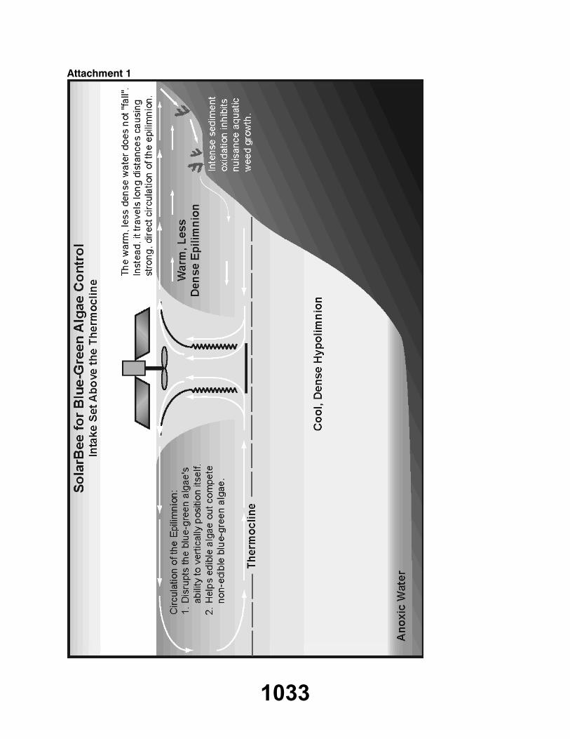
Attachment 1
1033
TERMINATION
ON MOTION, the meeting terminated at 11:20 a.m., on Friday, November 2, 2007.
Gerri Lynn O'ConnorChair
/ks
Brian DenneySecretary-Treasurer
1034