igs phase center model igs08.atx - current status and...
TRANSCRIPT

Kolloquium Satellitennavigation, 4. Juli 2011
IGS phase center model igs08.atx -Current status and future improvements
Ralf SchmidInstitut für Astronomische und Physikalische Geodäsie
Technische Universität München
Many thanks to all the members of the IGS Antenna Working Group!
Kolloquium Satellitennavigation, 4. Juli 2011
Outline
• Background– Antenna phase center modeling– Phase center calibration: absolute vs. relative
• Benefit from first absolute IGS model igs05.atx– Global terrestrial scale– Troposphere parameters
• From igs05.atx to igs08.atx• Deficiencies of igs08.atx
– Azimuth-dependent satellite antenna PCVs– PCVs for big nadir angles– Dependence on the ITRF scale

Kolloquium Satellitennavigation, 4. Juli 2011
Antenna phase center modeling
ZenithSatellite Nadir
Receiver
Phase center offset (PCO): from ARP/CoM to mean phase centerPhase center variations (PCVs): elevation- and azimuth-dependent
corrections

Kolloquium Satellitennavigation, 4. Juli 2011
Relative field calibration
• PCVs relative to the reference antenna AOAD/M_T (Dorne Margolin chokering antenna)
• Arbitrary assumption: PCV (AOAD/M_T) = 0• Systematic errors on long baselines as identical satellites
appear at different elevations at the two tracking stations• In use within the IGS from June 1996 until November 2006
Mader (1999)

Kolloquium Satellitennavigation, 4. Juli 2011
Absolute receiver antenna calibration
• Robot (using real GNSS signals) or anechoic chamber (artificial signals) approach
• PCVs down to 0° elevation for different azimuth angles• The two independent approaches agree on the 1 mm level• Cause large terrestrial scale bias, if satellite antennas unconsidered• In use within the IGS since November 2006
Zeimetz (2010)

Kolloquium Satellitennavigation, 4. Juli 2011
Satellite antenna phase center modeling
< 14.3°
• maximum nadir angle is small: < 14.3° in the GPS case• uneven distribution of observations w.r.t. the nadir angle• PCO and PCVs cannot be estimated simultaneously• if terrestrial data is used, receiver antenna calibrations and
station coordinates (global scale) have to be fixed• absolute PCV level cannot be separated from the clock

Kolloquium Satellitennavigation, 4. Juli 2011
IGS transition to absolute phase center modelingReceiver antenna Satellite antenna
PCO PCV Radome PCO PCVblock-specificsatellite-specific
igs01.pcv(1996-2006)
relative to reference antenna AOAD/M_T
ignored ignored
igs05.atx(2006-2011)
absolute, i.e., independent of a reference antenna
considered, if calibration available
block-specific
Model

Kolloquium Satellitennavigation, 4. Juli 2011
Benefit from absolute model igs05.atx
• G. Beutler (1998): "The Bermuda Triangle troposphere, station heights, GPS antennas is the final destination for many GPS analysts."
• As with absolute phase center corrections one of the elevation-dependent effects could be improved, other, highly correlated, elevation-dependent effects should benefit:
– station heights: better stability of the global scale, smallerheight biases w.r.t. other space geodetic techniques, smallercoordinate jumps due to antenna changes, etc.
– troposphere parameters

Kolloquium Satellitennavigation, 4. Juli 2011
Benefit for the terrestrial scale rate
Ge et al. (2005): Changes in the satellite constellation cause changes in the global terrestrial scale, if satellite antenna z-offsets are incorrect
Gendt et al. (2007): Absolute phase center corrections reduce IGS scale rate
Relative modelAbsolute model

Kolloquium Satellitennavigation, 4. Juli 2011
Benefit for the global terrestrial IGS scale
Gendt et al. (2007)
• better scale consistency between ACs, as identical satellite antenna corrections are used (not the case before November 2006!)
• better agreement with ITRF scale, as the latter was fixed for the estimation of satellite antenna corrections

Kolloquium Satellitennavigation, 4. Juli 2011
Benefit for troposphere parameters (I)
Ortiz de Galisteo et al. (2010): "Before November 6, 2006, the data calculated with the GPS ground receivers contained a systematic error, overestimating the precipitable water vapor in 2-3 mm. After November 6, 2006, this wet bias practically decreases to zero."

Kolloquium Satellitennavigation, 4. Juli 2011
Benefit for troposphere parameters (II)
Thomas et al. (2011): "Our conclusion is that, in Antarctica at least, a proportion of the widely observed bias between GPS and radiosonde measurements can be explained by earlier GPS analysis deficiencies."
ZTD
diff
eren
ce w
.r.t.
basi
c so
lutio
n [m
m]
dark blue: IGS PPP product using relative PCVsred: solution using absolute PCVsgreen: radiosonde data
DOY 2004 DOY 2004

Kolloquium Satellitennavigation, 4. Juli 2011
Why igs08.atx?• igs05.atx was approximately consistent with IGS05 (IGS
realization of ITRF2005)• Altamimi et al. (2011): scale difference between ITRF2008
(released end of May 2010) and ITRF2005 of -0.94 ppb• Zhu et al. (2003): Δz [m] ≈ -0.13 · Δscale [ppb]
-0.94 ppb correspond to about +12.2 cm (too big to ignore!)
Problems to be solved at the same time:• igs05.atx only contained block mean values for satellites launched
between 2006 and 2010, i.e., no satellite-specific estimates• especially important for GLONASS, as the constellation
completely changed since 2006• receiver antenna calibrations had not been updated since 2006 for
consistency reasons

Kolloquium Satellitennavigation, 4. Juli 2011
Strategy to derive igs08.atx1) Update of receiver antenna calibrations:
• get latest mean calibration results for each antenna type from Geo++
• include corrections for the GLONASS frequencies, if available• correct known inconsistencies
2) Correction of IGS station coordinates to account for calibrationupdates: ITRF2008 → IGS08
3) Estimation of GPS satellite antenna z-offsets from reprocessed (1994-2007) and operational (2008-2010) weekly SINEX files of five ACs with ITRF2008/IGS08 and igs05.atx PCVs kept fixed
4) Estimation of GLONASS satellite antenna corrections from separate long-term solutions of CODE and ESOC with GPS satellite antenna corrections kept fixed
5) Common release of IGS08 and igs08.atx

Kolloquium Satellitennavigation, 4. Juli 2011
GPS satellite antenna z-offset time series (I)
only small biases between ACs
formal errors by far too optimistic

Kolloquium Satellitennavigation, 4. Juli 2011
GPS satellite antenna z-offset time series (II)
"Annual" signal in z-offset time series probably connected to deficiencies in the modeling of orbits ("draconitic period") and station coordinates (aliased loading effects)

Kolloquium Satellitennavigation, 4. Juli 2011
Trends in z-offset time series
Significant trend in igs05.atx time series (due to error in the mean vertical velocity of IGb00) has disappeared with igs08.atx

Kolloquium Satellitennavigation, 4. Juli 2011
GLONASS estimates by CODE and ESOC
Dilssner & Dach et al. (2011)
Considerable improvement compared to igs05.atx: more ACs, more data, more satellites, more tracking stations, extension w.r.t. nadir angle
Kolloquium Satellitennavigation, 4. Juli 2011
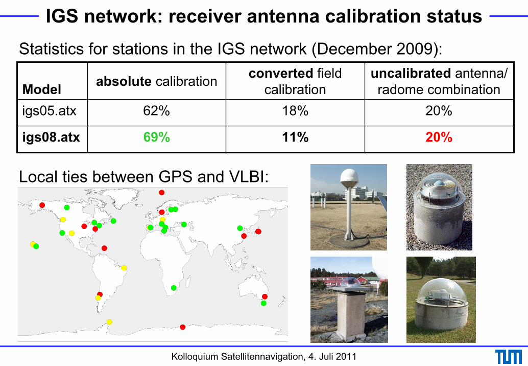
IGS network: receiver antenna calibration status
Model absolute calibration converted field calibration
uncalibrated antenna/ radome combination
igs05.atx 62% 18% 20%
igs08.atx 69% 11% 20%
Statistics for stations in the IGS network (December 2009):
Local ties between GPS and VLBI:

Kolloquium Satellitennavigation, 4. Juli 2011
igs05.atx vs. igs08.atx
GLONASSsat. ant. 15 months of data, 1 AC 7/2.5 years of data, 2 ACs
robot calibrations for about 60% of the IGS stations
robot calibrations for about 70% of the IGS stations
GPS-specific corrections only GPS- and GLONASS-specific corrections
Receiverantennas
igs05.atx igs08.atx
11 years of data, 2 ACs 16 years of data, 5 ACssolutions aligned to IGb00 (based on relative phase center corr.)
solutions aligned to IGS08, i.e., full consistency with reference frame
trend-correction due to error in mean vertical velocity of IGb00 no common z-offset trend
radome calibrations not considered
available radome calibrations applied
block mean values for satellites launched since 2006
satellite-specific estimates for 8 latest satellites
GPSsatellite
antennas

Kolloquium Satellitennavigation, 4. Juli 2011
Azimuth-dependent PCVs (nadir angle = 14°)
• TUM results based on a few days of data only (Schmid et al., 2005)
• JPL values shifted by 90° in azimuth direction
• different resolution in nadir: 14° (TUM), 1° (JPL)
Kolloquium Satellitennavigation, 4. Juli 2011
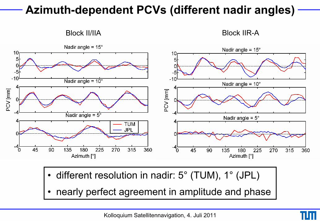
Azimuth-dependent PCVs (different nadir angles)
Block II/IIA Block IIR-A
• different resolution in nadir: 5° (TUM), 1° (JPL)
• nearly perfect agreement in amplitude and phase

Kolloquium Satellitennavigation, 4. Juli 2011
PCV values for big nadir angles (I)
Jäggi et al. (2011) Haines et al. (2010)
Most LEO observations are taken at nadir angles for which the IGS does not provide phase center corrections so far

Kolloquium Satellitennavigation, 4. Juli 2011
PCV values for big nadir angles (II)
Jäggi et al. (2011)
Jason-2 solution (CODE):• GPS and LEO PCVs estimated• simultaneously• certain set of GPS PCVs has• to be fixed to a priori values• (2 Block IIA satellites for the• example on the right)• significant PCV signal beyond• a nadir angle of 14°• biggest PCV signal for latest satellite generation• strengthened PCV estimates possible by combining the data of
several LEO missions

Kolloquium Satellitennavigation, 4. Juli 2011
PCV values for big nadir angles (III)
Dilssner et al. (2011)
Jason-1/2-solution(ESOC):
• simultaneous processing of LEO and ground data: sufficient to fix ground antenna calibrations
• PCVs for nadir angles ≤ 14° should be fixed to igs08.atx values in order to include remaining estimates into the IGS model

Kolloquium Satellitennavigation, 4. Juli 2011
Dependence on the ITRF scale (I)Collilieux et al. (2010): "Although the [GPS] scale drift compared to VLBI and SLR mean scale is smaller than 0.4 mm/year, we think that it would be premature to use that information in the ITRF scale definition due to its strong dependence on the GPS satellite and ground antenna PCVs."
Zhu et al. (2003):Δz [m] ≈ -0.13 · Δscale [ppb]
(scale difference of 1 ppb corresponds to z-offset difference of 13 cm)

Kolloquium Satellitennavigation, 4. Juli 2011
Dependence on the ITRF scale (II)
Dilssner et al. (2011)
• "JPL approach": scale constraint from satellite force models (GM)• GPS scale closer to ITRF2005 scale (VLBI-based) than to
ITRF2008 scale (VLBI- and SLR-based)• independent GNSS scale achievable
Jason-1/2-solution(ESOC):

Kolloquium Satellitennavigation, 4. Juli 2011
Upcoming new signalsZeimetz (2010)
• chamber calibration (using artificial signals) could provide phase center corrections for any signal
• when and how to incorporate these results into the IGS model?

Kolloquium Satellitennavigation, 4. Juli 2011
Conclusions• Awareness of antenna issues could be considerably improved
during the last decade (5 years ago, e.g., the impact of radomes as well as satellite antenna effects were still ignored within the IGS)
• High consistency achieved between reference frame and antenna model: ITRF2008/IGS08 and igs08.atx much more consistent than IGS05 and igs05.atx
• Theoretical solutions for lots of open antenna issues available, the question is how and when to consider them in practice:
• PCV extension to bigger nadir angles should be easy• independent IGS scale with upcoming reprocessing campaign
repro2?• azimuth-dependent PCVs??
• Beutler's vision from 1998 could become reality:Antennas could really be the "final destination"!

Kolloquium Satellitennavigation, 4. Juli 2011
N.N.
Thanks foryour attention!
MUEJ, Munich