hydrogeological characterization of a geothermal system...
TRANSCRIPT
523
Int. J. Environ. Res., 9(2):523-534, Spring 2015ISSN: 1735-6865
Received 30 June 2014; Revised 17 Oct. 2014; Accepted 28 Oct. 2014
*Corresponding author E-mail: [email protected]
Hydrogeological Characterization of a Geothermal system: the case of theThermo-mineral area of Mondragone (Campania, Italy)
Corniello, A.1*, Cardellicchio, N.2, Cavuoto, G. 2, Cuoco, E.3, Ducci, D.1, Minissale, A.4,Mussi, M.4, Petruccione, E.7, Pelosi, N.2, Rizzo, E.5, Polemico, M.6, Tamburino, S.2,
Tedesco, D.3, Tiano, P.7 and Iorio, M.2
1Department of Civil, Architectural and Environmental Engineering - University of NaplesFederico II, Italy
2Institute for Coastal Marine Environment (CNR), Italy3University of Naples (SUN), Italy
4Institute of Geosciences and Earth Resources (CNR), Italy5Institute of Methodologies for Environmental Analysis (CNR), Italy6Research Institute for geo-hydrological protection (CNR-IRPI), Italy
7Outside expert, Italy
ABSTRACT: This paper deals with thermo-mineral groundwater of the Mondragone plain (Campania, southernItaly) and the possibility to use this low enthalpy geothermal resource. In the NW sector of this plain, at thebottom of Mt. Pizzuto, near the sea, there are thermo-mineral waters (50 °C) of sodium-chloride type,sulfureous and rich in CO2 whose recharge is from the Mt. Pizzuto groundwater body. In the SE sector of theplain, close to the calcareous Mt. Petrino, a 80 m deep well has intercepted, in the carbonate basement of theplain, thermo-mineral groundwater (33 °C), sulfureous and rich in CO2, as in the NW sector, but displaying acalcium-bicarbonate composition. The chemical and the isotopic analyses allowed to verify that these typesof groundwater are due both to meteoric waters infiltration and to enrichment of endogenous CO2 and H2S, atfairly high temperature. In the Petrinum well, the gases involve “connate waters”, affecting upwards thegroundwater body of Mt. Petrino. Moreover, the rising of the gases increases the dissolution of the carbonateaquifer, determining very high values of HCO3 ions in the thermo-mineral groundwater. In the case of Mt.Pizzuto, the upwelling gas intercepts also evaporitic formation and, probably, causes saltwater intrusion. Theupwelling of the gases occurs along the major fault that crosses NE-SW the plain of Mondragone. Finally, theunderstanding of the mineralization patterns allowed to identify in the plain the best location for a geothermalexploration well.
Key words: Thermo-mineral groundwater, Carbonate rocks, Geothermal energy, Mondragone, Italy
INTRODUCTIONIn the Campania region (southern Italy) there are
several, well known, mineral and thermo-mineral springsat the bottom of carbonate aquifers (Lete, Telese spa,Contursi spa etc.) and many studies have pointed outthe mechanisms of deep circulation and the origin ofthe mineralization (Celico et al., 1979; Corniello, 1988;1994; Baiocchi et al., 2010). One of the most famousthermal spring’s group is located 30 km NW of Naples,in the NW sector of the coastal plain of Mondragone,at the bottom of the Mt. Pizzuto (Fig. 1). The springsthere present, well known from the Roman time, when
nearby they founded a town called Sinuessa (fromwhich the springs are named), are thermal, Na-Cl type,sulfureous and rich in CO2. In the SE plain sector awell, drilled a few years ago at the foot of Mt. Petrino(Fig. 1), intercepted thermo-mineral groundwater,sulfureous and rich in CO2, as in the NW sector, but ofCa-HCO3 type.
The plain of Mondragone is one of the pilot areasof the Italian VIGOR Project (2012). This project(Evaluation of geothermal potential in the ItalianRegions of Convergence), originated from a synergybetween the Italian Ministry of Economic Development
524
Corniello, A. et al.
and the Italian Council for Research (CNR), supportedthe exploitation of low enthalpy geothermal resourcesof the plain.In the framework of the Project manyactivities and surveys were conducted (structural-geological survey of the area, analysis of stratigraphicdata, electrical tomographies, seismic profiles, chemicaland isotopic analysis of groundwater etc.) in order toidentify the most suitable site to drill a geothermalexploration well. The study highlights the contributionthat the hydrogeological and hydrochemical surveyscan give to the understanding the structural patternsthat control the different mineralization observed ingroundwater of the plain. Furthermore, thermo-mineralgroundwater of Mondragone are close to the sea, awidespread situation in Italy (eg Baiocchi et al., 2010;Petrini et al., 2013) as well as in Greece (Lambrakis &Kallergis, 2005), in Turkey (Hatipoglu et al., 2009; Magriet al., 2012), in Syria (Charideh & Rahman, 2007) etc.and could be exposed to the seawater intrusion(Maramathas, 2006; Fleury et al., 2007; Sandford et al.,2007; Polemio et al., 2009; Custodio, 2010). The area ofinterest includes the coastal plain located SW of theMassico Mountain between Mondragone and the Mts.
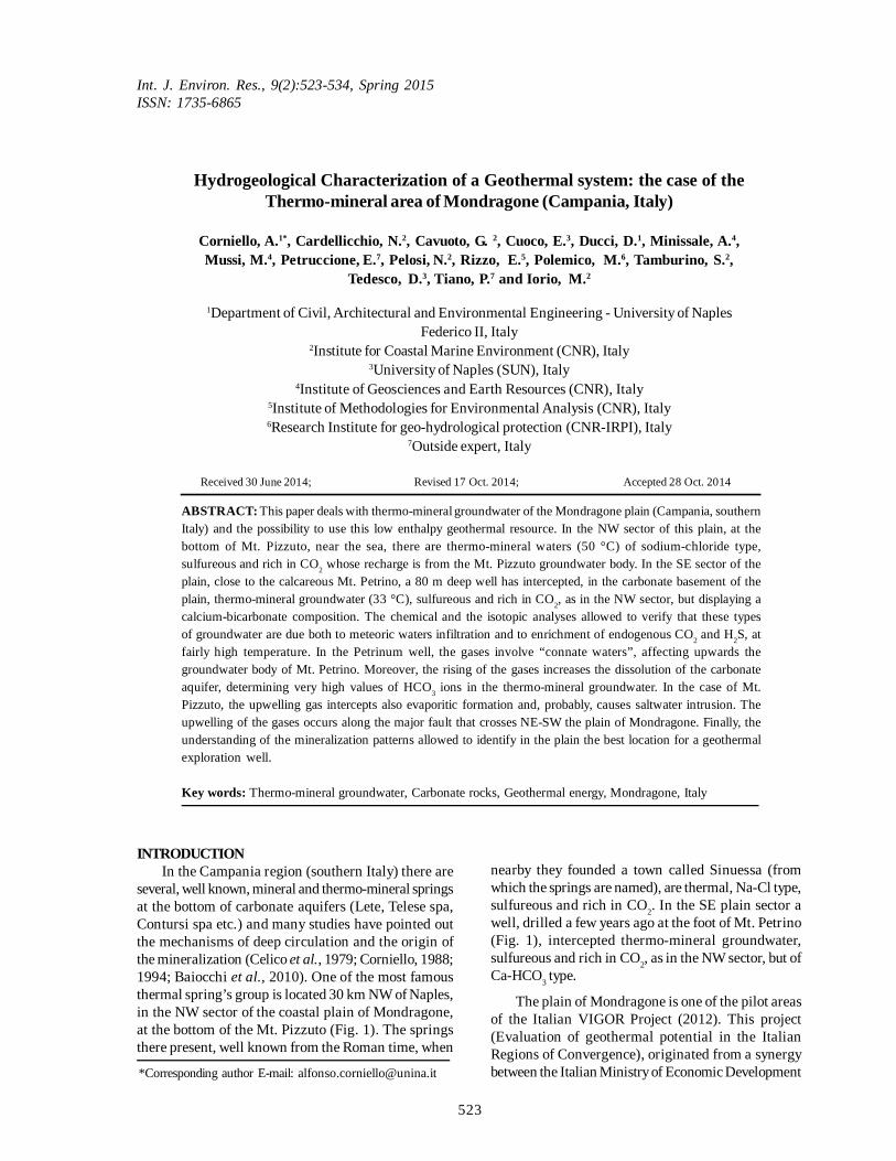
Pizzuto, Crestegallo and Petrino (Fig. 1). The MassicoMountain is a northeast trending horst typified in theeastern and central sector by carbonate rocks rangingfrom Trias to upper Cretaceous, while the southern sectoris characterized by Miocene marly-arenaceous-clayeydeposits (Vallario, 1966), which also form the Mts. Pizzutoand Crestegallo (Fig. 1). The Mt. Petrino, which is N ofMondragone town, is calcareous and in tectonic contactwith the Miocene deposits above mentioned (Billi etal., 1997). The raised fault block is bounded along themargins of the Garigliano (NW) and the Volturnodepressions (SE) by NE-SW striking high-angle normalfaults whereas southwestern margin is cut by a curveddipping fault that bounds the extensional coastal andprobably represents the principal geothermal faultrecognized in the area (VIGOR Project, 2012). Locally,near Falciano del Massico, an extensional N-S strikingfault determines the contact between the carbonaterocks and the Miocene marly-arenaceous-clayeydeposits (Fig. 1). Generally, the faults bounding thehorst have a throw estimated at hundreds of meters andthey represent the contact between the rocks of theMassico Mountain (Mariani & Prato, 1988; Billi et al.,1997; Bruno et al. 2000) and the Quaternary sedimentsfilling the depressions (Corniello et al., 2010; Ducci etal., 2010) constituted by pyroclastic-alluvial depositscaracterized by the presence of a level of grey tuff, theso-called Campanian Ignimbrite (39 ky B.P. to 37 kyB.P.: Deino et al., 1994; De Vivo et al., 2001). Thesestructural boundaries have been clearly identified alsoby the gravimetric approach using the “enhancedhorizontal derivative” (Fedi & Florio, 2001). Severaldata testify a recent activity of the marginal faults ofthe Massico Mountain during the Late Pleistocene(Romano et al., 1994; Billi et al., 1997). According tothe geomorphological evolution of the Volturno plainbetween Middle Pleistocene and Holocene times,reconstructed by Romano et al. (1994), the tectoniclowering of the Massico Mountain toward SW hasbeen probably active until historical times. This is alsopointed out by the discovery of paved roads andharbour structures of Roman age, on the seabed nearMondragone, at a depth between 2 and 20 m below thesea level (Pagano, 1974; Cocco et al., 1994).
From an hydrogeological point of view, thepermeability of the Mt. Petrino limestones is high andfavors the recharge by rainfalls of the unconfined,groundwater body that feeds, in turn, the deposits ofthe Mondragone plain through subsurface flow. Inspite of this, in the Mondragone plain at the bottom ofMt. Petrino there is only one spring with relativelyhigh flow rate (No. 20 – Tab. 1 and Fig. 2). Close to thisspring, a well, drilled some years ago in the Petrinumspa (Fig. 1), intercepted an artesian groundwater, ofcalcium-bicarbonate type, sulfureous and rich in CO2.
Fig. 1. Hydrogeological schematic map of the Mt.Massico. 1) Quaternary detritic-pyroclastic-
alluvial deposits; 2) Tertiary marly-arenaceous-clayey flysch deposits; 3) Mesozoic limestones; 4)
Mesozoic dolomites; 5) main faults; 6)groundwater flow direction in the carbonate
aquifer; 7) Sinuessa springs; 8) thermo-mineralwells: 1. Sinuessa spa, 2. Petrinum spa; 9) study
area (represented in the next Figures)
525
Int. J. Environ. Res., 9(2):523-534, Spring 2015
These wells have a depth of about 80 meters andthey reach the carbonate bedrock hydrogeologicallyconnected to the Mt. Petrino. As above mentioned, atthe bottom of Mt. Pizzuto, where low permeabilitymarly-rich deposits crop out (Allocca et al., 2007), thereare several thermo-mineral springs (Sinuessa), ofsodium-chloride type, sulfureous and rich in CO2(temperatures ranging between 30 °C and 45 °C andtotal discharge of about 1.0 l/s). CO2 degassing andevaporation form thin travertine deposits around themain springs. Near the springs there are also two wellsof the Sinuessa Spa with discharging temperaturessimilar to the natural sources (T 43 °C).
MATERIALS & METHODSTo investigate groundwater origin, the deep
groundwater flow and the mixing processes of thetermo-mineral waters of the Mondragone plain, all thephysico-chemical analyses of the springsalready published (Corniello, 1988; Duchi et al., 1995)have been revised. Moreover, groundwater of somewells distributed in the plain of Mondragone (Fig. 2),including the wells of the Sinuessa spa, was monthlymonitored from December 2001 to January 2003 forphysico-chemical parameters (Cuoco, 2004). Additionaldata (May 2006) of the Sinuessa springs and wells,and of seawater in the nearby seashore, were also takenfrom the literature (Cuoco, 2008). In 2012, under theVigor Project, many of the thermal wells and springspreviously analyzed were sampled again also forseveral isotopic determination. In all the samplingcampaigns, the water temperature, pH, Eh, specificelectrical conductivity (EC) and alkalinity weremeasured in situ; in particular, alkalinity wasdetermined by titration with 0.1 N HCl acid. All sampling
materials were pre-washed using Milli-Q watergenerated by Milli-Q Plus Water System (Millipore,Bedford, MA, USA) and water samples were stored inPE bottles. Major and minor elements (Cl-. SO4
2-, NO3-
, F-, Br-, Ca2+, Mg2+, Na+ and K+) were analyzed onsamples unfiltered and stored at 4°C before analysis.Chloride, sulphate, nitrate, fluoride, bromide, calcium,magnesium, sodium and potassium were analyzed byion chromatography in the laboratory of the IAMC-CNR of Taranto (Italy). All analyses show a chargebalance error of less than 5%. Silica analysis wasperformed on samples filtered (0.45 µm) and stored inacidified solutions to prevent precipitation. Silica wasdetermined by spettrophotometry. The δ 18O and δ Dvalues were determined by dual inlet mass spectrometer(Finingan) using standard procedures. The analyticaland isotopic data produced are shown in Table 1 and inTable 2. Regarding the average monthly temperature inthe area and rainfall data, they were provided by the raingauge network of the Centre for Weather Forecastingand Monitoring of Weather, Rainfall, Water andLandslides (Civil Protection of the Campania region)and integrated by the data of the meteorological networkof the agricultural Council of the Campania region (http://www.agricoltura .regione.campania.it/meteo/agrometeo.htm).
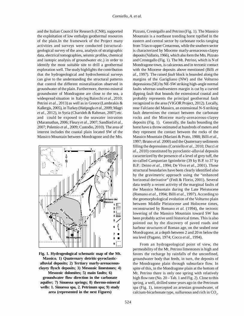
During the study, five high-resolution electricaltomographies (device used: Wenner-Schlumberger,average depth of investigation: about 180 m),performed in the plain of Mondragone within theVIGOR Project (2012), have been acquired. Also, in theframework of the VIGOR Project, the results of 8 newseismic profiles were examined (recording system: 9 to24 channels GEODE seismographs equipped withvertical geophones at 10 Hz). The seismic profiles have
Fig. 2. Wells () and springs () sampled for groundwater physico-chemical (Tab. 1) and isotopic (Tab. 2)analyses
526
Geothermal system of Mondragone
been acquired with a “multi-fold wide-openness”geometry (Bruno et al., 2010), which allows to processthe data in the key of seismic reflection and refraction,as well as to obtain tomographic images. Finally,stratigraphic logs of about 50 boreholes were collectedand organized, giving useful contributions to drawingup the hydrogeological map (Fig. 3) and the crosssections of the Mondragone plain (Fig 4). To plot thepiezometric surface (Fig. 3), groundwater levels were
measured in more than 40 wells; a pumping test(unsteady-state flow) was also performed to evaluatethe hydraulic properties of the aquifer (Fig. 3).
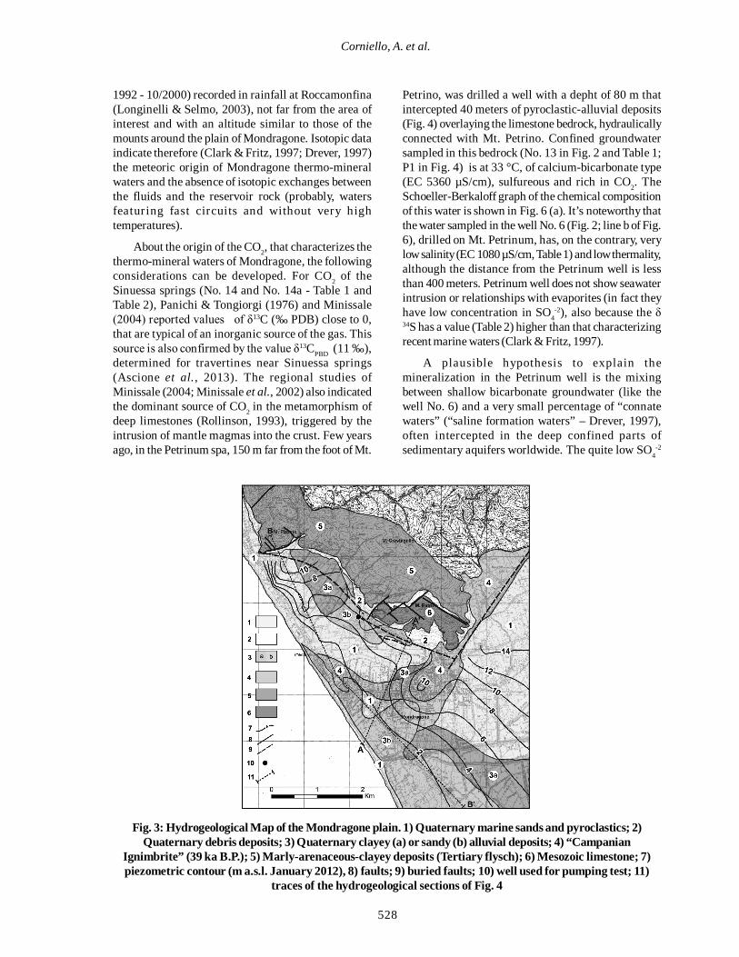
RESULTS & DISCUSSIONFig. 3 shows the Hydrogeological Map of the area
of Mondragone, drawn up on the basis of an ex novostructural-geological survey of the area and of severalstratigraphic data gathered from private wells. Based
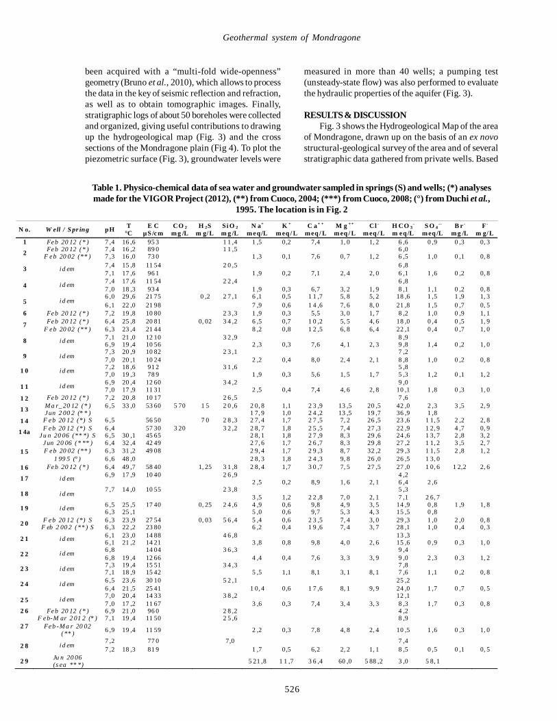
N o. W ell / S pr ing pH T °C
E C µ S /cm
CO 2 m g /L
H 2S m g/L
Si O 2 m g /L
N a+ m eq/L
K + m eq / L
C a+ + m eq / L
M g ++ m eq / L
Cl - m eq / L
H CO 3-
m eq/L S O 4
-- m eq /L
B r - m g /L
F - m g/L
1 Feb 20 12 (* ) 7 ,4 16 ,6 95 3 1 1 ,4 1 ,5 0,2 7,4 1, 0 1, 2 6 ,6 0 ,9 0 ,3 0, 3
2 Feb 20 12 (* ) 7 ,4 16 ,2 89 0 1 1 ,5 6 ,0 F eb 20 02 (** ) 7 ,3 16 ,0 73 0 1 ,3 0,1 7,6 0, 7 1, 2 6 ,5 1 ,0 0 ,1 0, 8
3 i d em 7 ,4 15 ,8 11 54 2 0 ,5 6 ,8 7 ,1 17 ,6 96 1 1 ,9 0,2 7,1 2, 4 2, 0 6 ,1 1 ,6 0 ,2 0, 8
4 i d em 7 ,4 17 ,6 11 54 2 2 ,4 6 ,8 7 ,0 18 ,3 93 4 1 ,9 0,3 6,7 3, 2 1, 9 8 ,1 1 ,1 0 ,2 0, 8
5 i d em 6 ,0 29 ,6 21 75 0 ,2 2 7 ,1 6 ,1 0,5 1 1 ,7 5, 8 5, 2 18 ,6 1 ,5 1 ,9 1, 3 6 ,1 22 ,0 21 98 7 ,9 0,6 1 4 ,6 7, 6 8, 0 21 ,8 1 ,5 0 ,7 0, 5
6 Feb 20 12 (* ) 7 ,2 19 ,8 10 80 2 3 ,3 1 ,9 0,3 5,5 3, 0 1, 7 8 ,2 1 ,0 0 ,9 1, 1
7 Feb 20 12 (* ) 6 ,4 25 ,8 20 81 0, 02 3 4 ,2 6 ,5 0,7 1 0 ,2 5, 5 4, 6 18 ,0 0 ,4 0 ,5 1, 9 F eb 20 02 (** ) 6 ,3 23 ,4 21 44 8 ,2 0,8 1 2 ,5 6, 8 6, 4 22 ,1 0 ,4 0 ,7 1, 0
8 i d em 7 ,1 21 ,0 12 10 3 2 ,9 8 ,9 6 ,9 19 ,4 10 56 2 ,3 0,3 7,6 4, 1 2, 3 9 ,8 1 ,4 0 ,2 1, 0
9 i d em 7 ,3 20 ,9 10 82 2 3 ,1 7 ,2 7 ,0 20 ,1 10 24 2 ,2 0,4 8,0 2, 4 2, 1 8 ,8 1 ,0 0 ,2 0, 8
1 0 i d em 7 ,2 18 ,6 91 2 3 1 ,6 5 ,8 7 ,0 19 ,3 78 9 1 ,9 0,3 5,6 1, 5 1, 7 5 ,3 1 ,2 0 ,1 1, 2
1 1 i d em 6 ,9 20 ,4 12 60 3 4 ,2 9 ,0 7 ,0 17 ,9 11 31 2 ,5 0,4 7,4 4, 6 2, 8 10 ,1 1 ,8 0 ,3 1, 0
1 2 Feb 20 12 (* ) 7 ,2 20 ,8 10 17 2 6 ,5 7 ,6
1 3 M a r_ 20 12 (* ) 6 ,5 33 ,0 53 60 5 70 1 5 2 0 ,6 2 0, 8 1,1 2 3 ,9 13 ,5 20 ,5 42 ,0 2 ,3 3 ,5 2, 9 Jun 2 00 2 (* * ) 1 7, 9 1,0 2 4 ,2 13 ,5 19 ,7 36 ,9 1 ,8
1 4 F eb 20 12 (*) S 6 ,5 56 50 7 0 2 8 ,3 2 7, 4 1,7 2 7 ,5 7, 2 26 ,5 23 ,6 1 1, 5 2 ,2 2, 8
1 4a F eb 20 12 (*) S 6 ,4 57 30 3 20 3 2 ,2 2 8, 7 1,8 2 5 ,5 7, 4 27 ,3 22 ,9 1 2, 9 4 ,7 0, 9 Ju n 20 06 (** *) S 6 ,5 30 ,1 45 65 2 8, 1 1,8 2 7 ,9 8, 3 29 ,6 24 ,6 1 3, 7 2 ,8 3, 2
1 5 Jun 20 06 (* ** ) 6 ,4 32 ,4 42 49 2 7, 6 1,7 2 6 ,7 8, 3 29 ,8 27 ,2 1 1, 2 3 ,5 2, 7 F eb 20 02 (** ) 6 ,3 31 ,2 49 08 2 9, 4 1,7 2 9 ,3 8, 7 32 ,2 29 ,3 1 1, 5 2 ,8 1, 2
1 99 5 (° ) 6 ,6 48 ,0 2 8, 3 1,8 2 4 ,3 9, 8 26 ,0 26 ,5 1 3, 0 1 6 Feb 20 12 (* ) 6 ,4 49 ,7 58 40 1, 25 3 1 ,8 2 8, 4 1,7 3 0 ,7 7, 5 27 ,5 27 ,0 1 0, 6 1 2,2 2, 6
1 7 i d em 6 ,9 17 ,9 10 40 2 6 ,9 4 ,2 2 ,5 0,2 8,9 1, 6 2, 1 6 ,4 2 ,6
1 8 i d em 7 ,7 14 ,0 10 55 2 3 ,8 5 ,3
3 ,5 1,2 2 2 ,8 7, 0 2, 1 7 ,1 2 6, 7
1 9 i d em 6 ,5 25 ,5 17 40 0, 25 2 4 ,6 4 ,9 0,6 9,8 4, 9 3, 5 14 ,9 0 ,8 1 ,9 1, 8 6 ,3 25 ,1 5 ,0 0,6 9,7 5, 3 4, 3 15 ,5 0 ,8
2 0 F eb 20 12 (*) S 6 ,3 23 ,9 27 54 0, 03 5 6 ,4 5 ,4 0,6 2 3 ,5 7, 4 3, 0 29 ,3 1 ,0 2 ,0 0, 8 F eb 2 00 2 (** ) S 6 ,3 22 ,2 23 80 6 ,2 0,4 1 9 ,6 7, 4 3, 7 28 ,1 1 ,0 0 ,4 0, 3
2 1 i d em 6 ,1 23 ,0 14 88 4 6 ,8 13 ,3 6 ,1 21 ,2 14 21 3 ,8 0,8 9,8 4, 0 2, 6 15 ,6 0 ,9 0 ,3 1, 0
2 2 i d em 6 ,8 14 04 3 6 ,3 9 ,4 6 ,8 19 ,4 12 66 4 ,4 0,4 7,6 3, 3 3, 9 9 ,0 2 ,3 0 ,3 1, 2
2 3 i d em 7 ,3 19 ,4 15 51 3 4 ,3 7 ,8 7 ,1 18 ,9 15 42 5 ,5 1,1 8,1 3, 1 8, 1 7 ,6 1 ,1 0 ,2 0, 8
2 4 i d em 6 ,5 23 ,6 30 10 5 2 ,1 25 ,2 6 ,4 21 ,5 25 41 1 0, 4 0,6 1 7 ,6 8, 1 9, 9 24 ,0 1 ,7 0 ,7 0, 5
2 5 i d em 7 ,0 20 ,4 14 33 3 8 ,2 12 ,1 7 ,0 17 ,2 11 67 3 ,6 0,3 7,4 3, 4 3, 3 8 ,3 1 ,7 0 ,3 0, 8
2 6 Feb 20 12 (* ) 6 ,9 21 ,0 96 0 2 8 ,2 4 ,2
2 7 F eb-M ar 2 01 2 (* ) 7 ,1 19 ,4 11 50 2 5 ,6 8 ,9
Feb -M a r 20 02 (** ) 6 ,9 19 ,4 11 59 2 ,2 0,3 7,8 4, 8 2, 4 10 ,5 1 ,6 0 ,3 1, 0
2 8 i d em 7 ,2 77 0 7,0 7 ,4 7 ,2 18 ,3 81 9 1 ,7 0,5 6,2 2, 2 1, 1 8 ,5 0 ,5 0 ,1 0, 5
2 9 Ju n 20 06 (s ea ** *) 5 21 ,8 1 1 ,7 3 6 ,4 60 ,0 5 88 ,2 3 ,0 5 8, 1
Table 1. Physico-chemical data of sea water and groundwater sampled in springs (S) and wells; (*) analysesmade for the VIGOR Project (2012), (**) from Cuoco, 2004; (***) from Cuoco, 2008; (°) from Duchi et al.,
1995. The location is in Fig. 2
527
Int. J. Environ. Res., 9(2):523-534, Spring 2015
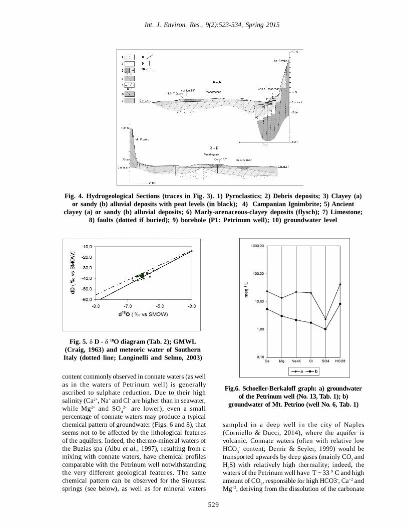
on these data, the relationship between the differentlithologies are outlined in the hydrogeological crosssections of Fig. 4, whose traces are reported in Fig. 3.The stratigraphic data show the presence of a powerfulbank of tuff, almost continuous across the plain,belonging to the Campanian Ignimbrite (hereinafter IC)eruption from the Phlegraean Fields Caldera, dating at39 yr BP, that represents one of the largest lateQuaternary volcanic event. This IC, with variablethickness and different degree of welding, has generallylow permeability and therefore separates the abovepyroclastic-alluvial deposits (often with peat, C14 dated4,69 ± 0.06 and 8.3 ± 0.07 ka; Amato 2006) from theunderlying alluvial deposits, deeper and more permeable,making confined this lower aquifer.
The pyroclastic-alluvial deposits of the plain receivegroundwater by both lateral and vertical subsurfaceflows from the carbonate aquifer of Mt. Petrino. Thisgroundwater flow is shown by the piezometric contourlines (Fig. 3) of the alluvial deposits aquifer, located below
the IC (Fig. 4). The piezometric pattern shows also aclear drainage area, close to N of Mondragone town,between the foot of Mt. Petrino and the coast line, whichcorresponds, probably, to a paleo-r iver bed,subsequently filled by pyroclastic materials. Agroundwater divide, near Mondragone, separates thisarea from the remaining, flowing toward SE. Thepiezometric head at the bottom of Mt. Petrino is about 6m a.s.l., while the piezometric head along the SE and theNW borders of the Massico Mountain is about 20 ma.s.l. (Corniello et al., 2010; Ducci et al., 2010). Thispiezometric difference and the geological setting of Mt.Petrino suggest the hydrogeological separation of Mt.Petrino from the remaining Massico Mountain (Fig. 1).On the other hand, the infiltration at Mt. Petrino (about1.8 km2) was assessed on the basis of climatic data inthe range 25-30 l/s, which is almost equal to the amountof the subsurface flow from the Mt. Petrino aquifertoward the plain, evaluated in about 30 l/s. This valuehas been obtained applying the Darcy law to thepiezometric pattern of the plain and using thetransmissivity value of 3.8 x 10⁻³ m2/s obtained from apumping test performed in unsteady-state flow (Fig. 3).The storage coefficient of 1.7 x 10⁻⁶ has also confirmedthe confined conditions of the aquifer.
The groundwater flow from Mt. Pizzuto and Mt.Crestegallo into the plain is likely reduced due to thelow permeability of the marly-arenaceous-clayeydeposits that constitute these mounts. However, thepresence of thermo-mineral groundwater at the foot ofMt. Pizzuto, indicates the existence of a smallgroundwater body, probably floating on seawater, dueto the proximity to the coast. Geophysical data providedadditional information about the subsoil stratigraphy ofthe plain (thickness about 400 m) at depths greater thanthose crossed by boreholes (max 80 m as peak depth).These data have suggested the presence of severalfaults affecting the carbonate bedrock; the mostsignificant fault (Fig. 3) crosses the whole plain fromNW to SE and is coupled with other sub-parallel tectoniclineaments, as stressed also by the geoelectricaltomography. Table 2 shows isotopic data of waterssampled at wells and springs in 2012, in the frameworkof the VIGOR Project. The maiority of determinationsexamines the isotopes D and 18O (vs SMOW). Theclassic δD - δ18O graph of Fig. 5 shows that all watersare between the line of the meteoric waters of southernItaly (Longinelli & Selmo, 2003) and the Global MeteoricWater Line (Craig, 1963). In addition, the isotopic valuesof the different samples differ little from the mean value(- 6.1 for δ 18O and - 37.3 for δ D) and that makesinsignificant to draw a strictly local meteoric water line,which, in other situations, can provide a usefulcontribution (e.g. Lihe et al., 2011). These mean valuesare also very close to the isotopic content (period 3/
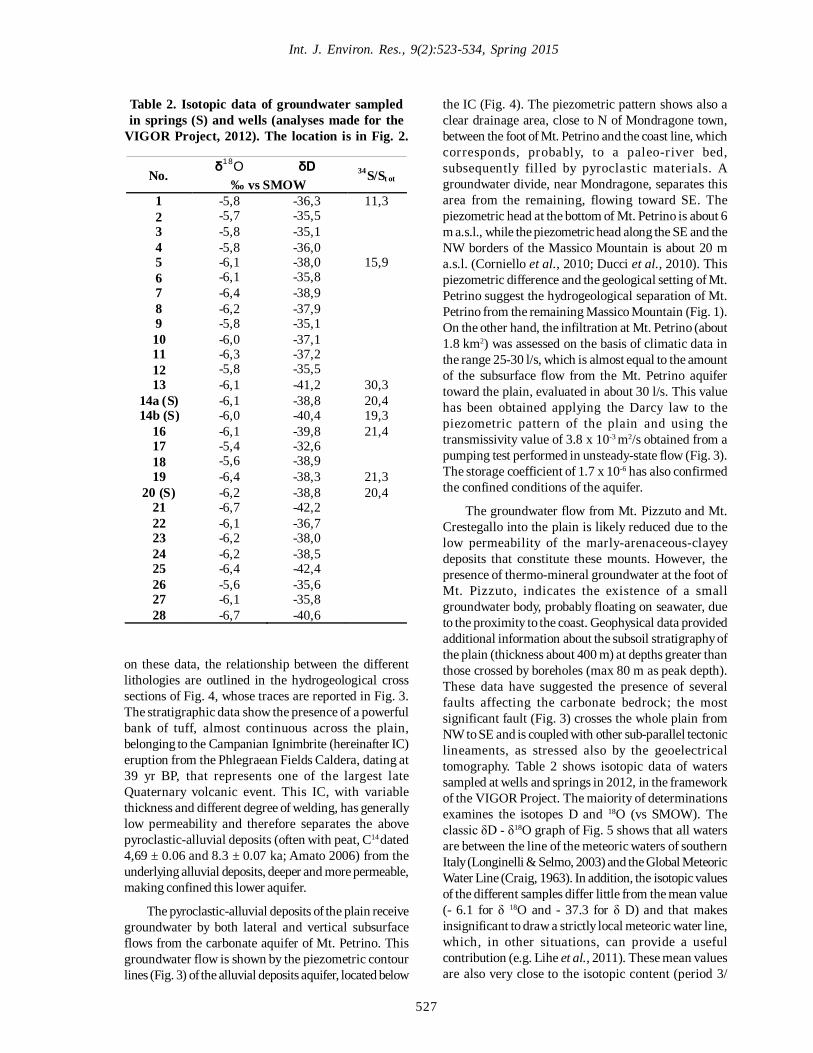
No. δ18O δD 34S/St ot ‰ vs SMOW
1 -5,8 -36,3 11,3 2 -5,7 -35,5 3 -5,8 -35,1 4 -5,8 -36,0 5 -6,1 -38,0 15,9 6 -6,1 -35,8 7 -6,4 -38,9 8 -6,2 -37,9 9 -5,8 -35,1 10 -6,0 -37,1 11 -6,3 -37,2 12 -5,8 -35,5 13 -6,1 -41,2 30,3
14a (S) -6,1 -38,8 20,4 14b (S) -6,0 -40,4 19,3
16 -6,1 -39,8 21,4 17 -5,4 -32,6 18 -5,6 -38,9 19 -6,4 -38,3 21,3
20 (S) -6,2 -38,8 20,4 21 -6,7 -42,2 22 -6,1 -36,7 23 -6,2 -38,0 24 -6,2 -38,5 25 -6,4 -42,4 26 -5,6 -35,6 27 -6,1 -35,8 28 -6,7 -40,6
Table 2. Isotopic data of groundwater sampledin springs (S) and wells (analyses made for the
VIGOR Project, 2012). The location is in Fig. 2.
528
Corniello, A. et al.
1992 - 10/2000) recorded in rainfall at Roccamonfina(Longinelli & Selmo, 2003), not far from the area ofinterest and with an altitude similar to those of themounts around the plain of Mondragone. Isotopic dataindicate therefore (Clark & Fritz, 1997; Drever, 1997)the meteoric origin of Mondragone thermo-mineralwaters and the absence of isotopic exchanges betweenthe fluids and the reservoir rock (probably, watersfeaturing fast circuits and without very hightemperatures).
About the origin of the CO2, that characterizes thethermo-mineral waters of Mondragone, the followingconsiderations can be developed. For CO2 of theSinuessa springs (No. 14 and No. 14a - Table 1 andTable 2), Panichi & Tongiorgi (1976) and Minissale(2004) reported values of δ13C (‰ PDB) close to 0,that are typical of an inorganic source of the gas. Thissource is also confirmed by the value δ13CPBD (11 ‰),determined for travertines near Sinuessa springs(Ascione et al., 2013). The regional studies ofMinissale (2004; Minissale et al., 2002) also indicatedthe dominant source of CO2 in the metamorphism ofdeep limestones (Rollinson, 1993), triggered by theintrusion of mantle magmas into the crust. Few yearsago, in the Petrinum spa, 150 m far from the foot of Mt.
Petrino, was drilled a well with a depht of 80 m thatintercepted 40 meters of pyroclastic-alluvial deposits(Fig. 4) overlaying the limestone bedrock, hydraulicallyconnected with Mt. Petrino. Confined groundwatersampled in this bedrock (No. 13 in Fig. 2 and Table 1;P1 in Fig. 4) is at 33 °C, of calcium-bicarbonate type(EC 5360 µS/cm), sulfureous and rich in CO2. TheSchoeller-Berkaloff graph of the chemical compositionof this water is shown in Fig. 6 (a). It’s noteworthy thatthe water sampled in the well No. 6 (Fig. 2; line b of Fig.6), drilled on Mt. Petrinum, has, on the contrary, verylow salinity (EC 1080 µS/cm, Table 1) and low thermality,although the distance from the Petrinum well is lessthan 400 meters. Petrinum well does not show seawaterintrusion or relationships with evaporites (in fact theyhave low concentration in SO4
-2), also because the δ34S has a value (Table 2) higher than that characterizingrecent marine waters (Clark & Fritz, 1997).
A plausible hypothesis to explain themineralization in the Petrinum well is the mixingbetween shallow bicarbonate groundwater (like thewell No. 6) and a very small percentage of “connatewaters” (“saline formation waters” – Drever, 1997),often intercepted in the deep confined parts ofsedimentary aquifers worldwide. The quite low SO4
-2
Fig. 3: Hydrogeological Map of the Mondragone plain. 1) Quaternary marine sands and pyroclastics; 2)Quaternary debris deposits; 3) Quaternary clayey (a) or sandy (b) alluvial deposits; 4) “Campanian
Ignimbrite” (39 ka B.P.); 5) Marly-arenaceous-clayey deposits (Tertiary flysch); 6) Mesozoic limestone; 7)piezometric contour (m a.s.l. January 2012), 8) faults; 9) buried faults; 10) well used for pumping test; 11)
traces of the hydrogeological sections of Fig. 4
529
Int. J. Environ. Res., 9(2):523-534, Spring 2015
content commonly observed in connate waters (as wellas in the waters of Petrinum well) is generallyascribed to sulphate reduction. Due to their highsalinity (Ca2+, Na+ and Cl- are higher than in seawater,while Mg2+ and SO4
2- are lower), even a smallpercentage of connate waters may produce a typicalchemical pattern of groundwater (Figs. 6 and 8), thatseems not to be affected by the lithological featuresof the aquifers. Indeed, the thermo-mineral waters ofthe Buzias spa (Albu et al., 1997), resulting from amixing with connate waters, have chemical profilescomparable with the Petrinum well notwithstandingthe very different geological features. The samechemical pattern can be observed for the Sinuessasprings (see below), as well as for mineral waters
Fig. 4. Hydrogeological Sections (traces in Fig. 3). 1) Pyroclastics; 2) Debris deposits; 3) Clayey (a)or sandy (b) alluvial deposits with peat levels (in black); 4) Campanian Ignimbrite; 5) Ancient
clayey (a) or sandy (b) alluvial deposits; 6) Marly-arenaceous-clayey deposits (flysch); 7) Limestone;8) faults (dotted if buried); 9) borehole (P1: Petrinum well); 10) groundwater level
sampled in a deep well in the city of Naples(Corniello & Ducci, 2014), where the aquifer isvolcanic. Connate waters (often with relative lowHCO3
- content; Demir & Seyler, 1999) would betransported upwards by deep gases (mainly CO2 andH2S) with relatively high thermality; indeed, thewaters of the Petrinum well have T ~ 33 ° C and highamount of CO2, responsible for high HCO3-, Ca+2 andMg+2, deriving from the dissolution of the carbonate
Fig. 5. δ D - δ 18O diagram (Tab. 2); GMWL(Craig, 1963) and meteoric water of SouthernItaly (dotted line; Longinelli and Selmo, 2003)
Fig.6. Schoeller-Berkaloff graph: a) groundwaterof the Petrinum well (No. 13, Tab. 1); b)
groundwater of Mt. Petrino (well No. 6, Tab. 1)
530
Geothermal system of Mondragone
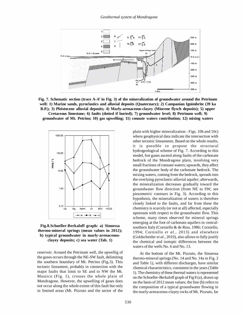
reservoir. Around the Petrinum well, the upwellig ofthe gases occurs through the NE-SW fault, delimitingthe southern boundary of Mt. Petrino (Fig.3). Thistectonic lineament, probably in connection with themajor faults that limit to SE and to NW the Mt.Massico (Fig. 1), crosses the whole plain ofMondragone. However, the upwelling of gases doesnot occur along the whole extent of this fault but onlyin limited areas (Mt. Pizzuto and the sector of the
Fig. 7. Schematic section (trace A-A’ in Fig. 3) of the mineralization of groundwater around the Petrinumwell: 1) Marine sands, pyroclastics and alluvial deposits (Quaternary); 2) Campanian Ignimbrite (39 kaB.P.); 3) Pleistocene alluvial deposits; 4) Marly-arenaceous-clayey (Miocene flysch deposits); 5) upper
Cretaceous limestone; 6) faults (dotted if buried); 7) groundwater level; 8) Petrinum well; 9)groundwater of Mt. Petrino; 10) gas upwelling; 11) connate waters contribution; 12) mixing waters
Fig.8.Schoeller-Berkaloff graph: a) Sinuessathermo-mineral springs (mean values in 2012);
b) typical groundwater in marly-arenaceous-clayey deposits; c) sea water (Tab. 1)
plain with higher mineralization - Figs. 10b and 10c)where geophysical data indicate the intersection withother tectonic lineaments. Based on the whole results,it is possible to propose the structuralhydrogeological scheme of Fig. 7. According to thismodel, hot gases ascend along faults of the carbonatebedrock of the Mondragone plain, involving verysmall fractions of connate waters; upwards, they affectthe groundwater body of the carbonate bedrock. Themixing waters, coming from the bedrock, spreads intothe overlying pyroclastic-alluvial aquifer; afterwards,the mineralization decreases gradually toward thegroundwater flow direction (from NE to SW; seepiezometric contours in Fig. 3). According to thishypothesis, the mineralization of waters is thereforeclosely linked to the faults, and far from these thechemistry is scarcely (or not at all) affected, especiallyupstream with respect to the groundwater flow. Thisscheme, many times observed for mineral springsemerging at the foot of carbonate aquifers in central-southern Italy (Corniello & de Riso, 1986; Corniello,1994; Corniello et al. , 2013) and elsewhere(Goldscheider et al., 2010), also allows to fully justifythe chemical and isotopic differences between thewaters of the wells No. 6 and No. 13.
At the bottom of the Mt. Pizzuto, the Sinuessathermo-mineral springs (No. 14 and No. 14a in Fig. 2and Table 1), with different discharges, have similarchemical characteristics, consistent in the years (Table1). The chemistry of these thermal waters is representedon the Schoeller-Berkaloff graph of Fig 8 (a), drawn upon the basis of 2012 mean values; the line (b) refers tothe composition of a typical groundwater flowing inthe marly-arenaceous-clayey rocks of Mt. Pizzuto, far
531
Int. J. Environ. Res., 9(2):523-534, Spring 2015
from the mineral springs, and the line (c) refers tothe sea water composition (Table 1). The graph of Fig.8 clearly shows the differences in chemistry betweenthe thermal springs (a) and the more superficial waters(b). The chemical composition of the thermal springsis similar to the Petrinum well (Fig. 6), with higher valuesof Na+, K+, Cl- and, especially SO4
2-. The origin of theSinuessa thermo-mineral springs (and the groundwaterof the neighboring wells No. 15 and 16) is similar to thePetrinum well, but in Sinuessa area the upwelling ofdeep gases also involves seawater and/or some waterleaching evaporitic Miocene formations, as indicatedby the concentration of SO4
-2, higher than ingroundwater of the Petrinum well. The values of δ34S(Table 2) are anyhow in agreement with those foundfor present seawater and for chalks of the Miocene(Clark & Fritz, 1997). Also in the Mt. Pizzuto area theupwelling of CO2 and H2S (respectively 98.11 and 1,69% of the gases - Duchi et al., 1995) occurs along themain fault that crosses the plain of Mondragone. Thesehot gases cause the pH lowering and the increase ofthe carbonate dissolution in the Mt. Pizzuto rocks.
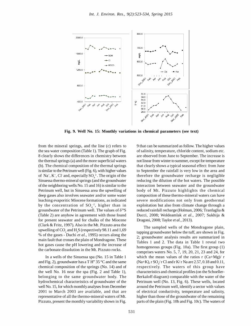
In a wells of the Sinuessa spa (No. 15 in Table 1and Fig. 2), groundwater has a T H” 35 °C and the samechemical composition of the springs (No. 14) and ofthe well No. 16 near the spa (Fig. 2 and Table 1),belonging to the same groundwater body. Thehydrochemical characteristics of groundwater of thewell No. 15, for which monthly analyses from December2001 to March 2003 are available, and that arerepresentative of all the thermo-mineral waters of Mt.Pizzuto, present the monthly variability shown in Fig.
Fig. 9. Well No. 15: Monthly variations in chemical parameters (see text)
9 that can be summarized as follow. The higher valuesof salinity, temperature, chloride content, sodium etc.are observed from June to September. The increase isnot linear from winter to summer, except for temperaturethat clearly shows a typical seasonal effect: from Juneto September the rainfall is very low in the area andtherefore the groundwater recharge is negligiblereducing the dilution of the hot waters. The possibleinteraction between seawater and the groundwaterbody of Mt. Pizzuto highlights the chemicalcomposition of these thermo-mineral waters can havesevere modifications not only from geothermalexploitation but also from climate change through areduced rainfall recharge (Holman, 2006; Tranfaglia &Ducci, 2008; Woldeamlak et al., 2007; Sukhija &Dragoni, 2008; Taylor et al., 2013).
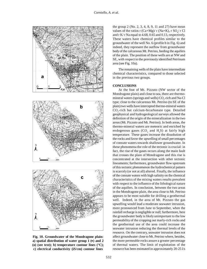
The sampled wells of the Mondragone plain,tapping groundwater below the tuff, are shown in Fig.2; groundwater analysis results are summarized inTables 1 and 2. The data in Table 1 reveal twohomogeneous groups (Fig. 10a). The first group (1)comprises waters No. 5, 7, 19, 20, 21, 23 and 24, forwhich the mean values of the ratios r (Ca+Mg)/ r(Na+K), r SO4/ r Cl and r K/ r Na are 2.57, 0.18 and 0.11,respectively. The waters of this group havecharacteristics and chemical profiles (on the Schoeller-Berkaloff diagram) comparable with the water of thePetrinum well (No. 13, Fig. 6). These wells, locatedaround the Petrinum well, identify a sector with valuesof electrical conductivity, temperature and salinity,higher than those of the groundwater of the remainingparts of the plain (Fig. 10b and Fig. 10c). The waters of
532
Corniello, A. et al.
Fig. 10. Groundwater of the Mondragone plain:a) spatial distribution of water group 1 () and 2(o) (see text); b) temperature contour lines (°C);c) electrical conductivity (ìS/cm) contour lines
the group 2 (No. 2, 3, 4, 8, 9, 11 and 27) have meanvalues of the ratios r (Ca+Mg)/ r (Na+K), r SO4/ r Cland r K/ r Na equal to 4.68, 0.65 and 0.13, respectively.These waters have chemical profiles similar to thegroundwater of the well No. 6 (profile b in Fig. 6) andindeed, they represent the outflow from groundwaterbody of the calcareous Mt. Petrino, feeding the aquifersof the plain. The position of these wells are at NW andSE, with respect to the previously identified Petrinumarea (see Fig. 10a).
The remaining wells of the plain have intermediatechemical characteristics, compared to those selectedin the previous two groups.
CONCLUSIONSAt the foot of Mt. Pizzuto (NW sector of the
Mondragone plain) and close to sea, there are thermo-mineral waters (springs and wells) CO2-rich and Na-Cltype; close to the calcareous Mt. Petrino (to SE of theplain) two wells have intercepted thermo-mineral watersCO2-rich but calcium-bicarbonate type. Detailedgeophysical and hydrogeological surveys allowed thedefinition of the origin of the mineralization in the twoareas (Mt. Pizzuto and Mt. Petrino). In both areas, thethermo-mineral waters are meteoric and enriched byendogenous gases (CO2 and H2S) at fairly hightemperature. These gases increase the dissolution ofthe rocks and favor the upwelling of small percentagesof connate waters towards shallower groundwater. Inthese phenomena the role of the tectonic is crucial: infact, the rise of the gases occurs along the main faultthat crosses the plain of Mondragone and this rise isconcentrated at the intersection with other tectoniclineaments; furthermore, groundwater flow upstreamof this tectonic phenomenon the hydrochemical patternis scarcely (or not at all) altered. Finally, the influenceof the connate waters with high salinity on the chemicalcharacteristics of the mixing waters results prevalentwith respect to the influence of the lithological natureof the aquifers. In conclusion, between the two areasin the Mondragone plain, the area close to Mt. Petrinoappears to be most suitable for drilling a geothermalwell. Indeed, in the area of Mt. Pizzuto the gasupwelling would lead a moderate seawater intrusion,more pronounced from June to September, when therainfall recharge is negligible or null; furthermore, herethe groundwater body is likely unimportant to the lowpermeability of the cropping out marly-rich rocks andthe geothermal use of the area could increase theseawater intrusion reducing the thermal levels of theresource. On the contrary, seawater intrusion does notaffect groundwater close to Mt. Petrino where, besides,the more permeable rocks assure a greater percentageof thermal waters. The limit of exploitation of theresource has been estimated in approximately 20-25 l/s
533
Int. J. Environ. Res., 9(2):523-534, Spring 2015
through a hydrogeological budget of Mt. Petrino,which represents the recharge area of the carbonatebedrock where the thermo-mineral groundwater of theplain originates. Finally, this research also contributesto the assessment and mapping of the geothermalresources of Campania (Italy) and offers a furtherexample of the significance of the carbonate aquifersthat, apart from the volcanic areas, constitute oftenthe main geothermal reservoirs.
REFERENCESAlbu, M., Banks, D. and Nash, H. (1997). Mineral andthermal groundwater resources. (Springer)
Allocca, V., Celico, F., Celico, P., De Vita, P., Fabbrocino, S.,Mattia, C., Monacelli, G., Fusilli, I., Piscopo, V., Scalise,A.R., Summa, G. and Tranfaglia, G. (2007). HydrogeologicalMap of Southern Italy. Istituto Poligrafico e Zecca delloStato, ISBN 88-448-0215-5, pp. 71.
Amato, V. (2006) La risposta di alcuni tipici sistemimorfodinamici della Campania (Italia meridionale) allevariazioni climatiche oloceniche. Ph.D Thesis, Universitàdegli Studi di Napoli “Federico II”.
Ascione, A., Iannace, A., Imbriale, P., Santangelo, N. andSanto, A. (2013). Tufa and travertines of southern Italy:deep-seated, fault-related CO2 as the key control inprecipitation. Terra Nova, 26(1), 1-13.
Baiocchi, A., Di Paola, A., Lotti, F., Piscopo, V. and Spaziani,F. (2010). Seawater intrusion in carbonate aquifers: the caseof the spring group of Castellammare di Stabia (Naples,Southern Italy). It. Journal of Engineering Geology andEnviroment, 2, 5-20.
Billi, A., Bosi, V. and De Meo, A. (1997). Caratterizzazionestrutturale del rilievo del M.te Massico nell’ambitodell’evoluzione quaternaria delle depressioni costiere deifiumi Garigliano e Volturno (Campania settentrionale). IIQuaternario, 10, 15-26.
Bruno, P.P., Di Fiore, V. and Ventura, G. (2000). Seismicstudy of the ‘41st Parallel’ Fault System offshore theCampanian–Latial continental margin, Italy.Tectonophysics, 324, 37–55.
Bruno, P.P., Improta, L., Castello, A., Villani, F. andMontone, P. (2010). The Vallo di Diano fault system; newevidence for an active range-bounding fault in southern Italyusing shallow, high-resolution seismic profiling. Bulletin ofthe Seismological Society of America, 100(2), 882-890.
Celico, P., de Gennaro, M., Ghiara, M.R. and Stanzione, D.(1979). Le sorgenti termominerali della Valle del Sele: indaginistrutturali, idrogeologiche e geochimiche. Rendiconti SocietàItaliana Mineralogia e Petrologia, 35, 1- 40.
Charideh, A. and Rhaman, R. (2007). Environmental isotopicand hydrochemical study of water in the karst aquifer andsubmarine springs of the Syrian coast. Hydrogeology J., 15,351-364.
Clark, I.D. and Fritz, P. (1997). Environmental Isotopes inHydrogeology. (CRC Press)
Cocco, E., Crimaco, L., De Magistris, M.A. and Gasperetti,G. (1994). Primi risultati sulle indagini di geoarcheologiasubacquea nell’area dell’antica colonia Romana di Sinuessapresso Mondragone (Piana campana, Golfo di Gaeta).Memoria descrittiva della Carta Geologica d’Italia, 52, 361-372.
Corniello, A. (1994). Lineamenti idrogeochimici dei principalimassicci carbonatici della Campania. Memorie SocietàGeologica Italiana, 51, 333-342.
Corniello, A. (1988). Considerazioni idrogeologiche su taluneacque minerali e termominerali della provincia di Caserta.Memorie Società Geologica Italiana, 41, 1053-1063.
Corniello, A. and Ducci, D. (2014). Mineral waters in the Mt.Echia area (Naples). Proceedings of the 5th InternationalConference on the History of Engineering. (Paper presentedat the 19th - 20th. Naples)
Corniello, A., Ducci, D., Rotella, M., Trifuoggi, M. andRuggieri, G. (2010). Hydrogeology and hydrogeochemistryof the plain between Mt. Massico and the river Volturno(Campania). Italian Journal of Engineering Geology andEnvironment, 1, 51-64.
Corniello, A., Trifuoggi, M. and Ruggieri, G. (2013). Themineral springs of the Scrajo spa (Sorrento peninsula, Italy):a case of “natural” seawater intrusion. Environmental EarthSciences, 72(1), 147-156.
Craig, H. (1963). The isotopic geochemistry of water andcarbon in geothermal areas. (In E. Tongiorgi (Ed.), NuclearGeology on Geothermal Areas, Spoleto (pp. 17-53). PisaItaly: Consiglio Nazionale delle Ricerche, Laboratorio diGeologia Nucleare.)
Cuoco, E. (2004) Geochimica e geochimica isotopica delleacque sotterranee nell’area di Mondragone. Thesis, SecondaUniversità di Napoli.
Cuoco, E. (2008) Investigations of natural and anthropogenicprocesses affecting groundwaters geochemistry of theCaserta Province (Southern Italy). PhD Thesis, SecondaUniversità di Napoli.
Custodio, E. (2010). Coastal aquifers of Europe: an overview.Hydrogeology J., 18, 269-280.
Deino, A.L., Southon, J., Terrasi, F., Campajola, L. and Orsi,G. (1994). 14C and 40Ar/39Ar dating of the CampanianIgnimbrite, Phlegrean Fields, Italy. In Abstracts, ICOG 1994,Berkeley, CA.
Demir, I. and Seyler, B. (1999). Chemical composition andgeologic history of saline waters in Aux Vases and CypressFormations, Illinois Basin. Aquatic Geochemistry, 5, 281–311.
De Vivo, B., Rolandi, G., Gans, P.B., Calvert, A., Bohrson,W.A., Spera, F.J. and Belkin, H.E. (2001). New constraintson the pyroclastic eruptive history of the Campanianvolcanic Plain (Italy). Mineral Petrology, 73, 47–65.
Dragoni, W. and Sukhija, B.S. (2008). Groundwater andclimatic changes: a short review. In Climatic Change andGroundwater - Geological Society, London, S.P., 288, 1-12.
534
Geothermal system of Mondragone
Drever, J.I. (1997). The geochemistry of natural waters:surface and groundwater environments. (Prentice Hall)
Ducci, D., Corniello, A. and Sellerino, M. (2010).Hydrostratigraphical setting and groundwater quality statusin alluvial aquifers: the low Garigliano River Basin (SouthernItaly), case study. (In Groundwater Quality Sustainability.Krakow, (pp. 12–17) September 2010, vol. 1, 197-203,ISBN: 9788322619797.
Ducci, D. and Tranfaglia, G. (2008). The Effect of ClimateChange on the Hydrogeological Resources in CampaniaRegion (Italy). In Climatic Change and Groundwater -Geological Society, London, S.P., 288, 25-38.
Duchi, V., Minissale, A., Vaselli, O. and Ancillotti, M. (1995).Hydrogeochemistry of the Campania region in southern Italy.Journal of Volcanology and Geothermal Research, 67, 313-328.
Fedi, M. and Florio, G. (2001). Potential fields sourceboundaries detection by an Enhanced Horizontal Derivative.Geophysical Prospecting, 49, 13-25.
Fleury, P., Bakalowicz, M. and de Marsily, G. (2007).Submarine springs and coastal karst aquifers: a rewiew. J. ofHydrology, 339, 79-92.
Goldscheider, N., Madl-Szonyi, J., Eross, A. and Schill, E.(2010). Review: Thermal water resources in carbonate rockaquifers. Hydrogeology J., 18 (6), 1303-1318.
Hatipoglu, Z., Motz, L.H. and Bayari, C.S. (2009).Characterization of the groundwater flow system in thehillside and coastal aquifers of the Mersin-Tarsus region(Turkey). Hydrogeology J., 17, 1761-1778.
Holman, I.P. (2006). Climate change impacts on groundwaterrecharge: uncertainty, shortcomings and the way forward.Hydrogeology J., 14 (5), 637-647.
Lambrakis, N. and Kallergis, G. (2005). Contribution to thestudy of Greek thermal springs: hydrogeological andhydrochemical characteristics and origin of thermal waters.Hydrogeology J., 13, 506-521.
Lihe, Y., Guangcai, H., XiaoSi, S., Dong, W., Jiaqiu, D.,Yonghong, H. and Xiaoyong, W. (2011). Isotopes (äD andä18O) in precipitation, groundwater and surface water in theOrdos Plateau, China: implications with respect togroundwater recharge and circulation. Hydrogeology J.,19(2), 429-443.
Longinelli, A. and Selmo, E. (2003). Isotopic composition ofthe precipitation in Italy: a first overall map. J. of Hydrology,270, 75-88.
Magri, F., Akar, T., Gemici, U. and Pekdeger, A. (2012).Numerical investigations of fault-induced seawatercirculation in the Seferihisar-Balçova Geothermal system,western Turkey. Hydrogeology J., 20, 103-118.
Maramathas, A. (2006). A new approach for the developmentand management of brackish karst springs. Hydrogeology J.,14, 1360-1366.
Mariani, M. and Prato, R. (1988). I bacini neogenici costieridel margine tirrenico: approccio sismico-stratigrafico.Memorie della Società Geologica Italiana, 4, 519-531.
Minissale, A. (2004). Origin, transport and discharge of CO2in central Italy. Earth Sciences Rewiews, 66, 89-141.
Minissale, A., Kerrick, D.M., Magro, G., Murrell, M.T.,Paladini, M., Rihs, S., Sturchio, N.C., Tassi, F. and Vaselli,O. (2002). Geochemistry of Quaternary travertines in theregion north of Rome (Italy): structural, hydrologic andpaleoclimatic implications. Earth and Planetary ScienceLetters, 203, 709-728.
Pagano, M. (1974). Una città sepolta: Sinuessa. TipografiaSeverini, Napoli, 55 pp.
Panichi, C. and Tongiorgi, E. (1976). Carbon isotopiccomposition of CO2 from springs, fumaroles, mofettes andtravertines of Central and Southern Italy: preliminaryprospection method of geothermal area. Proc. 2° U.N. Symp.Development Use of Geothermal Resources, S. Francisco,815-825.
Petrini, R., Italiano, F., Ponton, M., Slejko, F.F., Aviani, U.and Zini, L. (2013). Geochemistry and isotope geochemistryof the Montefalcone thermal waters (northern Italy):interference on the deep geothermal reservoir. HydrogeologyJ., 21, 1275-1287.
Polemio, M., Dragone, W. and Limoni, P. P. (2009).Monithoring and methods to analyse the groundwater qualitydegradation risk in coastal karstic aquifers (Apulia, SouthernItaly). Environmental Geology, 58, 299-312.
Romano, P., Santo, A. and Voltaggio, M. (1994). L’evoluzionegeomorfologica della piana del fiume Volturno (Campania)durante il tardo Quaternario (Pleistocene medio-superiore -Olocene). II Quaternario, 7, 41-56.
Sandford, W., Langevin, C., Polemio M. and Povinec, P.(2007). A new focus on groundwater-seawater interactions.(IAHS Proceedings and Reports (“Red Books”))
Taylor, R.G., Scanlon, B., Döll, P., Rodell, M., Van Beek,R., Wada, Y., Longuevergne, L., Leblanc, M., Famiglietti,J.S., Edmunds, M., Konikow, L., Green, T.R., Chen, J.,Taniguchi, M., Bierkens, M.F.P., Macdonald, A., Fan, Y.,Maxwell, R.M., Yechieli, Y., Gurdak, J.J., Allen, D.M.,Shamsudduha, M., Hiscock, K., Yeh, P.J.F., Holman, I. andTreidel, H. (2013). Ground water and climate change. NatureClimate Change, 3, 322-329.
Vallario, A. (1966). Geologia del Monte Massico (Caserta).Bollettino Società dei Naturalisti in Napoli, 72, 41-76.
VIGOR Project (2012). Rapporto di fattibilità tecnica 1.Area di studio: Mondragone (CE) – Campania.
Woldeamlak, S.T., Batelaan, O. and De Smedt, F. (2007).Effect of climate change on the groundwater system in theGrote-Nete catchment, Belgium. Hydrogeology J., 15, 891-902.