hunting park west - city of philadelphia: city of philadelphia plans/hpwfinal.pdf · hunting park...
TRANSCRIPT

Hunting Park WestReviving Philadelphia’s Industrial LandsPhiladelphia, PASEPTEMBER 2010


Hunting Park WestReviving Philadelphia’s Industrial LandsPhiladelphia, PA
September 2010
PREPARED BY
Wallace Roberts & Todd, LLC
with
4ward Planning
Traffi c Planning and Design
Advanced GeoServices

ELECTED OFFICIALS
Senator Vincent Hughes
State Representati ve Jewell Williams
City Councilman Curti s Jones
City Councilwoman Donna Reed Miller
PUBLIC AGENCIES
Philadelphia City Planning Commission (PCPC), Project Manager
Philadelphia Department of Commerce
Philadelphia Industrial Development Corporati on (PIDC)
Southeastern Pennsylvania Transportati on Authority (SEPTA)
Philadelphia Housing Authority (PHA)
Philadelphia Water Department (PWD)
The School District of Philadelphia
Department of Veterans Aff airs Regional Offi ce
Mayor’s Offi ce of Sustainability
Mayor’s Offi ce of Transportati on and Uti liti es
COMMUNITY ORGANIZATIONS
Multi -Community Alliance:
Abbott sford Tenants Council
Allegheny West Foundati on
East Falls Development Corporati on
East Falls Community Council
Nicetown Community Development Corporati on/NAC
Ridge/ Allegheny/ Hunti ng Park
Resident’s Coaliti on
Southwest Germantown Neighbors
Tioga United
PRIVATE PARTNERS
The Salvati on Army—Kroc Center
Material Culture
WIC
Preferred Real Estate/ Jackson Cross
GRM
Temple University Health Systems
Randolph Skills Academy
Ironstone Real Estate Group
Pep Boys
Tasty Baking/ Binswanger
Transcor
Drexel University
Special thanks to all Hunti ng Park West Area Study Stakeholders.
Acknowledgements
This project was funded in part by a grant from the
Commonwealth of Pennsylvania Department of Community
and Economic Development (DCED), under the Land Use
Planning and Technical Assistance Program (LUPTAP).

Table of Contents
1 Introduction3 Background
4 Project Goals
6 Process, Schedule, and Parti cipants
8 Technical Reports
9 Planning Goals and Objectives11 Review of Available Informati on and Previous Studies
12 Stakeholder Interviews
13 Developer Interviews
13 Advisory Committ ee Meeti ngs
14 Public Meeti ngs
18 Vision and Planning Principles
18 HPW as a Model for the City’s Environmental Sustainability Goals
19 Existing Conditions Summary23 Industrial and Flex Space Uses
25 Commercial Land Uses
25 Insti tuti onal Land Uses
27 Residenti al Land Uses
29 Uti liti es, Transportati on and Vacant Land
32 Developments and Relocati ons
35 Existi ng Land Use Issues and Potenti als
35 Preliminary Environmental Inventory
37 Existi ng Traffi c and Circulati on
37 Existi ng Roadway System
41 Existi ng Transit System
42 Market Conditi ons
52 Market Supply and Demand
57 Sustainable Land Use and Urban Design Framework59 Build on Existi ng Assets
59 Build on Existi ng Initi ati ves and Incenti ves
61 Development Program
64 Entertainment and Arts Producti on District
64 Henry Avenue and Hunti ng Park Avenue Mixed Use Corridors
65 Light Industrial Manufacturing
65 Neighborhood Retail Center
69 Access and Circulati on Framework
71 Open Space Framework
72 Future Traffi c System
73 Salvati on Army Kroc Community Center
80 Fiscal Impact Analysis
81 Eastern Pennsylvania Psychiatric Institute Highest and Best Use Analysis
83 Site and Building Conditi ons Assessment
86 Development/Reuse Scenarios
90 Highest and Best Use Analysis
90 Financial Analysis Key Findings
91 Conclusions
93 Next Steps96 Land Use Recommendati ons
96 Zoning Recommendati ons
97 Open Space and Environment Recommendati ons
98 Traffi c/Movement Recommendati ons
99 Implementati on

iv Hunti ng Park West Industrial Area Study
Figures4 Figure 1.1: Study Area Setti ng5 Figure 1.2: Hunti ng Park West Study Area14 Figure 2.1: Prioriti es for Intersecti on Improvements20 Figure 3.1: Hunti ng Park West Study Area22 Figure 3.2: Existi ng Land Use Map23 Table 3.1: Existi ng Land Use24 Figure 3.3: Aerial View of Hunti ng Park West Study Area
and Neighboring Land Uses26 Figure 3.4: Property Ownership28 Figure 3.5: Major Uti liti es29 Figure 3.6: Rail Freight and SEPTA Regional Rail Services30 Figure 3.7: Parcel Size31 Figure 3.8: Building Typologies33 Figure 3.9: Site Analysis34 Figure 3.10:Environmental Inventory37 Figure 3.11: Block Dimensions38 Figure 3.12: Existi ng Traffi c and Circulati on40 Figure 3.13: Existi ng Transit System41 Table 3.2: Average Daily Traffi c Counts—24-Hour Weekday42 Figure 3.14: Primary Market Area43 Figure 3.15: Change in Number of Households in Upper
Income Brackets43 Figure 3.16: Change in Households by Income Brackets,
2000-200944 Figure 3.17: 2009 Esti mated Household Income and
Expenditures (Per Square Mile)44 Figure 3.18: 2009 Esti mated Aggregate Consumer
Expenditures (Per Square Mile)44 Figure 3.19: 2009 Esti mated Aggregate Consumer
Expenditures (Per Square Mile)45 Figure 3.20: Percentage of Adults 25+ with
Bachelor’s Degree45 Figure 3.21: Percentage Channge in Housing Tenure,
2000–200946 Figure 3.22: Percentage of People 16+ in the Labor Force
47 Table 3.3: Hunti ng Park West Employment Profi le: 200247 Table 3.4: Hunti ng Park West PMA—Top 5 Industries
by Employment48 Figure 3.23: Persons per Supermarket in 200948 Figure 3.24: Rati o of Licensed Childcare Spaces
to Pre-K Children49 Table 3.5: Existi ng Open Space and Parkland51 Table 3.6: Residenti al Real Estate Opportuniti es52 Figure 3.25: Retail Opportuniti es53 Table 3.7: Philadelphia Offi ce Market Third Quarter
2009 Profi le56 Figure 3.26: Suscepti bility to Change60 Figure 4.1: Proposed Land Use62 Figure 4.2: Future Hunti ng Park West Study Area66 Figure 4.3: “Full Build-out” Scenario (Parcel Index)67 Table 4.1: Full Build-out Scenario (Site Development
Program)68 Figure 4.4: Circulati on and Streetscape Improvements69 Figure 4.5: Street Types70 Figure 4.6: Open Space Framework Plan72 Figure 4.7: Traffi c Generati on73 Table 4.2: Forecasted Peak Flow Vehicle Trips74 Figure 4.8: Henry Avenue Cross Secti on75 Figure 4.9: Wissahickon Avenue Cross Secti on76 Figure 4.10: Existi ng Zoning76 Figure 4.11: Proposed Zoning78 Table 4.3: Hunti ng Park West Area—Predominate Existi ng
Zoning Categories 79 Table 4.4: Hunti ng Park West Area—Proposed Zoning
Categories 84 Figure 5.1: Former EPPI Study Area86 Figure 5.2: Site Locati on & Confi gurati on87 Figure 5.3: Scenario A: Adapti ve Reuse/Parti al Demoliti on88 Figure 5.4: Scenario B: Adapti ve Reuse with Additi on89 Figure 5.5: Scenario C: Full Demoliti on/Redevelopment

1
Introduction 1

2 Hunti ng Park West Industrial Area Study
Philadelphia’s historical industrial buildings were built in manufacturing corridors along the riverfront and rail lines. The map above shows industrial zoned land which currently comprises 19.7% of the City’s land use (City of Philadelphia Industrial Land Use Study).

3Introduction
Background
In the fall of 2009 the Philadelphia City Planning Commission retained the
team led by Wallace Roberts & Todd, LLC (WRT) to prepare a study of the
Hunti ng Park West Area. This approximately 400-acre area of largely his-
torically industrial uses is generally located between the Roosevelt Boule-
vard (Route 1), the Wayne Juncti on train yard, Hunti ng Park Avenue, and
extends just to the west of the SEPTA R6 railroad tracks. The area also
contains the Philadelphia Housing Authority Abbott sford Homes develop-
ment, the Randolph Career Academy and other uses. The area once was
home to landmark Philadelphia insti tuti ons and companies including the
Eastern Pennsylvania Psychiatric Insti tute, Tasty Baking, the Budd Com-
pany, Midvale Heppenstall, and others. It is surrounded by several neigh-
borhoods including East Falls, Southwest Germantown, Nicetown, Tioga,
and Allegheny West. These neighborhoods also are home to signifi cant
concentrati ons of development: the Veterans Administrati on Center, the
former Medical College of Pennsylvania Hospital, SEPTA Wayne Juncti on,
and Temple Health Systems.
The City of Philadelphia, like many older citi es, has a large inventory of land
and buildings historically used for manufacturing and producti on, helping to
give the city the nickname “Workshop of the World”. Land used for industrial
use sti ll comprises approximately 20% of Philadelphia’s land area. With a 62%
decline in industrial fi rms in the City during the last 35 years of the 20th cen-
tury, many such areas and structures are now unused. The questi on posed
to the study is what is the best use of 19th and 20th Century assets in a 21st
Century economy? In parti cular, what is the best use of the Hunti ng Park
West study area? They present challenges in their current conditi on; at the
same ti me they off er signifi cant opportuniti es for redevelopment.
Aerial view of the Atwater Kent Radio Factory North and South Plant showing the “Super-Span Saw Tooth” roof truss-es designed to incorporate natural light by Ballinger Architects and Engineers of Philadelphia in 1923.
In the 1920s Atwater Kent was the larg-est producer of radios in the world. This North Philadelphia Plant produced over 6,000 radios a day and employed ap-proximately 12,000 workers at its peak.
http://www.workshopoftheworld.com/nicetown/atwater.html
http://www.workshopoftheworld.com/nicetown/atwater.html
Production of railcars at the Budd Company plant.
http://explorepahistory.com
The irony of the situati on is that the characteristi cs that once made these
areas so powerful (major infrastructure in place, access to labor, and low
transportati on costs due to proximity to complementary industrial mar-
kets) contributed to their abandonment as industrial processes changed
and employers moved to greenfi eld locati ons. Now, with rising transpor-
tati on costs, the desire of many to live in the city with easy commutes and
access to the faciliti es and services only the city can off er, the strengths
of such areas are beginning to be appreciated anew. Couple this with
demands of other land uses for more land, the interest of communiti es
adjacent to these areas in “greener” and more sustainable neighbors,
increasing energy costs, and the evoluti on of “industrial” use to now in-
clude many “lighter” acti viti es such as fabricati on/ assembly. There is the
potenti al to reinvent and improve these underuti lized assets, while im-
proving the economy and setti ng of surrounding neighborhoods through
a thoughtf ul process of study and engagement.
The City of Philadelphia is in the midst of city-wide creati ve re-inventi on
of itself to enable it to compete and thrive in the 21st century. The PCPC
has recently produced major planning policy initi ati ves to make the city
more sustainable and transform its waterfronts, among others. It is now
in the process of updati ng its zoning and land development ordinances.
At the same ti me, the Philadelphia Industrial Development Corporati on
(PIDC) commissioned a study of industrial land throughout the city. In this
context, the Hunti ng Park West Area Study represents one leading edge
of the eff ort to create a bett er future of the city.

4 Hunti ng Park West Industrial Area Study
Project Goals
The PCPC’s overarching goal for the area is to att ract investment in re-
sponsible development with a strategic approach that evolves from a
public engagement process with neighbors and stakeholders. Of parti cu-
lar concern are: redevelopment of vacant land and buildings; reuse or re-
moval of vacant buildings as appropriate; job creati on; improvements for
the full range of travel modes including vehicles, bicycles, and pedestrian;
improvement of compromised environmental conditi ons; commercial
development; improvements to recreati onal opportuniti es; overall sus-
tainable development and design. Special att enti on was to be focused on
streetscape design along Henry Avenue and an assessment of the highest
and best use potenti als for the former Eastern Pennsylvania Psychiatric
Insti tute (EPPI) campus.
FIGURE 1.1: Study Area Setti ng

Introduction 5
FIGURE 1.2: Hunti ng Park West Study Area
o 0 300 600 900FT
6 Hunti ng Park West Industrial Area Study
ContentsThis report documents the conclusions of over eight months of analysis,
public and stakeholder involvement, and refi nement of directi on and
recommendati ons. This report is organized in the following secti ons:
Planning Goals and Objecti ves• —results of public sector and commu-
nity feedback through a structured and inclusive process.
Existi ng Conditi ons• —documentati on of existi ng conditi ons including
identi fi cati on of areas suscepti ble to change or public interventi on to
achieve the agreed upon goals.
Land Use and Urban Design Framework• —proposed land use and ur-
ban design guidelines to help achieve project goals.
Highest and Best Use Study of the EPPI Property• —recommendati ons
regarding the highest and best use of the EPPI property.
Recommendati ons and Next Steps• —recommended acti ons to ad-
vance help achieve study goals and create meaningful change and
improvement in the area.
Process, Schedule, and Participants
Process and ScheduleThe Study work was organized into four phases, each building on the pre-
vious phase. The chart below presents the fl ow of the work from under-
standing existi ng conditi ons to setti ng a vision and guiding principles, to
development of the sustainable land use plan, zoning recommendati ons,
Henry Avenue streetscape recommendati ons, and the highest and best
use study of the EPPI site.
Study work commenced in September 2009 with the Advisory Committ ee
kick-off meeti ng. Subsequent to that meeti ng, the WRT team conducted
three additi onal meeti ngs with the Advisory Committ ee and three sepa-
rate meeti ngs with the general public. The latt er were conducted as work
sessions in large and well adverti sed locati ons. The public meeti ngs at-
tracted between 150 and 180 parti cipants each. These meeti ngs started
with the development of a vision and goals for the area, progressed to
ideas for future land use and implementati on recommendati ons.
The work was guided by the PCPC with a Advisory Committ ee composed
of representati ves of City departments, the Philadelphia Industrial De-
velopment Corporati on, surrounding neighborhoods and community
organizati ons, and other stakeholders. A majority of the neighborhoods
surrounding the study area had been organized for some ti me and were
knowledgeable about urban planning and development issues from pre-
vious acti viti es.

7Introduction
PHASE 1
Existing Conditions
(Advisory Committ ee Meeti ng #1)
Data Collecti on and Review•
Existi ng Conditi ons Analysis•
Best Practi ces Research•
(Advisory Committ ee Meeti ng #2)
Visioning
(Stakeholder Interviews)
(Public Meeti ng #1)
Evaluate Goals and Strategies•
Defi ne Land Use Sub Zones•
PHASE 2
Sustainable Land Use Framework/Conceptual Land Use Plans
Sustainable Land Use and •
Urban Design Framework
Market Supply and Demand Analysis•
Conceptual Land Use Plans•
Preliminary Zoning Analysis/•
Rezoning Recommendati ons
Development Program•
EPPI Site Best Use Alternati ves•
(Advisory Committ ee Meeti ng #3)
(Public Meeti ng #2)
PHASE 3
Recommendations forDevelopment
Recommended Buildout/Evaluati on of •
Sustainability Framework
EPPI Highest and Best Use Study•
Fiscal Impact Analysis•
Traffi c Impact Analysis and •
Recommendati ons
Implementati on Matrix•
Draft Report•
(Advisory Committ ee Meeti ng #4)
(Public Meeti ng #3)
Final Report
Public Meeting One. Public Meeting One.
Advisory Committ ee Meeti ng #1
September 2010
Advisory Committ ee Meeti ng #2
December 2010
Stakeholder Interviews
PublicMeeti ng #1
January 2010
Advisory Committ ee Meeti ng #3
February 2010
Public Meeti ng #2March 2010
Advisory Committ ee Meeti ng #4 May 2010
Public Meeti ng #3May 2010
Final Report July 2010

8 Hunti ng Park West Industrial Area Study
Technical Reports
In additi on to this report, a number of technical reports were prepared.
Their conclusions and recommendati ons informed the work of the study
and are included in this report as appropriate. The more detailed techni-
cal reports are:
Hunti ng Park West Area Study: Transportati on Analysis: Existi ng Con-•
diti ons Report, December 16, 2009, Traffi c Planning and Design, Inc.
Hunti ng Park West Area Study: Transportati on Analysis: Final Report, •
April 20, 2010, Traffi c Planning and Design, Inc.
Hunti ng Park West Area Study: Preliminary Environmental Inventory, •
November 24, 2009, Advanced GeoServices.
Strengths, Weaknesses, Opportuniti es, Threats Analysis of the •
Hunti ng Park West Study Area, December 2009, WRT.

9
2
Planning Goals and Objectives

10 Hunti ng Park West Industrial Area Study

11Planning Goals and Objectives
Collaborati on and communicati on with the com-
munity and area stakeholders were vital to ensuring
that this planning process for Hunti ng Park West could
bring about agreement for real and sustained change.
In order to gain an eff ecti ve understanding of the pub-
lic’s needs and aspirati ons, the project team conducted
a four pronged public outreach approach. The public
process included a review of available existi ng informa-
ti on and previous studies related to the site, stakehold-
er interviews, four Advisory Committ ee meeti ngs, and
three Public Meeti ngs.
Review of Available Information and Previous Studies
The WRT team reviewed existi ng informati on and a number of relevant plan-
ning studies. These included master plans, neighborhoods plans, site studies
and development proposals. At the ti me that this project was completed,
City of Philadelphia’s Industrial Land Use Study was not yet released. The
team’s review of the available materials revealed goals that consistently
appeared in these previous eff orts. These included the desire to improve
transit connecti vity, stabilize adjacent neighborhoods, develop infi ll housing
to retain historic neighborhood fabric, encourage transit oriented develop-
ment where appropriate, improve existi ng open spaces and connect those
open spaces to a regional open space system. Some of the plans, like “The
Germantown and Nicetown Transit-Oriented Plan”, that address substanti al
amounts of industrial land looked at opportuniti es to rezone their unproduc-
ti ve industrially zoned land for mixed-use development.
Public Meeting One. Public Meeting Two.
12 Hunti ng Park West Industrial Area Study
Stakeholder Interviews
Throughout the planning process, the WRT team conducted numerous in-
dividual and group interviews in order to gain a broader understanding of
stakeholder objecti ves and concerns. While the majority of interviews were
in person, some stakeholder interviews were conducted by telephone.
A number of the stakeholders interviewed were part of the Multi -Com-
munity Alliance (MCA), an umbrella organizati on that represents 11
neighborhood groups. These neighborhood groups share similar needs
and goals and were impacted by development plans for the vacant sites
adjacent to them. The stakeholder interviews also included city agencies
that have a role to play in the future of Hunti ng Park West, including the
Philadelphia Housing Authority, the Mayor’s Offi ce of Sustainability, the
Salvati on Army, and SEPTA.
The following summarizes concerns, aspirati ons and questi ons from the
interviews organized in six categories:
EconomyHow can we att ract neighborhood services, parti cularly a supermarket?•
How can we use this land to bring jobs back? •
What are new industries that can be att racted to HPW?•
Is there an opportunity to att ract medical services back to this area •
aft er the loss of EPPI and MCP?
Policy/ImplementationAny plan created needs City support for implementati on and clear •
commitments from other public agency partners as part of this pro-
cess. (Questi on: What will the School District do with Randolph site?)
How do you get the commitment of the private landowners; try tax •
incenti ves.
Access/TransportationConcerns about pedestrian safety for the users of the new Kroc Center.•
Safe pedestrian and bike access; traffi c calming.•
Improved SEPTA connecti ons to area Regional Rail Stati on as well as •
improved bus services for new uses.
SustainabilityOpportunity for green development partnerships.•
Business att racti on and development plan for clean energy.•
Improving existi ng physical environment.•
VisionHow much impact can the vision have? The need for a result-oriented •
plan, many of the stakeholders expressed concern that this not be an-
other document that would be shelved aft er the study was completed.
Despite the number of dense residenti al neighborhoods in the area •
and the lack of retail and convenience goods, parti cularly sit down
restaurants, the HPW study area provides an opportunity for dense
mix-use development that can bring some of these uses.
The importance of marketi ng/branding in order to create a place of •
strength, an anchor, a desti nati on.
Build off existi ng assets such as the Philadelphia University Sustain-•
able Design Program (Engineering and Design Insti tute).
An Inclusive Public ProcessConcern that all stakeholders are brought to the table (well adver-•
ti sed public meeti ngs, selecti ng meeti ng locati ons to take place in
diff erent areas of the surrounding neighborhoods, having engaging
presentati ons and eff ecti ve dialogue).

13Planning Goals and Objectives
Developer Interviews
In additi on to these stakeholder interviews, the team conducted inter-
views with regional and nati onal developers in order to gain their per-
specti ves as related to their experience with urban development, mix-use
revitalizati on projects, adapti ve reuse, and the parti cular opportuniti es
and challenges that may be identi fi ed by this study.
Developer Interviews Summary Key fi ndings:
Opti misti c about prospects for the study area.•
Area was generally safe, suff ered from a percepti on of crime.•
Would like to see improved public transit.•
Favored a mixed-use redevelopment strategy.•
University and employee housing “village” as catalyst project.•
Development incenti ves as necessary component to development •
strategy (tax exempti ons, wage tax off sets, tax credits, etc.).
Advisory Committee Meetings
The Advisory Committ ee’s role in this study was to ensure that the study
included an eff ecti ve public parti cipati on process, the study retains its
results oriented approach, and that the experti se and advice of a number
of individuals who are familiar with the history and challenges of the area
can inform the study process help create an eff ecti ve strategy for redevel-
opment. The Advisory Committ ee worked closely with the project team
to structure and adverti se the public meeti ngs and reviewed presenta-
ti on materials prior to presentati ons to the larger public.
Former Budd building on Stokley Street. Tasty Baking production will move to the Philadelphia Navy Yard.

14 Hunti ng Park West Industrial Area Study
Public Meetings
This site is unique in that although there are a number of communiti es
living adjacent to the planning area there are very few residents who live
within the 434-acre study area boundary. Thus, it was imperati ve that this
planning process emphasized the stake that the adjacent neighbors have
for what happened within the boundaries of the Hunti ng Park West Study
Area. The primary goals of the public meeti ngs were to:
Bring parti cipants up to date regarding existi ng conditi ons in the area.•
Build consensus amongst a wide range of interest groups and com-•
muniti es of diff ering social, economic backgrounds and needs.
Achieve a singular vision for what HPW can become—the site is large •
and can accommodate a variety of uses and acti viti es, but needs to have
a directi on and image to set the directi on for what it can become.
Build a consti tuency for future implementati on—once this planning •
process is completed, there needs to be energized to assist with im-
plementi ng the vision.
Public Meeting OneThe fi rst public meeti ng was held on Thursday, December 12th at Mercy
Vocati onal High School. The meeti ng started with a summary presenta-
ti on of the existi ng conditi ons analysis, a draft Strengths/Weaknesses/
Opportuniti es/Threats analysis and best practi ces research. Following
the presentati on of the existi ng conditi ons, WRT held a breakout vision-
ing session with the public to understand stakeholder needs and priori-
ti es and help arti culate project goals. Approximately 175 residents and
stakeholders, representi ng a cross secti on of the adjacent neighborhoods
and stakeholder interest groups, att ended this fi rst meeti ng. The thirteen
breakout groups each created possible land use scenarios. Because of
similariti es in aspirati ons, these were consolidated into the three sce-
narios described below.
FIGURE 2.1: Prioriti es for Intersecti on Improvements
Priorities for intersection improvement:
1. Allegheny Ave/Henry Ave/Hunting Park Ave (5-point intersection)
2. Hunting Park Ave at Wissahickon Ave
3. Roosevelt Ave at Fox St
22
33
11
o 0 300 600 900FT

15Planning Goals and Objectives
Land Use Scenario 1 “Industrial Core”
Focus industrial in the center of the site
Mixed-use with recreati on adjacent to Kroc Center•
Residenti al focused mixed use at former EPPI•
Restaurants farmers markets, performance hall, •
supermarket
Land Use Scenario 2 “Industrial to the East”
Keep industrial on eastern porti on of the site near SEPTA
Opportuniti es for larger format retail off of Fox Street•
Mixed-use at EPPI and along Henry Avenue•
Open space as part of new higher density development•
Land Use Scenario 2B:
Performing Arts Center•
Niche market and convenience retail but no •
large format retail
Opportunity for mix use on Hunti ng Park Avenue•

16 Hunti ng Park West Industrial Area Study
How do we establish an identity for HPW and what should it be?
Arts and Culture—Jazz festi vals, arti sts live/work space, hosti ng cul-•
tural events, reusing warehouses for a variety of arts producti on.
Greening—Urban Gardens, Farmers Markets, Tree Nurseries, greenhouses.•
Environment /Sustainability—solar industry co-op, green enterprises.•
History—preserve and build on the sites strong manufacturing heritage.•
University Incubator Educati on/ Bio-tech- Use existi ng proximity of •
Temple, Drexel, Philadelphia University, Temple Health Systems—
compati ble adapti ve reuse of large former manufacturing buildings
for health and educati on.
Mixed-use development/Entertainment District—Rezone to facili-•
tate mixed-use development, create a walkable community; for-
mer Budd buildings can be adaptively reused for entertainment
and commercial uses, provide housing for a range of age groups
and affordability levels.
What are acti ons that the city might lead? (Not in order of importance)
Provide Regulatory Incenti ves•
Streetscape and Transportati on Improvements: Green Streets•
Maintenance/Safety•
Marketi ng•
Programming (short-term)•
Public Meeting TwoThe second public meeti ng was held on March 10th at Temple University
Health System on Hunti ng Park Avenue. This venue provided att endees
the opportunity to see a former Budd industrial building being adap-
ti vely reused as the headquarters for Temple University Health Systems.
The second public presentati on summarized the fi ndings and common
themes that emerged from the fi rst public meeti ng break-out sessions.
The presentati on included the Vision and Guiding Principles and sum-
mary of the Market Supply and Demand Analysis, introduced possible
land use and urban design framework and the structure of the EPPI High-
est and Best Use Analysis. The presentati on was followed by a break-out
session where parti cipants worked in groups to discuss their long-term
vision, goals and objecti ves and prioriti es for the study area. Below is a
summary of the fi ndings from the break-out session.
Priorities (Not in order of importance)
Provide jobs for residents which allow them to earn a living wage.•
Implement regulatory and policy (Zoning) changes to enti ce develop-•
ers and facilitate the revitalizati on of Hunti ng Park West.
Implement streetscape and transportati on improvements in order to •
create bett er access and connecti ons for pedestrians, bicyclists and
public transit users.
Maintenance and Safety- create a strategy to maintain the appear-•
ance of vacant sites, increase police presence.
Marketi ng and Programming-start hosti ng temporary events that can •
lead to an identi ty and consti tuency of people who know and care
about the area; create design competi ti on for a logo and banners.
Public Meeting Two.

17Planning Goals and Objectives
Public Meeting ThreeThe third public meeti ng was held on May 19th at the Falls Center Audi-
torium on Henry Avenue. This meeti ng presented:
The Vision for Hunti ng Park West•
Proposed Land Use and Zoning changes•
Fiscal Impact Analysis•
Traffi c Recommendati ons•
EPPI Reuse Scenarios•
Implementati on and Next Steps•
At the fi nal public meeti ng, parti cipants voiced their main concerns with
the study. These included:
Acknowledgement that the immediate concerns for EPPI is for the •
State to transfer the site to the City.
The fi nal report should clearly recognize the community’s preferred •
long-term vision for the EPPI site which is Scenario C: Full Demoli-
ti on/Redevelopment. They felt this would be the most sustainable
and have the most positi ve and lasti ng impact on the adjacent com-
muniti es.
There was concern voiced about the zoning change for the new shop-•
ping center being created without full community parti cipati on.
The study should acknowledge the community’s vision to have a •
SEPTA Regional rail stop within the HPW study area even if it was
not feasible in the short term.
Ensure that future development on the EPPI site does not include •
casinos or detenti on/correcti on facility uses.
Gaudenzia needs to be relocated in order for the EPPI site to have •
the most possibiliti es for redevelopment.
Design controls should be applied for the enti re site to encourage •
pedestrian friendly design.
These key features of the land use plan were generally supported:
Stormwater management and greening •
On-site energy producti on•
Mixed Use along Henry Avenue and Hunti ng Park Avenue•
Traffi c Calming•
Public Meeting Three. Presentation materials and findings from all the public meetings were placed on the PCPC website.

18 Hunti ng Park West Industrial Area Study
Vision and Planning Principles
Based on a review of the existi ng conditi ons, fi ndings from the public in-
volvement process and stakeholder interviews, a vision statement and
guiding principles were developed to guide the plan. These were further
refi ned as the study progressed. The vision and development principles
for the Hunti ng Park West area are:
Vision A vital mix of land uses connected to and supporti ng adjacent neighborhoods.
PrinciplesEncourage sustainable land use (green building, adapti ve reuse).1.
Connect communiti es and provide access through a network of green streets 2.
and open space and recreati on ameniti es.
Develop green infrastructure.3.
Provide a safe and att racti ve access and circulati on network.4.
Create a mixed-use redevelopment framework focused on att racti ng businesses 5.
with well paying jobs.
Provide services important to any healthy community such as retail, day care, 6.
and grocery shopping.
Focus on Early Acti ons.7.
HPW as a Model for the City’s Environmental Sustainability Goals
The Hunti ng Park West area study provides an opportunity to develop
a catalyti c 21st century model for reusing Philadelphia’s industrial land.
The study area is crucial for the City of Philadelphia as it considers its
enormous inventory of comparable land – abandoned or underuti lized
historically industrial sites and structures that can be repositi oned for
community, economic, and environmental benefi t, and the enhancement
of surrounding areas.
The study area is a place where the City can advance its sustainability
goals by integrati ng economic, environmental, and socially responsible
land use and development strategies building on existi ng policies such
as GreenWorks Philadelphia and the Philadelphia Water Department’s
Green Streets and Parcel Based Billing Initi ati ve. These initi ati ves exem-
plify the City’s strategy to create a competi ti ve city with high quality of
life for all its citi zens. Hunti ng Park West is one of the fi rst areas in which
the strategy will be applied.
The study’s planning process included input from residents, and consul-
tati on with stakeholders, neighborhood organizati ons, and community
groups. That engagement forms one basis for on-going local support and
advocacy for environmentally sustainable redevelopment of the area.

3
Existing Conditions Summary

Hunti ng Park West Industrial Area Study20
FIGURE 3.1: Hunti ng Park West Study Area
o0 300 600 900FT

21Planning Goals and Objectives
delphia School District’s Randolph Career Academy,
Philadelphia Water Department Maintenance Facility
and the approximately 60-acre SEPTA Midvale Yard.
The largest single private owner is Preferred Properti es
which has consolidated over 75-acres into the Budd
Commerce Center.
As a result of the study area’s past as a large industrial
manufacturing center, the site features large land par-
cels and blocks with few secondary streets in strong
contrast to the fi ne grain patt ern of residenti al devel-
opment to the south and east of the site. While a large
porti on of the study area is zoned industrial, only a
small percentage of that is in acti ve industrial use, the
majority being transportati on, uti lity, warehousing and
storage, fl ex and multi -tenant industrial uses.
Planning Goals and Objectives 21
The Hunti ng Park West Study area is bounded by
Roosevelt Boulevard to the north, SEPTA Midvale Bus
Depot to the east, Hunti ng Park Avenue to the south
and Scott s Lane/CSX tracks to the West. The area is well
served by transportati on infrastructure with access to
Roosevelt Boulevard and the CSX rail line. Although
three regional rail lines cross the site, the study area
does not have convenient regional rail access because
the nearest stati ons are well over a 15-minute walk.
The 434 acre study area includes a number of dispa-
rate land uses. The majority of the site is vacant for-
mer industrial land and buildings. While there are few
residents within the study area, the site is bordered
by a number of vibrant neighborhoods including East
Falls, Southwest Germantown, Tioga, Nicetown, and
Allegheny West. A signifi cant percentage of the site is
in public ownership. This includes the former Eastern
Pennsylvania Psychiatric Insti tute (EPPI), Philadelphia
Housing Authority’s Abbott sford Homes, the Phila-
Figure ground depicticting character of industrial development.

Hunti ng Park West Industrial Area Study22
FIGURE 3.2: Existi ng Land Use Map
o0 300 600 900FT

23Planning Goals and Objectives
Industrial and Flex Space Uses
Historically Hunti ng Park West had a signifi cant place in Philadelphia’s
manufacturing history, now the site has few manufactures or industrial
businesses. The current users have very few employees compared to
the thousands who worked in the area during its peak. The former Budd
Plant, which was constructed between 1917 and 1988, was once one of
the city’s largest manufacturers. The Budd automoti ve plant has over 20
buildings totaling 2.4 million square feet. A majority of these former in-
dustrial buildings now sit vacant. A few new users are reusing some of the
former Budd Plant buildings including GRM Informati on Management
Services, an informati on management company which owns a 250,000
square foot facility on Fox Street. The SEPTA Midvale/Roberts Avenue
Yard is the largest single user within the study area boundary. The facility
encompasses over 60 acres and houses the transit agency’s bus fl eets.
While porti ons of the site are intensely used, the 30 acres adjacent to
Wissahickon Avenue are almost vacant and are very underuti lized. Trans-
cor Corporati on occupies two warehouse structures previously owned by
Midvale Steel and SEPTA on a 12.66 acre site. Altomare, a small precast
concrete manufacturing facility, has a 6.35 acre site off Wissahickon Av-
enue that employs approximately 20 persons. The former Melrath Gas-
ket Company on the corner of Henry and Hunti ng Park Avenue is a large
137,000 square foot building currently owned by Philly Self Storage inc.
The building is currently used for storage, Food Share is located on the
eastern side and a porti on of the building is sti ll leased by Melrath Gas-
ket.
TABLE 3.1: Existi ng Land Use
LAND USE ACREAGE
Commercial 11Institutional 18.46Industrial 20.4Light Industrial 73.4Mixed Use 17Planned Development 18.7Residential 31Utilities 9.9Vacant 117.3Total Study Area 434.23
Modern industry includes not only the manufacturing of goods but also
the producti on, distributi on and repair of goods. Citywide, the Industrial
sector accounts for approximately 20% of the City’s total employment.
(City of Philadelphia Industrial Land Use Study)
Sherman Mills
Philadelphia, PA
Adaptive reuse of textile mills into residential, commercial and artist space. The 20,000 square feet space includes an array of venues including commercial space, glass blowing studio and outdoor event
plaza.
CASE STUDY

24 Hunti ng Park West Industrial Area Study
ROBERTS AVE
ROUTE 1
HUNTING PARK AVE
FOX ST
FIGURE 3.3: Aerial View of Hunti ng Park West Study Area and Neighboring Land Uses
PHA Abbott sford Homes1.
Philadelphia Water Depart-2. ment (PWD)
GRM Management3.
Material Culture & other 4. tenants
Salvati on Army Kroc Center5.
Fern Hill Park6.
SEPTA Midvale Bus Depot7.
Planned Resturant Depot8.
Tasty Baking Company 9. (former warehouse)
Tasty Baking Company 10. (former Tasty Kake factory)
Former Budd11.
Temple University Health 12. Systems
Randolph Career Academy13.
Pep Boys Headquarters14.
Sherman Mills15.
Former EPPI 16.
Falls Center (former MCP)17.
Queen Lane Reservoir18.
Veterans Administrati on19.
19
WISSAH
ICKON
AVE
HEN
RY A
VE
18
WEST ALLEGHENY AVE
12
3
4
5
6
7
8
14
16
13 9
10
11
11
11
12
17
15

25Planning Goals and Objectives
CASE STUDY
Commercial Land Uses
Commercial uses make up a small percentage of the site. Off of Scott ’s
Lane adjacent to Sherman Mills is a 168,600 square foot facility currently
being leased as fl ex offi ce space. Other than the former Atwater Kent
Radio Factory which has a mix of tenants, there are no true mixed-use
developments within the study area. The former Atwater Kent Radio Fac-
tory building, located at 4700 Wissahickon Avenue, houses a number of
retailers and offi ces. The largest retail user is Material Culture, a 90,000
square foot warehouse selling a variety of furniture and housing acces-
sories from around the world. The building also houses the Wissahickon
Charter School, an aucti on house, and a number of agencies, nonprofi t
organizati ons and small businesses. Pep Boys, an automoti ve retailer,
has their corporate headquarters on Allegheny Avenue with a Pep Boys
Auto Parts retail and service establishment on the corner of Allegheny
and Henry Avenues. A Valero Gas Stati on on Fox and Abbott sford takes
advantage of north bound traffi c off of Roosevelt Boulevard and there are
some smaller auto oriented commercial uses located off Stokely Street
between Abbott sford and Roberts Avenue. The nearest commercial cor-
ridors to the study area are on Ridge Avenue in East Falls, Chelten Avenue
in Germantown, and North 22nd Street in Tioga.
Institutional Land Uses
With the largest former insti tuti onal user the Eastern Pennsylvania Psychiat-
ric Insti tute (EPPI) now sitti ng vacant, there are no longer large insti tuti onal
users within the study area, but there sti ll exists a number of smaller insti tu-
ti ons. Most of these smaller insti tuti ons are educati onal or health care re-
lated. The Youth Study Center, temporarily housed in the lower building of
the former EPPI facility, houses teens in secure detenti on. The Center has
been planned for relocati on once new faciliti es are built in West Philadel-
phia. Gaudenzia Diagnosti c & Rehabilitati on Center for treatment of chemi-
cal dependency and mental illness has a 20-year lease of one of the former
EPPI faciliti es. A. Philip Randolph Career Academy on Henry Avenue off ers
vocati onal training in a number of fi elds including auto mechanics, carpentry,
culinary arts and a fi re academy. The program currently houses approximate-
ly 300 students. The School District has had talks of moving and consolidat-
ing the school. Wissahickon Charter School is a Kindergarten through eighth
grade charter school with an environmental focus inhabiti ng the northern
edge of 4700 Wissahickon Avenue. Fresnius Medical Care, an internati onal
provider of dialysis services and renal care products has a 30,000 square feet
facility on the corner of Fox Street along the CSX rail line. The facility has the
capacity to treat approximately 360 pati ents per day. Adjacent to the study
area are a number of signifi cant insti tuti onal users including the Falls Center
(former MCP), and Veterans Administrati on Offi ce. Within 2.5 miles of the
study area there are a number of educati onal insti tuti ons including Phila-
delphia University, Drexel University College of Medicine, Temple University
and La Salle University. Directly outside the boundaries of the study area
on Stokely Street and Hunti ng Park Avenue is the newly renovated Temple
University Health System Corporate Offi ces which has over 265,000 square
feet of space and currently houses over 1,000 employees in a former Budd
warehouse building.
Temple University Health System Corporate Offices
Philadelphia, PA
Adaptive reuse of 240,000 square feet Budd building into Temple University Health System new administrative offices. Completed in 2006, the renovated building includes private offices, execu-tive suites, a new learning center, cafeteria, fitness center, a data processing and training center in addition to large meeting rooms.
Veterans Administrtaion office on Wissahickon Avenue.
Drexel University College of Medicine on Queen Lane.

Hunti ng Park West Industrial Area Study26
FIGURE 3.4: Property Ownership
o0 300 600 900FT

27Planning Goals and Objectives
Residential Land Uses
While a number of residenti al neighborhoods including East Falls, South-
west Germantown, Nicetown, Allegheny West, and Tioga border the site,
there are only two small pockets of residenti al development within the
Study Area. These existi ng residenti al areas are isolated from each other
and the surrounding residenti al neighborhoods. The Philadelphia Hous-
ing Authority’s Abbott sford Homes occupies 28.8 acres between Henry
Avenue and Fox Street. Part of the development site is vacant as ap-
proximately 100 substandard units were demolished to make the way
for mixed-use development. The remaining units received over $30 mil-
lion dollars of renovati ons in 2001. The development currently houses
approximately 200 residents. Although the site is served by the SEPTA R
and 32 buses, residents lack walkable support services, especially retail
and other ameniti es. The northeastern porti on of the site was cleared for
a proposed commercial development that has not materialized leaving a
9.36 acre area vacant. On Roberts Avenue between King and Wissahickon
is a stretch of mostly att ached two story row homes. These residents are
also isolated from other neighborhoods and lack services.
Allgheny West neighborhood. Allgheny West neighborhood.
East Falls neighborhood.
Situated on a hillside is the PHA Abbottsford Homes. The site has approximately300 units and has an on-site community center.
Hunti ng Park West Industrial Area Study28
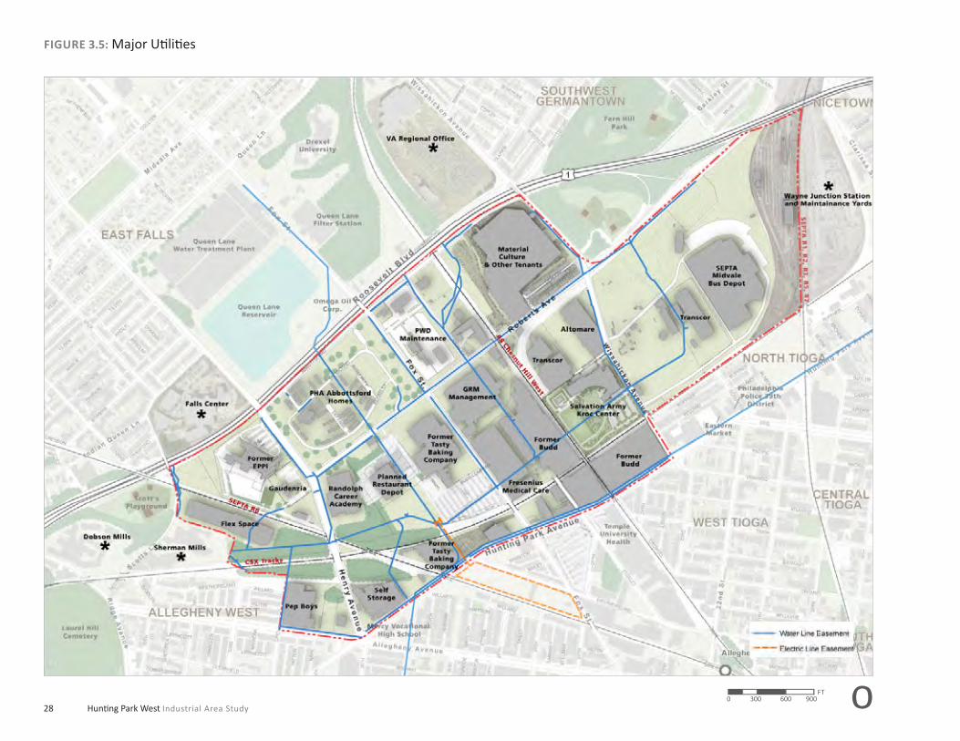
FIGURE 3.5: Major Uti liti es
o0 300 600 900FT

29Planning Goals and Objectives
Utilities, Transportation and Vacant Land
Because of its industrial past, the site is well served by infrastructure with
capacity to accommodate very large amounts of future development. The
study area has a robust uti lity network with a number of major sewers,
water and electric lines running through the site. The Philadelphia Water
Department (PWD) has a maintenance facility on Fox Street. The 9.88
acre site contains mostly surface parking with a few accessory buildings.
With its industrial past, the HPW Study area is also well served by freight
rail. There are approximately two miles of freight track within the study
area, three SEPTA commuter rail lines, and one CSX freight line. Although
two Regional Rail lines (the SEPTA R6, and R8) pass through the site, the
study area is not well served by commuter rail because of the distance of
the regional rail stati ons.
With the planned relocati on of Tasty Baking there are over 100 acres va-
cant. Preferred Real Estate Investments which owns the majority of the
former Budd plant has been marketi ng the area as the Budd Commerce
Center with the goal of att racti ng a range of commercial users. While
Preferred has had some success in att racti ng new industries and some
creati ve temporary uses for its large buildings, leasing one of the former
Budd warehouses for fi lm producti on to Paramount Pictures, an overall
strategy is needed to bring new life to this once thriving industrial land.
However, with such extensive infrastructure service in place and large
vacant and underuti lized buildings and parcels, the study area is primed
for redevelopment.
FIGURE 3.6: Rail Freight and SEPTA Regional Rail Services
o0 700 1400 2100FT

Hunti ng Park West Industrial Area Study30
FIGURE 3.7: Parcel Size
o0 300 600 900FT

31Planning Goals and Objectives
FIGURE 3.8: Building Typologies
Institutional/Campus
EPPI, 11 story tower
Flex/multi-tenant, 2 story
Former Budd, 760,000sf 6 story
Pep Boys, 5 story
Falls Center (MCP), 8 story
Material Culture and other tenants, 2 story
Tasty Baking Company, 6 story 550,000 GSFSEPTA Midvale Yard, 430,000 GSF Transcor, 1 and 2 story
Industrial/Warehouse Medium Industrial
Highrise Industrial
o0 300 600 900FT

32 Hunti ng Park West Industrial Area Study
Developments and Relocations
New and planned users in the study area may help to catalyze develop-
ment. Currently in constructi on, and scheduled to open October 2010, is
the Salvati on Army Ray and Joan Kroc Corps Community Center. The 12.4
acre facility on Wissahickon Avenue will feature a 130,000 square foot
community center with indoor gymnasium, aquati c center, worship and
performing art spaces on the ground fl oor, and fi tness administrati on and
classrooms on the second fl oor. A central open space with rain gardens,
playgrounds, open lawn, an athleti c fi eld, and a community farm will pro-
vide a range of outdoor acti viti es. The center will have approximately 250
parking spaces on site and is expected to bring a high number of daily visi-
tors by bus. Restaurant Depot a wholesale food, beverage and restaurant
supply shop is planning a one story commercial building for the 6 acre site
between the Randolph Academy and the former Tasty Baking warehouse
site. Tasty Baking Company which has been in Hunti ng Park since 1922
has recently completed its relocati on to new faciliti es in the Philadelphia
Navy Yard. The move leaves vacant a 550,000 square foot, fi ve and six-
story Tasty Baking building on an 8 acre site on Hunti ng Park Avenue and
the Tasty Baking warehouse located on Fox Street. The 12.1 acre site has
a 2 story masonry and brick building with 260,000 square feet.
Salvation Army Ray and Joan Kroc Corps Community Center in construction, Spring 2010.
www.use.salvationarmy.org
A rendering of the Salvation Army Ray and Joan Kroc Corps Community Center.
MGA PARTNERS, Architects

33Planning Goals and Objectives
SEPTA R6
SEPTA R8
SEPTA R7
SEPTA R1, R2, R3, R5
Germantown Ave
Roosevelt Expy
W H
unting Pa
rk A
ve
Ridge Ave
Wissahickon Ave
Wissahickon Ave
Henry Ave
Henry Ave
+180’
+230’
+200’
+110’
+110’
+250’
Abbortsford Homes
DobsonMills
East FallsStation
Queen LaneStation
WayneJunction
LaurelHill
Cemetery
Mt. VernonCemetery
MaterialCulture
Fern Hill Park
StentonPark
PhiladelphiaUniversity
Rhodes EWashingtonHigh School
Sch
uyl
kill
Riv
erSEPTA
FutureKroc
Center
Scott’sPlayground
ShermanMills
FormerEPPI
FutureRestaurant
Depot
Wissahick
on Creek
SEPTA R6
Roosevelt Expy
W H
unting Pa
rk A
ve
Ridge Ave
+180’
+200’
+110’
+110’
+250’
Abbortsford Homes
DobsonMills
East FallsStation
LaurelHill
Cemetery
Mt. VernonCemetery
MaterialCulture
Fern Hill Park
University
Rhodes EWashingtonHigh School
Sch
uyl
kill
Riv
erSEPTA
FutureKroc
Center
Scott’sPlayground
ShermanMills
FormerEPPI
FutureRestaurant
Depot
W
SEPTA R6
SEPTA R8
SEPTA R7
SEPTA R1, R2, R3, R5
Germantown Ave
Roosevelt Expy
W H
unting Pa
rk A
ve
Ridge Ave
Wissahickon Ave
Wissahickon Ave
Henry Ave
Henry Ave
Abbortsford Homes
DobsonMills
East FallsStation
Queen LaneStation
WayneJunction
LaurelHill
Cemetery
Mt. VernonCemetery
MaterialCulture
Fern Hill Park
StentonPark
PhiladelphiaUniversity
Rhodes EWashingtonHigh School
Sch
uyl
kill
Riv
er
SEPTA
FutureKroc
Center
Wissahick
on Creek
SEPTA R6
Roosevelt Expy
W H
unting Pa
rk A
ve
Ridge Ave
Abbortsford Homes
DobsonMills
East FallsStation
LaurelHill
Cemetery
Mt. VernonCemetery
MaterialCulture
Fern Hill Park
University
Rhodes EWashingtonHigh School
Sch
uyl
kill
Riv
er
SEPTA
FutureKroc
Center
W
SEPTA R6
SEPTA R8
SEPTA R7
SEPTA R1, R2, R3, R5
N 22nd Street
Erie Ave
N 29th
Street
Wayne Ave
W Allegheny Ave
Kelly Drive
Fox StMidvale
Germantown Ave
Roosevelt Expy
W H
unting Pa
rk A
ve
Ridge Ave
Wissahickon Ave
Wissahickon Ave
Henry Ave
Henry Ave
Abbortsford Homes
DobsonMills
East FallsStation
Queen LaneStation
WayneJunction
LaurelHill
Cemetery
Mt. VernonCemetery
MaterialCulture
Fern Hill Park
StentonPark
PhiladelphiaUniversity
Rhodes EWashingtonHigh School
Sch
uyl
kill
Riv
er
SEPTA
FutureKroc
Center
Scott’sPlayground
ShermanMills
FormerEPPI
FutureRestaurant
Depot
Wissahick
on Creek
SEPTA R6
N 22n
Erie Ave
N 29th
Street
W Allegheny Ave
Kelly Drive
Fox StMidvale
Roosevelt Expy
W H
unting Pa
rk A
ve
Ridge Ave
Abbortsford Homes
DobsonMills
East FallsStation
LaurelHill
Cemetery
Mt. VernonCemetery
MaterialCulture
Fern Hill Park
University
Rhodes EWashingtonHigh School
Sch
uyl
kill
Riv
er
SEPTA
FutureKroc
Center
Scott’sPlayground
ShermanMills
FormerEPPI
FutureRestaurant
Depot
W
+180’
+230’
+200’
+110’
+110’
+250’
Abbortsford Homes
DobsonMills
East FallsStation
Queen LaneStation
WayneJunction
LaurelHill
Cemetery
Mt. VernonCemetery
MaterialCulture
Fern Hill Park
StentonPark
PhiladelphiaUniversity
Rhodes EWashingtonHigh School
Sch
uyl
kill
Riv
er
SEPTA
FutureKroc
Center
Scott’sPlayground
ShermanMills
FormerEPPI
FutureRestaurant
Depot
Wissahick
on Creek
+180’
+200’
+110’
+110’
+250’
Abbortsford Homes
DobsonMills
East FallsStationtion
LaurelHill
Cemetery
Mt. VernonCemetery
MaterialCulture
Fern Hill Park
University
Rhodes EWashingtonHigh School
Sch
uyl
kill
Riv
er
SEPTA
FutureKroc
Center
Scott’sPlayground
ShermanMillsMi
FormerEPPI
FutureRestaurant
Depot
W
Topography Existi ng Vegetati on
Slope Analysis Stormwater and Drainage
FIGURE 3.9: Site Analysis
Stormwater Outfalls
An analysis of the environmental context of the area, presented in Figure 3.9, shows its location in north central Philadelphia. The area’s topography ranges from high points of ap-proximately 190’ to 200’ at Abbortsford Homes a low of 110‘ along Hunting Park Avenue, with some steep slopes located internal to the area. The area’s high degree of impervious surface and limited tree cover, inspite of significant vegetated surrounding areas, combined with the significant grade change indicate that a great deal of its storm water does not percolate into the soil and recharge ground water, but rather drains primarily to the Wissahickon Creek watershed.
0%-8% suitable for most land uses
8%-30% suitable for vegetati on, passive recreati on, some light development
>30% not suitable for development
Water Body
100 Year Floodplain
500 Year Floodplain
+ Local High Point
Major Drainage Route
Minor Drainage Route
Cemetery
Public Park
Water
Existing trees

Hunti ng Park West Industrial Area Study34
FIGURE 3.10:Environmental Inventory
Data Source: Advanced GeoServices
o0 300 600 900FT

35Planning Goals and Objectives
CASE STUDY
Existing Land Use Issues and Potentials
With over 117 acres containing vacant land and buildings in multi ple
ownerships, the Hunti ng Park West Study Area is subject to uncoordi-
nated incremental redevelopment. A comprehensive land use and zoning
strategy is needed to guide redevelopment in a manner that achieves the
vision and goals for the area. While there are signifi cant vacant and un-
deruti lized land and buildings, many of the sites may not be appropriate
for current industrial and manufacturing needs. The City of Philadelphia’s
Industrial Land Use Study’s preliminary results note that modern indus-
try needs fl at parcels over 10 acres in size with suitable access. There
are few such sites in the city or the study area. Large sites in the study
area typically contain large industrial buildings, making reuse diffi cult as
the building types are not conducive to modern industrial processes. The
potenti al may lie more in the light industrial, assembly, and fl ex space
sectors which typically do not need the large amounts of space contained
in many of the vacant buildings in the study area.
Preliminary Environmental Inventory
To ascertain the potenti al redevelopment opportuniti es for the Hunti ng
Park West Study Area and develop a strategy to att ract investment, Ad-
vanced GeoServices conducted a preliminary environmental inventory of
the study area (For the full report can be found in the Technical Report:
Advanced Geo Services Preliminary Environmental Inventory, November,
2009). The inventory included review of a variety of available informati on
concerning the overall study area and the individual properti es within it.
The available informati on included environmental reports, site plans, and
business development studies for the area. This Preliminary Environmen-
tal Inventory is not intended to be a Phase I Environmental Site Assess-
ment (ESA) and does not include a review of the detailed items present
during an ESA or site visits of individual properti es.
This Preliminary Environmental Inventory covers the 434-acre Hunti ng
Park West study area. The natural environment within the study area has
been impacted by the man-made development that has occurred over a
250 year period. This has resulted in extensive alterati ons to the area’s
original topography, vegetati on, and drainage patt ern. As a result, the
area has developed from a relati vely open and rural environment into
the dense, urban environment seen today. Between the mid 1800s and
mid 1900s, the area transiti oned into an industrial area with a number
of large companies fabricati ng parts for the automobile industry. This in-
dustrial boom began to decline in the mid 1900s as numerous businesses
shrank or closed. This decline had a marked and enduring impact on the
adjacent communiti es as evidenced by the number of vacant and dete-
riorati ng properti es.
Industrial Land as a Driver for Economic Development
Other cities are also position-ing themsleves to reuse histori-cally industrial land as a driver for economic development. New York City’s Mayor introduced 30 Initia-tives to grow New York’s green economy that include programs to support and attract green businesses and entrepreneurs, provide green collar job train-ing, solar power tax abatements, building innovative solar projects, and expanding the urban forestry program with the goal to create 13,000 green jobs over the next decade.

36 Hunti ng Park West Industrial Area Study
CASE STUDY
The land, buildings, faciliti es and infrastructure within the site were de-
veloped over a long ti me and represent a wide variety of materials and
processing that may have negati vely impacted the environment. Parts
of the study area contain large areas or faciliti es that are vacant, under-
uti lized or in poor conditi on. These include site areas and faciliti es that
maybe contaminated, may have undergone an environmental investi ga-
ti on, and some which may have already been remediated.
Based on the documentati on available to the project team, a gradient
was created to characterize the site properti es based on their relati ve lev-
els of environmental impact ; low, medium, and high. These levels were
established for the various areas throughout the study area based on lim-
ited environmental data. The levels were based on the potenti al “costs
to develop the area” due to the requirement to clean up an area to an
acceptable standard prior to the constructi on of the proposed facility. For
instance, an area that had been identi fi ed as “high” has the potenti al for
large project costs to address environmental cleanup prior to construc-
ti on. It should be noted that more detailed testi ng will be required within
all areas of the study area once the proposed development is further de-
veloped. The results of this more detailed testi ng could fi nd that an area
that had been preliminarily identi fi ed as “low” actually has high develop-
ment costs and conversely, the detailed testi ng could determine that an
area preliminarily identi fi ed as “high” actually will have low development
costs from an environmental perspecti ve.
The majority of sites with available informati on were in the low and me-
dium categories. The main areas of concern were the rail corridors, the
SEPTA Roberts Avenue Yard, the former EPPI site and buildings, and a
small one story concrete structure located adjacent to the planned Res-
taurant Depot. The SEPTA Roberts Avenue Yard is currently used for bus
storage and maintenance. Both it and SEPTA’s Midvale Yard are charac-
terized by a moderate to signifi cant level of concern. The SEPTA Midvale
Bus Depot has a number of tanks containing diesel fuel, used oil, and
other hazardous substances. Its historical use as a rail yard indicates that
there is a potenti al of PCB, volati le organics, and metal contaminati on.
Although the team did not have site specifi c environmental characteris-
ti cs available for review, the SEPTA Roberts Yard as an equipment storage
yard, has a potenti al for contaminati on based on previous use. The rail
lines owned by CSX and SEPTA located within the study area, including
three SEPTA commuter lines and one freight line, have no documentati on
available. However, based on site acti viti es, there is a possibility of pesti -
cides, herbicides, metals, and volati le chemicals as well as the possibility
that spills of materials in transit may have occurred along the tracks. The
former EPPI site has a moderate level of concern due to asbestos and ra-
diati on contaminati on noted to exist in the facility. Some of these materi-
als may have been remediated. At the ti me of this study, a full report on
EPPI was not available so it is suggested that a complete Phase I Environ-
mental Site Assessment be conducted for the EPPI site. A number of the
sites within the study area did not have enough informati on available to
make a determinati on at this ti me. These sites are left blank on the map
and identi fi ed as No Available Data.
Industrial Land as Green Infrastructure
Interconnected network of open spaces :
Manages stormwater• Reduces flood risk• Improves air and water quality• Includes greenways, wetlands, • parks, native plant vegetation

37Planning Goals and Objectives
Existing Traffic and Circulation
The existi ng traffi c and circulati on conditi ons were studied in depth using
available data and new traffi c counts at selected locati ons. The transpor-
tati on porti on of the area study encompassed the following intersecti ons
and roadways: Henry Avenue (S.R. 4001) and Roberts Avenue (S.R. 4009);
Roberts Avenue and Wissahickon Avenue (S.R. 4003); Roberts Avenue
and Fox Street; Henry Avenue/West Hunti ng Park Avenue (S.R. 0013)/
West Allegheny Avenue (S.R. 2016).
Existing Roadway System
Henry Avenue (S.R. 4001) is a four-lane, east-west, urban principal arte-
rial roadway with a posted speed limit of 35 MPH in the vicinity of the
sites. At its signalized intersecti on with Abbott sford Avenue, Henry Av-
enue (S.R. 4001) has a separate eastbound left -turn lane, two eastbound
and westbound travel lanes, and a separate westbound right-turn lane.
At its signalized intersecti on with Roberts Avenue (S.R. 4009), Henry Av-
enue (S.R. 4001) has a separate eastbound left -turn lane, two eastbound
and westbound travel lanes, and a separate westbound right-turn lane.
At its signalized intersecti on with W. Allegheny Avenue (S.R. 2014)/W.
Hunti ng Park Avenue (S.R. 0013), Henry Avenue (S.R. 4001) has a sep-
arate eastbound left -turn lane, a separate eastbound travel lane, two
separate eastbound right-turn lanes, and a westbound travel lane. The
pavement surface and lane markings are in fair conditi on throughout the
study area.
Roberts Avenue (S.R. 4009) is a two-lane, north-south, urban minor arte-
rial roadway with a posted speed limit of 30 MPH in the vicinity of the
sites. At its signalized intersecti on with Henry Avenue (S.R. 4001), Roberts
Avenue (S.R. 4009) has a single travel lane. At its signalized intersecti on
with Fox Street, Roberts Avenue (S.R. 4009) has a separate left -turn lane
and a single travel lane on both approaches. At its signalized intersec-
ti on with Wissahickon Avenue (S.R. 4003), Roberts Avenue (S.R. 4009)
has a separate left -turn lane and a single travel lane on both approaches.
The pavement surface and lane markings are in fair to poor conditi on
throughout the study area.
Henry Avenue at Roberts Avenue.
5-point Intersection (Allegheny Avenue, Henry Avenue, Hunting Park West Avenue, and 30th Street).
Roberts Avenue at Fox Street.
FIGURE 3.11: Block Dimensions
The large block sizes found in the Hunting Park West are indicative of the study areas historical use as a manufacturing center.

Hunti ng Park West Industrial Area Study38
FIGURE 3.12: Existi ng Traffi c and Circulati on
o0 300 600 900FT

39Planning Goals and Objectives
The team reviewed existi ng available traffi c impact studies for
the following locati ons:
Wissahickon Avenue (S.R. 4003) is a four-lane, east-west, urban minor
arterial roadway with no posted speed limit in the vicinity of the sites. At
its signalized intersecti on with Roberts Avenue (S.R. 4009), Wissahickon
Avenue (S.R. 4003) has a separate left -turn lane and two travel lanes on
both approaches. At its signalized intersecti on with W. Hunti ng Park (S.R.
0013), Wissahickon Avenue (S.R. 4003) has a separate left -turn lane on
the eastbound approach and a single travel lane on both approaches.
The pavement surface and lane markings are in fair conditi on throughout
the study area.
Fox Street is a two-lane, east-west, urban minor arterial roadway with a
posted speed limit of 30 MPH in the vicinity of the sites. At its signalized
intersecti on with Roberts Avenue (S.R. 4009), Fox Street has a single trav-
el lane on both approaches. At its signalized intersecti on with W. Hunt-
ing Park (S.R. 0013), Fox Street has a separate left -turn lane and a single
travel lane on both approaches. The pavement surface and lane markings
are in fair to poor conditi on throughout the study area.
West Hunti ng Park Avenue (S.R. 0013) is a four-lane, north-south, urban
principal arterial roadway with a posted speed limit of 30 MPH in the
vicinity of the sites. At its signalized intersecti on W. Allegheny Avenue
(S.R. 2014)/Henry Avenue (S.R. 4001), W. Hunti ng Park 9S.R. 0013) has an
eastbound separate left -turn lane, through lane, and through right-turn
lane and two westbound through lanes and a separate right-turn lane.
At its signalized intersecti on with Fox Street, W. Hunti ng Park Avenue
(S.R. 0013) has a separate left -turn lane and two travel lanes on both
approaches. At its signalized intersecti on with Wissahickon Avenue (S.R.
4003), W. Hunti ng Park Avenue (S.R. 0013) has a separate northbound
left -turn lane and a two travel lanes on both approaches. The pavement
surface and lane markings are in good to fair conditi on throughout the
study area.
West Allegheny Avenue (S.R. 2014) is a two-lane, east-west, urban minor
arterial roadway with a posted speed limit of 25 MPH eastbound and 30
MPH westbound in the vicinity of the sites. At its signalized intersecti on
with W. Hunti ng Park Avenue (S.R. 0013)/Henry Avenue (S.R. 4001), W.
Allegheny Avenue (S.R. 2014) has a separate left -turn lane and a single
travel lane on both approaches. Additi onally, bike lanes are provided in
both directi ons. The pavement surface and lane markings are in fair to
poor conditi on throughout the study area.
Wissahickon Avenue at Hunting Park Avenue.
Fox Street at Roberts Avenue.
West Hunting Park Avenue at Allegheny Avenue.
West Allegheny Avenue at 30th Street.
Sample Road Characteristics

Hunti ng Park West Industrial Area Study40
FIGURE 3.13: Existi ng Transit System
0 700 1400 2100FT o

41Planning Goals and Objectives
TABLE 3.2: Average Daily Traffi c Counts—24-Hour Weekday
Segment Directi on ADTYear
Collected Source
Roosevelt Boulevard (Route 1)
Between Henry Avenue and Fox Street NB 54,645 2006 iTMS
SB 55,286 2006 iTMS
Henry Avenue
Between Abbott sford Avenue and Roberts Avenue
EB 3,849 2009 TPD1
WB 6,608 2009 TPD1
Between Roberts Avenue and W. Hunti ng Park Avenue
EB 7,159 2007 DVRPC
WB 9,079 2007 DVRPC
Roberts Avenue
Between Fox Street and Wissahickon Avenue
Bi-Directi onal 8,928 2006 iTMS
Wissahickon Avenue
Between Roberts Avenue and W. Hunti ng Park Avenue
EB 9,723 2008 iTMS
WB 6,823 2008 iTMS
W. Hunti ng Park Avenue
Between Fox Street and Wissahickon Avenue
NB 8,608 2009 TPD1
SB 9,952 2009 TPD1
Between Fox Street and Wissahickon Avenue
NB 8,300 2005 iTMS
SB 7,659 2005 iTMS
Existing Transit System
The study area is currently served by mass transit via various bus routes
and regional rail lines provided by the Southeastern Pennsylvania Trans-
portati on Authority (SEPTA). The team obtained ridership data for the bus
and regional rail service in the study area from SEPTA offi cials. The exist-
ing transit system and ridership data throughout the study area is shown
in the Existi ng Transit System Plan.
The 24-hour weekday traffi c count informati on for the identi fi ed
roadways within the study area is summarized in Table 3.2.
iTMS = PennDOT Internet Traffic Monitoring System (iTMS)
DVRPC = Delaware Valley Regional Planning Commission
TPD = Traffic Planning and Design, Inc.

42 Hunti ng Park West Industrial Area Study
CASE STUDY Existing Market ConditionsSocio-demographic analysis was performed on the above PMA, and,
where appropriate, compared to the broader regional geography of the
City of Philadelphia and/or the Philadelphia MSA, representi ng twelve
counti es in the Delaware Valley region.
Within 15-minutedrive from center of Study Area:
1.2 million persons•
482,000 households•
$22 billion in annual spending•
The PMA includes a number of insti tuti ons LaSalle University, Philadel-
phia University, Pep Boys Head Quarters, and Temple University Health
Systems.
Market Conditions
The market analysis employed a combinati on of qualitati ve and quanti ta-
ti ve techniques in order to identi fy existi ng market and socio-economic
conditi ons within the study area. The analysis began with a review of ex-
isti ng market and planning studies covering the Hunti ng Park West study
area and then proceeded to a baseline market analysis, examining local
and regional demographic, labor, industry and real estate trends.
Demographic trend analysis was performed using U.S. Census data and
proprietary demographic analysis soft ware (ScanU.S.) and covers the
2000 and 2009 (esti mated) periods. Labor market data covered the 2002
to 2006 ti me period and is based on reported U.S. Census and Pennsyl-
vania Labor Data. Quanti tati ve analysis was followed by interviews with
local, regional and nati onal developers, along with interviews of large
business organizati ons located within the study area. The purpose of
positi oning interviews aft er the quanti tati ve analysis was to both share
insight and validate fi ndings with interviewees.
Conventi onally, a primary market area (PMA) represents a geographic
area containing 70- to 75-percent of household demand (purchasers of
goods and services) for a commercial center (e.g., community or regional
retail center). For the purposes of this analysis, four postal ZIP code areas
were identi fi ed within the larger area immediately adjacent to the study
area as the PMA for the Hunti ng Park West Study Area. These four ZIP
code areas are: 19144 (Germantown); 19140 (Tioga/Nicetown); 19132
(Allegheny West); and 19129 (East Falls).
FIGURE 3.14: Primary Market AreaIndustrial Land as Neighborhood Revitalization
Brewer’s Hill Baltimore, Maryland
Historic renovation and adap-• tive reuse of two landmark breweries
Conversion of 11 buildings into • Class-A office, flex/warehouse, retail, restaurant
Maryland Green Building Tax • Credit Program
Branding•

43Planning Goals and Objectives
TRENDSDemographic and Labor TrendsBoth Hunti ng Park West and the City of Philadelphia saw esti mated de-
clines in household populati on from 2000 to 2009. The relati vely high
populati on loss exhibited in Hunti ng Park West during that ti me period is,
in part, a result of conti nued loss of large employers and signifi es struc-
tural economic and/or social issues.
The measurement of geography’s household income, coupled with
knowledge of the household formati on trends within that geography pro-
vides insight into the prospecti ve types and quanti ti es of goods and ser-
vices which may be demanded by these households. As shown in fi gure
3.16, growth in household income occurred in all three geographies and
was parti cularly pronounced in the highest income bracket (>$149,999).
While household incomes at the upper end of the scale kept pace with
FIGURE 3.15: Change in Number of Households in Upper Income Brackets
FIGURE 3.16: Change in Households by Income Brackets, 2000-2009
Source: US Census Bureau; ScanUS; 4ward Planning LLC, 2009
Source: US Census Bureau; ScanUS; 4ward Planning LLC, 2009
Source: US Census Bureau; ScanUS; 4ward Planning LLC, 2009
the City and MSA. The relati vely large decline in lower income households
within Hunti ng Park West also suggests a lack of suitable employment
opportuniti es for working age residents as lack of income opportunity
is a consistent factor for household out-migrati on. Even as the PMA lost
residents in the lower income bracket, the PMA also experienced a sig-
nifi cant percentage increase in the total number of upper income bracket
households as seen in fi gure 3.17. While the share of household income
in the upper income brackets is increasing, Hunti ng Park West demon-
strates substanti ally lower median household incomes than the City as a
whole. Thus, an important focus of a redevelopment strategy for Hunti ng
Park West should be to bring the area’s income level’s closer to the City’s
through quality employment opportuniti es.
Demographic and Labor Trends
• Between 2000 and 2009, the Hunting Park West PMA experi-enced a 69.7% growth in the Up-per Income ($75,000 and greater income bracket) households.
• The 2009 estimated annual aggregate expenditures for households within the Hunting Park West PMA was $197,181 per square mile.
• The largest industry employment sector for 2006 was Healthcare and Social Service Workers, Educa-tional Services, and Manufacturing.

44 Hunti ng Park West Industrial Area Study
Consumer Expenditure ProfileThe relati ve purchasing power within lower-income, urban communiti es
has, historically, been overlooked or substanti ally discounted by regional
and nati onal retailers for a host of reasons – crime percepti ons, unac-
ceptably low incomes, etc. The sheer volume of pent-up demand within
these communiti es, as has been well documented through numerous
studies examining the purchasing power of lower-income urban area
communiti es, presents an enormous opportunity for goods and service
retailers seeking expansion opportuniti es. The following charts graphi-
cally illustrate the signifi cant household spending power within the Hunt-
ing Park West PMA, relati ve to that for the households within the City of
Philadelphia and the Philadelphia MSA. The fi gure shows that while the
aggregate income per square mile for HPW is slightly lower than the City,
the esti mated expenditures is slightly larger (approximately 6.3 percent
larger). This is indicati ve of the high household densiti es found within the
Hunti ng Park West PMA.
Source: US Census Bureau; ScanUS; 4ward Planning LLC, 2009
Source: US Census Bureau; ScanUS; 4ward Planning LLC, 2009
Source: US Census Bureau; ScanUS; 4ward Planning LLC, 2009
FIGURE 3.17: 2009 Esti mated Household Income and Expenditures (Per Square Mile)
FIGURE 3.18: 2009 Esti mated Aggregate Consumer Expenditures (Per Square Mile)
FIGURE 3.19: 2009 Esti mated Aggregate Consumer Expenditures (Per Square Mile)

45Planning Goals and Objectives
Educational AttainmentLike household income, a geography’s educati onal att ainment trends (for
adults 25 years of age and older) provides an important indicator concern-
ing potenti al business investment and revitalizati on opportuniti es. Areas
experiencing increases in educati onal att ainment levels (e.g. increasing
percentage of adults possessing a four-year degree) are favorable for vari-
ous types of consumer related real estate investment, as educati onal at-
tainment is both strongly and positi vely correlated with income. While the
percentage share increased across all geographies from 2000 to 2009, the
total percentage is signifi cantly higher in the MSA than in the City, and is
roughly double that of Hunti ng Park West. However, Hunti ng Park West
demonstrated higher percentage changes in the number of adults possess-
ing an associate’s (55.5 percent), bachelor’s (32.9 percent), and graduate
(33.3 percent) degrees than both the City and the MSA. A redevelopment
strategy for the Hunti ng Park West study area should facilitate opportuni-
ti es to sustain these educati onal att ainment increases, as well as the reten-
ti on of area adults possessing undergraduate and graduate degrees.
Housing TenureAn examinati on of housing tenure trends within a given geography fa-
cilitates the identi fi cati on of areas att racti ng investment (or experiencing
disinvestment) and considered stable or in transiti on. Owner-occupied
housing units declined in Hunti ng Park West by 8.4 percent from 2000 to
2009, as compared to a decline of 7.2 percent for the City and an increase
of 4.8 percent for the MSA. Declines in owner-occupied housing units are
a typical indicator of an area experiencing social and economic disloca-
ti on and real estate disinvestment.
FIGURE 3.20: Percentage of Adults 25+ with Bachelor’s Degree
FIGURE 3.21: Percentage Channge in Housing Tenure, 2000–2009
CASE STUDY
Industrial Land as Art and Recreation
Seattle Art Museum Olympic
Sculpture Park
9 acre park on former • industrial site
Environmental restoration, • creation of salmon habitat, stormwater reuse

46 Hunti ng Park West Industrial Area Study
Labor TrendsFigure Number shows the percentage of people 16+ who are considered
in the labor force; it does not include military or those not acti vely seek-
ing employment. As exhibited in the adjacent graphic, all three geogra-
phies show a small percentage increase in persons parti cipati ng in the
labor force from 2000 to 2009. The percentages were lowest in Hunti ng
Park West, followed by the City, and were highest in the MSA.
Hunting Park West PMA Employment Profile (2002-2006)Table A-2 exhibits the top fi ve PMA industries by employment, for years
2002, 2004 and 2006. Consistently within the PMA top fi ve industries by
employment were Healthcare and Social Assistance, Educati onal Servic-
es, Manufacturing and Retail Trade.
Employment within the Healthcare and Social Assistance and Educati onal
Services industry sectors represented 55 percent of total industry em-
ployment within the Hunti ng Park West PMA in 2006 – approximately 1.5
ti mes greater than the number employed in these industries in 2004. This
increase in employment within the above referenced service industries is
indicati on of favorable labor pool conditi ons and faciliti es, and is consis-
tent with regional and nati onal employment trends.
While exhibiti ng a declining employment presence within the Hunti ng
Park West PMA, the manufacturing industry, nonetheless, employs a
relati vely large number of workers (2,402 as of 2006) and should be con-
sidered a strong strategic asset within future redevelopment plans.
Upon examinati on of the number of Hunti ng Park West PMA workers
who also lived within the PMA it was determined that fewer than 14 per-
cent (approximately 3,500 persons) did so, in 2006. Or, to state it more
emphati cally, more than 22,000 persons who had primary employment
within the Hunti ng Park West PMA during 2006, lived outside of the PMA.
The magnitude of this fi nding is considerable, when household expendi-
tures for even a small fracti on of the number living outside of the PMA
are factored. Future redevelopment plans should consider opportuniti es
to provide residenti al opti ons in close proximity to the study areas key
employers.
FIGURE 3.22: Percentage of People 16+ in the Labor Force
Source: US Census Bureau; ScanUS; 4ward Planning LLC, 2009

47Planning Goals and Objectives
CASE STUDY
TABLE 3.3: Hunti ng Park West Employment Profi le: 2002
TABLE 3.4: Hunti ng Park West PMA—Top 5 Industries by Employment
Industrial Land as Driver for Tourism and Economic Development
European Route of Industrial Heritage
Includes 6 countries•
Former industrial site in Essen, • Germany now UNESCO World Heritage Site
Includes history, art, sculpture, • recreation
Total Primary Jobs 26,639
Jobs by Worker Age (pct.)
Age 30 or younger 19.1%
Age 31 to 54 63.6%
Age 55 or older 17.3%
Jobs by Earnings Paid (pct.)
$1,200 per month or less 22.6%
$1,201 to $3,400 per month 44.4%
More than $3,400 per month 33.0%
Top Five Industries by Employment
Healthcare and Social Assistance 8,908
Educati onal Services 4,262
Manufacturing 3,965
Retail Trade 1,707
Constructi on 1,170
Total Private Employers 1,262
Total Private Employment 16,370
Average Employment/Firm 13
2002
Healthcare and Social Assistance 8,908
Educati onal Services 4,262
Manufacturing 3,965
Retail Trade 1,707
Constructi on 1,170
2004
Healthcare and Social Assistance 5,117
Manufacturing 2,931
Retail Trade 1,956
Educati onal Services 1,580
Wholesale Trade 1,070
2006
Healthcare and Social Assistance 8,797
Educati onal Services 5,311
Manufacturing 2,402
Retail Trade 1,938
Accommodati on and Food Services 1,065
Source: U.S. Census Bureau; 4ward Planning LLC, 2009
Source: U.S. Census Bureau; 4ward Planning LLC, 2009

48 Hunti ng Park West Industrial Area Study
Baseline Socio-Economic Infrastructure AssessmentThe assessment of the adequacy or defi ciency of socio-economic services
within the Hunti ng Park West PMA provides an indicator of the overall
health of the communiti es surrounding HPW. The following socio-eco-
nomic infrastructure services were examined:
Number of full-service supermarkets per 10,000 residents
A total of fi ve full-service supermarkets were identi fi ed within the Hunt-
ing Park West PMA, representi ng one supermarket for every 28,437 resi-
dents – a rati o which is nearly three ti mes greater than what is considered
opti mal and 3.2 ti mes greater than the U.S. average. PMA households
which are unable or unwilling to travel to supermarkets which may be
several miles from their homes are likely paying a premium for food and
other necessiti es, and getti ng a more limited selecti on off ered by smaller
grocers and corner stores. The consequences for households which do
travel a greater distance to access a conventi onal supermarket are higher
travel costs and increased greenhouse gas emissions. Studies have shown
that there are signifi cant health risks for communiti es that do not have
access to quality fresh foods including an increased risk in childhood obe-
sity and diabetes. An easily accessible supermarket is a key defi ning ser-
vice in a competi ti ve community of choice.
The Hunti ng Park West study area presents an excellent opportunity for
facilitati ng one or more supermarkets, given land area available for rede-
velopment.
Ratio of licensed childcare center slots to pre-school age children and younger
The rati o of licensed childcare spaces to pre-K children is 52.2 percent, as
compared to 50.8 percent for the City of Philadelphia and 53.5 percent
for the U.S., for 2009. Specifi cally, 75 childcare spaces to every 100 pre-K
children should be the fi ve-year established goal within the PMA. The re-
development opportuniti es within the Hunti ng Park West study area can
serve as a central locati on for many of these new spaces.
Hunti ng Park West Master Plan48
FIGURE 3.23: Persons per Supermarket in 2009
FIGURE 3.24: Rati o of Licensed Childcare Spaces to Pre-K Children
Source: US Census Bureau; ScanUS; 4ward Planning LLC, 2009
Source: US Census Bureau; ScanUS; 4ward Planning LLC, 2009

49Planning Goals and Objectives
Public open space acreage per 1,000 residents
The table below exhibits the open space att ributes of the Hunti ng Park
West PMA compared to the City of Philadelphia and other high density
citi es in the United States. ZIP code area 19144 (Germantown) has the
most open space at 353 acres, followed by 19140 (Tioga/Nicetown) with
119 acres. The PMA has 655 total acres in open space and parkland,
which equates to 4.6 acres per 1,000 residents. This is signifi cantly less
parkland per 1,000 residents than the City of Philadelphia at 7.2 acres
per 1,000 residents, and most of the observed high density citi es, only
surpassing Chicago with 4.3 acres per 1,000 residents. GreenWorks Phila-
delphia, the City’s guide to open space planning recommends 10 acres
of park space per 1,000 residents. Accessible, well-maintained parks are
markers of healthy communiti es. The Hunti ng Park West study area pro-
vides a tremendous opportunity to convert underuti lized lands into vi-
able park and open spaces. The new Kroc Corps Community Center will
provide an additi onal 12.4 acres of open space for the Hunti ng Park West
Primary Market Area.
Number and type of public transit options
The Hunti ng Park West PMA is served by public transit, off ering a variety
of opti ons, including one subway line (Broad Street Line), three regional
rail lines (R6, R7 and R8) and 17 bus lines (see table below). Each of the
transit lines which pass through some porti on of the Hunti ng Park West
PMA provide at least one stop, with many of the transit lines providing
multi ple stops within the PMA. Further, and of parti cular importance to
the revitalizati on of the Hunti ng Park West study area, public transit ac-
cessibility to and from the PMA and locati ons within the greater Philadel-
phia area are likely second only to Center City Philadelphia. Major em-
ployment centers, insti tuti ons, and residenti al communiti es are within a
ten to fi ft een minute ride on any number of transit lines found within
the PMA. Such strong public transit access is a highly valued asset for
consumers, retailers, and employers, alike. It should be noted, however,
that while there are a great number of mass transit opti ons and stops
within the Hunti ng Park West PMA, relati vely few of these stops are lo-
cated within the study area boundaries. In order for the Hunti ng Park
West redevelopment area is to reach its full potenti al signifi cant transit
improvements will need to be made including consistent bus to rail con-
necti ons from the site.
49Planning Goals and Objectives
LOCA
TIO
N
ACR
ES IN
OPE
N S
PACE
/PA
RKLA
ND
ACR
ES P
ER 1
,000
RES
IDEN
TS
19129 59
19132 124
19140 119
19144 353
Hunti ng Park West PMA
655 4.6
Philadelphia 8900 7.2
Chicago 4.3
New York 7.2
Balti more 7.5
Los Angeles 8.5
Boston 8.7
San Francisco 10.3
TABLE 3.5: Existi ng Open Space and Parkland

50 Hunti ng Park West Industrial Area Study
Interviews with Regional and National DevelopersThe team conducted multi ple interviews with real estate owners and us-
ers within the study area (Preferred Real Estate, Pep Boys Automoti ve
Group, and Temple University Health Systems), as well as regional and
nati onal developers experienced with urban, mixed-use revitalizati on
projects (The Rockefeller Group, L-COR, and The Dawson Companies).
Following are key fi ndings from the interviews:
Existi ng owners and users were generally opti misti c about the pros-•
pects for the study area.
When owners and users were asked about the presence of crime •
within the study area, all felt that, with few excepti ons, the area is
generally safe and suff ers more from the percepti on of crime than
actual crime events.
Owners and users were also unanimous in their desire to see im-•
proved public transit opti ons for the area. Indeed, all interviewees,
including outside developers, emphasized the criti cal need to estab-
lish frequent, reliable and quick public transit to move workers, pa-
trons and residents into and out of the study area.
Temple University Health System (TUHS) moved into their present •
locati on (the Budd Commerce Center Complex) in April of 2007 and
currently employs more than 800 workers. More than half of these
workers are esti mated to have a college degree and earn more than
$60,000 per year. TUHS would like to see greater nearby ameniti es
for its employees (quality restaurants, retail shops, personal service
establishments, etc.).
Pep Boys Automoti ve employs more than 400 workers at its facility •
(its headquarters), many of whom are highly paid, white collar work-
ers. Like TUHS, Pep Boys would also like to see greater ameniti es for
its employees.
Developers interviewed were unanimous in their recommendati on •
to pursue a mixed-use redevelopment strategy, inclusive of housing,
retail, entertainment and commerce. However, all interviewed felt
that an appropriate phasing strategy would be paramount to the suc-
cess of the project (how and when land/buildings are taken down/
adapti vely re-used).
All of the developers encouraged the investi gati on of creati ng a uni-•
versity housing village for several of the area universiti es, as a way to
help pioneer the site and create a catalyst for retail and market rate
housing.
TUHS indicated that many of its workers would likely respond favor-•
ably to proposed housing within the study area, given that a number
of its workers commute from distances greater than 30 minutes.
Developers were unanimous in citi ng development incenti ves as a •
necessary component of any redevelopment strategy for the site.
Felt that the study area needed an “identi ty” or theme – the way in •
which the Navy Yard has an identi ty.

51Planning Goals and Objectives
CASE STUDY
*Even under flat/zero growth, new and/or substantially rehabilitated units are needed to replace physically obsolescent units over time.
TABLE 3.6: Residenti al Real Estate Opportuniti es
The Plymouth
Chicago, IL
The Plymouth is an adaptive reuse of a turn of the century 11-story office building into an 80-bed student residence hall. The building is located in downtown Chicago adjacent to a number of educational and cultural institutions including Grant Park, the Harold Washington Library, and public transportation. The buildings on-site amenities include a fitness center, media room, social lounges, coff ee shop & café, conference rooms and bicycle storage. The buildings historic façade will be preserved while the interior will feature modern apartment-style suites. The renovations include high-efficency heating and cooling systems, energy conserving lighting.
The building will off er two diff erent room configurations:
• Four bedroom, four-bed apartment with two baths, a living area and full kitchen totaling approximately 1,268–1,330 sf
• Two bedroom, four-bed apartment with two baths, a living area and full kitchen totaling approximately 1,277–1,339 sf
Residential Real Estate Opportunities A number of factors add to the demand for new housing units within the
PMA. Some of the factors leading to this demand include the percentage
of workers within the Hunti ng Park West PMA that live outside the PMA
and would consider living closer to their place of employment if a range
of housing opti ons were available. Also annually, 1.5% of all housing units
within PMA become physically obsolescent/unmarketable and are in
need of replacement or substanti al rehabilitati on. Out of the residenti al
unit demand projected for the PMA it is expected that 60% of the new
demand will be for rental units and 40% for ownership. We esti mate that
even under a fl at/zero growth scenario there is a demand for 779 new
units for the years 2009-2014. Some of the projected unit demand within
the PMA can be accommodated within the HPW Study Area. Additi onally,
there may be a need for additi onal student housing to serve the educa-
ti onal insti tuti ons within the PMA.
Modest Growth Scenario (1.25%)
Slow Growth Scenario (0.75%)
Flat/Zero Growth Scenario (0.00%)
Total Units 8,362 4,881 779
For-Sale 3,345 1,953 312
Rental 5,017 2,929 467
Higher Income ($75K+) 1,254 732 117
Moderate Income ($40K-$74,9K) 1,672 977 156
Lower Income ($39.9K-less) 5,436 3,172 506
*New residential will be needed for all income groups.

52 Hunti ng Park West Industrial Area Study
CASE STUDY
184
51
182
108
400
102
213
212
-89
53
-148
153
-40% -30% -20% -10% 0% 10% 20% 30% 40% 50% 60% 70% 80% 90% 100%
Grocery Stores
Restaurants
Home & Garden Supply
Furniture & Equipment
Clothing and Accessories
Entertainment
Existing S.F. (000s)
Needed S.F. (000s)
Restaurantss
Entertainmentt
Grocery Storess
NEED MORE
TOOMUCH
FIGURE 3.25: Retail Opportuniti es
Market Supply and Demand
Retail OpportunitiesThe chart above shows that the Hunti ng Park West PMA is oversupplied
in Clothing and Accessories and Home and Garden Supply categories and
greatly undersupplied in Entertainment, Restaurants and Grocery Stores.
This closely collaborates with what the team has heard from stakeholder
interviews and feedback received from the public meeti ngs. Resident’s
frequently voiced the need for sit-down restaurants, grocery stores and
retail and entertainment venues in close proximity to their neighbor-
hoods. This indicates a prospecti vely strong market for these types of ser-
vices. However, further analysis is necessary to understand the number
and nature (e.g. casual or formal chain; restaurant size; and price points;
etc.) which would be viable within the PMA. The HPW PMA makes a very
compelling case for retail investment given its relati vely high esti mated
expenditures on consumer goods and services and can support a super-
market and other retail services.140,000 Sq. Ft. Solar Powered Grocery Store
Berkeley, CA
The solar-powered Berkeley Bowl West supermarket uses 636 Photovoltaic panels to generate 149,633 kWh of energy every year. This reduces thousands of pounds of carbon dioxide being released into the atmosphere. The solar generated from the rooftop panels contribute to the building’s energy needs including lighting and extensive power demands from refrigeration.
http://www.sunlightandpower.com
Source: Directory of Major Malls; ULI Dollars & Cents of Shopping; 4ward Planning LLC, 2009

53Planning Goals and Objectives
CASE STUDY
Washington Avenue Loft District
St. Louis, MO
At the turn of the twentieth century, Washington Avenue in St. Louis was a prosperous manufacturing center with architecturally striking brick buildings housing shoe and clothing manufacturers. Following World War II and the decline in domestic garment production as well as a move towards single-story industrial spaces the area became increasingly va-cant. A vision was created to bring the area back to life and transform the derelict industrial buildings into a vital neighborhood with residential, cafes, lofts, galleries, night clubs and other entertainment venues. The state of Missouri adopted a tax credit for the redevelopment of historic buildings, attracting private development and making large-scale renova-tion financially feasible. The streetscape was one of the first phases of work to transform the area from a marginally active industrial area into a thriving arts-oriented and regional retail destination. Expanded public spaces were created for outdoor café seating, display of public art and street performances, and to stimulate potential linkages to adjacent desti-nations, attractions, and districts. The character of those spaces draws in-spiration from the historic context. Site furnishings, lighting, landscape and street planting, sidewalk paving patterns, and building-related elements all combine to create a unique ambiance for this revitalized urban area.
TABLE 3.7: Philadelphia Offi ce Market Third Quarter 2009 Profi le
Office OpportunitiesThe vacancy rates for Class B and C offi ce space in the city indicates that there
is limited demand for conventi onal offi ce space within the PMA, but the suc-
cess of Sherman Mills, the Falls Center, and Material Culture/4700 Wissahick-
on point to the long-term opportunity for start-up/incubator space. While
some offi ce/creati ve loft space remains vacant within the PMA, it is reason-
able to project a demand for up to 100,000 square feet of start-up/incubator
space in the long-term. These may include the following.
Office / Creative loft space:
Large fl exible space•
Usually unique buildings or adapti ve reuse•
Start-up/incubator space:
Flexible space•
Low-cost•
Meets needs of small business development•
Inventory SF (000)
Vacancy Rate
Under Constructi on
YTD Deliveries
YTD Absorpti on
Annual Lease Rates (FSG)Ask All Class A
Downtown Philadelphia 43,940 13.3% 0 0 (806,002) $26.01 $27.42
Suburban Philadelphia 58,020 21.6% 387,654 0 (2,491,026) $25.41 $27.20
Southern New Jersey 17,273 18.9% 60,000 0 (456,047) $20.31 $22.01
Northern Delaware 16,176 21.4% 163,800 0 (325,520) $23.16 $25.30
Lehigh Valley 8,813 16.4% 83,056 0 112,384 $19.64 $21.05
Greater Philadelphia Market 144,222 19.3% 694,510 0 (3,966,211) $24.34 $26.36Source: CB Richard Ellis; 4ward Planning LLC, 2009

54 Hunti ng Park West Industrial Area Study
CASE STUDY
Left: Tasty Baking Factory multi-story building Hunting Park West.
Right: New Tasty Baking facilities single-story warehouse Philadelphia Navy Yard.
The Tasty Baking Company 550,000 square feet Bakery facility in Hunting Park West was built primarily between 1922-1930 with additions occurring between 1956 and 1968. The five and six story building does meet current manufacturing needs. The 345,000sf one-story new Navy Yard facility will allow efficiencies and flexibility in production and is registered with USGBC for LEED accreditation.
Philadelphia Navy Yard
Located along the Delaware and Schuylkill rivers about 3 miles from Center City, the Navy Yard is an office park, research/devel-opment and industrial campus redevelopment built on the site of Philadelphia’s historic navy yard. The 1,200-acre project is managed by the Philadelphia Industrial Development Corporation (PIDC) and features adaptive reuse and new development. At full build-out, the Navy Yard is expected to have over 15 million square feet of space and to support more than 20,000 employees bringing over $2 billion in private investment. The project is very successful and currently has over 80 tenants in-cluding Urban Outfitters, the Aker Philadelphia Shipyard, Barthco In-ternational, new facilities for Tasty Baking Company, and the U.S. Navy, and over 7,500 employees working there. Amenities include restaurants and cafes, along with parks and riverfront trails.
Industrial/Flex OpportunitiesModern distributi on/warehousing faciliti es are less labor intensive and
have diff erent space demands than the industries that existed within Hunt-
ing Park West in the past. There are limited buildings and sites within the
study area that are compati ble with current distributi on and warehous-
ing needs. The ongoing citywide City of Philadelphia’s Industrial Land Use
Study is working to identi fy the key areas where industry should conti nue
within Philadelphia. While that work is not yet complete, one or more of
the existi ng buildings at the Budd Commerce site could provide att racti ve
fl ex opportuniti es of up to 200,000 SF. A targeted industry approach that
focuses on att racti ng a parti cular market sector (for example, renewable
energy research and development and manufacturing fi rms may be the
best way to create a market for the Hunti ng Park West study area.
Current industry site requirements include:
Large parcels 10+ acres in size•
Flat sites with easy transportati on access•
New constructi on•
Lodging OpportunitiesThere were fewer than six lodging faciliti es identi fi ed near the Hunti ng
Park West study area. The majority of these were service motor lodges.
Less than 3.5 miles from the study area is the Crowne Plaza Hotel and
the Hilton Homewoood Suites extended stay facility on City Avenue.
These faciliti es are well served by high quality service ameniti es. Unti l
the Hunti ng Park West study area achieves a criti cal mass of professional
and business service industries, limited support for additi onal lodging will
exist. However, the EPPI site, given its views, highway visibility and access
potenti ally presents an interesti ng opportunity for an extended stay hotel
product. High-end service ameniti es, restaurants and shopping are not
as criti cal for an extended stay product as they are for a traditi onal hotel
product. Extended-Stay hotels have a typical stay of a week or more, in-
clude small kitchens and laundry faciliti es, and support the lodging needs
of neighboring educati onal and medical insti tuti ons.

55Planning Goals and Objectives
CASE STUDY
CASE STUDY
Revitalize and Attract New Users
Increasing economic vitality along Wilmington's Christina River by transforming an industrial wasteland into a thriving destina-tion rich in history and filled with recreational, cultural, retail and culinary attractions.
Brooklyn Bowl
Brooklyn, NY
Adaptive reuse of a former (1882) Hecla Iron Works factory into a hip concert, bowling and dining venue in the Williamsburg neighbor-hood of Brooklyn. The 20,000-square foot building includes 16 lanes of high tech bowling, a 600-capacity performance venue and a state of the art sound system.
Entertainment OpportunitiesThere exists a signifi cant opportunity for entertainment uses within the
Hunti ng Park West study area. These include DVD, music and bookstores,
restaurants and cafes, theaters, family recreati on like bowling alleys, ice
skati ng rinks and other venues to meet the needs identi fi ed in the PMA.
There is also an opportunity to develop an indoor extreme sports park
and skati ng arena that can capitalize on the gritt y character of the area.
Susceptibility to ChangeBased on the existi ng and proposed land uses, Preliminary Environmen-
tal Inventory and Characterizati on and a SWOT (Strengths, Weaknesses,
Opportuniti es, and Threats) Analysis, a Suscepti bility to Change Map was
created to identi fy the properti es most and least likely to serve as oppor-
tuniti es for redevelopment. These are the sites in which public interven-
ti on or private investment are most likely to produce a physical change.
They are the basis for Study recommendati ons for public sector acti on.
No Change AreasNo Change describes the properti es that are not likely to alter their ex-
isti ng use and ownership. This category includes the SEPTA Midvale Bus
Depot which is currently one of SEPTA’s major bus service depots and is
intensely used. SEPTA has no immediate plans to vacate this property or
move those uses to another locati on. The new Salvati on Army Ray and
Joan Kroc Corps Community Center is a major new investment that will
be there for many generati ons. Material Culture/4700 Wissahickon, al-
though the tenants may change, has a use in the foreseeable future as a
multi -tenant building. GRM Management, the Planned Restaurant Depot,
PWD, and PHA Abbott sford Homes are also not likely to change uses in
the near future.
Moderate Likelihood of Change AreasProperti es described as Moderate Likelihood of Change have a reason-
able probability of changing uses and/or ownership within the next 10
to 20 years based on occupancy, planned relocati on and lease terms.
This category includes sites with signifi cant industrial buildings that
are likely to retain the buildings while their uses may change. The for-
mer Budd buildings are very large structures providing opportuniti es
for adapti ve reuse and redevelopment. Based on the scale of those
buildings and the current market, it will take creati ve and focused in-
vestment to fi nd the right mix of uses for those structures.
High Likelihood of Change AreasA signifi cant porti on of the site, over 100 acres, has a High Likeli-
hood of Change. These properti es have a signifi cant opportunity for
immediate change. This includes a number of vacant parcels like the
former EPPI, the cleared porti on of the PHA site as well as a num-
ber of underuti lized parcels and buildings. The latt er include the 30
acres of the SEPTA Midvale Yard adjacent to Wissahickon Avenue
which is suitable for modern industrial development. These parcels
with a high ability to change will form the focus of redevelopment in
the proposed land use and development strategy to follow.

56 Hunti ng Park West Industrial Area Study
FIGURE 3.26: Suscepti bility to Change
Concept 1
Concept 2
Concept 3
Based on the susceptibility to change map developed above, the priorities identi-fied through the public process and an analysis of existing conditions a number of land use scenarios were developed to test out possible site redevelopment. The three land use concepts were presented to the public , advisory committee and stakeholders and further refined into one land use framework for the site that will de described in detail in the following chapter.
o
o
0 300 600 900FT
0 300 600 900FT

57
4
Sustainable Land Use and Urban Design Framework

58 Hunti ng Park West Industrial Area Study

59Sustainable Land Use and Urban Design Framework
CASE STUDY
The purpose of the Sustainable Land Use and Urban
Design Framework Plan is to create a structure for sus-
tainable development by providing clear and att racti ve
access and circulati on systems for all modes of travel,
green infrastructure that reduces public and private life
cycle costs while generati ng environmental benefi ts, a
network of open space and recreati onal opportuniti es
connecti ng the HPW area and its surrounding neigh-
borhoods, and a rich mixture of uses and services that
can att ract and sustain vibrant businesses and support
residents.
Build on Existing Assets
One of the primary drivers for new investment is the number of insti -
tuti ons that already exist in the neighborhoods surrounding the study
area. With the opening of the Salvati on Army Ray and Joan Kroc Corps
Community Center in fall 2010 the Hunti ng Park West Study Area will
have a major catalyst for new investment. The success of Kroc Corps Com-
munity Centers in other places like San Diego has shown that this kind of
strategic investment can serve as a catalyst for neighborhood revitaliza-
ti on. The center esti mates over 2,500 daily weekday users and 3,500 daily
weekend users to its new Hunti ng Park West locati on. Added to existi ng
employment and visitors at Material Culture and the Temple University
Health System, there will be a large number of dayti me users along the
Wissahickon corridor. This intensity of use can att ract smaller retail and
commercial establishments such as restaurants and other services. The
market study identi fi ed no community retail centers within the Hunt-
ing Park West primary market area, despite populati on and household
density suffi cient to support one or more of these shopping centers. The
opening of the Kroc Center may be the catalyti c event to transform the
image of the area and sti mulate additi onal investment.
Build on Existing Initiatives and Incentives
The Hunti ng Park West Study area presents an opportunity to apply a
number of Philadelphia’s new and existi ng initi ati ves.
Green Works Philadelphia• —the City’s ambiti ous plan to repositi on
and repurpose Philadelphia as a sustainable City of the future.
Philadelphia Zoning Code Commission• —the new zoning code will
incorporate sustainable standards in order to facilitate the goals of
Green Works Philadelphia.
City of Philadelphia’s• Industrial Land Use Study—study recommenda-
ti ons may lead to additi onal investment.
Philadelphia Water Department (Green City, Clean Water)• —improve
watershed health through energy generati on and/or management on
their property.
PHILA2035 Comprehensive Plan• —the Plan and its subsequent district
plans to guide the physical development of the City.
Philadelphia Pedestrian and Bicycle Plan• —increase the connecti vity
of the bikeway and walkway networks.
Manage Stormwater Runoff
In Philadelphia’s urban environ-ment, rainfall from storms that can’t be absorbed and filtered naturally in the ground can pose a significant pollution risk to streams and rivers and the City’s water supply. The Philadelphia Water Department (PWD) has developed a comprehensive plan for reducing the negative im-pacts of stormwater by creating a strategy to decrease the city’s impervious cover. One of the tools to accomplish this goal is green stormwater infrastructure which includes bioretention planters in sidewalks and parking lots, green roofs, and rain gardens. One of the other tools that PWD is using is called Stormwater Billing; this new billing method takes into account a property's eff ect on the system by charging the property for its gross and impervious areas.
The City of Philadelphia’s Program for Combined Sewer Overflow Control A Long Term Control Plan Update Summary Report
Green City Clean Waters
Submitted by the Philadelphia Water Department September 1, 2009

Hunti ng Park West Industrial Area Study60
FIGURE 4.1: Proposed Land Use
o0 300 600 900FT

61Sustainable Land Use and Urban Design Framework
Development Program
A full build-out development program was created for the site to enable
the team to test traffi c capacity and other development impacts. This
program represents a reasonable set of assumpti ons of build-out under
the recommended zoning. Development program projecti ons are based
on a full build-out scenario illustrati ng the development potenti al and
capacity of the study area. It is important to note that full realizati on of
the development program is unlikely to happen within the immediate
short term and that the actual build-out will occur over many years. It is
likely to vary from this test assumpti on based on market conditi ons at the
ti me of development.
The intenti on of the study is to provide a development framework so that
short term development opportuniti es can be implemented in a planned
and coordinated manner to refl ect the goals and aspirati ons of the com-
munity and surrounding neighborhoods and market realiti es.
The following study recommendati ons highlight the potenti al for two po-
tenti ally catalyti c development opportuniti es. EPPI could be adapti vely
reused as a mixed use development with hotel, residenti al and commer-
cial/retail uses. The former Budd Company properti es could be redevel-
oped as a mixed-use light industrial and entertainment district that is
likely to speed up redevelopment and revitalizati on opportuniti es for the
enti re study area. Such opportuniti es, however, will require a number of
incenti ves.

62 Hunti ng Park West Industrial Area Study
FIGURE 4.2: Future Hunti ng Park West Study Area
1 2
3
5
5
6
8
910
11
12
13
1415
16
17
18
19
20
21 22
23
24
7 4

63Sustainable Land Use and Urban Design Framework
Entertainment District11. - Adapti vely reuse large industrial buildings for indoor extreme sports park, entertainment venues, arts and fi lm pro-ducti on and light industrial fabricati on
Retain Existi ng Businesses12. - Synergisti c land uses can promote industrial retenti on
Proposed Neighborhood Retail Center-13. Develop green building standards to ensure that existi ng and new businesses implement best practi ces for sustainable buildings and site development
Solar Power Generati on14. -Develop incenti ves to encourage on-site energy producti on; solar panels can provide power to off set lighti ng and refrigerati on costs while reducing greenhouse gas emissions for new commercial developments
Adapti vel Reuse15. - Reuse large former manufacturing buildings for new insti tuti onal, fl ex space and residenti al uses
Open Space16. -Use existi ng railline corridor to provide additi onal open space and recreati on resources
Mixed Use Residenti al and Commercial17. - Uti lize the visibility of the fi ve point intersecti on for new mixed-use commercial development and create a gateway for the district
Greening of Existi ng Faciliti es18. -Work with existi ng business to green their faciliti es and reduce energy costs
Synergisti c Development19. - arti st live work spaces can build on success of adjacent developments
Rail Corridor Greening20. - increase tree planti ng to beauti fy and improve air quality
EPPI Mixed Use Development21. -Create new mixed-use development with residenti al, commercial and offi ce to take advantage of vacant site, views and access
Henry Avenue Green Street22. - improve pedestrian connecti ons and reduce storm sewer overfl ow
Strengthen Existi ng Residenti al23. - By creati ng additi onal mixed-income residenti al
Pilot Project for Stormwater Management and District Energy Produc-24. ti on- Implement a pilot project for innovati ve storm water management systems at PWD Maintenance Facility that can include pervious surfac-ing, rain gardens, solar generati on and micro wind turbines
Hunting Park West Sustainable Land Use Framework
Adapti ve Reuse1. - Retain the current use of the former Atwater Kent radio factory building for light industrial, commercial, offi ce, and educa-ti on uses
Fern Hill Park2. -Improve and connect existi ng open spaces
Green Business3. -Implement sustainable business practi ces, marketi ng and incenti ves to att ract companies focused on renewable energy gen-erati on and energy conservati on technology products and services
SEPTA Midvale Bus Depot Greening4. -Implement greening and other site improvements to improve the faciliti es’ sustainability
Wissahickon Green Street5. - Implement pedestrian and streetscape improvements at Salvati on Army Kroc Corps Community Center and Venango Loop
Salvati on Army Kroc Corps Community Center Sustainable Facility6. : (Under Constructi on)
Series of rain gardens for rainwater retenti on•
Pervious asphalt parking lots and driveways to reduce runoff •
Harvesti ng rainwater from roofs into underground cisterns for site • irrigati on
Full and parti al cut-off site lighti ng fi xtures to minimize light polluti on•
Solar shading on southern facades to reduce energy costs•
Water saving plumbing fi xtures•
Green Roofs7.
Cost savings benefi ts for lower energy costs•
Stormwater retenti on•
Reduce greenhouse emissions•
Improve air quality•
Create additi onal recreati on spaces•
Provide Habitat•
Temple University Health Systems8. -Adapti ve Reuse of former Budd Building for insti tuti onal headquarters
Adapti ve Reuse9. - of industrial buildings for shared parking facility
Hunti ng Park Avenue Mixed Use Corridor10. - Infi ll mixed-use development residenti al with ground fl oor commercial that can provide services to adjacent residents and employees (cafeteria, cafes, fi tness center)

64 Hunti ng Park West Industrial Area Study
Entertainment and Arts Production District
Building on the energy and investment of Temple University Health Sys-
tems and the new Kroc Community Center, the Framework Plan proposes
mixed use development corridors along Hunti ng Park Avenue and Henry
Avenue. The centerpiece of this new mixed use development will be the
creati on of an entertainment district that reuses the former Budd Build-
ings as an entertainment and retail desti nati on. The large fl oor plate
buildings can be reused for indoor recreati on such as an indoor sports
park and skati ng arena, restaurants and cafés, bowling alley and concert
venue. Art producti on and fi lming as well as small incubator businesses
can also compati bly take place in these larger structures. An eff ecti ve
shared parking strategy can be implemented between adjacent insti tu-
ti onal users with intense day-ti me parking needs and entertainment dis-
trict users that would have peak evening parking demand.
Henry Avenue and Hunting Park Avenue Mixed Use Corridors
Hunti ng Park Avenue and Henry Avenue are envisioned as mixed use de-
velopment corridors with ground fl oor pedestrian retail ameniti es. Both
Henry and Hunti ng Park Avenues have strong infi ll potenti al. The mixed-
use corridor includes residenti al with ground fl oor retail and services that
can serve new residents as well as residents of the existi ng neighborhoods.
Along Henry Avenue, the goal is to increase the residenti al populati on and
support the smaller existi ng residenti al nodes at Abbott sford Homes and
Roberts Avenue. This would create the opportunity for residenti al income
mix that can strengthen and support new retail and commercial. New resi-
denti al and mixed use along Henry and Hunti ng Park Avenues would also
avoid land use confl ict by placing residenti al uses away from the SEPTA
yard and other industrial uses.
On Henry Avenue, the redevelopment of the former EPPI site could ac-
commodate a number of mixed use programs. These could include resi-
denti al, both permanent and in lodging faciliti es, and supporti ve com-
mercial and retail uses along the Henry Avenue frontage.

65Sustainable Land Use and Urban Design Framework
Light Industrial Manufacturing
The eastern porti on of the study area adjacent to the SEPTA faciliti es
off ers the best potenti al for retaining and att racti ng light industrial and
manufacturing uses in the Hunti ng Park West area. The land is large and
relati vely fl at and could accommodate current industrial site needs. The
City of Philadelphia’s Industrial Land Use Study identi fi ed key site require-
ments for modern industrial uses that are met by this porti on of the site,
this includes large areas over ten acres in size, fl at with space for truck
staging and employee parking, good highway access and separati on from
residenti al uses. Also the areas identi fi ed are likely the most environmen-
tally constrained, making it diffi cult for fi nancial and other reasons for
anything other than industrial use. Thus industrial development in this
locati on would not confl ict with nearby uses and would be a great way
to focus industrial economic development att racti on and retenti on in this
area of the City. The new zoning framework coupled with the right att rac-
ti on strategy could lead to the development of a new industrial sector for
Hunti ng Park West.
Neighborhood Retail Center
The large parcel of available land between Roberts Avenue, Fox Street
and Henry Avenue creates an immediate opportunity to develop a high
quality neighborhood retail center. This retail center can meet the needs
of adjacent neighborhood residents as well as provide retail and service
ameniti es for nearby employees and businesses. The center could include
an anchor supermarket and supporti ng businesses such as drug store, res-
taurant, cafe, bank, drycleaner, beauty parlor, medical and dental offi ces.
Sustainable urban design guidelines can be applied to help developers
create a retail center that meets the project goals to employ pedestrian-
friendly urban design features and enhance the character of the district.
The guidelines and benchmarks set forth by the Sustainable Sites Initi ati ve
can provide guidance for employing sustainable site features including:
on-site energy producti on, stormwater management, planti ng appro-
priate landscape species, building on the architectural character of this
historically industrial district, placing buildings at the streetwall, screen-
ing parking, and making connecti ons to existi ng transportati on and open
space systems. This development can have immediate positi ve impacts in-
cluding increasing revenue and ratables for the City, creati ng employment
opportuniti es for area residents, providing goods and services desired by
current area residents, and providing a commercial base that can att ract
additi onal infi ll development and encourage adapti ve reuse.

Hunti ng Park West Industrial Area Study66
FIGURE 4.3: “Full Build-out” Scenario (Parcel Index)
This full build-out scenario is based on the proposed zoning strategy with a focus on mixed use development along Henry and Hunting Park Avenue and industrial along Wissahickon Boulevard.
An entertainment district is envisioned at the former Budd site with indoor recreation, restaurants, gallery spaces, theatres and retail.
Former EPPI*- The detailed development strategy for the former EPPI can be found in Chapter 5.
o0 300 600 900FT

67Sustainable Land Use and Urban Design Framework
PARCEL
SITE DESCRIPTION OR CURRENT TENANT
EXISTING LAND USE/PROPOSED DEVELOPMENT
SIZE ACRES EXISTING BUILDING PARKING NOTES
1 SEPTA Roberts/Midvale Yard Remains Transportati on Use 40.21 ______________ Existi ng SEPTA bus depot and maintenance yard
2A Wissahickon Frontage Light Industrial Manufacturing (215,000sf) 30.13 ______________ 430 Former SEPTA property and private parcel (parking at 2 per 1,000sf)
2B Wissahickon Frontage Light Industrial Manufacturing (122,000sf) " ______________ 244 Former SEPTA property and private parcel
3 Altomare/Transcor (does not include R.O.W.) Light Industrial Manufacturing (239,600sf) 12.36 Existi ng and Proposed 170 Approx 50 existi ng spaces+ 120 new spaces
4 Salvati on Army Kroc Center Recreati onal 12.40 205 Esti mated 2,500 person weekday; 3,500 weekends
5 Former Budd Mix Use-Adapti ve Reuse (326 Res. Units; 84,081sf commercial) 6.26 760,000sf (6-story); 12'-24' Ceil Ht. 911 WRT Branywine Study July 2006
6 Former Budd Mix Use-Adapti ve Reuse (140 Res. Units; 24,407sf commercial) 4.45 360,000sf (4-story); 12'-20' Ceil. Ht. 132 WRT Brandywine Study July 2006
7 Hunti ng Park Ave Parcels Mixed-use development (ground fl oor retail with residenti al above) 3.07 30,000 sf retail + 42 residenti al units 102 Surface spaces
8A Former Tasty Baking Insti tuti onal Campus (Brewery with restau-rant with insti tuti onal space) 6.28 550,000sf (5-6 story)
8B Former Tasty Baking Building Mixed Use Parking Garage and Retail with residenti al above 6.28 18,000 retail +34 residenti al units 705 609 structure; 96 surface
9A&B GRM Management (Existi ng) Light Industrial Warehousing 9.50 250,000sf Assumes shared parking strategy
10A Former Budd Parking facility for mixed-use/entertainment district 11.13 165,000sf (1 story); 36' Ceil. Ht. 560 Assumes shared parking strategy
10B Former Budd Entertainment Uses (Restaurant, Retail, Art-ists live/Work) " 360,000sf (5 story); 14'-26' Ceil. Ht. Assumes shared parking strategy
11A Former Budd Entertainment Uses 4.52 150,000sf (1 story);36' Ceil. Ht. Assumes shared parking strategy
11B Former Budd Demolish " 102,000sf (2 story);10' Ceil. Ht. Assumes shared parking strategy
11C Fresenius Medical Care Light Industrial - Medical Insti tuti onal 1.08 30,000sf (1 story);36' Ceil. Ht. Assumes shared parking strategy
12 Retail Grocery store (60,000sf) and additi onal retail (45,000) 12.16 105,000sf 184 Based on PCPC Study
13 Retail 12.34 155,000sf 271 Based on PCPC Study
14 Restaurant Depot (Planned) Retail/Commercial 6.23 72,254sf 177 Proposed 1 story bldg with surface parking
15 Randolph School Site Mixed Use (retail + 80 residenti al units) 8.62 60,000sf retail and 120,000 residenti al 202 Based on PCPC Study
16 Mixed Use (former Melrath building) Mixed Use (retail + 154 residenti al units) 5.09 110,000sf retail and 72,000 residenti al 368
17 Pep Boys Headquarters Insti tuti onal Campus (offi ce, research, development) 7.18 300,796sf 511 Existi ng surface spaces
18 Scott 's Lane 122 units work live, residenti al and arti sts loft s 11.92 Precedent Peekskill Art Loft s (Peekskill,
NY) 142 Each unit has rear parking + guest parking spaces
19 Former EPPI* Mixed Use redevelopment of enti re site (residenti al, retail, offi ce) 20.71 See detailed EPPI Redevelopment
Study 1178 4 garages; surface lots and street parking
20 PHA Fox St. Parcel Residenti al (107 units) 3-story 9.37 134
21 Stokely St. Light Industrial Manufacturing and Uti lity 6.38 Existi ng Buildings 140 Existi ng + proposed surface spaces
22 Material Culture & other ten-ants (4700 Wissahickon Ave) Mixed use light industrial Assumes existi ng use and parking.
23 Existi ng residenti al Residenti al
TABLE 4.1: Full Build-out Scenario (Site Development Program)

Hunti ng Park West Industrial Area Study68
FIGURE 4.4: Circulati on and Streetscape Improvements
o0 300 600 900FT

69Sustainable Land Use and Urban Design Framework
FIGURE 4.5: Street Types
Access and Circulation Framework
The study area is easily accessible by Roosevelt Boulevard. Northbound
traffi c exits on the entry ramp via Wissahickon Ave. and southbound exits
on the ramp at Fox Street. Hunti ng Park Avenue, Wissahickon Avenue,
Henry Avenue, and Hunti ng Park Avenue are major arterial streets con-
necti ng the study area with surrounding neighborhoods. Fox Street and
Roberts Avenue are other local streets that serve the study area. Major
streets, accessibility to Route 1, and the presence of a freight line connec-
ti on, provide an advantageous transport infrastructure that served the
historically industrial uses well. However, the existi ng street network, the
three regional rail lines and freight line that traverse through the study
area create a structure of super-blocks that is very diff erent from that of
the predominantly residenti al uses that surround the study area. Pres-
ence of heavy (transit) rail and freight rail create overpasses and visual
and physical constraints for future expansion of existi ng streets.
The land uses proposed for the study area will serve the surrounding
neighborhoods as well as meet the needs of future industrial uses. Many
of these land uses do not need the large superblocks created for the his-
torically industrial uses. Therefore, a new street framework is proposed
to bring bett er road access to more land, to increase connecti vity with
surrounding neighborhoods, and to create a walkable, pedestrian friend-
ly environment. It is envisioned that additi onal streets would be built by
private development enti ti es as private development is created. The new
streets are proposed to create a structure of appropriately sized blocks
and to follow existi ng property lines where possible. The major streets
were designed to accommodate large volumes of heavy industrial traffi c.
Future uses are not likely to approach the former level of traffi c genera-
ti on in the area. The street network should serve and encourage the kinds
of uses desired for the area. Existi ng streets can have their functi onality
increased through redesign within their existi ng rights-of-way. Current
and future traffi c can be accommodated while bicycle lanes and greatly
improved pedestrian faciliti es can be added to increase the variety of
modes accessing the area. Additi onal turn lanes and medians are recom-
mended at key locati ons along Hunti ng Park Avenue, Henry Avenue and
Wissahickon Avenue as shown in the adjoining map. Bike lanes, on-street
parking and wider sidewalks are proposed along Henry Avenue and Wis-
sahickon Avenue between Hunti ng Park Avenue and Route 1 to the north.
These measures are possible within the existi ng rights-of-way by reducing
existi ng vehicular lanes along Henry Avenue and, on Wissahickon Ave.,
by widening the road towards the SEPTA property between Roberts and
Hunti ng Park Ave.
o0 300 600 900FT

Hunti ng Park West Industrial Area Study70
FIGURE 4.6: Open Space Framework Plan
o0 300 600 900FT

71Sustainable Land Use and Urban Design Framework
Open Space Framework
Although the City of Philadelphia has one of the nati on’s largest urban
open spaces, Fairmount Park, the City sti ll has an image of grit and ur-
banity that is a legacy of its industrialized past. In Hunti ng Park West, the
City has a unique opportunity to reconcile these two seemingly divergent
paths to create useful and att racti ve public spaces out of its industrial
landscape. Through GreenWorks Philadelphia, the City has started a pro-
cess by which it plans to make open space a large part of the sustainable
future for the region. Following on the model set forward in GreenWorks
Philadelphia, the project team worked with community and stakeholders
to identi fy their needs and prioriti es. Based on the available site data and
analysis of best practi ces, site capacity, existi ng land use patt erns and pro-
posed development, specifi c recommendati ons were made to guide the
implementati on of open space resources as this site is redeveloped. The
Philadelphia Department of Parks and Recreati on through Green 2015
is working to achieve the goal of 500 new acres in the city by 2015 and
ensure that all residents are adequately served by park and recreati on
centers. The new open spaces envisioned in this framework plan would
help achieve those goals.
The goal of the open space framework for Hunti ng Park West is to build a
green network that will provide safe connecti ons to neighborhoods, busi-
nesses and services and transportati on infrastructure. These green spac-
es are envisioned as multi -functi on spaces that can clean and infi ltrate
stormwater, improve the air quality while providing linkages between
communiti es and services. The Open Space Framework has two main
typologies green infrastructure and green spaces. These are described
further in the following plan and below:
Green Infrastructure- an interconnected network of open spaces and 1.
natural areas that naturally manage stormwater, reduce fl ooding risk,
and improves air and water quality.
Greenways- The plan repurposes residual open spaces such as rail •
corridors for green buff ers
Green Streets-The plan features a network of green streets, Phila-•
delphia Pedestrian and Bicycle Plan
Park and open spaces with nati ve plant vegetati on•
Green roofs-ecological and economic benefi ts•
Complete Streets- to enable safe pedestrian access for all users•
Green Spaces: Improving existi ng open spaces and creati ng new open 2.
spaces to balance future residenti al and worker demand.
Parks•
Plazas•
The implementati on of this green framework can support a healthy and
vibrant community of residents and businesses and can be used as a
demonstrati on of the City’s sustainability goals.
Parks
Green Infrastructure
Green Street
Rail Corridor and Green Buffers

72 Hunti ng Park West Industrial Area Study
Future Traffic System
In order to evaluate the suffi ciency of the existi ng roadway infrastructure
and transportati on system to meet future transportati on demands, traf-
fi c for the proposed land uses, based on the full build-out potenti al was
developed based on industry standard and Insti tute of Transportati on
Engineers (ITE) methodologies. Given the proximity, the potenti al land
uses, and the transit-oriented nature of the proposed revitalizati on, the
following vehicle reducti on factors were applied to the proposed devel-
opment trip generati on in order to account for the eff ects of Transporta-
ti on Demand Management (TDM) and transit on trip generati on, as well
as potenti al land use interacti on:
Transit Reducti on•
Pedestrian/Bicycle Reducti on•
Internal Capture/Interacti on Reducti on•
Based on the inventory of the existi ng roadway infrastructure and the
projected future transportati on demand throughout the study area, the
following map was made to illustrate where the most future demand is
projected for the site. In order for the existi ng roadway infrastructure to
accommodate this future demand some modifi cati ons would be needed
including pedestrian signal upgrades and streetscape enhancements.
Throughout the project, parti cipants in the public process have stressed
their desire for a regional rail stati on in the study area as a spur to eco-
nomic development and transit service. While a stati on is not considered
feasible at this ti me due to high cost and insuffi cient ridership, the team
agrees that the potenti al benefi ts of such a stati on are signifi cant and that
it merits study in the future.
FIGURE 4.7: Traffi c Generati on
o 0 300 600 900FT

73Sustainable Land Use and Urban Design Framework
PARCEL LAND USE TOTALDIRECTIONAL DISTRIBUTION
PERCENTAGE OF WEEKDAY
DIRECTIONAL DISTRIBUTION
Parcel 4 Recreati onal 550SUBTOTAL 550 50 : 50 14% 35 : 65
Parcel 5 Commercial 535Residenti al 946SUBTOTAL 1,484 50 : 50 9% 50 : 50
Parcel 6 Commercial 155Residenti al 405SUBTOTAL 562 50 : 50 9% 51 : 49
Parcel 7 Retail 644Residenti al 122SUBTOTAL 766 50 : 50 8% 52 : 48
Parcel 8A Insti tuti onal 2,229SUBTOTAL 2,229 50 : 50 13% 14 : 86
Parcel 8B Retail 385Residenti al 98SUBTOTAL 485 50 : 50 9% 52 : 48
Parcel 10B Entertainment 1,448Live/Work 838SUBTOTAL 2,286 50 : 50 9% 42 : 58
Parcel 11A Entertainment 2,812SUBTOTAL 2,812 50 : 50 8% 54 : 46
Parcel 12 Retail 2,254SUBTOTAL 2,254 50 : 50 9% 49 : 51
Parcel 13 Retail 3,326SUBTOTAL 3,326 50 : 50 9% 49 : 51
Parcel 14 Retail/Commercial 459SUBTOTAL 459 50 : 50 10% 17 : 83
Parcel 15 Retail 1,288Residenti al 232SUBTOTAL 1,521 50 : 50 9% 50 : 50
Parcel 16 Retail 2,361Residenti al 446SUBTOTAL 2,810 50 : 50 9% 52 : 48
Parcel 19 Hotel 940Residenti al 376Retail 449SUBTOTAL 1,768 50 : 50 8% 55 : 45
Proposed Trips 23,312 50 : 50 9% 44 : 55
Salvation Army Kroc Community Center
The Salvati on Army Kroc Community Center will be open fall 2010 and
provide family support, educati on, indoor and outdoor recreati on, and
cultural arts. Due to the anti cipated traffi c generati on of the planned cen-
ter and expected multi -modal trip distributi on, the team recommends
that the Kroc Center development group conti nue working with the City
Planning Commission to maximize pedestrian/vehicle safety and opera-
ti ons at the center. Potenti al roadway improvements in the vicinity of the
site include transit service at/near the center, streetscape enhancements,
and the installati on of a traffi c signal at the Kroc Center driveway.
Rendering of proposed improvements to the pedestrian crossing on Wissahickon Avenue.
The following chart shows the data for an average weekday and the weekday P.M. and Saturday midday peak hours.
Parcel numbers refer to Figure 4.3 “Full Build-out Scenario (Parcel Index)”.
TABLE 4.2: Forecasted Peak Flow Vehicle Trips

74 Hunti ng Park West Industrial Area Study
Existing Henry Avenue
Proposed Henry Avenue
FIGURE 4.8: Henry Avenue Cross Secti on

75Sustainable Land Use and Urban Design Framework
Existing Wissahickon Avenue
Proposed Wissahickon Avenue
FIGURE 4.9: Wissahickon Avenue Cross Secti on

76 Hunti ng Park West Industrial Area Study
FIGURE 4.11: Proposed ZoningFIGURE 4.10: Existi ng Zoning
C-3 Retail, Commercial and Residenti al
G-2 General Industrial
R-9A Multi -Family Detached, Semi-Detached and Att ached Houses (front, side and rear yard setbacks)
R-10 Multi -Family Detached, Semi-Detached and Att ached Houses (no front yard setback requirement)
R-11A Group Dwellings and Garden Apartments

77Sustainable Land Use and Urban Design Framework
Proposed Zoning
The adjoining map shows existi ng zoning categories for the study area.
Table 1 provides a descripti on of the existi ng zoning designati on for the
predominant zoning categories found in the study area. Approximately
229 acres or 72% of the total study area (317 Acres) is currently zoned
as G-2 (Industrial)—which is a predominant zoning category within the
study area. This includes vacant as well as historically industrial buildings
as well as existi ng uses such as the SEPTA Midvale Bus Depot. G-2 allows
light and heavy manufacturing and distributi on uses. Many of these ex-
isti ng industrial buildings are not suitable for new industrial uses that
demand new technologies and work place environments, oft en in single
storey buildings. As noted in the interim recommendati ons of the City
of Philadelphia’s Industrial Land Use Study, vacant parcels less than 10
acres in size are not compati ble with modern industrial use. Approxi-
mately 72 acres or 23% of the total area is zoned as C-3 (commercial).
C-3 allows for most retail and/or residenti al uses. This zoning category
includes the former Budd Company property which was zoned C-3 in
2007 when the site was considered for a casino. However in the existi ng
zoning code, Commercial Entertainment District is the only zoning cat-
egory where casinos are permitt ed. Three residenti al zoning categories
include R-11A (Abbotsford Homes), R-9A (EPPI) and R-10 (Roberts and
Wissahickon Avenues residenti al block). R-11A allows for single and/or
multi family residenti al uses. R-9A allows single family residenti al uses
although no multi -family residenti al is allowed. R-10 allows both single
and multi -family residenti al.
The adjoining map shows proposed zoning categories for each major
parcel within the study area. Proposed zoning categories follow theCity’s
existi ng zoning designati ons. The City of Philadelphia is in the process
of rewriti ng its zoning code; therefore it is recommended that the en-
ti re study area be rezoned in the interim, using the city’s existi ng zoning
code, before the zoning code update recommendati ons are adopted.
Table 2 provides a descripti on of the proposed land use and zoning cat-
egories for properti es within the study area. Zoning categories refl ect
the recommended land uses and follow the study planning and design
goals and principles. Proposed zoning recommendati ons are intended to
achieve the following four major land use strategies:
Henry and Hunti ng Park Avenues Mixed Use Corridors1. : C-3 (Com-
mercial) is recommended for parcels adjoining Henry Avenue from
their existi ng G-2 zoning to encourage street level retail and high den-
sity residenti al uses. Parcels closer to Henry Avenue along Hunti ng
Park Avenue are also proposed for C-3 Zoning.
Entertainment and Arts Producti on District2. : An entertainment mixed-
use district is proposed for existi ng large historically industrial build-
ings in the center of the study area (between Wissahickon Avenue,
Fox Street, Route 1 and Hunti ng Park Avenue) to encourage adapti ve
reuse and future development fl exibility. This mixed-use district will
promote a wide range of uses such as light industrial, commercial,
residenti al and entertainment, taking into account opportuniti es and
constraints of individual parcels with large industrial buildings. These
properti es include the former Tasty Baking factory, Budd Company,
and other properti es currently zoned as (C-3). It is recommended that
a new zoning district be formulated as part of the city’s ongoing zon-
ing code update to allow fl exibility in uses and develop incenti ves for
adapti ve reuse. In the interim, L-4 zoning is recommended for the
larger parcels and L-2 for smaller parcels which allows for commercial
/ offi ce and many types of light industrial uses. The study area should
not permit gaming or gaming-related uses. Therefore, the CED Dis-
trict is not recommended. L-4 zoning will allow immediate redevelop-
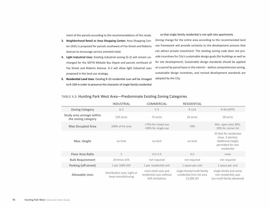
78 Hunti ng Park West Industrial Area Study
INDUSTRIAL COMMERCIAL RESIDENTIAL
Zoning Category G-2 C-3 R-11A R-9A (EPPI)
Study area acreage within the zoning category
229 acres 72 acres 26 acres 18 acres
Max Occupied Area 100% of lot area<75% for mixed use<90% for single use
70%Min. open area 30%,
20% for corner lot
Max. Height no limit no limit no limit
35 feet for residenti al (max. 3 stories);
Additi onal height permitt ed for non
residenti al
Floor Area Rati o 5 4.5–5.5 0.5 none
Bulk Requirement 20 ti mes GFA not required not required not required
Parking (off -street) 1 per 1000 GSF 1 per residenti al unit 1 space per unit 1 space per unit
Allowable UsesDistributi on uses; Light or
heay manufacturing
most retail uses and residenti al uses without
GFA limitati ons
single family/multi -family residenti al (min lot area
15,000 SF)
single family and some non-residenti al uses
(no multi -family allowsed)
TABLE 4.3: Hunti ng Park West Area—Predominate Existi ng Zoning Categories
ment of the parcels according to the recommendati ons of this study.
Neighborhood Retail or Area Shopping Center:3. Area Shopping Cen-
ter (ASC) is proposed for parcels southwest of Fox Street and Roberts
Avenue to encourage service oriented retail.
Light Industrial Uses4. : Existi ng industrial zoning (G-2) will remain un-
changed for the SEPTA Midvale Bus Depot and parcels northeast of
Fox Street and Roberts Avenue. G-2 will allow light industrial uses
proposed in the land use strategy.
Residenti al Land Uses5. : Existi ng R-10 residenti al uses will be chnaged
to R-10A in order to preserve the character of single family residenti al
so that single family residenti al is not split into apartments.
Zoning change for the enti re area according to the recommended land
use framework will provide certainty to the development process that
can att ract private investment. The existi ng zoning code does not pro-
vide incenti ves for City’s sustainable design goals (for buildings as well as
for site development). Sustainable design standards should be applied
on a parcel by parcel basis in the interim – before comprehensive zoning,
sustainable design incenti ves, and revised development standards are
adopted by the City.

79Sustainable Land Use and Urban Design Framework
PARCEL # AREAEXISTING ZONING PROPOSED LAND USE
ZONING1 RECOMMENDATION
1 40.21 Acres G-2 No Change G-2 (No Change)
2A / 2B 30.13Acres G-2 Light Industrial G-2 (No Change)
3A / 3B 12.36 Acres G-2 Light Industrial L-1 or L-2
4 12.40 Acres C-3 Recreati on/Open Space IDD (Insti tuti onal District)
5 6.26 Acres C-3 Industrial Mixed Use L-4
6 4.45 Acres C-3 Industrial Mixed Use L-4
7 3.07 Acres G-2 Industrial Mixed Use L-4
8 12.56 Acres G-2 Industrial Mixed Use C-3
9 9.50 Acres C-3 Industrial Mixed Use L-4
10 11.13 Acres C-3 Industrial Mixed Use L-4
11A/B 4.52 Acres C-3 Industrial Mixed Use L-4
11C 1.08 Acres C-3 Industrial Mixed Use L-4
12 12.16 Acres G-2 Commercial ASC2—Area Shopping Center
13 12.34 Acres C-3 Commercial ASC—Area Shopping Center
14 6.23 Acres C-3 Residenti al Mixed Use ASC—Area Shopping Center
15 8.62 Acres G-2 Residenti al Mixed Use C-3
16 5.09 Acres G-2 Residenti al Mixed Use C-3
17 7.18 Acres G-2 Residenti al Mixed Use C-3
18 11.92 Acres G-2 Residenti al Mixed Use C-3
19 20.71 Acres R-9A Residenti al Mixed Use C-3
20 9.37 Acres R-11A Residenti al Medium Density R-11A (No Change)
21 6.38 Acres G-2 Light Industrial L-2
22 22.69 Acres G-2 Industrial Mixed Use L-4
23 ?? R-10 Residenti al (existi ng) R-10A
Parcel numbers refer to Figure 4.3 “Full Build-out Scenario (Parcel Index)”.
TABLE 4.4: Hunti ng Park West Area—Proposed Zoning Categories

80 Hunti ng Park West Industrial Area Study
Fiscal Impact Analysis
The team conducted a community or fi scal impact analysis of the esti mat-
ed development program at build-out. This analysis examines the linkage
between local government revenue generated by development and its re-
sultant municipal service costs. The analysis used the most recent available
metrics for the City of Philadelphia’s general revenue fund and expenditure
data. The overall outcome is one of net positi ve fi scal impact from the de-
velopment program. At full build-out and stabilizati on of the Hunti ng Park
West area, tax revenues will exceed service costs/outlays by more than
$19 million annually. This represents a fi scally sustainable and net positi ve
impact development program for the community and the City. However
it is important to note that full realizati on of the full build-out scenario is
unlikely in the short term.

81
5
Eastern Pennsylvania Psychiatric Institute Highest
and Best Use Analysis

82 Hunti ng Park West Industrial Area Study

83Eastern Pennsylvania Psychiatric Institute Highest and Best Use Analysis
As part of the study, a highest and best use analy-
sis of potenti al opportuniti es for reuse of the Eastern
Pennsylvania Psychiatric Insti tute (EPPI) was under-
taken. This is a former hospital property located with-
in the study area at 3200 Henry Avenue. The site is
owned by the Commonwealth of Pennsylvania and is
currently vacant except for temporary use by the City’s
Youth Study Center on the lower two fl oors of the main
building and the adjoining Gaudenzia facility on a lease
porti on of the site.
Site and Building Conditions Assessment
The EPPI site consists of three subareas. First, the EPPI facility itself oc-
cupies 15.68 acres and makes up the bulk of the site containing approxi-
mately 405,200 Gross SF of fl oor area plus a separate boiler plant. To
the east, the Gaudenzia facility (46,840 GSF), is located on 2.7 acres and
includes a small building complex and surface parking. Gaudenzia has
a lease for this porti on of the site with twenty years remaining. At the
southwest corner of the site, a privately-owned parcel of 2.33 acres cur-
rently contains an unused surface parking lot. The aerial photograph on
the next page shows the locati on of the site and arrangement of sub-
areas. Tables A-1 and A-2 summarize existi ng site areas and buildings
square footages.
EPPI and Gaudenzia facility.
Exterior view of 11-story EPPI tower.

Hunti ng Park West Industrial Area Study84
FIGURE 5.1: Former EPPI Study Area
o0 300 600 900FT

85Eastern Pennsylvania Psychiatric Institute Highest and Best Use Analysis
The EPPI site, as it is popularly known, consists of three land parcels: the
15.68 acre EPPI property; a privately owned 2.33 acre parcel; and a 2.71
acre parcel under a twenty-year lease to Gaudenzia. The EPPI site has
been subject to limited environmental and architectural analyses. The
Pennsylvania Department of Health conducted a life safety code analysis
in May 1981 (a copy of which was not available at the ti me of this report).
A Facility Uti lizati on Plan was prepared in May 1982 by the Medical Col-
lege of Pennsylvania, Offi ce of Faciliti es and Planning, which recommend-
ed some improvements to correct some of the life safety code issues, but
referred to “several cited conditi ons” that required major expenditure of
funds. In August 1991 an Asbestos Identi fi cati on and Management Plan
was undertaken by the State.
Because the team did not have full access to the former EPPI building or
architectural drawings, the highest and best use evaluati on and analy-
sis is based on an exterior site visit and available reports. The exterior
evaluati on of the facility suggests the need for new HVAC, plumbing and
electrical systems, window replacements as well as possible structural
problems. The building complex is not in compliance with handicapped
access regulati ons. The narrow fl oor plate of the 11 story main building
(60 feet), also limits the reuse potenti al.
The buildings will most likely need significant upgrades in order to meet current needs.
The site is an att racti ve redevelopment parcel within the larger Hunti ng
Park West study area for several reasons: the size of the parcel and poten-
ti al for further assemblage; locati on relati ve to uti lity and transportati on
infrastructure; current high vacancy rate within the building complex;
and superior views from the site to downtown Philadelphia. While the lo-
cati on of the site suggests an att racti ve development/re-use opportunity,
the facility presents several fi nancial risks and redevelopment challeng-
es. These risks and challenges include extensive physical obsolescence
throughout the EPPI building, likely hazardous material abatement, and
relati vely large upfront costs for site work such as demoliti on, grading,
new infrastructure.

86 Hunti ng Park West Industrial Area Study
Development/Reuse Scenarios
The team prepared three scenarios to test possible development/re-
use opti ons. These are based on the analysis of current real estate and
socio-economic markets and real estate supply/demand analyses. WRT
developed architectural design test fi ts for three scenarios for potenti al
redevelopment of site. Many other scenarios could be imagined. These
represent a good range to examine feasibility and serve as a reference
point given the specifi c economic and other conditi ons at the ti me of the
work. These scenarios have several variables including degree of demoli-
ti on, amount of new constructi on and/or adapti ve reuse, categories of
use and amount of space, and physical confi gurati on. All of the scenarios
can be developed in phases over ti me to respond to specifi cs of fi nancing
and which, if either, of the two other parcels (the privately owned 2.3
acre parcel and the 2.7 acre parcel under long-term lease to Gaudenzia)
are added to the development area. It should be noted that during the
public involvement process many parti cipants expressed a very strong
preference for complete site clearance and redevelopment and that it
not include any development related to the gaming industry or judicial
system. Any reuse of the buildings and/or site will incur costs for hazard-
ous material abatement and site preparati on. The team used available
data and fi eld inspecti on to esti mate these costs. Our esti mate is that the
cost of suspected hazardous material abatement could be in the order
of $2.5 million. Site preparati on costs would vary depending on the uses
and phasing and should be incorporated in overall development costs.
The following are summary descripti ons of the re-use scenarios.
EPPI
Gaudenzia
Private Parcel
FIGURE 5.2: Site Locati on & Confi gurati on
SITE AREA
EPPI Site 683,421 sf15.68 acres
Gaudenzia Site 117,612 sf2.70 acres
Private Parcel*Same owner as the Falls Center
101,495 sf2.33 acres
Total 20.71 acres
SITE AREA
EPPI Building: TOTAL 336,500 sf4,000,000 CF
EPPI Building: Lower Wing 55,583 sf666,996 OF
EPPI Building: Entry Wing 13,117 sf157,404 CF
Gaudenzia Building 61,032 sf562,085 CF
Source: WRT, PCPC

87Eastern Pennsylvania Psychiatric Institute Highest and Best Use Analysis
FIGURE 5.3: Scenario A: Adapti ve Reuse/Parti al Demoliti onScenario A: Adaptive Reuse/Partial DemolitionThis scenario is based on parti al demoliti on of the EPPI building, adap-
ti vely reusing the tower as an extended-stay hotel with retail and com-
mercial uses on the ground fl oor, and residenti al units on the remainder
of the site surrounding the existi ng EPPI building. The program and rede-
velopment acti vity summary envisioned for this scenario is to:
Demolish entry wing and lower wing of the EPPI center and the en-•
ti re Gaudenzia facility (Note: the existi ng Gaudenzia facility could be
accommodated in Scenario A. For the purposes of the analysis, the
facility is assumed to be relocated).
Complete hazardous material abatement for the existi ng EPPI facility.•
Adapti vely reuse the existi ng EPPI tower for an extended-stay hotel •
yielding 230 rooms.
Adapti vely reuse 95,000 square feet of existi ng ground level space •
for hotel ameniti es including meeti ng rooms, restaurants, a business
center, and fi tness center.
Approximately 21,000 square feet of this space would be leased for •
general retail uses including a dry cleaners, hair salon, bank, etc.
The remainder of the site would include 130 units of mid-rise multi -•
family rental residenti al.
162 existi ng surface parking spaces would be resurfaced and 308 new •
spaces would be built.
The 130 units of mid-rise multi -family rental and 308 parking spac-•
es can be phased as or if the two additi onal parcels are acquired. If
they do not become available, the remainder of the site can sti ll be
developed at a similar residenti al density with considerati on for site
perimeter screening.
o0 300 600 900FT

88 Hunti ng Park West Industrial Area Study
FIGURE 5.4: Scenario B: Adapti ve Reuse with Additi on Scenario B: Adaptive Reuse with AdditionThis scenario is based on an adapti ve reuse of the existi ng building with
a new building additi on to change the typical fl oor plate area so it can ef-
fi ciently accommodate a double loaded corridor for residenti al uses. The
remainder of the site would contain parking and an open space resource
(e.g., parkland or plaza) for residents and community members. The pro-
gram and redevelopment acti vity summary envisioned for this scenario is:
The existi ng Gaudenzia facility could be accommodated in Scenario B. •
For the purposes of the analysis, the facility is assumed to be relocated.
Complete hazardous material abatement for the existi ng EPPI facility.•
Adapti vely reuse the existi ng EPPI tower and ground level space for •
residenti al uses.
Reuse of the EPPI facility involves new constructi on of an additi on to •
the existi ng EPPI tower eff ecti vely doubling the total square feet for
residenti al uses and yielding a total of 222 units.
Convert over 22,000 square feet of existi ng ground fl oor space to •
convenience retail space.
162 existi ng surface parking spaces would be resurfaced and 155 new •
spaces would be built.
Site development can be phased to accommodate ti med availability •
of the two additi onal parcels are not available at incepti on. If they do
not become available, the remainder of the site can sti ll be developed
at a similar density with considerati on for site perimeter screening.
o0 300 600 900FT

89Eastern Pennsylvania Psychiatric Institute Highest and Best Use Analysis
FIGURE 5.5: Scenario C: Full Demoliti on/RedevelopmentScenario C: Full Demolition/ RedevelopmentThis scenario examines full scale redevelopment and illustrates a mixed
use development program as well as new roads and infrastructure. The
scenario envisions creati on of an att racti ve public park with retail and
residenti al and offi ce uses facing Henry Avenue. A mixed income resi-
denti al development is located to the south, providing stunning views
of the city. Structured parking spaces can be accommodated to lessen
the visual impact while taking advantage of the existi ng topography. The
redevelopment scenario also provides a street framework that could be
developed to create walkable blocks and a pedestrian friendly, att racti ve
development. The redevelopment acti vity summary envisioned for this
scenario is:
Demolish all buildings on the enti re site including Gaudenzia which is •
assumed to relocate for this scenario.
Complete hazardous material abatement for the existi ng EPPI facility.•
Grade and prepare the site for large scale ground up redevelopment.•
Construct mixed use redevelopment plan containing 82 single fam-•
ily att ached townhomes, 351 high rise for-sale condominiums, 274
mid-rise rental residenti al units, almost 100,000 square feet of offi ce
space containing Class A and loft space, and around 100,000 square
feet of ground fl oor neighborhood retail space.
Parking constructi on includes over 1,000 structured spaces and •
around 250 on-street spaces
o0 300 600 900FT

90 Hunti ng Park West Industrial Area Study
Highest and Best Use Analysis
A Highest and Best Use (HBU) real estate analysis is an examinati on of
the most probable use of land or improved property given answers to the
following four criteria:
Legal Permissibility•
Physical Possibility•
Market Recepti vity•
Financial Profi tability•
Analysis of highest and best use involves two considerati ons: [1] the most
likely and profi table use of the site “as if vacant” under the requirements
set forth above, and [2] if a property is “already improved”, it is the use
that should be made of the property to maximize value for non-income
producing properti es or maximize net operati ng income on a long range
basis for investment properti es. In cases where capital expenditure is
necessary to renovate or improve an income producing property, these
costs must provide a suffi cient rate of return (to the sponsor) to support
for the total amount invested in the site and building improvements.
The three scenarios were evaluated using four broad land-use catego-
ries. These were identi fi ed based on the real estate market fi ndings for
the Hunti ng Park West study area. These uses included residenti al, offi ce,
lodging, and retail. Residenti al typologies included for-sale units (town-
houses and multi -family condominiums) and rental (garden apartments
and multi -family mid-rise units). Offi ce typologies evaluated included loft
and incubator offi ce space for small companies and start-up fi rms, and a
limited amount of fl ex space. Lodging typologies evaluated were limited
to extended stay faciliti es. Retail typologies included neighborhood scale
retail, which includes various amounts of convenience goods and per-
sonal services.
Financial Analysis Key Findings
Scenario A, with a possible total development cost of approximately •
$92 million, shows a positi ve unleveraged and leveraged before-tax
internal rates of return (IRR). However, this scenario assumes im-
proved credit conditi ons (lending criteria) compared to those that
exist today.
Scenario B, with a possible total development cost of approximately •
$67 million, shows a small internal rate or return, but is likely not
fi nancially feasible, due to the high constructi on costs involved in
constructi ng an additi on to the existi ng EPPI facility. Also, a large op-
portunity cost results from leaving the remainder of the site for open
space; that is, a substanti al amount of prospecti ve development rev-
enue is forgone.
Scenario C, the communiti es’ preferred scenario with a possible total •
development cost of over $400 million, requires large initi al capital
costs for the development sponsor and generates relati vely low rev-
enue streams, making it an unatt racti ve fi nancial propositi on, notwith-
standing the upfront sales revenues derived from condominium sales.
Further, the debt coverage rati os within Scenario C are considered in-
adequate by current lending standards.
All three scenarios show signifi cant initi al costs for a developer. This •
fact will need to be resolved for a project to be feasible. Both the risks
involved with redeveloping the site and high initi al costs for hazard-
ous material abatement and demoliti on weigh heavily on each sce-

91Eastern Pennsylvania Psychiatric Institute Highest and Best Use Analysis
CASE STUDYnario’s fi nancial performance.
Costs associated with site preparati on and grading are relati vely sig-•
nifi cant, given the topography of the site.
The development of surface parking in all scenarios, versus structured •
parking, substanti ally lowers upfront capital costs and signifi cantly af-
fects cash fl ows and rates of return.
All three scenarios assume demoliti on of the existi ng boiler plant •
building. Additi onal costs for uti liti es relocati on associated with the
boiler plant are not included in the fi nancial pro forma. Detailed in-
formati on about the boiler plant and any uti liti es was not available
for the analysis.
Conclusions
Based on the analysis of the three redevelopment scenarios, Scenario
A generates the best fi nancial performance with a 15 year unleveraged
internal rate of return of approximately 9.7 percent. This low number is
not, by itself, likely to att ract developer interest. To help ensure favorable
conditi ons for implementi ng any of the above scenarios both the public
and private sectors will need to work together. It is very likely that any
development or reuse will require substanti al public parti cipati on. Initi al
acti ons and policies which can be taken in furtherance of implementi ng
any of the scenarios studied, or future developer proposals, include the
following:
Assistance with land assembly, including low cost, ground leases, •
bonds used for infrastructure improvements.
Rezoning the site for market-responsive uses and densiti es as necessary.•
Fast track permitti ng, environmental review process.•
Assistance with environmental cleanup of the site and buildings.•
Assistance with demoliti on and site preparati on.•
Use of a special tax district or other strategy to fund infrastructure •
improvements.
Assistance with constructi on of parking on the site.•
Real estate tax abatements or PILOT payments.•
From Vacant Hospital to Apartments
San Franciso, CA
In San Francisco Forest City Devel-opment is converting the 7-story former Public Health Service Hospital Building into 154 luxury apartments. The building takes ad-vantage of dramatic ocean and city views and the Presidio landscape.

92 Hunti ng Park West Industrial Area Study

93
Next Steps 6

94 Hunti ng Park West Industrial Area Study

95Recommendations and Next Steps
This chapter summarizes the study’s recommenda-
ti ons and proposes a series of next steps to sustain
momentum for improvement and conti nue to engage
stakeholders in the area. The recommendati ons are
grouped in fi ve categories following this introducti on.
In summary, the study concluded that the Hunti ng Park
West Area can be successfully redeveloped in a man-
ner that helps the City achieve the study’s goals. The
study recommends that City resources be focused to:
• Reuse large historically industrial buildings - these may be lo-
cati ons for 21st century industry which includes a fl exible mix
of uses such as light industry, fabricati on and assembly, as well
as arts, entertainment and cultural acti viti es.
• Retain key historically industrial buildings or sites for industrial
use - some of these buildings and sites have the competi ti ve
advantages of large area plus very good highway (Route 1) and
rail access.
• Redevelop Henry and Hunti ng Park Avenues as mixed use
corridors—these streets are signifi cant connecti ve corridors
serving multi ple neighborhoods, all of which can support and
benefi t from new retail and commercial uses.
• Update land use and zoning—the area zoning should be updat-
ed using current districts in the short term and then updated
over the next several years as the new land development ordi-
nance is completed by the City.
• Improve streetscape standards—the major study area streets
(Henry Avenue, Whissahickon Avenue, and Hunti ng Park Ave-
nue) connect neighborhoods, give access to property and cre-
ate the visual image of the area. Improved streetscape would
benefi t all of those functi ons.
• Create green, sustainable infrastructure—improved streetscape
can create a dramati cally upgraded visual environment while
being used to reduce summer temperatures, sequester car-
bon, and manage storm water by reducing traditi onal “hard”
infrastructure investment and protecti ng our watershed.
• Improve traffi c and movement—study recommendati ons for
Henry and Wissahickon Avenues convert these roadways,
which currently serve as very high speed vehicular routes, to
serve all modes of travel including pedestrians and bicycles.
A new traffi c signal at the Kroc Center will create a safe and
pleasant entry experience for the thousands of people expect-
ed to visit every week.

96 Hunti ng Park West Industrial Area Study
CASE STUDY
Land Use Recommendations
The study recommends a mixture of land uses that includes residenti al,
commercial, offi ce, retail, entertainment, industrial, warehouse and dis-
tributi on, and services to support employees and residents of the area
and its neighbors. Industrial uses should be located to the east on more
environmentally constrained land that also has excellent road and rail ac-
cess and is adjacent to the acti ve SEPTA yards. Open space should be
interspersed with other uses to improve the visual and environmental
character of the area and to connect the study area to adjacent neighbor-
hoods. The recommendati ons of the City of Philadelphia’s Industrial Land
Study will need to be integrated with the land use recommendati ons for
Hunti ng Park West area.
Create a vital market responsive mixture of land uses.•
Establish Henry Avenue and Hunti ng Park Avenues as mix-use corridors.•
Create a neighborhood commercial and retail core.•
Establish a node of light industrial manufacturing on the eastern por-•
ti on of the study area that can benefi t from freight rail, freeway ac-
cess and take advantage of underuti lized industrial land.
Develop sustainable site planning guidelines for new and existi ng users.•
Reuse large former industrial buildings for entertainment, cultural •
and art producti on uses.
Create new parks and recreati on resources to support area revitalizati on.•
Zoning Recommendations
The study recommends that zoning changes supporti ve of the land use
framework be incorporated into the City’s zoning code. However, sicne
the City is not scheduled to complete the comprehensive update to its
zoning ordinance for some ti me, this study’s zoning recommendati ons
must follow existi ng zoning designati ons. In order to facilitate redevelop-
ment and investment into the area, it is recommended that the Hunti ng
Park West study Area be remapped now since it will take years to remap
the enti re city and adopt a new zoning code.
Financing the Rehabilitation of an Old Industrial Building into a Space for Visual and Performing Arts
Philadelphia, PA
The Crane Arts building was developed with the mission of creating a unique location for sup-porting visual and performance arts. A group of dedicated local artists who wanted to ensure that there was aff ordable space for art in the City turned the 1905 Crane Plumbing Company warehouse in Olde Kensington into a haven for local artist. One of the major challenges faced by the founders of Crane LLC was how to finance the rehabilitation of an old industrial space. Located in an area with a poverty rate over 33% and high unemployment, The Reinvestment Fund (TRF) was able to qualify for $4.2 million New Market Tax Credit (NMTC) loan for Crane Arts LLC. The NMTC encourages private sector investment in low-income areas to stimulate economic devel-opment. NMTC financing has also enabled the building to off er ten-ants rent at 30-40% below market.
www.cranearts.com/
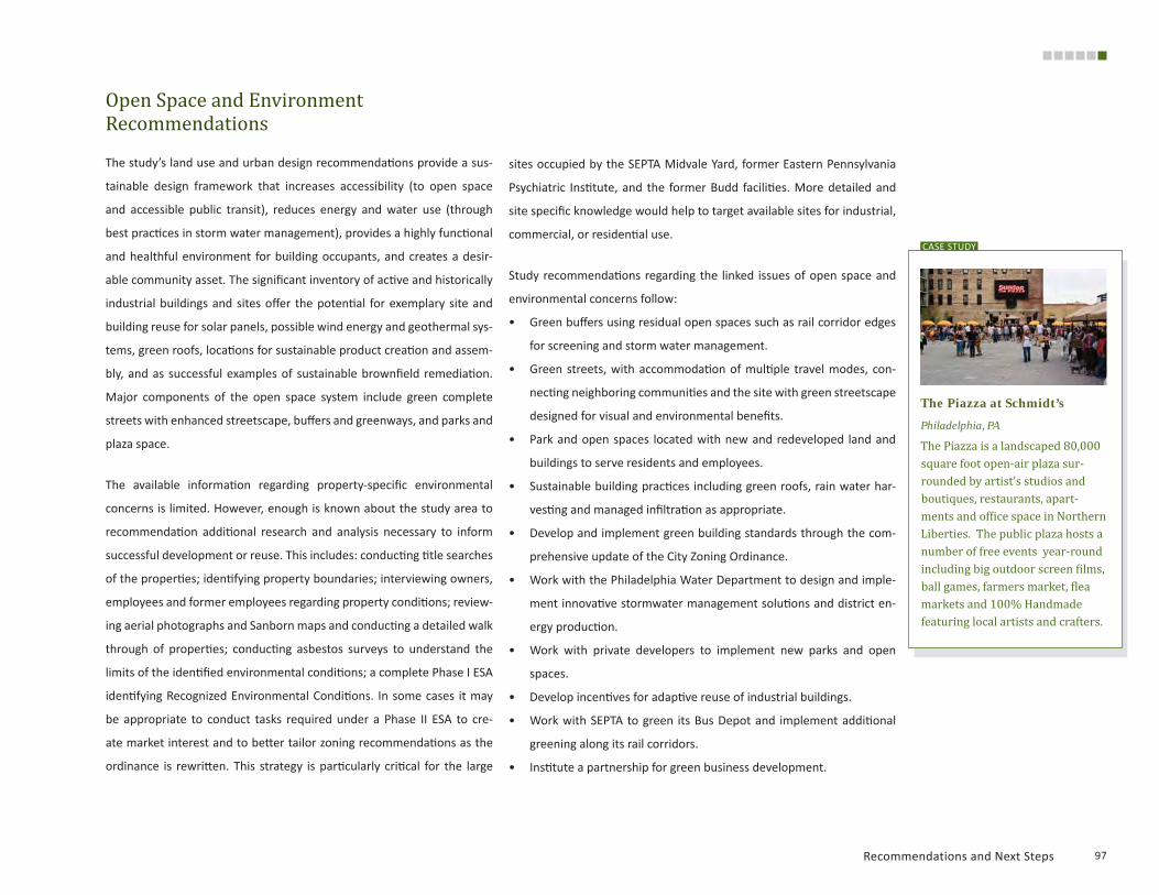
97Recommendations and Next Steps
CASE STUDY
Open Space and Environment Recommendations
The study’s land use and urban design recommendati ons provide a sus-
tainable design framework that increases accessibility (to open space
and accessible public transit), reduces energy and water use (through
best practi ces in storm water management), provides a highly functi onal
and healthful environment for building occupants, and creates a desir-
able community asset. The signifi cant inventory of acti ve and historically
industrial buildings and sites off er the potenti al for exemplary site and
building reuse for solar panels, possible wind energy and geothermal sys-
tems, green roofs, locati ons for sustainable product creati on and assem-
bly, and as successful examples of sustainable brownfi eld remediati on.
Major components of the open space system include green complete
streets with enhanced streetscape, buff ers and greenways, and parks and
plaza space.
The available informati on regarding property-specifi c environmental
concerns is limited. However, enough is known about the study area to
recommendati on additi onal research and analysis necessary to inform
successful development or reuse. This includes: conducti ng ti tle searches
of the properti es; identi fying property boundaries; interviewing owners,
employees and former employees regarding property conditi ons; review-
ing aerial photographs and Sanborn maps and conducti ng a detailed walk
through of properti es; conducti ng asbestos surveys to understand the
limits of the identi fi ed environmental conditi ons; a complete Phase I ESA
identi fying Recognized Environmental Conditi ons. In some cases it may
be appropriate to conduct tasks required under a Phase II ESA to cre-
ate market interest and to bett er tailor zoning recommendati ons as the
ordinance is rewritt en. This strategy is parti cularly criti cal for the large
sites occupied by the SEPTA Midvale Yard, former Eastern Pennsylvania
Psychiatric Insti tute, and the former Budd faciliti es. More detailed and
site specifi c knowledge would help to target available sites for industrial,
commercial, or residenti al use.
Study recommendati ons regarding the linked issues of open space and
environmental concerns follow:
Green buff ers using residual open spaces such as rail corridor edges •
for screening and storm water management.
Green streets, with accommodati on of multi ple travel modes, con-•
necti ng neighboring communiti es and the site with green streetscape
designed for visual and environmental benefi ts.
Park and open spaces located with new and redeveloped land and •
buildings to serve residents and employees.
Sustainable building practi ces including green roofs, rain water har-•
vesti ng and managed infi ltrati on as appropriate.
Develop and implement green building standards through the com-•
prehensive update of the City Zoning Ordinance.
Work with the Philadelphia Water Department to design and imple-•
ment innovati ve stormwater management soluti ons and district en-
ergy producti on.
Work with private developers to implement new parks and open •
spaces.
Develop incenti ves for adapti ve reuse of industrial buildings.•
Work with SEPTA to green its Bus Depot and implement additi onal •
greening along its rail corridors.
Insti tute a partnership for green business development.•
The Piazza at Schmidt’s
Philadelphia, PA
The Piazza is a landscaped 80,000 square foot open-air plaza sur-rounded by artist’s studios and boutiques, restaurants, apart-ments and office space in Northern Liberties. The public plaza hosts a number of free events year-round including big outdoor screen films, ball games, farmers market, flea markets and 100% Handmade featuring local artists and crafters.

Investi gate roadway improvements at the intersecti on of Henry Av-•
enue and Hunti ng Park Avenue/Allegheny Avenue, including but not
limited to: feasibility of installing dual left -turn lanes from north-
bound Hunti ng Park Avenue to westbound Henry Avenue; relocati on
of pedestrian crosswalks; re-designati on of 30th Street to provide
southbound vehicular travel to remove an additi onal phase from the
signal operati on; relocati on of pedestrian crosswalks.
Investi gate roadway improvements at the intersecti on of Hunti ng •
Park and Wissahickon Avenues including, but not limited to: opti mize
signal phasing for Kroc Center traffi c including pedestrian countdown
technology; relocate pedestrian crosswalks; potenti al restriping in-
tersecti on approaches to accommodate increased traffi c volumes.
Investi gate roadway improvements in coordinati on with redevelop-•
ment of the EPPI site at the intersecti on of Henry and Roberts Ave-
nues including, but not limited to: realignment of site access opposite
Roberts Avenue as a fourth leg of the signalized intersecti on; install
pedestrian upgrades, restripe faded pedestrian crosswalks.
Investi gate roadway improvements at Roberts Avenue and Fox Street •
including, but not limited to: install pedestrian countdown technol-
ogy on all legs; restripe faded pedestrian crosswalks; add wayfi nding
signage for Kroc Center and other desti nati ons; post clearly marked
truck route.
Investi gate roadway improvements at Wissahickon and Roberts Av-•
enues including, but not limited to: install pedestrian countdown
technology; restripe faded pedestrian crosswalks; add wayfi nding
signage for the Kroc Center and other desti nati ons; relocate pedes-
trian crosswalks.
Traffic/Movement Recommendations
Acti on on the following area-wide recommendati ons will dramati cally im-
prove the movement systems in the area:
Implement streetscape improvements to improve safety and connec-•
ti vity for pedestrians and cyclists on all streets.
The City should conti nue to coordinate with PennDOT and the Streets •
Department regarding planned pedestrian signal upgrades for study
area roadways. These pedestrian signal upgrades would benefi t cur-
rent and future pedestrian traffi c in the study area.
The City should conti nue to investi gate possible streetscape enhance-•
ments for roadway segments in the Hunti ng Parking West Area to
include the Henry Avenue and Wissahickon Avenue corridors. The
streetscape enhancements can provide pedestrian refuge crossing
the main roadway segments, pedestrian bump outs at intersecti ons,
bicycle lanes, and other traffi c calming measures that improve the
pedestrian environment without reducing traffi c capacity.
The City should conti nue to work with developers as they prepare •
plans in order to address individual traffi c impacts on the local road
network and to coordinate enhanced transit service.
Site specifi c recommendati ons include the following:
The Kroc Center development team should conti nue to work with •
SEPTA regarding enhanced transit access and the City Planning Com-
mission to investi gate improvements at the Wissahickon Avenue
driveway to include a traffi c signal with phasing opti mized to reduce
potenti al confl icts among through traffi c, SEPTA buses, and pedes-
trian movement.

99Recommendations and Next Steps
By following this study’s recommendati ons it is possible for the City to
create sustainable reuse of a signifi cant area of the city for the benefi t
of all stakeholders. These benefi ts include economic, social, and environ-
mental outcomes described as goals in the City sustainability framework.
The reducti on in life cycle costs for publicly fi nanced and maintained infra-
structure, improvement in storm water management outcomes, reduced
greenhouse gas emissions and urban heat island eff ects are signifi cant
outcomes that support a competi ti ve quality of life and att racti on for new
investment. Achievement of the study vision and adherence to its prin-
ciples can help the City achieve its city-wide goals for the 21st century.
Implementation
In additi on to the recommendati ons described above, it is important that
the City move forward with a variety of incenti ves to encourage redevel-
opment in the Hunti ng Park West Area. The challenges of area redevelop-
ment have been described above. Nevertheless, the area has a number
of strong competi ti ve advantages the City can help the private sector
seize to the benefi t of all parti es. The best approach is a packaging of
incenti ves that in diff erent combinati ons will be useful to diff erent actors.
We recommend the following for further development by the City:
Expansion of the Keystone Opportunity Zone.•
PIDC focused incenti ve package for area or specifi c faciliti es that are •
hard to reuse such as the Budd buildings.
Public/Private Partnerships: partnerships with the major insti tuti onal •
stakeholders in the area could be developed to help them meet their
expansion needs.
Make the Randolph School site available for development.•
Create a special taxing district.•

Philadelphia City Planning Commission