hoffman notch wilderness - adirondack park agency · pdf filehoffman notch wilderness ......
TRANSCRIPT

Hoffman Notch Wilderness
Proposed Final Unit Management Plan
Towns of Schroon, North Hudson, and Minerva
Essex County
ANDREW M. CUOMO
Governor
JOE MARTENS
Commissioner
For Further Information Contact:
New York State Department of Environmental Conservation232 Golf Course RoadWarrensburg, NY 12885Phone: (518) [email protected] February 2012
NEW YORK STATE
Department of Environmental ConservationDIVISION OF LANDS & FORESTS

This page intentionally left blank

Hoffman Notch Wilderness – Proposed Final Unit Management Plan – February 2012 i
PREFACE The Hoffman Notch Wilderness Unit Management Plan has been developed pursuant to, and is consistent with, relevant provisions of the New York State Constitution, the Environmental Conservation Law (ECL), the Executive Law, the Adirondack Park State Land Master Plan, Department of Environmental Conservation (“DEC”) Rules and Regulations, Department Policies and Procedures and the State Environmental Quality and Review Act. The State land which is the subject of this Unit Management Plan (UMP) is Forest Preserve lands protected by Article XIV, Section 1 of the New York State Constitution. This Constitutional provision, which became effective on January 1, 1895 provides in relevant part:
“The lands of the state, now owned or hereafter acquired, constituting the Forest Preserve as now fixed by law, shall be forever kept as wild forest lands. They shall not be leased, sold or exchanged, or be taken by any corporation, public or private, or shall the timber thereon be sold, removed or destroyed.”
ECL §3‐0301(1)(d) and 9‐0105(1) provide the Department with jurisdiction to manage Forest Preserve lands, including the Hoffman Notch Wilderness Area. The Adirondack Park State Land Master Plan (APSLMP) was initially adopted in 1972 by the Adirondack Park Agency (APA), with advice from and in consultation with the Department, pursuant to Executive Law §807, now recodified as Executive Law §816. The APSLMP provides the overall general framework for the development and management of State lands in the Adirondack Park, including those State lands which are the subject of this UMP. The APSLMP places State land within the Adirondack Park into the following classifications: Wilderness, Primitive, Canoe, Wild Forest, Intensive Use, Historic, State Administrative, Wild, Scenic and Recreational Rivers, and Travel Corridors, and sets forth management guidelines for the lands falling within each major classification. The APSLMP classifies the lands which are the subject of this UMP as part of the Hoffman Notch Wilderness Area. The APSLMP sets forth guidelines for such matters as: structures and improvements; ranger stations; the use of motor vehicles, motorized equipment and aircraft; roads, jeep trails and State truck trails; flora and fauna; recreation use and overuse; boundary structures and improvements and boundary markings. Executive Law §816 requires the Department to develop, in consultation with the APA, individual UMPs for each unit of land under the DEC’s jurisdiction which is classified in one of the nine classifications set forth in the APSLMP. The UMPs must conform to the guidelines and criteria set forth in the APSLMP. Thus, UMPs implement and apply the APSLMP’s general guidelines for particular areas of land within the Adirondack Park. Executive Law §816(1) provides in part that “(until) amended, the APSLMP for management of State lands and the individual management plans shall guide the development and management of State lands in the Adirondack Park.” Thus, the APSLMP and the UMPs have the force of law in guiding DEC actions. It is important to understand that the State Land Master Plan has structured the responsibilities of the Department and the Agency in the management of State lands within the Adirondack Park. Specifically, the APSLMP states that:

Preface
ii Hoffman Notch Wilderness – Proposed Final Unit Management Plan – February 2012
..... the legislature has established a two‐tiered structure regarding state lands in the Adirondack Park. The Agency is responsible for long range planning and the establishment of basic policy for state lands in the Park, in consultation with the Department of Environmental Conservation. Via the master plan, the Agency has the authority to establish general guidelines and criteria for the management of state lands, subject, of course, to the approval of the Governor. On the other hand, the DEC and other state agencies with respect to the more modest acreage of land under their jurisdictions, have responsibility for the administration and management of these lands in compliance with the guidelines and criteria laid down by the master plan.
In order to put the implementation of the guidelines and criteria set forth in the APSLMP into actual practice, the DEC and APA have jointly signed a Memorandum of Understanding concerning the implementation of the State Land Master Plan for the Adirondack Park. The document defines the roles and responsibilities of the two agencies, outlines procedures for coordination and communication, defines a process for the revision of the APSLMP, as well as outlines procedures for State land classification, the review of UMPs, state land project management, and state land activity compliance. The MOU also outlines a process for the interpretation of the APSLMP.
No Action Alternative or Need for a Plan
From the legal perspective, the “No Action” alternative of not writing an UMP is not an option. Executive Law §816 requires the Department of Environmental Conservation to develop, in consultation with the APA, individual unit management plans (UMPs) for each unit under its jurisdiction classified in the APSLMP. In addition an UMP serves as a mechanism for the DEC to study and identify potential areas for providing access to the HNWA for persons with disabilities in accordance with the Americans with Disabilities Act (ADA of 1990). The UMP also serves as an administrative vehicle for the identification and removal of nonconforming structures as required by the APSLMP. From the administrative perspective, the “No Action” alternative is not an option. The UMP provides guidance necessary for staff to manage the lands of the unit in a matter that is most protective of the environment while at the same time providing the most enjoyable outdoor recreation opportunities for the public. Without the UMP the sensitive environmental resources of the unit could be negatively impacted and it is highly likely that the public enjoyment of such resources would decrease. Management of the Hoffman Notch Wilderness Area via an UMP will allow the DEC to improve public use and enjoyment of the area, avoid user conflicts and prevent over use of the resources (e.g., through trail designations, access restrictions, placement of campsites and lean‐to in relation to a sensitive resource, etc.).

Hoffman Notch Wilderness – Proposed Final Unit Management Plan – February 2012 iii
CONTENTS ACKNOWLEDGEMENTS ....................................................................................................................................... v I. INTRODUCTION ............................................................................................................................................... 1 A. Planning Area Overview ............................................................................................................................ 1 1. Unit Geographic Area ............................................................................................................................ 1 2. General Location .................................................................................................................................... 1 3. Acreage .................................................................................................................................................. 1 4. General Access ....................................................................................................................................... 2
B. General History .......................................................................................................................................... 3 1. Warren’s Inn .......................................................................................................................................... 3 2. Logging History ...................................................................................................................................... 3 3. Tanning Industry .................................................................................................................................... 4 4. Mining .................................................................................................................................................... 5 5. General Acquisition History ................................................................................................................... 5 6. Durgin Farm .......................................................................................................................................... 7 7. Adirondack Northway I‐87 ..................................................................................................................... 8 8. Hoffman Mountain Ski Center ............................................................................................................... 8
II. INVENTORY OF RESOURCES, FACILITIES, AND USE ...................................................................................... 11 A. Natural Resources ................................................................................................................................... 11 1. Physical ................................................................................................................................................ 11 2. Biological .............................................................................................................................................. 19
C. Cultural Resources ................................................................................................................................... 41 Historical .................................................................................................................................................. 42
D. Economic Component ............................................................................................................................. 42 E. Public Use ................................................................................................................................................ 43 1. Land Resources .................................................................................................................................... 43 2. Wildlife ................................................................................................................................................. 43
F. Relationship between Public and Private Land ....................................................................................... 46 1. Land Ownership Patterns ................................................................................................................... 46 2. Land Use Regulations ........................................................................................................................... 46 3. Impact of NYS Ownership on Adjacent Lands ..................................................................................... 46
G. Capacity of the Resource to Withstand Use ........................................................................................... 49 1. Carrying Capacity Concepts ................................................................................................................. 49 1. Wildlife Resource ................................................................................................................................. 52 2. Fisheries Resource ............................................................................................................................... 53
III. MANAGEMENT AND POLICY OVERVIEW .................................................................................................... 55 A. Administration ......................................................................................................................................... 55 B. Past Management ................................................................................................................................... 55 1. Land Management ............................................................................................................................... 56 2. Wildlife Management .......................................................................................................................... 56 3. Fisheries Management ........................................................................................................................ 56
C. Management Guidelines ........................................................................................................................ 58 1. Guiding Documents ............................................................................................................................. 58 2. Application of Guidelines and Standards ............................................................................................ 59
D. Management Principles .......................................................................................................................... 61 E. Management Strategy ............................................................................................................................ 63

Table of Contents
iv Hoffman Notch Wilderness – Proposed Final Unit Management Plan – February 2012
F. Application of LAC Process ...................................................................................................................... 64 1. Trail Condition Indicators .................................................................................................................... 64 2. Campsite Condition Indicators ............................................................................................................ 64 3. Social Condition Indicators .................................................................................................................. 64
G. Americans with Disabilities Act (ADA) .................................................................................................... 64 H. Current Problems and Opportunities ..................................................................................................... 65
IV. PROPOSED MANAGEMENT RECOMMENDATIONS .................................................................................... 67 A. Bio‐Physical Resource .............................................................................................................................. 67 1. Water ................................................................................................................................................... 67 2. Soils ...................................................................................................................................................... 67 3. Wetlands .............................................................................................................................................. 68 4. Vegetation ........................................................................................................................................... 69 5. Air Quality ............................................................................................................................................ 72 6. Wildlife ................................................................................................................................................. 73 7. Fisheries ............................................................................................................................................... 74
B. Land Protection ...................................................................................................................................... 76 1. Open Space/Land Acquisition / Boundaries / Deeded Rights ............................................................. 76
C. Man‐Made Facilities ................................................................................................................................ 77 1. Trails..................................................................................................................................................... 77 2. Trailheads/ Entry Points ...................................................................................................................... 80 3. Signs ..................................................................................................................................................... 82 4. Bridges ................................................................................................................................................. 83 5. Campsites ............................................................................................................................................ 85
D. Public Use and Access ............................................................................................................................. 86 1. Public Use ............................................................................................................................................ 86 2. Access for Persons with Disabilities ..................................................................................................... 89
E. Proposed Regulations .............................................................................................................................. 90 V. SCHEDULE FOR IMPLEMENTATION ............................................................................................................ 91 BIBLIOGRAPHY AND REFERENCES ................................................................................................................... 97 APPENDIX 1: BREEDING BIRD ATLAS ............................................................................................................. 101 APPENDIX 2: ARCHEOLOGICAL SITES ............................................................................................................. 109 APPENDIX 3: POND MANAGEMENT CLASSIFICATIONS ................................................................................. 111 APPENDIX 4: TRAIL CLASSIFICATION SYSTEM ................................................................................................ 119 APPENDIX 5: CAMPSITE MONITORING FORM ............................................................................................... 121 APPENDIX 6: SEQR REQUIREMENTS .............................................................................................................. 131 APPENDIX 7: ACRONYMS ............................................................................................................................... 135 APPENDIX 8: DEFINITIONS/GLOSSARY OF TERMS ......................................................................................... 137 APPENDIX 9: Interagency Guidelines for Implementing Best Management Practices for the Control of Terrestrial and Aquatic Invasive Species on Forest Preserve Lands in the Adirondack Park ........................ 141 APPENDIX 10: Summary of Public Comment ................................................................................................ 173 APPENDIX 11: Maps ...................................................................................................................................... 191

Hoffman Notch Wilderness – Proposed Final Unit Management Plan – February 2012 v
ACKNOWLEDGEMENTS
DEC Planning Team Ben Thomas Forester ‐Task Force Leader Stewart Brown Forester‐ Task Force Leader (Retired) John Hastings Forester‐ Task Force Leader (Retired) Ed Russell Public Protection‐ Forest Ranger Harold Barber Public Protection‐ Environmental Conservation Officer Lance Durfey Senior Fisheries Biologist Paul Jensen Senior Wildlife Biologist Phil Johnstone Operations Supervisor(Retired) Darwin Tubbs Operations Supervisor Clive Friend Maintenance Assistant David Winchell Citizen Participation Specialist II Josh Clague Natural Resources Planner Kevin Prickett Natural Resources Planner – Adirondack Park Agency Special thanks to John Hastings and Stew Brown for preparing much of the content in this plan.
Other DEC Staff Preparers Bruce Barnard Forester I Tad Norton Forester I Michael Curley Forester II (retired) Tom Martin Regional Forester Robert Messenger Forester III Ed Reed Wildlife Biologist I Brian Finlayson Cartographic Technician III Mike Grove Real Property Specialist I Les Eggleton Real Property Supervisor Patrick Magee Assistant Land Surveyor Robert Bradley Land Surveyor Howard Lashway Forest Ranger (retired) Mary Lupo Secretary I (retired) Susan Clickner Program Aid
Ken Hamm DEC attorney Linda Kashdan‐Schrom Environmental Analyst Bill Schoch Regional Fisheries Manager DEC Gratefully acknowledges the contributions made by the following:
Roger Friedman Schroon Lake Cathy Moses Schroon Lake Betty Lou Bailey ADK, Schenectady John Huston Schroon Lake Paul Clickner Minerva

vi Hoffman Notch Wilderness – Proposed Final Unit Management Plan – February 2012
This page intentionally left blank

Hoffman Notch Wilderness – Proposed Final Unit Management Plan – February 2012 vii

viii Hoffman Notch Wilderness – Proposed Final Unit Management Plan – February 2012
This page intentionally left blank

Hoffman Notch Wilderness – Proposed Final Unit Management Plan – February 2012 1
I. INTRODUCTION
A. Planning Area Overview
The Hoffman Notch Wilderness Area (HNWA) is located in the east central Adirondack Park within the towns of Minerva, Schroon, and North Hudson (Essex County). The unit is located within the watersheds of the Boreas and Schroon Rivers. The unit is made up of one large contiguous parcel, covering 38,488 acres and has 52.23 miles of boundary line, 17.42 of which are shared with other State management units. The planning area is adjacent to the following: on the north the High Peaks Wilderness Area, on the east by Schroon Lake, on the south and west by the Vanderwhacker Wild Forest. Adjacent to the planning area, and not subject to this UMP, are privately‐owned lands, most of which are classified as “Resource Management” and “Rural Use” by the Adirondack Park Agency. There are also several private “rod & gun” clubs with small to moderate land holdings adjacent to the HNWA.
1. Unit Geographic Area
The unit is covered by the following U.S.G.S. quadrangle maps: 7½’ x 15' series: Blue Ridge, Schroon Lake, Paradox Lake 15’ x 15’ series: Schroon Lake, Paradox Lake
2. General Location
The major roads providing access to the Hoffman Notch Wilderness Area are: the Blue Ridge Road (or Boreas Road or County Route 2B) which provides access to the northern portion of the unit; and Hoffman Road (or Irishtown Road or Carl Hill Road), which provide access in the town of Schroon along the south. Several communities are adjacent to the unit. These include the hamlets of North Hudson, Minerva, Olmstedville, Schroon Lake and Newcomb. The unit is in proximity to several other Forest Preserve units including the High Peaks Wilderness Area to the northwest, the Dix Mountain Wilderness Area to the north and the Vanderwhacker Mountain Wild Forest to the west, the Pharoah Lake Wilderness Area to the southeast, and the Hammond Pond Wild Forest to the east. The unit is also near several State‐owned or State‐run intensive use areas including: Harris Lake Campground, Eagle Point Campground, Scaroon Manor, Camp Santanoni Historic Area, and the Visitor Interpretive Center at Newcomb.
3. Acreage
The overall size of the unit is 38,488acres. The largest proportion of the unit is comprised of lands in the Tract West of Road Patent (approximately 45%). The Totten and Crossfield (Township 30) and Hoffman Township contain considerable acreage (approximately 20% each). Other areas are contained in the Rogers Road Patent and the Gore between Hoffman Township and the tract west of Road Patent. Much (about 60%) of the lands in the Hoffman Notch Wilderness were acquired through the tax sales of 1871, 1877, 1881, 1885, 1890, 1895 and 1900. Much of the balance was purchased in 1891, 1892, 1897,

I. Introduction
2 Hoffman Notch Wilderness – Proposed Final Unit Management Plan – February 2012
1898, 1899, and 1900. The sources of these titles were either the purchase from owners, sales due to unpaid taxes, appropriations (condemnation) or conveyance. Hoffman Township
Tax sale: All or part of lots A, B, C, 1, 2, 3, 4, 5, 6, 7, 8, 9, 10, 11, 14, 15, 16, 18, 20, 23, 28, & 29
Purchase: All or part of lots 3, 11, 12, 13, 15, 19, 21, 22, & 30. Acquired after 1920: Part of lots 13, 17, 19, 24, 28, & 33. Co. Road Patent Tax sale: Part of lot 4 Purchase: Part of lots 3 and 4. Acquired after 1920: Part of lots 1, 3, 4, 5, & 8. Township 30 of the Totten and Crossfield Purchase Tax sale: Part or all of lots 5, 6, 7, 8, 9, 10, 11, 12, 16 & 18. Purchase: All or part of lots 7, 8, 10 & 17 Tract West of Road Patent
Tax sale: All or part of lots 28,29, 33, 34, 35, 36, 37, 47, 51, 52, 53, 54, 55, 71, 72, 73, 74, 75, 76, 77, 78, 79, 80, 81, 82, 85, 86, 93, 94, 100, 101, 102, 103, 104, 105, 106, 113, 117, 129, 131, 132, 133, 134, 142, 146, 147, 148, 149, 150, 156, 157, 160, 161, 162, & 168.
Purchase: All or part of lots 28, 29, 30, 31, 38, 39, 44, 45, 46, 59, 60, 61, 62, 68, 88, 89, 90, 110, 111, 112, 118, 119, 120, 121, 122, 123, 130, 132, 158, 159, 160, 167, & 175.
Acquired after 1920: All or part of lots 48, 49, 50, 56, 57, 58, 67, 69, 70, 71, 72, 83, 84,
85, 86, 95, 96, 97, 98, 99, 107, 108, 109, 115, & 116. Acquired in the 1950's from Finch Pruyn Co: Township 44, lots 1 & 8 The town by town breakdown of the HNWA acreage is as follows:
Essex County acres
Minerva 1,615 (4 %) North Hudson 15,280 (40%)
Schroon 21,593 (56%) Total 38, 488
4. General Access
In addition to the roads listed in Section 2. above, there are several tertiary and quaternary roads that provide access to the automobile‐traveling public. These include Loch Muller Road, Potash Hill Road, Youngs and Hoffman Road in Schroon and Byrns Road in Minerva. Many, but not all, of the above are town and county roads. A detailed location description of these roads will not be included here, as they are

I. Introduction
Hoffman Notch Wilderness – Proposed Final Unit Management Plan – February 2012 3
more easily located using the accompanying map, as well as the Essex County highway map. The HNWA can also be accessed via the Boreas River, two small lakes: Lester Flow and Cheney Pond, and several underpasses beneath I‐87Approximately 70 million people live within a day’s drive of the unit. Nearby population centers include: the city of Glens Falls (45 miles), the city of Plattsburgh (65 miles), the urban areas of the Capital District (90 miles), Montreal (120 miles), and New York City (230 miles).
B. General History
The area around the HNWA is rich with history. Only some incidents that relate directly to the development of the unit will be presented here. For an in‐depth look into the local history, the reader is referred to several useful sources, including Watson’s 1869 History of Essex County, Smith’s 1885 History of Essex County, and other sources listed in the bibliography and reference section of this document.
1. Warren’s Inn
Originally known as the Bailey Pond Inn this establishment was located at the end of the road at Loch Muller and was built in the late 1890's. Between 1914 and 1915 the name was changed to “Warren’s” to reflect the name of the owner A E.Warren. This was a popular spot and was well known for its access to many of the ponds, streams and mountains in the HNWA. Advertisements noted hiking trails to Hoffman Mountain (Cole’s Schroon Mountain), Bailey Pond, and Hayes Mountain, as well as equestrian trails to similar locations. The Inn was ultimately destroyed by fire. Nearby is the Loch Muller white pine, which was planted in 1845 by Paschal P.Warren when he and the tree were 12 years old. He placed a plaque on the tree in 1920 with the above information and the inscription “Woodsman Spare That tree, Touch Not a Single Bough, In Youth It Protected Me, And I’ll Protect It Now.” Mr. Warren’s granddaughter, Marion was born at the hotel in 1896 and may be the source for the naming of Marion Pond.
2. Logging History
During the 19th century, harvesting of white pine, red spruce, and, in some locales, hemlock occurred throughout the southern Adirondacks, and often took place on lands in close proximity to water courses, because the logs could be easily transported down rivers and streams. During this time period, softwoods were harvested from private lands that would later become part of the HNWA in areas along the Boreas River, Minerva Stream, and the Schroon River. Early cutting (1800‐1850) concentrated on the harvesting of pine, while later in the century it shifted to red spruce. Much of the hemlock was cut in the 1850‐1880 period to supply the local tanneries. Hardwoods were not generally harvested, because profitable markets did not exist for them until the early 1900's, and because they could not be transported as easily (they don’t float). In fact, hardwoods were generally only harvested in the conversion of forests to farmlands and used to make charcoal and potash in order to subsidize that land clearing. Consequently, much of the lands that would later make up interior sections of the HNWA sustained very little harvesting of hardwood logs since most of these lands were purchased prior to cost effective means and markets were available for hardwood logging. However, softwood logging continued over much of the 19th century, and eventually reached most areas of the HNWA before (or in between) State ownership. (Laws of the time required the State to bid for lands at tax sale that had no other bidders. Prior to the creation of the Forest Preserve, the State would acquire such lands and later attempt to sell them. In between State ownership, these lands might be logged. This explains why many Forest Preserve lots were acquired by the State several times.)
I. Introduction
4 Hoffman Notch Wilderness – Proposed Final Unit Management Plan – February 2012
In some cases, even State ownership did not preclude harvesting of some State lots. Because of tax laws of the time, it was not uncommon for individuals to challenge the State’s title to lands acquired through tax sales and win. This often resulted in further logging and then abandonment of these lots. After such abandonment the land would go up for bid at tax sale and would be re‐purchased by the State. Many viewed the problematic tax law as a State subsidy for the logging industry. Several individuals, such as George Ostrander, P. J. Marsh, and George Underwood became masters at acquiring title to land the State thought it owned. It is quite likely that some of these lots were lost through title challenges and logged during this time. Early single‐log river‐driving was started by the Fox brothers, Norman and Alanson, on the Upper Hudson in 1813 when they floated logs from the Brant Lake Tract via the Schroon River to Glens Falls (Freeman 1996). The Boreas River, which flows along the western edge of the unit, served as a route initially for sawlogs and later for pulpwood making their way to the Hudson and eventually to the softwood mills in Glens Falls. Reminders of this logging history are still evident nearby. For example, the old abutments of Brace Dam on the Boreas River north of the Blue Ridge Road are easily discernable. Similarly, Lester Dam, further south along the Boreas, was last used to transport logs to mill as late as 1949 and is even more conspicuous. The system of flush dams served to bring logs to the Hudson and on to Glens Falls in a journey that in some cases took two years to complete. Fires often followed logging and as a result, portions of the Adirondacks were consumed by fire around the turn of the 19th and 20th centuries. Generally only smaller fires occurred in the HNWA, evidence of which can still be seen around Big Pond as well as in the vicinity of the Blue Ridge Road.
3. Tanning Industry
Harvesting hemlock bark for its use in the tanning of leather was an important industry in the area around the HNWA in the mid‐nineteenth century. The abundance of hemlock and water for transportation and power helped fuel an industry which provided one of the first sources of employment for many of the local residents. People were needed to cut and transport bark to the mill, haul hides to and from the mills, cut fuelwood, work in the tanneries, and the many other support services such as grocery/hardware stores, blacksmiths, wagon makers, etc. As a result, much of the accessible hemlock of the HNWA was cut during this period (early on the logs were left in the woods to rot but this changed later on), and the bark sent to several tanneries in the immediate area, including Olmstedville, Pottersville, North Hudson and Schroon Lake. In fact, the hamlet of Olmstedville gets its name from Sanford and Levi Olmstead, who built the Alpine Tannery there in 1840. The tannery, which burned in 1867, was said to have consumed bark at five thousand cords per year. Other tanneries which operated in the area and likely utilized hemlock from the HNWA area include:
• Schroon Lake Tannery. Erected in 1852 by L. Hall. About one mile west of Schroon Lake Village on the Hoffman Road.
• Schroon (or Excelsior) Tannery. Erected in 1861 by W. Potter and D. Wyman. At the mouth of the West Branch.
• Sawyer and Mead Tannery. 1867. Located on the West Branch about 3 miles from the State road.
• Hoffman Tannery. Erected in 1856 by Bracket and Boyle. Six miles west of Schroon Lake Tannery.
• Burhans Tannery. Erected 1859 by E. Potter. West of North Hudson. • Wickham Tannery. Located opposite the Schroon Tannery.

I. Introduction
Hoffman Notch Wilderness – Proposed Final Unit Management Plan – February 2012 5
In 1869, Winslow Watson described the industry: “In the Towns of Schroon, Minerva, and North Hudson, this business is now the predominant and a highly important industrial pursuit. The vast hemlock forests, which spread over that region, afford an abundant and accessible material for those works.” By 1880, most of these tanneries were out of business, due to a variety of reasons; but primarily because of the economic slowdown during the 1870's, and the cost and/or unavailability of the tanbark. These tanneries were consuming up to 15,000 cords of bark per year with a cost of $5.00 per cord. Although hemlock was still present, the cost to get the bark to the mill, due to distance and terrain (and seasonal availability), coupled with the economic conditions resulted in the closure of most of these tanneries. Much of these lands reverted to State ownership as a result of tax sales during the later part of the 19th century.
4. Mining
The immediate area surrounding the HNWA also has a rich mining history. Most of the mining has taken place on neighboring private land. Although, not located on the HNWA, the mining operation to have the most obvious impact on the unit has been the MacIntyre Mines at Tahawus. Originally, the mines concentrated on the production of iron ore. However, the ore was found to have copious quantities of an impurity, making iron extraction more costly. This impurity was later identified as titanium and became significant in the early 1940’s as the US was drawn into World War II. In order to extend the D & H railroad tracks from the hamlet of North Creek to the titanium mines at Tahawus, the federal government appropriated forest preserve land along the Boreas River and Vanderwhacker Brook and the railroad was constructed. Regular railroad service along these tracks has since been discontinued, but the tracks remain privately owned. Near the end of the 19th century, a route was proposed from Crown Point to parallel the Carthage Road (modern‐day Blue Ridge Road) through parts of Township 30 near Wolf Pond and Vanderwhacker Pond. When Township 30 was sold to the State, an exception was made for the reservation of a 4‐rod right‐of‐way through certain lots for the construction of a railroad. However, plans for the railroad never got much further and it was never built. Also, some lots of the HNWA in the Tract West of Road Patent, which were acquired by the State, were formally railroad lands. These include lots 71, 72, 85, and 86. The Schroon River Forge was built on The Branch, just west of North Hudson, in 1857 by Jacob Parmeter and later sold to John Roth. It produced blooms, billots and slabs. It had two fires, a 1800 pound hammer and two wheels. This mill was able to operate at a profit as a result of high prices which resulted from the Civil War. A sawmill and gristmill also occupied the site. Most of the ore for this mill came from the Paradox Lake and Moriah areas. It burned in 1880.
5. General Acquisition History
Although State acquisition of the lands comprising the HNWA has been ongoing from the 1870's up to the present, it occurred mainly in two distinct periods in time; the end of the 19th century and during the Great Depression. The unit is entirely in the Towns of Schroon, Minerva and North Hudson and was acquired by the State for back taxes or by purchase in the late 19th and early 20th centuries. The bulk of these lands (60%) were acquired as a result of the tax sales in 1871, 1877, 1881, 1885, 1890, 1895 and 1900, while about 25% were purchased in 1891, 1892, 1897, 1898, 1899, and 1900.

I. Introduction
6 Hoffman Notch Wilderness – Proposed Final Unit Management Plan – February 2012
In 1901, the State acquired sole title to over 23,000 acres of land centered around Cheney Pond from George Finch of Finch Pruyn Paper Company. This acquisition represented the majority of Township 30 of Totten and Crossfield’s Purchase, which stretches from Hewitt Pond north to the current Vanderwhacker Mountain Wild Forest (VMWF) boundary north of the Blue Ridge Road and from the Durgin Brook drainage west to the point where State Highway(SH) 28N enters the VMWF from Newcomb. The eastern portion of the State lands in Township 30 are now classified as Hoffman Notch Wilderness Area and the remaining as VMWF lands. The land was acquired through the settlement of litigation, apparently because of legal problems with the State’s title to the land. Much of the Township had originally been acquired by the State in the tax sale years of 1877, 1881,and 1885. However, title was also held by George Finch, who claimed the lots had been offered at tax sale illegally and improperly. Litigation between Finch and the State ensued and resulted in a settlement in which Finch’s underlying title was sold to the State for $1.50 an acre. In the settlement, George Finch reserved some rights and passed them on to Finch Pruyn and Company. These reservations included; the right to dam waters and flood land throughout the Township in order to drive logs to the Hudson, a reservation to cut logs on certain lots in order to build and repair dams and build camps for purposes of river driving, a ten‐year timber reservation on certain lots, and a right‐of‐way for an east‐west railroad across the Township. Finch Pruyn did exercise some of these rights over the years including cutting timber locally to maintain Lester Dam and continuing to use the Boreas River and lesser waterways in the Township for river driving. In the litigation for Township 30, George Finch also negotiated several 25‐year, 50‐year, and lifetime leases to certain individuals then living along the Blue Ridge Road and the now SH 28N (Gregorie, LaBier, Provenchu, LeClaire, Kay, Havron,). Extinguishing these leases would prove time consuming to the State in the 20's and 30's as occupants were reminded of the temporary nature of their rights. A few of them resulted in further settlements, which explain the existence of a few of the private inholdings in the township; specifically the old LaBier Farm on Blue Ridge Road and Kay’s Place on SH 28N. Additional lands were acquired from timber companies and private citizens during the Great Depression as their use for the production of softwood pulpwood or for farming decreased, as did people’s and companies’ ability to pay property taxes. On August 31, 1959 Finch, Pruyn and Company, Incorporated (“Finch Pruyn”) conveyed to the People of the State of New York, title to Lots 48, 49, 50, 56, 57, 58, 83, 84, 85, 86, 95, 96, 97, 98, 99, 107, 108, and 109 of the West of Road Patent. These lands are located in the northern central area of the HNWA. The deed to this property provides as follows: “as the owner of extensive wild forest lands in the State of New York, and approving of the public ownership, extension and maintenance of wild forest lands within the Forest Preserve and Adirondack Park in said State of New York, and desirous of making a gift to The People of the State of New York, for forestry purposes, in accordance with the provisions of Subdivision 7 of Section 50 of the Conservation Law of the State of New York, (Finch Pruyn) does hereby remise, release and quitclaim (the subject lands) unto (The People of the State of New York), it successors and assigns forever...” Conservation Law §50 (7) provided at the time that the Conservation Department had the “power, duty and authority” to “receive and accept in the name of the People of the State, by gift or devise, the fee or other estate therein of lands or timber or both, for forestry purposes.” During the 1950's and early 1960's, Finch Pruyn gifted several such parcels of land in the Adirondack Park to the State pursuant to Conservation Law §50 (7). Recently, Finch Pruyn sued the Department over its management of similarly gifted parcels of land located elsewhere in the Park, demanding that the Department either harvest trees from such parcels or convey title back to Finch Pruyn. Finch Pruyn &

I. Introduction
Hoffman Notch Wilderness – Proposed Final Unit Management Plan – February 2012 7
Company, Inc. v. Erin Crotty, Albany County Supreme Court (Index Number 6370‐01‐2001). On May 4, 2002, the Court held that Finch Pruyn had no right of reverter, and that the language in certain 1956 and 1957 deeds which was virtually identical to that found in the deed to these parcels did not indicate that the lands conveyed were not intended to be added to the Forest Preserve, and that Article XIV, Section 1 of the New York State Constitution was applicable to the lands. The Court also noted that the lands at issue had been classified by the Master Plan in 1972 and that Finch Pruyn had failed to commence timely litigation challenging that classification within the applicable four month statue of litigation. One of these gifted parcels, approximately 2,426 acres, as described above, combined lots 1 and 8, township 44, abutted the HNWA on the north side and was part of the Vanderwhacker unit as Wild Forest. In 2005, this 2,426 acre parcel was reclassified by the APA to Wilderness and is now part of the HNWA The holding in that case is equally applicable to the instant parcels. Thus, the instant parcels constitute Forest Preserve lands and will be managed as Wilderness pursuant to their classification by the 1972 Master Plan. Other smaller scattered parcels were added to the HNWA over the years, but as has been mentioned above, the largest additions by far were made at the end of the 19th century.
6. Durgin Farm
South of the Blue Ridge Rd. in the western portion of the Hoffman Unit the Durgin farm was active during the later part of the 19th Century. The Durgins may have been one of the stakeholders involved in George Finch’s negotiated leases. An Essex County 1875 Census lends some valuable insight to the Durgin family and their farm which occupied a portion of the northwest corner of the Hoffman Notch Unit and whose name can now be recognized in “Durgin Brook” a stream adjacent to the area this family once farmed. The 1875 census reports that David D Durgin ‐ 42, His wife Jennie ‐ 34, and their sons; George D. – 10, Orson J – 6, Leslie H – 3 ¾ , William H ‐ 11 months all lived in a log cabin on this farm. Agricultural statistics for the Durgin Farm were recorded June 2, 1875 and are as follows:
• 200 acres of total land • 115 acres of which were improved with 85 acres of woods or timberland.
Cash value:
• of farm ‐ $2,000, • of farm buildings other than dwellings ‐ $300, • of stock ‐ $630, • of tools and implements ‐ $260 • and of gross sales from farm in 1874 ‐ $422.
Yield statistics:
• 16 acres plowed in 1874 and 14 acres plowed in 1875. • 25 acres in pasture in 1874 and 1875. • 74 acres in meadow 1874 • and 76 acres in meadow 1875.

I. Introduction
8 Hoffman Notch Wilderness – Proposed Final Unit Management Plan – February 2012
• 35 tons of hay in 1874. • 8 acres of oats sown in 1874 and 1875 with 150 bushells of oats harvested in 1874. • 6 acres of buckwheat sown in 1874 and 2 acres of buckwheat sown in 1875 with 34 bushells of
buckwheat harvested in 1874. • 2 ½ acres of potatoes planted in 1874 and 1875 with 225 bushells of potatoes harvested in 1874. • ½ acre of peas planted in 1874 and 2 acres of peas planted in 1875 with 5 ½ bushells of peas
harvested in 1874. • ¼ acre of root crops planted in 1874 and 1875 with 20 bushells of root crops harvested in 1874. • In 1875 there were 25 apple trees on this property, • 300 pounds of maple sugar and 2 gallons of maple molasses produced during the spring of 1875.
The Durgins had 1 milk cow in 1874 and 1875 and made 180 pounds of butter in 1874. There were 2 horses (older than 2 years) located on the farm in 1875. There was one pig slaughtered on the farm in 1874 and 30 pounds of pork made that same year. 13 sheep shorn in 1874 produced 44 pounds of wool while 17 sheep shorn in 1875 produced 70 pounds of wool. 6 lambs were raised in 1874 and 3 lambs were raised in 1875. One sheep was slaughtered in 1874. Poultry value on the farm in 1875 was $6 and $4.90 worth of poultry was sold in 1874.
7. Adirondack Northway I87
After WWII, the importance of highways in the national defense system led Congress to appropriate massive funds for interstate highway systems. A four to six lane highway was planned from Albany to Canada which had to pass near Plattsburgh (Air Force base). Ninety percent of the cost was to be provided by the federal government. In 1954 Assemblyman James FitzPatrick and Senator Gilbert Seeley of Saratoga, introduced a bill to locate the Northway in the eastern section of the Adirondacks, i.e. Lake George, Schroon Valley, Keeseville, Plattsburg to the Canadian border. The problem was that part of the highway would have to cross Forest Preserve lands which is not permissible without a Constitutional amendment. In 1958, the Department of Public Works submitted a report which described three alternative routes: 1. The Champlain Valley Route, 2. The FitzPatrick Route, and 3. Pharoah Lake Route. Ultimately, the FitzPatrick Route was chosen which required the use of 254 acres of Forest Preserve lands. A joint concurrent resolution, initiated by Assemblyman Richard Bartlet, to amend the State Constitution to allow the use of not more than 300 acres of Forest Preserve land to be used for construction and maintenance of the Adirondack Northway ( I‐87) was passed later in 1958. In 1959, the joint concurrent resolution passed the legislature a second time and in the fall of 1959 the Constitutional amendment was approved by the People of the State of New York at the General Election. I‐87, which forms the eastern boundary of the HNWA, was opened in 1967.
8. Hoffman Mountain Ski Center
As a result of the establishment of the Whiteface Mountain Ski Center on Forest Preserve lands in 1949, a number of other proposals for other ski centers were developed. In the late 40's a constitutional amendment was passed which allowed the construction of Belleayre and Gore Mountain Ski areas in 1950 and 1965, respectively. Similar proposals for Hunter Mountain and in the McIntyre Range were either not acted upon or withdrawn before fully enacted upon. In 1967 a proposal was put forth to establish a ski slope on Hoffman Mountain which would include 30 miles of ski trails, include lifts to the summits of Hoffman Mountain and two of the Peaked Hills. This was

I. Introduction
Hoffman Notch Wilderness – Proposed Final Unit Management Plan – February 2012 9
sponsored by the Schroon/ North Hudson Winter Sports Council. The Adirondack Mountain Club opposed construction on aesthetic, financial and technical grounds. The proposal passed the legislature, but was defeated by the voters by a margin of nearly 3 to1.

10 Hoffman Notch Wilderness – Proposed Final Unit Management Plan – February 2012
This page intentionally left blank

Hoffman Notch Wilderness – Proposed Final Unit Management Plan – February 2012 11
II. INVENTORY OF RESOURCES, FACILITIES, AND USE
A. Natural Resources
1. Physical
a. Geology
Information summarized from “New Mountains from Old Rocks: the Adirondacks” NYS Geological Survey Educational Leaflet 23 ‐ Donald Fisher, Yngvar Isachsen, Philip Whitney, “Longstreet Highroad Guide to the New York Adirondacks” Phil Brown and “Geology of the Schroon Lake Quadrangle‐William Miller. Much of the area is made up of sedimentary Precambrian rock of the Grenville formation. These sediments were laid down on the bottom of a sea that once covered a very large area of North America. The sediments occur throughout the Adirondacks and are also quite common in the provinces of Quebec and Ontario. Eventually, after continued accumulation, these sediments attained such depth and exerted such pressure that the bottom layers turned into rock such as sandstone, limestone, and shale. Around 1.1 billion years ago, a continent to the east collided with proto‐North America with enough force to lift these rocks into a 5‐mile high mountain range and recrystallize the sedimentary rock into metamorphic rock. Thus the sandstone became quartz, the limestone became marble, and the shale became gneiss. Igneous rock from magma from deep within the earth’s crust also underwent metamorphosis to form granitic gneiss, olivine metagabro, and metanorthosite. Metamorphosis of the gabbros resulted in localized occurrences of rock containing garnet. In addition, anorthosite underlies the entire Adirondack region and comes to the surface along the Blue Ridge in the northeast section of the HNWA. Minor minerals in anorthosite include oxides of iron and titanium. As a result, over the years there have been a few mining operations in close proximity to the Hoffman Notch Wilderness Area. These include the iron and titanium mine at Tahawus and at least two small mines, one near Loch Muller and one near the Blue Ridge Road. The forces of wind and water slowly eroded this mountain range down to a level plain and the landscape remained unchanged for hundreds of millions of years. Then, as recently as 5 to 10 million years ago, a localized domical uplift began which created the present mountains. “The uplift established the present radial drainage pattern, which is overprinted on an earlier trellis pattern, controlled by the parallel, northeast‐trending faults (Isachsen, 1980).” The mountains largely to the north of the HNWA (the area constituting the High Peaks) are the highest in the Adirondacks, because they were at the center of the domical uplifting and because they are composed of anorthosite, which resists erosion more than the metamophosed sedimentary rocks or gneisses. Consequently the highest peaks on the unit, the Blue Ridge, which includes Hoffman Mountain, are composed of anorthosite and are located in the northeastern section of the HNWA. Additionally, the rocks less resistant to erosion are found mainly in lower elevations, such as the area around the area of Loch Muller and continuing west and north along Minerva Stream. During the Ice Age, glaciers covered the entire area of the HNWA, however glacial till or moraine only superficially covers valley floors and certain mountains. In a few places, glacial outwash dominates the local geography. For example, along the Branch River near the Blue Ridge Road and a section between North Pond and Loch Muller were formed from glacial deposits. In addition, a great number of the ponds and lakes in the unit were formed when a preglacial valley was blocked by a morainal wall. Also, glacial erratics are common throughout the unit.

II. Inventory of Resources, Facilities and Use
12 Hoffman Notch Wilderness – Proposed Final Unit Management Plan – February 2012
b. Soils
Most soils in the HNWA are derived from glacial deposits that have been moved and deposited as glaciers advanced and retreated and are thus, quite different from the bedrock beneath them. These soils are divided into two broad categories: those derived from glacial till and those derived from glacial outwash, or eskers and moraines. Soils from glacial till are much more common on the HNWA and somewhat richer than those from outwash. A summary of the major soil types and their location are as follows:
1. Lyman‐Ricker Complex ‐ The Lyman soils are shallow to bedrock, well drained, low lime, loamy soil formed in glacial till deposits. The Ricker soils are very shallow to moderately deep, well to excessively drained, partially decomposed organic deposits over loamy soil. Permeability is moderate or moderately rapid. Available water capacity is low. These soils are found mostly in the eastern section (between I‐87 and Blue Ridge) on east facing slopes such as Peaked Hills, Wyman Hill, Jones Hill and Mt. Severance.
2. Becket‐Tunbridge‐Skerry Complex ‐ The Becket soils are very deep, well drained, low lime, loamy
soil formed in glacial till. The Tunbridge soils are moderately deep, well drained, low lime soil formed in glacial till. The Skerry soils are very deep, moderately well drained, low lime, loamy soil formed in glacial till. Surface runoff is medium. Permeability is moderate in the surface and subsoil, and slow or moderately slow in the substratum. Available water capacity is moderate. This soil is common in the northeast and southeast sections, especially in the foothills of Texas and Blue Ridge to the south and east slopes of Hedgehog Hill, Severance Hill, Jones Hill, Spruce Mt. and Wyman Hill.
3. Tunbridge‐Lyman Complex ‐ (See above descriptions of individual soils). Surface runoff is rapid. Permeability is moderate to moderately rapid. Available water capacity is low. This soil is primarily located in the eastern section on slopes and small hills such as Jones Hill, Severance Hill, Peaked Hills, and Wyman Hill. It is also found along Minerva Stream.
4. Becket Fine Sandy Loam ‐ This soil is very deep, moderately steep, well drained, low lime, loamy soil formed in glacial till deposits. Surface runoff is rapid. Permeability is moderate in the surface and subsoil, and slow or moderately slow in the dense substratum. Available water capacity is moderate. Becket soil is found along the lower foothills to the north and west of Blue Ridge and the eastern section between I‐87 and Blue Ridge. Other areas are found along Bailey Pond and within Hoffman Notch.
5. Skerry‐Becket Complex ‐ See No.2 above. Surface runoff is slow. This is found in scattered pockets in the eastern section, around Loch Muller and on the south slope of Texas Ridge near the East Branch.
6. Monadnock‐Tahawus Complex ‐ The Monadnock soils are very deep, well drained, low lime, loamy over sandy soil formed in glacial till. The Tahawus soil is very deep, poor and very poorly drained, low lime, sandy soil formed in glacial till. Surface runoff is slow to moderate. Permeability is moderate in the surface and subsoil, and moderately rapid or rapid in the substratum. Available water capacity is moderate. This soil can be found along the outlet to Bailey Pond and in an area west of Big Pond.

II. Inventory of Resources, Facilities and Use
Hoffman Notch Wilderness – Proposed Final Unit Management Plan – February 2012 13
7. Adirondack‐Tughill‐Lyme Complex ‐ The Adirondack soils are very deep, somewhat poorly to poorly drained. The Tughill soils are very deep and very poorly drained. The Lyme soils are very deep and poorly drained. All three of the above are low lime, loamy soils formed in glacial till. This complex is found scattered with in the eastern section and in a section along Durgin Brook.
8. Skerry‐Adirondack Complex ‐ See above descriptions. This soil is found along the upper reaches of Durgin Brook and its tributaries, as well as the upper section of Minerva Creek.
9. Monadnock Fine Sandy Loam ‐ See above description. This soil is located at the southern end of Hoffman Notch and near Platt Brook on the east side.
10. Monadnock‐Tunbridge‐Tahawus Complex ‐ See above descriptions. The upper elevations of Blue Ridge and Hoffman Mountain are the primary locations of this soil.
11. Mundal‐Rawsonville‐Worden Complex ‐ The Mundal soils are very deep, well drained, low lime, loamy soil formed in glacial till. Rawsonville and Worden soils are similar except that the Rawsonville soils is moderately deep and Worden soils are somewhat poorly drained. Surface runoff is moderate. Permeability is moderate in the surface and subsoil, and slow or moderately slow in the substratum. Available water capacity is moderate. This soil complex is found along the mid‐slopes of Bailey Hill, Washburn Ridge and Sand Pond Mountain and along the southern slope of Texas and Blue Ridge.
12. Mundalite Fine Sandy Loam ‐ This is a very deep, well drained, low lime, loamy soil formed in dense glacial till. Surface runoff is slow to moderate. Permeability is moderate in the surface and subsoil and slow or moderately slow in the substratum. Available water capacity is moderate. This is common in the hill along Durgin Brook in the northeast section of the unit.
13. Rawsonville‐Hogback Complex ‐ See above for Rawsonville soils. Hogback soils are shallow, well drained, low lime, loamy soils formed in glacial till. Surface runoff is rapid to very rapid. Permeability is moderate to moderately rapid. Available water capacity is moderate to high. These soils are found on the upper slopes of Washburn Ridge, Bailey Hill, Hayes Mountain, Texas Ridge and Blue Ridge.
14. Hogback‐Ricker Complex ‐ See above descriptions. These are common at the upper elevation on Texas and Blue Ridge, Hayes Mountain, Washburn Ridge and Bailey Mountain.
15. Ricker‐Couchsachraga‐Skylight Complex ‐ Ricker (See above description) Couchsachraga and Skylight soils are shallow or very shallow to bedrock, well drained, low lime, sandy soils formed in colluvium derived from residuum and glacial till. Surface runoff is very rapid. Permeability is moderate or moderately rapid. Available water capacity is low. The top elevations on the Blue Ridge are composed of these soils.
Actual soil types should be referred to when any activity (primarily construction related) is undertaken in the HNWA such that soil characteristics as permeability, drainage, etc. are conducive to the activity contemplated. For example, areas where the placement of new trails is being considered, soils should be well drained and have high permeability rates.

II. Inventory of Resources, Facilities and Use
14 Hoffman Notch Wilderness – Proposed Final Unit Management Plan – February 2012
c. Terrain/Topography
Winslow Watson’s apt description of Minerva in his 1869 History of Essex County also holds for much of the region surrounding the town. He describes it, as “a rugged and mountainous town, containing about one‐third mountain, one‐third feasible land, and the residue rough and stony.” A glance at a map reveals that the “one‐third mountain” and the other third “rough and stony” is now state land, some of which comprises the HNWA. In general, the land in this locale rises from south southeast, along Schroon Lake to north northwest. There are three main ranges which are oriented in a southwest/northeast direction; Washburn Ridge, Texas Ridge, and Blue Ridge Range. Elevation in the HNWA ranges from around 900 ft above Mean Sea Level (MSL) on the parcels near Schroon Lake up to 3,693 ft above MSL on Hoffman Mountain. Hoffman Mountain and Bailey Hill (3050 ft.) are the only points where the elevation rises above 3,000 feet on the unit. There are several other notable peaks on the unit that are easy to distinguish from others because of their size or shape including Blue Ridge (2825 ft.), Hayes Mountain (2787 ft.), and Severance Hill (1638).
d. Water
The Hoffman Notch Wilderness Area lies within the Upper Hudson watershed. The Boreas River, a ”scenic river”, designated by ECL §15‐2713(2)(c)) flows directly into the Hudson River and drains the northwestern portion of the unit. Minerva Stream flows into Trout Brook, which along with Rogers Brook, Platt Brook and The Branch flow directly into the Schroon River, a “recreational river” designated by ECL §15‐2714(3)(z)) and drain most of the HNWA. The Schroon River flows into the Hudson River at Warrensburg. Ponded waters in the HNWA range in size from small beaver flows to 57 acre Big Pond at the south central edge of the unit. The NYS Biological Survey lists 11 ponded waters within or bordering on the unit. Appendix 3 lists the major ponded water in and bordering the unit with a brief narrative pertaining to their important features, including past and current management, accessibility, size, water chemistry, and fish species composition. Appendix 3 also gives statistical information about ponded waters including definitions of fisheries management classifications and depth.
e. Wild, Scenic, and Recreational Rivers
Within the unit, no rivers are designated under the Wild, Scenic and Recreational Rivers Act. Immediately adjacent to the Hoffman Notch Unit, a portion of the Boreas River is classified scenic in the Vanderwhacker Unit and the Schroon River is classified as Recreational off the eastern boundary.
f. Wetlands
Wetlands within the HNWA have been inventoried and mapped, and are protected under the 1975 New York State Freshwater Wetlands Act by the Department of Environmental Conservation and the Adirondack Park Agency. The most recent inventory from 1989 is available on 7.5 minute quad sheets of the area at the APA offices in Ray Brook, NY. In the Adirondack Park, regulations cover wetlands of 1 acre or larger and include a buffer of 100 ft. Wetlands under an acre in size are also regulated if they border a body of water. Outside the Adirondack Park, New York State regulations cover wetlands of 12.4 acres or larger and include a 100 ft buffer. Federal regulations do not have a minimum size requirement, nor do they include a buffer distance.

II. Inventory of Resources, Facilities and Use
Hoffman Notch Wilderness – Proposed Final Unit Management Plan – February 2012 15
Hoffman Notch Wilderness Area Wetlands Statistics
According to APA regulatory wetland coverage:
Type Acreage
Wetland 3,092
Open Water 155
Upland 35,241
According to APA covertype wetland coverage (note difference with above): There are approximately 2,057 acres of regulated wetlands located in HNWA, which are broken up into the following categories and acreage:
Wetland Type Area (acres) % of Total Wetland Area
Forested Needle‐Leaved Evergreen 1284 62.4
Scrub/Shrub Broad‐Leaved Deciduous 204 9.9
Emergent Persistent 162 7.9
Scrub/Shrub Needle‐Leaved Evergreen 219 10.6
Scrub/Shrub Broad‐Leaved Evergreen 68 3.3
Forested Broad‐Leaved Deciduous 48 2.4
Forested Dead 70 3.4
Dead scrub/shrub 2 .1
Total 2057 100
See Appendix 11 for a regulated wetlands map. The most common are forested needle‐leaved evergreen wetlands, which are those with a high percentage of mature balsam fir and spruce tree cover. Scrub/shrub broad‐leaved deciduous wetlands, those where speckled alder, willow and other deciduous shrubs predominate, are also quite common. Wetlands with cattails, sedges, and grasses (emergent persistent wetlands) are also common on the unit. Wetlands consisting of young or stunted spruce and fir (scrub/shrub needle‐leaved evergreen) or a variety of evergreen shrubs such as leatherleaf, sheep laurel, and/or Labrador tea also are present. There are smaller areas of wetlands dominated by hardwood trees, such as red maple (forested broad‐leaved deciduous), and beaver activity has created wetlands of standing dead trees (forested dead).
g. Climate
Weather conditions affect public recreation and can be important in determining trail location, seasonal use trends, public uses, and management. The local climate of the HNWA area can be described as generally cool and moist. Climatic data exist for the hamlet of Newcomb on the outskirts of the unit, but

II. Inventory of Resources, Facilities and Use
16 Hoffman Notch Wilderness – Proposed Final Unit Management Plan – February 2012
information for interior portions of the unit is unavailable. Data for Newcomb are fairly representative of conditions on most of the HNWA. Conditions on the easternmost parcels of the HNWA in the vicinity of Schroon Lake will be generally warmer in winter months and have less snow cover. Of course, weather conditions will vary across the unit according to elevation, aspect, tree cover, distance from large bodies of water, and local wind patterns. Data collected by SUNY ESF at their Huntington Forest property near the Hamlet of Newcomb follows (1941 through 1994): Average Yearly Precipitation (including snowfall) = 40" Average Yearly Snowfall = 121" Mean Monthly Temperature (Fahrenheit)
January 15 April 39 July 65 October 44
February 17 May 51 August 63 November 32
March 26 June 60 September 55 December 19
[mean of daily high and low temperature] (data from personal communication with Ray Masters, SUNY ESF Huntington Forest) Blowdown
Winds have affected portions of the HNWA in recent years causing areas of blowdown on a relatively small scale. In 1950, winds leveled stands throughout the Adirondacks from Fulton County to Franklin County. Except for higher elevations, much of the HNWA escaped extensive damage from the 1950 blowdown. According to maps drawn shortly after the event, blowdown was limited to higher elevations such as south facing slopes of Hoffman Mountain and Texas Ridge. The area south of Lester Flow was also affected. In 2011, tropical storm Irene brought considerable blowdown over certain portions of the Hoffman Notch Wilderness, one area impacted heavily was the Big Pond Trail which sustained numerous large blowdown along most of its length.
h. Air Resources and Atmospheric Deposition
The effects of various activities on the Hoffman Notch Wilderness air quality have not been sufficiently measured nor determined. Air quality and visibility in the unit appears to be good to excellent, rated Class II (moderately well controlled) by federal and state standards. The county comprising the Hoffman Notch Wilderness have not been designated as a non‐attainment area for ozone or other criteria pollutants. The adverse effect of atmospheric deposition (i.e., acid rain) on the Adirondack environment over the last two decades has been documented by many researchers. While permanent monitoring sites have not been established in the Hoffman Notch Wilderness Area, general observations of the effects of acidic deposition on the regional ecosystem are numerous and well documented. Air quality in the region is good to excellent, rated Class II (moderately well controlled) by federal and state standards. The region receives weather flowing south from the Arctic Circle that tends to be cleaner than weather emanating from the west and southwest. Summit visibility is often obscured by haze caused by air

II. Inventory of Resources, Facilities and Use
Hoffman Notch Wilderness – Proposed Final Unit Management Plan – February 2012 17
pollutants when a large number of small diameter particles exist in the air. Air quality may be more affected by particulate matter blown in from outside pollution sources rather than from activities inside the Adirondack Park. The relative assimilation of outside pollutants, commonly referred to as “acid rain,” is under investigation and study by staff at the NYS Atmospheric Science Research Station located on Whiteface Mountain and other researchers. Whiteface’s preeminent feature as a high standing mountain apart from the other High Peaks, in the face of prevailing winds, and a long‐term collection center of weather research data, makes it an outstanding outdoor research laboratory. Recent results of lake chemistry monitoring by DEC from 1992 through 1999, sulfates declined in 92 percent of a representative sample of lakes, selected by the Adirondack Lakes Survey Corporation (ALSC), but nitrates increased in 48 percent of those lakes. The decrease in sulfates is consistent with decreases in sulfur emissions and deposition, but the increase in nitrates is inconsistent with the stable levels of nitrogen emissions and deposition. Continued monitoring by collection and analysis of acid deposition will allow the monitoring network to determine if improvements will continue as a result of reductions of SO2‐ and NO4‐ legislated in the 1990 Clean Air Act Amendments (CAAA). Effects of Acidic Deposition on Forest Systems
At present, the mortality and decline of red spruce at high elevations in the Northeast and observed reductions in red spruce growth rates in the southern Appalachians are the only cases of significant forest damage in the United States for which there is strong scientific evidence that acid deposition is a primary cause (National Science and Technology Council Committee on Environment and Natural Resources, 1998). The following findings of the National Acid Precipitation Assessment Program (1998) provide a broad overview of the effects of acidic deposition on the forests of the Adirondacks. The interaction of acid deposition with natural stress factors has adverse effects on certain forest ecosystems. These effects include:
• Increased mortality of red spruce in the mountains of the Northeast. This mortality is due in part to exposure to acid cloud water, which has reduced the cold tolerance of these red spruce, resulting in frequent winter injury and loss of foliage.
• Reduced growth and/or vitality of red spruce across the high‐elevation portion of its range. • Decreased supplies of certain nutrients in soils to levels at or below those required for healthy
growth. Nitrogen deposition, in addition to sulfur deposition, is now recognized as an important contributor to declining forest ecosystem health both at low and at higher elevations. Adverse effects occur through direct impacts via increased foliar susceptibility to winter damage, foliar leaching, leaching of soil nutrients, elevation of soil aluminum levels, and/or creation of nutrient imbalances. Excessive amounts of nitrogen cause negative impacts on soil chemistry similar to those caused by sulfur deposition in certain sensitive high‐elevation ecosystems. Sensitive Receptors
High‐elevation spruce‐fir ecosystems in the eastern United States epitomize sensitive soil systems. Base cation stores are generally very low, and soils are near or past their capacity to retain more sulfur or nitrogen. Deposited sulfur and nitrogen, therefore, pass directly into soil water, which leaches soil aluminum and minimal amounts of calcium, magnesium, and other base cations out of the root zone. The

II. Inventory of Resources, Facilities and Use
18 Hoffman Notch Wilderness – Proposed Final Unit Management Plan – February 2012
low availability of these base cation nutrients, coupled with the high levels of aluminum that interfere with roots taking up these nutrients can result in plants not having sufficient nutrients to maintain good growth and health. Sugar maple decline has been studied in the eastern United States since the 1950s. One of the recent studies suggests that the loss of crown vigor and incidence of tree death is related to the low supply of calcium and magnesium to soil and foliage (Driscoll 2002). Exposure to acidic clouds and acid deposition has reduced the cold tolerance of red spruce in the Northeast, resulting in frequent winter injury. Repeated loss of foliage due to winter injury has caused crown deterioration and contributed to high levels of red spruce mortality in the Adirondack Mountains of New York, the Green Mountains of Vermont, and the White Mountains of New Hampshire. Acid deposition has contributed to a regional decline in the availability of soil calcium and other base cations in high‐elevation and mid‐elevation spruce‐fir forests of New York and New England and the southern Appalachians. The high‐elevation spruce‐fir forests of the Adirondacks and Northern New England are identified together as one of the four areas nationwide with a sensitive ecosystem and subject to high deposition rates. Effects of Acidic Deposition on Hydrologic Systems
New York's Adirondack Park is one of the most sensitive areas in the United States affected by acidic deposition. The Park consists of over six million acres of forest, lakes, streams and mountains interspersed with dozens of small communities, and a large seasonal population fluctuation. However, due to its geography and geology, it is one of the most sensitive regions in the United States to acidic deposition and has been impacted to such an extent that significant native fish populations have been lost and signature high elevation forests have been damaged. There are two types of acidification which affect lakes and streams. One is a year‐round condition when a lake is acidic all year long, referred to as chronically or critically acidic. The other is seasonal or episodic acidification associated with spring melt and/or rain storm events. A lake is considered insensitive when it is not acidified during any time of the year. Lakes with acid‐neutralizing capability (ANC) values below 0 μeq/L are considered to be chronically acidic. Lakes with ANC values between 0 and 50 μeq/L are considered susceptible to episodic acidification; ANC may decrease below 0 μeq/L during high‐flow conditions in these lakes. Lakes with ANC values greater than 50 μeq/L are considered relatively insensitive to inputs of acidic deposition (Driscoll et al. 2001). Watersheds which experience episodic acidification are very common in the Adirondack Region. A 1995 EPA Report to Congress estimated that 70% of the target population lakes are at risk of episodic acidification at least once during the year. Recent results of lake chemistry monitored by NYS DEC
From 1992 through 1999, sulfates declined in a majority of selected lakes by the Adirondack Lake Survey Corporation, but nitrate patterns were less clear with a few lakes improving and most lakes not changing. The decrease in sulfates is consistent with decreases in sulfur emissions and deposition, but the nitrate pattern is not explained by the unchanged levels of nitrogen emissions and depositions of recent decades. In addition to sensitive lakes, the Adirondack region includes thousands of miles of streams and rivers which are also sensitive to acidic deposition. While it is difficult to quantify the impact, it is certain is that there are large numbers of Adirondack brooks that will not support native Adirondack brook trout. Over half of these Adirondack streams and rivers may be acidic during spring snowmelt, when high aluminum

II. Inventory of Resources, Facilities and Use
Hoffman Notch Wilderness – Proposed Final Unit Management Plan – February 2012 19
concentrations and toxic water conditions adversely impact aquatic life. Acid ion depositions, “acid rain,” has apparently had some impact on the fisheries resources in the Hoffman Notch Wilderness. Permanent Long‐Term Monitoring (LTM) sites in and around this unit
As part of an Adirondack Park extensive survey in 1986, the ALSC surveyed a total of two waters in this unit (See Appendix 3 table for ALSC ponds). One other surveyed pond is on private lands within the geographical boundary of the unit. Summaries of those ponded waters data can be found at (http://www.adirondacklakessurvey.org), see ALS Pond Information. Since 1992, the Adirondack Long‐Term Monitoring (LTM) program managed by the ALSC has been sampling chemistry in 52 lakes across the Park on a monthly basis.
2. Biological
a. Vegetation Inventory
The vegetation of the unit has been shaped over the years through the effects of wind, fire, logging, and settlement, and influenced by soils, elevation, aspect, hydrological regimes, and many other processes. In the mid to late 1800's, much of the unit was extensively logged, lessening the softwood component (pine, spruce and hemlock) resulting in extensive areas of hardwoods in the HNWA. The areas of settlement and agriculture were also much larger than they are today, as attested by the number of stone fences and old stone foundations throughout the unit. Beech bark disease (Nectria coccinea var. faginata) has also had an effect throughout the unit over the recent years. Many of the large diameter American beech have been killed, and mainly small root sprouts exist with scattered large diameter trees persisting. All plants on state land are protected by the General State Land Use Regulations (6 NYCRR § 190.8) The most common forest types of the unit include:
• Lowland Coniferous Forest ‐ This type is quite common and typical of low lying areas of the HNWA, where soils are generally high in moisture content and exhibit poor drainage. It is often composed of balsam fir (Abies balsamea) and red spruce (Picea rubra) and occasionally has an eastern white pine (Pinus strobus) component. Infrequent associated species include northern white cedar (Thuja occidentalis), black spruce (Picea mariana), and tamarack (Larix laricina). Often tree canopy is very dense and subsequently the herbaceous layer is quite sparse. This forest type is very common along the banks of the Boreas River, which was named for the “boreal” look of the vegetation along its banks.
• Mixed Coniferous and Deciduous Forest ‐ This type is generally composed of northern hardwoods
with a major red spruce and/or balsam fir component. It usually occurs at elevations above spruce‐fir swamps and eventually fades into northern hardwoods above. In some places, white spruce (Picea glauca) replaces red spruce.
• Northern Hardwoods Forest ‐ This type is the most common throughout the unit and usually
consists of sugar maple (Acer saccharum), American beech (Fagus grandifolia), and yellow birch (Betula alleghaniensis). Other associated tree species may include northern red oak (Quercus rubra) on warmer and drier sites, eastern hemlock (Tsuga canadensis), black cherry (Prunus serotina), white ash (Fraxinus americana), red maple (Acer rubrum), and less frequently American basswood (Tilia americana). Characteristic understory vegetation includes hobblebush (Viburnum lantanoides), striped maple (Acer pennsylvanicum), and overstory tree saplings. This type is

II. Inventory of Resources, Facilities and Use
20 Hoffman Notch Wilderness – Proposed Final Unit Management Plan – February 2012
normally found at elevations up to 2,500 ft. on moderately well‐drained sites. Examples of this type can be seen along the major ridge lines of the unit, including Texas and Hoffman.
• Mountain Spruce‐Fir Forest ‐ This type generally occurs at elevations above 2,500 ft. It is composed
of mainly red spruce and balsam fir often in association with yellow birch. Mountain‐ash (Sorbus americana) is often a sparse associate.
• Successional Forests ‐ This type is common to burned over areas, old openings and more recently
abandoned areas on the unit. This type can vary considerably, but is often made up of one or more of the following species; quaking aspen (Populus tremuloides), paper birch (Betula papyrifera), white pine, black cherry, and white ash. Examples of this type can be seen along roadsides and on parcels near the hamlet of Minerva. Stands of pure white pine also occur in some locations and are generally indicative of areas of fire or blowdown.
• Northern White Cedar Swamp ‐ a conifer or mixed swamp that occurs on organic soils in cool
poorly drained depressions in central and northern New York and along streams and lakes in the northern half of the state. A large community, near Durgin Brook, that occurs in association with high quality spruce‐fir swamp. A potentially high quality community that needs further field studies.
• Red Pine variant of Pitch Pine‐oak‐heath rocky summit ‐ a community that occurs on warm, dry,
rocky ridgetops and summits where the bedrock is noncalcareous and the soils are more or less acidic. The vegetation may be sparse or patchy with numerous rock outcrops. Found near Peaked Hills. A potentially high quality community that needs further field studies.
• Plantation ‐ Although not necessarily natural in character, plantations are present in several
locations on the unit. Many of these were planted on abandoned farmland and burned over areas in the ‘30s by the Civilian Conservation Corps (CCC) and may be made up of one or more species of softwoods, including eastern white pine, red pine (Pinus rubra), Norway spruce (Picea abies), and Scots pine (Pinus sylvestris). Examples of scotch pine plantations can be seen near the trail head on Hoffman Road. Norway spruce plantations were also established and can be seen along the northern portion of the Cheney Pond‐Irishtown snowmobile trail. A large red pine plantation is found along the southwestern boundary below Loch Muller.
Other forest types occur on the unit but occupy relatively small areas. Threatened, Rare, and Endangered Plants
Based on the Natural Heritage Maps, there are no known threatened, rare, or endangered plants known to exist on the unit. Invasive Plants
Terrestrial Invasive Plant Inventory
In 1998 the Adirondack Nature Conservancy’s Invasive Plant Project initiated Early Detection/Rapid Response (ED/RR) surveys along Adirondack Park roadsides. Expert and trained volunteers reported 412 observations of 10 plant species throughout the area surveyed, namely NYS DOT Right‐of‐Ways (ROW). In 1999 the Invasive Plant Project was expanded to include surveying back roads and the “backcountry” (undeveloped areas away from roads) to identify the presence or absence of 15 invasive plant species.

II. Inventory of Resources, Facilities and Use
Hoffman Notch Wilderness – Proposed Final Unit Management Plan – February 2012 21
Both surveys were conducted under the auspices of the Invasive Plant Council of New York “Top Twenty List” of non‐native plants likely to become invasive within New York State. A continuum of ED/RR surveys now exists under the guidance of the Adirondack Park Invasive Plant Program (APIPP). Assessments from these initial ED/RR surveys determined that four terrestrial plant species would be targeted for control and management based upon specific criteria such as geophysical setting, abundance and distribution, multiple transport vectors and the likelihood of human‐influenced disturbance. The four priority terrestrial invasive plants species are Purple loosestrife (Lythrum salicaria), Common reed (Phragmites australis), Japanese knotweed (Polygonum cuspidatum) and Garlic mustard (Alliaria petiolata). The Adirondack Park is susceptible to further infestation by invasive plant species intentionally or accidentally introduced to this ecoregion. While many of these species are not currently designated a priority species by APIPP, they may become established within or in proximity to a Unit and require resources to manage, monitor, and restore the site. Infestations located within and in proximity to a Unit may expand and spread to uninfected areas and threaten natural resources within a Unit; therefore it is critical to identify infestations located both within and in proximity to a Unit and then assess high risk areas and prioritize Early Detection Rapid Response (ED/RR) and management efforts. Terrestrial Invasive Plant Locations (See Appendix 11 for map of infestations) There is one (1) spotted knapweed infestation within the unit. At 4857383 N 599912 E, multiple spotted knapweed infestations occur at the Severance Hill trail head parking area, expanding westward from I‐87, into the trail head parking area, and along the trail for approximately .25 mile. Affected area is approximately 10,000 square feet. There is one (1) spotted knapweed infestation in close proximity to the unit. At 4856978 N 590036, spotted knapweed occurs within both right‐of‐ways of Loch Muller Road, expanding into upland fringe, .75 mile south of Warrens Pond. Additional infestations occur near the Bailey Pond trail head parking area and both right‐of‐ways at the intersection of Hill Road with Loch Muller Road. Affected area is approximately 2000 square feet. There is one (1) purple loosestrife infestation in proximity to the unit. At 4867605 N 593799 E, purple loosestrife occurs within the northern, maintained right‐of‐way of Boreas Road. Affected area is approximately 2500 square feet. Aquatic Invasive Plant Inventory
A variety of monitoring programs collect information directly or indirectly about the distribution of aquatic invasive plants in the Adirondack Park including the Department, Darrin Fresh Water Institute, Paul Smiths College Watershed Institute, lake associations, and lake managers. In 2001, the APIPP compiled existing information about the distribution of aquatic invasive plant species in the Adirondack Park and instituted a regional long‐term volunteer monitoring program. APIPP trained volunteers in plant identification and reporting techniques to monitor Adirondack waters for the presence of aquatic invasive plant species. APIPP coordinates information exchange among all of the monitoring programs and maintains a database

II. Inventory of Resources, Facilities and Use
22 Hoffman Notch Wilderness – Proposed Final Unit Management Plan – February 2012
on the current documented distribution of aquatic invasive plants in the Adirondack Park. Aquatic invasive plant species documented in the Adirondack Park are Eurasian watermilfoil (Myriophyllum spicatum), Water chestnut (Trapa natans), Curlyleaf pondweed (Potamogeton crispus), Fanwort (Cabomba caroliniana), European frog‐bit (Hydrocharis morsus‐ranae), and Yellow floating‐heart (Nymphoides peltata). Species located in the Park that are monitored for potential invasibility include Variable‐leaf milfoil (Myriophyllum heterophyllum), Southern Naiad (Najas guadalupensis), Swollen Bladderwort (Utricularia inflata), and Brittle Naiad (Najas minor). Additional species of concern in New York State but not yet detected in the Park are Starry Stonewort (Nitellopsis obtusa), Hydrilla (Hydrilla verticillata), Water hyacinth (Eichhornia crassipes), and Brazilian elodea (Egeria densa). Infestations located within and in proximity to a Unit may expand and spread to uninfected areas and threaten natural resources within a Unit; therefore it is critical to identify infestations located both within and in proximity to a Unit to identify high risk areas and prioritize Early Detection Rapid Response (ED/RR) and management efforts. Aquatic invasive plants are primarily spread via human activities, therefore lakes with public access, and those connected to lakes with public access, are at higher risk of invasion. Documentation of aquatic invasive plant distributions in the Park is limited by the number of lakes and ponds that have been surveyed and the frequency of monitoring. In some cases, only a portion of the water's shoreline has been surveyed. In other cases, a single specimen may have been identified without documentation as to its location within the waterbody. It follows that a negative survey result indicates only that an invasive plant has not been detected and does not preclude the possibility of its existence. While a comprehensive survey for the presence of aquatic invasive plant species has not been completed at present, APIPP volunteers monitored the following waterway in 2006 within the Unit: Big Pond. No aquatic invasive plants were detected during this survey. The APIPP Park‐wide volunteer monitoring program aims to maintain a long‐term monitoring program on this and other lakes. All aquatic invasive species pose a risk of spreading via transport mechanisms which may include seaplanes, motorized and non‐motorized watercraft (canoes, kayaks, jet skies, motor boats etc.) and associated gear and accessories. Aquatic Invasive Plant Locations No aquatic invasive plants were documented in the Unit.
b. Wildlife Inventory
Wildlife communities in the unit reflect those species commonly associated with mature northern hardwood and mixed hardwood/softwood forests that are transitional to the boreal forests of higher latitudes. Significant boreal forest within the unit includes high elevation (limited primarily to the Blue Ridge and Washburn ranges) and lowland spruce‐fir habitats that are important for a number of wildlife species with statewide distributions mostly or entirely within the Adirondacks (e.g., Bicknell’s Thrush, Spruce Grouse). Terrestrial fauna are represented by a variety of bird, mammal, and invertebrate species. Amphibians and reptiles also occur on the unit and, similar to other areas within the central Adirondacks, species diversity is relatively low as compared with other vertebrates. The distribution and abundance of wildlife species on the unit is determined by physical (e.g., elevation, topography, climate), biological (e.g., forest composition, structure, and disturbance regimes, available habitat, population dynamics, species’ habitat requirements), and social factors (e.g., land use). It is important to note that wildlife populations occurring on the unit do not exist in isolation from other forest preserve units or private lands. The

II. Inventory of Resources, Facilities and Use
Hoffman Notch Wilderness – Proposed Final Unit Management Plan – February 2012 23
physical, biological, and social factors that exist on these other lands can and do influence the abundance and distribution of wildlife species on the HNWA. Comprehensive field inventories of wildlife species have not focused specifically on the HNWA, or Forest Preserve units in general. Statewide wildlife survey efforts conducted by the DEC have included two Breeding Bird Atlas projects (1980‐1985 and 2000‐2005) (See Appendix 1) and the New York State Amphibian and Reptile Atlas Project (1990‐1999). Additionally, the Bureau of Wildlife collects harvest data on a number of game species (those that are hunted or trapped). Harvest data is not collected specific to Forest Preserve units, but rather on a town, county, and wildlife management unit (WMU) basis. Harvest data can provide some indication of wildlife distribution and abundance and is sometimes the only source of data on mammals. The unit is largely covered by mature forests with limited areas of early successional habitat. The physical structure of the unit’s forests has a significant effect on the occurrence and abundance of wildlife species. While some species prefer mature forests, many others occur in lower densities on Forest Preserve lands than they do on private lands characterized by a greater variety of habitat types. Natural forest disturbances including wind storms, ice storms, tree disease and insect outbreaks, fire, and beaver activity influence forest structure and wildlife habitats by creating patches of earlier successional stages within a larger matrix of mature forest. These natural disturbances create important habitat for a variety of species that depend on early succession vegetation communities and the edges created between these communities and the surrounding forest. However, these areas are usually limited in size. Private lands adjacent to public lands may provide some habitat for species that prefer early successional habitats, depending on land use and the silvicultural practices conducted. Amphibians and Reptiles
The New York State Amphibian and Reptile Atlas Project (1990‐1999) confirmed the presence of 20 species of reptiles and amphibians in USGS Quadrangles within, or partially within HNWA. It is important to note that quadrangles (the survey sample unit) overlap and extend beyond the land boundary of the unit. Therefore, recorded species do not necessarily reflect what was found on the unit, but on the quadrangles. Some species may have been found on private lands adjacent to the state lands. However, these data should provide a good indication of the species found throughout the HNWA. These included 2 species of turtles, 2 species of snakes, 9 species of frogs and toads, and 7 species of salamanders (Table 1). These species are classified as protected wildlife and some may be harvested during open hunting seasons. Of the 20 confirmed species, 1 was classified as special concern (Jefferson salamander) and none were classified as endangered or threatened. Table 1. Amphibian and reptile species recorded in USGS Quadrangles within, or partially within, the Hoffman Notch Wilderness Area (HNWA) during the New York State Amphibian and Reptile Atlas Project, 1990‐1999. Common Name Scientific Name
Spotted Salamander Ambystoma maculatum Red‐spotted Newt Notophthalmus v. viridescens Northern Dusky Salamander Desmognathus fuscus Northern Redback Salamander Plethodon cinereus Northern Spring Salamander Gyrinophilus p. porphyriticus Northern Two‐lined Salamander Eurycea bislineata

II. Inventory of Resources, Facilities and Use
24 Hoffman Notch Wilderness – Proposed Final Unit Management Plan – February 2012
Jefferson Salamander Ambystoma jeffersonianum Eastern American Toad Bufo a. americanus Northern Spring Peeper Pseudacris c. crucifer Gray Treefrog Hyla versicolor Bullfrog Rana catesbeiana Green Frog Rana clamitans melanota Mink Frog Rana septentrionalis Wood Frog Rana sylvatica Northern Leopard Frog Rana pipiens Pickerel Frog Rana palustris Common Snapping Turtle Chelydra s. serpentina Painted Turtle Chrysemys picta Northern Redbelly Snake Storeria o. occiptomaculata Common Garter Snake Thamnophis sirtalis 1Special Concern species. Habitat Associations
Spotted Salamander (Ambystoma maculatum).‐‐ The spotted salamander prefers vernal pools for breeding, but its jelly‐like globular egg masses are found in a variety of wetland habitats. Because of its fossorial habits, the spotted salamander is rarely encountered except during the breeding season. At that time they can be found under rocks, logs, and debris near the edges of the breeding pools. Red‐spotted Newt (Notophthalmus viridescens).‐‐ One of the most fascinating life histories of any salamander is that of the Red‐spotted Newt, with four stages in its life cycle (egg, aquatic larva, terrestrial immature red eft, and aquatic adult). Interestingly, the red eft remains on land from two (Bishop, 1941) to seven years (Healy, 1974) before they transform into their final life stage, the aquatic adult. Northern Dusky Salamander (Desmognathus fuscus).‐‐ The Northern Dusky Salamander inhabits rocky stream ecotones, hillside seeps and springs, and other seepage areas in forested or partially forested habitat. They are typically found under rocks and other cover objects such as logs adjacent to, or in the water (Harding, 1997). Northern Redback Salamander (Plethodon cinereus).‐‐ The Northern Redback Salamander is found in deciduous, coniferous or mixed forest where it nests in moist, rotten logs. It favors pine logs in advanced stages of decay rather than deciduous tree logs that appear to be more susceptible to molds, thus attributing to possible fungal infections in the eggs (Pfingsten and Downs 1989).
Northern Spring Salamander (Gyrinophilus porphyriticus).‐‐ Although Northern Spring Salamanders inhabit cool, well‐oxygenated streams in forested areas where they can be found under rocks and logs, they sometimes can be found foraging in the open on rainy nights. This species also uses underground springs that are a considerable distance away from their natal habitat (Harding, 1997). Northern Two‐lined Salamander (Eurycea bislineata).‐‐ Northern Two‐lined Salamanders inhabit springs and seeps in forested wetlands, edges of brooks and streams, and terrestrial areas many meters from water. They are usually found under rocks, logs, and debris (Pfingsten and Downs, 1989). Jefferson salamander (Ambystoma jeffersonianum).‐‐ Jefferson salamanders are considered vernal pool obligates. The salamanders require pools that remain deep long enough to complete metamorphosis.

II. Inventory of Resources, Facilities and Use
Hoffman Notch Wilderness – Proposed Final Unit Management Plan – February 2012 25
Typical Jefferson salamander breeding pools are ringed with scattered shrub vegetation in upland deciduous forest. Although vernal pools are a limiting habitat parameter for Jefferson salamanders, adults spend a very short period actually using the pools, remaining there only during the breeding season (Pfingsten and Downs, 1989). Consequently, the surrounding forested habitat used during the remainder of the year (including during hibernation) is of utmost importance. Eastern American Toad (Bufo americanus).‐‐ Although Eastern American Toads can be found in almost every habitat from cultivated gardens to woodlands, they are typically found in moist upland forest. Special habitat requirements include shallow water for breeding (DeGraaf and Rudis, 1983). Northern Spring Peeper (Pseudacris crucifer).‐‐ Northern Spring Peepers inhabit coniferous, deciduous and mixed forested habitat where they typically breed in ponds, emergent marshes or shrub swamps. However, their spring chorus is commonly heard from just about any body of water, especially in areas where trees or shrubs stand in and near water (Hunter, et al., 1999). Gray Treefrog (Hyla versicolor).‐‐ Gray Treefrogs are found in forested areas where they hibernate near the soil surface, tolerating temperatures as cold as ‐6 degrees C for as long as five consecutive days. Due to the production of glycerol which serves as an antifreeze, gray treefrogs can freeze up to 41.5% of their total body fluids. The frogs breed in both permanent or temporary ponds and wetlands (Hunter, et al., 1999). Bullfrog (Rana catesbeiana).‐‐ Bullfrogs require permanent bodies of water with adequate emergent and edge cover. Their aquatic habitats include shallow lake coves, slow‐moving rivers and streams, and ponds (Hunter, et al., 1999). Green Frog (Rana clamitans).‐‐ Green frogs are rarely found more than several meters from some form of water, including lakes and ponds, streams, quarry pools, springs, and vernal pools (DeGraaf and Rudis, 1983). Mink Frog (Rana septentrionalis).‐‐ Mink frogs prefer cool, permanent water with adequate emergent and floating‐leaved vegetation where they feed on aquatic insects and other invertebrates. Here they also hibernate on the bottom in the mud (Harding, 1997). Wood Frog (Rana sylvatica).‐‐ Wood frogs prefer cool, moist, woodlands where they select temporary pools for breeding. However, where vernal pools are absent, wood frogs will breed in a variety of habitats including everything from cattail swamps to roadside ditches (Hunter, et al., 1999). Northern Leopard Frog (Rana pipiens).‐‐ Although sometimes found in wet woodlands, Northern Leopard Frogs are the frog of wet meadows and open fields, breeding in ponds, marshes, and slow, shallow, vegetated streams (DeGraaf and Rudis, 1983). Pickerel Frog (Rana palustris).‐‐ Whether the habitat selected is a bog, fen, pond, stream, spring, slough, or cove, Pickerel Frogs prefer cool, clear waters, avoiding polluted or stagnant habitats. Grassy stream banks and inlets to springs, bogs, marshes, or weedy ponds are preferred habitats (Harding, 1997). Common Snapping Turtle (Chelydra serpentina).‐‐ Snapping Turtles are found in most permanent and semi permanent bodies of fresh and brackish water. Areas that have dense aquatic vegetation with deep, soft, organic substrates and plenty of cover are favored (Mitchell, 1994). Painted Turtle (Chrysemys picta).‐‐ Painted Turtles most often inhabit ponds, lakes, and other slow‐moving

II. Inventory of Resources, Facilities and Use
26 Hoffman Notch Wilderness – Proposed Final Unit Management Plan – February 2012
bodies of water with soft substrates and abundant aquatic vegetation. A critical habitat parameter is adequate basking sites such as logs, rocks, and mats of aquatic vegetation. Northern Redbelly Snake (Storeria occipitomaculata).‐‐ Although the Northern Redbelly Snake prefers wetland‐upland ecotones, it is found in a variety of terrestrial habitats. This extremely secretive nocturnal species may be found under rocks, logs, bark, and leaves; but if conditions are dry, they are apt to go underground in unused rodent borrows (Mitchell, 1994). Common Garter Snake (Thamnophis sirtalis).‐‐ Garter Snakes are found in a wide variety of habitats including, but not limited to, woodlands, meadows, wetlands, streams, drainage ditches, and even city parks and cemeteries (Conant and Collins, 1998). But large populations of Common Garter Snakes are usually found in moist, grassy areas near the edges of water (Harding, 1997). Birds
The avian community varies seasonally. Some species remain within the area year round, but the majority of species utilize the area during the breeding season and for migration. The first Breeding Bird Atlas Project (BBA) conducted during 1980‐1985 (Andrle and Carroll, 1988) and the Breeding Bird Atlas 2000 Project (2000‐2005) documented 124 and 98 species, respectively, in atlas blocks within, or partially within the HNWA. It is important to note that atlas blocks overlap and extend beyond the land boundary of the HNWA . Therefore, these data do not necessarily reflect what is found on the unit, but on the atlas blocks. It is probable that some species determined to be present by BBA surveys were found only on private lands adjacent to the state lands. However, the BBA data should provide a good indication of the species found throughout the unit and adjacent region. It is also important to note that many factors can influence survey results (e.g., weather, survey effort), therefore, BBA data should be used as a tool for further study and monitoring of bird populations and not as a definitive statement on bird population changes.
Birds Associated with Boreal Forest
The HNWA contains high elevation (limited primarily to the Blue Ridge and Washburn ranges) and lower elevation boreal forest that is significant for a variety of birds. In total, boreal forest comprises approximately 4,185 acres or 11% of the unit. This includes approximately 1,922 acres of lower elevation boreal forest, which occurs mostly in the northwestern portion of the unit. The state endangered Spruce Grouse prefers lowland boreal forests, where it selects immature or uneven‐aged spruce‐fir habitats. Spruce Grouse was detected during the first BBA, but not the second project. Additionally, there are approximately 2,263 acres of high elevation boreal forest (equal to or greater than 2,800 feet elevation) in the unit. This area is restricted primarily to the Blue Ridge Range (2,053 acres) with lesser amounts on Bailey Hill (133 acres), Washburn Ridge (72 acres), and Sand Pond Mountain (5 acres). High elevation spruce‐fir forest is especially important as breeding habitat for Bicknell’s Thrush, a special concern species in New York. Throughout the range of this species, montane forest between 2,900 ft. and 4,700 ft. and dominated by stunted balsam fir and red spruce is the primary breeding habitat (Atwood et al., 1996). This species utilizes fir waves and natural disturbances as well as the dense regenerated ecotones along the edges of ski slopes. The species is most common on the highest ridges of the Adirondacks, preferring young or stunted dense stands of balsam fir up to 9 ft. in height. Here they lay their eggs above the ground in the dense conifer thickets. No extant or historical records of Bicknell’s Thrush exist for HNWA. Of 27 bird species associated with boreal forest that occur in New York (Tim Post, NYSDEC, personal

II. Inventory of Resources, Facilities and Use
Hoffman Notch Wilderness – Proposed Final Unit Management Plan – February 2012 27
communication), 20 (74%) have been documented in BBA survey blocks within, or partially within, HNWA. During the two BBA projects, 13 species of lowland boreal forest birds, 3 species of high elevation boreal forest birds, and 4 species commonly associated with boreal forest, have been documented on the unit (Table 2). Some notable differences in boreal bird species composition were recorded between the two atlas periods; Spruce Grouse, Black‐backed Woodpecker, Blackpoll Warbler, and Blackburnian Warbler were documented in the first atlas project but not the second, and the Bay‐breasted Warbler and Pine Sisken were documented in the second atlas project but not the first. Table 2. Bird species associated with boreal forest as recorded by the New York State Breeding Bird Atlas projects (1980‐1985 and 2000‐2005) occurring in atlas blocks within, or partially within the Hoffman Notch Wilderness Area (HNWA).
Common Name Scientific Name 1980‐1985 2000‐2005
Lowland Boreal Forest Species
Spruce Grouse Falcipennis canadensis ✓ Black‐backed Woodpecker Piocoides dorsalis ✓ Olive‐sided Flycatcher Contopus cooperi ✓ ✓ Boreal Chickadee Poecile hudsonicus ✓ ✓ Ruby‐crowned Kinglet Regulus calendula ✓ ✓ Bay‐breasted Warbler Dendroica castanea ✓ Rusty Blackbird Euphagus carolinus ✓ ✓ White‐throated Sparrow Zonotrichia albicollis ✓ ✓ Yellow‐bellied Flycatcher Empidonax flaviventris ✓ ✓ Lincoln’s Sparrow Melospiza lincolnii ✓ ✓ Pine Sisken Carduelis pinus ✓ White‐winged Crossbill Loxia leucoptera ✓ ✓ Red Crossbill Loxia curvirostra ✓ ✓ High Elevation Boreal Forest Species
Blackpoll Warbler Dendroica striata ✓ Winter Wren Troglodytes troglodytes ✓ ✓ Swainson’s Thrush Catharus ustulatus ✓ ✓ Species Commonly Associated with Boreal Forest
Evening Grosbeak Coccothraustes vespertinus ✓ ✓ Blackburnian Warbler Dendroica fusca ✓ Magnolia Warbler Dendroica magnolia ✓ ✓ Northern Parula Parula americana ✓ ✓

II. Inventory of Resources, Facilities and Use
28 Hoffman Notch Wilderness – Proposed Final Unit Management Plan – February 2012
Habitat Associations
In additional to boreal and mixed‐boreal forests, other habitats types of importance include deciduous forests, lakes, ponds, streams, bogs, beaver meadows, and shrub swamps. Birds associated with marshes, ponds, lakes, and streams include: common loon, pied‐billed grebe, great blue heron, green‐backed heron, American bittern, and a variety of waterfowl. The most common ducks include the mallard, American black duck, wood duck, hooded merganser, and common merganser. Other species of waterfowl migrate through the region following the Atlantic Flyway. Bogs, beaver meadows, shrub swamps, and any areas of natural disturbance provide important habitat for species that require or prefer openings and early successional habitats. Species such as Alder and Olive‐sided Flycatchers, American Woodcock, Lincoln Sparrow, Nashville Warbler, Chestnut‐sided Warbler, Brown Thrasher, Blue‐winged Warbler, Yellow Warbler, Common Yellowthroat, Indigo Bunting, Eastern Towhee, and Field Sparrow rely on these habitats and are rarely found in mature forests. These species, as a suite, are declining more rapidly throughout the Northeast than species that utilize more mature forest habitat. Currently, habitat for these species is very limited within HNWA. Birds that prefer forest habitat are numerous, including many neotropical migrants. Some species prefer large blocks of contiguous forest (e.g., Northern Goshawk), others prefer blocks of forest with adjacent openings, and many prefer forest with a relatively thick shrub layer. The forest currently is maturing, and will eventually become old growth forest dominated by large trees. Songbirds are a diverse group filling different niches in the Adirondacks. The most common species found throughout the deciduous or mixed forest include the Ovenbird, Red‐eyed Vireo, Yellow‐bellied Sapsucker, Black‐capped Chickadee, Blue Jay, Downy Woodpecker, Brown Creeper, Wood Thrush, Black‐throated Blue Warbler, Pileated Woodpecker, and Black and White Warbler. The Golden‐crowned Kinglet, Purple Finch, Pine Sisken, Red and White‐winged Crossbill and Black‐throated Green Warbler are additional species found in the coniferous forest and exhibit preference for this habitat. Birds of prey common to the area include the Barred Owl, Great Horned Owl, Eastern Screech‐owl, Northern Goshawk, Red‐tailed Hawk, Sharp‐shinned Hawk, and Broad‐winged Hawk. Game birds include upland species such as turkey, ruffed grouse and woodcock, as well as a variety of waterfowl. Ruffed grouse and woodcock prefer early successional habitats and their habitat within the area is limited due to the lack of timber harvesting. Turkey are present in low numbers and provide some hunting opportunities. Waterfowl are fairly common along the waterways and marshes and provide hunting opportunities. Mammals
Large and Medium‐sized Mammals
Large and medium‐sized mammals known to occur in the central and southern Adirondacks are also believed to be common inhabitants of the HNWA and include the white‐tailed deer, moose, black bear, coyote, raccoon, red fox, gray fox, bobcat, fisher, American marten, river otter, mink, striped skunk, long‐tailed weasel, short‐tailed weasel, beaver, muskrat, porcupine, and snowshoe hare (Saunders, 1988). Of these species, white‐tailed deer, black bear, coyote, raccoon, red fox, gray fox, long‐tailed weasel, short‐tailed weasel, bobcat, and snowshoe hare can be hunted. Additionally, these species (with the exception of white‐tailed deer, black bear, and snowshoe hare) along with fisher, American marten, mink, muskrat,

II. Inventory of Resources, Facilities and Use
Hoffman Notch Wilderness – Proposed Final Unit Management Plan – February 2012 29
beaver, and river otter can be trapped. Hunting and trapping activities are highly regulated by DEC, and the DEC’s Bureau of Wildlife collects annual harvest data on many of these species. Important big game species within the area include the white‐tailed deer and black bear. Generally, white‐tailed deer can be found throughout HNWA. From early spring (April) to late fall (November), deer are distributed on their "summer range". When snow accumulates to depths of 20 inches or more, deer travel to their traditional wintering areas. This winter range is characteristically composed of lowland spruce‐fir, cedar or hemlock forests, and to a lesser degree, a combination of mixed deciduous and coniferous cover types. Often found at lower elevations along water courses, this habitat provides deer with protective cover from adverse weather and easier mobility in deep snows (see Critical Habitat section). Chronic Wasting Disease (CWD) in White‐tailed Deer
Chronic Wasting Disease (CWD) is a rare, fatal, neurological disease found in members of the deer family (cervids). It is a transmissible disease that slowly attacks the brain of infected deer and elk, causing the animals to progressively become emaciated, display abnormal behavior, and invariably results in the death of the infected animal. Chronic Wasting Disease has been known to occur in wild deer and elk in the western U.S. for decades and its discovery in wild deer in Wisconsin in 2002 generated unprecedented attention from wildlife managers, hunters, and others interested in deer. Chronic Wasting Disease poses a significant threat to the deer and elk of North America and, if unchecked, could dramatically alter the future management of wild deer and elk. However, there is no evidence that CWD is linked to disease in humans or domestic livestock other than deer and elk. In 2005, the DEC received confirmation of CWD from two captive white‐tailed deer herds in Oneida County and subsequently detected the disease in 2 wild deer from this area. Until recently, New York was the only state in the northeast with a confirmed CWD case in wild deer. However, CWD was recently detected in wild deer in West Virginia. The DEC has established a containment area around the CWD‐positive samples and will continue to monitor the wild deer herd in New York State. More information on CWD, New York’s response to this disease, the latest results from ongoing sampling efforts, and current CWD regulations are available on the DEC website: http://www.dec.ny.gov/animals/7191.html. Black bears are essentially solitary animals and tend to be dispersed throughout the unit. The Adirondack region supports the largest black bear population in New York State (4,000 to 5,000 bears). Hikers and campers in this region are likely to encounter a bear, and negative interactions between black bears and humans, mainly related to bears stealing food from humans, have been a fairly common occurrence in the Adirondack High Peaks for at least twenty years. In 2005 a new regulation was enacted, requiring all overnight campers in the Eastern High Peaks Wilderness Area to use bear‐resistant canisters for food, toiletries, and garbage. In other areas of the Adirondacks, DEC recommends the use of bear resistant canisters as well. Moose entered the state on a continuous basis in 1980, after having been absent since the 1860's. Currently, the moose population in New York State is estimated to be approximately 800 animals (Al Hicks, DEC, personal communication). In the northeastern United States, moose use seasonal habitats within boreal and mixed coniferous/deciduous forests. The southern distribution of moose is limited by summer temperatures that make the regulation of body temperature difficult. Moose select habitat primarily for the most abundant and highest quality forage (Peek 1997). Disturbances such as wind, fire, logging, tree diseases, and insects create openings in the forest that result in regeneration of important hardwood

II. Inventory of Resources, Facilities and Use
30 Hoffman Notch Wilderness – Proposed Final Unit Management Plan – February 2012
browse species such as white birch, aspen, red maple, and red oak. Typical patterns in moose habitat selection during the summer include the use of open upland and aquatic areas in early summer followed by the use of more closed canopy areas (such as upland stands of mature aspen and white birch) that provide higher quality forage in late summer and early autumn. After the fall rut and into winter, moose intensively use open areas again where the highest biomass of woody browse exists (i.e., dormant shrubs). In late winter when browse quantity and quality are lowest, moose will use closed canopy areas that represent the best cover available within the range (e.g., closed canopy conifers in boreal forest). From late spring through fall, moose commonly are associated with aquatic habitats such as lakes, ponds, and streams. However, use of aquatic habitats can vary geographically over their range. It is believed that moose use aquatic habitats primarily to forage on highly palatable plants, however, moose may also use these areas for relief from insects and high temperatures.
Small Mammals
The variety of habitats that occur within the Adirondack region are home to an impressive diversity of small mammals. These mammals inhabit the lowest elevations to those as high as 4,400 feet (Southern bog lemming). Most species are found in forested habitat (coniferous, deciduous, mixed forest) with damp soils, organic muck, or soils with damp leaf mold. However, some species (e.g., hairy‐tailed mole) like dry to moist sandy loam soils and others (e.g., white‐footed mouse) prefer the drier soils of oak‐hickory, coniferous, or mixed forests. Small mammals of the Adirondack region are found in alpine meadows (e.g., long‐tailed shrew), talus slides and rocky outcrops (e.g., rock vole), grassy meadows (e.g., meadow vole, meadow jumping mouse), and riparian habitats (e.g., water shrew). It is likely that many, if not most, of the small mammal species listed below inhabit the HNWA (Table 3). An exception may be the Northern bog lemming, a species whose southernmost range extends just into the northern portion of Adirondack Park; only one recently‐verified specimen exists (Saunders, 1988). All listed species are known to occur within Adirondack Park. Table 3. Small mammal species recorded within Adirondack Park towns (data based on museum specimens; Saunders, 1988). Number of towns represents the number of towns in which each species was recorded. Common Name Scientific Name Number of Towns Star‐nosed mole Condylura crestata 6 Hairy‐tailed mole Parascalops breweri 11 Short‐tailed shrew Blarina brevicauda 31 Pygmy shrew Sorex hoyi 1 Long‐tailed shrew Sorex dispar 7 Smoky shrew Sorex fumeus 18 Water shrew Sorex palustris 10 Masked shrew Sorex cinereus 25 Deer mouse Peromyscus maniculatus 26 White‐footed mouse Peromyscus leucopus 14 Southern red‐backed vole Myodes gapperi 32 Meadow vole Microtus pennsylvanicus 31 Yellownose vole Microtus chrotorrhinus 6 Woodland vole Microtus pinetorum 1 Southern bog lemming Synaptomys cooperi 12

II. Inventory of Resources, Facilities and Use
Hoffman Notch Wilderness – Proposed Final Unit Management Plan – February 2012 31
Northern bog lemming Synaptomys borealis 1 Meadow jumping mouse Zapus hudsonicus 22 Woodland jumping mouse Napaeozapus insignis 25
Endangered, Threatened, and Special Concern Species
New York has classified species at risk into three categories: endangered, threatened, and species of special concern (6 NYCRR §182). The following section indicates listed species documented in HNWA (Table 4) and their protective status and general habitat requirements. These data were compiled from the 1980‐1985 and 2000‐2005 BBA projects, 1990‐1999 Amphibian and Reptile Atlas Project, and New York Natural Heritage Program (NYNHP) surveys. Endangered: Any species that is either native and in imminent danger of extirpation or extinction in New York; or is listed as endangered by the US Department of Interior. Threatened: Any species that is either native and likely to become endangered within the foreseeable future in New York or is listed as threatened by the US Department of the Interior. Special Concern: Native species not yet recognized as endangered or threatened, but for which documented concern exists for their continued welfare in New York. Unlike the first two categories, they receive no additional legal protection under the Environmental Conservation Law; but, they could become endangered or threatened in the future and should be closely monitored. Table 4. Endangered, threatened, and special concern species documented in survey blocks within, or partially within, Hoffman Notch Wilderness Area (HNWA). Bird data were collected during the 1980‐1985 and 2000‐2005 Breeding Bird Atlas (BBA) projects and New York Natural Heritage Program (NYNHP) surveys. Amphibian and reptile data were collected during the 1990‐1999 Amphibian and Reptile Atlas Project1. Breeding Bird Atlas Project Common Name Scientific Name 1980‐1985 2000‐2005 Birds Endangered Spruce Grouse Falcipennis canadensis ✓ Threatened Northern Harrier Circus cyaneus ✓ Bald Eagle Haliaeetus leucocephalus ✓ Special Concern American Bittern Botaurus lentiginosus ✓ Common Loon2 Gavia immer ✓ ✓ Common Nighthawk Chordeiles minor ✓ ✓ Cooper's Hawk Accipiter cooperii ✓ ✓ Osprey Pandion haliaetus ✓ ✓ Red‐shouldered Hawk Buteo lineatus ✓ ✓ Sharp‐shinned Hawk Accipiter striatus ✓ ✓ Whip‐poor‐will Caprimulgus vociferus ✓

II. Inventory of Resources, Facilities and Use
32 Hoffman Notch Wilderness – Proposed Final Unit Management Plan – February 2012
Amphibians and Reptiles1
Special Concern Jefferson Salamander Ambystoma jeffersonianum
2Also recorded during New York Natural Heritage Program (NYNHP) surveys.
Habitat Associations
Endangered Species
Spruce Grouse (Dendragapus canadensis).‐‐ In the Adirondacks, the rare Spruce Grouse is a denizen of the boreal acid bog forest where it selects immature or uneven‐aged spruce‐fir habitat (Andryle and Carroll, 1988). Mosses, lichens, and shrubs provide nesting and foraging ground cover in areas where the forest canopy is less dense. Because their forested wetland habitat is poorly drained, grouse move on to upland summer range to dust and forage (Andryle and Carroll, 1988). Threatened Species
Northern Harrier (Circus cyaneus).‐‐ The Northern Harrier is a bird of open country and is associated with wet to mesic habitats (Johnsgard,1990). Results of a 1979 survey showed that bogs and other wetland habitats provided nesting sites for Northern Harriers in the Adirondacks (Kogut, 1979 In: Andrle and Carroll 1988). Unlike most New York raptors, harriers nest on the ground, either on hummocks or directly on the ground in nests that are woven from grass and sticks (Andrle and Carroll, 1988). Bald Eagle (Haliaeetus leucocephalus).‐‐ Bald eagles breed in forested and open areas that are usually near large bodies of water with an abundance of fish. Bald eagles construct their nests in large living trees, approximately 50 to 60 feet off the ground and occasionally on cliffs. Tree species used for nesting is not as important as its structural characteristics (e.g., size, shape) and distance to other nesting eagles. Nesting sites with an unobstructed view are preferred and access points to and from the nest (pilot trees) and perch trees are important components of bald eagle habitat. Bald eagles are sensitive to human disturbance. Special Concern Species
a. Bird
American Bittern (Botaurus lentiginosus).‐‐ In the Adirondacks, the American Bittern is a bird of freshwater emergent wetlands where it typically nests on a grass tussock or among the cattails. Here it lays its eggs from 4 to 18 inches above the water (Bull, 1974) in scanty nests made from sticks, grass, and sedges. Separate paths are made in the tall vegetation for entering and exiting the nest (Erlich et al., 1988). Common Loon (Gavia immer).‐‐ Common Loons use small and large freshwater lakes in open and densely forested areas for breeding and nest on lakes as small as two acres. Special habitat requirements include bodies of water with stable water levels with little or no human disturbance. Loons use islets for nesting and shallow coves for rearing their young. Nests are constructed on the ground at the water’s edge on sand, rock, or other firm substrates. Loons prefer small islands for nesting (to avoid predators) but will also nest along protected bays and small peninsulas of the shoreline. In an extensive project undertaken to

II. Inventory of Resources, Facilities and Use
Hoffman Notch Wilderness – Proposed Final Unit Management Plan – February 2012 33
determine the status of the common loon in New York, DEC staff surveyed 557 lakes in the northern part of the state during 1984 and 1985. Common Nighthawk (Chordeiles minor).‐‐ Two distinct habitats are used by nesting Common Nighthawks: bare flat rocks or bare ground in open fields and pastures, and, more recently (since the mid‐late 1800s), on flat, gravel rooftops (Bent, 1940). In upstate New York nighthawks also nest in mountainous areas, provided woods are interspersed with clearings or openings (Bull, 1974). Cooper’s Hawk (Accipiter cooperii).‐‐ Cooper’s Hawks use a variety of habitat types, from extensive deciduous or mixed forests to scattered woodlots interspersed with open fields. Floodplain forests and wooded wetlands are also used by Cooper’s Hawks. Cooper’s hawk construct nests typically at a height of 35 to 45 feet in both conifer (often white pine) and deciduous trees (often American beech). Nests are commonly constructed on a horizontal branch or in a crotch near the trunk. Cooper’s Hawks have been known to use old crow nests as well. Foraging areas are usually located away from the nest in forested areas or open areas adjacent to forest. Osprey (Pandion haliates). ‐‐ Osprey breed near large bodies of water, including rivers and lakes that support abundant fish populations. Osprey typically construct their nest in tall dead trees, but also use rocky ledges, sand dunes, artificial platforms, and utility poles. Nests are placed in locations that are taller than adjacent areas, which provide vantage points. Red‐shouldered Hawk (Buteo lineatus).‐‐ Red ‐shouldered Hawks breed in moist hardwood, forested wetlands, bottomlands and the wooded margins of wetlands, often close to cultivated fields, Red‐shouldered hawks are reported as rare in mountainous areas. Special habitat requirements include cool, moist, lowland forests with tall trees for nesting. Red‐shouldered hawks forage in areas used as nesting habitat as well as drier woodland clearings and fields. Sharp‐shinned Hawk (Accipiter striatus).‐‐ Sharp‐shinned Hawks prefer breeding habitats that consist of open or young woodlands that support a large diversity of avian species, the hawk’s primary prey (Johnsgard, 1990). Although Sharp‐shinned Hawks use mixed conifer‐deciduous forest for nesting, most nests recorded in New York State have been located in conifers, with 80% of the nests found in hemlocks (Bull, 1974). Whip‐poor‐will (Caprimulgus vociferus).‐‐Whip‐poor‐will select open woodlands in lowland deciduous forest, montane forest, or pine‐oak woods (Erlich, et. al., 1988) that is interspersed with open fields, with a preference for dry oak‐hickory woods in some areas of upstate New York (Bull, 1974). Whip‐poor‐will nest on the ground in dry, sparse areas. Eggs are typically laid in the open or under a small shrub on the leaf litter where they are well concealed (Bent, 1940). b. Amphibians and Reptiles
See Habitat Associations of Amphibians and Reptiles. Extirpated and Formerly Extirpated Species
Moose, elk, wolf, eastern cougar, Canada lynx, bald eagle, golden eagle, and peregrine falcon inhabited the Adirondacks prior to European settlement. All of these species were extirpated from the Adirondacks, mostly as a result of habitat destruction during the nineteenth century. In combination with landscape‐level changes (e.g., large‐scale fires and timber harvesting), unregulated wildlife harvest also lead to the

II. Inventory of Resources, Facilities and Use
34 Hoffman Notch Wilderness – Proposed Final Unit Management Plan – February 2012
decline of some species, such as moose, wolf, elk, beaver, river otter, American marten, and fisher. More recently, some bird populations declined due to the widespread use of DDT. Projects to re‐establish peregrine falcon, bald eagle, and Canada lynx in the Adirondacks have been implemented. A total of 83 Canada lynx were released into the High Peaks region from 1989 to 1991 by the SUNY College of Environmental Science and Forestry. Lynx dispersed widely from the release area and mortality was high, especially mortality caused by vehicle‐animal collisions. It is generally accepted that the lynx restoration effort was not successful and that there are no lynx from the initial releases or through natural reproduction of released animals remaining in the Adirondacks. Recent habitat suitability models developed at the University of Maine suggest that lynx habitat in the Adirondacks is limited to a small area of the High Peaks region and is not adequate to support a lynx population. Lynx are legally protected as a game species with no open season as well as being listed as threatened on both the Federal and State level. Efforts to reintroduce the peregrine falcon and the bald eagle through "hacking" programs began in 1981 and 1983, respectively. These projects have been remarkably successful within New York. Bald Eagles are becoming much more common (documented in HNWA during the 2000‐2005 BBA Project), and Peregrines are recovering. Golden Eagles are considered to have always been rare breeders within the state. The wolf and eastern cougar are still considered to be extirpated from New York State. Periodic sightings of cougars are reported from the Adirondacks, but the source of these individuals is believed to be from released captive individuals and there is no evidence to suggest a resident population. However, in 2011 a cougar was killed by vehicle collision in the state of Connecticut. Prior to this mortality, genetic material from this animal was retrieved by NYSDEC in December 2010 in the town of Lake George (hair sample from a bedding site). Subsequent analyses of multiple genetic samples revealed that this cougar dispersed from South Dakota, east through the Great Lakes region to New York and ultimately Connecticut. Reports of timber wolves are generally considered to be misidentified coyotes, although there is evidence to suggest that wolf genes may be present in the Eastern coyote population found in the Adirondacks. Invasive/Exotic Wildlife
As with plant species, these organisms do not occur naturally in New York State. While some species go relatively unnoticed (e.g., spiny water flea), other introductions such as the zebra mussel have caused great concern. There are no confirmed reports of zebra mussels in unit waters. Domestic canines and felines can also have an impact on native deer, rodents, and birds. Other Fauna
Other, less known, members of the animal kingdom occur within the unit. Insects are the most notable and abundant form of animal life. Some species can cause human health concerns (e.g., Giardia, swimmer’s itch) or are generally considered a nuisance (e.g, black flies, mosquitoes) to individuals that recreate in the area. Critical/Significant Habitat
An area within the unit has been identified as important wildlife habitat: Loon Nesting Areas‐ Sand Pond (see Public Use section). Deer Wintering Areas
The maintenance and protection of deer wintering areas (or deer yards) are important in maintaining

II. Inventory of Resources, Facilities and Use
Hoffman Notch Wilderness – Proposed Final Unit Management Plan – February 2012 35
northern deer populations. These areas provide deer with relief from the energetic demands of deep snow and cold temperatures at a time when limited fat reserves are being used to offset reduced energy intake (i.e., nutritionally, winter browse is poor). Previous researchers have demonstrated that deer consistently choose wintering areas which provide relief from environmental extremes over areas that may provide more abundant forage (Severinghaus, 1953; Verme, 1965). These observations are consistent with the fact that the nutritional value of winter browse is poor due to low digestibility and that deer can expend more energy obtaining browse than the energy gained by its consumption (Mautz, 1978). Severinghaus (1953) outlined several habitat components of deer yards, including topography and forest cover type (i.e., presence of conifers). The most important characteristic of an Adirondack deer yard is the habitat configuration making up a “core” and travel corridors to and from the core. The core is typically an area, or areas, of dense conifer cover used by deer during severe winter weather conditions. Travel corridors are dense but narrow components which allow access to food resources (hardwood browse) in milder conditions. Use of wintering areas by deer can vary over time depending on winter severity and deer population density. Although Severinghaus (1953) reported that some Adirondack deer yards have been used since the early 1800's, recent research suggests that the location of some current deer yards may overlap very little (or not at all) with their historical counterparts mapped in the late 1960's and early 1970's by DEC (Hurst, 2004). Therefore, planning for the protection of deer wintering areas relative to recreational activities in the unit should consider the dynamic nature of these areas (not the static representation of historical boundaries) and seek to update our understanding of wintering areas currently used by deer.
a. Historical Deer Wintering Habitat Historical deer wintering areas have been identified within HNWA from aerial surveys conducted by NYSDEC in the 1950’s and 1960’s. These general areas include:
1.) Durgin Brook 2.) Northeast of Spruce Mountain 3.) East of Squaw Mountain along the Schroon River 4.) Platt Brook 5.) Between the East Branch Trout Brook and Big Pond 6.) Western boundary of unit southeast of Lester Flow
b. Guidelines for Protection of Deer Wintering Areas
Research on wildlife responses to winter recreation (e.g., cross‐country skiing, foot travel, and snowmobiling) is limited. Studies conducted on mule deer (Freddy et al., 1986) and elk (Cassirer et al., 1992) suggest that these species can be disturbed by these activities. However, when planning the location of recreational trails, general guidelines for protecting deer wintering areas can be followed which should reduce the potential for disturbance. Activities which substantially diminish the quality or characteristics of the site should be avoided, but this does not mean human use is always detrimental. Pass through trails, and other recreational uses can be compatible with deer wintering areas if they are carefully considered. Recreational planning which affords protection of core sections and avoids fragmenting travel corridors are acceptable in many situations. Certain types of recreation such as cross‐country skiing are not presently considered to significantly impact deer yards in an overall negative way, particularly if the traffic along trails is not prone to stopping or off‐

II. Inventory of Resources, Facilities and Use
36 Hoffman Notch Wilderness – Proposed Final Unit Management Plan – February 2012
trail excursions. These types of trails in or adjacent to deer wintering areas can provide a firm, packed surface readily used by deer for travel during periods of deep snow. They can also create access for free‐roaming dogs if the location is close to human habitation; thus, trails should avoid deer yards in these situations. High levels of cross‐country ski use can increase the energy demands of deer within the yard due to increased movement. In summary, general guidelines for protecting deer wintering areas include:
• Within travel corridors between core wintering areas, avoid placement of trails within a 100 foot buffer on either side of streams,
• Avoid placement of trails through core segments of deer yards to reduce disturbance associated with users stopping to observe deer,
• Trails should not traverse core segments of deer yards in areas adjacent to densely populated areas such as hamlets, villages, or along roadsides developed with human habitation because they provide access to free roaming dogs,
• In areas with nearby human habitation, avoid land uses which result in remnant trails, roadways or other access lanes which facilitate accessibility to free‐roaming dogs.
High Elevation Boreal Forest and Bird Conservation Areas
In 1997, New York Sate created a model Bird Conservation Area (BCA) program based on Audubon’s Important Bird Area (IBA)program under §11‐2001 of the Environmental Conservation Law of New York. The program is designed to safeguard and enhance bird populations and their habitats on selected state lands and waters. In November of 2001, New York designated the Adirondack mountain summits above 2,800 feet in Essex, Franklin, and Hamilton counties as the Adirondack Subalpine Forest Bird Conservation Area (BCA). The site was nominated because of its diverse species concentration, individual species concentration and its importance to species at risk, in particular the Bicknell's Thrush (special concern). That portion of the HNWA over 2,800 feet includes areas primarily within the Blue Ridge and Washburn ranges. Management Guidance for Bird Conservation Areas
The vision for the Adirondack Subalpine Forest BCA is to “continue to maintain the Wilderness quality of the area, while facilitating recreational opportunities in a manner consistent with conservation of the unique bird species present” (DEC, 2001). The DEC has developed management guidance to identify education and research needs, and to outline operational management considerations. Considerations specific to the unit include:
• The BCA is comprised of lands that are within the HNWA and other lands within the broader Adirondack Forest Preserve. The HNWA portion is subject to relatively stringent regulations and use limitations. Portions of the BCA that are not within the HNWA may have less stringent use limitations.
• To ensure disturbances are kept to a minimum, trail maintenance and construction activities within the BCA should be accomplished outside of the breeding season, when possible. If, in accordance with DEC policy, motorized equipment use is necessary, such use shall be minimized during the breeding or nesting periods.
• There is a need to educate the public regarding the distinctive bird community present in subalpine forests over 2,800 feet. The potential impacts of human intrusion need to be communicated to the public, and a “please stay on the trails” approach may be beneficial. Partnerships with the National

II. Inventory of Resources, Facilities and Use
Hoffman Notch Wilderness – Proposed Final Unit Management Plan – February 2012 37
Audubon Society, Adirondack Mountain Club, and other groups involved in education and conservation of birds in New York State should continue.
• Acid rain deposition may be having an impact on nesting success of songbirds at high elevations by causing die‐offs of high altitude conifer forests, and killing snails and other sources of calcium needed for egg production. More research on this topic is needed. The curtailment of sulphur dioxide emissions and the reduction of acid rain is currently a significant New York State initiative.
• A detailed inventory and standardized monitoring of special concern species is needed for the area. In particular, all peaks above 2,800 feet should be surveyed for Bicknell’s Thrush and other bird species associated with high elevation boreal forests.
• The impact of the current levels of human use on nesting success needs to be assessed.
c. Fisheries Inventory
Fish communities in the Adirondacks are a result of geological and human influences. Prior to human influences relatively simple fish communities were common. Human‐caused changes in habitat and introduction of fishes have altered those natural communities. Geological History
The Fishes of the Adirondack Park, a DEC publication (August 1980) by Dr. Carl George of Union College, provides a summary of geological events which influenced the colonization of the Adirondack ecological zone by fishes. A limited number of cold tolerant, vagile, lacustrine species closely followed the retreat of the glacier. Such species presumably had access to most Adirondack waters. About 13,000 BP (before present) glacial Lake Albany, with a surface elevation of 350’ average sea level, provided colonizing route for Atlantean and eastern boreal species to portions of the Hudson Watershed. Barriers above that elevation would have excluded those species from interior portions of the Adirondacks. By about 12,300 BP, the Ontario lobe of the glacier had retreated sufficiently to allow species associated with the Mississippi drainage access to fringes of the Adirondacks via the Mohawk Valley and the St. Lawrence drainage including Lake Champlain. Lake Albany had apparently drained prior to that, as barriers had formed on the Lake George outlet. The sequence of colonization routes to surrounding areas, combined with Adirondack topography, resulted in highly variable fish communities within the Adirondacks. In general, waters low in the watersheds would have the most diverse communities. The number of species present would have decreased progressing towards headwater, higher elevation sections. Chance and variability in habitat would have complicated the trends. Consequently, a diversity of fish communities, from no fish to monocultures to numerous species, occurred in various Adirondack waters. Fish Community Changes
A variety of nonnative species were distributed into the Adirondack uplands via stocking efforts described by George (1980) as “nearly maniacal.” He notes that many species were “... almost endlessly dumped upon the Adirondack upland.” Nonnative species were introduced and the ranges of native species, which previously had limited distributions, were extended. The result has been a homogenization of fish communities. Certain native species, notably brook trout and round whitefish, have declined due to the introduction of other fishes. Other natives, brown bullhead and creek chubs, for example, are presently much more abundant than historically, having been spread to many waters where previously absent. Native species often were introduced concurrently with the nonnatives. Native‐but‐widely‐introduced (NBWI) fishes were stocked right along with the native fishes. NBWI introductions are just as unnatural as

II. Inventory of Resources, Facilities and Use
38 Hoffman Notch Wilderness – Proposed Final Unit Management Plan – February 2012
nonnative introductions, and due to the lack of early surveys, it is often unknown which NBWI fishes were actually native to a pond or if they have been introduced. Consequently, fish populations in the majority of waters in today's Adirondack wilderness areas have been substantially altered by the activities of mankind. Indeed, of the 1,123 Adirondack ecological zone waters surveyed by the Adirondack Lakes Survey Corporation (ALSC), 65% contained known nonnative species. Detailed documentation of the historic fish communities is not available. Extensive fishery survey data was first collected in the 1930's, decades after the massive stockings and introductions of the late 1800's. Reviewing work by Mathers from the 1880's and others, George (1980) has summarized what is known. Table 3 presents information on species known to be native, native‐but‐widely‐introduced (NBWI), and nonnative. It should be noted that the native classification does not mean those species were found in every water or even in a majority of waters. For example, of 1,123 waters surveyed by the ALSC in the 1980's which contained fish, white suckers and northern redbelly dace were found respectively in 51 and 19 percent of the lakes. Such distributions, after a century of introductions, demonstrate that “native” does not necessarily imply a historically ubiquitous distribution. Barriers, high stream gradients, low stream fertilities, and rigorous climatic conditions following retreat of the glacier resulted in low species diversity for fishes in most Adirondack waters. Low diversity allowed the brook trout to occur in large areas of the Adirondack upland. Habitat Changes
Natural reproduction by brook trout is also very sensitive to impacts from sedimentation caused, for example, by extensive logging, fires and other human activities. Due to their reproductive behavior, brook trout are among the most susceptible of all Adirondack fish fauna to the impacts of sedimentation. Brook trout spawn in the fall, burying their eggs in gravel. Flow must be maintained through the gravel, around the eggs, until hatching the following spring. Sand or fine sediments restrict flow around the eggs resulting in an inadequate supply of oxygen. The long incubation period, the lack of care subsequent to egg deposition and burying of the eggs contribute to the brook trout's susceptibility to sedimentation. Most other Adirondack fishes are spring spawners, yielding short incubation periods, and do not bury their eggs. Various strategies further minimize vulnerability to sediments, such as eggs suspended from vegetation (e.g.. yellow perch, northern pike, and certain minnow species) and fanning the nest during incubation (e.g.. bullhead, pumpkinseed, smallmouth bass and largemouth bass). In general, the species less susceptible to sedimentation have thrived during the recent history of the Adirondacks. Acid Precipitation
Recently acid deposition has impacted the aquatic resources of the Adirondacks. The ALSC surveyed 1,469 Adirondack waters, 24 percent of which had pH levels less than 5.0 (Kretser el al. 1989). Historic data and water chemistry analysis demonstrates that many of those waters were historically circumneutral and able to support fishes. Although less well studied, streams have also been impacted by acidification (Colquhoun 1984). Acid deposition has had little impact on the fisheries resources in the HNWA. With one exception, the pH ranges from 6.6 to 7.4 on area ponds for which chemistry data is available. The exception is Marion Pond with a pH of 5.78. Conclusion
Habitat changes, widespread introductions of nonnative fishes and broad dispersal of native fishes which

II. Inventory of Resources, Facilities and Use
Hoffman Notch Wilderness – Proposed Final Unit Management Plan – February 2012 39
historically had limited distributions have drastically altered the fish fauna of Adirondack waters. Throughout the Adirondack Park, native species sensitive to competition and habitat changes have declined. Distributions of other natives, and nonnatives, have increased due to stocking. Within the HNWA, brook trout populations maintained by natural reproduction have been nearly eliminated. Simple fish communities containing only brook trout, or brook trout in association with one or a few other fishes, are depressed within the unit. In ponds currently managed for brook trout abundance is low compared to other DEC managed waters. Streams
Major streams in or near the Hoffman Notch Wilderness include the Boreas River, The Branch, and Minerva Stream. Many additional small streams are also present. The Schroon River is near the eastern boundary of the unit. The Boreas River flows along the northeast corner of the HNWA unit. In addition, portions of Minerva Stream flow along the western edge of the unit. These streams and their tributaries support coldwater communities of fishes including: brown trout, brook trout, cutlips minnows, common shiners, blacknose dace, longnose dace, northern redbelly dace, creek chub, white sucker and slimy sculpin. In addition, smallmouth bass, a warmwater species, have been collected in portions of the Boreas.
d. Visual/Scenic Resources/Land Protection
Travel Corridors
The main corridors for automobile traffic access to the HNWA are the Hoffman Road, and Blue Ridge Rd, also known as Boreas Road. The main route from North Creek to Newcomb is SH 28N and offers many spectacular views. As SH 28N winds through the hamlet of Minerva, it offers a beautiful vista of the peaks of HNWA and beyond, brief, yet dramatic glimpse of the sheer slopes of the High Peaks to the north. Blue Ridge Road is also quite scenic as it threads its way between North Hudson and Newcomb, and is officially designated as a New York State Scenic Byway. Not far from Cheney Pond, there is a scenic pull‐off to the top of a small knob, offering fabulous views of the Boreas River and Minerva Stream valleys to the south. Observation Points
Overall, there are few peaks which provide rewarding views of the surrounding area. Mt. Severance provides a good view of the Schroon River Valley and Pharaoh Mountain. There are a few lesser peaks and ledges in the HNWA that deliver rewarding views to anyone ready to leave the beaten path. One such area is just south of Marion Pond on the slopes of Hayes Mountain, its many rocky outcrops offering views of the Minerva Stream valley and beyond.
Other Natural Areas
Other significant natural areas include the Boreas River and the many lakes and ponds of the HNWA.
Critical/ Significant Habitat
The New York Natural Heritage Program (NYNHP) is a cooperative effort between the Nature Conservancy (TNC) and the DEC to identify, inventory, and manage the occurrence of rare plants and animals and exemplary natural communities in New York State. No unique plant communities are known to exist in the

II. Inventory of Resources, Facilities and Use
40 Hoffman Notch Wilderness – Proposed Final Unit Management Plan – February 2012
Hoffman Notch Wilderness Area. The NYNHP would like to perform additional research in this unit to identify existing plant communities that may exist.
B. ManMade Facilities
Designated Foot Trails Miles Classification
Bailey Pond Trail .8 III Primitive
Hoffman Notch Trail 7.4 III Primitive / Cross country ski
Mt Severance Trail 1.0 IV Secondary
Big Pond Trail 5.7 III Primitive / Cross country ski
Total 14.9
Brief Description of HNWA existing facilities
Trails
• Hoffman Notch Trail ‐ historic route through the notch; was a designated snowmobile trail until adoption of the APSLMP in 1972 made it a non‐conforming use and it became a foot trail. This trail also serves as a popular cross country ski trail.
• Bailey Pond Trail was once a town road but was abandoned sometime after the state acquired ownership of the surrounding lands. The beginning portion of this trail (approximately .25 mile) is not located on the abandoned road, this section of trail winds through the woods connecting the parking lot with the old roadbed portion of the trail.
• Big Pond Trail (From Hoffman Road to junction of Hoffman Notch Trail) was once a logging road which still shows evidence of old corduroy. This trail also sees cross country ski use.
• Mt. Severance Trail was recently rerouted along the ridge which forms the southern approach to the mountain.
Unmarked trails
The Hoffman Notch Wilderness has a wide array of unmarked trails that occur in the unit. Historic trails present in the unit vary in character and have different origins. Abandoned town roads, historic logging roads, historic homesite access roads, old snowmobile trails, motor vehicle easements, illegally blazed or painted paths, paths that show obvious illegal use by all terrain vehicles and simple cleared unmarked foot paths all exist in this unit. These unmarked trails have different origins and were constructed to different standards. Some of these trails tell tales of considerable construction work and planning during their layout, while others have seemingly been quickly placed without much thought to erosion potential and suitable site location. Due to the vast number of existing unmarked trails present in this unit, trails will continue to be catalogued by the Department as they are discovered. When considering placement of the new trails described in this UMP or any potential new trails in this unit in the future, unmarked trails of various origins will be considered first in an attempt to utilize where possible, existing properly constructed trails and minimize the impact to the unit during placement of new trails (See Historic trails map in appendix 11).

II. Inventory of Resources, Facilities and Use
Hoffman Notch Wilderness – Proposed Final Unit Management Plan – February 2012 41
Parking Lots
Location Capacity Loch Muller 10 Hoffman Road (Big Pond) 5 Mt. Severance 15 SH 9 North of Schroon Lake Village(Easement to Culvert under I‐87)
5
Blue Ridge Road(Hoffman Notch Trail) 3 Total 38
Bridges ( 8 )
Type Location Quantity Foot Mt. Severance trail 2 Foot Big Pond Trail 2 Foot Hoffman Notch Trail 4 Trail registers (3) Location
Mt. Severance Off SH 9, north of Schroon Lake Hoffman Notch Trail Loch Muller Road Big Pond Trail Hoffman Road Pit privy (1) Near Loch Muller Parking lot Signs
There are numerous signs located throughout the unit including trailhead signs, and directional signs.
C. Cultural Resources
The term “cultural resources” encompasses a number of categories of human‐created resources including structures, archaeological sites and related resources. The DEC is required by the New York State Historic Preservation Act (SHPA ‐ PRHPL Article 14) and the State Environmental Quality Review Act (SEQRA ‐ ECL Article 8) to include such resources in the range of environmental values that are managed on public lands. The Adirondack Forest Preserve was listed as a National Historic Landmark by the National Park Service in 1963. This designation also results in automatic listing of the Park in the State and National Registers of Historic Places Archaeological sites are, simply put, any location where materials (artifacts, ecofacts) or modifications to the landscape reveal evidence of past human activity. This includes a wide range of resources ranging from pre‐contact Native American camps and villages to Euro‐American homesteads and industrial sites. Such sites can be entirely subsurface or can contain above ground remains such as foundation walls or earthwork features.

II. Inventory of Resources, Facilities and Use
42 Hoffman Notch Wilderness – Proposed Final Unit Management Plan – February 2012
As a part of the inventory effort associated with the development of this plan the DEC arranged for the archaeological site inventories maintained by the New York State Museum and OPRHP to be searched in order to identify known archaeological resources that might be located within or near the unit. The two inventories overlap to an extent but do not entirely duplicate one another. The purpose of this effort was to identify any known sites that might be affected by actions proposed within the unit and to assist in understanding and characterizing past human use and occupation of the unit. Much of the derivation of the names of geographical features of the unit is unclear. Many features are probably named after local individuals and families as hinted at through old census records and maps, but direct evidence is hard to come by. Examples of such features include Mt. Severance, Bailey Pond, Big Pond, Marion Pond and Durgin Brook. Cultural Evidence of human settlement and occupation exists throughout the HNWA. Old farm clearings, stone and barbed wire fences, foundations, softwood plantations, old hunting camps, and woods roads and trails exist in many places in the unit including sites along Hoffman Road, in the Mt. Severance area, the trail to Bailey Pond and countless other locations. Since almost all of the area was logged and/or settled, few locations within the unit are without evidence of human interference. Historical
Documented archeological sites are located on the unit and are listed in Appendix 2.
D. Economic Component
Besides its many intrinsic values relative to watershed protection, preservation of wildlife and natural habitats, and outdoor recreation, the state lands in this area are an important asset to local and regional economies. These lands are an attraction to tourists and local users. Maintenance of their natural setting has a positive influence on private land values. A direct economic benefit is the amount of land and school taxes paid to local governments for forest preserve lands. Pursuant to Real Property Tax Law §532(a), the People of the State of New York pay all local taxes on forest preserve lands. This is especially significant because state lands do not require the same infrastructure, government goods and services demanded by the private sector. The state government pays the same taxes on unimproved forest lands as private landowners do. State lands are assessed by local assessors and subject to review by the New York State Office of Real Property Services (formerly the State Board of Equalization and Assessment). Tax payments for forest preserve lands in all the representative towns of the HNWA are paid to the County Treasurer’s offices of Essex counties who disburses payment to the towns. Real property values and assessments are determined by local assessors based on comparable values of similar lands in each town.

II. Inventory of Resources, Facilities and Use
Hoffman Notch Wilderness – Proposed Final Unit Management Plan – February 2012 43
Table 2. 2007 Land and School Taxes Paid on Forest Preserve Lands to towns of the HNWA. Representative Forest Preserve acres in towns may not be located entirely within the HNWA.
Town HNWA Forest Preserve Acres in Town
Total Taxes Paid ($) For all FP land
Approx. Annual payment received
from state for HNWA ($)
Schroon 21,439 $832,520 $316,357.00
North Hudson 14,332 $1,023,734 $174,034.00
Minerva 2,886 $3,140,109 $125,604.00
Total $615,995.00
E. Public Use
1. Land Resources
A variety of activities are allowed on the Hoffman Notch Wilderness Area and its facilities. Most trails in the unit are used by a variety of recreationists including those interested in hiking, skiing, snowshoeing, fishing and hunting. Presently, three trail registers are located in the HNWA. The oldest trail register exists at the base of Mt Severance. During the 1990's, only two years of full data with total people visiting the summit were tallied: 1995(4585) and 1996(4841). In 2003(3753), 2004(4315), 2006(4086), and 2007, 4036 individuals were tallied.
2. Wildlife
Data regarding the amount of public use of the wildlife resource within HNWA are not available. A variety of wildlife recreation uses occur on the unit, including: hunting, trapping, hiking, bird watching, and wildlife photography. Past studies by DEC indicate that few sportsmen sign‐in at trailhead registers. This, combined with the fact that many hunters and trappers traditionally bush whack, and use unmarked trails and watercourses to enter State lands, prevents an accurate estimate of total visitor use. Information regarding non‐consumptive use of wildlife is also lacking. For the most part, observations of wildlife enhance the recreational experience of the general public. Recreational use tends to be heaviest near towns, roads, and access points. With the exception of the more readily accessible areas (e.g., adjacent to Hoffman Road), the majority of the unit probably is not heavily used by sportsmen during the hunting and trapping seasons. A number of mammals and birds may be hunted or trapped during seasons set annually by DEC. These species are identified in the Environmental Conservation Law (ECL), Section 11‐0903 and 11‐0908. The DEC has the authority to set hunting and trapping season dates and bag limits by regulation for all game species. White‐tailed deer and bear may be taken during archery, muzzleloading, and regular seasons. Antlerless deer harvest is prohibited during the regular firearm season but may be permitted during the archery season. In addition, there is an early season for black bear.

II. Inventory of Resources, Facilities and Use
44 Hoffman Notch Wilderness – Proposed Final Unit Management Plan – February 2012
Small game hunters may take certain waterfowl, woodcock, snipe, rail, crow, ruffed grouse, wild turkey, coyote, bobcat, raccoon, red fox, gray fox, weasel, skunk, varying hare, cottontail rabbit and gray squirrel. Muskrat, beaver, weasel, river otter, mink, fisher, American marten, skunk, raccoon, coyote, red fox, gray fox, and bobcat may also be trapped. Harvest statistics are generated and compiled by DEC using an automated licensing and reporting system (DECALS) for deer, bear, coyote, and turkey and a pelt sealing system for beaver, river otter, fisher, American marten, and bobcat. Harvest information is reported by township, county, and Wildlife Management Unit (WMU). Since harvest information is not collected on a Forest Preserve unit basis and harvest distribution is not evenly distributed across the landscape, harvest data by town are generally not representative of the actual harvest within units. Types and levels of non‐consumptive uses of wildlife within HNWA have not been determined.
a. Potential Impacts
The impact of public use on most wildlife species within the unit is unknown. Wildlife species that can be vulnerable to disturbance associated with public recreational activity include: Nongame Species
Common Loon: Common loons nest along shorelines of lakes and ponds. Their nests are often very near the water line, and are susceptible to disturbance from the land or from the water. Nests along shore are more susceptible to human disturbance where trails follow the shore of a lake. Nests along the shore or on islands are more susceptible to human disturbance if boats or canoes can be carried readily into lakes occupied by loons. Water bodies with greater boating access will have higher levels of disturbance. If adults are forced to leave the nest, nest abandonment could occur. Additionally, fledgling mortality can occur if chicks are chased by boats. Loons are a long‐lived species and a predator near the top of the food chain. These characteristics make loons more susceptible to the accumulation of environmental toxins. Thus, this species is often used by scientists as an ecological indicator of the health of the environment and water quality. Airborne contaminants, including “acid rain”, can cause the bioaccumulation of mercury, a neurotoxin, and a decreased food supply, which can potentially lead to decreased reproductive success. The death of adult loons due to lead toxicity from the ingestion of lead fishing tackle accidentally lost by anglers is a concern and has recently been documented in New York State. The effects of direct human impacts, such as disturbance or shoreline use, on breeding loons within this unit has not been determined, but is presumed to be low due to the minimal number of improvements and facilities. Management efforts will concentrate on protecting loon nesting areas and habitat. Game Species
Impacts appear to be minimal for those game species that are monitored. The DEC Bureau of Wildlife monitors the populations of game species partly by compiling and analyzing harvest statistics, thereby determining levels of consumptive wildlife use. Several recent legislative changes have occurred that likely have had impacts on use of the area by hunters. Both hunting of bears by using bait and by using dogs have been prohibited, probably lowering use by bear hunters. Use by deer hunters probably has increased because of two legislative changes, one allowing successful archers to purchase a second tag for use during the regular firearms season and similar legislation allowing successful muzzleloader hunters the same privilege. Harvest statistics are compiled by town, county and wildlife management unit. Regular season deer regulations (bucks only) for this area result in limited impacts to the reproductive capacity of the deer
II. Inventory of Resources, Facilities and Use
Hoffman Notch Wilderness – Proposed Final Unit Management Plan – February 2012 45
population. Overall, deer populations within the unit are capable of withstanding current and anticipated levels of consumptive use. An analysis of black bear harvest figures, along with a study of the age composition of harvested bears, indicates that hunting has little impact on the reproductive capacity of the bear population. Under existing regulations, the unit's bear population is capable of withstanding current and anticipated levels of consumptive use. The coyote, varying hare, and ruffed grouse are widely distributed and fairly abundant throughout the Adirondack environment. Hunting and/or trapping pressure on these species is relatively light. Under current regulations, these species undoubtedly are capable of withstanding current and anticipated levels of consumptive use. While detrimental impacts to game populations over a large area are unlikely, wildlife biologists continually monitor furbearer harvests, with special attention to beaver, river otter, bobcat, fisher, and American marten. These species can be susceptible to overharvest to a degree directly related to market demand for their pelts as well as a variety of other economic and environmental factors. The DEC Bureau of Wildlife closely monitors furbearer harvest by requiring trappers to have the pelts of beaver, bobcat, fisher, American marten, and river otter sealed by DEC staff. Additionally, biological samples are required for all trapped martens, which biologists use to closely monitor the harvest. Specific regulations are changed when necessary to protect furbearer populations. Other Impacts
Water fluctuations can have a significant impact on nesting activity of loons, marsh birds, and waterfowl and can also have a negative impact on furbearers such as muskrats and beaver. The maintenance and protection of winter deer yards remains a concern of wildlife managers, particularly in the Adirondacks, as they fulfill a critical component of the seasonal habitat requirements of white‐tailed deer. Few data are available on the impacts of cross‐country ski trails and foot travel during winter on deer use of wintering areas. Fisheries
Quantitative information about the numbers of anglers who visit the waters of the HNWA is unavailable. However, fishing appears to be a popular activity in selected waters. Fishing pressure is generally higher on the more readily accessible lakes and streams, but angler use of the unit's streams is believed to be less than on lakes and ponds. Much of the fishing activity is concentrated on coldwater lakes, and on Adirondack brook trout ponds (See definitions in Appendix 3). Bailey and Marion ponds are probably the most frequently fished ponds, with brook trout being the primary target species. Trout fishing on lakes and ponds typically peaks in April, May, and June when trout can still be found in the cool water near the surface. Surface fishing activity declines in the summer due to formation of a thermocline which causes fish to move to deeper water. Warmwater angling on the unit's warmwater lakes peaks in July‐August. DEC angling regulations are designed to conserve fish populations in individual waters by preventing over‐exploitation. When necessary, populations of coldwater game fishes are maintained or augmented by DEC's annual stocking program. Most warmwater species (smallmouth bass, largemouth bass, northern pike and panfishes) are maintained by natural reproduction; however, stocking is sometimes used to introduce those fishes to waters where they do not exist.

II. Inventory of Resources, Facilities and Use
46 Hoffman Notch Wilderness – Proposed Final Unit Management Plan – February 2012
Under existing angling regulations, the coldwater and warmwater fish populations are capable of withstanding current and anticipated levels of angler use. DEC monitors the effectiveness of angling regulations, stocking policies, and other management activities by conducting periodic biological and chemical surveys. Based on analysis of biological survey results, angling regulations may be changed as necessary to protect the fish populations. Statewide angling and special angling regulations provide the protection necessary to sustain or enhance natural reproduction where it occurs. Water Resources
Aside from fishing, the water resources of the HNWA are mainly used by the public for wildlife viewing, non‐motorized boating, and of course for their general scenic character. However, information regarding public use of the water resource is mostly anecdotal, as there are no DEC registers relating to water bodies on the HNWA. Most waterbodies, substantially or fully contained within the HNWA, are small and accessible by non‐motorized means only. These ponds receive limited use by anglers willing to carry small boats or canoes moderate to long distances to aid in fishing. These ponds include Bailey Pond, Big Pond, and North Pond. Of course, there are several ponds and lakes with less demanding ingress that receive heavier use such as Cheney Pond and Lester Flow. They probably experiences highest use in mid‐ to late‐summer and early fall due to the access road and the existence of primitive campsites on the east and west shores of the pond, but public use figures are not available.
F. Relationship between Public and Private Land
1. Land Ownership Patterns
The unit borders other Forest Preserve units in a few places and a fair amount of private land, as well. To the north, much of the private land is owned by large corporations (Finch & Pruyn, Co., Inc.) and managed for the production of forest products and may also be leased to rod and gun clubs. Private lands on the southern and eastern boundaries of the unit are mainly individually owned and also used in the production of forest products and/or as primary and secondary residences. Most of these private lands are posted against public entrance.
2. Land Use Regulations
Much of the private land both surrounding and surrounded by the unit is zoned “Resource Management” or “Rural Use” by the APA. Around the Hamlets of Minerva, North Hudson, and Schroon Lake, the unit shares short borders with private land zoned “Low Intensity Use”, “Moderate Intensity Use,” and “Hamlet.”
3. Impact of NYS Ownership on Adjacent Lands
The economic impact of state ownership on adjacent private land is minor, although desirable, attributable to an increase in the value of the private lands due to a confidence in future stability of area use. Although the state does pay full taxes on the assessed value of Forest Preserve Lands pursuant to Real Property Tax Law §532(a), there may nonetheless be some impact on the area’s other taxpayers. Some argue that if Forest Preserve land were privately held and “improved”, property taxes on this land would

II. Inventory of Resources, Facilities and Use
Hoffman Notch Wilderness – Proposed Final Unit Management Plan – February 2012 47
increase, adding to the tax base. State ownership precludes improvements which generate significant property tax increases. However, this state land generates tax revenues without creating the public service demands usually required by improved properties. Quantitative hunter and angler use estimates and their economic impact for the HNWA are not available. Angling‐related expenditures contribute to the economy of the area and have probably remained stable or increased in the last decade. Tourism and outdoor recreation are a major portion of the area’s economy.
a. Relationship to Adjacent State Lands
The Hoffman Notch Wilderness Area is not the only unit of state land in the area. As mentioned before, there are several Wilderness units, and other state lands in close proximity to the HNWA. Inherent in the classification of “Wilderness “are the many restrictions on allowable public uses and activities. Wild Forest areas, on the other hand are less fragile, ecologically, and consequently the resources in these areas can withstand more human impact. In addition, Wild Forest areas are generally more accessible to the public, with more roads reaching in to areas that might otherwise be difficult to access. The southern boundary of the Hoffman Notch Wilderness with Vanderwhacker Mt. Wild Forest in the western portion of the unit is somewhat confusing. This section of boundary located west of Loch Muller Rd. and just north of Bigsby Hill follows a meandering path which crosses the land in a seemingly random way. This boundary appears to be the same as a path which can be seen on a 1953 USGS Topographic map but which on the ground there are no obvious signs. In order to make this boundary between Wilderness and Wild Forest more discernable it may be desirable at some point to move this boundary to a more identifiable geographic location such as a drainage, ridgeline or perhaps on a single bearing, so that it may be easily identified and marked on the ground. Another option may be to move this boundary south to the Hoffman Rd.
b. Adjoining Forest Preserve Areas
The High Peaks Wilderness Complex, Dix Mountain Wilderness, Vanderwhacker Mountain Wild Forest, Hammond Pond Wild Forest and Pharaoh Lake Wilderness border Hoffman Notch Wilderness Area. Area statistics are presented below. High Peaks Wilderness Complex
State Lands 193,385 acres Bodies of Water (117) 1,700 acres Elevation (maximum) 5,344 feet Foot Trails 303+ miles Lean‐tos 73 The High Peaks Wilderness Complex is the best known Wilderness in the Adirondacks and consequently receives the most visitation. The area contains many of New York’s highest peaks including Mount Marcy at 5,344 feet. The High Peaks Wilderness is an extremely popular Wilderness area and receives considerable use, to the point of being damaging. There is an opportunity to encourage increased use of the HNWA in order to alleviate problems created by over‐use of this Wilderness area. Dix Mountain Wilderness
State Lands 45,208 acres Bodies of Water (12) 92 acres

II. Inventory of Resources, Facilities and Use
48 Hoffman Notch Wilderness – Proposed Final Unit Management Plan – February 2012
Elevation (maximum) 4,857 feet Foot Trails 36.5 miles Lean‐tos 3 This area is in the towns of Elizabethtown, Keene and North Hudson. The terrain is rough, rocky and mountainous with several of the mountain tops exceeding 4,000 feet. There are four trailless peaks in the area; South Dix, East Dix, Hough and McComb, which are all over 4,000 feet in elevation. Most use of this area is for hiking and camping, but significant use is for fishing and hunting.
Vanderwhacker Mountain Wild Forest
State Lands 91,854 acres Bodies of Water (47) 1,399 acres Elevation (maximum) 3,878 feet Foot Trails 14.4 miles Lean‐tos 1 The Vanderwhacker Mountain Wild Forest (VMWF) is located in the central Adirondack Park within the towns of Minerva, Newcomb, Schroon, North Hudson (Essex County), Johnsburg, Chester (Warren County), and Indian Lake (Hamilton County). The unit is located within the Hudson River watershed and the lesser watersheds of the Boreas and Schroon Rivers. The unit is made up of almost two dozen non‐contiguous parcels, covering 91,854 acres in area and has 261 miles of boundary line. The bulk of the unit is made up of a single parcel of approximately 60,000 acres, located mainly within the town of Minerva. The remainder of the parcels range in size from 100 acres to more than 6,000 acres.
Pharaoh Lake Wilderness
State Lands 46,291 acres Bodies of Water (39) 1,100 acres Elevation (maximum) 2,551 feet Foot Trails 62.8 miles Lean‐tos 13 The Pharaoh Lake Wilderness straddles the Essex‐Warren County line in the towns of Ticonderoga, Hague, Horicon and Schroon. The unit is located in the Upper Hudson Watershed. Use of the area is for a wide range of activities, including hiking, camping, hunting and fishing which is quite extensive in many of the smaller ponds as well as in Pharaoh Lake. Hammond Pond Wild Forest
State Lands 40,036 acres Bodies of water(32) 1,331 acres Elevation (maximum) 2,680 feet Foot trails 9.5 miles Lean‐tos 1 This area is located in the towns of Crown Point, Moriah, North Hudson and Schroon in Essex County. Many ponds offer scenic fishing opportunities and have defined but unmarked trails. Use of the area is for hunting, fishing and other recreation. Access to the area is abundant which provides recreational opportunities similar to Pharaoh Lake Wilderness.
II. Inventory of Resources, Facilities and Use
Hoffman Notch Wilderness – Proposed Final Unit Management Plan – February 2012 49
G. Capacity of the Resource to Withstand Use
1. Carrying Capacity Concepts
The HNWA cannot withstand ever‐increasing, unlimited visitor use levels without suffering the eventual loss of Wilderness character. The challenge for managers is to determine how much use and what type of use the area, or particular sites within it, can withstand before the impacts of use cause serious degradation of the wilderness resource. A manager’s most important responsibility is to work to ensure that a natural area’s “carrying capacity” is not exceeded while providing for visitor use and benefit. The term carrying capacity has its roots in range and wildlife sciences. As defined in the range sciences, carrying capacity means “the maximum number of animals that can be grazed on a land unit for a specific period of time without inducing damage to the vegetation or related resources” (Arthur Carhart National Wilderness Training Center, 1994). This concept, in decades past, was modified to address recreational uses as well, although in its application to recreational use it has been shown to be significantly flawed when the outcome sought has been the maximum number of people who should be allowed to visit an area such as the HNWA. Much research had shown that the derivation of such a number is not useful, because the relationship between the amount of use and the resultant amount of impact is not linear (Krumpe and Stokes, 1993). For many types of activities, low levels of use can cause observable impacts. For example, in sensitive areas the elimination of ground vegetation at a campsite can become significant after only a few camping parties have occupied it. Once moderate use levels have removed nearly all the vegetation, large increases in use cause relatively little additional impact. It has been discovered that such factors as visitor behavior, site resistance and resiliency and type of use may actually be more important in determining the degree of impact than the amount of use, although the total amount of use contributes to a significant extent (Hammit and Cole, 1987). The shortcomings of a simple carrying capacity approach have become so apparent that the basic question has changed from the old one, “How many is too many?” to the new, more realistic one: “How much change is acceptable?” Because of the complex relationship between use and use impacts, the manager’s job is much more involved than simply counting, redirecting, or restricting the number of visitors in an area. Professionally‐informed judgements must be made so that carrying capacity is defined in terms of acceptable resource and social conditions. These conditions must be compared to real conditions, projections must be made, and management policies and actions must be drafted and enacted to maintain or restore the desired conditions. Influencing visitor behavior can require a well‐planned, multi‐faceted educational program. Determining site resistance and resiliency always requires research, often involving much time, legwork and experimentation. Shaping the types of use impacting an area can call not only for education, research and development of facilities, but also the formulation and enforcement of a set of regulations which some users are likely to regard as objectionable. The DEC embraces this new approach, recognizing the ambitious scope of the work required to adopt it and subsequently implement needed management. The shift in the focus of managers, from trying to determine how many visitors an area can accommodate to trying to determine what changes are occurring in the area and whether or not they are acceptable, will be more effective in assuring that all areas of the Forest Preserve will, as required by the New York State Constitution, be “forever kept as wild forest lands,” and that in the HNWA, the primeval character inherent in the APSLMP definition of Wilderness will be retained. A central goal of this plan is to lay out a strategy for achieving an appropriate balance between resource protection and public use in the HNWA. This strategy reflects legal requirements, policy guidelines and established management principles and has

II. Inventory of Resources, Facilities and Use
50 Hoffman Notch Wilderness – Proposed Final Unit Management Plan – February 2012
directed the development of goals, objectives, and ultimately the management proposals which are detailed in Section IV. The Goal‐Achievement Framework
In Wilderness areas, the DEC is mandated by law to implement actions designed to realize the intent of the Wilderness guidelines of the APSLMP. The goal‐achievement framework will be used to organize this management plan to direct the process of determining appropriate management actions through the careful development of goals and objectives. Goals are general descriptions of management direction reflecting legal mandates and general conditions to be achieved or maintained in the Wilderness area. Once articulated, the goals for the management of the HNWA will shape management objectives, which are statements of more specific conditions whose achievement will be necessary to assure progress toward the attainment of the established goals. Objectives in turn will serve as criteria for deciding what management actions are needed. General goals proposing a long‐term direction for the management of the HNWA are given in Section IV. In each category of management activity included in Section V, the current management situation is assessed and assumptions about future trends and conditions are discussed. Proposed objectives describing conditions to be achieved on the way toward meeting long‐term management goals are presented and individual actions to meet the objectives are proposed. The goal‐achievement framework provides an organized approach to planning that is effective in addressing the full range of issues affecting a Wilderness area. However, the objectives developed in this approach usually do not identify specific thresholds of unacceptable impact on particular resources or give managers or the public clear guidance as to whether a restrictive management action is warranted in a particular situation. For significant management issues that require the resolution of conflicting goals, that involve activities that have the potential to lead to unacceptable change, and lend themselves to the development of measurable and attainable standards, the Limits of Acceptable Change (LAC) process will be used. Limits of Acceptable Change (LAC) Process
The Limits of Acceptable Change (LAC) process employs carrying capacity concepts to prescribe the desired resource and social conditions that should be maintained regardless of use. It does not prescribe the total number of people who can visit an area. Establishing and maintaining acceptable conditions depends on explicit management objectives which draw on managerial experience, research, inventory data, assessments, projections and public input. When devised in this manner, objectives founded in the LAC process dictate how much change will be allowed, as well as how management will respond to change. Indicators ‐ measurable variables that reflect conditions ‐ are chosen and standards, representing the bounds of acceptable conditions, are set, so management efforts can address unacceptable change. A particular standard may be chosen to act as a boundary which allows for management action before conditions deteriorate to the point of unacceptability. The monitoring of resource and social conditions is critical. The LAC process relies on monitoring to provide systematic and periodic feedback to managers concerning specific conditions related to a range of impact sources, from visitor use to the atmospheric deposition of pollutants. Though the LAC process is ideally suited to solving many management problems, it does not work in every situation. LAC is designed to help managers decide how best to address competing goals where there are concerns about the potential for unacceptable change. For instance, two goals of Wilderness management are protecting natural conditions and providing public recreational access. Yet the promotion of

II. Inventory of Resources, Facilities and Use
Hoffman Notch Wilderness – Proposed Final Unit Management Plan – February 2012 51
recreational use could have unacceptable impacts to natural resources, such as the soils and vegetation in a popular camping area. The LAC process could be used to determine the thresholds of acceptable soil and vegetation impacts and what management actions would be taken to protect resources from camping use. Issues that do not involve potential trade‐offs do not lend themselves to LAC treatment. For example, managers do not need a process to help them determine how much motor vehicle use is acceptable in Wilderness. Because existing Wilderness guidelines and regulations explicitly prohibit all public motor vehicle use, it is clear that no amount of public motor vehicle use is acceptable. The DEC will identify all significant management issues affecting the HNWA and prioritize them. Issues suitable for the application of the LAC process will be selected. For these issues, the DEC will implement the four major components of the LAC process:
1. The identification of acceptable resource and social conditions represented by measurable indicators;
2. An analysis of the relationship between existing conditions and those desired; 3. Determinations of the management actions needed to achieve and preserve desired conditions;
and, 4. A monitoring program to determine whether objectives continue to be met over time.
The process involves 10 steps: Step 1: Define Goals and Desired Conditions Step 2: Identify Issues, Concerns and Threats Step 3: Define and Describe Acceptable Conditions Step 4: Select Indicators for Resource and Social Conditions Step 5: Inventory Existing Resource and Social Conditions Step 6: Specify Standards for Resource and Social Indicators for Each Opportunity Class Step 7: Identify Alternative Opportunity Class Allocations Step 8: Identify Management Actions for Each Alternative Step 9: Evaluate and Select a Preferred Alternative Step 10: Implement Actions and Monitor Conditions Though generally the levels of human impact within the HNWA are relatively low, a number of management issues could develop within the area that could be addressed by the LAC process. Such issues may be categorized as conflicts between public use and resource protection, conflicts between users, and conflicts between outside influences and the objectives for natural resource or social conditions within the unit. The capacity of the area to withstand use can be divided into three categories for which impact indicators can be chosen: Physical capacity ‐ May include indicators that measure visitor impacts to physical resources (e.g., soil erosion on trails, campsites and access sites) and changes to environmental conditions (e.g., air and water quality). Biological capacity ‐ May include indicators that measure visitor impacts to biological resources (e.g., vegetation loss at campsites or waterfront access sites) and changes in the ecosystem (e.g., diversity and distribution of plant and animal species). Social capacity ‐ May include indicators that measure visitor impacts on other visitors (e.g., conflicts

II. Inventory of Resources, Facilities and Use
52 Hoffman Notch Wilderness – Proposed Final Unit Management Plan – February 2012
between user groups), the effectiveness of managerial conditions (e.g., noncompliant visitor behavior), and interactions with the area’s physical or biological capacity (e.g., the impacts of the sight of significant erosion on trails on the recreational experience of visitors). The following list gives examples of indicators that could be used in assessing and monitoring conditions in the HNWA. Physical capacity
‐ Extent of soil erosion on trails and at campsites ‐ Extent of air and water quality degradation caused by fossil fuel combustion1 Biological capacity
‐ Extent of unvegetated soil in camping areas and riparian areas near lakes and streams ‐ Diversity and distribution of plant and animal species Social capacity
‐ Noise volume and frequency of aircraft overflights2 ‐ Incidence and volume of late night noise at campsites ‐ Extent of illegal tree cutting for firewood near campsites ‐ Number of encounters with large groups on trails The application of the LAC process will require a substantial commitment of staff time and public involvement. Because each DEC office is responsible for several Forest Preserve management units, the full implementation of LAC for each unit will occur over a period of years. It will be important to prioritize the issues within each unit and focus management attention on the most significant issues first. Of the 10 steps of the LAC process, these plan implements steps 1, 2 and 3, which apply to all the resources and conditions of the unit. The application of steps 4, 5 and 6 to selected land resource issues is proposed for the next five years. Though LAC will not be fully implemented during the five‐year scope of this plan, the plan is complete, organized according to the goal‐achievement framework. It provides substantial resource inventory information, sets goals founded on law, policy and the characteristics of the area, identifies management issues, and lays out an extensive system of proposed objectives and actions designed to meet management goals. Once it is fully implemented, LAC will provide more detailed guidance to managers and the public in the management of important issues. Ultimately, a monitoring system will be put in place, and management actions will be revised and refined over time in response to the results of periodic evaluation to assure that desired conditions will be attained or maintained. LAC will be incorporated into the management of the HNWA as a fully‐developed, science‐based approach to protecting and managing the area’s physical, biological and social resources.
1. Wildlife Resource
Current levels of consumptive (i.e., hunting and trapping) and non‐consumptive wildlife uses are not expected to significantly impact wildlife populations in HNWA. The inaccessibility of much of the unit substantially reduces the potential for overharvest of game species, including many furbearer species (e.g.,
1 Though LAC could be useful in addressing this issue, it is beyond the scope of a UMP. 2 Though LAC could be useful in addressing this issue, it is beyond the scope of a UMP.

II. Inventory of Resources, Facilities and Use
Hoffman Notch Wilderness – Proposed Final Unit Management Plan – February 2012 53
river otter, fisher, and American marten) and provides a “reservoir” that ensures that harvests are sustainable over time. Defining the amount and type of use that the area could withstand before negative impacts to the wildlife resource occurred would be a significant challenge. However, consideration of relative differences in wildlife or community sensitivities to disturbances could be useful for recreational planning. Endangered, threatened, and special concern wildlife species, critical habitats, and significant ecological communities should receive primary attention during planning efforts, because their capacity to withstand use is likely less than that for more abundant wildlife species and common habitats and communities. Furthermore, impacts to these resources due to our limited understanding of their capacity to withstand use could be much more serious than for other more common resources. Several areas within HNWA should receive careful consideration during planning efforts, including: 1) high‐elevation and lowland boreal forests that are important to a number of wildlife species, 2) shorelines of lakes where Common Loons nest, (Reschke, 1990) identified by NYNHP, and 3) core deer wintering areas.
2. Fisheries Resource
Quantitative angler use estimates and their economic impact for the Hoffman Notch Wilderness are not available. Fishing pressure on the unit’s streams is probably light. Trout fishing on lakes and ponds typically peaks in April, May, and June when trout can still be found in the cool water near the surface. Surface fishing activity declines in the summer due to formation of a thermocline which causes fish to move to deeper water. These periods of peak angler use do not overlap the periods of peak usage by campers and hikers during summertime. DEC angling regulations are designed to conserve fish populations in individual waters by preventing over‐exploitation. When necessary, populations of coldwater gamefishes are maintained or augmented by DEC's annual stocking program. Most warmwater species (smallmouth bass, largemouth bass, northern pike and panfishes) are maintained by natural reproduction; however, stocking is sometimes used to introduce those fishes to waters where they do not exist. Under existing angling regulations, the coldwater and warmwater fish populations are capable of withstanding current and anticipated levels of angler use. DEC monitors the effectiveness of angling regulations, stocking policies, and other management activities by conducting periodic biological and chemical surveys. Based on analysis of biological survey results, angling regulations may be changed as necessary to protect the fish populations. Statewide angling and special angling regulations provide the protection necessary to sustain or enhance natural reproduction where it occurs.

54 Hoffman Notch Wilderness – Proposed Final Unit Management Plan – February 2012
This page intentionally left blank

Hoffman Notch Wilderness – Proposed Final Unit Management Plan – February 2012 55
III. MANAGEMENT AND POLICY OVERVIEW
A. Administration
Administration of the HNWA is shared by several programs in the DEC. Within the context of the HNWA, DEC programs fill the following functions: The Division of Lands and Forests acquires and maintains land for public use, manages the Forest Preserve lands, promotes responsible use of public lands and provides educational information regarding the use of the Forest Preserve. The Division of Fish, Wildlife and Marine Resources protects and manages fish and wildlife species, provides for public use and enjoyment of natural resources, stocks freshwater fish, licences fishing, hunting and trapping, protects and restores habitat, and provides public fishing, hunting and trapping access. The Division of Water protects water quality in lakes and rivers by monitoring waterbodies and controlling surface runoff. The Division of Operations designs, builds and maintains DEC facilities and infrastructure, operates Department Campgrounds and day‐use facilities and maintains trails and lean‐tos. The Division of Public Affairs and Education is the public communication wing of the DEC. The Division communicates with the public, promotes citizen participation in the UMP process, produces, edits and designs DEC publications. The Division of Law Enforcement is responsible for enforcing all of New York’s Environmental Conservation Laws relating to hunting, fishing, trapping, licence requirements, endangered species, possession, transportation and sale of fish and wildlife, trespass, and damage to property by hunters and fishermen. The Forest Ranger Division is responsible for the preservation, protection, and enhancement of the State’s forest resources, and the safety and well‐being of the public using those resources. Forest Rangers are the stewards of the Forest Preserve and are the primary public contact for the HNWA and responsible for fire control and search and rescue functions. In 1980, state law designated Forest Rangers as Peace Officers with all powers to enforce all state laws and regulations with emphasis on the Article 9 of the Environmental Conservation Law and Part 190 of the Department’s Regulations. Examples include enforcement of laws protecting state lands, open burning laws and licensed guide regulations.
B. Past Management
The administration of Forest Preserve land is the responsibility of the Division of Lands and Forests. The responsibility for the enforcement of DEC rules and regulations lies with the Office of Public Protection. The Division of Operations conducts interior construction, maintenance and rehabilitation projects. The Bureau of Recreation within the Division of Operations operates and manages the public campgrounds adjacent to the unit. The Division of Fish, Wildlife and Marine Resources manages the state’s fish and wildlife resources.

III. Management and Policy Overview
56 Hoffman Notch Wilderness – Proposed Final Unit Management Plan – February 2012
Most management activities in HNWA in the past have focused on public uses, such as hunting, fishing and recreation. Past and present wildlife management activities on HNWA have been shaped largely by Article XIV of the New York State Constitution that provides that the lands of the Forest Preserve “shall be forever kept as wild forest lands” and that the timber thereon shall not be “sold, removed, or destroyed.” Therefore, habitat management through the use of timber harvesting, prescribed burning, or other means of modifying the vegetation to alter wildlife habitat is not permissible in the unit. Additionally, NYCRR §194.2 (b) prohibits prescribed fires to be set on Forest Preserve lands. Options for wildlife management in the Forest Preserve include the setting of hunting and trapping seasons, setting harvest limits, defining manner of taking, restoring or augmenting populations of native species, preventing the introduction of non‐native species, and removing non‐native species In addition, the relatively small network of trails, relative to the unit’s size, consists mostly of abandoned roads used for public and private travel in years gone by. Many of these trails lead to popular fishing and hunting locations, and consequently have remained as designated trails. In the 1930's, the Civilian Conservation Corps (CCC) was responsible for establishing Norway spruce, Scots pine, and white pine plantations on the unit on burned over areas and abandoned farmland acquired by the state for back taxes. Examples of such plantations can be seen in the vicinity of the Hoffman Road trailhead and near the southwest section of the unit. 1. Land Management
Maintenance of the trails in the HNWA has generally included annual blowdown removal and periodic drainage work. Other land management activities include maintenance of existing bridges and the removal of the non‐conforming use of former snowmobile trails. 2. Wildlife Management
A number of changes have occurred over the history of the Forest Preserve that have impacted a variety of wildlife species within the HNWA. Habitat changes have resulted from pre‐Forest Preserve logging, wild fires, acid precipitation, recreational uses, natural plant succession, and other natural and human‐caused disturbances. Other influences on wildlife populations have included legislation involving timber harvesting and harvesting of wildlife species, reintroduction of extirpated species , and natural population recovery of some species to the area. Recent wildlife management activities have been focused on managing and monitoring wildlife harvests and improving knowledge of vertebrate species distributions across large scales (e.g., BBA projects, Amphibian and Reptile Atlas Project). Lastly, NYNHP surveys have focused on endangered, threatened, and special concern species and significant and high‐quality ecological communities.
3. Fisheries Management
a. Early Stocking
During the mid‐ to late 1800's, exploitation of pristine fisheries combined with environmental degradation resulted in the decline of fish populations and stimulated early management efforts consisting primarily of stocking. In the early years of fishery management in the Adirondacks, volunteers who applied for fish from the state and federal hatcheries would drive to the hatchery or to train depots with horse and buggy to pick

III. Management and Policy Overview
Hoffman Notch Wilderness – Proposed Final Unit Management Plan – February 2012 57
up their allocated cans of fish for stocking. Later on, hatchery employees would employ wagons and teams to haul fish to individual waters or to train depots for more distant delivery (Pfeiffer 1979). In the year 1891, the state purchased its own specially designed wooden railroad car appropriately named “The Adirondack”. Initially, the railroad companies furnished free transportation as a public service (Lindsey 1958). Despite the difficulty of moving live fish, “enthusiastic citizens secured and distributed all sorts of fish for New York's inland waters” (NYS Forest, Fish and Game Commission, 1909). Brook trout, brown trout, landlocked salmon, rainbow trout, lake trout, lake whitefish, round whitefish, cisco, smelt, walleye, yellow perch, crappie, largemouth bass, smallmouth bass and rock bass were among the species distributed by the state hatcheries (NYS Forest, Fish and Game Commission 1909). Although millions of fish were stocked in waters selected by volunteers, stocking was not done scientifically prior to the 1930's when the first biological surveys established stocking policies (planned annual stocking). Few waters were stocked every year and many waters were stocked only occasionally, because volunteers were not available in all areas of the Adirondacks. Stocking of fish from the New York Fish and Game Commission was frequently not carried out as planned. The Fifteenth Annual Report of the Forest, Fish and Game Commission, in the year 1909 cited that, “The messenger (railroad) is obliged to take the fish to the next applicant on his route if applicants for fish failed to meet messengers. Often the applicants were not on hand to meet the messenger because certain persons who occupy summer homes in the Adirondacks or some other resorts apply for fish which have to be sent after those persons have returned to their winter homes.” Consequently, fish were sent to the next applicant on the route, who stocked the fish in nearby waters. Fishes may have become established in waters where stocking was not intended by the Forest, Fish and Game Commission because of difficulties in distribution and because unclaimed fish were disposed of along the route. The New York Forest, Fish and Game Commission feared that many of our Adirondack lakes had received bass and other fish from the United States Commission of Fisheries (obtained by volunteers via application) “which never should have been placed in trout waters.” In its report to the legislature in the year 1909, the Forest, Fish and Game Commission expressed concern about stocking nonnative fishes via the federal stocking program and cited New York law “prohibiting the placing of anything but trout in Adirondack waters. We most certainly desire to continue to produce from the Federal hatcheries every year such allotments as are necessary to keep up the stock in our inland waters, but we respectively submit that this allotment should only be made with the advice of this Commission based on the scientific knowledge of the State Fish Culturist.” (NYS Forest, Fish and Game Commission 1909). Similarly, “... the one outstanding reason why so many of the lakes, ponds and streams of this and other Adirondack areas are now unfit for the native species is that small–mouthed bass, perch, northern pike and other species of non‐native warmwater fishes have been introduced” (1932 Biological Survey of the Upper Hudson Watershed). The decline in brook trout associated with the introduction of other fishes is a result of both predation and competition for food. Brook trout feed primarily on invertebrates. Many other fishes, including white sucker, longnose sucker, redbreast sunfish, pumpkinseed, brown bullhead, yellow perch, and the cyprinids (minnows, shiners, and dace) also feed primarily on invertebrates (Scott and Crossman 1973). In low fertility waters such as Adirondack ponds, competition for such forage can be intense. In addition to competing with brook trout for food, many fishes prey directly on brook trout. Northern pike, largemouth bass, smallmouth bass, and rock bass are highly piscivorus. Species which may feed on eggs

III. Management and Policy Overview
58 Hoffman Notch Wilderness – Proposed Final Unit Management Plan – February 2012
and/or fry include yellow perch, brown bullhead, pumpkinseed, creek chub, common shiner, white sucker and longnose sucker (Scott and Crossman 1973). The relative importance of competition versus predation in the decline of brook trout is not known for individual waters, but the result is the same regardless of the mechanism. Competition and predation by introduced species has greatly reduced the abundance of brook trout sustained by natural reproduction. Only about 40 (10%) of the traditional brook trout ponds in public ownership in the Adirondack Park now support viable, self‐sustaining brook trout populations, and they are subject to reproductive failure as other fishes become established. No ponds in the HNWA are presently known to sustain brook trout by natural reproduction. Human introductions of nonnative and native‐but‐widely‐introduced (NBWI) fishes have nearly eliminated natural brook trout monocultures in the Adirondacks. The presence of brook trout monocultures is well known, and the survival of even a few such unique communities through the massive environmental disturbances and species introductions of the 19th and 20th centuries is quite remarkable.
b. Recent Management Activities
Fish management in the HNWA has emphasized brook trout restoration through an annual stocking program. Area waters generally are subject to statewide angling regulations with the exception that the use of fish as bait is prohibited in the unit to minimize the potential for introducing additional nonnative fishes. Future management will continue to concentrate on brook trout, but may focus on pond liming to offset the effects of acidification on those ponds that meet the Division of Fish, Wildlife and Marine Resources' criteria for liming candidates. Biological data are available for slightly under half the ponded waters in the unit. Appendix 3 presents pond specific survey and management data for ponds in the unit.
C. Management Guidelines
1. Guiding Documents
This unit management plan has been developed within the guidelines set forth by Article XIV of the State Constitution, Article 9 of the Environmental Conservation Law, Parts 190‐199 of Title 6 NYCRR of the State of New York, the Adirondack Park State Land Master Plan (APSLMP), and established Department policy. The lands of the HNWA are Forest Preserve lands protected by Article XIV, Section 1 of the New York State Constitution. This Constitutional provision, which became effective on January 1, 1895, provides in relevant part:
“The lands of the State, now owned or hereafter acquired, constituting the forest preserve as now fixed by law, shall be forever kept as wild forest lands. They shall not be leased, sold or exchanged, or be taken by any corporation, public or private, nor shall the timber thereon be sold, removed or destroyed.”
The APSLMP provides guidance for the use and management of lands which it classifies as “Wilderness” and “Primitive” by establishing basic guidelines. Guidelines are set forth for such matters as: structures and improvements; ranger stations; the use of motor vehicles, motorized equipment and aircraft; roads, jeep trails and state truck trails; flora and fauna; recreation use and overuse; boundary structures and

III. Management and Policy Overview
Hoffman Notch Wilderness – Proposed Final Unit Management Plan – February 2012 59
improvements and boundary markings. Actions by the State on lands covered by the APSLMP must be consistent with the provisions of the APSLMP. DEC policy has been developed for the public use and administration of Forest Preserve lands. Select policies relevant to the management of this unit include:
• Administrative Use of Motor Vehicles and Aircraft in the Forest Preserve (CP‐17) • Standards and Procedures for Boundary Line Maintenance (NR‐91‐2; NR‐95‐1) • Tree Cutting on Forest Preserve Land (O&D #84‐06) • Cutting and Removal of Trees in the Forest Preserve (LF‐91‐2) • The Administration of Conservation Easements (NR‐90‐1) • Acquisition of Conservation Easements (NR‐86‐3) • Division Regulatory Policy (LF‐90‐2) • Adopt‐A‐Natural Resource (ONR‐1) • Policies and Procedures Manual Title 8400 ‐ Public Land Management • Fishery Management in Wilderness, Primitive and Canoe Areas, as amended ‐November 2, 1993
(O&D #93‐35) • Adirondack Subalpine Forest Bird Conservation Area – Management Guidance
Guidance and Clarification Documents
• Memorandum of Understanding Between the Adirondack Park Agency and the Department of Environmental Conservation Concerning the Implementation of the State Land Master Plan for the Adirondack Park
SEQRA
The recommendations presented in this unit management plan are subject to the requirements of the State Environmental Quality and Review Act of 1975. All proposed management activities will be reviewed and significant environmental impacts and alternatives will be assessed. The DEC also maintains policy to provide guidelines for the design, location, siting, size, classification, construction, maintenance, reconstruction and/or rehabilitation of dams, fireplaces, fire rings, foot bridges, foot trails, primitive camping sites, road barriers, sanitary facilities and trailheads. Other guidelines used in the administration of Forest Preserve lands are provided through Attorney General Opinions, Department policy memos, and Regional operating procedures. The recommendations presented in this unit management plan are subject to the requirements of the State Environmental Quality and Review Act of 1975. All proposed management activities will be reviewed and significant environmental impacts and alternatives will be assessed. 2. Application of Guidelines and Standards
All trail construction and relocation projects will be developed in accordance with the APSLMP, and will incorporate the use of Best Management Practices, including but not limited to such considerations as:
• Locating trails to minimize necessary cut and fill; • Wherever possible, lay out trails on existing old roads or clear or partially cleared areas; • Locating trails away from streams, wetlands, and unstable slopes wherever possible;

III. Management and Policy Overview
60 Hoffman Notch Wilderness – Proposed Final Unit Management Plan – February 2012
• Use of proper drainage devices such as water bars and broad‐based dips; • Locating trails to minimize grade; • Using stream crossings with low, stable banks, firm stream bottom and gentle approach slopes; • Constructing stream crossings at right angles to the stream; • Limiting stream crossing construction to periods of low or normal flow; • Using stream bank stabilizing structures made of natural materials such as rock or wooden timbers; • Avoiding areas where habitats of threatened and endangered species are known to exist; • Using natural materials to blend the structure into the natural surroundings.
All bridge construction and relocation projects will incorporate the use of Best Management Practices, including but not limited to such considerations as:
• Minimizing channel changes and the amount of cut or fill needed; • Limiting construction activities in the water to periods of low or normal flow; • Minimizing the use of equipment in the stream; • Installing bridges at right angles to the stream channel; • Constructing bridges to blend into the natural surroundings; • Using stream bank stabilizing structures made of natural materials such as rock or wooden timbers; • Stabilizing bridge approaches with aggregate or other suitable material; • Using soil stabilization practices on exposed soil around bridges immediately after construction; • Designing, constructing and maintaining bridges to avoid disrupting the migration or movement of
fish and other aquatic life; • Consultation with the Adirondack Park Agency in cases where existing bridge abutments must be
replaced. All lean‐to construction and relocation projects will incorporate the use of Best Management Practices, including but not limited to such considerations as:
• Locating lean‐tos to minimize necessary cut and fill; • Locating lean‐tos to minimize tree cutting; • Locating lean‐tos away from streams, wetlands, and unstable slopes; • Using drainage structures on trails leading to lean‐to sites to prevent water from flowing into the
sites; • Locating lean‐tos on flat, stable, well‐drained sites; • Limiting construction to periods of low or normal rainfall.
All parking lot construction and relocation projects will incorporate the use of Best Management Practices, including but not limited to such considerations as:
• Locating parking lots to minimize necessary cut and fill; • Locating parking lots away from streams, wetlands, and unstable slopes wherever possible; • Locating parking lots on flat, stable, well‐drained sites using gravel for surfacing or other
appropriate material to avoid stormwater runoff and erosion; • Locating parking lots in areas that require a minimum amount of tree cutting; • Limiting construction to periods of low or normal rainfall; • Wherever possible, using wooded buffers to screen parking lots from roads; • Limiting the size of the parking lot to the minimum necessary to address the intended use.

III. Management and Policy Overview
Hoffman Notch Wilderness – Proposed Final Unit Management Plan – February 2012 61
All fish stocking projects will be in compliance with the Programmatic Environmental Impact Statement on Fish Species Management Activities of the Department of Environmental Conservation, Division of Fish and Wildlife, dated December 1979. All liming projects will be in compliance with the Final Generic Environmental Impact Statement on the New York State Department of Environmental Conservation Program of Liming Selected Acidified Waters, dated October 1990, as well as the Division of Fish, Wildlife and Marine Resources liming policy. All pond reclamation projects will be in compliance with the “Programmatic Environmental Impact Statement on Fish Species Management Activities of the Department of Environmental Conservation” and “Programmatic Environmental Impact Statement on Undesirable Fish Removal by the Use of Pesticides Under Permit Issued by the Department of Environmental Conservation, Division of Lands and Forests, Bureau of Pesticide Management.”
D. Management Principles
The call for a management approach which balances the need for recreational use with the need to preserve the Wilderness character of the area and the capacity of the resources to withstand use presents a challenging and complex task ‐ one which requires both long‐term and a day‐to‐day approach to problem solving. Managers must recognize that there may be no one right answer to a problem ‐ that in making decisions, the key is to apply a systematic rationale based on monitoring and evaluation. In order to accomplish this, the following principles will be used to manage the HNWA. • Manage Wilderness as a composite resource, not as separate parts.
Wilderness is a distinct resource producing many societal values and benefits. One of Wilderness's distinctive features is the natural relationship between all its component parts: geology, soil, vegetation, air, water, fish and wildlife ‐ everything that makes up a Wilderness. In most cases, separate management plans will not be developed for vegetation, fish, wildlife, recreation, etc. Rather, one plan must deal simultaneously with the interrelationships between these and all other components.
• Manage the use of other resources and activities within Wilderness in a manner compatible with
the Wilderness resource itself All proposed management actions must consider their effect on the Wilderness resource so no harm comes to it. For example, recreation should be managed and kept within acceptable levels that maintain the HNWA's Wilderness character, including opportunities for solitude or a primitive and unconfined type of recreation emphasizing a quality visitor experience.
• Allow natural processes to operate freely in Wilderness. This principle is derived in part from the APSLMP (2001) definition of Wilderness in dealing with the term "natural conditions." According to the APSLMP, the primary wilderness management guideline will be to achieve and perpetuate a natural plant and animal community where man's influence is not apparent. It means, for example, not introducing exotic plants and animals not historically associated with the Adirondacks nor manipulating vegetation to enhance one resource over another.
III. Management and Policy Overview
62 Hoffman Notch Wilderness – Proposed Final Unit Management Plan – February 2012
• Attain a high level of Wilderness character within legal constraints. An important APSLMP Wilderness goal is to retain and make, where necessary, Adirondack Wilderness areas as wild and natural as possible. Examples of this principle include efforts to rehabilitate alpine summits, closing roads to motor vehicle use, or restoring severely eroded trails.
• Preserve and enhance Wilderness air and water quality. Wilderness air and water quality bear testimony to the general health of our environment. Federal and state laws are designed specifically to protect air and water quality. In wilderness, internal pollution sources such as human and animal wastes must be controlled.
• Safeguard human values and benefits while preserving Wilderness character. Wilderness areas are not just designated to protect natural communities and ecosystems; they are also for people. The APSLMP (2001) states: “Human use and enjoyment of those lands (meaning state lands within the Adirondack Park) should be permitted and encouraged, so long as the resources in their physical and biological context and their social and psychological aspects are not degraded.” This is especially true for Wilderness.
• Preserve outstanding opportunities for solitude or a primitive and unconfined type of recreation. This principle comes directly from the APSLMP (2001) definition of Wilderness. Levels of solitude within any given Wilderness will vary; sometimes substantially. However, each wilderness should have places and times where visitors can find little or no contact with others. Management strategies to protect the wilderness resource should strive to minimize the amount of contact or control over visitors once they are in the unit.
• Control and reduce the adverse physical and social impacts of human use in Wilderness through education and minimum regulation. When human use must be controlled to prevent misuse and overuse, it is best to do so by education followed by the minimum degree of regulation necessary to meet management objectives. The latter option is sometimes called the minimum tool rule ‐ application of the minimum tools, equipment, regulations, or practices that will bring the desired result.
• Favor Wilderness dependent activities when managing Wilderness use. Wilderness is a distinct resource, and many recreational or other activities taking place there can be enjoyed elsewhere. Not all outdoor activities require a wilderness setting. Examples are large group use, orienteering schools, competitive events, and other organized events (DEC policy, 1972‐present). A DEC management goal is to refer these activities to Wild Forest areas. While it is the goal to refer these activities away from Wilderness areas, in some instances, the most practical choice may be to direct a minimal impact event or outdoor activity toward a Wilderness setting such as the Hoffman Notch Wilderness Snowshoe Challenge. This snowshoe race occurring from 2006 through 2009 is an example of a minimal impact traditional recreation use which has been handled successfully using the Temporary Revocable Permit Process. Conditions of the permit such as staggering the flow of racers so that large groups do not end up occupying the same space during the race in combination with favorable environmental conditions resulted in very minimal impact during this event.
• Remove existing structures and terminate uses and activities not essential to Wilderness
management except for those provided by the APSLMP. “A Wilderness area is further defined to mean an area of state land or water having a primeval

III. Management and Policy Overview
Hoffman Notch Wilderness – Proposed Final Unit Management Plan – February 2012 63
character without significant improvements or permanent human habitation...” (APSLMP, 2001). Except for those conforming structures, uses, and administrative actions specifically identified by the APSLMP, DEC is mandated to remove all non‐conforming structures and uses not compatible with a Wilderness environment as soon as possible.
• Accomplish necessary Wilderness management work with the “minimum tool.” This principle requires every management action to be scrutinized to see first if it is necessary, then plan to do it with the “minimum tool” to accomplish the task. Its goal is to have the least possible impact on the environment and the visitor experience.
• Establish specific management objectives, with public involvement, in a management plan for
each Wilderness. Working together within the constraints of the APSLMP, managers and the public need to define acceptable levels of use and specific management practices for each Adirondack Wilderness. These need to be clearly stated in management plans available for public review and comment. It is essential visitors and other users understand wilderness values, and managers clearly know their management responsibilities…
• Harmonize Wilderness with adjacent land uses.
Wilderness management should be coordinated with the management of adjacent state and private lands in a manner that recognizes differing land management goals.
• Manage Wilderness with interdisciplinary scientific skills.
Because Wilderness consists of complex relationships, it needs the skills of natural resource professionals and social scientists that work as an interdisciplinary team focusing on preserving wilderness as a distinct resource. Environmental and social sciences are used to replace nostalgia and politics in decision‐making.
• Manage special exceptions provided by the APSLMP with the minimum impact on the Wilderness resource. The APSLMP (2001) provides for certain conforming uses and structures that differ from the Wilderness definition. These exceptions, in part, include interior outposts, existing dams on established impoundments, existing or new fish barrier dams, trails, bridges, signs, trail shelters (lean‐tos), etc. Construction of additional conforming structures and improvements will be restrained to comply with wilderness standards, and all management and administrative actions will be designed to emphasize the self‐sufficiency of users in an environmentally sound and safe way.
E. Management Strategy
The development of a unit management plan and long‐term strategy for managing the HNWA uses a combination of two generally accepted Wilderness planning methods: (1) the goal‐achievement framework; and (2) the Limits of Acceptable Change (LAC) model employed by the U.S. Forest Service and other agencies. Given the distinctly different, yet important purposes of these methods, there are clear benefits offered by employing a blend of these two approaches.

III. Management and Policy Overview
64 Hoffman Notch Wilderness – Proposed Final Unit Management Plan – February 2012
F. Application of LAC Process
The impacts of public use on the land resources of the HNWA are relatively low, so other units sustaining more severe impacts will take priority in the application of the LAC process. In the HNWA, work during the next five years will concentrate on the development of a list of indicators and an inventory of trail and campsite conditions, mostly in zone 1, to establish a baseline for monitoring, and the selection of standards to quantify management goals and objectives. The inventory will involve an initial measurement of indicators such as: 1. Trail Condition Indicators
• Depth of trail tread compared to surrounding grade at fixed locations every 500 feet along trail • Width of trail tread at fixed locations every 500 feet along trail. • Number and development of user‐created trails. • Number of locations, and at each location, distance of trail where drainage is not controlled and erosion is active. • Number of locations, and at each location, distance along trail and width of disturbance where standing water/wetlands requires hikers to walk around.
2. Campsite Condition Indicators
• General inventory indicating the number of campsites too close to water, trails, roads and each other.
• Frissell campsite condition class (one of five classes related to the degree of disturbance to vegetation and soils).
• Area of barren core. • Distance of down firewood from fire ring.
3. Social Condition Indicators
• Average number of trail register entries per day by season. • Average size of party signing in to trail registers. • Number of parties per week larger than 10 signing in to trail registers by season. • Number of other groups camping within sight and sound. • Number of pieces of litter at campsites.
LAC standards for the indicators, once selected, will be the targets against which the results of periodic monitoring will be compared. Future effort will focus on the development of management prescriptions to prevent standards from being exceeded.
G. Americans with Disabilities Act (ADA)
The Americans with Disabilities Act (ADA), along with the Architectural Barriers Act of 1968 (ABA) and the Rehabilitation Act of 1973; Title V, Section 504, have had a profound effect on the manner by which people with disabilities are afforded equality in their recreational pursuits. The ADA is a comprehensive law prohibiting discrimination against people with disabilities in employment practices, use of public transportation, use of telecommunication facilities and use of public accommodations. Title II of the ADA

III. Management and Policy Overview
Hoffman Notch Wilderness – Proposed Final Unit Management Plan – February 2012 65
requires, in part, that reasonable modifications must be made to the services and programs of public entities, so that when those services and programs are viewed in their entirety, they are readily accessible to and usable by people with disabilities. This must be done unless such modification would result in a fundamental alteration in the nature of the service, program or activity or an undue financial or administrative burden. Consistent with ADA requirements, the Department incorporates accessibility for people with disabilities into the planning, construction and alteration of recreational facilities and assets supporting them. This UMP incorporates an inventory of all the recreational facilities or assets supporting the programs and services available on the unit, and an assessment of the programs, services and facilities on the unit to determine the level of accessibility provided. In conducting this assessment, DEC employs guidelines which ensure that programs are accessible, including buildings, facilities, and vehicles, in terms of architecture and design, transportation and communication to individuals with disabilities. A federal agency known as the Access Board has issued the ADA Accessibility Guidelines (ADAAG) for this purpose. An assessment was conducted, in the development of this UMP, to determine appropriate accessibility enhancements which may include developing new or upgrading of existing facilities or assets. The Department is not required to make each of its existing facilities and assets accessible so long as the Department’s programs, taken as a whole, are accessible. New facilities, assets and accessibility improvements to existing facilities or assets proposed in this UMP are identified in the proposed management actions section. For copies of any of the above mentioned laws or guidelines relating to accessibility, contact Carole Fraser, DEC Universal Access Program Coordinator at 518‐402‐9428 or [email protected]
H. Current Problems and Opportunities
The HNWA has relatively few facilities, given its overall acreage. Therefore, the HNWA has many natural resources that are unaffected by DEC facilities. For example, at over 38,488 acres, the HNWA has less than 16 miles of hiking and ski trails. In other words, the capacity of the resource to withstand use is a great deal higher than the use which the current facilities support. Locals and visitors have few places to recreate without leaving established trails. The unit has a small number of stocked lakes and ponds. Currently, the unit experiences little recreation use compared to neighboring units for this and several other reasons. One major factor is the aforementioned paucity of destination‐type trails. Some HNWA trails, such as the one leading to Bailey Pond and the extended unmarked path to Marion Pond, do not see much public use, because they do not offer compelling scenic destinations and require the user to return via the same route. In comparison, the Mt. Severance trail is one of the best used trails in the unit, partly due to the fact that it is relatively short (1.2 miles) and leads to a scenic vista. Minor problems exist throughout the unit concerning trail locations and parking facilities. Overall, management activities on the HNWA should seek to remedy minor problems of environmental degradation where they exist and increase recreation opportunities for visitors. The towns in the area, specifically Minerva, Schroon and North Hudson are surrounded by state land. Presently, economic benefit is derived from the presence of the Wilderness area beyond state payments in lieu of taxes. The majority of public comments received during and after the scoping sessions (both written

III. Management and Policy Overview
66 Hoffman Notch Wilderness – Proposed Final Unit Management Plan – February 2012
and spoken) stressed the public’s wish to have additional trails developed. The towns of Newcomb and Schroon have also been major proponents of such trail development over the years.

Hoffman Notch Wilderness – Proposed Final Unit Management Plan – February 2012 67
IV. PROPOSED MANAGEMENT RECOMMENDATIONS The APSLMP charges the DEC with the responsibility of developing UMPs for all DEC managed lands within the Adirondack Park. Additionally, the APSLMP prohibits construction of new facilities within units unless authorized by approved UMPs. In general, UMPs establish a five‐year schedule of management activities for a specific unit, but necessarily address a longer period of planning. This is the first UMP to be developed for the Hoffman Notch Wilderness Area. Therefore, few management activities beyond maintenance of existing facilities have occurred within the HNWA for 30 years. Those proposed activities that should be performed within the five‐year period of the UMP are listed below. For each activity, the appropriate permits, if any, will be acquired prior to construction.
A. BioPhysical Resource
1. Water
Present Conditions:
The DEC Bureau of Fisheries routinely conducts biological surveys to assess and monitor fish populations in area waters. Additionally, the Adirondack Lakes Survey Corporation (ALSC) conducts water quality studies researching the effects of acid deposition on aquatic ecosystems. The DEC Division of Water conducts the statewide Lake Classification and Inventory (LCI), which is a comprehensive lake monitoring program that measures both water chemistry and biological parameters to evaluate lake water quality and trophic condition. Two HNWA water bodies are currently included in the LCI, Big Pond and Marion Pond. There are few surface waters in the unit. No degradation of water quality is presently known in the unit or in the adjacent Wild Forest lands comprising the Vanderwhacker unit. No studies have specifically focused on the effects of recreation use on water quality. Objectives:
• To maintain, protect and/or improve the quality of the area’s water resources. • To gain detailed knowledge on the public’s use of the area’s waters, and how that use may be
negatively impacting water resources.
Management Actions:
• Continue existing research and management activities that monitor the effects of acid deposition and recreational use on water resources. Support new research as appropriate (e.g. funding, staffing, permitting, etc.).
• Support and encourage research to determine the effects of recreational use on water quality.
2. Soils
Present Conditions:
Determinations of various soil types within the unit are general. Little information has been compiled on soil loss and/or degradation within the unit, except that there are a few sites where some minor soil disturbances on trails that may require rehabilitative actions in the future. However, guidelines that limit the development and type of recreation that can occur within the unit have served well in overall

IV. Proposed Management Actions
68 Hoffman Notch Wilderness – Proposed Final Unit Management Plan – February 2012
protection of the unit’s soil resources. A limited number of trails located on relatively mild grades (under 10%) has resulted in minimal soil disturbances. Objectives:
• To keep soil erosion and compaction caused by recreational use within acceptable limits that closely approximate the natural erosion process.
• To minimize the amount of soil compaction from human activity on undeveloped areas where natural plant communities exist.
Management Actions:
• Through field observation, inventory and monitor soil conditions within the unit affected by recreational use.
• The Regional Forester, in accordance with existing guidelines, will close, rehabilitate, or restrict use of unit facilities, as appropriate, to reduce negative impacts to soil resources caused by recreational use.
• Concentrate trail maintenance efforts on areas prone to erosion and overuse. • Design, locate, and construct all new structures and improvements in ways that will minimize the
potential for soil erosion.
3. Wetlands
Present Conditions:
The APA has authority under the NYS Freshwater Wetlands Act (1975) and the Adirondack Park Agency Act (1971) to regulate wetlands within the Adirondack Park. This authority extends to all wetlands over one acre in size, or any size wetlands adjacent to open water. Wetland inventories and maps for the entire Park are incomplete, but official maps are available for this unit. Objectives:
• To preserve and protect wetland community vegetation and associated plant species. • To minimize the amount of wetland disturbances and impacts caused by the construction,
maintenance and use of structures and improvements and human recreational use Management Actions:
• Coordinate all future construction and maintenance activities that may affect wetlands with the Adirondack Park Agency to determine wetland boundaries and the need for wetlands permits. DEC will acquire APA wetlands permits as necessary for all proposed management activities in wetlands.
• Install bridges and other erosion control devices as appropriate to protect wetland areas. • Promote the development of GIS information to assist managers in accessing inventoried wetland
data. • Correct any undesirable wet conditions and relocate any trails or facilities when necessary to
reduce the impacts on wetlands or associated vegetation. • Install and maintain erosion control devices on trails to minimize soil movement. • Minimize the impacts of construction and maintenance activities on wetlands.

IV. Proposed Management Actions
Hoffman Notch Wilderness – Proposed Final Unit Management Plan – February 2012 69
4. Vegetation
Present Conditions: Impacts to the vegetation of natural communities come from a variety of sources; however most are related to visitor activities in the unit. Culture and nature have impacted the distribution and types of vegetative cover within the unit over time. However, due to the stringent constitutional protections, human disturbances have had little impact on the unit’s vegetation in the past century. Impacts directly attributed to recreational use do exist, but these problems are concentrated to areas of high use and are not widespread. Concentrated human activity in areas such as trail corridors, riparian areas and mountain summits are likely to be the main source of impacts to vegetation, both presently and for the future. Due to the remoteness of lands within the unit, there is a need for additional inventories for unique, rare, and endangered plants. Objectives:
• To continue to allow natural processes to function in the succession of plant communities. • To protect species and ecological communities identified as rare, threatened or endangered. • To support research efforts that monitor and map forest health and changing forest conditions. • To reduce or eliminate terrestrial invasive plant species found within the unit and protect the area
from the introduction, establishment and spread of invasive species. • To continue and expand programs that identify and map ecological communities and sensitive,
rare, threatened, and endangered plant species or communities.
Management Actions:
• Enforce existing policies and regulations that protect the unit’s vegetation. • Relocate existing facilities, or locate and construct new facilities where they will not impact rare,
threatened or endangered plant species or communities. • As authorized by New York Education Law § 235‐a and pursuant to Environmental Conservation
Law § 3‐0302, support the New York State Biodiversity Research Institute in the identification of lands and waters that harbor plants, animals and ecological communities that are rare within the unit.
• Utilize only native vegetation when necessary to reclaim or restore an area negatively impacted by recreational use.
• Monitor vegetation in high‐use areas to determine overuse and the need for restricting use in such areas.
• Assist the New York Natural Heritage Program in monitoring the presence of rare, threatened and endangered plants and significant plant communities where they occur within the HNWA.
• Continue to allow and support appropriate Wilderness research activities by Temporary Revocable Permit.
• Enforce the Lands and Forests general rules and regulations regarding tree cutting on State land. 6 NYCRR §190.8(g) provides that “No person shall deface, remove, destroy, or otherwise injure in any manner whatsoever any tree, flower, shrub, fern, moss or other plant, rock, fossil or mineral found or growing on State land. ” 6 NYCRR §190.1© further provides that “No wood, except from dead and down trees or from supplies furnished by the DEC, shall be used for fuel.”
• Eliminate any identified populations of invasive plant species that are discovered in the unit. These actions may be carried out by DEC personnel or by members of APIPP or other volunteers under supervision of DEC through an Adopt‐a‐Natural Resource Agreement

IV. Proposed Management Actions
70 Hoffman Notch Wilderness – Proposed Final Unit Management Plan – February 2012
Invasive Plants
The negative impacts of invasive species on natural forest and aquatic communities are well documented. Colonization and unrestrained growth of invasive species cause the loss of biodiversity, interruption of normal hydrology, suppression of native vegetation, and significant aesthetic, human safety and economic impacts. Terrestrial and aquatic invasive species have been identified at increasing rates of colonization along roadsides in campgrounds, and in water bodies of the Forest Preserve. Some of these species have the potential to colonize backcountry lands, lakes and ponds and degrade natural resources of the Forest Preserve. Although in the context of a global society, the transfer of species from one location to another may be viewed as part of a “natural process,” there may be occasions when this relocation of non‐native species becomes unacceptable and an active response is warranted. The Department of Environmental Conservation has created an Office of Invasive Species to work with various universities, state agencies and non‐profit groups in coordinating a response to invasive species. The Department is a member and will continue to collaborate with other partners of the Adirondack Park Invasive Plant Program (APIPP) (Adirondack PRISM) to support education, inventory, research, control protocol, and control of invasive species. An inventory and analysis of the current distribution of invasive species on Forest Preserve lands will provide the necessary information on the present extent of invasive exotics and provide the basis for long term decision making. In 2010 the Department and the Adirondack Park Agency developed Inter‐Agency Guidelines for Implementing Best Management Practices for the Control of Terrestrial and Aquatic Invasive Species on Forest Preserve Lands in the Adirondack Park (see appendix 9). These Guidelines provide a template for the process through which comprehensive active terrestrial and aquatic invasive species management will take place on Forest Preserve lands in the Adirondack Park. The Department shall be responsible for management of terrestrial and aquatic invasive species on Forest Preserve lands while the Agency will be responsible for providing review of, and advice on, APSLMP compliance and permit jurisdiction. The control methods and Best Management Plans (BMPs) contained in these Guidelines restrict the use of herbicides so that adverse impacts to non‐target species are avoided and native plant communities are restored. Aquatic invasive species will be managed using non‐mechanical harvesting techniques (hand‐pulling) and temporary benthic matting as described in the Guidelines. Use of pesticides for aquatics is not a part of this guidance. The Guidelines are meant to be a dynamic document that is periodically revised to reflect new invasive species threats, continuing inventory of the Forest Preserve, and evolving invasive species management techniques. Efforts should be made to restore and protect the native ecological communities in the Hoffman Notch Wilderness through early detection and rapid response efforts to eradicate or control existing or newly identified invasive species populations. Adoption of the Guidelines and implementation through the UMP and site specific work planning process, gives the Department the basic tools needed to preserve, protect and restore the natural native ecosystems of the Forest Preserve. Prior to implementing containment and/or eradication controls, terrestrial invasive plant infestations occurring within the Unit need to be assessed on a site‐by‐site basis. The geophysical setting and the presence, or absence, of sensitive native flora within or adjacent to the targeted infestation often predicts the Best Management Practices (BMP’s) and limitations of the control methodology. Infestations occurring

IV. Proposed Management Actions
Hoffman Notch Wilderness – Proposed Final Unit Management Plan – February 2012 71
within specific jurisdictional settings may trigger a permitting process, as do most terrestrial infestations occurring within an aquatic setting. The species itself often dictates whether manual management controls, e.g. hand‐pulling or cutting, or the judicious, surgical application of herbicides is warranted in order to best control that specific species in that specific setting. No single BMP guarantees invasive plant containment or eradication. Many infestations require multiple, seasonal control efforts to reduce the density and biomass at that setting. Adaptive management protocols suggest that implementation of integrated control methodologies may provide the best over‐all efficacy at specific infestations. All management recommendations are based on knowledge of non‐native invasive species present within the Unit and their location, species, abundance and density. A complete inventory of the Unit is necessary to identify aquatic and terrestrial invasive plant threats facing the unit. Inventory should be based on existing inventories, formal or informal inventories during routine operations, and by soliciting help from volunteers to actively study the Unit and report on invasive species presence, location, and condition. Management Actions
Many, if not all, invasive plant infestations within a respective Unit will have multiple transport and distribution vectors or threaten sensitive communities. All “easy to contain – low abundance” terrestrial and aquatic invasive plant infestations within the Unit are immediate targets for containment and/or eradication controls. Minimizing the spread of newly documented and immature infestations before they have the chance to become established is a priority management action. The Department will collaborate with APIPP to implement the management controls at the Severance Hill trail head’s spotted knapweed infestations. APIPP staff will collaborate with Essex County to implement ongoing controls at the Boreas Road purple loosestrife infestation and Loch Muller spotted knapweed infestations in proximity to the Bailey Pond trail head parking area. APIPP will collaborate with NYS DOT in order to implement ED/RR inventories of the I‐87 Adirondack Northway corridors as they relate to the eastern boundary of Hoffman Notch Wilderness Area Unit. No aquatic plant occurrences are documented within the unit, therefore there are no management recommendations prescribed at this time. However, ongoing inventory is required to detect new invasive plant occurrences. Aquatic invasive species signage will be posted at all public access locations. All waters with public access will be inventoried for the presence of aquatic invasive plants. When identified, all “easy to contain – low abundance” aquatic plant infestations will be considered immediate targets for containment and eradication controls. Minimizing the spread of newly documented and immature infestations before they have the chance to become well‐established will be considered a priority management action. Rapid response will be implemented by hand‐pulling plants via the guidelines set forth by the Adirondack Park Agency’s “Advice on the Hand‐harvesting of Nuisance and Invasive Aquatic Plants.” Additional methods may be required to manage an infestation to contain, reduce, or eradicate the population. Management will require assessing a set of criteria to evaluate site conditions to determine appropriate and permitted actions. Additional research and collaboration among partners and stakeholders will occur to develop an appropriate, effective, and approved prevention and integrated plant management plan. Facilities and activities within the Unit may influence invasive plant species introduction, establishment, and distribution throughout and beyond the unit boundaries. These facilities and activities are likely to serve as “hosts” for invasive plant establishment. Perpetual ED/RR protocols will be implemented within the Hoffman Notch Wilderness at probable locations of invasive plant introductions, such as

IV. Proposed Management Actions
72 Hoffman Notch Wilderness – Proposed Final Unit Management Plan – February 2012
parking/trailhead areas. Protocols to minimize the introduction and transfer of invasive plant species will be incorporated during routine operations and historic and emergency maintenance activities, which may include the following: Construction Projects
Supplemental to the principals of the Minimum Tools Approach, all soils/straw/seed or sources of materials to be used as stabilization/cover for construction projects within the unit will be certified as weed‐free. Trail Maintenance
Supplemental to the principals of the Minimum Tools Approach, all soils/straw/seed or sources of materials to be used as stabilization/cover for construction projects within the Unit will be certified as weed‐free. Field Sampling
Personnel performing field sampling will avoid transferring aquatic invasive species between waters by thoroughly inspecting and cleaning equipment between routine operations. Potential pathways include: vehicles, boats, motors, and trailers; sampling equipment; measuring and weighting devices; monitoring equipment; and miscellaneous accessories. Angling Tournaments / Derbies
Licensing, registration, and/or permitting information distributed by the Department to Tournament or Derby applicants will include guidelines to prevent the introduction and transport of invasive species. Restoration of sites where invasive plant management occurs is critical to maintain or enhance historical ecological function and structure. Restoration will incorporate best available science to determine effective techniques and the use of appropriate native or non‐invasive plant species for site restoration. Educating natural resource managers, elected officials, and the public is essential to increase awareness about the threat of invasive species and ways to prevent their introduction and transport into or out of the Unit. Invasive species education will be incorporated in staff training and citizen licensing programs for hunting, fishing, and boating; through signage, brochures, and identification materials; and included in information centers, campgrounds, community workshops, and press releases. 5. Air Quality
Present conditions:
One of the most important features of the Adirondacks is clean air. Federal Clean Air Act Standards rate Adirondack air as Class II (Class I being the cleanest). Research indicates that air quality problems tend to originate outside the Park boundaries and are transported long distances. There are no known air pollution activities within the Adirondacks that have negatively affected sight visibility, water quality, or open space in general. More research needs to be conducted to determine whether the air quality of the area is static, improving, or deteriorating.
Objective:
• To achieve Federal Class I air standards.

IV. Proposed Management Actions
Hoffman Notch Wilderness – Proposed Final Unit Management Plan – February 2012 73
Management Actions:
• Cooperate with other agencies and scientific researchers in developing baseline data to identify the effects of potential air pollutants on natural resources within the unit.
• Support and encourage research to determine the effects and impacts of recreational use on air quality.
• Monitor air quality at various locations within the Adirondack Park. 6. Wildlife
Present Conditions:
While all of the objectives and management actions outlined below are important, a management priority should be placed on increasing our understanding of the occurrence and distribution of many wildlife species and their habitats within HNWA. This priority is reflected under the list of potential management action projects (denoted by letters) outlined below. Objectives:
• To perpetuate, support, and expand a variety of wildlife recreational opportunities, including sustainable hunting and trapping and wildlife observation and photography as desirable uses of wildlife resources.
• To assure that wildlife populations are of appropriate size to meet the demands placed on them, including consumptive and non‐consumptive uses.
• To increase our understanding of the occurrence, distribution, and ecology of game and nongame wildlife species and their habitats
• To minimize wildlife damage and nuisance problems • To meet the public’s desire for information about wildlife and its conservation, use, and enjoyment.
Management Actions:
• Manage and protect wildlife through enforcement of the Environmental Conservation Law and applicable Rules and Regulations.
• Support traditional use of the unit’s wildlife resources, particularly activities designed to perpetuate hunting and trapping programs and education efforts.
a) Conduct a survey of hunters and trappers that use the unit. • Continue to monitor and inventory wildlife populations and their habitats, particularly game
species, species classified as rare, threatened, endangered or special concern, and those species associated with boreal habitats.
a) Conduct targeted surveys for endangered, threatened, and special concern bird species that were documented in the first Breeding Bird Atlas Project, but not the second. b) Inventory boreal forest habitats within the unit. c) Where harvest information is lacking, conduct surveys for American marten to better
understand distribution and habitat use. d) Conduct surveys for bird species associated with lowland and high‐elevation boreal forest.
Priority should be placed on those species that were detected during the first Breeding Bird Atlas Project, but not the second and on those species that were not detected during either project.
e) Monitor existing radio‐collared moose and continue to collar new individuals on an opportunistic basis.

IV. Proposed Management Actions
74 Hoffman Notch Wilderness – Proposed Final Unit Management Plan – February 2012
f) Monitor use of deer wintering areas in the unit. g) Continue to support statewide survey efforts that increase our understanding of the
occurrence and distribution of flora, fauna, and significant ecological communities (e.g., New York Natural Heritage Program surveys).
• Active management of wildlife populations will be accomplished primarily through hunting and trapping regulations developed by the DEC’s Bureau of Wildlife for individual or aggregate Wildlife Management Units. Where appropriate, continued input from Citizen Advisory Committees will be considered in determining desirable levels of wildlife.
• Re‐establish, to the extent possible, self‐sustaining wildlife populations of species that are extirpated, endangered, threatened or of special concern in habitats where their existence will be compatible with other elements of the ecosystem and human use of the area.
a) Conduct surveys for Spruce Grouse and evaluate the distribution and quality of potential Spruce Grouse habitat. Based on results of the surveys and habitat assessment, consider reintroducing this species.
• Provide information, advice and assistance to individuals, groups, organizations and agencies interested in wildlife whose activities and actions may affect, or are affected by, the wildlife resources or the users of wildlife.
• Provide information, advice and/or direct assistance to requests for relief from, or solutions to reduce or alleviate problems with nuisance wildlife.
a) Provide information to user groups on avoiding problems associated with black bears. Encourage the use of bear‐resistant food canisters.
b) Work cooperatively with the Division of Lands and Forests to assess problems associated with beaver‐flooded trails. Work with area trappers and encourage trapping at nuisance sites during the open beaver trapping season.
7. Fisheries
Present Conditions:
The surface waters of the HNWA are located in the Upper Hudson watershed. The first large‐ scale biological survey of the unit’s surface waters was conducted in 1932. The first survey identified the widespread presence of nonnative fishes throughout most of the Hoffman Notch Wilderness Area. By 1932, lakes and ponds in the unit often contained two nonnative species. Apparently during the late 19th or early 20th century, fishes such as smallmouth bass, largemouth bass, yellow perch, and golden shiner were introduced in the unit. Along with these species came nonnative bait fish which further impacted the native fishes by replacing small native fish. At one time, brook trout were well represented in the unit, but their exact distribution remains obscure because the early establishment of nonnative species heavily impacted the unit’s brook trout fisheries. Today, brook trout are maintained principally through routine stocking and by reclamation of impacted ponds, lakes, and streams. Eleven ponds occur within, or border the unit. All of these surface waters are shown on the current U.S.G.S. 7.5‐minute topographic maps. Surface waters are dispersed throughout the planning unit, and range in size from less than an acre to Big Pond, which is 63 acres. Many other ponded areas occur within the unit, but these represent in‐stream impoundments, wetlands, and temporal beaver ponds that are too small and shallow for fisheries management potential.

IV. Proposed Management Actions
Hoffman Notch Wilderness – Proposed Final Unit Management Plan – February 2012 75
Ponded waters in or bordering the unit have an approximate acreage of 210 acres. The area also contains many miles of small, coldwater streams and beaver flows. Prominent streams include Minerva Stream, North Branch Trout Brook, Hoffman Notch Brook, Platt Brook and 0.25 miles of the Boreas River. See Appendix 3 for Pond Narratives section and related fisheries tables. It has been determined that some of the ponds within the unit contain non‐native species and cannot be returned to natural conditions (natives only). In some of these ponds, their association with contiguous wetlands precludes effective treatment with rotenone. In other ponds, the absence of a natural fish barrier or a suitable site upon which to construct a fish barrier precludes effective treatment with rotenone. As other fishes become established in these waters, it is likely that brook trout will be eliminated from these ponds. These ponds cannot be restored with current technology. Objectives:
The 1993 Organizational and Delegation Memorandum regarding “Fishery Management in Wilderness, Primitive, and Canoe Areas” forms the basis for fishery management goals in the unit. That memorandum includes policy guidelines that resulted from negotiations between the DEC, APA and several citizen organizations.
• Restore native fish communities with emphasis on native species that have declined due to man’s influences. This goal is consistent with the primary Wilderness management guideline in the SLMP. Implementation may include reclamations, liming, stocking and other activities as per the “Fishery Management Policy in Wilderness, Primitive, and Canoe Areas.”
• Protect native fish communities from the addition of undesirable non‐native fishes. This goal is also consistent with the primary Wilderness management guideline in the SLMP.
• Provide recreational angling as part of a larger Wilderness experience emphasizing quality over quantity.
• Protect the fishless state of naturally barren waters that have not been stocked. Management Actions:
• Reduce the distribution of nonnative and native‐but‐widely‐introduced fish species, and increase the abundance of the depressed native brook trout. This will include reclaiming Marion Pond.
• Restore a native fish community in Marion Pond through reclamation. • Manage one pond (Marion) as an Adirondack brook trout pond, and one pond (Bailey) as a
Coldwater pond. • Manage two ponds (Big and North) as Warmwater ponds. • Assess North Pond as a potential reclamation candidate to restore a native fish community there. • Survey Unnamed Ponds UH‐P392, UH‐P453D, UH‐P455C, UH‐P5427, and UH‐P5428 to determine
their fish communities and habitat characteristics. • Maintain and enforce regulations that prohibit the use of fish as bait in the unit. The use of fish as
bait is a potentially significant vector for introductions of disruptive non‐natives. • Promote angler use of the waters in the unit, but generally only in the context of numerous
additional waters throughout the Adirondacks. For example, leaflets distributed to anglers will list waters in the Hoffman Unit along with other waters that provide similar fish resources; they will not highlight the Hoffman waters over other waters.
• Conduct biological surveys of waters within the unit as required. • Manage the aquatic resources of the ponds in the unit as is appropriate based on their water

IV. Proposed Management Actions
76 Hoffman Notch Wilderness – Proposed Final Unit Management Plan – February 2012
quality, habitat, and biological resources. This may include reducing the distribution of nonnative and native‐but‐widely‐introduced fish species, and increase the abundance of native species including brook trout. Marion Pond has been identified as a reclamation candidate. If future surveys on other waters indicate reclamation is appropriate, the UMP will be amended to include a justification and description of the proposed work. Concurrent with this shall be the revision of the pond narrative to reflect new survey data.
• Enhance partially effective natural fish barriers, and construct fish barrier dams as needed to prevent the spread of non‐natives and NBWI fishes. The SLMP specifies that fish barrier dams are conforming structures in wilderness areas. When non‐natives have been established upstream of an existing barrier, enhanced/constructed fish barriers may be the only option to prevent the spread of fishes further upstream in that portion of the watershed. Specific sites for newly enhanced or constructed barriers are not proposed in this plan. If or when the need for a new barrier site is identified, the UMP will be amended to include the proposed work.
• Fish stocking will emphasize native species, although historically associated fishes may be stocked as per the “Fishery Management Policy in Wilderness, Primitive, and Canoe Areas.” Heritage strains of brook trout are preferred in ponds where habitat and the degree of competition allow viable brook trout populations to be maintained. Historically associated species that are predators on brook trout would not be stocked in waters with good brook trout populations. If the abundance of non‐native/competing fishes increases to the point that the viability of the brook trout population declines, then brown trout are likely to be stocked.
B. Land Protection
1. Open Space/Land Acquisition / Boundaries / Deeded Rights
Present Conditions:
A land protection plan, under the conceptual framework of the Open Space Plan and the Environmental Protection Act (1993), specific to the HNWA has not been completed. This task is commonly referred to as a “needs assessment.” Assessing needs for protection of Wilderness resources, including open space, are difficult to determine. Each Wilderness resource and open space viewshed has its own characteristics and is usually found in only one or a few specific locations. However, this needs assessment must be completed before an acquisition list is developed. Aside from public roads and riparian boundaries, the unit has approximately 52 miles of boundary lines that must be maintained on a regular basis. Deeded private water sources exist in Hoffman Notch Wilderness. Three separate deeds have been identified at this point. These deeds provide for use of springs / spring houses / basins etc. located on state lands. Some of these water rights include motor vehicle access and maintenance of water structures. These areas will require a primitive corridor classification to ensure that the fulfillment of these rights are in compliance with the SLMP. There are approximately 2 miles of unclear unit boundary along the southern edge of this unit on the west side. This 2 mile shared boundary with Vanderwhacker Mt. Wild Forest appears to be based on a trail from an old USGS topographic map, however, there are no identifiable features of this boundary on the ground. Should there be a need to identify this boundary between the Wilderness and Wild Forest units it may prove difficult. Future consideration of this area may prompt a decision to relocate this boundary to a more easily identifiable location.

IV. Proposed Management Actions
Hoffman Notch Wilderness – Proposed Final Unit Management Plan – February 2012 77
Objectives:
• Complete land protection needs assessment task for the HNWA in accordance with the Open Space Plan.
• Locate and mark all boundary lines on a scheduled basis. • Physically identify APSLMP unit designations on the ground for administrative and public use.
Management Actions:
• Develop a HNWA‐ wide open space protection priority listing including a fee and conservation easement acquisition priority list. Determine if landowners express selling an interest in their properties. Acquire properties only through negotiated sale with willing sellers under established guidelines, as opportunities arise and funds are available.
• Physically inspect the boundary to determine resurvey and maintenance needs; assign a priority to each. Undertake maintenance activity to ensure all boundaries are identified and marked within the five‐year implementation of this plan. Brush, paint, and sign all boundary lines at least once every seven years. Mark boundaries where they cross any trail, road, or stream. Monitor boundaries for unauthorized activities, such as illegal motor vehicle and mountain bike entry and timber trespass.
• Sign unit boundaries with boundary signs identifying the Wilderness land classification of the unit. Sign trailheads, trails and other entrances to the HNWA with specific signage identifying the unit’s designation, so that both DEC personnel and the public know individual unit designations.
• Enforce the Lands and Forests general rules and regulations regarding operation of motorized equipment in wilderness. NYCRR §196.8(b) provides that “No person or employee of a city, village, town or county government agency or employee of a state government agency other than the department shall possess or operate motorized equipment within the boundaries of an area of state land classified as wilderness, primitive, or canoe in the Adirondack Park, or an area of state land classified as wilderness or primitive bicycle corridor in the Catskill Park, except at times and locations and for purposes authorized by the department or in the performance of activities authorized by an easement or use reservation on lands subject to such easement or use reservation.”
C. ManMade Facilities
1. Trails
Present Conditions:
Trail management involves not just the trail itself, but also the corridor it occupies. Trails are not self‐sustaining. Once developed, all trails must receive a degree of maintenance; otherwise non‐maintained trails will deteriorate and cause resource problems. Most Hoffman Notch trails are in good condition due to limited use and relatively gentle terrain. Objectives:
• Preserve the largely trail‐less character of the interior of the HNWA • To provide visitors with a trail system that offers a range of wilderness recreational opportunities in
a manner that keeps natural resource impacts and maintenance needs to a minimum. • Identify suitable locations and Create improved access to the unit and access information about the
unit for people with disabilities.

IV. Proposed Management Actions
78 Hoffman Notch Wilderness – Proposed Final Unit Management Plan – February 2012
• On existing marked trails or existing unmarked trails to be marked, address major wetland, spring, or stream crossings, beaver flooding or soil erosion on slopes through trail relocation where feasible. Address major wet areas and erosion problems that cannot be avoided through trail relocation, as well as minor wet areas and erosion problems, through the installation of bridges or appropriate water management structures but only where necessary to protect natural resources.
• In the construction of new trails, seek routes that would minimize environmental impacts and ongoing maintenance costs by utilizing historic trails where practical, avoiding wetlands, stream crossings, significant habitats, unstable soils and steep slopes, while taking advantage of natural features that would contribute to the enjoyment of the trail by visitors.
• Identify important existing vistas and maintain them by cutting of brush and tree limbs and by minor tree cutting but only to the extent that vista maintenance will not significantly reduce the wild character of the area.
• Design and locate trail markers and trail signs in accordance with the unified system developed for all Forest Preserve lands.
Management Actions:
• Formally adopt, as a matter of DEC policy, the trail classification system and marking standards proposed in Appendix 4 for all trail management activities and assign appropriate classification to all trails in the unit.
• Construct and maintain all trails in the unit in accordance with their classifications under the official trails classification and standards system. Trail maintenance will include removal of trees, tree pruning, clearing of brush, ditching, water bar construction and cleaning, the construction of bridges where needed, bridge repairs and reconstruction. All maintenance and construction will conform to the best management practices and will be conducted in accordance with project work plans and APA permits if required, subject to the availability of funds and volunteer labor. Hoffman Notch Trail and Big Pond Trail are to be classified as foot trail and cross country ski trails. The Hoffman Notch Trail will be maintained generally to meet the character of a Class III Primitive trail but also to accommodate cross country ski use at a moderate to advanced level. The Big Pond Trail will likewise be maintained generally to meet the character of a Class III Primitive trail but also to accommodate cross country ski use at a moderate level.
• Identify trail sections that are vulnerable to excessive damage because of steep slopes, erodible soil types or high water tables and close them during wet seasons. Announce trail closures through the posting of signs at trailheads and through the media. Seek voluntary compliance first, regulation and enforcement only when and where lack of voluntary compliance poses a serious threat to natural resources.
• Improve accessibility of trail to Bailey Pond and the Big Pond Trail from Hoffman Rd. to first water body. Both of these trails are old road beds and retain that character over most of the trail length described here. Improvement will include trail hardening and improved drainage on muddy stretches of trail and bridging over drainages that would significantly impede wheelchair use.
• Develop a hardened turn‐around / resting area and box privy at the end of the improved section of Big Pond Trail at the first large waterbody.
• Provide UTAP descriptions of improved accessibility trails. • Prohibit by regulation the marking or maintenance of trails, including trails that serve as exclusive
access from adjacent private lands, without Department approval. • Develop LAC indicators and standards for marked and unmarked trails in the HNWA. • Conduct a detailed inventory of chosen LAC indicators for all marked trails in the unit. Begin an
inventory of major unmarked trails after the inventory of marked trails has been completed.

IV. Proposed Management Actions
Hoffman Notch Wilderness – Proposed Final Unit Management Plan – February 2012 79
• Analyze inventory information in relation to LAC standards. • Take appropriate actions when and where necessary to keep LAC standards from being exceeded. • Re‐inventory trails every five years. • Presently, an unmarked trail system (approx. 3.2 miles long) exists south and west of Big Pond. This
trail forms a loop to the Big Pond Trail. Approximately .27 miles of this trail cross private property. This plan proposes to formalize this trail as a Class Three and cross country ski trail pending an easement with the private landowner allowing public hiking, skiing, trail maintenance and trail markers along this trail segment. Should the agreement to cross private land not work out, a class III hiking and ski trail approximately .5 miles in length including a potential bridge will be developed between the existing Big Pond trail and a point on the loop trail near the outlet of Big Pond. DEC and APA staff will work cooperatively to site the new trail or reroute portions of this existing trail that adversely affect wetlands.
• Near the summit of Severance Hill, a short loop reroute of approximately 200 feet, is proposed to alleviate a section of eroded trail.
• Regardless of the North Country National Scenic Trail, adopt the eastern 4‐mile Platt Brook trail segment from North Pond to Route 9 to be constructed as an addition to the Hoffman Notch Wilderness trail system
• If approved, adopt the western segment of the North Country National Scenic Trail through the southern portion of the unit, as described in the NCNST section below.
• Develop and cut out an unmarked trail and corresponding 3‐4 car parking area along the northwest portion of the Unit. This approximately one‐mile trail segment will head south east from the Blue Ridge Rd. and roughly follow the property line of the adjoining private parcel. This trail will link up with the old access road to the Durgin Farm and provide access to the northwest corner of the Hoffman Unit. A simple 2‐3 log bridge crossing a drainage along the mid portion of this trail will be constructed as part of this trail.
North Country National Scenic Trail (NCNST)
Present Conditions:
The North Country National Scenic Trail (NCNST) was originally conceived in the mid 1960's as a trail to connect through eight northern states, from the Lewis & Clark Trail on the Missouri River in South Dakota to the Appalachian Trail in the Green Mountains of Vermont. In 1980, Federal legislation authorized the establishment of the entire length of the NCNST from South Dakota through New York as a component of the National Trails System. It is one of only eight trails authorized by Congress to be National Scenic Trails. The portion of the NCNST through western New York has been designated and generally follows the Finger Lakes Trail (FLT). The completion of the trail through eastern New York (the Adirondacks) has been an issue from the start. Several problems were perceived with the original concept for the trail route through the already heavily impacted High Peaks Region. For a variety of reasons, local trail groups opposed this route and have been reluctant to actively adopt the NCNST as a cause, and without the critical elements of local support and advocacy, the trail has literally gone nowhere. One issue that there is general agreement on is that the trail should pass through the southern Adirondacks, outside the High Peaks Region. With this in mind, several new alternative routes were developed. One of the alternatives recommends that the trail pass through the HNWA. However, it is impractical at this point to consider a specific location until the APA and DEC decide on a general route and how to handle a trail of this nature within the framework of the UMP process. It is believed that the HNWA

IV. Proposed Management Actions
80 Hoffman Notch Wilderness – Proposed Final Unit Management Plan – February 2012
would be able to support this type of trail system, and is thus a potential candidate for selection. The criteria for this assessment are based on the National Scenic Trail standards, the APSLMP, DEC policy, and comment from the New York State Trails Council and the Forest Preserve Advisory Committee. The resulting recommendations for the most appropriate route will be the major consideration in deciding the final approved route. The approximate proposed route is included in the location map. The preferred route through the HNWA has the proposed trail entering the unit at its southwestern boundary. The proposed trail will follow an abandoned road north to Bailey Pond for approximately 2.6 miles. At Bailey Pond, the trail follows the Bailey Pond Trail to the intersection of the Hoffman Notch Trail. The proposed trail then follows the Hoffman Notch Trail north for about 1 mile and turns east onto the Big Pond Trail, then heads eastward for approximately 4 miles. In the vicinity of North Pond, approximately 4 miles of new trail will be required to reach SH 9 to the east and eventually to a culvert underneath I‐87. Management Action:
• Should the upcoming assessment of proposed routes for the NCNST determine that the most environmentally sound route for the trail is to pass through the HNWA, and the DEC and APA approve the resulting recommendations from the assessment, construct the trail using the route prescribed in the assessment. If the DEC or APA disapprove of the specific trail layout described in the assessment, DEC and APA will work together to identify an acceptable route for the trail to cross through the unit.
2. Trailheads/ Entry Points
Present Conditions:
The HNWA is served by six public entry points, five of which are considered developed, as a parking area is available at that location. One additional trailhead / parking area is planned for the northwest portion of the unit along the Blue Ridge Rd. A trailhead is defined as the starting or termination point of one or more designated trails at a point of entrance to state land which may contain some or all of the following: vehicle parking, trail signs, and peripheral registration structures. Access to the area is limited along the east, south and north sides. Please see maps in the appendix 11 for locations of trailheads and/or culverts that allow access to this unit. The following is a description of those locations:
1. Trailhead‐ North side of unit (developed)‐ travel approximately 5.5 miles west on the Blue Ridge Road from exit 29 of I‐87. Once across the bridge over The Branch, turn left off the Blue Ridge Road to a parking lot to access the Hoffman Notch Trail. While this trailhead is not on state land, in 2010 the state (DEC) bought a conservation easement on this property. The conservation easement allows for the construction of a larger parking area than currently exists so that winter parking does not interfere with highway snow removal.
2. East side of unit(undeveloped)‐ travel approximately 1.6 miles south of exit 29 of I‐87 on SH 9 to access Hammond Pond Wild Forest lands on the west side of SH 9. Walk to the Schroon River on the unmarked old logging road. An old fish management structure is evident in the river. At one time, a walkway was available to cross the river but was destroyed in high waters. In order to cross the river to gain access to a pedestrian underpass which goes beneath I‐87, one must use a canoe/ boat unless water level is very low enabling an individual to cross the old fish management structure. The pedestrian underpass at this location along with a substantial timber bridge located in the median of I‐87 between the north and south bound lanes was provided for during

IV. Proposed Management Actions
Hoffman Notch Wilderness – Proposed Final Unit Management Plan – February 2012 81
construction of the Northway, however, has probably almost never been used due to the difficulty associated with crossing the Schroon River.
3. East side of unit (developed)‐ travel approximately 1.6 miles north of exit 28 off I‐87on SH 9. Turn left into small parking area. The People of New York State have a deeded access to park and travel the trail only that leads to a culvert that is under I‐87 that leads to unit lands. Follow trail system here to the vehicular underpass beneath I‐87.
4. Trailhead‐ East side of unit(developed)‐ travel approximately .6 miles south of exit 28 of I‐87 on SH 9. Take right across from Alder Meadow Road into parking lot for access to hiking trail and pedestrian underpass leading to Severance Hill.
5. Trailhead‐ South side of unit (developed)‐ travel approximately 1.7 miles west on the Hoffman Road from Schroon Lake Road. Enter small parking lot on the north side of road to access trail to Big Pond.
6. Trailhead‐ South side of unit (developed)‐ travel approximately 5 miles west on the Hoffman Road from Schroon Lake village to junction of the Hoffman Road and Loch Muller Road. Turn right onto Loch Muller Road and travel about 3 miles to the dead end. Find parking lot here to access Hoffman Notch Trail. The final segment of this access road (approximately ¼ mile) connects the town plow turn‐around to the developed lot. This road segment is in need of maintenance as it is somewhat rocky and rough for smaller vehicles. The developed lot at this location is prone to wet conditions and limits parking especially at wet times of the year. Some work here is needed.
7. Driveway located on south side of Blue Ridge Rd. west of a private parcel in the vicinity of Durgin Brook. This driveway is located at the point which the character of the Blue Ridge Rd. abruptly changes from straight open stretches to a winding narrower road. This driveway is planned to be expanded to accommodate 3‐4 vehicles.
Informal Public Access Points include access from adjacent wild forest boundaries primarily located along the western edge of the unit and access from adjacent roads which can be found in the north along a short portion of the Blue Ridge Rd. directly east of the Boreas River and another short segment of Blue Ridge Rd located just west of Sand Pond. Access points to the unit along the eastern edge are fairly limited, however there are a few access points which the public may use to access the unit by foot. Located at the I‐87 #28 interchange is a short paved road which travels north along the west side of I‐87 before ending at private property. Just before the end of this road, a small piece of Hoffman Notch Wilderness bounds the west edge of this road. An additional pedestrian underpass exists beneath I‐87 in the vicinity of 17th Brook. A spot along Route 9 once suitable for a parking area, but now grown in with trees along with an easement to site a trail would provide access to this pedestrian underpass, however it would require construction of a new bridge over the Schroon River and is also only a short distance from the vehicular underpass located just to the south of this location which the State also holds deeded rights to, so this access is not called to be developed in this plan. Informal Private Access points have the potential to occur anywhere private lands adjoin the Unit. Numerous informal herd paths enter the Hoffman Notch Wilderness from adjacent private lands. It is believed that a majority of informal private access to the unit occurs during the hunting season as many private hunting camps are located adjacent to the unit. Some adjacent private landowners also grant hunters permission to cross their property to access the Hoffman Unit. It is believed that a significant amount of privately gained access to The Hoffman Notch Wilderness occurs along the eastern side of the southern boundary in the vicinity of the Big Pond Trailhead. Should historic privately accessed points become shut off to the individuals who have used these access points for years, it is logical to believe Big Pond Trailhead may see increased use. The Big Pond Trailhead currently has space for approximately 3‐4

IV. Proposed Management Actions
82 Hoffman Notch Wilderness – Proposed Final Unit Management Plan – February 2012
vehicles. For the popularity and size of this existing trail, the addition of the new trail segment from North Pond to Route 9 and to provide more adequate public access to this section of the unit it is recommended to increase the size of this parking lot by 1‐2 vehicle spaces. Objectives:
• To provide adequate access to the unit. • To provide and manage adequate trailhead facilities that accommodates visitor needs and protect
resource values. • To provide adequate parking and mitigate any parking related problems. • To reduce the amount of litter and vandalism occurring at trailheads. • To provide wooden ID signs and kiosks / registers at all trailheads.
Management Actions:
• Construct a 5‐car parking area at the Hoffman Notch Trailhead on the Blue Ridge Road. • Develop Route 9 gravel pit Access point #3. Clear debris, grade parking area, install ID sign and
kiosk and mark foot trail to underpass. • Support development of a foot bridge across the Schroon River in the vicinity of the Fish weir
(Hammond Pond Wild Forest UMP) and development of a marked foot trail leading from this bridge to the pedestrian underpass and timber bridge to facilitate foot access to the Hoffman Notch Wilderness.
• Encourage partnerships with local governments and outside volunteers to maintain and snowplow trailhead parking facilities.
• Install new trail registers at the north end of the Hoffman Notch Trail, at the Route 9 gravel pit access point and at Durgin Access point #7 along Blue Ridge Rd.
• Encourage proposed snowmobile / multiple use trail north of unit to cross The Branch at a location across the Palmer Pond Dam to facilitate public foot access to The Hoffman Notch Wilderness at this location.
• Construct a 3‐4 car parking lot in existing driveway along Blue Ridge Rd Access point #7 near northwest corner of the unit and construct associated unmarked path approximately one‐mile in length with associated 2‐3 log bridge along private land boundary to link up with old road access to Durgin Farm. This would provide a much needed access to the Northwest corner of the Hoffman Notch Wilderness.
• Increase the size of the Big Pond Trailhead parking by 1‐2 vehicle spaces. This may be accomplished to an extent by using fill from the adjacent Vanderwhacker Mountain Wild Forest if the parking area for Muller Pond could be improved by relocating it to an adjacent location at the height of ground just east of the current access road to Muller Pond. A lot in this location would improve winter access and safety of vehicles into and out of the lot as well as provide material for the Big Pond Trailhead.
• Correct water issues at the Hoffman Notch Trailhead parking lot (south) through addition of geotextile fabric and gravel.
• Replace privy at Lock Muller Trailhead with accessible privy. 3. Signs
Current Conditions:
Signs are provided to mark trails, minimize impacts, and provide safety information. Signage is kept to a

IV. Proposed Management Actions
Hoffman Notch Wilderness – Proposed Final Unit Management Plan – February 2012 83
minimum to avoid interfering with Wilderness values and guidelines. Currently, Lands and Forests, Operations, and Fish and Wildlife all use signs in the unit. Trailheads and much of the Wilderness boundaries are not well identified. Trailhead signing is limited to small signs on standards. Register boxes exist at the following trailheads; Mt. Severance, Big Pond, and Hoffman Notch (south). Interior signing is limited to trail junctions and special information and regulatory signs. Progress is being made to reduce overall signing and to use smaller sign boards. Sign theft and vandalism is an occasional problem near Wilderness boundaries. Objectives:
• More adequately identify access points to the unit. • Provide for the minimal use of signs necessary to manage and protect the Wilderness resource and
user safety. • Bring current signing into compliance with Wilderness standards i.e., made of rustic materials and
limited in number (APSLMP, 2001, Page 22). Management Policies and Actions:
• Update and maintain sign inventory annually. • Coordinate and review all sign needs through a single area manager. • Signs will be provided for visitor safety and resource protection, not for the convenience of the
user. • Signs may be erected at trail junctions, showing directions with arrows; wording will be reduced to
the minimum necessary. • Minimize regulatory signs at interior locations in favor of signs posted at trailheads or access points
and published, where feasible, in brochures and maps or otherwise made available to users prior to entry into the unit.
• Install roadside signs designating unit boundaries along the Blue Ridge Road and Hoffman Road near the Big Pond trailhead and along the road north of I‐87 interchange#28 and west of I‐87.
• Install new and/or maintain existing ID signs and kiosks with register books at the six developed parking lot access points to Hoffman Notch Wilderness.
4. Bridges
Present Conditions:
Eight bridges currently exist on Hoffman Notch Trails. Many of these bridges are in good to excellent condition. Some crossing locations are missing bridges that had them in the past. Many drainages show evidence of old logs, timbers and boards which most likely are the remains of historic Hoffman Notch bridges. The foot bridge along the north end of Hoffman Notch Trail over the Sand Pond Brook, as well as two bridges on the trail up Mt. Severance, were all replaced around 2000. Another bridge along the northern Hoffman Notch Trail which crosses Hoffman Notch Brook at its northernmost location is in good condition. Two bridges on the north end of the Hoffman Notch trail over the Hoffman Notch Brook were washed away. One of these two was replaced with a temporary bridge but will need to be replaced. The other bridge location and one additional location a short distance away, pose a difficult crossing situation and should be addressed through new bridges or a trail re‐route. The old Durgin Access Rd. has an existing wooden bridge in fair condition, this bridge should be replaced with a simple 2‐3 log stringer bridge. Along the southern end of the Hoffman Notch Trail a bridge over the West Branch Trout Brook was replaced just a few years ago and is in good condition. The Big Pond Trail has two bridges; one bridge is located over

IV. Proposed Management Actions
84 Hoffman Notch Wilderness – Proposed Final Unit Management Plan – February 2012
North Branch Trout Brook on the western end of the trail and is in good condition, the other is located on the outlet of the pond downstream from Big Pond. This bridge is in fair condition. A bridge is proposed to be built on the Big Pond Trail over the large tributary stream East Branch Trout Brook, approximately 3.4 miles from the Big Pond trailhead. Of the numerous small stream crossings one encounters in the Hoffman Unit which are not bridged, a small number appear to have qualities that may necessitate a bridge, many of which may have had a bridge in the past. Bridges generally do provide a safer means of crossing waterways, particularly during high water times or during the winter months with ice buildup. Bridges also help to lessen trampling of soil and vegetation along the banks. Objectives:
• To adopt a bridge design system that meets the user’s needs, provides resource protection and requires minimal future maintenance.
• To ensure all bridges are properly maintained and safe for travel. Management Actions:
• Develop a comprehensive MMS type bridge inventory with location maps, design sketches, and material construction details.
• Conduct regular safety inspections of all bridges to identify maintenance needs and develop a priority list.
• Assess replacement needs in coordination with all DEC program units and volunteer organizations. • Incorporate the use of Best Management Practices (BMPs) identified in the Management
Guidelines section of this plan in all new bridge construction and relocation projects. • Incorporate the principles of universal design where required into all new bridge construction
projects and maintenance work. • Construct all bridges of natural materials as indicated in the APSLMP. • Remove any building scrap from new bridge construction and/or old bridge maintenance/ removal
and dispose of properly. • Repair or replace unit bridges as necessary. • Reroute a portion of the Hoffman Notch Trail to avoid two large Hoffman Notch Brook crossings. A
¼ mile reroute has been identified which would eliminate the need for two large bridge crossings on Hoffman Notch Brook. This trail reroute located on the west side of the brook is somewhat limited as to where it can be built due to terrain constraints, but will serve a good alternative to multiple bridges. The reroute provides a very interesting section of trail, adjacent to the brook on the north and south ends and furthest from the brook along the middle stretch. The reroute passes magnificent cedar and hemlock trees and fascinating terrain features. Specialized work required for this reroute will require some bench cutting where the bank is steep in a few locations, two smaller bridges constructed of natural materials to facilitate safe hiking and ski passage across side hill drainages, brushing will be needed to clear most of the trail, however, a handful of trees larger than 3” diameter will need to be removed at specified pinch points along the re‐route. The reroute and associated drainage structures will be handled through a work order , trail design will be based on Class III primitive trail standards modified where necessary to accommodate cross country ski use at a moderate to advanced level. This reroute will provide a safe, minimal impact, and interesting alternative to multiple large bridge construction along Hoffman Notch Brook.
• For remaining stream crossings along trails in this unit that do not currently have bridges, but

IV. Proposed Management Actions
Hoffman Notch Wilderness – Proposed Final Unit Management Plan – February 2012 85
perhaps should, this plan recommends monitoring these potential bridge locations throughout an annual cycle to observe seasonal flows, trail use and erosion, erosion potential and safety considerations. The Unit Manager will monitor and assess these questionable crossings and make the determination if a natural timber bridge, stepping stones or other acceptable structure will be necessary. These bridges or crossings will be compliant with the master plan and will be handled through a work plan.
• Construct bridges along Bailey Pond Trail to improve accessibility. While this trail will not be constructed to be universally accessible, drainages that would significantly impede wheelchair access along this trail will be bridged.
• Construct two bridges on unit trails and two smaller bridges on proposed reroute. The two bridges on unit trails will consist of, one on the Hoffman Notch Trail over the Hoffman Notch Brook, and one on the Big Pond Trail. A temporary bridge was placed on the northern end of the Hoffman Notch Trail during the fall of 2006 at a location, approximately 1.4 miles south of the Blue Ridge Road Trailhead. The plan proposes to construct a more permanent bridge with longer stringers a short distance upstream from this location. The Big Pond Trail bridge will cross the East Branch Trout Brook (approximately 3.4 miles from the Big Pond Trailhead) Old evidence of sill logs exist at this crossing location just downstream from a large erratic. Rocky stable base located along east shore of stream and firm stable bank on west side of stream provide excellent locations to support cribbing. Bridge will consist of two to three large stringers and a railing. Bridge will be constructed of materials found at site and will utilize some fasteners. Approximate coordinates for the two bridges are as follows:
Hoffman Notch Trail
N43 56 35.156 W73 50 58.519
Big Pond Trail N 43 52 7.814 W 73 50 51.806
5. Campsites
Present Conditions:
There are no designated primitive campsites located on this unit. There are numerous fire rings ‐ three on North Pond and one each on Bailey Pond, Big Marsh, Tyrrell Marsh, Big Pond, Marion Pond and one in Hoffman Notch located mostly on the larger bodies of water where people have camped. However, these areas are used only occasionally and show no site deterioration. Over the years, an occasional camping permit has been issued for one or more of these sites by the Forest Ranger. Objectives:
• Keep camping back away from shorelines (150 feet) to reduce the impacts of erosion, pollution and aesthetics on the Wilderness resource through enforcement of regulations.
• Keep designated campsites properly spaced (at least one quarter mile apart) to maintain the solitary atmosphere of the Wilderness setting.
• To provide a small number of designated favorable tent sites in a manner which minimizes impact to the site while providing an enjoyable experience for the user.

IV. Proposed Management Actions
86 Hoffman Notch Wilderness – Proposed Final Unit Management Plan – February 2012
Management Actions:
• Due to the absence of any designated tent sites in the unit, two tent sites will be designated at Big Pond. Campers should be educated whenever possible from DEC personnel on the appropriate use of camping areas to prevent tent site deterioration.
• Designate and develop a tent site at Bailey Pond with accessibility in mind. Level / hardened site with accessible fire ring and accessible Privy.
• Construct a lean‐to in the vicinity of Platt Brook along the 4‐mile new trail segment. • Develop LAC indicators and standards for vegetative cover for primitive tent sites of the unit.
Primitive tent sites will be closed, re‐vegetated and/or relocated when these standards are exceeded.
• Designate 1 campsite on North Pond • Install accessible box privy at all designated tent sites and lean‐to.
D. Public Use and Access
1. Public Use
Present Conditions:
Accurate figures for the public’s use of the unit are not available. Primarily, use is concentrated seasonally at a few locations. The public’s use of the area, as with most of the Forest Preserve, is free and relatively unregulated. Regulations do exist for certain activities such as length of stay, and the DEC requires the issuance of a Temporary Revocable Permit for organized activities, such as sanctioned snowshoe races.
Public use is permitted to the extent that it does not degrade the physical, biological, and social characteristics of the area. The “minimum tool” concept is used to manage public use and achieve management objectives, using indirect methods when possible (i.e. limiting parking), and direct methods when necessary (promulgating regulations). One example of where such direct methods are considered necessary is the use of the unit by large groups.
Many visitors consider large groups inappropriate and undesirable in wilderness. Most wilderness users prefer not to feel crowded, and highly value privacy, solitude, and peace and quiet (Dawson, et al, 2005). Aside from behavioral factors, the potential to cause impact varies with party size and the type of user. Parties larger than 8 persons in a group have been documented to cause greater impacts to certain environmental and sociological resources than smaller groups (Cole, 1987, 1989, Hendee, 1990, and USDA Forest Service, 1994). Although large party use in the unit represents a small proportion of total users, they contribute a disproportionate amount of impact when compared to smaller parties.
Large groups commonly create congestion problems in trailhead facilities, on trails, rock climbing sites, and mountain summits. It is very difficult to control and confine large groups in vulnerable locations, such as mountain summits or riparian areas. The rate of unacceptable change on a particular resource can be accelerated by large group occupancy of a site over a short period of time. Higher noise levels and sound issues are associated with large groups.
Large camping groups require greater campsite space and often clear areas to accommodate additional tents, store equipment, or make room to eat and congregate. Large groups cooking with wood fires generally consume greater amounts of fuel wood and extend firewood gathering areas. Impacts tend to be

IV. Proposed Management Actions
Hoffman Notch Wilderness – Proposed Final Unit Management Plan – February 2012 87
more spread out and extend well beyond campsite boundaries. DEC regional practice limits overnight groups in Wilderness Areas to a maximum of 12 individuals. Forest rangers issue the permits and are given the authority to lower this ceiling depending on campsite suitability, time of desired use, and location.
There are currently no restrictions limiting day use in the HNWA. Groups of any size may enter the unit. It is a major source of visitor dissatisfaction when large groups, just by their sheer size, displace other users. There is also a problem when groups from one organization split into several smaller groups and then rejoin at interior locations, often fragile summit areas. Large group use is inconsistent with the concept of solitude, which is called for in Wilderness Areas as per the APSLMP.
Selecting a specific group size requires judgment; no magic formula exists to calculate an ideal number. The situation is parallel to setting speed limits to control use on highways. Research indicates that the size of a group should be low, ideally 4‐6 people per group, but generally less than 10 persons per party to be effective in reducing environmental and sociological impacts (Cole, and others, 1987).
Day use group size restrictions of a maximum of 15 people are recommended in order to protect the natural resources and the “wilderness character” of the unit as called for in the Management Principles of this plan. This number is consistent with group size limitations recently established in other nearby Wilderness Areas, and will help to set a standard for the recreational use of Wilderness within the Adirondack Park.
Many of the resource impacts that result from recreational use can be mitigated through an active visitor education and information program. Most visitors lack a basic understanding of DEC rules and regulations and are unaware of the effects their activities have on the resource. Visitors need to be informed of the proper use of state land and all special rules and regulations that apply before they enter the unit. A well developed education and information program can help reduce any user related impacts while improving the visitor experience.
The Hoffman Notch Wilderness has been used in the past for use appropriate organized events such as the Hoffman Notch Snowshoe Race. A Temporary Revocable Permit process was the tool used to ensure that this traditional use based event would be held in such a way as to meet Wilderness concepts and protect sensitive areas of the unit. Event specifics outlined in this permit process included: 1) clearly identified beginning and ending points along with the specified route to be used, 2) provisions on adjoining private land at race beginning and ending points to account for human waste, 3) clearly defined timeframe in which to hold the event, 4) staggered race starting times to prevent an accumulation of racers at any one point along the race course, and 5) general provisions prohibiting injuring of vegetation, littering etc. and leave‐no –trace concepts. Conditions present for the snowshoe race such as frozen ground and snow cover provided an event site that was quite resistant to environmental overuse and site conditions after the snowshoe race showed little if any environmental impact associated with this activity.
Objectives:
• To enforce existing laws, rules, regulations and policies.

IV. Proposed Management Actions
88 Hoffman Notch Wilderness – Proposed Final Unit Management Plan – February 2012
• To permit and encourage recreational use levels consistent with the protection of the unit’s natural resources and character and consistent with the concept of wilderness as described by the APSLMP.
• Monitor changes in use and level of use over time. • Encourage both overnight and day users to keep parties small and establish desirable maximum
party sizes. • To provide users with information on the unit and its facilities and the appropriate use of the area. • To identify and develop methods to monitor public use accurately. • To minimize user conflicts by providing appropriate information to visitors.
Management Actions:
• Develop a Hoffman Notch Wilderness Area web page on the DEC public website that details the unit’s history, recreational opportunities, and use guidelines. The web page will include a unit map showing present boundaries of the HNWA parcels and existing trails, parking lots, or other important public facilities. Such map will be updated periodically as facilities are created or removed and as funds are made available. .
• Supplement trail register data with site sampling techniques (trail timers, head counts, infrared counters, surveys, etc.) to better determine actual public use numbers.
• Develop a system to monitor the public use of the area. • Employ the “minimum tool” necessary to regulate public use, using indirect methods whenever
possible (such as limiting parking) and direct methods such as regulations when necessary. • Install registers at unit trailheads as outlined in “Trailheads/ Entry Points” above. • Adopt regulations to limit the maximum number of overnight users to groups of eight. This will be
implemented over a two year period. YEAR ONE – Inform the public of the impending change through an information and education effort.
YEAR TWO – Adopt a specific regulation to conform with the APSLMP to reduce the maximum number of persons per campsite to eight.
• Adopt regulations to limit the size of day use groups to a maximum of 15 persons per party. This will be implemented over a two year period.
YEAR ONE – Inform the public of the impending change through an information and education effort.
YEAR TWO – Adopt a specific regulation to conform with the APSLMP to reduce the size of day use groups to a maximum of 15 persons per party.
1. When larger groups split up to meet size limits, each subgroup must be equipped as a self‐sustaining group. Each division of a larger group must camp and travel at least one mile apart from other divisions of the group so as not to violate group size limits. Day use groups must adhere to this same requirement and not congregate into larger groups on trails or at destination points.
2. Those groups desiring a larger group size for day and overnight activities will be referred to appropriate Wild Forest areas where a higher degree of recreational use can be sustained and is permitted by the APSLMP.
3. Information about group size limits will be disseminated through the unit's information and education program, to Inform visitors of limits during trip planning and/or prior to arrival.

IV. Proposed Management Actions
Hoffman Notch Wilderness – Proposed Final Unit Management Plan – February 2012 89
• Promote “Leave‐No‐Trace” ethics and techniques with all users, particularly with hikers. • Use the Temporary Revocable Permit Process for organized events where appropriate. In limited
circumstances as deemed appropriate by the Department, depending on the character of the area in question and the nature of the proposed activity, the Temporary Revocable Permit Process will be used to handle appropriate organized events in the unit such as the traditional use snowshoe race. The character of the area in question must be such that any proposed use will not cause physical alteration of the area and the nature of the proposed activity must be in line with Wilderness characteristics to the extent that it does not degrade the physical, biological, and social characteristics of the area.
2. Access for Persons with Disabilities
Present Conditions
Past management of the HNWA has not focused on provision of access for people with disabilities. Slopes and other terrain constraints make much of the unit difficult to access. Exposed roots, rocks and other natural barriers also limit access. The primitive nature of Wilderness coupled with APSLMP guidelines that Wilderness be “without significant improvement,” and “generally appears to be affected primarily by the forces of nature, with the imprint of man’s work substantially unnoticeable” severely limits what forms of interior modification can be undertaken. The APSLMP provides for limited development along the periphery of the unit. These areas remain the most likely candidates for development of accessible facilities. The Universal Trail Assessment Process (UTAP) is an objective method of measuring such site conditions as average and maximum grade, minimum trail width, cross slope, trail length, and surface type. These variables can then be presented to the user at the trailhead to allow them to make an informed decision on whether they would like to use the facility or not. Objectives
• Increase access opportunities for people with disabilities where such development is economically feasible, does not alter the fundamental nature of existing programs, is compliant with Department regulation and policy, and conforming under the guidelines of the APSLMP.
• Comply with the Americans with Disabilities Act (ADA) of 1990 by improving access and creating recreational opportunities for people with disabilities.
• Inform users of the location and condition of facilities in the unit, focusing on such variables as length of trails, average grade, steepest grade, minimum width, etc., to allow them to make informed decisions regarding whether they choose to use a facility or not.
Management Actions
• Incorporate accessible signage/ kiosks at trailhead access points. • Increase the accessibility of two portions of trails in the Hoffman Notch Wilderness. Bailey Pond
Trail and Big Pond trail retain old road characteristics over portions of their length. While it would not be feasible to make these trails universally accessible, portions of these trails will be improved for accessibility allowing improved access for people with less severe disabilities. Bailey Pond Trail will be improved from the trailhead to Bailey Pond and The Big Pond Trail will be improved from the Trailhead to the first large water body. Improvement will include correcting drainage issues and hardening the more severe muddy portions of these trails. Additionally, drainages that would pose a significant barrier to wheelchair use along these trails will be bridged to allow for wheelchair

IV. Proposed Management Actions
90 Hoffman Notch Wilderness – Proposed Final Unit Management Plan – February 2012
use. The tentsite at Bailey Pond will be sited and constructed with accessibility in mind, utilizing a level and hardened site and containing an accessible fire ring and accessible privy. A hardened turn‐around/ resting spot and associated box privy will be opened at the end of the improved portion of the Big Pond trail at the first large waterbody.
• Provide a UTAP assessment of these trails at the kiosk and on our website. • Identify potential additional opportunities for access in the unit. • Identify potential additional opportunities to perform Universal Trail Assessment (UTAP) process.
E. Proposed Regulations
Present Conditions
Several of the management proposals outlined in this section require the promulgation of new rules and regulations in accordance with the State Administrative Procedure Act, Department policies and procedures, and the APSLMP. Statutory authority for regulations is found in the ECL §9‐0105(3), and Executive Law §816. Executive Law §816.3 directs the Department to develop rules and regulations necessary to implement the APSLMP. Existing regulations relating to public use of State lands under the jurisdiction of the Department are found in 6 NYCRR, Part 190. These proposed regulations constitute the minimum level of direct regulation necessary to assure APSLMP compliance and directly influence visitor behavior to protect resources and the experiences of visitors. Amend 6 NYCRR §190.13 (Wilderness Areas in the Adirondack Park) to apply the following regulations to the HNWA:
• 190.13(c) Group size restrictions: which prohibit day use groups of sixteen or more people, prohibit camping groups of nine or more people, and prohibit larger groups unless separated into smaller groups which do not exceed such limitations and such smaller groups maintain a separation distance from each other of at least one mile at all times.
• • 190.13(f) Miscellaneous Restrictions:
o Requiring registration at trail registers. o Prohibiting the use of soap or detergent in any pond, stream or other water body. o Prohibiting the disposal of any food scrap, food matter or food container in any pond,
stream or other water body. o Prohibiting the marking of trails with plastic ribbons, paint, blazes or other devices. o Prohibiting unattended pets or pets not under the complete control of their owners. o Requiring users to have proof of a valid and current rabies inoculation for any dog which is
accompanying them.
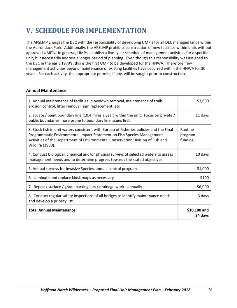
Hoffman Notch Wilderness – Proposed Final Unit Management Plan – February 2012 91
V. SCHEDULE FOR IMPLEMENTATION The APSLMP charges the DEC with the responsibility of developing UMP’s for all DEC managed lands within the Adirondack Park. Additionally, the APSLMP prohibits construction of new facilities within units without approved UMP’s. In general, UMPs establish a five‐ year schedule of management activities for a specific unit, but necessarily address a longer period of planning. Even though this responsibility was assigned to the DEC in the early 1970's, this is the first UMP to be developed for the HNWA. Therefore, few management activities beyond maintenance of existing facilities have occurred within the HNWA for 30 years. For each activity, the appropriate permits, if any, will be sought prior to construction.
Annual Maintenance
1. Annual maintenance of facilities: blowdown removal, maintenance of trails, erosion control, litter removal, sign replacement, etc
$3,000
2. Locate / paint boundary line (10.4 miles a year) within the unit. Focus on private / public boundaries more prone to boundary line issues first.
11 days
3. Stock fish in unit waters consistent with Bureau of Fisheries policies and the Final Programmatic Environmental Impact Statement on Fish Species Management Activities of the Department of Environmental Conservation Division of Fish and Wildlife (1980).
Routine program funding
4. Conduct biological, chemical and/or physical surveys of selected waters to assess management needs and to determine progress towards the stated objectives.
10 days
5. Annual surveys for Invasive Species, annual control program $1,000
6. Laminate and replace kiosk maps as necessary $100
7. Repair / surface / grade parking lots / drainage work ‐ annually $6,000
8. Conduct regular safety inspections of all bridges to identify maintenance needs and develop a priority list.
3 days
Total Annual Maintenance: $10,100 and24 days

V. Schedule for Implementation
92 Hoffman Notch Wilderness – Proposed Final Unit Management Plan – February 2012
YEAR ONE
1. Designate two tentsites in the unit on Big Pond 2 days
2. Construct bridge over Hoffman Notch Brook in the north end of the unit. Crew of 5 people 10 days$200 materials
3. Assess North Pond as a potential reclamation candidate to restore a native fish community there.
4. Place new sign and register box / kiosk off the Blue Ridge Road at the Hoffman Notch Trail
$600
5. Severance Hill Trail reroute 8 days
6. Improve parking lot at gravel pit along west site Route 9 north of I‐87 interchange #28 access to vehicular underpass. Install sign and kiosk at this site.
$3,600
7. Designate tent site on North Pond 2 days
8. Designate tent site on Bailey Pond on hardened level surface construct accessible fire ring and install accessible privy.
10 days
9. Conduct targeted surveys for endangered, threatened, and special concern bird species That were documented in the first Breeding Bird Atlas Project, but not the second
10. Conduct surveys for bird species associated with lowland and high‐elevation boreal forest. Priority should be placed on those species that were detected during the first Breeding Bird Atlas Project, but not the second and on those species that were not detected during either project.
11. Develop a comprehensive MMS type bridge inventory with location maps, design sketches, and material construction details.
4 days
12. Inform the public of the impending regulation to limit the maximum number of overnight users to groups of eight and day use groups to fifteen.
Total costs year one: $4,400 and76 days

V. Schedule for Implementation
Hoffman Notch Wilderness – Proposed Final Unit Management Plan – February 2012 93
YEAR TWO
1. Construct the bridge over East Branch Trout Brook along the Big Pond Trail Crew of 5 people10 days
$200 materials
2. ¼ mile reroute of Notch trail north of Big Marsh with construction of two small bridges
Crew of 5 people 10 days
$200 materials
3. Conduct a detailed inventory of chosen LAC indicators for all marked trails in the unit. Begin an inventory of major unmarked trails after the inventory of marked trails has been completed.
12 days
4. Develop a Hoffman Notch Wilderness Area brochure that details the unit’s history, recreational opportunities, and use guidelines. The brochure will include a unit map showing present boundaries of the HNWA parcels and existing trails, parking lots, or other important public facilities.
4 days
5. Inventory boreal forest habitats within the unit.
6. Survey Unnamed Ponds UH‐P392, UH‐P453D, UH‐P455C, UH‐P5427, and UH‐P5428 to determine their fish communities and habitat characteristics.
7. Build necessary reroutes and sign the existing herd path around Big Pond as an official Class Three and cross country ski trail
30 days
8. Adopt a specific regulation to limit the maximum number of overnight users to groups of eight and day use groups to fifteen.
Total costs year two: $400 and146 days

V. Schedule for Implementation
94 Hoffman Notch Wilderness – Proposed Final Unit Management Plan – February 2012
YEAR THREE
1. Construct a 5‐car parking area at Hoffman Notch trailhead on Blue Ridge Rd. $10,000
2. Locate and construct Platt Brook trail segment connecting Big Pond Trail in the vicinity of North Pond to vehicular underpass at trailhead on Route 9 north of I‐87 Interchange #28. Approximately 4 miles in length.
5‐person crew15 days
3. Where harvest information is lacking, conduct surveys for American marten to better understand distribution and habitat use.
4. Reestablish a native fish community in Marion Pond through reclamation $8,000
5. Improve accessibility of trail to Bailey Pond and the Big Pond Trail from Hoffman Rd. to the first water body. Both of these trails are old road beds and retain that character over most of the trail length described here. Improvement will include trail hardening and improved drainage on muddy stretches of trail and bridging over drainages that would significantly impede wheelchair use.
5‐person crew 15 days$2000
materials
6. Provide UTAP descriptions of improved accessibility trails. 4 days
7. Develop a hardened turn‐around / resting area and associated accessible box privy at the end of the improved section of Big Pond Trail at the first large water body.
10 days
8. Correct water issues at the Hoffman Notch Trailhead parking lot (south) through addition of geotextile fabric and gravel and replace outhouse with accessible outhouse.
$4000
Total costs year three: $24,000 and164 days
YEAR FOUR
1. Monitor existing radio‐collared moose and continue to collar new individuals on an opportunistic basis.
2. Construct Lean‐to in the vicinity of Platt Brook along the new eastern trail segment. $7,000
3. Increase the size of the Big Pond Trailhead parking by 1‐2 vehicle spaces. $2000
4. Construct 3‐4 car parking lot, install sign and register box/ kiosk and cut out an unmarked path to provide access along old Durgin access Rd. in Northwest corner of unit south of Blue Ridge Rd. 2‐3 stringer log bridge to replace existing wooden bridge along this trail.
$2000
Total costs year four: $11,000

V. Schedule for Implementation
Hoffman Notch Wilderness – Proposed Final Unit Management Plan – February 2012 95
YEAR FIVE
1. Conduct a survey of hunters and trappers that use the unit.
2. Monitor use of deer wintering areas in the unit.
3. Conduct surveys for Spruce Grouse and evaluate the distribution and quality of potential Spruce Grouse habitat. Based on results of the surveys and habitat assessment, consider reintroducing this species.
4. Ensure all six trailheads in unit have ID signs at road and map/kiosk registers on trail.
5. Ensure all designated tent sites and lean‐to have accessible privy boxes.

96 Hoffman Notch Wilderness – Proposed Final Unit Management Plan – February 2012
This page intentionally left blank

Hoffman Notch Wilderness – Proposed Final Unit Management Plan – February 2012 97
BIBLIOGRAPHY AND REFERENCES Adironack Park Agency. 2001. Adirondack Park State Land Master Plan. Adirondack Park Agency: Ray
Brook, NY. Andrle, R.F., and J.R. Carroll. 1988. The Atlas of Breeding Birds in New York State. Cornell University Press, Ithaca. Architectural and Transportation Barriers Compliance Board. 1999. Regulatory Negotiation Committee on
Accessibility Guidelines for Outdoor Developed Areas ‐ Final Report. The Access Board: Washington, DC. (http://www.access‐board.gov/outdoor/outdoor‐rec‐rpt.htm)
Arthur Carhart National Wilderness Training Center. 1999. Wilderness Planning Training Module,
Missoula, MT. (http://carhart.wilderness.net/manual/aware/aware.pdf) Atwood, J.L., C.C. Rimmer, K.P. McFarland, S.H. Tsai, and L.R. Nagy. 1996. Distribution of Bicknell’s Thrush in New England and New York. Wilson Bulletin 108:650‐662.. Ball, J. 1974. Birds of New York State. Doubleday/Natural History Press. Garden City, NY. Beehler, B. 1978. Bird Life of the Adirondack Park. Adirondack Mountain Club: Glens Falls, NY. Bent, A.C. 1940. Life Histories of North American Cuckoos, Goatsuckers, Hummingbirds, and their Allies. Dover Publications, Inc. New York. Bishop, Sherman C. 1941. The Salamanders of New York. New York State Museum Bulletin 324:1‐365.
Bowie, Mark. 2003. An Adirondack Wilderness‐ Hoffman Notch . Adirondack Life 34:4 pp42‐46. Brown, E. 1985. The Forest Preserve of New York State. Adirondack Mountain Club: Glens Falls, NY. . Brown, Phil. date unknown. “Longstreet Highroad Guide to the New York Adirondacks”, Longstreet, Atlanta,
Georgia Bull, J. 1974. Birds of New York State. Comstock Publishing Associates, Ithaca. Cassirer, E.F. , D.J. Freedy, and E.D. Ables. 1992. Elk responses to disturbance by cross‐country skiers in Yellowstone National Park. Wildlife Society Bulletin 20:375‐381.
Cole, D.N. 1989. Wilderness Campsite Monitoring Methods: A Source Book. Gen. Tech. Report INT‐259, USDA Forest Service, Intermountain Research Station: Ogden, UT. (http://www.wilderness.net/pubs/179.pdf)
Cole, D.N. 1989. Low‐Impact Recreational Practices for Wilderness and Backcountry. Gen. Tech. Report Int‐265, USDA Forest Service, Intermountain Research Station: Ogden, UT. (http://www.wilderness.net/pubs/183.pdf)

Bibliography and References
98 Hoffman Notch Wilderness – Proposed Final Unit Management Plan – February 2012
Cole, D.N., Petersen, M. and Lucas, R. 1987 Managing Wilderness Recreation Use: Common Problems and Potential Solutions. Gen. Tech. Report INT‐230, USDA Forest Service, Intermountain Research Station: Ogden, UT. (http://www.wilderness.net/pubs/169.pdf)
Cole, D.N. 1994. The Wilderness Threats Matrix, A Framework for Assessing Impacts. Research Paper INT‐475, USDA Forest Service, Intermountain Research Station: Ogden, UT. (http://www.wilderness.net/pubs/247.pdf)
Conant, R. and J.T. Collins. 1998. A Field Guide to Reptiles and Amphibians, Eastern and Central North America. Houghton Mifflin Company, Boston.
Dawson, C.P., Peters, N., Connelly, N.A. and Brown, T.L. 2005. Adirondack Visitor Studies Conducted in Support of NYSDEC Unit Management Planning: Bog River Unit, McKenzie Mountain Wilderness, West Canada Lake. Human Dimensions Research Unit Report HDRU Series No. 05‐6, Cornell University. Ithaca, NY.
Dawson, C.P., Connelly, N.A. and Brown, T.L. 2005. Adirondack Visitor Studies Conducted in Support of NYSDEC Unit Management Planning: Lake George Wild Forest (North) and William C. Whitney Wilderness. Human Dimensions Research Unit Report HDRU Series No. 05‐7, Cornell University. Ithaca, NY. DeGraaf, R.M. and D.D. Rudis. 1983. Amphibians and Reptiles of New England. The University of Massachusetts Press, Amherst. DeGraaf, R.M. and D.D. Rudis. 1986. New England Wildlife: Habitat, Natural History, and Distribution. U.S. Department of Agriculture, Forest Service. General Technical Report NE‐108. Driscoll, C. T. et. al. 2001. Acidic Deposition in the Northeastern United States: Sources and Inputs,
Ecosystem Effects, and Management Strategies. BioScience 51:3, p 180‐198. Driscoll, C. T., K. M. Driscoll, M. J. Mitchell and D. J. Raynal. 2002. Effects of acidic deposition on forest and
aquatic ecosystems in New York State. Environmental Pollution. (In Press). Erlich, P. R., D.S. Dobkin, and D. Wheye. 1988. The Birder’s Handbook: a field guide to the natural history of North American birds. Simon and Schuster, Inc., New York. Essex County Soil and Water District. Map and soils descriptions. Fisher, Donald. Isachsen, Yngvar. Whitney, Philip. “New Mountains from Old Rocks: the Adirondacks” NYS
Geological Survey Educational Leaflet 23 Fox, William F. 1976. “History of the Lumber Industry in the State of New York”, Harbor Hill Books, Harrison,
NY. Freddy, D.J., W.M. Bronaugh, and M.C. Fowler. 1986. Responses of mule deer to disturbance by persons afoot and snowmobiles. Wildlife Society Bulletin 14:63‐68. Freeman, Aileen Sallon. 1996. “There’s a Fox in Pinchot’s Forest”, FOSI, Ltd, Paupack, Pa.
Bibliography and References
Hoffman Notch Wilderness – Proposed Final Unit Management Plan – February 2012 99
George, C.J. 1980. The Fishes of the Adirondack Park. GNOSTIC Publications. 93 pp. Hammit, W. E. and D. N. Cole. 1987. Wildland Recreation: Ecology and Management. John Wiley and
Sons: New York, NY. Harding, J.H. 1997. Amphibians and Reptiles of the Great Lakes Region. The University of Michigan Press, Ann Arbor. Healy, W.R. 1974. Population consequences of alternative life histories in Notophthalmus v. viridescens. Copeia 1:221‐229. Hendee, J. C., G. H. Stankey and R. C. Lucas. 1990. Wilderness Management. International Wilderness
Leadership Foundation: Golden, CO. Hunter, M.L., A.J.K. Calhoun, and M. McCollough. 1999. Maine Amphibians and Reptiles. The University of Maine Press, Orono. Hurst, J.E. 2004. An evaluation of historical change in white‐tailed deer winter yards in the Adirondack region of New York. M.S. Thesis, State University of New York, College of Environmental Science and Forestry. Syracuse, NY. Johnsgard, P.A. 1990. Hawks, Eagles, and Falcons of North America, Biology and Natural History. Smithsonian Institution Press, Washington DC. Kretser, W., J. Gallagher and J. Nicolette. Adirondack Lakes Study 1984‐1987, an Evaluation of Fish
Communities and Water Chemistry. Adirondack Lake Survey Corporation: Ray Brook, NY. Mather, F. 1884. Memoranda relating to Adirondack fishes with descriptions of new species, from
researches made in 1882. Appendix E, New York State Land Survey. p. 113‐ 182. Mautz, W.W. 1978. Sledding on a bushy hillside: the fat cycle in deer. Wildlife Society Bulletin 6:88‐90. McMartin, Barbara. 1986. “Discover the Central Adirondacks”, Backcountry Publications, Woodstock,
Vermont. McMartin, Barbara. 1994. “The Great Forests of the Adirondacks”, North Country Books, Utica, NY. Metcalfe, Ann Breen. 2000. “The Schroon River”, Warren County Historical Society, Glens Falls, NY. Miller, William J. 1919. “The Geology of the Schroon Lake Quadrangle”, New York State Museum
Bulletin , Albany, New York. Minerva Historical Society. 1967. “Minerva 1817‐1967; A History of a Town in Essex County, NY”, Multiprint,
Inc., New York, NY. Mitchell , J.C. 1994. The Reptiles of Virginia. Smithsonian Institution Press. Washington.
Bibliography and References
100 Hoffman Notch Wilderness – Proposed Final Unit Management Plan – February 2012
National Science and Technology Council Committee on Environment and Natural Resources. 1998.
National Acid Precipicitation Assessment Program Biennial Report to Congress: An integrated Assessment. US National Acid Precipitation Assessment Program, Silver Springs, MD.
(www.nnic.noaa.gov/CENR/NAPAP/NAPAP_96.htm). O’Neill, W. 1990. Air Resources in the Adirondack Park. The Adirondack Park in the Twenty‐First Century, Technical Reports, Volume One. Commission on the Adirondacks in the Twenty‐First Century: Albany, NY. Peek, J.M. 1997. Habitat relationships. Pages 351‐376 in Franzmann, A.W. and C.C. Schwartz (eds.) Ecology and management of the North American moose. Smithsonian Institution Press, Washington, D.C. Pfingston, R.A. and F.L. Downs. 1989. Salamanders of Ohio. College of Biological Sciences, The Ohio State University, Columbus, Ohio. Proskine, Alec. 1986. “Adirondack Canoe Waters; South and West Flow”, Adirondack Mountain Club. Reschke, Carol. 1990. Ecological Communities of New York State. New York Natural Heritage Program, New
York State Department of Environmental Conservation, Latham, NY 96 pp. + xi Saunders, D.A. 1988. Adirondack Mammals. Adirondack Wildlife Program, State University of New York College of Environmental Science and Forestry, Syracuse, NY. Severinghaus, C.W. 1953. Springtime in New York ‐ another angle: what goes on in our Adirondack deeryards. New York State Conservationist 7:2‐4. Smith, H. P. 1885. “History of Essex County, New York”, D. Mason & Co., Syracuse, NY. Tuttle, S.E. and D.M. Carroll. 1997. Ecology and natural history of the wood turtle (Clemmys insculpta) in southern New Hampshire. Chelonian Conservation and Biology 2:447‐449.
U.S. Forest Service. 1994. Leave No Trace: A Program to Teach Skills for Protecting the Wilderness Environment. Washington, D.C.
Verme, L.J. 1965. Swamp conifer deeryards in northern Michigan. Journal of Forestry 523‐529. Van Valkenburgh, Norman. 1985. “Land Acquisition for New York State, An Historical Perspective”, The
Catskill Center, Arkville, NY. Van Valkenburg, N. J. 1987. Unit Management Planning for Wilderness Management. The Association for
the Protection of the Adirondacks: Schenectady, NY. Wadsworth, Bruce. 1986. “Guide to Adirondack Trails: Central Region”, Adirondack Mountain Club Watson, Winslow C. 1869. “The Military and Civil History of the County of Essex, New York”, J. Munsell, Albany, NY.