history and environmental of the grand .... proceedings of the indiana academy of science...
TRANSCRIPT
1999/2000 . Proceedings of the Indiana Academy of Science 108/109 :3–10
HISTORY AND ENVIRONMENTAL SETTINGOF THE GRAND CALUMET RIVER
Meredith Becker Nevers, Richard L . Whitman, and Paul J. Gerovac : U.S.Geological Survey, Biological Resources Division, Lake Michigan EcologicalResearch Station, 1100 North Mineral Springs Road, Porter, Indiana 4630 4
ABSTRACT . The Grand Calumet River lies in an area of great ecological diversity, a result of theconvergence of three biomes during glaciation . Over thousands of years the region and the river hav echanged ecologically due to ice retreat, lake level declines, settlement and industrialization . Settlementand industrialization have greatly accelerated the rate of change, and the Grand Calumet River and it sbasin are now subject to the added effects of years of direct pollution . For years, industries directlydischarged into the waterway; and those contaminants remain locked in the sediment a century later. Inorder to preserve the remaining surrounding natural areas and to improve the Grand Calumet River, burie dcontaminants would have to be dredged from the river. Restoration needs to be implemented as part o fthe clean-up process, and recontamination should be prevented .
Keywords : Grand Calumet River, Calumet region, settlement, industrializatio n
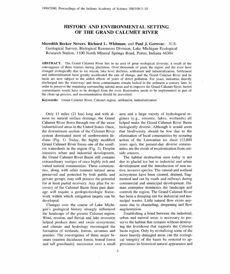
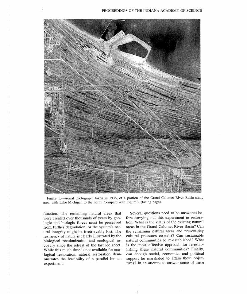
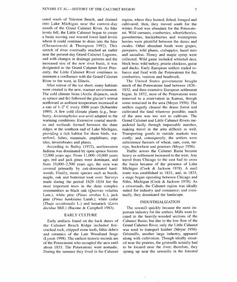
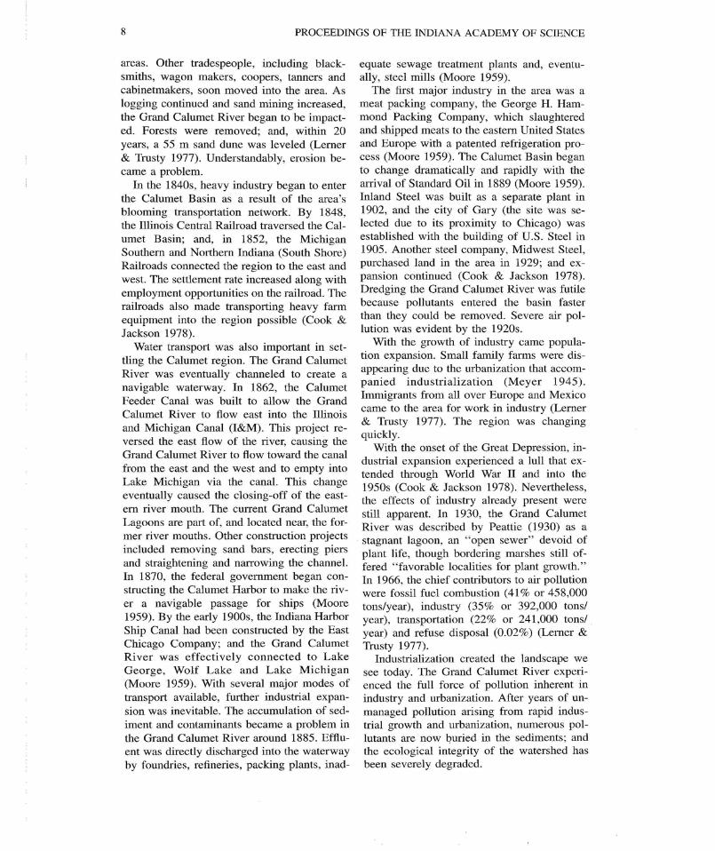
Only 13 miles (21 km) long and with al-most no natural surface drainage, the Gran dCalumet River flows through one of the moreindustrialized areas in the United States . Once ,the downstream section of the Calumet Rive rsystem dominated most of northwestern In-diana (Fig. 1) . Today, the highly modifie dGrand Calumet River forms one of the small-est watersheds in the region (Fig . 2) . Despit eintensive urban and industrial development ,the Grand Calumet River Basin still contain sextraordinary vestiges of once highly rich an dvaried natural communities . These communi-ties, along with other remnant natural areaspreserved and protected by both public an dprivate groups, may still possess the potentia lfor at least partial recovery . Any plan for re-covery of the Calumet Basin from past dam-age will require a geologic/ecologic frame -work within which mitigation targets can b edeveloped .
Changes over the course of Lake Michi-gan's geological history strongly influencedthe landscape of the present Calumet region .Wind, erosion, and fluvial and lake recessio nhelped produce dune and Swale ecosystems ;and climate and hydrology encouraged theformation of wetlands, forests, savannas an dprairies . The convergence of three major bi-omes (eastern deciduous forest, boreal forestand tall grasslands), succession over a small
area and a large variety of hydrological re-gimes (e .g., streams, lakes, wetlands) allhelped make the Grand Calumet River Basinbiologically diverse. Although it would seemthat biodiversity should be low due to th eelimination of local communities by scouringaction of the Laurentian ice sheet (12,00 0years ago), the present-day diverse commu-nities are the result of recolonization from out -side sources .
The habitat destruction seen today is notdue to glacial ice but to industrial and urba ndevelopment and the introduction of non-na-tive, invasive species . The natural and wetlandecosystems have been cleared, drained, frag-mented and cut by roads and railways durin gcommercial and municipal development . Hu-man enterprise dominates the landscape andcontrols the region . The Grand Calumet Riverhas been a dumping site for industrial and mu-nicipal wastes . Little natural flow exists any-more due to channeling, deepening and flowaugmentation .
Establishing a bond between the industrial ,urban and natural areas is necessary to pre -serve the habitat that remains without destroy-ing the livelihood that supports the Calumetbasin region. Only by revitalizing some of themore heavily-damaged areas can the ecologi-cal integrity of the basin be restored to ap-proximate its historical natural appearance an d
3
4
PROCEEDINGS OF THE INDIANA ACADEMY OF SCIENCE
Figure 1 .-Aerial photograph, taken in 1938, of a portion of the Grand Calumet River Basin studyarea, with Lake Michigan to the north . Compare with Figure 2 (facing page) .
function . The remaining natural areas tha twere created over thousands of years by geo-logic and biologic forces must be preservedfrom further degradation, or the system's nat-ural integrity might be irretrievably lost. Theresiliency of nature is clearly illustrated by th ebiological recolonization and ecological re-covery since the retreat of the last ice sheet .While this much time is not available for eco-logical restoration, natural restoration dem-onstrates the feasibility of a parallel humanexperiment .
Several questions need to be answered be-fore carrying out this experiment in restora-tion. What is the status of the existing natura lareas in the Grand Calumet River Basin? Ca nthe remaining natural areas and present-daycultural pressures co-exist? Can sustainabl enatural communities be re-established? Whatis the most effective approach for re-estab-lishing these natural communities? Finally ,can enough social, economic, and politicalsupport be marshaled to attain these objec-tives? In an attempt to answer some of these
NEVERS ET AL.—HISTORY OF THE CALUMET REGION
5
Figure 2.—Aerial photograph, taken in 1975, of a portion of the Grand Calumet River Basin stud yarea, with Lake Michigan to the north . Compare with Figure 1 (facing page) .
questions, the U .S. Army Corps of Engineersdeveloped a remedial action plan with re -search and consultation conducted by scien-tists intimately familiar with the ecosystemand its components . The following papers arethe culmination of these efforts and an attemptto answer the first four questions ; the las tquestion can only be answered after imple-mentation of a restoration plan .
REGIONAL GEOGRAPHY
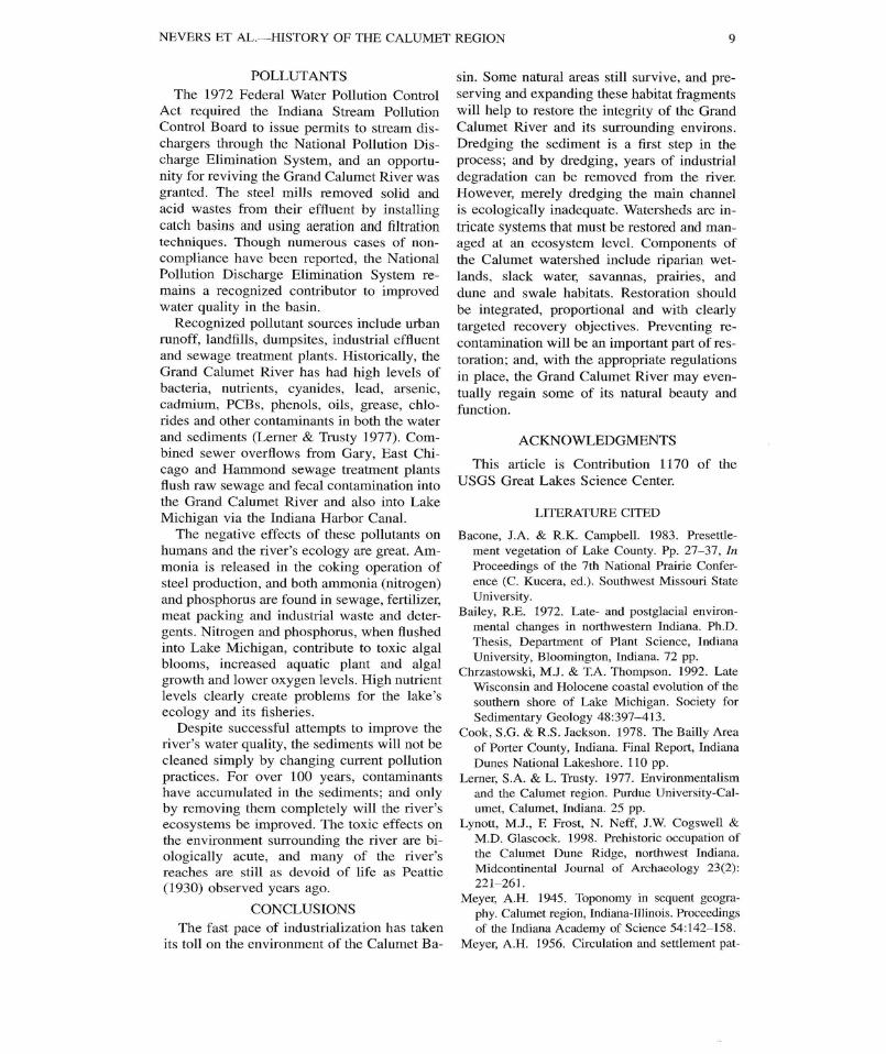
The natural watershed of the Grand Calu-met River is located between Toleston Beac hand the present-day shore of Lake Michiga n(Fig. 3) . The watershed lies within the Calu-met lacustrine plain, or lake plain, which ex -tends from the shore of modem-day Lake
Michigan to the Valparaiso terminal moraine .After the Wisconsin glaciation, the LakeMichigan lobe of the Laurentian ice sheet be-gan to retreat, and the Valparaiso terminal mo -raine marks the point of the ice sheet's furthes tsouthward advance before receding . The mo-raine also serves as the continental divide andthe southern boundary of the Lake Michiga nwatershed. Drainage from areas to the northof the moraine enters the Atlantic Ocean vi athe Calumet River, Lake Michigan, Lake Hu-ron, the St . Clair River, Lake Erie, Lake On-tario and the St . Lawrence River. Drainagefrom areas south of the moraine typicall yflows to the Gulf of Mexico via the Missis-sippi River. The Calumet Basin lies on the
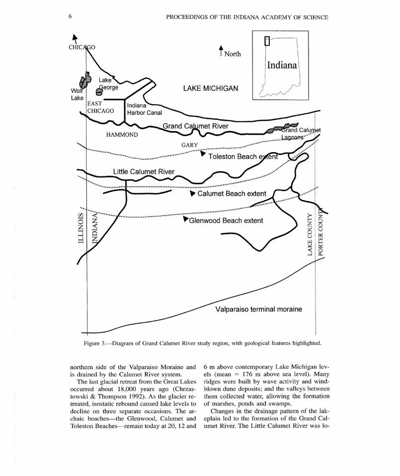
Figure 3 .-Diagram of Grand Calumet River study region, with geological features highlighted.
6 PROCEEDINGS OF THE INDIANA ACADEMY OF SCIENC E
I North
LAKE MICHIGA N
. ..GARY . . . . .
. .' Toleston Beach e
Valparaiso terminal morain e
northern side of the Valparaiso Moraine andis drained by the Calumet River system.
The last glacial retreat from the Great Lake soccurred about 18,000 years ago (Chrzas-towski & Thompson 1992) . As the glacier re-treated, isostatic rebound caused lake levels t odecline on three separate occasions . The ar-chaic beaches—the Glenwood, Calumet andToleston Beaches—remain today at 20, 12 and
6 m above contemporary Lake Michigan lev-els (mean = 176 m above sea level) . Manyridges were built by wave activity and wind -blown dune deposits ; and the valleys betweenthem collected water, allowing the formatio nof marshes, ponds and swamps .
Changes in the drainage pattern of the lak-eplain led to the formation of the Grand Cal-umet River. The Little Calumet River was lo-
NEVERS ET AL .—HISTORY OF THE CALUMET REGION
7
cated south of Toleston Beach, and drainedinto Lake Michigan near the current-daymouth of the Grand Calumet River. As lakelevels fell, the Little Calumet began to createa basin moving east toward lower land level swhere it could continue to drain into the lake(Chrzastowski & Thompson 1992) . Thisstretch of river eventually reached an outletnear the present-day Grand Calumet Lagoons ,and with changes in drainage patterns and th eincreased size of the new river basin, it wa sdesignated as the Grand Calumet River. Pres-ently, the Little Calumet River continues t omaintain a confluence with the Grand CalumetRiver to the west, in Illinois .
After retreat of the ice sheet, many habitat swere created in the new, warmer environment .The cold climate biota (Arctic disjuncts, suchas spruce and fir) followed the glacier's retrea tnorthward as ambient temperature increased a ta rate of 1–2° C every 1000 years (Schneider1989) . A few cold climate plants (e .g ., bear-berry, Arctostaphylos uva-ursi) adapted to thewarming conditions . Extensive coastal marsh -es and wetlands formed between the dun eridges at the southern end of Lake Michigan ,providing a rich habitat for shore birds, wa-terfowl, fishes, mammals, amphibians, rep -tiles, invertebrates and plants .
According to Bailey (1972), northwesternIndiana was dominated by open spruce forest s12,000 years ago . From 11,000–10,000 year sago, red and jack pines were dominant, andfrom 10,000–2,500 years ago, the area wa scovered primarily by oak-dominated hard-woods. Finally, mesic species such as beech ,maple, oak and butternut took over. Surveysmade during the period 1829–1834 list themost important trees in the dune comple xcommunities as black oak (Quercus velutin aLam.), white pine (Pinus strobus L .), jackpine (Pinus banksiana Lamb.), white cedar(Thuja occidentalis L.) and tamarack (Larixdecidua Mill .) (Bacone & Campbell 1983) .
EARLY CULTURE
Early artifacts found on the back dunes ofthe Calumet Beach Ridge included fire -cracked rock, chipped stone tools, lithic debri sand ceramics of the Late Woodland Stag e(Lynott 1998) . The earliest historic records ar eof the Potawatomi who occupied the area unti labout 1833 . The Potawatomi were nomadic .During the summer they lived in the Calumet
region, where they hunted, fished, foraged an dcultivated ; then, they moved south for th ewinter. Food was abundant for the Potawato-mi . Wild currants, cranberries, whortleberries ,gooseberries, huckleberries and wintergreenberries were plentiful between the dunes an dswales. Other abundant foods were grapes ,pawpaws, wild plums, crabapples, hazel nut sand sassafras . Honey and maple syrup werecollected . Wild game included whitetail deer,black bear, wild turkey, prairie chickens, gees eand ducks . Early European settlers traded to-bacco and food with the Potawatomi for fur,cranberries, venison and beadwork.
The United States government boughtmuch of the Potawatomi land between 1826–1832, and then extensive European settlemen tbegan. In 1832, most of the Potawatomi wereremoved to a reservation in Kansas, thoughsome remained in the area (Meyer 1956) . Thesettlers eagerly cleared the dense forest an dcultivated the land wherever possible ; muc hof the area was too wet to cultivate . TheGrand Calumet and Little Calumet Rivers me-andered lazily through impassable marshes ,making travel in the area difficult as well .Transporting goods to outside markets wa scostly ; and, consequently, the settlers weresubsistence farmers of wheat, oats, corn, tur-nips, buckwheat and potatoes (Meyer 1956) .
Traffic across the Calumet Basin becameheavy as settlement increased to the west . Anytravel from Chicago to the east had to cros sthe basin because of the presence of Lak eMichigan (Cook & Jackson 1978) . A mailroute was established in 1831 ; and, in 1833,a stage began operating between Chicago an dNiles, Michigan (Cook & Jackson 1978) . Asa crossroads, the Calumet region was ideallysuited for industry and commerce ; and even-tually, they dominated the landscape .
INDUSTRIALIZATION
The sawmill quickly became the most im-portant industry for the settlers . Mills were lo-cated in the heavily-wooded sections of theCalumet Basin ; but due to the low flow of th eGrand Calumet River, only the Little Calume twas used to transport lumber (Meyer 1956) .Gristmills, another large industry, appeare dalong with cultivation. Though ideally situat-ed near the prairies, the gristmills actually hadto be located near the river ; therefore, theysprang up near the sawmills in the forested
8
PROCEEDINGS OF THE INDIANA ACADEMY OF SCIENCE
areas. Other tradespeople, including black-smiths, wagon makers, coopers, tanners andcabinetmakers, soon moved into the area . Aslogging continued and sand mining increased ,the Grand Calumet River began to be impact -ed. Forests were removed ; and, within 20years, a 55 m sand dune was leveled (Lerner& Trusty 1977) . Understandably, erosion be-came a problem .
In the 1840s, heavy industry began to enterthe Calumet Basin as a result of the area' sblooming transportation network. By 1848 ,the Illinois Central Railroad traversed the Cal-umet Basin ; and, in 1852, the MichiganSouthern and Northern Indiana (South Shore )Railroads connected the region to the east andwest . The settlement rate increased along wit hemployment opportunities on the railroad . Therailroads also made transporting heavy far mequipment into the region possible (Cook &Jackson 1978) .
Water transport was also important in set-tling the Calumet region . The Grand CalumetRiver was eventually channeled to create anavigable waterway . In 1862, the Calume tFeeder Canal was built to allow the GrandCalumet River to flow east into the Illinoi sand Michigan Canal (I&M) . This project re-versed the east flow of the river, causing theGrand Calumet River to flow toward the canalfrom the east and the west and to empty int oLake Michigan via the canal . This changeeventually caused the closing-off of the east-ern river mouth. The current Grand CalumetLagoons are part of, and located near, the for-mer river mouths . Other construction project sincluded removing sand bars, erecting pier sand straightening and narrowing the channel .In 1870, the federal government began con-structing the Calumet Harbor to make the riv-er a navigable passage for ships (Moore1959) . By the early 1900s, the Indiana Harbo rShip Canal had been constructed by the EastChicago Company ; and the Grand CalumetRiver was effectively connected to Lak eGeorge, Wolf Lake and Lake Michigan(Moore 1959) . With several major modes o ftransport available, further industrial expan-sion was inevitable . The accumulation of sed-iment and contaminants became a problem i nthe Grand Calumet River around 1885 . Efflu-ent was directly discharged into the waterwayby foundries, refineries, packing plants, inad-
equate sewage treatment plants and, eventu-ally, steel mills (Moore 1959) .
The first major industry in the area was ameat packing company, the George H . Ham-mond Packing Company, which slaughtere dand shipped meats to the eastern United State sand Europe with a patented refrigeration pro-cess (Moore 1959) . The Calumet Basin bega nto change dramatically and rapidly with thearrival of Standard Oil in 1889 (Moore 1959) .Inland Steel was built as a separate plant i n1902, and the city of Gary (the site was se-lected due to its proximity to Chicago) wa sestablished with the building of U .S . Steel in1905 . Another steel company, Midwest Steel ,purchased land in the area in 1929 ; and ex-pansion continued (Cook & Jackson 1978) .Dredging the Grand Calumet River was futilebecause pollutants entered the basin faste rthan they could be removed. Severe air pol-lution was evident by the 1920s .
With the growth of industry came popula-tion expansion. Small family farms were dis-appearing due to the urbanization that accom-panied industrialization (Meyer 1945) .Immigrants from all over Europe and Mexic ocame to the area for work in industry (Lerne r& Trusty 1977) . The region was changin gquickly.
With the onset of the Great Depression, in-dustrial expansion experienced a lull that ex -tended through World War II and into th e1950s (Cook & Jackson 1978) . Nevertheless ,the effects of industry already present werestill apparent . In 1930, the Grand CalumetRiver was described by Peattie (1930) as astagnant lagoon, an "open sewer" devoid o fplant life, though bordering marshes still of-fered "favorable localities for plant growth ."In 1966, the chief contributors to air pollutio nwere fossil fuel combustion (41% or 458,00 0tons/year), industry (35% or 392,000 tons /year), transportation (22% or 241,000 tons/year) and refuse disposal (0.02%) (Lerner &Trusty 1977) .
Industrialization created the landscape w esee today. The Grand Calumet River experi-enced the full force of pollution inherent inindustry and urbanization . After years of un-managed pollution arising from rapid indus-trial growth and urbanization, numerous pol-lutants are now buried in the sediments ; andthe ecological integrity of the watershed hasbeen severely degraded .
NEVERS ET AL. HISTORY OF THE CALUMET REGION
9
POLLUTANTSThe 1972 Federal Water Pollution Contro l
Act required the Indiana Stream Pollutio nControl Board to issue permits to stream dis-chargers through the National Pollution Dis-charge Elimination System, and an opportu-nity for reviving the Grand Calumet River wa sgranted. The steel mills removed solid an dacid wastes from their effluent by installin gcatch basins and using aeration and filtratio ntechniques . Though numerous cases of non -compliance have been reported, the NationalPollution Discharge Elimination System re -mains a recognized contributor to improve dwater quality in the basin .
Recognized pollutant sources include urba nrunoff, landfills, dumpsites, industrial effluentand sewage treatment plants . Historically, th eGrand Calumet River has had high levels o fbacteria, nutrients, cyanides, lead, arsenic ,cadmium, PCBs, phenols, oils, grease, chlo-rides and other contaminants in both the wate rand sediments (Lerner & Trusty 1977) . Com-bined sewer overflows from Gary, East Chi-cago and Hammond sewage treatment plant sflush raw sewage and fecal contamination int othe Grand Calumet River and also into LakeMichigan via the Indiana Harbor Canal .
The negative effects of these pollutants o nhumans and the river's ecology are great. Am-monia is released in the coking operation o fsteel production, and both ammonia (nitrogen )and phosphorus are found in sewage, fertilizer ,meat packing and industrial waste and deter-gents . Nitrogen and phosphorus, when flushedinto Lake Michigan, contribute to toxic algalblooms, increased aquatic plant and alga lgrowth and lower oxygen levels . High nutrien tlevels clearly create problems for the lake' secology and its fisheries .
Despite successful attempts to improve theriver's water quality, the sediments will not b ecleaned simply by changing current pollutionpractices . For over 100 years, contaminantshave accumulated in the sediments ; and onlyby removing them completely will the river ' secosystems be improved . The toxic effects onthe environment surrounding the river are bi-ologically acute, and many of the river' sreaches are still as devoid of life as Peattie(1930) observed years ago .
CONCLUSIONSThe fast pace of industrialization has take n
its toll on the environment of the Calumet Ba-
sin . Some natural areas still survive, and pre-serving and expanding these habitat fragment swill help to restore the integrity of the Gran dCalumet River and its surrounding environs .Dredging the sediment is a first step in theprocess; and by dredging, years of industrialdegradation can be removed from the river.However, merely dredging the main channelis ecologically inadequate. Watersheds are in-tricate systems that must be restored and man -aged at an ecosystem level . Components ofthe Calumet watershed include riparian wet -lands, slack water, savannas, prairies, an ddune and swale habitats . Restoration shoul dbe integrated, proportional and with clearl ytargeted recovery objectives . Preventing re -contamination will be an important part of res-toration; and, with the appropriate regulation sin place, the Grand Calumet River may even-tually regain some of its natural beauty andfunction .
ACKNOWLEDGMENTS
This article is Contribution 1170 of theUSGS Great Lakes Science Center .
LITERATURE CITED
Bacone, J .A. & R.K. Campbell . 1983 . Presettle-ment vegetation of Lake County. Pp . 27-37, InProceedings of the 7th National Prairie Confer-ence (C. Kucera, ed .) . Southwest Missouri Stat eUniversity .
Bailey, R .E . 1972. Late- and postglacial environ-mental changes in northwestern Indiana . Ph .D .Thesis, Department of Plant Science, IndianaUniversity, Bloomington, Indiana . 72 pp .
Chrzastowski, M .J . & T.A . Thompson. 1992 . LateWisconsin and Holocene coastal evolution of thesouthern shore of Lake Michigan . Society forSedimentary Geology 48 :397-413 .
Cook, S .G. & R .S . Jackson . 1978 . The Bailly Areaof Porter County, Indiana. Final Report, Indian aDunes National Lakeshore . 110 pp .
Lerner, S .A . & L . Trusty. 1977 . Environmentalis mand the Calumet region . Purdue University-Cal -umet, Calumet, Indiana . 25 pp .
Lynott, M .J., F. Frost, N. Neff, J.W. Cogswell &M.D. Glascock . 1998 . Prehistoric occupation o fthe Calumet Dune Ridge, northwest Indiana .Midcontinental Journal of Archaeology 23(2) :221-261 .
Meyer, A.H. 1945 . Toponomy in sequent geogra-phy. Calumet region, Indiana-Illinois . Proceedingsof the Indiana Academy of Science 54 :142-158 .
Meyer, A .H. 1956 . Circulation and settlement pat-
10
PROCEEDINGS OF THE INDIANA ACADEMY OF SCIENCE
terns of the Calumet region of northwest Indianaand northeast Illinois : The second stage of oc-cupance-pioneer settler subsistence economy,1830-1850 . Annals of the Association of Amer-ican Geographers 46(3) :312-356 .
Moore, P.A. 1959. The Calumet Region : Indiana' sLast Frontier. (D . Riker & G . Thornbrough, eds .) .
Indiana Historical Bureau, East Chicago, Indi-ana. 654 pp .
Peattie, P.C. 1930. Flora of the Indiana Dunes .Field Museum of Natural History, Chicago, Illi-nois . 432 pp .
Schneider, S .H. 1989. The changing climate . Sci-entific American 261(3) :70-79 .