ground collapsing in the city of tuzla (bosnia & herzegovina) · ground collapsing in the city...
TRANSCRIPT
Ground Collapsing in the City of Tuzla (Bosnia & Herzegovina)
F. Mancini a, F. Stecchi b, G. Gabbianelli b, A. Dzindo c
a DISTART, University of Bologna, Bologna, 40136, Italy ([email protected])
b CIRSA / Interdepartmental Research Centre for the Environmental Sciences, University of Bologna, Ravenna, 48100, Italy (giovanni.gabbianelli, [email protected])
c DIRECTION FOR BUILDINGS d.o.o. Tuzla, 75000 Tuzla, Bosnia & Herzegovina ([email protected]) Abstract – Since the year 1955, when the salt deposits exploitation activities were carried out in the city of Tuzla and surroundings, dramatic ground collapsing phenomena occurred. Up to 10 meters of sinking in the last half century produced several damages with regards to buildings and infrastructures, leading to the demolition of the most compromised part of the city by the inhabitants. Traditional topographic survey was used in order to monitor the land deformations from the 50' to year 2000 with the establishment of a dense topographic network around the sinking area. The analisys of the huge dataset of altimetric data, the correlation with the boreholes activities and the introduction of more productive modern technologies (satellite GPS for geodesy) for repeated land monitoring are the object of this paper. Keywords: ground collapsing, topographic survey, satellite, GPS, salt deposit exploitation.
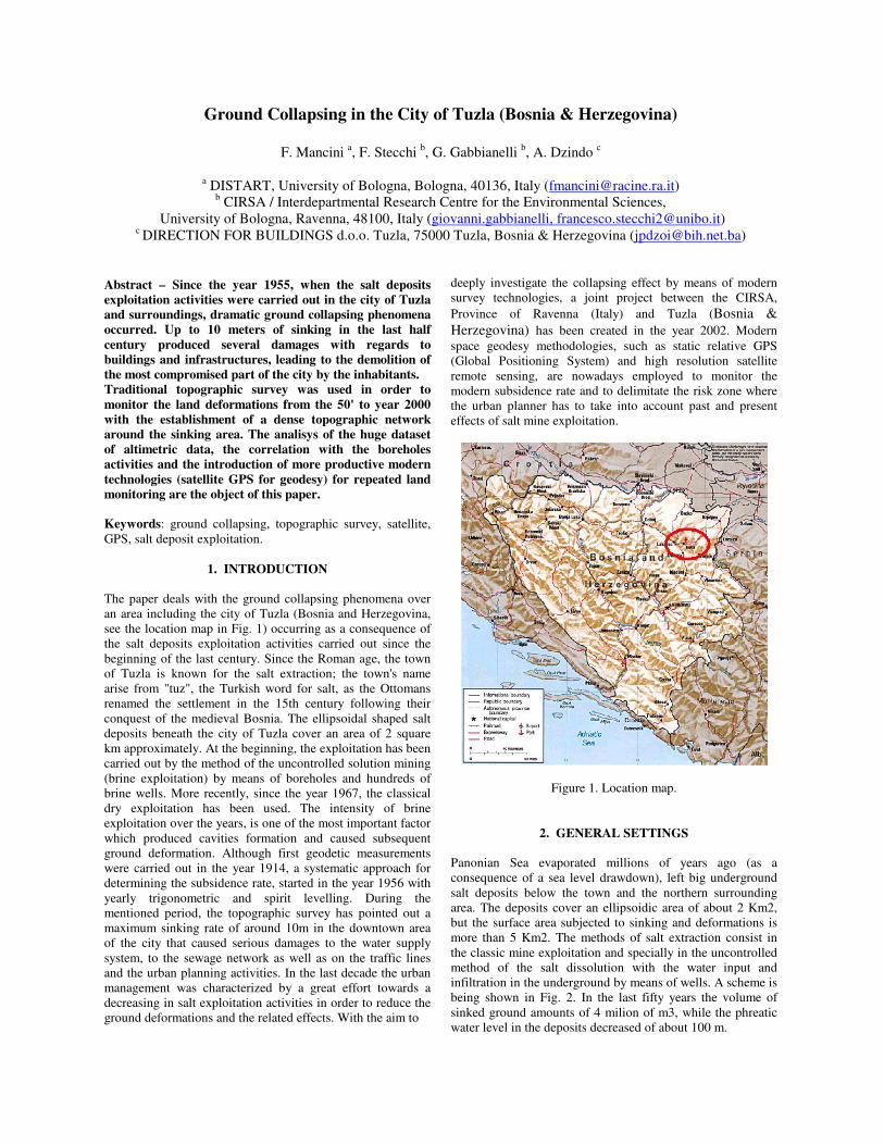
1. INTRODUCTION The paper deals with the ground collapsing phenomena over an area including the city of Tuzla (Bosnia and Herzegovina, see the location map in Fig. 1) occurring as a consequence of the salt deposits exploitation activities carried out since the beginning of the last century. Since the Roman age, the town of Tuzla is known for the salt extraction; the town's name arise from "tuz", the Turkish word for salt, as the Ottomans renamed the settlement in the 15th century following their conquest of the medieval Bosnia. The ellipsoidal shaped salt deposits beneath the city of Tuzla cover an area of 2 square km approximately. At the beginning, the exploitation has been carried out by the method of the uncontrolled solution mining (brine exploitation) by means of boreholes and hundreds of brine wells. More recently, since the year 1967, the classical dry exploitation has been used. The intensity of brine exploitation over the years, is one of the most important factor which produced cavities formation and caused subsequent ground deformation. Although first geodetic measurements were carried out in the year 1914, a systematic approach for determining the subsidence rate, started in the year 1956 with yearly trigonometric and spirit levelling. During the mentioned period, the topographic survey has pointed out a maximum sinking rate of around 10m in the downtown area of the city that caused serious damages to the water supply system, to the sewage network as well as on the traffic lines and the urban planning activities. In the last decade the urban management was characterized by a great effort towards a decreasing in salt exploitation activities in order to reduce the ground deformations and the related effects. With the aim to
deeply investigate the collapsing effect by means of modern survey technologies, a joint project between the CIRSA, Province of Ravenna (Italy) and Tuzla (Bosnia & Herzegovina) has been created in the year 2002. Modern space geodesy methodologies, such as static relative GPS (Global Positioning System) and high resolution satellite remote sensing, are nowadays employed to monitor the modern subsidence rate and to delimitate the risk zone where the urban planner has to take into account past and present effects of salt mine exploitation.
Figure 1. Location map.
2. GENERAL SETTINGS Panonian Sea evaporated millions of years ago (as a consequence of a sea level drawdown), left big underground salt deposits below the town and the northern surrounding area. The deposits cover an ellipsoidic area of about 2 Km2, but the surface area subjected to sinking and deformations is more than 5 Km2. The methods of salt extraction consist in the classic mine exploitation and specially in the uncontrolled method of the salt dissolution with the water input and infiltration in the underground by means of wells. A scheme is being shown in Fig. 2. In the last fifty years the volume of sinked ground amounts of 4 milion of m3, while the phreatic water level in the deposits decreased of about 100 m.
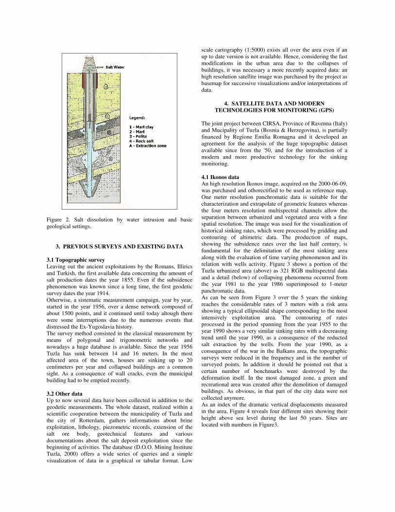
Figure 2. Salt dissolution by water intrusion and basic geological settings.
3. PREVIOUS SURVEYS AND EXISTING DATA 3.1 Topographic survey Leaving out the ancient exploitations by the Romans, Illirics and Turkish, the first available data concerning the amount of salt production dates the year 1855. Even if the subsidence phenomenon was known since a long time, the first geodetic survey dates the year 1914. Otherwise, a sistematic measurement campaign, year by year, started in the year 1956, over a dense network composed of about 1500 points, and it continued until today altough there were some interruptions due to the numerous events that distressed the Ex-Yugoslavia history. The survey method consisted in the classical measurement by means of polygonal and trigonometric networks and nowadays a huge database is available. Since the year 1956 Tuzla has sunk between 14 and 16 meters. In the most affected area of the town, houses are sinking up to 20 centimeters per year and collapsed buildings are a common sight. As a consequence of wall cracks, even the municipal building had to be emptied recently. 3.2 Other data Up to now several data have been collected in addition to the geodetic measurements. The whole dataset, realized within a scientific cooperation between the municipality of Tuzla and the city of Rotterdam, gathers informations about brine exploitation, lithology, piezometric records, extension of the salt ore body, geotechnical features and various documentations about the salt deposit exploitation since the beginning of activities. The database (D.O.O. Mining Institute Tuzla, 2000) offers a wide series of queries and a simple visualization of data in a graphical or tabular format. Low
scale cartography (1:5000) exists all over the area even if an up to date version is not available. Hence, considering the fast modifications in the urban area due to the collapses of buildings, it was necessary a more recently acquired data: an high resolution satellite image was purchased by the project as basemap for successive visualizations and/or interpretations of data.
4. SATELLITE DATA AND MODERN TECHNOLOGIES FOR MONITORING (GPS)
The joint project between CIRSA, Province of Ravenna (Italy) and Mucipality of Tuzla (Bosnia & Herzegovina), is partially financed by Regione Emilia Romagna and it developed an agreement for the analysis of the huge topographic dataset available since from the '50, and for the introduction of a modern and more productive technology for the sinking monitoring. 4.1 Ikonos data An high resolution Ikonos image, acquired on the 2000-06-09, was purchased and othorectified to be used as reference map. One meter resolution panchromatic data is suitable for the characterization and extrapolate of geometric features whereas the four meters resolution multispectral channels allow the separation between urbanized and vegetated area with a fine spatial resolution. The image was used for the visualization of historical sinking rates, which were processed by gridding and contouring of altimetric data. The production of maps, showing the subsidence rates over the last half century, is fundamental for the delimitation of the most sinking area along with the evaluation of time varying phenomenon and its relation with wells activity. Figure 3 shows a portion of the Tuzla urbanized area (above) as 321 RGB multispectral data and a detail (below) of collapsing phenomena occurred from the year 1981 to the year 1986 superimposed to 1-meter panchromatic data. As can be seen from Figure 3 over the 5 years the sinking reaches the considerable rates of 3 meters with a risk area showing a typical ellipsoidal shape corresponding to the most intensively exploitation area. The contouring of rates processed in the period spanning from the year 1955 to the year 1990 shows a very similar sinking rates with a decreasing trend until the year 1990, as a consequence of the reducted salt extraction by the wells. From the year 1990, as a consequence of the war in the Balkans area, the topographic surveys were reduced in the frequency and in the number of surveyed points. In addition it should be pointed out that a certain number of benchmarks were destroyed by the deformation itself. In the most damaged zone, a green and recreational area was created after the demolition of damaged buildings. As obvious, in that part of the city data were not collected anymore. As an index of the dramatic vertical displacements measured in the area, Figure 4 reveals four different sites showing their height above sea level during the last 50 years. Sites are located with numbers in Figure3.
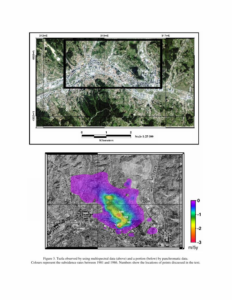
Figure 3. Tuzla observed by using multispectral data (above) and a portion (below) by panchromatic data. Colours represent the subsidence rates between 1981 and 1986. Numbers show the locations of points discussed in the text.
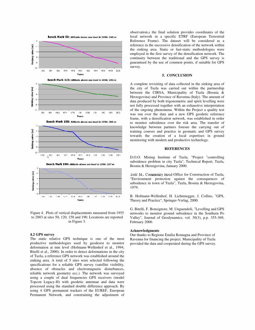
Figure 4. Plots of vertical displacements measured from 1955 to 2003 at sites 50, 120, 158 and 190. Locations are reported
in Figure 3. 4.2 GPS survey The static relative GPS technique is one of the most productive methodologies used by geodesist to monitor deformation at mm level (Hofmann-Wellenhof et al., 1994; Bitelli et al., 2000). In order to detect deformations in the city of Tuzla, a reference GPS network was established around the sinking area. A total of 5 sites were selected following the specifications for a reliable GPS survey (satellite visibility, absence of obstacles and electromagnetic disturbances, reliable network geometry ecc.). The network was surveyed using a couple of dual frequencies GPS receivers (model Topcon Legacy-H) with geodetic antennae and data were processed using the standard double difference approach. By using 4 GPS permanent trackers of the EUREF, European Permanent Network, and constraining the adjustment of
observation,s the final solution provides coordinates of the local network in a specific ETRF (European Terrestrial Reference Frame). The dataset will be considered as a reference in the successive densification of the network within the sinking area. Static or fast-static methodologies were employed in the first survey of the densification network. The continuity between the traditional and the GPS survey is guaranteed by the use of common points, if suitable for GPS survey.
5. CONCLUSION A complete revisiting of data collected in the sinking area of the city of Tuzla was carried out within the partnership between the CIRSA, Municipality of Tuzla (Bosnia & Herzegovina) and Province of Ravenna (Italy). The amount of data produced by both trigonometric and spirit levelling were not fully processed together with an exhaustive interpretation of the ongoing phenomena. Within the Project a quality test was run over the data and a new GPS geodetic reference frame, with a densification network, was established in order to monitor subsidence over the risk area. The transfer of knowledge between partners foresee the carrying out of training courses and practice in geomatic and GPS survey towards the creation of a local expertises in ground monitoring with modern and productive technology.
REFERENCES D.O.O. Mining Institute of Tuzla, "Project "controlling subsidence problem in city Tuzla", Technical Report, Tuzla, Bosnia & Herzegovina, January 2000. ����������� �������������� ��������� �
-Office for Construction of Tuzla, “Environment protection against the consequences of subsidence in town of Tuzla”, Tuzla, Bosnia & Herzegovina, 1979. B. Hofmann-Wellenhof, H. Lichtenegger, J. Collins, "GPS, Theory and Practice", Springer-Verlag, 2000. G. Bitelli, F. Bonsignore, M. Unguendoli, "Levelling and GPS networks to monitor ground subsidence in the Southern Po Valley", Journal of Geodynamics, vol. 30(3), p.p. 355-369, February 2000. Acknowledgments Our thanks to Regione Emilia Romagna and Province of Ravenna for financing the project. Municipality of Tuzla provided the data and cooperated during the GPS survey.