geology of the ortigalita peak quadrangle, california
TRANSCRIPT

TN24-C3A3
->wife7WWXMMWI
STATE OF CALIFOENmDEPARTMENT OF NATURAL RESOURCES
>!^'ilH»«l
GEOLOGY OF THE
ORTIGALITA PEAK QUADRANGLECALIFORNIA
BULLETIN 167
1S53
DIVISION OF MINESFEsaT ^WLDma, san frakcsco
HMMMOMMMHanWRHa
THE LIBRARY
OF
THE UNIVERSITY
OF CALIFORNIA
DAVIS


STATE OF CALIFORNIAEARL WARREN, Governor
DEPARTMENT OF NATURAL RESOURCESWARREN T. HANNUM, Director
DIVISION OF MINESFERRY BUILDING, SAN FRANCISCO II
OLAF P. JENKINS, Chief
SAN FRANCISCO BULLETIN 167 lUNE 1953
GEOLOGY OF THE
ORTIGALITA PEAK QUADRANGLE
CALIFORNIA
By LOUIS I. BRIGGS. JR.
LIBRARYUNIVERSITY OF CALIFORNIA
DAVIS


LETTER OF TRANSMITTAL
To His ExcellencyThe Honorable Earl WarrenGovernor of the State of California
Dear Sir : I have the honor to transmit herewith Bulletin 167, Geology
of the Ortigalita Peak Quadrangle, California, prepared under the direc-
tion of Olaf P. Jenkins, Chief of the Division of Mines, Department of
Natural Resources. The report includes colored geologic and economicmineral maps, geologic sections, and many other illustrations. The area
mapped lies on the west side of the San Joaquin Valley, largely within
Merced County, although parts of it are in San Benito and Fresno Coun-ties. Since it describes a large number of important oil field formations, it
is of particular interest to oil geologists. Economic minerals present in the
area are magnesite, quicksilver, diatomite, gypsum, lime, sand, gravel,
and bentonite.
The author, Louis I. Briggs, Jr., prepared the map and report as a doc-
torate thesis required by the University of California. The publication of
the results of this project represents one of the cooperative undertakingsof the Division of Mines with the University.
Respectfully submitted,
Warren T. Hannum, Director
Department of Natural Resources
February 26, 1953.
(3)


CONTENTSPage
ABSTRACT 7
INTRODUCTION 7
Geography 9
STRATIGRAPHY 11
Jurassic sj-stem 11
Franciscan group 11
Cretaceous system 20
"Wisenor formation 20
Panoche formation 24
Moreno formation 32
Petrography of the Upper Cretaceous sediments 34
Tertiary-Quaternary system 36
Laguna Seca formation 37
Tesla (?) formation 39
Kreyenhagen formation 41
San Pablo formation 44
Oro Loma formation 46
Tulare formation 48
Stream terraces 49
Recent alluvium 50
Landslides ^ 50
GEOLOGIC STRUCTURE 50
Folding 50
Faulting 52
Structural history 53
GEOLOGIC HISTORY 53
ECONOMIC RESOURCES 58
Quicksilver 58
Magnesite 58
Diatomite 58
Gypsum 58
Lime 59
Bentonite 59
Sand and gravel 59
Petroleum 59
BIBLIOGRAPHY 60
(5)
ILLUSTRATIONSPage
Plate 1. Geologic map of the Ortigalita Peak quadrangle, California In pocket
2. Economic map of the Ortigalita Peak quadrangle, California In pocket
3. Geologic structure sections across Ortigalita Peak quadrangle,California In pocket
4. Geologic map of Tertiary formations in the Laguna Seca Hills,
Merced County, California In pocket
Figure 1. Index map showing location of Ortigalita Peak quadrangle 8
2. Columnar section of rock in Ortigalita Peak quadrangle 12
3. Photomicrograph of typical Franciscan graywacke from Ortigalita
Peak area 13
4. Photomicrograph of Franciscan phyllonite from Ortigalita thrust zone 14
5. Photomicrograph of Franciscan pillow basalt from Miner Creek 15
6. Photomicrograph of Franciscan metagreenstone from east slope of
Ortigalita Peak 16
7. Photomicrograph of pegmatoid vein in Franciscan quartz gabbro sill
south of Ortigalita Peak 17
8. Photomicrograph of ex-solution patterns of magnetite-ilmenite altered
to leucoxene and quartz 20
9. Photo showing quartz gabbro sill on north bank of Miner Creek 21
10. Photo showing slump bedding in silt strata 23
11. Photo showing gnarly bedding of Upper Cretaceous sandstone 25
12. Photo showing concretions in Upper Cretaceous rocks 26
13. Photo showing conglomerate series in north branch of Los BanosCreek 26
14. Photo showing sandstone penetrating overlying conglomerate 27
15. Photomicrograph of Upper Cretaceous subgraywacke 28
16. Histogram of rock types in coarse conglomerate at Ortigalita Creekand Los Banos Creek 29
17. Photo showing concretion in Panoche formation 30
18. Photo showing diatomaceous shale in Moreno formation 33
19. Photo showing formations in Rattlesnake Canyon 37
20. Photo showing outcrop of Kreyenhagen shale on Oro Loma Creek 40
21. Photomicrograph of jarosite and glauconite 42
22. Photomicrograph of jarosite crystals and clusters 43
23. Photo showing disconformity separating Tesla(?) shale and lowermember of Kreyenhagen formation 44
24. Photo showing Kreyenhagen shale, San Pablo beds, and Oro Lomaformation 45
25. Photo showing view north across Dog Leg Creek 46
26. Photomicrograph of sandstone from base of San Pablo formation 47
27. Photo showing Tulare formation underlain by Moreno shale in cliff ontributary to Ortigalita Creek 48
28. Photo showing Piedra Azul fault 51
29. Photo showing view down Ortigalita Creek in sec. 18, T. 12 S., R. 10 E. 54
30. Photo showing view north along crest of Laguna Seca Hills 54
31. Photo showing badland topography in Tulare beds 55
32. Photo showing Mercy quicksilver mine, southern workings 56
33. Photo showing remains of Scott furnace of Mercy quicksilver mine 57
(6)

GEOLOGY OF THE ORTIGAUTA PEAKQUADRANGLE, CALIFORNIA*
By Louis I. Briggs, Jr.**
ABSTRACT
Ortigalita Peak quadrangle is in the Coast Ranges bordering the San JoaquinValley, approximately 5 miles south of Los Banos. The small part of Diablo Rangein the southwestern portion of the mapped area is underlain by Franciscan (UpperJurassic) graywacke, chert, and greenstone intruded by quartz gabbro and serpen-
tine, and locally converted to glaucophane schists and phyllonites along the Ortigalita
thrust, the major structural element of the area. Franciscan rocks have been thrust
northeastward over Upper Cretaceous conglomerate, sandstone, and shale, and locally
Wiseuor shale of Lower Cretaceous (Horsetown) age is exposed beneath the fault
surface. The thickest known section of Upper Cretaceous rocks in California (some
30,000 feet) underlies the foothill belt to the east of the thrust ; it consists of the
Panoche formation (sandy shale, massive concretionary sandstone, and a coarse con-
glomerate) overlain by the Moreno formation (purplish organic shale and sandstone).
Relatively thin-bedded Tertiary sediments fringe the eastern edge of the foothills.
They include Laguna Seca (Paleocene) concretionary sandstone, siltstone, and shale,
Tesla(?) anauxitic sand and shale, Kreyenhagen diatomite and glauconitic sandstone
of Eocene age, San Pablo (Miocene-Pliocene) bentonitic sandstone, shale, and con-
glomerate, and Oro Loma (Pliocene) gravels, sands, and silts. Flat-lying Tulare (Plio-
Pleistocene) reddish gravels and white-weathering silt and marl overlap the older
formations and obscure much of the tilted bedrock series, especially near Little PanocheCreek.
The major uplift of Diablo Range occurred during the upper Pliocene orogeny along
the Ortigalita thrust which forms the eastern structural element of Diablo Rangefor some 130 miles. Dislocation in the thrust zone near the end of the Jurassic period,
probably during the Diablan orogeny, is indicated by coeval development of glaucophaneschists and phyllonites in apparent equilibrium, and was accompanied by intrusion
of ultrabasic igneous masses. Subsequent to the Jurassic deformation, deforming forces
have squeezed the serpentinous ultrabasic rocks into faults and fractures of the dis-
rupted Franciscan rocks in the thrust zone during the upper Pliocene orogeny.
Economic resources include magnesite, quicksilver, diatomite, gypsum, lime, sand,
gravel, and bentonite ; however, sand, gravel, and gypsum are the products success-
fully exploited from this area to date. At least 7 holes have been drilled for petroleumbut all have been abandoned.
INTRODUCTION
Ortigalita Peak quadrangle, delimited by meridians 120^45'-121°00'
west and by parallels 36°45'-37°0U' north, lies largely within MercedCounty, although it extends into parts of San Benito and Fresno Coun-ties. There are no settlements within the quadrangle, but Los Banos is
only 5 miles beyond the northern boundary, and Dos Palos, Firebaugh,and Mendota are within 20 miles of the eastern boundary. The area is
approximately 50 miles west of Fresno and 100 miles southeast of SanFrancisco.
Numerous roads enter the region ; one is oiled, and the others are well
graded and passable except during and immediately after rains. Themost convenient approach to the northern sector is by Ortigalita Road,past the oil-pumping station in the north-central map area ; but MercySprings Road (2 miles farther east) is a better access to the Laguna Secaarea. Little Panoche Valley is best approached from Mendota.
• Based upon a dissertation submitted in partial satisfaction of requirements for thedegree of Doctor of Philosophy in Geology, in the Graduate Division of the Univer-sity of California, Berkeley, California, 19 50. Manuscript submitted for publica-tion January 1951.
•• Instructor, Department of Geology, University of Michigan.
(7)

8 ORTIGALITA PEAK QUADRANGLE [Bull. 167
Figure 1. Index map of part of central California showing location of the OrtigalitaPeak quadrangle and of other quadrangles in the vicinity published as geologic maps by
the Division of Mines.
Mapping of Ortigalita Peak quadrangle was begun in the spring of
1948, continued during the summers of 1948 and 1949, and completed
during the spring of 1950. Field data were plotted on aerial photographs(scale approximately 1:16,700) and later transferred in the field to
the U. S. Geological Survey topographic map of the Ortigalita Peakquadrangle (scale 1:62,500).
Acknoivledgments. I am particularly indebted to N. L. Taliaferro,
C. M. Gilbert, F. J. Turner, and J. Verhoogen, of the University of
California, for their help in this work. Invertebrate megafossils collected
during the course of the investigation were identified by J. W. Durhamand M. V. Kirk, also of the University of California. I am grateful also
for the hospitality and courtesies shown me during the field seasons byMr. Frank Arburua, Mr. and Mrs. S. Marsi, and Mr. P. Lindbloom. TheBoard of Research, University of California, Berkeley, furnished mate-rial aid to defray the major part of expenses incurred in the field.
Previous Literature. One of the earliest and most comprehensive pa-
pers covering geology of the Ortigalita Peak area is the report on the
geology and oil resources of the eastern foothill belt of Diablo Rangeby Anderson and Pack (1915). Although their work was of a recon-
naissance nature, considerable attention was given to description anddistribution of lithologic units. 0. P. Jenkins (1931) in a detailed de-
scription of the stratigraphic and economic significance of the Kreyen-hagen shale, mentions the occurrence of the Kreyenhagen in the

1953] INTRODUCTION 9
Ortigalita area, and includes a comprehensive bibliography up to the
year 1930. A. P. Bennison mapped in detail the stratigraphy of late
Upper Cretaceous strata both to the north and to the south of Pacheco
Pass ; although the results of his work were never published, they were
presented before the LeConte Club in April 1940. The Moreno shale
in Panoche Hills was subdivided into lithologic units by M. B. Payne
(1951) who described the continuation of the units as far north as
Ortigalita Creek.
N. L. Taliaferro (1941) published a structure section across Ortiga-
lita Peak quadrangle in 1941, and in a later paper (1944) discussed
Lower Cretaceous sediments to the east of Ortigalita thrust. Detailed
stratigraphy of late Upper Cretaceous and Eocene sediments of LagunaSeca Hills was described by C. F. Green (1942) in an unpublished thesis,
and several stratigraphic correlation sections from the same area by
Stewart, Popenoe, and Suavely (1944) were published as a preliminary
chart of the U. S. Geological Survey Oil and Gas Investigations. Radio-
laria from the Kreyenhagen shale were described by B. L. Clark and
A. S. Campbell (1945).
S. N. Daviess (1946) attempted to establish a mineralogical basis for
correlation of Upper Cretaceous, Paleocene, and Eocene sandstones from
a study of outcrop samples from Laguna Seca, Oro Loma, and Rattle-
snake Creeks and from well cores taken from the floor of the adjacent
valley. Quien Sabe quadrangle to the west was mapped and the geology
described by C. J. Leith (1949) the San Benito quadrangle to the south-
west was mapped by I. F. "Wilson (1942).
Geography
Relief and Topography. The area of Ortigalita Peak quadrangle, as
a part of the Diablo Range, the easternmost of the Coast Ranges, is typ-
ical in many ways of the foothills at the western border of the SanJoaquin Valley. Flat hills of low relief rise abruptly from the vaUeyfloor with slopes approaching the eastward dip of underlying Tertiary
and Cretaceous beds. The maximum elevation in Laguna Seca Hills is
only 1,320 feet, whereas the average elevation is 800 feet. Westward, the
altitude slowly increases, except in the broad terraced flats of Carrisa-
litos, Salt Creek, and Little Panoche Valley, Rugged and steep Fran-ciscan terrane of Diablo Range contrasts markedly with rolling foot-
hills of softer Cretaceous and Tertiary rocks, culminating at 3,716 feet
in an unnamed peak. Lower but better known Ortigalita Peak rises
abruptly some 2,000 feet from the floor of Little Panoche Valley. Thegently rolling summit areas of the Diablo Range are a striking topo-
graphic feature, contrasting with precipitous slopes of lower altitudes.
Climate and Vegetation. The western slopes of Diablo Range are
characterized climatically by hot, dry summers, mild winters, and little
rainfall. Average daily maximum temperatures during July and Augustare 99 to 101 degrees Fahrenheit, whereas average daily minimum tem-
peratures during December and January are about 30 to 35 degrees.
Summer rains are rare. A northwesterly breeze, at times reaching gale
proportions, blows throughout much the year.
The predominant vegetation of the foothills is range grass, principally
foxtail and wild oat, but even these are absent over extensive areas. Soils
derived from shale and silt are largely barren ; northern slopes and sandy

10 ORTIGALITA PEAK QUADRANGLE [BuU. 167
soils support a good grass cover; and cottonwood, sycamore, oak, andwillow trees mark the course of major streams, in particular Los Banos,Ortigalita, Little Panoche, and Piedra Azul Creeks. In contrast, higherFranciscan terrane of Diablo Range supports a sparse but widespreadflora including oak, juniper, cottonwood, sycamore, and pine, as well
as a short brush cover largely of sage.
Drainage and Water Supply. Drainage is toward the east except in
a small part of Diablo Range near the southwestern margin of the area.
Most of the stream valleys are dry except during rainstorms, but waterflows sluggishly throughout much of the year through shallow ponds in
the upper reaches of Los Banos Creek and Little Panoche Creek, seepinginto alluvium before reaching the valley.
Trellis drainage is well developed in Laguna Seca Hills and less per-
fectly in the remainder of the foothill belt, whereas a dendritic pattern
is carved into more homogeneous Franciscan rocks of Diablo Range.Extensive terrace mantle indicates that Los Banos, Little Panoche, andSalt Creeks follow Plio-Pleistocene drainage lines; however, Ortigalita
Creek, Laguna Seca Creek, and others appear to have developed courses,
in a large part dictated by relative resistance of underlying strata, in
late Pleistocene or Recent time.
Several minor terrace levels are evident even in the smallest streams,
and although most of the valleys are stepped by a single terrace, Molino,
Piedra Azul, Los Banos, Ortigalita, and Little Panoche Creeks have well-
preserved terraces at three levels. Leith (1949) and Wilson (1942) notedsimilar occurrences in adjacent regions.
Paucity of water suitable for irrigation of crops, for watering of
stock, and for human consumption is perhaps the major obstacle hinder-
ing economic development of the fertile soil covering much of the area.
In the San Joaquin Valley the problem has been partly solved by the
drilling of deep wells into the valley alluvium and by a vast network of
irrigation canals which bring water from the San Joaquin River drain-
age system. The vast system of the Delta-Mendota Canal now brings
water from the Sacramento River drainage to the Mendota area, aiding
agricultural development of the semi-arid regions of the San JoaquinValley.
The remainder of the area has less available water. Shallow wells,
bored into Tulare terrace mantle or in thin alluvium of larger streams,
produce a meager supply of water. A considerable number of large steel
water tanks are spotted throughout the central portion of the area to
water sheep during the short spring grazing period. A few of these tanks
are supplied from local sources, but the majority must be replenished
with water trucked from the valley.
Natural springs in the Diablo Range supply sufficient water for the
few hundred head of cattle that remain there throughout most of the
year. The spring in the NWl sec. 29, T. 13 S., R. 10 E. flows several hun-
dred gallons an hour of clear water, but at present it is not utilized;
neither is the sulfurous spring about half a mile to the south. However,Mercey Hot Springs, in Little Panoche Valley 3 miles beyond the
southern quadrangle limits, is a popular summer spa.
The structure sections (pi. 3) show the inadvisability of boring water
wells into Cretaceous and Tertiary bedrock of the foothills, as the beds
dip steeply toward the valley, even at a depth of 6,000 feet below sea

1953] STRATIGRAPHY 11
level. Most units of the Upper Cretaceous are lenticular, and probably
do not carry much water ; furthermore, those waters that are present
are charged with calcium sulfate, sodium chloride, and other soluble
salts, as evinced by several horizons of salt water struck by borings for
oil into the adjacent valley.
Only some 8 inches of rain falls during the year, and much of this
runs off into the alluvium of the valley. Of the little water that seeps
into the tilted bedrock, much must return to the atmosphere by capillary
action and evaporation ; therefore, the supply of water from the foothill
belt is meager. The Tulare terrace mantle forms the only reservoir rock
but it is very thin and patchy in distribution;yet shallow wells obtain
water from this formation in Little Panoche Valley, the north slopes
of Wisenor Hills, Carrisalito Flat, the Gastonbide Ranch area, and the
Laguna Seca Ranch area. Elsewhere water may be obtained from shallow
wells in the alluvium of the major streams.
STRATIGRAPHY
The oldest rocks of the region are Franciscan graywaeke, siltstone,
and shale, interbedded with chert and greenstone, and intruded by quartz
gabbro and serpentine. Lower Cretaceous shale is sandwiched betweenFranciscan rocks and Upper Cretaceous conglomerate along Ortigalita
thrust about a mile east of Ortigalita Peak, and the major part of the
foothill belt to the east is underlain by Upper Cretaceous sandstone,
shale, and conglomerate. Comparatively thin Tertiary and Quaternarybeds border the San Joaquin Valley and include Paleocene Laguna Secasandstone and shale, lower or middle Eocene Tesla ( ?) white quartzose
sand, and upper Eocene Kreyenhagen diatomaceous shale. Miocene-Pliocene San Pablo bentonitic sandstone, conglomerate, and shale over-
lain by Pliocene unconsolidated sand, silt, and gravel complete the bed-
rock sequence. Pleistocene Tulare terrace deposits mantle much of the
foothill belt.
Jurassic SystemFranciscan Group
Distribution and Thickness. Franciscan rocks underlie the southwestportion of the map area, and form a small part of the almost continuouslyexposed Franciscan core of Diablo Range covering an area of about1,500 square miles. In the Ortigalita Peak quadrangle the Franciscanis exposed in the eastern limb of an asymmetrical anticline, overturnedadjacent to Ortigalita thrust. Total thickness is difficult to estimate as
faults are difficult to trace in the homogeneous graywaeke sediments,
but erratic attitudes and some development of phyllonites indicate azone of dislocation southwest of Sugarloaf. The layered sequence abovethis zone is 8,000 to 10,000 feet in thickness, and if repetition is absent
or minor, the thickness (measured on section E-E' tbrough Ortigalita
Peak) is at least 20,000 feet. Neither the bottom nor the top of the Fran-ciscan group is represented.
Lithology. Graywaeke sandstone associated with black slaty shale
and siltstone is the predominant rock type of the diversified Franciscangroup and comprises an estimated 80 percent of the total volume. Thegraywaeke characteristically is massive, slate-blue to greenish gray whenfresh and tan to buff on weathered surfaces. In the upper reaches of

12 ORTIGALITA PEAK QUADRANGLE [Bull. 167
AGE FORMATION COLUMN FEET DESCRIPTION
Quoternary
"'"Pho"-'""Pleistocene
aferroces
Tulore 0-500
Pliocene CrO LOmo 400 +
Miocene Son Pablo 400 -
Jravel, sand, and silt
Gravel, sand, silt, azr.z marly beds
St -';. ar. J
^rave , sa:..
EoceneKreyenhogen 700
^'Tesia (?)
Upper - '-liite and brown diatomaceous shale.Lower - glauconitic pebbly sand anJ browuradiolariau shale, locally tuffaceous
Paleocene Loquno Seca50-200
Anauxitic quartzose sands and kaolinitir
clay, locally tuil'aceous
1.200CoT-cretionary feldspathic sandstone, silts, and
sf-ales
2,600Purplish brown shale and concretionaryfeldscathic sandstone
Upper
Cretaceous
Ponoche23,000
to
29,000
Concretionary feldspathic ssindstone, coarseconglomerate, and sandy shale
Lower
Crefoceous1,800 t
Dark shale and thin hard carbonaceous sand-
stone
Upper
JurassicFranciscan 10,000 +
Thin bedded and massive graywacke sandstone and
siltstone, chert and greenstone. Intruded byquartz gabbro and serpentine, and locallymetamorphosed to glaucophane schists and re-
lated green schists
Figure 2. Columnar section of rocks In the Ortigalita Peak quadrangle, California.

1953] STRATIGRAPHY 13
^yf?^^:^L^^S?
^^^r-^
Figure] 3. Photomicrograph of typical Franciscan graywacke, from the Ortiga-lita Peak area. Angular quartz and feldspar grains in micaceous matrix are poorly
sorted and distinctly laminated. Magnification 20x, plane polarized light.
Piedra Azul Creek and southward persistent strata 1 foot to 10 feet in
thickness are separated by dark gray siltstone and slaty shale in con-
tinuous layers a fraction of an inch to several inches in thickness. Hardplaty red shale that is intimately bedded with chert and greenstone in
the upper part of the sequence only is well exposed along the road be-
tween Piedra Azul Spring and Wisenor Flat. Graywacke of the lowerbeds is typically fine-grained though angular grains of quartz, fresh
feldspar, muscovite, and black pelitic fragments are recognizable withthe use of the hand lens. A fresh sample will fracture across grains andmatrix alike revealing a few clear quartz and feldspar grains.
A faint lineation may be seen throughout Franciscan exposures andin some places, such as south of the Sugarloaf diabase-gabbro sill, strong
shearing on two or more shear planes has produced pencil cleavage in
finer-grained sediments. Lineation is pronounced near Ortigalita thrust.
The fabric and the mineralogy were determined by metamorphic reorgan-ization of the rock ; therefore, in the thrust zone phyllonites have formedfrom graywacke by partial recrystallization along planes of shear. Inthe typical graywacke incipient crystallization of the matrix is the onlyalteration revealed by the microscope. Sorting is poor, both of grainsize and of grain composition. The largest grains and rock fragmentsare 0.5 to 1.0 millimeter in diameter but the average grain is muchsmaller ; furthermore, there is a complete gradation in grain size downto that not resolvable under the highest magnification (x350). Packingis moderately close although the matrix occupies about half the tOtal
volume. Feldspar and quartz appear to be equally abundant. The quartz

14 ORTIGALITA PEAK QUADRANGLE [Bull. 167
Figure 4. Photomicrograph of Franciscan phyllonite from the Ortigalitathrust zone north of Wisenor Flat. Deformation lamellae in quartz grrains(resembling polysynthetic twinning of plagioclase) are aligned with peliticstreaks and lawsonite prisms. Glaucophane is common. Magnification 20x,
crossed nicols.
grains show strain shadows, fritted edges, and inclusions of minuteneedles of a colorless prismatic amphibole ( ?), and of the feldspar grains,
plagioclase, invariably calcic oligoclase or sodic andesine, is much moreabundant than orthoclase and perthite. Present also are chlorite, mus-covite, sericite, epidote, clinozoisite, sphene, magnetite, and carbonate
minerals. Lithic fragments constitute about 5 percent of the grains,
including volcanic rock, chert, and pelitic schist. A greater proportion
of matrix (70 to 80 percent), smaller average grain size, and paucity
of composite grains distinguish graywacke siltstone from sandstone. Thestriking similarity in mineral composition of sandstone, siltstone, andshale of the Franciscan graywacke sediments is their characteristic
microscopic property.
Crystalline chert comprises the remainder of the sedimentary rocktypes and is characteristic of the late volcanic sequence. The chert is
typically white or pale yellowish, less commonly red or green, and beddedin lenticular layers a few feet to several tens of feet thick that formdiscontinuous outcrops one eighth to one half mile in length. Continuousoutcrops of 2 or 3 miles occur locally as along the spur south of Ortigalita
Peak. Countless thin lenticles, a fraction of an inch to several inches in
thickness, separated by papery-thin argillaceous or tuffaceous material,
compose a single chert bed, which is characteristically contorted, frac-
tured, and intricately quartz-veined. Rhythmic banding typifies aUvarieties except the strongly sheared and completely recrystallized
massive chert. Quartz, both cryptocrystalline and coarsely granulose,
stilpnomelane, and small acicular prisms of clinozoisite ( ?) make up the

1953] STRATIGRAPHY 15
minerals of these rocks, over 90 percent of which is quartz. Colored
patches of red chert contain acicular clinozoisite( ?) and cryptocrystalline
quartz, the latter exhibiting strong preferred orientation, in contrast to
the coarse granulose patches which show undulatory extinction of doublypolarized light.
Partially or completely altered pillow basalt, andesite, intrusive basalt
and diabase, tuff, and agglomerate are conveniently grouped as green-
stone, which is most profuse in the upper part of the sequence adjacentto Ortigalita thrust. Northwesterly continuation of these rocks in a
similar stratigraphic position is recorded by Leith (1949, p. 15) whocorrelates them with El Puerto volcanic rocks of the eastern portion of
Diablo Range.
FiGUKD 5. I'hotomicrograph of Franciscan pillow basalt from MinerCreek showing variolitic texture of flamboyant sheaths of feldspar micro-liths (saussuritized). Euhedral grains are quartz and calcite, pseudo-morphs after olivine and feldspar and amygdules. Magnification 9 Ox, plane
polarized light.
Thickness of greenstone strata ranges from a few inches to several
hundred feet. A broad zone of schistose igneous rock east of Ortigalita
Peak attains an apparent thickness of at least 3,000 feet (measured onstructure sections), although extreme shearing and faulting prevent anexact measurement. Some of the rock may be intrusive, indeed abundantcoarse augite grains in a specimen from this area may be evidence of
intrusion. However, prevalence of fine-grained meta-igneous rock makesit doubtful that all greenstone in the thrust zone east of Ortigalita Peakis intrusive ; moreover, complete disruption of the entire sequence in this
area nullifies any attempt to establish the intrusive or extrusive characterof the greater part of these rocks. Thin sheets of greenstone occur sporadi-

16 ORTIGALITA PEAK QUADRANGLE [Bull. 167
Ir
Figure 6. Photomicrograph of Franciscan metagreenstone from the easternslope of Ortigalita Peak with relict augite (lower right), flamboyant glauco-phane (feathery tinted grains), and acicular lawsonite (small prismatic grains
in groundmass). Magnification 25x, plane polarized light.
cally in the lower graywacke beds. Many of the thinner layers, some only
2 to 4 inches in thickness, are certainly altered tuffs, whereas a few layers
several feet in thickness are certainly volcanic flows. Pillow structure is
clearly shown by a flow in Miner Creek a mile east of Sugarloaf, com-posed largely of altered volcanic glass containing microscopic bundles
of radiating flamboyant saussuritized feldspar microliths. Most of the
greenstone is very fine-grained, thoroughly chloritized and oxidized,
making fresh fracture surfaces a rarity. Much greenstone has an ophitic
or diabasic texture; some carries clear colorless phenocrysts of augite
rimmed by colorless or green uralite, and minor amounts of leucoxene
and granular sphene.
Greenstone, quartz diabase-gabbro, and serpentine intrude the Fran-ciscan sediments. A small body of greenstone is located 1^ miles west of
Ortigalita Peak, and a half mile northwest an elliptical basaltic plugwith steeply dipping curved joint planes forms a craggy prominencevisible from Wisenor Flat and adjacent ridges to the north.
Serpentinous ultrabasic rock, highly sheared and locally altered to
silica-carbonate rock, occurs only along the Ortigalita thrust zone. Thereis no thermal contact zone along the serpentine, rather the contacts
are marked by shearing in both the intrusive serpentine and the invadedrock. Small irregular patches of glaucophane schist are common along
the contact zones. Thin stringers and sheets of serpentine in the disruptedrock of the thrust zone and a single thin sheet, only 20 to 50 feet in
thickness, marking the sinuous trace of Ortigalita thrust east of Orti-

1953] STRATIGRAPHY 17
galita Peak, are evidence of * * cold'
' intrusion during a period of deforma-
tion later than that accompanying the original intrusion of ultrabasic
rock.
Hornblende-quartz gabbro forms the sill passing through Sugarloaf
and Ortigalita Peak. The sheet swells and pinches within short distances
along the strike, attaining a maximum thickness of approximately 1,350
feet in Miner Creek, and dips steeply to the east at angles greater than70 degrees except immediately south of Ortigalita Peak where the incli-
nation flattens to about 45 degrees. Although the intrusive body is not
continuously exposed between Ortigalita Peak and Sugarloaf, the rela-
tive stratigraphic position of the exposures suggests continuity of the
sill at depth. Specimens from a section across the sill in Miner Creekcontain the following minerals : augite, hornblende—including colorless,
green, brown, and blue varieties—chlorite, saussuritized feldspar, quartz,
magnetite, ilmenite, leucoxene, chromite, chalcopyrite, and calcite.
Epidote and sphene are sparse in some of the specimens. Apatite com-monly forms euhedral grains in quartz, and in one specimen large
euhedral grains up to 4 millimeters in length compose several percent of
the rock.
Augite ranges in composition from diopsidic at the top of the sill to
subcalcic near the base where the grains have an optic angle of about 40degrees. Diallage parting is common and most of the grains are rimmedwith secondary hornblende or partially replaced by a felted mass of
0A1:
Figure 7. Photomicrograph of pegmatoid vein in Franciscan quartz gabbrosill south of Ortigalita Peak, showing intergrowth pattern of quartz (white)and saussuritized feldspar (dark). Magnification 18x, plane polarized light.

18 ORTIGALITA PEAK QUADRANGLE [Bull. 167
chlorite and colorless amphibole. Hornblende is believed to be secondaryalthough that which is darker colored, pleochroic, and rimmed by slender
prisms of colorless amphibole might well be primary. Acicular needles
of glaucophane line cleavage traces of some of the hornblende and occurin irregular patches in others. Quartz abounds in specimens taken nearthe top of the sill, is rare in those from the base, and averages about 5
percent of the bulk of the minerals. It is commonly intergranular, andmicrographic intergrowths with saussuritized feldspar constitute 25percent or more of pegmatoid rocks near the top of the sill. Veins of
coarse granular quartz are profuse throughout the intrusive rock andin the adjacent contact graywacke wliereas minute granulose quartz
occurs wdthin saussuritized feldspar laths. Chlorite—both pale green
and yellow varieties—makes up the greater part of most specimens, andappears to have formed from augite and perhaps from amphibole.
Abundance of chlorite and actinolite may be ascribed to dynamic meta-
morphism in the shear zone bordering Ortigalita thrust ; incipient glau-
cophane may be attributed to metasomatic solutions permeating the frac-
tures of this zone.
Differentiation of the sill is indicated by decrease in optic angle of
augite from top to bottom of the intrusion and by concentration of quartz
at the top. The texture is diabasic near the top and clotty or gabbroic
near the base although a subophitic texture is common throughout the
sill.
Intrusion at high temperature is indicated by a hornfelsic zone border-
ing the top and the bottom of the sill. No high-temperature metamorphicminerals were detected in the contact sediments ; the matrix is coarsely
crystalline chlorite and sericite with lawsonite( ?) and epidote, and the
rock is traversed by a myriad of quartz veins. The hornfels zone border-
ing the top of the sill in Miner Creek is about 400 feet in thickness butelsewhere it rarely exceeds 50 feet. Greater breadth of both sill and con-
tact zone along Miner Creek indicates that the sill originated in this
vicinity and spread southward between the bedded grayvvacke.
Hornblende-quartz gabbro of the Franciscan group has been described
only from the Tesla area by Huey (1948, pp. 20-21), thus the outcrops in
Diablo Range may hold an important—though presently unkno^vn—sig-
nificance in the history of the Franciscan series.
Glaucophane schist is restricted largely to the Ortigalita thrust zonewhich reaches a width of 1^ miles east of Ortigalita Peak and maintainsa width of about 1 mile elsewhere to the northwest. The Ortigalita Peak-Sugarloaf sill apparently formed a bulwark against which the overlyingrock was sheared, as the metamorphic zone is wider adjacent to the sill
and the rocks forming the uppermost part of the intrusive are metamor-phosed. The zone of metamorphism, marked by sheared graywacke at
the southern border of the map area, doubtless extends at least as far as
Glaucophane Ridge, 5 miles beyond the southern border of the quad-rangle.
Some of the rocks, for example the sheared graywacke or phyllonite,
owe their metamorphic recrystallization largely to stress and dislocation,
whereas in others, such as the glaucophane schists of Piedra Azul Spring,
metasomatic solutions appear to have played the dominating role. Formost rocks it is difficult or impossible to conclude whether shearing stress
or metasomatism has been the primary factor producing metamorphism,but both have had an influence. All of the previously described Fran-

1953] STRATIGRAPHY 19
ciscan rock varieties have their metamorphic derivatives in the thrust
zone, and in most of them metamorpliism has not progressed to the deforce
that the original rock type cannot be recognized as there is a complete
graduation from practically unaltered sedimentary rock and greenstone
to that which is completely recrystallized. For reasons of cartographic
continuity those slightly altered rocks whose parentage was certain w^ere
mapped wdth unaltered rocks of the same group.
Glaucophane schist occurs in a small area about Piedra Azul Spring
surrounded by serpentine and silica-carbonate rock. Glaucophane, mus-
covite, actinolite, and quartz are the prominent minerals. The schist ap-
pears to be embedded in the serpentine, suggesting that the metamorphic
rock was carried up from depth within the serpentine body, and the min-
eralogy and distinctive appearance leave little doubt that metasomatism
has played a dominant role in metamorphism.
Phyllonites of the thrust zone southeast of Piedra Azul Spring owetheir recrystallization to shearing stress although the glaucophane ap-
pears to be in stable equilibrium. The microscope reveals a mixture of
very coarse schistose and clastic texture with elongate streaks of pelitic
material, incipient glaucophane, and rotation of grains. Quartz showing
deformation lamellae, andesine plagioclase, chert, and basic igneous lithic
fragments occur as relict clastic grains whereas glaucophane, lawsonite,
chlorite, sericite, stilpnomelane, and actinolite are metamorphic minerals,
and granular spene, clinozoisite, magnetite, and carbonate minerals maybe either relict or metamorphic. Fabric and structure of these meta-gray-
wackes may be correlated with the Subzone Chlorite 2 described by F. J.
Turner (1948, p. 38) for the graywackes of southern New Zealand. In
this and other schists of the metamorphic zone along Ortigalita thrust
lawsonite takes the place of albite generally present in rocks of corre-
sponding composition in the green schist facies [See G. A. Joplin (1937,
pp. 424-430) for similar occurrences in New Caledonia]
.
Most metagreenstone is very fine-grained and contains abundant glau-
cophane (or crossite) and lawsonite. It is widespread in the shear zone
east of Ortigalita Peak where the eastern slope of the peak is composedlargely of alternating greenstone and glaucophane schist, fractured into
small splintery fragments. Some rare occurrences of quartz-sericite schist
appear to have developed from chert by metamorphism. Sericite in very
thin partings between massive layers of coarse-grained quartz suggests
thin argillaceous partings of rhythmically banded chert.
Diahlan Orogeny. Franciscan rocks in the Ortigalita Peak area are
in fault contact with Lower Cretaceous and Upper Cretaceous sediments,
thus precluding any possibility that an unconformity may have beenpreserved between Franciscan and Lower Cretaceous rocks ; consequently
evidence of a Jurassic-Cretaceous orogeny must be sought in the lithology
and fabric of the Franciscan rocks.
Common field association of glaucophane schist with serpentine hasled Taliaferro (1943) to the opinion that glaucophane schist of the Cali-
fornia Coast Ranges is a product of pneumatolytic or metasomaticemanations from ultrabasic intrusives. There are numerous localities
where devlopment of glaucophane schist can be explained in no other
plausible manner; however, there are other occurrences where miner-
alogy and fabric of the schist are clearly the result of dislocation, andmetasomatism—although it may be instrumental in development of glau-

20 ORTIGALITA PEAK QUADRANGLE [Bull. 167
^ 4
<
1
Figure S. Photomicrograph of ex-solution patterns of magnetite-ilmenltealtered to leucoxene and quartz in Franciscan quartz gabbro sill. Magnification
18x, plane polarized light.
cophane—could not have formed the dominant metamorphic fabric andmineralogy of the schist. In meta-graywacke of the Ortigalita thrust
zone, granulation and rotation of grains, deformation lamellae in quartz,
and large discoidal pelitic streaks are the product of shearing stress
during dislocation coeval with crystallization of lawsonite, glaucophane,chlorite, sericite, and stilpnomelane. Lawsonite and glaucophane occurin schists derived from various Franciscan rock types—graywacke, sand-stone and shale, but most abundantlv in metagreenstone—and if em-anations from ultrabasic magma are necessary for development of these
minerals in the thrust zone, then shearing and fracturing, intrusion of
ultrabasic magma, and metasomatism must have taken place concurrently.
Since serpentine and schist are restricted to Franciscan-Knoxville rocks,
it follows that dislocation in the Ortigalita thrust zone occurred duringthe period of metamorphism, that is, during the Diablan orogeny nearthe close of the Jurassic period.
Wisenor FormationCretaceous System
Name and Occurrence. East of Ortigalita Peak Lower Cretaceousshale and thin sandstone beds extend for 2 miles northward from Little
Panoche Valley between the Ortigalita thrust and the basal conglomerateof the Panoche formation. They were originally included in the Panocheformation by Anderson and Pack (1915) but Taliaferro (1943a) distin-
guished them and placed them in the Shasta group on the basis of lith-
ology and stratigraphic position. Later (Taliaferro, oral communication,

1953] STRATIGRAPHY 21
Figure 9. Exposure of quartz gabbro sill on north bank of Miner Creek.
Intricate quartz veining and strongly developed sheet jointing roughly paral-lel boundary of sill.

22 ORTIGALITA PEAK QUADRANGLE [BuU. 167
1950) fossils indicating the Horsetown stage as defined by F, M. Ander-son (1936) were collected from these beds, indicating that they are to be
correlated with similar strata along the east side of Diablo Range in
Hospital Creek and Corral Hollow. Because of their exposure in the
Wisenor Hills, the name Wisenor formation is suggested for these strata
of Horsetown age.
That an angular discordance exists between the Wisenor formation
and the Panoche formation is seen in several localities where the strikes
of the two formations differ. But everywhere the angle of dip of the twoformations is steep and approximately the same, so that the observed
unconformity might be explained by gentle warping of the Wisenorstrata before the Panoche was laid down. If this is correct the uncon-
formity may be only local and elsewhere the same formations might ap-
pear conformable, as they do north of Ortigalita Creek where the lowest
conglomerate beds occur about 3,000 feet stratigraphically above the
lowest exposed Cretaceous strata. The shale and thin sandstone beds at
the base of this section, however, are lithologically similar to those inter-
bedded vidth Panoche conglomerate, and the presence of very coarse Pan-oche conglomerate at the base of the section in Ortigalita Creek indicates
that if Lower Cretaceous beds are to be found farther north their ex-
posure must be very limited.
A single thin section of the fine-grained flaggy sandstone typical of the
Wisenor formation has approximately the following composition
:
Mineral constituent Percentage
Quartz 20Feldspar 15
Matrix 35Caleite 20Lithic fragments 4Carbonaceous material . 2
Chlorite, biotite, epidote . 4
100
Carbonate cement consists of coarse to fine crystalline interstitial cal-
eite and veins. Much of the feldspar is twinned and some is sericitized or
kaolinized ; both quartz and feldspar grains are fractured and angular.
Matrix material consists of recognizable crystallized clay(?), granular
quartz, chlorite, and serieite ; the chlorite listed separately appears to be
altered biotite. Lithic fragments include quartzite, chert, schist, andother rock types. The sandstone is a graywacke (Tallman, 1949; Petti-
john, 1950) although the texture and proportion of argillaceous matrix
are intermediate between Franciscan graywacke and Upper Cretaceous
subgraywacke. Sandstone of the Wisenor formation resembles micro-
scopically sandstone of the Shasta group from Lake County, California
(Brice, 1953).
Origin. There is some evidence that Lower Cretaceous sediments were
deposited in a continuous geosyncline extending throughout the central
and northern Coast Ranges within the approximate limits of the previous
Franciscan basin (Taliaferro, 1944). Preponderance of black shale andabundant carbonaceous fragments suggest that deposition was in quiet
waters under anaerobic conditions. Interbeds of sandstone are indicative
of occasional currents competent to transport sediment of sand size.

1953] STRATIGRAPHY 23
OSa;"

24 ORTIGALITA PEAK QUADRAXGLE [Bull. 167
Panoche Formation
Anderson and Pack (1915) subdivided Upper Cretaceous sediments
(previously called the Chico formation) on the east side of Diablo Rangenorth of Coalinga into two formations, namely the Panoche formation
below and the Moreno shale above. Taliaferro (1943a) and F. M. Ander-son (1941) have proposed divisions of the Panoche formation wherein
Anderson's Pioneer group is approximately the equivalent of Talia-
ferro's Pacheco group and Anderson's Panoche and Moreno groups are
inclusive of Taliaferro 's Asuncion group. Taliaferro made his divisions
in the Santa Lucia Range where Upper Cretaceous strata are separated
by a strong unconformity that represents the Santa Lucian orogeny. Hecorrelated conglomerate strata bearing reworked Turonian * fauna along
the eastern slopes of Diablo Range with the disturbance. Anderson's sub-
division is based on the same fossiliferous conglomerate beds, thus the
close correspondence in their Upper Cretaceous grouping.
That lithologic units in the Upper Cretaceous can be separated within
limited areas was recognized by Anderson and Pack who subdivided the
Panoche and Moreno formations along the 130-mile strip north of Coa-
linga ; but because they also realized that the units could not be extended
with any degree of certainty beyond local areas, they did not attempt to
subdivide Upper Cretaceous sediments along Diablo Range into units
more refined than the Panoche and Moreno formations. Because Cre-
taceous rocks are not continuously exposed along the east side of Diablo
Range, owing to considerable overlapping of Quaternary terrace deposits
and alluvium and to extreme lenticularity of the Upper Cretaceous lith-
ologic units, exact correlation between isolated areas is not possible.
Stratigraphic terminology of the Upper Cretaceous of Diablo Rangeis not satisfactory. Fossils are relatively sparse throughout great thick-
nesses of sedimentary strata and where preserved they are frequently
long-range forms.
Distribution and Relations. The Panoche formation is the most wide-
spread formation unit of the map area ; it underlies approximately100 square miles of the area covered by Ortigalita Peak quadrangle. Theoutcrops in this region comprise but a small part of the very extensive
belt of early Upper Cretaceous rocks along the west side of the SanJoaquin Valley that includes the type section in Panoche Hills, whichextend into the southeastern part of the mapped area.
The greatest thickness accurately measured on cross-sections where both
the base and top of the formation are exposed is shown on structure sec-
tion C-C (pi. 3) where there are 30,000 feet of beds mapped as Panoche• European names applied to stages of the Cretaceous System.
Series Stages *
I Danian
1 MaestrichtianUpper ) ( Campanlan
Cretaceous \Senonian •< Santonian
Turonian
, Cenomanian
[ Albian
Coniacian
.
towerCretaceous .jAptian /Barremian
I -KT^^ „:„- jHauterivian(Neocomian <ValanginianVBerriasian

1953] STRATIGRAPHY 25

26 ORTIGALITA PEAK QUADRANGLE [Bull. 167
Figure 12. Spheroidal reddish-brown limy concretions characteristic of Upper Cre-taceous rocks. Panoche sandstone near Salt Canyon, sec. 11, T. 13 S., R. 10 E. Hammer
is 18 inches long.
and a total of 32,000 feet of Upper Cretaceous sediments. Section E-E'through Ortigalita Peak indicates a thinning of the Upper Cretaceous
rocks as only 26,000 feet are here exposed of which about 23,400 feet
comprise the Panoche formation. Exposure of Lower Cretaceous Wisenorstrata along this section may indicate a local ridge in the floor of the
basin over which Upper Cretaceous sediments were deposited.
The angular discordance separating the Wisenor and the Panoche for-
mations east of Ortigalita Peak has been discussed. Elsewhere, UpperCretaceous sediments are in fault contact with the Franciscan formationor the contact is obscured by Quaternary deposits. The line of separation
between the Panoche and Moreno formations is gradational.
Figure 13. Conglomerate series in north bank of Los Banos Creek in northwest cornerof sec. 21, T. 11 S., R. 9 E., containing- angular boulder of Franciscan-type greenstone(under hammer), and reddish-brown concretionary sandstone boulder (right) charac-
teristic of Upper Cretaceous strata.

1953] STRATIGRAPHY 27
/^''^^:
Figure 14. Sandstone penetrating overlying conglomerate as a result of compactionand slumping of conglomerate. "Flow lines" accentuated by weathering continue into
penetrating area and are crossed by compaction shear surfaces at nearly right angles.
Depositional currents were probably from left (west) to right (ea.st). Exposure in northbank of Los Banos Creek, in northwest corner of sec. 21, T. 11 S., R. 9 E. Inch markings
on hammer handle.
Lithology. Siltstone and shale intimately bedded with thin flaggy
lime-cemented subgraywacke sandstone (Tallman, 1949) are typical rock
types of the Panoche formation, particularly the lower part. Massive
sandstone is also prominent, especially the huge lens extending across
the area 4,000 to 6,000 feet above the base of the formation, and several
other concretionary sandstones are of mappable size, namely, one form-
ing the low ridge of Laguna Seca Hills (Joaquin Kidge sandstone),
and several along Los Banos Creek. Concretionary sandstone is prominent
also along the lower reaches of Salt Canyon and elsewhere throughout
the Panoche formation as thin beds less than 100 feet in thickness.
Coarse conglomerate lenses containing well-rounded pebbles, cobbles,
and boulders 2 to 12 inches across, occur sporadically throughout the
lower 18,000 feet of the formation. A single lens of conglomerate is
generally no more than 30 feet in thickness and many are only several
feet across, but in Los Banos Creek as many as 12 individual lenses
merge at the canyon walls to form a continuous exposure of conglom-
erate in sheer cliffs rising 300 to 400 feet above the valley floor. Dense
tan limestone occurs as thin lenses within massive concretionary sand-
stone beds although limestone makes up but a minor part of the sedi-
mentary sequence.
Coarse polymictic conglomerate indistinguishable lithologically from
that higher in the section occurs at the base of the Panoche formation and
is absent for a short distance only along the Franciscan contact near
Wisenor Flat. In detail, however, the conglomerate is lenticular and
discontinuous as few beds extend along the strike for more than a mile
or reach a thickness greater than 50 feet. Conglomerate lenses are cross-
bedded on a large scale, grading laterally into coarse biotite sandstone
within several feet. Discontinuous lenticles of coarse to fine sandstone
and thin-bedded siltstone and shale are interbedded with the conglom-
eratic strata. Thin alternating beds of soft dark-gray shale, siltstone,

28 ORTIGALITA PEAK QUADRANGLE [Bull. 167
Figure 15. Photomicrograph of Upper Cretaceous calcareous subgraywackecemented by coarse-grained carbonate minerals. Calcite grains (high relief) are
clastic. Magnification 25.\, plane polarized light.
and hard flaggy biotitic feldspathic sandstone occur with tlie conglom-erate and comprise the major part of the lower beds of the Panoche for-
mation. In places thick massive sandstone is prominent, as near the head-
waters of Ortigalita Creek, but such occurrences are relatively rare.
Shale of the lower Panoche beds is lighter in color and more silty andthe interbedded flaggy sandstone contains much less carbonaceous debris
than that of the underlying Wisenor formation.
A giant sandstone lens extends more than 12 miles across the mappedarea 4,000 to 6,000 feet above the base of the Panoche formation, reach-
ing a maximum thickness of 3,000 feet near Piedra Azul Creek. In the
Wisenor Hills this member can be separated into a lower massive sand-
stone and an upper fissile standstone. Lime-cemented concretionary
coarse gray biotitic subgraywacke of the lower unit weathers to buff
cavernous exposures, and in "Wisenor Hills stream courses are brokenby numerous falls and small amphitheaters eroded into the vertical
strata which are favorite haunts for deer and smaller game. Thin pebble
conglomerate is commonly interbedded and north of Carrisalito Flatthere are several lenses of coarse conglomerate lithologically similar
to those higher and lower in the section. A thin pebble conglomerate bedcomposed of rounded black and green limestone and black shale frag-
ments crops out along the south bank of Piedro Azul Creek and through-
out Wisenor Hills, affording an excellent marker zone.

1953] STRATIGRAPHY 29
The fissile sandstone unit north of Ortif^alita Creek jirades laterally
into sandy shale litholo<iically inseparable from that of the overlying
sequence. Abundant plates of biotite lend fissility to the rock, abetted
by lack of cement.
Approximately 9,000 feet of strata overlying the sandstone memberare characterized by sandy shale and silt which include the thick con-
glomerate series at Los Banos Creek and Ortigalita Creek that extends
laterally more than 10 miles and vertically through more than 1,500
feet of strata. The beds are a monotonous sequence of dark soft clay
shale and siltstone, interbedded here and there with biotitic limy concre-
tionary sandstone which only locally reaches a thickness of 50 feet. Im-pure argillaceous tan limestone beds, containing large ironstone con-
cretions, separate many sandstone beds from overlying shale and silt.
Relatively pure clay shale is not common in continuous thick sequences,
but the bed above the conglomerate series at Los Banos Creek and that
below the conglomerates south of Ortigalita Creek are notable for their
thickness (200 to 400 feet) and their lateral persistence. Good exposuresoccur only along steep stream banks but the shale can be traced readily
by its characteristic dark clayey soil and its presence in swales andvalleys.
At Ortigalita Creek there are five strata of conglomerate, 30 to 50 feet
thick, distributed through a vertical thickness of 1,100 feet ; 2 miles
ORTIGALITA CREEK
7
ROCK TYPES
granitedlorlt©aplltegabbro
serpentinepegmatitegneiss
schistquartz porphyry
feldspar porphyryrhyolite porphyrybasic volcanicacid volcanic
quartzlimestone
black chertred chertquartzitegraywackesandstone
greenstonebreccia
indeterminate
LOS BANOS CREEK
\
Figure 16. Histogram of rock types in coarse conglomerate (Panoche) at OrtigalitaCreek and at Los Banos Creek.

30 ORTIGALITA PEAK QUADRANGLE [Bull. 167
Figure 17. Spheroidally weathered limy concretion in Panoche formation north ofSalt Canyon, sec. 11, T. 13 S., R. 10 E. Major fractures paralleling hammerhead follow
original bedding planes.
northward the sequence totals but 100 feet in thickness. Northward the
beds can be traced intermittently to Salt Creek. South of Ortigalita
Creek four conglomerate strata disappear beneath Tulare gravels of the
Laguna Seca Ranch area to reappear as a single stratum which continues
southward for about 2 miles, giving a lateral distribution of approxi-
mately 10 miles for the entire series. The conglomerate units throughwhich Los Banos Creek has cut a steep-walled gorge are made up of thin
beds that reach their maximum thickness and extent in the near-vertical
walls of the canyon in sec. 19, T. 11 S., R. 9 E. Thickness of the con-
glomerate series within the Ortigalita Peak area is 1,500 feet (measuredon structure section A-A'). Although the beds have not been traced
northwestward to their termination, conglomerate in approximately the
same position has been observed as far north as Highway 152 on the
area covered by the Pacheco Pass quadrangle, which, if continuous with
the conglomerate of Los Banos Creek, denotes a lateral extent of at least
10 miles.
Excellent exposures of conglomerate at Los Banos Creek contain
reworked early Upper Cretaceous fossils. Anderson and Pack (1915,
pp. 43-44) noting the presence of the fossiliferous boulders remarked:"One of the most significant features of the conglomerate is the fact that many-
beds contain boulders of sandstone and conglomerate in which typical Chico (UpperCretaceous) fossils occur. Such boulders were found at many places and at no less
than three different horizons, the lowest being in the basal conglomerate overlying
the Franciscan formation northeast of Ortigalita Peak . . . The explanation of these
fossiliferous inclusions that appears most reasonable is that at various times oscilla-
tions of the shore line took place which brought littoral areas of the sediments abovesea level and allowed banks to be cut in them, from which lumps of sand and gravel,
somewhat consolidated by the lime of the contained shells were washed down into the
sediments that were continually being deposited nearby. These beds are therefore
similar to the intraformational conglomerates in the Cambrian and Ordovician of
New York and rennsylvania described by Walcott."
The composition of about 200 pebbles and boulders at both Los BanosCreek and Ortigalita Creek, determined megaseopically, indicate the
relative proportions of rock types included in the conglomerates. One

1953] STRATIGRAPHY 31
of the commonest components is porphyry which is not indigenous to
the bedrock series of either the Coast Ranges or the Sierra Nevada,suggesting a western source for the bulk of the Upper Cretaceous sedi-
ment. Further support is lent by a northeasterly decrease in grain size
of the coarser constituents of the conglomerate in Los Banos Creek, andan unconformity within the conglomerate sequence along Los BanosCreek in the northwest corner of sec. 21, T. 11 S., R. 9 E. truncating
uptilted strata of sandstone and siltstone which could be deformed only
by lateral movement of the overlying conglomerate strata from west to
east. Other boulders of the conglomerate are granite, diorite, aplite,
pegmatite, gneiss, schist, and quartzite which are similar to rocks com-prising the Sur series of the western Coast Ranges, and small amountsof greenstone, graywacke, and red chert are found that could have beenderived from a Franciscan provenance. Thus there is considerable evi-
dence supporting a western source for the conglomeratic strata.
Units lying over the highest conglomerate member in Ortigalita Creekand below the massive sandstone of Laguna Seca Hills are composed of
diversified lithologic types. Lenses of sandstone, siltstone, and shale
interdigitate along the strike of the beds. The strata are predominantlysoft and easily eroded, a factor responsible for the low depression ex-
tending northwestward from Little Panoche Creek to beyond the north-
ern boundary of the mapped area. Thin-bedded to massive concretionary
subgraywaeke forms an important part of the beds, especially to the
south of Laguna Seca Ranch. A prominent shale stratum, attaining
about 800 feet in thickness, occurs about 1,000 feet above the Ortigalita
Creek conglomerate, and shale is abundant at Los Banos Creek as well.
Tulare gravels and residual soil obscure much of this member.Bennison (1941) established the Mustang Creek formation which he
extended as far southward as Ortigalita Creek, beyond which it loses its
identity. It is best exposed in the Ortigalita Peak quadrangle at LosBanos Creek where the lower unit is massive concretionary sandstoneforming a low topographic ridge from Laguna Seca Ranch northwest-ward beyond the limits of the quadrangle.The low summit area of Laguna Seca Hills is underlain by concretion-
ary biotitic subgraywaeke and thin beds of soft fine-grained sand and silt
which pass northward into thin-bedded sandstone and siltstone nearOrtigalita Creek. At Los Banos Creek contemporary units were groupedinto the Mustang Creek formation and the Oat Gulch shale by Bennison(1941) who termed the massive sandstone of Laguna Seca Hills the
Joaquin Ridge sandstone. The Quinto member described by Bennisonincludes sandy shale and two beds of massive biotitic sandstone at LosBanos Creek and at Salt Creek, but the units at Salt Creek are poorlyexposed, being partly covered by slides of terrace mantle. The RaggedValley shale and the Brown Mountain sandstone, poorly defined strati-
graphic units of the late Upper Cretaceous, are included in the uppermostpart of the Panoche formation.
Age and Correlation. Fossil-bearing strata are widespread through-out the Panoche formation but few are abundantly fossiliferous. In the
course of this investigation diagnostic ammonite and rudistid fauna werefound in only four localities.*
* The fossils and their descriptions are on file with the IMuseum of Paleontology', Uni-versity of California, Berkeley. Localities are marked on aerial photographs^—onfile with Mr. Theo Crook, Senior Museum Curator, Department of GeologicalSciences, University of California, Berkeley.

32 ORTIGALITA PEAK QUADRANGLE [Bull. 167
A fossil locality in basal conglomerate east of Ortigalita Peak hasyielded a diagnostic rudistid species interbedded in the matrix of theconglomerate pebbles, and the same species has been identified fromfossiliferous boulders in a conglomerate lens that crosses the upperreaches of Salt Creek in sec. 34, T. 11 S., R. 9 E. Of those found in thebasal conglomerate, M. V. Kirk (written communication, 1950) states
:
"Locality A-6612 contains Duraniaf californica Anderson ms. in place. This fossil
is apparently the same as D. californica from Peterson Ranch, Glenn County, Cali-fornia where it occurs associated with Pervinquria inflata, a world-wide Upper Albianmarker. At Peterson Ranch these fossils occur in the highest part of the Shasta Series,
just below the unconformity which marks the Mid-Cretaceous disturbance."
If the reworked Albian fossils at the southern extremity of the conglom-erate series that at Los Banos Creek contains an unconformity mark theboundary between the Pacheco and Asuncion groups in the OrtigalitaPeak quadrangle, they indicate that the unconformity at Los BanosCreek is a product of the Santa Lucian orogeny.A fossil locality in sec. 32, T. 12 S., R. 10 E. yielded a rich ammonite
fauna representing at least three species of which one, Baculiteschicoensisf, indicates an age not older than Turonian and probablyConiacian or Santonian. The fossils are found in a limestone interbeddedwith sandy shale approximately three-fourths of a mile southeast of
Langan Ranch within a zone stratigraphically above the Los Banosconglomerate series.
The sandstone bed at the mouth of Los Banos Creek yielded a poorlypreserved ammonite tentatively identified as Parapachydiscus sp. andabundant pelecypods including Glycyoneris veatchii.
Fossils in the Panoche formation indicate an age from Cenomanian to
possible Maestrichtian—a range that includes almost the entire UpperCretaceous epoch. Both the Pacheco and Asuncion groups of Taliaferro,
or the Pioneer and Panoche groups of Anderson are represented thoughthey have not been satisfactorily separated in this area.
Moreno Formation
Distrihution and Relations. The Moreno formation includes the
3^oungest Upper Cretaceous beds exposed between Los Banos Creek andWildcat Canyon and in a small area of Panoche Hills in the southeastcorner of the map area. Tulare terrace cover near Salt Creek, Ortigalita
Creek, Wildcat Canyon, and Little Panoche Creek, makes correlation
difficult between isolated exposures, and causes doubt as to the exactstratigraphic position of the Panoche-Moreno contact at Los Banos Creek,Salt Creek, and the Panoche Hills.
Thickness of the Moreno formation is practically constant in the
Laguna Seca Hills, the only area within the quadrangle where both topand bottom of the formation are exposed, being 2,800 feet at Ortigalita
Creek and 2,400 feet at Hamburg Creek and Wildcat Canyon.The Cretaceous-Paleocene boundary is gradational within the Orti-
galita Peak area. Purplish-brown shale at the top of the Moreno alongmost of Laguna Seca Hills thins north of Rattlesnake Canyon and is
absent at Ortigalita Creek. Absence of the shale member at Ortigalita
Creek can be ascribed to overlap of the Paleocene Laguna Seca beds or
to lateral gradation of shale to sand. The shale member underlying the
uppermost sandstone bed {"Glycymeris reef") at the mouth of LosBanos Creek is placed near the top of the Panoche formation.

1953] STRATIGRAPHY
f
33
Figure 18. White-weathering' diatomaceous shale in the Moreno formation. Viewnorth across Wildcat Canyon in sec. 5, T. 13 S., R. HE. Level summit surface is capped
with Tulare gravel.
If the map designation of the base of the Moreno formation at LosBanos Creek is correct, the Moreno is in part equavalent to the Garzasformation of Bennison (1941) suggesting northward gradation of the
Moreno formation from typical shale of Panoche Hills and Laguna SecaHills into sandstone of the Garzas formation. Paucity of sandstone in
the Moreno formation of Panoche Hills and a gradual increase in the
sandstone to shale ratio in Laguna Seca Hills from 29 percent at WildcatCanyon on the south to 60 percent at Ortigalita Creek on the north lends
further support, as does paleontologic and stratigraphic evidence voiced
by Stewart, Popenoe, and Suavely (1944) :
"The fossiliferous upper part of the Moreno ( ?) near Garzas Creek is F. M. Ander-son's Garzas member. It contains a fairly distinct Upper Cretaceous fauna, including
TurrHella chaneyi, a new species of Cucullaea and a Fiscus-like gastropod. Unfor-
tunately this fauna has not been recognized in the Laguna Seca area and the strata
cannot be traced directly across the entrance to Pacheco Pass. It is not liliely that
strata containing Turritella chaneyi have been eroded from the top of the Moreno in
the Laguna Seca area where no unconformity has been recognized. It is likely, how-ever, that Upper Cretaceous strata have been removed from the Garzas Creek section
just before or during deposition of the conglomeratic sandstones (placed at the base
of the Paleocene in Garzas Creek) shown in column 12. Possibly the fauna containing
Turritella chaneyi is the equivalent of that found in the Laguna Seca area about 1,000
to 1,600 feet below the top of the Moreno (column 11), but it may be older."
The Cretaceous-Paleocene boundary is difficult to establish in the field.
Good exposures occur along Rattlesnake Canyon where the Laguna Seca
strata consist largely of argillaceous sandstone and thin limestone beds,
including several fossil reefs. Near the base of the Laguna Seca forma-
tion, fossils occur within 100 feet of the purplish-brown shale of the
Moreno formation ; the intermediate beds, however, grade imperceptibly
through fine sandstone, argillaceous white sandstone, brown silt, to the
purplish shale. The contact is placed at the top of this shale as was donepreviously by Anderson and Pack (1915), C. F. Green (1942), andStewart, Popenoe, and Suavely (1944).
Lithology. The Moreno formation is characterized by organic clay
shale. Where well exposed it is purplish brown, soft, bedded in paper-thin

34 ORTIGALITA PEAK QUADRANGLE [Bull. 167
laminae which commonly weather to small pencil-shaped fragments,
and intricately veined with gypsum. At Wildcat Canyon the Morenoincludes massive white-weathering diatomaceous shale that is lithologi-
cally indistinct from the younger Kreyenhagen shale of Eocene age.
Anderson and Pack (1915) reported that diatoms are as abundant in
this member of the Moreno formation as in the Tertiary diatomite.
Massive concretionary sandstone identical to that of the Panoche for-
mation comprises a considerable part of the Moreno formation of the
Laguna Seca area, and like that of the Panoche, the sandstone is lentic-
ular and grades laterally into shale. Sandstone occurs in beds a few inches
to several feet in thickness alternating with siltstone and shale, and in
massive lenses as much as 500 feet or more in thickness.
]\Iost of the sandstone is calcareous and concretionary and contains
abundant biotite and feldspar, but some is light-colored and friable, andcontains few visible ferromagnesian minerals. Glauconite is widespreadbut never abundant. Conglomeratic sandstone is limited to several zones
all of which contain fossils. Sandstone dikes within the Moreno formationare not as common in the Ortigalita Peak quadrangle as they are else-
where along the eastern front of Diablo Eange, but several small dikes
a few feet in thickness are well exposed in the southern tributarv to
Ortigalita Creek in the SW^ sec. 28, T. 11 S., R. 10 E.
C. F. Green lists the following foraminifera from the ]\Ioreno shale
taken from a single locality in Dog Leg Creek (S^Y| sec. 12, T. 12 S.,
R. 10 E.) :
Glohotruncana areaMarginuUna cf. modesta Ruess of Cushman and ParkerSiphogenerinoides cf. clarki Cushman and CampbellSiphogenerinoides whitei ChurchBuUinina cf. triangularis Cushman and ParkerBulimina proUxa Cushman and ParkerCibicides sp.
Eponides sp.
Glohigerina creiacea
GlobigerineUa valuta WhiteGuenhelina globulosa
Gyroidinq sp.
Lagena acuticosta RuessNodosaria cf. nuda Ruess of Cushman and ChurchRotalia sp.
Ventilahrella ornatissima Cushman and Church
This assemblage probably falls into Goudkoff's (1945) D-1 zone al-
though there are several forms including Siphogenerinoides whitei
Church, Bulimina cf. triangularis Cushman and Parker, Guemhelinaglobulosa, and Ventilahrella ornatissima Cushman and Church that donot belong in. this zone.
Petrography of the Upper Cretaceous Sediments
Because there is little to distinguish rocks of the Moreno formationfrom those of the Panoche, except the content of organic shale, the twounits will be described together.
Megascopic Features. Perhaps the most striking feature of the UpperCretaceous is the great thickness of strata involved. Several measure-ments along structure sections have been given which show a maximumthickness of about 33,000 feet. The relative proportions of sandstone andshale have been computed from the sections with the assumption that
sandy shale units contain 10 percent sand.

<l
1953] STRATIGRAPHY 35
Section (north to south) B-B' C-C D-D' E-E'
Entire Upper Cretaceous
:
Total thickness, feet 83,000 32.400 29,800 26,400
Sandstone, feet 12,800 10,000 12,300 11,900
Sandstone, percent 38 31 41 45
Shale, feet 20,000 21,400 17,000 14,000
Shale, percent 60 66 57 53Conglomerate, feet 200-300 500 500 400Conglomerate, percent 1-2 1-2 1-2 1-2
Limestone, percent Trace Trace Trace Trace
The average composition of the Upper Cretaceous sediments in the area
coverecl by the Ortigalita Peak quadrangle includes 39 percent sand-
stone, 59 percent shale, 1 to 2 percent conglomerate, and a trace of lime-
stone.
Throughout the Upper Cretaceous section the rocks are lithologically
similar and a hand specimen of Moreno sandstone cannot be distin-
guished from one of Panoche sandstone. Exceptions are coarse biotitic
sandstone and polymictic conglomerate of the lower Panoche strata, andorganic purplish shale of the Moreno formation. Indeed, a lithologic dis-
tinction can be made onl}^ by grouping of rock-units.
Sedimentary structures include such features as limestone concretions,
and exposures are dotted with these dark reddish-brown spherical'
' can-
non-balls'
' which attain a diameter of 10 feet or more. On fresh exposures,
however, the concretions are the same color as the surrounding sandstone
and can be distinguished only by their concentric structure. Small ferru-
ginous concretions, many having irregular and grotesque shapes, occur
in shale, but few reach more than a few inches in breadth. In sandy shale
units a thin stratum of argillaceous limestone commonly separates thin-
bedded platy sandstone from overlying shale, and at several localities
in the Panoche formation the upper surface of the sandstone adjacent to
the limestone is contorted into small undulations with an amplitude of
less than an inch.
Slump bedding, another type of non-deformational folding, occurs in
the Panoche formation along Salt Canyon about a mile above the junc-
tion with Little Panoche Creek in sec. 19, T. 13 S., R. 11 E. The names"glide bedding," "curly bedding," and "hassock structure" have been
used as well for this structure. Folding in a 6-inch silt stratum inter-
bedded with papery-thin argillaceous shale is outlined by darker bandswithin the white silt stratum. Wilson (1942, pp. 203, 234) cites a similar
example in the Call sandstone member of the Panoche formation along
the west bank of Moody Canyon in the southeast corner of the PanocheVallej^ quadrangle and suggests that "the contortion is probablj" due to
sliding or slumping while the siltstone still contained water and could
act as a plastic mass."Pettijohn (1950, p. 145) writes that "such deformation is due to sub-
aqueous slump or gliding . . . (and is) most characteristic of thick silt-
shale sequences of graded beds which mark delta-like accumulations of
geos3^lclines.'
'
The common occurrence of thick shale beds interrupted by thin silt
strata indicates that intraformational slumping is more probable in this
depositional environment. If sediment is deposited on a gentle submarine
slope, the weight of the accumulated overburden of mud and silt wouldexpel the entrapped water from the mud into the more permeable silts,
making them more fluidal and reducing their viscosity. Even on a very

36 ORTIGALITA PEAK QUADRANGLE [BuU. 167
gentle slope, weight of the sedimentary overburden could lead to sub-
marine slumping; such movement probably would occur during or
shortly after deposition when the greatest compaction of the muds andexpulsion of the entrapped water takes place.
Feldspar (including orthoclase, microcline, perthite, and sodic plagio-
clase) is the major constituent of the sandstones equaling or exceeding
quartz in all specimens. Orthoclase is the predominant feldspar;plagio-
clase is especially conspicuous in the lower Panoche sandstones where it
is commonly associated with volcanic rock fragments. Biotite character-
izes the Upper Cretaceous sediments, generally making up 3 to 5 percent
of the mineral components, but it too becomes increasingly abundant in
the lower part of the section and reaches a maximum in the upper mem-ber of the giant sandstone lens near the base of the Panoche formation.
Abundant heavy minerals are epidote, sphene, tourmaline, green horn-
blende, and black opaque minerals, whereas zircon, garnet, rutile, andstaurolite are widespread but in minor quantities. Staurolite is a promi-
nent heavy mineral only in the Moreno sediments. Lithic fragments (com-
posite grains) are present in all samples (1 to 5 percent).
Carbonate cementation is typical of perhaps 30 to 50 percent of the
Upper Cretaceous sandstones but an exact proportion is difficult to de-
termine in so thick and extensive a formation. It is likewise difficult to
ascertain whether the cement is of primary deposition or of secondary
precipitation from intrastratal solutions. Those sandstones containing
widely dispersed clastic grains in a medium of 30 to 50 percent carbo-
nate matrix are most likely the result of accumulation of clastic mineral
and carbonate grains with subsequent recrystallization of the carbonate
minerals. Cementation of sandstone areas closely associated with fossil
molds and casts is clearly the result of solution of carbonate fossils andredeposition of the lime in interstices of the enclosing sandstone.
Although marine life was common in the Upper Cretaceous seas in
central California, as shown by abundant fossiliferous boulders in
Panoche conglomerate, well-preserved fossils are relatively rare in the
Upper Cretaceous sediments, indicating that most of the carbonate
cement was derived from solution of organic remains.
Tertiary-Quaternary System
The thick monotonous sequence of Upper Cretaceous sediments con-
trasts strikingly with thinly bedded Tertiary sediments. Concretionary
subgraywacke, thin argillaceous limestone, dark siltstone, and shale of
Paleocene age closely resemble those of the Cretaceous ; however, quart-
zose anauxitic sandstone and shale, glaueonitic greensand, siliceous dia-
tomaceous and radiolarian shale, and bentonic sandstone, shale, andconglomerate stand in sharp distinction to all but Moreno diatomaceous
shale.
Diagnostic fossils have been found in only the lowermost Paleocene
strata, often referred to the Martinez formation (Anderson and Pack,
1915, p. 58 ; Stewart, Popenoe, and Suavely, 1944) but named LagunaSeca formation by Payne (1951). Kadiolaria and diatoms, abundant in
the white siliceous shale, have been described in detail by Clark andCampbell (1945), but precise correlation is not possible; however, the
term Kreyenhagen shale is sanctioned by previous usage in this area.
The bentonitic beds are believed correlative with the Neroly formation
of the San Pablo group. The formation in the Ortigalita Peak quadrangle

1953] STRATIGRAPHY 37
Figure 19. View of Rattlesnake Canyon showing Martinez formation (middle ground),Moreno shale and sandstone, and ridge-forming Panoche sandstone (background).
was termed San Pablo because of lithologic and stratigraphic similarity
to fossiliferous beds to the north containing upper Miocene (Neroly)
fauna.
Loose reddish gravel, silt, and sand overlying and gradational into
the San Pablo formation were Cjuestionably referred to the Tulare forma-
tion by Anderson and Pack (1915)., Mistaken correlation of the SanPablo with lithologically similar Jacalitos and Etchegoin formations in
the Coalinga region was largely responsible for this designation ; struc-
tural and stratigraphic evidence in the Ortigalita area indicate that the
beds in question are older than the typical Tulare formation. Andersonand Pack also referred the flatfish beds in the northern and western
sectors of Panoche Hills to the Tulare formation, but these beds have
been traced into the so-called'
' Quaternary gravels'
' near Little PanocheCreek and are identical lithologically to the same unit elsewhere in the
area. Though fossil evidence is lacking, a new name, Oro Loma, is given
to the strata overlying and folded with the San Pablo formation, andthe name Tulare is restricted to the slightly folded '
' Quaternary gravels,
inclusive of the beds that lap around the northern and western sectors
of Panoche Hills. These constitute cartographic units not delimited in
age by fossil evidence.
Laguna Seca Formation
The name Laguna Seca formation, as used in this report, was proposed
by Payne (1951) (type locality Laguna Seca Creek) for the lithologic
unit lying above the Moreno formation and below the Tesla ( ?) forma-
tion. Anderson and Pack (1915) used Martinez ( ?) formation for lower
Eocene beds of the Ortigalita area. This name was retained by Stewart,
Popenoe, and Suavely (1944) for the same unit with the following sug-
gestion :
"The fauna ... is similar to the larger fauna from the Martinez formatioD of
Carquinez Strait and Mt. Diablo, and from the Martinez (m the south side of Simi
Valley. That fauna of these zones is now referred to the Paleocene. The similarity
of the faunas seems to justify correlation of these strata and use of the name Martinez
formation for the strata exposed in the Laguna Seca area."

38 ORTIGALITA PEAK QUADRANGLE [Bull. 167
C. F. Green (1942) erected four units within the Paleocene and Eocenestrata underlying the Kreyenhagen shale and labeled them Te-1 to Te-4,
inclusive. The Te-1 unit is equivalent to the Tejon of Anderson and Packand the Tesla ( ?) of this report. Units Te-2 through Te-4 are lithologic
subdivisions of the Laguna Seca formation.
Distribution aticl Relations. The Laguna Seca formation is intermit-
tently exposed between Ortigalita Creek and AVildcat Canyon in the
Ortigalita area, a distance of about 10 miles. A somewhat constant thick-
ness of 1,200 feet is maintained throughout the exposures; however, the
top of the formation is not exposed at either Ortigalita Creek or WildcatCanyon. The line of separation between the Laguna Seca and adjacentformations is gradational and commonly poorly exposed.
Lithology. The Laguna Seca formation is lithologically similar to
the L'pper Cretaceous sediments, excepting organic shale and coarse-
grained conglomerate. Although glauconite is abundant throughout the
formation and locally, as in Wildcat Canyon, comprises about 50 percent
of an individual bed, greensand is not typical. White, tan, and dark-gray
siltstone and clay shale predominate, although abundant thin biotitic
sandstone beds, many containing calcareous concretions, are interbedded.
Massive, friable, white sandstone streaked with red and orange occurs
locally, as in Ortigalita Creek, laminated with thin shale and calcareous
biotitic sandstone beds. Cross-bedding and ripple marks were observed
in several localities and conglomeratic sandstone is well exposed along
Wildcat Canyon. Thin, hard, buff-colored argillaceous limestone beds,
commonly associated with fossiliferous sandstone containing nodular
and "cannon-ball" concretions, occur throughout the formation.
Petrographically the arenaceous sediments resemble those of the UpperCretaceous—sorting is fair as to size of the grains but not as to the
minerals comprising the grains. The mineral grains are subangular to
subrounded, and moderately close packed but not interlocking. Of the
total bulk, feldspar averages about 30 percent. Clay is sparse in most of
the samples, forming the matrix of most of the sandstones and lending
an unsorted appearance to the hand-specimen. Heavy minerals include
hornblende, tourmaline, sphene, epidote, garnet, zircon, apatite, metallic
ores, jarosite, and limonite.
Fossils and Age. Fossils are most abundant near the base of the forma-
tion along Rattlesnake Canyon (sec. 34, T. 11 S., R. 10 E.) and in the
same zone along the low ridge for several miles to the southeast. Petrified
logs are profuse along this ridge and also a quarter of a mile southeast
of Laguna Seca Creek. The Paleocene marker, Turritella packecoensis,
occurs in the middle of the formation on a small spur about a quarter
of a mile north of Laguna Seca Creek.'c '
ConrJitions of Deposition. The gradational contact with the INIoreno
formation indicates that deposition did not cease in the geosynclinal basin
at the close of the Mesozoic era ; however, Pholas borings in sandstone andnumerous petrified logs near the base of the Laguna Seca formation
suggest local shelving at the beginning of Tertiary time. Cross-bedding,
abundant mollusean and coralline fossils, floods of petrified logs andsmaller wood fragments, and ubiquitous glauconite are indicative of
continued shallow marine environment throughout the Paleocene and

1953] STRATIGRAPHY 39
possibly into the lower Eocene. Similarity of Lagiina Seea sediments
to those of the Upper Cretaceous is suggestive of continued degradation
of the Upper Cretaceous landmass to supply the detritus. Tt is possible,
however, that the sediment may have been derived from Cretaceous beds
exposed nearby.
Tesla(?) Formation
Name and Character. Overlying the Paleocene-Lower Eocene ( ?) La-
guna Seea formation with apparent conformity are thin beds of quartzose
sands and kaolinitic clay, brown shale, and local pebble conglomerate pre-
viously mapped as Tejon by Anderson and Pack (1915). The only fossils
found in these beds are poorly preserved carbonaceous wood fragments
and fragmental leaf impressions, but stratigraphic position of the strata
between fossiliferous Paleocene beds and diatomaceous upper Eocene
beds of the Kreyenhagen formation restricts their age to late Paleocene,
early or middle Eocene.
Strata of similar lithology have been described from the Tesla area byHuey (1948, pp. 33-38) and from other areas of the Coast Ranges and the
Sierra Nevada by Allen (1941). Huey (1948) and Stewart, Popenoe, andSuavely (1944) noted the close similarity in fauna and lithology between
the Tesla formation in Corral Hollow and beds along the east side of
Diablo Range in the Orestimba area and Huey suggested use of the nameTesla formation for the latter beds. The unique occurrence of quartz-
anauxite sandstones in Eocene strata of central California (probably cor-
relative to the lone formation of the western foothill belt of the Sierra
Nevada) leaves little doubt that the Tesla(?) formation designated in
the Ortigalita area is correlative, at least in part, to similar beds in the
Orestimba area and the type Tesla formation in Corral Hollow.
Distrihution and Relations. The Tesla ( ?) formation has been traced
for approximately 6 miles from Rattlesnake Canyon southeastward to
wuthin 2 miles of Wildcat Canyon, where it is covered by terrace gravels
and alluvium. A mile north of Rattlesnake Canyon a small exposure of
pebble conglomerate is questionably assigned to the Tesla ( ?) as is a thin
glauconitic sand along the steep north bank of Rattlesnake Canyon man-tled by soil derived from the overlying Kreyenhagen shale.
The contact with the underlying Laguna Seea formation is gradational
and is easily discerned wdiere well exposed in steep stream cuts. Else-
where soft basal sands of the Tesla(?) formation reflect a sharp topo-
graphic break with the harder concretionary sandstone of the LagunaSeea; consequently, throughout much of the area the contact is placed
at the top of the uppermost ridge-forming sandstone of the Laguna Seea
formation.
An erosional surface separating the Tesla (?) and overlying Kreyen-
hagen formations is clearly exposed along the north fork of Laguna Seea
Creek where large blocks of white shale and sand of the Tesla (?) are
included in the base of the lower greensand of the Kreyenhagen forma-
tion, and elsewhere along the contact angular or subrounded fragments of
white shale are abundant within basal Kreyenhagen pebbly glauconitic
beds.
Lithology. The sediments resemble those of the lone formation de-
scribed by Allen (1929). Thin-bedded white anauxitic clay shale lami-
nated with white quartzose sands that are particularly diagnostic form

40 ORTIGALITA PEAK QUADRANGLE [Bull. 167
Figure 20. Bold outcrop of Kreyenhagen shale along the east bank of Oro Loma Creekin the southwest corner of sec. 1, T. 12 S., R. 10 E. Tesla (?) formation poorly exposed
in foreground.
the top of the formation northward from Laguna Seca Creek to Oro LomaCreek. Maximum thickness of the beds does not exceed 30 to 50 feet. Theunderlying strata include soft brown clavstone containing delicate len-
ticular partings of white to yellow anauxitic sands and many carbona-
ceous plant remains, and along the northern branch of Oro Loma Creeknear the base of the formation is a considerable thickness of white quartz-
ose sandstone that is red-streaked, anauxitic and clayey, minutely cross-
bedded, and locally conglomeratic. The conglomerate pebbles, composedlargely of white to gray chert, quartzite, and acid volcanic rocks are ex-
ceptionally well rounded and average about 1 inch in diameter, occurring
in thin lenticles only locally exceeding a foot in thickness, widely dis-
persed throughout the lower beds.
A thin tuffaceous sandstone, 1 foot to 3 feet in thickness, is interbeddedwith the lower conglomeratic sandstone in the southern part of the La-guna Seca area, and although the outcrops are discontinuous, it is believed
that this ejected volcanic material is restricted to a single zone. Pastel
red to lilac colors prevalent in the higher beds may be evidence of volcanic
ash accumulation.
Petrographic study of three rock specimens (white quartzose sand-
stones having a variation in clay content) reveals quartz to be the pre-
dominant mineral, and clouded feldspar rare, comprising less than 10
percent of the bulk. Anauxite or kaolinite, present in all samples, is pre-
ponderant in a specimen of laminated sand and shale. Biotite is commonin the lower beds, muscovite and glauconite make up as much as 10 per-
cent of the minerals in some of the sandstone beds. Heavy minerals are
extremely rare, but they include the diagnostic mineral andalusite, pre-
sumably derived from metamorphic rocks of the Sierra Nevada, as well
as metallic minerals, zircon, garnet, epiclote, sphene, and tourmaline. Theclay mineral abundantly present is a member of the kaolinite group
—
probably the species anauxite described by Allen (1941) from the loneformation of California ; however, the optical properties do not exclude
other members of the kaolinite group.

1953] STRATIGRAPHY 41
Origin. The presence of anauxite and andalusite suggests a Sierran
provenance, but an increase of feldspar in the lower beds suggests someother source area as well. Glauconite signifies a marine environment of
shallow clear waters, evinced by cross-bedding, ripple marks, and local
conglomerate beds. Allen (1941, p. 77) suggested that the anauxitic
Eocene beds of California were formed in shallow marine basins filled bysediments derived partly from the embryo Coast Ranges and partly fromthe lateritic soils blanketing the Sierra Nevada. A Paleocene or early
Eocene time is indicated, either the Meganos or Capay stage, and the
presence of wood fragments associated with kaolinitic clay and quartz
sand suggests a warm moist climate leading to deep chemical weathering.
Kreyenhagen Formation
The Kreyenhagen formation of this report includes the Kreyenhagenshale as described by Anderson and Pack (1915) and laminated sandstone
and shale, radiolarian shale, and pebbly greensand which are termed the
lower member of the Kreyenhagen formation. The basal beds have beenmapped separately, but as no diagnostic fossils have been found in the
lower member, the two units are grouped into the Kreyenhagen forma-tion.
In 1945 Clark and Campbell published a monograph on radiolaria fromthe Kreyenhagen formation near Los Banos, California, from samplescollected by Allen Bennison near Oro Loma Creek. Bennison's strati-
graphic section includes 45 feet of laminated sandstone and shale at the
base of the Kreyenhagen shale, underlain by approximately 50 feet of
silty shale, glauconitic sand, gray sand, and coarse-grained conglomerateassigned to the Domengine formation. The pebbly and glauconitic "Do-mengine" strata have been traced southward from Rattlesnake Canyonfor about 6 miles in which interval the thickness varies from 2 to 50 feet.
Distrihution and Relations. The brilliant white of the Kreyenhagenshale forms a conspicuous feature in the foothill belt bordering the SanJoaquin Valley from Rattlesnake Canyon southward almost to WildcatCanyon, visible for miles both to the east and to the west. The zone of out-
crop in the Laguna Seca area extends approximately 6 miles, and a thick-
ness of about 700 feet is maintained although an erosional surface sep-
arates the Kreyenhagen shale from the overlying San Pablo beds.
Lithology. The basal pebbly glauconitic sand is a consistent markerzone of the lower sand and shale member and is no more than a foot or
two in thickness. Fragments of well-rounded chert, quartzite, and variousporphyritic igneous rocks half an inch to 5 inches in diameter, are the
pebbles. Included in this bed and the overlying greensand are fragmentsof anauxitic quartz sand and shale of the Tesla( ?) formation, overlain
at Oro Loma Creek and North Fork of Laguna Seca Creek by 3 to 4feet of white to gray sandstone, 8 feet of green sandstone, and 40 feet
of brown arenaceous radiolarian clay shale which weathers a light gray.
The 45-foot gritty white laminated sandstone and shale unit describedby Bennison reaches its maximum thickness along the northeastern bankof Oro Loma Creek and has a total lateral extent of about 1 mile. Themember consists of white, yellow, lavender, and gray, coarse-grained,
cross-bedded, thinly banded sandstone containing lenses of diatomaceousshale. Locally it carries well-rounded black chert granules. It gradesvertically through sandy shale to brown and buff diatomaceous shale

42 ORTIGALITA PEAK QUADRANGLE [Bull. 167
Figure 21. Photomicrograph of jarosite (minute prisms and dark clusters) and glau-conite (larger light to dark gray grains) from lower member of Kreyenhagen formation
one mile south of Rattlesnake Canyon. Magnification 9 Ox, plane polarized light.
of the Kreyenhagen formation. Near the base of this member ripple
marks and slightly curved tubules about a foot in length and half aninch in diameter (which may be moUuscan burrows) are indicative
of very shallow water deposition.
The remainder of the Kreyenhagen formation—the Kreyenhagenshale—is composed of white-weathering diatomite and radiolarite, withdense ocherous limestone lentils and thin layers of volcanic ash inter-
bedded near the base. Fresh exposures are predominantly light brownto pinkish brown, massive, blocky, and thinly bedded ; however, weatheredsurfaces are of pure white, paper-thin, flexible laminae. Locally, as alongOro Loma Creek, bold picturesque cliffs are eroded into the soft whiteshale near the base of the unit. Gypsum is everywhere present in thin
veins, both cross-cutting and interbedded with the shale, whereas onflat summits efflorescent gypsum forms extensive deposits several feet
in thickness.
Jarosite comprises 30 to 40 percent of the "Domengine" basal con-
glomerate 1 mile southeast of Rattlesnake Canyon, occurring throughoutthe rock in drusy aggregates and individual crystals up to 0.01 millimeterin diameter. Glauconite makes up 15-20 percent
;quartz, acid feldspar,
lithic fragments and clay compose the remainder. Replacement of glau-
conite by jarosite is clearly" shown by a complete transition from clear
ovoid grains of glauconite (some coarsely crystalline, others crystalline
aggregates) to patches of jarosite incorporating scattered fragments of
glauconite. Small crystals of jarosite are aligned along the basal cleavageplanes of glauconite, and locally along the cleavage traces of alkaline

1953] STRATIGRAPHY 43
feldspar. Jarosite was observed in rocks of the lower member of the
Kreyenhagen formation between Rattlesnake Canyon and Oro LomaCreek, a distance of about 2 miles, in the laminated sands at the base of
the Kreyenhagen shale at Oro Loma Creek, and in a thin section of
Laguna Seca siltstone from Wildcat Canyon. Its presence was not dis-
covered until mapping of the area was practically complete, thus the
distribution may be more widespread than indicated above.
Age arid Correlation. The lower member is possibly correlative withthe type Domengine formation (middle Eocene) south of Panoche Hills,
but lack of diagnostic fossils prevents exact correlation at this time. TheKreyenhagen shale is considered upper Eocene by most authorities,
Oligocene by others, and for a complete review of the stratigraphic
problems and a copious bibliography up to and including the year 1930,
the reader is referred to 0. P. Jenkins (1931).
v;
.'\
v'-^'»-«'
Figure 22. Photomicrograph of jarosite crystals and clusters showing facets of indi-vidual grains. From glauconitic basal conglomerate of lower member of Kreyenhagenformation, one mile south of Rattlesnal^e Canyon. Magnification 375x, plane polarized
light.
Conditions of Deposition. Abundant glauconite, cross-bedding andlocal molluscan ( ? ) burrows indicate shallow marine deposition of thelower beds of the formation. A specialized environment was necessaryfor prodigious growth of siliceous radiolarians and diatoms—perhapssilica from volcanic tuffs now in the lower part of the formation attractedthese planktonic marine forms. There is considerable controversy con-cerning the depth of water accompanying radiolarian and diatomaceousdeposition ; however, it is reasonably certain that the radiolarite of thelower member was formed in relatively shallow water, but such cannot

44 ORTIGALITA PEAK QUADRANGLE [Bull. 167
Figure 23. Disconfornnity separating white anauxitic Tesia( ?) shale and darker glau-conitic pebbly sands of the lower member of the Kreyenhagen formation along theeastern bank of the north fork of Laguna Seca Creek in sec. 18, T. 12 S., R. 11 E. Tiltedblocks of white shale and angular inclusions of shale in the base of the glauconitic
member are below the hammerhead. Inch markings are on hammer handle.
be said of the upper shale. Fish scales, shark teeth, and molds of Acila sp.
constitute the only fossil evidence besides siliceous microorganisms in
the top 500 feet of this shale, but regularity and thinness of beddingare suggestive of quiet deposition, perhaps in somewhat deeper water.
San Pablo Formation
Name and Relations. Anderson and Pack (1915, pp. 95-97) defined
the San Pablo formation of the eastern part of the Diablo Range as
follows
:
"In the vicinity of Tesla, resting upon the undifferentiated Miocene and southwardas far as Little Panoche Creek, overlapping the older Tertiary or Cretaceous strata,
is a formation composed mainly of bluish sandstone, fine and coarse grained con-
glomeratic sand . . . They may be traced more or less continuously from the Teslaregion northward along the edge of the San Joaquin Valley to the north side of MountDiablo where they have been more thoroughly studied and definitely correlated withthe San Pablo formation of San Francisco . . . Southward from Lone Tree Creekbeds which represent a portion of the San Pablo as exposed in the area are traceable
for about 30 miles, nearly to Garzas Creek where they disappear beneath the alluviumof the San Joaquin A'alley. Beds of somewhat similar character, occupying a similar
stratigraphic position, appear at the edge of the low foothills between Ortigalita andLittle Panoche creeks."
The line separating the San Pablo formation from the Kreyenhagenshale marks the most profound erosional disconformity to which the
sediments of this depositional basin were subject since the beginningof Upper Cretaceous. Angular discordance, if present, is difficult to
show as the underlying siliceous shale is subject to local crumpling andslumping and the overlying conglomeratic beds are strongly cross-bedded
and extremely lenticular. The surface separating these formations is
somewhat irregular and its trend in the field cannot be predicted withcertainty. Locally, as far as 600 feet northwest and 2,900 feet southeast of
Hamburg Creek, large blocks of hard silicified Kreyenhagen shale, several
hundred feet in diameter, lie in the base of the San Pablo sandstone, and

1953] STRATIGRAPHY 45
Figure 24. View north across Oro Loma Creek (sec. 1, T. 12 S., R. 10 E. ) showingthin-bedded Kreyenhagen shale (left), white-weathering- San Pablo beds forming boldoutcrops (middle), and reddish gravels of Oro Loma formation (right). Beds dip about
40 degrees to east beneath the San Joaquin Valley.
elsewhere the basal sandstone contains pebbles and chips of reworkedsilicified diatomaceous shale. In contrast, because there is no sharp line
of demarkation between the San Pablo and Oro Loma, the uppermosttuffaceous strata have been arbitrarily assigned to the top of the SanPablo formation.
Lithology and Distrihution. Deeply and irregularly colored red, yel-
low, and green tuffaceous San Pablo strata are exposed southeastward
from Rattlesnake Canyon for a distance of about 7 miles, and in this
interval the beds vary considerably in thickness, being 400 feet at Rattle-
snake Canyon, 75 feet northwest of Oro Loma Creek, and 375 feet south-
east of Hamburg Creek. A gritty white sandstone at the base of the
formation in places is especially well exposed along Oro Loma Creek.
Abundant quartz, red and black volcanic fragments, and a clay matrixcharacterize the irregularly cemented sandstone. About 50 feet above
the base of the formation in Oro Loma Creek a pale-green thin clay
stratum containing casts of peleeypods forms an excellent marker bed,
but it is limited in lateral extent. Above this bed are bentonitic con-
glomerate and shale which weather to bold angular outcrops. Theconglomerate strata are irregularly dispersed throughout the formation.
Rounded to subangular pebbles and boulders are composed largely of
quartz-veined green, red, black, and white chert, brown to greenish sand-
stones, and Franciscan greenstone and glaucophane schist. Many well-
rounded pebbles and boulders resemble those of the Cretaceous con-
glomerates.
Age and Correlation. Beds of the San Pablo formation in the Ortiga-
lita area comprise the southernmost occurrence of this formation alongthe west side of the San Joaquin Valley. Overlap of terrace gravels andalluvium across the entrance to Pacheco Pass separates the exposuresin this area from those along Garzas Creek, the nearest correlative out-
crops. Correlation based upon lithologic and stratigraphic similarity is

46 ORTIGALITA PEAK QUADRANGLE [Bull. 167
•V
/
Figure 25. "View north across Dog- Leg Creek (sec. 7, T. 12 S., R. 11 E. ) showingwhite-weathering San Pablo bentonitic sandstone overlain by reddish unconsolidatedgravel of the Oro Loma formation. Beds forming the subdued topography on left and inforeground are Kreyenhagen shale. Beds dip 35-40 degrees beneath San Joaquin Valley.
strengthened by volcanic detritus in the rocks of Garzas Creek, the
Ortigalita area, and in the highest beds of the San Pablo group of the
Mount Diablo region.
Fragments of horse teeth found in the Neroly formation along the west
side of the San Joaquin Valley in the Carbona area have been assigned
to the lower Pliocene by Stirton (1939), and flora of the Neroly is con-
sidered by Chaney, Conduit, and Axelrod (1943) to be Mio-Pliocene
;
however, B. L. Clark (1943) and most invertebrate paleontologists agree
that the San Pablo invertebrate fauna is upper Miocene.
The imperfectly preserved pelecypod casts in the lower sandstone of
the Ortigalita area cannot be positively identified. J. W. Durham (oral
communication, 1950), who examined the casts, stated that "they re-
semble a Spisula, which would indicate brackish water or marine con-
ditions".
Oro Loma Formation
Anderson and Pack (1915) included in their Tulare (?) formation
beds overlying the San Pablo formation along the front of Laguna Seca
Hills which dip beneath valley alluvium at angles up to 40 degrees, andflattish beds bordering Little Panoche Creek which are structurally andlithologically distinct. Here the name Oro Loma is given to the strata of
Laguna Seca Hills. The type section and name are taken from Oro LomaCreek along which there are excellent exposures.
The Oro Loma formation, continuously exposed for about 6 miles south
of Rattlesnake Canyon, is overlapped both north and south by Tulare
terrace mantle. The maximum thickness of approximately 300 feet occurs
in the vicinity of Oro Loma Creek.
Lithology. The beds are an assortment of loose sand, silt, and gravel,
of deep reddish color. The gravel, locally cemented to conglomerate, is a
prominent lithologic type throughout the formation ; however, near the
top of the sequence a soft, light-gray, fine-grained, argillaceous easily
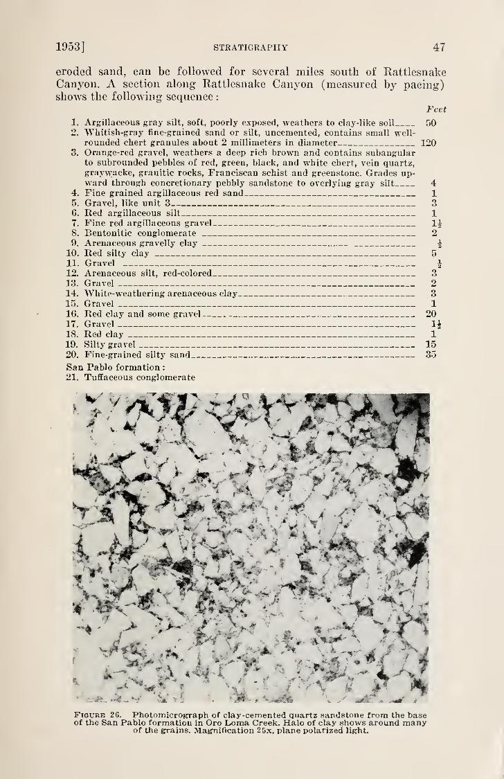
1953] STRATIGRAPHY 47
eroded sand, can be followed for several miles south of RattlesnakeCanyon. A section along Rattlesnake Canyon (measured by pacing)shows the following sequence
:
Feet
1. Argillaceous gray silt, soft, poorly exposed, weathers to clay-like soil 502. Whitish-gray fine-grained sand or silt, uncemented, contains small well-
rounded chert granules about 2 millimeters in diameter 1203. Orange-red gravel, weathers a deep rich brown and contains subangular
to subrounded pebbles of red, green, black, and white chert, vein quartz,graywacke, granitic rocks, Franciscan schist and greenstone. Grades up-ward through concretionary pebbly sandstone to overlying gray silt 4
4. Fine grained argillaceous red sand 15. Gravel, like unit 3 36. Red argillaceous silt 17. Fine red argillaceous gravel 1^8. Bentonitic conglomerate 29. Arenaceous gravelly clay ^
10. Red silty clay 511. Gravel ^12. Arenaceous silt, red-colored 313. Gravel 214. White-weathering arenaceous clay 315. Gravel 116. Red clay and some gravel 2017. Gravel li18. Red clay 1
19. Silty gravel 1520. Fine-grained silty sand 35
San Pablo formation
:
21. Tufifaceous conglomerate
' ^ ^ * 1 ^ V^' ^^' V **! *%
Figure 26. Photomicrograph of clay-cemented quartz sandstone from the baseof the San Pablo formation in Oro Loma Creek. Halo of clay shows around many
of the grains. Magnification 25x, plane polarized light.

48 ORTIGALITA PEAK QUADRANGLE [Bull. 167
Age and Correlation. As no fossils were found in the Oro Loma beds,
the age of the beds must be inferred from stratigraphic position andstructural details. Underlying San Pablo beds (either upper Mioceneor lower Pliocene) grade imperceptibly into the Oro Loma formation.
Date of the first pulse of the Coast Ranges orogeny which folded andfaulted the Tertiary and older strata has been determined in adjacent
areas by Taliaferro (1943a) to be upper Pliocene, thus the beds in
question may be lower or middle Pliocene in age, possibly both.
Strata of similar lithology and stratigraphic position occur along the
west side of the San Joaquin Valley northward from Pacheco Pass andinclude many beds mapped by Anderson and Pack as Tulare ( ?).
Tulare Formation
Distribution and Thickness. The most extensive occurrences of the
Tulare formation in the area covered by the Ortigalita Peak quadrangle
are at Little Panoche Creek and between Los Banos and Ortigalita
Creeks ; however, there is considerable extent of the formation elsewhere
throughout the region. A thickness of at least 350 feet is attained near
Little Panoche Creek, but the lowermost beds only are exposed to the
south along the north-trending part of Little Panoche Valley ; thus as
much as 500 feet of sediment may have been deposited in this area. Else-
where the beds are 100 feet or less in thickness and generally measure a
few tens of feet.
Lithology. Lithologic similarity of the Tulare to the Oro Loma led
Anderson and Pack to consider the formations a single unit ; however,
separation can be made on lithology and structural characteristics. OroLoma beds are folded with the bedrock series and the Tulare strata ex-
tensively overlap all of these units, including the Franciscan formation.
Thin argillaceous limestone of the Tulare formation which has no counter-
part in the Oro Loma formation is most extensive south and east of Little
Panoche Creek, especially in the bordering PanoQhe Valley quadrangle.
Figure 27. Flat-lying dark reddish gravel and white marly silt of the Tulare forma-tion underlain by dark-weathering Moreno shale dipping- 35 degrees into the cliff alongthe east bank of the southern tributary to Ortigalita Creek, in the soutliwest corner of
sec. 28, T. 11 S., R. 10 E. The cliff is approximately 100 feet in height.

1953] STRATIGRAPHY 49
Significant amounts of marl or marly silt occur north and east of ArburuaRanch (T. 12 S., R. 9 E.), east of Ortigalita Creek (sec. 17, T. 12 S., R.10 E.), and east of Laguna Seca Ranch (sec. 22, T. 12 S., R. 10 E.).
A nearly complete section of the Tulare formation occurs in Little
Panoche Valley (sec. 36, T. 13 S., R. 10 E.) where approximately 150 to
200 feet of strata are exposed in the westward facing, deeply colored
cliffs. White silt beds are prominent between Ortigalita Creek and Rattle-
snake Canyon and in the broad expanse of terrace between Ortigalita
Creek and Los Banos Creek. Gravel composed characteristically of sub-
angular pebbles, cobbles, and boulders dispersed through an incoherent
red silt matrix is the dominant phase of the Tulare formation, whichmay be appropriately termed terrace gravel. Franciscan debris including
chert, diabase-gabbro, glaucophane schist, greenstone, and graywacke is
the most prominent constituent. Relative frequency of the Franciscanrock types in the Tulare varies with geographic location
;greenstone,
gabbro, and graywacke predominate near Piedra Azul Creek and in the
Laguna Seca Ranch area; chert, glaucophane schist, and graywackepredominate in northwestern Little Panoche Valley ; and sheared gray-
wacke predominates in southern Little Panoche Valley. That the compo-sition of the gravel in the Tulare formation directly reflects the lithology
of the adjacent Franciscan terrane is evidence of local origin of the
Tulare beds. Locally, as along Los Banos Creek, Cretaceous debris
(especially pebbles and boulders from Panoche conglomerate) is promi-
nent in the Tulare beds. Concretionary Panoche sandstone is a minorbut widespread constituent and other Cretaceous sediments may havecontributed to the silty matrix.
Structural Relations. The Tulare formation was deposited upon a
weathered and eroded surface of low relief with a gentle easterly slope
toward the San Joaquin Valley. Initial dips recorded from the beds cov-
ering Little Panoche Valley reach a maximum of 2 to 3 degrees, but local-
ized uplift of Wisenor Hills tilted the Tulare beds lapping around the
northern rim of this poorly defined dome and subsequent erosion haslargely removed the beds from the summit areas. The steepest dip
recorded is 16 degrees.'&•'
Age and Correlation. The Tulare formation postdates the upper Plio-
cene orogeny and predates the mid-Pleistocene orogeny, thus limiting
the time of deposition to Plio-Pleistocene and early Pleistocene. Conse-quently, age and degree of deformation agree closely with the typical
Tulare formation south of Coalinga.
Stream Terraces
Remnants of older stream levels occur along most of the larger streamsand locally, as in Piedra Azul and Molino Creeks, remnants of tw^o or
three terraces have been preserved. The highest and oldest level is approx-imately 50 to 75 feet above the present stream beds, whereas the youngestand most extensive terrace stands fi:om 2 to 10 feet above stream bottoms.
In Piedra Azul trough materials composing stream terraces closely re-
semble those of the Tulare formation ; therefore the line of separation is
arbitrarily drawn. Good sections of local stream terrace are well exposedin the lower reaches of Laguna Seca and Hamburg Creeks.

50 ORTIGALITA PEAK QUADRANGLE [Bull. 167
Recent Alluvium
Sediment derived from local areas by sheet flood and gulley erosion is
periodically deposited in the graded portions of streams, valleys, anddepressions during the short seasonal rainfall. The San Joaquin Valleyis the largest area of aggradation and the ultimate site of deposition for
the sediment derived from the adjacent foothills and Diablo Range. Ero-sive action of wind continually removes, transports, and sorts loose soil
and sediment but the over-all bulk is small compared to that of runningwater ; however, infrequent winds of strong velocity remove considerable
volumes of fine dust, principally from the border areas of the San JoaquinValley.
Landslides
Local slides of considerable quantities of material occur only in Fran-ciscan serpentine between Piedra Azul and Molino Creeks. Elsewheresmall slides of shale in the Panoche and Moreno formations are present
along steep stream banks. Large cones of conglomerate talus in Los BanosCreek were not considered landslides as their formation was piecemealand not by movement of large masses of material.
GEOLOGIC STRUCTURE
The general picture of Diablo Range has been termed by Andersonand Pack (1915, p. 108) as "a broad anticline which has been subjected
to long continued erosion. This erosion has stripped the cover of youngerbeds from the central part and exposed a core of folded and contorted
Franciscan rocks flanked by steeply inclined Cretaceous and youngerbeds."
In the Ortigalita Peak area this anticlinal structure has been disruptedon its eastern flank by the thrusting of Franciscan rocks northeastwardover younger sediments. The dismembered flank .includes bedded Creta-
ceous and Tertiary sediments dipping eastward in a homoclinal sequenceoverturned adjacent to the thrust. The crest portion of the anticlinal
structure is difficult to locate and escaped detection by Leith (1949) in
the adjacent Quien Sabe area. The principal folds in the Franciscan rocks
appear to be westward-trending anticlines and synclines as indicated
by Leith (1949) and by Wilson (1942) in the San Benito area, and asimilar structure is suggested by a local decrease in inclination of the
Franciscan strata south of Ortigalita Peak. However, the main anticlinal
axis must trend southeastward across the southwest corner of the area
as dips as low as 25 degrees northeast are recorded within 2 miles of the
thrust, but it is just as probable that in regions several miles west of
the fault the dominating structure trends east-west, a possible result of
the Diablan and the mid-Cretaceous orogenies.
Folding
Diablo Anticline. During the upper Pliocene orogeny some 45,000feet of preponderantly sedimentary strata were flexed into a single anti-
clinal fold with the intensity of upbowing decreasing gradually towardthe east and terminating abruptly at the border of the San JoaquinValley, as is indicated in well cores in the adjacent valley in sees, 17 and28, T. 12 S., R. 11 B. Moreover, numerous stream terraces indicate that

1953] GEOLOGIC STRUCTURE 51
Figure 28. Piedra Azul trough, near Piedra Azul spring. Small dark knollsare silica-carbonate rock ; hill in right background is serpentine capped in
part with Tulare gravel. Ortigalita thrust forms eastern border of hill andtrends just right of knoll and Franciscan rocks in foreground.
the region is still tectonically active and that future deformation may-
be expected to transgress eastward and to fold the bordering sediments
of the San Joaquin Valley.
Upbowing of Diablo Range probably started in lower Miocene and is
reflected in the unconformity separating the Kreyenhagen and the SanPablo formations ; however, some 30,000 feet of Upper Cretaceous sedi-
ments must have been removed previous to exposure of the Franciscan
rocks. Probably the greater part of the upper Miocene and Pliocene
formations are composed of redeposited Cretaceous sediment, and the
30,000 feet of Upper Cretaceous beds in the area covered by Ortigalita
Peak quadrangle may haVe been represented by less than 20,000 feet
along the axis of the present Diablo Range. Thus the total elevation of
Diablo Range since the Miocene lies between 25,000 and 50,000 feet, de-
pending upon the thickness of Upper Cretaceous and Lower Cretaceous
strata originally present there and the thickness of Franciscan rocks
subsequently removed by erosion. The major part of this uplift probably
took place along Ortigalita thrust in upper Pliocene time.
Wisenor Fold. The small flexure in the northern portion of Wisenor
Hills was probably caused by the mid-Pleistocene orogeny.
Los Banos Fold. A small imperfectly formed dome is evident from
the abrupt westerly swing in the trend of the Upper Cretaceous rocks in
the northwest corner of the map area. Panoche sediments south of Los
Banos Creek strike N. 30° -40° W. and dip eastward 35-60°, whereas
north of the creek the beds strike westward and dip northward 10-20
degrees. The center of this flexure lies in the neighboring Quien Sabe
area and is shown by Anderson and Pack (1915) to affect the attitude
of beds in a circular area about 2 miles across. Alignment of the dome

52 ORTIGALITA PEAK QUADRANGLE [Bull. 167
with two small areas of late Pleistocene volcanic flows to the northwestin the area covered by the Pacheco Pass quadrangle led to the suggestionthat the doming is caused by a local igneous intrusion, not exposed byerosion.
Faulting
Ortigalita Thrust. The fault forming the contact between Franciscanand younger rocks is one of the major structural features of this area. It
was first shown by Anderson and Pack (1915) in the Ortigalita area butTaliaferro (1943, p. 162) noted that the extent in this area is but a small
part of the major thrust that bounds Diablo Range along its eastern edgefrom the New Idria area northward to Mount Diablo, a distance of about120 miles. The northeast continuation of Ortigalita thrust in Quien Sabearea was described by Leith (1949) who mapped a parallel fault in Fran-ciscan terrane northwest of Carrisalito Flat. Undoubtedly the continua-
tion of this structure forms the western boundary of Piedra Azul trough,
and perhaps the identical fracture is responsible for the escarpmentfacing Little Panoche Valley south of Ortigalita Peak. In essence Orti-
galita thrust forms the most easterly fracture of a broad zone of shearedFranciscan rock, a mile to 2 miles in width near Ortigalita Peak, narrow-ing slightly north of Wisenor Flat. The southern continuation of the
thrust beneath Little Panoche Valley must pass near Mercey Hot Springsas it is known that Franciscan rocks and Cretaceous sediments are ex-
posed in adjacent outcrops through Tulare terrace mantle in this vicinity.
(Taliaferro, oral communication.)Rapid lateral and vertical variation in the inclination of the fault sur-
face is a striking characteristic of the Ortigalita thrust which dips 20 to
30 degrees southwestward near Ortigalita Peak and gradually steepens
northwest of Wisenor Flat, becoming essentially vertical north of PiedraAzul Spring. Convexity of the fault surface, evident where Franciscanrocks are thrust over Wisenor shale, has been noted by Taliaferro (1943a)
who states that "in the vicinity of Ortigalita Creek (section VII) . . .
the dip varies from less than 30 to 45 degrees in a vertical distance of
nearly 1,000 feet." Preliminary fractures in this zone appeared near the
close of the Upper Jurassic during the Diablan orogeny but extensive
thrusting along this zone occurred during the upper Pliocene orogeny.The fault may have broken again during the mid-Pleistocene orogeny;however, Ortigalita thrust proper was not active during the mid-Pleisto-
cene as the Tulare (Plio-Pleistocene and early Pleistocene) formationlaps over the Ortigalita thrust in Carrisalito Flat, Piedra Azul trough,and Little Panoche Valley without dislocation.
Minor Longitudinal and Transverse Faults, l^'aults, most of minordisplacement, are abundant within the Franciscan rocks but only a fewof these were mapped. A strong offset along the northern border of
Wisenor Flat is probably a fault having a horizontal displacement of
1,000 feet or more ; the same fault may account for a 1,300-foot easterly
displacement of the serpentine contact a mile to the east. If it displaces
the Ortigalita thrust, it is clearly of Pleistocene or Recent age, and maybe associated with the doming of Wisenor Hills. Faults displacing con-
glomerate beds in Wisenor Hills are believed to be tension fractures
formed at the same time.

1953] GEOLOGIC HISTORY 53
A longitudinal fault, clipping at a higli angle to the east, crosses LosBanos Creek near the top of the conglomerate sequence. A vertical dis-
placement of less than 50 feet increases toward the north and may exceed
100 feet in the stream valley where upward movement of the eastern
block is clearly evident.
structural History
The earliest orogeny of which there is evidence in the Ortigalita area
occurred near the close of the Franciscan deposition (Diablan orogeny)
which compressed and lithified the Franciscan sediments, formed the pre-
liminary fractures of Ortigalita thrust, and was accompanied by the de-
velopment of glaucophane schists and phyllonites. It is probable that the
great serpentine bodies of the Franciscan group worked their way up the
earliest of these fractures, and emanations rising from the serpentine
through fractures in the overlying Franciscan rocks locally converted
sandstone, shale, and greenstone to glaucophane schist.
In the middle of the Cretaceous period the region was again subjected
to mild folding and uplift, and erosion stripped off an unknown volume
of Lower Cretaceous sediments before subsequent sinking allowed trans-
gression of the Upper Cretaceous sea. During the early part of the UpperCretaceous, borders of the geosyncline were in continuous tectonic ac-
tivity, and parts of the previously deposited Upper Cretaceous sediment
were stripped from the uplifted portions of the geosyncline and deposited
in the more stable basins. Culmination of this activity uplifted and folded
lower Upper Cretaceous rocks of the Santa Lucia Range in the middle
of the Upper Cretaceous epoch.
Pholas-bored sandstone in the Paleocene Laguna Seca formation and a
slight disconformity within the Eocene sediments are evidence of minoruplifts compared with that of the ]\Iiocene epoch which led to erosion of anunknown volume of diatomaceous Kreyenhagen shale, huge blocks of
which are included in the base of the overlying San Pablo formation. It
is doubtful that the core of the Diablo Range was subsequently beneaththe seas as abundant Franciscan debris characterizes the San Pablo andoverlying Oro Loma beds.
Diastrophic activity culminated in the Tapper Pliocene orogeny whichfolded the Tertiary and older rocks and thrust Franciscan over Creta-
ceous along Ortigalita thrust. A mid-Pleistocene disturbance faulted andfolded the previouslj^ deformed rocks and locally tilted the Tulare ter-
race mantle. Subsequent erosion has removed much of the Tulare beds,
and minor Recent uplifts are manifested by numerous terraces along
stream courses.
GEOLOGIC HISTORY
The decipherable history of the Coast Ranges judged from the rocks in
the Ortigalita Peak area and adjacent regions begins with the UpperJurassic geosyncline covering approximately the area of the present
Coast Ranges, but extending beyond the western geographical limits of
California, and terminating against a high and rugged landmass fromwhich the bulk of Upper Jurassic and Cretaceous sediment was derived.
The eastern shore of this broad seaway lapped against the newly formedlow-lying Sierra Nevada, approximately at the center of the present GreatValley of California. In the basin a thick blanket of graywacke sediment
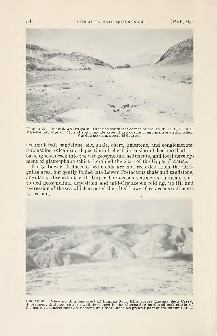
54 ORTIGALITA PEAK QUADRANGLE [Bull. 167
,-»*:
.*4.Avf
.-J*-^'m'- <0''
Figure 29. View down Ortigalita Creek in southeast corner of sec. 18, T. 12 S., R. 10 E.Massive outcrops of left and right middle ground are coarse conglomerate strata which
dip downstream about 45 degrees.
accumulated: sandstone, silt, shale, chert, limestone, and conglomerate.Submarine volcanism, deposition of chert, intrusion of basic and ultra-
basic igneous rock into the wet geosynclinal sediments, and local develop-
ment of glaucophane schists heralded the close of the Upper Jurassic.
Early Lower Cretaceous sediments are not recorded from the Orti-
galita area, but gently folded late Lower Cretaceous shale and sandstone,
angularly discordant with Upper Cretaceous sediments, indicate con-
tinued geos>Ticlinal deposition and mid-Cretaceous folding, uplift, andregression of the sea which exposed the tilted Lower Cretaceous sedimentsto erosion.
"^W^
-x-'.^J
»A.
Figure 30. View north along crest of Laguna Seca Hills across Laguna Seca Creek.Subsequent drainage pattern well developed in the alternating hard and soft strata ofthe massive concretionary sandstone unit that underlies greater part of the summit area.

1958] GEOLOGIC HISTORY 55
Figure 31. Badland topography eroded into Tulare beds in westward-facing bluffs in
sec. 36, T. 13 S., R. 10 E. The upper light-colored beds are white, red, and bluish cross-bedded gravel, sand, and silt underlain by deep bluish green and deep red unconsoli-
dated silt.
Subsequent sinking allowed ingress of the broad shallow Upper Cre-
taceous sea that lapped against a deeply eroded Sierra Nevada of low
relief near the eastern border of the present Great Valley. A vast thick-
ness (over 30,000 feet in the Ortigalita Peak region) of shallow-water
marine sediment was deposited in this basin during Upper Cretaceous
time. The sea persisted until middle Eocene when local uplift allowed
shallow scoring of the previously deposited sediments. In middle Eocene.the long-lived western landmass contributed little or no detritus to the
basin ; deeply weathered crystalline rock of the Sierra Nevada supplied
quartz sands and refractory kaolinitic clay. The climate was tropical,
warm and moist, and chemical weathering deeply altered exposed rock
masses. Near the close of the Eocene epoch the sea returned, teeming with
plankton, and siliceous tests accumulated on the sea floor to a thickness of
several hundred feet to form the Kreyenhagen shale. Silica derived fromvolcanic ejecta showered into the sea from distant volcanos possibly at-
tracted these organisms.
Renewed epeirogenic uplift drained the narrow upper Eocene seawayand laid bare to erosion the freshly formed siliceous shale in lower
Miocene time. Denudation was followed by ingress of a shallow sea anddeposition of a thin stratum of quartpse sand close ashore or in brackish
water. Local uplift at the close of the Miocene epoch flooded the area
with coarse detritus coeval with deposition of great thicknesses of wind-
blown tuffaceous silt and sand. Volcanism ceased in lower Pliocene but
deposition of detritus derived largely from nearby Franciscan rocks
continued. The material spread as broad alluvial fans from the embryoDiablo Range onto vast flood plains to the east.
Deposition was interrupted in upper Pliocene by upbowing of the
sediments into the broad anticlinal Diablo Range while other ranges of
the Coast Ranges were folded and thrust into much their present topo-
graphic form. Rupture of the rocks along the Ortigalita thrust displaced
Franciscan over Cretaceous and disjointed the eastern limb of the anti-
clinal structure. The bordering foothills were eroded and imperfectly

56 ORTIGALITA PEAK QUADRANGLE [Bull. 167
Figure 32. Mercy quicksilver mine, southern workings.

1953] GEOLOGIC HISTORY 57
* •r .-•«- ^ '
V %*
%\-~ V
^ t
^-^'•««->*^;^
• «l
?.-^:'
-3^-- vK
»5te °*'*^l^%^ im. -*
:?s-
.v»»^, .
Figure 33. Remains of Scott furnace of Mercy quicksilver mine.

58 ORTIGALITA PEAK QUADRANGLE [Bull. 167
planed in early Pleistocene and a thin mantle—the Tulare formation
—
was spread over the surface. The mid-Pleistocene orogeny locally folded
and fractured the rocks, and the invigorated streams cut rapidly into
soft sediments to form the present drainage pattern. Several more recent
elevations temporarily renewed the activity of streams which cut into
previously graded channels to form local terraces along their valleys.
The geologic history recorded in the Ortigalita Peak area is much the
same as that elsewhere along the eastern border of Diablo Range. Thisarea was a central basin for accumulation of Upper Cretaceous sediment,
and perhaps for Franciscan sediment as well ; however, the Tertiary rec-
ord throughout the Coast Ranges varies greatly from area to area, evenwhere they are adjacent, as the Tertiary seas were narrow and much of
the rocks were land-laid.
ECONOMIC RESOURCES
Quicksilver
There is no recorded production of quicksilver from the Ortigalita
Peak area ; however, the Mercy mine lying only a quarter mile bej^ond
the southern boundary of the area is a large producer. According to
Yates and Hilpert (1945, p. 25) ''It is the leading producer in the dis-
trict with a total recorded production of 1,682 flasks of quicksilver.
Mexicans started mining cinnabar about 1860, but it is reported that the
property had been explored earlier for silver. In 1911 the Pacific Quick-
silver Company took over the mine, enlarged the operations, and installed
a 24-ton Scott furnace, which was operated until about the end of 1914.
Since then operation has been intermittent.'
'
The mining claims extend northward into sees. 32 and 33, T. 13 S., R.
10 E. in the area covered by the Ortigalita Peak quadrangle and ore of
economic value may exist along the kaolinized zone extending north of
Mercy mine. Deeply colored green clay of this zone is similar to the
deeply colored beds at the base of the Tulare formation in the adjacent
area to the east, indicative that a vast amount of quicksilver ore wasstripped from this zone during lower Pleistocene time.
Magnesite
Associated with Franciscan serpentine are small thin veins of mag-nesite that have been worked on a small scale, as that north of WisenorFlat. However, no production has been recorded. Fracturing and shear-
ing of the serpentine bodies and the irregularity and small size of the
veins makes it doubtful that these deposits are economically valuable.
Diatomite
The Kreyenhagen shale is an almost inexhaustable supply of purediatomite in the Ortigalita Peak area. Argillaceous diatomite, almost as
pure, is in the Moreno formation of Wildcat Can^'on. Neither of these
sources has been exploited.
Gypsum
Vein gypsum, most too disperse to be of economic value, occurs abun-dantly in the Kreyenhagen and Moreno shales. Efflorescent surface de-
posits are in the same formations and are especially abundant on the

1953] ECONOMIC RESOURCES 59
flattish summits of the ridge-forming Kreyenhagen shale. North of OroLoma Creek such material was being cleared of top soil in the spring of
1950 for marketing by the Agriculture Minerals and Fertilizer Companyof Los Banos, California. Mr. A. D. Sousa of this company prospected andprepared the deposits, which contain highly concentrated gypsite that
demands little processing, and is of easy access for the local users of
agricultural gypsum.
Lime
Lime is locally mined and processed for agricultural use from Tulare
marl at the summit of Panoche Hills in the adjacent Panoche Valley
area. Anderson and Pack (1915, p. 210) listed partial analyses of two
samples taken in Ni sec. 30, T. 14 S., R. 11 E.
:
Partial analyses of calcareous beds in fhe terrace capping the Panoche Hills in sec.
30, T. 14 S., H. 11 E.(Analyst, George Steiger)
1 2
SiOo 19.84 9.74
AI2O3 4.97 2.76
Fe203 1.95 1.65 Sample 1 was considered a fair average
MgO 5.28 1.85 of the marl ; sample 2 was taken from
CaO 34.06 45.48 a thin hard limestone intercalated with
CO2 29.85 35.34 clay.
SO3 0.0 0.0
95.95 97.42
The white Kreyenhagen shale locally contains a notable proportion
of lime and much of the shale will effervesce freely with acid. Several
samples taken from NW^ sec. 2, T. 12 S., R. 10 E. were analyzed by means
of the standard alkalimeter tests following sedimentary laboratory pro-
cedure giving a range of CaCOs for white diatomite of 10.0—13.2 percent
(four tests) and for brown diatomite of 1.5—5.0 percent (two tests).
Bentonite
Bentonitic shale, sandstone, and conglomerate occur abundantly
throughout the San Pablo formation along the eastern front of the
Laguna Seca Hills. It is doubtful that the deposits are of economic im-
portance at the present time as the bentonite is commonly intermixed
with silt, sand and gravel arid in most localities it forms the cementing
medium for these clastic sediments. Somewhat pure bentonite of limited
extent does occur within the San Pablo sequence offering a possible
future supply of this material for local consumption.
Sand and Gravel
Sand and gravel from Los Banos Creek is being worked in sees. 32
and 33, T. 10 S., R. 10 E. for aggregate and road metal. Fresno Countyoperates a small gravel pit at the mouth of Little Panoche Creek in sec.
15 T. 13 S., R. 11 E. which is worked intermittently for use on local
county roads. There is almost an unlimited supply of such materials.
Petroleum
At least 7 holes have been drilled within the area covered by Ortigalita
Peak quadrangle in search of oil and gas ; however, all have been aban-

60 ORTIGALITA PEAK QUADRANGLE [Bull. 167
doned. The highly organic shales of the Kreyenhagen and Morenoformations have been long considered the source beds for much of the
petroleum found in the San Joaquin Valley and bordering areas, andthe presence of the same formations in the Ortigalita area suggests
the possibility of economic accumulations of oil in the bordering valley.
However, the attitude of outcropping strata in the foothills offers noclue to a favorable structure in the San Joaquin Valley.
BIBLIOGRAPHY
Allen, Victor T. (1929) The lone formation of California: Univ. California. Dept.Geol. Sci. Bull., vol. 18, pp. 347-448.
Allen, Victor T. (1941) Eocene anauxitic clays and sands in the Coast Rangesof California : Geol. Soc. America Bull., vol. 52, pp. 271-294.
Anderson, Frank M. (1938) Faunal and chronological aspects of the Upper Cre-taceous in the Great Valley of California (abstract) : Geol. Soc. America, 37thAnnual Meeting, April 1, 1938.
Anderson, Frank M. (1941) Subdivisions of the Chico scries (abstract) : Geol,
Soc. America Bull., vol. 52, p. 1943.
Anderson, J. Q. (1941) Talk given before the Pacific Section, Soc. Econ. Paleon.and Min. at Bakersfield, June 6, 1941.
Anderson, Robert, and Pack, R. W. (1915) Geology and oil resources of the westborder of the San Joaquin Valley north of Coalinga, California : U. S. Geol. SurveyBull. 603.
Bennison, A. P. (1940) Late Cretaceous of the Diablo Range: paper read at themeeting of the LeConte Club, Stanford University, March 2, 1940,
Bennison, A. P. (1941) Unpublished geological map of late Upper Cretaceous de-
posits south of San Luis Creek, Merced and Fresno Counties, California, dated 1941.
Brice, James (1953) Geology of Lower Laka quadrangle, California: California
Div. Mines Bull. 166.
Chaney, Ralph W., Condit, "C, and Axelrod, D. I. (1944) Pliocene floras of
California and Oregon : Carnegie Inst. Washington Pub. 553.
Clark, Bruce L. (1943) Notes on California Tertiary correlation: California Div.
Mines Bull. 118, pp. 187-191.
Clark, Bruce L., and Campbell, A. S. (1945) Radiolaria from the Kreyenhagenformation near Los Banos, California : Geol. Soc. America Mem. 10.
Daviess, S. N. (1946) Mineralogy of late Upper Cretaceous, Paleocene, and Eocenesandstones of Los Banos district, west border of the San Joaquin Valley, California :
Am. Assoc. Petroleum Geologists Bull., vol. 30, pp. 63-83.
Goudkoff, Paul P. (1943) Stratigraphic relations of Upper Cretaceous in the
Great Valley, California : Am. Assoc. Petroleum Geologists Bull., vol. 29, pp. 956-1007.
Green, Charles F. (1942) Eocene and Cretaceous stratigraphy of the LagunaSeca Hills, Merced County, California : unpublished master's thesis, Stanford Uni-versity, California.
Huey, Arthur S. (1948) Geology of the Tesla quadrangle, California: California
Div. Mines Bull. 140.
Jenkins, Olaf P. (1931) Stratigraphic significance of the Kreyenhagen shale:
California Div. Mines Rept. 27, pp. 141-186.
Joplin, G. A. (1937) An interesting occurrence of lawsonite in glaucophane bear-
ing rocks from New Caledonia : Mineral. Mag., vol. 24, pp. 534-537.
Kuenen, Ph. H. and Migliorini, C. I. (1950) Turbidity currents as a cause of
graded bedding : Jour. Geology, vol. 58, pp. 91-127.
Leith, Carlton J. (1949) Geology of the Quien Sabe quadrangle, California:
California Div. Mines Bull. 147.
Mackin, Jo.seph H. (1948) Concept of the graded river: Geol. Soc. America Bull.,
vol. 59, pp. 463-511.
Payne, Max B. (1941) Moreno shale, Panoche Hills, Fresno County, California
(abstract) : Geol. Soc. America Bull., vol. 52, pp. 1953-1954 (1951) Type Morenoformation and overlying Eocene strata on the west side of the San Joaquin Valley,
Fresno and Merced Counties, California : California Div. Mines Special Rept. 9.
Pettijohn, F. .T. (1949) Sedimentary rocks: Harper and Bros., New York (1950)
Turbidity currents and graywacke : a discussion ; Jour. Geology vol. 58, pp.169-171.

1953] BIBLIOGRAPHY 61
Popenop, W. P. (1942) Tapper Cretaceous formations and faunas of southern Cali-
fornia : Am. Assoc. Petroleum Geologists Bull., vol. 20, pp. 1(52-187.
Stewart, Ralph, Popenoe, \V. P., and Snavely, P. D., Jr. (1944) Tertiary andlate I'pper Cretaceous stratigraphy of the west horder of San Joaquin Valley northof Panoche Creek, Fresno, Merced, and Stanislaus Counties, California : U. S. Geol.
Survey Oil and (?as Investigations, Preliminary Chart 6.
Stirton, R. A. (1989) Cenozoic mammal remains from the San Francisco Bayregion : Univ. California Dept. Geol. Sci. Bull. vol. 24, pp. 339-410.
Taliaferro, Nicolas L. (1943) Franciscan-Knoxville problem: Am. Assoc. Petro-
leum Geologists Bull., vol. 27, pp. 109-219.
Taliaferro, Nicolas L. (1943a) Geologic history and structure of the central CoastRanges of California : California Div. Mines Bull. 118, pp. 119-163.
Taliaferro, Nicolas L. (1944) Cretaceous and Paleocene of Santa Lucia Range,California : Am. Assoc. Petroleum Geologists Bull., vol. 28, pp. 449-591.
Tallman, S. L. (1949) Sandstone types: their abundance and cementing agents:
Jour. Geology vol. 57, pp. 582-591.
Turner, Francis J. (1948) Mineralogical and structural evolution of the meta-morphic rocks : Geol. Soc. America Memoir 30.
Wilson, Ivan F. (1942) Geology of the San Benito quadrangle, California: Cali-
fornia Div. Mines Rept. 39, pp. 183-270.
Yates, R. G., and Hilpert, L. S. (1945) Quicksilver deposits of central San Benitoand northwestern Fresno Counties, California : California Jour. Mines and Geology,
vol. 41, pp. 11-36.
printed in California state printing office
71529 12-52 BM


^r^?


DIVISION OF MINESOLAF P. JENKINS, CHIEF
STATE OF CALIFORNIADEPARTMENT OF NATURAL RESOURCES
BULLETIN 167 <^S
PLATE 3 «
LOS BANDS HILLS
EXPLANATION
Ool - olluvium, T0l,T0tg,TQ1m - Tulare I
Tol - Oro Loma fm;Tsp - San Pablo fm
,
Tk- Kreyenhogen fm , TI - Teslo (?) fm,
Tls-Loguno Seco fm; Km- Moreno f m,
Kp- Ponoctie fm,Kw - Wisenor fm
JSP- serpentine, Jdg- diobose- gobbro,Jgr- greenslone. J fs - sondstone,jfsch- schists, ch- chert
GEOLOGIC STRUCTURE SECTIONS ACROSS ORTIGALITA PEAK QUADRANGLE, CALIFORNIA
VERTICAL AND HORIZONTAL SCALE

.HIS BOOK IS DUE ON THE L/.
STAMPED BELOW
AN INITIAL FINE OF 25 CENTSWILL BE ASSESSED FOR FAILURE TO RETURNTHIS BOOK ON THE DATE DUE. THE PENALTYWILL INCREASE TO SO CENTS ON THE FOURTHDAY AND TO $1.00 ON THE SEVENTH DAYOVERDUE.
AOgjs «?
APR 2 i90fB"
Jf\H 5
3B$
JUNU 1973
liOV 1 5 1930
J4lttl9l9Sl
GEO' '-
I m 1 4 ^381
SEP 24 1:3 J
RECEIVED
NOV 1 1981
PHYS SCI LIBRARY
NOV 1 1 mi
00=
oi0=
CDs
co=
PHYS £iCi t-lt^'"^^>>^o"*' BookSlip-25m-7,'53(A899884)458
106766

