geology of the basin quadrangle jefferson, lewis and … · geology of the basin quadrangle...
TRANSCRIPT

Geology of the Basin Quadrangle Jefferson, Lewis and Clark, and Powell Counties, MontanaBy EDWARD T. RUPPEL
GEOLOGICAL SURVEY BULLETIN 1151
A descriptive report of an area along the west margin of the Boulder batholith
UNITED STATES GOVERNMENT PRINTING OFFICE, WASHINGTON : 1963

UNITED STATES DEPARTMENT OF THE INTERIOR
STEWART L. UDALL, Secretary
GEOLOGICAL SURVEY
Thomas B. Nolan, Director
The U.S. Geological Survey Library has cataloged this publication as follows :
Ruppel, Edward Thompson, 1925-
Geology of the Basin quadrangle, Jefferson, Leis and Clark, and Powell Counties, Montana. Washington, U.S. Govt. Print. Off., 1963.
121 p. illus., maps (1 col.) diagrs., tables. 24 cm. (U.S. Geological Survey. Bulletin 1151)
Part of illustrative matter folded in pocket.
Bibliography: p. 119-121.
1. Geology Montana Basin quadrangle. 2. Mines and mineral re sources Montana Basin quadrangle. I. Title: Basin quadrangle. Montana. (Series)
For sale by the Superintendent of Documents, U.S. Government Printing Office Washington, D.C. 20402 ,

CONTENTS
Page
Abstract-----...---..---------------------------------------------- 1Introduction._ ____________________________________________________ 2
Location and access___-___--___-__-___---__-__--___--____--____ 2Topography and drainage._____________________________________ 3Vegetation__________________ ________________________________ 4Previous work.-_______________________________________________ 4Present work and acknowledgments--.._____.___-___-____.___-___ 5
Geology._______-_-______-________________-______-__----__--_-____ 6Sedimentary rocks.-.--_____--_-_____________--------__---_____ 8
Morrison formation ________________________________________ 8Kootenai formation ________________________________________ 8Colorado formation ________________________________________ 9
Elkhorn Mountains volcanics----------------------------------- 9Stratigraphic relations___.__.______________-___-__-_--.___ 10Rock types _______________________________________________ 14
Welded tuff____-...-__...-__-...__-._-._.---___-.-.._. 14Tuff and lapilli tuff _-----_-__...._____-_...____----..-_ 17Breccia___-______..__-_______--.__.__:_____-__--_-____ 18Volcanic sedimentary rocks_____.____-_-__.__-__-____. __ 19Andesitic intrusive rocks__ _____________________________ 20Basalt____----------_-_--_-_-----__-_-------------__-_ 20Basaltic intrusive rocks_______________________________ 21Age relations of basalt__ _______________________________ 21
Batholithic rocks______________________________________________ 22Classification of batholithic rocks_-_---__--_--_---------_-___' 28Inclusions _________________________________________________ 29Petrography._____________________________________________ 30
Early-stage batholithic rocks...------------------------- 32Butte quartz monzonite ________________________________ 33
Coarse-grained rocks...____________________________ 33Medium-grained rocks _____________________________ 33Fine-grained rocks.._______________________________ 35
Late-stage batholithic rocks_-------------------------- 36Emplacement of the batholithic rocks------.---.---.--------- 36
Is the Boulder batholith a laccolith?_ ____________________ 40Metamorphism. _ _____________._._.__..___:-___-___________ 40Late magmatic alteration.__________________________________ 42Age of quartz monzonite and related rocks.-----.------------- 43
Tertiary volcanic rocks_________________________________________ 44Lowland Creek volcanics-----___-_--._.__---------------_-- 44
Petrography __________________________________________ 46Volcanic sedimentary rocks_-___-_--------_--_---_-_ 46Tuff and lapilli tuff ________________________________ 47Welded tuff_______________.______.________________ 50Flow rocks._______________________________________ 50Intrusive rocks.___________________________________ 51
in

IV CONTENTS
Geology ContinuedTertilary volcanic rocks Continued Page
Rhyolite_________._______--.-_-.-----.-----_-__----_---_ 52Petrography _______.-___-_____---_-__-__-_-___----__-_' 54
Flow rocks______________---_-_-_---_____---___-_ 54Flow breccias. _________-_-_---_--_---_-_-_- --_-_-_ 55Basal glasses._____________------__---_____---_-_-_ 56Welded tuff.________________._____---..__--_-.__-_ 56Lapilli tuff and tuff.________________________________ 57Intrusive rocks.____--_-_-_-------_-----__------___ 57
Tertiary prevolcanism surfaces ______________________________ 57Age relations of quartz latite and rhyolite____-_______---__--_ 58
Surficial geology.__________-_-----------------------_---------- 60Gravel veneering strath terraces..__________________--------- 60Glacial deposits.____-__-___-__-----_-----_----__---------- 61Mass-wasting deposits_______---___-----_____-___--------- 63
Creep-and-solifluction deposits_________________-----_.-- 63Protalus rampart and rock stream deposits_______________ 64Talus deposits.----------------------.----------------- 65Landslide deposits.____________________________________ 65
Bog and swamp deposits._--____-__--____-_________---___-_ 65Structural geology.____________________________________________ 65
Folding in Elkhorn Mountains volcanics._____________________ 67Joints. -----_----___-_.----------------__.-_____---------_ 68Lineaments, breccia pipes, and shear zones_________________ 72Faults.-----__--.._-____-------_-_--..___.-.----.-.-.-. 75
East-trending fault zones.______________________________ 75North-trending faults._________________________________ 77N. 20° E.-trending faults_______________________________ 79Northeast- and northwest-trending faults._--_-_-_-------- 81Thrust faults______.__________----------------------- 82Faults near Basin______-------_--__--_.-_-------------- 82
Summary of evolution of landforms._____________________-_-_---- 83Mineral deposits_________________________________________________ 85
History of mining.____________________________________________ 86Metallic mineral deposits._-----_--___._________________________ 88
Classification__ _.________________________________________ 88Disseminated deposits of auriferous pyrite____________________ 88Deposits in quartz veins___ _______________________________ 89Secondary enrichment__.____________________________________ 92Placer deposits.___________________________________________ 92
Gold-bearing placer deposits ____________________________ 92Tin-bearing placer deposits _____________________________ 93
Nonmetallic deposits.____-____--__-________-_________------_--- 95Mines ________________________________________________________ 97
Ada mine_________________________________________________ 97Armstrong mine.__________________________________________ 98Aurora mine______________________________________________ 98Beatrice mine._______________________'_____________________ 99Boulder mine_____________________________________________ 100Buckeye mine_____________--___------___--_--_---------- 101

CONTENTS
Mineral deposits Continued Mines Continued
Bullion mine._____________________________________________Crystal, St. Lawrence, and Sparkling Water mines (Crystal
group)------------------_------------------------_--.--Hope, Katie, and Katie Extension mines (Jib group)..-.------_Iron Mountain iron deposit.._______________________________Josephine mine.-___-___.__--___.-_-_______-______-_-____._Justice-Clementh (Clemantha) mines_______________________Lady Hennessey mine-_--____---_--------------___---___-_-Lady Leith-Cady Leith mines.._____________________________Lotta tunnel._____________________________________________Monte Cristo mine ________________________________________Morning mine___-____---___-----_-_-_-_____--____-----__--Porphyry Dike, Paupers Dream, and VenuS mines....---.-..-.Solar mine___--_-__-_---__----____-_--___-__-____---______Sylvan mine._---__---_-_-_-_--___--------__--_-----_---_-Uncle Sam mine_-___-----------___-__-___-__-_--___-_-____Vindicator mine--__-----_------^------_-------------_-----Winters Camp and Morning Star mine_--_-_-__--_---_---__--
References cited..__________-___-_____-_---__---__-_---__-__---___-
Page 101
ILLUSTRATIONS
[Plates are in pocket]
PLATE 1. Geologic map and sections of the Basin quadrangle.2. Geologic map showing generalized distribution of types of quartz
monzonite within the Boulder batholith, Basin quadrangle.3. Generalized map of Oligocene prevolcanic topography.4. Generalized map of Miocene(?)-Pliocene(?) prevolcanic topography.5. Structure map of the Basin quadrangle.6. Map of Bullion mine.7. Plan and vertical longitudinal projection, Jib mine group.
FIGURE 1. Index map showing location of Basin quadrangle. _____________2. Quantitative mineralogical classification of igneous rocks.3. Thin-section modes of rocks of the Boulder batholith----------4. Comparison of oxides in rocks of the Boulder batholith, Basin
quadrangle ____________________________^______________5. Outcrops of quartz latitic volcanic conglomerate west of Mor
mon Gulch____________-_-_____-__-_____--_____--_____.6. Large spherulite in rhyolite flow rocks east of the Josephine
mine... _____-_-____-____---__._-_-______-__.___--_-__.
Page 2 7
23
24
48
55

VI CONTENTS
TABLES
[Tables 5 and 6 are in pocket]Page
TABLE 1. Interpretation of stratigraphic relations in the Elkhorn Moun tains volcanics-________________________________________ 12
2. Chemical and spectrographic analyses of welded tuff of theElkhorn Mountains volcanics____________________________ 16
3. Chemical and spectrographic analyses of Boulder batholithrocks ___________________-_____-_-_____-_--_-__--___--- 26
4. Chemical and spectrographic analyses of Tertiary volcanicrocks.-_-_-----_---_--- T ---___-_--------__------------ 49
5. Descriptions of rocks of the Boulder batholith.6. Interpretations of Late Cretaceous to Recent geologic history.

GEOLOGY OF THE BASIN QUADRANGLE JEFFERSON, LEWIS AND CLARK, AND POWELL COUNTIES, MONTANA
By EDWARD T. RUPPEL
ABSTRACT
The Basin quadrangle, in the northern part of the Boulder Mountains between Butte and Helena, Mont., is underlain principally by igneous rocks that include Upper Cretaceous quartz latitic and andesitic Elkhorn Mountains volcanics, quartz monzonite and related rocks of the Boulder batholith, Oligocene quartz latitic volcanic rocks, and late-Miocene (?)-early Pliocene (?) rhyolitic volcanic- rocks. Sedimentary rocks of the Upper Jurassic Morrison formation, the Lower Cretaceous Kootenai formation, and the Lower Cretaceous lower part of the Colorado formation, crop out in the northwest part of the quadrangle. The batholithic rocks include early-stage quartz monzonite, quartz monzonite and granodiorite of the Butte quartz monzonite, and late-stage aplite and alaskite. The rocks of the Butte quartz monzonite are in discontinuous layers approxi mately conformable to the folded Elkhorn Mountains volcanics that form the roof of the batholith, and may be part of a sill-like body rather than of a batholith in the classic sense. Metamorphic changes in the roof rocks are not conspicuous except in one stratigraphic unit that probably was especially susceptible to thermal reorganization.
The batholithic rocks and the Elkhorn Mountains volcanics are jointed, and are cut by faults that trend about east, north, N. 20° E., northeast, and northwest. The east-trending faults are most abundant, especially in the eastern part of the quadrangle, and cut only the batholibhic and older rocks; many of the faults of other trends cut Tertiary volcanic rocks, and a few cut Pleistocene glacial de posits. The Elkhorn Mountains volcanics are folded into a series of shallow anticlines and synclines that trend about N. 35° E.
A surface of moderate relief was cut before eruption of the Lowland Creek volcanics of Oligocene age, and the late Miocene (?)-early Pliocene (?) volcanic rocks covered a deeply weathered surface of low relief. By Pleistocene time a landscape almost like that of today had been formed, and during the one period of Pleistocene glaciation, valley glaciers and a mountain ice sheet modified the earlier landforrns and left extensive deposits of till and outwash. These deposits have been modified in many places by mass-wasting processes that have dominated postglacial erosion.
Mineral deposits in the quadrangle include deposits of disseminated auriferous pyrite, base- and precious-metal bearing quartz veins in some of the east-trending fault zones, placer deposits of gold and tin, and a few nonmetallic deposits, chiefly stone, gravel, and dumortierite. Nearly all the metallic minerals mined in the quadrangle have come from the east-trending quartz veins and from the placer deposits.
1
2 GEOLOGY OF THE BASIN QUADRANGLE, MONTANA
INTRODUCTION
LOCATION AND ACCESS
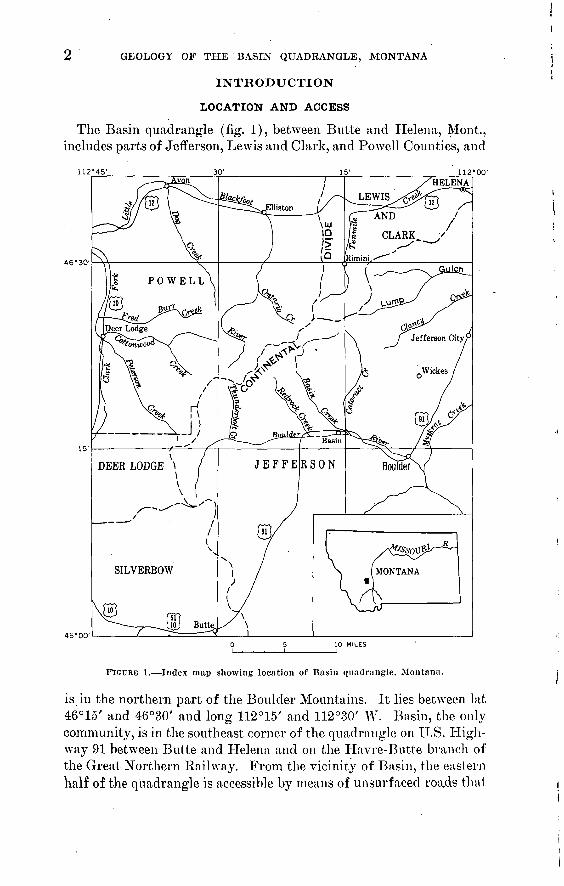
The Basin quadrangle (fig. 1), between Butte and Helena, Mont., includes parts of Jefferson, Lewis and Clark, and Powell Counties, and
112M5 112°00'
FIGURE 1. Index map showing location of Basin quadrangle, Montana.
is in the northern part of the Boulder Mountains. It lies between lat 46°15 / and 46°30' and long 112°15' and 112°30' W. Basin, the only community, is in the southeast corner of the quadrangle on U.S. High way 91 between Butte and Helena and on the Havre-Butte branch of the Great Northern Railway. From the vicinity of Basin, the eastern half of the quadrangle is accessible by means of unsurfaced roads that

INTRODUCTION 6
extend northward along the principal stream valleys; the principal access road, in the valley of Basin Creek, is linked by logging and mine roads to publicly maintained roads that extend southward along Tenmile and Minnehaha Creeks from U.S. Highway ION west of Helena.
The western half of the quadrangle is more difficult of access than the eastern half. An unsurfaced but maintained road, the Bernice- Deer Lodge U.S. Forest Service road, extends westward from U.S. Highway 91 near th,e south boundary of the quadrangle, and a few roads reach northward from it for short distances. Principal among these is the road in the valley of Thunderbolt Creek and the road in the vicinity of Alta Gulch. In the northwest part of the quadrangle, an excellent county-maintained unsurfaeed road follows the valley of the Little Blackfoot River, extending southward from Elliston; this road is linked by logging and mine roads to the Minnehaha Creek- Tenmile Creek-Basin Creek road network, and, through Kading Gulch, to roads farther west that lead to the Deer Lodge Valley. The few major stream valleys that do not contain roads are followed by pack trails maintained by the U.S. Forest Service.
TOPOGRAPHY AND DRAINAGE
The Basin quadrangle is entirely mountainous, but the mountains, like those elsewhere in the Boulder Mountains, are mostly low and rounded and so differ from those of most of the other mountainous regions in western Montana. Most of the mountain tops are at altitudes ranging from 7,000 to 7,600 feet. A few peaks rise above the general level of the range, but these peaks, too, lack rugged features. The highest peaks in the quadrangle are Thunderbolt Mountain and Jack Mountain, both of which rise about 1,000 feet above the surrounding lower mountains. A few other peaks are higher than 8,000 feet, among them, Electric Peak, Bison Mountain, Rocker Peak, the Three Brothers, and Old Baldy Mountain. Pole Mountain, Fox Mountain, and Iron Mountain are prominent peaks in the southern part of the quadrangle, but they do not rise above the general low level farther north. The relief between the mountain tops and the adjacent valley bottoms rarely exceeds 1,500 feet and commonly is less than 1,000 feet; the total relief is about 3,600 feet. The lowest point, which is about 5,150 feet, is in the valley of Tenmile Creek in the northeast corner of tlie quadrangle.
The Continental Divide extends in a general northeast direction from Electric Peak and Thunderbolt Mountain at the southwest to Jericho Mountain at the northeast. The drainage in the northwest part of the quadrangle is into the Clark Fork of the Columbia River

4 GEOLOGY OF THE BASIN QUADRANGLE, MONTANA
through its tributary, the Little Bl'ackfoot River. Most of the area in the Missouri River basin east of the Continental Divide is drained by the Boulder River and its tributaries, but the northeastern part of the quadrangle is drained by Tenmile Creek and its tributaries directly into the Missouri River northeast of Helena. Nearly all the streams in the map area flow in valleys that have been glaciated, and most streams have their headwaters in broad basins that contain large swamps and bogs. In the southeast and northwest parts of the quad rangle the valleys of all the major streams and many of their tribu taries trend either northeast or northwest, and the drainage patterns are strikingly rectilinear.
VEGETATION
The mountains in the map area are well timbered with pine, spruce, and fir. In general, lodgepole pine is most common in the northern part of the quadrangle, but Englemann spruce and alpine fir are also plentiful. Small stands of Douglas-fir and ponderosa pine are pres ent locally. Farther south the type of timber cover gradually changes, and the dominant tree in the southern part of the map area is Douglas-fir. Lodgepole pine, Englemann spruce, and alpine fir occur only locally and where present are sparsely distributed. Lim ber pine is the predominant tree on the higher mountain tops through out the quadrangle.
Quaking aspen flourishes along the courses of streams and in swampy areas, and alder forms nearly impenetrable thickets in swampy areas in the northern part of the quadrangle. Cottonwood is locally abundant in the lower parts of the stream valleys and along the Boulder River. Snow willow is common locally, and mountain maple and mountain ash grow in a few places. Sagebrush- grows over much of the quadrangle, but is most abundant west of the Little Blackfoot River and in the vicinity of Red Rock Creek and lower Basin Creek.
Small grassy meadows are common throughout the map area, both along and in the headwaters of streams and on the mountain slopes and: divides. They are utilized for grazing during the summer months.
PREVIOUS WORK
'Reconnaissance geologic studies and investigations of mineral de posits in the map area have been made by a number of geologists. Knopf's description (1913) of the Helena mining region includes a brief section on the Basin district in addition to general informa tion on regional geology. Pardee and Schrader (1933) contribute similar information, and the studies of Billingsley (1916) and Bill-
INTRODUCTION 5
ingsley and Grimes (1918) furnish data on the Boulder batholith, on structural features, and on mineral deposits. The placer deposits are described briefly by Lyden (1948), and Brinker l has made a detailed study of the Basin Creek placer deposit.
F. S. Robertson 2 has studied the geology and mineral deposits of the Elliston mining district, the southern part of which extends into the Basin quadrangle. That part of the Basin quadrangle mapped by Robertson (see pi. 1) was not remapped in this study and Robertson's map and much of his geologic information 'have been incorporated in the present report under an informal cooperative arrangement with Robertson and the Montana State Bureau of Mines and Geology. Robertson (1953) studied the Zosell mining district a few miles west of the Basin quadrangle and contributes information on the nature of the basaltic rocks and the mineral deposits in that area.
PRESENT WOKK AND ACKNOWLEDGMENTS
The investigation of the Basin quadrangle was part of a study by the U.S. Geological Survey of the geology and mineral deposits in and adjacent to the northern part of the Boulder batholith. The field- work in the quadrangle was begun in August 1953, and was com pleted in 1956; a total of about 13 months was devoted to the field investigation. Color terms used in rock descriptions are those used in the National Research Council Rock Color Chart (1948).
I am particularly indebted to the geologists of the U.S. Geological Survey who have recently mapped other areas in and adjacent to the Boulder batholith and have made their information available to me for this report, and to Paul E. Myers who capably served as field assistant during the 1954 and 1955 field seasons. Mrs. Loretta B. Peck, Librarian at the Montana State School of Mines, Butte, Mont., made the facilities of that library available to me and was most help ful in the search for historical data on mines and mining.
I am pleased to acknowledge the generous cooperation and hos pitality of the people in the urea. Thanks are given especially to A. J. Bullock, G. C. Holshue, J. P. Bragg, and George Mayer of Basin, and W. E. Field and Ted Nyquist of Boulder for maps and other information on mines, and to G. C. Holshue of Basin, C. J. Ericksen of Butte, and the late Caesar Vercellin of Rimini for providing field accommodations.
The Anaconda Co., Basin-Jib Mines, Ltd., the Bullion Mining Co., and the Golden Messenger Corp. supplied information on their mines
1 Brinker, W. F., 1944, Placer tin deposits north of Basin, Montana: M.S. thesis, Montana State School of Mines, Butte, Mont.
2 Robertson, P. S., 1956, Geology and mineral deposits of the Elliston mining district, Powell County, Montana: Ph. D. thesis, Washington Univ., Seattle, Wash.

6 GEOLOGY OF THE BASIN QUADRANGLE, MONTANA
and prospects in the Basin quadrangle, and have released such in formation for publication in this report.
John Eodgers visited the Basin quadrangle in 1956 and contributed many helpful suggestions. John Rodgers, R. F. Flint, A. M. Bateman, M. S. Walton, Jr., and several Geological Survey colleagues critically reviewed part or all of the manuscript, and I am grateful for their helpful suggestions and criticisms.
GEOLOGY
The Basin quadrangle (pi. 1) is underlain principally by Cre taceous and Tertiary volcanic rocks and by rocks of the Boulder batho- lith. Sedimentary rocks of Jurassic and Cretaceous age that crop out west of the Little Blackfoot River in the northwest part of the quad rangle include mudstone of the Upper Jurassic Morrison formation; sandstone, shale, mudstone, and limestone of the Lower Cretaceous Kootenai formation; and shale and sandstone of the Lower Cretaceous lower part of the Colorado formation.
The sedimentary rocks are unconformably overlain by the Upper Cretaceous Elkhorn Mountains volcanics, which, in the Basin quad rangle, consist largely of quartz latitic 3 (fig. 2) welded tuff probably equivalent to the middle member of the formation in the type area (Klepper, Weeks, and Ruppel, 1957, p. 31-41), although representa tives of the upper and lower members are thought to be present locally. Basaltic rocks nnconformably overlying locally welded tuff and tuff-breccia in the northwestern part of the quadrangle are pro visionally considered a part of the Elkhorn Mountains volcanics, perhaps equivalent in part to the upper member of the formation in its type area.
The quartz monzonite, granodiorite, and related rocks of the Boul der batholith were emplaced at or near the close of the Cretaceous period and, throughout most of the map area where these rocks crop out, the top of the batholith is at or near a single stratigraphic hori zon in the Elkhorn Mountains volcanics. The emplacement of the batholithic magma was accompanied by metamorphism of the vol canic rocks; apparently the extent of metamorphic change was de-
3 With the exception of aplite, alaskite, and pegmatite, the igneous rock names used in this report are from the terminology proposed by Johannsen (1939, p. 141-149), modified (a) to include quartz monzonite (adamellite of Johannsen), quartz latite (clellenlte of Johannsen), and quartz diorite (tonalite'Of Johannsen), and (b) to use 10 percent ratherthan 5 percent taken as the upper limit for the quartz content of syenite, monzonite, syeno- diorite, and syenogabbro. The quartz monzonite, granodiorite, and related rocks of the Boulder batholith are classified in accordance with this modified Johannsen system on the basis of their actual mineral content as determined by this section modes. The volcanic rocks are classified, in the basis Of their Chemical composition, in accordance with the system proposed by Rittman (1952). The terminology applied to fragmental volcanic rocks is mainly that of Wentworth and Williams (1932, p. 45-53).

SEDIMENTARY ROCKS
Potassic granite Potassic rhyo/ife'
Quartz diorite Docife
7 / Syenite / / SyeniteTrachyte/" / Trachyte
5 POTASSIC FELDSPAR
/ Monzonite / Latife
35
i Syenodiorite \ Trachyandesife
\ \ \ \ Diorite\ \Andesite
65 95 PLAGIOCLASE
ROCKS WITH PLAGIOCLASE OF COMPOSITION AnQ 5fl
Potassic granite Potassic rhyo/ife?
/Syenite / Trachyte/^
/___>
QUARTZ
1
Calcic granite / Calcic quartz \ Granogabbro Monzonite
Quartz gabbro ' Quartz basalt
Calcic rhyo/ife Calcic quartz la fife
Rhyobasa/f
Calcic syenite / Calcic monzonite \ Syenogabbro \ \ Gabbro Calcic trachyte j Calcic /afire \ (Calcic) frachybaso/f \ *'Basalt
35 65 95 PLAGIOCLASEPOTASSIC FELDSPAR
ROCKS WITH PLAGIOCLASE OF COMPOSITION An 5(M oo
FIOUKE 2. Quantitative mineralogical classification of igneous rocks. Rock types referred to in this report are underlined. Modified from A Johannsen (19H9).
termined primarily by the original texture, and perhaps also by the composition, of the volcanic rocks except in a thin, intensely horn- felsed cordierite-bearing zone that some places formed adjacent to the batholithic rocks.
The Tertiary geologic episodes include two periods of erosion, each of which was terminated by a period of volcanism. Early Tertiary erosion unroofed the batholith and produced a mountainous landscape
8 GEOLOGY OF THE BASIN QUADRANGLE, MONTANA
(pi. 3) onto which quartz latitic volcanic rocks (Lowland Creek volcanics) were erupted in Oligocene time. Erosion following the period of quartz latite volcanism probably carved the-broad landscape of low relief (pi. 4) on which the Miocene(?)-Pliocene( ?) rhyolitic rocks were erupted. During the erosional periods that preceded the Tertiary volcanic eruptions, a drainage system ancestral to the present system was established.
Since the period of rhyolite volcanism, erosion has stripped away part of the Tertiary volcanic rocks and formed the present region of low mountains that have been modified by glaciation. Glacial deposits cover a large part of the quadrangle, and in many areas have been modified.by mass-wasting processes, mainly frost action, which have dominated postglacial erosion.
SEDIMENTARY BOCKS
Sedimentary rocks crop out only in the northwest part of the Basin quadrangle (pi. 1). The oldest rocks, exposed in small areas on the northern tributary of Hat Creek and west of Kading Ranger Station, are lithologically similar to the rocks of the upper part of the Upper Jurassic Morrison formation farther east (Klepper, Weeks, and Ruppel, 1957, p. 23-24). The Jurassic rocks are overlain with ap parent conformity by sandstone, shale, and limestone of the Lower Cretaceous Kootenai formation, which crops out over an area of about 2 square miles northwest of Hat Creek and in small fault blocks in the vicinity of Kading Ranger Station. In both of these areas, slopes facing north and west are commonly dip slopes cut on sand stone of the Kootenai. The Kootenai formation is overlain with apparent conformity by dark-gray shale and sandstone similar to and correlative with the Lower Cretaceous lower part of the Colorado formation in the 'Elkhorn Mountains farther east (Klepper, Weeks, and Ruppel, 1957, p. 26-27).
MORRISON FORMATION
The rocks assigned to the Morrison formation in the Basin quad rangle are largely concealed by surficial debris, and the areas they underlie are partly bounded by steep faults. For these reasons, the rocks are not well known and their thickness was not measured. The limited exposures and float fragments suggest that the Morrison rocks are entirely olive-gray and grayish-olive mudstone.
KOOTENAI FORMATION
Rocks lithologically similar to, and almost certainly correlative with, those of the Kootenai formation farther east (Klepper, Weeks, and Ruppel, 1957, p. 24) crop out in the vicinity of Hat Creek.

""' ELKHORN MOUNTAIN VOLCANICS 9
These rocks are faulted and partly concealed beneath widespread surficial debris; as a result, the formation, is not well known and its thickness was not measured. The rocks include light-gray quartzitic sandstone and conglomerate, both of which contain abundant black chert grains; light-olive-gray and subordinate amounts of grayish- red and grayish-purple shale and mudstone; and, in the upper part, medium-dark-gray finely, crystalline limestone. Part of this lime stone contains abundant gastropods and is similar to the "gastropod limestone" characteristic of the upper part of the Kootenai formation elsewhere in southwestern Montana. West of Kading Ranger Sta tion, different parts of the formation crop out in small fault blocks. The northT facing dip slope northwest of the station is cut on sandstone and subordinate amounts of conglomerate.
COLORADO FORMATION
Dark-gray shale and dark-gray argillaceous fine-grained sandstone that conformably overlie the Kootenai formation in the northwest part of the Basin quadrangle are lithologically similar to and almost certainly a correlative of the lower unit of the Colorado formation farther east (Klepper, Weeks, and Ruppel, 1957, p. 26). The Colo rado formation is uncohformably overlain by the Elkhorn Mountains volcanics of Late Cretaceous age. The thickness of the formation was not measured because.of poor exposures and faulting.
ELKHORN MOUNTAINS VOLCANICS
In the northern part of the Boulder Mountains most of the volcanic rocks older than the bathdlith are considered, largely on the basis of lithologic similarity, to- be part of the middle member of the Elk- horn Mountains volcanics as described in the type area farther east (Klepper, Weeks, and Ruppel, 1957, p. 31-41); the upper and lower members of the formation may be represented locally (table 1). These rocks have an estimated aggregate thickness in the map area of about 3,000 feet, and include welded ash-flow tuff and tuff-breccia, tuff, lapilli tuff, tuff-breccia, flow breccia, and hypabyssal intrusive rocks; the welded rocks make up the major part of the formation. The rocks are predominantly andesitic and quartz latitic in composition, although rhyolitic rocks may be present locally. Provisionally included in the formation are basalt flows and flow breccias and associated hypabyssal intrusive rocks. The rocks form the western part of the Elkhorn Mountains volcanic field (Klepper, Weeks, and Ruppel, 1957, p. 32) as it is exposed at the present time. They crop out over much of the central and western part of the map area and extend westward into the Deer Lodge Valley (Ruppel, 1961). In the eastern part of the map area, Elkhorn Mountains volcanics are

10 GEOLOGY OF THE BASIN QUADRANGLE, MONTANA
preserved as remnants of the roof of the Boulder batholith, but a large part of the formation has been removed either by the batholithic magma when it was emplaced or by subsequent erosion.
STRATIGRAPHIC RELATIONS
Because of poor exposures and structural complexities, the sequence of rocks included in the Elkhorn Mountains volcanics in the map area is not well known. The inferred stratigraphic relations are sum marized in table 1. In the eastern and southern part of the area the sequence appears to consist of two units of welded tuff and an over lying unit of tuff and volcanic sandstone. In the vicinity of Thunder bolt Mountain farther west the lowermost welded tuff unit abruptly thins and disappears, and its stratigraphic position is occupied by fragmental volcanic rocks that include tuff, lapilli tuff, tuff-breccia, and volcanic conglomerate. The upper welded tuff extends over a broad area west and southwest of Thunderbolt Mountain and west of the map area to underlie the mountains that form the east flank of the Deer Lodge Valley (Kuppel, 1961).
The Elkhorn Mountains volcanics in the vicinity of Cliff Mountain (table 1), a few miles northwest of Thunderbolt Mountain, are sep arable into two major parts, both consisting dominantly of fragmen tal rocks. The lower part is a sequence 600 to 700 feet thick of tuff and lapilli tuff beds; a tuff-breccia bed 50 feet thick occurs near the middle of the sequence. The uppermost lapilli tuff beds are overlain by strongly welded tuff, perhaps 100 to 200 feet thick, that forms the base of the upper part of the sequence. The welded tuff is in turn overlain by (a) flow breccia, possibly as much as 400 feet thick, (b) 400 feet of tuff and tuff-breccia, part of which is moderately to strong ly welded, (c) about Y5 to 100 feet of bedded tuff and lapilli tuff, (d) about 50 feet of tuff-breccia, and (e) an unknown thickness of welded tuff approximately correlative with the upper welded tuff in the southern part of the quadrangle and farther west.
Northeast of Cliff Mountain in the vicinity of the Little Blackfoot Eiver and in the northwestern part of the quadrangle (table 1) the Elkhorn Mountains volcanics have not been subdivided. Robertson (p. 24-37) 4 states that the formation in this area includes a basal flow and pyroclastic breccia as much as 1,500 feet thick, overlain by a series of andesitic tuff, lapilli tuff, and tuff-breccia, mostly welded to some degree and perhaps as much as 1,000 feet thick. The relation of these rocks to the rocks exposed on Cliff Mountain is not known, but probably the basal breccia corresponds to the flow breccia at Cliff Mountain (table 1) and the andesitic pyroclastic rocks correspond to
* See footnote 2, p. 5.

ELKHORN MOUNTAIN VOLCANICS 11
the rather similar rocks above the flow breccia on Cliff Mountain. The breccias described by Robertson unconformably overlie the Lower Cretaceous Kootenai formation and the black shale and sandstone of the lower part of the Colorado formation.
Near the head of Peterson Creek (Ruppel, 1961), a few miles south west of Cliff Mountain and west of the Basin quadrangle, the relation of Elkhorn Mountains volcanics to older rocks is not well known, but there appear to be a few hundred feet of tuffaceous sandstone stnd tuff overlain by welded tuff and welded tuff-breccia. The tuffaceous sandstone and tuff probably overlie siliceous sedimentary rocks of the middle part of the Colorado formation.
These volcanic rocks in the Basin quadrangle are similar to the volcanic rocks elseAvhere in the Elkhorn Mountains volcanic field (Klepper, Weeks, and Ruppel, 1957, p. 31-41). The prevalence of welded rocks suggests correlation (table 1) of much of the formation in the map area with the middle, largely welded, member of the Elk- horn Mountains volcanics farther east. The lower tuff and breccia member of the formation in the type area may be represented by the lower tuff and breccia unit in the vicinity of Cliff Mountain; it does not appear to be represented elsewhere in the quadrangle, where the welded or partly welded volcanic rocks overlie either the Kootenai formation or the lower part of the Colorado formation. West of the quadrangle (Ruppel, 1961) a few hundred feet of the lower member of the formation may be present between the middle part of the Colo rado formation and the middle member of the Elkhorn Mountains volcanic. The lower member of the formation is also present at the north end of the Deer Lodge Valley, where an estimated thickness of 1,000 feet of tuffaceous sandstone and siltstone, tuff-breccia, and andesitic (?) flow rocks crop out. Beds near the base of the lower member in this locality contain a Judith River flora (Roland W. Brown, written communication, 1956). The tuff and volcanic sand stone that overlie the welded tuff in the east half of the quadrangle are lithologically similar to rocks in the upper member of Elkhorn Mountains volcanics in the type area (Klepper, Weeks, and Ruppel, 1957, p. 32), and may be correlative with it. Similar rocks above the welded rocks are not present elsewhere in the Basin quadrangle, or, as far as is known, farther west on the east side of the Deer Lodge Valley.
In the northwestern part of the Basin quadrangle, the andesitic and quartz latitic rocks are unconformably overlain by basaltic flows and flow breccias that here are provisionally included in the Elkhorn Mountains volcanics as a fourth unit that is not known to exist else-
678765 O 63 2

12 GEOLOGY OF THE BASIN QUADRANGLE, MONTANA
es _is"e
ito"
.«se
.3o a
s J1?3
18i.
^
v-C
s *ato
**
3"ws~
8rig£X
5-Cn _g
<3&.00
>
eo p*
]s<»K
S» «"sI-H
(HJ(6<H
(M
12
2
Ia<Dbo
3<aO
£ "Sb
b- o03O1
a'3x>
co
O^
M bjo o.S^'d"§««
I^l
* O § u
W IB s,
05
w >
O 03PH
at"'3 § ®'a-osg^.to.olo
3.3 ^ O
Csc3O
§s5
"3 c £'3OS'S g§3 ° $*
"a
1K
Ed . 2 s"-K. 3
C <Z 2 to"
§<y0-
C^
£ °& Or-j'Z £«D.w
& oo D-^j
3^1. >>§ £"SsS
0
03 03 m'S
IIn
o03 03
**1Ltn£^'
11
o'203o "o <B > C o3Sfp coc^
|i>,^"c «3t- 03 t?QJ C^ >>a)
tH C O ^
a-a'SJ 2*-*
il^ a 03'32d 'S
^'S 03 ^
^ fe
|1 J|
^o 'OjQ
P"~" ^
"^ T3
03" a ^2 i- g2^| | a£
laJ-S' f.aSSie S te « §135 || <; fn
«_. S 03
OS'S 'S5 -2'^ 'Sg
jy ^ o T3 73 .2"13 £ *"
111 i«|«|| IfP EH EH EH PM [^
,."3 ' T3
_j ig > g C
£ § .t! -"'§>«C3 "o3 S u ^ Cfl fe '^ 03 O t3
^0 ^5 0 o QJfe.t3(H "!&:'£ £ rtg«s ^slllP EH
0? a>
"o3 03
Is 3 fe 303 -^ 03 *^3 T3 3 -3
- § «-2S"3 §"3a^ o ^
>>!c s*
cu S *I'll
l?lfc^S-crB^
^«£oi "^ss'H 3 -!|2o-o3«
te ° 3 .3 °EH
C 3
g 0
w|3 to
EH
-.2
3 S 9
11
3 03EH
?i! .-
- £ h 'S '> 3 ̂1- S3 ° 0 ;S *i> 2
llllllllS3S.2te-^l^.-So f§'s3rt£o33*
(o3B JOAiy mipnf ^pat'jua ao ^jureui)

(Old
er v
olca
nic
rock
s, i
f any
ex
is
ted,
des
troy
ed
by e
mpl
acem
ent
of b
atho
lith
ic
rock
s.)
(Old
er v
olca
nic
rock
s, i
f an
y ex
is
ted,
des
troy
ed
by e
mpl
acem
ent
of b
atho
lith
ic
rock
s.)
(Bas
e no
t ex
po
sed.
)( U
ncon
form
able
on
Koo
tena
i fo
rmat
ion
and
low
er p
art
of
Col
orad
o fo
rma
tio
n.)
(Pro
babl
y ov
erlie
s m
iddl
e, s
ili
ceou
s, p
art
of
Col
orad
o fo
rma
tio
n.)
(Bas
e no
t ex
po
sed.
)(B
ase
unkn
own.
)
1 B
ased
mai
nly
on r
econ
nais
sanc
e by
the
wri
ter.
2 Lith
olog
ic d
ata
in p
art
from
Rob
erts
on (
1953
) an
d R
ober
tson
, 19
56,
Geo
logy
and
min
eral
dep
osits
of
the
Ell
isto
n m
inin
g di
stri
ct,
Pow
ell
Cou
nty,
Mon
t.: P
h. D
. th
esis
, W
ashi
ngto
n U
niv.
, Se
attle
, W
ash.

14 . GEOLOGY OF THE BASIN QUADRANGLE, MONTANA
where in the formation. The flows may be represented elsewhere in the vicinity of the northern part of the Boulder batholith by intru sive basaltic rocks similar to those related to extrusive basaltic rocks in the Basin quadrangle.
ROCK TYPES
The Elkhorn Mountains volcanics in the map area include welded tuff and tuff-breccia, tuff, lapilli tuff, tuff-breccia, flow breccia, vol canic sandstone and conglomerate, and related hypabyssal intrusive rocks in the form of sills, dikes, and irregular small plutons.
WELDED TUFF
Welded tuff constitutes the major part of the Elkhorn Mountains volcanics over most of the map area east of Thunderbolt and Cliff Mountains. The welded tuff has been divided into upper and lower map-units in the present study. These units are each made up of separate welded tuffs of similar composition this is indicated by the presence of lenses of bedded tuff in the upper welded tuff on the south flank of Thunderbolt Mountain; by the presence of small lenticular deposits of quartzitic sandstone and quartzite, which prob ably represent stream deposits, in the upper welded tuff on the north west slope of Jack Creek Kidge; and by the number of distinct vari eties within the lower welded tuff in the vicinity of Basin Creek.
The welded tuff units have a number of characteristics in common; among them are very fine grain size, abundant crenulated and draped bands and wisps that represent collapsed pumice fragments and glass shards, platy jointing, arid, in many places, columnar jointing. The two units have been divided on the basis of differences in color and in the nature of the collapsed fragments and draped shards.
The lower welded tuff (Kvai), which crops out mainly in the central part of the quadrangle, is locally separable into a number of varieties on the 'basis of megascopic differences in texture and layering and is thus characterized by an apparent heterogeneity that contrasts strongly with the homogeneity of the upper welded tuff. The mega scopic differences that separate types of welded tuff within the lower Avelded tuff are not paralleled 'by microscopic differences, however. The estimated thickness of the exposed part of the lower welded tuff is about 500 feet. Differences in the shape and size of the lenticular crenulated layers and wisps serve in large part to distinguish varie ties within the lower welded tuff, although other criteria (including color, relative amounts of plagioclase and of hornblende, and ground- mass texture) were also utilized in the field. The layers and wT isps are locally similar to the thin crenulated wisps characteristic of the

ELKHORN MOUNTAIN VOLCANICS 15
upper unit, but more commonly they are 1 to 7 mm thick and 2 to 10 cm long.
In general, the rocks of the lower welded tuff are medium dark gray to medium light gray or greenish gray, are fine to very fine grained, and contain abundant anhedral to euhedral 0.5- to 3-mm-long plagioclase crystals (An3 o-3 5 ), which commonly are oriented about parallel to the characteristic layering of the rock. Subhedral to euhe dral hornblende crystals 1 to 3 mm long are locally common, and where present are also alined paralled to the layering. Alkalic feldspar and quartz occur locally and sparsely, the feldspar as euhedral to subhedral crystals 1 to 2 mm across and the quartz as anhedral grains 0.5 to 1 mm across. Chlorite, epidote, apatite, and magnetite are common in these rocks, and probably are derived mainly from alteration of original mafic minerals and from saussuritization of the plagioclase. The groundmass of the rock is not clearly resolvable under the microscope; it appears to be a felted aggregate of quartz, plagioclase, and alkalic feldspar. Two chemical analyses of welded tuff typical of much of this lower unit (table 2, 4R11C, 4S12C) indi cate that it is quartz latite.
The varieties of welded tuff in the lower welded tuff in the vicinity of Basin Creek do not appear to have any consistent relation to each other or to maintain a constant stratigraphic position. The differ ences in layering from place to place in the lower welded tuff probably represent in part separate ash flows Avithin the unit and in part dif ferent degrees of welding within individual ash flows. Similarly, the different crystal content from place to place probably reflects both separate ash flows and variations within individual ash flows. The change from partly welded to strongly welded rocks within a single welded tuff is clearly demonstrated south of the divide at the head of the South Fork of Basin Creek. Here, the base of the welded tuff is only partly welded and commonly contains angular to sub- rounded and only slightly flattened hapilli. The degree of welding, as indicated by collapsed lapilli or pumice fragments, gradually in creases above the base, and from 100 feet stratigraphically above the base to the present top of the welded tuff the rock is strongly welded.
The upper welded tuff (Kva2 ) crops out over much of the southern half of the quadrangle and farther west (Ruppel, 1961). The rock typically is light brownish gray or grayish red to medium gray and is aphanitic or very fine grained. It contains abundant crenulated wisps, typically 0.5 mm or less thick and a few millimeters to 3 cm long; about 10 percent chipped and rounded feldspar crystals, prin cipally plagioclase in 1- to 2-mm-long crystals; 5 to 10 percent acci dental lithic volcanic fragments 1 to 2 mm in diameter; and a small

16 GEOLOGY OF THE BASIN QUADRANGLE, MONTANA
TABLE 2. Chemical and spectrographic analyses of welded tuff of the ElkhornMountains volcanics
Field No. ........ 4R11C. ...--.
Welded tuff...
SEK, sec. 22,T.7N., R. 6 W.
4S12C... ......139452.........Welded tuff...
SEM, sec. 15,T. 7N., R. 6 W.
0). ...........
Welded tuff-
ThunderboltCreek.
4S13C... ........ .139453-..-.-.-...Metamorphosed
welded tuff. Sec. 31, T. 7N.,
R. 5 W.
(2).
Metamorphosedwelded tuff.
Sec. 8, T. 8 N.,R. 6 W.
Chemical analysis
[Analysts: N. F. Philips, P. L. D. Elmore and ~K. E. White'except as noted; rapid method unless noted otherwise]
Si0 2.. AhOj.... ... FeO... ...... ... ..FejO3~ ~ MgO. ..... ....CaO ...........Na 20 .._... .K2O -------TiO2.. ....... . ...PsOs ~MnO. ........... .C0 2-- -------H 20 ........
S ..............BaO --.. .
Total. ......
63.017.01.82.51.73.33.33.8.69.26.08.10
2.1
99.63
62.818.61.42.21.24.9
3.4.64.20.05.08.94
100. 01
64.4517.691.931.33.57
3.733.853.68.69.16.05.29
+.80-.59
.04
.19
100. 04
72.314.6
.721.0.71
1.02.45.4.34.06.03.17
1.2
99.93
' 73.813.8
.51
.38
.16
.993.2'
6.0.28.04.08
.30
99.54
Quantitative spectrographic analyses Tor minor elements 3
[Analyst: Harry Bastron. Dilution factor 2]
Cu.. ...... .......Co.......- ..NL ...... ......Cr. .... ......V..... ............Zr. ...............Be. ... ...... .Sr....... .........Ba_. .............
0. 0008.001.001.003'.01.02.0002.06.02
0. 0004.001
0.003.009.02.0002.1.2
0. 000200.002.005.02.0002.01.2
1 From Knopf (1913, p. 26). Standard analysis.2 From F. S. Robertson, 1956, p. 214a. See footnote 2, p. 5.3 0 in unit column means element not detected; elements also looked for but not found are Ag, Au, Hg,
Ru, Rh, Pd, Ce, Ir, Pt, Mo, W, Re, Ge, Sn, Pb, As, Sb, Bi, Te, Zn, Cd, Tl, In, Sc, Y, Yb, La,Th,Nb, Ta, U, Li, P, Be, Ga.
percentage of biotite. The flattened layers and wisps are draped around the crystals and lithic fragments. In thin section the rock ap pears largely to be devitrified glass. A chemical analysis of this rock (table 2) given by Knopf (1913, p. 26) indicates that it is quartz latite in the southwestern part of the quadrangle, but studies of the metamorphosed rocks of the unit in the eastern part of the quad rangle suggest that rhyolitic rocks were present there (see p. 42).
Structural complexities and widely separated poor exposures have prevented accurate measurement of the thickness of the upper welded tuff; the estimated thickness is 500 to 1,000 feet. The completely flattened pumice fragments and glass shards indicate that the entire

ELKHORN MOUNTAIN VOLCANICS 17
unit has 'been strongly welded, and tops or bottoms of individual ash flows are not recognizable.
The upper welded tuff is apparently conformable on earlier pails of the Elkhorn Mountains volcanics except south of Thunderbolt Mountain, where it truncates older beds of volcanic sediments and fills depressions in the earlier surface. West of Thunderbolt Mountain the rock rests with apparent conformity on fine-grained bedded tuff. The upper 2 to 5 feet of the fine-grained tuff is deformed; the larger folds in this disturbed zone have amplitudes of 5 to 10 feet and typically are asymmetrical toward the west and northwest. Indi vidual tuff beds and laminae in the disturbed zone are severely con torted ; the contortions are typically overturned to the west and north west, and are cut by small thrust faults that dip east and southeast. The welded tuff itself is characterized by floAvage contortions and swirls in this area, indicating that the welded tuff flowed as a viscous liquid during welding, and therefore the folds, faults, and contortions in the thin layer of underlying bedded tuff might have been produced by drag below a viscous flow of the overlying welded tuff.
The upper welded tuff appears to have been especially susceptible to thermal metamorphism, and it has been altered to a distinctive quartz-sericite-potassuim feldspar hornfels wherever batholithic rocks are in contact, or nearly in contact, with it. The nature of the altera tion is discussed more fully in the section on metamorphism related to batholithic rocks.
Although chemical analyses (table 2) indicate that the welded tuff in much of the map area is quartz latite, Robertson (p. 25-28, 29) 5 describes andesitic welded tuff from the southern part of the Elliston mining district and-from the vicinity of Cliff Mountain, and gives-a composite section 3,000 feet thick, based on exposures in these areas, the lower half of .which is andesitic and the upper half latitic. Eobertson's determinations are based primarily on the mineralogy of crystals and crystal fragments in the welded rocks. The andesitic rocks contain anclesine and hornblende without recognizable potassium feldspar, and the latites contain potassium feldspar and biotite in addition to andesine and hornblende. .
TUFF AND LAPILLI TUFF
Tuff crops out mainly in the western and southern parts of the area and typically is dark gray and very fine to fine grained. The rocks contain sparse to moderately abundant subhedral to anhedral crystals and crystal fragments 1 to 2 mm long of plagioclase (probably ande sine), sparse crystal fragments less than 1 mm long of hornblende and, more rarely, pyroxene and an abundant opaque mineral, prob-
5 See footnote 2, p. 5.

18 GEOLOGY OF THE BASIN QUADRANGLE, MONTANA
ably magnetite. Lapilli are locally common, but tuff beds containing lapilli in quantity sufficient to be classed as lapilli tuffs are uncommon.
BRECCIATuff-breccia, welded tuff-breccia, and flow breccia are mainly re
stricted to the western and northern parts of the quadrangle, and extend farther west. They form massive, structureless outcrops that appear bedded when viewed from a distance.
The tuff-breccia and welded tuff-breccia typically are grayish red to medium light gray and are composed of tightly packed, unsorted angular to subrounded blocks of various types of tuff, welded tuff, and dioritic rocks. The blocks range from 0.1 foot to 3 feet in diam eter although the most common range in diameter is from 0.1 foot to 1.5 feet. The matrix is very fine to fine grained ash that commonly contains abundant plagioclase crystals (andesine) as much as 2 mm long. Some of the tuff-breccia units are unwelded; some are moder ately to strongly welded.
The welded tuff-breccia units are widespread, extending north and west of Cliff Mountain, and are believed to be products of ash flows that may have traveled long distances before deposition and welding. The lenticular tuff-breccia at the top of Cliff Mountain contains inter- beds of very fine to fine grained tuff, which suggest that this unit may be made up of overlapping mudflows.
The tuff-breccia exposed on the west side of Thunderbolt Mountain is unique in the map area in that it contains subangular to subrounded boulders from 4 to 30 feet in diameter, apparently locally derived, enclosed in a lapilli tuff matrix. The breccia is overlain on the south by poorly sorted and poorly bedded volcanic conglomerate and sand stone composed largely of locally derived material. On the west the breccia appears to butt against tuff and lapilli tuff coextensive with similar rocks in the vicinity of Cliff Mountain. The breccia is thought to be a landslide deposit derived from a high area located in the vicinity of the present Thunderbolt Mountain, deposited in a deeply eroded canyon, and buried on the south by its own erosional debris.
The flow breccia described by Robertson (p. 28) 6 in the vicinity of Negro Mountain and the flow breccia that crops out on Cliff Mountain and farther west and southwest may be parts of a single flow breccia, for the composition of the rocks is similar, that of calcic andesite near basalt, and both breccias are unilithic. The breccias cannot be traced into each other laterally, and there is no evidence other than apparent lithologic similarity to substantiate correlation. The rocks are medium gray to dark gray, fine to very fine grained, and in the
See footnote 2, p. 5.

ELKHORN MOUNTAIN VOLCANICS 19
vicinity of Cliff Mountain they contain plagioclase crystals, probably andesine, about 0.5 mm long, whereas crystals of similar composition in the vicinity of Negro Mountain are 1 to 3 mm long. The abundant subrounded to subangular fragments in the breccia typically are 1 to 15 cm in diameter. Locally a small number of blocks of bedded tuff, welded tuff, and welded tuff-breccia as much as 3 feet in diameter are present in the breccia.
The tuff-breccia in the fault block at the head of Kading Gulch in the northwest part of the quadrangle differs from other tuff-breccias in the Elkhorn Mountains volcanics in containing sparse granitic boulders 1 to 2 feet in diameter and moderately abundant smaller granitic fragments and granite sand. In general the granitic rocks resemble the alaskitic rocks of the Boulder batholith, although at least one boulder is considered by Robertson (p. 63) ~ to have been derived from a rheomorphic breccia. A single zircon age determina tion suggests that the granitic rocks.may be about 50 million years old (Howard Jaffe, written communication); the zircon may have been damaged by metamorphism, however, and the error in the age determination possibly is quite large. No granitic rocks crop out in the northwest part of the Basin quadrangle, in the northern part of the Deer Lodge Valley, or north of the Basin quadrangle to the Avon Valley, and the source of the granitic boulders and debris is not known.
VOLCANIC SEDIMENTAKY ROCKS
Sedimentary rocks of volcanic derivation occur in the area west of Fox Mountain and south of Thunderbolt Mountain. The rocks west of Fox Mountain are poorly bedded to massive sandstone in which are interbedded a few thin lenses of well-bedded to laminated finer grained sandstone and one lens of coarse breccia that may represent a mudflow. The volcanic sandstone overlies welded tuff with ap parent erosional unconformity. Most of these rocks are massive, greenish gray, poorly sorted, and medium- to coarse-grained, are composed of andesitic sand and contain a few andesitic pebbles. The lenses of finer grained sandstone are composed of similar andesitic material, but the sands are well sorted. The breccia is composed qf subangular to subrounded fragments of accessory tuff in an andesitic mudstone matrix. Some fragments of tuff are as much as 4 cm in diameter, but fragments having a diameter of about 1 cm are more common.
The volcanic conglomerate and sandstone south of Thunderbolt Mountain underlie the upper welded tuff but must be partly contem poraneous with it, for the conglomerate contains fragments of the
7 See footnote 2, p. 5.

20 GEOLOGY OF THE BASIN QUADRANGLE, MONTANA
upper welded tuff. The conglomerate is dark greenish gray, and con tains abundant rounded to subrounded fragments from a few milli meters to about 2 cm in diameter in a very fine grained matrix. Thin beds of siltstone and sandstone are interbedded with the conglomerate. The rocks appear to have been derived mainly from the adjacent tuff-breccia.
ANDESITIC INTRUSIVE ROCKS
Andesitic intrusive rocks are present in the vicinity of the South Fork of Basin Creek, north of the Boulder River in the vicinity of Alta Gulch, and in the vicinity of Thunderbolt Mountain and Thun derbolt Creek. These rocks, most of which occur in sills, are typically dark-greenish-gray or greenish-gray porphyries that contain abundant phenocrysts set in a very fine grained or aphanitic groundmass. The phenocrysts consist of plagioclase (andesine) in euhedral to sub- hedral crystals 0.2 to 4 mm long, of biotite in subhedral to anhedral crystals* 0.1 to 2 mm long, and locally of hornblende in euhedral or subhedral crystals 0.5 mm to 1 cm long. The groundmass is com posed of plagioclase, alkalic feldspar, and a small percentage of quartz in anhedral grains 0.03 to 0.05 mm long. The relative proportions of the minerals in the groundmass could not be determined accurately in thin section because of the small grain size; plagioclase is abundant, whereas alkalic feldspar is much less common. The composition of the groundmass in most of these rocks appears to be about that of andesite.
BASALT
Basaltic flows and flow breccias, here provisionally included in the Elkhorn Mountains volcanics, crop out in the northwestern part of the map area and cover an extensive area farther west to the Deer Lodge Valley (Ruppel, 1961) and southwest to the Zosell mining district, where they have been described by Robertson (1953, p. 6-8). In the present study a number of types of basaltic rocks have been included in the single map unit, among them amygdaloidal basalt, porphyritic basalt with pyroxene phenocrysts, porphyritic basalt with pyroxene and plagioclase phenocrysts, and basalt flow breccias. The basaltic rocks typically are medium dark gray or dark greenish gray, fine to very fine grained, and either columnar jointed or massive. According to Robertson (p. 55-59),8 the pyroxene basalts are characterized by phenocrysts 2 to 4 mm long of augite and diopsidic augite and locally by small crystals of olivine. The plagioclase (An GO ), a major constitu ent of the rock, occurs in small and indistinct lath-shaped crystals that commonly are aggregated into glomerophyric clusters. The ground- mass of the rock is microdiabasic. The plagioclase-pyroxene basalts
' See footnote 2, p. o.
ELKHORN MOUNTAIN VOLCANI6S 21
are mineralogically similar to the pyroxene basalts but are somewhat finer grained, contain a smaller amount of pyroxene, and are character ized by plagioclase (An or,_ 7n ) phenocrysts 2 to 4 mm long. Amygda- loiclal zones are common in the flows, and some flows are amygdaloiclal through their entire thickness. The amygdales typically are filled by quartz, or quartz and calcite, and minor amounts of chlorite, hematite, and epidote. Flow-brecciated basalts are common. Oxidized zones from a few feet to as much as 15 feet thick are present locally between flows.
BASALTIC INTRUSIVE ROCKS
Basaltic intrusive rocks crop out on Thunderbolt Mountain and northward in the vicinity of Little Blackfoot. Creek. These rocks typically are medium gray, fine to very fine grained, and contain con spicuous oriented and rounded phenocrysts of plagioclase (An r) -,. (i0 ) commonly 2 to 5 mm long, although rarely as much as 1 cm long. The phenocrysts resemble flakes of rolled oats, and as a consequence the rock is commonly referred to in the field as an "oatmeal" basalt. Pyroxene phenocrysts 1 to 2 mm in diameter are locally abundant in the rock but lack the wide distribution of the characteristic plagioclase phenocrysts. The rocks at places are flow banded and amygdaloiclal.
AGE RELATIONS OF BASALT
Some of the plagioclase-pyroxene basalt flows closely resemble the porphyritic basalt intrusive rocks, and at the head of Baggs Creek, west of the map area (Ruppel, 1961), a porphyritic basalt sill was traced laterally into similar but amygdaloidal flow basalt. Porphy ritic basalt dikes cut the flow basalts in places, and thin dikes are common at a few places in the underlying rocks of the Elkhorn Moun tains volcanics. Andesitic intrusive rocks have nowhere been observed cutting basaltic flow rocks or basaltic intrusive rocks. On Thunderbolt Mountain basaltic intrusive rocks similar to those that cut the basalt flows cut andesitic tuffs and locally have formed rocks composed of intricately mixed basalt and tuff that resemble peperites; this com position suggests that at the time of intrusion the tuffs were not con solidated and that they contained an appreciable amount of water. The basaltic intrusive rocks in turn are cut by batholith rocks, and basaltic flow rocks in the Zosell mining district several miles west of the map area (Robertson, 1953) are cut by veins in which the minerali zation is similar to that in veins thought to be genetically related to the batholithic rocks. '. The porphyritic basalt intrusive rocks must therefore be older than the batholithic rocks but not greatly younger than the andesitic rocks of the Elkhorn Mountains volcanics.

22 GEOLOGY OF THE BASIN QUADRANGLE, MONTANA
The basaltic extrusive rocks rest with angular and erosional uncon formity on earlier rocks of the Elkhorn Mountains volcanics and on rocks of the Colorado and Kootenai formations; west of the map area they are folded and cut by faults. The folding of the basalts is simi lar to that observed in the map area and in the Elkhorn Mountains (Klepper, Weeks, and Ruppel, 1957) in the upper part of the Elkhorn Mountains volcanics. The rocks are unconformably overlain by Ter tiary rhyolitic rocks.
The intrusive and extrusive basaltic rocks thus appear to be genetic ally related and of.about the same age; the intrusive bodies may have served as feeders for the basaltic flows. The rocks are younger than the bulk of the Elkhorn Mountains volcanics in the map area, although perhaps-only slightly so, and for the most part are older than the rocks of the Boulder batholith, although some of the uppermost flows could be younger than the batholith. The flow rocks appear to have been erupted during the final phases of the Laramide disturbance. The basaltic rocks in the map area may represent local variation in the closing phases of eruption of the Elkhorn Mountains volcanics. In this study it was considered most practical to map the rocks sep arately, but to consider them provisionally as part of the Elkhorn Mountains volcanics, either equivalent to or slightly younger than the upper part of that formation in its type area in the Elkhorn Moun tains (Klepper, Weeks, and Ruppel, 1957).
BATHOLITHIC ROCKS
Part of the western margin of the Boulder batholith is in the Basin quadrangle, and quartz monzonite and granodiorite of the batholith crop out over much of the quadrangle. In general these rocks appear to have been intruded in three stages: an early stage represented by small bodies of dark-gray quartz monzonite, an intermediate or main stage during which the Butte quartz monzonite was emplaced, and a late stage during which most or all of the larger bodies of aplite and alaskite were emplaced.
Because of poor exposures in the map area, the relation of the early- stage quartz monzonite to the Butte quartz monzonite is not well known; the rocks are thought to be early principally because of their similarity to known early-stage rocks elsewhere in the Boulder batho lith (Knopf, 1957, p. 90-91), because they appear to have been in truded toy several varieties of Butte quartz monzonite, and 'because the distribution of the southernmost bodies of this rock near Red Rock Creek suggests they may originally have formed a single stocklike body that was partly destroyed by intrusion of the Butte quartz mon zonite. However, there is no conclusive evidence that the rock was

BATHOLITHIC ROCKS 23
emplaced before the main stage of batholithic intrusion, and it may be a variety of Butte quartz monzonite rather than a representative of an early stage of intrusion. The exposures in the Basin quadrangle do not provide conclusive evidence. The rocks are fine to medium grained, and are similar in color (medium dark gray), texture, and mineralogy throughout the quadrangle. The mineralogy of these rocks (table 5) does not differ notably from that of the Butte quartz monzonite in the quadrangle, but in nearby areas the early-stage rocks include gabbro and granodiorite in addition to quartz monzonite (H. W. Smedes, oral communication, 1956; Knopf, 1957, p. 90-91). The areas of outcrop in the vicinity of Basin Creek and Red Rock Creek form poorly defined and in part conjectural northeast-trending bands.
The Butte quartz monzonite has been divided on the basis of grain size, texture, mineralogy, and color (see p. 128). These rocks form the major part of the batholithic rocks in the Basin quadrangle. The variations of Butte quartz monzonite have a somewhat similar min eralogy (fig. 3; table 5) and nearly all are quartz monzonite; grano-
QUARTZ EXPLANATION
D Coarse-grained
A
Medium-grained
o Fine-grained
Early stage batholith rocks
4R5CField number of chemically
analyzed rock
SyeniteiC
Potassic granite Quartz diorite
ADiorite
5 35-65 ALKALIC FELDSPAR
Mafic minerals subtracted and modes recalculated to 100 percent
65-35 5PLAGIOCLASE
Classification diagram modified from Johannsen(1939, p. 141-154)
FIGURE 3. Thin-section modes of rocks of the Boulder batholith, Basin quadrangle,Montana.

24 GEOLOGY OF THE BASIN QUADRANGLE, MONTANA
dioritic rocks are present only at a few places. However, the modes of the fine-grained and coarser grained types of Butte quartz monzonite plotted on triangular diagrams (fig. 3) occupy fairly well defined fields and chemical analyses of Butte quartz monzonite (table 3; fig. 4)
Sample No.
Rock classification m d mdb mdc tie fd
SiO ;
CoO
No 2 0 and K 20
FeO and Fe 203 5.04.0
MgO3.0"
Z.Q--10--
Ti0 2
0.7
0.6-
0.5
0.4-
0.25"
0.20-
O.I5--
FIGURE 4. Comparison of oxides in rocks of the Boulder batholith, Basin quadrangle, Montana. See table 3 for sample locations and for complete rapid method and quan titative spectographic analyses.
indicate that there also are differences in chemical composition, es pecially in silica, calcium, and magnesium content, between some of the fine-grained and medium-grained rocks.

BATHOLITHIC ROCKS ' 25
In general, an increase in grain size signifies an increase'in calcium and a decrease in silica (tables 3, 5; fig. 4). The rocks range in color from light gray to medium gray, and in grain size from less than 1 mm to about 4 mm. Many of the varieties are locally tinted pink as a result of weathering, and a few are characteristically tinted pink as a result of their mineralogy and texture. None of the rocks of the Butte quartz monzonite in the Basin quadrangle are as dark colored as the rocks thought to represent the early stage. Most of the rocks are porphyritic and contain plagioclase phenocrysts typically only slightly larger than other minerals in the rock. The only rocks in the quad rangle that contain common or abundant large crystals of alkalic feldspar (fla, flc, mdc, clb) crop out in a northeast-trending band in the vicinity of Jericho Mountain (pi. 1). The medium-grained varieties of Butte quartz monzonite are the most widespread in the quadrangle. Field study in and east of the Basin quadrangle indicates (G. E. Becraft, oral communication, 1957) that rocks of the Butte quartz monzonite in these areas are age-equivalents of the Clancy granodiorite described by Knopf (1957, p. 91-93). ' The relation of the Butte quartz monzonite to remnants of the older volcanic rocks that form the roof of the batholith suggests that none of the present exposures of Butte quartz monzonite are more than 1,000 feet below the original roof of the batholith in the Basin quad rangle. Southeast and south of the map area the Butte quartz mon zonite is much more homogeneous and is thought to be somewhat deeper in the batholith (G. E. Becraft, oral communication, 1956). Most of the fine-grained rocks of the Butte quartz monzonite are either in contact with older roof rocks or crop out in areas immediately be neath logical reconstructions of the roof based on surrounding ex posures of the roof rocks and on the structure of the roof rocks. How ever, medium- and coarse-grained rocks occur in contact with the roof rocks as commonly as the fine-grained rocks.
The contacts between varieties of Butte quartz monzonite are gen erally concealed by surficial deposits, and as a result the contact rela tions cannot be determined with certainty over much of the quad rangle. In a number of places, however, notably in the head of Basin Creek, on Jack Mountain, and in the vicinity of Uncle Sam Gulch, observable contacts between types of Butte quartz monzonite clearly are sharp in one place and gradational in another; it appears almost certain that such contact relations are typical.
The aplite and alaskite that represent the late stage of batholithic emplacement form irregular plutons or sheets and dikes that com monly intrude one or more joint sets in earlier batholithic rocks, but that locally intrude the older volcanic rocks where they are in contact

TAB
LE 3
. C
hem
ical
and s
pect
rogr
aphi
c an
alys
es o
f B
ould
er b
atho
lith
rock
s, B
asin
qua
dran
gle,
Mon
tana
Fie
ld
No
. ..
.._
__
Lab
ora
tory
No.
___
Loca
tion-
_ __
_
Ear
ly s
tage
4R14
C-_
_.__
_13
9540
_-_-
_._
Qua
rtz
mon
- zo
nite
. g_
_ __
_ _-
_ _
C s
ec.
33,
T.
7 N
., R
. 6W
.
Butt
e qu
artz
mon
zoni
te
4R
6C
.13
8235
- ___
___
Quar
tz
mon
zo
nite
. m
dN
E),
se
c.
6,
T.
7 N
., R
. 5
W.
4R10
C__
____
_13
9541
. __..__
Qua
rtz
mon
zo
nite
. m
db
._
____
_S
E&
se
c.
7,
T.
6 N
., R
. 5
W.
4R
2C
_-.
..._
_13
8231
____
_._
Qua
rtz
mon
zo
nite
. m
dc_
____
____
NE
K,
sec.
2,
T
. 8
N.,
R.
6 W
.
4R4C
____
___.
1382
33__
_.__
_Q
uart
z m
on
zoni
te.
fl_.
___
____
___
SW%
, se
c. 3
1,
T.
9 N
., R
. 5
W.
4R8C
_-_-
____
13
95
37
.__
--_-
Qu
artz
m
on
zoni
te.
flb _
_ _
.___--
NW
J4 s
ec.
19,
T.
6 N
., R
. 5
W.
4R5C
. 13
8234
. Q
uart
z m
on
zoni
te.
fd.
SE
&
sec.
17
, T
. 8
N.,
R.
5 W
.1
to O-
Rap
id-m
etho
d ch
emic
al a
nal
yses
[Ana
lyst
s: N
. F.
Phi
llips
, P
. L
. D
. E
lmor
e, a
nd K
. E
. W
hite
]
SiOa. -__------__
Al,0
s_ ----- --_
FeO___. -- .._
FeaO
8- ---
--
MgO ....__..___
CaO. _._.___..._
Na
2O _._._...___
K2O_
__._
__..
._.
TiO
2_ _.
.._-
_.__
.P
205-_-. --
----
---
MnO _.
.._.
__._
_CO
2- _.
.___
_.._
_H
2O_ _.
.._.
_.._
_
Total--___
62. 0
15. 3
3. 5
2. 5
2. 9
4. 8
2. 8
3.9 . 70
. 23
.08
<.05
.83
99. 54
63.
215
. 1
4.0
1.6
2. 5
4. 2
3. 0
4. 1 . 64
. 24
. 10
. 20 .75
99. 63
62. 2
15. 8
2. 1
3.3
2. 7
4. 4
3. 1
3.6 . 60
. 29
.08
.48
1. 4
100.
05
63. 6
15.
13.
81. 5
2. 3
4. 1
2. 9
4.2 . 61
. 28 . 10
. 10
. 75
99. 34
66. 9
14. 4
2. 4
2.0
1. 7
2. 7
2. 8
5. 2 . 52
. 23
.07
<.05
. 58
99. 50
67. 2
14. 9
1.0
2. 5 1. 6
2.9
3. 2
4.3 . 40
. 16
.08
. 21
1.3
99. 75
67. 6
14. 3
1. 8
2. 6
1. 2
2. 9
2. 8
4. 6 .46
. 20
.08
. 80
. 96
100.
30

BATHOLITHIC ROCKS 27
e .5 1 a
2 3& n
!! 3 <J
(NCD i I N Tt< CO O O O O O O l~i O Woooooooo^.
CO i-H i-H Tfrl Ci OOOOOO ^HOooooooo
i(N Oi O
§ OOO^HINOCO OOOOOOO i
ooooooooo o
IMO5(N(N 1C O OOOO^H lOCO OOOOOOOO'
* (N (N t~- »OOOOOOiNOOCOoooooooo^
O -<
0^
678765 O 63 3

28 GEOLOGY OF THE BASIN QUADRANGLE, MONTANA
with the batholithic rocks. The aplite and alaskite outcrops do not form definite patterns. There is a suggestion of a northeast trend locally, but the trend in each case is so poorly defined that an attempt to relate the outcrop areas to the structures in older rocks can be only speculation. The paucity of aplite and alaskite and the absence of well-defined outcrop patterns of these rocks in the Basin quadrangle contrast strikingly with the presence of abundant aplite and alaskite in the Jefferson City quadrangle adjacent on the east, where these rocks crop out in small northeast-trending dikes that are largely confined to a northeast-trending outcrop belt about 5 miles wide (G. E. Becraft, oral communication, 1956).
CLASSIFICATION OF BATHOLITHIC ROCKS
The classification of rocks of the Boulder batholith used in this report is an empirical field classification devised in 1953 by G. E. Becraft and R. W. Chapman (Becraft, 1955, p. 1642) after several years of detailed and reconnaissance mapping in the area underlain by the Boulder batholith. Since 1953 much of the northern part of the batholith has been mapped in detail by geologists of the U.S. Geo logical Survey, who have applied this classification of batholithic rocks and who have modified it as additional field and laboratory work required.
In accordance with this classification, the batholithic rocks in the Basin quadrangle (pi. 1) are divided into three groups on the basis of relative age. Rocks of the earliest stage of intrusion are desig nated by the letter symbol g (gabbro, granodiorite, and quartz mon- zonite), those of the main (batholithic) stage of intrusion are assigned to the Butte quartz monzonite and designated by letter symbols that indicate their texture and composition, and those of the late stage of intrusion are designated by the letter symbol a (aplite and alaskite).
The Butte quartz monzonite is further subdivided on the basis of the most fundamental properties that could be recognized in the field: grain size, overall gray color and minor color differences, textural differences, and mineralogy. The comparative grain size is indicated by c (coarse grained, 2 mm or larger average grain size), m (medium grained, 1 to 2 mm average grain size), and f (fine grained, less than 1 mm average grain size). The overall gray color is indicated by 1 (light gray) or d (medium gray), and differences in mineralogy, tex ture and minor color differences are indicated by a terminal letter. The textures of rocks of the Butte quartz monzonite are hypauto- morphic (granitic) and xenomorphic (aplitic), granular and porphy- ritic; some of the rocks have both granitic and aplitic textures, but others are characterized by a single texture throughout their outcrop

BATHOLITHIC ROCKS 29
area. Most of the rocks are porphyritic, that is, they contain large phenocrysts in a finer grained groundmass; some phenocrysts are well-formed crystals, but others are irregular masses of alkalic feld spar that clearly formed after crystallization was nearly complete. The term "porphyritic'' is used in a purely descriptive sense, without genetic connotation, throughout this report. Differences in miner alogy include differences in the content and distribution of plagioclase, alkalic feldspar, quartz, biotite, and hornblende. The overall gray color and minor color differences in the rocks are primarily aids to mapping; most color differences reflect, differences in mineralogy, grain size, or texture.
In the Basin quadrangle the Butte quartz monzonite has been divided into 13 mappable varieties (table 5). To identify these varie ties by use of modifiers with a rock name would be very cumbersome, and to identify them by use of geographic names taken from features in the Basin quadrangle Avould be cumbersome and perhaps also mis leading, because the batholithic rocks in the Basin quadrangle are not typical of the batholith as a whole in either variety or distribu tion. For these reasons the varieties of quartz monzonite and grano- diorite are referred to by the descriptive letter symbols throughout this report. The varieties of batholithic rocks and their, differences are discussed in the section on petrography, and their mineralogy and chemistry are summarized in tables 3 and 5 and figures 3 and 4. The descriptions of batholithic rocks given in table 5 summarize many hundreds of field descriptions and the results of detailed study of about 250 thin sections of batholithic rocks. The 28 thin-section modes plotted in figure 3 are typical of the varieties of batholithic rock they represent.
INCLUSIONS
Inclusions are everywhere sparsely present in the Butte quartz monzonite and in a few small areas they are abundant. The medium- and coarse-grained rocks contain rounded dark masses, several cen timeters in diameter, composed of biotite, hornblende, plagioclase, and a small amount of alkalic feldspar and quartz. The contacts of the inclusions with the enclosing rocks typically are gradational over a thickness of a few millimeters to one cm. A few of these inclu sions retain banded structures that suggest they were derived from the Cretaceous volcanic rocks, but in general diagnostic features have been destroyed and the source of the.inclusions cannot be determined. The inclusions are thought to represent the chemically inactive relict parts of stoped blocks. In contrast, the fine-grained rocks are char acterized by xenoliths, some many feet in diameter, that are generally recrystallized, but that retain vestiges of their original welded struc-

30 GEOLOGY OF THE BASIN QUADRANGLE, MONTANA
tures and clearly came from the upper welded tuff of the Elkhorn Mountains volca.nics. Mafic-rich inclusions are present in these rocks too, but they are subordinate in amount to the xenoliths with lithol- ogies related to known country-rock units.
PETROGRAPHY
The varieties of quartz monzonite and granodiorite of the early stage of emplacement of the Boulder batholith and those of the Butte quartz monzonite are similar in many respects, especially in terms of gross mineralogy. The petrographic features of these rocks are summarized in table 5.
Batholithic rocks of both stages typically contain 25 to 40 percent plagioclase, 25 to 35 percent alkalic feldspar, 20 to 30 percent quartz, and 5 to 15 percent biotite and hornblende (table 5). The plagioclase ranges in composition from An25 to An50 ; most commonly it occurs in progressively zoned crystals with an average composition of about An40 ; the crystals commonly are enclosed in an envelope of oligoclase (An25_ 60 ). In some porphyritic rocks, the phenocrysts are andesine and the finer grained plagioclase in the rest of the rock is oligoclase. In many rocks the cores of plagioclase crystals are moderately to strongly saussuritized, and the crystals locally are deeply embayed by quartz and alkalic feldspar. The alkalic feldspar is microcline in the coarse-grained granodiorite (clb) north of Rimini, but in all other batholithic rocks it is largely microcline microperthite. Typically, it occurs in interstitial anhedral grains or in irregular masses that com monly contain fragments of other rock-forming minerals and so appear to have formed by replacement. Chemical analyses (table 3) show, however, that none of the rocks in the map area are exceptionally rich in potassium or sodium, and suggest that most or all of the large alkalic feldspar crystals in the Butte quartz monzonite have grown as a result of late magmatic reactions. Quartz is interstitial in all the quartz monzonite, and in some rocks it is micrographically intergrown with alkalic feldspar. In one rock (fib), thought to be altered by late magmatic reactions, quartz replaces alkalic feldspar. Biotite, the most common mafic mineral, occurs as disseminated crystals and as clusters of crystals replacing hornblende. Hornblende is locally common, typically in phenocrysts. Commonly the mafic minerals are largely chloritized.
The accessory mineral suite is much the same in all the quartz monzonite and granodiorite of the batholith and includes sphene, apatite, zircon, fluorite, chlorite, and epidote. The chlorite and epidote have been largely if not entirely derived by alteration of the mafic minerals.

BATHOLITHIC ROCKS 31
As mentioned on page 25, modes indicate that the fine-grained rocks tend to be most silicic and least calcic and that the coarse grained quartz monzonite tends to be the most calcic (table 5; fig. 3). The early-stage quartz monzonite appears to be about as calcic as the medium-grained Butte quartz monzonite. Chemical analyses (table 3; fig. 4) of these rocks indicate that their alkali content is similar, but that the fine-grained rocks of the Butte quartz monzonite contain appreciably more silica and less calcium and magnesium than the medium-grained rocks. The specific gravity (table 5) of the fine- ancl medium-grained light-colored Butte quartz monzonite is uni formly lower than the specific gravity of the darker colored Butte quartz monzonite and of the coarse-grained light-gray Butte quartz monzonite (bcl).
The numerous varieties of Butte quartz monzonite in the Basin quadrangle contrast strongly with the few widespread varieties that are characteristic of much of the rest of the Boulder batholith, The relatively small number of specific-gravity determinations and of chemical analyses of batholithic rocks in the Basin quadrangle form an inadequate base for definite conclusions regarding the processes that determined the differences in texture, mineralogy, and chemistry. However, a number of possible processes warrant consideration, even though none of them are subject to proof or conclusive evaluation with the available evidence. Certainly the differences in grain size in rocks of the Butte quartz monzonite at least partly reflect differ ences in cooling rates, for the fine-grained rocks are in some places clearly chilled marginal rocks, but marginal chilling does not explain all the fine-grained rocks. The differences may locally reflect differ ences in the character and amount of assimilated stoped roof rocks, a conclusion suggested by the mineralogic and chemical differences be tween the fine-grained and coarser-grained rocks and by the contrast ing character of the inclusions and xenoliths that are contained in the fine-grained and coarser-grained rocks. Chemical data in support of this conclusion are not available, but possibly the fine-grained quartz monzonite reflects the assimilation of rocks from the upper welded tuff unit in the Elkhorn Mountains volcanics in the Basin quadrangle. These rocks appear, at least locally, to be rhyolitic in composition (table 2), although other rocks of the Elkhorn Mountains volcanics are andesitic or quartz latitic. The chemical differences between the fine-grained and coarser-grained Butte quartz monzonite may also reflect silica and alkalis retained in the rapidly chilled fine-grained rocks but lost in late-magmatic or hydrothermal solutions from the more slowly cooled coarser grained rocks to form aplite, alaskite, hydrothermal alteration zones, and quartz veins.

32 GEOLOGY OF THE BASIN QUADRANGLE, MONTANA
Another explanation of the relations of rocks of the Butte quartz monzonite is suggested by the layering of these rocks, for, in general terms, the fine-grained rocks are at the roof of the batholith and are underlain by medium-grained, and at greater depths by coarse grained, rocks. The progressive and consistent chemical and miner - alogic changes (figs. 3, 4; tables 3, 5) with changing grain size in these rocks suggest that alkali-charged water could have diffused from the deeper parts of the magma to the marginal part where pressure and temperature were lower, or diffused into the marginal part of the magma from water-saturated country rocks as the country rocks were heated. Diffusion of water under these circumstances has been dis cussed at length by Kennedy (1955, p. 490-494). This explanation is weakened by the facts that: (a) in the fine-grained rocks, abundant aplite, pegmatite bodies, or quartz veins that would suggest a greater abundance of water than in the coarser grained rocks are absent; in deed, aplite and pegmatite bodies and quartz veins are appreciably more common in the medium- and coarse-grained rocks than in the fine-grained rocks; (b) the country rocks adjacent to the batholith do not appear to have lost silica and alkalis, and water contained in these rocks probably would have escaped to the surface rather than remain in a closed system and diffuse into the magma; and (c) the fine-grained batholithic rocks in some places clearly reflect marginal chilling that does not appear to be compatible with contemporaneous addition, through diffusion, of water and alkalis.
Finally, the fine-grained rocks may represent a later, more siliceous differentiate of magma that formed the coarser grained rocks, and so be later, separate intrusive bodies. This explanation is weakened, however, by the commonly gradational nature of the contact between fine-grained and coarser grained Butte quartz monzonite, and by the clear indications that at least some of these fine-grained rocks reflect marginal chilling.
EARLY-STAGE BATHOLITHIC ROCKS
The fine- to medium-grained medium-dark-gray quartz monzonite that may represent an early stage of batholithic intrusion differs from Butte quartz monzonite principally in its notably darker color. The reasons for the darker color are not clear, as the rocks are similar in mineralogy, grain size, and texture to many of the varieties of Butte quartz monzonite. Chemical analysis (table 3, fig. 4) suggests, how ever, that the darker color may be due to a slightly greater content of calcium, magnesium, and iron and slightly lower content of alkalis and silica in the early-stage rocks than in the later rocks.

BATHOLITHIC ROCKS 33
BUTTE QUARTZ MONZONITE
COARSE-GRAINED ROCKS
Coarse-grained batholithic rocks (bcl, bclb) in the Basin quad rangle are light gray to medium light gray. The most widespread variety of coarse-grained quartz monzonite (bcl) is commonly por- phyritic. The phenocrysts are crystals of plagioclase (An 35 -io) and alkalic feldspar that are only slightly larger than the minerals that comprise the bulk of tke rock. This variety of quartz monzonite (bcl) locally includes mineralogically similar rocks that range in grain size from medium to coarse and that could not be separated at the present scale of mapping because of poor exposures and broadly gradational contacts.
A distinct variety of coarse-grained rock (bclb) in the northeast corner of the quadrangle differs from other comparatively coarse grained rocks in that it contains conspicuous ragged crystals of alkalic feldspar as much as 2 cm long, abundant plagioclase (An 40-.i 5 ) phenocrysts 3 to 5 mm long, rounded clusters of quartz grains 2 to 3 mm across and conspicuous irregular masses of chlorite and epidote, a few millimeters across, that apparently have been derived by altera- I ion of hornblende. The large alkalic feldspar crystals commonly con tain fragments of the other rock-forming minerals, and appear to have formed by replacement. The plagioclase in the groundmass is oligoclase. The two modes counted of this rock (bclb) suggest it is granodiorite, but the sodic composition of the bulk of the plagio clase (An25 -3o) suggests that the chemical composition of the rock is most probably near that of quartz monzonite and that the available thin sections are not completely representative.
MEDIUM-GRAINED ROCKS
The medium-grained rocks of the Butte quartz monzonite constitute the main mass of the batholith in the map area. Of the six varieties mapped, three (bmla, bmd, bmdb) are common, and three (bmlb, bmld, bmdc) crop out in bodies of only local extent.
The most widespread light-colored medium-grained quartz mon zonite (bmla) is distinguished from other medium-grained rocks especially by its distinctive color, light brownish gray to grayish pink and pale red; the color appears due to strongly colored alkalic feldspar (microcline microperthite) associated with plagioclase (An30 -3 5 ) that is lighter colored than is common in the batholithic rocks, and that has a low percentage of mafic minerals (5 percent), so that the rock color is determined largely by the alkalic feldspar. Chemical analysis, of similar rocks from the adjacent Jefferson City quadrangle (G. E. Becraft, oral communication, 1956) indicates that this rock (bmla)

34 GEOLOGY OF THE BASIN QUADRANGLE, MONTANA
contains appreciably more silica (about 71 percent) and alkalis (about 7.8 percent), and less calcium (about 2.3 percent), iron (about 2.1 per cent FeO + Fe2 O3 ), magnesia (about 0.3 percent), titania (0.25 per cent), and phosphate (0.06 percent) than most of the other Butte quartz monzonite in the quadrangle.
The other varieties of light-gray medium-grained quartz mon zonite (bmlb, bmld) do not exhibit the pinkish tint of bmla, and in addition are characterized by distinctive mineralogic or textural fea tures. The quartz monzonite (bmlb) that crops out in two small bodies at the north end of Lee Mountain in the northeast corner of the quadrangle contains sparse 2 to 5 mm crystals of alkalic feldspar and conspicuous irregular clots of intimately associated hornblende, biotite, and chlorite from 4 mm to as much as 1 cm in diameter. Bio- tite is also common as minute, disseminated flakes and as euhedral crystals as much as 2 mm in diameter. The quartz monzonite (bmld) that forms a single small body on the southwest flank of the Three Brothers contains phenocrysts of plagioclase (An3 o-3 5 ) 4 to 6 mm long and of hornblende 2 to 3 mm long; these, and the typically aplitic groundmass, serve to distinguish this rock from other varieties of medium-grained light-gray quartz monzonite.
The two most common of the medium-gray medium-grained Varie ties of quartz monzonite (bmd, bmdb) are more homogeneous, both texturally and mineralogically, throughout their outcrop areas in the Basin quadrangle than any other variety of batholithic rock. The most widespread of these quartz monzonites, bmd, locally contains sparse alkalic feldspar crystals 4 mm to 1 cm long and rare plagioclase (An35 _ 10 ) phenocrysts 3 to 5 mm long. The rock is actually coarse grained (2 to 4 mm) in a few small areas where it was not practical to map the coarser grained rocks separately. In these areas, the'rock is slightly darker in color than the light-gray coarse-grained quartz monzonite (bcl).
The other varieties (bmdb and bmdc) of medium-gray medium- grained quartz monzonite differ markedly from each other and from the variety (bmd) just described. The quartz monzonite widespread in the southern part of the quadrangle (bmdb) is characteristically tinted pink, the color being due to the color of the alkalic feldspar and to iron oxide stain on mineral grains. The texture of the ground- mass of the rock is typically aplitic. Alkalic feldspar crystals 2 to 4 mm long locally are present, and biotite is disseminated as minute grains and in small clusters associated with saussuritized plagioclase (An35 _45 ). The mafic minerals are commonly chloritized.
The medium-gray medium-grained quartz monzonite (bmdc) in the vicinity of the Beatrice mine (pi. 1, no. 1) west of Minnehaha

BATHOLITHIC ROCKS 35
Creek is distinguished by its high content of mafic minerals, by com mon phenocrysts of plagioclase (An25-3o) 2 to 3 mm long, and by common crystals of alkalic feldspar 5 mm to 1.5 cm long. The prin: cipal mafic mineral is biotite, biit hornblende is common. Swarms of xenoliths are more common in this quartz monzonite than in any other batholithic rocks in the map area, and where such swarms are present, large, euhedral hornblende phenocrysts are abundant. The rock is fine grained in a few small areas that could not be separated at the present scale of mapping.
FINE-GRAINED ROCKS
The principal varieties of fine-grained quartz monzonite (bfl and bfd) differ in color and texture and slightly in composition. The darker rock (bfd), which is medium gray to medium dark gray, con tains about 5 percent more biotite and hornblende.than the light-gray rock (bfl), and is uniformly aplitic whereas the light-gray rock (bfl) may be either granitic or aplitic. Plagioclase (An35 _45 ) pheno crysts are sparsely to moderately abundant in both rock varieties and appear to be slightly larger in the light-colored rocks (3-4 mm) than in the dark-colored rocks (1-2 mm typical, rarely as long as 4 mm). As a rule, the cores of plagioclase crystals are saussuritized in the darker rocks. Alkalic feldspar crystals 1 to 2 mm across are rare in both varieties of quartz monzonite, but are present locally. Horn blende phenocrysts, as much as 8 mm long, are present only in the light-gray fine-grained quartz monzonite (bfl).
The other varieties of fine-grained batholithic rocks in the map area (bfla, bflb, bflc) are all light gray, and are distinct from the two principal varieties (bfl, bfd). The fine-grained quartz monzonite (bfla) that forms an irregular mass intrusive into medium-grained quartz monzonite (bmdc) in the vicinity of the Beatrice mine (pi. 1, no. 1), along the Continental Divide west of Minnehaha Creek, is tinted pink and contains plagioclase (An4o-4 5 ) phenocrysts from 2 to 6 mm long, and biotite as small crystals disseminated throughout the rock and in irregular masses, of crystals 1 to 4 mm in diameter. The plagioclase in the groundmass is less calcic (An 35 _4n ) than that in the phenocrysts. Biotite is the only mafic mineral.
The fine-grained quartz monzonite (bflb) that crops out near Basin and in Saul Haggerty Gulch is characterized by moderately abundant euhedral biotite crystals about 0.5 mm in diameter, by conspicuous chlorite and epidote probably derived from original hornblende, and by its color, typically light brownish gray to grayish pink. Most of the plagioclase (An35 _,j 5 ) in the rock is moderately to strongly saus-, suritized. Locally the alkalic feldspar is deeply embayed by quartz.

36 GEOLOGY OF THE BASIN QUADRANGLE, MONTANA
A small area near the north margin of the map area west of Minne- haha Creek is underlain by fine-grained quartz monzonite porphyry (bflc) that differs from any other batholithic rocks in the area. About 50 percent of the rock consists of large crystals, of which about 45 per cent are plagioclase (An35 _4o), 25 percent are alkalic feldspar, 20 percent are quartz, and 10 percent are biotite. The plagioclase cry stals are 3 to 8 mm long, euhedral or subhedral, and are complexly twinned. The alkalic feldspar crystals are as much as 8 cm long, although most are 2 to 4 cm long, and clearly embay, cut and include the groundmass minerals. Subhedral quartz crystals 1 to 6 mm across are deeply embayed and corroded by the groundmass and locally arebroken or shattered. The subhedral biotite crystals, 0.5 to 4 mm across, also are deeply corroded by the groundmass, and have been largely converted to chlorite, as has the sparse hornblende, which occurs in 0.5-mm-long needles. The groundmass of the rock is a xenomorphic granular aggregate of quartz and alkalic feldspar in grains 0.05 to 0.1 mm in diameter.
LATE-STAGE BATHOIITHIC ROCKS
The aplite and alaskite that represent the late batholithic stage grade into each other, and it was not considered practical to separate them in this study. The rocks are pinkish gray to pale red and are fine to medium grained, although locally they contain pegmatitic knots and clusters. The textures may be aplitic, granitic, graphic, or pegmatitic, and the rocks are characterized both by abrupt textural changes and by the presence of two or three different textures in a single outcrop. The fine-grained aplite is composed of about equal amounts of quartz and alkalic feldspar, and the typical texture of the rock is xenomorphic granular. The medium-grained alaskite contains about 10 to 15 percent plagioclase, the composition of which is in determinate in thin section, in addition to quartz and alkalic feldspar. The alaskite typically has a hypautomorphic granular texture. Al most without exception part of the aplite and alaskite is micrographic or granophyric. Biotite is nearly ubiquitous in these rocks, typically in amounts less than 1 percent, and black tourmaline is locally common in pegmatitic streaks and clusters. ' >'
EMPLACEMENT OF THE BATHOLITHIC ROCKS
In the Basin quadrangle, the Elkhorn Mountains volcanics that form the roof of the batholith have been folded into a series of broad, north-trending folds (pi. 2) similar in magnitude and trend to those in Elkhorn Mountains volcanics in the Elkhorn Mountains farther east (Klepper, Weeks, and Kuppel, 1957, p. 55-56). For this mason the folds in the two regions are thought to be of about the same

BATHOLITHIC ROCKS 37
age and to have been formed in the Laramide disturbance that preceded the intrusion of the Boulder batholith (Klepper, Weeks, and Ruppel, 1957, p. 60). The possibility exists, of course, that some of the folding in the roof rocks was induced by the intrusion of the batholithic magma, but the complete absence, as far as known, of any corroborative or even suggestive field evidence in support of the pos sibility strengthens the conclusion that the folding occurred before emplacement of the batholith.
Two lines of evidence suggest that the emplacement of batholithic magma was controlled by the stratigraphy and structure of the roof rocks. These lines of evidence are: structural and stratigraphic rela tions of roof rocks to Butte quartz monzonite; and relations of varie ties of Butte quartz monzonite to each other. Throughout much of the map area the upper surface of the batholith is in contact with the volcanic rocks of a single stratigraphic unit in the Elkhorn Moun tains volcanics, the distinctive upper welded tuff. The upper surface of the batholith therefore must conform in considerable detail to the folds in the volcanic rocks.
Many of the varieties of batholithic rocks crop out in arcuate bands (pi. 2) that are about parallel to stratigraphic units in the folded older rocks, and the distribution of the varieties of Butte quartz monzonite within the area underlain by the batholith indicates that these rocks occur in irregular and discontinuous layers that in general probably dip in the same direction as the roof rocks. The layering suggests that the intrusive mass was emplaced in a series of surges in which magma of later surges intruded fractures or zones of weak ness, approximately parallel to the roof, in the partly crystallized rocks formed from preceding magma surges. The surges must have been closely spaced in time, however, because each of several varieties of Butte quartz monzonite shows both sharp and gradational contacts against each of several other varieties. These contact relations sug gest that the rocks of the Butte quartz monzonite were emplaced at about the same time in one intrusive episode, either in a single intru sive surge, or in multiple surges so closely spaced in time that magma of the later surges was injected before the magma of earlier surges had completely crystallized. The differences in grain size and com position (see p. 30) probably represent modifications resulting from different physical and chemical conditions during crystallization.
Tlie structural and stratigraphic conformity of batholithic and roof rocks and the distribution of varieties of rocks within the batho lith suggest that the batholithic rocks either are part of a sill-like body of unknown thickness, in which fractures or zones of weakness formed approximately parallel to both a floor and a roof, or form the

38 GEOLOGY OF THE BASIN QUADRANGLE, MONTANA
upper part of a batholith, in the classic sense, in which the fractures or zones of weakness formed approximately parallel to the roof. The degree to which the batholithic contact is confined to rocks of a single stratigraphic unit and the conformity of batholithic rocks to structures in the roof rocks suggest that the batholithic rocks in the Basin quadrangle most probably are part of a sill-like body injected laterally into a structurally and stratigraphically favorable zone. The Elkhorn Mountains volcanics that formed the roof above the batholithic magma in the Basin quadrangle probably were rather thin, perhaps about 5,000 feet, the same order of magnitude as the upper part of the Elkhorn Mountains volcanics in the type area farther east (Klepper, Weeks, and Kuppel, 1957, p. 32). The rela tively small load represented by so thin a roof possibly was of im portance in facilitating lateral injection of magma. Also, the homogeneous upper welded tuff unit may have responded somewhat differently than the less homogeneous underlying rocks to the forces that caused the folding, so that a structural discontinuity existed at this horizon in the volcanic rocks.
The orientation and physical characteristics of the joints that cut the Butte quartz monzonite suggest that the source of magma was to the south. The dominant joint sets appear to have formed dur ing the period of crystallization of the magma as primary joints genetically related to the batholithic intrusion. In this study (see p. 68-72) I have interpreted the north-trending, steeply dipping joints in batholithic rocks as longitudinal joints, the east-trending steeply dipping joints in batholithic rocks as tension joints, and the east-trending gently dipping joints as primary flat-lying joints (Balk, 1948, p. 27-42). If this interpretation is correct, the source of the magma and of the intrusive forces must have been to the north or south, and most probably was the main mass of Boulder batholith magma farther south. Also, if this interpretation of joints is correct, flow lines in the magma must have been relatively flat (Balk, 1948, p. 34-36), and the batholithic rocks in the Basin quadrangle probably represent part of a sill-like body of magma that was injected along the axes of folds in the older rocks.
Two other lines of evidence, the relations of aplite and alaskite to Butte quartz monzonite and the relations of lineaments to batho lithic and roof rocks, do not suggest structural and stratigraphic controls on the emplacement of the magma as clearly as do the above lines of evidence, but they do suggest the presence of a floor beneath the batholithic rocks in the map area. The relative paucity of aplite and alaskite in.the map area as compared to areas farther east (G. E. Becraft, oral communication, 1955) suggests the absence of a deep-

BATHOLITHIC ROCKS 39
seated crystallizing reservoir that could provide abundant late resi dues rich in silica and potassium, and may indicate that the Butte quartz monzonite and granodiorite is floored by older rocks in the map area, but not farther east. Further, the northeast and northwest trends of the prominent lineaments (pi. 5) in the roof rocks and batholithic rocks in the map area are strikingly similar to major structural trends in southwestern Montana that are thought to reflect basement structures periodically active from Precambrian time. The similarity and continuity of the lineaments in the Basin quadrangle and elsewhere in southwestern Montana strongly suggest a common origin, and therefore also suggest that the part of the batholith that underlies the quadrangle may be floored by older rocks in which structures have been reactivated since intrusion of the batholithic rocks. In adjacent areas, where there is no evidence that suggests a possible floor, the lineaments that cut batholithic rocks typically trend about north or east instead of northeast and northwest. How ever, it is possible that renewed tectonic forces have formed structures in batholithic rocks in the Basin quadrangle that are similar to earlier structures formed in older rocks by recurrent movements in the basement.
The widespread distribution of inclusions suggests that stoping and assimilation of the country rock were effective to some extent in the emplacement of the magma, but if magma was injected laterally into a structurally and stratigraphically favorable zone, at least some of the inclusions could have been carried in from elsewhere. If regional doming accompanied injection of the magma such doming was not recognized in the Basin quadrangle.
The alaskite and aplite of the late stage of batholithic intrusion probably represent residual magma derived from cooling quartz mon zonite and injected into the cooled outer shell. The occurrence of ap lite dikes in the dominant joint sets indicates that the forces that formed the joints were active during the period of crystallization of the batholithic rocks. The primary flat-lying joints are most commonly intruded by aplite and alaskite, but some of the steeply dipping joints are also occupied by these rocks. The sparse aplite and alas kite bodies in the Basin quadrangle do not exhibit any preferred orientation, and they appear to be randomly distributed. The abun dant aplite and alaskite bodies in the Jefferson City quadrangle, ad jacent on the east, differ strikingly in these respects, for most of them trend northeast and are confined to a northeast-trending band about 5 miles wide (G. E. Becraft, oral communication, 1956). The greater volume of aplite and alaskite in the Jefferson.City quadrangle almost certainly reflects a greater volume of magma than crystallized

40 GEOLOGY OF THE BASIN QUADRANGLE, MONTANA
in the Basin quadrangle; the northeast-trending outcrop band, which parallels the long axis of the Boulder batholith, may reflect a weak zone in the crust that controlled the emplacement of the main mass of the batholith (G. E. Becraft, oral communication, 1956).
IS THE BOULDER BATHOLITH A LACCOLITH?
The quartz monzonite and granodiorite of the Butte quartz mon zonite in the Basin quadrangle differ from those elsewhere in the northern part of the Boulder batholith in variety and especially in distribution, for the arcuate outcrop bands are unique to this quad rangle, as far as is known. The conclusion that these rocks in the Basin quadrangle are part of a sill-like intrusive of unknown thick ness peripheral to the main mass of the batholith therefore cannot be extended to other parts of the batholith. Kecent field studies in the area underlain by the northern part of the batholith by geologists of the U.:S. Geological Survey indicate that the main mass of the Boulder batholith is a generally discordant and almost certainly truly batholithic intrusive, and not an irregularly transgressive laccolith as suggested by Lawson (1914). Knopf (1914, p. 397), while con ceding the usefulness of Lawson's concept as a working hypothesis, anticipated my conclusion by stressing the possibility of a limited amount of laccolithic injection of quartz monzonite along the periphery of the main batholithic mass. Robertson (p. 225-228) 9 con cluded that a floor beneath batholithic rocks was actually exposed in the southern part of the Elliston mining district pi. 1; NE% sec. 20, T. 8 N., E. 6 W.). He acknowledged, however, that the rocks he believed to be part of a floor could also be roof rocks dropped to their present position along faults, an interpretation I consider more in keeping with the field relations at this locality.
METAMORPHISM
Slight to intense hornfelsing has been the principal metamorphic effect of the batholithic magma on the Elkhorn Mountains volcanics that form its roof. The most intense hornfelsing is in the rocks im mediately adjacent to the batholithic rocks, which locally have been metamorphosed to very fine grained cordierite hornfels. Above this thin marginal zone, however, the different metamorphic changes ap pear to reflect original textural and perhaps compositional differences, or differences in reactivity. For example, in the eastern part of the quadrangle, the upper quartz latite welded tuff of the Elkhorn Moun tains volcanics has been metamorphosed to a quartz-sericite-alkalic feldspar hornfels even where underlain by only slightly hornfelsed rocks of the lower welded tuff.
9 See footnote 2, p. 5.
BATHOLITHIC ROCKS 41
The upper welded tuff is commonly in contact with batholithic rocks, and its conversion to the distinctive quartz-sericite-alkalic feldspar hornfels has been the most striking effect of metamorphism in the Basin quadrangle. The original texture, and perhaps composition, of the rock appear to have made it especially susceptible to thermal met amorphism, and microscopic study shows that it has been converted to a granoblastic aggregate of quartz and alkalic feldspar, that con tains from a few percent to 50 percent sericite, and from a few per cent to about 25 percent sericitized plagioclase as embayed crystals 0.5 to 4 mm long. The quartz and alkalic feldspar occur as grains 0.5 to 1 mm in diameter in the granoblastic groundmass. The mafic minerals have been largely destroyed. The finest grained hornfelses are those in the thin cordierite-bearing zone adjacent to the batholithic rocks. Layered and wispy structures characteristic of welded tuff can be detected on suitably weathered surfaces except immediately adjacent to the contact, but the structures in the rocks are inconspic uous over a thickness of 40 or 50 feet above the contact. The met amorphosed wisps consist entirely of quartz in grains as much as 0.5 mm in diameter. Quartz is also common in thin veinlets throughout the rock.
The joints in the hornfels are most commonly coated with iron oxide, but locally there are thin coatings of tourmaline and, on Jack Mountain, of dumortierite. The hornfels commonly contains many small cavities, some of which are lined by pyrite, quartz and tourma line. The pyrite, perhaps derived by combination of iron from the mafic minerals and partly exotic sulfur (table 2) during metamorph ism, generally has been destroyed by weathering and probably supplies much of the iron oxide that films the joints.
Robertson (p. 210-215) 10 considered similar quartz-sericite-alkali feldspar hornfels at three localities in the Elliston mining district to be a product of additive metamorphism, with silica and potassium being added from the cooling batholithic rocks. At two of these lo calities, near the Ontario mine (sec. 22, T. 8 N., R. 6 W.) and south of Jericho Mountain, the hornfels was in contact with bodies of replace ment aplite; at the third, in the vicinity of the Pauper mine (sec. 8, T. 8 N., R. 6 W.), it was above endomorphically altered batholithic rock. Robertson thus concluded that the hornfels was produced by residual deuteric or hydrothermal solutions, rich in silica and potas sium, that originated in and altered the batholithic rocks, locally con verting them to replacement aplite, and leaked into and meta morphosed the overlying volcanic rocks.
10 See footnote 2, p. 5.

42 GEOLOGY OF THE BASIN QUADRANGLE, MONTANA
The quartz-sericite-alkalic feldspar hornfels and batholithic rocks elsewhere in the Basin quadrangle are separated in places by other rocks of the Elkhorn Mountains volcanics that are only slightly horn- felsed, as in the vicinity of Joe Bowers Creek and the South Fork of Basin Creek. Additive solutions possibly could have passed through these intervening rocks, leaving no trace, and spread out along the upper welded tuff, 'but the uniform degree of metamorphic change, both laterally and vertically, in the upper welded tuff over much of the eastern part of the Basin quadrangle more strongly suggests that the metamorphism was almost exclusively thermal, with addition per haps of water alone. Also, the only locality in the quadrangle, other than those described by Robertson, where quartz-sericite-alkalic feld spar hornfels overlies batholithic rocks that have been strongly altered by late magmatic reactions is on the south flank of Pole Mountain; elsewhere in the quadrangle the 'batholithic rocks in contact with the hornfels are fresh and unchanged. These relations suggest that meta morphism of the roof rocks by the magma of the Boulder batholith in the map area must have been almost exclusively thermal, with addition of material other than water, perhaps boron and sulfur, only in the areas where tourmaline, dumortierite, and pyrite are present. The quartz-sericite-alkalic feldspar hornfels therefore is probably the product of thermal metamorphism acting on glassy welded tuffs es pecially susceptible to thermal reorganization because of their glassy nature and possibly because of their composition.
Chemical analyses of the quartz-sericite-alkalic feldspar hornfels (table 2) indicate that they have about the composition of rhyolite and so are quite different from the unmetamorphosed quartz latite welded tuffs that are present at about the same stratigraphic position several miles farther west. No comparative analyses 'of metamor phosed and unmetamorphosed rocks from the same bed in the upper welded tuff could ibe obtained in the Basin quadrangle, but such analy ses farther east (H. W. Smedes, oral communication, 1956) indicate no major compositional differences between metamorphosed and un metamorphosed rocks. The compositional differences suggested by the few analyses of rocks in the Basin quadrangle therefore most prob ably reflect original differences in chemical composition of the upper welded tuff in different areas and perhaps also at slightly different stratigraphic positions within the welded tuff unit.
LATE MAGMATIC ALTERATION
Many of the batholithic rocks in the Basin quadrangle appear to have been affected to some extent by reaction with locally derived late-magmatic residual solutions, but conspicuous effects of such reactions are largely restricted to the vicinity of Basin, to the vicinity

BATHOLITHIC ROCKS 43
of the Beatrice mine (pi. 1, no. 1) west of Minnehaha Creek, and to a few small areas elsewhere in the quadrangle.
Several mineralogic and textural features appear to fee late in the paragenetic sequence of mineral formation and are inferred to result from late magmatic processes. The alkalic feldspar in many of the batholithic rocks typically replaces earlier plagioclase, and the crys tals of alkalic feldspar are more or less irregular masses that have only rude crystal form and that contain abundant unreplaced rem nants of other minerals. These relations are especially evident in the rocks (bmdc, bflc) that contain conspicuous alkalic feldspar crystals in the vicinity of the Beatrice mine, but are also evident in other batholithic rocks in the map area that contain large alkalic feldspar crystals. Quartz locally replaced alkalic feldspar, but most com monly is intergrown with it. Other widespread changes thought to have taken place during the late magmatic stage in many of the va-
.rieties of batholithic rocks include saussuritization of the plagioclase, conversion of hornblende to biotite, and, probably later in the stage, alteration of the mafic minerals to chlorite and epidote.
The fine-grained quartz monzonite (bflb) in the vicinity of Basin and in a few other small areas in the quadrangle is characterized by most of the features listed above as suggestive of late magmatic alter ation. The rock (bflb) is thought to be the marginal zone of the underlying medium-gained quart? monzonite (bmdb), altered by late magmatic solutions.
South of Basin, the coarse-grained quartz monzonite (bcl) east of Kleinsmith Gulch has been converted to a rock composed of quartz, alkalic feldspar, kaolinized(?) plagioclase, and sericite that is locally common both as finely disseminated .crystals and in irregular small masses. The original mafic minerals of the rock have been completely destroyed, but possibly are represented by the moderately abundant limonite that stains the rocks. White massive quartz in small veins and irregular masses is common in the altered rock. The alteration differs from that described above as resulting from late magmatic solutions, but it may represent a later stage of alteration in which the solutions were dominantly siliceous rather than potassic or alkalic.
AGE OF QUARTZ MONZONITE AND RELATED ROCKS
The magma of the Boulder batholith intruded the folded Elkhorn Mountains volcanics in the Basin quadrangle. Batholithic rocks, ex posed by erosion that breached the roof of the batholith, \vere blan keted by deposits of quartz latite and rhyolite, the oldest of which is of Oligocene age, The Elkhorn Mountains volcanics are Late Cre taceous in age, probably mainly or entirely of Judith River age (Klep-
678765 O 63 4

44 GEOLOGY OF THE BASIN QUADRANGLE, MONTANA
per, Weeks, and Euppel, 1957, p. 37-38), so the evidence available in the Basin quadrangle simply confirms earlier determinations of the age of the Boulder batholith as Late Cretaceous or early Tertiary (Knopf, 1913, p. 34). Zircon determinations of the absolute age of the Butte quartz monzonite range from 61 to 72 million years (Chap man, Gottfried, and-Waring, 1955),'Late Cretaceous, or Paleocene, and a single argon-potassium age determination (Knopf, 1956) sug gests that the batholithic rocks are more than 65 million years old, and probably are about 87 million years old. These determinations suggest that the batholith was emplaced at or near the close of the Cretaceous.
TERTIARY VOLCANIC ROCKS
Quartz latite of the Lowland Creek volcanics of Oligocene age and rhyolite that may be late Miocene-early Pliocene in age crop out over much of the central and southern parts of the Basin quadrangle. The quartz latite, part of the Lowland Creek volcanics (Smedes, 1962), crops out in the southern part of the quadrangle, and over an extensive area south and southwest of the quadrangle. Two remnants preserved in the northern part of the quadrangle suggest it may have originally been present farther north but was largely removed by erosion before eruption of the rhyolite. The rhyolite crops out in the northern and central parts of the quadrangle, northwest of the quadrangle, and at a few localities west of the quadrangle. It appears to have originally formed a widespread but discontinuous blanket over the northern two- thirds of the quadrangle. At three of the four localities where the two types of rock are in contact, rhyolite overlies quartz latite with apparent conformity; at the fourth locality, rhyolite overlies quartz latite with slight angular unconformity.
Each of the composition groups contains a variety of rock types. The rocks grouped under the heading of quartz latite are volcanic sandstones and siltstones, tuff and lapilli tuff, welded tuff, lava flows, and related intrusive rocks in dikes and small, irregular plutons. The rhyolite consists of flows, flow breccias, basal glasses, tuff, lapilli tuff, and Avelded tuff, locally intruded by thin rhyolite dikes. The Tertiary volcanic rocks apparently were erupted from local fissures, now rep resented by dikes, and from vents now represented by the small ir regular plutons.
LOWLAND CREEK VOLCANICS
The quartz latite group of rocks in the southern parts of the quad rangle, part of the Lowland Creek volcanics (Smedes, 1962), includes bedded and massive volcanic sedimentary rocks, tuff, lapilli tuff, welded tuff, and associated intrusive rocks. The rocks rest with angu lar and erosional unconformity on Elkhorn Mountains volcanics and

TERTIARY VOLCANIC ROCKS 45
batholit.hic rocks, and the contact zone is commonly characterized by deep-reddish iron oxide staining in the weathered underlying rocks.
In most places the basal unit, of the volcanics is light-gray tuffaceous sandstone containing small lenses of tuffaceous conglomerate. The sandstone and conglomerate are composed largely of quartz latite debris, but locally contain small fragments of Cretaceous volcanic rock. The thickness of the basal unit differs from place to place, depending on the configuration of the earlier topography; the thickest deposits of this type are south of Fox Mountain, where thin-bedded, commonly crossbedded, sandstone and conglomerate fill a basin (pi. 3) to a depth of at least 350 feet. The basal sandstone is absent near the top of Pole Mountain, south of Bernice, and in the southwest corner of the quadrangle areas that appear to have been hills at the time of quartz latite eruption. Probably much of the debris that accumulated as basal sand and gravel deposits was washed from these and other high areas and accumulated in the lower areas.
The basal volcanic sedimentary rocks are overlain by a unit com posed principally of medium-light-gray to very light gray welded tuft'. The unit includes a number of ash flows locally interbedded Avith layers and channel deposits of bedded sandstone. South of Thunder bolt Creek, two welded tuffs are separated by a pumiceous zone, which is the top of the lower welded tuff, and a glassy zone, which is the basal part of the upper welded tuff. South of Bernice and in the vicinity of the mouth of Thunderbolt Creek welded tuff rests directly on 'weathered older rocks. The minimum thickness of welded tuff ap pears to be about 400 feet; the maximum thickness is not known.
The distribution of the rocks that overlie the welded tuft indicates that the welded tuff was deeply eroded and that the younger volcanic sediments were deposited on the eroded surface. These younger rocks include Avell bedded to massive volcanic sandstone, siltstone, and con glomerate composed largely of quartz latite debris, but locally contain ing small fragments of Cretaceous volcanic rocks and batholithic rocks. The thickness of the volcanic sediments differs from place to place; the maximum thickness of these rocks in the map area probably is about 600 feet.
Pole Mountain is capped by quartz latitic tuff and lapilli tuff unlike the quartz latitic rocks elsewhere in the Basin quadrangle. Where the base of these pyroclastic rocks is exposed, they overlie Cretaceous volcanic rocks with angular unconformity. The relation of these' rocks to the other quartz latitic volcanic rocks is not known with cer tainty, but it appears likely that they are the youngest quartz latitic rocks in the map area, for they cap a hill that rose above the general level of the other quartz latitic beds.
46 GEOLOGY OF THE BASIN QUADRANGLE, MONTANA
Quartz latitic rocks crop out at two localities in the northern part of the quadrangle, one east of Ruby Creek and one northeast of Cliff Mountain. The relation of these rocks to the other quartz latitic rocks farther south is not known. The rock east of Ruby Creek is a dark- gray hornblende quartz latite porphyry flow that overlies batholithic rocks and is preserved in a few erosional remnants beneath the rhyo- lite. Northeast of Cliff Mountain, the quartz latitic rocks are thinly laminated grayish red purple to medium-gray flow rocks and glasses, commonly interbedded with layers of breccia 2 to 3 feet thick. The rocks appear to have been deposited in a northwest-trending valley cut in Cretaceous volcanic rocks, and they are unconformably overlain by a sedimentary breccia composed of angular fragments of Cretaceous volcanic rocks and Tertiary quartz latite. The breccia is overlain by thinly flow-laminated rhyolite.
The extrusion of the Lowland Creek volcanics was accompanied by intrusion of quartz latite dikes and irregular plutons that cut quartz latitic volcanic rocks and earlier volcanic and batholithic rocks in the vicinity of Basin and the lower canyon of Basin Creek and, farther west, in the vicinity of Bernice, Iron Mountain, and Olinger and Torpy Gulches. Three varieties of intrusive rocks have been recognized. In the southeastern part of the quadrangle, the most common are quartz latitic clastic dikes intruded principally in or parallel to pre existing zones of structural weakness in Cretaceous volcanic rocks and batholithic rocks. These rocks are composed largely of devitrified glass shards, irregular broken fragments of glassy quartz and plagio- clase, and small, rounded quartz latite rock fragments. The quartz latitic intrusive rocks south of Basin and south of Iron Mountain are light-gray porphyries. Almost without exception, these rocks are cut by closely spaced vertical or near-vertical fractures parallel to the long dimension of the intrusive body and to the poorly defined flow lamination of the rock. The dikes low on the east flank of Pole Moun tain are somewhat darker gray porphyries containing abundant phenocrysts of plagioclase, quartz, and biotite.
PETROGRAPHY
VOLCANIC SEDIMENTARY ROCKS
The widespread volcanic sedimentary rocks in the Basin quadrangle are dominantly light gray or very light gray fine to very fine grained sandstone composed of euhedral to subhedral crystals and broken fragments of plagioclase (An3 o-4o) and quartz, biotite, and horn blende in a loosely cemented matrix that probably consists largely of minute glass fragments and forms 30 to 40 percent of the rock. The detritus making up the rock has been derived almost completely from

TERTIARY VOLCANIC ROCKS, 47
quartz latitic volcanic rocks. Sparse pebbles of Lowland Creek volcanics and Elkhorn Mountains volcanics are present in a few places, and thin, lenticular conglomerate zones containing such pebbles are locally common. Rare, small pieces of carbonized woody material are present in the sandstone that crops out north of Basin. The sand stone is most commonly thick bedded or massive, but locally is thin bedded. Much of the sandstone is crossbeded. South of the mouth of Red Rock Creek, the upper sandstones contain lenticular beds of medium-gray finely laminated siltstone and very fine grained sandstone.
Thick deposits of volcanic conglomerate, distinctly different from the thin conglomerate beds in the sandstone, crop out west of Mormon Gulch and also south of the mouth of Thunderbolt Creek, where they appear to fill channels cut in the quartz latite welded tuff. The de posit west of Mormon Gulch contains abundant subrounded to rounded fragments, typically 1 to 3 cm in diameter but locally as much as 10 cm in diameter, of Elkhorn Mountains volcanics and of welded tuff of the Lowland Creek volcanics, in a tuffaceous matrix. The deposit south of Thunderbolt Creek contains abundant subrounded to rounded fragments typically 0.5 foot to 2 feet in diameter and rarely as large as 6 feet. Fragments of Elkhorn Mountains volcanics especially welded tuff, are most abundant near the base of the conglomerate, and decrease in abundance above the base. The most .common type of fragment is quartz latite welded tuff, and the only other rock type in the conglomerate is fine-grained mafic-rich quartz monzoriite, which occurs sparsely. The matrix of the conglomerate is tuffaceous sand stone. The upper part of the -unit commonly contains thin interlayers of volcanic siltstone and sandstone, and the proportion of matrix to f ragments is appreciably higher in the upper part of the unit than in the lower part. The volcanic conglomerate units characteristically are eroded to badland-type topography (fig. 5).
TUFF AND LAPILLI TUFF
Tuff and lapilli tuff crop out only on Pole Mountain, west of Basin. The tuff is a light brownish-gray rock composed of abundant chipped and broken crystals of plagioclase and quartz, and of sparse biotite in a very fine grained, in part glassy, matrix. Lapilli of quartz latite and Cretaceous volcanic rocks are sparse constituents. The lapilli tuff differs from the tuff mainly in that it contains abundant quartz latite lapilli. Microscopic study shows that the tuff and lapilli tuff are very similar, for coarse ash fragments as much a 1 mm in diameter make up about 30 percent of the tuff, and similar fragments, ranging in size from 0.2 to 5 mm, constitute about half of the lapilli tuff. Quartz as euhedral to subhedral bipyramidal crystals 1 mm long and as

48 GEOLOGY OF THE BASIN QUADRANGLE, MONTANA
FIGURE 5. Outcrops of quartz latitlc volcanic conglomerate west of Mormon Gulch in SE% sec. 20, T. 6 N., R. 6 W. The badland topography is characteristic of weathered outcrops of this rock
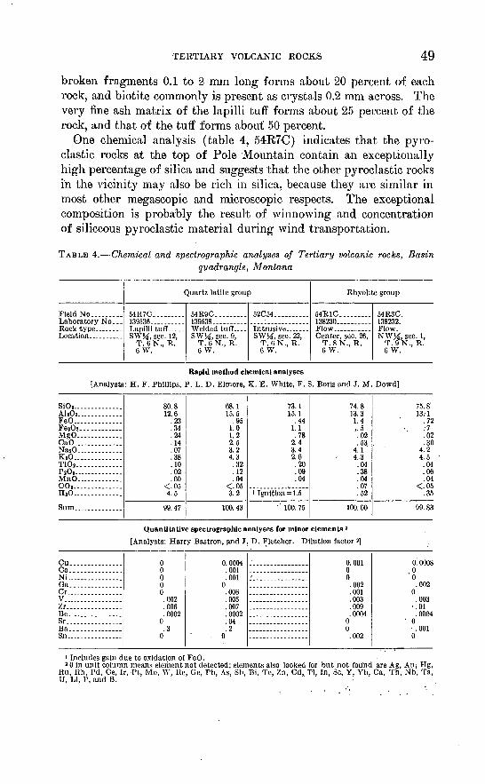
TERTIARY VOLCANIC ROCKS 49
broken fragments 0.1 to 2 mm long forms about 20 percent of each rock, and biotite commonly is present as crystals 0.2 mm across. The very fine ash matrix of the lapilli tuff forms about 25 percent of the rock, and that of the tuff forms about 50 percent.
One chemical analysis (table 4, 54R7C) indicates that the pyro- clastic rocks at the top of Pole Mountain contain an exceptionally high percentage of silica and suggests that the other pyroclastic rocks in the vicinity may also be rich in silica, because they are similar in most other megascopic and microscopic respects. The exceptional composition is probably the result of winnowing and concentration of siliceous pyroclastic material during wind transportation.
TABLE 4. Chemical and spectrographic analyses of Tertiary volcanic rocks, Basinquadrangle, Montana
Field No. ........Laboratory No...
Quartz latite group
54R7C. ........139536..........Lapilli tuff..... SWJi, sec. 12,
T. 6N., R. 6W.
54R9C. ........139538. .........Welded tuff.... SW>i, sec. 9,
T.6N., R. 6 W.
52C54. .........
SW]4, sec. 22, T.6N., R. 6 W.
Rhyolite group
54R1C. ........138230..........
Center, sec. 26, T. 8N., R. 6 W.
54R3C. 138232. Flow. NWM, sec. 1,
T. 9N., R. 6 W.
Rapid method chemical analyses
[Analysts: H. F. Phillips, P. L. D. Elrnore, K. E. White, F. S. Boris and 3. M. Dowd]
SiO z.... ..........Ah03 - - .FeO..............FejOa.... . ....MgO... ..........CaO...... ........NasO. ............KjO.... ..........TiOj.. ...........PsOo........ ......MnO. ............CO S .. ............HaO... ...........
80.812.6
.23
.34
.24
.14
.07
.38
.10
.02
.00<.054.5
99.47
68.115.5
.951.01.22.53.24.3.32.12.04
<.053.2
100. 43
73.115.1
.441.1.78
2.43.42.6.20.09.04
i Ignition =1.5
' 100. 75
74.813.31.4i.5.02.53,
4.14,3.04.38.04.07.52
100. 00
75. 8'13.1
.72:7.02.30
4.24.5.04.06.04
<.05.35
99.83
Quantitative spectrographic analyses for minor elements 2
[Analysts: Harry Bastron, and J. D. Fletcher. Dilution factor
Cu. ..............Co...............Ni ...............Ga. ..............Cr.... ............V..... .Zr.... ............Be................Sr.._. ..........Ba. ..............Sn...... ..........
00000
.002
.006
.00020.3
0
0.0004.001.001
0.006.005.007.0002.04.2
0
,
0.00100.002.001.003.009.0004
00.002
0. 000800.002
0.003
' .01.0004' 0
.0010
1 includes gain due to oxidation of FeO.2 0 in unit column means element not detected; elements also looked for but not found are Ag, Au; I-Ig,
Ru, Rh, Pd, Ce, Ir, Pt, Mo, W, Re, Oe, Pb, As, Sb, Bi, Te, Zn, Cd, Tl, In, Sc, Y, Yb, Ca, Th, Nb, Ta, U, Li, P, and B.

50 GEOLOGY OF THE BASIN QUADRANGLE, MONTANA
WELDED TUFF
The welded tuff is medium light gray to very light gray and con tains abundant crystals of plagioclase and quartz and less abundant crystals of biotite and hornblende in a very fine grained matrix. In some places the welded tuff is pseudovesicular where flattened pumice fragments 1 to 2 cm long have weathered out and left ovoidal cavities. Thin pyroclastic breccia zones are common along the contact of the welded tuff and the underlying volcanic sandstone. The welded tuff is composed of about 25 percent plagioclase, 25 percent quartz, 10 percent biotite, and 40 percent matrix and pumice fragments. An- desine (An30-3 5) occurs as euhedral to subhedral zoned crystals about 2 mm across and as irregular, broken fragments 0.5 to 1 mm across. Quartz forms anhedral grains 0.1 to 4 mm across, and rounded crystals1 mm across. Biotite occurs as euhedral to subhedral crystals 0.1 to 1 mm across. The matrix of the rock and the pumice fragments contain abundant glass shards, which are crumpled and draped over the crystals, and abundant cryptocrystalline volcanic ash. A chemical analysis (table 4, 54R9C) of the rock indicates it is quartz latite.
FLOW BOCKSThe flow rocks preserved in erosional remnants in the northern part
of the Basin quadrangle are dark-colored fine-grained porphyries distinctly different from the quartz latitic rocks farther south and from the overlying rhyolitic flow rocks. The flow rock preserved beneath the rhyolite east of Ruby Creek is a medium-dark-gray to dark-gray hornblende-sanidine porphyry. The hornblende crystals
form 5 to 10 percent of the rock, range from less than 0.5 mm to about2 mm long, and typically are oriented paralled to flow structures in the rock. Sanidine is the only feldspar in phenocrysts, although plagioclase (An35 ?) is abundant as minute flow-oriented crystals in the very fine grained groundrrxass that forms the major part of the rock. The glassy sanidine crystals typically are chipped and broken, and are as much as 4 or 5 mm in maximum dimension; they form about 10 to 15 percent of the rock. The lower part of this flow contains abundant sand and larger fragments derived from the un derlying quartz monzonite.
Northeast of Cliff Mountain, the quartz latite flow rocks are gray ish red purple to medium gray, very fine grained or aphanitic, and thinly flow laminated. They contain abundant sand and sparse smallrock fragments derived from earlier rocks. As a rule these flows rocks contain only a small percentage of phenocrysts, typically plagioclase in chipped crystals 1 to 2 mm long weathered to clay. The map unit of quartz latite flow rocks in this vicinity includes a number of similar

TERTIARY VOLCANIC ROCKS 51
thin flows separated by breccia beds 2 to 3 feet thick and by thin layers of thinly flow-laminated volcanic glass.
INTRUSIVE ROCKS
Three distinctive types of quartz latitic intrusive rocks have been recognized in the Basin quadrangle; these are clastic dike rocks and light- and medium-gray porphyritic rocks in dikes and small plutons. The clastic dikes are most common in the vicinity of the lower canyon of Basin Creek, but also crop out in the vicinity of the Red Rock mine (pi. 1, no. 50), in the lower canyon of Red Rock Creek, and at the top of Fox Mountain and of Iron Mountain. The rock in these dikes is fine grained and pale red to light brownish gray. It is composed of chipped and broken or rounded crystals and crystal fragments, as much as 2 or 3 mm in diameter, of plagioclase, largely converted to an unidentified clay mineral, and of glassy quartz, in a very fine grained matrix that appears to consist largely of devitrified glass and granulated quartz and alkalic feldspar. The clastic dike rocks typi cally contain a small number of rounded rock fragments that are 1 to 2 cm long and are similar to the tuffs and lapilli tuffs that cap Pole Mountain. Barite encrustations on fissure walls are commonly as sociated with the clastic dikes.
All the clastic dikes except those southeast of Lily-of-the-West Gulch and at the Boulder (pi. 1, no. 49) and Katie Extension (pi. 1, no. 54) mines intrude preexisting northeast- or north-trending elon gate, coarse breccia pipes (see p. 73) in Cretaceous volcanic rocks and batholithic rocks. Before the clastic dikes were intruded, the Cretaceous volcanic rocks and batholithic rocks in the early breccia pipes had been extensively hydrothermally altered, and the pipes had been silicified and veined with several generations of cryptocrystalline silica and locally cut by veins of hematite, for the dike rocks are not silicified or mineralized and the argillic alteration of the plagio clase in the clastic dike rocks is mostly probably deuteric. The clastic dike at the Boulder mine (pi. 1, no. 49) on Pole Mountain splits a preexisting sulfide-bearing quartz vein. Intrusion of the dike has brecciated the vein locally but otherwise has not affected the sulfide minerals in the quartz. Similarly, where the clastic dike cutting the northern segment of.the Hope-Katie vein (pi. 1, no. 54) has been seen underground, it has brecciated the earlier vein matter. The clastic dikes southeast of Lily-of-the-West Gulch are alined parallel to northeast-trending lineaments, but do not intrude preexisting brec cia pipes in the older rocks. The intrusion of these clastic dikes, as of all the others in the quadrangle, was not accompanied by any altera tion of the enclosing rocks. The clastic dikes therefore appear to have intruded earlier formed elongate breccia pipes and zones of struc-

52 GEOLOGY OF THE BASIN QUADRANGLE, MONTANA
tural weakness, most of which parallel the northeast-trending line aments, and to have had no effect on the intruded pipes, veins, or older rock other than local, minor brecciation.
The clastic dikes cut Cretaceous volcanic rocks and batholithic rocks, and their eroded edges are overlain by other qua.rtz latitic volcanic rocks near the Boulder mine (pi. 1, no. 49) and south of the Red Rock mine (pi. 1, no. 50).. Field relations thus indicate that the clastic dikes are earlier than other quartz latites in the Basin quad rangle, although they are similar in composition to other quartz latites and probably are related in origin. The method of emplacement of the clastic dikes is not known with certainty; they may represent fissures from which ash flows and pyroclastic material were explosive ly erupted or through which vesiculating lavas were erupted (Curtis, 1954, p. 469-470) early in the period of quartz latite volcanism.
The intrusive rocks south of Basin and south of Iron Mountain are light-gray very fine grained porphyries that contain about 20 to 25 percent quartz, commonly in bipyramidal crystals 1 mm long, 20 to 25 percent plagioclase An 3n_35 ) in euhedral to subhedral crystals from less than 0.5 mm to 1 mm long, and 5 to 10 percent biotite in crystals less than 1 mm long, in a groundmass that is cryptocrystalline and probably is largely devitrified glass. Euhedral crystals of sanidine are locally abundant in this rock; a few are as much as 4 cm long but most are 3 to 4 mm long.
The dikes that intrude batholithic rocks on the east flank of Pole Mountain differ from the other related intrusive rocks. These dikes are composed of medium-light-gray to medium-gray very fine grained quartz latite porphyry. The abundant phenocrysts are plagioclase, quartz, and biotite. Plagioclase (An 3o- 35 ) phenocrysts from 25 per cent of the rock and range from 0.7 to 6 mm long, although most are 1 to 2 mm long. The andesine forms euhedral to subhedral crys tals that are commonly zoned. Quartz forms 10 to 15 percent of the rock and occurs as rounded crystals and embayed grains from 1 to 2 mm long. Biotite forms about 10 percent of the rock and is dissem inated through the rock as euhedral to subhedral crystals 0.5 to 1 mm long. The cryptocrystalline groundmass forms about 50 percent of the rock and is probably devitrified glass.
RHYOMTE
The rhyolitic rocks in the Basin quadrangle are principally lava flows, including massive and thinly laminated varieties, flow breccias, and basal glasses. Tuff and lapilli tuff, welded tuff, and related intru sive rocks are less abundant. The rhyolite differs from one area of outcrop to another, and as a result its stratigraphy is not well known.
The rhyolite rests with angular unconformity on Elkhorn Moun-

TERTIARY VOLCANIC ROCKS 53
tains volcanics and batholithic rocks, and at least locally with slight angular unconformity on Lowland Creek volcanics. On Luttrell Peak, lapilli tuff and tuff are at the base of the unit, and north and east of the Blackfoot Meadows and in the vicinity of the Armstrong mine (pi. 1, no. 3) welded tuff forms the base. Elsewhere in the map area, the basal rocks are flow rocks.
The rhyolite flow rocks are light colored and very fine grained, and some of them are spherulitic, lithophysa.1, or both. The flow rocks are finely laminated to massive, and some are columnar jointed. In the few places where the bottoms of the flows are exposed, they are glassy. As a rule, the glass grades in a short distance laterally into a basal breccia, which is composed of angular fragments of ryholite typically 2 to 3 inches in diameter, and angular to well-rounded fragments of earlier rocks, ranging from sand size to boulders 8 to 10 inches in diameter, in a very fine grained matrix. The basal glass or breccia grades upward into the main mass of the flow rock and typically is only a few feet thick, although it may be as much as 20 feet thick. Individual boulders of quartz monzonite are found 30 or 40 feet above the bases of flows in a few places. The boulders are well rounded and deeply weathered; they appear to have been picked up from the prerhyolite erosion surface and churned into the flows. In the vicinity of the Josephine mine (pi. 1, no. 24), and in a few small areas farther south and west, the flow rocks are coarse, porous breccias that probably are flow fronts or tops.
Although the flow rocks are generally similar in texture and min eralogy, they differ in color and structure from one area of outcrop to another. Poor exposures made it impractical to map the different varieties of flow rocks separately, so that the relations between the varieties are not known with certainty. The different varieties prob ably represent individual flows for the most part, but in some places they may represent local variations in a single flow.
Rhyolite similar to that in the flows forms dikes that are character ized by vertical sheeting showing consistent trends in individual dikes. Typically the dikes are too thin and too short to map at the present scale. The dikes are locally common cutting the rhyolitic extrusive rocks, but they are virtually absent in areas underlain by other rocks. They are most abundant in the vicinity of the Porphyry Dike mine (pi. 1, no. 11), and in the vicinity of the South Fork of Basin Creek.
A number of lines of evidence suggest that the rhyolites were erupted from local, dikelike feeders. These lines of evidence include: the absence of rhyolite dikes away from the area of rhyolite outcrop; the presence of rhyolite dikes cutting the rhyolitic extrusive rocks: the limited distribution of individual types of rhyolite; the presence

54 GEOLOGY OF THE BASIN QUADRANGLE,. MONTANA
of breccias interpreted as flow fronts or tops; and the occurrence of lithophysal rocks that indicate a highly gas-charged lava. The rocks probably were more extensive originally than at the present time, but erosion has removed them from areas other than those of maximum accumulation near the vents. The thickest section of rhyolitic flows now exposed is on Lee Mountain, where they appear to be about 800 to 1,000 feet thick. Elsewhere in the quadrangle, the rhyolitic rocks are now generally less than 500 feet thick; in much of the central part of the quadrangle they are now probably less than 100 feet thick.
PETROGRAPHY
FLOW ROCKS
The widespread rhyolitic flow rocks are similar in that all contain phenocrysts of clear and smoky quartz and of sanidine in a very fine grained (0.01 to 0.05 mm typical grain size) groundmass composed of glass, quartz, and alkalic feldspar. The quartz phenocrysts typi cally are about 0.5 to 3 mm long, euhedral, and bipyramidal; the crystals rarely are as much, as 6 mm long. In some of the rocks the quartz forms rounded crystals or anhedral grains. Sanidine pheno crysts are typically about the same size as the associated quartz pheno crysts and are either euhedral or chipped and broken subhedral crystals. Plagioclase (An20-25) is widespread, but sparse, typically forming euhedral to subhedral crystals less than 1 mm long, although in the flow in the vicinity of Joe Bowers Creek and Weasel Gulch they are as much as 6 mm long. Biotite, as euhedral to subhedral crystals 0.1 mm or less in diameter, and minute needles of hornblende commonly comprise a few percent of the flow rocks. The hornblende crystals are generally oriented parallel to the flow banding. Phenocrysts typically form about 10 percent of the flow rocks, but in the flow rocks in the vicinity of Joe Bowers Creek and Weasel Gulch, phenocrysts form 40 to 50 percent of the rock.
The flow rocks are rather similar from place to place throughout their outcrop area. In color, the rocks are light gray, medium light gray, grayish pink to grayish red, or pale pink to pale red purple; the gray rocks as a rule are faintly purple. Most of the rocks are flow- laminated, some very thinly and evenly, and locally the laminae have been severely contorted by flowage. Spherulites and lithophysae are locally abundant in these rocks, especially in the vicinity of Old Baldy Mountain and of the Josephine mine (pi. 1, no. 24), and they range in diameter from about 1 mm to as much as 20 cm (fig. 6), although the most common range is from a few millimeters to. 6 cm. Chemical analyses (table 4) support the conclusion that the flow rocks are rhyolite.

TERTIARY VOLCANIC ROCKS 55
FIGURE 6. Large spherulite in rhyolite flow rocks east of the Josephine mine in NWHsec. 25, T. 8 N., R. 6 W.
The rhyolitic flow rocks are characterized by platy jointing or part ing parallel to the flow laminae, and many of the rocks show columnar jointing at least locally. The columns generally range from 0.5 to 2.5 feet in diameter, although columns 3 to 5 feet in diameter are common west of the Solar mine (pi. 1, no. 23). The flow laminae do not bear any consistent angular relation to the columns. The platiness facili tates mechanical destruction of the columns, so that the rock waste consists mainly of plates and not of columns.
FLOW BRECCIA
The rhyolite flow breccias are coarse breccias composed of angular to subangular fragments a few millimeters to 10 cm long of thinly flow banded rhyolite. The space between breccia fragments is com monly partly open, and the walls of some voids are lined with pale red to pale reddish brown layered chalcedony in botryoidal encrusta tions 8 mm to 2 cm thick.
Such breccias are rather common in the rhyolitic flow rocks in the map area, but few of them are well enough exposed or sufficiently wide spread to justify mapping. They are thought to represent the tops or fronts of individual flows.

56 GEOLOGY OF THE BASIN QUADRANGLE, MONTANA
BASAL GLASSES
The basal, glassy parts of the rhyolitic flows range in color from light olive gray to medium light gray to grayish and brownish black; the dark colors are most common. Most of the glasses are spherulitic rhyolite pitchstone, but some, especially those from the vicinity of the Blackfoot Meadows and the vicinity of the Solar and Josephine mines (pi. 1, nos. 23, 24), are intricately flow-laminated perlitic rhyolite obsidian.
Most of the rhyolitic glasses contain few or no phenocrysts, but rhyolitic obsidian vitrophyre is locally present west of the Basin quadrangle, and Robertson (p. 72-Y4) n indicates that obsidian vitrophyre commonly is at the base of the sequence of rhyolitic rocks in the southern part of the Elliston mining district. The phenocrysts in the vitrophyres are predominantly sanidine, commonly accom panied by a small amount of quartz. The phenocrysts are typically deeply corroded.
Robertson (p. 72) 12 considered that all the rhyolitic glasses and associated fine-grained rhyolitic rocks in the Elliston district are welded tuffs, but similar glasses and related rocks elsewhere in the Basin quadrangle exhibit none of the characteristic features of welded tuffs and almost certainly are lava flows.
WELDED TUFF
Unquestionable rhyolitic welded tuff crops out in only three known localities in the Basin quadrangle exclusive of that part of the quad rangle mapped by Robertson. These are in the vicinity of the Arm strong mine (pi. 1, no. 3), north of the Blackfoot Meadows, and east of the Blackfoot Meadows. At each of these localities the welded tuff is at the base of the rhyolitic rocks. The glass-rich welded tuffs con tain 10 to 30 percent subangular to subrounded accidental and acces sory lithic fragments as much as 6 inches in diameter around which the flattened, glassy fragments and shards have been crumpled and draped. The rocks appear to be strongly welded through their entire thickness. The Avelded tuff in the vicinity of the Blackfoot Meadows is moderate red or grayish red to light brown, contains about 5 to 10 percent smoky quartz in bipyramiclal crystals and crystal fragments 1 to 2 mm long and a few percent sanidine in broken crystals 1 to 3 mm long, and is characterized by abundant completely flattened, crenu- lated pumiceous fragments and glass shards typically no more than 1 mm thick and 1 cm long. Where it is exposed, this welded tuff ranges from about 50 feet to 300 feet in thickness. Near the Arm strong mine (pi. 1, no. 3) the brownish-black welded tuff is about
11 See footnote 2, p. 512 See footnote 2, p. 5.

TERTIARY VOLCANIC ROCKS 57
100 to 150 feet thick, contains sparse, broken crystals of quartz and sanidine 1 to 3 mm long, and is characterized by flattened and crenu- lated glass shards that are about 0.5 mm thick but only a few milli meters long and by abundant larger (1 to 4 cm) glass fragments that are only moderately flattened.
The ash flows that formed the welded tuffs near the Armstrong mine and east of the Blacltfoot Meadows appear to have flowed down and partly filled prerhyolite valleys (pi. 4). The similarity of the rhyolitic welded tuffs north of the Blackfoot Meadows to those east of the Meadows suggests that they may have been deposited by the same ash flow where it lapped out of the valley.
LAPILLI TUFF AND TUFF
In the vicinity of the headwaters of Monitor Creek and of the di vide between Monitor and Basin Creeks, the rhyolitic rocks are mainly lapilli tuff and small amounts of tuff. These rocks are white, light gray, or various light shades of yellow, brown, and red, and all con tain a small but conspicuous amount of smoky and clear glassy quartz as angular to subangular fragments 1 to 5 mm long. The lapilli tuff contains abundant angular to subangular. rhyolite lapilli commonly 5 mm to 1 cm in diameter and rare blocks as much as 8 cm in diameter. The tuff matrix is similar to the bedded and massive tuffs in this vicinity and the few tuffaceous deposits elsewhere in that it is very fine grained and is probably largely glass in the form of ash.
INTRUSIVE ROCKS
Although few rhyolitic intrusive rocks were mapped in the course of this study, such rocks are locally common as thin dikes cutting the rhyolitic extrusive rocks. The dikes are most abundant in the vicinity of the Porphyry Dike mine (pi. 1, no. 11) and of the South Fork of Basin Creek. The intrusive rocks closely resemble the flow rhyo- lites in mineralogy and texture but generally contain no apparent glass and are not spherulitic or lithophysal. The sanidine phenocrysts locally are as much as 1 cm long. The rocks may be either laminated or massive, and without known exception they are cut by nearly verti cal sheeting parallel to the. walls of the dike. The similarity and close spatial association of the dike rocks and extrusive rocks suggest that the dikes represent fissures that fed the extrusive lava flows.
TERTIARY PREVOLCANISM SURFACES
The configuration of the surface onto which the quartz latite was erupted (pi. 3) is not well known, partly because of the limited ex posures of the surface in the map area and farther south, where ero sion has not yet breached the quartz latite blanket to expose the earlier

58 GEOLOGY OF THE BASIN QUADRANGLE, MONTANA
surface, and partly because of the uncertainty that exists regarding the original extent of the quartz latite. The present distribution of the quartz latite along the Boulder River and farther south suggests that a valley extended southward from the vicinity of the present mouth of Red Rock Creek to the vicinity of Butte, and that this valley was bounded by a mature, moderately mountainous terrain ancestral to the present mountains between Pole Mountain and Thunderbolt Mountain. The maximum relief may have been as much as 3,000 feet. The surface cannot be reconstructed in the northern two-thirds of the Basin quadrangle, where only two isolated remnants of quartz latite are known to be preserved; the remnant east of Cliff Mountain apparently originally filled a northwest-trending stream valley, and the remnant east of Ruby Creek apparently rests on a highland area of low relief.
The prerhyolite erosion surface (pi. 4) is exposed or nearly exposed over much of the central and northern part of the Basin quadrangle, and was a surface of low relief above which-a few rounded hills rose perhaps 500 to 1,000 feet. The surface appears to have been uplifted shortly before eruption of the rhyolite, for the rhyolite fills sharp north- and northwest-trending canyons cut in Cretaceous volcanic rocks and batholithic rocks. The stream valleys cut in the prerhyolite surface were reoccupied as the rhyolite was removed by erosion, and most of the present-day streams flow in exhumed channels partly established before eruption of the rhyolite. The surface that the rhyolite covered was deeply weathered; locally a saprolite at least 20 feet thick was developed on the batholithic rocks. The saprolite is particularly well preserved beneath the rhyolite in the vicinity of the Golden Glow mine (pi. 1, no. 15). The maximum depth of pre rhyolite weathering is not known with certainty, but probably it was about 100 feet in most of the batholithic rocks. Contemporaneous oxidation and secondary enrichment of sufide-bearing quartz veins occurred to depths of about 200 feet.
AGE RELATIONS OF QUARTZ LATITE AND RHYOLITE
In the Basin quadrangle the age of the volcanic rocks younger than the batholithic rocks is uncertain, as no fossils have been found in these rocks there. Weed (1912, p. 29^tT), in discussing Tertiary volcanic rocks near Butte, stated that the quartz latite (dacite of Weed) was of the same age as rhyolitic lake beds west of Butte that contain late Miocene vertebrate fossils, but M. K. Klepper (oral com munication, 1955), on the basis of recent field studies, considered it more likely that the rhyolitic lake beds were deposited on an erosion surface cut on the quartz latite. Volcanic sedimentary rocks of early and middle Oligocene age in the Townsend Valley (Freeman, Ruppel,

TERTIARY VOLCANIC ROCKS 59
and Klepper, 1958, p. 508-510) farther east indicate a period of vol- canism during that epoch. H. W. Smedes (1962) indicates that the Lowland Creek volcanics, which includes the quartz latitic rocks in the Basin quadrangle, is late Oligocene in age.
In the Basin quadrangle, rhyolite overlies the. quartz latite east of Cliff Mountain and east of Ruby Creek. West of the quadrangle, the rocks are in contact with each other in the vicinity of Champion Pass and Caribou Mountain (Ruppel, 1961). East of Cliff Mountain, the quartz latite and rhyolite are separated by a deposit (Tsb),- possibly as much as 500 feet thick, of dark greenish gray poorly sorted fine grained breccia and coarse-grained sandstone composed of fragments of Elkhorn Mountains volcanics and Lowland Creek volcanics. The angularity of the fragments, and the poor sorting of these rocks sug gest they represent rapidly deposited debris derived from a nearby higher area; the abundance of "oatmeal" basalt fragments suggests that the source area was Thunderbolt Mountain, where such rocks are relatively widespread.
East of Ruby Creek, thinly flow-laminated rhyolite overlies locally preserved erosional remnants of hornblende quartz latite. Elsewhere in the quadrangle the rhyolite rests on deeply weathered quartz mon- zonite or Cretaceous volcanic rocks.
At the Champion Pass locality west of the quadrangle (Ruppel, 1961), thinly flow-laminated rhyolite, glassy at its base, overlies bedded quartz latitic tuffaceous sandstone with apparent conformity. The conformity may be more apparent than real, however, for the sandstone consists of erosional detritus derived from quartz latite and so may be younger than the quartz latite period of volcanism. At the Caribou Mountain locality (Ruppel, 1961), the map distribution of rhyolite and quartz latite indicates that thinly flow-laminated rhyolite rests with slight angular unconformity on quartz latitic flow rocks. This evidence from four widely separated localities indicates that the rhyolite overlies the quartz latite with erosional and locally angular unconformity.
The consistent relation of rhyolite overlying quartz latite indicates that the rhyolite is younger than the quartz latite, but the evidence is insufficient to establish clearly the magnitude of the time interval be tween the episodes of volcanism. There appear to be two alternatives. The rhyolite may have been erupted during the latter part of the quartz latite period of volcanism, and so may be of essentially the same age (Oligocene), or the interval between quartz latite and rhyolite erup tions may have been rather long, and the rhyolite may be contempo raneous with the late Miocene-Pliocene sedimentary tuffs in the Town- send Valley (Freeman, Ruppel, and Klepper, 1958, p. 51) and the late
678765 O 63 5

60 GEOLOGY OF THE BASIN QUADRANGLE, MONTANA
Miocene rhyolitic lake beds near Butte described by Weed (1912, p. 29-47).
I believe the rhyolite is of late Miocene (?) -early Pliocene (?) age, and thus appreciably younger than the quartz latite. The rhyolite in the Basin quadrangle rests in most places on Elkhorn Mountains vol- canics and batholithic rocks, but the presence of postbatholithic quartz latite beneath the rhyolite at the two localities in the northern part of the quadrangle suggests that the quartz latite originally may have exended over much of the quadrangle and been largely removed by erosion before eruption of the rhyolite; such extensive erosion ap pears to be incompatible with eruption of both rock types during one rather short period of volcanism. Second, the angular unconformity between quartz latite and rhyolite exposed on Caribou Mountain, west of the Basin quadrangle, indicates at least local deformation between the period of quartz latite eruption and the period of rhyolite erup tion, and suggests an interval during which the quartz latitic rocks were locally deformed and bevealed by erosion before eruption of the rhyolitic rocks. The deformation and beveling of the quartz latite on Caribou Mountain most probably were contemporaneous with the up lift and erosion of the pre-rhyolite surface that preceded the eruption of the rhyolite in the Basin quadrangle.
SURFICIAL GEOLOGY
A large part of the Basin quadrangle is covered by surficial de posits, including glacial drift and subordinate amounts of stream al luvium and of deposits formed by mass-wasting processes.
The surficial deposits are shown on plate 1 and are very briefly described in the following section. A brief account of the glacial geology of the quadrangle and of adjacent parts of the Boulder Moun tains is presented elsewhere (Kuppel, 1962).
GRAVEL. VENEERING STRATH TERRACES
Scattered deposits of gravel and subordinate finer grained sedi ments along Boulder River mantle strath terraces and adjacent slopes. The fragments in the gravel are subangular to subrounded, range in diameter from less than 1 inch to about 2.5 feet, 2 to 8 inches being a common size, and are composed almost wholly of Elkhorn Mountains volcanics, principally welded tuff and associated intrusive rocks from the western part of the quadrangle. Most of the deposits contain some material from adjacent slopes. The gravel deposits rest in part on paired surfaces cut on bedrock, remnants of former straths cut by the Boulder River at altitudes (plus or minus about 50 feet) of about 100 feet, 250 feet, 450 feet, and 700 feet above the present valley bottom, The 700-foot strath, where well-preserved on the high, flat surfaces

SURFICIAL GEOLOGY 61
west and south of the mouth of Eed Rock Creek, was 2 to 3 miles wide. The 450-foot strath, not well preserved, was about 1 to 2 miles wide southeast of Fox Mountain, where the ancestral Red Rock Creek ap parently emptied into the Boulder River across the low divide south east of the mountain. The best preserved remnants of the 250-foot strath are west of the mouth of Torpy Gulch (the uppermost terrace of Knopf, 1913, p. 13). The terrace is also represented by flat-topped ridges along the Boulder River west of Red Rock Creek where it had a maximum width of about 1 mile. Other remnants are present near Basin. The lowest strath is poorly preserved and commonly is buried by glacial drift.
These strath terraces indicate repeated changes in the regimen of the river. The rather uniform 150- to 250-foot difference in altitude between each strath and their slightly greater altitudes above the present Boulder River in the vicinity of Basin than farther west sug gest that the several terraces may have been formed as a result of recurrent differential uplight. Becraft (oral communication 1954), has suggested that the Boulder Mountains have been arched along a north-trending axis lying east of Basin.
The strath terraces were formed in post-Oligocene-pre-late Pleisto cene (?) time, and most probably in Pliocene and early Pleistocene time. The terraces, some of which are cut on Lowland Creek volcanics, are clearly preglacial (older than late Pleistocene?), for glacial drift covers part of the lower strath. The late Miocene (?)-early Plio- cene(?) rhyolitic rocks do not crop out in the southern part of the quadrangle. Boulder River is superposed from an erosion surface cut on the blanket of Lowland Creek volcanics (Oligocene). The river probably flowed eastward on the southern extension of the prerhyolite surface; the initial incision may have taken place before the eruption of the rhyolite when farther north in the Basin quadrangle canyons were incised in Cretaceous volcanic rocks and batholithic rocks.
GI^ACIAL, DEPOSITS
Glacial deposits in the Basin quadrangle include till, outwash, and lake sediments, weathered to depths of at least 6 feet, possibly as much as 10 feet, but exposures more than 6 feet deep are very scarce. The deposits are believed to be early Wisconsin in age, equivalent to the second or "Early" period of glaciation in the Elkhorn Mountains (Klepper, Weeks, and Ruppel, 1957), and to the Bull Lake stage in the Waterton area, Alberta (Horberg, 1954), and in the Wind River Mountains, Wyoming (Holmes and Moss, 1955). Till blankets valley walls and much of the broad flat region in the central part of the map area. Lateral moraines are conspicuous locally in the valleys of Tenmile Creek, Jack Creek, and Red Rock Creek, but are

62 GEOLOGY OF THE BASIN QUADRANGLE, MONTANA
inconspicuous or absent elsewhere. Medial moraines are present in a few places where separate ice streams merged, as at the junction of Monitor Creek and Tenmile Creek and at the junction of the north- and northeast-trending branches of Jack Creek. A prominent end moraine was deposited near the mouth of Red Rock Creek by the combined Red Rock Creek-Basin Creek ice streams. A second large end moraine at the mouth of Thunderbolt Creek was deposited by the combined ice streams from the valleys of Thunderbolt Creek and, west of the map area, Rock Creek. The till forms a broad, rather thin blanket whose assumed initial morainic topography has been smoothed and dissected. The forms of the deposits on some valley walls are the result of mass-wasting processes, although their com position clearly indicates that they are reworked till.
The till is composed primarily of material derived from the local bedrock, the most abundant being batholithic rocks, Elkhorn Moun tains volcanics, and, rarely, massive white quartz. Pebbles and larger fragments of Tertiary volcanic rocks are abundant in the till only near outcrops of these rocks. Fragments of volcanic rocks in the till are typically from 6 inches to 1 foot across, those of granitic rocks are from about 1 foot to 6 feet in diameter. In the valley of Basin Creek near Vacchiou Gulch and Clay Creek the till contains excep tionally large boulders derived from the coarsely jointed batholithic rocks on the west side of Jack Mountain, blocks 5 to 8 feet in maxi mum dimension are abundant, and larger blocks, one 35 feet long, are common. The fragments of batholithic rocks in the upper few feet of the till few exposures of the till were more than 5 feet deep typically are disintegrated to depths of 3 to 6 inches, and those ex posed on the surface commonly are surrounded by exfoliation shells and by sand produced by granular distintegration. Very few cob bles and pebbles of batholithic rocks are found in the till, apparently because they have been completely destroyed .by granular disinte gration.
Outwash deposits were mapped in a few valleys. In Boulder River valley, the outwash was derived mainly from the western part of' the map area, and, like that along Red Rock Creek, consists of poorly sorted cobbles and small boulders of Cretaceous volcanic rocks and sparse boulders of batholithic rocks. The outwash in the valleys of Basin Creek and the Little Blackfoot River, on the other hand, is bet ter sorted and finer grained, and contains more numerous sand and gravel lenses. Batholithic rocks are nearly absent in the Basin Creek outwash gravels, which consist almost wholly of pebbles, cobbles, and small boulders of Elkhorn Mountains volcanics and a small propor tion of massive quartz in a matrix of sand that was derived princi pally from the disintegrated quartz monzonite.

SURFICIAL GEOLOGY 63
Well-sorted, finely layered sands containing numerous small clusters of ice-rafted (?) pebbles are present northwest of Pole Mountain (not differentiated on pi. 1), and apparently were deposited in a pond behind a moraine dam during the waning phase of glaciation.
MASS-WASTING DEPOSITS
Deposits formed by mass-wasting and related processes occur throughout the Basin quadrangle. They are most conspicuous in the eastern half of the area where the till blanket on many relatively steep valley walls supplied abundant surficial debris in a topographic setting conducive to mass-wasting, and where volcanic and batholithic rocks are exposed to frost action. In contrast, most of the glacial deposits in the western half of the quadrangle mantle relatively flat areas, protecting the bedrock from frost action.
Most or all of the mass-wasting deposits are younger than the glacial drift. Three sets of protalus ramparts suggest three periods of intensified frost action since glaciation, the oldest perhaps formed during the late Wisconsin when alpine glaciers existed in the Elkhorn Mountains (Klepper, Weeks, and Ruppel, 1957). The creep-and-soli- fluction deposits and perhaps the debris slides on Fox and Old Baldy Mountains may have developed during this same cool interval. The intermediate set of protalus ramparts resemble the cirque moraines that represent the latest period of glaciation in the Elkhorn Moun tains.
CREEP-AND-SOLIFLUCTION DEPOSITS
These deposits are the most widespread of the surficial materials resulting from mass-wasting, and commonly have irregular, hum- mocky, and swampy surfaces covered with dense vegetation. Most of the deposits were derived from till and are composed of similar ma terial. On the north and west slopes of Pole Mountain a large grass- covered sheet of debris is composed of soft, distintegrated rock from the underlying volcanic sandstone and of abundant small angular fragments derived from the tuff and lapilli tuff that cap Pole Moun tain.
Stone-banked terraces similar to but somewhat larger than those described by Antevs (1932, p. 61-64) occur in association with the creep-and-solifluction deposits, especially in the vicinity of Tenmile Creek and Basin Creek. The terraces, covered by moderately dense vegetation and invariably paralleling the slope, range in size from a few feet wide, less than a hundred feet long, and less than 5 feet high, to as much as 400 feet wide, about one-half mile long, and 50 feet high in the exceptional terraces at the south end of Lee Mountain. The terraces and associated deposits appear to be stable at present and

64 GEOLOGY OF THE BASIN QUADRANGLE, MONTANA
to be the result of an episode of vigorous frost action in postglacial time.
PROTALUS RAMPART AND ROCK STREAM DEPOSITS
Accumulations of rock waste in the form of protalus ramparts, rock streams, and block fields are common in areas of rhyolite out crop, especially in the northeastern part of the quadrangle. Block fields and, locally, taluses are also associated with other volcanic rocks. Mantles or sheets of boulders of disintegration occur in some areas of quartz monzonite. The taluses and rock streams associated with the protalus ramparts are so small that it was impractical to map them separately.
Protalus ramparts are most widespread on the flanks of Luttrell Peak, but many smaller ramparts, not mapped separately, occur in the eastern part of the quadrangle; few are found farther west. The ramparts have formed only where the cliff headwall is composed of fine-grained, platy, and closely jointed rocks. Those on the east side of Luttrell Peak are in three distinct sets; an old, partly dissected set covered by thick soil and dense vegetation is the most extensive. An intermediate little-dissected set is covered by thin soil and sparse vegetation, and a young fresh-appearing set probably still receives debris during severe winters. The intermediate and youngest sets are also present on the north side of Luttrell Peak and on Lee Mountain, but elsewhere only the youngest set is to be found.
Small relatively broad rock streams, with flowage wrinkles and frontal slopes as steep as 40°, have formed at the toes of a number of protalus ramparts on Luttrell Peak, the most prominent being near the Monte Cristo mine. The rock streams contain only rocks from the cliffy outcrops immediately upslope and cover glacial deposits, outwash, and younger alluvium, as, for example, the rock stream in the valley of the Boulder River east of Bernice. The steep frontal slopes and the complete absence of vegetation suggest that movement has occurred in the comparatively recent past. The rock streams, there fore, are not related in any way to the earlier glaciers.
Extensive block fields or mantles of angular blocks and slabs are common on interstream divides that are capped by volcanic rocks, especially along the western margin of the quadrangle south of Cliff Mountain, between Thunderbolt Mountain and Bison Mountain, and in the northeastern part of the quadrangle. The block fields were not mapped.
Most of the quartz monzonite in areas that were not glaciated or where it has been exhumed from beneath the rhyolite since glacia- tion has weathered into rounded boulders of disintegration (Larsen, 1948, p. 114-119; Chapman and Greenfield, 1949) that mantle large
STRUCTURAL GEOLOGY 65
areas on Old Baldy Mountain, the Three Brothers, and southwest of Iron Mountain. Extensive mantles of such boulders form only on batholithic rocks cut by widely spaced joints. These areas are broken by a few ribs of bedrock, and all stages of disintegration can be seen ranging from only slightly rounded joint blocks in place to toppled, well-rounded boulders of disintegration. There are no indications of mass downslope movement. In relatively flat places, the boulders are widely spaced and partly buried by gruss.
TALUS DEPOSITS
Talus accumulations are common wherever volcanic rocks crop out, but few of them are large enough to be shown on the geologic map. All are bare, unstable accumulations of small unweathered angular fragments and are accumulating at the present time.
LANDSLIDE DEPOSITS
Several landslides were mapped. Those on the south slope of Old Baldy Mountain and on the east slope of Fox Mountain are deposits of rock waste that accumulated as taluses before sliding. These slides are relatively old; their surfaces are smoothed and rounded and covered with dense vegetation, although they are not appreciably dissected. In the valley of Red Rock Creek alluvium was deposited where the creek was dammed by the Fox Mountain slide, and the creek is now cutting a new channel in bedrock around the east margin of the slide.
On the east slope of Lee Mountain a mass of rhyolite apparently slipped from the prerhyolite surface into the valley of Tenmile Creek, at least partly as a result of glacial steepening of the canyon wall. This slide appears to be much younger than the other two, for it is an open rubble of angular rhyolite blocks that retains the fresh, hum- mocky appearance of a recent landslide and has no soil cover and no vegetal cover other than a few scattered trees. The slide may orig inally have dammed Tenmile Creek, which now flows approximately in its original course.
BOG AND SWAMP DEPOSITS
Accumulations of organic and mineral matter in bogs and swamps are a common feature in the upper parts of most of the major valleys in the Basin quadrangle. Only the largest deposits were mapped.
STRUCTURAL GEOLOGY
Structural features in the Basin quadrangle (pi. 5) include folds in the Elkhorn Mountains volcanics; joint sets cutting the Elkhorn Mountains volcanics and batholithic rocks; northwest- and northeast- trending lineaments, thought, to be structurally controlled, eroded

66 GEOLOGY OF THE BASIN QUADRANGLE, MONTANA
in Elkhorn Mountains volcanics and batholithic rocks; east-trending fault zones that cut the Elkhorn Mountains volcanics and batholithic rocks and that contain most of the metallic mineral deposits in the quadrangle; and other faults of different trends, some of which cut the Tertiary volcanic rocks and Quaternary glacial deposits as well as the older rocks. The folds in the Elkhorn Mountains volcanics are the earliest structural features in the quadrangle, and almost certainly were formed in Late Cretaceous time when folds of similar magni tude and trend were formed in the Elkhorn Mountains and Townsend Valley farther east (Klepper, Weeks, and Ruppel, 1957, p. 55-56; Freeman, Ruppel, and Klepper, 1958, p. 523). The joints include several steeply dipping sets and one gently dipping set. The joints in batholithic rocks probably are primary and must have formed be fore final consolidation of the batholithic magma, for the steep sets locally contain small aplite dikes and the flat set locally has been in-> truded by aplite sheets and by quartz monzonite. The joints in the Elkhorn Mountains volcanics include sets that parallel the most prominent sets in the batholithic rocks and are probably secondary joints related to the primary joints in the batholithic rocks, and sets of secondary joints apparently related to the folding in these volcanic rocks.
Faults and fault zones are common in the Basin quadrangle, but few of them are well known because of the relative homogeneity of the rocks they cut and because many of the faults are partly concealed by younger volcanic rocks or by surficial deposits. A few north- trending faults in the northwest part of the quadrangle appear to be the oldest faults in the quadrangle, for their movement occurred during the eruption of the Upper Cretaceous Elkhorn Mountains volcanics. The east-trending fault zones are also old, for they cut only batholithic and older rocks, and many of them have been min eralized by hydrothermal solutions related to the batholith. The northeast- and northwest-trending zones that control the lineaments probably formed at about the same time as the east-trending fault zones, for elongate breccia pipes and shears zones along and parallel "to the lineaments are also hydrothermal] y altered and silicified.
Many of the other faults in the quadrangle have had movement along them that was later than the movement on the east-trending fault zones, for they cut Tertiary volcanic rocks and, in a few places, Pleistocene glacial deposits. Other faults that are apparently young er than the east-trending set trend about northeast, about northwest, and about N. 20° E. The straight traces of most of the faults indi cate that they dip steeply, but two west-dipping low-angle thrust faults cut the sedimentary and volcanic rocks in the northwestern part of the quadrangle.

STRUCTURAL GEOLOGY . 67
The nature and direction of the forces that formed the structural features in the map area are not known with certainty, and the rela tively few and incompletely known structural features in the Basin quadrangle do not provide an adequate basis for general conclusion on the originating forces. The uniformity of structures throughout the quadrangle suggests that many of the structures formed in re sponse to regional stresses, and the similarity of structures in the quadrangle to many of the structures in adjacent and nearby areas strongly supports this conclusion. The trend of folds in the 'Basin quadrangle (N. 30°-35° E.) is about parallel to trends of folds in the Elkhorn Mountains and Townsend Valley farther east (Klepper, Weeks, and Ruppel, 1957, p. 55-56; Freeman, Ruppel, and Klepper, 1958, p. 523). Such folds would be formed by compressional forces directed about east-southeast-west-northwest, and many of the other structures in the quadrangle probably can be related to similarly di rected forces. The east-trending fault zones are tensional features that most probably also reflect such compression and the northeast- and northwest-trending weak zones that control the lineaments in the quadrangle and that are thought to be about contemporaneous with the east-trending fault zones occupy theoretical shear positions for east-west compression.
The younger faults in the quadrangle are not all clearly duplicated by similar faults in adjacent or nearby areas. Geomorphic evidence, discussed in other sections of this report, suggests some uplift since eruption of the Lowland Creek volcanics of Oligocene age, and pos sibly many or all of these younger faults reflect regional uplift rather than specifically directed compression.
The folds and some of the faults in the Basin quadrangle are ap proximately parallel to the N. 20° E.-trending long axi&of the Boulder batholith, as are the folds and some of the faults in the Elkhorn Moun tains (Klepper, Weeks, and Ruppel, 1957, p. 56) along the east'mar gin of the batholith and in other areas peripheral to the northern part of the batholith. The folds and some of the faults are clearly older than the batholith, however, and few of the younger structures appear to bear any particular relation to the batholith. The trend and elongate shape of the batholith at its present level of exposure pos sibly were controlled at least partly by structural weaknesses result ing from the compressive forces that caused the folding and early faulting. . -.:
FOLDING IN ELKHORN MOUNTAINS VOLCANICS
The Elkhorn Mountains volcanics in the Basin quadrangle are folded into a series of shallow'folds (pi. 5) that trend about N. 35° E.

68 GEOLOGY OF THE BASIN QUADRANGLE, MONTANA
The axial traces of the folds are only approximately located for the following reasons: (a) major pa.rts of some of the folds are con cealed beneath late Miocene (?) -early Pliocene (?) rhyolite that is much younger than the folding, or beneath Pleistocene glacial deposits; (b) the folds were, invaded by batholithic magma, and, although their structure is believed to be reflected in the arcuate outcrop bands of varieties of batholithic rocks, the volcanic roof rocks themselves have been largely destroyed by erosion as the batholith was unroofed; (c) the Elkhorn Mountains volcanics commonly are poorly exposed throughout the quadrangle, and the configuration of the folds is based mainly on the distribution of mapped units within the Elkhorn Moun tains volcanics.,
The configuration of the folds is only partly supported by the small number of attitudes measured at widely separated localties mainly in welded tuff. Although the gross aspect of attitudes in the welded tuffs suggests these major folds, individual attitudes in these rocks commonly appear to have little relation to the distribution of strat- igraphic units. The attitudes in some areas underlain by welded tuffs, most notably .in the vicinity of Jack Creek and the South Fork of Basin Creek, appear to be almost completely random despite the essentially simple structure indicated by the distribution of strati- graphic units. In some areas the attitudes in the welded tuffs pos sibly are erratic as a result of minor faulting and tilting of fault blocks. Most commonly, however, the erratic attitudes reflect flow- contorted layers in the rock, for, as discussed in the preceding section on the Elkhorn Mountains volcanics, some of these rocks flowed as viscous liquids during welding.
West of the map area, the Cretaceous volcanic rocks are similarly folded into shallow folds that trend about north to N. 20° E., and west of Cliff Mountain two small folds are cut by an east-trending fault (Euppel, 1961). The folds in and west of the Basin quadrangle probably were formed in Late Cretaceous time when folds of similar trend and magnitude were formed in the Cretaceous volcanic rocks in the Elkhorn Mountains and Townsend Valley farther east (Klepper, Weeks, and Ruppel, 1957, p. 55-56; Freeman, Euppel, and Klepper, 1958, p.523).
The distribution of varieties of batholithic rocks (pi."2) in the axial portions of the folds in the older volcanic rocks suggests that the folds played a dominant role in controlling the intrusion of magma.
JOINTS
The Elkhorn Mountains volcanics and the batholithic rocks in the
Basin quadrangle are cut by a number of joint sets, as is indicated

STRUCTURAL GEOLOGY 69
by the attitudes of the joints that are plotted on the structure map (pi. 5) and summarized on the equal area contour diagrams that ac company the map. As a rule, all the joint directions that could be measured in a single outcrop or group of closely spaced outcrops were recorded in the field, and every effort was made to avoid meas uring and recording the attitude of only the most prominent joints in a given outcrop. Joint measurements were taken on most out crops other than those where joint blocks could have been moved by frost-wedging or could have shifted as a result of other weathering processes. The distribution of joint measurements is reasonably uni form in the east half of the quadrangle, but rather spotty farther west, largely because much of the western part of the quadrangle is concealed beneath Tertiary rhyolite and glacial deposits. The atti tudes of the joints that were measured in the west half of the quad rangle are similar in trend to those farther east, however, and most probably the joint attitudes that have been plotted on the structure map and summarized on the equal-area contour diagrams are reason ably representative of the jointing in the rocks that underlie the quadrangle.
The equal area diagram (pi. 5) representing the joints in batholithic rocks summarizes the attitudes of nearly 500 joints and clearly indi cates three prominent joint sets and two less prominent sets. Three joint sets subparallel to the most prominent sets in the batholithic rocks are also reflected on the equal area diagram representing 85 joints measured in Elkhorn Mountains volcanics, but in these rocks the range of attitudes of the joints appears to be wider and the major concentrations of joints are not as well defined as on the diagram representing the joints cutting batholithic rocks. The Elkhorn Moun tains volcanics also are cut by two less prominent joint sets that are not apparent in the younger batholithic rocks.
The joint sets that cut the batholithic rocks include (a) two prom inent, steeply dipping sets, one that trends about east and dips steeply north and one that trends about north and most commonly dips steeply west; (b) a prominent east-trending set that most commonly dips gently south but in places dips gently north; and (c) two less prominent, nearly vertical sets that trend about N. 35° E. and N. 35° W. These joints are from a few inches to many feet apart. Generally, the finer grained batholithic rocks are more closely jointed than the coarser-grained batholithic rocks, and the east-trending steep joints are more widely spaced than the north-trending steep joints. In the medium-grained rocks that form the major part of the batholith in the Basin quadrangle, the north-trending steep joints typically are from about 1 to 5 feet apart and the east-trending steep joints are
70 GEOLOGY OF THE BASIN QUADRANGLE, MONTANA
from 5 to 10 feet apart. In the coarse-grained batholithic rocks in the vicinity of Jack Mountain, the north-trending steep joints are locally as much as 15 feet apart and the east-trending steep joints as much as 40 feet apart. The east-trending gently dipping joints are from 1 to 15 feet apart, and although the joints are commonly more widely spaced in coarser grained rocks, the spacing typically is less consistent than for the steep joints. Individual joints are rarely more than 30 feet long, but where one joint dies out it com monly is overlapped by a parallel joint that either is entirely separate and from less than an inch to several inches away, or that is connected by a linking transverse joint or joints. As a rule in the Basin quad rangle, the north-trending joints in the batholithic rocks are the most prominent and include the longest individual joints.
The feldspar crystals in the batholithic rocks adjacent to the north- trending steep joints are commonly broken by fractures less than 0.5 mm apart parallel to the joint over a thickness of 1 to 4 inches from the joint, although none of the other minerals in the rock appear to be similarly fractured. There is no apparent fracturing parallel to the other joint sets.
The steeply dipping joints in the batholithic rocks have been in truded by thin dikes of aplite in a few places in the quadrangle; the gently dipping joints have locally been intruded by thick sheets of aplite, and in the vicinity of Old Baldy Mountain varieties of quartz monzonite (md, mdb) are layered parallel to the gently dipping joints. Most, if not all, of the joints that cut the batholithic rocks must therefore be primary joints genetically related to the emplace ment and cooling history of the batholithic magma (Balk, 1948, p. 7, 30,35,39-40).
The physical characteristics of the joints in the batholithic rocks suggest that the nomenclature applied to primary fracture systems by Balk (1948, p. 27-42) can be applied to the primary joint systems in batholithic rocks in the Basin quadrangle. However, primary flow structures were not recognized in these batholithic rocks, and the relations between flow lines and joint systems required for strict application of Balk's terminology cannot be demonstrated. There fore, although the joint systems in batholithic rocks in the Basin quadrangle are classified below in accordance with the nomenclature used by Balk (1948, p. 27-42), the classification is purely interpretive, and is based on similarity of physical characteristics of the joints to those described by Balk rather than on relations to flow lines. The east-trending steeply dipping joints are similar to the cross joints or tension joints described by Balk (1948, p. 27-33), the north-trend ing steeply dipping joints are similar to longitudinal joints (Balk,
STRUCTURAL GEOLOGY 71
1948, p. 34-36), and the east-trending gently dipping joints appear to be primary flat-lying joints (Balk, 1948, p. 39-40). The small number of N. 35° E. and N. 35° W. trending nearly vertical joints occupy anomalous positions and cannot be classified in accordance with the terminology applied to the other points in the batholithic rocks. However, they occupy theoretical shear positions for north- south compression, and if the above interpretation of the other joints that cut the batholithic rocks is correct (also see p. 38), these seem ingly anomalous joints may be shearing joints developed in rocks that crystallized early in the intrusive episode as the magma of -later surges was injected from the main mass of batholithic magma farther south.
The joints that cut the Elkhorn Mountains volcanics include sets that are about parallel to the prominent east-trending steeply dipping, north-trending steeply dipping, and east-trending gently dipping sets in the batholithic rocks, and two nearly vertical sets, trending about N. 60° W. and N. 40° E., that apparently have no counterpart in the batholithic rocks. The joints in these volcanic rocks are typically only a few inches apart, and the lengths of individual joints could not be measured in such closely broken rock.
The age relations of the joints in the Elkhorn Mountains volcanics are less certain than those of joints in the batholithic rocks. The steeply dipping east- and north-trending joints have been intruded by thin dikes of aplite in a few places, and probably are secondary joints genetically related to the subparallel primary joints in the batholithic rocks. The east-trending, gently dipping joints in the volcanic rocks may be primary joints related to the depositional and cooling history of the rocks, or they may have been formed when the rocks were folded; there is no evidence that suggests that these joints are genetically related to the subparallel joints in the batholithic rocks, and the similarity of attitudes in the two joints sets may be a coin cidence induced by the subparallel layering in the batholithic rocks and roof rocks. The N. 60° W; and N. 40° E. trending nearly vertical joints sets in the Elkhorn Mountains volcanics are most probably secondary joints genetically related to the folding of these rocks, fof the N. 60° W. set is about normal to the trend of the fold axes, and the N. 40° E. set is about parallel to the trend of the fold axes.
Most of the joints in the Tertiary rocks are primary joints and partings resulting from flowage and cooling. Columnar joints from 0.5 to 5.0 feet in diameter cut the rhyolite flows throughout much of their outcrop area. The columnar jointing is commonly obscured by platy jointing that is parallel to flow laminae a situation that facilitates rapid mechanical destruction of the columns. The quartz

72 GEOLOGY OF THE BASIN QUADRANGLE, MONTANA
latitic welded tuff also is commonly cut by columnar joints, typically 1 to 4 feet in diameter, and by platy jointing parallel to the collapsed pumice fragments and glass shards.
LINEAMENTS, BRECCIA PIPES, AND SHEAR ZONES
In the southeast and northwest parts of the quadrangle (pis. 1, 5) the drainage patterns are strikingly rectilinear, and most of the val leys of major streams and of many tributaries trend either northeast or northwest. The rectilinear drainage pattern is apparent only where Elkhorn Mountains volcanics, batholithic' rocks, or Mesozoic sedimentary rocks crop out in the quadrangle, and is absent in thoseparts of the quadrangle where Tertiary volcanic rocks crop out. The lineaments formed by the valleys and alined swales and gulches in areas underlain by these older rocks are pronounced topographic features.
The bedrock in and adjacent to the lineaments is almost everywhere concealed by surficial deposits, and the reasons for such prominent zones of weakness are not completely known. Eobertson (p. 229) 13 considers that there has been faulting along N. 45° E.-trending zones that control much of the valley of the Little Blackfoot River north of Larabee Gulch, and a few of the lineaments elsewhere in the quad rangle at least locally are fault controlled. The field evidence is no more than suggestive, however, and for this reason no faults are shown in such areas on the geologic map (pi. 1). Lithologic units in the vicinity of most of the lineaments are not offset or cut off, and the limited exposures in the quadrangle, mainly in the rock steps in the valley of Basin Greek, a northwest-trending lineament, support tne conclusion that most of the lineaments are not fault controlled. The lineaments occupy theoretical shear positions for compression directed about east-west, and they may be controlled by zones of feather joints formed by shearing stresses under east-west compression.
The lineaments clearly were formed after the emplacement of the batholithic rocks, for they extend through these rocks without inter ruption. Northeast-trending elongate breccia pipes and northwest- trending shear zones occur along and parallel to the lineaments and are thought to have been localized in the structurally weak zones the lineaments reflect. The breccia pipes and the shear zones served as conduits for hydrothermal solutions and the breccia pipes were later intruded by quartz latitic dikes. The Tertiary volcanic rocks filled some of the lineaments and completely buried any lineaments in the central and northeast parts of the quadrangle, and the northeast trend of the outcrop belt of rhyolitic rocks (pi. 1) and of belts of small
18 See footnote 2, p. 5.

STRUCTURAL GEOLOGY 73
rhyolitic intrusive bodies within the main mass of rhyolite strongly suggests that the eruption of these rocks was controlled by northeast- trending structurally weak zones. The. zones of weakness therefore had been formed and the lineaments eroded by early Oligocene time when the quartz latite volcanics were erupted, and probably had been formed before or during the hydrothermal stage in the cooling of the batholith; most probably they were formed at the same time as the east-trending fault zones. The northeast- and northwest-trending faults, described in a following section of this report, that cut Quater nary surficial deposits in the northeast part of the quadrangle, may be similar zones of weakness along which there has been late move ment, but if so, they are much less conspicuous than the lineaments elsewhere in the quadrangle.
The breccia pipes in the southeastern part of the 'quadrangle are for the most part elongate to the northeast, and are a.lined in northeast- trending and, in the vicinity of Basin Creek, northwest-trending bands along or parallel to the lineaments. The northwest-trending shear zones south of Pole Mountain and south of the mouth of Thunderbolt Creek are hydrothermally altered and mineralized, and probably are related to the breccia pipes; and like the breccia pipes, they probably are related to the structurally weak zones that control the lineaments.
The breccia pipes are made up of closely packed angular to sub- angular fragments, typically not more than a few inches long, of bath- olithic rocks, including aplite, and Elkhorn Mountains volcanics, prin cipally of the upper welded tuff member of the welded tuff unit. The quartz monzonite fragments in the breccia have been converted to aplitelike rocks composed of very fine anhedral grains of potassium feldspar and quartz, and of sericite and clay minerals that are in part pseudomorphic after plagioclase. The original mafic minerals in the quartz monzonite fragments have been completely destroyed and prob ably are represented in part by disseminated pyrite and iron oxide, both of which are common in the breccia pipes. Despite such com plete replacement, the quartz monzonite fragments retain some vestiges of their original texture, at least in hand specimen, and hence can be distinguished from other aplitic rocks in the breccias. The fragments of aplite and of welded tuff that had earlier been thermally meta morphosed were composed originally of quartz, potassium, feldspar, and, in the welded tuff, sericite; these fragments apparently were stable in the replacing solutions, for they are essentially unchanged. The increase of hydrous minerals in the altered rocks and the pres ence of pyrite commonly disseminated throughout the breccia pipes suggests that at least sulfur and water were added during the altera tion process. The presence of igneous aplite in the breccias indicates

74 GEOLOGY OF THE BASIN QUADRANGLE, MONTANA
that the solutions formed after the aplite stage of crystallization, and they therefore may be partly contemporaneous with the early hydro- thermal solutions that altered the wallrocks adjacent to east-trending fault zones elsewhere in the quadrangle. Later hydrothermal solu tions must have been almost entirely siliceous, for the pipes are cut by abundant chalcedonic silica veins and veinlets, are largely cemented with chalcedonic silica, and contain fragments of brecciated chal cedonic veins. The brecciated chalcedonic silica fragments indicate that the breccia pipes were brecciated at least twice and perhaps sev eral times, for it is not known how many generations of chalcedonic silica are represented in the brecciated fragments. Many of the breccia pipes were later cut by small, north- to northeast-trending faults, some of which were in turn occupied by veins of massive, white quartz. One on Iron Mountain contains a vein 3 feet thick of massive siliceous hematite. The solutions that resulted in the hydrothermal alteration and quartz or siliceous hematite veins almost certainly were residual from the cooling batholithic magma.
The northwest-trending shear zones south of Pole Mountain and south of the mouth of Thunderbolt Creek are zones of crushed rock bounded by sharp, nearly vertical faults and typically cut by sev eral clearly defined nearly vertical faults in the central parts of the zones. Most of the rock fragments in the zones are only a few inches or less in diameter. The zones are flooded with limonite, at least part of which almost certainly has come from oxidation of hydrothermal pyrite^ and the rocks in the zones have been hydrothermally altered to clay minerals and sericite. The zones are silicified, but the chalce donic silica is less abundant in these zones than in the breccia pipes, possibly because the shear zones cut only Elkhorn Mountains vol- canics in the. roof of the batholith, and so were presumably farther from the source of hydrothermal solutions.
Lineaments in adjacent areas to the east and south of the map area most commonly trend about north or east and less commonly trend northeast, but, like the lineaments in the Basin quadrangle, the rea sons for the zones of weakness they reflect are not well known. Brec cia pipes and shear zones similar to those in the Basin quadrangle have not been recognized in these adjacent areas. As discussed in the preceding section on the emplacement of the batholithic rocks, the lineaments in the Basin quadrangle may reflect periodically reacti vated structures in basement rocks beneath a sill-like mass of quartz monzonite and related rocks, and the different trends of lineamentsin adjacent areas underlain by batholithic rocks may reflect the absence of underlying older rocks there. The few lineaments recog nized west of the Basin quadrangle trend north and most probably

STRUCTURAL GEOLOGY 75
are related to the north-trending normal faults that are common in the area between the west margin of the Basin quadrangle and the Deer Lodge Valley. The lineaments north of the quadrangle trend northwest and northeast.
FAULTS
An appreciable number of faults and fault zones cut the rocks and, at some places, surficial deposits in the Basin quadrangle (pis. 1, 5). Similarities in trend, probable age, and other characteristics of these faults suggest their division into the descriptive groupings followed in this report:, (a) east-trending fault zones, which are the most common faults in the quadrangle and which contain most of the metal lic mineral deposits in the quadrangle; (b) north-trending faults, which are present in the northwest part of the quadrangle and in the vicinity of Jack Creek; (c) N. 20° E.-trending faults, which include the Monarch fault, the longest fault in the quadrangle; (d) northeast- and northwest-trending faults, which are approximately parallel to the lineaments and are possibly related to the zones of structrural weakness that control the lineaments; (e) north-trending, gently \vest-dipping thrust faults, which occur only in the north west part of the quadrangle; and (f) faults near Basin that are not clearly related to the other groups of faults. Most of the faults other than the thrust faults dip steeply, and most of them are prob ably normal faults although the direction of movement typically can not be conclusively demonstrated. The age relations of the faults are not completely known, but in general some of the north-trending faults appear to be the oldest, and some of the northwest- and north east-trending faults and N. 20° E.-trending faults have had movement along them most recently.
EAST-TRENDING FAULT ZONES
East-trending fault zones, cutting only Elkhorn Mountains vol- canics and batholithic rocks, are most abundant in the eastern half of the map area (pi. 1). The majority of them are clustered into rather well defined groups in the vicinity of Basin and the lower part of Basin Creek, on the north side of Jack Mountain and west ward to the vicinity of Winters Camp (pi. 1, no. 37), and in the vicin ity of Kuby Creek. Other east-trending faults are in smaller groups and some occur singly. Similar fault zones are common in adjacent areas underlain by Elkhorn Mountain volcanics and batholithic rocks, and are especially abundant in the Jefferson City quadrangle adjacent on the east (G. E. Becraft, oral communication, 1954).
Few east-trending faults have been recognized in the western part of the quadrangle, probably mainly because of the extensive cover of
678765 O 63 6

76 GEOLOGY OF THE BASIN QUADRANGLE, MONTANA
Tertiary volcanic rocks and surficial deposits. A group of these faults cut batholithic and older rocks in the vicinity of Alta Gulch, and single faults cut the Elkhorn Mountains volcanics west of Thun derbolt Mountain, south of Kading Kanger Station, and west of the map area in the vicinity of Cliff Mountain.
The east-trending fault zones strike between about N. 60° W. and S. 60° W. and dip steeply north or, rarely, steeply south. The most typical trend of the fault zones is about east. The zones range in width from a foot or less to more than 30 feet, and the width typically changes abruptly along the strike. The strike length of the fault zones ranges from a few hundred feet to several miles, but most are less than a mile long. As exposed in underground workings, the fault zones include one or more faults marked by smooth, gouge- coated surfaces. As a rule, at least two or three faults are present in a zone. Where multiple faults are present they join and split repeat edly and. are connected by intricate series of linking fractures. The marginal faults may die out, either by merging with a joint or by horsetailing.
The movement along the few fault zones that cut well-defined lith- ologic units, for example the Crystal-Bullion zone (pi. 1, nos. 31-34), is clearly predominantly normal, and probably most of the east- trending fault zones reflect normal fault movements. The distribu tion of Cretaceous volcanic rocks on either side of the Crystal-Bullion fault zone east of the Bullion mine suggests that the block north of the fault moved eastward as well as down, and so suggests that a signifi cant strike-slip component was included in the movement along this east-trending fault zone and perhaps also along other parallel fault zones. The map pattern at this locality can also be explained by assuming a not at all improbable slight irregularity in the contact of the batholith and its roof, however, and strike-slip movement on the east-trending fault zones, although probable, cannot be conclusively demonstrated in the Basin quadrangle.
The amount of displacement along individual fault zones in the Basin quadrangle cannot be determined, but along most of the zones the displacement appears to be small. Most of the zones probablyformed by repeated grinding of adjacent blocks rather than by
offsetting.The fault zones consist of clay gouge and brecciated country rock,
and sericitic and argillic products of hydrothermal alteration are common along most of their length. The fault zones are subparallel to the east-trending set of steeply dipping joints, and in similar zoneseast of the map area D. M. Pinckney (oral communication, 1955) considers it likely that appreciable hydrothermal alteration occurred
STRUCTURAL GEOLOGY 77
along the east-trending joint sets before faulting and that such altered zones localized the faulting and facilitated the development of clay gouge.
The zones locally contain concentrations of metallic minerals, and have been the source of most of the ore mined in the Basin quad rangle. Quartz and pyrite are common along most of the fault zones, but base-metal sulfides and precious metals are largely restricted to shoots. Siliceous and metalliferous solutions entered the zones after some faulting had occurred, for the gouge and breccia are cut by quartz veins and stringers, are locally silicified, and contain metallic sulfides associated with the quartz and replacing the gouge and breccia fragments. Postmineralization movement occurred along some of the fault zones and brecciated the quartz and metallic sulfides. The breccia in these zones is commonly silicified and recemented by quartz, some of which may have been deposited from solutions of meteoric origin.
The east-trending fault zones cut folded Elkhorn Mountains vol canic rocks and batholithic rocks, but do not cut the Tertiary vol canic rocks. Low scarps along a few of the fault zones in the vicinity of Jack Mountain, where Tertiary volcanic rocks do not occur, suggest movement along these faults in comparatively recent time. There fore, although movement on most of the east-trending fault zones probably was completed by Oligocene time, a small amount of move ment may have taken place along a few of these fault zones since Oligocene time and possibly since Pleistocene glaciation.
NORTH-TRENDING FAULTS
The only faults that trend north in the Basin quadrangle are in the northwest corner of the quadrangle (pi. 1) where a number of such faults cut the Mesozoic sedimentary rocks and Elkhorn Mountains volcanics and one cuts Tertiary rhyolite, and near the mouth of Jack Creek, where two such faults cut batholithic rocks and Elkhorn Moun tains volcanics. Similar faults are common cutting the basaltic rocks west of the quadrangle on the east flank of the Deer Lodge Valley (Ruppel, 1961), and most of these faults have almost certainly had movement along them in comparatively recent time, for they locally offset stream channels and ridge crests. The north-trending faults are typically nearly vertical, and most of them in and west of the quadrangle appear to be normal faults.
The complex network of linked north-trending faults west of Kad- ing Eanger Station cuts Jurassic and Cretaceous sedimentary rocks, and Cretaceous Elkhorn Mountains volcanics, including both ande- sitic tuff breccias and the younger basalts provisionally included in the formation. The faults are cut off at their south end by an east-

78 GEOLOGY OF THE BASIN QUADRANGLE, MONTANA
trending fault, and at the north end they merge into a northeast- trending fault zone that is almost certainly a continuation of the fault that cuts off the westernmost of the faults in the vicinity of Hat Creek and of the fault (Robertson, p. 229) 14 that controls the northeast- trending valley of the Little Blackfoot River. The stratigraphic dis placement on the faults is not known, but probably ranges from less than 100 feet to about 600 feet. The older volcanic and sedimentary rocks in the fault blocks have clearly been offset more than the basalt, indicating that the initial movement on the faults preceded eruption of the basalt. The faults are buried beneath rhyolitic flow rocks and have been intruded by rhyolite dikes. The major movement on the network of linked faults therefore preceded the eruption of basalt, which is thought to have taken place late in the Late Cretaceous Elk- horn Mountains volcanic episode, and later minor movements that offset the basalt preceded the eruption of Miocene (?)-Pliocene (?) rhyolitic rocks. The initial movement on the faults therefore probably took place during the Late Cretaceous period of folding and faulting that preceded the emplacement of the Boulder batholith. The latest movement on similar faults farther west, on the east flank of the Deer Lodge Valley, has been in post-late Pleistocene time.
The north-trending linked faults merge into the northeast-trending zone of linked faults that bounds them on the north. This relation strongly suggests that northeast-trending structurally weak zones either existed or were formed during the folding and faulting before the emplacement of the batholith, and thus supports to some degree the conclusion that the lineaments of similar and northwest trend elsewhere in the quadrangle reflect fundamental regional structures.
The linked faults and the similar faults farther west are much like the block faults that bound many of the mountain masses in the vicin ity of the northern part of the Boulder batholith (Klepper, Weeks, and Ruppel, 1957, p. 57; Freeman, Ruppel, and Klepper, 1958, p. 527) and elsewhere in western Montana (Pardee, 1950, p. 359-406). If the interpretation of the age of the basalt in the Basin quadrangle is correct, however, the initial movement on the linked faults was earlier than the initial, probably Oligocene, movement recognized on block faults in adjacent areas (Pardee, 1950, p. 366; Freeman, Ruppel, and Klepper, 1958, p. 527). The east-trending fault that cuts off the southern extension of the north-trending faults may be contem poraneous with the east-trending -faults elsewhere in the quadrangle, for it cuts only Elkhorn Mountains volcanics and batholithic rocks and is buried by rhyolitic rocks; the relation is not conclusive, how-
14 See footnote 2> p. 5.

STRUCTURAL GEOLOGY 79
ever, and as the fault is not mineralized it may be younger than the other east-trending faults.
The linked faults appear to be part of a zone in which a north- trending fault terminates by horsetailing and by intersecting and merging with a northeast-trending structural weak zone. The south ern extension of the linked faults, south of the east-tending fault, must lie west of the margin of the Basin .quadrangle, but its exact location is not known. The strike slip component on the east-trending fault therefore cannot be measured.
The two north-trending faults east of the junction of Jack Creek and Basin Creek cut batholithic rocks (cl, fl) and Elkhorn Mountains volcanics. The northern portions of both faults are concealed by glacial deposits, so their relations to the volcanic rocks and to other faults are not well known. The westernmost fault appears to dip steeply west in its southern portion and to be nearly vertical in its northern, concealed, portion; the east block along the fault has moved down relative to the west block. The stratigraphic displacement along the portion of the fault north of Jack Creek may be as much as 1000 feet, but south of Jack Creek the displacement on the exposed por tion of the fault is about 150 feet. The fault appears to cut off an east-trending fault zone north of Jack Creek.
The easternmost fault also appears to dip steeply west to vertical, and it apparently splits into two strands beneath the glacial deposits in the valley of Jack Creek. The amount of displacement along the fault is unknown, but the block between the two fault strands has clearly moved upwards relative to the adjacent blocks. The western fault strand cuts an east-trending vein zone, and the eastern fault strand cuts off a dumortierite-bearing east-trending sheared zone in the volcanic rocks.
The ages of the north-trending faults in the vicinity of Jack Creek cannot be established very closely. The faults are younger than the east-trending fault zones and vein zones, and are older than the glacial deposits.
N. 20° E.-TRENDING FAULTS
Three faults that trend a'bout N. 20° E., approximately parallel to the axes of the folds in Elkhorn Mountains volcanics and to the long axis of the Boulder batholith, have been recognized in the Basin quadrangle (pi. 1), one on the west flank of the Three Brothers, one near the Solar mine (pi. 1, no. 23), and one, the Monarch fault, that extends from Thunderbolt Mountain to the vicinity of Treasure Mountain in the Elliston mining district, the longest fault recognized in the Basin quadrangle. The straight traces of the faults suggest that they all dip steeply. The east block of the fault near the. Solar

80 GEOLOGY OF THE BASIN QUADRANGLE, MONTANA
mine has moved down relative to the west block, whereas the west block has moved down relative to the east' block on each of the other two faults.
The fault on the west flank of the Three Brothers is entirely in batholithic rocks. It offsets two east-trending fault zones where it enters Jack Creek, but it does not appear to displace the postglacial swamp and bog deposits along its trace.1 Farther north, above the Lady Leith-Cady Leith prospect (pi. 1, no. 20), there is a sharp topo graphic break at the fault, and the presence of fields of boulders of disintegration east of the fault strongly suggests that slightly decom posed granitic rocks have been upthrown since glaciation. The fault west of the Solar mine cuts Elkhorn Mountains volcanics and batho lithic rocks, displaces glacial debris, and disrupts postglacial drainage patterns established in the glacial debris; its trace is marked by a prominent scarp about 40 feet high that is cut by very sharp, short gulches.
The Monarch fault cuts Elkhorn Mountains volcanics, batholithic rocks, and Tertiary rhyolite. It does not appear to displace the few small glacial deposits along its trace, and ice-smoothed outcrops of rhyolite along its trace have not been offset by postglacial movement. Much of the movement along the fault probably took place before eruption of the rhyolite, for structural cross section drawn across the fault (pi. 1, sections B-B', E-E'-E"} west of Bison Mountain sug gest that the stratigraphic displacement of the batholithic rocks and Elkhorn Mountains volcanics may be as much as 1,000 feet, but that the rhyolites are displaced at the most only a few hundred feet,
The fault cuts off the east-trending fault extending from the vi cinity of Kading Kanger Station. At its south end on Thunderbolt Mountain the Monarch fault cuts a northwest-trending fault, and farther south is concealed beneath glacial deposits.
The N. 20° E.-trending faults in the eastern part of the guadrangle thus have had movement along them in postglacial time; the latest movement along the Monarch fault followed eruption of the late Miocense (?) -early Pliocene (?) rhyolite, but preceded glaciation. The time of earliest movement on the faults is uncertain, but since they displace both east-trending fault zones and northwest-trending struc turally weak zones, they almost certainly were formed after the em placement of the batholith. They may have formed during the regional uplift that appears to have preceded the rhyolite eruptions.
Faults having a somewhat similar trend cut the sedimentary and volcanic rocks in the southern part of the Elkhorn Mountains farther east but are clearly reverse faults formed during Late Cretaceous folding (Klepper, Weeks, and Ruppel, 1957, p. 57). The similarly

STRUCTURAL GEOLOGY 81
trending faults in the eastern part of the Elkhorn Mountains are older than the N. 20° E.-trending faults in the Basin quadrangle and are of obscure origin (R. A. Weeks, oral communication, 1957).
NORTHEAST- AND NORTHWEST-TRENDING FAULTS
Faults that trend about northeast and northwest are most common in the northeast part of the map area. A few small faults having similar trends occur in the vicinity of the South Fork of Basin Creek and at the mouth of the Canyon of "Red Rock Creek, but these faults appear to be more closely related to the east-trending fault zones, for their distribution suggests that they may be faults branching from east-trending fault zones where they cross the structurally weak zones that control the lineaments.
The northeast-trending faults in the northwestern part of the quad rangle (see page 72) most probably reflect movement along the structurally weak zones that control the northeast- and northwest- trending lineaments.
These faults cut Elkhorn Mountains volcanics, batholithic rocks, and Tertiary rhyolite in the northeastern part of the quadrangle, and the faults near the Josephine mine (pi. 1, no. 24)) displace glacial deposits, disrupt postglacial drainage patterns, and are marked by prominent scarps, 50 to 300 feet high, that are cut by very sharp, short gulches. The fault north of the Josephine mine appears to have off set an aplite sheet about 150 to 200 feet vertically, but to have offset the rhyolite only about 25 to 50 feet vertically (pi. 1, section B'-B"} ; the postrhyolite movement along the fault therefore appears to be only a comparatively small part of the total movement. The steep northwest face of Old Baldy Mountain is partly a fault scarp along a northeast-trending fault. These faults are approximately parallel to the lineaments, describe'd in an earlier section of this report, and may be related to the structurally weak zones that control the linea ments. If so, they are the only northeast- and northwest-trending zones in the quadrangle along which post-Teritary movement has taken place.
The northwest-trending fault on the north flank of Thunderbolt Mountains displaces only Upper Cretaceous Elkhorn Mountains vol canics. Movement on this fault, and perhaps also-along the Monarch fault that displaces it, may have taken place in Tertiary time, however, for rock waste almost certainly eroded from the block between the two faults forms a thick breccia deposit (Tsb, see p. 59) between the Oli- gocene quartzz latitic rocks of the Lowland Creek volcanics and Miocene (?)-Pliocene( ?) rhyolitic volcanic rocks east of Cliff Moun tain (pi. 1).

82 GEOLOGY OF THE BASIN QUADRANGLE, MONTANA
THRUST FAULTS
Two thrust faults cut the sedimentary and volcanic rocks in the vicinity of Hat Creek, in the northwestern part of the quadrangle. These faults trend about north and dip 20° to 30° west. The horizon tal displacement, although uncertain, does not appear to be large along either fault. The westernmost of the faults is offset by a younger N. 65° E.-trending fault and is cut off at its south end by a N. 45° E.-trending fault. The easternmost fault is younger, for it cuts both the northeast-trending faults; it also cuts late Miocene(?)-early Pliocene (?) rhyolite but is buried beneath Pleistocene glacial de posits. The thrust faults appear to have formed later than the nearby north-trending linked faults, for they apparently displace basaltic rocks as much as older rocks, and the latest movement along the easternmost fault was later than the eruption of the rhyolite but pre ceded Pleistocene glaciation. The movement along the westernmost fault probably took place in early or middle Tertiary time; the move ment along the easternmost fault probably took place in late Tertiary or early Pleistocene time.
FAULTS NEAR BASIN
Three faults having different attitudes cut Elkhorn Mountains vol- canics and batholithic rocks immediately south of Basin, and cannot be clearly related to other faults in the Basin quadrangle. The dis placement along the east-trending, steeply north-dipping fault that extends to the west from Kleinsmith Gulch is probably small; the greatest displacement on the fault is near its east end, and the fault dies out to the west. The fault cuts the east end of the more steeply dipping east-trending fault zone occupied by the Hope-Katie quartz vein (pi. 1, no. 54), and is in turn cut by a N. 25° W.-trending fault described below.
The curving north- to northeast-trending fault that controls part of the channel of Kleinsmith Gulch is nearly vertical where it has been seen underground and the east block of coarse-grained batholithic rocks has unquestionably moved upwards relative to the west block of Cretaceous volcanic rocks. This fault is also cut off at its east end by the N. 25° W.-trending fault.
The N. 25° W.-trending fault that cuts off both the other faults in this vicinity also displaces the eastern end of the east-trending Hope- Katie quartz vein about 800 feet to the north. The movement along the fault appears to have been almost entirely strike-slip. The fault does not displace any of the Oligocene Lowland Creek volcanics along its trace, and quartz latitic clastic dikes have been intruded into the fault zone. Like the two other faults in this vicinity, it is therefore

SUMMARY OF EVOLUTION OF LANDFORMS 83
younger than the east-trending fault zones and the quartz veins that occupy them, and older than the Oligocene Lowland Creek volcanics.
SUMMARY OF EVOLUTION OF LANDFORMS
The mountains in the Basin quadrangle, and the Boulder Mountains of which they are a part, probably were first outlined in Late Creta ceous time by folding and faulting and emplacement of the Boulder batholith (table 6). The first movement on the north-trending faults most probably also took place at this time in the Basin quadrangle as it did in the Elkhorn Mountains and Townsend Valley farther east (Klepper, Weeks, and Euppel, 1957; Freeman, Kuppel, and Klepper, 1958). These early mountains were eroded and the roof of the batho lith was breached during early Teritary time. Subsequently, in the Oligocene, quartz latitic volcanic rocks were poured out over part or all of the Basin quadrangle and surrounding areas. The configuration of the surface on which the volcanic rocks accumulated is imperfectly known, but the limited exposures of the surface now being exhumed in the southern part of the Basin quardangle and farther south sug gest it was a mature mountainous surface having a maximum relief of perhaps 3,000 feet (pi. 3). In the vicinity of the Elkhorn Moun tains farther east (Klepper, Weeks, and Ruppel, 1957, p. 61; Freeman, Ruppel, and Klepper, 1958, p. 530) early Oligocene tuffaceous sedi ments and gravel which are thought to be contemporaneous with the quartz latitic volcanic rocks, appear to have been deposited on a some what similar mature landscape.
The drainage pattern that had been developed before the eruption of the quartz latitic volcanic rocks appears to have been similar to that of the present, for the quartz latite locally fills structurally controlled northeast- and northwest-trending stream channels that are being exhumed by the present streams. The Boulder River, however, flowed south or southwest from the southern part of the Basin quad rangle, and occupied a rather broad valley flanked on either side by hills of moderate relief similar to those in its headwaters in the south ern part of the Basin quadrangle.
The eruption of the quartz latitic volcanic rocks was followed by ero sion that probably extended through the remainder of the Oligocene and much of the Miocene, although the dating is somewhat uncertain. The end product of the erosion, in late Miocene (?) time, was a broad, deeply weathered, nearly flat surface (pi. 4), above which a few rounded mountains rose perhaps 500 to 1,000 feet.
In late Miocene (?.) time the flat erosion surface was uplifted, and streams again cut channels along northeast- and northwest-trending structurally weak zones in the pre-Tertiary rocks. The Boulder River

84 GEOLOGY OF THE BASIN QUADRANGLE, MONTANA
flowed eastward and it appears likely that the superposition of its course across the structurally controlled earlier drainage pattern was initiated by the uplift at this time. Rhyolitic volcanic rocks were erupted in late Miocene(?)- early Pliocene(?) time, and the rhyolite filled the northeast- and northwest-trending stream channels. At the close of the volcanic episode, rhyolite blanketed a large part of the central and northern parts of the Basin quadrangle, and extended farther northwest and west, although perhaps only as rather small, more or less isolated, volcanic fields.
Erosion during the Pliocene and early Pleistocene carved a land scape essentially like that of today. During this time the Boulder River, as it was superposed, cut at least four straths probably because of recurrent differential uplift that are now preserved as paired ter races. Most of the other streams in the quadrangle appear to have shifted laterally into earlier formed channels in the Cretaceous vol canic rocks and batholithic rocks as the easily eroded Tertiary vol canic rocks were removed, or to have been captured by streams work ing headward along channels filled by the Tertiary volcanic rocks. It is not possible to determine which of the two processes was more effective in reestablishing the features of the prevolcanism drainages, because all traces of earlier streams developed on the Teritary volcanic rocks were destroyed as the rocks were stripped away. However, all the major streams in the map area except the Boulder River flow in valleys partly established before one or the other of the Tertiary periods of volcanism and exhumed from beneath the Teritary volcanic rocks.
The Boulder River deepened its channel shortly before or during glaciation in the late Pleistocene, probably as a result of climatic change, and the deepened channel was filled with outwash during glaciation. The glacial period, thought to be early Wisconsin in ;age, included an early alpine-glacier phase, an intermediate mountain-ice- sheet phase, and a late, short-lived phase of ice retreat. The subdued and rounded cirques that head most of the major stream valleys in and west of the Basin quadrangle probably were formed during the early alpine-glacier phase, and were partly destroyed under the later moun tain ice sheet that, at its maximum size, blanketed an area of at least 200 square miles in and west of the Basin quadrangle. Ice flowed radially from the mountain ice sheet down all the major valleys, sharpening and deepening them to typically U-shaped glacial canyons, and flowed across interstream divides, stripping them to bedrock and carving the bedrock. The final phase of ice retreat must have been rather short, for none of the features smoothed under the ice sheet were resharpened by late alpine glaciers as they would have been had

MINERAL DEPOSITS 85
the time of ice 'retreat been 'at all long. As the ice melted, the melt water trenched the rock lips cut by the ice in a number of valleys and probably reworked much of the glacial debris in the valleys. The sharp canyon of Basin Creek ibelow the Daily West mine (pi. 1, no. 40) probably also was deepened at this time.
'Since glaciation the glacial deposits on valley walls have been ex tensively modified by mass-wasting, and the upstream parts of glaci ated canyons have been choked with mass-wasted debris and with bog and swamp deposits. Frost-wedging has formed distinctive accumu lations of rock waste in favorable lithologic and geographic settings.
The accumulations of rock waste and the modified glacial deposits indicate intensified frost action and mass-wasting, and suggest at least three periods, since glaciation, of alpine climate more severe than the present climate. The earliest period of alpine climate was almost certainly contemporaneous with the late period, perhaps late Wiscon sin, -of glaciation represented by glacial deposits in the Elkhorn Mountains (Kuppel, 1962).
Postglacial alluvium has been deposited along only a few of the major streams, while a few of their tributaries have built small alluvial fans at their mouths.
The present mountainous surface in the Basin quadrangle thus is a composite surface that includes exhumed parts of two earlier surfaces, one developed in early Tertiary time now being exhumed from beneath quartz latitic volcanic rocks, and one of late Tertiary age now being exhumed from beneath rhyolitic volcanic rocks. Following eruption of the rhyolite, the region was eroded to a mountainous terrain essen tially like that of today, and late Pleistocene glaciers and a mountain ice sheet sculptured the mountains to their present form.
The northeast- and northwest-trending valleys of most of the major streams were established along similarly trending structurally weak zones in the Cretaceous volcanic rocks and batholithic rocks in early Tertiary time, buried beneath the Oligocene and Miocene (?) -Plio cene (?) volcanic rocks, and reoccupied by the streams as the Tertiary volcanic rocks were removed by erosion. The structurally weak zones in the pre-Tertiary rocks appear to have 'been the only persistent controlling elements in the development of the landforms.
MINERAL DEPOSITS
The mineral deposits in the map area include disseminated deposits of auriferous pyrite, a large number of base- and precious-metal-bear ing quartz veins in east-trending fault zones, placer deposits of gold and tin, and a few nonmetallic deposits. Disseminated auriferous pyrite occurs in a breccia pipe at the Boulder mine (pi. 1, no. 49), in

86
rhyolite on the divide between Tenmile and Basin Creeks, and report edly in quartz monzonite in the vicinity of Red Kock Creek. The base- and precious-metal-'bearing quartz veins occur mainly in rela tively distinct groups in the vicinity of Mmnehaha Creek and Jericho Mountain, at the head of Basin Creek, on the north slope of Jack Mountain, in the vicinity of Winters Camp on Basin Creek, and on lower Basin Creek. The Jack Mountain and lower Basin Creek groups are the largest from the standpoint of ore production and number of veins, but most of the ore produced in each of these groups has come from one or two mines. Several quartz veins are character ized by anomalous radioactivity. Nearly all the placer deposits are in Tenmile, Monitor, and Basin Creeks below the area of rhyolite out crop. The only nonmetallic deposits mined or explored in the area are rhyolite, quarried near the Josephine mine (pi. 1, no. 24); quartz latite, quarried west of Red Rock Creek; gravels, quarried in the Boulder River Valley; and dumortierite, discovered on Jack Creek Ridge during the course of fieldwork leading to this report.
HISTORY OF MINING «
The mineral deposits first discovered in the map area, as in other parts of Montana, were the gold placer deposits, and the search for the source of the gold led ultimately to lode mining. The date of discovery of the Tenmile and Monitor Creek placer deposits (pi. 1, nos. 9 and 10) is not definitely known, but it probably was about 1865, when the upper Basin Creek placers (pi. 1, no. 22) were discovered. Extensive placer mining operations were started about 1868, when two bedrock flumes were constructed on Basin Creek, and by 1869 two hydraulic monitors were in use on Tenmile Creek, and one each on Monitor and Minnehaha Creeks.
Production of placer gold reached a maximum between 1868 and 1872, and in 18YO, the Basin Creek placers were the major producers of placer gold in Jefferson County. After 1872 placer mining was completely overshadowed by lode mining, but several thousand dol lars worth of gold was produced each year from the placer mines until about 1890. From 1890 to 1932 the placer deposits were worked inter-
15 The historical information in this section and in description® of individual mines has been drawn from numerous sources. Chief among these have been histories of Montana by Leeson (1885) and by Miller and Swallow (1894) ; mineral resources statistical and historical data by Browne (1868), Browne and Taylor (1867), Burchard (1882i; 1883; 1884; 1885), Raymond (1870), and in Minerals Resources and Minerals Yearbooks; re ports of the Montana Inspector of Mines ; and mining periodicals including Western Mining World, Mining World, Mining and Scientific Press, Mining Journal, Mining Truth, and Mining and Engineering World, relevant parts of which have been abstracted in the Mon tana Mining Index and the Western Mining World card file, both prepared by the Works Project Administration Mineral Resources Study, Montana State School of Mines, Butte, Mont.

MINERAL DEPOSITS 87
mittently, but the value of the gold produced probably was small. In 1906, a small, floating dredge was constructed to work the lower Basin Creek placer (pi. 1, no. 22), but it ceased operations after a year or two. In the period from 1933 to 1938, 845 fine ounces of gold were recovered from Basin Creek (Lyden, 1948, p. 49), and small amounts of gold were mined from several of the creeks from 1938 to 1941. Small shipments of stream tin collected from 1932 to 1941 were made in 1939 and in 1941. In 1940 a dragline dredge was as sembled on Basin Creek near the hull of the early dredge, but it was removed after one season (Lyden, 1948, p. 49).
The first discoveries of vein deposits were made at about the same time as the original placer discoveries, and included the discovery of galena in 1865 in Tenmile Creek east of the map area, of lead-silver ore at the Ada (pi. 1, no. 28) in the early 1860's, and of gold at the Buckeye (pi. 1, no. 21) in 1868. By 1870, lode mining was becoming an important factor in the mineral production of the map area, but transportation difficulties and the lack of adequate milling facilities seriously hampered the development of the mines. The transporta tion problem was overcome in the late 1870's, but milling remains a difficult problem to the present day.
The main period of lode mining activity in the map area began about 1880, reached a peak between 1895 and 1903, and ended about 1907. Since that time, mining has been intermittent and largely re stricted to a few mines, especially the Crystal, Bullion, Hope, Katie, and Katie Extension mines, which have yielded most of the ore mined in the area. Many of the smaller mines and prospects have been re opened occasionally for further exploration or for purposes of specu lation, but none of them have yielded appreciable quantities of ore. The Katie Extension (pi. 1, no. 54) ore body is the only ore body of appreciable size and value discovered since the main period of mining activity ended. The total value of the metals yielded by ores from, lode and placer deposits in the Basin quadrangle is about $5.5 million.
Three mines the Katie Extension (pi. 1, no. 54), the Boulder (pi. 1, no. 49), and the Morning (pi. 1, no. 27) were active in 1956. The dumortierite deposit (fig. 2, no. 36) on the east flank of Jack Creek Ridge was prospected by shallow cuts in 1955, but the results were not encouraging. A few small properties yielding marginal ores have been active in recent years, but most of them were closed down in late 1955. No placer mining other than testing by the U.S. Bureau of Mines was conducted from 1941 to 1956, but a dragline and washing plant were in operation on the upper Basin Creek placer. during the spring runoff in 1956.

88 GEOLOGY OF THE BASIN QUADRANGLE, MONTANA
METALLIC MINERAL DEPOSITS
CLASSIFICATION
The metallic mineral deposits other than placer deposits of the Boulder batholith region have been classified by Knopf (1913, p. 42-61) and by Billingsley and Grimes (1918, p. 291-324). Pardee and Schrader (1933, p. 192-200) adopted Knopf's classification as being more simple and practical than that of Billingsley and Grimes. In the present study these deposits are divided into disseminated de posits of auriferous pyrite and deposits in quartz veins. The dissemi nated deposits include a reported deposit in quartz monzonite (Bill ingsley-arid Grimes, 1918, p. 298), deposits associated with chalcedony- bearing breccia pipes, and a deposit in rhyolite. The t deposits in quartz veins are in east-trending fault zones and occur only in batho- lithic and older rocks. This descriptive classification of the metallic mineral deposits is more satisfactory for the purposes of this study than either of the earlier, primarily genetic 'classifications, for neither of the early classifications can be confirmed in the Basin quadrangle, where most of the mines are inaccessible and the mineral deposits are poorly exposed at the surface and could not be studied in detail.
DISSEMINATED DEPOSITS OF AURIFEROUS PYRITE
Disseminated deposits of auriferous pyrite in the map area occur in breccia pipes, in rhyolite, and reportedly in quartz monzonite. The deposits are not minable at present because of their low gold content.
Disseminated pyrite and, according to local miners, a small amount of associated gold occur in sericitized and argillized rock fragments in a breccia pipe near the Boulder mine (pi. 1, no. 49) and probably also in some of the other breccia pipes in the map area. A number of these deposits have been prospected, but they are not known to have yielded any ore. The auriferous pyrite appears to have been formed at about the same time the rock fragments were sericitized and argillized, and before deposition of the chalcedonic silica that is abundant as fragments, veins, and veinlets in the pipes, for the chal cedonic silica does not contain pyrite. Much or all of the pyrite prob ably was derived from hydrothermal sulfur that combined with iron released from the rock fragments in the breccia during alterations.
Disseminated auriferous pyrite deposits in rhyolite at and near the Porphyry Dike mine (pi. 1, no. 11) on the divide between Basin Creek and Monitor Creek are the only deposits of metallic minerals in the Tertiary volcanic rocks in the map area. The deposits have been de scribed by both Knopf (1913, p. 84-85) and Billingsley and Grimes(1918, p. 321-322). The rhyolite containing the pyrite has been hydrothermally altered and silicified, and part of the batholithic rocks

MINERAL DEPOSITS 89
underlying the rhyolite also contain abundant, gold-bearing dis seminated pyrite. These facts indicate that the metallization of the rhyolite was due to pervasive hydrothermal solutions.
Disseminated pyrite in batholithic rocks in the vicinity of Red Rock Creek was reported by Bill-ingsley and Grimes (1918, p. 298), who stated that the sparse fine-grained pyrite was entirely primary and occurred in fine-grained basic batholithic rocks near their contact with Elkhorn Mountains volcanics. The rocks reportedly carried 0.02-0.04 ounces of gold per ton. This deposit was not found in the course of the field work leading to this report, and because Billingsley and Grimes state only that it is on Red Rock Creek, its exact location is unknown. However, medium dark gray fine-grained Elkhorn Moun tains volcanics that commonly contain disseminated pyrite, probably of metamorphic origin, crop out locally in the vicinity of Red Rock Creek. Most probably the deposit reported by Billingsley and Grimes is in the volcanic rocks rather than in the batholithic rocks.
DEPOSITS IN QUARTZ VEINS
Nearly all the major mineral deposits in the map area are in quartz veins that are in east-trending fault zones. Most of these veins are in two principal geographic groups and in several minor groups. The largest group extends across the central part of the map area north of Jack Mountain. The Crystal-Bullion (pi. 1, nos. 31-34) vein, the major vein in this group, probably has yielded more base-metal ore than all the other base-metal mines in the quadrangle combined. The veins in the group in the vicinity of lower Basin Creek and the village of Basin are mostly base-metal veins that have yielded small amounts of rather low-grade ores, but the Hope-Katie-Katie Extension vein (pi. 1, no. 54) at Basin has yielded several million dollars worth of gold ore. Minor groups of veins are present in the vicinity of Deer Creek and the lower part of Uncle Sam Gulch, at the head of Basin Creek, in Ruby Creek, and east of Jericho Mountain; a few veins occur singly. None of the mines on veins of the smaller groups or on single veins have yielded more than a few hundred tons of ore.
The quartz veins are replacement veins that occupy east-trending fault zones cutting the Elkhorn Mountains volcanics and rocks of the batholith. The sericitic and argillic hydrothermal alteration com mon in and adjacent to all the veins is similar to that described at Butte by Sales and Meyer (1948), and to that in fault zones east of the map area (Pinckney, oral communication, 1955). The alteration of the wallrocks is generally confined to a thin layer, typically about 1 foot thick and rarely more than a few feet thick, that grades into fresh country rock. Sericitic alteration appears to be most common.
In general the quartz veins in east-trending fault zones can be di-

90 GEOLOGY OF THE BASIN QUADRANGLE, MONTANA
vided into base-metal and precious-metal deposits, but the only appar ent difference between the deposits is the relative concentration of base and precious metals. The precious-metal deposits typically con tain small to moderate amounts of base-metal sulfides, and minor amounts of precious metals are ubiquitous in the base-metal deposits. The general sequence of mineralization appears to be divisible into early, intermediate, and late phases. Minerals of the early phase are gray quartz, pyrite, and sparse chalcopyrite; minerals of the inter mediate phase are pyrite, galena, and sphalerite; and minerals of the late phase are white quartz, pyrite, and chalcopyrite. Each phase typically contains minor amounts of sulfide minerals characteristic of other phases. Arsenopyrite, uncommon in the quartz veins of the map area, probably is a mineral of the early phase, and tetrahedrite and chalcopyrite are most commonly associated with late, white quartz. Most of the gold in the veins is probably associated with pyrite and chalcopyrite and the silver with galena and tetrahedrite. Quartz is the most common gangue mineral, but early tourmaline and late barite and carbonate minerals are abundant in a few veins.
Knopf (1913, p. 46-51) considered that most of the quartz veins in the Basin quadrangle were older (Late Cretaceous(?)) tourmalinic veins, for many of them contain tourmaline as a constituent of the gangue, and he considered the absence of tourmaline in the veins of the region as indicative of a "slightly less energetic phase of tourma linic mineralization" (1913, p. 44). However, only the Armstrong (pi. 1, no. 3), Justice-Clementh (no. 4), Monte Cristo (no. Y), and Golden Glow (no. 15) mines explore veins characterized by thick layers and veinlets of quartz and black tourmaline in a fine-grained intergrowth and by coarser-grained quartz and tourmaline occurring separately in small masses. In the other veins in the map area, tourma line, if present, is in small irregular fragments that may be unreplaced remnants of early tourmaline. The degree of hydrothermal altera tion is similar in all the fault zones occupied by either quartz or quartz-tourmaline veins, and the similarity of the hydrothermal alter ation products suggests that the veins may be more closely related than Knopf implied. Pinckney (oral communication, 1955), as a result of his work on the mineral deposits east of the map area, has concluded that the abundant tourmaline in vein deposits may indi cate the local presence of boron and fluorine in the early mineralizing solutions and the absence or ineffectiveness of later solutions that might have destroyed the tourmaline by replacement. If this view is correct, the presence or absence of tourmaline in the quartz veins in the map area indicates only local variations in the composition of the mineralizing solutions.

MINERAL DEPOSITS 91
Billingsley and Grimes (1918, p. 306-315) recognized the common features of strongly tourmalinic and sparsely tourmalinic or essen tially nontourmalinic quartz veins, and considered that the mineral izing solutions were essentially similar in iron, lead, and zinc content over wide areas, but differed from place to place in content of boron, fluorine^ copper, arsenic, antimony, and manganese. Gold and silver should also be included among the elements that differed in amount from place to place. They (1918, p. 306) also considered, however, that there was a close areal relation in the distribution of aplite in trusions and the distribution of quartz veins, and that "in the majority of instances the vein-forming solutions * * * penetrated the same fissures that the aplite had earlier found, or * * * occupied fractures in the aplite, reopening along the same general zones." Aplite bodies are not common in the map area, and of the few that are present, only three one at the Crystal mine (pi. 1, no. 32), one at the Evening Star mine (pi. 1, no. 58), and one at the Blackbird mine (pi. 1, no. 66) are closely associated areally with quartz veins. The conclusions of Billingsley and Grimes in this respect therefore are entirely with out support in the Basin quadrangle.
Billingsley and Grimes (1918, p. 312-315) also believed that the deposits in quartz veins are zoned vertically, so that arsenopyrite and galena are found in the* upper parts of the veins, sphalerite mainly below the lead zone, and pyrite and small amounts of bornite, enargite, and primary chalcocite in the lower parts of the veins. They (1918, p. 308) considered it established that the productive parts of the veins were limited to a range of about 1,000 feet above and 1,000 feet below the contact of batholithic rocks and roof rocks. Most lead deposits were confined to the 1,000 feet of batholithic rocks below the roof of the batholith, and zinc deposits occurred from 1,000 to 1,200 feet below the roof. Their conclusions in this respect have discouraged further exploration of the quartz veins at depth.
The conclusions of Billingsley and Grimes appear to be based on in sufficient evidence, however. Only a few mines in the map area ex plore vein zones more than a few hundred feet below the roof of the batholith, and so far as is known, few ore bodies show zonal distribu tion of sulfide minerals with depth. Rather, the podlike shoots die out vertically as they do laterally, by progressive decrease of sulfide minerals and increase of pyrite-bearing quartz and of gouge and brec cia. Until more thorough exploration has been done at greater depths, the conclusion of Billingsley and Grimes that ore is lacking at depth can neither be confirmed nor denied.
678765 O 63-

92 GEOLOGY OF THE BASIN QUADRANGLE, MONTANA
SECONDARY ENRICHMENT
A significant amount of the ore from most of the more productive quartz veins in the map area has come from secondarily enriched zones. Most commonly, the veins have been enriched in silver and lead in the zone of oxidation, but the supergene sulfides chalocite and covel- lite have formed from primary chalcopyrite at the Crystal mine (pi. 1, no. 32) and probably also at the Bullion mine (pi. 1, no. 34). No con clusive figures are available for comparisons of the grade of primary and secondary ores, but the enrichment in the oxidized zone probably most commonly ranges from twofold to fourfold in both silver and lead. Virtually all the rich silver ore reported from the Josephine (pi. 1, no. 24) and Monte Cristo (pi. 1, no. T) mines in early mining periodicals was from strongly oxidized zones immediately beneath Tertiary rhyolitic lava flows. Similarly, in the other mines through out the map area where secondarily enriched ores have been important to total ore production, the secondary zone is almost certainly a fossil zone formed during the late Tertiary erosional period and preserved beneath rhyolitic volcanic rocks. Glaciation has removed the sec ondarily enriched zones from most veins that were not protected by volcanic cappings, and most of these veins have yielded only primary ores containing small amounts of base-metal sulfides.
PLACER DEPOSITS
Gold and a small quantity of tin have been recovered from placer deposits in the Basin quadrangle. The total value of the gold re covered from all the placer deposits in the map area probably does not exceed $500,000. At least half and possibly as much as two-thirds of this gold was mined in the headwaters of Basin Creek.
GOLD-BEARING PLACER DEPOSITS
All the placer deposits in the map area have been mined for their gold content, and all are similar in that the gold is in gravels com posed mainly of till slightly reworked by post glacial streams. The numerous large boulders left behind by the retreating ice have serious ly hampered placer mining. Except in Basin Creek, the gravels are restricted to narrow valleys and appear to be relatively thin. In the broad basin at the head of Basin Creek, the gravels are only 10 to 15 feet thick, but they are more widespread than the gravels in other creeks. The nature of the surface the gravels rest on is uncertain. At least locally in Monitor Creek and probably also in Tenmile Creek, the gravels are underlain by ice-smoothed bedrock, but the gravels in Basin Creek rest mainly on ice-rounded and grooved clay deposits. The narrow placer deposits in Monitor and Tenmile Creeks have beenlargely mined out. About half of the gravel in the headwaters of Basin Creek has been mined.

MINERAL DEPOSITS 93
Most of the gold in the gravels has almost certainly been eroded from the gold-bearing rhyolite that caps the divide between Basin Creek and Tenmile and Monitor Creeks and includes the deposit ex plored by the Porphyry Dike, Paupers Dream, and Venus mines (pi. 1, nos. 11,12, and 13). Some gold has also come from the quartz veins exposed in the area; the gold from quartz veins typically is coarser grained and of greater fineness than that from the rhyolite (Pardee and Schrader, 1933, p. 261). *The placer gold probably includes both gold carried in by glacier ice and incorporated in the glacial deposits, and gold carried in by streams since glaciation.
TIN-BEARING PLACER DEPOSITS
The presence of cassiterite as wood-tin in the placer deposits of Ten- mile Creek was reported in 1869 (Raymond, 1870, p. 284), 2 years after similar deposits were reported in Clancy Creek east of the map area (Browne, 1868, p. 496). Since that time it has been reported in a number of other creeks that drain areas of rhyolite. In some creeks, especially in Basin Creek, the mineral has been abundant enough to clog the riffles in the sluices employed in gold-placering operations. Two small shipments of cassiterite, totaling about 3,000 pounds, were made from the Basin Creek placers, one in. 1939 and one in 1941 (George Mayer, oral communication, 1954).
In undisturbed gravels, cassiterite is present only in the lower few feet of beds, but where the gravels have been mined for their gold con tent the cassiterite has been in part mixed throughout the gravel and in part artifically concentrated with other heavy minerals in cleanup piles left from the sluicing operations.
In the Basin Creek placer deposits the cassiterite occurs as botryoi- dal, reniform, and stalactitic masses and as angular fragments that probably are pieces of larger masses crushed during flood-stage shifts in the stream bed. The angular corners of the broken fragments have been slightly rounded by stream transportation, but the botryoidal, reniform, and stalactitic masses are essentially unworn and retain most or all of their original form. Fragments of rhyolite inccusted by cassiterite are relatively common, and many of the broken pieces of cassiterite are flat and appear to have been incrustations. Without known exception the cassiterite particles are made up of thin concen tric shells characterized by radiating fibrous structure.
According to W. F. Brinker,16 most of the cassiterite particles are from 1.5 to 7 mm in diameter, and less than 5 percent of the particles are less than 1 mm in diameter. Particles larger than 1 cm in diam eter are very rare, but a few specimens as much as 10 cm in diameter
16 See footnote 1, p. 5.

94 GEOLOGY OF THE BASIN QUADRANGLE, MONTANA
have been collected by placer miners. Two distinct color varieties are present, one brownish black and the other pale brown to moderate brown; these varieties may occur either separately or in alternating concentric layers. Averages of forty determinations made by Brinker indicate that the specific gravity of the light-colored variety is about 5.3 and that of the dark-colored variety is about 6.4. The dark-colored variety has a higher iron content and a lower silica con tent than the light-colored variety.
Chalcedonic silica may be associated with the cassiterite as a core, as a coating, or as scattered grains between concentric layers. Iron oxide occurs similarly in cores and as included masses. Well-formed crystals and crystal aggregates of topaz form the cores of a fdw con centric masses and topaz needles cross the concentric layers and lie parallel to the fibrous structure of a small number of cassiterite particles.
The source of the cassiterite is not definitely known, but two pos sible sources have been suggested by earlier writers. Knopf (1913, p. 45) considered that the cassiterite probably was derived from the erosion of oxidized lode deposits that contained slightly stanniferous sulfides. However, the base-metal bearing quartz veins at the heads of Basin and Tenmile Creeks are so few in number and of such low metal content that the explanation appears to be inadequate to explain these placer deposits. Brinker 17 compared the geologic setting of the Basin Creek deposits with that of other tin placer deposits through out the world, and concluded that the placer cassiterite was derived from cassiterite-bearing veins in the rhyolite. Since no veins of this type have been found in the rhyolite, he suggested they were localized near the original upper surface of these rocks and were entirely destroyed by postrhyolite erosion.
The small amount of topaz-bearing cassiterite almost certainly has been eroded from small cassiterite-bearing veins in the rhyolite, even though no such veins have been discovered. The absence of stream- roimding on most of the cassiterite masses and fragments that do not contain topaz suggests, however, that they could not have been trans ported and deposited as Brinker believed, and also suggests that the tin in the non-topaz-bearing cassiterite most probably was leached from its source rocks, transported as a colloid or in solution, and flocculated or precipitated virtually in its present position in thestream bed. The collofbrm structure of the cassiterite indicates it probably was transported as a colloid. The concentration of iron in the cassiterite suggests that flocculation may have been brought about by mixing of tin-bearing water with iron- and acid-rich water from
17 See footnote 1, p. 5.

MINERAL DEPOSITS 95
pyrite-bearing quartz veins, or with water containing iron and organic acids from the swampy headwaters of Basin, Tenmile, and Ruby Creeks. The close relation of areas of rhyolite outcrop and of cas- siterite-bearing placer deposits indicates that the rhyolite is almost certainly the source of the tin, and quantitative spectrographic analysis (table 4, no. 54R1C) of a sample of rhyolite flow rock from west of the Josephine mine (pi. 1, no. 24) indicates that about 0.002 percent tin is at least locally present in these rocks. The most probable source rocks in the rhyolite are the glass-rich lithophysal and spheru- litic flow rocks and associated small dike-feeders common on the di vide between Basin Creek and Tenmile Creek and their tributaries; presumably the tin could occur in these rocks either in chemical com bination, possibly with boron, or dissolved in the glass.
NONMETAI.LIC DEPOSITS
Stone, quartz, dumortierite, and gravel are the only nonmetallic de posits in. the map area, and few of these are of even local economic importance at present;
Many of the rhyolite flows are light-colored, attractive rocks and are suitable for light building purposes. A small amount of this stone was quarried near the Josephine mine (pi. 1, no. 24), and re portedly was used for patio and terrace flooring and for walls in home construction. The platy partings and columnar jointing com mon in most of the rhyolitic flows facilitate quarrying of blocks suit able for the uses given above, but the rock is difficult to dress and probably could be used only with difficulty where more finished stone work is required.
Quartz latitic rocks are quarried for road metal about a mile west of the mouth of Red Rock Creek. The rock is most commonly used for surfacing gravel roads and is comparatively satisfactory for this purpose because it retains a fairly smooth surface. The rock frag ments break down readily under traffic, however, and the abundant clay and very fine ash tend to make the roads slippery during pro longed wet weather.
Many of the batholithic rocks are suitable in appearance and. strength for use in construction, and at least locally the joint blocks of batholithic rocks are of large enough dimension that the rock could be quarried. In general, however, the batholithic rocks most suitable for quarrying are in relatively inaccessible parts of the map area, and this, combined with the absence of local markets, precludes their utilization at present.
A vein of massive, iron-stained, white quartz 10 to 15 feet thick crops out on the west canyon wall of Basin Creek about half a mile

96 GEOLOGY OF THE BASIN QUADRANGLE, MONTANA
south of the Daily West mine (pi. 1, no. 40), and similar veins crop out on the east canyon wall of Red Rock Creek and in the vicinity of Kading Gulch. The veins are similar to a quartz mass east of Basin (Knopf, 1913, p. 122) and to quartz bodies in batholithic rocks east of the map area (G. E. Becraft, oral communication, 1954, but the relative thinness, the presence of appreciable iron, and the inac cessibility of the veins in the Basin quadrangle suggest they are of much less potential economic importance than the quartz masses de scribed by Knopf and Becraft.
A small deposit of dumortierite (pi. 1, no. 36) was discovered in Elkhorn Mountains volcanics on Jack Creek Ridge during the course of mapping leading to this report. The country rock at the deposit is quartz latitic welded tuff that has been thermally metamorphosed to a light-colored rock composed of uniform grains about 1 mm in di ameter of quartz, sericite, and alkalic feldspar. Much of the dumor tierite is disseminated in the rock as radiating, fibrous aggregates of crystals from 0.1 mm to 0.8 mm long that interlock with the com ponents of the rock, but it also occurs as interstitial fillings in brec- ciated country rock, as thin, branching veinlets, and as cavity fillings in tourmaline veins. In nearly all the mineralized rock, veinlets of dumortierite parallel relict banding in the welded tuffs. Associated minerals include tourmaline, magnetite, hematite, and limonite. The richest sample of dumortierite-bearing rock contained about 50 per cent dumortierite, but in most samples the percentage is much lower.
The deposit underlies a steep, sliderock-covered slope, and because of lack of exposures its geologic setting is not well known. The dis tribution of float and the presence of brecciated country rock con taining interstitial dumortierite suggest that the primary control on dumortierite deposition may have been an east-trending shattered zone in the volcanic rocks. Thelboron-rich solution probably permeated the country rock outward from this zone along at least two beds in the welded tuff unit that now contains disseminated dumortierite. The deposit is unique in the map area, although dumortierite also occurs as joint coatings in metamorphosed Elkhorn Mountains vol canics on Jack Mountain.
The small size of the dumortierite crystals and the interlocking tex ture of the replaced rock make it difficult to obtain concentrates of dumortierite that do not also contain quartz, sericite, and alkalic feld spar. Possibly because of these impurities in concentrates, the mate- tial breaks down at temperatures too low to permit its use as a refrac tory, and the tests conducted by a number of private companies havebeen disappointing. A small amount of dumortierite-bearing rook was mined from the deposit in the fall of 1955 for roofing aggregate.

MINERAL DEPOSITS 97
Outwash gravels in the Boulder Kiver Valley southwest of the mouth of Red Rock Creek have been mined for railroad ballast. The gravels are poorly sorted, and contain numerous boulders from 2 to 3 feet in diameter. They consist largely of welded tuff and other volcanic rocks from outcrops of Elkhorn Mountains volcanics several miles to the west and northwest.
MINES
The mine and prospect openings in the map area must number sev eral hundred, but only those that were of economic inportance or that are representative of particular types or varieties of mineralization are described in this report. The histories of the various mines described herein and estimates of production and tenor of ore have been drawn largely from contemporary mining periodicals and his torical references (see footnote 15, p. 86). For a few mines, reports of mining engineers and geologists have been made available to me, and information so obtained is incorporated in the description by permission of the mine owners.
The mines in that part of the Elliston mining district that extends into the Basin quadrangle (see pi. 1) have been described by Robert- son,18 and, accordingly, no descriptions of these mines are given in this report.
The mines are listed alphabetically in the following descriptions; the number enclosed in parenthesis after each mine name is the num ber of that mine on the geologic map (pi. 1).
ADA MINE (28)
The Ada mine is in the valley of Rocker Creek, near the east margin of the map area about two-thirds of a mile north of Rocker Peak. The mine was discovered by Alien T. Axe in the early 1860's, and was patented about 1890. Although a small amount of ore was shipped before 1900, most of the ore was mined from 1900 to 1902. The mine was shut down in 1902. After being reopened for brief periods in 1903, 1906, and 1907, periods during which no ore was produced, the mine was again closed down in 1907 and has remained inactive to the present time. The mine is now caved and inaccessible.
The vein was explored and developed by an adit trending N. 15° W. that crosscut 250 to 300 feet to the vein, a drift about 250 to 300 feet westward on the vein from the intersection of the adit and vein to the ore body, and stopes on the ore body. In 1906-07 an inclined shaft was sunk on the vein. The shaft intersected the tunnel at a depth down the incline of about 130 feet; the total depth of the incline was about 330 feet.
18 See footnote 2, p. 5.

98
The total production from the Ada mine probably was about 2,000 tons of ore that 'had an approximate value of $100,000, principally in silver and lead and subordinately in copper, zmc, ana gold. The ore was mined from a single hanging-wall shoot. Dump specimens indi cate that it consisted of galena, tetrahedrite, sparse chalcopyrite, and abundant pyrite in a gangue of gray massive quartz and white comb quartz. The vein occupies a fault zone that trends N. 80° W., dips 60° N. and cuts fine-grained light-gray quartz monzonite (bfl). The thickness of the mineralized zone may have been 20 to 30 feet. The strike length of the productive shoot was about 80 feet.
ARMSTRONG MINE (3)
The Armstrong mine is on the west side of Minnehaha Creek, about li/4 miles south of the northern boundary of the map area. The his tory of the mine is not known. It was first mentioned, so far as is known, by Pardee and Schrader (1933, p. 248), who noted only that it explored a tourmaline-bearing vein. The mine was active intermit tently from 1940 to 1948. The total production from the mine is thought to have been perhaps 10,000 to 15,000 tons of lead-silver ore. In 1955 most of the mine was caved and inaccessible.
The Armstrong mine openings include four adits along the vein at altitudes of about 5,920 feet, 6,000 feet, 6,120 feet, and 6,200 feet; these are connected by stopes. A fifth adit at an altitude of 6,000 feet explores a split from the main vein. The total length of the drifts probably is about 1,500 feet, and stopes probably extend over a verti cal range of about 300 feet, a range through which there is no apparent change in mineralogy. West of the uppermost adit, the vein is explored by a few pits.
The Armstrong vein occupies a fault zone that trends about east, dips 80° to 85° N., and cuts medium-grained medium-gray Butte quartz monzonite (bmdc). The vein typically is from 1 to 4 feet thick, but locally is at least 12 feet thick. The sulfide minerals are abundant disseminated and massive pyrite, and sparse galena, sphaler ite, and chalcopyrite in a gangue of massive, milky quartz and black tourmaline. The tourmaline is intergrown with the quartz as large irregular masses and as fine disseminated .needles. The vein is made up of layers of quartz and tourmaline in various proportions; of quartz, pyrite, and other sulfides, with or without tourmaline; and of massive quartz. Weak radioactivity, ranging to 0.015 mr per hr, background 0.007 mr per hr, was detected on the dumps of all the adits, but the radioactive material could not be identified.
AURORA MINE (39)
The Aurora mine is at the mouth of Saul Haggerty Gulch on lower Basin Creek. According to the Minerals Yearbook, the mine pro-

MINERAL DEPOSITS 99
duced about 1,000 tons of ore in 1943-45. During its most recent period of activity, in 1954-55, a comparable amount of ore may have been produced. The amount of ore produced before 1943 probably was negligible, and the total production of the Aurora mine probably does not exceed 3,000 tons of silver, lead, and zinc ore. The mine was closed late in 1955.
The Aurora mine comprises five adits that crosscut to and drift along the vein. The three short adits on the east side of Basin Creek are inaccessible; probably none of them is more than 200 feet long, and probably little, if any, ore was mined from this part of the vein. The two adits on the west side of Basin Creek were open in 1955, and the upper adit, which is about 500 feet long, was being actively worked at that time. Several stopes above this upper adit have yielded vir tually all the ore that has been produced from the Aurora vein. The lower adit, about 60 feet below the upper adit, is connected to it by an inclined winze; pyrite is the only sulfide mineral in the vein at the level of this lower adit.
The mine explores a vein 2 to 10 feet thick that occupies a fault zone that trends N. 80° W., dips 60° to 85° N., and cuts metamorphosed Elk- horn Mountains volcanics (Kva2 ). At its east end the fault dies out in medium-grained medium-gray Butte quartz monzonite (mbd). The vein is offset by numerous north-tending transverse faults of small displacement, and is cut off by one of these faults at its west end in the present mine workings. The metallic sulfide minerals in the vein are common to abundant disseminated and massive pryrite, sparse fine-grained galena and brown sphalerite, and sparse to very sparse chalcopyrite; the gangue is massive gray quartz and white quartz. The sequence of mineral deposition appears to have been: (a) dis seminated pyrite and chalcopyrite and gray quartz, (b) galena and sphalerite, replacing the early sulfide minerals, and (c) massive py rite and white quartz. Galena locally encrusts crystals of white quartz, suggesting that a minor amount of lead was deposited after the white quartz.
BEATRICE MINE (1)
The Beatrice mine, which is west of Minnehaha Creek on the east flank of Jericho Mountain, was extensively explored-in the period 1901-03, but the only recorded shipments are of siliceous gold and silver ore in 1903.
The vein was explored through an adit, which extended about 450 feet westward on the vein, and a 400-foot inclined shaft on the vein. The shaft intersected the adit at about the 100-foot level. A 600-foot long crosscut was extended from the adit to intersect and explore a parallel vein farther south, and a drift was extended 300 feet east-

100 GEOLOGY OF THE BASIN QUADRANGLE, MONTANA
ward from the 200-foot level in the shaft. All the mine workings are now caved and inaccessible.
The Beatrice quartz vein occupies a fault zone that trends N. 80° to 85° W., dips 75° to 85° S., and cuts fine- and medium-grained Butte quartz monzonite (fla, mdc). The vein has a maximum thickness of about 4 feet. Sulfide minerals are abundant pyrite, which occurs disseminated, as irregular masses, and as veinlets and stringers, and sporadic argentiferous galena, sphalerite, and chalcopyrite. The gangue is massive gray quartz. The vein is cut off at its east end by a northeast-trending fault, and is concealed to the west by glacial deposits.
BOULDER MINE (49)
The earliest production reported from the Boulder mine, on the east flank of Pole Mountain west of Basin, was in 1881, when gold and sil ver ore valued at $24,000 was mined.19 The mine was inactive in 1882, and, except for brief periods in the late 1890's and early 1900's, it remained inactive until 1931. The mine was operated continuously from 1931 to 1942, and has been operated intermittently since 1942. It has been rehabilitated in recent years, and a small amount of ore was mined in 1946. From 1931 to 1956, about 4,300 tons of ore that yielded about 3,300 ounces of gold and 8,000 ounces of silver was mined. The total production from the Boulder mine probably has been about 5,000 tons of gold and silver ore.
All the earlier production from the vein was through an upper adit and through shafts and trenches on the vein; these older workings are now inaccessible. A lower adit was started in 1934 and has recently been rehabilitated. The adit comprises a 200-foot long crosscut to the vein, and a drift that extends westward along the vein for about 425 feet. The ore mined since 1934 has come from the vein on this lower level.
The quartz vein at the Boulder mine is from 1 to 15 feet thick, and occupies a fault zone that trends N. 75° W., dips 70° N. to 85° S., and cuts medium-grained Butte quartz monzonite (bmdb). The vein has been intruded and split along its strike by a quartz latite dike about 500 feet long and about 50 feet thick. Less extensive workings nearby expore at least four closely spaced, parallel to subparallel similar veins in the quartz monzonite. So far as is known, the ore extracted has come only from the main vein. The sulfide minerals a-re sparse to abundant disseminated auriferous pyrite, and sparse argentiferous chalcopyrite, galena, and sphalerite; in most of the vein exposed in the present workings the sulfide minerals have been oxidized, and
19 Data on ore production and grade are from records of James P. Bfilgg, Butte, Mont, owner of the Boulder Mine, and are published by permission.

MINERAL DEPOSITS 101
only limonite and malachite were recognized. The gangue is massive gray quartz and brecciated altered wallrock.
BUCKEYE MINE (21)
The Buckeye mine, situated north of the Buckeye Meadows at the head of Basin Creek, was discovered by C. K. Riale in 1868, and was patented by him about 1875. The mine was worked sporadically from 1868 to 1908, and has been idle since that time. The principal period of mining activity was from 1896 to 1903. The original shaft, now concealed by a dump, was sunk to a depth of 100 feet in 1882, and was deepened, probably to 200 feet, in subsequent years. Some ore was mined, mainly from the 100-foot level, in 1882-84, and in later years. In 1896 the shaft was rehabilitated and a few small ship ments of ore valued at about $15.00 per ton and containing gold- bearing pyrite and minor quantities of silver-bearing galena were made. New machinery was installed in 1897, and from 1898 to 1901 small but regular shipments of gold-bearing pyrite concentrates were made. The original shaft collapsed in late 1901, and in 1902 a new shaft was sunk to a depth of 200 feet, and a level was driven westward on the vein zone at that depth. The ore from this level was milled at the mine, and the concentrates were reportedly valued at about $30 per ton. The mine was closed in 1903. It was briefly reopened in 1907-08, but since that time it has been idle. All the mine workings are now caved and inaccessible. The total production from the mine cannot be estimated.
The adjacent Enterprise mine, a 400-foot vertical shaft, was oper ated at about the same time on a similar, parallel vein. It was closed permanently before 1900.
The 5-foot thick Buckeye vein and the adjacent smaller veins are almost completely concealed, but apparently they occupy fault zones that trend about N. 85° W. and are nearly vertical. The fault zones cut Butte quartz monzonite (bmd). Metallic sulfides include abun dant disseminated and massive pyrite, locally abundant arsenopyrite, sparse chalcopyrite, and sparse, local galena and dark-colored sphalerite. The gangue includes both early massive gray quartz and later white comb quartz; tourmaline is a rare constituent.
BULLION MINE (34)
The Bullion vein on the north flank of Jack Mountain was discov ered about 1882, and the property was patented in 1897 when the major exploration and development work was started. The upper most of the three adits at the mine and an accompanying shaft were started in 1882; the intermediate adit was started about 1901; the lower adit was started in 1900. Since 1948, the mine has been idle.

102 GEOLOGY OF THE BASIN QUADRANGLE, MONTANA
The Bullion mine probably produced only negligible quantities of ore before 1897.20 In mid-1901 the total value of the ore produced from the mine was listed as about $20,000, a value probably obtained from 750 to 1,000 tons of ore, and the mine was listed as a regular producer in contemporary mining periodicals. A production peak was apparently reached in 1902 and 1903, and a 200-ton concentrator and smelter were erected near the mine. Production in 1903 is thought to have totaled about 4,000 tons; it apparently decreased rapidly after that year, and in 1907 the mine was temporarily closed. The mine was reopened in 1909, and was worked almost continuously from 1912 to 1948, when it was again closed. The total production from the Bullion mine probably has been about 30,000 tons of ore that contained about 3,500 ounces of gold, 250,000 ounces of silver, 300 tons of copper, and 1,000 tons of lead. The amount of zinc contained in this ore is unknown, but most probably was about 1,000 tons.
The Bullion mine comprises three adits on the vein, a shaft and several stopes, crosscuts, winzes, and raises from and connecting the adits. All the workings were inaccessible in 1956. The lowest adit (No. 3 adit) extends eastward on the vein about 2,900 feet; from about 800 feet to 1,100 feet inside the portal the vein has been extensively developed by workings from the adit (pi. 6). Two inclined raises connect to the intermediate (No. 2) adit and to a sublevel that explores the hanging-wall part of the vein between the No. 2 and No. 3 adits. The No. 2 adit is about 900 feet long and explores the vein through several short crosscuts into the footwall, and by a stope 500 feet long. The No. 2 adit is connected by inclined raises with the upper (No. 1) adit and with a sublevel between the No. 1 and No. 2 adits. The No. 1 adit is about 350 feet long and has a few short, appended crosscuts. The vein also has been explored by a number of shaillow pits, by the discovery shaft connecting with the upper adit, and by a few bulldozer trenches.
The Bullion vein is the western extension of the vein explored bythe Crystal mine (32), and occupies a fault zone that trends N. 70°W., dips 50° N. to 70° N., and cuts coarse-grained light-gray Buttequartz monzonite (cl). The vein ranges from a few inches to about 40 feet in thickness; it is thickest in the lower adit and thins to only a few feet at the surface. According to Knopf (1913, p.'124), the metallic sulfides in the vein are, in order of decreasing abundance, pyrite, tetrahedrite, galena, dark-colored sphalerite, chalcopyrite, and arsenopyrite in a gangue of white quartz and postsulfide gray, flinty quartz. Samples from the dump of the No. 3 adit, referred to as the
20 Data on ore production and grade at the Bullion mine are mainly from assay records, smelter returns, and mine maps furnished by the Bullion Mining Co., Joplln, Mo., and are published by permission of that company.

MINERAL DEPOSITS 103
carbonate tunnel, indicate that the gangue on this level included mod erately abundant siderite a mineral apparently absent in the upper adits. Similarly, the No. 2 adit is known locally as the sulfide tunnel because pyrite is more abundant on this level than on~the upper and lower adit levels.
Assays and smelter returns on the ore mined from the No. 3 adit from 1935 to 1947 indicate that the typical metal content was as fol lows : gold, 0.04 to 0.05 ounces per ton; silver, 3 to 5 ounces per ton; lead, 2 to 5 percent; zinc, 3 to 4 percent; copper, not recorded but probably about 0.1 percent; and iron, 6.5 percent. The metal content of the vein decreases appreciably eastward, and near the face of the lower adit the vein is essentially barren of metallic sulfides.
Available records and maps of the No. 2 adit suggest that the typical ore grade at this level was about as follows: gold, 0.2 ounces per ton; silver, 9 to 9.5 ounces per ton; copper, 1 to 1.5 percent; and iron, 15 percent. The intermediate adit appears to have ibeen mined for its precious metal and copper content; galena and sphalerite occurred only in small although commonly high-grade pods. As in the Crystal mine, the ores of different types occurred in separate shoots, the gold- silver-copper ore in a^footwall shoot, and the lead-zinc ore in a hang ing-wall shoot. No records are available to indicate the grade of the ore mined from the No. 1 adit and shaft.
Uranium-bearing material was found on the dumps of the two upper adits at the Bullion mine in 1950 by geologists of the Atomic Energy Commission (Thurlow and Reyner, 1952, p. 38-41), and in a few spots on the dump of the lower adit during fieldwork leading to this report. Eadioactivity on the lower dump is little more than twice background (0.012 mr per hr, background 0.005 mr per hr) and on the middle dump four times background (0.020 mr per hr, background 0.005 mr per hr). As reported by Thurlow and Reyner (1952, p. 40- 41) on the basis of examination of specimens by Kerr, the radioactive minerals are uramnite, closely associated with cryptocrystalline quartz, pyrite, and a sooty black mineral that occurs in thin coatings with massive pyrite and arsenopyrite.
CRYSTAL (32), ST. LAWRENCE (33), AND SPARKLING WATER (31) MINES
(CRYSTAL GROUP)
The Crystal mine, at the head of Uncle Sam Gulch, and the mines and prospects on adjacent claims explore the eastern end of the Bul lion-Crystal vein. The Crystal mine was located originally in 1883 as the Green Lode and was relocated as the Crystal in 1885. Appar ently it was worked intermittently by lessees until about 1899; at that time intensive exploration and development was begun, and 'by 1901

104 GEOLOGY OF THE BASIN QUADRANGLE, MONTANA
about $10,000 worth of ore reportedly had been mined.21 About $50,000 worth of silver-gold-copper ore reportedly was mined from the St. Lawrence mine, west of the Crystal on the vein zone, during this period. From 1900 to 1915, about 2,000 tons of ore is known to have been mined from the Crystal, and from 1915 to 1926 about 4,500 tons of gold-silver-copper ore, and about 7,300 tons of lead-zinc-silver ore were mined. From 1926 to 1936 the mine was idle, but in 1936 operations were resumed and continued until 1942; during this period about 5,850 tons of gold-silver-copper ore and about 1,650 tons of lead-zinc-silver ore were mined. In 1951, the extension of the vein east of the Crystal on the Sparkling Water claim was explored by an adit nearly 300 feet long.
The aggregate post-1900 production from the Crystal mine totals about 21,000 to 22,000 tons of ore that yielded about 3,650 ounces of gold, 338,300 ounces of silver, 300 tons of copper, 980 tons of lead, and 1,020 tons of zinc. The addition of production before 1900 probably would not greatly increase this total figure.
Mine openings on the Crystal and adjacent claims include two shafts and associated levels on the St. Lawrence claim; several shal low shafts and pits on the Jack fraction between the St. Lawrence and Crystal claims; an upper adit, a lower adit and appended drift now the. main working level, and several old shafts on the Crystal claim; and an adit on the Sparkling Water claim at the east end of the mineralized zone. The upper Crystal adit, now caved at the portal but accessible though a raise from the lower adit, drifts on the vein for more than 1,400 feet; from it a large number of crosscuts, raises and winzes, and stopes explore the vein. A number of sublevels have been cut in the vein above the upper adit. The lower adit crosscuts 900 feet to the vein and extends westward along it for 1,300 feet. Two intermediate levels are present between the upper and lower adit levels, and a number of stopes have been mined above the lower adit and above the intermediate levels.
The Crystal quartz vein occupies a fault zone that trends N. 70° to 80° W. and dips 60° to 75° N. On the Crystal claim coarse-grained Butte quartz monzonite (cl) in the footwall is faulted against alaskite (a) in the hanging wall; farther west, on the St. Lawrence claim, the footwall rock is medium-grained light-gray qua.rtz monzonite (mla), and that in the hanging wall is coarse-grained quartz mon zonite (cl). The maximum thickness of the vein is about 30 feet; in most places it is much thinner. Most of the known ore is localized in three shoots, one each in the footwall, in the central part, and in
21 Data on ore production and grade at the Crystal mine are from reports and records in the files of the Golden Messenger Corporation, Rlverdale, Calif., and are published by permission of that corporation.

MINERAL DEPOSITS 105
the hanging wall of the vein. The footwall shoot contains pyrite, cop per minerals, minor amounts of lead and zinc minerals that commonly are in small, high-grade pods, and associated gold and silver; the central and hanging-wall shoots contain galena, sphalerite, and as sociated silver. The footwall and central shoots have been most pro ductive and persistent. The shoots pinch and swell over short dis tances both laterally and vertically as does the vein, and stope length and height, both along the strike and down the dip, range from 20 to 100 feet. The central and hanging-wall shoots have, in general, been mined as one shoot, and the footwall shoot has been mined separately; the shoots have been mined from the surface to a depth of about 400 feet. No progressive change in sulfide mineralogy with increasing depth is apparent in the Crystal ore shoots. The zone of oxidation extends from the surface to depths of from 25 to 175 feet. Supergene copper sulfides are present in the deepest mine workings.
Sulfide minerals are, in their approximate order of abundance, pyrite, sphalerite, arsenopyrite, galena, chaloopyrite, tetrahedrite, covellite, and earthy chalcocite; the gangue is quartz and altered country rock. The gold is thought to occur with the pyrite and arse nopyrite and the silver with the galena and tetrahedrite. Assays and smelter returns on ore from the Crystal mine indicate that the aver age metal content of the footwall ore was: gold 1.23 ounces per ton; silver, 12.8 ounces per ton; copper, 2.8 percent. The ore from the cen tral and hanging-wall shoots had an average metal content as follows: gold, 0.09 ounces per ton; silver, 19.97 ounces per ton; lead, 10.9 per cent; zinc, 11.3 percent; copper, 0.51 percent. In this ore, the ratio of silver to lead appeared to be constant at about 2 ounces of silver to J percent of lead.
HOPE, KATIE, AND KATIE EXTENSION MINES (JIB GROUP) (54)
The Hope, Katie, and Katie Extension mines (pis. 1, 7), in the town of Basin, are on a vein structure that has been offset by a northwest-trending fault.22 The Hope and Katie mines are on the southern segment of the vein and the Katie Extension mine is on the northern segment. The southern segment of the vein was probably discovered before 1870, much earlier than the northern segment, but was not actively mined until about 1890, when the Hope shaft was started. The Katie shaft, about 700 feet east of the Hope shaft was started about 1893. Work was suspended on both shafts in 1895 as a result of mine fires, but in 1896 and 1897 the shafts were retim- bered and surface installations rebuilt so that mining was resumed in 1897. The Hope shaft reached a depth of about 550 feet, and the
22 Data on ore production and grade are from reports In the flies of Basln-Jlb Mines, Ltd., Toronto, Ontario, Canada, and are published by permission of that company.

106 GEOLOGY OF THE BASIN QUADRANGLE, MONTANA
Katie shaft a depth of about 500 feet in 1899, and by that year levels had been driven on the vein from the Katie shaft at depth of about 100, 200, and 300 feet, and from the Hope shaft at depth of about 100, 150 (the 200 level), 250 (the 300 level) and 450 feet (the 500 level). The Hope shaft was inclined on the vein to the 300 level, and vertical below that level; the Katie shaft was vertical. The Katie discovery shaft and the East Katie shaft had also been sunk on the Katie claim by 1899.
The Hope and Katie mines appear to have been worked only in termittently from 1899 to 1908, principally in 1903 and 1907, and to have been idle from 1908 to about 1917 or 1918. The mines were again operated from 1918 to 1926; the most productive years were 1924 and 1925, following the construction of a 300-ton mill in 1924. In early 1926 the mines were closed for a few months, but were re-
. opened for about 6 months later in 1926 when pillars of high-grade ore remaining in the mine were extracted in leasing operations. When the pillars were exhausted, the mines were again closed and allowed to fill with water. A small amount of surface development work was done at the mines in 1929, but as far as is known, no under ground operations have been carried on in the Hope and Katie mines since the leasing operations late in 1926.
The levels extending from the Hope and Katie shafts (pi. 7) were lengthened in the period from 1918 to 1922, and in subsequent years until the mines were closed most of the mining probably was in stopes opened by these levels.
The total production from the Hope and Katie mines is not known with certainty, but the available records suggest it has been about 240,000 tons of ore having a gross value of about $3,000,000, largely in gold and silver. Of this total, perhaps half was mined between 1918 and 1926; from 1922 to 1926, about 100,000 tons of ore was mined, almost entirely from the Katie mine. About 50,000 to 60,000 tons of this ore from the Katie was mined from below the 300-level. The grade of the ore is uncertain, but probably it contained slightly more gold and silver than the ore from the Katie Extension mine described below. The gold and silver in the ore reportedly maintained a ratio of about 1 to 10.
The Katie Extension mine is on the faulted extension of the Hope- Katie vein (Pardee and Schrader, 1933, p. 290-291), and includes all the workings on the northern segment of that vein. The mine, re ferred to by Pardee and Schrader as the East Katie (1933, p. 290) in cludes two old shafts, the East Katie Extension shaft and the White Elephant shaft and several hundred feet of levels connecting with the shafts. A third shaft, still farther east and in the Butte quartz mon-

MINERAL DEPOSITS 107
zonite (flb) of the hanging wall, was begun in 1955. The mine was started in 1923 after C. H. Clapp discovered that the eastern extension of the productive Hope-Katie vein had been moved about 800 feet northward along a northwest-trending transverse fault (Pardee and Schrader, 1£33, p. 290-291). The original East Katie Extension shaft, about 90 feet deep, was sunk in 1923 or 1924 near the northwest- trending transverse fault. Company records suggest that'the levels extending from this shaft at 50 feet, 65 feet, and at the bottom of the shaft yielded about 9,000 tons of 'ore having a value in gold and silver of about $113,000. The White Elephant shaft was begun after 1924, and by 1933 about 4,000 tons of gold ore had been taken from a level at the bottom of the 200-foot deep shaft. Thfe level extended east ward about 100 feet and westward about 160 feet to connect, through a raise, with the bottom level of the East Katie Extension. The ore was mined from a shoot in the western part of the level, and had an average metal yield of: gold, 0.14 oz. per ton; silver, 5.65 oz. per ton; copper, 0.15 percent; and lead, 2 percent. In 1935 and 1936, about 6,000 tons of ore of somewhat lower grade was mined from this shoot. The mine was closed late in 1936. In 1953 and 1954, about 500 tons of oxidized surface ore was excavated and shipped from the vicinity of the original East Katie Extension shaft; the gold content of the ore was slightly higher than that of the White Elephant ore, but the silver content was lower. Assays of diamond drill core taken from east of the White Elephant shaft suggest ore of similar grade to that of the surface ores. The shaft begun in 1955 reached a depth of about 300 feet at the 200-foot level a crosscut was extended south to the vein and a drift was extended west on the vein to the northwest-trending transverse fault that offset it. The shaft was closed in 1956, and was allowed to fill with water after all machinery had been removed. No information was released on the grade of ore found in these workings.
The vein zone explored by the Hope, Katie, and Katie Extension mines occupies a fault zone that trends N. 80° to 85° W. and dips 80° to 85° N. The fault zone cuts medium-grained medium-gray Butte quartz monzonite (mdb) and fine-grained light-gray Butte quartz monzonite (flb). The maximum thickness of the zone is about 40 feet. The fault zone and vein are offset by a N. 25° W.-trending fault east of the Katie shaft, and the east segment has been displaced about 800 feet to the north. A dike of Tertiary quartz latite about 100 feet thick has been intruded ,along the transverse fault. The vein zone in cludes footwall and hanging-wall parts, typically 5 to 10 feet thick, that are separated by as much as 15 feet of brecciated, altered wall- rock and quartz. The ore minerals are almost entirely restricted to
678-765 O-63 8

108 GEOLOGY OF THE BASIN QUADRANGLE, MONTANA
the footwall 'and hanging-wall parts of the vein zone and most of the ore has come from the hanging-wall part. The ore minerals typically are oxidized to a depth of about 80 feet, although oxidation locally ex tends to depths of more than 100 feet. Below the oxidized zone, the ore consists (Pardee and Schrader, 1933, p. 291) chiefly of quartz and pyrite, but contains some sphalerite, galena, chalcopyrite, tetra- hedrite, gold-silver telluride, and native gold. The gangue includes quartz of two ages, altered wallrock and, at places, rhodochrosite or ankerite.
IRON MOUNTAIN IRON DEPOSIT (61)
The Iron Mountain iron deposit, at the top of Iron Mountain in the south-central part of the quadrangle, is a deposit of siliceous hematite that occupies a north-trending sheared and brecciated zone in welded tuff of the Elkhorn Mountains volcanics. The ore production and his tory of exploration at the deposit are not known; the existing open ings at the deposit include a 30-foot deep inclined shaft on the zone, and an adit that crosscuts to the zone and drifts along it for a short distance. A small stope on the zone extends from the adit to the surface.
The sheared and brecciated zone occupied by the deposit trends about north, dips steeply east, and cuts both welded tuff (Kva2 ) of the Elkhorn Mountains volcanics and medium-grained medium-gray Butte quartz monzonite (md) of the Boulder batholith, which under lies the volcanic rocks at shallow depth in this locality. The sheared and brecciated zone is about 50 feet thick at the iron deposit, and the deposit itself has a strike length of about 200 feet. The most intense iron mineralization was along a slickensided surface in the lower part of the sheared zone, where-the brecciated country rock in the hanging wall was almost entirely replaced to form a 3-foot-thick vein of sili ceous hematite; away from this vein, the hematite occurs mainly as stalactitic, botryoidal, and filmlike encrustations and open space fill ings, and replacement deposits are of only minor extent. The relations of the various minerals in the deposit suggest that deposition of the hematite was preceded by at least two periods of brecciation separated by a period of deposition of chalcedonic silica, and was followed suc cessively by: a period of weathering and erosion in which the land sur face was lowered nearly to its present level, and iron oxides trans ported in ground water flooded through the adjacent country rock; the emplacement of a quartz latitic clastic dike (see p. 5) along the footwall of the sheared zone, accompanied by some renewed breccia tion of the sheared zone; open-space filling of fissures with white barite, both in massive, finely crystalline deposits and in encrustations of coarse crystals; remobilization of a small amount of hematite that
MINERAL DEPOSITS 109
now encrusts barite crystals and streaks the quartz latitic clastic dike; and a final phase of introduction of chalcedonic silica.
JOSEPHINE MINE (24)
The Josephine mine, situated near the Continental Divide at the head of Basin Creek, was located in 1887, and was worked until 1893 through an adit and through a 200-foot deep shaft with several hun dred feet of level workings underground. During this time about $50,000 worth of lead-silver gold ore was produced from the mine, according to contemporary mining periodicals. From 1896 to 1946 the mine was worked intermittently by lessees, and from 1946 to 1950 a small amount of mining was carried on during the summer months; from 1950 to 1956 the mine was inactive. The total production is not known, but it probably does not exced 2,000 tons of ore valued chiefly for its precious metal content.
The Josephine mine comprises an inclined shaft 200 feet deep, a vertical shaft 400 feet deep, an adit, and a number of shallow pits and shafts. The inclined shaft was connected through winzes from its level workings with the adit. All the ore produced through this shaft, its level workings, and the adit seemingly was mined from an oxidized zone preserved beneath the Tertiary rhyolite. The vertical shaft was completed by 1903 and probably has been the main working shaft since 1893. Several hundred feet of level workings reportedly have been extended from the shaft on the 200-foot, 300-foot, and 400-foot levels. Other shafts and pits are shallow and probably have been of little im portance in the exploration of the Josephine vein.
The quartz vein at the Josephine mine is in a fault zone that trends about east and dips from 55° to 70° N.; the vein is almost entirely concealed at the surface by Tertiary rhyolite. The fault zone cuts medium-grained light-gray Butte quartz monzonite (mla). The vein apparently contained pyrite, and sparse galena, arsenopyrite, and chal- copyrite in a gangue of massive white quartz. In the adit, the only part of the mine accessible in 1955, the sulfide minerals had been entirely oxidized and abundant earthy hematite and limonite occur in seams and stringers and as stains on the vein quartz. The iron oxide also stains the wallrock adjacent to the fault zone and extends outward from the fault zone for considerable distances along joints.
The following description of the geology and radioactivity is quoted from a U.S. Atomic Energy Commission report (Thurlow and Reyner, 1952, p. 35-38).
On the 300-foot level it (the main vein) consists predominantly of white glassy quartz with pyrite, galena, arsenopyrite, and minor veinlets of chalcopyrite. Small radiating clusters of tourmaline, amphibole, pink quartz, some smoky quartz, white clay minerals, and a little limonite accompany the vein.

110 GEOLOGY OF THE BASIN QUADRANGLE, MONTANA
Slight radioactivity (2 to 3 times background) is widespread underground, even in the wall rock several tens of feet from the vein. A radiometric traverse * * * indicates that the main vein contains a few small radioactive shoots sev eral feet long, but assays show that the average grade of this material is not more than a few hundredths of a percent U3O8 . The highest concentration of uranium observed is in the new stope on the 300-foot level 140 feet east of the crosscut from the shaft, from which a few carloads of gold-silver-lead ore were shipped during the summer of 1950. The only uranium mineral identified is metatorbernite, although it is probable that some uraninite is present in thin seams and coatings. Five samples from this stope averaged 1.3 foot wide, 0.036% equivalent and 0.032% chemical uranium. . . ,
The potash content of the granite [wall rock] (5 to 6%) is approximately equal to that of the normal quartz monzonite of the region and appears to ac count for one-half to two-thirds of the total radioactivity of the rock. However, the UsO8 content averages approximately 0.002%, or considerably more than that in ordinary acidic igneous rocks (0.0003 to 0.0005%), which may account for the widespread abnormal radioactivity of the wall rock in the Josephine mine.
JUSTICE-CLEMENTH (CLEMANTHA) MINES (4)
The Justice and Clementh mines are along Minnehaha Creek about a mile south of the Armstrong mine. They explore a vein that is prob ably a southwest extension of the Lee Mountain vein mined at Rimini, east of the map area. That part of the vein between Rimini and the Justice and Clementh mines is entirely concealed by surficial deposits and by rhyolite. Farther to the southwest, the same vein is explored by the Lucky Joe mine (pi. 1, no. 5). Most of the work on the Justice and Clementh mines apparently was done before 1901, but the Justice was mined in 1944 and 1946 and was reopened briefly in 1954. In 1900 the vein yielded about 200 tons of gold ore that was valued at $25.00 a ton; it may have yielded a small amount of ore in the earlier years. The only known production since 1900 was in 1944 and 1946, when about 110 tons of gold ore of unknown grade was shipped.
At the Justice mine, an adit extends about 220 feet eastward from the Minnehaha Creek road to the. vein; drifts extend along the vein to the northeast and southwest. The northeast drift and a winze reported to be 50 feet deep are inaccessible, because of caved rock. About 200 feet of the southwest drift has been reopened, but the greater part of its original length is caved. In this drift the vein has been further explored by several small stopes. The Clementh mine adjoins the Justice on the northeast, and comprises a shaft, reportedly about 150 feet deep, and probably moderately extensive levels underground; the size of the dump suggests the aggregate length of such levels may be nearly 1,000 feet. All the Clementh workings were inaccessible in 1955.
The quartz vein explored by these mines occupies a fault zone that trends ajjout northeast, dips 70° to 80° NW., and cuts fine-grained light-gray Butte quartz monzonite (bfl). The fault zone in the Justice

MINERAL DEPOSITS 111
mine is from 1 to 6 feet thick. The thin quartz vein contains abun dant pyrite and local sparse galena, arsenopyrite, chalcopyrite, and tetrahedrite in a gangue of massive quartz and abundant black tour maline. The minerals in the vein have been crushed and brecciated by postmineralization movement along the fault zone.
Background radioactivity was 0.005 mr per hr and radioactivity at one spot on the Justice dump was 0.026 mr per hr. No radioactivity was detected on the Clementh dump, and none was detected under ground in the accessible workings. The radioactive material on the Justice dump could not be identified.
LADY HBNNESSEY MINE (14)
The Lady Hennessey mine, located west of Old Baldy Mountain on the divide between Ruby Creek and Basin Creek, explores a N. 80° W.-trending steeply north-dipping sulfide-bearing quartz vein zone in batholithic rock (md). The principal workings on the zone are two vertical shafts, now completely caved, but short adits and shallow pits explore the same zone for a few hundred feet farther east. Metal lic sulfides in dump samples include pyrite and very sparse galena, sphalerite, and chalcopyrite.
The dumps of both shafts contain an unidentified radioactive material. The westernmost dump was most radioactive (0.023 mr per hr, background 0.005 mr per hr) and the other, about 100 feet east, less so (0.016 mr per hr).
LADY LEITH-CADY LEITH MINES (20)
The Lady Leith and Cady Leith claims, on the west flank of the Three Brothers, were referred to by Knopf (1913, p. 124) as the Butte and Philadelphia prospect. The deposits Avere discovered before 1890, and they probably were mined intermittently from 1890 to 1911, but as far as is known they have been idle since 1911. The amount of ore obtained from these mines is not known, but it probably totaled only a few hundred tons.
The mine openings on the claims include an upper adit about 500 feet long and a vertical shaft 50 to 100 feet deep; lower workings that include an adit 350 to 400 feet long and appended drift; and a number of other short adits and shallow prospect pits. All these workings were inaccessible in 1957.
The mines explore three closely spaced, parallel fault zones that cut medium-grained medium-gray Butte quartz monzonite (bmd), and trend about N. 80° to 85° W. and dip about 65° N. The maximum thickness of any fault zone is about 10 feet. The fault zones are oc cupied by quartz veins that contain abundant pyrite, and sparse, local chalcopyrite, galena, sphalerite, and chalcocite. The gangue consists

112 GEOLOGY OF THE BASIN QUADRANGLE, MONTANA
of early massive gray quartz and later white quartz, black tourmaline, siderite, and thin stringers of barite.
LOTTA TUNNEL (51)
The Lotta tunnel, slightly less than a mile west of Basin on the north side of U.S. Highway 91, was started in the 1890's as a haulage and exploration adit to crosscut a series of northeast-trending fault zones, some of which contain quartz veins. 23 The original length of the adit reportedly was about 775 feet. In 1953 and 1954 it was re opened, and about 660 feet of its total length was cleared.
The adit is in medium-grained medium-gray Butte quartz mon- zonite (bmdb) and cuts a number of fault zones 0.1 to 1 foot thick. About 500 feet from the portal the adit cuts across a fault zone 3 to 15 feet thick that trends N. 45° E., dips 35° to 45° N., and is occupied by a quartz vein. Drifts extend along the vein about 120 feet southwest and 170 feet northeast from the adit, and a stope 10 to 30 feet wide and about 130 feet long further explores the vein above the east drift. The vein zone consists of 0.1- to 6-foot thick irregular veins and pods of massive, gray quartz that locally has been brecciated by movement on the fault zone after deposition of the ore. Pyrite is abundant in the quartz, and is also common as small euhedral crystals disseminated in the gouge and breccia that form the remaining part of the fault zone.
The same vein was originally mined from the surface by short adits, drifts, and stopes, and about $75,000 worth of free-milling gold ore reportedly was produced from a shoot 3 to 4 feet thick. The shoot probably was the same one mined in the stope from the east Lotta drift, from which about 1,000 tons of ore containing less than 0.5 ounces per ton of gold was mined in 1953 and 1954.
MONTE CRISTO MINE (7)
The Monte Cristo mine is about half a mile southwest of the junc tion of Ruby Creek and Tenmile Creek, on the north flank of Lut- trell Peak. By 1900 the mine had yielded about 150 tons of silver-gold-copper ore. The ore was mined through a 140-foot-deep shaft and from stopes at several levels. From 1900 to about 1915 mining activity was sporadic and the original mine openings caved. In 1916 a new adit, planned to intersect the vein at a depth of about 200 feet, was started about 500 feet north of the original openings on the vein. The dump from this adit contains very little altered wall- rock or vein material, which suggests that virtually no drifting was done on the vein once it was reached. From the time of completion of this adit, possibly in 1917 or 1918, until 1930 the mine was idle. An-
23 See footnote 22, p. 105.

MINERAL DEPOSITS 113
other short adit, about 150 feet east of the original mine openings, was started about 1930 to crosscut to the vein and drift on it. This period of mining activity ended about 1935, and since then, except for relatively recent bulldozer trenching along the vein, the mine has been idle. The total production from the mine probably has been less than 300 tons of oxidized ore valued chiefly for its silver content. All the mine openings at the Monte Cristo mine were caved and inaccessible in 1955.
The Monte Cristo fault zone trends about N. 85° W., dips 80° S. and cuts medium-grained medium-gray Butte quartz monzonite (md); the fault zone ranges in thickness from 5 to 10 feet. The vein that occupies the fault zone consists of quartz and black tourmaline, and the entire fault zone is deeply stained and seamed by earthy hematite, limonite, and, at places, malachite. The hematite, limonite, cuprite, malachite, argentite, and native silver appear to have formed by oxidation of primary argentiferous pyrite and chalcopyrite; prob ably all the ore shipped from this mine was taken from the oxidized zone and was secondarily enriched in sih'er and perhaps also in gold. The oxidized zone has been preserved beneath the rhyolite since Tertiary time.
MORNING MINE (27)
The Morning mine, on the north flank of Jack Mountain northwest of Rocker Peak, comprises two claims, the Morning and the Midnight. The mine probably was discovered before 1900 and has been worked sporadically since that time.24 Rehabilitation and a small amount of mining was undertaken during the summer months from 1949 to 1956. The total production of the Morning vein is unknown, but is thought to have been small, aggregating at the most only a few hundred tons of ore valued for its lead and silver content.
The Morning vein has been explored by three adits that crosscut to the vein at different elevations, two vertical shafts, an inclined shaft on the vein above the uppermost adit, several prospect pits, and ex tensive bulldozer trenches. The lower adit is caved at the portal, but probably it was not long enough to intersect the vein. The interme diate adit crosscuts about 250 feet to intersect the vein; a drift extends eastward along the vein for a few hundred feet from the adit. The upper adit, the Catherine Anne, crosscuts about 200 feet and extends about 60 feet into the footwall of the vein; drifts explore the vein both east and west of the adit. A vertical shaft west of the Catherine Anne adit is about 40 feet deep; short levels from its bottom explore the vein. Eastward from this vertical shaft the footwall of the vein
=t Data on ore production and grade are from records of G. C. Holshue, Basin, Mont., owner of the Morning mine, and are published by permission.

114 GEOLOGY OF THE BASIN QUADRANGLE, MONTANA
is explored by a trench and by an inclined shaft that probably con nects with the Catherine Anne adit.
The fault zone containing the quartz vein trends N. 65°-Y5° W., dips about 70° N., and ranges from 10 to 30 feet in thickness. The fault places fresh fine-grained light-gray Butte quartz monzonite (fl) in contact with a wide zone of altered coarse- and medium- grained Butte quartz monzonite (cl). The vein ,has been repeatedly brecciated and rehealed. Massive and irregular quartz veins in the fault zone are as much as 5 feet thick, and much of the breccia in the fault zone is cemented by quartz. The quartz appears to be of two ages. Metallic sulfides include pyrite that is disseminated through the entire fault zone and also occurs in small masses in the vein, sparse galena and sphalerite, and very sparse chalcopyrite. Black tourmaline is common locally in the quartz gangue. Much of the ore from the mine has come from the secondarily enriched zone, and cerussite has been the principal lead mineral. Sphalerite and secondary zinc min erals are almost completely absent in the near-surface parts of the mine. Some secondary enrichment, especially in silver but also in lead, is indicated by assays and smelter returns on about 160 tons of ore shipped from the mine since 1949. The average metal yield of carbonate ore was: gold, 0.3 ounce per ton; silver, 8-10 ounces per ton; lead, 2 to 6 percent. The average metal yield of sulfide ore was: gold, 0.2 ounce per ton; silver, 1 to 4 ounces per ton; lead, 1 to 2 per cent ; and a lower percentage of zinc.
PORPHYRY DIKE (11), PAUPERS DREAM (12), AND VENUS (13) MINES
The Porphyry Dike, Paupers Dream, and Venus mines (Knopf, 1913, p. 84-85; Pardee and Schrader, 1933, p. 259-260) explore 'gold- bearing rhyolite that caps the low divide between Basin Creek and Monitor and Ruby Creek.25 The Porphyry Dike mine is on the west flank of Luttrell Peak, near the head of Monitor Creek; the Paupers Dream mine is on the divide at the head of Monitor Creek; and the Venus mine is at the head of Basin Creek near the road that leads to Gould Reservoir.
The presence of gold in the rhyolite was discovered by early placer miners who did a small amount of exploration work in the yearsbefore 1892. In that year a ten-stamp amalgamation mill was erected on Coon Hollow Creek to recover gold from Porphyry Dike and Paupers Dream ore. At about the same time a similar mill was
25 Data on ore production and grade at the Porphyry Dike, Paupers Dream, and Venus mines are from engineers' and geologists' reports furnished the writer by the Anaconda Co. A part of the geologic information has also been drawn from these reports. This material is published by permission of the Anaconda Co.

MINERAL DEPOSITS 115
erected at the Venus mine. Both of the mills were closed about 1898, the one in Coon Hollow Creek when a permanent injunction was served by the Helena Water Co. to prevent contamination of the Helena water supply. During the period it operated the Coon Hol low mill treated about 10,200 tons of ore, 8,000 tons of which was from the Paupers Dream mine, and the Venus mill treated about 8,000 tons of ore. A small amount of work may have been done at the Porphyry Dike after the closing of the mill, for a mining periodi cal noted in 1901 that the adit under the open pit was being extended to a total length of 1,200 feet.
The properties were idle until 1914, when a 20-stamp amalgamation mill was erected at the Porphyry Dike mine for sampling and mill testing, and in 1918 a 300-ton ball mill was erected to replace the stamp mill. The tailings from these mills were dewatered and stored to prevent contamination of the Helena water supply, but in 1926 the mine was again closed on complaint of the City of Helena. It has been idle since that time except for exploratory work that in: eluded drilling in 1926 and extensive geologic investigations in 1950. During the 1914-26 operation, mining was largely confined to the Porphyry Dike mine where the open pit was enlarged and more than 2,000 feet of adits, crosscuts, and raises were dug.
The workings at the Porphyry Dike include two 1,200-foot adits under the pit, both with numerous crosscuts and connecting vertical workings; other levels above the upper haulage adit; and the open pit, which is about 150 feet wide, 300 feet long, and 150 feet deep. The Paupers Dream mine includes an open pit about 50 feet wide, 200 feet long, and 20 to 30 feet deep, an adit that extends under the pit from a point about 350 feet farther north, and a number of shallow pits and shafts. The Venus workings include an open pit about 140 feet long, 30 to TO feet wide, and 25 feet deep, an adit that extends under the pit from about 300 feet farther southwest, and several trenches, pits, and shallow shafts. Other minor prospects in the rhyolite nearby include the shallow T. & B. open pit north of the Venus; three southwest-trending adits and several shafts, pits, and trenches on the Gold Coin claim west of the Paupers Dream; and several shallow shafts at the M. & M. claim on the south flank of Old Baldy Mountain. Nearly all the underground workings in the rhyo lite were caved and inaccessible in 1955.
The total known production from each of the mines is as follows: Porphyry Dike, about 50,275 tons of ore from which about $87,550 worth of gold bullion was recovered; Paupers Dream, about 8,000 tons of ore from which about $12,700 worth of gold bullion was recovered; and the Venus, 8,000 tons of ore yielding gold bullion valued at $8,000.

116 GEOLOGY OF THE BASIN QUADRANGLE, MONTANA*
The average gold content of all the ore mined was about 0.1 ounce per ton.
Geologists of the Anaconda Co. recognize four interlay ered and overlapping pyroclastic and flow units in the rhyolite at the Porphyry Dike and Paupers Dream mines. These units are cut by thin dikes and by faults. The gold is not uniformly disseminated in the rhyolite; its present abundance is a function of the original gold content and of the degree of secondary enrichment. Primary gold associated with pyrite and arsenopyrite was disseminated in the closely jointed, laminated flow rocks, and probably was sparse or absent in the pyro clastic rocks, which reportedly contain less gold than the flow rocks. Where the sulfide minerals have been oxidized by weathering the gold is free. Part of this free gold has been washed into open joints by meteoric water descending through the rhyolite, and so concentrated. The richest ore mined at the Porphyry Dike was from a vertically sheeted zone along which oxidation was particularly deep and thorough and along which concentration of gold in open joints could easily occur. In less favorable structural frameworks the gold prob ably remains with the unoxidized sulfides. Since only free gold can be recovered by amalgamation, the gold recovered from the rhyolite at these mines does not necessarily indicate the actual gold content of the rhyolite, but only the amount of gold freed by oxidation of the primary sulfide minerals.
SOLAR MINE (23)
The main period of mining activity at the Solar mine, west of Clear Creek at the head of Basin Creek, was in 1896-97; since 1901 the mine has been inactive. The ore contained gold, silver, and lead thought to have had a total value of about $15,000, but the grade of the ore and the total tonnage of ore mined are not known.
The mine workings consist of a single vertical shaft, now caved, reportedly about 140 feet deep, from which levels were extended west ward to a north-trending fault that offsets the vein. As far as is known no underground exploration was carried on west of this fault, nor was the vein explored east of shaft. Southwest of the shaft, the vein is further explored by a number of shallow shafts and prospect pits.
The Solar fault zone trends K 70°-80° E., dips steeply north, and cuts light-gray and dark-gray fine-grained quartz monzonite (fl,g). The quartz vein occupying the fault zone contains pyrite, both as dis seminations and as irregular masses and veinlets, sparse galena, and very sparse tetrahedrite, arsenopyrite, and chalcopyrite. The gangue includes quartz and a little black tourmaline that is partly replaced by the quartz and sulfideininerals.

MINERAL DEPOSITS 117
SYLVAN MINE (56)
The Sylvan mine, in the valley of Deer Creek about 2,y2 miles north of Basin, explores through several adits a sheared and silicified zone that trends about N. 70°-80° E. and is nearly vertical. The vein zone consists of at least two parallel strands as much as 2 feet thick, and of several smaller discontinuous veins, of gray quartz and abundant pyrite separated by several feet.of intensely silicified, sericitized, and kaolinized Butte quartz monzonite (md). In the lower adit, the only one open in 1956, the vein is radioactive for a length of about 60 feet. The most radioactive sample from this level was a grab sample submitted to the U.S. Atomic Energy Commission by D. A. McNabb, operator of the mine during a Defense Minerals Exploration Administration exploration program. It assayed 2.0 percent ell but only 0.02 percent U. The radioactivity resulted mainly from radium in the amount of 9 X 10~9 grams per gram of sample. The most radio active sample from a winze connecting with this adit was from a small split of the vein less than 0.1 foot wide about 50 feet below the top of the winze. This sample assayed 0.48 percent uranium. The radio active vein material consists of black earthy material associated with abundant unaltered euhedral pyrite crystals. The U.S. Atomic En ergy Commission reports the presence of hydrocarbon in the black earthy material.
UNCLE SAM MINE (57)
The Uncle Sam mine, in Uncle Sam Gulch near the eastern margin of the map area, explores a N. 7'0 0-80 0 W.-trending steep north-clip ping vein zone in Butte quartz monzonite (mla) by means of several drifts and crosscut adits, now all caved and inaccessible. Sulfide minerals present include .pyrite both in the vein and disseminated in the wallrock, galena, and dark-colored sphalerite. The gangue is mainly quartz but includes some siderite.
Radioactive material was found on the dump and underground in the then accessible main adit in 1952 by geologists of the U.S. Geologi cal Survey. A Geiger counter survey of the adit indicated the pres ence of radioactive material in the altered wallrock (to about 0.3 mr per hr, background 0.007 mr per hr), in the main vein zone (0.4 mr per hr, background 0.007 mr per hr), and in several smaller
parallel veins. Analysis of two dump specimens gave 0.069 percent eU and 0.054 percent U; analysis of a sample from part of the main vein zone, probably not the most radioactive part, gave 0.025 percent eU and 0.015 percent U. The uranium minerals were not identified.
VINDICATOR MINE (26)
The Vindicator mine is south of the head of Jack Creek and north west of the Morning mine (27); it explores three parallel veins.

118 GEOLOGY OF THE BASIN QUADRANGLE, MONTANA
Little is known of the history of the mine. Probably it was discov ered about 1890 when the Hawkeye claim about 2,000 feet farther north was located. A small amount of ore may have been mined from near-surface workings from 1890 to 1929, and in 1929, 1935, 1938', and 1939 small shipments of ore of unknown tenor were made. Secon darily enriched ores from, near the surface reportedly contained sig nificant amounts of silver and lead, but primary sulfide ores from below the thin zone of oxidation are low grade. The total produc tion at the Vindicator mine cannot have been more than a few hun dred tons of gold-silver-lead-zinc ore.
The mine comprises several adits that drift eastward along the vein zones at different levels, and of a number of pits and trenches. The upper adit on the northernmost vein reopened in 1953; all the other underground workings are caved and inaccessible. The aggre gate length of the underground workings, estimated from dumps, is less than 1,000 feet.
The quartz veins at the Vindicator mine occupy three parallel fault zones that trend N. 75°-80° W., dip 65°-80° N., and cut fine- and coarse-grained Butte quartz monzonite (fl, cl). Each of the fault zones is about 5 feet thick. Metallic sulfide minerals in the veins are pyrite, in small, irregular masses and also, disseminated through the entire fault zone, sparse to locally common galena in irregular masses, sparse black sphalerite and rare tetrahedrite and chalcopyrite. The gangue is gray quartz and calcite.
On the north side of Jack Creek two other veins have been ex plored, both probably before 1900. The Hawkeye mine is about 2,000 feet north of the Vindicator on a vein that trends about N. 85° W., dips steeply north, and cuts medium-grained Butte quartz monzonite (md). The vein is explored by an adit that crosscuts northward 300 to 400 feet to the vein, and by several shallow shafts, pits, and trenches. The adit is caved and inaccessible. The vein contains abundant pyrite, moderately abundant galena at places, and very sparse tetrahedrite, arsenopyrite, and chalcopyrite in a quartz gangue. The vein reportedly contained a small amount of probably secon darily enriched high-grade silver ore at shallow depth. About 1,000 feet north of the Hawkeye a parallel vein is explored by a number of adits and shallow shafts, all of which are caved and inaccessible. Dump specimens suggest that pyrite is the only metallic sulfide min eral in a gangue of quartz and black tourmaline.
WINTERS CAMP (37) AND MORNING STAR MINE (38)
Winters Camp, along Basin Creek south of its junction with Joe Bowers Creek, was an early central campsite for placer miners and for prospectors who explored several small veins along Basin Creek in

REFERENCES CITED 119
this vicinity. Nothing is known of the history of the mines, but their small size suggests that the total yield of the veins has been small.
The veins occupy fault zones that trend about east, dip steeply north, and cut tuff and welded tuff of the Elkhorn Mountains vol- canics. Sulfide minerals are abundant pyrite and sparse galena, sphalerite, and arsenopyrite. The gangue is massive quartz. The veins are explored by several short adits, most % of which are inaccessible.
The Morning Star mine, on the principal vein of the Winters Camp group, is a few hundred feet west of Basin Creek. The vein is explored by two main shafts, about 200 feet apart, and by several trenches, pits, and shallow shafts. Vein minerals seen in the eastern most main shaft are abundant pyrite and sparse galena, arsenopyrite, and tetrahedrite in quartz gangue. Sphalerite and galena are more abundant on the dump of the westernmost shaft, and the ganuge here contains cryptocrystalline silica.
REFERENCES CITED
Alden, W. C., 1932, Physiography and glacial geology of eastern Montana and adjacent areas: U.S. Geol. Survey Prof. Paper 174.
1953, Physiography and glacial geology of western Montana and adjacent areas: U.S. Geol. Survey Prof. Paper 231.
Antevs, Ernst, 1932, Alpine zone of Mount Washington Range: Auburn, Maine, Merrill & Webber Co., 118 p.
Atwood, W. W., 1916, The physiographic conditions at Butte, Montana, and Bingham Canyon, Utah, when the copper ores in these districts were en riched : Bcon. Geology, v. 11, p. 697-740. \
Balk, Robert, 1948, Structural behavior of igneous rocks: Ann Arbor, Mich., Edwards Brothers, Inc.
Becraft, G. E., 1955, New field classification of the quartz monzonite and grano- diorite of the Boulder batholith,'Montana [abs.] : Geol. Soc. America Bull., v. 66, p. 1642.
Billingsley, Paul, 1916, The Boulder batholith of Montana: Am. Inst. Mining Metall. Engineers Trans., v. 51, p. 31-56.
Billingsley, Paul, and Grimes, J. A., 1918, Ore deposits of the Boulder batholith of Montana: Am. Inst. Mining Metall. Engineers Trans., v. 58, p. 284-361.
Browne, J. R., 1868, Report on the mineral resources of the States and Terri tories west of the Rocky Mountains, 1867: Washington, U.S. Govt. Printing Office, 674 p.
Browne, J. R., and Taylor, J. W., 1867, Reports upon the mineral resources of the United States, 1866 : Washington, U.S. Govt. Printing Office, 360 p.
Burchard, H. C., 1882, Production of gold and silver in the United States, 1881, in Report of the Director of the Mint upon the statistics of the production of the precious metals in the United States: Washington, U.S. Govt. Print ing Office.
1883, Production of gold and silver in the United States, 1882, in Report of the Director of the Mint upon the statistics of production of the precious metals in the United States: Washington, U.S. Govt. Printing Office.

120 GEOLOGY OF THE BASIN QUADRANGLE, MONTANA
Burchard, H.O., 1884, Production of gold and silver in the United States, 1883, in Report of the Director of the Mint upon the statistics of the production of the precious metals in the United States : Washington, U.S. Govt. Printing Office.
1885, Production of gold and silver in the United States, 1884, in Reportof the Director of the Mint upon the statistics of the production of the pre cious metals in the United States: Washington, U.S. Govt. Printing Office.
Chapman, R. W., and Greenfield, M.A. 1949, Spheroidal weathering of igneousrocks: Am. Jour. Sci., v. 247, p. 407-429.
Chapman, R. W., 'Gottfried, David, and Waring, C. L., 1955, Age determinationson some rocks from the Boulder batholith and other batholiths of westernMontana : Geol. Soc. America Bull., v. 66, p. 607-609.
Curtis, G. H., 1954, Mode of origin of pyroclastic debris in the Mehrten formationof the'Sierra Nevada : California Univ. Pub. Geol. Sci., v. 29, no. 9, p. 453-502.
Freeman, V. L., Ruppel, E. T., and Klepper, M. R., 1958, Geology of part of theTownsend Valley, Broadwater and Jefferson Counties, Montana: U.S. Geol.Survey Bull. 1042-N, p. 481-556.
Holmes, G. W., and Moss, J. H., 1955, Pleistocene geology of the southwesternWind River Mountains, Wyoming: Geol. Soc. America Bull., v. 66, p. 629-653.
Horberg, C. L., 1954, Rocky Mountain and continental Pleistocene deposits in theWaterton region, Alberta, Canada: Geol. Soc. America Bull., v. 65, p. 1093-1150.
Johannsen, Albert, 1939, A descriptive petrography of the igneous rocks, v. 1:Chicago, Chicago Univ. Press, 267 p.
Kennedy, G. C., 1955, Some aspects of the role of water in rock melts in Polder-vaart, A., ed., Crust of the earth a symposium: Geol. Soc. America Spec.Paper 62, p. 489-503.
Klepper, M. R., Weeks, R. A., and Ruppel, E. T., 1957, Geology of the southernElkhorn Mountains, Jefferson and Broadwater counties, Montana: U.S. Geol.Survey Prof. Paper 292.
Knopf, Adolph, 1913, Ore deposits of the Helena mining region, Montana: U.S.Geol. Survey Bull. 527.
1914, Is the Boulder batholith a laccolith?: Econ. Geology, v. 9, p. 396-402. 1956, Argon-potassium determination of the Boulder bathylith, Montana:
Am. Jour. Sci., v. 254, p. 744-745. 1957, The Boulder bathylith of Montana : Am. Jour. Sci., v. 255, p. 81-103.Larsen, E. S., Jr., 1948, Batholith and associated rocks of Corona, Elsinore, and
San Luis Rey quadrangles, Southern California : Geol. Soc. America Mem. 29.Lawson, A. C., 1914, Is the Boulder "batholith" a laccolith? a problem in ore
genesis: California Univ. Dept. Geology Bull. 8, p. 1-15.Leeson, M. A., editor, 1885, History of Montana, 1739-1885: Chicago, Warner
Beers and Co.Lyden, C. J,, 1948, The gold placers of Montana: Montana Bur. Mines Geology
Mem. 26.Miller, Joaquin, and Swallow, G. C., 1894, History of Montana: Chicago, Lewis
Publishing Co.Pardee, J. T., 1950, Late Cenozoic block faulting in western Montana: Geol. Soc.
America Bull., c. 61, p. 359-406.Pardee, J. T., and Schrader, F. C., 1933, Metalliferous deposits of the Greater
Helena mining region, Montana: U.S. Geol. Survey Bull. 842.Raymond, R. W., 1870 Mineral deposits, in Statistics of mines and mining
in the 'States and Territories west of the Rocky Mountains, 1869: Wash ington, U.S. Govt. Printing Office.

REFERENCES CITED 121
Rittman, Alfred, 1952, Nomenclature of volcanic rocks: Bull. Volcanol., ser. 2, v. 12, p. 75-102.
Robertson, F. S., 1953, Geology and mineral deposits of the Zosell (Emery) mining district, Powell County, Mont.: Montana Bur. Mines Geology Mem. 34.
Ruppel, E. T., 1961, Reconnaissance geologic map of the Deer Lodge quad rangle, Powell and Jefferson Counties, Montana: U.S. Geol. Survey Min. Inv. Map MF-174.
1962, a Pleistocene ice sheet in the northern Boulder Mountains, Jeffer son, Powell, and Lewis and Clark Counties, Montana: U.S. Geol. Survey Bull. 1141-G.
Sales, R. H., and Meyer, Charles, 1948, Wall rock alteration at Butte, Montana: Am. Inst. Mining Metall. Engineers Trans., v. 178, p. 9-33.
Smedes, H. W., 1962, Lowland Creek voleanics, an Oligocene formation near Butte, Montana : Jour. Geology, v. 70, p. 255-266.
Thurlow, E. E., and Reyner, M. L., 1952, Preliminary report on uranium-bearing deposits of the northern Boulder batholith region, Jefferson County, Mon tana: U.S. Atomic Energy Comin. RMO-SOO, issued by Tech. Inf. Service, Oak Ridge, Tenn.
Weed, W. H., 1912, Geology and ore deposits of the Butte district, Montana: U.S. Geol. Survey Prof. Paper 74.
Wentworth, C. K., and Williams, Howel, 1932, The classification and terminology of the pyroclastic rocks: Rept. Conun. on Sedimentation, 1930-32, p. 19-53, Natl. Research Council Bull. 89.
U.S. GOVERNMENT PRINTING OFFICE : l»«3 0 678-765 .