economic geology of the darwin quadrangle, inyo county
TRANSCRIPT

Darwin QuadrangleInyo County, California
California Division of Mines
Special 7£efio*t5?

COVER—Darwin surface plant, Darwin Mines. MaturangoPeak, highest in the Argus Range, is in the background.
Photo by Mary R. Hill, 1957.

STATE OF CALIFORNIAGOODWIN J. KNIGHT, Governor
DEPARTMENT OF NATURAL RESOURCESDeWITT NELSON. Director
DIVISION OF MINESFERRY BUILDING, SAN FRANCISCO 11
GORDON B. OAKESHOTT, Chief
FRANCISCO SPECIAL REPORT 51 OCTOBER 1958
ECONOMIC GEOLOGY OF THE
DARWIN QUADRANGLEINYO COUNTY, CALIFORNIA
By WAYNE E. HALL and E. M. MACKEVETT
With a Section on the
DARWIN SILVER-LEAD DISTRICT
By W. E. Hall. E. M. Mackevett, and D. L. Davis
and on the
TUNGSTEN DEPOSITSBy W. E. Hall. E. M. Mackevett. and D. M. Lemmon
Prepared in Cooperation with the
CALIFORNIA STATE DIVISION OF MINES
Price $2.50


ECONOMIC GEOLOGY OF THE DARWIN QUADRANGLE, LNYO COUNTY, CALIFORNIA!By Wayne E. Hall • and E. M. Mackevett •
OUTLINE OF REPORT Pagetract -4
oduction 4
urpose and scope 4
jcation and accessibility 5
limate and vegetation 5
apograph}' and water supply 5
revious work and acknowledgments 6
era! geology 6>dimentary rocks of Paleozoic age 6
Pogonip group 6Eureka quartzite 7
Ely Springs dolomite 7
Hidden Valley dolomite 7
Lost Burro formation 8Tin Mountain limestone 8
Perdido formation 8Lee Flat limestone 8Rest Spring shale 9Keeler Canyon formation 9Owens Valley formation 10lutonic rocks of Mesozoic age 11Biotite-hornblende quartz monzonite 11Petrography 11
Leucocratic quartz monzonite 12Distribution 12Petrography 12Other intrusives 12Age 12
Hypabyssal rocks 12Volcanic rocks and sedimentary deposits of late Cenozoic
age 13Pliocene (?) and Pleistocene sedimentary deposits 13Volcanic rocks 13
Age 14Recent alluvial deposits 14
icture 14deposits 15
istory 15;ad-silver-zinc deposits 15Distribution 15Ore controls 16Mineralogy 16
Hypogene minerals 17Supergene minerals 18
Primary zoning 18
Darwin silver-lead-zinc district, by W. E. Hall, E. M.Mackevett, and D. L. Davis 18
Production 19
Grade of ore 20
Geology 20Structure 21
Belle Union mine 22
Buckhorn mine 22
Christmas Gift mine 22
Custer mine 23
Darwin mine 25
Geology 25
Structure 26
Ore bodies 27
Bernon workings 27
Defiance workings 27
Driver prospect 27
Essex workings 27
Independence workings 29
Rip Van Winkle workings 30
Thompson workings 30
Fairbanks mine 30
Jackass mine 31
Keystone mine 31
Lane mine 32
Lucky Jim mine 33
Promontory mine 37
Santa Ana mine 40
Standard group 40
Susquehanna mine 40
lbllcation authorized by the Director, U. S. Geological Survey,sologist, U. S. Geological Survey.
™ iPa&eWonder mine 4]
Mines and prospects in the Argus Range__ 41Darwin zinc prospect 41Empress mine _ 41Wynog prospect 44Zinc Hill mine (Utacala group, Colorado group) 44
Mines and prospects in the Santa Rosa Hills and InyoMountains 49
Lee mine (Emigrant mine) 49Santa Rosa mine 53Silver Reid prospect 55
Mines and prospects in the Talc City Hills 57Cactus Owen (Midway) prospect 57Homestake mine 57Silver Dollar (Domingo) mine ,
r>7
Tungsten deposits, by W. E. Hall, E. M. Mackevett, andD. M. Lemmon 59
Distribution 59History and production 59Acknowledgments and previous work 59Deposits in the Darwin district 62
Geologic setting (J2
Ore bodies 62Grade 62Ore controls 62Mineralogy 63Alameda mine 63Bruce mine 63Chipmunk claim 63Darwin group 64Durham mine 64Fernando mine 64Hayward mine 65Lane mine 65St. Charles mine 65Toga mine 65
Deposits in the Coso Range 66Lone Pinyon (Black Rock) prospect 66
Antimony deposits 66Darwin Antimony mine 66
Copper deposits 66Geology 66Giroux (Jeroo, Rio Tinto) mine 67Kingman prospect 67Whipperwill prospect 67
Gold prospects 67Nonmetallic commodities 67
Talc deposits 67Geology 68Alliance mine 68Apex prospect 68Bobcat claims 68Frisco mine 68Hard Scramble prospect 71
Irish lease 71
Talc City mine 71
Trinity mine 71
Victory mine 72
Viking mine 72
White Swan mine 72
Iceland spar 72
Limestone and dolomite 72
Quartzite 72
Literature cited 72
Illustrations
Plate 1. Simplified geologic map of the Darwinquadrangle In pocket
2. Geologic map and cross sections of the Talc
City Hills, Inyo County In pocket
3. Geologic map of the Christmas. Gift minearea, Inyo County In pocket
4. Geologic maps of the underground workings
of the Christmas Gift mine, Inyo County In pocket
5. Geologic map of the Darwin mine area, Inyo
County In pocket
6. Geologic maps of the Defiance workings of
the Darwin mine, Inyo County In pocket
(3)

Special Report 51
8.
9.
Figure 1.
2.
3.
4.
0.
7.
8.
9.
10.
11.
12.
13.
14.
15.
16.
17.
18.
19.
20.
21.
22.
23.
24.
25.
Photo 1.
2.
3.
4.
5.
0.
7.
8.
9.
Table 1.
PageGeologic maps of the Thompson, Essex,
and Independence workings of the Dar-
win mines, Inyo County In pocket
Geologic map of the Ivee mine area, InyoCounty In pocket
Geologic map of the Durham, Fernando,and St. Charles mines area, Inyo County In pocket
Index map of the Darwin quadrangle, showinglocation of principal geographic features 5
Geologic section of the Defiance workings show-
ing stope outlines 20Longitudinal section of the Essex workings show-
ing stope outlines 28Geologic section of the Independence workingsshowing stope outlines 29
Geologic map of the underground workings of
the Keystone mine 31
Geologic map of the Keystone mine 32Geologic maps of the underground workings of
the Lucky Jim mine 34Composite map and longitudinal projection of
the Lucky Jim mine 35
Geologic map of the Lucky Jim mine 36Geologic map of the Promontory mine 38Geologic maps of the underground workings of
the Promontory mine 39Cross section and geologic map of the underground
workings of the Empress mine 42Geologic map of the Empress mine 43Geologic map of the Zinc Hill mine 46Geologic maps and section of the upper workings
in Area A, Zinc Hill mine 47Map of workings in Area B, Zinc Hill mine 48Composite map of the underground workings of
the Lee mine 50Geologic maps of the underground workings of the
Lee mine 51Geologic sections of the Lee mine 52Geologic map of the Silver Reid prospect 54Geologic map of the main stope of the Silver
Keid prospect 55Geologic map of the Cactus Owen prospect area 56Geologic map of the Silver Dollar mine area 58Geologic map of the underground workings of the
' Durham and Fernando mines 60Geologic map of the underground workings of the
St. Charles mine 01Specimen from Thompson mine, showing sub-
hedral scheelite crystals embayed by galena 17Folded beds in the transition zone between over-
turned beds in the west and central parts ofthe Darwin Hills and right-side-up beds, on theeast side 21
View north toward Christmas Gift mine 23View west toward east slope of Darwin Hills 24View east toward Darwin mining camp and the
west side of the Darwin Hills 24Lucky Jim mine 33View south toward Lee mine 49View north toward Alliance tale mine 69View of Talc City mine 70Stratigraphic section of the Darwin quadrangle 7Tentative correlation of Tertiary and Quatenary
volcanic and sedimentary rocks 13Ore produced from the Darwin silver-lead-zinc
district 19Ore produced from the Christmas Gift mine since
1893 22Ore produced from the Custer mine 23Ore produced from the Lane mine 33Partial ore production from the Lucky Jim mine__ 37Ore produced from the Promontory mine since 1911 37Ore produced from the Empress mine 41Ore produced and grade of ore from the Zinc Hill
mine__ 45
Recent ore production from the Lee mine 50Ore produced from the Silver Dollar (Domingo)mine _ m
Talc produced from the Talc City mine 71
ABSTRACTThe Darwin quadrangle comprises 225 square miles in
west-central part of Inyo County and includes parts of theMountains, Coso Range, Argus Range, and Darwin Hills,
dollar value of the mine production through 1951 is estimatf
$37,500,000. The principal commodities are lead, silver,
steatite-talc, tungsten, and small amounts of antimony andThe Paleozic rocks range in age from Early Ordovicia
Permian in an essentially conformable sequence more than 1-
feet thick. Silurian and Ordovician rocks are predominantlymite ; Devonian rocks are limestone, dolomite, shale, and quartand Mississipian and younger Paleozic rocks are mainly limes
The Paleozoic strata are intruded by the batholith of the 1
Range in the southwestern part of the quadrangle, the bath
of Hunter Mountain in the northeastern part, and by many s
plutons. Most of the northern half of the quadrangle is covere
olivine basalt flows and andesite of late Cenozoic age.
Structurally the area is on the west limb of a majorclinorium where the Paleozoic strata strike predominantly n
to N. 30° W. and dip gently to the west. Within 2 or 3 milt
major intrusive bodies the structure is much more complex
;
beds are tightly folded and faulted, and much of the beddir
overturned. Inverted anticlines and synclines are common.The mineral deposits are concentrated around the margi
the batholith in the Coso Range. The Darwin silver-lead dis
is in the Darwin Hills on the east side of the Coso bathe
Lead-silver-zinc deposits are mainly on the western side of
Darwin Hills and tungsten deposits are on the eastern side,
deposits are in the Talc City Hills at the north end of the bf
lith.
Limestone—altered to calc-hornfels and tactite—is the host
for most of the lead-silver-zinc deposits and the tungsten depo:
dolomite and to a lesser extent quartzite are the host rocks foi
talc deposits. Fractures have controlled the deposition of most
bodies.
INTRODUCTIONPurpose and Scope
The present investigation of the Darwin quadrai l<
is part of a long-range program by the U. S. Geolog 1
Survey, in cooperation with the California Divisioi >:
Mines, to study the geologic factors relating to the 1< i
silver-zinc deposits in a belt extending from the I <
Mountains southeastward to the Resting Spring dist i
in the Tecopa quadrangle, a distance of about 120 m s
The Cerro Gordo, Ubehebe, Darwin, Modoc, Panam t
Resting Springs, and several smaller districts lie wil 1
this belt. As part of the program C. W. Merriam <
Ward C. Smith of the U. S. Geological Survey ie
viously mapped the New York Butte quadrangle, wll
includes the Cerro Gordo district and a report of t i
investigation is under preparation, and J. F. McAllii
(1955, 1956) mapped the Ubehebe Peak quadrangle
The Darwin quadrangle, which lies southeast of i
New York Butte quadrangle and south of the Ubel)
Peak quadrangle, was mapped during 1952 and 11
and the mineral deposits were studied during 1954. 1
quadrangle contains some of the most important 1(3
silver-zinc mines in the State, the largest steatite-t(
producing area in the State, and significant tungi
deposits.
The report is divided into two parts. The first pbriefly describes the rocks and structure of the Danquadrangle. The second part is a description of 1
mineral resources, including the deposits in the Danlead-silver district, the Zinc Hill district, the Lee disti
and the Talc City Hills. Emphasis is given to descf
tions of the lead-silver-zinc deposits. The talc depcl
are described only briefly, as detailed mine descript ..:
have been published recently by Page (1951). The tij

Darwin Quadrangle
II8°00' II7°45'
36°30*
36°I5'
Figure 1. Index map of the Darwin quadrangle showing location of principal geographic features.
eposits were mapped in 1941 and 1942 by a U. S.
jical Survey party under D. M. Lemmon, and their
are published herein.
Location and Accessibility
Darwin quadrangle is in central Inyo County in
utheastern part of California 35 miles southeast ofrhitney and 40 miles west of Death Valley betweenians 117°30' and 117°45' W. and parallels 36°15'
6°30' N. (Fig. 1). The southern end of the Inyotains, the northeastern flank of the Coso Range, andTthwestern flank of the Argus Range lie within the
angle. Darwin, a small mining town of several
ed inhabitants, is the only town within the quad-:. The Anaconda Company maintains a large min-.mp about a mile northwest of Darwin, and a fewnces are at some of the mines and springs.
\e Highway 190, which connects U. S. Highway 6
jone Pine with Death Valley, traverses easterly
the central part of the quadrangle. Abundantliary roads branch off from the State Highway andle good access. The nearest railroad is 13 miles bylorthwest of the Darwin quadrangle at Keeler, the
;rn terminus of Southern Pacific's narrow-gaugead from Keeler to Laws, Calif. Lone Pine, the prin-
supply center, is 26 miles by paved highway north-
)f the Darwin quadrangle.
Climate and Vegetation
The climate is characterized by scant rainfall, aprevalence of wind, and by a considerable diurnal andannual range in temperature. The closest weather sta-
tion is 14 miles southwest of the Darwin quadrangle at
Haiwee at an altitude of 3,830 feet. The U. S. WeatherBureau's publication Climatological Data for 1948 lists
the normal annual rainfall at Haiwee as 6.06 inches.
The average January temperature is 40.4° F, and the
average July temperature is 81.7° F. The extremes in
recorded temperature for 1948 are a high of 102° Fand a low of 14° F. Except at the lower altitudes nearPanamint Valley where the summer temperatures are un-comfortably hot, the figures listed above are probablytypical of most of the area in the Darwin quadrangle.
Vegetation is sparse, consisting of scattered creosote
bush and some cacti and Joshua trees. An impressive
stand of Joshua trees is growing at Lee Flat. Pihonpines and junipers grow in some places at altitudes above
6,000 feet, except where the bedrock is basalt.
Topography and Water Supply
The Darwin quadrangle is in the western part of the
Basin and Range physiographic province, in which par-
allel mountain ranges trending N. 10°-20° W. rise above
intermontane plains. Narrow, deeply incised, easterly

6Special Report 51
1 rending canyons are prominent topographic features
in the eastern part of the quadrangle. Altitudes range
from 1,960 feet in an unnamed canyon 2 miles north
of Rainbow Canyon to 7,731 feet in the Inyo Mountains.
Drainage is into two enclosed basins, the Panamint
Valley to the east and Owens Lake to the west. About
four-fifths of the quadrangle drains into Panamint Val-
ley, principally through Darwin Wash, Santa Rosa Flat,
and Lee Flat. The remaining area in the southwestern
part of the quadrangle drains through Lower Centennial
Flat into Owens Lake.
Darwin Wash and Darwin Canyon provide the prin-
cipal water supply in the quadrangle. The drainage from
an area of 165 square miles, which includes the Darwin
Hills, the west flank of the Argus Range, and the north-
east flank of the Coso Range in the Darwin quadrangle
and the northern half of the Coso Peak quadrangle, is
fnnneled into Darwin Canyon. Wells and springs in the
canyon provide the water supply for the Darwin Mines,
the Miller-Warnken tungsten mill in Darwin Canyon,
a mill and residence at China Garden Springs, and the
motel at Panamint Springs. The town of Darwin re-
ceives its water supply through a pipe line from a spring
in the Coso Range 8 miles to the southwest. Water is
hauled from Darwin or Lone Pine to the Santa Rosa
mine and the mines in the Talc City Hills and Santa
Rosa Hills
Previous Work and Acknowledgments
Early mining activity near Darwin is described byRaymond (1877, p. 25-30), Burchard (1884, p. 163-164),
and in reports of the State Mineralogist (Goodyear,
1888; Aubury, 1902 and 1908). Knopf (1914) wrote
on the geology and ore deposits of the Darwin lead-
silver district, and Kelley (1937; 1938) mapped the
Darwin Hills and made large scale maps of some of the
mines. Hopper (1947) mapped about 90 square miles in
the southern part of the Darwin quadrangle in his recon-
naissance study of a strip from the Sierra Nevada to
Death Valley.
Commodity studies carried on by the U. S. Geological
Survey during World War II covered some of the min-eral deposits. Preliminary reports were made available
to the writers on the lead-silver-zinc deposits by C. W.Merriam and L. C. Craig and on the tungsten deposits
by D. M. Lemmon and others. B. M. Page (1951) andL. A. Wright studied the talc deposits during WorldWar II and T. E. Gay, Jr. and L. A. Wright (1954)mapped the geology of the Talc City area.
L. K. Wilson (1943), resident geologist for the Pacific
Tungsten Company, described the tungsten deposits onthe east side of the Darwin Hills. D. L. Davis and E. C.
Peterson (1948) of The Anaconda Company describedthe geology and ore deposits of the Darwin Mines. Areport on the Santa Rosa mine is a product of the pres-
ent investigation (MacKevett, 1953).
The writers wish to express their gratitude to themining people in the area for their wholehearted co-
operation. The Anaconda Company furnished maps ofmany of the mines owned by them in the Darwin dis-
trict and extended many other courtesies to the writers.Kspecial thanks are due D. L. Davis, John Eastlick, M.B. Kildale, and F. E. Tong. E. H. Snyder of CombinedMetals Reduction Company furnished production data
and a map of the upper workings of the Zinc Hill mMany other individuals supplied production data, ,
are credited under individual mine descriptions.
J. F. McAllister and C. W. Merriam of the U.
Geological Survey were of great help with stratigraj
and structural problems. E. H. Bailey, district super
ing geologist for the U. S. Geological Survey, provi
valuable suggestions during the preparation of the
port. Field work was benefited by discussions with MBillings of Harvard University and C. E. Stearnr
Tufts University. Many geologists provided capable f
assistance for periods ranging from 2 weeks to 3 monThese include L. A. Brubaker, Santi das Gupta, J
Hernandez, Victor Mejia, E. H. Pampeyan, D. L. Pi
H. G. Stephens, and D. H. Thamer. The cartography .
done under the direction of Esther T. McDermott.
GENERAL GEOLOGY
Rocks in the Darwin quadrangle include sediment •
rocks of Paleozoic age, plutonic and hypabyssal ro i
of late Mesozoic age, and volcanic rocks and sedime <
of Cenozoic age. The stratigraphic sequence is sumi -
rized in table 1. Paleozoic rocks range in age from Ea l
Ordovician to Permian in a sequence approximat t
14,200 feet thick. Formational contacts are conforma i
except for local unconformities in the Pennsylvan i
and Permian series. Pre-Mississippian rocks are mai -
dolomite ; Mississippian and younger rocks are preck -
inantly limestone. Similar Paleozoic sections have b i
described in adjacent areas by McAllister (1952, 19! i
and Merriam (1954).
The Paleozoic rocks are intruded by the batholith I
the Coso Range in the southwestern part of the qu.
-
rangle, the batholith of Hunter Mountain in the nor-
eastern part, and by several small plutons in the Dan i
Hills and Argus Range. Volcanic rocks and sediments!
late Cenozoic age unconformably overlie the Paleoz
and Mesozoic rocks.
The distribution of the rocks and the location of
ore deposits are shown in plate 1. The purpose of i
map is to show the distribution of the mineral depon
with respect to lithology and nearness to igneous c<-
tacts. The geology has been simplified and the faults ; I
not shown. The distribution of the mineral deposi
about the margin of the batholith of the Coso Range, 1
1
restriction of talc deposits to a dolomite and quartz 1
host rock of Devonian or older age, and the concent
tion of lead-silver-zinc and tungsten deposits in lir.
stone of late' Paleozoic age are the principal geolo;
features shown on the map.
Sedimentary Rocks of Paleozoic Age
Pogonip Group
The Pogonip group of Early and Middle Ordovici
age is the oldest rock sequence exposed in the quadrang
It crops out in isolated or fault-bounded segments alo
the southwest side of the Talc City Hills and at the e;
end of the hills west of the West Virginia claim (pi. !
Although the base of the sequence is unexposed, m<
of the Pogonip group is exposed west of the West Vginia claim by a section 1,570 feet thick.
The group consists predominantly of light-gr;
medium- to thick-bedded dolomite, but includes liri
stone, shaly limestone, and siliceous limestone "in t

Darwin Quadrangle
able 1. Stratigraphic section of the Darwin quadrangle.
Age
Recent
Pleistocene
Pleistocene
or Pliocene
Pliocene(?)
Cretaceousf?)
Cretaceous
Lithologic unit
Alluvium, including fanglomerate, playa i
its, and minor lake beds
Olivine basalt flows, fanglomerate, and DarwinWash lake beds of Hopper, 1947
Coso formation of Schultz, 1937
Andesite, basaltic pyroclastics, basalt flows,
pumice
Hypabyssal rocks—andesite porphyry and ala-
skite dikes
Permian
Permian andPennsylvanian
Pennsylvanian(?)
Pennsylvanianf?)^
and Mississippian
Batholith of Hunter Mountain, batholith of the
Coso Range, and related intrusive rocks
—
mainly quartz monzonite but includes grano-
diorite, syenodiorite, gabbro, leucogranite, andaplite
Thickness(feet)
0-600
910+
>"3s a
u a
Limestone-conglomerate member—in-
cludes limestone conglomerate, silt-
stone, and calcarenite
Shale member—brick-red and yellow-
ish-brown shale; subordinate silt-
stone and limestone
Lower limestone member—mainlyfine-grained calcarenite; some thick
limestone lenses, shale, and siltstone
Upper member—calcilutite and fine-
grained calcarenite with lesser shale
and limestone-pebble conglomerate
Lower member—thin-bedded lime-
stone with intercalated limestone-
pebble conglomerate
Rest Spring shale
—
dark-brown fissile
shale, minor siltstone. The Rest Spring shale
is present only as fault slivers in the northwest
part of the quadrangle, ft is the stratigraphic
equivalent of the upper part of the Lee Flat
limestone
Mississippian
Devonian
Devonian andSilurian
Ordovician
Lee Flat limestone—thin-bedded medium-gray
limestone; equivalent to the upper part of
Perdido formation and to the Rest Spring shale
Perdido formation—limestone and bedded chert
180+
200
2,800
1,700
2,300±
0-50+
520+
Tin Mountain limestone—fossiliferous thin- to
thick-bedded limestone with chert lenses and
nodules
Lost Burro formation—coarse-grained white and
light-gray marble; dolomite and limestone in
lower part of formation; minor quartzite and
shale
Hidden Valley dolomite
dolomite
-light-gray, massive
Ely Springs dolomite—dark-gray dolomite with
chert beds and lenses; some lighUgray dolomite
Eureka quartzite—light-gray to white vitreous
orthoquartzite
Pogonip group—light- and medium-gray thick-
bedded dolomite; some thinner-bedded dolo-
mite and limestone
330
430
1,770+
1,000±
920±
440
1,570+
die and upper parts. The siliceous limestone beds
ther dark brown and are a distinctive horizon marker,
ss-bedding is common near the top of the sequence.
. widespread fossiliferous horizon is in the Pogonip
lp about 250 feet below its contact with the Eureka
rtzite. The fossils, which include Beccptaculites,
ndant large gastropods Palliseria longwelli and Mac-
tes Sp?, and probable algal remains, are indicative
]hazy age (Middle Ordovician).
Eureka Quartzite
Eureka quartzite is abundantly exposed in the TalcCity Hills, where it forms distinctive, glistening white,outcrops. It is on both flanks of the overturned synclineat the northwest end of the Talc City Hills 1,600 feet
northeast of the "White Swan mine and at the HardScramble talc prospect. Isolated patches of the Eurekacrop out between the Alliance talc mine and the CactusOwen prospect. Most contacts of the Eureka are faults,
and isolated blocks of Eureka quartzite as much as sev-
eral hundred feet long are common in fault zones in thePogonip group and Ely Springs dolomite.
The Eureka quartzite is 440 feet thick in an unfaultedsection on the ridge 2,000 feet N. 30° E. of the northern-most workings of the White Swan talc mine (pi. 2). Theformation consists almost entirely of white vitreousquartzite, but brown-weathered, in part platy quartzite
crops out locally above the basal contact. Individualquartz grains are mostly of coarse silt size. Cross-beddingis common in the basal part of the formation.
The age of the Eureka is Middle Ordovician. It lies
above Middle Ordovician fossils near the top of the Pogo-nip group and below the fossiliferous Ely Springs dolo-
mite of Late Ordovician age.
Ely Springs Dolomite
Exposures of Ely Springs dolomite are confined to
the Talc City Hills. The formation crops out mainly in
the northwestern part of the hills on both flanks of anoverturned syncline (pi. 2). Other exposures are at the
Trinity tale mine, in two bands extending west from the
Alliance talc mine, and on the hill 1 mile east of the
Viking talc mine. The contact of the Ely Springs dolo-
mite with the underlying Eureka quartzite is markedby abrupt lithologic and color differences and forms the
most conspicuous formational boundary in the Paleozoic
section. The sharp change from the white vitreous
quartzite of the Eureka to the dark-gray, thick-bedded
dolomite of the Ely Springs may be readily distinguished
even at a distance of a mile.
A complete section of Ely Springs dolomite on the
ridge 3,500 feet N. 6° E. of the northernmost workings
of the White Swan mine is 920 feet thick. The lower part
of the formation consists of dark-gray, thick-bedded
dolomite with irregular lenses and nodules of chert. It
grades upward through medium-gray to massive, light-
gray dolomite. A bed of dark-gray dolomite, 50 feet
thick, is present at most places at the top of the forma-
tion.
The formation has been dated as Late Ordovician in
age by C. W. Merriam of the U. S. Geological Survey
based on fossils collected from the lower part of the Ely
Springs on the ridge southeast of the Hard Scramble
prospect.
Hidden Valley Dolomite
Hidden Valley dolomite crops out for 1£ miles along
the crest of the ridge 1,400 feet west of the HardScramble prospect, and other smaller outcrops are pres-
ent north of the Alliance talc mine, 700 feet south of the
Talc City mine, and 300 feet north of the Trinity talc
mine. The formation consists entirely of massive, buff to
light-gray dolomite. The dolomite is recrystallized, and
8 Special Report 51
very little bedding is preserved. The entire section of the
Hidden Valley is not exposed at any one locality within
the quadrangle. Approximately 1,000 feet of HiddenValley dolomite is exposed along the ridge between the
White Swan tale mine and the Hard Scramble prospect,
although the upper part of the formation is eroded.
Only meager, indeterminate fossil remains were foundin the Hidden Vallev dolomite in the Talc City Hills.
McAllister (1952, p. 16) dated the Hidden Valley dolo-
mite as Silurian and Early Devonian in age in the
Quartz Spring area.
Lost Burro Formation
The Lost Burro formation crops out in the Santa RosaHills underlying the hill at the Silver Reid prospect, in
the Talc City Hills at the Cactus Owen, Homestake, andTalc City mines, and on the west flank of the DarwinHills. No complete section of the Lost Burro is exposedin the quadrangle, but the thickness is probably greater
than 1,700 feet and a composite section may be as thick
as 2,400 feet. The accuracy of this estimate is somewhatimpaired by minor faulting and folding. The formationconsists of light-gray dolomite, quartzite, sandy lime-
stone, shale, and chert in the lower part and white to
light-gray marble with local thin quartzite beds in the
upper part. The lower part of the formation is exposedat the Talc City mine. It consists of 65 feet of inter-
bedded brown-weathering quartzite, sandy limestone, andchert and is correlated with the Lippincott member(McAllister, 1955, p. 12). This lower part is overlain byabout 600 feet of light-gray mottled dolomite that, in
turn, is overlain by light-gray limestone and shale. Theupper part of the formation is exposed in the Santa RosaHills at the Silver Reid prospect, and it consists of whiteto light-gray marble with minor thin quartzite beds. Themarble is finely banded with alternating white and me-dium-gray layers. Some medium-gray limestone bedswithin the white marble contain abundant Cladoporaand Stromatopora. The age of the Lost Burro is De-vonian.
Tin Mountain Limestone
Tin Mountain limestone crops out for 4 miles alongthe crest of the Santa Rosa Hills, and smaller exposuresare at the Lee mine and locally along the west flank ofthe Darwin Hills. The formation is 435 feet thick at thesouth end of the Santa Rosa Hills. The dominant rocktype is medium- to dark-gray, fine-grained limestone inbeds \ foot to 12 feet thick. Chert lenses and nodulesand crinoidal debris are common throughout the TinMountain limestone. At the south end of the Santa RosaHills the Tin Mountain limestone is bleached and in partrecrystallized to marble, so that it resembles marble ofthe Lost Burro formation. Elsewhere a sharp colorcontrast distinguishes the dark limestone of the TinMountain from the underlying coarse-grained whitemarble of the Lost Burro formation.
The Tin Mountain limestone is the most fossiliferousformation in the quadrangle and contains numerouscorals, brachiopods, bryozoans, and crinoidal stems.Several collections of fossils from the Tin Mountain ofthe Santa Rosa Hills were examined by Helen Duncanand by Mackenzie Gordon, Jr., of the U. S. Geological
Survey, who summarized his findings of the brachiopcas follows
:
"The three collections appear to represent approximatelysame faunal assemblage. The small narrow Spirifer sp. A, v,rather long dental plates and about 5 ribs on each side of a nansinus in the pedicle valve, occurs both in collection F-l andalong with poorly preserved horn corals that have a general lo\Mississippian aspect, according to Miss Duncan.
Cyrtina and Leptaena are genera that range through Silurand Devonian rocks and into the lower Mississippian. Inwestern United States Leptaena analaga (Phillips) is typicalthe rocks of Madison age and is not definitely known to ra-higher. In the mid-continent this species and several eyrtinasknown in rocks of Kinderhook and Osage age and are not knoto range as high as uppermost Osage. Rhipidomella oweni (Hawith which several partly crushed silicified specimens are hcompared is a widespread lower Osage form. The presence oflarge productid, though too poorly preserved to identify even asgenus, precludes a Devonian age for the assemblage. The rest'the specimens are not well preserved or entire enough to add aevidence to that discussed above.
In summary, the fossils can be said to represent an eaMississippian (Madison) fauna. In terms of mid-continent sttigraphy they are believed to be not younger than Osage in i
and may be Kinderhook in age."
Perdido Formation
The Perdido formation is present mainly in the SarRosa Hills conformably overlying Tin Mountain lin'
stone and locally at the south end of the Talc City Hiand on the western flank of the Darwin Hills. The foration is approximately 325 feet thick in the Santa EcHills. It consists predominantly of limestone, silty lin
stone, and chert. Thin-bedded, medium-gray limestowith thin layers of bedded chert are characteristic of t
lower part of the formation. Chert is much more abudant in the upper part of the formation where it
present in beds as much as 60 feet thick at the south ei
of the Santa Rosa Hills. The lithology of the lower paof the Perdido formation and the upper part of the TMountain limestone is similar and the contact betwe< ;
the two is placed at the base of the lowermost beddchert in the Perdido formation.
The Perdido formation is much thinner in the Darwquadrangle than in the Quartz Spring area where MAllister (1952, p. 23) measured a section about 610 fe
thick. The Perdido formation in the Darwin quadrangis similar in lithology to the lower part of the Perdit
formation in the Quartz Spring area, although the uppclastic part of the Perdido is missing. The age of tl
formation, according to McAllister (1952, p. 24)Mississippian based on fossils in the Ubehebe Peak quarangle and the Quartz Spring area.
Lee Flat Limestone
The Lee Flat limestone is named here for exposurnear Lee Flat, a Joshua-tree-studded, alluviated aneast of the Santa Rosa Hills. The type section trent
south from near the top of the prominent hill nine-tentl
of a mile S. 36° E. of the main shaft of the Lee min;
The formation is exposed for 4| miles along the nort;
east side of the Santa Rosa Hills, and it forms the proi
inent hill 3,000 feet south of the Lee mine. Smaller ou'
crops of Lee Flat limestone are in the southern part <
the Talc City Hills and along the west flank of tl™
Darwin Hills.
The predominant rock type is thin-bedded, mediurto dark-gray limestone. Locally the generally unifor
Darwin Quadrangle
ance of the limestone is broken by thin, sandylined partings or by thin beds and lenses of chert.
;e Flat limestone is at least 520 feet thick at the
fcality where it conformably overlies the Perdido
ion. The upper part of the limestone is covered by
m. The formation is estimated to be more thau
it thick on the hill 3,000 feet south of the Lee
jut the top of the formation is covered by basalt
uvium, and faulting in the exposed section vitiates
imate.
only fossils found in the Lee Flat limestone are
[ fragments; consequently the age of the forma-
derived from its stratigraphic position. The for-
ties conformably on limestone and chert that are
;ted with the lower part of the Perdido formation
Ubehebe Peak quadrangle, where the lowest beds
)bably Early Mississippian. (See Helen Duncan in
ister, 1952, p. 24.) The top beds of the Perdido
ion in the Quartz Spring area are of Chester ageMississippian) (McAllister, 1952, p. 24). The Leemestone occupies the same stratigraphic position
le upper part of the Perdido formation and the
pring shale occupy in the Quartz Spring area andbe Peak quadrangle (McAllister, 1952, pi. 2).
igh there are no fossils to show equivalence of age,
se Flat limestone probably correlates with the
part of the Perdido formation of Late Mississip-
ge and all of the Rest Spring shale of Pennsyl-
l ( ?) age. It then represents a facies change from;ic section of siltstone, shale, and minor limestone
Ubehebe and Quartz Spring areas to fine-grained
me in the Darwin quadrangle,
he Darwin Hills the Lee Flat limestone is overlain
s Keeler Canyon formation, which ranges in age
)robable Atoka or Des Moines (Pennsylvanian) to
Wolfcamp (Permian). It is probably a time-
;raphic equivalent of the Chainman shale in the
fork Butte quadrangle of Late Mississippian age.
>ring Shale
Rest Spring shale is present only in fault zones in
irwin quadrangle in the northern part of the Dar-
ills, in the Santa Rosa Hills, and in the Talc City
The formation consists of dark-brown, fissile shale,
est Spring shale conformably overlies the Perdido
tion in the Ubehebe Peak quadrangle (McAllister,
p. 13). The Lee Flat limestone conformably over-
le lower part of the Perdido formation in the
n quadrangle and the upper part of the Perdido
tion is absent. The Rest Spring shale is probably a
graphic equivalent of the upper part of the Lee
imestone. McAllister (1952, p. 26) considers the
Spring shale to be Pennsylvanian (?) in age.
Canyon Formation
Keeler Canyon formation is defined by Merriam
[all (1957, p. 4) as a thick sequence of limestone
;d in Keeler Canyon in the New York Butte quad-
! and east of the portal of the Estelle tunnel 2 miles
vest of Cerro Gordo Peak. The formation crops out
Darwin quadrangle in the northern part of the
Rosa Hills, the eastern part of the Talc City Hills,
l the western part of the Darwin Hills. No complete
irrupted section is present in the quadrangle, but
a composite of measured partial sections in the westernpart of the Santa Rosa Hills indicates an approximatethickness of 4,000 feet.
The Keeler Canyon formation is divided into twomembers in the Darwin quadrangle. The lower member,which is estimated to be about 2,300 feet thick, consists
of thin- to medium-bedded bluish-gray limestone withminor limestone-pebble conglomerate. It underlies the
hill west of the Darwin Antimony mine in sec. 2, T. 19 S.,
R. 40 E. at the north end of the Darwin Hills, and the
calc-hornfels that underlies Ophir Mountain and all of
the Darwin mine area is a metamorphosed part of the
lower member.
The upper member consists of pink shale, bluish-gray
silty limestone, and limy siltstone. Crossbedding is com-mon near the top of the upper member, but it was not
observed in the lower member. A measured section along
the ridge trending east from the Darwin Antimony mineis 1,700 feet thick. The contact between the lower andupper members is gradational, and it is arbitrarily placed
below the abundant pink shale and pink silty limestone
of the overlying member. Slopes underlain by the uppermember have a pinkish hue in contrast to a grayish hueof slopes underlain by the lower member.
The Keeler Canyon formation ranges in age fromprobable Atoka or Des Moines (Pennsylvanian) to prob-
able late Wolfcamp (Permian) according to L. G. Hen-best and R. C. Douglass of the U. S. Geological Sur-
vey. Fusulinids are the most abundant fossils, but in
many the internal structures are impaired by silicifica-
tion to such an extent that assured identifications are
unobtainable.
A report by Lloyd G. Henbest of the U. S. Geological
Survey concerning a collection of fusulinids from near
the base of the Keeler Canyon formation in the Santa
Rosa Hills 1.58 miles S. 77° W. of the Lee mine is given
below.
F-9591 Pennsylvanian, Atoka or Des Moines age.
Solenoporoid AlgaeClimacammina sp.
Endothyra sp.
Millerella ? sp.
Fusulinella sp. or Wedekindellina sp.
Fusulinella sp. or an early form of Fusulina.
"Most of the specimens show massive deformation and poor
preservation. The fusulinids are identified generically with fair
assurance. The age indicated is Atoka or very early Des Moines.
The foraminiferal association gives support of very limited value
to this age determination. The species of solenoporoid Algae is a
fossil of common occurrence in the Rocky Mountain region. In
my experience, it is limited to rocks of Atoka and of approx-
imately the first half of Des Moines age. By the fusulinids
alone, in this state of preservation, I could not definitely prove
that they are not of early Permian age. The assemblage andespecially the peculiar solenoporoid all agree in indicating Atokaor early Des Moines age."
Two collections of fusulinids were made at the top of
the upper member of the Keeler Canyon formation at
the north end of the Darwin Hills northeast of the Dar-
win Antimony mine. These collections were examined byR. C. Douglass of the U. S. Geological Survey in 1954,
and his reports are given below.
F-9748 "At north end of Darwin Hills in sec. 35 (projected),
T. 18 S., R. 40 E., at elevation 5,290 feet. Located3.92 miles N. 73° E. from road junction of State
highway 190 and Darwin turn off and 1.20 miles N.

10 Special Report 51
33° W. of VABM 5979. In thinly bedded blue-gray,
fine-grained limestone."
Climacammina sp.
TetrataxisfEndothyratSchwagerina spp.
One aff. 8. compacta (White)
"Evidence on the age of this sample is inconclusive. The
sample is probably of YVolfcamp age, possibly middle to late
Wolfcamp."
F-9749 "At north end of Darwin Hills at elevation 5,400 feet.
Located in gully 6G0 feet north of VABM 5979 and
4.:>
.!> miles N. 86^° E. of junction of State highway
190 and Darwin turn off. In 3-foot thick limestone
bed interbedded in pink fissile shale."
Calcitornellids
Climacammina sp.
Triticites sp.
Schwagerina spp. (possibly 3 species)
One aff. S. diversiformis Dunbar & Skinner
Another aff. <S. linearis Dunbar & Skinner
Pseudosch wagerina sp.
Parafusulina?
"This assemblage contains elements common to the uppermost
Wolfcamp and lower Leonard formations. It can probably be
correlated with this boundary zone with fair certainty."
Owens Valley Formation
The name Owens Valley formation is defined by Mer-
riam and Hall (1957, p. 7) as a sequence of limestone
and shale exposed extensively on the western slope of the
Inyo Range ; the type locality is in the foothills between
Union Wash and the Reward mine, about 9 miles south-
east of Independence. The formation is abundantly ex-
posed in the Darwin quadrangle. It underlies Conglomer-
ate Mesa (pi. 1) and the low group of hills at the head
of Santa Rosa Flat in the northwestern part of the quad-
rangle, and it is in the southeastern part of the quad-
rangle on the east side of the Darwin Hills, in DarwinCanyon, and on the west flank of the Argus Range.
The Owens Valley formation is more than 3,200 feet
thick and consists of interbedded calcarenite, silty lime-
stone, pure limestone, siltstone, and shale. For conven-
ience of description, it is divided informally into 3 mem-bers. The lower member is about 2,800 feet thick andconsists of calcarenite, shaly limestone, lenses of pure
limestone, shale, and siltstone and will be referred to as
the lower limestone member. Lenses of bluish-gray, purelimestone as much as 40 feet thick and several thousandfeet long are characteristic of the lower member, andcross-bedded calcarenite is abundant. A contact betweenthe Keeler Canyon formation and the lower member of
the Owens Valley formation is 4,500 feet east of the
Darwin antimony mine. A brown-weathering siltstone
450 feet thick is at the base of the formation, and this
is overlain by interbedded calcarenite, pure limestone,
and shaly limestone. It was not possible to correlate
details of lithology in the Keeler Canyon formation andlower member of the Owens Valley formation in theDarwin Hills to those in the group of low hills at thehead of Santa Rosa Flat in the northwestern part of thequadrangle. A gradational contact between these twoformations in the northwestern part of the quadrangleis 3 miles east of the northwest corner of the quadrangle.The ( hvens Valley formation to the west contains abun-dant lenses of pure limestone in calcarenite while theunderlying Keeler Canyon to the east contains abundantinterbedded pink shale and silty limestone. No siltstone
bed similar to the one in the Darwin Hills was ifl
at the contact, but another siltstone bed 250 feet 'Iis in the upper member of the Keeler Canyon form; os
1,200 feet below the contact.
The middle shale member of the Owens Valley fo Jtion is exposed only in the northwestern part oilquadrangle along the foot of Conglomerate Mesa. I
approximately 200 feet thick, but the incompetent Jthe beds and poor outcrop preclude an accurate mea:'lment of the thickness. The middle member consists 1ponderantly of shale but includes subordinate siltsIand limestone. Most of the shale is brick red or yellow &brown on both fresh and weathered surfaces, but |is dark gray or greenish-gray.
The upper limestone conglomerate member formft
resistant capping and cliff exposures of Conglom<|Mesa. It has a minimum thickness of 180 feet in{
Darwin quadrangle, and consists of limestone conglerate, siltstone, and sandstone. The contact with tg
underlying middle shale member is disconformabk ti
the adjacent Ubehebe Peak quadrangle the limeslconglomerate in the stratigraphic equivalent upper I
of the Bird Spring ( ?) formation has a maximum til
ness of 600 feet (McAllister, 1955, p. 14). The congaerate contains fragments of gray limestone and I
limestone mostly 1 inch to 4 inches in diametersand-sized matrix of limestone and chert. In places W
conglomerate has been nearly completely silicified. 1
The age of the Owens Valley formation ranges if
late Wolfcamp (Permian) to probably Guadalupe (jj
mian). The lower limestone member ranges in age il
late Wolfcamp (Permian) into Leonard (Permian). Jfaunal assemblage includes fusulinids, corals, brail
pods, ammonites, and gastropods.
Two collections from near the base of the Owens V<|formation in the northwestern part of the quadra
I
were studied by R. C. Douglass of the U. S. GeoloJSurvey and were determined as probably late Wolfe I
in age. Collection F-9645 is 2.85 miles S. 86|° E. of|
northwest corner of the quadrangle ; collection F-96'
I
2.20 miles S. 80° E. of the northwest corner. The des(|
tions by Douglass are given below.
F-9fi45 PermianCalifornia, Inyo County. Darwin quadrangle
Schitbertella sp.
Triticites? sp.
Schwagerina sp.
Pseudoschicagerina? sp.
"The material in this collection is fractured and silieifie
is of Permian age, probably upper Wolfcamp."
F-9648 PermianCalifornia, Inyo County, Darwin quadrangleSchwagerina spp. advanced formsPsendoschwagerina sp.
"This sample is of Permian age, probably upper Wolfcamp
Two collections were made at the top of the kmember of the Owens Valley formation. Collec
F-9650 of fusulinids was from a limestone lens 40
thick in silty limestone 1.20 miles S. 71° E. of the nc
west corner of the quadrangle. Collection F-119 is
miles S. 58° E. of the northwest corner. It is a collec
of gastropods, corals, brachiopods, and bryozoa fro
craggy limestone lens 84 feet thick that is stratigr;
icallv a few feet below collection F-9650.
Darwin Quadrangle 11
C. Douglass studied collection F-9650 and reports
:
350 PermianCalifornia, Inyo County, Darwin quadrangle
rhere are many small forms in this collection most of whicha to be immature individuals of the following genera, but
e of which may be Endoihyra and Schubertella.
Schtvagerina spp. advanced forms related to S. guembeliDunbar and Skinner
Parafusulina sp.
his sample is the youngest of the lot studied for this report.
3 Permian in age and is probably equivalent to the Leonard."
nes Steele Williams of the II. S. Geological Survey53 summarized results of paleontological studies of
gafossil assemblage collected from locality F-119the top of the lower limestone member as follows
:
ozoa (identified by Helen Duncan)tenodiscus? sp. indet. (no close age significance)
chiopoda
eekella sp. indet. large formictyoclostus sp. indet., related to D. ivesi bassi McKeeictyoclostusf sp. indet., possibly related to D. ivesi (New-berry )
nteletes? sp. indet.
tropods
dree specimens of gastropods were reported on separately byEllis Yochelson.
wo are indeterminate and one represents an undeterminedspecies of the genus Peruvispira which was described frombed's said to be of "Lower Permian" age in Peru but hasbeen found in beds in the U. S. that range from Wolfcampto Word in age."
l?he large Dictyoclostus in the above list is crushed and in-
plete but as nearly as one can tell it is probably a D. ivesi
ety bassi McKee. The smaller one is related to D. ivesi
wberry) as restricted by McKee but it appears to haveser costae and a deeper sulcus than are typical of that
ies. The species of Meekella in mature individuals is larger
most Pennsylvanian species. On these rather slender groundslieve that the collection is probably of Leonard or youngernian age. It is not the typical Owenyo fauna but appears to
:o be older than that fauna. I do not believe it is as old as
cal McCloud. It may however be an unusual facies of onelese faunas."
fossils were found in the middle shale member of
pper limestone conglomerate member of the Owens
y formation. The middle shale member is probably
onard or later Permian age as it conformably over-
le lower member, the upper part of which contains
3 that are considered by James Steele Williams to
Leonard or later Permian age as cited above. Onasis of Owenyo fauna and fossils from time-equiv-
rocks in the New York Butte quadrangle, Merriamres the limestone conglomerate member is Permian,
ibly Guadalupe.
Plutonic Rocks of Mesozoic Age
ltonic rocks are exposed at the surface over approx-
ly 10 percent of the quadrangle, and possibly 10
nt more underlie a thin cover of basalt or alluvium,
ms include the batholith of Hunter Mountain in the
eastern part of the quadrangle, the batholith of the
Range in the southwestern part, and the stocks in
•arwin Hills, Talc City Hills, and at Zinc Hill. Most
e plutonic rocks fall into two lithologic types
—
e-hornblende quartz monzonite and leucocratic
;z monzonite. Small bodies of leucogranite, aplite,
and pegmatite are common at the border of bodies ofquartz monzonite and as thin dikes intruding them.
Biotite-Hornblende Quartz Monzonite
Biotite-hornblende quartz monzonite is the predomi-nant rock type in the batholith of Hunter Mountain, in
the batholith of the Coso Range, and in the stock in thecentral part of the Darwin Hills. Biotite-hornblendequartz monzonite crops out in the batholith of HunterMountain in steep, east-trending canyons where the rockhas been exposed by faulting or by erosion of the over-
lying basalt. This batholith extends northward into theIlbehebe Peak quadrangle where it has been describedas the Hunter Mountain quartz monzonite by McAllister(1956). In the Darwin Hills and the Coso Range, bio-
tite-hornblende quartz monzonite is the most easily
weathered rock, and forms gentle slopes that commonlyare gruss covered. Locally resistant leucocratic differen-
tiates crop out that do not reflect the composition of the
gruss-covered areas.
The biotite-hornblende quartz monzonite in RainbowCanyon and in the canyon to the north probably are
satellitic to the batholith of Hunter Mountain and sepa-
rated from it by Paleozoic rocks of Devonian and Mis-
sissippian age beneath a volcanic cover. Two other small
masses of biotite-hornblende quartz monzonite at the
south end of the Santa Rosa Hills are also satellitic to
the batholith of Hunter Mountain. The southerly one,
about one mile north of State Highway 190, contains
gently dipping flow structures shown by oriented min-erals and by light-colored schlieren and is probably a
flat-lying concordant intrusion.
Petrography
The biotite-hornblende quartz monzonite is a light-
gray rock that has a speckled appearance produced by a
scattering of dark ferro-magnesian minerals. The texture
ranges from equigranular, with an average grain size of
2 to 3 mm, to porphyritic, with 10 to 20 percent pheno-
crysts of pinkish potassium feldspar as much as 1^ cmlong in a finer grained light-gray equigranular ground-mass. The uUcontaminated rock is predominantly quartz
monzonite in composition but ranges from granodiorite
to quartz monzonite. Essential minerals are quartz,
potassium feldspar, and plagioclase ; commonly at least
five percent hornblende and biotite are present. Feldsparmakes up 62 io 76 percent of the rock
;plagioclase and
potassium feldspar are in about equal quantities. Plagio-
clase is calcic oligoclase or andesine of composition An 2 g
to An4 r, and it is commonly normally zoned. The potas-
sium feldspar is microperthitic ; some of it has microcline
twinning. Quartz makes up as much as 30 percent of the
rock. It is more abundant in the quartz monzonite fromthe batholith of the Coso Range than that from the
batholith of Hunter Mountain. The mafic minerals in-
clude biotite, hornblende, and, in the batholith of HunterMountain, augite, and they range in volume percent
from 8 to 30. Hornblende is predominant in the quartz
monzonite from the Coso Range and from the batholith
of Hunter Mountain, and biotite is predominant in the
quartz monzonite underlying the low hills west of Dar-win. Minor accessory minerals are sphene, apatite, mag-netite, and tourmaline. Tourmaline is particularly abun-
dant in the satellite bodies south of the Santa Rosa Hills.

]2 Special Report 51
The Darwin stock is an heterogeneous intrusive com-
posed predominantly of biotite-hornblende quartz mon-
zonite and granodiorite similar to that in the Coso
Range, but the rocks are deeply weathered and few
unaltered specimens were found for study. Near the
Defiance and Thompson workings of the Darwin mine
the intrusive is contaminated and consists largely of
granodiorite, quartz diorite, and diorite.
Megascopically the biotite-hornblende quartz monzo-
nite from the batholith of Hunter Mountain, the batho-
lith of the Coso Range, and the least contaminated parts
of the stock of the Darwin Hills are similar in color andtexture. However there are some overall differences be-
tween quartz monzonite from the different plutons. Thequartz monzonite in the batholith of the Coso Rangecontains more quartz and less mafic minerals than the
batholith of Hunter Mountain. Augite is a common mafic
mineral in the batholith of Hunter Mountain but wasnot observed in the batholith of the Coso Range. Thesedifferences are believed to be due mainly to assimilation
of limestone by the batholith of Hunter Mountain rather
than to a difference in the parent magmas. The central
part of the batholith of Hunter Mountain in the UbehebePeak quadrangle (McAllister, 1956) is also relatively
low in quartz, and it is probable that the exposures ofthe batholith are closer to the former roof than the expo-sures of the batholith of the Coso Range.
Border Fades. The border facies of quartz monzoniteof the batholith of Hunter Mountain are quartz-poorrocks that include monzonite, syenodiorite, and gabbro.Generally the border facies rocks are slightly coarsergrained and are darker than the typical quartz monzo-nite, but in some exposures the two are nearly indistin-
guishable. Except for the low quartz content, monzoniteis similar to quartz monzonite in mineralogy and texture.Syenodiorite megascopically also is similar, but in thinsection it is seen that some of the amphibole is hastings-ite instead of hornblende. The syenodiorite that containshastingsite also contains minor tourmaline and scapolitein veinlets transecting and replacing plagioclase.
Leucocratic Quartz MonzoniteDistribution
Leucocratic quartz monzonite is present in the stockin the Talc City Hills and in the stock at Zinc Hill inthe Argus Range. Most slopes underlain by the stock inthe Talc City Hills are gruss covered and only a fewshallow gullies expose relatively unweathered rock. Thestock at Zinc Hill is in an area of rugged relief and is
well exposed.
Petrography
Leucocratic quartz monzonite is a medium- to course-grained, light grayish-pink rock that at most places con-tains less than five percent mafic minerals. The textureranges from equigranular to porphyritic ; locally the rockcontains pink feldspar crystals as much as 1| cm long ina medium-grained equigranular groundmass. Dark fine-grained discoidal inclusions less than 1| inches long aresparsely disseminated through the stock in the Talc CityHills. The leucocratic quartz monzonite is lighter coloredand coarser grained than the more widespread biotite-hornblende-quartz monzonite.
Essential minerals in the rock are quartz, plagiot $and orthoclase. Feldspars constitute 70 to 75 perce; of
the rock and are present in about equal quantities.o-
clase is microperthite and commonly forms phenoc ts
that poikilitically enclose all the other minerals. PI .
clase is sodic oligoclase. Biotite is the predominant i Bo
mineral and generally constitutes less than five pei nt
of the rock, although as much as seven percent has ;n
observed ; it is in part altered to chlorite. Hornbl }e
may be present in small quantities. Minor accessory n-
erals are allanite, apatite, magnetite, pyrite, sphene, id
tourmaline.
Other Intrusives
A body of diorite, gabbro, epidote amphibolite, ,id
amphibolite described briefly by Hopper (1947, p. 2
crops out in Darwin Canyon in the vicinity of Da ii
Falls. This diorite and amphibolite body grades b
hornfels of the Owens Valley formation and is noi I
formably overlain by olivine basalt of late Cenozoic ;e
The amphibolite is a heterogeneous, fine-grained, gi n-
ish-gray rock cut by stringers and lenses of epi< e
Numerous dioritic dikes cut the surrounding hon b
close to its contact with the main diorite body. In pi I
bedding of the adjacent hornfels extends into the dii ti
and amphibolite body and is preserved in it. Con 1
ti
between the diorite and hornfels are gradational e
distances of 10 to 20 feet. The diorite is believed to n
formed from the alteration of impure limestonio
Permian age by hydrothermal solutions from a bv. I
intrusive.
Age
In the Darwin quadrangle the age of the gran ii
rocks can be determined only as younger than Pen u
and older than late Cenozoic. In the Inyo Mountainsgranitoid rocks intrude shale and volcanic rocks of T i
sic age (Knopf, 1918, p. 60). David Gottfried (oral dmunication, 1955) of the U. S. Geological Survey rej 1
the Hunter Mountain quartz monzonite to be 99 mi >;
years old (middle Cretaceous) based on zircon deter:
i
ation by the Larsen method of a sample collected by i
writers from the southeast part of the Ubehebe hquadrangle. This is about the same age as that di i
mined for the Sierra Nevada batholith (Faul, 195']
265).Hypabyssal Rocks
Hypabyssal rocks include dikes of andesite porph;
diorite, and alaskite. Andesite porphyry dikes are wi'l
distributed in the rocks of Paleozoic age and are uni
formably overlain by volcanic rocks of late Cenozoic :
The dikes are 2 to 6 feet thick and strike about N. 70' jl
and dip nearly vertically. They are greenish-gw
fresh surfaces and weather to shades of brown. The a
site porphyry dikes are highly altered and consisi
plagioclase phenocrysts with saussuritic alteration
fine-grained pilotaxitic groundmass composed mainli
albite, epidote, chlorite, calcite, and stilbite. An alas.'
porphyry dike crops out half a mile east of Ophir M,i
tain. This dike contains phenocrysts of albite and qu'
2 to 4 mm long in a cryptocrystalline groundmass (I
posed of albite, quartz, and minor epidote and chloi
The dikes are Cretaceous or younger in age. The and

Darwin Quadrangle 13
lyry dikes intrude Cretaceous quartz monzonite andonconformably overlain by Pliocene ( ?) pyroclastic
. They are considered to be Cretaceous ( ?) in age.
Volcanic Rocks and Sedimentary Deposits of
Late Cenozoic Age
uks of Tertiary and Quaternary age are widely
buted throughout the Darwin quadrangle. They can
vided into three groups: (1) Pliocene(?) and Pleis-
e sedimentary deposits; (2) volcanic rocks of late
zoic age; and (3) Recent alluvial deposits. The ages
e Tertiary and Quaternary deposits are not well
nented. Even the relative ages of the rock types is
questionably known, as each rock type is gener-
n a separate area within the quadrangle with little
interlayering between types to show relative strati-
aic positions. A tentative correlation is made in
2.
th Tentative correlation of Tertiary and Quaternary
volcanic and sedimentary rocks.
Age
le?
Volcanic rocks
Basalt flows
Basalt flows and minor tuff
Sedimentary deposits
Alluvium including fanglom-
erate, playa deposits, andminor lacustrine deposits
Poorly bedded agglomerate,
minor pumice
Andesite
Poorly bedded agglomerate,
mainly red to reddish pur-
ple in color. Some basalt
dikes and flows.
Well-bedded tuff and tuff-
breccia, mainly yellow andyellowish brown.
Darwin Wash lake beds of
HopperFanglomerate derived from
the Argus Range
Coso formation of Schultz
and fanglomerate derived
from the Inyo Mountains
ene(?) and Pleistocene Sedimentary Deposits
iocene(?) and Pleistocene sedimentary rocks in-
e fanglomerate from the Inyo Mountains, Coso
ge, and Argus Range and lacustrine deposits in Dar-
Wash. The best known deposit is the Coso forma-
of Schultz, the rocks of which have been described
Knopf (1918, p. 51), Schultz (1937, p. 78), and
per (1947, p. 415). The formation is exposed m the
;ern part of the quadrangle on both sides of State
hway 190. It forms low, white dissected hills that
;rude 5 to 30 feet above Recent alluvium. The forma-
consists largely of alluvial-fan material that was
ved from disintegrated granite in the Coso Range,
locally it contains pumice and fragments of basaltic
ia and andesite. The formation overlies the batholith
he Coso Range and locally is conformably overlain
3asaltic tuff and olivine basalt. It has been tilted by
in-Range faults to measured dips as great as 40°
the more extensive exposures west of the Darwin
quadrangle. Schultz (1937, p. 98), on the basis of verte-
brate fossils found west and southwest of the Darwinquadrangle, believes that the formation was formed dur-
ing the transition period between Pliocene and early
Pleistocene.
Erosional remnants of dissected fans are marginalto the Inyo Mountains and to the Argus Range. Thefanglomerate at the south end of the Inyo Mountainscontains fragments of dolomite, limestone, and quartzite
of Ordovician to Devonian age in a clay and silt matrix.
It probably is the same age as the nearby Coso forma-tion of Schultz.
The fanglomerate on the west slope of the ArgusRange consists of fragments of Pennsylvanian and Per-
mian limestone, quartz monzonite, agglomerate, and oli-
vine basalt in a predominantly sandy matrix. The fan
is overlain by, and in part interfingers with, the DarwinWash lake beds of Hopper (1947). The fanglomeratedips 4° to 6° W., but it has been tilted locally to loweast dips.
Conspicuous white lake beds crop out in Darwin "Washeast and southeast of Lane Mill. The essentially horizon-
tal beds have a maximum exposed thickness of 58 feet,
but the base is unexposed. The lake beds consist of white,
fine-grained pumiceous ash, silt, clay, and diatomaceousearth in beds half a foot to 4 feet thick. The lake bedshave been dated as middle to late Pleistocene in age byK. E. Lohman (written communication) on the basis of
diatoms.
The upper part of the fanglomerate from the ArgusRange interfingers with the Darwin Wash lake beds of
Hopper and is therefore middle to late Pleistocene in age
and is younger than the Coso formation of Schultz of
late Pliocene or early Pleistocene age.
Volcanic Rocks
Volcanic rocks, which cover about 30 percent of the
quadrangle, include basalt, andesite, basaltic pyroclastics,
and minor pumice. Basaltic pyroclastics are the oldest
volcanic rock. Andesite and pumice are interbedded near
the top of the pyroclastics. Olivine basalt is the youngest
rock and is the resistant capping that forms mesas andplateaus in the Inyo Mountains and on Darwin Plateau.
Pyroclastic rocks are widely distributed throughout
the northern half of the quadrangle and are best exposed
in the Inyo Mountains at the Santa Rosa mine and in
the basin a mile and half southwest of the Santa Rosamine. The section has a maximum thickness of 910 feet
near local vents. Pyroclastic rocks rest nonconformablyon Paleozoic rocks and granitic rocks. The pyroclastics
are unconformably overlain by olivine basalt flows. Mostof the pyroclastics dip less than 25°, but dips as much as
41° were measured beneath nearly horizontal basalt,
indicating a period of tilting prior to the extrusion of
the basalt.
The pyroclastic rocks consist of agglomerate, tuff-
breccia, lapilli-tuff, scoria, volcanic cinders—all of ba-
saltic composition—and locally, thin layers of pumice.
The lower part of the pyroclastic section contains of well-
bedded light-brown and yellowish-brown basaltic tuff
and tuff-breccia. The upper part is poorly bedded andconsists mainly of red or reddish-brown agglomerate,
cinders, volcanic breccia, tuff-breccia, and scoriaeeous
basalt.
14 Special Report 51
Andesite is exposed over an area of about 3 square
miles south and southeast of the Santa Rosa mine. This
andesite crops out in bold reddish cliffs and forms a
broad dome interbedded in the upper part of the pyro-
clastics. It is a red or gray porphyritic rock containing
phenocrysts and clusters of plagioclase as long as 10 mmand euhedral phenocrysts of hornblende as long as 4 mmin an aphanitic groundmass. The gray variety is light
gray on fresh surfaces and weathers dark gray ; the other
variety is red to reddish gray on fresh surfaces andweathers reddish brown. The red andesite owes its color
to oxyhornblende and hematite.
Petrographically, the andesite consists of plagioclase
of composition An46 to An34 ,hornblende or oxyhorn-
blende, biotite, volcanic glass, and minor amounts of
cristobalite, quartz, orthoclase, augite, apatite, and
zircon.
Olivine basalt covers a large part of the northern two-
thirds of the quadrangle, and it is present in several
isolated patches in the southern one-third of the quad-
rangle. It is in flows 10 to 100 feet thick with a maximumaggregate thickness of about 600 feet. Thin basalt dikes,
some representing feeders for the flows, are abundant
near volcanic vents. The basalt is dark gray on fresh
surfaces and weathers dark yellowish brown or to
brownish-black desert-varnished surfaces. Vesicles are
abundant near the tops and bottoms of the flows and in
some of the dikes. The basalt is finely porphyritic with1- to 2-mm phenocrysts of olivine, and a few smaller
phenocrysts of plagioclase and augite, in a fine-grained
groundmass consisting of plagioclase, olivine, augite,
biotite, and volcanic glass. Secondary minerals are
iddingsite, antigorite, goethite, calcite, and chalcedony.
Minor embayed quartz fragments, probably xenocrysts,
are in some of the basalt. The plagioclase is labradorite
of composition An r,; to An o-
Age
The age of the volcanic rocks is only tentatively given
in table 2 as their relationship with known Cenozoic
deposits is not well established. The basaltic pyroclastic
rocks are probably Pliocene in age. Fragments of ba-
saltic agglomerate and scoria that are probably timeequivalents of the basaltic pyroclastics in the InyoMountains are abundant in the Coso formation of Schultz
on the west side of the Coso Range east of HaiweeReservoir. If the pyroclastics are equivalents, they are
older than the Coso formation of Schultz of late Plio-
cent or early Pleistocene age.
The andesite south of the Santa Rosa mine is inter-
bedded in the upper part of the pyroclastics and is iden-
tical to the andesite in the Coso Range east of HaiweeReservoir. The Coso Range andesite apparently is inter-
bedded with the lower part of the Coso formation below
the fossiliferous beds described by Schultz (1937, p. 98).
The Coso formation of Schultz on the west flank of the
Coso Range contains fragments of andesite, but bedsidentical in lithology to the Coso formation of Schultz
and with contiguous outcrop underlie the andesite in the
Coso Range at Cactus Flat 3 miles east of Haiwee Res-ervoir. The andesite is probably late Pliocene in age.
Olivine basalt flows overlie the Coso formation of
Schultz (1937) in the Haiwee Reservoir q\iadrangle
(Hopper, 1947, p. 417) and in the southwestern partthe Darwin quadrangle, and olivine basalt flows ovei
fanglomerate in Darwin Canyon near Darwin FaThey must be early Pleistocene or younger in age.
Recent Alluvial Deposits
Recent alluvial deposits cover about one-fourth of
quadrangle and are particularly abundant in LwCentennial Flat, Santa Rosa Flat, and Lee Flat. Thsediments are largely alluvial fan deposits, but inchsome playa deposits and lake beds.
STRUCTURE
The Darwin quadrangle is on the west limb of
major anticlinorium, the axis of which trends appromately N. 15° W. near the crest of the Panamint Rarabout 15 miles east of the quadrangle. The Paleozrocks are folded and faulted. Bedding strikes predoinantly north to N. 30° W. and dips southwest, exc(
in the Talc City Hills where the strike is N. 60°-80°
as a result of deformation by forceful intrusion of 1
batholith of the Coso Range. Thrust faults and ste
faults, some probably with large strike-slip displaceme:
were formed during the late Mesozoic orogeny. Bas
and Range faults of Cenozoic age are important in for
ing the present topography.
The only major unconformity truncates the Paleozi
rocks and the Cretaceous plutonic rocks. Minor unc(
formities are represented in the Pennsylvanian a
Permian strata by recurrent limestone-pebble conglo
erates and by local angular discordances. Pronouncdifferences in lithology between formations of Paleoz<
age may represent minor hiatuses.
The Paleozoic rocks are deformed into broad op
folds with moderate dips at distances greater than s«
eral miles from a major intrusive. The trend of the fol
is north to N. 20° W. Within 2 to 3 miles of the batl
lith of the Coso Range in the Darwin Hills and Tffl
City Hills folding is much more intense and beddingoverturned. Inverted anticlines and synclines are coi'
mon, and faults are abundant. The structure of t
Darwin Hills is an overturned syncline with an ax;
plane that strikes N. 15° W. and dips about 50° vi
along the eastern margin of the hills. The rocks ran
in age in a conformable sequence from Devonian on i
west to Permian on the east. Bedding, which is ov(
turned, strikes north and dips predominantly to t
west, except locally on limbs of minor folds. The strt
ture in the Talc City Hills is also synclinal; Devonii'
and Silurian rocks are in the core and Ordovician roc
on the flanks of the syncline (pi. 2).
Two general periods of faulting are recognized—a la
Mesozoic period of faulting and late Cenozoic faultii
producing the present basin-and-range topography. La
Mesozoic faults include thrust faults and steep faui
that have mainly a strike-slip displacement. The maj
thrust fault is in the Talc City Hills where rocks
Devonian to Ordovician age have been thrust towai
the northeast over limestone of predominantly Penns)
vanian and Permian age. The stratigraphic throw on tl
fault is 5,900 feet, and the net slip is estimated to I
3.6 miles. The Davis thrust is an important ore contr(
ling structure in the Darwin Hills.

Darwin Qx tadrangle 15
trike-slip faults are common in the Darwin Hillsthe Santa Rosa Hills. The Darwin tear fault is the
jor fault in the Darwin Hills. It is a left-lateral trans-
se strike-slip fault with a displacement of 2,200 feet,
th side west. Strike-slip faults in the Santa RosaIs are also left lateral, but the net slip is not known,'aults of late Cenozoic age account for many of the
5ent topographic features. These faults strike northdip steeply. Most of them are normal faults with an;chelon pattern. A swarm of Basin-Range faults in
northeastern part of the quadrangle is responsible
the escarpment on the west side of Panamint Valley.
t of the faults are normal faults with their down-iwn side to the east, but some are reverse faults withvalley or east side faulted up. Another swarm of
ts on the western flank of the Argus Range forms a
js of step-like benches. The cumulative vertical dis-
lement on these faults is about 1,600 feet; in the
;heastern part of the quadrangle on the west side
'anamint Valley it is about 2,000 feet The Basin-
ge faults are less conspicuous in other parts of the
irangle.ORE DEPOSITS
he Darwin quadrangle is best known economically
its deposits of lead-silver-zinc ore, but in addition,
tungsten, antimony, copper, and gold have beenluced, and vast deposits of limestone and dolomite
known. The total value of the ore produced fromi to 1952 is approximately $37,500,000. Productioni the Darwin district has accounted for $29,000,000
his amount. Most of the silver, lead, and zinc wasid from the Darwin Hills. Smaller deposits havei developed in the Zinc Hill area, the Lee district,
at the Santa Rosa mine. Steatite-grade talc has beenid continuously since 1917 from the Talc City Hills,
cipally from the Talc City mine. The only other
nodity exploited in any quantity is tungsten, whichfirst produced in 1941 from mines on the east side
tie Darwin Hills, and intermittent production hasmaintained since then.
History
ddized silver-lead ore bodies were discovered at
ivin in November 1874 (Chalfant, 1933, p. 274), andeen 1875 and 1880 the rich near-surface ores were;d extensively. The town of Darwin was reported to
had a population of 5,000 people by 1880 (Kelley,
, p. 507). Between 1875 and 1877 three smelters
built near Darwin—the Cuervo with a capacity of
ons per day, the Defiance with a capacity of 60and the New Coso with a capacity of 100 tons
)dyear, 1888, p. 226).
May 1875 the New Coso Mining Company pur-
ed the Christmas Gift and Lucky Jim mines, then
prospects, and under the management of L. L.
nson the company recovered 226,672 ounces of silver
1,920,261 pounds of lead by April 1, 1877, (Robin-
1877, p. 38) with a total value of $410,350. By 1883,
,000 in bullion had been recovered, but the prop-
s were idle at that time (Burchard, 1884, p. 164).
le Defiance and Independence mines were in pro-
ion by 1875 as reported in the Coso Mining Newsecember 24, 1875, and by 1883 they yielded bullion
worth $1,280,000. The district was nearly dormant by1888 owing to the exhaustion of the easily mined, high-grade, near-surface ores (Goodyear, 1888, p. 226), andproperties were operated only intermittently by lesseesuntil World War I.
The history from World War, I until 1945 is quotedfrom Norman and Stewart (1951, p. 60).
... As these surface ores [of the Darwin district] were ex-hausted, however, the isolation of the district and unfavorableprice fluctuation of metals allowed only intermittent operationuntil World War I, during which some of the principal mines,the Lucky Jim, Promontory, Lane and Columbia, were operated bythe Darwin Development Company, the Darwin Lead-Silver Devel-opment Company, and finally by the Darwin Silver Company. TheDarwin Silver Company consolidated the Defiance and Independ-ence mines with the others.
In 1919, the brokerage firm of E. W. .Wagner and Companygained control of the properties, and und'er the management ofA. G. Kirby, installed surface equipment, prepared some of theproperties for production and remodeled the Lane mill. In 1921the Wagner Company went bankrupt, and the Wagner AssetsRealization Corporation, a creditors' organization, was formedto take charge of the assets. From 1922 to 1925 A. G. Kirbyoperated the properties on a lease. In 1925, C. H. Lord obtaineda lease and bond on the properties and operated them as C. H.Lord, Trustee, until 1927. He then formed the American Metals,Incorporated, and continued operations until the end of the year.The Wagner Assets Realization Corporation then attempted toregain possession of the properties, but certain legal difficulties
were not straightened out until 1936. Two of C. H. Lord's financial
backers formed the Darwin Lead Company, obtained a lease andbond on the properties, and commenced operations in the fall of1936 and continued until the summer of 1938. The Imperial Smelt-ing and Refining Company, Mr. Sam Mosher and Ralph Daviesand associates began operating the property in 1940. Later Mr.Davies withdrew, and Mr. Mosher and an association of officers
of the Signal Oil Company continued operations as the ImperialMetals, Incorporated. In March 1943, Arthur J. Theis and asso-
ciates took over the operation under the name Darwin Mines,although Imperial Metals, Incorporated retained an interest. TheAnaconda Copper Mining Company purchased the property onAugust 1, 1945.
The Anaconda Company has operated the Darwinmines since 1945, except for brief shutdowns in 1948and from March 1954 to January 1955. Most of their
production has come from the Defiance, Essex, Inde-
pendence, and Thompson mines. The Lucky Jim minewas rehabilitated in 1948, but no ore has been minedfrom it since then.
Talc was first mined in the Talc City Hills sometimeprior to 1919. Waring and Huguenin (1919, p. 126) de-
scribe operations at the Talc City mine—then called
Simonds talc mine—in their biennial report for 1915-
1916. In 1918 the Simonds talc mine was purchased bythe Inyo Talc Company, which later became known as
the Sierra Talc and Clay Company. The Sierra Talc andClay Company operated the Talc City mine and several
smaller deposits continuously since 1918.
Scheelite was recognized in the eastern part of the
Darwin district during World War I and was mentioned
by Kelley (1938, p. 543), but no deposits were developed
until 1940. The principal production of tungsten was in
1941 and 1942 by the Pacific Tungsten Company.
Lead-Silver-Zinc DepositsDistribution
Deposits of lead-silver-zinc are widely distributed
throughout the Darwin quadrangle. The largest deposits
are in the southern part of the quadrangle in the DarwinHills north and east of the town of Darwin. Other de-

16 Special Report 51
posits have been mined at Zinc Hill 6 miles northeast
of Darwin, in the Lee district at the south end of the
Santa Rosa Hills, at the Santa Rosa mine in the Inyo
Mountains, and at a few small deposits in the Tale City
Hills (PI. 1).
Ore Controls
Most of the lead-silver-zinc deposits are in calc-horn-
fels close to an intrusive contact. The deposits in the
Darwin Hills are in calc-hornfels of the lower memberof the Keeler Canyon formation of Pennsylvania andPermian age. The Santa Rosa mine is in calc-hornfels
of the lower member of the Owens Valley formation of
Permian age. A few small deposits are in marble or
limestone.
No individual formation can be considered as particu-
larly favorable for ore deposits, although within mineral-
ized areas certain beds are favorable. In general, all
formations consisting of limestone seem to be favorable
for lead-silver-zinc deposits,, and formations of dolo-
mite and quartzite appear unfavorable. The deposits in
the Lee district are in the Lost Burro formation of
Devonian age and the Tin Mountain limestone of Mis-
sissippian age. The Cactus Owen prospect and the
Homestake mine in the Talc City Hills are in a limestone
unit of the Lost Burro formation. Deposits in the Zinc
Hill district are mainly in Mississippian limestone. TheSilver Dollar mine is in limestone of Pennsylvanian agenear a thrust fault contact with older dolomite. Dolo-
mite and quartzite in the Talc City Hills contain talc
deposits, but only the limy parts of the formationscontain lead-zinc deposits.
The generalization that limestone is favorable for lead-
silver-zinc deposits and dolomite is unfavorable is also
true in the Cerro Gordo area northwest of the Darwinquadrangle. However, the major lead-silver mines in
the Ubehebe Peak quadrangle, the Lippincott and Ube-hebe mines, are mainly in dolomite (McAllister, 1955,
p. 20).
Within mineralized areas, certain beds in a formationare more favorable than other beds. In the Darwin dis-
trict a medium-grained wollastonite-garnet-idocrase calc-
silicate rock formed from a fairly pure limestone is
favorable but dense, gray or greenish-gray calc-hornfels
formed from silty limestone is unfavorable. At the ZincHill mine all the known ore bodies are in one favorablemarble bed 200 feet thick, while other limestone bedsare only slightly mineralized.
Individual deposits occur within favorable horizons as
replacement bodies along faults, as bedded replacementscommonly near the crests of folds, and as steep irregularor pipelike ore bodies. A fault control is apparent fornearly all the deposits, although it may be only one ofseveral controls instrumental in localizing ore. In theDarwin district, most of the ore bodies are in favorablebeds in or close to steep-dipping strike-slip faults strik-ing N. 50°-70° E. that served as feeder channels for theore solutions. The ore is in the N. 50°-70° E. faults atthe Christmas Gift, Lucky Jim, and Rip Van Winklemines. At the Thompson mine the ore is in north-strikingfractures that are close to the N. 50°-70° E. faults, andthe fractures are progressively less mineralized awayfrom the northeast-striking faults. An exception is theEssex ore body, which is in a fault that strikes N. 65° W.
e
Bedded replacement bodies are at the Defiance, I
pendence, Jackass, Custer, Promontory, Empress, d
Zinc Hill mines. At both the Defiance and Independ;e
mines the bedded replacement bodies are at the ei -
of gentle folds close to a granodiorite sill. The bee d
ore body at the Defiance mine becomes progressiy
thinner outward along bedding away from the no I
east-trending Defiance fault.
The largest steep pipelike ore body is at the Defii e
mine; this ore body has been developed from the ).
foot level to the 1000-foot level. It is adjacent to e
Defiance fault and is localized in a zone broken upy
numerous small fractures that strike northerly from e
Defiance fault.
In the Lee district, ore bodies are localized in
lying fractures between major steep-dipping faults,
flat fractures may parallel bedding or transect bedd I
A similar structural environment at the Ubehebe n e
has been described by McAllister (1955, p. 27) and o
has been observed by the writers about 11 miles soi I
east of Darwin at the Defense mine in the Argus Rai >.
The ore bodies range in size from small pods t|t
contain a few tens of tons of ore, as in the Lee mine o
the large bedded replacement bodies of the Independe e
mine or pipelike ore body of the Defiance mine in e
Darwin district. The bedded ore body at the Indepe I
ence mine is mineralized, although not all of it is e
grade, for a maximum strike length of 500 feet, a th I
ness as much as 160 feet, and a distance of 700 feet d( a
the dip. The pipelike ore body of the Defiance mine s
been developed 700 feet vertically from 125 feet abe
the 400-foot level to the 1000-foot level, but its t<|
vertical extent is not delimited. The mineralized areiB
approximately 5,000 square feet in cross section, hu4
is not all ore.
Mineralogy
The minerals identified in the lead-silver-zinc depo
in the Darwin quadrangle are listed below.
Hypogene minerals
Ore and sulfide minerals
Andorite. -- PbAgSb 3S«
Argentite .. Ag 2S
Arsenopyrite FeAsSBismuth (?) Bi
Bornite - CusFeSiChalcopyrite CuFeStEnargite-famatinite (?) CujAsSi-CuiSbSi
Franckeite _ PbsSnsSbiSuGalena PbSGuanajuatite (?W -- Bi 2Se»
Matildite AgBiS 2
Pyrite FeS 2
Pyrrhotite Fei_xSScheelite CaWO*Sphalerite ZnSStannite _ Cu 2FeSnS»Tetrahedrite-tennantite (Cu, Fe)i 2Sb<Su-(Cu, Fe)i 2A8«Su
Unknown lead-bismuth-sele-
nium sulfosalt
Gangue minerals
Bari te - - BaSO
«
Calcite - CaCO.Chalcedony Si0 2
Deweylite MgjSiaOio 6H 2
Diopside CaMgSi 20«Fluorite CaF 2
Garnet sp. andradite (Ca)s(Al, Fe) 2SijOi 2
Graphite CIdocrase Cae[Al(OH, F) ]Al 2(SiO0 1
Jasper. _ Si0 2
Kaolinite H4Al 2Si 20»Montmorillonite (OH) 4Al»Si sO a xH 2

Darwin Quadrangle 17
rtz SiOj
;ite (H. K)AlSi04. . £j±
\
lastonite CaSiOj Wr'^J^f ~\
le minerals , w*. U" WfL^ > 'j^minerals .•«* <pW >,
:ntite AgsS "F wf'' Tk.Icocite C112S 0&° ?F -*%ellite CuSzone /' ***.Alesite PbSO* ri--.*./ / ' *3 •
erite.. CiuCOH^SCh JL1&4* » '' *;k
chalcite 2(Zn, Cu)COs-3(Zn, Cu)(OH) s jSW?M- Jrite.... -
2CuC0 3 Cu(OH)! ff&rl " •, ' •**• •
Iheimite... Pb 2Sb 2 6(0, OH) jK^rXCr-^ '"* rTj:hantite CuSO,-3Cu(OH) 2 t
.£.* * ^> if7'- v]M
donite .. .. .. Cu 2Pb 6(S04)a(COa)(OH) t * 'V^^rV #y, '| * ^
onite (mid goethite). __ .. Hydrous iron oxide JBMaPfc—fi ^^S^tf/' .MHHr
nbojarosite PbFe6(OH)i2(S0 4)4 'W$m^%m&*'J&mtti *i ^/'^»>morphite (PbCl)Pb4(PO.)i frpP»y^.Jj^ a|fci/
^
ife J»«^^r'
;hsonite__ ZnCOijr Sidinite (PbCl)Pb4(V04).fenite PbMCh * **, I /Oc/j
pogene Minerals
hypogene ore and sulfide minerals consist princi- Photo 1. Specimen from Thompson mine show-
Of galena, sphalerite, pyrite, pyrrhotite, and chal- ias subliedral seheelite crystals (s) embayed by
te with minor tetrahedrite, seheelite, andorite,ga ena (gn).
:eite, stannite, enargite-famatinite( ?), matildite, _, in ._ _. _,. ., , „ , ,.
th(?) and an unidentified lead-bismuth-seleniumPeterson, 1948, p. 2) Similar crystals of seheelite sur-
alt. Argentiferous galena is the principal orerounded and embayed by galena have been found in the
£ It ranges in texture from coarsely crystallinedeeP levels of the lhomPson mine (photo 1).
$ to fine-grained steel galena. Corroded inclusions Franckeite, andorite, bismuth, stannite, and enargite-
•ahedrite, pyrrhotite, and chalcopyrite are common famatinite( t) were identified by Charles Milton of the
galena. Some of the steel galena from the Essex U. s - Geological Survey from a silver-rich ore body in
contains tiny lamellar inclusions oriented along the 534 stope above the 400 level of the Thompson mine,
ge planes that are probably matildite that has Franckeite is in the silver-rich primary ore bodies that
ed from the galena. The inclusions are similar in contain little galena. It is in thin, tabular, warped
ind reflectivity to galena and are distinctly aniso- crystals as much as f inch long that are prominantly
from light to dark gray. The galena with inclu- striated. In polished section, tiny irregular white inclu-
gave distinct bismuth and silver peaks on the *™ns are visible irregularly distributed through the
spectrometer. Some galena from the Essex mine franckeite. The inclusions may be guanajuatite (Bi2Se3 ),
listinct selenium peaks on the x-ray spectrometer as both bismuth and selenium were indicated by the
iay be clausthalite x-ray spectrometer. Andorite is associated with the
alerite is common in all the primary ore and is franckeite and may account for the high silver content
redominant hypogene mineral at the Zinc Hill where sulfantimonides are present. It is in thin tabular
It is commonly in coarsely crystalline masses with crystals similar in appearance to franckeite, but the
ge faces 1 to 2 inches in diameter. Pyrite is abun- presence of both minerals was verified by x-ray diffrac-
n all the lead-zinc deposits except at the Lee mine. tion pattern by J. M. Axelrod of the U. S. Geological
also widely distributed through the country rock Survey. An unidentified lead-bismuth-selenium sulfosalt
Darwin mines. Pyrrhotite is commonest in the deep that may be a new mineral is associated with franckeite
of the Thompson mine. It commonly forms a in the Thompson mine. The sulfosalt is a silver-white
d structure with galena and sphalerite in the tabular mineral that is prominantly striated. The x-ray
i ore bodies. Chalcopyrite is a minor constituent diffraction pattern does not agree closely with any
ore and occurs as corroded inclusions in sphalerite known sulfide mineral. The presence of bismuth, lead,
alena and selenium was indicated by the x-ray spectrometer,
le of the primary lead-zinc ore contains seheelite The gangue minerals consist principally of calcite,
hedral and euhed'ral octahedral crystals i to £ inch fluorite, garnet, and jasper with minor barite, clay
meter, and many euhedral crystals have been re- minerals, diopside, idocrase, orthoclase, quartz, and wol-
-d loosely embedded in oxidized ore (Davis and lastonite. Both calcite and fluorite are directly associated
18 Special Report 51
with ore minerals. Caleite is very coarsely crystalline at
some of the deposits in the Darwin Hills. Gray caleite
rhombohedrons 2 to 6 inches long are abundant at the
surface workings of the Defiance mine. It is also par-
ticularly abundant at the Custer mine where rhombo-
hedrons as much as 24 inches long make up most of the
vein, and the lead minerals form pockets or chimneys
interstitial to the caleite. Pluorite is commonly inter-
grown with galena, and the miners have used it as an
indicator of ore. It ranges in color from colorless to
light green, light blue, or rose, and was noted at nearly
all the mines in the Darwin district. Garnet, idocrase,
diopside, and wollastonite were formed by recrystalliza-
tion of the limestone to silicate minerals before the pe-
riod of metallization, and they are in part replaced by
ore minerals. Jasper is in some of the ore bodies formed
in major fault zones. It is particularly abundant as a
gangue mineral at the Santa Rosa mine. Only small
quantities of barite are found in the Darwin district,
but it is an abundant gangue mineral at the Lee mineand Silver Reid prospect in the Lee district.
Supergene Minerals
The zone of oxidation at most places in the Darwinquadrangle is deep. The ore is largely oxidized except
where protected from oxidation by an impermeable layer
or in the deeper levels of the Darwin mine. The oxidized
ore is a porous, crumbly mass composed mainly of limon-
ite, hemimorphite, and cerussite with some unaltered
relicts of galena. At the Defiance mine the ore wasmainly oxidized to the 400-foot level, and both oxide
and primary ore extend from the 400-foot level to the
1,000-foot level. At the Lucky Jim mine, only small
relicts of primary sulfide minerals extend down to the
deepest workings on the 920-foot level. Anglesite formsa thin alteration halo around some of the galena. Hydro-zincite, plumbojarosite, pyromorphite, and smithsonite
are less abundant in the oxidized ore. At some places,
secondary copper minerals accompany the secondarylead and zinc minerals. Aurichalcite, azurite, bronchan-tite, caledonite, chrysocolla, linarite, and malachite havebeen identified from the Darwin district. Some of the
oxidized near-surface ore mined during the early history
of the Darwin district is reported to have contained as
much as 950 ounces of silver per ton (Raymond, 1877,
p. 30). Native silver, cerargyrite, and sooty argentite
are reported in the oxidized ore at Darwin (Kelley, 1938,
p. 546; Davis and Peterson, 1948, p. 2; and Carlisle
and others, 1954, p. 46). Euhedral crystals of cerargy-rite were identified from the Lee mine. Other mineralsfound in small quantities in the zone of oxidation arebindheimite, creedite, crocoite, goslarite, jarosite, melan-terite, pyrolusite, sulfur, vanadinite, and wulfenite.Small quantities of chalcocite and covellite are in someof the sulfide ore.
Primary Zoning
The hypogene mineralization within the Darwin areashows a general zonal distribution, which probably canbe correlated with an overall temperature gradient at thetime of ore deposition. In general the near-surface orecontains more lead and silver, but with depth the zinc-to-lead content increases and the silver content decreases.The Defiance workings of the Darwin mine will be usedas an example. The near-surface primary ore in the
bedded deposits consisted mainly of galena wit!
above-average content of silver. The gangue minare largely caleite, fluorite, and jasper. The upperof the steep pipelike Defiance ore body consisted pre
inantly of galena that had a lower content of silver
the overlying bedded deposits. Some sphalerite is pnin this ore. With increasing depth in the Defianet
body the proportion of zinc to lead shows a definit
crease and the silver content of the ore shows a s
decrease. Pyrite also shows a marked increase in
deeper levels of the mine. The gangue mineralspredominantly garnet, wollastonite, and caleite. It
be emphasized, however, that there are many local Itions within this general zonal distribution.
Zoning is also evident between the lead-silver
bodies and the tungsten ore bodies on the east sid
the stock of the Darwin Hills ; the lead-silver ore b(
are farther out along the same faults that control t
sten ore bodies.
Scheelite with little or no associated galena is fouu
tactite and calc-hornfels in the Fernando adit for a
tance of 660 feet from the portal west to the contac
the stock of the Darwin Hills. Lead-silver ore is 450
N. 70° E. of the tungsten ore—farther from the i
stock—in the Fernando fault at the old Fernando wings. Similarly at the St. Charles No. 3 workingsscheelite ore is close to the stock of the Darwin Eand the ore at the Custer mine is localized by on
the same fractures but farther from the intrusive I
Lane Canyon, scheelite is found in tactite along t
crest of an anticline 450 feet from the contact of e
intrusive but silver-lead ore at the Lane and Santa I
mines to the east is still farther from the intrusive I
The Jackass mine, where both scheelite and lead-si I
ore are found within a few feet of each other, is i
exception to the zoning on the east side of the stl
Scheelite is disseminated in tactite while the lead-si i
ore with no scheelite is in a bedding plane fault at j
footwall contact of the tactite with calc-hornfels an is
undoubtedly later.
Darwin Silver-Lead-Zinc District
by W. E. Hall, E. M. Mackevett, and D. L. Davis *
The Darwin silver-lead-zinc district, which is in
southern part of the Darwin quadrangle, is within
New Coso mining district. The Darwin district is
extensive with the Darwin Hills. The district is 39 n
by paved road from Lone Pine, the nearest supply
ter. The nearest -railroad is at Keeler, the southern
minus of the Southern Pacific Railroad Company'srow gauge line from Keeler to Laws, Calif. The Anaco
Company maintains a modern mining camp, incluc:
housing, grocery store, and recreational facilities, 1 i
north of Darwin.The Darwin district can be divided into two pa)
Lead, zinc, and silver are the principal commodi
mined in the western part, while tungsten is the p
cipal commodity mined in the eastern part. Most of
mines in the western part of the district have been <
solidated under one management since World War I,
they are commonly referred to as the Darwin mi
The Darwin mines consist of the Bernon, Columi
Defiance, Driver, Essex, Independence, Lane, Lib<]
• Former resident geologist. The Anaconda Company. Darwin M
'

Darwin Quadrangle
Table 3. Ore produced from the Darwin silver-lead-zinc district* t
10
ear
Gold(oz)
Silver
(oz)
Copper(lbs)
Lead(lbs)
Zinc(lbs) Operator or Mine
23.517.26
6453
741
591
3925
24.19
4
23.8775
1
38.3262.99
6.023.0
38275
114.617.064.66
61
152543
31.11481
90.21111
23
5
7
77175
377442529472
232361441
1,571,000
(estimated)
26,759
70,09519,362
5,517
54,80037,34913,178
14,333
4,360
14,814
12,276
5,036
3,97012,600
17,785
3,271
11,358
4,292
11,670
28,174
13,043
10,028
103,546
145,870
50,56812,698
6,827
1,186
89,116
125,899
40,24210,467
33,145
38,238635
1,161
64,076
6,829
146748
32,24453,072
138,662
252,900575,069871,091
1,093,709
393,761
352,482600,440570,595
2,600
462904
13,210
6,097
1,256
31427,207
232,222
11,854
1,400
648
7,712
18,098
8,920
3,804
4,320
7,916
1,935
9,521
2,457
170
16,501
4,422
130,931
198,307
86,690131,022
130,527
202,829225,140
11,905
3,200
2,042
36,842100,000
182,405
75,235170,609
5,667
215,710440,624
195,667
121,363
1,361,401
1 ,672,569
997,038149,945
92,61318,918
937,5382,026,692
731,249
84,822
978,001
1,223,534
22,395
21,192
1,049,491
119,679
32,712
1,424,236
1,510,000
4,890,000
5,218,000
10,428,000
15,416,000
13,102,000
12,156,000
9,856,000
16,958,000
14,382,000
76,947
1,110,000
1,992,000
1,708,000
1,206,000
8,994,000
8,124,000
10,474,000
9,440,000
Defiance mine; New Coso Mining Co.
Phoenix mineCuster mine; J. A. McKenzie; H. Mettler; Phoenix mineChristmas Gift mine; Henry MettlerCuster mine; J. A. McKenzie; Henry MettlerJ. A. McKenzie and W. W. BoswellR. C. TroegerCuster mine; Last Chance Mining Co.; J. A. McKenzie; Phoenix mineW. W. Boswell; J. A. McKenzie; Phoenix mineW. W. Boswell; J. A. McKenzie; Phoenix mineJ. A. McKenzie; Phoenix mineJ. A. McKenzieInyo County Mining and Dev. Co.; J. A. McKenzieChristmas Gift mine; Inyo County Mining and Dev. Co.C. R. Bradford; Inyo County Mining and Dev. Co.; New Coso Mining Co.New Coso Mining Co.New Coso Mining Co.Christmas Gift mine; New Coso Mining Co.; S. H. ReynoldsNew Coso Mining Co.; S. H. ReynoldsC. A. Bradford; Custer mine; New Coso Mining Co.; S. H. ReynoldsChristmas Gift mine; Independence Mining Co.; New Coso Mining Co.Christmas Gift mine; Custer mine; New Coso Mining Co.; J. C. Roeper; M. J.
SummersNew Coso Mining Co.Christmas Gift mine; Darwin Development Corp.; Theo PetersonChristmas Gift mine; Darwin Mines Corp.Christmas Gift mine; Custer mine; Darwin Mines Corp.; Theo Peterson; M. J.
SummersA. A. Belin; Custer mine; Darwin Silver Co.; A. G. Kirby; Rooney and BradfordCuster mine; Darwin Silver Co.; Theo Peterson; M. J. SummersCuster mine; Darwin Silver Co.; Theo Peterson; M. J. SummersDarwin Silver Co.; A. G. KirbyA. G. KirbyChristmas Gift mine; A. G. KirbyA. G. Kirby
_
_ _
...
American Metals Inc.; Christmas Gift mine; L. D. Foreman and Co.American Metals Inc.; Christmas Gift mine; L. D. Foreman and Co.
Custer mine; Darwin Keystone Ltd.; Darwin Lead Co.; L. D. Foreman andCo.; Louis Warnken, Jr.
Darwin Keystone Ltd.; Darwin Lead Co.; Louis Warnken, Jr.
J. B. Anthony
Imperial Metals, Inc.
Imperial Metals, Inc.; L. D. Foreman and Co.
The Anaconda Co.; Custer mine; L. D. Foreman and Co.; Keystone mine;St. Charles mine
The Anaconda Co.; Custer mine; Keystone mine
The Anaconda Co.; Belle Union; Lane; Promontory
5,913.81 7,630,492 1,489,396
744.7
117,566,900
58,783.5
52,124,947
26,062.5
page 19 for sources of production data.
I with the permission of the mine owners.
,Lucky Jim, Promontory, Rip Van Winkle, and
•son. In this report the name Darwin mine will
trieted to the mines through which the Radiorepasses. This includes the Rip Van Winkle, De-Bernon, Thompson, Essex, and Independenceand each of these deposits will be referred to as
igs—the Defiance workings, Essex workings, etc.
; production of The Anaconda Company from the
n district has come from the Darwin mine. TheDarwin mines will be used in the former unre-
i sense. The mines in the eastern part of the dis-
vere originally mined for their lead and silver
t, but since 1940 they have been mined only for
en.
Production
The total known production of lead, silver, zinc, cop-
per, and gold from the Darwin district is given in table
3. The production from 1875 to 1883 was estimated bythe writers from smelter returns listed in the report to
the stockholders in 1877 by the New Coso Mining Com-pany and from value of production given in early
descriptions of the district in the Coso Mining News andby Burchard (1884, p. 164). The production data from1888 to 1942 for the Darwin mines were compiled by the
Mineral Production and Economics Division of the U. S.
Bureau of Mines. The production figures for the other
mines in the district are from annual records from the
U. S. Bureau of Mines, Metal Economics Branch, San

20 Special Report 51
Francisco office. All production figures are published
with the permission of the mine owners. The production
of lead, zinc, and silver from 1943 through 1951 is from
the Minerals Yearbook.
No record of production was found for some of the
smaller mines. Possibly their production was combined
with shipments from other properties, and they did not
receive recognition for their ore.
Grade of Ore
Before 1942 mainly high-grade oxidized silver-lead
ore with some relict galena was mined from shallow
workings at the Darwin mine. Smelter returns of the
New Coso Mining Company prior to April 1877 show
that 20.5 percent lead and 47 ounces of silver per ton
of ore were recovered from its furnaces (Robinson, 1877,
p. 38). Burchard (1884, p. 164) reports that ore from
the Defiance and Independence mines averaged 30 per-
cent of lead and $40 (31 ounces) of silver per ton. The
grade of ore must have been very erratic as Raymond(1877, p. 30) reports ore at the Defiance mine assayed
up to $1,225.29 (950 ounces) of silver per ton and 56
percent lead.
Production data compiled during World War II by
the U. S. Bureau of Mines, Metal Economics Branch,
indicate that 102,524 tons of ore was mined from the
Darwin mines from 1902 through 1942. The average
recovery from this ore was 0.03 ounces of gold per ton,
8.7 ounces of silver per ton, 0.2 percent copper, and 7.3
percent lead. The zinc content of the ore is not known,and probably little zinc was recovered.
Since 1942, production of sulfide ore from the Darwinmine has exceeded that of oxide ore. The grade of sulfide
ore averages approximately 6 percent lead, 6 percent zinc,
and 6 ounces of silver per ton. A considerable tonnageof high-grade ore containing approximately 20 to 30
percent lead was produced and direct-shipped from 1944through 1952.
Geology
The rocks in the Darwin district are marble, limestone,
silty limestone, shale, and siltstone in an overturned sec-
tion that ranges in age from Devonian at the northwestend of the Darwin Hills to Permian on the east side. Astock intrudes the Pennsylvanian and Permian rocks
along the east side of the Darwin Hills. The Paleozoicrocks strike northerly and dip predominantly to the
west. Within 4,000 feet of the stock the sedimentaryrocks are mostly altered to calc-hornfels, marble, andtactite.
The Lost Burro formation of Devonian age is theoldest formation present. It crops out on the west sideof the Darwin Hills 3,700 feet N. 47° W. of Ophir Moun-tain. It is about 600 feet thick and consists of bandedwhite and light gray coarsely crystalline marble andminor gray limestone. The marble is correlated with theLost Burro formation on the basis of stratigraphic suc-cession, lithology, and very poor fragmentary fossils thatresemble Cladopora.
The Tin Mountain limestone of Mississippian age cropsout in a band east of the Lost Burro formation. Theformation is about 300 feet thick and consists of thin-to medium-bedded gray limestone that locallv is bleached
white. Fragmentary solitary corals and Syringoporae
present. The Tin Mountain limestone is in fault cont
with the Lost Burro formation, but the bedding-ple
fault probably has little displacement, and almost al f
the formation is believed to be present.
The Perdido formation of Mississippian age crops t
on the west side of the Darwin Hills in a band appr .
mately 350 feet thick adjacent on the east to the i
Mountain limestone. It consists of thinly bedded medi;
.
gray limestone, bedded chert, and siltstone. Beddi -
plane faults of small displacement separate the Perd I
formation from the Tin Mountain limestone on the v t
and from the Lee Flat on the east. The previously .
scribed formations—the Lost Burro, Tin Mountain,i i
Perdido—are present only at the 'north end of the Ej.
win Hills northwest of Ophir Mountain, and they pro; t
into alluvium in the vicinity of the Darwin mine.
The Lee Flat limestone of Mississippian and Pennvanian ( ? ) age is the oldest formation in the Darmine area. It crops out from the north end of the A -
conda Company mining camp to the north end of
Darwin Hills. The formation consists of thin- to medii
bedded gray limestone that contains thin beds of cl t
and iron-stained hornfels. Locally the limestone I
bleached white and is recrystallized to marble. The i -
mation is about 500 feet thick, but part of the sect i
may be cut out by faulting.
The Keeler Canyon formation of Pennsylvanian ; I
Permian age underlies most of the Darwin Hills, andis the host rock for most of the ore deposits in ;
Darwin district. It crops out along the crest and e|
slope of the Darwin Hills north of the Darwin mit,
and constitutes all of the Paleozoic rocks in the DarnHills south of the Darwin mine. The formation is ab it
4,000 feet thick and consists of bluish-gray limestc
,
silty limestone, sandy limestone, pink shale, and sj
stone. The lower part of the formation is mostly lii]
stone, and the upper part contains abundant shale dinterbedded limestone. The unaltered formation is v;l
exposed north of the Darwin tear fault in the vicin /
of the Darwin Antimony mine. South of the Darvi
tear fault the formation is mostly altered to calc-horni i
and tactite.
The Golfball horizon, which is thinly bedded blui-
gray limestone with \- to l|-inch spherical chert nodis
and which locally contains sparse tiny fusulinids, cr<8
out along the western contact of the limestone sequel
between Ophir Mountain and the Darwin mining car.
This horizon is characteristic of the base of the fori i-
tion throughout the Darwin, New York Butte, PanamlButte, and Ubehebe Peak quadrangles.
The Owens Valley formation of Permian age is pres I
on the east side of the Darwin Hills 2,700 feet east!
the Darwin Antimony mine and 3,500 feet east of
Christmas Gift mine. It consists of light- to medium-gj'i
thin- to medium-bedded calcarenite, siltstone, shale, il
lenses of massive pure limestone. The calcarenite c(
monly is cross-bedded.
The rocks of Paleozoic age are intruded by a st<
along the central part of the Darwin Hills and bj
small concordant pluton on the west slope of OpMountain. The batholith of the Coso Range crops i
locally along the west edge of the Darwin Hills.
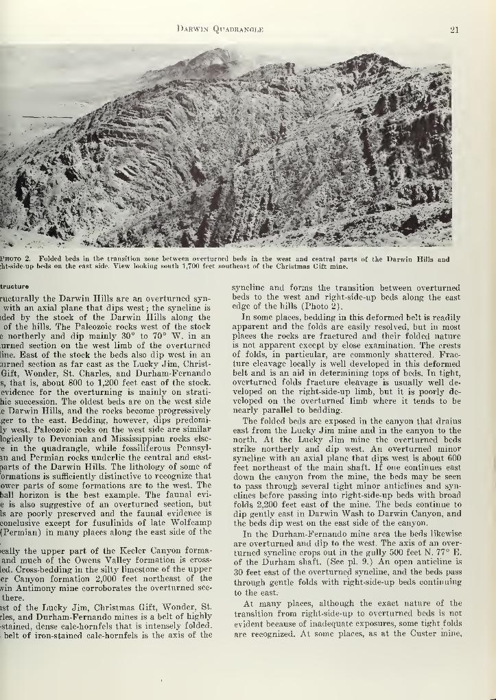
Darwin Quadranole 21
f^f&$t&m^-Mj%mM'jggg**-^
JVVr ik«. . A:, *."A V* 1 *T v _.>- jpf^flSsMEl- . &"(
fc&^V.i
Photo 2. Folded beds in the transition zone between overturned beds in the west and central parts of the Darwin;ht-side-up beds on the east side. View looking south 1,700 feet southeast of the Christmas Gift mine.
tructure
ructurally the Darwin Hills are an overturned syn-
with an axial plane that dips west; the syncline is
ided by the stock of the Darwin Hills along the
of the hills. The Paleozoic rocks west of the stock
e northerly and dip mainly 30° to 70° W. in an;urned section on the west limb of the overturnedline. East of the stock the beds also dip west in an;urned section as far east as the Lucky Jim, Christ-
Gift, Wonder, St. Charles, and Durham-Fernandos, that is, about 800 to 1,200 feet east of the stock,
evidence for the overturning is mainly on strati-
hie succession. The oldest beds are on the west side
e Darwin Hills, and the rocks become progressively
ger to the east. Bedding, however, dips predomi-
ly west. Paleozoic rocks on the west side are similar
logically to Devonian and Mississippian rocks else-
e in the quadrangle, while fossiliferous Pennsyl-
an and Permian rocks underlie the central and east-
parts of the Darwin Hills. The lithology of some of
brmations is sufficiently distinctive to recognize that
ower parts of some formations are to the west. Theball horizon is the best example. The faunal evi-
e is also suggestive of an overturned section, but
Is are poorly preserved and the faunal evidence is
conclusive except for fusulinids of late Wolfcamp(Permian) in many places along the east side of the
ically the upper part of the Keeler Canyon forma-
and much of the Owens Valley formation is cross-
led. Cross-bedding in the silty limestone of the upperer Canyon formation 2,000 feet northeast of the
ivin Antimony mine corroborates the overturned sec-
there.
ist of the Lucky Jim, Christmas Gift, Wonder, St.
rles, and Durham-Fernando mines is a belt of highly
stained, dense calc-hornfels that is intensely folded.
belt of iron-stained calc-hornfels is the axis of the
syncline and forms the transition between overturnedbeds to the west and right-side-up beds along the east
edge of the hills (Photo 2).
In some places, bedding in this deformed belt is readily
apparent and the folds are easily resolved, but in mostplaces the rocks are fractured and their folded natureis not apparent except by close examination. The crests
of folds, in particular, are commonly shattered. Frac-ture cleavage locally is well developed in this deformedbelt and is an aid in determining tops of beds. In tight,
overturned folds fracture cleavage is usually well de-
veloped on the right-side-up limb, but it is poorly de-
veloped on the overturned limb where it tends to benearly parallel to bedding.
The folded beds are exposed in the canyon that drains
east from the Lucky Jim mine and in the canyon to the
north. At the Lucky Jim mine the overturned bedsstrike northerly and dip west. An overturned minorsyncline with an axial plane that dips west is about 600
feet northeast of the main shaft. If one continues east
down the canyon from the mine, the beds may be seen
to pass through several tight minor anticlines and syn-
clines before passing into right-side-up beds with broad
folds 2,200 feet east of the mine. The beds continue to
dip gently east in Darwin Wash to Darwin Canyon, andthe beds dip west on the east side of the canyon.
In the Durham-Fernando mine area the beds likewise
are overturned and dip to the west. The axis of an over-
turned syncline crops out in the gully 500 feet N. 77° E.
of the Durham shaft. (See pi. 9.) An open anticline is
30 feet east of the overturned syncline, and the beds pass
through gentle folds with right-side-up beds continuing
to the east.
At many places, although the exact nature of the
transition from right-side-up to overturned beds is not
evident because of inadequate exposures, some tight folds
are recognized. At some places, as at the Custer mine,

22 Special, Eeport 51
faults separate overturned from right-side-up beds (see
pi. 9).
The Paleozoic rocks are intersected by four sets of
faults. The four sets are described under the subtopic
"Darwin mine" as the faults are important in localizing
ore. The largest fault is the Darwin tear fault, which is
a left-lateral strike-slip fault that strikes N. 70° W. Dis-
placement on the fault is 2,300 feet, the north block mov-
ing west.
Belle Union Mine
The Belle Union mine, owned by The Anaconda Com-pany, is in sec. 12, T. 19 S., R. 40 E., at altitudes near
5,200 feet. It is one of the old mines in the district but
in recent years has been inactive. Mine workings includ-
ing three shafts are largely inaccessible and their size
and extent are not known. The mine is in calc-hornfels
of the Keeler Canyon formation near a salient of the
Darwin Hills stock. The ore is in a near-vertical vein
trending N. 58° E. Observed ore minerals on the dumpsand in the highly iron-stained vein include galena, cerus-
site, and hemimorphite.
Buckhorn Mine
The Buckhorn mine, which is owned by Andrew Sund-berg, is in sec. 31, T. 18 S., R. 41 E., at an altitude of
4,240 feet. The mine is developed by two shafts, one
about 30 feet deep inclined northerly at 70°, and the
other inclined to the northwest at 30°. Other workingsinclude minor pits and open cuts south of the mainworkings. Production from the property is small.
The mine is in silty limestone of the lower member of
the Owens Valley formation. Ore is a replacement of a
fault zone that strikes N. 70° E. and dips 30° N. An-other fault, which strikes N. 28° W. and dips 70° N.,
apparently cuts off and displaces the N. 70° E. fault.
Ore minerals consist of cerussite, hemimorphite, andminor galena in an iron-stained quartz-calcite gangue.The size or grade of the ore body is not known.
Christmas Gift Mine
The Christmas Gift mine is 2-§ miles north of Darwinin sees. 1 and 12, T. 19 S., R. 40 E., at an altitude of
5,440 feet. The property is accessible by a dirt road 2\miles long that branches off the Darwin to Lone Pinehighway 2.2 miles northwest of Darwin. The mine is
owned by C. B. Skinner of Morro Bay, Calif.
The recorded production from the Christmas Giftmine since 1893 is given in table 4. The total productionfrom 1875 to 1893 is not known. Both the Christmas Giftand Lucky Jim mines were owned by the New CosoMining Company during the early history of the dis-
trict and the production of both mines was lumped.Burchard (1884, p. 164) reports the production of thetwo mines by 1883 to be $750,000. .The Christmas Giftmine was worked extensively in 1875 and early 1876according to the annual report of 1877 to the stockhold-ers, and 8,871 bars of silver were produced from theChristmas Gift during this period (estimated by thewriters to contain 83,500 ounces of silver and 700,000pounds of lead). Apparently most of the productionbetween the spring of 1876 and 1883 came from theLucky Jim mine.
Table !f. Ore produced from the Christmas Gift mine since 18
Year
189418951905
1909191219131914191519161917191819231926
Total
Ore Gold Silver Copper Lea(tons) (oz.) (lbs.) (lbs.) (lbs
12,952
_. .. 7,692 __
50 24.19 4,918 ._
21 0.87 908 85 12,
135 14.32 6,813 535 82,
400 19.01 14,677 2,801 254,
183 4.02 7,553 910 137,
69 3.00 2,817 314 48
368 2,522 4,520 90,
385 14,000 __ 213,
235 2.61 6,027 1,279 119,i
7 256 83 2,
6 0.11 115 83 2,
52 -- 615 21 10.'
1,911 68.13 81,865 10,631 973/
* Published with the permission of the mine owners.
The mine workings consist of 5 shafts, several ac
:
totaling more than 600 feet in length, and many ot.i
cuts and shallow shafts. The Christmas Gift shaft y i
sunk on the vein to a depth of 250 feet, and a wild
extends 126 feet below the 250-foot level. There id
approximately 1,900 feet of levels from the shaft a.
winze. The Johnny John shaft is reported by Normand Stewart (1951, p. 59) to be 250 feet deep, but.
was inaccessible. The other shafts are 90 to 100 feet de>
The Christmas Gift area is underlain by quartz m<
zonite and by calc-hornfels and hornfels that is mer!
morphosed limestone and silty limestone of the lovl
and upper members of the Keeler Canyon formati.
(pi. 3). The ore deposits are in calc-hornfels that C'j]
relates with the uppermost part of the lower membof the Keeler Canyon formation (photo 3). The lov,ri
member consists of white to light-gray dense calc-hoii(
fels with 1- to 2-inch thick greenish-gray dense hornf >i
bands that are metamorphosed shale. The calc-hornf
of the lower member of the Keeler Canyon formati'
is intruded by small irregular bodies of quartz m(j]
zonite and granodiorite that line up in a northei I
direction. The contact with the upper member of tl
Keeler Canyon formation is 370 feet northeast and 8,1
feet east of the Christmas Gift shaft. The upper membconsists of dense greenish-gray hornfels that weathti:
dark brown.Bedding is overturned in the metasedimentary rocj
It strikes predominantly north to N. 40° W. and di^
25° to 50° W. The rocks are cut by many faults th
strike N. 30°-70° E. and dip steeply northwest. The d]
placement where recognized is left lateral. Nearly hoi
zontal slickensides exposed underground confirm tj
strike-slip displacement on the fault through the ChrL
mas Gift shaft.
Ore in the Christmas Gift mine is localized in fau»
that strike N. 30°-70° E. Seven faults have been pritj
pected, but most of the ore was mined from the Christm
Gift vein, which is exposed in the Christmas Gift sha
Ore minerals are exposed along the Christmas Gift ve
intermittently for a strike length of 700 feet and to
depth of 334 feet, but only locally is the grade sufficient
high to be ore. Most of the ore in the vicinity of t:
Christmas Gift shaft has been mined between the si*
face and the No. 6 level, a vertical distance of 146 fe*

Darwin Quadrangle 23
Photo 3. View looking north at Christmas Gift mine. The area is underlain by quartzmonzonite and by calc-hornfels of the lower unit of the Keeler Canyon formation of Pennsyl-vanian and Permian age. The thrust fault near the skyline probably is an extension of theDavis thrust.
ore shoot strikes N. 40°-50° E. and dips 70°-80°
;it rakes steeply to the southwest. Average thick-
of the vein is about 3 feet.
e ore is oxidized in the deepest mine workings,
3 only minor relicts of galena remain. The vein
3t predominantly of limonite and cerussite in a
lie of calcite and jasper and locally they contain
and green secondary copper minerals,
structural control for ore shoots related to strike of
ault zone seems evident. The ore is localized where
aults strike approximately N. 45° E., and the faults
rily slightly mineralized where the strike is N. 65°-
I As the faults had a left-lateral displacement, the
zones were open where the strike is N. 45° E.
—
favorable for ore deposition—and tight where the
; is N. 65° -70° E. This is illustrated by the ore
on the No. 10 level (pi. 4). The mineralization
restricted to the part of the fault southwest of the
i where it strikes N. 35° E. and dips 68° NW. The
is unmineralized northeast of the winze where the
i changes to N. 70° E. and the dip steepens to ap-
mately vertical.
pocket of ore was mined from a shaft 670 feet N. 6°
f the Christmas Gift shaft. The shaft is 98 feet deep
has 5 short levels. Ore was stoped from the bottom
y to the surface but the tonnage mined was small,
s ore was also mined from shallow adits and open
along the veins at the north end of the property.
uster Mine
e Custer mine is in sec. 19, T. 19 S., R. 41 E., on the
side of the Darwin Hills a mile N. 70° E. of Dar-
n the narrow canyon half a mile south of Lane mill
l altitude of 4640 feet. The mine is accessible by a
1 mile lone: that leads east from Darwin down the
canyon past the St. Charles mine or by a road 1.1 mileslong that heads southerly from Lane mill (see pi. 9).
The mine is owned by Harry R. Staples and Paul C.
Staples of Oxnard, Calif. The property is developed byan inclined shaft 400 feet deep that bears S. 60° W. at-50°. The collar of the shaft is at an altitude of 4,641feet and levels extend off the shaft at altitudes of 4,600feet (50-foot level), 4,503 feet (200-foot level), 4,452 feet
(250-foot level), 4,396 feet (300-foot level), and 4,308feet (400-foot level). A winze extends 240 feet below the
400-foot level.
The recorded production from the Custer mine is 994tons from which 96,614 pounds of lead and 10,492 ounces
of silver were recovered. In addition, 6,123 ounces of sil-
ver were recovered during the 1890 's from an unknownamount of ore. The total production is given below
:
Table 5. Ore produced from the Custer mine.*
Gold Silver Copper Lead Zinc
Year Tons (oz.) (oz.) (lbs.) (lbs.) (lbs.)
1893 1,575
1895 __ .. 3,978 __
1899 __ 570 __
1911 21 1,116 __ 5,667
1913 13 1.98 2 251 6,709 __
1917 109 __ 2,020 _. 15,302 __
1918 16 2.00 355 __ 3,236 ._
1919 8 1.19 396 1,615 ..
1920 8 1.19 396 __ 2,100 ..
1935 29 90.21 1,161 1,935 21,192 ..
1937 20 1.00 60 ..
1940 20 6.00 304 102 2,700 ..
1947 166 6.00 942 664 11,124 __
1948 579 30.00 3,635 3,254 24,295 _.
1949 5 2.00 105 416 2,674 72
Total . 994 141.57 16,615 6,622 96,614 72
* Published with the permission of the mine owners.

24 Special Report 51
W
'<•»
ja a
PB a
3UIUJ
33U3pudd3pUI
3UILU X3SS3
tsnjm SjADQ
P'a *
.3«
« ^2
<ua, O
au/cu uosdiuoq±
<M
3uiw uoujagHe*.
t
1
I E
' /
/ .
1
1
[J
au/uj 33uoi;ao<i
1:
||nD)
!33dS0jd J3MJQ I
o -
£ ~f,
-V
t-l si
•r o"
o 2-
1«
" >
*'
a;
So a
i w ctJ
H u C3
> fao a

Darwin Quadrangle 25
tie uppermost part of the lower member of the
ler Canyon formation crops out in the mine area. It
ists of aphanitic light-gray, greenish-gray, andra cale-hornfels and beds of bluish-gray limestone
are in part altered to tactite. A fault contact be-
m the lower and upper members of the Keeler Can-formation is about 150 feet northeast of the inclined
t. The upper member consists of aphanitic greenish-
calc-hornfels that is characteristically highly iron
led on weathered surfaces.
le Keeler Canyon formation is intruded by a quartz
zonite dike 300 feet S. 65° W. of the collar of the
ned shaft and by a small irregular intrusion of
•tz monzonite 100 feet S. 10° W. of the main shaft,
tie Paleozoic rocks are folded and tilted into an over-
ed section and are intersected by many faults. Bed-
; at the shaft strikes N. 2° W. and dips 56° SW.Paleozoic and intrusive rocks are cut by several
ts that strike N. 50° to 70° E. and dip steeply either
he north or south. Displacement on the faults is
il.
tie ore body at the Custer mine is in calc-hornfels
is parallel to bedding. The bedded deposit consists
[ominantly of coarse calcite and quartz with pockets
interstitial material composed of cerussite, galena,
nite, jarosite, pink and green fluorite, and locally
)r amounts of malachite. The calcite is gray to whiteolor and commonly occurs as rhombohedrons 12 to
nches on a side. Some scheelite is exposed in the
ic
tie ore body is inconspicuously exposed at the sur-
. On the 50-foot level it is approximately 60 feet long6 to 10 feet thick, and is stoped for about 30 feet
re the level. The shape of the ore body is lenticular
Ian view, and it has a long axis that pitches nearly
ight down the dip. The bedded deposit is strong onthe 200-foot and 300-foot levels. On the 200-foot
i it is 110 feet long and is terminated on the north
i pre-mineral fault that strikes N. 70° E. and dips
N. The thickness of the ore body is erratic. Withinw feet it ranges from a few inches to 10 feet thick,
ore body is stoped for about 70 feet above the level
for 18 feet below the level. On the 300-foot level
lead content of the ore body has decreased, and the
led deposit consists mainly of quartz and calcite. It
>0 feet long and a maximum of 40 feet wide. Locally
•ntains pockets of galena and cerussite. The calcite-
•tz vein extends to the 400 level, but it carries very
i lead at this depth except locally at the northwest
Darwin Mine
tie Darwin mine includes the workings owned by the
conda Company that are developed by the 6,300-foot
Radiore adit. They are the Bernon, Defiance, Essex,
ipendence, Rip Van Winkle, and Thompson work-and Driver prospect—most of which are visible in
;o 4. The mine is about a mile north of Darwin.
eology. The rocks in the Darwin mine area are
stone, silty limestone, and minor siltstone in an over-
led section that ranges in age from Mississippian onwest side of the Darwin Hills to Permian on the
side (pi. 5). A stock intrudes the Pennsylvanian
and Permian rocks along the east side of the DarwinHills in the vicinity of the Defiance, Thompson, andIndependence workings. The Lee Flat limestone of Mis-sissippian and Pennsylvanian (?) age is the oldest for-
mation in the mapped area. It crops out in a band alongthe west side of the Darwin Hills and at the top ofOphir Mountain (photo 5). It is a thin- to medium-bedded, medium- to dark-gray limestone. Locally thelimestone is bleached white and recrystallized to marbleclose to its contact with the batholith of the Coso Range.The limestone is altered to massive, buff-colored dolomite1,300 feet west of the Bernon workings (pi. 5). Thedolomite resembles the Hidden Valley dolomite exceptfor occasional relicts of the Lee Flat limestone.The Keeler Canyon formation underlies most of the
mine area. It is in fault contact with the Lee Flat lime-
stone on the west side of the Darwin Hills and alongthe prominent ridge trending S. 60° W. from the topof Ophir Mountain. The lowermost part of the KeelerCanyon formation is exposed on the southeast side of
the Ophir fault. The golfball horizon (limestone withspherical chert nodules) and limestone with sparse tinyfusulinids are in the prominent inverted syncline onthe west flank of Ophir Mountain. Between the golfball
horizon and the Davis thrust on the east side of the hills
are interbedded bluish-gray thinly bedded limestone,
silty limestone, and minor siltstone. Much of the lime-
stone is altered to a white, gray, brown, or greenish-graydense calc-hornfels.
Nearly all of the ore is in the Keeler Canyon forma-tion between the Davis thrust and the stock of the Dar-win Hills. The formation in this interval consists of
dense white calc-hornfels and white, fine- to medium-grained calc-silicate rocks. Idocrase crystals commonly| to \ inch in diameter are characteristic of the calc-
silicate rocks on the east side of the Davis thrust andare rare or absent in the calc-hornfels on the west side
of the thrust. The idocrase-bearing calc-silicate rocks are
west of the stock from the Independence workings south
to the Susquehanna mine. This horizon also crops out
north of Ohpir Mountain as far as Belle Union mine.
The Keeler Canyon formation is intruded by the stock
of the Darwin Hills in the vicinity of the Independence,
Thompson, and Defiance workings, and by a nearly con-
cordant intrusive on the southwest side of Ophir Moun-tain. The stock is made up of a heterogeneous mixtureof diorite, granodiorite, quartz monzonite, and aplite.
The intrusive rocks are deeply weathered, and north of
the Defiance workings they are highly iron stained,
which makes them easy to distinguish from the hard,
lighter-colored calc-hornfels. The stock is composed pre-
dominantly of quartz monzonite and granodiorite.
Granodiorite and quartz diorite are prevalent aroundthe Defiance and Thompson workings but quartz mon-zonite and minor aplite are prevalent in the area extend-
ing from the Thompson workings to the Independence
workings. Aplite also crops out south of the Defiance
workings.
Quartz monzonite crops out on the west flank of OphirMountain as an essentially concordant intrusive 1,400
feet long and 600 feet wide. The sill is 1,100 feet east
of the batholith of the Coso Range and is probably anoffshoot from it. The south end of the sill is in contact
with diorite and gabbro. Several small diorite and

26 Special Report 51
EXPLANATION
5400
5200
5000-
4800
4600
-5200
Quartz m onz on i ! e
ond gronodi orite
White, dense col-hornfels 1(Not differentiated underground 'I
CPk 2
Medium grained cole- si 1 1 c o te roc 1(Includes CPki underground)
!
Brown and gray dense hornfe B
Is, unaltered limestone
Keeler Canyon formation
Conl actDashed where approximate
Underground geology and outline of
mine workings from mops of
The Anoconda ComponyPublished with permissiorof mine owners
200
Fault, showing relative movemtDashed where approximate
Dip of overturned beds
sSloped area.
Dotted where projected
Mine workings cut by sectionDashed where projected
Diamond drill hole
Figure 2. Geologic section of the Defiance workings showing stope outlines.
gabbro bodies are 200 to 700 feet west of the Bernonworkings and are similar to the diorite at Darwin Falls,
which is considered a granitized silty limestone.
Structure. The Paleozoic rocks in the mine areastrike northerly and dip mostly 30° to 70° W. in anoverturned section that ranges in age from Mississippian
to Permian on the west limb of a major overturnedsyncline. The stock of the Darwin Hills intruded nearthe axis of the syncline. Several minor open folds aresuperposed on the overturned limb of the syncline. Oneof these folds on the west flank of Ophir Mountain is
visible from the Darwin mining camp. The strata arefolded into the form of an open anticline that plungesgently to the north, but younger strata are in the coreand older rocks are on the flanks of the fold. Therefore,this fold, which commonly is referred to locally as theOphir Peak anticline, is a minor inverted syncline ac-cording to the definition of White and Jahns (1950, p.196). Similar inverted synclines are exposed in the De-fiance and Bernon workings, in the Intermediate work-
ings, and on the west side of the Darwin Hills adjac
to the Darwin mining camp.
The Paleozoic rocks are intersected by four sets
faults. One set strikes N. 50°-70° E. and dips stee'
to the north. Displacement on the faults is left lat<
with the north block moving west a few feet to 100 ]
relative "to the south block. The horizontal displacem
is shown by offset of beds and by abundant nearly bzontal slickensides and mullion structure exposed
fault planes in underground workings. The N. 50°-70c
faults are mineralized and many ore bodies are locali
in or close to them. The Defiance fault, Copper fa
Water Tank fault, and Mickey Summers fault are
this group.
A second set strikes N. 65° W. and dips steeply. Tare parallel to the Darwin tear fault, which is a 1
lateral strike-slip fault. The Essex vein exemplifies 1
set.
The third set of faults are thrust faults that sti
northerly and dip 30° to 40° W. The Davis thrust cr

Darwin Quadrangle 27
along the side of the hill above the Independence,
x, and Bernon workings, and at the south end of
nine area it is exposed on the west side of the hills
e the mining camp at the water tanks. This fault is
exposed in the Essex workings and in the upperpendence workings. Right-hand drag folds localized
to the fault plane indicate that the west block
>d upward toward the east relative to the east block
5). The amount of displacement is not known. Their fault is west of, and parallel to, the Davis thrust,
;he amount of displacement on it is small. The drag
; associated with it are left-hand drag folds instead
ight-hand drag folds like those along the Davis
st. Four parallel faults also are exposed between)phir fault and the alluvium on the west side of the
vin Hills. The writers believe that the overthrust
c above the Davis thrust broke along several parallel
es as it was moving and that each underlying block
;d slightly farther to the east than the overlying
[. Therefore, the overlying block on the west side
e Ophir fault moved downward relative to the over-
st block between the Ophir fault and the Davis
st. Thus, left-hand drag folds were formed along
)phir fault while right-hand drag folds were formed
I the Davis thrust.
le fourth set of faults strikes northerly and dips
ly steeply to the west. The displacement is small,
faults are mineralized, and many of the ore bodies
le district are localized along them.
e Bodies. Ore in the Darwin mine occurs mainlyfavorable stratigraphic zone more than 840 feet
: close to pre-mineral feeder faults that strike
0°-70° E. and dip steeply to the northwest. Indi-
al ore bodies occur as replacements of certain
rable beds close to the N. 70° E. faults, as replace-
; bodies in fault zones, and as irregular or pipelikeas in calc-hornfels. The bedded deposits have sharp
icts with the wall rock both stratigraphically above
below the favorable bed, although the ore within a
iralized bed has a considerable range in grade andi blocks of low grade ore were left behind as stope
rs.
description of the ore bodies and ore controls for
of the workings is given below.
>,rnon Workings. The Bernon workings adjoin the
mce workings on the north and the Thompson:ings on the south. The workings are in white,
ium-grained calc-hornfels along the crest of a minor
rted syncline that extends southward to the De-
:e workings. The Paleozoic rocks are intruded by a
)f quartz monzonite south of the 434 fault, and byke south of the Bernon fault. The rocks are cut bypre-mineral Bernon fault and the 434 fault, both of
h strike N. 50°-60° E. and dip steeply to the north-
. The faults are cut off on the west by the Davis
st. All ore is in the Bernon fault in medium-grained
silicate rock.
sfiance Workings. The Defiance workings are in
southeast part of the Darwin mine area 0.7 miles
h of the town of Darwin. Two bedded ore bodies
out along the crest of an inverted syncline
re it is cut bv the Defiance fault. The Blue vein is
in dense white calc-hornfels near the upper contact of agranodiorite sill. The vein is 300 feet long and has beenmined 400 feet down the dip from the surface to the215-foot level (fig. 2). The Red vein is in dense whitecalc-hornfels 60 feet stratigraphically above the Bluevein and 80 feet stratigraphically below an upper sill
of granodiorite. This vein is 460* feet long at the De-fiance tunnel level, 5 to 10 feet thick, and has beenmined 670 feet down the dip from the surface to the400-foot level. Other smaller bedded ore bodies havebeen mined in the deeper mine workings. Both the Redand Blue veins lie between two sills of granodiorite thatare stratigraphically about 200 feet apart. Both sills
pinch out in depth. The upper sill does not extend tothe 110-foot level from the surface ; the lower sill termi-nates between the 570-foot and 700-foot levels. The lowersill cannot be delimited on the surface as it merges withthe main Darwin Hills stock at the level of the presenterosion surface (fig. 2). The bedded ore in the Defianceworkings is approximately coextensive in depth withthe extent of the sills.
Below the 400-foot level the principal ore bodieschange from concordant veins to an irregular, vertical
replacement ore body that has been developed for 570feet vertically to the 1,000-foot level. The ore is localized
close to the Defiance fault but extends outward from the
fault along closely spaced fractures for distances as
much as 270 feet. On both the 800- and 900-foot levels
about 25 percent of the calc-hornfels over an area 200feet by 270 feet is replaced by ore (pi. 6). Insufficient
exploration work has been done to delimit the ore on the
1,000-foot level.
Driver Prospect. The Driver prospect is 1,000 feet
S. 10° E. of the Defiance workings. The prospect is de-
veloped by several small open cuts, adits, and winzes. It
is in dense white calc-hornfels 30 to 50 feet west of the
contact with the stock of the Darwin Hills. Bedding in
the calc-hornfels strikes northerly and dips 35° to 53°
W. The Mickey Summers fault displaces the contact of
the quartz monzonite and calc-hornfels 75 feet, the north
side moving west relative to the south side. A parallel
fault cuts the calc-hornfels 230 feet south of the MickeySummers fault.
The calc-hornfels is highly iron stained parallel to
bedding close to the N. 70° E. faults. A belt of white calc-
hornfels 20 to 30 feet wide is highly iron stained 30 feet
west of the stock of the Darwin Hills and north of the
Mickey Summers fault. Gossan 1 to 2 feet thick is locally
distributed along a bedding-plane fault on the east side
of the iron stained zone. The calc-hornfels is similarly
heavily iron stained for 50 feet north of the fault that
is south of the Mickey Summers fault and parallel to it.
It is not known if any ore was mined from the shallow
workings.
Essex Workings. The Essex workings are 230 feet
southwest of the portal of the Independence workings
and 820 feet northwest of the portal of the Thompsonworkings. The surface workings are in medium-grained
calc-silicate rock 50 feet east of the Davis thrust. Bed-
ding strikes northerly and dips 32° to 68° W. The calc-
hornfels is cut by the Essex fault, which strikes N. 70°
W. and dips vertically to very steeply south. The Essex
fault is cut off by the Davis thrust.

28 Special Report 51
Sn033V13M0 NVIWMSd ONW NVINVA1 JkSNN3d (ijNWINVATASNNSd BNVIddlSSISSIH
1fk\
ucmDujiO) uoXuoo Jd|ad»
V
H
» Mlc
o oh-i
o

Darwin Quadrangle 20
re minerals are not conspicuous at the surface of the
>x workings. The Essex fault is iron stained over a
th of 10 feet and contains jasper near the Essex
t. The open cut and short adits 40 feet northeast of
shaft are on a branch of the Essex fault, and they
)se only minor iron staining. The main ore body in
Essex workings does not crop out at the surface, but
below the Davis thrust in the Essex fault zone and
g steep north-striking fractures in calc-hornfels
i to both the Essex fault and an intrusive contact
3).
re has been mined from the Essex fault from 50 feet
w the surface to the 600-foot level, a vertical dis-
le of 780 feet. The ore is localized in the fault in calc-
ate rock between the stock of the Darwin Hills andDavis thrust. Between the surface and the 3B level,
Davis thrust and the west contact of the stock are
roximately parallel and are about 360 feet apart. Oreiscontinuous over this distance and has a maximumkness of 30 feet. This is one of the few places in the
e where ore extends up to the Davis thrust (fig. 3).
iw the 3B level the trend of the contact between the
silicate rock and the Darwin Hills stock dips verti-
r or steeply to the east. As the distance between the
k and the Davis thrust becomes progressively greater
i depth, the amount of known ore is proportionately
Ore along north-striking fractures is best developed
ae 200- and 400-foot levels (see pi. 7, plan of 400-foot
level). On the 200-foot level ore extends 175 feet northof the Essex fault, and on the 400-foot level it extends400 feet north of Essex fault close to the intersection of
a steep north-striking fault and a sill of quartz mon-zonite that dips 34° W. The ore is localized within 40feet of the intrusive contact.
Independence Workings. The Independence workingsare at the north end of the Darwin mine 850 feet N. 25°
W. of the Thompson workings. Medium-grained calc-
silicate rock is exposed at the surface in most of the areaover a width of 130 feet from the stock of the DarwinHills west to the Davis thrust. Fine-grained gabbro anddiorite crop out southwest of the portal of the Inde-
pendence adit around the base of the mine dump. Northof the Independence workings the favorable calc-silicate
rock is cut off by the Davis thrust, and an unfavorableoverthrust block of dense greenish-gray calc-hornfels is in
contact with the stock. Gossan is exposed at the surface
in medium-grained calc-silicate rock along its contact
with the stock. The contact strikes northerly and dips43° to 72° W. A prospect pit 30 feet deep 60* feet north
of the Independence adit exposes a highly iron stained
zone 10 feet thick along a fault contact between the
stock and calc-silicate rock. An open cut at the crest of
the ridge 250 feet N. 25° E. of the Independence adit
exposes gossan about 20 feet thick that dips 43° W. along
the calc-hornfels-intrusive contact.
EXPLANATION
i'Kqm 1]
QuOftz mom onile
ond g r onodi or i le
Light gray mfdi um- groinedcole- silicote rock
€Light gray dense
cole- hor nfels,
Is, unaltered limestone
" jr^Brown, groy, dense
cole- hornf els,
is, blue limestone
CPkh, limestone
CPHI2, Sandy limestone
Golfboll horizon
Limestone with 1" chert nodule'
derground geology and mine workings)m maps of The flnocondo Companyibhshed with permission of mine owners
Lee Flat limestone
ContactDashed where opprommote
Foult, showing relotive movementDoshed where approximole
Outline of stope
Dotted where appronmote
Dip of overturned beds
Figure 4. Geologic section of the Independence workings showing stope outlines.
30 Special Report 51
The underground workings show that the stock of the
Darwin Hills terminates to the west in a series of sills
that commonly are anticlinal shaped and pinch out in
depth to the west (fig. 4). Ore above the 100-foot level
is in medium-grained calc-silicate rock above the upper-
most sill and below the Davis thrust. The Davis thrust
terminates the favorable calc-hornfels in the workings
on both the Independence and 100-foot levels. The ore
is an irregular bedded replacement body that has a strike
length of 250 feet and a width of 120 feet on the Inde-
pendence level. Approximately 30 percent of the calc-
silicate rock over this area is replaced by ore. The ore is
stoped from the 100-foot level to the surface. A sill of
quartz monzonite is between the 100- and 200-foot levels.
The largest bedded ore body in the district is between
the 200-foot and 3B levels over a lower anticlinal-shaped
quartz monzonite sill (fig. 4). Bedded ore has been stoped
discontinuously between the quartz monzonite sills, a
vertical distance of 160 feet, along the crest of the anti-
clinal-shaped fold (an inverted syncline) for a maximumstrike length of 500 feet on the 3B level. Ore has been
mined westward down the dip above the upper contact
of the lower sill for a distance of 700 feet to the 400-foot
level.
Smaller bedded ore bodies are below the lower sill
between the 400-foot and 600-foot levels (fig. 4). All the
known ore is within 100 feet of the lower contact of the
sill. The ore body on the west limb of the inverted syn-
cline is 200 feet long and as much as 50 feet thick; it
has been mined 260 feet down the dip below the 400-foot
level. A smaller bedded ore body was mined on the east
limb of the inverted syncline from the 400 level to 40
feet below the 500 level.
Rip Van Winkle Workings. The Rip Van Winkle
workings are on the west side of the Darwin Hills above
the Darwin mine camp. They include the workings on
the Water Tank fault, the Mickey Summers fault, and
the workings 680 feet N. 40° E. of the portal of the
Radiore adit (pi. 5).
The shaft on the Water Tank fault 80 feet east of the
water tanks is in calc-hornfels at the intersection of the
Water Tank fault with the Davis thrust. The favorable
medium-grained calc-silicate rock lies east of the Davis
thrust and unfavorable dense, greenish-gray calc-horn-
fels is west of the thrust, An irregular plug of quartz
monzonite crops out at the surface 300 feet northeast of
the shaft. The Water Tank fault, which strikes N. 70°
E. and dips 85° N., is highly iron stained at the surface.
The Radiore adit crosses the Water Tank fault in the
favorable calc-silicate rock on the east side of the Davis
thrust, and the fault is mineralized on this level along its
strike for 360 feet (pi. 6).
The Mickey Summers fault strikes N. 74° E. and dips80° SE. A parallel mineralized fault 60 feet north of the
Mickey Summers fault is developed by two shafts 220feet apart. Mineralization is continuous between the twoshafts. Kelley (1938, p. 558) reports one of the vertical
shafts to be 250 feet deep but inaccessible at the timeof his fieldwork. He states the ore is highly pyritic but is
reported to be unusually high in silver.
The inclined shaft 680 feet N. 40° E. of the portal ofthe Radiore adit is on a vein 6 feet thick that strikes N.20° W. and dips 54° SW. parallel to bedding. The vein.
which can be traced for about 50 feet on the surfac<
in dense white to light-gray calc-hornfels 70 feet i
of a small outcrop of quartz monzonite. Only a sr
amount of ore minerals is exposed in the Radiore i i
218 feet below the collar of the shaft.
Thompson Workings. The Thompson workings1,200 feet N. 25° W. of the Defiance workings nearwestern contact of the stock of the Darwin Hills. Quf i
monzonite crops out at the portal of the Thompson a
and it extends 370 feet N. 67° W. into the adit andfeet on the surface west of the adit. White medii
|
grained calc-silicate rock is exposed west of the quemonzonite and extends over an outcrop width of
feet to the Davis thrust. Bedding in the calc-silicate r
;
strikes north and dips 16° to 53° W. The Copper fa,
which strikes N. 60° E. and dips steeply to the north j
exposed near the portal of the Thompson adit. Two p
allel faults cut the calc-silicate rock 300 and 360 i
north of the Copper fault.
The ore in the Thompson workings is in mediigrained calc-silicate rock in the same stratigraphic h< -
zon as in the Independence and Bernon workir,
Gossan 1 foot to 6 feet thick is exposed in a surf
stope in calc-silicate rock at the contact with quamonzonite 250 feet S. 75° W. of the Thompson poi':
and 40 feet north of the Copper fault. Most of the i
mined underground was north of the gossan that i
exposed at the surface, and only minor mineralizat
is exposed on the 200-foot level 77 feet below the surf, •
stope. The ore underground is in faults striking N. 5-
70° E. in calc-silicate rock close to intrusive contas
and also in fractures in calc-silicate rock closely p1
allel to intrusive contacts. The 234 and 229 northerstriking faults are mineralized discontinuously for ('•
tances as much as 400 feet from a minor sill or dike
quartz monzonite. Ore has been stoped along the 234 fa
for as much as 190 feet along its strike. The thickness
ore ranges between 4 and 20 feet between the 200-fi
and 3B levels, a vertical distance of 200 feet. Above 1*
200-foot level and below the 3B level the ore is in nor
striking faults between the 234 and 229 faults. The 2
fault has been less productive than the 234 fault, a!
has yielded ore for 135 feet along strike with a thickn,
of 10 feet between the 200-foot and 3A levels. A near
horizontal sill cuts out the ore at the 3B level, but t
faults and a little ore continue beneath the sill. In aoV
tion a considerable tonnage of ore has been mined fr<'
bedded replacement bodies between the 229 and 2]
faults.
Fairbanks Mine
The Fairbanks mine is 3 miles north of Darwinsees. 1 and 2, T. 19 S., R. 40 E., at an altitude of 5,6
feet. The mine is owned by Mrs. Marie Wilson of S
Francisco. The workings consist of a shaft, reported
be 150 feet deep (Tucker and Sampson, 1938, p. 44(
on a strand of the Darwin tear fault, and a number
open cuts and shallow shafts.
The host rock is the lower member of the Keeler Ca
yon formation and consists of thinly bedded bluish-gr
limestone that is in part altered to calc-hornfels. T
Darwin tear fault cuts across the north end of the mi
area. It is a stronglv sheared zone 50 to 100 feet wi

Darwin Quadrangle 31
Elev. portal 4671'
EXPLANATION
Sloped,inaccessible
lev. 4557
/, Stoped aboveabout 20 feet high
- ~ in
Elev. 4906'
Keeler canyon formation) i
-~-^\70
Fault showing dip
Vertical fault
Fault showing bearing
and plunge of slickensides
UPPER WORKINGS
LOWER WORKINGS
Mopped by E. M. MacKevett ond H. G. Stephens , 1954
^30
Strike and dip of beds
\80
Vein, showing dip
x xx
Hydrothermol colcite
Jasper
Limonitic alteration
Head of raise or winze
showing inclination
Foot of raise or wime
Inclined workings
(chevrons point down)
100
Figure 5. Geologic map of the underground workings of the Keystone mine.
strikes N. 70° W. The Darwin tear fault is highly
stained, but apparently contains little or no lead
srals. Kelley (1938, p. 554) reports a small chimney•e was mined from a vertical vein that strikes north-
within the shear zone of the Darwin tear fault. Theis 2 to 4 feet thick and consists of galena and
ssite in a gangue of calcite and limonite.
ackass Mine
ie Jackass mine is in sec. 18, T. 19 S., R. 41 E.,
le N. 60° E. of Darwin and half a mile southwest
ane mill on the east side of the Darwin Hills at anude of 5,000 feet. A dirt road 1 mile long extends
srly from Darwin to the mine. The property con-
of a patented claim owned by George F. Seeman'resno, Calif. It is developed by an inclined shaft
feet deep with about 150 feet of drifts. An inclined
t about 35 feet deep with a short drift at the bottomiout 600 feet N. 15° W. of this shaft.
) record was found of the production from the
ass mine. Tucker (1921, p. 288) reports the mine to
been in operation at the time of his visit and that
)re was carried to the Lane mill by an aerial tramThe tram line has since been dismantled. George F.
lan acquired control of the property in 1950. Hemined 20 tons of ore from workings at the north
of the property that he reports assayed 21 percent
and 17 ounces of silver per ton (written communi-n, 1955).
ie rocks in the mine area are brown-stained dense
hornsfels and bluish-gray limestone that is in part
ed to tactite. The beds strike N. 20° W. and dip
78° W. The 140-foot inclined shaft is on a bedding-planevein between a bluish-gray limestone and tactite bed50 feet thick on the west and brown-stained, dense calc-
hornfels on the east. Open cuts at the surface expose the
vein with a thickness of 1 to 4 feet over a length of 80feet. The vein contains some galena and secondary cop-
per minerals in a gangue of limonite and calcite.
On the 66-foot level a drift has been driven S. 38° E.for a distance of 75 feet along the vein and 70 feet N.18° W. from the shaft. The vein south of the shaft is
1 to 2 feet thick, and ore in the vein is in pockets. Thetactite contains a little scheelite disseminated through it
over a thickness of 2 to 4 feet several feet into the hang-ing wall of the vein. North of the shaft a chimney of
ore has been stoped for 20 feet along the level to a
height of 20 feet and a thickness of 10 feet.
The 35-foot shaft 600 feet N. 15° W. of the maininclined shaft is on a vein that strikes N. 63° E. anddips 77° SE. The vein is 3 feet thick at the surface andcontains galena, cerussite, sphalerite, and pyrite in a
gangue of calcite and limonite. The vein thins to 1 foot
at the bottom of the shaft.
Keystone Mine
The Keystone mine is in sees. 19, 20, 29, and 30, T. 19
S., R. 41 E. It lies mainly on the east slope of the Dar-
win Hills about 1.75 miles southeast of Darwin. The
mine is owned by Hilda Bickley, Helen Gunn, and Jess
G. Sutleff of Independence, Calif.
The lower workings (fig. 5) include the Keystone adit
626 feet long, a drift 210 feet long, 120 feet of crosscuts,

32 Special Keport 51
EXPLANATION
CPk
Keeler Canyon formation
(Silty limestone portly
oltered to calc -hornfels)
F70""
Foult , showing dip
Dashed where approximote
,90
Vertical foult
<2iS
en 1-
Ha.<
Shear 2one
Syncline
60Strike and dip of beds
Portal and open cut
4t«<k
'//Tip*
Dump
Outline of underground workings
Topography oy EM. MocKevett ond HG Stephens
Geology by HG.Stephens, 1954
Contour interval 20 feet
Datum mean seo level
4Q0 Feet
Figure 6. Geologic map of the Keystone mine.
a 175-foot steeply inclined winze, and small stopes, Theupper workings consist of the McDonald adit, which is
caved 145 feet from its portal, 135 feet of drifts, andminor crosscuts. A connecting raise and adjacent stopes
between the lower and upper workings are largely in-
accessible.
Production data are rather scanty. Tucker and Samp-son (1938, p. 435) report that 800 tons of sorted ore wasshipped from the lower winze and the zone between the
lower and upper workings. This ore contained 15 percentlead, 28 ounces of silver per ton, and minor amounts of
gold. Shipments during 1940 and the early part of 1941,
according to the records of Mr. Sutleff, consisted of 205tons of ore containing 0.04 ounces of gold per ton, 27.9
ounces of silver per ton, 25 percent lead, 0.6 percentzinc, and 20 percent iron.*
The mine is in folded and faulted rocks of the uppermember of the Keeler Canyon formation (fig. 6). Therocks are brown-weathering silty limestone and blue-gray limestone. The limestones are partly altered to calc-
hornfels, particularly in the western part of the minearea. The dominant faults trend between N. 70° E. andeast and dip steeply.
Ore is in a poorly exposed vein 2 to 10 feet thick thatstrikes north and dips 60° W. to vertical. It has been ex-ploited for a strike length of about 40 feet underground.The ore is highly oxidized and contains cerussite as the
• Published with permission of the mine owners.
chief ore mineral with only minor relict galena. Ganj
|
minerals are limonite, jasper, and calcite.
Lane Mine
The Lane mine is 1.4 miles northeast of Darwinsec. 18, T. 19 S., R. 41 E., on the east side of i
Darwin Hills at an altitude of 4,440 feet. The mineadjacent to the Lane mill. The road from DarwinPanamint Springs passes through the mill site. The Aconda Company owns the property but has not opera
'
it to date.
Development work consists of two vertical shafts i
feet apart that are 600 and 800 feet deep with le\
at 280, 350, 470, 610, and 700 feet according to an l
dated old company assay map of the mine. Waring a
Huguenin (1919, p. 98) report the shafts as 725 a:
750 feet deep. Both shafts are inaccessible. Two otl1
shafts 300 and 600 feet west of the main shaft are ei
200 feet deep. An adit reported by Kelley (1938, p. 5a
to be 1,300 feet long and now accessible for about 1,(
feet trends S. 85° W. from the gully just west of i
shafts.
The mine was discovered early in the history of 1
Darwin district, but was not extensively developed ur
the early 1890 's by the Inyo Mining and Developmi
Company according to Crawford (1894, p. 24). The mwas not mentioned by Goodyear in the Eighth AnnReport of the State Mineralogist for 1888. By 11
Crawford (1894, p. 24) reports shafts 30, 80, and I
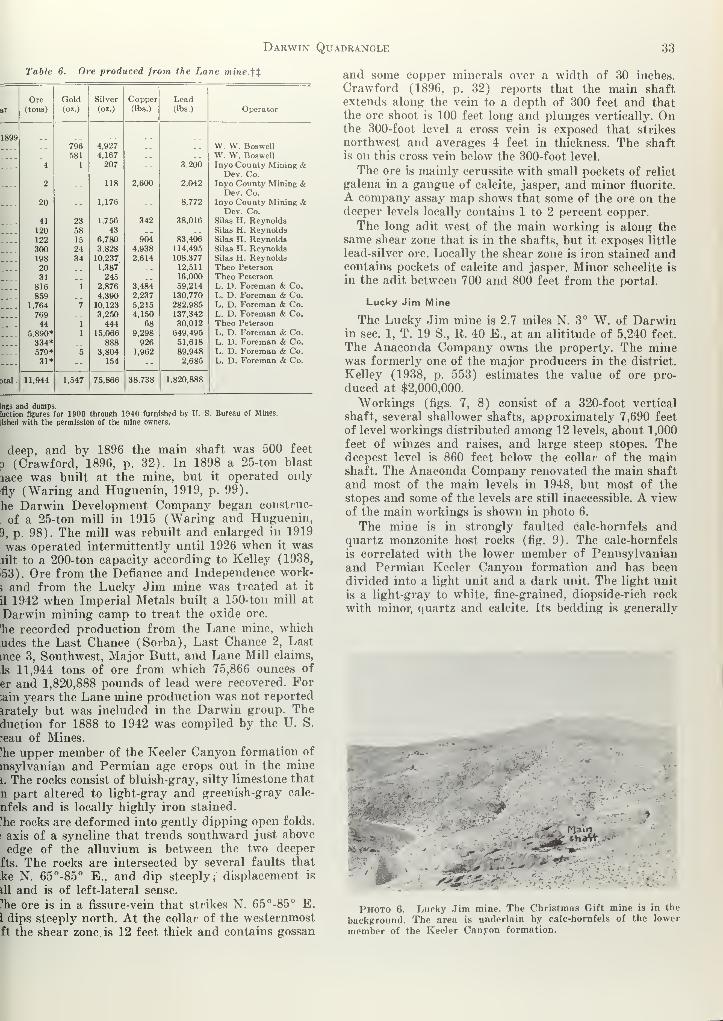
Darwin Quadrangle 33
Table 6. Ore produced from the Lane mine.tt
Ore Gold Silver Copper Leadar (tons) (<M.) (oz.) (lbs.) (lbs.) Operator
1899796 4,927 __ __ W. W. Boswell581 4,167 __ __ W. W. Boswell
.... 4 1 207 -- 3,200 Inyo County Mining &Dev. Co.
---- 2 -- 118 2,600 2,042 Inyo County Mining &Dev. Co.
-— 20 -- 1,176 -- 8,772 Inyo County Mining &Dev. Co.
41 23 1,756 342 38,016 Silas H. Reynolds120 58 43 .. Silas H. Reynolds122 15 6,780 904 83.406 Silas H. Reynolds300 24 3,828 4,938 114,495 Silas H. Reynolds198 34 10,237 2,614 108,377 Silas H. Reynolds
20 1,387' __ 12,511 Theo Peterson
31 245 16,000 Theo Peterson
816 1 2.876 3,484 59,214 L. D. Foreman & Co.
859 4,390 2,237 130,770 L. D. Foreman & Co.
1,764 7 10,123 5,215 282,985 L. D. Foreman & Co.
769 3,250 4,150 137,342 L. D. Foreman & Co.
44 1 444 68 30,012 Theo Peterson
5,890* 1 15,066 9,298 649,495 L. D. Foreman & Co.
334* 888 926 51,618 L. D. Foreman & Co.
579* 5 3,804 1,962 89,948 L. D. Foreman & Co.
---- 31* -- 154 -- 2,685 L. D. Foreman & Co.
3tal_ 11,944 1,547 75,866 38,738 1,820,888
tags and dumps.luction figures for 1900 through 1940 furnished by U. S. Bureau of Mines.
lished with the permission of the mine owners.
deep, and by 1896 the main shaft was 500 feet
p (Crawford, 1896, p. 32). In 1898 a 25-ton blast
lace was built at the mine, but it operated only
fly ("Waring and Huguenin, 1919, p. 99).
he Darwin Development Company began eonstrue-
of a 25-ton mill in 1915 (Waring and Huguenin,
9, p. 98). The mill was rebuilt and enlarged in 1919
was operated intermittently until 1926 when it waslilt to a 200-ton capacity according to Kelley (1938,
>53). Ore from the Defiance and Independence work-
3 and from the Lucky Jim mine was treated at it
il 1942 when Imperial Metals built a 150-ton mill at
Darwin mining camp to treat the oxide ore.
he recorded production from the Lane mine, which
udes the Last Chance (Sorba), Last Chance 2, Last
tnce 3, Southwest, Major Butt, and Lane Mill claims,
,1s 11,944 tons of ore from which 75,866 ounces of
er and 1,820,888 pounds of lead were recovered. For;ain years the Lane mine production was not reported
irately but was included in the Darwin group. Theduction for 1888 to 1942 was compiled by the U. S.
*eau of Mines.
'he upper member of the Keeler Canyon formation of
insylvanian and Permian age crops out in the mine
i. The rocks consist of bluish-gray, silty limestone that
n part altered to light-gray and greenish-gray calc-
nfels and is locally highly iron stained,
'he rocks are deformed into gently dipping open folds,
s axis of a syncline that trends southward just above
edge of the alluvium is between the two deeper
fts. The rocks are intersected by several faults that
ke N. 65°-85° E., and dip steeply; displacement is
ill and is of left-lateral sense.
"!he ore is in a fissure-vein that strikes N. 65°-85° E.
I dips steeply north. At the collar of the westernmostft the shear zone. is 12 feet thick and contains gossan
and some copper minerals over a width of 30 inches.
Crawford (1896, p. 32) reports that the main shaftextends along the vein to a depth of 300 feet and thatthe ore shoot is 100 feet long and plunges vertically. Onthe 300-foot level a cross vein is exposed that strikes
northwest and averages 4 feet in thickness. The shaftis on this cross vein below the 300-foot level.
The ore is mainly cerussite with small pockets of relict
galena in a gangue of calcite, jasper, and minor fluorite.
A company assay map shows that some of the ore on thedeeper levels locally contains 1 to 2 percent copper.
The long adit west of the main working is along thesame shear zone that is in the shafts, but it exposes little
lead-silver ore. Locally the shear zone is iron stained andcontains pockets of calcite and jasper. Minor scheelite is
in the adit between 700 and 800 feet from the portal.
Lucky Jim Mine
The Lucky Jim mine is 2.7 miles N. 3° W. of Darwinin sec. 1, T. 19 S., R. 40 E., at an alititude of 5,240 feet.
The Anaconda Company owns the property. The minewas formerly one of the major producers in the district.
Kelley (1938, p. 553) estimates the value of ore pro-
duced at $2,000,000.
Workings (figs. 7, 8) consist of a 320-foot vertical
shaft, several shallower shafts, approximately 7,690 feet
of level workings distributed among 12 levels, about 1,000
feet of winzes and raises, and large steep stopes. Thedeepest level is 860 feet below the collar of the mainshaft. The Anaconda Company renovated the main shaft
and most of the main levels in 1948, but most of the
stopes and some of the levels are still inaccessible. A viewof the main workings is shown in photo 6.
The mine is in strongly faulted calc-hornfels andquartz monzonite host rocks (fig. 9). The calc-hornfels
is correlated with the lower member of Pennsylvanianand Permian Keeler Canyon formation and has beendivided into a light unit and a dark unit. The light unit
is a light-gray to white, fine-grained, diopside-rich rock
with minor, quartz and calcite. Its bedding is generally
j*> Main
... *#*
Photo 6. Lucky Jim mine. The Christmas Gift mine is in the
background. The area is underlain by calc-hornfels of the lower
member of the Keeler Canyon formation.

34 Special Report 51
EXPLANATION
00 LEVEL
200 LEVEL
Quartz monzonite
and granodiorite
Keeler Canyon formation
( Cole hornf els )
Contact showing dip
Foult showing dip
Vertical foult
Foult showing bearing
and plunge of striotions
Fault breccia
Overturned beds
Limonitic alteration
400 Feet
Modified from maps of The Anoconda Componyby WE. Hon and E M MacKevett, 1954Published with permission of mine owners
Figure 7. Geologic maps of the underground workings of the Lucky Jim mine.

Darwin Quadrangle 35
Hlified from mops of The Anoconda ComponyW. E Hall ond E M MocKevetT, 1954
iblished with permission of mine owners
COMPOSITE PLAN
EXPLANATION
LONGITUDINAL PROJECTION
Figure 8. Composite map and longitudinal projection of the Lucky Jim Mine.

36 Special Report 51
ond tolus J o
Quartz monzonite ond
gronod i or i te
Brown colc-hornfels
Groy cole - hornfels
EXPLANATION
Indefinite contoct
Fault showing dip
Verticol fault
Concealed fault
mmShear zone
Strike ond dip of beds
Keeler Canyon for motion Overturned beds
Vein showing dip
Verticol vein
Shoft
Open slope
Trench or prospect pit
4&Open cut
Ou mp
Geology and topography by
E M MocKevett ond W E Hall
Contour interval 20 feet
Datum meon seo level
GEOLOGIC MAP OF THE LUCKY JIM MINE
Figure 9. Geologic map of the Lucky Jim Mine.

Darwin Quadrangle 37
Table 7. Partial ore production from the Lucky Jim mine*
;given in report on Darwin Mines by Ira Joralemon (1940) :
Dry tons
Average grade Metal content
Year
Au Ag Pb Zn CuGold
(oz.)
Silver
(oz.)
Lead
(lbs.)
5-1923
>ude ore
7-1924
)re milled t- -
11,592
28,848
0.017
.009
36.0
11.3
18.0
10.4
6.8
4.0
0.3 - --
Total 40,440 .011 18.39 12.58 -- - 456.7 743,759 10,178,148
om old records of Darwin Mine and of Lane Mill
:
Year Tons
y 1922-Jan. 1923 Crude ore
iy 1922-Jan. 1923 Mill ore
). 1923-Jan. 1924 No data
i. 1924-July 1924
lata furnished by the Anaconda Company.ncludes dump ore.
ncludes 2,850 tons of dump ore.
210
8.590J
34 (probably from dump)
)scure, but locally 1- to 2-foot thick beds are discern-
ile. The dark unit conformably overlies the light unit.
; is light gray on fresh surfaces and weathers to mediumrown. The dark unit is a fine-grained calc-hornfels com-
Dsed mainly of quartz, calcite, and diopside in beds
to 2 feet thick. Local lenses of fusulinid-bearing blue
mestone 1 to 2 feet thick are in this unit. The quartz
lonzonite is a greenish-gray, altered porphyritic rock
lat crops out as numerous irregularly shaped masses
iroughout the mine area and is exposed as dikes andlis in the mine workings.
The metasedimentary sequence strikes northerly andips west except for minor folds in the eastern part of
le mine area and minor divergences in attitude near
lutonic salients. Rocks in the mine area are strongly
mlted. The major faults and the economically impor-
int faults, exemplified by those in the Lucky Jim fault
>ne, strike N. 60°-75° E. and except for local diver-
jnces dip steeply northwest. The faults of this zone
enerally are not traceable for more than 150. feet. Theyjmmonly branch into other faults, which become domi-
ant, or are superseded by en echelon faults (fig. 7).
'he fault zone ranges from a foot to approximately 20
jet in thickness. Locally faults of the Lucky Jim fault
)ne encompass horses of country rock or splay out intoreak faults. Some faults in the Lucky Jim fault zone
ave well-developed mullion structures that rake from8° to 30° SW. Near-vertical slickensides are locally
aperposed on the mullion surfaces and indicate later
ip-slip movement. The major displacement was strike-
lip and left lateral. This movement is similar to that
n. the nearby northwest-trending Darwin tear fault.
'he number 1 fault, which strikes N. 30° W. and dips
teeply southwest, displaces the Lucky Jim fault zone
ausing the west segment to be offset about 50 feet to
le south. Whether this is a manifestation of dominanttrike-slip or of dip-slip movement is not known. Thelumber 2 fault is similar to the number 1 fault in atti-
ade. The number 2 fault apparently truncates ore on
he 820-foot level, but only minor mineralization is ex-
posed on the 920-foot level southwest of the number 2fault. Very little work has been done southwest of this
fault on the deeper levels, where the ore shoot wouldproject, however.
Ore occurs mainly as fissure fillings within the steepnortheast-trending Lucky Jim fault zone and is com-monly bounded by fault surfaces. Stope outlines (fig. 7)indicate that the bulk of ore was mined between thesurface and the 320-foot level northeast of the number 1
fault. Another productive shoot was mined southwest ofthe number 1 fault between the 320- and 820-foot levels.
This shoot may represent a segment of the shoot abovethe 320-foot level that has been down-faulted by thenumber 1 fault. The ore shoots are as thick as 15 feet
and average about 3 feet; they rake moderately south-west. Much of the Lucky Jim fault zone is tight andlacks vein minerals. The ore shoots appear to be localized
where the fault diverges to a more northeasterly strike,
similar to an ore control at the Christmas Gift mine.Minor quantities of ore occur in some of the gentlydipping fissures.
The ore consists mainly of galena and its oxidationproducts cerussite and anglesite. Heavy iron stainingpervades the veins and masks many of the mineralogicdetails. Galena occurs as small relicts 2 or 3 inches in
diameter surrounded by cerussite and minor anglesite.
Secondary copper minerals are present locally. The chief
gangue minerals are quartz, calcite, pyrite, and limonite,
accompanied by lesser amounts of jasper, fluorite, jaro-
site, and clay minerals.
Assays by The Anaconda Company show that themetal content of the Lucky Jim vein ranges from less
than 1 ounce of silver per ton and 1 percent lead to
about 70 ounces of silver per ton and 30 percent lead.
The assays show some zinc, but no zinc minerals wereidentified.
Promontory Mine
The Promontory mine is near the south end of the
Darwin Hills 1.3 miles southeast of the town of Darwinin sec. 30, T. 19 S., R. 41 E., at an altitude of 5,000
feet. The property is accessible by a dirt road that leads
south from Darwin. The Anaconda Company owns the
mine but has not operated it. The property is developed
by an inclined shaft with a vertical depth of 283 feet
and with levels at depths of 40, 67, 140, 170, 180, 210,
240, and 280 feet. The production from the Promontorymine is not known, as the production in the past gen-
Table 8. Ore produced from the Promontory mine since 1911.*
Dry tons
Average grade Metal content
Year
Au Ag Pb Zn Cu-Gold
(oz.)
Silver
(oz.)
Lead
(lbs.)
1911 21
1,932'
87.6'
0.086
.053
37.4
24.0
21.6
17.8
3.0
5.2
0.17
1,116 5,667
1916-1919'
19372
-
Total 2040.6 .08 37.0 21.3 - - 170 75,571 871,119
• Data supplied by the Anaconda Company, 1956, and published with their permission.
2 Data from report on Darwin Mines by Ira Joralemon, 1940.3 Crude ore.

38 Special Report 51
NVNIWU3d QNVNVINVAHASNN3d
Ea. x'5 2
Q.0.0-
I— o
|!l|t jQ a, %"
o aj
o

Darwin Quadrangle 39
illy has been reported with that of the Darwin Silver
oup.
rhe average grade of ore that has been shipped is not
own. According to records in the San Francisco office
the U. S. Bureau of Mines, however, 1,116 ounces
silver and 5,667 pounds of lead were recovered from
51-ton shipment of ore in 1911 by C. A. Bradford and
42 ounces of silver and 17,738 pounds of lead were
:overed from 82 tons of ore shipped in 1918 by the
irwin Development Company. The average grade of
is ore is 21 ounces of silver per ton and 11.3 percent
id.
The lower member of the Keeler Canyon formation of
nnsylvanian and Permian age crops out in the mine
area. It consists of light-gray dense calc-hornfels withsome relicts of limestone and light-gray dense calc-horn-
fels with interbedded chert and hornfels. The beds strike
northerly and dip 33° to 55° "W. in an overturned section.
The beds in the mine area are cut by three faults that
strike N. 70°-80° E. and dip steeply south and by a
fault 240 feet west of the main shaft that strikes north-
erly and dips 82° W. (fig. 10).
The ore occurs .as a bedded replacement of limestone
and light-gray calc-hornfels close to faults that trendN. 70° E. Three mineralized beds are exposed in the opencut at the main inclined shaft. The westernmost vein is
a replacement of a bluish-gray limestone bed that is ex-
posed in the collar of the shaft. Gossan is also exposedin light-gray calc-hornfels 12 feet and 40 feet farther
MAP OF 40 LEVELEle: I960'
MAP OF 210 LEVELEle: 4790'
E XPLANATION
Keeler Conyon formation z L
(Light gray cole - hornfels ) J 5 c
Fault showing dip
Vertical fault
Strike and dip of overturned teds
Vein showing dip
Disseminated on
5OA40 45
MAP OF 140 LEVELEle* 485?'
MAP OF 240 LEVELElev. 4762
Z)
SI
Bottom ot shall
2ICHXQZInclined workings
(chevrons pointed dow
Foot ot roise or winze
Head of roise or winie
===1=Coved workings
MAP OF 280 LEVELElev 4724'
MAP OF 180 LEVELElev 4820'
Geology and underground workings from mapsof The Anoconda Compony
Published with permission ot mine owners
A-Nj-^b,-- '
COMPOSITE PLAN
Figure 11. Geologic maps of the underground workings of the Promontory mine.

40 Special Report 51
east of the shaft. The veins can be traced on the surface
for only a few. feet north of the open cut.
The most extensive ore exposed in the mine is on the
180- and 210-foot levels. On the 180-foot level ore is
exposed discontinuously for 180 feet as a replacement of
3 or 4 thin beds (fig. 11). The veins range from a few
inches to 5 feet thick. On the 210-foot level one vein is
exposed for 133 feet that ranges in thickness from a few
inches to 8 feet. Mineralization below the 210-foot level
is weak.
Gossan is exposed in several shallow workings south
and southeast of the main inclined shaft. A shallow
surface stope 52 feet long, 350 feet S. 10° W. of the
inclined shaft exposes gossan 2 to 4 feet thick parallel to
bedding and a shallow inclined shaft has been sunk on
gossan 210 feet S. 54° E. of the main inclined shaft.
The ore consists of cerussite and minor wulfenite,
plumbojarosite, and hydrozincite in a gangue of jasper,
iron oxides, and calcite. Kelley (1938, p. 561) reports
some siderite in the gangue also.
Santa Ana Mine
The Santa Ana mine is in sec. 18, T. 19 S., R. 41 E.,
on the east slope of the Darwin Hills at an altitude of
4,560 feet. According to claim notices the mine waslocated by L. D. Owen in July 1926, sold to Alex Ruonain February 1927, and subsequently deeded to the pres-
ent owners, Hilma Ruona of Huortana, Finland, andMarie Ruona Wilson, of San Francisco. According to
Kelley (1938, p. 559) the mine probably was "workedduring the nineties. The main workings consist of a
200-foot vertical shaft with drifts at the 75-, 150-, and200-foot levels and with a 30-foot winze from the lowest
drift. Other workings are an inclined shaft about 30 feet
deep and shallow surface pits.
The country rock is blue limestone and greenish-gray,
brown-weathering calc-hornfels of the upper member of
the Keeler Canyon formation. The main workings are ona vein striking N. 42° E. and dipping 85° SE. The vein
ranges from 1 foot to 6 feet in thickness at the surface,
and Kelley (1938, p. 559) states it is as much as 10 feet
thick where exposed in underground workings. The veinis highly iron stained and contains jasper and coarse
gray calcite. Galena and cerussite are the chief ore
minerals.
Standard Group
The Standard Group includes several claims in the
eastern part of sec. 13, T. 19 S., R. 40 E., and in thewestern part of sec. 18, T. 19 S., R. 41 E. The claimswere explored and mined mainly during the early 1920 's
by Alex Ruona. They are now owned by Mrs. MarieWilson of San Francisco and Hilma Ruona of Finland.A small mine camp in the canyon north of Lane Canyonwas largely demolished by a cloudburst. The mine work-ings consist of many adits and open cuts. No record ofproduction was found.
Workings of the Standard Group are near the irreg-ular eastern border of the stock of the Darwin Hills,
mainly in calc-hornfels of the Keeler Canyon formation,but locally within granitic rocks. Bedding strikes northand dips mainly west except for minor open folds, oneof which is well exposed near the old mining camp. Twonearly vertical branches of a N. 60°-80° W.-trending
fault zone near the old campsite are the most conspicu s
structural features. These faults, which are parallel
)
the Darwin tear fault, are marked by iron-stained bret I
and gouge zones 10 to 40 feet thick with pockets [
jasper, calcite, and minor pyrite, chalcopyrite, and -
lena. These faults have been extensively explored by ad
but little ore has been found. The ore-bearing ve:
which are 1 foot to 4 feet thick, strike N. 50°-75° E. i\
dip from 70° NW. to vertical. The most important c
these are the Standard vein, the Standard Extens i
vein, and an unnamed vein, possibly a faulted segmof the Standard vein, north of the northwest-trend
j
fault zone.
The Standard vein is exposed for about 1,000 feet
the northeast part of sec. 13. Workings on the vein ci •
sist of a vertical shaft 70 feet deep, adits 100 and 21
feet long, and extensive surface workings. The v>
.
strikes N. 50°-55° E. and dips from 75° NW. to vertic
Ore is in four closely spaced, thin parallel veins t)
contain pockets of galena, cerussite, pyrite, chrysoco!
,
and anglesite in a gangue of highly iron-stained quai
jasper, and fluorite.
The Standard Extension vein crops out for about 6
feet in sees. 13 and 18, about 600 feet south of the Star
ard vein. Workings on the vein consist of three shaf
each about 100 feet deep, two adits, drifts, and mir,
surface workings. The vein strikes N. 60°-70° E. a
dips from 75° NW. to vertical.. A salient of the stc
of the Darwin Hills is adjacent to the western extrer
ties of the vein. Away from the stock the vein cuts ca
hornfels of the Keeler Canyon formation. The vein av<;
ages about 2 feet in thickness and is composed of coai
calcite, quartz, jasper, and limonite with lesser amouiof galena, cerussite, hemimorphite, and chrysocolla.
A possible faulted segment of the Standard vein cro
out near the extreme northeast corner of sec. 13 nor
of a strong northwesterly trending fault. This vein
explored by a northeast-trending adit and by surfa
workings. The vein, which is 2 feet thick, strikes N. 6
E. and dips 75° NW. It is similar to the Standard ve
in mineral content.
The strong northwest-trending faults in the mi,
area are explored by long adits, but apparently th
lack ore. Small quantities of ore minerals are local
distributed on steep minor subsidiary faults that strij
between N. 25° W. and N. 25° E.
Susquehanna Mine
The Susquehanna mine is in sec. 24, T. 19 S., R. 40 I
between The Anaconda Company mining camp and Da;
win at an altitude of 4,880 feet. The property is owmby the Mickey Summers' estate, and it is leased to Ro
:
Finley and Tom Vignich of Darwin. The mine is acc(
sible by hard-surfaced roads both from Darwin ai'
from The Anaconda Company mining camp. It is dev<
oped by an inclined shaft 43 feet deep that bears S. 2l'
E. at -79°. A drift at the bottom of the shaft heads50°-70° E. for approximately 870 feet with a few sho
crosscuts from it. Little stoping was done. Local res
dents state the mine has had a small production, but I
record of it was found.
The lower member of the Keeler Canyon formation i
Pennsylvanian and Permian age crops out in the mil
area. The rocks near the collar of the shaft consist '

Darwin Quadrangle 41
anitic light-gray and greenish-gray calc-hornfels. Theris thrust fault is exposed about 300 feet east of the
ft. East of the Davis thrust and extending to the
k of the Darwin Hills, 800 feet east of the shaft, the
r.s are aphanitic white and light-gray calc-hornfels.
calc-hornfels east of the Davis thrust is cut by a
;ical fault that strikes N. 50° B. A bedding-plane
iture can be traced for about 100 feet north of the>0° E. fault,
oth the N. 50° E. fault and a bedding-plane fracture
feet northeast of the shaft are mineralized locally.
N. 50° E. fault is iron stained and locally contains
or amounts of malachite through a thickness of 8
. A vertical shaft 30 feet deep on the fault exposes
ore. The bedding-plane fracture is limonite stained
mgh a thickness of 3 feet and contains minor jasper,
inclined shaft bearing S. 70° W. at minus 33° ex-
;s no ore.
he Davis thrust fault is exposed in the undergroundkings about 300 feet northeast of the main inclined
!t. On the east side of the thrust fault, the drift is
tg a fault that strikes N. 50° E. and dips 50° SE.the intersection of the two faults the sheared calc-
ifels is highly iron stained and is reported to havetained some ore. The N. 50° E. fault away from the
rsection is only slightly mineralized.
Wonder Mine
he Wonder mine is in sec. 18, T. 19 S., R. 41 E., onsouth side of Lane Canyon 3,000 feet west of Lane
1 at an altitude of 4,720 feet. The Wonder No. 1
m is on the north side of Lane Canyon adjacent onnorth to the Wonder claim. The Anaconda Com-y owns the property, which has been idle for manyrs. The mine was first described by Knopf (1914,
6) and briefly by Kelley (1938, p. 559).
he Wonder claim is developed by an adit about 100
long trending S. 20° E., an inaccessible inclined!
t reported by Tucker (1926, p. 465) to be 100 feet
3, and several surface pits. The Wonder No. 1 claim
eveloped by an inclined shaft, reported by Tucker
26, p. 465) to be 225 feet deep.
he rocks in the mine area are calc-hornfels andUy tactite at the top of the lower member of the
ler Canyon formation. Between the workings on the
rider and Wonder No. 1 claims the rocks are inter-
ed by a number of N. 70° E. fractures that are part
the Lane fault. Bedding south of the Lane fault
kes north and dips 55° W. North of the fault the
kings are along the crest of an open anticlinal-shaped
[ that may be an inverted syncline.
he ore in the Wonder claim is along a vein that
kes N. 27° W. and dips 55° SW. A steep N. 70° E.-
iding fault cuts the vein in the adit about 60 feet
n the portal and offsets the southern segment ap-
ximately 8 feet to the west. The vein is 2 to 6 feet
k and consists predominantly of coarse gray calcite,
mite, and garnet with local pockets of galena, cerus-
, fluorite, pyrite, quartz, oxidized copper minerals,
minor scheelite.
imilar ore is exposed along the crest of an anticlinal-
ped fold at the collar of the inclined shaft on the
nder No. 1 claim. The ore extends down the west
limb of the fold as a bedding-plane vein 4 to 6 feet thickthat strikes N. 10° W. and dips 55° SW.
Mines and Prospects in the Argus RangeDarwin Zinc Prospect
The Darwin Zinc prospect is in sec. 2, T. 19 8., R. 41E., on the west slope of the Argus Range at altitudesof about 3,700 feet. Workings include a crosscut adit 174feet long trending N. 74° E., a 20-foot raise from theadit, and northwest-trending surface pits and trencheson the slope above the adit. An ore chute about 120 feet
long connects the surface workings with the access roadnear the portal of the adit. Additional older workingsare accessible from the canyon north of the new workingsand consist of a S. 15° W.-trending open stope 70 feet
long and an 87-foot long adit that trends S. 12° W. Theportal of a caved north-trending adit is on the northwall of the canyon.
The workings explore a major N. 10°-30° W.-trendingfault zone that is marked by numerous fault surfacesand steep parallel brecciated and shattered zones. Fossil-
iferous silty limestone of the lower member of the OwensValley formation of Permian age is west of the fault andMississippian marble lies to the east. The marble appearsidentical to much of the marble at the Empress and ZincHill mines. Minor amounts of hydrozincite in the openstope constitute the only identified ore mineral. Ironstaining is locally abundant throughout the fault zone,
and in places coarse calcite crystals coat some of thebrecciated rock.
Empress Mine
The Empress mine includes four unpatented claimsin sec. 2, T. 19 S., R. 41 E., on a precipitous west slope
of the Argus Range at altitudes about 4,500 feet (pi. 1).
The mine is connected to the Darwin Canyon road by asteep narrow road about 1.2 miles long. The property is
operated by W. E. McCulley of Darwin, Calif. The mineproduction, which is from records of the U. S. Bureauof Mines, is given in the following table.
Table 9. Ore produced from the Empress mine*
YearCrude Ore
(tons)
Gold(oz)
Silver
(oz)
Copper(lbs)
Lead(lbs)
Zinc(lbs)
194619471948194919501951
798913691
None reco
25
1
2
2
1
rded
5301,450
2,824
726
170
2,033
2,453
5,880
3,699
199
34,891
66,403
62,354
39,329
13,209
12,539
8,141
22,300
12,388
1,670
420 6 5,700 14,264 216,186 57,038
* Production figures furnished by the U. S. Bureau of Mines and published with the
permission of the owner.
Mine workings consist of 412 feet of level workings, less
than 100 feet of winzes and raises, small stopes, andminor surface pits and trenches (fig. 12).
The Empress mine is in an unfaulted block of Cre-
taceous quartz monzonite and a roof pendant of Missis-
sippian limestone that is cut by minor quartz diorite,
aplite, and basalt dikes (fig. 13). The limestone beds
are 1 foot to 2 feet thick and contain numerous 1- to 4-
inch thick chert lenses. The limestone is similar to the

42 Special Report 51
EXPLANATI ON
4520
4500
4480 ~
4460'
4440
44201
-
4400'
Mopped by E. M. MacKevett
and H G Stephens, 1954
COMPOSITE MAP WITH GEOLOGY SHOWN ON THE4464 AND 4474 LEVELS
Kqm
Quortz monzonite
11^4%
Per dido t?) formation
Contoct, approximately located
Fault showing dip
(Dashed where approximate )
Vertical fault
Fault showing bearing ond plunge
of slickensides
Strike ond dip of beds
Vein showing dip
Open cut
ElFoot of raise or winze
12Head ot raise or winze
DOre chute
Inclined workings, chevrons point down
Projection of stope on horizontal plane
©Radioactive locality in MR/hr.
Background = .02 MR/hr.
SECTION A-A
50L_ -i i_
o-i L
50_1_
Figure 12. Cross section and geologic map of the underground workings" of the Empress mine.

Darwin Quadrangle 43
EXPLANATION
Perdidol?) formation
Gray limestone with chert lenses*
white marble ond 1 1 gh t colored
cole- hornfels, Cpl; mainlytactile and dork -coloredcalc - hornfels , Cpt
Geology by E.M MacKtv«H , 1954
Topography by W. E. Hall ond E .M Mac KeveM
*£$$-' ' ' Datum mean seo level
Figure 13. Geologic Map of the Empress mine.

44 Special Report 51
Perdido formation of Mississippian age and is tentatively
correlated with it. Where unaltered, the limestone is
medium gray and the chert is light gray. Most of the
limestone is metamorphosed to white marble, light-col-
ored calc-hornfels, and dark-brown tactite; the chert is
bleached white. The marble consists predominantly of
coarse-grained white ealcite, but locally it contains minor
amounts of antigorite. Wollastonite is the predominant
mineral in the light-colored calc-hornfels. The dark-
brown tactite, which attains a maximum thickness of
about 70 feet, is generally contiguous to quartz mon-
zonite. It consists of garnet and epidote with lesser
amounts of quartz, ealcite, pyroxene, limonite, antigo-
rite, and very minor amounts of scheelite and chrysotile.
The quartz monzonite is a medium-grained, pinkish-
gray rock containing quartz, orthoclase, oligoclase, and
biotite with minor amounts of pyrite, apatite, and
sphene. The quartz diorite is a fine-grained, dark-gray
speckled rock made up of hornblende, biotite, quartz,
and plagioclase with a lesser quantity of apatite and
opaque minerals. It occurs in irregular dikelike masses
as much as 20 feet thick that are cut by a few aplite
dikes 1 inch to 4 inches thick. An altered, grayish-brown
basalt dike 3 to 4 feet thick strikes N. 20° W. across
the mine area. The dike is intermittently exposed, as its
upper limits only locally reach the present erosion sur-
face. The dike consists predominantly of labradorite andolivine. Secondary minerals are ealcite, limonite, chlorite,
epidote, and iddingsite. Dolomitic alteration of limestone
and iron staining are abundant in or near the ore hori-
zon and adjacent to some faults.
Three sets of steep faults cut the rocks in the minearea. These faults strike N. 20°-30° W., N. 70°-80° W.,
and N. 50°-60° E. Most of the faults can be traced for
only short distances. They have little displacement andappear to be closely associated with ore deposition. Theore horizon cuts across some of the faults, but in others
the faults displace the ore horizon slightly, a probable
attribute to minor movement on the faults after ore
deposition.
Bedding mainly strikes nearly east and dips 15° to
40° N. Aberrant southerly dips are near intrusive con-
tacts and in a minor flexure in the east-central part of
the mine area.
Ore at the Empress mine is a bedded replacement of
limestone and a continuation as a flat-lying quartz vein
in quartz monzonite. The ore zone in limestone is well
exposed on the surface for about 400 feet where it rangesfrom a few inches to about 6 feet thick. In places local
bifurcations give rise to two separate and generallythinner veins. Extensive iron stains and some dolomitemark the ore horizon in limestone. Most of the earlyworkings exploited the north end of the vein withinquartz monzonite near the contact with the limestone.The ore in the southern part of the mine is lowergrade and consists of thin discontinuous galena-bearingstringers in a heavily iron-stained and dolomitized hostrock. Both limestone and chert of the host rock werereplaced by ore.
The primary ore consists of pockets of argentiferousgalena, sphalerite, and chalcopyrite in a quartz-richgangue. Secondary ore minerals are cerussite, anglesite,azurite, malachite, chrysocolla, hemimorphite, and verylittle wulfenite. The gangue consists mainly of quartz
and chalcedony with lesser ealcite, limonite, pykaolinite, and gypsum. The same minerals are in
quartz veins that cut quartz monzonite, and the
minerals generally occur as irregular replacementsi
the veins.
Anomalous radioactivity was measured in the n
workings. Local radioactivity ranged from 0.04 to 1
1
MR/hr in the A-15 and A-17 workings ; the backgro i
count averaged 0.02 MR/hr (fig. 12). In the A-14 wings radioactivity averaged about 0.03 MR/hr.source of the radioactivity is not known.
Wynog Prospect
The Wynog prospect is in sec. 11, T. 19 S., R. 41
at an altitude of about 4,080 feet on the west slope
the Argus Range. The prospect is 2,000 feet S. 18°
of the Empress mine. It is accessible by a trail 1,000 :
long from the sharp bend in the road to the Empi !
mine. According to claim notices W. W. Tice and I
Quinn of Darwin located the prospect on March 26, 11
No production has been recorded, and the prospercurrently idle. The main workings consist of a 50-it
adit trending N. 15° W., a 44-foot drift trending noi -
east, and a surface trench 500 feet long about 110 il
N. 60° E. of the portal.
The prospect is in an upfaulted area underlain t
marble and tactite metamorphosed from Mississipp l
limestone and by irregular salients of biotite-quaj
monzonite. Garnet and epidote are the most abund t
constituents of the tactite.
Ore is in a quartz vein 1 inch to 12 inches thick tjj
strikes northeast and dips about 35° SE. The host ncin the main workings is marble. The vein cuts the qua!
monzonite where explored by the trench, and it I
parently pinches out in the intrusive rock north of
trench.
Three nearly vertical faults trending N. 20° W. <
the vein and each elevates the east side 1 foot to 6 f
relative to the west side. The vein is truncated by \
southernmost of these faults about 10 feet south of 1
portal of the main workings.
The ore minerals include galena, cerussite, chrysocol
and minor quantities of chalcopyrite, cuprite, and a:
rite. Quartz is the dominant gangue mineral associal
with minor ealcite, barite, hematite, and limonite. 1
ore minerals are in small pods an inch or two long tl
are irregularly distributed in the quartz vein. Parts I
the vein are -slightly radioactive and have about tw
the background count.
Zinc Hill Mine (Utacala Group, Colorado Group)
The Zinc Hill mine is 5f miles northeast of Darwinsec. 2, T. 19 S., R. 41 E., at the north end of the Argj
Range at an altitude of 3,875 feet. The mill site aj
abandoned mining camp is on the old State Highway 1
between Darwin and Panamint Springs. The mine
accessible by a pack trail 4,400 feet long that leads nor
east from the mill site. A small jeep can negotiate t
trail.
The property consists of five unpatented claims own
by the Combined Metals Reduction Company of Si
Lake City, Utah. The early history of the mine is inco:
pletely known. The mine was not mentioned by Wari:
and Huguenin in the 15th Annual Report of the StE

Darwin Quadrangle 45
ralogist for the years 1915-1916. From 1917 to 1920nine was owned by the Utaeala Exploration Com-of Salt Lake City, Utah, during which time it wasnajor zinc producer in California. The propertyjperated by the Combined Metals Reduction Com-from 1941 to 1943 and in 1946, and it was leased>yal J. Wright and Tom Taylor from January to
[ 1947 and January to May 1949 (Norman andart, 1951, p. 83). The property has been idle .since
e known production from the Zinc Hill mine totals
.9 tons, of which 2,959.8 tons was oxide ore and
.1 tons was sulfide ore. All the ore produced beforewas oxide ore from the lower mine workings. Thisveraged 44.18 percent zinc. The production since
has been from the upper workings and has beenly sulfide ore. The sulfide ore shipped averagedpercent zinc, 1.33 percent lead, and 1.43 ounces perf silver.
10. Ore produced and grade of ore from the Zinc Hill mine*
Oxide ore
Silverear Gross ValueZinc (oz/ton)
Tons (percent)
100.7 39.02 1.821,150 45.2 .. $50,375.90293.3 49.7 13,479.78667.8 50.1 .. 33,413.17103.9 40.2243.1 30.94 .. 7,309.09109.3 39.37 .. 2,683.85250.8 37.32 ._
40.9 34.45 -- --
tal 2,959.8 -- -- --
I - 44.18 -- --
Sulfide ore
Lead(percent)
Silver
(oz/ton)
Year
TonsZinc
(percent)
Gold(oz/ton)
385.81,433.2
104.940.2
25.4721.7118.4721.76
1.381.182.583.15
1.74
1.3
2.081.60
0.010.0070.0030.005
&\—
1
1,964.1
22.28 1.33 1.43
--
Undifferentiated ore
35.722 27.4
lied with the permission of Combined Metals Reduction Co. Data from Company
e property is developed by numerous open cuts,
surface stopes, and short adits into a steep hillside,
workings develop four separate mineralized areas,
here are no interconnecting workings between them,
are designated workings A, B, C, and D, for con-
nce in writing. The ore from the westernmost work-
was brought up to the end of the pack trail by an
inclined tramway, and that from the upper workingswas brought down by an aerial tram line.
The rocks in the mine area are marble and limestoneof Mississippian age faulted against silty limestone ofPermian age (fig. 14). The sequence of rocks is givenbelow
:
Age Stratographic unit Lithology
Cretaceous(?) 6 Diorite dike
Permian Owens Valley forma-tion
5. Silty blue-gray limestone
FaultPennsylvanian ( ?)
and Mississippian
contact
Lee Flat(?) limestone 4. Marble, white 130+
3. Blue-gray limestone with beddedchert 130
Mississippian Perdido(?) formation 2. Ore horizon. Marble. Containsbedded chert in lower part. 200
Mississippian Tin Mountain(?)limestone
1. Blue-gray limestone, in part alteredto marble. Contains bedded chertnear top. Lower part probably TinMountain limestone. 120+
The oldest rock in the mine area is thinly bedded blue-gray limestone that is locally bleached and recrystallizedto marble. It is overlain by a 200-foot-thick marble bedthat contains all the known ore bodies. Most of themineralization is in the upper half of this ore horizon.It is overlain by 130 feet of gray to bluish-gray lime-stone with 1- to 4-inch-thick beds of chert, which in turnis overlain by marble. The above units lithogically resem-ble the Mississippian formations found elsewhere in thequadrangle, and Hopper (1947, p. 409) found Mississip-
pian fossils in limestone that is probably about the samestratigraphic horizon 4 miles to the southeast. The lith-
ology is similar to that of the Lee Flat limestone, Perdidoformation, and Tin Mountain limestone.
The Mississippian limestones are faulted on both the
east and west sides of the mine area against silty bluish-
gray limestone of the Owens Valley formation of Per-mian age.
A fine-grained diorite dike 1 foot to 2 feet thick cuts
the Mississippian rocks in the southern part of the minearea. It strikes N. 65° W. and dips vertically. The dike
has been stoped at the surface for 250 feet along strike,
but the nature of the ore removed is not known.Faulting is the main structural feature in the mine
area. The mine is in a horst of Mississippian limestone
that has been faulted up against the Owens Valley for-
mation by steep north to N. 20° W.-trending faults.
Beds within the horst strike northwest to west and dip10° to 38° N. ; those in the Permian limestone strike
northeast to east and dip 35° to 80° N.
The Zinc Hill fault bounds the horst of Mississippian
limestone on the west and has a stratigraphic throw of
over 2,700 feet. It is displaced 150 feet, north side west,
by 3 northwest-trending faults that are locally dolo-
mitized. Many discontinuous north- to northeast-trend-
ing faults are near the ore bodies. They are important in
localizing ore bodies, although they have only a few feet
of displacement. A major fault striking N. 20° W.bounds the horst on the east. It also has a stratigraphic
throw of over 2,700 feet.

46 Special Report 51
Jmoi3viim HMimuU
S^lsV v\\\ o
«^rT, V».\ >•
^Q »^>l >
hi I
II? - Ill t°l \? t« "•'!!« ° *. !5 k« v\g fc| .5
? r ^; £ s si e 5 1°
o:
O
<
>-
(-
z=>
Oo
o .>- :
OzM o
LU
X
Q_
C3
O

Darwin Quadrangle 47
Fill on floor
Mopped at altitude
\90 38 96
Ore 4-7 thickin winze
Iron- stoined3' thick on incline
altitude of workings3907'
PLAN OF UPPER STOPE
EXPLANATION
Perdido formation
St op e d ore
Showing dip ot mop level
COMPOSITE PLAN, SHOWINGGEOLOGY AT ALTITUDE 3875 FEET
'30
Ore showing dip
Disseminated mineralization
3900
3860
3940'
-3900
3860
GEOLOGIC SECTION A-A'
Approximate conloct
Fault showing dip
(Dashed where approximate)
90
Vertical fault
Open cut
Inclined workings
(Chevrons point down)
Foot of raise or winze
13
Head of raise or winze
38823874
Altitude bock and floor of stope
Rock debris
40 40_L_
Mopped by w. E. Hall, E M MacKevetf.ond EHPampeyon.1954
Figure 15. Geologic maps and section of the upper workings in Area A, Zinc Hill mine.

48 Special Report 51
I Projection of1 3678' level
Mapped at altitude
3688' 150
Projection of
rim of cut
Mapped at attitude3710'
'^Projection stope on
oxidized ore 3 - 10'
thick dipping 32°N
MAP OF 3688-FOOT AND 3710-FOOT LEVELS
E XPLANATION
Perdido formation —
(morble )
Chevrons point down
inclined workings
12
Heod ol raise
OF 3678-FOOT LEVEL
Mopped by E M MocKevelt ond E H Pompeyan ,1954
Figure 16. Map of workings in Area B, Zinc Hill mine.
The faults must have had several periods of movement.Many of the northwest- and northeast-trending faults
are mineralized or dolomitized, yet the northwest-trend-ing faults apparently displace the Zinc Hill fault, whichhas had late Tertiary or Quaternary displacement.
The ore occurs as replacement bodies parallel to bed-ding and to a lesser extent along faults where they cuta favorable stratigraphic horizon (fig. 14). The favorableore horizon crops out for 1,500 feet in a northwesterlydirection, and it is cut off by faults at both ends. Mine-able ore bodies are in four localities within this favor-able horizon. The ore in areas A and D is mainly parallelto bedding, while the ore bodies in areas B and C aremainly along steeply dipping faults (fig. 14).
Ore in the upper workings in area A is mainly in
bedded replacements in what is called the Colorado bedby the Combined Metals Reduction Company (writtencommunication). The Colorado bed is at the top of the
favorable ore horizon. As the ore within the Colon
bed was mined out when the mine was mapped, det
within the bed were not evident. The Colorado bet
described by L. G. Thomas (written communicati(j)
geologist for Combined Metals Reduction Company i
follows
:
"The deposit is a replacement type composed of at least 3 I
possibly 4 distinct beds intercalated between ribs or parti
within the Colorado bed and adjacent to a feeder fissure, called i
Herbert fissure, which strikes N. 35° E. and dips 60° to 751
the northwest. The sequence within the Colorado bed is in gerJ
as follows :"
Upper bed No. 4 Ore, 2+ feet
Limestone parting Waste, 6 feet
Bed No. 3 Ore, 4 to 6 feet
Limestone parting Waste or low grade, 3-4 fee
Main bed No. 2 Ore, 5-8 feet
Limestone parting Waste or low grade
Bottom bed No. 1 Ore, 3-4 feet

Darwin Quadrangle 49
>re in the upper workings in area A was mined fromstopes (fig." 15). The lower stope is approximately
feet long, 60 feet wide, and 10 to 16 feet high. Oren beds Nos. 1 and 2 was mined from this stope. Ap-simately a third of the ore removed from this stope
primary ore and the rest oxidized ore. The upper>e is approximately 25 feet long, 25 feet wide, and 4
to 7 feet high. It apparently contained only oxidized
The Royal Wright winze was sunk 22 feet from the
er stope on oxidized ore 4 to 7 feet thick with some
3t sphalerite and galena along fractures striking N.
E. and dipping 37° NW. These fractures are con-
lous between the upper and lower stopes. Two beddedbodies each about 30 feet long, 25 feet wide, andauch as 10 feet thick were mined in area D. This ore
>cally cut by faults, and oxidized ore extends a short
ance along the faults.
mall oxide ore bodies are localized along faults in
is B and C. In area B, ore is stoped discontinuously
a distance of 200 feet along a fault zone striking N.
W. and dipping 30° to 50° NE. (fig. 16). The ore
to 10 feet thick and is stoped about 50 feet down the
Oxide ore is still exposed on the lower level (fig. 16).
at the east end of the open stope in area B termi-
ss against a mineralized fault that strikes N. 30° W-dips 65° SE. Ore 1 to 12 feet thick was mined 50
along strike and 40 feet down dip; ore 2 to 4 feet
k is exposed at the bottom of the stope.
mall, discontinuous ore bodies both parallel. to bed-
\ and along faults were mined in area C. The largest
body is a bedded deposit that strikes east and dips
N. It is stoped 40 feet along strike and 30 feet downdip ; it has a thickness of 3 to 6 feet. Other small
ies of ore occur along faults.
he primary ore contains sphalerite, galena, pyrite,
chalcopyrite in order of decreasing abundance in
ingue of calcite, jasper, gypsum, and quartz. Sphal-
$ is the predominant primary ore mineral. It is
svn to yellowish-brown and has a resinous luster. Then size is \ to 4 mm in diameter. Galena is only locally
ndant. It commonly has a bluish color due to a thin
ered film containing copper. Pyrite and chalcopyrite
present in minor quantities.
tost of the ore that remains in the mine is oxidized
! ore. It is a crumbly, porous, brownish-colored mass
S consists mainly of hemimorphite, hydrozincite, andmite, and lesser amounts of cerussite, anglesite,
thsonite, and some blue and green secondary copper
erals.
[emimorphite is the principal supergene mineral, and
lust have made up nearly 100 percent of the oxide
that was mined. The hemimorphite forms crumbly
;ses of colorless, white, or cream-colored crystals that
admixed with limonite. Locally the crystals are
ned pink, red, or deep green. Hydrozincite is con-
trated near the borders of oxidized zinc ore bodies,
ticularly in area C. It forms a white, powdery coat-
on chalcedony and on vugs and is admixed and
ded with clay minerals. Smithsonite is rare. It is in
l veinlets away from the zinc ore bodies and has been
isported farther than the other supergene zinc
lerals.
Jerussite and anglesite are present in small quantities
. where observed are always near relict galena. Angle-
site admixed with cerussite is restricted to a dark-grayrim several millimeters thick surrounding galena, whilecerussite was not observed more than a few centimetersfrom galena. Where the ore is completely oxidized,
mainly zinc minerals are present.
Supergene copper minerals of various shades of blueand green are on the dump and in the lower adit in area C.
Azurite and malachite are the most abundant.Locally the secondary ore is slightly radioactive. Local
radioactivity in a vein of hydrozincite in the lower adit
in area C is 0.05 to 0.2 MR/hr, and averages about 0.08
MR/hr compared to a background of 0.02 MR/hr. Thesurface exposure of the vein has about the same amountof radioactivity. The upper workings in area C also
are radioactive and give readings as high as five timesthe background count. The source of the radioactivity
is not known.
Mines and Prospects in the Santa Rosa Hills
and Inyo Mountains
Lee Mine (Emigrant Mine)
The Lee mine includes 6 claims in sec. 23 (projected),
T. 17 S., R. 40 E., 11.8 miles N. 5° W. of Darwin at
an altitude of 5,280 feet. Mrs. Agnes Reid of PanamintSprings owns the mine, and it is leased to Albert F.
Glenn. A view of the mine area is shown in photo 7. The
Cp
•*. v»:
Photo 7. View looking south at the Lee mine. The Tin Moun-tain limestone (Ctm), Perdido formation (Cp), Lee Flat limestone
(Clf), and quartz monzonite (Kqm) are in the distance.
mine, formerly known as the Emigrant mine, was one
of the early silver producers. Its history has been marked
by many small-scale operations by lessees and intermit-
tent periods of inactivity. The main production probably
was during the 1870 's and early 1880 's, but no pro-
duction records are available for this period. An early
description of the mine by Burchard (1884, p. 163) is
given below:
"Emigrant mine with a shaft 100 feet in depth and lateral
drifts which show a vein 4 feet wide, with a rich streak of gold
and silver on both walls. On the hanging wall side the streak is
6 inches and on the footwall side 12 inches. Assay $200 per ton.
The ore is sacked and shipped to San Francisco."
This description probably refers to the inaccessible
shaft and workings on the major steep northeasterly
dipping vein west of the present main shaft. Some of
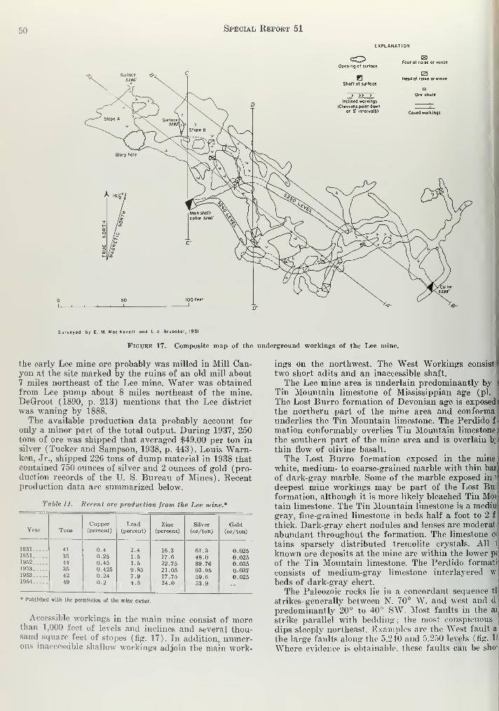
50 Special Report 51
EXPLANATION
Opening ot surface
CSSFoot of raise or winze
HShaft ot surface
IZ1Head of raise or winze
> >> > Ore chute
Inclined workings
{Chevrons point down|
at 5' intervals) Caved workings
Surveyed by E M. Moc Kevett ond L A Bruboker, 1951
Figure 17. Composite map of the underground workings of the Lee mine.
the early Lee mine ore probably was milled in Mill Can-yon at the site marked by the ruins of an old mill about7 miles northeast of the Lee mine. Water was obtainedfrom Lee pump about 8 miles northeast of the mine.DeGroot (1890, p. 213) mentions that the Lee district
was waning by 1888.
The available production data probably account for
only a minor part of the total output. During 1937, 250tons of ore was shipped that averaged $49.00 per ton insilver (Tucker and Sampson, 1938, p. 443). Louis Warn-ken, Jr., shipped 226 tons of dump material in 1938 thatcontained 750 ounces of silver and 2 ounces of gold (pro-duction records of the U. S. Bureau of Mines). Recentproduction data are summarized below.
Table 11. Recent ore production from the Lee mine.*
Year TonsCopper(percent)
Lead(percent)
Zinc(percent)
Silver
(oz/ton)
Gold(oz/ton)
1951
1951
19521953
1953
1954
41
3544
354249
0.40.250.450.4250.240.2
2.41.5
1.5
9.857.94.5
16.317.6
22.7521.0517.7524.0
61.348.089.7693.9559.653.9
0.0250.0250.0350.0370.025
• Published with the permission of the mine owner.
Accessible workings in the main mine consist of morethan 1,000 feet of levels and inclines and several thou-sand square feet of stopes (fig. 17). In addition, numer-ous inaccessible shallow workings adjoin the main work-
ings on the northwest. The West Workings consist
two short adits and an inaccessible shaft.
The Lee mine area is underlain predominantly byTin Mountain limestone of Mississippian age (pi. .
The Lost Burro formation of Devonian age is exposed 1
the northern part of the mine area and conforma I
underlies the Tin Mountain limestone. The Perdido fl
mation conformably overlies Tin Mountain limestone i
the southern part of the mine area and is overlain h; i
thin flow of olivine basalt.
The Lost Burro formation exposed in the mine a
white, medium- to coarse-grained marble with thin bail
of dark-gray marble. Some of the marble exposed in I
deepest mine workings may be part of the Lost Buii
formation, although it is more likely bleached Tin MoV-
tain limestone. The Tin Mountain limestone is a mediur
gray, fine-grained limestone in beds half a foot to 2 f \
thick. Dark-gray chert nodules and lenses are moderat'
abundant throughout the formation. The limestone c«l
tains sparsely distributed tremolite crystals. All1f
known ore deposits at the mine are within the lower p;,
of the Tin Mountain limestone. The Perdido formatii
consists of medium-gray limestone interlayered wi
beds of dark-gray chert.
The Paleozoic rocks lie in a concordant sequence tli
strikes generally between N. 70° W. and west and d
!
predominantly 20° to 40° SW. Most faults in the an
strike parallel with bedding ; the most conspicuous
dips steeply northeast. Examples are the West fault a)
the large faults along the 5,240 and 5,250 levels (fig. If)
Where evidence is obtainable, these faults can be shd

Darwin Quadrangle51
EXPLANATION
Tin Mountain limestone to
Foult showing dip
Doshed where opproximote
Vertical foull
"Tso
Strike ond dip of beds
Ore showing dip(Highly oxidized borite -guortz-calcite
vein with minor sulfides ondsecondary ore minerols)
XXXColcite
MAP AT 5242' MAP AT 5222'
50 100 Feet
EM MocKevett ond L. A. Brubaker, 1951
Figure 18. Geologic maps of the underground workings of the Lee mine.

52 Special Rki-okt 51
szoo"*-
^-iBedding ?
-^ /
/ A' /7 ff
/I \
I \
I \
I I
SECTION A-A'
SECTION B-B'
Moin shaft C
SECTION C-C' SECTION D-D'
5200'
r>D
Ctm 1 !\5
*̂
S2T3' - A j.
0/
7 i
3250' -
iii
\ /
, W"i Ctm
hermal
EXPLANATION
QTin Mountoin $ Foult, dashed where Ore Hydrothermol calcite Iron staining Breccia Mine workingslimestone
1 5; approximately located
I i i_
50 100_l Geology by E. M. Mac Kevett 1951
Fkjche 19. Geologic sections of the Lee mine.

Darwin Quadrangle 53
; normal faults. The cumulative dip slip of the Westt and two similar faults south of it is about 50 feet,
ther less prominent fault set strikes parallel withling and dips steeply southwest. Minor bedding-
e faults are present locally.
le rocks are brecciated and shattered in the vicinity
le main workings. Some of the brecciated rocks are
ineylike and have a long vertical dimension ; for
lple, the breccia at the inaccessible shaft 100 feet S.
E. of the main shaft is at least 70 feet long in verti-
limension. Well-stratified subrounded material rang-
in size from fine sand to pebbles occurs at two places
le mine in vertical pipelike bodies about 7 feet in
leter circumscribed by near-vertical slickensides.
e ore fragments are in the breccia. Both the chimney-breccias and the detritus-filled chimneylike bodies
believed to be formed by the solution of limestone
ag a period of abundant rainfall and the subsequent
pse of the overlying rock. The well-stratified ma-,1 was deposited in the solution cavities prior to the
pse.
:e occurs as discontinuous, flat-lying bodies that are
>art controlled by bedding or bedding-plane frac-
5. The size and shape can best be inferred from the
;nsions of the old stopes (figs. 18, 19). The largest
es are about 1,400 square feet in area, about 16 feet
laximum height, and 6 feet in average height. Orees exploited in recent years were considerably
ler, and, in general, yielded between 50 and 100 tons
re each.
ost of the ore is oxidized and only relicts of the pri-
V minerals remain. Hemimorphite is the most abun-
; ore mineral. It is in radial and divergent aggregates
ght-gray to colorless crystals associated with cerar-
te, which economically is probably the most impor-
mineral. The cerargyrite is in euhedral olive-green
tals that are cubes 0.2 mm on a side modified by octa-
al faces. In addition aurichalcite, azurite, bindheim-
cerussite, chrysocolla, and native copper have been
tified.
ilena is the most abundant primary ore mineral. It
-esent as relicts 1 inch to 4 inches in diameter sur-
ided by oxidized ore minerals. Cerussite and angle-
are found only where relict galena is evident. Minorants of sphalerite, pyrite, and tetrahedrite are in
primary ore. The sphalerite is in irregularly shaped
ments as great as an inch in maximum dimension
is a resinous light brown. Barite, quartz, calcite, and
cedony are the principal gangue minerals and gyp-
and clay minerals are in small quantities,
ae most important ore bodies are near fault zones
re the rocks are in part brecciated and shattered,
lough most ore bodies are shallow dipping and gen-
[y conform to bedding, locally they steepen and ap-
ntly transect bedding. Some of this steepening maydrag effect of post-ore faulting. The favorable ore
occupied by the discontinuous ore bodies plunges
ly to the southeast (see fig. 19, section A-A')-
Tiere steep northeast-dipping faults, such as the West
t, are mineralized, they contain abundant quartz,
ite, yellow and brown ocherous iron oxides, andcedony, but they contain little ore minerals. Move-
t on the steep faults was probably instrumental in
ling open fractures parallel to bedding that served
as locii for ore bodies, but the steep fractures servedonly as channelways for the ore solutions. Slickensidedselvages and local shattering indicate some post-ore
movement. The northeast-dipping fractures in places off-
set the shallow-dipping ore bodies of the main workings.
Santa Rosa Mine
The Santa Rosa mine is in sees. 26 and 35 (projected),T. 17 S., R. 39 E., in the southern part of the InyoMountains at an altitude of 6,500 to 7,100 feet. The mineis described in detail by Mackevett (1953), and his re-
port is summarized here.
Workings consist of the 352-foot Hesson inclined shaft,
several shallower shafts, about 1,500 feet of drifts andcrosscuts, and extensive stopes. In addition, an 1,800-
foot westerly trending crosscut adit was driven in 1953to explore the known veins at greater depth.The mine is the eighth largest lead producer in the
State. From the time of its discovery in 1910 until 1950the mine produced 36,854 short tons of ore containing11,990,792 pounds of lead, 487,347 pounds of copper,
4,105 pounds of zinc, 426,543 fine ounces of silver, and478.7 fine ounces of gold (Mackevett, 1953, p. 4). Lessees
have mined some ore from the new deeper workingssince 1953.
The mine is within an inlier of the lower limestone
member of the Owens Valley formation of Permian agethat has been metamorphosed to calc-hornfels. The inlier
is approximately 2,000 feet long and 600 feet wide. It
is encircled by Tertiary and Quaternary volcanic rocks
consisting of olivine basalt, tuff, tuff-breccia, agglom-erate, and andesite. The calc-hornfels is a dense, fine-
grained rock that is greenish-gray on fresh surfaces andweathers brown. It consists mainly of calcite, quartz, anddiopside and minor amounts of zoisite, garnet, epidote,
limonite, and opaque minerals. Minor beds of unsilicated
bluish-gray limestone that are locally fossiliferous are
interbedded with the calc-hornfels.
Andesite porphyry dikes, which were called syeno-
diorite porphyry by Mackevett (1953), are 2 to 6 feet
thick, strike N. *70° W., and dip nearly vertical. Thesedikes cut the Owens Valley formation of the inlier but
do not cut the adjacent volcanic rocks. Northeast-trend-
ing, steeply dipping basalt dikes 2 to 16 feet thick cut
both limestone and volcanic rocks.
The inlier of calc-hornfels is structurally a horst. TheSanta Rosa fault bounds the inlier on the east, andanother steep fault forms part of the western boundaryof the inlier. The Santa Rosa fault is a north-trending
normal fault that dips about 80° E. The east block has
been downfaulted probably at least 250 feet. Rocks of
the inlier strike N. 10°-20° W. and dip 30°-70° NE.Faults of prevolcanic age within the inlier contain the
ore-bearing veins. The most important faults strike par-
allel with bedding and dip 30° to 60° SW. Some of the
ore-bearing faults strike parallel with bedding and dip55° to 80° NE. or strike about east and dip nearly
vertically.
Ore is in veins within prevolcanic faults. At least 12
veins are exposed. They range from less than 100 feet
to 700 feet in length and average between 3 and 4 feet
in thickness. West-dipping veins are the most abundant
and productive. Fissure filling was the dominant process
involved in the emplacement of the veins.

54 Special, Report 51
EXPLANATION
™%mmmm. Dlbm
Lost Burro formationDlbl, fine grained medium-gray
limestone; Dlbm, marble
Contact, approximately located
90
Vertical fault
Fault showing dip
Doshed where approximate
Strike and dip of beds
Ve in showing d ip
Outcrop of vein
Bal shaft
prospect pit
300 300i
Contour interval 20 feet
Figure 20. Geologic map of the Silver Reid prospect.
Geology by L. A. Brubaker, May 195
and W. E. Hall, June 195
Topography by E. M. MocKevett 195
600 FeetI

Darwin Quadrangle 55
veins are highly oxidized and consist chiefly of
ite and hemimorphite in an iron-stained silica- and-rich gangue. The primary ore is composed mainly
rite, sphalerite, and galena with subordinate ar-
rrite and chalcopyrite. The grade of ore within a
3 erratic, and the richest ore occurs in shoots in
icker parts of veins. Outlines of workings indicate
lost of the production from the Hesson vein, eco-
illy the most important vein, was from a shoot
aked gently to the north.
adit was driven under the mine workings by Thenda Company to explore the veins at depth. The?as driven westerly 1,800 feet at an altitude of
6,580 feet from the sharp bend in the road at the
I the tramway from Upper Sanger workings. (See
vett, 1953, pi. 2.) The adit is completely in calc-
;ls. The ore showings in the adit are sparse. Most•. veins have pinched out above the level of the
>ut some zinc-rich primary ore was discovered andjing mined in 1955.
ver Reid Prospect
Silver Reid prospect is 12.5 miles north of Darwinsoutheastern part of the Santa Rosa Hills in sec.
rejected), T. 17 S., R. 40 E. The prospect is ac-
e by a dirt road that leads from the Saline Valley
. mile east to the Lee mine; the property adjoins
ee mine on the north. The surface geology was
mapped by L. A. Brubaker and E. M. Mackevett in
May 1951 and additions were made by W. E. Hall in
July 1953.
The Silver Reid prospect was staked in 1924 by W. A.Reid, and it is now owned by his widow, Mrs. AgnesReid of Panamint Springs, Calif. The property has beenprospected intermittently since 1924, and by 1951, de-
velopment work consisted of about 25 shallow pits andshafts and several near-surface stopes. No productionhas been recorded from the property, but a small pro-
duction may have been lumped with that of the Leemine.
The Lost Burro formation of Devonian age crops outin the prospect area (fig. 20). It is conformably over-
lain by Tin Mountain limestone of Mississippian agesouth of the prospect at the Lee mine, and it is un-conformably overlain by flat-lying basalt of Tertiary or
Quaternary age and by alluvium to the west and northof the prospect. A section 1,500 feet thick of the Lost
Burro formation is exposed in the area. It consists of
white, medium- to coarse-grained marble that is char-
acteristically banded parallel to bedding and contains
streaks and thin beds of dark-gray marble less than aninch thick. Quartzite lenses are locally in the whitemarble. Fine-grained, medium-gray limestone beds as
much as 50 feet thick are interbedded with the whitemarble in the northeast part of the prospect area near
the base of the exposed section of Lost Burro. Thin
EXPLANATION
01b
Lost Burro formation
(mainly white marble)
z<zo>UJa
__iL°
Contact, approximately locoted,snowing dip
Fault showing dip
(Dashed where opproximote)
Vein containing quartz, coicite,
barite, and minor goleno
Sloped vein
C^Open cut and outline of slope
d by W.E.Hall , 1953
20 40 FEET
Figure 21. Geologic map of the main stope of the Silver Reid prospect.

Special Report 51
EXPLANATION
Ool
Alluvium
01b --
gESg-DlbqLost Burro formation
(Mainly limestone ; Dlbq, quartzite J
Fault showing dip and relative movt(Dashed where approximate)
.. r-90
Vertical foult
Contact
Foult breccia
~r70
Strike and dip of beds
Limonite
Dolomitized limestone
Portal of adit
co ^.
Smoll prospect pit or open cut
I }
Dump
Shaft at surface
Mapped by LA Brubaker and
EM MacKevett, 1951
100 50
Contour interval 20 teet
Figure 22. Geologic map of the Cactus Owen prospect area.
chert interbeds are abundant in the medium-gray lime-
stone near the base of the exposed section.
Bedding in the Lost Burro formation strikes N. 45°
W. to west and dips southwest to south from 35° to 87°
except for local steep northeast dips near the crest ofthe hill. Two sets of faults are evident in the mine area.
One set strikes about N. 70° W., approximately parallel
to the strike of bedding, and dips steeply either to thenorth or south. The other set strikes N. 20°-70° "W. anddips gently southwest. The flat faults have no appreci-able displacement and are probably fractures formed bydifferential movement along the steep major faults. Themajor faults strike parallel to bedding, but in generaldip more steeply than bedding. They are believed tohave mainly a strike-slip displacement.
Ore is localized in small bodies in flat-lying faults nearmajor steeply dipping faults striking N. 60°-80° W.Most of the steep faults are only slightly mineralized.The largest known ore body has been stoped over an
area 40 feet long and 20 feet wide, and it has an ave:$
thickness of 2 feet (fig. 21). At least five other flat Vi
are exposed on the surface or in shallow prospect i
(fig. 20) to the northwest of the main stope, but ii
are extensively developed.
At a few places the steep N. 60°-80° W. faults low!
the vein material. At the west side of the Silver li
prospect an inclined shaft has been driven to a dd
of 56 feet on a N. 70° W.-striking fault. At the sur]
the fault shows little mineralization, but a 30-foot ci
at the bottom of the inclined shaft exposes a vein]
3 feet thick, and a winze has been driven on the 1
to a depth of 10 feet below the level. The steeply-dip] i
vein is similar in mineralogy to the flat-lying veins.
The veins consist of minor galena and pyrite i
gangue of quartz, calcite, and barite. Secondary coji
minerals and a yellow antimony mineral, probably b«
heimite, are present locally. No silver minerals were si

Darwin Quadra n< i i .i •X
ttle data are available about the grade of the ore.
rt Glenn (oral communication, 1954), lessee of theining Lee mine, sampled the dump near the Mam; and reports the sample assayed 18 ounces of silver
;on.
i and Prospects in the Talc City Hills
actus Owen (Midway) Prospect
ie Cactus Owen prospect is in sec. 25 (projected),I S., R. 39 B., on an isolated hill U miles N. 70° W.e Talc City mine, at an altitude of 5.01)0 feet. The3ect has no recorded production. Workings consist
clined shafts 40 and 200 feet deep, a short adit, andt 300 feet of levels.
mestone and quartzite of the Lost Burro formationsvonian age crop out in the prospect area (fig. 22).limestone is a light-gray, bleached rock in beds 1
to 4 feet thick. It is recrystallized and shows evi-
s of intense deformation. Several quartzite beds 1
to 12 feet thick are interbedded with the limestone,quartzite is medium-gray on fresh surfaces andhers light brown.
e sedimentary rocks strike N. 80° W. to west andsteeply south. They are cut by a steep fault thates N. 20°-30° E. The fault is marked by an iron-ed breccia zone about 10 feet thick. Other faults arellel or nearly parallel to bedding. They are ironed and in some places have local pockets of quartzcalcite. Workings have mainly developed the bed-plane faults.
e only ore minerals observed were found on the
) and consisted of a few scattered galena fragmentsiated with quartz and minor quantities of pyritespecular hematite. Calcite commonly coats and veinstz. Minor gossan is exposed in a few places but ap-i barren of ore minerals.
omestake Mine
e Homestake mine is 2,000 feet northwest of theCity mine in sec. 30 (projected), T. 18 S., R. 40 E.,
altitude of 5,520 feet. The mine is owned by Edithhart and George Koest. Workings at the Homestake)er 1 claim consist of inclined shafts 50 feet and 150leep and workings on the adjacent Homestake nuiii-
claim include a 45-foot adit trending S. 33° W. and1-foot drift trending N. 45° W.e country rock is thin-bedded bluish-gray limestonee Lost Burro formation that strikes N. 70° W. and70° SW. The mine workings follow major shear
I The major structure at the Homestake number 1
i is a shear zone 2 to 10 feet thick that strikes N.W. and dips 70° SW. The upper workings are ontz-rich shear zones as much as 6 feet thick that
3 N. 45° W. and N. 33° E. and dip steeply south,
sheared limestone is iron stained and is locally re-
d by dolomite. In places the shear zones are re-
d by pockets of quartz and minor calcite, cerussite,
morphite, and oxidized copper minerals.
ilver Dollar (Domingo) Mine
e Silver Dollar mine is 2,600 feet east of the Talc
mine in sec. 29 (projected), T. 18 S., R. 40 E., in
astern part of the Talc City Hills at an altitude of1 feet. It is owned by Edith T ickhart and George
Koest, mailing address Darwin, Calif. Early mining op-erations were for lead and silver, lint in recent years talc
deposits have been exploited on some of the claims. Pro-duction data from the files of the Q. S. Bureau of Mines,San Francisco office, for the metalliferous deposits aregiven below. These data are given under the name Do-mingo, a former name of the mine. George Koest pro-
vided much of the following historical information.
Tiihlf LI. Ore produced from the silrcr Dollar (Domingo) mine.*
YearGold(oz)
Silver
(OZ)
Copper(lbs)
Lead
1910 .
1.79
1 .45
5,360
12.247
1,117
970 229
107,000
326,57835.374
830
191 1 _ . .
1913-.1915
* Product ion figures furnished by the 1'. S. Bureau of Minispermission of the mine owners.
and published with the
Ore was first discovered on the property in 1910 at
the site of the main pit and all the recorded productionwas made during the ensuing five years. During late
1910 and early 1911 a shaft, sunk to a reported depth of90 feet, explored a vertical vein on the south side of the
main pit. During the next four years, lessees enlargedthe main pit and drove short drifts along a vein dippingto the northeast, backfilling the original shaft. Thisnortheast-dipping vein was followed for 100 feet downthe dip before work was abandoned in 1915. During the
late 1930 's the present owners sunk a 130- foot shaft 100feet east of the main pit. Crosscuts were driven from the
bottom of the shaft to points under the main pit, but noore was found. The main talc workings consist of a
75-foot inclined shaft with several hundred feet of drifts
and crosscuts.
The Silver Dollar mine is in a complexly faulted area
underlain by the Lost Burro formation of Devonian ageand the Keeler Canyon formation of Pennsylvania]] andPermian age (fig. 23). Minor Rest Spring shale of Penn-sylvanian age crops out in fault zones. The Lost Burroformation consists mainly of massive light-gray dolomite
but includes some medium-bedded, light-bluish graylimestone and minor quartzite. The Rest Spring shale is
a dark-brown fissile shale that is localized along a thrust
plane. Bluish-gray thin-bedded cherty limestone of the
Keeler Canyon formation is the host rock for the lead-
silver ore.
The Devonian rocks are thrust over the Rest Springshale and the Keeler Canyon formation. The best ex-
posure of the thrust fault is about 300 feet north of the
main pit where the Lost Burro formation overlies the
Rest Spring shale. Numerous steeply dipping faults that
strike about N. 50° W., approximately parallel to bed-
ding, displace the thrust fault. Some of the northwest-
trending faults contain dragged and shattered quartzite.
Rocks in the thrust plate are strongly folded. The con-
tact of limestone and dolomite 175 feet southeast of the
main pit is parallel to bedding, and the structure is a
faulted inverted syncline.
Ore from the main pit probably accounts for almost
the entire mine production. The ore is in limestone of
Pennsylvanian and Permian age in a fault zone that
strikes N. 55° W. and dips steeply northeast. Judging

58 Special Report 51
1 3 U- £ » T n 1 - ' ? ,K ^ 1 * ° °
I ' - 1 > ; ^S '; .2 ! • -
N«IHd3d OOTAiTONSlLOTlO N»INttyUSNN3d WINWCUSNN3d

Darwin Quadrangle 59
a the size and shape of the main pit, the main ore
y was about 35 feet long, 30 feet thick, and extended
eet down dip. Little ore remains in any of the work-
;, but many faults in the mine area are strongly iron
tied and contain quartz, calcite, and jasper. A com-ition of abundant local faulting and shattering and.vorable host rock probably accounts for the localiza-
of ore at the main pit. No data are available regard-
the tenor of the ore.
he talc deposits are within dolomite of the Lost
to formation 650 feet northwest of the lead-silver
The talc is in strongly sheared masses in a fault
; that strikes N. 20° W. and dips 70° SW. The de-
Its were not mapped. The talc is pale green and is
ly laminated by shearing. Locally it contains someirite. Several of the N. 70° W.-trending faults in the
;hern part of the map area contain talc and they havel explored by small pits (fig. 23).
Tungsten Deposits
by W. E. Hall, E. M. Mackevett, and D. M. Lemmon *
ribution
ungsten in the mineral scheelite has been recovered
the Darwin quadrangle principally from mines in
[18 and 19, T. 19 S., R. 41 E., in the east part of
Darwin Hills 1 mile to 1£ miles east and northeast
Darwin. Stolzite has been reported by Tucker andipson (1941, p. 567). However, D. M. Lemmon sub-
ted similar material to Jewel Glass of the U. S. Geo-
cal Survey as that from which stolzite was reported,
the material was identified as scheelite mixed with
»r minerals but it contained no stolzite. Some schee-
is present in the Thompson mine of the Darwinup, but it is intimately associated with galena andicult metallurgical problems have discouraged efforts
ecover it except from local high-grade concentrations
t were mined selectively and given special metallur-
il treatment. A small amount of scheelite has beenled from deposits on the northeast slope of the Cosolge about 8 miles west and southwest of Darwin. All
one of these deposits, the Lone Pinyon, which lies
hin the quadrangle in sec. 26, T. 19 S., R. 39 E., are
th of the Darwin quadrangle (pi. 1).
lorae of the deposits in the Darwin district contain
h scheelite and lead-silver minerals or scheelite andper minerals. The Custer, Defiance, Fairbanks, Jack-
Lane, Promontory, Standard, Thompson, and Won-mines have both lead-silver and tungsten minerals,
jse properties, which were developed mainly for their
i-silver ore, are described under the heading, "lead-e-silver deposits".
tory and Production
Although scheelite was recognized in the Darwinrer-lead district during World War I, the deposits
lained undeveloped until 1940. At this time Frankttkins purchased a group of patented claims on the
t side of the Darwin Hills at a tax sale, relocated
litional claims, and with C. W. Fletcher and others
anized the Darwin Consolidated Tungsten Companydevelop the tungsten. In 1941 the E. L. Cord interests
ler the name Pacific Tungsten Company leased 23
eologist, U. S. Geological Survey.
mining claims from the Darwin Consolidated TungstenCompany, and during the ensuing twelve months theyproduced 30,940 tons of ore that averaged about 1 per-
cent W03 (Wilson, 1943, p. 544). The ore was treated
at a mill near Keeler owned by the West Coast TungstenCorporation. This production was principally from the
Durham, Fernando, St. Charles, and Hayward claims.
Possibly 25,000 tons of tungsten ore has been mined in
the district from 1944 to 1955.
Howard Miller and Louis Warnken leased the Dur-ham-Fernando and St. Charles groups of claims from1951 to 1953, and the Hayward and St. Charles groupduring 1951-1955. They erected a mill in Darwin Washfrom which they recovered approximately 2,475 units of
W03 from 1952 through 1954. The Ajax Tungsten Cor-poration, C. H. Hall, president, obtained a lease on the
Durham and Fernando properties in 1954 and shippedsome ore.
The scheelite in the Thompson mine of the Darwingroup normally is not recovered except from local con-
centrations of high-grade ore that are mined selectively.
Davis and Peterson (1948, p. 2) report that several hun-dred tons of high-grade scheelite ore containing 10 to
15 percent WO3 have been mined, and scheelite wasbeing stockpiled at the Darwin mine in March 1955.
This high-grade ore was shipped to Tooele where it wasfused with sodium carbonate and then leached with hot
water for recovery of WO3.Some deposits about 1 mile east and southeast of Dar-
win were located originally in the 1890 's for their coppershowings, but they were operated briefly during WorldWar II for tungsten. These include the Alameda andToga claims. The Alameda claim is mentioned as a cop-
per prospect by Aubury (1908, p. 313) under the nameRichardson group, and part of the Toga claim is prob-
ably part of the Kingman claim described bv Auburv(1902, p. 245).
Acknowledgments and Previous Work
The eastern part of the Darwin Hills, where the tung-
sten deposits are located, was mapped by Kelley (1938,
pi. 7) as part of his study of the Darwin silver-lead
district. He identified scheelite on the Bruce claim. AU. S. Geological Survey party under D. M. Lemmonstudied the tungsten deposits from Nov. 3, 1941 to
March 4, 1942. They mapped the Durham-Fernando-St.Charles area on a scale of 1 inch equals 200 feet andmade larger scale maps of the underground workings.
Their maps are published in this report, and with addi-
tional data supplied by Lemmon serve as the basis for
the description of the tungsten deposits. The writers
mapped the recent workings in the Fernando and St.
Charles mines. The U. S. Geological Survey party under
D. M. Lemmon also mapped the tungsten prospects in
the Coso Range in Feb. 1942.
L. K. Wilson (1943, p. 543-560), geologist for the
Pacific Tungsten Company, described the tungsten de-
posits in the Darwin district, their genesis, and the op-
erations of the Pacific Tungsten Company from 1941 to
1943. The U. S. Bureau of Mines under D. W. Butner
(1949, p. 2), project engineer, trenched and sampled
nine properties in the Darwin district in 1941-42. Most
of this work was done at the Silver Reef mine, owned
by Mickey Summers' estate, at the south end of the

60 Special Report 51
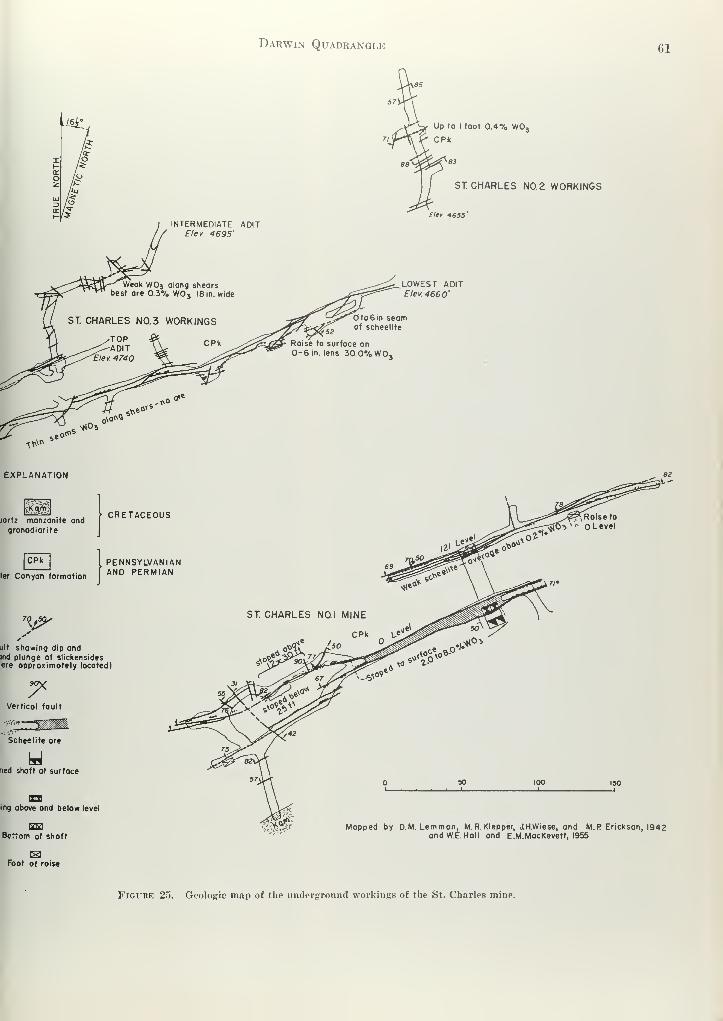
Dakwin Quadrangle 61
Up to I foot 0.4% WOj
I
ST CHARLES N0.2 WORKINGS
Elev 4655'
LOWEST ADITElev. 4660'
to 6 in seamof scheelite
ise to surface on0-6 in. lens 30.0% WO,
^rgiartz monzonite andgranodiorite
CPk
CRETACEOUS
PENNSYLVANIAN
ler Conformation AND PERMIAN
V*'ult showing dip andind plunge of slickensidesere approximately located)
ST. CHARLES NO.I MINE
CPK _ \,e
BOX
Vertical fault
Scheelite ore
ned shaft ot surface
x in
ing above and below level
rzra
Bottom of shaft
ISFoot of raise
ilffl&f Mapped by DM. Lemmon, M. R. Klepper, JH.Wiese, and M.P Erickson, 1942and W.E. Hall and E.M.MacKevett, 1955
FiGX'RE 25. Geologic map of the underground workings of the St. Charles mine.

62 Special Report 51
Darwin Hills south of the Darwin quadrangle, but some
work was done on all the principal tungsten showings
in the Darwin Hills.
Deposits in the Darwin District
Geologic Setting
Most of the tungsten deposits in the Darwin district
are within metamorphosed rocks of the upper part of
the lower member of the Keeler Canyon formation of
Pennsylvanian and Permian age close to the eastern con-
tact of the stock of the Darwin Hills. The rocks consist
of calc-hornfels, marble, and tactite that are metamor-phosed equivalents of interbedded silty and sandy lime-
stone, limy shale, and pure limestone. The metamor-phosed zone extends about 3,000 feet east of the stock.
The calc-hornfels is derived from limy shale and silty
and sandy limestone. The relatively pure limestone beds
are in part unmetamorphosed, but in most places they
are recrystallized to marble or altered to tactite.
Calc-hornfels is the predominant rock type. It is a
light-gray to greenish-gray dense rock with a wide range
in mineralogy depending upon the original composition
of the rock. In general, the calc-hornfels is composed of
diopside and wollastonite with lesser amounts of garnet,
oligoclase, scapolite, tremolite, and relict calcite. Thepure limestone beds are partly recrystallized to a gray,
medium-grained marble. Locally the marble and lime-
stone are replaced by tactite within a few hundred feet
of an intrusive contact close to the intersection of faults.
Most of the tactite is a garnet- or idocrase-rich rock, butsome contains epidote, diopside, wollastonite, and calcite.
The garnet is andradite.
The eastern contact of the stock of the Darwin Hills
is very irregular. Many small dikes and sills extend as
far as 1,500 feet east of the main intrusive body, andthe tungsten deposits are localized close to these off-
shoots. A group of dikes and small, irregular intrusions
extend east of the main stock on the St. Charles claims.
A sill of quartz monzonite is 160 feet east of the Dur-ham glory hole, and an irregular intrusion crops out
along the ridge between the Durham and Chipmunkmines (pi. 9).
The Paleozoic rocks have been tilted into an over-
turned section that strikes north and dips 30° to 78° W.as described under the subtopic "Geology" in the sec-
tion on the Darwin lead-silver-zinc district. Numerousfaults that strike N. 60° E. to east and dip steeply either
north or south cut the rocks, but the displacement alongthe faults is small. Slickensides are nearly horizontal,
and the displacement is predominantly left lateral.
Ore Bodies
Scheelite ore bodies are found as replacements of purelimestone and tactite beds close to the intersection withN. 70° E.-striking faults and within the N. 70° E. faults
mostly where the wall rock is pure limestone or tactite.
Most of the ore is found within 3 limestone beds locally
known as the Durham, Frisco, and Alameda beds (pi. 9).
Only the Durham ore body is known to extend morethan 60 feet vertically (fig. 24). The Durham and Ala-meda ore bodies are replacements of pure limestone andtactite beds close to the intersections with the Fernandoshear zone. The Durham ore body is a replacement of
the footwall of the Durham limestone bed where it Icontact with calc-hornfels. The ore body is expose!350 feet at the surface and has been mined to a dej I350 feet where the ore body is only 30 feet long (fig IIts thickness ranges from 2£ to 35 feet.
Three ore bodies that are replacements of the Ala Jbed near N. 70° E. faults have been mined. Two sithe intersection of the Alameda bed with the Ferr I
shear zone; the third is 1,000 feet northwest of thelnando shear at the Alameda shaft. The largest of I
ore bodies is at the intersection of the Alameda bed Ithe Fernando shear 950 feet S. 80° W. of the port!the Fernando adit. It has been developed by an opel50 feet long parallel to the strike of the enclosing I
stone, 60 feet wide, and about 20 feet deep. A drif 1being driven in 1955 under the pit to develop ore!remained at the bottom.
The ore in the St. Charles-Hayward area is in N|E. faults that dip steeply to the northwest (pi. 9) I
largest ore body is developed by the St. Charles J]
workings (fig. 25). The ore shoot was 140 feet long!10 feet thick, and was mined from the surface 11
average depth of about 30 feet. Most of the scheelill
posed in the St. Charles No. 2 and St. Charles 11
workings is in thin veins or streaks along N. 7(|faults, and no scheelite is disseminated in the wall
between faults (fig. 25). The streaks range from ation of an inch to 6 inches thick and can be minedby highly selective methods or where fractures are
ciently close that several can be mined together. Soi
the streaks contain 10,to 30 percent W03 , but the{
of ore over a mining width would probably averageabout 0.2 to 0.3 percent W0 3 .
Grade
The grade of ore mined from the district has avei
about 0.75 percent W03 . Wilson (1943, p. 558) re
that from 1941 to 1942 approximately 32,000 tons o
averaging more than 1 percent W03 was mined froi
Darwin Hills. The ore at the Durham mine averaj
percent WO3 over an average width of 15 feet 01
200-foot and 300-foot levels (Wilson, 1943, p. 558)
grade of ore at the St. Charles No. 1 mine was higr
ranged from 2 to 10 percent W03 . Ore mined since
averaged about 0.5 percent WO3.Submargirxal ore is present at the Fernando mint
to a lesser extent at the St. Charles No. 3 mine. Themarginal ore at the Fernando mine is exposed ir
main Fernando adit along the Fernando shear zone
24). Scheelite is localized along fractures over a le
of 610 feet and a width up to 50 feet ; some parts oi
area are estimated to contain 0.2 to 0.5 percent WOOre Controls
The ore controls for scheelite are both stratigr?
and structural. Pure limestone, and tactite formed 1
alteration of it, are more favorable for ore than 1
calc-hornfels. However, the dense calc-hornfels cannl
eliminated as a possible host rock as some ore has
mined from it. The bedded replacement body at the I
ham mine selectively replaced tactite and pure limes 1
Most other occurrences of scheelite in the district a
along N. 70° E.-striking faults, and scheelite mai

Darwin Quadrangle 63
t whether the wall rock is tactite, limestone, or
)rnfels. Commonly the scheelite zone is widest
a fault cuts tactite and thins to a narrow stringer
the fault cuts calc-hornfels. In both the St. Charles
workings and in the Hayward mine, ore has beenfrom veins where the wall rock is calc-hornfels. Atlyward mine the ore is widest where the wall rock
ite, and the vein thins to a thin stringer to the east
the wall rock is calc-hornfels. The ore body rakes
west parallel with bedding.
nitic rocks must be close by in order to form either
or scheelite. The most favorable places for ore are
small satellitic intrusive bodies crosscut structure,
ctite and scheelite do not necessarily form adjacent
intrusive rocks, but are within a few hundred feet
•usive rocks and commonly are localized by faults.
leralogy
primary tungsten ore contains scheelite in a
e of andradite, calcite, fluorite, idocrase, and py-3ismuthinite is present at the Fernando mine,
j the wall rock is hornfels, wollastonite and diop-
•e common. At the Thompson mine the scheelite is
ited with galena, sphalerite, pyrite, chalcopyrite,
e, and calcite in light-colored calc-hornfels com-of idocrase, garnet, wollastonite, diopside, and
e.
scheelite is commonly in euhedral crystals as muchches in diameter. At the Thompson mine, euhedral
hedral crystals of scheelite predominantly three-
s to three-fourths inch in diameter are surrounded1 places veined and slightly corroded by sulfide
lis. Davis and Peterson (1948, p. 2) described
ral scheelite crystals in a powdery matrix of limon-
rosite, and clay minerals from the oxidized ore in
lompson mine. At the Durham, Fernando, and St.
;s mines galena and sphalerite are only in small
its in tungsten ore bodies, but they occur elsewhere
the same ore controlling structures farther from)ck of the Darwin Hills.
Durham ore body contains bismuthinite and py-
sar the intersection of the Durham bed with the
ndo shear zone. The bismuthinite is in tabular
Is as much as 2 inches long in calcite veinlets that
e tactite. It is mostly pseudomorphously replaced
;ht green powdery bismutite. The tungsten ore
from the Durham ore body had an average bis-
metal content of approximately 0.05 percent, but
muth was recovered.
t of the ore is oxidized and consists of euhedral to
Iral crystals and grains of scheelite in a crumbly
I of limonite, calcite, and partially decomposed
licate minerals. Chrysocolla, azurite, malachite,
ppsum coat some of the fractures. Bismuthinite at
;rnando mine is nearly completely altered to bis-
!. The scheelite in the upper stopes of the Thomp-ine is embedded in a crumbly matrix of limonite,
;e, cerussite, and clay minerals. The scheelite re-
el essentially inert to the meteoric waters, although
I other minerals were oxidized or partly leached;
:he ore has undergone some residual enrichment of
en.
Alameda Mine
The Alameda mine is 4,200 feet N. 80° E: of Darwinin sec. 19, T. 19 S., R. 41 E., at an altitude of 5,000 feet.
The property was originally developed as a copper pros-
pect by Charles Richardson in the early 1900 's and hesunk an inclined shaft 103 feet deep (Aubury, 1908,
p. 313). Very little drifting or crosscutting were done.
A pocket of scheelite ore was reported in the shaft at
a depth of 95 feet by Wilson (1943, p. 557). This pocketwas mined by the Pacific Tungsten Company duringWorld War II, and an additional small tonnage wasmined in 1953 by W. E. Schmidt who had a sublease
on the property from Howard Miller and Louis Warn-ken, Jr. The total tonnage of tungsten ore mined is
small, because the stope at the bottom of the shaft is onlyabout 25 feet long, 6 to 10 feet wide, and 9 feet high.
The rocks in the mine area are marble, calc-hornfels,
and tactite of the Keeler Canyon formation and are
intruded 290 feet west of the inclined shaft by the stock
of the Darwin Hills. Bedding strikes N. 18° W. anddips 71° SW. The shaft is sunk in marble on a bedding-plane vein 3 feet thick. The vein contains a small amountof secondary copper minerals in a gangue of calcite andlimonite. Scheelite has been mined from a small stope at
the bottom of the shaft where the N. 18° W. vein is inter-
sected by a small fault that strikes N. 20° E. and dips77° SE. Only a small amount of scheelite remains alongthe cross fault.
Bruce Mine
The Bruce mine is 6,000 feet N. 28° E. of Darwin in
sec. 18, T. 19 S., R. 41 E., on the north side of LaneCanyon at an altitude of 4,800 feet. A steep dirt roadleads to the property from the road in Lane Canyon. Themine is owned by The Anaconda Company and wasleased to A. J. Pouch and "Frenchie" Lingsley of Dar-win in 1955. The workings consist of 2 adits about 80 and100 feet long and an open cut 50 feet long, 10 feet wide,
and 5 to 15 feet deep.
The rocks in the mine area are calc-hornfels and tactite
that are folded into an open anticlinal-shaped fold that
is an inverted syncline. The fold axis is approximately
350 feet east of the stock of the Darwin Hills. The rocks
are correlated with the upper part of the lower unit of
the Keeler Canyon formation of Pennsylvanian and Per-
mian age. The crest of the anticline is mineralized along
the surface for a distance of about 400 feet. In the open
cut the vein is 2 to 6 feet thick along the crest of the
anticline, and ore extends down the west limb of the
anticline as a bedding-plane vein that strikes N. 25° W.and dips 67° SW. The vein contains calcite, quartz,
limonite, chrysocolla, cuprite, malachite, garnet, and
scheelite. The grade or continuity of the deposit downthe dip is not known because of insufficient development.
Samples cut by D. L. Davis on surface exposures aver-
aged 0.40 percent W0 3 and approximately 1 percent
copper ; the vein shows only scattered ore minerals where
cut by the lower adit.
Chipmunk Claim
The Chipmunk claim, owned by W. E. McCully of
Darwin, is 6,000 feet S. 75° E. of Darwin in sec. 19, T.
19 S., R. 41 E., at an altitude of 4,700 feet. The claim is
850 feet S. 15° W. of the Durham open cut. A dirt road

64 Special Report 51
that branches off from the Durham road leads south to
the property. Mine workings consist of an adit 115 feet
long and several open cuts and short adits.
The rocks in the mine area are calc-hornfels and
tactite that are correlated with the top of the lower
member of the Keeler Canyon formation. Overturned
bedding strikes north and dips 65° to 80° W. A steep
fault that strikes N. 70° E. cuts through the portal of
the main adit, which trends S. 15° W. along another
steep fault.
Scheelite is exposed along the N. 70° E. fault for a
distance of 70 feet. Only a few specks of scheelite were
seen in the adit along the steep N. 15° E. -striking fault.
Darwin Group
Some of the lead-silver stopes of the Thompson work-
ings have local concentrations of scheelite, although most
of the ore contains no scheelite. Davis and Peterson
(1948, p. 2) report several hundred tons of lead-silver
ore containing 10 to 15 percent W03 was mined from
oxidized ore. Euhedral crystals of scheelite are found
loosely embedded in a matrix of cerussite, limonite,
jarosite, gypsum, and wulfenite. Primary ore has also
been found in the deeper levels that contain euhedral
crystals of scheelite surrounded and slightly embayed bygalena (photo 1). Small amounts of scheelite are in frac-
tures in or near the Water Tank fault near the crest of
the ridge east of the Darwin mining camp and on the
Bernon claim (pi. 5). All are too low grade to be ore.
Durham Mine
The Durham mine is 5,500 feet east of Darwin in sec.
19, T. 19 S., R. 41 E., at an altitude of 4,640 feet. Theproperty is accessible by a hard-surfaced road leading
south from Lane mill. Development work consists of aninclined shaft 250 feet deep with 4 levels totaling 1,100
feet of drifts and crosscuts (fig. 24). The 100-foot level
connects with the bottom of the Fernando shaft.
The rocks in the mine area consist of limestone, mar-ble, calc-hornfels, and tactite of the Keeler Canyon for-
mation and are intruded by a sill of quartz monzonite170 feet east of the Durham shaft. Overturned beddingstrikes north and dips 50° to 67° W. The rocks are inter-
sected bv a series of strike-slip faults that trend east to
N. 70° E.
The ore body extends south from the Fernando shear
along the footwall of a limestone bed 40 feet thick that
is in part recrystallized to marble and altered to anidocrase- and garnet-rich tactite. The tactite is in the
basal part of the limestone bed in the upper mine work-ings and in the central part of the bed below the 200-foot
level. Many small cross fractures cut the limestone andtactite.
The ore body is 350 feet long at the surface, and the
ore mined by the Pacific Tungsten Company in 1941 to
1943 ranged in thickness from 4 to 20 feet. The lowergrade wall rock has been mined by subsequent lessors
so that the glory hole now has a maximum width of 44feet. The ore body extended to a depth of 350 feet (fig.
24). On the and 100 levels, the best grade of ore is onthe footwall of the limestone bed where it is altered to
tactite. On the 200-foot and 300-foot levels the footwallis barren, and the ore is in the middle of the limestoneand tactite bed.
Scheelite occurs irregularly through much of th «tite, but the mineralization is more intense where oj
fractures are abundant, and scheelite extends out athe main ore body into tactite along these cross frac I
Fernando Mine
The Fernando mine consists of two patented clthat lie adjacent to the Durham mine on the north aboth properties are accessible by the same road. Th t»
mines have been worked as a unit through intercoiling workings. The Fernando mine was worked origjl
for its lead-silver values. The old workings are 50(1N. 70° E. of the portal of the Fernando adit, andlconsist of an inclined shaft 125 feet deep paral.lbedding and several levels driven from the shaft. Bl(1938, p. 561) reports that on the 100-foot level millization along the Fernando shear zone is 30 to 4(1wide and the ore consists of galena, cerussite, and elsite in a gangue of limonite, calcite, and jasper. The!recorded production of lead-silver ore was in 191? I1920 when the mine was operated by Theo Peterson]
The tungsten ore is along the Fernando shear zonjfeet S. 70° W. of the old Fernando workings. The I
zone is prospected and developed by three adits. I
Fernando or zero level totals 1,850 feet of drifts,!
crosscuts, and a winze extends 40 feet below thisJ
The intermediate level, 230 feet above the zero level i
the Alameda glory hole have 310 feet of drifts and <|
cuts. An inclined shaft 130 feet deep near the porll
the Fernando adit connects with the 100-foot level cl
Durham mine.
Tungsten ore in the Fernando mine is of low gland it has been worked successfully only by sehlmining and sorting or by screening. Scheelite is er:J
ally distributed along fractures in the Fernando I
zone, which strikes east and dips steeply south, bl
is not sufficiently abundant to be ore except at the il
sections of the Fernando shear with pure limestoii
tactite beds. The largest ore shoot was mined froi i
open cut at the intersection of the Alameda bed anJFernando shear zone. The ore shoot was 90 feet i
parallel to bedding, 46 feet wide, and was mined 1
depth of 50 feet.
Considerable prospecting has been done on thef
level along the Frisco bed, but only a small amou:Jore was found. A winze was sunk on ore on the Fj
bed to a depth of 40 feet along a fracture that st-J
N. 70° E. and dips 55° SE. On the zero level th.
shoot is 55 feet long and 2 to 10 feet thick, but I
scheelite is exposed at the bottom of the winze (sej
24). Low-grade ore containing less than half a pelW03 is within the Fernando shear zone at its intersej
with the Frisco bed (fig. 24). Low-grade scheelite cl
exposed for 200 feet and is a few inches to 15 feet tj
The vertical extent has not been prospected. A|
stringer of scheelite is exposed in the crosscut or]
Frisco bed 340 feet south of the Fernando shear.]
scheelite stringer is 1 inch to 6 inches thick along a I
ture that strikes N. 77° W. and dips 66° SW. No c
cutting has been done along the fracture. Some ore
mined at the portal of the Fernando adit near the i
section with the Durham bed, but no ore was four
a downward extension in the Fernando shaft.

Darwin Quadrangle 65
Hayward Mine
he Hayward mine is 1 mile N. 78° E. of Darwin in
19, T.*19 S., R. 41 E., 300 feet east of the portal of
St. Charles No. 1 adit. The mine is accessible by a
road down the canyon past the St. Charles mine,
elopment work consists of an open pit 50 feet long,
eet wide, and 20 feet deep. A 50-foot vertical shaft
sunk at the east end of the open pit.
he ore consists of many narrow seams of scheelite
g fractures in a shear zone striking N. 65° E. and)ing 72° SE. in dense hornfels. The size of the ore
Y is outlined by the dimensions of the pit. The fault
! extends northeast onto the Custer claim where it
been prospected by a vertical shaft 50 feet deep that
tO feet N. 74° E. of the Hayward open pit. Only a
*ow seam of scheelite is exposed in the vertical shaft.
;veral shallow shafts and open cuts have been duga fault zone 200 feet south of the fault through the
'ward open pit. The fault zone is 3 to 4 feet thick
contains minor scheelite and secondary copper min-
s. In 1955 an adit was being driven to prospect the
t zone at a depth of about 50 feet.
Lane M ine
ome scheelite is exposed in the Lane mine 700 to 800within the portal of the Lane adit, and a raise wasen 70 feet above the level by the Imperial Metalslpany to explore the scheelite-bearing zone. Theelite is in hornfels along fractures in a fault zonestrikes N. 72° E. The U. S. Bureau of Mines sam-
[ the raise and the adit at 10-foot intervals from 63370 feet from the portal between Nov. 17, 1941, and. 19, 1942 (Butner, 1949, p. 6). Thirteen samplesig the adit assayed a trace of W03 and one sampleyed 0.09 percent W03 . Four samples were taken in
raise. Two assayed a trace of W0 3 , one assayed 0.49
sent "W0 3 over a width of 5.5 feet, and one 0.8 per-
; W03 over a width of 4.7 feet.
St. Charles Mine
he St. Charles mine is 4,500 feet N. 72° E. of Darwinec. 19, T. 19 S., R. 41 E., at an altitude of 4,750 feet.
mine is southwest of the Custer mine. Three areas
prospected by separate workings known as the St.
rles No. 1, No. 2, and No. 3 workings (fig. 25). TheCharles No. 1 area is developed by an inclined shaft
feet deep and by 662 feet of drifts and crosscuts.
St. Charles No. 2 workings, which are 280 feet north
he St. Charles shaft, consist of an adit 97 feet long
1 two short crosscuts ; the No. 3 workings 230 feet
L5° W. of the St. Charles shaft consist of three un-
tiected adits with several short crosscuts, all of which
I 600 feet in length,
he rocks in the mine area are interbedded calc-horn-
and pure limestone beds that are in part recrystal-
i to marble and altered to tactite. They are correlated
1 the lower member of the Keeler Canyon formation
'ennsylvanian and Permian age. Overturned bedding
he metasedimentary rocks strikes N. 30° W. and dips
SW. Many steep faults that strike N. 60° -70° E. cut
rocks. A granodiorite dike that is an offshoot of the
win stock is 100 feet northwest of the St. Charles
1 shaft.
The ore body in the St. Charles No. 1 workings is in avein that strikes N. 65° E. and dips 70° NW (fig. 25).The ore shoot was 140 feet long and 2 to 10 feet thick ; it
was mined from the surface to an average depth of 30feet. The ore extended only 10 to 15 feet below the aditlevel, and the bottom 105 feet of the shaft is in sub-marginal ore or barren rock.' The ore from the stopeaveraged 2 to 8 percent W03 . The scheelite was localizedin two narrow high-grade veins separated by 5 to 8 feet
of low-grade ore. Southwest of the ore shoot the 2 high-grade veins diverged to a horizontal separation of 20feet, and the amount of scheelite in each vein decreases.Some ore has been mined from the northernmost split fora stope length of 35 feet, a width of 3 to 4 feet, and fora maximum distance of 55 feet down the dip. Work wasbeing done in this part of the mine in March 1955.
At the St. Charles No. 2 workings, scheelite is exposedin the adit 50 feet from the portal, along fractures trend-ing N 65° E., but the showings are thin and low grade(fig. 25).
At least three veins have been prospected in the St.
Charles No. 3 workings, but ore was mined only from the
lowest adit. Thin seams of scheelite are exposed in manyplaces in the lowest adit in fractures trending N. 65° E.,
but only two small shoots have been mined. A high-gradeseam of scheelite 40 feet long and a maximum of 6 inches
thick was mined between 25 and -65 feet within the adit,
and a raise has been driven to the surface on a shoot of
ore 10 feet long in the same structure 90 feet within the
adit. At 65 feet within the portal 2 thin seams of high-
grade scheelite are exposed, but the hornfels betweenseams is barren, making the average grade over a miningwidth of 3 feet less than 0.3 percent WO3. The 2 upperadits exposed only a small amount of scheelite in thin
fractures and none is of ore grade.
Toga Mine
The Toga mine is 4,500 feet S. 82° E. of Darwin in
sec. 19, T. 19 S., R. 41 E., along the crest of the ridge
overlooking Darwin Wash (pi. 9). The property is ac-
cessible by a road from Darwin. The C. W. Fletcher
estate owns the mine.
The property is developed by several short adits andraises to the crest of the ridge at the end of the road to
the Toga mine and by an adit 370 feet long that wasdriven from the gully 270 feet east of the raises. Somescheelite was mined by Fletcher in 1943 from the work-
ings along the crest of the ridge.
The rocks in the mine area are limestone and calc-
hornfels of the lower member of the Keeler Canyon for-
mation and quartz monzonite of the stock of the Darwin
Hills. The stock crops out 60 feet southwest of the work-
ings at the crest of the hill and a dike offshoot from the
stock is 60 feet to the east. The mine workings intersect
a fault that strikes N. 70° E. and dips 80° SE.
A small scheelite ore body was mined from the work-
ings at the crest of the hill. The ore was localized in the
N. 70° E. fault at the intersection with one of the Ala-
meda limestone beds. The fault zone is 8 feet thick in
the mine area and locally contains scheelite in a highly
limonitic groundmass. Scattered scheelite is exposed in
the fault zone in the 390-foot adit on the property.

66 Special Report 51
Deposits in the Coso Range
A few small tungsten deposits are on the northeast
slope of the Coso Range 8 to 10 miles southwest of
Darwin. Most of the deposits are south of the Darwin
quadrangle, and only the Lone Pinyon prospect, which
is near Black Springs, lies within the quadrangle and is
described here. The deposits are within roof pendants or
screens of metasedimentary rocks in quartz monzonite
of the batholith of the Coso Range. None have proved to
be extensive.
Lone Pinyon (Black Rock) Prospect
The Lone Pinyon prospect is in the Coso Range 8 miles
S. 80° W. of Darwin and 2,400 feet east of Black Springs
in the SW£ sec. 26, T. 19 S., R. 39 E., at an altitude of
6,200 feet. The prospect is accessible from Darwin by a
dirt road that crosses Lower Centennial Flat. Clyde E.
Hanbury and associates developed the property in 1941
and 1942. Little or no work has been done since then.
The property is opened by an adit 140 feet long bearing
S. 31° W. and a few surface pits and trenches. D. M.Lemmon and J. H. Wiese of the U. S. Geological Survey
mapped the property in February 1942 and most of the
data here are from their investigations.
Quartz monzonite is the predominant rock type in the
mine area. It contains many small screens or roof pen-
dants of limestone that are in part altered to tactite andcalc-hornfels. The main tungsten showings are in a screen
that is 100 feet long in a N. 30° E. direction and 30 feet
wide that has been prospected by the adit. Beddingstrikes N. 80° E. and dips 50° SE.
Scheelite-bearing tactite crops out at the surface 100
feet S. 30° W. of the adit portal and 60 feet higher at
the contact with quartz monzonite over an area 20 feet
long and 10 feet wide. The ore did not extend to the adit.
For the first 40 feet the adit is in tactite that contains
a small amount of scheelite. The tactite is composed of
garnet, epidote, calcite, limonite, and quartz. The re-
mainder of the adit is in hornfels and marble with onlya few narrow streaks of scheelite-bearing tactite.
Antimony Deposits
Darwin Antimony Mine
The Darwin Antimony mine is in the Darwin Hills
2 miles north of Darwin in sec. 2, T. 19 S., R. 40 E. Themine is on one of three unpatented claims located in 1942by F. E. Groover of Balboa, Calif. The production of
antimony from the mine is reported by Norman andStewart (1951, p. 29) as, "50 to 100 tons of ore assay-
ing more than 30 percent antimony. '
' The workings con-sist of shafts, drifts, and crosscuts totaling 550 feet. Thelower shaft, reported by Norman and Stewart (1951, p.
29) to be 100 feet deep with 50 feet of crosscuts east andwest from the bottom, is inaccessible. The shaft has aninclination of 65° W. The upper or main shaft, about350 feet due north and 68 feet higher at the collar, is
150 feet deep and has an inclination of 65° in a S. 78° W.direction. At the 100-foot level, 12-foot drifts extendnorth and south from the shaft. At the bottom of theshaft, 50-foot drifts extend north and south. From thesouth end of the south drift, crosscuts extend 50 feetwest and 30 feet east. A stope in the east crosscut pro-duced all the antimony ore shipped from the mine.
The Darwin Antimony mine area is underlain bybedded medium-gray limestone of the lower memb*the Keeler Canyon formation of Pennsylvanian andmian age, which is about 1,000 feet thick, in the vici
of the mine. Bedding in the Keeler Canyon formati*
overturned. It strikes north at the main shaft and62° to 65° W. The limestone is sheared and fraet
near the main shaft, and limonite and calcite fill nof the fractures. A bedding-plane fault that strikes nand dips 65° W. is exposed in the main shaft. It is
off by the Darwin tear fault at the position of the 1<
shaft.
Ore in the Darwin Antimony mine is localized a
the bedding-plane fault exposed in the main shaft,
fault is traceable along strike for about 1,000 feet, i
nite is exposed intermittently at the surface and in'
underground workings over a strike length of aboutfeet near the main shaft and probably was in the lcl
shaft 350 feet farther south. The vein consists of stib
with minor secondary antimony minerals in she;
limestone. Limonite and calcite are the chief gar
minerals. The vein ranges in thickness from a few in
to about 3 feet. All the ore was mined from a stop
the footwall between the 100- and 150-foot levels al
40 feet south of the main shaft. Small discontimseams and pods of stibnite less than an inch thick
exposed in the north drifts on the 100- and 150-
levels.
Many other bedding-plane faults, also having a in
strike, are exposed in the west crosscut, but are not i
eralized. Several faults with approximate N. 60°
strikes and steep northwest dips intersect the main notrending fault in the east crosscut of the 150-foot 1
and are mineralized at some of these intersections.
At least three shallow prospect pits were cut into
vein at the surface not more than 100 feet north of
main shaft, but no ore was produced from them.
Copper Deposits
Copper minerals are associated with practically al
the lead-silver-zinc ores and with some of the schef
deposits. In a few deposits copper minerals are
principal ore mineral, and only these deposits will
described here. The deposits are the Giroux mineadjacent prospects near Darwin and the Whipperprospect near the east border of the quadrangle (pi
Mines of the Darwin group account for most of the (
per production in the quadrangle, but the Santa RLane, and Custer mines also produced some copper.
Mining activity on the copper prospects was mo;
confined to the late 1890 's and the first few years of'
century. Most of the deposits are described by Aub(1902, 1908). A blast furnace was built at the Lane rr
in 1898, and some copper matte was recovered (Warand Huguenin, 1919, p. 99).
Geology
Copper minerals are in the lead-silver-zinc depoand locally along fractures in some tactites. Most of
copper minerals are in oxidized ore. Chrysocolla is
prevalent copper mineral—occurring in almost ev
copper-bearing deposit. Antlerite, aurichalcite, azur
brochantite, caledonite, chalcanthite, cuprite, linar
malachite, and tenorite are the less common second
il

Darwin Quadrangle 07
er minerals found in the quadrangle. The primaryer minerals are chalcopyrite, enargite(?), tetrahe-
, and tennantite. Small amounts of supergene chaleo-
md covellite are also present.
x (Jeroo, Rio Tinto) Mine
ie Giroux mine, which is owned by the C. W.;her estate, is in sec. 24, T. 19 S., R. 40 E., abouta mile east of the town of Darwin. The main mineings consist of a lagged two-compartment vertical
; 203 feet deep with a 95-foot crosscut and a 70-foot
shaft inclined 42° SB. about 150 feet S. 32° E. of
nain shaft. Most of the workings were made prior
108 when the mine was owned by Joseph Giroux of
Angeles (Aubury, 1908, p. 313). No production dataivailable.
ie mine is along a contact between iron stained
mic rocks of the stock of the Darwin Hills to the
least and calc-hornfels of the Keeler Canyon forma-
to the southwest. A garnet-rich tactite zone 1 foot
feet thick is locally along the contact. The workings[op small oxidized veins and irregular iron stained
5. A 2-foot thick vein explored by the inclined shaft
es N. 55° W. and dips 42° SW. parallel to beddingLe calc-hornfels. Minor cross fractures cut this vein
;ause negligible offsets. Another vein is exposed in a
ibout 50 feet S. 43° W. of the main shaft. This vein
es N. 80° W. and dips 40° SW. It is 3 feet thick andie traced for 30 feet on the surface.
ie ore minerals consist of secondary copper minerals,
ly chrysocolla, with minor cuprite, and malachite,
veins are heavily iron stained and limonite pseudo-
)hous after pyrite pyritohedrons are abundant. Au-(1902, p. 245) reports chalcopyrite and minor
ints of gold and silver in the ore.
nan Prospect
ie old Kingman copper prospect is in sec. 19, T. 19
I 41 E., about 1,000 feet S. 66° E. of the Giroux. Workings consist of 2 adits each about 100 feet
that trend S. 5° W. and an open pit 40 feet long,
ximum of 20 feet wide, and 20 feet deep. The pros-
is in calc-hornfels and tactite of the Keeler Canyonation near the contact with the stock of the Darwini. Copper minerals are in two iron stained veins 1
to 4 feet thick and in smaller quantities as fracture
ngs in tactite. One of the veins strikes N. 20° W.dips 70° NE., and the other strikes N. 85° E. and75° SE. The prevalent copper mineral is chrysocolla
some cuprite, malachite, and aurichalcite( ?). Au-(1902, p. 245) reports chalcopyrite and small
ints of gold and silver.
iperwill Prospect
ie Whipperwill prospect is in sec. 35 (projected),
1 S., R. 41 E., in a canyon near the eastern border
ie quadrangle. Workings consist of an inclined shaft
t 40 feet deep and short drifts. Copper minerals are
ized in a shear zone 6 to 20 feet thick that cuts the
hornfels and tactite country rock. The shear zone
es N. 20° W. and dips 70° SW., approximatelyUel to bedding. The shear zone contains chrysocolla
gangue of sheared, iron-stained calc-silicate min-
Gold Prospects
Gold prospects are distributed through the graniticrocks in the southwestern part of the quadrangle, par-ticularly in the low rolling hills west of the Darwin Hills
(pi. 1). A few prospects are in the extreme northwesternpart of the quadrangle, the southern part of the SantaRosa Hills, and in the Argus Range. The prospects areall small, and it is doubtful if any produced more than afew tons of ore. Most of them were located during the1930 's and show little indication of recent work.
The numerous prospects in the low hills west of
Darwin and those in the northern part of the CosoRange are on iron-stained and local quartz-rich fracturescutting granitic rocks of the batholith of the Coso Range.The fractures strike about N. 30° W. and dip steeply.
They can be traced for as much as several hundred feet.
Commonly the fractures are tight and locally containsmall quartz lenses and veins a maximum of 1 foot thick.
Most of the quartz veins and lenses are iron-stained andcontain minor amounts of calcite, pyrite, and secondarycopper minerals. No gold was seen.
The prospects in the northwest part of the quadrangleare in the shale member of the Owens Valley formation.They explore small gash veins filled with coarsely crys-
talline quartz. The veins are 10 to 30 feet long and a fewinches thick. Shallow workings for gold in the southernpart of the Santa Rosa Hills are on northwest-trending,steeply dipping mineralized faults cutting Mississippianlimestone. The principal workings are on the West vein
at the Lee mine on an iron-stained quartz-calcite vein
(pi. 8). At the Granite claim in the Argus Range a short
adit follows a steeply dipping fracture in quartz monzo-nite that locally contains quartz.
Nonmetallic Commodities
Nonmetallic commodities include talc, light-green
chlorite which is locally called "pyrophyllite, " lime-
stone, dolomite, and quartzite. Only talc and "pyro-phyllite" are important commercially at present. Thegreat distance to marketing centers is the chief factor
inhibiting the development of the vast quantity of lime-
stone and dolomite.
Talc Deposits
Talc deposits are confined to Devonian and older rocks
in the Talc City Hills (pi. 2). Only a brief description of
the deposits is given here as the deposits are described
by Page (1951) and the reader is referred to his report
for detailed mine descriptions. Gay and Wright (1954,
map sheet no. 12) mapped the surface geology of the
Talc City Hills Mines in the Talc City Hills have been
one of the nation's major sources of steatite-grade talc,
but in recent years production has been small. TheSierra Talc and Clay Company owns most of the large
mines.
The Talc City Hills are underlain by sedimentary
rocks of Early Ordovician to Permian age and Creta-
ceous quartz monzonite. The Silurian and Ordovician
sedimentary rocks are predominantly dolomite; the Mis-
sissippian and younger rocks are predominantly lime-
stone. The older part of the Devonian rocks is predomi-
nantly dolomite and the younger part is limestone and
shale.

68 Special Report 51
The Devonian and older rocks are thrust over youngerPaleozoic rocks. The Devonian and older rocks in the
thrust plate are tightly folded and cut by many steep
faults. Overturned bedding and inverted structures are
common.
Geology
The talc deposits are replacements of dolomite andquartzite near or within shear zones peripheral to the
stock of the Talc City Hills. Dolomite of the Lost Burroformation is the principal host rock for talc, but deposits
are also in quartzite and dolomite of pre-Devonian age.
Some talc has replaced felsite dikes and sills in the
Frisco mine. No deposits are in limestone. Most of the
dolomite is normal in the regional stratigraphic section,
but some dolomitized limestone is present locally nearmost of the mines. The dolomite is recrystallized andnearly all evidence of original bedding has been obliter-
ated so that original dolomite does not look like its ana-logue in unaltered equivalent sections. The prevalenttalc-controlling shears strike northwesterly and dipnearly vertically.
The steatite is grayish green, pale green, or dull white.It commonly is highly sheared. The larger steatite de-
posits are irregular elongate pods as much as 600 feet
long and 50 feet thick. Most of the deposits are smallirregularly shaped bodies a few inches to a few feet thickand are exposed for 10 to 20 feet along shear zones. Someof the deposits contain large residual masses of the hostrock.
Except for a few thin dikes and sills of felsite thenearest intrusive rock is quartz monzonite of the stockwhich crops out in the southern part of the Talc CityHills. The deposits near the stock are larger than thosefarther away from the stock.
Alliance Mine
The Alliance mine is in sees. 29 and 30 (projected),T. 18 S., R. 40 B., at an altitude of 5,400 feet. EdithLockhart and George Koest, mailing address Darwin,Calif., own the mine. The main workings consist of anortheast-trending glory hole about 200 feet long, 50 feetin maximum width, and 30 feet in maximum depth, aninclined shaft 70 feet deep that connects with about 500feet of level underground workings and stopes, andseveral minor adits and pits. Page (1951, p. 12) reportsa total production between 5,000 and 10,000 tons.The talc deposits are in or near shear zones in dolomite
and quartzite of Ordovician and Silurian age. The dolo-mite and quartzite are thrust over limestone of Pennsyl-vanian and Permian age; the thrust contact is exposedat the south end of the mine (photo 8). Locally the con-tact is steep on the Irish lease. Here, the thrust is ap-parently displaced 'a small amount by a later steep fault.The main workings are on a N. 70° E.-trending shearthat dips about 47° NW.. Eureka quartzite is in the foot-wall of the shear and Hidden Valley dolomite in thehanging wall. Talc is in an alteration zone as much as30 feet thick that can be traced about 200 feet. Much ofthe material of this zone is a dark-gray chloritic rock,but talc is in irregularly shaped bodies in gradationalcontact with the chlorite. According to Page (1951, p.22) two types of talc were mined—a white to gray, com-monly mottled talc and a dark-gray to black talc.
The easternmost workings are on a shear zone 4 fe
thick that strikes N. 48° E. and dips 75° NW. The herock is dark-gray Ely Springs dolomite. Talc is mainon the hanging wall of the shear zone.
Apex Prospect
The Apex talc prospect is in sec. 29 (projected), T.
:
S., R. 40 E., bordering the Talc City mine on the norteast. Talc occurs locally along a N. 80° E.-strikir
vertical shear zone and along a north-striking vertic
shear zone, which is developed by a 40-foot shaft and a
adit 100 feet long. The country rock is light-gray dol
mite and minor bluish-gray limestone of the Lost Bunformation.
Bobcat Claims
The Bobcat claims are in sees. 29 and 32 (projectedT. 18 S., R. 40 E., in the eastern part of the Talc Cit
Hills. Talc is along two near-vertical shear zones. Tl
major zone strikes N. 75° W. and the other N. 25° 1
Page (1951, p. 30) reports the ore body, which is no
mined out, was more than 100 feet long and was 5 to 1
feet thick. The host rock is light-gray dolomite of ft
Lost Burro formation. Blue-gray limestone of the Loi
Burro formation crops out south of the northwest-trencing shear zone.
Frisco Mine
The Frisco mine is 4,000 feet southwest of the Ta!
City mine in sec. 31 (projected), T. 18 S., R. 40 E. Th
mine is owned by the Sierra Talc and Clay CompanjThe deposit is developed by two inclined shafts 60 an
65 feet deep and three pits, the largest approximate350 feet long, 100 feet wide, and 50 feet deep. Ligh
medium gray dolomite of the Pogonip group is the prir
cipal host rock. Gray limestone of the Pogonip is ej
posed in parts of the mine area but does not serve as
host for the talc. Some sills and dikes of chloritefelsite are exposed in one of the pits. Slivers of quartzit
locally distributed in the shear zones are believed to b
Eureka quartzite fault-dragged into the Pogonip. Al;
though the mine produced significant quantities of steat
ite, a large part of the production consisted of massiv
green chlorite, locally called "pyrophyllite."
The easternmost inclined shaft and two of the larg
open pits are on a chlorite-rich shear zone that strike
N. 20° E. and dips 70° NW. Chlorite is abundantly el
posed in the largest pit along near-vertical shear zone
2 to 15 feet thick striking N. 70° W. and N. 20° E. Pag;
(1951, p. 30) gives the chemical analysis of the chlorit
as follows
:
Percent
Si02 36.24
Fe^O, 1.19
Al 2Os 23.56
MgO 23.39
Alkalies 0.35
CaO 1.47
Ig. loss 12.19
C0 2 0.86
Moisture 0.18
99.43
The identification of chlorite was confirmed by a)
x-ray defraction pattern.

Darwin Quadrangle 69
H —
3 a
a s
is >,
O <-
o
o a)
"3 w
5 a
o00 o
oH 05
O Ml
w 2
—

70 Special Report 51
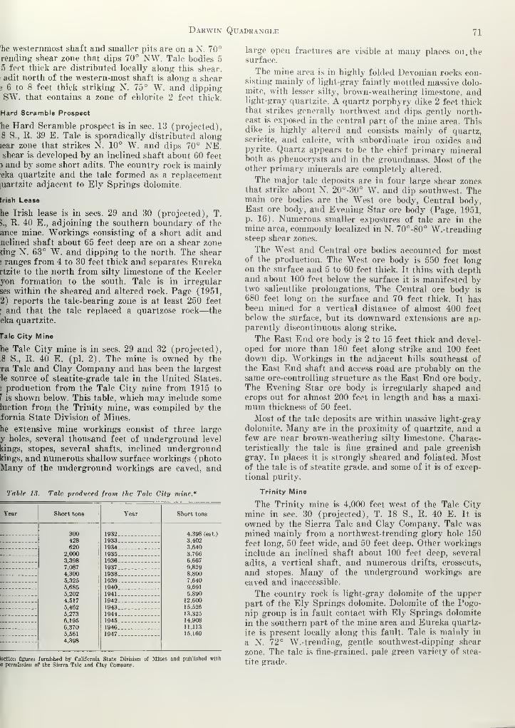
Darwin Quadrangle 71
'he westernmost shaft and smaller pits are on a N. 70°
rending shear zone that dips 70° NW. Tale bodies 5
5 feet thick are distributed locally along this shear.
adit north of the western-most shaft is along a shear3 6 to 8 feet thick striking N. 75° W. and dippingSW. that contains a zone of chlorite 2 feet thick.
Hard Scramble Prospect
he Hard Scramble prospect is in sec. 13 (projected),.8 S., R. 39 E. Talc is sporadically distributed alongtear zone that strikes N. 10° W. and dips 70° NE.shear is developed by an inclined shaft about 60 feet
3 and by some short adits. The country rock is mainlyeka quartzite and the talc formed as a replacementluartzite adjacent to Ely Springs dolomite.
Irish Lease
he Irish lease is in sees. 29 and 30 (projected), T.
>., R. 40 E., adjoining the southern boundary of the
ance mine. Workings consisting of a short adit andnclined shaft about 65 feet deep are on a shear zonering N. 63° W. and dipping to the north. The shear» ranges from 4 to 30 feet thick and separates Eurekartzite to the north from silty limestone of the Keeleryon formation to the south. Talc is in irregular
ses within the sheared and altered rock. Page (1951,
2) reports the talc-bearing zone is at least 250 feet
[ and that the talc replaced a quartzose rock—the
eka quartzite.
rale City Mine
he Talc City mine is in sees. 29 and 32 (projected),
.8 S., R. 40 E. (pi. 2). The mine is owned by the
ra Talc and Clay Company and has been the largest
le source of steatite-grade talc in the United States.
! production from the Talc City mine from 1915 to
J is shown below. This table, which may include someluction from the Trinity mine, was compiled by the
fornia State Division of Mines.
he extensive mine workings consist of three large
y holes, several thousand feet of underground level
kings, stopes, several shafts, inclined undergroundkings, and numerous shallow surface workings (photoMany of the underground workings are caved, and
Table 13. Talc produced from the Talc City mine*
Year Short tons Year Short tons
300428620
2,000
3,398
7,087
4,300
5,325
5,685
5,202
4,517
5,462
5,273
6,195
6,370
5,561
4,398
1932
19334,398 (est.)
3,402
1934 3,640
19351936 .
3,766
6,667
1937 9,829
1938 8,800
1939... --
19407,640
9,691
1941 5,890
1942 12,600
1943 15,526
1944 13,325
1945 14,908
1946 11,113
1947. 15,169
luction figures furnished by California State Division of Mines and published withe permission of the Sierra Talc and Clay Company.
large open fractures are visible at many places on. thesurface.
The mine area is in highly folded Devonian rocks con-sisting mainly of light-gray faintly mottled massive dolo-mite, with lesser silty, brown-weathering limestone, andlight-gray quartzite. A quartz porphyry dike 2 feet thickthat strikes generally northwest and dips gently north-east is exposed in the central part of the mine area. Thisdike is highly altered and consists mainly of quartz,sericite, and calcite, with subordinate iron oxides andpyrite. Quartz appears to be the chief primary mineralboth as phenocrysts and in the groundmass. Most of theother primary minerals are completely altered.
The major talc deposits are in four large shear zonesthat strike about N. 20°-30° W. and dip southwest. Themain ore bodies are the West ore body, Central body,East ore body, and Evening Star ore body (Page, 1951,
p. 16). Numerous smaller exposures of talc are in themine area, commonly localized in N. 70°-80° W.-trendingsteep shear zones.
The West and Central ore bodies accounted for mostof the production. The West ore body is 550 feet longon the surface and 5 to 60 feet thick. It thins with depthand about 100 feet below the surface it is manifested bytwo salientlike prolongations. The Central ore body is
680 feet long on the surface and 70 feet thick. It hasbeen mined for a vertical distance of almost 400 feet
below the surface, but its downward extensions are ap-parently discontinuous along strike.
The East End ore body is 2 to 15 feet thick and devel-
oped for more than 180 feet along strike and 100 feet
down dip. Workings in the adjacent hills southeast of
the East End shaft and access road are probably on the
same ore-controlling structure as the East End ore body.The Evening Star ore body is irregularly shaped andcrops out for almost 200 feet in length and has a maxi-mum thickness of 50 feet.
Most of the talc deposits are within massive light-gray
dolomite. Many are in the proximity of quartzite, and a
few are near brown-weathering silty limestone. Charac-teristically the talc is fine grained and pale greenish
gray. In places it is strongly sheared and foliated. Mostof the talc is of steatite grade, and some of it is of excep-
tional purity.
Trinity Mine
The Trinity mine is 4,000 feet west of the Talc City
mine in sec. 30 (projected), T. 18 S., R. 40 E. It is
owned by the Sierra Talc and Clay Company. Talc wasmined mainly from a northwest-trending glory hole 150
feet long, 50 feet wide, and 50 feet deep. Other workings
include an inclined shaft about 100 feet deep, several
adits, a vertical shaft, and numerous drifts, crosscuts,
and stopes. Many of the underground workings are
caved and inaccessible.
The country rock is light-gray dolomite of the upperpart of the Ely Springs dolomite. Dolomite of the Pogo-
nip group is in fault contact with Ely Springs dolomite
in the southern part of the mine area and Eureka quartz-
ite is present locally along this fault. Talc is mainly in
a N. 72° W.-trending, gentle southwest-dipping shear
zone. The talc is fine-grained, pale green variety of stea-
tite grade.

72 Special Report 51
Victory Mine
The Victory mine is in sec. 19 (projected), T. 18 S.,
R. 40 E. (pi. 1). The mine is owned by Edith Lockhart
and George Koest. The main workings consist of a
northeast-trending adit 170 feet long and a shallow shaft.
Talc is irregularly distributed in an altered shear zone
within Hidden Valley dolomite near the contact with
Ely Springs dolomite. The shear zone strikes N. 44° E.,
dips 60° NW., and has a maximum thickness of 8 feet.
Viking Mine
The Viking mine is in sees. 23 and 24 (projected),
T. 18 S., R. 39 E. (pi. 1). The mine is owned by Edith
Lockhart, Ida Nelson, and George and Helen- Knight.
Production was from the Viking number 1 and Viking
number 4 claims. The Viking number 1, the easternmost
of the claims, is developed by a shaft less than 100 feet
deep, two drifts, and minor trenches. Tale is mainly
along a N. 33° E.-trending minor shear zone cutting
Eureka quartzite and Ely Springs dolomite.
The Viking number 4 claim is on a shear zone striking
N. 75° W. and dipping 80° SW. The mine is worked bytwo shafts and two adits. Ely Springs dolomite is south
of the shear zone and Eureka quartzite to the north. TheEureka quartzite forms a wedge-shaped, fault-bounded
outcrop.
White Swan Mine
The White Swan mine includes several claims in sec.
23 (projected), T. 18 S., R. 39 E., at the northwest endof the Talc City Hills. The mine is owned by Mrs. EdnaM. Towers. Workings, which for descriptive purposesare grouped as the North workings and the South work-ings, are on many shear zones in the mine area. TheNorth workings include an adit about 100 feet long anda pit about 50 feet long, 30 feet wide, and 20 feet deep,
on a N. 83° W.-trending shear zone in Ely Springsdolomite. Talc surrounds fragments of brecciated dolo-
mite within the shear zone. Another shear zone, about 50feet to the south in Ely Springs dolomite, strikes N. 60°
E. and dips 74° SE. The shear zone is 8, feet thick andcontains a talc-bearing border zone about 6 inches thickon the footwall. Other smaller workings expose smalllenses of talc.
The South workings consist of 2 adits, a shaft, andsurface cuts on a N. 80° W.-striking shear zone that dips80° NE. Dolomite of the Pogonip group is north of theshear zone and dolomite and limestone of the Lost Burroformation are to the south. Talc is irregularly distrib-
uted in small pods in the thick shear zone.
Iceland Spar
Coarse calcite crystals are a common accessory mineralin many of the lead-zinc-silver deposits in the quad-rangle, but they are generally discolored by iron oxidesand other impurities. Only one deposit has been devel-oped for iceland spar. This is the Iceland prospect in
sec. 3, T. 19 S., R. 40 E., in the northern part of theDarwin Hills. The property is owned by the estate of
W. R. Wallace. Workings consist of an open cut 60 feet
long, with small irregular underground workings nearits northwest end, a vertical shaft 40 feet deep, andminor surface cuts. Calcite occurs as cavity fillings
between coarse limestone fragments in a N. 45°
trending, vertical fault zone. The coarse calcite rhon
.
hedrons are a maximum of 4 inches across clea\ i
fragments. The quality of the iceland spar is impai|
by imperfect transparency due to iron oxide discoL
.
tion and local fracturing. No production is recor|
from the property.
Limestone and Dolomite
The Darwin quadrangle is a large potential sourc<
limestone and dolomite, but their development is hpered by distances from markets. Limestone of
Devonian and younger Paleozoic rocks probably coulc
used in the manufacture of cement. The Tin Mount i
limestone and the upper part of the Lost Burro for Ition are the most likely sources. Minor shallow drill j-
was done a few hundred feet north of the Lee Flat r h
in the Santa Rosa Hills by operators who contemplalquarrying Tin Mountain limestone for ornamental •
building stone, but no limestone was mined.Massive dolomite in the Devonian and older rockiv
abundant in the Talc City Hills. The massive light-g -
Hidden Valley dolomite probably would be the njsuitable formation for commercial exploitation.
Quartzite
The upper part of the Eureka quartzite is excepti-
ally pure and is a potential source of silica for refi •
tory silica brick. The Eureka quartzite crops out at I
north end of the Talc City Hills at the Hard Scrair
;
mine and north of the White Swan mine.
LITERATURE CITED
Aubury, L. E., 1902, The copper resources of California : C
Min. Bur. Bull. 23, 282 p.—•, 1908, The copper resources of California : Calif. Min. ]
Bull. 50, 366 p.
Burchard, H. C, 1884, Report of the U. S. Director of the J
upon the statistics of the production of precious metals in\
United States for the calendar year 1883.
Butner, D. W., 1949, Investigation of tungsten occurrences i
Darwin district, Inyo County, Calif. : U. S. Bur. Mines RInv. 4475, 6 p.
Carlisle, Donald, and others, 1954, Base metal and iron depo I
of Southern California : Calif. Div. Mines Bull. 170, chap
,
p. 41-49.
Chalfant, W. A., 1933, The story of Inyo (rev. ed.), Los Ang<
,
Citizens Print Shop, Inc., 430 p.
Crawford, J. J., 1894, Argentiferous galena—Inyo County : Cl
Min. Bur. Rept. 12 (second biennial), p. 23-25.
, 1896, Argentiferous galena—Inyo County : Calif. Min. I
.
Rept. 13 (third biennial), p. 32-33.
Davis, D. L., and Peterson, E. C, 1948, Anaconda's operatior t
Darwin Mines, Inyo County, Calif. : Am. Inst. Mining I
.
Trans., Tech. Pub. 2407, 11 p.
DeGroot, Henry, 1890, Inyo County : Calif. Min. Bur. Rept. ,
p. 209-218.
Faul, Henry, 1954, Nuclear geology : New York, John Wile; i
Sons, 414 p.
Gay, T. E., Jr., and Wright, L. A., 1954, Geology of the Talc (
area, Inyo County: Calif. Div. Mines Bull. 170, map si I
no. 12.
Goodyear, W. A., 1888, Inyo County : Calif. Min. Bur. Rept
,
p. 224-309.
Hopper, R. H., 1947, Geologic section from the Sierra Nevada!
Death Vallev, Calif. : Geol. Soc. America Bull., v. 58, no. E •
393-432.
Kelley, V. C, 1937, Origin of the Darwin silver-lead depos
Econ. Geology, v. 32, p. 987-1008.

Darwin Quadrangle 73
, V. C, 1938, Geology and ore deposits of the Darwin silver-
mining district, Inyo County, Calif. : Calif. Jour. Mines andogy, v. 84, p. 503-562.
,Adolph, 1914, The Darwin silver-lead mining district, Cali-
ia : U. S. Geol. Survey Bull. 580-A, p. 1-18.
•, 1918, A geological reconnaissance of the Inyo Range and the
;rn slope of the Sierra Nevada, Calif., with a section on the
tigraphy of the Inyo Range by Edwin Kirk : U. S. Geol.
'ey Prof. Paper 110, 130 p.
vett, E. M., Jr., 1953, Geology of the Santa Rosa lead mine,
i County, Calif. : Calif. Div. Mines Special Rept. 34, 9 p.
ster, J. F., 1952, Rocks and structure of the Quartz Spring
, northern Panamint Range, California : Calif. Div. Mines:ial Rept. 25, 38 p.
, 1955, Geology of mineral deposits in the Ubehebe Peakidrangle, Inyo County, Calif. : Calif. Div. Mines Special
t. 42, 63 p.
-, 1956, quad, map, GQ-95. Geology of the Ubehebe PeakIrangle, Inyo County, Calif. : U. S. Geol. Survey.
m, C. W., 1954, Rocks of Paleozoic age in southern Cali-
ia: Calif. Div. Mines Bull. 170, chap. 3, p. 9-14.
m, C. W., and Hall, W. E., 1957, Pennsylvanian and Per-
l rocks of the southern Inyo Mountains, Calif. : U. S. Geol.
rey Bull. 1061A, p. 1-15.
n, L. A., Jr., and Stewart, R. M., 1951, Mines and mineral
urces of Inyo County : Calif. Jour. Mines and Geology, v. 47,
r-223.
Page, B. M., 1951, Talc deposits of steatite grade, Inyo County,Calif. : Calif. Div. Mines Spec. Rept. 8, 35 p.
Raymond, R. W., 1877, Statistics of mines and mining in the
States and Territories west of the Rocky Mountains : EighthAnnual Rept. Washington Printing Office, p. 25-30.
Robinson, L. L., 1877, Annual report to the stockholders of the
New Coso Mining Company, San Francisco, 39 p.
Schultz, J. R., 1937, A late Cenozoic vertebrate fauna from the
Coso Mountains, Inyo County, Calif. : Carnegie Inst. Washing-ton Pub. 487, p. 75-109.
Tucker, W. B., 1921, Los Angeles district—Inyo County : Calif.
Min. Bur. Rept. 17, p. 273-305.
, 1926, Los Angeles field division—Inyo County : Calif. Min.Bur. Rept. 22, p. 453-530.
Tucker, W. B., and Sampson, R. J., 1938, Mineral resources of
Inyo County : Calif. Div. Mines, Rept. 34, p. 368-500.
, 1941, Recent developments in the tungsten resources of
Calif. : Calif. Div. Mines, Rept. 37, p. 565-588.
Waring, C. A., and Huguenin, Emile, 1919, Inyo County : Calif.
Min. Bur. Rept. 15, p. 29-134.
White, W. S., and Jahns, R. H., 1950, Structure of central andeast-central Vermont : Jour. Geology, v. 58, p. 179-220.
Wilson, L. K., 1943, Tungsten deposits of the Darwin Hills, InyoCounty, Calif. : Econ. Geology, v. 38, p. 543-560.
Anonymous, 1948, Climatological data for the United States bysections (California Section) : U. S. Dept. of Commerce,Weather Bur., v. 33, p. 145-156.
8 5-58 3,500prinlid in caiifohnu state printing office


DIVISION OF MINESOLAF P. JENKINS, CHIEF
UNITED STATES DEPARTMENT OF THEIfern nr.ir.Ai cuoiicw *- '
SIMPLIFIED GEOLOGIC MAP OF THE DARWIN QUADRANGLE SHOWING THE LOCATION OF MINES AND PROSPECTS

, jOF minesDh-iiNKINS, CHIEF
.„ „ STATE OF CALIFORNIADEPARTMENT OF NATURAL RESOURCES
Special Report 51
Ploie 2
EXPLANATION
<Tp .
L-C 3_
6J (Tnc/udes rurr-oreccio, oga'ome
jul
Ely Springs dolomit
Pogonip group
Contour interval 100 feet; datum mean sea level
Ill
B \\\ / cp. I
\ /
\ /
IDoshed .here opproximole)
Indelmile conloct
*" he°"""'"» ""<««, sho.in, dip-
EXPLANATION
upper plate)
-(^-
Tops known Tops unh
GEOLOGIC MAP AND CROSS SECTIONS
OF THE
TALC CITY HILLSINYO COUNT Y, CALI FOR N I A
Attitude of be

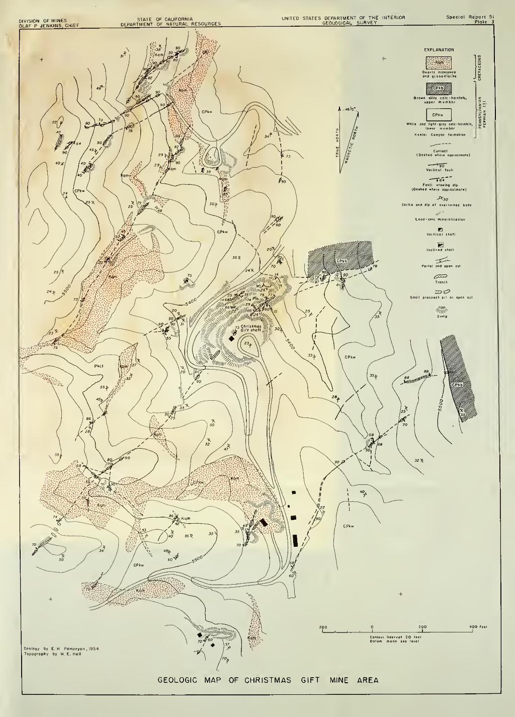
UNITED STATES DEPARTMENT OF THE INTERIORGEOLOGICAL SURVEY
EXPLANATION
GEOLOGIC MAP OF CHRISTMAS GIFT MINE AREA


Ln of minesFfi FNKINS, CHIEF
NO 2 LEVELElev. 5381'
NO 6 LEVELElev. 5268'
NO. II LEVELElev 5156'
NO. 9 LEVELElev. 5198'
COMPOSITE PLAN OF THE UNDERGROUND WORKINGS
Surveyed by , op, 00d compQSS by WE H0„E M Mock,,,,, on0 EHPeim p, >0 „
i,955
"&=
NO 8 LEVELElev. 5242'
EXPLANATION
I !<\>
;
Quortz monzonile
->KqrnV
Keeler Conyon formation via
White ond light gray calc- hornfels lie
Vertical fault
Foult showing beoring andplunge of slickensides
Fault breccia
Strike and dip of overturned beds
Vein showing dip
Mineralized rock(Mostly disseminoted limonite,
colcite, and cerussite
)
Shaft af surface
Shaft going above ond below levels
BBottom of shoft
inclined workings(Chevrons point down}
Foot of raise
Coved or filled workings
GEOLOGIC MAPS OF THE
UNDERGROUND WORKINGS OF THE CHRISTMAS GIFT MINE


DIVISION OF MINESOLflF P JENKINS, CHIEF
GEOLOGIC MAP OF THE DARWIN MINE AREA, INYO COUNTY CALIFORNIA


STATE OF CALIFORNIADEPARTMENT OF NATURAL RESOURCES
GEOLOGIC MAPS OF THE DEFIANCE WORKINGS OF THE DARWIN MINE, INYO COUNTY, CALIFORNIA


UNITED STATES DEPARTMENT OF THE INTERIORGEOLOGICAL SURVEY
EXPLANATION
GEOLOGIC MAPS THOMPSON, ESSEX AND INDEPENDENCE WORKINGS
OF THE DARWIN MINES


GEOLOGIC MAP OF THE LEE MINE AREA


ft^SIWUNITEO STATES DEPARTMENT OF THE INTERIOR
GEOLOGICAL SURVEY
GEOLOGIC MAP OF THE DURHAM FERNANDO AND ST. CHARLES MINES AREA, INYO COUNTY, CALIFORNIA