geology of the , clay hills area san juan county, utah · 2011-06-27 · geology of the , clay...
TRANSCRIPT
Geology of the , Clay Hills Area San Juan County, Utah
' By THOMAS E. MULLENS
CONTRIBUTIONS TO THE GEOLOGY OF URANIUM
'GEOLOGICAL SURVEY BULLETIN 1087-H
This report concerns work done on behalf of the U.S. Atomic Energy Commission and is published with the permission of the Commission
UNITED STATES GOVERNMENT PRINTING OFFICE, WASHINGTON j 1960

UNITED STATES DEPARTMENT OF THE INTERIOR
FRED A. SEATON, .Secretary
GEOLOGICAL SURVEY
Thomas B. Nolan, Director
For sale by the Superintendent of Documents, U.S. Government Printing Office Washington 25, D.C. - Price 75 cents (paper cover)

CONTENTS
Page Abstract...__...__._____-__.-.._-__----_.-.___-.-_ 259Introduction. _ ______________________-__________-_________ _-_____-_ 260
Location and access___--_________-----_---_------_----_-------- 260Present investigation.____________-___________-_-___________ ____ 261
, Purpose..--.._--.-._-_-__---------------_---_-__----- 261Fieldwork. _--_.__-__.___._.--------_.__..___._ _.__... 262Acknowledgments--------_-------_---------------------.-- 262
Previous publications._-______--_-_-_---_-_-_-----_---_-_-_-_-_--_. 262Geography _____-__---_-__-____-__-_----_------_-------____---_-__ 264
> Topographic features._________________________________________ 264Relief__________.__..._._._..._....__._.._...____.___.. 26ftClimate and vegetation.. _.__-___-__-__-----_-_-__--___--__-___ 266>Population and industry_________-_-____-_-_-_-_-_-_-_-___._____ 266.Accessibility in the area--______-__--_-_l_____-___----_-__-_____ 267
Stratigraphy._____________________________________________________ 267General features_______________-_---___-_-_-_-_---___-_______ 267Permian system_______________-__--_-_-_-___-_--__-___-_______ 267
Cutler formation__ -_____-_-__--_-___-_-___-_-___-_____-___ 268Halgaito tongue.______________________________________ 268Cedar Mesa sandstone member_.__-___._______.____.__ 270Organ Rock tongue.___________________________________ 272De Chelly sandstone member.__________________________ 274Hoskinninitongue.____________-_-_-_-_-_-__-______-___ 275
Triassic system______________________________________________ 278Lower and Middle(?) Triassic series________________________ 278
Moenkopi formation---___---___----_-_-___-_-___-_-___ 278Upper Triassic series_--_--_-__--_--_----_-_-_-_---_-_---__- 280
Chinle formation. ___-____--_____-_-___-___-.____-_-___ 280General description._______________________________ 280Shinarump member___-__--___-__-----_----_____-__ 282Undiff erentiated Chinle formation ___________________ 285
Triassic and Jurassic systems. --___-_--_---_____---_---_-_---___ 290Glen Canyon group.____--____--___---_________-_-_-_____-_ 290
Wingate sandstone ____________________________________ 291> Kayenta formation. ______----___-_-___-_-_____________ 293
Navajo sandstone.___--___-_-___--____-_-_---___--____ 294Quaternary system____________________________________________ 296
Landslide blocks._________________________________________ 296Terrace gravel--__--____-____---__---_-__---____--__-_____ 296Stream alluvium._________________________________________ 297Alluvial fans._-___--__-______----___-__________-____-_____ 298Dune sand__-____---__-_____-___-----__-_--______--__-__ 299
in

IV CONTENTS l
PageStructure____________ _.-_-.__________ 300
Folds. ________._._.____._-.__.__________________ _ 301Oljeto synclme______----__-__-__------_--______________-__ 301Organ Rock anticline._____________________________________ 302Castle Creek anticline____________---____-_--___________ 302
Faults___________________--_______._______. 303Joints_________________________-___________ 304Age of deformation-_____-__----_-_---_---_---___-___-_________ 304
Mineral resources________________________________________________ 304Uranium. ________________________________________________ 305Gold.______.__...._--....-......-..____-_.--_.___..._..___ 306Copper___________-_-_____-.______.___ __._____ 306Gravel.__________________________________________._____.. 307
Literature cited.__________________________________________________ 307Representative stratigraphic sections_______________________________ 309Index______________... ________..______________ 335
ILLUSTRATIONS
PLATE 27. Geologic map of the Clay Hills area, San Juan County,Utah _ _____ _ _ _____._____________________In pocket
FIQUBB 26. Index map of Utah showing location of the Clay Hills area,San Juan County, Utah. ___ 267
27. Map showing location of the Clay Hills area and areas in adjoining regions for which reports have been published by the U.S. Geological Survey...... _____ . ______ __ 263

CONTRIBUTIONS TO THE GEOLOGY OF URANIUM
GEOLOGY OF THE CLAY HILLS AREA, SAN JUAN
COUNTY, UTAH
By THOMAS E. MULLENS
ABSTRACT
The Clay Hills area includes 296 square miles of canyon and plateau country in southwestern San Juan County, Utah. Rocks exposed in the area were mostly deposited in a terrestrial environment and are of Permian, Triassic, Jurassic, and Quaternary ages. The aggregate thickness of these rocks is about 3,900 feet.
The Cutler formation of Permian age is the oldest exposed formation and is subdivided into three red-bed tongues and two light-colored wind-deposited sandstone members the Halgaito tongue, only partly exposed in the eastern part of the map area in the San Juan River Canyon; the Cedar Mesa sand stone member, about 700 feet thick; the Organ Rock tongue, about 350 feet thick; the De Chelly sandstone member, about 30 feet thick in the southwest ern part of the area and absent elsewhere because of nondeposition; and the Hoskinnini tongue, about 110 feet thick in most of the area, but only 42 feet thick where it overlies the De Chelly sandstone member.
The Moenkopi formation of Early and Middle (?) Triassic age conformably overlies the Cutler formation, ranging in thickness from 260 to 340 feet. It is composed of a lower evenly bedded siltstone, a middle cross-laminated sand stone, and an upper evenly bedded siltstone. The Moenkopi is overlain Tin- conformably by the Chinle formation of Late Triassic age.
The Chinle formation of Late Triassic age ranges from 780 to 1,195 feet In thickness and is composed of sandstone, conglomerate, mudstone, variegated claystone, limestone, and calcareous siltstone. The Chinle can be subdivided into four divisions based on the dominance of rock types, but gradation and intermixing of rock types make it difficult to map the upper three divisions. Therefore, the Chinle is divided into the Shinarump member (lower unit) and undifferentiated Chinle (upper unit).
The Shinarump member, the lower member of the Chinle formation consists of cross-laminated sandstone and conglomerate irregularly interbedded with mudstone. It is conspicuous only in the southern part of the map area where it reaches a thickness of 176 feet. Elsewhere the Shinarump is absent or rep resented only by thin lenses; the local absence is due to nondeposition. The Shinarump member, where present, conformably underlies the undifferentiated Chinle formation.
The undifferentiated Chinle formation can be divided into a lower unit of sandstone and mudstone; a middle unit of variegated claystone, calcareous
259

260 CONTRIBUTIONS TO THE GEOLOGY OF URANIUM
siltstone, and limestone; and an upper unit of reddish-orange to reddish-brown interbedded siltstone and very fine grained sandstone. All contacts between units of the undifferentiated Chinle are conformable, and the upper unit con formably underlies the Glen Canyon group.
The formations of the Glen Canyon group include the Wingate sandstone of Late Triassic age, the Kayenta formation of Jurassic (?) age, and the Navajo sandstone of Jurassic and Jurassic (?) age. The Wiugate is a massive wind- deposited sandstone and averages about 320 feet thick; the Kayenta consists of irregularly bedded fluviatile deposits and averages about 220 feet thick; the Navajo is a massive wind-deposited sandstone that includes lenses of limestone. A complete thickness of the Navajo cannot be measured in the map area as erosion during Cenozoic time has removed the upper part of the sandstone; the maximum preserved thickness is about 600 feet.
Deposits of Quaternary age, consisting of landslide blocks, terrace deposits, alluvium in present flood plains, fans, and dune sand, are widespread in the map area.
The Clay Hills area is on the gently dipping west flank of the Monument upwarp. Locally the westward dip is interrupted by minor northward-trending asymmetrical folds. Normal faults are associated with the eastward-dipping limbs of the minor folds; many joints cut the sandstone strata.
Interest in the mineral resources of the Clay Hills area has centered around uranium, gold, and copper. To the present time no commercially important mineral deposit has been discovered in the area, although much time and effort has been used in prospecting for uranium.
INTRODUCTION
LOCATION AND ACCESS
The Clay Hills area comprises 296 square miles in southwestern San Juan County, Utah (fig. 26). Most of the area is between Red Canyon, a tributary to the Colorado River, and the San Juan River; a part is south of the San Juan River and in the Navajo Indian Reservation. The map area includes the Clay Hills 15-minute quadrangle and the adjoining Clay Hills 1 NW T 1/^ minute quadran gle. Part of the Clay Hills area is in T. 40 S., Rs. 14 and 15 E., and T. 41 S., Rs. 13,14, and 15 E., Salt Lake meridian; the remainder of the area is unsurveyed land.
The part of the Clay Hills area north of the San Juan River is reached by a graded dirt road that joins Utah State Route 95, which is also a graded dirt road, about one-fourth of a mile west of the entrance to Natural Bridges National Monument. The north boundary of the Clay Hills area is about 8 miles by road southwest of this junction. Blanding, Utah, the nearest town, is 42 miles east from this junction on Utah State Route 95.
The part of the area south of the San Juan River is reached by a dirt road leading north from Oljeto, Utah, a trading post on the Navajo Indian Reservation. The south boundary of the Clay Hills area is 19 miles north of Oljeto.

GEOLOGY, CLAY HILLS AREA, SAN JUAN COUNTY, UTAH 261
41
114° 112" 110°
20 40 60 80 100 MILES
FIGURE 26. Index map of Utah showing location of the Clay Hills area, San Juan County,Utah.
PRESENT INVESTIGATION
PURPOSE
The present investigation of the Clay Hills area is part of a re gional geologic mapping program of the U.S. Geological Survey made on behalf of the Division of Raw Materials of the U.S. Atomic Energy Commission. Primary objectives of the regional mapping program were: to appraise the uranium resources of the main uranium-bearing formations in the Colorado Plateau, to collect and

262 CONTRIBUTIONS TO THE GEOLOGY OF URANIUM
interpret geologic data, and to prepare geologic maps that show the distribution of uranium-bearing formations and geologic setting of uranium deposits. Although no known uranium ore deposits occur in the Clay Hills area, it includes rocks of Triassic age that may contain significant uranium deposits.
FZELDWORK
^Fieldwork on which this report is based was done between July and October 1952, and between May and July 1953. Stratigraphic units and geologic structures were mapped on stereopairs of air photographs (scale 1:31,680) as topographic maps were not avail able. The air photographs were furnished by the U.S. Soil Conser vation Service. In addition to mapping and studying stratigraphic units and geologic structures, a search was made for uranium minerals, for abnormal radioactivity, and for geologic features fa vorable for uranium deposits. In this search particular emphasis was placed on the study of the lower parts of the Chinle formation of Late Triassic age, as these parts of the Chinle are uranium bear ing in nearby areas. A systematic search for uranium minerals and geologic features favorable for uranium deposits was made wherever the lower parts of the Chinle were exposed. Other formations ex posed in the Clay Hills area were examined in many places for ura nium minerals in the course of geologic mapping, but not in such detail as the lower parts of the Chinle.
The position of boundaries between stratigraphic units and the traces of geologic structures were marked on preliminary editions of topographic maps with a scale of 1:24,000 and a 40-foot contour interval in 1956. A compilation of the five 7l/£-minute quadrangles was then made at a scale of 1:48,000.
ACKNOWLEDGMENTS
Able assistance was rendered in the field by H. A. Hubbard in 1952 and J. N. Taggart in 1953. The project was under the super vision of J. F. Smith, Jr., who visited the field party several times and gave valuable advice on field methods. The assistance of these men is gratefully acknowledged.
PREVIOUS PUBLICATIONS
Many papers that describe geology, regional correlation of strati- graphic units, and geography of southeastern Utah have been pub lished (fig. 27). Baker (1936, p. 17) compiled an extensive bibli ography of such literature. The complete list is not repeated here, but several papers that are directly related to the area deserve spe cial mention. Gregory (1938) described the broad geologic and geographic features of the part of the Clay Hills area north of the

GEOLOGY, CLAY HILLS AREA, SAN JUAN COUNTY, UTAH 263
112"'______111!_______UQ1_______109".114 113
36° 36°
109°
Area Report1 This report2 Gregory, H. E., and Moore, R. C. r 19313 Gregory, H. E., 19174 Baker, A. A., 1936 . .5 Miser, H. D., 1924 and 19256 Gregory, H. E., 19387 Baker, A. A., 19338 Hunt, C. B., 1954
Area Report9 Baker, A. A., 1946
10 McKnight,E.T.,194011 . Dane, C. H., 193512 Fisher, D. J., 193613 Gilluly, James, 192914 Spieker, E. M.,193115 Lupton, C. T., 191616 Gregory, H. E., 1950
FIGURE 27. Map showing location of the Clay Hills area (shaded) and areas In adjoining regions for which reports have been published by the U.S. Geological Survey.
San Juan River in his geologic and geographic reconnaissance of the San Juan country, and included the part of the area south of the San Juan River in his report and map of the Navajo Country (1917). Baker (1936) mapped the part of the Clay Hills area that is south of the San Juan River in his study of the Monument Valley- Navajo Mountain region. Miser (1924 and 1925) described the geology of the San Juan River Canyon from Bluff, Utah, to the mouth of the river, and his map includes a large part of the Clay Hills area both north and south of the river.
Regional correlation of some stratigraphic units exposed in the Clay Hills area is discussed in detail by Baker, Dane, and Reeside (1936) and Baker and Reeside (1929).
530029 60 2

264 CONTRIBUTIONS TO THE GEOLOGY OF URANIUM
The Clay Hills area is on the route of the Mormon settlers who migrated from Escalante, Utah, to Bluff, Utah, in 1879-80. A de scription of this migration through barren and rugged country is given in a newspaper article by Alter (1921), abstracted by Miser (1924, p. 31-32). Gregory (1938, p. 31-33) and Judd (1924, p. 2Y5- 302) have also described the route taken by the Mormon settlers.
TOPOGRAPHIC FEATURES
In its general relations, the Clay Hills area is part of the Canyon Lands section of the Colorado Plateaus province (Fenneman, 1931, p. 306-312), a section characterized by bare rock surfaces, plateaus, cliffs, and steep-walled canyons. These features are typical in the Clay Hills area, which is on the gently dipping west flank of the Monument upwarp where differential erosion of rocks of unequal resistance has produced a series of westerly sloping plateaus with eastward-facing escarpments. Both plateaus and escarpments are deeply trenched by the San Juan Eiver Canyon. The map area consists of parts of two of these plateaus, the intervening escarp ment, and part of the San Juan River Canyon.
The eastern part of the Clay Hills quadrangle is a gently undu lating area that slopes westward. The part north of the San Juan Eiver is the Grand Gulch Plateau (Gregory, 1938, p. 11-12), and the part south of the river is unnamed, but comprises the western extension of Douglas Mesa (Baker, 1936, p. 10 and pi. 2). The same white sandstone stratum is exposed and little difference in topogra phic expression exists on the opposite sides of the river. Many streams trench the area, and the San Juan River has cut a vertical- walled westward-trending canyon about 800 feet wide near the south ern part of the map area. This canyon is deepest (about 800 feet) at the eastern edge of the map area. Westward, owing to the re gional dip of the sandstone in which the canyon is cut, the canyon progressively decreases in depth. At Clay Hills Crossing, the top of the sandstone is at water level and the river flows in a wide val ley. The streams in Grand Gulch and Oljeto Wash also flow in vertical-walled canyons 400 to 600 feet deep, but other streams fol low relatively wide valleys with ledges on the slopes except where they join the San Juan River in narrow vertical-walled canyons. Interstream areas on the Grand Gulch Plateau and its extension south of the San Juan River are relatively flat, but locally intricate knobs, rounded domes, and flat-topped buttes of sandstone are formed on the divides.
The Grand Gulch Plateau is joined to the Red House Cliffs es carpment on the west through 60 to 100 feet of ledge-forming beds

GEOLOGY, CLAY HILLS AREA, SAN JUAN COUNTY, UTAH 265
above the white sandstone. Locally the ledge-forming beds support westward-sloping benches 1/4 to 1 mile wide, and in these places the dividing line between Grand Gulch Plateau and the escarpment is not well defined.
The Clay Hills were called the Red House Cliffs by Gregory (1938, p. 13); they form the most conspicuous topographic feature in the map area. The southeast-facing escarpment formed by these hills trends northeast from the San Juan River to about 8 miles beyond the northeast corner of the mapped area. The plural "cliffs" is a fitting description, for the escarpment rises about 1,600 feet above Grand Gulch Plateau in two great steps. A lower step comprises a steep slope about 300 feet high capped by a cliff about 100 feet high. The cliff at the top of the lower slope bounds a westward- sloping bench that averages about half a mile in width, although the width of the bench ranges from 100 yards to more than a mile. A second step rises from this bench and forms a steep irregular slope about 900 feet high, whose top is a palisadelike cliff about 300 feet high. The upper slope in the escarpment is covered by rubble in most places, but, where there is no rubble, maroon, gray, green, and purple rocks crop out in the middle of the slope. These pastel colors contrast strongly with the general reddish brown of other rocks ex posed in the escarpment.
The upper step of the escarpment has been stripped away by a northwestward-flowing tributary to the Colorado River in the north east part of the area. Here the escarpment contains only the lower step and an extensive bench supported by the capping cliff of the lower step. At two other places along the escarpment, Clay Hills Divide and in sees. 4, 8, and 17, T. 40 S., R. 14 E., erosion by south- westward-flowing tributaries to the San Juan River has breached the upper vertical cliff. However, in these two places most of the upper slope is intact.
The San Juan River flows parallel to the base of the Red House Cliffs for a short distance in the southwestern part of the area. At Piute Farms the river turns and flows in a narrow canyon through the escarpment.
The small part of the area south of this canyon is part of Segi Mesas (Gregory, 1917, pi. 1), a much dissected continuation of the Red House Cliffs and the plateau extending west from the capping vertical cliff of the Red House Cliffs south of the San Juan River.
Red Rock Plateau, as defined by Gregory (1938, p. 13-14), in cludes 800 square miles, and is bounded by Clay Hills, White Can yon, the San Juan River, and the Colorado River. Only the south eastern part of Red Rock Plateau, about 150 square miles, is in the mapped area. The surface of the plateau is extremely irregular.

266 CONTRIBUTIONS TO THE GEOLOGY OF URANIUM
Many buttes and rounded domes of sandstone rise above the gen eral level; many steep-walled canyons are cut deep. Mikes Mesa is an outlier of the plateau in the southern part of the area.
Stream valleys on Red Rock Plateau differ greatly in character. Steer Pasture Canyon is a narrow sand-covered flat bounded by ver tical walls, the middle part of Castle Creek is a broad sand-covered flat bounded by low rounded sandstone hills, and the lower part of Castle Wash is a narrow inner gorge in a broad flat-floored canyon. Moki Canyon, a tributary to the Colorado River, is a steep-walled narrow canyon about 600 feet deep and less than half a mile wide. Mikes Canyon is about 1^ miles wide and 1,000 feet deep. How ever, only the upper 300 feet of the canyon that rims Mikes Canyon is steep walled; the lower part of the canyon is a relatively gentle rubble-covered slope.
BELIEF
Maximum relief in the Clay Hills area is about 3,125 feet. The highest point, 6,725 feet above sea level, is on Red Rock Plateau 2^ miles southwest of Red House Spring; the lowest point, about 3,600 feet above sea level, is at the water level of the San Juan River in the southwestern part of the area. These two points are about 22 miles apart. Local relief is greatest from the base to the top of Red House Cliffs where differences in elevation of 1,600 feet within 2 miles are common.
CLIMATE AND VEGETATION
The climate of the Clay Hills area is arid. No records of pre cipitation are available for the area, but Bluff, Utah (about 35 miles east of the area) and Hite, Utah (about 15 miles northwest of the area) usually receive less than 8 inches of precipitation a year (Gregory, 1938, p. 17-18). Most of the precipitation occurs in brief but heavy showers, which cover only a few square miles.
The scant precipitation supports little vegetation. Scattered grass, low bushes, and cactus grow in the lower elevations and some juniper and pifion trees grow in the higher elevations on Red Rock Plateau and Grand Gulch Plateau. A few cottonwood trees grow along the larger drainages such as Castle Creek, Moki Canyon, and Grand Gulch, and salt cedar is abundant along the banks of the San Juan River.
POPULATION AND INDUSTRY
The Clay Hills area is not permanently inhabited. An Indian family cultivates a small tract of land at Piute Farms during the spring and summer. The only other regular visitors to the area are ranchers who graze cattle on Red Rock Plateau and Grand Gulch Plateau during the winter and spring.

GEOLOGY, CLAY HILLS AREA, SAN JUAN COUNTY, UTAH 267
ACCESSIBILITY IN THE AREA
There are few roads in the Clay Hills area. The road that enters near the northeast corner of the mapped area turns northwest at Red House Spring and leads to uranium mines in Red Canyon. This is an access road for the U.S. Atomic Energy Commission, and was passable to passenger cars in 1956. The road that branches from the access road at Red House Spring leads southwest along the base of Red House Cliffs. Near the base of Clay Hills Divide the road turns westward to cross the hills and continue past the western boundary of the map area. This road, which follows the route of Mormon settlers who migrated from Escalante, Utah, to Bluff, Utah, in 1879-80, was constructed by the Skelly Oil Company in 1951, in order to carry supplies to a well drilled about 4 miles west of the area. Drilling stopped in November 1952, but the road has been maintained and was passable to four-wheel drive vehicles in 1956.
In late 1954, and early 1955, prospectors for uranium constructed a road from the base of Clay Hills Divide to the San Juan River, and then along the north side of the river to the southwestern part of the mapped area. The condition of this road in 1956 is not known.
The field party gained access to most of the area by walking. Most places are accessible on foot, although circuitous routes to many places are necessary because of the canyons and cliffs. The main barrier to foot travel is the palisadelike capping cliff of Clay Hills. Access to the main part of Red Rock Plateau is gained only at Clay Hills Divide and in the westernmost tributary of Mikes Canyon. Other barriers to travel are Moki Canyon, Grand Gulch, and the San Juan River Canyon cut in the Grand Gulch Plateau and Doug las Mesa surface. The walls of Moki Canyon are unscalable except in the northwestern part of the area where a sand dune has covered the canyon wall. Grand Gulch can be entered by the tributary at Collins Spring, but cannot be crossed in this area. The San Juan can be crossed at the fault in sec. 19, T. 40 S., R. 15 E.
It is difficult to cross the San Juan River during times of high water, but ordinarily the river is no obstacle to foot travel. During the summer, fall, and winter, few places below Clay Hills Crossing are more than 2 feet deep except immediately after rains.
STRATIGRAPHY
GENERAL FEATURES
Rocks of Permian, Triassic, and Jurassic age, aggregating about 3,900 feet in thickness, and thin deposits of Quaternary age crop out in the Clay Hills area. Excepting the deposits of Quaternary

268 CONTRIBUTIONS TO THE GEOLOGY OF URANIUM
age, the oldest rocks crop out in the eastern part of the area and progressively younger rocks are exposed westward. Most of the for mations are continental in origin, and the lithologic characteristics, thickness, and color within the formations in the area are nearly uni form. Red is the dominant color, but most of the Cedar Mesa sand stone member of the Cutler formation of Permian age is white and the Chinle formation of Late Triassic age is strikingly variegated. There are no diagnostic fossils in the formations, but correlation of units in the Cutler formation and Glen Canyon group is made with little doubt as most of these units can be traced directly to type areas.
No igneous rocks crop out in this area.The areal distribution of the formations is shown on plate 27, and
Si generalized stratigraphic section is shown on the following table. Measured stratigraphic sections are included on pages 309-332.
Stratigraphic units were studied by measuring sections and trac ing the units along the outcrop. Composition, grain size and shape, . and percentage of cementing material given in the description of the formations are based mainly on megascopic examination.
PERMIAN SYSTEM
CUTLJER FORMATION
The Cutler formation was named by Cross and Howe (1905, p. 5) for exposures of arkosic conglomerate in southwestern Colorado. Baker and Reeside (1929) extended the name "Cutler formation" to rocks in southeastern Utah where the Cutler formation comprises 3 red-bed tongues and 2 light-colored sandstone members. ' These subdivisions of the Cutler formation are, in ascending order, the Halgaito tongue, the Cedar Mesa sandstone member, the Organ Rock tongue, the De Chelly sandstone member, and the Hoskinnini tongue.
The Halgaito tongue is partly exposed in the San Juan River Canyon at the east edge of the map area and the De Chelly sandstone member is exposed only in the canyon in the southwestern part of the area. The other members in the Cutler formation form extensive outcrops in the southeastern half of the area.
[ HALGAITO TONGUE
The Halgaito tongue, lowest unit in the Cutler formation, was named for exposures at Halgaito Spring in Monument Valley by Baker and Reeside (1929, p. 1443). It crops out in the southeastern part of the Clay Hills area at the bottom of the San Juan River Canyon. This exposure, which is accessible only by boat, was ex amined from a distance. About the upper two-thirds of the Halgaito is exposed at the edge of the mapped area, but progressively less of the member is exposed westward, owing to the regional dip, and about 2 miles downstream it disappears.
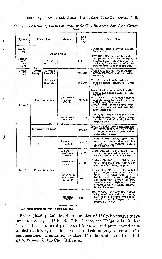
GEOLOGY, CLAY HILLS AREA, SAN JUAN COUNTY, UTAH 269
Stratigraphic section of sedimentary rocks in the Clay Hills area, San Juan County,Utah
System
Quater nary
Jurassic and
Juras- sic(?)
Juras- slc(?)
Triassic
Permian
Formation
Navajo sandstone
Canyon Kayenta Group, formation
Wingate sandstone
Chinle formation
Moenkopi formation
Cutler formation
Member
Undlfferen- tiated Chinle
Shinarump member
Hoskinnini tongue
De Chelly sandstone member
Organ Rock tongue
Cedar Mesa sandstone member
Halgaito tongue
Thick ness (feet)
600+
200-230
310-360
780-1020
0-175 .
260-340
42-120
0-30
315-450
700
200+
Description
Landslides, terrace gravel, alluvial fans, and sand dunes.
Cross-laminated pale-red to roddish- orangp medium-grained sandstone; scattered thin beds of light-gray to dark-gray limestone; top of forma tion not exposed in mapped area.
Cross-laminated pale-red to reddish- brown sandstone and Interbedded siltstone.
Cross-laminated reddish-brown to reddish-orange sandstone, forms cliff.
Upper third: evenly bedded reddish- orange fine-grained sandstone and siltstone.
Middle third: variegated siltstone and claystone and lenticular beds of light-gray limestone.
Lower third: greenish-gray sand stone and maroon and greenish- gray mudstone.
Light-gray conglomeratic sandstone, lenticular beds, mottled yellow and purple, absent at most places in mapped area.
Evenly bedded brown siltstone and sandstone, abundant ripple marks; white gypsum along beds and in crosscutting seams.
Reddish-brown silty, very fine grained sandstone; abundant fine to coarse well-rounded quartz grains; forms cliff.
Cross-laminated yellowish-gray fine- to medium-grained sandstone ab sent in most of the mapped area.
Horizontally bedded reddish-brown silty sandstone; several thin white sandstone beds in upper part.
Upper 60 to 100 ft, cross-laminated yellowish-gray fine-grained sand- stnnfi intcrbedded with evenly bedded reddish-brown siltstone and sandstone. .Lower 600 feet, cross-laminated light-gray fine grained sandstone, many horizon tal parting planes.
Red to chocolate-brown fine-grained silty sandstone and shale, some thin beds of unfossiliferous lime stone.' Base of tongue not ex posed In map area.
> Description of member from Baker (1936, pi. 5).
Baker (1936, p. 30) describes a section of Halgaito tongue meas ured in sec. 34, T. 41 S., R. 17 E. There, the Halgaito is 425 feet thick and consists mostly of chocolate-brown and purplish-red thin- bedded sandstone, including some thin beds of grayish unfossilifer ous limestone. This section is about 15 miles southeast of the Hal gaito exposed in the Clay Hills area.

270 CONTRIBUTIONS TO THE GEOLOGY OF URANIUM
CEDAR MESA SANDSTONE MEMBER
The Cedar Mesa member of the Cutler formation was named by Baker and Keeside (1929, p. 1443) for exposures in the cliffs around Cedar Mesa, near Mexican Hat, Utah. The cliffs in this mesa are the eastern boundary of Grand Gulch Plateau, which is about 15 miles east of the mapped area. The Cedar Mesa sandstone member crops out in the Grand Gulch Plateau and Douglas Mesa and consists of a lower white to grayish-orange massive sandstone and an upper irregularly interbedded reddish siltstone and sandstone unit. Excel lent sections of the lower part of the Cedar Mesa sandstone member are exposed in the vertical walls of the San Juan River Canyon, Grand Gulch, and Oljeto Wash. The upper unit of the Cedar Mesa, 60 to 100 feet thick, crops out in benches along the western edge of Grand Gulch Plateau and its extension south of the San Juan River and is also locally preserved as flat-topped hills in the intercanyon areas on the Grand Gulch Plateau and its extension.
The thickness of the Cedar Mesa sandstone member cannot be determined accurately in this area because of the great width of outcrop and the lack of persistent beds. As determined from the topographic map, the Cedar Mesa is about 700 feet thick where the San Juan River crosses the Organ Rock anticline. The base of the sandstone is not exposed here, but study of the local structure indi cates that the base is about 25 feet below the water level in the canyon. The thickness of the Cedar Mesa probably differs in differ ent parts of the area, because of intergrading with the overlying Organ Rock tongue. Probably the same relationship holds for the contact with the underlying Halgaito tongue (Baker, 1936, p. 32).
The lower part of the Cedar Mesa sandstone member is grayish- white to very pale orange well-sorted cross-laminated sandstone. It is composed of subrounded to rounded, fine and very fine quartz grains and sparse red and black accessory grains, and is weakly cemented by calcium carbonate. Individual sandstone beds range from 8 to 40 feet in thickness and average about 20 feet. The beds of sandstone have long sweeping cross-laminations of the type at tributed to eolian deposition, but each bed is separated from adjacent beds by horizontal parting planes that truncate the cross-laminations in the bed below. Some horizontal parting planes extend for more than a mile before they disappear in a cross-laminated unit, but the average extent is less than half a mile. Immediately above the horizontal parting planes horizontal laminations predominate, but these grade upward into the long sweeping cross-laminations. Lo cally channeled surfaces are associated with the horizontal parting planes in the lower part of the Cedar Mesa, but these channels are rare and relief on them does not exceed 3 feet. Thin films of reddish- brown siltstone are common along the parting planes, and a 6-inch
GEOLOGY, CLAY HILLS AREA, SAN JUAN COUNTY, UTAH 271
bed of dense gray limestone extended about 500 feet along the cliff above a parting plane in Grand Gulch. This was the only limestone bed observed in the lower part of the Cedar Mesa; however, lime stone is common in the upper part. :
The upper part of the Cedar Mesa sandstone member is a transi tion zone from the light-colored sandstone below to the red beds of the Organ Eock tongue. This transition zone is about 100 feet thick at the San Juan Kiver, and it thins regularly to about 60 feet at the northern boundary of the mapped area. The zone is composed mainly of lenticular beds of sandstone and reddish-brown siltstone, but it includes some beds, 6 inches to 1 foot thick, of dense gray limestone and stubby lenses of limestone-pellet conglomerate. The sandstone beds range from white to pale reddish brown. In general the sandstone is lighter colored, thicker bedded, and contains less silt near the base of the zone than the sandstone near the top. Con versely, reddish-brown siltstone is abundant near the top of the zone and sparse near the base. Some sandstone beds are structureless, whereas others -are either horizontally laminated or cross-laminated. Both eolian and fluviatile types of cross-laminations occur in the transition zone, but eolian cross-laminations are found mainly in the lower part of the zone. Channels, some filled with limestone- pellet conglomerate, are abundant both within and at the base of the sandstone beds. The maximum depth observed for these chan nels was Y feet, but:the average depth is about 2 feet. Irregular .elongate dense gray limestone concretions and some nodular lime stone concretions are common in the sandstone in the transition zone.
Beds of conglomerate that fill channels in the transition zone are composed of rounded and subrounded limestone pellets in a silty or sandy limestone matrix; few of these beds exceed 3 feet in thick ness or 100 feet in length. Locally some of the matrix in the con glomerate is replaced with dark-gray or red chert. The term "pellet" is used to describe these limestone conglomeratic beds be cause the pellets are not the product of erosion of limestone. They were deposited as mud or clay balls, and they have been partly or completely altered to limestone by diagenetic or epigenetic changes. The maximum observed size of the limestone pellets was 2 inches, and the average size is about one-half inch.
The well-sorted sand and the cross-laminations in the lower part of the Cedar Mesa suggest that this part of the formation was deposited as sand dunes.
The Cedar Mesa sandstone member grades into a series of gypsifer- ous sandstone and red beds about 20 miles east of the mapped area (Sears, 1956, p. 183-184). These beds are water laid, and the body of water in which they were deposited possibly transgressed the
539029 60 3

272 CONTRIBUTIONS TO THE GEOLOGY OP URANIUM
dune area to the west from time to time. Repeated transgressions by this body of water could possibly account for the horizontal part ing planes and the associated siltstone in the lower part of the Cedar Mesa in the map area. However, the general limited areal extent of the parting planes indicates that they more likely were formed in small shallow lakes rather than the larger body of water to the east.
The upper 60 to 100 feet of the Cedar Mesa reflects a change of depositional environment. Probably streams overran the sand dunes and formed stream deposits, and in turn the streams were displaced by quiet water. Intermingling of the dune, stream, and quiet-water deposits indicates that the change in depositional environment pro gressed erratically.
The basal contact of the Cedar Mesa was not examined in the area of this study. Baker (1936, p. 32) states that the Halgaito tongue and Cedar Mesa sandstone member are gradational laterally as well as vertically.. The contact of the Cedar Mesa sandstone member with the over lying Organ Rock tongue is conformable, with lateral and vertical gradation. Gregory (1938, p. 45) reports an unconformity of un known significance at the top of the Cedar Mesa in the San Juan country, but no evidence for an unconformity was noted in the mapped area.
No fossils were found in the Cedar Mesa in this area. The evi dence of Permian age for the Cedar Mesa is given by Baker (1936, p. 29) and Baker and Reeside (1929, p. 1421-1422). Correlation with the type section in Cedar Mesa is assured as the Cedar Mesa can be traced without a break in outcrop to the type locality.
ORGAN ROCK TONGUE
The Organ Rock tongue of the Cutler formation was named by Baker and Reeside (1929, p. 1443) for exposures at Organ Rock, a slender spire about 10 miles south of the area in Monument Valley. Within the area mapped the main outcrop of the Organ Rock tongue is a narrow band along the base of Red House Cliffs that widens southeast of Clay Hills Divide across the Organ Rock anticline and Oljeto syncline. The basal part of the Organ Rock tongue crops out south of the San Juan River from Clay Hills Crossing to Piute Farms, and a small isolated exposure of the basal part of the Organ Rock is near the crest of the Organ Rock anticline in sec. 24, T. 40 S., R. 14 E.
The Organ Rock tongue forms both steep slopes and benches in the map area. The upper part of the Organ Rock forms steep ledged slopes at the base of the Red House Cliffs, and the lower part commonly forms gently sloping benches along the western edge of

GEOLOGY, CLAY HILLS AREA, SAN JUAN COUNTY, UTAH 273
the Grand Gulch Plateau and its extension south of the river. Many of the benches are covered with deposits of Quaternary age.
The Organ Eock tongue is about 450 feet thick at the southern edge of the map area, and it thins to about 315 feet at the northern edge of the map area. The south-to-north thinning is mostly due to lateral gradation of Organ Rock tongue to Cedar Mesa sandstone member, but some of the thinning may be due to lateral gradation with the overlying Hoskinnini tongue near the San Juan Eiver.
The Organ Rock tongue consists mainly of reddish-brown siltstone and silty very fine grained sandstone. Some limestone-pellet con glomerate beds are disseminated through the Organ Rock, and locally light-gray highly calcareous fine-grained sandstone beds, as much as 3 feet thick, occur in the top 80 feet of the Organ Rock.
The siltstone and sandstone are composed mainly of clear quartz fragments stained red by iron oxide, but abundant interstitial clay and disseminated very fine white mica flakes occur in both the silt- stone, and sandstone. Both siltstone and sandstone are firmly ce mented by calcium carbonate, and both weather to angular frag ments about 1 inch in maximum dimension. The limestone-pellet conglomerate beds generally fill small channels at the base of sand stone beds. These conglomerate beds resemble limestone-pellet con glomerate beds in the top part of the Cedar Mesa sandstone member except that the matrix contains more silt and less calcium carbonate than limestone conglomerate in the Cedar Mesa.
The Organ Rock tongue contains many irregularly spaced pale- green mottles, and the lower two-thirds of the Organ Rock contains many fractures, bleached pale green. The fractures are apparently randomly spaced and oriented and do not conform to the regional joint pattern. Apparently the pale-green color is due to removal or changes of valence of the ferric ion, but the agent, or agents, affecting the ferric ion is not known.
Viewed from a distance, the Organ Rock tongue appears to be evenly bedded, in units 3 to 10 feet thick; however, in detail the beds are lenslike. Most individual beds in the Organ Rock cannot be traced more than a few hundred yards along the outcrop, but the light-colored beds near the top of the tongue extend 2 to 5 miles along the outcrop. The ledged character of the Organ Rock slope is a result of the sandstone being slightly more resistant to weather ing than the siltstone.
The reddish color and lenticular nature of the beds suggest a continental origin for the Organ Rock tongue; but these features are not conclusive proof of a continental origin. The Organ Rock tongue probably accumulated in relatively quiet nonmarine water, although slight channels and lenticular beds are indicative of some current action. But this current action was relatively unimportant.

274 CONTRIBUTIONS TO THE GEOLOGY OF URANIUM
The Organ Rock tongue conformably overlies the Cedar Mesa sandstone member and conformably underlies the De Chelly sand stone member and the Hoskinnini tongue where the De Chelly sand stone member is absent.
No fossils were found in the Organ Rock tongue in the area mapped, but fossils that indicate a Permian age are reported south of the area (Baker, 1936, p. 35). The Organ Rock tongue can be traced without a break in outcrop to the area near Organ Rock, the type section.
The De Chelly sandstone member, the upper sandstone member of the Cutler formation, was defined originally by Gregory (1917, p. 31), as the massive sandstone that forms the walls of Canyon De Chelly in northeastern Arizona. It was included as a member of the Cutler formation by Baker and Reeside (1929, p. 1443). A wedge edge of the De Chelly sandstone member crops out in the San Juan River Canyon near the southwest corner of the Clay Hills area. Northeast and southeast of the canyon the De Chelly sancU stone member is absent in the area mapped owing to nondeposition.
The De Chelly crops out in a rounded to vertical cliff that extends only a few hundred feet along the river. Westward, the De Chelly disappears under younger rocks owing to the regional dip; east ward, the sandstone wedges out between the Organ Rock and Hos kinnini tongues of the Cutler formation.
The maximum thickness of completely exposed De Chelly in this area is 30 feet, but the De Chelly may thicken slightly westward as it is 45 feet thick in the next exposure, about 5 miles west. Eastward from the maximum of 30 feet, the lower 25 feet of the De Chelly wedges out in less than 200 yards. The upper 5 feet grades laterally into the overlying Hoskinnini tongue.
The De Chelly sandstone member, a grayish-yellow cross-lami nated sandstone, is composed of fine to medium-sized, well-rounded quartz grains and common very fine grained black accessory miner als. Many of the quartz grains are frosted and are coated with a thin film of red iron oxide. The sandstone is weakly cemented with calcium carbonate. The thicker part of the De Chelly has long sweeping cross-laminations; near the wedge edge the De Chelly is horizontally bedded in beds 2 to 6 feet thick, and bedding structures in the individual beds are not distinguishable.
The De Chelly sandstone member is probably a wind-laid deposit and the wedge edge in the area mapped apparently was deposited in sand dunes near a body of water.
The De Chelly sandstone member conformably overlies the Organ Rock tongue. The contact is sharply defined by a change in sedi mentary structures and color where the De Chelly is a light-colored

GEOLOGY,. CLAY HILLS AREA, SAN JUAN COUNTY, UTAH 275
cross-laminated sandstone, but the contact is not sharp at the wedge edge of the De Chelly. The change from Organ Rock tongue to De Chelly is in part transitional, for the upper beds of the Organ Rock closely resemble De Chelly in composition.
The De Chelly sandstone member conformably underlies the Hoskinnini tongue. Part of the De Chelly grades laterally into Hoskinnini at the wedge out, but over the main mass of the De Chelly the contact is defined by a change in texture and sedimentary structures. The Hoskinnini tongue intersects the cross-laminations at an acute angle in the De Chelly and some authors (Harshbarger, Repenning, and Irwin, 1957; I. J. Witkind and R. E. Thaden written communication) interpret the contact as unconformable. The author interprets the contact as conformable and as representing an environmental change in which no appreciable break in sedimen tation occurred.
: No diagnostic fossils are known from the De Chelly sandstone member, and it is assigned a Permian age because of its close strati- graphic relationship with the Organ Rock tongue. Baker (1936, stone member is absent in the area mapped owing to nondeposition. p. 37.) and Baker and Reeside (1929, p. 1421-1422) cite the evidence for assigning the De Chelly sandstone member a Permian age.
The outcrop of the De Chelly sandstone member in the San Juan River Canyon is isolated from the main mass of the De Chelly in Monument Valley. The nearest exposed De Chelly is about 4 miles southeast of the exposure in the canyon, but the correlation is assured on the basis of a distinctive lithologic assemblage and stratigraphic position.
HOSKINNINI TONGUE
The Hoskinnini tongue of the Cutler formation was named by Baker and Reeside (1929, p. 1443) for exposures in Hoskinnini Mesa near the west side of Monument Valley, about 15 miles south of the area mapped. It crops out in a narrow band along the Red House Cliffs and their extension south of the San Juan River.
The Hoskinnini tongue forms part of the lower vertical cliff at most places along Red House Cliffs, but at Clay Hills Divide and north of the San Juan River at Piute Farms, it is a ledged slope. Typically the cliff formed by the Hoskinnini is smooth or rounded, but locally there are many diagonal joints in the cliff and erosion along these joints forms many small arches in the otherwise smooth cliff.
The thickness of the Hoskinnini tongue is nearly constant north of Clay Hills Crossing. It is 117 feet thick at Clay Hills Crossing, 110 feet at Clay Hills Divide, and 108 feet at the north boundary of the area. However, the Hoskinnini tongue is less than 100 feet thick

276 CONTRIBUTIONS TO THE GEOLOGY OF URANIUM
at all places south of Clay Hills Crossing, and it is only 42 feet where it overlies the De Chelly sandstone member.
The Hoskinnini tongue is composed mainly of reddish-brown poorly sorted siltstone and very fine grained sandstone. It is well indurated, but only slightly calcareous. Included in the silty sand stone are abundant larger grains of quartz, chert, and feldspar. The larger grains are subrounded to rounded and range from fine to coarse grained. They occur both in laminar concentrations and in disseminations throughout the Hoskinnini tongue and, in general, the size and abundance of the larger grains decrease from the base to the top. About 90 percent of the larger grains are clear quartz and iron-stained quartz; the remaining 10 percent is composed of about equal proportions of dark-colored chert and gray feldspar. In general, the chert and feldspar grains are less rounded than the quartz grains.
The Hoskinnini tongue contains a unique zone of contorted beds 1 to 4 feet thick, ranging from about 12 to 20 feet below the top. North of Clay Hills Divide this zone contains irregular beds of light-colored highly calcareous medium-grained sandstone, which grades into coarsely crystalline limestone locally. Both the sand stone and limestone contain abundant medium-sized and coarse grains of orange chert. Bedding in this zone is contorted, and in some places the contortions are regular and form a sine curve pattern with amplitudes of as much as 4 inches. South of Clay Hills Divide to near the outcrop of the De Chelly sandstone member the zone is gypsiferous and in many places is composed entirely of white granu lar gypsum. Where the Hoskinnini tongue overlies the De Chelly sandstone member the zone contains only calcareous sandstone. This zone can be traced into the "crinkly bed" which is 8 to 11 feet below the top of the Hoskinnini tongue in exposures in Monument Valley described by Baker (1936, p. 39-40).
Bedding structures in the Hoskinnini tongue are not distinct. In general, the Hoskinnini tongue forms a massive cliff broken only by a few discontinuous horizontal parting planes, but close examina tion of the cliff reveals fine-scale contorted laminations bounded by grayish-red clay films. Probably these are ripple laminations, but they may be extremely small scale cross-laminations or horizontal laminations contorted during diagenesis.
The Hoskinnini tongue is a water-laid deposit, but whether or not the water was marine is not known. The lack of sorting indicates that the Hoskinnini sediments were buried rapidly, or that current action was so weak that sorting was not accomplished. The con torted zone near the top of the Hoskinnini tongue probably reflects a stage when a temporary decrease in the supply of detritus allowed an evaporite basin to form. Gypsum, extending from Clay Hills

GEOLOGY, CLAY HILLS AREA, SAN JUAN COUNTY, UTAH 277
Divide to Clay Hills Crossing, and limestone and limy sandstone northeast and southwest of the gypsum suggest that a central part of the evaporite basin existed between Clay Hills Divide and Clay Hills Crossing. However, the outline of the evaporite basin cannot be determined by the single cross section exposed along Ked House Cliffs.
Near the wedge edge of the De Chelly sandstone member it is difficult to separate the Hoskinnini tongue from the underlying Organ Rock tongue. For this reason Baker (1936, pi. 1, p. 39) did not extend the boundary ot the Hoskinnini tongue past the wedge edge of the De Chelly. However, by detailed examination, the Hoskinnini can be distinguished from the Organ Rock by the dis tinctive mixed grain size and the small-scale contorted laminations in the Hoskinnini tongue. North of Clay Hills Crossing the Hos kinnini tongue forms a distinctive rounded cliff that extends many miles north of the area mapped and can be separated easily from the underlying Organ Rock.
The Hoskinnini tongue conformably overlies the De Chelly sand stone member in a small part of the area mapped, and the upper few feet of the De Chelly grades laterally into the Hoskinnini tongue at the wedge edge of the De Chelly. In other places the Hoskinnini tongue overlies the Organ Rock tongue with no apparent uncon formity that would reflect either erosion or nondeposition of beds equivalent to the De Chelly sandstone member. The only evidence of irregularity in the basal Hoskinnini contact is that the Hoskinnini thins from a thickness of more than 100 feet where the De Chelly is absent to about 40 feet at the wedge edge of the De Chelly. This change in thickness may partly represent contemporaneous deposi tion of the lower part of the Hoskinnini tongue with deposition of part of the De Chelly.
Some sediments of the Hoskinnini tongue probably accumulated in water while some sediments of the De Chelly accumulated in sand dunes at the edge of the water. The strand line was stable in a narrow range for no broad-scale alternation of water-laid deposits and wind-laid deposits took place. After a sufficient length of time to allow several tens of feet of sediments of the Hoskinnini tongue to be deposited offshore and to allow deposition of sand dunes of the De Chelly, the strand line migrated landward. This migration resulted in a beveling of the sand dunes of the De Chelly and de position of sediments of the Hoskinnini tongue over the De Chelly sandstone member.
The well-defined unconformity between rocks of Permian and Triassic age to the west (Gregory and Moore, 1931, p. 45-46) is not present in the area mapped; here the contact between the Hoskinnini tongue and the Moenkopi formation of Early and Middle(?) Tri-
278 CONTRIBUTIONS TO THE GEOLOGY OF URANIUM
assic age is not distinct. In vertical sections the contact is marked by a minor break in color, a surface with local irregularities 1 to 6 inches high, and a change in stratification. In less well exposed sections it is difficult to pick the contact with accuracy because of the small, differences between the Hoskinnini tongue and the Moenkopi. The author interprets the contact as conformable. The Moenkopi formation is in part a marine deposit, 'but the relation of the Moen kopi sea to the body of water in which the Hoskinnini was deposited is not clear. Possibly the water in which the Hoskinnini was de posited was directly connected with the Moenkopi sea.
The Hoskinnini tongue is closely related to the underlying rocks of Permian age, and it may be closely related to the overlying rocks of Triassic age. No fossils have been found in it and it was assigned a Permian age (Baker, 1936, p. 40; and Baker and Keeside, 1929, p. 1421-1422) because it resembles other red-bed members of the Cutler formation and in places, according to Baker, unconformably under lies the Moenkopi formation. No conclusive evidence as to the age of the Hoskinnini tongue was found in the area mapped; the author accepts the Permian age assignment with the reservation that further study may result in a Triassic age assignment for at least part of the Hoskinnini tongue.
The Hoskinnini tongue exposed in the Clay Hills area can be traced directly to the type locality at Hoskinnini Mesa.
TRIASSIC SYSTEM
LOWER AND MIDDLE (?) TRIASSIC SERIES
MOENKOPI FORMATION
The Moenkopi formation of Early and Middle(?) Triassic age was named by Ward (1901, p. 403) for exposures along Moenkopi Wash in northern Arizona, about 100 miles southwest of the Clay Hills area. In the area mapped the Moenkopi formation crops out in Red House Cliffs, and along the San Juan River in the south western part of the area. It forms a lower steep earthy slope, a middle steep ledged cliff, and an upper steep earthy slope.
The Moenkopi formation is about 335 feet thick 1 mile south of the map area, 290 feet thick at Clay Hills Divide, and 280 feet thick near Red House Spring. These figures indicate a general north eastward thinning, but near the San Juan River the Moenkopi for mation is locally only 260 feet thick, owing to scouring away of the top beds along the erosional surface that separates the Moenkopi from the overlying rocks of Late Triassic age. The general north eastward thinning of the Moenkopi formation is apparently due to nondeposition and not related to the erosional surface, as the upper beds in the Moenkopi are persistent except where cut out by channels.

GEOLOGY, CLAY HILLS AREA, SAN JUAN COUNTY, UTAH 279
The Moenkopi formation is differentiated from other formations by its distinctive brown color and sedimentary structures. It is com posed of micaceous siltstone, fine-grained and very fine grained sand stone, and minor amounts of gypsum in beds, seams, and nodules. The siltstone is pale brown and occurs mainly in the basal and upper thirds of the Moenkopi. It is composed chiefly of quartz particles, but it includes interstitial clay and fine-grained white mica flakes. The siltstone is horizontally laminated, and vertical exposures of the siltstone have a varved appearance. The siltstone is fissile and weathers to thin plates about 1 inch in long dimension. Beds of very fine grained sandstone, 1 to 6 inches thick, are interbedded at irregu lar intervals in the siltstone. Many thin sandstone beds in the silt- stone and some sandy siltstone beds contain abundant symmetrical and asymmetrical ripple marks, which are as much as 4 inches from crest to crest and have linear extent of more than 20 feet. Cuspate ripple marks, which McKee (1954, p. 60) believes indicate stream deposits, occur in some of the sandier siltstone beds. These ripple marks are shaped like a horseshoe and may be as much as 6 inches across and 2 inches deep. Sandstone beds in the upper siltstone are pale green and this interval weathers to a brown and green banded slope.
Gypsum in the Moenkopi formation is nearly limited to the silt- stone beds. It occurs in beds as much as 1 foot thick, in seams as much as 1 inch thick that crosscut the siltstone beds, and in elongate nodules whose long dimensions parallel the bedding. Gypsum beds occur only in the lower siltstone interval south of Clay Hills Divide, but the nodules and seams are in the Moenkopi throughout the area mapped.
Sandstone is generally concentrated in the middle third of the Moenkopi formation, but near Red House Spring the base of the sandstone zone is only a few feet above the base of the Moen kopi. The sandstone is light brown and fine to very fine grained. It is composed of clear subrounded and rounded quartz grains, very fine grained black accessory minerals, and fine-grained mica flakes; it is variably silty and weakly cemented by calcium carbonate. The sandstone occurs in beds from 2 to 40 feet thick, which are separated from adjacent sandstone beds by 1 to 8 feet of siltstone. Sedi mentary structures in the sandstone beds include asymmetrical and symmetrical ripple marks, horizontal laminations, ripple lamina tions, and long sweeping low-angle (less than 11°) cross laminations. The individual sandstone beds have flat regular contacts on the underlying siltstone, but the top contact grades into the overlying siltstone through an increase in silt content. Sandstone beds also grade laterally into siltstone beds. Ripple marks, mud cracks, and rain-pitted surfaces are common in the sandier part of the transition zone from sandstone to siltstone.
280 CONTRIBUTIONS TO THE GEOLOGY OF URANIUM
The alternation of siltstone and sandstone in the middle part of the Moenkopi formation possibly indicates a shifting of the strand line that allowed an alternation of water-laid and beach deposits. Other means of producing the alternation of sandstone and siltstone are the maintenance of a stable strand line and change in the source material or a change in the capacity of streams bringing detritus to the Moenkopi sea.
The ripple marks and even bedding indicate that part of the Moenkopi formation was deposited in quiet water, but the mud cracks and rain-pitted surfaces indicate that subaerial conditions prevailed at times. No direct proof that this sea was marine exists in the area mapped; however, north and west of the area mapped the Moenkopi formation contains marine sedimentary rocks (Gil- luly, 1929, p. 86-87; and in a report currently being prepared by J. Fred Smith, Jr., Lyman C. Huff, E. Neal Hinrichs, and Kobert G. Luedke). In the area mapped the sediments of the Moenkopi formation were probably deposited partly in a shallow extension of the Moenkopi sea and partly in a terrestrial environment that bor dered the sea.
The Moenkopi formation conformably overlies the Hoskinnini tongue of the Cutler formation. It is separated from the overlying Shinarump member of the Chinle formation or, where the Shina- rump member is absent, from the undifferentiated Chinle formation by an erosional unconformity.
No fossils were found in the Moenkopi formation exposed in the area mapped. The Early Triassic age has been established by ma rine fossils, collected in southwestern Utah by Reeside and Bassler (1922, p. 67-68) and in the San Rafael Swell in east-central Utah by Gilluly (1929, p. 86-87). The upper part of the Moenkopi is con sidered Middle (?) Triassic as the marine fossils represent the top of Lower Triassic and over 1,000 feet of Moenkopi beds overlie the fossil zone in southwestern Utah (McKee, 1954, p. 11). The Moenkopi formation exposed in the area cannot be traced by con tinuous outcrops to the type locality in Moenkopi Wash, but the distinctive sedimentary structures, the brown color, and the composi tion of the Moenkopi formation leave little doubt in the correlation.
UPPER TRIASSIC SERIES
CHlNXiE FORMATION
GENERAL DESCRIPTION
The Chinle formation was named by Gregory (1917, p. 42-43) for exposures in Chinle Valley of northeastern Arizona, which is about 75 miles southeast of the Clay Hills area.

GEOLOGY, CLAY HILLS AREA, SAN JUAN COUNTY, UTAH 281
In the area mapped, the entire thickness of the Chinle formation is exposed along the upper slope of Eed House Cliffs from the south rim of Eed Canyon to the San Juan River. The Chinle is also ex posed in Mikes Canyon, Castle Wash, and Moki Canyon, but not in complete thickness, as none of the streams in these drainage ways has cut into the underlying Moenkopi formation. The basal part of the Chinle is exposed south of the San Juan River in the south western corner of the area.
The Chinle formation normally crops out in a steep slope at the base of the vertical cliff formed of the Wingate sandstone, but it underlies a relatively wide valley in Mikes Canyon, and sandstone and conglomerate beds near the base of the Chinle form benches in the southwestern part of the area. The slopes of the Chinle are mantled with landslide debris and talus, which conceal the under lying bed rock in most of the area. Completely exposed sections of the Chinle formation ocur only in a few places in the cliffs above Red House Spring, at Clay Hills Divide, and where the easternmost tributary of Mikes Canyon has breached Clay Hills. The basal part of the Chinle is exposed in most places along Clay Hills, and the upper part of the Chinle is exposed in Castle Wash and Moki Can yon. Exposures of rocks of the Chinle formation add color and beauty to the landscape, for the pastel colors in the lower two-thirds of the formation contrast strongly with the generally reddish rocks exposed in the area.
The Chinle formation is Y90 feet thick above Red House Spring, 785 feet at Clay Hills Divide, 820 feet in sec. 18, T. 40 S., R. 14 E., and 1,195 feet half a mile south of the area mapped in the southwest corner of sec. 2, T. 41 S., R. 13 E.
The Chinle formation is the most heterogeneous of the formations exposed in the area mapped. It is composed mainly of reddish- orange to reddish-brown siltstone and sandstone, variegated clay- stone and mudstone, gray to light-greenish sandstone, conglomerate, pale-red calcareous claystone, grey limestone, and gray mudstone and limestone-pellet conglomerate. Based on predominance of types of rocks, the Chinle formation can be divided into four units: a lower unit characterized by sandstone, conglomerate, and mudstone, the Shinarump member; the next higher unit characterized by sand stone and mudstone; the next higher unit characterized by claystone, calcareous siltstone, and limestone; and the highest unit character ized by siltstone and sandstone. Gradation and intermixing of rock types and intertonguing among the upper three units make these boundaries indefinite and unsuitable for mapping purposes. There fore, for purposes of mapping and description the Chinle is divided into the Shinarump member and undifferentiated Chinle.

282 CONTRIBUTIONS TO THE GEOLOGY OF URANIUM
SHINARUMP MEMBER
The name "Shinarump conglomerate" was first used in print by Gilbert (1875, p. 176) and Howell (1875, p. 247-248) in two articles published in the same volume. Neither defined the Shinarump con glomerate; and Howell (1875, p. 270-273) indicated that the name was suggested by J. W. Powell. Powell (1876, p. 458) defined a Shinarump group which included a middle conglomerate that capped the Shinarump Cliffs in southwestern Utah, but Gilbert (1877, p. 6) in his study of the Henry Mountains used the name "Shinarump conglomerate" to designate only the conglomerate that caps the Shinarump cliffs.
The member cannot be traced by unbroken outcrop from the area mapped to the type locality, which is about 120 miles west. Because of the close stratigraphic relation of the conglomerate to the over lying Chinle formation at the Shinarump Cliffs, geologists regarded any conglomerate at the base of the Chinle formation as Shinarump conglomerate. However, recent work by members of the U.S. Geo logical Survey (Stewart, 1957) has shown that the conglomerate at the base of the Chinle formation in the vicinity of the junction of the Colorado and Green Rivers does not correlate with the Shinarump member of the type area. They restrict the term "Shinarump mem ber" to a conglomerate at the base of the Chinle formation south of a line trending northwest through Blanding, Utah. This con glomerate is believed to be continuous with the conglomerate that caps Shinarump Cliffs. Thus the Shinarump member exposed in the Clay Hills area is believed to correlate with the conglomerate at Shinarump Cliffs. :
The Shinarump member rims the San Juan River Canyon in the southwestern part of the area mapped, but near Clay Hills Crossing the main mass of the Shinarump pinches out. North of Clay Hills Crossing the Shinarump member is represented only by discontinu ous lenses that are too small to show on the geologic map (pi. 27).
The thickness of the Shinarump member is irregular; part of the irregularity is due to scouring at the base, part to lateral gradation of Shinarump into sandstone of the undifferentiated Chinle at the top, and part to the general thinning of the Shinarump to a wedge hear Clay Hills Crossing. A maximum thickness of 176.6 feet was measured about 200 yards south of the area mapped in sec. 2, T. 41 S., R. 13 E. This.thickness included sediments of the Shinarump member that filled a channel 40 feet deep in the Moenkopi forma tion. The maximum observed thickness on the north side of the river is 108 feet and includes a channel-fill sandstone, 50 feet thick, cut into the Moenkopi formation. In general, the Shinarump that rims the inner gorge of the San Juan River Canyon is 20 to 50 feet thick where no basal channels are involved.

The basal channels are important economically as most uranium deposits in the Shinarump member occur in sediments that fill chan nels in the Moenkopi formation. The position of the basal channels is shown on plate 27, although no known uranium ore deposits occur in them. They range from 5 to 50 feet in depth, and from 25 to 500 feet in width.
The Shinarump member is composed of greenish- to yellowish- gray sandstone irregularly interbedded with lenses of dark-colored conglomerate and greenish-gray mudstone. The sandstone is fine grained to coarse grained, poorly sorted, and composed largely of clear quartz, but it includes minor amounts of red and orange chert grains, feldspar grains, and fine-grained black accessory minerals. It is weakly cemented by calcium carbonate and irregularly stained by yellowish-brown iron oxide and black desert varnish. The con glomerate is composed of fragments of quartzite, chert, quartz, and silicified limestone ranging in size from granule to cobble. Granules are most abundant numerically, but probably most volume is occu pied by pebbles; cobbles are relatively rare. Average pebble size is about three-fourths of an inch; the largest cobble observed was 4 inches. Granules are angular and consist mainly of quartz; pebbles and cobbles are subrounded to rounded and are composed of quartz ite, chert, quartz, and silicified limestone in decreasing order of abundance. Some pebbles and cobbles of quartzite and chert are disseminated in the sandstone. The mudstone consists of very fine grained sand, silt, and clay. It is not fissile and is only slightly cal careous.
The sandstone, conglomerate, and mudstone are irregularly inter- bedded. In general, lenses of conglomerate are abundant in the basal channels cut into the Moenkopi formation and also at the base of the Shinarump where no channels occur. Mudstone is abundant in the basal channels and near the top of the Shinarump. Quantita tively, the Shinarump member comprises about 70 percent sand stone, 20 percent mudstone, and 10 percent conglomerate.
Plant remains, preserved either as carbonaceous material or re placed by silica and calcium carbonate, are abundant in the Shina rump member. They are most abundant in the basal channels and in the basal 3 feet of the Shinarump where there are no channels. Carbonaceous material occurs as -logSj as much as 10. feet long and 2 feet in diameter; as coal beds, as much as 4 inches thick; and as poorly preserved leaves and stems. The coal 'beds and'the leaves and stems are nearly limited to the lenses of mudstone. Plant re mains replaced by ;silica and calcium carbonate are common in the conglomerate lenses and disseminated in the sandstone. Most re placed plant material occurs as small fragments, 2 to 10 inches long

284 CONTRIBUTIONS TO THE GEOLOGY OF URANIUM
and 1 to 3 inches in diameter, but replaced logs, 10 feet long and 2 feet in diameter, are not uncommon.
The lenses of the Shinarump member north of Clay Hills Cross ing are unlike the Shinarump exposed south and west of Clay Hills Crossing in gross appearance as a whole. These lenses are composed of angular to subrounded quartz and quartzite pebbles, one-fourth to 3 inches in diameter; some chert pebbles; and angular fragments of rocks from the Moenkopi formation, as much as 12 inches in diam eter all in a matrix of poorly sorted silty quartz sandstone. Car bonaceous material is completely lacking, and silicified plant remains are uncommon in these lenses. The lenses are stained yellow and purple by iron minerals, sedimentary structures are not well pre served, and the lenses do not contain discrete beds of mudstone. The largest lens is about 20 feet thick and can be traced for about 2 miles; the other lenses are less than 8 feet thick and extend less than 1 mile. Probably these lenses are not continuous with the main mass of the Shinarump member; they are described as Shinarump because they are conglomerate and are at the base of the Chinle formation.
The lens-type bedding and the scour-and-fill crossbedding indicate that the Shinarump member was deposited by shifting streams. In the map area most of the cross-laminations dip northwestward, and most of the channels trend northwestward; therefore, it is presumed that the streams that deposited the Shinarump member flowed north westward.
The nature of the streams that deposited the Shinarump member is problematical. The relatively thin member has been traced over much of southern Utah and northern Arizona and nowhere does it differ greatly from the exposures along the San Juan River. To reconcile this great areal extent with the small thickness and per sistent lithologic character, Stokes (1950, p. 91-92) has considered the Shinarump to be a vast pediment deposit.
The pinchout of the Shinarump member west of Clay Hills Cross ing possibly reflects the northern extent of a persistent drainage pat tern of the streams that deposited the Shinarump. North of Clay Hills Crossing the Shinarump occurs only as discontinuous lenses, and apparently these lenses do not reflect areas of stabilized drain age. This northern limit of stabilized drainage possibly reflects movement of the Monument upwarp during Late Triassic time. However, the lack of outcrop east and southeast and presumably upstream in the Shinarump drainage pattern precludes a solution to this problem in the map area.
The lower contact of the Shinarump member is an unconformity. Irregularly, spaced channels, as deep as 50 feet, are cut into the un derlying Moenkopi formation, but between cnannels the relief oh the erosion surface is generally less than 1 foot. Near the San Juan

GEOLOGY, CLAY HILLS AREA, SAN JUAN COUNTY, UTAH 285
River the contact is sharp with little or no apparent weathering or reworking of the Moenkopi formation, but under the lenses of Shinarump north of Clay Hills Crossing the contact is less well defined. Here, the lower few feet of beds in the Shinarump con sists of reworked Moenkopi. These beds contain pebbles that were brought in by the streams reworking the upper few feet of the Mo enkopi.
The upper contact of the Shinarump member is gradational both laterally and vertically into undifferentiated Chinle formation. In places the contact is defined as a mudstone on sandstone but in other places the contact is sandstone on sandstone. Sandstone in the Shin arump differs from sandstone in the Chinle mainly in bedding chara cteristics. Where sandstone in the lower part of the undifferentiated Chinle overlies sandstone in the Shinarump, the bedding in the sand stone in the Chinle is contorted whereas bedding in the sandstone of the Shinarump is not.
No identifiable fossils were found in the Shinarump member in the area mapped. The member is assigned Late Triassic age chiefly because of its close stratigraphic relation with the Chinle formation (Gregory, 1950, p. 66).
UNDIFFERENTIATED CHINLE FORMATION
The lower unit of undifferentiated Chinle consists mainly of sand stone and mudstone, but includes a few beds of mudstone and lime stone-pellet conglomerate, claystone, and chert. This division ranges from about 240 to 350 feet in thickness. Gray, light greenish gray, and maroon are the most common colors in the lower division. The color zones appear distinct and sharply defined from a distance, but close examination shows that the colors are transitional. Color zones roughly coincide with beds; but in places a color zone may cut across beds or a color zone may be continuous across a change in rock type. In general, the sandstone is gray or greenish gray; the mudstone is either greenish gray or maroon.
Sandstone in the lower unit is composed of clear quartz and abun dant dark minerals, which include mica flakes. Locally the dark minerals make up more than 30 percent of the sandstone but the gen eral composition of sand-sized particles is about 90 percent quartz and 10 percent other minerals. Interstitial silt and clay are present in varying amounts. Some sandstone beds contain little clay, other sandstone beds contain abundant clay; and some clean sandstone grades laterally and vertically into mudstone. Generally the sand stone is weakly cemented and friable, but some is firmly cemented with calcite or silica. Where firmly cemented, the sandstone beds form resistant ledges or support relatively wide benches. Sandstone occurs in beds ranging in thickness from a few inches to more than

286 CONTRIBUTIONS TO THE GEOLOGY OF URANIUM
30 feet; the shape of the individual beds ranges from tabular to lens shaped. Lens-shaped beds appear to be a result of filling of stream channels by sand, and the width of these lens-shaped beds ranges from a few feet to more than half a mile. The underlying beds have been scoured generally to depths ranging from a few inches to 5 feet, but in sec. 4, T. 40 S., E. 14 E., a channel 25 feet deep was cut into the underlying beds.
Because of the friable nature of the sandstone, primary bedding structures generally are not well exposed. However, several types of structures occur in the sandstone. Some sandstone contains no visible laminations, some is cross-laminated, some is horizontally laminated, and some is ripple laminated. Ripple laminations and most cross-laminations are of the type generally attributed to stream deposition; however, some cross-laminations continue from the top to bottom of sandstone beds as much as 20 feet thick. This cross- lamination may be related to a deltaic type deposition.
Local accumulations of silicified wood, scattered in the sandstone in the lower unit of the Chinle formation, may contain logs as much as 20 feet long, but most pockets contain only fragments of wood about 2 feet or less in length. Except in these local pockets, wood fragments are rare in the lower part of the Chinle. In addition to silicified logs, coalified logs and fronds were noticed in a muddy sandstone near the base of the Chinle formation in Mikes Canyon, and small bits of carbonaceous material are disseminated in many of the sandstone beds.
The term "mudstone" aptly applies to the mixture of clay, silt, and very fine sand interbedded with the sandstone in the lower divi sion of undifferentiated Chinle formation. Pure claystone beds are local, but mudstone is the dominant type of rock. Mica flakes and small blebs of swelling clay are common in the mudstone. The mud- stone is dominantly maroon and light greenish gray, but there are shades of purple, orange, and pink. The colors locally crosscut beds with no apparent'regard for rock types. Some mudstone is gypsi- ferous.
Some horizontal laminations were observed in the mudstone, but massive bedding with no visible laminations is characteristic of most of the mudstone.
Thin beds of gray or red chert occur locally at the base of the undifferentiated Chinle where the Shinarump member is absent. These beds of chert are lenticular and apparently are silica repla'ce- ment of material that filled small channels in the top of the Moen- kopi formation. In addition to the chert beds, chert concretions are common in the lower part of the undifferentiated Chinle. These concretions range from % to 5 inches in diameter, are mostly round, and have a dull, nearly black metallic luster on weathered surfaces.

GEOLOGY, CLAY HILLS AREA, SAN JUAN COUNTY, UTAH 287
IFresh surfaces of the chert concretions are dark gray and have a vitreous luster, but streak or powder to a red hematitic color. These concretions occur in the lower 20 feet of the undifferentiated Chinle.
The middle unit of the undifferentiated Chinle formation consistsmainly of claystone, calcareous siltstone, and thin beds of limestone. Sandstone similar to that in the lower unit is sparsely distributed in the lower part of the middle unit, which ranges from 215 to 375 feet in thickness in most of the area mapped. However, in the ex treme south and southwestern part of the area the thickness of the limestone and siltstone exceeds 500 feet, as the upper unit of the undifferentiated Chinle grades into an interbedded sequence of lime- .-stone and siltstone that cannot be easily distinguished from the lime stone and siltstone of the middle unit.
In general, the middle unit contains variegated claystone and silt- stone at the base and grades upward by a gradual increase in cal- 'cium carbonate content to interbedded siltstone and impure clayey limestone at the top. The gradation in composition is accompanied by gradation in color from variegated at the base to dominantly pale red at the top. Pale-red calcareous siltstone or greenish-gray lime stone occur locally near the base of the middle unit.
The claystone is probably bentonitic, as it weathers to a frothy- surfaced slope typical of clay beds that contain swelling clay. Alien (1930, p. 280-285) has shown that similar rocks in the Chinle forma tion of northern Arizona contain montmorillonite, the chief constit uent of bentonite, as the dominant mineral.
The clayey limestone in the middle unit of the undifferentiated Chinle formation occurs in beds 6 inches to 6 feet thick; it ranges from pale red to greenish gray, and from only slightly clayey lime stone to extremely clayey and silty limestone. The top and bottom contacts of all limestone beds in this unit are gradational with calcareous siltstone and some of the limestone grades laterally into calcareous siltstone. Locally the limestone contains small gastropods identified as Triasamnicola assiminoides Yen by J. B. Keeside, Jr. This gastropod is believed to be a fresh-water form.
Most of the middle unit is horizontally bedded, the beds ranging from 6 inches to 10 feet in thickness. The scattered sandstone beds are crossbedded, and they occur as small lenses that apparently rep resent filled channels of small streams.
The upper unit of the undifferentiated Chinle formation is as much as 190 feet thick and consists mainly of reddish-orange inter bedded siltstone and very fine grained sandstone. Dense gray lime stone and limestone-pellet conglomerate beds are sparsely distributed in the upper division, and locally the upper 10 to 40 feet of the upper unit consists of a pale-red medium-coarse- to coarse-grained sandstone.
53D029 60 5

288 CONTRIBUTIONS TO THE GEOLOGY OF URANIUM
The reddish-orange siltstone and sandstone consist mainly of iron- stained quartz grains with minor amounts of red and black acces sory minerals. Most of the beds are mixtures of very fine grained sand and silt, and lateral and vertical gradations between sandstone and siltstone are common. The sandstone and siltstone occur in beds from 1 foot to several feet thick and individual beds are struc tureless.
Pale-red sandstone locally present in the upper part of the di vision consists of medium to coarse angular to subrounded clear quartz grains. Ked mudstone pebbles and thin seams of reddish- brown mudstone and coarse white mica flakes are common in the sandstone, which occurs in lenticular beds and is cross-laminated with the type of cross-laminations attributed to stream deposition.
The limestone-pellet conglomerate in the upper division occurs in lenticular beds and apparently represents filling of stream channels. The pellets consist of granule- to pebble-sized silty limestone, and they occur in a poorly sorted matrix of clay, silt, and sand-sized angular quartz grains. These limestone-pellet conglomerate beds locally contain reptilian teeth and bone fragments.
The upper unit of the undifferentiated Chinle formation grades southwestward into an interbedded limestone and calcareous sandy siltstone sequence that cannot be seperated from the middle unit of the undifferentiated Chinle in the southwest part of the map area.
The sedimentary structures and the fossils in the rocks of the un differentiated Chinle indicate that these rocks accumulated in a terrestrial environment. The lower unit is dominantly of fluviatile origin. The lenticular sands represent filling of stream channels, and the mudstone probably accumulated on flood plains bordering the streams. The claystone, limestone, and calcareous siltstone in the middle unit apparently accumulated in a lacustrine environment. The lenticular sandstone beds scattered here and there in the middle unit and the intertonguing of the lower and middle units clearly indicate the transitional nature of the dominantly fluviatile environ ment of the lower unit to the dominantly lacustrine environment of the middle unit. The gentle lensing and gradation of rock types in the middle unit probably indicate many shallow lakes on a gen erally low plain, instead of a single large lake. Most of the upper division of the undifferentiated Chinle probably accumulated in a, dominantly lacustrine environment, which represents a continuation of the environment of the middle unit. However, the change in tex ture and composition of sediments in the upper unit represents a. gradual change in type of sediments supplied to the lakes.
The source of the sediments of the undifferentiated Chinle is not known at the present time. Stewart (1957) indicates that many of the sands in the Chinle formation were derived from southeast of

GEOLOGY, CLAY HILLS AREA, SAN JUAN COUNTY, UTAH 289*
the Clay Hills area, possibly in central New Mexico. Much of the- mudstone and clay in the lower two divisions of the Chinle is ben- tonitic, and probably the bentonite was derived from ash falls. How ever, no pure beds of bentonite were noted in the Ked House Cliffs- area. This would indicate that most of the volcanic ash was carried in by streams, and only a small part or none of the ash fell in the- area mapped. No bentonitic material is in the upper unit; there fore, it is assumed that volcanic activity had ceased or source areas- of Chinle sediments had so shifted that volcanic ash was not de posited in the upper part of the Chinle formation.
In the original description and definition of the Chinle f ormatiom Gregory (1917, p. 42-43) separated the formation into four divisions. These divisions which excluded the Shinarump member, are in. descending order: division A, characterized by red, brown, and pink calcareous shale and sandstone beds; division B, characterized by gray, pink, and purple limestone interbedded with light- to dark-red- shale; division C, characterized by variegated shale and marl beds- with minor amounts of calcareous sandstone; and division D, char acterized by dark-red, light-red, and chocolate-colored shale (70 per cent) and shaly sandstone (30 percent). Later workers have assigned. member status to these divisions. These members are: Church Rock member, equivalent to division A and Owl Rock member, equivalent- to division B by Irving J. Witkind and Eobert E. Thaden in a re port currently being prepared; Petrified Forest member, equivalent- to division C (Gregory, 1950, p. 67); and the Monitor Butte member,, equivalent to division D by Irving J. Witkind and Robert E. Thaden in a report currently being prepared.
These various members are all represented in gross features in the- threefold division of the undifferentiated Chinle formation in the Clay Hills area. The lower sandstone and mudstone unit contains the Monitor Butte member. The lower unit in the Clay Hills area- is thicker than the Monitor Butte member and contains rocks equiv alent to the Petrified Forest member farther south. The middle unit- in the area mapped is equivalent to most of the Petrified Forest- member and the Owl Rock member. South of the area the boundary between the Petrified Forest and Owl Rock member is generally placed at the lowest limestone bed in the Owl Rock member. This boundary is not applicable in the area mapped, as limestone is- sporadically distributed in the entire middle unit. The upper unit in the area correlates in general with the Church Rock member. However, the presence of limestone in the upper unit indicates gradation of Church Rock and Owl Rock members, and precludes an exact correlation of the upper unit with the Church Rock member.
The greater thickness and the increased limestone content in the Chinle formation in the southern part of the area mapped may indi-

290 CONTRIBUTIONS TO 'THE GEOLOGY OF URANIUM
cate tectonic activity in Triassic time. The Cliinle in this area is near the trough of the Nokai syncline (Baker, 1936, p. 67-68), which lies about 2 miles west of the area mapped. This syncline separates the Organ Rock anticline and the Balanced Rock anticline, which is &bout 3 miles west of the southwestern corner of the map (Baker, 1936, p. 69-70). The increased thickness and limestone content of the Chinle near the trough of the Nokai syncline can be explained by postulating movement of these anticlines and syncline during Triassic time. The basin formed by the Nokai syncline of Triassic ;age would have received more sediments than adjoining areas. It possibly may have contained more standing water in which limestone could accumulate than adjoining areas.
The evidence for the Late Triassic age of the Chinle formation was recently summarized by Gregory (1950, p. 71-72). In general, this evidence consists of saurian and plant remains, abundant in the 'Chinle formation in northern Arizona and southern Utah. Both saurian and plant remains are in the Chinle in this area, but the remains are fragmentary and received no special attention in this study.
The undifferentiated Chinle formation conformably overlies the Shinarump member with lateral and vertical gradation of beds. Where the Shinarump member is absent the undifferentiated Chinle formation is separated from the underlying Moenkopi formation by =a prominent erosional unconformity.
The Chinle formation conformably underlies the Wingate sand stone of Late Triassic age. This contact is marked by a sharp change in sedimentary structures and in topographic form. However, the conformable relationship of the Chinle and Wingate is attested to "by the even character of the contact and the close resemblance in tex ture and composition of uppermost beds of the Chinle to Wingatesandstone.
TRIASSIC AND JURASSIC SYSTEMS
GLEN CANYON GROUP
The name Glen Canyon group was adopted for the series of rocks that rim the Glen Canyon of the Colorado River. The group, as defined by Gilluly and Reeside (1928, p. 69) and Gregory and Moore (1931, p. 61), included in ascending order the Wingate sandstone, the Todilto(?) formation, and the Navajo sandstone. No diagnostic fossils were found in the Glen Canyon group, and, because of its stratigraphic position between rocks of Late Triassic and Middle Jurassic age, the group was assigned a Jurassic(?) age by these authors. Later work revealed that the Todilto limestone of north western New Mexico was younger than the middle formation in the Glen Canyon group and the middle formation was redefined as the Kayenta formation (Baker, Dane, and Reeside, 1936, p. 5).

GEOLOGY, CLAY HILLS AREA, SAN JUAN COUNTY, UTAH 291
Eecent work by Harshbarger, Repenning, and Irwin (1957) on Jurassic stratigraphy of the Navajo Indian Reservation has revealed an intertonguing relationship between the Wingate sandstone, the basal formation in the Glen Canyon group, and rocks previously mapped as Chinle formation. This relation has resulted in a new- definition of the Glen Canyon group. The group now contains in ascending order: the Wingate sandstone of Triassic age, the Moenave formation of Triassic (?) age, the Kayenta formation of Jurassic(?) age, and the Navajo sandstone of Jurassic and Jur assic^) age.
The Wingate sandstone, the Kayenta formation, and the Navajo* sandstone crop out extensively on Red Rock Plateau, but the Moenavft formation does not extend into the Clay Hills area.
WINGATE SANDSTONE
The name Wingate sandstone was applied by Dutton (1885, p. 136-137) to rocks that form a steep cliff near Fort Wingate in north' western New Mexico. This name was subsequently applied to a massive cliff-forming sandstone bed that crops out extensively in southeastern Utah and northeastern Arizona; nevertheless, detailed study by Harshbarger, Repenning, and Irwin (1957) proved the two cliff-forming units were not exactly correlative. Only the lower part of the sandstone at Fort Wingate is now believed to correlate with the cliff-forming sandstone in southeastern Utah and north- eastern Arizona.
In the area mapped the Wingate sandstone forms the dark pali- sadelike upper cliff of Red House Cliffs that is covered with desert varnish and similar cliffs that rim Mikes Canyon, upper Castle Creek, and Moki Canyon. The sandstone is not particularly resistant to erosion and its cliff-forming characteristics are due to its strati- graphic position. It overlies relatively nonresistant beds in the Chinle formation, and underlies relatively resistant beds in the Kayenta formation. The underlying rocks of the Chinle allow erosion to undercut the massive homogeneous sandstone of the Win- gate, but the overlying rocks of the Kayenta protect the upper part Thus, most of the Wingate is removed by slabbing off large blocks of sandstone along joints, and the cliff remains vertical. In places in Red Rock Plateau where the overlying Kayenta formation has been stripped back or the rocks of the Chinle are not exposed, the Wingate is characterized by smooth rounded light-colored slopes that form steep slopes at the top and bottom of the exposure. In many places the steep lower and upper slopes exceed 10 feet in height and they form effective barriers to crossing exposures of Wingate sandstone.
"292 CONTRIBUTIONS TO THE GEOLOGY OF URANIUM
The thickness of the Wingate sandstone ranges from 310 to 360-feet in the area mapped and averages about 320 feet. The range in thickness is due partly to irregularity in the boundary between the Tfingate sandstone and the overlying Kayenta formation. Both-upper and lower boundaries of the Wingate sandstone are selected-primarily on changes in sedimentary structures. The lower boundary-forms a parting plane that can be traced for several miles, whereas,-the upper contact forms a parting that generally extends less than :a mile before it disappears in sediments of either the Wingate or Kayenta. The variation in the upper contact does not exceed 15 feet in any one break in the contact, but over several miles of out crop the total variation may exceed 30 feet. No systematic variation in the contact between the Wingate sandstone and the Kayenta for- :mation was observed in the area mapped.
The Wingate sandstone is reddish brown to pale reddish orange-on freshly broken surfaces; but the rounded slopes of Wingate sand stone are moderate orange pink, and the vertical cliffs are reddish "brown or black, due to desert varnish. The Wingate is almost uni formly a fine-grained sandstone, although the basal few feet of sand stone commonly contain abundant medium-sized well-rounded quartz grains. One thin bed of limestone was observed near the base. The-sandstone is composed of subrounded to rounded clear and iron- rstained quartz with common very fine grained black accessory min--erals. It is weakly to firmly cemented with calcium carbonate. Well-rounded medium-sized quartz grains, both clear and iron stained, are disseminated in and concentrated along cross-laminations in the basal 10 feet of the sandstone. Individual sandstone beds have long, sweeping laminations attributed to eolian deposition, and .are separated from adjacent sandstone beds by horizontal parting-planes. The parting planes truncate cross-laminations in the bed foelow, but cross-laminations in the bed above are tangential to the parting planes. Thickness between parting planes ranges from 5 to SO feet and averages about 40 feet.
A limestone bed four-fifths of a foot thick crops out 19 feet above the base of the Wingate sandstone near Green Water Spring.
The uniform character of the sandstone and the long sweeping-cross-laminations suggest that the Wingate sandstone is a wind-laid-deposit. Most of these cross-laminations dip southeastward and pre sumably indicate that the wind blew to the southeast. The hori- .zontal parting planes suggest that from time to time a body of water beveled the wind-laid sand, and at least one body of water existed long enough for a thin bed of limestone to accumulate. These part ing planes generally extend less than 1 mile before they disappear into a cross-laminated unit, and they apparently represent small dis-

GEOLOGY, CLAY HILLS AREA, SAN JUAN COUNTY, UTAH 293
crete lakes instead of a large body of water that periodically trans gressed sand dunes.
The Wingate sandstone conformably overlies the Chinle formation and conformably underlies the Kayenta formation.
No fossils were found in the Wingate sandstone in the area mapped. The Triassic age of the Wingate has been established by Harshbarger, Repenning, and Irwin (1957) by the stratigraphic relations of the Wingate and the Chinle formation of Late Triassic age.
The Wingate sandstone cannot be traced directly to the type section at Fort Wingate; however, it can be traced without a break in outcrop to the type section of the Glen Canyon group, which is about 15 miles west of the area mapped.
KAYENTA FORMATION
The name Kayenta formation was adopted for a series of irregu larly bedded rocks previously called "Todilto(?) formation" when detailed work proved that the Todilto limestone in northwestern New Mexico was younger than the Todilto (?) formation in south eastern Utah (Baker, Dane, and Eeeside, 1936, p. 5). The type locality of the Kayenta formation is about 1 mile north of Kayenta, Ariz., and about 30 miles south of the Clay Hills area.
The Kayenta formation crops out on Ked Rock Plateau where the lower part of the formation forms extensive benches and the upper part forms steep ledged slopes that merge with the steep rounded slopes of the overlying Navajo sandstone. The thickness of the Kayenta ranges from 200 to 230 feet in the area mapped.
The Kayenta formation is composed of irregularly bedded sand stone, which is locally conglomeratic, and interbedded mudstone. The sandstone is poorly sorted, very fine to coarse grained, and is composed mainly of subrounded to angular clear quartz grains with red and black accessory minerals, although locally it includes abun dant white mica flakes and claystone fragments. It is cemented with calcium carbonate. Most of the sandstone is pale red but some is reddish brown and white. Sandstone beds occur as lenses a few inches to 30 feet thick and a few feet to several hundred feet long. Most lenses are cross-laminated with fluvial-type laminations, but some of the longer lenses are horizontally laminated or contain long sweeping cross-laminations with 2° to 5° dip. The sandstone with the stream-type cross-laminations commonly fills channels cut a few inches to several feet into the underlying bed, and many of these channels contain conglomerate composed of quartz granules, mud- stone fragments, and minor amounts of limestone pellets. The mud- stone fragments are as much as 2 inches in diameter and range from

294 CONTRIBUTIONS TO THE GEOLOGY OF URANIUM
well rounded to extremely angular. Many of the more angular mud- stone fragments resemble part of tightly curved mudstone curls; found on dry lake surfaces or stream beds.
The interbedded mudstone is a poorly sorted mixture of sand and', silt-sized quartz particles and clay. It is commonly reddish brown to pale red, but greenish-gray mudstone occurs below some of the scoured surfaces. Mudstone beds, as much as 25 feet thick and' several miles long, occur in the Kayenta formation, but lens-like- mudstone beds, 1 inch to 4 feet thick and 10 to 300 feet long, inter- bedded with the sandstone are most common.
The lenticular and irregularly bedded sediments in the Kayenta, formation indicate that the sediments were probably deposited in. shifting streams and associated flood plains. However, the small part of the Kayenta formation that contains long low-angle cross- laminations may have been deposited in shallow lakes. No fossils were found in the Kayenta formation in the map area but species of Unio (Baker, Dane, and Reeside, 1936, p. 5) found in the Kayenta formation in other places in southeastern Utah indicates that the formation was deposited in fresh water.
The basal bed of the Kayenta formation locally fills channels cut into the underlying Wingate sandstone as much as 6 feet deep, which indicates some erosion of Wingate sandstone prior to deposition of sediments of the Kayenta. However, in other places the basal bed in the Kayenta formation may be traced along strike through gradual changes from a cross-laminated stream-deposited bed to a structureless bed and finally to a wind-deposited bed that cannot be distinguished from the Wingate. This contact apparently repre sents a change from an eolian to fluviatile environment, but it appar ently does not represent a time break in sedimentation.
The contact of the Kayenta formation with the overlying Navajo sandstone is similar to the lower contact, but at the upper contact the change in depositional environment is from fluviatile to eolian.
No diagnostic fossils have been found in the Kayenta formation, and it has been assigned a Jurassic (?) age because it overlies rocks of Late Triassic age and underlies rocks of Jurassic age. Correlation of the Kayenta formation in the area mapped to the type locality is made with assurance as the rocks can be traced directly.
NAVAJO SANDSTONE
The Navajo sandstone was defined originally by Gregory (1917, p. 53) without a specific type locality other than the "Navajo Country," but years later Gregory (1950, p. 73) indicated a more specific type locality as surrounding Navajo Mountain, which is about 25 miles southwest of the Clay Hills area.

GEOLOGY, CLAY HILLS AREA, SAN JUAN COUNTY, UTAH 295
The Navajo sandstone crops out extensively in the western part of the area in buttes and gently rounded domes, rising above the bench formed by the Kayenta formation.
Complete thicknesses of the Navajo sandstone cannot be deter mined in the area, as the top of the sandstone has been removed by erosion during Cenozoic time. Gregory (1938, p. 56) reports that the Navajo is 880 feet thick on the south side of Wilson Mesa, which is about 15 miles southwest of the area mapped. The maximum preserved thickness in the area mapped is about 600 feet.
The Navajo sandstone contains long sweeping cross-laminations and is composed mainly of medium-sized rounded to subrounded quartz grains and scarce red and black accessory minerals. A few beds of limestone are interbedded with the sandstone.
The sandstone is very pale orange and moderate reddish orange and is weakly cemented with calcium carbonate. Most sand grains are clear or frosted, but some are covered with a thin film of iron oxide. The sandstone has long sweeping cross-laminations of the type generally attributed to wind deposition. Horizontal bedding planes in the Navajo sandstone are relatively scarce as compared to the Cedar Mesa sandstone member of the Cutler formation or the Wingate sandstone.
The limestone in the Navajo sandstone ranges from light gray to nearly black and from massive to thin bedded. Most of it contains abundant clear quartz grains, and near the top and bottom of the beds enough quartz grains occur to classify it as sandy limestone.
The limestone occurs in lenslike beds, as much as 1 mile long and 10 feet thick, and each limestone bed is associated with a horizontal bedding plane in the generally cross-laminated sandstone. In most places the horizontal bedding plane extends several hundred yards past the edge of the limestone lens before it disappears into cross- laminated sandstone.
The long sweeping high-angle cross-laminations and the well- sorted sand in the Navajo sandstone are indicative of eolian deposi tion. The majority of the cross-laminations dip southeastward, and presumably this indicates that the sandstone was deposited by winds blowing to the southeast. The scattered limestone beds are believed to have been deposited in local lakes that existed in the general dune area.
No fossils were found in the Navajo sandstone in the area mapped, and no diagnostic fossils have been found in any exposures of Navajo sandstone. The Navajo is assigned a Jurassic and Jurassic(?) age (Harshbarger, Repenning, and Irwin, 1957) as it overlies beds that lack diagnostic fossils but which in turn overlie beds that contain Late Triassic fossils.
539029 60 6

296 CONTRIBUTIONS TO THE GEOLOGY OF URANIUM
The Navajo sandstone exposed on Red Rock Plateau can be traced directly to the type locality of the Navajo sandstone around Navajo Mountain.
QUATERNARY SYSTEM
Quaternary deposits comprising landslide blocks, terrace gravels, stream alluvium, alluvial fans, and sand dunes are widespread in the Clay Hills area. All these deposits lie unconformably on older rocks.
LANDSLIDE BLOCKS
All landslide blocks in the map area are related to outcrops in the steep slope of the Chinle formation. The claystone and mudstone in the lower part of the Chinle formation furnish excellent planes of slippage when they are saturated with water. This allows large blocks of sandstone from the upper Chinle and Wingate to slide down towards the bench formed by the middle part of the Moenkopi formation or by the Shinarump member of the Chinle formation. Landslide blocks are common along Red House Cliffs and Mikes Canyon where most of the Chinle is exposed; but few landslide blocks occur in Steer Pasture Canyon and Moki Canyon where only the top part of the Chinle is exposed.
All landslide blocks in the area mapped are more or less covered with rubble composed of large angular boulders of limestone and sandstone. Many of the sandstone boulders are derived from slabs broken from the overlying Wingate sandstone and are not related to a landslide. It was impossible, in most places, to determine which part of the boulder rubble was talus derived directly from the Win- gate sandstone and which part was derived from weathering of the landslide blocks that contained Wingate sandstone. The units shown as landslide deposits on plate 27, therefore, contain an unknown amount of material better classified as talus.
Two end types of landslide deposits and all gradations between the two types can be differentiated in the map area. The end types consist of: toreva blocks (Reiche, 1937, p. 538-548), landslide blocks that preserve the original bedding of the Chinle formation; and landslide blocks in which all traces of the original bedding of the Chinle formation are obliterated.
In general, toreva blocks are most abundant high on the upper slope of Red House Cliffs, but some occur on the middle bench and lower slope. In these blocks the original bedding of the Chinle for mation dips into the cliffs as much as 50°, but in most cases the dip ranges from 3° to 8°. The largest toreva block in the map area is about half a mile long and is about 1 mile northeast of Clay Hills Divide. Other toreva blocks are mainly less than 100 yards long, but whether the smaller blocks represent discrete slides or whether they

GEOLOGY, CLAY HILLS AREA, SAN JUAN COUNTY, UTAH 297
represent differential movement along much larger blocks was not determined. These smaller toreva blocks form a nearly continuous but minor bench below the cliff formed by the Wingate sandstone along Red House Cliffs and in Mikes Canyon.
The minor bench formed on the toreva blocks is locally as much as 400 feet wide and is generally about 150 feet below the base of the Wingate sandstone. The bench is supported by sandstone from the upper part of the Chinle formation and lower part of the Win- gate sandstone. The sandstone is resistant to erosion and it protects the upper part of the toreva block while claystone and siltstone in the lower part of the block are rapidly eroded.
The second type of landslide, the type in which all traces of the original bedding have been obliterated, consists of a heterogeneous mixture of angular blocks of sandstone and limestone in a poorly sorted mudstone matrix. This type of landslide is probably caused by repeated movement of toreva blocks; and the type is more com mon on the middle bench and lower slope of Clay Hills than on the upper slope.
The second type of landslide weathers to rough boulder-covered irregular hills. Most of these landslides have been deeply eroded and are no longer connected to their source. These landslides form hills as the boulder rubble is more resistant to erosion than the un disturbed bedrock on which they rest.
Most landslide blocks are probably related to a time or times when the climate in southeastern Utah was more humid. Apparently no landslides have occurred recently for the bench formed on landslide blocks near the top of the upper slope is fairly well covered with juniper trees. This indicates that the current climatic conditions do not furnish enough water to saturate the Chinle formation and cause landslides. Some landslide blocks near the San Juan River may have been caused by saturation of water from the river, and these blocks would not necessarily indicate a more humid climate in the area mapped.
TERRACE GRAVEL
Terrace gravel occurs at several places south of Clay Hills Cross ing. All the terrace gravel deposits are shown in a single category on plate 27; however, at least 4, and possibly 5, distinct terrace levels are represented. The highest terrace is represented by a small remnant of gravel about 700 feet above the present level of the San Juan River near the axis of the Organ Rock anticline. The lowest terrace is between Clay Hills Crossing and Piute Farms and is about 10 feet above water level. The intermediate terrace levels are from 25 to 450 feet above present water level, and these levels contain the bulk of the terrace material in the area mapped.

298 CONTRIBUTIONS TO THE GEOLOGY OF URANIUM
Regardless of the height above the present river level the size and composition of the gravel in the terrace deposits are remarkably uniform. The gravel deposits are composed mainly of quartzite, limestone, a dark fine-grained igneous rock, and milky quartz in about this order of abundance. Sandstone and coarse-grained igne ous rocks occur in all gravel deposits, but are relatively rare. All rocks in the gravel are foreign to the area mapped.
Gravel sizes range from about one-eighth inch to 14 inches and average about 2 inches. All gravels have rounded edges. Most gravels more than 4 inches in long dimension have disc or elongate ellipsoidal shapes; only gravels less than 4 inches in long dimension approach a spherical shape. No correlation between composition and size or degree of roundness was observed.
Most of the terrace deposits contain abundant poorly sorted sand as a matrix; and some terrace deposits contain large lenses of poorly sorted sand in which there is no gravel. As a general rule the terrace deposits are poorly cemented, but locally the deposits are firmly cemented with calcium carbonate in the form of caliche.
Baker (1936, p. 78-80) suggests that these terrace deposits were related to temporary base levels caused by resistant bedrock units downstream. Probably this is true for some of the terrace deposits; conversely, some of the terrace deposits may be related to damming of the river by landslide blocks. About 100 yards west of the area mapped terrace gravel deposits occur on a landslide block about 100 feet above present river level. It is possible that this landslide may have dammed the river and formed a temporary base level. Many such temporary base levels could have been formed by landslides as the Chinle formation was exposed at progressively lower altitudes downdip, but at the same relative distance above the San Juan River as the Red House Cliffs escarpment retreated westward. Therefore, accurate correlation of any single terrace level to a base level caused by a resistant bedrock unit exposed downstream would be difficult.
STREAM ALLUVIUM
Stream alluvium in patches large enough to show on the geologic map (fig. 27) occurs along the San Juan River near Piute Farms, in Castle Creek, in Steer Pasture Canyon, and in upper Mikes Canyon. Other streams in the area flow mainly in narrow bedrock channels. The alluvium differs greatly in composition and detail in the places shown on the map. In Castle Creek, Steer Pasture Canyon, and Mikes Canyon, the alluvium fills steep-walled canyons, and the pres ent streams are incised in a relatively wide and even floor. Along the San Juan River near Piute Farms the alluvium coincides with the present flood plain of the river.

GEOLOGY, CLAY HILLS AREA, SAN JUAN COUNTY, UTAH 299
Alluvium in Castle Creek and Steer Pasture Canyon is light colored, consists mainly of poorly consolidated irregularly bedded sand that was derived mainly from sandstone in the Glen Canyon group, and is locally more than 40 feet thick. The alluvium is covered by a thin veneer of windblown sand, and in the wider part of Castle Creek west of Castle Creek anticline alluvium is concealed by windblown sand as much as 40 feet thick.
Alluvium in Castle Creek and Steer Pasture Canyon forms a rela tively even and little-dissected floor in a steep-walled canyon. The present stream is incised in this floor, locally as much as 40 feet below the top of the alluvium. Hunt (1954, p. 205-209) determined that the most recent arroyo-cutting cycle for streams in southeastern!,- Utah began shortly after 1880. Presumably, then, the present stream in Castle Creek began its downcutting about the same date. Since downcutting began the alluvial flat has probably changed from a well-watered meadow to the present sandy waste land. (See Hunt, 1954, p. 205-209 for effects of arroyo cutting in southeastern Utah.)
Alluvium in Mikes Canyon consists of light-brown evenly bedded mudstone that grades into poorly sorted conglomerate downstream. Most of the alluvium in Mikes Canyon was derived from the Chinle formation, but the conglomeratic alluvium consists of slightly re worked landslide material.
The evenly bedded character of part of the alluvium in Mikes Canyon may indicate that this alluvium was deposited in a lake instead of a flood plain. A past lacustrine environment in upper Mikes Canyon is plausible, as the lower part of the stream is in a narrow deep canyon cut in the lower part of the Chinle formation and surrounded by landslide material. Probably some of the land slides have dammed the stream in the past and formed a lake in upper Mikes Canyon.
Alluvium at Piute Farms is on the present flood plain of the San Juan River. This alluvium consists mainly of poorly consolidated sand, but it includes a few lenses of granule gravel. There is no evidence to indicate the thickness of the alluvium near Piute Farms. Miser (1924, p. 67-71) estimated that the maximum thickness of allu vium along the San Juan River Canyon is about 80 feet.
ALLUVIAL, FANS
Alluvial fans occur at several places along the base of Clay Hills. These fans consist of fanglomerate spread over small pediments, locally developed at the base of the cliffs. Only a few of the fans coalesce and most fans have been cut off from a source of sediments.
The fanglomerate is coarsely stratified, and is composed mainly of angular fragments of sandstone and some limestone in a poorly
300 CONTRIBUTIONS TO THE GEOLOGY OF URANIUM
sorted sand and silt matrix. The fragments are as much as 2 feet in long dimension, but most are only 1 or 2 inches across.
The thickness of the f anglomerate deposited on the pediment sur faces is as much as 60 feet in the large compound alluvial fan south east of Clay Hills Divide. In other alluvial fans shown on the map, however, the f anglomerate is much thinner, and locally the f anglom erate is only a 1- or 2-foot veneer on the pediment surfaces.
DUNE SAND
Hummocky sand-covered flats and low rounded sand hills cover relatively large areas on Red Rock Plateau and small parts of the Grand Gulch Plateau and its extension south of the river. The sand covering the hummocky flats and the sand in the rounded hills is ap parently wind deposited, and it is included with a relatively minor amount of shifting sand as dune sand on plate 27.
Dune sand on Red Rock Plateau is derived mainly from the Na- vajo sandstone and occurs chiefly on benches and shallow valleys that are floored by Navajo sandstone and on alluvial fill in Castle- Creek. This dune sand is a few feet to 20 feet thick on the hum mocky flats. Locally, however, in the rounded hills the sand in creases in thickness to about 80 feet. Sand in the hummocky flats and the rounded hills is fairly well stabilized by sparse vegetation.
Dune sand on Grand Gulch Plateau is derived mainly from the Cedar Mesa sandstone member of the Cutler formation. It occurs chiefly in hummocky flats formed here and there on benches floored by the Cedar Mesa sandstone member, on the edges of alluvial fans,, and on terrace deposits. The thickness of sand in these flats gen erally ranges from 2 to 10 feet.
Shifting sand dunes are relatively abundant in the area mapped, but they cover relatively little area and are not important in total volume. Many of the shifting dunes occupy small basins in bare rock and are too small to show on the geologic map. Larger shift ing dunes occur on the leeward side of the hummo.cky flats. The largest single area covered by shifting sand is on the south side of Moki Canyon where sand derived from a relatively stabilized dune area has spilled over the canyon rim. This dune reaches to the bot tom of Moki Canyon and it is the only place where the canyon can be entered in the area mapped.
STRUCTURE
The Clay Hills area is on the west flank of the Monument upwarp, a large elongate dome that extends from near Kayenta, Ariz., to near the junction of the Colorado and Green Rivers in southeastern Utah. Monument upwarp is an asymmetrical fold with a steeply dipping east limb and a gently dipping west limb; thus the domi-

GEOLOGY, CLAY HILLS AREA, SAN JUAN COUNTY, UTAH 301
nant structure of the Clay Hills area is a gentle westward dip. In two places in the area mapped the regional dip is interrupted by minor northward-trending asymmetrical folds. Normal faults are associated with the eastward-dipping limbs of the minor folds; many joints associated with both the Monument upwarp and the small folds are well exposed in the sandstone strata." The structure of the rocks in part of the Clay Hills area is shown on the geologic map (pi. 27) by a cross section and structure con tours drawn on the base of the Wingate sandstone. No structure contours were drawn where the Cedar Mesa sandstone member forms the surface rock as persistent beds are absent in this member.
The structure contours are most accurate along Clay Hills and Steer Pasture Canyon where elevations of the base of the Wingate sandstone were determined with alidade and planetable. In other areas on the map the elevation of the base of the Wingate was de termined from the topographic map after the geology was trans ferred from airphotos to the topographic map.
FOLDS
OUTETO SYNCLINE
The Oljeto syncline is the easternmost of the minor folds in the area mapped. This syncline was named the Moonlight syncline (Miser, 1924, p. 134) for Moonlight Creek which flows northward approximately along the axis of the syncline on the south side of the San Juan River. Baker (1936, p. 66, and pi. 1), however, used the name Oljeto, the Navajo word for moonlight, for both the creek and the syncline.
The Oljeto syncline trends northward across the area. It extends only a mile or so north of the area mapped, but it extends south ward at least 20 miles (Baker, 1936, p. 67). The axis of the syncline is sinuous and lies about 2 miles west of the 110° 15' meridian. The eastern limb of the syncline rises gently to the crest of the Monument upwarp, which is about 15 miles east. The western limb is shorter and rises to the crest of the Organ Rock anticline about 1 mile west of the axis of the syncline. Although the two limbs of the syncline are unequal in length, the western limb dips more steeply only near the north side of the San Juan River. Here the western limb dips 3° to 5° and the eastern limb dips only about 2°.
The axis of the Oljeto syncline is concealed by Quaternary de posits southeast of Clay Hills Divide for about 3 miles. South of this 'Quaternary cover the axis of the syncline is not f mlted, but north of the cover the axis coincides with a northward-trending fault,
! The Cedar Mesa sandstone member of the Cutler formation is the surface rock across the syncline in the southern part of the area

302 CONTRIBUTIONS TO THE GEOLOGY OF URANIUM
mapped. Younger rocks crop out in the syncline where it crosses Clay Hills and Red Eock Plateau.
ORGAN ROCK ANTICLINE
The axis of the Organ Rock anticline is about 1 mile west of and parallel to the Oljeto syncline. The fold was named from Organ. Rock (Miser, 1924, p. 134), which is near the crest of the fold about 10 miles south of the area mapped. The fold barely extends to the northern edge of the area, but it extends south of the area for at least 21 miles (Baker, 1936, p. 17). The structural relief between the Organ Rock anticline and Oljeto syncline is about 200 feet at the southern boundary of the area and about 1,400 feet a few miles south of the Utah-Arizona State line (Baker, 1936, p. 68). In the area mapped the anticline plunges gently to the north, and has a maximum plunge of 2° about 1 mile north of sec. 6, T. 40 S., R. 15 E. No closed domes occur along this anticline in the area.
The east limb of the Organ Rock anticline dips 2° to 5° toward the axis of the Oljeto syncline about a mile away. The west limb dips about 2° westward to the Castle Creek anticline and Balanced Rock anticline, which are 3 to 12 miles away.
In general, the upper part of the Cedar Mesa sandstone member floors the dip slopes on the anticline in the Grand Gulch Plateau, but a small remnant of the Organ Rock tongue is preserved near the crest of the anticline about one-half of a mile south of the San Juan River. The Organ Rock and all younger rocks in the area mapped crop out along the crest of the anticline across Clay Hills and Red Rock Plateau.
CASTLE CREEK ANTICLINE
A poorly denned anticline and syncline trend northeastward from about 5 .miles north of the southwestern part of the area mapped. This anticline crosses the northern .boundary of the area about 8 miles east of the northwestern corner and extends an unknown dis tance northward. The structure was shown in part by Gregory (1938, pi. 1). It is here named the Castle Creek anticline as it is best exposed where Castle Creek crosses it. The anticline plunges gently to the southwest and probably disappears a short distance west of the area mapped. The Glen Canyon group forms the sur face of most of the anticline, and, as persistent beds are absent in the Glen Canyon group, the configuration of the anticline can be determined only approximately.
The east limb has a maximum dip of about 3° and is less than-1 mile long. The axis of the poorly denned syncline east, of the anti cline is not shown on the geologic map (fig. 27), but the axis gen erally is slightly east of the fault zone on the east side of Castle

GEOLOGY, CLAY HILLS AREA, SAN JUAN COUNTY, UTAH 303
Creek anticline. The east limb of this syncline extends to the crest of the Organ Rock anticline. The west limb of Castle Creek anti cline has a maximum dip of about 2° and extends past the western boundary of the area mapped. The maximum structural relief be tween the crest of the anticline and the slight syncline on the east is less than 100 feet in the area mapped. In several places along the anticline the beds are structurally lower at the crest of the anti cline than in the trough of the syncline because the beds west of the synclinal axis are downthrown along a series of faults.
The Glen Canyon group forms the surface rock along much of Castle Creek anticline, but the Chinle formation is exposed where a tributary to Moki Canyon has cut a canyon normal to the trend of the anticline near the northern edge of the area.
If the regional dip of the area is considered, Castle Creek anti cline and part of Organ Rock anticline are better classified as small eastward-dipping monoclines. Dip of the west flank of Castle Creek anticline corresponds to the regional dip; the dip of the east flank of the syncline east of Castle Creek anticline also corresponds to the regional dip. A similar pattern holds for most of the Organ Rock anticline. Thus, both folds would become small eastward- dipping monoclines if the regional dip were removed.
FAULTS
Several normal faults occur in the area mapped. All the faults dip steeply, are downthrown on the west side, and most are in two fault zones associated with the east flanks of the minor anticlines superimposed on the west flank of the Monument upwarp. The maximum displacement along any of the faults is slightly over 200 feet, and in most places the displacement is less than 100 feet.
Faults along the east flank of the Organ Rock anticline form an en-echelon pattern in the southeastern part of the area. Displace ment along the faults in the en echelon zone is as much as 100 feet on the northernmost fault, but most faults in this zone have dis placements of only a few feet. North, across Clay Hills and Red Rock Plateau, a long continuous fault marks the continuation of the zone of en echelon faults. This fault is vertical, is downthrown on the western side, and locally has a displacement of as much as 80 feet. Locally short faults with displacements of a few feet parallel the larger fault.
For the most part, faults along the east side of Castle Creek anti cline form an en echelon pattern, but they form a horsetail pattern near the northern boundary of the area mapped. The faults are all downthrown on the western side and have displacements ranging from a few inches to 200 feet. The maximum observed displacement

304 CONTRIBUTIONS TO THE GEOLOGY OF URANIUM
along this fault zone was-235 feet measured across two faults just north of Castle Creek. Near the northern boundary of the-area the. faults have displacements of less than 50 feet.
Faults not associated with the eastern side of the minor anticlines have displacements of only a few feet and apparently represent dis placement along joints parallel to the dominant joint set.
JOINTS
Two sets of joints are well exposed in the sandstone formations exposed in the Clay Hills area. The most prominent set trends about N. 40° E. in the southeastern part of the area and changes to trend about N. 15° E. in the northern and western parts of the area mapped. The second set of joints trends nearly east and is formed in the northwestern part of the area. All joints are vertical or nearly vertical. Major joint sets in the Moenkopi formation and Organ Rock tongue of the Cutler formation conform to the regional joint pattern, but these joints are not well exposed.
AGE OF DEFORMATION
The age of the folding and faulting in the area mapped is con sidered to be either latest Cretaceous or earliest Tertiary. Evidence for this particular age of deformation is lacking in the area, but Baker (1936, p. T4-T5), Gregory (1917, p. 80-81), and Hunt (1954, p. 201) cite evidence that indicated a latest Cretaceous or earliest Tertiary age for the formation of the Monument upwarp. The small folds superimposed on the Monument upwarp, in the area mapped, show the same trend and cross sections as the Monument upwarp, and they are inferred to be of the same age.
Within the area mapped the age of deformation cannot be deter mined closer than after Early Jurassic and before Quaternary. The youngest bed rock unit, the Navajo sandstone of Jurassic and Juras-, sic(?) age, has been involved in folding and faulting; the Quater nary mantle which rests unconf ormably on the bed rock has not been involved.
The stratigraphic relationship of the Chinle formation to the structural elements possibly indicates a slight movement of the Mon ument upwarp during Triassic time. ... ;
MINERAL RESOURCES
Interest in the mineral resources of the Clay Hills area centers around four possible products: uranium, gold, copper, and gravel. However, to the present time no commercially important mineral deposit has been discovered within the area. .

GEOLOGY, CLAY HILLS AREA, SAN JUAN COUNTY, UTAH 305
URANIUM
A primary purpose of this investigation was to appraise the ura nium resources of the Clay Hills area. As no uranium minerals or places with abnormally high radioactivity were found in the area, any appraisal of the uranium resources must be based on the habits of uranium deposits in similar geologic settings.
Uranium deposits on the Colorado Plateau have a wide strati- graphic range, but significant uranium deposits have been found only in a few stratigraphic zones. These zones include the Shina- rump member and other parts of the Chinle formation, the Morrison formation of Jurassic age, and the Dakota and Mesaverde forma tions of Cretaceous age. Deposits in these zones all are of similar habits; they are associated with stream-deposited sandstone that contains abundant carbonaceous material.
Among the formations exposed in the Clay Hills area only the lower part of the undifferentiated Chinle formation and the Shina- rump member contain stream-deposited sandstone with carbona ceous material. Thus, these stratigraphic zones were thought most likely to contain uranium minerals and particular attention was given them during this investigation. The Shinarump member and the sandstone beds in the lower part of the undifferentiated Chinle formation were examined systematically for uranium minerals and geologic features thought to be favorable for the accumulation of uranium minerals at all accessible outcrops. No systematic search for uranium minerals was made in the other formations, although these formations were examined in many places in the course of geologic mapping.
Uranium ore associated with copper minerals occurs at several places in the Shinarump member in exposures 3 miles north of the Clay Hills area; and uranium ore associated with copper and vana dium minerals occurs at the Whirlwind mine in the Shinarump about 200 yards south of the map area in sec. 2, T. 41 S., R. 13 E. However, no uranium minerals or abnormally high radioactivity were observed in the Shinarump member exposed within the area mapped.
Although no uranium minerals were observed, this does not indi cate that uranium ore deposits are completely absent in the Shina rump member within the area mapped. To the present time, little is known about the origin and the manner of deposition of 'the uranium ore in the Shinarump member, but several empirical guides to uranium deposits in the Shinarump member have been estab lished. According to Finch (1953) these guides are: most ore de posits occur in sediments of the Shinarump member of the Chinle

306 CONTRIBUTIONS TO THE GEOLOGY OP URANIUM
formation that filled channels cut into the Moenkopi formation, most ore deposits are associated with abundantly carbonaceous and irregularly bedded sediments, and most ore deposits are associated with a regional margin of deposition of the Shinarump member. The Shinarump exposed along the San Juan River is, on the basis of the empirical guides listed, a favorable host rock for uranium ore.-Thus, concealed uranium deposits may be present in some of the Shinarump in channels within the area. However, high exploration costs for concealed deposits makes it unlikely that many deposits will ever be discovered in the Shinarump member in the area mapped as the Shinarump is deeply covered in most places.
Sandstone and conglomerate beds in the lower part of the Chinle formation are uranium-bearing in Lisbon Valley, the San Eafael Swell, and near the junction of the Colorado and Green Rivers in .Utah, and near Cameron, Ariz. Sandstone in the lower part of the Chinle formation in the Clay Hills area contains many stream- deposited sandstone beds, and many of the beds contain carbonaceous material. Nevertheless, no uranium minerals or places of abnormal radioactivity were observed in the area.
The lack of known uranium minerals in the lower part of the un- differentiated Chinle formation in the area mapped, the relatively great distances to places where the lower Chinle is uranium-bearing, the lack of knowledge about habits and origin of ore in the lower part of the Chinle formation preclude an appraisal of the uranium potential of the lower part of the Chinle in this area.
GOLD
Placer gold, as extremely fine flakes, is widely distributed in the gravel terraces and bars along the San Juan River, but apparently not in sufficient concentrations to justify mining. Gregory (1917, p. 139-140) states that in 1891 and 1892 reports of rich gold deposits along the river caused a gold rush, and that a reported 1,200 men .were searching for gold along the river by 1892. Prospecting and development work continued until about 1912, but the small amounts of gold recovered did not justify commercial operations (Gregory, 1917).
Since 1912, few attempts have been made to recover gold from the San Juan River, and in 1952 and 1953, there were no gold prospectors in the area.
COPPER
Malachite, a copper carbonate, is disseminated through an irregu lar patch of about 15 square feet in a small lens of the Shinarump member of the Chinle formation exposed about 3 miles northeast of Clay Hills Divide. This occurrence, which is not of economic value, was the only copper observed in the map area.
GEOLOGY, CLAY HILLS AREA, SAN JUAN COUNTY, UTAH 307:
GRAVEL
A large amount of gravel suitable for construction purposes occurs in the terraces along the San Juan River. This gravel is not now of economic value; nevertheless, the gravel has potential economic value because of its geographic location.
The potential economic value of the gravel depends on the con struction of the Glen Canyon Dam on the Colorado River; the lake formed behind this dam will extend up the San Juan River to Clay Hills Crossing. As Clay Hills Crossing will be the most accessible part of the lake along the San Juan River, the area of the crossing may become a focal point for recreational facilities, and nearby gravel deposits will be a source of material for roads and buildings.
LITERATURE CITED ,
Alien, V. T., 1930, Triassic bentonite of the Painted Desert: Am. Jour. Sci., 5thser., v. 19, p. 282-288.
Alter, J. C., October 23, 1921, Salt Lake Tribune, Salt Lake City, Utah. Baker, A. A., 1933, Geology and oil possibilities of the Moab district, Grand and
San Juan Counties, Utah: U.S. Geol. Survey Bull. 841. 1936, Geology of the Monument Valley-Navajo Mountain region, San
Juan County, Utah: U.S. Geol. Survey Bull. 865. : 1946, Geology of the Green River Desert-Cataract Canyon region, Emery,
Wayne, and Garfield Counties, Utah: U.S. Geol. Survey Bull. 951.Baker, A. A., Dane, C. H., and Reeside, J. B., Jr., 1936, Correlation of the
Jurassic formations of parts of Utah, Arizona, New Mexico, and Colorado: U.S. Geol. Survey Prof. Paper 183.
Baker, A. A., and Reeside, J. B., Jr., 1929, Correlation of the Permian ofC
southern Utah, northern Arizona, northwestern New Mexico, and south western Colorado: Am. Assoc. Petroleum Geologists Bull., v. 13, p. 1413- 1448.
Cross, C. W., and Howe, Ernest, 1905, Description of the Silverton quadrangle, Colorado: U.S. Geol. Survey Geol. Atlas, Folio 120.
Dane, C. H., 1935, Geology of the Salt Valley anticline and adjacent areas, Grand County, Utah: U.S. Geol. Survey Bull. 863.
Dutton, C. E., 1885, Mount Taylor and the Zuni Plateau: U.S. Geol. Survey 6th Ann. Rept., p. 105-198.
Fenneman, N. M., 1931, Physiography of western United States: New York and London, McGraw-Hill Book Co., Inc.
Finch, W. I., 1953, Geologic aspects of the resource appraisal of uranium de posits in Pre-Morrison formations of the Colorado Plateau: U.S. Atomic Energy Comm., RMO-328-A, Tech. Inf. Service, Oak Ridge.
Fisher, D. J., 1936, The Book Cliffs coal field in Emery and Grand Counties, Utah: U.S. Geol. Survey Bull. 852.
Gilbert, G. K., 1875, Report upon the.geology of portions of Nevada, Utah, California, and Arizona, examined in the years 1871 and 1872: U.S. Geog. and Geol. Surveys west of 100th Meridian Rept., v. 3.
1877, Report on the geology of the Henry Mountains: U.S. Geog. andGeol. Survey, Rocky Mountain region.
Gilluly, James, 1929, Geology and oil and gas prospects of part of the SanRafael Swell, Utah: U.S. Geol. Survey Bull. 806-C.

308 CONTRIBUTIONS TO THE GEOLOGY OF URANIUM
Gilluly, James, and Reeside, J. B., Jr., 1928, Sedimentary rocks of the SanRafael Swell and some adjacent areas in eastern Utah: U.S. Geol. SurveyProf. Paper 150-D, p. 61-110.
Gregory, H. E., 1917, Geology of the Navajo country A reconnaissance ofparts of Arizona, New Mexico, and Utah: U.S. Geol. Survey Prof. Paper 93.
1938, The San Juan country, a geographic and geologic reconnaissanceof southeastern Utah: U.S. Geol. Survey Prof. Paper 188.
1950, Geology and geography of the Zion Park region, Utah and Arizona: U.S. Geol. Survey Prof. Paper 220, [1952].
Gregory, H. E., and Moore, R. C., 1931, The Kaiparowits region, a geographicand geologic reconnaissance of parts of Utah and Arizona: U.S. Geol.Survey Prof. Paper 164.
Harshbarger, J. W., Repenning, C. A., and Irwin, J. H., 1957, Triassic andJurassic stratigraphy of the Navajo country: U.S. Geol. Survey Prof.Paper 291.
Howell, E. E., 1875, Geology of portions of Utah, Nevada, Arizona, and NewMexico, explored and surveyed in 1872 and 1873: U.S. Geol. and Geog.Surveys West of the 100th Meredian Rept., v. 3, p. 231-306.
Hunt, C. B., assisted by Averitt, Paul, and Miller, R. L., 1954, Geology andgeography of the Henry Mountains region, Utah: U.S. Geol. Survey Prof.Paper 228.
Judd, N. M., 1924, Beyond the Clay Hills: Natl. Geog. Mag., v. 45, p. 275-302. Lupton, C. T., 1916, Geology and coal resources of Castle Valley in Carbon,
Emery, and Sevier Counties, Utah: U.S. Geol. Survey Bull. 628. McKee, E. D., 1954, Stratigraphy and history of the Moenkopi formation of
Triassic age: Geol. Soc. America Mem. 61. McKhight, E. T., 1940, Geology of area between Green and Colorado Rivers,
Grand and San Juan Counties, Utah: U.S. Geol. Survey Bull. 908. Miser, H. D., 1924, The San Juan Canyon, southeastern Utah, a geographic
and hydrographic reconnaissance: U.S. Geol. Survey Water-Supply Paper538.
1925, Geologic structure of San Juan Canyon and adjacent country:U.S. Geol. Survey Bull. 751-D.
Powell, J. W., 1876, Report on the geology of the eastern portion of the UintaMountains and a region of country adjacent thereto: U.S. Geol. and Geog.Survey Terr., Washington.
Reeside, J. B., Jr., and Bassler, Harvey, 1922, Stratigraphic sections in south western Utah and northwestern Arizona: U.S. Geol. Survey Prof. Paper129-D.
Reiche, Parry, 1937, The toreva block, a distinct landslide type: Jour. Geology,v. 45, p. 538-548.
Sears, J. D., 1956, Geology of Comb Ridge and vicinity north of the San JuanRiver, San Juan County, Utah: U.S. Geol. Survey Bull. 1021-E.
Spieker, E. M., 1931, The Wasatch Plateau coal field, Utah: U.S. Geol. SurveyBull. 819.
Stewart, J. H., 1957, Proposed nomenclature of part of Upper Triassic stratain southeastern Utah: Am. Assoc. Petroleum Geologists Bull., v. 41, p.
. 441-465.Stokes, W. L., 1950, Pediment concept applied to Shinarump and similar con
glomerates: Geol. Soc. America Bull., v. 61, p. 91-98. Ward, L. F., 1901, Geology of the Little Colorado Valley: Am. Jour. Sci., 4th
ser., v. 12, p. 401-413.

GEOLOGY, CLAY HILLS AREA, SAN JUAN COUNTY, UTAH 309
REPRESENTATIVE STRATIGRAPHIC SECTIONS
Section of Kayenta formation and Wingate sandstone measured on north side of Castle Wash about half a mile north of Green Water Spring
[Measured by T. E. Mullens and H. A. Hubbard]
Navajq sandstone: Feet 14. Sandstone, pale-red; horizontally bedded in basal 1 ft, grading
upward to eolian type cross-laminated reddish-orange fine grained sandstone; not measured.
Contact of the Kayenta formation and Navajo sandstone; no apparent unconformity, but abrupt change in lithologic and bedding charac teristics ; contact seems to represent continued deposition, but a change from one depositional environment to another; intertonguing of rocks with .bedding similar to the Navajo with rocks with bedding similar to the Kayenta within the Clay Hills area.
Kayenta formation:13! Sandstone, pale-red, fine- to medium-grained; composed of clear
subangular quartz grains with many black and red accessory minerals and white mica flecks, some lenticular beds contain abundant reddish-brown mudstone and clay blebs; weak
. carbonate cement; fluviatile-type bedding, with channels in bases of individual beds; local concentrations of grayish-purple sandstone with abundant white mica at base of deeper channels; forms ledged slope with small benches on lenticular beds ____ __ . _ 54.0
12. Sandstone, pale-red, very fine grained; composed of clear sub- rounded quartz grains with red and black accessory minerals common; horizontally laminated; forms rounded ledge___ 5.2
11. Sandstone, calcareous, light-gray and moderate-pink, very fine grained; composed of clear well-rounded quartz grains in a dense limestone matrix; horizontally bedded from %-4 in. thick ____________________________________ 4.7
10. Sandstone, grayish-orange to moderate-reddish-orange, very fine grained, well-sorted; composed of clear and iron-stained quartz grains with abundant black accessory mineral; weak carbonate cement; bedding structures not visible; forms two horizontal ledges; contains abundant irregular-shaped calcareous concre tions as much as 6 in. in length; grades upward to unit 11__ 10.7
9. Siltstone, moderate-reddish-brown, very fine grained sandy; con tains abundant very fine white mica flecks; weak carbonate cement; forms earthy slope; contains a 2% ft white fine grained sandstone bed 5 ft above base, which does not extend over 50 ft along strike and was noted in section because of spotty oil stains in sandstone. Top of unit a 3-ft lenticular pale-red sandstone with abundant nodules of carbonate-covered sandstone; grades into sandstone like unit 8 along strike__ 25.0
8; Sandstone, white, fine-grained, well-sorted; composed of clear angular to subrounded quartz grains with abundant dull white
: accessory mineral (possibly altered feldspar) and orange and - .black accessory grains common; firm noncarbonate cement;
lenticular bed, fluvial-type cross-laminations; forms minor ,i ledge in line of section______________________ 2.0

310 CONTRIBUTIONS TO THE GEOLOGY OF URANIUM
Kayenta formation Continued peet 7. Sandstone, pale-red, fine- to medium-grained, poorly sorted; com
posed of angular to subrounded clear quartz grains, many black accessory mineral grains and scarce green accessory grains; many lenticular beds, each differing slightly in ce mentation, porosity, and content of mudstone blebs from adjacent beds; locally individual beds contain enough mud-, stone and clay blebs to be termed conglomerate; limestone con cretion zone about 8 ft above base of unit locally becomes a sandy limestone bed 1 ft in thickness; 1-2 ft lenticular bed of fissile, silty sandstone that contains abundant white mica flecks directly above the limestone zone; compositely bedded, horizontal and fluviatile-type cross-laminations; forms steep ledged slope with local small benches on lenticular beds 85.5
6. Sandstone, pale-red, fine- and very fine grained, poorly sorted, silty; composed of clear quartz with many black accessory mineral grains and scarce white mica flakes; firm to weak carbonate cement; lenticular fluvial-type beds in part, unit mostly covered by talus. A 1-ft. bed of dark reddish-brown clay-bleb conglomerate in a pale-red sandstone matrix at top of unit _________________________________ 18.3
5. Sandstone, pale-red, dominantly medium-grained, poorly sorted; contains abundant fine and very fine grains; composed of sub- angular quartz with many black accessory mineral grains, scarce white mica flecks, and abundant blebs of dark-reddish- brown claystone and mudstone; blebs average about one- fourth inch in diameter, largest observed 1 in; lenticular bed, basal channel surface, fluviatile-type cross-laminations; some crossbeds are well-shaped festoons as much as 20 ft across, but most are 1-2 ft in thickness and 4-8 ft long; units form irregular ledge at top of rounded cliff formed by the Wingate_ 7.2
Total Kayenta formation _________________ 212.6
Contact of the Wingate sandstone and Kayenta formation; channeled surface and abrupt change in lithologic and bedding characteristics; local relief oh channeled surface as much as 6 ft; deeper channels filled with reworked Wingate sandstone and reddish-brown and pale- red mudstone blebs as much as 2 in in diameter; channeled surface probably represents an encroachment of Kayenta fluviatile deposition on eblian Wingate sandstone, not a time break in sedimentation; basal ledge of Kayenta sandstone loses its fluviatile characteristics along strike and merges into a structureless bed that cannot be distinguished from the Wingate sandstone.
Wingate sandstone: . . -: , 4. Sandstone, moderate-reddish-orange and pale-reddish-brown, fine
grained, well-sorted; composed of clear rounded and subrounded quartz grains with many iron-stained quartz grains and many black accessory mineral grains^ and scarce stringers and dis-
. seminations of well-rounded medium-sized quartz grains; weak calcareous cement; composite bedding, long sweeping' cross-
... laminations between horizontal parting planes;. horizontal

GEOLOGY, CLAY HILLS AREA, SAN JUAN COUNTY, UTAH 311
Wingate sandstone Continued peet planes 8-30 ft apart; local small-scale cross-laminations, smaller units from 2-6 ft thick and 4-20 ft in length; unit weathers to rounded ciiff in general with some benches on horizontal planes and local flaggy weathering of cross-laminations 289.0
3. Limestone, light-gray, locally grayish-pink; dense, noncrystalline; thin-bedded from 1 in beds to a massive 0.9 ft bed; locally very sandy with fine subrounded clear quartz grains; unit forms a narrow gray band in sandstone cliff. At Clay Hills Divide limestone beds such as this unit are in the Chinle formation and it is possible that units 2 and 3 should be included in the Chinle formation _________ _ .9
2. Sandstone, pale-reddish-brown, very fine grained; composed of clear and iron-stained subrounded quartz with abundant black accessory mineral and disseminated medium-sized subrounded clear quartz grains; firm noncalcareous cement; crossbedded in units 2-6 ft thick and 4-10 ft in length; forms vertical smooth cliff ______________________________ 18.9
Total Wingate sandstone __________________ 308.8
Contact of the Wingate sandstone and Chinle formation; no apparent un conformity but an abrupt change in lithologic and bedding charac teristics.
Chinle formation:1. Sandstone, dark-reddish-brown; dominantly very fine grained,
but contains abundant silt and many fine grains; poorly sorted; composed of clear and iron-stained subrounded quartz with abundant black accessory mineral grains and many white mica flecks; well indurated, calcareous cement; hackly weather ing ; forms earthy slope; poorly exposed in slope at .base of Wingate; not measured.
Section, of Chinle formation measured on the north face of the extreme south east side of the cliff which rims Red Canyon
[Section measured by T. E. Mullena and H. A. Hubbard]
.Wingate sandstone: feet 32. Sandstone, moderate-reddish-brown, very fine grained; many to
scarce red and black accessory minerals; well indurated; only slightly calcareous; not measured.
Contact of the Wingate sandstone and Chinle formation; apparently con formable; change in bedding and grain size but no channeling; Win- gate sandstone has ripple marks and mud crack casts on basal surface.
Chinle formation:81. Siltstone, dark-reddish-brown, sandy; well indurated; noncal
careous cement; hackly to concretionary weathering; forms ; slight undercut below Wingate sandstone ____:__._____ 4.5
30. Siltstone to very fine grained sandstone like unit 26_______ 63.9 29. Limestone, greenish-gray, dense, noncrystalline; relatively pure;
lenticular bed; contains scattered chert concretions_____ 1.1 28. Siltstone to very fine grained sandstone like unit 26______ 15.4

312 CONTRIBUTIONS TO THE GEOLOGY OF URANIUM
Chime formation Continued .....27. Sandstone, moderate-reddish-orange, very fine grained, well-
sorted ; composed of clear quartz with many black and scarce red accessory minerals; firm calcareous cement; one massive bed with horizontal laminations; forms distinctive ledge at base, platy slope at top_________________________ 17.8
26. Siltstone to very fine grained sandstone, moderate-reddish- orange; very fine quartz grains, scarce rounded medium-sized quartz grains; well-indurated; calcareous cement; bedding structures not exposed, but probably horizontal as horizontal ledges, 18 in. to 2 ft thick, occur in upper part of steep slope 85.4
25. Sandstone, pale-red, fine-grained to very fine grained, poorly sorted; composed of clear quartz with abundant black and dark-green accessory minerals, many green and white mica flakes, and abundant interstitial clay; weak calcareous cement; bedding structures masked; forms steep slope 23.8
24. Mudstone to silty sandstone, moderate-orange-pink to moderate- reddish-orange ; abundant greenish-gray mottling; composed of clay, silt, and very fine clear quartz grains; well indurated; calcareous cement; crude horizontal bedding; hackly to rounded weathering; more calcareous beds form rounded to angular ledges; forms a prominent ledge in line of section; calcite and chert concretions common in more limy beds; limestone-pellet conglomerate in top 12 ft of unit; local con centration of coarse angular quartz grains and a few pieces of pale-red chert as much as 1 in. long in top 12 ft of the unit_ 42.5
23. Claystone, moderate-reddish-orange to pale-reddish-brown; well- indurated; calcareous cement; poorly exposed__ ____ 81.1
22. Sandstone, pale-red, fine-grained, poorly sorted; composed of subangular to subrounded clear quartz with abundant black and green accessory minerals, scarce white mica flakes and much interstitial clay; firm calcareous cement; lenticular bed, thin (one-eighth inch) gentle-dipping cross-laminations; forms small ledge in line of section ______ __ 1.6
21. Conglomerate, light gray, limestone-pellet; clay matrix; rounded limestone pellets average %, in., largest 1^ in.; unit poorly consolidated; forms small ledge _________________ 0.8
20. Claystone, like top of unit 19______________________ 12.619. Limestone, clayey pale red-purple; grading upward to very limy
Claystone, unit forms distinctive ledge in line of section; contains chert concretions, small gastropods, abundant sand grains and green mottling in limestone_____________ 7.1
18. Claystone; grayish-red to pale-red-purple in lower 12 ft; moderate reddish orange to top with greenish-gray mottling; well-indurated; calcareous cement; bedding masked by hard frothy cover; unit forms steep slope________________ 37.8
17. Limestone, clayey, pale-red-purple; dense, noncrystalline; con tains common fine quartz grains, abundant chert concretions and green mottling in limestone, grades to limy claystone: two beds separated by a 1 ft clayey zone; unit forms distinctive . ledge _ _________________,_____ 4.8

GEOLOGY, CLAY HILLS AREA, SAN JUAN COUNTY, UTAH 313
Chlnle formation Continued peet16. Claystone, moderate-reddish-orange; greenish-gray mottling;
well-indurated; calcareous cement; forms steep frothy slope; upper 1 ft of unit altered to pale red purple 40.5
15. Mudstone, pale-red to pale-red-purple; composition like unit 13with more silt and clay; forms steep slope 66.0
14. Sandstone, pale-red-purple, pale-red, and grayish orange-pink, very fine to medium-grained, poorly sorted; composed of clear angular to subrounded quartz, abundant black and green acces sory minerals, abundant interstitial clay, abundant green and white mica, and scarce red accessory mineral; firm to weak calcareous cement; lenticular bed, fluvial-type cross-lamina tions, some channeling within unit, channels at base; weathers to friable rounded ledge with irregular-spaced more resistant smaller ledges; a 2-ft limestone-pellet conglomerate 27 ft above base of unit _____________ _ _ 37.6
13. Mudstone, moderate-reddish-orange and yellowish-orange; locally fine-grained sandstone; well-indurated; calcareous cement; contains some beds of limestone nodules, weathers moderate reddish orange at top and base, pale yellowish orange in mid dle ; bedding structures masked by frothy slope. ________ 47.0
12. Mudstone, moderate-reddish-brown; composed of clay, silt, and very fine to fine quartz grains; contains abundant white mica; well-indurated noncalcareous cement; bedding structures masked; forms steep frothy slope___ _ 7.3
11. Sandstone, pale-red, very fine to fine-grained, poorly sorted; composed of clear quartz with abundant black and green acces sory minerals, abundant white mica, abundant interstitial clay, and much red accessory mineral; friable, weak calcareous cement; bedding complex, a mixture of horizontal laminations and low-angle cross-laminations; some beds weather as short lenses; unit forms steep sandy slope; a 4-ft bed of limestone conglomerate like unit 7 present 12 in. above base_______ 31.4
10. Claystone, dark reddish-brown, slightly silty; weathers dusky red; well-indurated; noncalcareous cement; contains some nodular limestone concretions; forms steep frothy slope-___ 44.2
9. Sandstone, medium-light-gray, very fine grained, well-sorted; composed of clear quartz with abundant block, green, and scarce red accessory minerals; firm calcareous cement; irregu lar beds, low-angle cross-laminations one-eighth to one-half inch thick, local channels within the ledge; platy weathering along cross-laminations; forms irregular platy ledge_____ 15.9
8. Sandstone, light-greenish-gray, medium- to coarse-grained, poorly sorted; composed of clear quartz with abundant green and black accessory minerals, abundant interstitial clay, and scarce red accessory mineral; weak calcareous cement; slightly fri able; bedding structures indistinct, local traces of stream-type cross-laminations; forms rounded ledge______________ 3.2

314 CONTRIBUTIONS TO THE GEOLOGY OF URANIUM
Chinle formation Continued : : peet7. Conglomerate, greenish-gray, limestone-pebble; rounded limestone
and clay pebbles in a matrix of medium-size to coarse clear quartz grains and coarse dark grains; well-indurated; calcite cement; limestone pebbles as much as 1^ in. in diameter, but average less than one-half inch; lenticular bed; locally be comes more sandy or more conglomeratic along strike; split into two distinct limestone conglomerate ledges by a tongue of sand, like unit 6, in line of section___________ __ 6.0
6. Sandstone, light-greenish-gray, very fine grained, well-sorted; composed of clear quartz with scarce red and black accessory minerals; firm calcareous cement; tabular bed with horizontal laminations to one-fourth inch thick; forms distinctive ledge in line of section, but apparently is not present along strike 8.8
5. Conglomerate, light-gray, limestone-pebble; contains spots of medium dark gray; well-indurated, calcite and silt matrix; limestone pebbles subrounded, average size %-l in., largest ob served 2% in.; bedding indistinct, channels at base and, locally, the upper 1 ft of unit are altered to greenish gray; contains small lenses of coarse-grained quartz sand locally 3.0
4. Mudstone, dark reddish-brown; composed mainly of silty clay with scarce very fine quartz grains; well-indurated noncal- careous cement; hackly fracture, deep frothy weathering; forms steep dusky-red slope _ ________ _ 64.7
3. Mudstone, grayish-blue; composition same as unit 2; formslenticular grayish-blue band ____________ ____ 7.0
2. Mudstone, grayish-red; composed of sand-sized quartz grains, silt, and clay; brown and white mica and unknown accessory black mineral; well-indurated; noncalcareous cement; bed ding structures masked; many lateral changes. Along strike unit changes to conglomerate which can be termed Shinarump. This conglomerate is pale red purple with mottles of dusky yellow, is composed of fine to pebble-size subangnlar frag ments of quartz; is friable to firmly cemented, highly lenticu lar, and has a channel surface at base ___ ____ 18.5
Total Chinle formation ___________________ 795.3
Contact of the Chinle and Moenkopi formation marked by abrupt change in composition, color, and bedding characteristics; local channeling as much as 3 ft, a concentration of light-colored quartzite and sub- rounded quartz pebbles that average 2 in. in diameter; chert and silici- fied limestome pebbles scarce at the contact.
Moenkopi formation:1. Siltstone, pale-reddish-brown, mottled and banded grayish-yellow-
green; contains scattered, very fine grained quartz; well- indurated ; slightly calcareous cement; horizontal beds 1 in. to 1 ft thick, light-colored beds, as much as 2 in. thick, form bands about 1-2 ft apart; hackly to slightly fissile weathering; forms steep slope; not measured.
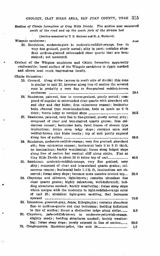
GEOLOGY, CLAY HILLS AREA, SAN JUAN COUNTY, UTAH 315
Section of Chinle formation at Clay Hills Divide. The section was measured south of the road and up the south fork of the stream bed
[Section measured by T. E. Mullens and H. A. Hubbard]
Wingate sandstone: Feet 30. Sandstone, moderate-pink to moderate-reddish-orange, fine- to
very fine grained, poorly sorted; silty in part; contains abun dant medium-grained subrounded clear quartz that are iron- stained ; not measured.
Contact of the Wingate sandstone and Chinle formation apparently conformable; basal surface of the Wingate sandstone is ripple marked and shows mud crack impressions locally.
Chinle formation:29. Covered. Along strike (across to north side of divide) this zone
is similar to unit 27, however along line of section the covered zone is probably a very fine to fine-grained reddish-brown sandstone __ _ ____ _-_ 19.4
28. Sandstone, pale-red, fine- to coarse-grained, poorly sorted; com posed of angular to subrounded clear quartz with abundant silt and clay and clay blebs; firm calcareous cement; lenticular beds, channel type cross-laminations, beds as much as 6 ft thick; forms ledgy to vertical slope ____ ___ _ 36.5
27. Sandstone, pale-red, very fine to fine-grained, poorly sorted, silty; composed of clear and iron-stained quartz grains; firm cal careous cement; lenticular beds, faint traces of stream type laminations; forms steep ledgy slope; contains mica and reddish-brown clay blebs locally; top of unit poorly exposed along line of section _____________ ___________ 39.6.
26. Sandstone, moderate-reddish-orange; very fine grained, abundant silt; firm calcareous cement; horizontal beds 2 to 5 ft thick, no laminations; hackly weathering; forms steep ledged slope along line of section but vertical cliff along strike. Flat at Clay Hills Divide is about 20 ft below top of unit_______ 40.5
25. Sandstone, moderate-reddish-orange, very fine grained, very silty; composed of clear and iron-stained quartz grains; cal careous cement; horizontal beds 1-1% ft, laminations not ob served ; forms steep slope; becomes more massive toward top_ 35.0
24. Claystone and siltstone, light-brown; contains abundant fine clear quartz grains; highly calcareous, well-indurated; bed ding structures masked; hackly weathering; forms steep slope which merges with the moderate to light-reddish-orange color of unit 25; abundant light-green mottling, that increases upward ________________________________ 70.0
23. Limestone, greenish-gray, dense, lithographic; contains abundant fine- to medium-quartz and clay inclusions; bedding indistinct in line of section; forms a distinctive ledge along strike__ 3.0
22. Claystone, pale-reddish-brown to moderate-yellowish-orange, slightly sandy; bedding structures masked; hackly weather ing; forms steep slope; poorly exposed in line of section__ 86.0
21. Conglomerate, limestone-pellet, like unit 14___________ 1.7

316
Chinle formation Continued Feet20. Sandstone, moderate-reddish-brown, very fine grained; abundant
silt and clay matrix; composed of clear and iron-stained quartz; weak calcareous cement; bedding structures masked; forms steep slope 11.4
19. Claystone, limy, grayish-red; forms 5 ledges along line of section; each ledge about 1 ft thick, separated by about 1 ft of clay- stone like unit 18 __________________ 8.2
18. Claystone, moderate-orange-pink; scattered fine and very fine quartz grains; calcareous cement; bedding structures masked; forms steep slope ____________ 36.0
17. Limestone, light-gray, dense; conchoidal fracture; contains abundant pale-red-purple chert concretions; in two indistinct beds; each bed weathers into irregular blocks as much as 1 ft in length; forms distinct ledge in area 4.4
16. Claystone; grayish purple in lower half, moderate reddish orange in upper part; upper half weathers moderate orange pink; contains common very fine to fine clear quartz grains; calcareous cement; slightly fissile; bedding structures masked; forms steep slope _____.____________________ 72.0
15. Sandstone; like unit 11; contains lenticular beds of limestone- pellet conglomerate such as unit 14; limestone-pellet con glomerate bed near the top, 8 ft thick, extends less than 150 ft along strike _____________________________ 36.1
14. Conglomerate, grayish-red; limestone-pellet; limestone pellets as much as % in. long in a matrix of fine to coarse angular to rounded clear quartz grains and clay; pellets weather to gray clay; black mica common in matrix; lime cement removed locally; lenticular; low-angle fluviatile cross-laminations__ 2.8
13. Claystone, moderate-reddish-orange; mottled dusky yellow; forms moderate-orange-pink slope; fine clear quartz grains common; firm calcareous cement; bedding structures masked; hackly weathering ___________________________ 41.5
12. Sandstone, pale-reddish-brown, fine- to medium-grained, poorly sorted; contains abundant very light gray mottling; angular to subrounded quartz grains; black accessory minerals common; chert grains scarce; abundant silt and clay; weak calcareous cement; bedding structures masked; forms distinct thin light- gray band ______________________ 0.3
11. Mudstone, dark-reddish-brown; composed of silt and fine and very fine quartz grains; weak calcareous cement; bedding structures masked; forms moderate-red slope ________ 4.0
10. Sandstone, grayish-red and light-gray, medium- to coarse-grained, poorly sorted; composed of angular to subrounded quartz grains and abundant green mineral, abundant interstitial clay, black accessory mineral, clear mica, and many fine red chert grains; friable; slightly calcareous; bedding structures poorly exposed, some traces of fluviatile cross-laminations; forms steep rounded grayish slope ; 31.4

GEOLOGY, CLAY HILLS AREA, SAN JUAN COUNTY, UTAH 317
Chinle formation Continued feet 9. Claystone, dark-reddish-brown to grayish-red; local mottles and
streaks of greenish gray; contains thin lenticular beds of fine-grained very calcareous sandstone, thin stringers of nodu lar limestone, and calcite concretions; bedding masked; forms steep frothy slope 52.0
8. Sandstone, pale-green, fine- to medium-grained, poorly sorted; composed of clear quartz, with at least 50 percent black and green minerals and interstitial clay; grains angular to
! rounded; friable, calcareous cement; bedding generally 1 masked, local fluvial cross-laminations; forms steep green i slope; contains fossil wood largest log observed 14 in. by
8 ft; gradational contact with unit 9_ _ 76.5 ; 7. Mudstone, grayish-yellow-green; consists of clay, silt, and fine
to very fine sand grains; weak, noncalcareous cement; con- ; tains gypsum concretions that, locally, alter the unit to dark 1 gray and grayish orange; bedding masked; frothy weathering;
forms greenish slope; contains some lenticular beds of sand stone along strike; aragonite float abundant on slope locally; unit interflngers with dark-reddish-brown claystone along
.; strike _________________________________ 17.5 . Claystone, variegated; dark yellowish orange near base, grayish
purple to grayish blue in middle, and dark reddish brown at ' . . top; very fine to fine clear quartz grains common; forms
steep frothy slope _________________________ 33.35. Claystone, grayish-purple; contains local dark-grayish-orange
mottling; well-indurated; noncalcareous cement; frothy weath ering; forms steep slope _________ ___________ 8.1
4. Sandstone, light-gray, very fine to medium-grained; contains abundant silt; composed of angular to subrounded quartz grains; firm cement, very calcareous; local calcareous nodules; forms thin gray band in steep slope________ _____ .3
3. Claystone, grayish-purple; contains scarce clear quartz sand grains; well-indurated; noncalcareous cement; bedding indis tinct ; hard surface, hackly weathering; forms steep grayish- purple slope _ ____________ __________ 6.0
2. Mudstone, grayish-red and light-gray; contains irregular spots of dark reddish brown; an unsorted mixture of clay, silt, sand and granule-sized particles of predominantly clear angu lar to subrounded quartz; larger pebbles mainly reddish- brown quartz and quartzite, common milky to clear quartz, and scarce reddish chert, angular to well-rounded as stringers locally and disseminated throughout unit; local concentrations of iron oxide near the Moenkopi-Chinle contact; well-in durated ; slight calcareous cement; forms steep gray slope_ 11.0
Total Chinle formation ___________________ 784.5
Contact of the Chinle formation and Moenkopi formation; erosional unconformity marked by abrupt change in lithologic characteristics and local channeling of rocks of the Chinle into those of the Moenkopi; greatest channel depth 2 ft; no Shinarump member in line of section.

318 CONTRIBUTIONS TO THE GEOLOGY OF URANIUM
Moenkopi formation: .1. .Siltstone, dark-reddish-brown; banded and mottled with streaks
of pale yellowish green; contains abundant very fine quartzgrains; well-indurated; slightly calcareous cement; horizontal
. beds 1 in to 1 ft thick; bedding accentuated by bands of paleyellowish green; hackly fracture; forms steep rounded slope;not measured.
Section of Chinle formation measured at northeast end of Mikes Mesa
[Measured by T. B. Mullens and J. H. Stewart]
Wingate sandstone: Feet . 25. Sandstone, moderate-reddish-orange, very fine grained; contains
abundant stringers of medium, well-rounded and iron-stained quartz grains near base of unit; not measured.
Contact of the Chinle formation and Wingate sandstone; no apparent unconformity, but a slight waviness at basal surface of Wingate sandstone.
Chinle formation:24. Sandstone, pale-reddish-brown, very fine grained, silty; composed
of clear quartz, common white mica flakes, other accessory minerals masked; firm calcareous cement; horizontally lami nated; platy weathering; forms steep talus-covered slope 13.6
23. Sandstone; same as unit 22__ _ 14.2 Covered ___________________ ___ ___ 16.8
22. Sandstone, pale-red; minor amounts of very light gray, very fine to coarse-grained locally silty, poorly sorted; composed of clear and milky angular and subangular quartz, abundant black and green accessory minerals, and many white mica flakes; about 50 percent limestone-pellet conglomerate along line of section, pellets, as much as 1 ft, but average 1 in. in diameter, and many granules and abundant milky quartz grains; forms minor ledge in earthy slope____ ___ __ 62.9
21. Conglomerate, pale-red and light greenish-gray limestone- pellet ; contains subrounded limestone pebbles as much as 2 in. in diameter and abundant milky and clear quartz subrounded to rounded, from very fine to very coarse grained; forms white ledge-_____________________________ 5.0
20. Siltstone; probably like unit 13; poorly exposed ________ 84.8 19. Siltstone; like unit 13 _:_________________________ 21.8 18. Limestone, grayish-orange-pink, pale-red, and light greenish-gray,
very silty; greenish parts contain abundant very fine quartz grains; massive basal portion, thin bedded and flaggy weather ing in upper half; flaggy part contains abundant marks similar to worm borings and possibly plant impressions__. 14.1
17. Siltstone, like unit 13__________________________ 39.4 16. Sandstone, limy, conglomeratic, light-greenish-gray; very fine
to coarse subangular to well-rounded quartz grains; firm calcareous cement; pebbles composed of limestone from very coarse grained to }4 in. in diameter; clay pellets as much as 1 In. in diameter __________________________ 3.2

GEOLOGY, CLAY HILLS AREA, ; SAN JUAN COUNTY, UTAH 319
Chinle formation Continued Feet15. Sandy siltstone like unit 13 : ^__ ^ 62.214. Limestone, pale-red, very silty, very fine grained, sandy; mot
tled to light greenish gray; gradational with lower and upper unit; forms highly fractured ledge in line of section 9.4
13. Siltstone, sandy, pale-reddish-brown; abundant subangular to subrounded clear and iron-stained quartz grains; well- indurated ; calcareous cement; very thin to 4-in. beds of light- greenish-gray limestone nodules and calcareous beds common in lower two-thirds of unit; abundant light-greenish-gray spots ________ 52.2
12. Mudstone, pale-red and pale-reddish-brown; composed of equalproportions of clay, silt, and very fine quartz grains; containsabundant very fine mica flakes; calcareous cement; top 5 ftcontains nodules of light-greenish-gray very fine grained very
'calcareous sandstone ' - 39.611. Sandstone like unit 7 except for local bands of pale red and
light greenish gray from three-eighths to 2 in. thick along lamination planes - - ;_^_- 13.6
10. Claystone; pale red in lower half and moderate orange pink in upper half, sparse very fine quartz grains; pale-red part slightly more calcareous than orange-pink part; well in durated; forms steep frothy slope _______:____:_____ 40.6
9. Siltstone, calcareous, pale-red; locally contains abundant fine to very coarse well-rounded quartz and limestone grains: rela tively pure dense limestone locally; forms prominent band in slope; gradational with units above and below_____ 7.0
8. Claystone, pale-red, well-indurated; calcareous; contains abund ant pale-green mottling in spots and streaks; forms steep frothy slope _ _ ___________ 39.3
7. Sandstone, pale-red, fine-grained to very fine grained, poorly sorted, silty; composed of subangular clear quartz with abund ant black and white mica and green and black accessory minerals; calcareous cement, firm to friable; basal channel surface; trough-type cross-lamination; lenticular unit; forms minor ledge in line of section _________________ 10.2
6. Siltstone, variegated dusky-yellow, moderate-pink-brown, gray ish-red, dark-reddish-brown; weathers to moderate orange-pink with basal part moderate yellow, sparse very fine quartz grains; well-indurated; calcareous cement; contains a 29.8-ft sandstone unit at 56.3 ft above base of unit__________ 86.1
5. Sandstone, moderate-pink, medium-grained; composed of angular clear quartz and milky quartz, white and pink feldspar, and abundant black and white mica and yellow accessory minerals; friable; crossbedded; individual beds weather to form ledges in gentle rounded slope; contains local lenses of more firmly cemented grayish-red sandstone _________________ 24.7
4. Sandstone, like sandstone in unit 3 except grains are larger (fine- to medium-grained) and contains black mica flakes as large as 2 min; contains short lenses of medium-gray lime stone-pellet conglomerate; conglomerate locally contains ag gregates of small pellets and large nodules as large as 2 in.
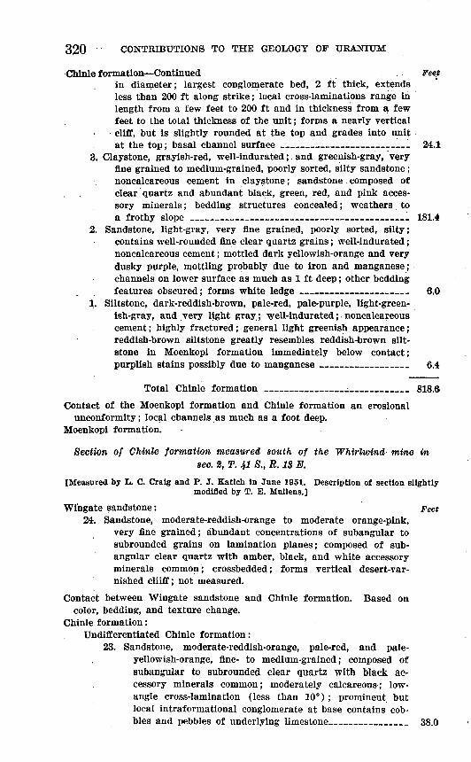
320Chlnle formation Continued . ... Feet
in diameter; largest conglomerate bed, 2 ft thick, extends less than 200 ft along strike; local cross-laminations range in length from a few feet to 200 ft and in thickness from a few feet to the total thickness of the unit; forms a nearly vertical cliff, but is slightly rounded at the top and grades into unit at the top; basal channel surface 24.1
3. Claystone, grayish-red, well-indurated; and greenish-gray, very fine grained to medium-grained, poorly sorted, silty sandstone ; noncalcareous cement in claystone; sandstone composed of clear quartz and abundant black, green, red, and pink acces sory minerals; bedding structures concealed; weathers to a frothy slope 181.4
2. Sandstone, light-gray, very fine grained, poorly sorted, silty; contains well-rounded fine clear quartz grains; well-indurated; noncalcareous cement; mottled dark yellowish-orange and very dusky purple, mottling probably due to iron and manganese; channels on lower surface as much as 1 ft deep; other bedding features obscured; forms white ledge _ ___ 6.0
1. Siltstone, dark-reddish-brown, pale-red, pale-purple, light-green ish-gray, and very light gray; well-indurated; noncalcareous cement; highly fractured; general light greenish appearance; reddish-brown siltstone greatly resembles reddish-brown silt- stone in Moenkopi . formation immediately below contact; purplish stains possibly due to manganese __________ 6.4
Total Chinle formation __________________ 818.6
Contact of the Moenkopi formation and Chinle formation an erosionalunconformity; local channels as much as a foot deep.
Moenkopi formation.
Section of Chinle formation measured south of the Whirlwind mine in sec. 2, T. 41 8., R. IS E.
[Measured by L. C. Cralg and P. J. Katich In June 1951. Description of section slightlymodified by T. E. Mullens.]
Wingate sandstone: Feet 24. Sandstone, moderate-reddish-orange to moderate orange-pink,
very fine grained; abundant concentrations of subangular to subrounded grains on lamination planes; composed of sub- angular clear quartz with amber, black, and white accessory minerals common; crossbedded; forms vertical desert-var nished cliiff; not measured.
Contact between Wingate sandstone and Chinle formation. Based oncolor, bedding, and texture change.
Chinle formation:Undifferentiated Chinle formation:
23. Sandstone, moderate-reddish-orange, pale-red, and pale- yellowish-orange, fine- to medium-grained; composed of subangular to subrounded clear quartz with black ac cessory minerals common; moderately calcareous; low- angle cross-lamination (less than 10°); prominent but local intraformational conglomerate at base contains cob bles and pebbles of underlying limestone__________ 38.0

321
Chinle formation ContinuedUndifferentiated Chinle formation Continued . Feet
22. Limestone, light greenish-gray to very light gray, dense to very fine grained; constitutes 90 percent of the unit; in platy to slabby to massive ledges; pale-red; sandstone and claystone form interbeds as much as 1 ft thick; bedding planes in limestone show siltstone and claystone, mud cracks, horizontally laminated to ripple laminated 39.4
21. Sandstone, silty, moderate-reddish-orange, very fine grained size; structureless;.hackly weathering; forms prominent red ledge in lower part and red slope above 15.8
20. Claystone, grayish-red, mottled and streaked light greenish- gray, probably silty; constitutes 80 percent of the unit; hackly "weathering; forms very steep slope; pale-red and light-greenish-gray limestone; forms sequence of prominent hackly to slabby ledges 6 in to 3 ft thick; prominent ledgy unit below upper red unit; not inspected because unit forms steep dangerous slope _ ____ 87.8
19. Claystone, grayish-red, mottled and streaked light greenish- gray ; constitutes 99 percent of unit; very thin discontinu ous limestone ledges less than 6 in. thick; claystone probably quite sandy; not inspected because unit forms
steep dangerous slope _ _ 99.218. Sandstone, pale-red, medium- to fine-grained; weathers a
purplish cast; composed of subangular to subrounded clear quartz, common to abundant orange, black, and scarce green accessory minerals; abundant interstitial clay; fluviatile cross-laminations; forms friable ledge __ 10.0
17. Claystone, grayish-red and pale-red, contains scattered fine quartz grains; highly calcareous; hackly weathering forms minor cliff _____________ ___:_____ 8.4
16. Limestone, pale-red, mottled, light-greenish-gray, dense tovery fine grained; brecciated appearance __ __ .8
15. Claystone, sandy to clayey sandstone; dark reddish brown below to pale reddish brown and moderate reddish orange above, sandstone is very fine to fine grained; moderately calcareous; hackly to earthy weathering; forms steep slope ___ _____; ____ _ __________ 97.2
14. Sandstone and claystone, pale-red and light-greenish-gray; sandstone very fine to medium-grained, composed of sub- angular clear quartz, orange, black, and green accessory minerals common; sandstone shows fine cross-laminations in indistinct beds; locally forms minor ledge_______ 5.5
13. Limestone, pale-red, very fine grained to dense; forms local 'minor ledge; contains scattered pelecypods________ 1.0
12. Sandstone, clayey to pale-red claystone; sandy parts com posed of clear subangular to subrounded quartz with com mon to abundant orange, black, and green accessory minerals; very friable; structureless; forms hard-surfaced steep slopes; above 22 ft is dominantly claystone, variably silty to sandy, hackly weathering; thin, moderate reddish- orange clay bed 8 ft thick at top of unit______1____ 128.2

322 CONTRIBUTIONS TO THE GEOLOGY OF URANIUM
Chinle formation ContinuedUndifferentiated Chinle formation Continued . Feet
11. Claystone, grayish-red; light-greenish-gray mottles; . con tains medium-grain sand; frothy weathering; forms gentle to steep slopes; contains light- to medium-gray dense to fine-grained limestone concretions _ 25.0
10. Covered interval. Slump blocks of Wingate sandstone onbench _ _ 61.4
9. Sandstone, siltstone, and minor amounts of claystone; heterogeneous unit; pale-red, pale-reddish-brown, moder ate red sandstone; ranges from very fine to coarse-grained, poorly sorted; composed of subangular to subrounded clear quartz, very common to abundant orange and black ac cessory minerals, abundant clay matrix; thin limestone conglomerate at base in grayish band; pale-red, mottled light-greenish-gray, very fine grained, partly dolomitic(?) limestone beds as much as 5 ft thick at top of unit- 75.6
8. Claystone, grayish-red; light-greenish-gray mottling and much greenish-gray mottling in lower part; slightly silty; hackly weathering; forms steep slope; unit rather in distinct and some slumping included _ 81.0
7. Claystone, yellowish-gray, pale-olive to pale-green; grades from pure to slightly silty to very fine grained sandy; hackly to deep frothy weathering; weathers to a steep hard slope; contains bands of red locally; badly slumped in part ______ __ 97.2
6. Claystone, variegated; poorly .exposed- _ --_____ 49.6. 5. Claystone, pale-olive, silty to slightly fine-grained sandy;
constitutes 80 percent of the unit; earthy weathering; forms poorly exposed slope; interbedded with brownish- gray, fine-grained, highly .calcareous sandstone that weathers dark brown; slabs 2-3 ft thick; ripple-laminated ledges showing great distortion. Laterally along strike near section sandstone similar to Shinarump builds up as high as top of this unit of sandstone but shows no con tortion ______ ______________________ 97.2
Total undifferentiated Chinle formation______1018.3
Contact between undifferentiated Chinle formation and Shinarumpmember conformable with local gradation and intertonguing.
Shinarump member of Chinle formation:4. Sandstone, conglomeratic, slightly quartzitic, light-greenish-
gray to pale yellowish-brown; weathers very pale orange to grayish orange; fine to medium-size grains, sparse coarser grains; composed of subangular to subrounded clear quartz fragments and scarce black and orange accessory minerals; fluviatile cross-lamination; layers with pebbles as much as 1 in. in diameter in middle of unit; scattered granules of quartz and dull white chert________________ 84.8
3. Claystone, dusky-yellow to yellowish-gray; flaky to platyweathering; poorly exposed __________^______ 4.9

GEOLOGY, CLAY HILLS AREA, SAN JUAN COUNTY, UTAH 323
Chlnle formation ContinuedShinarump member of Chinle formation Continued ._ __ _Feet
2. Sandstone, conglomeratic, pale-yellowish-orange to yellowish- gray, medium- to coarse-grained; composed of subangular to subrounded clear quartz, scarce black accessory minerals; pebbles mostly white quartz, rose to pink quartz, white chert, and dark chert; pebbles less than 1 in., mostly one- half to one-fourth inch in diameter, disseminated in sand matrix as well as concentrated in lenses; fluviatile cross- lamination; beds 1 to 10 ft thick; forms massive ledge; plant fragments and intraformational clay pebbles common at base 76.9
Total Shinarump member 176.6
Total Chinle formation 1,194.9
Contact of the Shinarump member of Chinle formation and Moenkopi formation an erosional unconformity and marked by channels and abrupt change in lithologic characteristics.
Moenkopi formation:1. Claystone and siltstone, interbedded, grayish-red; mottled light-
greenish-gray ; claystone silty and micaceous; parallel sets less than 6 in. thick of parallel laminations; top 4 in. altered light greenish gray; not measured.
Section of Shinarump member of the Chinle formation measured about 2 miles southwest of Red House Spring
[Measured by T. B. Mullens]
Chinle formation: Feet Undifferentiated Chinle formation: Mudstone, variegated. Chinle
formation not measured or described. Contact of the undifferentiated and Shinarump member of Chinle
formation gradational vertically and laterally.Shinarump member 1 of the Chinle formation: Conglomerate, light-
gray; mottled grayish-purple and dusky-yellow; matrix composed of fine to very coarse subangular clear quartz grains, interstitial clay, and scarce black accessory mineral; larger sized fragments consist of clear and rose quartz, quartzite, and chert; larger frag ments range from granule to pebble size and are angular to sub- rounded; largest pebble observed is 2 in. in diameter, average pebble size one-fourth to one-half inch; lenticular bed, basal chan- eled surface with relief as much as 4 ft; basal foot or so of the Shinarump consists of altered and reworked Moenkopi rocks; a prominent light-colored ledge in line of section__________ 12.0
Contact between Shinarump member and Moenkopi formation an ero sional unconformity, with local channels as deep as 4 ft; marked by abrupt change in lithologic characteristics.
Moenkopi formation: Siltstone, moderate reddish-brown; evenly bedded and slightly fissile; not measured.
1 The Shinarump member In this section corresponds closely In stratlgraphlc and litho logic characteristics to the "purple-white" bed generally considered as part of undifferen tiated Chinle formation (Finch, 1953).
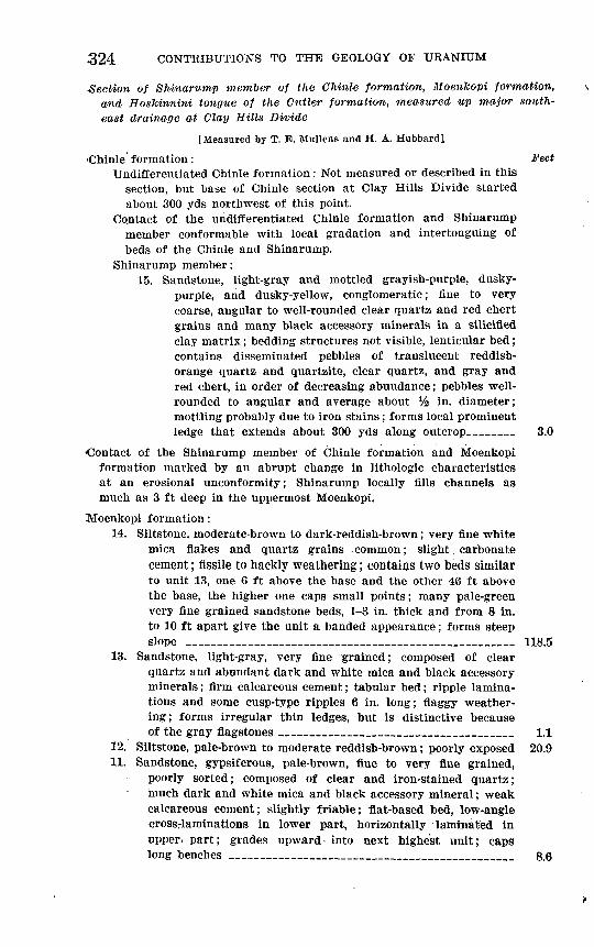
324 CONTRIBUTIONS TO THE GEOLOGY OF URANIUM
Section of Shinarump member of the Chinle formation, HoenJcopi formation, and Hoskinnini tongue of the Cutler formation, measured up major south east drainage at Clay Hills Divide
[Measured by T. E. Mullens and H. A. Hubbard]
Chinle formation: Feet Undifferentiated Chinle formation: Not measured or described in this
section, but base of Chinle section at Clay Hills Divide started about 300 yds northwest of this point.
Contact of the undifferentiated Chinle formation and Shinarump member conformable with local gradation and intertonguing of beds of the Chinle and Shinarump.
Shinarump member:15. Sandstone, light-gray and mottled grayish-purple, dusky-
purple, and dusky-yellow, conglomeratic; fine to very coarse, angular to well-rounded clear quartz and red chert grains and many black accessory minerals in a silicified clay matrix; bedding structures not visible, lenticular bed; contains disseminated pebbles of translucent reddish- orange quartz and quartzite, clear quartz, and gray and red chert, in order of decreasing abundance; pebbles well- rounded to angular and average about Vz in. diameter; mottling probably due to iron stains; forms local prominent ledge that extends about 300 yds along outcrop __ 3.0
Contact of the Shinarump member of Chinle formation and Moehkopi formation marked by an abrupt change in lithologic characteristics at an erosional unconformity; Shinarump locally fills channels as much as 3 ft deep in the uppermost Moenkopi.
Moenkopi formation:14. Siltstone, moderate-brown to dark-reddish-brown; very fine white
mica flakes and quartz grains common; slight. carbonate cement; fissile to hackly weathering; contains two beds similar to unit 13, one 6 ft above the base and the other 46 ft above the base, the higher one caps small points; many pale-green very fine grained sandstone beds, 1-3 in. thick and from 8 in. to 10 ft apart give the unit a banded appearance; forms steep slope __ ___________________________ 118.5
13. Sandstone, light-gray, very fine grained; composed of clear quartz and abundant dark and white mica and black accessory minerals; firm calcareous cement; tabular bed; ripple lamina tions and some cusp-type ripples 6 in. long; flaggy weather ing; forms irregular thin ledges, but is distinctive because of the gray flagstones ________________________ 1.1
12. Siltstone, pale-brown to moderate reddish-brown; poorly exposed 20.911. Sandstone, gypsiferous, pale-brown, fine to very fine grained,
poorly sorted; composed of clear and iron-stained quartz; much dark and white mica and black accessory mineral; weak calcareous cement; slightly friable; flat-based bed, low-angle crossrlaminations in lower part, horizontally laminated in upper* part; grades upward into next highest unit; caps long benches ______________._______________ 8.6

GEOLOGY, CLAY HILLS AREA, SAN JUAN COUNTY, UTAH 325
Moenkopi formation Continued10. Siltstone, dark-brown, slightly fissile; interbedded with light-
brown, very fine grained gypsiferous sandstone; abundant dark and white mica in both siltstone and sandstone; silt- stone contains abundant veinlets and nodules of gypsum; horizontally bedded in 8 in. to 2 ft beds; forms vertical cliff to steep earthy slope 34.6
9. Sandstone, light-brown, fine-grained and slightly silty ; composed of subrounded quartz, abundant black accessory minerals, with much dark and white mica; firm to weak, part gypsum and part carbonate cement; lower 15 ft is low-angle cross-lami nated ; upper 15 ft is structureless ; along outcrop upper 15 ft grades to siltstone; forms most prominent ledge in the Moenkopi along line of section 30.9
8. Siltstone, like unit 6 except that unit 8 forms vertical cliffunder sandstone ledge 33.0
7. Sandstone, gypsiferous, white, fine-grained to very fine grained; composed of clear rounded quartz with many black accessory minerals ; friable, gypsiferous cement ; tabular bed, fluviatile cross-laminations; forms minor ledge in basal shale slope of Moeukopi ________ __ ____ 6.5
6. Siltstone, moderate-brown; contains abundant very fine quartz grains and local veinlets and beds of white gypsum ; weak carbonate cement; horizontally bedded in beds one-half to 2 ft ; some beds slightly fissile ; contains several 1-2 in. beds of grayish sandstone and greenish-gray claystone that give unit a banded appearance ___ _ ___ _ ________ 36.9
Total Moenkopi formation _________________ 291.0
Contact between Moenkopi formation and Hoskinnini tongue of the Cut ler formation apparently conformable and marked by slight'change in lithologic characteristics.
Cutler formation:Hoskinnini tongue of the Cutler formation:
: 5. Silty sandstone, pale-reddish-brown; dominantly very fine grained sand and silt but contains fine- and medium-grained clear and iron-stained quartz; firm to weak carbonate
-cement; horizontally bedded, but individual beds contain contorted fine scale laminations; basal 6 ft form a vertical cliff, upper 8 ft form a ledgy slope that merges with the overlying slope of the Moenkopi________________ 14.7
4. Mudstone, grayish-red with abundant greenish-gray mottling in spots and streaks; composed of clay, silt, and very fine to medium-sized sand grains; larger grains are rounded clear and iron-stained quartz; firm calcareous cement; bed ding structures obscured; hackly weathering ________ 2.1
3. Sandstone, light-greenish-gray, very fine grained to medium- coarse-grained; composed of subangular to rounded clear
. - quartz with many gray chert and feldspar grains and ; scarce very fine grained black accessory mineral; firm cal
careous cement; contorted wavy bed and contorted thin
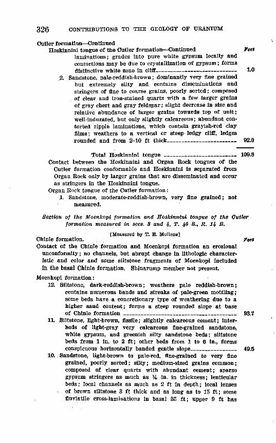
326 CONTRIBUTIONS TO THE GEOLOGY OF URANIUM
Gutter formation ContinuedHoskinnini tongue of the Cutler formation Continued Feet
laminations; grades into pure white gypsum locally and contortions may be due to crystallization of gypsum; forms distinctive white zone in cliff 1.0
2. Sandstone, pale-reddish-brown; dominantly very fine grained but extremely silty and contains disseminations and stringers of fine to coarse grains, poorly sorted; composed of clear and iron-stained quartz with a few larger grains of gray chert and gray feldspar; slight decrease in size and relative abundance of larger grains towards top of unit; well-indurated, but only slightly calcareous; abundant con torted ripple laminations, which contain grayish-red clay films; weathers to a vertical or steep ledgy cliff, ledges rounded and from 2-10 ft thick 92.0
Total Hoskinnini tongue 109.8 Contact between the Hoskinnini and Organ Bock tongues of the
Cutler formation conformable and Hoskinnini is separated from Organ Rock only by larger grains that are disseminated and occur as stringers in the Hoskinnini tongue.
Organ Rock tongue of the Cutler formation:1. Sandstone, moderate-reddish-brown, very fine grained; not
measured.
Section of the MoenJcopi formation and Hoskinnini tongue of the Cutler formation measured in sees. 8 and 4, T. 40 8., R. 14 E.
[Measured by T. E. Mullens] Chinle formation. FeetContact of the Chinle formation and Moenkopi formation an erosional
unconformity; no channels, but abrupt change in lithologic character istic and color and some siltstone fragments of Moenkopi included in the basal Chinle formation. Shinarump member not present.
Moenkopi formation:12. Siltstone, dark-reddish-brown; weathers pale reddish-brown;
contains numerous bands and streaks of pale-green mottling; some beds have a concretionary type of weathering due to a higher sand content; forms a steep rounded slope at base of Chinle formation _ __.,_____________________ 93.7
11. Siltstone, light-brown, fissile; slightly calcareous cement; inter- beds of light-gray very calcareous fine-grained sandstone, white gypsum, and greenish silty sandstone beds; siltstone beds from 1 In. to 2 ft; other beds from 1 to 6 In., forms conspicuous horizontally banded gentle slope__________ 49.5
10. Sandstone, lighkbrown to pale-red, fine-grained to very fine grained, poorly sorted; silty; medium-sized grains common; composed of clear quartz with abundant cement; sparse gypsum stringers as much as ^4 in. in thickness; lenticular beds; local channels as much as 2 ft in depth; local lenses of brown siltstone 3 ft thick and as long as to 15 ft; some fluviatile cross-laminations in basal 35 ft; upper 9 ft has

GEOLOGY, CLAY HILLS AREA, SAN JUAN COUNTY, UTAH 327
Moenkopi formation Continued Feet ripple laminations; forms long bench in Moenkopi outcrop; contains dark-brown rounded and angular clay blebs locally as much as % in. in long dimension _ 44.0
9. Sandstone, like unit 7 ___ ___ 43.08. Sandstone, light-brown, very fine grained, poorly sorted, silty;
composed of clear and iron-stained quartz grains with black accessory minerals common; weak gypsiferous cement; bed- ing structures not visible; basal contact flat; forms rounded to vertical ledge; contains siltstone partings along strike and upper part of unit is not easily recognized 21.6
7. Sandstone, light-brown, very fine grained, poorly sorted, silty; slight calcareous cement; horizontal beds, ripple laminations; interbeds of pale-brown siltstone, greenish silty sandstone and white nodular gypsum; forms horizontally banded vertical cliff _______________________________ 42.0
6. Sandstone, very pale green, very fine to fine-grained, poorly sorted; composed of subrounded to subangular clear quartz grains with abundant green minerals and black accessory minerals common; friable, gypsiferous cement; lenticular bed; some channel-type cross-laminations grade into siltstone part ings and disappear along strike_ _ 4.5
6. Siltstone, light-grayish-brown, clayey; abundant very fine quartz grains; slight calcareous cement; slightly fissile; thin beds (1 in. to 2 ft) with horizontal laminations interbedded with white gypsum and moderate reddish-brown gypsiferous silty sandstone; contains abundant gypsum stringers and beds as much as 1 ft thick; forms horizontally banded vertical unit_ 37.3
4. Gypsum, white, fine-grained; base of unit wavy ___ .4
Total Moenkopi formation _______________ 336.0
Cutler formation:Hoskinnini tongue:
3. Sandstone, moderate-reddish-brown, very fine to fine-grained, poorly sorted, silty; composed of clear and iron-stained subrounded quartz grains, black accessory mineral, gypsum grains and small blebs; weak calcareous cement; gypsum also in one-tenth to one-eighth inch seams and stringers; bedding generally obscured by slump, but some indica tions of ripple laminations; a very light green 2-in. sand stone bed present 10 ft above base; forms steep slope and weathers to small platy fragments __________ 23.0
2. Gypsum, white, fine to coarsely crystalline; variable impure along strike; locally contains abundant very fine to fine clear quartz grains and greenish-gray clay impurities; tabular bed; basal surface slightly wavy___________ 1.9
1. Sandstone, light-brown, very fine grained, silty; composed of clear quartz, abundant subrounded to well-rounded fine to coarse grains, black accessory minerals common, and white mica flecks abundant; larger grains are mainly clear and iron-stained quartz, many black and scarce red grains;
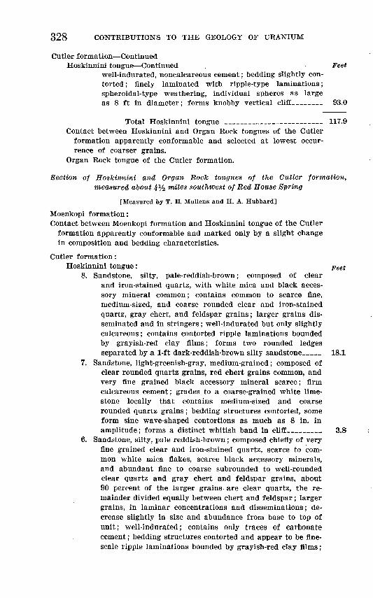
328 CONTRIBUTIONS TO THE GEOLOGY OF URANIUM
Cutler formation ContinuedHoskinnini tongue Continued . Feet
well-indurated, noncalcareous cement; bedding slightly con torted ; finely laminated with ripple-type laminations; spheroidal-type weathering, individual spheres as large as 8 ft in diameter; forms knobby vertical cliff 93.0
Total Hoskinnini tongue _________________ 117.9 Contact between Hoskinnini and Organ Rock tongues of the Cutler
formation apparently conformable and selected at lowest occur rence of coarser grains.
Organ Rock tongue of the Cutler formation.
Section of Hoskinnini and Organ Rock tongues of the Cutler formation, measured aoout 4Vz miles southwest of Red House Spring
[Measured by T. E. Mullens and H. A. Hubbard]
Moenkopi formation:Contact between Moenkopi formation and Hoskinnini tongue of the Cutler
formation apparently conformable and marked only by a slight changein composition and bedding characteristics.
Cutler formation:Hoskinnini tongue: peet
8. Sandstone, silty, pale-reddish-brown; composed of clear and iron-stained quartz, with white mica and black acces sory mineral common; contains common to scarce fine, medium-sized, and coarse rounded clear and iron-stained quartz, gray chert, and feldspar grains; larger grains dis seminated and in stringers; well-indurated but only slightly calcareous; contains contorted ripple laminations bounded by grayish-red clay films; forms two rounded ledges separated by a 1-ft dark-reddish-brown silty sandstone___ 18.1
7. Sandstone, light-greenish-gray, medium-grained; composed of clear rounded quartz grains, red chert grains common, and very fine grained black accessory mineral scarce; firm calcareous cement; grades to a coarse-grained white lime stone locally that contains medium-sized and coarse rounded quartz grains; bedding structures contorted, some form sine wave-shaped contortions as much as 8 in. in amplitude; forms a distinct whitish band in cliff______ 3.8
6. Sandstone, silty, pale reddish-brown; composed chiefly of very fine grained clear and iron-stained quartz, scarce to com mon white mica flakes, scarce black accessory minerals, and abundant fine to coarse subrounded to well-rounded clear quartz and gray chert and feldspar grains, about 90 percent of the larger grains are clear quartz, the re mainder divided equally between chert and feldspar; larger grains, in laminar concentrations and disseminations; de crease slightly in size and abundance from base to top of unit; well-indurated; contains only traces of carbonate cement; bedding structures contorted and appear to be fine- scale ripple laminations bounded by grayish-red clay films;

GEOLOGY, CLAY HILLS AREA, SAN JUAN COUNTY, UTAH 329
Cutler formation ContinuedHoskinnini tongue Continued Feet
forms nearly vertical smooth cliff with local patches of solution pit weathering 79.7
Total Hoskinnini tongue _ 101.6
Contact between the Hoskinnini and Organ Rock tongues of the Cutler formation apparently conformable and marked by an ap pearance of larger grains as disseminations and laminar concentra tions and contorted and fine scale bedding in the Hoskinnini.
Organ Rock tongue:5. Sandstone, pale to moderate reddish-brown, very fine grained,
silty; composed of iron-stained quartz, white mica flakes common, and black accessory mineral scarce; well-in durated but only slight carbonate cement; horizontally bedded in beds 6 in. to 2 ft thick with 1-6 in. very clayey and silty sandstone partings; hackly to rounded concretion ary weathering; forms steep ledgy slope; contains several beds like unit 4 that give a white banded appearance to slope ________________________________ 86.01
4. Sandstone, yellowish-gray, very fine grained, well-sorted; composed of clear quartz, with red, green, and black ac cessory minerals common, and scarce white mica flakes; firm carbonate cement; forms lowest prominent light- colored ledge in Organ Rock tongue_____________ !.{>
3. Sandstone and mudstone, dark-reddish-brown; sandstone, very fine grained and slightly silty; mudstone, a mixture of very fine grained sand, silt, and clay; horizontally bedded in 1-10 ft beds; forms ledgy slope, sandstone forms ledges, mudstone forms steep slopes; contains numerous randomly oriented fractures bleached greenish gray in upper half_ 230.01
2. Sandstone, moderate-reddish-brown, very fine grained, poorly sorted, silty; composed of clear and iron-stained quartz with many white mica flakes; unit forms a bench 100 yd wide in line of section _____________________ 10.0'
Total Organ Rock tongue ________________ 327.5 Contact between the Organ Rock tongue and Cedar Mesa sandstone
member of the Cutler formation conformable with local lateral gradation; placed at top of highest light-colored bed in the transi tion zone between the Cedar Mesa sandstone member and Organ Rock tongue.
Cedar Mesa sandstone member:1. Sandstone, light-brown; not measured or described.
Section of the Hoslcinnini and Organ Rock tongues of the Cutler formation measured about 2 miles northeast of Red House Spring
[Measured by T. B. and M. C. Mullens]
Moenkopi formation:
Contact of the Hoskinnini tongue and Moenkopi formation; a slight change in lithologic characteristics but no apparent unconformity at

330 CONTRIBUTIONS TO THE GEOLOGY OF URANIUM
contact; beds of the Moenkopi contain more mica, are ripple-marked, and are slightly fissile.
Cutler formation:Hoskinnini tongue: Feet
11. Sandstone, like unit 8 except that coarser grains are rela tively rare and do not exceed medium size _ __ _ 20.0
10. Sandstone, moderate-reddish-brown, very fine grained, poorly sorted, silty; contains scattered greenish-gray mottles; clear and iron-stained quartz grains with scattered fine and medium grains; firm calcareous cement; hackly weathering ______________________________ 3.9
9. Sandstone, white; mainly very fine grained, but contains small lenses and disseminations of coarser grains; com posed of quartz and accessory red chert; firm very cal careous cement; contorted bedding wavy; some waves as much as 6 in. in amplitude; forms a thin white to gray band ______________ __ 1.1
8. Sandstone and siltstone, moderate-reddish-brown; composed of clear and iron-stained quartz with common black accessory minerals, abundant white mica, very scarce red accessory mineral and abundant fine to very coarse quartz and chert grains; larger grains dominantly subrounded to rounded quartz; firm carbonate cement; bedding struc tures not visible; spheroidal-type weathering, individual spheres as much as 8 ft in diameter; forms lower part of prominent vertical cliff; separated from Organ Rock on basis of weathering and abundant larger grains___ 83.0
Total Hoskinnini tongue ________________ 108.0
Organ Rock tongue:7. Siltstone; like unit 5 except it contains abundant very fine
to fine iron-stained quartz grains; forms very ledgy slope; ledges 2 ft to 8 ft in height and angular to concretionary in shape; ledges separated by lenticular partings of red dish-brown silty claystone; a 1-f t zone, like unit 6, at top of unit and a 2-ft zone, like unit 6, 5 ft from top of unit 46.0
6. Sandstone, yellowish-gray, very fine grained, well-sorted; composed of clear quartz, green and black accessory min erals ; white mica flecks common; firm calcareous cement_ 1.0
6. Siltstone, moderate-reddish-brown; variable very fine grained, sandy; contains scarce very fine mica flecks; well- indurated, calcareous cement; horizontally bedded, indi vidual beds inconspicuous except for several pale-yellowish- green very fine grained sandstone beds; contains pale yel lowish-green joint discolorations as much as 2 in. in width but no preferred orientation; separated from underlying unit by finer grain size and subtle color change_____ 142.0
4. Sandstone, dark-reddish-brown to moderate-reddish-brown; some greenish-gray mottling in streaks and spots; very fine grained, variably silty; composed of clear and iron-stained quartz, white mica flecks common, and scarce red and black

GEOLOGY, CLAY HILLS AREA, SAN JUAN COUNTY, UTAH 331
Cutler formation ContinuedOrgan Bock tongue Continued Feet
accessory minerals; well-indurated, slight to abundant cal careous cement; no bedding structures visible; hackly to platy weathering; forms steep slope with sandier zones making minor ledges; break in topographic slope from slight benches to steeper slope 60 ft above base of unit 95.0
3. Sandstone, pale-reddish-brown, very fine to fine-grained, poorly sorted, silty; composed of clear and iron-stained subangular to well-rounded quartz grains, larger grains better rounded, scarce red and black accessory minerals and white mica flecks; firm calcareous cement; tabular bed; no bedding structures visible; forms rounded ledge and caps minor points _______ ____ __ 2.0
2. Siltstone, dark-reddish-brown; contains abundant very fine quartz grains; well-indurated, noncalcareous cement; bed ding structures masked; hackly weathering; forms long gentle slope _____________ ___ __ 28.2
Total Organ Rock tongue_______________- 314.2
Contact between Organ Rock tongue and Cedar Mesa sandstone member gradational vertically and laterally.
Cedar Mesa sandstone member:1. Sandstone, very pale orange, very fine to medium-grained,
poorly sorted; weathers moderate orange-pink, composed of angular to well-rounded clear quartz with scarce red and white accessory minerals, larger grains well-rounded; firm calcareous cement; bedding structures masked; forms nar row bench. Cedar Mesa not measured.
Section of De Chelly sandstone member of the Cutler formation measured about Vz mile north of the north boundary of sec. 3, T. 41 8., R. 13 E.
[Measured by T. B. Mullens and J. N. Taggart]
Cutler formation:Hoskinnini tongue. FeetContact of the Hoskinnini tongue and the De Chelly sandstone mem
ber of the Cutler formation marked by a sharp break in color, change in bedding characteristics, and change in grain size.
De Chelly sandstone member of the Cutler formation: Sandstone, yellowish-gray, fine- to medium-grained; composed of clear and iron-stained rounded quartz and common black accessory minerals; weak carbonate cement; cross-laminated with eolian-type cross- laminations; basal 18 ft forms vertical ledge, upper 12 ft forms rounded ledge; eastward along outcrop the basal part wedges out; the upper 5 to 10 ft probably grade laterally into Hoskinnini tongue _ _ __ __ __ 30.0
Contact between the De Chelly sandstone member and Organ Rock tongue of the Cutler formation marked by change in bedding characteristics and a slight increase in grain size.
Organ Rock tongue of the Cutler formation.
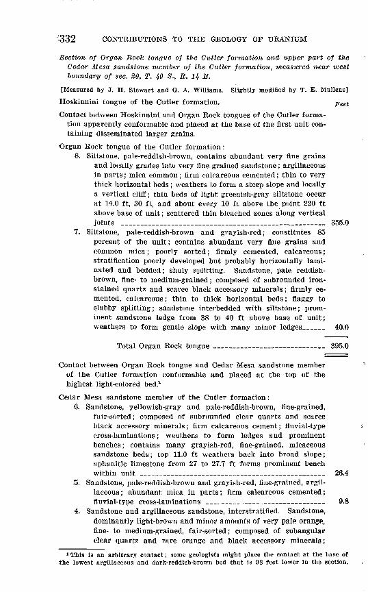
-332 CONTRIBUTIONS TO THE GEOLOGY OF URANIUM
Section of Organ Rock tongue of the Cutler -formation and upper part of the Cedar Mesa sandstone member of the Cutler formation, measured near west boundary of sec. 20, T. 40 8., R. 14 E.
'[Measured by J. H. Stewart and G. A. Williams. Slightly modified by T. E. Mullens]
Hoskinnini tongue of the Cutler formation. peet
Contact between Hoskinnini and Organ Rock tongues of the Cutler forma tion apparently conformable and placed at the base of the first unit con taining disseminated larger grains.
Organ Rock tongue of the Cutler formation:8. Siltstone, pale-reddish-brown, contains abundant very fine grains
and locally grades into very fine grained sandstone; argillaceous in parts; mica common; firm calcareous cemented; thin to very thick horizontal beds; weathers to form a steep slope and locally a vertical cliff; thin beds of light greenish-gray siltstone occur at 14.0 ft, 30 ft, and about every 10 ft above the point 220 ft above base of unit; scattered thin bleached zones along vertical joints ____________________________________ 355.0
7. Siltstone, pale-reddish-brown and grayish-red; constitutes 85 percent of the unit; contains abundant very fine grains and common mica; poorly sorted; firmly cemented, calcareous; stratification poorly developed but probably horizontally lami nated and bedded; shaly splitting. Sandstone, pale reddish- brown, fine- to medium-grained; composed of subrounded iron- stained quartz and scarce black accessory minerals; firmly ce mented, calcareous; thin to thick horizontal beds; flaggy to slabby splitting; sandstone interbedded with siltstone; prom inent sandstone ledge from 38 to 40 ft above base of unit; weathers to form gentle slope with many minor ledges___ 40.0
Total Organ Rock tongue __________ ___ __ 395.0
Contact between Organ Rock tongue and Cedar Mesa sandstone member of the Cutler formation conformable and placed at the top of the highest light-colored bed.1
Cedar Mesa sandstone member of the Cutler formation:6. Sandstone, yellowish-gray and pale-reddish-brown, fine-grained,
fair-sorted; composed of subrounded clear quartz and scarce black accessory minerals; firm calcareous cement; fluvial-type cross-laminations; weathers to form ledges and prominent benches; contains many grayish-red, fine-grained, micaceous sandstone beds; top 11.0 ft weathers back into broad slope; aphanitic limestone from 27 to 27.7 ft forms prominent bench within unit _________________________________ 26.4
5. Sandstone, pale-reddish-brown and grayish-red, fine-grained, argil laceous ; abundant mica in parts; firm calcareous cemented; fluvial-type cross-laminations ____________ 9.8
4. Sandstone and argillaceous sandstone, interstratified. Sandstone, dominantly light-brown and minor amounts of very pale orange, fine- to medium-grained, fair-sorted; composed of subangular clear quartz and rare orange and black accessory minerals;
1 This is an arbitrary contact; some geologists might place the contact at the base of the lowest argillaceous and dark-reddish-brown bed that is 98 feet lower in the section.

GEOLOGY, CLAY HILLS AREA, SAN JUAN COUNTY, UTAH 333
Cedar Mesa sandstone member of the Cutler formation Continued Feet poorly to firmly cemented; fluvial-type cross-laminations; forms ledges and prominent benches. Argillaceous sandstone, pale reddish-brown and grayish-red, very fine to fine-grained, poorly sorted; abundant mica; firmly cemented _ 42.4
3. Sandstone, yellowish-gray, fine- to medium-grained, fair-sorted, poorly cemented; composed of subangular clear quartz and scarce orange and black accessory minerals; a few limonite stains; forms rounded ledge ___________________ 14.3
2. Sandstone, dark-reddish-brown, fine-grained, fair-sorted; firmly cemented; composed of subrounded clear quartz and rare black accessory minerals; forms prominent re-entrant in massive sandstone cliffs; contains a few limestone masses ________ 5.1
1. Sandstone, yellowish-gray to white, fine- to medium-grained, fair-sorted; composed of subrounded clear quartz and scarce orange, green, and black accessory minerals, limonite spots common; poorly cemented; long sweeping cross-laminations between horizontal parting planes 10-50 feet apart; forms vertical cliff; base of unit not exposed and unit not measured.


INDEX
PageAbstract..... .. . ... 259-260 Access to the area 260,267 Acknowledgments . 262 Alluvium, fanglomerate__... 299-300
stream __ 298-299
Carbonaceous material 283-284,286 Castle Creek................................. 266Castle Creek anticline... 302-303 Castle Wash, stratigraphic section measured
along........................... 309-311Cedar Mesa sandstone member of Cutler forma
tion, environment of depositions. 271-272 lithologlccharacter___....___ 269,270-271outcrops... . _..._____ 270stratigraphic relations_______ 272,301-302stratigraphic section__________ 332-333thickness. 270
Chert concretions... . . 286-287Cblnle formation, chert beds________ 286-287
divisions of.________________ 281exposures . ......... 280-281,303fossils.-.... 287,288general description___________ 280-281 Shinarump member..... 269,282-285
For detailed references see Shinarumpmember of Chinle formation.
stratigraphic sections__________ 311-324thickness.. _...___... 269,281,289-290undifferentiated, claystone in middle unit. 287
environment of deposition.___.... 288limestone in middle unit_______ 287 limestone in upper unit_______ 287,288 mudstone in lower unit_______ 286-287 sandstone in lower unit_______ 285-286 sandstone in upper unit_______ 287-288 siltstone in upper unit _______ 287-288 source of sediments _________ 288-289 stratigraphic relations________ 290
Church Rock member of Chinle formation... 289 Clay Hills, description.....____.__.... 265Clay Hills Crossing_______________ 264 Clay Hills Divide, stratigraphic sections at.... SIS-
SIS, 324-326 Climate.__......____......____..... 266Coal beds 283-284Copper_________._______.____ 306 Cutler formation, Cedar Mesa sandstone
member ... 269,270-272,332-333 De Ohelly sandstone member___ 274-275,331 Halgaito tongue_____________ 268-269 Hoskinninl tongue... . . . 275-278,325-326,327-330Organ Kock tongue..... 272-274,329,330-331,332subdivisions._.____.____.__ 268,269 See also under individual members for
detailed listings.
PageDe Chelly sandstone member of Cutler for
mation, exposures____ 274,275 lithologic character_________ 269,274-276 stratigraphic relations______... 274-275 stratigraphic section_______ 331 thicknes__________________ 274
Deformation, age of.______________ 304 Douglas Mesa________________ 264 Dune sand___________________ 300
Extent of the area.. 260
Fanglomerate_ ___.. 299-300 Faults.....___..__._...__.____ 303-304 Fleldwork ._. .._.__ 262,267 Fossils, gastropods ... ... 287
Geography... 264-267 Glen Canyon group, age_______...... 290-291
Kayenta formation_________ 269,293-294Navajo sandstone__ . . 269,294-298Wingate sandstone_________ 269,291-293
Gold....____-__.____.__. .... 306Grand Gulch..............._....._...__ 267Grand Gulch Plateau____________ 264-265 Gravel, terrace........__._._.... 297-298,307Grazing______________________ 266 Green Water Spring, stratigraphic section
measured near_________ 309-311 Gypsiferous sandstone beds______ 271-272,276 Gypsum deposits..... ___ 276,279
Halgaito tongue of Cutler formation, ex posures ..... ____ 268
lithologic character____________ 269Hosklnnini tongue of Cutler formation, en
vironment of deposition__ 276-277 exposures.________________ 276,277 lithologic character___________ 269,276 stratigraphic relations______-__ 277-278 stratigraphic sections_____ 325-326,327-330 thickness..__ _.............. 269,275-276
Introduction_________________ 260-262
Joints..___.__.__.__....___-_ 304
Kayenta formation, environment of deposi tion.___....................... 294
exposures________________ 293,294 lithologic character. __________ 269,293 stratigraphic relations. ______-___ 294 stratigraphic section___________ 309-310 thickness _.................... 269,293
Landslide blocks..- _____________ 296-297 Limestone-pellet conglomerate__ 271,273,287,288 Literature cited._........................ 307-308
335

336 INDEX
Location of the area.Page
260,261,263
Mikes Canyon...___________ __ 266 Mikes Mesa, stratigraphic section at........ 318-320Mineral resources__.._...________ 305-307 Moenkopi formation, environment of deposi
tion........__.__.__._.... 280exposures_.._____ . __ 278 lithologic character.. ___________ 269,279 stratigraphic relations..__________ 280 stratigraphic sections..-.-.-.... 324-325,326-327thickness... . 269,278
Moki Canyon.............................. 266,267Monitor Butte member of Chinle formation.. 289 Monument upwarp........_._- 300-301.304Mormon settlers..._____________ 264,267 Mudstone.... . - 281,283,286,294
Navajo sandstone, exposures____ .. 294-295 lithologic character........ _.......... 269,295stratigraphic relations.... _. 295thickness....__..--------.....__.... 269,295
Oljetosyncline.. ..__. . - 301-302 Oljeto Wash____________________ 264 Organ Rock anticline._ 302 Organ Rock tongue of Cutler formation, en
vironment of deposition____ 273 lithologic character... __-----.__ .. 269,273outcrops.--..--.-..-.__---._.. 272-273,302 stratigraphic relations...... _. 274stratigraphic sections. 329,330-331,332 thickness..--......-__-..__...__.. 269,273
Owl Rock member of Chinle formation...__ 289
Permian rocks.________________ 268-278 Petrified Forest member of Chinle formation.. 289 Piute Farms..__.__.____- . ._ 265 Plant remains.. . 283-284,286,290 Population. _-.__ .... . .. 266Previous investigations..... ... .. 262-264Present investigation....... . . 261-262Purpose of the investigation.. ... 261-262
Quaternary deposits.Page
296-300
Red Canyon, stratigraphic section measuredIn............... ........ 311-314
Red House Cliffs. ....__-----_ 264-265,266Red House Spring, stratigraphic section near.. 323 Red Rock Plateau.............____..... 265-266Roads 260,267
Sand dunes.___________________ 300 Segi Mesas. __________________ 265 Shinarump member of Chinle formation,
environment of deposition__.. 284 exposures________________ 282importance of basal channels in_ ____ 283 lithologic character.. _................ 283-284search for uranium deposits in_____ 305-306 stratigraphic relations.._________ 284-285 stratigraphic sections. __________ 322-324 thickness.---_....._...._----- 269,282-283
Steer Pasture Canyon.____....._____ 266Stream valleys, comparison of... _______ 266Stratigraphic sections, chart..________ 269
measured.._ ._....__-_ 309-333Structural features, faults....-.-_......... 303-304
folds--. 300-303joints-..___...._.....---..----.__ 304
Topographic features.__.-________ 264 Toreva blocks..--__ ..___ ... 296-297Triassic rocks.._____.__________ 278-290
See also Wingate sandstone.
Uranium deposits...____.___-------- 305-306
Vegetation............._._ ..._...... 266
Whirlwind mine, stratigraphic section southof . - .. 320-323
Wingate sandstone, exposures.-..___.. 291,293 lithologic character..!.....-.-.-__.... 269,292 stratigraphic relations.. _________ 293 stratigraphic section.._________ 310-311 thickness__.--..--.----..._...-.-.. 269,292
o