geographic information — land administration domain model ... · geographic information — land...
TRANSCRIPT

©ISO 2008 — All rights reserved
Document type: International Standard Document subtype: Document stage: (20) Prepatory Document language: E
ISO TC 211 N XXXX Date: 2008-10-31 ISO/WD 19152.3
ISO TC 211/WG 7 Secretariat: SN
Geographic information — Land Administration Domain Model (LADM) Information géographique — Modèle du Domaine de l’Administration des Terres
Warning
This document is not an ISO International Standard. It is distributed for review and comment. It is subject to change without notice and may not be referred to as an International Standard.
Recipients of this draft are invited to submit, with their comments, notification of any relevant patent rights of which they are aware and to provide supporting documentation.

ISO/WD 19152.3
2 ©ISO 2008 — All rights reserved
Copyright notice
This ISO document is a working draft or committee draft and is copyright-protected by ISO. While the reproduction of working drafts or committee drafts in any form for use by participants in the ISO standards development process is permitted without prior permission from ISO, neither this document nor any extract from it may be reproduced, stored or transmitted in any form for any other purpose without prior written permission from ISO.
Requests for permission to reproduce this document for the purpose of selling it should be addressed as shown below or to ISO's member body in the country of the requester:
Standards Norway P.O. Box 242 NO-1326 Lysaker, Norway
Tel: +47 67 93 86 00 Fax: +47 67 93 86 01 e-mail: [email protected]
Reproduction for sales purposes may be subject to royalty payments or a licensing agreement. Violators may be prosecuted.

ISO/WD 19152.3
©ISO 2008 — All rights reserved
3
Contents
CONTENTS III
FOREWORD VI
INTRODUCTION VII
Review history viii
1 SCOPE 1
2 CONFORMANCE 1
3 NORMATIVE REFERENCES 1
4 TERMS, DEFINITIONS, AND ABBREVIATIONS 2
4.1 Terms and definitions 2
4.2 Abbreviations 3
5 LAND ADMINISTRATION DOMAIN MODEL 3
5.1 Introduction 3
5.2 The Core LADM 3
5.3 Class VersionedObject 4
5.4 Class LA_Party 5
5.5 Class LA_GroupParty 5
5.6 Class LA_Member 6
5.7 Class ExtParty 6
5.8 Class LA_RRR (Right, Restriction, and Responsibility) 6
5.9 Class LA_Right 7
5.10 Class LA_Restriction 7
5.11 Class LA_Responsibility 7
5.12 Class LA_Mortgage 8

ISO/WD 19152.3
4 ©ISO 2008 — All rights reserved
5.13 Class LA_RecordedObject 8
5.14 Class LA_SpatialUnit 8
5.15 Class ExtAddress 9
5.16 Class ExtValuation 10
5.17 Class ExtUsage 10
5.18 Class ExtTaxation 11
5.19 Class LA_SpatialUnitSet 11
5.20 Class LA_BuildingReserve 11
5.21 Class LA_BuildingUnit 11
5.22 Class LA_NetworkReserve 12
5.23 Class FaceString 12
5.24 Class Face 13
5.25 Class LA_SourcePoint 13
5.26 Class LA_SourceDocument 14
5.27 Class LA_AdminDocument 15
5.28 Class LA_SpatialSourceDocument 15
6 PACKAGES OF THE LADM 15
6.1 Introduction 15
6.2 Spatial Unit Package 15
6.3 Surveying Package 17
6.4 Spatial Representation Package 18
6.5 Party Package 21
6.6 Administrative Package 22
7 OTHER ASPECTS OF THE LADM 24
7.1 History and Dynamic Aspects 24
7.2 Interface Classes 24
7.3 Code Lists 24

ISO/WD 19152.3
©ISO 2008 — All rights reserved
5
REFERENCES 26
ANNEX A. ABSTRACT TEST SUITE (P.M.) 27
ANNEX B. SOCIAL TENURE DOMAIN MODEL (STDM) (P.M.) 27
ANNEX C. OBJECT DIAGRAMS (P.M.) 27
ANNEX D. NATIONAL (COUNTRY) EXAMPLES (P.M.) 27
ANNEX E. GML APPLICATION SCHEMA (P.M.) 27
ANNEX F. LADM AND LPIS (P.M.) 27
ANNEX G. LADM AND INSPIRE (P.M.) 27

ISO/WD 19152.3
6 ©ISO 2008 — All rights reserved
Foreword ISO (the International Organization for Standardization) is a worldwide federation of national standards bodies (ISO member bodies). The work of preparing International Standards is normally carried out through ISO technical committees. Each member body interested in a subject for which a technical committee has been established has the right to be represented on that committee. International organizations, governmental and non-governmental, in liaison with ISO, also take part in the work. ISO collaborates closely with the International Electrotechnical Commission (IEC) on all matters of electrotechnical standardization.
International Standards are drafted in accordance with the rules given in the ISO/IEC Directives, Part 2.
The main task of technical committees is to prepare International Standards. Draft International Standards adopted by the technical committees are circulated to the member bodies for voting. Publication as an International Standard requires approval by at least 75 % of the member bodies casting a vote.
Attention is drawn to the possibility that some of the elements of this document may be the subject of patent rights. ISO shall not be held responsible for identifying any or all such patent rights.
ISO 19152 was prepared by Technical Committee ISO/TC 211, Geographic information/Geomatics.

ISO/WD 19152.3
©ISO 2008 — All rights reserved
7
Introduction This International Standard (IS) defines the Land Administration Domain Model (LADM). Land administration is a large field; the focus of this standard is on that part of land administration that is mainly connected to land (or water) and property ownership, and the geometrical (spatial) components thereof. The LADM provides a reference model which will serve at least two important goals: (1) to avoid reinventing and re-implementing the same functionality over and over again, but rather to provide an extensible basis for the development and refinement of efficient and effective land administration systems, based on a Model Driven Architecture (MDA), and (2) to enable involved parties, both within one country and between different countries, to communicate, based on the shared vocabulary (that is, an ontology) implied by the model. The second goal is important for creating standardized information services in an international context, where land administration domain semantics have to be shared between regions, or countries, in order to enable necessary translations. Important considerations during the design of the model were: it should cover the common aspects of land administration all over the world; it should be based on the conceptual framework of Cadastre 2014 (Kaufmann & Steudler, 1998); it should follow ISO standards; and, at the same time, the model should be as simple as possible, in order to be useful in practice.
It should be noted that although this is a land administration domain model, it is not intended to be complete for any particular country. It is likely that additional attributes, operators, associations, and perhaps even complete new classes, will be needed for a specific region or country; see for example the Social Tenure Domain Model (STDM) in Annex B, the integration of LADM with Land Parcel Identification Systems in Annex F; or the national (country) LADM examples in Annex D. Conversely, it is possible to use only a subset, or profile, of the LADM for a specific implementation.
Until now, most countries (or states, or provinces) have developed their own land administration system. One country operates deeds registration, another title registration. Some systems are centralized, and others decentralized. Some systems are based on a general boundaries approach, others on fixed boundaries. Some systems have a fiscal background, others a legal one. However, the separate implementation and maintenance of land administration systems is not cheap, especially if one considers the ever-changing requirements. Also, the different implementations (foundations) of the various land administration systems do not make meaningful communication across borders easy. Looking from a distance, one can observe that the different systems are in principle largely the same: they are all based on the relationships between people and land and property, linked by (property) rights, and are in most countries influenced by developments in Information and Communication Technology (ICT). Furthermore, the two main functions of every land administration and land registry are: (1) keeping the contents of these relationships up-to-date (based on legal and related transactions); and (2) providing information from the register.
The UN Land Administration Guidelines (UN/ECE, 2006) describe land administration as the ‘process of determining, recording and disseminating information on ownership, value and use of land when implementing land management policies’. If ownership is understood as the mechanism through which rights to land are held, we can also speak about land tenure. A main characteristic of land tenure is that it reflects a social relationship regarding rights to land, which means that in a certain jurisdiction the relationship between people and land is recognised as a legally valid one (either formal or non-formal). These recognised rights are in principle eligible for registration, with the purpose being to assign a certain legal meaning to the registered right (e.g. a title). Therefore, land administration systems are not just 'handling geographic information’, as they represent a lawfully meaningful relationship amongst people, and between people and land. As land administration activity on the one hand deals with huge amounts of data, which moreover are of a very dynamic nature, and on the other hand requires a continuous maintenance process, then the role of ICT is of strategic importance. Without the availability of information systems it will be difficult to guarantee good performance with respect to meeting changing customer demands. Organizations are now increasingly confronted with rapid developments in technology, a technology push (internet, spatial data bases, modelling standards, open systems, GIS), as well with a growing demand for new services, a market pull (e-governance, sustainable development, electronic conveyance, integration of public data and systems). Modelling is a basic tool facilitating appropriate system development and reengineering and, in addition, it forms the basis for meaningful communication between different (parts of the) systems.

ISO/WD 19152.3
8 ©ISO 2008 — All rights reserved
Standardization has become a well-known process in the work of land administrations and land registries. In both paper-based systems and computerized systems, standards are required to identify objects, transactions, relationships between objects (e.g. parcels, more generally spatial units) and persons (e.g. subjects, more generally parties), classification of land use, land value, map representations of objects, and so on. Computerized systems require further standardization, when topology and the identification of single boundaries are introduced (see Van Oosterom and Lemmen, 2001). In existing land administrations and land registries, standardization is generally limited to the region, or jurisdiction, where the land administration or land registry is in operation. Open markets, globalization, and effective and efficient development and maintenance of flexible (generic) systems, require further standardization.
Review history Version Date Comments
19152.1 01-Feb-2008 Equal with ISO/TC 211 N 2385
19152.2 31-Jul-2008 Comments Copenhagen 26-27 May 2008
19152.2a 05-Sep-2008 Remaining Comments Copenhagen 26-27 May 2008. Further model simplification and adjustments to INSPIRE TWG 'Cadastral Parcels'. Annex C partly filled. Annex F added
19152.3 31-Oct-2008 Comments Delft 22-23 September 2008.

WORKING DRAFT 19152.3
©ISO 2008 — All rights reserved
1
Geographic information — Land Administration Domain Model (LADM)
1 Scope This International Standard:
⎯ defines a reference Land Administration Domain Model (LADM) covering all basic information-related components of Land Administration (including those over water as well as land, and elements above and below the surface)
⎯ provides an abstract, conceptual schema with five basic packages related to (1) parties (people and organizations); (2) spatial units (parcels); (3) rights, responsibilities, and restrictions (property rights); (4) spatial sources (surveying); and (5) spatial representations (geometry and topology)
⎯ provides a terminology for land administration, based on various national and international systems, that is as simple as possible in order to be useful in practice. The terminology allows a shared description of different formal or informal practices and procedures in various jurisdictions
⎯ provides a basis for national and regional profiles
⎯ enables the combining of land administration information from different sources in a coherent manner.
The following is outside the scope of this International Standard:
⎯ interference with (national) land administration laws that might have any legal implications
⎯ construction of external databases with person data, address data, valuation data, usage data, and taxation data. However, the LADM provides blue print stereotype classes which indicate what data LADM expects from these external sources, where it is available.
2 Conformance Any land administration domain model claiming conformance to this standard shall satisfy the requirements of Annex A.
3 Normative references The following referenced documents are indispensable for the application of this document. For dated references, only the cited edition applies. For undated references, the latest edition of the referenced document (including any amendments) applies. ISO 19106, Geographic Information – Profiles
ISO 19107, Geographic Information – Spatial schema
ISO 19108, Geographic Information – Temporal schema
ISO 19109, Geographic Information – Rules for application schema
ISO 19111, Geographic information – Spatial referencing by coordinates
ISO 19113, Geographic information – Quality principles
ISO 19114, Geographic information – Quality evaluation procedures

ISO/WD 19152.3
2 ©ISO 2008 — All rights reserved
ISO 19115, Geographic information – Metadata
ISO 19136, Geographic information – Geography Markup Language (GML).
4 Terms, definitions, and abbreviations
4.1 Terms and definitions For the purposes of this International Standard, the following terms and definitions apply.
4.1.1 Administrative document
a document providing formal facts. It is the evidence of a party’s right to a recorded object [equivalent to legal document in UN/ECE, 2004]
4.1.2 Coordinate reference system
[from ISO 19111]
4.1.3 Group party
any number of parties (members), considered as a unit; for example communities, or cooperatives
4.1.4 Land administration
the process of determining, recording and disseminating information about ownership, value and use of land [adapted from UN/ECE, 1996]
4.1.5 Mortgage
a conditional conveyance of (property) right as security for the repayment of a loan
4.1.6 Party
a person, or group of persons, that compose an identifiable single entity
4.1.7 Profile
set of one or more base standards or subsets of base standards, and, where applicable, the identification of chosen clauses, classes, options and parameters of those base standards, that are necessary for accomplishing a particular function [ISO 19106]
4.1.8 Recorded object
administrative information concerning spatial units as included in a Land Administration system
4.1.9 Registry
information system on which a register is maintained [ISO 19135]
4.1.10 Register
set of files containing identifiers assigned to items with descriptions of the associated items [ISO 19135]
4.1.11 Registration
assignment of a permanent, unique and unambiguous identifier to an item [ISO 19135]

ISO/WD 19152.3
©ISO 2008 — All rights reserved
3
4.1.12 Right
the formal or informal entitlement to own, or to do something
4.1.13 Responsibility
the formal or informal obligation to do something
4.1.14 Restriction
the formal or informal entitlement to refrain from doing something
4.1.15 Spatial Source Document
a document providing the spatial description of a spatial unit
4.1.16 Spatial unit
a single area of land or, more specifically, a volume of space, under a homogeneous and unique right (e.g. a property right, or land use right). By unique is meant that a right is held by one, or several, parties (e.g. owners or users) for the whole spatial unit. By homogeneous is meant that a right (e.g. right of ownership, use, social tenure, lease, or mortgage) affects the whole spatial unit, with the exception that specific rights may affect only part of the spatial unit (e.g. an encumbrance) [based on UN/ECE, 2004 and WG-CPI, 2006]
4.2 Abbreviations GIS Geographical Information System
GPS Global Positioning System
INSPIRE Infrastructure for spatial information in Europe
LADM Land Administration Domain Model
LA_RRR Right, Restriction, Responsibility
STDM Social Tenure Domain Model
UML Unified Modeling Language
5 Land Administration Domain Model
5.1 Introduction The LADM is based on ISO 191XX and other ISO standards. To differentiate LADM object classes from other ISO object classes, they are given a prefix LA. This standard also provides so called blue print stereotype classes, with a minimal number of attributes, in case an LADM refers to external sources for parties, addresses, valuation, taxation or land usage. Furthermore, LADM allows user-defined elements to be added. It is likely that additional attributes, operators, associations, and perhaps even complete new classes, will be needed for a specific region, or country, or that parts of the LADM are not used at all.
5.2 The Core LADM Figure 1 shows the core LADM as a UML 2.1 class diagram (see www.omg.org for UML 2.1).
The core LADM is based on three classes:
1. Class LA_Party. An instance of LA_Party associated to zero or more (0..*) instances of a subclass of LA_RRR.

ISO/WD 19152.3
4 ©ISO 2008 — All rights reserved
2. Class LA_RRR (where RRR stands for Right, Restriction, and Responsibility). An instance of a subclass of LA_RRR associated to zero or one (0..1) instances of LA_Party, and to exactly one (1) instance of LA_RecordedObject.
3. Class LA_RecordedObject. An instance of LA_RecordedObject associated to one or more (1..*) instances of a subclass of LA_RRR.
class ladm figure 1 core model
VersionedObjectLA_Party
VersionedObjectLA_RRR
VersionedObjectLA_RecordedObject
+rrr
1..*
+object
1
+party
0..1
+rrr
0..*
Figure 1. Core classes of the LADM: LA_Party, LA_RRR, and LA_RecordedObject
LADM supports temporal aspects of LA_Party, LA_RRR, and LA_RecordedObject. They all inherit temporal attributes from class VersionedObject.
5.3 Class VersionedObject This class, re-used from ISO 19108 and INSPIRE TWG 'Cadastral Parcels' is introduced into LADM to manage history in the database as shown in Figure 2a.
class ladm figure 2a
«FeatureType»LA_Party
«FeatureType»VersionedObject
+ partyID: ExtParty+ type: LA_PartyType+ role: LA_PartyRoleType [0..*]
«FeatureType»LA_RRR
+ share: Rational+ timeSpec: Time
«FeatureType»LA_RecordedObject
+ roID: Oid+ name: PT_FreeText [0..1]+ registerType: LA_RegisterType [0..1]
+ beginLifespanVersion: DateTime+ endLifespanVersion: DateTime [0..1]
+rrr +object
1..* 1
+party +rrr
0..1 0..*
Figure 2a. Class VersionedObject
The attributes of VersionedObject are:
⎯ beginLifespanVersion: the start time of a specific instance version
⎯ endLifespanVersion: the end time of a specific instance version.

ISO/WD 19152.3
©ISO 2008 — All rights reserved
5
Class VersionedObject allows one to manage and maintain historical data in the database. This requires that inserted and deleted data is given a time-stamp in the database. In this way, the contents of the database can be reconstructed, as they were at any moment in the past.
5.4 Class LA_Party An instance of class LA_Party is a party as shown in Figure 2b.
The attributes of LA_Party are:
⎯ partyID: the identifier of an instance of LA_Party in an external registration (blue print class ExtParty)
⎯ type: the type of an instance of LA_Party (e.g. natural person, non natural person, group, etc.)
⎯ role: the role of an instance of LA_Party in the data update and maintenance process (e.g. conveyor, notary, writer, surveyor, certified surveyor, bank, money provider, employee, etc.).
class ladm figure 2b
VersionedObject
«FeatureType»LA_Party
VersionedObject
«blueprint»ExtParty
+ partyID: Oid+ addressID: ExtAddress [0..1]+ photo: Image [0..1]+ fingerprint: Image [0..1]+ authentication: Image [0..1]
+ partyID: ExtParty+ type: LA_PartyType+ role: LA_PartyRoleType [0..*]
VersionedObject
«FeatureType»LA_RRR
+ share: Rational+ timeSpec: Time
VersionedObject
«FeatureType»LA_RecordedObject
+ roID: Oid+ name: PT_FreeText [0..1]+ registerType: LA_RegisterType [0..1]
RecordedObjectAsParty
0..1
+rrr +object
0..1
«FeatureType»LA_GroupParty
+ groupID: Integer+ type: LA_PartyRoleType+ name: PT_FreeText [0..1]
constraints{sum(LA_Member.share)=1 per group}
«FeatureType»LA_Member
+ share: Rational [0..1]
1..* 1
+party +rrr
+parties 2..*
+group 0..*
0..1 0..*
Figure 2b. Classes LA_Party, LA_GroupParty, LA_Member, and ExtParty
LA_Party is associated with LA_RecordedObject (a party might be a recorded object, indicated by the attribute partyType). See Figure 2b.
5.5 Class LA_GroupParty An instance of class LA_GroupParty is a group party as shown in Figure 2b. Class LA_GroupParty is a subclass of LA_Party, because LA_Party might have an association to class LA_RRR (and thereby also to class LA_RecordedObject). Note that an instance of LA_GroupParty might consist of two or more (2..*) instances of LA_Party, but also of other instances of LA_GroupParty (that is to say, a group of group parties). Conversely, an instance of LA_Party might be a member of zero or more (0..*) instances of LA_GroupParty.
The attributes of LA_GroupParty are:
⎯ groupID: the identifier of a group party

ISO/WD 19152.3
6 ©ISO 2008 — All rights reserved
⎯ name: the name of the group party
⎯ type: the type of the group party (e.g. a tribe, an association, a family)
There is a constraint stating that the sum of the shares of the group party members is equal to 1.
5.6 Class LA_Member Class LA_Member is an optional association class between LA_Party and LA_GroupParty. See Figure 2b.
The attributes of LA_Member are:
⎯ share: that is a fraction of the whole.
5.7 Class ExtParty Class ExtParty is a blue print class for an external registration of parties. See Figure 2b.
The attributes of ExtParty are:
⎯ partyID: the identifier of an instance of ExtParty
⎯ addressID: the identifier pointing to an instance of ExtAddress
⎯ photo: photo of an instance of ExtParty
⎯ fingerprint: fingerprint of an instance of ExtParty
⎯ authentication: signature of an instance of ExtParty.
5.8 Class LA_RRR (Right, Restriction, and Responsibility) Class LA_RRR is an abstract class (it has no instances). See Figure 2c.
An instance of a subclass of LA_RRR might be a right, a social tenure relationship, a restriction, or a responsibility. If it is a right or responsibility, then it is associated with exactly one (1) instance of LA_Party, and exactly one (1) instance of LA_RecordedObject. If it is a restriction, than it is associated with zero or one (0..1) instances of LA_Party, and exactly one (1) instance of LA_RecordedObject. The latter allows for the registration of restrictions (easements, servitudes, etc.) to a spatial unit, with, or without an association to LA_Party.
The attributes of LA_RRR are:
⎯ share: a share in an instance of a subclass of LA_RRR. There is a constraint that the sum of all shares is equal to 1. For example: two parties each holding a share of ½ in a right of ownership; or one party holding ¼ and another holding ¾
⎯ timeSpec: operational use of a right in time sharing. This attribute is capable of handling other temporal representation, such as recurring patterns (every week-end, every summer, etc.). This means, for example, that a party can hold a right to use an apartment each year in March, or that a group of pastoralists has the right to cross a field each summer.

ISO/WD 19152.3
©ISO 2008 — All rights reserved
7
class ladm figure 2c
VersionedObject
«FeatureType»LA_Party
In case of Right and Responisbility there is always 1 Party and in case of Restriction there can be 0 or 1 Party
VersionedObject
«FeatureType»LA_RecordedObject
VersionedObject
«FeatureType»LA_RRR
+ partyID: ExtParty+ type: LA_PartyType+ role: LA_PartyRoleType [0..*]
+ share: Rational+ timeSpec: Time
+ roID: Oid+ name: PT_FreeText [0..1]+ registerType: LA_RegisterType [0..1]
constraints{sum(RRR.share)=1 per type}
«FeatureType»LA_Right
+ type: LA_RightType
«FeatureType»LA_Restriction
+ type: LA_RestrictionType
«FeatureType»LA_Responsibility
+ type: LA_ResponsibilityType
+object+rrr
VersionedObject
«FeatureType»LA_Mortgage
+ amount: Integer+ interest: Float+ ranking: Integer
0..*
+moneyprovider 0..*
+rests(ordered)
0..1 1..*
1..* 1+party +rrr
0..1 0..*
Figure 2c. Classes LA_RRR, LA_Right, LA_Restriction, LA_Responsibility, and LA_Mortgage
5.9 Class LA_Right An instance of LA_Right is a right, based on recordation, or registration). See Figure 2c. Class LA_Right is a subclass of LA_RRR.
The attribute of LA_Right is:
⎯ type: the type of an instance of LA_Right (e.g. lease, occupation, ownership, water right, grazing right, etc.).
5.10 Class LA_Restriction An instance of LA_Restriction is a restriction to a (recorded/registered) right. See Figure 2c. Class LA_Restriction is a subclass of LA_RRR.
The attribute of LA_Restriction is:
⎯ type: the type of an instance of LA_Restriction (e.g. a servitude, a monument, etc.).
5.11 Class LA_Responsibility An instance of LA_Responsibility is a responsibility to a (recorded/registered) right. See Figure 2c. Class LA_Responsibility is a subclass of LA_RRR.
The attribute of LA_Responsibility is:

ISO/WD 19152.3
8 ©ISO 2008 — All rights reserved
⎯ type: the type of an instance of LA_Responsibility (e.g. to maintain a monument, or maintain a waterway, etc).
5.12 Class LA_Mortgage An instance of LA_Mortgage is a mortgage. See Figure 2c. LA_Mortgage is associated with LA_Right (the instance of LA_Right that is the basis where the mortgage rest on), and LA_Party (the instance of LA_Party that is the money provider).
The attributes of LA_Mortgage are:
⎯ amount: the amount of money of the mortgage, in local currency
⎯ interest: interest of the mortgage
⎯ ranking: this is, the ranking order if more than one mortgage applies to a right.
5.13 Class LA_RecordedObject An instance of LA_RecordedObject is a recorded object, and subject to registration (by law), or recordation (by informal right, or customary right, or another social tenure relationship). See Figure 2d.
LA_RecordedObject is associated with LA_Party (a party might be a recorded object, indicated by the attribute partyType). See Figure 2b.
The attributes of LA_RecordedObject are:
⎯ roID: the identifier of a recorded object
⎯ name: the name of a recorded object
⎯ registerType: the type of the original registry (e.g. urban registry, forest registry, road registry, etc.).
Note that, by using attribute registerType, in a certain territory (or, jurisdiction) instances of LA_RecordedObject might be registered by different organizations.
5.14 Class LA_SpatialUnit An instance of LA_SpatialUnit is a spatial unit. See Figure 2d. LA_SpatialUnit is a subclass of VersionedObject. LA_SpatialUnit is associated with LA_RecordedObject for administrative information and is associated with LA_FaceString and LA_Face for boundary information (if available). All types of LA_SpatialUnits (2D, 3D parcels, buildings, utility networks) share the same representation structure, which is further explained in Section 6.4.
The attributes of LA_SpatialUnit are:
⎯ suID: the spatial unit identifier
⎯ psuID: the preliminary spatial unit identifier. This is an optional temporal identifier, used between data acquisition and final acceptance of the data related to the spatial unit
⎯ label: the name of the spatial unit
⎯ referencePoint: the coordinates of a point inside the spatial unit
⎯ type: the type of a spatial unit (e.g. 2D, 3D, liminal, etc.)
⎯ layer: the layer in which the spatial unit is maintained
⎯ structure: the structure of the spatial unit (e.g. full partition, polygons, unstructured, etc.)
⎯ nationalArea: the registered area
⎯ nationalVolume: the registered volume (in case of bounded 3D description)

ISO/WD 19152.3
©ISO 2008 — All rights reserved
9
⎯ addressID: an external address link.
class ladm figure 2d
VersionedObject
«FeatureType»LA_Party
«blueprint»ExtAddress
«FeatureType»LA_BuildingUnit
«FeatureType»LA_BuildingReserv e
+ partyID: ExtParty+ type: LA_PartyType+ role: LA_PartyRoleType [0..*]
VersionedObject
«FeatureType»LA_RRR
+ share: Rational+ timeSpec: Time
VersionedObject
«FeatureType»LA_RecordedObject
+ roID: Oid+ name: PT_FreeText [0..1]+ registerType: LA_RegisterType [0..1]
VersionedObject
«FeatureType»LA_SpatialUnit
+ suID: Oid+ psuID: Oid [0..1]+ label: PT_FreeText [0..1]+ referencePoint: GM_Point [0..1]+ type: LA_SpatialUnitType [0..1]+ layer: Integer [0..1]+ structure: LA_StructureType [0..1]+ nationalArea: Integer [0..1]+ nationalVolume: Integer [0..1]+ addressID: ExtAddress [0..*]
+ areaClosed() : Boolean+ volumeClosed() : Boolean+ computeArea() : Integer+ computeVolume() : Integer
VersionedObject
«FeatureType»LA_SpatialUnitSet
+ susID: Oid+ level: Integer+ label: PT_FreeText+ name: PT_FreeText [0..1]+ referencePoint: GM_Point [0..1]+ oidType: LA_SuOidType [0..1]
+ addressID: Oid+ streetName: PT_FreeText [0..1]+ buildingNumber: PT_FreeText [0..1]+ buildingName: PT_FreeText [0..1]+ postalCode: PT_FreeText [0..1]+ City: PT_FreeText [0..1]+ Country: PT_FreeText [0..1]+ State: PT_FreeText [0..1]+ addressCoordinate: GM_Point [0..1]
+ addressID: ExtAddress+ type: UnitType+ unitNum: Integer
+ complNum: PT_FreeText+ dimension: Integer+ numberOfFloors: Integer [0..1]+ numberOfUnits: Integer [0..1]
«FeatureType»LA_NetworkReserv e
+ belowSurface: Boolean+ risk: LA_NetworkRisk+ extPhysicalNetworkLink: + status: NetworkStatus+ type: LA_NetworkType
+set
0..1
+element
1..*
+element 1..*
+set 0..1
+element+partOf
1..*1
0..*
0..*
+rrr +object
1..* 1
+party +rrr
0..1 0..*
Figure 2d. Classes LA_RecordedObject, LA_SpatialUnit, LA_SpatialUnitSet, LA_BuildingReserve,
LA_BuildingUnit, LA_NetworkReserve, and ExtAddress
5.15 Class ExtAddress Class ExtAddress is a blue print class for an external registration of addresses. See Figure 2d.
The attributes of ExtAddress are:
⎯ addressID: the identifier of an instance of ExtAddress
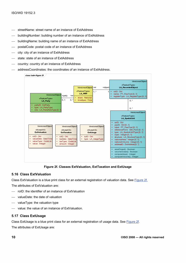
ISO/WD 19152.3
10 ©ISO 2008 — All rights reserved
⎯ streetName: street name of an instance of ExtAddress
⎯ buildingNumber: building number of an instance of ExtAddress
⎯ buildingName: building name of an instance of ExtAddress
⎯ postalCode: postal code of an instance of ExtAddress
⎯ city: city of an instance of ExtAddress
⎯ state: state of an instance of ExtAddress
⎯ country: country of an instance of ExtAddress
⎯ addressCoordinates: the coordinates of an instance of ExtAddress.
class ladm figure 2f
VersionedObject
«FeatureType»LA_Party
VersionedObject
«FeatureType»LA_RecordedObject
+ partyID: ExtParty+ type: LA_PartyType+ role: LA_PartyRoleType [0..*]
VersionedObject
«FeatureType»LA_RRR
+ share: Rational+ timeSpec: Time
+rrr +object
+ roID: Oid+ name: PT_FreeText [0..1]+ registerType: LA_RegisterType [0..1]
VersionedObject
«FeatureType»LA_SpatialUnit
+ suID: Oid+ psuID: Oid [0..1]+ label: PT_FreeText [0..1]+ referencePoint: GM_Point [0..1]+ type: LA_SpatialUnitType [0..1]+ layer: Integer [0..1]+ structure: LA_StructureType [0..1]+ nationalArea: Integer [0..1]+ nationalVolume: Integer [0..1]+ addressID: ExtAddress [0..*]
+ areaClosed() : Boolean+ volumeClosed() : Boolean+ computeArea() : Integer+ computeVolume() : Integer
VersionedObject
«blueprint»ExtTaxation
+ roID: Oid+ taxDate: DateTime+ taxType: CodeList+ amount: Integer
VersionedObject
«blueprint»ExtUsage
+ suID: Oid+ type: LA_UsageType
VersionedObject
«blueprint»ExtValuation
+ roID: Oid+ valueDate: DateTime+ valueType: CodeList+ value: Integer
1..* 1
+party +rrr
0..1 0..* 0..*
0..*
Figure 2f. Classes ExtValuation, ExtTaxation and ExtUsage
5.16 Class ExtValuation Class ExtValuation is a blue print class for an external registration of valuation data. See Figure 2f.
The attributes of ExtValuation are:
⎯ roID: the identifier of an instance of ExtValuation
⎯ valueDate: the date of valuation
⎯ valueType: the valuation type
⎯ value: the value of an instance of ExtValuation.
5.17 Class ExtUsage Class ExtUsage is a blue print class for an external registration of usage data. See Figure 2f.
The attributes of ExtUsage are:

ISO/WD 19152.3
©ISO 2008 — All rights reserved
11
⎯ suID: the identifier of an instance of ExtUsage
⎯ type: the type of usage.
5.18 Class ExtTaxation Class ExtTaxation is a blue print class for an external registration of taxation data. See Figure 2f.
The attributes of ExtTaxation are:
⎯ roID: the identifier of an instance of ExtTaxation
⎯ taxDate: the date of taxation
⎯ taxType: the tax type
⎯ amount: the amount of taxation.
5.19 Class LA_SpatialUnitSet Class LA_SpatialUnitSet is associated with class LA_SpatialUnit. See Figure 2d. Using this class, a link with the administrative subdivision of a region (or country) can be made.
The attributes of LA_SpatialUnitSet are:
⎯ susID: the identifier of a spatial unit set
⎯ level: the level in the hierarchy of the administrative subdivision
⎯ label: the label of the spatial unit set
⎯ name: the name of the spatial unit set
⎯ referencePoint: a centroid of the spatial unit set
⎯ oidType: the type of identifier of the spatial unit set.
5.20 Class LA_BuildingReserve An instance of LA_BuildingReserve is the space or surface around a building. See Figure 2d. Class LA_BuildingReserve is a subclass of LA_SpatialUnit.
The attributes of LA_BuildingReserve are:
⎯ complNum: the identifier of the building
⎯ dimension: the dimension of the coordinate system
⎯ numberOfFloors: the number of floors of the building
⎯ numberOfUnits: the number of units of the building.
5.21 Class LA_BuildingUnit An instance of LA_BuildingUnit is a component of an instance of LA_BuildingReserve. An instance of LA_BuildingUnit might be a common (shared) area, or an apartment. See Figure 2d. Class LA_BuildingUnit is a subclass of LA_SpatialUnit.
The attributes of LA_BuildingUnit are:
⎯ addressID: the link to an external address of the building unit
⎯ type: the type of a building unit (e.g. shared, individual, etc.)
⎯ unitNum: the identifier of a building unit.

ISO/WD 19152.3
12 ©ISO 2008 — All rights reserved
5.22 Class LA_NetworkReserve An instance of LA_NetworkReserve represents the area, or space, around a network, which has been registered. See Figure 2d. Class LA_NetworkReserve is a subclass of LA_SpatialUnit.
The attributes of LA_NetworkReserve are:
⎯ belowSurface: is it an underground network, or an above-the-ground network?
⎯ networkRisk: an estimation of the risk (e.g. risk type 1, risk type 2, etc.)
⎯ extPhysicalNetworkLink: a reference to the physical (technical) description of the utility network in an external information source (for instance, of the organization responsible for the utility network)
⎯ status: the status of an instance of LA_NetworkReserve (e.g. in use, planned, etc.)
⎯ type: the type of an instance of LA_NetworkReserve (e.g. chemicals, electricity, etc.).
5.23 Class FaceString Class LA_FaceString is a subclass of VersionedObject. An instance of LA_FaceString is used to describe the boundary of a LA_SpatialUnit via a linestring in 2D (which can be projected vertically up and down to have the 3D interpretation if needed; see Section 6.4 for further explanation). It has an association with LA_Source point to document the origin of the geometry. See Figure 2e.
The attributes of LA_FaceString are:
⎯ fsID: the LA_FaceString identifier
⎯ geometry: the boundary described via a curve at ground (or zero height) level, can be derived from associated LA_SourcePoint
⎯ locationByText: the boundary described via natural text
⎯ estimatedAccuracy: the estimated accuracy of the boundary description; this can be derived from associated LA_SourcePoint
⎯ productionMethod: the production method of this boundary description; this can be derived from associated LA_SourcePoint.

ISO/WD 19152.3
©ISO 2008 — All rights reserved
13
class ladm figure 2e
VersionedObject
«FeatureType»LA_Party
VersionedObject
«FeatureType»LA_FaceString
VersionedObject
«FeatureType»LA_SpatialUnit
+ fsID: Oid [0..1]+/ geometry: GM_Curve [0..1]+ locationByText: PT_FreeText [0..1]+/ estimatedAccuracy: Length [0..1]+/ productionMethod: LI_Lineage [0..1]
VersionedObject
«FeatureType»LA_SourcePoint
0..* 1..*
+ partyID: ExtParty+ type: LA_PartyType+ role: LA_PartyRoleType [0..*]
VersionedObject
«FeatureType»LA_RRR
+ share: Rational+ timeSpec: Time
VersionedObject
«FeatureType»LA_RecordedObject
+ roID: Oid+ name: PT_FreeText [0..1]+ registerType: LA_RegisterType [0..1]
+ suID: Oid+ psuID: Oid [0..1]+ label: PT_FreeText [0..1]+ referencePoint: GM_Point [0..1]+ type: LA_SpatialUnitType [0..1]+ layer: Integer [0..1]+ structure: LA_StructureType [0..1]+ nationalArea: Integer [0..1]+ nationalVolume: Integer [0..1]+ addressID: ExtAddress [0..*]
+ areaClosed() : Boolean+ volumeClosed() : Boolean+ computeArea() : Integer+ computeVolume() : Integer
VersionedObject
«FeatureType»LA_Face
+ fID: Oid+/ geometry: GM_Surface [0..1]+/ estimatedAccracy: Length [0..1]+/ productionMethod: LI_Lineage [0..1]
+/ dimension: Integer+ locationOrig: GM_Point+ locationTransf: GM_Point [0..1]+ pointType: LA_MonumentationType+ quality: DQ_Element [0..*]+ transformation: CC_Operation [0..1]
LA_SourceDocument
«FeatureType»LA_SpatialSourceDocument
+ measurements: + quality: DQ_Element [0..*]+ surveyDate: DateTime+ type: SurveyDocumentType
1..* 1..*
+sourcePoint 1..*
+source 1
0..*0,2..*{ordered}
0..*3..*{ordered}
0..* 1..*
0..*
/derived
1..* 1..* 0..*
0..*
+rrr +object
+surveyor 1..* 1..* 1
+party +rrr
0..1 0..*
Figure 2e. Classes FaceString, Face, LA_SourcePoint, and LA_SpatialSourceDocument
5.24 Class Face Class LA_Face is a subclass of VersionedObject. An instance of LA_Face is used to describe the boundary of a LA_SpatialUnit via a surface in 3D; see Section 6.4 for more explanations. It has an association with LA_Source point to document the origin of the geometry. See Figure 2e.
The attributes of LA_Face are:
⎯ fID: the LA_Face identifier
⎯ geometry: the boundary described via a surface in 3D space; can this be derived from associated LA_SourcePoint
⎯ estimatedAccuracy: the estimated accuracy of the boundary description; can this be derived from associated LA_SourcePoint
⎯ productionMethod: the production method of this boundary description; can this be derived from associated LA_SourcePoint
5.25 Class LA_SourcePoint An instance of LA_SourcePoint is a point of an instance of LA_SpatialUnit, as observed in the field. See Figure 2e.
The attributes of LA_SourcePoint are:

ISO/WD 19152.3
14 ©ISO 2008 — All rights reserved
⎯ dimension (derived): the number of dimensions (2D or 3D)
⎯ locationOrig: calculated co-ordinates, based on observations
⎯ locationTransf: shift in co-ordinates, after a new survey of the same point
⎯ pointType: type of monumentation in the field (e.g. beacon, corner stone, marker, etc.)
⎯ quality: quality label related to survey method (ISO 19113, ISO 19114)
⎯ transformation: transformation used (from calculated co-ordinates in a local reference system to transformed co-ordinates).
5.26 Class LA_SourceDocument An instance of a subclass of class LA_SourceDocument is a source document. A source document is a document, providing facts. In LADM, source documents are modelled, starting with an abstract class LA_SourceDocument. See Figure 2g.
The attributes of LA_SourceDocument are:
⎯ sdID: an identifier of the source document
⎯ acceptance: date of acceptance of the source document by an authority
⎯ authentication: data in electronic form which are attached to, or logically associated with, other electronic data and which serve as a method of authentication (DIRECTIVE 1999/93/EC)
⎯ recordation: date of registration (recordation) of the source document by registering authority
⎯ submission: date of submission of the source document by an instance of LA_Party.
class ladm figure 2g
VersionedObject
«FeatureType»LA_Party
VersionedObject
«FeatureType»LA_RecordedObjectVersionedObject
«FeatureType»LA_RRR
+ partyID: ExtParty+ type: LA_PartyType+ role: LA_PartyRoleType [0..*]
+ share: Rational+ timeSpec: Time
+rrr +object+ roID: Oid+ name: PT_FreeText [0..1]+ registerType: LA_RegisterType [0..1]
«FeatureType»LA_AdminDocument
+ salePrice: Measure [0..1]+ text: PT_FreeText+ type: LA_AdminDocumentType
VersionedObject
«FeatureType»LA_SourceDocument
+ sdID: PT_FreeText+ acceptance: DateTime+ authentication: Binary [0..1]+ recordation: DateTime+ submission: DateTime
+rrr 0..*
+source 1..*
1..* 1+party +rrr
+conveyor
1..*
0..*
+represented by 0..1
0..*
0..1 0..*
Figure 2g. Classes LA_SourceDocument, and LA_AdminDocument

ISO/WD 19152.3
©ISO 2008 — All rights reserved
15
5.27 Class LA_AdminDocument An instance of class LA_AdminDocument is an administrative document. See Figure 2g. Class LA_AdminDocument is a subclass of LA_SourceDocument.
The attributes of LA_AdminDocument are:
⎯ salePrice: purchase price in relation to a transaction (buying, selling, etc.)
⎯ text: contents of the document
⎯ type: type of document (e.g. a deed, title, etc).
5.28 Class LA_SpatialSourceDocument An instance of class LA_SpatialSourceDocument is a spatial source document. See Figure 2e. Class LA_SpatialSourceDocument is a subclass of LA_SourceDocument.
The attributes of LA_SpatialSourceDocument are:
⎯ measurements: field observations, and measurements, as a basis for mapping, and as a basis for historical reconstruction of the location of (parts of) the spatial unit in the field
⎯ quality: precision of observations
⎯ surveyDate: date of survey in the field
⎯ type: type of the spatial source document (e.g. field sketch, orthophoto, etc.).
6 Packages of the LADM
6.1 Introduction The LADM contains several different classes for parties, rights, and spatial units. This facilitates the maintenance of different data by different organizations. The complete model might be therefore implemented through a distributed set of (geo-) information systems, each supporting data maintenance activities and the provision of elements of the model. The model might also be implemented by one or more maintenance organizations operating at national, regional or local level. This underlines the relevance of the model: different organizations have their own responsibilities in data maintenance and supply, but can communicate on the basis of standardized administrative and technical update processes. One need not look at the whole model at once, as the coherent parts of the model represent UML packages. The advantages of distinguishing several packages are: to be able to present the LADM in comprehensive parts yet maintain and develop packages independently; and being able to use a package to implement one type of functionality.
6.2 Spatial Unit Package Spatial units are refined into three main categories: (1) land (2D) or space (3D) spatial units, (2) buildings, and (3) utility networks. Land (2D), or space (3D) spatial units may be from different recordations. See Figure 3a.
The different types of land (2D), or space (3D) spatial units include: topological spatial units, polygon spatial units, line spatial units, point spatial unit, and text spatial unit.
A topological spatial unit has a consistent topological structure (and includes its boundaries), in contrast with a polygon spatial unit, where a consistent topological structure is not guaranteed. A line spatial unit is represented by a set of lines which can be collected from different sources. This set of lines is not topologically structured, so that area calculation is not possible. A point spatial unit only contains the coordinates of the unit’s centroid. A text spatial unit is not represented by coordinates, but has a spatial description in words, e.g. the metes and bounds system (a system of spatial unit description in terms of distance, direction, and landmarks).

ISO/WD 19152.3
16 ©ISO 2008 — All rights reserved
A spatial unit may change its representation over time, from text spatial unit, to point spatial unit, to line spatial unit, to polygon spatial unit, to topological spatial unit.
The different types of building spatial units include: LA_BuildingReserve, and LA_BuildingUnit. These specializations of LA_SpatialUnit have associations with zero or more instances of LA_Party via the LA_RRR class. It is possible that a spatial unit is only associated with a LA_RRR and not with LA_Party (via LA_RRR). In this way, land with joint ownership, and other types of common lands, can be modelled. This is expressed by the multiplicity [0..1] from LA_RRR to LA_Party.
Spatial units can be aggregated into instances of LA_SpatialUnitSet, for example, a section, a municipality, a planning area. An instance of LA_SpatialUnitSet can be an aggregation of other instances of LA_SpatialUnitSet. In implementations of the LADM, this can be related to spatial unit identifiers; when a spatial unit identifier is composed out of e.g. country id/department id/county id/municipality id/etc. Further, it is possible that a LA_RRR is associated with a group of spatial units.
An LA_BuildingReserve (the representation of the legal, recorded or informal space, not the physical object) is composed out of several instances of LA_BuildingUnit. Note that an instance of LA_BuildingUnit is intended in the general sense, not only for living purposes, but also for other purposes, e.g. commercial. Further note that LA_RecordedObject allows the relating of one right to, for instance, a combination of spatial units (e.g. an apartment, a parking place and building unit).
A BuildingUnit has type as attribute. This can be used to represent shared units, or individual units. In this a way, an apartment could be represented as an individual unit, and the common areas (threshold, stairs, corridors, elevator, roof,…) as a shared unit. For all types there can be separate instances of LA_RRR. Class LA_BuildingUnit is associated with LA_SourcePoint via class Building.
In most land administration systems, a restriction is associated with a complete spatial unit, and this is also reflected in the model: an instance of LA_Party can have an instance of LA_Restriction (specialization of LA_RRR) on an instance of LA_SpatialUnit.
It is possible that no spatial unit exists for an instance of a subclass of LA_RRR. For instance, in the case of a right to fish in a commonly held area, where the holder of the fishing right does not (or no longer) hold rights to a spatial unit in the area. This is modelled by the multiplicity [0…*] from LA_RRR to LA_SpatialUnit.

ISO/WD 19152.3
©ISO 2008 — All rights reserved
17
class ladm figure 3a
VersionedObject
«FeatureType»LA_Party
VersionedObject
«FeatureType»LA_RRR
VersionedObject
«FeatureType»LA_RecordedObject
VersionedObject
«FeatureType»LA_SpatialUnit
VersionedObject
«FeatureType»LA_SpatialUnitSet
«FeatureType»LA_BuildingUnit
«FeatureType»LA_BuildingReserve
«FeatureType»LA_NetworkReserve
+element
1..*
+partOf
1
+set
0..1
+element
1..*
+element1..*
+set 0..1
0..*
0..*
+rrr
1..*
+object
1+party
0..1
+rrr
0..*
Figure 3a. Spatial unit package
The model is specified in UML 2.1 class diagrams (see www.omg.org) in Figure 3a. The conversion of this UML model into an GML schema, which might be used for data exchange, is described in Annex E.
6.3 Surveying Package Data acquisition can be conducted digitally in a field office, or compiled from various sources using forms and field sketches, or enlarged satellite images, aerial photographs, or existing topographic maps. In the case of traditional land surveying, a sketch will be used to identify the surveyed points. A further option is data acquisition based on GPS, or a combined GPS/Images approach. The forms are used to record administrative data about the parties, RRR's (such as social tenure relationships), and spatial units. The enlarged satellite images, or aerial photographs, can be used to create the identifiers of spatial units, possibly with boundaries. The same method can be used for buildings. If no satellite images or aerial photographs are available, a field sketch can be made of the spatial units and buildings, showing the neighbouring relationships. A spatial unit can be incomplete. An alternative field sketch might be a (digital) photograph of a sketch again showing the spatial unit identifiers and neighbouring relationships. Another option is to include a description in words of the spatial units. Finally, it may that no spatial data is referenced at all, except a village name.
A land administration survey is documented on an instance of LA_SpatialSourceDocument, which is a source document. This can be the final (sometimes formal) document, or all documents related to a survey. Spatial source documents may be created in the field, and can be finished in the office. Sometimes, several documents are the result of a single survey. The document may contain digital signatures, where these have legal standing; otherwise, paper based documents (which may be scanned) should be considered as an integral part of the land administration system. A set of measurements with terrestrial observations (distances, bearings, and referred geodetic control) to points is an attribute of LA_SpatialSourceDocument. The individual survey points are instances of class LA_SourcePoint, which is associated with LA_SpatialSourceDocument. A

ISO/WD 19152.3
18 ©ISO 2008 — All rights reserved
SpatialSourceDocument can be associated with several instances of LA_SourcePoint. The survey points form the measured foundation of both the topology-based spatial units, and the non topology-based spatial units.
If a survey point is observed during different surveys, there will be different instances of LA_SpatialSourceDocument. If a survey point is observed from different positions during a survey, there is only one association with an instance of LA_SpatialSourceDocument. One of the attributes of class LA_SourcePoint is the pointType, which indicates the type of survey point; this could for example be a Geodetic Control Point (GCP). Further, there might be reasons for changing coordinates, for example map revision, or moving to a different coordinate reference system, or new computation of the existing coordinate reference system. Geodetic control points, including multiple coordinates for points and supporting multiple reference systems are supported in the LADM.
Aerial photographs, satellite images, existing topographic maps may also be used as a spatial source document.
class ladm figure 3b
VersionedObject
«FeatureType»LA_Party
VersionedObject
«FeatureType»LA_RRR
VersionedObject
«FeatureType»LA_RecordedObject
VersionedObject
«FeatureType»LA_SpatialUnit
VersionedObject
«FeatureType»LA_SourcePoint
LA_SourceDocument
«FeatureType»LA_SpatialSourceDocument
1..*
1..*+sourcePoint 1..*
+source 1
1..*
/derived
1..*
0..*
0..*
+rrr
1..*
+object
1+surveyor 1..*
0..*
+party
0..1
+rrr
0..*
Figure 3b. Surveying package
6.4 Spatial Representation Package All types of LA_SpatialUnits (2D, 3D parcels, buildings, utility networks) share the same representation structure. An important requirement is that existing 2D data, whether topologically structured, polygons, unstructured, or simply point or textual descriptions should easily be included. At the same time, the model should also support the increasing use of 3D representations of LA_SpatialUnits, without putting additional burden on the existing 2D representations. An important requirement is that there should be no mismatch between the parts of the domain that are described in 2D and the parts of the domain that are described in 3D. Further, the LADM must be based as much as possible on already accepted and available spatial schema as published in ISO 19107. The model described below has been designed using key concepts such as LA_FaceString and LA_Face. Coordinates themselves are rooted in instances of LA_SourcePoint (mostly after geo-referencing, depending on the data collection method used.

ISO/WD 19152.3
©ISO 2008 — All rights reserved
19
LA_FaceString
Linestring at local ground level
+∞
-∞
Node = vertical edge
LA_FaceString left parcel
right parcel
GM_Curve
3D parcel
3D parcel
Liminal 2D
spatial unit
3D spatial units
3Dspatial units
Simple 2D
spatial unit
Liminal 2D
spatial unit A
Liminal2D
spatial unit
2D Liminal
3D
3D
3D
3D
3D
3D
3D 3D
Liminal
Figure 3c. upper left: FaceString concepts, upper right: LA_SpatialUnits defined by LA_FaceStrings, lower left: top view of mixed 2D/3D representations, lower right: side view showing the mixed use of LA_FaceString and LA_Face to define both bounded and unbounded 3D volumes (Thompson, 2008)
As pointed out by (Stoter, 2004), in many countries a 2D description should be interpreted as a 3D prismatic volume with no upper and lower bound; See Figure 3c (upper left and upper right). Using this interpretation, 2D and 3D representations can be unified. The boundaries in the 2D descriptions are called LA_FaceString: they use a normal GM_Curve (linestring) for storage, but this implies a series of vertical faces. For true 3D descriptions that also have non-vertical faces, the class LA_Face is introduced. A liminal spatial unit has a combination of LA_FaceStrings and vertical LA_Faces. The vertical LA_Faces must dissolve into face strings (when common pairs of edges are removed). The faces must be completely defined from +∞ to -∞. This method is used for a 2D spatial unit which is adjacent to a 3D spatial unit, with a split in the shared vertical face. The attribute ‘type’ in LA_SpatialUnit indicates if it concerns a 2D, liminal or 3D respresentation of an LA_SpatialUnit.
In addition to these principles, there are five levels of spatial description identified (indicated by the ‘structure’ attribute in LA_SpatialUnit):
⎯ Point based (point spatial unit)
⎯ Text based (text spatial unit)
⎯ Unstructured (Line) based (line spatial unit)
⎯ Polygon based (polygon spatial unit), and
⎯ Topological based (topological spatial unit).

ISO/WD 19152.3
20 ©ISO 2008 — All rights reserved
Point based LA_SpatialUnit is used when the only information about location is the coordinates of a single point within their area (or volume). The attribute referencePoint in the LA_SpatialUnit is used to record this location, which may carry a z value.
Text based LA_SpatialUnit is used when the definition of the LA_SpatialUnit is entirely by descriptive text. The LA_SpatialUnit is accompanied by one or more LA_FaceStrings, each of which carries a block of free text in the locationByText attribute. No geometry is used in this type of face string. The referencePoint is optional, may be used as a specific labelling point, and could carry a z value.
Line based (unstructured or ‘spaghetti’) LA_SpatialUnit is used when the description is allowed to have inconsistencies such as hanging lines and incomplete boundaries. For the 2D case, the full length LA_FaceStrings are stored once only, not broken at the corners of LA_SpatialUnits. The LA_SpatialUnits are linked to the LA_FaceStrings that define them. For the 3D case, at least one LA_Face is included (and this may intersect other LA_FaceStrings and LA_Faces).
Polygon based LA_SpatialUnit is used when each LA_SpatialUnit is recorded as a separate entity. There is no topological connection between neighbour LA_SpatialUnits (and no boundaries shared), and so any constraints enforcing a complete coverage must be applied by the originating and receiving software. In the a 2D representation there is exactly one link to a closed LA_FaceString instance for every ring of the polygon (or set of LA_FaceStrings that form together a closed ring). Polygon based LA_SpatialUnit is used in a 3D representation case uses at least one (non-shared) LA_Face is included in the description.
Topology based LA_SpatialUnit is used when LA_SpatialUnits share boundary descriptions. A topological based LA_SpatialUnit is encoded by reference to its boundaries, with the common boundary between two LA_SpatialUnits being stored once only. Thus there is a topological connection between neighbours. In case of a 2D description only, LA_FaceStrings are used forming closed loop(s) and these LA_FaceStrings have left and right references to the LA_SpatialUnits. In case of a 3D description, at least one LA_Face with left/right information is included.
Mixed representations are also possible, because an LA_FaceString object may be defined either by a geometry, or by a free text block. It is possible for an LA_SpatialUnit in any form of encoding to be specified by geometry on some faces, but text on others. It is also possible to topologically encode text based LA_SpatialUnits; for example, part of a boundary may be defined by text “along the natural shoreline”, while the other boundaries could be defined by coordinates. The LA_FaceString that defines the shoreline can be used in the definition of a water feature on the other side of the boundary, thus ensuring topological correctness without the need for coordinate values. Again, this can occur in both 2D and 3D.
It must be stressed that the above applies to any type of LA_SpatialUnit (including the ones that are used for recorded spaces around buildings and utilities, or for servitudes). To organize the instances, there is the concept of a layer model. This is especially relevant for the topology based LA_SpatialUnits (attribute ‘layer’), but also applies to the other types. For example, there can be a base layer (1) with ownership LA_SpatialUnits, which are topologically defined and there could be an additional layer (2) with polygon based LA_SpatialUnits representing servitudes. The concept of layers can also be used in other situations. For example, layer 1 for the current ownership and layer 2 for the pre-war ownership. A 3D example would be layer 1 containing ownership (2D, liminal and 3D topological LA_SpatialUnits) and layer 2 would contain ownership of ‘legal space’ around utilities crossing many other LA_SpatialUnits (from which the utilities space could be subtracted); see Figure 3c1.:

ISO/WD 19152.3
©ISO 2008 — All rights reserved
21
Z=0, or local
d
+∞
-∞
closed GM_curve
3D LA_SpatialUnit in layer 2 not broken by layer 1 boundaries (LA_FaceStrings)
Figure 3c1. Multiple layers
The 2D or 3D (topology) structures must be valid at every moment in time. With topological LA_SpatialUnits, there are never gaps or overlaps in the partition. However, boundaries belonging to different time spans (defined by versions) may cross. The temporal topology must also be maintained: that is, no time gaps or overlaps can occur in the representations. Therefore, the structure is based on spatio-temporal topology. Current land administration registration systems, based on 2D topological and geometrically described spatial units, have shown limitations in defining the (2D and 3D) location of 3D constructions (e.g. pipelines, tunnels, building complexes) and in the vertical dimension (depth and height) of rights established for 3D constructions (Stoter, 2004). In the LADM, 2D and 3D data are treated in a consistent manner throughout the model. It is important to realize that there is a difference between the 3D physical object itself and the legal space related to this object. The LADM only covers the ‘legal space’; that is the space that is relevant for the Land Administration (bounding envelope of the object). This is usually larger than the physical extent of the object itself (for example including a safety zone).
6.5 Party Package class ladm figure 3d
VersionedObject
«FeatureType»LA_Party
VersionedObject
«FeatureType»LA_RRR
VersionedObject
«FeatureType»LA_RecordedObject
VersionedObject
«blueprint»ExtParty
«FeatureType»LA_GroupParty
constraints{sum(LA_Member.share)=1 per group}
«FeatureType»LA_Member
+party
0..1
+rrr
0..*
+rrr
1..*
+object
1
+parties 2..*
+group 0..*
Figure 3d. LA_Party Package

ISO/WD 19152.3
22 ©ISO 2008 — All rights reserved
6.6 Administrative Package The main class in this package is the abstract class LA_RRR, with its specializations LA_Right, LA_Restriction, and LA_Responsibility (note: social tenure relationships are considered to be included in class LA_RRR). In principle, all specializations of LA_RRR are based on an instance of LA_AdminDocument as source. See Figure 3e.The essential data, for example names, or transaction dates, which can be obtained from class LA_AdminDocument, might be represented in the classes LA_RRR, LA_Mortgage, LA_Party, LA_RecordedObject, and LA_SpatialUnit. A single instance of LA_AdminDocument may even create of mix of these types. Conversely, an instance of the specializations of class LA_RRR, or class LA_Mortgage is always associated with exactly one instance of LA_AdminDocument as its source. It is possible to describe more than one mortgage in one administrative document.
class ladm figure 3e
VersionedObject
«FeatureType»LA_Party
VersionedObject
«FeatureType»LA_RRR
VersionedObject
«FeatureType»LA_RecordedObject
«FeatureType»LA_Right
«FeatureType»LA_Restriction
«FeatureType»LA_Responsibility
VersionedObject
«FeatureType»LA_Mortgage
LA_SourceDocument
«FeatureType»LA_AdminDocument
*
+source
0..*
+moneyprovider 0..*
+rests(ordered)
0..1 1..*
+rrr 0..*
+source
1..*
+rrr
1..*
+object
1
+conveyor 1..*
0..*
+party
0..1
+rrr
0..*
Figure 3e. Administrative Package
Each jurisdiction has a different 'land tenure system', reflecting the social relationships regarding rights (restrictions, and responsibilities) to land in that area. The variety of rights is quite large within most jurisdictions, and the exact meaning of similar rights can differ considerably between jurisdictions (which could be areas with customary tenures). The aforementioned rights are primarily in the domain of private, or customary law. Usually the rights are created after an agreement between the party obtaining the right and the party (e.g. the land owner) who restricts his right by the newly created right. The rights and restrictions usually "run with the land", meaning that they remain valid even when the right to the land is transferred after the right was created (and registered). Because property and ownership rights are generally based on (national) legislation, code lists might support this. A Customary Right related to a region, or an Informal Right can be included; from modelling perspective this is straightforward.
In addition to those private law restrictions, many countries also have public law restrictions, which are usually enforced by a (local) government body. The 'holder' of the right is a LA_Party (either ‘the government’ or

ISO/WD 19152.3
©ISO 2008 — All rights reserved
23
‘society-at-large’) and usually they are primarily seen as restrictions. Some of them apply to a specific spatial unit (or right therein), or a small group of them, or the duty to pay a certain tax for improvements on a road, or the duty to repair damage, or perform delayed maintenance. Each non-ownership right by a third party (be it government, or a private party) creates a restriction. Class LA_Right (a specialization of the abstract super class LA_RRR) has a compulsory association between LA_SpatialUnit and LA_Party, where this is not compulsory in the case of class LA_Restriction, or class LA_Responsibility (the other specializations of LA_RRR). The class LA_RRR allows for the introduction of shares of rights in cases where more than one instance of LA_Party hold together a complete right (or restriction, or responsibility).
A restriction means that you have to allow someone to do something, or that you have to refrain from doing something yourself. Restrictions can both be within private law, especially in the form of servitudes, or within public law, through zoning and other planning restrictions, as well as in environmental limitations. Responsi-bilities mean that one has actively to do something. Not all formal systems allow such mandated activities as property rights, and this will also affect the question whether they might be (or must be) registered. Their impact can be substantial, and their registration is therefore preferable.
The class LA_RRR has associations to both LA_Party and LA_RecordedObject (Zevenbergen, 2004; Paasch, 2005). It is possible that a single spatial unit is associated to several instances of LA_Party (via LA_RecordedObject, and LA_RRR associations) and, conversely, that a single party is related to several spatial units (again, via LA_RRR, and LA_RecordedObject associations). There is always at least one instance of LA_Right (subclass of LA_RRR) in which the type of right represents the strongest (or primary) right, for instance customary or statutory ownership, freehold or leasehold. Connected to this strongest right, certain interests can be added or subtracted from this strongest right. A point of discussion is how to represent the subtractions (restrictions), as they are already implied by a non-primary right of a third party. The fact that a neighbour is allowed to walk over your spatial unit is an additional right (appurtenance, positive-side) to the ownership of his property, whereas it is a restriction (encumbrance, negative-side) to your property. In the present model, both sides are represented, but it is the intention to store only the positive-side, and derive (compute) the negative side, when needed (compare Zevenbergen, 2004).
One or several mortgage(s) is always vested on a (set of) right(s), and should never be seen as a separate relationship between LA_Party and LA_SpatialUnit. On the other hand, a mortgage is usually vested as collateral for a loan. Therefore, the mortgagee (mortgagor?) is connected to the Mortgage as MoneyProvider, one of the specializations of LA_Party. LA_Mortgage is associated with class LA_Right.
The fact that all the different (public law, or private law) rights find their base in some kind of establishing or transacting document is represented by connecting them to LA_AdminDocument which is a specialization of the abstract class LA_SourceDocument. The party responsible for drafting the document is connected to this as conveyer.
The formal/administrative part of the LADM, as just described, is based on the notion of one strongest (primary) right, with other limited rights derived from it. This notion can be found in most continental European countries, but it also fits with the different approach found in Anglo-American law, which starts from the concept of property rights as ‘estates’ held in the land. Ownership in this approach is often seen as a ‘bundle of sticks’. Separate ‘sticks’ of the bundle can be acquired in different ways and can be held by different parties for different periods. When a party owns all the rights, he is said to own the fee simple title. When he owns only some of the rights, he has a partial interest. This approach is also used in (Paasch, 2005). Land administration systems that underpin customary land tenure systems, informally arranged land use, or conflicting claims to rights, and whose objects might not be clearly identifiable (fuzzy), not (yet) clearly identified or whose areas overlap are in need of other classes to allow for those type of situations (Van Oosterom et al, 2005). Often in such countries, or jurisdictions, both types of situations (strictly formalized, or more fuzzy and informal) are to be found in the same area, and should therefore be able to co-exist in the land administration system, and thus in the LADM.

ISO/WD 19152.3
24 ©ISO 2008 — All rights reserved
7 Other Aspects of the LADM
7.1 History and Dynamic Aspects Two different approaches are used to model the result of dynamic systems (discrete changes in the state of the system): (1) event based modelling; and (2) state based modelling.
In event based modelling, transactions are modelled as separate entities within the system (with their own identity and set of attributes). When the start state is known, and all events are known, it is possible to reconstruct every state in the past, by reversing the whole chain of events. It is also possible to represent the current state, and not to keep the start state (and go back in time via the ‘reversal’ of events).
In state based modelling, the states (that is to say, the results) are modelled explicitly: every object is assigned (at least) two dates/times which indicate the time interval during which the object is valid. Through the comparison of two successive states it is possible to reconstruct what happened as a result of one specific event. It is straightforward to obtain the state at a given moment in time, by selecting the object based on a time interval (tmin-tmax). The temporal aspect is inherited from class VersionedObject with its attributes beginLifespanVersion and endLifespanVersion. The class LA_RRR has an additional temporal attribute called timeSpec, which is capable of handling other temporal representations, such as a recurring pattern (every week-end, every summer, etc.). Note that most objects inherit the temporal attributes via either LA_Party, LA_RRR, or LA_RecordedObject – or directly via VersionedObject.
The LADM covers both event based modelling (via class LA_SourceDocument), and state based temporal modelling (via class VersionedObject). In addition to the event and state modelling, it is also possible for explicit parent-child associations between the spatial units to be modelled (lineage), for example, when a spatial unit is subdivided. However, as these associations can also be derived from a spatio-temporal overlay, the model has not been made more complex through the explicit parent-child relationships.
Besides the data modelling aspect of the dynamic processes within the LADM, it provides support for investigating how functions and processes are related to each other? The UML class diagram should further be completed by diagrams covering other aspects, e.g. via state (use case, sequence, collaboration, state or activity) diagrams. Activity diagrams show how processes are related to the information (data), and how it ‘flows’ from one in to the other. In all the other types of UML diagrams, actors or organizations in this Standard play an important role, and this may be dependent on (national) arrangements. The introduction of different ‘stages’ of a spatial unit (point, image, surveyed), a right (start, landhold, freehold), and a party further reflect the dynamic nature of the system.
7.2 Interface Classes There might be many interface classes to support the generation, and management of products, and services. These interface classes are considered to be user-defined, and outside the scope of LADM.
7.3 Code Lists
Code lists can be used in the LADM for using local, regional, or national terminology.

ISO/WD 19152.3
©ISO 2008 — All rights reserved
25
class ladm figure 6
«CodeList»LA_Netw orkType
«CodeList»LA_AdminDocumentType
«CodeList»LA_ResponsibilityType
«CodeList»LA_SuOidType
«CodeList»LA_Regis terType
+ .. ..+ chemicals+ electricity+ gas+ heat ing+ oi l+ telecommunication+ water
+ .. ..+ de ed+ mortgage+ title
+ .. ..+ monumentMa intenance+ waterwayMaintenance
+ .. ..+ adminSub division+ geoBased
+ .. ..+ urb an+ rural+ min ing+ publicSpace+ forest+ special
«datatype»Oid«datatype»
Rational«CodeList»
LA_RestrictionType+ localId: Cha racterString+ namespace: Ch aracterString+ numerator: int
+ denominator: int+ .. .+ servitude+ noBui lding+ monument
«CodeList»LA_NetworkStatus «CodeList»
LA_Usa geType«CodeList»LA_PartyRoleType «enumeration»
LA_PartyType+ .. ..+ inUse+ outOfUse+ plan ned
«CodeList»LA_PartyRoleType
+ .. ..+ agricu lture+ housing+ industry+ nature+ recre ation
«CodeList»LA_RightType + .. ..
+ farmer+ moneyProvider+ conveyor+ surveyor
natural Person nonNaturalPerson recordedObject gro up
+ tribe+ associ ation+ family
+ .. ..+ lea se+ occup ation+ ownership+ waterrights+ grazing
«enumeration»LA_UnitType
shared individual
«CodeList»LA_Surv eyDocumentType
«CodeList»LA_Spatia lUnitType
«CodeList»LA_Struc tureType
«CodeList»LA_NetworkRisk «CodeList»
LA_MonumentationType+ .. ..+ fieldSketch+ gnssSurvey+ relativeMeasurement+ ortho Photo+ topoMap+ video
+ .. ..+ 2D+ 3D+ limi nal
+ .. ..+ fullPartition+ polygons+ polygonWithHoles+ unstru ctured
+ .. .+ riskT ype2+ riskType1
+ .. ..+ bea con+ cornerstone+ marker
Figure 4 — Types (basic types and code lists)

ISO/WD 19152.3
26 ©ISO 2008 — All rights reserved
References Augustinus, C, C.H.J. Lemmen, P.J.M. van Oosterom, 2006, ‘Social Tenure Domain Model - Requirements from the Perspective of Pro-Poor Land Management’, 5th FIG Regional Conference - Promoting Land Administration and Good Governance, Accra, Ghana, March 8-11, 2006
WG-CPI, 2006, Role of the cadastral parcel in INSPIRE and national SDIs with impacts on cadastre and land registry operations. Joint Working Group of EuroGeographics and the PCC (WG-CPI), Inventory document.
Directive 1999/93/EC of the European Parliament and of the Council of 13 December 1999 on a Community framework for electronic signatures
Inan, H.I., W. Devos, P. Milenov, P.J.M. van Oosterom, V. Sagris, and J. Zevenbergen 2008, Data model for the collaboration of LASs and IACS/LPISs. Workshop ‘LPIS applications and quality’, 17-18 September 2008, Sofia, Bulgaria (to be presented).
Kaufmann, J., & Steudler, D. (1998). Cadastre 2014, A vision for a future cadastral system, FIG, July 1998. Available from http://www.fig.net/cadastre2014/translation/c2014-english.pdf
Lemmen, C.H.J., P.J.M. van Oosterom: Cadastral Systems IV. Computers, Environment and Urban Systems 30(5): 523-528 (2006)
Van Oosterom, P.J.M. and C.H.J. Lemmen, 2001, ‘Spatial Data Management on a very large cadastral database’, in: ‘Computers, Environment and Urban Systems’, Theme Issue ‘Cadastral Systems’, p. 509-528, Volume 25, number 4-5, 2001, Elsevier Science, New York.
Van Oosterom, P.J.M, C.H.J. Lemmen, T. Ingvarsson, P. van der Molen, H. Ploeger, W. Quak, J. Stoter and J. Zevenbergen, 2005, ‘The core cadastral domain model’ In: Computers, Environment and Urban Systems, Volume 30, pp. 627-660.
Van Oosterom, P.J.M., 2008 (sept 2), Temporal aspects and maintenance. Discussion paper. INSPIRE Technical working group 'Cadastral parcels'.
Paasch, J.M., 2005, ‘A Legal cadastral Domain Model - An Object-oriented Approach’, in: Nordic Journal of Surveying and Real Estate Research 2:1 (2005) 117-136, http://mts.fgi.fi/NJSR/issues/2005/njsrv2n12005_paasch.pdf
Sagris, V. and Devos, W., 2008. LPIS Core Conceptual Model: Methodology for Feature Catalogue and Application Schema, GeoCAP Discussion Paper, DG JRC – Ispra, Institute for the Protection and Security of the Citizen, Agriculture Unit (Available at http://mars.jrc.it/marspac/GEO-INF/Documents/7665.pdf, access date August 25, 2008)
Stoter, J.E., 2004, 3D cadastre, PhD thesis, 327 pp, TU Delft, the Netherlands
Thompson, R., 2008, illustrations made by Rod Thompson, after discussion following the ISO 19152 sept’08 meeting
UN/ECE, 1996, United Nations, Economic Commission for Europe, Land Administration Guidelines With special reference to countries in transition, Geneva, Switzerland.
UN/ECE, 2004, United Nations, Economic Commission for Europe, ‘Guidelines on Real property Units and Identifiers – and their importance in supporting effective national land administration and land management’, Geneva, Switzerland, http://www.unece.org/hlm/wpla/publications/Guidelines On Real Property - FINAL.doc UN/ECE, 2005, United nations Economic Commission for Europe, ‘Land Administration in the UNECE Region, Geneva, Switzerland, http://www.unece.org/env/documents/2005/wpla/ECE-HBP-140-e.pdf
UN/ECE, 2006, United Nations/Economic Commission for Europe, ‘Land Administration Guidelines’, Geneva, Switzerland, http://www.unece.org/hlm/wpla/publications/laguidelines.html
Zevenbergen, J., 2004, Expanding the Legal/Administrative Package of the Cadastral Domain Model – from Grey to Yellow?, in: Proceedings of the Workshop Standardisation in the Cadastral Domain, Bamberg, Germany, 9-10 December 2004, FIG, Denmark, 2004

ISO/WD 19152.3
©ISO 2008 — All rights reserved
27
Annex A. Abstract Test Suite (p.m.) (normative)
To be included.
Annex B. Social Tenure Domain Model (STDM) (p.m.) (informative)
To be included.
Annex C. Object diagrams (p.m.) (informative)
To be included.
Annex D. National (country) examples (p.m.)
(informative) To be included.
Annex E. GML application schema (p.m.)
(informative) To be included.
Annex F. LADM and LPIS (p.m.)
(informative) To be included.
Annex G. LADM and INSPIRE (p.m.)
(informative) To be included.