from real-life experience to map; using landscape as a ... · from real-life experience to map....
TRANSCRIPT

From real-life experience to map. Using landscape as a
tool for decentralized urban planning
Serge Ormaux, Laurent Couderchet
To cite this version:
Serge Ormaux, Laurent Couderchet. From real-life experience to map. Using landscape as atool for decentralized urban planning. /www.territorial-intelligence.eu. ”Grand Ouest” days ofTerritorial Intelligence IT-GO, ENTI. Nantes-Rennes, mar. 2010, Mar 2010, Nantes-Rennes,France. 10p., 2010, INTI-International Network of Territorial Intelligence. <hal-00767291>
HAL Id: hal-00767291
https://halshs.archives-ouvertes.fr/hal-00767291
Submitted on 4 Feb 2013
HAL is a multi-disciplinary open accessarchive for the deposit and dissemination of sci-entific research documents, whether they are pub-lished or not. The documents may come fromteaching and research institutions in France orabroad, or from public or private research centers.
L’archive ouverte pluridisciplinaire HAL, estdestinee au depot et a la diffusion de documentsscientifiques de niveau recherche, publies ou non,emanant des etablissements d’enseignement et derecherche francais ou etrangers, des laboratoirespublics ou prives.

FROM REAL-LIFE EXPERIENCE TO MAP Using landscape as a tool for decentralized urban planning
Serge ORMAUX
UMR 6049 THEMA University of Franche-Comte, CNRS
Laurent COUDERCHET UMR 5185 ADES
University of Bordeaux 3, CNRS [email protected]
Abstract The large diffusion of GIS is greatly improving the capacities of territorial analysis; yet these tools are increasing the weight of cartographic representations and the gap between the everyday’s space and the space of town planning projects. GIS are certainly essential tools, but they require a reflection about their territorial effects. The maps of “intervisibility” which are produced this way are difficult to understand and address the issue of mediation. We propose to contribute to the reflection through experiments conducted in France. We successively used maps and photos within the framework of town planning projects; we are now able to propose a protocol which formalizes the interactions between the project space and the real-life space. This process is improving the dialogue and the decentralization; the landscape becomes a tool for urban development. Key-words
Map, Landscape, Photography, Decentralisation, Participatory approaches, Urban planning.
Introduction
The European Landscape Convention states that "Landscape" means an area, as perceived by people, whose character results from the action of natural and/or human factors and their interrelationships.
The landscape concept is indeed based on a two-way interaction: firstly, it has the dual status of physical object and mental construction; in other respects, it refers to representations of two distinct universes, that of tangential vision, which is the territory as perceived by people from the ground, and the vision of it from above, which is the map projection.
The first interaction is fairly widely accepted, the landscape being often viewed as a relationship and this relationship implies a subject and an object, presupposing the encounter between an environmental materiality and an operation of perception accompanied by the production of meaning.
The second interaction is much more rarely considered, in both research and development practices, yet it introduces a gap in the participatory approaches in spatial planning. Urban planning is indeed faced with

2
two topologies of reference, one of which is the zoning decision and one that is lived by actors, usually the first one winning over the second one. This double referencing can lead to a dialogue of the deaf between the technician sphere and the public opinion during consultations.
In what follows, we will examine a relationship between the weight of vertical images (top view) and descending approaches in urban development projects; the local decision is indeed still very much regulated, despite the decentralization policy and the emergence of grassroots democracy. The formalization of the relationship between space and landscape will then inform the operating difficulties of the public debate. The last section of the communication proposes a re-articulation of the spatial representations in the steering of projects in real-world cases.
I. From a narrow conceptual framework on landscape to a broader approach
1. The status of studies in landscape planning
In France, the Act of 1976 requires the consideration of the landscape, among other environmental parameters in urban planning. For years, it has not exceeded the evocation of the environmental problems. The transformation of landscape by development was addressed only through the ambiguous notion of integration into the site. These studies routinely included a diagnosis, an estimate of the project’s impacts on the landscape in a very conservative manner, and the proposed project accompanying measures, intended to reduce its impacts on landscapes.
The Act of 1993 changes the status of the landscape. Somehow, it leads to convert the landscape impact study into a complete file by itself. Throughout the following years, the interpretations of the law led to push the landscape diagnosis upstream of spatial studies and to make it a foundation of the urban development project. It is by the abundance of the questioning that the “landscape law” bore its fruits more than the procedural decrees of application of the text. Elected officials were stakeholders in this collective reflection which attended the confrontation between the outside landscape experts and the lived landscape of the representatives of the population.
Landscape maps were used in the process. Complex in substance, they placed the expert in a dominant position over elected officials and did not offer high efficiency in the exchange. In contrast, the landscape photographs helped building the bases for a common language between stakeholders and formulating, in landscape terms, the objectives of development.
In 2000, the law “Solidarity and urban renewal” brought into the process a new procedure referred to as the "Land-use and sustainable development project". It was offering the opportunity to bring into regulations the landscape basis of planning documents.
2. The burden of descending (top-down) instructions
The local development operations are decentralized but certainly the state determines the framework by recalling the main principles of the Urban Code: section L110 prescribes that "the French territory is the common heritage of the nation and every public authority is manager and guarantor of it"; the new section L121.1 emphasizes on the concept of urban renewal in respect of sustainable development objectives, without telling of the nature of these objectives. In the paragraph devoted to environment issues, the section emphases on the efficient use of natural spaces, urban, suburban and rural areas, and the desire to limit urban sprawl.

3
The law lays down the basic principles but does not specify the means of achieving them; during the presentation of the "Bring to knowledge" prescription, the prefectural authority therefore stresses the need for urban intensification within the built perimeter, the latter maintaining its dimensions, whenever possible, so as to preserve natural areas for future generations. The speech systematically ignores the size and functions of the agglomeration; it applies equally to shy communal maps and ambitious local development plans.
Beyond the recalls of the law and its interpretations, the central authorities present the upper-tier issues to be respected, in the form of maps taken from various geographic databases established at the levels of the department or the region. Thus many perimeter lines are imposed to lower-tier governments’ planning documents: noise zones along major roads, highways and railways, flood-risk areas, constructability limitations on both sides of main roads and city entrances, etc.1
Fig. 1. Perimeter lines imposed to planning documents in the community Montbéliard
Ultimately, regulatory constraints and upper-tier issues have such an importance as that the local zoning by-law can be developed almost from the central administrative services. This possibility is reinforced by the technical capabilities that are now with these services since the spatial databases and GIS offer systematic zoning areas between urbanization and potentially non-development areas. In this context, communities, especially the smallest of them, could no longer have the prerogative other than those of the second level: the type of urbanization within the perimeter and the opposition agricultural/natural outside.
In urbanised communities, we find the same kind of constraints, projections of the master plan or plan of territorial coherence leaving little latitude to elected officials in the registered municipalities2
1 Section L111.1.4 code sets planning conditions restricting the arrangements of city entrances and outskirts of major
roads within a band ranging from 75 to 100 meters thick on both sides of the road by its importance. 2 We base our observations on the study of the urban communities of Besançon and Montbéliard in the Doubs
department.
, somehow fixing quotas of activities or residential surfaces by municipality.
Constructability limitations Noise zones Flood-risk areas
Hig
h le
vel
Low
leve
l
Intermediary level
Doubs river
Doubs river Doubs river

4
In the suburb of the city of Besançon, for example, the interpretation of the concept of urban renewal in the direction of the intensification of the land occupation of urban space has led the upper-tier institution to provide a supra-communal map of "hollow teeth" to be filled before considering any extension of the perimeter frame of the communal territory. The pejorative term used to describe the open spaces of the town is indicative of the reducing nature of the doctrine; once again, the GIS capabilities have been involved in identifying all the corresponding plots and to attribute them the vocation of urban renewal areas, irrespectively of their functional and landscape intrinsic characteristics.
This table somewhat oppressive does not impede digressions, including the use of the landscape lever. Other passages in the "Bring to knowledge" presciption, referring in fact to the landscape law and the importance it gives to some remarkable elements that can precisely occupy the open spaces of the city: urban green spaces, orchards and family gardens notably. In the Community of Montbéliard, the "Bring to knowledge” of planning operations thus insists on the heritage character of fruit trees. In the years 1999-2000, a program for the preservation of orchards was launched from the regional capital through territorial exploitation contracts (CTE become DAC in 2003).
The protection of these iconic elements of the landscape of North-eastern Franche-Comté, located mainly in the periphery of urban areas and in vacant spaces, was recalled to elected officials as a goal of the regional coherence policy. The contradiction between the intentions of heritage protection and those of densification of the city then offered the opportunity to operate a decentralized hierarchy of territorial issues. The landscape, used as a raw material for the development project, allowed elected officials to recover the authority on the development of their communities.
II. From space to landscape
1. The inertia of representations and ambiguity of the map
a. Tangent view and projection view
In scientific terms, relations that the photograph has with the landscape are not univocal. In our view, the main cæsura between different ways of representing the landscape is not between photography and other media, but between documents which apprehend the surface of the earth as seen from the surface, of which the photograph is usual, and those which represent the area from above, including aerial photography, satellite imagery, maps, planning documents. Both documents refer in fact to two distinct functional universes. The first one is the field of experience, of everyday life and perception; the second one refers to the vision of the Prince, that of the power and of zoning, that also of scientific abstraction.
On one side is the “egoreferenced” space of the inhabitant, and on another side the “georeferenced” space of the decision-maker. Those are two very different universes of reference and often this duality undermines mutual understanding. Many conflicts between policymakers and citizens stem from a confusion between these two topologies and are often wrongly interpreted as a conflict of scale.
The opposition between the tangential and projectional reference systems described above thus appears to light in built areas such as social housing. In projectional view, the ratio between empty and full is largely in favor of empty, according to the principles of the Charter of Athens. However, to locals or those who walk in the neighbourhood, the tangential vision gives to the facades an overwhelming presence in the landscape scene and produces a real effect of confinement. It is not surprising that the ground plan used to build the district is unable to provide support for mediating or retraining; it even shatters retrospectively its own technical legitimacy.

5
b. The image in the public debate
The land-use planning procedures in France set the public consultation at the public inquiry. Then it is on a draft plan that citizens are consulted. Although the emergence of participatory democracy is universally viewed as a progress, it is not without difficulties. Models of democracy can indeed hardly be projected onto a society that is not prepared for it. Moreover, concertation without education may have more negative consequences than benefits on the involvement of people in public life. The hierarchy of consultation is not necessarily understood by those who are familiar with the public investigation, thus the confusion is frequent between meetings for presentation and collection of information on the one hand and meetings for validation of a project on the other hand. When the confusion is overcome, the land implications of land planning schemes are such that the interest of a participatory sequence may be compromised.
However, the use of landscape photographs at meetings between land-planners and residents may be a way to establish a dialogue between them. For residents, the landscape picture refers to the experience that everyone has of the land and has a suggestive power that does not have a map or a plan. It brings out representations, it provokes reactions, it leads to talk of land and guidance for its stewardship.
The landscape picture is less scaring than the maps because it is unsuitable for delineation of boundaries or zoning, it focuses on customs, permanence and change, rather than assignments and constraints. But in a second time, it can be the basis of the outline plan, allowing a return to the map or GIS, and thus to complete the process with georefereced space. In this manner, it is an intermediary object, an instrument of mediation.
2. Systematics of intervisibility
In recent years, a certain number of research teams have focused on scientific analysis of the landscape through photographic sampling on ground3
This work has fed the landscape impact studies which have proliferated in the 90’s and 2000’s (L. Couderchet, 2001, L. Couderchet, S. Ormaux, 2002). Some research questions: what is seen, from where? With what intensity is this portion of space viewed? From what point can an object be seen, foreground or background? So many questions to which this analysis could provide answers. But more than ad hoc
. This involves mobilizing the flow of information circulating within the usual vision, to collect this information through systematic sampling procedures and to process the data with standardised grids in the logic of a spatial information array. These steps helped giving substance to the notion of visible landscape and bringing out the concepts of intervisibility and visual proposal. They have shown that there is a landscape materiality, defined as a set of signals pre-existing to the landscape observer’s perception procedures, and raw material thereof. In reference to the information theory, it is the information released, whereas what we see is information received (sorted, processed, decoded, connoted by our cultural and personal filters).
Here the cliché has the very specific status of data carrier; it is not illustrative, it does not transmit the codes or the inclinations of the observer, thus it is an anti-cliché. Neither does the cliché itself makes sense, but the whole photographic file, through its logical construction and spatial resolution. Nothing to do with a holiday photo album.
3 These include the School of Besancon, of course: (J.P. Massonie, D. Mathieu et J. Praicheux, 1982), (J.C. Wieber
et Th. Brossard, 1984), (D. Joly, 1992), But research also Swiss and German.

6
responses, such approaches have permanently installed the field of "visible landscape" within the general problem of the landscape geography.
Gradually but never completely, the relay was taken by the methods of simulation of landscape scenes from digital elevation models and remote sensing. In the context of development projects. It is then possible to feed the public debate with various maps of overall visual submission, submission from built-up areas, from remarkable points and routes, etc. (L. Couderchet, 2004).
Yet these documents, closer a priori to the vision of ordinary people than projectional planning instruments, are often inaccessible in their make-up and their design, and can be an object of the mediation process only at the expense of a patient pedagogy. The mistrust of these “invented” landscapes, as well as the adhesion to their magical aspect without question, leave the researcher-expert in a situation of dissatisfaction and in the difficulty to refocus these documents to the lived landscape of residents and elected officials.
Thus the inference of this discussion brings a reconsideration of the order of things. Would it not be better to start the process by a phase of emergence of representations from iconic photographs discussed with local residents or elected officials, staking on the results of these exchanges to inform in a second time a more systematic phase, based on geomatics, more focused on the problems and opportunities raised ?
The fundamental interest of ground landscape photographs relies in the fact that they can function both as a basis for objectification (in respect of the space continuum), and as a medium for dialogue between stakeholders and experts. This is their strength, provided that the discussion is not confined to a discourse of exclusion, which would prioritize the significant in detriment of the systematic or, conversely, which would consider only materiality and ignore the phenomenological dimension.
III. The project: between space and landscape
In this section, we present the case of two municipalities in the agglomeration community of Pays de Montbéliard, whose opposite developmental trajectories have resulted in contrasting landscape signatures.
In this area, the intercommunal services possess structured information on the dynamics of land use, providing valuable insights on the development of the commons over the last fifty years. The excerpts of the map database, however, have the abstract characteristics of the projectional representation and are quite difficult to use in the process of shaping the urban planning project. The photograph is then a means of dialogue between stakeholders (elected officials) and experts/researchers, positioning the landscape in the heart of the planning project. These images of the everyday life raise numerous and interactive reactions from the stakeholders of the urban development project: they instigate the discussion on the landscape and on the urban policy options that produced the city.
1. Protocol
Spatial data and maps have also helped making a choice of sites to be observed based on the socio-spatial dynamics of each common.
Under these operational exercises, we have proposed a typology of landscape elements and landscape forms on the whole municipal territory and produced a photography collection, representative of each of these landscape types. The preliminary analysis of the pictures has focused on the uses and functions of

7
corresponding areas and their self-replication capacity. It was then presented in the Planning Commission, discussed and amended.
2. Urban policies and landscape signatures in Exincourt and Voujeaucourt
The Community of the Montbéliard Agglomeration has a population of a little above a hundred thousand people organized in small communities. The population of the city of Montbeliard is less than 30000 and Audincourt half of it. The remaining 27 municipalities of the community of agglomeration present population figures between 1000 and 5000. Under the impetus of major industries such as Japy and Peugeot, the community of Montbéliard has known a tremendous increase in population in the nineteenth century and early twentieth. In the second half of the twentieth, industrial restructuring caused a dramatic reduction in jobs related to the automobile business. In this context, the population of the commons has undergone a steady decline since the 70’s to stabilize at the very end of the century. The demographic profile is of course variable from one municipality to another, according to local contexts.
The two commons that we chose to analyze both have a population of about 3000 inhabitants. However, Exincourt has lost more than 1000 people since 1968 while the population of Voujeaucourt increased by more than 500 residents over the same period, being not affected by the social and demographic crisis in the community of Montbéliard.
Exincourt
While the business was still flourishing, Exincourt gained over 1500 inhabitants between 1950 and 1968. The town had committed early in a systematic suburban housing policy for the middle classes of Peugeot employees (supervisors and technicians). The territory was thus built on a rational scheme similar to that of housing estates started 50 years before by the Japy family.

8
Fig 2. Map and landscape as planning arguments in Exincourt
The map at the time of completion of constructions, extracted from the GIS of the Agglomeration Community, gives an idea of how space is consumed by successive and regular waves until the early 60’s.
Yet it is much less this image than the photography of the school, built in the early 60’s and now oversize, which has impressed the politicians and prompted the search for the development solutions.
The collection of photographs also allows to establish a relationship between a type of landscape inherited of this optimized occupation process of space by the city and the current moroseness.
In that location, the houses are all alike. The architectural forms provide a key to articulate the spaces of the landscape and those of the map: the two sided-roofs correspond to the years 50 buildings, represented in red on the map; the turn of the 50-60’s is marked by a change in architecture, these objects being well identified landscape objects represented in orange on the map. The owners had 30 years in the sixties, they are now 70-80. The built park is released gradually and the urban renewal raises the question of restructuring of these neighbourhoods. Clearly, the urban landscapes of the common may no longer be attractive to the privileged categories of the local population, as was previously the case.
Voujeaucourt
The development of Voujeaucourt has been done much more spontaneously. Accompanying the growth of the Community of Montbéliard, buildings were erected along existing roads, without the concern for rationalization that was observed in the nearby common of Exincourt. The pace of development has not been as spectacular and utilities could be put in place more progressively. The map shows that the envelope of the town has emerged very early, combining empty and built lots into a complex mosaic.
Two sided-roofs - Years 50 buildings Four sided-roofs - Years 60 buildings
Oversized school Year of finishing habitations
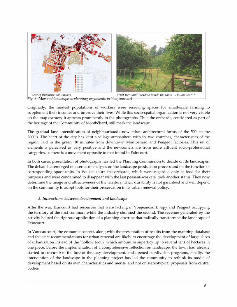
9
Fig. 3. Map and landscape as planning arguments in Voujeaucourt
Originally, the modest populations of workers were reserving spaces for small-scale farming to supplement their incomes and improve their lives. While this socio-spatial organization is not very visible on the map extracts, it appears prominently in the photographs. Thus the orchards, considered as part of the heritage of the Community of Montbéliard, still mark the landscape.
The gradual land intensification of neighbourhoods now mixes architectural forms of the 50’s to the 2000’s. The heart of the city has kept a village atmosphere with its two churches, characteristics of the region, laid in the green, 10 minutes from downtown Montbeliard and Peugeot factories. This set of elements is perceived as very positive and the newcomers are from more affluent socio-professional categories, so there is a movement opposite to that found in Exincourt.
In both cases, presentation of photographs has led the Planning Commission to decide on its landscapes. The debate has emerged of a series of analyses on the landscape production process and on the function of corresponding space units. In Voujeaucourt, the orchards, which were regarded only as food for their purposes and were condemned to disappear with the last peasant-workers, took another status. They now determine the image and attractiveness of the territory. Their durability is not garanteed and will depend on the community to adopt tools for their preservation in its urban renewal policy.
3. Interactions between development and landscape
After the war, Exincourt had resources that were lacking in Voujeaucourt. Japy and Peugeot occupying the territory of the first common, while the industry shunned the second. The revenue generated by the activity helped the rigorous application of a planning doctrine that radically transformed the landscape of Exincourt.
In Voujeaucourt, the economic context, along with the presentation of results from the mapping database and the state recommendations for urban renewal are likely to encourage the development of large slices of urbanization instead of the "hollow tooth" which amount in superficy up to several tens of hectares in one piece. Before the implementation of a comprehensive reflection on landscape, the town had already started to succumb to the lure of the easy development, and opened subdivision programs. Finally, the intervention of the landscape in the planning project has led the community to rethink its model of development based on its own characteristics and merits, and not on stereotypical proposals from central bodies.
Year of finishing habitations Fruit trees and meadow inside the town - Hollow tooth?

10
Conclusion
Hence, speaking about the landscape and observing from the inside have provided the opportunity to bring it upstream of the procedure, and to get around the interpretations of regulations: the objectives of the urban renewal policy give appropriate foundation for the two urban projects, but they nevertheless produce diametrically opposed results on the two territories.
The images used are mainly informative. The landscape photography was preferred for practical reasons, but other vectors, such as drawing or game, may have contributed to trigger the process of mediation. The city-production processes emerged from the landscape debate, leaving a mark in the geographic information system of the Community of agglomeration. The initiation of the planning process has proceeded to a selection of landscape dynamics recognized as positive and took the form of draft informative plans in the map database. At that point, the loop was looped: indeed, it is essential to be able to bring the landscape patterns into the georeferenced space in order to have a reproducible information, the planning document being based fundamentally on zoning.
Highlighting the issue of landscaping offers an alternative to often stereotypical proposals of prefectural bodies and methodological guides of the Ministry of Equipment. The proposed approach is still experimental but it points in the direction of a more authentic decentralization, based on the local landscape material that produces the planning project. The examples of Exincourt and Voujeaucourt show the ambiguity of the State "Bring to knowledge" prescription, which stresses systematically on the need to limit urban sprawl and on construction intensification. The first common identified in this article had anticipated these orientations, whereas the second one had followed a more unbridled way of development. Today the effects of these policies, opposite as far as the socio-spatial system and the landscape material mobilization is concerned, offer potential for other developments... which are not favourable to the orthodox model.

11
Bibliography G. BERTRAND, 1978, “Le paysage, entre la nature et les sociétés”, Revue de Géographie des Pyrénées et du Sud-
Ouest, tome 49, fasc. 240-258. J.P. MASSONIE, D. MATHIEU et J. PRAICHEUX, 1982, “Approche théorique de la lecture du paysage : la
soumission à la vue”, Cahiers de Géographie de Besançon, séminaires et notes de recherches, pp. 43-64. J.C. WIEBER et Th. BROSSARD, 1984, “Le paysage, trois modes de définition, un mode d’analyse et de
cartographie”, L’espace géographique, n°1, pp 5-12. A. BERQUE, 1990, De milieux en paysages, Fayard Reclus, 156 p. C. COLLET, 1992, Système d’information géographique en mode image, Presses polytechniques et universitaires
romandes, 186 p. D. JOLY, 1992, “Usage des données satellites et altitudinales pour l’étude du paysage et l’aménagement de
l’espace” Actes du colloque FI3G, Strasbourg, pp 131-138. R. ZEWE et H.J. KÖGLIN, 1995, “A method for the visual assesment of overhead lines”, comput and graphics,
vol. 19, n°1, pp. 97 – 108. R. BORODKINE, L. COUDERCHET, S. ORMAUX, 1999, “La question des pollutions visuelles” dans Le paysage,
état des lieux, Actes du colloque de Cerisy, Editions OUSIA, Bruxelles, pp 82-102. L. COUDERCHET, 2001, Propositions pour un protocole d’étude des paysages, définition dans le cadre des lignes de
transport d’électricité, Presses Universitaires Franc-Comtoises, 114 p. S. ORMAUX 2001 : "Ceci est-il un paysage ? ou quelques propositions pour un nouvel usage de la
photographie en géographie", in Intergéo Bulletin, 1/2001, L’Image au cœur de la géographie, pp. 9-15. L. COUDERCHET, S. ORMAUX, 2002 : “Paysages de synthèse et réduction d’impact des lignes de transport
d’électricité”, Les choix énergétiques, de l’évaluation des impacts à l’évaluation environnementale stratégique, actes du sixième colloque international des spécialistes francophones en évaluation d’impacts, Cotonou, 23 au 27 avril 2001, bibliothèque nationale du Québec, pp 493-502.
D. LE COUÉDIC, 2002, “Le paysage tué par ceux-là même qui l’adoraient”, dans le paysage par-delà la norme, Cahier de géographie du Québec, n° 129, pp. 281à 297.
F. TREMBLAY et Ph. POULLAOUEC-GONIDEC, 2002, “Contre le tout Paysage : pour des émergences et des oublis”, Le paysage par-delà la norme, Cahiers de géographie du Québec, n°129, pp. 345-355.
M. GRISELIN et S. ORMAUX, 2003 - Le paysage et ses temporalités en Baie du Roi (Svalbard). Essais de problématisation et d'instrumentation, Bulletin de l'Association de Géographes Français, 80, 4, pp. 386-393.
L. COUDERCHET, 2004, “L’illusion du visible - Paysage et aménagement d’infrastructures de transport d’électricité”, dans les actes du colloque L’évaluation du paysage : une utopie nécessaire ? Montpellier, 15 et 16 janvier, à paraître.
S. ORMAUX, 2009, “Landscape and territorial intelligence”, Ricerca e Sviluppo per le politiche sociali, N° 1-2 2008, pp. 83-89.
Y. DROZ et alii, 2009, Anthropologie politique du paysage, Valeurs et postures paysagères des montagnes suisse, Karthala, Paris, 172 pp.