flagler county · flagler county manatee protection plan executive summary ... and provides shore...
TRANSCRIPT

Flagler CountyManatee Protection Plan
Prepared by:Flagler County
Board of County Commissioners1769 East Moody Boulevard
Bunnell, FL 32110386.313.4000
Technical Assistance by: Atlantic Ecological Services, LLC
217 Gallicia AvenueSt. Augustine, FL 32086 www.atlanticeco.com
904.347.9133
December 20141st Revision - June 2015
DRAFT

December 20141st Revision – June 2015 P a g e | I
FLAGLER COUNTY MANATEE PROTECTION PLAN
EXECUTIVE SUMMARY
This document represents Flagler County’s Manatee Protection Plan (MPP) which isintended to assist in protecting manatees and their habitats to ensure their continuedsurvival. Specific objectives include: reducing the number of boat-related mortalities;creation of a boat facility siting plan, protecting manatee habitat; promoting boatingsafety; and increasing public awareness of the need to protect manatees and theirhabitat.
Flagler County has been in discussions with the Florida Fish and Wildlife ConservationCommission (FWC) and the U.S. Fish and Wildlife Service (FWS) regarding manateeprotection since 2006. It was in 2006 that the County received a Biological Opinion (BO)from FWS to the U.S. Army Corps of Engineers (USACE) recommending denial of fivemulti-slip projects within Flagler County. The BO referenced five projects within FlaglerCounty and expressed the FWS’ position regarding Flagler County and the MarineMammal Protection Act and Endangered Species Act. In summary, the BO stated thatdue to the “threat” to manatees from the additional proposed slips the FWS could notrecommend approval. During the years of 2003, 2006, and 2007 Flagler County saw asmall spike in watercraft related manatee deaths (2 in each of those years). In 2007 theFWC identified Flagler County within the Manatee Management Plan (MMP) as an areawith little or no manatee protection regulations and therefore would require evaluationto determine if Manatee Protection Zones were warranted. Through coordination withFWS and FWC, and the agreement of adopting a Manatee Protection Plan, the permitswere eventually issued. In 2011, after years of coordination between the agencies andFlagler County, FWS re-initiated Section 7 Consultation with the USACE and requestedthe permits be revoked. None of the marina developments included in the BO wereever constructed. Since then, two other permit applications were subsequently deniedbased on protection of manatees through the requirement of a MPP.
Manatee Protection Zones (boat speed restriction zones) are a management tool thathave historically been used in areas where watercraft related manatee deaths are high.Flagler County is not recognized as an area with high watercraft related manateedeaths, but the County does recognize that the number of deaths in the early to mid-2000’s increased to a number of concern (but still not what would be considered high,historically). Flagler County took its first large step towards overall protection ofmanatees in 2012 by instituting Manatee Protection Zones over 5.4 miles of the
DRAFT

December 20141st Revision – June 2015 P a g e | II
FLAGLER COUNTY MANATEE PROTECTION PLAN
Intracoastal Waterway (ICW) in the areas identified as requiring additional protections.The speed zones became enforceable in 2013. Flagler County has started the processand intends to establish an additional zone which is approximately 0.5 miles in lengthand provides shore to shore manatee protection around the mouth of the Lehigh Canal.
Flagler County’s intent is to utilize this MPP and its recommendations as a means toprovide adaptive management practices in regards to manatee protection. The findingsof this study represent a solid baseline of data. The creation of a Manatee ProtectionPlan Yearly Status Report updating the number of newly constructed slips and/or ramps,watercraft related manatee deaths and locations of deaths, law enforcement statuswithin the Manatee Protection Zones, land acquisitions along the ICW, and otherpertinent manatee related information can be utilized as a guide to create adaptivemanagement techniques which will truly provide useful protection of manatees. Thecreation of protocol for inter-agency coordination between Flagler County, FWS, FWC,and other stakeholders will provide assurances that all manatee related issues are keptwithin open discussion and the yearly status reports are reviewed by each that isinvolved.
This plan does not pertain to single family docks; only projects proposing expansion orconstruction of new facilities of five or more slips. Among the components of this MPPare:
An inventory of boat facilities (marinas, multi-family residential facilities, & boatramps).
An assessment of boating activity patterns. Manatee sighting and mortality information. Information on Aquatic Preserves and Outstanding Florida Waters. Manatee protection measures, such as boating speed zone regulations. A Boat Facility Siting Plan. An education and awareness program for the public, boaters, and children. Recommendations and schedule for future review.
DRAFT

December 20141st Revision – June 2015 P a g e | III
FLAGLER COUNTY MANATEE PROTECTION PLAN
TABLE OF CONTENTS
EXECUTIVE SUMMARY ...............................................................................ITABLE OF CONTENTS ...................................................................................................... IIILIST OF FIGURES.............................................................................................................. IVLIST OF TABLES................................................................................................................ VILIST OF APPENDICES ...................................................................................................... VIILIST OF ABBREVIATIONS ................................................................................................ VIILIST OF DEFINITIONS..................................................................................................... VIII
1.0 INTRODUCTION...................................................................................11.1 GEOGRAPHIC SETTING ............................................................................................... 21.2 COUNTY DEMOGRAPHICS.......................................................................................... 31.3 RESIDENTIAL AND COMMERCIAL DEVELOPMENT WITHIN THE COUNTY .................. 41.4 MANATEE RELEVENT WATERWAYS, WATER QUALITY, AND RECREATION ................ 51.5 MANATEE PROTECTION ZONES ................................................................................. 71.6 MANATEE NATURAL HISTORY IN FLORIDA............................................................... 121.7 LAND DEVELOPMENT REVIEW ................................................................................. 131.8 MANATEE PROTECTION PLAN OBJECTIVE................................................................ 14
2.0 FLAGLER COUNTY MANATEE HABITAT...............................................142.1 PELLICER AND TOMOKA MARSH AQUATIC PRESERVES ........................................... 142.2 THE ATLANTIC INTRACOASTAL WATERWAY IN FLAGLER ......................................... 182.3 FLAGLER COUNTY PRESERVATION LANDS ............................................................... 262.4 FRESHWATER AVAILABILITY ALONG THE ICW IN FLAGLER COUNTY ........................ 332.5 FORAGE OPPORTUNITIES FOR MANATEES IN FLAGLER COUNTY............................. 40
3.0 INFORMATION ASSESSMENT.............................................................463.1 MANATEE DISTRIBUTION......................................................................................... 463.2 AERIAL SURVEYS....................................................................................................... 473.3 MANATEE MORTALITY ............................................................................................. 523.3.1 WATERCRAFT RELATED MANATEE MORTALITIES ................................................. 623.4 BOAT ACTIVITY ......................................................................................................... 643.4.1 BOATING ACCIDENT STATISTICS ........................................................................... 683.4.2 BOATING STUDIES IN FLAGLER COUNTY ............................................................... 703.5 EXISTING BOATING FACILITY INVENTORY ................................................................ 733.5.1 COMMERCIAL AND RESIDENTIAL MARINAS ......................................................... 733.5.2 RAMPS AND TRANSIENT SLIPS .............................................................................. 733.5.3 COMMERCIAL FACILITIES ...................................................................................... 733.5.4 MARINELAND & MATANZAS RIVER REGION – SECTION A..................................... 75
DRAFT

December 20141st Revision – June 2015 P a g e | IV
FLAGLER COUNTY MANATEE PROTECTION PLAN
3.5.5 PALM COAST REGION – SECTION B ....................................................................... 773.5.6 FOX CUT REGION – SECTION C .............................................................................. 793.5.7 SMITH CREEK NORTH OF SR100 REGION – SECTION D.......................................... 803.5.8 SMITH CREEK SOUTH OF SR100 REGION – SECTION E........................................... 833.5.9 LAKE CRESCENT REGION – SECTION F ................................................................... 843.6 MANATEE COINCIDENCE DATA................................................................................ 853.7 INFORMATION ASSESSMENT DISCUSSIONS............................................................. 86
4.0 BOAT FACILITY SITING PLAN ..............................................................904.1 COUNTY AND MUNICIPALITY JURISDICTION............................................................ 914.2 BOAT FACILITY SITING PLAN DEVELOPMENT CRITERIA............................................ 924.3 BOAT FACILITY SITING PLAN RECOMMENDATIONS ................................................. 924.4 EXISTING MARINA EXPANSION .............................................................................. 1114.5 SINGLE FAMILY DOCKS AND MULTI-FAMILY FACILITIES LESS THAN 5 SLIPS........... 111
5.0 EDUCATION PLAN............................................................................ 1115.1 INFORMATIONAL KIOSKS ....................................................................................... 1135.2 BOATING GUIDE PAMPHLETS ................................................................................ 113
6.0 MANATEE PROTECTION ZONES AND LAW ENFORCEMENT .............. 1137.0 IMPLEMENTATION PLAN ................................................................. 114
7.1 MANATEE PROTECTION PLAN ADOPTION ............................................................. 1147.2 MANATEE PROTECTION PLAN STATUS REPORT..................................................... 1147.3 MANATEE PROTECTION ZONE LAW ENFORCEMENT YEARLY REPORT................... 1157.4 MANATEE PROTECTION PLAN FUNDING ............................................................... 1157.5 MANATEE PROTECTION PLAN RECOMMENDATIONS............................................ 116
REFERENCES ...........................................................................................................118
LIST OF FIGURES
FIGURE 1: LOCATION OF FLAGLER COUNTY, FLORIDA ................................................................... 3FIGURE 2: DRAINAGE BASINS .................................................................................................. 6FIGURE 3: MANATEE PROTECTION ZONES ................................................................................. 8FIGURE 4: MANATEE PROTECTION ZONE SECTION B.................................................................... 9FIGURE 5: MANATEE PROTECTION ZONE SECTIONS C & D.......................................................... 10FIGURE 6: MANATEE PROTECTION ZONE SECTION E.................................................................. 11
DRAFT

December 20141st Revision – June 2015 P a g e | V
FLAGLER COUNTY MANATEE PROTECTION PLAN
FIGURE 7: ADDITIONAL PROPOSED MANATEE PROTECTION ZONE ................................................ 12FIGURE 8: ICW AQUATIC PRESERVES AND OUTSTANDING FLORIDA WATERS.................................. 15FIGURE 9: LAKE CRESCENT OUTSTANDING FLORIDA WATERS ...................................................... 16FIGURE 10: OVERVIEW OF MPP PLANNING SECTIONS ............................................................... 20FIGURE 11: AERIAL VIEW OF MPP PLANNING SECTION A .......................................................... 21FIGURE 12: AERIAL VIEW OF MPP PLANNING SECTION B .......................................................... 22FIGURE 13: AERIAL VIEW OF MPP PLANNING SECTION C .......................................................... 23FIGURE 14: AERIAL VIEW OF MPP PLANNING SECTION D .......................................................... 24FIGURE 15: AERIAL VIEW OF MPP PLANNING SECTION E........................................................... 25FIGURE 16: AERIAL VIEW OF MPP PLANNING SECTION F........................................................... 26FIGURE 17: PRESERVATION LANDS SECTION A.......................................................................... 28FIGURE 18: PRESERVATION LANDS SECTION B.......................................................................... 29FIGURE 19: PRESERVATION LANDS SECTION C.......................................................................... 30FIGURE 20: PRESERVATION LANDS SECTION D ......................................................................... 31FIGURE 21: PRESERVATION LANDS SECTION E.......................................................................... 32FIGURE 22: PRESERVATION LANDS SECTION F .......................................................................... 33FIGURE 23: FRESHWATER SOURCES SECTION A ........................................................................ 35FIGURE 24: FRESHWATER SOURCES SECTION B ........................................................................ 36FIGURE 25: PALM COAST WATER TREATMENT EFFLUENT DISCHARGE POINTS ................................ 37FIGURE 26: FRESHWATER SOURCES SECTION C......................................................................... 38FIGURE 27: FRESHWATER SOURCES SECTION D ........................................................................ 39FIGURE 28: FRESHWATER SOURCES SECTION E......................................................................... 40FIGURE 29: MANATEE FORAGE MAP SECTION A ...................................................................... 42FIGURE 30: MANATEE FORAGE MAP SECTION B ...................................................................... 43FIGURE 31: MANATEE FORAGE MAP SECTION C ...................................................................... 44FIGURE 32: MANATEE FORAGE MAP SECTION D ...................................................................... 45FIGURE 33: MANATEE FORAGE MAP SECTION E....................................................................... 46FIGURE 34: AERIAL SURVEY MAP SECTION A ........................................................................... 48FIGURE 35: AERIAL SURVEY MAP SECTION B ........................................................................... 49FIGURE 36: AERIAL SURVEY MAP SECTION C ........................................................................... 50FIGURE 37: AERIAL SURVEY MAP SECTION D........................................................................... 51FIGURE 38: AERIAL SURVEY MAP SECTION E ........................................................................... 52FIGURE 39: FWRI FLAGLER COUNTY MANATEE MORTALITY CATEGORIES ..................................... 53FIGURE 40: MANATEE MORTALITIES SECTION A....................................................................... 54FIGURE 41: MANATEE MORTALITIES SECTION B....................................................................... 55FIGURE 42: MANATEE MORTALITIES SECTION C ....................................................................... 56FIGURE 43: MANATEE MORTALITIES SECTION D....................................................................... 57FIGURE 44: MANATEE MORTALITIES SECTION E ....................................................................... 58FIGURE 45: MANATEE MORTALITIES SECTION F ....................................................................... 59FIGURE 46: MANATEE MORTALITIES DUE TO WATERCRAFT COLLISIONS, 1999-2013.................... 62FIGURE 47: BOATING DENSITY OVERVIEW .............................................................................. 72FIGURE 48: OVERALL BOATING FACILITIES MAP ....................................................................... 75
DRAFT

December 20141st Revision – June 2015 P a g e | VI
FLAGLER COUNTY MANATEE PROTECTION PLAN
FIGURE 49: BOATING FACILITIES SECTION A............................................................................. 77FIGURE 50: BOATING FACILITIES SECTION B............................................................................. 78FIGURE 51: BOATING FACILITIES SECTION C............................................................................. 80FIGURE 52: BOATING FACILITIES SECTION D ............................................................................ 82FIGURE 53: BOATING FACILITIES SECTION E............................................................................. 83FIGURE 54: BOATING FACILITIES SECTION F ............................................................................. 84FIGURE 55: BOAT FACILITY SITING PLAN RECOMMENDATIONS – COUNTY OVERVIEW....................... 98FIGURE 56: BOAT FACILITY SITING PLAN RECOMMENDATIONS – SECTION A NORTH ....................... 99FIGURE 57: BOAT FACILITY SITING PLAN RECOMMENDATIONS – SECTION A SOUTH ...................... 100FIGURE 58: BOAT FACILITY SITING PLAN RECOMMENDATIONS – SECTION B NORTH ...................... 101FIGURE 59: BOAT FACILITY SITING PLAN RECOMMENDATIONS – SECTION B SOUTH ...................... 102FIGURE 60: BOAT FACILITY SITING PLAN RECOMMENDATIONS – SECTION C NORTH ...................... 103FIGURE 61: BOAT FACILITY SITING PLAN RECOMMENDATIONS – SECTION C SOUTH ...................... 104FIGURE 62: BOAT FACILITY SITING PLAN RECOMMENDATIONS – SECTION D NORTH...................... 105FIGURE 63: BOAT FACILITY SITING PLAN RECOMMENDATIONS – SECTION D SOUTH ...................... 106FIGURE 64: BOAT FACILITY SITING PLAN RECOMMENDATIONS – SECTION E NORTH ...................... 107FIGURE 65: BOAT FACILITY SITING PLAN RECOMMENDATIONS – SECTION E SOUTH ...................... 108FIGURE 66: BOAT FACILITY SITING PLAN RECOMMENDATIONS – SECTION F NORTH ...................... 109FIGURE 67: BOAT FACILITY SITING PLAN RECOMMENDATIONS – SECTION F SOUTH....................... 110
LIST OF TABLES
TABLE 1: MANATEE WATERWAY TYPES IN FLAGLER COUNTY ..................................................... 19TABLE 2: FLAGLER COUNTY MANATEE MORTALITY SPECIFIC DATA ............................................. 59TABLE 3: WATERCRAFT RELATED MANATEE DEATHS 1999-2013 ............................................. 63TABLE 4: BOAT REGISTRATION 2013 EAST COAST ATLANTIC COUNTIES ...................................... 64TABLE 5: BOAT REGISTRATION 2013 ENTIRE STATE................................................................. 65TABLE 6: BOAT REGISTRATION DATA FLAGLER COUNTY 2000-2013.......................................... 67TABLE 7: BOAT TYPES FLAGLER COUNTY 2000-2012.............................................................. 68TABLE 8: BOATING ACCIDENT STATISTICS 2013...................................................................... 68TABLE 9: FLAGLER COUNTY BOATING ACCESS INVENTORY......................................................... 74TABLE 10: FLAGLER COUNTY MPP RECOMMENDATIONS........................................................ 116
DRAFT

December 20141st Revision – June 2015 P a g e | VII
FLAGLER COUNTY MANATEE PROTECTION PLAN
LIST OF APPENDICES
APPENDIX 1: EDUCATION PLAN ................................................................................... 119
LIST OF ABBREVIATIONS
BOCC Board of County CommissionersBFSP Boat Facility Siting PlanDLE Division of Law EnforcementFAC Florida Administrative CodeFDEP Florida Department of Environmental ProtectionFIND Florida Inland Navigation DistrictFLUM Future Land Use MapFS Florida StatuteFWC Florida Fish and Wildlife Conservation CommissionICW Intracoastal WaterwayMML Mote Marine LaboratoryMMPA Marine Mammal Protection ActMPP Manatee Protection PlanNMFS National Marine Fisheries ServiceNOAA National Oceanic and Atmospheric AdministrationPWC Personal Watercraft (e.g., Jet Ski, Sea Doo)SAV Submerged Aquatic VegetationSJRWMD St. Johns River Water Management DistrictUSACE U.S. Army Corps of EngineersUSCG U.S. Coast GuardUSFWS U.S. Fish and Wildlife Service
DRAFT
December 20141st Revision – June 2015 P a g e | VIII
FLAGLER COUNTY MANATEE PROTECTION PLAN
LIST OF DEFINITIONS
Blatant Non-compliance - blatant non-compliance was defined as a vessel in-use at aspeed greater than one speed category faster than the posted limit through a significantportion of a speed-regulated area. (Example: a vessel traveling at Planing Speed within aSlow Speed Zone).
Boat - a vehicle designed for operation as a watercraft propelled by sails, or one or moreelectric or internal combustion engine(s). A boat shall not be considered as arecreational vehicle even though it has facilities for temporary living quarters. For thepurpose of this plan, the word “boat” does not include canoes and kayaks.
Boat Facility - a public or private structure or operation where boats are moored and/orlaunched, including commercial, recreational, and residential marinas, and public boatramps. A dry storage facility is considered part of a boat facility if the dry storage facilityhas the capability of launching vessels into adjacent waters. For the purpose of thisplan, docks with less than five (5) wet slips are not considered boat facilities.
Boat Facility Siting Plan – A component of a Manatee Protection Plan, which is a countywide guidance document for future development, construction and expansion, of boatfacilities. The plan specifies preferred locations for boat facility development basedupon an evaluation of manatee protection needs, potential natural resource impacts,and zoning and future land use compatibility. The purpose of developing a boat facilitysiting plan is to reduce threats to manatees and other living resources, such asseagrasses, mangroves, wetlands and oysters, from boating activities and infrastructuredevelopment impacts.
Boat Ramp - A sloped surface structure, or man-made improvement to a shoreline areathat facilitates the launching and landing of boats into a water body.
Boat Slip - a boat slip is a space, mooring, or parking space which can accommodate oneboat or vessel in the water or on land (examples include, lifts, trailers, blocks,anchorage, beached or blocked, hoist, floating platforms, davits, boat lifts). For thepurposes of this plan, a boat trailer parking space is a boat slip. Slips that do notcontribute to boat traffic, such as courtesy slips for boat ramps and dry storage facilities,are exempt from the Boat Facility Siting Strategy. Structures authorized only for fishingor observation, are not considered slips.
DRAFT

December 20141st Revision – June 2015 P a g e | IX
FLAGLER COUNTY MANATEE PROTECTION PLAN
Boat Yard - a boat facility (wet or dry slips) used only for boat repair and/or boatbuilding.
Build-out - A term referring to maximum planned development for a community, interms of the physical structures, use of land and approximate number of people whichcan be accommodated within the community.
Channel of the Intracoastal Waterway - all waters within the navigable channel of theIntracoastal Waterway in Flagler County, Florida, and which navigable channel is a partof the inland waterways, and which said navigable channel is located by buoys or othermarkers placed by the U.S. Coast Guard (USCG).
Compliance (compliant) - Any vessel in-use that was determined to maintain a speedthat was consistent with the posted speed at a study site.
Comprehensive Plan - an official document in ordinance form adopted by the localgovernment setting forth its goals, objectives and policies regarding the long termdevelopment of the area within its jurisdiction.
Dry Slip - a space designed for the storage of single watercraft in an upland locationwith access to a waterway from the upland location.
Dry Storage Facility - an upland structure used for storing watercraft. A dry storagefacility may be either a water-dependent or a water-related use.
Existing Facility - A boat facility that is permitted and/or authorized, constructed, and inoperation as of the effective date of this plan. Permits and authorizations must be inplace from state and local permitting agencies. Facilities permitted but not yetconstructed are also considered existing. This definition does not include unauthorizedstructures.
Lane - A part of a boat ramp that allows for the launching and landing of one boat at atime. A boat ramp can have more than one lane.
Linear Shoreline or Shoreline - the mean high water line in tidally influenced areas andthe ordinary high water line along waterways that are not tidally influenced. Linearshoreline shall be calculated using survey quality aerial photographs or by accurate fieldsurvey. The calculation of linear shoreline is based upon contiguous shoreline that isowned or legally controlled by the applicant.
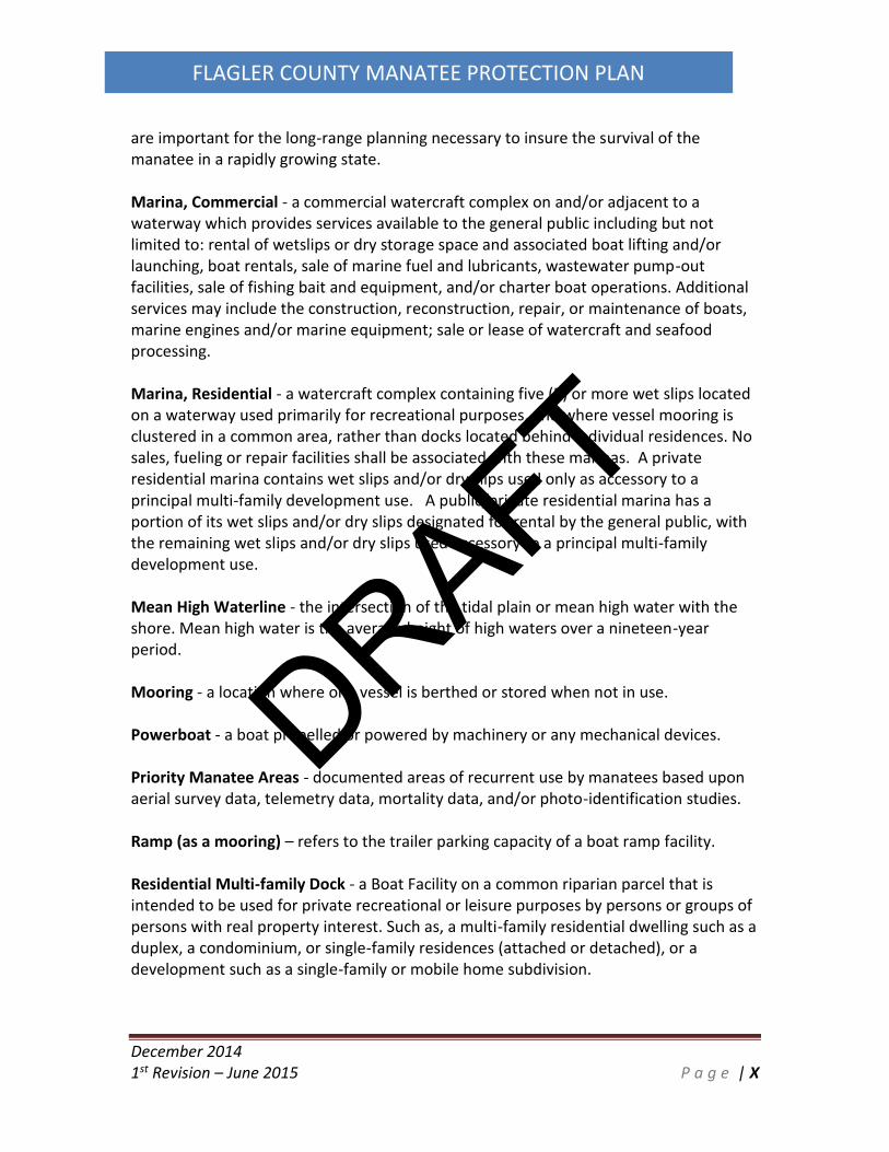
Manatee Protection Plan – a State-approved summary of manatee data, strategies, andmanagement actions aimed at protecting manatees in a specific area or county. They
DRAFT
December 20141st Revision – June 2015 P a g e | X
FLAGLER COUNTY MANATEE PROTECTION PLAN
are important for the long-range planning necessary to insure the survival of themanatee in a rapidly growing state.
Marina, Commercial - a commercial watercraft complex on and/or adjacent to awaterway which provides services available to the general public including but notlimited to: rental of wetslips or dry storage space and associated boat lifting and/orlaunching, boat rentals, sale of marine fuel and lubricants, wastewater pump-outfacilities, sale of fishing bait and equipment, and/or charter boat operations. Additionalservices may include the construction, reconstruction, repair, or maintenance of boats,marine engines and/or marine equipment; sale or lease of watercraft and seafoodprocessing.
Marina, Residential - a watercraft complex containing five (5) or more wet slips locatedon a waterway used primarily for recreational purposes, and where vessel mooring isclustered in a common area, rather than docks located behind individual residences. Nosales, fueling or repair facilities shall be associated with these marinas. A privateresidential marina contains wet slips and/or dry slips used only as accessory to aprincipal multi-family development use. A public/private residential marina has aportion of its wet slips and/or dry slips designated for rental by the general public, withthe remaining wet slips and/or dry slips used accessory to a principal multi-familydevelopment use.
Mean High Waterline - the intersection of the tidal plain or mean high water with theshore. Mean high water is the average height of high waters over a nineteen-yearperiod.
Mooring - a location where one vessel is berthed or stored when not in use.
Powerboat - a boat propelled or powered by machinery or any mechanical devices.
Priority Manatee Areas - documented areas of recurrent use by manatees based uponaerial survey data, telemetry data, mortality data, and/or photo-identification studies.
Ramp (as a mooring) – refers to the trailer parking capacity of a boat ramp facility.
Residential Multi-family Dock - a Boat Facility on a common riparian parcel that isintended to be used for private recreational or leisure purposes by persons or groups ofpersons with real property interest. Such as, a multi-family residential dwelling such as aduplex, a condominium, or single-family residences (attached or detached), or adevelopment such as a single-family or mobile home subdivision.
DRAFT

December 20141st Revision – June 2015 P a g e | XI
FLAGLER COUNTY MANATEE PROTECTION PLAN
Riparian Rights - those rights incident to lands bordering upon navigable waters, asrecognized by the courts and common law (Ch. 18-21.003(53), FAC).
Single-Family Dock - a fixed or floating structure, including moorings, used for berthingbuoyant vessels, accessory to a single-family residence, with no more than two (2)boatslips per residence. Notwithstanding, a shared single-family dock may contain up tofour (4) boat slips. Said docks cannot be rented, leased or sold to a party unless saidparty rents, leases, or buys the associated single-family residence. A single-family dockmay include a fishing or observation pier.
Technical Non-compliance - A vessel that was considered to be in technical violation ofthe posted speed at a study site, as defined by:
< A vessel traveling at a speed which was determined to be one speed category fasterthan the posted speed limit (Example: a vessel traveling at Slow Speed within the IdleSpeed Zone).< A vessel traveling at any excessive speed, but for only a relatively small distance withinthe posted area (Example: a speeding vessel extending a short distance into an IdleSpeed Zone before slowing to the posted speed, or a vessel which accelerates out of anIdle Speed Zone before leaving the posted area).
Trailer - A trailer-type of mooring refers to a boat with trailer that was visible from awaterway. While this provides an estimate of trailered vessels in Flagler County, it isunderstood that the term is both subjective and provides only a rough estimate oftrailered vessels in the County.
Travel Corridor - a waterway through which manatees travel, either daily or seasonally,between feeding areas and sources of fresh or warm-water, resting or feeding locations,or other habitat areas.
Vessel (or boat or watercraft) - a vehicle designed for operation in the water that ispropelled by sails or one or more electric, jet or internal combustion engine(s). Theseterms may refer to any size vessel including a personal watercraft to freighters or cruiseships. For purposes of this plan, the word “boat” does not include human-poweredvessels, such as canoes or kayaks.
Warm-water Refuge - a natural or manmade warm-water habitat which maintains atemperature equal to or greater than minimum required for manatee survival(approximately 68F or 20C).
Waters - waters of the State of Florida.
DRAFT

December 20141st Revision – June 2015 P a g e | XII
FLAGLER COUNTY MANATEE PROTECTION PLAN
Water-Dependent Uses - Water-dependent uses shall include those uses whose primaryfunction is derived by direct water access such as, but not limited to commercialmarinas, commercial charter fishing, touring and diving boat piers, water-skiing, sailing,and similar instructional operations, dredging, hauling, marine repair and other relateduses.
Wet Slip - a Space designed for the mooring of a single watercraft in water. Such spacesmay extend from a dock or pier, however any piers authorized for fishing or observationare not considered wet slips.
DRAFT

December 2014
1st Revision – June 2015 P a g e | 1
FLAGLER COUNTY MANATEE PROTECTION PLAN
1.0 Introduction
Flagler County is located in Northeast Florida, south of St. Johns County and north of Volusia
County (Figure 1). Flagler County’s Intracoastal Waterway (ICW) is characterized by a significant
percentage of conservation areas, or other areas prohibited from development of waterfront
facilities. The length of the ICW in Flagler County is approximately 18.5 miles of waterway. The
setting within Flagler County also includes approximately 19 miles of coastline along the
Atlantic Ocean.
The Florida manatee (Trichechus manatus latirostris) inhabits the waters of the ICW year round.
Few manatees are observed during the winter months (November, December, January,
February, and March). Manatees are more often observed from late April through early
October with highest concentrations occurring during spring and summer months (May, June,
July and August). Florida manatees exhibit an array of activities in these waters including
traveling, resting, and cavorting (mating).
Manatees are protected under the Marine Mammal Protection Act of 1972 (as amended in
1996), the Endangered Species Act (ESA) of 1973, and the Florida Manatee Sanctuary Act
(1978), through the Florida Fish & Wildlife Conservation Commission (FWC).
In 1989, Florida's Governor and Cabinet identified counties experiencing excessive watercraft-
related mortality of manatees and mandated that these counties take positive measures to
reduce this problem.
Specifically, thirteen key counties - Brevard, Broward, Citrus, Collier, Miami-Dade, Duval, Indian
River, Lee, Martin, Palm Beach, St. Lucie, Sarasota, and Volusia - were to develop manatee
protection plans which would address the multitude of threats facing manatees. Presently, all
“Key Counties” have state-approved Manatee Protection Plans (MPP) in place. Flagler County
was not identified as one of the “Key Counties” requiring a MPP. In 2007 the FWC identified
Flagler County within the Manatee Management Plan (MMP) as an area with little or no
manatee protection regulations and therefore would require evaluation to determine if
manatee protection zones were warranted. In 2012, after much coordination between FWC,
FWS, and Flagler County, 5.4 miles of the ICW and canals in Flagler County became Manatee
Protection Zones. As a next step in protection of manatees, Flagler County has determined the
adoption of this MPP and the addition of approximately 0.5 miles more Manatee Protection
Zone will serve to help provide future protection to the species.
DRAFT

December 2014
1st Revision – June 2015 P a g e | 2
FLAGLER COUNTY MANATEE PROTECTION PLAN
This MPP is intended to assist in protecting manatees and their habitats to ensure their
continued survival. These objectives are derived from the USFWS Florida Manatee Recovery
Plan (third revision October 2001), the Governor and Cabinet’s 1989 desire to improve boating
safety and manatee protection for Florida waterways, and the 2007 State of Florida Manatee
Management Plan (MMP). Specific objectives include: reducing the number of boat-related
mortalities; creation of a boat facility siting plan, protecting manatee habitat; promoting
boating safety; and increasing public awareness of the need to protect manatees and their
habitat. The objective of the Manatee Recovery Plan is the downlisting and ultimate delisting
of the Florida manatee from its endangered and/or protected status.
Among the components of this MPP are:
An inventory of boat facilities (marinas, docks, boat ramps, etc.)
An assessment of boating activity patterns
Manatee sighting and mortality information
Information on aquatic preserves, Outstanding Florida Waters, etc.
Manatee protection measures, such as boating speed zone regulations
Future boat facility siting planning
An education and awareness program for the public, boaters, and children
Recommendations and schedule for future review
The FWC has the authority to review and approve MPPs developed by individual counties.
Flagler County has also coordinated with the USFWS to receive comments on this MPP.
This document fulfills the requirements for completion of a comprehensive Manatee Protection
Plan in Flagler County.
1.1 Geographic Setting
Flagler County lies in the northeastern part of Florida, about sixty miles south of Jacksonville
and 25 miles north of Daytona Beach. Flagler County is about 23 miles wide at its widest point
east to west, and 29 miles long at its longest point north to south. The Atlantic Ocean
beachfront area is approximately 19 miles long and forms the eastern county-boundary, and
Crescent Lake forms a significant portion of its western boundary.
In total, Flagler County occupies approximately 571 square miles consisting of approximately
485 square miles of land area and 86 square miles of water area. This County includes the
incorporated cities of Beverly Beach, Bunnell, Flagler Beach, Marineland, and Palm Coast. The
DRAFT

December 2014
1st Revision – June 2015 P a g e | 3
FLAGLER COUNTY MANATEE PROTECTION PLAN
City of Bunnell, the county seat, is located at the approximately geographical center of the
County at U.S. 1 and SR 100 crossroad.
Flagler County can be divided into three major geographic areas: the barrier island east of the
ICW, the coastal area east of U.S. Highway 1 and the ICW, and western Flagler County west of
U.S. Highway 1.
Figure 1: Location of Flagler County, Florida
1.2 County Demographics
The 2010 U.S. Census Bureau lists the population of Florida at 18,801,310 (48.9 percent male
and 51.1 percent female). Of the 67 counties in Florida, Flagler County ranked 35th with a
resident population of 95,996 people (0.5 percent of the state total, 48.0 percent male, 52.0
percent female) as of 2010. Of this 95,996 people, 75,180 live in the City of Palm Coast (78% of
the total population). The remaining 22 percent of the residents live in the City of Bunnell, the
DRAFT

December 2014
1st Revision – June 2015 P a g e | 4
FLAGLER COUNTY MANATEE PROTECTION PLAN
City of Flagler Beach, the town of Marineland, the town of Beverly Beach, or unincorporated
areas of the County. Countywide 54.1 percent of the population is between the age of 21 and
64, and 27.4 percent of the population is age 65 or greater. Countywide the average annual
household income was $48,134 (2000 census data).
1.3 Residential and Commercial Development within the County
The coastal area east of U.S. Highway 1 contains portions of the cities of Bunnell and Palm
Coast and the cities of Flagler Beach, Beverly Beach, and Marineland are located entirely east of
the interstate. In addition to the incorporated areas, there are five areas of unincorporated
Flagler County that include the planned communities of Plantation Bay, Matanzas Shores, Palm
Coast Plantation and Hammock Dunes; and unincorporated Painters Hill and Hammock areas
along A1A. Presumably, most of the urban development activity in Flagler County has occurred
in this area due to the following factors:
The traditional development pattern of the Florida Atlantic coast.
Flagler County’s attractive natural resources and recreation opportunities.
A relatively affordable supply of housing within a reasonable commute of employment
opportunities in other counties.
A developed and connected roadway system providing access to SR A1A, Interstate 95,
U.S.1, SR 100, Palm Coast Parkway.
Current land development patterns show that most of the residential development in the
coastal area is occurring in the City of Palm Coast and surrounding unincorporated areas where
central water and sewer facilities are available. Other residential development occurs in the
incorporated areas of Flagler Beach, Beverly Beach or Bunnell, and older, small subdivisions or
isolated single-family residences along A1A, SR 100, Old Dixie Highway, Old Kings Road and John
Anderson Highway. There are many factors that have resulted in the residential development
of the coastal area. The primary reason is the aforementioned close proximity to the Atlantic
Ocean and the Intracoastal Waterway. This location provides for a pleasant climate and
appealing lifestyle. Additionally there are numerous parks and recreational facilities and a
growing commercial base in Palm Coast. The coastal area also contains numerous
opportunities for business development and excellent schools.
The Flagler coastal area is characterized by an overall low-density residential land use pattern.
The eastern, coastal region of the county also has many regional inducements for continued
growth. The eastern seaboard of Florida has traditionally experienced growth because of
tourism/retirement and proximity to the ocean and Intracoastal Waterway. Flagler County has
DRAFT

December 2014
1st Revision – June 2015 P a g e | 5
FLAGLER COUNTY MANATEE PROTECTION PLAN
traditionally been a tourism and retirement destination. Given the changes in the global
economy, Flagler County now has additional attributes (proximity to Interstate I-95, Florida East
Coast rail line, close proximity to Jacksonville and Orlando Metropolitan Statistical Areas) that
could be alluring for development of industrial and technological uses. These assets help local
governments in the development of balanced, sustainable communities.
The region of Flagler County west of US 1 occupies approximately over 60 percent of the total
land area. This area is characterized by farming and timber production. Small rural
communities that have existed for many years include St. Johns Park, Espanola, Haw Creek and
Cody’s Corner. Rural subdivisions (one acre minimum) include Flagler Estates, Daytona North
and Smokerise.
The Atlantic Intracoastal Waterway (ICW) in Flagler County begins just north of the Town of
Marineland at Mile Marker 796. From Marineland south for about 15 miles the ICW is a land cut
waterway with the first 4-5 miles being fairly sparsely developed. About 5 miles south of
Marineland the ICW runs through the City of Palm Coast. Palm Coast is known for its extensive
canal system allowing residents’ access to the ICW. Following the ICW southward, it passes
through the towns of Beverly Beach and Flagler Beach and then flows into Volusia County.
There is no ocean access inlet in Flagler County, the closest one being approximately 3 miles to
the north of Marineland at Matanzas Inlet in St. Johns County. The closest ocean access by
water south of Flagler County is at Ponce Inlet in Volusia County, a distance of approximately 26
miles.
1.4 Manatee Relevant Waterways, Water Quality and Recreation
The Tolomato/Matanzas River basin is located within northeast Florida, in portions of Duval, St.
Johns, and Flagler counties, and has a contributing drainage area of approximately 127,000
acres, within 37 basins. Portions of the Tolomato/Matanzas River planning unit are designated
as Class II waters, which is the standard for commercial and recreational shellfish harvesting.
The Pellicer Creek planning unit is located south of St. Augustine and includes southern St.
Johns County and northern Flagler County. Commercial shell fishing for oysters and clams has
historically occurred in the southern St. Johns County portion of this planning unit. Pellicer
Creek, which forms the boundary between St. Johns and Flagler counties, is one of two natural
watershed drainage features in this planning unit (Longs Creek). Pellicer Creek is designated by
the state of Florida as an Outstanding Florida Water (OFW). The Pellicer Creek planning unit
consists of vast wetlands, many miles of which were drained for pine plantations or real estate
DRAFT

December 2014
1st Revision – June 2015 P a g e | 6
FLAGLER COUNTY MANATEE PROTECTION PLAN
development, and to reduce mosquito breeding sites. Water access to Pellicer Creek is
characterized by a large, shallow estuarine lagoon known as Pellicer Flats.
The Halifax River planning unit includes portions of Flagler and Volusia counties along the
northeast Florida coast and encompasses an area of nearly 208,000 acres, within 33 basins.
Major drainage into the ICW comes from Bulow Creek, the Tomoka River, and Spruce Creek,
and their natural tributaries. Rose Bay, which is a large embayment partially isolated from the
main part of the Halifax River by an abandoned causeway and the present U.S. 1 causeway, also
contributes drainage to the Halifax River. Both the Tomoka River and Spruce Creek basins are
listed as OFWs.
Figure 2: Drainage Basins
Overall, the Intracoastal Waterway (ICW) is a brackish, estuarine system along the length of
Flagler County. The water column is characterized by ocean (salt) water inputs from the inlets
DRAFT

December 2014
1st Revision – June 2015 P a g e | 7
FLAGLER COUNTY MANATEE PROTECTION PLAN
north and south of the county and with freshwater inputs from the uplands to the west, from
the canal residential areas in Palm Coast and Flagler Beach and from rainwater. Significant
sources of natural freshwater from upland drainage to the ICW in Flagler County include
Pellicer Creek in the extreme north portion of the county and Long’s Creek about 5 miles to the
south of Pellicer Creek. Long’s Creek is closely adjacent to major urban areas of Palm Coast.
No freshwater springs or other significant point-sources of freshwater are documented within
the ICW in Flagler County. The mouth of Pellicer Creek located adjacent to the Pellicer Creek
Aquatic Preserve provides a freshwater input to the Northern portion of the ICW via a large
tidal lagoon system, part of which is part of the Pellicer Creek Aquatic Preserve. The mouth of
Long Creek is similar morphologically although it runs through a residential area of Palm Coast
that is considerably more developed than that of Pellicer Creek and its surrounding areas.
The ICW south of Jacksonville and south to Fort Pierce was designed and built to be 12 feet
deep by 125 feet wide to allow for safe, protected shipping lanes and recreation. Although
during March to November, with the peak months of May through September, Flagler County’s
climate and water temperature is favorable when compared to northern climate, recreational
boating is primarily along the ICW. Recreational opportunities along the ICW in Flagler County
include fishing, picnicking, sunbathing, swimming, sightseeing, water skiing or similar
recreational activities.
An additional relevant manatee waterway is the portion of Lake Crescent and Dead Lake which
are located within the boundaries of Flagler County. Dunns Creek flows from the St. Johns River
in Putnam County into Lake Crescent and provides a navigable waterway for manatees to
traverse into the lake. Dead Lake is attached to Lake Crescent and receives flow from Bull
Creek. The Haw Creek also drains into Lake Crescent within Flagler County and is designated as
an Outstanding Florida Water. Lake Crescent is known for its premier largemouth bass and
speckled perch fishing. Large beds of tapegrass (Vallisneria americana) thrive along the
shoreline of Lake Crescent and Dead Lake when water quality conditions are favorable. The
beds expand and contract on a regular basis. Tapegrass is a freshwater submerged aquatic
vegetation (SAV) that provides forage for manatees.
1.5 Manatee Protection Zones There are approximately 5.4 miles of Manatee Protection Zones (enforceable speed zones) on
the navigable portion of the ICW in Flagler County. The zones are located in the vicinity of the
Hammock Dunes Bridge, the Flagler Beach Bridge, and the southern end of the county near
Gamble Rogers State Park. The manatee protection boat speed zones near the Hammock Dunes
Bridge and in the southern portion of the county were placed by the FWC in 2012. As a result
DRAFT

December 2014
1st Revision – June 2015 P a g e | 8
FLAGLER COUNTY MANATEE PROTECTION PLAN
these speed zones became enforceable in 2013. The speed zone that was created in and around
the Hammock Dunes/ Palm Coast Parkway Bridge encompasses approximately 0.6 miles of
navigable ICW. The speed zone around the Flagler Beach/SR 100 Bridge covers approximately
2.7 miles of navigable ICW. The most southern zone starts at the Flagler County border and
extends north/northwest for 2.1 miles on the navigable ICW. All manatee speed zones are in
effect from May 1 through September 7.
Flagler County is currently in the process of establishing an additional 0.5 miles of Manatee
Protection Zone within the Lehigh Canal zone and would result in shore to shore, warm season,
middle zone protection.
The speed zones depicted in the following figures documents the Manatee Protection Zones in
place today. A depiction of the approximate limits of the 0.5 mile zone which is currently being
established is also included.
Figure 3: Manatee Protection Zones. Source: FWC
DRAFT

December 2014
1st Revision – June 2015 P a g e | 9
FLAGLER COUNTY MANATEE PROTECTION PLAN
Figure 4: Manatee Protection Zone Section B & C. Source: FWC
DRAFT

December 2014
1st Revision – June 2015 P a g e | 10
FLAGLER COUNTY MANATEE PROTECTION PLAN
Figure 5: Manatee Protection Zone Section D. Source: FWC
DRAFT

December 2014
1st Revision – June 2015 P a g e | 11
FLAGLER COUNTY MANATEE PROTECTION PLAN
Figure 6: Manatee Protection Zone Section E. Source: FWC
DRAFT

December 2014
1st Revision – June 2015 P a g e | 12
FLAGLER COUNTY MANATEE PROTECTION PLAN
Figure 7: Additional Proposed Manatee Protection Zone
1.6 Manatee Natural History in Florida
The Florida Manatee is one of two subspecies of the West Indian Manatee that ranges from
Brazil to Mexico and the Southeastern United States and Caribbean. The Florida manatee’s
range for most of the year includes slow-moving waters in coastal estuaries and rivers
throughout the southeast. However, in the colder months manatee survival is dependent on
water temperatures that are above 68 degrees Fahrenheit and most manatees aggregate at
DRAFT

December 2014
1st Revision – June 2015 P a g e | 13
FLAGLER COUNTY MANATEE PROTECTION PLAN
warm-water refuges once temperatures approach 68 degrees Fahrenheit (Laist and Reynolds,
2004). Natural warm-water refuges include springs that have a typically consistent output of
water at a temperature of approximately 72 degrees Fahrenheit and thermal basins which are
areas with slow, local cooling processes which temporarily retain warmer water during colder
weather. Some researchers believe that the historic winter habitat for the manatee was south
of Sebastian Inlet on the east coast and Charlotte Harbor on the west coast. Flagler County’s
temperatures are not conducive to a winter manatee habitat. Anthropogenic warm-water
refuge sites have allowed manatees adaptation into some northern areas of the state.
Manatees are well known and documented to having congregated at the warm-water effluent
sites of up to 10 power-plants throughout the state which is believed to have altered their
historic over-wintering range. Flagler County has no known warm water refuge sites.
1.7 Land Development Review
In general, Flagler County and the municipalities in the County rely on state and federal
regulations and permitting criteria to protect the natural resources of the shoreline. The County
and each municipality have, or share, Land Development Code standards that allow them to
regulate activities on planned development sites. State and/or federal regulations provide
protection for wetlands, and permits must be obtained for projects that involve water
management systems and/or discharges from these systems into jurisdictional waters.
Regulations also dictate conditions concerning the construction of vertical bulkheads and other
erosion control structures that could affect shoreline vegetation. No changes in shoreline
standards appear to be needed in order to protect manatees and/or manatee habitat.
The majority of the submerged lands in Flagler County that are accessible to manatees are
lands that are owned or controlled by the State of Florida, also known as sovereign submerged
lands. Projects on/over submerged lands (e.g., marinas, utility installations) are reviewed by the
FDEP Bureau of State Lands for compliance with various environmental and public interest
criteria and in many instances must be approved by the Governor and Cabinet sitting as
Trustees of the Internal Improvement Trust Fund. Additionally, dredge/fill activities proposed
on submerged lands are independently reviewed by federal agencies, including the USACE,
USFWS, NMFS and USCG. In addition to these state and federal reviews, Flagler County and the
City of Palm Coast have developed and implemented an approval process through which
DRAFT

December 2014
1st Revision – June 2015 P a g e | 14
FLAGLER COUNTY MANATEE PROTECTION PLAN
proposed projects must be reviewed and approved by the County and/or City prior to
construction.
1.8 Manatee Protection Plan Objective
Flagler County is renowned for its beaches and access to the Matanzas River and Intracoastal
Waterway and ecotourism is a driving force in the local economy. Manatee protection serves
this element of ecotourism and Flagler County’s residents recognize the importance of intact
ecosystems and waterways for their quality of life. A key component of manatee protection is
the protection of habitat; as such management resources should be focused on identifying and
protecting the highest quality habitat that is used by manatees in Flagler County. It is equally
important to understand how manatees use the available habitat in Flagler County to
implement effective management and protection measures. The objective of this plan is to
allow for reasonable recreational and commercial use of Flagler County’s Intracoastal
Waterway while balancing the protection of manatees.
2.0 Flagler County Manatee Habitat
2.1 Pellicer and Tomoka Marsh Aquatic Preserves
Flagler County has two primary estuarine areas. The Matanzas Estuary and Bulow Creek
portion of the Tomoka Marsh Aquatic Preserve receive freshwater from Pellicer Creek and
Bulow Creek respectively. Both Pellicer Creek and Bulow Creek are aquatic preserves. The
endangered West Indian manatee is a summer resident of the area, traveling in the Matanzas
River, Bulow Creek, Halifax and Tomoka Rivers.
DRAFT

December 2014
1st Revision – June 2015 P a g e | 15
FLAGLER COUNTY MANATEE PROTECTION PLAN
Figure 8: ICW Aquatic Preserves and Outstanding Florida Waters
DRAFT

December 2014
1st Revision – June 2015 P a g e | 16
FLAGLER COUNTY MANATEE PROTECTION PLAN
Figure 9: Lake Crescent Outstanding Florida Waters
Pellicer Creek flows into the Matanzas River, which is part of the Intracoastal Waterway. The
Matanzas River provides on-water access to the Atlantic Ocean by way of the Matanzas Inlet,
located approximately 2.5 miles north of Pellicer Creek and Flagler County. The long, narrow
chain of barrier islands outside the preserve, acts as the first line of defense for the mainland
against storm surges. Inlets have formed along these islands during storms, forming temporary
shallow inlets that later closed due to siltation. Human modification of the existing inlets has
allowed saline water to mix with fresh water, creating the estuarine environment that now
exists. Matanzas Inlet is the only natural uncontrolled inlet in Florida and one of the few on the
DRAFT

December 2014
1st Revision – June 2015 P a g e | 17
FLAGLER COUNTY MANATEE PROTECTION PLAN
east coast of the United States. Pellicer Creek is part of the northern watershed in the Upper
East Coastal Basin. The majority of the watershed in this basin is drained by relatively small
creeks or branches. The Hulett, Pringle, Stevens, Dave, and Schoolhouse Branches all drain into
the aquatic preserve from the west. Styles Creek flows south out of Pellicer Creek, near the
Matanzas River. From the Matanzas River lagoon area, the flow of water eventually empties
into the Atlantic Ocean by way of the Matanzas Inlet. The undisturbed salt marsh portrays one
of the most pristine estuarine/riverine systems along Florida's east coast providing exceptional
biological and aesthetic value to the state and resulting in its designation as a State Canoe Trail.
The Tomoka Marsh Aquatic Preserve is an estuarine system comprised of six distinct areas
which include portions of the Halifax River, Smith Creek, Bulow Creek, the Tomoka River, the
Tomoka Basin and a 1,100 acre mosquito impoundment area.
Approximately seven miles of the Halifax River, north from the southern boundary of Ormond
by the Sea is designated aquatic preserve. The Halifax is a long, wide, shallow estuarine lagoon
bounded on the west by the Florida mainland and on the east by a barrier island. The mixing of
salt water from the Atlantic Ocean introduced through the Matanzas inlet to the north and the
Ponce DeLeon Inlet to the south, with fresh water from the Tomoka River, Bulow Creek, and the
upper Halifax River drainage basin creates the estuary. The Atlantic Intracoastal Waterway
(ICW) channel is part of the Halifax River. The ICW is 125 feet wide and had been dredged to a
depth of 12 feet.
Smith Creek is a shallow, estuarine creek with numerous oyster beds. Portions of the natural
channel of the creek were dredged to accommodate the ICW. The remaining natural channel is
primarily salt marsh, interspersed with small islands, both natural and created.
Bulow Creek is a shallow meandering waterway bordered by marsh and floodplain hardwood
trees. From its origin in vast wetlands to the north, the creek flows south for about 4 miles
meandering to its confluence with the Halifax River. Large expanses of black needle rush
(Juncus roemerianus) border the creek.
The Tomoka River (in Volusia County) watershed drains an area of about 150 square miles,
making it one of the largest sub-basins within the Florida East Coast Basin. Man-made drainage
in the form of numerous canals has increased the boundary of the Tomoka watershed. The
natural headwaters of the Tomoka River originate in low-lying areas south of Interstate 4 (I-4)
and west of Interstate 95 (I-95). From its natural headwaters, the river flows generally north-
northeast until its confluence with the Halifax River at the Tomoka Basin. The Tomoka River
east of U.S. 1 is designated as aquatic preserve.
DRAFT

December 2014
1st Revision – June 2015 P a g e | 18
FLAGLER COUNTY MANATEE PROTECTION PLAN
The 1100-Acre Mosquito Impoundment consists mainly of tidal marshes interspersed with open
water with perimeter and some interior ditches. The impoundment has not been actively
managed since 1980 and is permanently opened to the Halifax River and other areas by large
culverts and two breaches in the impoundment dike walls. Although the marsh inside the
impoundment is disturbed, the culverts and breaches provide access for many species of fish.
The area is utilized by fisherman and for commercial crabbing. Numerous wading birds
including wood stork, roseate spoonbill, snowy egret, great egret, great blue heron, and white
ibis are often observed feeding in the area. Shorebirds such as black-bellied plover, spotted
sandpiper, least tern, royal tern, and several species of gull also utilize the area.
2.2 The Atlantic Intracoastal Waterway in Flagler County
The ICW in Flagler County spans approximately 18 miles from the St. Johns/Flagler county line
to the Flagler/Volusia county line.
The ICW in Flagler County is comprised of the southern end of the Matanzas River in the
northern portion of Flagler County and averages around 400 feet wide from bank to bank. The
dredged portion of the ICW beginning just north of Palm Coast averages 300 feet wide bank to
bank. In the southern reaches of Flagler County, the ICW returns to a more natural river system
as the northern portion of the Halifax River and widens. The channel in the ICW was dredged to
10 feet depth and 125 feet width in the 1960’s and has been periodically maintained with
dredging in the intervening years. There is no documented presence of significant seagrass beds
along the ICW in Flagler County but some forage opportunity does exist in the form of marsh
grasses and other vegetation that are accessible during high tides.
Throughout the ICW and the extensive marsh systems and canal systems in Flagler County,
there exists potential for manatee habitat, especially as a travel corridor. Much of the high
marsh found to the west of the ICW could be considered “potential manatee habitat” as
manatee access to those areas is dependent on limited-depth feeder channels and extreme
high-tide occurrences. The canal systems in Palm Coast and Flagler Beach function as manatee
habitat in as much as it serves as a travel corridor and calm water respite area, but consistent
fresh, warm water nor a dependable, long-term food source are available in the canal areas.
Table 1 below documents the amount of linear feet and miles and the total percent of shoreline
type found in the county.
DRAFT

December 2014
1st Revision – June 2015 P a g e | 19
FLAGLER COUNTY MANATEE PROTECTION PLAN
Table 1: Manatee Waterway Types in Flagler County
Shoreline Type Total Linear Ft Total Miles Percent of
Total
Intracoastal Waterway 191,519 36.3 22%
Marina 15,325 2.9 2%
Canal 336,325 63.7 40%
Natural Waterway 95,672 18.1 11%
Tidal 104,681 19.8 12%
Lake 106,743 20.2 13%
Total 850,265 161.0 100%
Flagler County and the FWC have previously determined five Waterway Regions which
segregate areas (sections) for mapping, data analysis, and planning use. The areas include
Section A – Marineland & Matanzas River, Section B – Palm Coast, Section C – Fox Cut, Section
D – Smith Creek North of SR 100, and Section E – Smith Creek South of SR 100. Lake Crescent
was not assessed by the FWC, but has been included in this study as Section F – Lake Crescent
due to the potential for use by manatees. An overview map of these sections can be found
below. Descriptions of each region can be found in Sections 3.5.4 through 3.5.9.
DRAFT

December 2014
1st Revision – June 2015 P a g e | 20
FLAGLER COUNTY MANATEE PROTECTION PLAN
Figure 10: Overview of MPP Planning Sections
DRAFT

December 2014
1st Revision – June 2015 P a g e | 21
FLAGLER COUNTY MANATEE PROTECTION PLAN
Figure 11: Aerial View of MPP Planning Section A
DRAFT

December 2014
1st Revision – June 2015 P a g e | 22
FLAGLER COUNTY MANATEE PROTECTION PLAN
Figure 12: Aerial View of MPP Planning Section B
DRAFT

December 2014
1st Revision – June 2015 P a g e | 23
FLAGLER COUNTY MANATEE PROTECTION PLAN
Figure 13: Aerial View of MPP Planning Section C
DRAFT

December 2014
1st Revision – June 2015 P a g e | 24
FLAGLER COUNTY MANATEE PROTECTION PLAN
Figure 14: Aerial View of MPP Planning Section D
DRAFT

December 2014
1st Revision – June 2015 P a g e | 25
FLAGLER COUNTY MANATEE PROTECTION PLAN
Figure 15: Aerial View of MPP Planning Section E
DRAFT

December 2014
1st Revision – June 2015 P a g e | 26
FLAGLER COUNTY MANATEE PROTECTION PLAN
Figure 16: Aerial View of MPP Planning Section F
2.3 Flagler County Preservation Lands Flagler County’s ICW is characterized by a significant percentage of conservation areas, or other
areas prohibited from development of waterfront facilities. The length of waterfront on the
ICW in Flagler County is approximately 37 miles when measuring each side of the 18.5 mile
length of the waterway. There are 14.9 miles (40%) of waterfront properties facing the ICW that
are prevented from future waterfront facility development. Factors that drive this analysis
include ownership and use as state, county, or city parks, ownership by the Florida Inland
Navigation District, and areas controlled that are effected by conservation easement and deed
DRAFT

December 2014
1st Revision – June 2015 P a g e | 27
FLAGLER COUNTY MANATEE PROTECTION PLAN
restrictions. Also, the entirety of Bulow Creek from the Volusia/Flagler lines through to its
navigable northern extent have had private docks banned by County ordinance. The figures
below document the Preservation Lands found within Flagler County.
In addition to the currently protected parcels, Flagler County’s Land Acquisition Program
continues to pursue parcels for acquisition as it has since 1988. A study was started in 2003,
and a partnership with state agencies was completed in 2011, for potential parcel acquisitions
as part of the Flagler County Blueways Florida Forever project. A total of 5,015 acres including
multiple parcels in eastern Flagler County were identified as potential land acquisition
properties. The Flagler County Blueway project consists of multiple properties clustered from
south of Pellicer Creek on the north to the Flagler County line on the south. The project
essentially follows the Intracoastal Waterway and includes most undeveloped and available
land east of I-95 in Flagler County. The St. Johns River Water Management District (SJRWMD)
and Flagler County are considered partners on this project. The Flagler County Blueways
identified parcels are included on the Preservation Lands that follow. The parcels identified are
presently private owned and it is not certain they will be purchased in the future. The goal of
the project is to identify funding sources to purchase the parcels from the private owners.
DRAFT

December 2014
1st Revision – June 2015 P a g e | 28
FLAGLER COUNTY MANATEE PROTECTION PLAN
Figure 17: Preservation Lands Section A
DRAFT

December 2014
1st Revision – June 2015 P a g e | 29
FLAGLER COUNTY MANATEE PROTECTION PLAN
Figure 18: Preservation Lands Section B
DRAFT

December 2014
1st Revision – June 2015 P a g e | 30
FLAGLER COUNTY MANATEE PROTECTION PLAN
Figure 19: Preservation Lands Section C
DRAFT

December 2014
1st Revision – June 2015 P a g e | 31
FLAGLER COUNTY MANATEE PROTECTION PLAN
Figure 20: Preservation Lands Section D
DRAFT

December 2014
1st Revision – June 2015 P a g e | 32
FLAGLER COUNTY MANATEE PROTECTION PLAN
Figure 21: Preservation Lands Section E
DRAFT

December 2014
1st Revision – June 2015 P a g e | 33
FLAGLER COUNTY MANATEE PROTECTION PLAN
Figure 22: Preservation Lands Section F
2.4 Freshwater Availability along the ICW in Flagler County Availability of freshwater appears to be an important factor in determining sustainable
manatee habitat although it is not clear if the access to freshwater sources is necessary for
manatee survival. Manatees appear to be capable of assimilation of sufficient freshwater for
survival through diet but aggregation of manatees in relation to the presence of natural or
anthropogenic sources of freshwater has been documented.
DRAFT

December 2014
1st Revision – June 2015 P a g e | 34
FLAGLER COUNTY MANATEE PROTECTION PLAN
Significant sources of natural freshwater from upland drainage to the Intracoastal Waterway in
Flagler County include Pellicer Creek in the extreme north portion of the county and Long’s
Creek about 5 miles to the south. Both of these freshwater source areas are found within large
conservation areas. It is likely that smaller, insignificant sources from seeps and small drainage
creeks exist along the ICW. Also, extensive canal systems and mosquito drainage ditches
throughout the City of Palm Coast and Flagler Beach contribute some freshwater drainage to
the ICW. There is no documentation of freshwater springs located along the ICW in Flagler
County.
These freshwater sources provide freshwater mixing to the estuarine habitat throughout the
creek. Importantly, the freshwater component of flow from Pellicer and Long’s creek
freshwater systems occur as a mixed salt and freshwater inflow (brackish water) to the ICW in
habitat that is likely too shallow to provide meaningful manatee occurrence based on the
extensive tidal flats and shallow oyster reefs that exist between the larger creeks and the ICW.
The urban canals in Palm Coast and Flagler Beach are, for the most part, armored with seawalls
and any metabolic freshwater utilized by migrating manatee populations is from anthropogenic
sources like garden hoses, stormwater runoff and leaking sprinkler systems. Mosquito drainage
ditches in manatee accessible areas are dominated by the already brackish water from the ICW
and as such, provide an inconsistent source of metabolic freshwater for migrating manatee
populations.
DRAFT

December 2014
1st Revision – June 2015 P a g e | 35
FLAGLER COUNTY MANATEE PROTECTION PLAN
Figure 23: Freshwater Sources Section A
DRAFT

December 2014
1st Revision – June 2015 P a g e | 36
FLAGLER COUNTY MANATEE PROTECTION PLAN
Figure 24: Freshwater Sources Section B
The City of Palm Coast operates three water treatment plants which have the ability to
discharge concentrate from the treatment process into the ICW. This section contains two
water treatment discharge locations. There had been concern that these discharges could
become a warm water attractant for manatees during cold weather events. The City has
worked to eliminate these discharges. The discharge has been blended back into reclaimed
water and utilized for residential and golf course irrigation, meaning it’s no longer discharged to
the ICW. Discharges are still authorized, and the City of Palm Coast Utility Department
conducted a 2009 study to ascertain whether these discharges caused a temperature
DRAFT

December 2014
1st Revision – June 2015 P a g e | 37
FLAGLER COUNTY MANATEE PROTECTION PLAN
differential. The results of the test determined that there was no temperature difference
between the discharge and the background water temperature, and thus no danger of these
discharges attracting manatees. Figure 25 demonstrates the location of Palm Coast’s two
discharge points both of which are located within the manatee protection speed zone.
Figure 25: Palm Coast Water Treatment Effluent Discharge Points
DRAFT

December 2014
1st Revision – June 2015 P a g e | 38
FLAGLER COUNTY MANATEE PROTECTION PLAN
Figure 26: Freshwater Sources Section C
DRAFT

December 2014
1st Revision – June 2015 P a g e | 39
FLAGLER COUNTY MANATEE PROTECTION PLAN
Figure 27: Freshwater Sources Section D – No Freshwater Sources
DRAFT

December 2014
1st Revision – June 2015 P a g e | 40
FLAGLER COUNTY MANATEE PROTECTION PLAN
Figure 28: Freshwater Sources Section E
2.5 Forage Opportunities for Manatees in Flagler County Manatees favor calm, shallow, warm near-shore marine, estuarine, and freshwater systems in
Florida and forage primarily on submerged aquatic vegetation found throughout. They have
demonstrated tendencies to return to the same warm-water sites and forage sites annually and
will congregate at these sites for foraging or warm-water refuge.
The abundance of submerged aquatic vegetation (SAV) appears to be a factor in influencing
manatee distribution and in general, characterizes preferred manatee habitat and aggregation
DRAFT

December 2014
1st Revision – June 2015 P a g e | 41
FLAGLER COUNTY MANATEE PROTECTION PLAN
areas. Similarly, manatees are limited to near-shore marine environments where the presence
of aquatic macrophytes are limited by sunlight attenuation at relatively shallow depths in
marine environments. Research has shown that manatees demonstrate a preference for
shallow seagrass beds adjacent to deep water access and that “disproportionately large
numbers” of cow-calf pairs are likely in such habitat. There are no known seagrass beds in
Flagler County and as such the lack of a stable food supply only lends itself to a migratory
through way for manatees. Large beds of tapegrass (Vallisneria americana) thrive along the
shoreline of Lake Crescent and Dead Lake when water quality conditions are favorable. The
beds expand and contract on a regular basis. Tapegrass is a freshwater submerged aquatic
vegetation (SAV) that provides forage for manatees.
Saltmarsh vegetation such as smooth cordgrass (Spartina alterniflora) is available to manatee
populations based on tidal influence, and as such manatee instantaneous distribution can be
influenced by tides. The saltmarsh areas within Flagler County are documented on Figures 25-
29. For instance, during high-tides, manatees can be found feeding on emergent macrophytes,
while at lower tides they are found resting in deeper channels.
DRAFT

December 2014
1st Revision – June 2015 P a g e | 42
FLAGLER COUNTY MANATEE PROTECTION PLAN
Figure 29: Manatee Forage Map Section A
DRAFT

December 2014
1st Revision – June 2015 P a g e | 43
FLAGLER COUNTY MANATEE PROTECTION PLAN
Figure 30: Manatee Forage Map Section B
DRAFT

December 2014
1st Revision – June 2015 P a g e | 44
FLAGLER COUNTY MANATEE PROTECTION PLAN
Figure 31: Manatee Forage Map Section C
DRAFT

December 2014
1st Revision – June 2015 P a g e | 45
FLAGLER COUNTY MANATEE PROTECTION PLAN
Figure 32: Manatee Forage Map Section D
DRAFT

December 2014
1st Revision – June 2015 P a g e | 46
FLAGLER COUNTY MANATEE PROTECTION PLAN
Figure 33: Manatee Forage Map Section E
3.0 Information Assessment
3.1 Manatee Distribution The distribution and population of manatees in Flagler County is solely dependent on water
temperatures, which is dependent on the time of year. This is due to water temperatures in
the ICW and Lake Crescent only being conducive to manatees during the late spring through
early fall time period, and due to the fact that no warm water sources of refuge are located
within the ICW or Lake Crescent in Flagler County. It is commonly believed that Flagler
DRAFT
December 2014
1st Revision – June 2015 P a g e | 47
FLAGLER COUNTY MANATEE PROTECTION PLAN
County’s manatee population is mostly transient (migratory) due to the lack of seagrass, no
inlets, no natural warm-water refugia, and no natural freshwater accessibility.
3.2 Aerial Surveys
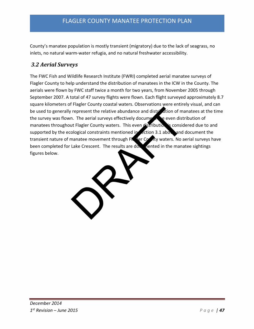
The FWC Fish and Wildlife Research Institute (FWRI) completed aerial manatee surveys of
Flagler County to help understand the distribution of manatees in the ICW in the County. The
aerials were flown by FWC staff twice a month for two years, from November 2005 through
September 2007. A total of 47 survey flights were flown. Each flight surveyed approximately 8.7
square kilometers of Flagler County coastal waters. Observations were entirely visual, and can
be used to generally represent the relative abundance and distribution of manatees at the time
the survey was flown. The aerial surveys effectively document the even distribution of
manatees throughout Flagler County waters. This even distribution is considered due to and
supported by the ecological constraints mentioned in Section 3.1 above and document the
transient nature of manatee movement through Flagler County waters. No aerial surveys have
been completed for Lake Crescent. The results are documented in the manatee sightings
figures below.
DRAFT

December 2014
1st Revision – June 2015 P a g e | 48
FLAGLER COUNTY MANATEE PROTECTION PLAN
Figure 34: Aerial Survey Map Section A. Data Source: FWRI
DRAFT

December 2014
1st Revision – June 2015 P a g e | 49
FLAGLER COUNTY MANATEE PROTECTION PLAN
Figure 35: Aerial Survey Map Section B. Data Source: FWRI
DRAFT

December 2014
1st Revision – June 2015 P a g e | 50
FLAGLER COUNTY MANATEE PROTECTION PLAN
Figure 36: Aerial Survey Map Section C. Data Source: FWRI
DRAFT

December 2014
1st Revision – June 2015 P a g e | 51
FLAGLER COUNTY MANATEE PROTECTION PLAN
Figure 37: Aerial Survey Map Section D. Data Source: FWRI
DRAFT

December 2014
1st Revision – June 2015 P a g e | 52
FLAGLER COUNTY MANATEE PROTECTION PLAN
Figure 38: Aerial Survey Map Section E. Data Source: FWRI
3.3 Manatee Mortality Manatee carcasses have been routinely recovered and examined by either state or federal
entities since 1974. A Manatee Carcass Salvage Program was initiated by federal entities, and
that program was transferred to the State of Florida (FWC) in July 1986. In 1992, a dedicated
state laboratory and necropsy facility was constructed to perform post-mortem examinations.
Currently, staff from four field stations collect carcasses from the southeastern United States
DRAFT

December 2014
1st Revision – June 2015 P a g e | 53
FLAGLER COUNTY MANATEE PROTECTION PLAN
and transport them to the FWC Marine Mammal Pathobiology Laboratory (MMPL) in St.
Petersburg, Florida.
Manatee mortality in Flagler County has been observed within the ICW and in smaller natural
and man-made tributaries and canals and lakes. Also, at least 6 manatee mortalities were
reported in the Atlantic Ocean since 1974.
Figure 39: FWRI Flagler County Manatee Mortality Categories
Figure 39 provides graphic representation of manatee mortality categories for Flagler County as
reported by FWC staff. There have been a total of eighty-three reported manatee mortalities
between 1976 and 2013 in Flagler County. Perinatal deaths account for approximately 46
percent of manatee mortality in Flagler County. Mortalities attributed to human related causes
by FWC staff account for approximately 19 percent of reported mortalities in the 37 year
period. Mortalities attributed to natural causes account for 19 percent of the reported
Natural 19%
Perinatal46%
Undetermined15%
Human: Watercraft Collision
19%
Human: Other1%
Manatee Mortality Categories in Flagler County 1976-2013
Data source: Fish and Wildlife Research Institute
DRAFT

December 2014
1st Revision – June 2015 P a g e | 54
FLAGLER COUNTY MANATEE PROTECTION PLAN
mortalities. Approximately 15 percent of manatee mortalities within the county are from
undetermined causes.
Watercraft collisions account for a total of 16 verified mortalities within Flagler County waters
between 1976 and 2013. The locations of all verified manatee deaths in Flagler County between
1976 and 2013 are illustrated below in Figures 40 - 45. Typically, maps displaying the spatial
distribution of recovered carcasses should be approached with caution because plotted points
only represent points of recovery, not necessarily points where animals were injured or expire.
Figure 40: Manatee Mortalities Section A. Data Source: FWC
DRAFT

December 2014
1st Revision – June 2015 P a g e | 55
FLAGLER COUNTY MANATEE PROTECTION PLAN
Figure 41: Manatee Mortalities Section B. Data Source: FWC
DRAFT

December 2014
1st Revision – June 2015 P a g e | 56
FLAGLER COUNTY MANATEE PROTECTION PLAN
Figure 42: Manatee Mortalities Section C. Data Source: FWC
DRAFT

December 2014
1st Revision – June 2015 P a g e | 57
FLAGLER COUNTY MANATEE PROTECTION PLAN
Figure 43: Manatee Mortalities Section D. Data Source: FWC
DRAFT

December 2014
1st Revision – June 2015 P a g e | 58
FLAGLER COUNTY MANATEE PROTECTION PLAN
Figure 44: Manatee Mortalities Section E. Data Source: FWC
DRAFT

December 2014
1st Revision – June 2015 P a g e | 59
FLAGLER COUNTY MANATEE PROTECTION PLAN
Figure 45: Manatee Mortalities Section F. Data Source: FWC
Table 2: Flagler County Manatee Mortality Specific Data. Data Source: FWC
Map ID Reported Date Sex Mortaility Reason Carcass Length
(cm)
1 2/19/1989 M Natural 233
2 1/5/2004 F Cold Stress 219
3 7/3/2005 M Undetermined 352
4 12/6/1992 F Watercraft collision 208
5 1/18/1996 M Cold Stress 234
6 2/9/1996 M Natural 175
7 10/17/2008 U Undetermined 178
8 5/12/1990 F Watercraft collision 279
DRAFT
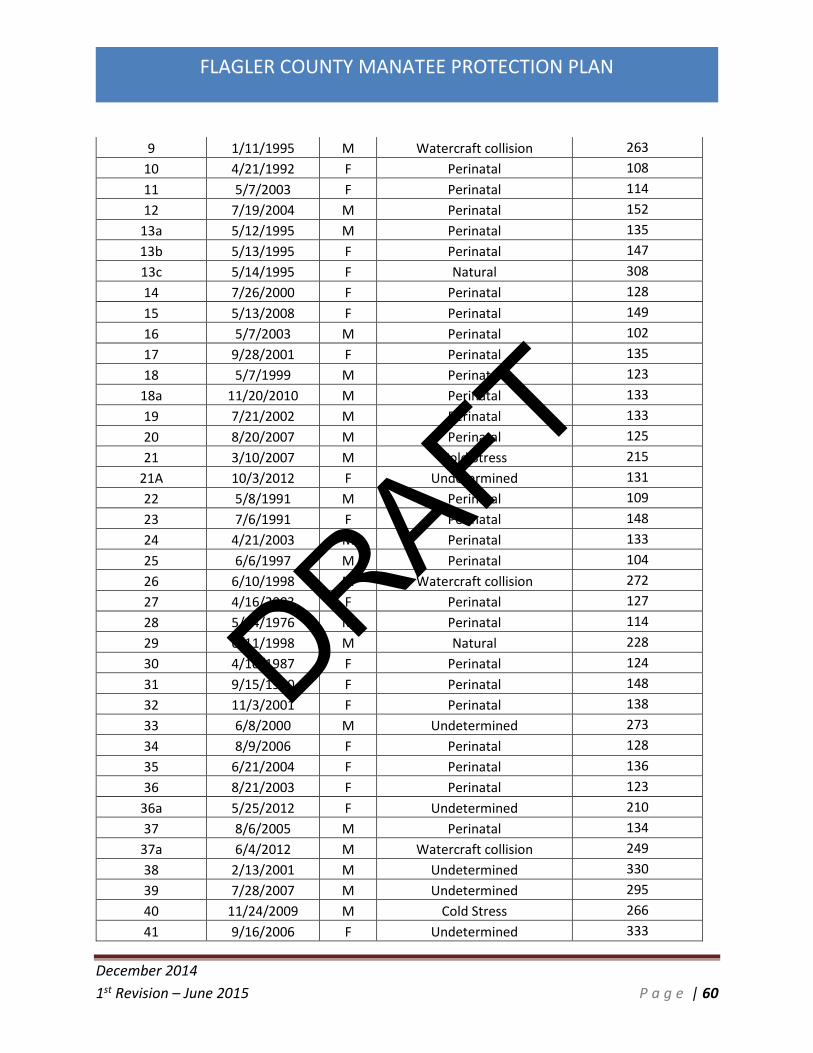
December 2014
1st Revision – June 2015 P a g e | 60
FLAGLER COUNTY MANATEE PROTECTION PLAN
9 1/11/1995 M Watercraft collision 263
10 4/21/1992 F Perinatal 108
11 5/7/2003 F Perinatal 114
12 7/19/2004 M Perinatal 152
13a 5/12/1995 M Perinatal 135
13b 5/13/1995 F Perinatal 147
13c 5/14/1995 F Natural 308
14 7/26/2000 F Perinatal 128
15 5/13/2008 F Perinatal 149
16 5/7/2003 M Perinatal 102
17 9/28/2001 F Perinatal 135
18 5/7/1999 M Perinatal 123
18a 11/20/2010 M Perinatal 133
19 7/21/2002 M Perinatal 133
20 8/20/2007 M Perinatal 125
21 3/10/2007 M Cold Stress 215
21A 10/3/2012 F Undetermined 131
22 5/8/1991 M Perinatal 109
23 7/6/1991 F Perinatal 148
24 4/21/2003 M Perinatal 133
25 6/6/1997 M Perinatal 104
26 6/10/1998 M Watercraft collision 272
27 4/16/2003 F Perinatal 127
28 5/24/1976 M Perinatal 114
29 6/11/1998 M Natural 228
30 4/10/1987 F Perinatal 124
31 9/15/1990 F Perinatal 148
32 11/3/2001 F Perinatal 138
33 6/8/2000 M Undetermined 273
34 8/9/2006 F Perinatal 128
35 6/21/2004 F Perinatal 136
36 8/21/2003 F Perinatal 123
36a 5/25/2012 F Undetermined 210
37 8/6/2005 M Perinatal 134
37a 6/4/2012 M Watercraft collision 249
38 2/13/2001 M Undetermined 330
39 7/28/2007 M Undetermined 295
40 11/24/2009 M Cold Stress 266
41 9/16/2006 F Undetermined 333
DRAFT

December 2014
1st Revision – June 2015 P a g e | 61
FLAGLER COUNTY MANATEE PROTECTION PLAN
42 9/29/2006 M Watercraft collision 271
43 8/9/1998 M Perinatal 111
44 2/8/1990 M Undetermined 273
45 3/24/1993 F Perinatal 120
46 1/18/1987 M Undetermined 226
47 10/2/1980 F Perinatal 123
48 4/3/1976 F Natural 300
48a 1/9/2010 M Cold Stress 295
49 7/26/2002 M Perinatal 117
50 8/14/1997 F Perinatal 133
50a 1/31/2013 F Cold Stress 194
51 5/30/2009 M Perinatal 117
52 6/13/2007 F Perinatal 139
53 5/3/2009 M Perinatal 124
54 7/19/2003 M Perinatal 120
55 7/10/2008 F Undetermined 196
56 1/30/2009 F Cold Stress 192
57 9/2/1996 M Perinatal 125
58 4/1/2009 F Natural 245
59 5/20/2007 M Watercraft collision 214
60 12/24/1989 F Cold Stress 180
61 9/27/2008 F Natural 338
62 7/14/2009 M Watercraft collision 307
63 5/29/1994 F Watercraft collision 245
64 11/13/1993 M Watercraft collision 153
65 6/5/2007 M Watercraft collision 324
66 7/23/2006 M Watercraft collision 308
67 5/24/2003 F Watercraft collision 267
68 7/22/2004 M Watercraft collision 296
69 8/16/2008 M Perinatal 123
70 5/25/2003 F Watercraft collision 125
71 5/10/2002 F Watercraft collision 275
72 4/22/2001 M Undetermined 321
72a 12/13/2012 M Cold Stress 225
73 5/6/2007 M Undetermined 216
73a 9/10/2012 M Perinatal 150
74 3/1/2008 F Watercraft collision 221
75 4/16/1990 M Perinatal 149
DRAFT

December 2014
1st Revision – June 2015 P a g e | 62
FLAGLER COUNTY MANATEE PROTECTION PLAN
3.3.1 Watercraft Related Manatee Mortalities Flagler County is not recognized as an area with high watercraft related manatee deaths, but
the County does recognize that the number of deaths in the early to mid-2000’s increased to a
number of concern (with spikes to 2 deaths each year in 2003, 2006, & 2007). Flagler County
has averaged 0.69 watercraft related manatee mortalities since 1999.
Figure 46. Watercraft Collision Mortalities 1999-2013. Data Source: FWC
As stated above, Flagler County has experienced 11 watercraft related manatee deaths since
1999. This equals an average of 0.69 manatee deaths per year. Statewide this ranks Flagler
County 20th in watercraft related manatee deaths per year over the same time period. Table 3
below documents each County’s average number of watercraft related manatee deaths over
the time period of 1999-2013.
DRAFT
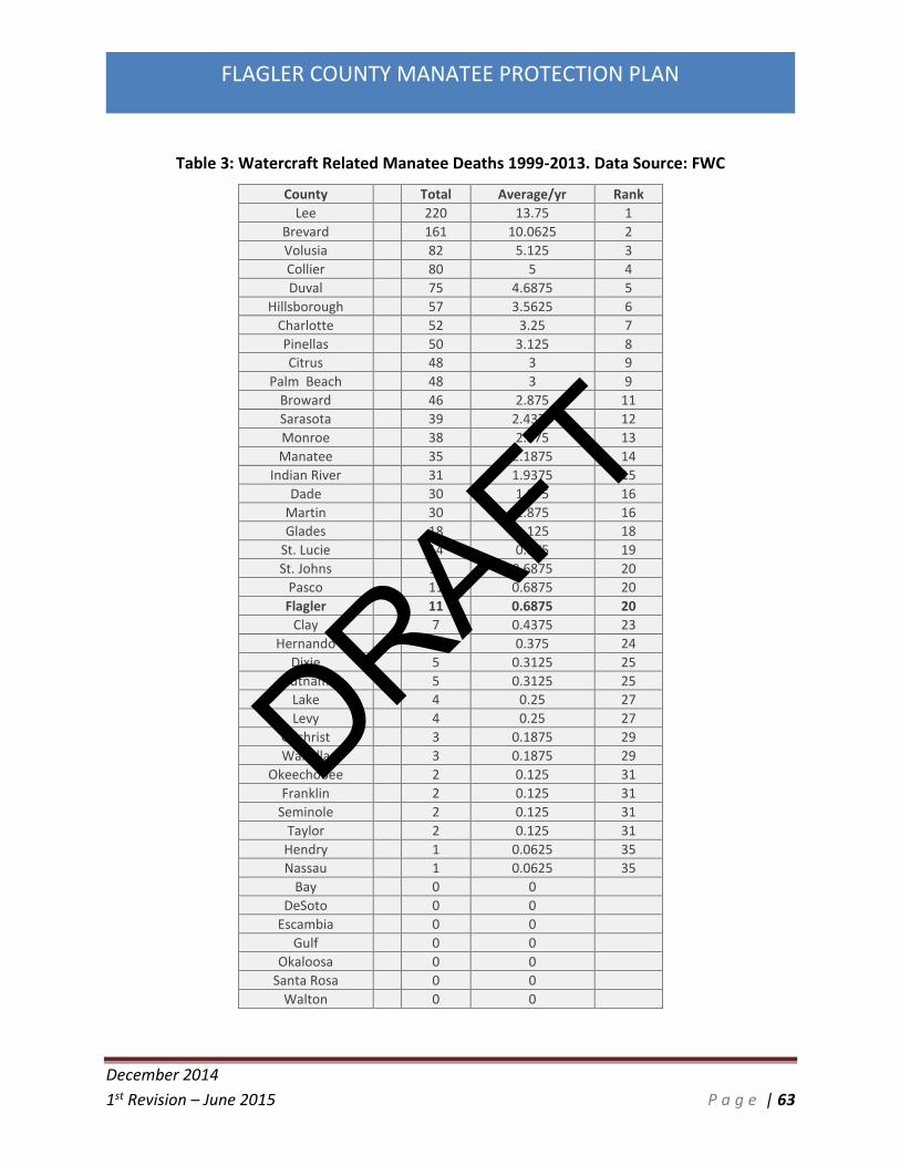
December 2014
1st Revision – June 2015 P a g e | 63
FLAGLER COUNTY MANATEE PROTECTION PLAN
Table 3: Watercraft Related Manatee Deaths 1999-2013. Data Source: FWC
County Total Average/yr Rank
Lee 220 13.75 1
Brevard 161 10.0625 2
Volusia 82 5.125 3
Collier 80 5 4
Duval 75 4.6875 5
Hillsborough 57 3.5625 6
Charlotte 52 3.25 7
Pinellas 50 3.125 8
Citrus 48 3 9
Palm Beach 48 3 9
Broward 46 2.875 11
Sarasota 39 2.4375 12
Monroe 38 2.375 13
Manatee 35 2.1875 14
Indian River 31 1.9375 15
Dade 30 1.875 16
Martin 30 1.875 16
Glades 18 1.125 18
St. Lucie 14 0.875 19
St. Johns 11 0.6875 20
Pasco 11 0.6875 20
Flagler 11 0.6875 20
Clay 7 0.4375 23
Hernando 6 0.375 24
Dixie 5 0.3125 25
Putnam 5 0.3125 25
Lake 4 0.25 27
Levy 4 0.25 27
Gilchrist 3 0.1875 29
Wakulla 3 0.1875 29
Okeechobee 2 0.125 31
Franklin 2 0.125 31
Seminole 2 0.125 31
Taylor 2 0.125 31
Hendry 1 0.0625 35
Nassau 1 0.0625 35
Bay 0 0
DeSoto 0 0
Escambia 0 0
Gulf 0 0
Okaloosa 0 0
Santa Rosa 0 0
Walton 0 0
DRAFT

December 2014
1st Revision – June 2015 P a g e | 64
FLAGLER COUNTY MANATEE PROTECTION PLAN
Based upon aerial surveys and manatee mortality data collected, the following conclusions can
be made:
Manatee use of the Flagler County waterways is widespread and the Flagler County
waterways support a primarily seasonal manatee population with greatest abundance during
non-winter months. Watercraft related manatee deaths have occurred primarily during the
summer months. The documented winter deaths are each identified as cold stress related.
The largest number of watercraft related manatee deaths have occurred within Section E –
Smith Creek south of SR 100 (10 of the total 16 verified watercraft related manatee deaths).
Manatees in Flagler County are widely dispersed and move freely between each area and
within the canals and lakes, particularly during non-winter months.
Some Flagler County waterways are used by manatees for nursing and calving. The most
significant locations for these types of activities appear to be the man-made canals within the
City of Palm Coast and Flagler Beach.
Watercraft-related manatee mortality in Flagler County was at an elevated level between
2002 and 2009.
3.4 Boat Activity According to 2013 Florida Department of Highway Safety and Motor Vehicles (FDHSMV) data
Flagler County currently ranks 13th (last) out of 13 Florida East Coast Atlantic counties in
number of registered boating vessels, and 39th in overall abundance statewide. Recreational
boats in Flagler County represent 1.66% of the total registered recreational boats found within
the 13 East Coast Atlantic counties and 0.62% of the registered commercial boats found within
the same region. A general increase (56%) in registered vessels over the past thirteen years is
seen in Table 6, with an increase of 1,747 registered vessels in Flagler County over the same
time period. As depicted in the tables, Flagler County is much lower in boater registration than
many counties throughout the state including landlocked counties.
Table 4: Boat Registration 2013 East Coast Atlantic Counties. Source: FDHSMV
COUNTY Recreational Commercial TOTAL
DADE 59,031 1,829 61,537
BROWARD 40,208 937 41,657
PALM BCH 36,852 1,046 38,142
BREVARD 32,185 822 33,456
DUVAL 27,072 663 27,840
DRAFT

December 2014
1st Revision – June 2015 P a g e | 65
FLAGLER COUNTY MANATEE PROTECTION PLAN
MONROE 24,422 2,515 27,100
VOLUSIA 25,898 702 26,828
MARTIN 14,871 541 15,606
ST. JOHNS 12,854 379 13,308
ST. LUCIE 11,983 499 12,564
IND.RIVER 9,983 415 10,449
NASSAU 5,755 160 5,937
FLAGLER 4,989 65 5,073
TOTAL 306,103 10,573 319,497
Table 5: Boat Registration 2013 Entire State. Source: FDHSMV
COUNTY RECREATIONAL COMMERCIAL TOTAL
DADE 59,031 1,829 61,537
PINELLAS 45,166 1,178 46,929
LEE 42,370 1,097 43,736
BROWARD 40,208 937 41,657
HILLSBOROUGH 40,140 716 41,004
PALM BCH 36,852 1,046 38,142
BREVARD 32,185 822 33,456
DUVAL 27,072 663 27,840
POLK 26,961 406 27,455
ORANGE 26,567 222 26,991
VOLUSIA 25,898 702 26,828
MONROE 24,422 2,515 27,100
PASCO 22,633 423 23,241
SARASOTA 20,989 368 21,577
COLLIER 20,816 819 21,775
LAKE 20,049 181 20,326
CHARLOTTE 19,876 568 20,545
MARION 17,879 217 18,169
BAY 17,406 771 18,315
OKALOOSA 17,354 470 17,978
SEMINOLE 16,975 238 17,305
MANATEE 16,592 663 17,425
LEON 16,276 345 16,638
ESCAMBIA 15,317 334 15,753
CITRUS 15,004 557 15,618
MARTIN 14,871 541 15,606
DRAFT

December 2014
1st Revision – June 2015 P a g e | 66
FLAGLER COUNTY MANATEE PROTECTION PLAN
SANTA ROSA 13,875 253 14,162
ST. JOHNS 12,854 379 13,308
ST. LUCIE 11,983 499 12,564
CLAY 11,557 143 11,725
ALACHUA 10,024 238 10,320
IND.RIVER 9,983 415 10,449
HERNANDO 8,681 189 8,885
HIGHLANDS 8,069 69 8,172
OSCEOLA 7,851 129 7,998
PUTNAM 7,407 270 7,720
NASSAU 5,755 160 5,937
WALTON 5,262 143 5,419
FLAGLER 4,989 65 5,073
OKEECHOBEE 4,625 161 4,801
JACKSON 4,607 27 4,635
WAKULLA 4,400 337 4,743
COLUMBIA 4,221 40 4,273
SUMTER 4,052 37 4,098
LEVY 3,798 299 4,128
TAYLOR 3,561 151 3,726
HENDRY 2,702 118 2,853
SUWANNEE 2,645 30 2,683
GULF 2,535 281 2,819
GADSDEN 2,311 35 2,348
FRANKLIN 2,298 1,061 3,370
WASHINGTON 2,266 22 2,288
BRADFORD 2,217 10 2,227
DIXIE 2,183 286 2,485
BAKER 2,174 9 2,184
DESOTO 2,143 75 2,220
HOLMES 2,081 19 2,103
GILCHRIST 1,587 31 1,619
HARDEE 1,501 18 1,520
CALHOUN 1,499 31 1,530
JEFFERSON 1,317 18 1,340
GLADES 1,158 33 1,193
MADISON 1,139 7 1,146
LIBERTY 1,091 27 1,122
LAFAYETTE 912 8 921
DRAFT

December 2014
1st Revision – June 2015 P a g e | 67
FLAGLER COUNTY MANATEE PROTECTION PLAN
UNION 889 6 895
HAMILTON 871 7 882
TOTAL 863,982 24,764 894,830
Table 6: Boat Registration Data Flagler County 2000-2013. Source: FDHSMV
Year
Recreational
Recreational Percent Annual
Increase Commercial
Commercial Percent Annual
Increase
2013 4989 -1.83% 65 -4.41%
2012 5082 -1.76% 68 -10.53%
2011 5173 -1.75% 76 -1.30%
2010 5265 -1.20% 77 -7.23%
2009 5329 13.33% 83 -5.68%
2008 4702 -8.84% 88 -2.22%
2007 5158 4.94% 90 5.88%
2006 4915 4.73% 85 -2.30%
2005 4693 2.29% 87 2.35%
2004 4588 4.25% 85 -8.60%
2003 4401 5.16% 93 19.23%
2002 4185 7.12% 78 -7.14%
2001 3907 23.76% 84 -25.00%
2000 3157 112
Recreational Overall Percent Increase 2000-2013 58.03%
Commercial Overall Percent Increase 2000-2014 -41.96%
DRAFT

December 2014
1st Revision – June 2015 P a g e | 68
FLAGLER COUNTY MANATEE PROTECTION PLAN
Table 7: Boat Types Flagler County 2000-2012. Source: FDHSMV
3.4.1 Boating Accident Statistics A summary of boating accident statistics for the state of Florida and Flagler County for the year
2013 (data received from FWC Division of Law Enforcement - LE) is provided in Table 8. Only
two (2) boating accidents were reported in 2013 in Flagler County, placing the County 40th
overall in boating accidents and representing only 0.27% of all statewide reported boating
accidents. This number is consistent with Flagler County’s ranking in regards to boat
registrations and also population in general. The number of accidents is somewhat consistent
throughout the state with the number of boat registrations. The counties with the highest
number of boats and accidents is also consistent with the highest number of watercraft related
manatee deaths.
Table 8: Boating Accident Statistics 2013. Source: FWC - LE
County Total
Vessels Reportable Accidents
Fatalities Injuries Property Damage
Rank Accident
Rate
Alachua 10,320 0 0 0 $0 51 0
Baker 2,184 0 0 0 $0 52 0
Bay 18,315 13 0 12 $228,650 17 1:1,409
Bradford 2,227 0 0 0 $0 53 0
Brevard 33,456 24 2 19 $189,600 7 1:1,394
Broward 41,657 50 1 29 $270,510 4 1:833
Calhoun 1,530 0 0 0 $0 54 0
Charlotte 20,545 12 1 10 $93,500 18 1:1,712
Citrus 15,618 17 0 17 $60,800 14 1:919
P C P C P C P C P C P C P C P C
2012 835 1 1186 26 2534 30 384 9 79 1 2 1 0 0 62 21 5082 68 5171
2011 864 1 1171 30 2612 35 400 8 67 2 2 0 0 0 57 27 5173 76 5276
2010 873 2 1184 30 2654 35 423 7 69 3 1 0 0 0 61 21 5265 77 5363
2009 868 3 1210 32 2693 36 429 7 67 4 1 1 0 0 61 29 5329 83 5441
2008 718 5 1194 26 2320 40 350 10 64 6 2 0 0 0 55 30 4703 87 4820
2007 799 4 1199 31 2618 40 421 9 68 5 3 1 0 0 50 32 5158 90 5280
2006 738 4 1200 25 2471 41 384 9 70 5 2 0 0 0 51 22 4916 84 5022
2005 726 5 1172 27 2327 41 350 9 66 4 1 0 0 0 52 30 4694 86 4810
2004 663 4 1226 29 2244 35 345 10 62 6 2 0 0 0 47 35 4589 84 4708
2003 629 3 1234 35 2090 41 341 9 64 4 0 0 0 0 44 41 4402 92 4535
2002 618 3 1224 30 1915 32 321 8 66 4 1 0 0 0 41 46 4186 77 4309
2001 567 9 1194 25 1758 37 296 8 55 4 3 0 0 0 35 49 3908 83 4040
2000 440 3 1015 28 1424 31 228 7 48 42 2 0 0 0 1 38 3158 111 3307
Class 5
< than 12' 12-15'11" 16'-25-11" 26'-39'11" 40'-64'11" 65'-109'11" 110' OR More
Class A-1 Class A-2
CanoesSubtotals Totals
Deal
Class 1 Class 2 Class 3 Class 4
Year
DRAFT

December 2014
1st Revision – June 2015 P a g e | 69
FLAGLER COUNTY MANATEE PROTECTION PLAN
Clay 11,725 9 0 10 $27,350 22 1:1,303
Collier 21,775 22 3 12 $120,224 9 1:990
Columbia 4,273 0 0 0 $0 55 0
Desoto 2,220 1 1 0 $0 44 1:2,220
Dixie 2,485 2 2 6 $5,200 38 1:1,243
Duval 27,840 19 4 6 $529,280 10 1:1,465
Escambia 15,753 6 3 6 $5,250 26 1:2,626
Flagler 5,073 2 0 1 $4,100 40 1:2,537
Franklin 3,370 6 1 2 $69,900 27 1:562
Gadsden 2,348 0 0 0 $0 56 0
Gilchrist 1,619 0 0 0 $0 57 0
Glades 1,193 5 0 2 $154,000 28 1:239
Gulf 2,819 1 1 1 $2,500 46 1:2,819
Hamilton 882 0 0 0 $0 58 0
Hardee 1,520 0 0 0 $0 59 0
Hendry 2,853 2 0 0 $6,450 39 1:1,427
Hernando 8,885 5 0 2 $18,865 29 1:1,777
Highlands 8,172 3 1 3 $6,250 34 1:2,724
Hillsborough 41,004 19 0 13 $91,200 11 1:2,158
Holmes 2,103 0 0 0 $0 60 0
Indian River 10,449 10 1 2 $44,00 19 1:1,045
Jackson 4,635 2 0 2 $0 43 1:2,318
Jefferson 1,340 0 0 0 $0 61 0
Lafayette 921 0 0 0 $0 62 0
Lake 20,326 8 1 5 $33,450 24 1:2,541
Lee 43,736 30 1 14 $215,504 6 1:1,446
Leon 16,638 0 0 0 $ 63 0
Levy 4,128 1 0 1 $0 48 1:4,128
Liberty 1,122 0 0 0 $0 64 0
Madison 1,146 0 0 0 $0 65 0
Manatee 17,425 9 0 9 $44,200 20 1:1,936
Marion 18,169 2 0 3 $4,480 42 1:9,085
Martin 15,606 18 3 8 $309,951 12 1;867
Miami-Dade 61,537 104 4 50 $1,660,557 1 1;592
Monroe 27,100 100 5 56 $937,500 2 1:2271
Nassau 5,937 2 0 1 $2,600 41 1:2,969
Okaloosa 17,978 24 4 13 $590,670 8 1:749
Okeechobee 4,801 4 0 1 $54,400 33 1:1,200
Orange 26,991 7 0 3 $67,500 25 1:3,856
DRAFT

December 2014
1st Revision – June 2015 P a g e | 70
FLAGLER COUNTY MANATEE PROTECTION PLAN
Osceola 7,998 5 1 3 $62,000 30 1:1,600
Palm Beach 38,142 56 3 20 $927,650 3 1:681
Pasco 23,241 9 1 6 $95,400 21 1:2,582
Pinellas 46,929 47 8 22 $456,600 5 1:998
Polk 27,455 5 1 5 $33,500 31 1:5,491
Putnam 7,720 3 0 0 $23,000 35 1:2,573
Santa Rosa 14,162 2 1 7 $173,000 36 1:7,081
Sarasota 21,577 15 1 10 $121,300 16 1:1,438
Seminole 17,305 5 1 2 $15,000 32 1:4,326
St. Johns 13,308 9 3 6 $54,001 23 1:1,479
St. Lucie 12,564 17 0 5 $292,800 15 1:739
Sumter 4,098 0 0 0 $0 66 0
Suwannee 2,683 1 0 1 $3,500 45 1:2,683
Taylor 3,726 1 0 0 $4,000 47 1:3,726
Union 895 0 0 0 $0 67 0
Volusia 26,828 18 0 10 $88,650 13 1:1,490
Wakulla 4,743 1 0 1 $0 49 1:4,743
Walton 5,419 1 0 0 $3,500 50 1:5,419
Washington 2,288 2 1 2 $75 37 1:1,144
3.4.2 Boating Studies in Flagler County The primary boating data used for this review was collected by MOTE Marine Laboratory (MML)
from August 2007 through February 2009 using aerial surveys. The MML flew 20 surveys during
this time period. The data were collected in four survey quarters: Winter (December –
February), Spring (March – May), Summer (June – August), and Fall (September – November).
Each quarter contained five flights consisting of two weekday flights and three weekend flights.
The boat data used in this analysis was a subset of the overall dataset for multiple counties.
The survey differentiated vessel size categories per the standard FWC Law Enforcement size
classes, and designated as: Less than 16 feet, 16 feet - 25 feet, 26 feet – 39 feet, 40 feet – 64
feet, 65 feet – 109 feet, and greater than 110 feet.
Vessel speeds were identified as: Anchor / Drift, Human-Powered (Oar/Paddle), Under Sail, Idle
/ Slow, Plowing, Cruising, and Planing. The speed definitions for vessels under power were
taken from Gorzelany (1999, 2000) and were originally adapted from the Florida Administrative
Code 62N-22. Individual speed categories were defined as follows:
Idle Speed
DRAFT
December 2014
1st Revision – June 2015 P a g e | 71
FLAGLER COUNTY MANATEE PROTECTION PLAN
The minimum speed that maintains steerage of a vessel, or the speed at which a vessel is
normally docked. Little or no displacement of water is observable from either the bow or stern,
and the vessel remains level in the water at all times. This typically corresponds to a speed of
less than 5 miles per hour (Gorzelany, 1998).
Slow Speed
The speed at which all vessels are completely off plane and fully settled in the water. Some
minimal water displacement at either the bow or stern (or both) may be observed. Because
this will vary greatly from vessel to vessel, this speed has also been defined as approximately 5
to 9 miles per hour (Gorzelany, 1998).
Plowing Speed
An intermediate speed between slow speed and planing speed; the bow of the vessel typically
rides higher than the stern, and substantial displacement of water occurs. Depending on the
size and type of vessel, plowing may occur at a variety of speeds, but is most often observed
between 10 and 20 miles per hour (Gorzelany, 2000). This speed designation is used specifically
for vessels with planing-type hulls.
Cruising Speed
A qualitative speed designation uniquely applied to a relatively fast-moving vessel with a non-
planing-type hull (e.g.; a pontoon boat or displacement hull vessel). It is identified by
noticeable water displacement from the bow and/or stern and an observed speed faster than
the previously defined slow speed designation. Similar to those at plowing speed, vessels at
cruising speed most often travel at speeds between 10-20 miles per hour (Gorzelany, 2000).
Planing Speed
A vessel traveling at sufficient speed to partially raise the vessel out of the water during travel.
Vessel planing speeds vary widely depending upon vessel size and hull design; however the
majority of planing vessels typically travel at speeds in excess of 15 miles per hour (Gorzelany,
1996).
In regards to manatees, the important category of boats are those under power and at a speed
of plowing, cruising, or planning. The power boat data set included a total of 732 boats in
Flagler County. The Flagler County power boat data was further subdivided to include vessels
that were classified as plowing, cruising or planing. This “Fast Boats” subset included a total of
DRAFT

December 2014
1st Revision – June 2015 P a g e | 72
FLAGLER COUNTY MANATEE PROTECTION PLAN
277 boats, or approximately 38% of the dataset. Results from this survey were utilized to
complete the boating density figure below.
The MML boat surveys document that the areas of heavy boat concentrations in Flagler County
waters are near the existing marinas, within the canals (which are primarily at full build out),
within areas that are known for recreational angling, or are near existing boat ramps. Flagler
County has instituted Manatee Protection Zones in the areas of known high boat traffic density.
The Manatee Protection Zones were previously described in Section 1.5. No boating studies
have been completed for Lake Crescent. Due to its known use as a destination for largemouth
bass and speckled perch recreational anglers, the assumption is made that Lake Crescent is
primarily used by small bass boats (less than 20’ in length) and pontoon boats.
Figure 47: Boating Density Overview. Source: MML
DRAFT

December 2014
1st Revision – June 2015 P a g e | 73
FLAGLER COUNTY MANATEE PROTECTION PLAN
3.5 Existing Boating Facility Inventory A study utilizing permitting data, current Flagler County Property Appraiser data, FWC data,
2014 aerial imagery, and ground-truthing was completed as part of this Manatee Protection
Plan to inventory the existing boat slips and boat ramps (with appropriate number of parking
spaces) presently found in Flagler County. The data was compiled to create an inventory of all
existing facilities with 5 or more slips, boat ramps, and transient mooring slips such as
restaurants in Flagler County. Facility type designations were established for Commercial
Marina (CM) & Residential Marina (RM), Boat Ramp (BR), Transient Slip (TS), and Commercial
Facility (CF). In this analysis of all facility types combined, there was a total of 711 wet slips, 72
dry slips, and 168 boat ramp boat trailer parking spaces for a grand total of 951 inventoried
slips.
3.5.1 Commercial and Residential Marinas
Thirteen (13) marinas were identified, of which nine (9) were multi-family residential marinas,
two (2) were multi-family residential/commercial marinas, and two (2) were commercial
marinas. Total slip capacity for each boat facility type was indicated by the sum of all wet slips
and dry slips. A total of 748 slips (676 wet and 72 dry) was identified for this grouping of boat
facilities. Slip occupancy was found to vary widely and frequently, as a few marinas appear to
be at occupancy and a few marinas appear to be near empty.
3.5.2 Ramps and Transient Slips
Eight (8) boat ramps were identified along with two (2) transient slip facilities (restaurants).
Total slip capacity for each ramp was indicated by the sum of available boat trailer parking
spaces. For the transient slip facilities (restaurants), total moorings were used to indicate total
slip capacity. There was a total of 211 slips (168 boat trailer parking spaces and 43 transient
slips) that were identified for this grouping of boat facilities.
3.5.3 Commercial Facilities
Three (3) commercial facilities were identified. Total slip capacity for the commercial facilities
was 12 wet slips that were identified for this grouping of boat facilities.
DRAFT

December 2014
1st Revision – June 2015 P a g e | 74
FLAGLER COUNTY MANATEE PROTECTION PLAN
Table 9: Flagler County Boating Access Inventory
FACILITY NAME TYPE ADDRESS WET SLIPS
DRY SLIPS
RAMP LANES
RAMP PARKING
TOTAL SLIPS
Bing's Landing BR 5862 N. Oceanshore Blvd 0 0 2 46 0
Bull Creek Fish Camp TS, BR 3861 CR 2006 W 20 0 1 10 20
Bulow Ruins State Park BR 3501 Old Kings Rd S 0 0 1 2 0
Canopy Walk RM 550 Canopy Walk 69 0 69
Emerald Cove RM N. Flagler Ave 9 0 9
Flagler Bridge Marina CM 127 Lehigh Ave 82 72 154
Flagler by the Sea RM 2982 N. Oceanshore Blvd 6 0 6
Gamble Rogers State Park BR 3100 S. Oceanshore Blvd 0 0 1 40 0
Hammock Beach Yacht Harbor
CM, RM 106 Yacht Harbor Dr 209 0 209
Hammock by the River RM 11 Hammock Oak Ct 9 0 9
Harborside Village Marina RM 100 Palm Harbor Pkwy 30 0 30
Herchel King Park BR 150 Waterfront Park Rd 0 0 2 45 0
Mantanzas Shores Boat Club RM 400 San Juan Dr 6 0 0 0 6
Marina Bay RM 100 Marina Bay Dr 45 0 45
Marina Cove RM Marina Point Place 65 0 65
Marineland CM 9507 N. Oceanshore Blvd 25 0 25
Moody Public Boat Launch BR 825 Moody Ln 0 0 4 22 0
Newcastle Marine CF 5658 N. Oceanshore Blvd 1 0 1
Palm Coast Marina CM, RM 15 Palm Coast Resort Blvd 80 0 80
Princess Place Preserve BR 1281 Princess Place Rd 0 0 2 Open Field 0
Rhodes Marine Service CF 5478 N. Oceanshore Blvd 1 0 1
Sea Ray Boats CF 100 Sea Ray Dr 10 0 10
Shell Bluff Park BR 14331 SR 100 W 0 0 1 3 0
Sunset Inlet RM Morning Light Ct 31 0 41
820 Moody Lane Restaurant TS 820 Moody Ln 23 0 23
Total 701 72 14 168 793
DRAFT
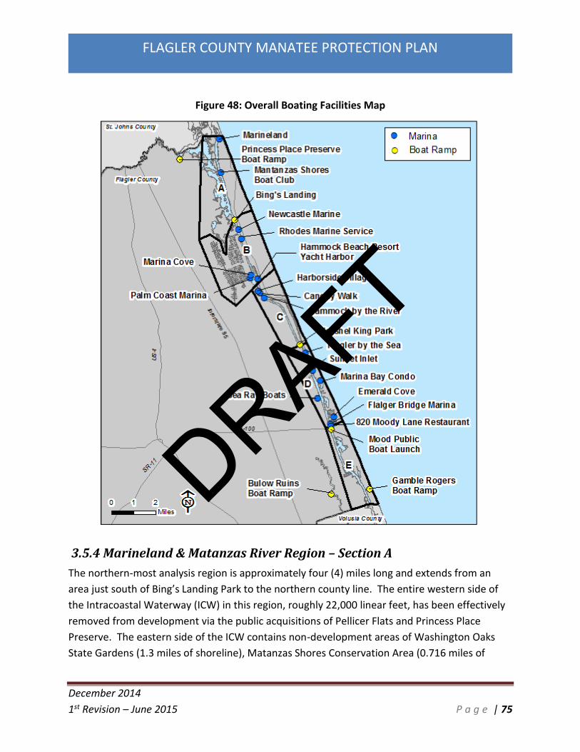
December 2014
1st Revision – June 2015 P a g e | 75
FLAGLER COUNTY MANATEE PROTECTION PLAN
Figure 48: Overall Boating Facilities Map
3.5.4 Marineland & Matanzas River Region – Section A
The northern-most analysis region is approximately four (4) miles long and extends from an
area just south of Bing’s Landing Park to the northern county line. The entire western side of
the Intracoastal Waterway (ICW) in this region, roughly 22,000 linear feet, has been effectively
removed from development via the public acquisitions of Pellicer Flats and Princess Place
Preserve. The eastern side of the ICW contains non-development areas of Washington Oaks
State Gardens (1.3 miles of shoreline), Matanzas Shores Conservation Area (0.716 miles of
DRAFT

December 2014
1st Revision – June 2015 P a g e | 76
FLAGLER COUNTY MANATEE PROTECTION PLAN
shoreline), and River to Sea Preserve (0.6 miles of shoreline). Out of approximately 8 miles of
shorelines roughly 6.7 miles, or 84%, have no potential for development of boating facilities.
A commercial marina facility is located in the Town of Marineland. This facility currently has 25
boat slips with 55 more planned. A small residential marina is located within the Matanzas
Shores Subdivision. This marina currently has 6 transient residential boat slips for subdivision
residents only.
Princess Place Preserve is located in this planning section. Two small canoe/kayak launches are
located within Princess Place. No motorized boats are launched from these ramp and no
designated trailer spaces are located within the park.
This region also contains Bings Landing Park. Bing’s Landing is a County owned public two lane
boat ramp which contains 46 boat trailer parking spaces. Further expansion of this Park to
provide additional trailer parking spaces would be very difficult. The property to the north is
developed with a single family home, and while the park itself does contain some undeveloped
areas, this park also contains the ruins of Joseph Hernandez’s plantation home. The home’s
ruins and surrounding property is on the U. S. Department of the Interior’s National Register of
Historic Places.
DRAFT

December 2014
1st Revision – June 2015 P a g e | 77
FLAGLER COUNTY MANATEE PROTECTION PLAN
Figure 49: Boating Facilities Section A
3.5.5 Palm Coast Region – Section B
To the south of the Marineland & Matanzas River region is the Palm Coast region. It is
approximately three miles in length. Its northern boundary is south of Bing’s Landing Park,
while the southern boundary is approximately the Hammock Dunes Bridge.
Existing boating facilities include the Marina at Hammock Beach Resort which contains 209
total wet slips and the Palm Coast Marina with 81 total wet slips. These two marinas are the
largest commercial/residential mixed use marinas in Flagler County. The marinas are
DRAFT

December 2014
1st Revision – June 2015 P a g e | 78
FLAGLER COUNTY MANATEE PROTECTION PLAN
predominately used by residential owners and guests of the mixed residential uses associated
with each. Both do provide transient slips (commercial slips) for non-owners also.
This region also contains the Marina Cove residential marina. This marina is strictly for Marina
Cove residential owners and guests. This marina has 65 total wet slips.
This region also contains to commercial facilities, the Newcastle Marine, a +/-4.5 acre defunct
large yacht manufacturing facility with 300’ of ICW waterfront and a marine railway and the
Rhodes Marine Service which also has a marine railway and caters to smaller vessels. Both
commercial facilities are located on parcels which could be expanded for use as a boating
facility in the future.
Figure 50: Boating Facilities Section B
DRAFT
December 2014
1st Revision – June 2015 P a g e | 79
FLAGLER COUNTY MANATEE PROTECTION PLAN
3.5.6 Fox Cut Region – Section C
This section is approximately 3.5 miles in length, extending from the Hammock Dunes Bridge
south to the Herschel King Park. The Harborside Village is located south of the Hammock Dunes
Bridge. The Harborside Village has a residential marina facility associated with the Harborside
Village Condominiums. The facility currently has 30 wet slips available for condo owners and
guests only. Canopy Walk is a residential marina facility associated with the Canopy Walk
Condominiums. This facility has 69 existing wet slips available for condo owners and guests
only. The permit for Canopy Walk limits the vessel size within this residential marina to a 25
foot maximum length. The Hammock by the River subdivision and residential marina are also
located in this region. This is a small neighborhood dock with 9 slips available for owners and
guests only.
Waterfront Park is located on the west side of the ICW in this section. This 20 acre park is
owned and operated by the City of Palm Coast and does not provide slips nor a boat ramp. It is
utilized as an ICW observation and fishing area. Waterfront Park has an undeveloped shoreline
of 4,200’.
Hershel King Park is a County owned two-lane boat ramp and basin along the western side of
the ICW. The 17 acre facility provides 47 boat trailer parking slips with approximately 1800’ of
ICW frontage. This Park has room for boat trailer parking expansion.
DRAFT

December 2014
1st Revision – June 2015 P a g e | 80
FLAGLER COUNTY MANATEE PROTECTION PLAN
Figure 51: Boating Facilities Section C
3.5.7 Smith Creek North of SR 100 Region – Section D
This Region is approximately 4 miles in length and extends from south of Hershel King Park in its
northern extent to the SR 100 Bridge to the south. The western side of the ICW in this Region is
dominated by single family homes with docks. The eastern side of the ICW within this Region
has single family docks in the northern section, very few docks in the mid-section in the City of
Flagler Beach upland cut canals with single family homes to the south.
DRAFT

December 2014
1st Revision – June 2015 P a g e | 81
FLAGLER COUNTY MANATEE PROTECTION PLAN
The Flagler by the Sea mobile home park is located within this region. This community has a
small residential marina with 6 total wet slips. The Sunset Inlet residential marina is also
located in this section. The Sunset Inlet Subdivision is 31 single family lots with slips already
constructed. This subdivision is currently under construction. Also within this section is the 45
slip Marina Bay Condominium located within Silver Lake. This is a residential marina for Condo
owners and guests only. Silver Lake is one of two bays along the east side of the ICW. The
Emerald Cove residential marina is also located within this region. This is a small 9 slip
residential marina for the Emerald Cove subdivision owners and guests only.
The industrial component is primarily identified with the Sea Ray boat manufacturing plant
located northeast of Roberts Road. This facility is one of the largest private sector employers in
the County and is rapidly growing and adding jobs. This commercial facility has 10 total wet
slips. Sea Ray tests each vessel built at the Palm Coast facility on the Intracoastal Waterway.
Typically, testing times are between 7:00 AM and 4:30 PM Monday through Thursday. There is
a maximum of three (3) vessels being operated at the same period of time on the water.
Vessels constructed and tested are in the 40+ foot range. These test runs may be anywhere
from 90 to 180 minutes with speeds ranging from idle to the maximum posted speed.
The Sea Ray manufacturing plant has had a longstanding manatee awareness training program
for its captains. This program instructs captains on how to recognize when manatees are
present, how to avoid impacts, and what to do if an impact does take place. Sea Ray captains
also maintain a manatee sighting log to record any observed animals.
The Flagler Beach Marina is a commercial marina located north of the SR100 Bridge. This small
commercial marina is permitted for 82 wet slips and 72 dry storage slips. This marina currently
trailers any dry slip boats within the grassed upland parking area. No dry storage facility is
found onsite.
A defunct, closed restaurant property located at 820 Moody Lane, just north of the SR100
Bridge, is also located in this region. This closed restaurant has finger piers and moorings for a
total of 23 small boats. This total was included as wet slips and identified as a transient slip
facility.
DRAFT
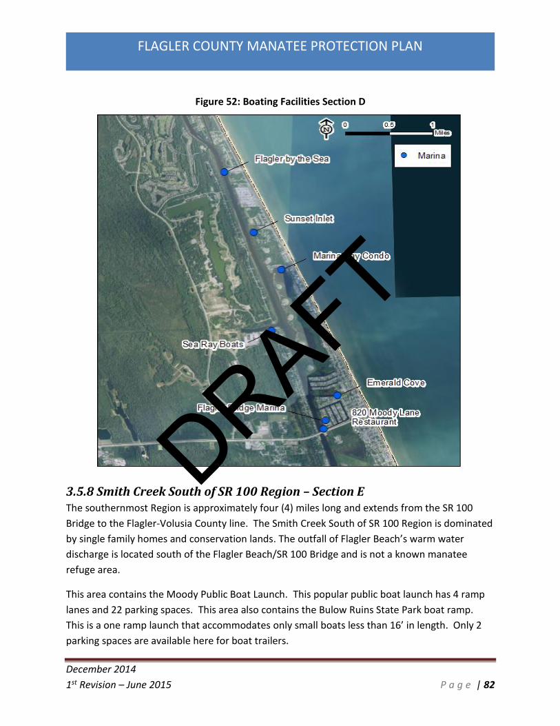
December 2014
1st Revision – June 2015 P a g e | 82
FLAGLER COUNTY MANATEE PROTECTION PLAN
Figure 52: Boating Facilities Section D
3.5.8 Smith Creek South of SR 100 Region – Section E The southernmost Region is approximately four (4) miles long and extends from the SR 100
Bridge to the Flagler-Volusia County line. The Smith Creek South of SR 100 Region is dominated
by single family homes and conservation lands. The outfall of Flagler Beach’s warm water
discharge is located south of the Flagler Beach/SR 100 Bridge and is not a known manatee
refuge area.
This area contains the Moody Public Boat Launch. This popular public boat launch has 4 ramp
lanes and 22 parking spaces. This area also contains the Bulow Ruins State Park boat ramp.
This is a one ramp launch that accommodates only small boats less than 16’ in length. Only 2
parking spaces are available here for boat trailers.
DRAFT
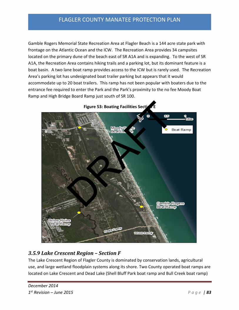
December 2014
1st Revision – June 2015 P a g e | 83
FLAGLER COUNTY MANATEE PROTECTION PLAN
Gamble Rogers Memorial State Recreation Area at Flagler Beach is a 144 acre state park with
frontage on the Atlantic Ocean and the ICW. The Recreation Area provides 34 campsites
located on the primary dune of the beach east of SR A1A and is expanding. To the west of SR
A1A, the Recreation Area contains hiking trails and a parking lot, but its dominant feature is a
boat basin. A two lane boat ramp provides access to the ICW but is rarely used. The Recreation
Area’s parking lot has undesignated boat trailer parking but appears that it would
accommodate up to 20 boat trailers. This ramp has not been popular with boaters due to the
entrance fee required to enter the Park and the Park’s proximity to the no fee Moody Boat
Ramp and High Bridge Board Ramp just south of SR 100.
Figure 53: Boating Facilities Section E
3.5.9 Lake Crescent Region – Section F The Lake Crescent Region of Flagler County is dominated by conservation lands, agricultural
use, and large wetland floodplain systems along its shore. Two County operated boat ramps are
located on Lake Crescent and Dead Lake (Shell Bluff Park boat ramp and Bull Creek boat ramp)
DRAFT

December 2014
1st Revision – June 2015 P a g e | 84
FLAGLER COUNTY MANATEE PROTECTION PLAN
Both ramps offer very minimal parking. The Bull Creek Fish Camp is also located in this region.
This is a bait shop and restaurant owned by Flagler County adjacent to the Bull Creek boat
ramp. Ten transient slips associated with the restaurant and bait shop are located here.
Figure 54: Boating Facilities Section F
3.6 Manatee Coincidence Data FWC staff provided analysis to Flagler County regarding recommended areas for installation of
speed zones along the ICW in Flagler County. In their analysis, FWC utilized the Mote aerial
boating survey data described in Section 3.4.2 and the FWRI manatee aerial survey data
DRAFT

December 2014
1st Revision – June 2015 P a g e | 85
FLAGLER COUNTY MANATEE PROTECTION PLAN
described in Section 3.2 and calculated coincidence by multiplying the per survey manatee
cover by the per survey boating cover. This geographic information system (GIS) analysis
allowed the FWC to theorize areas where a higher threat of manatee watercraft interaction
were likely to occur. Coincidence, in their analysis, is the area of potential spatial overlap
between the two datasets, with the higher numbers representing a higher potential for
manatee-boat interactions. This coincidence data was one of the datasets utilized in creating
the speed zones analysis. Differences in manatee distribution may occur due to the availability
of resources, fresh water, or foraging areas. However, due to the small sample size it may be
random as many view Flagler County’s lack of manatee resources and conclude that manatees
are likely traversing through Flagler to reach resource areas. There are no known sea grass
beds or warm water refuges in Flagler County and as such the waterways of Flagler County
serve primarily as migration routes during the spring through early fall months for manatee
population. The manatee coincidence data was also utilized for the preparation of the boat
facility siting planning found within Section 4.0. FWC did not complete a coincidence study for
Lake Crescent.
Coincidence Data Analysis by Planning Section
Section A
No watercraft mortalities have been identified in this region. Manatee observations indicate
that density documented during summer was four times that documented during the winter
months. This area had a relatively low coincidence level at 0.363 overall with a value of 0.396
in the warmer months.
Section B
Three carcasses recovered within this region have been identified as watercraft related deaths.
Manatee observations for this region were ironically relatively low at 0.215 and an overall
warm season value of 0.232. However, warm season coincidence values were relatively high
for the sections north of the Palm Coast canals with warm season coincidence at 0.916.
Additionally, an area south of the Palm Coast canals to roughly 300’ south of the Hammock
Dunes Bridge experienced a warm season value of 1.459. This southern section from the canal
to south of the bridge was one of the areas to receive a warm season slow speed zone from
FWC.
Section C
The density of manatees observed was 0.886 with a warm season value of 1.714. No watercraft
mortalities have been recorded for this section.
DRAFT

December 2014
1st Revision – June 2015 P a g e | 86
FLAGLER COUNTY MANATEE PROTECTION PLAN
Section D
This section has seen one manatee carcass recovered that was attributed to watercraft related
injuries. The coincidence value recorded for this section was 0.915 with warmer months at
1.326. This section has received warm season slow speed zones from the SR 100 Bridge to
north of the Lehigh Canal. Of note, this section has witnessed the most manatees observed
from 2005-2007 with 72 of the 234 manatees observed. The proposed additional 0.5 mile
section of Manatee Protection Zone is found within this section at the mouth of the Lehigh
Canal.
Section E
The relative low coincidence values for this section (0.607 overall, 0.946 warm season) belies
the fact that this section has witnessed the greatest number of watercraft related manatee
deaths. These deaths have occurred despite a Volusia County speed zone being adopted in
1991, and all watercraft deaths have occurred after the installation of the speed zone.
3.7 Information Assessment Discussions This section discusses the findings of the data included throughout Section 3 in regards to
manatee and boating use overlap, water-craft related manatee deaths, existing marine
facilities, and existing manatee protection measures. The discussions are described by planning
section.
Marineland & Matanzas River Region – Section A
Manatee Protection Zones: No manatee protection zones are located in this region.
Existing Watercraft Access: There are a total of approximately 77 motorboat access points in
this area. This access consists of 46 boat trailer parking spaces at one boat ramp and 31 marina
slips. The remainder of property within this region is primarily public lands or single family
residential parcels.
Boating Traffic: The MML boating study verified the majority of boats in the region were
located near or at the Marineland marina or Bing’s Landing boat ramp. Boats routinely traverse
the ICW in this area making their way north to St. Augustine or south towards Palm Coast. Boat
traffic in this region would be considered light.
Manatee Data: Manatee use in this area seems primarily limited to traveling in the ICW. Only
one water-craft related manatee death was identified in this region, occurring in 1992.
Manatees have been regularly sighted in this area. The FWC coincidence data had a relatively
low coincidence level at 0.363 overall with a value of 0.396 in the warmer months.
DRAFT

December 2014
1st Revision – June 2015 P a g e | 87
FLAGLER COUNTY MANATEE PROTECTION PLAN
Summary: Shoreline land use in this area is predominately conservation and single family
parcels. This is primarily a conservation area with regular manatee use and predominately low
boat activity. FWC did not identify this area as requiring additional manatee protection.
Palm Coast Region – Section B
Manatee Protection Zones: State manatee protection zone around the Hammock Dunes/ Palm
Coast Parkway Bridge encompasses approximately 0.6 miles of navigable ICW.
Existing Watercraft Access: There are a total of approximately 357 motorboat access points in
this area. This access consists of 355 marina slips and 2 commercial facility slips. This section
includes the canal network found within the City of Palm Coast. This network of canals
provides single family dock access to the ICW. The canals within the City are predominately at
build-out capacity.
Boating Traffic: The MML boating study verified the majority of boats in the region were
located near or at the existing large marinas just north of the Hammock Dunes Bridge. This area
also includes the mouths of the canal networks to the ICW. Boat traffic in this area is the
highest found within the County, primarily due to the existing marinas and number of single
family docks.
Manatee Data: The manatee surveys for this area were relatively low. Only three water-craft
related manatee death were identified in this region, all occurring in the 1990’s. Manatees
have been regularly sighted in this area. The FWC coincidence data was ironically relatively low
at 0.215 and an overall warm season value of 0.232. However, warm season coincidence values
were relatively high for the sections north of the Palm Coast canals with warm season
coincidence at 0.916. Additionally, an area south of the Palm Coast canals to roughly 300’
south of the Hammock Dunes Bridge experienced a warm season value of 1.459.
Summary: Shoreline land use in this area includes conservation, residential & commercial
marinas, commercial facilities, and single family parcels. This area was identified as the highest
boat traffic area in the County. Warm season speed zones around the Hammock Dunes Bridge
have been in place since 2012.
Fox Cut Region – Section C
Manatee Protection Zones: State manatee protection zone around the Hammock Dunes/ Palm
Coast Parkway Bridge encompasses approximately 0.6 miles of navigable ICW, of which a small
portion is within this section south of the bridge.
DRAFT

December 2014
1st Revision – June 2015 P a g e | 88
FLAGLER COUNTY MANATEE PROTECTION PLAN
Existing Watercraft Access: There are a total of approximately 155 motorboat access points in
this area. This access consists of 108 residential marina slips and 47 boat trailer parking spaces
at one boat ramp. This section is primarily single family parcels.
Boating Traffic: The MML boating study verified the majority of boats in the region were
located near the Hammock Dunes Bridge, which is also where the 3 marinas in this section are
located. Boat traffic in this area is the highest near the bridge and marinas but then lowers as
you head south around Fox Cut.
Manatee Data: The manatee surveys for this area were on average. Only one water-craft
related manatee death was identified in this region, occurring recently in the 2012. Manatees
have been regularly sighted in this area. The FWC coincidence data documented a density of
manatees observed of 0.886 with a warm season value of 1.714.
Summary: Shoreline land use in this area includes predominately single family parcels and
public lands. This area was identified as a moderate boat traffic area in the County. Warm
season speed zones around the Hammock Dunes Bridge have been in place since 2012.
Smith Creek North of SR100 Region – Section D
Manatee Protection Zones: State manatee protection zones around the Flagler Beach/SR 100
Bridge and within the Lehigh Canal covers approximately 2.7 miles of navigable ICW within this
region. Also this region includes the proposed additional 0.5 mile speed zone which will be
located at the mouth of the Lehigh Canal.
Existing Watercraft Access: There are a total of approximately 278 motorboat access points in
this area. This access consists of 245 residential and commercial marina slips, 10 commercial
facility slips, and 23 restaurant transient slips. This section includes the canal network found
within the City of Flagler Beach. This network of canals provides single family dock access to
the ICW. The canals within the City are predominately at build-out capacity.
Boating Traffic: The MML boating study verified the majority of boats in the region were
located near the SR100/Flagler Beach Bridge, which is also where the larger marina and canals
are located.
Manatee Data: The manatee surveys for this area were relatively high. Only one water-craft
related manatee death was identified in this region, occurring in 2006. Manatees have been
regularly sighted in this area. The FWC coincidence data recorded for this section was 0.915
DRAFT

December 2014
1st Revision – June 2015 P a g e | 89
FLAGLER COUNTY MANATEE PROTECTION PLAN
with warmer months at 1.326. Of note, this section witnessed the most manatees observed
from 2005-2007 with 72 of the 234 manatees observed.
Summary: Shoreline land use in this area includes conservation, residential & commercial
marinas, restaurant, commercial facilities, and single family parcels. Warm season speed zones
from the SR100/Flagler Beach Bridge north to Beverly Beach have been in place since 2012. An
additional speed zone is proposed at the mouth of the Lehigh Canal.
Smith Creek South of SR100 Region – Section E
Manatee Protection Zones: State manatee protection zone are located around the Flagler
Beach/SR 100 Bridge and a southern zone starts at the Flagler County border and extends
north/northwest for 2.1 miles on the navigable ICW.
Existing Watercraft Access: There are a total of approximately 42 motorboat access points in
this area. This access consists of 42 boat trailer parking spaces at two boat ramps. The
remainder of property within this region is primarily public lands or single family residential
parcels.
Boating Traffic: The MML boating study verified a moderately high level of boats extending the
entire length of this region even though boating access points are limited. It is anticipated this
is due to the recreational fishing aspect of the vast saltmarshes found within southern Flagler
and northern Volusia County.
Manatee Data: Manatee use in this area is spread out throughout the ICW. Ten water-craft
related manatee death was identified in this region, with 8 occurring in the 2000’s. Manatees
have been regularly sighted in this area. The relative low coincidence values of manatees and
boats for this section (0.607 overall, 0.946 warm season) belies the fact that this section has
witnessed the greatest number of watercraft related manatee deaths. Warm season speed
zones have been in effect since 2012.
Summary: Shoreline land use in this area is predominately conservation and single family
parcels. This is primarily a conservation area with regular manatee use and predominately
moderate boat activity. But due to the water-craft related manatee deaths which occurred in
recent years, warm season speed zones were established in 2012.
Lake Crescent Region – Section F
Manatee Protection Zones: No manatee protection zones are located in this region.
DRAFT

December 2014
1st Revision – June 2015 P a g e | 90
FLAGLER COUNTY MANATEE PROTECTION PLAN
Existing Watercraft Access: There are a total of approximately 33 motorboat access points in
this area. This access consists of 23 boat trailer parking spaces at two boat ramps and 10
transient restaurant/fish camp slips. The remainder of property within this region is primarily
public lands, agriculture, large floodplain wetlands, or large single family residential parcels.
Boating Traffic: No boating studies have been completed for Lake Crescent. Lake Crescent is a
freshwater lake connected to the St. Johns River by Dunn’s Creek. The lake is known for its
high quality largemouth bass and speckled perch recreational fishery. Boat use is primarily
limited to small bass boats and pontoon boats.
Manatee Data: No manatee surveys have been completed for Lake Crescent. Only one water-
craft related manatee death was identified in this region, occurring recently in 2008. Manatees
have been regularly sighted in the lake and Dunn’s Creek. Submerged Aquatic Vegetation (SAV)
is found along the shoreline and shallow areas throughout the lake.
Summary: Shoreline land use in this area is predominately agriculture, conservation, floodplain
wetland swamp, and large single family parcels. This is primarily a conservation/agricultural
area with regular manatee use and predominately low boat activity.
4.0 Boat Facility Siting Plan
The Boat Facility Siting Plan of the Flagler County Manatee Protection Plan is designed to
minimize watercraft-related manatee mortalities by establishing requirements for siting new
construction, rehabilitating, or expanding existing boat facilities. The required elements within
this plan are designed such that subsequent boating activity will be less likely to affect
manatees or their habitat in the affected areas. The approach is to fairly balance manatee
protection, habitat conservation, and boating safety with commercial and recreational marine
interests.
Under the Boat Facility Siting Plan, marine facilities within the jurisdiction of this document are
required to adhere to the federal, state, and local management plans and rules, as well as the
requirements listed below. All publicly owned land will be subject to their respective agency’s
policies.
The boat facility siting strategy objective is to minimize the overlap between boat traffic and
potential manatee inhabited areas and to reduce the potential for adverse manatee/watercraft
interaction. The intention is to minimize secondary and cumulative impacts to manatees and
manatee habitat as a result of boat facilities, in a long term, comprehensive manner. The
DRAFT
December 2014
1st Revision – June 2015 P a g e | 91
FLAGLER COUNTY MANATEE PROTECTION PLAN
following are factors to consider when developing recommendations for construction of a new
facility or expansion of an existing facility, if applicable:
Potential manatee use areas
Areas of highly productive habitat
Areas of high manatee mortality
Identification of sensitive, undisturbed natural areas frequented by manatees
Areas of minimal manatee use and mortality
Areas with well flushed, deep water where the least dredging is required
Areas with high demand for water access
Travel time to high use boater destinations
Existing Manatee Protection Zones
In addition to the recommendations in this strategy, all boat facility development must also
conform with all applicable federal, state and local regulations in place at the time of permit
application; and all boat facilities determined to be existing as defined in this MPP will continue
to operate according to permitting guidelines.
4.1 County & Municipality Jurisdiction
The Boat Facility Siting Plan of the MPP applies to unincorporated Flagler County. The
incorporated areas of the County have been included as well, however as Flagler County is a
non-charter county, meaning Flagler County is only authorized to exercise the powers of self-
government prescribed in the Florida Constitution and state laws. The individual incorporated
municipalities have the power of self-governance, and set their own regulations for
development. As such, cities may adopt the MPP provisions as written, or adopt their own MPP
and pursue approval from FWC. If a city fails to adopt this MPP, the State and Federal agencies
may continue to not issue permits for new or expanding marine facilities within that city’s
jurisdiction. If a city wishes to adopt its own plan the city should submit the plan to state and
federal authorities for approval. Once approved, the city’s plan would operate independently
from this MPP.
Those cities which decide to adopt this MPP will coordinate with Flagler County on project
review and notice to FWC and FWS. Flagler County, as the entity legally bound to administer
this MPP, will be the entity providing notice to permitting agencies regarding boat facility
application compliance with the plan.
DRAFT

December 2014
1st Revision – June 2015 P a g e | 92
FLAGLER COUNTY MANATEE PROTECTION PLAN
4.2 Boat Facility Siting Plan Development Criteria
Section 3 of this MPP documents the data assessment of manatee related information in
regards to manatee abundance, watercraft-related manatee mortalities, existing marine
facilities, boating survey data, and coincidence data for overlap of boats and manatees. The
findings were utilized for the development of this Boat Facility Siting Plan. Each of the factors
above were studied to characterize the potential risk to manatees if additional boat trips are
added to the system from a given location. The factors which are considered when assessing
the relative importance of specific areas to manatees and potential risks associated with
watercraft activity, include natural resource data, documented or anticipated boating patterns,
and/or physical waterbody characteristics. The most critical factors which represent the
relative potential for manatee/watercraft overlap are:
Manatee abundance
Manatee calving and loafing areas
Watercraft-related manatee mortality areas
Proximity to known boating destinations
Existing marine facility sizes and locations
Presence of Manatee Protection Zones and Preservation Lands
Marine facility types and boat traffic generated
For a thorough discussion of these and other factors considered to identify areas where boat
activity interacts with high use manatee areas, and to determine what appear to be appropriate
boat facility locations and slip densities, refer to Section 3 of this MPP.
4.3 Boat Facility Siting Plan Recommendations
This Boat Facility Siting Plan has been completed and incorporated into the MPP to help reduce
the potential for adverse manatee/watercraft interaction. The recommendations herein apply
to the construction of any new boating facility as defined in this MPP and/or the expansion of
an existing boating facility.
A. Unless specified otherwise, the Boat Facility Siting Plan recommendations defined in
4.3.B below, and in figures 55-67, apply to any new boating facility, as defined in the
MPP, with five (5) or more slips, or expansion of a boating facility. The Boat Facility
Siting Plan recommendations do not apply to Boat Facilities with a total of four (4) or
less slips.
DRAFT

December 2014
1st Revision – June 2015 P a g e | 93
FLAGLER COUNTY MANATEE PROTECTION PLAN
B. Marine Facility Slip Allocation Recommendations are as follows:
Preferred - Development in a Preferred area can have an unrestricted number of
slips from a manatee management perspective. These areas were not identified
by FWC or FWS as requiring additional manatee protection. The data assimilated
in Section 3 also did not provide scientific reasoning for additional restrictions
outside of those required as part of the state and federal permitting
requirements.
Acceptable With Conditions - Development in an Acceptable With Conditions
(total slips per linear foot) area may occur at up to five (5) slips for every 100 feet
of shoreline owned or controlled by the applicant. For example: A site has 342
feet of shoreline. In order to calculate the allowable number of slips, 342 is
rounded up to the next one hundred foot increment (400), then divided by 100
which equals 4. That number is multiplied by the slip to shoreline ratio (5). In
this example, 20 would be the allowable number of slips.
C. Special Development Area – Development in the following locations is allowable as
detailed below:
Newcastle Marine Property – This property (Flagler County Parcel ID # 40-10-31-
3150-00000-0420) consists of the existing Newcastle commercial marine facility.
This facility is currently closed. It formerly existed as a commercial boat building
facility. The property is anticipated to be converted into a dry storage facility in
the future. It is anticipated up to 200 dry slips will be proposed for this special
development area.
Jose Park Property – This property consists of multiple parcels (Flagler County
Parcel ID #’s 40-10-31-3150-00000-0570, 40-10-31-3150-00000-0580, 40-10-31-
3150-00000-0590, 40-10-31-3150-00000-0630, 40-10-31-3150-00000-0640, and
40-10-31-3150-00000-0650) known as the Jose Park property and is
approximately 18 acres. The property is currently zoned as a mix of commercial
and residential. A PUD was approved in 2005 for 150 boat slips. The project did
receive a state permit for the marina from FDEP but did not complete its federal
permit due to the downturn in the economy, and no construction occurred. It
exists presently as undeveloped land, and the Rhodes Marine Service is located
at the southern extent of the property and has 1 commercial facility slip.
Contact was made with the owner of the Jose Park property in regards to future
DRAFT

December 2014
1st Revision – June 2015 P a g e | 94
FLAGLER COUNTY MANATEE PROTECTION PLAN
use and timeframes. The owner acknowledged the desire to construct a
development which would service the Hammock Dunes properties to the east
and would include a predominately dry slip marina for boat storage utilized
primarily by Hammock Dunes property owners. It is anticipated the
development would include the construction of approximately 50 wet slips and a
dry stack building able to hold approximately 150 boats. Therefore, it is
anticipated up to 200 slips will be proposed for this special development area.
Villages at Palm Coast Property – This property consists of three linear parcels
(Flagler County Parcel ID #’s 05-11-31-5918-00000-00C0, 05-11-31-5918-00000-
00F0, and 05-11-31-5918-00000-00G0) along the ICW owned by the Villages at
Palm Coast Home Owners Association and Tidelands Condominium. The three
parcels equal approximately 9.5 acres and are a part of the Villages at Palm Coast
PUD. A denied USACE permit for the Tidelands Docks (described in the Executive
Summary) is located within this parcel. The applicant was seeking a 100 wet slip
linear marina for residential use only. The PUD includes slips as accessory to the
residential communities and has granted 38 slips to date. Future slips are
permissible to the City of Palm Coast Land Development Code. It is anticipated
the northern parcel of this property will seek permits for wet slips in the future.
The maximum limit on slips per the City of Palm Coast LDC would be 271. These
would be accessories to the existing residential units and would only be allowed
for owners and guests use.
Flagler County School Board Property – This 20 acre parcel (Flagler County
Parcel ID # 07-11-31-7085-00170-0000) is owned by the Flagler County School
Board. It is anticipated a public marina will be constructed on this parcel in the
future. The proposed use is for a total of 100 wet and dry slips (designation of
total of each separately is unknown at this time).
Harbor View Marina Property – This property consisting of multiple parcels
(Flagler County Parcel ID #’s 35-11-31-0000-01010-0060, 02-12-31-0000-01010-
0041, and 02-12-31-0000-01010-0050) is the location of the USACE revoked
Harbor View Marina Permit (SAJ-2004-08169). The marina and upland
development is part of an existing PUD. The PUD allows for the construction of
an 83 wet slip marina basin. The proposed development also includes 135 single
family residence lots along the proposed upland cut canal that could potentially
DRAFT
December 2014
1st Revision – June 2015 P a g e | 95
FLAGLER COUNTY MANATEE PROTECTION PLAN
lead to 2 future boat slips for each lot. The maximum boat size in the marina
basin will be 30 feet.
The owner of the parcel has indicated the desire to potentially modify the site
plan for this parcel so as not to construct the planned freshwater canals with 135
single family residential lots with boat dock potential. In return the property
owner would propose constructing a dry stack marina of a size not to exceed the
270 slips that would have been created from the 135 waterfront lots. (135 lots X
2 slips per dock). Therefore the project would include the 83 wet slip marina and
a 270 slip dry stack marina facility.
McKinna – Grand Haven Marina Property – This property consisting of multiple
parcels (Flagler County Parcel ID #’s 02-12-31-0000-01010-0040, 02-12-31-0000-
01010-0044, 02-12-31-0000-01010-0060, 02-12-31-0000-01010-0080, 02-12-31-
4938-00000-0010, 02-12-31-4938-00000-0020, 02-12-31-4938-00000-0030, 02-
12-31-4938-00000-0040, 02-12-31-4938-00000-0050, 02-12-31-4938-00000-
0060, 02-12-31-4938-00000-0100, 02-12-31-4938-00000-0110, 02-12-31-4938-
00000-0120, and 02-12-31-4938-00000-0130) is the location of the USACE
revoked McKinna – Grand Haven Marina Permit (SAJ-2003-12778). This permit
authorized the construction of a new boat basin and an 80 wet slip marina. The
proposed development also included 200 dry storage slips.
Flagler Beach Marina Property – This parcel (Flagler County Parcel ID # 12-12-
31-2425-00840-0010) contains an existing commercial marina permitted for 82
wet slips and 72 dry storage slips. Currently the dry storage slips exist as
outdoor parking within a grassed parking lot. Flagler Beach Marina pursued a
permit modification through the FDEP to increase the number of dry slips by 128
to a total of 200. The FWC provided comment to FDEP to deny the permit
modification citing manatee protection concerns. It is anticipated that the
property owner will pursue expansion of the existing marina in the future.
820 Moody Lane Restaurant Property – This parcel (Flagler County Parcel ID #
12-12-31-2425-00850-0010) is currently developed as a restaurant with 23
moorings (transient boat slips). It is anticipated the property will be proposed
for a commercial marina in the future. This future development will consist of 80
wet slips.
DRAFT

December 2014
1st Revision – June 2015 P a g e | 96
FLAGLER COUNTY MANATEE PROTECTION PLAN
Hammock Beach River Club Property – This large parcel (Flagler County Parcel ID
# 13-12-31-0000-01010-0000) is known as the Hammock Beach River Club. The
Hammock Beach River Club is the last remaining large, undeveloped
(unrestricted) ICW property left in Flagler County. The property is approximately
2,000 acres in size and has approximately 5,600 linear feet of ICW shoreline.
This parcel is the location of the USACE revoked Hammock Beach River Club
Permit (SAJ-1996-00918). This permit authorized the construction of a 10 wet
slip residential marina. The proposed development also includes 74 single family
residence lots along the ICW that could potentially lead to future boat slips for
each lot. The SJRWMD permit for this development remains valid. The property
owner was contacted in regards to the future use of the property. The owner
anticipates applying for a modification of the existing permit to incorporate a
more recreational, eco-tourism type development utilizing the vast amount of
preservation land along Bulow Creek for hiking and other passive uses. The
revised plan will potentially include a mix of single family slips as previously
permitted and a residential marina including wet and dry slips. The developer
envisions a total of 250 slips for the project (this includes single family lots, small
residential marina, and approximately 100 dry slip storage). The developer does
not have a set timeframe for permitting or construction, but did indicate it would
be well into the future.
Flagler County Hammock Beach Property – This small parcel (Flagler County
Parcel ID # 13-12-31-2850-0PL30-0000) is owned by Flagler County and is located
within the Hammock Beach River Club described above. This parcel is
anticipated to be a small public park and will include 2 boat ramp lanes and
approximately 40 parking spaces.
D. The boat facility siting recommendations do not apply to Boat Facilities
accommodating human–powered vessels such as canoes and kayaks. These facilities
are considered consistent with the MPP if the facility is consistent with all local,
state and federal environmental standards in place at the time of permit application.
E. Unforeseen boat facility siting matters that may arise which are not addressed by
the boat facility siting strategy will be evaluated on a case by case basis through the
Flagler County Growth Management. Review of any proposed marine facilities
which do not meet the guidelines of this MPP will also require review and approval
by FWS and FWC. If a proposal for new slips is inconsistent with the MPP, the State
DRAFT
December 2014
1st Revision – June 2015 P a g e | 97
FLAGLER COUNTY MANATEE PROTECTION PLAN
and Federal permitting processes allow for an applicant to submit alternative
manatee protection measures for FWC and USFWS consideration. Any proposed
alternative protection measures submitted for FWC and USFWS evaluation under
these circumstances will need to be unique, and provide reasonable assurance that
adverse impacts and incidental take to manatees will not occur.
DRAFT

December 2014
1st Revision – June 2015 P a g e | 98
FLAGLER COUNTY MANATEE PROTECTION PLAN
Figure 55: Boat Facility Siting Plan Recommendations – County Overview
DRAFT

December 2014
1st Revision – June 2015 P a g e | 99
FLAGLER COUNTY MANATEE PROTECTION PLAN
Figure 56: Boat Facility Siting Plan Recommendations – Section A North
DRAFT

December 2014
1st Revision – June 2015 P a g e | 100
FLAGLER COUNTY MANATEE PROTECTION PLAN
Figure 57: Boat Facility Siting Plan Recommendations – Section A South
DRAFT

December 2014
1st Revision – June 2015 P a g e | 101
FLAGLER COUNTY MANATEE PROTECTION PLAN
Figure 58: Boat Facility Siting Plan Recommendations – Section B North
DRAFT

December 2014
1st Revision – June 2015 P a g e | 102
FLAGLER COUNTY MANATEE PROTECTION PLAN
Figure 59: Boat Facility Siting Plan Recommendations – Section B South
DRAFT

December 2014
1st Revision – June 2015 P a g e | 103
FLAGLER COUNTY MANATEE PROTECTION PLAN
Figure 60: Boat Facility Siting Plan Recommendations – Section C North
DRAFT

December 2014
1st Revision – June 2015 P a g e | 104
FLAGLER COUNTY MANATEE PROTECTION PLAN
Figure 61: Boat Facility Siting Plan Recommendations – Section C South
DRAFT

December 2014
1st Revision – June 2015 P a g e | 105
FLAGLER COUNTY MANATEE PROTECTION PLAN
Figure 62: Boat Facility Siting Plan Recommendations – Section D North
DRAFT
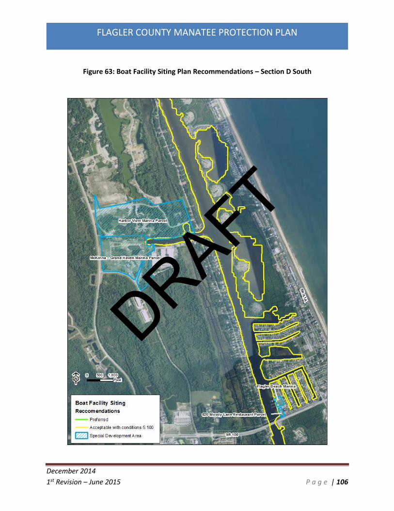
December 2014
1st Revision – June 2015 P a g e | 106
FLAGLER COUNTY MANATEE PROTECTION PLAN
Figure 63: Boat Facility Siting Plan Recommendations – Section D South
DRAFT

December 2014
1st Revision – June 2015 P a g e | 107
FLAGLER COUNTY MANATEE PROTECTION PLAN
Figure 64: Boat Facility Siting Plan Recommendations – Section E North
DRAFT

December 2014
1st Revision – June 2015 P a g e | 108
FLAGLER COUNTY MANATEE PROTECTION PLAN
Figure 65: Boat Facility Siting Plan Recommendations – Section E South
DRAFT

December 2014
1st Revision – June 2015 P a g e | 109
FLAGLER COUNTY MANATEE PROTECTION PLAN
Figure 66: Boat Facility Siting Plan Recommendations – Section F North
DRAFT

December 2014
1st Revision – June 2015 P a g e | 110
FLAGLER COUNTY MANATEE PROTECTION PLAN
Figure 67: Boat Facility Siting Plan Recommendations – Section F South
DRAFT

December 2014
1st Revision – June 2015 P a g e | 111
FLAGLER COUNTY MANATEE PROTECTION PLAN
4.4 Existing Marina Expansion
Due to the nature of the ICW and the existing developed marina parcels in Flagler County, it is
not anticipated that the existing marinas will have the capacity to dramatically expand in size in
the future. The configuration of the existing marinas does not allow for large-scale expansions.
It is anticipated that in the future potential re-configurations to the existing marinas to target
the changing boating market will occur. The changes in the number of slips would be expected
to be minimal. All marina expansion projects will be required to meet existing federal, state,
and Flagler County rules and regulations prior to expansion. Any proposed marina expansion
will be thoroughly reviewed by Flagler County Growth Management staff to ensure the
development is consistent with the goals of this MPP.
4.5 Single Family Docks and Multi-family Facilities Less than 5 Slips
Additional single family dock and small residential dock facility (4 slips or less) construction is
anticipated to continue to occur throughout the County. Many small parcels, primarily in the
unincorporated ICW areas of the County provide the opportunity for single family docks and
small residential docking facilities. The incorporated areas of the City of Palm Coast and Flagler
Beach are for the most part completely developed and single family docks already exist with
the lots. The primary areas of additional single family docks will come with the final
construction of the remaining PUD’s along the ICW. These include the build-out of the Grand
Haven PUD, the Palm Coast Plantation PUD, the Harbor View Marina property, the Hammock
Beach River Club PUD, the Flagler Beach Polo Club PUD, and the Bulow Preserve PUD.
Boat Facility Siting Plans generally do not pertain to the construction of a single family dock or a
small multi-family (less than 5 slips) facility.
5.0 Education Plan
In order to communicate with Flagler County citizens regarding the objectives incorporated into
the Manatee Protection Plan for Flagler County, an Education component to the Manatee
Protection Plan has been developed. The intent of the Education and Awareness component of
the MPP is to increase knowledge, awareness, and understanding among Flagler County
residents and visitors with respect to the presence of manatees in Flagler County’s waterways.
There are many successful models for Flagler County to follow in development of an education
plan. The County will coordinate its efforts as appropriate with federal, state, and local
agencies and organizations in providing information to the public regarding manatee safety
issues. Completion of these initiatives is the responsibility of the county but may require
additional, outside funding sources or partnerships and will be implemented once funding is
DRAFT

December 2014
1st Revision – June 2015 P a g e | 112
FLAGLER COUNTY MANATEE PROTECTION PLAN
secured and/or partnerships are formalized. Partnering agencies in these efforts might include
Florida Sea Grant, University of Florida- IFAS, Florida Fish and Wildlife Conservation Commission
(FWC), University of Florida’s Whitney Laboratory for Marine Bioscience (Whitney Lab), Florida
Department of Environmental Protection (FDEP), Guana Tolomato Matanzas National Estuarine
Research Reserve (GTM-NERR), St. Johns River Water Management District (SJRWMD), U.S. Fish
and Wildlife Service (FWS), National Oceanic and Atmospheric Administration (NOAA), Flagler
County School Board (FCSB), Flagler County Property Appraiser (FCPA), Flagler County Sheriff’s
Office (FSO), Flagler County Tax Collector (Tax Collector), Boy Scouts of America (Boy Scouts),
Girl Scouts of the USA (Girl Scouts), Georgia Aquarium, private sector businesses and Save the
Manatee Club (SMC).
Funding for some of these education and awareness initiatives may be paid for by Flagler
County, but funding assistance will be sought in the form of grants and donations. Some
funding mechanisms that are being considered include a portion of funds from enforcement
related penalties, impact fees on waterfront development, and federal, state, and local grant
programs.
Flagler County School District staff since 2010 have had access to an 18 lesson curriculum
correlated to Florida’s Sunshine State Standards for 3rd grade classes at Rymfire and Bunnell
Elementary Schools. The program is jointly administered by the University of Florida, College of
Veterinary Medicine and the Whitney Laboratory for Marine Bioscience and was developed by
Florida SeaGrant staff at the University of Florida’s Institute for Food and Agricultural Sciences
(IFAS) program located in Bunnell. The program is based on a book called “Sam the Sea Cow”
and introduces students to manatee biology and threats facing manatees while addressing
math and science curriculum needs. The program includes lessons about adaptations,
characteristics of mammals, what manatees need to survive and marine pollution. The
curriculum is provided as Attachment 1.
Flagler County identifies each of the initiatives as short-term, near-term, and long-term. Short-
term refers to beginning an initiative within the first two years of Plan implementation. Near-
term initiatives will begin between three to five years from Plan implementation and long-term
will begin later than 5 years from the date of Plan implementation. In Attachment 2, Flagler
County’s educational initiatives are listed along with their planned implementation timelines
and proposed funding sources.
DRAFT

December 2014
1st Revision – June 2015 P a g e | 113
FLAGLER COUNTY MANATEE PROTECTION PLAN
5.1 Informational Kiosks
One valuable source of manatee education for boaters is the inclusion of kiosks at high use
public boat ramps. Flagler County currently does not have informational kiosks at any of the
county owned and managed boat ramps. Due to the changes in boating speed zones and need
for further manatee educational materials for the public, the incorporation of informational
kiosks at Bings Landing Park, Herschel King Park, and Moody Public Boat Launch are proposed.
The kiosks will include information about the speed zone areas and signage, speed limits, and
current information on the status of the manatee in Flagler County along with biology of the
species and conservation measures.
5.2 Boating Guide Pamphlets
Flagler County will also implement a boating guide pamphlet which can be distributed at the
DMV, local marinas, boat ramps, and be available online. The pamphlet will include general
boating safety information, habitat and resource protection, and parks and recreation. The
pamphlet will also include navigation aid information, speed zone information (including a
guide to markers and signs), locations of boat ramps, marinas, and waterside facilities. The
pamphlet will also include emergency contact numbers and sheriff’s office information. The
pamphlet will be produced with assistance of the Flagler County Sheriff’s Office and the Florida
Fish and Wildlife Conservation Commission Enforcement Office.
6.0 Manatee Protection Zones and Law Enforcement
Slow speed zones for boaters are considered by FWC and USFWS to be an important part of any
Manatee Protection Plan. Although it is difficult to measure the direct “effectiveness” of speed
zones in terms of manatee survivorship, the USFWS believes that a reduction in watercraft
speed will result in a reduction of the risk of collision with manatees. According to the Army
Corps of Engineers Manatee Programmatic Biological Opinion from 2011: “The enforcement of
manatee speed zones is the primary conservation measure through which proposed projects
could reduce the likelihood of take from watercraft collisions to an unlikely-to-occur level.” It
follows that based on this assumption, FWC relies heavily on the relationships between boats
and manatees in the development of manatee protection plans. Related, manatee density and
abundance in relation to boating density and abundance is assumed to play a key role in
determining the likelihood for injury and fatality for manatees. Although a large vessel may
cause injury or death to a manatee, even at slow speeds, for the purpose of this assessment it is
assumed that speed zone restrictions generally reduce the likelihood and/or severity of injuries
caused by boat collisions. Generally, the visible presence of law enforcement on the waterway
DRAFT

December 2014
1st Revision – June 2015 P a g e | 114
FLAGLER COUNTY MANATEE PROTECTION PLAN
induces slower boat traffic. This visible presence of law enforcement officers on the water and
the subsequent slowing of boat traffic is known as the “halo effect”.
On-water law enforcement in Flagler County is performed by officers from the Florida Fish and
Wildlife Conservation Commission Law Enforcement Division and the Flagler County Sheriff
Office (FCSO). FWC estimates approximately 1000 hours by its officers in and around Flagler
County’s ICW. FCSO provides enforcement whenever FWC is not scheduled to patrol on water.
FCSO hours for the first two months of the enforcement period are included below. FWC Law
Enforcement hours were requested from their staff, but those figures have still not been
released.
During the speed zone enforcement time period so far in 2015 (months of May and June) the
FCSO has patrolled the Manatee Protection Zones for approximately 35 hours each month. In
that 2 month period 58 verbal warnings and 19 written warnings have been issued by FCSO
officers to boaters. No citations have been issued. No manatees have been struck by boaters
during this period. The FCSO has provided a commitment to supply assistance in the
enforcement of speed zones for manatee protection. The FCSO has agreed to provide monthly
updates to Flagler County staff during the Manatee Protection Zone enforcement months of
May 1st through September 7th.
7.0 Implementation Plan
7.1 Manatee Protection Plan Adoption
Once the FWC and FWS have approved this MPP the County will move forward with adoption
of the plan by resolution into the Flagler County Comprehensive Plan. The County will
coordinate with and encourage the cities and municipalities within Flagler County to adopt this
MPP into their respective Comprehensive Plans. It is anticipated the incorporation of the final
MPP approved by FWC and FWS will be completed within 1 year of approval by the agencies.
The MPP will be made available to the public through the Flagler County website. GIS
shapefiles of the Boat Facility Siting Plan maps will be made available to allow for planning,
development, and permitting of future properties.
7.2 Manatee Protection Plan Status Report
Flagler County staff will develop a MPP Status Report. This report will include a review all
manatee related data, any new waterward development permitting and construction, manatee
deaths related to human causes, speed zone law enforcement, education programs, and
habitat protection. The review and report will be completed on a yearly basis. This report will
DRAFT

December 2014
1st Revision – June 2015 P a g e | 115
FLAGLER COUNTY MANATEE PROTECTION PLAN
be submitted to the FWC Imperiled Species Management Section and FWS North Florida
Ecological Services Office each year.
The MPP Status Report will specifically review of the types of watercraft-related deaths (large
vessel deaths and small vessel deaths, if known) and their locations, the number of manatee
deaths over time, and whether five watercraft deaths have occurred in that 12 month period. If
5 or more watercraft related deaths occur in a 12 month period consultation with FWC and
FWS will be initiated to determine if additional manatee protection is warranted.
7.3 Manatee Protection Zone Law Enforcement Yearly Report
Flagler County staff will coordinate with Law Enforcement staff to develop a Law Enforcement
Report. This report will include items such as total number of on water patrol hours, number of
citations reported, boating accidents, water-craft related manatee deaths, and general speed
zone compliance.
7.4 Manatee Protection Plan Funding
A critical component of any MPP is to maintain adequate funding for implementation of the
plan. Flagler County will provide a yearly budget towards implementation of the MPP. To
successfully implement the objectives of this MPP, Flagler County will:
A. Continue to fund the Flagler County Sheriff’s budget on an annual basis, which currently
includes on water patrol activities for the Intracoastal Waterway, in conjunction with the FWC
enforcement division; and
B. Continue to fund the County’s Growth Management division, which will oversee
development and compliance with the MPP; and
C. Continue to fund the Flagler County’s Land Management division, which will provide a
yearly status report and organize educational activities; and
D. Provide funds through the General Fund to ensure consistent support for these
activities; and
E. Work to identify additional funding sources that might be available in order to
implement specific MPP tasks. These other possible funding sources include governmental
grant programs, corporate sponsors, private donations, public interest groups, etc.
DRAFT

December 2014
1st Revision – June 2015 P a g e | 116
FLAGLER COUNTY MANATEE PROTECTION PLAN
7.5 Manatee Protection Plan Recommendations
Table 10 below is a summary of the recommendations and implementation of the Flagler
County Manatee Protection Plan.
Table 10: Flagler County MPP Recommendations
MPP Objective Action Anticipated Schedule
Flagler County Comprehensive Plan will be amended to incorporate the Manatee Protection Plan
Submit County Resolution amendment to FWC
Within 1 year of approval of the MPP by FWC
Flagler County Growth Development will utilize the MPP during review of potential waterward developments
Distribute and coordinate with County development review staff. Provide GIS shapefiles of BFSP maps to development review staff.
Immediately upon approval
Inventory all waterward construction of slips, manatee mortalities, and habitat impact
Draft and update a Yearly MPP Status Report
Annually
Review Manatee Protection Zones for effectiveness in regards to manatee mortality and boat speeds
Engage Flagler County Sheriff’s Office to draft and update a Yearly Law Enforcement Status Report
Annually
Keep the MPP current Review the MPP in conjunction with FWC and FWS to determine if revisions are necessary; Requires compilation of data and reports described above
Every 5 years
Increase manatee habitat protection
Work with agencies involved with the Flagler County Blueways Project to source funding for the purchase and management of additional
Ongoing
DRAFT

December 2014
1st Revision – June 2015 P a g e | 117
FLAGLER COUNTY MANATEE PROTECTION PLAN
lands identified within the Flagler County Blueways study
Implement Manatee Education Measures
Continue manatee education measures in place and follow implementation schedule for additional educational measures
Active and Ongoing
Facilitate law enforcement participation in manatee protection
Coordinate seasonally with law enforcement staff in regards to officer man hours on the water and briefing of findings
Seasonally/as Necessary
DRAFT

December 2014
1st Revision – June 2015 P a g e | 118
FLAGLER COUNTY MANATEE PROTECTION PLAN
References
Beeler IE, O’Shea TJ (1988) Distribution and Mortality of the West Indian Manatee (Trichechus
manatus) in the Southeastern United States. Prepared for the U.S. Army Corps of Engineers,
Jacksonville District.
Best RC (1981) Food and feeding habits of wild and captive Sirenia. Mammal Rev. 11(1):3-29
Calleson CS, Frohlich RK (2007) Slower boat speeds reduce risks to manatees. Endangered
Species Research 3:295-304
Craig BA, Reynolds JE III (2004) Determination of manatee population trends along the Atlantic
coast of coast of Florida using a Bayesian approach with temperature-adjusted aerial survey
data. Marine Mammal Science 20:386-400
Deutsch CJ, Reid JP, Bonde RK, Easton DE, Kochman HI, O’Shea TJ (2003) Seasonal movements,
migratory behavior and site fidelity of West Indian manatees along the Atlantic Coast of the
United States. Wildlife Monographs 151:1-77
Duval County Manatee Protection Plan 3rd Edition (2014) City of Jacksonville Waterways
Commission. http://www.coj.net/departments/planning-and-development/community-
planning-division/plans-and-studies/manatee-protection-plan.aspx
Florida Fish and Wildlife Conservation Commission (2007) Florida Manatee Management Plan
Trichechus manatus latirostris
Gorzelany, Jay (2009) Aerial Surveys of Boating Activity in Flagler, St. Johns, and Duval Counties.
Mote Marine Laboratory. Mote Technical Report No. 1366
Gorzelany JF, Koelsch JK (1994) Habitat characterization of preferred manatee sites in the
Sarasota area. Final report submitted to the Florida Dept. of Environmental Protection, Bureau
of Protected Species Management
Hartman DS (1974) Distribution, status, and conservation of the manatee in the United States.
National Technical Information Service No. PB81-140725. Springfield, Virginia
Hartman, DS (1979) Ecology and behavior of the manatee (Trichechus manatus) in Florida. The
Amer. Soc. Mammal Spec. Publ. No. 5
Irvine AB, Campbell HW (1978) Aerial census of the West Indian manatee, Trichechus manatus,
in the southeastern United States. Journal of Mammalogy 59:613-617
DRAFT

December 2014
1st Revision – June 2015 P a g e | 119
FLAGLER COUNTY MANATEE PROTECTION PLAN
Kinnaird MF (1983b) Site-specific analysis of factors potentially influencing manatee boat/barge
mortality. Site-specific reduction of manatee boat/barge mortality. University of Florida, Florida
Cooperative Fish and Wildlife Research Unit, Gainesville, Florida. Report No. 4, Agreement No.
14-16-0004-81-923
Koelsch JK (1997) The seasonal occurrence and ecology of Florida manatees (Trichechus
manatus latirostris) in coastal waters near Sarasota, Florida. MS Thesis, University of South
Florida, Tampa, Florida
Laist DW, Reynolds JE (2005a) Florida Manatees, warm-water refuges, and an uncertain future.
Coastal Management 33:279–295
Laist DW, Reynolds JE (2005b) Influence of power plants and other warm water refuges on
Florida manatees. Marine Mammal Science 21(4):739–764
Langtimm CA, Beck CA, Edwards HH, Ackerman BB, Fick-Child KJ, Barton SL, Hartley WC (2004)
Survival estimates for Florida manatees from the photo-identification of individuals. Marine
Mammal Science 20:438-463
Lefebvre LW, Marmontel M, Reid JP, Rathbun GB, Domning DP (2001) Status and biogeography
of the West Indian manatee 425-474 In: Woods CA, Sergile FE (eds) Biogeography of the West
Indies: new patterns and perspectives. CRC Press LLC. Boca Raton, Florida
O'Shea TJ (1988) The past, present, and future of manatees in the southeastern United States:
realities, misunderstandings, and enigmas 184-204 In: Odom RR, Riddleberger KA, Ozier JC (eds)
Proceedings of the Third Southeastern Nongame and Endangered Wildlife Symposium. Georgia
Department of Natural Resources, Game and Fish Division, Social Circle, Georgia
Packard JM, Siniff DB, Cornell JA (1986) Use of replicate counts to improve indices of trends in
manatee abundance. Wildl. Soc. Bull. 14:265-275
Pitchford TD, Rommel, Sentiel A, Pitchford ME (2003, revised 2005) Characterizing and
Interpreting Watercraft-Related Wounds in Florida Manatees: A Retrospective Analysis of
Florida Manatee Mortality Data for Evidence of Deaths Attributable to (Very) Large Vessels,
1990-1999.
Provancha, JA, Provancha MJ (1988) Long term trends in abundance and distribution of
manatees (Trichechus manatus) in the northern Banana River, Brevard County, Florida. Marine
Mammal Science 4(4): 323-338
DRAFT

December 2014
1st Revision – June 2015 P a g e | 120
FLAGLER COUNTY MANATEE PROTECTION PLAN
Reid JP, Rathbun GB, Wilcox JR (1991) Distribution patterns of individually identifiable West
Indian manatees (Trichechus manatus) in Florida. Marine Mammal Science 7:180-190
Rommel SA, Costidis AM, Pitchford TD, Lightsey JD, Snyder RH, Haubold EM (2007) Forensic
methods for characterizing watercraft from watercraft-induced wounds on the Florida manatee
(Trichechus manatus latirostris). Marine Mammal Science 23(1):110-132
Runge MC, Langtimm CA, Kendall, WL (2004) A stage-based model of manatee population
dynamics. Marine Mammal Science 20:361-385
Runge MC, Sanders-Reed CA, Fonnesbeck CJ (2007a) A core stochastic population projection
model for Florida manatees (Trichechus manatus latirostris). Final report. US Geological Survey,
Patuxent Wildlife Research Center. Laurel, Maryland
Runge, MC, Sanders-Reed CA, Langtimm CA, Fonnesbeck CJ (2007b) A quantitative threats
analysis for the Florida manatee (Trichechus manatus latirostris).
Sarasota County Manatee Protection Plan (2004)
https://www.scgov.net/EnvironmentalPlanning/Pages/MPP.aspx
Shane SH (1983) Abundance, distribution, and movements of manatees (Trichechus manatus) in
Brevard County, Florida. Bulletin of Marine Science 33:19
USFWS (2001) Florida Manatee Recovery Plan Trichechus manatus latirostri, Third Revision. US
Fish and Wildlife Service, Atlanta, Georgia
Wright, S.D., B.B. Ackerman, R.K. Bonde, C.A. Beck, and D.J. Banowetz. 1995. Analysis of
watercraft-related mortality of manatees in Florida, 1979-1991. pp 259268 In: Population
Biology Of The Florida Manatee. U.S. Dept. of The Interior Information and Technology Report
1.
DRAFT

December 2014
1st Revision – June 2015 P a g e | 121
FLAGLER COUNTY MANATEE PROTECTION PLAN
APPENDIX 1
Flagler County Manatee Protection Plan Education Initiatives, Timelines, and Funding Sources
DRAFT

Education andAwarenessInitiative
Timeline-
Objective Funding SourceandAdministration
PotentialPartneringAgencies
Educational Material Delivery Methods
Boater EducationBrochure and Map
Near-Term
Provide anddistribute abrochure and mapto registeredboaters andproperty owners inthe county
To BeDetermined
Flagler County TaxCollector orProperty Appraiser– for Distribution
FCPA or Tax Collector Mailing, Supply MarineBusinesses, Supply Municipalities as necessary
Flagler County TVSpot
Short-Term
Reach broadsegment of FlaglerCounty withmanateeconservationdiscussion
Flagler CountyCommunications
Sea Grant, UF-IFAS,NOAA, FWC
Recurring broadcast spot on FCTV
Flagler CountyWebsite
Near-Term
Provide access toMPP and othermanateeconservationinformation onCounty Website
Flagler CountyI.T., FlaglerCounty LandManagement
FWC, USFWS,NOAA, Sea Grant,UF-IFAS
Provide access to management and otherdocuments to general public on-demand
Local Radio PSA Near- Reach broad Flagler County Local Radio Provide a written or recorded radio spot for
DRAFT

Education andAwarenessInitiative
Timeline-
Objective Funding SourceandAdministration
PotentialPartneringAgencies
Educational Material Delivery Methods
Term segment of FlaglerCounty withmanateeconservationinformation anddirect to website
Communications
Stations local radio outlets
Manatee Alert forNOAA radiobroadcast
Near-Term
Provide boater-specific waterwayand manatee alerts
TBD NOAA Periodic broadcast on NOAA radio channels
Manateeconservationeducational signsand kiosks at boatramps
Short-term
Provide boaterswith educationalmaterials andreminders to“Share thewaterway” withmanatees
Funding – TBD,Administration– Flagler CountyParks andRecreation
Flagler County Strategic sign and kiosk placement at high-traffic boat ramps in Flagler County
“No feeding orwatering” signs,brochures andinformation toresidents
Short-term
Reminders andeducation ofwaterfronthomeowners thatfeeding manatees
TBD City of Palm Coast,Beverly Beach,Flagler Beach
Placement of signs in waterways and canalsDRAFT

Education andAwarenessInitiative
Timeline-
Objective Funding SourceandAdministration
PotentialPartneringAgencies
Educational Material Delivery Methods
is harmful/illegal
Grades K-5ManateeEducationPrograms
Near-term(existing)
Continue to utilizethe curriculumdeveloped byFlorida Sea Grant
Continueexisting funding
Sea Grant Continue to provide educational materials andcurriculum in elementary schools
Manatee trainingfor LawEnforcementofficers.
Short-Term
Provide LE withtools to educatepublic during theirinteractions and for“manateespotter/reporting”as necessary
TBD FWC, FCSO, USFWS Contact with citizens during on-water patrols
Increased on-water presence ofLaw Enforcement
Long-Term
Provide fundingand developintergovernmentalcooperation andcapacity for multi-agency on-waterpresence formaintaining safespeeds and “halo”
TBD FWC, FCSO On-Water presence by Law Enforcementofficers has been shown to be a significantpreventative for violations of speed zones.D
RAFT

Education andAwarenessInitiative
Timeline-
Objective Funding SourceandAdministration
PotentialPartneringAgencies
Educational Material Delivery Methods
effect
Tabling at LocalFestivals andEnvironmentalFairs
Near-Term
Provide educationalmaterials to thepublic
TBD Festival Organizersand Sponsors
Brochures, Posters, Presenters
VolunteerSpeaker’s Forum
Long-Term
Create a forum forconservationprofessionals,students, andvolunteers todiscussconservation issuesincluding manatees
TBD Local High Schools,and regionalcolleges, advocacygroups, and non-profitorganizations
Spoken Word and Audio-visual presentations
DRAFT