final environmental assessment for - bureau of · pdf filefinal environmental assessment . ......
TRANSCRIPT

DK-5000-16-03
Finding of No Significant Impact and
Final Environmental Assessment
for Funding and Construction to Repair the Slides at McClusky Canal, McLean County, North Dakota Dakotas Area Office Bismarck, North Dakota
May 2017
U.S. Department of the Interior Bureau of Reclamation

This Page Left Blank Intentionally
UNITED STATES DEPARTMENT OF THE INTERIOR
BUREAU OF RECLAMATION
DAKOTAS AREA OFFICE BISMARCK, NORTH DAKOTA
FINDING OF NO SIGNIFICANT IMPACT
Of
FINAL ENVIRONMENTAL ASSESSMENT
FOR
Funding and Construction to Repair the Slides at McClusky Canal, McLean County, North Dakota
NO. DK-5000-16-03

This Page Left Blank Intentionally

Mission Statements The mission of the Department of the Interior is to protect and provide access to our Nation’s natural and cultural heritage and honor our trust responsibilities to Indian Tribes and our commitments to island communities. The mission of the Bureau of Reclamation is to manage, develop, and protect water and related resources in an environmentally and economically sound manner in the interest of the American public.

This Page Left Blank Intentionally

1
Finding of No Significant Impact For
Environmental Assessment Funding and Construction to Repair the Slides at McClusky Canal, McLean
County, North Dakota
The Bureau of Reclamation (Reclamation), in cooperation with Garrison Diversion Conservancy District (Garrison Diversion) is proposing to fund and construct a slide repair on the McClusky Canal (Canal), McLean County, North Dakota (Proposed Project). The Canal was constructed in the early 1970s as the initial stage of the Garrison Diversion Unit (GDU). Since that time, numerous slides have occurred in the canal prism. The Proposed Action would repair the Canal slide from Mile Marker (MM) 20 to MM 22. McClusky Canal Slide Repair from MM 20 to 22 would include (Figure 1-1):
a) Flatten the slope from 2:1 to 4:1, b) Removal of approximately 3 million cubic yards of soil from the canal side slopes; c) Reduce the canal capacity from 1,950 cubic feet per second to 500 cubic feet per second; d) Raise the canal invert from elevation of approximately 1,827 to 1,832; e) Decrease the canal bottom width from approximately 25 feet to 10 feet; f) Reconstruct roads on both sides of the canal with a width of 20 feet and an approximate
elevation of 1,849.5; g) Improve drainage around the project area by filling and draining adjacent wetlands which
contribute to slope instability through groundwater infiltration and added weight to canal slopes.
h) Reclamation’s Environmental Mitigation Commitments and Best Management Practices (BMPs).
Eight agency responses, three phone calls, and two emails were received regarding the preparation of the EA in response to Reclamation’s scoping notice. The comments were referenced and incorporated where appropriate within the environmental impact categories addressed in the final EA. Appendix B of the final EA contains the responses to scoping. More than 30 days have transpired since the release of the draft EA, during which time Reclamation received four agency responses (pages 7-14).

2
Figure 1-1. Depiction of the Slide Repair Project Area.

3
Agency Decision No Action. If Reclamation would adopt the No Action alternative, no federal funding and no repairs would occur to the Canal slide at MM 20 to MM 22. Landslides and slope failures would continue to occur and the Canal would become plugged, stopping existing flows, resulting in no water deliveries downstream of the slide location. The operations and maintenance (O&M) roadway would continue to be nonfunctional. In the event flows were reduced or eliminated, revisions to the water service contract and Garrison Diversion Unit master repayment contract between Reclamation and Garrison Diversion would be required. This alternative was rejected because it does not meet Reclamation’s authorized purpose and need of providing a reliable water supply of approximately 500 cfs downstream of MM 22 in accordance with the authorized purposes of the Dakota Water Resources Act (Act of December 21, 2000, P.L. 106-554, 114 Stat. 2763). Proposed Action Alternatives. The EA analyzed two Proposed Action Alternatives: Alternative 1 would include:
• flatten the slope from 2:1 to 4:1, resulting in the removal of approximately 3 million cubic yards of soil from the canal side slopes;
• reduce the canal capacity from 1,950 cubic feet per second to 500 cubic feet per second; • raise the canal invert from elevation of approximately 1,827 to 1,832; • decrease the canal bottom width from approximately 25 feet to 10 feet; • reconstruct roads on both sides of the canal with a width of 20 feet and an approximate
elevation of 1,849.5; • improve drainage around the project area by filling and draining adjacent wetlands which
contribute to slope instability through groundwater infiltration and added weight to canal slopes.
Alternative 2 would include most of the elements presented in Alternative 1, however, Reclamation would utilize Federal ROW only for disposal of 3.0 million cubic yards of soil from the canal slopes. Reclamation would not improve drainage around the Project Area by filling or draining adjacent wetlands, which contribute to slope instability through groundwater infiltration and added weight to canal slopes. The existing culverts would be replaced at existing locations and set at existing elevations. Canal slopes would need to be reduced to a slope flatter than 4:1 and/or interceptor drains would be placed within the Federal ROW to reduce the groundwater influence on canal slopes. Reclamation has determined to implement Alternative 1 utilizing Federal ROW and private lands (pending private landowner’s approval) to construct the slide repair of the Canal at MM 20 to 22. Alternative 1, as described in the environmental assessment (EA) DK-5000-16-03, meets Reclamation’s authorized purpose and need and will not result in significant impacts to the human and natural environment; therefore, an environmental impact statement will not be prepared. A complete description and analysis of the project’s anticipated environmental impacts is contained in the EA.

4
Reclamation defines significance relative to context and intensity in accordance with CEQ Regulations, 40 CFR 1508.27. The reasons for the FONSI determination are summarized as follows:
1. All requirements of the National Environmental Policy Act have been met, including public involvement and coordination with Federal, State, and local agencies.
2. All stipulations of the Clean Water Act and other applicable Federal laws, regulations, and guidelines concerning wetlands and water resources will be satisfied prior to construction in wetlands. Mitigation measures coordinated with NRCS, USACE, and USFWS will be in compliance with all applicable regulations to offset wetland losses.
3. Reclamation has determined the Proposed Action would have no effect on all listed species and designated critical habitat in McLean County.
4. Reclamation has determined the Proposed Action would have no impacts to migratory birds or eagles. Mitigation and minimization measures have been incorporated into the project’s design to eliminate potential impacts to migratory birds.
5. All stipulations of the National Historic Preservation Act and other applicable Federal laws, regulations, and guidelines concerning cultural resources will be satisfied prior to construction. Avoidance measures have been incorporated into the project’s design to reduce or eliminate impacts to historic properties.
6. Reclamation has determined the Proposed Action would have no impacts to Indian Trust Assets.
7. All applicable Federal and State environmental laws, regulations, and executive orders will be adhered to.
8. Reclamation is including a list of environmental commitments as part of the proposed action to be implemented in order to (a) prevent, minimize, or offset the occurrence of potential adverse environmental effects and (b) ensure compliance with applicable Federal and State regulations designed to protect fish and wildlife resources, important habitats and sensitive areas, cultural and paleontological resources, human health and safety, and the public interest.
Environmental Mitigation Commitments of the Community Alternative This section presents environmental commitments which have been developed by Reclamation and the project sponsor in consultation with Federal and State agencies, the Tribes, and the public through responses to scoping. These commitments are included as an inseparable component of this Proposed Action and are designed to offset potential for significant environmental effects resulting from the Proposed Action.

5
As sponsor of the McClusky Slide Repair at MM 20 to 22, GDCD will be responsible for complying with these commitments. Should this project be constructed, GDCD will ensure that these commitments are implemented and followed prior to and/or during construction of the Project, as these commitments are required for Reclamation funding. Appropriate environmental commitments will be incorporated into the designs and construction contracts and specifications of the project. An Interagency Environmental Review Team, with appropriate agency representation, may be assembled to review environmental compliance in the field, as needed. These environmental commitments will be implemented to (1) prevent, minimize, or offset the occurrence of potential for adverse environmental effects and (2) ensure compliance with applicable Federal and State regulations designed to protect fish and wildlife resources, important habitats and sensitive areas, cultural and paleontological resources, human health and safety, and the public interest.
General Best Management Practices Comply with all appropriate Federal, State, and Local laws. Follow recommended practices for construction, restoration, and maintenance. Dump grounds, trash piles, and potential hazardous waste sites will be avoided. Standard construction, industry measures will be taken to minimize fugitive dust emissions during construction activities. Any complaints that may arise will be dealt with in a timely and effective manner. Erosion Best Management Practices (BMPs) will be followed to prevent runoff of soil, silt, and other debris.
Surface Water and Wetlands A 404 permit will be completed and submitted to the U.S. Army Corps (USACE), as necessary. Section 401 and 402 certification will be completed, as necessary. Wetland impacts will be appropriately mitigated according to the standards and direction of the USACE, Natural Resources Conservation Service (NRCS), and U.S. Fish and Wildlife Service (USFWS). Wetland impacts will comply with the Clean Water Act and Agricultural Act of 2014. Woody species including those bordering wetlands, shelterbelts, riparian woodlands, woody draws, or woodland vegetation will be avoided to the extent possible. For unavoidable impacts to woody habitats, replacement plants at a 2:1 ratio of native speciation would be planted, as appropriate. Erosion control measures will be employed as appropriate: Stabilization, erosion controls, restoration, and re-vegetation of all streambeds and embankments will be performed as soon as a stream crossing is completed and maintained until stable.
Fish and Wildlife Species and Habitat To the extent possible, construction would avoid: - Wetlands - Federal, State, and Local wildlife areas and refuges - Designated critical habitats - Migratory bird habitats during the nesting brood rearing season (February 1 – July 15) To minimize impacts to fisheries resources, any stream identified as a fishery (fisheries – confirm with ND Game and Fish Department) will be avoided from April 15 to June 1 and crossed later in the summer or fall when flows are low or the stream is dry. Construction within 660 feet of visible nesting bald eagles will be avoided from February through August.

6
Project proponents will coordinate with the USFWS’s appropriate Refuges and Wetland Management Districts and provide the latest-map version of the Proposed Project to avoid impacts to USFWS lands, including wetland and grassland easements, national wildlife refuges (NWR), waterfowl production areas or other USFWS lands interface. If threatened or endangered species are identified and encountered during construction, all ground-disturbing activities in the immediate area will be stopped until Reclamation can consult with the USFWS to determine appropriate steps to avoid impacting the species. Native prairie will be avoided to the extent possible. However, if native prairie sod must be broken, existing topsoil will be carefully salvaged and replanted with native grasses in a timely manner, with a seed mix recommended by the local NRCS and approved by Reclamation and the landowner. Tree removal would take place during the non-active time of year for the northern long-eared bat and migratory birds (November 1 to January 31). Any new signage will be placed in a manner as to not endanger raptors which may perch on the top of the post.
Cultural Resources All cultural resource investigations will be performed according to the procedures specified in the programmatic agreement among Reclamation, the SHPO, and the Advisory Council on Historic Preservation for Reclamation activities in North Dakota. Cultural resource inventories will be performed under the direction of an archaeologist that meets the Secretary of the Interior’s Professional Qualifications Standards (48 FR 44738-9). All appropriate cultural resource activities will be completed prior to the commencement of ground-disturbing activities, including Class I and Class III surveys and consultation with the SHPO. All cultural resources, except those exempted in the programmatic agreement, will be avoided if their significance cannot be established prior to disturbance. If avoidance is not practicable, Reclamation, in consultation with the SHPO would determine if the site is eligible for nomination to the National Register of Historic Places [36CFR800.4(c) and 36CFR60.4]. If the site is eligible as a historic property, initially Reclamation, SHPO, and other interested parties, depending on the type of property, will consult to determine a plan of mitigation. If an adverse effect cannot be avoided, the Advisory Council on Historic Preservation will be contacted. All ensuing activities will comply with the NHPA, as amended, and the Archaeological Resource Protection Act. The Tribes will be consulted concerning the locations of unmarked burials or cemeteries. All such burials or cemeteries will be avoided to the extent possible. If a burial or cemetery cannot be avoided or is encountered during construction, Reclamation will comply with the Native American Graves Protection and Repatriation Act if graves are discovered on Federal or trust lands or within reservation boundaries. Reclamation will comply with North Dakota Century Code 23-06-27: “Protection of Human Burial Sites, Human Remains, and Burial Goods” for graves on private or State-owned lands. If unrecorded cultural resources or traditional cultural properties are encountered during construction, all ground disturbance activity within the area will be stopped, Reclamation and appropriate authorities will be notified, and all applicable stipulations of the NHPA will be followed. Activities in the area will resume only when compliance has been completed.
Paleontological Resources Reclamation consulted with the North Dakota Geological Survey to identify areas for paleontological survey where significant fossils are likely. No response was received. If paleontological resource(s) are uncovered during construction, Garrison Diversion stop construction and contact the state paleontologist for further direction.
Future Modifications and Changes Major changes or modifications to the proposed action would be addressed through additional NEPA and NHPA compliance.

7

8

9

10

11
12

13

14

DK-5000-16-03
Final Environmental Assessment for the Funding and Construction to Repair the Slides at McClusky Canal, McLean County, North Dakota Dakotas Area Office Bismarck, North Dakota
May 2017
U.S. Department of the Interior Bureau of Reclamation

This Page Left Blank Intentionally

INTRODUCTION AND REGULATORY BACKGROUND INTRODUCTION ...................................................................................................................................................... 1-1 AUTHORITY ........................................................................................................................................................... 1-1 PURPOSE AND NEED FOR THE PROPOSED ACTION.................................................................................................. 1-2 PROJECT AREA ...................................................................................................................................................... 1-2 PERMITS AND AUTHORIZATIONS REQUIRED .......................................................................................................... 1-5
PROPOSED ACTION AND ALTERNATIVES CONSIDERED NO ACTION ALTERNATIVE .................................................................................................................................... 2-1 PROPOSED ACTION ALTERNATIVES ....................................................................................................................... 2-1
Alternative 1 ..................................................................................................................................................... 2-1 Construction Timing ...................................................................................................................................................... 2-1 Construction Procedures ................................................................................................................................................ 2-1 Lands Involved .............................................................................................................................................................. 2-3 Reclamation ................................................................................................................................................................... 2-4
Alternative 2 ..................................................................................................................................................... 2-4 ALTERNATIVES CONSIDERED AND ELIMINATED FROM FURTHER STUDY............................................................... 2-5
Perform Minimal Excavation Necessary to Open and Maintain the Canal ..................................................... 2-5 Stabilize Canal Slopes with Piers..................................................................................................................... 2-5 Replace Open Canal with a Buried Culvert ..................................................................................................... 2-5 Temporary Repairs .......................................................................................................................................... 2-5
Pumping ......................................................................................................................................................................... 2-5 Raising the Water Surface in Reach 1 ............................................................................................................................ 2-5 Directional Drilling of a Siphon or Inverted Siphon ...................................................................................................... 2-5 Create a Small Reservoir ................................................................................................................................................ 2-6
AFFECTED ENVIRONMENT AND ENVIRONMENTAL CONSEQUENCES
INTRODUCTION ...................................................................................................................................................... 3-1 RESOURCES CONSIDERED AND ELIMINATED FROM FURTHER ANALYSIS ............................................................... 3-1 AFFECTED ENVIRONMENT AND ENVIRONMENTAL CONSEQUENCES ...................................................................... 3-2
Water Resources and Hydrology...................................................................................................................... 3-2 Affected Environment .................................................................................................................................................... 3-2 Alternative 1 .................................................................................................................................................................. 3-9 Alternative 2 ................................................................................................................................................................ 3-10 No Action Alternative .................................................................................................................................................. 3-10
Threatened and Endangered Species ............................................................................................................. 3-10 Affected Environment .................................................................................................................................................. 3-10
Interior Least Tern (Sterna antillarum) ......................................................................................................... 3-11 Population Rangewide ................................................................................................................................................. 3-11 Action Area .................................................................................................................................................................. 3-11
Piping Plover (Charadrius melodus) and its Designated Critical Habitat .................................................... 3-12 Population Rangewide ................................................................................................................................................. 3-12 Action Area .................................................................................................................................................................. 3-12
Rufa Red Knot (Calidris canutus rufa) .......................................................................................................... 3-14 Population Rangewide ................................................................................................................................................. 3-14 Action Area .................................................................................................................................................................. 3-14
Whooping Crane (Grus americana) ............................................................................................................... 3-15 Population Rangewide ................................................................................................................................................. 3-15 Action Area .................................................................................................................................................................. 3-15
Pallid Sturgeon (Scaphirhynchus albus) ........................................................................................................ 3-16 Population Rangewide ................................................................................................................................................. 3-16 Action Area .................................................................................................................................................................. 3-16
Dakota Skipper (Hesperia dacotae) ............................................................................................................... 3-18 Population Rangewide ................................................................................................................................................. 3-18 Action Area .................................................................................................................................................................. 3-18
Gray Wolf (Canis lupus) ................................................................................................................................ 3-22 Population Rangewide ................................................................................................................................................. 3-22

Action Area .................................................................................................................................................................. 3-22 Northern Long-eared Bat (Myotis septentrionalis) ........................................................................................ 3-22
Population Rangewide ................................................................................................................................................. 3-22 Action Area .................................................................................................................................................................. 3-23 Alternative 1 ................................................................................................................................................................ 3-23 Alternative 2 ................................................................................................................................................................ 3-24 No Action Alternative .................................................................................................................................................. 3-25
Bald and Golden Eagle Protection Act .......................................................................................................... 3-25 Alternative 1 ................................................................................................................................................................ 3-26 Alternative 2 ................................................................................................................................................................ 3-26 No Action Alternative .................................................................................................................................................. 3-26
Migratory Bird Treaty Act ............................................................................................................................. 3-26 Alternative 1 ................................................................................................................................................................ 3-26 Alternative 2 ................................................................................................................................................................ 3-27 No Action Alternative .................................................................................................................................................. 3-27
Cultural Resources ......................................................................................................................................... 3-27 Affected Environment .................................................................................................................................................. 3-27 Alternative 1 ................................................................................................................................................................ 3-28 Alternative 2 ................................................................................................................................................................ 3-28 No Action Alternative .................................................................................................................................................. 3-29
Vegetation, Noxious Weeds, and Soils ........................................................................................................... 3-29 Affected Environment .................................................................................................................................................. 3-29 Alternative 1 ................................................................................................................................................................ 3-34 Alternative 2 ................................................................................................................................................................ 3-34 No Action Alternative .................................................................................................................................................. 3-34
Transportation and Roads.............................................................................................................................. 3-34 Affected Environment .................................................................................................................................................. 3-34 Alternative 1 ................................................................................................................................................................ 3-34 Alternative 2 ................................................................................................................................................................ 3-34 No Action Alternative .................................................................................................................................................. 3-34
Cumulative Effects ......................................................................................................................................... 3-36 Summary of Environmental Effects ................................................................................................................ 3-36
ENVIRONMENTAL COMMITMENTS
AGENCY CONSULTATION AND COORDINATION COMPLIANCE WITH ENVIRONMENTAL STATUTES .................................................................................................. 5-2 LIST OF PREPARERS ............................................................................................................................................... 5-2
REFERENCES
LIST OF TABLES TABLE 1. PERMITS AND/OR AUTHORIZATIONS REQUIRED BY AGENCIES AND DEPARTMENTS. .... 1-5 TABLE 2. RESOURCES ELIMINATED FROM FURTHER ANALYSIS. ............................................................ 3-1 TABLE 3. FEDERALLY-LISTED SPECIES IN THE ACTION AREA. .............................................................. 3-10 TABLE 4. NUMBER OF VEGETATION SPECIES AND ECOLOGICAL SITE DESCRIPTION OF THE 10
DAKOTA SKIPPER VEGETATION SURVEYS. ....................................................................................... 3-19 TABLE 5. VEGETATION DOCUMENTED AT SITES 1 – 4 AND 5 – 10. ......................................................... 3-19 TABLE 6. LANDCOVER TYPES IN PROJECT AREA (LANDFIRE 2015). ...................................................... 3-29 TABLE 7. NOXIOUS WEED ACREAGE IN MCLEAN COUNTY, NORTH DAKOTA (NORTH DAKOTA
DEPARTMENT OF AGRICULTURE 2016). .............................................................................................. 3-30 TABLE 8. SOIL TYPES IN THE PROJECT AREA (NRCS 2015). ...................................................................... 3-31 TABLE 9. SUMMARY OF ENVIRONMENTAL EFFECTS. ............................................................................... 3-36 TABLE 10. ENVIRONMENTAL COMMITMENTS REGARDING THE MCCLUSKY CANAL SLIDE REPAIR
PROJECT. ........................................................................................................................................................ 4-1

LIST OF FIGURES FIGURE 1. OVERVIEW OF SLIDE AREA AT MCCLUSKY CANAL. ............................................................... 1-3 FIGURE 2. OVERVIEW OF SLIDE AREA AT MCCLUSKY CANAL. ............................................................... 1-3 FIGURE 3. OVERVIEW OF THE PROPOSED PROJECT AREA. ........................................................................ 1-4 FIGURE 4. TYPICAL FINISHED CROSS SECTION............................................................................................. 2-2 FIGURE 5. AREAS 1 – 4 CONSIDERED FOR FILL DISPOSAL. ......................................................................... 2-4 FIGURE 6. SURFACE WATER FLOW WITHIN AND SURROUNDING THE PROJECT AREA. .................... 3-3 FIGURE 7. SURFACE FLOW MODEL WITHIN AND SURROUNDING THE PROJECT AREA. .................... 3-6 FIGURE 8. NATIONAL WETLAND INVENTORY (NWIS) WITHIN AND SURROUNDING THE PROJECT
AREA. .............................................................................................................................................................. 3-7 FIGURE 9. GROUNDWATER WELLS WITHIN AND SURROUNDING THE PROJECT AREA. .................... 3-8 FIGURE 10. DESIGNATED CRITICAL HABITAT FOR THE PIPING PLOVER NEAR THE PROJECT AREA.
....................................................................................................................................................................... 3-13 FIGURE 11. CENTRAL FLYWAY WHOOPING CRANE CORRIDOR AND CONFIRMED SIGHTINGS. .... 3-16 FIGURE 12. CURRENT RANGE OF PALLID STURGEON, INCLUDES BOTH WILD AND HATCHERY-
REARED FISH (AVAILABLE AT: HTTPS://WWW.FWS.GOV/MOUNTAIN-PRAIRIE/SPECIES/FISH/PALLIDSTURGEON/RECOVERYPLAN2014.PDF). ...................................... 3-17
FIGURE 13. DAKOTA SKIPPER SURVEY LOCATIONS AT THE PROJECT AREA. .................................... 3-21 FIGURE 14. WHITE-NOSE SYNDROME ZONE (AVAILABLE AT:
HTTPS://WWW.FWS.GOV/MIDWEST/ENDANGERED/MAMMALS/NLEB/PDF/WNSZONE.PDF). . 3-23 FIGURE 15. PRIMARY AND SECONDARY RANGE OF BALD EAGLES (A) AND GOLDEN EAGLES (B) IN
NORTH DAKOTA (NDGF 2016A; NDGF 2016B). .................................................................................... 3-26 FIGURE 16. CANAL CONSTRUCTION IN THE EARLY1970’S. PEARL WALL HERDS CATTLE IN THE
FOREGROUND (COURTESY OF THE STATE HISTORICAL SOCIETY OF NORTH DAKOTA [21081-08]). ................................................................................................................................................................ 3-29
FIGURE 17. OVERVIEW OF LANDCOVER IN THE PROJECT AREA (LANDFIRE 2015). .......................... 3-32 FIGURE 18. OVERVIEW OF SOIL TYPES IN THE PROJECT AREA (NRCS 2016). ...................................... 3-33 FIGURE 19. ROADS IN THE PROJECT AREA. .................................................................................................. 3-35
APPENDICES
Appendix A: Scoping Notice Contact List Appendix B: Scoping Letter and Scoping Letter Responses

List of Acronyms and Definitions Action Area – Based on Reclamation’s assessment of the potential direct and indirect effects of the proposed action to federally listed species (50 CFR 402.02) APE – area of potential effect Canal – McClusky Canal CEQ – Council of Environmental Quality CFR – Code of Federal Regulations CFS – cubic feet per second Critical Habitat – It is a specific geographic area(s) that is essential for the conservation of a threatened or endangered species and that may require special management and protection. Connected Actions – Connected actions are those actions that are “closely related” to the proposal and alternatives. Connected actions automatically trigger other actions, they cannot or will not proceed unless other actions have been taken previously or simultaneously, or they are interdependent parts of a larger action and depend on the larger action for their justification (40 CFR Part 1508.25) DKAO – Dakotas Area Office Environmental Mitigation Commitments – These are commitments included as an inseparable component of this Proposed Action. They are designed to offset potential for significant environmental effects resulting from the Proposed Action. These commitments will be implemented to (1) prevent, minimize, or offset the occurrence of potential for adverse environmental effects and (2) ensure compliance with applicable Federal and State regulations designed to protect fish and wildlife resources, important habitats and sensitive areas, cultural and paleontological resources, human health and safety, and the public interest. EA – Environmental Assessment ESA – Endangered Species Act of 1973 ESD – Ecological Site Description FONSI – Finding of No Significant Impact, the decision document that concludes an EA Garrison Diversion – Garrison Diversion Conservancy District GDU – Garrison Diversion Unit IPaC – Information, Planning, and Conservation System MM – Mile Marker MR&I – Municipal Rural and Industrial (water supply) NDSHPO – North Dakota State Historic Preservation Officer NEPA – National Environmental Policy Act of 1969 as amended NHPA – National Historic Preservation Act of 1966 as amended

NRCS – Natural Resources Conservation Service NRHP – National Register of Historic Places O&M – Operations and Maintenance Project Area – The McClusky Canal slide repair location and the proposed fill locations Proposed Project – The subject of this EA, funding and construction of the McClusky Canal Slide Repair Project Program - Pick-Sloan Missouri Basin Program Reclamation – U.S. Department of the Interior, Bureau of Reclamation ROW – Right-of-Way USFWS – U.S. Fish and Wildlife Service
1-1
Introduction and Regulatory Background
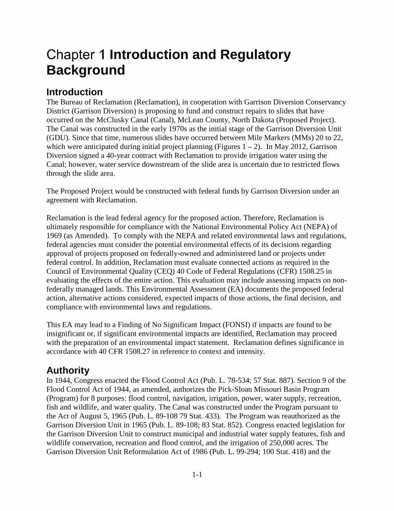
Introduction The Bureau of Reclamation (Reclamation), in cooperation with Garrison Diversion Conservancy District (Garrison Diversion) is proposing to fund and construct repairs to slides that have occurred on the McClusky Canal (Canal), McLean County, North Dakota (Proposed Project). The Canal was constructed in the early 1970s as the initial stage of the Garrison Diversion Unit (GDU). Since that time, numerous slides have occurred between Mile Markers (MMs) 20 to 22, which were anticipated during initial project planning (Figures 1 – 2). In May 2012, Garrison Diversion signed a 40-year contract with Reclamation to provide irrigation water using the Canal; however, water service downstream of the slide area is uncertain due to restricted flows through the slide area. The Proposed Project would be constructed with federal funds by Garrison Diversion under an agreement with Reclamation. Reclamation is the lead federal agency for the proposed action. Therefore, Reclamation is ultimately responsible for compliance with the National Environmental Policy Act (NEPA) of 1969 (as Amended). To comply with the NEPA and related environmental laws and regulations, federal agencies must consider the potential environmental effects of its decisions regarding approval of projects proposed on federally-owned and administered land or projects under federal control. In addition, Reclamation must evaluate connected actions as required in the Council of Environmental Quality (CEQ) 40 Code of Federal Regulations (CFR) 1508.25 in evaluating the effects of the entire action. This evaluation may include assessing impacts on non-federally managed lands. This Environmental Assessment (EA) documents the proposed federal action, alternative actions considered, expected impacts of those actions, the final decision, and compliance with environmental laws and regulations. This EA may lead to a Finding of No Significant Impact (FONSI) if impacts are found to be insignificant or, if significant environmental impacts are identified, Reclamation may proceed with the preparation of an environmental impact statement. Reclamation defines significance in accordance with 40 CFR 1508.27 in reference to context and intensity. Authority In 1944, Congress enacted the Flood Control Act (Pub. L. 78-534; 57 Stat. 887). Section 9 of the Flood Control Act of 1944, as amended, authorizes the Pick-Sloan Missouri Basin Program (Program) for 8 purposes: flood control, navigation, irrigation, power, water supply, recreation, fish and wildlife, and water quality. The Canal was constructed under the Program pursuant to the Act of August 5, 1965 (Pub. L. 89-108 79 Stat. 433). The Program was reauthorized as the Garrison Diversion Unit in 1965 (Pub. L. 89-108; 83 Stat. 852). Congress enacted legislation for the Garrison Diversion Unit to construct municipal and industrial water supply features, fish and wildlife conservation, recreation and flood control, and the irrigation of 250,000 acres. The Garrison Diversion Unit Reformulation Act of 1986 (Pub. L. 99-294; 100 Stat. 418) and the

1-2
Dakota Water Resources Act of 2000 (Pub. L. 106-554, 114 Stat. 2763) revised the original project scope by decreasing the amount of irrigation acres and increasing funding for MR&I water, and recreation and wildlife facilities. Under the GDU legislation, as amended, Reclamation would utilize a cooperative agreement with Garrison Diversion to undertake the work to repair and stabilize the Canal. The construction costs for the Proposed Project would be capitalized under the GDU project, with repayment as outlined in the authorizing legislation. Purpose and Need for the Proposed Action The purpose of the Proposed Project is to provide a reliable water supply from the Canal downstream of MM 22 in accordance with the authorized purposes of the Dakota Water Resources Act (Act of December 21, 2000, P.L. 106-554, 114 Stat. 2763). The need, which is detailed in Garrison Diversion and Reclamation (2013), includes a water supply of 500 cfs downstream of the slide repair:
• 10,000 acres for Canal Side Irrigation (154 cfs), • 50% of the undesignated 28,000 acres of irrigation (215 cfs), • Painted Woods Augmentation (40 cfs), • Historical wildlife releases to North Dakota Game and Fish Department (NDGF) and
U.S. Fish and Wildlife Service (USFWS) (10 cfs), • Losses from seepage and evaporation (40 cfs) • 10% design factor (46 cfs).
Project Area The Canal is located in McLean, Burleigh, and Sheridan Counties, North Dakota, originating at Audubon Lake in Section 11, Township 147 North, Range 82 West, McLean County and extends 73.6 miles east terminating in Section 25, Township 149 North, Range 76 West, Sheridan County. Water is pumped from Lake Sakakawea into Audubon Lake and flows by gravity through the Canal. The Canal was designed to convey 1,950 cfs of water for municipal and rural water systems and irrigation. The design features include 2:1 slopes with a 25-foot bottom width, 17-foot water depth, and 94-foot water surface width. The Canal also provides recreation opportunities and wildlife habitat. The slide repairs would occur between MM 20 to 22 in Sections 28, 29, 32, 33, Township 146 North, Range 80 West, McLean County. The Project Area would include the slide repair location and the proposed fill locations which extend from just north of MM 18 to just south of MM 22 in Sections 17, 20, 28, 29, 32 and 33, Township 146 North, Range 80 West, McLean County (Figure 3). There are several types of public and private land ownership that occur in and around the Canal Project Area including state school lands, wetland and grassland easement lands, and wildlife development areas. The Project Area is located in the Great Plains (level I ecoregion), West-Central Semi-Arid Prairies (level II ecoregion), Northwestern Glaciated Plains (level III ecoregion), and Missouri Coteau and Missouri Coteau Slope (level IV ecoregions). The Northwestern Glaciated Plains marks the western extent of continental glaciation and contains significant surface irregularity.

1-3
The ecoregion contains a high concentration of wetlands and land uses which consist mainly of farming and cattle ranching (Bryce et al, 1996). Precipitation averages 17.7 inches annually and the average annual low temperature is in January, 18.3 ºF, while July has the highest average temperature, 83.5 ºF (NOAA 2002).
Figure 1. Overview of Slide Area at McClusky Canal.
Figure 2. Overview of Slide Area at McClusky Canal.

1-4
Figure 3. Overview of the Proposed Project Area.
1-5
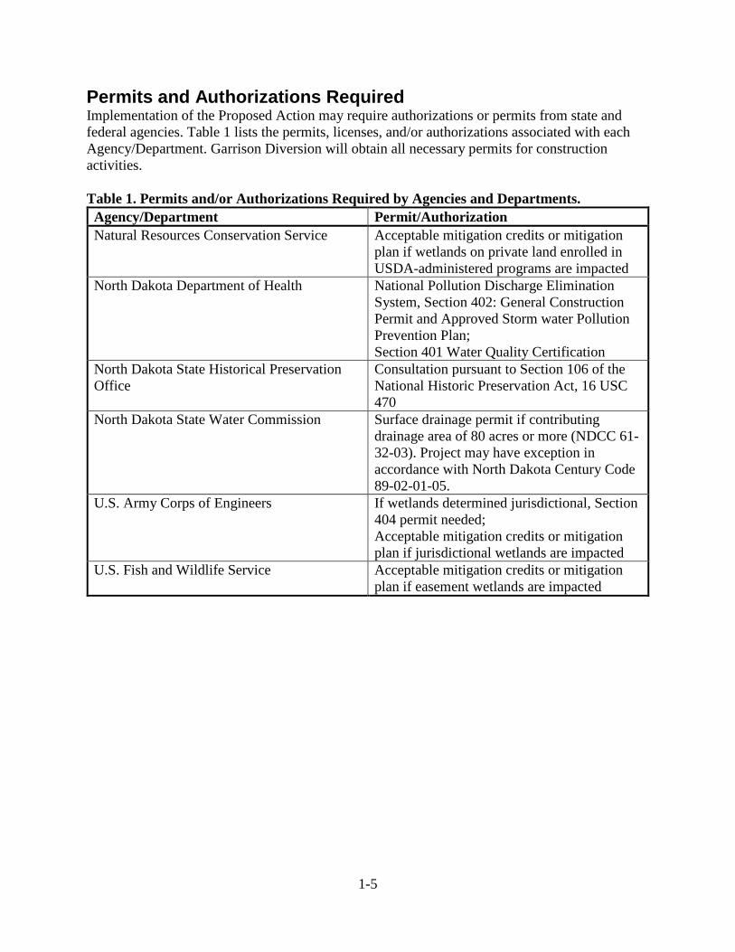
Permits and Authorizations Required Implementation of the Proposed Action may require authorizations or permits from state and federal agencies. Table 1 lists the permits, licenses, and/or authorizations associated with each Agency/Department. Garrison Diversion will obtain all necessary permits for construction activities. Table 1. Permits and/or Authorizations Required by Agencies and Departments.
Agency/Department Permit/Authorization Natural Resources Conservation Service Acceptable mitigation credits or mitigation
plan if wetlands on private land enrolled in USDA-administered programs are impacted
North Dakota Department of Health National Pollution Discharge Elimination System, Section 402: General Construction Permit and Approved Storm water Pollution Prevention Plan; Section 401 Water Quality Certification
North Dakota State Historical Preservation Office
Consultation pursuant to Section 106 of the National Historic Preservation Act, 16 USC 470
North Dakota State Water Commission Surface drainage permit if contributing drainage area of 80 acres or more (NDCC 61-32-03). Project may have exception in accordance with North Dakota Century Code 89-02-01-05.
U.S. Army Corps of Engineers If wetlands determined jurisdictional, Section 404 permit needed; Acceptable mitigation credits or mitigation plan if jurisdictional wetlands are impacted
U.S. Fish and Wildlife Service Acceptable mitigation credits or mitigation plan if easement wetlands are impacted

2-1
Proposed Action and Alternatives Considered No Action Alternative The No Action Alternative consists of the future without the proposed federal action – no federal funding and no repairs would occur to the Canal slide at MM 20 to MM 22. With the No Action Alternative, landslides and slope failures would continue to occur and the Canal would become plugged, stopping existing flows, resulting in no water deliveries downstream of the slide location. The operations and maintenance (O&M) roadway would continue to be nonfunctional. There would be potential revisions to the water service contract and Garrison Diversion Unit master repayment contract between Reclamation and Garrison Diversion. Proposed Action Alternatives The Proposed Action, Reclamation’s preferred alternative, would be to repair the Canal slide from MM 20 to MM 22. There are two different Proposed Action Alternatives being considered as part of this NEPA analysis. Alternative 1 Alternative 1 would include:
• flatten the slope from 2:1 to 4:1, resulting in the removal of approximately 3 million cubic yards of soil from the canal side slopes;
• reduce the canal capacity from 1,950 cubic feet per second to 500 cubic feet per second; • raise the canal invert from elevation of approximately 1,827 to 1,832; • decrease the canal bottom width from approximately 25 feet to 10 feet; • reconstruct roads on both sides of the canal with a width of 20 feet and an approximate
elevation of 1,849.5; • improve drainage around the project area by filling and draining adjacent wetlands which
contribute to slope instability through groundwater infiltration and added weight to canal slopes.
Construction Timing Construction is estimated to begin in Summer 2017. The Proposed Project would be split into subprojects, for an estimated six year duration. A subproject approach would allow the project to start or stop at any time along the slide area and provides a transition point from year to year. Earth moving activities would occur when the ground is not frozen, typically April through December. The 500 cfs capacity repair would be completed through the slide area by the end of Year 6. Construction Procedures Prior to construction, surveying and staking would be completed in the Project Area. Garrison Diversion would first obtain approval from Reclamation and participating landowners, then mark the limits of the approved work areas. If needed, cultural resource avoidance areas would be marked or fenced for protection. The “North Dakota One Call” would be contacted by Garrison Diversion to ensure no underground utilities are damaged during construction.

2-2
Reducing the side slope from 2:1 to 4:1 is required to achieve an acceptable factor of safety and provide a reliable water conveyance system. The 3.0 million cubic yards of soil removal would be split approximately between the right and left banks of the canal within Reclamation’s right-of-way (ROW). Reducing the canal capacity from 1,950 to 500 cfs, raising the canal invert, narrowing the bottom width, and raising the O&M roads reduces the required excavation volume, compared to restoring the canal to its original configuration. Figure 4 depicts a typical finished cross section of the canal.
Figure 4. Typical Finished Cross Section. Water would be allowed to flow through the Canal while excavating the canal prism at elevations about the O&M road. The watered portion of the canal prism below the O&M road would be diked off in sections and dewatered to allow for dry excavations. Once the Canal is excavated to the design grade the dike would be removed and water flow restored. The topsoil would be stripped on the Federal ROW before excavation so that it could be placed on top of the finished canal slopes and spoil piles. The excavated soil would be placed on existing spoil piles parallel to the banks of the canal and would be setback 20 feet from the edge of the new canal prism and setback 8 feet from adjacent property. The 20-foot setback is to ensure the weight of the berms does not surcharge the slope of the canal and decrease the reliability. The spoil pile would have a 5:1 slope on the canal side and a 4:1 slope on the adjacent property side. The spoil pile finish grade would be gradually sloped back toward the canal, so runoff would flow into the canal instead of infiltrating into canal slopes. When spreading excavated soil, lifts would be placed no greater than 12 inches and tracked in with a bulldozer. Canal O&M roads would also be maintained at a width of 20 feet to provide adequate space for maintenance vehicles to operate. The wetlands, adjacent to the canal on private property, are likely contributing to canal side slope instability due to infiltrating groundwater. These wetlands would be partially filled and drained into the canal, reducing ponding and groundwater infiltration, which would make the canal slopes more stable. An agreement would be entered into between Garrison Diversion and the property owner before entering and modifying private property. Placement of canal excavated material would be limited to the defined area to maintain the productivity of the agricultural land. Within the private land, the topsoil and 1st soil horizon would be stripped and stockpiled separate to restore the private lands after placing canal excavated material. The finish grade would be sloped to a culvert which would discharge into the canal. Construction would be performed by Garrison Diversion with staff and equipment, either owned or rented. Earth moving equipment would consist of tractor pulled tandem pan scrapers,

2-3
excavators, dozers, haul trucks, loaders, and a blade. The majority of soil would be moved using up to four tractor pulled tandem pan scraper units. Excavators would be used to excavate the culverts, water prism section, and final shaping of the slopes. Loaders and trucks would be used to transport aggregate used in beach belting and grave surfacing. A blade would prepare and maintain haul roads for equipment. If additional annual appropriations are made available, construction contract(s) may be issued to complete a portion of the Proposed Project. The use of the U.S. Army National Guard, as a training mission, would also be an option to complete a portion of the Proposed Project. Lands Involved Reclamation’s ROW and pending landowner approval, adjacent grasslands and wetland areas would be used for disposal of 3.0 million cubic yards of soil from the canal slopes. On a basis of cost for hauling soil, disposal of soil would occur first within the canal ROW, then on grasslands and wetlands on private property, and lastly on Reclamation’s ROW to the north of the excavation area. Reclamation’s ROW is approximately 700 feet on either side of the canal centerline. Most of the soil would be placed on Reclamation’s ROW adjacent to the canal. The spoil pile would be up to 20 feet high and 300 feet wide at the base, allowing for approximately 2.4 million cubic yards of soil. The private land areas considered for fill disposal are split into four areas: Area 1, Area 2, Area 3, and Area 4 (Figure 5).
• Areas 1, 1.1, 1.2, and 1.3 are located in the southwest portion of the Project Area and consists mainly of low wetland area with open water. Based on a balanced cut/fill and a plan area size of 16 acres with an average depth of 2 feet, approximately 50,000 cubic yards of soil would be placed in Area 1. The fill would be placed to a minimum of 0.80% slope, enhancing positive drainage and reducing long term ponding. A new culvert would be placed to drain the area directly into the Canal.
• Areas 2 and 2.1 are located in the northwest portion of the Project Area and used mainly for hay production. Based on a balanced cut/fill and a fill area of 21 acres with an average depth of 4 feet, approximately 145,000 cubic yards of soil would be placed in Area 2. Fill in this area would not change the drainage patterns and water would continue to be directed to an existing 24-inch culvert under 17th Avenue NW (McLean County Road 27).
• Area 3 is located in the southeast portion of the Project Area and contains a large wetland area. Based on a balanced cut/fill and a basin size of 21 acres and average depth of 3 feet, approximately 117,000 cubic yards of soil would be placed in Area 3. The fill would be placed to a minimum of 0.50% slope, enhancing positive drainage and reducing long term ponding. A new culvert would be placed to drain the area directly into the Canal.
• Area 4 is located in the northeast portion of the Project Area and is utilized for agriculture production. Soil would be placed in this area, resulting in improved drainage and returning it to agricultural use. Area 4 is approximately 50 acres with an average depth of 4 feet, up to approximately 325,000 cubic yards of soil could be placed in Area 4. Runoff in this area would be routed to three areas: a new 24-inch culvert, which would drain directly to the canal; an existing culvert under 16th Avenue NW near the intersection with 1st Street NW; and the existing discharge point on the southern end of 11th Avenue NW
Other private lands within the Project Area may be considered for excavated soil disposal and drainage with landowner approval.

2-4
Figure 5. Areas 1 – 4 Considered for Fill Disposal. Reclamation Restoration of vegetation is a critical component of the project. Vegetation would reduce future canal bank erosion and utilize soil moisture which would likely result in an increase to slope reliability. The different land types would require different levels of restoration. The long-term settlement of soils would be acceptable and there would be no extra means to compact the soil. A seed mix would be recommended by Natural Resources Conservation Service (NRCS) and approved by Reclamation and private landowners. The intended long-term use of fill areas on private lands would be for agricultural purposes, including row crop and cattle grazing. Therefore, topsoil would be separated from bottom layers of soil during removal. Topsoil for each property would be handled and stored in a separate location and replaced after the soil placement. By completing the Canal slide repair several benefits would occur downstream of the slide area including:
1. the number of irrigation acres per year would increase 3,500 acres annually after completion of the project, up to a capacity of the authorized 51,700 acres;
2. the freshening of downstream wetland and wildlife areas and provide an outlet for natural runoff accumulations into the canal system;
3. the flows downstream would provide water for the Chain of Lakes and Hoffer Lake recreation areas and instream flow maintenance on Painted Woods Creek and Turtle Creek for wildlife and livestock watering; and
4. the Canal repair would allow opportunity for future MR&I uses downstream of the slide area.
Alternative 2 Alternative 2 would include most of the elements presented in Alternative 1, however, Reclamation would utilize Federal ROW only for disposal of 3.0 million cubic yards of soil from the canal slopes. Reclamation would not improve drainage around the Project Area by filling or
2-5
draining adjacent wetlands, which contribute to slope instability through groundwater infiltration and added weight to canal slopes. The existing culverts would be replaced at existing locations and set at existing elevations. Canal slopes would need to be reduced to a slope flatter than 4:1 and/or interceptor drains would be placed within the Federal ROW to reduce the groundwater influence on canal slopes. As private lands would not be utilized, excess soil material would be hauled further north and disposed of on Federal ROW. Soil would be placed on upland areas, no wetland basins would be impacted. A portion of the soil may be placed on Federal ROW managed by USFWS as a GDU Wildlife Development Area. Alternatives Considered and Eliminated from Further Study Numerous previous studies have been completed on Alternatives to address the repairs on the Canal (Reclamation 2001, Houston Engineering 2005, Black & Veatch 2009). The following Alternatives were evaluated but eliminated because they did not meet the purpose or need for the Proposed Project or were not reasonable or feasible. Perform Minimal Excavation Necessary to Open and Maintain the Canal The efforts would be to include improvement of surface drainage and reshaping failed slopes as they occur. This alternative was eliminated due to: high risk of injury to construction workers, high maintenance costs, and continued unscheduled disruption of canal water flows. Stabilize Canal Slopes with Piers The Alternative involves stabilization of canal slopes using piers combined with reduced slope inclination. The slope would be reconstructed and a three-foot dimeter, heavily reinforced, auger-cast piers would be constructed on 6-foot centers along either side of the canal to depths exceeding 55 feet. This Alternative was eliminated due to: high costs and moderate effectiveness. Replace Open Canal with a Buried Culvert A round or box shaped culvert would be installed and canal slopes would be reduced. This Alternative was eliminated due to high costs. Temporary Repairs A number of temporary repairs were considered for the Proposed Project and included (Garrison Diversion and Reclamation 2013): Pumping Pumping 75 cfs would require approximately 1,500 total horsepower at 100 feet of pumping head and 10,000 feet of force main pipe. This Alternative was eliminated due to high costs, ongoing O&M costs, and safety concerns. Raising the Water Surface in Reach 1 Reach 1 is currently maintained at an elevation of 1845.5, which is 1.5 feet lower than Audubon Lake. Reach 1 would be increased to the same elevation as Audubon Lake, 1847.0, which would push water through the slide area. This Alternative was eliminated due to susceptibility to additional slide activity. Directional Drilling of a Siphon or Inverted Siphon

2-6
A siphon or inverted siphon directional drilling installation would require approximately 60-inch diameter high density polyethylene pipeline for approximately 8,000 feet. Intake and discharge structures would need to be constructed at each end of the siphon. This Alternative was eliminated due to high costs, limited head available, and unstable soils for pipeline installation. Create a Small Reservoir Levees would be constructed upstream and downstream of the slide area and a low head high flow pump would be used to pump water from upstream to create a small reservoir. The water level within the reservoir would inundate the material blocking the canal channel. A discharge structure would be incorporated with the downstream levee, allowing a passage of water. The pump station would operate simultaneous to the discharge to maintain stable water levels. This Alternative was eliminated due to temporary nature, complexities with timing of pumping operations and downstream discharges, and high costs.
3-1
Affected Environment and Environmental Consequences Introduction This section describes the existing conditions and potential impacts for resources which may be affected by the Proposed Project. The affected environment includes the existing communities, land, water, and air-sheds that might be affected by the Proposed Project. Environmental consequences to these resources may be direct (as a result of construction, operation, or maintenance) or indirect (generally subsequent to a direct effect but not directly resulting from proposed action), positive (beneficial) or negative (adverse), and long term (permanent, long-lasting) or short term (temporary). Measures that would be implemented to reduce, minimize, or eliminate impacts (mitigation measures) are presented in Chapter 4 as an inseparable part of the proposed action, Required Mitigation Measures for the Proposed Action, and discussed under each resource. The ultimate anticipated impacts of the Proposed Project, accounting for the use of mitigation measures, are summarized at the end of each resource section. Table 9 shows a summary of the temporary and permanent impacts that could occur as a result of the proposed action. The area of potential impacts (affected area) would be resource-specific and is defined in each individual resource discussion. The boundary of the affected area for each resource extends to where effects can be reasonably and meaningfully measured. Direct impacts would generally occur within the Project Area; however, some impacts may occur on a broader scale, encompassing an area beyond the Project Area. Impacts that may extend beyond the Project Area are disclosed in the section of each resource. Resources Considered and Eliminated from Further Analysis In light of Reclamation’s Environmental Commitments (Chapter 4) and in response to comments received from the scoping notice, the Proposed Project would have no potential to affect certain resource areas or its affect to certain resource areas is so minor (negligible) that it was discounted. These resources include: air quality and noise, recreation, environmental justice, public health and human safety, paleontological resources, wildlife, prime and unique farmlands, and visual resources (Table 2). Table 2. Resources Eliminated from Further Analysis.
Resource Rationale for Elimination from Further Analysis Air Quality and Noise
Proposed Action Alternatives would result in temporary effects during construction activities which would include fugitive dust and an increase in noise. Application of standard construction, industry measures would be taken to minimize fugitive dust emissions during construction activities. Noise impact would be short-term and would occur mainly during daylight hours.
Climate Change Proposed Action Alternatives would result in minor emissions due to construction activity. Climate change may result in changes to water demand, any new activity, including WSCs, on the Canal would be addressed through additional NEPA and NHPA compliance.
Recreation Proposed Action Alternatives would result in temporary effects during construction activities which would include loss of access to public lands.

3-2
Resource Rationale for Elimination from Further Analysis Recreation activities including but not limited to hunting, fishing, camping may increase in the Project Area if the Proposed Project is completed.
Environmental Justice
No Environmental Justice population has been identified that would disproportionately bear impacts of the Proposed Action Alternatives.
Indian Trust Assets (ITAs)
No impacts to ITAs are anticipated from the Proposed Action Alternatives.
Public Health and Human Safety
No impacts to public safety are anticipated from the Proposed Action Alternatives. Public access and transportation have the potential to be temporarily affected during construction activities.
Paleontological Resources
No response was received from the North Dakota State Paleontologist during scoping review. No impact to paleontological resources is anticipated from the Proposed Action Alternatives.
Wildlife Impacts to wildlife from the Proposed Action Alternatives would include displacement due to noise and traffic from construction activities. Impacts would be temporary and would cease upon completion of construction.
Prime and Unique Farmlands
Minimal acreage (<2.0 acres) of prime farmland would be disturbed by the Proposed Action Alternative 1. No acreage of prime farmland would be disturbed by the Proposed Action Alternative 2. Farmland of Statewide Importance is found throughout the Project Area. Impact would be temporary and care would be taken to restore areas to previous conditions.
Visual Resources Impacts to visual resources from the Proposed Action Alternatives would be temporary and would cease upon completion of construction activities.
Affected Environment and Environmental Consequences Water Resources and Hydrology Affected Environment Surface Water According to the Watershed Boundary Dataset (USGS 2015), the Project Area occurs within the Painted Woods-Square Butte sub-basin Hydrologic Unit (HUC-10130101). The Project Area is further divided into two subwatershed Hydrologic Units, with the upper portion of the project in Lake Ordway-Turtle Creek unit (HUC12-101301010402) and the lower portion of the project in Bethel Cemetery unit (HUC12-101301010505). The Lake Ordway-Turtle Creek Unit consists of a 34,972 acre watershed which follows Turtle Creek south into the Missouri River. The Bethel Cemetery Unit is classified as a closed basin watershed consisting of 36,462 acres, where all surface drainage is contained within the unit and no overland flow exits the hydrologic unit. However, the construction of the Canal has created an artificial surface connection in the Bethel Cemetery Unit, which connects the Canal to Painted Woods Creek, which then flows into the Missouri River (USDA et al. 2017). Figure 6 depicts surface water flow within the Project Area vicinity.

3-3
Figure 6. Surface Water Flow within and surrounding the Project Area.
3-4
Surface water drainage models were developed to inform the location of surface water infiltration sites along the side slopes of the Canal. Micro-watersheds extrapolated from LIDAR data using 1-foot contours were delineated immediately adjacent to the slide area to determine the current surface water movement toward or away from the Canal. Much of the Project Area drainage flows toward the Canal where it is either channelized into the Canal or collects in wetland basins adjacent to the Canal. Figure 7 depicts surface water drainage models within and adjacent to the Project Area. Wetlands According to the National Wetlands Inventory (NWI) (USFWS 2015), twenty-six freshwater emergent wetlands totaling 60 acres are contained within the Project Area (Figure 8). Seven of the wetlands consist of a temporarily flooded water regime (PEMA), which indicates they receive most of their water from snowmelt and direct precipitation. These types of wetlands are typically farmed each year, since the water has evaporated by mid-summer. Sixteen of the wetlands have a seasonally flooded water regime (PEMC), which indicates they are wet most of the growing season and become dry towards the end of the season; however, the water table is often near the ground surface. According to NWI, two of the seasonal wetlands have been partially drained or ditched (PEMCd). One freshwater pond that has been diked or impounded, likely for use as a stock dam, occurs within the Project Area (PABFh) (Cowardin et al. 1979). Consultation with USFWS indicates a wetland easement in the SE¼ of Section 32, T146N, R80W. No field wetland delineations or determinations have been conducted to date. Pending landowner permission to access, wetland delineations are anticipated to be completed in the Summer of 2017. Based on review of historical aerial photos from 1997 to 2013, it is believed the two largest wetlands occurring in the S½ of Section 33, T146N, R80W and the NE¼ of the SE¼ of Section 32, T146N, R80W may be considered groundwater discharge or flow through wetlands. The relatively stable presence of water in these wetlands may indicate they receive groundwater inflow in addition to surface runoff and precipitation (Sloan 1972). Based on the seasonality of the remainder of the wetlands in the Project Area, they would likely be considered flow through or groundwater recharge wetlands, losing most of their surface water through evaporation and transpiration. Groundwater Nearly all groundwater in McLean County is derived from precipitation. Surface water sources, such as lakes and wetlands, are in hydraulic connection with the aquifers. The aquifers may receive recharge from or discharge into these lakes and wetlands, depending on hydraulic head (Klausing 1974). While no surficial aquifers occur within the Project Area, the McClusky Canal intersects Lake Nettie, Turtle Lake, Lost Lake, Butte, and Painted Woods Creek aquifers (NDSWC 2016). According to 2017 North Dakota State Water Commission groundwater and surface water well data, four test holes, one functioning observation well, and one destroyed observation well, all owned by Reclamation, occur within the Project Area (NDSWC 2017). One driller log from 1972 for a stock well by Broenske Well Drilling occurs just outside the fill area in the SW¼ of Section 28, T146N, R80W. Reclamation has installed 51 monitoring wells within the Project Area, with water elevation measurements taken between 2000 and 2009 (Figure 9). Weekly water level, rainfall, and Canal water surface level measurements were made for several months after installation. As of April 2009, six wells have been destroyed within the Project Area due to various factors, including freezing and landslides.

3-5
Field investigations were conducted within the Project Area as part of an overall Canal Modification Feasibility study to determine the causes of the Canal failures. The stratigraphy of the Project Area can be divided into four general deposits, the Upper Layer, Upper Till, Extensive Sand Layer, and Lower Till. As part of the groundwater investigations, 25 piezometers were installed in February of 2000 to determine how the groundwater (measured by piezometric head) adjacent to the Canal responded to snowmelt, precipitation event and canal fluctuations. Two areas of saturation were found to occur within the Project Area, the first consisting of shallow sand lenses in the Upper Layer and the second occurring in the Extensive Sand Layer, which intersects and extends under the invert of the Canal. The Upper Layer is composed of sandy lean clay with numerous silt and sand lenses and a perched water table. Additionally, it was noted that the response of water surface elevation in piezometers located within the sand lenses of this Layer appeared to correlate to average daily precipitation measurements. Groundwater levels within the Extensive Sand Layer appeared to correlate with changes in the upstream Canal water surface elevation measurements; however, they did not correlate to downstream measurements. The study suggests groundwater flows in a southern direction through the Extensive Sand Layer, with the sand layer being recharged near station 1131+00 (located south of bridge R2-0) (Gemperline et al. 2001).

3-6
Figure 7. Surface Flow Model within and surrounding the Project Area.

3-7
Figure 8. National Wetland Inventory (NWI) within and surrounding the Project Area.

3-8
Figure 9. Groundwater Wells within and surrounding the Project Area.
3-9
Alternative 1 Under Alternative 1, no surficial aquifers occur within the Project Area, therefore no disturbance to aquifers would occur during project construction. Surface water would be affected through rerouting of surface runoff for Areas 1 – 4 as identified in Chapter 2, Lands Involved, to flow into or away from the Canal through a series of culverts, as discussed below. Surface drainage for each Area would include grading and culvert placement and may include draining and filling wetlands. Any surface drainage occurring on private lands would require landowner approval prior to construction. Area 1 wetlands in the SE¼ of Section 32 are currently under a USFWS easement. These wetlands are proposed to be graded and filled with excavated soil from the Canal repair work. Wetland mitigation for wetlands under USFWS easement would involve the transfer of easement acreage credits to a USFWS approved area. The wetlands basins would be graded to provide positive drainage. The grading would reduce season long water retention; however, groundwater inflow may continue to saturate the area underneath the fill. The use of artificial subsurface drainage would be considered upon further investigations of the wetland basin. The grading would combine wetlands in the SE¼ of Section 32 into a single drainage. Wetlands in the NE¼ of Section 32 would each be drained into the canal via culvert. Area 2 surface drainage patterns would remain unchanged, with only minor changes to grading. The existing culvert beneath 17th Avenue NW was deemed adequate and would remain in place. The Area 3 wetland would be filled in with excavated soils from the Canal repair work. The bottom of the wetland will be graded to provide positive drainage. The grading would reduce season long water retention; however, groundwater inflow may continue to saturate the area underneath the fill. The use of artificial subsurface drainage would be considered upon further investigations of the wetland basin. A new culvert would provide drainage directly into the Canal. The northern portion of Area 4 currently has surface and likely internal drainage issues in the SW¼ of Section 28. This area was previously filled with soil and surface drained to the canal. Over time drain maintenance has been neglected, resulting in water ponding and internal drainage issues with the area. Extensive grading is proposed, with wetlands and surface runoff routed to three areas, the existing discharge point on the southern end of 16th Avenue NW, a proposed 24-inch culvert which will drain into the canal, and a new 36-inch culvert to replace the existing culvert near the intersection of 1st Street NW and 16th Avenue NW . The proposed grading would eliminate the wetlands within Area 4. The use of artificial subsurface drainage would be considered upon further investigations of the wetland basin. The southern portion of Area 4 (NW¼ of Section 33) surface drainage patterns would remain similar, with only minor grading changes to a new culvert near the section line and existing culvert location on the southern end of 16th Avenue NW. Surface water management proposed within Reclamation ROW would include new culverts, culvert replacement, and culvert resizing to provide continuous flow from private lands. Total wetland acreage potentially impacted through draining and/or filling under Alternative 1 (based on NWI calculations) for Areas 1 – 4 on private land is 58 acres. Filling of wetlands would result in the loss of water storage during precipitation events and spring runoff. This surface runoff is anticipated to be routed through the proposed drainage systems discussed

3-10
above. All wetland acreage impacted during construction will be mitigated in coordination with NRCS, USACE, and USFWS. Each proposed surface drainage plan would affect groundwater through reduction of surface water infiltration through the soil in the wetland areas discussed above, thereby reducing groundwater recharge. Alternative 2 Under Alternative 2, no surficial aquifers occur within the Project Area, therefore no disturbance to aquifers will occur during project construction. Surface water management proposed within Reclamation ROW would be conducted to address deferred maintenance issues and culvert damage due to slope failures. This Alternative would include new culverts, culvert replacement, and culvert resizing to provide drainage at existing ground elevations and surface grading to provide positive surface drainage within Reclamation ROW. Surface drainage patterns along the tributary to Turtle Creek adjacent to Reclamation ROW would remain unchanged, with minor grading changes. All surface water drainage would be designed to avoid impacts to private lands and wetlands. No effect to surface water, wetlands, or groundwater is anticipated. No Action Alternative Under the No Action Alternative, the existing surface water channels would become silted and plugged. Existing culverts and structures would fail to convey water to the Canal. This would result in increased surface water ponding, increased ground water influence on the Canal, and enlarge wetland basins. The Canal would not flow water downstream of the slide area. Thus, water deliveries for irrigation, wildlife areas, Painted Woods Creek augmentation, and recreation would be reduced or eliminated. The Canal and Chain of Lakes water quality downstream of the slide area would also degrade over time. Threatened and Endangered Species Reclamation consulted the USFWS, North Dakota Ecological Service’s Office website (https://www.fws.gov/northdakotafieldoffice/SEtable.pdf) and the Information, Planning, and Conservation System (IPaC) (https://ecos.fws.gov/ipac/) to obtain a list of threatened and endangered species and critical habitats associated with the affected area (Table 3). This section constitutes the Biological Assessment for the Proposed Action as required under Section 7(c) of the Endangered Species Act of 1973, as amended, in compliance with regulations found at 50 CFR Part 402 Interagency Cooperation – Endangered Species Act of 1973, as Amended. Affected Environment The Action Area identified is based on Reclamation’s assessment of the potential direct and indirect effects of the proposed action to federally listed species (50 CFR 402.02). The evaluation of federally listed species focuses on the aquatic and terrestrial environments that may be influenced by the activities of the Proposed Project. Therefore, the Project Action Area consists of all areas where direct project impacts are proposed to occur (Figure 3). Table 3. Federally-Listed Species in the Action Area.
Group Species Federal Status1
Bird Interior Least Tern E Piping Plover T

3-11
Group Species Federal Status1
CH Rufa Red Knot T Whooping Crane E
Fish Pallid Sturgeon E Invertebrate Dakota Skipper T
Mammal Gray Wolf E
Northern Long-eared Bat T 1 T = threatened, E = endangered, CH = designated critical habitat. Interior Least Tern (Sterna antillarum) Interior least terns are 8 to 10 inches in length, have a black crown on their head, a white underside and forehead, grayish back and wings, orange legs, and a yellow bill with a black tip. Population Rangewide There are three subspecies of least tern: the eastern or coastal least tern (Sterna antillarum antillarum) that breeds along the Atlantic and Gulf Coast, the California least tern (Sterna antillarum browni) that breeds along the California Coast, and the interior least tern (Sterna antillarum athallasos) that extends from Texas to Montana, and from eastern Colorado and New Mexico to southern Indiana. The interior least tern was listed as endangered in 1985 (Federal Register 50:21784-21792). Historically, interior least terns utilized major river systems from Texas to Montana, and from eastern Colorado and New Mexico to southern Indiana. However, due to dams and channelization, much of their suitable nesting habitat has been eliminated and has disturbed food sources. Wintering locations have been documented along the Central American and South American coasts, from Venezuela to northeastern Brazil. Partial monitoring data from 2012 show population estimates at 13,855 (USFWS 2013a). The range-wide survey would suggest that overall the interior population of the least tern has surpassed the 7,000 birds’ recovery goal, but the distribution of those numbers and management of those areas is not yet as envisioned by the USFWS when the recovery plan was written. Action Area In North Dakota, the interior least tern nests on sparsely vegetated sandbars on the Missouri River and on shorelines of Missouri River reservoirs, where they feed mostly on small fish. The majority of interior least terns in North Dakota are on the Garrison Reach of the Missouri River. Partial monitoring data for the Missouri River from 2012 show interior least tern numbers at 742 (USFWS 2013a). Breeding season lasts from May through August, with peak nesting from mid-June to mid-July. While the proposed action will increase the amount of water conveyed from the Missouri River via Lake Audubon through the Canal, the proposed action is restoring the original water delivery determined by the previously authorized action, which was the original construction of the Canal. Although the Action Area contains small fish, the interior least tern preferred nesting and foraging habitat of sandy, vegetated shorelines and sandbars does not occur within the Action Area.
Source: http://tpwd.texas.gov/huntwild/wild/species/leasttern/

3-12
Piping Plover (Charadrius melodus) and its Designated Critical Habitat Piping plovers are about 7 inches in length and have a sand-colored upper body, and white underside. Breeding birds have a single black breastband, a black bar across the forehead, bright orange legs and bill, and a black tip on the bill. In the winter, piping plovers lose the black band, legs become a pale yellow, and the bill is mostly black. Population Rangewide Three sub-populations of piping plover have been identified: an interior Great Plains population, Atlantic Coast population, and a Great Lakes population. The piping plover was listed as threatened in 1985 (Federal Register 50:50726-50734). The breeding range includes Alberta, Saskatchewan, Manitoba, Montana, North Dakota, Minnesota, South Dakota, Nebraska, and Iowa. Wintering locations includes the Atlantic Coast from North Carolina south to Florida and on the Gulf of Mexico from Florida to Texas; northern Cuba, Puerto Rico, Bahamas, Greater Antilles, eastern Mexico, and the Yucatan Peninsula. Much like the interior least tern, piping plover numbers have declined due to dams and channelization, reducing suitable habitat. In 2006, the adult population of piping plovers was estimated at approximately 8,100, with 3,000 of that estimate in the Northern Great Plains (Elliott-Smith et al. 2009). The USFWS designated critical habitat for the Great Plains breeding population in 2002 (Federal Register 67:57637), Great Lakes breeding population in 2001 (Federal Register 66:22938), and the winter piping plover population in 2001 (Federal Register 66:36038). Action Area Piping plover nesting and foraging habitat in North Dakota consists of barren sand and gravel bars and shorelines of the Missouri River and shorelines of prairie alkali lakes. The piping plover occurs in North Dakota from mid-April to August, with peak breeding season from May to mid-July. While the proposed action will increase the amount of water conveyed from the Missouri River via Lake Audubon through the Canal, the proposed action is restoring the original water delivery determined by the previously authorized action, which was the original construction of the Canal. The piping plover preferred nesting and foraging habitat of barren sand and gravel bars and shorelines of alkali lakes does not occur within the Action Area. Designated critical habitat of the piping plover in North Dakota includes numerous alkaline lakes, Lake Sakakawea and the Missouri River. No designated critical habitat for the piping plover occurs within the Action Area. The nearest piping plover critical habitat occurs 3.5 miles southeast of the Action Area (Figure 10).
Source: https://www.fws.gov/midwest/endangered/pipingplover/pipingpl.html

3-13
Figure 10. Designated Critical Habitat for the Piping Plover near the Project Area.

3-14
Rufa Red Knot (Calidris canutus rufa) Rufa red knots are typically 9 to 11 inches in length. During the breeding seasons they are a mottled gray, black, and white that run into stripes on their head and face with a cinnamon-brown underside and face. The legs and bill are black. The bill is straight tapering to the tip. During the non-breeding season rufa red knots are white and gray. Population Rangewide The rufa red knot was listed as threatened in 2014 (Federal Register 79:73706-73748). The red knot migrates between its breeding grounds in the Canadian Arctic and several wintering regions, including the southeast United States, the northeast Gulf of Mexico, northern Brazil, and Tierra del Fuego at the southern tip of South America. During both the northbound and southbound migrations, red knots use key staging and stopover areas to rest and feed. Long-distance migrant shorebirds are highly dependent on the continued existence of quality habitat at a few key staging areas. These areas serve as stepping stones between wintering and breeding areas. A majority of the key migration staging areas are along the coasts; records of stopovers in the interior states show small numbers (fewer than 10) of red knots. Action Area While little is known about interior migrating red knots, they are believed to be rare migrants through North Dakota, occasionally utilizing wetlands as stopover habitat. Migration through North Dakota occurs from mid-May to mid-September, early October. Geolocator results from a study of eight knots wintering in Texas found five of the birds used the Northern Great Plains (Saskatchewan, Canada and North Dakota) as a stopover (USFWS 2013b). According to Ebirds.org, ten locations throughout North Dakota have documented observations of small number of red knots since 1982, with the nearest observation to the Action Area at Lonetree Wildlife Management Area (WMA). Knot migration through North Dakota is rare and although wetlands occur within the Action Area, the habitat is marginal in comparison to surrounding areas with documented use, such as Lonetree WMA.
Source: http://ecos.fws.gov/ecp0/profile/speciesProfile?spcode=B0DM; https://www.allaboutbirds.org/guide/red_knot/id
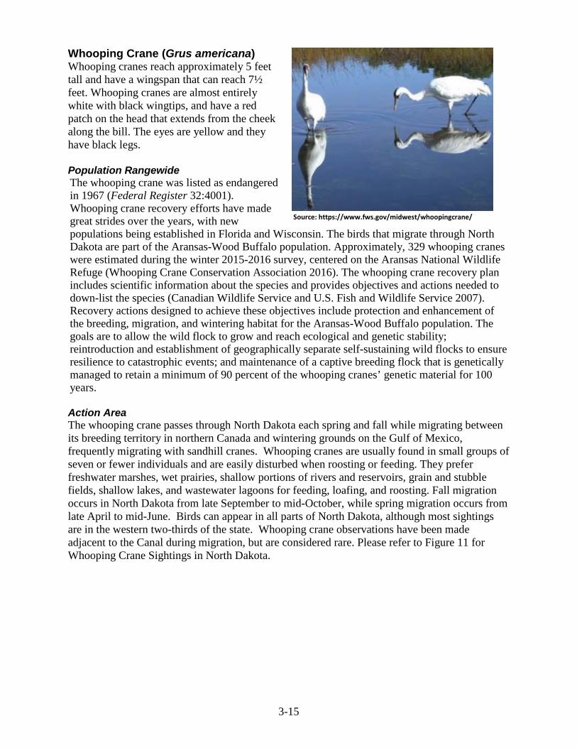
3-15
Whooping Crane (Grus americana) Whooping cranes reach approximately 5 feet tall and have a wingspan that can reach 7½ feet. Whooping cranes are almost entirely white with black wingtips, and have a red patch on the head that extends from the cheek along the bill. The eyes are yellow and they have black legs. Population Rangewide The whooping crane was listed as endangered in 1967 (Federal Register 32:4001). Whooping crane recovery efforts have made great strides over the years, with new populations being established in Florida and Wisconsin. The birds that migrate through North Dakota are part of the Aransas-Wood Buffalo population. Approximately, 329 whooping cranes were estimated during the winter 2015-2016 survey, centered on the Aransas National Wildlife Refuge (Whooping Crane Conservation Association 2016). The whooping crane recovery plan includes scientific information about the species and provides objectives and actions needed to down-list the species (Canadian Wildlife Service and U.S. Fish and Wildlife Service 2007). Recovery actions designed to achieve these objectives include protection and enhancement of the breeding, migration, and wintering habitat for the Aransas-Wood Buffalo population. The goals are to allow the wild flock to grow and reach ecological and genetic stability; reintroduction and establishment of geographically separate self-sustaining wild flocks to ensure resilience to catastrophic events; and maintenance of a captive breeding flock that is genetically managed to retain a minimum of 90 percent of the whooping cranes’ genetic material for 100 years. Action Area The whooping crane passes through North Dakota each spring and fall while migrating between its breeding territory in northern Canada and wintering grounds on the Gulf of Mexico, frequently migrating with sandhill cranes. Whooping cranes are usually found in small groups of seven or fewer individuals and are easily disturbed when roosting or feeding. They prefer freshwater marshes, wet prairies, shallow portions of rivers and reservoirs, grain and stubble fields, shallow lakes, and wastewater lagoons for feeding, loafing, and roosting. Fall migration occurs in North Dakota from late September to mid-October, while spring migration occurs from late April to mid-June. Birds can appear in all parts of North Dakota, although most sightings are in the western two-thirds of the state. Whooping crane observations have been made adjacent to the Canal during migration, but are considered rare. Please refer to Figure 11 for Whooping Crane Sightings in North Dakota.
Source: https://www.fws.gov/midwest/whoopingcrane/

3-16
Figure 11. Central Flyway Whooping Crane Corridor and Confirmed Sightings. Pallid Sturgeon (Scaphirhynchus albus) Pallid sturgeon are one of the largest fish found in the Missouri and Mississippi River Systems, weighing up to 85 pounds. Pallid sturgeon are typically light brown with a white underside. The snout is flat and shovel-shaped with fleshy chin barbels. Population Rangewide The pallid sturgeon was listed as endangered in 1990 (Federal Register 55:36641-36647). The pallid sturgeon requires turbid water and flow rates of large, free-flowing rivers. Historically the population ranged in the lower 200 miles of the Yellowstone River; the Missouri River (from Fort Benton, MT to St. Louis, MO); the Mississippi River from St. Louis south to Louisiana; larger tributaries include the Platte, Kansas, St. Francis, Ohio, Arkansas, and Yazoo/Big Sunflower Rivers; and the Atchafalaya River. Total length of the pallid sturgeon’s historical range was approximately 3,515 river miles (USFWS 2014). A majority of its habitat has declined due to river channelization, construction of impoundments, and related changes in water flow. Today, the pallid sturgeon has been limited to fragmented segments of free-flowing rivers within its historical range (Figure 12). Action Area
Source: https://www.fws.gov/southdakotafieldoffice/STURGEON.HTM

3-17
Pallid sturgeon observations have been reported on the Missouri River in North Dakota between Fort Peck Dam and Lake Sakakawea (Jordan 2006). The Canal does not contain habitat for the pallid sturgeon.
Figure 12. Current range of pallid sturgeon, includes both wild and hatchery-reared fish (available at: https://www.fws.gov/mountain-prairie/species/fish/pallidsturgeon/recoveryplan2014.pdf).

3-18
Dakota Skipper (Hesperia dacotae) Dakota skippers are small butterflies with a thick body and 1-inch wingspan. The male’s wings are tawny-orange to brown on the upper side with a prominent mark on the forewing, while the female’s wings are darker brown with tawny-orange spots and a few white spots on the forewing (USFWS 2016a). Population Rangewide The Dakota skipper was listed as threatened with a 4(d) rule in 2014 (Federal Register 79:63672-63748). Critical habitat was designated in 2015 (Federal Register 80: 59248-59384), with 38 units identified in three states including North and South Dakota, and Minnesota. Historically, the Dakota skipper had been recorded from northeast Illinois to southern Saskatchewan, although they likely occurred throughout the prairie in north-central U.S. and south-central Canada. The Dakota skipper requires high quality native prairie for each of the four stages of its life cycle. Two distinct habitat types have been identified, moist bluestem prairie and upland prairie on hillsides and ridges. This species is in decline due to the widespread conversion of native prairie to agricultural uses (USFWS 2016a). Action Area The Dakota skipper is known to occupy sites in McKenzie, McHenry, Rolette, Ransom, and Wells County in North Dakota; with critical habitat designated in those five counties as well as Richland County (species not detected in 2012-2013 surveys). No critical habitat has been designated in McLean County and none occurs in the Action Area. However, according to the North Dakota Ecological Service’s Office website and IPaC, McLean County is listed as a county of occurrence of the Dakota skipper. Vegetation dominance and the presence of requisite Dakota skipper vegetation were evaluated during a vegetation survey conducted by Reclamation personnel June 15 – 16, 2016. Prior to the survey, the Action Area was evaluated in ArcGIS to determine locations for intensive surveys. Since Dakota skipper are not documented to utilize reclaimed areas (which occur along the Canal ROW) and wetland areas do not contain their requisite species (USFWS 2016b), these areas were excluded from further analysis. After exclusion of unsuitable habitat, two native prairie parcels were analyzed in ArcGIS by categorizing them into Ecological Site Descriptions (ESDs) from Web Soil Survey and randomly generating points within each of the ESDs (NRCS 2015). Of the thirty randomly generated points, ten locations were chosen for intensive vegetation surveys: thin loamy (5), loamy (4), and clayey (1) ESD sites (Table 4). Within each survey location, vegetative species within a 5-foot radius were recorded and assigned an overall percent ground cover within the site. Based on geographic location of the survey locations, they were grouped into two overall site locations (Table 5). Smooth brome (Bromus inermis) and Kentucky bluegrass (Poa pratensis) were the predominant grass species present, with no observations of grass species typified for Dakota skipper larval habitat. Figure 13 depicts the survey locations within each of the two native prairie parcels and the associated ESD. Based on the results of the vegetation survey, Dakota skipper habitat is not present in the Action Area.
Source: http://mnzoo.org/blog/animals/dakota-skipper/
Female
Male
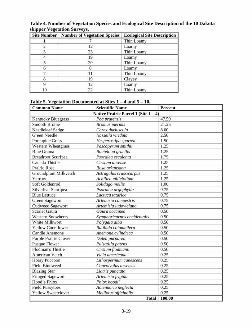
3-19
Table 4. Number of Vegetation Species and Ecological Site Description of the 10 Dakota skipper Vegetation Surveys.
Site Number Number of Vegetation Species Ecological Site Description 1 7 Thin Loamy 2 12 Loamy 3 23 Thin Loamy 4 19 Loamy 5 20 Thin Loamy 6 8 Loamy 7 11 Thin Loamy 8 19 Clayey 9 12 Loamy
10 22 Thin Loamy Table 5. Vegetation Documented at Sites 1 – 4 and 5 – 10.
Common Name Scientific Name Percent Native Prairie Parcel 1 (Site 1 – 4)
Kentucky Bluegrass Poa pratensis 47.50 Smooth Brome Bromus inermis 21.25 Needleleaf Sedge Carex duriuscula 8.00 Green Needle Nassella viridula 2.50 Porcupine Grass Hesperostipa spartea 1.50 Western Wheatgrass Pascopyrum smithii 1.25 Blue Grama Bouteloua gracilis 1.25 Breadroot Scurfpea Psoralea esculenta 1.75 Canada Thistle Cirsium arvense 1.25 Prairie Rose Rosa arkansana 1.25 Groundplum Milkvetch Astragalus crassicarpus 1.25 Yarrow Achillea millefolium 1.25 Soft Goldenrod Solidago mollis 1.00 Silverleaf Scurfpea Psoralea argophylla 0.75 Blue Lettuce Lactuca tatarica 0.75 Green Sagewort Artemisia campestris 0.75 Cudweed Sagewort Artemisia ludoviciana 0.75 Scarlet Gaura Gaura coccinea 0.50 Western Snowberry Symphoricarpos occidentalis 0.50 White Milkwort Polygala alba 0.50 Yellow Coneflower Ratibida columnifera 0.50 Candle Anemone Anemone cylindrica 0.50 Purple Prairie Clover Dalea purpurea 0.50 Pasque Flower Pulsatilla patens 0.50 Flodman's Thistle Cirsium flodmanii 0.50 American Vetch Vicia americana 0.25 Hoary Puccoon Lithospermum canescens 0.25 Field Bindweed Convolvulus arvensis 0.25 Blazing Star Liatris punctata 0.25 Fringed Sagewort Artemisia frigida 0.25 Hood’s Phlox Phlox hoodii 0.25 Field Pussytoes Antennaria neglecta 0.25 Yellow Sweetclover Melilotus officinalis 0.25
Total 100.00

3-20
Common Name Scientific Name Percent Native Prairie Parcel 2 (Site 5 – 10)
Kentucky Bluegrass Poa pratensis 40.83 Smooth Brome Grass Bromus inermis 25.50 Crested Wheatgrass Agropyron cristatum 8.50 Green Needle Grass Nassella viridula 5.17 Needleleaf Sedge Carex duriuscula 2.83 Western Wheatgrass Pascopyrum smithii 2.33 Needleandthread Hesperostipa comata 1.67 Blue Grama Bouteloua gracilis 1.17 Prairie Junegrass Koeleria macrantha 0.67 Spikeoat Avenula hookeri 0.17 Black Medic Medicago lupulina 0.83 Yellow Sweetclover Melilotus officinalis 0.67 Scarlet Gaura Gaura coccinea 0.67 White Milkwort Polygala alba 0.67 Common Dandelion Taraxacum officinale 0.67 Fringed Sagewort Artemisa frigida 0.50 Prairie Milkvetch Astragalus laxmannii 0.50 Prairie Coneflower Ratibida columnifera 0.50 Breadroot Scurfpea Psoralea esculenta 0.50 Goatsbeard Tragopogon dubius 0.50 Silverleaf Scurfpea Psoralea argophylla 0.50 American Vetch Vicia americana 0.50 Field Bindweed Convolvulus arvensis 0.33 Groundplum Milkvetch Astragalus crassicarpus 0.33 Cutleaf Goldenweed Haplopappus spinulousus 0.33 Scarlet Globemellow Sphaeralcea coccinea 0.33 Prairie Rose Rosa arkansana 0.33 Stiff Goldenrod Solidago rigida 0.33 Curlycup Gumweed Grindelia squarrosa 0.17 Nothern Bedstraw Galium boreale 0.17 Pennsylvania Cinquefoil Potentilla pensylvanica 0.17 Field Sowthistle Sonchus arvensis 0.17 Rush Skeletonplant Lygodesmia juncea 0.17 Purple Coneflower Echinacea angustifolia 0.17 Purple Prairie Clover Dalea purpurea 0.17 Blazing Star Liatris aspera 0.17 Prairie Chickweed Cerastium arvense 0.17 Alfalfa Medicago sativa 0.17 Yarrow Achillea millefolium 0.17 Wavy Leaf Thistle Cirsium undulaatum 0.17 Downy Paintbrush Castilleja sessiliflora 0.17
Total 100.00

3-21
Figure 13. Dakota Skipper Survey Locations at the Project Area.

3-22
Gray Wolf (Canis lupus) The gray wolf is the largest living member of its family (Canidae), with males averaging 88 pounds and females generally weighing 5-10 pounds less. Fur color in individuals can range from black to gray to white, sometimes red and brown. The gray wolf is a keystone predator and is considered a habitat generalist, occurring in temperate and boreal forests, mountains, tundra, and grasslands. Population Rangewide By the time wolves were protected by the ESA of 1973, only a few hundred remained in extreme northeastern Minnesota and a small number on Isle Royale, Michigan. The status of the gray wolf has changed multiple times since the original 1973 listing. In December 2011, the USFWS revised and removed the Western Great Lakes Distinct Population Segment of gray wolf from the list of endangered and threatened wildlife (Federal Register 76:81665-81726). In February 2015, following court orders, the USFWS reinstated the March 9, 1978 (Federal Register 43:9607) regulatory protection for the gray wolf, including the endangered status for gray wolves in the eastern half of North Dakota (Federal Register 80:9218-9229). Action Area The gray wolf is an infrequent visitor to North Dakota, occasionally entering the state from Minnesota or from Manitoba, Canada. The increasing wolf population in Minnesota and the accompanying expansion of wolf range westward and southwestward in the state have led to an increase in dispersing wolves in North Dakota. As the Minnesota and Canada populations continue to increase, North Dakota could expect to see additional transients. No surveys have been conducted to document the number of wolves in North Dakota; however, occasional lone dispersers that appear primarily in the eastern portion of the state. There were reports of pups in the Turtle Mountains of North Dakota, one wolf sighting was confirmed in early 2004, and two wolf depredation incidents were verified north of Garrison in late 2005 (Federal Register 71 (58):15286). There have been no verified recent sightings in the Project Area. Due to the relative absence of secluded habitat in most of North Dakota, there is considerable uncertainty regarding whether a wolf pack will establish or become more common in the state. According to Licht and Huffman (1996), wolves could recolonize portions of their former range on the prairie in the Dakotas. However, the agricultural dominated landscape (cropland, hayland and pasture) and relatively high densities of roads would facilitate negative encounters between wolves and humans, which could preclude their re-establishment. Northern Long-eared Bat (Myotis septentrionalis) Northern long-eared bats are a medium-sized bat, with very long ears. Their length is 3.0 – 3.7 inches with a wingspan of 9 – 10 inches. The fur color is medium to dark brown on the back with a tawny to pale-brown on their underside. Population Rangewide The northern long-eared bat was listed as threatened in 2015 (Federal Register 80:17974-18033) with a 4(d) rule in 2016 (Federal Register 81:1900-1922). The range of the northern long-eared bat includes much of the eastern and north-central United States and most of the
Source: https://www.fws.gov/wyominges/Species/NLEBat.php

3-23
Canadian provinces. The northern long-eared bat spends winters hibernating in caves and mines. In summer, the northern long-eared bat roosts underneath bark of live and dead trees, rock crevices, caves, mines, barns, and sheds. The dramatic decline of the northern long-eared bat is due to white-nose syndrome. There are many unknowns regarding white-nose syndrome, however it is expected that the disease will spread throughout the United States. Currently, North Dakota is not within the white-nose syndrome zone (Figure 14). Other sources of decline include impacts to hibernacula, degradation of summer habitat, and wind farm operation. Action Area Little work has been conducted in North Dakota to document the distribution of the northern long-eared bat in North Dakota. Summer surveys in North Dakota (2009 – 2011) documented this species in the Turtle Mountains, the Missouri River Valley, and the Badlands (Gillam and Barnhart 2012). Gillam and Barnhart (2012) found most of this bat species using tree roosts particularly cottonwoods. To date, no hibernacula or bat activity during the winter months has been documented in the state. Based on this species ecology and range, it is unlikely that this species would occur in the Action Area.
. Figure 14. White-nose syndrome zone (available at: https://www.fws.gov/midwest/endangered/mammals/nleb/pdf/WNSZone.pdf). Alternative 1 Due to the distance of the Action Area to the Missouri River and the absence of suitable habitat within the Action Area, Alternative 1 will have no effect on the interior least tern or pallid sturgeon.

3-24
Due to the distance of the Action Area to the closest piping plover designated critical habitat (located 3.5 miles southeast of the Canal) and the absence of suitable habitat within the Action Area, Alternative 1 will have no effect on the piping plover. The wetland designated as critical habitat for piping plover is not hydrologically connected to the Canal, therefore Alternative 1 will have no effect on piping plover designated critical habitat. Although wetlands providing potential habitat for whooping crane and rufa red knot occur in the Action Area, sightings of both species are rare in North Dakota and no recorded observations of either species has occurred within the Action Area. Therefore, Alternative 1 will have no effect on the rufa red knot and whooping crane. Alternative 1 would impact two parcels of native prairie through removal of vegetation; however, vegetative species typifying Dakota skipper larval habitat do not occur within these parcels. Additionally, no recorded observations of Dakota skipper occur within 0.6 mile of the Action Area. Due to the absence of larval habitat and no recorded observations within 0.6 mile the Action Area, Alternative 1 will have no effect on the Dakota skipper. North Dakota is not identified as a recovery area and gray wolves occur as rare, sporadic transients with no established populations in the state; therefore, Alternative 1 will have no effect on the gray wolf. Northern long-eared bat may use “suitable” roosting trees adjacent to the Canal within the Action Area. However, Reclamation is not aware of any survey results, nor have maternity roost trees or hibernacula been identified within the Action Area. Using 2015 National Agriculture Imagery Program (NAIP) aerial imagery, approximately 5.9 acres of tree removal would occur within the Action Area under Alternative 1. The trees would be removed during the non-active time of year, November 1 to March 31. Alternative 1 will have no effect on the northern long-eared bat. No endangered species are known to occupy the Action Area; however, in the event that any threatened or endangered species are encountered during activities, the contractor will contact Reclamation. Reclamation will consult with the USFWS to determine the appropriate steps to avoid any effects to these species, including cessation of construction. Alternative 2 Alternative 2 would involve ground disturbing activities associated with repairs to the Canal. However, all activities would occur within the Canal ROW, all of which has been previously disturbed through the original construction of the Canal. No private lands would be impacted as part of the proposed Alternative. Due to the lack of habitat within the Canal ROW, Alternative 2 would have no effect on the interior least tern, piping plover, piping plover designated critical habitat, rufa red knot, whooping crane, pallid sturgeon, Dakota skipper, or gray wolf. Northern long-eared bat may use “suitable” roosting trees adjacent to the Canal within the Action Area. However, Reclamation is not aware of any survey results, nor have maternity roost trees or hibernacula been identified within the Action Area. Using 2015 NAIP aerial imagery, approximately 3.9 acres of tree removal would occur within the Action Area under Alternative 2. The trees would be removed during the non-active time of year, November 1 to March 31. Alternative 2 will have no effect on the northern long-eared bat. No endangered species are known to occupy the Action Area; however, in the event that any threatened or endangered species are encountered during activities, the contractor will contact

3-25
Reclamation. Reclamation will consult with the USFWS to determine the appropriate steps to avoid any effects to these species, including cessation of construction. No Action Alternative The No Action Alternative would not involve ground disturbing activities associated with repairs to the Canal. Slope failures and landslides would continue to occur in this reach of the Canal; water would cease to flow through the Canal. Stoppage of flows would not affect any of the above federally listed species due to the absence of species or lack of habitat in the Action Area; therefore, the No Action Alternative would have no effect on the interior least tern, piping plover, piping plover designated critical habitat, rufa red knot, whooping crane, pallid sturgeon, Dakota skipper, gray wolf, or northern long-eared bat. Bald and Golden Eagle Protection Act Bald eagles (Haliaeetus leucocephalus) range in size from 30 – 43 inches in length, with a wingspan of 80 inches (6.5 feet). Weight ranges from 6 – 14 pounds, with females typically larger than males. Adult bald eagles have a dark brown body with a white head and tail. The range of the bald eagle is throughout most of North America. Both year-round and migratory individuals occur in North Dakota. Preferred habitat includes the Missouri River system, including Lake Sakakawea, the Heart River, Cannonball River, Sheyenne River, Red River, Souris River, and the Devils Lake basin (Figure 15A). Golden eagles (Aquila chrysaetos) range in size from 30 – 40 inches in length, with a wingspan of 79 inches (6.5 feet). Weight ranges from 6.5 – 13.0 pounds, with females typically larger than males. Adult golden eagles are mostly dark brown, with golden brown feathers on head and nape. The range of the golden eagle is throughout most of North America, with breeding in the western United States, southwestern Canada, and northern Mexico. Both year-round and migratory individuals occur in North Dakota. The badlands and Lake Sakakawea breaks are preferred habitat of golden eagles (Figure 15B). The Bald and Golden Eagle Protection Act (16 U.S.C. 668-668d, 54 Stat. 250) as amended was enacted in 1940 and prohibits anyone, without a permit, from taking bald eagles or golden eagles, including their parts, nests, or eggs.
Source: http://www.sdakotabirds.com/species/golden_eagle_info.htm
Source: http://www.southdakotamagazine.com/eagle-season

3-26
Figure 15. Primary and Secondary Range of Bald Eagles (A) and Golden Eagles (B) in North Dakota (NDGF 2016a; NDGF 2016b). Alternative 1 Golden eagle habitat does not occur in the project area. No known bald eagle nests occur in the project area. However, in the event that a bald eagle nest is observed:
• Construction within 660 feet of visible nesting bald eagles will be avoided from February 1 to August 15;
Based on the environmental commitments including those in Chapter 4 and lack of suitable golden eagle habitat in the project area, Reclamation has determined Alternative 1 would have no impact on golden eagles and bald eagles. Alternative 2 Impacts associated with Alternative 2 would be similar to Alternative 1, however Alternative 2 impacts would be maintained to Reclamation’s ROW. Environmental commitments would be maintained for Alternative 2. Reclamation has determined Alternative 2 would have no impact on golden eagles and bald eagles. No Action Alternative Under the No Action Alternative there would be no repair of the Canal. Current conditions would remain the same. Reclamation has determined the No Action Alternative would have no impact to golden eagles or bald eagles. Migratory Bird Treaty Act The Migratory Bird Treaty Act of 1918 (16 U.S.C. 703-712; Ch. 128; July 13, 1918; 40 Stat. 755) as amended, makes it illegal for anyone, without a permit, to take, possess, import, export, transport, sell, purchase barter, or offer for sale, purchase, or barter, any migratory bird, or the parts, nests, or eggs of such a bird. Alternative 1 The following environmental commitments would be utilized to reduce potential impact to migratory birds:
• Construction would avoid migratory bird habitats during the nesting brood rearing season (February 1 – July 15). If construction-type activities cannot avoid this time period, the construction area would be mowed and maintained prior to February 1 until construction

3-27
clearing has occurred. If that is not feasible, Garrison Diversion would follow the USFWS guidance that a qualified biologist conduct a field survey of the affected habitat to determine the presence or absence of nesting birds no greater than 5 days before construction or mowing. If nesting birds are found, Reclamation will contact USFWS for further guidance;
• Tree removal would occur outside of the nesting brood rearing season; • Any new signage will be placed in a manner as to not endanger raptors which may perch
on the top of the post. Based on the environmental commitments, including those in Chapter 4, Reclamation has determined Alternative 1 would have no impact to migratory birds.
Alternative 2 Environmental commitments for Alternative 1 would be the same for Alternative 2. Reclamation has determined Alternative 2 would have no impact to migratory birds. No Action Alternative Under the No Action Alternative there would be no repair of the Canal. Current conditions would remain the same. Reclamation has determined the No Action Alternative would have no impact to migratory birds. Cultural Resources Affected Environment Reclamation manages cultural resources along the Canal in accordance with Section 110 and Section 106 of the National Historic Preservation Act (NHPA) and other applicable laws and regulations. Under Section 110 of the NHPA, Reclamation has completed cultural resource surveys at the Canal and has conducted evaluations to determine what cultural resource sites are eligible for listing on the National Register of Historic Places (NRHP). Sites that are determined to be eligible for listing on the NRHP are given high cultural resource management consideration and status as historic properties. Section 106 of the NHPA requires Reclamation to consider effects to historic properties when planning and implementing actions such as those identified in this EA. The Canal is located in the Southern Missouri River Study Unit, which is one of 13 Study Units (drainage basins) used for prehistoric and protohistoric archeological site studies and management in North Dakota (Gregg et al. 2008). The majority of the cultural resource sites along the Canal are prehistoric stone circle sites and cairns. Stone circle sites, also called tipi ring sites, are distinguished by one or more circular rings of stone. Cairn are a pile or clustering of stones of varying size and shape. Rock cairns have been used for various purposes including, but not limited to, capping human burials, and ceremony, cache, trail, and boundary markers. Additional site types include prehistoric occupation sites, lithic scatters, historic sites, and sites consisting of the skeletal remains of prey animals. Occupation sites are scatters of artifacts, bone, pottery shards, and fire-cracked rock. Lithic scatters are distinct accumulations of stone (lithic) tools and/or debris from tool making. The sites consisting of faunal remains lack artifacts, but they appear to be have been made as the result of human activity. The Canal itself does not yet meet the criteria of a historic property due to its age. The Canal right-of-way was originally surveyed by the River Basin Survey staff of the Smithsonian in 1966 (Mallory). Additional surveys were performed by University of North

3-28
Dakota Archaeological Research (UNDAR) in 1997 (Wermers and Klinner 1998) and 1998 (Wermers and Klinner 1999), along with evaluative test excavations in 2000 (Klinner et al. 2002). Alternative 1 For Alternative 1, activities would occur within in the Canal ROW and in parcels of private land adjacent to the Canal. A Class I and Class III cultural resource inventory will be completed for the portions of the project area that fall outside of the existing Canal ROW prior to the commencement of ground-disturbing activities. Under the NHPA, criteria are used to determine a cultural resource site’s NRHP eligibility (36 CFR 60.4). In addition, criteria in 36 CFR Part 800 are applied to determine effects to historic properties. Any new cultural resources and historic properties identified during the survey(s) will be evaluated for listing on the NRHP, as necessary. Newly recorded resources whose significance cannot be established prior to disturbance will be left unevaluated for the NRHP. Previously identified cultural resources and historic properties outside of the Canal ROW will be assessed based on their previous NRHP evaluations. A Class I inventory of the entire area of potential effect (APE) was performed by Reclamation’s Area Archaeologist on February 21, 2017. One previously recorded cultural resource was identified in the project area; the resource is not eligible for listing on the NRHP.
• Cultural resources determined to not be NRHP eligible are managed to the discretion of Reclamation.
• The preferred treatment of the unevaluated cultural resource sites would be avoidance. However, if avoidance is not possible, the unevaluated sites within the APE would be evaluated for eligibility to the NRHP. Reclamation would then consult with the North Dakota State Historic Preservation Officer (NDSHPO) on the determination of NRHP eligibility and effects in accordance with the NHPA.
• As stated above, cultural resource sites that are included in or eligible for listing on the NRHP are given special status as historic properties. The preferred treatment of historic properties would be physical avoidance through the planning and design of activities and facilities and/or the avoidance of adverse effects. Reclamation would consult with the NDSHPO on the determination of effect in accordance with the NHPA if avoidance is not possible. The resolution of adverse effects would be done in consultation with the NDSHPO and tribes.
With the above stipulations, Reclamation has determined that Alternative 1 would have no effect on historic properties. Alternative 2 For Alternative 2, all activities would occur within the Canal ROW, all of which has been previously disturbed through the original construction of the Canal (Figure 16). This undertaking has no potential to affect historic properties and is exempt from further consultation with the NDSHPO in accordance with the terms of the Programmatic Agreement (Memorandum of Understanding No. 3-FC-60-03300). The undertaking meets the criteria of the programmatic agreement due to the fact that the activity will take place in completely disturbed areas and will not affect any buildings, structures, sites, objects, or districts older than 50 years in age. The project will be included in the annual report to the NDSHPO, which is a requirement of the programmatic agreement. Reclamation has determined that Alternative 2 would have no effect on historic properties.

3-29
Figure 16. Canal construction in the early1970’s. Pearl Wall herds cattle in the foreground (Courtesy of the State Historical Society of North Dakota [21081-08]). No Action Alternative There would be no effect to historic properties under the No Action Alternative. Vegetation, Noxious Weeds, and Soils
Affected Environment Landcover in the project area includes agricultural crops, native grasslands and tame grasslands. According to LANDFIRE (2015) data, dominant landcover is split between Modified/Managed Northern Tallgrass Grassland and Western Cool Temperate Developed Ruderal Grassland (Table 6; Figure 17). The Modified/Managed Northern Tallgrass Grassland is an area that is dominated by introduced perennial forbs or grassland species including but not limited to: Cirsium spp., Centaurea spp., Euphorbia esula (leafy spurge), Melilotus spp., Agropyron cristatum (crested wheatgrass), and Bromus inermis (smooth brome) (LANDFIRE 2015). The Western Cool Temperate Developed Ruderal Grassland includes herbaceous vegetation resulting from succession following significant anthropogenic disturbance of an area and is characterized by unnatural combinations of species (LANDFIRE 2015). During surveys by Reclamation completed on June 15 – 16, 2016, smooth brome and Kentucky bluegrass were the dominate vegetation documented in the area. Based on the vegetation survey, Area 2 and the NW¼ of Section 33, T146N, R80W within Area 4 are considered native grasslands, utilized mainly for cattle grazing. A list of other observed vegetation species can be found in Threatened and Endangered Species Section of this document (pages 3-17 – 3-18). Table 6. Landcover Types in Project Area (LANDFIRE 2015).
Landcover Alternative 1 (acres)
Alternative 2 (acres)

3-30
Western Cool Temperate Developed Ruderal Grassland 234.8 114.1 Modified/Managed Northern Tallgrass Grassland 226.6 196.8 Western Cool Temperate Row Crop 95.4 1.3 Developed-Roads 75.2 44.5 Western Cool Temperate Close Grown Crop 47.1 0.2 Western Cool Temperate Wheat 46.9 0.4 Open Water 45.6 32.5 Western Great Plains Depressional Wetland Systems 37.4 21.1 Western Cool Temperate Urban Herbaceous 19.8 11.8 Western Great Plains Wooded Draw and Ravine 18.0 11.1 Western Great Plains Floodplain Shrubland 4.4 3.8 Western Cool Temperate Urban Mixed Forest 2.9 2.9 Western Cool Temperate Pasture and Hayland 2.9 2.2 Western Cool Temperate Urban Evergreen Forest 1.8 0.9 Developed-Low Intensity 1.1 1.1 Western Cool Temperate Fallow/Idle Cropland 1.1 1.1 Western Cool Temperate Urban Shrubland 0.9 - Western Cool Temperate Developed Ruderal Shrubland 0.9 - Western Cool Temperate Row Crop - Close Grown Crop 0.9 0.4
Western Great Plains Floodplain Herbaceous 0.4 - North-Central Interior Dry-Mesic Oak Forest and Woodland 0.2 -
Total Acres 864.3 446.2 There are 11 weeds declared noxious by the state of North Dakota. Counties are able to list additional weeds if needed, however McLean County has no additional weeds listed as noxious. Five noxious weeds were recorded in 2015 for McLean County, for a total of 5,891 acres (Table 7). No noxious weeds were identified by Reclamation personnel during the surveys on June 15 – 16, 2016. Table 7. Noxious Weed Acreage in McLean County, North Dakota (North Dakota Department of Agriculture 2016).
Common Name Scientific Name Acres Absinth wormwood Artemisia absinthium 1,847 Canada thistle Cirsium arvense 3,096 Dalmatian toadflax Linaria genistifolia - Diffuse knapweed Centaurea diffusa - Leafy spurge Euphorbia esula 812 Musk thistle Carduus nutans 101 Purple loosestrife Lythrum salicaria - Russian knapweed Centaurea repens - Saltcedar Tamarisk ramosissima - Spotted knapweed Centaurea maculosa 35 Yellow toadflax Linaria vulgaris -
Total 5,891 Soils in the project area have been substantially disturbed through historical agricultural use and canal construction. A large percentage of the soils in the area are Ustarents loamy, canal-Water complex (Table 8, Figure 18). This series contains a slope of 0 – 75%, is located on fills on till plain and spoil banks on till plains, and is considered slightly saline.

3-31
Table 8. Soil Types in the Project Area (NRCS 2015).
Soil Type Alternative 1 (acres)
Alternative 2 (acres)
Ustarents loamy, canal-Water complex, 0% to 75% 420.7 384.5 Williams-Bowbells loams, 3% to 6% 264.6 23.5 Parnell silty clay loam, 0% to 1% 40.1 2.2 Regent-Savage silty clay loams, 6% to 9% 31.2 2.8 Williams-Zahl-Zahill complex, 6% to 9% 28.6 - Zahl-Werner complex, 15% to 35% 27.6 14.6 Williams-Bowbells loams, 0% to 3% 19.7 0.5 Wildrose silty clay, 0% to 2% 12.8 0.8 Arnegard loam, 0% to 2% 11.0 11.0 Harriet-Regan-Stirum complex, 0% to 2%, occasionally flooded 5.3
5.1
Williams-Bowbells loams, 6% to 9% 1.4 1.4 Williams-Zahl loams, 3% to 6% 0.2 - Total Acres 863.2 446.4
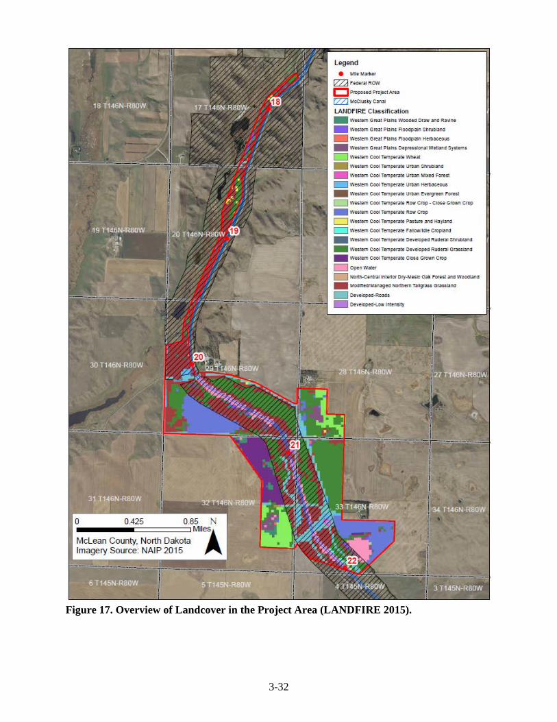
3-32
Figure 17. Overview of Landcover in the Project Area (LANDFIRE 2015).

3-33
Figure 18. Overview of Soil Types in the Project Area (NRCS 2016).

3-34
Alternative 1 Under Alternative 1, disturbance to all vegetation types would be expected to be temporary and minimal. Most construction activities would occur in areas that have been previously disturbed by the development of existing facilities and roadways, with the exception of Areas 2 and the southern portion of Area 4, which are considered native grassland. Garrison Diversion would reestablish vegetated areas disturbed during construction to stabilize disturbed soils and control the presence and spread of noxious weeds. All seed used for restoration would be certified “noxious weed free” before use. The seed mix would be recommended by NRCS and approved by Reclamation and private landowners. Alternative 2 Impacts associated with Alternative 2 would be similar to Alternative 1, however Alternative 2 impacts would be maintained to Reclamation’s ROW. All construction activities would occur in areas that have been previously disturbed by development of the Canal. No Action Alternative The No Action Alternative would have no impacts to vegetation, noxious weeds, and soils. Transportation and Roads Affected Environment Main access to the project area would include North Dakota State Highway 200 and local gravel roads: 16th Avenue NW, 17th Avenue NW, 1st Street NW, and Main Street (Figure 19). Canal maintenance roads would also be utilized to access the project area. Traffic is generally light in this area, consisting of local residents, farm and ranch traffic, and school busses. The county roads are maintained by McLean County Highway Department and the Canal maintenance roads are maintained by Garrison Diversion. McLean County Highway Department requested to be notified prior to any construction taking place. Alternative 1 Under Alternative 1, the direct impacts would include increased traffic in the Project Area due to construction activities. Heavy truck traffic may cause damage to roads and ditches. Garrison Diversion would restore road and ditches to their original conditions following each phase of construction. Additionally, roads would be maintained during construction to allow for an uninterrupted flow of traffic. Alternative 2 Under Alternative 2, the direct impacts include those discussed in Alternative 1. The impacts would be confined primarily to the Canal maintenance roads. No Action Alternative Under the No Action Alternative there would be no change to roads or transportation. Current conditions would remain the same.

3-35
Figure 19. Roads in the Project Area.

3-36
Cumulative Effects The definition of cumulative effects provided by the CEQ’s regulations is as follows: the impact on the environment which results from the incremental impact of the action when added to other past, present, and reasonably foreseeable future actions regardless of what agency (Federal or non-federal) or person undertakes such other actions (40 CFR § 1508.7). Cumulative impacts for the Proposed Project may include future water service contracts for users downstream that were originally anticipated before slides occurred along the canal, which was addressed in the Environmental Impact Statement for the Garrison Diversion Unit (Department of Interior 1979). Summary of Environmental Effects Reclamation has examined the potential for significant environmental effects to water resources and hydrology; threatened and endangered species; cultural resources; vegetation, noxious weeds, and soils; and transportation and roads (Table 9). Table 9. Summary of Environmental Effects.
Resource No Action Alternative Alternative 1 Alternative 2 Water Resources and Hydrology
Canal would not flow water to downstream water users. Canal water quality downstream of the slide would deteriorate. Over time, existing infrastructure would fail and pond water outside the Canal ROW.
Permanent effect to wetlands impacting Canal, which would be drained and filled. Mitigation for wetland impacts would be approved by U.S. Fish and Wildlife Service, Natural Resources Conservation Service, and U.S. Army Corps of Engineers.
No Effect
Threatened and Endangered Species, Bald and Golden Eagles, Migratory Birds
No Effect No effect to threatened and endangered species.
No effect to threatened and endangered species.
Cultural Resources
No Effect Consultation ongoing for cultural resources.
Consultation ongoing for cultural resources.
Vegetation, Noxious Weeds, and Soils
No Effect Temporary effect from devegetation. Disturbed area would be restored to previous or better conditions.
Temporary effect from devegetation. Disturbed area would be restored to previous or better conditions.
Transportation and Roads
No Effect Temporary effect, including increased traffic, during construction.
Temporary effect, including increased traffic, during construction. Fill would be trucked further north along Reclamation ROW to avoid private lands.

4-1
Environmental Commitments This Chapter presents environmental commitments which have been developed in consultation with Federal and State agencies, the Tribes, and the public in response to construction activities and scoping over the last decade of Reclamation water projects in North Dakota. These environmental commitments would be implemented to 1. Prevent, minimize, or offset the occurrence of or potential for adverse environmental effects and 2. Ensure compliance with applicable Federal and State regulations designed to protect fish and wildlife resources, important habitats and sensitive areas, cultural and paleontological resources, human health and safety, and the public interest. Should this project be constructed, Garrison Diversion would ensure the environmental commitments are implemented prior to and/or during construction of the Proposed Project, as the commitments are required for Reclamation funding. Appropriate environmental commitments would be incorporated into the designs, construction contracts, and specifications of the project. An Interagency Environmental Review Team, with appropriate agency representation, may be assembled to review environmental compliance in the field, as deemed appropriate. Table 10. Environmental Commitments regarding the McClusky Canal Slide Repair Project.
General Best Management Practices Comply with all appropriate Federal, State, and Local laws. Follow recommended practices for construction, restoration, and maintenance. Dump grounds, trash piles, and potential hazardous waste sites will be avoided. Standard construction, industry measures will be taken to minimize fugitive dust emissions during construction activities. Any complaints that may arise will be dealt with in a timely and effective manner. Erosion Best Management Practices (BMPs) will be followed to prevent runoff of soil, silt, and other debris.
Surface Water and Wetlands A 404 permit will be completed and submitted to the U.S. Army Corps (USACE), as necessary. Section 401 and 402 certification will be completed, as necessary. Wetland impacts will be appropriately mitigated according to the standards and direction of the USACE, Natural Resources Conservation Service (NRCS), and U.S. Fish and Wildlife Service (USFWS). Wetland impacts will comply with the Clean Water Act and Agricultural Act of 2014. Woody species including those bordering wetlands, shelterbelts, riparian woodlands, woody draws, or woodland vegetation will be avoided to the extent possible. For unavoidable impacts to woody habitats, replacement plants at a 2:1 ratio of native speciation would be planted, as appropriate. Erosion control measures will be employed as appropriate: Stabilization, erosion controls, restoration, and re-vegetation of all streambeds and embankments will be performed as soon as a stream crossing is completed and maintained until stable.
Fish and Wildlife Species and Habitat To the extent possible, construction would avoid: - Wetlands - Federal, State, and Local wildlife areas and refuges - Designated critical habitats - Migratory bird habitats during the nesting brood rearing season (February 1 – July 15)

4-2
To minimize impacts to fisheries resources any stream identified as a fishery (fisheries – confirm with ND Game and Fish Department) will be avoided from April 15 to June 1 and crossed later in the summer or fall when flows are low or the stream is dry. Construction within 660 feet of visible nesting bald eagles will be avoided from February through August. Project proponents will coordinate with the USFWS’s appropriate Refuges and Wetland Management Districts and provide the latest-map version of the Proposed Project to avoid impacts to USFWS lands, including wetland and grassland easements, national wildlife refuges (NWR), waterfowl production areas or other USFWS lands interface. If threatened or endangered species are identified and encountered during construction, all ground-disturbing activities in the immediate area will be stopped until Reclamation can consult with the USFWS to determine appropriate steps to avoid impacting the species. Native prairie will be avoided to the extent possible. However, if native prairie sod must be broken, existing topsoil will be carefully salvaged and replanted with native grasses in a timely manner, with a seed mix recommended by the local NRCS and approved by Reclamation and the landowner. Tree removal would take place during the non-active time of year for the northern long-eared bat and migratory birds (November 1 to January 31). Any new signage will be placed in a manner as to not endanger raptors which may perch on the top of the post.
Cultural Resources All cultural resource investigations will be performed according to the procedures specified in the programmatic agreement among Reclamation, the SHPO, and the Advisory Council on Historic Preservation for Reclamation activities in North Dakota. Cultural resource inventories will be performed under the direction of an archaeologist that meets the Secretary of the Interior’s Professional Qualifications Standards (48 FR 44738-9). All appropriate cultural resource activities will be completed prior to the commencement of ground-disturbing activities, including Class I and Class III surveys and consultation with the SHPO. All cultural resources, except those exempted in the programmatic agreement, will be avoided if their significance cannot be established prior to disturbance. If avoidance is not practicable, Reclamation, in consultation with the SHPO would determine if the site is eligible for nomination to the National Register of Historic Places [36CFR800.4(c) and 36CFR60.4]. If the site is eligible as a historic property, initially Reclamation, SHPO, and other interested parties, depending on the type of property, will consult to determine a plan of mitigation. If an adverse effect cannot be avoided, the Advisory Council on Historic Preservation will be contacted. All ensuing activities will comply with the NHPA, as amended, and the Archaeological Resource Protection Act. The Tribes will be consulted concerning the locations of unmarked burials or cemeteries. All such burials or cemeteries will be avoided to the extent possible. If a burial or cemetery cannot be avoided or is encountered during construction, Reclamation will comply with the Native American Graves Protection and Repatriation Act if graves are discovered on Federal or trust lands or within reservation boundaries. Reclamation will comply with North Dakota Century Code 23-06-27: “Protection of Human Burial Sites, Human Remains, and Burial Goods” for graves on private or State-owned lands. If unrecorded cultural resources or traditional cultural properties are encountered during construction, all ground disturbance activity within the area will be stopped, Reclamation and appropriate authorities will be notified, and all applicable stipulations of the NHPA will be followed. Activities in the area will resume only when compliance has been completed.
Paleontological Resources Reclamation consulted with the North Dakota Geological Survey to identify areas for paleontological survey where significant fossils are likely. No response was received. If paleontological resource(s) are uncovered during construction, Garrison Diversion stop construction and contact the state paleontologist for further direction.

5-2
Agency Consultation and Coordination Reclamation sent a scoping notice announcement to approximately 55 individuals including Native American Tribes, North Dakota’s congressional delegation, appropriate state and federal agency contacts, associated county government auditor offices, private individuals, non-government organizations and 2 published newspapers, the Bismarck Tribune and McClusky Gazette (Appendix A). Reclamation’s Scoping Notice and responses to Reclamation’s Scoping Notice are included in Appendix B. No private party responses were received. Eight agency letters of response were received: Bureau of Indian Affairs, North Dakota Geological Survey, North Dakota Department of Health, State Historical Society of North Dakota, USFWS, North Dakota State Water Commission, North Dakota Department of Transportation, and USACE. Three phone call responses were received: McLean County Highway, North Dakota Game & Fish Department, and West River Telecom. McLean County Highway would like to be advised prior to any construction taking place. The NDGF requested additional information on potential wetland impacts and had no further comment. West River Telecom advised on cable locations in the project area. Two email responses were received. McLean Electric Coop advised on the location of overhead power lines and clearance requirements in the project area and the National Park Service requested to be included in documentation to determine the optimal location of the North Country National Scenic Trail in this area. An interagency meeting occurred November 17, 2016, with Reclamation, USFWS, NRCS, and USACE regarding potential wetland impacts and mitigation. The mitigation efforts would be approved by all three agencies. Compliance with Environmental Statutes If the Proposed Action Alternative would be implemented, it would be accomplished in accordance and compliance with the following environmental laws, regulations, directives and compliance with the following:
• American Indian Religious Freedom Act of 1978 (P.L. 95-341) • National Historic Preservation Act of 1966 (P.L. 89-665), as amended 1992 (P.L. 102-
575) • Native American Grave Protection and Repatriation Act (P.L. 101-601) • Archaeological and Historic Preservation Act (P.L. 93-291) • Archaeological Resources Protection Act of 1979 (P.L. 96-95) • National Environmental Policy Act of 1969 (42 USC 4321) • Clean Air Act (33 USC 7401) and Amendments • Clean Water Act (33 USC 1251 et esq.), Sections 401, 402, and 404 • Endangered Species Act of 1973 (P.L. 93-205) (16 USC 1531-1544) • Farmland Protection Policy Act (P.L. 97-98) • Fish and Wildlife Coordination Act of 1958 (P.L. 85-624) • Indian Trust Responsibilities (512 DM Chapter 2) • Executive Order 13175 – Consultation and Coordination with Indian Tribal Governments • Federal Energy Policy Act of 2005 • Executive Order 11988 – Floodplain Management (1977)

5-2
• Executive Order 11990 – Protection of Wetlands (1977) • Executive Order 12898 – Environmental Justice (1994) • Executive Order 13007 – Indian Scared Sites (1996) • Executive Order – 11593 – Protection and Enhancement of the Cultural Environment
(1971) • Executive Order 13186 – Protection of Migratory Birds (2001) Responsibilities of
Federal Agencies to Protect Migratory Birds in furtherance of the purposes of the migratory bird conventions
• Executive Order 13112 – Invasive Species • Migratory Bird Treaty Act (16 USC 703-711) • Bald and Golden Eagle Protection Act (16 USC 668-668d) • Fish and Wildlife Coordination Act (16 USC 661-666c) • Endangered Species Act of 1973 (16 USC 1531-1544)
List of Preparers A list of individuals with primary responsibility for conducting this study, preparing the documentation, and providing technical reviews is below: Kate Kenninger – Natural Resource Specialist – DKAO – Bismarck, North Dakota Andrea Gue – Natural Resource Specialist – DKAO – Bismarck, North Dakota Randy Ehlis – Natural Resource Specialist – DKAO – Bismarck, North Dakota Matt Cox – Archaeologist – DKAO – Bismarck, North Dakota Mike Marohl – Agriculture Engineer – DKAO – Bismarck, North Dakota Nathan Kraft – Civil Engineer – DKAO – Bismarck, North Dakota Damien Reinhart – Supervisory Natural Resource Specialist – DKAO – Bismarck, North Dakota Joe Hall – Division Manager, Environment and Resources – DKAO – Bismarck, North Dakota Arden Freitag – Area Office Manager – DKAO – Bismarck, North Dakota

6-1
References Black & Veatch. 2009. Technical Memorandum Slide Repair Preliminary Design Study. Bryce, S.A., J.M. Omernik, D.A. Pater, M. Ulmer, J. Schaar, J. Freeouf, R. Johnson, P. Kuck,
and S.H. Azevedo. 1996. Ecoregions of North Dakota and South Dakota, (color poster with map, descriptive text, summary tables, and photographs): Reston, Virginia, U.S. Geological Survey (map scale 1:1,500,000).
Canadian Wildlife Service and U.S. Fish and Wildlife Service. 2007. International recovery plan
for the whooping crane. Ottawa: Recovery of Nationally Endangered Wildlife (RENEW), and U.S. Fish and Wildlife Service, Albuquerque, New Mexico. 162 pp. Available at: http://www.fwspubs.org/doi/suppl/10.3996/092012-JFWM-088/suppl_file/092012-jfwm-088r1-s09.pdf. Accessed June 14, 2016.
Cowardin L. M., V. Carter, F. C. Golet, E. T. LaRoe. 1979. Classification of Wetlands and
Deepwater Habitats of the United States. United States Department of Interior, Fish and Wildlife Service. U.S . Government Printing Office Washington, D.C . 20402.
Department of Interior. 1979. Final Comprehensive Supplementary Environmental Statement:
Garrison Diversion Unit, Pick-Sloan Missouri Basin Program, North Dakota. Doc. No. FES 79-7.
Elliott-Smith, E., S. Haig, and B. Powers. 2009. Data from the 2006 International Piping Plover
Census. U.S. Department of Interior, Geological Survey Data Series 426, 332 pp. Available at: http://pubs.usgs.gov/ds/426/pdf/ds426.pdf. Accessed June 22, 2016.
Garrison Diversion Conservancy District (GDCD) and U.S. Department of Interior Bureau of
Reclamation (Reclamation). 2013. McClusky Canal Slide Repair Recommendations. 73pp.
Gemperline, M., S. Robertson, and K. Weeghorst. 2001. Canal Modification Feasibility Study
for McClusky Canal – Reach 2 Station 1124+00 through 1204+00. Technical Service Center, U.S. Bureau of Reclamation. Denver, CO.
Gillam, E. & P. Barnhart. 2012. Distribution and Habitat Use of the Bats of North Dakota – Final
Report. Prepared for North Dakota Game and Fish. Available at: https://gf.nd.gov/sites/default/files/publications/T2-5-R%20Bat%20Survey%20Final%20Report%202012_0.pdf. Accessed January 10, 2017.
Gregg, M., A, Bleier, and F. E. Swenson. 2008. The Southern Missouri River Study Unit. In The
North Dakota Comprehensive Plan for Historic Preservation: Archaeological Component. Produced by and available at the Archaeology and Historic Preservation Division, State Historical Society of North Dakota, Bismarck, ND.

6-2
Houston Engineering. 2005. McClusky Canal, Reach 2 – Rehabilitation Station 1124+00 through Station 1204+00.
Jordan, G. 2006. Pallid sturgeon (Scaphirhynchus albus) range-wide stocking and augmentation
plan. Pallid Sturgeon Recovery Team plan submitted to U.S. Fish and Wildlife Service. Billings, MT.
Klausing, R.L. 1974. Ground – Water Resources of McLean County. United States Geological
Survey in Cooperation with the North Dakota State Water Commission, North Dakota Geological Survey, and McLean County Board of Commissioners, Bismarck, ND.
Klinner, D., G, Werners, and D. Toom. 2002. McClusky Canal 2000 Evaluative Test Excavations
at Archeological Sites 32BL144, 32BL145, 32BL175, 32ML896, 32ML899, and 32ML901,'Burleigh and McLean Counties, North Dakota. Department of Anthropology and Archaeology, University of North. Dakota, Grand Forks. Submitted to the U.S. Bureau of Reclamation, Dakotas Area Office, Bismarck, ND.
LANDFIRE. 2015. LANDFIRE Project. U.S. Department of Agriculture, Forest Service; U.S.
Department of Interior. Available at: http://www.landfire.gov/index.php. Accessed December 23, 2016.
Licht, D. & L. Huffman. 1996. Gray Wolf Status in North Dakota. The Prairie Naturalist 28(4):
169-174. Available at: http://digitalcommons.unl.edu/cgi/viewcontent.cgi?article=1059&context=usfwspubs. Accessed January 10, 2017.
Mallory, O. 1966. An Appraisal of the Archaeological Resources of the Garrison Diversion
Project, North Dakota, November 1966. A Project of the Inter-Agency Archaeological and Paleontological Salvage Program. Prepared by the River Basin Surveys, Smithsonian Institution. Manuscript on file at the State Historical Society of North Dakota, Bismarck, ND.
National Oceanic and Atmospheric Administration (NOAA). 2002. Monthly Station Normals of
Temperature, Precipitation, and Heating and Cooling Degree Days 1971-2000. Climatography of the United States, No. 81. Available at: https://www.ndsu.edu/fileadmin/ndsco/normals/documents/7100/NDnorm.pdf. Accessed October 24, 2016.
Natural Resources Conservation Service, United States Department of Agriculture. 2016. Web
Soil Survey. Available at: https://websoilsurvey.sc.egov.usda.gov/App/HomePage.htm. Accessed January 3, 2016.
North Dakota Department of Agriculture. 2016. 2015 McLean County Annual Weed Board
Report. Available at: http://agdepartment.vision-technology.com/weedsurvey/report.asp. Accessed December 23, 2016.

6-3
North Dakota Game and Fish Department. 2016. Bald Eagle. Available at: https://gf.nd.gov/wildlife/id/raptors/bald-eagle. Accessed January 10, 2017.
North Dakota State Water Commission (NDSWC). 2016. Surficial Aquifers - Vector data. North
Dakota State Water Commission, 900 E. Boulevard Avenue Bismarck, ND 58505. Retrieved from: https://apps.nd.gov/hubdataportal/srv/en/main.home from ND GIS Hub.
————. 2017. Ground/Surface Water Data and Well Driller Logs. North Dakota State Water
Commission, 900 East Boulevard Avenue, Dept 770, Bismarck, ND. Sloan, C. E. 1972. Ground-Water Hydrology of Prairie Potholes in North Dakota. Geological
Survey Professional Paper 585-C. Department of Interior. U.S. Government Printing Office Washington, D.C. 20402.
United States Department of Agriculture (USDA), United States Geological Survey (USGS),
Environmental Protection Agency (EPA). 2017. Watershed Boundary Dataset for North Dakota. Available at: http://datagateway.nrcs.usda.gov
U.S. Fish and Wildlife Service (USFWS). 2013a. Interior Least Tern (Sternula antillarum) 5-
Year Review: Summary and Evaluation. https://ecos.fws.gov/docs/five_year_review/doc4294.pdf
————. 2013b. Rufa Red Knot Ecology and Abundance, Supplement to: Endangered and
Threatened Wildlife and Plants; Proposed Threatened Status for the Rufa Red Knot (Calidris canutus rufa). Docket No. FWS-R5-ES-2013-0097; RIN 1018-AY17. Available at: https://www.fws.gov/northeast/redknot/pdf/20130923_REKN_PL_Supplement02_Ecology%20Abundance_Final.pdf. Accessed January 10, 2017.
————. 2014. Revised Recovery Plan for the Pallid Sturgeon (Scaphirhynchus albus). U.S.
Fish and Wildlife Service, Denver, Colorado. 115 pp. Available at: https://www.fws.gov/mountain-prairie/species/fish/pallidsturgeon/RecoveryPlan2014.pdf. Accessed June 23, 2016.
————. 2015. National Wetlands Inventory website. U.S. Department of the Interior, Fish and
Wildlife Service, Washington, D.C. Available at: http://www.fws.gov/wetlands/. Accessed October 1, 2016.
————. 2016a. Dakota skipper (Hesperia dacotae). U.S. Fish and Wildlife Service,
Endangered Species, Midwest Region. Available at: https://www.fws.gov/midwest/Endangered/insects/dask/daskFactSheet.html. Accessed January 10, 2017.
————. 2016b. Guidance for Interagency Cooperation under Section 7(a)(2) of the
Endangered Species Act for the Dakota Skipper, Dakota Skipper Critical Habitat, and Poweshiek Skipperling Critical Habitat, Verision 1.1. Available at:

6-4
https://www.fws.gov/midwest/endangered/insects/dask/pdf/DakotaSkipperS7GuidanceV1.1.pdf. Accessed January 5, 2017.
Wermers, G. L. and D. Klinner. 1998. McClusky Canal Cultural Resources Inventory of Selected
Areas in Burleigh and McLean Counties, North Dakota. Department of Anthropology and Archaeology, University of North Dakota, Grand Forks. Submitted to the U.S. Bureau of Reclamation, Dakotas Area Office, Bismarck, ND.
————. 1999. McClusky Canal 1998 Cultural Resources Inventory of Selected Areas in
Burleigh, Sheridan, and McLean Counties, North Dakota. Department of Anthropology and Archaeology, University of North. Dakota, Grand Forks. Submitted to the U.S. Bureau of Reclamation, Dakotas Area Office, Bismarck, ND.
Whooping Crane Conservation Association. 2016. Winter 2015/16 Whooping Crane Survey
Results. Available at: http://whoopingcrane.com/author/wcca_admin/. Accessed June 14, 2016.

A-1
Appendix A: Scoping Notice Contact List

A-2
AUDUBON DAKOTA CHAPTER, EXECUTIVE DIRECTOR AUDUBON NATIONAL WILDLIFE REFUGE, MR. TODD FRERICHS BUREAU OF INDIAN AFFAIRS- GREAT PLAINS REGIONAL OFFICE, PROGRAM DIRECTOR BUREAU OF LAND MANAGEMENT, NORTH DAKOTA FIELD OFFICE DAKOTA RESOURCE COUNCIL DUCKS UNLIMITED GARRISON DIVERSION CONSERVANCY DISTRICT, MR. DUANE DEKREY FEDERAL HIGHWAY ADMINISTRATION, MR. WENDALL MEYER INDIAN AFFAIRS COMMISSION, MR. SCOTT DAVIS MCLEAN COUNTY AUDITOR MCLEAN COUNTY HIGHWAY DEPARTMENT MCLEAN COUNTY WATER RESOURCE BOARD MCLEAN ELECTRIC COOP. MHA NATION, HONORABLE MARK FOX, CHAIRMAN MHA NATION- TRIBAL HISTORIC PRESERVATION OFFICE, ELGIN CROWS BREAST NATURAL RESOURCES CONSERVATION SERVICE, MR. DAVID HENDRICKSON NATURAL RESOURCE CONSERVATION SERVICE, MS. MARY PODOLL NORTH COUNTRY NATIONAL SCENIC TRIAL, MR. MARK WEAVER NORTH DAKOTA CHAPTER OF THE WILDLIFE SOCIETY, PRESIDENT NORTH DAKOTA DEPARTMENT OF COMMERCE, MR. AL ANDERSON NORTH DAKOTA DEPARTMENT OF HEALTH, MR. WAYNE KERN NORTH DAKOTA DEPARTMENT OF HEALTH- ENVIRONMENTAL HEALTH SECTION, MR. DAVID GLATT NORTH DAKOTA DEPARTMENT OF TRANSPORTATION, MR. GRANT LEVI NORTH DAKOTA DEPARTMENT OF TRUST LANDS, MR. MIKE HUMANN

A-3
NORTH DAKOTA GAME AND FISH DEPARTMENT, NATURAL RESOURCES CHIEF NORTH DAKOTA GEOLOGICAL SURVEY, STATE GEOLOGIST NORTH DAKOTA GEOLOGICAL SURVEY, STATE PALONTOLOGIST NORTH DAKOTA GOVENOR JACK DALRYMPLE NORTH DAKOTA INDUSTRIAL COMMISSION NORTH DAKOTA IRRIGATION ASSOCIATION NORTH DAKOTA PARKS AND RECREATION DEPARTMENT, MR. MARK ZIMMERMAN NORTH DAKOTA STATE WATER COMMISSION, MR. GARLAND ERBELE NORTH DAKOTA STATE WATER COMMISSION, MR. JEFFREY MATTERN NORTH DAKOTA TOURISM DIVISION, MS. SARAH OTTE COLEMAN NORTH DAKOTA WILDLIFE FEDERATION, MR. MIKE MCENROE OTTERTAIL POWER COMPANY SIERRA CLUB, PRESIDENT DAKOTA CHAPTER SPIRIT LAKE TRIBE, HONORABLE MYRA PEARSON, CHAIRWOMAN SPIRIT LAKE TRIBE- TRIBAL HISTORIC PRESERVATION OFFICER, DR. ERICH LONGIE STANDING ROCK SIOUX TRIBE, HONORABLE DAVE ARCHAMBAULT II, CHAIRMAN STANDING ROCK SIOUX TRIBE, TRIBAL HISTORIC PRESERVATION OFFICER, JON EAGLE STATE HISTORICAL SOCIETY OF NORTH DAKOTA, MS. CLAUDIA BERG TURTLE LAKE IRRIGATION DISTRICT TURTLE MOUNTAIN BAND OF CHIPPEWA, HONORABLE CHARIMAN RICHARD MCCLOUD TURTLE MOUNTAIN BAND OF CHIPPEWA, TRIBAL HISTORIC PRESERVATION OFFICER U.S. ARMY CORPS OF ENGINEERS, MS. PATRICIA MCQUEARY

A-4
U.S. ARMY CORPS OF ENGINEERS, MR. TODD LINDQUIST USDA RURAL UTILITIES SERVICE U.S. FISH AND WILDLIFE SERVICE, MR. KEVIN SHELLEY U.S. FISH AND WILDLIFE SERVICE, ZONE ARCHAEOLOGIST U.S. GEOLOGICAL SURVEY UNITED STATES HOUSE OF REPRESENTATIVES, HONORABLE KEVIN KRAMER UNITED STATES SENATOR, HONORABLE HEIDI HIETKAMP UNITED STATES SENATOR, HONORABLE JOHN HOVEN WEST RIVER TELECOM 6 PRIVATE LANDOWNERS

B-1
Appendix B: Scoping Letter and Scoping Letter Responses

B-2

B-3

B-4

B-5
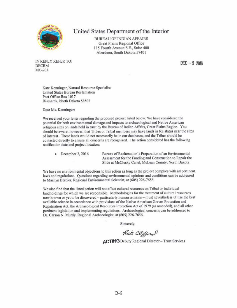
B-6

B-7

B-8

B-9

B-10

B-11

B-12

B-13
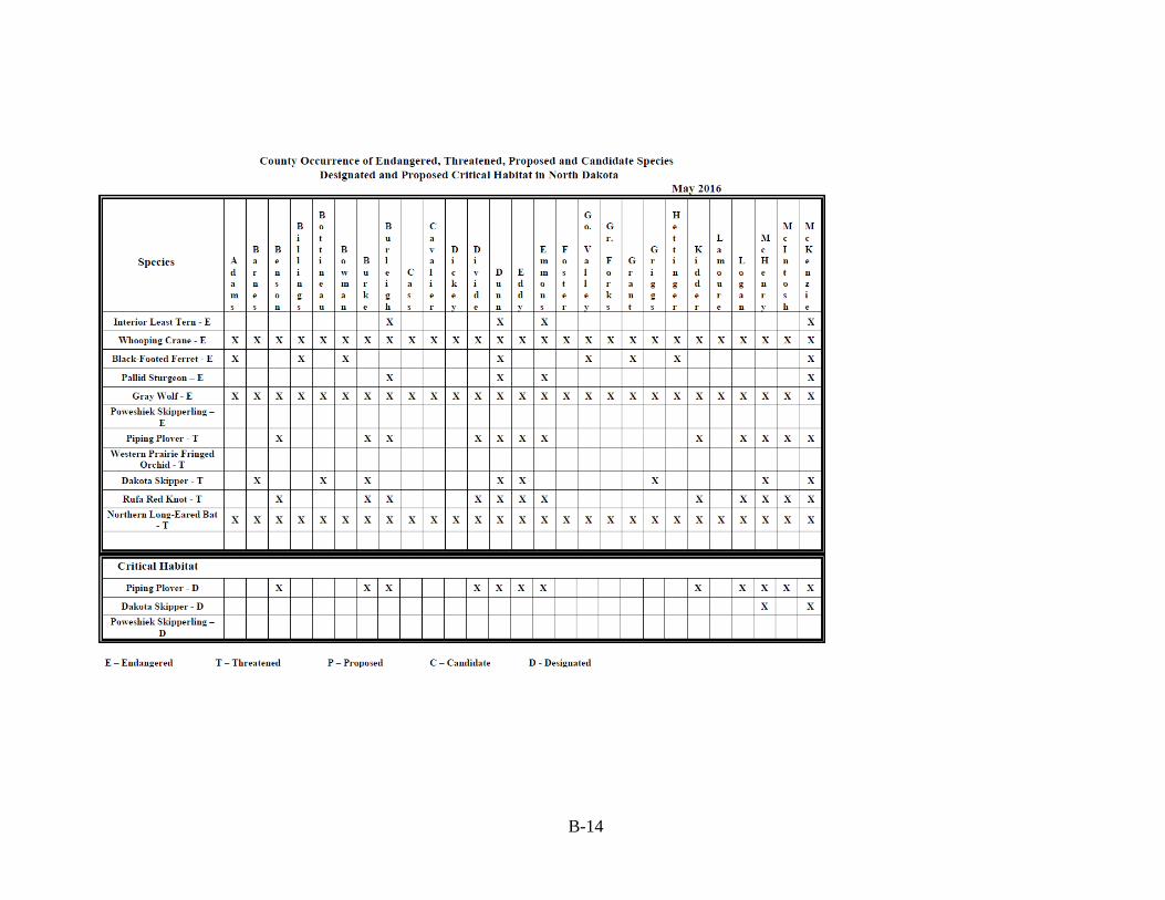
B-14

B-15

B-16

B-17

B-18

B-19

B-20