environmental assessment - defense technical … · environmental assessment: ... 1.3 intent and...
TRANSCRIPT

ENVIRONMENTAL ASSESSMENT
TARGET UPGRADES ON LEACH LAKE TACTICAL RANGE AT THE NATIONAL TRAINING CENTER, FORT IRWIN, CALIFORNIA
June 2006
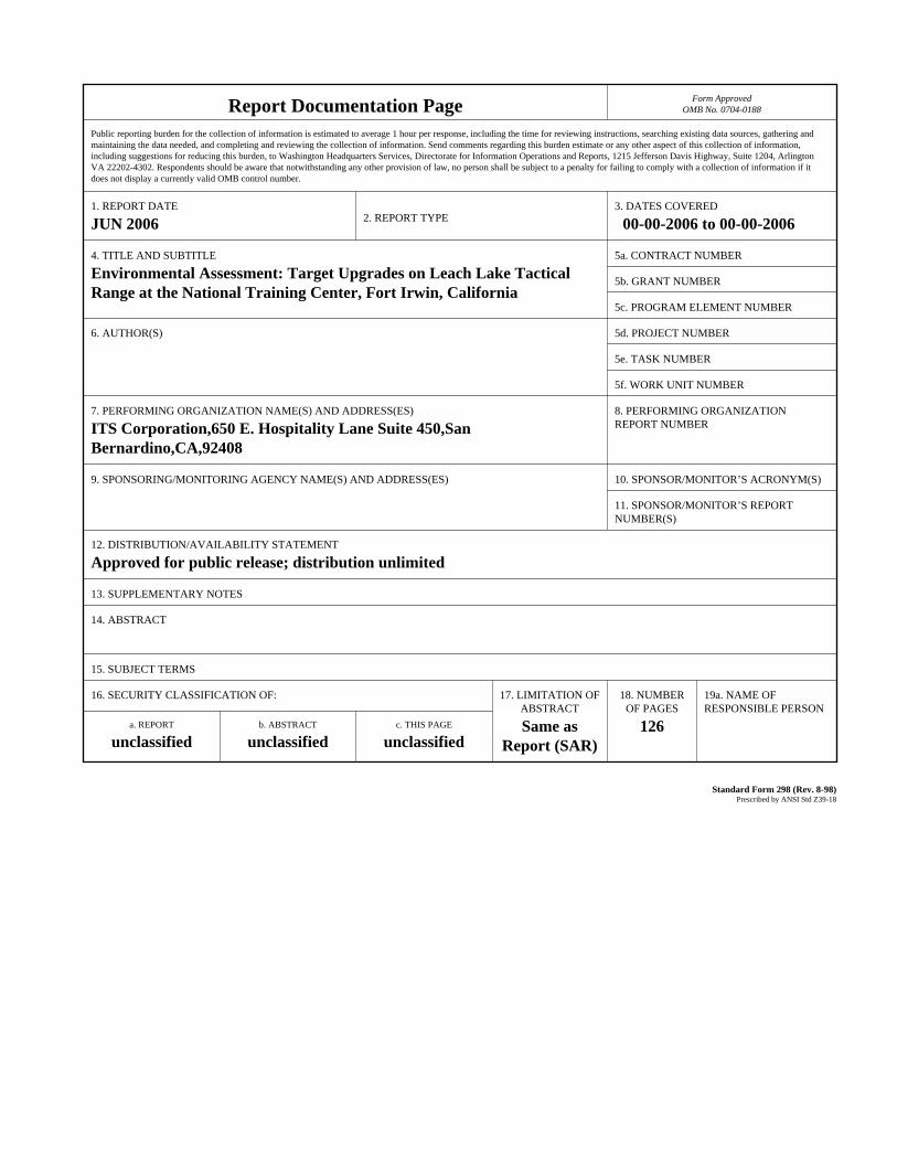
Report Documentation Page Form ApprovedOMB No. 0704-0188
Public reporting burden for the collection of information is estimated to average 1 hour per response, including the time for reviewing instructions, searching existing data sources, gathering andmaintaining the data needed, and completing and reviewing the collection of information. Send comments regarding this burden estimate or any other aspect of this collection of information,including suggestions for reducing this burden, to Washington Headquarters Services, Directorate for Information Operations and Reports, 1215 Jefferson Davis Highway, Suite 1204, ArlingtonVA 22202-4302. Respondents should be aware that notwithstanding any other provision of law, no person shall be subject to a penalty for failing to comply with a collection of information if itdoes not display a currently valid OMB control number.
1. REPORT DATE JUN 2006 2. REPORT TYPE
3. DATES COVERED 00-00-2006 to 00-00-2006
4. TITLE AND SUBTITLE Environmental Assessment: Target Upgrades on Leach Lake TacticalRange at the National Training Center, Fort Irwin, California
5a. CONTRACT NUMBER
5b. GRANT NUMBER
5c. PROGRAM ELEMENT NUMBER
6. AUTHOR(S) 5d. PROJECT NUMBER
5e. TASK NUMBER
5f. WORK UNIT NUMBER
7. PERFORMING ORGANIZATION NAME(S) AND ADDRESS(ES) ITS Corporation,650 E. Hospitality Lane Suite 450,San Bernardino,CA,92408
8. PERFORMING ORGANIZATIONREPORT NUMBER
9. SPONSORING/MONITORING AGENCY NAME(S) AND ADDRESS(ES) 10. SPONSOR/MONITOR’S ACRONYM(S)
11. SPONSOR/MONITOR’S REPORT NUMBER(S)
12. DISTRIBUTION/AVAILABILITY STATEMENT Approved for public release; distribution unlimited
13. SUPPLEMENTARY NOTES
14. ABSTRACT
15. SUBJECT TERMS
16. SECURITY CLASSIFICATION OF: 17. LIMITATION OF ABSTRACT Same as
Report (SAR)
18. NUMBEROF PAGES
126
19a. NAME OFRESPONSIBLE PERSON
a. REPORT unclassified
b. ABSTRACT unclassified
c. THIS PAGE unclassified
Standard Form 298 (Rev. 8-98) Prescribed by ANSI Std Z39-18
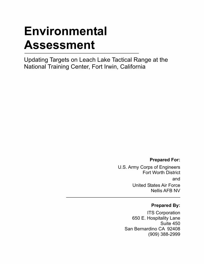
Environmental Assessment Updating Targets on Leach Lake Tactical Range at the National Training Center, Fort Irwin, California
Prepared For:
U.S. Army Corps of Engineers Fort Worth District
and United States Air Force
Nellis AFB NV
Prepared By: ITS Corporation
650 E. Hospitality Lane Suite 450
San Bernardino CA 92408 (909) 388-2999
FINDING OF NO SIGNIFICANT IMPACT
1. Name of the Action
The name of this action is Environmental Assessment for Target Upgrades on Leach Lake Tactical Range at the National Training Center, Fort Irwin, California.
2. Description of the Proposed Action and Alternatives
The USAF at Nellis AFB, Nevada proposes to upgrade targets on Leach Lake Tactical Range to enhance realistic training for air liaison officers, forward air controllers-airborne, tactical air control parties, special tactics team members, and selected Army, Navy, and Marine Corps members. The realistic training includes tactics, techniques, and procedures in planning, requesting, coordinating, and controlling close air support at the tactical level. The Proposed Action will include reconfiguring and/or rebuilding current targets, building new targets, constructing a 500-foot fence on each side of the existing Owl Springs fence and gate, and installing installation boundary signs and range warning signs to improve range security and public safety.
No Action Alternative. Under the No Action Alternative, no changes would occur and the proposed target upgrade construction projects and fence/gate construction programmed on the Leach Lake Tactics Range would not proceed. Range clean up and target-rebuilding activities that are currently performed to support the Air Warrior mission would continue to be performed.
3. Summary of Environmental Resources and Impacts.
Implementation of the Proposed Action would have no significant impacts on air quality, biological resources, cultural resources, environmental justice, hazardous materials/waste, solid waste, noise, safety, socioeconomics, or water resources, and a beneficial impact to range security and public safety. There would be no significant impacts to human health and the natural environment.
4. Conclusion
Pursuant to the Council on Environmental Quality (CEQ) Regulations (40 CFR, Parts 1500 -1500) implementing procedural provisions of the National Environmental Policy Act (NEPA) of 1969 (42 USC §4321, et seq.) and 32 CFR 989, which implements NEPA and CEQ procedures for Air Force actions, the United States Air Force at Nellis AFB has prepared this EA to explore and examine the potential environmental impacts for target upgrades on Leach Lake Tactical Range at the National Training Center, Fort Irwin, California. Based on the findings and conclusions of the EA, an Environmental Impact Statement (EIS) is not required.
Date
Environmental Assessment USAF, Nellis AFB, Nevada Target Upgrades on Leach Lake Tactical Range June 2006
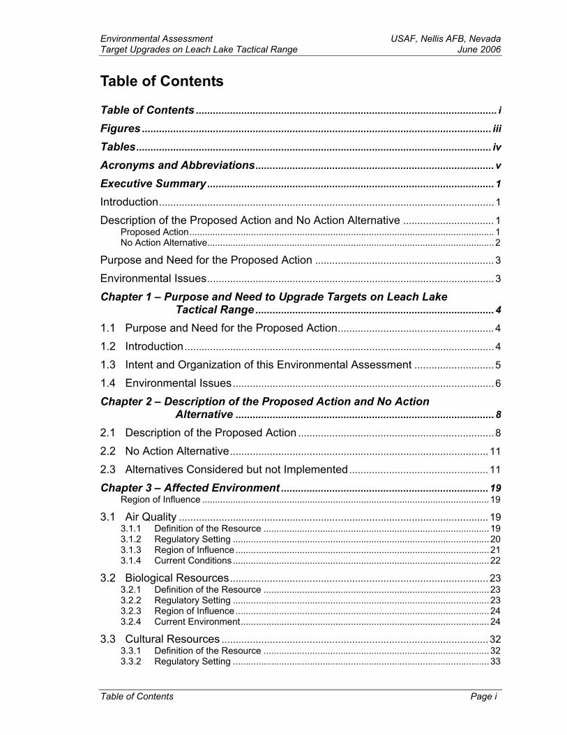
Table of Contents
Table of Contents .......................................................................................................... i
Figures ........................................................................................................................... iii
Tables............................................................................................................................. iv
Acronyms and Abbreviations.................................................................................... v
Executive Summary..................................................................................................... 1
Introduction...................................................................................................................... 1
Description of the Proposed Action and No Action Alternative ................................ 1 Proposed Action.......................................................................................................................1 No Action Alternative................................................................................................................2
Purpose and Need for the Proposed Action ............................................................... 3
Environmental Issues..................................................................................................... 3
Chapter 1 – Purpose and Need to Upgrade Targets on Leach Lake Tactical Range .................................................................................... 4
1.1 Purpose and Need for the Proposed Action....................................................... 4
1.2 Introduction............................................................................................................. 4
1.3 Intent and Organization of this Environmental Assessment ............................ 5
1.4 Environmental Issues............................................................................................ 6
Chapter 2 – Description of the Proposed Action and No Action Alternative ........................................................................................... 8
2.1 Description of the Proposed Action ..................................................................... 8
2.2 No Action Alternative........................................................................................... 11
2.3 Alternatives Considered but not Implemented................................................. 11
Chapter 3 – Affected Environment ......................................................................... 19 Region of Influence ................................................................................................................19
3.1 Air Quality ............................................................................................................. 19 3.1.1 Definition of the Resource ........................................................................................19 3.1.2 Regulatory Setting ....................................................................................................20 3.1.3 Region of Influence...................................................................................................21 3.1.4 Current Conditions ....................................................................................................22
3.2 Biological Resources........................................................................................... 23 3.2.1 Definition of the Resource ........................................................................................23 3.2.2 Regulatory Setting ....................................................................................................23 3.2.3 Region of Influence...................................................................................................24 3.2.4 Current Environment.................................................................................................24
3.3 Cultural Resources .............................................................................................. 32 3.3.1 Definition of the Resource ........................................................................................32 3.3.2 Regulatory Setting ....................................................................................................33
Table of Contents Page i
USAF, Nellis AFB Nevada Environmental Assessment June 2006 Target Upgrades on Leach Lake Tactical Range
3.3.3 Region of Influence (Moffitt and Moffitt 2005)...........................................................33 3.3.4 Current Conditions ....................................................................................................35
3.4 Earth Resources .................................................................................................. 36 3.4.1 Regulatory Setting ....................................................................................................36 3.4.2 Region of Influence ...................................................................................................37 3.4.3 Current Environment.................................................................................................37
3.5 Environmental Justice......................................................................................... 44 3.5.1 Regulatory Setting ....................................................................................................44 3.5.2 Current Conditions ....................................................................................................44
3.6 Hazardous Materials/Waste and Solid Waste ................................................. 44 3.6.1 Definition of the Resource.........................................................................................44 3.6.2 Regulatory Setting ....................................................................................................45 3.6.3 Current Conditions ....................................................................................................45
3.7 Noise ..................................................................................................................... 46 3.7.1 Definition of the Resource.........................................................................................46 3.7.2 Current Conditions ....................................................................................................49
3.8 Safety .................................................................................................................... 51 3.8.1 Regulatory Setting ....................................................................................................51 3.8.2 Current Conditions ....................................................................................................51
3.9 Socioeconomics................................................................................................... 54 3.9.1 Regulatory Setting ....................................................................................................54 3.9.2 Current Conditions ....................................................................................................54
3.10 Water Resources................................................................................................. 54 3.10.1 Definition of the Resource.........................................................................................54 3.10.2 Regulatory Setting ....................................................................................................55 3.10.3 Region of Influence ...................................................................................................55 3.10.4 Current Conditions ....................................................................................................55
Chapter 4 – Environmental Consequences ......................................................... 56
4.1 Air Quality ............................................................................................................. 56 4.1.1 Proposed Action........................................................................................................56 4.1.2 No Action Alternative ................................................................................................58
4.2 Biological Resources........................................................................................... 59 4.2.1 Proposed Action........................................................................................................63 4.2.2 No Action Alternative ................................................................................................66
4.3 Cultural Resources.............................................................................................. 67 4.3.1 Proposed Action........................................................................................................69 4.3.2 No Action Alternative ................................................................................................69
4.4 Earth Resources .................................................................................................. 69 4.4.1 Proposed Action........................................................................................................69 4.4.2 No Action alternative.................................................................................................69
4.5 Environmental Justice......................................................................................... 70 4.5.1 Proposed Action........................................................................................................70 4.5.2 No Action Alternative ................................................................................................70
4.6 Hazardous Materials/Waste and Solid Waste ................................................. 70 4.6.1 Proposed Action........................................................................................................70 4.6.2 No Action Alternative ................................................................................................70
Page ii Table of Contents
Environmental Assessment USAF, Nellis AFB, Nevada Target Upgrades on Leach Lake Tactical Range June 2006
4.7 Noise ..................................................................................................................... 71 4.7.1 Proposed Action........................................................................................................71 4.7.2 No Action Alternative ................................................................................................71
4.8 Safety .................................................................................................................... 71 4.8.1 Proposed Action........................................................................................................72 4.8.2 No Action Alternative ................................................................................................72
4.9 Socioeconomics................................................................................................... 73 4.9.1 Proposed Action........................................................................................................73 4.9.2 No Action Alternative ................................................................................................73
4.10 Water Resources ................................................................................................. 73 4.10.1 Proposed Action........................................................................................................73 4.10.2 No Action Alternative ................................................................................................73
Chapter 5 – Cumulative Impacts............................................................................. 74
5.1 Definition ............................................................................................................... 74
5.2 Reasonable Foreseeable Future Actions ......................................................... 74
5.3 Impacts.................................................................................................................. 74
Chapter 6 – Other Required Considerations........................................................ 76
6.1 Irreversible and Irretrievable Commitment of Resources ............................... 76
Chapter 7 – List of Preparers................................................................................... 77
Chapter 8 – Persons and Agencies Contacted ................................................... 78
Chapter 9 – Bibliography and References............................................................ 80
Chapter 10 – Glossary of Terms ............................................................................. 87
Chapter 11 – Appendices ......................................................................................... 90
Appendix A – Intergovernmental and Interagency Coordination for Environmental Planning (IICEP) and Sample Letter........................................................ 91
Appendix B – Agency Consultations ............................................................................... 94
Appendix C – Notice of Availability, Comments, and Responses to the Draft EA......... 106
Figures
Figure 1-1: National Training Center .................................................................... 7 Figure 2-1: Leach Lake Tactical Range – Composite Map................................. 12 Figure 2-2: Leach Lake Tactical Range – West.................................................. 13 Figure 2-3: Leach Lake Tactical Range – Central .............................................. 14 Figure 2-4: Leach Lake Tactical Range – East................................................... 15 Figure 2-5: Regional Map ................................................................................... 16 Figure 3-1: Geology............................................................................................ 39
Table of Contents Page iii
USAF, Nellis AFB Nevada Environmental Assessment June 2006 Target Upgrades on Leach Lake Tactical Range
Figure 3-2: Faults and Seismic Hazards .............................................................40 Figure 3-3: Soils ..................................................................................................43 Figure 3-4: Typical A-Weighted Sound Levels of Common Sounds....................50
Tables
Table 2-1: Target Correlation...................................................................................... 11
Table 2-2: Summary of Alternatives........................................................................... 17
Table 3-1: National and State Ambient Air Quality Standards ............................... 21
Table 3-2: Air Quality Criteria Thresholds ................................................................. 21
Table 3-3: Threatened, Endangered, and Sensitive Species................................. 24
Table 3-4: Comparative Terminology For Present Chronological Models (California Deserts)............................................................................ 35
Table 3-5: Leach Lake Basin Archaeological Sites ................................................. 36
Table 3-6: Aircraft Participation .................................................................................. 48
Table 4-1: PM10 Generation....................................................................................... 56
Table 4-2: Construction Equipment Emissions ........................................................ 58
Table 4-3: Shrub List.................................................................................................... 60
Page iv Table of Contents
Environmental Assessment USAF, Nellis AFB, Nevada Target Upgrades on Leach Lake Tactical Range June 2006
Acronyms and Abbreviations
µg/m3 micrograms per cubic meter µm micrometer AAM Annual Arithmetic Mean AMSL Above Mean Sea Level AFI Air Force Instruction AFOSH Air Force Occupational and Environmental Safety AGL Above Ground Level AGM Annual Geometric Mean AGOS Air Ground Operations School AIRFA American Indian Religious Freedom Act BASH Bird-Aircraft Strike Hazard CAA Clean Air Act CAAQS California Ambient Air Quality Standards CARB California Air Resource Board CEQ Council on Environmental Quality CERCLA Comprehensive Environmental Response, Compensation and Liability Act CFR Code of Federal Regulations CNDDB California Natural Diversity Database CO Carbon Monoxide CRMP Cultural Resources Management Plan CTS Combat Training Squadron dB Decibel DA Department of the Army DoD Department of Defense DoDD Department of Defense Directive DPW Directorate of Public Works EA Environmental Assessment EIS Environmental Impact Statement EO Executive Order EOD Explosive Ordnance Disposal EPA Environmental Protection Agency EPCRA Emergency Planning and Community Right-to-Know Act ESA Endangered Species Act F Fahrenheit FAA Federal Aviation Administration FICUN Federal Interagency Committee on Urban Noise FIP Federal Implementation Plan FONSI Finding of No Significant Impacts ft Feet H2S Hydrogen Sulfide HAP High Accident Potential INRMP Integrated Natural Resource Management Plan ISA Interservice Support Agreement JCAS Joint Close Air Support JFC Joint Firepower Course JTAC Joint Terminal Attack Controller L Sound Level Ldn Day-Night Average Sound Level
Acronyms and Abbreviations Page v
USAF, Nellis AFB Nevada Environmental Assessment June 2006 Target Upgrades on Leach Lake Tactical Range
Lmax Maximum Sound Level MDAQMD Mojave Desert Air Quality Management District MR_NMAP MOA Range Noise MAP MSL Mean Sea Level NAAQS National Ambient Air Quality Standards NAGPRA Native American Graves Protection and Repatriation Act NEPA National Environmental Policy Act NHPA National Historic Preservation Act NO2 Nitrogen Oxide NOI Notice of Intent NOX Nitrogen Oxides NRHP National Register of Historic Places NTC National Training Center NTTR Nevada Test and Training Range O3 Ozone OP Operation Position PM10 Particulate Matter with an Aerodynamic Diameter of Less than 10 Microns ppm Parts Per Million RANW Range Wing RCRA Resource Conservation and Recovery Act ROI Region of Influence SEL Sound Exposure Level SIP State Implementation Plan SO2 Sulfur Oxide SWDA Solid Waste Disposal Act USAF United States Air Force USC United States Code USFWS U.S. Fish and Wildlife Service UTM Universal Transverse Mercator UXO Unexploded Ordnance VOC Volatile Organic Compounds WTC Weapons and Tactics Center
Page vi Acronyms and Abbreviations
Environmental Assessment USAF, Nellis AFB, NevadaTarget Upgrades on Leach Lake Tactical Range June 2006
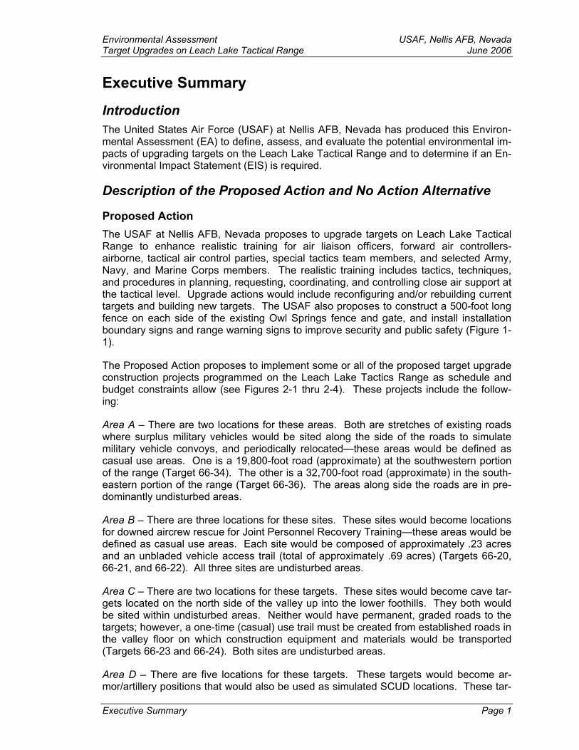
Executive Summary
Introduction The United States Air Force (USAF) at Nellis AFB, Nevada has produced this Environ-mental Assessment (EA) to define, assess, and evaluate the potential environmental im-pacts of upgrading targets on the Leach Lake Tactical Range and to determine if an En-vironmental Impact Statement (EIS) is required.
Description of the Proposed Action and No Action Alternative
Proposed Action The USAF at Nellis AFB, Nevada proposes to upgrade targets on Leach Lake Tactical Range to enhance realistic training for air liaison officers, forward air controllers-airborne, tactical air control parties, special tactics team members, and selected Army, Navy, and Marine Corps members. The realistic training includes tactics, techniques, and procedures in planning, requesting, coordinating, and controlling close air support at the tactical level. Upgrade actions would include reconfiguring and/or rebuilding current targets and building new targets. The USAF also proposes to construct a 500-foot long fence on each side of the existing Owl Springs fence and gate, and install installation boundary signs and range warning signs to improve security and public safety (Figure 1-1).
The Proposed Action proposes to implement some or all of the proposed target upgrade construction projects programmed on the Leach Lake Tactics Range as schedule and budget constraints allow (see Figures 2-1 thru 2-4). These projects include the follow-ing:
Area A – There are two locations for these areas. Both are stretches of existing roads where surplus military vehicles would be sited along the side of the roads to simulate military vehicle convoys, and periodically relocated—these areas would be defined as casual use areas. One is a 19,800-foot road (approximate) at the southwestern portion of the range (Target 66-34). The other is a 32,700-foot road (approximate) in the south-eastern portion of the range (Target 66-36). The areas along side the roads are in pre-dominantly undisturbed areas.
Area B – There are three locations for these sites. These sites would become locations for downed aircrew rescue for Joint Personnel Recovery Training—these areas would be defined as casual use areas. Each site would be composed of approximately .23 acres and an unbladed vehicle access trail (total of approximately .69 acres) (Targets 66-20, 66-21, and 66-22). All three sites are undisturbed areas.
Area C – There are two locations for these targets. These sites would become cave tar-gets located on the north side of the valley up into the lower foothills. They both would be sited within undisturbed areas. Neither would have permanent, graded roads to the targets; however, a one-time (casual) use trail must be created from established roads in the valley floor on which construction equipment and materials would be transported (Targets 66-23 and 66-24). Both sites are undisturbed areas.
Executive Summary Page 1
Area D – There are five locations for these targets. These targets would become ar-mor/artillery positions that would also be used as simulated SCUD locations. These tar-
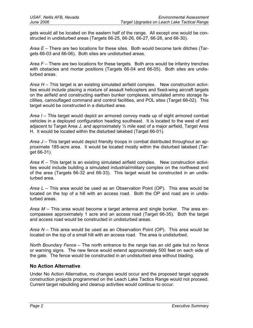
USAF, Nellis AFB, Nevada Environmental Assessment June 2006 Target Upgrades on Leach Lake Tactical Range gets would all be located on the eastern half of the range. All except one would be con-structed in undisturbed areas (Targets 66-25, 66-26, 66-27, 66-28, and 66-30).
Area E – There are two locations for these sites. Both would become tank ditches (Tar-gets 66-03 and 66-06). Both sites are undisturbed areas.
Area F – There are two locations for these targets. Both arcs would be infantry trenches with obstacles and mortar positions (Targets 66-04 and 66-05). Both sites are undis-turbed areas.
Area H – This target is an existing simulated airfield complex. New construction activi-ties would include placing a mixture of assault helicopters and fixed-wing aircraft targets on the airfield and constructing earthen bunker complexes, simulated ammo storage fa-cilities, camouflaged command and control facilities, and POL sites (Target 66-02). This target would be constructed in a disturbed area.
Area I – This target would depict an armored convoy made up of eight armored combat vehicles in a deployed configuration heading southeast. It is located to the west of and adjacent to Target Area J, and approximately ½ mile east of a major airfield, Target Area H. It would be located within the disturbed lakebed (Target 66-01).
Area J – This target would depict friendly troops in combat distributed throughout an ap-proximate 185-acre area. It would be located mostly within the disturbed lakebed (Tar-get 66-31).
Area K – This target is an existing simulated airfield complex. New construction activi-ties would include building a simulated industrial/military complex on the northwest end of the area (Targets 66-32 and 66-33). This target would be constructed in an undis-turbed area.
Area L – This area would be used as an Observation Point (OP). This area would be located on the top of a hill with an access road. Both the OP and road are in undis-turbed areas.
Area M – This area would become a target antenna and single bunker. The area en-compasses approximately 1 acre and an access road (Target 66-35). Both the target and access road would be constructed in undisturbed areas.
Area N – This area would be used as an Observation Point (OP). This area would be located on the top of a small hill with an access road. The area is undisturbed.
North Boundary Fence – The north entrance to the range has an old gate but no fence or warning signs. The new fence would extend approximately 500 feet on each side of the gate. The fence would be constructed in an undisturbed area without blading.
No Action Alternative Under No Action Alternative, no changes would occur and the proposed target upgrade construction projects programmed on the Leach Lake Tactics Range would not proceed. Current target rebuilding and cleanup activities would continue to occur.
Page 2 Executive Summary
Environmental Assessment USAF, Nellis AFB, NevadaTarget Upgrades on Leach Lake Tactical Range June 2006 Purpose and Need for the Proposed Action The purpose of the Proposed Action is to provide target upgrades to better support U.S. and allied air and ground forces during advanced combat training conducted at the Na-tional Training Center (NTC), Fort Irwin, California. The USAF Air Ground Operations School (AGOS) at Nellis AFB, Nevada uses the Leach Lake Tactical Range to provide interservice training of Joint Firepower Course (JFC) students. The USAF would also re-build the boundary fence at the north entrance of the range required to delineate the Army boundary from areas that allow public access.
The proposed changes are needed to improve the Leach Lake Tactical Range for future Joint Forces Command-Directed Joint National Training Capabilities exercise events. The reconstructed fence and warning signs are needed to enhance security and public safely.
Environmental Issues The following environmental resources were considered relevant to the proposed action; they are all defined in Chapter 3 and analyzed for potential impacts in Chapter 4.
Air Quality Hazardous Materials/Waste – Solid Waste
Biological Resources Noise
Cultural Resources Safety
Earth Resources Socioeconomics
Environmental Justice Water Resources
After a thorough evaluation of the above-mentioned environmental issues, the USAF at Nellis AFB, Nevada has concluded that no significant environmental impacts would oc-cur as a result of implementing the Proposed Action. The following table shows a com-parison of the Proposed Action and the No Action Alternative.
For an impacts summary of the alternatives, refer to Table 2-2.
Executive Summary Page 3
USAF, Nellis AFB, Nevada Environmental Assessment June 2006 Target Upgrades on Leach Lake Tactical Range
Chapter 1 – Purpose and Need to Upgrade Targets on Leach Lake Tactical Range
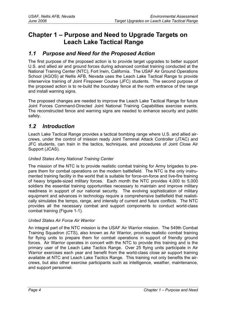
1.1 Purpose and Need for the Proposed Action The first purpose of the proposed action is to provide target upgrades to better support U.S. and allied air and ground forces during advanced combat training conducted at the National Training Center (NTC), Fort Irwin, California. The USAF Air Ground Operations School (AGOS) at Nellis AFB, Nevada uses the Leach Lake Tactical Range to provide interservice training of Joint Firepower Course (JFC) students. The second purpose of the proposed action is to re-build the boundary fence at the north entrance of the range and install warning signs.
The proposed changes are needed to improve the Leach Lake Tactical Range for future Joint Forces Command-Directed Joint National Training Capabilities exercise events. The reconstructed fence and warning signs are needed to enhance security and public safely.
1.2 Introduction Leach Lake Tactical Range provides a tactical bombing range where U.S. and allied air-crews, under the control of mission ready Joint Terminal Attack Controller (JTAC) and JFC students, can train in the tactics, techniques, and procedures of Joint Close Air Support (JCAS).
United States Army National Training Center
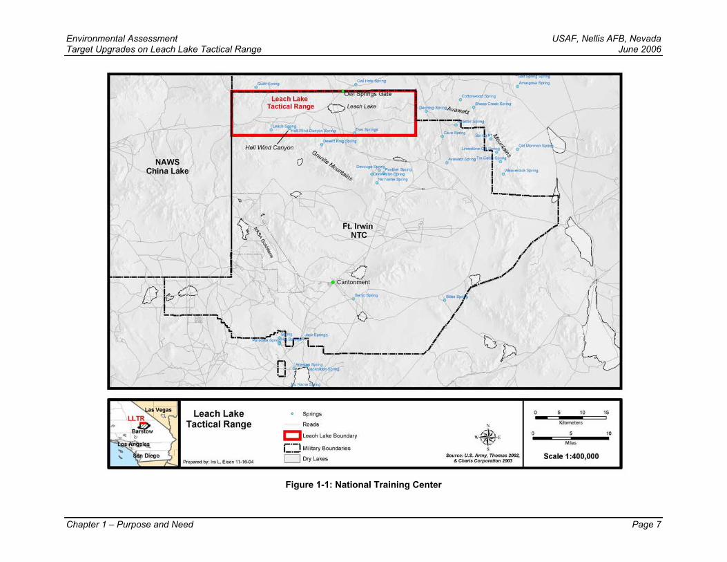
The mission of the NTC is to provide realistic combat training for Army brigades to pre-pare them for combat operations on the modern battlefield. The NTC is the only instru-mented training facility in the world that is suitable for force-on-force and live-fire training of heavy brigade-sized military forces. Each month the NTC provides 4,000 to 5,000 soldiers the essential training opportunities necessary to maintain and improve military readiness in support of our national security. The evolving sophistication of military equipment and advances in technology require a comprehensive battlefield that realisti-cally simulates the tempo, range, and intensity of current and future conflicts. The NTC provides all the necessary combat and support components to conduct world-class combat training (Figure 1-1).
United States Air Force Air Warrior
An integral part of the NTC mission is the USAF Air Warrior mission. The 549th Combat Training Squadron (CTS), also known as Air Warrior, provides realistic combat training for flying units to prepare them for combat operations in support of friendly ground forces. Air Warrior operates in concert with the NTC to provide this training and is the primary user of the Leach Lake Tactics Range. Over 25 flying units participate in Air Warrior exercises each year and benefit from the world-class close air support training available at NTC and Leach Lake Tactics Range. This training not only benefits the air-crews, but also other exercise participants such as intelligence, weather, maintenance, and support personnel.
Page 4 Chapter 1 – Purpose and Need
Environmental Assessment USAF, Nellis AFB, Nevada Target Upgrades on Leach Lake Tactical Range June 2006 Stationed at Nellis AFB, Nevada, the 6th CTS is tasked to train air liaison officers, for-ward air controllers-airborne, tactical air control parties, special tactics team members, and selected Army, Navy, and Marine Corps members in the tactics, techniques, and procedures for planning, requesting, coordinating, and controlling close air support at the tactical level. Instruction includes lectures, seminars, and joint planning exercises cover-ing areas such as service doctrine, mission and organization; command and control; tac-tical operations; and weapons systems training. The course finishes with a field training exercise integrated with Air Warrior and NTC operations at Fort Irwin.
1.3 Intent and Organization of this Environmental Assessment The USAF at Nellis AFB has prepared this Environmental Assessment (EA) in accor-dance with the National Environmental Policy Act (NEPA) of 1969 (42 USC 4321), 32 CFR 989, and the Council on Environmental Quality (CEQ) Implementation Regulations (40 CFR 1500-1508). It was prepared to define, evaluate, and assess the potential envi-ronmental impacts of upgrading targets on Leach Lake Tactical Range and to determine if an Environmental Impact Statement (EIS) is required. At the conclusion of the EA process, the USAF at Nellis AFB must determine if the proposed action would cause significant environmental impacts. If not, then a Finding of No Significant Impact (FONSI) will be prepared. If it is determined that the proposed action would cause sig-nificant environmental impacts, then the USAF would either abandon the project or re-lease a Notice of Intent (NOI) to prepare an EIS. The NTC at Fort Irwin is a cooperating agency in preparing this document.
The EA is organized in the following manner:
Chapter 1 – Purpose and Need. Chapter 1 discusses the purpose and need for upgrading targets on Leach Lake Tactical Range; an introduction to Air Warrior; the environmental impact analysis process; and the envi-ronmental issues evaluated in this analysis.
Chapter 2 – Description of the Proposed Action and No Action Alternative. Chapter 2 describes the Proposed Action and the No Action Alternative.
Chapter 3 – Affected Environment. Chapter 3 provides an overview of the baseline environmental conditions of the Leach Lake Tactical Range and the potentially affected environment.
Chapter 4 – Environmental Impacts. Chapter 4 addresses the potential im-pacts of implementing the alternatives described in Chapter 2, when com-pared to baseline conditions presented in Chapter 3.
Chapter 5 – Cumulative Impacts. Chapter 5 presents the cumulative im-pacts resulting from this project.
Chapter 6 – Other Required Considerations. Chapter 6 presents the other required considerations i.e., the irreversible and irretrievable commitments of resources.
Chapter 7 – List of Preparers. Chapter 7 presents the list of preparers in-volved in this document.
Chapter 1 – Purpose and Need Page 5

USAF, Nellis AFB, Nevada Environmental Assessment June 2006 Target Upgrades on Leach Lake Tactical Range
Chapter 8 – Persons and Agencies Contacted. Chapter 8 presents the list of persons and agencies contacted in the process of preparing this report.
Chapter 9 – Bibliography and References. Chapter 9 presents the refer-ences cited in this document.
Chapter 10 – Glossary of Terms. Chapter 10 presents the definitions of the terms used in this report.
Chapter 11 – Appendices
1.4 Environmental Issues Environmental resource areas typically explored in environmental assessments often include land uses, recreational and visual resources, transportation, and hydrology and water resources. Land uses were not explored because this is not a land acquisition ac-tion—the proposed action would occur on previously withdrawn lands currently managed by the Army for military training; recreational and visual resources would remain un-changed as a result of this action; and transportation was not explored because this pro-ject does not propose any new, or changes to existing, ground transportation resources. During internal scoping, the above-mentioned environmental resources were examined but found to have no additional environmental effects. Therefore, these resource areas are not included in this document.
The following environmental resources were considered relevant to the proposed action; they are all defined in Chapter 3 and analyzed for potential impacts in Chapter 4.
Air Quality Hazardous Materials/Waste – Solid Waste
Biological Resources Noise
Cultural Resources Safety
Earth Resources Socioeconomics
Environmental Justice Water Resources
Page 6 Chapter 1 – Purpose and Need
Environmental Assessment USAF, Nellis AFB, Nevada Target Upgrades on Leach Lake Tactical Range June 2006
Chapter 1 – Purpose and Need Page 7
Figure 1-1: National Training Center
NAWS China Lake
Leach Lake Tactica l Range
Hell IMnd Canyon
QLeschLske
t} Leach Lake 0 Springs
""', Tactical Range Roads
'.x.' I::J Leach Lake Boundary
L
~· C.:J Military Boundaries , ... D Dry Lakes
Prepared by: Ira L. Eisen 11-16-04 \': ,r.;...
0~So<"ll
-Ctetk$p<>ng o.t-SpongA vawa~z o
N
W E • s Source: U.S. Army, Thomas 2002,
& Charts Corporotion 2003
0
0
5 10 15
Kilometers
5 10
Miles
Scale 1 :400,000
USAF, Nellis AFB, Nevada Environmental Assessment June 2006 Target Upgrades on Leach Lake Tactical Range Chapter 2 – Description of the Proposed Action and No
Action Alternative
2.1 Description of the Proposed Action The USAF at Nellis AFB, Nevada proposes to upgrade targets on Leach Lake Tactical Range to enhance realistic training for air liaison officers, forward air controllers-airborne, tactical air control parties, special tactics team members, and selected Army, Navy, and Marine Corps members. The realistic training includes tactics, techniques, and procedures in planning, requesting, coordinating, and controlling close air support at the tactical level. The Proposed Action will include reconfiguring and/or rebuilding cur-rent targets and building new targets, and constructing a 500-foot long (estimated) fence on each side of the existing Owl Springs fence and gate, and installing installation boundary signs and range warning signs to improve range security and public safety. Except for the boundary fence and gate, the proposed action outlines all of the potential projects that would further enhance the realism of the targets for the Air Force’s Close-Air Support mission at Leach Lake Tactics Range. More realistic targets provide better training opportunities and make the Range more consistent with the needs of realism relative to Joint National Training Capability’s goals. Each individual project listed fills or enhances capabilities for the CAS mission and each individual action partially fulfils the purpose and need of the action. This suite of options would be implemented based De-partment of Defense (DoD) training needs and operational funding. As a result, the Air Force considers each individual action as an alternative and the analyses section in Chapter 4 reflect the cumulative impacts as though all of the actions would be imple-mented. Some or all of the actions may be implemented over the course of many years. The environmental impacts of each individual project or combination of projects would be a subset of the analyses provided in Chapter 4.
The following are descriptions of the proposed construction activities that could take place in each target area—for the purpose of this analysis, it is assumed that all pro-posed construction projects would take place (see Figures 2-1 thru 2-4):
Area A – These areas consist of placing surplus military vehicles along the side of the road (no more than 20 feet from the side of the road) to simulate military vehicle convoys. There are two stretches of road where these targets would be located and periodically relocated. One is a 19,800-foot road (approximate) at the southwestern portion of the range (approximately 18.2 acres) (Target 66-34). The other is a 32,700-foot road (approximate) in the southeastern portion of the range (approximately 30 acres) (Target 66-36). A maximum of 50 vehi-cles could be placed on each segment of road. The target vehicles would be hauled and/or towed to the target areas. The areas along side the roads are in predominantly undisturbed areas. No blading activities would be required; however, the locating and relocating of target vehicles would, over time, disturb the target areas. No live ordnance would be dropped on these targets.
Area B – Area B consists of three locations for the Joint Personnel Recovery Training Program for aircrew rescue training. These areas would be casual use areas and would not require any blading, construction, or major ground disturb-ing activities. Each site would be composed of approximately .23 acres and an
Page 8 Chapter 2 – Description of Proposed Action and Alternative

Environmental Assessment USAF, Nellis AFB, NevadaTarget Upgrades on Leach Lake Tactical Range June 2006
unbladed vehicle access trail (total of approximately .69 acres) (Targets 66-20, 66-21, and 66-22). All three sites are undisturbed areas.
Area C – Area C consists of two simulated cave target sites. Each cave target would be sized for simulated vehicle traffic, approximately 15 feet wide and 12 feet tall. There would be two simulated caves at each location. Construction would be either metal (two semi-truck sized storage containers) or concrete. The “two track” vehicle access trails to the sites would be unbladed and would only be used for construction and periodic maintenance—where possible, these trails would follow dried wash beds. The disturbed area would be approximately 400 feet by 100 feet at each site plus the vehicle access trails to each site. No live ordnance would be dropped on these targets (each site would be approxi-mately 1 acre) (Targets 66-23 and 66-24). Both sites are undisturbed areas.
Area D – There are five locations for these targets. These sites would be used as armor/artillery positions and simulated SCUD locations. These targets would all be located in the middle to eastern half of the range. All except one would be constructed in undisturbed areas. The approximate size of each site would be 1,000 feet by 1,000 feet plus an unbladed vehicle access trail. These sites would require some blading for surface preparation. No live ordnance would be dropped on the three eastern sites (each site would be approximately 23 acres (total of approximately 115 acres)) (Targets 66-25, 66-26, 66-27, 66-28, and 66-30).
Area E – These sites consists of two tank ditch targets. Target E1 (66-03) is an area of approximately 2,000 feet by 100 feet, approximately 6 feet deep (ap-proximately 4.6 acres); target E2 (66-06) is an area of approximately 1,000 feet by 100 feet, approximately 6 feet deep (approximately 2.3 acres). Both areas are in undisturbed areas.
Area F – These sites consists of two arc-shaped trenches to be used as infantry positions with obstacles and mortar positions located at Targets 66-04 and 66-05. The arcs would extend approximately 500 feet from existing targets and arc approximately a quarter circle (approximately 90 degrees) (approximately 5 acres each). The target areas would be within undisturbed areas.
Area H – This target is an existing simulated airfield complex. New construc-tion activities would include placing a mixture of assault helicopters and fixed-wing aircraft targets on the airfield and constructing earthen bunker complexes, simulated ammo storage facilities, camouflaged command and control facilities, and POL sites (approximately 60 acres). Vertical targets would be built using a mixture of empty sea-land containers, and wood and/or composite structures. Several movable (time critical) targets would be placed inside the target com-plex, interspersed with personnel figures (Target 66-02). This target would be constructed in a disturbed area.
Area I – This target would depict an armored convoy made up of eight armored combat vehicles in a deployed configuration heading southeast. It is located to the west of and adjacent to Target Area J, and approximately ½ mile east of a major airfield, Target Area H (approximately 70.6 acres). It would be located within the disturbed lakebed (Target 66-01).
Chapter 2 – Description of Proposed Action and Alternative Page 9
USAF, Nellis AFB, Nevada Environmental Assessment June 2006 Target Upgrades on Leach Lake Tactical Range
Area J – This target area would depict friendly troops-in-contact, distributed throughout an approximate 185-acre area located within the disturbed lakebed. Construction activities would include dispersing mock plywood troops and equipment throughout the target area. The mock-ups would be periodically moved (Target 66-31). NOTE: this target area was redesigned to exclude a large portion of its northeastern corner (approximately ¼ of the original target size) to avoid archeological site CA-SBR-571.
Area K – This target is an existing simulated airfield complex. New construc-tion activities would include building a simulated industrial/military complex on the northwest end of the area (approximately 1,000 feet by 1,000 feet in an un-disturbed area (approximately 23 acres)) (Target 66-32). Vertical targets would be built using a mixture of empty sea-land containers, and wood and/or composite structures. Construction would also include building earthen bunker complexes, simulated ammo storage facilities, camouflaged command and con-trol facilities, and POL sites. Several movable (time critical) targets would be placed inside the target complex, interspersed with personnel figures.
Area L – Site L would be at the top of Hill 883 and would serve as an Observa-tion Point (OP). The area would be accessed by a new road and have parking space for two vehicles—the new road would be approximately 720 feet long (approximately .2 acres) in an undisturbed area. The OP would be sited in an undisturbed, unimproved area, only large enough to place mobile radio trans-mitters—no blading of this area would be required (approximately 35.6 acres). This site is not a target and would not be authorized for live or inert ordnance.
Area M – This area would be used as an antenna and single bunker target. The area of new disturbance would encompass approximately 1 acre and an access road. Construction would require blading and building a simulated bunker. The site would be authorized for live ordnance; periodic maintenance would be re-quired (Target 66-35).
Area N – Site N would be at the top of Chocolate Chip Hills and would serve as an OP. The area would be accessed by a new road on the southwest side of the hill—the new road would be approximately 830 feet long (approximately .22 acres) in an undisturbed area. The OP would be sited in an undisturbed, unim-proved area, only large enough to place mobile radio transmitters—no blading of the OP area would be required (approximately 1.6 acres). This site is not a target and would not be authorized for live or inert ordnance.
North Boundary Fence – The north entrance to the range has an old gate but no fence or warning signs. The new fence would extend 500 feet on each side of the gate until it reaches mountainous terrain. Periodic maintenance may be re-quired. Warning signs indicating that the area is a military reservation and pub-lic access is prohibited would be placed along the fence.
The construction crews and equipment are based out of the Nevada Test and Training Range (NTTR). Work during Coronet Clean rotations is based on crew availability and access times to the Leach Lake Tactical Range. The resulting schedule would limit the construction activities to 2, 14-day periods, of which only 24, 10-hour days would be worked. The annual activities include approximately 3 days for explosive ordnance Page 10 Chapter 2 – Description of Proposed Action and Alternative

Environmental Assessment USAF, Nellis AFB, NevadaTarget Upgrades on Leach Lake Tactical Range June 2006 clearance, 3 days for target debris cleanup, 12 days of site grading, and 6 days for target construction.
Table 2-1: Target Correlation
TARGET AREA NUMBERED TARGETS
A 66-34 66-36 B 66-20 66-21 66-22
C 66-23 66-24 D 66-25 66-26 66-27 66-28 66-30
E 66-03 66-06 F 66-04 66-05 H 66-02 I 66-01 J 66-31 K 66-33
M 66-35
2.2 No Action Alternative Under the No Action Alternative, no changes would occur and the proposed target up-grade construction projects and fence/gate construction programmed on the Leach Lake Tactics Range would not proceed. Range cleanup and target rebuilding activities that are currently performed to support the Air Warrior mission would continue to be per-formed.
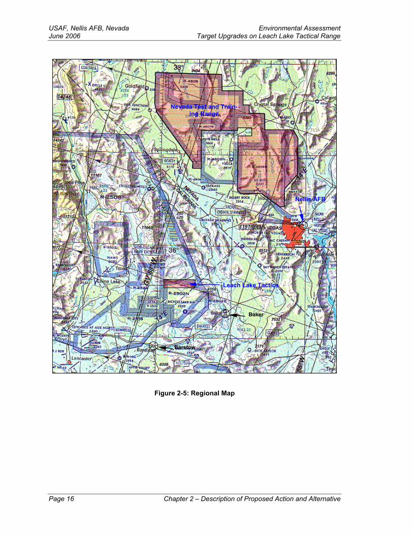
2.3 Alternatives Considered but not Implemented Constructing New Targets on the Nevada Test and Training Range (NTTR). The NTTR is a 2.79 million-acre bombing range located in southern Nevada, north of Las Vegas (Figure 2-5). The NTTR is used by Nellis AFB to support training and testing combat tactics, aircraft, their associated weapons systems, and all the activities that support those primary missions (USAF 1999). Constructing new targets on the NTTR for Air Warrior training, though feasible, would not meet the training requirements needed for close coordination with the Army activities on the NTC. The primary purpose of Air War-rior training is to provide both pilots and Army units the ability to train together in the manner they would in a wartime situation. The NTC is the only range where the Air Force and the Army can train side-by-side using live ordnance. Because of the unique and vital training opportunities that are available on the NTC (absent on the NTTR), which would greatly enhance the combat-readiness and safety of troops, this alternative was not carried forward for further consideration.
Chapter 2 – Description of Proposed Action and Alternative Page 11
USAF, Nellis AFB, Nevada Environmental Assessment June 2006 Target Upgrades on Leach Lake Tactical Range
Page 12 Chapter 2 – Description of Proposed Action and Alternative
Figure 2-1: Leach Lake Tactical Range – Composite Map
~~ Leach Lake ~·-, LLTR (;:l.
... Target Points Mili1ary Boundaries 0 2 4 6 8 L.-I<> ~ Tactical Range D Projected Target Areas CJ Leach Lake Boundary N Kilometers
- Barstow w. e .:!'!-. ... to Eye Candy Target Roads D 0 1 2 3 4
f!:'!'~os·~rilfeles t Dry Lakes Mile$
~- -TroopiMortar Positions .... - -- Roads s
\. San Diego - New Roads Contours (20 Feet) Source: U.S. Anny, Thomas 2002, Scale 1 :175,000 Proparod by: lll> l. E"""' 04.02-04 & Charis Corporation 2003
Environmental Assessment USAF, Nellis AFB, Nevada Target Upgrades on Leach Lake Tactical Range June 2006
Chapter 2 – Description of Proposed Action and Alternative Page 13
Figure 2-2: Leach Lake Tactical Range – West
Leach Lake Tactical Range
F'ropared by: haL. Eiscfl 0Hl2-04
.t. Target Points
CJ Projected Target Areas
Eye Candy Target Roads
- Troop/Mortar Positions
- New Roads
r.::-.J Military Boundaries
c:J Leach Lake Boundary N
D Dry Lakes w.E
Roads s
Contours (20 Feet) sou:~~~rl~· ~':/;,.~':::,~;~ooz,
0 2 3
Kilometers
0 0 ,5 1.5
Miles
Scale 1 :75,000
USAF, Nellis AFB, Nevada Environmental Assessment June 2006 Target Upgrades on Leach Lake Tactical Range
Page 14 Chapter 2 – Description of Proposed Action and Alternative
Figure 2-3: Leach Lake Tactical Range – Central
Leach Lake ... Target Points C'.:J Military Boundaries 0 2 3 Tactical Range D Projected Target Areas CJ Leach Lake Boundary N Kilometers • 0 o.s 1.5 Eye Candy Target Roads D Orylakes w 6
Miles Troop/Mortar Positions Roads s -
Source: U.S. Army, Thomas 2002, - NewRoads - Contours (20 Feet) & Ch.aris Corporation 2003 Scale 1 :75,000 Prepared by: Ira L. Elsen 04-02-04
Environmental Assessment USAF, Nellis AFB, Nevada Target Upgrades on Leach Lake Tactical Range June 2006
Chapter 2 – Description of Proposed Action and Alternative Page 15
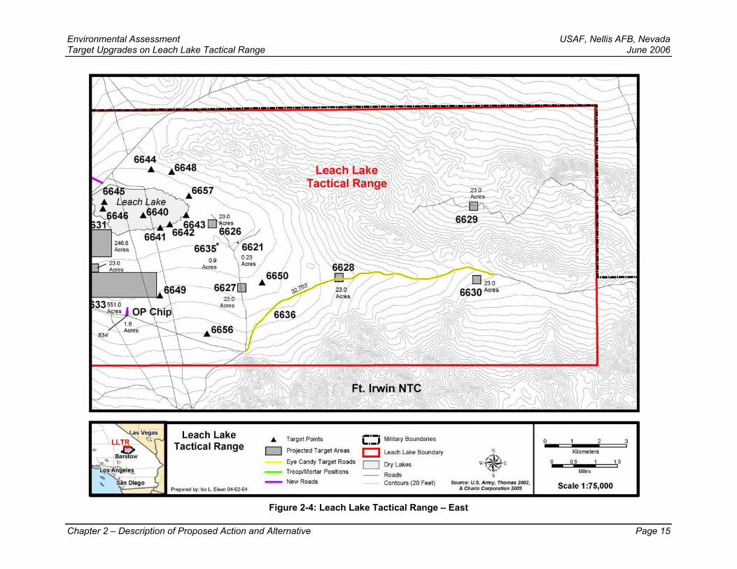
Figure 2-4: Leach Lake Tactical Range – East
Leach Lake Tactical Range
Prepared by: Ira L Eisen 04.02.04
• Target Points
c::::J Projected Target Areas
Eye Candy Target Roads
Troop/Mortar Positions
- NewRoads
C:J Military Boundaries
D Leach Lake Boundary
c::::J DryLakes
Roads Contours (20 Feet)
N w.e s
Source: U.S. Anny, Thomas 2002, & Charis Corporation 2003
0 2 3
Kilometers
0 0 ,5 1,5
Miles
Scale 1:75,000
USAF, Nellis AFB, Nevada Environmental Assessment June 2006 Target Upgrades on Leach Lake Tactical Range
Barstow
Baker
Nellis AFB
Leach Lake Tactics
Nevada Test and Train-ing Range
Figure 2-5: Regional Map
Page 16 Chapter 2 – Description of Proposed Action and Alternative
Environmental Assessment USAF, Nellis AFB, NevadaTarget Upgrades on Leach Lake Tactical Range June 2006
Table 2-2: Summary of Alternatives
PROPOSED ACTION NO ACTION ALTERNATIVE
AIR QUALITY
The air quality impacts as a result of selecting the Proposed Action would be of short duration (lasting through construction) and isolated to defined area (at and immediately adjacent to the construction sites), and are estimated to be well below de minimus levels.
There would be no change to current opera-tions and therefore no additional air quality impacts.
BIOLOGICAL RESOURCES
To avoid impacts to threatened and endan-gered species as a result of selecting the Pro-posed Action for those projects located in un-disturbed habitat in the eastern portion of the project area, the USAF will have a biological monitor present when construction activities are taking place and take mitigation measures as outlined in paragraphs 4.2.1.1 and 4.2.1.2.
The No Action Alternative would have no ef-fects on biological resources.
CULTURAL RESOURCES
A no adverse effects determination with no eligible sites was sent to the California SHPO to address Section 106 of the NHPA.
The No Action Alternative would have no ef-fects on cultural resources.
EARTH RESOURCES
• New target construction operations would have no impacts to geology and only minor effects to soil resources from blading the area for the first time—these impacts are es-timated to be minor as only limited blading would occur.
• Wind erosion would be expected to occur on areas where the desert pavement has been broken and/or disturbed; however, the eroded materials (i.e., dust) are expected to remain within the boundaries of the Leach Lake Tactical Range.
• Water erosion is expected to occur at various degrees on the new targets that are con-structed on sloping terrain. Slight erosion would occur on all soil texture classes on slopes less than 4 percent or sandy soils on slopes less than 15 percent; moderate ero-sion would occur on loamy and clay soils on slopes of 4-15 percent or sandy soils with slopes of 15-30 percent; high erosion would occur on soils having loamy soils of 15-30 percent or all soils heavier than loam with slopes over 30 percent. Due to low average rainfall, any water erosion would be infre-quent and less than significant.
The No Action Alternative would have no ef-fects on geology or soil resources within the Leach Lake Tactical Range.
Chapter 2 – Description of Proposed Action and Alternative Page 17
USAF, Nellis AFB, Nevada Environmental Assessment June 2006 Target Upgrades on Leach Lake Tactical Range
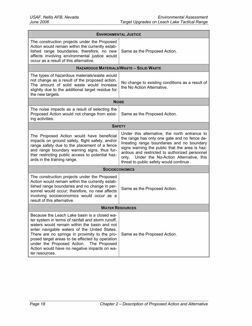
ENVIRONMENTAL JUSTICE
The construction projects under the Proposed Action would remain within the currently estab-lished range boundaries; therefore, no new affects involving environmental justice would occur as a result of this alternative.
Same as the Proposed Action.
HAZARDOUS MATERIALS/WASTE – SOLID WASTE
The types of hazardous materials/waste would not change as a result of the proposed action. The amount of solid waste would increase slightly due to the additional target residue for the new targets.
No change to existing conditions as a result of the No Action Alternative.
NOISE
The noise impacts as a result of selecting the Proposed Action would not change from exist-ing activities.
Same as the Proposed Action.
SAFETY
The Proposed Action would have beneficial impacts on ground safety, flight safety, and/or range safety due to the placement of a fence and range boundary warning signs, thus fur-ther restricting public access to potential haz-ards in the training range.
Under this alternative, the north entrance to the range has only one gate and no fence de-lineating range boundaries and no boundary signs warning the public that the area is haz-ardous and restricted to authorized personnel only. Under the No-Action Alternative, this threat to public safety would continue .
SOCIOECONOMICS
The construction projects under the Proposed Action would remain within the currently estab-lished range boundaries and no change in per-sonnel would occur; therefore, no new affects involving socioeconomics would occur as a result of this alternative.
Same as the Proposed Action.
WATER RESOURCES
Because the Leach Lake basin is a closed wa-ter system in terms of rainfall and storm runoff, waters would remain within the basin and not enter navigable waters of the United States. There are no springs in proximity to the pro-posed target areas to be effected by operation under the Proposed Action. The Proposed Action would have no negative impacts on wa-ter resources.
Same as the Proposed Action.
Page 18 Chapter 2 – Description of Proposed Action and Alternative
Environmental Assessment USAF, Nellis AFB, NevadaTarget Upgrades on Leach Lake Tactical Range June 2006
Chapter 3 – Affected Environment The procedures established in NEPA require that the analysis address the components of the environment potentially affected by the proposed actions. The environment in-cludes all resource areas and lands that might be affected, as well as the natural, cul-tural, and socioeconomic resources they contain or support. For this proposal, Nellis AFB managers have examined 10 environmental resources that could potentially be ef-fected by the proposed actions: air quality, biological resources, cultural resources, earth resources, environmental justice, hazardous materials/waste and solid waste, noise, safety, water resources, and socioeconomics.
Region of Influence Unless further refined in the following resource areas, the Region of Influence (ROI) for this project is defined as the current lateral and vertical boundaries of the Leach Lake Tactical Range. The Leach Lake Tactical Range is withdrawn land. Access is limited to authorized personnel and restricted from public access. The area surrounding Leach Lake is remote and sparsely populated. The closest population center is Baker, Califor-nia, approximately 26 miles southeast of the range’s most southeastern corner.
The Leach Lake Tactical Range also shares a contiguous border to its north with the Death Valley National Park. The Death Valley National Park was established by act of Congress in 1994 through the California Desert Protection Act (CDPA) of 1994 (CDPA 1994). The California Military Lands Withdrawal and Overflights Act of 1994, contained within the CDPA protects current military lands and overflight missions. The act states in Sec. 802, MILITARY OVERFLIGHTS:
OVERFLIGHTS—Nothing in this Act, The Wilderness Act, or other land man-agement laws generally applicable to the new units of the National Park or Wil-derness Preservation Systems (or any additions to existing units) designated by this Act, shall restrict or preclude low-level overflights of military aircraft over such units, including military overflights that can be seen or heard within such units (CDPA 1994).
3.1 Air Quality
3.1.1 Definition of the Resource Air quality at a given location can be described by the concentrations of various pollut-ants in the atmosphere. Units of concentration are generally expressed in parts per mil-lion (ppm) or micrograms per cubic meter (µg/m3). The significance of a pollutant con-centration is determined by comparing the concentration to an appropriate federal and/or state ambient air quality standard. The standards represent the allowable atmospheric concentrations and a reasonable margin of safety to protect the public health, welfare, and the more sensitive receptors in the population. Federal standards, established by the U.S. Environmental Protection Agency (EPA) are termed the National Ambient Air Quality Standards (NAAQS). The NAAQS for all averaging periods other than annual are defined as the maximum acceptable concentrations that may not be exceeded more than once per year. The annual NAAQS may never be exceeded. The state standards, established by the California Air Resource Board (CARB), are termed the California Am-bient Air Quality Standards (CAAQS). The CAAQS are defined as the maximum ac-
Chapter 3 – Affected Environment Page 19
USAF, Nellis AFB, Nevada Environmental Assessment June 2006 Target Upgrades on Leach Lake Tactical Range ceptable pollutant concentrations that are not to be equaled or exceeded, depending on the specific pollutant.
The pollutants considered in the impact analysis of this EA include volatile organic com-pounds (VOC), Ozone (O3), Carbon Monoxide (CO), nitrogen oxides (NO2), sulfur oxides (SO2), and particulate matter (less than 10 microns) (PM10). Nitrogen oxides and VOC are considered as precursor emissions that form O3. Airborne emissions of lead and hydrogen sulfide (H2S) are not addressed in this EA because there are no known signifi-cant lead or H2S emission sources in the region or associated with the project and its alternatives.
3.1.2 Regulatory Setting The Federal Clean Air Act (CAA) of 1970 (42 USC § 7401) established the NAAQS and delegated the enforcement of air pollution control provisions of the CAA to the states. The CARB is responsible for enforcing state air pollution laws and regulations. In turn, the CARB has delegated the responsibility of regulating various air emission sources to local air districts. The proposed action must comply with the NAAQS and USAF guide-lines, as well as all state and local requirements.
Under the CAA, Section 176(c) requires federal agencies, including the DoD, to ensure that proposed federal actions conform to the appropriate requirements in the State Im-plementation Plan (SIP) or Federal Implementation Plan (FIP). For federal actions that occur in federal criteria pollutant non-attainment or maintenance areas, the non-permitted activities of a proposed federal action must be evaluated under the general conformity rule (40 CFR § 51). This ensures that the proposed federal action conforms to an applicable SIP. The general conformity rule applies when a state or air district in which a federal action occurs has an EPA approved conformity rule in the SIP, and when the federal action exceeds trigger rates specified in the conformity rule. The Mojave De-sert Air Quality Management District (MDAQMD) has an approved conformity rule. The federal action is proposed for an area that is federal non-attainment for PM10 only, so conformity analysis is only required for PM10.
Per the CAA, MDAQMD Rules, and USAF guidance the federal agency proposing the action determines general conformity. Federal agencies claiming that a federal action “conforms” are required to provide documentation through an applicability analysis dem-onstrating that the total direct and indirect emissions of applicable criteria pollutants do not contribute to a violation of the NAAQS or any interim milestones.
3.1.2.1 Air Conformity Statement The Leach Lake Tactical Range is located in the eastern portion of the Mojave Desert Air Basin within San Bernardino County. This proposed action would occur within the MDAQMD. The military operations occurring within the Leach Lake Tactical Range must comply with federal and/or state ambient air quality standards as defined by the NAAQS, established by the EPA; the CAAQS established by the CARB; and in accordance with MDAQMD Rule 2002. In general, a conformity determination is required for each pollut-ant where the total of direct and indirect emissions in a non-attainment or maintenance area caused by a federal action would equal or exceed any of the rates specified in the MDAQMD conformity rule. A required conformity analysis would involve comparison of the Federal action with the applicable Federal attainment plan.
Page 20 Chapter 3 – Affected Environment
Environmental Assessment USAF, Nellis AFB, NevadaTarget Upgrades on Leach Lake Tactical Range June 2006
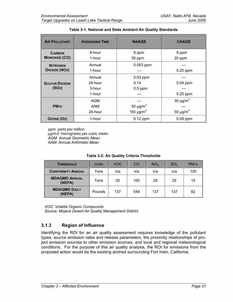
Table 3-1: National and State Ambient Air Quality Standards
AIR POLLUTANT AVERAGING TIME NAAQS CAAQS
CARBON MONOXIDE (CO)
8-hour 1-hour
9 ppm 35 ppm
9 ppm 20 ppm
NITROGEN DIOXIDE (NO2)
Annual 1-hour
0.053 ppm —
— 0.25 ppm
SULFUR DIOXIDE (SO2)
Annual 24-hour 3-hour 1-hour
0.03 ppm 0.14 0.5 ppm
—
— 0.04 ppm
— 0.25 ppm
PM10 AGM AAM
24-hour
— 50 µg/m3
150 µg/m3
30 µg/m3 —
50 µg/m3
OZONE (O3) 1-hour 0.12 ppm 0.09 ppm
ppm: parts per million µg/m3: micrograms per cubic meter AGM: Annual Geometric Mean AAM: Annual Arithmetic Mean
Table 3-2: Air Quality Criteria Thresholds
THRESHOLD Units VOC CO NOX SO2 PM10
CONFORMITY ANNUAL Tons n/a n/a n/a n/a 100
MDAQMD ANNUAL (NEPA) Tons 25 100 25 25 15
MDAQMD DAILY (NEPA) Pounds 137 548 137 137 82
VOC: Volatile Organic Compounds Source: Mojave Desert Air Quality Management District
3.1.3 Region of Influence Identifying the ROI for an air quality assessment requires knowledge of the pollutant types, source emission rates and release parameters, the proximity relationships of pro-ject emission sources to other emission sources, and local and regional meteorological conditions. For the purpose of this air quality analysis, the ROI for emissions from the proposed action would be the existing airshed surrounding Fort Irwin, California.
Chapter 3 – Affected Environment Page 21
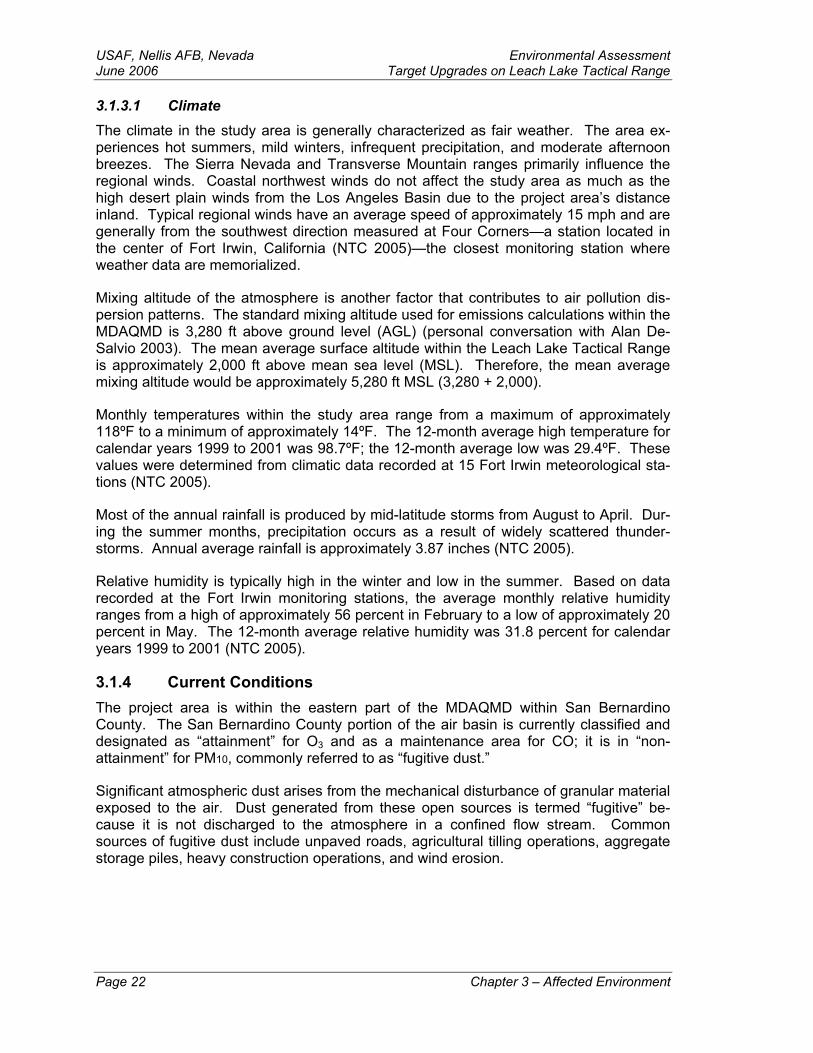
USAF, Nellis AFB, Nevada Environmental Assessment June 2006 Target Upgrades on Leach Lake Tactical Range 3.1.3.1 Climate The climate in the study area is generally characterized as fair weather. The area ex-periences hot summers, mild winters, infrequent precipitation, and moderate afternoon breezes. The Sierra Nevada and Transverse Mountain ranges primarily influence the regional winds. Coastal northwest winds do not affect the study area as much as the high desert plain winds from the Los Angeles Basin due to the project area’s distance inland. Typical regional winds have an average speed of approximately 15 mph and are generally from the southwest direction measured at Four Corners—a station located in the center of Fort Irwin, California (NTC 2005)—the closest monitoring station where weather data are memorialized.
Mixing altitude of the atmosphere is another factor that contributes to air pollution dis-persion patterns. The standard mixing altitude used for emissions calculations within the MDAQMD is 3,280 ft above ground level (AGL) (personal conversation with Alan De-Salvio 2003). The mean average surface altitude within the Leach Lake Tactical Range is approximately 2,000 ft above mean sea level (MSL). Therefore, the mean average mixing altitude would be approximately 5,280 ft MSL (3,280 + 2,000).
Monthly temperatures within the study area range from a maximum of approximately 118ºF to a minimum of approximately 14ºF. The 12-month average high temperature for calendar years 1999 to 2001 was 98.7ºF; the 12-month average low was 29.4ºF. These values were determined from climatic data recorded at 15 Fort Irwin meteorological sta-tions (NTC 2005).
Most of the annual rainfall is produced by mid-latitude storms from August to April. Dur-ing the summer months, precipitation occurs as a result of widely scattered thunder-storms. Annual average rainfall is approximately 3.87 inches (NTC 2005).
Relative humidity is typically high in the winter and low in the summer. Based on data recorded at the Fort Irwin monitoring stations, the average monthly relative humidity ranges from a high of approximately 56 percent in February to a low of approximately 20 percent in May. The 12-month average relative humidity was 31.8 percent for calendar years 1999 to 2001 (NTC 2005).
3.1.4 Current Conditions The project area is within the eastern part of the MDAQMD within San Bernardino County. The San Bernardino County portion of the air basin is currently classified and designated as “attainment” for O3 and as a maintenance area for CO; it is in “non-attainment” for PM10, commonly referred to as “fugitive dust.”
Significant atmospheric dust arises from the mechanical disturbance of granular material exposed to the air. Dust generated from these open sources is termed “fugitive” be-cause it is not discharged to the atmosphere in a confined flow stream. Common sources of fugitive dust include unpaved roads, agricultural tilling operations, aggregate storage piles, heavy construction operations, and wind erosion.
Page 22 Chapter 3 – Affected Environment
Environmental Assessment USAF, Nellis AFB, NevadaTarget Upgrades on Leach Lake Tactical Range June 2006 3.2 Biological Resources
3.2.1 Definition of the Resource The Leach Lake Tactical Range lies within the Mojave Desert Ecosystem. The native vegetation consists primarily of desert scrub communities at low to mid-elevations and mixed shrub communities at the mid- to upper elevations. Wildlife includes species that are primarily associated with Mojave Desert scrub and mixed shrub habitats. A wider variety of migratory and widely distributed species are associated with the limited water resources at the desert springs and seasonally flooded playas within the ROI.
3.2.2 Regulatory Setting Federal and state regulatory documents that apply to this action include:
The Endangered Species Act (ESA) of 1973 (16 USC § 1531)
The Bald Eagle Protection Act of 1940 (16 USC §§ 668-668d)
The Wild Free Roaming Horse and Burro Act of 1971 (16 USC § 1331)
The Migratory Bird Treaty Act of 1918 (16 USC §§ 703-711)
Noxious Weeds—Management of Undesirable Plants on Federal Lands (7 USC 2814)
Executive Order (EO) 13186, Responsibilities of Federal Agencies to Protect Mi-gratory Birds (EO 2001)
California Endangered Species Act (CESA) (Fish and Game Code §§ 2050, et seq.)
Existing Fort Irwin environmental documents that include Leach Lake are the Fort Irwin Integrated Natural Resources Management Plan (INRMP)(Draft) (DA 2003) and the Bio-logical Opinion for the Proposed Addition of Maneuver Training Lands at Fort Irwin, Cali-fornia (1-8-03-F-48) (DOI 2004).
3.2.2.1 Definitions Federally-Listed Threatened and Endangered – The ESA, as amended, is federal legis-lation. Its purpose is to protect endangered and threatened species and their critical habitats, and to take steps to recover these species. Endangered species are fish, wild-life, and/or plant species that are in danger of extinction throughout all or a significant portion of its range. Threatened species are those that are likely to become endangered in the foreseeable future. Once a species is listed, all protective measures authorized by the ESA apply to the species and its habitat.
Federal Species of Concern – This is a category of sensitive species that has not been listed, proposed for listing, or placed in candidate status. Species of concern receive no legal protection, and the use of the term does not necessarily mean that the species will eventually be proposed for listing as a threatened or endangered species. The term in-
Chapter 3 – Affected Environment Page 23
USAF, Nellis AFB, Nevada Environmental Assessment June 2006 Target Upgrades on Leach Lake Tactical Range dicates that the U.S. Fish and Wildlife Service (USFWS) has some degree of concern for the future well being of the taxon, but no legal protection under the ESA is afforded.
State Listed Threatened and Endangered – The CESA is California state legislation that establishes state policy to conserve, protect, restore, and enhance endangered or threatened species and their habitat. Endangered species as defined under the CESA are native species or subspecies of a bird, mammal, fish, amphibian, reptile, or plant which is in serious danger of becoming extinct throughout all, or a significant portion of its range due to one or more causes, including loss of habitat, change in habitat, overex-ploitation, predation, competition, or disease.
State Species of Special Concern – This category of sensitive species is used by the California Department of Fish and Game. It applies to plants and animals not listed un-der the federal ESA or the CESA, but which nonetheless 1) are declining at a rate that could result in listing, or 2) historically occurred in low numbers and known threats to their persistence currently exist. This designation is intended to result in special consid-eration for these plants and animals, and to focus attention on the species to help avert the need for costly listing under the federal and state endangered species laws and re-covery efforts that may ultimately be required.
3.2.3 Region of Influence Leach Lake Tactical Range is located in the northern portion of the Mojave Desert. The Northern Mojave Desert is an extremely arid region that is climatically and floristically distinct from the Sonora Desert to the south and the Great Basin to the northeast. The Mojave Desert ecosystem is approximately 10,000 years old and contains many woody plant and wildlife species that evolved in adjacent habitats or continents; however, as many as one third of the annual plants evolved within the Mojave Desert during the last 10,000 years. Widely spaced, low, evergreen, or winter deciduous shrubs characterize the Mojave Desert. The fauna of the Mojave Desert is well adapted to the sparse pre-cipitation and seasonally variable temperatures.
3.2.4 Current Environment The U.S. Fish and Wildlife Service (USFWS) list several federally protected species that may occur within the study area (USAF 2004). A search of the California Natural Diver-sity Database (CNDDB) (CDFG 2003) was also done to show the biological makeup of the study area. The result of this literature search is shown in the table below.
Table 3-3: Threatened, Endangered, and Sensitive Species
FEDERAL THREATENED AND ENDANGERED
BIRD SPECIES Bald Eagle (Haliaeetus leucocephalus) – threatened, fully protected Least Bell’s Vireo (Vireo bellii pusillus) – endangered Southwestern Willow Flycatcher (Empidonax traillii extrimus) – endangered
REPTILE SPECIES Desert Tortoise (Gopherus agassixii) – threatened
FISH SPECIES Mojave Tui Chub (Gila bicolor mahavensis) - endangered
PLANT SPECIES Lane Mountain Milkvetch (Astragalus jaegerianus) - endangered
Page 24 Chapter 3 – Affected Environment
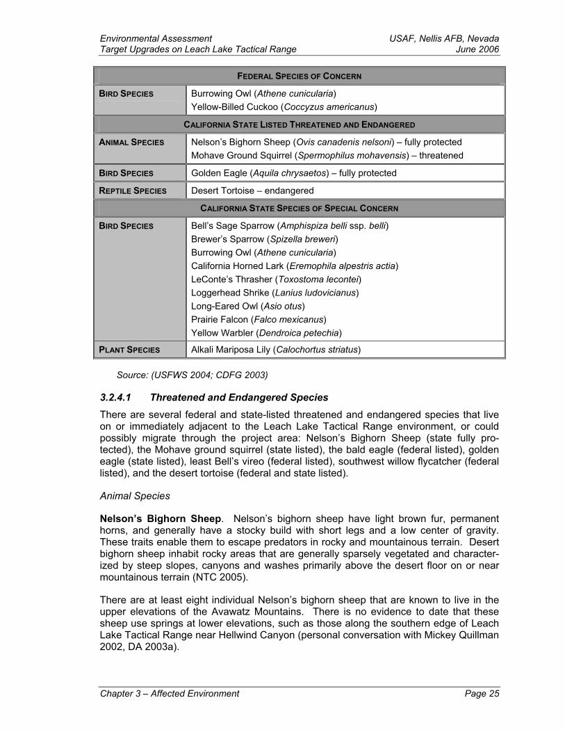
Environmental Assessment USAF, Nellis AFB, NevadaTarget Upgrades on Leach Lake Tactical Range June 2006
FEDERAL SPECIES OF CONCERN
BIRD SPECIES Burrowing Owl (Athene cunicularia) Yellow-Billed Cuckoo (Coccyzus americanus)
CALIFORNIA STATE LISTED THREATENED AND ENDANGERED
ANIMAL SPECIES Nelson’s Bighorn Sheep (Ovis canadenis nelsoni) – fully protected Mohave Ground Squirrel (Spermophilus mohavensis) – threatened
BIRD SPECIES Golden Eagle (Aquila chrysaetos) – fully protected
REPTILE SPECIES Desert Tortoise – endangered
CALIFORNIA STATE SPECIES OF SPECIAL CONCERN
BIRD SPECIES Bell’s Sage Sparrow (Amphispiza belli ssp. belli) Brewer’s Sparrow (Spizella breweri) Burrowing Owl (Athene cunicularia) California Horned Lark (Eremophila alpestris actia) LeConte’s Thrasher (Toxostoma lecontei) Loggerhead Shrike (Lanius ludovicianus) Long-Eared Owl (Asio otus) Prairie Falcon (Falco mexicanus) Yellow Warbler (Dendroica petechia)
PLANT SPECIES Alkali Mariposa Lily (Calochortus striatus)
Source: (USFWS 2004; CDFG 2003)
3.2.4.1 Threatened and Endangered Species There are several federal and state-listed threatened and endangered species that live on or immediately adjacent to the Leach Lake Tactical Range environment, or could possibly migrate through the project area: Nelson’s Bighorn Sheep (state fully pro-tected), the Mohave ground squirrel (state listed), the bald eagle (federal listed), golden eagle (state listed), least Bell’s vireo (federal listed), southwest willow flycatcher (federal listed), and the desert tortoise (federal and state listed).
Animal Species
Nelson’s Bighorn Sheep. Nelson’s bighorn sheep have light brown fur, permanent horns, and generally have a stocky build with short legs and a low center of gravity. These traits enable them to escape predators in rocky and mountainous terrain. Desert bighorn sheep inhabit rocky areas that are generally sparsely vegetated and character-ized by steep slopes, canyons and washes primarily above the desert floor on or near mountainous terrain (NTC 2005).
There are at least eight individual Nelson’s bighorn sheep that are known to live in the upper elevations of the Avawatz Mountains. There is no evidence to date that these sheep use springs at lower elevations, such as those along the southern edge of Leach Lake Tactical Range near Hellwind Canyon (personal conversation with Mickey Quillman 2002, DA 2003a).
Chapter 3 – Affected Environment Page 25
USAF, Nellis AFB, Nevada Environmental Assessment June 2006 Target Upgrades on Leach Lake Tactical Range Mohave Ground Squirrel. The Mohave ground squirrel is a medium-sized ground squirrel that is diurnal, exhibits a seasonal cycle of activity, and uses burrows for cover. The Mohave ground squirrel occupies all major desert scrub habitats in the western Mo-jave Desert. It has been observed in the following habitats, which are found throughout its range: Mojave creosote scrub, desert saltbush scrub, desert sink scrub, desert greasewood scrub, shadscale scrub, and Joshua tree woodland. In the northern portion of its range, the Mohave ground squirrel is found in Mojave mixed woody scrub. It inhabits areas with flat to moderate terrain and is not generally found in steep contours. The species has been found most frequently in sandy, alluvial soils; it is also found in gravelly, and occasionally rocky soils. Specific habitat requirements include the avail-ability of food resources and soils with appropriate composition for burrow construction. The presence of shrubs that provide a reliable food source during drought years may be critical for a population to persist in a particular area (NTC 2005).
The Mohave ground squirrel occupies portions of Inyo, Kern, Los Angeles and San Ber-nardino counties in the western Mojave Desert. The species ranges from Palmdale (Los Angeles County) in the southwest to Olancha (Inyo County) in the north. The northern extent of its range includes the Coso Range and the Argus Range (Inyo County) in the northwest and the Avawatz Mountains and the Soda Mountains (San Bernardino County) in the northeast. The southern extent of its range includes Palmdale in the southwest and the Mojave River in the southeast. The San Bernardino and San Gabriel Mountains limit the species’ distribution further south (NTC 2005). No Mohave ground squirrels were observed during the biological survey.
Bird Species
Bald Eagle. The bald eagle is our national symbol and one of North America’s largest birds. In California, bald eagles may be found throughout the state at lakes, reservoirs, rivers, and some rangelands and coastal wetlands during the winter months. In the win-ter, they roost communally in dense, sheltered remote conifer stands. The breeding habitats in California are mainly in mountain and foothill forests and woodlands near lakes, rivers, and reservoirs. Most breeding territories are in northern California. How-ever, they also nest at a few scattered locations in the Sierra Nevada Mountains and foothills, at several locations from the central coast to inland southern California, and on Santa Catalina Island. Bald eagles perch high on large limbs in tall trees, in broken topped trees, on snags, or on rocks near water (NTC 2005).
The range of the bald eagle occurs entirely within North America, including Alaska, Can-ada, the lower 48 states, and northwest Mexico. Bald eagles are fairly common as local winter migrants at a few favored inland waters in southern California, which include Big Bear Lake, Cachuma Lake, Lake Mathews, Nacimiento Reservoir, San Antonio Reser-voir, and along the Colorado River. The bald eagle has been observed at Harper Lake, the Piute Ponds on Edwards AFB, along the Mojave River, and in the Cady Mountains southwest and south of the Study Area. The Study Area does not contain habitat that is likely to support bald eagles. The bald eagle may occur as a migrant in the Study Area. The likelihood of occurrence of the bald eagle in the study area is low (NTC 2005). No bald eagles were observed during the biological survey.
Golden Eagle. Golden eagles are found in open terrain habitats including grasslands, deserts, savannahs, and early successional stages of forest and shrub habitats. They nest on cliffs and in large trees in open areas. Golden eagles breed from Alaska east Page 26 Chapter 3 – Affected Environment
Environmental Assessment USAF, Nellis AFB, NevadaTarget Upgrades on Leach Lake Tactical Range June 2006 across northern Canada and south to Mexico. They winter in the southern part of their breeding range (NTC 2005). Though golden eagles are not known to reside or frequent the project area, they have been observed in the area during the migratory seasons. No golden eagles were observed during the biological survey.
Least Bell’s Vireo. The least Bell’s vireo is a small songbird associated with riparian habitats. The least Bell’s vireo typically breeds in willow riparian forest supporting a dense, shrubby understory of mulefat and other mesic species. They have also been observed to use oak woodland with a willow riparian understory. Individuals sometimes enter adjacent chaparral, coastal sage scrub, or desert scrub habitats to forage. The least Bell’s vireos in California occur in riparian forest dominated by willows and tend to avoid riparian areas dominated by non-native salt cedar (Tamarisk ramosissima) (NTC 2005).
The least Bell’s vireo breeds in southwestern California and adjacent northwestern Baja California. It largely occurs in southern California, but it does extend into areas along the western flank of the Anza-Borrego Desert (San Diego County), in the vicinity of Palm Springs (Riverside County), in Leona Valley (Los Angeles County), in Morongo Valley (San Bernardino County), and along the Mojave River. There are breeding records for this subspecies north in the southern Owens Valley (Inyo County), and it regularly breeds just northwest at the South Fork Kern River Preserve. Elsewhere in the West Mojave Desert, the least Bell’s vireo is an occasional migrant (NTC 2005).
The eastern limit of the range of the least Bell’s vireo in California is contentious, in that the ranges of the least Bell’s vireo and the Arizona Bell’s vireo (V. b. arizonae) in Cali-fornia are based more on supposition than on direct evidence. It is generally believed that the Arizona Bell’s vireo is confined to the Lower Colorado River Valley, whereas the least Bell’s vireo occurs in cismontane southern California and on the western edge of the deserts, extending north up the Mojave River into the Owens Valley, and eastward into Death Valley National Park, along the Amargosa River (Inyo County) and at Fort Pi-ute in the East Mojave Desert. The breeding population along the Mojave River is south of the project area (NTC 2005). No least Bell’s vireos were observed during the biologi-cal survey.
Southwestern Willow Flycatcher. The southwestern willow flycatcher breeds in dense riparian habitats along rivers, streams, or other wetlands across the southwestern U.S. The riparian woodland used by willow flycatchers typically is next to, or over, water and has a canopy and understory of shrub and sapling vegetation. The vegetation composi-tion of occupied habitats varies between sites and may include one or more of the following: native willows, ash, alder, coast live oak, mature nonnative tamarisk, cotton-woods, box elders, and nonnative Russian olive (NTC 2005). No southwestern willow flycatchers were observed during the biological survey.
Reptile Species
Desert Tortoise. The desert tortoise is a medium-sized, terrestrial turtle in the family Testudinidae. Its unhinged shell is colored in shades of brown with faint orange or yel-low in the centers of some scutes (the keratinized shell cover). Muted mottling is vari-ously present in the plastron (ventral shell), especially in juvenile tortoises. They range in length from about 1.4 inches (35 mm) at hatching to 11-16 inches (28-40 cm) for adults in weight from .04 to 15 pounds (.02 to 6.9 kg) (NTC 2005).
Chapter 3 – Affected Environment Page 27
USAF, Nellis AFB, Nevada Environmental Assessment June 2006 Target Upgrades on Leach Lake Tactical Range The desert tortoise occupies arid habitats below approximately 4,000 ft AMSL (1,200 m). Common vegetation associations in the Mojave Desert include creosote bush scrub, saltbush scrub, Joshua tree woodland, and Mojave yucca communities. Because of the burrowing nature of desert tortoises, soil type is an important habitat component. In California, desert tortoises typically inhabit soft sandy loams and loamy sands, although they are also found on rocky slopes and in rim-rock that provide natural cover sites in crevices. In portions of Nevada and elsewhere, where a near-surface durapan limits digging, desert tortoises often occupy caverns in the exposed caliche of wash banks. Hills with round, exfoliating granite boulders often support higher densities of desert tor-toise than surrounding flat areas, especially in Arizona. Valleys, alluvial fans, rolling hills, and gentle mountain slopes are also inhabited. Playas and steep, talus-covered slopes are avoided (NTC 2005). Though some evidence of tortoise burrows were dis-covered in the far eastern portion of the study area, no desert tortoises, burrows, or scat were observed within the immediate vicinity of current or proposed target areas during the biological survey.
Fish Species
There are no standing bodies of water in the project area in which fish would be present.
Plant Species
Lane Mountain Milkvetch. The project area is outside the habitat range of the Lane Mountain Milkvetch.
3.2.4.2 Sensitive Species
Bird Species
The LeConte’s thrasher, loggerhead shrike, and long-eared owl were observed in Hell-wind Canyon (McCalvin and Pereksta 1994). Field surveys by Harmsworth and Associ-ates have shown that sensitive bird species use the Cave Springs, approximately 5 miles to the east of the Leach Lake Tactical Range boundary (NTC 2003a). These sen-sitive species primarily use the higher elevations of the Leach Lake Valley and only oc-casionally use the central portion of the valley. The Bell’s sage sparrow, Brewer’s spar-row, California horned lark, loggerhead shrike, yellow warbler, and prairie falcon were observed in the other mountain canyons of the Leach Lake Tactical Range (McCalvin and Pereksta 1994). Prairie falcons have been observed in the area.
Burrowing Owl. The burrowing owl is a BLM sensitive species, a CSSC, and a FSOC. Within California burrowing owls are found in open dry habitats including grasslands, prairie, and desert floors. Burrowing owls breed from Canada south through most of the western U.S. and Central America to the southern tip of South America. Northern popu-lations migrate to the southern extent of their breeding range, while southern populations are largely non-migratory. Burrowing owls within the Mojave Desert are largely resident. The burrowing owl has been observed at locations south and southwest of Fort Irwin in-cluding Harper Lake, Edwards AFB, and several locations along the Mojave River near Barstow. The burrowing owl was petitioned for state listing as threatened or endangered by a coalition of conservation groups in April of 2003 (NTC 2005).
Page 28 Chapter 3 – Affected Environment
Environmental Assessment USAF, Nellis AFB, NevadaTarget Upgrades on Leach Lake Tactical Range June 2006 California Horned Lark. California horned larks are resident to a variety of open habi-tats with low sparse vegetation, typically without trees and large shrubs. The range of California horned larks includes most of North America. California horned larks are yearlong residents within the state and are found from grasslands along the coast and deserts near sea level to alpine dwarf-shrub habitat above the tree-line. They are less common in the North Coast mountain regions and in coniferous or chaparral habitats. Flocks of the desert lowlands and other areas of California are augmented by winter visi-tants, many migrating from outside of the state. California horned larks have been ob-served within [Fort Irwin] and are likely permanent residents (NTC 2005). No California Horned Larks were observed during the biological survey.
LeConte’s Thrasher. LeConte’s thrasher inhabits desert flats; washes, and alluvial fans characterized with scant vegetation, usually cholla and creosote bush, and sandy or al-kaline soils. If available, golden cholla is preferred for nest sites. However, in some ar-eas, allscale is the only suitable host plant for nesting. LeConte’s thrasher is a non-migratory bird that is endemic to southern California, southern Nevada, southwestern Utah, western and central Arizona, and northwestern Mexico. It is found in desert scrub across the Mojave Desert of California. It occurs in the Antelope Valley (Los Angeles County), north to Ridgecrest and NAWS China Lake (Kern County). It also occurs along the northern base of the San Bernardino and San Gabriel Mountains, throughout Joshua Tree National Park and into the Owens and Panamint valleys. It has been observed throughout [Fort Irwin]. LeConte’s thrashers occur on [Fort Irwin] and are potential resi-dent year round (NTC 2005). No LeConte’s threshers were observed during the biologi-cal survey.
Loggerhead Shrike. The loggerhead shrike occupies arid and semi-arid habitat throughout lowlands with suitable hunting perches. Densely vegetated areas are avoided. The loggerhead shrike’s range extends across North America from Canada to southern Mexico. Breeding birds in California deserts probably remain as resident, while migrating loggerhead shrikes arrive in these areas in winter. Loggerhead shrikes are widely distributed throughout the Mojave Desert. Loggerhead shrikes were observed throughout [Fort Irwin]. [Fort Irwin] lies within the species’ range, and it is likely a per-manent resident (NTC 2005). No loggerhead shrikes were observed during the biologi-cal survey.
Long-Eared Owl. The long-eared owl is a medium sized owl and one of the most strictly nocturnal of all owls. Long-eared owls use bottomland habitats with tall willows and cottonwoods or belts of live oaks adjacent to stream courses and open land. Within the desert long-eared owls are generally found resting and/or roosting in willows, cot-tonwoods, junipers, native live oak, dense plantings of tamarisk, elms, and conifers. Within North America the long-eared owl is found across central Canada, south across the northeastern U.S., and within most of the western U.S. The long-eared owl winters in the southern part of its breeding range. While there is some influx of wintering owls that occurs in California deserts, it is not clear if the majority of these birds are winter visitors. Long-eared owls have been observed in a tract of cottonwoods and willows along the Mojave River near Victorville (BLM 2002u). The long-eared owl may occur as a migrant in the Project Area (NTC 2005). No long-eared owls were observed during the biological survey.
Prairie Falcon. Prairie falcons breed from Canada south through the western half of the U.S. into Mexico and winter throughout their breeding range. Habitat for the falcon in-
Chapter 3 – Affected Environment Page 29
USAF, Nellis AFB, Nevada Environmental Assessment June 2006 Target Upgrades on Leach Lake Tactical Range cludes barren mountains, prairies, perennial grasslands, savannahs, rangeland, some agricultural fields, and desert scrub. Prairie falcons nest on cliffs in rugged mountain ranges, usually within a half-mile of a water source. They are found throughout the western Mojave Desert. Prairie falcons have been observed foraging near the eastern portion of [Fort Irwin] in the Avawatz Mountains. Prairie falcons are likely residents, as well as winter visitors to [Fort Irwin]. Prairie falcons may roost and nest in the mountain ranges of [Fort Irwin} (NTC 2005). No prairie falcons were observed during the biologi-cal survey.
Yellow-Billed Cuckoos. Yellow-billed cuckoos have one of the most restrictive suites of macro-habitat requirements of any bird species. The habitat type, size and configura-tion are extremely important. During the breeding season in California, yellow-billed cuckoos are confined to cottonwood-willow riparian habitat (NTC 2005).
Yellow-billed cuckoos have a wide distribution throughout North America. They breed from the West Indies and the northern third of Mexico, north to extreme southern Can-ada and winter from northern South America, south to northern Argentina, primarily east of the Andes. The western subspecies, the California yellow-billed cuckoo (C.a. occi-dentalis), has a much smaller range and more restrictive habitat requirements. It breeds in California, Idaho, Utah, Arizona, New Mexico, Texas, possibly Nevada, and western Colorado at dispersed locations where suitable habitat is located. The majority of yel-low-billed cuckoos in California are found along the upper Sacramento River and at the South Fork Kern River, with the remaining cuckoos at other various locations, including the Mojave River near Hodge, southwest of the Study Area. Cuckoos have been ob-served during the breading season along the Mojave River between Victorville and Bar-stow. However, there are no confirmed nesting areas within this region of the Mojave Desert. Yellow-billed cuckoos could occur at any desert oasis with willow and cotton-woods, although there are very few records of migrant yellow-billed cuckoos in the vicin-ity (NTC 2005). No yellow-billed cuckoos were observed during the biological survey.
Yellow Warbler. The yellow warbler is a wood warbler. Within the California desert, yellow warblers occupy riparian woodland or forest habitat dominated by cottonwoods and willows. Yellow warblers have a vast range that extends throughout most of North America, and they winter in the tropics. Three subspecies of yellow warblers nest in California: D. p. brewsteri along the Pacific coast and a few desert locations, D. p. mor-comi from the Sierra Nevadas to the Great Basin, and D. p. sonorana along the Colo-rado River. Yellow warblers are common migrants through southeastern California. Within the Mojave Desert yellow warblers are known to nest at the Mojave River at Vic-torville, Camp Cady, and Morongo Valley. Yellow warblers are found at springs and the installation all summer to breed. The long-eared owl may occur as a migrant in the Pro-ject Area (NTC 2005). No yellow warblers were observed during the biological survey.
Plant Species
Alkali Mariposa Lily. Alkali mariposa lily is a perennial of the Liliaceae family. Alkali mariposa lily occurs in calcareous sandy soil in seasonally moist alkaline habitats includ-ing alkali meadows, ephemeral washes, vernally moist depressions, and at seeps within saltbush scrub (NTC 2005).
Alkali mariposa lily is endemic to moist alkaline areas in the arid interior of southern Cali-fornia and southern Nevada. It occurs in the southern Sierra Nevadas; in the western, Page 30 Chapter 3 – Affected Environment
Environmental Assessment USAF, Nellis AFB, NevadaTarget Upgrades on Leach Lake Tactical Range June 2006 central, and southern Mojave Desert; at the north base of the San Bernardino Moun-tains; in the southern San Joaquin Valley; and discontinuously in southern Nevada. Populations recorded in the region include: the San Bernardino Mountains at Cushen-bury Springs and Box “S” Springs; Lucerne Valley (at Rabbit Spring); north of Barstow (which may be the same as the next); Paradise Springs near Fort Irwin; Edwards AFB, north of Lancaster; and Red Rock Canyon State Park (NTC 2005).
University of California-Los Angeles (UCLA) personnel observed two plant individuals at Two Springs in 1993-1994 (Gibson et al. 1994). No evidence of this species was ob-served in the fall 2003 surveys. The most probable reason is due to overgrazing by feral burros that are known to regularly use this spring. Habitat for this species on Leach Lake Tactical range does not occur outside the spring areas.
3.2.4.3 Other Biological Resources
Wildlife
Fort Irwin is home to at least 31 mammal, 32 reptile, 187 bird, and thousands of insect species. There are no native fish or amphibians on Fort Irwin. The USFWS completed wildlife studies and species lists for Hellwind Canyon in 1994 (McCalvin and Pereksta 1994). This area should have the most species of wildlife within Leach Lake Tactical Range due to the presence of trees and surface water. In that survey, 8 lizard, 4 snake, 76 bird, and 13 mammal species were observed in washes near the springs or adjacent creosote bush scrub, riparian woodland, and desert wash vegetation of the northern Granite Range. This relatively wildlife-rich habitat is not indicative of the project area; most of the proposed construction sites are located on dry alluvial fans and in undis-turbed areas (Charlton 2004).
Migratory Birds and Other Raptors
Birds may be permanent residents, overwinter, nest, or occasionally pass through the study area during migration. The diversity and density of bird species in the Mojave De-sert is relatively low, especially at the lower elevations vegetated by saltbush scrub. The low numbers and lack of bird diversity is due to the absence of permanent water sources and lack of a tree overstory that is used by birds for cover and foraging. Seed-eating birds are generally found at lower elevations. The most commonly observed birds in the area include black-throated sparrows (Amphispiza bilineata), house finches (Carpodac-tus mexicana), Gambel’s quail (Callipepla gambellii), ground and morning doves (Zenaida macroura), and other sparrows such as the white crowned sparrow (Zonotricha leucophrys) and fox sparrow (Passerellqa iliaca).
Fall and spring migrants use springs and other sources of water. Riparian and forest dwellers such as vireos and warblers may be observed using springs in the study area during migration periods. Springs are a valuable water resource to most resident and migratory bird species.
Approximately 120 species of birds pass through the study area during migration. Costa’s hummingbirds (Calypte costae) nest in the Mojave Desert, and Anna’s hum-mingbirds (Calypte anna) overwinter in the area. Cactus rock wrens (Salpinctes obso-letus) and canyon wrens (Caterpes mexicanus) use the rocky canyons and boulder piles in the area. In addition to the previously mentioned golden eagle and prairie falcon, other migrant raptor species that have also been observed in the area include red-tailed
Chapter 3 – Affected Environment Page 31
USAF, Nellis AFB, Nevada Environmental Assessment June 2006 Target Upgrades on Leach Lake Tactical Range hawks (Falco jamaicensus), the most common raptor, and northern harriers (Circus cyaneus). The barn owl (Tyto alba) is the most common nocturnal avian predator in the area. It usually roosts in abandoned buildings and large trees on homesteads. Turkey vultures (Cathartes aura) may also be observed in the area in the fall during migration.
Floristics and Vegetation
Leach Lake is located in the northern portion of the central Mojave floristic province (Rowlands et al. 1992). The central Mojave Desert is one of the smallest and least di-verse of the five floristic provinces because it lacks extremes in topographic diversity. Approximately 550 plant species occur in the central Mojave Desert. Approximately 137 plant species have been documented (Charlton 2003, McCalvin and Pereksta 1994) as occurring within the Leach Lake Basin. The most diverse vegetation was the Mojave mixed woody scrub and the wetlands around Leach Springs. During the fall 2003 plant species survey of the study area, 60 plant species were observed. The most common plant community within the study area is creosote bush scrub, which comprises 70 per-cent of the Mojave Desert and 91 percent of the Leach Lake Basin (Charlton 2004). All proposed projects, except for two observation points in the Granite Range, are located in creosote bush scrub. The two observation points are located in Mojave mixed woody scrub.
The Mojave Desert Ecosystem Program (MDEP) personnel have completed the most accurate vegetation maps of the area. The maps describe five plant communities in the Leach Lake Basin: creosote bush scrub, Mojave mixed woody scrub, saltbush scrub, desert wash scrub, and desert sink scrub. Fieldwork conducted for this project found that the desert sink scrub does not exist, and three very small alkaline meadow and seep habitats were previously overlooked. The saltbush and alkali sink communities are allscale saltbush scrub vegetation.
3.3 Cultural Resources
3.3.1 Definition of the Resource Cultural resources are prehistoric and historic districts, sites, structures, artifacts, and any other physical evidence of human activities considered important to understanding a culture, subculture, or community for scientific, traditional, religious or other reasons. Cultural resources are divided into three categories:
Prehistoric and historic
Historic buildings and structures
Traditional cultural properties
The Army Cultural Resources Management Plan (USACE 2002) defines and explains these categories.
Native American and Euroamerican archaeological resources are locations where hu-man activity measurably altered the earth or left deposits of physical remains (e.g. stone tools, projectile points, bottles, etc.). In this discussion, Native American archaeological resources pre-date the beginning of written records. In the Central Mojave Desert, they range from isolated stone tools to village sites. Euroamerican resources are defined as Page 32 Chapter 3 – Affected Environment
Environmental Assessment USAF, Nellis AFB, NevadaTarget Upgrades on Leach Lake Tactical Range June 2006 those formed after the beginning of written records. Euroamerican archaeological re-sources on Fort Irwin include campsites, roads, fences, trails, dumps, and a variety of other features.
Architectural and cultural landscape resources include standing buildings, dams, canals, and bridges. Resources also include designed landscapes, rural landscapes, and other structures or landscapes of historic aesthetic, or scientific significance. The structures must generally be 50 years of age or older, although military buildings and structures from the Cold War Era (1946-1989) can be considered significant architectural resources if they were of exceptional importance to the nation’s military history.
3.3.2 Regulatory Setting Under federal law, impacts to cultural resources may be considered by agencies to be adverse if the resources are generally those that are eligible for nomination to the Na-tional Register of Historic Places (NRHP) established by the National Historic Preserva-tion Act (NHPA) of 1966 (36 CFR § 60.4). Or those that are important to Native Ameri-can or other traditional groups as outlined in the American Indian Religious Freedom Act (AIRFA) of 1978 (42 USC § 1996), the Native American Graves Protection and Repatria-tion Act (NAGPRA) of 1990 (25 USC §§ 3001-3013), and EO 13007, Indian Sacred Sites Executive Order (EO 13007). Cultural resources that have been determined eligible for inclusion in the HRHP are called “historic property.” An historic property must be more than 50 years old unless considered of exceptional importance in understanding, for ex-ample the Cold War.
To be considered eligible for nomination to the National Register, Native American and Euroamerican archaeological resources, architectural resources, landscapes, and tradi-tional cultural properties must meet one or more of the criteria outlined in NRHP. Sig-nificant resources are those that:
are associated with events that have made a significant contribution to the broad patterns of our history;
are associated with lives of persons significant in our past;
embody the distinctive characteristics of a type, period, or method of construc-tion, or that represent the work of a master, or possess high artistic values, or represent a significant and distinguishable entity whose components may lack individual distinction; or
have yielded, or may be likely to yield, information important in prehistory or his-tory.
3.3.3 Region of Influence (Moffitt and Moffitt 2005) The ROI used for the cultural resource analysis lies within the current NTC withdrawn land encompassed within the boundaries described as Leach Lake Tactical Range, lo-cated in the north central Mojave Desert region of southern California. The Mojave De-sert lies within the culturally and geographically defined area known as the southwestern Great Basin. Traditionally, prehistoric evidence for human occupation in the Mojave De-sert was identified by the presence of artifacts including flaked stone and groundstone tools. Artifacts within assemblages were analyzed and type markers, usually based on
Chapter 3 – Affected Environment Page 33
USAF, Nellis AFB, Nevada Environmental Assessment June 2006 Target Upgrades on Leach Lake Tactical Range point morphology, were established for determining relative chronological associations. Early archaeological investigations generally include basic field notes lacking detailed information regarding provenience of artifacts and features. Generally, archaeological sites found within the deserts of California are often spread across the surface and lack soil depth. Early research tended to focus their efforts on locating sites near water sources including ancient lakebeds, riverbeds, washes, sinks, and springs. The early research efforts of Malcolm Rogers (1929, 1939), and Elizabeth Campbell (1931, 1936; Campbell and Amsden 1934), provide early historic attempts to establish chronological sequences based on similarities or patterns observed within archaeological assem-blages recovered from the Mojave Desert region.
Elizabeth Campbell (1936) was the first to introduce a cultural sequence for the Mojave Desert region. Her sequence included in the earlier Pinto and Silver Lake Cultures as-sociated with sites located along high terraces near shore of present-day skinks or ex-tinct rivers; followed by the Big Blade Camps with sites located near present-day water holes and shores of ephemeral sinks; continuing with cultures associated with arrow points but containing no pottery, and concluding with an Arrow point cultural group asso-ciated with pottery. In 1939, Malcolm Rogers defined the following cultural sequences: the Malpais based on a poorly defined core and flake industry, the Playa Industry (Lake Mohave Complex), the Pionto-Gypsum Complex, the Armagosa Industry I (without pot-tery) and II (with pottery), and the late prehistoric Yuman culture group. Rogers later changed his categories; however, problems prevailed in his terminology and conflicting descriptions. Vast differences are found in the proposed chronologies of Campbell and Rogers, as Campbell dated human use of the Mojave Desert from 15,000 B.P. (Camp-bell and Campbell 1935; Campbell 1936; Campbell et al. 1937), while Rogers indicated the earliest human occupation of the area occurred ca. 4000 B.P. (Rogers 1939). Al-though, both Campbell and Rogers contributed to our knowledge of prehistoric in the Mojave Desert, Roger’s chronology provided the foundation for later work by research-ers.
In the 1950s and 1960s chronological sequences for the Mojave Desert were proposed by Wallace (1962), who spent over two decades conducting research in the Death Valley area. Wallace established a Death Valley sequence and incorporated Roger’s 1939 se-quence into his work on California deserts with some modifications. Wallace proposed the earliest human occupation at ca. 9000 B.P. (Lake Mohave period), including a period of abandonment of the desert by about 7000 B.P., followed by reoccupation of the area ca 5000 B.P. to the historic period. Cultural sequences determined during this time pe-riod by Wallace (1962) include Pinto (ca. 5000-2000 B.P.), Saratoga Springs (ca. 2000-1000 B.P., and Shoshonean-Yuman (ca. 1000 B.P. to historic period). This chronology was adopted by Hunt (1960) during his work in the Death Valley region. During the 1960s, Lanning (1963) established a cultural chronology using stratigraphic information and data collected from cross-dating artifacts recovered from the Rose Springs site (CA-INY-3732), located south of Owens Lake in Rose Valley.
More recent chronologies used by present researchers include those developed by Bet-tinger and Taylor (1974), and Warren and Crabtree (1986). Bettinger and Taylor estab-lished a new chronology as earlier versions were found inadequate “for distinguishing and temporally ordering extinct socio-cultural groups” (Bettinger and Taylor 1974). These chronologies are comparable for approximately the past 1,500 years but reflect a significant split in opinion among archaeologists regarding the temporal placement of earlier point forms (e.g., Lake Mohave, Silver Lake, and Pinto). The two primary chro- Page 34 Chapter 3 – Affected Environment
Environmental Assessment USAF, Nellis AFB, NevadaTarget Upgrades on Leach Lake Tactical Range June 2006 nologies used in the Great Basin culture region to date the placement of early points in-clude the short chronology and the long chronology. Considering the Pinto Point, those proponents of the short chronology argue that Pinto points are associated with ephem-eral lakes, streams, and springs suggesting occupation during the Little Pluvial, dated between 5000-4500 B.P., into the onset of Christian era (Wallace 1962). Proponents of the long chronology argue that Pinto lithic assemblages developed from Lake Mohave assemblages and indicate a long cultural continuum (Tuohy 1974; Warren 1980).
The short chronology is supported by Bettinger and Taylor (1974) with the establishment of five chronological categories based on radiometric data representing the Great Basin area. These categories include the Lake Mohave period (ca. pre 6000 B.P.), followed by Little Lake period (ca. 1350-650 B.P.), Newberry period (ca. 3150-1350 B.P., Haiwee period (ca. 1350-650 B.P.), and Marana period (ca. 650-100 B.P.). The long chronology is supported by Warren and Crabtree (1986) and is evident in their model including the division of five chronological categories. These categories are described as follows: the Lake Mohave period (pre ca. 7000 B.P.), the Pinto period (ca 7000-4000 B.P.), the Gyp-sum period (ca. 4000-1500 B.P.), the Saratoga Springs period (ca. 1500-650 B.P.), and the Shoshonean period (ca. 650-100 B.P.).
Table 3-4: Comparative Terminology For Present Chronological Models (California Deserts)
BETTINGER AND TAYLOR (1974) WARREN AND CRABTREE (1986)
Marana Shoshonean
Haiwee Saratoga Springs
Newberry Cypsum
Little Lake Pinto
Lake Mohave Lake Mohave
3.3.4 Current Conditions In 1988 archaeologist Richard Norwood researched this area, conducted a one-day field survey, and wrote a report summarizing the knowledge of Leach Lake Basin archae-ology (Norwood 1989). He noted that the Malcolm Rogers of the San Diego Museum of Man did the first known archaeological research of the area in the 1920s. The study identified archaeological sites at Leach Springs, Two Springs, and Leach Lake playa lakebed. No site-specific reports were generated but the information was used for theo-ries on the use of the Mojave Desert by Native Americans published in 1939 and 1945 (Norwood 1989).
In 1948 the San Bernardino County Museum did cultural resource surveys in Leach Lake Basin (Sheppard and Smith 1948). They reexamined the three known sites and made collections of artifacts, some significant. Kaldenberg visited the basin in 1976 and wrote an overview of the archaeology of the central Mojave in 1980 (Kaldenberg 1981).
Between 1980 and 1985, when Fort Irwin became the National Desert Training Center for the Army, the Interagency Archaeological Services began developing a long-term
Chapter 3 – Affected Environment Page 35
USAF, Nellis AFB, Nevada Environmental Assessment June 2006 Target Upgrades on Leach Lake Tactical Range Cultural Resources Management Plan (CRMP) for Fort Irwin. This project included fieldwork in the Leach Lake Basin. After 1985, inventorying cultural resources at Fort Irwin became the responsibility of the Directorate of Public Works (DPW). A report on the Late Holocene Archaeology of Drinkwater Basin, Fort Irwin, San Bernardino County (Basgall et al. 1988) is the only document specifically for the northern central Mojave Desert. Archaeological studies on the nearby Salt Creek-Amargosa Drainage are within the Northern Mojave Desert, a different cultural region.
The results of the Norwood (1989) report documented 11 sites, of which 3 were the pre-viously recorded sites. Norwood defined a site as having 10 or more artifacts or a site feature (Edwards AFB protocol). A few isolated flakes and a possible prehistoric/historic trail were also documented. The 11 sites are listed below.
Table 3-5: Leach Lake Basin Archaeological Sites
SITE NAME PREHISTORIC HISTORIC DESCRIPTION
LEACH SPRINGS P H Flakes, ground stone, rock cabins, tank, corral
TWO SPRINGS P H Rock art, eligible for the NRHP
EAST SIDE ROCK P Rock ring
HAMMERSTONE MOUND P Chipping station, suitable material from a wash
TENTPAD WEST P H Rock cairn and historic tentpad
NW CHERT QUARRY1 P Paleo Eligible for nomination to the NRHP
CENTRAL MINING COMPLEX H Historic mine shafts, well, 2 cabins
HELLWIND CANYON P H 1 dense flake site, cabin, 1920’s car, sheds
LEACH LAKE PLAYA1 P Paleo Off limits
CHOCOLATE DROPS1 Paleo Wood rat middens
MINI-CANYON1 Paleo Wood rat middens Note 1: Paleontological sites Source: (Norwood 1989)
3.4 Earth Resources
3.4.1 Regulatory Setting Most of the state and federal regulations that cover earth resources apply to minerals and mining. No mining or mineral extraction occurs on Leach Lake Tactical Range or are included in this action so they do not apply. Those that do apply are Air Force In-struction 32-7064, Integrated Natural Resources Management (USAF 1997b), Army Regulation 200-3, Natural Resources—Land, Forest, and Wildlife Management (DA 1995), and the Department of the Army Integrated Natural Resources Management Plan (DA 2003).
Page 36 Chapter 3 – Affected Environment
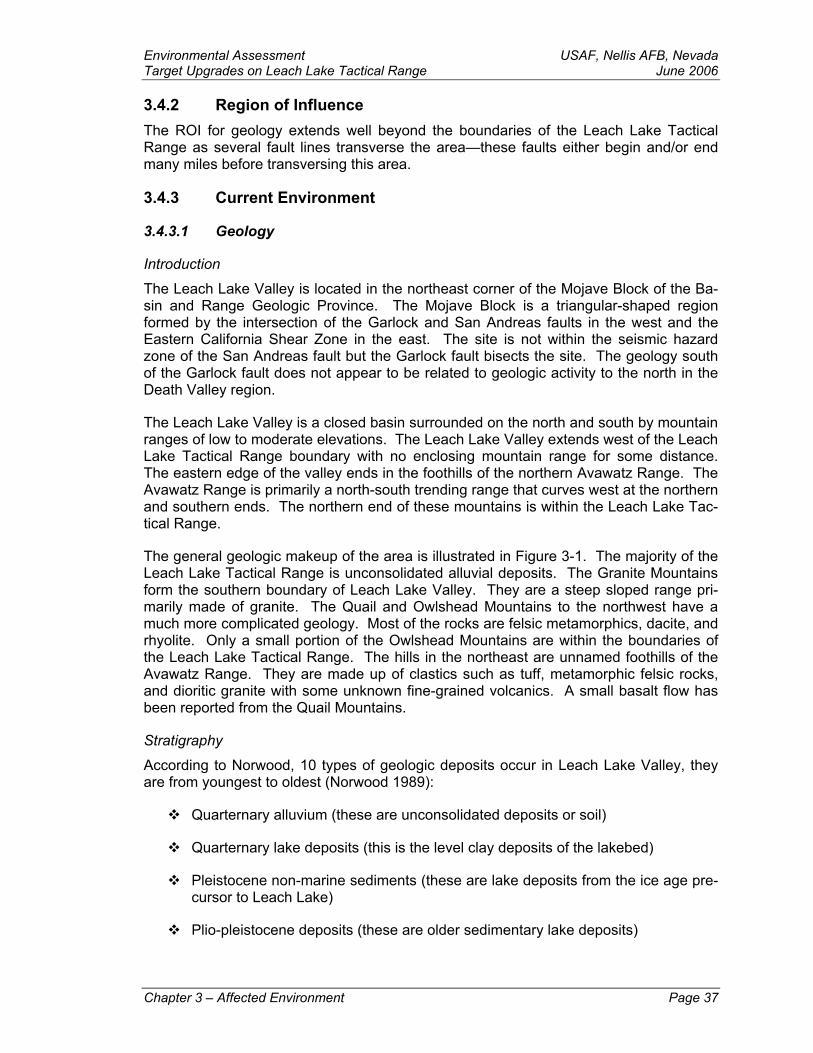
Environmental Assessment USAF, Nellis AFB, NevadaTarget Upgrades on Leach Lake Tactical Range June 2006 3.4.2 Region of Influence The ROI for geology extends well beyond the boundaries of the Leach Lake Tactical Range as several fault lines transverse the area—these faults either begin and/or end many miles before transversing this area.
3.4.3 Current Environment
3.4.3.1 Geology
Introduction
The Leach Lake Valley is located in the northeast corner of the Mojave Block of the Ba-sin and Range Geologic Province. The Mojave Block is a triangular-shaped region formed by the intersection of the Garlock and San Andreas faults in the west and the Eastern California Shear Zone in the east. The site is not within the seismic hazard zone of the San Andreas fault but the Garlock fault bisects the site. The geology south of the Garlock fault does not appear to be related to geologic activity to the north in the Death Valley region.
The Leach Lake Valley is a closed basin surrounded on the north and south by mountain ranges of low to moderate elevations. The Leach Lake Valley extends west of the Leach Lake Tactical Range boundary with no enclosing mountain range for some distance. The eastern edge of the valley ends in the foothills of the northern Avawatz Range. The Avawatz Range is primarily a north-south trending range that curves west at the northern and southern ends. The northern end of these mountains is within the Leach Lake Tac-tical Range.
The general geologic makeup of the area is illustrated in Figure 3-1. The majority of the Leach Lake Tactical Range is unconsolidated alluvial deposits. The Granite Mountains form the southern boundary of Leach Lake Valley. They are a steep sloped range pri-marily made of granite. The Quail and Owlshead Mountains to the northwest have a much more complicated geology. Most of the rocks are felsic metamorphics, dacite, and rhyolite. Only a small portion of the Owlshead Mountains are within the boundaries of the Leach Lake Tactical Range. The hills in the northeast are unnamed foothills of the Avawatz Range. They are made up of clastics such as tuff, metamorphic felsic rocks, and dioritic granite with some unknown fine-grained volcanics. A small basalt flow has been reported from the Quail Mountains.
Stratigraphy
According to Norwood, 10 types of geologic deposits occur in Leach Lake Valley, they are from youngest to oldest (Norwood 1989):
Quarternary alluvium (these are unconsolidated deposits or soil)
Quarternary lake deposits (this is the level clay deposits of the lakebed)
Pleistocene non-marine sediments (these are lake deposits from the ice age pre-cursor to Leach Lake)
Plio-pleistocene deposits (these are older sedimentary lake deposits)
Chapter 3 – Affected Environment Page 37

USAF, Nellis AFB, Nevada Environmental Assessment June 2006 Target Upgrades on Leach Lake Tactical Range
Tertiary volcanics (these include the pinkish dacite strata)
Tertiary rhyolitic volcanic deposits (these are pinkish-purple plugs)
Tertiary non-marine deposits (these are very old lake and stream deposits)
Pre-cretaceous metamorphic rocks (these are primarily reheated granitic gneiss)
Mesozoic granitic type rocks
Precambrian metamorphic rocks (also gneiss)
Seismicity
The Leach Lake Valley is formed by the Garlock fault zone, one of the most obvious geologic features in Southern California. The Garlock fault is a left-lateral strike slip fault, meaning the surfaces on both sides of the fault are moving in relatively different directions with very little vertical movement. At the eastern end of the fault, the Garlock fault’s main trace splits into the Mule Springs (El Paso) fault and the Leach Lake fault (southern trace). Both traces show evidence of surface rupture within the Holocene (last 8,000 years). The Garlock fault is an active major fault system with low, moderate, and active zones between Lebec, California and Leach Lake. Six well-resolved earthquakes have been documented in the last 7,500 years in the central portion of the fault. These occurred between 1640 and 1450 AD, 950 and 675 AD, 475 and 275, 250 and 25 AD, 2930 and 3340 BC, and 4670 and 5300 BC (Dawson et al. 2003).
Detailed studies show 60 meters of horizontal displacement have occurred with very little vertical movement (McGill 1998). Figure 3-2 shows the following faults within the Leach Lake Tactical Range:
Brown Mountain fault Granite Mountains fault
El Paso fault Owl Lake fault
Garlock fault
The Garlock fault interacts with a fault zone running nearly perpendicular at its eastern terminus. This interaction terminates the Garlock fault and results in it bending south. The Death Valley fault is located within the Eastern California Shear Zone. It forms Silu-rian Valley in which the town of Baker is located. The uplift of the Avawatz Range was caused by this fault interaction (Reinert 2003). Slip along the Garlock fault began be-tween 12 and 14 million years ago. Right-lateral slip activity along the Death Valley fault may have also begun about 14 million years ago.
Page 38 Chapter 3 – Affected Environment

Draft Environmental Assessment USAF, Nellis AFB, Nevada Target Upgrades on Leach Lake Tactical Range June 2006
Chapter 3 – Affected Environment Page 39
Figure 3-1: Geology
Leach Lake Tactical Range Geology
Quaternary Mesozoic ... Target Pomts
~.,~r~~ Ouatemary Altuviats
Tertiary
Igneous Sedimentary
• ,:-:~: Chemteal, limes-tone
• • CJasllc, NA
Igneous
(Plutonic)
:·~:;:\ Oiontlc
~GraM;c
(Volcanic)
~~·:·J Oaoitic
..:~~ Rhyolitic - NA
Metamorphic D Projecced Target Areas
Eye Candy Target Roads
~=~~ Felsic, NA Troop/Mortar Posilions
New Roads
r·-·· '-·-· ... Military Boundaries
D Leach Lake Boundary
D Orylakes
Roads
Source Data: US Army Topographic Engineering Centw, l.oul.slan• Stato Unlv0t$lty, & Charts Corpontfon 2003
'I W.l' - ~ .
s
0 2 4 6
Kilometers
0 2 3 - Miles
Scale 1 :100,000
Prepared by Ire L Eisen 1 1·17.04
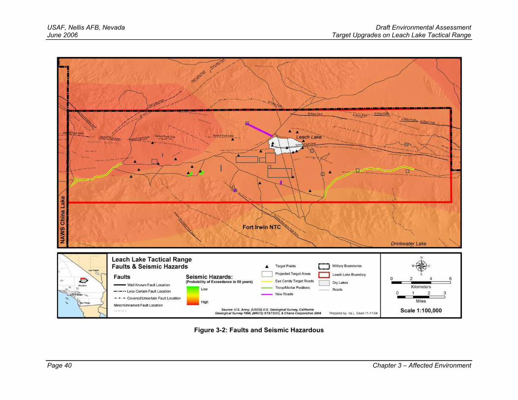
USAF, Nellis AFB, Nevada Draft Environmental Assessment June 2006 Target Upgrades on Leach Lake Tactical Range
Figure 3-2: Faults and Seismic Hazardous
Page 40 Chapter 3 – Affected Environment
Leach Lake Tactical Range Faults & Seismic Hazards
Faults - 'Nell Known Fautt Location
- · - · - Less Certain F auh Location
-~ • - ~- Covered11.1ncertain Fault Location
Minor/Unnamed Faul1 Location
Seismic Hazards: (Probability of Exceedance In 50 years)
Low
High
A. Target Points
c::::J Projected Target Areas
Eye Candy Target Roads
-- Troop/Mortar Positions
-- NewRoads
;::::J Mi6tary Boundaries
c:J Leach Lake Boundary
c::::J Dlylakes
Roads
Source: U.S. Army, (USGS) U.S. Geological Survey, California Goologlclf Survoy 1994, (NRCS) STATSGO, ol Ch•rl• Corporo~ort Z004 Prepared by Ire L Eisen 1 1·17.04
\ \ l
Drinkwater Lake
0
0 -Kilometers 1 2
Miles
Scale 1 :100,000
6
3

Draft Environmental Assessment USAF, Nellis AFB, NevadaTarget Upgrades on Leach Lake Tactical Range June 2006
3.4.3.2 Soils Mojave Desert soils are poorly developed and their composition is primarily related to the type of adjacent bedrock, topographic relief, and the weather. Most desert soils support only grazing activity. There is no evidence of extensive agriculture in the Leach Lake Valley. Only ranching, associated with the springs, has been documented. Some alfalfa and fruit tree agriculture has occurred in the Mojave River Drainage and date farming occurs in the Amargosa Drainage to the northeast.
Soil Classification
The basic unit described in soil surveys is the soil series. Most desert soils are not de-scribed at the series level due to of suitability for use in agriculture. The soil map poly-gons mapped during the soils surveys that have been completed contain several soil se-ries. Most or all of the soil series within each polygon are described and the percent of the primary soil series within each polygon may be estimated. These polygons are pri-marily based on mapping of the geomorphology or surface topographic units and not ex-tensive subsurface description. The source of the electronic version of the soils map is the National Resources Conservation Service (NRCS) State Soil Geographic (STATSGO) database (NRCS STATSGO 2004) (Figure 3-3). At least 16 soil series have been documented within the boundaries of the Leach Lake Tactical Range (NRCS STATSGO 2004). These include: Arizo, Bitter, Bitterwater, Cajon, CalVista, Carrizo, Chuckwalla, Gunsight, Glendale, Nickel, Rillito, Rositas, Sparkhule, Tecopa, Upsprings and Victorville Variant. Other less developed “soils” within rock outcrops include: rock outcrop, lithic torriorthenth, and badlands. Playa soils are the clay pans on the dry lake-beds. All are common and widely distributed soil series. Each soil series has an erodi-bility factor but this number is only for undisturbed soils.
Arizo, Cajon, and Victorville variant soils occur on the valley floor. Cajon and Glendale soils occur near the lakebed. Badland, Bitterwater, Sparkhule, Upspring, and Tecopa soils occur on the alluvial fans and foothills in the Quail and Avawatz Mountains.
Soil Formation
The bedrock in the area is primarily granite. Granite breaks down into sand, clay, and ferromagnesian metals. These form particles of various composition and size, and are transported by wind and water throughout the site. Small quantities of fine-grained par-ent materials such as rhyolite, limestone, basalt, and dacite also occur in the area. Most of the poorly formed soils in the region are described as unconsolidated recent alluvium, geologically. Old benches of Pleistocene age are apparent in the northern and eastern edges of the Leach Lake Valley.
3.4.3.2.1 Erosion Factors Various conditions reduce soil erosion in the desert. The soil surface of the Leach Lake Valley contains a variety of scattered surface stone. These stones reduce erosion rates. These rock particles become very dense in the east, forming desert pavement. Hard-ened soil crusts form on the lakebeds and occasionally on the alluvial fans. These allu-vial fan crusts are often the result of biological activity. The crusts are combinations of algae, bacteria, and fungi and are an important element in stabilizing the desert soil sur-face. These crusts have the depth of a surface film and are known as macrobiotic crusts. They not only resist wind and water erosion but also fix nitrogen. They are eas-ily destroyed by surface traffic. Such crusts are not common in the Leach Lake Valley.
Chapter 3 – Affected Environment Page 41
USAF, Nellis AFB, Nevada Draft Environmental Assessment June 2006 Target Upgrades on Leach Lake Tactical Range Several desert plant species develop an association between the plants roots and mi-croorganisms during the seedling stage. This relationship is known as a mycorrhizal re-lationship and this association increases a plant’s ability to absorb water, mineral, and non-mineral nutrients. Mycorrhizal relationships are easily broken by intense soil distur-bance. Non-native Eurasian exotic weeds are adapted to disturbed soils and will replace native wildflowers after disturbance. Non-native exotics are most common in the target areas in the Leach Lake Valley.
Sparse vegetation, intense rains and wind, large amounts of unconsolidated sand, and low amounts of organic matter result in desert soils being highly susceptible to erosion. Soils may be transported away in disturbed areas leaving them void of soil and/or soil forming materials. Erodibility varies within the various soil series as a result of variations in texture, organic matter, aggregate structure, and slope. Generally, erodibility in-creases with increasing sand content and decreases with increasing clay content. Clay soils are very susceptible to erosion when the surface is disturbed or when wet. Wet clay soils become plastic and the surface deforms under pressure. Clay soils dampen slowly and dry slowly, so they remain susceptible to deformation much longer than allu-vial fan soils.
Wind Erosion
In their natural undisturbed state, most desert soils are resistant to wind erosion. Wind erosion occurs when bare, loose, dry soils are exposed to wind of sufficient speed to cause soil particle movement. This process is accelerated when the natural equilibrium between climate, soils, and vegetation is disturbed.
Soil particles less than 0.84 mm in size are considered erodible by wind. Wind speeds of 21-24 km per hr (13-15 mph) 1 foot above the soil surface may initiate highly erodible conditions. The passage of a vehicle over an erodible surface may provide enough en-ergy to initiate soil erosion. As medium sized particles are detached they enter the wind stream temporarily, but are pulled back by gravity. This may cause the particles to im-pact and dislodge other particles.
Wind erosion is divided into three hazard classes: slight, moderate, and high. Slight hazard soils contain at least ⅓ rock fragments on the surface of soils with less than 35 percent slope. Moderate erodible soils have clay, silty clay, silty clay loam, clay loam, silt loam, loam, very fine sandy loam, and sandy loam textures. Highly erodible soils have loamy fine sand, fine sand, or sandy soil texture.
Water Erosion
Water erosion is the redistribution and removal of the upper layers of soil by the action of falling rain and/or water flowing over the soil surface. Erosion by water is a natural phe-nomenon but the removal of the soil’s protective layer of vegetation during times of heavy rain greatly increases erosion rates, so that they exceed rates of soil formation. This process is known as accelerated erosion. Accelerated erosion by water may re-duce soil quality and the water-holding capacity of many eroded soils (Favis-Mortlock 2002).
Page 42 Chapter 3 – Affected Environment
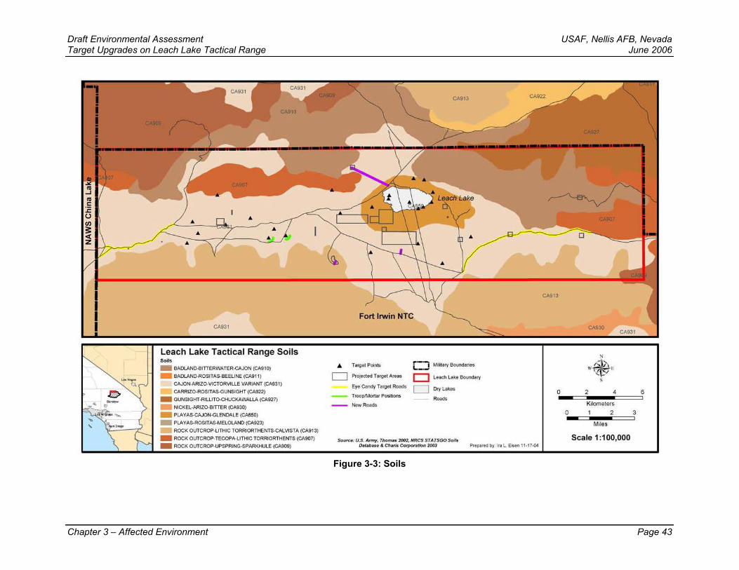
Draft Environmental Assessment USAF, Nellis AFB, Nevada Target Upgrades on Leach Lake Tactical Range June 2006
Chapter 3 – Affected Environment Page 43
Figure 3-3: Soils
CA931
Leach Lake Tactical Range Soils Soils
- BAOLAND·BITIERWATER·CAJON (CA910)
- BAOLAND-ROSITAS-BEELINE (CA911) CAJON-ARIZO-VICTORVILLE VARIANT (CA931)
CARRIZO-ROSITAS-GUNSIGHT (CA922)
- GUNSIGHT-RILLITO-CHUCKAWALLA (CA927)
- NICKEL·ARIZQ.,BITIER (CA930) - PLAYAS-CAJON-GLENDALE (CA650)
- PLAYAS-ROSITAS-MELOLANO (CA923) ROCK OUTCROP-LITHIC TORRIORTHENTS.CALVISTA (CA913)
- ROCK OUTCROP-TECOPA-LITHIC TORRIORTHENTS (CA907)
- ROCK OUTCROP-UPSPRING-SPARKHULE (CA909)
Fort Irwin NTC
... Target Points .. ·-·-i,.,_,J Miitary Boundaries
D Projected Target Areas D Leach Lo~e Boundary
Eye Can<ly Target Roads D Dry Lo~es
Troop/Mortar Positions Roads New Roads
Source: U.S. Army. Thomas 2002, NRCS STATSGO Soils Olt#bl$0 4 Cherls Corpor1t1on 2()03 Prepared by Ire L Eisen 1 1· 17.04
CA913
CA930 CA931
:-1 W. E s
0 2 4 6
Kilometers
0 2 3 - Miles
Scale 1 :100,000
USAF, Nellis AFB, Nevada Environmental Assessment June 2006 Target Upgrades on Leach Lake Tactical Range Water erosion would result from surface water deposited by seasonal rain and thunder-storms. Surface water sources within the study area are scarce due to annual average rainfall being approximately 3.87 inches. Washes descending from elevated landforms form intermittent channels that runoff into playas where temporary lakes form. This type of water accumulation occurs about once every 10 years during greater than average precipitation. Without a drainage outlet, surface water in shallow ephemeral lakes is lost though groundwater percolation and/or evaporation (NTC 2005).
For soils eroded by flowing water from the approximately 3.87 inches of annual rainfall, the erosion hazard is divided into three classes: slight, moderate, and high. Slight ero-sion hazards includes all soil texture classes on slopes less than 4 percent or sandy soils on slopes less than 15 percent. Moderate hazards occur on loamy and clay soils on slopes of 4-15 percent or sandy soils with slopes of 15-30 percent. High erosion hazards exist on soils having loamy soils of 15-30 percent or all soils heavier than loam with slopes over 30 percent.
3.5 Environmental Justice
3.5.1 Regulatory Setting Executive Order (EO) 12898, Federal Actions to Address Environmental Justice in Minority Populations and Low-Income Populations, requires that “each federal agency shall make achieving environmental justice part of its mission by identifying and addressing, as appropriate, disproportionately high and adverse human health or environmental effects of its programs, policies, and activities on minority populations and low income populations” (EO 12898).
3.5.2 Current Conditions There are no minority and/or low-income populations within the Leach Lake Tactical Range boundaries. The proposed action of this project would remain within the currently established boundaries, therefore, no new affects involving environmental justice would occur as a result of this project.
3.6 Hazardous Materials/Waste and Solid Waste
3.6.1 Definition of the Resource Hazardous materials are defined as any substances that, due to quantity, concentration, physical, chemical, or infectious characteristics, that if released may present substantial danger to public health, welfare, or the environment. Examples of hazardous materials include petroleum, natural gas, synthetic gas, toxic chemicals, and low-level radioactive sources, such as compasses and military vehicle gauges. Hazardous wastes are de-fined as any solid, liquid, contained gaseous or semisolid waste, or any combination of wastes that either exhibit one or more hazardous characteristic of ignitability, corrosivity, toxicity or reactivity, or are listed as a hazardous waste under the Environmental Protec-tion Agency’s (EPA), Resource Conservation and Recovery Act (RCRA). The term “solid waste” is used to define non-hazardous waste and materials resulting from domes-tic refuse, mining operations, vegetative debris from clearing of land, sewage sludge, and building debris.
Page 44 Chapter 3 – Affected Environment
Environmental Assessment USAF, Nellis AFB, NevadaTarget Upgrades on Leach Lake Tactical Range June 2006 3.6.2 Regulatory Setting Hazardous materials are identified and regulated under the Comprehensive Environ-mental Response, Compensation, and Liability Act (CERCLA) of 1980 (42 USC § 9606); the Solid Waste Disposal Act (SWDA) of 1980 (SWDA 1965); and the Emergency Plan-ning and Community Right-to-Know Act (EPCRA) of 1986 (42 USC § 11001). Hazard-ous materials and wastes are federally regulated by the EPA, in accordance with the Federal Water Pollution Control Act (FWPCA) of 1972 (commonly known as the Clean Water Act [CWA]) as amended (33 USC § 1251); the Toxic Substance Control Act (TSCA) of 1976 (15 USC § 2601); the SWDA as amended (SWDA 1965); the Resource Conservation and Recovery Act (RCRA) of 1976 (42 USC § 6901); CERCLA as amended (42 USC § 9606); and the Clean Air Act (CAA) of 1970, as amended (42 USC § 7401). In California, hazardous materials and substances are regulated under Title 22 of the California Code of Regulations.
Department of Defense Directives (DoDD) and Manuals covering the management of hazardous materials/waste and solid waste include: Pollution Prevention (DoD 1996b), Hazardous Materials Pollutions Prevention (DLA 1994), and Storage and Handling of Hazardous Materials (DLA 1999).
Air Force Instructions (AFI) and Policy Directives that direct management of hazardous materials/waste and solid waste include: Disaster Preparedness Program (USAF 1997a); Hazardous Materials Management (USAF 1997c); Managing Radioactive Mate-rials in the USAF (USAF 2000a); and Pollution Prevention Program (USAF 1994).
Army Regulations (AR) that apply to hazardous materials/waste and solid waste man-agement include: AR 200-1, Environmental Protection and Enhancement (DA 1990).
3.6.3 Current Conditions Hazardous materials that could possibly be used on Leach Lake Tactical Range include, but are not limited to, petroleum, oil, lubricants, paint, batteries, solvents, thinners, anti-freeze, and aerosol containers. Nellis AFB personnel and/or their contractors properly handle, store, use, and dispose of hazardous materials and solid waste in accordance with established directives and procedures. Those persons who would most likely come in contact with hazardous materials would be drivers and maintenance workers. Indi-viduals likely to come in contact with hazardous materials or hazardous waste will be trained for initial response to spills and other incidents. The Nellis Environmental Flight will coordinate all regulatory spill reporting.
The use of live and practice ordnance on Leach Lake Tactical Range generates quanti-ties of target debris, smaller quantities of exploded ordnance debris, ordnance castings, concrete, and UXO. It is estimated that approximately 1.5 million pounds of USAF live ordnance will dropped on the Leach Lake Tactical Range over the next 5 years (per-sonal conversation with Captain Taylor 2004).
Training on the Leach Lake Tactical Range includes bombing targets that are con-structed of various materials, such as concrete, plastic, or plywood materials built to re-semble military hardware and/or high-value targets. Empty metal cargo containers are assembled to simulate buildings and/or industrial complexes. Salvaged military and civilian equipment (trucks, tanks, aircraft, etc.) are also used as high-fidelity targets. To eliminate environmental contamination, salvaged equipment is demilitarized and de-
Chapter 3 – Affected Environment Page 45
USAF, Nellis AFB, Nevada Environmental Assessment June 2006 Target Upgrades on Leach Lake Tactical Range fluidized on the NTTR Southern Ranges in accordance with federal, state, and local en-vironmental requirements before siting as targets.
Coronet Clean Operations
The USAF at Nellis AFB contracts with private contractors for range cleanup and target construction on the Leach Lake Tactical Range. Termed “Coronet Clean,” these activi-ties are scheduled throughout the year. The contractor employs explosive ordnance disposal (EOD) qualified specialist to ensure range safety for military and other contrac-tor personnel. Prior to cleanup and target construction, EOD military and contractor per-sonnel identify and neutralize UXO in place during Coronet Clean operations. Once detonated, the material then becomes solid waste. Contractor personnel dispose of tar-get debris and range munitions residue in accordance with the Nellis AFB Plan 12 Solid Waste Management and AFI 32-7080, Pollution Prevention Program (USAF 1994).
3.7 Noise
3.7.1 Definition of the Resource Noise is usually defined as sound that is unwanted or undesirable because it interferes with speech communication and hearing, or is otherwise annoying. Under certain condi-tions, noise may cause hearing loss, interfere with human activities, and in various ways may affect people’s health and well-being. Noise is perhaps the most identifiable con-cern associated with aircraft operations. Although many other sources of noise are pre-sent in today’s communities, aircraft noise is often singled out for special attention and criticism.
Noise may also affect the habits and routines of wildlife in the area. There are many scientific studies regarding the effects of noise on wildlife and some anecdotal reports of wildlife “flight” due to noise. Few of the studies or reports include any reliable measures of the actual noise levels involved. However, in the absence of definitive data on the ef-fects of noise on animals, the Committee on Hearing, Bioacoustics, and Biomechanics of the National Research Council (NRC) has proposed that protective noise criteria for animals be taken to be the same as for humans (NRC 1977).
3.7.1.1 Representations of Noise Noise is represented by a variety of quantities or “metrics.” Each noise metric was de-veloped to account for the type of noise and the nature of what may be exposed to the noise. Human hearing is more sensitive to medium and high frequencies than to low and very high frequencies, so it is common to use “A-weighted” metrics, which account for this sensitivity. Impact of impulsive noise depends on factors other than human hear-ing, so it is often quantified by “C-weighted” metrics, which are flat over a broad fre-quency range.
Different time periods also play a role. People hear the sound that occurs at a given time, so it is intuitive to think of the instantaneous noise level, or perhaps the maximum level that occurs during an aircraft flyover. However, impact over a period of time de-pends on the total noise exposure over extended periods, so “cumulative” noise metrics are used to assess the impact of on-going activities such as those that occur in Military Operations Areas (MOAs). Within this EA, noise is described by the sound level (L), the
Page 46 Chapter 3 – Affected Environment
Environmental Assessment USAF, Nellis AFB, NevadaTarget Upgrades on Leach Lake Tactical Range June 2006 maximum sound level (Lmax), the Sound Exposure Level (SEL), and Day-Night Average Sound Level (Ldn).
Sound Level
Sound level (L) is the amplitude of the sound that occurs at any given time. Some of the sounds are continuous or long term averages (e.g., garbage disposal; rural and urban ambient), and some are maximum levels (e.g., aircraft and truck passbys). Sound levels are measured in decibels, and are reflected on a logarithmic scale. A 3-decible (dB) in-crease reflects a doubling in sound level. However, due to the way the human ear re-sponds to noise, it actually requires about a 10-dB increase to be perceived as a dou-bling in noise. It should also be noted that an “instantaneous” level as used in environ-mental analysis usually represents sound averaged over some short time period, typi-cally one second for slowly changing sounds and ⅛ second for fast-changing sounds. When an aircraft flies by, the noise level changes continuously. It begins at the ambient (background) level, increases to a maximum as the aircraft passes closest to the re-ceiver, then falls back to ambient as the aircraft recedes into the distance.
Maximum Sound Level
Maximum sound level (Lmax) is the highest instantaneous sound level measured during a single noise event, such as an aircraft overflight. The maximum sound level is important in judging whether a noise event would interfere with conversation, sleep, or other com-mon activities.
Sound Exposure Level
While Lmax is commonly viewed as an indication of how intrusive a noise event is, impact also depends on how long a sound lasts. A sound that lasts a long time would be more intrusive than one that is over quickly. Sound Exposure Level (SEL) combines both of these characteristics (maximum sound and duration) into a single metric. Sound Expo-sure Level does not directly represent the sound level heard at any given time, but rather provides a measure of the total exposure of the entire event. For this reason, it is a bet-ter indicator of impact than just Lmax.
Day-Night Sound Average Level
Day-Night Sound Average Level (Ldn) is a composite metric combining the levels and duration of individual events, and the number of events that occur over an extended time period. Mathematically, it is a long-term average, but because it incorporates all noise events it is referred to as a cumulative metric. It is computed over a specific period of time, commonly a year, to represent the total noise exposure. Because noise is more intrusive at night than during the day, sounds that occur after 10:00 PM and before 7:00 AM are adjusted by a 10-dB penalty.
Studies have shown that Ldn represents adverse effects of noise much more reliably than individual noise levels alone. As noted above for SEL versus Lmax, Ldn is not the sound level heard at any given time, but is the best measure of long-term cumulative im-pact.
For military airspaces, there are two important variations of Ldn that account for special characteristics of military aircraft noise, described below.
Chapter 3 – Affected Environment Page 47

USAF, Nellis AFB, Nevada Environmental Assessment June 2006 Target Upgrades on Leach Lake Tactical Range 3.7.1.2 Noise Modeling Prediction of aircraft noise requires two elements. The first is a quantitative understand-ing of aircraft operations: types and altitudes. The second element is physical modeling of the noise itself, which is then accumulated over all operations. Aircraft Operations below describes operations on the range, from the perspective of noise analysis. Noise modeling is described in the paragraph titled Subsonic Aircraft Noise Modeling.
Aircraft Operations
Air Warrior flight operations generally originate at Nellis AFB, Nevada. Aircraft transition at high altitude from Nellis AFB into the Shoshone and Panamint MOAs. They then en-ter the range upon arrival or hold in the MOAs until cleared into the range. The types and altitudes used by participating aircraft that have taken part in Air Warrior activities in the Leach Lake Tactical Range are listed in Table 3-6. The airspace over the Leach Lake Tactical Range is categorized as Restricted Airspace (R-2503N). Pilots operating within this airspace are allowed to operate from the surface to the altitude limitations of the aircraft. The altitudes listed for each specific aircraft in Table 3-6 are normal operat-ing altitudes, not altitude restrictions.
Subsonic Aircraft Noise Modeling
Within the Leach Lake Tactical Range flight often occurs randomly, or, due to either air-space configuration or training scenarios, it may be spatially concentrated, or channeled, into specific areas or corridors. The Air Force has developed the MOA Range NoiseMAP (MR_NMAP) computer program to calculate noise in these areas. The acoustic portion of the model is based on the Air Force’s NoiseMAP technology, which is the standard method of analyzing military aircraft noise. NoiseMAP can calculate noise for both random operations and operations channeled into corridors (Lucas and Calamia 1996).
Table 3-6: Aircraft Participation
AIRCRAFT TYPES NORMAL OPERATING ALTITUDES
SEL
A-4 15,000 – 25,000 ft MSL 46.3
A-10 15,000 – 25,000 ft MSL 61.6
A-10 500 – 5,000 ft AGL* 101.8
AV-8B 15,000 – 25,000 ft MSL 61.8
B-1 15,000 – 25,000 ft MSL 77.6
B-52 15,000 – 25,000 ft MSL 61.4
C-130 15,000 – 25,000 ft MSL 64.0
CH-47 100 –1,000 ft AGL 92.2
E-8C 15,000 – 25,000 ft MSL Not Available
F-14 15,000 – 25,000 ft MSL 55.2
F-15E 15,000 – 25,000 ft MSL 59.9
F-16 15,000 – 25,000 ft MSL 66.0
Page 48 Chapter 3 – Affected Environment
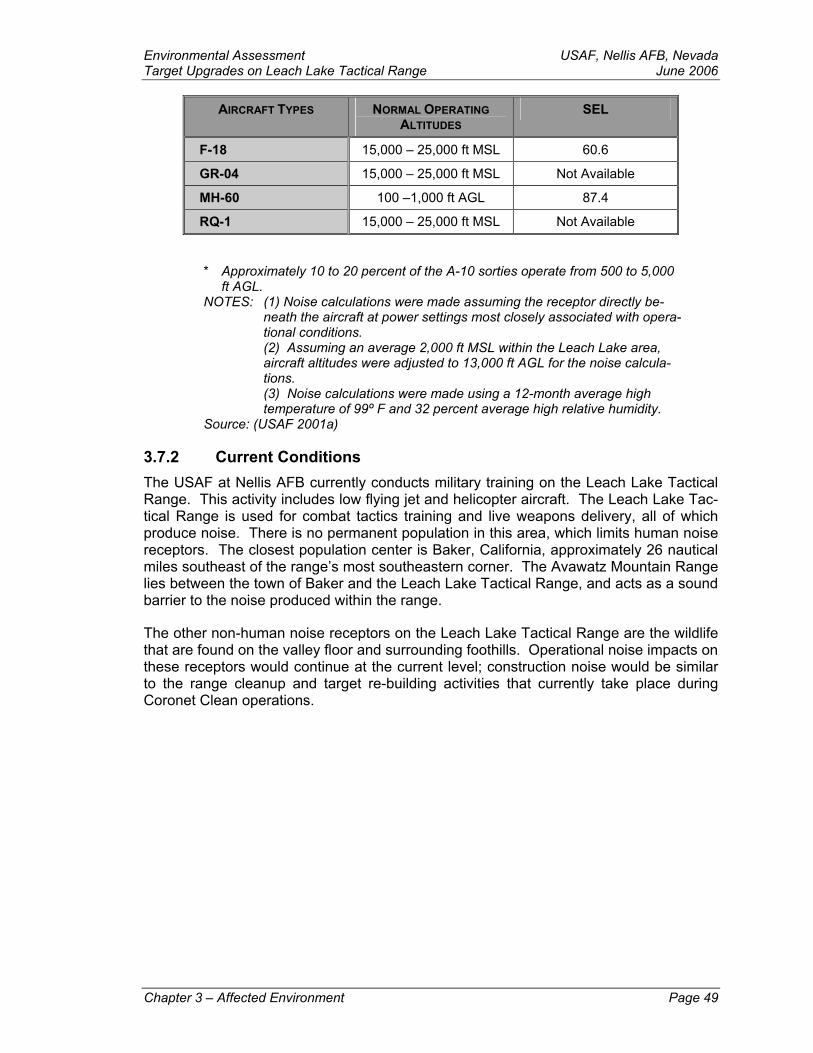
Environmental Assessment USAF, Nellis AFB, NevadaTarget Upgrades on Leach Lake Tactical Range June 2006
AIRCRAFT TYPES NORMAL OPERATING ALTITUDES
SEL
F-18 15,000 – 25,000 ft MSL 60.6
GR-04 15,000 – 25,000 ft MSL Not Available
MH-60 100 –1,000 ft AGL 87.4
RQ-1 15,000 – 25,000 ft MSL Not Available
* Approximately 10 to 20 percent of the A-10 sorties operate from 500 to 5,000 ft AGL.
NOTES: (1) Noise calculations were made assuming the receptor directly be-neath the aircraft at power settings most closely associated with opera-tional conditions.
(2) Assuming an average 2,000 ft MSL within the Leach Lake area, aircraft altitudes were adjusted to 13,000 ft AGL for the noise calcula-tions.
(3) Noise calculations were made using a 12-month average high temperature of 99º F and 32 percent average high relative humidity.
Source: (USAF 2001a)
3.7.2 Current Conditions The USAF at Nellis AFB currently conducts military training on the Leach Lake Tactical Range. This activity includes low flying jet and helicopter aircraft. The Leach Lake Tac-tical Range is used for combat tactics training and live weapons delivery, all of which produce noise. There is no permanent population in this area, which limits human noise receptors. The closest population center is Baker, California, approximately 26 nautical miles southeast of the range’s most southeastern corner. The Avawatz Mountain Range lies between the town of Baker and the Leach Lake Tactical Range, and acts as a sound barrier to the noise produced within the range.
The other non-human noise receptors on the Leach Lake Tactical Range are the wildlife that are found on the valley floor and surrounding foothills. Operational noise impacts on these receptors would continue at the current level; construction noise would be similar to the range cleanup and target re-building activities that currently take place during Coronet Clean operations.
Chapter 3 – Affected Environment Page 49

USAF, Nellis AFB, Nevada Environmental Assessment June 2006 Target Upgrades on Leach Lake Tactical Range
1/6 Times as Loud
1/4 Times as Loud
Baseline
4 Times as Loud
16 Times as Loud
32 Times as Loud
QUIET
JUST AUDIBLE
MODERATE
VERY LOUD
UNCOMFORTABLE
Threshold of Hearing
Recording Studio
Quiet Urban Nighttime
Quiet Urban Daytime
Automobile at 100 FeetAir Conditioner at 100 Feet
Heavy Truck at 50 FeetVacuum Cleaner at 10 Feet
Garbage Disposal
Discotheque
Textile Mill
Oxygen Torch
LOUDNESS
(Compared to 70 dB)
COMMON SOUNDS
SOUND LEVEL(dB)
0
10
20
30
40
50
60
70
80
90
100
110
120
130
Figure 3-4: Typical A-Weighted Sound Levels of Common Sounds
* Approximately 10 to 20 percent of the A-10 sorties operate from 500 to 5,000 ft AGL.
NOTES: (1) Noise calculations were made assuming the receptor directly be-neath the aircraft at power settings most closely associated with opera-tional conditions.
(2) Assuming an average 2,000 ft MSL within the Leach Lake area, aircraft altitudes were adjusted to 13,000 ft AGL for the noise calcula-tions.
(3) Noise calculations were made using a 12-month average high temperature of 99º F and 32 percent average high relative humidity.
Source: (USAF 2001a)
Page 50 Chapter 3 – Affected Environment
Environmental Assessment USAF, Nellis AFB, NevadaTarget Upgrades on Leach Lake Tactical Range June 2006 3.8 Safety This section addresses ground, flight, and range safety associated with activities con-ducted on the Leach Lake Tactical Range. Ground Safety includes fire and crash re-sponse. Flight Safety considers aircraft flight risks such as aircraft accidents and bird-aircraft strike hazards. Range safety assesses the management and use of ordnance or munitions associated with range use and cleanup.
3.8.1 Regulatory Setting The regulatory setting for safety within the Leach Lake Tactical Range comes under nu-merous regulatory and instructional sources. Samples of the various sources are: DoDI 6055.7, Accident Investigation, Reporting, and Record Keeping (DoD 2000); AFI 91-301, Air Force Occupational and Environmental Safety, Fire Protection, and Health (AFOSH) Program (USAF 1996) and Series 91 Safety Instructions; and Air Combat Command (ACC) Series 91 Safety Instructions and supplements to USAF Safety Instructions; AR 385-10, Army Safety Program (DA 2000a); and AR 385-64, Army Explosives Safety Program (DA 2000b).
3.8.2 Current Conditions
3.8.2.1 Ground Safety
Ground Fires
Fire protection for the Leach Lake Tactical Range is provided by the NTC as outlined by an Interservice Support Agreement (ISA). As stated in the ISA, the NTC will, “Provide limited fire fighting support at Leach Lake Tactics Range (LLTR) when available.” The Weapons and Tactics Center (WTC) at Nellis will in return, “Reimburse the [NTC] for any costs billed by outside agencies (i.e. BLM) to fight fires attributed to [WTC] use of LLTR.” (WTC and NTC 1993)
Crash Response
The Disaster Control Group (DCG), directed by the 57th Wing at Nellis AFB maintains detailed mishap response procedures, as outlined in Nellis AFB Plan 19-1, Facility Re-sponse Plan (FRP), to respond to a wide range of potential incidents. The FRP assigns agency responsibilities and prescribe functional activities necessary to react to major mishaps. Response will normally occur in two phases. The initial response considers such factors as rescue, evacuation, fire suppression, safety, elimination of explosive de-vices, ensuring security of the area, and other actions immediately necessary to prevent loss of life or further property damage. Subsequently, the investigation phase is accom-plished.
The initial response element consists of those personnel and agencies primarily respon-sible for beginning the initial phase. This element includes the Fire Chief (who normally is the first on-scene commander), fire fighting and crash rescue personnel, medical per-sonnel, security police, and crash recovery personnel. A subsequent response team is comprised of an array of organizations, including the 99 CES Environmental Flight, whose participation is governed by the circumstances associated with the mishap and actions required to be performed.
Chapter 3 – Affected Environment Page 51
USAF, Nellis AFB, Nevada Environmental Assessment June 2006 Target Upgrades on Leach Lake Tactical Range If an aircraft accident occurs on non-federal property, regardless of the agency initially responding to the situation, as soon as the situation is stabilized, a National Defense Area would normally be established around the accident scene and secured for the in-vestigation phase.
After all required investigations and related actions on the site are complete, the aircraft would be removed. The 99 CES Environmental Flight will coordinate with environmental regulators as required during the spill and clean-up process.
Overall, the purpose of the response planning is to:
save lives, property, and material by timely and correct response to mishaps;
quickly and accurately report mishaps to MAJCOM and all federal, state, and lo-cal regulators; and
investigate the mishap to preclude the reoccurrence of the same or similar mis-hap.
3.8.2.2 Flight Safety
Aircraft Accidents/Mishaps
Aircraft flight operations on the Leach Lake Tactical Range are governed by standard flight rules. Additionally, specific procedures applicable to local operations are continued in detailed standard operating procedures that must be followed by all aircrews operating from the installation (USAF 2002).
The Air Force defines four categories of aircraft accidents/mishaps: Classes A, B, C, and High Accident Potential (HAP). Class A accidents result in the total cost of damages to government and other property in the amount of $1 million or more; a DoD aircraft is de-stroyed; or an injury and/or occupational illness results in a fatality or permanent total disability. Class B accidents result in the total cost of damage in the amount of $200,000 or more, but less than $1 million; an injury and/or occupational illness results in perma-nent partial disability; or when three or more personnel are hospitalized for inpatient care as a result of a single accident. Class C accidents result in the total cost of property damage is $20,000 or more, but less than $200,000; a nonfatal injury that causes any loss of time from work beyond the day or shift on which it occurred; or a nonfatal occupa-tional illness or disability that causes loss of time from work or disability at any time (DoD 2000). A HAP represents a significant aircraft, missile, space, explosives, miscellaneous air operations, or ground occurrences with a high potential for causing injury, occupa-tional illness, or damage if they recur (USAF 2001b). Class C accidents and HAPs, the most common types of occurrences, represent relatively unimportant incidents because they generally involve minor damage and injuries, and rarely affect property or the pub-lic. This EA will focus on Class A accidents because of their potentially catastrophic re-sults.
Page 52 Chapter 3 – Affected Environment
It is impossible to predict the precise location of an aircraft accident. Major considera-tions in any accident are loss of life and property damage. The aircrew’s ability to exit a malfunctioning aircraft is dependent on the type of malfunction encountered. The prob-ability of an aircraft crashing into a populated area is extremely low, but it cannot be to-tally discounted. Several factors are relevant: the ROI and immediate surrounding ar-
Environmental Assessment USAF, Nellis AFB, NevadaTarget Upgrades on Leach Lake Tactical Range June 2006 eas have relatively low population densities; pilots of aircraft are instructed to avoid di-rect overflight of population centers at very low altitudes; and the limited amount of time the aircraft is over any specific geographic area limits the probability that impact of a dis-abled aircraft in a populated area would occur.
Secondary effects of an aircraft crash include the potential for fire and environmental contamination. The extent of these secondary effects is situationally dependent, and is therefore difficult to quantify. The terrain overflown in the ROI is diverse. For example, should a mishap occur, highly vegetated areas during a hot, dry summer would have a higher risk of experiencing extensive fires than would more barren and rocky areas dur-ing winter. When an aircraft crashes, it may release hydrocarbons. The petroleum, oil, and/or lubricants not consumed in a fire could contaminate soil and water. The potential for contamination is dependent on several factors. The porosity of the surface soils would determine how rapidly contaminants are absorbed. The specific geologic struc-ture in the region would determine the extent and direction of the contamination plume. The locations and characteristics of surface and groundwater in the area would also af-fect the extent of contamination to those resources.
F-16 aircraft carry small quantities of hydrazine in a sealed canister as part of the emer-gency power unit system. Hydrazine is a highly volatile propellant that contains toxic elements. When used for its intended purpose, hydrazine is completely consumed, and poses no safety hazard. The sealed hydrazine canister is designed to survive most crash impacts; however, in a crash that is severe enough to rupture the canister, it is most likely that fire would also be involved. In this case, the hydrazine would also burn and be completely decomposed. In the unlikely event that the hydrazine should be re-leased, but not consumed by fire, impacts on soils and groundwater are likely to be of minor consequence. Hydrazine absorbs water at room temperature. It is incombustible in solution with water at concentrations of 40 percent or less, and it evaporates at any given temperature at a rate slightly slower than water evaporation. Movement of hydra-zine through natural soils has been shown to be slow and limited. Due to its absorption and natural decomposition processes, the probability of released hydrazine significantly contaminating groundwater is considered extremely low.
Bird-Aircraft Strike Hazards
In 2000, the Federal Aviation Administration (FAA) did an in depth study of the occur-rence of wildlife (including bird) strikes to civilian aircraft in the United States from 1990 to 1999 (FAA 2000). The study analyzed 28,150 reports of wildlife strikes, including 20,893 in which the altitudes of the strikes were indicated. The FAA study found that 74.8 percent of strikes occurred under 600 ft AGL; 95.7 percent under 5,000 ft AGL; and 99 percent under 10,000 ft AGL. Ninety-six percent of bird strikes occurred during the takeoff/climb, and/or descent/approach/landing roll phases of flight.
Between 1990 and 1999, 2,516 known bird strikes were reported in California. This equated to almost 10 percent of all bird strikes reported for this period throughout the United States, Puerto Rico, and the U.S. Virgin Islands. There is no further breakdown of this data to airport locations. National Transportation Safety Board aircraft accident data from 1983 to 2003 were searched to identify those accidents involving bird strikes (NTSB 2003). This database contains no accidents involving bird strikes in the Fort Ir-win area.
Chapter 3 – Affected Environment Page 53
USAF, Nellis AFB, Nevada Environmental Assessment June 2006 Target Upgrades on Leach Lake Tactical Range Nellis AFB maintains Bird-Aircraft Strike Hazardous (BASH) data for the aircraft that op-erate from Nellis AFB. Records indicate that approximately 80 percent of reported BASH incidents have no specific location indicated. Most BASH incidents were detected on post-flight aircraft inspections. For those incidents without specific locations indi-cated, pilots could only verify that the incident occurred sometime after takeoff and be-fore landing. A records search for the past 5 years revealed no BASH incidents within the Leach Lake Tactical Range (personal conversation with Captain Bass 2004).
3.8.2.3 Range Safety
Coronet Clean
The Government Contractor employs EOD qualified specialist to ensure range safety for military and contractor personnel. Prior to target cleanup and target construction (Coro-net Clean Operations), EOD contractor personnel identify and detonate in place any UXO found in the area. After the UXO has been detonated, the target debris and muni-tions residue is collected and disposed of in accordance with established procedures. Contractor personnel are responsible to follow and adhere to USAF safety regulations, instructions, and guidelines, and for reporting safety related accidents/incidents.
Currently, the north entrance to the range has a gate but no fence depicting the range boundaries or boundary signs to warn the public that they are restricted from entry (there is a warning sign at the entry gate). This deficiency detracts from range security and public safety.
3.9 Socioeconomics
3.9.1 Regulatory Setting A central requirement of NEPA is to determine impacts, in advance, where actions of a federal agency may alter the ways in which people live, work, play, relate to one another, organize to meet their needs, and generally cope as members of society. Such socio-economic impacts must be evaluated where the federal government may take "actions significantly affecting the quality of the human environment" (42 USC § 4321 and USAF 2003).
3.9.2 Current Conditions There are no permanent facilities or full-time workers on, or assigned to, the Leach Lake Tactical Range. All workers on the range are active duty military, government civilians, or government contractors. When performing official duties on the range, workers travel on a daily basis from Nellis AFB, Ft Irwin, or from temporary quarters in nearby towns (primarily Pahrump, Nevada, to the north east of and approximately 90 minutes travel from the range).
3.10 Water Resources
3.10.1 Definition of the Resource Three springs are located within the Leach Lake basin and Tactical Range boundaries. All springs—Leach Spring, Hell Wind Canyon Spring, and Two Springs, are located at or near the boundaries of the basin. One additional spring is located approximately 1½
Page 54 Chapter 3 – Affected Environment
Environmental Assessment USAF, Nellis AFB, NevadaTarget Upgrades on Leach Lake Tactical Range June 2006 miles south of the southern range boundary—Desert King Spring, with another two springs located less than a mile outside the northern range boundary—Quail Spring and Owl Hole Spring. Finally, Denning Spring is located approximately 1½ miles east of the eastern range boundary. None of the springs within or near the basin generate sufficient flows to sustain perennial surface watercourses.
3.10.2 Regulatory Setting Federal and state regulatory documents that apply to this action include the Federal Wa-ter Pollution Control Act of 1972 (33 USC § 1251), commonly referred to as the Clean Water Act and the Water Quality Act of 1987 (33 USC 1251 et seq.), which amended the Clean Water Act.
3.10.3 Region of Influence Leach Lake is a dry lakebed enclosed on all sides by mountainous terrain. All rainfall and storm runoff is contained within the Leach Lake basin where is percolates to groundwater or is lost to evaporation. Hydrologically, Leach Lake is a closed system. There are no navigable waters of the United States within the Leach Lake basin nor does runoff in the general region reach any navigable waters. Groundwater of the Leach Lake basin is not used for potable or fodder crop irrigation purposes.
3.10.4 Current Conditions The waters of the springs within and outside the boundaries of the Leach Lake Tactical Range do not reach Leach Lake. The only water to reach Leach Lake would be the stormwater from infrequent thunderstorms. None of the water that flows into Leach Lake leaves the basin or flows into the navigable waters of the United States. There are no springs within the project areas.
Chapter 3 – Affected Environment Page 55
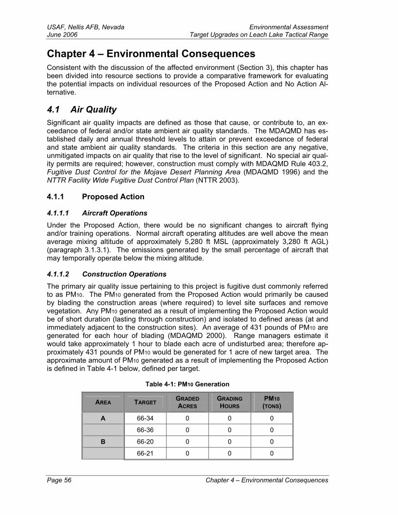
USAF, Nellis AFB, Nevada Environmental Assessment June 2006 Target Upgrades on Leach Lake Tactical Range Chapter 4 – Environmental Consequences Consistent with the discussion of the affected environment (Section 3), this chapter has been divided into resource sections to provide a comparative framework for evaluating the potential impacts on individual resources of the Proposed Action and No Action Al-ternative.
4.1 Air Quality Significant air quality impacts are defined as those that cause, or contribute to, an ex-ceedance of federal and/or state ambient air quality standards. The MDAQMD has es-tablished daily and annual threshold levels to attain or prevent exceedance of federal and state ambient air quality standards. The criteria in this section are any negative, unmitigated impacts on air quality that rise to the level of significant. No special air qual-ity permits are required; however, construction must comply with MDAQMD Rule 403.2, Fugitive Dust Control for the Mojave Desert Planning Area (MDAQMD 1996) and the NTTR Facility Wide Fugitive Dust Control Plan (NTTR 2003).
4.1.1 Proposed Action
4.1.1.1 Aircraft Operations Under the Proposed Action, there would be no significant changes to aircraft flying and/or training operations. Normal aircraft operating altitudes are well above the mean average mixing altitude of approximately 5,280 ft MSL (approximately 3,280 ft AGL) (paragraph 3.1.3.1). The emissions generated by the small percentage of aircraft that may temporally operate below the mixing altitude.
4.1.1.2 Construction Operations The primary air quality issue pertaining to this project is fugitive dust commonly referred to as PM10. The PM10 generated from the Proposed Action would primarily be caused by blading the construction areas (where required) to level site surfaces and remove vegetation. Any PM10 generated as a result of implementing the Proposed Action would be of short duration (lasting through construction) and isolated to defined areas (at and immediately adjacent to the construction sites). An average of 431 pounds of PM10 are generated for each hour of blading (MDAQMD 2000). Range managers estimate it would take approximately 1 hour to blade each acre of undisturbed area; therefore ap-proximately 431 pounds of PM10 would be generated for 1 acre of new target area. The approximate amount of PM10 generated as a result of implementing the Proposed Action is defined in Table 4-1 below, defined per target.
Table 4-1: PM10 Generation
AREA TARGET GRADED ACRES
GRADING HOURS
PM10 (TONS)
A 66-34 0 0 0
66-36 0 0 0
B 66-20 0 0 0
66-21 0 0 0
Page 56 Chapter 4 – Environmental Consequences
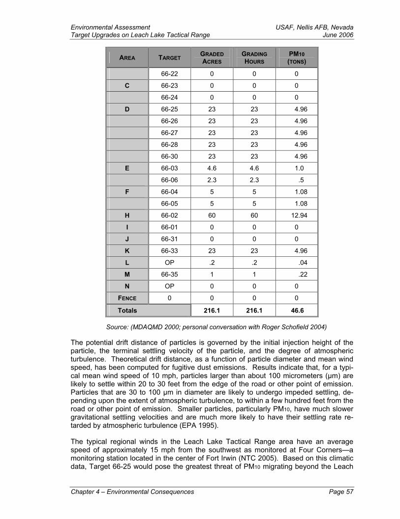
Environmental Assessment USAF, Nellis AFB, NevadaTarget Upgrades on Leach Lake Tactical Range June 2006
AREA TARGET GRADED ACRES
GRADING HOURS
PM10 (TONS)
66-22 0 0 0
C 66-23 0 0 0
66-24 0 0 0
D 66-25 23 23 4.96
66-26 23 23 4.96
66-27 23 23 4.96
66-28 23 23 4.96
66-30 23 23 4.96
E 66-03 4.6 4.6 1.0
66-06 2.3 2.3 .5
F 66-04 5 5 1.08
66-05 5 5 1.08
H 66-02 60 60 12.94
I 66-01 0 0 0
J 66-31 0 0 0
K 66-33 23 23 4.96
L OP .2 .2 .04
M 66-35 1 1 .22
N OP 0 0 0
FENCE 0 0 0 0
Totals 216.1 216.1 46.6
Source: (MDAQMD 2000; personal conversation with Roger Schofield 2004) The potential drift distance of particles is governed by the initial injection height of the particle, the terminal settling velocity of the particle, and the degree of atmospheric turbulence. Theoretical drift distance, as a function of particle diameter and mean wind speed, has been computed for fugitive dust emissions. Results indicate that, for a typi-cal mean wind speed of 10 mph, particles larger than about 100 micrometers (µm) are likely to settle within 20 to 30 feet from the edge of the road or other point of emission. Particles that are 30 to 100 µm in diameter are likely to undergo impeded settling, de-pending upon the extent of atmospheric turbulence, to within a few hundred feet from the road or other point of emission. Smaller particles, particularly PM10, have much slower gravitational settling velocities and are much more likely to have their settling rate re-tarded by atmospheric turbulence (EPA 1995).
The typical regional winds in the Leach Lake Tactical Range area have an average speed of approximately 15 mph from the southwest as monitored at Four Corners—a monitoring station located in the center of Fort Irwin (NTC 2005). Based on this climatic data, Target 66-25 would pose the greatest threat of PM10 migrating beyond the Leach
Chapter 4 – Environmental Consequences Page 57
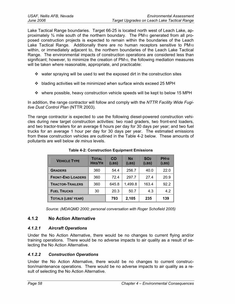
USAF, Nellis AFB, Nevada Environmental Assessment June 2006 Target Upgrades on Leach Lake Tactical Range Lake Tactical Range boundaries. Target 66-25 is located north west of Leach Lake, ap-proximately ¾ mile south of the northern boundary. The PM10 generated from all pro-posed construction projects is expected to remain within the boundaries of the Leach Lake Tactical Range. Additionally there are no human receptors sensitive to PM10 within, or immediately adjacent to, the northern boundaries of the Leach Lake Tactical Range. The environmental impacts of construction operations are considered less than significant; however, to minimize the creation of PM10, the following mediation measures will be taken where reasonable, appropriate, and practicable:
water spraying will be used to wet the exposed dirt in the construction sites
blading activities will be minimized when surface winds exceed 25 MPH
where possible, heavy construction vehicle speeds will be kept to below 15 MPH
In addition, the range contractor will follow and comply with the NTTR Facility Wide Fugi-tive Dust Control Plan (NTTR 2003).
The range contractor is expected to use the following diesel-powered construction vehi-cles during new target construction activities: two road graders, two front-end loaders, and two tractor-trailers for an average 6 hours per day for 30 days per year; and two fuel trucks for an average 1 hour per day for 30 days per year. The estimated emissions from these construction vehicles are outlined in the Table 4-2 below. These amounts of pollutants are well below de minus levels.
Table 4-2: Construction Equipment Emissions
VEHICLE TYPE TOTAL HRS/YR
CO (LBS)
NX (LBS)
SO2 (LBS)
PH10 (LBS)
GRADERS 360 54.4 256.7 40.0 22.0
FRONT-END LOADERS 360 72.4 297.7 27.4 20.9
TRACTOR-TRAILERS 360 645.8 1,499.8 163.4 92.2
FUEL TRUCKS 30 20.3 50.7 4.3 4.2
TOTALS (LBS/ YEAR) 793 2,105 235 139
Source: (MDAQMD 2000; personal conversation with Roger Schofield 2005)
4.1.2 No Action Alternative
4.1.2.1 Aircraft Operations Under the No Action Alternative, there would be no changes to current flying and/or training operations. There would be no adverse impacts to air quality as a result of se-lecting the No Action Alternative.
4.1.2.2 Construction Operations Under the No Action Alternative, there would be no changes to current construc-tion/maintenance operations. There would be no adverse impacts to air quality as a re-sult of selecting the No Action Alternative.
Page 58 Chapter 4 – Environmental Consequences
Environmental Assessment USAF, Nellis AFB, NevadaTarget Upgrades on Leach Lake Tactical Range June 2006 4.2 Biological Resources The effects of this project would be considered significant if there is a loss or degrada-tion of rare or sensitive species or habitat, loss of federal or state listed individuals or populations, a substantial loss of natural vegetation that is slow to recover, or substantial loss in diversity in vegetation and wildlife habitat. Most desert ecosystems are low in diversity and slow to recover after disturbance.
Wildlife
Leach Lake Valley contains wildlife species typical of the Mojave Desert. Three days of field surveys were conducted in October and November. The most commonly observed wildlife species were birds and insects. The most commonly observed bird species were black-throated sparrows (Amphispiza bilineata) and ravens (Corvus corax). Antelope ground squirrels (Ammospermophilus leucurus), kangaroo rat (Dipodomys sp.) sign, and burros (Equus asinus) were also observed. Harvester ants (Pogonomyrmex sp.) were active during the afternoon and a few painted lady butterflies (Vanessa sp.) were ob-served. A wildlife list was not made, although the following species were observed: at least 26 burros, antelope ground squirrels, ravens, sparrows, harvester ants, and painted lady butterflies.
Plants
The scrub community within Leach Lake Valley is not very diverse and is dominated by creosote bush (Larrea tridentata) and burrobush (Ambrosia dumosa). Golden cholla (Opuntia echinocarpa) is the most common subdominant with desert senna (Senna ar-mata) being common in the transition with desert wash scrub. Desert senna is normally a wash species but is more common on bajadas adjacent to braided washes. Approxi-mately 10 annual species were identified from skeletons. Only three types of plants were observed in flower: fall blooming shrubs, summer annuals, and a spring flowering shrub that responded to recent summer rainfall.
The saltbush scrub on and adjacent to Leach Lake is dominated by allscale (Atriplex polycarpa). No other saltbush species were observed in this community because very little surveying could be done due to the high amount of unexploded ordinance near the lakebed.
Desert wash scrub is common in Leach Lake Valley. The most common species on the northern flowing drainages, in the south, is cheesebush (Hymenoclea salsola). Other species observed in the washes were desert senna and California tea (Ephedra califor-nica). The main wash in the west is in Alpine Valley and the main wash in the east is Desert King wash. A much more diverse community occurs on the east-west flowing drainage in the central portion of the valley. Vegetation here includes black-banded rab-bitbrush (Chrysothamnus paniculatus) and sandpaper plant (Petalonyx thurberi). Much of this wash has been used as a road and is largely unvegetated.
The rocky hillsides and boulder piles located in the south contain a very diverse Mojave mixed woody scrub vegetation. This vegetation occurs on steep to vertical rocky slopes. Shrubs and perennials grow in the canyons, rock cracks, and crevices formed by the ex-foliating granite. The project will not impact this plant community, as construction would be expensive and extremely difficult. Plant species observed in this and past surveys
Chapter 4 – Environmental Consequences Page 59
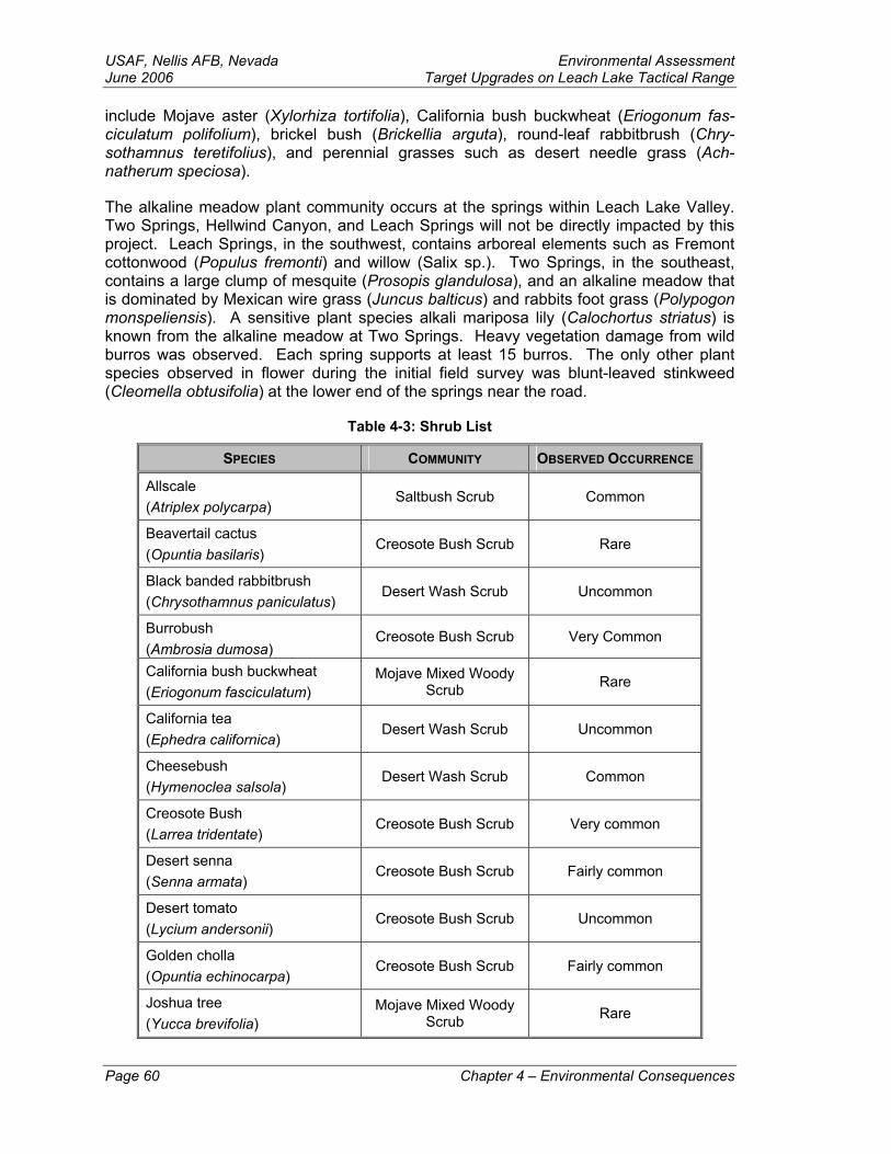
USAF, Nellis AFB, Nevada Environmental Assessment June 2006 Target Upgrades on Leach Lake Tactical Range include Mojave aster (Xylorhiza tortifolia), California bush buckwheat (Eriogonum fas-ciculatum polifolium), brickel bush (Brickellia arguta), round-leaf rabbitbrush (Chry-sothamnus teretifolius), and perennial grasses such as desert needle grass (Ach-natherum speciosa).
The alkaline meadow plant community occurs at the springs within Leach Lake Valley. Two Springs, Hellwind Canyon, and Leach Springs will not be directly impacted by this project. Leach Springs, in the southwest, contains arboreal elements such as Fremont cottonwood (Populus fremonti) and willow (Salix sp.). Two Springs, in the southeast, contains a large clump of mesquite (Prosopis glandulosa), and an alkaline meadow that is dominated by Mexican wire grass (Juncus balticus) and rabbits foot grass (Polypogon monspeliensis). A sensitive plant species alkali mariposa lily (Calochortus striatus) is known from the alkaline meadow at Two Springs. Heavy vegetation damage from wild burros was observed. Each spring supports at least 15 burros. The only other plant species observed in flower during the initial field survey was blunt-leaved stinkweed (Cleomella obtusifolia) at the lower end of the springs near the road.
Table 4-3: Shrub List
SPECIES COMMUNITY OBSERVED OCCURRENCE
Allscale (Atriplex polycarpa)
Saltbush Scrub Common
Beavertail cactus (Opuntia basilaris)
Creosote Bush Scrub Rare
Black banded rabbitbrush (Chrysothamnus paniculatus)
Desert Wash Scrub Uncommon
Burrobush (Ambrosia dumosa)
Creosote Bush Scrub Very Common
California bush buckwheat (Eriogonum fasciculatum)
Mojave Mixed Woody Scrub Rare
California tea (Ephedra californica)
Desert Wash Scrub Uncommon
Cheesebush (Hymenoclea salsola)
Desert Wash Scrub Common
Creosote Bush (Larrea tridentate)
Creosote Bush Scrub Very common
Desert senna (Senna armata)
Creosote Bush Scrub Fairly common
Desert tomato (Lycium andersonii)
Creosote Bush Scrub Uncommon
Golden cholla (Opuntia echinocarpa)
Creosote Bush Scrub Fairly common
Joshua tree (Yucca brevifolia)
Mojave Mixed Woody Scrub Rare
Page 60 Chapter 4 – Environmental Consequences
Environmental Assessment USAF, Nellis AFB, NevadaTarget Upgrades on Leach Lake Tactical Range June 2006
Mojave aster (Xylorhiza tortifolia)
Mojave Mixed Woody Scrub Rare
Peachthorn (Lycium cooperi)
Creosote Bush Scrub Uncommon
Sandpaper plant (Petalonyx thurberi)
Desert Wash Scrub Rare
Turpentine broom (Thamnosma montana)
Creosote Bush Scrub Uncommon
The following annuals were also observed:
• Annual desert spurge (Chamaesyce micromeria)
• Blunt-leaved Stinkweed (Cleomella obtusitolia)
• Brittle spineflower (Chorizanthe brevicornu)
• Brown-eyed evening primrose (Camissonia claviformis)
• Chia sage (Salvia columbariae)
• Cinchweed (Pectis papposa)
• Fremont pincushion flower (Chaenactis fremontii)
• Royal lupine (Lupinus odoratus)
• Split grass (Schismus barbatus)
• Woody bottlewasher (Camissonia boothii)
Survey Methods
Records Search – A literature search of the California Natural Diversity Database (CNDDB) showed two sensitive wildlife species potentially occurring on Leach Lake. A Mohave ground squirrel was found in the extreme southwestern corner of Leach Lake. The hills in the northeastern portion of the range are considered potential habitat for Nel-son’s bighorn sheep although the hills are too low in elevation for the species to utilize the site as permanent habitat. Denning Springs, the main source of water in the area, has been dry for a number of years. The area is roadless.
Protocols and Field Results – Field surveys were conducted in October and November. A 100 percent systematic survey following standard desert tortoise protocols (10 meter parallel tracts) were followed for all undisturbed areas. A cursory survey was done on all disturbed areas due to the possible presence of unexploded ordinance. The following proposed targets were surveyed.
Chapter 4 – Environmental Consequences Page 61
USAF, Nellis AFB, Nevada Environmental Assessment June 2006 Target Upgrades on Leach Lake Tactical Range Area A – Area A was surveyed on October 23 and consists of locating abandoned vehi-cles adjacent to the road. The vehicles would be occasionally moved.
Area B –Site B west is located along a wash that is used at the main access road and contains creosote bush scrub vegetation and a rocky soil surface. Site B central is lo-cated on the top of a rocky promontory. No access exists to the site. A road goes par-tially to the site on the bajada then military personnel hike to the observation point. Site B east is located on the lower alluvial fan draining into Leach Lake for the east. The site contains creosote bush scrub and desert wash scrub.
Area C – These two sites are both remote cave sites. The vegetation at both sites is slightly more diverse than the valley floor. A small mammal burrow (coyote or kit fox) was observed in the general area.
Area D – Site D1 is only accessible cross-country. The vegetation at the site was slightly more diverse than the valley floor. Sites D2 and D3 are located east of the lake-bed. These sites contain sparse low creosote bush scrub with some allscale and desert wash scrub. The topography was flat and no sites existed for desert tortoise to burrow. This was one of the least diverse habitats. Access to site D4 is cross-country; roads to this site do not exist. The site was surveyed and revealed no evidence of desert tortoise or other sensitive plant or animal species. Site D5 was completely inaccessible by vehi-cles and was not surveyed—this site will need a biological survey prior to any construc-tion activity. Site D6 is located in the extreme eastern portion of the range. The vegeta-tion was slightly more diverse than the valley floor. A collapsed desert tortoise burrow was observed on this site.
Area E – Site E1 is located on the valley floor and site E2 is located on the alluvial fans from the Quail Mountains. Both sites would be located within the disturbed target arrays. Typical wildlife observed included ants and kangaroo rat and other small rodent burrows. Both sites were surveyed in October when summer annuals were still green.
Area F – Sites F1 and F2 are infantry trenches, both located on alluvial fans from the Granite Mountains. No sensitive plant or animal species were observed.
Area G – This site is large and contains highly disturbed desert wash scrub with creo-sote bush scrub. The soil surface contains vehicle tracks used by range clean up per-sonnel and craters from ordnance. The foothills above the site (approximately 1 mile south) contain potential desert tortoise habitat. The perimeter of the site was surveyed because it contains the least disturbed habitat.
Area H – This site is large and the center contains the bladed simulated airfield. The perimeter of this site was spot checked in October and surveyed in November. Vegeta-tion included creosote bush scrub and allscale transition. Vegetation was sparse and disturbance was moderate.
Area I – This site is adjacent to, and east of, site H. The surface is heavily disturbed by vehicle tracks and bomb craters. Occasional areas were bladed. The site contains creosote bush scrub vegetation.
Areas J and K – These are two large areas located near the lakebed. The northern por-tions could not be surveyed due to unexploded ordinance. Area J had heavy surface
Page 62 Chapter 4 – Environmental Consequences

Environmental Assessment USAF, Nellis AFB, NevadaTarget Upgrades on Leach Lake Tactical Range June 2006 disturbance and Area K had a moderate to lightly disturbed surface. Vegetation is creo-sote bush scrub and desert wash scrub. The vegetation is sparse, short, with lots of bare washes.
Area M – This area is located near Site B east and Site D2. This site is located in creo-sote bush scrub and desert wash vegetation.
Area N - The site contains creosote bush scrub and desert wash scrub.
4.2.1 Proposed Action Under the Proposed Action, approximately 216 acres of undisturbed habitat would be graded for target construction. This added to the previously disturbed habitat would total approximately 1,106 acres. The Leach Lake Tactical Range is approximately 144 square miles (24 miles long by 6 miles wide). At 640 acres per square mile, the range contains approximately 92,160 acres. The amount of new habitat that will be graded amounts to approximately 2 tenths of 1 percent. After competing the Proposed Action, the total amount of disturbed habitat (approximately 1,106 acres) would amount to ap-proximately 1.2 percent of the range.
4.2.1.1 Threaten and Endangered Species
Animal Species
Nelson’s Bighorn Sheep. The drying of some of the springs in the Avawatz Range within historic times has resulted in a general degradation of bighorn sheep populations at the lower elevations. This project is limited to lower elevations of the Leach Lake Ba-sin so would not impact current bighorn sheep habitat.
Mohave Ground Squirrel. Fort Irwin is at the extreme eastern range of the Mohave ground squirrel; historic records document the presence of the Mohave ground squirrel in the far western portion of the project area. Mohave ground squirrels are usually lo-cated in the diverse scrub that occurs in sandy areas. The succulent leaved boxthorn (Lycium sp.), summer fruiting saltbush (Atriplex sp.), and Joshua tree (Yucca brevifolia) provide a food supply when the ground squirrels are active. These plant species are sparse within the study area so potential habitat quality is considered low; therefore, the presence of this species is remote—no Mohave ground squirrels were observed during the biological survey. Fort Irwin resource managers are undergoing conservation efforts to the south of Leach Lake.
To preclude any negative impacts on the species, should they be found in the target construction areas, the biologist present to monitor for the desert tortoise will also be ob-servant for the Mohave ground squirrel. Implementing the Proposed Action should have no new impacts on the Mohave ground squirrel.
Bird Species
Bald and Golden Eagles. Bald or golden eagles are not known to reside, frequent, or nest within the project area; however, they could migrate through the area during migra-tion seasons. Implementing the Proposed Action would have no new impacts on the bald or golden eagles.
Chapter 4 – Environmental Consequences Page 63
USAF, Nellis AFB, Nevada Environmental Assessment June 2006 Target Upgrades on Leach Lake Tactical Range Least Bell’s Vireo. The breeding population of least Bell’s vireo is along the Mojave River well south of the project area. No least Bell’s vireos were observed during the bio-logical survey. Implementing the Proposed Action would have no impacts on the least Bell’s vireo.
Southwester Willow Flycatcher. The southwestern willow flycatcher breeds in dense riparian habitats along rivers, streams, or other wetlands across the southwestern U.S. The riparian woodland used by willow flycatchers typically is next to, or over, water and has a canopy and understory of shrub and sapling vegetation. No southwestern willow flycatchers were observed during the biological survey. The target areas proposed un-der this action are not within spring or riparian areas; therefore, implementing the Pro-posed Action would have no impacts on the southwester willow flycatcher.
Reptile Species
Desert Tortoise. Some evidence of tortoise burrows was observed in the far eastern portion of the study area; however, none of the projects are located in diverse or sensi-tive habitat (Charlton 2003). Most projects would be located near roads or in undis-turbed target areas.
As a dust prevention measure, heavy construction vehicles vehicle speeds will kept be-low 15 MPH and all other vehicles will be kept below 25 MPH. This measure will also help prevent inadvertent takes of desert tortoise crossing roadways. Implementing the Proposed Action should have no new impacts on the desert tortoise; however, the appli-cable mitigation measures outlined in the Fort Irwin Biological Opinion (DOI 2004) will be followed, to include:
A field evaluation of the work sites will be performed to determine whether addi-tional protective measures are to be implemented.
An evaluation of the level of on-site protection needed for desert tortoise during implementation of the project. Such on-site protection may include full- or part-time monitors or fencing to separate desert tortoise from work areas.
A project-specific worker education program.
The USAF must develop a boundary design that allows desert tortoise to exit trenches or prevent them from entering them.
During the implementation of all projects, the USAF must ensure that its activities are not providing subsidies for predators of the desert tortoise. In particular, the USAF must ensure that the water stops do not provide drinking opportunities for common ravens.
4.2.1.2 Sensitive Species Bird Species
Burrowing Owl. The burrowing Owl is present throughout the Mojave Desert and the lands encompassing Fort Irwin. It is expected that the burrowing owl would be found on the Leach Lake Tactical Range; however no evidence of burrowing owls were observed in the proposed target construction areas. Most sensitive bird species are located in and Page 64 Chapter 4 – Environmental Consequences
Environmental Assessment USAF, Nellis AFB, NevadaTarget Upgrades on Leach Lake Tactical Range June 2006 around springs. There are no springs proximal to the proposed target areas; therefore, impacts to the burrowing owl are less than significant. The applicable mitigation meas-ures outlined in the Fort Irwin Biological Opinion (DOI 2004) that will be followed for the desert tortoise (as outlined in paragraph 4.2.1.1 above) would also protect any inadver-tent disturbance or taking of burrowing owls that could be nesting in the project areas.
Yellow-Billed Cuckoos. During the breeding season in California, yellow-billed cuck-oos are confined to cottonwood-willow riparian habitat. Cuckoos have been observed during the breading season along the Mojave River between Victorville and Barstow. However, there are no confirmed nesting areas within this region of the Mojave Desert. Yellow-billed cuckoos could occur at any desert oasis with willow and cottonwoods, al-though there are very few records of migrant yellow-billed cuckoos in the vicinity (NTC 2005). No yellow-billed cuckoos were observed during the biological survey. There are no riparian areas within the proposed target construction areas. Construction activities proposed in the Proposed Action will have no negative impacts on the yellow-billed cuck-oos.
Other Bird Species. The LeConte’s thrasher, loggerhead shrike, long-eared owl, Bell’s sage sparrow, Brewer’s sparrow, California horned lark, yellow warbler, and prairie fal-con primarily use the higher elevations of the Leach Lake Valley and only occasionally use the central portion of the valley. Construction activities proposed in the Proposed Action will have no negative impacts on these bird species.
Feral burro activity reduces habitat quality for birds. Although Two Springs (on the southern boundary of Leach Lake Tactical Range and outside the project area) does not contain an arboreal overstory (primarily willow trees), the other springs do contain trees. Some bird species will remain in areas that contain large trees such as cottonwood (i.e., Leach Springs, also on the southern boundary of Leach Lake Tactical Range outside the project area). Other species, such as warblers, like dense stands of shrubby willow trees to linger in an area. Some species prefer tall grass-like plants such as reeds or cattails to provide cover near the water source. Burros reduce the tree canopy by eating sprouting seedlings and reduce the shrubby trees or grass layers by overgrazing.
Plant Species
Alkali Mariposa Lily. The Alkali Mariposa Lily is found only in riparian areas around springs and other permanent water sources. These sensitive areas are off limits to mili-tary construction and training activities; therefore, this plant species would be protected by avoidance (personal conversation with Mickey Quillman 2006). There are no springs or permanent water sources within the proposed target construction areas.
4.2.1.3 Other Biological Resources
Wildlife
Fort Irwin is home to a wide diversity of wildlife species; however, most inhabit the can-yons and washes near springs or adjacent creosote bush scrub, riparian woodland, and desert wash vegetation of the northern Granite Range. This relatively wildlife-rich habi-tat is not indicative of the project area; most of the proposed construction sites are lo-cated on dry alluvial fans (Charlton 2004). Construction activities proposed in the Pro-posed Action will not significantly impact wildlife species.
Chapter 4 – Environmental Consequences Page 65
USAF, Nellis AFB, Nevada Environmental Assessment June 2006 Target Upgrades on Leach Lake Tactical Range Migratory Birds and other Raptors
Nellis AFB maintains BASH data for the aircraft operating out of Nellis AFB. Records indicate that approximately 80 percent of reported BASH incidents have no specific loca-tion indicated. Most BASH incidents were detected on post-flight aircraft inspections. For those incidents without specific locations indicated, pilots could only verify that the incident occurred sometime after takeoff and before landing. A records search for the past 5 years revealed no BASH incidents within the Leach Lake Tactical Range (per-sonal conversation with Captain Bass 2004). Air operations would not change as a re-sult of the proposed actions; therefore there would be no additional impacts to birds or other raptors.
4.2.1.4 Other Potential Impacts This project would result in small losses of habitat and degradation of existing disturbed habitat. The amount of undisturbed habitat that would be degraded and bladed for new construction and access roads depends on the amount of proposed projects that occur. Some projects are more destructive because of the project’s location in undisturbed ar-eas such as the far eastern portion of Leach Lake.
Most mission activities occur within the bare target areas but off road activities and stray ordnance may land significant distances from the target areas. Wildfires could start when heat caused by the hot metal and explosives ignite remaining vegetation and weedy annuals. Any fires that are ignited by munitions would most likely occur within the target areas.
For those projects located in undisturbed habitat in the eastern portion of the project area, the USAF would have a biological monitor present when construction activities are taking place in accordance with the Fort Irwin Biological Opinion (DOI 2004). All other terms and conditions of the Biological Opinion would also be implemented.
4.2.2 No Action Alternative
4.2.2.1 Threatened and Endangered Species
Animal and Reptile Species
Under the No Action Alternative, activities at Leach Lake would continue as they have historically. Fort Irwin and Nellis AFB would continue target maintenance and range clearances. Fort Irwin would continue to consider Leach Lake as part of its natural re-source management area and would continue to include it in general environmental documentation.
Under the No Action Alternative, there would be no new impacts on the Nelson’s bighorn sheep and Mohave ground squirrel. Desert tortoise education for all range personnel would continue. Travel would be at speeds below 25 MPH to spot tortoises on the roads, and construction equipment and supplies considered attractive to tortoises (such as empty ended pipes) would be properly stored. There would be no new impacts on the Nelson’s bighorn sheep, Mohave ground squirrels, or desert tortoise.
Page 66 Chapter 4 – Environmental Consequences
Environmental Assessment USAF, Nellis AFB, NevadaTarget Upgrades on Leach Lake Tactical Range June 2006 Bird Species
Bald and golden eagles are not known to reside or frequent the project area; however, they could migrate through the area during migration seasons. Implementing the No Ac-tion Alternative would have no new impacts on the bald or golden eagles, the least Bell’s vireo, or the southwestern willow flycatcher.
4.2.2.2 Sensitive Species
Bird Species
Under the No Action Alternative, activities at Leach Lake would continue as they have historically. There would be no new impacts on the yellow-billed cuckoo, Bell’s sage sparrow, Brewer’s sparrow, California horned lark, Leconte’s thrasher, loggerhead shrike, long-eared owl, prairie falcon, or yellow warbler.
Plant Species
Under the No Action Alternative, activities at Leach Lake would continue as they have historically. There would be no new impacts on the alkali mariposa lily.
4.2.2.3 Other Biological Resources Wildlife
Under the No Action Alternative, activities at Leach Lake would continue as they have historically. There would be no new impacts on the other wildlife species that live on our adjacent to the Leach Lake Tactical Range.
Migratory Birds and Other Raptors
Nellis AFB maintains BASH data for the aircraft operating out of Nellis AFB. Records indicate that approximately 80 percent of reported BASH incidents have no specific loca-tion indicated. Most BASH incidents were detected on post-flight aircraft inspections. For those incidents without specific locations indicated, pilots could only verify that the incident occurred sometime after takeoff and before landing. A records search for the past 5 years revealed no BASH incidents within the Leach Lake Tactical Range (per-sonal conversation with Captain Bass 2004). Air operations would not change as a re-sult of the No Action Alternative; therefore there would be no additional impacts to birds or other raptors.
4.3 Cultural Resources This section discusses the methods and results for identifying and evaluating cultural resources within the ROI.
Survey Methods
Records Search – A prehistoric and historic record search of the project area was con-ducted at the San Bernardino County Information Center, San Bernardino County Mu-seum, Redlands, California on 9 April 2004. The search utilized site records, manu-scripts, and maps of the California Archaeological Inventory.
Field Methods – On-foot surveys of target areas were conducted on 26-28 April and 13-15 September 2004. Target areas were located by the use of a GPS unit using the Uni-
Chapter 4 – Environmental Consequences Page 67
USAF, Nellis AFB, Nevada Environmental Assessment June 2006 Target Upgrades on Leach Lake Tactical Range verse Transverse Mercator (UTM) coordinates provided by the government. Ground visibility was excellent. Transects were walked and spaced approximately 25 meters apart.
Field Survey Results
Area A – Area A is undisturbed. No cultural resources were observed.
Area B – Area B is undisturbed. No cultural resources were observed.
Area C – Area C is undisturbed. No cultural resources were observed at either cave site or along potential “two track” vehicle access trails that would lead from the main road to the cave sites following dried wash beds.
Area D – Area D is undisturbed. Target area D-2 is located on the east side of Leach Lake Playa. One archaeological site was located at the west boundary. The site con-sists of a light scatter (20+ flakes) of lithic debitage and one biface fragment. Lithic ma-terials are cryptocrystalline silicates and include chalcedony and chert. The west boundary of target D-2 bisects the site. For other Area D targets, no cultural resources were observed.
Area E – Area E is undisturbed. No cultural resources were observed.
Area F – Area F is undisturbed. No cultural resources were observed.
Area G – Area G is undisturbed. No cultural resources were observed.
Area H – Target Area H is a very large, heavily disturbed area.
Area I – Target Area I is a very large, heavily disturbed area.
Area J – Target Area J is a heavily disturbed area.
Area K – Target Area K-1 is an undisturbed area located at the northwest corner of Tar-get Area K-2. No cultural resources were observed. K-2 is a very large, heavily dis-turbed area. No cultural resources were observed.
Area L – Target Area L is an undisturbed area located on top of a small hill located on the south side of the range. No cultural resources were observed.
Area M – Target Area M is an undisturbed area located on the east of Leach Lake. No cultural resources were observed. The road alignment to the target area runs east/west from an unimproved dirt road located east of the target area. No cultural resources were observed.
Area N – Target Area N is an undisturbed area located on top of the Chocolate Chip hills located due south of Target Area K-2. No cultural resources were observed.
North Boundary Fence – The proposed fence line is in an undisturbed area. No cultural resources were observed.
Page 68 Chapter 4 – Environmental Consequences
Environmental Assessment USAF, Nellis AFB, NevadaTarget Upgrades on Leach Lake Tactical Range June 2006 4.3.1 Proposed Action A 100% intensive systematic cultural resource survey was completed in all undisturbed areas. Only one cultural resource a small, sparse, surface lithic scatter on the west boundary of target area D2, was located. The scatter was tested for subsurface depos-its and no subsurface deposits were located. Nellis AFB determined that the surface site is ineligible for nomination to the NRHP under section 106 of the NHPA. Thus, Nellis AFB made a determination of no adverse effects for the project. Nellis AFB sent a con-sultation letter requesting concurrence to the California SHPO on January 5, 2006.
4.3.2 No Action Alternative Under the No Action Alternative, no new target construction would occur. Normal target rebuilding and cleanup activities would continue to occur under current guidelines.
4.4 Earth Resources Typically, an impact to earth resources would be considered less than significant unless it meets and/or exceeds one or more of the following criteria (NTC 2003a):
Disturbs topographical or geological features of unusual scientific study or inter-pretative value.
Triggers or accelerates geological processes that would threaten human life or property.
Disturbs the upper dried clay surface crust of dry lakebeds or playas by vehicular or other direct mechanical means that expose these surfaces to wind erosion.
4.4.1 Proposed Action No adverse impacts to the geology or soil resources are anticipated to occur at targets constructed on disturbed sites. New target construction operations would have no im-pacts to geology and only minor effects to soil resources. The impacts to soil resources at undisturbed sites would result from blading the area for the first time—these impacts are estimated to be minor as only limited blading would occur. Limited displacement of soil and changes in topography would result as construction of target sites occurs. Wind erosion would be expected to occur on areas where the desert pavement has been bro-ken and/or disturbed; however, the eroded materials (i.e., dust) are expected to remain within the boundaries of the Leach Lake Tactical Range (see paragraph 4.1.1.2).
Water erosion is expected to occur at various degrees on the new targets that are con-structed on sloping terrain (e.g., target areas D-1, and C East and West). Slight to no erosion is expected to occur on all other target areas. Due to the low and infrequent an-nual rainfall in the area, any soil erosion would be less than significant.
4.4.2 No Action alternative The No Action Alternative would have no new effects on geology or soil resources within the Leach Lake Tactical Range.
Chapter 4 – Environmental Consequences Page 69
USAF, Nellis AFB, Nevada Environmental Assessment June 2006 Target Upgrades on Leach Lake Tactical Range 4.5 Environmental Justice In accordance with EO 12898, Federal Actions to Address Environmental Justice in Mi-nority Populations and Low-Income Populations (EO 12898), the USAF is required to identify and address disproportionately high and adverse human health and environ-mental effects of federal programs, policies, and activities on minority and low-income populations.
4.5.1 Proposed Action The Leach Lake Tactical range lies within the current NTC withdrawn land. Access to the range is restricted from the public. There are no minority and/or low-income popula-tions within the ROI boundaries. The construction projects proposed under the Pro-posed Action would remain within the currently established range boundaries; therefore, no new effects involving environmental justice would occur as a result of selecting the Proposed Action.
4.5.2 No Action Alternative Under the No Action Alternative, there would be no changes to current flying and/or training operations. There would be no adverse impacts to minority and/or low-income populations as a result of selecting the No Action Alternative.
4.6 Hazardous Materials/Waste and Solid Waste The hazardous materials used on Leach Lake Tactical Range include petroleum, oil, lu-bricants, paint, batteries, solvents, thinners, antifreeze, and aerosol containers. The use of live and practice ordnance on Leach Lake Tactical Range would generate target de-bris and munitions residue. The USAF expects to drop an approximately 1.6 million pounds of live ordnance on the Leach Lake Tactical Range over the next 5 years. This represents a 100,000-pound increase over the past 5 years (personal conversation with Captain Taylor 2004).
4.6.1 Proposed Action The construction projects proposed under the Proposed Action would not introduce any new or different hazardous materials or generate new or different hazardous wastes on Leach Lake Tactical Range. All surplus vehicles and equipment used as targets would be de-fluidized and demilitarized prior to being placed on the range. Vehicle dials and/or instruments that contain low-level radiation would be removed. Other construction mate-rials would be non-polluting/non-toxic. Any hazardous materials/waste and solid waste impacts as a result of selecting the Proposed Action are considered less than significant and would be disposed of as required by Nellis AFB Plan 12, Hazardous Waste Man-agement, Nellis AFB Solid Waste Management Plan, and Nellis AFB Plan 12, Waste Sampling and Analysis.
4.6.2 No Action Alternative Under No Action Alternative, there would be no changes to current range cleanup and target rebuilding operations.
Page 70 Chapter 4 – Environmental Consequences
Environmental Assessment USAF, Nellis AFB, NevadaTarget Upgrades on Leach Lake Tactical Range June 2006 4.7 Noise This section discusses the impacts of noise that the proposed action would have on re-ceptors within the ROI. The criteria in this section are any negative, unmitigated impacts caused by noise that rise to the level that would adversely impact human and biological receptors.
4.7.1 Proposed Action
Construction Noise
The noise generated from construction activities is expected to be primarily engine noise from land moving equipment (e.g., road graders, front-end loaders, dump trucks, trac-tors, etc.). The noise generated from construction activities would be very similar to the noises currently generated from range cleanup and target re-building activities. Con-struction noises would be of relative short duration (only as long as needed to construct the target) and isolated to the immediate area of each construction site. The construc-tion noise impacts would be barely audible to off-site receptors and onsite workers would be equipped with the appropriate hearing protection as required by OSHA.
Operational Noise
The primary noise receptors within the Leach Lake Tactical Range are those other than human. The range is on withdrawn land and closed to the public. Except for military ob-servers that would be present to conduct tactics training, the range would be closed to flying and training operations when range managers/maintainers are present.
Studies on the effects of noise on wildlife, caused by aircraft overflights and impulse noise such as sonic booms have been focused on birds and hoofed mammals, including raptors and bighorn sheep. It has been shown that occasional, low-altitude overflights can produce increased heart rates in hoofed mammals, but the effect was not found to be detrimental. Birds on the other hand, appear to be unaffected by both low-altitude aircraft overflight noise and sonic booms. Desert tortoises also appear to be unaffected by noise even up to levels over 100 dBA (Parsons 1995). Flying operations under the Proposed Action would not change from those that currently occur.
4.7.2 No Action Alternative Under the No Action Alternative, there would be no changes to current coronet clean, flying, and/or training operations.
4.8 Safety This section addresses the impacts on ground, flight, and range safety associated with proposed target construction and operational activities on the Leach Lake Tactical Range. Ground safety includes fire and crash response. Flight safety considers aircraft flight risks such as aircraft accidents and BASH incidents. Range safety assesses the management and use of ordnance associated with range use and cleanup.
Chapter 4 – Environmental Consequences Page 71

USAF, Nellis AFB, Nevada Environmental Assessment June 2006 Target Upgrades on Leach Lake Tactical Range 4.8.1 Proposed Action
4.8.1.1 Ground Safety
Ground Fires
The Proposed Action would not increase or decrease the potential for ground fires on the Leach Lake Tactical Range. Fire protection provided under the Proposed Action would continue as outlined in paragraph 3.8.2.1.
Crash Response
The Proposed Action would not increase or decrease the potential for crash response activities as a result of aircraft accidents on the Leach Lake Tactical Range. Crash re-sponse provided under the Proposed Action, as a result of aircraft accidents on range, would continue as outlined in paragraph 3.8.2.1.
4.8.1.2 Flight Safety
Aircraft Accidents/Mishaps
Under the Proposed Action, aircraft flight operations on the Leach Lake Tactical Range would remain as currently governed by flight rules and standard operating procedures. The effects of an aircraft crash, to include the potential for fire and environmental con-tamination, would continue to exist.
4.8.1.3 Range Safety Government contractor personnel employ EOD qualified specialists to ensure range safety for military and contractor personnel. Prior to maintenance or construction work on a target, EOD personnel would ensure the target areas are free of UXO. Contractor personnel are responsible to follow and adhere to USAF safety regulations, instructions, and guidelines, and report safety related accidents/incidents.
Improved range security and public safety would occur due to the construction of a boundary fence on either side of the existing northern range entrance gate and installa-tion of new warning signs along the fence. The fence would extend approximately 500 feet on each side of the gate.
4.8.2 No Action Alternative
4.8.2.1 Ground Safety
Ground Fires
Fire protection provided under the No Action Alternative would continue as outlined in paragraph 3.8.2.1.
Crash Response
Crash response provided under the No Action Alternative, as a result of aircraft acci-dents on range would continue as outlined in paragraph 3.8.2.1.
Page 72 Chapter 4 – Environmental Consequences
Environmental Assessment USAF, Nellis AFB, NevadaTarget Upgrades on Leach Lake Tactical Range June 2006 4.8.2.2 Flight Safety
Aircraft Accidents/Mishaps
Under the No Action Alternative, aircraft flight operations on the Leach Lake Tactical Range would remain as currently governed by standard flight rules and standard operat-ing procedures. The effects of an aircraft crash, to include the potential for fire and envi-ronmental contamination would continue to exist.
Bird-Aircraft Strike Hazards
Under the No Action Alternative, flight activity would be expected to remain as currently constituted.
4.8.2.3 Range Safety Range cleanup under the No Action Alternative would continue as currently conducted and scheduled.
4.9 Socioeconomics This section describes the potential impacts on social features and economic resources within the ROI by implementing the proposed action.
4.9.1 Proposed Action There are no permanent facilities or full-time workers on, or assigned to, the Leach Lake Tactical Range. All workers on the range are active military, government civilians, or government contractors. When performing official duties on the range, workers travel on a daily basis from Nellis AFB, Ft Irwin, or from temporary quarters in nearby towns (pri-marily Pahrump, Nevada, to the northeast, approximately 90 minutes travel from the range).
4.9.2 No Action Alternative Impacts would be the same as the Proposed Action.
4.10 Water Resources
4.10.1 Proposed Action Because the Leach Lake basin is a closed water system in terms of rainfall and storm runoff, waters would remain within the basin and not enter navigable waters of the United States. Any water naturally collected after infrequent thunderstorms accumulate on the dry lakebed and be lost through natural percolation and/or evaporation. There are no springs proximal to the proposed target areas that would be effected by operation under the Proposed Action. The springs in the vicinity of Leach Lake would not be used as a potable water source for human consumption in association with Air Force activi-ties. The Proposed Action would have no negative impacts on water resources.
4.10.2 No Action Alternative Impacts would be the same as the Proposed Action.
Chapter 4 – Environmental Consequences Page 73
USAF, Nellis AFB, Nevada Environmental Assessment June 2006 Target Upgrades on Leach Lake Tactical Range Chapter 5 – Cumulative Impacts
5.1 Definition The CEQ regulation for implementing NEPA defines cumulative impacts as:
“. . . the impact on the environment which results from the incremental impact of the action when added to other past, present, or reasonably foreseeable future actions regardless of what agency (Federal or non-Federal) or person under-takes such actions. Cumulative impacts can result from individually minor but collectively significant actions taking place over a period of time.” (40 CFR §§ 1500-1508)
Therefore, a cumulative impact analysis is based on a series of assumptions concerning future plans and/or projects and information about their character and timing. Cumula-tive impacts are examined by combining the effects of the proposed action alternatives with the effects of other past, present, and reasonably foreseeable activities within the ROI.
5.2 Reasonable Foreseeable Future Actions The NTC at Fort Irwin is currently preparing a Draft Supplemental Environmental Impact Statement for Proposed Addition of Maneuver Training Land at Fort Irwin, California (NTC 2003a). This initiative also includes expanding Restricted Area airspace to overlay the proposed expansion of maneuver training land. This initiative includes five action alternatives and a no action alternative—none of the alternatives impact the Leach Lake Tactical Range.
The NTC at Fort Irwin is also preparing a Draft Programmatic Environmental Impact Statement (PEIS) to implement the NTC Transformation Plan (NTC 2003b). The PEIS has not yet been released for public review. The purpose of this document is to support and prepare Fort Irwin, the NTC, and the training battlefield at Fort Irwin to effectively train current and future Army combat forces to carry out the Army’s national defense mission of creating a force that is dominant across the full spectrum of military opera-tions.
The USAF at Nellis AFB also released an Environmental Assessment for Changing the Silver Military Operations Area (MOA) for Nellis Air Force Base, Nevada. The purpose of the proposed action is to reconfigure the Silver MOA to better support U.S. and Allied air and ground forces during advanced Air Warrior combat training conducted at the NTC. The current airspace configuration hampers realistic, high fidelity training. The proposed action would also improve flight safety for military and nonparticipating aircraft.
5.3 Impacts Section 106 of the National Historic Preservation Act of 1966 requires that Federal agencies take into account the effects of their undertakings on historic properties. Ef-forts to identify and evaluate cultural resource properties for this project according to 36 CFR 800.4 are described in a Cultural Resources Report (Moffitt and Moffitt 2005) on file at in the Cultural Resources section of Nellis Air Force Base (99 CES/CEVN). One ar-chaeology site, CA-SBR-11627, a lithic scatter, was located within the Area of Potential
Page 74 Chapter 5 – Cumulative Impacts
Environmental Assessment USAF, Nellis AFB, NevadaTarget Upgrades on Leach Lake Tactical Range June 2006 Effect. The site was evaluated as ineligible for nomination to the National Register of Historic Places according to 36 CFR 60.4 (d). A determination of no adverse effect for the project was submitted to the California State Historic Preservation Office, according to 36 CFR 800.5. The Air Force has completed its consultation responsibilities for the undertaking according to 36 CFR 60.4.
There are no negative direct, indirect, or cumulative impacts on air quality, biological re-sources, cultural resources, earth resources, environmental justice, hazardous materi-als/waste-solid waste, noise, safety, socioeconomics, or water resources as a result of implementing the Proposed Action or the No Action Alternative. There are no other past, present, or reasonably foreseeable airspace actions in this geographical area to which this project would add to any cumulative impacts.
Section 5 – Cumulative Impacts Page 75
USAF, Nellis AFB, Nevada Environmental Assessment June 2006 Target Upgrades on Leach Lake Tactical Range
Chapter 6 – Other Required Considerations
6.1 Irreversible and Irretrievable Commitment of Resources Irreversible and irretrievable resource commitments are related to the use of nonrenew-able resources and the effects that the use of these resources have on future genera-tions. Irreversible commitments of resources are those resources that cannot be re-versed or are lost for an extremely long period of time (e.g., energy and minerals). Irre-trievable resource commitments of resources involve the loss in value of an affected re-source that cannot be restored as a result of the action (e.g., the extinction of a threat-ened or endangered species, or the disturbance/destruction of a cultural site).
The continuation of activities at Leach Lake Tactical Range as described in the Pro-posed Action and No Action Alternative would neither irreversibly nor irretrievably com-mit resources. As in the past, activities that have the potential to produce ground distur-bance also have the potential to impact water resources, air quality, biological resources, and cultural resources. However, management policies and practices in place and pro-posed to continue are designed to minimize potential impacts to these resources.
Construction and maintenance of targets on Leach Lake Tactical Range would require the consumption of limited quantities of aggregate, steel, concrete, petroleum, oil, and lubricants. The commitment of these resources would apply under both the Proposed Action and No Action Alternative.
Page 76 Section 6 –Other Required Considerations
Environmental Assessment USAF, Nellis AFB, NevadaTarget Upgrades on Leach Lake Tactical Range June 2006 Chapter 7 – List of Preparers
Charlton, David Biological Resources; Threatened, Endangered, and Sensitive Species; ITS Corporation
B.S., Plant Sciences/Biology, 1974 M.A., Environmental Studies, 2001 Years of Experience – 30 Eisen, Ira Geographical Information System Specialist; ITS Corporation M.A. Geography, 2003 Years of Experience – 5 Garner, William Senior Project Manager; ITS Corporation B.G.S., Business Management, 1974 M.B.A., Business Administration, 1980 Years of Experience – 33 Gifford, John Air Quality, Water Resources; ITS Corporation LL.B., 1989 M.P.A., Public Administration, 1991 Years of Experience – 30 Moffitt, Linda Cultural Resources; Independent Contactor (Archeologist) B.S., Anthropology/Archaeology, 1994 M.A., Anthropology/Archaeology, 1996 Years of Experience – 11 Moffitt, Steven Cultural Resources; Independent Contractor (Archeologist) B.S., Anthropology, 1992 M.S., Anthropology, 1996 Years of Experience – 12 years
Section 7 – List of Preparers Page 77
USAF, Nellis AFB, Nevada Environmental Assessment June 2006 Target Upgrades on Leach Lake Tactical Range
Chapter 8 – Persons and Agencies Contacted
Bass, Thomas, Capt; 57 Wing Flight Safety Officer, 57WG/SEF, Nellis AFB NV.
Bee, Dennis; Chief, Airspace Management, 57OSS/OSM, Nellis AFB NV.
Burchett, Steve; UXO Specialist, DynCorp Technologies Services LLC/Versar, North Las Vegas NV.
Burris, Martin; Green Procurement Program Manager, 99 CES/CEVP, Nellis AFB, NV.
Campe, James; Former NEPA Program Manager, 99CES/CEVN, Nellis AFB NV.
Christensen, Roger; Environmental Administrator, 98RANW Plans and Programs, Nellis AFB, NV.
Cortese, Billy; UXO Specialist, DynCorp Technologies Services LLC/Versar, North Las Vegas NV.
DeSalvio, Alan; Acting Supervising Air Quality Engineer, Mojave Desert Air Quality Man-agement District, Victorville CA.
Dibble, Gary; UXO Specialist, DynCorp Technologies Services LLC/Versar, North Las Vegas NV.
Haarklau, Lynn; Acting NEPA Program Manager, 99 CES/CEVN, Nellis AFB, NV.
Hudson, Hank; Targets Manager, DynCorp Technologies Services LLC/Versar, North Las Vegas NV.
Lieber, Charles; Environmental Specialist, FAA Western-Pacific Region, Lawndale CA.
Fu, Jimeng; Former Air Quality Program Manager, 99 CES/CEVC, Nellis AFB, NV.
Murphy, Christopher; Solid Waste Program Manager, 99 CES/CEVP, Nellis AFB, NV.
Myhrer, Keith; Archaeologist/CRM Program Manager, 99CES/CEVN, Nellis AFB, NV.
Porterfield, Mark; HazMat Program Manager, 99 CES/CEVP, Nellis AFB, NV.
Quillman, Mickey; Natural/Cultural Resources Manager, Directorate of Public Works, Fort Irwin CA.
Ramirez de Bryson, Luz; Post Archaeologist, Directorate of Public Works, Fort Irwin CA.
Roe, John; Water Quality Program Manager, 99 CES/CEVC, Nellis AFB, NV.
Schmidt, Bernd; Restoration Program Manager, 99 CES/CEVA, Nellis AFB, NV.
Page 78 Section 8 – Persons and Agencies Contacted
Environmental Assessment USAF, Nellis AFB, NevadaTarget Upgrades on Leach Lake Tactical Range June 2006 Schofield, Roger; Environmental Engineer, 98 RANW Plans and Programs, Nellis AFB
NV.
Taylor, Lynn, Captain; Operations Officer, 549 CTS, Nellis AFB NV.
Turner, Robert; Natural Resources Program Manager, 99 CES/CEVN, Nellis AFB, NV.
Chapter 8 – Persons and Agencies Contacted Page 79

USAF, Nellis AFB, Nevada Environmental Assessment June 2006 Target Upgrades on Leach Lake Tactical Range Chapter 9 – Bibliography and References
7 USC § 2814. Noxious Weeds; Management of Undesirable Plants on Federal Lands.
15 USC § 2601. 1976. Toxic Substances Control Act of 1976. Public Law 94-469.
16 USC §§ 668-668d. 1940. Bald Eagle Protection Act of 1940. 54 Stat. 250 as amended by Public Laws 86-70; 87-884; 92-535; and 95-616.
16 USC §§ 703-711. 1918. Migratory Bird Treaty Act of 1918 (as amended).
16 USC § 1331. 1971. Wild Free Roaming Horse and Burro Act of 1971. Public Law 92-195.
16 USC § 1531 et seq. 1973. Endangered Species Act of 1973. Public Law 93-205 as amended.
25 USC §§ 3001-3013. 1990. Native American Graves Protection and Repatriation Act of 1990. Public Law 101-601.
33 USC § 1251. 1972. Federal Water Pollution Control Act of 1972 (commonly known as the Clean Water Act). Public Law 92-500 as amended by Public Law 95-217 and Public Law 100-4.
32 CFR § 989
36 CFR § 60.4. 2003. Parks, Forests, and Public Property; National Park Service, De-partment of the Interior; National Register of Historic Places.
40 CFR § 51, Subpart W and § 93 Subpart B. 1993. Determining Conformity of General Federal Actions to State or Federal Implementation Plans.
40 CFR §§ 260-261 et al. 1997. Environmental Protection Agency, Military Munitions Rule.
40 CFR §§ 1500-1508. 1986. Council on Environmental Quality (CEQ), Regulations for Implementing the Procedural Provisions of the National Environmental Policy Act.
42 USC § 1996. 1978. American Indian Religious Freedom Act of 1978. Public Law 95-341.
42 USC § 4321, et seq. 1969. National Environmental Policy Act (NEPA) of 1969. Pub-lic Law 91-190 as amended.
42 USC § 6901. 1976. Resource Conservation and Recovery Act (RCRA) of 1976. Public Law 94-580.
42 USC § 7401; 40 CFR §§ 51 and 93. 1970. Clean Air Act of 1970. Public Law 91-604 as amended by Public Law 91-631 and Public Law 101-549.
Page 80 Chapter 9 – Bibliography and References
Environmental Assessment USAF, Nellis AFB, NevadaTarget Upgrades on Leach Lake Tactical Range June 2006 42 USC § 9606. 1980. Comprehensive Environmental Response, Compensation, and
Liability Act (CERCLA) of 1980. Public Law 96-510 as amended by the Superfund Amendments and Reauthorization Act (SARA) of 1986 (Public Law 99-499).
42 USC § 11001 et seq. 1986. Emergency Planning and Community Right-to-Know Act (EPCRA). Public Law 99-499. Also know as the Superfund Amendments and Reauthorization Act (SARA) of 1986.
Basgall, M.E., M.C. Hall, and W.R. Hildebrandt. 1988. The Late Holocene Archaeology of Drinkwater Basin, Fort Irwin, San Bernardino County, California. Far Western Anthropological Research Group, Inc. Document on File with U.S. Army Corps of Engineers, Los Angeles.
Bettinger, R.L. and R.E. Taylor. 1974. Suggested Revisions in Archaeological Se-quences of the Great Basin and Interior Southern California. Nevada Ar-chaeological Survey Research Paper, No. 5:1-26.
California Department of Fish and Game (CDFG). 2003. Letter to William M. Garner, Subject: Nellis AFB, Silver Military Operations Area. From Ms. Rebecca Jones, Environmental Scientist, Habitat Conservation Planning Branch, East-ern Sierra-Inland Deserts – Region 6, dated December 12, 2003.
California Desert Protection Act (CDPA) of 1994. 1994. Public Law 103-433.
California Endangered Species Act (CESA). Fish and Game Code §§ 2050, et seq.
Campbell, E.W.C. 1931. An Archaeological Survey of the Twenty-Nine Palms Region. Southwest Museum Papers No. 7. Los Angeles, California.
_____. 1936. Archaeological Problems in the Southern California Deserts. American Antiquity 1:295-300.
Campbell E.W.C. and C.A. Amsden. 1934. The Eagle Mountain Site. The Masterkey 8(6):170-173.
Campbell E.W.C. and W.H. Campbell. 1935. The Pinto Basin Site: An Ancient Aborigi-nal Camping Ground in the California Desert.
Campbell E.W.C., W.H. Campbell, E. Antevs, C.E. Amsden, J.A. Bardieri, and F.D. Bode. 1937. The Archaeology of Pleistocene Lake Mojave. Southwest Mu-seum Papers, No. 11.
Charlton, D. 2004. A Biological Survey of Selected Areas of the Leach Lake Tactical Range, Fort Irwin, California. Report produced for the Charis Professional Services Corporation, San Bernardino, California.
Comprehensive Environmental Response, Compensation, and Liability Act (CERCLA). 1980. Public Law 96-510 as amended by the Superfund Amendments and Reauthorization Act (SARA) of 1986 (Public Law 99-499).
Chapter 9 – Bibliography and References Page 81

USAF, Nellis AFB, Nevada Environmental Assessment June 2006 Target Upgrades on Leach Lake Tactical Range Dawson, T., S. McGill, and T. Rockwell. 2003. Irregular Recurrence of Paleoearth-
quakes Along the Central Garlock Fault Near El Paso Peaks, California. Journal of Geophysical Research, Vol. 108:2356.
Defense Logistics Agency (DLA). 1999. Defense Logistics Agency Instruction 4145.11. Storage and Handling of Hazardous Materials.
_____. 1994. Defense Logistics Agency Directive 4210.4. Hazardous Material Pollu-tion Prevention.
Department of the Army (DA). 2003. Integrated Natural Resource Management Plan (INRMP)(Draft). Fort Irwin, California.
_____. 2001. Army Regulation 75-1. Malfunctions Involving Ammunition and Explo-sives.
_____. 2000a. Army Regulation 385-10. Army Safety Program.
_____. 2000b. Army Regulation 385-64. Army Explosive Safety Program.
_____. 1995. Army Regulation 200-3. Natural Resources—Land, Forest, and Wildlife Management.
_____. 1992. Army Regulation 75-14. Interservice Involving Ammunition and Explo-sives.
_____. 1990. Army Regulation 200-1. Environmental Protection and Enhancement.
_____. 1978. Army Regulation 75-15. Responsibilities and Procedures for Explosive Ordnance Disposal.
Department of Defense (DoD). 2000. Department of Defense Instruction 6055.7, Acci-dent Investigation, Reporting, and Record Keeping.
_____. 1996a. Department of Defense Directive 4715.1, Environmental Security.
_____. 1996b. Department of Defense Instruction 4715.4, Pollution Protection.
_____. 1996c. Department of Defense Instruction 4715.9, Environmental Planning and Analysis.
Depart of the Interior (DOI). 2004. United States Fish and Wildlife Service (USFWS), Biological Opinion for the Proposed Addition of Maneuver Training Lands at Fort Irwin, California (1-8-03-F-48).
Environmental Protection Agency (EPA). 1995. Compilation of Air Pollutant Emission Factors, AP-42, Fifth Edition, Volume 1: Stationary Point and Area Sources.
Executive Order (EO) 12898. 1994. Federal Actions to Address Environmental Justice in Minority Populations and Low-Income Populations.
Page 82 Chapter 9 – Bibliography and References
Executive Order (EO) 13007. 1996. Indian Sacred Sites.
Environmental Assessment USAF, Nellis AFB, NevadaTarget Upgrades on Leach Lake Tactical Range June 2006 Executive Order (EO) 13186. 2001. Responsibilities of Federal Agencies to Protect Mi-
gratory Birds.
Favis-Mortlock D. 2002. Erosion by Water. Published in the Encyclopedia of Soil Sci-ence, ISBN: 0-8247-0846-6. Available on line at http://www.dekker.com/servlet/product/DOI/101081EESS120001797
Federal Aviation Administration (FAA). 2000. FAA National Wildlife Strike Database. Wildlife Strikes to Civil Aircraft in the Unites States 1990-1999.
Federal Interagency Committee on Urban Noise (FICUN). 1980. Guidelines for Consid-ering Noise in Land Use Planning and Control.
Gibson, A.C., B.A. Prigge, and K. Niessen. 1994. Floral Surveys at the Fort Irwin Na-tional Training Center, San Bernardino County, California. Department of Bi-ology, University of California-Los Angeles, California.
Hunt, A.P. 1960. Archaeology of the Death Valley Salt Pan. University of Utah Ar-chaeological Papers, No. 47.
Kaldenberg, R.L. 1981. The Archaeology of Selected Springs and Playas on Fort Irwin, San Bernardino, CA. Far Western Anthropological Research, Inc. Document on file with the U.S. Army Corps of Engineers, Los Angeles.
Lanning, E.P. 1963. Archaeology of the Rose Spring Site, Iny-372. University of Cali-fornia Publications in Archaeology and Ethnology 49(3):237-336.
Lucas, M.J. and P.T. Calamir. 1996. Military Operations Area and Range Noise Model: MR_NMAP User’s Manual. Final. Wright-Patterson AFB OH: AAMRL. A1/OE-MN-1996-0001.
McCalvin, C. and D. Pereksta. 1994. Biological Inventory of the Hellwind Canyon Drainage System, Military Fort Irwin Reservation and San Bernardino County, California. U.S. Fish and Wildlife Service for Fort Irwin Directorate of Public Works.
McGill, S. 1998. Slip-Rate Studies of the Garlock and Owl Lake Faults. (available on line at http://erp-web.er.usgs.gov/reports/annsum/vol40/sc/G2210.htm.
Moffitt, S.A., and L.R. Moffitt. 2005. An Archaeological Survey of Selected Areas of the Leach Lake Tactical Range and Evaluation of Archaeological Site CA-SBR-11627, Fort Irwin, California. Report produced for ITS Corporation, San Ber-nardino, California.
Mojave Desert Air Quality Management District (MDAQMD). 2000. Antelope Valley Air Pollution Control District. Emissions Inventory Guidance; Mineral Handling and Processing Industries.
_____. 1996. Fugitive Dust Control for the Mojave Planning Area.
_____. 1994. General Federal Actions Conformity, Rule 2002.
Chapter 9 – Bibliography and References Page 83
USAF, Nellis AFB, Nevada Environmental Assessment June 2006 Target Upgrades on Leach Lake Tactical Range National Research Council (NRC). 1977. Guidelines on Preparing Environmental Impact
Statements on Noise: Report of Working Group 69 on Evaluation of Environ-mental Impact of Noise.
National Resources Conservation Service (NFCS) State Soil Geographic (STSTSGO). 2004. Soils database web page. http://www.ncgc.nrcs.usda.gov/branch/ssb/products/statsgo/ (Accessed No-vember 2004)
National Training Center (NTC). 2005. Supplemental Final Environmental Impact State-ment for the Proposed Addition of Maneuver Training Land at Fort Irwin, Cali-fornia.
_____. 2003a. Draft Urban Operations Environmental Assessment.
_____. 2003b. NTC Transformation Campaign Plan.
National Transportation Safety Board (NTSB). 2003. National Transportation Safety Board web site. http://www.ntsb.gov. (Accessed November 2003).
_____. 1999. Annual Review of Aircraft Accident Data, U.S. Air Carrier Operations, Calendar Year 1996.
Nevada Test and Training Range (NTTR). 2003. NTTR Facility Wide Fugitive Dust Control Plan, July 2, 2003.
New World Technology (NWT). 2003. Personal communications with field supervisors who have managed all range clean up surveys over the past 10 years.
Norwood, R. 1989. Cultural Resource Reconnaissance for Leach Lake Basin. 831 CSG/DEV, George AFB, California. Report resides at Edwards AFB, Califor-nia.
Parsons. 1995. Draft Final Report, Effects of Flight Noise from Jet aircraft and Sonic Booms on Hearing, Behavior, Heart Rate, and Oxygen Consumption of De-sert Tortoises (Gopherus Agassizii). Prepared for Armstrong Laboratory, Brooks Air Force Base, Texas; Noise Effects Branch, Wright-Patterson Air Force Base, Ohio; and Environmental Management Office, Air Force Flight Test Center, Edwards Air Force Base. Prepared by Parsons Engineering-Science, Inc.
Peltzer, G., F. Crampe, S. Hensley, and P. Rosen. 2001. Transient Strain Accumulation and Fault Interaction in the Eastern California Shear Zone. Geological Soci-ety of America, Vol. 29 p. 975-978.
Reinert, E. 2003. Transpression within the Eastern California Shear Zone and Low Temperature Thermochronometry of the Avawatz Mountains, Southern Cali-fornia, USA.
Rogers, M.J. 1929. Report on an Archaeological Reconnaissance in the Mojave Sink Region. San Diego Museum of Man, Papers No. 1. San Diego, California.
Page 84 Chapter 9 – Bibliography and References

Environmental Assessment USAF, Nellis AFB, NevadaTarget Upgrades on Leach Lake Tactical Range June 2006 _____. 1939. Early Lithic Industries of trhe Lower Basin of trhe Colorado River and Ad-
jacent Desert Areas. San Diego Museum of Man, Papers No. 3. San Diego, California.
Rowlands, P.G., H.B. Johnson, E. Ritter, and A.S. Endo. 1992. The Mojave Desert, Reference Handbook of the North American Deserts. Greenwood Press, Westport, Connecticut.
Sheppard and Smith. 1948. San Bernardino County Museum record 385.
Solid Waste Disposal Act (SWDA). 1965. Public Law 96-482.
Tuohy, D. 1974. A Comprehensive Study of Late Paleo-Indian Manifestations in the Western Great Basin. Nevada Archaeological Survey Paper, No. 5:91-116.
United States Air Force (USAF).
2003. Air Force Instruction 32-3001. Explosive Ordnance Disposal Program.
_____. 2002. Nellis Air Force Base Instruction 11-250. Local Flying Procedures.
_____. 2001a. Aural Displays and Bioacoustics Research (computer program, version 1.0.0 Beta). AFRL/HECB, Wright-Patterson AFB OH.
_____. 2001b. Air Force Instruction 91-211. USAF Guide to Aviation Safety Investiga-tion.
_____. 2000a. Air Force Instruction 40-201. Managing Radioactive Materials in the USAF.
_____. 2000b. Air Force Instruction 91-112. Safety Rules for U.S. Strike Aircraft.
_____. 1999. Department of the Air Force. Renewal of the Nellis Air Force Range Land Withdrawal Legislative Environmental Impact Statement.
_____. 1997a. Air Force Instruction 32-40. Disaster Preparedness.
_____. 1997b. Air Force Instruction 32-7064. Integrated Natural Resources Manage-ment.
_____. 1997c. Air Force Instruction 32-7086. Hazardous Material Management.
_____. 1996. Air Force Instruction 91-301. Air Force Occupational and Environmental Safety, Fire Protection, and Health (AFOSH) Program.
_____. 1994. Air Force Instruction 32-7080. Pollution Prevention Program.
United States Army Corps of Engineers (USACE). 2002. Final Programmatic Environ-mental Impact Statement for Army Transformation. Prepared by the Mobile Alabama District for the Department of the Army.
Chapter 9 – Bibliography and References Page 85
USAF, Nellis AFB, Nevada Environmental Assessment June 2006 Target Upgrades on Leach Lake Tactical Range United States Fish and Wildlife Service (USFWS). 2004. Letter to William M. Garner,
Subject: Species List for Fort Irwin and the National Training Center, San Bernardino County, California. From Ms. Judy Hohman, Division Chief, Mo-jave/Great Basin Desert, Ventura Fish and Wildlife Office, dated January 12, 2004.
Wallace, W.J. 1962. Prehistoric Cultural Development in the Southern California De-serts. American antiquity 28(2):172-180.
Warren, C.N. 1980. The Archaeology and Archaeological Resources of the Amargosa-Mojave Basin Planning Units. In “A Cultural Resource Overview of the Amargosa-Mojave Basin Planning Units,” by C.N. Warren, M. Knack, and E.T. Warren, pp 1-134. Submitted to the Bureau of Land Management, Riv-erside, California.
Warren, C.N. and R.H. Crabtree. 1986. Prehistory of the Southwestern Area. In “Handbook of the North American Indians,” Volume 11: Great Basin, edited by W. L. d’Azevedo, pp. 183-193. Smithsonian Institute, Washington DC.
Weapons and Tactics Center (WTC) and National Training Center (NTC). 1993. In-terservice Support Agreement Between Weapons and Tactics Center (WTC) Nellis AFB, NV and the National Training Center (NTC) Ft. Irwin, CA. 14 Jun 1993.
Zembal, R. and C. Gall. 1980. Observations on Mohave Ground Squirrel (Spermophilus Mohavensis) in Inyo County, California. Journal of Mammalogy. 61: 347-350.
Page 86 Chapter 9 – Bibliography and References
Draft Environmental Assessment USAF, Nellis AFB, NevadaTarget Upgrades on Leach Lake Tactical Range June 2006
Chapter 10 – Glossary of Terms Above Ground Level (AGL). The altitude expressed in feet measured above the earth’s surface.
Above Mean Sea Level (MSL). The altitude expressed in feet above average sea level.
Air Force Instruction (AFI). An AFI is an Air Force directive that sets goals, assigns re-sponsibilities, and provides guidance and procedures to the Air Force , Air National Guard, Air Force Reserves, major commands, and other subordinate activities to meet standards at all Air Force installations.
Air Warrior. The 549th Combat Training Squadron (CTS), in concert with Detachment 2, USAF Air-Ground Operations School (AGOS), based at Fort Irwin, CA, develops, exe-cutes, and directs Air Combat Command’s Air Warrior exercises. Air Warrior trains USAF ground combat units in the tactical control of airpower in the close battle. U.S. Army brigade commanders and their combat forces deployed to National Training Cen-ter receive the support and integrate the airpower presented by the 549 CTS.
Air-to-Ground Training. Air-to-ground training employs all the techniques and maneu-vers associate with weapons use and includes low- and high-altitude tactics, navigation, formation flying, target acquisition, and defensive reaction. Training activities include surface attack tactics, different modes of weapons delivery, electronic combat training, and use of defensive countermeasures.
Carbon Monoxide (CO). Carbon monoxide is a common product of incomplete combus-tion. It is a criteria pollutant with state and federal standards. It is not a primary photo-chemical reaction compound, but is involved in photochemical reactions. It dissipated rapidly, and is therefore only important on a local scale near sources.
Class A Accident. Any accident incidental to flight, which results in the total cost of damages to government and other property in the amount of $1 million or more; a DoD aircraft is destroyed; or an injury and/or occupational illness results in a fatality or per-manent total disability.
Class B Accident. Any accident incidental to flight which results in the total cost of dam-age in the amount of $200,000 or more, but less than $1 million. An injury and/or occu-pational illness results in permanent partial disability; or when three or more personnel are hospitalized for inpatient care as a result of a single accident.
Class C Accident. Any accident incident to flight which results in the total cost of prop-erty damage is $20,000 or more, but less than $200,000; a nonfatal injury that causes any loss of time from work beyond the day or shift on which it occurred; or a nonfatal oc-cupational illness or disability that causes loss of time from work or disability at any time.
Close Air Support (CAS). CAS consists of air operations against hostile targets in close proximity to friendly forces; further, these operations require detailed integration of each air mission with the fire and movement of those [friendly] forces. CAS provides direct support to help friendly ground forces carry out their assigned tasks. In fluid, high-intensity warfare, the need for tight control, the unpredictability of the tactical situation,
Chapter 10 – Glossary of Terms Page 87
USAF, Nellis AFB, Nevada Environmental Assessment June 2006 Target Upgrades on Leach Lake Tactical Range and the proliferation of lethal ground-based air defenses make CAS especially challeng-ing.
Coronet Clean. Coronet Clean is the operational term used to describe range cleanup and target rebuild activities. During Coronet Clean operations, the range is closed to flight training activities. Range EOD contractor personnel make the range safe for cleanup personnel by clearing the target areas of UXO. This is done by detonating the UXO in place. Range contractor personnel then collect and transport all range residue to accumulation sites, where the residue is segregated and processed for disposal and/or recycling. When the target areas are clean of UXO and range residue, range contractor personnel rebuild old targets and/or construct new targets for follow on train-ing.
Exercise. A military maneuver or simulated wartime operation involving planning, prepa-ration, and execution. It is carried out for the purpose of training and evaluation. It may be a combined, joint, or single-service exercise, depending on participating organiza-tions.
Flight Level (FL). Flight level is an aeronautical term for depicting altitude above 18,000 feet above mean sea level. When combined with the number of feet, the last two digits are removed (i.e., 24,000 feet is depicted at FL240). When expressed verbally, each number is pronounced individually (i.e., “flight level, two, four, zero”).
High Accident Potential (HAP). Significant aircraft, missile, space, explosives, miscella-neous air operations, or ground occurrences with a high potential for causing injury, oc-cupational illness, or damage if they recur.
Joint Force. A general term applied to a force composed of significant elements, as-signed or attached, of two or more Military Departments, operating under a single joint force commander.
Knot. One knot equals one nautical mile per hour.
Longitude/Latitude. A geographical grid reference system used for referencing positions on the earth. Longitude is the angular distance (measured in degrees and minutes) east or west of the Greenwich meridian. Latitude is the angular distance (measured in de-grees and minutes) north or south of the equator.
Maneuver. A maneuver is defined as 1) a movement to place ships or aircraft in a posi-tion of advantage over the enemy; 2) a tactical exercise carried out at sea, in the air, on the ground, or on a map in imitation of war; 3) the operation of a ship, aircraft, or vehicle to cause it to perform desired movement; and/or 4) employment of forces on the battle-field through movement of combat forces in relation to the enemy, supported by fire or fires potential from all sources, to gain potential advantage from which to destroy or threaten destruction of the enemy to accomplish the mission.
Military Operations Area (MOA). A MOA is one of the six types of special use airspace. A MOA is airspace designated outside of Class A airspace, to separate or segregate certain non-hazardous military activities from IFR traffic and to identify to VFR traffic where these activities are conducted.
Page 88 Chapter 10 – Glossary of Terms
Draft Environmental Assessment USAF, Nellis AFB, NevadaTarget Upgrades on Leach Lake Tactical Range June 2006
Nautical Mile. A unit of distance used in air navigation. It is the mean distance of one minute of longitude on the equator. One nautical mile is equal to 6,080 feet; it equals approximately 1.15 statute miles.
Nitrogen Oxides (NOX). Nitrogen oxides are common products of combustion in the presence of nitrogen. It includes nitrogen oxide (NO2), which is a criteria pollutant with state and federal standards. It is locally and regionally important due to its involvement in the photochemical formation of ozone (O3).
Ozone (O3). Ozone is a gas mainly produced by a photochemical reaction between re-active organic gases and oxides of nitrogen in the presence of sunlight (also produced by molecular oxygen in the presence of ultraviolet light or electrical discharge). It is a strong oxidant that is damaging at ground level but necessary at high altitude (in the stratosphere, where it absorbs dangerous ultraviolet light). It is also considered an im-portant greenhouse gas. It is a criteria pollutant with state and federal standards.
Particulate Matter-10 (PM10). Particulate matter with an aerodynamic diameter of less than 10 microns. It is that portion of particulate matter that tends to penetrate into the human lung. It is a criteria pollutant with state and federal standards. It is locally and regionally important.
Restricted Airspace. Restricted airspace is one of the six types of special use airspace. Restricted airspace is established when determined necessary to confine or segregate activities considered hazardous to nonparticipating aircraft.
Sortie. A sortie is a single flight, by one aircraft, from takeoff to landing.
Special Use Airspace. SUA is airspace of defined dimensions wherein activities must be confined because of their nature, or wherein limitations may be imposed upon aircraft operations that are not a part of those activities. The six types of SUA are: Prohibited Areas, Restricted Areas, Military Operations Areas, Warning Areas, Alert Areas, and Controlled Firing Areas.
Volatile Organic Compounds (VOC). Volatile organic compounds are a portion of total organic compounds or gasses (excluding methane, ethane, and acetone due to their low photochemical reactivity). It is regionally important due to its involvement in the photo-chemical reaction that produces ozone (O3).
Chapter 10 – Glossary of Terms Page 89
USAF, Nellis AFB, Nevada Environmental Assessment June 2006 Target Upgrades on Leach Lake Tactical Range Chapter 11 – Appendices
Appendix A – Intergovernmental and Interagency Coordination for Environmental Plan-ning (IICEP) and Sample Letter
Appendix B – Agency Consultations
Appendix C – Notice of Availability, Comments, and Responses to the Draft EA
Page 90 Chapter 11 – Appendices
Appendix A – Intergovernmental and Interagency Coordination for Environmental Planning (IICEP) and Sample Letter
91

MAILING LIST Federal Agencies United States Fish and Wildlife Service Ventura Fish and Wildlife Office 2943 Portola Road, Suite B Ventura CA 93003
Mr. Mickey Quillman Natural and Cultural Resources Directorate of Public Works, Environmental Division Fort Irwin CA 92310-5085
Bureau of Land Management Barstow Field Office 2601 Barstow Road Barstow CA 92311
U.S. Army Corps of Engineers, Fort Worth District Attn: CESWF-CT-C (Mr. Charlie McGregor) Contracting Division, Room 2A19 819 Taylor Street Fort Worth TX 76102
California State Agencies California State Clearinghouse 1400 Tenth Street P.O. Box 3044 Sacramento CA 95812-3044
California Air Resources Board 1001 “I” Street P.O. Box 2815 Sacramento CA 95812-2815
California Department of Fish and Game Eastern Sierra-Inland Desert – Region 6 407 West Line Street Bishop CA 93514
Mojave Desert Air Quality Management District Attn: Alan DeSalvio 14306 Park Ave Victorville CA 92392
Public Libraries Barstow Public Library 304 East Buena Vista Street Barstow CA 92311
Baker Community Center 56725 Park Avenue Baker CA 92309
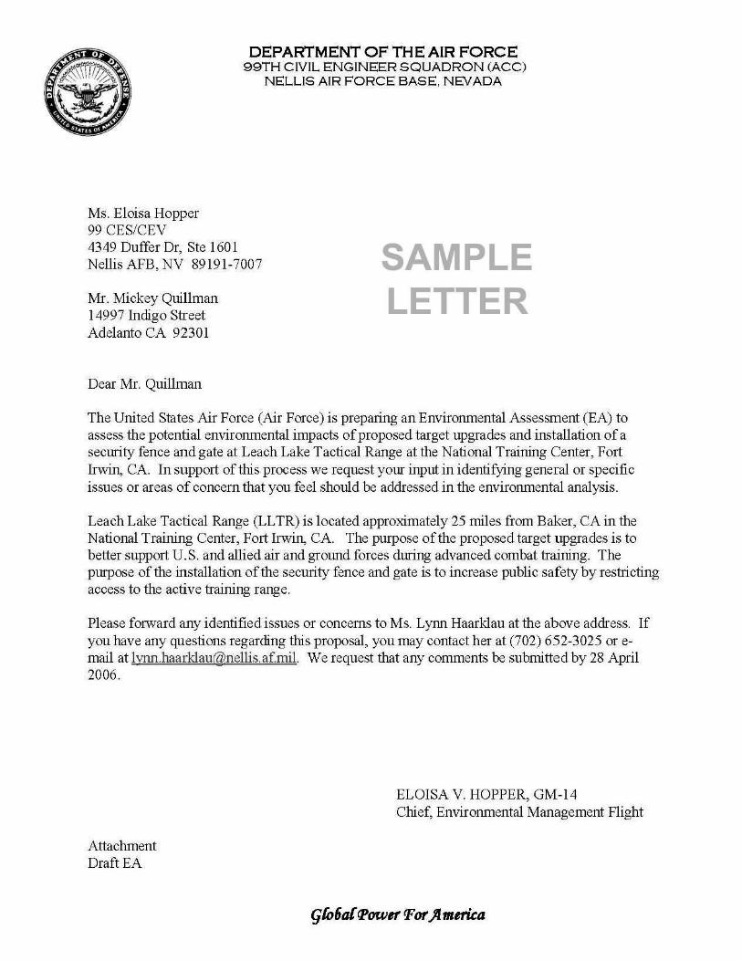
Ms. Eloisa Hopper 99 CES/CEV
DEPARTMENT OF THE AIR FORCE 99TH CIVIL ENGINEER SQUADRON (ACC)
NELLIS AIR FORCE BASE. NEVADA
4349 Duffer Dr, Ste 160 1 Nellis AFB, NV 89191-7007 SAMPLE
LETTER Mr. Mickey Quillman 14997 Indigo Street Adelanto CA 92301
Dear Mr. Quillman
The United States Air Force (Air Force) is preparing an Environmental Assessment (EA) to assess the potential environmental impacts of proposed target upgrades and installation of a security fence and gate at Leach Lake Tactical Range at the National Training Center, Fort Irwin, CA. In support of this process we request your input in identifying general or specific issues or areas of concern that you feel should be addressed in the environmental analysis.
Leach Lake Tactical Range (LLTR) is located approximately 25 miles from Baker, CAin the National Training Center, Fort Irwin, CA. The purpose of the proposed target upgrades is to better support U.S. and allied air and ground forces during advanced combat training. The purpose of the installation of the security fence and gate is to increase public safety by restricting access to the active training range.
Please fmward any identified issues or concerns to Ms. Lynn Haarklau at the above address. If you have any questions regarding this proposal, you may contact her at (702) 652-3025 or email at [email protected]. We request that any comments be submitted by 28 April 2006.
Attachment DraftEA
ELOISA V. HOPPER, GM-14 Chief, Environmental Management Flight

Appendix B – Agency Consultations
94

United States Fish and Wildlife Service (USFWS)
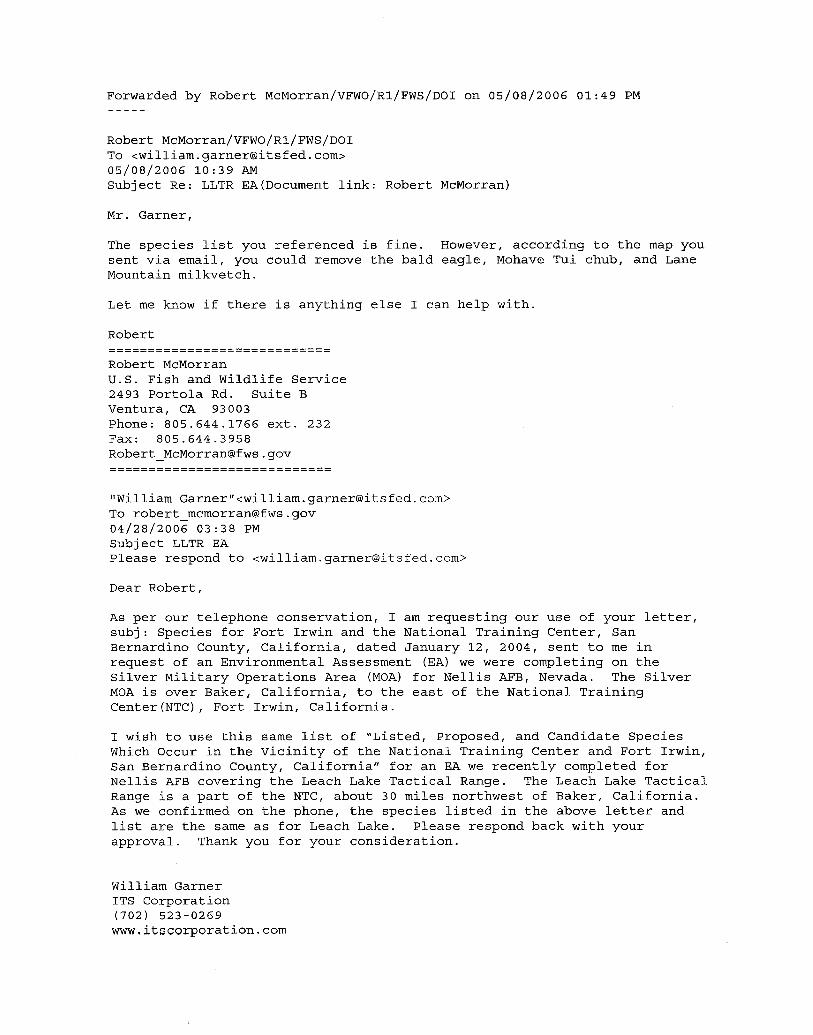
Forwarded by Robert McMorran/VFWO/R1/FWS/DOI on 05/08/2006 01:49 PM
Robert McMorran/VFWO/R1/FWS/DOI To <william.garner®itsfed.com> 05/08/2006 10:39 AM Subject Re: LLTR EA(Document link: Robert McMorran)
Mr. Garner,
The species list you referenced is fine. However, according to the map you sent via email, you could remove the bald eagle, Mohave Tui chub, and Lane Mountain milkvetch.
Let me know if there is anything else I can help with.
Robert ============================ Robert McMorran U.S. Fish and Wildlife Service 2493 Portola Rd. Suite B Ventura, CA 93003 Phone: 805.644.1766 ext. 232 Fax: 805.644.3958 Robert_McMorran®fws.gov ============================
"William Garner"<william.garner®itsfed.com> To robert_mcmorran®fws.gov 04/28/2006 03:38PM Subject LLTR EA Please respond to <William.garner®itsfed.com>
Dear Robert,
As per our telephone conservation, I am requesting our use of your letter, subj: Species for Fort Irwin and the National Training Center, San Bernardino County, California, dated January 12, 2004, sent to me in request of an Environmental Assessment (EA) we were completing on the Silver Military Operations Area (MOA) for Nellis AFB, Nevada. The Silver MOA is over Baker, California, to the east of the National Training Center(NTC), Fort Irwin, California.
I wish to use this same list of "Listed, Proposed, and Candidate Species Which Occur in the Vicinity of the National Training Center and Fort Irwin, San Bernardino County, California" for an EA we recently completed for Nellis AFB covering the Leach Lake Tactical Range. The Leach Lake Tactical Range is a part of the NTC, about 30 miles northwest of Baker, California. As we confirmed on the phone, the species listed in the above letter and list are the same as for Leach Lake. Please respond back with your approval. Thank you for your consideration.
William Garner ITS Corporation (702) 523-0269 www.itscorporation.com
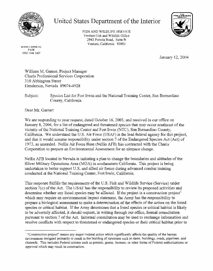
u.s. FISH & WILDLIFE
SERVICE
United States Department of the Interior
~ IN REPLY REFER TO:
PAS# 1002.1106.1467
FISH AND WILDLIFE SERVICE Ventura Fish and Wildlife Office
2943 Portola Road, Suite 8 Ventura, California 93003
William M. Garner, Project Manager Charis Professional Services Corporation 310 Abbington Street Henderson, Nevada 89074-4928
~OI!'"'"tlll'
January 12, 2004
Subject: Species List for Fort Irwin and the National Training Center, San Bernardino County, California
Dear Mr. Garner:
We are responding to your request, dated October 16, 2003, and received in our office on January 8, 2004, for a list of endangered and threatened species that may occur southeast of the vicinity of the National Training Center and Fort Irwin (NTC), San Bernardino County, California. We understand the U.S. Air Force (USAF) is the lead federal agency for this project, and that it would assume responsibility under section 7 of the Endangered Species Act (Act) of 1973, as amended. Nellis Air Force Base (Nellis AFB) has contracted with the Charis Corporation to prepare an Environmental Assessment for an airspace change.
Nellis AFB located in Nevada is initiating a plan to change the boundaries and altitudes of the Silver Military Operations Area (MOA) in southeastern California. This project is being undertaken to better support U.S. and allied air forces during advanced combat training conducted at the National Training Center, Fort Irwin, California.
This response fulfills the requirements ofthe U.S. Fish and Wildlife Service (Service) under section 7(c) of the Act. The USAF has the responsibility to review its proposed activities and determine whether any listed species may be affected. If the project is a construction project' which may require an environmental impact statement, the Army has the responsibility to prepare a biological assessment to make a determination of the effects of the action on the listed species or critical habitat. If the Army determines that a listed species or critical habitat is likely to be adversely affected, it should request, in writing through our office, formal consultation pursuant to section 7 of the Act. Informal consultation may be used to exchange i!l_formation and resolve conflicts with respect to threatened or endangered species or their critical habitat prior to
1 "Construction project" means any major Federal action which significantly affects the quality of the human environment designed primarily to result in the building of structures such as dams, buildings, roads, pipelines, and channels. This includes Federal actions such as permits, grants, licenses, or other forms of Federal authorizations or approval which may result in construction.

William M. Garner
a written request for formal consultation. During this review process, the Army may engage in planning efforts but may not make any irreversible commitment of resources. Such a commitment could constitute a violation of section 7 (d) of the Act.
2
Federal agencies are required to confer with the Service, pursuant to section 7(a)(4) of the Act, when an agency action is likely to jeopardize the continued existence of any proposed species or result in the destruction or adverse modification of proposed critical habitat (50 CFR 402.10(a)). A request for formal conference must be in writing and should include the same information that would be provided for a request for formal consultation. Conferences can also include discussions between the Service and the Federal agency to identify and resolve potential conflicts between an action and proposed species or proposed critical habitat early in the decision-making process. The Service recommends ways to minimize or avoid adverse effects of the action. These recommendations are advisory because the jeopardy prohibition of section 7(a)(2) of the Act does not apply until the species is listed or the proposed critical habitat is designated. The conference process fulfills the need to inform Federal agencies of possible steps that an agency might take at an early stage to adjust its actions to avoid jeopardizing a proposed species.
The Migratory Bird Treaty Act (16 U.S.C. 703-712) prohibits the taking, killing, possession, transportation, and importation of migratory birds, their eggs, parts, and nests, except when specifically authorized by the Department of the Interior. While the Act has no provision for allowing unauthorized take, it must be recognized that some birds may be killed at structures such as communications towers even if all reasonable measures to avoid it are implemented. The Service's Division of Law Enforcement carries out its mission to protect migratory birds not only through investigations and enforcement, but also through fostering relationships with individuals and industries that proactively seek to eliminate their impacts on migratory birds. While it is not possible under the Act to absolve individuals or companies from liability if they follow these recommended guidelines, the Division of Law Enforcement and Department of Justice have used enforcement and prosecutorial discretion in the past regarding individuals or companies who have made good faith efforts to avoid the take of migratory birds.
Candidate species are those species presently under review by the Service for consideration for federal listing. Candidate species should be considered in the planning process because they may become listed or proposed for listing prior to project completion. Preparation of a biological assessment, as described in section 7(c) of the Act, is not required for candidate species. If early evaluation of your project indicates that it is likely to affect a candidate species, you may wish to request technical assistance from this office.
The take of candidate species is not prohibited by the Act, however, we encourage you to consider their conservation in your planning process in the event they are listed prior to project completion. For information on other species of concern that may occur in the project area, the Service recommends that you review information in the California Department of Fish and Game's (CDFG) Natural Diversity Database and that you contact CDFG at (916)324-3812.
William M. Garner
If you have any questions regarding this letter, please contact Robert McMorran of my staff at (805) 644-1766.
Enclosure
Sincerely,
~!:J~ Judy Hohman Division Chief Mojave/Great Basin Desert
3
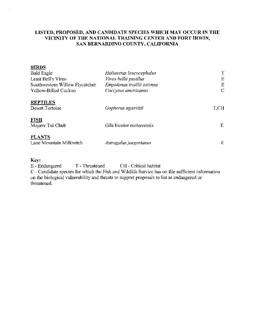
LISTED, PROPOSED, AND CANDIDATE SPECIES WIDCH MAY OCCUR IN THE VICINITY OF THE NATIONAL TRAINING CENTER AND FORT IRWIN,
SAN BERNARDINO COUNTY, CALIFORNIA
BIRDS Bald Eagle Haliaeetus leucocephalus Least Bell's Vireo Vireo bellii pusillus Southwestern Willow Flycatcher Empidonax traillii extimus Yellow-Billed Cuckoo Coccyzus americanus
REPTILES
T E E c
Desert Tortoise Gopherus agassizii T,CH
FISH Mojave Tui Chub Gila bicolor mohavensis
PLANTS Lane Mountain Milkvetch Astragalus j ae gerianus
Key: E - Endangered T - Threatened CH - Critical habitat C - Candidate species for which the Fish and Wildlife Service has on file sufficient information on the biological vulnerability and threats to support proposals to list as endangered or threatened.
E
E

California State Historic Preservation Office (SHPO)
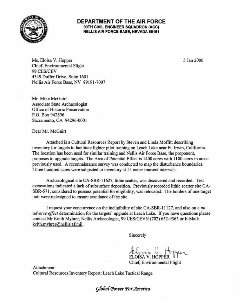
DEPARTMENT OF THE AIR FORCE 99TH CIVIL ENGINEER SQUADRON (ACC) NELLIS AIR FORCE BASE, NEVADA 89191
Ms. Eloisa V. Hopper Chief, Environmental Flight 99CES/CEV 4349 Duffer Drive, Suite 1601 Nellis Air Force Base, NV 89191-7007
Mr. Mike McGuirt Associate State Archaeologist Office of Historic Preservation P.O. Box 942896 Sacramento, CA 94296-0001
Dear Mr. McGuirt
5 Jan 2006
Attached is a Cultural Resources Report by Steven and Linda Moffitt describing inventory for targets to facilitate fighter pilot training on Leach Lake near Ft. Irwin, California. The location has been used for similar training and Nellis Air Force Base, the proponent, proposes to upgrade targets. The Area of Potential Effect is 1400 acres with 1100 acres in areas previously used. A reconnaissance survey was conducted to map the disturbance boundaries. Three hundred acres were subjected to inventory at 15 meter transect intervals.
Archaeological site CA-SBR-11627, lithic scatter, was discovered and recorded. Test excavations indicated a lack of subsurface deposition. Previously recorded lithic scatter site CASBR-571, considered to possess potential for eligibility, was relocated. The borders of one target unit were redesigned to ensure avoidance of the site.
I request your concurrence on the ineligibility of site CA-SBR-11127, and also on a no adverse effect determination for the targets' upgrade at Leach Lake. If you have questions please contact Mr Keith Myhrer, Nellis Archaeologist, 99 CES/CEVN (702) 652-9365 or E-Mail: [email protected].
Sincerely
-U~ U , 14'""'-.. ELOISA V. HOPPfR" (fr-Chief, Environmental Flight
Attachment: Cultural Resources Inventory Report: Leach Lake Tactical Range
qliJ6a{ q>ower Por ~merica
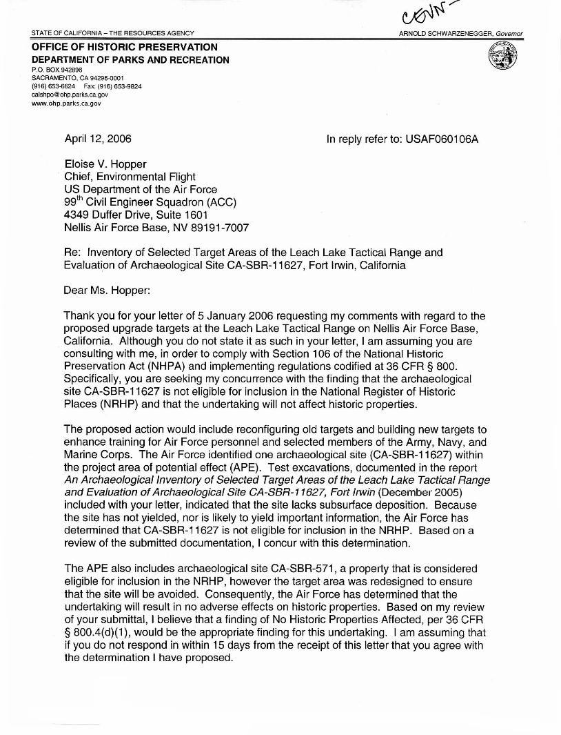
STATE OF CALIFORNIA- THE RESOURCES AGENCY
OFFICE OF HISTORIC PRESERVATION DEPARTMENT OF PARKS AND RECREATION P.O. BOX 942896 SACRAMENTO, CA 94296-0001 (916) 653-6624 Fax: (91 6) 653-9824 [email protected] www.ohp.parks .ca.gov
April 12, 2006
Eloise V. Hopper Chief, Environmental Flight US Department of the Air Force 99th Civil Engineer Squadron (ACC) 4349 Duffer Drive, Suite 1601 Nellis Air Force Base, NV 89191-7007
In reply refer to: USAF0601 06A
Re: Inventory of Selected Target Areas of the Leach Lake Tactical Range and Evaluation of Archaeological Site CA-SBR-11627, Fort Irwin, California
Dear Ms. Hopper:
Thank you for your letter of 5 January 2006 requesting my comments with regard to the proposed upgrade targets at the Leach Lake Tactical Range on Nellis Air Force Base, California. Although you do not state it as such in your letter, I am assuming you are consulting with me, in order to comply with Section 1 06 of the National Historic Preservation Act (NHPA) and implementing regulations codified at 36 CFR § 800. Specifically, you are seeking my concurrence with the finding that the archaeological site CA-SBR-11627 is not eligible for inclusion in the National Register of Historic Places (NRHP) and that the undertaking will not affect historic properties.
The proposed action would include reconfiguring old targets and building new targets to enhance training for Air Force personnel and selected members of the Army, Navy, and Marine Corps. The Air Force identified one archaeological site (CA-SBR-11627) within the project area of potential effect (APE). Test excavations, documented in the report An Archaeological Inventory of Selected Target Areas of the Leach Lake Tactical Range and Evaluation of Archaeological Site CA-SBR-11627, Fort IIWin (December 2005) included with your letter, indicated that the site lacks subsurface deposition. Because the site has not yielded, nor is likely to yield important information, the Air Force has determined that CA-SBR-11627 is not eligible for inclusion in the NRHP. Based on a review of the submitted documentation, I concur with this determination.
The APE also includes archaeological site CA-SBR-571, a property that is considered eligible for inclusion in the NRHP, however the target area was redesigned to ensure that the site will be avoided. Consequently, the Air Force has determined that the undertaking will result in no adverse effects on historic properties. Based on my review of your submittal, I believe that a finding of No Historic Properties Affected, per 36 CFR § 800.4(d)(1) , would be the appropriate finding for this undertaking. I am assuming that if you do not respond in within 15 days from the receipt of this letter that you agree with the determination I have proposed.
ELOISE V. HOPPER APRIL 12, 2006 2 of 2
USAF0601 06A
Thank you for seeking my comments and considering historic properties as part of your project planning. If you have any questions or concerns, please contact David Byrd, Project Review Unit historian, at (916) 653-9019 or at dbyrd @ca.parks.gov.
Sincerely,
Milford Wayne Donaldson, FAIA State Historic Preservation Officer
MWD:db

California Department of Fish and Game (CDFG)

-----Original Message----From: Becky Jones [mailto:[email protected]] Sent: Wednesday, May 10, 2006 2:36PM To: [email protected] Subject: Re: Ll TR EA
Hi William,
The following is correct, with the addition of the burrowing owl.
Becky Jones CDFG
William Garner wrote:
Dear Rebecca,
As per our telephone conservation, I am requesting our use of your letter, subj: Nellis AFB, Silver Military Operations Area, dated December 12, 2003, sent to me in request for an Environmental Assessment (EA) we were completing on the Silver Military Operations Area (MOA) for Nellis AFB, Nevada. The Silver MOA is over Baker, California, to the east of the National Training Center (NTC), Fort Irwin, California.
I wish to use this same list of California listed threatened, endangered, and sensitive species for an EA we are completing for Nellis AFB covering the Leach lake Tactical Range. The Leach Lake Tactical Range is a part of the NTC, about 30 miles northwest of Baker, California. As we confirmed on the phone, the species listed in the above letter and list are the same as for leach lake with the exception of the burrowing owl-as directed, we will add the burrowing owl to the list. Please respond back with your approval. Thank you for your consideration.
William Gamer ITS Corporation (702) 523-0269 www.itscorporation.com
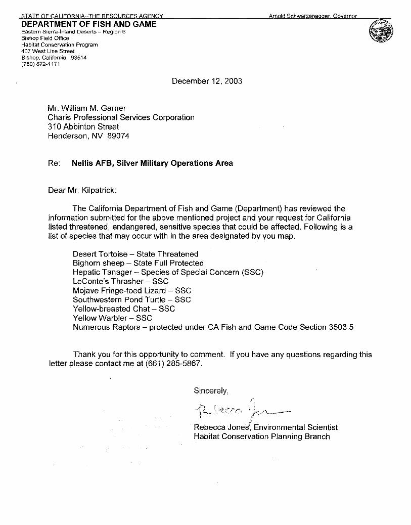
DEPARTMENT OF FISH AND GAME Eastern Sierra-Inland Deserts - Region 6 Bishop Field Office Habitat Conservation Program 407 West Line Street Bishop, California 93514 (760) 872-1171
December 12, 2003
Mr. William M. Garner Charis Professional Services Corporation 31 0 Abbinton Street Henderson, NV 8907 4
Re: Nellis AFB, Silver Military Operations Area
Dear Mr. Kilpatrick:
The California Department of Fish and Game (Department) has reviewed the information submitted for the above mentioned project and your request for California listed threatened, endangered, sensitive species that could be affected. Following is a list of species that may occur with in the area designated by you map.
Desert Tortoise - State Threatened Bighorn sheep- State Fuil Protected Hepatic Tanager- Species of Special Concern (SSC) LeConte's Thrasher- SSG Mojave Fringe-toed Lizard- SSC Southwestern Pond Turtle - SSC Yellow-breasted Chat- SSG Yellow Warbler- SSG Numerous Raptors - protected under CA Fish and Game Code Section 3503.5
Thank you for this opportunity to comment. If you have any questions regarding this letter please contact me at (661) 285-5867.
Sincerely,
· Rebecca Jones:· Environmental Scientist Habitat Conservation Planning Branch

Appendix C – Notice of Availability, Comments, and Responses to the Draft EA
106
spatch, Barstow,. Calif. DESERT LIFE Tuesday, March 28, 2006 · PAGE AS
Noteworthy events · in the Barstow area
~-- "'x~'Zi!Q ""' ,.,~,.~mn~l'lllli""''Otmlr--T-·a:m:w-ooa-.~:ir\iiiificlisse-s.-· · -·--Cii'w:ar-··~·«·~:-·-~·-----·~·--·-·-__,.,._-i, tion, call Patt Rees at 252·2880 nator, at 909-228-8823 or check Friendsofth&Library P-raise Tuesday. Praise ~t or the mruieum at256-5'452. the website at www.main- Book sale, 50 cents for hard singing at 6:30 p.m.l301 E. Mt. n streetmurals. backs and 25 cents for paper· View. 256-1624.
~: Mojave Rlver~valley :t Museum to hold '· monthly mee~inq . r. · BARS'l'OW.-,-.. Linda Slater
will be_ presenting a "Tour of Cultural Sites in the M9jave
· · Nation& PreserVe'' on WedneS'· day. at 7:30 p;m; ;Eillda iS a Park ranger in education and out
t reach at the MojavE(Natiorial '11 . Preserve. She works on exhibit. ~ pl~ing,. is the editor of the
parlt newspaper, maintains -the 5. park website, and .presents ed-1 ucation .programs at the Desert
DiscoverY'. Cent~r. r For more information! call s 256-5~52.
l ·-
7 Chile cook~off and Sal· " ·sa/CumbiaFestiVal ;· BARSTOW ~ The Barstow
Hispanic Ch~mber of Com~ • merce in conjunction. with 95.9 ~ El Portal will present its annut al New Mexico .. Chile cook-off ; and Salsa/Cumbia · 'Festivai on • :April 8 at Dana Park from. > noon to 6 p.m. Participants are
needed and can win · cash prizes for the best New Mexico chile.
Also vendors and non-profit civic groups · interested in' showcasing their goods or products should contact Jeanett at 256-2l21 or 241-4759. Space is limited., -..
0 -..... ~dy? t
·. '·' . ,· ' . ,, . ' . . : Nellis Air Force Base Invites J'ublic Comments on the Di'qft Environmental Assessmentfor
Target Upgrades on Leach Lake Tacticid Range at theNationaiTrainlng Cente~; Fort Irwin, CA ' •• .' > • •
Nellis Air Force. Base (AFB) announces the availability of a draft Environmental Assessment (EA) to reconfigure and/or rebuild current targets and build new targets on Leach Lake Thctical Range at the National'D:aining Center (NTC), Fort Irwin, California. The Air Force proposes to reconfi~e. rebuild, and/or build new targets on Leach Lake Thctical Range to enhance realistic training for air liaison officers, forward air,controlleril-airborne, tactical air control parties. special tactics team members, and selected Army, Navy, andMarine Corps members. The Leach Lake TactiCal Range is a part of the NTC. . . .. . , .
. You may view the· .draft EAand draft Finding of No Significant Impact (FONSI) at www.nellis.af.mil/pa or request a copy from the address below. ·Copies are also available for review at the Barstow Public Ubrary, 204 East Buena Vista Street, Barstow CA, and the Baker Community Center, 56725 Park Avenue, Baker CA. Please provide any comments on the draft · EA by April28, 2006 to: ,
Mr. Mike Estrada 99th Air Base Wing/Office ofPubJie Affairs (99ABWIPA)
4430 Grissoin Ave., Suite 107, Nellis AFB, NV. 89191 For general inforniation, contacfMr. Estrada at: . (702)652-2750
PRESENTS YOUi BE THE JUDGE BY ELISSA BERNSTEIN
. How Could You Drug Your Baby? Josie cruised the stre~ in her $ix-iJICh heels and a A month later, Josie had some wonderful news. "I'm
. · fake fur coat. She tried to tempt the male drivers. pregnant." Craig approached her. He had noticed her~. Craig was thrilled. "Hey gorgeous! How about a little action But Josie couldn't beat the heroin. tonight?" Josie grinned. She gave birth to a sick little boy.'· Craig had something else in mind. The doctor scowled. "Your' baby is drug "Actually. I was wondering if you'd like tO addicted. I'm calling social services." · talk ••• " · Josie was charged With child abu~ "This isO't a chatroom;• Josie barked. "I'm working." Some~ow, Craig convinced her.to join .. ·· her at the neighborhood diner. They talked for hours. Craig looked into Josil~'s eyes; "Can't you do something else with your life?" .
THECOU~OOM The prosecutor argued firmly. ''Josie took heroin, knowing she'd be harming
he( baby. We should have no pity tot her. Hold her accountable." .
"BASED t1NA.CTUA
COURT CASES!
Josie was beside herself, "I know that I have a problem. I tried so many times to stop, but I
simply can't. l never meant to harm my child, but my addiction is stronger then me. Please help!"
·Josie stormed to her feet. "Don't try to change me. Heroine and hooking are my life." Craig chased after her. "I know you can kick the . drugs. Let me help." "Why would you want a loser like me?" Josie turned Is Josie guilty of child abuse? You! Be The Judge. · to him, in tears. They fell in love and moved in tooether. Josie oot a
Arnold Schwarzenegger
Governor
Date:
To:
From:
Re:
S T AT E OF C A Ll F 0 R N I A
Governor's Office of Planning and Research
State Clearinghouse and Planning Unit
Memorandum
April 7, 2006
All Reviewing Agencies
Scott Morgan, Senior Planner
SCH # 2006044001
Target Upgrades on Leach Lake Tactical Range at the National Training Center, Fort Irwin, California
Sean Walsh · Director
The State Clearinghouse sent you the Notice of Completion for the above-referenced
project on April 3, 2006 but we did not provide a copy of the Negative Declaration.
Please accept the attached Neg Dec with the Notice of Completion attached. We
apologize for any inconvenience this may have caused.
cc: Lynn Haarklau U.S. Air Force, Nellis AFB 4349 Duffer Drive, Suite 1601 Nellis AFB, NV 89191-7007
1400 TENTH STREET P.O. BOX 3044 SACRAMENTO, CALIFORNIA 95812-3044 TEL (916) 445-0613 FAX (916) 323-3018 www,opr.ca.gov
Notice of Completion & Envltonmenlal Document Ttan51ftlltal "1'1"'·-- · M<rllto:SDI~Ocaringhowse.P.O. Bol'J044,Sacl'lmcnlo.CA9S812·3044~16)44S~I![• · 2 0 0 6 0 44 Q 0 i Fol'lltmd~~Atltlret•: IAOOTCIIIkS!reet.SicDrnento.CA9SII4 L t • •
ProJect ntre: Tqet Upgrades on Leach lake Taclcal R!!!A! at lhe Naions T ~ Oenter, Fort Irwin, Calfomia leo<! "fC"CY' u.s. M Force,.Neii AFB . COIIIKI ,., oa: ~ ~ l:Y!!!..~rn:..:Haarideu==:...._ ___ _ llfailins Addrta: 4349 DUffer DfiV&, Suli! 1601 Ploooe: . (1)2) ~'30=25::._ ____ _ c~~y: Ne1is AFB, NV _ lip: 89191-7007 c..un~y: ']! !.iC _ ProfKt Locellon:
C.-y: San.;;Bemardino~=:..:!..------- City!N- c-...1: Baker, CA ·- _ c,_ 51m:u: NIA Zip C<>4c: .=923~1~0--::-......._.. Pon:d No.: NIA ~ T-: 17N & 1f ~ JUo ; 2E& 3E Base: Slllllemnno W~hln 2 Mil .. : s-=K:...:. .. -1-~~:'. NI.,..'A _____ w-,.: NIA
_ ---- ~~=·.: ~Nl=A===:::==...:k•:;ilwty$:~:0:· ¥.Nl~IA'::-F-'i=t-:=-=:=.:.s ;~-;, :tV<.~.:.:~_-_-_-_-_-_-_-_-_ RECEIVED
CEQA: C NOP (] Dnft I!JR NE 1\' (] NOI 0 Early Cons 0 Supplcnlc ""' 3 0 200f II EA 0 Nes Dec (!'rio<' SCH t o .) tA:f\teW:: \~ 0 Drill "El!
(" ~= 0 Joint Document 0 Final Ooculncnt 0 Other ______ _
0 Mit Nc~Dcc 0 0t11cr . '"USE Ill FONST ______________ ,,;u';:..!,~:O::':!..---- ~------·
Local Aclloft TJPe:
0 <"ocnenl ,.., Updose (] Spccifoc: Pl.. 0 .RC20<1C 0 A.nn<xotioa 0 Cicncoal Plan Anu•n<lmcnl [J l\4aslco l'lln C Poctot>c 0 ~lopmctll 0 GC~~eral Plan Elcracat C 1'11nnc4 Unit Dcvelo!>menl 0 ll_le hnnit 0 c~-.1 Perra it 0 COIIIUIUJ\lty Plan (] Silt Plan 0 lAnd OmJi~>~~ (Sob< ivislm , . :c.) 1!1 Otbcr 0a0 don
De~TrJ~e: CA~: Un~ A~ C Office: Sq.tt_ Acres __ F..mploy=~-0 CfM1JII>Crdl1: liq.ft __ /v:re$ __ &n,loyccc __
lJWat.,.Focilitiu: l ~pc-· _____ MOD __ _
0 T<I<ISpONtion: 1 ~""- _ - - -------0 Mlniftc: l !.clcnl
C hiCII>$Uill: Sq.ft. -- Acn:s __ Emplo)'Cts __ OEcluc.tioMI
0 p.,_,.: Jrp: __ ---- MW __ _
0 llccreadon.l --:------------
ow- TJatmcDt: 1 rP'_ _ _ ____ MGD __ _
Toc.l .A<rH (app<ox.), _____ _ 0 HtatdoesWIAO: ·~-. --------•Otbcr.I@IIYTII!I!! ~ ··-------------------------------------------------Prot-Is-Dl-sed In Doc:urn.nt:
0 AcaheticiVIsual 0 Fbal C lltcreationll'llfb C A&~ Lond C Flood Pbin1Floo4in(! 0 Schoo1A/'Ufti-$ilic• II A it" Qualky Ill Fomt Lanci/Fioc Huard 0 Sepio: SJJ~=J
II Vqetalion !I Woter Qutliry
• M:beoJosicaiiHistoril • Gc:>olocicJSciomi< 0 s..-Capecicy II BioiOiical Res-= C Min<nb II Soil Eroslon/Compeaioe.' iradin : 0 C-1 Zone • No$ II Solie! Wam
J WolCI' SUJlllly/Ground'Mter J Wdlmdlllipcrioll II Wildlife
II ~AbscxptiM IJ Populotion/H~ Dabnc:c II Tozic:Muwdau.< 0 t""""""ic:/Jobs 0 Pllblic: S...Vi<e$/Faeilidcs 0 Trsff...Orallotion
J GroW1h Inducing !I I.AindUse e Cumohothle ara .. J Other -------------------------------l'rHent Lend u.e.llonlllv/Ce.-.1 Plen Deelpellon:
~.!<!!!!.~~-------------------- -------------Profecl o.ec:riptlon' (plene ,_ • $0pBI"IJI• fHif1e it~)
liM USAF il ... AFB, Nevada~~ to LW3c1e IQaiC"" l..udll.ake Tadlcal ~to on11ante "ablic r. ling for air lioiocn ~ 101WM1 at.~ l8cllc:8l elr *"d padies, Sflecirallactlc:s Teem,...._, and MfiUed Army, Navy and""*' Ca-ps membels. The INIIIIc n;Mg fndudls Idea, *"t~ and IJIOQidUIM in ~. ~. c:ooniNinO,Ind conrdlhg rlose at. SII(IIIOII II file lactlcaii!Vtl. Upgt"ade acllans W!Uf intWII ~ Mdlar leliulclng cwm ~ and t.M~g -lai!Jel!. The USAF .po propes 10 COII!INd a 500-lcollong '-- en IIGdlaldt d hll!llllno OM Spring~ fen!llllld gale, and instil ~ bcuolllry~ •to In 31 : til! MM1J and l)ldc sallly.
State Oearinghouse Contact:
State Review Began:
SOl COMPLIANCE
(916) 445-061 3
_1_-..l.-2006
Please note State Clearinghouse Number (SCH#) on all Comments
SCH#: _2-:--:--0 _0 _6 _0-:-4-::-4-:0:-Q:-1 Pl~se ferwanl late coDUJOeall direclly to the L~dAgeney
AQMDIAPCD 33(!U.
(Resources: ~_1_L
Project Sent to the foUowing State Agencies
_lL_ ResourttS Boating & Watei'Wiys
--Coastal Comm
Colorado R'T Bd .....:£..._ Conservation _JL Fish & Game#~
Delta Protection Conm = Forestry & Fire Prot _.l(_ Historic Preservation _x_ Parks & Rec
Reclamation Board
__ Bay Cons & Dev Co:rmn
XDWR ....:::L OES (Emergency Svcs)
Bas Transp Boas Aeronautics
----y:- CHP
_JLCaltraiiS#..!}_ _ _ Trans Plarming
Housing & Com Dev - - Food & Agriculture - - Health Services
State/Consumer Svcs General Services
Cal EPA ARB- Airport Projects
=ARB - Transportation Projects _ _ ARB- Major Industrial Proje~ts ~Integrated Waste Mgmt Bd
SWRCB: Clean Wtr J>rog = SWRCB: Wtr Quality SWRCB: Wtr Rights
X Reg. WQCB # J,Y_ _.L Toxic Sub Ctri-CfC
Yth/Adlt Correc:tions Conections
Independent Comm Energy Coounission
__x_NAHC Public Utilities Comm State Lands Comm
= Tahoe Rgl Plan Agency
Conservancy
Other: - - - --
Arnold Schwarzenegger Governor
May3, 2006
Lynn Haarklau U.S. Air Force
S T A T E OF C A L I F 0 R N I A
Governor's Office of Planning and Research
State Clearinghouse and Planning Unit
4349 Duffer Drive, Suite 1601 Nellis AFB, NV 89-191-7007
Sean Walsh Director
Subject: Target Upgrades on Leach Lake Tactical Range at the National Training Center, Fort Irwin, California SCH#: 200604400 l
Dear Lynn Haarklau:
The State Clearinghouse submitted the above named Joint Document to selected state agencies for review. The review period closed on May 2, 2006, and no state agencies submitted comments by that date. This letter acknowledges that you have complied with the State Clearinghouse review requirements for draft environmental documents, pursuant to the California Environmental Quality Act.
Please call the State Clearinghouse at (916) 445-0613 if you have any questions regarding the environmental review process. If you have a question about the above-named project, please refer to the ten-digit State Clearinghouse number when contacting this office.
Sincerely,
~0~ Director, State Clearinghouse
1400 TENTH STREET P.O. BOX 3044 SACRAMENTO, CALIFORNIA 95812-3044 TEL (916) 445-0613 FAX (916) 323-3018 www.opr.ca.gov
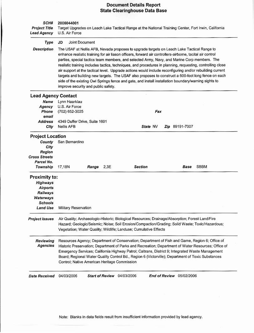
2006044001
Document Details Report State Clearinghouse Data Base
SCH# Project Title
Lead Agency Target Upgrades on Leach Lake Tactical Range at the National Training Center, Fort Irwin, California U.S. Air Force
Type JD Joint Document
Description The USAF at Nellis AFB, Nevada proposes to upgrade targets on Leach Lake Tactical Range to
enhance realistic training for air liason officers, forward air controllers-airborne, tacital air control
parties, special tactics team members, and selected Army, Navy, and Marine Corp members. The
realistic training includes tactics, techniques, and p.rocedures in planning , requesting, controlling close
air support at the tactical level. Upgrade actions would include reconfiguring and/or rebuilding current
targets and building new targets. The USAF also proposes to construct a 500-foot long fence on each
side of the existing Owl Springs fence and gate, and install installation boundary/warning sights to
improve security and public safety.
Lead Agency Contact Lynn Haarklau U.S. Air Force (702) 652-3025
Name Agency
Phone email
Address City
4349 Duffer Drive, Suite 1601 Nellis AFB
Project Location County San Bernardino
City Region
Cross Streets Parcel No. Township 17,18N
Proximity to: Highways
Airports Railways
Waterways Schools
Range 2,3E
Land Use Military Reservation
Fax
State NV Zip 89191-7007
Section Base SBBM
Project Issues Air Quality; Archaeologic-Historic; Biological Resources; Drainage/Absorption; Forest Land/Fire
Hazard; Geologic/Seismic; Noise; Soil Erosion/Compaction/Grading ; Solid Waste; Toxic/Hazardous;
Vegetation; Water Quality; Wildlife; Landuse; Cumulative Effects
Reviewing Resources Agency; Department of Conservation; Department of Fish and Game, Region 6; Office of
Agencies Historic Preservation; Department of Parks and Recreation; Department of Water Resources; Office of
Emergency Services; California Highway Patrol; Caltrans, District 9; Integrated Waste Management
Board; Regional Water Quality Control Bd., Region 6 (Victorville); Department of Toxic Substances
Control; Native American Heritage Commission
Date Received 04/03/2006 Start of Review 04/03/2006 End of Review 05/02/2006
Note: Blanks in data fields result from insufficient information provided by lead agency.
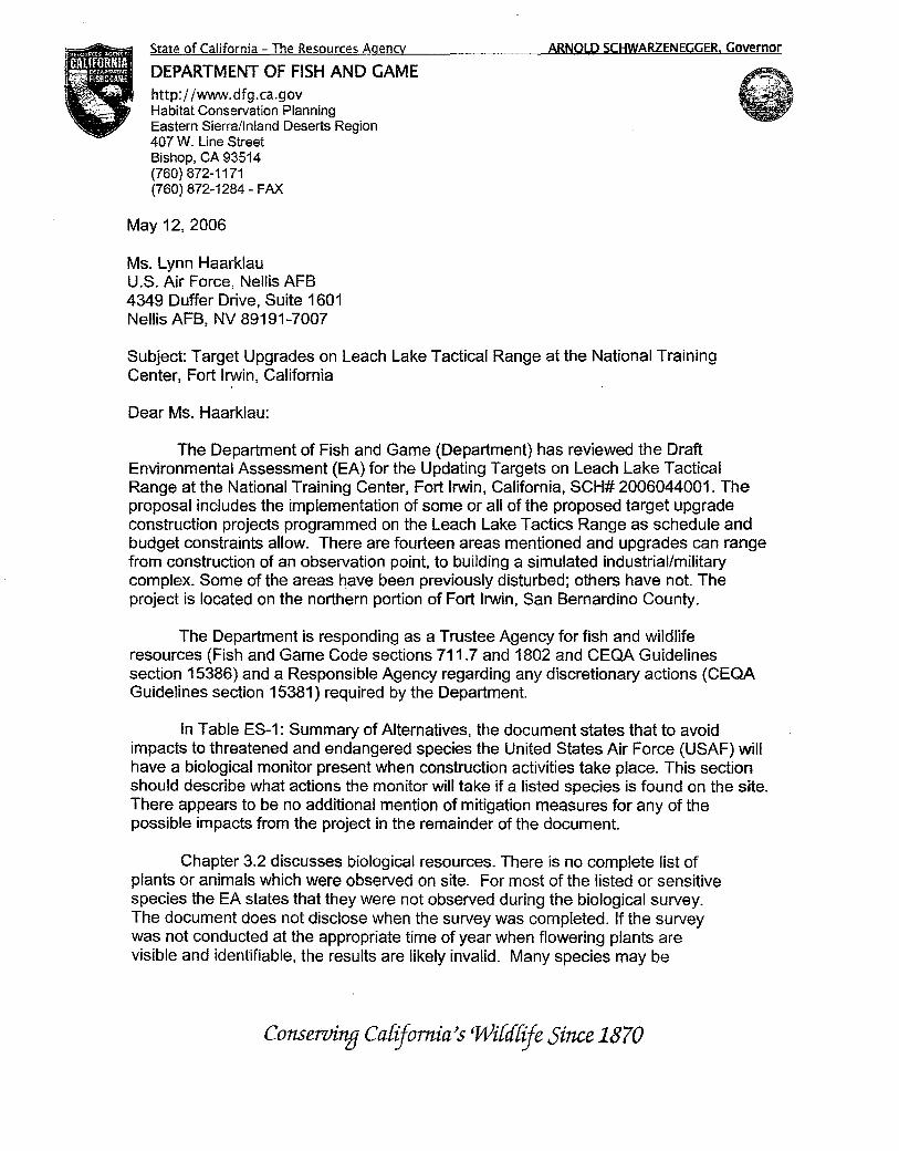
State of California - The Resources Agency
DEPARTMENT OF FISH AND GAME http://www.dfg.ca.gov Habitat Conservation Planning Eastern Sierra/Inland Deserts Region 407 W. Line Street Bishop, CA 93514 (760) 872-1171 (760) 872-1284- FAX
May 12,2006
Ms. Lynn Haarklau U.S. Air Force, Nellis AFB 4349 Duffer Drive, Suite 1601 Nellis AFB, NV 89191-7007
ARNOLD SCHWARZENEGGER. Governor
Subject: Target Upgrades on Leach Lake Tactical Range at the National Training Center, Fort Irwin, California
Dear Ms. Haarklau:
The Department of Fish and Game (Department) has reviewed the Draft Environmental Assessment (EA) for the Updating Targets on Leach Lake Tactical Range at the National Training Center, Fort Irwin, California, SCH# 2006044001. The proposal includes the implementation of some or all of the proposed target upgrade construction projects programmed on the Leach Lake Tactics Range as schedule and budget constraints allow. There are fourteen areas mentioned and upgrades can range from construction of an observation point, to building a simulated industrial/military complex. Some of the areas have been previously disturbed; others have not. The project is located on the northern portion of Fort Irwin, San Bernardino County.
The Department is responding as a Trustee Agency for fish and wildlife resources (Fish and Game Code sections 711.7 and 1802 and CEQA Guidelines section 15386) and a Responsible Agency regarding any discretionary actions (CEQA Guidelines section 15381) required by the Department.
In Table ES-1: Summary of Alternatives, the document states that to avoid impacts to threatened and endangered species the United States Air Force (USAF) will have a biological monitor present when construction activities take place. This section should describe what actions the monitor will take if a listed species is found on the site. There appears to be no additional mention of mitigation measures for any of the possible impacts from the project in the remainder of the document.
Chapter 3.2 discusses biological resources. There is no complete list of plants or animals which were observed on site. For most of the listed or sensitive species the EA states that they were not observed during the biological survey. The document does not disclose when the survey was completed. If the survey was not conducted at the appropriate time of year when flowering plants are visible and identifiable, the results are likely invalid. Many species may be
Conserving Cafijomia's Wi[d[ije Since 1870

Ms. Lynn Haarklau May 12,2006 Page2
missed if surveys are conducted during inappropriate times of year. In addition, survey protocols should be followed. The document should disclose the survey methodology that was used, in order for reviewers to determine if appropriate protocols were used. A copy of the survey results should be included in the document.
Burrowing owl is known from other locations at Fort Irwin. Burrowing owl is a California Species of Special Concern, and individual owls and their burrows are also protected under Fish and Game Code Section 3503.5. This species was not discussed in the document. The document should discuss whether the species is present, and the amount of habitat which will be significantly impacted. Impacts to habitat must be mitigated with replacement habitat. Individual owls and their burrows may not be taken at any time. If individual owls will be impacted, the Department should be contacted to determine the most appropriate action.
There is no mention of how much habitat will be lost for species use. In Chapter 4, Section 4.1 -Air Quality it says that 216.1 acres will be graded. It was previously mentioned in the document that some of the area was disturbed and some was undisturbed. The amount of area with vegetation on it, that will be impacted should be listed in Section 4.2.
In closing, the additional information mentioned above should be included in the revised document. Thank you for this opportunity to comment. Questions regarding this letter and further coordination on these issues should be directed to Ms. Rebecca Jones, Environmental Scientist, at (661) 285-5867.
Sincerely,
-~ J L/7. /b~-0tZ!/ ~t&>:t~·
Denyse ~ine Senior Environmental Scientist
cc: Ms. Rebecca Jones, CDFG Mr. Ray Bransfield, USFWS State Clearinghouse Chron
Nellis AFB has made the changes to the document requested by the California Department of Fish and Game.
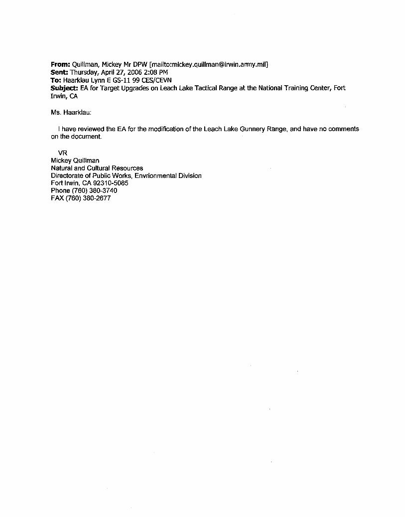
From: Quillman, Mickey Mr DPW [mailto:[email protected]] Sent: Thursday, April 27, 2006 2:08PM To: Haarklau LynnE GS-11 99 CES/CEVN Subject: EA for Target Upgrades on Leach Lake Tactical Range at the National Training Center, Fort Irwin, CA
Ms. Haarklau:
I have reviewed the EA for the modification of the Leach Lake Gunnery Range, and have no comments on the document.
VR Mickey Quillman Natural and Cultural Resources Directorate of Public Works, Envrionmental Division Fort Irwin, CA 92310-5085 Phone (760) 380-3740 FAX (760) 380-2677