far north coast region
TRANSCRIPT

NSW State of the Beaches 2011–2012: Far North Coast region Page 23
Far North Coast region
Councils The Far North Coast region of NSW extends from the Queensland border to Wooli in the south. Three local councils in this region participate in the Beachwatch Partnership Program (Figure 7):
Byron Shire Council
Ballina Shire Council
Richmond Valley Council
The programs Monitoring in the Far North Coast region is conducted under the Beachwatch Partnership Program. In 2011–2012, a total of 21 swimming locations were sampled (Table 10). Each council fully funded its sample collection and laboratory analysis, with quality assurance and reporting support provided by OEH.
Bryon Shire Council joined the Beachwatch Partnership Program in 2009. Eleven swimming
locations were monitored on a weekly basis from November 2011 to June 2012. Enterococci samples were collected between the flags at patrolled beaches and in the middle of the beach at unpatrolled beaches.
Ballina Shire Council has been a part of the Beachwatch Partnership Program since its inception in 2002 (as the Beachwatch Pilot Partnership Program). Enterococci samples were collected on a weekly basis during the four busiest months of the swimming season: November, December, January and February. Six sites were sampled during 2011–2012.
Richmond Valley Council joined the Beachwatch Partnership Program in 2006. Four swimming locations were monitored for enterococci on a weekly basis throughout 2011–2012.
To ensure that the data collected and reported under the Beachwatch Partnership Program are accurate and reliable, quality assurance of sampling, microbial analysis and reporting is undertaken. The findings of the quality assurance program are described in the quality assurance section of this report.
Table 10: Monitoring of Far North Coast swimming sites
Number of sites Organisation
Sampling frequency Ocean
beaches Ocean baths
Estuarine Lagoon/
lake Freshwater
river Total
Byron Shire Council Weekly (November to June)
9 – 2 – – 11
Ballina Shire Council Weekly (November to February)
3 – 2 1 – 6
Richmond Valley Council
Weekly (year-round)
3 – 1 – – 4

NSW State of the Beaches 2011–2012: Far North Coast region Page 24
Figure 7: Councils and sampling locations in the Far North Coast region

NSW State of the Beaches 2011–2012: Far North Coast region Page 25
2011–2012 results Of the 21 sites monitored on the Far North Coast, 19 were classified as Very Good or Good (Table 11).
Ocean beaches
Twelve of the 15 oceans beaches in the region were classified as Very Good:
The Strand, Belongil Beach, Main Beach (Byron Bay), Clarkes Beach, Wategos Beach, Tallow Beach (Byron Bay), Tallow Beach (Suffolk Park) and Broken Head in the Byron Shire Council area
Seven Mile Beach in the Ballina Shire Council area
Airforce Beach, Main Beach and Shark Bay in Richmond Valley Council area.
These sites have consistently good microbial water quality and very few potential sources of faecal contamination.
Three ocean beaches were rated as Good: South Beach (Brunswick Heads), Shelly Beach (Ballina) and Lighthouse Beach. Microbial water quality at these sites is suitable for swimming for most of the time, but may be susceptible to pollution from a number of potential sources of microbial contamination.
Estuarine
Three of the five estuarine swimming sites were classified as Good: Torakina Beach, The Serpentine and Evans River. Microbial water quality at these sites is suitable for swimming for most of the time, but may be susceptible to pollution from several potential sources of faecal contamination.
Simpsons Creek in the Byron Shire and Shaws Bay East in the Ballina Shire area were graded as Poor. Microbial water quality at Simpsons Creek was often unsuitable for swimming during dry and wet weather conditions. Shaws Bay East generally had good microbial water quality during dry weather conditions but was susceptible to faecal contamination following rainfall. It is recommended that swimming at these locations be avoided during and for up to three days following rainfall or if there are signs of stormwater such as discoloured water or odour or floating debris.
Lagoons
Lake Ainsworth West in the Ballina Shire was classified as Good. Microbial water quality at this site is suitable for swimming for most of the time, but may be susceptible to pollution from several potential sources of faecal contamination.

NSW State of the Beaches 2011–2012: Far North Coast region Page 26
Table 11: Beach Suitability Grades in the Far North Coast region, 2011–2012
Site Site type Sanitary
Inspection Category
Microbial Assessment
Category
Beach Suitability
Grade
The Strand Ocean beach Low Category A Very Good
Torakina Beach Estuarine Moderate Category B Good
Simpsons Creek Estuarine Moderate Category C Poor
South Beach (Brunswick Heads) Ocean beach Moderate Category A Good
Belongil Beach Ocean beach Low Category A Very Good
Main Beach (Byron Bay) Ocean beach Low Category A Very Good
Clarkes Beach Ocean beach Low Category A Very Good
Wategos Beach Ocean beach Low Category A Very Good
Tallow Beach (Byron Bay) Ocean beach Low Category A Very Good
Tallow Beach (Suffolk Park) Ocean beach Low Category A Very Good
Byr
on
Sh
ire
Co
un
cil
Broken Head Ocean beach Low Category A Very Good
Seven Mile Beach Ocean beach Low Category A Very Good
Lake Ainsworth West Lagoon/lake Moderate Category B Good
Shelly Beach Ocean beach Low Category B Good
Shaws Bay East Estuarine Moderate Category C Poor
The Serpentine Estuarine Moderate Category B Good
Bal
lin
a S
hir
e C
ou
nci
l
Lighthouse Beach Ocean beach Low Category B Good
Airforce Beach Ocean beach Low Category A Very Good
Main Beach Ocean beach Low Category A Very Good
Shark Bay Ocean beach Low Category A Very Good
Ric
hm
on
d V
alle
y C
ou
nci
l
Evans River Estuarine Moderate Category B Good
NSW State of the Beaches 2011–2012: Far North Coast region Page 27
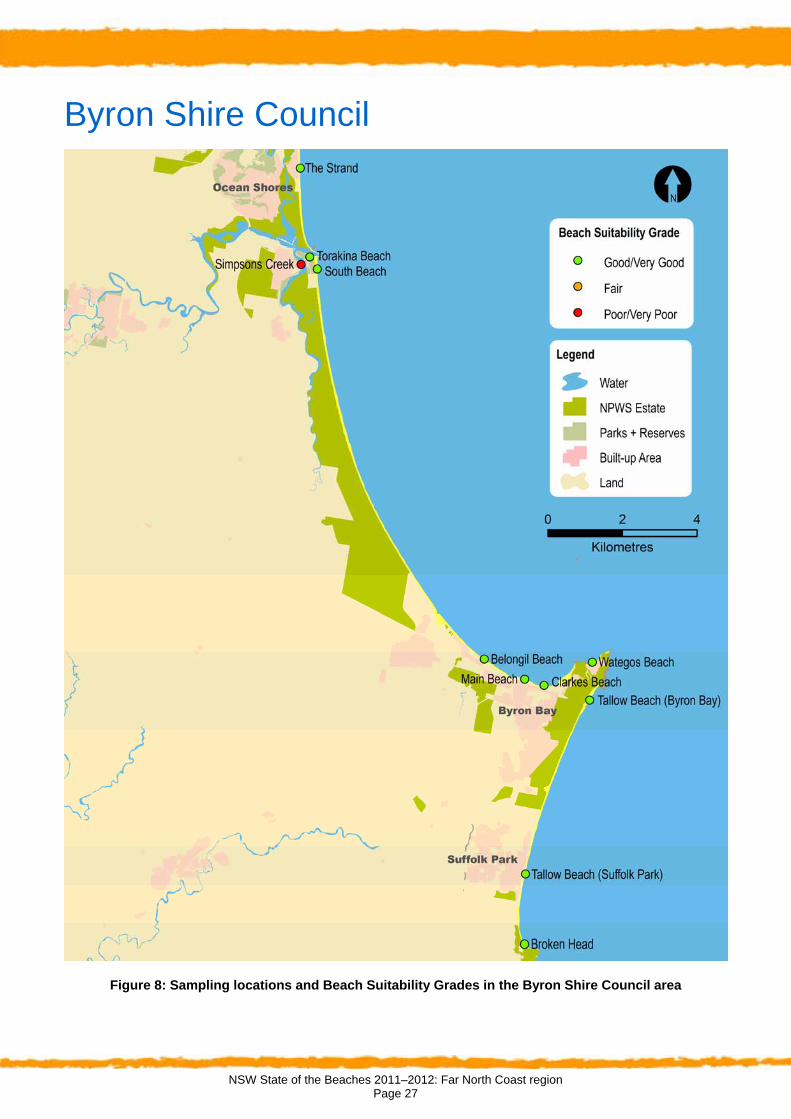
Byron Shire Council
Figure 8: Sampling locations and Beach Suitability Grades in the Byron Shire Council area

NSW State of the Beaches 2011–2012: Far North Coast region Page 28
Message from Byron Shire Council The Byron Shire coastline is much loved by residents and visitors and our beach culture is part of that attraction. Council recognises it is crucial to ensure that the quality of our water is of a high standard for the enjoyment and recreation of all who use it and with tourism being our major industry, it's also an important economic asset. In the late 1990’s, the community identified the need to improve the quality of our waterways by ensuring our infrastructure was not a polluting factor, affecting the health of humans and the natural environment. The development of high quality Sewage Treatment Plants for the Shire that featured wastewater management strategies, and incorporated environmental repair and recognition of important coastal habitats, were implemented. The result has delivered award winning outcomes and importantly our environment has benefited. The Tallow and Belongil Creeks in the south of the Shire and the Brunswick River and Simpsons Creek in the north, are now in a much better condition to ensure the health and wellbeing of the community, visitors and biodiversity. Simpsons Creek forms part of the Brunswick River system and in past years has received a poor Beachwatch rating, but with the new STP and environmental programs we look forward to the area being returned to an improved water quality. The Beachwatch Partnership program has been able to confirm that we are achieving our goals and monitor where we are able to improve our performance.
Overview of the area Description
Byron Shire is located on the Far North Coast of NSW and borders the Tweed, Lismore and Ballina local government areas. The shire is characterised by rugged topography, rising steeply to approximately 800 metres above sea level in the Koonyum Range. The shire covers around 556 square kilometres.
Byron Shire has an estimated local resident population of 29,209 at the 2011 Census (ABS 2012).Tourism increases the overnight population by an estimated average of 22 per cent.
The Byron Shire is one of the highest profile holiday destinations in Australia, and is well known both domestically and internationally. The area is famed for its rural beauty and its coastline and beaches. Tourism is the principal economic driver in the shire, followed by agriculture and associated value-added products, and the creative industries.
Rainfall
There were several significant rain and flooding events on the far north coast during 2011–2012 (BOM 2012):
In early December, a heavy rain event in northern NSW exacerbated existing flooding following November rain.
High rainfall in mid January was followed by a very significant rain event across northern NSW between the 23rd and 29th of January, with Byron Bay exceeding 94 mm of rainfall in one day. This triggered additional flooding in the northern rivers.
Heavy rainfall continued in northern NSW in early February, with continued flooding and associated poor water quality, particularly in lagoons and estuaries.
Assessment Microbial water quality
NHMRC recommends that at least 20 samples are collected each year, providing 100 data points over a five year period. The sampling frequency at sites in the Byron Shire Council area is higher than this minimum, with approximately 30 samples collected each year.
However, as sampling began in 2009, there are fewer than 100 data points currently available for analysis. The Microbial Assessment Categories for 2011–2012 were calculated from data collected between November 2009 and April 2012. At Broken Head Beach data were only available from December 2010 to April 2012. At Simpsons Creek only data collected since the decommissioning of Brunswick Heads Sewage Treatment Plant (December 2010 to April 2012) were used for the analysis. The Microbial Assessment Categories for 2011–2012 are therefore regarded as provisional. When more data become available in following years, the beach grades will become final and response to rainfall trends more defined.
Sanitary inspections
Sanitary inspections have been completed for all monitored swimming locations in the Byron Shire Council area. These are scheduled for review during 2012–2013.
Beach Suitability Grades Ten of the 11 swimming locations monitored in Byron Shire Council area were graded as Good or Very Good during 2011–2012 (Figure 8).

NSW State of the Beaches 2011–2012: Far North Coast region Page 29
Very Good
Eight ocean beaches were graded as Very Good: The Strand, Belongil Beach, Main Beach (Byron Bay), Clarkes Beach, Wategos Beach, Tallow Beach (Byron Bay), Tallow Beach (Suffolk Park) and Broken Head.
These sites all had excellent water quality (Microbial Assessment Category A) and few potential sources of microbial contamination (Sanitary Inspection Categories of Low).
Good
Two beaches were graded as Good: South Beach (Brunswick Heads) and Torakina Beach.
These sites had mostly very good water quality (Microbial Assessment Category A or B), but had several, or more significant, potential sources of microbial contamination, including discharge from the Brunswick River.
Fair
No swimming sites were graded as Fair.
Poor
Simpsons Creek was graded as Poor. The microbial water quality at this site has improved since the decommissioning of Brunswick Heads STP in December 2010, but elevated enterococci levels were still recorded after low levels of rainfall (resulting in a Microbial Assessment Category C). A Sanitary Inspection Category of Moderate was assigned due to the discharge from the Brunswick River, stormwater runoff and possible boat discharges. It is recommended that swimming at this location be avoided during and for up to three days following rainfall or if there are signs of stormwater such as discoloured water or odour or floating debris.
Some improvements in water quality since the decommissioning of Brunswick Heads STP may have been masked by the extreme wet weather events during 2011–2012. Further improvements in water quality at Simpsons Creek are expected once rainfall conditions return to average and more data are available to better define the enterococci distribution.
Very Poor
No swimming sites were graded as Very Poor.
Management Wastewater management
Byron Shire Council is responsible for the management of four sewage treatment plants (STPs). These are Brunswick Valley STP, Ocean Shores STP, Byron Bay STP and Bangalow STP (EPA NSW 2012).
The Brunswick Valley STP was commissioned in December 2010 and services the areas of Mullumbimby and Brunswick Heads. It replaces Mullumbimby STP and Brunswick Heads STP with greater capacity and improved tertiary treatment processes. This has improved the quality of the effluent being discharged to the Brunswick River. Existing sewage pumping stations in Mullumbimby have also been upgraded to significantly reduce wet weather sewage overflows. It is expected that 80 per cent of the average dry weather treated effluent flow will be re-used on local dairy farms, with increased use in future years.
Completion of the Brunswick Valley STP concluded a $100 million capital works program for the shire’s treatment plants. The program connected three of the four STPs to effluent re-use schemes, eliminated discharges to Tallow Creek (Byron Bay) and Simpsons Creek (Brunswick Heads), and greatly improved discharged water quality at all four treatment plants.
The Bangalow STP services the Bangalow village community. The plant treats the wastewater to a high standard using membrane bio-reactor technology. Wastewater is re-used on a nearby rural property.
Ocean Shores STP is a small plant where wastewater is tertiary treated and ultraviolet-disinfected before discharge to the Brunswick River.
Wastewater from the Byron Bay STP is re-used for irrigation at the Byron Bay Integrated Water Management Reserve at Belongil Creek, and at local schools, nurseries and playing fields. Excess tertiary-treated effluent is discharged to Belongil Creek.
Byron Shire Council is currently implementing the Mullumbimby Inflow and Infiltration Program. The program aims to reduce stormwater ingress to the Mullumbimby sewage reticulation system; this ingress causes wet weather overflows to the Brunswick River and affects the performance of the sewerage system for households in lower lying areas (Byron Shire Council 2012b).
In Byron Shire there are at least 3600 existing on-site sewage management systems. The majority of

NSW State of the Beaches 2011–2012: Far North Coast region Page 30
sewage management facilities are septic tanks with conventional trench systems, but some high technology, larger systems operate to support commercial and small residential development. Byron Shire has a high rainfall climate with extensive areas of environmentally sensitive habitat. Many systems are located in high-risk, sensitive environments close to creeks and intermittent waterways (Byron Shire Council 2012a).
Coastal and estuary management
Byron Shire Council has a number of estuary and coastal management plans to identify key issues and target management actions. These include plans for the Belongil and Brunswick estuaries.
Site management
Byron Shire Council responds to reports of suspected algal contamination and stormwater and
sewage pollution by erecting temporary signage on site and issuing media releases to notify the public. Permanent signage has been erected at Simpsons Creek recommending that swimming be avoided up to three days after heavy rain owing to the possibility of pollution from stormwater. No marine or estuarine blue-green algae blooms were experienced during the 20112012 monitoring period.
Lifeguard service
Byron Shire Council lifeguard service patrols eight main beaches: Brunswick Heads, Byron Bay Main (two locations), Broken Head, Suffolk Park, South Golden, Wategos, Tallow and The Pass. Beaches are patrolled in Christmas school holidays, and some during the Easter school holidays.

NSW State of the Beaches 2011–2012: Far North Coast region Page 31
The Strand Beach Suitability Grade: Very Good
See page 21 for key to map
The Strand is an open, sandy beach approximately 2.5 kilometres north of the mouth of the Brunswick River at New Brighton. The site is a popular animal exercise area. It is also a popular swimming beach over summer and during holiday periods.
The Beach Suitability Grade of Very Good indicates that the microbial water quality is considered suitable for swimming almost all of the time, with very few potential sources of faecal contamination.
The response to rainfall graph indicates that enterococci levels increased slightly with increasing rainfall, sometimes exceeding the safe swimming limit in response to 5 mm of rainfall or more.
This site has been monitored since November 2009.
Sanitary Inspection: Low Very Low Low Moderate HighSource: Very Low Low Moderate HighSource:
Microbial Assessment: A Monitoring period for 2011–12 result is November 2009 to April 2012.
230
30
100
200
300
400
500
600
2007-08 2008-09 2009-10 2010-11 2011-12
95
th %
ile
E
nte
roc
oc
ci
cfu
/10
0m
L
A
B
C
D
Mic
rob
ial
As
se
ss
me
nt
Cat
ego
ry
Response to rainfall Rainfall from Byron Bay rain gauge
1
10
100
1000
10000
0 0.1–4.9 5–9.9 10–19.9 20+24-hour rainfall (mm)
En
tero
co
cc
i (c
fu/1
00
mL
)
Trends in enterococci data through time
^
AnimalsOnSite Systems
Ver
y L
ow Bathers
Hig
hM
od
erat
eL
ow
0%
20%
40%
60%
80%
100%
92-9
3
93-9
4
94-9
5
95-9
6
96-9
7
97-9
8
98-9
9
99-0
0
00-0
1
01-0
2
02-0
3
03-0
4
04-0
5
05-0
6
06-0
7
07-0
8
08-0
9
09-1
0
10-1
1
11-1
2
% E
nte
roc
oc
ci
sa
mp
les
<=40 cfu/100mL 41-200 cfu/100mL 201-500 cfu/100mL >500 cfu/100mL

NSW State of the Beaches 2011–2012: Far North Coast region Page 32
Torakina Beach Beach Suitability Grade: Good
See page 21 for key to map
Torakina Beach is a protected sandy area located approximately 300 metres upstream of the Brunswick River mouth at Brunswick Heads. The site is a very popular swimming location, particularly for young children.
The Beach Suitability Grade of Good indicates that the microbial water quality is suitable for swimming most of the time, but the water may be susceptible to pollution from discharges from the Brunswick River.
The response to rainfall graph shows enterococci levels generally increase with increasing rainfall, often exceeding the safe swimming limit in response to 5 mm of rainfall or more.
The site has been monitored since November 2009.
Sanitary Inspection: Moderate Very Low Low Moderate HighSource: Very Low Low Moderate HighSource:
Microbial Assessment: B Monitoring period for 2011–12 result is November 2009 to April 2012.
155
4580
0
100
200
300
400
500
600
2007-08 2008-09 2009-10 2010-11 2011-12
95
th %
ile
E
nte
roc
oc
ci
cfu
/10
0m
L
A
B
C
D
Mic
rob
ial
As
se
ss
me
nt
Ca
teg
ory
Response to rainfall Rainfall from Byron Bay rain gauge
1
10
100
1000
10000
0 0.1–4.9 5–9.9 10–19.9 20+24-hour rainfall (mm)
En
tero
co
cc
i (c
fu/1
00
mL
)
Trends in enterococci data through time
^
Bathers
Hig
hM
od
erat
eL
ow
Ver
y L
ow
Toilet Facilities
River Discharge
Boats
0%
20%
40%
60%
80%
100%
92-9
3
93-9
4
94-9
5
95-9
6
96-9
7
97-9
8
98-9
9
99-0
0
00-0
1
01-0
2
02-0
3
03-0
4
04-0
5
05-0
6
06-0
7
07-0
8
08-0
9
09-1
0
10-1
1
11-1
2
% E
nte
roc
oc
ci
sa
mp
les
<=40 cfu/100mL 41-200 cfu/100mL 201-500 cfu/100mL >500 cfu/100mL

NSW State of the Beaches 2011–2012: Far North Coast region Page 33
Simpsons Creek Beach Suitability Grade: Poor
See page 21 for key to map
The sampling site is located approximately 500 metres upstream of the confluence with the Brunswick River, between the road bridge and the footbridge. The site is moderately well flushed, occasionally used for swimming, and popular for recreational boating and fishing.
The Beach Suitability Grade of Poor indicates that the microbial water quality is susceptible to faecal pollution with a number of potential faecal contamination sources including stormwater, river discharge and boat discharges.
The response to rainfall graph indicates that enterococci levels generally increased with increasing rainfall, sometimes exceeding the safe swimming limit after only low levels of rain.
The site has been monitored since November 2009 with some improvement in water quality since Brunswick Head STP was decommissioned in December 2010.
Sanitary Inspection: Moderate Very Low Low Moderate HighSource: Very Low Low Moderate HighSource:
Microbial Assessment: C Monitoring period for 2011–12 result is December 2010 to April 2012.
600
500
400
0
100
200
300
400
500
600
700
2007-08 2008-09 2009-10 2010-11 2011-12
95
th %
ile
E
nte
roc
oc
ci
cfu
/10
0m
L
A
B
C
D
Mic
rob
ial
As
se
ss
me
nt
Ca
teg
ory
Response to rainfall Rainfall from Byron Bay rain gauge
1
10
100
1000
10000
0 0.1–4.9 5–9.9 10–19.9 20+24-hour rainfall (mm)
En
tero
co
cci
(cfu
/10
0m
L)
Trends in enterococci data through time
^
OnSite Systems
BathersVer
y L
ow
Toilet Facilities
Stormwater
River Discharge
Hig
hM
od
erat
eL
ow
Boats
0%
20%
40%
60%
80%
100%
92-9
3
93-9
4
94-9
5
95-9
6
96-9
7
97-9
8
98-9
9
99-0
0
00-0
1
01-0
2
02-0
3
03-0
4
04-0
5
05-0
6
06-0
7
07-0
8
08-0
9
09-1
0
10-1
1
11-1
2
% E
nte
roc
oc
ci
sa
mp
les
<=40 cfu/100mL 41-200 cfu/100mL 201-500 cfu/100mL >500 cfu/100mL

NSW State of the Beaches 2011–2012: Far North Coast region Page 34
South Beach (Brunswick Heads) Beach Suitability Grade: Good
See page 21 for key to map
South Beach is an open, sandy beach that extends south from the Brunswick River at Brunswick Heads. The sampling site is close to the Brunswick Heads Surf Life Saving Club. The site is a popular swimming and surfing location and is important to local tourism.
The Beach Suitability Grade of Good indicates that the microbial water quality is suitable for swimming most of the time, but the water may be susceptible to pollution from discharges from the Brunswick River.
The response to rainfall graph indicates that enterococci levels increased slightly with increasing rainfall, but rarely exceeded the safe swimming limit.
The site has been monitored since November 2009.
Sanitary Inspection: Moderate Very Low Low Moderate HighSource: Very Low Low Moderate HighSource:
Microbial Assessment: A Monitoring period for 2011–12 result is November 2009 to April 2012.
20 2 20
100
200
300
400
500
600
2007-08 2008-09 2009-10 2010-11 2011-12
95
th %
ile
E
nte
roc
oc
ci
cfu
/10
0m
L
A
B
C
D
Mic
rob
ial
As
se
ss
me
nt
Ca
teg
ory
Response to rainfall Rainfall from Byron Bay rain gauge
1
10
100
1000
10000
0 0.1–4.9 5–9.9 10–19.9 20+24-hour rainfall (mm)
En
tero
co
cc
i (c
fu/1
00
mL
)
Trends in enterococci data through time
^
Animals
Toilet FacilitiesBathersV
ery
Lo
w
River Discharge
Hig
hM
od
erat
eL
ow
0%
20%
40%
60%
80%
100%
92-9
3
93-9
4
94-9
5
95-9
6
96-9
7
97-9
8
98-9
9
99-0
0
00-0
1
01-0
2
02-0
3
03-0
4
04-0
5
05-0
6
06-0
7
07-0
8
08-0
9
09-1
0
10-1
1
11-1
2
% E
nte
roc
oc
ci
sa
mp
les
<=40 cfu/100mL 41-200 cfu/100mL 201-500 cfu/100mL >500 cfu/100mL

NSW State of the Beaches 2011–2012: Far North Coast region Page 35
Belongil Beach Beach Suitability Grade: Very Good
See page 21 for key to map
Belongil Beach is an open, sandy beach located to the north of Byron Bay. The area is popular for animal exercise, swimming and surfing but is not patrolled. The site is important to the local community and local tourism.
The Beach Suitability Grade of Very Good indicates that the microbial water quality is considered suitable for swimming almost all of the time, with very few potential sources of faecal contamination.
The response to rainfall graph indicates that enterococci levels increased slightly with increasing rainfall but generally remained below the safe swimming limit across all rainfall categories.
The site has been monitored since November 2009. The site may be impacted by the intermittent opening of Belongil Creek to the sea after heavy rain.
Sanitary Inspection: Low Very Low Low Moderate HighSource: Very Low Low Moderate HighSource:
Microbial Assessment: A Monitoring period for 2011–12 result is November 2009 to April 2012.
12 2 5
0
100
200
300
400
500
600
2007-08 2008-09 2009-10 2010-11 2011-12
95
th %
ile
E
nte
roc
oc
ci
cfu
/10
0m
L
A
B
C
D
Mic
rob
ial
As
se
ss
me
nt
Ca
teg
ory
Response to rainfall Rainfall from Byron Bay rain gauge
1
10
100
1000
10000
0 0.1–4.9 5–9.9 10–19.9 20+24-hour rainfall (mm)
En
tero
co
cc
i (c
fu/1
00
mL
)
Trends in enterococci data through time
^
Animals
Ver
y L
ow Bathers
Hig
hM
od
erat
eL
ow
0%
20%
40%
60%
80%
100%
92-9
3
93-9
4
94-9
5
95-9
6
96-9
7
97-9
8
98-9
9
99-0
0
00-0
1
01-0
2
02-0
3
03-0
4
04-0
5
05-0
6
06-0
7
07-0
8
08-0
9
09-1
0
10-1
1
11-1
2
% E
nte
roc
oc
ci
sa
mp
les
<=40 cfu/100mL 41-200 cfu/100mL 201-500 cfu/100mL >500 cfu/100mL

NSW State of the Beaches 2011–2012: Far North Coast region Page 36
Main Beach (Byron Bay) Beach Suitability Grade: Very Good
See page 21 for key to map
Main Beach at Byron Bay is an iconic sandy beach. The sampling location is adjacent to the Byron Bay Surf Life Saving Club. The area is popular for swimming, including competitive ocean swimming, and surfing. The area is used throughout the year and is very important to tourism and the local economy.
The Beach Suitability Grade of Very Good indicates that the microbial water quality is considered suitable for swimming almost all of the time, with few potential sources of faecal contamination.
The response to rainfall graph indicates that enterococci levels increased slightly with increasing rainfall, occasionally exceeding the safe swimming limit in response to 20 mm of rainfall or more.
The site has been monitored since November 2009.
Sanitary Inspection: Low Very Low Low Moderate HighSource: Very Low Low Moderate HighSource:
Microbial Assessment: A Monitoring period for 2011–12 result is November 2009 to April 2012.
60
4 7
0
100
200
300
400
500
600
2007-08 2008-09 2009-10 2010-11 2011-12
95
th %
ile
E
nte
roc
oc
ci
cfu
/10
0m
L
A
B
C
D
Mic
rob
ial
As
se
ss
me
nt
Ca
teg
ory
Response to rainfall Rainfall from Byron Bay rain gauge
1
10
100
1000
10000
0 0.1–4.9 5–9.9 10–19.9 20+24-hour rainfall (mm)
En
tero
co
cci
(cfu
/10
0m
L)
Trends in enterococci data through time
^
Stormwater
Ver
y L
ow Bathers
Toilet Facilities
Hig
hM
od
erat
eL
ow
0%
20%
40%
60%
80%
100%
92-9
3
93-9
4
94-9
5
95-9
6
96-9
7
97-9
8
98-9
9
99-0
0
00-0
1
01-0
2
02-0
3
03-0
4
04-0
5
05-0
6
06-0
7
07-0
8
08-0
9
09-1
0
10-1
1
11-1
2
% E
nte
roc
oc
ci
sa
mp
les
<=40 cfu/100mL 41-200 cfu/100mL 201-500 cfu/100mL >500 cfu/100mL

NSW State of the Beaches 2011–2012: Far North Coast region Page 37
Clarkes Beach Beach Suitability Grade: Very Good
See page 21 for key to map
Clarkes Beach at Byron Bay is an open, sandy beach. Samples are collected approximately 500 metres east of the Byron Bay Surf Life Saving Club. The site is very popular for swimming and surfing, particularly over summer and during holiday periods.
The Beach Suitability Grade of Very Good indicates that the microbial water quality is considered suitable for swimming almost all of the time, with few potential sources of faecal contamination.
The response to rainfall graph indicates that enterococci levels increased slightly with increasing rainfall and generally remained below the safe swimming limit across all rainfall categories.
The site has been monitored since November 2009. A stormwater fed lagoon is located above the high water mark adjacent to the monitoring location. However, low microbial levels indicate the lagoon has little impact on water quality at the beach.
Sanitary Inspection: Low Very Low Low Moderate HighSource: Very Low Low Moderate HighSource:
Microbial Assessment: A Monitoring period for 2011–12 result is November 2009 to April 2012.
2 2 30
100
200
300
400
500
600
2007-08 2008-09 2009-10 2010-11 2011-12
95
th %
ile
E
nte
roc
oc
ci
cfu
/10
0m
L
A
B
C
D
Mic
rob
ial
As
se
ss
me
nt
Ca
teg
ory
Response to rainfall Rainfall from Byron Bay rain gauge
1
10
100
1000
10000
0 0.1–4.9 5–9.9 10–19.9 20+24-hour rainfall (mm)
En
tero
co
cci
(cfu
/10
0m
L)
Trends in enterococci data through time
^
BathersVer
y L
ow
Toilet Facilities
Stormwater
Hig
hM
od
erat
eL
ow
0%
20%
40%
60%
80%
100%
92-9
3
93-9
4
94-9
5
95-9
6
96-9
7
97-9
8
98-9
9
99-0
0
00-0
1
01-0
2
02-0
3
03-0
4
04-0
5
05-0
6
06-0
7
07-0
8
08-0
9
09-1
0
10-1
1
11-1
2
% E
nte
roc
oc
ci
sa
mp
les
<=40 cfu/100mL 41-200 cfu/100mL 201-500 cfu/100mL >500 cfu/100mL

NSW State of the Beaches 2011–2012: Far North Coast region Page 38
Wategos Beach Beach Suitability Grade: Very Good
See page 21 for key to map
Wategos Beach is an iconic sandy beach that is slightly protected by rocky headlands. The sampling location is approximately 600 metres south-west of the northern extremity of the Cape Byron rocky headland. The site is popular for swimming, surfing and ocean kayaking and is very important to tourism and the local economy.
The Beach Suitability Grade of Very Good indicates that the microbial water quality is considered suitable for swimming almost all of the time, with few potential sources of faecal contamination.
The response to rainfall graph indicates that enterococci levels had little response to rainfall and remained below the safe swimming limit across all rainfall categories.
The site has been monitored since November 2009.
Sanitary Inspection: Low Very Low Low Moderate HighSource: Very Low Low Moderate HighSource:
Microbial Assessment: A Monitoring period for 2012–12 result is November 2009 to April 2012.
2 2 20
100
200
300
400
500
600
2007-08 2008-09 2009-10 2010-11 2011-12
95
th %
ile
E
nte
roc
oc
ci
cfu
/10
0m
L
A
B
C
D
Mic
rob
ial
As
se
ss
me
nt
Ca
teg
ory
Response to rainfall Rainfall from Byron Bay rain gauge
1
10
100
1000
10000
0 0.1–4.9 5–9.9 10–19.9 20+24-hour rainfall (mm)
En
tero
co
cci
(cfu
/10
0m
L)
Trends in enterococci data through time
^
Stormwater
BathersVer
y L
ow
Toilet Facilities
Sewage Overflows
Hig
hM
od
erat
eL
ow
0%
20%
40%
60%
80%
100%
92-9
3
93-9
4
94-9
5
95-9
6
96-9
7
97-9
8
98-9
9
99-0
0
00-0
1
01-0
2
02-0
3
03-0
4
04-0
5
05-0
6
06-0
7
07-0
8
08-0
9
09-1
0
10-1
1
11-1
2
% E
nte
roc
oc
ci
sa
mp
les
<=40 cfu/100mL 41-200 cfu/100mL 201-500 cfu/100mL >500 cfu/100mL

NSW State of the Beaches 2011–2012: Far North Coast region Page 39
Tallow Beach (Byron Bay) Beach Suitability Grade: Very Good
See page 21 for key to map
Tallow Beach is an open, sandy beach that extends from Cape Byron headland to Suffolk Park. The sampling location is approximately 500 metres south of Cape Byron rocky headland. Car parking and amenities are available approximately 150 metres from the sampling location. The beach is very popular with experienced surfers for most of the year.
The Beach Suitability Grade of Very Good indicates that the microbial water quality is considered suitable for swimming almost all of the time, with very few potential sources of faecal contamination.
The response to rainfall graph indicates that enterococci levels had little response to rainfall and remained below the safe swimming limit across all rainfall categories.
The site has been monitored since November 2009.
Sanitary Inspection: Low Very Low Low Moderate HighSource: Very Low Low Moderate HighSource:
Microbial Assessment: A Monitoring period for 2011–12 result is November 2009 to April 2012.
2 2 20
100
200
300
400
500
600
2007-08 2008-09 2009-10 2010-11 2011-12
95
th %
ile
E
nte
roc
oc
ci
cfu
/10
0m
L
A
B
C
D
Mic
rob
ial
As
se
ss
me
nt
Ca
teg
ory
Response to rainfall Rainfall from Byron Bay rain gauge
1
10
100
1000
10000
0 0.1–4.9 5–9.9 10–19.9 20+24-hour rainfall (mm)
En
tero
co
cci
(cfu
/10
0m
L)
Trends in enterococci data through time
^
BathersVer
y L
ow
Toilet Facilities
Hig
hM
od
erat
eL
ow
0%
20%
40%
60%
80%
100%
92-9
3
93-9
4
94-9
5
95-9
6
96-9
7
97-9
8
98-9
9
99-0
0
00-0
1
01-0
2
02-0
3
03-0
4
04-0
5
05-0
6
06-0
7
07-0
8
08-0
9
09-1
0
10-1
1
11-1
2
% E
nte
roc
oc
ci
sa
mp
les
<=40 cfu/100mL 41-200 cfu/100mL 201-500 cfu/100mL >500 cfu/100mL

NSW State of the Beaches 2011–2012: Far North Coast region Page 40
Tallow Beach (Suffolk Park) Beach Suitability Grade: Very Good
See page 21 for key to map
Tallow Beach is an open, sandy beach that extends from Cape Byron headland to Suffolk Park. The sampling location is approximately 2.5 kilometres south of the mouth of Tallow Creek at Suffolk Park. The site is popular for swimming and surfing over summer and during holiday periods.
The Beach Suitability Grade of Very Good indicates that the microbial water quality is considered suitable for swimming almost all of the time, with very few potential sources of faecal contamination.
The response to rainfall graph indicates that enterococci levels had little response to rainfall and remained below the safe swimming limit across all rainfall categories.
The site has been monitored since November 2009.
Sanitary Inspection: Low Very Low Low Moderate HighSource: Very Low Low Moderate HighSource:
Microbial Assessment: A Monitoring period for 2011–12 result is December 2009 to April 2012.
2 7 20
100
200
300
400
500
600
2007-08 2008-09 2009-10 2010-11 2011-12
95
th %
ile
E
nte
roc
oc
ci
cfu
/10
0m
L
A
B
C
D
Mic
rob
ial
As
se
ss
me
nt
Ca
teg
ory
Response to rainfall Rainfall from Byron Bay rain gauge
1
10
100
1000
10000
0 0.1–4.9 5–9.9 10–19.9 20+24-hour rainfall (mm)
En
tero
co
cci
(cfu
/10
0m
L)
Trends in enterococci data through time
^
Toilet FacilitiesBathersV
ery
Lo
wH
igh
Mo
der
ate
Lo
w
0%
20%
40%
60%
80%
100%
92-9
3
93-9
4
94-9
5
95-9
6
96-9
7
97-9
8
98-9
9
99-0
0
00-0
1
01-0
2
02-0
3
03-0
4
04-0
5
05-0
6
06-0
7
07-0
8
08-0
9
09-1
0
10-1
1
11-1
2
% E
nte
roc
oc
ci
sa
mp
les
<=40 cfu/100mL 41-200 cfu/100mL 201-500 cfu/100mL >500 cfu/100mL
NSW State of the Beaches 2011–2012: Far North Coast region Page 41
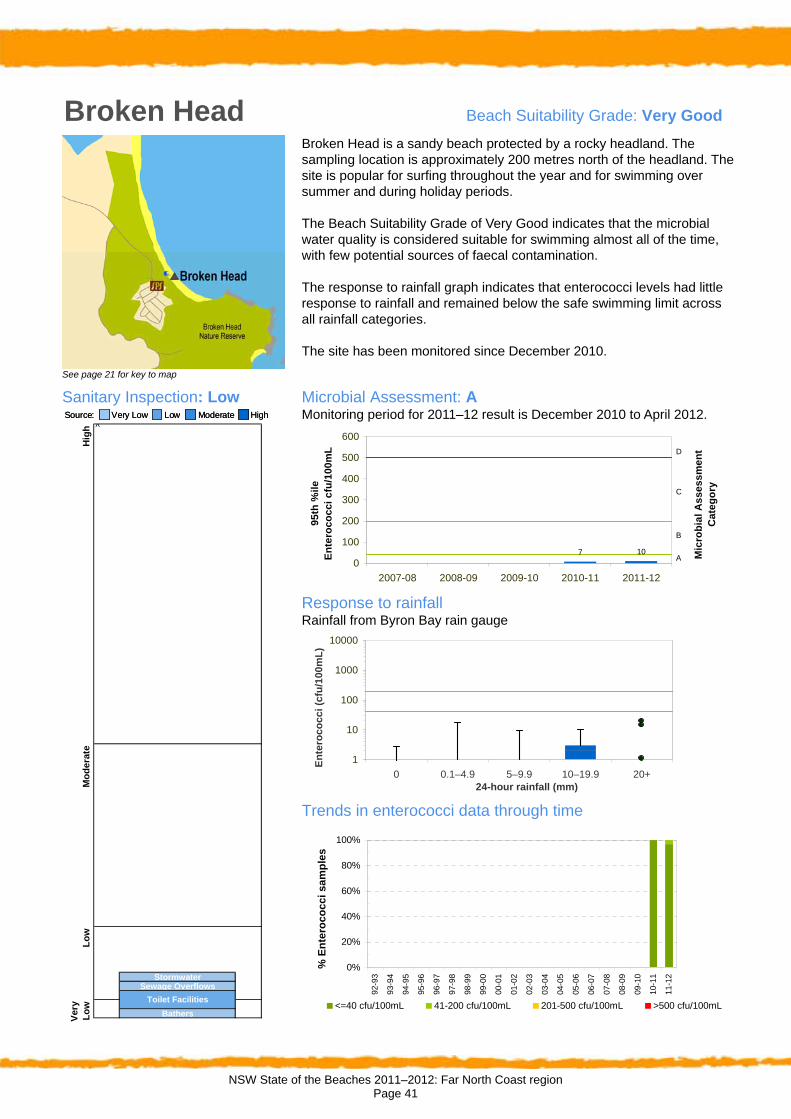
Broken Head Beach Suitability Grade: Very Good
See page 21 for key to map
Broken Head is a sandy beach protected by a rocky headland. The sampling location is approximately 200 metres north of the headland. The site is popular for surfing throughout the year and for swimming over summer and during holiday periods.
The Beach Suitability Grade of Very Good indicates that the microbial water quality is considered suitable for swimming almost all of the time, with few potential sources of faecal contamination.
The response to rainfall graph indicates that enterococci levels had little response to rainfall and remained below the safe swimming limit across all rainfall categories.
The site has been monitored since December 2010.
Sanitary Inspection: Low Very Low Low Moderate HighSource: Very Low Low Moderate HighSource:
Microbial Assessment: A Monitoring period for 2011–12 result is December 2010 to April 2012.
7 10
0
100
200
300
400
500
600
2007-08 2008-09 2009-10 2010-11 2011-12
95
th %
ile
E
nte
roc
oc
ci
cfu
/10
0m
L
A
B
C
D
Mic
rob
ial
As
se
ss
me
nt
Ca
teg
ory
Response to rainfall Rainfall from Byron Bay rain gauge
1
10
100
1000
10000
0 0.1–4.9 5–9.9 10–19.9 20+24-hour rainfall (mm)
En
tero
co
cc
i (c
fu/1
00
mL
)
Trends in enterococci data through time
^
StormwaterSewage Overflows
BathersVer
y L
ow
Toilet Facilities
Hig
hM
od
erat
eL
ow
0%
20%
40%
60%
80%
100%
92-9
3
93-9
4
94-9
5
95-9
6
96-9
7
97-9
8
98-9
9
99-0
0
00-0
1
01-0
2
02-0
3
03-0
4
04-0
5
05-0
6
06-0
7
07-0
8
08-0
9
09-1
0
10-1
1
11-1
2
% E
nte
roc
oc
ci
sa
mp
les
<=40 cfu/100mL 41-200 cfu/100mL 201-500 cfu/100mL >500 cfu/100mL

NSW State of the Beaches 2011–2012: Far North Coast region Page 42
Ballina Shire Council
Figure 9: Sampling locations and Beach Suitability Grades in the Ballina Shire Council area
NSW State of the Beaches 2011–2012: Far North Coast region Page 43
Message from Ballina Shire Council The Ballina shire boasts 32 kilometres of spectacular coastline. Our beaches, the beautiful Richmond River and our impressive hinterland are the backdrop for a shire that has one of the fastest growth rates in NSW. The beaches in the Ballina shire are regarded as some of the finest in the world. Lennox Point is identified by surfers as one of the best breaks in Australia, and other beaches and waterways are popular with locals and visitors who like to fish, swim, walk and run. A band of dedicated volunteers help the Ballina Council keep our coastal environment and beaches in pristine condition and I commend our Dunecare and Landcare groups for the work they have done over many years, removing weeds and revegetating degraded sections of coastline. These groups have won many awards and are deserving of the accolades bestowed upon them. Ballina Council has been involved in the Beachwatch program since 2002 and we are committed to ensuring our beaches are clean and our water quality is good. The health of the coastal and marine environments is a priority for the Ballina Council.
Overview of the area Description
Ballina Shire is located on the NSW Far North Coast and covers an area of 487 square kilometres. Its coastal waters extend from Seven Mile Beach in the north to Wardell in the south.
Land use is predominantly rural and more than 80 square kilometres of rural land lies along the coast. The main commercial activities are agriculture, tourism and fishing, with a growing sector of primary production.
The estimated local resident population in the Ballina Shire was 42,708 at the 2011 Census, with more than half the population living within ten kilometres of the coast (ABS 2012).
The major towns in the region are Ballina, Lennox Head, Alstonville, Wollongbar and Wardell. Two significant tributaries to the Richmond River in the shire are Emigrant Creek and North Creek, both of which enter the estuary at Ballina.
Rainfall
There were several significant rain and flooding events on the far north coast during 2011–2012 (BOM 2012):
In early December, a heavy rain event in northern NSW exacerbated existing flooding following November rain, with severe thunderstorms causing locally heavy rainfall in Ballina.
High rainfall in mid January was followed by a very significant rain event across northern NSW between the 23rd and 29th of January. During this event Ballina received 157 mm of rainfall in one day which is the highest daily rainfall ever recorded in January. This rainfall event triggered additional flooding in the northern rivers.
Heavy rainfall continued in northern NSW in early February, with continued flooding and associated poor water quality, particularly in lagoons and estuaries.
Assessment Microbial water quality
NHMRC recommends that at least 20 samples are collected each year, providing 100 data points over a five year period. The sampling frequency at sites in the Ballina Shire is just below this recommended level, with samples collected on a weekly basis over four months of the year.
The Microbial Assessment Category for 2011–2012 was calculated from the most recent 100 data points up until the end of the 2011–2012 swimming season, which was November 2007 until February 2012 for all sites except Lighthouse Beach (which was November 2009 to February 2012).
As sampling at Lighthouse Beach began in 2009, there are only 54 data points currently available for analysis, fewer than recommended. The Microbial Assessment Category for this site is therefore regarded as provisional. As more data become available in following years, the beach grade will become final and response to rainfall trends more defined.
Sanitary inspections
Sanitary inspections have been completed for all monitored swimming locations in the Ballina Shire Council area. These are scheduled for review during 2012–2013.
Beach Suitability Grades Five of the six swimming locations monitored in Ballina Shire Council area were graded as Very Good or Good during 2011–2012 (Figure 9).

NSW State of the Beaches 2011–2012: Far North Coast region Page 44
Very Good
One ocean beach (Seven Mile Beach) was graded as Very Good.
This site had excellent water quality (Microbial Assessment Category A) and few potential sources of microbial contamination (Sanitary Inspection Category of Low).
Good
Four swimming locations were graded as Good: Lake Ainsworth West, Shelly Beach, The Serpentine and Lighthouse Beach.
These sites had mostly good water quality (Microbial Assessment Category B), but had several, or more significant, potential sources of microbial contamination, such as urban stormwater, river discharge or lagoons.
Fair
No swimming sites in the Ballina Shire were classified as Fair.
Poor
Shaws Bay East was graded as Poor. This site often had poor water quality (Microbial Assessment Category C) and occasionally exceeded the safe swimming limit in response to low levels of rainfall. A Sanitary Inspection Category of Moderate was assigned due to stormwater and discharge from the Richmond River. It is recommended that swimming at this location be avoided during and for up to three days following rainfall, or if there are signs of stormwater such as discoloured water or odour or floating debris.
Very Poor
No swimming sites in the Ballina Shire were classified as Very Poor.
Management Wastewater management
Ballina Shire Council is responsible for the management of the Ballina and Lennox Head wastewater treatment plants (WWTPs) and two smaller WWTPs at Alstonville and Wardell (EPA NSW 2012). All wastewater flows are screened and treated in oxidation ponds and have UV disinfection before discharge.
Ballina WWTP discharges into North Creek Canal, which flows into the Richmond River, with some wastewater re-used to irrigate the Ballina Racecourse, playing fields and parks.
The Lennox Head WWTP generates tertiary-treated and ultraviolet-disinfected wastewater for re-use at Ballina Golf Course, and at Chickiba and Skennars Head playing fields. The surplus water is discharged to the ocean at Skennars Head.
An upgrade of the Lennox Head WWTP was completed in early 2011. Construction of the new West Ballina WWTP commenced in June 2011, with commissioning expected in early 2013. A recycled water treatment plant will be constructed at Lennox Head WWTP at the same time, along with the construction of the recycled water distribution and storage system. These works will deliver improved effluent quality with greater opportunities for effluent re-use.
The two smaller WWTPs at Alstonville and Wardell have discharge points in tributaries of the Richmond River, and some of the wastewater is re-used for irrigation.
Maintenance and repairs to the sewer pipes within Ballina Shire commenced in April 2012. The work is part of a rehabilitation plan issued by Ballina Shire Council to improve the sewerage system, which helps protect the local environment and public health. The activities associated with this work include: internal inspection of maintenance holes; closed circuit television (CCTV) inspection of the main sewer pipes both before and after the work; cleaning of sewer pipes; and installation of structural liners.
Ballina Shire Council in partnership with Rous Water has completed the Accelerated Assessment of On-site Sewage Management (OSSM) Project in Emigrant Creek Catchment. There were 146 existing on-site sewage management systems inspected within the Emigrant Creek Catchment, mostly septic tanks with conventional trench systems. Several of the systems are located in high risk, sensitive environments close to creeks and intermittent waterways.
The project commenced in April 2010 and concluded in April 2011. The results of this project revealed that 37% of the on-site sewage management systems inspected were not operating satisfactorily or established in accordance with Council’s requirements. Although the project has concluded there is a significant amount of follow up work required to ensure compliance within the Emigrant Creek Catchment.
Management programs
Ballina Shire Council has a number of management plans in place to address the key catchment issues. These include the Shaws Bay Estuary Management Plan, the Ballina Coastline Management Study and

NSW State of the Beaches 2011–2012: Far North Coast region Page 45
Management Plan, and the Lake Ainsworth Management Plan.
Richmond River County Council is coordinating the Richmond River Estuary Management Study and Plan across the Richmond Valley, Lismore City, and Ballina Shire council areas.
The Coastal Zone Management Plan for the Richmond River was gazetted in February 2012, following ten years of studies, supporting reports and community consultation. It provides a template for work across the estuary in Ballina Shire, Lismore City and Richmond Valley council areas. The first areas of investigation to be resolved are the governance of the estuary and floodplain and how this is to be managed into the future, and a review of the backswamp areas to see which actions would be most cost-effective in managing future blackwater events on the Richmond River.
Site management
Ballina Shire Council has placed precautionary signage at lake and estuarine swimming sites, advising that these areas may be affected by algal blooms and that swimming is not recommended during these periods. In the event of suspected
algal blooms, water samples are collected and sent to the regional algal coordinating committee, and advice is sought to coordinate an appropriate course of action.
If sewage contamination is suspected, the swimming area is closed and microbial water quality testing undertaken until samples indicate that water quality is once again suitable for swimming.
Media releases are issued during periods of heavy rain and minor flooding in the region to advise which swimming spots are likely to be impacted by stormwater and may be unsuitable for swimming. As a general precaution, swimming should be avoided for at least one day after heavy rainfall at ocean beaches, and for up to three days in estuarine sites. After extended rainfall and flooding, swimming should be avoided for as long as stormwater is present.
Lifeguard service
Ballina Shire Council lifeguard service patrols five main beaches: Lighthouse, Shelly, Lennox Head, Sharps and South Ballina. Some beaches are patrolled from October to April, and others are patrolled from December to January.

NSW State of the Beaches 2011–2012: Far North Coast region Page 46
Seven Mile Beach Beach Suitability Grade: Very Good
See page 21 for key to map
Seven Mile Beach extends for over eight kilometres and is a significant tourism drawcard in the region. The sampling site is at the southern end of the beach, adjacent to the surf club. The beach is used throughout the year and is particularly popular during the Christmas holiday period.
The Beach Suitability Grade of Very Good indicates that the microbial water quality is considered suitable for swimming almost all of the time, with few potential sources of faecal contamination.
The response to rainfall graph indicates that levels of enterococci generally remain below the safe swimming limit across all rainfall categories, showing little response to rainfall.
The site has been monitored since 2002 and microbial water quality has been of a generally high standard.
Sanitary Inspection: Low Very Low Low Moderate HighSource: Very Low Low Moderate HighSource:
Microbial Assessment: A Monitoring period for 2011–12 result is November 2007 to February 2012.
24 30 30 24 36
0
100
200
300
400
500
600
2007-08 2008-09 2009-10 2010-11 2011-12
95
th %
ile
E
nte
roc
oc
ci
cfu
/10
0m
L
A
B
C
D
Mic
rob
ial
As
se
ss
me
nt
Ca
teg
ory
Response to rainfall Rainfall from Ballina rain gauge
1
10
100
1000
10000
0 0.1–4.9 5–9.9 10–19.9 20+24-hour rainfall (mm)
En
tero
co
cci
(cfu
/10
0m
L)
Trends in enterococci data through time
^
StormwaterToilet Facilities
BathersVer
y L
ow
Hig
hM
od
erat
eL
ow
0%
20%
40%
60%
80%
100%
92-9
3
93-9
4
94-9
5
95-9
6
96-9
7
97-9
8
98-9
9
99-0
0
00-0
1
01-0
2
02-0
3
03-0
4
04-0
5
05-0
6
06-0
7
07-0
8
08-0
9
09-1
0
10-1
1
11-1
2
% E
nte
roc
oc
ci
sa
mp
les
<=40 cfu/100mL 41-200 cfu/100mL 201-500 cfu/100mL >500 cfu/100mL

NSW State of the Beaches 2011–2012: Far North Coast region Page 47
Lake Ainsworth West Beach Suitability Grade: Good
See page 21 for key to map
Lake Ainsworth West is located on the western shore of Lake Ainsworth, a coastal freshwater lake. The lake is situated to the west of Seven Mile Beach and north of the township of Lennox Head.
The Beach Suitability Grade of Good indicates that the microbial water quality is generally suitable for swimming, but the water can be susceptible to pollution from a number of potential sources of faecal contamination.
The response to rainfall graph indicates that enterococci levels generally increased with increasing rainfall, sometimes exceeding the safe swimming limit after only low levels of rain.
The site has been monitored since 2002, with a small percentage of elevated enterococci results recorded in most years.
Sanitary Inspection: Moderate Very Low Low Moderate HighSource: Very Low Low Moderate HighSource:
Microbial Assessment: B Monitoring period for 2011–12 result is November 2007 to February 2012.
130 130 150 140 160
0
100
200
300
400
500
600
2007-08 2008-09 2009-10 2010-11 2011-12
95
th %
ile
E
nte
roc
oc
ci
cfu
/10
0m
L
A
B
C
D
Mic
rob
ial
As
se
ss
me
nt
Ca
teg
ory
Response to rainfall Rainfall from Ballina rain gauge
1
10
100
1000
10000
0 0.1–4.9 5–9.9 10–19.9 20+24-hour rainfall (mm)
En
tero
co
cc
i (c
fu/1
00
mL
)
Trends in enterococci data through time
^
Hig
hM
od
erat
eL
ow
Stormwater
Lagoons
Animals
Ver
y L
ow Bathers
Toilet Facilities
Sewage Overflows
0%
20%
40%
60%
80%
100%
92-9
3
93-9
4
94-9
5
95-9
6
96-9
7
97-9
8
98-9
9
99-0
0
00-0
1
01-0
2
02-0
3
03-0
4
04-0
5
05-0
6
06-0
7
07-0
8
08-0
9
09-1
0
10-1
1
11-1
2
% E
nte
roc
oc
ci s
am
ple
s
<=40 cfu/100mL 41-200 cfu/100mL 201-500 cfu/100mL >500 cfu/100mL

NSW State of the Beaches 2011–2012: Far North Coast region Page 48
Shelly Beach Beach Suitability Grade: Good
See page 21 for key to map
Shelly Beach is approximately 700 metres long and is backed by a narrow coastal reserve and urban development. The sampling site is adjacent to the surf club at the southern end of the beach.
The Beach Suitability Grade of Good indicates that the microbial water quality is generally suitable for swimming, but the water can be susceptible to pollution from a number of potential sources of faecal contamination.
The response to rainfall graph indicates that enterococci levels increased slightly with increasing rainfall but generally remained below the safe swimming limit.
The site has been monitored since 2002. Microbial water quality has generally been of a high standard, with a small percentage of elevated enterococci results recorded in some years.
Sanitary Inspection: Low Very Low Low Moderate HighSource: Very Low Low Moderate HighSource:
Microbial Assessment: B Monitoring period for 2011–12 result is November 2007 to February 2012.
45 40 45 4065
0
100
200
300
400
500
600
2007-08 2008-09 2009-10 2010-11 2011-12
95
th %
ile
E
nte
roc
oc
ci
cfu
/10
0m
L
A
B
C
D
Mic
rob
ial
As
se
ss
me
nt
Ca
teg
ory
Response to rainfall Rainfall from Ballina rain gauge
1
10
100
1000
10000
0 0.1–4.9 5–9.9 10–19.9 20+24-hour rainfall (mm)
En
tero
co
cci
(cfu
/10
0m
L)
Trends in enterococci data through time
^
Bathers
Hig
hM
od
erat
eL
ow
River Discharge
Ver
y L
ow
Toilet Facilities
Sewage Overflows
Stormwater
0%
20%
40%
60%
80%
100%
92-9
3
93-9
4
94-9
5
95-9
6
96-9
7
97-9
8
98-9
9
99-0
0
00-0
1
01-0
2
02-0
3
03-0
4
04-0
5
05-0
6
06-0
7
07-0
8
08-0
9
09-1
0
10-1
1
11-1
2
% E
nte
roc
oc
ci
sa
mp
les
<=40 cfu/100mL 41-200 cfu/100mL 201-500 cfu/100mL >500 cfu/100mL

NSW State of the Beaches 2011–2012: Far North Coast region Page 49
Shaws Bay East Beach Suitability Grade: Poor
See page 21 for key to map
The sampling site is located on the eastern side of Shaws Bay, an inlet near the mouth of the Richmond River. A training wall protects the bay but allows tidal flushing. The bay is primarily used for swimming.
The Beach Suitability Grade of Poor indicates that the microbial water quality is susceptible to faecal pollution with a number of potential faecal contamination sources including stormwater and discharge from the Richmond River.
The response to rainfall graph indicates that enterococci levels increased with increasing rainfall, occasionally exceeded the safe swimming limit in response to low levels of rainfall and often in response to 20 mm or more.
The site has been monitored since 2002.
Sanitary Inspection: Moderate Very Low Low Moderate HighSource: Very Low Low Moderate HighSource:
Microbial Assessment: C Monitoring period for 2011–12 result is November 2007 to February 2012.
220190
150175
220
0
100
200
300
400
500
600
2007-08 2008-09 2009-10 2010-11 2011-12
95
th %
ile
E
nte
roc
oc
ci
cfu
/10
0m
L
A
B
C
D
Mic
rob
ial
As
se
ss
me
nt
Ca
teg
ory
Response to rainfall Rainfall from Ballina rain gauge
1
10
100
1000
10000
0 0.1–4.9 5–9.9 10–19.9 20+24-hour rainfall (mm)
En
tero
co
cc
i (c
fu/1
00
mL
)
Trends in enterococci data through time
^
Animals
Toilet Facilities
Hig
hM
od
erat
eL
ow
Ver
y L
ow Bathers
Stormwater
River Discharge
0%
20%
40%
60%
80%
100%
92-9
3
93-9
4
94-9
5
95-9
6
96-9
7
97-9
8
98-9
9
99-0
0
00-0
1
01-0
2
02-0
3
03-0
4
04-0
5
05-0
6
06-0
7
07-0
8
08-0
9
09-1
0
10-1
1
11-1
2
% E
nte
roc
oc
ci
sa
mp
les
<=40 cfu/100mL 41-200 cfu/100mL 201-500 cfu/100mL >500 cfu/100mL

NSW State of the Beaches 2011–2012: Far North Coast region Page 50
The Serpentine Beach Suitability Grade: Good
See page 21 for key to map
The Serpentine is situated in North Creek, a tributary of the Richmond River. It is a popular swimming and fishing location in summer. The waterway is characterised by flat, shallow sandbars.
The Beach Suitability Grade of Good indicates that the microbial water quality is generally suitable for swimming, but the water may be susceptible to pollution from several potential sources of faecal contamination including discharge from the Richmond River.
The response to rainfall graph indicates that enterococci levels occasionally exceeded the safe swimming limit in response to low levels ofrainfall and regularly in response to 10 mm of rainfall or more.
The site has been monitored since 2002, with some improvement in water quality recorded in the last three years.
Sanitary Inspection: Moderate Very Low Low Moderate HighSource: Very Low Low Moderate HighSource:
Microbial Assessment: B Monitoring period for 2011–12 result is November 2007 to February 2012.
200 185 165 150195
0
100
200
300
400
500
600
2007-08 2008-09 2009-10 2010-11 2011-12
95
th %
ile
E
nte
roc
oc
ci
cfu
/10
0m
L
A
B
C
D
Mic
rob
ial
As
se
ss
me
nt
Ca
teg
ory
Response to rainfall Rainfall from Ballina rain gauge
1
10
100
1000
10000
0 0.1–4.9 5–9.9 10–19.9 20+24-hour rainfall (mm)
En
tero
co
cci
(cfu
/10
0m
L)
Trends in enterococci data through time
^
AnimalsBoats
Hig
hM
od
erat
eL
ow
Stormwater
River Discharge
Ver
y L
ow Bathers
STP Discharge
Sewage Overflows
0%
20%
40%
60%
80%
100%
92-9
3
93-9
4
94-9
5
95-9
6
96-9
7
97-9
8
98-9
9
99-0
0
00-0
1
01-0
2
02-0
3
03-0
4
04-0
5
05-0
6
06-0
7
07-0
8
08-0
9
09-1
0
10-1
1
11-1
2
% E
nte
roc
oc
ci
sa
mp
les
<=40 cfu/100mL 41-200 cfu/100mL 201-500 cfu/100mL >500 cfu/100mL

NSW State of the Beaches 2011–2012: Far North Coast region Page 51
Lighthouse Beach Beach Suitability Grade: Good
See page 21 for key to map
Lighthouse Beach is situated to the north of the sea wall at the mouth of the Richmond River. The beach is used by swimmers during the summer months and is also very popular with surfers and for fishing. The sampling site is at the northern end of the beach.
The Beach Suitability Grade of Good indicates that the microbial water quality is generally suitable for swimming, but the water may be susceptible to pollution from a few potential sources of faecal contamination, including river discharge.
The response to rainfall graph indicates that levels of enterococci increased slightly in response to rainfall, but generally remain below the safe swimming limit across all rainfall categories.
The site was monitored in 2002–2003, and since 2009–2010.
Sanitary Inspection: Low Very Low Low Moderate HighSource: Very Low Low Moderate HighSource:
Microbial Assessment: B Monitoring period for 2011–12 result is November 2009 to February 2012.
40 60 55
0
100
200
300
400
500
600
2007-08 2008-09 2009-10 2010-11 2011-12
95
th %
ile
E
nte
roc
oc
ci
cfu
/10
0m
L
A
B
C
D
Mic
rob
ial
As
se
ss
me
nt
Ca
teg
ory
Response to rainfall Rainfall from Ballina rain gauge
1
10
100
1000
10000
0 0.1–4.9 5–9.9 10–19.9 20+24-hour rainfall (mm)
En
tero
co
cci
(cfu
/10
0m
L)
Trends in enterococci data through time
^
Toilet FacilitiesBathers
Lo
wV
ery
Lo
w
River Discharge
Hig
hM
od
erat
e
0%
20%
40%
60%
80%
100%
92-9
3
93-9
4
94-9
5
95-9
6
96-9
7
97-9
8
98-9
9
99-0
0
00-0
1
01-0
2
02-0
3
03-0
4
04-0
5
05-0
6
06-0
7
07-0
8
08-0
9
09-1
0
10-1
1
11-1
2
% E
nte
roc
oc
ci
sa
mp
les
<=40 cfu/100mL 41-200 cfu/100mL 201-500 cfu/100mL >500 cfu/100mL

NSW State of the Beaches 2011–2012: Far North Coast region Page 52
Richmond Valley Council
Figure 10: Sampling locations and Beach Suitability Grades in the Richmond Valley Council area

NSW State of the Beaches 2011–2012: Far North Coast region Page 53
Overview of the area Description
Richmond Valley Council is located on the Far North Coast of NSW and covers an area of 3051 square kilometres. The council area has approximately 35 kilometres of coastline, of which almost 27 kilometres is contained within national parks.
The council area stretches 85 kilometres inland to the Great Dividing Range and comprises natural bushland, timber country, grazing land, sugar cane plantations and coastal heath.
The estimated local resident population in the Richmond Valley area was 22,037 at the 2011 Census, with major population centres at Casino and Evans Head and smaller populations in the villages of Coraki, Woodburn, Broadwater and Rileys Hill (ABS 2012).
Rainfall
Several significant rain and flooding events occurred on the far north coast during 2011–2012 (BOM 2012):
In early December, a heavy rain event in northern NSW exacerbated existing flooding following November rain.
High rainfall in mid January was followed by a very significant rain event across northern NSW between the 23rd and 29th of January. During this event Evans Head received 113 mm of rainfall in one day, the highest daily rainfall ever recorded in January. This rainfall event triggered additional flooding in the northern rivers.
Heavy rainfall continued in northern NSW in early February, with continued flooding and associated poor water quality particularly in lagoons and estuaries.
Assessment Microbial water quality
NHMRC recommends that at least 20 samples are collected each year, providing 100 data points over a five year period. The sampling frequency at sites in the Richmond Valley Council area is higher than this minimum, with approximately 50 samples collected each year.
The Microbial Assessment Category for 2011–2012 was calculated from the most recent 100 data points up until the end of the 2011–2012 swimming season, which was May 2010 until April 2012.
Sanitary inspections
Sanitary inspections have been completed for all monitored swimming locations in the Richmond Valley Council area. These are scheduled for review during 2012–2013.
Beach Suitability Grades All four swimming locations monitored in Richmond Valley Council area were graded as Very Good or Good during 2011–2012 (Figure 10).
Very Good
The three ocean beaches were graded as Very Good: Airforce Beach, Main Beach and Shark Bay.
These sites all had excellent water quality (Microbial Assessment Category A) and few potential sources of microbial contamination (Sanitary Inspection Categories of Low).
Good
The Evans River swimming location was graded as Good. This site had mostly good water quality (Microbial Assessment Category B) but several potential sources of microbial contamination, including urban stormwater and river discharge. Elevated enterococci results have been recorded on a number of occasions during the past four years and are associated with flooding of the Evans River.
Fair
No swimming sites were classified as Fair.
Poor
No swimming sites were classified as Poor.
Very Poor
No swimming sites were classified as Very Poor.
Management Wastewater management
Richmond Valley Council is responsible for four sewage treatment plants (STPs). These are located at Evans Head, Rileys Hill, Casino and Coraki.
The Evans Head STP was upgraded in 2007 to produce tertiary-treated, disinfected effluent that is discharged via an open drain feeding a natural wetland that empties into Salty Lagoon (a designated SEPP 14 wetland located in Broadwater National Park). The second stage of the upgrade is currently being investigated and involves an expansion of treatment capabilities.
Council is currently working on the Broadwater/Woodburn sewerage scheme, which

NSW State of the Beaches 2011–2012: Far North Coast region Page 54
plans to connect these communities to the sewerage network, with final treatment at the Evans Head STP.
Rileys Hill STP and Casino STP treat sewage to a tertiary level, with some re-use at both sites. Coraki STP treats sewage with oxidation ponds. Effluent not re-used from these STPs is discharged to tributaries of the Richmond River (EPA NSW 2012).
There are over 2800 licensed on-site sewage management systems in the council area. Richmond Valley Council has prepared and implemented an On-site sewage and wastewater management strategy for the area, focusing on existing and new systems (Richmond Valley Council 2001). Random audits of the existing systems to assess compliance with legislation including pre- purchase inspections are undertaken.
Management programs
Richmond Valley Council has a number of management plans, including the Evans River and stormwater. The revised stormwater management plan includes measures to reduce the impact of stormwater, by slowing the velocity of stormwater through the construction of wetlands, sediment basins (located at Evans Head), maintenance of
gross pollutant traps and other stormwater control devices. The stormwater management plan has not yet been fully implemented owing to a lack of financial resources.
Richmond River County Council is coordinating the Richmond River Estuary Management Study and Plan across the Richmond Valley, Lismore City, and Ballina Shire council areas.
Richmond Valley Council is continuing to monitor Salty Lagoon as part of the ecosystem rehabilitation management plan. The Department of Primary Industries – Crown Lands Division, and Fisheries and Ecosystems Research Unit – have issued permits to implement the lagoon rehabilitation works by closing the artificial channel linking Salty Lagoon to Salty Creek. Works to improve the condition of Salty Lagoon included the upgrade of the Evans Head STP which replaced the trickle filter plant in 2007. As a result of the STP upgrade there has been considerable improvement in the quality of effluent discharged to the Salty Lagoon system.
Lifeguard service
Richmond Valley Council lifeguards patrol beaches in the council area during the swimming season.

NSW State of the Beaches 2011–2012: Far North Coast region Page 55
Airforce Beach Beach Suitability Grade: Very Good
See page 21 for key to map
Airforce Beach is located on a 31 kilometre stretch of beach between Richmond River in the north and Evans River in the south. This is the second-longest beach in NSW. The sampling site is adjacent to the 4WD beach access track at Evans Head.
The Beach Suitability Grade of Very Good indicates that the microbial water quality is considered suitable for swimming almost all of the time, with few potential sources of faecal contamination.
The response to rainfall graph indicates that elevated levels of enterococci are occasionally measured in response to 5 mm of rainfall or more.
The site has been monitored since 2006 and microbial water quality has generally been of a very high standard.
Sanitary Inspection: Low Very Low Low Moderate HighSource: Very Low Low Moderate HighSource:
Microbial Assessment: A Monitoring period for 2011–12 result is May 2010 to April 2012.
5 7 18 32 22
0
100
200
300
400
500
600
2007-08 2008-09 2009-10 2010-11 2011-12
95
th %
ile
E
nte
roc
oc
ci
cfu
/10
0m
L
A
B
C
D
Mic
rob
ial
As
se
ss
me
nt
Ca
teg
ory
Response to rainfall Rainfall from Evans Head rain gauge
1
10
100
1000
10000
0 0.1–4.9 5–9.9 10–19.9 20+24-hour rainfall (mm)
En
tero
co
cci
(cfu
/10
0m
L)
Trends in enterococci data through time
^
Animals
Toilet FacilitiesBathers
Lo
wV
ery
Lo
w
River Discharge
Hig
hM
od
erat
e
0%
20%
40%
60%
80%
100%
92-9
3
93-9
4
94-9
5
95-9
6
96-9
7
97-9
8
98-9
9
99-0
0
00-0
1
01-0
2
02-0
3
03-0
4
04-0
5
05-0
6
06-0
7
07-0
8
08-0
9
09-1
0
10-1
1
11-1
2
% E
nte
roc
oc
ci
sa
mp
les
<=40 cfu/100mL 41-200 cfu/100mL 201-500 cfu/100mL >500 cfu/100mL

NSW State of the Beaches 2011–2012: Far North Coast region Page 56
Main Beach Beach Suitability Grade: Very Good
See page 21 for key to map
Main Beach is located at the southern end of a 31 kilometre stretch of beach between Richmond River in the north and Evans River in the south. This is the second-longest beach in NSW. The sampling site is adjacent to the surf club.
The Beach Suitability Grade of Very Good indicates that the microbial water quality is considered suitable for swimming almost all of the time, with few potential sources of faecal contamination.
The response to rainfall graph indicates that elevated levels of enterococci are occasionally measured in response to 10 mm of rainfall or more.
The site has been monitored since 2006 and microbial water quality has generally been of a very high standard.
Sanitary Inspection: Low Very Low Low Moderate HighSource: Very Low Low Moderate HighSource:
Microbial Assessment: A Monitoring period for 2011–12 result is May 2010 to April 2012.
10 7 10 18 9
0
100
200
300
400
500
600
2007-08 2008-09 2009-10 2010-11 2011-12
95
th %
ile
E
nte
roc
oc
ci
cfu
/10
0m
L
A
B
C
D
Mic
rob
ial
As
se
ss
me
nt
Ca
teg
ory
Response to rainfall Rainfall from Evans Head rain gauge
1
10
100
1000
10000
0 0.1–4.9 5–9.9 10–19.9 20+24-hour rainfall (mm)
En
tero
co
cci
(cfu
/10
0m
L)
Trends in enterococci data through time
^
Hig
hM
od
erat
eL
ow
Ver
y L
ow Bathers
Toilet Facilities
River Discharge
0%
20%
40%
60%
80%
100%
92-9
3
93-9
4
94-9
5
95-9
6
96-9
7
97-9
8
98-9
9
99-0
0
00-0
1
01-0
2
02-0
3
03-0
4
04-0
5
05-0
6
06-0
7
07-0
8
08-0
9
09-1
0
10-1
1
11-1
2
% E
nte
roc
oc
ci
sa
mp
les
<=40 cfu/100mL 41-200 cfu/100mL 201-500 cfu/100mL >500 cfu/100mL

NSW State of the Beaches 2011–2012: Far North Coast region Page 57
Shark Bay Beach Suitability Grade: Very Good
See page 21 for key to map
Shark Bay is a small beach located between the southern entrance wall to the Evans River and the cliffs below Razorback Lookout. There is good access to the beach with parking available, making it a popular beach for fishing, picnics and swimming.
The Beach Suitability Grade of Very Good indicates that the microbial water quality is considered suitable for swimming almost all of the time, with few potential sources of faecal contamination.
The response to rainfall graph indicates that elevated levels of enterococci are occasionally measured in response to 20 mm of rainfall or more.
The site has been monitored since 2006 and microbial water quality has generally been of a very high standard.
Sanitary Inspection: Low Very Low Low Moderate HighSource: Very Low Low Moderate HighSource:
Microbial Assessment: A Monitoring period for 2011–12 result is May 2010 to April 2012.
10 7 6 6 6
0
100
200
300
400
500
600
2007-08 2008-09 2009-10 2010-11 2011-12
95
th %
ile
E
nte
roc
oc
ci
cfu
/10
0m
L
A
B
C
D
Mic
rob
ial
As
se
ss
me
nt
Ca
teg
ory
Response to rainfall Rainfall from Evans Head rain gauge
1
10
100
1000
10000
0 0.1–4.9 5–9.9 10–19.9 20+24-hour rainfall (mm)
En
tero
co
cci
(cfu
/10
0m
L)
Trends in enterococci data through time
^
Toilet FacilitiesBathers
Lo
wV
ery
Lo
w
Stormwater
River Discharge
Hig
hM
od
erat
e
0%
20%
40%
60%
80%
100%
92-9
3
93-9
4
94-9
5
95-9
6
96-9
7
97-9
8
98-9
9
99-0
0
00-0
1
01-0
2
02-0
3
03-0
4
04-0
5
05-0
6
06-0
7
07-0
8
08-0
9
09-1
0
10-1
1
11-1
2
% E
nte
roc
oc
ci
sa
mp
les
<=40 cfu/100mL 41-200 cfu/100mL 201-500 cfu/100mL >500 cfu/100mL

NSW State of the Beaches 2011–2012: Far North Coast region Page 58
Evans River Beach Suitability Grade: Good
See page 21 for key to map
The Evans River is approximately 20 kilometres long, with the entrance at the town of Evans Head. The sampling site is located near the stormwater outlet adjacent to the rotunda in the caravan park.
The Beach Suitability Grade of Good indicates that the microbial water quality is suitable for swimming most of the time but the water may be susceptible to pollution after heavy rain due to river discharge and stormwater.
The response to rainfall graph indicates that levels of enterococci increased with increasing rainfall, often exceeding the safe swimming limit in response to 5 mm of rainfall or more.
The site has been monitored since 2006. Elevated enterococci results have been recorded in the last four years due to flooding of the Evans River.
Sanitary Inspection: Moderate Very Low Low Moderate HighSource: Very Low Low Moderate HighSource:
Microbial Assessment: B Monitoring period for 2011–12 result is May 2010 to April 2012.
45 65105
155 150
0
100
200
300
400
500
600
2007-08 2008-09 2009-10 2010-11 2011-12
95
th %
ile
E
nte
roc
oc
ci
cfu
/10
0m
L
A
B
C
D
Mic
rob
ial
As
se
ss
me
nt
Ca
teg
ory
Response to rainfall Rainfall from Evans Head rain gauge
1
10
100
1000
10000
0 0.1–4.9 5–9.9 10–19.9 20+24-hour rainfall (mm)
En
tero
co
cci
(cfu
/10
0m
L)
Trends in enterococci data through time
^
Boats
Bathers
Hig
hM
od
erat
eL
ow
River Discharge
Ver
y L
ow
Toilet Facilities
Sewage Overflows
Stormwater
0%
20%
40%
60%
80%
100%
92-9
3
93-9
4
94-9
5
95-9
6
96-9
7
97-9
8
98-9
9
99-0
0
00-0
1
01-0
2
02-0
3
03-0
4
04-0
5
05-0
6
06-0
7
07-0
8
08-0
9
09-1
0
10-1
1
11-1
2
% E
nte
roc
oc
ci
sa
mp
les
<=40 cfu/100mL 41-200 cfu/100mL 201-500 cfu/100mL >500 cfu/100mL

NSW State of the Beaches 2011–2012: Far North Coast region Page 59