exhibit a aeng 749 findings bcc 091812 final
TRANSCRIPT

EXHIBIT A
FINDINGS FOR A-ENGROSSED ORDINANCE NO. 749 AN ORDINANCE AMENDING THE TRANSPORTATION PLAN ELEMENT
OF THE COMPREHENSIVE PLAN RELATING TO THE BROOKWOOD PARKWAY INTERCHANGE AREA MANAGEMENT PLAN
September 18, 2012
Part 1: GENERAL FINDINGS A-Engrossed Ordinance No. 749 amends the 2020 Washington County Transportation Plan to add new roadways and modify the number and functional classification of lanes for existing roadways so they are consistent with the U.S. 26 Brookwood Parkway/Helvetia Road Interchange Area Management Plan (IAMP), incorporated in its entirety herein. Changes to the Transportation Plan are limited to roadways within the Urban Growth Boundary (UGB) as it existed prior to Metro’s decision to expand the UGB in October 2011 (Metro Ordinance 11-1264 B). A-Engrossed Ordinance No. 749 adds or modifies strategy statements for the following components of the Washington County Transportation Plan: Policy 10 – Functional Classification Policy; Policy 19 – Transportation Planning Coordination; and Public Involvement Policy. The purpose of these amendments is to describe and enable implementation of the IAMP. A-Engrossed Ordinance No. 749 changes the lane number designation for Cornelius Pass Road between U.S. 26 and Cornell Road from 5-lanes to 7-lanes. Additional records regarding A-Engrossed Ordinance No. 749 are retained in staff files and are hereby included as part of the record. The file is available for inspection upon request.
Because the ordinance makes changes that do not affect compliance with Oregon’s Statewide Planning Goals (Goals), it is not necessary for these findings to address the Goals with respect to each amendment. The Board of County Commissioners (Board) finds that the Goals apply to amendments covered by these findings only to the extent noted in specific responses to individual applicable Goals, and that each amendment complies with the Goals. Goals 3 (Agricultural Lands), 4 (Forest Lands), 5 (Open Spaces, Scenic and Historic Areas and Natural Resources), 6 (Air, Water and Land Resources Quality), 7 (Areas Subject to Disasters and Hazards), 8 (Recreation Needs) and 10 (Housing) are not addressed because A-Engrossed Ordinance No. 749 does not affect these Goals. Goals 15 (Willamette River Greenway), 16 (Estuarine Resources), 17 (Coastal Wetlands), 18 (Beaches and Dunes) and 19 (Ocean Resources) and related state administrative rules (OAR) are not addressed because these resources are not located within Washington County.

Exhibit A Findings – A-Engrossed Ordinance No. 749
September 18, 2012 Page 2 of 12
S:\PLNG\WPSHARE\2012ord\Ord749_Brookwood-26_IAMP\Resolution_Findings\Exhibit A AEng 749_Findings BCC 091812 FINAL.doc
Part 2 STATEWIDE PLANNING GOAL FINDINGS The purpose of the findings in this document is to demonstrate that A-Engrossed Ordinance No. 749 is consistent with Statewide Planning Goals, ORS and OAR requirements and applicable Metro requirements. The Washington County Comprehensive Plan was adopted to implement these planning documents, and was acknowledged by the State of Oregon. The County follows the post-acknowledgment plan amendment (PAPA) process to update the Comprehensive Plan with new state and regional regulations as necessary, and relies in part upon these prior state review processes to demonstrate compliance with all necessary requirements. No Goal compliance issues were raised in the proceeding below. In addition, none of the proposed changes to the text or maps of the Plan implicate a Goal compliance issue. The following precautionary findings are provided to demonstrate ongoing compliance. Goal 1 - Citizen Involvement Washington County has an acknowledged citizen involvement program that provides opportunities for citizens and other interested parties to participate in all phases of the planning process. In addition, Chapter X of the County Charter sets forth specific requirements for citizen involvement during review and adoption of land use ordinances. Washington County has utilized these requirements for the adoption of A-Engrossed Ordinance No. 749. In addition the development of the IAMP followed the citizen involvement efforts as explained in Exhibit B. Goal 2 - Land Use Planning Washington County has an acknowledged land use planning process that provides for the review and update of the various elements of the Comprehensive Plan. This plan includes documents such as the Washington County 2020 Transportation Plan, which is modified by this Ordinance. Washington County utilized this process to adopt A-Engrossed Ordinance No. 749. In addition the development of the IAMP followed the land use planning procedures described in Exhibit B. Goal 9 Economy of the State Policy 20 in the Comprehensive Framework Plan for the Urban Area and Policies 15, 16, 20 and 21 in the Rural/Natural Resource Plan set out the county’s policies to strengthen the local economy. The Transportation System Plan contributes to a sound economy by providing standards and infrastructure that facilitate development in an orderly and efficient fashion. Goal 11 - Public Facilities and Services Policies 15, 25, 26, 27, 28, 29, 30 and 31 of Washington County’s Urban Comprehensive Framework Plan and Policy 22 of the Rural/Natural Resource Plan address the provision of public facilities and services in the urban and rural areas of unincorporated Washington County. The Community Development Code (CDC) requires that adequate public facilities and services be available for new development. Plan compliance with Goal 11 is maintained with the

Exhibit A Findings – A-Engrossed Ordinance No. 749
September 18, 2012 Page 3 of 12
S:\PLNG\WPSHARE\2012ord\Ord749_Brookwood-26_IAMP\Resolution_Findings\Exhibit A AEng 749_Findings BCC 091812 FINAL.doc
amendments made by A-Engrossed Ordinance No. 749. The amendments are consistent with the County's acknowledged policies and strategies for the provision of public facilities and services as required by Goal 11. Goal 12 - Transportation Policy 32 of the Comprehensive Framework Plan for the Urban Area, Policy 23 of the Rural/Natural Resource Plan, and in particular the Washington County 2020 Transportation System Plan, describe the transportation system required to accommodate the needs of Washington County through the year 2020. Implementing measures are contained in the Transportation System Plan (TSP) and the Community Development Code (CDC). A-Engrossed Ordinance No. 749 maintains Plan compliance with Goal 12. The amendments are consistent with the County’s acknowledged policies and strategies for the provision of transportation facilities and services as required by Goal 12. Goal 13 Energy Goal 13 requires developed land uses to be managed and controlled so as to maximize the conservation of all forms of energy, based upon sound economic principles. Policies 36, 37, 38, 39 and 40 of the CFP, and Policy 25 of the Rural/Natural Resource Plan address energy conservation in the urban and rural areas of unincorporated Washington County. The CDC implements the energy conservation policies by establishing standards that promote energy efficient development, especially in Article IV. No changes to Energy policies are contemplated as part of A-Engrossed Ordinance No. 749. Part 3 TRANSPORTATION PLANNING RULE (OAR 660-012) FINDINGS
Washington County has an acknowledged Transportation System Plan (TSP) adopted by A-Engrossed Ordinance No. 588 in 2002 consistent with the Transportation Planning Rule (TPR) provisions. A-Engrossed Ordinance No. 749 amends sections of the TSP. A-Engrossed Ordinance No. 749 has been developed in compliance with all applicable provisions of Division 12. A-Engrossed Ordinance No. 749 makes limited amendments to the adopted TSP. These amendments do not affect compliance with certain sections the TPR. Therefore, it is not necessary for these findings to address each section of the TPR. The Board of County Commissioners (Board) finds that the TPR applies to amendments covered by these findings only to the extent noted in specific responses to individual applicable sections. A-Engrossed Ordinance No. 749 amends the TSP to add roadways and modify the functional classification and number of lanes of some existing roadways consistent with the U.S. 26 Brookwood Parkway/Helvetia Road Interchange Area Management Plan (IAMP). These changes

Exhibit A Findings – A-Engrossed Ordinance No. 749
September 18, 2012 Page 4 of 12
S:\PLNG\WPSHARE\2012ord\Ord749_Brookwood-26_IAMP\Resolution_Findings\Exhibit A AEng 749_Findings BCC 091812 FINAL.doc
are within the Urban Growth Boundary (UGB) as it existed prior to Metro’s decision to expand the UGB in October 2011 (Metro Ordinance 11-1264 B). A-Engrossed Ordinance No. 749 also adds or modifies strategy statements for the following components of the Washington County Transportation Plan: Policy 10 – Functional Classification Policy; Policy 19 – Transportation Planning Coordination; and Public Involvement Policy. The purpose of these amendments is to describe and enable implementation of the IAMP. A-Engrossed Ordinance No. 749 also changes the lane number designation for Cornelius Pass Road between U.S. 26 and Cornell Road is changed from 5-lanes to 7-lanes. A-Engrossed Ordinance No. 749 does not alter any existing land use designations, or the levels of development permitted. The amendments made by A-Engrossed Ordinance No. 749 are consistent with and support the adopted and acknowledged strategies in the 2020 Transportation Plan. A-Engrossed Ordinance No. 749 will significantly affect a transportation facility, as described in OAR 660-012-0060 (1). As a result the County must put in place measures as provided in section (2) of OAR 660-012-0060. OAR 660-012-0060 (2) states: “If a local government determines that there would be a significant effect, then the local government must ensure that allowed land uses are consistent with the identified function, capacity, and performance standards of the facility measured at the end of the planning period identified in the adopted TSP through one or a combination of the remedies listed in (a) through (e)”
“(a) Adopting measures that demonstrate allowed land uses are consistent with the planned function, capacity, and performance standards of the transportation facility.”
Response: A-Engrossed Ordinance No. 749 does not change any allowed land uses. The proposed amendments provide additional capacity through a regionally significant industrial area designated by Metro. Furthermore, the proposed changes are consistent with the financially constrained regional transportation plan (RTP). All but four of the IAMP improvement projects are included in the Metro 2035 RTP. The four IAMP improvement projects not included in the Metro 2035 RTP are new proposed street. (Proposed IAMP Improvement Projects 2, 4, 8 and 11, see Table 8 in IAMP). “(b) Amending the TSP or comprehensive plan to provide transportation facilities, improvements or services adequate to support the proposed land uses consistent with the requirements of this division; such amendments shall include a funding plan or mechanism consistent with section (4) or include an amendment to the transportation finance plan so that the facility, improvement, or service will be provided by the end of the planning period.”
Response: As described in Exhibit B, A-Engrossed Ordinance No. 749 amends the TSP to add roadways and modify the functional classification and number of lanes of some existing roadways consistent with the IAMP.
Exhibit A Findings – A-Engrossed Ordinance No. 749
September 18, 2012 Page 5 of 12
S:\PLNG\WPSHARE\2012ord\Ord749_Brookwood-26_IAMP\Resolution_Findings\Exhibit A AEng 749_Findings BCC 091812 FINAL.doc
The intersection of Cornelius Pass Road and Cornell Road has received additional funding through Washington County Major Street Transportation Improvement Program (MSTIP). In addition it is expected that development in the vicinity would contribute towards the Cornelius Pass Road Improvements. Some of these improvements may be eligible for credits towards the Transportation Development Tax (TDT). “(c) Amending the TSP to modify the planned function, capacity or performance standards of the transportation facility.”
Response: A-Engrossed Ordinance No. 749 amends the TSP to provide a plan for an adequate transportation system to serve the industrial areas in the vicinity. No modification of existing performance standards has been contemplated. “(d) Providing other measures as a condition of development or through a development agreement or similar funding method, including, but not limited to, transportation system management measures or minor transportation improvements. Local governments shall, as part of the amendment, specify when measures or improvements provided pursuant to this subsection will be provided.”
Response: A-Engrossed Ordinance No. 749 does not change any allowed land uses. When allowed land uses in the area are changed, additional measures may be contemplated. Article 5 of the Washington County Community Development Code, contains provisions to condition development to ensure an adequate and safe transportation system. “(e) Providing improvements that would benefit modes other than the significantly affected mode, improvements to facilities other than the significantly affected facility, or improvements at other locations, if the provider of the significantly affected facility provides a written statement that the system-wide benefits are sufficient to balance the significant effect, even though the improvements would not result in consistency for all performance standards.”
Response: A-Engrossed Ordinance No. 749 does not change any allowed land uses. A-Engrossed Ordinance No. 749 provides a plan for a complete, balanced multi-modal system.
“(3) Notwithstanding sections (1) and (2) of this rule, a local government may approve an amendment that would significantly affect an existing transportation facility without assuring that the allowed land uses are consistent with the function, capacity and performance standards of the facility” Response: A-Engrossed Ordinance No. 749 provides a plan for the transportation system to serve the anticipated industrial uses in the vicinity. The transportation plan for the area is being updated to reflect the level and intensity of expected development in areas where allowed industrial land uses are anticipated, consistent with adopted and acknowledged plans.

Exhibit A Findings – A-Engrossed Ordinance No. 749
September 18, 2012 Page 6 of 12
S:\PLNG\WPSHARE\2012ord\Ord749_Brookwood-26_IAMP\Resolution_Findings\Exhibit A AEng 749_Findings BCC 091812 FINAL.doc
“(4) Determinations under sections (1)–(3) of this rule shall be coordinated with affected transportation facility and service providers and other affected local governments.” Response: Washington County has developed the plan adopted by A-Engrossed Ordinance No. 749 in coordination with the Oregon Department of Transportation (ODOT) and the City of Hillsboro. See Attachment 1 to this Exhibit.
“(a) In determining whether an amendment has a significant effect on an existing or planned transportation facility under subsection (1)(c) of this rule, local governments shall rely on existing transportation facilities and services and on the planned transportation facilities, improvements and services set forth in subsections (b) and (c) below. (b) Outside of interstate interchange areas, the following are considered planned facilities, improvements and services:
(A) Transportation facilities, improvements or services that are funded for construction or implementation in the Statewide Transportation Improvement Program or a locally or regionally adopted transportation improvement program or capital improvement plan or program of a transportation service provider. (B) Transportation facilities, improvements or services that are authorized in a local transportation system plan and for which a funding plan or mechanism is in place or approved. These include, but are not limited to, transportation facilities, improvements or services for which: transportation systems development charge revenues are being collected; a local improvement district or reimbursement district has been established or will be established prior to development; a development agreement has been adopted; or conditions of approval to fund the improvement have been adopted. (C) Transportation facilities, improvements or services in a metropolitan planning organization (MPO) area that are part of the area's federally-approved, financially constrained regional transportation system plan.”
Response: All but four of the IAMP improvement projects are included in the Metro 2035 RTP. The four IAMP improvement projects not included in the Metro 2035 RTP are new proposed street. (Proposed IAMP Improvement Projects 2, 4, 8 and 11, see Table 8 in IAMP). As discussed in the IAMP significant components of the improvements have obtained funding though JTA. The intersection of Cornelius Pass Road and Cornell Road has received additional funding through Washington County Major Street Transportation Improvement Program (MSTIP). In addition it is expected that development in the vicinity would contribute towards the Cornelius Pass Road Improvements. Some of these improvements may be eligible for credits towards the Transportation Development Tax (TDT).

Exhibit A Findings – A-Engrossed Ordinance No. 749
September 18, 2012 Page 7 of 12
S:\PLNG\WPSHARE\2012ord\Ord749_Brookwood-26_IAMP\Resolution_Findings\Exhibit A AEng 749_Findings BCC 091812 FINAL.doc
“(11) A local government may approve an amendment with partial mitigation as provided in section (2) of this rule if the amendment complies with subsection (a) of this section, the amendment meets the balancing test in subsection (b) of this section, and the local government coordinates as provided in subsection (c) of this section.
(a) The amendment must meet paragraphs (A) and (B) of this subsection or meet paragraph (D) of this subsection.
(A) Create direct benefits in terms of industrial or traded-sector jobs created or retained by limiting uses to industrial or traded-sector industries.”
Response: Partial mitigation for land development under section 11 of -0060 is not contemplated at this time. The importance of industrial development, and allowed partial mitigation, is referenced here as being critical to statewide planning goals to allow for partial mitigation in such circumstances. These plans are adopted to limit or avoid situations where partial mitigation will need to be contemplated in this area.

Exhibit A Findings – A-Engrossed Ordinance No. 749
September 18, 2012 Page 8 of 12
S:\PLNG\WPSHARE\2012ord\Ord749_Brookwood-26_IAMP\Resolution_Findings\Exhibit A AEng 749_Findings BCC 091812 FINAL.doc
Part 4 REGIONAL TRANSPORTATION PLAN (RTP) FINDINGS RTP compliance for the U.S. 26 Brookwood Parkway/Helvetia Road Interchange Area Management Plan (IAMP) is addressed in Exhibit B. The foregoing paragraphs address changes to the lane number designation for Cornelius Pass Road between U.S. 26 and Cornell Road. The land use in the vicinity of Cornelius Pass Road is designated as various categories of industrial, regionally significant industrial and employment areas by Metro’s Urban Growth Management Functional Plan, Title 4, Sections 3.07.410-.450. Significant employment is expected in this corridor. Cornelius Pass Road is identified as a “Major Arterial” on the Regional Transportation Plan, Arterial and Throughway map, and as a “Regional Street” on the regional design classification map. The proposed cross section for a 7-lane Cornelius Pass Road is consistent with the Regional Transportation Plan (RTP). A Regional Street within an Industrial or Employment Area may have appropriate turn and auxiliary lanes needed to provide adequate capacity. Page 2-26 of the Regional Transportation Plan identifies conceptual street cross sections. However, footnote 7 states:
“The number of through lanes may vary based on right-of-way constraints or other factors. Some places in the region may require additional lanes due to a lack of connectivity. Major and minor arterial streets can either be 2 or 4 lanes with turn lanes as appropriate.” (emphasis added).
U.S. 26 is a significant barrier limiting North/South street connectivity in this industrial area. In light of this barrier and the land use designations in the vicinity, a 7-lane designation is necessary and consistent with RTP goals and objectives. A-Engrossed Ordinance No. 749 is consistent with the RTP published on July 29, 2010. RTP section 6.7.1 requires that local plans be implemented consistent with the Regional Transportation Functional Plan (RTFP). The RTP provisions are satisfied because the County’s TSP is consistent with the RTFP. Findings concerning the RTFP are discussed in Part 5 below.

Exhibit A Findings – A-Engrossed Ordinance No. 749
September 18, 2012 Page 9 of 12
S:\PLNG\WPSHARE\2012ord\Ord749_Brookwood-26_IAMP\Resolution_Findings\Exhibit A AEng 749_Findings BCC 091812 FINAL.doc
Part 5 REGIONAL TRANSPORTATION FUNCTIONAL PLAN (RTFP) FINDINGS Washington County has an acknowledged Transportation System Plan (TSP) adopted by A-Engrossed Ordinance No. 588 in 2002. A review, update and amendment process is underway consistent with Table 3.08-4. RTFP 3.08.110 This section relates to street system design. FINDING: A-Engrossed Ordinance No. 749 is consistent with the provisions of RTFP section
3.08.110. Washington County has an acknowledged TSP adopted by A-Engrossed
Ordinance No. 588 in 2002 consistent with 3.08.110C. A-Engrossed Ordinance No. 749 makes no substantive amendments that affect policies related to the system design provided. A-Engrossed Ordinance No. 588 provides for a framework of complete streets, and transit supportive design elements consistent with 3.08.110A. A-Engrossed Ordinance No. 749 makes no substantive changes to these previously adopted requirements.
RTFP 3.08.120 This section relates to transit system design. FINDING: A-Engrossed Ordinance No. 749 is consistent with the provisions of RTFP section
3.08.120. Washington County has an acknowledged TSP adopted by A-Engrossed
Ordinance No. 588 in 2002. A-Engrossed Ordinance No. 749 does not amend the transit component of the adopted TSP. No modification to the public transportation system is contemplated as part of A-Engrossed Ordinance No. 749. Transit services are provided on a county-wide basis by TriMet, the regional transit agency.
RTFP 3.08.130 This section relates to pedestrian system design. FINDING: A-Engrossed Ordinance No. 749 is consistent with the provisions of RTFP section
3.08.130. Washington County has an acknowledged TSP adopted by A-Engrossed
Ordinance No. 588 in 2002 consistent with 3.08.130A. A-Engrossed Ordinance No. 749 details and updates the system of
multi-modal streets consistent with the adopted TSP. Special design considerations were given to the pedestrian and bicycle crossings of the arterials and U.S. 26 during the development of the IAMP, and the conceptual

Exhibit A Findings – A-Engrossed Ordinance No. 749
September 18, 2012 Page 10 of 12
S:\PLNG\WPSHARE\2012ord\Ord749_Brookwood-26_IAMP\Resolution_Findings\Exhibit A AEng 749_Findings BCC 091812 FINAL.doc
configuration of Cornelius Pass Road. These design level considerations and treatments do not require an amendment to the TSP to be implemented.
RTFP 3.08.140 This section relates to bicycle system design. FINDING: A-Engrossed Ordinance No. 749 is consistent with the provisions of RTFP section
3.08.140. Washington County has an acknowledged TSP adopted by A-Engrossed
Ordinance No. 588 in 2002 consistent with 3.08.140. A-Engrossed Ordinance No. 749 details and updates the system of
multi-modal streets consistent with the adopted TSP. Special design considerations were given to the pedestrian and bicycle crossings of the arterials and U.S. 26 during the development of the IAMP, and the conceptual configuration of Cornelius Pass Road. These design level considerations and treatments do not require an amendment to the TSP to be implemented.
RTFP 3.08.150 This section relates to freight system design. FINDING: A-Engrossed Ordinance No. 749 is consistent with the provisions of RTFP section
3.08.150. Washington County has an acknowledged TSP adopted by A-Engrossed
Ordinance No. 588 in 2002 consistent with 3.08.150. RTFP 3.08.160 This section relates to transportation system management and operations. FINDING: A-Engrossed Ordinance No. 749 is consistent with the provisions of RTFP section
3.08.160. Washington County has an acknowledged TSP adopted by A-Engrossed
Ordinance No. 588 in 2002 consistent with 3.08.160. RTFP Title 2 sections 3.08.210, 3.08.220 and 3.08.230 Title 2 of the RTFP relates to the Development and Update of Transportation System Plans. FINDING: A-Engrossed Ordinance No. 749 is consistent with the Title 2 provisions of RTFP
sections 3.08.210, 3.08.220 and 3.08.230. Washington County has an acknowledged TSP adopted by A-Engrossed
Ordinance No. 588 in 2002 consistent with sections 3.08.210, 3.08.220 and 3.08.230.

Exhibit A Findings – A-Engrossed Ordinance No. 749
September 18, 2012 Page 11 of 12
S:\PLNG\WPSHARE\2012ord\Ord749_Brookwood-26_IAMP\Resolution_Findings\Exhibit A AEng 749_Findings BCC 091812 FINAL.doc
Section 3.08.210(A) relates to updates of the TSP. Washington County has begun a comprehensive TSP update and amendment process consistent with Table 3.08-4.
The evaluation procedures described below used data and methodology consistent with the adopted RTP.
An extensive planning process of considering Transportation System Management and Operations strategies, including a variety of local and regional Travel Demand Management strategies is explained in the IAMP.
Transit, bicycle and pedestrian system improvements were also considered and are incorporated as key elements of the plan.
Traffic calming, land use strategies, and connectivity improvements to parallel roadways were also considered and are incorporated as key elements of the plan were available and appropriate.
This process of evaluating transportation solutions was followed consistent with 3.08.220(A).
RTFP Title 3 section 3.08.310 Title 3 of the RTFP relates to Transportation Project Development. FINDING: A-Engrossed Ordinance No. 749 is consistent with the Title 3 provisions of RTFP
sections 3.08.310. Section 3.08.310 concerns project development, CDC Article VII provides a
consolidated review process for review of land use decisions for permitting transportation projects. A-Engrossed Ordinance No. 749 does not amend this process for land use review of transportation projects.
RTFP Title 4 section 3.08.410 Title 4 of the RTFP relates to parking management. FINDING: A-Engrossed Ordinance No. 749 is consistent with the Title 4 provisions of RTFP
sections 3.08.410. The Community Development Code Article 4 (section 413) details applicable
parking standards within unincorporated Washington County. A-Engrossed Ordinance No. 749 provides for a multi-use transportation system designed to reduce reliance upon the automobile and provide connected and complete network of multi-modal streets consistent with Title 4 section 3.08.410. A-Engrossed Ordinance No. 749 does not modify these parking management strategies.

Exhibit A Findings – A-Engrossed Ordinance No. 749
September 18, 2012 Page 12 of 12
S:\PLNG\WPSHARE\2012ord\Ord749_Brookwood-26_IAMP\Resolution_Findings\Exhibit A AEng 749_Findings BCC 091812 FINAL.doc
RTFP Title 5 section 3.08.510 Title 5 of the RTFP relates to Amendments of Comprehensive Plans and Transportation System Plans. FINDING: A-Engrossed Ordinance No. 749 is consistent with the Title 5 provisions of RTFP
sections 3.08.510. As discussed above under RTFP Title 2 strategies consistent with 3.08.220A
(1) though (5) were considered and included where possible and appropriate. As discussed above, A-Engrossed Ordinance No. 749 is consistent with OAR
660-012-0060. Any implementation of a transportation improvement identified in the TSP (or
otherwise) is required to be developed through the adopted Article VII procedures identified in the Washington County Community Development Code. These article VII procedures are consistent with the complete street and green streets design guidelines identified in 3.08.510.
RTFP Title 6 section 3.08.610 Title 6 of the RTFP relates to Compliance Procedures to the RTFP. FINDING: A-Engrossed Ordinance No. 749 is consistent with the Title 6 provisions of RTFP
sections 3.08.610. Washington County has an acknowledged TSP adopted by A-Engrossed
Ordinance No. 588 in 2002. A TSP update and amendment process is underway consistent with Table 3.08-4

ATTACHMENT 1


Findings and Compliance with State and Local Plans, Policies, Provisions, and Regulations Draft
US 26/Brookwood Parkway/Helvetia Road Interchange Area Management Plan (IAMP)
Hillsboro and Washington County, Oregon
Appendix A
Findings and Compliance with State, Local, and Regional Plans, Policies, Provisions, and Regulations
August, 2012
US 26/Brookwood Parkway/Helvetia Road IAMP i
EXHIBIT B

Findings and Compliance with State and Local Plans, Policies, Provisions, and Regulations Draft
This page intentionally left blank.
US 26/Brookwood Parkway/Helvetia Road IAMP ii

Findings and Compliance with State and Local Plans, Policies, Provisions, and Regulations Draft
Findings and Compliance
This appendix presents relevant state, local, and regional plans and policies, with information supporting the Brookwood Parkway/Helvetia Road IAMP’s compliance. In reviewing these findings, it is important to recall that the interchange will be built as part of the Brookwood Parkway Job Transportation Act (JTA) project, which is still in the planning process. Therefore, these findings will refer to activities performed and information gathered as a part of the JTA process, including pending or future actions meant to achieve compliance.
Oregon Statewide Planning Goals and Guidelines
Since 1973, Oregon has maintained a strong statewide program for land use planning. The foundation of that program is a set of 19 statewide planning goals. Most of the goals are accompanied by guidelines, which are suggestions about how a goal may be applied. The goals express the state’s policies on land use and related topics, such as citizen involvement, housing, and natural resources. Oregon’s statewide goals are achieved through local comprehensive planning. State law requires each city and county to adopt a comprehensive plan, of which transportation system plans must be made a part, and the zoning and land‐division ordinances needed to put the plan into effect. The local comprehensive plans must be consistent with the Statewide Planning Goals. When the state’s Land Conservation and Development Commission (LCDC) officially approve a local government’s plan, the plan is said to be acknowledged. It then becomes the controlling document for land use in the area covered by that plan. Oregon´s planning laws strongly emphasize coordination—keeping plans and programs consistent with each other, with the goals, and with acknowledged local plans. The goals that are most pertinent to transportation system planning are described below.
Statewide Planning Goal 1 (Citizen Involvement)
Goal 1, Citizen Involvement, ensures the opportunity for all citizens to be involved in all phases of the planning process. The citizen involvement program shall be appropriate to the scale of the planning effort. The program shall provide for continuity of citizen participation and for information that enables citizens to identify and understand the issues.
Finding of Consistency: The IAMP will update the transportation plans for the City of Hillsboro and Washington County. Therefore, the planning process requires citizen involvement consistent with Goal 1. Pages 2 through 5 of the IAMP detail the Public Involvement process for the project. Project committees for the IAMP guided the process and provided important policy, community, and technical feedback throughout the project. Interviews, public meetings, and briefings were held with neighbors, business interests, and local community organizations. Informational materials—newsletters, the project website, and a press release—provided project updates to the general public.
The Project Advisory Committee comprised technical staff from partner jurisdictions and community stakeholder representatives. Members were strategically selected to represent the interests of all partners in the IAMP and to provide a venue for representatives of the public to follow and contribute to the plan’s development. PAC members included one representative each from the Helvetia Community Association, Meek Neighborhood, Hillsboro Chamber of Commerce, Brookwood area bicyclists, Jacobson Road (Pac Trust), City of Hillsboro, and Washington County, and the ODOT project manager. The purpose of the committee was to ensure that technically viable solutions are also
US 26/Brookwood Parkway/Helvetia Road IAMP 3

Findings and Compliance with State and Local Plans, Policies, Provisions, and Regulations Draft
responsive to community needs. PAC members, project team members, and members of the public attended the PAC meetings.
Two open houses were held to share information and invite feedback from the general public. The first was held January 17, 2012 at Liberty High School in Hillsboro, Oregon. Forty‐nine (49) people signed in to the event. The second event was held in June 25, 2012 at the city of Hillsboro Civic Center. The Open House immediately followed the final Project Advisory Committee (PAC) meeting. Twenty three (23) people signed in, however some attendees stayed for the open house after participating at the PAC meeting. Information handouts and comment cards were made available. Feedback received was recorded in an open house summary and shared with the PAC.
Two project newsletters provided project updates and an invitation to the two open houses. Each newsletter was mailed to approximately 3,100 addresses in an area surrounding the interchange and posted on the project website approximately two weeks before each open house. Newsletters included names, titles and contact information for project staff. In addition to the project newsletters, email notifications were sent to approximately 200 addresses for the open houses.
A project website was developed and made publicly available early in the process. The site included a project description, maps, project schedule, open house materials, and PAC materials. The project website also advertised the open houses on its home page. The draft IAMP was made available for public review and comment for a 30‐day period in July to September 2012 on the Brookwood IAMP website.
http://cms.oregon.gov/ODOT/HWY/REGION1/pages/us26_brookwoodpkwy/index.aspx
A press release was sent to media contacts through ODOT’s Region 1 office before each event. The Hillsboro Argus announced the meeting.
www.oregonlive.com/argus/index.ssf/2012/01/us_highway_26_interchange_open.html
Therefore, the IAMP is consistent with Goal 1.
Statewide Planning Goal 2 (Land Use Planning)
Goal 2 requires that city, county, state, and federal agency and special district plans and actions related to land use be “consistent with the comprehensive plans of cities and counties and regional plans adopted under Oregon Revised Statutes (ORS) Chapter 268.” Goal 2 also contains standards for taking exceptions to statewide goals. An exception may be taken when a statewide goal cannot or should not be applied to a particular area or situation.
Land use decisions and actions must be supported by an “adequate factual base.” Evidence must be provided that a reasonable person would find sufficient to support a finding of fact that a land use action complies with the applicable review standards.
Finding of Consistency: The IAMP’s consistency with the comprehensive plans and other adopted land use and transportation plans for Metro, the City of Hillsboro, and Washington County is demonstrated below under the respective document headings. The IAMP was prepared in conjunction with ODOT, the
US 26/Brookwood Parkway/Helvetia Road IAMP 4

Findings and Compliance with State and Local Plans, Policies, Provisions, and Regulations Draft
City of Hillsboro (City), and Washington County (County). Further coordination efforts are documented on pages 2 through 3 of the IAMP.
The purpose of the IAMP is to:
Support the US 26: Brookwood Parkway/Helvetia Interchange JTA Project
Support the ongoing and future City of Hillsboro and Washington County transportation, land use, and economic development planning efforts in and around the study area described below (North Hillsboro); and
Protect the future function of the interchange.
To achieve the purpose of the IAMP, technical research was conducted on existing and planned land uses, traffic, and natural resources within the IAMP Study Area. The following technical memoranda provide the framework of “adequate factual base” consistent with Goal 2:
• Technical Memorandum #1: IAMP Definition and Background, which includes Purpose and Intent, Problem Statement, Interchange Function, Goals and Objectives, and Management Area.
• Technical Memorandum #2: Identifies existing land use, transportation, and natural and historic resources within the IAMP Study Area.
• Technical Memorandum #3: Develops 2035 baseline (no‐build) land use and traffic volume forecasts and analyzes traffic operations.
• Technical Memorandum #4: Develops the 2035 build transportation analysis for the future transportation network, traffic volumes, traffic operations, intersection operations, freeway operations, queuing, and safety in the IAMP Study Area.
Pertinent sections of Technical Memorandums #2, #3, and #4 are incorporated into the IAMP. This appendix to the IAMP documents compatibility and consistency with applicable standards. Therefore, the IAMP is consistent with Statewide Planning Goal 2 (Land Use Planning).
The 2035 build analysis for the future transportation network demonstrates that the proposed improvements and other management actions for the interchange are expected to result in levels of service that meet standards and preserve the function of the interchange, as well as planned land uses. Therefore, the IAMP is consistent with Goal 2.
Statewide Planning Goal 3 (Agricultural Lands)
Goal 3 is to preserve and maintain agricultural lands. Agricultural lands shall be preserved and maintained for farm use, consistent with existing and future needs for agricultural products, forest and open space and with the state's agricultural land use policy expressed in ORS 215.243 and 215.700.
Finding of Consistency: The IAMP Study Area represents the western developed edge of the Portland Metropolitan area, with large areas of farmland mostly to the northwest, and is adjacent to industrial areas and residential development to the south and east. The interchange is partially within and partially outside of the Portland Metropolitan UGB. Some of the area within the IAMP Study Area and within the
US 26/Brookwood Parkway/Helvetia Road IAMP 5

Findings and Compliance with State and Local Plans, Policies, Provisions, and Regulations Draft
Metro UGB is expected to be developed with urban land uses during the planning horizon (year 2035). Those areas outside the Metro UGB will remain designated for rural uses as expressed in ORS 215.243 and 215.700.
The IAMP sought to avoid and minimize impacts to agricultural lands in the rural areas in Washington County. One of the IAMP Tier 1 projects, NW Groveland Drive Realignment, is identified as passing through agricultural lands. The purpose of this improvement project is to maintain the NW Groveland Drive connection from Helvetia Road that will be lost as part of the interchange improvements. The realignment of NW Groveland Drive is designed to connect to Helvetia Road at its proposed location to comply with ODOT access spacing standards. Certain transportation improvements including realignments of existing rural roads are conditionally allowed on rural lands under OAR 660‐012‐0065 without a goal exception. See Transportation Planning Rule (TPR) section on page ‐‐‐‐ for goal exception discussion.
The proposed IAMP local street improvements are conceptual and will require Washington County to develop and construct the rural road. The IAMP relies on the County’s Rural/Natural Plan to ensure that development will not adversely affect the surrounding agricultural and forest activities. The Gloveland Drive realignment is located in Washington County designated EFU Farm Use zone which is an exclusive farm use zone The preferred alternative concept must be consistent with the requirements of ORS 215.283 and 215.296.
The purpose of the realignment is not to shorten travel times or provide additional capacity or other advantages that might induce land use development pressures on agricultural lands. The improvement of service levels on the local road network will enhance the ability of farm operators to move equipment along those roadways.
The proposed realignment will not result in following farm and forest impacts:
• Fragmentation. The proposed realignment will require a strip of land adjacent to the existing white oak grove and wetland. No parcel fragmentation will occur as a result of the proposed IAMP interchange concept.
• Access and Maneuverability. The proposed realignment will allow the surrounding farms to continue to access their fields for county roads. This will not result in any equipment maneuverability issues or significant out‐of‐direction travel for farm activities in the vicinity of the interchange. The proposed realignment will not create farm parcels that can not be economically farmed.
• Removal of farm/forest land. The proposed realignment will not significantly reduce the amount of farm/forest land there will be no significant change to farm practices or cost associated with the acquisition of the land.
The NW Groveland Drive Realignment improvement project is consistent with this definition. Washington County will require a land use permit approval for the realignment in which the applicant will be required to demonstrate that there will be no significant changes to farm practices nor significant increases in farm costs as a result of the realignment (per ORS 215.213 (2) or (11) or 215.283 (2) or (4).
See additional findings under OAR 660, Division 12 Transportation Planning Rule and Statewide Planning Goal 12 (Transportation).
US 26/Brookwood Parkway/Helvetia Road IAMP 6

Findings and Compliance with State and Local Plans, Policies, Provisions, and Regulations Draft
As such, the IAMP has adequately addressed Goal 3, Agricultural Lands.
Statewide Planning Goal 5 (Open Spaces, Scenic and Historic Areas and Natural Resources)
Goal 4 is to protect natural resources and conserve scenic and historic areas and open spaces. Local governments shall adopt programs that will protect natural resources and conserve scenic, historic, and open spaces for present and future generations. These resources promote a healthy environment and natural landscape that contributes to Oregon’s livability.
Finding of Consistency: The IAMP sought to avoid and minimize impacts to natural resources lands in the rural areas in Washington County. The wetland/oak woodland adjacent to Helvetia Road was indentified as potential natural, scenic and historic areas to be avoided. The Groveland Drive realignment sought to avoid the impacts to this area and recommended an alignment out of the wetland/oak woodland area to reconnect the road to Helvetia Road. Therefore, the IAMP is consistent with Goal 5.
Statewide Planning Goal 9 (Economic Development)
This goal requires that local comprehensive plans and policies contribute to a stable and healthy economy in all regions of the state.
Finding of Consistency: The Brookwood Parkway interchange provides a vital function in supporting local and regional economic development goals and plans. The interchange serves employee commute trips and truck freight traffic generated by raw material supply and finished product distribution associated with the major industries in North Hillsboro. The IAMP was developed jointly with ODOT, city of Hillsboro and Washington County to ensure that transportation improvements will be available to support the planned employment uses in the urban areas of the city and the rural farming activities in Washington County that are consistent with the County and City’s economic development goals. Therefore, the IAMP is consistent with Goal 9.
Statewide Planning Goal 10 (Housing)
Goal 10 Housing is to provide for the housing needs of the citizens of the state. Buildable lands for residential use shall be inventoried and plans shall encourage the availability of adequate numbers of needed housing units at price range and rent levels which are commensurate with the financial capabilities of Oregon households and allow for flexibility of housing location, type and density.
Finding of Consistency: The IAMP analysis using Metro 2035 population forecast and 2035 traffic projections, indicated the new interchange will operate at acceptable mobility levels. The Metro population and housing forecasts establishes the region housing needs and the City’s Comprehensive Plan determines the location and density of the city’s housing needs. No actions are required to comply with the region or city’s housing policies. The improvements identified are able to accommodate the planned residential growth in the area and still meet ODOT mobility standards. Therefore, the IAMP is consistent with Goal 10.
Statewide Planning Goal 11 (Public Facilities and Services)
US 26/Brookwood Parkway/Helvetia Road IAMP 7

Findings and Compliance with State and Local Plans, Policies, Provisions, and Regulations Draft
Cities and counties shall plan and develop a timely, orderly and efficient arrangement of public facilities and services to serve as a framework for urban and rural development. The goal requires that urban and rural development be "guided and supported by types and levels of urban and rural public facilities and services appropriate for, but limited to, the needs and requirements of the urban, urbanizable and rural areas to be served."
Finding of Consistency: Transportation facilities are considered a primary type of public facility. The Brookwood IAMP documents the current and future transportation needs of the urban and rural areas in the vicinity of the Brookwood Parkway interchange. The IAMP contains policies that will guide growth within the vicinity of the interchange to ensure that development takes place at a rate and density that is compatible with the capacity of the interchange. In terms of other, non‐transportation public facilities, the IAMP does not result in any land use changes. No impact on public facilities is expected because no intensification of land use is created as a result of improvements recommended in the IAMP. The IAMP is consistent with the proposed land uses and public facilities of the urban and rural areas surrounding the interchange. Therefore, the IAMP is consistent with Statewide Planning Goal 11 (Public Facilities and Services).
Statewide Planning Goal 12 (Transportation)
Goal 12 requires cities, counties, metropolitan planning organizations, and ODOT to provide and encourage a “safe, convenient and economic transportation system.” This is accomplished through development of Transportation System Plans based on inventories of local, regional and state transportation needs. Goal 12 is implemented through OAR 660, Division 12, also known as the Transportation Planning Rule (TPR). The TPR contains numerous requirements governing transportation planning and project development. (See the OAR 660, Division 12 section of this document for findings of compliance with the TPR.)
Finding of Consistency: The purpose of the Brookwood Parkway/Helvetia Road IAMP is to protect the function of the interchange and its ability to serve future transportation demands, thereby preserving the state’s investment in the facility. The IAMP contains a discussion of the transportation analysis that was conducted in order to determine future demand, available capacity, deficiencies, and necessary improvements for this interchange area. The analysis demonstrates that the planned transportation facility will be adequate to safely and efficiently serve trips generated by future land uses for a period of at least 20 years.
To implement the IAMP, the City HCP‐3‐12: North Hillsboro TSP Amendment (Ordinance # 2793) will amend the Hillsboro Comprehensive Plan specifically to the TSP to reclassify and update information for transportation improvements within the IAMP area to be consistent with the IAMP. Refer to Attachment A‐1. Washington County Ordinance # 749 amends the Transportation Plan Element of the Comprehensive Plan relating to the IAMP. Refer to Attachment A‐2.
By providing for safe and efficient operations of the interchange and local road network that accommodates existing and planned land uses and through amending the transportation plans of Hillsboro and Washington County, the IAMP is consistent with Goal 12.
See additional findings under OAR 660, Division 12 Transportation Planning Rule and Statewide Planning Goal 3 (Agricultural Lands) and Statewide Planning Goal 12 (Transportation).
US 26/Brookwood Parkway/Helvetia Road IAMP 8

Findings and Compliance with State and Local Plans, Policies, Provisions, and Regulations Draft
.
Statewide Planning Goal 14 (Urbanization), and OAR 660, Divisions 14 and 22
This goal requires cities to estimate future growth and needs for land and then plan and zone enough land to meet those needs. Goal 14 requires an orderly and efficient transition from rural to urban land use by establishing UGBs and unincorporated communities to separate urbanizable land from rural land.
Finding of Consistency: The IAMP Study Area is partially within the Portland Metro UGB. The IAMP documents the existing and planned land use designations and identifies future transportation needs based on these designations and the associated land use regulations. The IAMP model determined needed improvements to support future land uses by assuming that existing and planned land uses would not change, and the uses allowed by the zoning would stay the same. Since provisions of the Hillsboro Comprehensive Plan and Washington County Comprehensive Framework Plan, West Union Community Plan, and Rural/Natural Resource Plan, and the city and county zoning and subdivision ordinances are adopted by reference into the IAMP, ODOT has the ability to review and weigh in on proposed amendments to plans and codes, before their adoption by the City of Hillsboro and Washington County, to ensure that any changes to these land use controls would avoid development that would jeopardize the achievement of the goal and objectives of the IAMP. Therefore, the IAMP is consistent with Goal 14.
Other Statewide Goals:
These goals were determined not to be applicable to the development of the IAMP. The IAMP does not have an effect on the following goals:
Goal 4 Forest Lands
Goal 6 Air, Water and Land Resources Quality
Goal 7 Areas Subject To Natural Disasters and Hazards
Goal 8 Recreation Needs
Goal 13 Energy
Goal 15 Willamette Greenway
Goal 16 Estuarine Resources
Goal 17 Coastal Shorelands
Goal 18 Beaches and Dunes
Goal 19 Ocean Resources
US 26/Brookwood Parkway/Helvetia Road IAMP 9

Findings and Compliance with State and Local Plans, Policies, Provisions, and Regulations Draft
Oregon Transportation Plan
The Oregon Transportation Plan (OTP) is the state’s long‐range multimodal transportation plan. The OTP considers all modes of Oregon’s transportation system as a single system. The current OTP assesses state, regional, and local public and private transportation facilities through 2030. The OTP establishes goals, policies, strategies, and initiatives that address the core challenges and opportunities facing Oregon. It also provides the framework for prioritizing transportation improvements based on varied future revenue conditions.
Finding of Consistency:
An IAMP must be consistent with the applicable OTP goals and policies. The applicable policies are listed below, followed by a finding for consistency.
Policy 1.3 – Relationship of Interurban and Urban Mobility
US 26 is a freight route linking Portland to Washington County and the Oregon coast. The Brookwood Parkway interchange on US 26 serves as a major entry point to large high‐tech employment centers based throughout North Hillsboro. The interchange serves employee commute trips and truck freight traffic generated by raw material supply and finished product distribution associated with the major industries in North Hillsboro. The interchange is currently approaching or exceeding the mobility standards identified in the OHP for this facility. The heavy traffic has a detrimental effect on traffic operations on the US 26 mainline, the surface arterial roadways near the interchange, and the expansion of current and future businesses (and jobs) in the surrounding area.
The IAMP complies with the policy to minimize adverse effects on urban land use and travel patterns and provide for efficient long distance travel by correcting the current and projected deficiencies. The improvements on the interchange ramps, and the intersection and storage improvements will protect the future functioning of the interchange. Improved bicycle and pedestrian facilities and a new SB travel lane will improve safety and urban mobility. Implementing the IAMP ramp changes will allow the facility to operate at levels consistent with the mobility standard for the 2035 planning year and beyond. Therefore, the IAMP is consistent with this policy.
Policy 2.1 – Capacity and Operational Efficiency
The project was developed in response to safety, capacity, and operational efficiency issues, as documented in Technical Memorandum #2: Existing Conditions Analysis. Those issues, briefly characterized under the response to Policy 1.3 concern the declining function of the interchange, which is currently approaching or exceeding the mobility standards identified in the OHP. The capacity and operational efficiency improvements that will result from the IAMP’s implementation will benefit all users of the interchange and US 26 by adding capacity to meet projected long‐term development, and improve safety for the movement of goods and people across US 26. Therefore, the IAMP is consistent with this policy.
Policy 2.2 – Management of Assets
The policy calls for managing transportation assets to extend their life and reduce maintenance costs. The Oregon JTA of 2009 appropriated $45,000,000 for ODOT to design and construct needed
US 26/Brookwood Parkway/Helvetia Road IAMP 10

Findings and Compliance with State and Local Plans, Policies, Provisions, and Regulations Draft
improvements to the interchange to address existing operation and safety issues and to address anticipated future travel demand in North Hillsboro. The stated purpose of the IAMP is to maximize the operational life of the interchange and, consequently, protect the State of Oregon’s investment in the facility. The IAMP includes management actions identified for ODOT, Washington County, and the City of Hillsboro to protect the long‐term system capacity of the interchange through ongoing management of the roads and facilities that are integral to its function. Further, the three partners signed a Memorandum of Understanding (MOU) that memorializes the intentions of the Partners for their collaborative work on the JTA Project. Therefore, the IAMP is consistent with this policy.
Policy 3.1 – An Integrated and Efficient Freight System
The primary function of the US 26/Brookwood Parkway/Helvetia Road interchange is to provide employee vehicle and bicycle commute trips and truck freight traffic access to existing and future large high‐tech employment centers based throughout North Hillsboro. The interchange improvements will increase efficiency and reliability for freight accessing nearby industrial businesses through the interchange and local street improvements. Therefore, the IAMP is consistent with this policy.
Policy 3.2 – Moving People to Support Economic Vitality
This policy supports an integrated system of transportation facilities, services and information so that intrastate, interstate and international travelers can travel easily for business and recreation. The IAMP will improve multi‐modal mobility on the interchange and in the Interchange Management Area, by improving roadway, bicycle, and pedestrians connections to commerce and employment. Therefore, the IAMP is consistent with this policy.
Policy 4.1 – Environmentally Responsible Transportation System
This policy provides for a transportation system that encourages conservation and protection of natural resources. Technical Memorandum #2 identified environmental resources in the IAMP Study Area, including wetlands, Goal 5 Resources, hazardous materials, and cultural resources. Mitigation for any impacts to these resources will meet local, state, and federal standards when each individual improvement project is being developed. Therefore, the IAMP is consistent with this policy.
Policy 4.3 – Creating Communities
Creating communities is about compact communities and neighborhoods that integrate residential, commercial and employment land uses to help make shorter trips, transit, walking and bicycling feasible. The IAMP supports the integration of land uses because the interchange provides access primarily to industrial and secondarily to residential uses. Bicycle and pedestrian facilities were integrated into all but one of the improvement projects (the project that is identified as a rural collector). The local street improvements will provide safer and more connective bicycle and pedestrian facilities in the Interchange Management Area, thus providing increased accessibility to goods and services. Therefore, the IAMP is consistent with this policy.
Policy 5.1 – Safety and Security
The IAMP sets a goal of ensuring safe and efficient operations between connecting roadways and protecting the function, operations, and safety of the interchange. The IAMP addresses safety concerns
US 26/Brookwood Parkway/Helvetia Road IAMP 11

Findings and Compliance with State and Local Plans, Policies, Provisions, and Regulations Draft
through the closing and realigning of streets that currently connect to Brookwood Parkway near the interchange. The access of Meek Road to Brookwood Parkway will be closed. NW 253rd Avenue will provide an alternate route for residents in the area and provide access to industrial lands and a parallel route to Brookwood Parkway. (Part of NW 253rd is outside of the current UGB but within the Urban Reserve area.) Additionally, the NW Groveland Drive Realignment (project 2) will meet spacing standards and will address spacing concerns related to the current location of NW Groveland Drive’s intersection with Helvetia Rd near the interchange. Therefore, the IAMP is consistent with this policy.
Policy 7.1 – A Coordinated Transportation System
One of the stated goals of the IAMP was to support the ongoing and future City of Hillsboro and Washington County transportation, land use and economic development planning efforts in and around the study area. As described earlier in these findings (see response to Statewide Planning Goal 2, Land Use Planning), development of this IAMP involved ongoing collaboration with the City of Hillsboro and Washington County with regard to their planning efforts for the area. The MOU spells out the nature of the agencies’ collaboration on the JTA and IAMP. The project team for the IAMP comprised lead staff from ODOT, Washington County, City of Hillsboro, and the consultant team. The Project Advisory Committee (PAC) was created to guide the IAMP process and provide important policy, community and technical feedback through the project. The PAC was comprised of technical staff from partner jurisdictions and community stakeholder representatives. The IAMP’s local access and circulation projects were developed in consideration of the projects identified in the County’s and City’s TSPs and community plans. The IAMP was developed to safely accommodate freight traffic and provide for pedestrian and bicycle facilities and increased connectivity in the area. The IAMP also provides for three tiers of projects to allow for the future construction of the local streets identified in the North Hillsboro Industrial Area Community Plan. Therefore, the IAMP is consistent with this policy.
Policy 7.3 – Public Involvement and Consultation
The response to Statewide Planning Goal 1 (Citizen Involvement), above, documents Public Involvement for the project. In addition, comments from the public have been responded to and, where applicable, incorporated into project deliverables, as documented in the Responses to Comments table found on the project website.
(http://www.oregon.gov/ODOT/HWY/REGION1/US26_brookwoodpkwy/)
Policy 7.4 – Environmental Justice
The IAMP process included public meetings held at times when stakeholders and community members could attend. A description of the public involvement program is contained in the IAMP starting on page 4. The IAMP had four PAC meetings and two Open Houses that were located the city of Hillsboro. The agendas of each PAC meeting and Open House provided opportunities for public comments. The PAC and Open House agendas and project information was posted to the project web site to provide all members of the community, including diverse populations such people with lower incomes and disabilities to participate in the process. Therefore, the IAMP is consistent with this policy.
Oregon Highway Plan (2011)
US 26/Brookwood Parkway/Helvetia Road IAMP 12

Findings and Compliance with State and Local Plans, Policies, Provisions, and Regulations Draft
The 2011 OHP establishes policies and investment strategies for Oregon’s state highway system over a 20‐year period and refines the goals and policies found in the OTP. Policies in the OHP emphasize the efficient management of the highway system to increase safety and to extend highway capacity, partnerships with other agencies and local governments, and the use of new techniques to improve road safety and capacity. These policies also link land use and transportation, set standards for highway performance and access management, and emphasize the relationship between state highways and local road, bicycle, pedestrian, transit, rail, and air systems.
OAR 734‐051‐0155 requires IAMPs to be consistent with the OHP. Consistency with applicable OHP goals are addressed below:
Goal 1 – System Definition
Policy 1B (Land Use and Transportation) recognizes the need for coordination between state and local jurisdictions.
Finding of Consistency: As described under the finding for Policy 7.1 of the OTP, coordination with local jurisdictions occurred throughout the preparation of the IAMP via the project team and PAC. Members included representatives from ODOT, the City of Hillsboro, and Washington County. Pages 2 through 6 of the IAMP further documents the decision making and public involvement related to planning for the US 26: Brookwood Parkway/Helvetia Road Interchange. Therefore, the IAMP is consistent with this policy.
Goal 2 – System Management
Policy 2B (Off–System Improvements) helps local jurisdictions adopt land use and access management policies.
Finding of Consistency: Chapter 4 of the IAMP contains the management actions. The adoption of the IAMP will enable the partner agencies to comply with applicable agency planning requirements and provide for the future planning, development, and management of transportation system within the IAMP Study Area. The IAMP will be used by ODOT as a planning tool to guide the future planning and management of the interchange that connects to the County and City street systems. The IAMP will be utilized by Washington County and the City of Hillsboro to guide the management and improvements to the local road network in the IAMP Management Area. Specific IAMP implementation actions are detailed below for each partner agency.
The IAMP identifies management actions for both the City and the County. The City of Hillsboro will continue to coordinate with ODOT and Washington County in evaluating land use actions (including amendments to the comprehensive plan, TSP, and development code, the UGB expansion, and transportation improvements) that could affect the function of the interchange, in order to ensure that coordination is timely and that actions and improvements are consistent with the defined function of the IAMP. Therefore, the IAMP is consistent with this policy.
Goal 3 – Access Management
Policy 3A (Classification and Spacing Standards) sets access spacing standards for driveways and approaches to the state highway system.
US 26/Brookwood Parkway/Helvetia Road IAMP 13

Findings and Compliance with State and Local Plans, Policies, Provisions, and Regulations Draft
Policy 3C (Interchange Access Management Areas) sets policy for managing interchange areas by developing an IAMP that identifies and addresses current interchange deficiencies and short, medium and long term solutions.
Policy 3D (Deviations) establishes general policies and procedures for deviations from adopted access management standards and policies.
Finding of Consistency: The Oregon JTA of 2009 appropriated $45,000,000 for ODOT to design and construct needed improvements to the interchange to address existing operation and safety issues and to address anticipated future travel demand in North Hillsboro. An access management strategy is being prepared for the JTA Project that identifies short‐term access management measures for each approach that will be implemented during the construction phases of the JTA Project.
To meet access spacing standards, NW Jacobson Road will be widened/realigned to the north to improve access spacing between the new JTA interchange and Jacobson Road. In addition, safety concerns near the new US 26/Brookwood Parkway/Helvetia Road Interchange will require closing the Meek Road access to Brookwood Parkway and realigning NW Groveland Drive to the north, so that it will access Helvetia Road across from Schaaf Road.
The IAMP Problem Statement on page 3 of the IAMP summarizes the existing deficiency and is corroborated by the traffic analysis in Chapter 2, Existing Conditions, of the IAMP. Short‐, medium‐, and long‐term solutions are presented in the IAMP in Table 6, Proposed IAMP Improvement Projects. Deviation requests will follow established general policies and procedures.
The Oregon Department of Transportation State Agency Coordination Program (Oregon Administrative Rule Chapter 731, Division 15)
This section of the findings addresses compliance with applicable provisions of the Oregon Department of Transportation’s (ODOT’s) State Agency Coordination Program, which is Division 15 of Oregon Administrative Rule (OAR) Chapter 731. The purpose of ODOT’s State Agency Coordination Program is to ensure that ODOT plans and projects “are carried out in compliance with the statewide planning goals and in a manner compatible with acknowledged comprehensive plans.”1 The provisions of ODOT’s State Agency Coordination Program below apply to the Facility Plan for the Brookwood Parkway/Helvetia Road Interchange Area Management Plan.
ODOT adopted its State Agency Coordination Program to comply with Division 30 of OAR Chapter 660, issued by the Oregon Land Conservation and Development Commission (LCDC). Division 30 of OAR Chapter 660 implements LCDC’s statutory duty to “coordinate planning efforts of state agencies to assure compliance with goals and compatibility with city and county comprehensive plans.” The section of these findings entitled “below, further addresses the requirements of Division 30 of OAR Chapter 660.
OAR 731‐015‐0065, Coordination Procedures for Adopting Final Facility Plans
OAR 731‐015‐0065 regulates ODOT procedure for adopting facility plans. An IAMP is a facility plan. The procedure outlined in OAR 731‐015‐0065 requires that ODOT coordinate with LCDC and local
1 Oregon Administrative Rule (OAR) 731‐015‐0005.
US 26/Brookwood Parkway/Helvetia Road IAMP 14

Findings and Compliance with State and Local Plans, Policies, Provisions, and Regulations Draft
government agencies during development of the facility plan, and provide a draft of the plan to affected cities, counties, and other agencies for comment. The facility plan must be consistent with statewide planning goals and local comprehensive plan policies, and findings of compatibility must be presented to the OTC for facility plan adoption.
Finding of Consistency: The IAMP is the result of a collaborative planning effort between ODOT, the City, and the County. Findings addressing statewide goals and requirements, as well as local plan policies, are included herein. Findings of compliance with statewide planning goals and local comprehensive plans will be included in the OTC adoption materials.
ODOT Administrative Rules on Highway Approaches Highway Approaches, Access Control, and Spacing Standards (OAR Chapter 734, Division 51)
The purpose of OAR 734‐051 is to “…establishes procedures, standards, and approval criteria used by the department to govern highway approaches, access control, spacing standards, and restriction of turning movements in compliance with statewide planning goals and in a manner compatible with acknowledged comprehensive plans and consistent with Oregon Revised Statutes (ORS), Oregon Administrative Rules (OAR), and the Oregon Highway Plan (OHP).”
OAR Chapter 734, Division 51 was last updated on May 3, 2012. The update identifies IAMP criteria in section 734‐051‐7010, Access Management Plans and Interchange Area Management Plans, which are addressed below:
(7) Interchange Area Management Plan Criteria. An interchange area management plan must comply with the following criteria, unless the plan documents why compliance with a criterion is not applicable:
(a) Be developed no later than the time an interchange is designed or is being redesigned.
Finding of Consistency: The IAMP was completed in tandem with the interchange design as part of the JTA project.
(b) Identify opportunities to improve operations and safety in conjunction with roadway projects and property development or redevelopment and adopt policies, provisions, and development standards to capture those opportunities.
Finding of Consistency: The local street circulation improvement projects were designed to serve anticipated future property development, primarily industrial development. The improvements are described in the IAMP in the section Prioritized Transportation and Circulation Improvement Projects, starting on page 32. Projects are listed in Table 8 will be adopted into the City’s and County’s TSPs as applicable.
(c) Include short, medium, and long‐range actions to improve operations and safety within the designated study area.
US 26/Brookwood Parkway/Helvetia Road IAMP 15

Findings and Compliance with State and Local Plans, Policies, Provisions, and Regulations Draft
Finding of Consistency: Table 8, Proposed IAMP Improvement Projects, in the IAMP lists the improvement projects identified to improve operations and safety within the Interchange Management Area. The projects are prioritized in tiers. Although the tiers are not directly attributed to short‐, medium‐, and long‐range actions, the implication is that the Tier 1 projects will be the first projects constructed as funding is identified.
(d) Consider current and future traffic volumes and flows, roadway geometry, traffic control devices, current and planned land uses and zoning, and the location of all current and planned approaches.
Finding of Consistency: Technical Memorandums #2 through #4 studied current and future traffic and land use characteristics, which were used for development of the IAMP. These studies are summarized in Chapters 2 and 3 of the IAMP, and the technical memorandums are appended to the IAMP.
(e) Provide adequate assurance of the safe operation of the facility through the design traffic forecast period, typically twenty (20) years.
Finding of Consistency: The design traffic forecast period used for development of the IAMP is 2035 (or 23 years from the IAMP completion). The 2035 Build condition shows improvement from the Baseline condition. For the Interchange Management Area, the JTA and Brookwood Parkway improvements would improve intersection operations near US 26. The Brookwood Interchange ramp terminals would not impact US 26 operations as they are forecast to impact under the Baseline scenario. All intersections analyzed within the Interchange Management Area are forecast to meet operational standards with the exception of Helvetia Road at Jacobson Road during the PM peak hour.
(f) Consider existing and proposed uses of all the property within the designated study area consistent with its comprehensive plan designations and zoning.
Finding of Consistency: Existing and proposed uses were considered, as documented in the IAMP sections 2 and 3 and Technical Memorandums #2 through #4. Currently, the IAMP Study Area represents the urbanized edge of the Portland Metropolitan area, with areas of industrial uses to the south and east and large areas of agricultural and rural uses to the west and north. Some of the land within the IAMP Study Area and within the Metro UGB is expected to be developed with urban land uses during the planning horizon, as determined by the City of Hillsboro. Those areas outside the Metro UGB will remain designated for rural uses. After adoption of the IAMP, the City of Hillsboro plans to start the planning process required by Metro’s Urban Growth Management Functional Plan Title 11: Planning for New Urban Areas (Metro Code section 3.07) to allow for the future planning and development of the 358.89‐acre land area in the southwest quadrant of the management area that was added to the Metro UGB in 2011. The City of Hillsboro will annex the land areas within the UGB for future industrial land uses.
(g) Be consistent with any applicable access management plan, corridor plan or other facility plan adopted by the commission.
Finding of Consistency: Additional facility plans, such as an access management plan, will be completed after the IAMP. There are no other applicable facility plans that apply to the interchange.
(h) Include policies, provisions and standards from local comprehensive plans, transportation system plans, and land use and subdivision codes that are relied upon for consistency and that are relied upon to implement the interchange area management plan.
US 26/Brookwood Parkway/Helvetia Road IAMP 16

Findings and Compliance with State and Local Plans, Policies, Provisions, and Regulations Draft
Finding of Consistency: Policies, provisions, and standards from local comprehensive plans, transportation system plans, and land use and subdivision codes that are relied upon for consistency and provisions that are specifically relied upon to implement the IAMP are included in Regional Plans, Local Plans and Policies sections..
Transportation Planning Rule
This section of the findings addresses compliance with applicable provisions of Section 0030 of Division 12, Chapter 660 (OAR 660‐012‐0030) of the Oregon Administrative Rules, known as the Transportation Planning Rule (TPR). The TPR implements Statewide Planning Goal 12, Transportation. Pursuant to ODOT’s State Agency Coordination Program (addressed beginning on page 14), provisions of OAR 660‐012‐0030 apply to the IAMP. For the reasons stated below, neither Goal 12, itself, nor any sections of the administrative rules that implement Goal 12 other than OAR 660‐012‐0030, nor any other of the Statewide Planning Goals, apply to the IAMP.
OAR 660, Division 12, Transportation Planning Rule
The purpose of the TPR is “to implement Statewide Planning Goal 12 (Transportation) and promote the development of safe, convenient and economic transportation systems that are designed to reduce reliance on the automobile so that the air pollution, traffic and other livability problems faced by urban areas in other parts of the country might be avoided.” A major purpose of the Transportation Planning Rule (TPR) is to promote more careful coordination of land use and transportation planning, to ensure that planned land uses are supported by and consistent with planned transportation facilities and improvements. The TPR references OAR 731, Division 15 for ODOT coordination procedures for adopting facility plans and plans for Class 1 and 3 projects.
Section 660‐012‐0005 through 660‐012‐0050.
These sections of the TPR contain policies for preparing and implementing a transportation system plan. The TPR requirement that local governments adopt consistent land use regulations “to protect transportation facilities, corridors and sites for their identified functions” (OAR 660‐012‐0045(2)) is achieved through a variety of measures, including:
• Access control measures that are consistent with the functional classification of roads and consistent with limiting development on rural lands to rural uses and densities;
• Standards to protect future operations of roads;
• A process for coordinated review of future land use decisions affecting transportation facilities, corridors or sites;
• A process to apply conditions to development proposals in order to minimize impacts and protect transportation facilities, corridors or sites;
• Regulations to provide notice to ODOT of land use applications that require public hearings, involve land divisions, or affect private access to roads; and
US 26/Brookwood Parkway/Helvetia Road IAMP 17

Findings and Compliance with State and Local Plans, Policies, Provisions, and Regulations Draft
• Regulations ensuring that amendments to land use designations, densities, and design standards are consistent with the functions, capacities, and performance standards of facilities identified in the TSP. See also OAR 660‐012‐0060.
Finding of Consistency: The IAMP documents existing and future conditions for the Interchange Management Area and IAMP Study Area in sections 2 and 3, respectively. The most salient changes expected are build out of the newly‐created industrial lands in Hillsboro’s expanded UGB. Traffic analysis of future planned growth showed significant deficiencies at many intersections without changes to the interchange. Current problems and the demands from future planned land uses were considered in the design of the interchange in order to ensure its ability to function adequately and to ensure the local network continues to function at level of service standards.
The IAMP “Implementation” chapter outlines the amendments necessary to make the IAMP and the City’s and County’s TSPs consistent. Attachment A of this document outlines the City of Hillsboro Comprehensive Plan, TSP, and zoning and subdivision ordinances, and the Washington County Comprehensive Framework Plan, Community Plans, 2035 TSP, and Community Development Code that that the IAMP relies on for implementation.
An access management strategy is being prepared for the JTA Project that identifies short‐term access management measures for each approach that will be implemented during the construction phases of the JTA Project.
The IAMP assumes that, within the IAMP Management Area, the City of Hillsboro and Washington County will maintain their respective land use designations, plan and code amendment processes; requirements for traffic impact studies; and processes to notify ODOT regarding land use actions that may affect state transportation facilities.
Since provisions of the Hillsboro Comprehensive Plan and Washington County Comprehensive Framework Plan, West Union Community Plan, and Rural/Natural Resource Plan, and the city and county zoning and subdivision ordinances are adopted by reference into the IAMP, ODOT has the ability to review and weigh in on proposed amendments to plans and codes, before their adoption by the City of Hillsboro and Washington County, to ensure that any changes to these land use controls would avoid development that would jeopardize the achievement of the goal and objectives of the IAMP.
For additional findings on local compliance see Local Plans and Policies section for Washington County and the City of Hillsboro.
Section 660‐012‐0055 – Timing of Adoption and Update of Transportation System Plans
Part 5 of this section requires cities and counties to update their TSPs and implementing measures when a refinement plan has been completed.
Finding of Consistency: The City HCP‐3‐12: North Hillsboro TSP Amendment (Ordinance # 2793) will amend the Hillsboro Comprehensive Plan specifically to the TSP to reclassify and update information for transportation improvements within the IAMP area to be consistent with the IAMP. Refer to Attachment A‐2.
Washington County Ordinance # 749 amends the Transportation Plan Element of the Comprehensive Plan relating to the IAMP. Refer to Attachment A‐1.
US 26/Brookwood Parkway/Helvetia Road IAMP 18

Findings and Compliance with State and Local Plans, Policies, Provisions, and Regulations Draft
For additional findings on local compliance see Local Plans and Policies section for Washington County and the City of Hillsboro.
Section 660‐012‐0065 – Transportation Improvements on Rural Lands
This rule identifies transportation facilities, services and improvements which may be permitted on rural lands consistent with Goals 3, 4, 11, and 14 without a goal exception. Section 2 (f) states:
"Realignment" means rebuilding an existing roadway on a new alignment where the new centerline shifts outside the existing right of way, and where the existing road surface is either removed, maintained as an access road or maintained as a connection between the realigned roadway and a road that intersects the original alignment. The realignment shall maintain the function of the existing road segment being realigned as specified in the acknowledged comprehensive plan”
Finding of Consistency: The IAMP calls for the realignment of Groveland Drive an existing rural road in the County’s EFU zoning designation. The IAMP is a planning level document that designates local transportation system to support the long‐term function of the interchange. The recommendation to realign Groveland Drive is to support the access management of local road at the interchange. The recommended realignment suggests the reconnection of the existing rural road network at a logical location. At the time of project development for the realignment, Washington County will be required to develop the location and justification for the rural road. Because Gloveland Drive is a County rural local road it does not require an amendment to the Transportation Plan. The Washington County’s Community Development Code Article 7 requirements will apply to the realignment project.
Section 5 states:
“For transportation uses or improvements listed in subsections (3)(d) to (g) and (o) of this rule within an exclusive farm use (EFU) or forest zone, a jurisdiction shall, in addition to demonstrating compliance with the requirements of ORS 215.296:
(a) Identify reasonable build design alternatives, such as alternative alignments, that are safe and can be constructed at a reasonable cost, not considering raw land costs, with available technology. The jurisdiction need not consider alternatives that are inconsistent with applicable standards or not approved by a registered professional engineer;
(b) Assess the effects of the identified alternatives on farm and forest practices, considering impacts to farm and forest lands, structures and facilities, considering the effects of traffic on the movement of farm and forest vehicles and equipment and considering the effects of access to parcels created on farm and forest lands; and
(c) Select from the identified alternatives, the one, or combination of identified alternatives that has the least impact on lands in the immediate vicinity devoted to farm or forest use.
Finding of Consistency: The JTA interchange’s westbound exit loop ramp will require the closing of the existing Groveland Drive connection to Helvetia Road. Groveland Drive needs to be realigned to improve safety and meet access spacing standards. The IAMP was jointly developed by ODOT, City of Hillsboro and Washington County. ODOT, Washington County, and the City of Hillsboro explored a wide range of
US 26/Brookwood Parkway/Helvetia Road IAMP 19
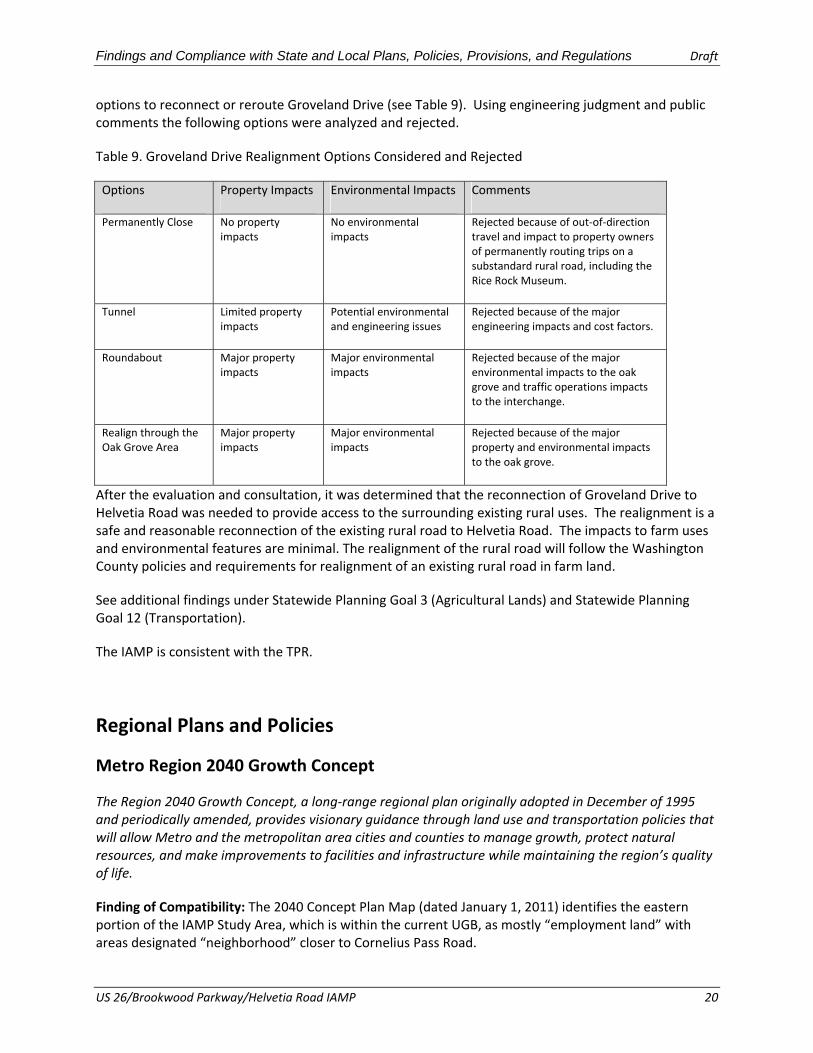
Findings and Compliance with State and Local Plans, Policies, Provisions, and Regulations Draft
options to reconnect or reroute Groveland Drive (see Table 9). Using engineering judgment and public comments the following options were analyzed and rejected.
Table 9. Groveland Drive Realignment Options Considered and Rejected
Options Property Impacts Environmental Impacts Comments
Permanently Close No property impacts
No environmental impacts
Rejected because of out‐of‐direction travel and impact to property owners of permanently routing trips on a substandard rural road, including the Rice Rock Museum.
Tunnel Limited property impacts
Potential environmental and engineering issues
Rejected because of the major engineering impacts and cost factors.
Roundabout Major property impacts
Major environmental impacts
Rejected because of the major environmental impacts to the oak grove and traffic operations impacts to the interchange.
Realign through the Oak Grove Area
Major property impacts
Major environmental impacts
Rejected because of the major property and environmental impacts to the oak grove.
After the evaluation and consultation, it was determined that the reconnection of Groveland Drive to Helvetia Road was needed to provide access to the surrounding existing rural uses. The realignment is a safe and reasonable reconnection of the existing rural road to Helvetia Road. The impacts to farm uses and environmental features are minimal. The realignment of the rural road will follow the Washington County policies and requirements for realignment of an existing rural road in farm land.
See additional findings under Statewide Planning Goal 3 (Agricultural Lands) and Statewide Planning Goal 12 (Transportation).
The IAMP is consistent with the TPR.
Regional Plans and Policies
Metro Region 2040 Growth Concept
The Region 2040 Growth Concept, a long‐range regional plan originally adopted in December of 1995 and periodically amended, provides visionary guidance through land use and transportation policies that will allow Metro and the metropolitan area cities and counties to manage growth, protect natural resources, and make improvements to facilities and infrastructure while maintaining the region’s quality of life.
Finding of Compatibility: The 2040 Concept Plan Map (dated January 1, 2011) identifies the eastern portion of the IAMP Study Area, which is within the current UGB, as mostly “employment land” with areas designated “neighborhood” closer to Cornelius Pass Road.
US 26/Brookwood Parkway/Helvetia Road IAMP 20

Findings and Compliance with State and Local Plans, Policies, Provisions, and Regulations Draft
Employment lands are typically considered industrial areas and are described as the following in the Region 2040 Growth Concept:
Serving as hubs for regional commerce, industrial land and freight facilities for truck, marine, air and rail cargo provide the ability to generate and move goods in and out of the region. Access to these areas is centered on rail, the regional freeway system and key roadway connections. Keeping these connections strong is critical to maintaining a healthy regional economy.
The third goal of the IAMP, as referenced in Technical Memorandum #1, is to “accommodate planned growth that depends on the interchange,” which is consistent with the Region 2040 Growth Concept employment industrial areas designation.
The IAMP includes improvement projects that will serve as key roadway connections to the regional transportation network to accommodate the planned industrial growth in the area and to protect the function of the interchange in support of efficient freight movement through the region. The IAMP is consistent with the 2040 Growth Concept.
Metro Urban Growth Management Functional Plan (UGMFP)
The UGMFP (the Functional Plan) implements the Region 2040 Growth Concept and the Regional Framework Plan (a general, regional land use planning policy document that establishes a framework for planning in the region by linking land use and transportation plans). The Functional Plan requires cities and counties to designate boundaries for the 2040 Growth Concept Design Types, including the Portland Central City, Regional Centers, Town Centers, and Station Communities.
The purpose of the Functional Plan is to implement the Regional Urban Growth Goals and Objectives (RUGGO) adopted by the Metro Council, including the Metro Region 2040 Growth Concept and the Regional Framework Plan.
Finding of Compatibility: The three sections of the UGMFP most relevant to the US 26/Brookwood Parkway/Helvetia Road IAMP are: (1) Title 11: Planning for New Urban Areas, (2) Title 4: Industrial and Other Employment Areas, and (3) Title 3: Water Quality and Flood Management.
According to the March 17, 2011 Metro reserves map, the southwest quadrant of the US 26/Brookwood Parkway/Helvetia Road IAMP Study Area is designated as an urban reserve. A portion of the northwest quadrant is shown as an undesignated reserve area (8B‐urban). Title 11: Planning for New Urban Areas, details the components of a concept plan that local governments are required to prepare prior to adding an urban reserve to the UGB.
Metro requires that, before adding land into the UGB, the local jurisdiction must provide documentation that the comprehensive plan amendment is consistent with all applicable titles of the Functional Plan. The City of Hillsboro completed Concept Plans for the Evergreen, Shute Road, and Helvetia areas following their addition to the UGB in 2002 and 2005, as required under Metro’s Title 11. Since completing the concept planning analysis, the City of Hillsboro has annexed the entire Shute Road concept planning area and portions of the Helvetia concept planning area. The highly parcelized Evergreen concept planning area remains outside the Hillsboro city limits. Planning efforts and urban reserves allotments are discussed further under Section 3, Ongoing Planning Efforts, below. The transportation and circulation improvement projects in the IAMP are consistent with Title 11: Planning
US 26/Brookwood Parkway/Helvetia Road IAMP 21

Findings and Compliance with State and Local Plans, Policies, Provisions, and Regulations Draft
for New Urban Areas because they provide the framework for an improved road network to support development.
Title 4: Industrial and Other Employment Areas of the Functional Plan establishes the regulatory framework for protecting regionally significant industrial areas (RSIAs). These areas are near the region’s most significant transportation facilities, including US 26 in Hillsboro. Local jurisdictions implement the RSIA designation through zoning and special plan designations that limit land division of parcels of more than 50 acres in order to preserve large parcels for future industrial development. In some circumstances, larger parcels may be subdivided if the city has developed and adopted a master plan for the area, allowing clustering of similar industries to operate more productively than if they were in dispersed locations. Title 4 is an important component of the ongoing urban/rural reserves discussion (please see Section 3, Ongoing Planning Efforts). As areas are added to the UGB, Metro and local jurisdictions will be required to identify RSIAs and implement regulatory measures to ensure that those areas are protected for future industrial development. The proposed improvement projects in the IAMP are consistent with Title 4, because they are intended to support the planned industrial development in the area
Title 3: Water Quality and Flood Management protects designated Water Quality and Flood Management Areas by limiting or mitigating the impact of development activities on those areas. Best Management Practices and mitigation will limit the impact of development on water quality and flood management, and meet all local and federal regulations when each individual improvement project is being developed.
The IAMP is consistent with these documents.
Metro Regional Transportation Plan (RTP)
On June 10, 2010, Metro’s Joint Policy Advisory Committee on Transportation (JPACT) and the Metro Council approved the 2035 RTP for the purpose of completing a federal‐ and state‐required air quality conformity analysis of the proposed system. The RTP introduces the concept of organizing the region’s multimodal transportation improvements by mobility corridors. The regional mobility corridor framework calls for consideration of multiple facilities, modes, and land use when identifying needs and the most effective mix of land use and transportation solutions to improve mobility within a specific corridor area.
Finding of Compatibility: The IAMP is in Mobility Corridor 22 – Highway 217 to North Plains. The interchange improvements (JTA project) and IAMP are listed as a five‐ to ten‐year investment strategy.
The RTP identifies the overall function of the corridor as:
2040 Access: Connects the Central City to Hillsboro regional central the Sunset industrial area and provides regional access to Hillsboro Airport, Portland Community College (Rock Creek Campus), and the Oregon Graduate Institute.
Freight Mobility: Provides air freight access for west side industrial areas, and statewide access to marine and rail facilities.
Statewide Travel: Serves as a western gateway to the region, and provides access to Central City interstate hub and travel to the northern Oregon coast.
US 26/Brookwood Parkway/Helvetia Road IAMP 22

Findings and Compliance with State and Local Plans, Policies, Provisions, and Regulations Draft
The IAMP incorporates the RTP Corridor Function in its statement of interchange function, as follows:
The primary function of the US 26/Brookwood Parkway/Helvetia Road Interchange is to provide employee vehicle and bicycle commute trips and truck freight traffic access to existing and future large high‐technology employment centers based throughout North Hillsboro. The secondary function is to provide access to the residences in the unincorporated community surrounding the interchange.
According to Figure 2‐22 of the RTP, there is a designated Community Bikeway loop formed by NW West Union Road, NW Cornelius Pass Road, NW Brookwood Parkway, and NW Evergreen Parkway. NW Evergreen Parkway is a designated Community Bikeway throughout its length. Community Bikeways provide for travel to and within other 2040 Target Areas or areas identified for development as part of the 2040 Growth Concept. US 26 west of NW Brookwood Parkway is a designated Regional Bikeway. These routes also provide access to regional attractions, such as schools and parks, and connect neighborhoods to the rest of the regional bicycle network.
The IAMP is listed as a five‐ to ten‐year investment strategy, and therefore completion of the IAMP is consistent with and implements the RTP. All but one of the improvement projects include bicycle lanes that will be constructed to applicable standards to the maximum extent practicable. All but four of the improvement projects (which are new proposed streets) in the IAMP are included in the Metro 2035 RTP (Proposed IAMP Improvement Projects 2, 4, 8, and 11, see Table 8 in IAMP).
The IAMP is consistent with the RTP.
Metro Regional Transportation Functional Plan
The Regional Transportation Functional Plan (RTFP) implements the Goals and Objectives in section 2.3 of the Regional Transportation Plan (RTP). Cities and counties in the region implement the Goals and Objectives in their comprehensive plans, TSPs, other land use regulations, and transportation project development.
Finding of Compatibility: Development of the improvement projects will be done so in accordance with the local jurisdiction’s standards, which integrate RTFP standards. The IAMP is consistent with the TPR.
US 26/Brookwood Parkway/Helvetia Road IAMP 23