executive summary - great lakes and mississippi river...
TRANSCRIPT


GLMRIS Summary Report
May, 2013
Executive Summary
As part of the Great Lakes and Mississippi River Interbasin Study (GLMRIS), the U.S. Army Corps of Engineers (USACE), in collaboration with various other Federal and state resource agencies, evaluated all the potential aquatic pathways that exist or are likely to form across the nearly 1,500 mile (2,414 kilometer) basin divide separating runoff that flows into the Mississippi River Basin from runoff that flows into the Great Lakes Basin. Where it was determined that an aquatic pathway exists or was found capable of forming from up to a one percent recurrence interval storm event, the evaluation also included a qualitative assessment of the probability that certain aquatic nuisance species (ANS) would be able to reach the pathway on their own through connecting waterways and then use it to cross into the adjacent basin. A total of 36 locations were identified in 2010 where an aquatic pathway was initially thought to exist. Based on review of available resource information and some site investigation, this was subsequently reduced to 18 locations that were then subjected to more detailed analysis in 2011-2012. A detailed report for each of these locations was produced with the results summarized here. These reports, or pathway assessments, are the next step in a tiered approach to assess the risk associated with the spread of ANS between the Great Lakes and Mississippi River Basins outside of the Chicago Area Waterway System (CAWS). This Summary Report presents the results, methodology, and key evidence used to assess each of the 18 locations that were investigated in 2011 and 2012.

GLMRIS Summary Report
May, 2013

GLMRIS Summary Report
May, 2013
i
Table of Contents1 Introduction . . . . . . . . . . . . . . . . . . . . . . . . . . . . . . . . . . . . . . . . . . . . . . . . . . . . . . . . . . . . . . . . . . . . . . . . . . . 1 1.1 Purpose. . . . . . . . . . . . . . . . . . . . . . . . . . . . . . . . . . . . . . . . . . . . . . . . . . . . . . . . . . . . . . . . . . . . . . . . . . . 1 1.2 ANS Terminology . . . . . . . . . . . . . . . . . . . . . . . . . . . . . . . . . . . . . . . . . . . . . . . . . . . . . . . . . . . . . . . . . . . 2 1.3 Authorization . . . . . . . . . . . . . . . . . . . . . . . . . . . . . . . . . . . . . . . . . . . . . . . . . . . . . . . . . . . . . . . . . . . . . . . 4 1.4 Scope of Assessment . . . . . . . . . . . . . . . . . . . . . . . . . . . . . . . . . . . . . . . . . . . . . . . . . . . . . . . . . . . . . . . . 4 1.5 Study Team . . . . . . . . . . . . . . . . . . . . . . . . . . . . . . . . . . . . . . . . . . . . . . . . . . . . . . . . . . . . . . . . . . . . . . . . 52 Study Area . . . . . . . . . . . . . . . . . . . . . . . . . . . . . . . . . . . . . . . . . . . . . . . . . . . . . . . . . . . . . . . . . . . . . . . . . . . 53 Methodology . . . . . . . . . . . . . . . . . . . . . . . . . . . . . . . . . . . . . . . . . . . . . . . . . . . . . . . . . . . . . . . . . . . . . . . . . . 6 3.1 Coordination . . . . . . . . . . . . . . . . . . . . . . . . . . . . . . . . . . . . . . . . . . . . . . . . . . . . . . . . . . . . . . . . . . . . . . 6 3.2 ANS of Concern . . . . . . . . . . . . . . . . . . . . . . . . . . . . . . . . . . . . . . . . . . . . . . . . . . . . . . . . . . . . . . . . . . . 6 3.3 Identification of Potential Pathways . . . . . . . . . . . . . . . . . . . . . . . . . . . . . . . . . . . . . . . . . . . . . . . . . . . 10 3.4 Pathway Assessment . . . . . . . . . . . . . . . . . . . . . . . . . . . . . . . . . . . . . . . . . . . . . . . . . . . . . . . . . . . . . . 10 3.5 Example Calculation of Overall Aquatic Pathway Viability . . . . . . . . . . . . . . . . . . . . . . . . . . . . . . . . . . 144 Results and Discussion . . . . . . . . . . . . . . . . . . . . . . . . . . . . . . . . . . . . . . . . . . . . . . . . . . . . . . . . . . . . . . . . . 15 4.1 Indiana . . . . . . . . . . . . . . . . . . . . . . . . . . . . . . . . . . . . . . . . . . . . . . . . . . . . . . . . . . . . . . . . . . . . . . . . . . 20 4.1.1 Eagle Marsh . . . . . . . . . . . . . . . . . . . . . . . . . . . . . . . . . . . . . . . . . . . . . . . . . . . . . . . . . . . . . . . . . . . 21 4.1.2 Loomis Lake . . . . . . . . . . . . . . . . . . . . . . . . . . . . . . . . . . . . . . . . . . . . . . . . . . . . . . . . . . . . . . . . . . . 26 4.1.3 Parker-Cobb Ditch . . . . . . . . . . . . . . . . . . . . . . . . . . . . . . . . . . . . . . . . . . . . . . . . . . . . . . . . . . . . . . 31 4.2 Minnesota . . . . . . . . . . . . . . . . . . . . . . . . . . . . . . . . . . . . . . . . . . . . . . . . . . . . . . . . . . . . . . . . . . . . . . . . 35 4.2.1 Libby Branch of Swan River . . . . . . . . . . . . . . . . . . . . . . . . . . . . . . . . . . . . . . . . . . . . . . . . . . . . . . . 36 4.2.2 Swan River . . . . . . . . . . . . . . . . . . . . . . . . . . . . . . . . . . . . . . . . . . . . . . . . . . . . . . . . . . . . . . . . . . . . 40 4.3 New York . . . . . . . . . . . . . . . . . . . . . . . . . . . . . . . . . . . . . . . . . . . . . . . . . . . . . . . . . . . . . . . . . . . . . . . . . 43 4.3.1 East Mud Lake . . . . . . . . . . . . . . . . . . . . . . . . . . . . . . . . . . . . . . . . . . . . . . . . . . . . . . . . . . . . . . . . . 44 4.4 Ohio. . . . . . . . . . . . . . . . . . . . . . . . . . . . . . . . . . . . . . . . . . . . . . . . . . . . . . . . . . . . . . . . . . . . . . . . . . . . . 48 4.4.1 Grand Lake St. Marys . . . . . . . . . . . . . . . . . . . . . . . . . . . . . . . . . . . . . . . . . . . . . . . . . . . . . . . . . . . . 49 4.4.2 Little Killbuck Creek . . . . . . . . . . . . . . . . . . . . . . . . . . . . . . . . . . . . . . . . . . . . . . . . . . . . . . . . . . . . . 53 4.4.3 Mosquito Creek Lake . . . . . . . . . . . . . . . . . . . . . . . . . . . . . . . . . . . . . . . . . . . . . . . . . . . . . . . . . . . . 58 4.4.4 Ohio - Erie Canal at Long Lake. . . . . . . . . . . . . . . . . . . . . . . . . . . . . . . . . . . . . . . . . . . . . . . . . . . . . 61 4.5 Pennsylvania . . . . . . . . . . . . . . . . . . . . . . . . . . . . . . . . . . . . . . . . . . . . . . . . . . . . . . . . . . . . . . . . . . . . . 66 4.6 Wisconsin . . . . . . . . . . . . . . . . . . . . . . . . . . . . . . . . . . . . . . . . . . . . . . . . . . . . . . . . . . . . . . . . . . . . . . . . 71 4.6.1 Brule Headwaters . . . . . . . . . . . . . . . . . . . . . . . . . . . . . . . . . . . . . . . . . . . . . . . . . . . . . . . . . . . . . . 72 4.6.2 Hatley – Plover River. . . . . . . . . . . . . . . . . . . . . . . . . . . . . . . . . . . . . . . . . . . . . . . . . . . . . . . . . . . . . 76 4.6.3 Jerome Creek . . . . . . . . . . . . . . . . . . . . . . . . . . . . . . . . . . . . . . . . . . . . . . . . . . . . . . . . . . . . . . . . . . 79 4.6.4 Menomonee Falls (South and West). . . . . . . . . . . . . . . . . . . . . . . . . . . . . . . . . . . . . . . . . . . . . . . . . 83 4.6.5 Portage (Downstream and Canal) . . . . . . . . . . . . . . . . . . . . . . . . . . . . . . . . . . . . . . . . . . . . . . . . . . 87 4.6.6 Portage (Upstream) . . . . . . . . . . . . . . . . . . . . . . . . . . . . . . . . . . . . . . . . . . . . . . . . . . . . . . . . . . . . . 92 4.6.7 Rosendale – Brandon . . . . . . . . . . . . . . . . . . . . . . . . . . . . . . . . . . . . . . . . . . . . . . . . . . . . . . . . . . . . 96 4.6.8 South Aniwa . . . . . . . . . . . . . . . . . . . . . . . . . . . . . . . . . . . . . . . . . . . . . . . . . . . . . . . . . . . . . . . . . . 1005. Opportunities and Jurisdictional Guide . . . . . . . . . . . . . . . . . . . . . . . . . . . . . . . . . . . . . . . . . . . . . . . . . . . . 1036. References . . . . . . . . . . . . . . . . . . . . . . . . . . . . . . . . . . . . . . . . . . . . . . . . . . . . . . . . . . . . . . . . . . . . . . . . . 108

ii GLMRIS Summary Report
May, 2013
List of Tables
Table 1: ANS of Concern for GLMRIS . . . . . . . . . . . . . . . . . . . . . . . . . . . . . . . . . . . . . . . . . . . . . . . . . . . . . . . . . . 8Table 2: ANS of Concern Threatening the Mississippi River Basin . . . . . . . . . . . . . . . . . . . . . . . . . . . . . . . . . . . . 9Table 3: ANS of Concern Threatening the Great Lakes Basin . . . . . . . . . . . . . . . . . . . . . . . . . . . . . . . . . . . . . . . . 9Table 4: Example Calculation of Pathway Viability for ANS Spreading into the Great Lakes Basin . . . . . . . . . . 14Table 5: Example Calculation of Pathway Viability for ANS Spreading into the Mississippi River Basin . . . . . . . 14Table 6: Flow Characteristics Summary . . . . . . . . . . . . . . . . . . . . . . . . . . . . . . . . . . . . . . . . . . . . . . . . . . . . . . . 16Table 7: Summary of FA2 Study for Aquatic Pathway Viability . . . . . . . . . . . . . . . . . . . . . . . . . . . . . . . . . . . . . . 18Table 8: Summary of FA2 Results for Each ANS Evaluated. . . . . . . . . . . . . . . . . . . . . . . . . . . . . . . . . . . . . . . . . 19Table 9: ANS of Concern for Eagle Marsh, IN Aquatic Pathway. . . . . . . . . . . . . . . . . . . . . . . . . . . . . . . . . . . . . . 21Table 10: Eagle Marsh Pathway Viability for ANS Spreading into the Great Lakes Basin . . . . . . . . . . . . . . . . . . 25Table 11: Eagle Marsh Pathway Viability for ANS Spreading into the Mississippi River Basin . . . . . . . . . . . . . . 25Table 12: ANS of Concern for Loomis Lake, IN Aquatic Pathway . . . . . . . . . . . . . . . . . . . . . . . . . . . . . . . . . . . . 26Table 13: Loomis Lake Pathway Viability for ANS Spreading into the Great Lakes Basin . . . . . . . . . . . . . . . . . . 30Table 14: Loomis Lake Pathway Viability for ANS Spreading into the Mississippi River Basin . . . . . . . . . . . . . . 30Table 15: ANS of Concern for Parker-Cobb Ditch, IN Aquatic Pathway . . . . . . . . . . . . . . . . . . . . . . . . . . . . . . . . 31Table 16: Parker-Cobb Pathway Viability for ANS Spreading into the Great Lakes Basin . . . . . . . . . . . . . . . . . . 34Table 17: Parker-Cobb Pathway Viability for ANS Interbasin Transfer . . . . . . . . . . . . . . . . . . . . . . . . . . . . . . . . . 34Table 18: ANS of Concern for Libby Branch Swan River, MN Aquatic Pathway . . . . . . . . . . . . . . . . . . . . . . . . . 36Table 19:Libby Branch of Swan River Pathway Viability for ANS Spreading into the Great Lakes Basin . . . . . . 39Table 20:Libby Branch of Swan River Pathway Viability for ANS Spreading into the Mississippi River Basin . . . 39Table 21: Swan River Pathway Viability for ANS Interbasin Transfer . . . . . . . . . . . . . . . . . . . . . . . . . . . . . . . . . . 42Table 22: ANS of Concern for East Mud Lake, NY Aquatic Pathway . . . . . . . . . . . . . . . . . . . . . . . . . . . . . . . . . . 44Table 23: East Mud Lake Pathway Viability for ANS Interbasin Transfer . . . . . . . . . . . . . . . . . . . . . . . . . . . . . . . 47Table 24: ANS of Concern for Grand Lake St. Marys, OH Aquatic Pathway . . . . . . . . . . . . . . . . . . . . . . . . . . . . 49Table 25: Grand Lake St. Marys Pathway Viability for ANS Spreading into the Great Lakes Basin. . . . . . . . . . . 52Table 26: Grand Lake St. Marys Pathway Viability for ANS Spreading into the Mississippi River Basin . . . . . . . 52Table 27: ANS of Concern for Little Killbuck Creek, OH Aquatic Pathway . . . . . . . . . . . . . . . . . . . . . . . . . . . . . . 53Table 28: Little Killbuck Creek Pathway Viability for ANS Spreading into the Great Lakes Basin . . . . . . . . . . . . 57Table 29: Little Killbuck Creek Pathway Viability for ANS Spreading into the Mississippi River Basin. . . . . . . . . 57Table 30: Mosquito Creek Lake Pathway Viability for ANS Interbasin Transfer . . . . . . . . . . . . . . . . . . . . . . . . . . 60Table 31: ANS of Concern for Ohio-Erie Canal at Long Lake, OH Aquatic Pathway . . . . . . . . . . . . . . . . . . . . . . 61Table 32: Ohio-Erie Canal at Long Lake Pathway Viability for ANS Interbasin Transfer . . . . . . . . . . . . . . . . . . . 65Table 33: ANS of Concern for Brule Headwaters, WI Aquatic Pathway . . . . . . . . . . . . . . . . . . . . . . . . . . . . . . . . 72Table 34: Brule Headwater Pathway Viability for ANS Spreading into the Great Lakes Basin. . . . . . . . . . . . . . . 75Table 35: Brule Headwater Pathway Viability for ANS Spreading into the Mississippi River Basin . . . . . . . . . . . 75Table 36: ANS of Concern for Hatley-Plover River, WI Aquatic Pathway . . . . . . . . . . . . . . . . . . . . . . . . . . . . . . . 78Table 37: Jerome Creek Pathway Viability for ANS Interbasin Transfer. . . . . . . . . . . . . . . . . . . . . . . . . . . . . . . . 82Table 38: ANS of Concern fo Menomonee Falls, WI Aquatic Pathway. . . . . . . . . . . . . . . . . . . . . . . . . . . . . . . . . 83Table 39: Menomonee Falls Pathway Viability for ANS Spreading into the Great Lakes Basin . . . . . . . . . . . . . . 86Table 40: Menomonee Falls Pathway Viability for ANS Spreading into the Mississippi River Basin . . . . . . . . . . 86Table 41: ANS of Concern for Portage Downstream and Canal, WI Aquatic Pathway. . . . . . . . . . . . . . . . . . . . . 87Table 42: Portage Downstream and Canal Pathway Viability for ANS Spreading into the Great Lakes Basin . . . . 91Table 43: Portage Downstream and Canal Pathway Viability for ANS Spreading into the Mississippi River Basin. 91Table 44: ANS of Concern for Portage Upstream, WI Aquatic Pathway. . . . . . . . . . . . . . . . . . . . . . . . . . . . . . . . 92Table 45: Portage Upstream Pathway Viability for ANS Spreading into the Great Lakes Basin . . . . . . . . . . . . . 95

GLMRIS Summary Report
May, 2013
iii
Table 46: Portage Upstream Pathway Viability for ANS Spreading into the Mississippi River Basin . . . . . . . . . . 95Table 47: ANS of Concern for Rosendale-Brandon, WI Aquatic Pathway . . . . . . . . . . . . . . . . . . . . . . . . . . . . . . 96Table 48: Rosendale-Brandon Pathway Viability for ANS Spreading into the Great Lakes Basin . . . . . . . . . . . . 99Table 49: Rosendale-Brandon Pathway Viability for ANS Spreading into the Mississippi River Basin . . . . . . . . 99Table 50: South Aniwa Pathway Viability for ANS Interbasin Transfer . . . . . . . . . . . . . . . . . . . . . . . . . . . . . . . . 102
List of Figures
Figure 1: Potential Aquatic Pathway Locations . . . . . . . . . . . . . . . . . . . . . . . . . . . . . . . . . . . . . . . . . . . . . . . . . . . 3Figure 2: Diagram of Focus Area 2 Aquatic Pathway Assessment Model . . . . . . . . . . . . . . . . . . . . . . . . . . . . . . 13Figure 3: Flow During 100-year Flood Event: Focus Area 1 vs. Focus Area 2. . . . . . . . . . . . . . . . . . . . . . . . . . . 17Figure 4: Photo of Eagle Marsh, IN Location . . . . . . . . . . . . . . . . . . . . . . . . . . . . . . . . . . . . . . . . . . . . . . . . . . . . 21Figure 5: Eagle Marsh, IN Location Map . . . . . . . . . . . . . . . . . . . . . . . . . . . . . . . . . . . . . . . . . . . . . . . . . . . . . . . 22Figure 6: Habitat Map of Eagle Marsh, IN . . . . . . . . . . . . . . . . . . . . . . . . . . . . . . . . . . . . . . . . . . . . . . . . . . . . . . 23Figure 7: Photo of Temporary ANS Barrier Fence at Eagle Marsh, IN . . . . . . . . . . . . . . . . . . . . . . . . . . . . . . . . 23Figure 8: Photo of Flooding at Eagle Marsh, IN . . . . . . . . . . . . . . . . . . . . . . . . . . . . . . . . . . . . . . . . . . . . . . . . . . 24Figure 9: Photo of Graham McCulloch Ditch and Culverts in Left Bank Berm . . . . . . . . . . . . . . . . . . . . . . . . . . . 24Figure 10: Photo of Loomis Lake, IN . . . . . . . . . . . . . . . . . . . . . . . . . . . . . . . . . . . . . . . . . . . . . . . . . . . . . . . . . . 26Figure 11: Loomis Lake, IN Location Map . . . . . . . . . . . . . . . . . . . . . . . . . . . . . . . . . . . . . . . . . . . . . . . . . . . . . . 28Figure 12: Plan and cross-section views of Basin Divide at Loomis Lake, IN . . . . . . . . . . . . . . . . . . . . . . . . . . . 29Figure 13: Photo of Basin Divide at Parker-Cobb Ditch, IN Pathway Locaton . . . . . . . . . . . . . . . . . . . . . . . . . . 31Figure 14: Parker-Cobb Ditch, IN Location Map. . . . . . . . . . . . . . . . . . . . . . . . . . . . . . . . . . . . . . . . . . . . . . . . . . 32Figure 15: Photo of Libby Branch Swan River, MN Pathway Location. . . . . . . . . . . . . . . . . . . . . . . . . . . . . . . . . 36Figure 16: Libby Branch Swan River, MN Location Map . . . . . . . . . . . . . . . . . . . . . . . . . . . . . . . . . . . . . . . . . . . 37Figure 17: Photo of Culvert Under 154th Ave., Libby Branch Swan River, MN . . . . . . . . . . . . . . . . . . . . . . . . . . 38Figure 18: Photo of Drop Structure at US Route 2, Libby Branch Swan River, MN . . . . . . . . . . . . . . . . . . . . . . 38Figure 19: Photo of Swan River, MN area . . . . . . . . . . . . . . . . . . . . . . . . . . . . . . . . . . . . . . . . . . . . . . . . . . . . . . 40Figure 20: Swan River, MN Location Map . . . . . . . . . . . . . . . . . . . . . . . . . . . . . . . . . . . . . . . . . . . . . . . . . . . . . . 41Figure 21: East Mud Lake, NY Location Map. . . . . . . . . . . . . . . . . . . . . . . . . . . . . . . . . . . . . . . . . . . . . . . . . . . . 45Figure 22: Photo of Northwest Pond at East Mud Lake, NY Location . . . . . . . . . . . . . . . . . . . . . . . . . . . . . . . . . 46Figure 23: Photo of Southern Berm of Edwin Butcher Pond at East Mud Lake, NY Location . . . . . . . . . . . . . . . 46Figure 24: Photo of Silver Creek Reservoir Dam and Spillway, Parcells Corners, NY . . . . . . . . . . . . . . . . . . . . 46Figure 25: Photo of Grand Lake St. Marys, OH Outflow into Mississippi River Basin . . . . . . . . . . . . . . . . . . . . . 49Figure 26: Grand Lake St. Marys, OH Location Map . . . . . . . . . . . . . . . . . . . . . . . . . . . . . . . . . . . . . . . . . . . . . . 50Figure 27: Photo of Agricultural Field and Ditch at Little Killbuck Creek, OH Pathway . . . . . . . . . . . . . . . . . . . . 53Figure 28: Little Killbuck Creek, OH Location Map . . . . . . . . . . . . . . . . . . . . . . . . . . . . . . . . . . . . . . . . . . . . . . . 54Figure 29: Photo of Flooded Area Near Willow Road and Garden Isle Road Intersection . . . . . . . . . . . . . . . . . 55Figure 30: Photo of Same Area as Figure 29 After Flood Water Receded. . . . . . . . . . . . . . . . . . . . . . . . . . . . . . 55Figure 31: Photo of Flooded Field West of Franchester Road at Little Killbuck Creek, OH . . . . . . . . . . . . . . . . 56Figure 32: Photo of Wetland That Spans Basin Divide on Western Side of Little Killbuck Creek, OH. . . . . . . . . 56Figure 33: Photo of Basin Divide at Mosquito Creek Lake, OH Pathway Location . . . . . . . . . . . . . . . . . . . . . . . 58Figure 34: Mosquito Creek Lake, OH Location Map . . . . . . . . . . . . . . . . . . . . . . . . . . . . . . . . . . . . . . . . . . . . . . 59Figure 35: Photo of Ohio-Erie Canal at Long Lake, OH . . . . . . . . . . . . . . . . . . . . . . . . . . . . . . . . . . . . . . . . . . . 61Figure 36: Ohio-Erie Canal at Long Lake, OH Location Map . . . . . . . . . . . . . . . . . . . . . . . . . . . . . . . . . . . . . . . 62Figure 37: Photo of Intake to Long Lake Feeder Gate . . . . . . . . . . . . . . . . . . . . . . . . . . . . . . . . . . . . . . . . . . . . 63Figure 38: Photo of Outlet of Long Lake Feeder Gate . . . . . . . . . . . . . . . . . . . . . . . . . . . . . . . . . . . . . . . . . . . . . 63

iv GLMRIS Summary Report
May, 2013
Figure 39: Portage Lakes Area, OH Location Map. . . . . . . . . . . . . . . . . . . . . . . . . . . . . . . . . . . . . . . . . . . . . . . . 64Figure 40: Photo of Ohio-Erie Canal Lock 1 Control Weir . . . . . . . . . . . . . . . . . . . . . . . . . . . . . . . . . . . . . . . . . . 65Figure 41: Photo of Long Lake, OH . . . . . . . . . . . . . . . . . . . . . . . . . . . . . . . . . . . . . . . . . . . . . . . . . . . . . . . . . . . 65Figure 42: Pennsylvania Potential Pathways Location Map . . . . . . . . . . . . . . . . . . . . . . . . . . . . . . . . . . . . . . . . 68Figure 43: Pennsylvania Potential Pathway Number 6 Location Map . . . . . . . . . . . . . . . . . . . . . . . . . . . . . . . . . 69Figure 44: Digital Elevation Map of Photo of Culver Pennsylvania Potential Pathway Number 6 . . . . . . . . . . . . 70Figure 45: Photo of Habitat at Brule Headwaters, WI . . . . . . . . . . . . . . . . . . . . . . . . . . . . . . . . . . . . . . . . . . . . . 72Figure 46: Brule Headwater, WI Location Map. . . . . . . . . . . . . . . . . . . . . . . . . . . . . . . . . . . . . . . . . . . . . . . . . . . 74Figure 47: Photo of Wetland Habitat near Hatley-Plover River, WI Location . . . . . . . . . . . . . . . . . . . . . . . . . . . 76Figure 48: Hatley-Plover River, WI Location Map . . . . . . . . . . . . . . . . . . . . . . . . . . . . . . . . . . . . . . . . . . . . . . . . 77Figure 49: Jerome Creek, WI Location Map. . . . . . . . . . . . . . . . . . . . . . . . . . . . . . . . . . . . . . . . . . . . . . . . . . . . . 80Figure 50: Potential Locations of Interbasin Flow at Jerome Creek, WI . . . . . . . . . . . . . . . . . . . . . . . . . . . . . . . 81Figure 51: Photo of habitat at Menomonee Falls, WI Location. . . . . . . . . . . . . . . . . . . . . . . . . . . . . . . . . . . . . . . 83Figure 52: Menomonee Falls, WI Location Map. . . . . . . . . . . . . . . . . . . . . . . . . . . . . . . . . . . . . . . . . . . . . . . . . . 84Figure 53: Photo of Urban Storm Drain Near Ann Avenue at Menomonee Falls, WI . . . . . . . . . . . . . . . . . . . . . . 85Figure 54: Photo of Swan Lake Wildlife Area, Portage, WI . . . . . . . . . . . . . . . . . . . . . . . . . . . . . . . . . . . . . . . . . 87Figure 55: Portage Downstream, WI Location Map . . . . . . . . . . . . . . . . . . . . . . . . . . . . . . . . . . . . . . . . . . . . . . . 88Figure 56: Portage Flood Risk Management Project Un-gated Interbasin Flow Structure. . . . . . . . . . . . . . . . . . 89Figure 57: Photo of Portage Canal Lock . . . . . . . . . . . . . . . . . . . . . . . . . . . . . . . . . . . . . . . . . . . . . . . . . . . . . . . 89Figure 58: Photo of Portage Canal Inlet Structure . . . . . . . . . . . . . . . . . . . . . . . . . . . . . . . . . . . . . . . . . . . . . . . . 90Figure 59: Photo of Lewiston Levee at Portage Upstream, WI . . . . . . . . . . . . . . . . . . . . . . . . . . . . . . . . . . . . . . 92Figure 60: Portage Upstream, WI Location Map . . . . . . . . . . . . . . . . . . . . . . . . . . . . . . . . . . . . . . . . . . . . . . . . . 93Figure 61: Photo of Culvert Under Lewiston Levee at Portage Upstream, WI . . . . . . . . . . . . . . . . . . . . . . . . . . . 94Figure 62: Photo of Culvert Under County Road M at Rosendale-Brandon, WI Location . . . . . . . . . . . . . . . . . . 96Figure 63: Rosendale-Brandon, WI Location Map . . . . . . . . . . . . . . . . . . . . . . . . . . . . . . . . . . . . . . . . . . . . . . . . 97Figure 64: Photo of Area near Watershed Divide at South Aniwa, WI Pathway Location . . . . . . . . . . . . . . . . . 100Figure 65: South Aniwa, WI Location Map . . . . . . . . . . . . . . . . . . . . . . . . . . . . . . . . . . . . . . . . . . . . . . . . . . . . . 101

GLMRIS Summary Report
May, 2013
v
Acronyms
ANS . . . . . . Aquatic Nuisance SpeciesANSTF . . . . Aquatic Nuisance Species Task ForceCAWS . . . . Chicago Area Waterway SystemCEQ . . . . . . Council on Environmental QualityCFS . . . . . . Cubic Feet per SecondCMP . . . . . . Corrugated Metal PipeCMS . . . . . . Cubic Meters per SecondDEM . . . . . . Digital Elevation ModelFEMA . . . . . Federal Emergency Management AgencyGIS . . . . . . Geographic Information SystemGLFC . . . . . Great Lakes Fishery CommissionGLMRIS . . . Great Lakes and Mississippi River Interbasin StudyHUC . . . . . . Hyrdologic Unit CodesIDNR . . . . . Indiana Department of Natural ResourcesMNDNR . . . Minnesota Department of Natural ResourcesNAS . . . . . . Nonindigenous Aquatic SpeciesNCDC . . . . National Climatic Data CenterNEPA . . . . . National Environmental Policy ActNOAA. . . . . National Oceanic and Atmospheric AdministrationNRCS . . . . Natural Resources Conservation ServiceRCP . . . . . . Reinforced Concrete PipeUSACE . . . U.S. Army Corps of EngineersUSFWS . . . U.S. Fish and Wildlife ServiceUSGS . . . . U.S. Geological SurveyWRDA . . . . Water Resources Development Act

GLMRIS Summary Report
May, 2013
1
prepared in accordance with the detailed procedures and criteria specified in the GLMRIS Focus Area 2 Study Plan (USACE, 2011a). The primary purpose of this Summary Report is to present a compilation of the key evidence and results from each of these pathway assessments. This report is also intended to contribute to the accomplishment of each of the four objectives identified in the Study Plan (USACE, 2011a):
To develop a definitive inventory of all potential locations where a viable surface water connection between headwater streams on both sides of the drainage divide exists or is likely to form between the Great Lakes and the Mississippi River Basins;
To create a standalone report for each potential aquatic pathway location that characterizes the probability of aquatic pathway formation and the probability of interbasin spread of ANS at that particular location;
To develop clear problem statements that frame the means, constraints, uncertainties, and likelihood of the interbasin spread of ANS via the potential aquatic pathways; and
To illustrate how the collective authorities, resources, and capabilities of USACE and other applicable Federal, State, local, and non-governmental stakeholder organizations may best be coordinated and applied to prevent the interbasin spread of ANS through the aquatic pathways.
A preliminary assessment was completed in 2010 which identified a total of 36 locations where a surface water connection across the basin divide appeared possible. This Great Lakes and Mississippi River Interbasin Study Other Pathways Preliminary Risk Characterization was a rapidly conducted study intended to accomplish two objectives (USACE, 2010). The first and primary objective was to determine if there were any locations within the GLMRIS, aside from the CAWS, where there was believed to exist a near term risk for the interbasin spread of ANS. “Near term” in this case meant that implementation of some sort of measure(s) might be warranted to reduce the potential for ANS transfer at that particular location in the short term versus setting that site aside for further analysis. The only location that
1 Introduction
1.1 PurposeThe U.S. Army Corps of Engineers (USACE) Great Lakes and Mississippi River Interbasin Study (GLMRIS) evaluates the range of options and technologies available to prevent aquatic nuisance species (ANS) from spreading between the Great Lakes and Mississippi River Basins through the Chicago Sanitary and Ship Canal and other aquatic pathways. The GLMRIS Project Management Plan divides this Federal study into two separate focus areas. Focus Area 1 concerns the Chicago Area Waterway System (CAWS) that opens to Lake Michigan, and Focus Area 2 evaluated all other aquatic pathways that exist or are likely to form across the nearly 1,500-mile (2,414 kilometers) basin divide separating runoff that flows into the Mississippi River or its tributaries from runoff that flows into the Great Lakes and its tributaries. The aquatic pathway assessments within Focus Area 2 and summarized in this report were completed with the assistance of a broad array of Federal, State, and other partner agencies.
The Focus Area 2 portion of GLMRIS has produced a detailed Pathway Assessment for each of the 18 potential aquatic pathways that were found between the two basins. Each report evaluates key evidence from available information to qualitatively estimate the likelihood of an aquatic pathway forming and ANS being able to utilize it to reach the adjacent basin. Included in many of these pathway assessments, and briefly summarized at the end of this report, are some potential actions or opportunities that were identified which might prevent or reduce the probability of ANS transfer occurring between the basins. It should be noted, however, that the USACE is not necessarily the most appropriate agency to implement these opportunities since they often involve a broader range of Federal and state authorities and jurisdictions, and/or could more easily be implemented at a local level. These reports, or pathway assessments, are the next step in a tiered approach to assess the risk associated with the spread of ANS between the Great Lakes and Mississippi River Basins within Focus Area 2, and were

2 GLMRIS Summary Report
May, 2013
These summaries are presented in alphabetical order by state in Section 4 of this report. The reader should refer to each of these individual stand alone reports for more detailed information. It is important to note that these results represent only a snapshot in time and any subsequent modification of on-the-ground conditions, including downstream from the sites, could change the study findings. Accordingly, resource agencies and any prospective projects in these areas, or on connecting streams and ditches, need to take into consideration any potential effect that such actions might have on pathway connectivity, fish passage, and ultimately how the action(s) could change the ratings presented in these reports.
1.2 ANS TerminologyThis report addresses the problem of ANS invading, via surface-water pathways, the Great Lakes Basin from the Mississippi River Basin and vice versa. Aquatic nuisance species are nonindigenous species that threaten the diversity or abundance of native species or the ecological stability of infested waters, or commercial, agricultural, aquacultural, or recreational activities dependent on such waters.
The USGS Nonindigenous Aquatic Species (NAS) information resource http://nas.er.usgs.gov/about/faq.aspx defines NAS as “…a species that enters a body of water or aquatic ecosystem outside of its historic or native range.” (USGS, 2012).
Based on discussions between the USACE, USGS, and the U.S. Fish and Wildlife Service (USFWS), the following definitions were established for the purposes of the GLMRIS. All non-indigenous aquatic species (per the USGS definition above), that are present in the Great Lakes but not known to be present in the Mississippi River and its tributaries are defined as ANS of concern for GLMRIS. Likewise, all non-indigenous aquatic species present in the Mississippi River or its tributaries but not known to be present in the Great Lakes are also considered as ANS of concern for the GLMRIS. Therefore, the term ANS is synonymous with the term non-indigenous aquatic species in this report.
was determined to meet this criteria for near term risk was Eagle Marsh just south of Fort Wayne, Indiana. The Eagle Marsh location is indicated in Figure 1 as site number 6. The second objective was to refine the scope of the other aquatic pathways portion of the GLMRIS by developing a list of potential aquatic pathways that could form anywhere along the divide separating the Great Lakes and Mississippi River Basins, and help provide a basis for prioritizing future study efforts based upon an assessment of relative risk. The preliminary risk characterization was intended to support development and application of a risk-based approach to GLMRIS for preventing the spread of ANS between the Great Lakes and Mississippi River Basins (USACE, 2010). The preliminary report and the subsequent analysis contained in this Other Aquatic Pathways Summary Report have been produced for a broad audience ranging from the scientific community to the general public, and are specifically intended to identify any locations where an aquatic pathway exists or may form between the basins, and to evaluate the probability that specific ANS would be able to arrive at that pathway and cross into the new basin. The information in this Summary Report and the specific detailed Focus Area 2 reports are intended to provide a sound scientific basis for helping to prioritize future funding of GLMRIS and/or other actions at these potential aquatic pathway locations.
While there were no locations identified within the Commonwealth of Pennsylvania in 2010, additional collaboration in 2011 with U.S. Geological Survey (USGS), Natural Resources Conservation Service (NRCS), and the State resource agencies led to the reassessment of the potential existence of six aquatic pathways in Pennsylvania which is presented in Section 4.5 of this report. None of these six locations warranted the same level of analysis as was done for the 18 other locations along the Great Lakes and Mississippi River Basin divide. The findings from each of these six locations are contained within one report whereas the results from each of the 18 sites that were subjected to a more detailed evaluation are described in site specific assessment reports. Each of these 19 reports are available at http://glmris.anl.gov/.
This document compiles the results from each of these 19 reports into a brief summary section for quick reference.

GLMRIS Summary Report
May, 2013
3
OK
KS
MN
IA
WI
MI
IL
MO
AR
MS
AL GA
SC
NC
TN
IN OH
KY
WVVA
MD
PA
DE
NJ
NY
Lake Erie
Lake
Mic
higa
n
Lake Superior
Lake Huron
Lake Ontario
Illin
ois
R
.
Ohio
R.
M
i ssissippi R .
Missouri R.
M
issi
ssip
pi R
.Arkansas R.
Great Lakes Great Lakes Basin Upper Mississippi River Basin Lower Mississippi River Basin
NAME COUNTY STATE
East Mud Lake Chautauqua NY
Mosquito Lake - Grand River Trumbull OH
Ohio-Erie Canal at Long Lake Summit OH
Little Killbuck Creek Medina OH
Grand Lake-St Marys Mercer OH
Eagle Marsh, Fort Wayne Allen IN
Loomis Lake Porter IN
Parker-Cobb Ditch Porter IN
Portage (Upstream) Columbia WI
NAME COUNTY STATE
Portage (Downstream and Canal) Columbia WI
Jerome Creek Kenosha WI
Menomonee Falls Waukesha WI
Rosendale - Brandon Fond du Lac WI
Hatley-Plover River Marathon WI
S. Aniwa Wetlands Marathon-Shawano WI
Brule Headwaters Douglas WI
Swan River Itasca MN
Libby Branch of Swan River Aitkin MN
POTENTIAL AQUATIC PATHWAYS LOCATIONS AND RATINGS:
LEGEND
Low Medium High
1
11
12
14
15
17
18
2
5
7
3
10
13
16
4
8
9
6
Border of Great Lakes and Upper Mississippi River Basins
1
11
12
1414
15
1718
2
5
3
13
16
48
9
6
7
10
Figure 1. Potential aquatic pathway locations and associated ratings.

4 GLMRIS Summary Report
May, 2013
1.3 AuthorizationThe GLMRIS is a Federal study that was authorized in Section 3061(d) of the Water Resources Development Act of 2007 (WRDA, 2007). It prescribes the following authority to the Secretary of the Army and the USACE:
a. “(d) FEASIBILITY STUDY.-The Secretary, in consultation with appropriate Federal, State, local, and nongovernmental entities, shall conduct, at Federal expense, a feasibility study of the range of options and technologies available to prevent the spread of aquatic nuisance species between the Great Lakes and Mississippi River Basins through the Chicago Sanitary and Ship Canal and other aquatic pathways.”
The USACE headquarters issued specific guidance to the Great Lakes and Ohio River Division Commander for execution of the project, including the following general direction to:
“ …provide a thorough and comprehensive analysis of the options and technologies that could be applied to prevent the inter-basin transfer of aquatic nuisance species between the Great Lakes and Mississippi River through aquatic pathways.”
The results of these pathway assessment reports represent the first step toward the accomplishment of this directive in that they aid in identifying which of these aquatic pathways might be sufficiently viable to warrant further study or action by Federal or State agencies, or other applicable entities. These reports reflect a multi-agency collaborative effort to identify where the threat of ANS transfer is greatest within Focus Area 2.
1.4 Scope of Assessment
Although there are many vectors by which ANS could and do move between the Great Lakes and Mississippi River Basins, the GLMRIS authority is limited to study
only the range of options and technologies available to prevent the spread of ANS between the Great Lakes and Mississippi River Basins through aquatic pathways. That component of the Focus Area 2 portion of GLMRIS summarized in this document is focused on evaluating the likelihood of an aquatic pathway existing at the basin divide and, where applicable, the probability of select ANS getting from their current known locations in either basin up to and across the aquatic pathway into the adjacent basin within the next 50 years. Other non-aquatic pathways and vectors including transport by humans on watercraft, bait bucket transfers, aquarium releases from the pet trade, aquaculture practices, cultural practices, and the like are not evaluated in much detail as part of GLMRIS. In addition, spreading of ANS by attachment to other non-aquatic animals (e.g. transport by migratory waterfowl) is also outside the scope of this study. Although these vectors were not evaluated in the overall assessment of the likelihood that ANS could spread across the divide at the aquatic pathway locations, some of these non-aquatic methods of transport were still identified at locations where they were determined to most likely pose a threat. This provided a more comprehensive assessment of the overall ANS threats potentially affecting that particular aquatic pathway location. In general, threats posed by non-aquatic and anthropogenic vectors are not necessarily limited geographically to the aquatic pathways being evaluated. Rather, transfer of ANS by such mechanisms could theoretically occur with equal or even greater likelihood at multiple other locations along the basin divide, or from areas deeper within either basin. An assessment of these non-aquatic and anthropogenic vectors would require separate study and likely a slightly different list of ANS.
The following is a list of some of the more common sources of uncertainty that were encountered in completing this study. They affected the pathway assessments to varying extents depending on the location.
Very limited and often no data regarding the hydrology of these pathways was available during this investigation;
High resolution Digital Elevation Model (DEM) data was not available for all locations;

GLMRIS Summary Report
May, 2013
5
USGS NOAAUSFWSNRCSGreat Lakes Fishery Commission (GLFC)New York State Department of Environmental Conservation (NYSDEC)Pennsylvania Fish and Boat Commission (PAFBC)Pennsylvania Department of Environmental Protection (PADEP)Minnesota Department of Natural Resources (MNDNR)Ohio Department of Natural Resources (ODNR)Indiana Department of Natural Resources (IDNR)Wisconsin Department of Natural Resources (WDNR)Illinois Department of Natural Resources (IDNR)Michigan Department of Natural Resources (MDNR)Michigan Department of Environmental Quality (MDEQ)
2 Study Area
Focus Area 2 of GLMRIS evaluates potential surface-water connections between the Great Lakes and Mississippi River Basins in the states of New York, Pennsylvania, Ohio, Indiana, Wisconsin, and Minnesota. Any potential surface water connections within the state of Illinois are incorporated within Focus Area 1 of GLMRIS. Focus Area 2 encompasses all natural and man-made aquatic surface water pathways and hydraulic connections that exist or may form between the basins outside of the CAWS. The focus of this investigation is along the approximately 1,500-mile (2,414 km) basin divide which delineates the Great Lakes Basin drainage from the drainage of the Mississippi River Basin (Figure 1). However, areas throughout each basin away from the divide were also given consideration by the pathway teams as they developed their respective lists of ANS of concern for each applicable pathway location. The known existing locations of ANS within either basin were of importance in rating each species in its ability to reach and possibly cross over the basin divide at certain aquatic pathways. The USGS established the hydraulic unit codes (HUC) as a nested hierarchal system for subdividing large river
A complete understanding of specific ANS habitat requirements, capabilities, and habitat tolerences was not always available and applicability of existing information to the diverse habitats along the basin divide lend a level of uncertainty to the ratings;
In some instances there was conflicting data between available resources (e.g., FEMA flood mapping versus NRCS soil survey information);
Some FEMA flood mapping that has not been updated recently, or in some cases appeared to be inaccurate based on site investigations;
Potential inaccuracies in National Wetland Inventory (NWI) mapping due to resolution and age of the data at some locations.
1.5 Study TeamA multi-disciplinary team of individual water resource scientists and engineers from a broad array of Federal, State, and local organizations was assembled to complete the numerous site investigations and characterizations, provide input, and also provide review comments and guidance along the way. Over 30 individuals from USACE (two divisions; eight districts) and over 30 personnel from other organizations participated in this study. Contributing experts were from fields including, but not limited to, hydraulics and hydrology, soils, geographic information systems, biology, fisheries, aquatic ecology, and ANS specialists. A team of applicable experts was formed for each of the individual pathway locations that included USACE personnel from Great Lakes and Mississippi River Districts as well as personnel from the applicable state departments of natural resources. Additional experts were then brought in based on need and availability.
The following list of organizations generously collaborated with the USACE either through direct input on site characterizations and provision of data, providing guidance during the study process, or by participating in the review process:

6 GLMRIS Summary Report
May, 2013
Development of this plan also included input from the public and interested non-governmental organizations received during formal NEPA public scoping meetings which were held at 12 locations across the region in both basins between December 2010 and March 2011. The USACE requested the support and participation of the best available experts from the state and Federal agencies responsible for water resources, and fish and wildlife management in the states along the Great Lakes and Mississippi River Basin divide to address the critically important issue of preventing interbasin transfer of ANS. The USGS, NRCS, and each state DNR assigned personnel to assist each USACE pathway assessment team. In addition, a technical review team comprised of 16 senior level experts from the USACE and these external partner agencies, including NOAA and the GLFC, was assembled to review and guide the work of these teams. Overall, extensive collaboration among partner agencies, the review team, and other subject matter experts throughout the study has led to detailed Focus Area 2 pathway assessments.
3.2 ANS of Concern
The list of ANS of Concern for a particular location was developed by first consulting the USACE white paper titled, Non-Native Species of Concern and Dispersal Risk for the Great Lakes and Mississippi River Interbasin Study released in September 2011 (USACE, 2011b). This technical paper, prepared by a multi-disciplinary USACE Natural Resources team, took a broad look at the potential range of species that could be of concern to the GLMRIS. The paper is Appendix C of the GLMRIS Focus Area 2 Study Plan and it is an integral component of the plan. This USACE white paper included a review of 254 aquatic species that are either non-indigenous to either basin or native species that occur in one basin or the other. The list of 254 aquatic species were iteratively screened to identify all potential ANS that could be of concern in either basin and to systematically focus the study toward those species judged to pose the highest potential risk of ecological impacts if they became established in the other basin.
In the first screening iteration, 119 of the 254 aquatic species reviewed were determined to pose a potential threat of infiltrating the other basin and were carried
basins into progressively smaller drainage areas, and it was a primary tool used to define the location of the basin divide and the hydrologic conditions in the vicinity of potential surface water pathways across the divide.
Not included in the study area are portions along the Great Lakes Basin where runoff on the other side of the divide flows to a basin other than the Mississippi River Basin, (e.g. Hudson River, Delaware River, Susquehanna River, Chesapeake Bay, or Souris-Red-Rainy River Basins). Also, both the Great Lakes and Mississippi River Basins have open aquatic pathways to the Atlantic Ocean that are used for international commercial navigation For example, on the Great Lakes side are the Saint Lawrence Seaway and Erie Canal, and on the Mississippi River Basin side are the Port of New Orleans and the Lock and Dam facilities on the Mississippi and Ohio Rivers upstream of their confluence. Evaluation of those pathways is outside the scope of the GLMRIS.
3 Methodology
The GLMRIS risk analysis process is an adaptation of the generic model and process described in the Generic Nonindigenous Aquatic Organisms Risk Analysis Review Process (For Estimating Risk Associated with the Introduction of Nonindigenous Aquatic Organisms and How to Manage for that Risk) (ANSTF, 1996). The Aquatic Nuisance Species Task Force (ANSTF) defines the first step in this process as identification of interested parties and solicitation of input.
3.1 Coordination
The USACE identified interested parties and solicited input early in the process for Focus Area 2 and has included individual visits and discussions with the state agencies responsible for water resources, and fish and wildlife management in the eight states bordering the Great Lakes. The process used for the Focus Area 2 assessments has also been discussed in meetings with representatives of the Council on Environmental Quality (CEQ), USGS, USFWS, NOAA, NRCS, and GLFC.

GLMRIS Summary Report
May, 2013
7
Lakes from international waters, and information on other species cited by the review team as high risk potential invaders not yet in either basin (NOAA, 2011).
Each Focus Area 2 aquatic pathway team was granted flexibility in determining whether to add additional species to their assessment based on their review of available information and the actual location of the specific potential pathway relative to the known location of those ANS being considered. Based on concerns from local agencies about the potential for spread of Viral Hemorrhagic Septicemia virus (VHSv, Novirhabdovirus sp.), each Focus Area 2 aquatic pathway team evaluated whether VHSv should be included on the ANS of concern list for each of the Focus Area 2 aquatic pathways. Although VHSv has been identified in both basins (i.e., VHSv was confirmed in the Clark Fork Reservoir, Ohio, in the Ohio River Basin), it is yet to be determined that VHSv has established in the Mississippi River Basin. Minimizing the spread of VHSv remains a priority for the Great Lakes States (Great Lakes Commission, 2011; Kipp and Ricciardi, 2011). It was therefore included as an ANS of Concern threatening the Mississippi River Basin for most Focus Area 2 aquatic pathways.
No assessment of specific ANS was completed if it was determined that there was a low likelihood of an aquatic pathway existing at up to a one percent annual recurrence interval storm event. A recurrence interval relates any given storm, through statistical analysis, to the historical records of rainfall and runoff for a given area. The recurrence interval is based on the statistical probability that a given intensity storm event will be equaled or exceeded in any given year. For instance, a one percent annual frequency storm is a rainfall event that has a one percent probability, one chance in 100, of being equaled or exceeded in any given year. This level of storm event was commonly referred to as a 100-year storm event, but this term has led people to incorrectly conclude that a 100-year storm event is one that only occurs once in any given 100-year period. A ten percent annual recurrence interval storm (formerly referred to as a ten year event) is a smaller event that has a one in 10 chance of being exceeded during any given year, and a 0.2 percent annual recurrence interval storm (formerly referred to as a 500-year event) is a larger event that has a one in 500 chance of being exceeded in any given year.
into the second iteration of the analysis. The other 135 species were rejected for further analysis for several reasons. Initially, 104 species were dropped from further consideration because they were determined to already be established in both basins. Another 31 species were removed from further analysis because they were not yet located in either basin, could bypass any aquatic control mechanism by terrestrial movement, or had no potential to cause adverse affects to the invaded ecosystem.
To determine species of concern that are pertinent for the GLMRIS from the list of 119 species, the USACE Natural Resources team compiled, reviewed, and analyzed the best available information. Literature reviews, species proximity to aquatic interbasin connections (in particular the CAWS), ecological tolerances and needs, and vagility of the species were all included in the analysis. The team ranked each species as high, medium, or low risk according to these parameters. The result was the establishment of a list of 39 species, each identified as having both a high level of potential risk for both transferring from one basin to another, and potentially a high risk in that if they do disperse, and the invaded ecosystem could be moderately to severely affected by their colonization (Table 1). A fact sheet was developed for each of these species of concern detailing morphological characteristics useful for identification, including color photographs of the species, information on their ecology, habitat, distribution, and current status in the Mississippi River or Great Lakes Basins.
Each aquatic pathway team for a particular location then subdivided the set of species listed in Table 1 into two groups: (1) ANS threatening the Great Lakes, and (2) ANS threatening the Mississippi River and its tributaries. Each of these two lists was then sorted into subgroups in accordance with taxonomy and common dispersal mechanism. Table 2 and Table 3 reflect these groupings of species that were found to pose a significant risk to the Mississippi River and its tributaries, and to the Great Lakes and its tributaries, respectively (USACE, 2011b).
Additionally, each aquatic pathway team reviewed the information on the 119 species initially determined to pose a potential threat of infiltrating the other basin to see if any were in close enough proximity to the particular pathway location to be of concern. The team reviewed information on the NOAA Watchlist of species threatening the Great

8 GLMRIS Summary Report
May, 2013
Table 1. ANS of Concern for GLMRIS
Taxon Scientific Name Common Name Basin Interbasin Dispersal Mechanism
fish Alosa aestivalis blueback herring GL swimmer
fish Alosa chrysochloris skipjack herring MS swimmer
fish Alosa pseudoharengus Alewife GL swimmer
crustacean Apocorophium lacustre a scud MS ballast water
algae Bangia atropupurea red macro-algae GL ballast / recreational boating
annelid Branchuris sowerbyi tubificid worm GL sediment transport
crustacean Bythotrephes longimanus spiny waterflea GL ballast water/sediment transport
plant Carex acutiformis swamp sedge GL recreational boating & trailers
crustacean Cercopagis pengoi fish-hook water flea GL ballast / recreational boating
fish Channa argus northern snakehead MS swimmer
algae Cyclotella cryptica cryptic algae GL unknown / any water
algae Cyclotella pseudostelligera cylindrical algae GL unknown / any water
crustacean Daphnia galeata galeata water flea GL ballast water
crustacean Echinogammarus ischnus a European amphipod GL ballast water
algae Enteromorpha flexuosa grass kelp GL ballast / recreational boating
fish Gasterosteus aculeatus three-spine stickleback GL swimmer
plant Glyceria maxima reed sweetgrass GL recreational boating & trailers
fish Gymnocephalus cernua Ruffe GL swimmer
crustacean Hemimysis anomala bloody red shrimp GL ballast water
fish Hypophthalmichthys molitrix silver carp MS swimmer
fish Hypophthalmichthys nobilis bighead carp MS swimmer
plant Landoltia (Spirodela) punctata dotted duckweed MS recreational boating & trailers
bryozoan Lophopodella carteri bryozoans GL with aquatic plants
fish Menidia beryllina inland silverside MS swimmer
plant Murdannia keisak marsh dewflower MS recreational boating & trailers
fish Mylopharyngodon piceus black carp MS swimmer
crustacean Neoergasilus japonicus a parasitic copepod GL parasite to fish
plant Oxycaryum cubense Cuban bulrush MS recreational boating & trailers
fish Petromyzon marinus sea lamprey GL swimmer
mollusk Pisidium amnicum greater European pea clam GL ballast water
fish Proterorhinus semilunaris tubenose goby GL swimmer
protozoan Psammonobiotus communis testate amoeba GL ballast water
protozoan Psammonobiotus dziwnowi testate amoeba GL ballast water
protozoan Psammonobiotus linearis testate amoeba GL ballast water
crustacean Schizopera borutzkyi parasitic copepod GL ballast water
mollusk Sphaerium corneum European fingernail clam GL ballast water
algae Stephanodiscus binderanus Diatom GL ballast water
plant Trapa natans water chestnut GL recreational boating & trailers
mollusk Valvata piscinalis European stream valvata GL ships

GLMRIS Summary Report
May, 2013
9
Table 3. ANS of Concern Threatening the Great Lakes
Taxa Species Common Name Interbasin Dispersal Mechanism
fish Alosa chrysochloris skipjack herring swimmer
fish Channa argus northern snakehead swimmer
fish Hypophthalmichthys molitrix silver carp swimmer
fish Hypophthalmichthys nobilis bighead carp swimmer
fish Menidia beryllina inland silverside swimmer
fish Mylopharyngodon piceus black carp swimmer
crustacean Apocorophium lacustre a scud ballast water
plant Landoltia (Spirodela) punctata dotted duckweed recreational boats & trailers
plant Murdannia keisak marsh dewflower recreational boats & trailers
plant Oxycaryum cubense Cuban bulrush recreational boats & trailers
Table 2. ANS of Concern Threatening the Mississippi River Basin
Taxa Species Common Name Interbasin Dispersal Mechanism
fish Alosa aestivalis blueback herring swimmer
fish Alosa pseudoharengus Alewife swimmer
fish Gasterosteus aculeatus three-spine stickleback swimmer
fish Gymnocephalus cernua Ruffe swimmer
fish Petromyzon marinus sea lamprey swimmer
fish Proterorhinus semilunaris tubenose goby swimmer
crustacean Neoergasilus japonicus a parasitic copepod parasite to fish
crustacean Bythotrephes longimanus spiny waterflea ballast water/sediment
crustacean Cercopagis pengoi fish-hook water flea ballast / recreational boating
crustacean Daphnia galeata galeata water flea ballast water
crustacean Echinogammarus ischnus a European amphipod ballast water
crustacean Hemimysis anomala bloody red shrimp ballast water
crustacean Schizopera borutzkyi parasitic copepod ballast water
mollusk Pisidium amnicum greater European pea clam ballast water
mollusk Valvata piscinalis European stream valvata ships
mollusk Sphaerium corneum European fingernail clam ballast water
protozoan Psammonobiotus communis testate amoeba ballast water
protozoan Psammonobiotus dziwnowi testate amoeba ballast water
protozoan Psammonobiotus linearis testate amoeba ballast water
annelid Branchuris sowerbyi tubificid worm sediment transport
plant Carex acutiformis swamp sedge recreational boats & trailers
plant Glyceria maxima reed sweetgrass recreational boats & trailers
plant Trapa natans water chestnut recreational boats & trailers
bryozoan Lophopodella carteri bryozoans with aquatic plants
algae Bangia atropupurea red macro-algae ballast / recreational boating
algae Stephanodiscus binderanus Diatom ballast water

10 GLMRIS Summary Report
May, 2013
what level event an aquatic connection can begin to form and would indicate a location that should then be subjected to a more labor intensive evaluation of the probability of ANS to utilize that pathway. At the remaining 18 locations the interagency group did recommend that a more detailed assessment be conducted (Figure 1). This was subsequently done in 2011-2012 in collaboration with USGS, NRCS, USFWS, state natural resource agencies, and county surveyors, where applicable, and the results are presented in this report.
Although the focus of this assessment is on aquatic pathways, it should also be mentioned that there are other non-aquatic pathways that may enable ANS to transit across the aquatic pathway or across the basin divide. Although these other pathways do not influence the overall pathway ratings outlined in this report, they are included to point out potential other pathways (e.g., anthropogenic) and their potential influence on the same list of ANS as evaluated in Section 4 of this report. Any further analysis of these non-aquatic pathways outside of this study should develop a separate list of ANS that will likely differ from the list of ANS evaluated as part of this aquatic pathway report.
3.4 Pathway Assessment
The GLMRIS risk analysis process is an adaptation of the generic model and process described in the Generic Nonindigenous Aquatic Organisms Risk Analysis Review Process (For Estimating Risk Associated with the Introduction of Nonindigenous Aquatic Organisms and How to Manage for that Risk) (ANSTF, 1996). ANSTF defines the risk associated with an ANS as:
Equation 1 R Establishment = P Establishment x C Establishment
Where:R Establishment = Risk of Establishment P Establishment = Probability of Establishment C Establishment = Consequence of Establishment
Note the risk is defined as a multiplicative function. That means, if either of these components is zero or
3.3 Identification of Potential Pathways
In 2010, a total of 36 potential locations were initially identified along the divide where it appeared that interbasin flow could occur. These were locations situated in a mixture of rural, forested, suburban, and urban areas, and included locations where surface water flow patterns have been modified through the building of navigation canals, excavation of ditches, and construction of sewers to facilitate storm water management for agricultural, flood damage reduction, or other water management purposes. Also, many of the potential aquatic pathways identified in 2010 were locations where extensive natural wetlands exist in close proximity to, and in some instances appear to span, the basin divide. The lack of prior hydrologic studies and the level of uncertainty in the hydrology information led to a conservative approach in assigning the individual qualitative aquatic pathway risk ratings.
At 18 of these locations the interagency group determined that it would likely require an epic storm and flooding event (i.e., greater than a one percent annual recurrence interval storm event) for an aquatic pathway to ever form across the basin divide. These locations were not recommended for further investigation because areas that might require a flooding event in excess (greater magnitude, less frequency) of the one percent annual recurrence interval flood are less likely, and therefore present a low level of risk. These locations were not recommended for further investigation because areas that might require a flooding event in excess (greater magnitude, less frequency) of the one percent annual recurrence interval flood are less likely to occur and therefore present a very low probability of aquatic pathway formation. In this manner, limited resources could more quickly be focused on evaluating those locations which exhibited a greater potential threat of aquatic pathway formation. This one percent threshold criteria was established through collaboration with the USGS, USFWS, NRCS, GLFC, and the departments of natural resources in the states of MI, MN, WI, IL, IN, OH, PA, and NY. This threshold is also widely used in flood risk management and is typically aligned with most readily available hydrologic information. The one percent annual recurrence interval threshold only indicates at

GLMRIS Summary Report
May, 2013
11
P2 = P ANS transits pathway P3 = P ANS colonizes in new waterwayP4 = P ANS spreads in new waterway
This model works well in areas where a viable pathway is already known to exist, such as the CAWS. However, for many of the 18 locations identified in GLMRIS Focus Area 2, it was uncertain at the outset whether or not an aquatic pathway does in fact ever form. The team recognized that formation of a pathway at these locations would likely be infrequent, and with a limited duration and magnitude (width, depth, and rate of surface water flow across the basin divide). Consequently, the model in Equation 3 was modified further for Focus Area 2.
Greater efficiency in analysis can be gained by modifying Equation 3 by eliminating evaluation of the last two elements because if a pathway does not exist there is no reason to collect data on colonization (P3) and spread (P4) in the new basin. In addition, the third element of Equation 3, ANS transits pathway (P2), is broken down into its own sequence of necessary events to characterize in greater detail those variables being evaluated to determine whether or not a viable pathway exists. In setting aside the last two elements in Equation 3 (P3 and P4), no attempt is therefore made in this report to assess the probability that an ANS will colonize in or spread through the receiving waterway or basin. USACE or others may assess the last two elements of Equation 3 in the future when evaluating specific measures that could be taken to eliminate the probability of transfer at certain aquatic pathways.
Once again, in order to work efficiently in assessing ANS risk for Focus Area 2, the initial assessment focuses narrowly on the question of whether or not a viable aquatic pathway exists. Equation 4 shows how the third element of Equation 3 has been broken down to provide greater resolution for evaluating the pathway itself:
Equation 4 [Modification of Equation 3 – P2 Element]P2 = [P2a x P2b x P2c]
Where:P2 = P ANS transits pathway P2a = P ANS surviving transit to aquatic pathway P2b = P ANS establishing in proximity to aquatic pathwayP2c = P ANS spreading across aquatic pathway into new basin
low, the overall risk will also be zero or low. In order to work most efficiently given the large number of potential pathways, the GLMRIS Other Aquatic Pathways Team (Focus Area 2) concentrated its effort on characterizing the probability of establishment, while the GLMRIS Focus Area 1 Team for the CAWS is focusing on both components. An estimate of the consequences of any ANS establishment from the Focus Area 2 aquatic pathways will be deferred until possible future study by USACE or others.
ANSTF divides the probability of establishment component shown in Equation 1 into four basic elements which describe the basic events that must occur for an ANS to establish in the new environment:
Equation 2P Establishment = [P1 x P2 x P3 x P4]
Where:P1 = P ANS associated with pathwayP2 = P ANS survives transitP3 = P ANS colonizes in new environment P4 = P ANS spreads beyond colonized area
Each of the four elements of Equation 2 is qualitatively rated a High (H), Medium (M), or Low (L) based on the available evidence. They are also qualitatively assigned a level of certainty [Very Certain (VC), Reasonably Certain (RC), Moderately Certain (MC), Reasonably Uncertain (RU), Very Uncertain (VU)]. The overall probability rating is the rating of the element with the lowest probability. Thus, in a quartet of HLHH the overall probability rating is “L”. The multiplicative nature of the function assures this is actually a somewhat conservative estimate. With actual numbers the overall probability would always be smaller than the smallest of the four factors. These elements have been modified for use in GLMRIS (Equation 3) to describe the basic sequence of events that must occur for an ANS to successfully cross the basin divide through an aquatic pathway and establish in the new basin:
Equation 3 [FA1 Model]P Establishment = [P0 x P1 x P2 x P3 x P4]
Where:P0 = P Pathway existsP1 = P ANS has access to pathway

12 GLMRIS Summary Report
May, 2013
Delaying consideration of the last two elements of Equation 3 and substituting the more detailed consideration of the third element as expressed in Equation 4 yields the following model used in the GLMRIS Focus Area 2 assessments:
Equation 5 [FA2 Modified]P Viable pathway = [P0 x P1’ x P2a x P2b x P2c]
Where:P0 = P Pathway exists P1’ = P ANS occurring within either basinP2a = P ANS surviving transit to aquatic pathway P2b = P ANS establishing in proximity to aquatic pathwayP2c = P ANS spreading across aquatic pathway into new basin
Notice the overall probability is now the “probability a viable pathway exists” (PViable pathway) and is no longer the original “probability of establishment” (P Establishment) from Equation 3. The probability of establishment for certain aquatic pathways may be assessed in future studies by USACE or others, but likely only for those pathways with an unacceptable rating for the “probability of a viable pathway” existing. Note also that (P1), ANS has access to pathway from Equation 3 has been renamed (P1’), ANS occurring within either basin”. This did not change the element being evaluated but made it clearer to team members what “access to the pathway” actually meant.
This model remains consistent with the overall GLMRIS risk assessment approach and the ANSTF methodology, and the refinements enabled the assessors to focus more appropriately on the relevant evidence. At those locations along the basin divide where the first element in Equation 5 (i.e., likelihood that an aquatic pathway exists at up to a one percent annual recurrence interval event) was estimated to be low, no further assessment of that location was necessary. The low rating of this initial element assures that the overall probability of a viable pathway existing (Equation 5), the overall probability of establishment (Equation 3), and the ANS risk potential (Equation 1), will all be low because of the multiplicative nature of the model. This approach assured a more prudent use of public resources in data collection and assessment by minimizing the collection of unnecessary data, and the conduct of unnecessary analyses. It should also be understood that a low rating for probability of
a pathway existing (P0) is not necessarily the same as there being no probability of a pathway existing. At those locations where the probability of a pathway existing (P0) was determined to be medium or high, the remaining four elements in Equation 5 were evaluated for each ANS of concern specific to that particular location over a 50 year period of analysis..

GLMRIS Summary Report
May, 2013
13
Eq
uat
ion
1
R E
stab
lish
men
t = P
Est
ablis
hm
ent x
C E
stab
lish
men
t
Eq
uat
ion
5 [
FA2
Mo
del
]
P V
iab
le p
ath
way
= [
P0
x P
1’ x
P2a
x P
2b x
P2c
]
Eq
uat
ion
2
P E
stab
lish
men
t = [
P1
x P
2 x
P3
x P
4]
Eq
uat
ion
3 [
FA1
Mo
del
]
P E
stab
lish
men
t = [
P0
x P
1 x
P2
x P
3 x
P4]
Eq
uat
ion
4 [
Mo
dif
icat
ion
of
Eq
uat
ion
3 –
P2
Ele
men
t]
P2
= [
P2a
x P
2b x
P2c
]
Eq
uat
ion
4 [
Mo
dif
icat
ion
of
Eq
uat
ion
3 –
P2
Ele
men
t]
P2
= [
P2a
x P
2b x
P2c
]P
Est
ablis
hm
ent =
[P
0 x
P1
x P
2 x
P3
x P
4]P
3P
3P
4P
4
Wh
ere:
R E
stab
lish
men
t =
Ris
k o
f E
stab
lish
men
t
P E
stab
lish
men
t =
Pro
bab
ility
of
Est
ablis
hm
ent
C E
stab
lish
men
t =
Co
nse
qu
ence
of
Est
ablis
hm
ent
P1
= P
AN
S a
sso
ciat
ed w
ith
pat
hw
ay
P2
= P
AN
S s
urv
ives
tra
nsi
t
P3
= P
AN
S c
olo
niz
es in
new
en
viro
nm
ent
P4
= P
AN
S s
pre
ads
bey
on
d c
olo
niz
ed a
rea
P0
= P
Pat
hw
ay e
xist
s
P1
= P
AN
S h
as a
cces
s to
pat
hw
ay
P2
= P
AN
S t
ran
sits
pat
hw
ay
P3
= P
AN
S c
olo
niz
es in
new
wat
erw
ay
P4
= P
AN
S s
pre
ads
in n
ew w
ater
way
P1’
= P
AN
S o
ccu
rrin
g w
ith
in e
ith
er b
asin
P2a
= P
AN
S s
urv
ivin
g t
ran
sit
to a
qu
atic
pat
hw
ay
P2b
= P
AN
S e
stab
lish
ing
in p
roxi
mit
y to
th
e aq
uat
ic p
ath
way
P2c
= P
AN
S s
pre
adin
g a
cro
ss a
qu
atic
pat
hw
ay in
to n
ew b
asin
P V
iab
le p
ath
way
= [
P0
x P
1’ x
P2a
x P
2b x
P2c
]P
Via
ble
pat
hw
ay =
[P
0 x
P1’
x P
2a x
P2b
x P
2c]
MED-H
IGH
LOW
P0=
Fig
ure
2.
Dia
gra
m o
f th
e D
eriva
tion o
f th
e G
LM
RIS
Focu
s A
rea 2
Aquatic
Path
way
Ass
ess
ment
Model

14 GLMRIS Summary Report
May, 2013
3.5 Example Calculation of Overall Aquatic Pathway Viability
As described in Section 3.2, a list of ANS of Concern was developed for each pathway. ANS of Concern were grouped according to which basin they were currently established in to determine the viability of the aquatic pathway to transfer species across the divide in either direction. The determination of the likelihood of a viable aquatic pathway for each ANS of concern is the product of five probability elements (Equation 5). Thus, the probability of a viable pathway for a particular ANS of concern is equal to the lowest rating determined for each of the five probability elements (Table 4 and Table 5). The overall pathway viability for transferring ANS of concern
from the Mississippi River Basin to the Great Lakes Basin was equal to the highest probability of a viable pathway for each ANS of concern in Table 4. In this example, all were rated low and thus the overall pathway viability for transferring species from the Mississippi River Basin to the Great Lakes Basin is “low”. The overall pathway viability for transferring species from the Great Lakes Basin is calculated the same way and is shown in Table 5. In this example, the overall pathway viability for transferring species from the Great Lakes Basin to the Mississippi River Basin is “medium”. The last calculation is to determine the overall pathway viability for interbasin spread of ANS which is calculated by taking the highest of the overall ANS ratings for unidirectional transfer which were calculated in Tables 4 and 5. Thus, in Table 5, the overall probability that a viable aquatic pathway exists is “medium”.
Table 4. Example Calculation of Pathway Viability for ANS Spreading from Mississippi River Basin to the Great Lakes Basin via XXX Pathway.
Form 1
P0
Form 2
P1
Form 3
P2a
Form 4
P2b
Form 5
P2c
Pviable pathway
Group Common Name
Mode of Dispersal
Pathway Exists?
ANS Occuring
Within Either Basin?
ANS Surviving Transit to Pathway?
ANS Establishing in Proximity to Aquatic Pathway?
ANS Spread-
ing Across Aquatic Pathway into New Basin?
ANS/Path-way Viability
Rating
fish
Asian Carp,
swimmerM (RC)
M (RC) L (RC) L (MC) M (RU) Lsilver carp,
bighead carp,
black carp
fish inland silverside swimmer M (VC) L (MC) L (RC) L (RC) L
Overall Pathway Viability for Spread of ANS from Mississippi River Basin to Great Lakes Basin L
Table 5. Example Calculation of Pathway Viability for ANS Spreading from Great Lakes Basin to the Mis-sissippi River Basin via XXX Pathway.
Form 1
P0
Form 2
P1
Form 3
P2a
Form 4
P2b
Form 5
P2c
Pviable pathway
Group Common Name
Mode of Dispersal
Pathway Exists?
ANS Occuring
Within Either Basin?
ANS Surviving Transit to Pathway?
ANS Establishing in Proximity to Aquatic Pathway?
ANS Spread-
ing Across Aquatic Pathway into New Basin?
ANS/Path-way Viability
Rating
fish three-spine stickleback swimmer
M (RC)
M (VC) L (RC) L (MC) L (MC) L
pathogen VHSvfish pathogen
/water column
H (VC) H (MC) H (RC) H (RU) M
Overall Pathway Viability for Spread of ANS from Great Lakes Basin to Mississippi River Basin M

GLMRIS Summary Report
May, 2013
15
4 Results and Discussion
The results of the Focus Area 2 pathway assessments must be understood within the context of the entire GLMRIS geographic area of investigation, which includes that of Focus Area 1 and the CAWS. Since GLMRIS is one study, an appropriate understanding of the Focus Area 2 results can only be gained by first framing them with some basic information regarding what is considered the most significant aquatic pathway in GLMRIS, that of the CAWS. To this end, flow data for the CAWS at the one percent annual recurrence interval flow has been compared to the estimated one percent annual recurrence interval flow event at some representative Focus Area 2 pathways (Figure 3). The purpose of this comparison is not meant to convey the risk of any specific ANS transferring through the CAWS as compared to certain Focus Area 2 pathways, but is only presented to help illustrate the significance of the perennial nature of the CAWS aquatic pathway as compared to the Focus Area 2 locations. At low flow conditions (99 percent recurrence interval), the amount of flow within the CAWS can approach near zero CFS and exhibit relatively stagnant conditions; even during these low flow conditions, there are still significant water depths (5-26 feet, or 1.5-7.9 m) throughout this pathway. Whereas most of the Focus Area 2 pathways are intermittent in nature and only establish an aquatic pathway at the one or ten percent recurrence interval event, the CAWS is able to maintain an aquatic pathway at all times of the year regardless of flow.
The CAWS is made up of five separate aquatic pathways which are represented collectively in Figure 3.The flow information for the CAWS in this figure consists of data collected for the following locations:
1. Chicago River near controlling works2. Calument River near O’Brien Lock and Dam3. North Shore Channel near Wilmette Pumping
Station4. Little Calumet River near the Hart Ditch
confluence5. Grand Calumet River near Columbia Avenue
Where it was determined that an aquatic pathway could form within Focus Area 2, this formation was found to
be predominantly intermittent (i.e., only possible during certain flood events) while flows at a limited number of Focus Area 2 locations were determined to be perennial (Table 6).
An obvious but key distinguishing characteristic of the CAWS from any of the Focus Area 2 pathways is that it provides an uninterrupted connection for the movement of commercial cargo navigation traffic between the Great Lakes and the Mississippi River Basins. Manufacturers in the Chicago region have been using the CAWS to meet their transportation needs for a long time. Commodity traffic (e.g., coal, aggregates, chemicals, fuel) on the CAWS in 2008 was 15.9 million tons, although the amount of traffic over the last 15 years is characterized as flat or declining. Of the 15.9 million tons utilizing the CAWS in 2008, approximately one million tons are moving toward Lake Michigan. CAWS traffic originates from other areas such as the other Great Lakes ports, and ports along the Mississippi River Basin for destination within and beyond the CAWS (USACE, 2011c). The CAWS is also used heavily for non-cargo navigation, including for recreational, passenger, fishing, and governmental purposes (USACE, 2011d). As a result, there is a much more complex network of potential vectors for the interbasin transfer of ANS at the CAWS than at any of the other aquatic pathways identified along the divide between the Great Lakes and Mississippi River Basins.
As explained in Section 3 (Methodology), the overall pathway viability rating for each Focus Area 2 location is the product of several probability elements. For some locations, the only element rated was whether or not the pathway exists (P0). If it was determined that there was a low probability that a pathway exists at up to a one percent annual return interval storm event, then no further analysis was required. However, for most of the locations, it was determined that a pathway does exist for up to a one percent annual return storm event and thus the remaining probability elements in Equation 5 were rated and contributed to the overall rating for the pathway. The combined results from these calculations for all the Focus Area 2 pathways is shown in Table 7.
There are various reasons for the differences in the aquatic pathway ratings between locations, but most relate to individual species habitat requirements and tolerances, habitat and water quality at the pathway and

16 GLMRIS Summary Report
May, 2013
As all the Focus Area 2 pathways are located along the basin divide in headwater streams, ditches, lakes, or wetlands, it has been stated in many of the reports that the ANS of greatest concern are those that have the ability to self-propel or be carried by host fish. Therefore, the only species that received ratings of medium or high were those species with these abilities. In the case of Parker Ditch-Cobb Ditch and Little Killbuck Creek pathways, each had two ANS that required host fish [i.e., VHSv and the parasitic copepod (N. japonicus)]to be able to move to the basin divide.
Lastly, an overall pathway viability rating of low is not necessarily synonymous with there being “no probability” for ANS transfer to occur across an aquatic pathway. For example, a rating of low for the probability of pathway existence (H&H element) only means that it is unlikely for an aquatic connection to establish between headwaters tributaries on either side of the basin divide, unless possibly from a storm and subsequent flow event somewhere in excess of the one percent annual recurrence interval event. In addition, an aquatic pathway (surface water connection) can
connecting tributaries, and the presence or absence of instream barriers to upstream movement. Such rationales are briefly outlined later in this section for each of the Focus Area 2 pathways, and in more detail within each pathway report.
The combined results of these ratings from all Focus Area 2 locations for all the ANS of concern selected within Focus Area 2 is presented in Table 8. The information in this table indicates the source basin for each particular species. It also reveals which of the species at each pathway location are the key factors of the overall pathway viability ratings. For example, the only ANS causing the Rosendale-Brandon site to be rated as medium was VHSv; however, there were three species driving the medium rating for Parker Ditch-Cobb Ditch (i.e., northern snakehead, three-spine stickleback, and VHSv). Information about which species are correlated to the overall rating is an important aspect in understanding the likelihood of interbasin spread of ANS and the options and technologies to prevent it from occurring.
Table 6. Flow Characteristics Summary
Flow Characterization
Aquatic Pathway State Connects at less than a 10% event
Connects between a 10% and 1% event
Connects over 1% event
Eagle Marsh IN X X
Ohio-Erie Canal at Long Lake OH X X X
Little Killbuck Creek OH X X
Parker-Cobb Ditch IN X X X
Brule Headwaters WI X X
Portage Upstream WI X X
Portage Downstream WI X X
Rosendale-Brandon WI X X
Libby Branch SwanRiver MN X X X
Menomonee Falls (South/West) WI X/X X/X
East Mud Lake NY X X
Loomis Lake IN X X
Grand Lake St Marys OH X X X
Mosquito Creek Lake OH unknown
S. Aniwa Wetlands WI unknown
Jerome Creek WI unknown
Swan River MN unknown
Hatley-Plover River WI unknown

GLMRIS Summary Report
May, 2013
17
CAWS
Eagle
Mar
sh
Ohio-E
rie C
anal Por
tage
Dow
nstre
am
and
cana
l
Porta
ge U
pstre
amPar
ker-C
obb
Ditch
Brule
Headw
ater
s
Jero
me
Creek
Loom
is La
ke
Mos
quito
Lak
e
0
10000
20000
30000
40000
50000
60000
Flow (CFS)
Fl
ow
Du
rin
g O
ne
Pe
rc
en
t A
nn
ua
l
Re
cu
rr
en
ce
In
te
rv
al
Ev
en
t: F
A1
vs
. FA
2
FA
1F
A2
-Hig
hP
rob
ab
ility
F
A2
-Me
diu
m P
rob
ab
ility
FA
2 -L
ow
Pro
ba
bili
ty
(fo
r si
tes
with
flo
w d
ata
ava
ilab
le)
Th
e f
ollo
win
g o
the
r F
A2
pa
thw
ays
are
als
o k
no
wn
to
ha
ve in
terb
asi
n f
low
at
the
1%
a
nn
ua
l ch
an
ce f
loo
d e
ven
t, b
ut
the
ma
gn
itud
e in
cu
bic
fe
et
pe
r se
con
d is
no
t kn
ow
n:
St. M
ary
CA
WS
is
the
sum
of
the
5 lo
cati
on
s as
soci
ated
wit
h F
A1
53657
10971211000
5150470
0
0
0
0
Fig
ure
3. T
his
gra
ph d
epic
ts t
he f
low
of
the o
ne p
erc
ent
annual r
ecu
rrence
inte
rval e
vent
acr
oss
the w
ate
rshed d
ivid
e a
t F
ocu
s A
rea 1
, an
d t
he F
ocu
s A
rea 2
loca
tions
where
flo
w
data
was
ava
ilable
. The F
ocu
s A
rea 1
flo
w li
sted is
the t
ota
l flo
w t
hro
ugh a
ll fiv
e o
f th
e C
AW
S lo
catio
ns.
Additi
onal F
ocu
s A
rea 2
site
s have
flo
w a
cross
the w
ate
rshed
div
ide a
t th
e o
ne p
erc
ent
recu
rrence
inte
rval e
vent, b
ut
the m
agnitu
de o
f flo
w a
t th
ose
loca
tions
was
more
unce
rtain
and t
hey
were
there
fore
not
incl
uded in
the g
raph.

18 GLMRIS Summary Report
May, 2013
still develop from storm events up to the one percent annual recurrence interval event even at some of those locations that were given overall pathway viability ratings of low (e.g., Portage, WI locations). In these cases, the overall pathway viability rating of low was assigned most likely because of downstream obstructions (e.g., dams) preventing the ANS from reaching the aquatic pathway. Despite the overall low ratings, such locations may be of great importance should any such downstream obstructions be modified or removed in the future. The results from all the pathway assessments, regardless of their overall viability ratings, should be evaluated and taken into consideration by the appropriate Federal, state, or local resource agencies concerned with ANS in their respective areas of concern.
Table 7. Summary of probability of pathway viability for all Focus Area 2 locations.
Pathway NameState
Probability of Viable Pathway (to MRB)
Probability of Viable Pathway (to GLB)
Overall Pathway Viability Rating
Eagle Marsh IN High Medium High
Ohio-Erie Canal at Long Lake OH Low Medium Medium
Little Killbuck Creek OH Medium Medium Medium
Parker-Cobb Ditch IN Medium Medium Medium
Brule Headwaters WI Medium Low Medium
Portage Upstream WI Medium Low Medium
Portage Down-stream and canal WI Medium Low Medium
Rosendale-Brandon WI Medium Low Medium
Libby Branch Swan River MN Low Low Low
Menomonee Falls (South/West) WI Low Low Low
East Mud Lake NY Low Low Low
Loomis Lake IN Low Low Low
Grand Lake St Marys OH Low Low Low
Mosquito Creek Lake OH Low Low Low
S. Aniwa Wetlands WI Low Low Low
Jerome Creek WI Low Low Low
Swan River MN Low Low Low
Hatley-Plover River WI Low Low Low
MRB is defined as Mississippi River Basin
GLB is defined as Great Lakes Basin

GLMRIS Summary Report
May, 2013
19
Table 8. Summary of probability ratings for individual species, or species groups, for those potential pathways rated as either medium or high for liklihood of an aquatic pathway existing. Species indicated with an asterisk were deter-mined not to be applicable for detailed evaluation at that particular pathway.
From Mississippi River Basin
Pathway Name
Asian Carps1 (three species)
Inland silverside (Menidia beryllina)
Skipjack herring (Alosa
chrysochloris)
Northern Snakehead
(Channa argus)
Scud (Apocorophium
lucustre)
Plants2 (three species)
Eagle Marsh M M * M * *
Brule Headwaters L L * L * *
Ohio-Erie Canal at Long Lake M * L M * *
Little Killbuck Creek M M L M * *
Parker-Cobb Ditch L * * M * *
Portage Upstream L L * L L L
Portage Downstream L L * L L L
Rosendale-Brandon L L * L * *
Libby Branch Swan River L L * L * *
Menomonee Falls L L * L * *
East Mud Lake L L L * * *
Loomis Lake L * * L * *
Grand Lake St Marys L * * L * *
From Great Lakes Basin
Pathway Name
Three-spine Stickleback
(Gasterosteus aculeatus)
Benthic3 Ruffe &
Tubenose goby
VHSv (Novirhabdovirus
sp)
European Fingernail Clam
(Sphaerium corneum)
Parasitic Copepod
(Neoergasilus japonicus)
European Stream Valvata
(Valvata piscinalis)
Eagle Marsh M L H * M *
Brule Headwaters L L M * * *
Ohio-Erie Canal at Long Lake * * * * * *
Little Killbuck Creek M M M L M L
Parker-Cobb Ditch M L M * M *
Portage Upstream L L M * * *
Portage Downstream L L M * * *
Rosendale-Brandon L L M * * *
Libby Branch Swan River L L L * * *
Menomonee Falls L L L * * *
East Mud Lake * * * * * *
Loomis Lake L L L * L *
Grand Lake St Marys L L L * L *
Asterisk indicates species determined not to be applicable for detailed evaluation at that particular pathway.1 Silver carp (Hypophthalmichthys molitrix), Bighead carp (Hypophthalmichthys nobilis), and Black carp (Mylopharyngodon piceus)2 Dotted duckweed (Landoltia (Spirodela) punctata), marsh dewflower (Murdannia keisak), and Cuban bulrush (Oxycaryum cubense)3 Ruffe (Gymnocephalus cernua) and Tubenose goby (Proterorhinus semilunaris)

20 GLMRIS Summary Report
May, 2013

GLMRIS Summary Report
May, 2013
21
Eagle Marsh, INEagle Marsh is located on the southwest border of Fort Wayne, Indiana, within a wetland preserve in Allen County (Figures 4 through 6). The Eagle Marsh aquatic pathway is the only Focus Area 2 location in 2010 determined to warrant immediate action to prevent the interbasin spread of ANS. Because of this, a chain link fence was installed in 2010 by the state of Indiana as a temporary measure to reduce the likelihood of ANS (specifically adult Asian carp species) moving into the Great Lakes Basin (Figures 5 and 7). The wetland preserve is surrounded by flood prone agricultural lands. Eagle Marsh spans the Great Lakes and Mississippi River Basin divide allowing surface water to flow in either direction during flood events. The Eagle Marsh aquatic pathway is defined as the flooding created by back water inundation of the St. Marys River into Junk ditch and flooding of the Graham-McCullough Ditch. The flooding of these two ditches converges in Eagle Marsh creating the aquatic pathway (Figure 8). Drainage from this location to the Great Lakes Basin is through Junk Ditch to the St. Marys River while drainage toward the Mississippi River Basin is through Graham-McCullough Ditch to the Little River.
This site was determined to be capable of conveying water across the basin divide for multiple days several times per year from a ten percent annual recurrence interval storm event. Combined with the poor condition of the existing berm along Graham-McCulloch Ditch, a failure of which would increase the frequency of an aquatic pathway forming between the basins, a rating of “high” was assigned for the probability of an aquatic pathway existing at Eagle Marsh. A surface water pathway between the basins currently occurs most frequently during late winter to early summer and sporadically during heavy rain events during other times of the year. A hydrologic connection between the two watersheds can occur through the culverts in the agricultural berm on the southern bank of Graham-McCulloch Ditch or by overtopping of the crest of the berm (Figure 9). Based on hydrologic modeling, overtopping of this berm will occur from a ten percent annual recurrence interval flood event on the Graham-McCulloch Ditch Watershed or from a three percent annual recurrence
interval event on the St. Marys River Watershed.
The connection through the culvert may occur while the flap gate on the culvert is jammed or during drainage of the flood water in Eagle Marsh (back flow from St. Marys River) to Junk Ditch. The one percent annual recurrence interval flood event has a flow volume of approximately 1,097 cubic feet per second (cfs) (31 cubic meters per second (cms)) that floods the wetland area at a depth of 5.3 feet (1.6 m). At the ten percent annual recurrence interval flood event, an aquatic connection still exists, but at a much lower volume of only 190 cfs (5.38 cms) and a depth of 2.74 feet (0.8 m).
Figure 4. Pond at Eagle Marsh 4/16/11. Photo from USACE.
Table 9. Aquatic Nuisance Species of Concern
1. Hypophthalmichthys molitrix silver carp
2. Hypophthalmichthys nobilis bighead carp
3. Mylopharyngodon piceus black carp
4. Neoergasilus japonicus parasitic copepod
5. Channa argus northern snakehead
6. Gasterosteus aculeatus three-spine stickleback
7. Gymnochephalus cernua ruffe
8. Proterorhinus semilunaris tubenose goby
9. Novirhabdovirus sp viral hemorrhagic septicemia virus (VHSv)
10. Menidia beryllina inland silverside

22 GLMRIS Summary Report
May, 2013
Fig
ure
5.
Loca
tion o
f E
agle
Mars
h r
ela
tive t
o F
ort
Wayn
e,
India
na a
nd k
ey
surf
ace
wate
r fe
atu
res.
The a
ppro
xim
ate
natu
ral w
ate
rshed d
ivid
e b
etw
een t
he G
reat
Lake
s B
asi
n a
nd
Mis
siss
ippi R
iver
Basi
n is
show
n b
y th
e r
ed-w
hte
line.
Back
gro
und a
erial i
magery
court
esy
of
Bin
g M
aps.

GLMRIS Summary Report
May, 2013
23
As a result of the determination that interbasin flow can occur at this location, the pathway was further evaluated for potential transfer of ANS. For this part of the investigation, a total of ten ANS were identified for a more focused evaluation based on the biological requirements and capabilities of these specific ANS. These species are listed in Table 9.
Based on the hydrology of the aquatic pathway and evaluation of the above ten species, the pathway assessment found that the transfer of multiple ANS between the basins could occur at Eagle Marsh. For transfer into the Great Lakes Basin, five fish species were identified to be a potential threat and were each assigned medium ratings for their ability to arrive at, and cross through, the aquatic pathway. These ratings were limited largely by either their likely inability to arrive at the pathway within the next 20 years and/or by a lack of suitable habitat whereby they might not be able to establish a population in proximity to the pathway These species included the northern snakehead, Asian carp (silver carp, bighead carp, and black carp) and the inland silverside. For transfer into the Mississippi River Basin, the parasitic copepod, VHSv, and the three spine stickleback were found to be the most likely potential threats and, except for VHSv, were also assigned medium ratings for their ability to arrive at, and cross through, the aquatic pathway. The parasitic copepod and VHSv are able to be transported on numerous potential host fish species, including the common carp (Cyprinus carpio), which is more likely to be tolerant of the lower water quality found in the ditches connecting to the pathway. The parasitic copepod, however, ended up being rated lower than VHSv due largely to its slower rate of spread through the Great Lakes and therefore its likely inability to reach the Eagle Marsh pathway within the next 20 years. In addition, the three spine stickleback was also determined to be a potential threat to the Mississippi River Basin due to a lack of obstructions between the pathway and the Great Lakes, its tolerance of a variety of habitats, and the likelihood that sufficient forage would be available in connecting streams. However, if it were able to reach the vicinity of the pathway it would likely be in only small numbers due to limited habitat and water quality. Accordingly, an overall pathway viability rating of “high” was given to this pathway because of VHSv, which means that this location could serve as a viable aquatic pathway for the interbasin transfer of ANS within the next 20 years.
The collection of additional information about this pathway would reduce the level of uncertainty with these ratings. There was uncertainty associated with the biological ratings due to a variety of unknowns regarding the location and distribution of the large array of ANS that have been introduced to waters of the U. S., as well as the life history requirements of each of these ANS, and the suitability of the habitats within the waterways between the current nearest locations of the ANS and Eagle Marsh. Therefore, there is an opportunity to
Figure 6. Map of Eagle Marsh Habitat types (Little River Wetland Project, 2011a).
Figure 7. Photo of the temporary barrier fence. Photo from USACE.

24 GLMRIS Summary Report
May, 2013
develop a comprehensive monitoring plan to accurately record the movement and presence of ANS within both basins. An additional cause of uncertainty is the scarcity of stream gages and real data on water levels at, and in proximity to, the basin divide. There are no gages on the Graham-McCulloch Ditch or Junk Ditch, and the USGS gage at the temporary fence in Eagle Marsh only measures flood stage to help determine whether or not there is any head differential at that location which might induce flooding on Junk Ditch. Therefore, additional and better information would be needed to support design and construction of any structural measure to prevent ANS migration through this location.
Both structural and non-structural opportunities exist at this site to reduce or eliminate the potential for ANS transfer through this aquatic pathway. Such opportunities include the construction of barriers to sever the aquatic pathway, public education on the identification and threats posed by ANS, and increased and improved ANS monitoring to track the potential movement of ANS in streams connecting to this pathway. The USACE released a separate report, called the “Eagle Marsh ANS Controls Report”, in late 2012 which presented in greater detail the structural options that may be available at and near Eagle Marsh to prevent the interbasin transfer of ANS from occurring.
Figure 9. 12-inch pipes through Graham McCulloch Ditch left bank berm. Photo from USACE.
Figure 8. Flooding across the entrance road to Eagle Marsh. Photo from USACE.

GLMRIS Summary Report
May, 2013
25
Table 10. Pathway Viability for ANS Spreading from Mississippi River Basin to the Great Lakes Basin via the Eagle Marsh, IN Pathway. Certainty ratings for each element are in parentheses.
Form 1
P0
Form 2
P1
Form 3
P2a
Form 4
P2b
Form 5
P2c
Pviable pathway
Group Common Name
Mode of Dispersal
Pathway Exists?
ANS Occuring
Within Either Basin?
ANS Surviving Transit to Pathway?
Establish in proximity to pathway?
ANS Spread-
ing Across Aquatic Pathway into New Basin?
ANS/Path-way Viability
Rating
fish
Asian Carp
swimmer
H (RC)
H (VC) M/H (RC) M (RC) H (VC) Msilver carpbighead carp
black carp
fish northern snakehead swimmer M (RC) M (RC) H (RC) H (VC) M
fish inland silverside swimmer H (RC) M (MC) M (MC) H (RC) M
Overall Pathway Viability for Spread of ANS from Mississippi River Basin to Great Lakes Basin M
Table 11. Pathway Viability for ANS Spreading from Great Lakes Basin to the Mississippi River Basin via the Eagle Marsh, IN Pathway. Certainty ratings for each element are in parentheses.
Form 1
P0
Form 2
P1
Form 3
P2a
Form 4
P2b
Form 5
P2c
Pviable pathway
Group Common Name
Mode of Dispersal
Pathway Exists?
ANS Occuring
Within Either Basin?
ANS Surviving Transit to Pathway?
Establish in proximity to pathway?
ANS Spread-
ing Across Aquatic Pathway into New Basin?
ANS/Path-way Viability
Rating
fish three spine stickleback swimmer
H (RC)
H (VC) M (RC) M (MC) H (RC) M
fish
Benthic Fish
swimmer H (RC) L (RC) M (MC) H (RC) L ruffe, tubenose
goby
copepod parasitic copepod parasite M (RC) M (RC) H (RC) H (RC) M
virusviral
hemorrhagic septicemia
pathogen H (RC) H (VC) H (RC) H (VC) H
Overall Pathway Viability for Spread of ANS from Great Lakes Basin to Mississippi River Basin H

26 GLMRIS Summary Report
May, 2013
Loomis Lake, IN
Loomis Lake is one of a series of lakes in northwest Indiana that are collectively referred to as the Valparaiso Lakes, which are located just north of the city of Valparaiso, Indiana (Figures 10 and 11). The only source of water for Loomis Lake is from precipitation and inflow from Spectacle Lake located to the west. The divide between the Great Lakes Basin and the Mississippi River Basin for this pathway extends north-south just to the east of Loomis Lake. However, Loomis Lake drains into both basins through a culverted primary spillway (to the Mississippi River Basin) and through an auxiliary spillway at Proffitts Dam (to the Great Lakes Basin). The auxiliary spillway at Proffitts Dam is used periodically to discharge excessive lake water into the headwaters of Damon Run, which is part of the Salt Creek Watershed draining to the Little Calumet River. The lake’s drainage to the Mississippi River Basin is through an underground 900-foot (274 m) long culvert to the adjacent Flint Lake. Flint Lake then empties into Crooked Creek through two 24 inch (61 cm) diameter corrugated metal pipes. Crooked Creek is a tributary of the Kankakee River.
This site was estimated to be capable of conveying water across the basin divide toward the Mississippi River Basin continuously for multiple days from a 10 percent annual recurrence interval storm event through the underground culvert from Loomis Lake to Flint Lake. However, it is unlikely if not impossible for water to flow in the opposite direction from Flint Lake into Loomis Lake because Loomis Lake is perched approximately 17-feet (5 m) higher in elevation than Flint Lake (Figure 12). Accordingly, the existence of an aquatic pathway from the Great Lakes Basin to the Mississippi River Basin was rated as “medium” and the existence of an aquatic pathway from the Mississippi River Basin to the Great Lakes Basin was rated “low”.
As a result of this medium rating for flow toward the Mississippi River Basin, the Loomis Lake aquatic pathway was then further evaluated for its viabilty for particular ANS to transfer between the basins. For this part of the investigation, a total of nine ANS were identified for a more focused evaluation based on specific ANS biological requirements and capabilities.
Based on the hydrology of the aquatic pathway and consideration of the above species, the biological evaluation found that ANS transfer between the basins could not occur in either direction via the aquatic pathway at Loomis Lake. An ANS that might attempt to access the pathway from the Great Lakes Basin would not be able to get passed Proffitts Dam auxiliary spillway located on Loomis Lake at the headwaters of Damon Run. Conversely, an ANS that might attempt to access the pathway from the Mississippi River Basin would have a variety of locks and dams to bypass on the Illinois and Kankakee Rivers, and would then not be able to get passed the outflow of Flint Lake into Crooked Creek or be able to swim up the culvert to Loomis Lake due to the high water velocities anticipated in
Figure 10. Photo of Loomis Lake, Indiana. Photo from USACE.
Table 12. Aquatic Nuisance Species of Concern
Species Common Name
1. Hypophthalmichthys molitrix silver carp
2. Hypophthalmichthys nobilis bighead carp
3. Mylopharyngodon piceus black carp
4. Menidia beryllina inland silverside
5. Channa argus northern snakehead
6. Gasterosteus aculeatus three-spine stickleback
7. Gymnochephalus cernuus ruffe
8. Proterorhinus semilu-naris tubenose goby
9. Novirhabdovirus sp VHSv

GLMRIS Summary Report
May, 2013
27
that narrow culvert (approximately 7.5 feet per second (.2 mps) at full culvert inundation). The dams on the Illinois and Kankakee Rivers would likely slow down, but not necessarily prevent, the passage of ANS moving upstream toward Loomis Lake.
Three main data gaps exist for the Loomis Lake Pathway Assessment. First, the lack of site specific ground surface elevation data other than the USGS 10m DEM makes it difficult to describe relative elevations to the desired level of detail to properly understand surface water flow characteristics. Therefore, a detailed survey of the divide location would alleviate some of the uncertainty regarding elevation inconsistencies downstream of Flint Lake on Crooked Creek. Second, the diameter of the culvert connecting Loomis Lake and Flint Lake is reported in different sources as being either a 24-inch (61 cm) pipe or a 48-inch (1.2 m) corrugated metal pipe. According to drawings provided by the Valparaiso Lakes Area Conservancy District, it is a 24-inch (61 cm) clay tile pipe. During the site investigation it was not possible to confirm which of the above diameters is accurate since it was submerged. Verification of the exact dimensions of the culvert would allow for more accurate volume and velocity estimations. Lastly, the exact volumes, frequency, and duration of flows through the 900-foot (274 m) culvert connecting Loomis Lake and Flint Lake are not known. The verification of the culvert size and an associated modeling effort would likely provide useful information for determining the pathway’s overall viability.
As the likelihood of ANS transfer by natural aquatic means between the basins at Loomis Lake was found to be low, it is therefore likely that the potential pathways and vectors of greater concern are non-aquatic. These could include the collection of bait in one basin and its subsequent release in the adjacent basin, ANS adhering to recreational boats in one basin and then being released when the vessel is placed in a water body in the adjacent basin, release of imported aquaria fish and other exotic species, hitchhiking on waterfowl flying between basins, and so on.

28 GLMRIS Summary Report
May, 2013
Figure 11. Surface water features and watershed boundaries in proximity to Loomis Lake, Indiana. Spectacle Lake drains to Loomis Lake, which then drains primarily to Flint Lake in the Mississippi River Basin.

GLMRIS Summary Report
May, 2013
29
Fig
ure
12.
Pla
n a
nd c
ross
-sect
ion v
iew
s of
the c
onnect
ion b
etw
een L
oom
is a
nd F
lint
Lake
s alo
ng a
900-f
oot
(274 m
) lo
ng u
nderg
round c
ulv
ert
. F
low
direct
ion is
fro
m le
ft t
o r
ight
and d
rops
about
17 f
eet
(5 m
) in
ele
vatio
n o
ver
the le
ngth
of
the c
ulv
ert
. The b
asi
n d
ivid
e li
ne is
show
n r
unnin
g n
ort
h-s
outh
appro
xim
ate
ly 1
20 f
eet
(36.5
m)
east
of
Loom
is L
ake
. B
ase
aerial i
magery
court
esy
of
Bin
g M
aps.

30 GLMRIS Summary Report
May, 2013
Table 13. Pathway Viability for ANS Spreading from Mississippi River Basin to the Great Lakes Basin via the Loomis Lake, IN Pathway. Certainty ratings for each element are in parentheses.
Form 1
P0
Form 2
P1
Form 3
P2a
Form 4
P2b
Form 5
P2c
Pviable pathway
Group Common Name
Mode of Dispersal
Pathway Exists?
ANS Occuring
Within Either Basin?
ANS Surviving Transit to Pathway?
Establish in proximity to pathway?
ANS Spread-
ing Across Aquatic Pathway into New Basin?
ANS/Path-way Viability
Rating
fish
Asian Carp
swimmerL (VC)
H (VC) L (VC) * * Lsilver carpbighead carp
black carp
fish northern snakehead swimmer M (VC) L (VC) * * L
Overall Pathway Viability for Spread of ANS from Mississippi River Basin to Great Lakes Basin L
Table 14. Likelihood of ANS Spread from the Great Lakes Basin to the Mississippi River Basin via Loomis Lake aquatic pathway. Certainty ratings for each element are in parentheses.
Form 1
P0
Form 2
P1
Form 3
P2a
Form 4
P2b
Form 5
P2c
Pviable pathway
Group Common Name
Mode of Dispersal
Pathway Exists?
ANS Occuring
Within Either Basin?
ANS Surviving Transit to Pathway?
Establish in proximity to pathway?
ANS Spread-
ing Across Aquatic Pathway into New Basin?
ANS/Path-way Viability
Rating
fish three spine stickleback swimmer
M (RC)
H (VC) L (VC) * * L
fish
Benthic Fish
swimmer H (VC) L (VC) * * Lruffe, tubenose
goby
copepod parasitic copepod parasite M (RC) L (VC) * * L
virusviral
hemorrhagic septicemia
pathogen H (VC) L (VC) * * L
Overall Pathway Viability for Spread of ANS from Great Lakes Basin to Mississippi River Basin L

GLMRIS Summary Report
May, 2013
31
Parker-Cobb Ditch, INThe Parker-Cobb Ditch aquatic pathway is located on very flat ground surrounded by farm fields southwest of the city of Valparaiso, in Porter County, Indiana, and is linked to a network of ditches that have been excavated for agricultural drainage. Although not indicated on the topographic map for this area, the Parker-Cobb Ditch does in fact cross over the Great Lakes and Mississippi River Basin divide allowing surface waters to flow in either direction (Figure 13). The Parker-Cobb Ditch aquatic pathway is defined as the Parker-Cobb Ditch channel between West Fork Parker Ditch and 100 West Fork Cobb Ditch (approximately 1,000 feet (304 m) long). Drainage from this location to the Great Lakes Basin is through Salt Creek to the Calumet River while drainage toward the Mississippi River Basin is through Cobb Ditch to the Kankakee River (Figure 14).
This site was determined to be capable of conveying water across the basin divide for days to weeks, multiple times per year. A surface water pathway between the basins occurs most frequently during late winter to early summer and sporadically during heavy rain events during other times of the year. The connection may last for several days, several times per year and there is a 27-inch (68 cm) diameter underground culvert that connects Parker-Cobb Ditch to West Fork Parker Ditch through which any aquatic species traversing the basin divide would have to travel.
As a result of the determination that interbasin flow can occur at this location, the pathway was then further evaluated for ANS transfer potential. For this part of the investigation, a total of nine ANS were identified for a more focused evaluation based on the biological requirements and capabilities of these specific ANS. These species are listed in Table 15.
Based on the hydrology of the aquatic pathway and consideration of the above species, the biological evaluation found that ANS transfer between the basins could occur in either direction at Parker-Cobb Ditch. Accordingly, an overall pathway viability rating of “medium” was given to this pathway which means there is limited opportunity for ANS to reach the pathway and
then transfer into the adjacent basin within the next 20-50 years. The ratings for the elements associated with this location and how the overall pathway viability rating was determined are presented in Tables 16 and 17. For transfer into the Great Lakes Basin, a fish called the northern snakehead was determined to be a potential threat due to its ability to thrive in poor quality, low oxygen waters, and therefore have the potential to navigate the network of agricultural ditches to arrive at the pathway. The northern snakehead is established within the Mississippi River Basin in Arkansas so it is not expected to be a near-term threat.
Table 15. Aquatic Nuisance Species of Concern
Species Common Name
1. Hypophthalmichthys molitrix silver carp
2. Hypophthalmichthys nobilis bighead carp
3. Mylopharyngodon piceus black carp
4. Neoergasilus japonicas inland silverside
5. Channa argus northern snakehead
6. Gasterosteus aculeatus three-spine stickleback
7. Gymnochephalus cernua ruffe
8. Proterorhinus semilunaris tubenose goby
9. Novirhabdovirus sp VHSv
Mississippi River Basin Drainage
Great Lakes Basin Drainage
Parker Cobb Ditch
South Tributary
North Tributary
100 W. Fork Cobb
Figure 13. Aerial photograph showing Great Lakes and Mississippi River Basin boundary (red line) and flow direction in area ditches (white arrows). Circled area shows location of Parker-Cobb Ditch crossing basin divide.

32 GLMRIS Summary Report
May, 2013
Fig
ure
14.
Red s
haded a
rea in
dic
ate
s F
EM
A o
ne p
erc
ent
annual r
ecu
rrence
inte
rval f
loodpla
in.
Blu
e li
nes
are
str
eam
s near
the b
asi
n d
ivid
e w
ith f
low
direct
ions
indic
ate
d o
n
Park
er
and C
obb D
itches.
Basi
n d
ivid
e is
repre
sente
d b
y th
e r
ed-w
hite
line.
Base
aerial i
magery
court
esy
of
Bin
g M
aps.

GLMRIS Summary Report
May, 2013
33
However, the snakehead’s affinity for ditch and wetland habitat types, ability to breathe air, and survive out of water for short periods of time make it a species of concern. For transfer into the Mississippi River Basin, the parasitic copepod and VHSv were found to be the most likely potential threats due to their ability to be transported on numerous host fish species, including the common carp, which is more likely to be tolerant of the lower water quality found in the ditches connecting to the pathway. In addition, the three spine stickleback was also determined to be a potential threat to the Mississippi River Basin due to a lack of obstructions between the pathway and the Great Lakes, its tolerance of a variety of habitats, and the likelihood that sufficient forage would be available in connecting streams. However, if it were able to reach the vicinity of the pathway it would likely be in only small numbers due to limited habitat and water quality.
The collection of additional information about this pathway and its connecting streams would further reduce the level of uncertainty with these ratings. Such information includes the gathering of site specific data on the duration, frequency, and extent of the hydrologic connection at the pathway. A contributing factor to understanding the hydrologic conditions at this pathway is the lack of stream gages and site specific data on water levels which limits the ability to accurately characterize the width, depth, velocity, and frequency of various flow events. There is uncertainty regarding the ability of ANS to pass over the dams on the Illinois and Kankakee Rivers. A better understanding of the dams as a potential barrier to ANS movement would alleviate some uncertainty as to the ability of certain ANS to reach the potential pathway location. Additionally, there are many uncertainties one must take into account when attempting to predict the temporal and spatial migration patterns of Asian carp within the Mississippi River Basin. While on-going research by IDNR may suggest that adult Asian carp have no interest in spreading into small ditches and streams from more suitable areas, more long term studies are needed, and even these may not help explain the seemingly random movements of juveniles that have been witnessed. Habitat present within most of Sandy Hook Ditch and Cobb Ditch is not ideal habitat for silver and bighead carp which thrive in large rivers, but there is a slight level of uncertainty regarding to what extent this poor habitat quality may prevent movement of Asian carp through the network of connecting ditches.
Lastly, there is some uncertainty related to ground elevations, which have a vertical accuracy of +/- five feet (1.5 m). A survey of the pathway location would provide a greater level of elevation accuracy and help determine the ability of fish to swim through this area based on water flows. Both structural and non-structural opportunities exist at this site to reduce or eliminate the potential for ANS transfer through this aquatic pathway. Such opportunities include the modification of Parker-Cobb Ditch to sever the connection to 100 West Fork Cobb Ditch, public education on the identification and threats posed by ANS, and increased and improved ANS monitoring to track the potential movement of ANS in streams connecting to this pathway.

34 GLMRIS Summary Report
May, 2013
Table 16. Pathway Viability for ANS Spreading from Mississippi River Basin to the Great Lakes Basin via the Parker-Cobb Ditch, IN Pathway. Certainty ratings for each element are in parentheses.
Form 1
P0
Form 2
P1
Form 3
P2a
Form 4
P2b
Form 5
P2c
Pviable pathway
Group Common Name
Mode of Dispersal
Pathway Exists?
ANS Occuring
Within Either Basin?
ANS Surviving Transit to Pathway?
Establish in proximity to pathway?
ANS Spread-
ing Across Aquatic Pathway into New Basin?
ANS/Path-way Viability
Rating
fish
Asian Carp
swimmerH (VC)
H (VC) L (RC) M (RC) H (RC) Lsilver carpbighead carp
black carp
fish northern snakehead swimmer M (VC) M (MC) H (MC) H (RC) M
Overall Pathway Viability for Spread of ANS from Mississippi River Basin to Great Lakes Basin M
Table 17. Pathway Viability for ANS Spreading from Great Lakes Basin to the Mississippi River Basin via the Parker-Cobb Ditch, IN Pathway. Certainty ratings for each element are in parentheses.
Form 1
P0
Form 2
P1
Form 3
P2a
Form 4
P2b
Form 5
P2c
Pviable pathway
Group Common Name
Mode of Dispersal
Pathway Exists?
ANS Occuring
Within Either Basin?
ANS Surviving Transit to Pathway?
Establish in proximity to pathway?
ANS Spread-
ing Across Aquatic Pathway into New Basin?
ANS/Path-way Viability
Rating
fish three spine stickleback swimmer
H (VC)
H (VC) M (RC) M (MC) H (MC) M
fish
Benthic Fish
swimmer H (VC) L (MC) L (MC) M (MC) L ruffe, tubenose
goby
copepod parasitic copepod parasite M (RC) M (MC) H (MC) H (RC) M
virusviral
hemorrhagic septicemia
pathogen H (VC) M (MC) H (MC) H (RC) M
Overall Pathway Viability for Spread of ANS from Great Lakes Basin to Mississippi River Basin M

GLMRIS Summary Report
May, 2013
35

36 GLMRIS Summary Report
May, 2013
Libby Branch of Swan River, MNThe Libby Branch of Swan River potential aquatic pathway is located near Wawina, Minnesota at the headwaters of the West Branch of the Floodwater River (Great Lakes Basin) and of the Libby Branch of the Swan River (Mississippi River Basin). Habitat at this location includes palustrine wetlands with surface water that flows downstream into both basins.
This site was determined to be capable of conveying water across the basin divide for days to weeks, multiple times per year, and was therefore given a “high” probability rating to develop hydrologic conditions that could potentially facilitate the spread of ANS between the basins during an event up to a one percent return frequency flood. The area has multiple shallow, interconnected drainage ditches that convey water to both sides of the divide (Figures 15 and 16). In addition, during three separate site visits (May 2010, July 2010, and May 2011), flow was observed draining from the wetland area into both the Great Lakes Basin through the drop structure on US Route 2 (Figure 17) and the Mississippi River Basin through the culverts under 154th Avenue (Figure 18). In addition, a site visit to this location by the USACE on June 22, 2012 confirmed that substantial amounts of water were crossing the basin divide into both basins as a result of a two percent annual recurrence interval storm event on the Swan and Floodwood River Watersheds two or three days earlier (> 4 inches (10.4 cm) over 24 hour period). During this site visit on the Mississippi River Basin side of the divide, 154th Avenue was closed to vehicular traffic due to road flooding and observations were that about 120 cfs was flowing under and across the roadway. Also, flow through the drop structure at State Route 2 was estimated to be about 60 cfs
In order to further evaluate the aquatic pathway viability of this location, a total of nine ANS were identified for a more focused evaluation of this site based on specific ANS biological requirements and capabilities. These species are listed in Table 18.
Based on the hydrology of the potential pathway and consideration of the above species, ANS transfer could
occur in either direction between the two basins at this location. However, several existing dams on connecting streams on both sides of the divide would preclude ANS from reaching the divide location on their own. VHSv and Asian carp could have some potential to transfer, but both would depend on human facilitation, or some other terrestrial vector, to reach this divide location where transfer could then occur. As such, the overall pathway viability for this site has been rated “low”. The ratings for of the elements associated with this location and how the overall pathway viability rating was determined are presented in Tables 19 and 20. Any potential for ANS to reach this basin divide location by a non-aquatic vector
Table 18. Aquatic Nuisance Species of Concern
Species Common Name
1. Hypophthalmichthys molitrix silver carp
2. Hypophthalmichthys nobilis bighead carp
3. Mylopharyngodon piceus black carp
4. Menidia beryllina inland silverside
5. Channa argus northern snakehead
6. Gasterosteus aculeatus three-spine stickleback
7. Gymnochephalus cernua ruffe
8. Proterorhinus semilu-naris tubenose goby
9. Novirhabdovirus sp VHSv
Figure 15 . Typical ditch in wetland area atLibby Branch of Swan Riverpotential pathway area. Photo from USACE.

GLMRIS Summary Report
May, 2013
37
Fig
ure
16.L
ibby
Bra
nch
of
Sw
an R
iverv
icin
ity m
ap n
ear
Waw
ina,
MN
. B
lue li
nes
are
str
eam
s and d
itches
near
the b
asi
n d
ivid
e t
hat
are
pere
nnia
lly f
illed w
ith w
ate
r. B
asi
n d
ivid
e is
alo
ng r
ed a
nd w
hite
dash
ed H
UC
-12 b
oundary
just
east
of
Lib
by
Bra
nch
and r
ed s
haded a
reas
are
FE
MA
one p
erc
ent
floodpla
in.
Base
aerial i
magery
court
esy
of
Bin
g M
aps.

38 GLMRIS Summary Report
May, 2013
is a separate pathway that did not factor into the rating of this site.
There are three analyses that, if conducted, would provide greater clarity to the overall pathway viability of this location. The lack of site specific ground surface elevation data other than the USGS 10m DEM makes it difficult to describe relative elevations to the desired level of detail to properly understand surface water flow characteristics. Therefore, a survey of the divide location would allow for the identification of actual surface elevations as well as the ability to better predict the depth of open water habitats during flood conditions, which in turn would help determine the ability of fish to swim through this area or establish in the open-water areas at the pathway. Although interbasin flow was observed at the State Route 2 drop structure (toward Great Lakes Basin) and the culverts under 154th Avenue (toward Mississippi River Basin), there is no data available for these locations that would enable the accurate correlation of precipitation or flooding events to flow behavior between the basins. Further analysis would be required to determine if and how precipitation amounts influence the probability of pathway formation. Several dams exist on both the Mississippi and St. Louis Rivers that inhibit upstream movement of ANS toward the pathway. For many of the dams, the ability for fish passage was based on opinion from MNDNR, and due to the lack of FEMA flood insurance study profiles at those locations verification was not possible. The verification of each dam’s ability to prevent fish passage would lead to greater certainty regarding ANS ability to reach the basin divide at this pathway.
The most notable opportunity for reducing the potential for ANS transfer at Libby Branch of Swan River is through continued activities that reduce the potential for introduction of ANS between basins. This could include the creation and/or enforcement of laws prohibiting the transfer and release of ANS, support of educational programs to encourage the public to avoid potential transfer of ANS, encourage the public to report sightings of ANS, and continue to manage the divide location as a state forest and natural area to promote maintenance of a healthy ecosystem at the divide location that favors strong, robust native wildlife and vegetative communities.
Figure 17. Southern-most culvert under 154th Avenue. Photo from USACE.
Figure 18. View of drop structure at US Route 2, looking southwest. Photo from USACE.

GLMRIS Summary Report
May, 2013
39
Table 19: Pathway Viability for ANS Spreading from the Mississippi River Basin to the Great Lakes Basin via the Libby Branch of Swan River, MN Pathway. Uncertainty rating in parantheses.
Form 1 Form 2 Form 3a Form 4 Form 5
Group Common Name
Mode of Dispersal
Pathway Exists?
Within Either Basin?
Survive Independent
Transit to Pathway?
Establish at or Near Pathway?
Cross Path-way into
New Basin?
Aquatic Pathway Viability Rating
fish
Asian Carp,
swimmer
H (RC)
H (VC) L (VC) L (RC) M (RU) Lsilver carp,
bighead carp,
black carp
fish inland silverside swimmer M (RC) L (VC) L (MC) L (MC) L
fish northern snakehead swimmer M (MC) L (RC/VC) H (RC) H (RC) L
Overall Pathway Viability for Spread of ANS from Mississippi River Basin to Great Lakes Basin: L
Table 20: Pathway Viability for ANS Spreading from the Great Lakes Basin to the Mississippi River Basin via the Libby Branch of Swan River, MN Pathway. Uncertainty rating in parantheses.
Form 1 Form 2 Form 3a Form 4 Form 5
Group Common Name
Mode of Dispersal
Pathway Exists?
Within Either Basin?
Survive Independent
Transit to Pathway?
Establish at or Near Pathway?
Cross Path-way into
New Basin?
Aquatic Pathway Viability Rating
virus VHSv hitch hiker
H (RC)
H (RC) L (VC) M (RC) H (RC) L
fishruffe and tubenose
gobyswimmer H (RC) L (RC) L (MC) M (RC) L
fish three-spine stickleback swimmer H (VC) L (VC) M (MC) H (RC) L
Overall Pathway Viability for Spread of ANS from Great Lakes Basin to Mississippi River Basin: L

40 GLMRIS Summary Report
May, 2013
Highway 65 during this flood event. From where the water was observed crossing Highway 65 just north of the railroad, there was no observable surface water connection leading to the tributary of the Floodwood River just to the east. Accordingly, the observed flood conditions on June 22, 2012 support the findings of this report, at least for events up to a two percent annual recurrence interval magnitude.
There are two additional analyses that would alleviate some of the uncertainty regarding the existence of a viable aquatic pathway at this location. The area of the Swan River potential aquatic pathway site has been identified by FEMA to be Zone D, which means it is an area of undetermined, but possible, flood hazards. This is the only flood data available for this area, and since no base flood elevations have been determined for specific storm events, it does add a degree of uncertainty regarding the level of storm event that would be needed to cause a surface water connection at this location. The development of base level flood maps for this area would help to alleviate some of this uncertainty. In addition, there is no data available for this location that would enable the correlation of precipitation amounts to the behavior of surface water hydrology which adds another area of uncertainty regarding the amount of precipitation that would be needed to cause a surface water connection at this location. Further analysis would be required to determine if precipitation levels influence the probability of pathway formation.
Swan River, MN
The probability of a viable aquatic pathway forming at the Swan River potential aquatic pathway location was determined to be “low”, meaning it is unlikely that a surface water connection exists or could form at this location on a perennial or intermittent basis, continuously for multiple days from a ten percent annual return interval storm (Table 21). The Swan River divide location is along Minnesota Highway 65 (MN-65), north of its intersection with US Route 2, near the Town of Swan River, Minnesota, in Itasca County. Two surface water drainages were found to run parallel with one another on either side of MN-65; one flowing to the Mississippi River Basin (Bruce Creek) and the other flowing into the Great Lakes Basin (tributary to Floodwood River) (Figures 19 and 20). Culverts were found between these two drainages that could potentially provide a surface water connection between the two basins, however, a substantial area of artificially raised ground east of the divide serves as the actual basin divide (different than HUC boundary) and separates the two watersheds, prohibiting such a connection from establishing (Figure 19). Based on the observed site conditions, existing topography, positioning of culverts, and transportation routes in the vicinity of this area, it is likely that an event in excess of the one percent recurrence interval flood (one percent return interval) might be required to establish a surface water connection between the two basins.
A two day storm event on June 19-20, 2012 resulted in approximately 4.09 and 4.68 (10.4 and 11.9 cm) inches of rainfall on the Swan and Floodwood River Watersheds, respectively. Most of this rain fell over a 24 hour period and represented a two percent annual recurrence interval storm event. A site visit was made to the Swan River pathway location by the USACE on June 22, 2012. The USACE determined by visual estimation that Bruce Creek on the northwest side of Highway 65 had about 35 cubic feet per second of flow going toward the Mississippi River Basin (southwest). At the same time, some of this flow (possibly 10-20 cubic feet per second) was being conveyed to the southeast under Highway 65 toward the Great Lakes Basin through the 27 inch culvert just north of the railroad. This was the only location where flow was observed crossing
Figure 19. View of raised ground (right side of photo) parallel with and just east of MN-65, looking SW at railroad tracks. Grade slopes downhill toward left. Photo from USACE.
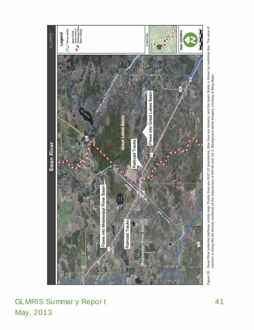
GLMRIS Summary Report
May, 2013
41
Fig
ure
20 .
Sw
an R
iver
pote
ntia
l path
way
vici
nity
map.
Purp
le li
nes
are
HU
C-1
2 b
oundaries,
blu
e li
nes
are
str
eam
s, a
nd t
he b
asi
n d
ivid
e is
show
n b
y re
d/w
hite
line. T
he a
rea o
f co
nce
rn is
alo
ng M
N-6
5 d
irect
ly n
ort
heast
of
the in
ters
ect
ion o
f M
N-6
5 a
nd U
S 2
. B
ack
gro
und a
erial i
magery
court
esy
of
Bin
g M
ap
s.

42 GLMRIS Summary Report
May, 2013
Table 21: Summary of individual probability elements and overall pathway viability for ANS spreading between the Mississippi River and Great Lakes Basins at Swan River, MN location.
Form 1 P0
Form 2 P1
Form 3 P2a
Form 4 P2b
Form 5 P2c
Pviable pathway
Direction of MovementPathway Exists?
ANS Occuring Within Either
Basin?
ANS Surviving Transit to Pathway?
Establish in proximity to pathway?
ANS Spreading Across Aquatic
Pathway into New Basin?
ANS/Pathway Viability Rating
MRB1 to GLB2 L (MC) NN3 NN NN NN L
GLB to MRB L (MC) NN NN NN NN L
Overall Pathway Viability for Spread of ANS Between MRB and GLB: L
1MRB: Mississippi River Basin2GLB: Great Lakes Basin3NN – Not Necessary

GLMRIS Summary Report
May, 2013
43

44 GLMRIS Summary Report
May, 2013
East Mud Lake, NY
The East Mud Lake pathway is located at the headwaters of Silver Creek (Great Lakes Basin) and the North Branch of Conewango Creek (Mississippi River Basin), approximately five miles (eight km) southeast of Forestville, New York in Chautauqua County. Habitat at this location includes East Mud Lake itself as well as several other small ponds, marshy/wetland areas, and streams (Figure 21). Two discrete areas were identified where interbasin flow may occur (Figures 21 through 23).
The site was determined to be capable of conveying water across the basin divide for multiple days from a ten percent annual recurrence interval storm. There are also wetlands spanning the divide that maintain significant ponds likely to become interconnected with streams on both sides of the basin divide from up to a ten percent annual recurrence interval storm. Therefore, the pathway assessment team determined there is a “medium” probability that an aquatic pathway exists at this location and that could develop hydrologic conditions that could potentially facilitate spread of ANS in either direction between the basins.
In order to further evaluate the aquatic pathway viability of this location, a total of 12 ANS were originally identified for a more focused evaluation of this site based on ANS biological requirements and capabilities. However, it was determined by the pathway assessment team that the Silver Creek Reservoir Dam, which is located immediately downstream from the East Mud Lake pathway within the Great Lakes Basin, provides a barrier to any potential ANS reaching the divide location on their own from the Great Lake Basin (Figure 24). Thus, only the remaining five ANS that are currently found in the Mississippi River Basin were evaluated. Those species are listed in Table 22.
Four of these species are currently located greater than 250 miles (402 km) away from the East Mud Lake aquatic pathway. The skipjack herring is the closest but still over 100 miles (160 km) away. There are numerous impediments to upstream movement, including eight dams along the Allegheny River alone. The Allegheny River and connecting streams to the East Mud Lake
pathway do not provide all of the necessary habitat requirements for all life stages of the ANS. Therefore, it was determined that there was a low probability that ANS from the Mississippi River Basin would be able to reach the East Mud Lake location on their own and spread into the Great Lakes Basin. As a result, the site overall has been rated “low” as a viable aquatic pathway for interbasin spread of ANS (Table 23).
An effort that would further support these analyses would be a hydrological analysis of the full range of potential flows for the Silver Creek Reservoir spillway to ensure this is a permanent barrier to ANS migration upstream. Also useful would be the development of a hydrology model to understand the inflows and outflows from the appropriate area ponds, upon which a corresponding hydraulic model could be developed and used to determine the type and location of structural measures to eliminate the probability of ANS transfer at this location. Efforts such as educational programs for anyone that may be using waterways at the East Mud Lake site would seem to provide a relatively small benefit, given the site’s somewhat remoteness, small size, and general lack of recreational opportunities.
Table 22. Aquatic Nuisance Species of Concern
1. Hypophthalmichthys molitrix silver carp
2. Hypophthalmichthys nobilis bighead carp
3. Mylopharyngodon piceus black carp
4. Menidia beryllina inland silverside
5. Alosa chrysochloris skipjack herring

GLMRIS Summary Report
May, 2013
45
Fig
ure
21.
Initi
al (
yello
w li
ne)
and p
ropose
d r
evi
sion (
dotted li
ne)
of
the w
ate
rshed d
ivid
e b
oundary
near
East
Mud L
ake
, N
Y. B
ack
gro
und a
erial i
magery
court
esy
of
Bin
g M
aps.

46 GLMRIS Summary Report
May, 2013
Figure 22. Northwestern Pond where one of the potential pathways exist. Photo from USACE.
Figure 23. Flow to south from Edwin Butcher Wildlife Pond to East Mud Lake, NY (Note: beaver-blocked culvert at south end of Edwin Butcher Wildlife Pond). Photo from USACE.
Figure 24. Silver Creek Reservoir Dam and Spillway, Parcells Corners, NY. Photo from USACE.

GLMRIS Summary Report
May, 2013
47
Table 23. Pathway Viability for ANS Spreading from Mississippi River Basin to the Great Lakes Basin via the East Mud Lake, NY Pathway. Certainty ratings for each element are in parentheses.
Form 1 Form 2 Form 3a Form 4 Form 5
Group Common Name
Mode of Dispersal
Pathway Exists?
Within Either Basin?
Survive Independent
Transit to Pathway?
Establish in proximity to pathway?
Cross Path-way into
New Basin?
Aquatic Pathway Viability Rating
fish
Asian Carp,
swimmer
M (RC)
M (MC) L (MC) L (RC) H (MC) Lsilver carp,
bighead carp,
black carp
fish inland silverside swimmer M (MC) L (MC) L (MC) H (MC) L
fish skipjack herring swimmer M (RC) L (MC) L (RC) H (MC) L
Overall Pathway Viability for Spread of ANS from Mississippi River Basin to Great Lakes Basin: L

48 GLMRIS Summary Report
May, 2013

GLMRIS Summary Report
May, 2013
49
evaluation found that ANS transfer between the basins could not occur in either direction at Grand Lake St. Marys. An ANS that might attempt to access the pathway from the Great Lakes Basin would not be able to get through the sluice gates at the east end of the lake. An ANS that might attempt to access the pathway from the Mississippi River Basin would be blocked by Roush Dam on the Wabash River and the U-shaped Weir at the west outlet of Grand Lake St. Marys. As a result, the overall pathway viability rating for this site is low. The ratings for of the elements associated with this location and how the overall pathway viability rating was determined are presented in Tables 25 and 26.
Grand Lake St. Marys, OHGrand Lake St. Marys is a shallow (mean depth of five feet (1.5 m) 13,500-acre (5,463 hectares) reservoir located on the border of Mercer and Auglaize Counties in west-central Ohio. The only connection this lake has with either the Great Lakes or Mississippi River Basins is through outflow structures located on either end of the lake. Other than direct precipitation, the only inflows to the lake are from a series of small tributary streams located on the south side of the lake which flow only into Grand Lake St. Marys.The outflow at the west end of the lake presents an impassible barrier for any ANS that might attempt to enter Grand Lake St. Marys from the Mississippi River Basin through Beaver Creek (Figure 25). There is an approximately 17-foot (5.1 m) vertical drop from the lake into Beaver Creek, which is a tributary to the Wabash River. Any ANS moving upstream in the Mississippi Basin would also encounter the Roush Dam on the Wabash River near Huntington, Indiana which is also an impassible fish barrier. A pair of sluice gates serves as the outflow on the east end of the lake and also presents an impassible barrier for any ANS that might attempt to enter the lake from the Great Lakes Basin through the Miami and Erie Canal Feeder Channel. The sluice gates are impassible to ANS moving toward the lake since the gates are approximately seven feet (2.1 m) higher than the canal channel, with canal water elevations normally fluctuating only about 30 inches (76 cm) during a given year. The lake and two outflows locations are shown in Figure 26. Because there is a perennial outflow from the lake into either basin, a rating of “high” was assigned to denote the probability that an aquatic pathway exists at Grand Lake St. Marys for flow in both directions.
As a result of this high rating for flow into either basin, the Grand Lake St. Marys aquatic pathway was further evaluated for the potential of any specific ANS to traverse the basin divide through this lake. For this part of the investigation, a total of nine ANS were identified for a more focused evaluation based on their known biological requirements and capabilities. These species are listed in Table 24.
Based on the hydrology of the aquatic pathway and consideration of the above species, the biological
Figure 25. Outflow from Grand Lake St. Marys into the Mississippi River Basin via Beaver Creek. Photo looking east toward the lake, with Beaver Creek to the west. Photo from USACE.
Table 24. Aquatic Nuisance Species of Concern
Species Common Name
1. Hypophthalmichthys molitrix silver carp
2. Hypophthalmichthys nobilis bighead carp
3. Mylopharyngodon piceus black carp
4. Menidia beryllina inland silverside
5. Channa argus northern snakehead
6. Gasterosteus aculeatus three-spine stickleback
7. Gymnochephalus cernua ruffe
8. Proterorhinus semilunaris tubenose goby
9. Novirhabdovirus sp VHSv

50 GLMRIS Summary Report
May, 2013
Fig
ure
26.
Gra
nd L
ake
St. M
ary
s outflo
w lo
catio
ns
and G
reat
Lake
s and M
issi
ssip
pi R
iver
Basi
n b
oundary
show
n b
y re
d-w
hite
line.

GLMRIS Summary Report
May, 2013
51
Although the overall aquatic pathway viability for Grand Lake St. Marys was found to be low, a threat may still exist that ANS might spread between the basins by non-aquatic pathways or vectors along this area of the basin divide because of the high recreational use of the lake. These pathways could include the collection of bait in one basin and its subsequent release in the adjacent basin, ANS adhering to recreational boats in one basin and then being released when the vessel is placed in a water body in the adjacent basin, release of imported aquaria fish and other exotic species, hitchhiking on waterfowl flying between basins, and so on. However, it is outside the scope of this study to examine the probabilities associated with ANS transfer from such vectors.
There are two areas of uncertainty associated with the rating of this location. First, the lake’s primary outfall structure is a U-shaped fixed weir at the west end of the lake. It has been determined that there is no potential for backflow from the Beaver Creek into the lake during a one percent recurrence interval flood event. However, additional data could be collected to better predict the potential for backwater flooding on the east end from Miami and Erie Canal Feeder Channel into Grand Lake St. Marys. Even though it is viewed as unlikely, such additional information would alleviate some of the uncertainty for the lake’s connection with the Canal. Second, as with many of the other pathway locations, there is some uncertainty associated with the biological ratings due to a variety of unknowns regarding the location and distribution of the large array of ANS that have been introduced to the waters of the U. S. within both basins. This uncertainty also includes the need for more and improved information on the life history requirements of each of these ANS and the suitability of the habitats within the waterways connecting their current known locations with Grand Lake St. Marys. As a result, there is an opportunity to develop a comprehensive monitoring plan to accurately record the movement and presence of ANS which may now or in the future be slowly spreading towards this, and potentially other aquatic pathway locations.

52 GLMRIS Summary Report
May, 2013
Table 25. Pathway Viability for ANS Spreading from Mississippi River Basin to the Great Lakes Basin via the Grand Lake St. Marys, OH Pathway. Certainty ratings for each element are in parentheses.
Form 1
P0
Form 2
P1
Form 3
P2a
Form 4
P2b
Form 5
P2c
Pviable pathway
Group Common Name
Mode of Dispersal
Pathway Exists?
ANS Occuring
Within Either Basin?
ANS Surviving Transit to Pathway?
Establish in proximity to pathway?
ANS Spread-
ing Across Aquatic Pathway into New Basin?
ANS/Path-way Viability
Rating
fish
Asian Carp
swimmerH (VC)
M (VC) L (VC) * * Lsilver carpbighead carp
black carp
fish northern snakehead swimmer M (MC) L (VC) * * L
Overall Pathway Viability for Spread of ANS from Mississippi River Basin to Great Lakes Basin L
Table 26. Pathway Viability for ANS Spreading from Great Lakes Basin to the Mississippi River Basin via the Grand Lake St. Marys, OH Pathway. Certainty ratings for each element are in parentheses.
Form 1
P0
Form 2
P1
Form 3
P2a
Form 4
P2b
Form 5
P2c
Pviable pathway
Group Common Name
Mode of Dispersal
Pathway Exists?
ANS Occuring
Within Either Basin?
ANS Surviving Transit to Pathway?
Establish in proximity to pathway?
ANS Spread-
ing Across Aquatic Pathway into New Basin?
ANS/Path-way Viability
Rating
fish three spine stickleback swimmer
H (VC)
M (MC) L (VC) * * L
fish
Benthic Fish
swimmer M (RC) L (VC) * * Lruffe, tubenose
goby
copepod parasitic copepod parasite M (RC) L (VC) * * L
virusviral
hemorrhagic septicemia
pathogen M (RC) L (VC) * * L
Overall Pathway Viability for Spread of ANS from Great Lakes Basin to Mississippi River Basin L

GLMRIS Summary Report
May, 2013
53
The interagency team evaluating the hydrology at the Little Killbuck Creek location determined that there is an intermittent stream capable of maintaining a surface water connection to streams on both sides of the basin divide continuously for multiple days from a ten percent annual recurrence interval storm. In addition, a wetland spans the basin divide and maintains significant ponds that are likely to become inter connected with streams on both sides of the basin divide from a ten percent annual recurrence interval storm. As a result, the probability of an aquatic pathway existing at this location was rated
Little Killbuck Creek, OHThis potential aquatic pathway site is located in Medina County, Ohio, just north of its boundary with Wayne County and approximately 30 miles (48 km) southwest of Cleveland. At the north end of the location is the Village of Lodi and at the southern end is the Village of Burbank (in Wayne County). The land use in the vicinity of the Little Killbuck Creek location along the basin divide is primarily agriculture, patches of woodland, wetlands, and rural residential development (Figure 27). This potential pathway drains into the Mississippi River Basin through Repp Run and Little Killbuck Creek, which drain into the Walhonding River and the Muskingum River. Drainage of the site into the Great Lakes Basin is through Clear Creek to the Black River (Figure 28).
A berm has been constructed along the northern side of Little Killbuck Creek (Mississipi River Basin) and Repp Run (Mississippi Basin) near the location of the basin divide to prevent water from overflowing into the crop fields. On the Great Lakes side of the berm (northern side), there are ditches which collect runoff that drain from the fields (Figure 28). The ditches were constructed as a drainage network to manage the surface water. Most of the ditches are connected, and flow to the north and west before entering Clear Creek and then the West Fork Black River (Great Lakes Basin). There are a few ditches at the northeastern end that flow into an unnamed stream which flows from the east and into the East Fork Black River (Great Lakes Basin). Although this ditch system flows to the Great Lakes Basin, there are connections to the Mississippi River Basin particularly at the southern end near the intersection of Willow Road and Garden Isle Road (yellow dot on Figure 28, and Figures 29 and 30). These ditches are also used to hold water during dry time in order to irrigate the agricultural fields. It was noted by a local farmer that, by opening control gates, water can pass from the Little Killbuck Creek into these ditches. It was observed during the field visit that recent storm water was being pumped from the ditches within the Great Lakes Basin into Little Killbuck Creek in the Mississippi River Basin.
Figure 27. Photo of agricultural field and ditch north of Willow Road and west of Garden Isle Road. Photo from USACE.
Table 27. Aquatic Nuisance Species of Concern
1. Hypophthalmichthys molitrix silver carp
2. Hypophthalmichthys nobilis bighead carp
3. Mylopharyngodon piceus black carp
4. Channa argus northern snakehead
5. Alosa chrysochloris skipjack herring
6. Gasterosteus aculeatus three-spine stickleback
7. Gymnochephalus cernua ruffe
8. Proterorhinus semilunaris tubenose goby
9. Neoergasilus japonicas parasitic copepod
10.Novirhabdovirus sp. VHSv
11. Sphaerium corneum European fingernail clam
12. Valvata piscinalis European stream valvata
13. Menidia beryllina inland silverside

54 GLMRIS Summary Report
May, 2013
Fig
ure
28.
Wate
rways
at
Litt
le K
illbuck
Cre
ek
pote
ntia
l path
way
site
. Arr
ow
s in
dic
ate
s direct
ion o
f flo
w a
nd p
hoto
loca
tions
are
indic
ate
d b
y co
lore
d d
ots
. C
lear
Cre
ek
is lo
cate
d a
t th
e t
op le
ft o
f th
e im
age a
nd R
epp R
un a
nd L
ittle
Kill
buck
Cre
ek
flow
south
fro
m t
he s
ite a
t th
e b
ottom
cente
r of
the im
age.
Ba
ckgro
und a
erial i
magery
court
esy
of
Bin
g
Maps.
.

GLMRIS Summary Report
May, 2013
55
regarding the location and distribution of the large array of ANS that have been introduced to the waters of the U.S. within both basins. The life history requirements of each of these ANS and the suitability of the habitats within the connecting tributaries could also be better understood with further research. There is an opportunity to develop a comprehensive monitoring plan to accurately record the movement and presence of ANS which could be slowly spreading toward this, and potentially other aquatic pathways from both basins. This would allow for more informed decision making and help to better determine species capabilities. A contributing factor to
as “medium”. There is an active farm with drainage and irrigation ditches spanning the divide and connecting both basins from less than a five percent annual recurrence interval storm event.
Pumps within this system are utilized to transfer water from the fields into either basin while check valves create the ability to bring water from either basin into the ditch system and agricultural fields for irrigation. Additionally, roadside ditches in the vicinity of the pathway span the divide and allow wetland systems to become hydrologically connected during storm events. (Figures 29 through 31).
In order to further evaluate the aquatic pathway viability of this location, a total of 13 ANS were identified for a more focused evaluation of this site based on ANS biological requirements and capabilities. These species are listed in Table 27.
Suitable habitat for a diversity of aquatic life, including the ANS of concern, is likely to be available at and near this location. Both the quality and the hydrology of the streams on either side of the basin divide allow for the potential support of ANS at the Little Killbuck Creek site, and it is possible that multiple ANS could utilize this pathway to transfer between the Mississippi River and Great Lakes Basins. This led the team to assign an overall site rating of “medium” for the probability that ANS could spread between the basins at this location. The rating was not higher for number of reasons, but largely because most of the ANS of concern are not known to be established in close proximity to the pathway from where they could possibly reach it on their own within the next 10-20 years. The ratings for of the individual elements associated with this pathway, and how the overall pathway viability rating was determined, are presented in Tables 28 and 29.
There are some opportunities to reduce the potential for ANS transfer at the Little Killbuck Creek site. Construction of berms, reconfiguring drainage ditches, and eliminating or modifying inter-basin pumping may be possible. Further investigation of the potential means of eliminating or reducing the liklihood of interbasin transfer of ANS could be conducted for this location.
There are some uncertainties associated with the rating of this location, such as the need for improved information
Figure 29. Flooded Area Near Willow Road and Garden Isle Road Intersection. Photo from USACE.
Figure 30. Same location as Figure 29 after the water receded. Photo from USACE.

56 GLMRIS Summary Report
May, 2013
the level of uncertainty in the hydraulic characterization of the area is the lack of site specific hydrologic and hydraulic modeling, making the understanding of the frequency, duration, and magnitude (width, depth, and flow velocity) of aquatic pathway formation more difficult. Adding to this uncertainty is the scarcity of stream gages and real data on water levels at, and in proximity to, this potential pathway location. A detailed survey of elevations and modeling of this location would provide additional certainty to this rating and may also be used to help identify possible measures to reduce or eliminate the interbasin transfer of ANS at Little Killbuck Creek.
Figure 32 . West of Franchester Road Flooded from < 20 percent annual recur-rence interval storm event (crosses divide). Photo from USACE.
Figure 31 . Flooded Field West of Franchester Road from < 20 percent annual recurrence interval storm event. Photo from USACE.

GLMRIS Summary Report
May, 2013
57
Table 28. Pathway Viability for ANS Spreading from Mississippi River Basin to the Great Lakes Basin via the Little Killbuck Creek, OH Pathway. Certainty ratings for each element are in parentheses
Form 1
P0
Form 2
P1
Form 3
P2a
Form 4
P2b
Form 5
P2c
Pviable pathway
Group Common Name
Mode of Dispersal
Pathway Exists?
ANS Occuring
Within Either Basin?
ANS Surviving Transit to Pathway?
Establish in proximity to pathway?
ANS Spread-
ing Across Aquatic Pathway into New Basin?
ANS/Path-way Viability
Rating
fish
Asian Carp
swimmer
M (VC)
H (RC) M (RC) M (RC) H (VC) Msilver carpbighead carp
black carp
fish inland silverside swimmer M (RC) M (MC) M (RC) H (RC) M
fish northern snakehead swimmer M (RC) M (RC) H (RC) H (RC) M
fish skipjack herring swimmer H (VC) L (RC) L (MC) M (RC) L
Overall Pathway Viability for Spread of ANS from Mississippi River Basin to Great Lakes Basin M
Table 29. Pathway Viability for ANS Spreading from Great Lakes Basin to the Mississippi River Basin via the Little Killbuck Creek, OH Pathway. Certainty ratings for each element are in parentheses.
Form 1
P0
Form 2
P1
Form 3
P2a
Form 4
P2b
Form 5
P2c
Pviable pathway
Group Common Name
Mode of Dispersal
Pathway Exists?
ANS Occuring
Within Either Basin?
ANS Surviving Transit to Pathway?
Establish in proximity to pathway?
ANS Spread-
ing Across Aquatic Pathway into New Basin?
ANS/Path-way Viability
Rating
fish three spine stickleback swimmer
M (VC)
H (VC) M (RC) M (MC) H (RC) M
fish
Benthic Fish
swimmer H (MC) M (RC) M (MC) H (RC) Mruffe, tubenose
goby
copepod parasitic copepod parasite H (MC) M (RC) H (RC) H (RC) M
virusviral
hemorrhagic septicemia
pathogen H (RC) M (RC) H (MC) H (RC) M
molluskEuropean fingernail
clamfloater M (VC) L (RC) M (MC) H (RC) L
molluskEuropean
stream valvata
floater H (RC) L (MC) H (MC) H (RC) L
Overall Pathway Viability for Spread of ANS from Great Lakes Basin to Mississippi River Basin M

58 GLMRIS Summary Report
May, 2013
were to form between the basins at this pathway it would likely be from an event in excess of the one percent annual recurrence interval flood. Accordingly, the establishment of a hydrologic connection between the basins at this location is considered unlikely. The rating for this site could be made more certain by additional hydrologic and hydraulic investigations to determine exactly what level storm event in excess of the one percent recurrence interval storm might initiate flow out of the auxiliary spillway, and what that flow might look like (e.g., width, depth, velocity). In addition to it being unlikely that an aquatic pathway could form at this location from up to the one percent storm event, the Mosquito Creek Lake Dam is a complete barrier to any ANS that might attempt to move on their own into the lake from the Mahoning River.
Mosquito Creek Lake experiences heavy recreational boating and fishing usage, resulting in some potential for anthropogenic introductions and possible transfer of ANS from the Great Lakes Basin to the Mississippi River Basin. Mosquito Creek Lake is the second largest inland lake in Ohio (7,850 acres (3,176 ha) of fishing water and 40 miles (64 km) of shoreline) with ten boat launch facilities, 234 campground sites, and is near high population centers. As such, management of Mosquito Creek Lake and its environs should consider possible ANS introductions and their potential interbasin transfer in all operations, especially during extreme higher water conditions.
Mosquito Creek Lake, OHThe Mosquito Creek Lake potential aquatic pathway is located in Trumbull County, Ohio, on U.S. Army Corps of Engineers property that is within an outgrant to the Ohio Department of Natural Resources. The pathway is very flat with no obvious topographic relief. At the time of the site visit in May 2011, the ground was very wet from recent rainfall. The pathway is a forested area between the north end of Mosquito Creek Lake and the headwaters of Baughman’s Creek about one mile (1.6 km) to the northwest (Figure 33). Baughman’s Creek is a headwater stream of the Grand River which flows into Lake Erie. Constructed in 1944, Mosquito Creek Lake provides flood protection for the Mahoning River Valley, and the Beaver and Upper Ohio Rivers. The lake has a substantial storage capacity for surface runoff with the ability to store the equivalent of 29 inches (73 cm) of precipitation from a 97 square mile (251 square kilometers) drainage area.
The pathway itself is an uncontrolled natural auxiliary spillway for Mosquito Creek Lake and could be used in the event that the normal outflow through Mosquito Creek Lake Dam at the south end of the lake is insufficient; thereby causing lake levels to rise high enough to allow flow out the north end of the lake and through this spillway. Mosquito Creek Dam allows for a perennial flow from the lake into the Mississippi River Basin. Since the lake’s construction, the spillway is not known to have ever been used and the lake has never reached the elevation whereby water would start flowing out through the auxiliary spillway. The divide between the Great Lakes and Mississippi River Basins extends approximately north-south through the middle of the pathway. There is no defined channel within this pathway and the area is made up of predominantly forested wetland with intermittent pools of standing water (Figure 33). Some of these pools can become interconnected, but there was no observable surface water flow during the site visit.
Because of the above factors, the probability of an aquatic pathway existing between Mosquito Creek Lake and the headwaters of Baughman’s Creek was determined to be low in either direction. If any surface water connection
Figure 33. Pools of standing water at divide location during May 24, 2011 site reconnaissance. Note stagnant condition of pools, lack of any channels, and vegetative obstructions to any ANS drifting or swimming. Photo from USACE.

GLMRIS Summary Report
May, 2013
59
Fig
ure
34.
Loca
tion o
f unco
ntr
olle
d n
atu
ral s
pill
way
are
a n
ort
hw
est
of
Mosq
uito
Cre
ek
Lake
. D
ivid
e R
un,
leadin
g t
o M
osq
uito
Cre
ek
Lake
, is
show
n in
blu
e in
the c
ente
r of
the
photo
. The h
eadw
ate
rs o
f B
aughm
an’s
Cre
ek,
leadin
g t
o G
rand R
iver,
are
on t
he le
ft s
ide o
f th
e p
hoto
. The B
asi
n D
ivid
e is
depic
ted a
s th
e r
ed-w
hite
line b
etw
een t
he
wate
rways
. B
ack
gro
und a
erial i
magery
court
esy
of
Bin
g M
aps.

60 GLMRIS Summary Report
May, 2013
Table 30. Summary of individual probability elements and overall pathway viability for ANS spreading between the Mississippi River and Great Lakes Basins at Mosquito Creek Lake, OH location.
Form 1 P0
Form 2 P1
Form 3 P2a
Form 4 P2b
Form 5 P2c
Pviable pathway
Direction of MovementPathway Exists?
ANS Occuring Within Either
Basin?
ANS Surviving Transit to Pathway?
Establish in proximity to pathway?
ANS Spreading Across Aquatic
Pathway into New Basin?
ANS/Pathway Viability Rating
MRB1 to GLB2 L (MC) NN3 NN NN NN L
GLB to MRB L (MC) NN NN NN NN L
Overall Pathway Viability for Spread of ANS Between MRB and GLB: L
1MRB: Mississippi River Basin2GLB: Great Lakes Basin3NN – Not Necessary

GLMRIS Summary Report
May, 2013
61
north of Summit Lake in downtown Akron provides a 15 foot vertical barrier, preventing the movement of ANS from the Great Lakes Basin into the Mississippi River Basin through the Canal. This obstruction, along with several other locks and low head dams, would make ANS movement from the Great Lakes Basin into the Mississippi River Basin nearly impossible. The ODNR concurred with this analysis (Figure 40).
In order to further evaluate the aquatic pathway viability of this location, a total of five ANS were identified for a more focused evaluation of this site based on specific ANS biological requirements and capabilities. The species are listed in Table 31.
The biological investigation concluded that this location provides suitable temporary habitat, and in some cases, permanent habitat for a diversity of aquatic life including the ANS of concern that have been identified for this pathway. Both the quality and the hydrology of the streams on either side of the interbasin divide allow for the potential support of ANS at the Ohio-Erie Canal
Ohio-Erie Canal at Long Lake, OHThe section of the Ohio-Erie Canal that is of concern as a potential ANS pathway is located between the cities of Akron and Portage Lakes, Summit County, Ohio. A couple of the key features of the Ohio-Erie Canal pathway are the Long Lake Feeder Gates and Long Lake Flood Gates that are adjacent to the Ohio-Erie Canal in Portage Lakes (Figures 35 through 38). These are the locations where water is either diverted from Long Lake (which sits in the Mississippi River Basin) into the Tuscarawas River through the Flood Gates or from Long Lake into the Ohio-Erie Canal through the Feeder Gates. Once in the Tuscarawas River, the water flows south into the Mississippi River Basin. However, much of the water that enters the Canal through the Feeder Gates flows north eventually reaching the Little Cuyahoga River (Great Lakes Basin).
The interagency pathway assessment team evaluating the hydrology at the Ohio-Erie Canal at Long Lake site gave it a rating of “high” for the probability of an aquatic pathway existing at this location. Significant volumes of water are known to cross the basin divide continuously for days to weeks multiple times per year. Site visits confirmed that there is a constant hydrologic connection across the basin divide via the Ohio-Erie Canal in the vicinity of Akron, Ohio. Long Lake and the network of Portage Lakes sit perched near the basin divide and are the source for water discharging into both the Great Lakes and Mississippi River Basins. The Ohio-Erie Canal at Long Lake site consists of a variety of aquatic habitats. The network of Portage Lakes (Turkeyfoot Lake, West Reservoir, East Reservoir, North Reservoir, and Long Lake) support a variety of wetland habitats, including the Portage Lakes Wetland State Nature Preserve which is primarily a tall shrub sphagnum bog community dominated by speckled alder and arrow wood (Figures 39 and 41).
A hydraulic analysis of the lock system located in the city of Akron determined that these structures will prevent the movement of ANS from the Great Lakes Basin to the Mississippi River Basin via the Ohio-Erie Canal. The Lock One gates are operated to maintain a constant elevation and flow rate in the canal. The Lock One gate
Figure 35. Typical View of Canal near Feeder Gates. Photo from USACE.
Table 31. Aquatic Nuisance Species of Concern
1. Hypophthalmichthys molitrix silver carp
2. Hypophthalmichthys nobilis bighead carp
3. Mylopharyngodon piceus black carp
4. Channa argus northern snakehead
5. Alosa chrysochloris skipjack herring

62 GLMRIS Summary Report
May, 2013
Fig
ure
36.
Deta
iled d
epic
tion o
f O
hio
-Erie C
anal a
quatic
path
way
featu
res
and F
EM
A f
loodpla
ins.
Back
gro
und a
erial i
magery
court
esy
of
Bin
g M
aps.

GLMRIS Summary Report
May, 2013
63
capabilities and swimming efficiency of Asian carp are well documented. The head difference between Long Lake and the tail water just downstream of the Flood Gates in the Tuscarawas River will likely during some flows be small enough to permit passage of Asian carp into Long Lake should they become established in the Tuscarawas River.
at Long Lake site, and it is possible that multiple ANS could utilize this pathway to transfer from the Mississippi River Basin to the Great Lakes Basin. This led the team to assign an overall aquatic pathway viability rating of “medium” for this location to characterize the probability that ANS could transfer between basins. The ratings of the individual elements associated with this pathway, and how the overall pathway viability rating was determined, are presented in Table 32.
Considering the level of recreational activity and widespread distribution of anglers within the network of Portage Lakes, it is reasonable to conclude that the potential for transfer of ANS by anthropogenic means is possible. However, such non-aquatic vectors did not factor into the rating of this site.
Opportunities exist to reduce the potential for ANS transfer at the Ohio-Erie Canal at Long Lake site location. Such opportunities may include implementing structural controls at a number of locations along the pathway and discussions are on-going with the ODNR to investigate such options.
There is some level of uncertainty associated with the overall rating for this site, such as unknown or insufficient information regarding the location and distribution of the large array of ANS that have been introduced into waters of the United States within both basins. This includes the need to better understand the life history requirements of each of these ANS and the suitability of the habitats within the waterways connecting the potential pathway location with the current known locations of the ANS. There is an opportunity to develop a comprehensive monitoring plan to include additional research on the biology of ANS so that the probability of transfer at this and other locations can be better understood. Also, increased field sampling and monitoring for the presence of ANS would support better informed water resource management decisions within the state and region. There is also uncertainty as to the hydrologic conditions that would allow for the migration of ANS through the Long Lake Flood Gates. It was noted by ODNR staff that high velocities through these gates such as those observed during the site visit would make ANS migration through the gates highly unlikely; although it is unclear at exactly what flow event the head drop through the flood gates would allow passage of ANS. However, the
Figure 37. Intake to Long Lake Flood Gates during May 27, 2011 site visit. Photo by USACE.
Figure 38. Outlet from Long Lake Flood Gates during May 27, 2011 site visit, forming headwaters of the Tuscarawas River. Photo by USACE.

64 GLMRIS Summary Report
May, 2013
Fig
ure
39.
Port
age L
ake
s are
a m
ap w
ith N
WI
Wetla
nds.
Back
gro
und a
erial i
magery
court
esy
of
Bin
g M
aps
and w
etla
nd m
appin
g f
rom
US
FW
S.

GLMRIS Summary Report
May, 2013
65
Figure 40. Lock 1 North Control Weir. Photo from USACE. Figure 41. Long Lake and associated wetland habitat. Photo from USACE.
Table 32. Pathway Viability for ANS Spreading from Mississippi River Basin to the Great Lakes Basin via the Ohio-Erie Canal, OH Pathway. Certainty ratings for each element are in parentheses.
Form 1
P0
Form 2
P1
Form 3
P2a
Form 4
P2b
Form 5
P2c
Pviable pathway
Group Common Name
Mode of Dispersal
Pathway Exists?
ANS Occuring
Within Either Basin?
ANS Surviving Transit to Pathway?
Establish in proximity to pathway?
ANS Spread-
ing Across Aquatic Pathway into New Basin?
ANS/Path-way Viability
Rating
fish
Asian Carp
swimmer
H (VC)
H (RC) M (RC) M (RC) H (RC) Msilver carpbighead carp
black carp
fish northern snakehead swimmer M (RC) M (RC) H (RC) H (RC) M
fish skipjack herring swimmer H (VC) L (MC) M (MC) H (MC) L
Overall Pathway Viability for Spread of ANS from Mississippi River Basin to Great Lakes Basin M

66 GLMRIS Summary Report
May, 2013

GLMRIS Summary Report
May, 2013
67
in 2011 and 2012. Figure 42 shows the approximate watershed boundary (red-white line) that extends from northeast to southwest as well as the location of each of the six sites which are numbered sequentially from east to west. The blue shading depicts those areas that FEMA has identified as potentially being within the one percent annual recurrence interval floodplain. The watershed divide undulates north and south near the Ohio border which is indicative of the retreat of the Laurentian Ice Sheet during the most recent ice age. This undulation is more prominent in the southern area where the bedrock is softer than the more resistant bedrock of the Appalachian Plateau to the north.
Through evaluation of detailed topographic mapping of the areas provided by the USGS, the interagency team concluded that it would require somewhere in excess of the one percent annual recurrence interval flood event to create an aquatic pathway across the watershed divide at locations one through five. However, location six was examined more closely than the others because it is situated within a wetland area spanning the basin divide, north of the Pymatuning Reservoir in the headwaters of the Ohio River Basin, and south of a headwater tributary to the Ashtabula River which drains to Lake Erie. Streams and ditches (blue lines) that existed or have been excavated through portions of the wetlands and floodplain areas on either side of the basin divide at location six are shown in Figure 43. The Ohio and Pennsylvania border extends north-south just to the west of location six.
A digital elevation model was produced for these areas based on two-foot contour mapping provided by the USGS-PA. This information relative to location six is presented in Figure 44. The red line from north to south was drawn along the likely alignment of a potential aquatic pathway, and that line was used to develop a vertical elevation profile across the basin divide between the basins. As shown in the profile graph inset in Figure 44, there is a slight rise of several feet in the ground surface toward the basin divide in both directions, but the road embankment provides the most significant increase in elevation.
Pennsylvania Aquatic Pathways The GLMRIS Other Pathways Preliminary Risk Characterization (USACE, 2010) did not identify any potential aquatic pathways within the Commonwealth of Pennsylvania. However, that rapid assessment in 2010 recommended that a more detailed evaluation be conducted to determine if there were any viable aquatic pathways in Pennsylvania through which ANS could spread between the Great Lakes and Mississippi River Basins. There were subsequently no locations identified in Pennsylvania in 2011 and 2012 that were determined to be potentially viable enough to warrant the same level of analysis as was done for the 18 potential aquatic pathways along the Great Lakes and Mississippi River Basin divide. The following is a summary of the more detailed evaluation conducted by USACE in Pennsylvania in collaboration with the PAFBC, PADEP, USGS, and NRCS.
The northwest corner of Pennsylvania borders Lake Erie over a distance of about 48 miles (78 km) between the States of New York and Ohio, with the city of Erie, Pennsylvania situated on the lakeshore about midway between these two states. At the border with New York, the watershed divide lies at an elevation of approximately 1,500 feet (457 m) above mean sea level and lies less than six miles (9.6 km) south of the Lake Erie shoreline (elevation 571 feet (174 m)). The elevation along the watershed divide in Pennsylvania generally declines from east to west to an elevation of approximately 1,030 feet (314 m) above sea level at the border with Ohio. The alignment of the basin divide trends southward to distances between 20 to 25 miles (32-40 km) south of Lake Erie near the border with Ohio.
Using a combination of available GIS data (e.g., digital elevation data and hydrologic unit codes) and other information, the USACE performed a preliminary analysis along the entire length of the watershed divide in Pennsylvania and no locations were identified where a perennial or permanent aquatic pathway spans the basin divide. However, six areas were identified where a very large storm might be capable of creating a temporary aquatic pathway between the basins, and each of these locations was evaluated in more detail

68 GLMRIS Summary Report
May, 2013
Fig
ure
42.
Loca
tion o
f si
x si
tes
in n
ort
hw
est
Pennsy
lvania
eva
luate
d f
or
likelih
ood o
f in
terb
asi
n f
low
. R
ed-w
hite
line is
the d
rain
age d
ivid
e b
etw
een L
ake
Erie a
nd t
he O
hio
Riv
er.
B
ack
gro
und a
erial i
magery
court
esy
of
Bin
g M
aps.

GLMRIS Summary Report
May, 2013
69
Fig
ure
43.
Larg
er
scale
aerial i
mage o
f pote
ntia
l aquatic
path
way
6 n
ear
the O
hio
bord
er
show
ing lo
catio
n o
f basi
n d
ivid
e r
ela
tive t
o a
dja
cent
floodpla
ins
and w
etla
nds
and t
ributa
ries.
The s
tate
line r
uns
nort
h-s
outh
just
to t
he w
est
of
PA
#6.
Back
gro
und a
erial i
magery
court
esy
of
Bin
g M
aps.

70 GLMRIS Summary Report
May, 2013
divide were conducted at these sites.
The PAFBC and PADEP expressed concern regarding the potential spread of Asian carp into Pennsylvania and a desire to determine how the GLMRIS might help prevent that from happening. Although the U.S. Congress only authorized the USACE to identify options and technologies to prevent the spread of ANS between the Great Lakes and Mississippi River Basins, the results of this and other GLMRIS interim reports may also increase public awareness and sensitivity to the impacts of ANS and how people might facilitate their spread. GLMRIS is also promoting continued collaboration among local, State and Federal stakeholder organizations that share responsibility for preventing the spread of ANS.
The presence of this road embankment provides a physical barrier to the formation of an aquatic pathway across the basin divide, but it raised the possibility that one or more culverts through the road embankment might be present. Following coordination between the NRCS and Conneaut Township in Crawford County, it was determined that no culverts were believed to be present and no culverts were found in this section of roadway during a site visit on July 22, 2011. Both sides of the surface section of the road spanning this low area were walked and revealed no apparent culverts (i.e., no signs/markers or openings) or signs of flowing water. However, heavy thunderstorms at the time hindered the inspection, as did dense, wet vegetation along both sides of the road.
No evidence was found to indicate that an aquatic pathway exists or would be likely to form across the basin divide at any of the six locations in Pennsylvania from up to a one percent annual recurrence interval storm event. As a result, no data collection or analyses for potential ANS movement up to or across the basin
Figure 44. Screenshot excerpt from USGS elevation contours with potential aquatic pathway six elevation profile. Figure provided courtesy of USGS.

GLMRIS Summary Report
May, 2013
71

72 GLMRIS Summary Report
May, 2013
In order to further evaluate the viability of this potential aquatic pathway a total of nine ANS were identified for a focused evaluation of this site based on specific ANS biological needs, and capabilities, and the known habitat and aquatic conditions within the pathway (Table 33). After consideration of these species, the site was determined to have an overall aquatic pathway viability rating of “medium” because of the potential for VHSv to reach the basin divide at this location and cross into the Mississippi River Basin. There is a sea lamprey barrier on the Brule River, but it includes a fish ladder that passes salmonids (e.g., brown trout) which could be a host for VHSv. The virus could also be present in the water column or transfer on host fish that are native species as well as ANS. Dams located within the Mississippi River Basin on the Saint Croix River would likely eliminate the probability of ANS being able to reach the potential pathway on their own. Therefore, VHSv is the only species driving the overall rating for this site and without this species the overall rating would have been low. The ratings for of the elements associated with this location and how the overall pathway viability rating was determined are presented in Tables 34 and 35.
If other pathways and vectors such as anthropogenic or terrestrial are considered, the probability of inter-basin spread of ANS could be higher. However, such non-aquatic vectors were not a factor in the rating of
Brule Headwaters, WI
The Brule Headwaters potential aquatic pathway is located in the Brule River State Forest at the headwaters of the Brule River (Great Lakes Basin) and of the St. Croix River (Mississippi River Basin), in Douglas County, Wisconsin. Habitat at this location includes predominantly forested wetlands and intermittent pools of stagnant water within a narrow valley surrounded by uplands (Figure 45). The area is a bog environment with a number of likely shallow groundwater connections that are the source of water for tributaries to both the Great Lakes and Mississippi River Watersheds.
A long narrow valley spans the basin divide at this location, which is a remnant of a spillway outlet that formed on the southern end of Lake Duluth, a predecessor to current Lake Superior. An intermittent surface water connection forms in the bottom of the valley which connects Porcupine Creek in the Mississippi River Basin with the West Fork Brule River, which drains to Lake Superior (Figure 46). There is some uncertainty regarding the frequency, duration, and magnitude of the surface water connection, but a completed surface water pathway across the basin divide appears most likely to occur when associated with melting snow and significant rainfall events in the spring. The duration of the surface water connection appears to be limited to several days during any given year and the probability of an aquatic pathway existing at this location was therefore rated as medium.
Figure 45. Photo taken from the Brule Bog boardwalk near Porcu-pine Creek in July, 2010. Occasional, small pockets of surface water exist, but it appears that all of the water movement in this area occurs in the subsurface. Photo from USACE.
Table 33. Aquatic Nuisance Species of Concern
Species Common Name
1. Hypophthalmichthys molitrix silver carp
2. Hypophthalmichthys nobilis bighead carp
3. Mylopharyngodon piceus black carp
4. Menidia beryllina inland silverside
5. Channa argus northern snakehead
6. Gasterosteus aculeatus three-spine stickleback
7. Gymnochephalus cernua ruffe
8. Proterorhinus semilunaris tubenose goby
9. Novirhabdovirus sp VHSv

GLMRIS Summary Report
May, 2013
73
this site. The recently announced intention by the state of Wisconsin to purchase conservation easements on 67,300 acres (27,235 ha) in four counties (including Douglas County) and open the areas up to various recreational uses might result in an even higher potential for anthropogenic vectors to transport various ANS to the forested wetland habitats of the Brule Headwaters aquatic pathway.
The main data gap and area of uncertainty for this location is the lack of a clear understanding of the flooding required to provide an adequate hydraulic connection between the basins for ANS to pass between the basins. Analysis of available information indicates that ANS are likely limited by a lack of a surface water connection at this site. However, further analysis would be required to determine with greater certainty if, and to what degree, precipitation and groundwater levels influence the probability of pathway formation. The lack of site specific ground surface elevation data, other than the USGS 10m DEM, makes it difficult to describe relative elevations to the desired level of detail in order to properly understand surface water flow characteristics. The representative cross-sections utilized for this investigation reveal relative ground elevations only and their vertical accuracy is limited. More detailed survey data of the divide location would allow for a better understanding of a hydraulic connection at different flood levels.
The most notable opportunities for reducing the likelihood of ANS transfer at this site would be continued public education and monitoring to minimize the potential for accidental human transport and to maintain the wetland and stream habitats as much as possible as intact native species communities. Structural opportunities may not be the most appropriate option to prevent ANS spread at this location at this time, although the placement of low berms or structures at key locations could be explored.

74 GLMRIS Summary Report
May, 2013
Fig
ure
46.
Map s
how
ing lo
catio
n o
f th
e t
wo p
ote
ntia
l path
ways
at
Bru
le H
eadw
ate
rs b
etw
een t
he B
rule
Riv
er
and S
ain
t C
roix
Cre
ek.
R
ed s
had
ed a
rea in
dic
ate
s F
EM
A o
ne p
er-
cent
floodpla
in.
Blu
e li
nes
are
str
eam
s near
the b
asi
n d
ivid
e,
whic
h is
illu
stra
ted b
y th
e r
ed-w
hite
line.
Back
gro
und im
agery
court
esy
of
Bin
g M
aps.

GLMRIS Summary Report
May, 2013
75
Table 35. Pathway Viability for ANS Spreading from the Great Lakes Basin to the Mississippi River Basin to the Mississippi River Basin via the Brule Headwaters, WI Pathway. Uncertainty rating in parantheses.
Form 1 Form 2 Form 3a Form 4 Form 5
Group Common Name
Mode of Dispersal
Pathway Exists?
Within Either Basin?
Survive Independent
Transit to Pathway?
Establish in proximity to pathway?
Cross Path-way into
New Basin?
Aquatic Pathway Viability Rating
fish VHSv fish pathogen /water
colmumn
M (RU)
H (RC) H (RU) H (RC) H (RC) M
fish ruffe and tubenose
gobyswimmer H (RC) L (RC) L (RC) L (RC) L
fish three-spine stickleback swimmer H (RC) L (RC) L (RC) M (MC) L
Overall Pathway Viability for Spread of ANS from Great Lakes Basin to Mississippi River Basin M
Table 34. Pathway Viability for ANS Spreading from the Mississippi River Basin to the Great Lakes Basin to the Great Lakes Basin via the Brule Headwaters, WI Pathway . Uncertainty rating in parantheses.
Form 1 Form 2 Form 3a Form 4 Form 5
Group Common Name
Mode of Dispersal
Pathway Exists?
Within Either Basin?
Survive Independent
Transit to Pathway?
Establish in proximity to pathway?
Cross Path-way into
New Basin?
Aquatic Pathway Viability Rating
fish
Asian Carp,
swimmer
M (RU)
M (RC) L (VC) L (RC) L (RU) Lsilver carp,
bighead carp,
black carp
fish inland silverside swimmer M (MC) L (VC) L (MC) L (MC) L
fish northern snakehead swimmer M (MC) L (VC) M (MC) M (MC) L
Overall Pathway Viability for Spread of ANS from Mississippi River Basin to Great Lakes Basin L

76 GLMRIS Summary Report
May, 2013
site between the Great Lakes and Mississippi River Basins except possibly from a flood event greater than the one percent recurrence intervalflood.
There is uncertainty with the rating of this location due to a lack of site specific modeling data to calibrate precipitation events to actual surface water hydrology at this location (e.g., three inches of rain equates to how much standing water at the basin divide, etc). A survey and hydraulic modeling of the divide location would allow for a better understanding of the possibility of a hydraulic connection forming at various flood events. The accuracy of the vertical elevation of the USGS 10 m DEM for ground surface profiles at the basin divide is also a potential source of uncertainty. The ground surface profiles do not depict any channel(s) or other low elevation conveyances for water that may occur at this location. A survey of the divide location would enable one to more properly understand surface water flow characteristics. In addition, a discrepancy was found between the two FEMA overlays available for this site. The “Older (Q3) Base Flood Layer” shows a one half-mile (0.87 km) gap between the flood-prone areas, however, the “Local Flood Hazard Overlay” does not show this gap. It is unclear why there is a difference, since no work has been done on flood mapping for this site since 1973. Verification of the correct boundaries of the one percent annual recurrence interval flood at this potential pathway location would alleviate some uncertainty regarding the potential for the formation of an interbasin connection.
Hatley-Plover River, WIThis potential aquatic pathway is a wetland area just east of Hatley, Wisconsin along an old railroad grade (Figure 47). The probability of a viable aquatic pathway being able to form at the Hatley-Plover potential aquatic pathway location was determined to be “low” (Table 36). This rating indicates it is unlikely that a surface water connection exists or could form at this location on a perennial or intermittent basis, or continuously for multiple days from a 10 percent annual recurrence interval storm. This potential pathway extends from the Plover River in Hatley, Wisconsin within the Mississippi River Basin eastward approximately four miles (6.4 m) through a flood-prone wetland area to Norrie Brook within the Great Lakes Basin (Figure 48). The most significant portion of this pathway is a relatively narrow area of the FEMA one percent recurrence interval floodplain along the Mountain Bay State Trail near State Highway 29.
During a site visit, surface water was found at the western end of this trail in the Mississippi River Basin; however, no continuous surface water connection was observed as far eastward as the basin divide or across it. No channel or flow path was found that could be utilized by flows that occur more frequently than a one percent recurrence interval flood event. Based on observed site conditions, and relevant and available information about local hydrology, it is unlikely that a surface water connection exists or could form at this
Figure 47. View of wetland habitat at Bridge No. 3. Photo from USACE.

GLMRIS Summary Report
May, 2013
77
Fig
ure
48.
Hatle
y-P
love
r pote
ntia
l path
way
are
a.
Red s
haded a
reas
are
FE
MA
one p
erc
ent
recu
rrence
inte
rval f
loodpla
ins.
Bridges
alo
ng t
he M
ounta
in-B
ay
Sta
te T
rail
are
indi-
cate
d b
y ye
llow
bridge s
ymbols
. F
rom
the b
asi
n d
ivid
e,
the g
enera
l flo
w d
irect
ion is
west
ward
. B
ase
imagery
court
esy
of
Bin
g M
aps.

78 GLMRIS Summary Report
May, 2013
Table 36. Summary of individual probability elements and overall pathway viability for ANS spreading between the Mississippi River and Great Lakes Basins at Hatley-Plover River, WI location.
Form 1 P0
Form 2 P1
Form 3 P2a
Form 4 P2b
Form 5 P2c
Pviable pathway
Direction of MovementPathway Exists?
ANS Occuring Within Either
Basin?
ANS Surviving Transit to Pathway?
Establish in proximity to pathway?
ANS Spreading Across Aquatic
Pathway into New Basin?
ANS/Pathway Viability Rating
MRB1 to GLB2 L (MC) NN3 NN NN NN L
GLB to MRB L (MC) NN NN NN NN L
Overall Pathway Viability for Spread of ANS Between MRB and GLB: L
1MRB: Mississippi River Basin2GLB: Great Lakes Basin3NN – Not Necessary

GLMRIS Summary Report
May, 2013
79
Jerome Creek, WI
The Jerome Creek potential aquatic pathway is comprised of three separate locations along the Great Lakes and Mississippi River Basin divide in Pleasant Prairie, Wisconsin. Although Jerome Creek is only about three miles (4.8 km) from Lake Michigan, it drains into the Mississippi River Basin (Figures 49 and 50). The probability of an aquatic pathway being able to form at this potential pathway was determined to be “low” in either direction, meaning that it is unlikely that a surface water connection exists or could form at this location on a perennial or intermittent basis, continuously for multiple days from a ten percent annual recurrence interval storm (Table 37). Locations one and three involve potential urban storm drain connections and location two is a possible connection between the headwaters of Jerome and Kenosha Creeks in a more rural and residential area. Interpretation of available flood and soils mapping for all three locations indicates that a flood from an event in excess of the one percent annual recurrence interval storm would be needed for surface water to cross the basin divide at any of these locations. Although the one percent FEMA floodplain does just barely cross the basin divide at Location 2, this is not likely sufficient to create a surface water connection with Kenosha Creek over 100 feet (30 m) to the east and no channels or other evidence of an existing or intermittent aquatic connection were found during a site visit.

80 GLMRIS Summary Report
May, 2013
Fig
ure
49.
Map o
f Je
rom
e C
reek
wate
rshed w
ithin
the M
issi
ssip
pi R
iver
Basi
n.
Back
gro
und a
erial i
magery
court
esy
of
Bin
g M
aps.

GLMRIS Summary Report
May, 2013
81
Fig
ure
50. T
hre
e p
ote
ntia
l loca
tions
of
inte
rbasi
n f
low
near
Jero
me C
reek
in P
leasa
nt
Pra
irie
, W
I. B
ack
gro
und a
erial i
magery
court
esy
of
Bin
g M
aps.

82 GLMRIS Summary Report
May, 2013
Table 37. Summary of individual probability elements and overall pathway viability for ANS spreading between the Mississippi River and Great Lakes Basins at Jerome Creek, WI location.
Form 1 P0
Form 2 P1
Form 3 P2a
Form 4 P2b
Form 5 P2c
Pviable pathway
Direction of MovementPathway Exists?
ANS Occuring Within Either
Basin?
ANS Surviving Transit to Pathway?
Establish in proximity to pathway?
ANS Spreading Across Aquatic
Pathway into New Basin?
ANS/Pathway Viability Rating
MRB1 to GLB2 L (MC) NN3 NN NN NN L
GLB to MRB L (MC) NN NN NN NN L
Overall Pathway Viability for Spread of ANS Between MRB and GLB: L
1MRB: Mississippi River Basin2GLB: Great Lakes Basin3NN – Not Necessary

GLMRIS Summary Report
May, 2013
83
After establishing where viable aquatic connections exist at West and South Menomonee Falls, the pathway viability for specific ANS of concern at these locations was then evaluated by looking at the biological requirements and capabilities of the nine ANS listed in Table 38.
The species evaluated as threatening the Great Lakes Basin are the bighead, black, and silver carp (Asian carp), northern snakehead, and the inland silverside. The species representing a threat to the Mississippi River Basin are VHSv, ruffe and tubenose goby (benthic fishes), and the three-spine stickleback. Based on physical barriers downstream of the sites, topography
Menomonee Falls, WIThe Menomonee Falls potential aquatic pathway is located in the village of Menomonee Falls, Wisconsin and is comprised of two potential aquatic pathways: West Menomonee Falls and South Menomonee Falls. Both sites are located along the divide between the Great Lakes and Mississippi River Basins. The West Menomonee Falls location consists of a wetland located between Willow Creek (Great Lakes Basin) and the Fox River (Mississippi River Basin). The South Menomonee Falls site also location consists of a wetland that extends between a storm drain connecting to the Menomonee River (Great Lakes Basin) and the Fox River (Mississippi River Basin) (Figures 51 and 52).
West Menomonee Falls is capable of conveying water across the basin divide for days to weeks, multiple times per year, and was therefore given a “high” probability rating for the existence of an aquatic pathway at this location from a ten percent annual recurrence interval flood event. The wetland area between the basins at West Menomonee Falls is entirely within the FEMA floodplain and is directly connected with ponds and ditches that ultimately connect with named streams within either basin. The wetland extends approximately 1,850 feet (563 m) between the headwater of Willow Creek that drains into the Great Lakes Basin and a ditch that drains this wetland into the Mississippi River Basin. This distance is comprised of thickly vegetated wetland grasses and shrubs (Figure 53).
The South Menomonee Falls site was rated medium for the probability of an aquatic pathway existing and being able to convey water across the basin divide (toward the Great Lakes Basin only) from up to a one percent annual recurrence interval flood event. This area also consists of a wetland and FEMA floodplain spanning the basin divide and contains areas of standing water that could become interconnected during flood events, and then connect with streams on both sides of the basin divide. However, the probability rating for flow toward the Mississippi River Basin across South Menomonee Falls was rated “low”, since a surface water connection between the basins in this direction would likely require greater than a one percent recurrence interval flood event.
Figure 51. Representation of typical habitat conditions within wetland area near the basin divide. Photo from USACE.
Table 38. Aquatic Nuisance Species of Concern
Species Common Name
1. Hypophthalmichthys molitrix silver carp
2. Hypophthalmichthys nobilis bighead carp
3. Mylopharyngodon piceus black carp
4. Menidia beryllina inland silverside
5. Channa argus northern snakehead
6. Gasterosteus aculeatus three-spine stickleback
7. Gymnochephalus cernua ruffe
8. Proterorhinus semilunaris tubenose goby
9. Novirhabdovirus sp VHSv

84 GLMRIS Summary Report
May, 2013
Fig
ure
52.
West
and S
outh
Menom
onee F
alls
pote
ntia
l aquatic
path
ways
. The r
ed-w
hite
line is
the b
asi
n d
ivid
e,
blu
e li
nes
are
str
eam
s near
the b
asi
n d
ivid
e,
and r
ed s
haded
are
as
are
the F
EM
A o
ne p
erc
ent
recu
rrence
inte
rval.
Back
gro
und a
erial i
magery
court
esy
of
Bin
g M
aps.

GLMRIS Summary Report
May, 2013
85
conditions and lack of available food supply at the pathway locations, steep topography, and the remote likelihood of any ANS being able to find the appropriate culverts during intermittent flood events all contribute to this overall low probability rating. Although this rating may suggest that immediate actions at these locations to reduce or eliminate the probability of ANS transfer are not necessary, opportunities do exist to conduct further research to better understand ANS distributions and movements, and to educate the public about potential threats.
A thorough ANS monitoring plan would be of great help for both sides of the basin. Such a plan could be developed through the involvement of Federal, State, and local entities so that a comprehensive approach is taken. Since climate and species movements cannot always be accurately predicted, such future data gathering and analysis could lead to the identification of ANS trends that could improve associated management decisions within both basins.
A contributing factor to the level of uncertainty in the hydraulic estimates for the frequency, duration, and magnitude of the intermittent aquatic pathway spanning the divide at these locations is the scarcity of stream gages site specific data on water levels at and in close proximity to the basin divide. Also, there is a lack of specific modeling data that calibrates precipitation events to actual surface water hydrology at this location (e.g., three inches of rain equates to how much standing water
of the pathway, habitat conditions, and the available hydrologic data, the overall paquatic pathway viability for Menomonee Falls at both sites was determined to be low. The ratings for of the elements associated with this location and how the overall pathway viability rating was determined are presented in Table 39 and 40.
For species threatening the Great Lakes Basin, dams on the Fox River were found to be a barrier to any upstream movement of ANS toward Menomonee Falls, although a more detailed evaluation of the Dayton Dam on the Fox River may be warranted. For species threatening the Mississippi River Basin, the Lepper Dam on the Menomonee River serves as a barrier for upstream movement to the West Menomonee Falls location. The only available entrance to the South Menomonee site is downstream of the Lepper Dam (Figure 52). The storm drain which acts as the connection between the Menomonee River and the South Menomonee Falls wetland at the basin divide has a 40 foot (12 m) incline over a distance of about 2,000 feet (609 m) before entering a 1,500 foot (457 m) long culvert (Figure 52). As flow is expected to only enter the Great Lakes Basin from the South Menomonee location, any ANS would have to swim upstream while traversing these elevation differences and the long underground culvert.
Additional data and analyses are needed for a more complete understanding of the hydrology of these connecting streams during large flood events to determine with greater certainty the flow dynamics at the downstream dams. This would assist in making a more definitive determination as to whether or not these dams are barriers to upstream movement for ANS. In addition, more complete and comprehensive monitoring of ANS locations and territorial ranges would assist in determining habitat requirements, capabilities, and environmental tolerances as well as possibly a timeline as to when ANS may advance (if unobstructed) to the interbasin connections. Information available at the time of the study was not always current and/or complete which could add a level of uncertainty to the probability ratings.
While a hydraulic connection between the Great Lakes Basin and Mississippi River Basin could form during certain storm events at these locations, the probability of ANS being able to get to, and establish in the proximity of, the pathway was determined to be low. Habitat
Figure 53. North end of urban storm drain near Ann Avenue (looking south). Photo from USACE.

86 GLMRIS Summary Report
May, 2013
at the basin divide, etc). More detailed survey data of these locations would allow for a better understanding of the potential for the formation of a hydraulic connection at different flooding levels. Finally, there was also some degree of uncertainty associated with biological ratings. This is due to a variety of unknowns regarding the location and distribution of the large array of ANS that have been introduced to the waters of the U.S. within both basins, as well as the life history requirements of each of these ANS and the suitability of the habitats within the waterways between the nearest known locations of the ANS and both West and South Menomonee Falls sites.
Table 39. Pathway Viability for ANS Spreading from the Mississippi River Basin to the Great Lakes Basin to the Great Lakes Basin via the Menomonee Falls, WI Pathway. Certainty ratings for each element are in parentheses.
Form 1 Form 2 Form 3a Form 4 Form 5
Group Common Name
Mode of Dispersal
Pathway Exists?
Within Either Basin?
Survive Independent
Transit to Pathway?
Establish in proximity to pathway?
Cross Path-way into
New Basin?
Aquatic Pathway Viability Rating
fish
Asian Carp,
swimmer H (West) (MC)
M (South) (RC)
H (RC/VC) L (RC) L (RC/VC) H (RC/VC) Lsilver carp,
bighead carp,
black carp
fish inland silverside swimmer M (RC/VC) L (RC/VC) L (RC) M (RC/MC) L
fish northern snakehead swimmer M (RC/VC) L (RC/VC) L/M (RC) H (RC) L
Overall Pathway Viability for Spread of ANS from Mississippi River Basin to Great Lakes Basin L
Table 40. Pathway Viability for ANS Spreading from the Great Lakes Basin to the Mississippi River Basin via the Menomonee Falls, WI Pathway. Certainty ratings for each element are in parentheses.
Form 1
P0
Form 2
P1
Form 3
P2a
Form 4
P2b
Form 5
P2c
Pviable pathway
Group Common Name
Mode of Dispersal
Pathway Exists?
ANS Occuring
Within Either Basin?
ANS Surviving Transit to Pathway?
Establish in proximity to pathway?
ANS Spread-
ing Across Aquatic Pathway into New Basin?
ANS/Path-way Viability
Rating
fish three spine stickleback swimmer
H (West) (MC)
M (South) (RC)
H (RC) L (RC/VC) L (RC) H (RC) L
fish
Benthic fish
swimmer H (RC) L (RC/VC) L (RC/VC) M (RC) Lruffe, tubenose
goby
virusviral
hemorrhagic septicemia
pathogen H (RC) L (RC) M (RC) H (RC/VC) L
Overall Pathway Viability for Spread of ANS from Great Lakes Basin to Mississippi River Basin L

GLMRIS Summary Report
May, 2013
87
connection to the canal from the Wisconsin River, but there are water supply pipes and a control structure intended to supply fresh water to the canal from the Wisconsin River (Figure 58). The canal is not a viable aquatic pathway, assuming that the water supply pipes are in fact buried in the bed of the Wisconsin River, and the sluice gate on the control structures remain closed. The condition of the supply pipes is unknown, which may warrant further investigation.
Portage Downstream and Canal, WI
The Portage Downstream and Canal potential pathway is located downstream, or southeast of Portage, Wisconsin in Columbia County. The habitat at this divide location consists of agricultural fields, wetlands, and limited woodland areas. The wetlands along the potential 1.75 mile (2.8 km) flow path between the Wisconsin River and Fox River are mostly within the Swan Lake Wildlife Area which is managed by the Wisconsin Department of Natural Resources (Figure 54). These wetlands are predominantly shallow marsh habitats dominated by cattail and reed canary grass with some open water. The Portage Downstream and Canal pathway is located downstream of the headwaters of the Wisconsin River (Mississippi River Basin) and at the headwaters of the Fox River (Great Lakes Basin) (Figure 55). The main connection point between the basins in this area is an ungated interbasin flow structure that was created as part of the Portage Flood Risk Management project to maintain the pre-project flow distribution between the Wisconsin and Fox Rivers (Figure 56). The Portage area has historically had high potential for interbasin exchange of water. Early settlers recognized this and actually established a navigable waterway and lock and dam system between the Fox and Wisconsin Rivers.
This site was identified as having a “medium” probability of a viable aquatic connection existing at this location via the interbasin flow structure. An aquatic connection exists for floods slightly greater than a 10 percent annual recurrence interval event. Significant rates of flow can occur at this location from the Mississippi River Basin toward the Great Lakes Basin during larger flood events (870 cfs at two percent annual recurrence interval event). Since 1935, eight floods on the Wisconsin River have exceeded the 10 percent annual recurrence interval flow at this location. On average, flows that could have passed the divided into the Great Lakes Basin lasted about three days for each event, and ranged from one to six days.
The Portage Canal, which is located within the city of Portage, Wisconsin, has also been included in this evaluation (Figures 55 and 57). There is no surface water
Figure 54. Swan Lake Wildlife Area. Photo from USACE.
Table 41. Aquatic Nuisance Species of Concern
Species Common Name
1. Hypophthalmichthys molitrix silver carp
2. Hypophthalmichthys nobilis bighead carp
3. Mylopharyngodon piceus black carp
4. Menidia beryllina inland silverside
5. Channa argus northern snakehead
6. Gasterosteus aculeatus three-spine stickleback
7. Gymnochephalus cernua ruffe
8. Proterorhinus semilunaris tubenose goby
9. Novirhabdovirus sp VHSv
10. Apo/corophium lacustre a Scud
11. Landoltia (Spirodela) punctata dotted duckweed
12. Murdannia keisak marsh dewflower
13. Oxycaryum cubense Cuban bulrush

88 GLMRIS Summary Report
May, 2013
Fig
ure
55.
Port
age W
isco
nsi
n lo
catio
n m
ap.
Red-w
hite
line is
basi
n d
ivid
e. T
he P
ort
age D
ow
nst
ream
pote
ntia
l connect
ions
are
labele
d in
terb
asi
n f
low
str
uct
ure
and D
uck
Cre
ek
back
wate
r. P
ort
age C
anal i
s als
o id
entif
ied.
Back
gro
und a
erial i
magery
court
esy
of
Bin
g M
aps.

GLMRIS Summary Report
May, 2013
89
(e.g., common carp) from Lake Winnebago that could carry VHSv. Any potential for ANS to reach this basin divide location by non-aquatic vectors is a separate pathway that did not factor into the overall rating of this site
There are several areas of uncertainty in the rating of Portage Downstream and Canal. More detailed topography and site specific stream gage data would help to increase the understanding of flows between the interbasin flow structure and the Swan Lake Wildlife Area, and would help to more accurately determine the ability of fish to swim through this area or survive in the limited open-water areas on the divide. Also, monitoring of ANS in the large upstream area on the Wisconsin River to
In order to further evaluate the viability of this aquatic pathway, a total of 13 ANS were then identified for a more focused evaluation of this site based on specific ANS biological requirements and capabilities. These species are listed in Table 41.
Unlike most of the Focus Area 2 potential pathways, the divide occurs well downstream of the headwaters of the Wisconsin River which carries a large amount of flow (base flow of about 5,000 cfs (141 cms)). This could present a unique opportunity for any ANS that might be established upstream of this pathway to be passively carried over the divide during flood events. Aquatic habitats upstream of this pathway on the Wisconsin River are high in diversity, providing an opportunity for most ANS to find suitable habitat. However, the Prairie du Sac Dam, which is located downstream on the Wisconsin River, currently functions as a permanent barrier to upstream movement of ANS toward Portage, and none of the ANS that are established in the Mississippi River Basin are currently known to exist upstream of the Prarie du Sac Dam or the Portage Upstream pathway. Thus, the aquatic pathway viability at this site from the Mississippi River Basin to the Great Lakes Basin has been rated “low”. If one of these species were to become established upstream in the future, this rating could increase. It should be noted though that installation of fish passage is currently a licence requirement for Prairie du Sac Dam and agencies are currently reviewing alternatives for this, although no final decisions have been made as of the date of this report. The low rating for Asian carp at this pathway is reflective only of existing conditions and does not take into consideration any future fish passage project at the dam.
There was one ANS evaluated that was determined to have a viability rating greater than “low”. VHSv, which is currently established in the Great Lakes Basin, was rated as having a “medium” probability for moving across the basin divide into the Mississippi River Basin. Thus, it was determined that there is a “medium” overall aquatic pathway viability at the Portage Downstream (not Canal) location toward the Mississippi River Basin. The ratings for each of the elements associated with this location and how the overall pathway viability rating was determined are presented in Tables 42 and 43. Just as with the Portage Upstream potential pathway, discussed next, the lock and dam system and dam heights on the Fox River appear to be insufficient to prevent the upstream migration of fish
Great LakesBasin
Figure 56. Portage Flood Risk Management Project Un-gated Interbasin Flow Structure. Photo from USACE.
Figure 57. Portage Canal Lock. Photo from USACE.

90 GLMRIS Summary Report
May, 2013
more definitively determine the presence or absence of ANS would further reduce the level of uncertainty in the rating toward the Great Lakes Basin. There was also some uncertainty associated with the biological ratings due to a variety of unknowns about the location and distribution of the large array of ANS that have been introduced to the waters of the U.S. in both basins, as well as the life history requirements of each of these ANS and the suitability of the habitats connecting the nearest locations of ANS with the Portage Upstream potential pathway. Lastly, an inspection of the inlet pipes from the Wisconsin River to the Portage Canal would help determine the likelihood that ANS could pass through them.
The most notable structural opportunity to reduce the potential for ANS transfer at this site would be the construction of a physical barrier by closing the interbasin flow structure and raising the Portage levee, or by constructing a separate physical barrier to prevent flow across the divide.
Manhole
Perforated pipesburied in this area
g
Porta
ge L
evee
WisconsinRiver
Gatewell
Figure 58. Portage Canal Inlet Structure. Photo from USACE.

GLMRIS Summary Report
May, 2013
91
Table 42. Pathway Viability for ANS Spreading from Mississippi River Basin to the Great Lakes Basin via the Portage Downstream & Canal, WI Pathway. Certainty ratings for each element are in parentheses.
Form 1
P0
Form 2
P1
Form 3
P2a
Form 4
P2b
Form 5
P2c
Pviable pathway
Group Common Name
Mode of Dispersal
Pathway Exists?
ANS Occuring
Within Either Basin?
ANS Surviving Transit to Pathway?
Establish in proximity to pathway?
ANS Spread-
ing Across Aquatic Pathway into New Basin?
ANS/Path-way Viability
Rating
fish
Asian Carp
swimmer
M (VC)
M (RC) L (RC) M (MC) H (RC) Lsilver carpbighead carp
black carp
fish inland silverside swimmer M (RC) L (RC) L (RC) L (MC) L
fish northern snakehead swimmer M (RC) L (RC) M (RC) H (RC) L
crustacean scud ballast water M (MC) L (MC) M (MC) H (MC) L
plant
dotted duckweed,
marsh dewflower,
Cuban bulrush
recreation boats and
trailersM (RU) L (RC) M (RC) M (MC) L
Overall Pathway Viability for Spread of ANS from Mississippi River Basin to Great Lakes Basin L*
* Though the rating from the Mississippi River Basin to the Great Lakes Basin is low, there is a much higher probability of ANS passage from the Mississippi River Basin if ANS are established in the Wisconsin River or tributaries based on the frequency of discharge events that enter the Great Lakes Basin from the Mississippi River Basin.
Table 43. Pathway Viability for ANS Spreading from Great Lakes Basin to the Mississippi River Basin via the Portage Downstream & Canal, WI Pathway. Certainty ratings for each element are in parentheses
Form 1
P0
Form 2
P1
Form 3
P2a
Form 4
P2b
Form 5
P2c
Pviable pathway
Group Common Name
Mode of Dispersal
Pathway Exists?
ANS Occuring
Within Either Basin?
ANS Surviving Transit to Pathway?
Establish in proximity to pathway?
ANS Spread-
ing Across Aquatic Pathway into New Basin?
ANS/Path-way Viability
Rating
fish three spine stickleback swimmer
M (VC)
M (RC) L (RC) M (RC) H (RC) L
fish
Benthic fish
swimmer M (RC) L (RC) L (RC) M (RC) Lruffe, tubenose
goby
virusviral
hemorrhagic septicemia
pathogen M (RC) M (RC) M (MC)* H (RC) M
Overall Pathway Viability for Spread of ANS from Great Lakes Basin to Mississippi River Basin M
* The WDNR recommended a lower certainty rating (i.e., relatively uncertain) based on a lack of sufficient cold water tributaries to support VHSv during summer months in the proximity of the pathway.

92 GLMRIS Summary Report
May, 2013
ANS biological requirements and capabilities. These species are listed in Table 44.
Unlike most of the Focus Area 2 potential pathways, the divide location here occurs well downstream of the headwaters of the Wisconsin River which carries a large amount of flow (base flow of about 5,000 cfs (141 cms) in the Portage area). This could present a unique opportunity for any ANS that might be established
Portage Upstream, WI
The Portage Upstream potential pathway is located upstream (west), Portage, Wisconsin in Columbia County. The Lewiston Levee is the highest point at this divide location. The levee runs along County Rd O and is vegetated with grass (Figure 59). There are two culverts under the levee and a low point on County Road O where interbasin flow can occur between the Great Lakes and Mississippi River Basins (Figures 60 and 61). The Portage Canal potential pathway is also shown on Figure 60 for reference, however this is addressed in a separate aquatic pathway assessment report titled “Portage Downstream and Canal”. The Portage Upstream pathway is located downstream (south) of the headwaters of the Wisconsin River (Mississippi River Basin) and at the headwaters of Big Slough which is a tributary to the Fox River (Great Lakes Basin). The habitat at this location consists of agricultural fields, wetlands, and woodland areas. The wetlands along the potential 2.5 mile (4 kilometers) flow path between the Wisconsin River and Big Slough are wet meadow and shallow marsh dominated by cattail and reed canary grass with little open water. The Portage area has historically been an area with high potential for interbasin exchange of water. Early settlers recognized this and actually established a navigable waterway and lock and dam system between the Fox and Wisconsin Rivers.
This site was determined to be capable of conveying water across the basin divide for floods slightly greater than a 10 percent annual recurrence interval event. Significant rates of flow can occur at this location from the Mississippi River Basin toward the Great Lakes Basin during larger flood events (2,900 cfs (82cms) at two percent annual recurrence interval event). Since 1935, eight floods on the Wisconsin River have exceeded the 10 percent annual recurrence interval flow at this location. On average, flows that could have passed the divide into the Great Lakes Basin lasted about three days for each event, and ranged from one to six days. Thus, the Portage Upstream pathway was given a “medium” probability rating for the existence of an aquatic pathway.
In order to further evaluate the viability of this potential aquatic pathway, a total of 13 ANS were identified for a more focused evaluation of this site based on specific
Figure 59. Lewiston Levee along County Road O which forms basin divide at Portage Upstream Locations. Photo from USACE.
Table 44. Aquatic Nuisance Species of Concern
Species Common Name
1. Hypophthalmichthys molitrix silver carp
2. Hypophthalmichthys nobilis bighead carp
3. Mylopharyngodon piceus black carp
4. Menidia beryllina inland silverside
5. Channa argus northern snakehead
6. Gasterosteus aculeatus three-spine Stickleback
7. Gymnochephalus cernua ruffe
8. Proterorhinus semilunaris tubenose goby
9. Novirhabdovirus sp virus
10. Apocorophium lacustre a Scud
11. Landoltia (Spirodela) punctata dotted duckweed
12. Murdannia keisak marsh dewflower
13. Oxycaryum cubense Cuban bulrush

GLMRIS Summary Report
May, 2013
93
Fig
ure
60.
Port
age W
isco
nsi
n lo
catio
n m
ap.
Red-w
hite
line is
basi
n d
ivid
e. T
he P
ort
age U
pst
ream
pote
ntia
l connect
ions,
labele
d a
s th
e c
ulv
ert
s and lo
w p
oin
t under
County
Road
O.
Back
gro
und a
erial i
magery
court
esy
of
Bin
g M
aps.

94 GLMRIS Summary Report
May, 2013
point over County Road O for a few days during spring spawning season, common carp may be able to cross into the Mississippi River Basin. Any potential for ANS to reach this basin divide location by non-aquatic vectors is a separate pathway that did not factor into the overall rating of this site.
There are three areas of uncertainty in the rating of this potential pathway. The scarcity of stream gages and site specific data on water levels at the basin divide make accurate estimations of the frequency, duration, and magnitude of aquatic pathway formation more difficult. While more data is available at Portage than at most other Focus Area 2 locations, additional information would be needed to improve the certainty of this rating and possibly support any future design and construction activities to prevent ANS migration through this location. There was also uncertainty associated with the biological ratings due to a variety of unknowns about the location and distribution of the large array of ANS that have been introduced to the waters of the U.S. in both basins, as well as the life history requirements of each of these ANS and the suitability of the habitats connecting the nearest locations of ANS with the Portage Upstream potential pathway. Continued monitoring of ANS in the large upstream area on the Wisconsin River to more definitively determine the presence or absence of ANS would reduce the level of uncertainty in the rating toward the Great Lakes Basin. Lastly, more detailed topographic data would help assess the presence or absence of a defined channel(s) within the pathway during flood events and the depth of any open water habitats. This would help to more accurately determine the ability of fish to swim through this area or survive in the limited open-water areas on the divide.
upstream of this pathway to be passively carried over the divide from the Mississippi River Basin to the Great Lakes Basin during flood events. Aquatic habitats upstream of this pathway on the Wisconsin River are high in diversity, providing an opportunity for most ANS to find suitable habitat. However, the Prairie du Sac Dam, which is located downstream on the Wisconsin River, currently functions as a permanent barrier to upstream movement of ANS toward Portage and none of the ANS that are established in the Mississippi River Basin are currently known to exist upstream of the Prarie du Sac Dam or the Portage Upstream pathway. Thus, aquatic pathway viability at this site from the Mississippi River Basin to the Great Lakes Basin has been rated “low”. If one of these species were to become established upstream in the future, this rating could increase. It should be noted though that installation of fish passage is currently a licence requirement for Prairie du Sac Dam and agencies are currently reviewing alternatives for this, although no final decisions have been made as of the date of this report. The low rating for Asian carp at this pathway is reflective only of existing conditions and does not take into consideration any future fish passage project at the dam.
There was one ANS evaluated that was determined to have a viability rating greater than “low”. VHSv, which is currently established in the Great Lakes Basin, was rated as having a “medium” probability for moving across the basin divide into the Mississippi River Basin. Thus, it was determined that there is a “medium” overall aquatic pathway viability at the Portage Upstream location toward the Mississippi River Basin. The ratings for each of the elements associated with this location and how the overall pathway viability rating was determined are presented in Tables 45 and 46. The lock and dam system and dam heights on the Fox River appear to be insufficient to prevent the upstream migration of fish (e.g., common carp) from Lake Winnebago that could carry VHSv. At flood stage, the Wisconsin River waters would cross the Portage Upstream divide by sheet flow over the Lewiston Levee and County Road O, traveling more than a mile (1.6 km) across farm fields or emergent wetlands to the Great Lakes Basin. The lack of a direct ditch connection over this pathway minimizes the probability of ANS transfer during a flooding event. However, if sufficient water depths of a foot (30 cm) or more were maintained in the farm fields or the wetlands on both sides of the low
Figure 61. Culvert Under Lewiston Levee at Potential Connection Number 1 Shown on Figure 54. Photo from USACE.

GLMRIS Summary Report
May, 2013
95
for ANS in the large upstream area on the Wisconsin River to more definitively determine the presence or absence of ANS would add more certainty to the rating of the Portage Upstream pathway.
The most notable opportunity to reduce the potential for ANS transfer at this site would be the construction of a physical barrier by either raising the Lewiston Levee or by constructing a similar physical barrier to prevent flow across the divide. Also, continued or additional monitoring
Table 45. Pathway Viability for ANS Spreading from Mississippi River Basin to the Great Lakes Basin via the Portage Upstream, WI Pathway. Certainty ratings for each element are in parentheses.
Form 1 - P0 Form 2 - P1 Form 3 - P2a Form 4 - P2b Form 5 - P2cPviable pathway
Group Common Name
Mode of Dispersal
Pathway Exists?
ANS Occuring
Within Either Basin?
ANS Surviving Transit to Pathway?
Establish in proximity to pathway?
ANS Spread-
ing Across Aquatic Pathway into New Basin?
ANS/Path-way Viability
Rating
fish
Asian Carp
swimmer
M (VC)
M (RC) L (RC) M (RC) H (RC) Lsilver carpbighead carp
black carp
fish inland silverside swimmer M (RC) L (RC) L (RC) L (MC) L
crustacean scud ballast water M (MC) L (MC) M (MC) H (MC) L
fish northern snakehead swimmer M (RC) L (RC) M (RC) H (RC) L
plant
dotted duckweed,
marsh dewflower,
Cuban bulrush
recreation boats and
trailersM (RU) L (RC) M (RC) M (MC) L
Overall Pathway Viability for Spread of ANS from Mississippi River Basin to Great Lakes Basin L*
* Though the rating from the Mississippi River Basin to the Great Lakes Basin is low, there is a much higher probability of ANS passage from the Mississippi River Basin if ANS are established in the Wisconsin River or tributaries based on the frequency of discharge events that enter the Great Lakes Basin from the Mississippi River Basin.
Table 46. Pathway Viability for ANS Spreading from Great Lakes Basin to the Mississippi River Basin via the Portage Upstream, WI Pathway. Certainty ratings for each element are in parentheses
Form 1 - P0 Form 2 - P1 Form 3 - P2a Form 4 - P2b Form 5 - P2cPviable pathway
Group Common Name
Mode of Dispersal
Pathway Exists?
ANS Occuring
Within Either Basin?
ANS Surviving Transit to Pathway?
Establish in proximity to pathway?
ANS Spread-
ing Across Aquatic Pathway into New Basin?
ANS/Path-way Viability
Rating
fish three spine stickleback swimmer
M (VC)
M (RC) L (RC) M (RC) H (RC) L
fish
Benthic fish
swimmer M (RC) L (RC) L (RC) M (RC) Lruffe, tubenose
goby
virusviral
hemorrhagic septicemia
pathogen M (RC) M (RC) M (RC)* H (RC) M
Overall Pathway Viability for Spread of ANS from Great Lakes Basin to Mississippi River Basin M
* The WDNR recommended a lower certainty rating (i.e., relatively uncertain) based on a lack of sufficient cold water tributaries to support VHSv during summer months in the proximity of the pathway.

96 GLMRIS Summary Report
May, 2013
In order to further evaluate the viability of this aquatic pathway, a total of nine ANS were identified for a more focused evaluation of this site based on specific ANS biological requirements and capabilities. These species are listed in Table 47. The interagency assessment team concluded that the aquatic pathway viability rating for this location toward the Great Lakes Basin was low. There are several dams on the Mississppi River Basin side of the divide that would prevent upstream migration of ANS, even during high flow events. In addition, the mile-wide (1.6 km) emergent and scrub-shrub wetland at the divide is considered a probable impediment for
Rosendale-Brandon, WILocated about 15 miles (24 km) west of the city of Fond du Lac, Wisconsin, the Rosendale-Brandon potential aquatic pathway consists of a mile-wide (1.6 km) emergent and scrub-shrub wetland that drains into both the Great Lakes and Mississippi River Basins (Figures 62 and 63 ). This site was identified as having a “medium” probability of an aquatic pathway existing at this location since there are intermittent streams capable of maintaining a surface water connection with contiguous wetlands on either side of the basin divide from a 10 percent recurrence interval storm event.
The drainage extending from this wetland area at the basin divide toward the Great Lakes Basin consists primarily of agricultural and roadside ditches. The Great Lakes drainage from the north end of this wetland connects via unnamed tributaries to either the West Branch Fond du Lac River or Silver Creek. The Great Lakes tributary of greatest relevance to this pathway is the one flowing to the West Branch Fond du Lac River which flows into the Fond du Lac River, through Lake Winnebago and then the Lower Fox River into Lake Michigan at Green Bay. The other tributary located a little further away to the northwest of the wetland flows into Silver Creek and into the Puchyan River, then into the Upper Fox River to Lake Butte des Morts, to Lake Winnebago, then to the Lower Fox River, and ultimately Lake Michigan.
There are 11 dams on the Lower Fox River, including nine federal dams operated by the U.S. Army Corps of Engineers. South of the drainage divide, surface water flows to the Mississippi River Basin through a culvert underneath County Road M (Figure 63) and into an unnamed tributary to the West Branch Rock River, through the Horicon Marsh, and then to the Rock River into the Mississippi River just downstream of Rock Island, Illinois. The National Inventory of Dams lists 21 dams associated with the Rock River in Wisconsin and 29 in Illinois, many of which are deemed severe restrictions to upstream fish movement.
Figure 62. Existing four foot culvert under County Road M. Photo taken on wetland side (west) of the roadway. Any flow across the basin divide is constrained through this culvert. Photo from USACE.
Table 47. Aquatic Nuisance Species of Concern
Species Common Name
1. Hypophthalmichthys molitrix silver carp
2. Hypophthalmichthys nobilis bighead carp
3. Mylopharyngodon piceus black carp
4. Menidia beryllina inland silverside
5. Channa argus Northern snakehead
6. Gasterosteus aculeatus three-spine Stickleback
7. Gymnochephalus cernua ruffe
8. Proterorhinus semilunaris tubenose goby
9. Novirhabdovirus sp VHSv

GLMRIS Summary Report
May, 2013
97
Fig
ure
63.
Wetla
nd a
rea a
t basi
n d
ivid
e a
s appro
xim
ate
d b
y th
e o
ne p
erc
ent
recu
rrence
inte
rval f
loodpla
in b
oundary
west
of
County
Road M
. Alth
ough t
he w
etla
nd c
ross
es
the b
asi
n
div
ide,
all
inte
rbasi
n f
low
is c
onst
rain
ed t
hro
ugh t
he f
our
foot
dia
mete
r cu
lvert
under
County
Road M
. B
ack
gro
und a
erial i
mage
ry c
ourt
esy
of
Bin
g M
aps.

98 GLMRIS Summary Report
May, 2013
across the entire wetland divide during flood events. A detailed survey of the divide and modeling would provide additional certainty to this rating and provide valuable information regarding the probability that sufficient water is available at the divide for ANS passage. In addition, the wetland area was not extensively surveyed for the presence of any channels or open water areas that might more easily allow for ANS with swimming ability to navigate through this wetland during flood events. Such survey information would provide more certainty to the ratings for the ability of any ANS to establish near or cross through the aquatic pathway. Although there may be some structural opportunities for reducing or eliminating the probability of ANS transfer at this location, the most easily implemented would likely be continued public education and monitoring to minimize the potential for accidental human transport of ANS to the vicinity of the aquatic pathway.
ANS establishment and movement across the aquatic pathway. The aquatic pathway viability rating toward the Mississippi River Basin (from the Great Lakes Basin) was determined to be low for all ANS of concern except for VHSv because of dams on the Fox River (e.g., Rapid Croche Lock and Dam) and the Eldorado Marsh on the Fond du Lac River that greatly restricts ANS upstream movement.
The WDNR identified the presence of VHSv in 2007 in freshwater drum (Aplodinotus grunniens) in the Lake Winnebago system (in the Great Lakes Basin) which is located upstream of the Rapid Croche Lock and Dam. No additional fish collected from the Lake Winnebago system have since been reported positive for VHSv through the summer of 2011, although the entire upstream river system has not been thoroughly sampled. Based on the positive report of VHSv in fish upstream of Rapid Croche Lock and Dam (though not documented since 2007), an overall aquatic pathway viability rating of “medium” has been assigned to this pathway. The ratings for of the elements associated with this location and how the overall pathway viability rating was determined are presented in Tables 48 and 49. If an infected fish were to arrive at the potential pathway area, a subsequent storm event sufficient to form an intermittent aquatic connection between the basins could facilitate the dispersal of an infected fish across the basin divide at that time. A confirmed infected fish from above the Rapid Croche Lock and Dam in 2007 indicates that the potential exists that VHSv may be present, or become present in fish, or the water column near the pathway location. However, without the confirmed report of this infected fish from 2007, the overall pathway rating would have remained low.
Water quality and volume within the pathway is likely to be suitable for fish movement during a flood event. However, the quality and volume of the water at the pathway and the adjacent ditches would likely decline as water levels dropped and the surface waters became disconnected. If fish were to access the divide wetland complex during a suitable flood event, the fish would need to migrate downstream with the receding waters to find suitable habitat to survive. No modeling, site specific gage, or survey elevation data (other than USGS 10m DEM) exists for the Rosendale-Brandon pathway location. Therefore, uncertainty exists about water depths

GLMRIS Summary Report
May, 2013
99
Table 48. Pathway Viability for ANS Spreading from the Mississippi River Basin to the Great Lakes Basin to the Great Lakes Basin via the Rosendale-Brandon, WI Pathway. Certainty rating in parantheses.
Form 1 Form 2 Form 3a Form 4 Form 5
Group Common Name
Mode of Dispersal
Pathway Exists?
Within Either Basin?
Survive Independent
Transit to Pathway?
Establish in proximity to pathway?
Cross Path-way into
New Basin?
Aquatic Pathway Viability Rating
fish
Asian Carp,
swimmer
M (MC)
H/M (VC) L (RC/VC) L (RC/VC) H (RC/VC) Lsilver carp,
bighead carp,
black carp
fish inland silverside swimmer M (RC/VC) L (RC/VC) L (RC) L (MC/RC) L
fish northern snakehead swimmer M/L (RC/VC) L (RC/VC) M (MC/RC) M/H (RC) L
Overall Pathway Viability for Spread of ANS from Mississippi River Basin to Great Lakes Basin L
Table 49. Organism Potential Summary for Transfer from the Great Lakes Basin to the Mississippi River Basin to the Mississippi River Basin via the Rosendale-Brandon, WI Pathway. Certainty ratings for each element are in parentheses.
Form 1
P0
Form 2
P1
Form 3
P2a
Form 4
P2b
Form 5
P2c
Pviable pathway
Group Common Name
Mode of Dispersal
Pathway Exists?
ANS Occuring
Within Either Basin?
ANS Surviving Transit to Pathway?
Establish in proximity to pathway?
ANS Spread-
ing Across Aquatic Pathway into New Basin?
ANS/Path-way Viability
Rating
fish three spine stickleback swimmer
M (MC)
H (RC) L (RC) L (RC) L/M (RC) L
fish
Benthic fish
swimmer H (RC/VC) L (RC) L (RC) L/M (MC/RC) Lruffe, tubenose
goby
virusviral
hemorrhagic septicemia
pathogen H (RC) L/M (RC) M (RC) M/H (RC) L/M
Overall Pathway Viability for Spread of ANS from Great Lakes Basin to Mississippi River Basin M

100 GLMRIS Summary Report
May, 2013
than the USGS 10m DEM, makes it difficult to describe relative elevation differences between the basins to the desired level of detail to properly understand and predict surface water flow characteristics. Therefore, a survey of the divide location would enable one to identify actual surface elevations and better predict the depth of any open water habitats that might arise during certain flood conditions. This would reduce uncertainty with the rating of this site and help determine the ability of ANS to swim through this area or be able to establish in any open-water habitats. There is also some uncertainty regarding the amount precipitation that would be necessary to cause a surface water connection to form between the basins. Site specific data linking precipitation amounts to the behavior of surface water hydrology at the pathway location would be of value.
The FEMA mapping shows the one percent recurrence interval floodplain crossing the HUC boundary from the Mississippi Basin into the Great Lakes Basin, but it does not extend to include any surface waters or floodplains within the Great Lakes Basin. The FEMA floodplains in this area are based on the USGS Flood-Prone Area Maps dating from the late 1960s and early 1970s. Due to the age of this data and because the FEMA mapping stops at the county line, it is not known with certainty that the one percent recurrence interval event would not actually extend from the area of interest to the connecting streams in the Great Lakes Basins. Further
South Aniwa, WI
The probability of a viable aquatic pathway existing at the South Aniwa location was determined to be “low” in either direction, meaning that it is unlikely that a surface water connection exists or could form at this location on a perennial or intermittent basis except during a flood somewhere in excess of the one percent recurrence interval flood event. The watershed divide at this location is 1.3 miles (2 km) southwest of Aniwa, Wisconsin, and the border of Marathon and Shawano Counties bisects the site (Figure 64). The nearest headwater streams are Aniwa Creek within the Mississippi River Basin, and the Middle Branch Embarrass River and Packard Creek within the Great Lakes Basin. The Great Lakes Basin streams are located about one mile (1.6 km) east (Middle Branch Embarrass River) and two miles (3.2 km) south (Packard Creek) of the potential pathway site and are not connected to the pathway by any surface water flows.
Existing flood mapping shows that the one percent recurrence interval flood event does in fact cross the basin divide from the Mississippi River Basin, but equivalent floodplain mapping is not currently available for Shawano County. However, NWI mapping from the USFWS was available for Shawano County and was therefore mapped alongside the floodplain map for Marathon County, as is shown on Figure 65. Although the NWI mapping shows a contiguous wetland and/or floodplain between the two basins, field observations found that there are not actually any contiguous wetlands between the basins as it is bisected with development and by County Road Zz (Figure 65). There is no evidence of any existing or intermittent surface water connection between the Mississippi River and Great Lakes Basins east or south of the site. There is a possibility that surface water from a flood in excess of the one percent recurrence interval storm event could bring surface waters (e.g., wetlands) from both basins into closer proximity. However, a lack of culverts underneath County Road Zz would prevent an actual connection from establishing.
Several data gaps were encountered during the investigation of this potential pathway location. The lack of site specific ground surface elevation data, other
Figure 64. View of ditch near the watershed divide looking east along County Road Zz. The road grade is several feet above the surrounding terrain at this point and no maintained roadside ditch or culverts exist. Photo from USACE.

GLMRIS Summary Report
May, 2013
101
Fig
ure
65.
Map o
f S
. Aniw
a p
ote
ntia
l path
way
are
a.
Red s
haded a
rea is
FE
MA
one p
erc
ent
floodpla
in. A
reas
of
inte
rest
are
those
contig
uous
wetla
nd a
nd f
loodpla
in a
reas
that
ext
end a
cross
the b
asi
n d
ivid
e a
nd a
cross
County
Road Z
z.
Back
gro
und a
erial i
magery
court
esy
of
Bin
g M
aps.

102 GLMRIS Summary Report
May, 2013
analysis would be needed to make this determination, although County Road Zz may still prevent a surface water connection from forming. Lastly, only the NWI mapping shows that aquatic conditions (i.e., wetlands) may at times actually extend south and across County Road Zz. Updated FEMA floodplain mapping may alleviate uncertainty regarding the extent of any possible aquatic connection at this location.
Table 50. Summary of individual probability elements and overall pathway viability for ANS spreading between the Mississippi River and Great Lakes Basins at South Aniwa, WI location.
Form 1 P0
Form 2 P1
Form 3 P2a
Form 4 P2b
Form 5 P2c
Pviable pathway
Direction of MovementPathway Exists?
ANS Occuring Within Either
Basin?
ANS Surviving Transit to Pathway?
Establish in proximity to pathway?
ANS Spreading Across Aquatic
Pathway into New Basin?
ANS/Pathway Viability Rating
MRB1 to GLB2 L (MC)4 NN3 NN NN NN L
GLB to MRB L (MC) NN NN NN NN L
Overall Pathway Viability for Spread of ANS Between MRB and GLB: L
1MRB: Mississippi River Basin2GLB: Great Lakes Basin3NN – Not Necessary4 MC: Moderately Certain - Initial field rating was “reasonably certain,” but USACE and NRCS concurred that the certainty should be re-
duced to moderately certain due to lack of updated flood mapping and site specific data, as well as some potentially conflicting information between FEMA and NWI mapping.

GLMRIS Summary Report
May, 2013
103
Culvert modifications (e.g., re-route, block, grates);
Drainage ditch reconfiguration.
Non-Structural Opportunities:
New and/or modified regulations prohibiting establishment of new connections between basins (e.g., roadway culverts, ditch construction, stormwater management);
Reduce source populations of ANS (e.g., harvesting, chemical treatment);
Public education to prevent bait bucket and boating transfers, and improve ANS reporting;
Support funding for further ANS research to improve knowledge on the biological requirements, tolerences of ANS, and development of control methodologies;
Improve ANS monitoring at Federal, State, and local levels;
Take ANS transfer potential into account for proposed water resource projects (e.g., dam removal, stream restoration, water management);
Site specific elevation surveys and hydrologic and hydraulic investigations at some aquatic pathways to better correlate precipitation events to surface flows in order to gain an improved understanding of the full potential of an aquatic pathway existing at such pathways;
Where possible, maintain pristine habitats as whole, intact ecosystems to help prevent any ANS establishment at or near the basin divide. This could also include ecosystem restoration (e.g., habitat) and/or restoration of native fish populations, where appropriate;
Land use changes of applicable areas so that potential ANS control options, if implemented, would not interfere as much with existing land uses.
None of the opportunities identified above are exclusive of each other. In fact, any single measure to prevent
5. Opportunities and Jurisdictional Guide
While it is not the main purpose of these assessments to produce and evaluate exhaustive lists of potential actions or opportunities to prevent ANS transfer at some locations, some were still identified that, if implemented, could prevent or reduce the probability of ANS spread between the basins at some Focus Area 2 locations. The list of opportunities that is presented is not specific to USACE authorities and is grouped according to structural and non-structural measures which have been consolidated from those pathway reports that received an overall aquatic pathway viability rating of medium or high. The list incorporates a wide range of possible authorities, capabilities, and jurisdictions at the Federal, State, and local levels so that a more comprehensive approach can be taken in the event further study or action is desired. For an understanding of which Focus Area 2 pathways these opportunities might apply to, interested parties are encouraged to read the site specific reports located at www.glmris.anl.gov.
The jurisdictional guide is intended as an introductory aid for the evaluation of legal requirements related to potential future implementation actions associated with preventing the transfer of aquatic nuisance species between the Mississippi River and Great Lakes Basins. The Federal laws listed would likely be applicable to all aquatic pathway locations. The State laws listed would likely be applicable to all aquatic pathway locations within the respective state. This list is not intended to be all inclusive.
Structural Opportunities:
In-stream structures to block upstream ANS movement (e.g., low-head dam, increase flow velocities through streambed slope modifications, weirs);
New and/or modified berms and levees to reduce or eliminate overland flood connections between basins;
Installation and/or modification of drop structures;

104 GLMRIS Summary Report
May, 2013
Where applicable, and based on authority and availability of funding, the USACE will also work with states and other appropriate Federal agencies to provide additional technical support and/or analysis to help identify any potential site specific measures which could be implemented by someone to prevent the interbasin transfer of ANS at any of the Focus Area 2 aquatic pathways.
ANS transfer at a particular location may benefit from corresponding development and implementation of one or more of the other types of opportunities.
The results of these Focus Area 2 aquatic pathway assessments should also be taken into consideration during the next updates to the Statewide Invasive Species Management Plans in Minnesota, Wisconsin, Indiana, Ohio, Pennsylvania, and New York. The USACE will continue to work with each state, as necessary, on how to best incorporate the results of these aquatic pathway assessments into their individual Statewide Invasive Species Management Plans.
Great Lakes and Mississippi River Interbasin Study Jurisdictional Guide
This table is intended only as an introductory aid to help determine jurisdiction and permitting requirements related to implementation or monitoring actions associated with preventing the transfer of ANS between the Mississippi River and Great Lakes Basins. The Federal laws would likely be applicable to all aquatic pathway locations whereas the state laws would likely be applicable only to those aquatic pathways within the respective states. This list is not intended to be all inclusive. For a broader understanding of potential alternatives to limit the transfer of ANS at some of the pathways, interested parties are encouraged to read the site specific pathway report located at www.glmris.anl.gov.
Regulator or Resource
Jurisdictional Policy, Law, or Regulation
Purpose and/or Permitting Requirements
National Invasive Species Hotline
Partnership between multiple Federal, state, provincial, & NGO organizations. Web-site supported by USFWS and Univer-sity of Texas - Arlington (www.100thmeridian.org)
Report ANS at 1-877-STOP ANS; record location, take photos and specimens, DO NOT RELEASE.
Federal Agencies Executive Order13112: Invasive Species
Signed February 3, 1999 to prevent the introduction of invasive species and provide for their control and to minimize the economic, ecological, and human health impacts that invasive species cause.
Federal Emergency Management Agency (FEMA)
Code of Federal Regula-tions (CFR) 44 CFR 60.3.
"Municipalities are required to produce notifications and assurance to meet minimum federal flood plain management criteria for flood prone areas."
USACE
33 CFR Part 332, Com-pensatory Mitigation for Losses of Aquatic Resources
Compensatory mitigation may also be required to ensure that an activity requiring autho-rization under section 404 of the Clean Water Act and/or sections 9 or 10 of the Rivers and Harbors Act of 1899 is not contrary to the public interest.
USACE Section 404 of the Clean Water Act
Section 404 Permit is required prior to discharging dredged or fill material into the waters of the United States, including their tributaries and associated wetlands. Typical activities implicating Section 404 permits are: site development fill for residential, commercial, or recreational developments; construction of revetments, groins, breakwaters, levees, dams, dikes, and weirs; placement of riprap and road fills; stream channelization and aquatic habitat restoration.
USACE Section 10 of the Rivers and Harbors Act
Section 10 Permit is required prior to the accomplishment of any work or structure in, over, or under navigable waters of the United States, or which affects the course, loca-tion, condition or capacity of such waters. Typical activities requiring Section 10 permits are construction of docks, piers, wharfs, bulkheads, marinas, ramps, floats, intake struc-tures, and cable or pipeline crossings; dredging, excavation, or deposition of material.
USACE Federal flood control project
Flood control projects are to ensure safety of the public, application to modify Federal flood control project(s) must be approved by USACE and local project sponsor(s).
U.S. Fish and Wildlife Service
18 USC 42-43; 16 USC 3371-3378; Lacey Act
"Prohibits importation or shipment of injurious mammals, birds, fish (including mollusks and crustacea), amphibia, and reptiles. It is unlawful to import, export, transport, sell, receive, acquire, or purchase any fish or wildlife or plant taken, possessed, transported, or sold in violation of any law, treaty, or regulation of the United States or in violation of any Indian tribal law."

GLMRIS Summary Report
May, 2013
105
Great Lakes and Mississippi River Interbasin Study Jurisdictional Guide
Regulator (Federal, State, other)
Jurisdictional Policy, Law, or Regulation
Purpose and/or Permitting Requirements
All States Section 401 Clean Water Act State water quality certification required for activities requiring permits under Section 404 of the Clean Water Act.
Indiana
Indiana Department of Natural Resources Indiana Code 14-22-25-2 Listed fish are illegal to import, possess, or release into public
waters without a permit.
Indiana Department of Natural Resources 312 IAC 9-6-7 Exotic Fish
A person must not import, possess, propagate, buy, sell, barter, trade, transfer, loan, or release into public or private waters des-ignated exotic fish, or their viable eggs or genetic material.
Minnesota
Minnesota Department of Natural Resources
Minnesota Statute, Chapter 84D, Invasive Species
The commissioner shall establish a statewide program to prevent and curb the spread of invasive species of aquatic plants and wild animals. The commissioner shall prepare and maintain a long-term plan, which may include specific plans for individual species and actions, for the statewide management of invasive species of aquatic plants and wild animals. A person may not possess, import, purchase, sell, propagate, transport, or intro-duce a prohibited invasive species.
Minnesota Department of Natural Resources
Minnesota Statute, 103A Water Policy and Information
The state shall control and supervise activity that changes or will change the course, current, or cross section of public waters, including the construction, reconstruction, repair, removal, abandonment, alteration, or the transfer of ownership of dams, reservoirs, control structures, and waterway obstructions in public waters.
Minnesota Department of Natural Resources
Minnesota Statute, 103B Water Plan-ning and Project Implementation
The purpose is to coordinate water planning activities of local, re-gional, and federal bodies with state water planning and integrate these plans with state strategies.
Minnesota Department of Natural Resources
Minnesota Statute, 103D Watershed Districts
To conserve the natural resources of the state by land use planning, flood control, and other conservation projects by using sound scientific principles for the protection of the public health and welfare and the provident use of the natural resources, the establishment of watershed districts is authorized under this chapter.
Minnesota Department of Natural Resources
Minnesota Statute, 103F Protection of Water Resources
"Encourages sound land use development and floodplain devel-opment in a manner which will result in minimum loss of life and threat to health, and reduction of private and public economic loss caused by flooding."
Minnesota Department of Natural Resources
Minnesota Statute, 103G Waters of the State
The Minnesota Water Law addresses issues related to Clean Water Act, actions in waters of the U.S., public water designa-tion, wetlands, diversions, permitting, dam construction and maintenance, flow easements, stream maintenance, Great Lakes Compact, and control of aquatic plants and organisms.
New York
New York State Dept. of Environ-mental Conservation
Freshwater Wetlands ECL Article 24 6NYCRR Part 663 (Habitat Protec-tion)
A permit is required if a project or activity will cause disturbance in or within 100 feet of a regulated wetland.
New York State Dept. of Environ-mental Conservation
Environmental Conservation Law, Article 3-0301
Promote and coordinate management of water, land, fish, wildlife and air resources to assure their protection, enhancement, provision, allocation, and balanced utilization consistent with the environmental policy of the state and take into account the cumu-lative impact upon all of such resources in making any determi-nation in connection with any license, order, permit, certification or other similar action or promulgating any rule or regulation, standard or criterion.

106 GLMRIS Summary Report
May, 2013
Great Lakes and Mississippi River Interbasin Study Jurisdictional Guide
Regulator (Federal, State, other)
Jurisdictional Policy, Law, or Regulation
Purpose and/or Permitting Requirements
New York (cont)
New York State Dept. of Environ-mental Conservation
Environmental Conservation Law, Article 11, Title 5
Possession, sale, barter, transfer, exchange and import of wild animals is prohibited. Fish or fish eggs shall not be placed in any waters of the state unless a permit is first obtained from the department; but no permit shall be required to place fish or fish eggs in an aquarium.
New York State Dept. of Environ-mental Conservation
Environmental Conservation Law, Article 11, Title 17
Prohibits importation, possession, and sale of fish without license or permit.
New York State Dept. of Environ-mental Conservation
6 NYCRR Part 10.1 (c) (3) Round Goby
Prohibits a person when fishing in the waters of the state to use or possess as bait round goby, Neogobius melanostomus.
Ohio
Ohio Environmental Protection Agency
Ohio Revised Code Chapter 6111: Water Pollution Control (isolated wetland sections only)
Requires a permit for actions in waters of the U.S. defined as '...all streams, lakes, ponds, marshes, watercourses, waterways, wells, springs, irrigation systems, drainage systems, and other bodies or accumulations of water, surface and underground, natural or artificial, regardless of the depth of the strata in which underground water is located, that are situated wholly or partly within, or border upon, this state, or are within its jurisdiction, ex-cept those private waters that do not combine or effect a junction with natural surface or underground waters'.
Ohio Environmental Protection Agency
Ohio Administrative Code Chapter 3745-1: Water Quality Standards
The purpose is '...to establish minimum water quality require-ments for all surface waters of the state, thereby protecting public health and welfare; and to enhance, improve and maintain water quality as provided under the laws of the state of Ohio.'
Pennsylvania
Pennsylvania Department of Environmental Protection
Pennsylvania Code Title 25, Chapter 105, Dam Safety and Waterway Management
A person may not construct, operate, maintain, modify, enlarge or abandon a dam, water obstruction or encroachment without first obtaining a written permit from the Department.
Pennsylvania Fish and Boat Commission Pennsylvania Fish and Boat Code
It is unlawful to possess, to introduce or import, transport, sell, purchase, offer for sale or barter the following live species in the Commonwealth: snakehead (all species), black carp, bighead carp, silver carp, zebra mussel, quagga mussel, European rudd, rusty crayfish, ruffe, round goby and tubenose goby.

GLMRIS Summary Report
May, 2013
107
Great Lakes and Mississippi River Interbasin Study Jurisdictional Guide
This table is intended as an introductory aid to determine jurisdiction and permitting requirements related to implementation actions associated with preventing the transfer of aquatic nuisance species between the Mississippi River and Great Lakes Basins. The Federal laws listed would likely be applicable to all aquatic pathway locations. The State laws listed would likely be applicable to all aquatic pathway locations within the respective state. This list is not intended to be all inclusive. For a broader understanding of potential alternatives to limit the transfer of aquatic nuisance species, interested parties are encouraged to read the site specific report located at www.glmris.anl.gov.
Regulator (Federal, State, other)
Jurisdictional Policy, Law, or Regulation
Purpose and/or Permitting Requirements
Wisconsin
Wisconsin, Dept. of Natural Resources
Wisconsin Statute, Section 31.30, Dams on the Brule River
The state issues permits and oversees actions related to the construction, operation, repair, and maintenance of dams and dikes constructed across drainage ditches and streams in drain-age districts for the purpose and interest of drainage control, water conservation, irrigation, conservation, pisciculture, and to provide areas suitable for the nesting and breeding of aquatic wild bird life and the propagation of furbearing animals.
Wisconsin, Dept. of Natural Resources
Wisconsin Statute, Section 31.02 Powers and Duties of the Depart-ment
A permit is required for actions that will include construction, operation, and maintenance activities that will affect the level and flow of navigable waters in the state.
Wisconsin, Dept. of Natural Resources
Wisconsin Statute, Section 237.10, Rapid Croche Lock
Requires operation and maintenance of the sea lamprey barrier at the Rapide Croche lock according to specifications of the department of natural resources in order to prevent sea lampreys and other aquatic nuisance species from moving upstream. Permits actions related to the transport of watercraft around Rapid Croche Lock and requires steps to be taken to control sea lampreys and other aquatic nuisance species prior to transport of vessels or construction activities to support transport of vessels.
Wisconsin, Dept. of Natural Resources
Wisconsin Administrative Code, Chapter NR 40, Invasive Species Identification, Classification and Control
Prohibits transfer, transport, and sale of invasive species, includ-ing eggs, identified by the state that has potential to directly or indirectly cause economic or environmental harm or harm to human health, including harm to native species, biodiversity, natural scenic beauty and natural ecosystem structure, function or sustainability; harm to the long-term genetic integrity of native species; harm to recreational, commercial, industrial and other uses of natural resources in the state; and harm to the safety or well being of humans, including vulnerable or sensitive individu-als.
Wisconsin, Dept. of Natural Resources
Wisconsin Statute, Ch. 29.736
A permit is required to introduce, stock, or plant any fish in wa-ters of the state.

108 GLMRIS Summary Report
May, 2013
6. References
ANSTF.(1996). Generic Nonindigineous Aquatic Organisms Risk Analysis Review Process for Estimating Risk Associated with the Introduction of Nonindigineous Aquatic Organisms and How to Manage for
that Risk. Report to the Aquatic Nuisance Species Task Force. Risk Assessment and Management Committee, Aquatic Nuissance Species Task Force (October 21, 1996).
Great Lakes Commission. (2011). Website accessed February 21, 2012: http://www.great-lakes.net/envt/ flora-fauna/invasive/pdf/vhs_glc_factsheet_2011.pdf
Kipp, R.B and A. Ricciardi. (2011). Novirhabdovirus sp.. USGS Nonindigenous Aquatic Species Database, Gainesville, FL. http://nas.er.usgs.gov/queries/FactSheet.aspx?SpeciesID=2656Rebekah M. Kipp
and Anthony Ricciardi. 2012. Novirhabdovirus sp.. USGS Nonindigenous Aquatic Species Database, Gainesville, FL. http://nas.er.usgs.gov/queries/FactSheet.aspx?SpeciesID=2656 Revision Date: 4/19/2010
Little Rivers Wetland Project. 2011. Georgaph of the Little River Valley. Online Resource: http://www.lrwp.org/ habitats.php
NOAA.(2011). Great Lakes Nonindiginous Aquatic Species Information System (GLANSIS). National Oceanic and Atmospheric Administration. http://www.glerl.noaa.gov/res/Programs/glansis/watchlist.html.
USACE. (2010). Great Lakes and Mississippi River Interbasin Study Other Pathways Preliminary Risk Characterization. Great Lakes and Ohio River Division. November 9, 2010. United States Army Corps
of Engineers.
USACE. (2011a). GLMRIS Focus Area 2 Study Plan. Great Lakes and Ohio River Division. United States Army Corps of Engineers.
USACE. (2011b). Non-Native Species of Concern and Dispersal Risk for the Great Lakes and Mississippi River Interbasin Study.
USACE. (2011c). Baseline Assessment of Cargo Traffic on the Chicago Area Waterway System. Great Lakes and Mississippi River Interbasin Study (GLMRIS). U.S. Army Corps of Engineers. December 2011.
USACE. (2011d). Baseline Assessment of Non-Cargo CAWS Traffic. Great Lakes and Mississippi River Interbasin Study (GLMRIS). U.S. Army Corps of Engineers. November 2011.
USGS. (2012). Nonindigenous Aquatic Species (NAS) website http://nas.er.usgs.gov/about/faq.aspx
WRDA. (2007). Water Resources Development Act of 2007 [Section 3061(d): P.L. 110-114; amends Section 345: P.L. 108-335; 118 Stat. 1352].