ev595 special topics stream restoration design spring 2011 semester lecture stream habitat february...
TRANSCRIPT

EV595 Special TopicsStream Restoration Design
Spring 2011 Semester
LECTURE Stream Habitat
February 16, 2011

Stream Habitat
Outline for Stream Habitat Lecture:
- define habitat and niche- define stream habitat quality - equilibrium concepts: geomorphic & ecological- stream habitat classification- habitat structure and function ideas- habitat surveys/assessment protocols

Defining Habitat
Odom (1971) defines habitat as a place where an organism lives, including physical, chemical, and biological features.
Southwick (1976) defines habitat as “…the natural abode or locality of an ‘organism’ including all features of the environment in an given locality.” • These definitions present a traditional view of habitat: 1.) habitat is addresses in terms of the organism; 2.) habitat includes all features of the environment, physical, chemical, and biological; and 3.) habitat is viewed as definable and quantifiable.

Defining Habitat
Southwood (1977) defines habitat according to three ecological concepts: duration stability, temporal variability, and spatial heterogeneity.
• Duration Stability: Duration stability relates organism generation time, and the length of time a habitat will remain favorable.
• Temporal Variability: Temporal variability is determined from the time that a site meets specific organism requirements in environments that have seasonal or other short-term variation.
• Spatial Heterogeneity: Spatial variability reflects that habitat attributes are not constant over space; e.g., bed substrate is highly variable over the stream bed.

Defining Habitat
Southwood’s (1977) habitat definition introduces the notion that habitat conditions vary; in terms of favorable and unfavorable locations (space) and periods (time).
In terms of space (location), habitat can be:
Continuous – favorable area is larger than the organism can cover to meet its biological resource needs;
Patchy – favorable and unfavorable areas are interspersed, but the organism can easily disperse from one favorable area to another; and
Isolated – favorable area is restricted, too far from other favorable areas for an organism to readily disperse between them, except rarely and by chance.

Defining Niche
Begon et al. (1986) defines a niche as “the responses of an organism to environmental conditions.”
Environmental conditions represent a multiple variables (e.g., temperature, velocity, etc.), in which a given organism can survive, grow, reproduce, and maintain a viable population.
optimum
Limits for individual

Defining Niche
Niche: n-dimensional hypervolume: Each variable representing an environmental condition is considered a dimension. The n-dimensional hypervolume is the suite of all environmental conditions, or multiple “dimensions”, that govern whether an organism survives and a population remains viable.
Fundamental versus realized niches: The view of all the environmental conditions as independent variable dimensions comprises a fundamental niche. The realized niche is the measured set of conditions, which take into account competition, predation, and other biota factors that influence “resource” utilization.
Comparing Habitat and Niche
Niche: it is important to realize that a niche is not something that can be seen; nor is it necessary to make measurements along each and every niche dimension for it to be a useful idea. It is an abstract concept that brings together all of the organism’s requirements to maintain a viable population. Therefore, it is a characteristic of an organism (species).
Habitat: it is an actual place; therefore provide numerous niches. A habitat is the environmental characteristics of the location, or “space”, utilized by a group of organisms.

Habitat: Landscape Ecology Terms
Matrix: the land cover is that is dominated and interconnected over the majority of the land surface (i.e., forest, agricultural, urban, water, wetland, etc.).
Patch: a nonlinear area that is less than abundant than, and different from the matrix.
Corridor: a special type of patch that links other patches in the matrix; it is linear and elongated in shape.
Defining Stream Habitat Quality
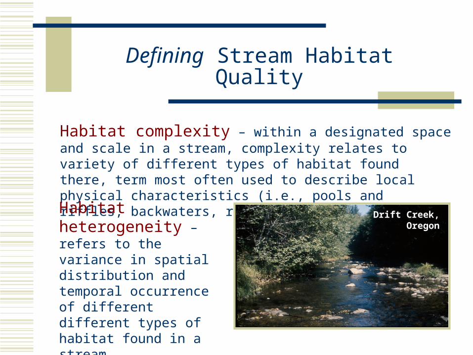
Habitat complexity – within a designated space and scale in a stream, complexity relates to variety of different types of habitat found there, term most often used to describe local physical characteristics (i.e., pools and riffles, backwaters, root wads, boulders, etc.).
Habitat heterogeneity – refers to the variance in spatial distribution and temporal occurrence of different different types of habitat found in a stream.
Drift Creek, Oregon

Defining Stream Habitat Quality
Habitat connectivity – a measure of how spatially continuous a corridor or matrix is, and how well different habitats within are connected in order for free movement of plants and animals, and the transport of materials and energy. In river systems, it is commonly referred to as how well the channel is connected to the floodplain.
Habitat fragmentation – the loss of habitat connectivity; isolation of unique habitat types, thereby reducing ecological function.
high connectivity
low connectivity

Process Framework for Stream Habitat
Relationships between hydro-geomorphic systems and physical stream habitat; in addition to in-stream flows and water quality.
Example for fish

Reviewing Geomorphic Equilibrium Concepts
Channel adjustment and changes in sediment transport regime from a disturbance:
Figures from Knighton (1998) Fluvial Forms and Processes
Geomorphic variable
dominant discharge governing

Ecological Equilibrium Concepts
Ecosystem “states” governed by abiotic and biotic factors of the environmental system (niches)
ecosystem capacity states
Figure from Ebersole et al. 1997; Warren 1979

Stream Habitat Classification
Hierarchical Classification of Stream Habitat: Frissell et al. (1986) identified five major spatiotemporal scales: 1) drainage network, 2) segment, 3) reach, 4) pool-riffle system (channel unit), and 5) microhabitat (channel sub-unit).
Drainage Network

Stream Habitat Classification
Hierarchical Classification of Stream Habitat: Gregory et al. (1991) identifies the same hierarchical scales as Frissell et al. (1986), spatial and time scales for stability (equilibrium) and physical constraints.

Stream Habitat Classification
Hierarchical Classification of Stream Habitat:
Habitat classification by Frissell et al. (1986) and Gregory et al. (1991) rely on a habitat-centered view of ecological systems – in that geomorphology is the habitat template that governs the distribution and abundance of organisms.
Poff (1997) adds a niche perspective, an organism-view, to the proposed hierarchical classification systems with different scales acting as a system of “landscape filters” which also governs the distribution and abundance of organisms.

Channel-unit Scale Habitat Classification
Channel-unit Habitat Types commonly include:pools, riffles, glides, runs, rapids, cascades, and steps.
They are identified at a low-flow stage; occur in the wetted area of the stream channel; and distinguished by similar areas of depth, velocity, and substrate.

Channel-unit Scale Habitat Classification
Channel-unit Habitat Types
Riffle – shallow areas with course bed material; channel slope <1%; surface waves; fast water.
Glide – shallow areas with fine to course substrate; channel slope < 1%; smooth water surface; water depth uniform throughout.
Run – areas with uniform flow, swift with no surface waves, bed substrate course and variable; bed; channel; slope > 4%.
Pool – deeper areas with fine bed substrate; channel slope < 1% ; smooth water surface.

Channel-unit Scale Habitat Classification
Channel-unit Habitat Types
Rapid – shallow areas with course bed material and some cobble/boulders; flow swift with surface waves; channel; slope 4 - 8%.
Cascade – areas with short falls and small plunge pools; bed material consisting of boulders and bedrock; slope > 8%; swift water.
Step – abrupt break in gradient usually shorter than the channel width caused by boulders, logs, or other large roughness elements.

Habitat Surveys/Assessment Protocols
Reach-scale Visual-based Habitat Assessment: USEPA Rapid Bioassessment Protocols (RBP); Barbour et al. (1999)
Parameters that are scored include: 1. Epifaunal substrate/available cover 2a. Embeddedness | 2b. Pool substrate characterization 3a. Velocity/depth combinations | 3b. Pool variability 4. Sediment deposition 5. Channel flow status 6. Channel alteration 7a. Frequency of Riffles (or bends) | 7b. Sinuosity 8. Bank stability 9. Bank vegetative protection 10. Riparian vegetative zone width
a. = high-gradient streams | b. low-gradient streams

Habitat Surveys/Assessment Protocols
Quantifying Physical Habitat
USEPA EMAP Program
Kaufmann
et al. (1999)

Habitat Surveys/ Assessment Protocols
Quantifying Physical Habitat
USEPA EMAP Program
Kaufmann et al. (1999)
stream mapping approach ----
Visual technique termed Basin Visual Estimation Technique (BVET); Hankin & Reeves (1989)

Habitat Surveys/Assessment Protocols
Quantifying Physical Habitat USEPA EMAP Program, Kaufmann et al. (1999)Examples of habitat metrics computed …

Channel-unit Scale Habitat Classification
Hawkins et al. 1993
CGU = Channel Geomorphic Unit
Channel-unit scale habitat classificationbased on:
1. Low-flow stage hydraulics2. One-dimensional
hydraulics in downstream direction
3. Visual observation of free-surface “turbulence”
4. Visual observation of physical-geomorphic characteristics and formative structures
American Fisheries Society; Bain & Stevenson (1999)

Flow-stage Dependent Habitat Classification
1. Flow structures influenced mostly by bed roughness and channel curvature.
2. Macro-bedforms = pools and riffles.
3. Relative d/s average velocities in units:Pools = low-velocity Riffles = high-velocity
Habitat Hydraulics at
Low-Flow Stages
Three-Dimensional View of Stream Habitat
Structure
flowEmbarras River

Flow-stage Dependent Habitat Classification
1. Flow structures influenced mostly by bed roughness and channel curvature.
2. Macro-bedforms = pools, riffles, and submerged point bars.
Habitat Hydraulics at
Moderate-Flow Stages
Embarras River
Three-Dimensional View of Stream Habitat
Structure
flow
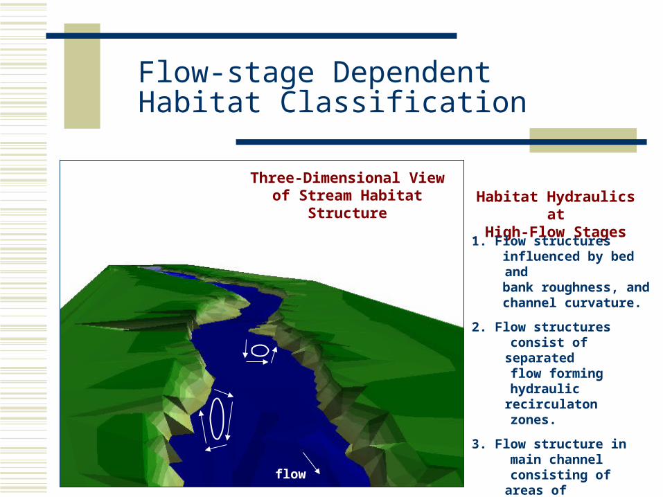
Flow-stage Dependent Habitat Classification
Habitat Hydraulics at
High-Flow Stages
Three-Dimensional View of Stream Habitat
Structure
flow
1. Flow structures influenced by bed and bank roughness, and channel curvature.
2. Flow structures consist of separated flow forming hydraulic
recirculaton zones.
3. Flow structure in main channel consisting of areas of accelerating and decelerating flow.

Flow-stage Dependent Habitat Classification
FlowFlow
glide
point bar
riffle
scour pool
pool
bank failure
bank ledge failurepool
pool
lateral habitat
bar structure
Planview
Low-flow Habitat Units

Flow-stage Dependent Habitat Classification
High-flow Habitat Units
Flow
Flow
bank ledge failure
bank failure
high-velocity corridor Planview
deflection(meander) eddy
concave bank bench
lateral accretion bar
expansion eddy
grassyvegetation

Flow-stage Dependent Habitat Classification
Concave-bank bench
Vegetated point bar (lateral accretion bar)
Deflection eddy
Expansion eddy
Local bank roughness
High-velocity corridor
Low-velocity refugia patches
Channel-unit Scale: High-flow Habitat Types
(Schwartz and Herricks 2005)

Microhabitat Scale Classification
Microhabitat Scale – Unit Characteristics
Physical features that occur within a channel unit that constituent provide an organism some biological resource, and influence their distribution (use of habitat space).
Physical features include:
Substrates (mud, silt, sand, gravel, cobble, boulders).Large woody debris (debris jams, logs, root wads)Undercut banksMacrophytes (aquatic vegetation)Miscellaneous large roughness elements

Fish Habitat Use: expression of biological resource need
Traditional view:
Habitat Structure is the physical conditions of the environment including channel morphology and flow hydraulics.
Coupling structure with ecology:
Habitat Function is how the physical habitat structure meets the biological resource needs of organisms (e.g., feeding, spawning, and flow refuge).
Example framework for Illinois prairie streams
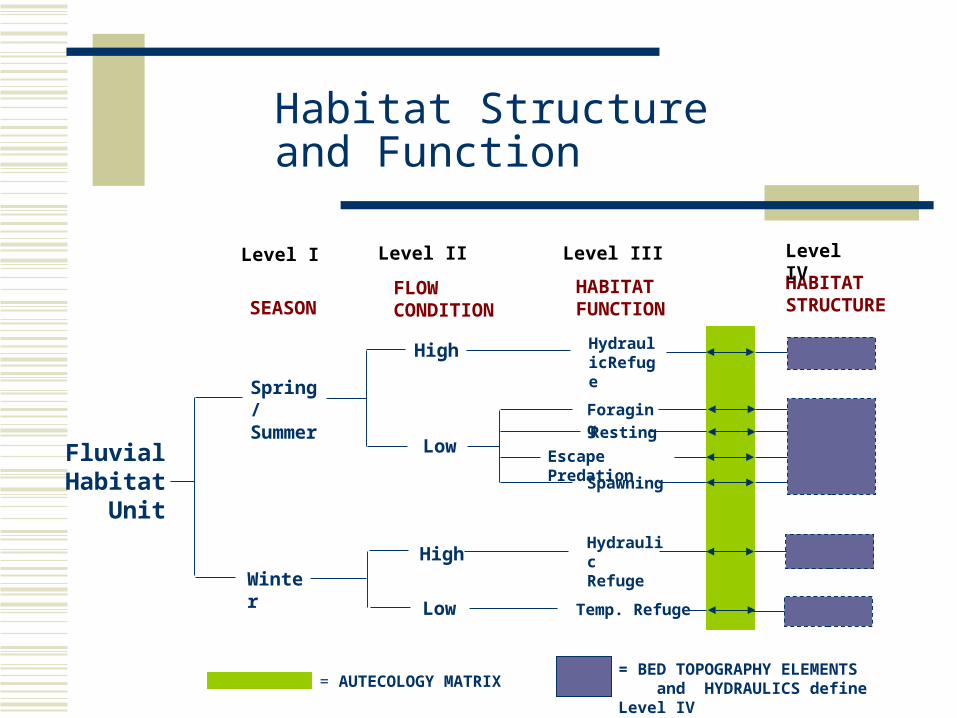
Habitat Structure and Function
HABITAT STRUCTURE
Temp. Refuge
HydraulicRefuge
HydraulicRefuge
HABITAT FUNCTION
Foraging
Resting
Escape Predation
Spawning
Low
Low
High
High
FLOW CONDITION
Spring /Summer
Winter
SEASON
Level I Level II Level III Level IV
= AUTECOLOGY MATRIX= BED TOPOGRAPHY ELEMENTS and HYDRAULICS define Level IV
Fluvial Habitat
Unit

Ecohydraulics: Hydraulic Habitats
Ecohydraulics: Habitat Models
Original constructs for ecohydraulics models was based on relationships of habitat use and habitat preferences to three physical characteristics of:
1.) instream velocity (mean downstream direction), 2.) water depth, and 3.) substrate characteristics (channel index).
Physical characteristics are fundamental features for classifying habitat unit types at the channel (pool-riffle) and and sub-channel (microhabitat) scales.

Ecohydraulics: Hydraulic Habitats
Relationships with velocity, depth and substrate identify that each species have evolved with an unique body morphology, and behavioral traits to survive, and maintain a vital population (Allan 1995).
Streamlined body:higher-velocity waters; medium to deep waters; gravel, vegetation spawners
Deep body:lower-velocity waters; deep waters; gravel to muddy debris spawners
Flatten body lg. pectoral fins:higher-velocity waters; shallow waters; gravel spawners

Ecohydraulics: Hydraulic Habitats
Ecohydraulics: Hydraulic Habitat Classification
Kemp et al. (1999) classifies habitat hydraulics into in-stream flow biotopes.
More recent developments recognize the importance of defining 3D habitat hydraulics (review lecture on habitat), in which habitat use/preferences change with flow stage, and preferred hydraulics conditions.

Ecohydraulics: Hydraulic Habitats
Measured three-dimensional velocities along transects in the meandering reach as depth-averaged vectors and magnitude, and transverse vectors (Rodriguez et al. 2000).
Transverse VectorsPlan Views
3D Hydraulic Associations with Habitat Structure

Ecohydraulics: Hydraulic Habitats
Hydraulic Habitat Units: Low-flow Stage (Schwartz & Herricks (2008)
Bed Topography - Erosional Units
1. Front of pool
2. Mid area of pool
3. Rear of pool
4. Local scour pool behind structural element
Bed Topography – Depositional Units
5. Glide
6. Riffle without raceway
7. Riffle with raceway
8. Lateral shallow area behind bank structure
9. Bar Structure
SUMMER LOW-FLOW
Redfin Shiner (feeding)
Striped Shiner (feeding)
Grizzard Shad (spawning)
Steelcolor Shiner (feeding)
Central Stoneroller (feeding)
Silverjaw Minnow (feeding)
Sand Shiner (feeding)
Longear Sunfish (resting)
Creek Chub 0+ (cover)

Ecohydraulics: Habitat Suitability Indices
Ecohydraulics: Habitat Suitability Indices (US F&WS)
Habitat Evaluation Procedures is a standard evaluation technique for the development of Habitat Suitability Index (HSI) Models.
The models reference numerous literature sources in an effort to consolidate scientific information on species-habitat relationships. Models are included that provide a numerical index of habitat suitability on a 0.0 to 1.0 scale, based on the assumption that there is a positive relationship between the index and habitat carrying capacity.
When possible, HSI models are derived from site-specific population and habitat data. The models should be viewed as hypotheses of species-habitat relationships rather than statements of proven cause and effect relationships.

Ecohydraulics: Habitat Suitability Indices
Example: HSI model for the Creek Chub (Semotilus atromaculatus)Development of Habitat Suitability Curves (HSCs)
velocity substrate
pool use

Ecohydraulics: Habitat Suitability Indices
Example: HSI model for the Creek Chub (Semotilus atromaculatus)Development of Habitat Suitability Curves (HSCs)
max. depth
gradient
temperature
turbidity

Ecohydraulics: Habitat Modeling
Ecohydraulics: Habitat Models
PHABSIM Model (Physical Habitat Simulation Model) –Hydraulic engineering approach to habitat modeling using the 1D Energy Equation, Direct Step Method, or using 2D mass-momentum methods (River2D Model) to compute velocities and depths, which are then used to perform habitat simulation modeling.
PHABSIM is one of the analysis/model module of the IFIM (Bovee et al. 1998; Waddle et al. 2000).
Hydraulic modeling: compute V and d
Target Species: Habitat Suitability Curves
Habitat Simulation: Compute weighted usable area (WUA)

Ecohydraulics: Habitat Modeling
PHABSIM Model
Habitat Simulation: Compute weighted usable area (WUA)
Computing weighted usable area (WUA) for a specific discharge (Q) and species (s):
n
isQiiQsQ csiaWUA
1,,,, ))((
))()(( cdv sisisicsi
ai – is the surface area of the cell (i); andcsi – is the composite suitability of the cell (i) at a discharge (Q)
for a target species (s)siv – suitability index for depth-averaged velocity sid – suitability index for water depthsic – suitability index for cover (substrate quality)

Ecohydraulics: Habitat Modeling
River2D Hydrodynamic ModelWest Fork Little Pigeon River Hydraulic modeling:
compute V and d

Ecohydraulics: Habitat Modeling
PHABSIM Model
Target Species: Habitat Suitability Curves
Habitat Simulation: Compute weighted usable area (WUA)
Species-dependent curves