eupos- initiative for unified ground-based gnss ...euref.eu/symposia/book2004/3-6-balodis.pdf ·...
TRANSCRIPT

EUPOS- Initiative for Unified Ground-based GNSS Infrastructure in Central and Eastern Europe
EUPOS Steering Committee Members contributing to the Project:
J. Balodis (Latvia), I. Fejes (Hungary), P. Hankemeier (Germany),
K. Leitmannova (Slovakia), G. Milev (Bulgaria), O. Odalovic (Serbia),
G. Rosenthal (Germany), P. Pihlak (Estonia), U. Samratov (Russia),
J. Sledzinski (Poland), Tiberiu Rus (Romania), G. Wübbena (Germany).
Paper presented by
Katarína Leitmannová
EUREF 2004 Bratislava, Slovakia
2 – 5 May 2004

The initiative EUPOS
• establishment of a uniform GNSS ground based infrastructure in C&EE countries for precise real time positioning and navigation – regional character supporting European integration
• examples of GBAS in Europe (AGRS, GPSNet, RGP, SAPOS, SWEPOS, SWIPOS)
• the case of late starters – opportunity for C&EE region to catch up in GBAS
• initiative in 2002 - joint effort of Berlin Senate Department for Urban Development and 13 C&EE
• extending the SAPOS philosophy to C&EE countries
• a Steering Committee was founded at the Conference in Berlin on 4-5 March 2002 to draw up the draft proposal of the European network to be established in the near future;
• project preparation for EU promotional programmes (ERDF, ISPA,CARDS, TACIS, INTERREG III C)
CONCISE CHARACTERISTICS OF EUPOS (1)
• Dense network of permanent GNSS stations – 411 stations
• The average distance between the stations will be about 70 km. Higher
density may be required in conurbation. Existing reference station
systems (e.g. EPN, IGS) will be connected or incorporated.
• The coordinates of the stations will be determined with high precision,
both in ETRS 89 and in conventional geodetic reference systems by
connecting to EUREF points as well as to the other control networks
of the countries.
• EUPOS will use the signals of Galileo as basis standard as soon as it is
available and GPS as basis standard up to the complete availability of
Galileo and as optional additional standard after complete availability
of Galileo; also System GLONASS will be used as optional additional
standard.

CONCISE CHARACTERISTICS OF EUPOS (2)
• The „full scale accuracy“ concept
» The dense reference station network - networking close to the
user,
» Real time accuracy ~1cm, serving all kind of users
• A common use of reference stations in neighbouring countries
close to border areas will be taken into account. The reference
stations will be networked with each other, even cross-border (data
exchange).
• All participating countries will observe the unified standards –
open system
EUPOS SUB-SERVICES
Permanent DGNSS service EUPOS will provide the following sub-services:
• EUPOS DGNSS for real time or post processing DGNSS applications by code and code-phase measurements with metre up to sub-metre accuracy;
• EUPOS RTK for real time DGNSS applications by carrier phase measurements with centimetre accuracy;
• EUPOS Geodetic for post-processing DGNSS applications by phase measurements in static or kinematic mode with centimetre up to sub-centimetre accuracy.

EUPOS DGNSSCorrection data for real time or post processing DGNSS applications by
code and code-phase measurements with an accuracy of 3 m up to 0.5 m,
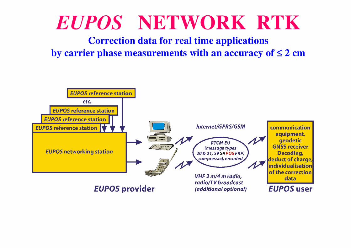
EUPOS NETWORK RTKCorrection data for real time applications
by carrier phase measurements with an accuracy of ≤≤≤≤ 2 cm
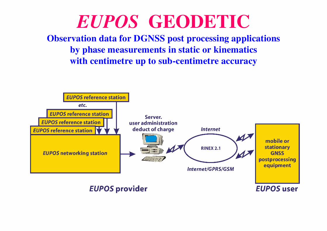
EUPOS GEODETIC Observation data for DGNSS post processing applications
by phase measurements in static or kinematics
with centimetre up to sub-centimetre accuracy
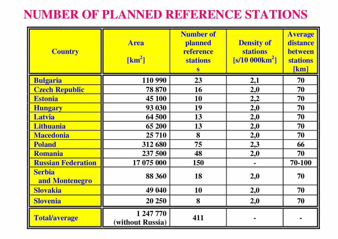
NUMBER OF PLANNED REFERENCE STATIONS
Country
Area
[km2]
Number of planned
reference
stations s
Density of stations
[s/10 000km2]
Average distance between
stations [km]
Bulgaria 110 990 23 2,1 70
Czech Republic 78 870 16 2,0 70
Estonia 45 100 10 2,2 70
Hungary 93 030 19 2,0 70
Latvia 64 500 13 2,0 70
Lithuania 65 200 13 2,0 70
Macedonia 25 710 8 2,0 70
Poland 312 680 75 2,3 66
Romania 237 500 48 2,0 70
Russian Federation 17 075 000 150 - 70-100
Serbia and Montenegro
88 360 18 2,0 70
Slovakia 49 040 10 2,0 70
Slovenia 20 250 8 2,0 70
Total/average 1 247 770
(without Russia) 411 - -
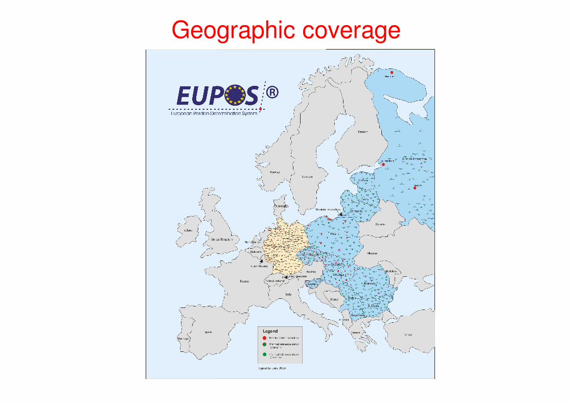
Geographic coverage
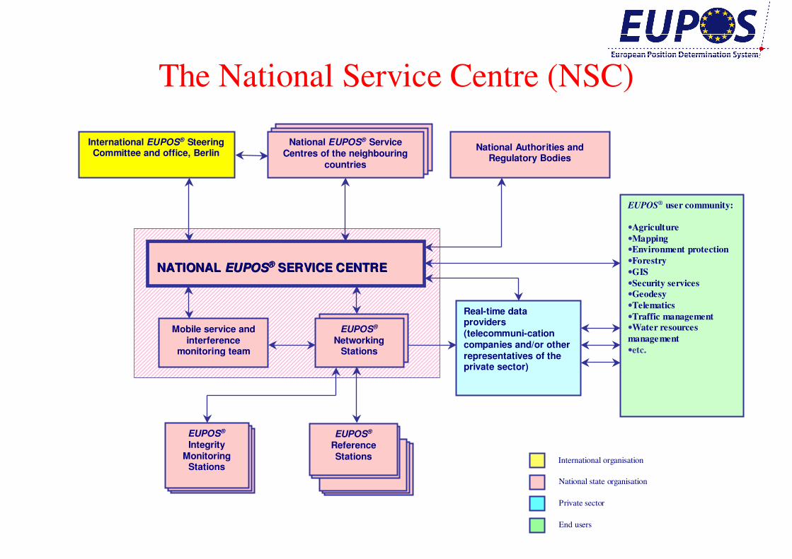
The National Service Centre (NSC)
National Authorities and Regulatory Bodies
NATIONAL NATIONAL EUPOSEUPOS®® SERVICE CENTRESERVICE CENTRE
International EUPOS® Steering Committee and office, Berlin
EUPOS® user community:
•Agriculture
•Mapping
•Environment protection
•Forestry
•GIS
•Security services
•Geodesy
•Telematics
•Traffic management
•Water resources
management
•etc.
EUPOS®
Networking Stations
Mobile service and interference
monitoring team
Real-time data providers (telecommuni-cationcompanies and/or other representatives of the private sector)
International organisation
National state organisation
Private sector
End users
National EUPOS® Service Centres of the neighbouring
countries
…
EUPOS®
Reference Stations
EUPOS®
Integrity Monitoring
Stations
EUPOS - densification of EPN• EUPOS respects existing infrastructure. Existing reference station
systems (e.g. EUREF, IGS) will be connected or incorporated,
• EUPOS reference stations will be connected to the stations of the EPN; positions of the EUPOS stations as well as transmitted DGNSS corrections will be related to the ETRS89,
• EUPOS network of reference stations will transfer the ETRS system to all CEE countries,
• selected part of EUPOS reference stations could be proposed as sub-network of the EPN when using the EPN standards,
• some selected EUPOS Processing Centres could serve also as EPN Local Analysis Centres and could process permanent observations from EPN and EUPOS stations,
• EUPOS stations will contribute to the maintenance of the ETRS inthe area of CEE,
• EUPOS ISC would like to establish close co-operation links to the IAG Sub-Commission for Europe – EUREF