environmental impact evaluation university of connecticut
TRANSCRIPT
Project No. 20120765.A10
Environmental Impact Evaluation
University of ConnecticutMain Accumulation Area
November 19, 2013
Prepared By:
146 Hartford RoadManchester, Connecticut 06040
Table of Contents
Environmental Impact EvaluationUniversity of Connecticut Main Accumulation Area
Environmental Impact Evaluation – University of Connecticut Main Accumulation Area i
Executive Summary ......................................................................... ES-1
1 Introduction ................................................................................... 11.1 Background ........................................................................................................... 2
1.1.1 Description of Existing MAA ..................................................................................... 21.1.2 Previous Siting Studies ................................................................................................. 31.1.3 North Campus Master Planning and Previous Environmental Documents....... 4
1.2 Proposed Action .................................................................................................... 61.3 Purpose and Need ................................................................................................. 71.4 Public Participation and Agency Coordination .................................................... 9
2 Alternatives Considered ............................................................ 102.1 No Action Alternative ...........................................................................................102.2 New MAA at the Existing Site ............................................................................. 112.3 Alternative Sites .................................................................................................... 11
2.3.1 Identification and Preliminary Screening of Alternative Sites ............................. 112.3.2 Detailed Site Evaluation............................................................................................. 14
2.4 Environmental Review of Alternatives .................................................................172.4.1 North Campus Parcel G Site .................................................................................... 172.4.2 W Lot Site .................................................................................................................... 212.4.3 North of Transfer Station Site .................................................................................. 212.4.4 F Lot Site ...................................................................................................................... 212.4.5 Site of Existing MAA (No Action and Upgraded Facility) .................................. 22
2.5 Preferred Alternative ............................................................................................ 22
3 Existing Environment and Analysis of Impacts ....................... 233.1 Environmental Resources of No Significance in the Project Area ..................... 233.2 Traffic, Parking, and Circulation ........................................................................ 23
3.2.1 Existing Conditions .................................................................................................... 233.2.2 Impact Evaluation....................................................................................................... 28
3.3 Air Quality ........................................................................................................... 303.3.1 Existing Conditions .................................................................................................... 313.3.2 Impact Analysis ........................................................................................................... 33
3.4 Noise ................................................................................................................... 343.4.1 Existing Conditions .................................................................................................... 343.4.2 Impact Evaluation....................................................................................................... 35
3.5 Water Resources .................................................................................................. 363.5.1 Existing Conditions .................................................................................................... 363.5.2 Impact Evaluation....................................................................................................... 41
3.6 Wetlands and Watercourses ................................................................................ 42

Table of Contents
Environmental Impact EvaluationUniversity of Connecticut Main Accumulation Area
Environmental Impact Evaluation – University of Connecticut Main Accumulation Area ii
3.6.1 Existing Conditions .................................................................................................... 433.6.2 Impact Evaluation....................................................................................................... 45
3.7 Wildlife and Vegetation ....................................................................................... 463.7.1 Existing Conditions .................................................................................................... 463.7.2 Impact Evaluation....................................................................................................... 48
3.8 Cultural Resources .............................................................................................. 493.8.1 Existing Conditions .................................................................................................... 493.8.2 Impact Evaluation....................................................................................................... 49
3.9 Visual and Aesthetic Character ........................................................................... 503.9.1 Existing Conditions .................................................................................................... 503.9.2 Impact Evaluation....................................................................................................... 51
3.10 Geology, Topography, and Soils ......................................................................... 533.10.1 Existing Conditions .................................................................................................... 533.10.2 Impact Evaluation....................................................................................................... 53
3.11 Utilities and Services ........................................................................................... 553.11.1 Existing Conditions .................................................................................................... 553.11.2 Impact Evaluation....................................................................................................... 59
3.12 Public Health and Safety ......................................................................................613.12.1 Existing Conditions .................................................................................................... 613.12.2 Impact Evaluation....................................................................................................... 63
3.13 Hazardous Materials ........................................................................................... 643.13.1 Existing Conditions .................................................................................................... 643.13.2 Impact Evaluation....................................................................................................... 66
3.14 Socioeconomics ................................................................................................... 673.14.1 Existing Conditions .................................................................................................... 673.14.2 Impact Evaluation....................................................................................................... 68
3.15 Land Use Planning .............................................................................................. 683.15.1 Land Use and Zoning in the Project Area .............................................................. 683.15.2 Local and Regional Land Use Planning................................................................... 693.15.3 Campus Land Use Planning ...................................................................................... 703.15.4 State Conservation and Development Plan ............................................................ 72
3.16 Construction Impacts .......................................................................................... 73
4 Summary of Impacts ................................................................. 774.1 Unavoidable Adverse Impacts............................................................................. 774.2 Irreversible and Irretrievable Commitments of Resources ................................. 774.3 Indirect and Cumulative Impacts ....................................................................... 784.4 Summary of Impacts and Mitigation Measures .................................................. 79
5 Costs and Benefits ...................................................................... 85
Table of Contents
Environmental Impact EvaluationUniversity of Connecticut Main Accumulation Area
Environmental Impact Evaluation – University of Connecticut Main Accumulation Area iii
6 Potential Certificates, Permits, and Approvals ....................... 86
7 References .................................................................................. 87
Tables PageES-1 Summary of Impacts and Proposed Mitigation ES-42-1 Site Scoring Results 162-2 Evaluation Criteria Weight Factors 162-3 Comparison of Alternatives 183-1 National Ambient Air Quality Standards 303-2 Air Quality Designation Area and Classification for Criteria Pollutants 313-3 Pollutant Data for Ozone 323-4 Connecticut Noise Zones and Standards 344-1 Summary of Impacts and Proposed Mitigation 806-1 List of Required Certificates, Permits and Approvals 866-2 Permits for the North Hillside Road Extension Project 86
Figures PageES-1 Location of Existing Main Accumulation Area ES-1ES-2 Location of Proposed Main Accumulation Area ES-2ES-3 Alternative MAA Locations ES-31-1 Location of Existing Main Accumulation Area 21-2 Existing Main Accumulation Area Facility 31-3 Location of Proposed Main Accumulation Area 61-4 Typical Interior Floor Plan of the Proposed MAA 72-1 Preliminary Alternative Site Locations 133-1 Campus Waste Generator Locations and UConn Waste Transport Vehicle Routes 253-2 Commercial Waste Transport Vehicle Routes 273-3 Water Resources 373-4 Water Quality Classifications 403-5 Wetlands and Watercourses 443-6 Site of Proposed MAA on North Campus Parcel G Looking Southeast 503-7 Site of Proposed MAA on North Campus Parcel G Looking Southwest 513-8 C Lot and C Lot Driveway Looking East Toward Parcel G 513-9 MAA Facility – University of Vermont Main Campus 523-10 MAA Facility – Cornell University Tech Park 523-11 Geology, Topography and Soils 54

Table of Contents
Environmental Impact EvaluationUniversity of Connecticut Main Accumulation Area
Environmental Impact Evaluation – University of Connecticut Main Accumulation Area iv
Figures Page3-12 Populated Areas Near the Existing and Proposed MAA Sites 653-13 North Campus Master Plan Proposed Energy Research Neighborhood 71
Appendices End of DocumentA Scoping DocumentsB Main Accumulation Area Facility Comparative Site Study (on CD)
Acronyms and AbbreviationsCEPA Connecticut Environmental Policy ActCEQ Council on Environmental QualityCFR Code of Federal RegulationsCGS Connecticut General StatutesCL&P Connecticut Light & PowerCNG Connecticut Natural GasCO Carbon MonoxideCT NDDB Connecticut Natural Diversity DatabaseCTDEEP Connecticut Department of Energy and Environmental ProtectionCUP Central Utility Plant
dB/dBa Decibel/A-weighted decibelDNL/LDN/Ldn Day Night Average Sound Level
EH&S UConn Department of Environmental Health & SafetyEIE Environmental Impact EvaluationEIS Environmental Impact StatementEPA U.S. Environmental Protection Agency
gpd gallons per daygpm gallons per minute
HEEP Hillside Environmental Education ParkHRSG Heat Recovery Steam Generator
IWWA Inland Wetlands and Watercourses Act
Table of Contents
Environmental Impact EvaluationUniversity of Connecticut Main Accumulation Area
Environmental Impact Evaluation – University of Connecticut Main Accumulation Area v
Acronyms and AbbreviationsLEED Leadership in Energy & Environmental DesignLEQ/Leq Equivalent Noise LevelLID Low Impact Development
MAA Main Accumulation Areamgd million gallons per day
NAAQS National Ambient Air Quality StandardsNCSS National Cooperative Soil SurveyNEPA National Environmental Policy ActNO2 Nitrogen DioxideNRCS Natural Resources Conservation Service
O3 OzoneOPM Office of Policy and Management
Pb Lead
RCSA Regulations of Connecticut State Agencies
SHPO State Historic Preservation OfficeSIP State Implementation Plan
THPO Tribal Historic Preservation OfficerTMDL Total Maximum Daily Loads
UConn University of ConnecticutUSACE U.S. Army Corps of EngineersUSDA United States Department of AgricultureUSFWS United States Fish and Wildlife ServiceUSGS Unites States Geologic Survey
WPCF Water Pollution Control FacilityWSS Web Soil Survey
Environmental Impact Evaluation – University of Connecticut Main Accumulation Area ES-1
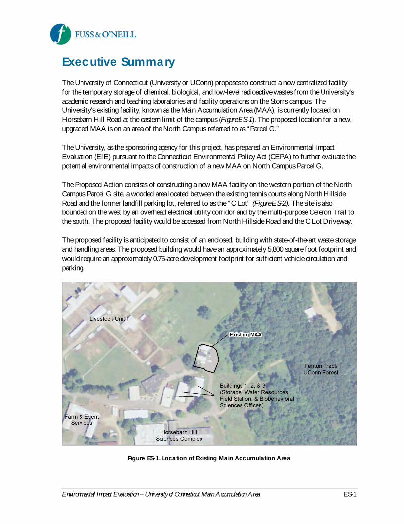
Executive SummaryThe University of Connecticut (University or UConn) proposes to construct a new centralized facilityfor the temporary storage of chemical, biological, and low-level radioactive wastes from the University’sacademic research and teaching laboratories and facility operations on the Storrs campus. TheUniversity’s existing facility, known as the Main Accumulation Area (MAA), is currently located onHorsebarn Hill Road at the eastern limit of the campus (Figure ES-1). The proposed location for a new,upgraded MAA is on an area of the North Campus referred to as “Parcel G.”
The University, as the sponsoring agency for this project, has prepared an Environmental ImpactEvaluation (EIE) pursuant to the Connecticut Environmental Policy Act (CEPA) to further evaluate thepotential environmental impacts of construction of a new MAA on North Campus Parcel G.
The Proposed Action consists of constructing a new MAA facility on the western portion of the NorthCampus Parcel G site, a wooded area located between the existing tennis courts along North HillsideRoad and the former landfill parking lot, referred to as the “C Lot” (Figure ES-2). The site is alsobounded on the west by an overhead electrical utility corridor and by the multi-purpose Celeron Trail tothe south. The proposed facility would be accessed from North Hillside Road and the C Lot Driveway.
The proposed facility is anticipated to consist of an enclosed, building with state-of-the-art waste storageand handling areas. The proposed building would have an approximately 5,800 square foot footprint andwould require an approximately 0.75-acre development footprint for sufficient vehicle circulation andparking.
Figure ES-1. Location of Existing Main Accumulation Area

Environmental Impact Evaluation – University of Connecticut Main Accumulation Area ES-2
Figure ES-2. Location of Proposed Main Accumulation Area
The purpose of the Proposed Action is to address three identified needs: (1) public concern about thelocation of the existing facility within a public drinking water supply watershed, (2) more efficient use ofspace compared to that of the existing MAA facility, and (3) future waste generation and storage on theStorrs campus.
The University conducted a siting study in 2012 to identify and evaluate potential sites on the Storrscampus for an upgraded MAA. The 2012 siting study was led by an Advisory Committee consisting ofrepresentatives from the Town of Mansfield, Windham Water Works, local watershed organizations, theConnecticut Institute of Water Resources, and University of Connecticut staff from Public Safety,Environmental Policy, and Residential Life.
The UConn Office of Environmental Policy, working closely with the Siting Advisory Committee,University staff, and its consultant, identified and evaluated the alternative sites shown in Figure ES-3with respect to physical site constraints (e.g., slopes, wetlands, and soils), public health issues, publicsafety, and University planning initiatives.
1. No Action – The No Action alternative assumes continued use of the existing MAA in its currentlocation, without modification. The facility would continue to operate with the existing structures,facility layout, and operational procedures.
2. New MAA at the Existing Site – Under this alternative, the existing MAA would be closed anddecommissioned, and a building with an approximately 5,800 square foot footprint would beconstructed on the existing site. The overall site footprint would be expanded to approximately 0.75acres to allow adequate vehicle circulation and parking.

Environmental Impact Evaluation – University of Connecticut Main Accumulation Area ES-3
3. North Campus Parcel G Site (Proposed Action)
4. F Lot Site – The UConn F Lot is located north of North Eagleville Road and west of LeDoytRoad, situated adjacent to an electrical substation and near the UConn Public Safety complex. Theproposed MAA would be located in the southeast corner of the parking lot, outside of the limits ofthe former ash landfill that underlies a large portion of the F Lot.
5. W Lot Site – The W Lot is located near the northern gateway entrance to the Storrs campus, westof Route 195 and north of Husky Village. The proposed MAA would be located in the northwestcorner of the parking lot. Access to the site would be from the existing W Lot entrance along Route195, across from the northern leg of Horsebarn Hill Road.
6. North of Transfer Station Site – This site is located north of the UConn Water Pollution ControlFacility and solid waste transfer station, east of the Connecticut Light & Power (CL&P) electricalutility corridor, and south of the Celeron Trail.
Figure ES-3. Alternative MAA Locations

Environmental Impact Evaluation – University of Connecticut Main Accumulation Area ES-4
A scoring matrix was developed in conjunction with the Advisory Committee as a semi-quantitative,multi-attribute rating and ranking tool designed to assist the Advisory Committee identify a ranked list ofpreferred sites. The evaluation criteria included consideration of ecological resources, public health,public water supplies, public safety/security and accessibility, land use and consistency with land useplanning, cost and regulatory considerations, and traffic safety and circulation.
The North Campus Parcel G site was the highest-rated site overall, and was individually scored as thehighest-rated site by 10 of the 11 Advisory Committee members. The lowest-rated site was the existingMAA facility location, i.e. the No Action alternative receiving the lowest overall score.
Based on the anticipated environmental impacts of the alternatives considered, a new MAA facilityconstructed on North Campus Parcel G is the preferred alternative evaluated in the subject EIE.
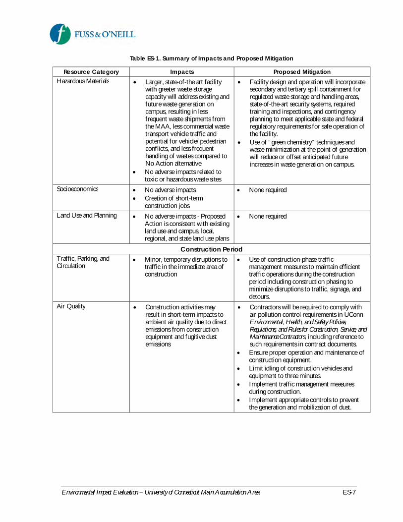
The Proposed Action would result in minor impacts to vehicle and pedestrian traffic on campus, loss offragmented upland forest habitat, and minor increases in energy and utility usage. Potential construction-related impacts include temporary impacts to vehicle and pedestrian traffic, air quality, noise, hazardousmaterials and solid waste, and stormwater. Anticipated impacts and proposed mitigation measures toavoid, minimize, or offset potential adverse impacts are summarized in Table ES-1.
Table ES-1. Summary of Impacts and Proposed Mitigation
Resource Category Impacts Proposed MitigationTraffic, Parking, andCirculation
Improved vehicle circulation,maneuverability, parking, andaccess/egress compared to thatof the existing facilityMinor increases in traffic andpotential for truck/pedestrianconflicts along waste shipmentroutes resulting fromredistribution of existing trafficassociated with EH&S andcommercial waste transportvehicles traveling to and fromthe MAALarger, state-of-the art facilitywith greater waste storagecapacity will address existing andfuture waste generation oncampus, resulting in lessfrequent waste shipments fromthe MAA, less commercial wastetransport vehicle traffic andpotential for vehicle/pedestrianconflicts, and less frequenthandling of wastes compared toNo Action alternative
Restrictions on the timing of wasteshipments and allowable truck routes toavoid periods and locations of highpedestrian activity on campus
Air Quality No adverse impacts None requiredNoise No adverse impacts None required

Environmental Impact Evaluation – University of Connecticut Main Accumulation Area ES-5
Table ES-1. Summary of Impacts and Proposed Mitigation
Resource Category Impacts Proposed MitigationWater Resources No adverse impacts to surface
water and groundwater quality orquantityNo adverse impacts to floodhazard potentialIncrease in stormwater runoffand potential stormwaterpollutant loading
Proposed stormwater management andfacility design elements will reduce thepotential for impacts associated with a releaseof chemicals or other hazardous materials tothe environment (see Utilities and Services)
Wetlands andWatercourses
No adverse impacts Proposed stormwater management andfacility design elements will reduce thepotential for impacts associated with a releaseof chemicals or other hazardous materials tothe environment (see Utilities and Services)
Wildlife and Vegetation No adverse impactsLoss of approximately 0.75 acresof fragmented upland foresthabitat
Proposed stormwater management andfacility design elements will reduce thepotential for impacts associated with a releaseof chemicals or other hazardous materials tothe environment (see Utilities and Services)
Cultural Resources Parcel G contains potential areasof prehistoric value
Additional cultural resource investigation ofParcel G (Phase 1B ArchaeologicalReconnaissance Survey) prior todevelopment and coordinate with the StateHistoric Preservation Office (SHPO) and theTribal Historic Preservation Officers(THPOs) of the Mashantucket Pequot andMohegan Tribes to ensure that historic,archaeological, and cultural resources areprotected
Visual and AestheticCharacter
No adverse impacts None required
Geology, Topography, andSoils
No adverse impacts Proposed facility design elements will reducethe potential for subsurface impactsassociated with a release of chemicals orother hazardous materials to the environment(see Hazardous Materials)

Environmental Impact Evaluation – University of Connecticut Main Accumulation Area ES-6
Table ES-1. Summary of Impacts and Proposed Mitigation
Resource Category Impacts Proposed MitigationUtilities and Services Adequate utility capacity is
availableThe creation of impervioussurfaces will cause increasedstormwater runoff
Non-structural source controls and pollutionprevention measures (parking lot sweeping,catch basin cleaning, drainage system andstormwater treatment system operation andmaintenance, etc.)LID approaches such as drywells, raingardens, vegetated swales, and otherinfiltration techniques to infiltrate runofffrom the building roof and sidewalks orpaved areas where regulated wastes will notbe handledRunoff from loading areas or other locationswhere regulated wastes are handled will bedirected to a stormwater collection systemthat can be effectively closed in the event of aspill. Such facilities will incorporate shut-offvalves, impermeable liners, or other similardesign features to reduce the potential for arelease to the environment.Management strategies to reduce stormwaterbacteria concentrations including filtrationpractices such as lined and underdrainedbioretention systems or subsurface sandfiltersThe facility design will incorporate spillcontainment measures to provide secondaryand tertiary containment for regulated wastestorage and handling areas, state-of-the-artsecurity systems, and required training,inspections, and a contingency planning tomeet applicable state and federal regulatoryrequirementsThe design will consider the CampusSustainable Design Guidelines, which includespecific measures for reduction of energyconsumption on new construction projectson campus
Public Health and Safety Sufficient public safety andemergency services are currentlyavailable to address the needs ofthe MAA
None required
Environmental Impact Evaluation – University of Connecticut Main Accumulation Area ES-7
Table ES-1. Summary of Impacts and Proposed Mitigation
Resource Category Impacts Proposed MitigationHazardous Materials Larger, state-of-the art facility
with greater waste storagecapacity will address existing andfuture waste generation oncampus, resulting in lessfrequent waste shipments fromthe MAA, less commercial wastetransport vehicle traffic andpotential for vehicle/pedestrianconflicts, and less frequenthandling of wastes compared toNo Action alternativeNo adverse impacts related totoxic or hazardous waste sites
Facility design and operation will incorporatesecondary and tertiary spill containment forregulated waste storage and handling areas,state-of-the-art security systems, requiredtraining and inspections, and contingencyplanning to meet applicable state and federalregulatory requirements for safe operation ofthe facility.Use of “green chemistry” techniques andwaste minimization at the point of generationwill reduce or offset anticipated futureincreases in waste generation on campus.
Socioeconomics No adverse impactsCreation of short-termconstruction jobs
None required
Land Use and Planning No adverse impacts - ProposedAction is consistent with existingland use and campus, local,regional, and state land use plans
None required
Construction PeriodTraffic, Parking, andCirculation
Minor, temporary disruptions totraffic in the immediate area ofconstruction
Use of construction-phase trafficmanagement measures to maintain efficienttraffic operations during the constructionperiod including construction phasing tominimize disruptions to traffic, signage, anddetours.
Air Quality Construction activities mayresult in short-term impacts toambient air quality due to directemissions from constructionequipment and fugitive dustemissions
Contractors will be required to comply withair pollution control requirements in UConnEnvironmental, Health, and Safety Policies,Regulations, and Rules for Construction, Service, andMaintenance Contractors, including reference tosuch requirements in contract documents.Ensure proper operation and maintenance ofconstruction equipment.Limit idling of construction vehicles andequipment to three minutes.Implement traffic management measuresduring construction.Implement appropriate controls to preventthe generation and mobilization of dust.

Environmental Impact Evaluation – University of Connecticut Main Accumulation Area ES-8
Table ES-1. Summary of Impacts and Proposed Mitigation
Resource Category Impacts Proposed MitigationNoise Heavy construction equipment
associated with site developmentmay result in temporaryincreases in noise levels in theimmediate area of construction
Contractors will be required to comply withnoise control requirements in UConnEnvironmental, Health, and Safety Policies,Regulations, and Rules for Construction, Service, andMaintenance Contractors, including reference tosuch requirements in contract documents.Ensure proper operation and maintenance ofconstruction equipment.Construction contractors should make everyreasonable effort to limit construction noiseimpacts.
Stormwater and WaterQuality
Exposure of soil increasespotential for erosion andsedimentation
Use of appropriate erosion and sedimentcontrols during construction, consistent withthe 2002 Connecticut Guidelines for Soil Erosionand Sediment Control, as amended.
Hazardous Materials andSolid Waste
Temporary on-site storage anduse of fuels and other materialsassociated with constructionvehicles and equipmentAsbestos-containing materials,lead-based paint or otherhazardous materials associatedwith closure of the existing MAAfacilityGeneration of solid wasteincluding construction anddemolition debris
Contractors will be required to comply withrequirements for construction-relatedhazardous materials and solid waste inUConn Environmental, Health, and SafetyPolicies, Regulations, and Rules for Construction,Service, and Maintenance Contractors, includingreference to such requirements in contractdocuments.Hazardous or regulated materials orsubsurface contamination encountered duringconstruction will be characterized anddisposed of in accordance with applicablestate and federal regulations.UConn will follow CTDEEP guidance forclosure and decommissioning of the existingMAA, including removal of the existingstructures and equipment, sitecharacterization for any residualcontamination, and associated cleanup.UConn will also follow applicable closureand decommissioning requirements of theNuclear Regulatory Commission.Construction-related solid waste will behandled and disposed of in a manner thatmeets current regulations and Universitystandards. Construction and demolitiondebris will be managed in accordance withapplicable state and federal regulations andthe University’s contractor policies.

Environmental Impact Evaluation – University of Connecticut Main Accumulation Area ES-9
The following certificates, permits, and approvals are anticipated to be required for the ProposedAction. Additional certificates, permits, and approvals may be identified following the CEPA process,pending the final design of the project.
CTDEEP Flood Management Certification – required for activities affecting natural or man-made drainage facilitiesCTDEEP General Permit for Discharge of Stormwater and Dewatering Wastewater Associatedwith Construction Activities – registration required if total site disturbance exceeds 1 acreCoordination with the State Historic Preservation Office (SHPO) and Tribal HistoricPreservation Officers (THPOs) of the Mashantucket Pequot and Mohegan Tribes – required asa mitigation commitment in the Record of Decision for the North Hillside Road Extension EIS
The following permits have been issued or are pending for the proposed extension of North HillsideRoad and associated development of the North Campus for the UConn Technology Park, includingParcel G, the site of the Proposed Action:
CTDEEP Flood Management Certification (FM-201205381)CTDEEP Inland Wetlands & Watercourses, Water Quality Certification, and Water DiversionPermit (IW-201205383, WQC- 201205382, DIV- 201205385, Draft)United States Army Corps of Engineers Section 404 Individual Permit (File No. NAE-2004-3990, Permit Pending)
A scoping notice for the subject project appeared in the April 16, 2013 edition of the EnvironmentalMonitor (Appendix A), beginning the 30-day scoping period. The scoping period ended on May 16, 2013.During the scoping period, a public scoping meeting was held on the UConn campus on May 1, 2013.Public oral comments were received during the public meeting from four Town of Mansfield residents.A summary of comments made at the public scoping meeting and copies of written comment lettersreceived during the scoping period are provided in Appendix A of the subject EIE.
Formal notice of the availability of this EIE has been published in the Hartford Courant, the WillimanticChronicle, and in the Environmental Monitor. An electronic copy of this document was also made availableon the UConn Office of Environmental Policy website. The document was sent to the appropriate Stateagencies and the Town of Mansfield for review and comment.

Environmental Impact Evaluation – University of Connecticut Main Accumulation Area 1
1 IntroductionThe University of Connecticut (University or UConn) proposes to construct a new centralized facilityfor the temporary storage of chemical, biological, and low-level radioactive wastes from the University’sacademic research and teaching laboratories and facility operations on the Storrs campus. TheUniversity’s existing facility, known as the Main Accumulation Area (MAA), is currently located onHorsebarn Hill Road. To protect public health and the environment and to ensure regulatorycompliance, the UConn Department of Environmental Health & Safety (EH&S) manages the wastes incompliance with local, state, and federal regulations, as well as University health and safety policies andprocedures.
The existing MAA is adequate to serve the current needs of the University and meets or exceeds stateand federal requirements for safety and environmental protection. However, space on the existing site islimited, resulting in poor circulation for waste transport vehicles, and its design is inconsistent with state-of-the-art MAA facilities at other comparable research institutions. The facility will also have difficultiesmeeting future needs without increasing the frequency of off-site waste shipments based on anticipatedgrowth in undergraduate enrollment and planned research growth at the University. In addition, theexisting MAA is located within the Fenton River watershed and the drainage basin of the WillimanticReservoir, which is a public water supply. Although the facility has been operated safely since it wasestablished in 1989, the University recognizes the public concern that remains about the location of thefacility within the public water supply watershed.
To address these concerns, UConn convened an advisory committee consisting of representatives fromthe Town of Mansfield, Windham Water Works, local watershed organizations, the Connecticut Instituteof Water Resources, and University of Connecticut staff from Public Safety, Environmental Policy, andResidential Life. The advisory committee conducted a siting study to identify and assess potential sitesfor an upgraded MAA facility. The study recommended a prioritized list of alternative sites, with theNorth Campus Parcel G site, located between the existing North Hillside Road and C Lot, identified asthe preferred alternative.
The University has prepared an Environmental Impact Evaluation (EIE) to further evaluate thepotential environmental impacts of construction of a new MAA on North Campus Parcel G, hereafterreferred to as the Proposed Action, as well as other alternatives considered, including the existinglocation (i.e., the No Action alternative). The format and content of this EIE are based on therequirements of the Connecticut Environmental Policy Act (CEPA) (Connecticut General Statutes[CGS] Sections 22a-1 through 22a-1h, inclusive, and, where applicable, CEPA regulations Sections 22a-1a-1 through 22a-1a-12, inclusive, of the Regulations of Connecticut State Agencies [RCSA]). Statefunds would be used for the Proposed Action, which triggers the CEPA process. The University is thesponsoring agency of this project.
The central purpose of the CEPA process is for state agencies to determine whether or not a proposedaction will have a "significant effect," which means substantial adverse impact on the environment(RCSA 22a-1a-1, Definitions). Agencies preparing an EIE must consider direct and indirect effects aswell as cumulative impacts. The subject EIE includes a description of the Proposed Action; the purposeand need for the action; an evaluation of the direct and indirect effects and cumulative impacts of the
Environmental Impact Evaluation – University of Connecticut Main Accumulation Area 2
proposed action; identification of unavoidable adverse environmental effects; evaluation of alternatives;and a description of proposed mitigation measures.
1.1 Background
1.1.1 Description of Existing MAA
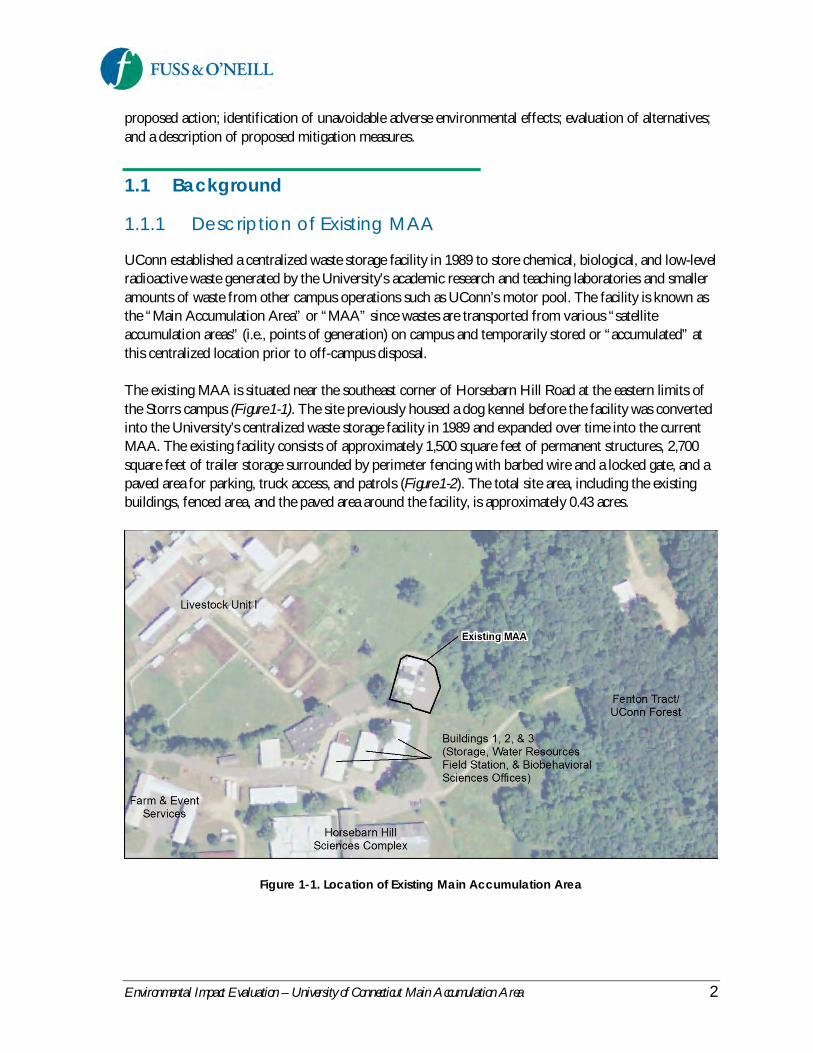
UConn established a centralized waste storage facility in 1989 to store chemical, biological, and low-levelradioactive waste generated by the University’s academic research and teaching laboratories and smalleramounts of waste from other campus operations such as UConn’s motor pool. The facility is known asthe “Main Accumulation Area” or “MAA” since wastes are transported from various “satelliteaccumulation areas” (i.e., points of generation) on campus and temporarily stored or “accumulated” atthis centralized location prior to off-campus disposal.
The existing MAA is situated near the southeast corner of Horsebarn Hill Road at the eastern limits ofthe Storrs campus (Figure 1-1). The site previously housed a dog kennel before the facility was convertedinto the University’s centralized waste storage facility in 1989 and expanded over time into the currentMAA. The existing facility consists of approximately 1,500 square feet of permanent structures, 2,700square feet of trailer storage surrounded by perimeter fencing with barbed wire and a locked gate, and apaved area for parking, truck access, and patrols (Figure 1-2). The total site area, including the existingbuildings, fenced area, and the paved area around the facility, is approximately 0.43 acres.
Figure 1-1. Location of Existing Main Accumulation Area

Environmental Impact Evaluation – University of Connecticut Main Accumulation Area 3
Figure 1-2. Existing Main Accumulation Area Facility
UConn EH&S personnel regularly collect regulated waste from the estimated 1,200 satelliteaccumulation areas on the Storrs campus and transport the waste via trucks to the MAA. Wastes aretemporarily stored at the MAA and managed by EH&S to ensure environmental protection andregulatory compliance. The facility operations meet or exceed state and federal requirements for safetyand environmental protection, including secondary containment, weekly inspections and documentation,contingency plans, container labeling, security, and personnel training. Since it was established in the late1980s, the MAA has been operated safely, not having experienced a release, break-in, or other securitythreat. The existing MAA has sufficient capacity to serve the current needs of the campus.
Commercial waste haulers are hired for scheduled pickups at the MAA and transport the waste to theappropriate off-campus disposal facilities. The commercial transport trucks are regulated by the U.S.Department of Transportation and meet stringent hazardous waste transporter requirements. Thestorage of chemical hazardous wastes at the MAA is limited to 90 days or less, pursuant to state andfederal hazardous waste (Resource Conservation and Recovery Act or RCRA) regulations. Chemicalwastes are typically removed monthly, biological wastes are typically removed weekly or bi-weekly, andlow-level radioactive wastes are typically removed every 12 to 15 months.
1.1.2 Previous Siting Studies
Over the past decade, UConn has evaluated options for relocating the MAA to another site on theStorrs campus in response to public concern about the location of the existing facility within the publicdrinking water supply watershed.
The University began evaluating options for relocating the existing MAA to a different on-campus site in2003. With the help of a project advisory committee representing University and local stakeholders,UConn initially evaluated six alternative locations including the current location off Horsebarn HillRoad. The study report was completed in 2004 (SEA Consultants, Inc.) and identified a prioritized list ofsites for the relocated MAA. Conceptual designs and layouts were prepared for the two highest-ratedalternative sites: (1) adjacent to the Transfer Station and west of the Water Pollution Control Facility(WPCF), and (2) a parcel within the WPCF. The CEPA process was initiated for these sites, but theprocess was suspended when the sites became unavailable because a portion of the Transfer Station was
1. Old Supply Storage Trailers2. Old Chemical Waste Shed3. New Bulk Chemical Storage Shed
4. Main Building (Chemical Laboratory and Low-Level Radioactive Waste Processing)5. Biological Waste Storage6. Radioactive Waste Storage Trailers
Environmental Impact Evaluation – University of Connecticut Main Accumulation Area 4
being used for construction staging associated with the landfill cap construction, and plans had beendeveloped for potential expansion of the WPCF and construction of the Reclaimed Water Facility in thearea west of the WPCF.
A new preferred alternative site for the relocated MAA was identified in 2007 to replace the twoprevious alternatives that had become unavailable. UConn met with the Connecticut Office of Policyand Management (OPM) and the Connecticut Department of Environmental Protection (now called theDepartment of Energy and Environmental Protection or CTDEEP) in June 2007 to discuss potentialalternative sites near the two previous highest-rated sites and agreed to proceed with a site north of theTransfer Station. The CEPA process was initiated for the new site, but the process was suspended in2008 due to public safety concerns.
The economic downturn in 2008 resulted in significant capital and operating budget cuts at theUniversity, putting the MAA facility relocation efforts on hold. In 2012, UConn investigated thefeasibility of relocating the MAA facility to the Depot Campus. However, because the Depot Campus isnot contiguous with the Main Campus, under the federal hazardous waste regulatory program orResource Conservation and Recovery Act (RCRA), hazardous waste generated on the Main Campuscannot be transported and stored on the Depot Campus without a change in regulatory status, whichwould entail a significantly greater compliance burden and liability to the University. This option wastherefore eliminated from further consideration.
In the spring of 2012, UConn initiated a new MAA siting study by convening another advisorycommittee (MAA Siting Advisory Committee or Advisory Committee) to assist in identifying andevaluating potential MAA sites on the Storrs campus, review and discuss the criteria that are used toevaluate each site, and recommend a preferred alternative location for the facility by ranking eachalternative site according to the criteria. Alternative MAA facility sites were independently rated andranked by each member of the Advisory Committee using a semi-quantitative, multi-attribute scoringmatrix and associated guidance document. The methods and results of the 2012 siting study aredescribed in the Main Accumulation Area Facility Comparative Site Study report, which is included in thesubject EIE as Appendix B. The 2012 study recommended a prioritized list of alternatives, withconstruction of a new MAA facility on the North Campus Parcel G site as the highest rated andpreferred alternative. The 2012 siting study also serves as the basis for the analysis of alternativesdescribed in Section 2, Alternatives Considered.
1.1.3 North Campus Master Planningand Previous EnvironmentalDocuments
The proposed site for the new MAA is located on a portion of the UConn campus known as the “NorthCampus,” which encompasses the area north of North Eagleville Road and west of Route 195. TheNorth Campus is currently accessible via North Hillside Road, which terminates near the entrance to theCharter Oak Apartments.
The construction of a roadway from North Eagleville Road to U.S. Route 44 and development of aresearch and technology park on the North Campus has been contemplated by the University since the

Environmental Impact Evaluation – University of Connecticut Main Accumulation Area 5
1970s. The proposed roadway construction and development of the North Campus has been the subjectof several previous planning efforts and associated state and federal environmental documents.
In 1982, the non-profit entity called the University of Connecticut Educational Properties, Inc. (UCEPI)was formed to develop a research park on the North Campus. In 1987, the construction of anapproximately 3,800 linear foot road, North Hillside Road, was reviewed in an EIE. After approval ofthe EIE by the Connecticut Office of Policy and Management (OPM) in 1988, the state beganconstruction of what is now the existing North Hillside Road, which was completed in 1989. UConnand the Department of Economic and Community Development jointly sponsored another EIE toassess the purpose and need for a research and technology park on the North Campus. The EIE wasreleased by the University in May 1994. The Connecticut Department of Transportation (CTDOT)began the roadway design following approval of the EIE by OPM in January 1995. However, designplans were halted at the sixty percent design stage.
In June 2000, UConn released the Outlying Parcels Master Plan (2000 Master Plan) (JJR, 2000), whichincluded a master plan for development of the North Campus. The 2000 Master Plan identified anumber of North Campus development parcels, including Parcel G, along with envisioned uses andmaximum development scenarios for each parcel. An EIE was prepared in 2001 (Frederic R. Harris,Inc., 2001) for the North Campus development proposed in the 2000 Master Plan. OPM subsequentlyfound the 2001 EIE to adequately comply with CEPA, but required that a “CEPA ComparativeEvaluation” be conducted prior to the development of future North Campus parcels to compare theanticipated environmental impacts described in the 2001 EIE with the anticipated impacts of future site-specific projects. The subject EIE, which addresses the construction of a new MAA on North CampusParcel G, meets and exceeds the requirements for a CEPA Comparative Evaluation in accordance withthe conditions of the 2001 EIE approval by OPM.
In 2005, approximately $6 million was appropriated by the federal government for the extension ofNorth Hillside Road north to Route 44, requiring preparation of an Environmental Impact Statement(EIS) pursuant to the National Environmental Policy Act (NEPA). Similar to previous stateenvironmental reviews, the EIS considered environmental impacts associated with the roadwayextension and associated development of the North Campus by identifying a conceptual developmentenvelope that included the original parcels identified in the 2001 EIE (FHWA, 2011). In October 2011,Connecticut Governor Dannel P. Malloy signed legislation (Public Act 11-57) approving the creation ofa research and technology park at the UConn North Campus, known as the “UConn Technology Park.”The General Assembly approved $172.5 million in required start-up funding for the project. The Recordof Decision (ROD) for the EIS was approved by the Federal Highway Administration in April 2012.Approval of the ROD was an important regulatory milestone, allowing subsequent creation of a newgateway entrance to the University and development of the UConn Technology Park on the NorthCampus.
A revised North Campus Master Plan was released in October 2012 (2012 Master Plan)(SOM, 2012).The 2012 Master Plan builds upon the previous planning efforts for the North Campus and creates aframework for future development of the UConn Technology Park. Relocation of the MAA to theNorth Campus is consistent with the technology uses envisioned for the UConn Technology Park. Theplanning process for the 2012 Master Plan identified Parcel G as the most likely potential site for a

Environmental Impact Evaluation – University of Connecticut Main Accumulation Area 6
relocated MAA facility within the UConn Technology Park. North Campus Parcels D and E were alsoconsidered in the 2012 master planning process as potential locations for the MAA facility.
1.2 Proposed Action
The Proposed Action consists of constructing a new MAA facility on the western portion of the NorthCampus Parcel G site, a wooded area located between the existing tennis courts along North HillsideRoad and the former landfill parking lot, referred to as the “C Lot” (Figure 1-3). The site is also boundedon the west by an overhead electrical utility corridor and by the multi-purpose Celeron Trail to thesouth. The proposed facility would be accessed from North Hillside Road and the C Lot Driveway.
Figure 1-3. Location of Proposed Main Accumulation Area
The proposed facility is anticipated to consist of an enclosed building with state-of-the-art waste storageand handling areas, laboratory space, a control room, loading and unloading areas, and bathrooms. Figure1-4 depicts a typical interior floor plan of the proposed facility. The proposed building would have anapproximately 5,800 square foot footprint and would require an approximately 0.75-acre developmentfootprint for sufficient vehicle circulation and parking, as depicted conceptually in Figure 1-3. In additionto the new MAA facility, the 2012 North Campus Master Plan envisions other future technology-relateduses for the balance of Parcel G.
The Proposed Action also includes closure and decommissioning of the existing MAA in accordancewith CTDEEP guidance (CTDEEP, 2005a), which would entail removal of the existing structures andequipment, as well as site characterization for any residual contamination at the existing site andassociated cleanup. The University would also follow applicable closure and decommissioningrequirements of the Nuclear Regulatory Commission.

Environmental Impact Evaluation – University of Connecticut Main Accumulation Area 7
Figure 1-4. Typical Interior Floor Plan of the Proposed MAA
1.3 Purpose and Need
Public concern has existed for years about the proximity of the current MAA location to public drinkingwater supplies. The facility is located within the Fenton River watershed and the drainage basin of theWillimantic Reservoir, a public drinking water supply operated by the Windham Water Works. The siteof the existing MAA is located approximately 3,500 feet west of the Fenton River and approximately 6miles upstream of the Willimantic Reservoir. While the site is situated outside of the mapped Level ARecharge Area1 of the Fenton Aquifer, public concern has existed about the relative proximity of the site(approximately 400 feet) to the mapped Level A Recharge Area since the Fenton River Wellfield drawswater from the Fenton Aquifer and supplies drinking water to the University.
Although the MAA has been operated safely since it was established in 1989, the University recognizesthe public concern that remains about the location of the facility within the Fenton River watershed andthe drainage basin of the Willimantic Reservoir. Furthermore, the Connecticut Council onEnvironmental Quality (CEQ) and OPM have recommended the relocation of the MAA outside of thepublic drinking water supply watershed (refer to the May 23, 2012 letter from CEQ, included inAppendix A).
1 Level A mapping defines the land area contributing groundwater to the public water supply well field.

Environmental Impact Evaluation – University of Connecticut Main Accumulation Area 8
While the existing MAA meets or exceeds state and federal requirements for safety and environmental protection, several issues exist with the design of the current facility. The existing MAA design and site configuration reflects the evolution of the site from its previous use as a dog kennel to its current use as the University’s centralized waste storage facility. Waste storage has been added and the facility upgraded over time in response to changes in the quantities and types of waste generated on the Storrs campus and to enhance security and working conditions at the facility. However, space is limited on the existing 0.43-acre site, which has resulted in less-than-ideal circulation and maneuverability for waste transport trucks and other vehicles. A newly constructed or relocated facility would benefit from a larger site area (0.75 acres) for improved vehicle circulation, including vehicle turn-around, parking, and access/egress. The existing MAA design is also not on par with state-of-the-art MAA facilities at other comparable research institutions. Given the approximately 4,200 square feet of existing permanent structures and trailer storage and the current frequencies of waste pickup, the existing MAA is adequate to handle the quantities and types of wastes that are currently being generated at the Storrs campus. However, the existing facility will have difficulties meeting future needs without increasing the frequency of off-site waste shipments based on anticipated growth in undergraduate enrollment and planned research growth at the University, including the Next Generation Connecticut initiative and the planned extension of North Hillside Road and the creation of the UConn Technology Park on the North Campus. Next Generation Connecticut is a proposal to significantly expand educational opportunities, research, and innovation in the science, technology, engineering, and math (STEM) disciplines at UConn over the next decade. The goals of this 10-year plan include hiring 259 new faculty (of which 200 will be in STEM), enrolling an additional 5,060 undergraduate students at the Storrs campus (of which 3,290 will be in STEM), building new STEM facilities and teaching laboratories, and upgrading aging infrastructure to accommodate new faculty and students. The proposed UConn Technology Park is anticipated to attract technology-related facilities that will generate regulated waste. The first facility planned for the technology park, the Innovation Partnership Building, will be a University building on land owned by UConn. Therefore regulated wastes from this building can be consolidated with other campus wastes at the MAA. As development plans for other UConn Technology Park facilities become available, they will be reviewed to determine how those facilities’ wastes must be managed to be in compliance with applicable regulations. The Next Generation Connecticut initiative, and potentially the proposed UConn Technology Park, is expected to increase waste generation and the demand for regulated waste storage on the Storrs campus. Given current trends in waste generation on the Storrs campus and the Next Generation Connecticut projections of a 42% increase in undergraduate STEM students and an increase of 200 STEM faculty over the next 10 years, UConn EH&S anticipates an approximately 50% increase in the generation of both chemical and biological waste by 2020 (UConn EH&S, personal communication, August 8, 2013). The existing MAA is not adequately sized to meet these future estimates without increasing the frequency of waste removal from the MAA (i.e., greater than monthly for chemical waste and greater than weekly or bi-weekly for biological waste), which would increase operational costs.

Environmental Impact Evaluation – University of Connecticut Main Accumulation Area 9
The University is therefore evaluating the construction of a new, state-of-the-art MAA facility on NorthCampus Parcel G. The purpose of the facility is to address three identified needs: (1) public concernabout the location of the existing facility within the public drinking water supply watershed, (2) moreefficient use of space compared to that of the existing MAA facility, and (3) future waste generation andstorage on the Storrs campus.
1.4 Public Participation and AgencyCoordination
Public input and participation and coordination with local, regional, state, and federal agencies are majorelements of the CEPA process. CEPA requires an early public scoping process to identify issues ofconcern related to the proposed action through coordination with interested persons and affectedagencies. Scoping begins with the publication of a scoping notice in the Environmental Monitor, a semi-monthly online publication of the Council on Environmental Quality (CEQ) (http://www.ct.gov/ceq).The scoping includes a 30-day public comment period during which governmental agencies, as well asother organizations and the public, can submit comments on the proposed project and request a publicscoping meeting. During the preparation of an EIE, the sponsoring agency must consider the issuesraised and comments received during scoping.
A scoping notice for the subject project appeared in the April 16, 2013 edition of the EnvironmentalMonitor (Appendix A), beginning the 30-day scoping period. The scoping period ended on May 16, 2013.During the scoping period, a public scoping meeting was held on the UConn campus on May 1, 2013.Public oral comments were received during the public meeting from four Town of Mansfield residents.During the 30-day scoping period, written comments were received from the Connecticut Departmentof Energy and Environmental Protection, the Mayor of the Town of Mansfield, the ConnecticutDepartment of Public Health, and a Town of Mansfield resident. A summary of comments made at thepublic scoping meeting and copies of written comment letters received during the scoping period areprovided in Appendix A.
Formal notice of the availability of this EIE has been published in the Hartford Courant, the WillimanticChronicle, and in the Environmental Monitor. An electronic copy of this document was also made availableon the UConn Office of Environmental Policy website. The document was sent to the followingagencies and entities for review and comment:
Council on Environmental QualityConnecticut Department of Energy and Environmental ProtectionConnecticut Department of Public HealthConnecticut Department of TransportationConnecticut Commission on Culture and TourismConnecticut Office of Policy and ManagementTown of Mansfield (with public copy available with Town Clerk)
Environmental Impact Evaluation – University of Connecticut Main Accumulation Area 10
2 Alternatives ConsideredThe Connecticut Environmental Policy Act (CEPA) requires state agencies undertaking an action thatmay result in potential significant effects on the environment to consider reasonable alternatives,particularly alternatives that might enhance environmental quality or avoid potential adverseenvironmental effects. Such alternatives include taking no action or substituting an action of asignificantly different nature that would provide similar benefits with different environmental impacts, aswell as the use of other sites controlled by or reasonably available to the sponsoring agency that wouldmeet the stated purpose of the action.
This section compares the No Action alternative, the Proposed Action, and reasonable alternatives inlight of their ability to meet the project purpose and need. The discussion of alternatives focuses on thealternative sites that were considered for an upgraded MAA facility during the 2012 siting study process.This section also describes potential environmental considerations associated with each alternative andthe basis for selection of the preferred alternative, which is the Proposed Action in this EIE.
The No Action alternative (i.e., the baseline for analysis of impacts under CEPA) and Proposed Actionare further evaluated in Section 3, Existing Environment and Analysis of Impacts.
2.1 No Action Alternative
The No Action alternative assumes continued use of the existing MAA in its current location, withoutmodification. The facility would continue to operate with the existing structures, facility layout, andoperational procedures, as described in Section 1.1. The No Action alternative would not fully address theidentified needs for an upgraded waste storage facility for the Storrs campus, which relate to proximityrelative to public drinking water supply, site location and configuration, and anticipated storage capacitydemands.
The existing MAA is located within the Fenton River watershed and the drainage basin of theWillimantic Reservoir, which is a public drinking water supply. Despite the safe operation of the facilitysince it was established in 1989, leaving the MAA in its existing location would not address the publicconcern about the proximity of the current MAA location to public drinking water supplies.
In its current location and configuration, the existing MAA site has less-than-ideal circulation andmaneuverability for waste transport trucks and other vehicles. Vehicle circulation, including vehicle turn-around, parking, and access/egress, would remain unchanged under the No Action alternative. Theseissues would be exacerbated in the future with the anticipated increase in regulated waste generation oncampus.
The existing MAA will also have difficulties meeting future needs without increasing the frequency ofoff-site waste shipments based on anticipated growth in undergraduate enrollment and planned researchgrowth at the University. The anticipated increase in waste generation would require an increase in thefrequency of waste removal from the MAA, which would increase operational costs.

Environmental Impact Evaluation – University of Connecticut Main Accumulation Area 11
2.2 New MAA at the Existing Site
Construction of a new MAA at the location of the existing facility was also considered. Under thisalternative, the existing MAA would be closed and decommissioned, and a new building with anapproximately 5,800 square foot footprint would be constructed on the existing site. The overall sitefootprint would be expanded to approximately 0.75 acres to allow adequate vehicle circulation andparking, similar to the Proposed Action.
While this alternative would provide a more efficient use of space compared to that of the existingfacility and meet future waste generation and storage needs, it would not address the public concernabout the proximity of the current MAA location to public drinking water supplies.
2.3 Alternative Sites
As discussed in Section 1.1, the University conducted a siting study in 2012 to identify and evaluatepotential sites on the Storrs campus for an upgraded MAA. The 2012 siting study was led by an advisorycommittee convened by UConn (MAA Siting Advisory Committee or Advisory Committee) and builtupon previous siting evaluations conducted by the University since 2003. The 2012 siting study alsoconsidered the No Action alternative and an upgraded MAA at its current location. This sectionsummarizes the methods and results of the 2012 siting study, which is documented in the MainAccumulation Area Facility Comparative Site Study report, referred to hereafter as the Siting Study Report. Acopy of the Siting Study Report is provided in Appendix B of this EIE.
2.3.1 Identification and PreliminaryScreening of Alternative Sites
A preliminary list of alternative sites was identified based on available sites that had been evaluatedpreviously in the 2004 study and subsequent evaluations in 2007/2008. Additional potential sites werediscussed by the Advisory Committee. Campus-wide GIS maps were used to screen on-campuslocations and identify sites with minimal physical, environmental, and public safety constraints that couldpotentially accommodate a proposed upgraded MAA facility. The following criteria were considered inthe initial identification and screening of potential sites:
Sites located on UConn-owned land on the main Storrs campus. Sites located on UConn-owned land that is not contiguous with the main campus (i.e., Depot Campus, Spring Hill Farm,Spring Manor Farm) were not considered due to federal and state hazardous waste regulatoryconstraints associated with transport of hazardous waste between non-contiguous parcels (seethe discussion under “Depot Campus Site” in Section 2 of the Siting Study Report). Sites on theNorth Campus, which is contiguous with the main campus, were considered as viable locations(the proposed UConn Technology Park parcels, UConn Motor Pool, UConn Architectural andEngineering Services Building, UConn Water Pollution Control Facility sites including theformer incinerator building, north of the UConn Transfer Station, F Lot, etc.).
Sites located outside of the core area of the campus. Sites located within the core area ofthe campus were considered in the 2004 study due to the close proximity to academic and

Environmental Impact Evaluation – University of Connecticut Main Accumulation Area 12
research laboratories and other waste generators. The Advisory Committee for the 2012 studydiscussed potential consideration of core campus sites such as the Old Central Warehouse at theScience Quad (see the discussion under “Science Quad Site, Old Central Warehouse” in Section2 of the Siting Study Report). However, similar to the conclusions of the 2004 study, theScience Quad and other sites in or near the core campus were not recommended as suitablelocations for the MAA facility due to the high population density and congestion in this area ofthe campus, which reduces emergency response effectiveness and increases potential for humanhealth impacts and significant campus disruption in the event of an accidental release. Forexample, the I Lot adjacent to the UConn ice arena was also considered but discounted due toits close proximity to the residential neighborhood on Separatist Road, as well as existing andhistorical wetlands on and near the site. Sites within the core campus were therefore eliminatedfrom further consideration.
Sites located outside of the public water supply watershed. No new sites were consideredwithin the Fenton River watershed or the drainage area associated with the WillimanticReservoir due to public concerns about the proximity of the MAA facility location to publicdrinking water supplies. This criterion also eliminated much of the core campus, as well as siteseast of Route 195.
The UConn Office of Environmental Policy, working closely with the Siting Advisory Committee,University staff, and its consultant, identified and evaluated the alternative sites shown in Figure 2-1 withrespect to physical site constraints (e.g., slopes, wetlands, and soils), public health issues, public safety,and University planning initiatives. Site visits of the most viable alternative sites were conducted by theSiting Advisory Committee. The advantages and disadvantages of each site were discussed and weighedqualitatively by the committee members and are summarized below.
As indicated previously, the Depot Campus was preliminarily considered as a potential site for the MAA.However, hazardous waste generated on the Main Campus cannot be transported and stored on theDepot Campus without UConn obtaining a RCRA treatment, storage, and disposal (TSD) permit under40 CFR 270 and the corresponding state regulations because the two campuses do not meet the RCRAdefinition of “contiguous” sites. Since TSD facilities (also called TSDFs) have significantly greaterregulatory compliance requirements, costs, and liability than hazardous waste generators that do nottransport, store, or dispose of hazardous waste, it has been UConn’s policy not to pursue TSDF status.It is also uncertain if the Connecticut Department of Energy and Environmental Protection (CTDEEP)would issue a TSDF permit to UConn. The Depot Campus was therefore eliminated from furtherconsideration as a potential site for the relocated MAA facility.

Environmental Impact Evaluation – University of Connecticut Main Accumulation Area 13
Figure 2-1. Preliminary Alternative Site Locations
The Old Central Warehouse, located at the Science Quad on the main portion of the campus, wasconsidered and evaluated in the 2004 siting study. This location was considered due to its closeproximity to academic and research laboratories and other waste generators, but was not recommendedas one of the preferred MAA facility locations since it is located in a highly congested and populated areaof campus, reducing emergency response effectiveness and increasing potential for human healthimpacts and significant campus disruption in the event of an accidental release. After consideration inthe 2012 study, the Advisory Committee also dismissed the Science Quad site as a feasible alternativebecause the Old Central Warehouse will be demolished and replaced with a new building.
The Advisory Committee identified the UConn Motor Pool (i.e., University vehicle maintenancefacility), which is located on the west side of North Hillside Road and north of the Central Warehouse,as a potential site for the relocated MAA facility. Construction of a MAA facility at the Motor Pool sitewould require relocation of the Motor Pool operations. Because relocation of the Motor Pool is highlyspeculative at this time, this site is not considered a feasible alternative and was eliminated from furtherconsideration.
As described previously, North Campus Parcels D and E were initially considered in the UConnTechnology Park master planning process as potential locations on the North Campus for the relocatedMAA facility. The UConn Technology Park master planning process ultimately identified Parcel G as

Environmental Impact Evaluation – University of Connecticut Main Accumulation Area 14
the most likely potential site for a relocated MAA facility within the UConn Technology Park based onconsideration of a number of factors including physical site constraints, environmental resources, anddistance from the roadway to minimize vibration impacts on laboratory facilities caused by traffic alongNorth Hillside Road. Parcels D and E were consequently eliminated from further consideration, withthe selection of Parcel G as the preferred North Campus location for the MAA facility. Futuretechnology-related development is planned for the North Campus Parcel G site with the creation of theUConn Technology Park, regardless of the location selected for an upgraded MAA.
The following alternatives were therefore retained for further detailed evaluation:
1. Site of Existing MAA – see description of No Action alternative in Section 2.1
2. Site of Existing MAA, Upgraded Facility – see description in Section 2.2
3. North Campus Parcel G Site – see description of Proposed Action in Section 1.2
4. F Lot Site – The UConn F Lot is located north of North Eagleville Road and west of LeDoytRoad, situated adjacent to an electrical substation and near the UConn Public Safety complex.The proposed MAA would be located in the southeast corner of the parking lot, outside of thelimits of the former ash landfill that underlies a large portion of the F Lot, avoiding the need todisrupt the ash landfill liner system for construction of a new MAA.
5. W Lot Site – The W Lot is located near the northern gateway entrance to the Storrs campus,west of Route 195 and north of Husky Village. The proposed MAA would be located in thenorthwest corner of the parking lot. Access to the site would be from the existing W Lotentrance along Route 195, across from the northern leg of Horsebarn Hill Road. The W Lotentrance and exit drives are configured to control traffic entering and exiting W Lot. A trafficlight exists at the intersection of the W Lot driveway and Horsebarn Hill Road.
6. North of Transfer Station Site – This site is located north of the UConn Water PollutionControl Facility and solid waste transfer station, east of the Connecticut Light & Power (CL&P)electrical utility corridor, and south of the Celeron Trail. This site was the preferred site for anew hazardous waste storage facility in 2008 but was eliminated from further consideration dueto concerns of UConn Public Safety given the close proximity of the site to the Celeron Trailand Lot C and pedestrian traffic in this general area. Spring weekend, which has historicallyresulted in significant pedestrian traffic in this area, has not occurred in the last few years. As aresult, public safety concerns have diminished, and the Siting Advisory Committee chose toconsider this site in the preliminary evaluation.
2.3.2 Detailed Site Evaluation
The six alternatives described above were evaluated following an approach similar to the evaluationmethod used in the 2004 siting study. A scoring matrix was developed in conjunction with the AdvisoryCommittee as a semi-quantitative, multi-attribute rating and ranking tool designed to assist the AdvisoryCommittee identify a ranked list of preferred sites.
Environmental Impact Evaluation – University of Connecticut Main Accumulation Area 15
The evaluation criteria from the 2004 study were selected for use in the 2012 siting study, with somemodifications. The following evaluation criteria and sub-criteria were considered in assessing a site’ssuitability for a MAA facility:
Environmental/Ecological – Proximity to plant and animal habitats, wetlands, &watercourses.
Public Health – Proximity to homes, student housing, day care, academic/classroom buildings,and healthcare buildings.
Public Water Supplies – Proximity to groundwater or surface water public water supplies.
Public Safety/Security and Accessibility – Does the site minimize potential for accidentaldamage, flooding damage, vandalism or terrorist threats, and allow for timely emergencyresponse and minimize disruption of campus activity in the event of a waste release?
Planning Consistency and Land Use – Is the site location in conformance with plans forfuture use and/or preservation and conservation, and does it complement surrounding landuses?
Cost and Regulatory Considerations – Capital costs associated with facility design andconstruction, including site access or utility improvements. Does the site allow for appropriatewaste handling systems (e.g., loading docks), site interior circulation, cost efficiencies associatedwith impacts on existing infrastructure, facilities, or land use, and cost efficiencies in labor andequipment? Will the site location trigger additional permitting (e.g., wetlands, floodmanagement) or regulatory reporting requirements?
Traffic Safety/Circulation – Does the site location minimize pedestrian/vehicle conflicts,accommodate efficient waste vendor access and egress from the campus, and minimize distancetraveled on campus roads for internal waste shipments (i.e., proximity to waste generators)?
The Advisory Committee members scored each of the six sites based on a numeric scale from 1 to 4 foreach evaluation criterion and sub-criterion, with 1 reflecting the greatest potential impact and 4 reflectingthe least potential impact. Scores could be assigned in half-point increments between 1 and 4 (i.e., 1.5,2.5, and 3.5) for subjective evaluation criteria, at the discretion of each committee member, with theexception of the permitting sub-criterion, which was posed as a yes (1) or no (4) question.
Several of the evaluation criteria allowed for quantitative scoring using GIS mapping where potentialimpacts are associated with the proximity of the site to environmental resources, such as plant andwildlife habitat, wetlands and watercourses, and drinking water supplies or sensitive receptors, such ashomes, student housing, day care, academic/classroom buildings, and healthcare facilities. Otherevaluation criteria are inherently more subjective, and several factors were considered to determine anoverall score. Advisory Committee members and staff from various UConn departments, includingUConn Environmental Health & Safety, UConn Police and Fire Departments, and UConnTransportation Services identified factors to be considered by the Advisory Committee in assigningscores for some of the more subjective evaluation criteria. Weight factors were also assigned to each
Environmental Impact Evaluation – University of Connecticut Main Accumulation Area 16
evaluation criterion by the individual committee members. Details of the evaluation criteria, weightfactors, and scoring rationale are presented in the 2012 Siting Study Report (Appendix B).
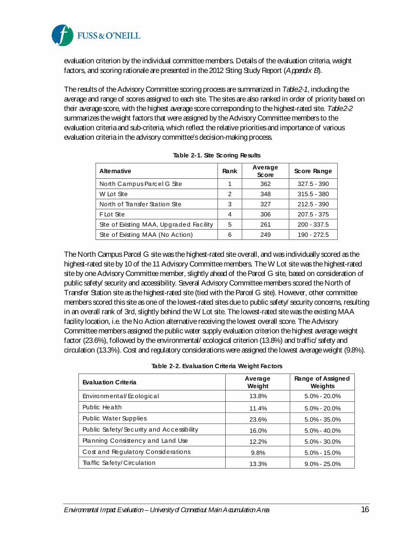
The results of the Advisory Committee scoring process are summarized in Table 2-1, including theaverage and range of scores assigned to each site. The sites are also ranked in order of priority based ontheir average score, with the highest average score corresponding to the highest-rated site. Table 2-2summarizes the weight factors that were assigned by the Advisory Committee members to theevaluation criteria and sub-criteria, which reflect the relative priorities and importance of variousevaluation criteria in the advisory committee’s decision-making process.
Table 2-1. Site Scoring Results
Alternative Rank AverageScore Score Range
North Campus Parcel G Site 1 362 327.5 - 390W Lot Site 2 348 315.5 - 380North of Transfer Station Site 3 327 212.5 - 390F Lot Site 4 306 207.5 - 375Site of Existing MAA, Upgraded Facility 5 261 200 - 337.5Site of Existing MAA (No Action) 6 249 190 - 272.5
The North Campus Parcel G site was the highest-rated site overall, and was individually scored as thehighest-rated site by 10 of the 11 Advisory Committee members. The W Lot site was the highest-ratedsite by one Advisory Committee member, slightly ahead of the Parcel G site, based on consideration ofpublic safety/security and accessibility. Several Advisory Committee members scored the North ofTransfer Station site as the highest-rated site (tied with the Parcel G site). However, other committeemembers scored this site as one of the lowest-rated sites due to public safety/security concerns, resultingin an overall rank of 3rd, slightly behind the W Lot site. The lowest-rated site was the existing MAAfacility location, i.e. the No Action alternative receiving the lowest overall score. The AdvisoryCommittee members assigned the public water supply evaluation criterion the highest average weightfactor (23.6%), followed by the environmental/ecological criterion (13.8%) and traffic/safety andcirculation (13.3%). Cost and regulatory considerations were assigned the lowest average weight (9.8%).
Table 2-2. Evaluation Criteria Weight Factors
Evaluation Criteria AverageWeight
Range of AssignedWeights
Environmental/Ecological 13.8% 5.0% - 20.0%
Public Health 11.4% 5.0% - 20.0%Public Water Supplies 23.6% 5.0% - 35.0%Public Safety/Security and Accessibility 16.0% 5.0% - 40.0%Planning Consistency and Land Use 12.2% 5.0% - 30.0%Cost and Regulatory Considerations 9.8% 5.0% - 15.0%Traffic Safety/Circulation 13.3% 9.0% - 25.0%

Environmental Impact Evaluation – University of Connecticut Main Accumulation Area 17
2.4 Environmental Review ofAlternatives
This section provides a review of environmental considerations associated with each of the alternativesdescribed in the previous section. Table 2-3 presents a comparison of alternatives in terms of potentialenvironmental effects and the ability of each alternative to meet the project purpose and need.
2.4.1 North Campus Parcel G Site
A new MAA constructed on North Campus Parcel G site was the highest-rated alternative from the2012 siting study. This alternative meets the project purpose and need by relocating the MAA outside ofthe public drinking water supply watershed and by providing more efficient use of space than theexisting facility and the ability to meet future waste generation and storage needs of the Storrs campus.The Parcel G site is also consistent with the planned UConn Technology Park land uses and NorthCampus Master Plan objectives. Although this alternative will require development of existing uplandforest, Parcel G is already planned for development as part of the future UConn Technology Parkregardless of whether it is used for a new MAA or another technology-related use. The site is also servedby existing utilities and is centrally located between existing waste generators on the main campus andpotential waste generators at the future UConn Technology Park on the North Campus.
The disadvantages of the Parcel G site are primarily related to public health and safety considerations.The site is generally located upwind of population centers based on prevailing wind directions2 in theevent of a fire or vapor cloud release. The site is also in relatively close proximity to pedestrian trafficassociated with the Celeron Trail and C Lot, as well as adjacent to the Connecticut Light & Power(CL&P) overhead electrical utility lines. Soils on and downgradient of the Parcel G site have moderate tohigh infiltration potential, whereas soils adjacent to and downgradient of the existing MAA facilitylocation and the W Lot site have lower infiltration potential, which poses a lower risk for soil orgroundwater impacts in the unlikely event of a release from the facility’s secondary containment systems.The Parcel G site is located outside of a public drinking water supply watershed and recharge areas forpublic water supply wells. Consequently, the site poses negligible risk to public water supplies.
The planned extension of North Hillside Road to Route 44 is anticipated to be completed prior toconstruction of a new MAA on the Parcel G site. However, in the event that the roadway extension isnot completed prior to construction of a new MAA on Parcel G, commercial waste transport vehicleswould be required to use North Eagleville Road (a high pedestrian traffic area) for waste shipments fromthe MAA. Following completion of the North Hillside Road extension, commercial waste transportvehicles would likely access and leave the MAA using the new gateway entrance to the campus on Route44 and the North Hillside Road extension, thereby avoiding North Eagleville Road.
2Prevailing winds on the UConn, Storrs campus vary seasonally. Weather data is collected and maintained by theUConn Department of Natural Resources and the Environment (NRE) Water Resources Field Station, which islocated near the existing MAA off of Horsebarn Hill Road. Weather data collected at this station indicate that theannual prevailing wind direction for 2011 and 2012 is from the west and southwest. Localized wind direction alsovaries at different points on the campus depending on a variety of factors such as topography, tree cover,buildings, etc. Additional information regarding the prevailing wind direction is provided in the 2012 MainAccumulation Area Facility Comparative Site Study report (in Appendix B of this EIE).
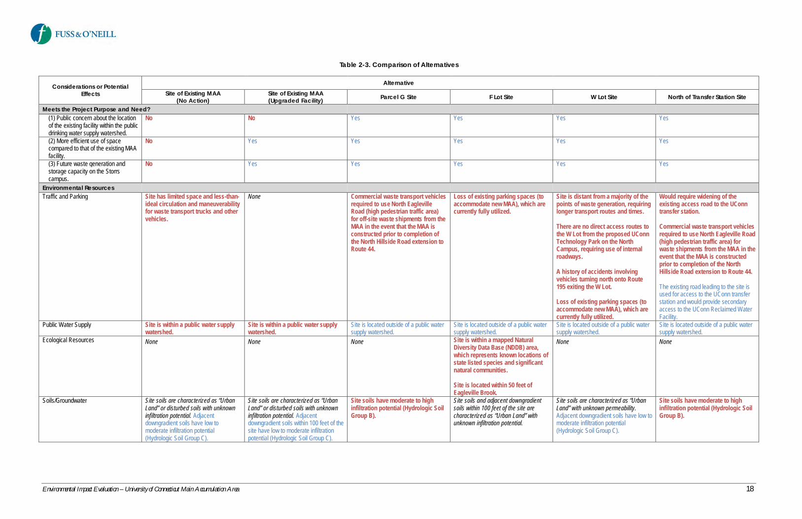
Environmental Impact Evaluation – University of Connecticut Main Accumulation Area 18
Table 2-3. Comparison of Alternatives
Considerations or PotentialEffects
AlternativeSite of Existing MAA
(No Action)Site of Existing MAA(Upgraded Facility) Parcel G Site F Lot Site W Lot Site North of Transfer Station Site
Meets the Project Purpose and Need?(1) Public concern about the locationof the existing facility within the publicdrinking water supply watershed.
No No Yes Yes Yes Yes
(2) More efficient use of spacecompared to that of the existing MAAfacility.
No Yes Yes Yes Yes Yes
(3) Future waste generation andstorage capacity on the Storrscampus.
No Yes Yes Yes Yes Yes
Environmental ResourcesTraffic and Parking Site has limited space and less-than-
ideal circulation and maneuverabilityfor waste transport trucks and othervehicles.
None Commercial waste transport vehiclesrequired to use North EaglevilleRoad (high pedestrian traffic area)for off-site waste shipments from theMAA in the event that the MAA isconstructed prior to completion ofthe North Hillside Road extension toRoute 44.
Loss of existing parking spaces (toaccommodate new MAA), which arecurrently fully utilized.
Site is distant from a majority of thepoints of waste generation, requiringlonger transport routes and times.
There are no direct access routes tothe W Lot from the proposed UConnTechnology Park on the NorthCampus, requiring use of internalroadways.
A history of accidents involvingvehicles turning north onto Route195 exiting the W Lot.
Loss of existing parking spaces (toaccommodate new MAA), which arecurrently fully utilized.
Would require widening of theexisting access road to the UConntransfer station.
Commercial waste transport vehiclesrequired to use North Eagleville Road(high pedestrian traffic area) forwaste shipments from the MAA in theevent that the MAA is constructedprior to completion of the NorthHillside Road extension to Route 44.
The existing road leading to the site isused for access to the UConn transferstation and would provide secondaryaccess to the UConn Reclaimed WaterFacility.
Public Water Supply Site is within a public water supplywatershed.
Site is within a public water supplywatershed.
Site is located outside of a public watersupply watershed.
Site is located outside of a public watersupply watershed.
Site is located outside of a public watersupply watershed.
Site is located outside of a public watersupply watershed.
Ecological Resources None None None Site is within a mapped NaturalDiversity Data Base (NDDB) area,which represents known locations ofstate listed species and significantnatural communities.
Site is located within 50 feet ofEagleville Brook.
None None
Soils/Groundwater Site soils are characterized as “UrbanLand” or disturbed soils with unknowninfiltration potential. Adjacentdowngradient soils have low tomoderate infiltration potential(Hydrologic Soil Group C).
Site soils are characterized as “UrbanLand” or disturbed soils with unknowninfiltration potential. Adjacentdowngradient soils within 100 feet of thesite have low to moderate infiltrationpotential (Hydrologic Soil Group C).
Site soils have moderate to highinfiltration potential (Hydrologic SoilGroup B).
Site soils and adjacent downgradientsoils within 100 feet of the site arecharacterized as “Urban Land” withunknown infiltration potential.
Site soils are characterized as “UrbanLand” with unknown permeability.Adjacent downgradient soils have low tomoderate infiltration potential(Hydrologic Soil Group C).
Site soils have moderate to highinfiltration potential (Hydrologic SoilGroup B).

Environmental Impact Evaluation – University of Connecticut Main Accumulation Area 19
Table 2-3. Comparison of Alternatives
Considerations or PotentialEffects
AlternativeSite of Existing MAA
(No Action)Site of Existing MAA(Upgraded Facility) Parcel G Site F Lot Site W Lot Site North of Transfer Station Site
Utilities Utilities available and no utility conflicts. Utilities available and no utility conflicts. Utilities available and no utility conflicts. An existing undergroundtelecommunications line that runsbelow the F Lot would have to beavoided to accommodate the MAA.
An underground storm drainage lineis located in the northwest corner oflot, which would have to be relocatedor avoided.
Sewer force mains from the closedlandfill and Celeron Apartments arelocated on-site, which would have tobe relocated or avoided.
Public Health & Safety Site has limited space and less-than-ideal circulation and maneuverabilityfor waste transport and othervehicles.
Site is distant from a majority of thepoints of waste generation, requiringlonger transport routes and times.
The site is located at the eastern limitsof the campus away from populationcenters.
Generally located downwind ofpopulation centers based on prevailingwind direction in the event of a fire orvapor cloud release.
Site is distant from a majority of thepoints of waste generation, requiringlonger transport routes and times.
Site is located at the eastern limits ofthe campus away from populationcenters.
Generally located downwind ofpopulation centers based on prevailingwind direction in the event of a fire orvapor cloud release.
Site is located in close proximity tothe Celeron Trail and the C Lot(pedestrian traffic) and theConnecticut Light & Power (CL&P)overhead electrical utility lines.
Generally located upwind ofpopulation centers based onprevailing wind direction in the eventof a fire or vapor cloud release.
Site is located close to the UConnPublic Safety complex, potentiallyresulting in shutdown of the complexin the event of an incident at theMAA facility and disruption ofcampus-wide security
Generally located upwind ofpopulation centers based onprevailing wind direction in the eventof a fire or vapor cloud release.
Site located near UConn andConnecticut Light & Power electricalsubstations
The close proximity to the UConn PublicSafety complex may provide potentiallyshorter response times in the event ofan incident at the MAA facility that doesnot result in shutdown of the complex.
Site is distant from a majority of thepoints of waste generation, requiringlonger transport routes and times.
Generally located downwind ofpopulation centers based on prevailingwind direction in the event of a fire orvapor cloud release.
Site is located in close proximity tothe Celeron Trail and the C Lot(pedestrian traffic) and theConnecticut Light & Power (CL&P)overhead electrical utility lines.
Generally located upwind ofpopulation centers based onprevailing wind direction in the eventof a fire or vapor cloud release.
State, Regional, Local & CampusPlanning
Site is within a Balanced PriorityFunding Area in State C&D Plan.
Inconsistent with State C&D Plan’sgrowth management principlesrelated to water supplies given thetype of use of the MAA facility andthe location of the site within apublic water supply watershed.
Site is within a Balanced PriorityFunding Area in State C&D Plan.
Inconsistent with State C&D Plan’sgrowth management principlesrelated to water supplies given thetype of use of the MAA facility andthe location of the site within apublic water supply watershed.
Site is within a Balanced PriorityFunding Area in State C&D Plan.
Consistent with state, regional and localplanning and the proposed UConnTechnology Park land use and NorthCampus Master Plan.
Site is within a Priority Funding Area inState C&D Plan.
Consistent with state, regional, localand campus planning.
Site is primarily within a BalancedPriority Funding Area in State C&DPlan.
Consistent with state, regional, localand campus planning.
Site is within a Balanced PriorityFunding Area in State C&D Plan.
Consistent with state, regional, localand campus planning.
Costs The existing MAA will havedifficulties meeting future needswithout increasing the frequency ofoff-site waste shipments based onanticipated growth in undergraduateenrollment and planned researchgrowth at the University. Theanticipated increase in wastegeneration would require an increasein the frequency of waste removalfrom the MAA, which would increaseoperational costs.
Construction of a new MAA isestimated to cost between $3 and $5million.
Lower cost for waste removal than theNo Action alternative due to largerwaste storage capacity and lessfrequent waste removal from the facility.
Construction of a new MAA isestimated to cost between $3 and $5million.
Lower cost for waste removal than theNo Action alternative due to largerwaste storage capacity and lessfrequent waste removal from the facility.
Construction of a new MAA isestimated to cost between $3 and $5million.
Lower cost for waste removal than theNo Action alternative due to largerwaste storage capacity and lessfrequent waste removal from the facility.
Construction of a new MAA isestimated to cost between $3 and $5million and could potentially requireutility relocation.
Lower cost for waste removal than theNo Action alternative due to largerwaste storage capacity and lessfrequent waste removal from the facility.
Construction of a new MAA isestimated to cost between $3 and $5million. In addition, locating the MAAat this site would require widening ofthe existing access road and utilityrelocation.
Lower cost for waste removal than theNo Action alternative due to largerwaste storage capacity and lessfrequent waste removal from the facility.

Environmental Impact Evaluation – University of Connecticut Main Accumulation Area 20
Legend:Potential advantages or benefits are shown in normal blue font.Potential neutral aspects are shown in italic black font.Potential disadvantages or adverse effects are shown in bold red font.

Environmental Impact Evaluation – University of Connecticut Main Accumulation Area 21
2.4.2 W Lot Site
A new MAA constructed at the northwest corner of the W Lot was the second highest-rated alternativefrom the 2012 siting study. This alternative also meets the project purpose and need by relocating theMAA outside of the public drinking water supply watershed and meeting existing and future operationalneeds as described previously. The W Lot site is also generally located downwind of population centersbased on prevailing wind direction in the event of a fire or vapor cloud release. Downgradient soilsadjacent to the W Lot site have lower infiltration potential than the soils at the Parcel G site, but similarinfiltration potential as the soils adjacent to and downgradient of the existing MAA site.
The primary disadvantages of the W Lot site are transportation-related. These include the loss of existingparking spaces, which are currently fully utilized, to accommodate a new MAA and access/egress. Thesite would be accessed from the existing W Lot entrance along Route 195, across from the northern legof Horsebarn Hill Road. The W Lot entrance and exit drives are configured to control traffic enteringand exiting the parking lot, as there is a history of accidents involving vehicles turning north onto Route195 exiting the W Lot.
The W Lot site is also relatively distant from a majority of the points of waste generation, requiringlonger transport routes and times, and there are no existing or planned direct access routes to the W Lotfrom the proposed UConn Technology Park on the North Campus. The University EH&S staff wouldnot be allowed to transport hazardous waste along Route 44 or Route 195 north of campus, but insteadwould be required to use North Hillside Road, North Eagleville Road, and Route 195 for transport ofwaste between future waste generation sites at the UConn Technology Park and a MAA located at the WLot since RCRA regulations restrict UConn waste collection vehicles to roadways along UConnproperty.
2.4.3 North of Transfer Station Site
Construction of a new MAA on a site located north of the UConn Water Pollution Control Facility andsolid waste transfer station was the third highest-rated alternative from the 2012 siting study. Similar tothe previous two alternatives discussed, the “North of Transfer Station” site also meets the projectpurpose and need. This site is located just south of Parcel G and the Celeron Trail and therefore sharessome of the same advantages and disadvantages with the Parcel G site. The existing road leading to thesite is used for access to the UConn sold waste transfer station and would provide secondary access tothe UConn Reclaimed Water Facility. However, locating the MAA at this site would also requirewidening of the existing access road, increasing the cost of this alternative. Sewer force mains from theclosed landfill and Celeron Apartments, which pass through this site, would have to be relocated oravoided, resulting in further costs.
2.4.4 F Lot Site
Construction of a new MAA on the F Lot site was the fourth highest-rated alternative from the 2012siting study. This alternative fully meets the project purpose and need since, like the previously discussedsites, it is located outside of a public water supply watershed and meets existing and future operationalneeds. A new MAA on this site would be located at the southeast corner of the parking lot, outside of

Environmental Impact Evaluation – University of Connecticut Main Accumulation Area 22
the limits of the former ash landfill that underlies a large portion of the F Lot, avoiding the need todisrupt the ash landfill liner system (located 18 inches below the existing ground surface) forconstruction of the facility. The site is also centrally located between existing waste generators on themain campus and future waste generators at the proposed UConn Technology Park on the NorthCampus.
The F Lot site is located close to the UConn Public Safety complex, providing potentially short responsetimes in the event of an incident at the MAA. However, an incident at the MAA could also potentiallyresult in shutdown of the UConn Public Safety complex and disruption of campus-wide security. Thesite is also situated approximately 50 feet from Eagleville Brook, although the parking lot is slopedtowards the west and not directly towards Eagleville Brook. The site is also a mapped CTDEEP NaturalDiversity Data Base (NDDB) area, which represents known locations of state-listed species andsignificant natural communities.
The site is located near UConn and Connecticut Light & Power electrical substations. An undergroundelectrical line was routed along the perimeter of the site, instead of across the middle of the site, to avoidthe area potentially identified for the MAA. However, an existing underground telecommunications linelocated below the F Lot would need to be avoided to accommodate the MAA, adding to the cost of thisalternative. This alternative would also result in the loss of existing parking spaces, which are currentlyfully utilized. As with other alternative sites, the F Lot Site is generally located upwind of populationcenters based on prevailing wind direction in the event of a fire or vapor cloud release.
2.4.5 Site of Existing MAA (No Actionand Upgraded Facility)
The two alternatives involving the site of the existing MAA were the lowest rated alternatives from the2012 siting study, with No Action alternative receiving the lowest overall score. Neither alternative, asdescribed in Sections 2.1 and 2.2, fully meets the project purpose and need since the MAA would remainwithin a drinking water supply watershed under either scenario. Furthermore, the facility would havedifficulty meeting the future waste generation needs of the campus in a cost-effective manner.
2.5 Preferred Alternative
Based on the alternatives considered, a new MAA facility constructed on North Campus Parcel G is thepreferred alternative evaluated in this EIE. This alternative meets the project purpose and need byremoving the facility from the public drinking water supply watershed, providing a more efficient use ofspace compared to that of the existing facility, and meeting future waste generation and storage needs ofthe Storrs campus. The Parcel G site was also the highest-rated alternative from the 2012 siting study,which reflects a balanced consideration by multiple University and community stakeholders of importantfactors and potential impacts including ecological resources, public health and safety, public watersupplies, traffic and parking, planning consistency, and cost considerations. A new MAA facilityconstructed on North Campus Parcel G (i.e., the Proposed Action) and the No Action alternative areevaluated in greater detail in Section 3, Existing Environment and Analysis of Impacts.
Environmental Impact Evaluation – University of Connecticut Main Accumulation Area 23
3 Existing Environment and Analysis of Impacts
3.1 Environmental Resources of NoSignificance in the Project Area
Some environmental resources do not occur in the project area and consequently would not be affectedby the Proposed Action. These resources, described below, are not included in the description ofexisting conditions or analysis of impacts in this EIE:
Coastal Resources – The project area is not within the Connecticut Coastal ManagementZone. Therefore, the project will not affect coastal resources.
Consistency with Connecticut Coastal Management Act – The project area is locatedoutside of the coastal boundary, as defined in C.G.S. Section 22a-94(b), and consequently is notsubject to the provisions of the Connecticut Coastal Management Act, Sections 22a-90 through22a-112.
3.2 Traffic, Parking, and Circulation
3.2.1 Existing Conditions
The North Campus Parcel G site is located off North Hillside Road and has direct access from the CLot Driveway, which provides entry and exit to the C Lot parking area. UConn Transportation Servicesprovides bus service between the C Lot and other portions of the Storrs campus. Pedestrianaccommodations in the area include the Celeron Trail, which passes to the south of Parcel G, walkwaysaround the existing C Lot parking area, and a walkway along the north side of the C Lot Driveway fromthe parking lot to North Hillside Road.
North Hillside Road is a campus roadway with a posted speed limit of 25 miles per hour. The roadwaybegins at North Eagleville Road and continues approximately 4,000 feet to the north, terminating justnorth of the entrance to the Charter Oak Apartments. A shared-use path is located along the east side ofNorth Hillside Road, and on-street parking is located along portions of North Hillside Road. Asdescribed in Section 1.1.3, UConn plans to extend North Hillside Road north to Route 44 to create a newgateway entrance to the University and enable the creation of the UConn Technology Park on the NorthCampus.
Approximately 1,200 satellite accumulation areas (i.e., points of waste generation) are located throughoutthe UConn campus, with the majority of waste generators concentrated in the central portion of thecampus (Figure 3-1). Regulated waste generated at these sites is picked up by UConn EH&S wastetransport vehicles, which travel along campus, town, and state roadways to transport the waste from thesatellite accumulation areas to the existing MAA, located off of Storrs Road (State Route 195) anddirectly accessed from Horsebarn Hill Road at the eastern edge of the campus.
Environmental Impact Evaluation – University of Connecticut Main Accumulation Area 24
Existing Roadway NetworkMajor roadways traveled by EH&S waste transport vehicles include, but are not limited to, the followingroads:
Storrs Road (Route 195)Hillside RoadMain Campus internal roads – Gilbert, Glenbrook, Auditorium, Mansfield RoadNorth Eagleville RoadHorsebarn Hill Road
Storrs Road (State Route 195) has a posted speed limit of 30 miles per hour in the vicinity of the campusand is classified by the Connecticut Department of Transportation (CTDOT) as a minor arterialroadway. This roadway begins at Route 66 to the south of the campus and continues north along thenortheastern portion of the UConn campus to its intersection with Route 44 and ultimately to Route 74,approximately 0.7 mile north of Interstate 84 in the Town of Tolland. State Route 195 provides onetravel lane in each direction with sidewalks on both sides of the roadway through the campus.
Hillside Road is a campus roadway with a posted speed limit of 25 miles per hour. This roadway beginsnorth of South Eagleville Road at Hillside circle and continues to North Eagleville Road. Due to heavypedestrian traffic, sidewalks are provided on both sides of the roadway with multiple crosswalks along itslength.
Mansfield Road has a posted speed limit of 25 miles per hour and is classified by CTDOT as a stateinstitution road as it is located on the UConn campus. Mansfield Road provides access to the internalcampus roadways and parking lots.
North Eagleville Road (State Route 430) is a state road from the intersection with Separatist/HuntingLodge Road east to Route 195. North Eagleville Road is a town road from Route 32 to theSeparatist/Hunting Lodge Road intersection. North Eagleville Road has a single travel lane in eachdirection and a posted speed limit of 25 miles per hour in the vicinity of the campus. This roadway isclassified by CTDOT as an urban minor arterial. The road serves as a main access roadway for thecampus, with multiple internal campus roadways and parking lot driveways intersecting it along itslength. A sidewalk exists on the north side of North Eagleville Road from Separatist Road east to theHillside Road/North Hillside Road intersection. Sidewalks are located on both sides of North EaglevilleRoad between the Hillside Road/North Hillside Road intersection and Route 195. There are nosidewalks on the town portion of North Eagleville Road.
EH&S waste transport vehicles use four primary signalized intersections. The signals at theseintersections provide exclusive pedestrian phasing to accommodate the high volume of pedestrian trafficon the UConn campus. The four signalized intersections are as follows:
North Hillside Road and Hillside Road at North Eagleville RoadStorrs Road (Route 195) at North Eagleville RoadStorrs Road (Route 195) at Mansfield RoadStorrs Road (Route 195) at Horsebarn Hill/Gurleyville Road

Environmental Impact Evaluation – University of Connecticut Main Accumulation Area 25
Figure 3-1. Campus Waste Generator Locations and UConn Waste Transport Vehicle Routes

Environmental Impact Evaluation – University of Connecticut Main Accumulation Area 26
Existing Pedestrian Activity and FacilitiesMost pedestrian activity at UConn is concentrated within the internal campus roadways. Pedestrianfacilities typically consist of unsignalized/mid-block crossings near campus buildings. Multiple highvolume pedestrian crossings (at both signalized and mid-block locations) are located on Storrs Road andNorth Eagleville Road. Most roadways in and around the campus provide adequate pedestrianaccommodations, including proper crosswalk placement/visibility, warning signs, accessible wheelchairramps, and well-lighted sidewalks.
Pedestrian/vehicle interactions are common on the UConn campus, where there is a high density ofcentrally-located campus buildings and internal service roadways. A significant portion of campusstudent housing is located to the north and east of the main campus, requiring students to cross NorthEagleville Road and Storrs Road to access classroom and other facilities on the main campus. Figure 3-2depicts the area of the campus with the highest density of pedestrians and vehicles, as well as thelocations of pedestrian crossings along the major routes traveled by commercial waste transport vehiclesto and from the existing MAA facility. North Eagleville Road and Hillside Road are the most commoncampus locations for vehicle/pedestrian incidents requiring response by the UConn Fire Department(Michael Makuch, Deputy Chief University of Connecticut Fire Department, email to Jason Coite,UConn Office of Environmental Policy, July 23, 2012).
Existing MAA Waste Transport Trips and RoutesEH&S uses two small box trucks (sometimes trailers) for daily pickup and transport of waste fromsatellite accumulation areas to the MAA. Waste pickups generally occur on an as-needed basis, uponrequest by the waste generators. Internal campus pickup routes are generally based on the closest accesspoint to a building. The goal for a pickup at any given building is to minimize the distance between thesatellite accumulation area within a building and the waste transport truck. Trucks are however limitedby the location of egress to the desired building. Transport routes on any given day vary depending onrequests received by EH&S. Multiple stops to collect compatible wastes are typically made before thetruck returns to the MAA. The number of daily truck trips varies but is negligible compared to theoverall traffic volume on the campus roadway network during the peak hour.
Commercial waste vendors are responsible for shipment of waste from the MAA to appropriate off-campus disposal facilities. Chemical wastes are typically removed monthly, biological wastes are typicallyremoved weekly or bi-weekly, and low-level radioactive wastes are typically removed every 12 to 15months. Waste vendor transport vehicles include vans, box trucks, 18-wheeled tractor trailers, andtanker trucks on rare occasions. UConn EH&S restricts the waste vendor shipment routes on campusbased on the size of the waste transport vehicle. Figure 3-2 shows the general waste vendor shipmentroutes to and from the existing MAA (red lines). Most commercial waste shipments are limited to Route44 and Route 195, with the exception of Horsebarn Hill Road, and have little impact on internal campustraffic volume and circulation. Both roads are state-owned and are designed with much greater capacitythan the internal campus road network.

Environmental Impact Evaluation – University of Connecticut Main Accumulation Area 27
Figure 3-2. Commercial Waste Transport Vehicle Routes
Environmental Impact Evaluation – University of Connecticut Main Accumulation Area 28
3.2.2 Impact Evaluation
No Action AlternativeNo significant short-term change to traffic operations or pedestrian movements is anticipated under theNo Action alternative. Based on anticipated growth in undergraduate enrollment and planned researchgrowth at the University, the existing MAA may not meet the future waste storage needs of the campuswithout increasing the frequency of off-site waste shipments to meet the additional demand for wastestorage. Over time, an increase is anticipated in EH&S waste transport vehicle trips and vehicle tripsassociated with waste vendor shipments from the MAA. Even with this anticipated increase, the numberof vehicle trips will remain negligible compared to the overall traffic volume on the campus roadwaynetwork during the peak hour.
Proposed ActionConstruction of a new MAA facility on the North Campus Parcel G site will improve vehicle circulation,maneuverability, parking, and access/egress compared to that of the existing facility. North HillsideRoad and the C Lot Driveway have adequate capacity and pedestrian facilities to safely accommodate theadditional traffic associated with EH&S waste transport vehicles and commercial waste shipments, alongwith traffic associated with the C Lot and pedestrian access.
The Proposed Action will not measurably increase vehicle trips and, in the short-term, could actuallyreduce the number of vehicle trips associated with waste shipments by providing increased waste storagecapacity and less frequent off-site waste shipments compared to that of the existing MAA. Relocatingthe MAA to the Parcel G site will not significantly change the internal EH&S waste transport routes onthe campus, but will have the indirect effect of redistributing existing traffic associated with EH&S andcommercial waste transport vehicles traveling to and from the MAA. Minor increases in traffic couldoccur in some areas due to this redistribution, but will not adversely impact traffic operations oncampus. Redistribution of waste transport vehicles may increase the potential for truck/pedestrianconflicts along waste shipment routes (Figure 3-2), as discussed below.
The planned extension of North Hillside Road north to Route 44 will create a new entrance to theUniversity and direct access to the future UConn Technology Park and the Parcel G site. Constructionof the roadway extension is anticipated to begin in 2014, with completion anticipated by 2016. Theplanned extension of North Hillside Road to Route 44 is anticipated to be completed prior toconstruction of a new MAA on the Parcel G site. However, given the uncertainty in the timing of theroadway construction and relocation of the MAA, the potential indirect effects of the Proposed Actiondue to redistribution of existing waste transport vehicle traffic were evaluated under the following twoscenarios, reflecting both short-term and long-term impacts:
Potential Impacts without North Hillside Road Extension – Under this scenario, a newMAA would be constructed on Parcel G prior to completion of the North Hillside Roadextension. This would result in a minor increase in commercial waste vendor trips through themain campus since it would require waste transport vehicles to access the MAA from NorthEagleville Road. Such an increase in waste vendor trips would also result in a slight increase inthe potential for vehicle/pedestrian interactions at unsignalized intersections compared toexisting conditions. However, the number of off-site commercial waste shipments from theMAA is very small, varying from 3 to 5 shipments per month. Any increases would be similarly

Environmental Impact Evaluation – University of Connecticut Main Accumulation Area 29
small and not anticipated to cause adverse impacts. The pedestrian crossings on NorthEagleville Road are well-marked, the roadway well-lighted, and the intersection geometry atNorth Hillside and North Eagleville Roads is adequate for truck movements.
Possible measures to reduce the potential for vehicle/pedestrian conflicts due to increased trucktraffic through the campus include scheduling waste shipments for weekends or during off-peakclassroom hours and limiting truck routes to major roads such as Route 44, Storrs Road (Route195), the state-owned portion of North Eagleville Road and North Hillside Road.
Potential Impacts with North Hillside Road Extension – Under this scenario, the NorthHillside Road extension would be completed and a new MAA constructed on the Parcel G site.This scenario also considers future development of the UConn Technology Park. The proposedroadway extension will create a 2-lane, 32-foot wide road. The project design includes a pavedpedestrian sidewalk on the east side of the roadway that will connect to the existing sidewalk tothe south and the existing multi-use path on Route 44 to the north, and a separate bicycle lanewithin the curb line in each direction.
Completion of the roadway extension would provide commercial waste vendors with directaccess to the MAA on the Parcel G site from the North Hillside Road connection at Route 44(Figure 3-2). The vast majority of commercial waste transport vehicles would be accessing theMAA directly from Route 44 and North Hillside Road, essentially avoiding the major pedestriancrossings along North Eagleville Road. Waste transporters accessing the campus from the southon Route 195 could also use the North Hillside connection at Route 44, avoiding NorthEagleville Road.
Future restrictions on the timing of waste shipments and allowable truck routes (e.g., Route 44,Storrs Road and North Hillside Road) are recommended to avoid periods and locations of highpedestrian activity on campus. Such restrictions will also minimize potential impacts associatedwith potential increases in waste transport traffic on the campus due to anticipated growth inundergraduate enrollment and planned research growth at the University.
Minor increases in traffic associated with UConn and commercial waste transport vehicles areanticipated in the future, regardless of the location of the MAA, given anticipated growth inundergraduate enrollment and planned research growth at the University. Given the location of theParcel G site between existing waste generators on the main campus and potential waste generators atthe future UConn Technology Park that may use the UConn MAA, the Proposed Action will help offsetpotential impacts associated with these minor increases by reducing the frequency of off-site wasteshipments, reducing the overall frequency of waste handling, providing direct access to the technologypark from North Hillside Road, reducing waste vehicle trips along North Eagleville Road and reducingthe potential for vehicle/pedestrian conflicts, and increasing the overall efficiency of internal wastedeliveries.

Environmental Impact Evaluation – University of Connecticut Main Accumulation Area 30
3.3 Air Quality
Under the authority of the U.S. Clean Air Act, as amended (CAAA), the U.S. Environmental ProtectionAgency (EPA) established National Ambient Air Quality Standards (NAAQS) for concentrations of sixair pollutants: carbon monoxide (CO), nitrogen dioxide (NO2), ozone, particulate matter ten microns orsmaller in diameter (PM10, includes particulate matter 2.5 microns or smaller, PM2.5), sulfur dioxide(SO2), and lead (Pb). Primary standards are established to protect public health; secondary standards areestablished to protect plants and animals and to prevent economic damage.
Connecticut adopted the national standards, listed in Table 3-1, and subsequently developed a StateImplementation Plan (SIP) to attain and maintain these standards. CTDEEP has 21 active pollutantmonitoring stations across the state. Monitoring data is used to determine compliance with the EPAprimary and secondary air quality standards and to evaluate the effectiveness of pollution control andabatement strategies.
This section addresses existing air quality and potential environmental consequences associated with theProposed Action and No Action alternative, including both regional (i.e., mesoscale) and local (ormicroscale) potential air quality impacts associated with mobile and stationary sources of air pollutants.Mobile sources of air pollutants consist of vehicles and construction equipment. Stationary sourcesinclude boilers, generators and other fuel-burning equipment. A discussion of existing conditions andpotential air quality impacts are presented in the following section.
Table 3-1. National Ambient Air Quality Standards
Pollutant Primary/Secondary
AveragingTime Level Form
Carbon Monoxide(CO) Primary
8-hour 9 ppm Not to be exceeded more than onceper year1-hour 35 ppm
Lead (Pb) Primary andsecondary
Rolling 3 monthaverage 0.15 g/m3 (1) Not to be exceeded
Nitrogen Dioxide(NO2)
Primary 1-hour 100 ppb 98th percentile, averaged over 3years
Primary andsecondary Annual 53 ppb (2) Annual Mean
Ozone (O3)Primary andsecondary 8-hour 0.075 ppm (3)
Annual fourth-highest dailymaximum 8-hr concentration,averaged over 3 years
ParticlePollution
PM2.5Primary andsecondary
Annual 15 g/m3 annual mean, averaged over 3 years
24-hour 35 g/m3 98th percentile, averaged over 3years
PM10Primary andsecondary 24-hour 150 g/m3 Not to be exceeded more than once
per year on average over 3 years
Sulfur Dioxide (SO2)Primary 1-hour 75 ppb (4)
99th percentile of 1-hour dailymaximum concentrations, averagedover 3 years
Secondary 3-hour 0.5 ppm Not to be exceeded more than onceper year
Source: EPA National Ambient Air Quality Standards (NAAQS) as of October 2011, http://www.epa.gov/air/criteria.html.Notes:(1) Final rule signed October 15, 2008. The 1978 lead standard (1.5 µg/m3 as a quarterly average) remains in effect until one

Environmental Impact Evaluation – University of Connecticut Main Accumulation Area 31
year after an area is designated for the 2008 standard, except that in areas designated nonattainment for the 1978, the 1978standard remains in effect until implementation plans to attain or maintain the 2008 standard are approved.(2) The official level of the annual NO2 standard is 0.053 ppm, equal to 53 ppb, which is shown here for the purpose ofclearer comparison to the 1-hour standard.(3) Final rule signed March 12, 2008. The 1997 ozone standard (0.08 ppm, annual fourth-highest daily maximum 8-hourconcentration, averaged over 3 years) and related implementation rules remain in place. In 1997, EPA revoked the 1-hourozone standard (0.12 ppm, not to be exceeded more than once per year) in all areas, although some areas have continuedobligations under that standard (“anti-backsliding”). The 1-hour ozone standard is attained when the expected number ofdays per calendar year with maximum hourly average concentrations above 0.12 ppm is less than or equal to 1.(4) Final rule signed June 2, 2010. The 1971 annual and 24-hour SO2 standards were revoked in that same rulemaking.However, these standards remain in effect until one year after an area is designated for the 2010 standard, except in areasdesignated nonattainment for the 1971 standards, where the 1971 standards remain in effect until implementation plans toattain or maintain the 2010 standard are approved.
3.3.1 Existing Conditions
The State of Connecticut is divided into designation areas by pollutant for air quality planning purposes.Each district is assigned an attainment or non-attainment status with respect to the NAAQS. TheUConn campus is located within the Eastern Connecticut Intrastate Air Quality Control Region (AQCR041) and the Greater Connecticut Area designation areas, depending on the pollutant designation.
The project site is located in non-attainment areas for ozone and is located in unclassified or attainmentair quality designation areas for the other criteria pollutants: CO, NO2, Pb, SO2, PM2.5, and PM10
(Table 3-2). The Eastern Connecticut Intrastate Air Quality Control Region designation area is amaintenance area for CO, meaning that it was previously in nonattainment but currently meets theNAAQS.
Table 3-2. Air Quality Designation Area and Classification for Criteria Pollutants
Pollutant Designation Area Designation/ClassificationCarbon Monoxide Eastern Connecticut Intrastate Air
Quality Control RegionAttainment
Lead Entire State Unclassifiable/AttainmentNitrogen Dioxide State of Connecticut Unclassifiable/AttainmentOzone (8-Hour Standard) Greater Connecticut Nonattainment; MarginalPM2.5(24-hour NAAQS andAnnual NAAQS)
Tolland County Unclassifiable/Attainment
PM10 Rest of State (Outside City of NewHaven)
Unclassifiable
Sulfur Dioxide Eastern Connecticut Intrastate AirQuality Control Region
Better than National Standards
Source: Title 40 Code of Federal Regulations (CFR) Part 81, Designation of Areas for Air Quality Planning Purposes.
The ambient ozone concentrations at a given location are less dependent on the amount of localemissions than on meteorological conditions, especially wind direction, temperature, and the amount ofsunlight. The most recent Annual Report on Air Quality in New England was released for data collected in2011. The ozone standard is that the 3-year average of the fourth-highest daily maximum 8-hour averageozone concentrations measured at each monitor within an area over each year must not exceed 0.075ppm. Therefore, if the fourth-highest concentration exceeds the standard concentration in 2011, it doesnot indicate whether the station exceeds the NAAQS. The ozone monitoring station in Tolland County
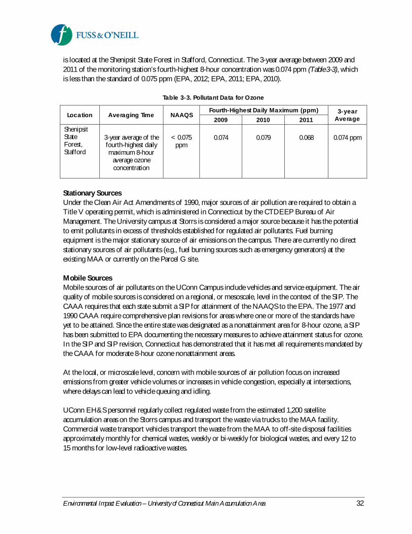
Environmental Impact Evaluation – University of Connecticut Main Accumulation Area 32
is located at the Shenipsit State Forest in Stafford, Connecticut. The 3-year average between 2009 and2011 of the monitoring station’s fourth-highest 8-hour concentration was 0.074 ppm (Table 3-3), whichis less than the standard of 0.075 ppm (EPA, 2012; EPA, 2011; EPA, 2010).
Table 3-3. Pollutant Data for Ozone
Location Averaging Time NAAQSFourth-Highest Daily Maximum (ppm) 3-year
Average2009 2010 2011ShenipsitStateForest,Stafford
3-year average of thefourth-highest dailymaximum 8-hour
average ozoneconcentration
< 0.075ppm
0.074 0.079 0.068 0.074 ppm
Stationary SourcesUnder the Clean Air Act Amendments of 1990, major sources of air pollution are required to obtain aTitle V operating permit, which is administered in Connecticut by the CTDEEP Bureau of AirManagement. The University campus at Storrs is considered a major source because it has the potentialto emit pollutants in excess of thresholds established for regulated air pollutants. Fuel burningequipment is the major stationary source of air emissions on the campus. There are currently no directstationary sources of air pollutants (e.g., fuel burning sources such as emergency generators) at theexisting MAA or currently on the Parcel G site.
Mobile SourcesMobile sources of air pollutants on the UConn Campus include vehicles and service equipment. The airquality of mobile sources is considered on a regional, or mesoscale, level in the context of the SIP. TheCAAA requires that each state submit a SIP for attainment of the NAAQS to the EPA. The 1977 and1990 CAAA require comprehensive plan revisions for areas where one or more of the standards haveyet to be attained. Since the entire state was designated as a nonattainment area for 8-hour ozone, a SIPhas been submitted to EPA documenting the necessary measures to achieve attainment status for ozone.In the SIP and SIP revision, Connecticut has demonstrated that it has met all requirements mandated bythe CAAA for moderate 8-hour ozone nonattainment areas.
At the local, or microscale level, concern with mobile sources of air pollution focus on increasedemissions from greater vehicle volumes or increases in vehicle congestion, especially at intersections,where delays can lead to vehicle queuing and idling.
UConn EH&S personnel regularly collect regulated waste from the estimated 1,200 satelliteaccumulation areas on the Storrs campus and transport the waste via trucks to the MAA facility.Commercial waste transport vehicles transport the waste from the MAA to off-site disposal facilitiesapproximately monthly for chemical wastes, weekly or bi-weekly for biological wastes, and every 12 to15 months for low-level radioactive wastes.

Environmental Impact Evaluation – University of Connecticut Main Accumulation Area 33
3.3.2 Impact Analysis
Stationary SourcesUnder the No Action alternative, there would continue to be no direct stationary sources of air pollutionat the existing MAA. The building would continue to be served by electricity provided by the centralcampus utilities or CL&P. Given the small size of the existing MAA facilities, emissions attributable tothe MAA from these indirect stationary sources are not regionally significant.
Construction of a new, state-of-the-art MAA facility may involve the installation and operation ofstationary sources of air emissions such as natural gas-fired heaters. The facility would be served byelectricity provided by the central campus utilities or CL&P. A backup emergency generator is notanticipated to be necessary for the facility. A stationary source permit from the CTDEEP Bureau of AirManagement, pursuant to section 22a-174-3 of the Regulations of Connecticut State Agencies, is notrequired since the increase in stationary source emissions would be significantly less than 15 tons peryear of any particular air pollutant. Direct air quality impacts associated with stationary sources are notanticipated to create or contribute to exceedances of NAAQS for CO.
No adverse air quality impacts from stationary sources are anticipated as a result of the Proposed Action.
Mobile SourcesAs described in Section 2, relocating the MAA to the Parcel G site will have the indirect effect ofredistributing existing traffic associated with EH&S and commercial waste transport vehicles traveling toand from the MAA. Minor increases in traffic could occur due to this redistribution. Minor increases intraffic associated with UConn and commercial waste transport vehicles are also anticipated in the future,regardless of the location of the MAA, as a result of anticipated growth in undergraduate enrollment andplanned research growth at the University. Due to the existing capacity in the traffic network near theproject site and elsewhere on campus, and the minor anticipated increase in traffic, neither the NoAction alternative nor the Proposed Action is expected to increase traffic delays at nearby intersectionsor vehicle emissions above acceptable levels.
An air quality analysis was previously conducted in support of a Final Environmental Impact Statementfor extension of North Hillside Road (FHWA, 2011) to evaluate the potential air quality impactsassociated with the proposed roadway extension and development of the North Campus for technology-related uses, including Parcel G. The analysis considered three intersections: Storrs Road and SouthEagleville Road, Storrs Road and Route 44, and Route 44 and North Hillside Road. The results of theanalysis demonstrated that the maximum one-hour and eight-hour CO concentrations at the subjectintersections are estimated to be well below the Connecticut and Federal CO standard of 35 and 9 ppm,respectively.
No adverse traffic-related air quality impacts are anticipated as a result of the No Action or ProposedAction alternatives. Temporary, construction-related air quality impacts and associated mitigation arediscussed in Section 3.16, Construction Impacts.

Environmental Impact Evaluation – University of Connecticut Main Accumulation Area 34
3.4 Noise
3.4.1 Existing Conditions
CTDEEP has established Noise Zone Standards for the evaluation of noise generated by adjacent noisezones (RCSA 22a-69-1 through 22a-69-7.4). The standards establish three noise zones based on landuse, placing limits within each class on the allowable amount of noise to be emitted by a source in anadjacent noise zone. Table 3-4 describes the various classes, with Class A being the most noise-sensitiveof the three types and Class C being the least sensitive.
Table 3-4. Connecticut Noise Zones and Standards
Class Description of Noise ZoneEmitter to Designated Receptor (dBA)
C B A/Day A/Night
A
Single and multiple family homes, hotels,prisons, hospitals, religious facilities, culturalactivities, forest preserves, and land intended forresidential or special uses requiring suchprotection.
62 55 55 45
B
Retail trade, personal, business and legalservices, educational institutions, governmentservices, amusements, agricultural activities, andlands intended for such commercial orinstitutional uses.
62 62 55 45
CManufacturing activities, transportation facilities,warehousing, military bases, mining, and otherlands intended for such uses.
70 66 61 51
The UConn campus is classified as a Class B Noise Zone. According to RCSA Section 22a-69-3.5, aClass B emitter shall not emit noise exceeding Leq3 levels of 55 dBA4 (daytime) or 45 dBA (nighttime) toan adjacent Class A Noise Zone, or 62 dBA at any time to an adjacent Class B or C Noise Zone.
The site of the existing MAA is located at the end of a service road off of Horsebarn Hill Road to theeast of State Route 195 on the East Campus portion of the UConn campus, which is mostly dedicated toagricultural education. The 440-acre Fenton Tract of the UConn Forest is adjacent to the site on theeast. The Horse Unit II and Livestock Unit I buildings and associated pastures are located to the northand agriculture-related development, research buildings, assorted outbuildings, and barns are located tothe south and west of the existing facility. The noise environment at the existing MAA is dominated bytraffic and operational noise associated with the MAA itself and the surrounding agricultural andeducational uses.
3 The Leq, or Equivalent Level, is the steady-state noise level for a given time period that has the same acousticenergy as the fluctuating noise levels observed during that time period. The Leq can be evaluated over differenttime periods including one hour (expressed as a one-hour Leq or Leq(h)) or 24 hours (expressed as a 24-hour Leqor Leq(24)).4 The unit typically used to describe sound levels perceptible to humans is the A-weighted decibel (dBA). The A-weighting attempts to approximate the human ear's sensitivity to sounds of varying frequencies and pitch. Thedecibel is a logarithmic unit of measure. For instance, a 10-decibel change in noise level is perceived as a doublingor halving of loudness. A 3-dB change would be barely perceivable for most people.

Environmental Impact Evaluation – University of Connecticut Main Accumulation Area 35
The North Campus Parcel G site is primarily wooded. The existing noise environment of the site isdominated by traffic along North Hillside Road and the C Lot Driveway; the adjacent tennis courts andnearby C Lot, Charter Oak Apartments, and UConn Water Pollution Control Facility and Solid WasteTransfer Station; and to a lesser extent by traffic on more distant surrounding roads including Route 44to the north, Route 195 to the east, North Eagleville Road to the south, and Hunting Lodge Road to thewest.
3.4.2 Impact Evaluation
The potential for noise-related impacts was evaluated in terms of potential changes in ambient noiselevels and consistency of the alternatives with the land uses and noise environment in the surroundingarea.
No Action AlternativeUnder the No Action alternative, no measurable change will occur to the existing noise environment ator near the site of the existing MAA. The existing MAA facility operations are consistent with theallowable noise based on the adjacent Class B Noise Zone land uses. No adverse noise impacts areanticipated.
Proposed ActionThe Proposed Action is consistent with the existing land uses in the vicinity of Parcel G and is notexpected to exceed the Class B emitter levels based on the nature of the proposed site activities. Nodirect or indirect noise-related impacts are anticipated to result from the Proposed Action.
As discussed in Section 1 and the North Campus Master Plan (2012), the North Campus area, includingParcel G, is proposed for future development of the UConn Technology Park. In addition to a newMAA, the master plan proposes potential development of the eastern portion of the Parcel G site withtechnology-related uses or facilities that could replace the existing tennis courts.
Certain research laboratories that may be located in the future UConn Technology Park could housevibration-sensitive research equipment that would require setbacks from major roads; the most sensitiveequipment can require up to 295-foot setbacks (SOM, 2012). The western portion of the Parcel G site,where the new MAA is proposed, is located relatively distant from the remainder of the North Campusdevelopment parcels. Access to the Parcel G site is available directly from the C Lot Driveway, avoidingthe need for a new access road. Furthermore, any future facilities that will house noise or vibration-sensitive equipment will be sited sufficiently far from the MAA and existing North Campus roads toavoid traffic-related noise or vibration impacts. Consequently, the Proposed Action is consistent withpossible noise or vibration-sensitive uses or facilities at the future UConn Technology Park.
Noise impacts from the Proposed Action would be most noticeable during construction; however,construction noise is exempt from the Connecticut noise regulations per RCSA 22a-69-1. Construction-related noise is addressed in Section 3.16, Construction Impacts.

Environmental Impact Evaluation – University of Connecticut Main Accumulation Area 36
3.5 Water Resources
3.5.1 Existing Conditions
Surface Water Resources
Existing MAA SiteThe site of the existing MAA is located within the Fenton River watershed (approximately 3,500 feetwest of the Fenton River and separated from the river by the 440-acre Fenton Tract of the UConnForest) and the drainage basin of the Willimantic Reservoir, which is located approximately six milesdownstream of the site and is owned and operated by the Windham Water Works. The surfacewaterbody closest to the existing MAA is Roberts Brook, which is located approximately 800 feet southof the facility. Roberts Brook flows easterly before joining the Fenton River.
Inland and coastal waters in Connecticut are assigned a Water Quality Classification based onConnecticut’s Water Quality Standards (CTDEEP, 2011). These classifications define designated uses thata waterbody can support. According to the Water Quality Classifications, Roberts Brook has a waterquality classification of Class AA. Designated uses for Class AA waters are as existing or proposeddrinking water supplies; habitat for fish and other aquatic life and wildlife; recreation; and water supplyfor industry and agriculture.
The existing site is relatively flat and paved. Stormwater runoff from the site flows east-southeast towarda wooded area associated with the Fenton Tract of the UConn Forest. Figure 3-3 depicts the existingMAA and nearby surface water resources.
North Campus Parcel G SiteThe North Campus Parcel G site is located in the Eagleville Brook watershed, a subregional basin withinthe larger Willimantic River watershed. The site is located just south of the drainage divide between theCedar Swamp Brook and Eagleville Brook watersheds. The drainage divide, which had historicallybisected the Parcel G site, currently follows the southern edge of the C Lot Driveway along the northernlimit of the project site as a result of construction of the C Lot Driveway. The topography on the projectsite slopes to the west, toward the southern limit of the closed UConn landfill as shown in Figure 3-3.The project site is situated approximately 0.3 miles north of Eagleville Brook, which begins nearEagleville Road and the main campus, flows southwest (underground in some reaches), and eventuallyjoins King’s Brook before reaching Eagleville Pond, an impoundment of the Willimantic River.
Inland waters in Connecticut are assigned a Water Quality Classification based on Connecticut’s WaterQuality Standards (CTDEEP, 2011). According to the Water Quality Classifications, the segment ofEagleville Brook downgradient of the project site has a water quality classification of Class A.Designated uses include potential drinking water supplies, habitat for fish and other aquatic life andwildlife, recreation, and industrial and agricultural water supply.

Environmental Impact Evaluation – University of Connecticut Main Accumulation Area 37
Figure 3-3. Water Resources

Environmental Impact Evaluation – University of Connecticut Main Accumulation Area 38
The segment of Eagleville Brook downgradient of the project site is included in the CTDEEP 2010303(d) list5 as an impaired waterbody for recreation due to elevated bacteria (Escherichia coli) levels. In the2012 State of Connecticut Integrated Water Quality Report (CTDEEP, 2012), this segment of Eagleville Brookis listed as not supporting aquatic life or recreational activities. The report notes the possible causes ofthe impairment as permitted and non-permitted stormwater, insufficient septic systems, agriculturalactivity, nuisance wildlife/pets, and landfills.
Eagleville Brook was also included on the CTDEEP 2004 List of Connecticut Waterbodies Not Meeting WaterQuality Standards due to not meeting the aquatic life criteria contained in Connecticut’s Water QualityStandards. As a result, a Total Maximum Daily Load (TMDL) analysis was approved for Eagleville Brookon February 8, 2007. The analysis identified the most probable cause of the aquatic life impairment inEagleville Brook as a complex array of pollutants transported by stormwater. Since the impairmentcannot be attributed to a specific pollutant, impervious cover was used as a surrogate measure forpollutants transported by stormwater. For the segment of Eagleville Brook on the UConn campus, theTMDL identified a goal of 59% reduction in impervious cover (compared to 2007 conditions),accomplished by improved stormwater management within the watershed (CTDEEP, 2007b). ThisTMDL goal does not preclude new development, but instead means that new development shouldimplement stormwater management controls to maintain current site hydrology, resulting in effectivelyno net increase in impervious cover in the watershed. The adaptive management strategy identifiedincludes reducing impervious cover where practical, disconnecting impervious cover from the surfacewaterbody, minimizing additional disturbance to maintain existing natural buffering capacity andinstalling engineered BMPs to reduce the impact of impervious cover on receiving water hydrology andwater quality.
A watershed-based management plan was developed for Eagleville Brook in June 2011, Eagleville BrookWatershed Management Plan (Dietz & Arnold, 2011) by the Center for Land Use Education and Research,University of Connecticut Cooperative Extension. The watershed management plan provides aframework and recommendations for implementing the Eagleville Brook TMDL. No site-specificstormwater retrofit concepts were identified for the Parcel G site since the site is primarily undeveloped.However, the plan recommended a variety of Low Impact Development (LID) stormwater retrofits atother developed sites within the Eagleville Brook watershed such as bioretention, rain gardens, grassswales, sand filters, and gravel wetlands.
Eagleville Brook is also included in the Connecticut Statewide Bacteria TMDL (2012) for impairments torecreation use. The impairments are due to elevated fecal indicator bacteria concentrations, with morefrequent exceedances during wet weather rather than during dry weather events, further indicating astormwater runoff-related management need for the watershed.
Groundwater Resources
Existing MAA SiteSimilar to surface waters, groundwater in Connecticut is also classified according to the ConnecticutWater Quality Standards (CTDEEP, 2011). The quality of groundwater beneath the site of the existing
5 The term "303(d) list" refers to the list of impaired and threatened waters (stream/river segments, lakes) underSection 303(d) of the Clean Water Act that states are required to submit for EPA approval every two years.

Environmental Impact Evaluation – University of Connecticut Main Accumulation Area 39
MAA is classified by CTDEEP as GAA (Figure 3-4). Class GAA groundwater is groundwater used, orwhich may be used, for public supplies of water suitable for drinking without treatment; groundwater inthe area that contributes to a public drinking water supply well; and groundwater in areas that have beendesignated as a future water supply by a water utility. The site is located approximately 400 outside of themapped Level A Recharge Area of the Fenton Aquifer, which draws water from the Fenton Aquifer andsupplies drinking water to the University. Level A mapping defines the land area contributinggroundwater to the public water supply well field.
North Campus Parcel G SiteThe quality of groundwater beneath the North Campus Parcel G site is classified by CTDEEP as GA(Figure 3-4). Class GA groundwater is groundwater within the area of existing private water supply wellsor an area with the potential to provide water to public or private water supply wells. Class GAgroundwater is presumed suitable for drinking or other domestic uses without treatment (CTDEEP,2011).
Groundwater beneath the former UConn solid waste landfill and chemical pits, located downgradientand west of the project site, is classified as “GA, GAA - May Not Meet Current Standards.” Suchgroundwater may not meet the GA or GAA water quality standards, which presume that groundwater issuitable for drinking without treatment. However, CTEEP’s goal is to restore groundwater in this area tobackground quality. Groundwater beneath the area south of the project site, in the vicinity of theUConn Transfer Station and Water Pollution Control Facility, is classified as Class GB. Class GBgroundwater is groundwater within a historically highly urbanized area or an area of intense industrialactivity and where public water supply service is available. Such ground water may not be suitable forhuman consumption without treatment due to waste discharges, spills or leaks of chemicals or land useimpacts.
Flood Hazard Potential
Floodplains, which are areas that would be impacted by floodwaters of some depth, are delineated bythe Federal Emergency Management Agency (FEMA). According to the FEMA Flood Insurance RateMap (FIRM) for Town of Mansfield, Tolland County, Connecticut (Community-Panel No. 090128 0005C) (effective January 2, 1981), neither the existing MAA nor the North Campus Parcel G site are locatedwithin a mapped flood hazard area.
On April 9, 2013, CTDEEP issued approval of a Flood Management Certification (FM-201205381) forextension of North Hillside Road and subsequent development of the North Campus, including ParcelG. The North Campus Parcel G site is also part of a pending CTDEEP Diversion Permit application forthe North Hillside Road extension (Application No. DIV-201205385), which is subject to the WaterDiversion Act since the proposed project involves the collection of stormwater runoff from an areagreater than 100 acres.

Environmental Impact Evaluation – University of Connecticut Main Accumulation Area 40
Figure 3-4. Water Quality Classifications

Environmental Impact Evaluation – University of Connecticut Main Accumulation Area 41
3.5.2 Impact Evaluation
Surface Water and Groundwater Resources
No Action AlternativeNo changes are proposed in facility operations at the existing MAA under the No Action alternative.Existing operational controls and safety measures would remain unchanged, and stormwater from thesite would continue to discharge to the adjacent wooded area as untreated surface runoff. The facilitywould remain located within the public water supply watershed of the Willimantic Reservoir, and inclose proximity but outside of the mapped Level A Recharge Area of the Fenton Aquifer. The potentialfor impacts to surface water and groundwater resources would also remain unchanged in the unlikelyevent of a release of chemicals or other hazardous materials to the environment. It should be noted thatthe existing MAA has been operated safely and has never experienced a release since it was establishedin 1989.
Proposed ActionThe Proposed Action would result in the development of approximately 0.75 acres of presently woodedland for the creation of a new waste storage facility, including impervious surfaces associated with thefacility building, parking, vehicle circulation areas, and driveway. The Parcel G site would remain withinand contribute runoff to the Eagleville Brook watershed system.
As described in Section 3.11, Utilities and Services, impervious surfaces serve as accumulation areas forstormwater pollutants, eliminate vegetation that would otherwise intercept precipitation and attenuatepollutants, and increase the quantity and rate of stormwater runoff by preventing infiltration. Thestormwater management system for the new MAA will be consistent with the conditions andrequirements of the CTDEEP Flood Management Certification (FM-201205381) and Diversion Permit(when it is issued), in addition to other pending permit applications for the North Hillside Roadextension and North Campus development. As described in Section 3.11, stormwater managementmeasures for the site will consist of a combination of LID techniques and conventional stormwatermanagement controls, the ability to effectively close the stormwater management system for areas wherea release may occur, pollution prevention measures, and stormwater management strategies to addressthe effective impervious cover goals in the Eagleville Brook Watershed Management Plan (Dietz & Arnold,2011) and the Connecticut Statewide Bacteria TMDL.
The facility design will also incorporate spill containment measures to provide secondary and tertiarycontainment for regulated waste storage and handling areas, state-of-the-art security systems, andrequired training, inspections, and contingency planning to meet applicable state and federal regulatoryrequirements for safe operation of the facility.
The proposed stormwater management and facility design elements will reduce the potential for impactsassociated with a release of chemicals or other hazardous materials to the environment. The ProposedAction is therefore not anticipated to result in adverse direct or indirect impacts to surface water orgroundwater resources.
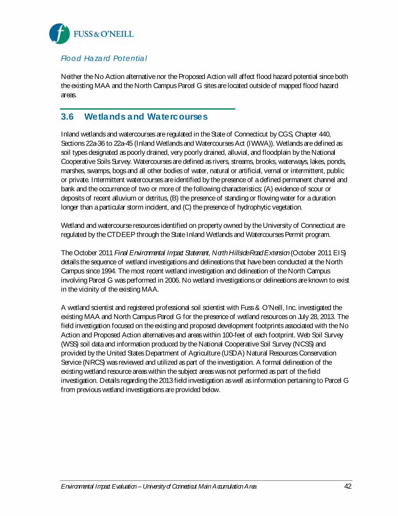
Environmental Impact Evaluation – University of Connecticut Main Accumulation Area 42
Flood Hazard Potential
Neither the No Action alternative nor the Proposed Action will affect flood hazard potential since boththe existing MAA and the North Campus Parcel G sites are located outside of mapped flood hazardareas.
3.6 Wetlands and Watercourses
Inland wetlands and watercourses are regulated in the State of Connecticut by CGS, Chapter 440,Sections 22a-36 to 22a-45 (Inland Wetlands and Watercourses Act (IWWA)). Wetlands are defined assoil types designated as poorly drained, very poorly drained, alluvial, and floodplain by the NationalCooperative Soils Survey. Watercourses are defined as rivers, streams, brooks, waterways, lakes, ponds,marshes, swamps, bogs and all other bodies of water, natural or artificial, vernal or intermittent, publicor private. Intermittent watercourses are identified by the presence of a defined permanent channel andbank and the occurrence of two or more of the following characteristics: (A) evidence of scour ordeposits of recent alluvium or detritus, (B) the presence of standing or flowing water for a durationlonger than a particular storm incident, and (C) the presence of hydrophytic vegetation.
Wetland and watercourse resources identified on property owned by the University of Connecticut areregulated by the CTDEEP through the State Inland Wetlands and Watercourses Permit program.
The October 2011 Final Environmental Impact Statement, North Hillside Road Extension (October 2011 EIS)details the sequence of wetland investigations and delineations that have been conducted at the NorthCampus since 1994. The most recent wetland investigation and delineation of the North Campusinvolving Parcel G was performed in 2006. No wetland investigations or delineations are known to existin the vicinity of the existing MAA.
A wetland scientist and registered professional soil scientist with Fuss & O'Neill, Inc. investigated theexisting MAA and North Campus Parcel G for the presence of wetland resources on July 28, 2013. Thefield investigation focused on the existing and proposed development footprints associated with the NoAction and Proposed Action alternatives and areas within 100-feet of each footprint. Web Soil Survey(WSS) soil data and information produced by the National Cooperative Soil Survey (NCSS) andprovided by the United States Department of Agriculture (USDA) Natural Resources ConservationService (NRCS) was reviewed and utilized as part of the investigation. A formal delineation of theexisting wetland resource areas within the subject areas was not performed as part of the fieldinvestigation. Details regarding the 2013 field investigation as well as information pertaining to Parcel Gfrom previous wetland investigations are provided below.

Environmental Impact Evaluation – University of Connecticut Main Accumulation Area 43
3.6.1 Existing Conditions
Existing MAA SiteThe existing MAA is located east of the southeast corner of Horsebarn Hill Road. Developed areasassociated with the UConn campus are located west of the facility. Agricultural fields, scrub-shrub, andforested areas are located north, east, and southeast of the facility. The topography of the existing facilityand adjacent areas trend to the east-southeast toward a palustrine (marsh) wetland resource area locatedwithin approximately 50 feet of the facility.
The NRCS soil survey map of the existing facility and adjacent areas was found to be consistent with soilprofiles examined during the July 2013 field investigation. The existing facility is classified as UrbanLand, where 85 percent of the soil surface has been altered or obscured by earth work and structures.Soils located north, east, and southeast of the facility are similar to the Woodbridge series, consisting ofcoarse-loamy, moderately well drained upland soils derived from lodgement till parent material.Moderately well drained soils east of the facility transition to poorly drained and very poorly drainedwetland soils similar to the Ridgebury, Leicester and Whitmans soils series. Wetland soils within 100 feetof the facility consist of coarse-loamy mineral soils derived from lodgement till parent material.
The wetland east of the facility is part of a large wetland resource system that extends north and south ofthe focus area (Figure 3-5). The wetland drains south toward Roberts Brook, a perennial watercourse andtributary to the Fenton River. Within 100 feet of the site, the wetland includes palustrine forest, scrub-shrub, and emergent wet meadow cover types. Groundwater discharge was observed from the hillsideeast of the facility during the July 2013 investigation. Pockets of shallow ponded water were notedwithin depressions in forested portions of the wetland. Sand and gravel fill piles were noted within theforested portion of the wetland, which indicate historic wetland disturbances. Dominant vegetationwithin the wetland forest includes: red maple (Acer rubrum), green ash (Fraxinus pennsylvanica), ironwood(Carpinus caroliniana), winterberry (Ilex verticillata), Virginia creeper (Parthenocissus quinquefolia), orientalbittersweet (Celastrus orbiculatus), muliflora rose (Rosa multiflora), Japanese barberry (Berberis thunbergii),skunk cabbage (Symplocarpus foetidus), jewelweed (Impatiens capensis), cinnamon fern (Osmunda cinnamomea),sensitive fern (Onoclea sensibilis), jack-in-the-pulpit (Arisaema triphyllum), and poison ivy (Toxicodendronradicans). Dominate vegetation in scrub-shrub portions of the wetland includes: multiflora rose, brambles(rubus spp.), Japanese barberry, and oriental bittersweet. Dominate herbaceous species in emergentportions of the wetland include: common reed (Phragmites australis), sensitive fern, milkweed (Asclepiassp.), goldenrod (Solidago spp.), and thistle (Cirsium spp.).
North Campus Parcel G SiteThe proposed MAA facility would be located west of the existing tennis courts on Parcel G in anundeveloped portion of the parcel that is dominantly vegetated with mature deciduous forest. Thetopography slopes toward the west in the vicinity of the development footprint and adjacent areas.
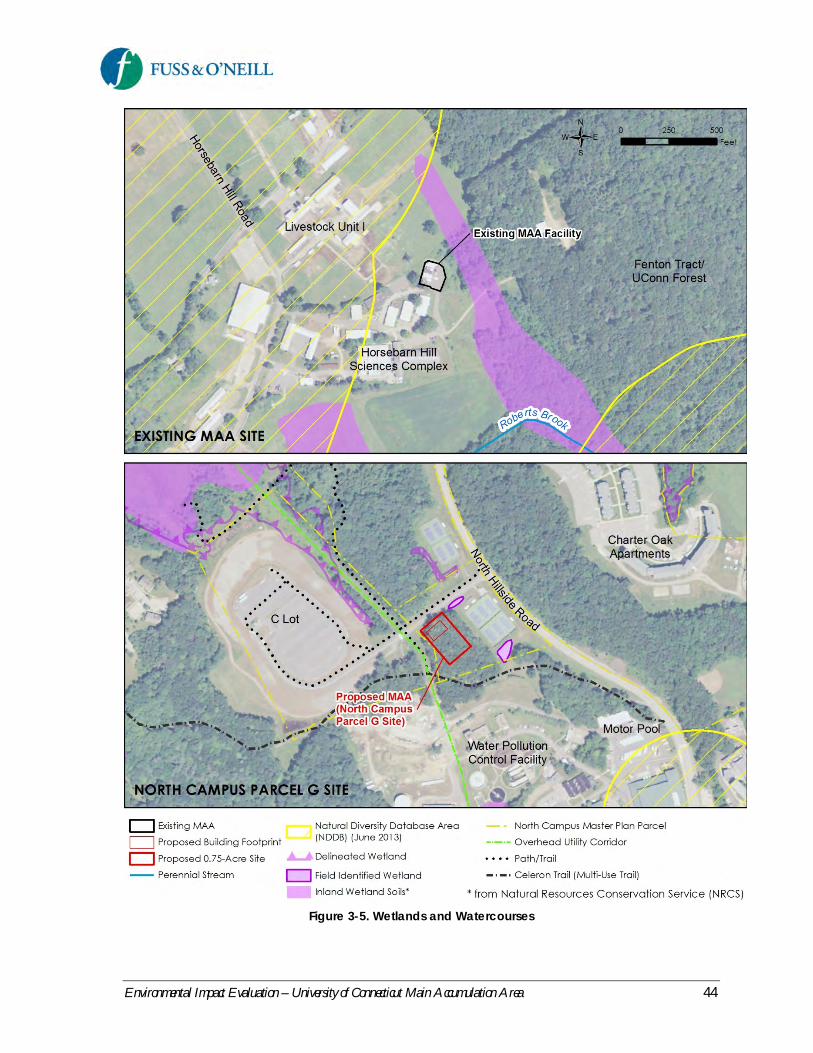
Environmental Impact Evaluation – University of Connecticut Main Accumulation Area 44
Figure 3-5. Wetlands and Watercourses

Environmental Impact Evaluation – University of Connecticut Main Accumulation Area 45
The NRCS soil map of the Parcel G site and adjacent areas was found to be generally consistent withsoil profiles examined during the July 2013 field investigation. The area of the proposed developmentfootprint was found to be similar to the well-drained Canton and Charlton soil series, consisting ofcoarse-loamy over sandy-skeletal soils derived from a loamy mantle over sandy till. Areas adjacent to theC Lot Driveway and tennis courts consist of Udorthents, smoothed soils, which are well drained tomoderately well drained soils where two or more feet of the original soil surface has been altered byfilling, excavation or grading activities. A narrow, man-made drainage swale extends along a portion ofthe northwest perimeter of the tennis courts on Parcel G. Soils within the swale are classified asAquents, where redox features were observed within 12-inches of the soil surface. A previouslyidentified and delineated man-made drainage feature is located north of the C Lot Driveway; soils withinthe swale are classified as Aquents. Satellite imagery6 indicates that the man-made drainage swale onParcel G did not exist prior to 2006 (Figure 3-5). It appears to have been created in association withconstruction of the C Lot Driveway. It functions to receive overland flow from the surrounding uplandsand discharge surface water to the upland forest. The swale contained shallow ponded water at the timeof the inspection. The swale is vegetated with a variety of hydrophytic emergent vegetation, dominatedby: pointed broom sedge (Carex scoparia), soft rush (Juncus effuses), Fox Sedge (Carex vulpinoidea), andshallow sedge (Carex lurida).
The man-made wetland north of the C Lot Driveway receives stormwater from the surroundingdevelopments. The man-made wetland is within 100 feet of the proposed MAA facility and vegetatedprimarily with the invasive plant species common reed and cattail (Typha sp.).
3.6.2 Impact Evaluation
No Action AlternativeNo direct or indirect impacts to wetlands resource are anticipated under the No Action alternative.Stormwater from the site would continue to discharge to the adjacent wetland area as untreated surfacerunoff. The potential for impacts to the adjacent wetlands, Roberts Brook, or the Fenton River wouldalso remain unchanged in the unlikely event of a release of chemicals or other hazardous materials to theenvironment. However, no releases have previously occurred since the facility was established in 1989.
Proposed ActionThe drainage swale adjacent to the tennis courts on Parcel G is located outside of the proposedfootprint of the development area for the proposed MAA facility; therefore no direct impacts to thiswetland are anticipated as a result of the Proposed Action. No direct or indirect impacts to wetlandresources are anticipated due to the facility operations given the proposed stormwater controls and otherfacility design elements that will significantly reduce the potential for a release of chemicals or otherhazardous materials to the environment.
6 Google Earth version 7.1.1.1888, released July, 17, 2013

Environmental Impact Evaluation – University of Connecticut Main Accumulation Area 46
3.7 Wildlife and Vegetation
An Environmental Scientist with Fuss & O'Neill, Inc. investigated the existing MAA and North CampusParcel G site on July 28, 2013 to document existing vegetation and wildlife. The 2013 field investigationfocused on the existing and proposed development footprints and areas within 100 feet of each site(referred to as the Study Areas). Natural resources information obtained from ConnecticutEnvironmental Conditions Online (CTDEEP & CLEAR, 2013) was utilized as part of the investigation.Key habitat types identified within the Study Areas correspond to habitat classifications defined inConnecticut’s Comprehensive Wildlife Conservation Strategy (CWCS) (CTDEEP and Terwilliger Consulting, Inc.,2005). In addition, information was reviewed from the October 2011 Final Environmental Impact Statement,North Hillside Road Extension (FHWA, 2011), which summarizes previous vegetation and wildlifeinvestigations conducted at the North Campus since 1994. Details regarding the 2013 field investigationas well as information pertaining to Parcel G from previous investigations are provided below.
3.7.1 Existing Conditions
Existing MAA SiteThe existing MAA is located east of the southeast corner of Horsebarn Hill Road. Developed areasassociated with the UConn campus are located west of the facility. Agricultural fields, mown lawn,scrub-shrub, and forested areas are located north, south and east of the facility. The topography of theexisting facility and adjacent areas trend to the east-southeast toward a wetland area located within 50±feet east of the facility.
The majority of the existing MAA facility Study Area consists of impervious surfaces, including asphalt,building structures, and concrete. Pervious areas include a gravel access drive behind the facility andgravel portions within the interior. Based on field observations, the facility footprint does not providesubstantial wildlife habitat. The dominant ecological habitat types within the Study Area include: UplandHerbaceous, Upland Shrub, Shrub Inland Wetland, and Forest Inland Wetland. A brief summarydescription of each of these habitats is provided below:
The areas classified as Upland Herbaceous habitat are composed of regularly mowed lawn andfield areas dominated by ragweed (Ambrosia trifida), thistle (Cirsium spp.), pokeweed (Phytolaccaamericana), sensitive fern (Onoclea sensibilis) and various species of goldenrod (Solidago spp.) andasters (Asteraceae). Upland Herbaceous areas are located north and south of the facility.
The Upland Shrub habitat adjacent to the eastern edge of the facility is dominated by a densegrowth of invasive plant species Japanese knotweed (Polygonum cuspidatum), multiflora rose (Rosamultiflora) and oriental bittersweet (Celastrus orbiculatus) as well as sensitive fern, milkweed(Asclepias sp.), goldenrod, thistle and asters. This area has been disturbed by historic filling,grading and clearing activities.
Shrub Inland Wetland habitat is located on a hillside seep east of the facility and is similar to theUpland Shrub habitat described above due to historic grading and clearing activities. The shrubinland wetland is dominated by brambles (Rubus spp.), sensitive fern, milkweed, goldenrod,

Environmental Impact Evaluation – University of Connecticut Main Accumulation Area 47
thistle and asters and invasive plant species multiflora rose, Japanese barberry (Berberis thunbergii),common reed (Phragmites australis), and oriental bittersweet.
The Inland Wetland Forest east of the hillside seep is dominated by red maple (Acer rubrum),green ash (Fraxinus pennsylvanica), ironwood (Carpinus caroliniana), winterberry (Ilex verticillata),Virginia creeper (Parthenocissus quinquefolia), oriental bittersweet, muliflora rose, Japanesebarberry, skunk cabbage (Symplocarpus foetidus), jewelweed (Impatiens capensis), cinnamon fern(Osmunda cinnamomea), sensitive fern, jack-in-the-pulpit (Arisaema triphyllum), and poison ivy(Toxicodendron radicans). Shallow pockets of surface water were observed within wetland. Nopotential vernal pool habitat was identified within the Study Area.
Direct wildlife observations within the Study Area were limited to eastern cottontail (Sylvilagus floridanus),grey squirrel (Sciurus carolinensis) and northern cardinal (Cardinalis cardinalis). A turkey (Meleagris gallopavo)feather was found east of the Upland Herbaceous habitat north of the facility. Wood frogs (Ranasylvatica), an obligate vernal pool species, were heard chorusing from the Forested Inland Wetlandbeyond the limits of the Study Area. Evidence of white tailed deer (Odocoileus virginianus) brows was alsonoted within Forested Inland Wetland within the Study Area. Other wildlife species may be present butwere not directly observed, nor was direct or indirect evidence of other species observed during the July28, 2013 site visit.
Information regarding Connecticut State listed endangered, threatened, and special concern plant andanimal species is maintained by the Connecticut Natural Diversity Database (CT NDDB) in accordancewith CGS Sections 26-306-4 through 26-306-6. Mapping provided by the CT NDDB identifies generalareas of concern for known occurrences of State- and Federally-listed endangered, threatened andspecial concern species and significant natural communities. Current CT NDDB mapping, dated June2013 (Figure 3-5), indicates that areas of concern exist in and adjacent to the Study Area, but outside ofthe footprint of the existing MAA facility and immediate surrounding area.
North Campus Parcel G SiteAs described previously in the subject EIE, the western portion of North Campus Parcel G isundeveloped, while tennis courts are located on the eastern portion of Parcel G. Parcel G is bounded tothe north by the C Lot Driveway, to the east by North Hillside Road, and to the west by an overheadelectrical utility corridor. The proposed MAA facility would be located west of the existing tennis courtswithin the undeveloped portion of the parcel. The topography slopes toward the west in the vicinity ofthe development footprint and adjacent areas.
The tennis courts, C Lot Driveway, and adjacent mowed areas do not provide substantial wildlifehabitat. Based on field observations, the dominant habitat types within the Study Area are Upland Forestand Intensively Managed utility right-of-way. A brief summary description of these habitats is providedbelow:
The undeveloped portion of Parcel G consists of mature Upland Forest. Mature Upland Foresthabitat is also located north and west of Parcel G. Areas classified as Upland Forest within theStudy Area are dominated by red oak (Quercus rubra), red maple, hickory (Carya spp.), easternwhite pine, white ash (Fraxinus americana) ironwood, hornbeam (Ostrya virginianan), mapleleafviburnum (Viburnum acerifolium), lowbush blueberry (Vaccinium angustifulium), Virginia creeper,

Environmental Impact Evaluation – University of Connecticut Main Accumulation Area 48
oriental bittersweet, New York fern (Thelypteris noveboracensis), lady fern(Athyrium filix-femina),Canada mayflower (Maianthemum canadense), wintergreen (Chimaphila maculate), rattlesnakeplantain (Goodyera tesselata), and Christmas fern (Polystichum acrostichoides). Invasive plant speciesglossy buckthorn (Rhamnus frangula) was noted growing along the north side of the C LotDriveway.
An overhead electrical utility corridor is located west of the proposed development boundaryand extends north and south of Parcel G. The ecological habitat within the corridor is classifiedas Intensively Managed in the CWCS. The following dominant species were documented withinthe Intensively Managed portions of the Study Area: glossy buckthorn, brambles, sweet-fern(Comptonia peregrina), mapleleaf viburnum, mullein (Verbascum thapsus), birdfoot trefoil (Lotuscorniculatus), cow vetch (Vicia cracca) and various species of goldenrod and aster.
Direct wildlife observations within the Study Area included white-tailed deer, groundhog (Marmotamonax), grey squirrel, northern cardinal, and red-tailed hawk (Buteo jamaicensis). A groundhog den wasobserved on Parcel G within the Upland Forest. Other wildlife species may be present but were notdirectly observed, nor was direct or indirect evidence of other species observed during the July 28, 2013site visit.
Current NDDB mapping, dated June 2013 (Figure 3-5), indicates that no identified areas of concern existwithin the Study Area. The nearest CT NDDB identified area of concern is located approximately 700feet southeast of the Study Area.
3.7.2 Impact Evaluation
No Action AlternativeNo direct or indirect impacts to wildlife or vegetation are anticipated under the No Action alternative.Stormwater from the site would continue to discharge to the adjacent wetland area as untreated surfacerunoff. The potential for impacts to the adjacent wildlife habitats would also remain unchanged in theunlikely event of a release of chemicals or other hazardous materials to the environment. However, noreleases have previously occurred since the facility was established in 1989.
Proposed ActionDevelopment of the proposed MAA facility on Parcel G would result in the loss of approximately 0.75acres of mature Upland Forest habitat. However, un-fragmented continuous tracks of mature forest arelocated to the north, west, and east of Parcel G, including the approximately 64-acre HillsideEnvironmental Education Park (HEEP) conservation area north and west of the former UConn landfilland approximately 100 acres of additional upland forest and wetlands that are proposed as conservationland on the North Campus as part of the mitigation associated with the North Hillside Road extensionand subsequent development of the North Campus. Loss of this relatively small, fragmented uplandforest on the Parcel G site is not anticipated to have a significant adverse impact to existing wildlife.
Similar to the No Action alternative, no direct or indirect impacts to wildlife or vegetation areanticipated due to the facility operations given the proposed stormwater controls and other facilitydesign elements that will significantly reduce the potential for a release of chemicals or other hazardousmaterials to the environment.

Environmental Impact Evaluation – University of Connecticut Main Accumulation Area 49
3.8 Cultural Resources
3.8.1 Existing Conditions
Existing MAA SiteThere are no known historical or archaeological sites located at or in the vicinity of the existing MAAaccording to the National Register of Historic Places (NRHP). The Farwell Barn and the “University ofConnecticut Historic District, Connecticut Agricultural School” are the only two sites on the UConncampus listed on the NRHP.
North Campus Parcel G SiteThe following cultural resource surveys have been completed along the corridor of the proposed NorthHillside Road extension in support of previous environmental reviews: (1) Phase 1A ArchaeologicalSurvey of the North Campus area (PAST, 1987), consisting of a literature search and sensitivity study,and (2) Phase 1B (field investigation) and Phase 2 (site evaluation) Archaeological Surveys (Lavin,Lucianne and Marc Banks, 2005 & 2006). The survey findings indicated that construction of the NorthHillside Road extension will not result in significant impacts to historical or archaeological resources.However, the Phase 1A Archaeological Survey identified potential areas of prehistoric value on severalof the North Campus parcels, including Parcel G. The Phase 1B and Phase 2 archaeological surveyswere limited to the roadway corridor and did not evaluate Parcel G.
3.8.2 Impact Evaluation
No Action AlternativeThe No Action alternative would result in no impacts to cultural resources since there are no knownhistorical or archaeological resources in the vicinity of the existing MAA. No ground disturbance oralteration of existing structures is proposed as part of the No Action alternative.
Proposed ActionSince Parcel G contains potential areas of prehistoric value, development of this parcel requiresadditional archaeological surveys prior to construction to determine if development activities wouldimpact cultural resources. Consistent with the mitigation commitments in the Record of Decision(ROD) for the North Hillside Road Extension EIS, dated April 4, 2012, UConn will conduct additionalcultural resource investigation of Parcel G (Phase 1B Archaeological Reconnaissance Survey) prior todevelopment and will coordinate with the State Historic Preservation Office (SHPO) and the TribalHistoric Preservation Officers (THPOs) of the Mashantucket Pequot and Mohegan Tribes to ensurethat historic, archaeological, and cultural resources are protected. The SHPO and/or TPHOs mayrequire UConn to conduct additional archaeological investigations, including Phase 2 and Phase 3 (datarecovery) surveys to further evaluate the presence of archaeological resources on Parcel G.

Environmental Impact Evaluation – University of Connecticut Main Accumulation Area 50
3.9 Visual and Aesthetic Character
3.9.1 Existing Conditions
Existing MAA SiteThe existing MAA is situated near the southeast corner of Horsebarn Hill Road at the eastern limits ofthe Storrs campus. The visual environment of the surrounding area is dominated by agricultural land andseveral administrative and academic buildings. Livestock Unit I is located to the northwest, the FentonTract of the UConn Forest is located to the east, and the Horsebarn Hill Sciences Complex is located tothe south of the site.
The site previously housed a dog kennel before the facility was converted into the University’scentralized waste storage facility in 1989, and expanded over time into the current MAA facility. Theexisting facility consists of approximately 1,500 square feet of permanent structures; 2,700 square feet oftrailer storage surrounded by perimeter fencing with barbed wire and a locked gate; and a paved area forparking, truck access, and patrols. Figure 1-2 illustrates the visual appearance of the existing MAA facility.
North Campus Parcel G SiteThe site of the proposed MAA is situated on the western portion of North Campus Parcel G, which ischaracterized by a fragmented wooded upland forest surrounded by developed land uses. The adjacentdevelopment includes an overhead electrical utility corridor to the west, the C Lot and C Lot Drivewayto the north and northwest, tennis courts and North Hillside Road to the east, and the Celeron Trail,UConn Transfer Station, and UConn WPCF to the south. No scenic roads7 are located adjacent to theproposed site. Photographs in Figures 3-6 through 3-8 illustrate the existing aesthetic and visual conditionsof the project site and surrounding area.
Figure 3-6. Site of Proposed MAA on North Campus Parcel G Looking Southeast
7 State-designated scenic highway must abut significant natural or cultural features such as agricultural land orhistoric buildings and structures which are listed on the National or State Register of Historic Places, or affordvistas of marshes, shoreline, forests with mature trees, or other notable natural or geologic feature which singularlyor in combination set the highway apart from other state highways as being distinct (CTDOT, 2013).

Environmental Impact Evaluation – University of Connecticut Main Accumulation Area 51
Figure 3-7. Site of Proposed MAA on North Campus Parcel G Looking Southwest
Figure 3-8. C Lot and C Lot Driveway Looking East Toward Parcel G
3.9.2 Impact Evaluation
No Action AlternativeNo change to the existing visual environmental would result under the No Action alternative. However,the appearance of the existing MAA is inconsistent with the visual character of similar, modern wastestorage facilities, such as those of MAAs at peer universities (Figures 3-9 and 3-10).
Proposed ActionThe Proposed Action would result in a change to the overall visual and aesthetic character of the ParcelG site. The facility would be likely visible from North Hillside Road developments immediately north of
Environmental Impact Evaluation – University of Connecticut Main Accumulation Area 52
Parcel G. A limited view of the facility would exist from developed areas south of the site, including theCeleron Trail, as a wooded buffer would be maintained along the southern portion of Parcel G.However, the design and exterior appearance of the facility would be consistent with the nearby existingUniversity and industrial land uses (e.g., C Lot, overhead electrical utility corridor, and UConn TransferStation and WPCF) as well as with the research and technology uses of the future UConn TechnologyPark. Although a final design of the facility has not been prepared, it is anticipated to have a visualappearance similar to that of central waste storage facilities at peer universities, as shown in the photosin Figures 3-9 and 3-10. Consequently, no direct or indirect impacts to visual resources are anticipated as aresult of the Proposed Action.
Figure 3-9. MAA Facility – University of Vermont Main Campus
Figure 3-10. MAA Facility – Cornell University Tech Park

Environmental Impact Evaluation – University of Connecticut Main Accumulation Area 53
3.10 Geology, Topography, and Soils
3.10.1 Existing Conditions
Existing MAA SiteThe existing MAA is located on a relatively flat site sloping easterly toward the Fenton Tract of theUConn Forest. Soils in the area are designated by the Natural Resources Conservation Service (NRCS)as primarily Urban Land (Figure 3-11). These soils have been influenced by site development, includingfilling and grading, and are mostly covered by paved areas, buildings, and/or other structures making thesoil properties varied and unknown. The soils adjacent to the site, downgradient to the east, areWoodbridge fine sandy loam (3 to 8% slopes) with an estimated saturated hydraulic conductivity of 0.0to 0.2 inches per hour (in/hr), which is very low to moderately high infiltration potential with aHydrologic Soil Group (HSG) classification of “Group C.” Group C soils have low infiltration rateswhen thoroughly wet and consist chiefly of soils with a layer that impedes downward movement ofwater and soils with moderately fine to fine texture. These soils generally have a low rate of watertransmission. Beneath the soil layer, surficial materials on the site are mapped as till which is generallyless than 50 feet thick. No Prime Farmland Soils or Soils of Statewide Importance are present on the siteof the existing MAA (Figure 3-11).
North Campus Parcel G SiteThe North Campus Parcel G Site is relatively flat and generally slopes to the southwest toward thesouthern limit of the former UConn landfill (including the south leachate interceptor trench and southdetention pond) and the existing C Lot. Soils on the site are designated by the NRCS as primarilyCanton and Charlton soils (3 to 8% slopes, very stony) with saturated hydraulic conductivity of 0.57 to5.95 inches per hour, which is considered well drained (Figure 3-11). The HSG of Canton and Charltonsoils is identified as “Group B.” Group B soils have moderate infiltration rates when thoroughly wet andconsist chiefly of moderately deep to deep, moderately well to well drained soils with moderately fine tomoderately coarse textures. These soils generally have a moderate rate of water transmission. There areno areas of Prime Farmland Soils or Soils of Statewide Importance within or adjacent to the site.
Beneath the soil layer, surficial materials on the site are mapped as thick till. The depth to bedrock in thisarea is typically 0 to 20 feet below grade surface with the metamorphic fabric striking northerly andpredominant fractures dipping to the west.
3.10.2 Impact Evaluation
The No Action alternative would have no adverse impacts on topography, soils or geologic features asexisting conditions would remain unchanged.
No soils or geologic features of national, state, or local importance or farmland soils are located withinthe area of proposed development under the Proposed Action. Some grading would be required toconstruct a new MAA facility on the Parcel G site. No direct or indirect impacts to geology or farmlandsoils are anticipated as a result of the construction of the facility.

Environmental Impact Evaluation – University of Connecticut Main Accumulation Area 54
Figure 3-11. Geology, Topography and Soils

Environmental Impact Evaluation – University of Connecticut Main Accumulation Area 55
The facility design will incorporate spill containment measures to provide secondary and tertiarycontainment for regulated waste storage and handling areas, state-of-the-art security systems, andrequired training, inspections, and contingency planning to meet applicable state and federal regulatoryrequirements for safe operation of the facility, as described in Section 3.13, Hazardous Materials andelsewhere in the subject EIE.
The USGS was contacted for their opinion on potential impacts of the MAA related to the landfillclosure at Lot C. They provided the contact at Haley & Aldrich to comment on the potential impacts.According to Haley & Aldrich, it is also unlikely that the proposed MAA would affect the former landfillstructures or remediation systems or that leachate from the former landfill would affect the site of theproposed MAA (Haley & Aldrich, Inc., personal communication, July 31, 2013).
The proposed facility design elements will reduce the potential for subsurface impacts associated with arelease of chemicals or other hazardous materials to the environment. The Proposed Action is thereforenot anticipated to result in adverse direct or indirect impacts to soils, groundwater, or geology.
Construction-phase soil erosion and sedimentation controls are addressed in Section 3.16, ConstructionImpacts.
3.11 Utilities and Services
3.11.1 Existing Conditions
Electrical and Emergency Power, Natural Gas, Steam, and Chilled WaterThe Central Utility Plant (CUP), located at 189 Auditorium Road, provides the campus with electricity,steam for heating and hot water in campus buildings, and chilled water for cooling needs. The CUP iscomprised of three separate buildings: a co-generation ("co-gen") plant, a boiler plant, and a chiller plant.The University generates electricity from the co-gen plant’s three 7.5-megawatt turbines, the exhaustfrom which provides thermal energy that powers three heat recovery steam generators (HRSG). Thethree HRSGs produce high pressure (600 – 650 psi) steam, which is used to power a 5-MW electricgenerator, and low pressure (125 psi) steam, which is used to heat campus buildings during cold monthsand to power three chillers that supply chilled water to campus during warmer months. The boiler plantgenerates steam to supplement the HRSGs for campus heat. The CUP’s chilled water plant produceschilled water (~ 50° F) for distribution in a closed-loop system to approximately 30 buildings in thecentral portion of campus. The chilled water is primarily used for building air conditioning, but also hasapplications in once-through process cooling for some research equipment. The central chiller plantcurrently has a cooling capacity of 10,000 tons. Buildings that are not serviced by this central chiller plantare served by the University’s south chiller plant, have individual chillers, or use window or rooftop airconditioning units. The CUP’s turbines, boilers, and chillers are fueled by natural gas that is provided byConnecticut Natural Gas (CNG), with fuel oil as a back-up fuel source for the turbines and boilers. Thecampus is connected to the electrical transmission system of Connecticut Light and Power (CL&P),which provides auxiliary electricity supply for the campus.
The existing MAA is connected to the campus-wide electrical system. The waste storage structures areserved by electric heating and cooling systems; no natural gas service is available to the facility. The

Environmental Impact Evaluation – University of Connecticut Main Accumulation Area 56
existing MAA consists of 1,500 square feet of permanent structures and 2,700 square feet of trailerstorage. The electrical demand of these structures is insignificant compared to the total campus energy,heating, and cooling demands.
The North Campus Parcel G site is not currently served by utilities, although electrical and natural gasare available along the North Hillside Road corridor. A 6-inch natural gas main is provided by CNG.Chilled water and steam are not available in the vicinity of the project site.
Energy Use and ConservationUConn has several ongoing energy efficiency and sustainability initiatives at the Storrs campus:
Campus Sustainable Design Guidelines (JJR and SmithGroup, 2004) - The Guidelinesinclude specific measures for reduction of energy consumption on new construction projects oncampus including:
o Planning sustainable siteso Safeguarding watero Conserving materials and resourceso Improving energy efficiencyo Enhancing indoor environmental quality
Sustainable Design & Construction Policy8 - Adopted in 2007, the policy requires newbuilding construction or renovation projects entering the pre-design planning phase to meet theLeadership in Energy & Environmental Design (LEED) Silver rating as a minimumperformance standard for any building construction or renovation project, and whenever theestimated total project cost exceeds $5 million, excluding the cost of equipment other thanbuilding systems.
UConn Climate Action Plan9 - The University is striving towards a carbon neutral campus bythe year 2050. The UConn Climate Action Plan focuses on strategies for reducing greenhouse gasemissions from the University. Progress is being tracked through an annual greenhouse gasinventory.
Renewable Energy Strategic Plan10 - The Preliminary Feasibility Study and Strategic DeploymentPlan for Renewable & Sustainable Energy Projects identifies and assesses target locations for thedevelopment of 12 demonstration-scale renewable and sustainable energy projects for thefollowing technologies: solar thermal, solar photovoltaic, wind, fuel cells, geothermal, andbiofuels.
8 http://www.ecohusky.uconn.edu/SDCpolicy.htm9 http://www.ecohusky.uconn.edu/pcc/climateactionplan.html10 http://www.ecohusky.uconn.edu/docs/energy/Final%20Renewable%20Deployment%20PlanMCr.pdf

Environmental Impact Evaluation – University of Connecticut Main Accumulation Area 57
“Relamping” Campaign11 - UConn expects a dramatic drop in its electricity demand due toan extensive lighting system upgrade campaign targeting 67 buildings on campus. Theseupgrades will increase energy efficiency, decrease overall energy use, and reduce greenhouse gasemissions.
Sanitary SewerUConn owns, operates, and maintains its own sanitary sewer system and Water Pollution ControlFacility (WPCF) located off of LeDoyt Road. The sewer service area includes the Main Campus, theDepot Campus, and some non-University owned properties surrounding campus (residential properties,apartment complexes, commercial properties, Town of Mansfield owned properties).
The WPCF capacity is currently 3.0 million gallons per day (mgd) with a peak flow capacity of 7.2 mgd.Although the WPCF is permitted to discharge an average of 3.0 mgd, the average daily discharge hasbeen between 0.62 mgd and 1.53 mgd for the August 2010 and April 2010 quarters, respectively, whichare the most recently reported values. The maximum daily flow for 2009 and 2010 has ranged from 1.11mgd (for the quarter ending July 2009) to 4.35 mgd (for the quarter ending April 2010) (Milone &MacBroom, Inc., 2011b).
The University recently opened a separate water treatment facility to provide tertiary treatment toeffluent from the WPCF. This “Reclaimed Water Facility” (RWF) produces high-quality reclaimed waterfor use in non-potable applications such as heating and cooling.
The existing MAA is served by a sanitary sewer line that connects to a force main from the HorsebarnHill Lift Station. Wastewater flows from the existing MAA were estimated based on the existing 1,500square foot permanent structure, which has laboratory space and a restroom. Wastewater dischargeestimates are based on the Connecticut Public Health Code Regulations and Technical Standards for SubsurfaceSewage Disposal Systems (2011). The total estimated wastewater discharge from the existing building isapproximately 15 gpd, with a projected peak flow of approximately 0.05 gallons per minute (gpm).
The North Campus Parcel G site is currently undeveloped and therefore has no existing wastewatergeneration. A 15-inch sanitary sewer force main exists near the site, situated approximately parallel to theCeleron Trail along the southern edge of Parcel G. A gravity sanitary sewer connection exists to a shedlocated on the north side of the tennis courts on Parcel G.
Water (Domestic and Fire Protection)UConn manages water supplies from the Fenton River and Willimantic River well elds, which serve theStorrs campus as well as portions of the Town of Mans eld. Average daily demand in 2010 was 1.29million gallons per day (mgd) and peak daily demand in 2010 was 2.23 mgd. The supply and distributionsystem also includes a water treatment facility at each well eld, three booster pumping stations, six waterstorage tanks, and 36 miles of water transmission and distribution mains (Milone & MacBroom, 2011a).
11 http://ecohusky.uconn.edu/energy/relamping.html

Environmental Impact Evaluation – University of Connecticut Main Accumulation Area 58
The existing MAA uses an estimated 15 gpd of water for bathrooms and laboratory facilities based onthe sanitary sewer generation estimate described in the previous section. The water demand of theexisting MAA is inconsequential compared to the total campus demand. No demand for water presentlyexists at the North Campus Parcel G site since the site is currently undeveloped.
The need for reducing withdrawals from the Fenton River wells during periods of low in-stream flowwas concluded in the Long Term Impact Analysis of the University of Connecticut’s Fenton River Water SupplyWells on the Habitat of the Fenton River (“Fenton River Study”) (Warner et al., 2006). Following the FentonRiver Study, a similar study was performed for the hydrogeologic capability of the Willimantic RiverWellfield to supply its registered withdrawal, An Analysis of the Impact of the University of Connecticut WaterSupply Wells on the Fisheries Habitat of the Willimantic River (“Willimantic River Study”) (Milone &MacBroom, 2010). The two studies concluded that the existing wellfields had likely reached their limitsfor public water supply. UConn’s 2011 Water Supply Plan also recognized that the Fenton River supplywould likely be limited during some summer and fall months to much lower withdrawals than thediversion registration allowed for, and that additional supply sources would be needed in the future(Milone & MacBroom, 2012).
In order to enable growth of the University and the surrounding area consistent with University andTown planning objectives, UConn and the Town of Mansfield conducted an evaluation of alternativesthat would meet future combined water supply needs. The evaluation was documented in the CEPAEnvironmental Impact Evaluation (EIE), Potential Sources of Water Supply (Milone & MacBroom, 2012). Thepreferred alternatives identified in the EIE were interconnection with the Connecticut Water Company,Metropolitan District Commission, and/or the Windham Water Works. In August 2013, the UConnBoard of Trustees endorsed the Connecticut Water Company as the University’s preferred alternative tosupplement the long-term water needs of the campus and those portions of the Storrs communityserved by the University water system. Connection with the Windham Water Works was identified as abackup source.
Stormwater/DrainageStormwater discharges from the site of the existing MAA as overland runoff. The site has no structuralstorm drainage systems. The site generally slopes to the east-southeast, and stormwater runoff from thesite flows toward a wooded area associated with the Fenton Tract of the UConn Forest. The existingMAA is located in the Fenton River subregional basin within the Roberts Brook watershed (Figure 3-3).
The North Campus Parcel G site is currently undeveloped and therefore has no structural stormdrainage systems. The storm drainage system along North Hillside Road adjacent to Parcel G consists ofa traditional collection system of catch basins, manholes, stone-lined drainage swales on the upgradientside of the road, and a drainage pipe network that discharges to the adjacent wetlands. Catch basins andstorm drainage pipes located along the C Lot Driveway collect and convey runoff from the drivewaynorth towards wetlands associated with Cedar Swamp Brook. The project site is located in theWillimantic River subregional basin and the Eagleville Brook watershed. The drainage divide betweenthe Cedar Swamp Brook watershed and the Eagleville Brook watershed is located to the north of ParcelG along the southern edge of the C Lot Driveway.

Environmental Impact Evaluation – University of Connecticut Main Accumulation Area 59
As discussed in Section 3.5, Eagleville Brook is listed as an impaired water body by CTDEEP. TotalMaximum Daily Loads (TMDL) for impervious cover and bacteria have been developed for EaglevilleBrook, requiring improved stormwater management for existing and proposed development within thewatershed. A recently approved CTDEEP Flood Management Certification (FM-201205381) and otherpending state and federal permits associated with the North Hillside Road extension will require the useof Low Impact Development (LID) and green infrastructure approaches to stormwater management forfuture development of the North Campus parcels.
TelecommunicationsTelecommunications services, including internet and telephone, are available at the existing MAA andare also available in the vicinity of the North Campus Parcel G site.
3.11.2 Impact Evaluation
Electrical and Emergency Power, Natural Gas, Steam, and Chilled WaterPotential energy consumption of the Proposed Action is likely to be similar or slightly greater than underthe No Action alternative. Under the Proposed Action, the extension of gas, water, sewer, electric, andtelecommunication utility lines will occur to serve a new MAA on the Parcel G site. The increase inelectrical, natural gas, steam and chilled water demand compared to existing conditions are anticipated tobe minor, if any. The existing capacity of the UConn CUP/CNG and CL&P systems are sufficient tomeet the demand.
Energy Use and ConservationUnder the No Action alternative, energy demand at the existing MAA would remain unchanged. TheProposed Action is anticipated to result in a slight increase in energy demand to serve the proposedMAA facility, which is larger than the existing MAA facility and includes more sophisticated buildingsystems. The proposed facility will also incorporate modern, energy efficient lighting, HVAC, and otherbuilding systems, which will tend to offset the increased energy demand due to the larger size of thefacility. The increase in energy demand, if any, would be minor and would not affect the ability ofUConn to meet its sustainability goals.
The Proposed Action will consider the Campus Sustainable Design Guidelines (JJR and SmithGroup, 2004),which include specific measures for reduction of energy consumption on new construction projects oncampus. Although the Sustainable Design & Construction Policy may not apply to this project since theconstruction costs are anticipated to be less than $5 million, the project will use comprehensiveapproaches to energy efficiency in the design of the new MAA building.
Sanitary SewerUnder the No Action alternative, wastewater flows to the sanitary sewer system and wastewatertreatment plant would remain similar to existing levels, which are estimated at 15 gpd. The projectedwastewater flows associated with the proposed facility were estimated based on an approximately 5,800square foot industrial-use building. The conceptual interior floor plan of the proposed MAA includeslaboratory space and one restroom. Wastewater discharge estimates are based on the Connecticut PublicHealth Code Regulations and Technical Standards for Subsurface Sewage Disposal Systems (2011). The totalestimated wastewater discharge from the facility is approximately 60 gpd, with a projected peak flow of

Environmental Impact Evaluation – University of Connecticut Main Accumulation Area 60
approximately 0.21 gallons per minute (gpm). Typical flows reported for the UConn WPCF are between0.62 mgd and 1.53 mgd (Milone & MacBroom, 2011b), and the facility is permitted for up to 3.0 mgd.
Therefore, the WPCF has sufficient capacity for the anticipated minor increase in sanitary wastewaterflows from the proposed MAA facility.
Water (Domestic and Fire Protection)No significant change to the existing water demand is anticipated under the No Action alternative.Similar to wastewater and sanitary sewer demand, the Proposed Action is expected to result in a minorincrease in water demand at the proposed MAA due to the larger building size and greater number ofstaff compared to that of the existing MAA. The estimated water demand from the proposed MAA isapproximately 60 gpd, which is roughly equivalent to the estimated wastewater flow and a net increase ofapproximately 45 gpd over the existing water demand. The existing water supply infrastructure oncampus, combined with the University’s existing and additional future water supply sources, is sufficientto accommodate this minor increase in water demand.
Stormwater/DrainageUnder the No Action alternative, stormwater from the existing MAA would continue to discharge to theadjacent wooded area as untreated surface runoff, and the facility would remain located within the publicwater supply watershed of the Willimantic Reservoir. The potential for impacts to surface waterresources would also remain unchanged in the unlikely event of a release of chemicals or otherhazardous materials to the environment. It should be noted that the existing MAA has been operatedsafely and has never experienced a release since it was established in 1989.
The stormwater management system for the new MAA will be consistent with the guidelines containedin the CTDEEP Connecticut Stormwater Quality Manual (as amended) and the requirements of theCTDEEP Flood Management Certification (FM-201205381) and other pending permit applications forthe North Hillside Road extension and North Campus development, including CTDEEP WaterDiversion Permit, Inland Wetlands and Watercourses Permit, and 401 Water Quality Certification inaddition to a Section 404 Army Corps of Engineers individual permit. As a condition of these permits,design plans for development of Parcel G, including the proposed MAA, will be submitted to theCTDEEP for review and approval prior to the start of construction. The stormwater managementsystem will also incorporate construction and post-construction management strategies to address thebacteria exceedances identified in both the Eagleville Brook Watershed Management Plan (Dietz &Arnold, 2011) and the Connecticut Statewide Bacteria TMDL.
The stormwater management measures for the site will consist of a combination of source controls,pollution prevention, LID and conventional structural stormwater management practices, and spillcontainment. The stormwater management strategy for the site will incorporate the following keyelements:
Non-structural source controls and pollution prevention measures (parking lot sweeping, catchbasin cleaning, drainage system and stormwater treatment system operation and maintenance,etc.) will be implemented after construction of the proposed facility.

Environmental Impact Evaluation – University of Connecticut Main Accumulation Area 61
LID approaches such as drywells, rain gardens, vegetated swales, and other infiltrationtechniques to infiltrate runoff from the building roof and sidewalks or paved areas whereregulated wastes will not be handled. The soils at the North Campus Parcel G site havemoderate to high infiltration potential (Hydrologic Soil Group B). Site-specific testing isrequired to verify the suitability of the soils and subsurface conditions to support stormwaterinfiltration.Runoff from loading areas or other locations where regulated wastes will be handled will bedirected to a stormwater collection system that can be effectively closed in the event of a spill,so that it is contained prior to discharge to the ground or the larger stormwater system. Suchfacilities will incorporate shut-off valves, impermeable liners, or other similar design features toreduce the potential for a release to the environment.The stormwater system design will incorporate management strategies to address the bacteriaexceedances identified in both the Eagleville Brook Watershed Management Plan (Dietz &Arnold, 2011) and the Connecticut Statewide Bacteria TMDL, including filtration practices suchas lined and underdrained bioretention systems or subsurface sand filters, both of which areeffective at reducing stormwater bacteria concentrations without relying on infiltration.
The facility design will also incorporate spill containment measures to provide secondary and tertiarycontainment for regulated waste storage and handling areas, state-of-the-art security systems, andrequired training, inspections, and contingency planning to meet applicable state and federal regulatoryrequirements for safe operation of the facility.
The proposed stormwater management and facility design elements will reduce the potential for impactsassociated with a release of chemicals or other hazardous materials to the environment. The ProposedAction is therefore not anticipated to result in adverse direct or indirect impacts related to stormwaterdrainage or surface water and groundwater resources.
TelecommunicationsTelecommunication services are available to the existing MAA and in the vicinity of the North CampusParcel G site. Therefore, no impacts are anticipated as a result of the No Action alternative or ProposedAction.
3.12 Public Health and Safety
3.12.1 Existing Conditions
The UConn Division of Public Safety maintains campus fire, police, and ambulance services for theprotection of life and property at the Storrs campus. UConn Public Safety personnel also respond tosome local town emergencies and members of the UConn Police Department are appointed specialconstables within the Town of Mansfield. The police and fire departments are co-located on campus at126 North Eagleville Road. The campus has a state-of-the-art Emergency 911 center and a system ofemergency phones is located throughout the campus.

Environmental Impact Evaluation – University of Connecticut Main Accumulation Area 62
The UConn Police Department is an organized police department with the same authority andresponsibilities as any municipal police department within the State of Connecticut. The UConn PoliceDepartment currently has 51 police officers at the main campus in Storrs. They are on duty 24 hours aday throughout the year and patrol the campus on foot, and in both marked and unmarked policevehicles. UConn police officers are responsible for enforcing all of the laws of the State of Connecticut,both criminal and motor vehicle.
The UConn Police Department also operates the University Alert Notification System which provides anumber of ways in which the University may contact the community in the event of an emergency. Thecomponents of the University Alert Notification System include website alerts, email, voice mail,outdoor sirens and Code Blue Phone Kiosks.
The 2011 Annual Security Report for the Storrs campus published by the UConn Division of Public andEnvironmental Safety shows that the majority of campus crimes involve burglary and liquor and drugviolations (UConn, 2011).
The UConn Fire Department is a fully operational department providing 24/7 response from the PublicSafety Building on North Eagleville Road. The fleet includes two engines, a tower ladder, four basic lifesupport ambulances, a pair of hazardous materials response vehicles, a decontamination trailer andnumerous support vehicles. The Fire Department responds to all emergencies and performs routineduties. These duties include, but are not limited to, fire code inspections in academic and residentialbuildings and approving an open-flame permit at a new construction site. All of the firefighters areHazardous Material trained to technician level.
The Mansfield Fire Department provides first responder services for incidents within Mansfield andoutside of the University campus and also provides backup for the UConn Fire Department. TheMansfield Fire Department is a full-service fire and rescue department, consisting of both career andvolunteer members divided among three stations. The department responds to as many as 2000emergency calls per year including fires, medical incidents, service calls, and hazardous conditionsincidents, including hazardous materials incidents (Mansfield Fire Department, 2013).
Medical services that are available to UConn students, faculty, and staff include:
UConn Student Health Services – Student Health Services is located on-campus andprovides numerous basic health services for UConn students, including clinic, advice nurse,community response, mental health, laboratory, radiology, orthopedic, allergy, nutrition,pharmacy, and physical activity counseling services.
Windham Community Memorial Hospital – UConn is located approximately 9 miles fromthis facility, which offers emergency services, inpatient and outpatient care, and other services.
Natchaug Hospital – This facility provides adult and adolescent psychiatric and substanceabuse treatment services.
Rockville General Hospital – UConn is located approximately 15 miles from this facility.

Environmental Impact Evaluation – University of Connecticut Main Accumulation Area 63
Manchester Memorial Hospital – UConn is located approximately 18 miles from this facility,which offers emergency services, inpatient and outpatient care, and other services.
The UConn EH&S provides comprehensive health and safety services for the University community.EH&S develops and administers policies and procedures to present personal injury and maintainregulatory compliance in the areas of biological, chemical, occupational and radiation safety. Trainingchemical, biological, radiation, and general laboratory safety, as well as occupational safety, is offered tothe University community by EH&S. In addition, EH&S operates the existing MAA and providesregulated waste management for the campus. A more detailed description of regulated wastemanagement can be found in Section 3.13, Hazardous Materials.
3.12.2 Impact Evaluation
The University has sufficient public safety and emergency services to address the needs of an MAAunder either the No Action or Proposed Action alternative. For each alternative, timely emergencyresponse is possible and the Proposed Action is not anticipated to place a burden on the capacity ofUConn Police or Fire Departments. Specific emergency response procedures are described in thefacility’s contingency plan and involve significant coordination between EH&S, the UConn PoliceDepartment, and both the UConn and Mansfield fire departments. In the unlikely event of a release ofregulated waste during transport of waste to or from the MAA by UConn or commercial waste transportvehicles, the first responder responsibilities are dictated by the jurisdiction of the release location (i.e.,Town of Mansfield or University property), although the response procedures would be similarregardless of the first responder.
Although the existing emergency response capabilities are adequate for both the existing and proposedMAA facilities, the UConn Fire Department indicated during the 2012 siting study that threat to publichealth and safety is an important factor in determining the timeliness in responding to a hazardousmaterial release emergency. Remote locations or those removed from vulnerable natural resourcesprovide cushion to allow for measured and efficient response and later, cleanup. Although a release fromthe existing MAA facility has not occurred since the facility was established, a leak or fume release at theproposed location would have greater potential for public impact than the existing location due to theproximity of larger numbers of people in the vicinity of or downwind12 of the facility, as discussed inSection 2, Alternatives Considered. This could increase human exposure in a shorter time and could increasepotential interruption to daily campus operations. These factors increase the pressure to performemergency response and mitigation faster, which may involve greater risk to first responders.
12 Prevailing winds on the UConn, Storrs campus vary seasonally. Weather data is collected and maintained by theUConn Department of Natural Resources and the Environment (NRE) Water Resources Field Station, which islocated near the existing MAA off of Horsebarn Hill Road. Weather data collected at this station indicate that theannual prevailing wind direction for 2011 and 2012 is from the west and southwest. Localized wind direction alsovaries at different points on the campus depending on a variety of factors such as topography, tree cover,buildings, etc. Additional information regarding the prevailing wind direction is provided in the 2012 MainAccumulation Area Facility Comparative Site Study report (in Appendix B of this EIE).

Environmental Impact Evaluation – University of Connecticut Main Accumulation Area 64
Under the No Action alternative, response times from the Public Safety Building would be longer in theevent of an emergency at the existing MAA, but the MAA is located in an area of lower populationdensity (see Figure 3-12). In contrast, the site of the proposed MAA on North Campus Parcel G is closerto the UConn Public Safety Building, but more proximal to more densely populated areas of thecampus.
3.13 Hazardous Materials
3.13.1 Existing Conditions
Regulated Waste ManagementHazardous wastes are defined by their corrosive, reactive, ignitable, or toxic characteristics that canpotentially harm human health or the environment when improperly managed. Hazardous wastegeneration, treatment, storage, and disposal is regulated under the Federal Resource Conservation andRecovery Act (RCRA). The disposal of hazardous waste is regulated pursuant to sections 22a-449(c)-11and 22a-449(c)-100 through 22a-449(c)-110 of the Regulations of Connecticut State Agencies.
UConn generates chemical, biological, and low-level radioactive wastes from the University’s academicresearch and teaching laboratories and certain facility operations on the Storrs campus. These wastes aremanaged by EH&S in compliance with local, state, and federal regulations, as well as University healthand safety policies and procedures. Since 1989, the University has maintained a centralized facility, theexisting MAA, for the temporary storage of these regulated wastes.
EH&S personnel regularly collect regulated waste from the estimated 1,200 satellite accumulation areason the Storrs campus and transport the waste via trucks to the MAA facility. Wastes are temporarilystored at the MAA facility and managed by EH&S. In 2012, a total of approximately 160,000 pounds ofchemical waste and 50,000 pounds of biological waste were temporarily stored at the MAA (UConnEH&S, personal communication, August 8, 2013). The storage of chemical hazardous wastes at theMAA facility is limited to 90 days or less, pursuant to state and federal hazardous waste regulations.Commercial waste haulers are hired for scheduled pickups at the MAA facility and transport the waste tothe appropriate off-campus disposal facilities. The commercial waste transport vehicles are regulated bythe U.S. Department of Transportation and meet stringent hazardous waste transporter requirements.UConn imposes restrictions on the routes that waste vendors are allowed to take on campus dependingon the size of the vehicle. Chemical wastes are typically removed monthly, biological/medical wastes aretypically removed weekly or bi-weekly, and low-level radioactive wastes are typically removed every 12 to15 months.
The existing MAA is designed and operated to provide secondary containment for waste containerstorage and handling, weekly inspections and documentation, contingency plans, and security measures.EH&S also maintains a Hazard Communication Program in accordance with the Department of Labor,Occupational Safety and Health Administration’s Hazard Communication Standard (29 CFR 1910.1200).The program outlines protocols for labeling of hazardous chemicals, Material Safety Data Sheets(MSDS), training, and contractor work. Since it was established in the late 1980s, the MAA facility hasbeen operated safely, not having experienced a release, break-in, or other security threat.

Environmental Impact Evaluation – University of Connecticut Main Accumulation Area 65
Figure 3-12. Populated Areas Near the Existing and Proposed MAA Sites

Environmental Impact Evaluation – University of Connecticut Main Accumulation Area 66
While the existing MAA meets or exceeds state and federal requirements for safety and environmentalprotection, several issues exist with the design of the current facility, as described in Section 1.3, Purposeand Need. Space is limited on the existing 0.43-acre site, which has resulted in poor circulation andmaneuverability for waste transport trucks and other vehicles and inefficient vehicle circulation, parking,and access/egress. Given the approximately 4,200 square feet of existing permanent structures andtrailer storage and the current frequencies of waste pickup, the existing MAA is adequate to handle thequantities and types of wastes that are currently being generated at the Storrs campus. However, theexisting facility will have difficulties meeting future needs without increasing the frequency of off-sitewaste shipments based on anticipated growth in undergraduate enrollment and planned research growthat the University.
Toxic or Hazardous Waste SitesHazardous materials or other subsurface environmental conditions could be encountered during theconstruction of a new MAA facility on the North Campus Parcel G site. A review of availableinformation on the Parcel G site and nearby properties (site history and federal, state, and localenvironmental databases) indicates that no identified environmental conditions such as spills or releasesof hazardous materials have been identified at or in the immediate vicinity of the project site. Severalsites in the surrounding area have experienced historical releases of hazardous materials or relatedenvironmental conditions including the UConn Motor Pool and WPCF, the former UConn solid wastelandfill and chemical pits, a former dry cleaner on North Eagleville Road, and several undergroundstorage tanks located on campus. All potentially contaminated sites identified are located downgradientof the Parcel G site (EDR, 2013).
3.13.2 Impact Evaluation
The No Action alternative would not improve upon the site circulation and layout of the existing facility.The existing facility also will likely not meet future needs based on anticipated growth in undergraduateenrollment and planned research growth at the University, which will increase waste generation and thedemand for regulated waste storage on the Storrs campus.
Construction of a new MAA facility on the North Campus Parcel G site will provide a larger site forimproved vehicle circulation, including vehicle turn-around, parking, and access/egress. The proposedfacility is expected to meet the future waste management needs of the University. The Proposed Actionwill provide a larger, state-of-the-art facility with greater waste storage capacity, thereby reducing thefrequency of off-site waste shipments, reducing the potential for vehicle/pedestrian conflicts, andreducing the frequency of waste handling compared to that of the existing MAA.
The University also promotes the use of “green chemistry”13 techniques and waste minimization at thepoint of generation, which will reduce or offset anticipated future increases in waste generation oncampus. The facility design will incorporate spill containment measures to provide secondary and tertiarycontainment for regulated waste storage and handling areas, state-of-the-art security systems, and
13 Green Chemistry is the design of chemical products and processes that reduce or eliminate the use or generationof hazardous substances. More information on green chemistry is available at http://www2.epa.gov/green-chemistry.

Environmental Impact Evaluation – University of Connecticut Main Accumulation Area 67
required training, inspections, and contingency planning to meet applicable state and federal regulatoryrequirements for safe operation of the facility.
No impacts related to toxic or hazardous waste sites are anticipated as a result of the Proposed Action.Potential impacts associated with closure of the existing MAA are discussed in Section 3.16, ConstructionImpacts.
3.14 Socioeconomics
3.14.1 Existing Conditions
Economy, Employment, and IncomeThe University currently employs three EH&S staff at the existing MAA to perform duties associatedwith the operation of the MAA, including hazardous waste pickup from generator sites, chemical testingin the on-site laboratory, and general management and oversight of facility operations. The facility doesnot generate income for the University nor does it contribute significantly to the local or regionaleconomy.
Environmental JusticeAccording to the CTDEEP Environmental Justice Program, “Environmental Justice” means that allpeople should be treated fairly under environmental laws regardless of race, ethnicity, culture oreconomic status. CTDEEP’s Environmental Justice Policy and the supporting regulations, Section 22a-20a of the CGS, ensure that Environmental Justice Communities are provided enhanced notice andopportunities for public participation in certain permitting processes. The Environmental Justice Policystates that no segment of the population should, because of its racial or economic makeup, bear adisproportionate share of the risks and consequences of environmental pollution or be denied equalaccess to environmental benefits.
Environmental Justice Communities are defined under the Environmental Justice Policy as:
United States census block groups, as determined in accordance with the most recent UnitedStates census, for which 30% or more of the population consists of low income persons whoare not institutionalized and have an income below two hundred percent of the federal povertylevel, orDistressed municipalities.
The Town of Mansfield is not identified on the current (last revised in August 2012) DistressedMunicipalities List maintained by CTDEEP. The most recent poverty data (2000 U.S. census) availablefor the Storrs campus indicates that the existing MAA is located within a census block group(090138811001) with 4.0% of persons below poverty. North Campus Parcel G is located within a censusblock group (090138813002) with 58.8% of persons below poverty. This is likely reflective of the largestudent population in Mansfield associated with the University who would be expected to have a muchlower annual income compared to the non-student population. Consequently, most of the Town ofMansfield located west of Route 195 is considered below the poverty level for this reason. As such, theNorth Campus Parcel G site is not considered to be located in an Environmental Justice Community.

Environmental Impact Evaluation – University of Connecticut Main Accumulation Area 68
3.14.2 Impact Evaluation
Economy, Employment, and IncomeExisting EH&S staffing levels are anticipated to be sufficient for the new MAA under the ProposedAction. Regardless of the location of the MAA, additional EH&S staff may be needed in response tofuture increases in waste generation on the campus as a result of anticipated increases in studentenrollment and planned research growth at the University. Under the Proposed Action alternative,short-term construction jobs would be created to construct the new MAA and decommission theexisting MAA.
Environmental JusticeNo impacts to Environmental Justice Communities are anticipated as a result of either the No Action orProposed Action alternatives.
3.15 Land Use Planning
This section describes the existing land uses in the project area and the local, regional, and state land useplans and policies that apply to the project area. Consistency of the Proposed Action with these land useplans and policies is also evaluated.
3.15.1 Land Use and Zoning in theProject Area
The existing MAA is located off of Horsebarn Hill Road to the east of State Route 195 on the UConnEast Campus, which is primarily dedicated to agricultural education. The 440-acre Fenton Tract of theUConn Forest is adjacent to the site on the east, and the Horse Unit II and Livestock Unit I buildingsand associated pastures are situated to the north. The “Biobehavioral Sciences Complex,” which consistsof approximately 25 acres of agriculture-related development, research buildings, assorted outbuildings,and barns are located to the south and west of the existing MAA.
The site of the proposed MAA is situated on the western portion of North Campus Parcel G, which ischaracterized by a fragmented wooded upland forest surrounded by developed land uses. The adjacentdevelopment includes an overhead electrical utility corridor to the west, the C Lot and C Lot Drivewayto the north and northwest, tennis courts and North Hillside Road to the east, and the Celeron Trail,UConn Transfer Station, and UConn WPCF to the south. The proposed extension of North HillsideRoad north to Route 44 will enable the creation of the UConn Technology Park on the North Campus.
Although UConn is not subject to specific local zoning requirements, the University strives to beconsistent with local zoning goals and objectives whenever possible. The majority of the Storrs maincampus, including the site of the existing MAA, is zoned “Institutional,” which permits buildings andfacilities owned and/or operated by the State of Connecticut or federal government (Town of Mansfield,2011). The “Institutional” zone permits facilities involving the transportation of hazardous orradioactive materials from other sites to a storage, processing or disposal facility. The existing MAAfacility is therefore consistent with permitted uses in this zone.

Environmental Impact Evaluation – University of Connecticut Main Accumulation Area 69
The North Campus is zoned “Research & Development Limited Industrial Zone” (RD/LI). Accordingto the Town of Mansfield Zoning Regulations, all proposed developments within the RD/LI Zoneinvolving the use of hazardous materials should have a management plan regarding the proposed use,generation, transportation, storage or disposal of hazardous materials (Town of Mansfield, 2011). TheProposed Action is consistent with the existing land use surrounding the North Campus Parcel G siteand the RD/LI zoning of the North Campus.
3.15.2 Local and Regional Land UsePlanning
Mansfield Plan of Conservation and Development (2006)The Mansfield Plan of Conservation and Development (Mansfield POCD) documents the community’s land usecharacteristics and establishes a consistent and coordinated land use philosophy and regulatoryframework for managing the Town’s future physical, economic and social environment. The MansfieldPOCD specifies policy goals, objectives and land use recommendations designed to protect andpromote the overall health, welfare and safety of existing and future residents. The overall policy goalsinclude:
To strengthen and encourage an orderly and energy-efficient pattern of development withsustainable balance of housing, business, industry, agriculture, government and open space anda supportive infrastructure of utilities, roadways, walkways and bikeways and publictransportation services.To conserve and preserve Mansfield’s natural, historic, agricultural and scenic resources withemphasis on protecting surface and groundwater quality, important greenways, agricultural andinterior forest areas, undeveloped hilltops and ridges, scenic roadways and historic village areas.To strengthen and encourage a mix of housing opportunities for all income levels.To strengthen and encourage a sense of neighborhood and community throughout Mansfield.
The Mansfield POCD includes recommendations designed to protect the Willimantic Reservoir drainagebasin and the State-designated aquifer protection areas for University of Connecticut wellfields in theWillimantic and Fenton Rivers. The Mansfield POCD recommends low-density residential development(minimum lot size of 90,000 square feet) in designated aquifer areas and most of the area within theWillimantic Reservoir drainage basin.
The No Action alternative (i.e., the existing MAA in its current location) is inconsistent with the watersupply-related land use recommendations of the Mansfield POCD, which recommends low-densityresidential development in designated aquifer areas and within the Willimantic Reservoir drainage basin.Conversely, relocating the MAA to the North Campus Parcel G site is consistent with the MansfieldPOCD since the MAA facility would be located outside of the public drinking water supply watershed.The Mansfield POCD contains no restrictions on such facilities at the proposed North Campus location.
Windham Region Land Use Plan (2010)The Town of Mansfield is located within the planning region of the Windham Region Council ofGovernments (WINCOG). The Windham Region Land Use Plan 2010 (Windham Regional Plan) identifiesnine general regional goals:

Environmental Impact Evaluation – University of Connecticut Main Accumulation Area 70
1. Development, especially intensive development, should be concentrated in areas where there ispublic water and sewer, public transportation service and facilities, sidewalks, schools, and othercommunity infrastructure.
2. Safe, comfortable, high-quality housing should be available to all residents of the region at a costthey can afford.
3. Public transportation should be promoted and expanded4. Energy-efficient development should be encouraged within the region5. Economic growth should be focused in areas with existing public infrastructure.6. The heritage of the Region should be preserved.7. Development in the Windham Region should not degrade water quality.8. Wildlife habitats should be preserved because they are critical to the health of our natural
environment and are the foundation of ecological communities.9. Municipal land use controls should foster and create strong, cohesive community centers and
discourage expansion into valuable farmland and woodland.According to the Windham Regional Plan, the existing MAA is located in a Priority Preservation Area.The general policy for preservation areas is that they should be permanently protected from anyimmediate and potential negative impacts to the resource, including the recommendation that structuraldevelopment should be avoided except as directly consistent with preservation values. Although the NoAction alternative does not involve new construction, the location of the existing MAA in a preservationarea is generally inconsistent with the plan’s preservation goal of protecting the area from potentialnegative impacts to environmental resource.
Much of the UConn Storrs campus is identified as a Regional Center in the Windham Regional Plan.According to the plan, Regional Centers are the highest priority for all forms of redevelopment anddevelopment including commercial, urban-density residential, and industrial. The North Campus ParcelG site is located with the Regional Center area. The Proposed Action is consistent with the general andsite-specific planning goals of the Windham Regional Plan.
3.15.3 Campus Land Use Planning
Storrs Campus Master Plan Update (2006)The University of Connecticut Storrs Campus Master Plan Update (Master Plan Update) was developed as aresult of significant changes to the physical campus setting since the 1998 University of ConnecticutCampus Master Plan. The focus of the Master Plan Update was on the Central Campus, South Campus,West Campus, Research, East Campus, and North Campus neighborhoods. However, more specificland use planning documents are applicable to the site of the existing MAA (East Campus Plan ofConservation and Development) and the North Campus Parcel G site (North Campus Master Plan),which are discussed below.
North Campus Master Planning Documents (2000 and 2012)In June 2000, UConn released the Outlying Parcels Master Plan (2000 Master Plan) (JRR, 2000), whichincluded a master plan for development of the North Campus. The 2000 Master Plan identified anumber of North Campus development parcels, including Parcel G, along with envisioned uses andmaximum development scenarios for each parcel.
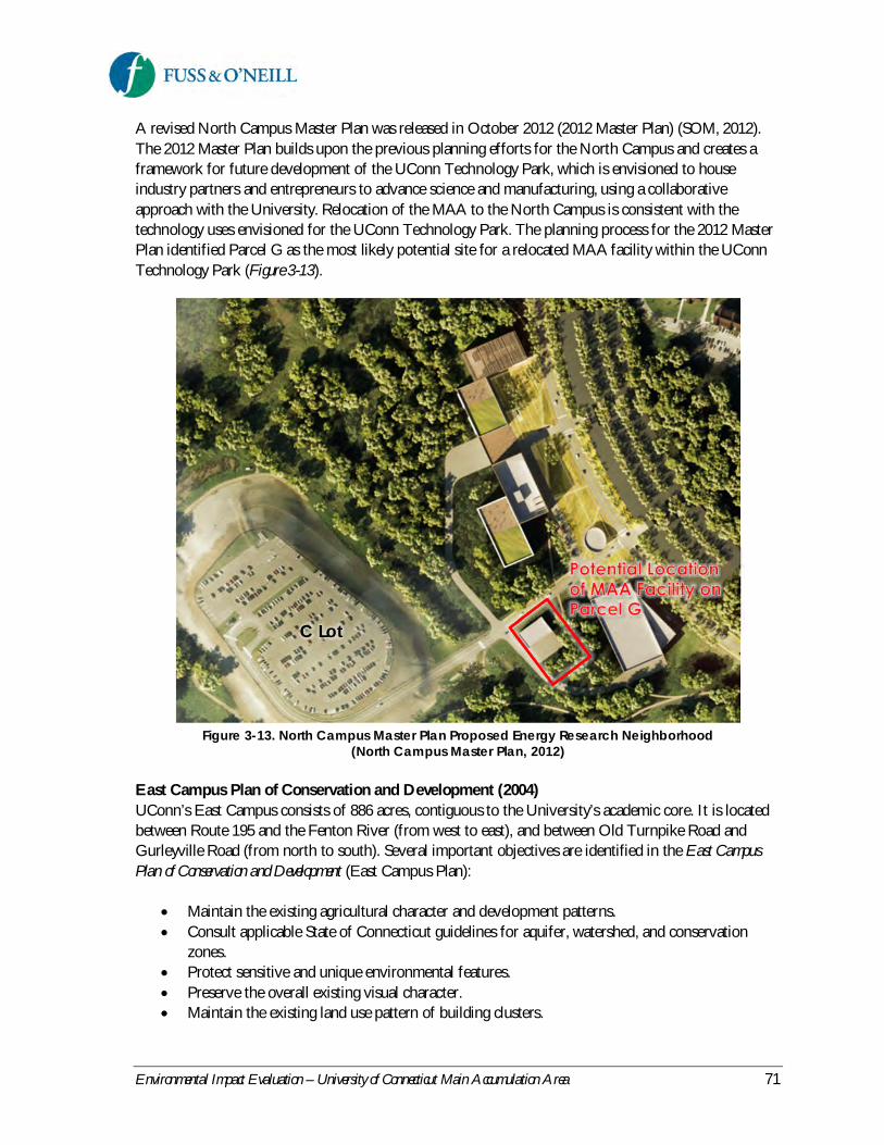
Environmental Impact Evaluation – University of Connecticut Main Accumulation Area 71
A revised North Campus Master Plan was released in October 2012 (2012 Master Plan) (SOM, 2012).The 2012 Master Plan builds upon the previous planning efforts for the North Campus and creates aframework for future development of the UConn Technology Park, which is envisioned to houseindustry partners and entrepreneurs to advance science and manufacturing, using a collaborativeapproach with the University. Relocation of the MAA to the North Campus is consistent with thetechnology uses envisioned for the UConn Technology Park. The planning process for the 2012 MasterPlan identified Parcel G as the most likely potential site for a relocated MAA facility within the UConnTechnology Park (Figure 3-13).
Figure 3-13. North Campus Master Plan Proposed Energy Research Neighborhood(North Campus Master Plan, 2012)
East Campus Plan of Conservation and Development (2004)UConn’s East Campus consists of 886 acres, contiguous to the University’s academic core. It is locatedbetween Route 195 and the Fenton River (from west to east), and between Old Turnpike Road andGurleyville Road (from north to south). Several important objectives are identified in the East CampusPlan of Conservation and Development (East Campus Plan):
Maintain the existing agricultural character and development patterns.Consult applicable State of Connecticut guidelines for aquifer, watershed, and conservationzones.Protect sensitive and unique environmental features.Preserve the overall existing visual character.Maintain the existing land use pattern of building clusters.
C Lot

Environmental Impact Evaluation – University of Connecticut Main Accumulation Area 72
Locate future growth and expansion in areas where development, utilities, and vehicular accessalready occur.
The existing MAA is located on the East Campus in the Biobehavioral Sciences Complex, whichconsists of approximately 25 acres of agriculture-related development, agriculture-related researchbuildings, assorted outbuildings, and barns. Many of these buildings are either temporary in theirconstruction methods, trailers, and/or are in poor condition.
According to the East Campus Plan, the Biobehavioral Sciences Complex area should continue to retain,replace, and expand existing University-related agriculture research and education uses. The planidentifies several conservation objectives, including the consultation of applicable state guidelines foraquifer, watershed, and conservation zones. The East Campus Plan also recommends possibly relocatingthe existing MAA. The Proposed Action is consistent with these East Campus Plan objectives andrecommendations.
3.15.4 State Conservation andDevelopment Plan
The state-wide land use conservation and development plan, Conservation and Development Policies: The Planfor Connecticut, 2013-2018 (State C&D Plan), provides the policy and planning framework foradministrative and programmatic actions and capital and operational investment decisions for stategovernment (OPM, 2013). It outlines broad-based growth management principles designed to encouragesustainable development that balance human needs with conservation of environmental andsocioeconomic resources. The State C&D Plan reflects a desire to avoid land use trends that encouragesprawl and the subsequent disproportionate consumption of land and resources that results. The Planuses growth management principles to encourage the revitalization of areas with existing infrastructureand capacity to support growth and the development of currently undeveloped areas that is consistentwith long-term sustainability of the state’s resources.
The Locational Guide Map (LGM) spatially interprets the growth management principles contained inthe Plan, with respect to each area’s potential to fulfill and to balance the conservation and developmentpriorities of the state. The LGM is used with the State C&D Plan to provide a basis for state agencies toevaluate funding decisions for projects that are considered “growth-related” as defined in sectionConnecticut General Statutes (C.G.S.) 16a-35c. The major categories of the LGM are:
Priority Funding Areas – areas classified by areas that include Urban Area or Urban Cluster(based on the 2010 Census), boundaries that intersect a ½ mile buffer surrounding existing orplanned mass-transit stations, existing or planned sewer service and/or water service, and localbus service.Balanced Priority Funding Areas – areas that meet the criteria of both Priority FundingAreas and Conservation Areas.Village Priority Funding Areas – traditional village centers located in the state’s more ruralmunicipalities, intended to recognize the unique characteristics and needs of these areas.

Environmental Impact Evaluation – University of Connecticut Main Accumulation Area 73
Conservation Areas – include core forest areas, existing or potential drinking water supplywatersheds, Aquifer Protection Areas, wetland soils, agricultural soils, Hurricane InundationZones or 100 year Flood Zones, Critical Habitats, and locally important conservation areas.Undesignated Areas – typically rural in nature and lack the criteria necessary for beingdelineated as either Priority Funding Areas or Conservation Areas.
According to the State C&D Plan’s LGM, the existing MAA is located within a Balanced PriorityFunding Area since the site is located within a water supply watershed and due to the existing availabilityof water and sewer services. The goal for Balanced Priority Funding Areas is a balanced consideration offactors in determining the extent to which it is consistent with the policies of the State C&D Plan.Although the existing MAA has been operated safely since it was established in 1989, the location of thesite within a public drinking water supply watershed is inconsistent with the State C&D Plan’s growthmanagement principle to protect and ensure the integrity of environmental assets critical to public healthand safety, including ensuring a safe and adequate drinking water supply.
The North Campus Parcel G site is also located within a Balanced Priority Funding Area since the areais classified as an Urban Area or Urban Cluster (based on the 2010 Census); has existing sewer service,water service, and local bus service; and has environmental sensitivity due to the presence of naturalresources on portions of the North Campus. However, the site is located outside of a public drinkingwater supply watershed. The Proposed Action is consistent with the growth management principles ofthe State C&D Plan.
3.16 Construction Impacts
The Proposed Action could result in temporary impacts associated with construction of a new MAA onthe North Campus Parcel G site and closure of the existing MAA. Potential construction-period impactsare related to traffic, hazardous materials, solid waste, air quality, noise, and stormwater. Measures will beimplemented during construction to avoid or minimize potential impacts. Such measures will beincorporated as requirements in the construction specifications or as best management practices (BMPs).In addition, contractors will be required to follow the measures outlined in the UConn Environmental,Health, and Safety Policies, Regulations, and Rules for Construction, Service, and Maintenance Contractors manual(UConn, 2012).
TrafficConstruction of the proposed MAA may result in traffic disruption along North Hillside Road in thevicinity of the C Lot driveway entrance and along the C Lot driveway due to lane closures and/orconstruction vehicles accessing the site. There may also be short-term traffic impacts in the vicinity ofthe existing MAA along Horsebarn Hill Road associated with removal and/or demolition of the existingstructures. These impacts would be short-term, lasting only during construction. Significant project-related traffic disruptions are not anticipated. However, potential traffic-related construction impactswould be mitigated by implementing appropriate traffic management measures, which would maintainefficient traffic operations during the construction period. These measures may include constructionphasing to minimize disruptions to traffic, signage, detours, and police officers to direct traffic and assistwith pedestrian street crossings as needed.
Environmental Impact Evaluation – University of Connecticut Main Accumulation Area 74
Air QualityPotential construction-related air quality impacts are associated with the use of diesel-poweredconstruction vehicles. Emissions from diesel equipment include carbon monoxide, hydrocarbons,nitrogen oxides, and particulate matter (PM10 and PM2.5). Emissions from construction equipment areanticipated to be significantly less than the total emissions from other industrial and transportationsources in the region, and therefore, are expected to be insignificant with respect to compliance with theNAAQS. However, potentially localized air quality impacts could occur as a result of diesel exhaustsfrom construction equipment in the vicinity of the project site.
Potential air quality impacts from diesel exhausts would be avoided or limited by proper operation andmaintenance of construction equipment, and prohibition of excessive idling of engines. Section 22a-174-18(b)(3)(C) of the Regulations of Connecticut State Agencies limits the idling of mobile sources to threeminutes. Contractors will be responsible for maintaining construction equipment and compliance withthe air pollution control measures in the University's Environmental, Health, and Safety Policies, Regulations,and Rules for Construction, Service, and Maintenance Contractors manual.
Fugitive dust emissions can occur during ground excavation, material handling and storage, movementof equipment, and transport of material to and from the project site. The potential for fugitive dustemissions is the greatest during periods of intense construction activity and during windy and/or dryweather conditions. Potential air quality impacts from fugitive dust would be addressed through a varietyof mitigation measures incorporated into contract specifications for the project, including:
Reducing exposed erodible earth area to the extent possible through appropriate constructionphasing.Stabilizing exposed earth with grass, pavement, or other cover as early as possible.Application of stabilizing agent (i.e., calcium chloride, water) to the work areas and haul roads.Covering, shielding, or stabilizing stockpiled material as necessary.Use of covered haul trucks.Limiting dust-producing construction activities during high wind conditions.Rinsing of construction equipment with water or any other equivalent method to minimizedrag-out of sediment by construction equipment onto the adjacent roads.Street sweeping of roads within construction areas.
NoiseConstruction activities are a potential source of short-term noise impacts. It is difficult to reliably predictthe sound levels that may occur at a particular receptor or group of receptors as a result of constructionactivity. Heavy construction equipment is the principal source of noise during construction activity, andthe pattern of heavy equipment use is constantly changing during construction. For the most part,construction activity would occur during daytime hours when higher sound levels are generally moretolerable at nearby receptors, and there is only limited residential land use in the project area. In addition,any adverse noise impacts due to construction activities would be temporary in nature, and no singlereceptor is expected to be exposed to high sound levels due to construction for an extended period oftime.

Environmental Impact Evaluation – University of Connecticut Main Accumulation Area 75
Construction noise is exempt from Connecticut’s Noise Regulations contained in section 22a-69-1through 22a-69-7.4 of the RCSA. However, in compliance with the UConn contractor guidancediscussed above, contractors at the University are required to comply with OSHA’s Noise Standard, 29CFR 1910.95 and CT DEEP’s regulations on the Control of Noise, 22a-69-1 through 7. Contractorswould be asked to cease work activities when noise levels to UConn employees or students are expectedto meet or exceed OSHA’s Action Level of 85 dBA (8-hour TWA). Activities would be allowed toresume when engineering or work practice controls reduce the level of noise below OSHArequirements. Should this not be feasible, work must be scheduled for a time when UConn employees,students and town residents are not impacted. Additional project-specific noise reduction measures orrestrictions may also be required to minimize disruption to teaching and learning activities.
StormwaterConstruction activity is a potential source of stormwater and water quality impacts from erosion andsedimentation. The construction phase of the project would be subject to the CTDEEP General Permit forthe Discharge of Stormwater and Dewatering Wastewater Associated with Construction Activity if the area of sitedisturbance exceeds 1 acre. Construction activities shall also comply with the Connecticut Guidelines forErosion and Sedimentation Control, as amended. Erosion and sedimentation control measures will beimplemented for the construction of a new MAA on the North Campus Parcel G site and for theremoval/demolition of the structures at the existing MAA during closure of the existing facility. Theproposed controls may include protection of existing storm drains, temporary vegetative cover,perimeter sediment barriers such as silt fence, straw bales, and coir logs, temporary sediment basins, andanti-tracking pads at construction entrances.
Hazardous MaterialsConstruction of the proposed MAA on Parcel G may result in the temporary on-site storage of fuel,petroleum, oil, or other similar materials associated with construction vehicles and equipment. Closureof the existing MAA also has the potential to generate Connecticut regulated and RCRA hazardouswaste potentially including asbestos-containing materials, lead-based paint or other hazardous materials.Contractors will be required to store and dispose of such materials in accordance with applicable stateand federal requirements and regulations. Contractors will be required to comply with requirements forconstruction-related hazardous materials in UConn Environmental, Health, and Safety Policies, Regulations, andRules for Construction, Service, and Maintenance Contractors. Reference to such requirements will be included inthe contract documents.
The University requires that an asbestos inspection be performed by a licensed and certified asbestosinspector prior to any renovation or demolition activities, including installation or repair work. Althoughnot anticipated, any necessary asbestos abatement would comply with applicable state and federalregulations. Additionally, testing of paint on existing MAA structures will be conducted by a CTDPHcertified inspector prior to removal or demolition of the structures. If lead-based or lead-containingpaint is identified, work will be performed using lead-safe work practices and by workers withappropriate OSHA training. Hazardous waste, asbestos, lead-based or lead-containing paint or lead-contaminated soil discovered during construction activities will be appropriately characterized anddisposed of in accordance with applicable state and federal regulations.

Environmental Impact Evaluation – University of Connecticut Main Accumulation Area 76
CTDEEP has prepared a draft guidance document (CTDEEP, 2005a) for the closure of facilities thatstore RCRA hazardous wastes for less than 90 days in accordance with Section 22a-449(c)-102(a)(2)(K)of the Regulations of Connecticut State Agencies, incorporating 40 CFR 265.111, 40 CFR 265.113(a), (b)and (c), and 40 CFR 265.114. The guidance outlines the following steps for closure of such facilities:
1. Characterize any residual contamination by developing a list of constituents of concern (COCs)– a list of all hazardous constituents that were ever stored at the facility.
2. Determine if structures and/or soils are contaminated.3. Determine the extent of contamination in soils that needs to be cleaned up (as applicable).4. Decontaminate or remove and dispose of all contaminated equipment, structures and soils
measured to be in excess of the media closure criteria.5. Verify that the cleanup is complete by sampling in accordance with the Sampling and Analysis
Guidance included in the guidance document6. Backfill all excavations with compacted clean soil.
Following removal or waste stored at the facility, UConn will adhere to the CTDEEP guidance forclosure and decommissioning of the existing MAA, including removal of the existing structures andequipment, site characterization for any residual contamination, and associated cleanup. The Universitywill also follow applicable closure and decommissioning requirements of the Nuclear RegulatoryCommission.
Solid and Regulated WasteLand clearing debris from the site preparation at Parcel G and waste other than clean fill (natural soil,rock, brick, ceramics, concrete and asphalt paving fragments) resulting from the removal or demolitionof structures at the existing MAA will be recycled, reused, and/or disposed of at a permitted landfill orother solid waste facility in accordance with applicable regulatory requirements and the University policyregarding waste recycling by contractors. The University's Environmental, Health, and Safety Policies,Regulations, and Rules for Construction, Service, and Maintenance Contractors manual outlines the University’spolicy for contractor recycling, including materials that must be recycled, collection and disposal of solidwaste, and proper treatment or disposal of hazardous and regulated waste.
No contamination is believed to be present on the North Campus Parcel G site. Therefore, generationand disposal of hazardous or toxic substances (i.e., contaminated soil or groundwater) is not anticipatedas a result of site clearing, demolition, and/or construction activities. Hazardous materials or subsurfacecontamination encountered during construction will be characterized and disposed of in accordancewith applicable state and federal regulations.

Environmental Impact Evaluation – University of Connecticut Main Accumulation Area 77
4 Summary of ImpactsBased upon the findings presented in Section 3, Existing Environment and Analysis of Impacts, this sectionsummarizes unavoidable adverse impacts associated with the proposed project, irreversible andirretrievable commitments of resources, and mitigation measures to reduce or minimize potentialimpacts associated with the Proposed Action.
4.1 Unavoidable Adverse Impacts
The preceding sections of this EIE have analyzed the potential for “significant effects” (i.e., substantialadverse impacts on the environment) associated with the Proposed Action. Anticipated minor impactsassociated with the Proposed Action are summarized in Table 4-1. Design elements and bestmanagement practices would be incorporated into the Proposed Action, as described in Sections 1 and 3,to avoid, minimize, or mitigate potential impacts. The only unavoidable adverse impacts anticipated withthe Proposed Action are related to the construction phase of the project. Construction-related impactsto traffic, air quality, noise, hazardous materials, solid waste, and stormwater are unavoidable but aretemporary in nature and will be mitigated through the use of best management practices duringconstruction (see Section 3.16 and Section 4.4).
4.2 Irreversible and IrretrievableCommitments of Resources
Irreversible and irretrievable commitment of resources associated with the Proposed Action consist ofresources that remain committed to a project through its lifespan (i.e., irreversible commitment) or thosethat are consumed or permanently impacted during project construction and operation as a result of theProposed Action (i.e., irretrievable commitment).
Irreversible and irretrievable resources that would be committed to the Proposed Action include energy(electric and natural gas), construction materials, land, human labor, and finances:
Energy – Energy will be consumed for project construction, and operation of the proposedfacility may require more energy than is currently used at the existing MAA.Construction Materials – A variety of construction materials will be utilized to construct theproposed building and site features. Some materials used in the construction of a new MAA anddecommissioning of the existing facility may be reused or recycled.Land – The land on the Parcel G site will be developed, and commitment of the site to this usewill preclude the possibility of other uses in the foreseeable future. Note that regardless of thelocation of the MAA, future development of Parcel G is anticipated as part of the future UConnTechnology Park.Human Labor – The dedication of human labor to the construction and operational phases ofthe project represents an irretrievable expenditure of time and production that cannot be usedfor other purposes.Financial – The expenditures required represent funds that, once committed, are no longeravailable for other purposes and once spent, cannot be regained.

Environmental Impact Evaluation – University of Connecticut Main Accumulation Area 78
4.3 Indirect and Cumulative Impacts
CEPA requires that the sponsoring agency consider the indirect or secondary impacts and cumulativeimpacts of its actions. Secondary or indirect impacts are effects of an action that are removed in time ordistance from the action itself. Cumulative impacts are those that result from the incremental impact of aproposed action when added to other past, present or reasonably foreseeable future actions of theagency (i.e., UConn).
Indirect ImpactsThere are two possible types of secondary or indirect effects – induced growth (or growth influencing)and encroachment-alteration. The University anticipates increases in waste generation associated withanticipated increases in student enrollment and planned research growth on the Storrs campus. Theincrease in waste generation is anticipated to occur regardless of the location or design of the MAA;therefore, no induced growth impacts are anticipated as a result of the Proposed Action.
Relocating the MAA to the Parcel G site will have the indirect effect of redistributing existing trafficassociated with EH&S and commercial waste transport vehicles traveling to and from the MAA. Minorincreases in traffic could occur in some areas due to this redistribution, in addition to the potential fortruck/pedestrian conflicts along waste shipment routes. However, given these minor changes comparedto the No Action alternative, no significant indirect impacts to traffic or circulation are anticipated.Restrictions on the timing of waste shipments and allowable truck routes (e.g., Route 44, Storrs Roadand North Hillside Road) are recommended to avoid periods and locations of high pedestrian activity oncampus. Such restrictions will also minimize potential impacts associated with potential increases inwaste transport traffic on the campus due to anticipated increases in student enrollment and plannedresearch growth at the University.
Indirect or secondary effects associated with encroachment-alteration can result in long-termdegradation to a resource. The proposed project site is not located in an area of sensitive naturalresources (e.g., wetlands, watercourses, threatened or endangered species), nor is the project anticipatedto significantly affect the transportation or utility infrastructure in the area. Therefore, no adverseindirect effects associated with encroachment-alteration are anticipated as a result of the ProposedAction.
Cumulative ImpactsPotential cumulative impacts can occur to those resources for which direct or indirect impacts from theProposed Action are anticipated. Cumulative impacts of the development of Parcel G were identified aspart of the North Hillside Road Extension FEIS (FHWA, 2011), which included analysis of impacts dueto the roadway extension and also the development of the North Campus parcels.
Based on the analysis in Section 3 of the subject EIE, the Proposed Action has the potential forcumulative impacts to cultural resources since Parcel G contains potential areas of prehistoric value, asidentified in the FEIS. Additional archaeological investigations are necessary prior to development ofParcel G, in addition to Parcels A, C, J, and E (see Figure 2-1 for parcel locations), to determine ifcultural resources are present and if development activities could impact identified cultural resources.Further archaeological surveys may also be required prior to development of Parcel H since the limits of
Environmental Impact Evaluation – University of Connecticut Main Accumulation Area 79
previous archaeological studies did not fully encompass the boundaries of this parcel. Parcel F containstwo state-listed historic structures. The conceptual North Campus development plan calls for thosestructures to remain, so no impact to historic resources is anticipated. The University will coordinatewith the State Historic Preservation Office (SHPO) and appropriate Tribal Historic PreservationOfficers (THPOs) to ensure that historic, archaeological, and cultural resources are protected prior todevelopment of Parcel G and other North Campus development parcels.
Minor increases in traffic associated with UConn and commercial waste transport vehicles areanticipated in the future, regardless of the location of the MAA, given planned research growth at theUniversity. Considering the location of the Parcel G site between existing waste generators on the maincampus and potential waste generators at the future UConn Technology Park on the North Campus, theProposed Action will help offset potential impacts associated with these minor increases by reducing thefrequency of off-site waste shipments, providing direct access to the technology park from NorthHillside Road, reducing waste vehicle trips along North Eagleville Road, and increasing the overallefficiency of internal waste deliveries.
Other resources are likely to experience minor increased use or consumption, but the impact analysis inSection 3 does not indicate significant adverse effects to those resources under the Proposed Action.Therefore, cumulative impacts are not anticipated.
4.4 Summary of Impacts andMitigation Measures
Mitigation measures have been identified to reduce or offset potential adverse impacts associated withthe proposed project. These are summarized in Table 4-1 by resource category as described in Section 3 ofthis EIE. For resource categories for which no mitigation is proposed, the impact evaluation hasdetermined that either the impacts are insignificant, requiring no mitigation, or that there will be noadverse impacts resulting from the proposed project.

Environmental Impact Evaluation – University of Connecticut Main Accumulation Area 80
Table 4-1. Summary of Impacts and Proposed Mitigation
Resource Category Impacts Proposed MitigationTraffic, Parking, andCirculation
Improved vehicle circulation,maneuverability, parking, andaccess/egress compared to thatof the existing facilityMinor increases in traffic andpotential for truck/pedestrianconflicts along waste shipmentroutes resulting fromredistribution of existing trafficassociated with EH&S andcommercial waste transportvehicles traveling to and fromthe MAALarger, state-of-the art facilitywith greater waste storagecapacity will address existing andfuture waste generation oncampus, resulting in lessfrequent waste shipments fromthe MAA, less commercial wastetransport vehicle traffic andpotential for vehicle/pedestrianconflicts, and less frequenthandling of wastes compared toNo Action alternative
Restrictions on the timing of wasteshipments and allowable truck routes toavoid periods and locations of highpedestrian activity on campus
Air Quality No adverse impacts None requiredNoise No adverse impacts None requiredWater Resources No adverse impacts to surface
water and groundwater quality orquantityNo adverse impacts to floodhazard potentialIncrease in stormwater runoffand potential stormwaterpollutant loading
Proposed stormwater management andfacility design elements will reduce thepotential for impacts associated with a releaseof chemicals or other hazardous materials tothe environment (see Utilities and Services)
Wetlands andWatercourses
No adverse impacts Proposed stormwater management andfacility design elements will reduce thepotential for impacts associated with a releaseof chemicals or other hazardous materials tothe environment (see Utilities and Services)
Wildlife and Vegetation No adverse impactsLoss of approximately 0.75 acresof fragmented upland foresthabitat
Proposed stormwater management andfacility design elements will reduce thepotential for impacts associated with a releaseof chemicals or other hazardous materials tothe environment (see Utilities and Services)

Environmental Impact Evaluation – University of Connecticut Main Accumulation Area 81
Table 4-1. Summary of Impacts and Proposed Mitigation
Resource Category Impacts Proposed MitigationCultural Resources Parcel G contains potential areas
of prehistoric valueAdditional cultural resource investigation ofParcel G (Phase 1B ArchaeologicalReconnaissance Survey) prior todevelopment and coordinate with the StateHistoric Preservation Office (SHPO) and theTribal Historic Preservation Officers(THPOs) of the Mashantucket Pequot andMohegan Tribes to ensure that historic,archaeological, and cultural resources areprotected
Visual and AestheticCharacter
No adverse impacts None required
Geology, Topography, andSoils
No adverse impacts Proposed facility design elements will reducethe potential for subsurface impactsassociated with a release of chemicals orother hazardous materials to the environment(see Hazardous Materials)
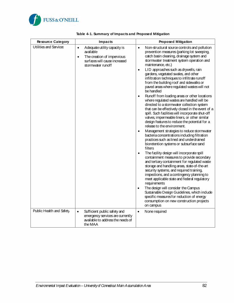
Environmental Impact Evaluation – University of Connecticut Main Accumulation Area 82
Table 4-1. Summary of Impacts and Proposed Mitigation
Resource Category Impacts Proposed MitigationUtilities and Services Adequate utility capacity is
availableThe creation of impervioussurfaces will cause increasedstormwater runoff
Non-structural source controls and pollutionprevention measures (parking lot sweeping,catch basin cleaning, drainage system andstormwater treatment system operation andmaintenance, etc.)LID approaches such as drywells, raingardens, vegetated swales, and otherinfiltration techniques to infiltrate runofffrom the building roof and sidewalks orpaved areas where regulated wastes will notbe handledRunoff from loading areas or other locationswhere regulated wastes are handled will bedirected to a stormwater collection systemthat can be effectively closed in the event of aspill. Such facilities will incorporate shut-offvalves, impermeable liners, or other similardesign features to reduce the potential for arelease to the environment.Management strategies to reduce stormwaterbacteria concentrations including filtrationpractices such as lined and underdrainedbioretention systems or subsurface sandfiltersThe facility design will incorporate spillcontainment measures to provide secondaryand tertiary containment for regulated wastestorage and handling areas, state-of-the-artsecurity systems, and required training,inspections, and a contingency planning tomeet applicable state and federal regulatoryrequirementsThe design will consider the CampusSustainable Design Guidelines, which includespecific measures for reduction of energyconsumption on new construction projectson campus
Public Health and Safety Sufficient public safety andemergency services are currentlyavailable to address the needs ofthe MAA
None required

Environmental Impact Evaluation – University of Connecticut Main Accumulation Area 83
Table 4-1. Summary of Impacts and Proposed Mitigation
Resource Category Impacts Proposed MitigationHazardous Materials Larger, state-of-the art facility
with greater waste storagecapacity will address existing andfuture waste generation oncampus, resulting in lessfrequent waste shipments fromthe MAA, less commercial wastetransport vehicle traffic andpotential for vehicle/pedestrianconflicts, and less frequenthandling of wastes compared toNo Action alternativeNo adverse impacts related totoxic or hazardous waste sites
Facility design and operation will incorporatesecondary and tertiary spill containment forregulated waste storage and handling areas,state-of-the-art security systems, requiredtraining and inspections, and contingencyplanning to meet applicable state and federalregulatory requirements for safe operation ofthe facility.Use of “green chemistry” techniques andwaste minimization at the point of generationwill reduce or offset anticipated futureincreases in waste generation on campus.
Socioeconomics No adverse impactsCreation of short-termconstruction jobs
None required
Land Use and Planning No adverse impacts - ProposedAction is consistent with existingland use and campus, local,regional, and state land use plans
None required
Construction PeriodTraffic, Parking, andCirculation
Minor, temporary disruptions totraffic in the immediate area ofconstruction
Use of construction-phase trafficmanagement measures to maintain efficienttraffic operations during the constructionperiod including construction phasing tominimize disruptions to traffic, signage, anddetours.
Air Quality Construction activities mayresult in short-term impacts toambient air quality due to directemissions from constructionequipment and fugitive dustemissions
Contractors will be required to comply withair pollution control requirements in UConnEnvironmental, Health, and Safety Policies,Regulations, and Rules for Construction, Service, andMaintenance Contractors, including reference tosuch requirements in contract documents.Ensure proper operation and maintenance ofconstruction equipment.Limit idling of construction vehicles andequipment to three minutes.Implement traffic management measuresduring construction.Implement appropriate controls to preventthe generation and mobilization of dust.

Environmental Impact Evaluation – University of Connecticut Main Accumulation Area 84
Table 4-1. Summary of Impacts and Proposed Mitigation
Resource Category Impacts Proposed MitigationNoise Heavy construction equipment
associated with site developmentmay result in temporaryincreases in noise levels in theimmediate area of construction
Contractors will be required to comply withnoise control requirements in UConnEnvironmental, Health, and Safety Policies,Regulations, and Rules for Construction, Service, andMaintenance Contractors, including reference tosuch requirements in contract documents.Ensure proper operation and maintenance ofconstruction equipment.Construction contractors should make everyreasonable effort to limit construction noiseimpacts.
Stormwater and WaterQuality
Exposure of soil increasespotential for erosion andsedimentation
Use of appropriate erosion and sedimentcontrols during construction, consistent withthe 2002 Connecticut Guidelines for Soil Erosionand Sediment Control, as amended.
Hazardous Materials andSolid Waste
Temporary on-site storage anduse of fuels and other materialsassociated with constructionvehicles and equipmentAsbestos-containing materials,lead-based paint or otherhazardous materials associatedwith closure of the existing MAAfacilityGeneration of solid wasteincluding construction anddemolition debris
Contractors will be required to comply withrequirements for construction-relatedhazardous materials and solid waste inUConn Environmental, Health, and SafetyPolicies, Regulations, and Rules for Construction,Service, and Maintenance Contractors, includingreference to such requirements in contractdocuments.Hazardous or regulated materials orsubsurface contamination encountered duringconstruction will be characterized anddisposed of in accordance with applicablestate and federal regulations.UConn will follow CTDEEP guidance forclosure and decommissioning of the existingMAA, including removal of the existingstructures and equipment, sitecharacterization for any residualcontamination, and associated cleanup.UConn will also follow applicable closureand decommissioning requirements of theNuclear Regulatory Commission.Construction-related solid waste will behandled and disposed of in a manner thatmeets current regulations and Universitystandards. Construction and demolitiondebris will be managed in accordance withapplicable state and federal regulations andthe University’s contractor policies.

Environmental Impact Evaluation – University of Connecticut Main Accumulation Area 85
5 Costs and BenefitsShort-term and long-term economic, social, and environmental costs and benefits are summarized in thissection for the No Action alternative and the Proposed Action. Costs and benefits associated with aproject may be both quantifiable (tangible) and non-quantifiable (intangible).
CostsThe No Action alternative would result in no short-term increase in costs since the facility operations atthe existing MAA would remain unchanged. However, waste generation on the UConn campus isanticipated to increase based on anticipated growth in undergraduate enrollment and planned researchgrowth at the University. The existing MAA is not adequately sized to meet the projected future wastestorage demands without increasing the frequency of waste removal from the MAA (i.e., greater thanmonthly for chemical waste and greater than weekly or bi-weekly for biological waste), which wouldresult in increased operational costs.
Construction of a new MAA on the North Campus Parcel G site is estimated to cost between $3 millionand $5 million, which is based on a detailed cost estimate for the proposed MAA building prepared byEarthTech in 2007. The 2007 cost estimate was adjusted to 2013 dollars and includes estimated costs forsite work, decommissioning and closure of the existing MAA, and administrative costs (insurance, legalfees, construction management, etc.). Estimated construction costs will be refined during project design.Operational costs associated with a new MAA are anticipated to be comparable to those of the existingfacility since existing EH&S staffing levels are anticipated to remain unchanged, and potential increasesin energy usage to support a larger facility will likely be offset by more modern, energy-efficient buildingsystems.
BenefitsUnder the No Action alternative, the University would avoid the capital expenditure associated withconstruction of a new MAA and closure of the existing facility. However, the No Action alternativewould not meet the basic project objective of more efficient use of space compared to that of theexisting facility and future waste generation and storage need of the Storrs campus. It also would notaddress the public concern about the location of the existing MAA within the public drinking watersupply watershed.
Construction of a new MAA on the North Campus Parcel G site would provide the neededimprovements in vehicle circulation, parking, and access/egress, and would provide the University witha state-of-the-art MAA facility on par with those of comparable research institutions for improvedpublic safety and environmental protection. A larger, modern MAA facility would also address the futurewaste management needs of the campus and avoid substantial increases in the frequency of off-sitewaste shipments, which would occur under the No Action alternative. Relocating the MAA outside ofthe public drinking water supply watershed would address the public concern about the location of theexisting MAA and would reduce the risk to public water supplies. The Proposed Action would alsocontribute to additional construction-related employment.

Environmental Impact Evaluation – University of Connecticut Main Accumulation Area 86
6 Potential Certificates, Permits, and ApprovalsTable 6-1 lists the certificates, permits, and approvals that are anticipated to be required for the ProposedAction. Additional certificates, permits, and approvals may be identified following the CEPA process,pending the final design of the project.
Table 6-1. List of Required Certificates, Permits and Approvals
Certificate/Permit/Approval Category Reviewing
Agency Comments
Flood Management Certification Stormwater CTDEEP Required for activitiesaffecting natural or man-made drainage facilities
General Permit for Discharge ofStormwater and DewateringWastewater Associated withConstruction Activities
Stormwater CTDEEP Registration required if totalsite disturbance exceeds 1acre
Coordination with the State HistoricPreservation Office (SHPO) and TribalHistoric Preservation Officers(THPOs) of the Mashantucket Pequotand Mohegan Tribes
CulturalResources
SHPO andTHPOs
Required as a mitigationcommitment in the Recordof Decision for the NorthHillside Road ExtensionEIS
Table 6-2 lists permits that have been issued or are pending for the proposed extension of North HillsideRoad and associated development of the North Campus for the UConn Technology Park, includingParcel G, the site of the Proposed Action. UConn will adhere to the applicable conditions contained inthe final permits for the North Hillside Road extension for the planning and development of the ParcelG site.
Table 6-2. Permits for the North Hillside Road Extension Project
Permit Permit Number
CTDEEP Flood Management Certification FM-201205381CTDEEP Inland Wetlands & Watercourses, WaterQuality Certification, and Water Diversion Permit
IW-201205383, WQC- 201205382,DIV- 201205385 (Draft)
United States Army Corps of Engineers Section 404Individual Permit
File No. NAE-2004-3990 (PermitPending)

Environmental Impact Evaluation – University of Connecticut Main Accumulation Area 87
7 ReferencesConnecticut Department of Energy & Environmental Protection (CTDEEP). (2005). Draft RCRAClosure Guidance for Generators Who Store Less than 90 Days Container Storage Areas and Tank Systems.<http://www.ct.gov/deep/lib/deep/waste_management_and_disposal/remediation_waste/draft_rcra_guidance_less_than_90.pdf> (August 7, 2013).
Connecticut Department of Energy & Environmental Protection (CTDEEP). (2007a). 2002 ConnecticutGuidelines for Soil Erosion and Sediment Control, DEP Bulletin 34. Errata Corrections September 2007.
Connecticut Department of Energy & Environmental Protection (CTDEEP). (2007b). A Total MaximumDaily Load Analysis for Eagleville Brook, Mansfield, CT. Final February 8, 2007.
Connecticut Department of Energy & Environmental Protection (CTDEEP). (2009). Title V OperatingPermit, The University of Connecticut, Storrs Campus, Title V Permit Number 098-0029-TV.
Connecticut Department of Energy & Environmental Protection (CTDEEP). (2011). Water QualityStandards. Surface Water Quality Standards Effective February 25, 2011; Ground Water QualityStandards Effective April 12, 1996.
Connecticut Department of Energy & Environmental Protection (CTDEEP). (2012). 2012 State ofConnecticut Integrated Water Quality Report Final – December 17, 2012.
Connecticut Department of Energy & Environmental Protection (CTDEEP) and the University ofConnecticut Center for Land Use Education and Research (CLEAR). (2013). “ConnecticutEnvironmental Conditions Online (CT ECO)” <http://www.cteco.uconn.edu> (August 19, 2013).
Connecticut Department of Energy & Environmental Protection (CTDEEP) and TerwilligerConsulting, Inc. (2005). Connecticut’s Comprehensive Wildlife Conservation Strategy.
Connecticut Department of Public Health (CTDPH). (2011). Connecticut Public Health Code Section 19-13-B100a, B103, B104. Regulations and Technical standards for Subsurface Sewage Disposal Systems.
Connecticut Department of Transportation (CTDOT). (2011a). Ozone Air Quality Conformity Determinationof the 2011 Regional Transportation Plans and the FY 2012-2015 Transportation Improvement Programs for theConnecticut portion of the New York-Northern New Jersey-Long Island, NY-NJ-CT Ozone Nonattainment Area andthe Greater Connecticut Ozone Nonattainment Area– November 2011.
Connecticut Department of Transportation (CTDOT). (2011b). PM 2.5 Air Quality ConformityDetermination of the 2011 Regional Transportation Plans and the FY 2012-2015 Transportation ImprovementPrograms for the Connecticut portion of the NY-NJ-CT PM 2.5 Nonattainment Area - November 2011.
Connecticut Department of Transportation (CTDOT). (2012). Connecticut Department of TransportationStatewide Transportation Improvement Program (STIP), Prepared By Connecticut Department of Transportation inCooperation with the U.S. Department Of Transportation Federal Highway Administration and Federal TransitAdministration and the Regional Planning Organizations, April 2012.
Environmental Impact Evaluation – University of Connecticut Main Accumulation Area 88
Connecticut Department of Transportation (CTDOT). (2013). “Connecticut Scenic Roads.”<http://www.ct.gov/dot/cwp/view.asp?a=2094&q=305520> (August 7, 2013).
Dietz, M. E. and Arnold, C. (2011). Eagleville Brook Watershed Management Plan. Center for Land UseEducation and Research University of Connecticut Cooperative Extension.
Environmental Data Resources Inc. (2013). The EDR Radius Map Report. Parcel G North Hillside RoadStorrs Mansfield, CT 06268. Inquiry Number: 3689995.1s. August 08, 2013.
Environmental Protection Agency, U.S. (EPA). (2010). 2009 Annual Report on Air Quality in New England.Office of Environmental Measurement and Evaluation, North Chelmsford, Massachusetts. ReleasedOctober 2010.
Environmental Protection Agency, U.S. (EPA). (2011). 2010 Annual Report on Air Quality in New England.Office of Environmental Measurement and Evaluation, North Chelmsford, Massachusetts. ReleasedSeptember 2011.
Environmental Protection Agency, U.S. (EPA). (2012). 2011 Annual Report on Air Quality in New England.Office of Environmental Measurement and Evaluation, North Chelmsford, Massachusetts. ReleasedSeptember 2012.
Environmental Protection Agency, U.S. (EPA). (2013). “Currently Designated Nonattainment Areas forAll Criteria Pollutants Listed by State, County then Pollutant, as of July 31, 2013.”<http://www.epa.gov/oar/oaqps/greenbk/ancl.html> (August 16, 2013).
Federal Emergency Management Agency (FEMA). (1981). Flood Insurance Rate Map, Town of Mansfield,Connecticut, Tolland Country; Panel 5 of 20, Community Panel Number 090128 0005 C. Effective Date January 2,1981.
Federal Highway Administration (FHWA). (2011). “Final Environmental Impact Statement (FEIS):North Hillside Road Extension.” Project Number: FHWA-CT-EIS-08-01-D. Prepared by Fuss &O’Neill, Inc. October 2011.
Frederic R. Harris, Inc. (2001). University of Connecticut, North Campus Master Plan, Mansfield, Connecticut -Connecticut Environmental Policy Act, Draft Environmental Impact Evaluation. February 2001.
Gast, F. (2012). University of Connecticut Planner: Presentation at Siting Advisory Committee Meeting#2 for University of Connecticut Main Accumulation Area EIE.( June 27, 2012).
Haley & Aldrich, Inc. (2013). Personal communication (email), Richard P. Standish, P.G.,LEP, LSP. July31, 2013.
JJR. (2000). Outlying Parcels Master Plan Final Report.
JJR and SmithGroup. (2004). University of Connecticut Campus Sustainable Design Guidelines.

Environmental Impact Evaluation – University of Connecticut Main Accumulation Area 89
Lavin, L. and Banks M. (2005). Phase 1B Archaeological Reconnaissance Survey of the North Hillside RoadExtension Property in Storrs, Connecticut: The North Hillside Road Site 78-187, Project #2001219a19. AmericanCultural Specialists, LLC, unpublished report.
Lavin, L. and Banks M. (2006). Phase 2 Intensive Archaeological Survey of the North Hillside Road ExtensionProperty in Storrs/Mansfield, Connecticut; The North Hillside Road Site 78-187. Final Report. American CulturalSpecialists, LLC, February 2006. Seymour, CT.
Mansfield Fire Department. (2013). “Mansfield Fire Department.” <http://www.mansfieldfirect.org>(August 12, 2013).
Milone & MacBroom, Inc. (2010). An Analysis of The Impact of the University Of Connecticut Water SupplyWells on the Fisheries Habitat of the Willimantic River.
Milone & MacBroom, Inc. (2011a). University of Connecticut Water Supply Plan.
Milone & MacBroom, Inc. (2011b). Permit Application for Wastewater Discharge Renewal of NPDES PermitCT010l320, University of Connecticut Water Pollution Control Facility, May 2011.
Milone & MacBroom, Inc. (2012). Potential Sources of Water Supply University of Connecticut Storrs, Connecticut.Connecticut Environmental Policy Act Environmental Impact Evaluation. University Project #901662.
Office of Policy and Management (OPM). (2013). Conservation & Development Policies: The Plan ForConnecticut, 2013-2018. Adopted by the Connecticut General Assembly on June 5, 2013.
Public Archaeological Survey Team, Inc. (PAST). (1987). Phase 1A Archaeological Assessment Survey.
SEA Consultants, Inc. (2004). Hazardous Waste Facility Comparative Site Study for the University of Connecticut.
Skidmore, Owings & Merrill LLP (SOM). (2012). UConn North Campus Master Plan.
Town of Mansfield. (2011). Zoning Regulations of the Town of Mansfield, Connecticut. Revised July 15, 2011.
Unites States Geological Survey (USGS). (2013). Personal communication, Carol Johnson, Hydrologistat USGS Branch of Geophysics, University of Connecticut, Storrs Mansfield, CT, August 5, 2013.
University of Connecticut. (2011). Annual Security Report. Division of Public and Environmental Safety.
University of Connecticut. (2012). Contractor EHS Manual: Environmental, Health, and Safety (EHS)Requirements for Construction, Service, and Maintenance Contractors. Revision 4; March 2012.
University of Connecticut. (2013a). “Air Compliance.”<http://www.envpolicy.uconn.edu/air.html#airemissions> (August 14, 2013).
University of Connecticut. (2013b). “Division of Environmental Health and Safety.”<http://ehs.uconn.edu/index.php> (August 6, 2013).

Environmental Impact Evaluation – University of Connecticut Main Accumulation Area 90
University of Connecticut. (2013c). “Division of Public Safety – Fire Department.”<http://fire.uconn.edu/> (August 6, 2013).
University of Connecticut. (2013d). “Division of Public Safety – Police Department.”<http://www.police.uconn.edu/overview.html> (August 6, 2013).
University of Connecticut. (2013e). UConn EH&S, personal communication, Stefan Wawzyniecki, Jr.,Chemical Health & Safety Manager, August 8, 2013.
Warner, Glenn S., Ogden, F. L., Bagtzoglou, A.C., and Parasiewicz, P. (2006). Long-Term Impact Analysisof the University of Connecticut’s Fenton River Water Supply Wells on the Habitat of the Fenton River.

Environmental Impact Evaluation – University of Connecticut Main Accumulation Area
Appendix A
Scoping Documents

Governor Dannel P. Malloy |
Home About Us Programs and Services Publications Contact Us
ENVIRONMENTALMONITOR
Current Issue
Monitor Archives
Publication Dates
What is CEPA?
CEPA Statutes
CEPA Regulations
What is Scoping?
What to Expect at aScoping Meeting
How to Request a PublicScoping Meeting
Guide to the State LandsTransfer Process
CEQ HOME
April 16, 2013
Scoping Notices
1. Runway Safety Area Project, Igor I. Sikorsky Airport, Stratford
2. NEW! Connecticut State Police Firearms Training Facility, Glastonbury
3. NEW! Library Lane and George Washington Turnpike Water Main Project, Burlington
4. NEW! UConn Main Accumulation Area, Mansfield
Post-Scoping Notices: Environmental Impact Evaluation Not Required
1. Route 69, New Haven Rd., Water Main, Prospect and Beacon Falls
2. NEW! Spring Hill Reliability Improvement Project, Norwalk and New Canaan
3. NEW! Windham Regional Transit Bus Facility Project #474-073, Mansfield
Environmental Impact Evaluations
1. Quinebaug Regional Technical Park, Putnam
2. Eastern Connecticut State University Master Plan Update, Willimantic, Mansfield
State Land Transfers
No State Land Transfer Notice has been submitted for publication in this edition.
The next edition of the Environmental Monitor will be published on May 7, 2013.
Subscribe to e-alerts to receive an e-mail when The Environmental Monitor is published.
Scoping Notices
"Scoping" is for projects in the earliest stages of planning. At the scoping stage, detailed information on aproject's design, alternatives, and environmental impacts does not yet exist. Sponsoring agencies are askingfor comments from other agencies and from the public as to the scope of alternatives and environmentalimpacts that should be considered for further study. Send your comments to the contact person listed for theproject by the date indicated.
The following Scoping Notices have been submitted for review and comment.
1. Notice of Scoping for Runway Safety Area Project, Igor I. Sikorsky MemorialAirport
Municipality where proposed project might be located: Stratford, CT
CEQ: Environmental Monitor - Current Issue http://www.ct.gov/ceq/cwp/view.asp?a=987&q=249438
1 of 9 4/18/2013 8:14 AM

Address of Project Location: Sikorsky Airport and immediate vicinity
Background:
This project was subject to previous environmental studies, including a Draft Environmental Impact Statement(DEIS)/Environmental Impact Evaluation (EIE), which led to a Final Environmental Impact Statement (FEIS)and a written re-evaluation of the EIS in 2011. These documents evaluated the project's scope, alternativesand environmental impacts. The documents were made available for public review and were the subject ofpublic hearings. The purpose of this Public Scoping notice and subsequent meeting is to satisfy theConnecticut Environmental Policy Act (CEPA) requirements for providing public opportunity to comment on theproject.
Project Description:
The Connecticut Department of Transportation (CTDOT) and the City of Bridgeport are proposing to constructimprovements to the Runway Safety Area (RSA) adjacent to Runway 24 at the Igor I. Sikorsky MemorialAirport (BDR), in Stratford, Connecticut. A partial relocation of State Route (SR) 113 is required toaccommodate the RSA improvements. These safety improvements include the construction of an EngineeredMaterial Arresting System (EMAS) beyond the Runway 24 threshold. The proposed improvements also includethe rehabilitation of existing Runway 6-24. A congressional mandate has been issued requiring completion ofthe airport safety improvements by December 2015. There will also be a reduction in flooding of Route 113,and improved stormwater management and treatment as a result of the project.
The proposed project includes the following activities within the airport proper:
Construction of an RSA that is 500 feet in width (250 feet on either side of the runway centerline) by300 feet in length, including installation of an EMAS (100 feet in width by 300 feet in length);Installation of new runway edge lights on Runway 6-24;Relocation of Runway End Identifier Lights (REILS);Construction of a new connector taxiway (35 feet in width by 300 feet in length) from Taxiway A toRunway 24 and demolition of the existing connector Taxiway D at the intersection of Runways 6-24 and11-29;Removal of the existing blast fence located adjacent to Runway 24;Installation of new Airport Security Fence;Construction of a Turn Around for Runway 6;Rehabilitation and removal of pavement (reduction in width) on Runway 6-24;Relocation of the Visual Approach Slope Indicator (VASI) and Precision Approach Path Indicator (PAPI)visual landing aids on Runways 6 and 24; andThe construction of wetland mitigation and listed species mitigation areas.
The proposed project includes the following activities within the vicinity of Route 113:
Construction of a realigned segment of Route 113 including an improved stormwater drainage systemand multi-use path (to accommodate the RSA);Relocation of all underground utilities from the existing Route 113 right-of-way to the proposed right-of-way;Closure and removal of the abandoned segment of Route 113;Delineation, removal and disposal of existing Raymark Superfund Site waste materials within the vicinityof the realigned Route 113;Construction of a new tidal channel to convey treated stormwater runoff and tidal flows;Wetland mitigation activities including restoration and enhancement areas; andCreation and enhancement of several listed species mitigation areas.
Project Maps: Click here to view a map of the project area.
Click here to view proposed construction features.
Written comments from the public are welcomed and will be accepted until the close of businesson: Thursday April 18, 2013
There will be a Public Scoping Meeting for this project at:
DATE: April 3, 2013
TIME: 7:00 pm
PLACE: Stratford Hotel and Conference Center, 225 Lordship Boulevard, Stratford, CT 06615
NOTES:The meeting location is accessible to persons with disabilities. Deaf and hearing impairedpersons wishing to attend this meeting and requiring an interpreter may make arrangements bycontacting the Department's Office of Communication at 860-594-3062 (voice only) at least five daysprior to the meeting.
Written comments should be sent to:
Name: Mr. Mark W. Alexander, Transportation Assistant Planning Director
Agency: Bureau of Policy and PlanningConnecticut Department of Transportation
CEQ: Environmental Monitor - Current Issue http://www.ct.gov/ceq/cwp/view.asp?a=987&q=249438
2 of 9 4/18/2013 8:14 AM

Address: 2800 Berlin TurnpikeNewington, CT 06131
Fax: 860-594-3028E-Mail: [email protected]
If you have questions about the public meeting, or other questions about the scoping for thisproject, contact:
Name: Mr. Richard B. Armstrong, Transportation Principal Engineer
Agency: Bureau of Engineering and ConstructionConnecticut Department of Transportation
Address: 2800 Berlin TurnpikeNewington, CT 06131
Phone: 860-594-3187E-Mail: [email protected]
2. Notice of Scoping for the Connecticut State Police Firearms Training FacilityRelocation
Municipality where proposed project might be located: Glastonbury
Address of Possible Project Location: Easterly end point of Toll Gate Road.
Project Description: The Department of Emergency Services and Public Protection (DESPP), Division of StatePolice (CSP) is proposing to relocate its existing Firearms Training Facility and Program located on Nod Road inSimsbury to a site in Glastonbury. The proposed site is generally situated along Route 2 adjacent to theDepartment of Energy and Environmental Protection’s (DEEP) Public Shooting Range, located within theMeshomasic State Forest (see project location figures). A land transfer between DESPP and DEEP would occuras part of this project. The exact parcel configuration and project layout is to be determined during design;however, the estimated maximum acreage needed for the project is approximately 30 acres with the potentialfor less.
The project proposes to maintain and improve the CSP Firearms Training Program to benefit DESPP’s criticalneeds. Other state, federal, international, and host community law enforcement agencies would also utilize thisfacility as part of the inter-relationships DESPP has with various agencies.
The following are the major facility elements associated with this relocation project:
· Approximately 55,000 gross square feet (GSF) multipurpose training building(s). This building (orcombinations of smaller buildings) would contain: classrooms to hold up to approximately 100 troopersand/or cadets; firearms simulator room; open area training room; indoor active-shooter training; guncleaning and smithing; file storage room; staff offices; firearms vault; ammunition storage vault;recruit/staff kitchen and dinning area; reloading area; target storage area; bathrooms with lockers andshowers; and a garage.
· 2 Range Control Towers (approximately 1 story high)
· 1 Qualifying Pistol Range (approximately 200 ft x 170 ft)
· 1 Active Shooter Training Range (approximately 200 ft x 170 ft)
· 1 Rifle Range (approximately 300 yd x 50 yd)
· 1 Shotgun Rifle Range (approximately 100 yd x 30 yd)
· Approximately 125 parking spaces
· Well and septic systems, telecom, and electrical utilities
Project Maps: Click here to view a figure of the general project location and click here to view an aerial ofthe project site.
Written comments from the public are welcomed and will be accepted until the close of businesson: May 16, 2013.
There will be a Public Scoping Meeting for this project at:
DATE: Thursday, May 9, 2013
TIME: 7:00 PM
CEQ: Environmental Monitor - Current Issue http://www.ct.gov/ceq/cwp/view.asp?a=987&q=249438
3 of 9 4/18/2013 8:14 AM
PLACE: Town Hall-Council Chambers, 2155 Main Street, Glastonbury, CT
NOTES: Doors open at 6:30 PM; meeting starts at 7:00 PM and will conclude after public comments.
On Behalf of DESPP, written comments are to be sent to the following participating agency contact:
Name: Jeff Bolton, Supervising Environmental AnalystAgency: Department of Construction Services
Address: 165 Capitol Avenue, Room 482Hartford, Connecticut 06106
Fax: (860) 713-7250E-Mail: [email protected]
If you have questions about the public meeting, or other questions about the scoping for thisproject, contact:
Name: Lt. J. Paul Vance, Public Information OfficerAgency: Department of Emergency Services and Public
Protection & the Connecticut State PoliceAddress: 1111 Country Club Road
Middletown, Connecticut 06457
Phone: (860) 685-8230Fax: (860) 685-8301E-Mail: [email protected]
The agency expects to release an Environmental Impact Evaluation for this project, for publicreview and comment, in August 2013.
Other information:What is Scoping? (CEQ Website)What to Expect at a Scoping Meeting (CEQ Website)What is CEPA? (OPM Website)
3. Notice of Scoping for Library Lane and George Washington Turnpike Water MainProject STEAP Grant
Municipality where proposed project might be located: Burlington
Address of Possible Project Location: Library Lane and George Washington Turnpike
Project Description: The purpose of this project is to install two segments of 8 inch ductile iron water main:from the intersection of Route 4 and Library Lane 900 feet north along Library Lane, and on GeorgeWashington Turnpike from the intersection with Thompsons Way approximately 900’ southeast to theintersection with Cornwall Road. This project has been awarded a STEAP grant and will provide water supply tobusinesses within Burlington’s central business zone. The Torrington Water Company will provide the watersupply, oversee this project and will own and maintain this extension when the project is completed.
Project Map: Click here to view a map of the project area.
Written comments from the public are welcomed and will be accepted until the close of businesson: Friday May 17, 2013
Any person can ask the sponsoring agency to hold a Public Scoping Meeting by sending such arequest to the address below. If a meeting is requested by 25 or more individuals, or byan association that represents 25 or more members, the sponsoring agency shall schedule a PublicScoping Meeting. Such requests must be made by April 26, 2013.
Written comments and/or requests for a Public Scoping Meeting should be sent to:
Name: Mr. Eric McPhee
Agency: Department of Public HealthDrinking Water Section
Address: 410 Capitol Avenue, MS #51WATPO Box 340308Hartford, CT 06134-0308
Fax: 860-509-7359
CEQ: Environmental Monitor - Current Issue http://www.ct.gov/ceq/cwp/view.asp?a=987&q=249438
4 of 9 4/18/2013 8:14 AM

E-Mail: [email protected]
If you have questions about the public meeting, or other questions about the scoping for thisproject, contact:
Name: Ms. Sara Rossetti-Nichols
Agency: Department of Public HealthDrinking Water Section
Address: 410 Capitol Avenue, MS #51WATPO Box 340308Hartford, CT 06134-0308
Phone: 860-509-7333Fax: 860-509-7359
E-Mail: Sara [email protected]
4. Notice of Scoping for UConn Main Accumulation Area
Municipality where proposed project might be located: Mansfield
Address of Possible Project Location: UConn North Campus Parcel G Site located between the existingNorth Hillside Road and C Lot on the University of Connecticut Storrs Campus, Mansfield, Connecticut
Project Description: UConn proposes to construct a new centralized facility for the temporary storage ofchemical, biological/medical, and low-level radioactive wastes from the University’s academic research andteaching laboratories and facility operations on the Storrs campus. The University’s existing facility, known asthe Main Accumulation Area (MAA), is located within the Fenton River watershed and the drainage basin of theWillimantic Reservoir, which is a public water supply. Although the facility has been operated safely since itwas established in 1989, the University recognizes the public concern that remains about the location of thefacility within the public water supply watershed.
The existing MAA facility, which is currently located on Horsebarn Hill Road, is sufficient to serve the currentneeds of the University and meets or exceeds state and federal requirements for safety and environmentalprotection. To protect public health and the environment and to ensure regulatory compliance, these wastesare managed by the UConn Department of Environmental Health & Safety (EH&S) in compliance with local,state, and federal regulations, as well as University health and safety policies and procedures. However, spaceon the existing site is limited, resulting in poor circulation for waste transport vehicles, its design isinconsistent with state-of-the-art MAA facilities at other comparable research institutions, and the facility willlikely not meet future needs based on planned research growth at the University.
To address these concerns, UConn convened an Advisory Committee consisting of representatives from theTown of Mansfield, Windham Water Works, local watershed organizations, the Connecticut Institute of WaterResources, and University of Connecticut staff from Public Safety, Environmental Policy, and Residential Life.The Advisory Committee conducted a siting study to identify and assess potential sites for an upgraded MAAfacility. The study recommended a prioritized list of alternative sites, with the North Campus Parcel G site,located between the existing North Hillside Road and C Lot, being the preferred alternative. An EnvironmentalImpact Evaluation will be prepared to further evaluate the preferred site as well as other alternativesconsidered, including the existing location (i.e., the No Action alternative).
Project Map: Click here to view a map of the project area.
Written comments: from the public are welcomed and will be accepted until the close of business on: May16, 2013
There will be a Public Scoping Meeting for this project at:Date: Wednesday, May 1, 2013Time: 7:00 p.m. (Doors will be open at 6:00 p.m. to allow review of informational materials.)Place: Room 146, UConn Bishop Center; One Bishop Circle; Storrs, CT
Written comments should be sent to:Name: Jason CoiteAgency: UConn - Office of Environmental PolicyAddress: 31 LeDoyt Road, U-3055; Storrs, CT 06269Fax: 860-486-5477E-Mail: [email protected]
CEQ: Environmental Monitor - Current Issue http://www.ct.gov/ceq/cwp/view.asp?a=987&q=249438
5 of 9 4/18/2013 8:14 AM

If you have questions about the Public Scoping Meeting, or other questions about the scoping forthis project, please contact Mr. Coite as directed above.
UConn expects to release an Environmental Impact Evaluation for this project, for public review and comment,in September 2013.
Post-Scoping Notices: Environmental Impact Evaluation Not Required
This category is required by the October 2010 revision of the Generic Environmental Classification Documentfor State Agencies. A notice is published here if the sponsoring agency, after publication of a scoping noticeand consideration of comments received, has determined that an Environmental Impact Evaluation (EIE) doesnot need to be prepared for the proposed project.
The Following Post-Scoping Notices have been submitted for publication in this edition.
1. Post-Scoping Notice for Route 69, New Haven Rd., Water Line
Municipalities where project will be located: Prospect/Beacon Falls
CEPA Determination: On February 5, 2013 the Department of Public Health (DPH) published a Notice ofScoping to solicit public comments for this project in the Environmental Monitor.
The Department of Energy and Environmental Protection provided comments dated March 7, 2013. Basedupon the DPH's environmental assessment of this project including all comments received, it has beendetermined that the project does not require the preparation of Environmental Impact Evaluation (EIE) underthe Connecticut Environmental Policy Act (CEPA). The DPH will coordinate with the United StatesEnvironmental Protection Agency and the Town of Prospect to ensure that the recommendations by the DEEPand DPH will be implemented.
The agency's conclusion is documented in a Memorandum of Findings and Determination and an EnvironmentalAssessment Checklist.
If you have questions about the project, you can contact the agency at:
Name: Mr. Eric McPheeAgency: Department of Public Health
Drinking Water SectionAddress: 450 Capitol Avenue, MS #51WAT
P O Box 340308Hartford, CT 06134-0308
Phone: 860-509-7333Fax: 860-509-7359E-Mail: [email protected]
What happens next: The DPH expects the project to go forward. This is expected to be the final notice of theproject to be published in the Environmental Monitor.
2. Post-Scoping Notice for the Spring Hill Reliability ImprovementProject
Municipality where project will be located: Norwalk and New Canaan
CEPA Determination: On January 8, 2013 the Department of Public Health (DPH) published a Notice ofScoping to solicit public comments for this project in the Environmental Monitor.
Based on the DPH’s environmental assessment of this project which includes comments provided by theDepartment of Energy & Environmental Protection (DEEP) on February 7, 2013, it has been determined thatthe project does not require the preparation of Environmental Impact Evaluation under CEPA. The DPH willcoordinate with Norwalk First Taxing District (NFTD) to ensure that the recommendations by the DEEP will beimplemented.
The agency’s conclusion is documented in a Memorandum of Findings and Determination and anEnvironmental Assessment Summary including the following attached correspondence: 2013-02-22 NorwalkFTD, 2013-03-08 Norwalk FTD Final Report, 2013-3-20 DPH Correspondence email, 2013-03-22 Norwalk FTDresponse to DPH comments, 2013-03-26 Norwalk FTD-DPH correspondence email
If you have questions about the project, you can contact the agency at:
CEQ: Environmental Monitor - Current Issue http://www.ct.gov/ceq/cwp/view.asp?a=987&q=249438
6 of 9 4/18/2013 8:14 AM

Name: Mr. Eric McPheeAgency: Department of Public Health
Drinking Water SectionAddress: 450 Capitol Avenue, MS #51WAT
P O Box 340308Hartford, CT 06134-0308
Phone: 860-509-7333Fax: 860-509-7359E-Mail: [email protected]
What happens next: The DPH expects the project to go forward. This is expected to be the final notice of the project to be published in theEnvironmental Monitor.
3. Post-Scoping Notice for Windham Region Transit District : Bus Garage and AdministrationBuilding
Municipality where project will be located: Mansfield
CEPA Determination: On November 6, 2012, the Connecticut Department of Transportation (CTDOT) published a Notice of Scoping tosolicit public comments for this project in the Environmental Monitor. The CTDOT has received comments from the Department of Energyand Environmental Protection and from the Department of Public Health. The CTDOT has taken those comments into consideration andhas concluded that the project does not require the preparation of Environmental Impact Evaluation under CEPA.
The agency's conclusion is documented in an Environmental Assessment Checklist and a Memo of Findings and Determination.
If you have questions about the project, you can contact the agency at:Name: Mr. Mark W. Alexander, Transportation Assistant Planning DirectorAgency: Bureau of Policy and Planning
Connecticut Department of TransportationAddress: 2800 Berlin Turnpike
Newington, CT 06131Phone:Fax: 860-594-3028E-Mail: [email protected]
What happens next: The CTDOT expects the project to go forward. This is expected to be the final notice of the project to be published inthe Environmental Monitor.
EIE Notices
After Scoping, an agency that wishes to undertake an action that could significantly affect the environment must produce, for public reviewand comment, a detailed written evaluation of the expected environmental impacts. This is called an Environmental ImpactEvaluation (EIE).
The following EIEs have been submitted for publication in this edition.
1. Notice of EIE for the Quinebaug Regional Tech Park
Municipality where project is proposed: Putnam
Address of Possible Project Location: Land adjacent to I-395 on the west bank of the Quinebaug River
Project Description: This Environmental Impact Evaluation (EIE) has been prepared for the Proposed Action onbehalf of the Department of Economic and Community Development (DECD) which is the sponsoring agencyand cooperating state agencies the Department of Transportation (DOT) and Department Social Services (DSS).
The Proposed Action is the construction of a new vehicular bridge at the intersection of Kennedy Drive and theI-395 Southbound off ramp at Exit 95 and a new regional YMCA facility. The purpose of the bridge is to provideaccess to a 267± acre site that is targeted for economic development, which would be an indirect or secondaryconsequence of the new bridge. The DSS is providing a portion of the funding needed to construct the YMCAfacility which will include a 48,000± square foot (SF) building, surface parking, and athletic fields. By providingimproved access to the Site, the new bridge has the potential for creating secondary actions that, in addition to theYMCA construction, include the development of the Quinebaug Regional Technical Park (QRTP), a lightindustrial type of development focused on “green technologies”. A significant portion of the QRTP will be set
CEQ: Environmental Monitor - Current Issue http://www.ct.gov/ceq/cwp/view.asp?a=987&q=249438
7 of 9 4/18/2013 8:14 AM

aside for conservation to protect rare species habitat, wetlands, floodplains, farmland soils and a portion of theproposed Aquifer Protection Area (APA).
Three site development alternatives were evaluated in an iterative process that evolved through the analysis ofenvironmental constraints. It is estimated that with the new zoning regulations being drafted, the environmentaland physical constraints of the site, the preferred alternative would be approximately 20 building lots of 7 – 8acres in size that would each be capable of supporting up to 70,000 square feet of such development in addition tothe YMCA.
Project Map: Click here to view a map of the project area.
Comments on this EIE will be accepted until the close of business on: April 22, 2013.
A copy of this EIE will be available for public review starting March 8, 2013 at:
The Putnam Town Clerk, 126 Church Street, Putnam, CT, 06260
The Putnam Public Library, 225 Kennedy Dr Putnam, CT, 06260
It also will be available at the following website starting March 8, 2013:
http://www.gza.com/quinebaug-regional-technical-park-environmental-impact-evaluation
There is no public hearing scheduled for this EIE. The agency will hold a public hearing if 25 or morepersons or an association that has at least 25 members requests a hearing. A public hearing request mustbe made no later than March 18, 2013.
To request a public hearing contact:
Name: Nelson Tereso, Project Manager
Agency: Department of Economic and Community DevelopmentOffice of Financial & Technical Review
Address: 505 Hudson StreetHartford, CT 06106
E-Mail: [email protected]: 860-270-8213
Send your comments about this EIE to:
Name: Mark HoodAgency: Department of Economic and Community DevelopmentAddress: 505 Hudson Street
Hartford, CT 06106E-Mail: [email protected]
2. Notice of EIE for the Eastern Connecticut State University 2008 Campus Plan Update
Municipalities where project is proposed: Windham (Willimantic) and Mansfield
Address of Possible Project Location: 83 Windham Street, Windham, CT (see Project Location figures)
Project Description: The Eastern Connecticut State University Campus Master Plan is part of an update to themaster plan first prepared in 1992 and revised in 1997. The Plan is a baseline for future campus developmentand funding requests to the Board of Regents. The Plan update for Eastern is a guide for incremental growththat responds to stated needs, planned expansions, and changes in facilities needs. Eastern is comprised twocampuses: the Main Campus, located south of Route 6; and the Mansfield Campus which consists of athleticfacilities, located north of the Route 6 within walking distance of the main campus.
The Plan is a ten-year comprehensive physical development plan to enhance the academic, residential, andcommunity life of the campus. It identifies new building and renovation projects that should be made by thetarget year 2017; with the understanding that all projects may not be accomplished over the ten-year period.
The full Plan can be viewed online here: http://www.ct.gov/dcs/cwp/view.asp?a=4224&Q=520014&PM=1
Project Map(s): (1) General Location figure (2) Campus Master Plan figure
Comments on this EIE will be accepted until the close of business on: April 19, 2013
CEQ: Environmental Monitor - Current Issue http://www.ct.gov/ceq/cwp/view.asp?a=987&q=249438
8 of 9 4/18/2013 8:14 AM

The public can view a copy of this EIE at: http://www.ct.gov/dcs/cwp/view.asp?a=4224&Q=520014&PM=1
Any person can ask the sponsoring agency to hold a Public Hearing on this EIE by sending such a requestto the address below by March 15, 2013. If a hearing is requested by 25 or more individuals, or by anassociation that represents 25 or more members, the Sponsoring and Participating Agencies will schedule aPublic Hearing.
Send your comments about this EIE to:
Name: Keith Epstein, AIATitle: Director of Capital ProjectsAgency: Connecticut Board of RegentsAddress: 61 Woodland Street
Hartford, Connecticut 06105Fax: 860-493-0059E-Mail: [email protected]
If you have questions about requesting a public hearing, or where you can review this EIE, or similarmatters, please contact:
Name: Jeff BoltonTitle: Supervising Environmental AnalystAgency: Connecticut Department of Construction ServicesAddress: 165 Capitol Avenue, Room 482
Hartford, Connecticut 06106Phone: 860-713-5706E-Mail: [email protected]
Other information: http://www.easternct.edu/
State Land Transfer Notices
Connecticut General Statutes Section 4b-47 requires public notice of most proposed sales and transfers ofstate-owned lands. The public has an opportunity to comment on any such proposed transfer. Each notice includesan address where comments should be sent. Read more about the five-step process...
No State Land Transfer Notice has been submitted for publication in this edition.
The Adobe Reader is necessary to view and print Adobe Acrobat documents, including some of the maps andillustrations that are linked to this publication. If you have an outdated version of Adobe Reader, it might causepictures to display incompletely. To download up-to-date versions of the free software, click on the Get Acrobatbutton, below. This link will also provide information and instructions for downloading and installing the reader.
Download the free Acrobat Reader!
Access.Adobe is a tool that allows blind and visually impaired users to read any documents in Adobe PDF format. For moreinformation, read the product overview at Adobe.com.
Content Last Modified on 4/16/2013 11:10:05 AM
Printable Version
79 Elm Street Hartford, CT 06106 / Phone: 860-424-4000Home | CT.gov Home | Send Feedback | Login | Register
State of Connecticut Disclaimer, Privacy Policy, and Web Site Accessibility Policy. Copyright © 2002-2012 State of Connecticut.
CEQ: Environmental Monitor - Current Issue http://www.ct.gov/ceq/cwp/view.asp?a=987&q=249438
9 of 9 4/18/2013 8:14 AM

Page 1 of 4
DRAFT MEETING MINUTES CEPA Public Scoping Meeting on the
UConn Main Accumulation Area
UConn Bishop Center, Rm 146 One Bishop Circle, Storrs, CT
May 1, 2013 Members Present: not applicable UConn Staff Present: Richard Miller, UConn Director of Environmental Policy
Jason Coite, UConn Environmental Compliance Professional The public scoping meeting was called to order at 7:00 p.m. by Richard Miller Opening Remarks
Mr. Miller introduced Mr. Erik Mas of Fuss & O’Neill, Inc. Mr. Mas presented the University’s proposed action; the purpose of the scoping meeting; an overview and background of the main accumulation area; the CEPA process and EIE considerations; the purpose and need for the proposed action; the results of the Siting Advisory Committee work; the alternative sites; the proposed schedule; and contact information for scoping comments.
Public Comments Four individuals presented comments. Meg Reich, Mansfield resident Mrs. Reich stated that the Siting Advisory Committed studied multiple sites, that the EIE is expected to focus on Parcel G as the preferred site, and that the preferred site of a similar EIE started by UConn several years ago had been repurposed before the EIE could be finished. Mrs. Reich also asked, if the preferred Parcel G site evaluated in this EIE were to become unavailable, would the other sites ranked by the Committee be included in the EIE and be considered as potential alternative sites for the MAA?. [Mr. Mas responded that the other sites ranked by the Committee would be included in the EIE and that the other ranked sites would be considered for the MAA if the preferred Parcel G site were to become unavailable.] Patricia Suprenant, Mansfield resident
Ms. Suprenant asked what was the EH&S department to which Mr. Mas referred to in his scoping presentation. [Mr. Mas responded that EH&S referred to Environmental Health & Saftey, the UConn department which oversees the operation of the MAA.] Ms. Suprenant stated that she has not been informed as to whether the Tech Park could include BioSafety Level 3 or 4 facilities, and asked if the proposed MAA would be designed to meet all Homeland
<\Q1?

Page 2 of 4
Security requirements, if the budget was enough to construct a MAA facility compliant with Homeland Security requirements, and if upgrades had been made to the existing MAA so that it was compliant with Homeland Security requirements. [Mr. Mas responded that the MAA would be designed and constructed in accordance with all prevailing regulations, including Homeland Security as applicable. Mr. Miller responded that several upgrades had been made to the existing MAA in recent years, though it is uncertain if those upgrades were made in response to any applicable Homeland Security requirements.] Ms. Suprenant asked if Fuss & O’Neill’s scoping presentation would be available on-line. [Mr. Coite responded that the presentation would be on OEP’s MAA website.] Ed Smith, Mansfield resident
Mr. Smith provided written comments. Mr. Smith asked what the cost difference was between the no action alternative versus a new facility. [Mr. Mas responded that there was essentially no additional cost for the no action alternative, which would be to keep the existing facility at its current location, and that the cost for a new facility, regardless of the site selected, is estimated at $3-$5 million.] Mr. Smith asked if there were any cost savings for constructing a new facility at the existing location versus relocating the facility elsewhere on campus. [Mr. Mas responded that there were no significant cost savings for a new building at the existing location versus building new elsewhere.] Mr. Smith asked if salt was stored at the existing facility and stated that salt is routinely applied to the ground within water supply watersheds and that salt had been the highest test result for water from the reservoir for Windham Waterworks, for which he had previously been a Commission member. [Mr. Mas responded that salt could be kept at the MAA.] Mr. Smith stated that he had toured the existing MAA several times. Mr. Smith asked if E. coli was stored there, and stated that geese are a large source of E. coli found in drinking water reservoirs. [Mr. Mas responded that potential waste source of E. coli bacteria, such as biological wastes, could be stored at the MAA.] Mr. Smith stated that the public health concerns presented about the existing MAA being located in a drinking water supply are false and insignificant compared to the salt, E. coli from geese, and other unmonitored sources of contamination in watersheds. Mr. Smith stated that the money needed to relocate the MAA would be better spent on things that are more proactive to preserving drinking water quality, such as purchasing lands within a drinking water watershed as done in New York State for the New York City water supplies, annual funding state labs to analyze private drinking water samples, or sponsoring youth groups to patrol watersheds in order to identify actual sources of pollution. Mr. Smith stated that the UConn MAA facility has been operated safely since it was constructed and that it is managed by trained professionals. He indicated that in the event that a gallon of gasoline were spilled at the MAA beyond all of its containment, UConn would respond by quickly removing any impacted soil before it could ever be a problem for the drinking water supply, and this type of oversight §

Page 3 of 4
and responsiveness by trained professionals would not necessarily occur for similar spills elsewhere in the watershed. Mr. Smith asked if waste oil or waste gasoline were kept at the existing MAA and asked who monitors the gas stations and tanker trucks transporting gasoline [Mr. Mas responded that waste oil or waste gasoline could be kept at the MAA.] Mr. Smith stated that radiological and medical facilities have to store similar wastes and that staff at those facilities have less training than the professionals at UConn managing the MAA wastes. Mr. Smith described a situation in which a lead box found at EO Smith High School was identified as a radioactive hazard with the help of trained UConn EH&S staff. Mr. Smith asked how long the UConn chemical pits had been operated. Mr. Smith stated that to his knowledge only one residential well had tested for a contaminant above a Maximum Contaminant Level (MCL). Alison Hilding, Mansfield resident Mrs. Hilding stated that the scoping meeting should have been published in the “UConn Community Update,” which has a circulation of approximately 8000 recipients. [Mr. Miller responded that the MAA Siting Advisory Committee’s findings were reported in a recent issue of the Community Update.] Mrs. Hilding stated that a term more specific and descriptive than “MAA” should be used. Mrs. Hilding asked, in relation to an alternative site at F-lot, if the electrical substation would have to be expanded should UConn’s electrical demand grow. Mrs. Hilding asked if fire concerns for the MAA had been reviewed. Mrs. Hilding requested that future MAA maps depict the chemical pits that were associated with the UConn landfill. Mrs. Hilding asked that Haley & Aldrich, Inc. and Carole Johnson of USGS be consulted on Parcel G’s proximity to the landfill and the potential effects on local groundwater and stated that the UConn Water/Wastewater Advisory Committee did not consult with H&A or USGS when it approved a sewer connection in the vicinity of the landfill. [Mr. Coite responded that H&A and USGS would be contacted as part of the EIE.] Mrs. Hilding stated that neither the portion of North Eagleville Road west of the Hunting Lodge Road intersection nor Bone Mill Road should be used by trucks transporting material from the MAA. Mrs. Hilding asked when the North Hillside Road extension is completed and when new facilities are constructed in the Tech Park, would that increase the amount of waste accumulated in the MAA and, if so, to what level and how would that increased volume be planned for. [Mr. Coite responded that the new MAA to be evaluated in the EIE will be based on footprint and layout conceived in 2007, and that should the amount of waste managed by the MAA increase over time, then the amount of bulk pick-ups from the MAA would increase accordingly.] §

Page 4 of 4
Mrs. Hilding asked if the MAA would be accepting waste from the proposed UConn Health Center facility in the Storrs Center development. [Mr. Coite indicated that since the Storrs Center development is not on UConn property, moving their waste into the UConn MAA would not be possible because it would not be compliant with RCRA regulations requiring contiguity.] Mrs. Hilding asked if the UConn Health Center’s MAA was subject to an EIE and how the health center’s regulated waste was currently being managed. Mrs. Hilding asked how the Siting Committee differentiated between the Parcel G site and the site that is North of the Transfer Station, which are located in relatively close proximity to each other. [Mr. Mas responded that the sites were primarily differentiated by their separating distances to wetlands and public areas like the Celeron trail, as well as each site’s accessibility.] Mrs. Hilding asked if a scenario in which a vehicle transporting waste crashed into the UConn wastewater treatment plant had been considered. Mrs. Hilding asked if Parcel G’s proximity to Motor Pool and trucks transporting fuel to Motor Pool had been considered. Mrs. Hilding asked if the UConn police station would have to be expanded. Mrs. Hilding asked if Parcel G’s proximity to Eagleville Brook and Cedar Swamp Brook had been considered. [Mr. Mas responded that the Siting Committee reviewed proximity to wetlands and watercourses. Mr. Coite responded that the EIE would continue that review.] Mrs. Hilding asked if there would be restrictions on the type of permissible use for buildings near the MAA. Action Not Applicable The scoping meeting ended at approximately 8:20 PM. §

STATE OF CONNECTICUT
DEPARTMENT OF ENERGY & ENVIRONMENTAL PROTECTION
OFFICE OF ENVIRONMENTAL REVIEW
79 ELM STREET, HARTFORD, CT 06106-5127 To: Jason Coite - Environmental Compliance Analyst UConn - Office of Environmental Policy, 31 LeDoyt Road, U-3055, Storrs, CT
From: David J. Fox - Senior Environmental Analyst Telephone: 860-424-4111
Date: May 16, 2013 E-Mail: [email protected]
Subject: UConn Main Accumulation Area The Department of Energy & Environmental Protection has received the Notice of Scoping for the Environmental Impact Evaluation (EIE) to be prepared for construction of a new centralized facility for the temporary storage of chemical, biological, medical and low-level radioactive waste at the Storrs campus. The following commentary is submitted for your consideration during preparation of the document. Previous scoping processes in 2004 and 2008 as well as the recent advisory committee alternatives analysis have adequately identified issues that should be addressed in the EIE. The 2001 Final Environmental Impact Statement, North Hillside Road Extension catalogued the environmental and ecological resources of the North Campus area, including this site. The Comparative Site Study that resulted from the thorough evaluation of alternative sites on the campus considered these environmental and ecological resources in proximity to the site. Therefore, our comments are limited to the management of stormwater at the proposed facility. The preferred site for the storage facility sits on the drainage divide between Eagleville Brook to the south and Cedar Swamp Brook to the north. Eagleville Brook was included on the 2004 List of Connecticut Waterbodies Not Meeting Water Quality Standards due to not meeting the aquatic life criteria contained in Connecticut’s Water Quality Standards. As a result, a Total Maximum Daily Load (TMDL) analysis was completed for Eagleville Brook on February 8, 2007 that established the percent of impervious cover (IC) throughout the watershed that must be achieved to meet the aquatic life criteria and attain the designated aquatic life uses. A goal of 59% reduction in IC for this Eagleville Brook sub-watershed area is to be accomplished by improved stormwater management. New development is not prohibited by this TMDL; rather, development plans should implement stormwater management controls to maintain current site hydrology resulting in effectively no net increase in IC in the watershed. The adaptive management strategy identified includes reducing IC where practical, disconnecting IC from the surface waterbody, minimizing additional disturbance to maintain existing natural buffering capacity and installing engineered BMPs to reduce the impact of IC on receiving water hydrology and water quality. Cedar Swamp Brook was assessed by CT DEEP and included in the list of impaired waters within the 2012 State of Connecticut Integrated Water Quality Report. Cedar Swamp Brook, along with Eagleville Brook are included in the Connecticut Statewide Bacteria TMDL (2012)
‘BN5\~0\
oo“\~\ E C T]co).
‘
E N \l W“~MENT

Jason Coite - 2 - May 16, 2013
for impairment to recreation use. The impairments are due to elevated fecal indicator bacteria concentrations. Analysis of the DEEP monitoring data reveals more frequent exceedences during wet weather rather than during dry weather events, indicating a stormwater runoff-related management need for each of these watersheds. The site is located at Parcel G of the North Campus technology park, which is presently part of the diversion permit application for the North Hillside Road extension (Application No. DIV - 201205385). The conceptual plan for the permit depicts a 45,000 sq.ft. building footprint occupying Parcel G, with runoff being conveyed northerly via a water quality swale to a stormwater management basin at Parcel F. The stormwater collection system for the main accumulation area should be described, at least on a conceptual basis in the EIE. Factors which should be considered in its design include: • The system should be in compliance with the parameters of the diversion permit (when it is
issued) as well as the flood management certification (FM-201205381) For example, construction should be confined to the specified building and parking/driving envelopes.
• Any runoff from loading areas or other locations where a spill may occur should be directed to a stormwater collection system that can be effectively closed in the event of a spill, so that it is contained prior to discharge to the ground or the larger stormwater system.
• LID techniques may be employed for clean runoff, such as rain gardens for roof runoff or pervious pavement for walkways where hazardous material will not be handled.
• Pollution prevention measures should include regular parking lot sweeping and catch basin cleaning, along with drainage system inspections and management at the site.
• The system should incorporate construction and post-construction management strategies to address the bacteria exceedences identified in both the Eagleville Brook Watershed Management Plan (2011) and the Connecticut Statewide Bacteria TMDL.
As required by the diversion permit, construction plans for development of Parcel G must be submitted to the Department for review and construction cannot commence without written approval from the Department. Thank you for the opportunity to review this proposal. If there are any questions concerning these comments, please contact me. cc: Robert Hannon, DEEP/OPPD Doug Hoskins, DEEP/IWRD Eric Thomas, DEEP/WPSD

TOWN OF MANSFIELD
Elizabeth Paterson, Mayor AUDREY P. BECK BUILDING FOUR SOUTH EAGLEVILLE ROAD MANSFIELD, CT 06268-2599 (860) 429-3336 Fax: (860) 429-6863
May 13, 2013
Mr. Jason Coite UConn Office of Environmental Policy 31 LeDoyt Road, U-3055 Storrs, Connecticut 06269 Subject: Relocation of Main Accumulation Area Dear Mr. Coite: On behalf of the Mansfield Town Council and Conservation Commission, I would like to offer the Town’s strong support for the University’s efforts to relocate the Main Accumulation Area. As you know, the current facility is located in close proximity to the Level A Aquifer Protection Area for the University’s Fenton River wellfields and is within the watershed for the Willimantic Reservoir, which is the source of the public drinking water supplied by Windham Water Works to Windham and southern Mansfield. The location of the current facility within a public water supply watershed has been a significant cause of concern for town residents and agencies for many years. While we understand that the facility has been adequately maintained and has not had any releases since its inception, the potential hazard and impacts of a release on the public drinking water supply cannot be understated. We anticipate that the current environmental impact evaluation (EIE) for this project will lead to the successful relocation of the facility outside of the public water supply watershed. To that end, we encourage the University to complete the EIE process and to dedicate the necessary financial resources to the relocation project to ensure its implementation. If there is anything that the Town can do to assist with the EIE process, please contact Matthew Hart, Town Manager, at 860 429-3336. Sincerely, Elizabeth Paterson Mayor Cc: Town Council Conservation Commission
Susan Herbst, President Michael Kirk, Deputy Chief of Staff Richard Miller, Director of Environmental Policy
CodiNON)4IVEIQOOAI

areP NN§€’U§U"§DEPARTREEHT GE‘ PUELEQ HE-AEYH
, ,.-,/,,_\"5 ~-/T':“5*,.t, / ;\_s_~'. ' §~.1,>,.-\ \
3 Wf, “-Eewel Mulleti, l'Vi.§}., l‘v.'E.,P.H..,, l%’§.P.A. ii i 3 (Zovemor
Commissioner , j \I Q’, Nancy Wyman’*“ 3/," Lt. iioverncr
May 13, 2013
Jason CoiteUConn Office of Environmental Policy31 LeDoyt Road, U-3055Storrs, CT 06269
Re: Notice of Scoping for the UConn Main Accumulation Area
Dear Mr. Coite:
The Department of Public Health Drinking Water Section’s Source Water Protection Unit hasreviewed the above Notice of Scoping. Please refer to the attached report for our comments.
If you have any questions regarding these comments, please call Pat Bisacky of this office at(860) 509-7333.
Sincerely,73, , ,
Eli-’__ iEric McPhee/\)Supervising Environmental AnalystDrinking Water Section
Cc: James Hooper, Windham Water WorksLori Mathieu, Public Health Section Chief, DPH Drinking Water Section
P1111111-1; (860) 509-7333 - Fax: (860) 509-73 59 - VP: (860) 899-1611410 Capitol Avenue, MS#51WAT, 1>.o. BOX 340308
'5 Hartford, Connecticut 06134-0308' wWW.ct.gov/dph
cQm?§C§1§i:f1§}§§:1T:z1i“ent A]j‘irmative Action/Equal Opportunity Employer
1 3 , Dannei P. l‘*v’§a§iov
"earn 3* NNE€’fiCU'§DEPARTR/KEN? OF PUBLTQ E?-AETH
ea ;;1?§§‘;*§x )§'*\g 8- M
*5 ee fig}em
w8»4:8-
<-1{3
Tiannel P. MalloyJewel 1\’§.t1llen, Mn, 1v1.1>.1~1., 1'1eP.e. ‘t p , Governor
Commissioner '3 0 ‘,1 Nancy ‘Wynian"1 1
“"‘ w Lt. Governor
MEMORANDUM
TO: Eric McPl1ee, Supervising Environmental Analyst
FROM: Patricia Bisacky, Environmental Analyst
DATE: May 13, 2013
SUBJECT: Notice of Scoping for UConn Main Accumulation Area
DPH PROJECT #: 2013-0152
TOWN: Mansfield
The Source Water Protection Unit of the Department of Public Health (DPH) Drinking Water Section(DWS) has reviewed the Notice of Scoping for the UConn Main Accumulation Area. UConn proposes toconstruct a new centralized facility for the temporary storage of chemical, biological/medical, and low-level radioactive wastes from the University’s academic research and teaching laboratories and facilityoperations on the Storrs campus. The University’s existing facility, known as the Main AccumulationArea (MAA), is located Within the Fenton River watershed and the drainage basin of the WillimanticReservoir, a source of public drinking water for the customers ofWindham Water Works (PWSID#CT 1 6300 1 1).
The DWS has the following comments regarding this Notice of Scoping:
9 The DWS supports the relocation of the potential sources of contamination that are stored atUConn’s active MAA from the public drinking water supply watershed to another facility outsideof a public drinking Water supply source water area.
9 The Environmental Impact Evaluation for this proposal should include an evaluation of potentialimpacts to the public drinking water supply and proposed mitigation measures due to thedecommissioning of the existing facility.
811ee¢1'e.-,, 8
A Phone: (860) 509-7333 - Fax: (860) 509-7359 - VP: (860) 899-1611DP 410 Capitol Avenue, MS#51WAT, P.O. Box 340308 _, , Hartford, Connecticut 06134-0308% wwW.ct.gov/dph
$8ta‘.112
c°"‘li‘$l§§“n<Q§§§§§§“e“l Aflirmative Action/Equal Opportunity Employer

Anti-UConn eco-activists are again raising concerns about UConn’s 90-dayhazardous waste storage facility. UConn is considering either upgrading the facility at itscurrent location or moving it and thus provided the public with an open house. MikeWesterfield there stated that if an accident happened, “It could represent a major publichealth hazard” by contaminating the drinking water provided by the Windham WaterWorks (WWW).
Having served for 10 years as a member of the WindhamWater Commission (WWC)that oversees the WWW and having investigated potential threats within the watershed, Ientirely disagree with Mr. Westerfield’s alarmism. Because UConn runs a very safe andprofessional facility, has never had a spill, has bermed impervious floors, has various,alarms to allow them to respond should a spill ever occur and additionally ships outnearly all wastes within 4 to 6 weeks so that only small amounts are ever on site - even ina ‘worst case scenario’ the WWW reservoir will never be threatened by a spill there.
While Chronicle readers focus on UConn’s potential impact to our drinking water, actualthreats go ignored. Thousands of homeowners who live in the same watershed yet farcloser to the WWW reservoir regularly use chemicals that are as noxious as nearlyanything at the UConn facility. Pesticides, gasoline, oil, solvents, fertilizers and heavymetals are all found in the garages, basements and sheds of most homes. Unfortunatelyhomeowners have little training in properly disposing of these chemicals while UConn’shazmat facility professionals have extensive skills and training.
Local homeowners are supposed to dispose of their unused hazardous wastes at thepublic hazmat in Willington, off Ruby Road, every other Saturday - but the staff theretold me that only a small percentage actually do this. Where are these hazardous wastesbeing disposed of then? In a survey of high school students I learned that approximately1 in 3 students lived in a home where one or more family members improperly dumpedhazardous chemicals or where there was clear evidence of a hazardous waste spill in theirback yards (oil or gas stains on the ground). No wonder soluble hazardous chemicals nowshow up in so many residential wells. Your neighbor pouring old gas on the ground inhis back yard a year ago or that jug of septic degreaser you poured down your toilet 20years ago are likely sources of MTBE or TCE should they appear in your well water.
How about the homeowners who dispose of their spent rechargeable batteries bythrowing them in the trash? Trash is incinerated which causes some of the heavy metalsin rechargeable batteries to exit through the smokestack - some of which then falls backto earth via dry or wet precipitation. How about the Midwestern coal burning powerplants that use coal laced with mercury and cadmium and which descends on Connecticutin high enough amounts that deer livers and many fish are placed under limitedconsumption advisories by our D.E.P.‘? Seems odd that the institution which has trainedmany of the scientists, educators and public officials who are confronting this real threatshould be made a local ‘boogie man’ for a facility that has done a perfect job of makingsure that toxic wastes from UConn are properly and safely disposed of.
The one chemical showing up in the WWW reservoir that is significantly above thenatural ‘background’ rate is sodium chloride. This is salt, one of many commonhousehold chemicals temporarily stored at UConn’s hazmat facility. Town and statehighway crews annually dump tons of it on roads throughout the WWW watershed inwinter. It has been implicated in the contamination of numerous wells and researchclearly shows negative impacts on freshwater stream organisms as well as on humanhealth. Where is the alarm?
Does anyone even talk about former landfills that sit immediately adjacent to the WWWdistribution (Willimantic Reservoir) and storage (Mansfield Hollow Lake) reservoirs?Iron laden leachate regularly seeps from both sites. Ibelieve the WWW does a good jobmonitoring these ‘threats’ and there is no evidence showing they have negativelyimpacted our drinking water in any degree (I drink the water from the WWW withcomplete confidence) ~ but there is not a shred of evidence that even hints that anyleachate, harmless or dangerous has ever found its way into the WWW reservoirs fromUConn which is 10 miles upstream. (The Chronicle has now stated twice that the UConnfacility is 7 miles from the WWW reservoir. But since water does not travel “as the crowflies”, instead flowing downhill following existing stream channels, the Chronicle wouldbe more accurate in quoting a distance of 10 miles. But even if it were only half a mile Iwould still say the threat is insignificant.)
Another way to put it in context, a farmer within half a mile of the WWW reservoirdumped on the ground over 5 tons per acre of fertilizers, herbicides and pesticides so asto be able to harvest his crop. But if a worker at the UConn hazmat facility accidentallydropped a gallon of any one of these chemicals outside their building it would constitutea hazardous waste spill (even though it would be immediately cleaned up) and mightmake headlines given the eco-activists propensity for dramatizing things that happen atUConn.
I’m tired of having UConn so often portrayed as a bad neighbor by the same people whohave knowingly misled Chronicle readers in the past. The two ‘organizations’ thatcontinue to smear UConn’s name are Citizens For Responsible Growth (CFRG) and theNaubesatuck Watershed Council (NWC). Both provided quotes in the Nov. 218‘Chronicle. Yet it was NWC folk who earlier twisted data concerning normal backgroundradiation in Connecticut’s waters and tried to imply it was UConn’s fault as well as madenumerous false statements such as that the hazmat facility had not gotten proper permitsand was exempt from regulations (seehttp://www.state.nv.us/nucwaste/news2000/nn10909.htm). hBoth ‘organizations’ haveselective memberships and closed meetings. Since Freedom of Information (FOI) rulesdo not apply to them, they are free to hide their biases from the public. I am limited toresponding to their statements carried in the Chronicle. In doing so and following theexposure of numerous of their untruths via exchanges of letters to the editor in whichthey were unable to rebut my statements - they responded with malicious letters to myemployer in an attempt to harm and silence me. Yet they claim UConn is a bully and notopen to the public?

UConn, the WWW and WWC are all bound by FOI regulations and all allow for fullpublic input. Every time I have ever attempted to tour a UConn facility (three times atthe hazmat facility — once unannounced) or get help from staff or administrators there Ihave been treated professionally and honestly. And every time I have attempted to attendmeetings of CFRG or NWC (or have asked members in leadership positions politequestions) I have been thrown out, denied, threatened, ignored or mocked. I amdismayed that these latter voices continue to be given substantial press when it comes todebates concerning local environmental factors affecting our drinking water.
The truth is that UConn is a terrific neighbor and does not deserve most of the badenvironmental press it has so often received these last several years. The Chronicle oughtto have UConn’s director of environmental policy Richard Miller write a weekly columnin which he is allowed to present accurate and helpful information on local environmentalissues. UConn professor Paul Stake does the very same thing with gardening andlandscaping information. Additionally the Chronicle ought to make it a policy ofcontacting the WWC chairman Mike Callahan for his response to any issue regardingimpacts to Willimantic’s drinking water. Under Mr. Callahan’s wise leadership (as wellas the excellent WWW staff) the water quality of Willimantic drinking water went frombeing a local joke to a now widely recognized ‘best in Connecticut’ product. Chroniclereaders would be much better served than to have biased activists, most of whom knowvery little about hydrology, engineering or environmental science, carry such weight ondrinking water issues.
Edmund J. SmithNovember 28, 2003Mansfield Center450-1015
9 Former 10-year member of the WWC9 Connecticut teacher selected and sponsored by the Connecticut Environmental
Health Association to attend the 2003 American Groundwater Institute TeacherSeminar
9 Citizens Water Quality Monitoring program participant9 8th grade science teacher at Two Rivers Magnet Middle School in East Hartford
but formerly having taught at Edwin O. Smith High School where I and mystudents regularly studied the water quality of the Fenton River using SEARCHprotocols
9 Connecticut Aquatic Resource Educator — D.E.P. certified instructor

~-1-i
. J;l
Barbara C. WagnerChair
M. Howard Beach
Janet P. Brooks
Liz Clark
Bruce R. Femandez
Karyl Lee Hall
Richard Sherman
Karl J. WagenerExecutive Director
STA TE OF CONNECTICUT
COUNCIL ON ENVIRONMENTAL QUALITY
May 23, 2012Dr. Susan HerbstPresident 'University of ConnecticutGulley Hall352 Mansfield Road, Unit 2048Storrs, CT 06269-2048
RE: Hazardous Waste Storage Facility
Dear Dr. Herbst:
I am writing on behalf of the Council to offer its recommendation regarding the Univer-sity‘s proposal to identify the best site for its hazardous waste storage facility.
The Council commends your decision to initiate a new environmental impact evaluationto aid in site selection. The Council, which has been following the University’s effortsto find the ideal site for many years, recommends that the new evaluation begin with thegoal of relocating the facility out of the watershed of the Windham Water Works. Whilethe existing site needs to be evaluated as the no-action alternative, the new evaluationshould state that the project’s purpose and need is to find the best site outside of thedrinking water watershed and to relocate the facility at that site.
If the new evaluation were to give equal weight to the existing site, the Council predictsthat the existing site would not be a preferred site when compared to well-chosen alter-natives. However, if the range of altematives is too restricted, then the Council can an-ticipate an outcome where the facility remains at its current location, which is far fromideal. Starting with the goal of relocating the facility to a better site would give moreimpetus to the selection of solid, realistic and better alternatives.
As you know, it is not just this Council that has recommended the relocation of the sto-rage facility. The Office of Policy and Management has communicated repeatedly thatthe facility is not in conformance with the State Conservation and Development PoliciesPlan and could not be built today where it currently stands. The University”s own mas-ter plan for the east campus recommends consideration of relocating the facility. Whenthe Council learned at its public forum held last July in Mansfield that there was no cur-rent plan to relocate the facility, despite numerous past pledges and projects to do so, itwas surprised. The subsequent announcement of a new evaluation was welcome news.Again, it is important to begin the evaluation with the goal of relocating the facility.
79 Elm Street. Hartford. CT 06106Phone: (860)424-4000 Fax: (860) 424-4070
http://www.ct.gov/ceq
The Council offers this recommendation with considerable knowledge of the projectThe Council held public meetings on campus and visited the storage facility severalyears ago. It recently received comments from citizens about the project and has re-ceived information about the project’s status from OEP Director Richard Miller. TheCouncil makes this recommendation pursuant to CGS Section 22a-l2(b), which author-izes it to offer advisory recommendations to other agencies regarding proposed con-struction projects.
Thank you for your consideration of this recommendation. If you or your staff have anyquestions, please do not hesitate to contact me.
Sincerely,
Karl J. WagenerExecutive Director
79 Elm Street, Hartford. CT 06106Phone: (860) 424-4000 Fax: (860) 424-4070
http://www.ct.gov/ceq

Environmental Impact Evaluation – University of Connecticut Main Accumulation Area
Appendix B
Main Accumulation Area Facility Comparative Site Study (on CD)