environmental impact assessment and management · pdf fileenvironmental consultant c009 ......
TRANSCRIPT
Colin Christian & Associates CC
Environmental Consultant
C009 February 2008
Ohorongo Mining (Pty) Ltd
Proposed Cement Manufacturing Plant and Quarry: Sargberg (Otavi/Tsumeb)
Environmental Impact Assessment and Management Plan
CONTENTS
1 INTRODUCTION..................................................................................................................4 1.1 Project Proponent........................................................................................................4 1.2 Need for the Project.....................................................................................................4 1.3 Location .......................................................................................................................4 1.4 Public Participation and Scoping Report .....................................................................6 1.5 Approach to this Environmental Impact Assessment ..................................................7 1.6 Approach to the Environmental Management Plan .....................................................7
2 THE PROJECT PROPOSAL ...............................................................................................8 3 THE PROJECT ENVIRONMENT (BIO-PHYSICAL & SOCIO-ECONOMIC) .....................11
3.1 Climate ......................................................................................................................11 3.2 Topography, Geology, Hydrogeology, Karst Features & Soils ..................................12 3.3 Karst Fauna ...............................................................................................................15 3.4 Vegetation .................................................................................................................15 3.5 Animals (mammals, reptiles and amphibians) ...........................................................16 3.6 Birds ..........................................................................................................................17 3.7 Land Use & Alternative Uses.....................................................................................18 3.8 Adjacent Farming Community ...................................................................................18 3.9 Socio-economic & Human Health Conditions in the Region......................................18
4 LEGAL & POLICY REQUIREMENTS ................................................................................20 5 ASSESSMENT CRITERIA.................................................................................................22 6 ASSESSMENT OF BIO-PHYSICAL & SOCIO-ECONOMIC IMPACTS ............................24
6.1 Impact of the Quarry Pit.............................................................................................24 6.2 Impact on Soil: Management of Topsoil, and Rehabilitation of the Quarry Area .......24 6.3 Potential for Sinkhole Formation................................................................................25 6.4 Impacts of Groundwater Abstraction .........................................................................26 6.5 Impacts on Karst Fauna in “Wet” Caves....................................................................29 6.6 Potential for Groundwater Contamination .................................................................30 6.7 Impacts of Coal Stockpiles, Unloading/Loading Areas & Liquid Fuels ......................31
2
6.8 Impacts of Site Camp ................................................................................................32 6.9 Impacts of Waste Disposal ........................................................................................33 6.10 Impacts on Natural Vegetation : Quarry & Plant........................................................33 6.11 Impacts of Alien Invasive Plants................................................................................36 6.12 Impacts of Harvesting Encroacher Bush for Fuel ......................................................37 6.13 Impacts on Indigenous Fauna (Amphibians, Reptiles and Mammals).......................39 6.14 Impacts on Birds........................................................................................................40 6.15 Impacts of New Access Road....................................................................................42 6.16 Impacts of New Power Line.......................................................................................43 6.17 Impacts of New Housing Provision............................................................................46 6.18 Impacts of Noise and Vibration..................................................................................46 6.19 Impacts on Road Traffic on Major Roads ..................................................................48 6.20 Impacts on Air Quality ...............................................................................................49 6.21 Health and Emergency & Hospital Services..............................................................52 6.22 Occupational Health & Safety Issues ........................................................................53 6.23 Impact on HIV/AIDS and of this Disease on the Project............................................53 6.24 Economic Benefits to Namibia...................................................................................54 6.25 Electricity Consumption .............................................................................................55 6.26 Potential Security Issues ...........................................................................................56 6.27 Visual Impacts & Lighting ..........................................................................................57 6.28 Impacts on Public Perceptions ..................................................................................57
7 SUMMARY & CONCLUSION ............................................................................................58
7.1 Summary ...................................................................................................................58 7.2 Environmental Economics Criteria.............................................................................60 7.3 Conclusion.................................................................................................................61
8 ENVIRONMENTAL MANAGEMENT PLAN .......................................................................62 9 REFERENCES...................................................................................................................68 10 ACKNOWLEDGEMENTS..............................................................................................70 FIGURES Figure 1 Location of the Study Area (1: 290 000 Topographic Map) ……….. ………...…5 Figure 2 Layout Map (1: 40 000 Orthophoto Map) ……………………………..Back Cover Figure 3 Geological Sketch Map and Cross Section of the Study Area …......Back Cover Figure 4 Geohydrological Map, showing locations of nearest wet Caves ……Back Cover Figure 5 Vegetation and landscape types in the Study Area ………………… Back Cover PHOTO SHEET Photos 1 - 2 Overview of Study Area …………………………….………………..…. Back Cover Photos 3 - 6 Vegetation of the Study Area ………………………………………..…. Back Cover Photo 7 Tower design for a typical 132 kV power line …………………..…..…………….45
3
APPENDICES Note that the Scoping Report (CCA, 2007) and this EIA Report are two volumes in the same environmental study. Some of the Appendices in the Scoping Report are referred to in this EIA volume and are therefore listed here: - APPENDICES CONTAINED IN THE SCOPING REPORT: Appendix A Plant Species List for the Quarter Degree Square including the Study Area Appendix B Newspaper Advertisements Appendix C List of Interested & Affected Parties (I&APs) Appendix D Minutes of Public Meetings & Attendance Appendix E Specialist Consultation Simpson & Rider (2007): Air Quality Appendix F1 Specialist / Authority Consultation: Ministry of Agriculture Water & Forestry,
Directorate of Geohydrology Appendix F2 Specialist Report: Water Sciences cc (2007): Hydrogeology Appendix G Specialist Consultation: Dr John Irish: Karst Flora & Fauna Appendix H Specialist Report: Schultz (2007): Encroacher Bush to Energy Appendix J Specialist Report: Envirolex Namibia (2007): Legal & Policy Requirements APPENDICES CONTAINED IN THIS EIA VOLUME: Appendix K Specialist Report: Water Sciences (December 2007): Aquifer Testing / Pump
Testing on the farm Sargberg. Appendix L Specialist Report: Strohbach (February 2008): Vegetation survey of the Quarry
& Cement Factory Site. Appendix M Specialist Report: Griffin (January 2008): Report on the fauna of the study area
- Amphibians, Reptiles and Mammals. Appendix N Specialist Report: Brown (February 2008): Report on birds of the study area.
4
1 INTRODUCTION
1.1 Project Proponent
Ohorongo Mining (Pty) Ltd was previously called Ohorongo Cement (Pty) Ltd. Ohorongo Mining (Pty) Ltd is a subsidiary of Ohorongo Holding (Pty) Ltd, which is a joint venture between Schwenk Namibia (Pty) Ltd, a 100% subsidiary of SCHWENK Zement KG, and a Namibian Investor Group. SCHWENK Zement KG, in Germany, is a company with a 160-year history in cement manufacture. The total investment in the construction of the plant is expected to be N$ 1.5 billion. The Directors of Ohorongo Mining (Pty) Ltd are: -
Ranga Haikali (Namibian) André Neethling (Namibian) Peter Koep (Namibian) Klaus Bauer (German) Gerhard Hirth (German)
1.2 Need for the Project
Widespread development in southern Africa is driving a growing demand for cement in the sub-continent. There is currently a shortage of supply in at least the following countries - Namibia, South Africa, Zambia and southern Angola. Namibia currently has no cement plant since the old, outdated plant at Otjiwarongo closed down in the late 1990s. In fact there is no cement plant within approximately 1200km of the proposed site near Otavi. The nearest plants are in southeastern Botswana, Zimbabwe, central Zambia and the central Angolan coast. Namibia has good reserves of the necessary raw materials. The proposed site has reserves of limestone, shale containing sufficient iron and aluminium, and silica - all estimated to be sufficient for more than 100 years. Gypsum is also needed, which can be sourced elsewhere in Namibia or can be imported from outside Namibia. This situation is therefore favourable for a cement plant to be established in Namibia. 1.3 Location
The location of the quarry site and proposed cement plant is on the farm Sargberg (Farm No. 585) – refer to Figure 1. The site is situated 16 - 17 km north-east of Otavi in the Otjozondjupa Region of Namibia. Approximate co-ordinates of the site are: 19° 31’ South, 17° 27’ East. The site is adjacent to the railway line between Otavi and Tsumeb. This line is being extended to Oshakati in the north, an area which is rapidly developing.

5
6
The site is also within 10 km of the B1 tar road between Otavi and Tsumeb. The access from that road is an existing farm road through the farm Gaub Pad (No. 759) and farm Mignon (No. 586). A new access road from the B1 route will be constructed following that route. Ohorongo Mining is the holder of EPL 3371, the extent of which is shown in Figure 2 (inside back cover). However, only a small portion of the EPL is required for the quarry and cement plant. Figure 2 shows the area in detail on an orthophoto basemap. Within the boundaries of EPL 3371 (yellow outline) the area of interest to Ohorongo Mining is limited to the Study Area (blue outline). The footprint of the factory area is shown by the red outline. The likely extent of the quarry is shown by the green outline for 25 and 100 years of operation. The proposed access route from the B1 tar road is shown by the red dotted line, with a slightly more environmentally friendly alternative shown by the orange dotted line. The economics of cement manufacture require that the manufacturing plant be adjacent to the source of the major raw materials. It is proposed to transport the raw material with conveyor systems from the crusher in the quarry to the factory. Within the quarry the raw material will be transported over a short distance with special trucks. 1.4 Public Participation and Scoping Report
A Scoping Report was produced by Colin Christian & Associates (CCA, Nov 2007) following a public participation process, site investigation and consultations with certain specialists. That report includes full details of the public participation activities and all the issues and concerns raised by the Interested and Affected Parties. There was considerable support for the project, particularly from the people of Otavi, who were looking for employment opportunities. It was apparent from the public participation that many of the public concerns stemmed from the legacy of the old cement plant at Otjiwarongo, which had a poor record of environmental management – especially in relation to air quality and dust emitted from the plant. This influenced many people’s perceptions who did not have experience of a modern cement plant. The Scoping Report was compiled in response to a number of inputs: -
• the concerns of I&APs, • the initial site investigation, • consultations with specialists • professional experience, and • the RSA DEAT 1992 Checklist of Environmental Characteristics.
The Scoping Report should be read as an integral component of this EIA as its content is not repeated here. It outlined the key issues that would need to be assessed in the EIA. The Scoping Report was submitted to MET (DEA) on 22 November 2007. In a telephonic conversation on 22 January 2008, Dr. F Sikabongo said that it was not necessary for DEA to comment on the Scoping Report – they would review and respond to the final EIA. It was also agreed that, since the quarry and plant were inseparable components of one project sharing a common site, they would be dealt with in a single EIA report. The Scoping Report was made available to the public through the Windhoek Library, Tsumeb Library and Otavi Village Council. Registered I&APs were notified of its availability. No
7
comments were received on that report, suggesting that the I&APs were satisfied that it provides a comprehensive record of their issues and concerns. 1.5 Approach to this Environmental Impact Assessment
In response to concerns raised during the Scoping Phase, further specialist studies were carried out and the information fed into this EIA report. All the key issues and potential impacts were then assessed. This EIA Report follows the following format: - Section 2 outlines the project proposal as a background against which to understand the impacts of project activities. Section 3 provides a detailed description of the project environment. Section 4 summarises the legal & policy requirements. Section 5 explains the criteria used to assess the potential environmental impacts that were identified during the scoping stage and the specialist studies for this EIA. Section 6 provides an assessment of the impacts – both biophysical and socio-economic. The impacts may be either positive or negative. Section 7 offers a summary of the potential impacts and the significance of each to a decision about the project. 1.6 Approach to the Environmental Management Plan
Section 8 summarises the key recommendations for environmental management in the form of an Environmental Management Plan. These recommendations are arranged according to the relevant phase of the project: -
1. Planning & Design phase, 2. Construction phase, 3. Operations phase, and 4. Closure phase.
8
2 THE PROJECT PROPOSAL
The project is comprised of a quarry and adjacent cement manufacturing plant as shown in Figure 2. A new access road and power line will also be constructed, and small pipelines from local boreholes to storage tanks. The Quarry Most of the raw materials required for cement manufacture are available at the proposed quarry site – i.e. limestone, silica, and shale containing iron and aluminium. These will be obtained from an open cast mine. Blasting will be required in hard limestone, but the shale and sand can be removed by a mechanical excavator. The volumes of limestone and shale to be mined will total approximately 1,200,000 t/annum. The extent of the quarry area depends also on the maximum depth which will be determined from the results of the drilling exploration. Gypsum is also required for cement production. This could be obtained elsewhere in Namibia, or potentially from a factory in South Africa, which produces it as a by-product. Since the source has not yet been identified this can not be included in this scoping report. The Cement Manufacturing Plant Ohorongo Cement provided a description of the manufacturing process, which is summarized below.
Stage 1 - Preparation of raw materials The mined limestone is crushed and blended in precise proportions with additional raw materials containing iron, alumina, and silica. The mixture is stored, and the blend is then fed to the raw mill, where the materials are dried using the hot waste gas from the clinker production line. It is then reduced to a fine powder, referred to as 'raw meal'. The raw meal is temporarily stored in a silo until required in Stage 2 of the process. Stage 2 - Clinker production in the kiln The raw meal is fed to the pre-heaters located in the pre-heater tower of the kiln structure. Here the raw meal passes downward through the rising hot kiln exhaust gasses through a series of cyclones. This raises the temperature of the raw meal to approximately 850 - 900ºC. Calcination of the raw meal takes place towards the base of the pre-heater tower in the pre-calciner. Next, the hot raw meal (850 - 900ºC) is fed into the main rotary kiln. This operates on a counter-current principle, meaning that the gases and solids flow in opposite directions through the kiln. This facilitates heat transfer from the kiln flame and exhaust gases to the material, resulting in the formation of a semi-smelted product at around 1,450ºC. The flame temperature is greater than 2,200ºC. This product is then rapidly cooled to
9
form clinker - a hard grey calcium-aluminium-silicate, ranging in size from dust to golf ball size. As a primary fuel coal and lignite is used, and oil for heating up the kiln system. The kiln is essentially a pipe of 3.8 m in diameter, lined with bricks. The kiln rotates and is mounted at a slight angle from the horizontal, so that the hot material can flow through the kiln at a controlled rate. The clinker is discharged from the outlet of the kiln at approximately 1,100 – 1,350ºC. It is then transferred to a cooler which rapidly reduces its temperature to prevent any further changes in its mineralogy. From the cooler, the clinker is transferred by conveyor for storage in a clinker silo. The cooling air increases in temperature and some of the hot cooling air is used as combustion air for the sintering and precalcining firing systems. Stage 3 - Clinker grinding and blending after the kiln The clinker is then milled to a very fine powder that becomes the principal component of cement. To retard the setting time of the cement approximately 5% gypsum is added to the mill. Extenders are used to improve the properties of the cement. These are blended with the clinker to make the final product. Stage 4 – Cement bulk loading and packing After clinker grinding the final cement product is stored in silos. From there the cement is conveyed directly over the bulk loading system into silo trucks or to the packing plant. In the packing plant the cement is placed into cement bags, and then moved to vehicles or railway for transport to customers.
The following facts and figures apply to the cement plant: - • The core land area required for the cement plant (including raw mills/kiln/clinker
storage/cement mills/cement storage and cement packing facilitiy is approximately 3 ha. The entire fenced area including roads, stores, conveyors etc will be approximately 25 – 30 ha.
• Maximum clinker capacity is approximately 2,000 t/day (or 640,000 t/annum).
• Cement production is approximately 650,000t/annum
• The power consumption of the cement plant will amount to approx. 15-17 MW.
• Heat consumption of the kiln is 3,100 kilojoules/kg clinker.
• Clinker and Cement production is a dry process.
• Water consumption is expected to be approximately 50,000 -70,000 m3/annum.
Very little water is used in the process – a very small amount is used in the process of grinding the clinker. Most of the consumption is for domestic use for employees, for washing vehicles and courtyard, for gardens and for dust suppression.
10
Emissions from the cement plant are estimated as follows: -
• No waste water is produced from the production plant. (Only some domestic waste water will be produced – i.e. sewage and cleaning water)
• Gas emissions after the kiln system:
- Specific gas volumina: approx. 2.0 m3N,tr/kg clinker - Air emissions after clinker cooler 1.0 m3N,tr/kg clinker
• Dust: All facilities will have dedusting filters (baghouse filters) with maximum dust
emissions of 20mg/m3. The average is below approximately 10mg/ m3. • Dust (PM10): Approximately 80% of total dust emissions are less than 10 µm
(PM10) i.e extremely small particles, which have the potential for human health impacts if concentrations exceed international emission standards for these small particles. Total dust emissions, including PM 10, will be within the limits of international emission standards.
• SO2 emissions are controlled through raw material composition (sulphide).
Emission levels will be according to international standards. • NOx: Max amount 500 mg/m3 due to European legal provisions (e.g. Directive
2000/76/EC) • Heavy metals: Emission values far below European legal provisions (e.g. Directive
2000/76/EC) • Dioxin and furans: Emission values far below European legal provisions (e.g.
Directive 2000/76/EC) • Noise: All requirements of actual environmental principles (e.g. ISO 14001) will be
implemented with technical equipment
• Traffic for cement delivering will be approximately 70 trucks per day. The Access Road It is proposed to construct a gravel road from the B1 through the farms Gaub Pad and Mignon to Sargberg as shown in Figure 2. The Power Line The exact route of the powerline has not been made known by NamPower. It is understood that a “T-off” will be provided from the main line near the B1 road, so that the new line will be routed through the same farms and along a similar route to the new access road. The towers will be single pole steel towers – refer to Section 6.16. The Groundwater Supply The water requirements of the project will be met by 4 or 5 boreholes on the farm Sargberg, which will be situated within the Study Area as shown in Figure 4.
11
3 THE PROJECT ENVIRONMENT (BIO-PHYSICAL & SOCIO-ECONOMIC)
This section provides an overview of those aspects of the natural environment that are considered as opportunities or constraints upon the project, or which aspects of the natural environment that may be impacted by the project. Photos 1 - 6 (inside back cover) provide an overview of the Study Area, its topography and vegetation. 3.1 Climate
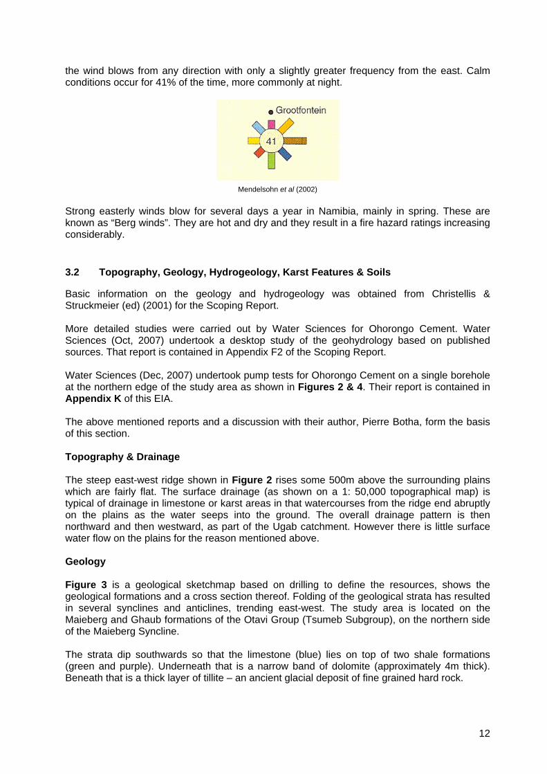
Information on the climate of the study area was obtained from Mendelsohn et al (2002). Solar radiation Being well within the tropics, this relatively dry area experiences intense solar radiation in the range of 6.0 – 6.2 kWh/m2/day on average - close to the highest values for Namibia. This fact has implications for the use of solar water heating. It should be feasible to provide hot water for all domestic purposes by means of solar water heaters and therefore completely eliminate the need for using electricity to heat water. This would apply to domestic water heating at the plant, and at staff housing in Otavi or Tsumeb. Temperature The average maximum temperatures during the hottest month, December, are in the range 32-34ºC. The average minimum temperatures during the coldest month, July, are in the range of 4–6 ºC. Frost may occur on 1-5 days per year. Humidity Values for relative humidity in the driest month, September, range from 10-20%. In the most humid month, February/March the values for RH are in the range 80-90%. These values may have implications for the storage of cement, and for the moisture content of the raw materials and any fuels such as encroacher bush. Rainfall The mean annual rainfall for the study area is 500–550 mm. Almost all the rain falls between October and April, with the wettest months being January and February. Rainfall has implications for recharge of the karst aquifer that will provide a source of water for the plant. It will also affect the moisture content of any fuel (especially bush chips) stored out of doors. The possibility of harvesting rainwater from roofs and paved areas should also be considered. Winds The nearest wind data available is for Grootfontein. The wind rose below shows the frequency with which the wind blows from each direction. Note that there is no prevailing wind direction –
12
the wind blows from any direction with only a slightly greater frequency from the east. Calm conditions occur for 41% of the time, more commonly at night.
Mendelsohn et al (2002) Strong easterly winds blow for several days a year in Namibia, mainly in spring. These are known as “Berg winds”. They are hot and dry and they result in a fire hazard ratings increasing considerably. 3.2 Topography, Geology, Hydrogeology, Karst Features & Soils
Basic information on the geology and hydrogeology was obtained from Christellis & Struckmeier (ed) (2001) for the Scoping Report. More detailed studies were carried out by Water Sciences for Ohorongo Cement. Water Sciences (Oct, 2007) undertook a desktop study of the geohydrology based on published sources. That report is contained in Appendix F2 of the Scoping Report. Water Sciences (Dec, 2007) undertook pump tests for Ohorongo Cement on a single borehole at the northern edge of the study area as shown in Figures 2 & 4. Their report is contained in Appendix K of this EIA. The above mentioned reports and a discussion with their author, Pierre Botha, form the basis of this section. Topography & Drainage The steep east-west ridge shown in Figure 2 rises some 500m above the surrounding plains which are fairly flat. The surface drainage (as shown on a 1: 50,000 topographical map) is typical of drainage in limestone or karst areas in that watercourses from the ridge end abruptly on the plains as the water seeps into the ground. The overall drainage pattern is then northward and then westward, as part of the Ugab catchment. However there is little surface water flow on the plains for the reason mentioned above. Geology Figure 3 is a geological sketchmap based on drilling to define the resources, shows the geological formations and a cross section thereof. Folding of the geological strata has resulted in several synclines and anticlines, trending east-west. The study area is located on the Maieberg and Ghaub formations of the Otavi Group (Tsumeb Subgroup), on the northern side of the Maieberg Syncline. The strata dip southwards so that the limestone (blue) lies on top of two shale formations (green and purple). Underneath that is a narrow band of dolomite (approximately 4m thick). Beneath that is a thick layer of tillite – an ancient glacial deposit of fine grained hard rock.
13
The plant will be situated on the tillite formation in the northern part of the study area. The tillite is a massive layer of unknown depth. The quarry will cover the limestone and shale formations in the central and southern parts of the study area. Both the limestone and shales are needed in the manufacture of cement. Hydrogeology Folding of the strata also resulted in associated joints and fractures which are important for the hydrogeological character of the area. Groundwater flow in the area takes place mainly along fractures and contact zones within hard rock formations. The site is within the Tsumeb-Otavi-Grootfontein Subterranean Water Control Area – GN 1969 of 13 Nov 1970 and Proclamation 278 of 31 Dec 1976. Therefore a permit is required to drill boreholes, and to utilise groundwater for industrial and domestic use. A Technical Report (in the format required by Water Affairs) must be submitted with the application for a permit. The Department of Water Affairs has divided the Karst aquifers into compartments for the purpose of regulating abstraction of groundwater. The study area falls into compartment G, where a total abstraction of 1.5Mm3/annum is permitted to be abstracted. Water quality in the area is generally good. Groundwater monitoring over the wider area of the OML in the past indicates a steady decline in the water levels in the Otavi Mountain Lands. Groundwater in the study area flows in a north-westerly direction as inferred from historical groundwater data. Groundwater in the area is already extensively utilised with more than 500 known boreholes in a 30km radius, more than 50 within 10km, and about 15 within a 5km radius, Existing boreholes in the area are drilled to less than 50m deep and yield around 5m3/day. Residence time of groundwater is low and the groundwater table reacts rapidly to recharge and/or abstraction. Water Sciences (Dec, 2007) conducted pump tests on a new borehole in the north-west corner of the farm Sargberg (Figure 2 & 4). Its location is 19°30.205’S and 17°27.727’E where the farm boundaries intersect the Gauss and Berg Aukas formations of the Abenab Sub Group). The borehole was sunk into the underlying dolomite formation. The rest water level at the time was 31.52m below the ground surface. They conducted a constant rate pump test for 25.5 hours, which yielded approximately 4m3/h. During this test the draw down was measured of 9.72m. This test was followed by a recovery test. The water level recovered to 0.2m (97%) of the draw down level. The transmissivity value was calculated at 38m2/d, which is within the range given for the Abenab Sub Group (GKW Consult, 2002). This is a low level of transmissivity. Water Sciences (Dec, 2007) concluded that the borehole could be pumped at 4 m3/hour for 11 hours per day. This would provide a sustainable yield of approximately 44m3/day or approximately 15,520 m3/year. This is insufficient to meet the 70,000 m3/year demand for the
14
year, so it was further recommended that a further three boreholes – each to be pumped for about 12 hours / day. P. Botha (pers comm) expects that, due to the low transmissivity rate, the cone of depression would be steep and, in an idealised subterranean environment would not extend beyond a radius of 600m from the borehole. However, in reality, any lineaments (e.g. joints or fissures) that are intersected may extend limbs of the cone of depression much further than that – probably less than 2-3 kilometres. Karst Features Many karst features occur in the Otavi Mountain Lands due to the solution of limestone and dolomite along joints and fractures that have provided a passage for water. Solution features can result in springs, where an underground “stream” intersects the ground surface, and caves. Such features are believed to have formed in zones where the groundwater level has fluctuated over geological time. In rare cases, the roofs of subterranean caves have collapsed resulting in sinkholes such as Otjikoto Lake and Guinas Lake some 35km to the north of the site. Some of the underground caves and sinkholes contain unique fauna (refer to Sections 3.3 & 6.5 below). A list of the known caves and sinkholes that contain water was obtained and the locations plotted in relation to the proposed abstraction sites within Ohorongo Cement’s study area. The nearest cave that is known to contain water is Aikab Hemicenote - approximately 19.7km away from the new abstraction borehole. The next nearest are Ghaub (35km) and Dragonsbreath (36km). Still further are Gamkarab, Aigamas, Klein Nosib, Pofaddergat, Harasib Lake and Skorpion Maze. Further background information can be found in a useful study on the karst area that was commissioned by Namwater and carried out by AfriDev Associates (2004). It was an Environmental Impact Assessment on abstraction of water from the Tsumeb and Karst III Aquifers for water supply to the Windhoek and the Central Areas of Namibia. A spring is known to exist some 6km to the north of the proposed site, but no other karst features are known nearby. Communications with the Directorate of Geohydrology were detailed in the Scoping Report (CCA, 2007) but these did not indicate any other karst features near the study area. These communications also considered the potential for sinkhole development at or near the proposed site – a question which is assessed in Section 6.3 below Soils The soil appears to be sandy, ranging in colour from pale brown and grey with broken calcrete pieces in it, to fine red sand – apparently of aeoloian origins. The stunted vegetation on the plains suggests that the soil is not very deep, or possibly the presence of a calcrete or shale layer may limit rooting depth. Approaching the ridge to the south of the site, however the talus slopes have deeper soil which supports large trees. Typical in this semi-arid climate the organic content of soils is usually low, with poorly developed topsoil or “A-horizon”. The topsoil is likely to be better developed in the more densely vegetated woodlands near the base of the hills.
15
3.3 Karst Fauna
Some of the karst caves and sinkholes that contain water are known to support populations of faunal species that are endemic to Namibia. As such they are protected under the Convention on Biodiversity. Namibia may not permit activities that present a threat to these species. Data obtained from E.Marais (pers comm) indicated the known species of conservation concern in cave lakes and sinkhole lakes. In order to protect the conservation status of these sites, their co-ordinates have been omitted from the table below. Quarter Degree
Name Species of concern
1916 Bd Aikab Hemicenote (large underground lake of some 0.86 ha, and up to 60m deep)
Namibianira aikabensis (endemic isopoda)
1916 Cd Gamkarab (underground lake more than 40m deep)
Fauna not listed
1917 Ad Aigamas (underground lake more than 60m deep)
Clarias cavernicola (endemic catfish), & Namibianira aigamasensis (endemic isopoda)
1917 Bd Klein Nosib (shallow underground lake 4m deep in 1995, dried up in 2004)
Fauna not listed
1917 Bd Pofaddergat (series of deep pools, estimated in 1995 at more than 10m deep)
Most of the pools have dried up.
1917 Bd Ghaub (small pool in remote part of cave) Fauna not listed.
1917 Bd Harisib Sinkhole (deep sinkhole lake of some 0.2 ha and more than 100m deep)
Fauna not listed.
1917 Db Dragonsbreath (large underground lake 2.4 ha and more than 80m deep)
Endemic skeleton shrimps Stygobarnardia caprellinoides & Trogloleleupia dracospiritus, and endemic isopoda Namibianira dracohalitus.
1917 Db Scorpion Maze Fauna not listed.
- Boreholes at Manheim & Wag-‘n-Bietjie Stygobarnardia caprellinoides and Trogloleleupia eggerti
Data supplied by E.Marais National Museum, Windhoek. The locations of the nearest of these wet caves to the study area is shown in Figure 4. 3.4 Vegetation
Strohbach (2008) undertook a survey of the vegetation in the study area for this EIA. His full report is contained in Appendix L. His survey was carried out from 22-24 January 2008. Rains had come late with the result that some plants were still only seedlings and could not be identified. However an advantage of the timing was that many geophytes, which are normally present only below ground, were in flower and could therefore be identified. Strohbach produced a list of all the species found (see also in Appendix L). The list is annotated with the conservation status and legal status of each species, where applicable. Overall he found 194 species representing 55 families of plants - i.e. a fairly high diversity for Namibia. He estimated that the actual numbers would be slightly higher had all species been growing and identifiable at the time of the survey. Distinct habitat types were identified by Strohbach as shown in the table below, but naturally there are overlaps in the species occurring in the different habitat types.

16
Overall
Species found
1. Karstveld
plains
2. Footslopes
3. Low
limestone hills
4. Steep
limestone hill
5. Intermontane
plains Sample size 40 9 9 7 5 10 Total species 194 126 105 61 87 122 Median species per 1000m2
32 47 31 28 35 32
Annual species 34 19 15 5 10 20 Perennial species
160 43 90 51 77 102
Woody species 60 38 40 28 40 42 Geophytes 24 14 8 6 7 16 Conservation status
Number of listed species
Species
Endemic species
7 Ornithoglossum calcicola, Tulbachia calcarea, Erythrina decora, Cyphostemma juttae, Ceropegia dinteri, Petalidium rautanenii, Barleria kaloxytona,
Protected – Forestry Act
12 Ficus thonningii, Boscia albitrunca, Albizia anthelmintica, Lonchocarpus nelsii, Erythrina decora, Kirkia acuminata, Spirostachys Africana, Sclerocarya birrea, Lannea discolor, Elaeodendron transvaalense, Berchemia discolour, Combretum imberbe,
Protected – Nature Conservation Ordinance
3 Cyphostemma juttae, Ceropegia dinteri, Stapelia spp.,
Red Data Listed
2 Cyphostemma juttae (Least Concern), Ceropegia dinteri, (Least Concern)
CITES 2 -Listed
2 Euphorbia guerichiana, Ceropegia dinteri.
None of the species listed in the table above as having special status is restricted in extent and therefore no species will be regionally threatened by the project. Within the study area, five habitat types were identified, each associated with different landscapes, as shown on the map, Figure 5. The impacts on each of these habitat types will be discussed in Section 6.10 below. 3.5 Animals (mammals, reptiles and amphibians)
A desktop study was carried out by a specialist zoologist Griffin (2007) for this EIA. The report is contained in Appendix M. It covers all the mammals, reptiles and amphibians that would be expected to occur in the area affected by the project and includes a list where the conservation status of each species is indicated. Griffin’s report was based on available databases, literature, and his considerable knowledge on the fauna of Namibia based of years of work in this field. He provides an annotated list of all species that are likely to occur in the study area. For each species the conservation status is also indicated (from Red Data Books (Ministry of Environment & Tourism) and the Nature Conservation Ordinance No. 4 of 1975. He listed 14 species of frogs, 80 species of reptiles and 92 species of mammals that are expected to occur in the study area and which may be locally affected by the development.
17
Amphibians There is no permanent surface water in the study area. The 1: 50,000 topographic map shows a drainage pattern that is typical of limestone and dolomite substrates; the drainage lines end abruptly because water finds its way into subsurface cracks and fissures. Any frog species present would be adapted to opportunistic breeding in ephemeral pools after rains. The loss of habitat would be limited to the actual footprint of the quarry and plant. Of the 14 species of frogs that may occur in the study area, two are of conservation interest – the Dombe Dwarf Toad (Poyntonophrynus dombensis) and the Spotted Rubber Frog (Phrynomantis affinis). They may be rare and seasonal in the area. Reptiles Of the 80 species of reptile that could occur in the study area, 4 are endemic to Namibia – the Namibian Dwarf Gecko (Lygodactylus bradfieldi), Kahalari Whip Snake (Psammophis trinasalis), Leopard Whip Snake (Psammophis leopardinus), and Zebra Snake (Naja nigricincta). However these all have wide distributions and will not be much affected. A newly described species – the Otavi Thick-toed Gecko (Pachydactylus otaviensis) is data deficient. It may occur on dolomitic outcrops in the area. It is thought to be rare and potentially vulnerable but should not be much affected, being on the hills away from the main area of project activity. Pythons, tortoises and the leguaan are all protected species under the Nature Conservation Ordinance No.4 of 1975. Mammals Of the 92 species of mammals that could occur in the study area, although many of the larger species are less likely because the dense stands of thorny bush make the habitat unsuitable for grazing (e.g. Wildebeest) and hunting (e.g. Cheetah). Sixteen species are listed as Protected Game under the Nature Conservation Ordinance No.4 of 1975 – Aardwolf (Proteles cristatus), Bat-eared Fox (Otocyon megalotis), Blue Wildebeest (Connochaetes taurinus), Dik-Dik (Madoqua damarensis), Duiker (Sylvicapra grimmea), Aardvark (Orycteropus afer), Pangolin (Manis temminckii), Cheetah (Acinonyx jubatus), Southern African Hedgehog (Atelerix frontalis), Leopard (Panthera pardus), Southern African Bushbaby (Galago maholi), Honey Badger (Mellivora capensis), Red Hartebeest (Alcelaphus caama), Cape Fox (Vulpes chama), Steenbok (raphicerus campestris), and Eland (Taurotragus oryx). No endemic mammals occur in the study area. 3.6 Birds
Dr Chris Brown (2008) compiled a desktop study of the birds in the study area for this EIA. His full report is contained in Appendix N This was based on the National Avifaunal Database which includes bird atlas data, road counts, and breeding records, together with Brown’s twenty five year experience working on birds in Namibia. His report includes a list of species that have been recorded in the four quarter degree squares that impinge on the study area. A total of 255 bird species have been recorded in the area, which represents a high diversity by Namibian standards.
18
Six endemic species occur in the four quarter degree squares impinging on the study area; Hartlaub’s Francolin (rocky hillsides), Rüppell’s Parrot (large trees), Monteiro’s Hornbill (bushveld), Carp’s Black Tit (bushveld), Barecheeked Babbler (thickets) and Rockrunner (rocky hillsides). Fifteen Red Data Species of Birds have been recorded in the same area; Cape Vulture, Saddlebilled Stork, Tawny Eagle, Booted Eagle, Martial Eagle, Bateleur, Lappetfaced Vulture, Whiteheaded Vulture, Black Stork, Marabou Stork, Whitebacked Vulture, Black Eagle, Peregrine Falcon, Lesser Kestrel, and Rüppell’s Parrot. The potential impacts on these species are assessed in Section 6.14 below. 3.7 Land Use & Alternative Uses
Within the study area, the land use on the affected plains and foothills is limited grazing that has been severely degraded by bush encroachment. Previous cultivation has also disturbed much of the area, resulting in bush encroachment on these abandoned lands. The grazing yield could be improved considerably by clearing the encroacher bush from the remaining part of the farm that is not needed for the project. The area has no unique scenic features that could be of interest to tourists. Therefore there are no alternative land uses envisaged that could compete with the proposed quarry and cement plant. 3.8 Adjacent Farming Community
A site visit and available maps show that the site has few near neighbours. There are a few families of farmers and farm labourers in the vicinity. The nearest homesteads are some 3km or more from the site. A few farm labourers live with their families on the farm Sargberg. These families are poor in financial terms but they appear to enjoy a peaceful and happy life on the farm. They will be the only people that may be affected, but none of their dwellings are within the quarry or plant site – so relocations will not be required. The only significant concentration of population is in Otavi more than 15km away. 3.9 Socio-economic & Human Health Conditions in the Region
Mendelsohn et al, 2002 provides useful information on socio-economic conditions for each region of Namibia. The following information is for the Otjozondjupa Region (unless otherwise stated). • The area near the project site has a very low population density – less than 1 person per
km2. • The population of the Region in 2001 was approximately 135,700 - mostly concentrated
around Grootfontein and Otavi (excluding Tsumeb, which is in the neighbouring region -Oshikoto.)
19
• The literacy rate (4 years or more of schooling) is 65% for females and 60% for males. • Schooling: 27% have no schooling, 43% have primary education, 18% have secondary
education, and 13% tertiary education. • Dependency: 40% of urban people are economically dependent on others, while 43 of rural
people are thus dependent. • Less than 60% of people in the region earn wage incomes. Roughly 33% of people have
no income, while the remaining 7% rely on pensions. • Poverty: Roughly 27% are considered to live in poverty. • Malnutrition: some 16% of children are underweight as a result of malnutrition. • Life expectancy at birth has declined steadily from 61 years in 1991 to 43 years in 2000.
This is due largely to increased mortality from HIV/AIDS and related incidence of Tuberculosis and other respiratory ailments.
• The HIV/AIDS infection rate in Namibia as a whole was 22% in 2000. This disease has
important implications for employers as it mainly affects the age groups that are normally most economically productive. Training has to be ongoing as a significant percentage of employees are lost before retirement age due to HIV/AIDS.
• Five diseases accounted for 46% of all deaths in government hospitals in Namibia during
the period 1995 – 1999. For the Otjozondjupa Region the numbers were: AIDS (280), Tuberculosis (218), Acute respiratory infections (198), Gastroenteritis (157), and Malaria (156).
• An estimated 100 – 300 people out of every 1,000 people in the region are treated for
Malaria every year. These statistics clearly indicate the serious need for employment opportunities and improved living conditions in the Region. They also indicate that any employer will face a number of social challenges in regard to the work force employed. For example, potentially high staff turnover rates due to loss of staff members to HIV/AIDS.
20
4 LEGAL & POLICY REQUIREMENTS
A review of the relevant legislation and policy requirements was undertaken by Envirolex Namibia (2007). The full report is contained in Appendix J to the Scoping Report (CCA, 2007). What follows is a brief summary of their report, and an update on the new Environmental Assessment and Management Act, 2007. Namibian Legislation -
• The Constitution of the Republic of Namibia Act, 1990 • The Water Act 54, 1956 • Minerals (Prospecting and Mining) Act, 1992 • Hazardous Substances Ordinance, 1974 • Explosives Act 26 of 1956 (as amended in SA to April 1978) • Atmospheric Pollution Prevention Ordinance, 1976 • Labour Act 6, 1992 and regulations GN 156 of 1997 (GG 1617 of 1 August 1997) • Model Sewerage and Drainage Regulations contained in GN 1311 of 21 May 1996,
promulgated in terms of section 94(2)(a) of the Local Authorities Act 23 of 1992 • National Heritage Act 27 of 2004 • Petroleum Products and Energy Act, 1990; • Nature Conservation Ordinance, No.4 of 1975 • Forest Act, No 12 of 2001 • Soil Conservation Act 76 of 1969, as amended in South Africa to March 1978 • Public Health Act, 36 of 1919
The new Environmental Assessment and Management Act, 2007 has been passed by the National Assembly in October 2007, but it has not yet come into force. The date for its implementation has yet to be gazetted. The Act has similar requirements to the existing Environmental Assessment Policy of Namibia. Of relevance to this project, the Act will require EIA’s for: -
• Mining and quarrying, • Manufacturing, • Abstraction of groundwater or surface water for industrial or commercial purposes, • Rezoning of land from agricultural to industrial use, • Any activity entailing a scheduled process referred to in the Atmospheric Pollution
Prevention Ordinance, 1976 (No.11 of 1976). Namibian Policies
• Minerals Policy of Namibia (2003) • Environmental Assessment Policy for Sustainable Development and Environmental
Conservation, August 1994 (Cabinet Resolution 16.8.94/0021995) • General Environmental Assessment Guidelines for the Mining (Onshore and Off-shore)
Sector of Namibia • Policy for the Conservation of Biotic Diversity and Habitat Protection, 1994
21
Upcoming Namibian Legislation
• Integrated Pollution Control and Waste Management Bill • Water Resources Management Bill
International and Regional Conventions
• Convention on Biological Diversity (1992) • Vienna Convention for the Protection of the Ozone Layer, 1985 • Montreal Protocol on Substances that Deplete the Ozone Layer, 1987 • United Nations Framework Convention on Climate Change 1992 Kyoto Protocol on the
Framework Convention on Climate Change (1998) For each of the above, Envirolex provided a summary of the applicable sections and how they must be taken into account by the project proponent. They also indicate where permits are required e.g. for groundwater abstraction. The project proponent must ensure that he complies with all the relevant laws and policies, and this applies equally to all contractors, sub-contractors and any other persons involved in the project or visiting the site.
22
5 ASSESSMENT CRITERIA
This section provides an introduction to the assessment of potential impacts in Section 6, and the criteria used in making each assessment are explained. Firstly, in line with international practice in EIAs, a broad definition of “Environment” is adopted, which incorporates both bio-physical and socio-economic components. The EA Policy of Namibia seeks to achieve a balance between negative and positive impacts, and between bio-physical impacts and social and economic gains to society. Therefore, both negative and positive impacts on the environment will be considered below. To the extent that it is practically possible, this report will recommend measures to mitigate negative impacts and optimize (or enhance) positive impacts. The assessments will include the quarry, the cement manufacturing plant and related infrastructure such as road, rail, powerline, and water pipeline. Normally, there is a two-way interaction between a project and its environment. Not only does the project have impacts on its environment, but the environment also provides opportunities and constraints on the project. For example, in Namibia water resources may pose a constraint, while the impact of HIV/AIDS has implications for training and maintaining the skills base of the work force. Another example of this two-way interaction is the impact on vegetation. The project has the potential for negative impacts on vegetation at the quarry site, but it also provides an opportunity to turn an existing environmental problem into a benefit – both for the project and for the environment. I refer to the opportunity to use encroacher bush for fuel, which would also open up large tracts of grassland for grazing of wildlife and domestic livestock. This assessment is made on the basis of the current proposals. Should these proposals change in any material way, then some of the assessments below may have to be reconsidered. In Section 6, for each activity with the potential for environmental impacts, a discussion of the impact is presented. Where practically possible, the discussion is followed by a table that summarizes the assessment according to specific criteria as follows. Assessment Criteria Nature of impact An explanation of how the environment will be affected by specific activities
Mitigation What measures could be applied to reduce negative impacts or enhance positive impacts
Extent The geographical extent of the impact
Duration The length of time that the impact persists: - - Short term 0-5 years - Medium term 5-15 years - Long term – lifespan of the project - Permanent
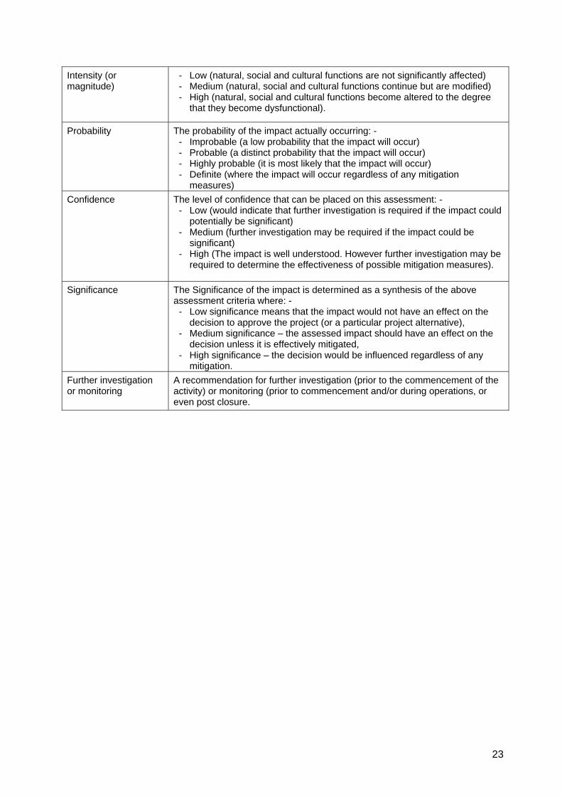
23
Intensity (or magnitude)
- Low (natural, social and cultural functions are not significantly affected) - Medium (natural, social and cultural functions continue but are modified) - High (natural, social and cultural functions become altered to the degree
that they become dysfunctional).
Probability The probability of the impact actually occurring: - - Improbable (a low probability that the impact will occur) - Probable (a distinct probability that the impact will occur) - Highly probable (it is most likely that the impact will occur) - Definite (where the impact will occur regardless of any mitigation
measures) Confidence The level of confidence that can be placed on this assessment: -
- Low (would indicate that further investigation is required if the impact could potentially be significant)
- Medium (further investigation may be required if the impact could be significant)
- High (The impact is well understood. However further investigation may be required to determine the effectiveness of possible mitigation measures).
Significance The Significance of the impact is determined as a synthesis of the above
assessment criteria where: - - Low significance means that the impact would not have an effect on the
decision to approve the project (or a particular project alternative), - Medium significance – the assessed impact should have an effect on the
decision unless it is effectively mitigated, - High significance – the decision would be influenced regardless of any
mitigation. Further investigation or monitoring
A recommendation for further investigation (prior to the commencement of the activity) or monitoring (prior to commencement and/or during operations, or even post closure.
24
6 ASSESSMENT OF BIO-PHYSICAL & SOCIO-ECONOMIC IMPACTS
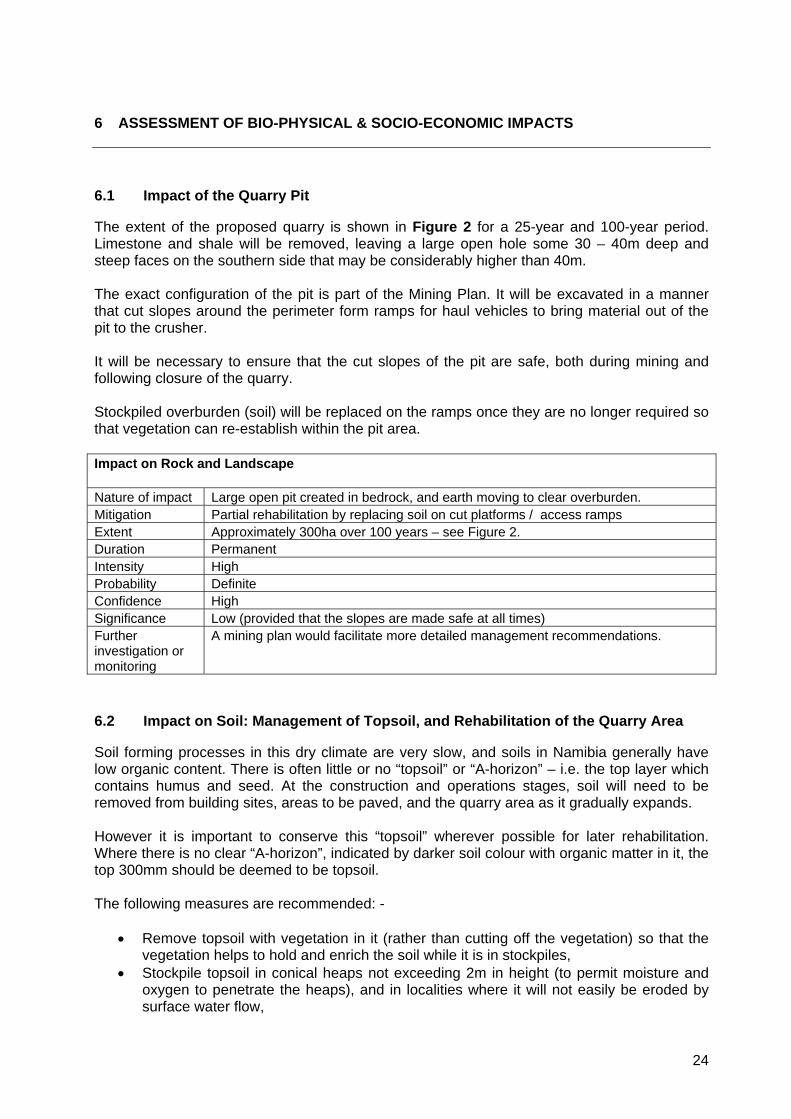
6.1 Impact of the Quarry Pit
The extent of the proposed quarry is shown in Figure 2 for a 25-year and 100-year period. Limestone and shale will be removed, leaving a large open hole some 30 – 40m deep and steep faces on the southern side that may be considerably higher than 40m. The exact configuration of the pit is part of the Mining Plan. It will be excavated in a manner that cut slopes around the perimeter form ramps for haul vehicles to bring material out of the pit to the crusher. It will be necessary to ensure that the cut slopes of the pit are safe, both during mining and following closure of the quarry. Stockpiled overburden (soil) will be replaced on the ramps once they are no longer required so that vegetation can re-establish within the pit area. Impact on Rock and Landscape Nature of impact Large open pit created in bedrock, and earth moving to clear overburden. Mitigation Partial rehabilitation by replacing soil on cut platforms / access ramps Extent Approximately 300ha over 100 years – see Figure 2. Duration Permanent Intensity High Probability Definite Confidence High Significance Low (provided that the slopes are made safe at all times) Further investigation or monitoring
A mining plan would facilitate more detailed management recommendations.
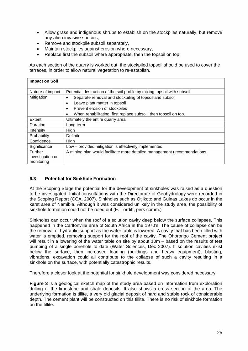
6.2 Impact on Soil: Management of Topsoil, and Rehabilitation of the Quarry Area
Soil forming processes in this dry climate are very slow, and soils in Namibia generally have low organic content. There is often little or no “topsoil” or “A-horizon” – i.e. the top layer which contains humus and seed. At the construction and operations stages, soil will need to be removed from building sites, areas to be paved, and the quarry area as it gradually expands. However it is important to conserve this “topsoil” wherever possible for later rehabilitation. Where there is no clear “A-horizon”, indicated by darker soil colour with organic matter in it, the top 300mm should be deemed to be topsoil. The following measures are recommended: -
• Remove topsoil with vegetation in it (rather than cutting off the vegetation) so that the vegetation helps to hold and enrich the soil while it is in stockpiles,
• Stockpile topsoil in conical heaps not exceeding 2m in height (to permit moisture and oxygen to penetrate the heaps), and in localities where it will not easily be eroded by surface water flow,
25
• Allow grass and indigenous shrubs to establish on the stockpiles naturally, but remove any alien invasive species,
• Remove and stockpile subsoil separately, • Maintain stockpiles against erosion where necessary, • Replace first the subsoil where appropriate, then the topsoil on top.
As each section of the quarry is worked out, the stockpiled topsoil should be used to cover the terraces, in order to allow natural vegetation to re-establish. Impact on Soil Nature of impact Potential destruction of the soil profile by mixing topsoil with subsoil Mitigation • Separate removal and stockpiling of topsoil and subsoil
• Leave plant matter in topsoil • Prevent erosion of stockpiles • When rehabilitating, first replace subsoil, then topsoil on top.
Extent Ultimately the entire quarry area Duration Long term Intensity High Probability Definite Confidence High Significance Low – provided mitigation is effectively implemented Further investigation or monitoring
A mining plan would facilitate more detailed management recommendations.
6.3 Potential for Sinkhole Formation
At the Scoping Stage the potential for the development of sinkholes was raised as a question to be investigated. Initial consultations with the Directorate of Geohydrology were recorded in the Scoping Report (CCA, 2007). Sinkholes such as Otjikoto and Guinas Lakes do occur in the karst area of Namibia. Although it was considered unlikely in the study area, the possibility of sinkhole formation could not be ruled out (E. Tordiff, pers comm.) Sinkholes can occur when the roof of a solution cavity deep below the surface collapses. This happened in the Carltonville area of South Africa in the 1970’s. The cause of collapse can be the removal of hydraulic support as the water table is lowered. A cavity that has been filled with water is emptied, removing support for the roof of the cavity. The Ohorongo Cement project will result in a lowering of the water table on site by about 10m – based on the results of test pumping of a single borehole to date (Water Sciences, Dec 2007). If solution cavities exist below the surface, then increased loading (buildings and heavy equipment), blasting, vibrations, excavation could all contribute to the collapse of such a cavity resulting in a sinkhole on the surface, with potentially catastrophic results. Therefore a closer look at the potential for sinkhole development was considered necessary. Figure 3 is a geological sketch map of the study area based on information from exploration drilling of the limestone and shale deposits. It also shows a cross section of the area. The underlying formation is tillite, a very old glacial deposit of hard and stable rock of considerable depth. The cement plant will be constructed on this tillite. There is no risk of sinkhole formation on the tillite.
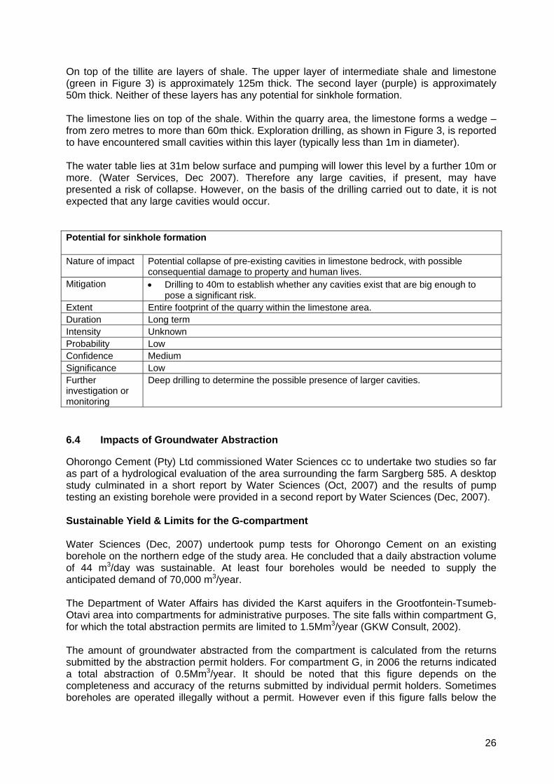
26
On top of the tillite are layers of shale. The upper layer of intermediate shale and limestone (green in Figure 3) is approximately 125m thick. The second layer (purple) is approximately 50m thick. Neither of these layers has any potential for sinkhole formation. The limestone lies on top of the shale. Within the quarry area, the limestone forms a wedge – from zero metres to more than 60m thick. Exploration drilling, as shown in Figure 3, is reported to have encountered small cavities within this layer (typically less than 1m in diameter). The water table lies at 31m below surface and pumping will lower this level by a further 10m or more. (Water Services, Dec 2007). Therefore any large cavities, if present, may have presented a risk of collapse. However, on the basis of the drilling carried out to date, it is not expected that any large cavities would occur. Potential for sinkhole formation Nature of impact Potential collapse of pre-existing cavities in limestone bedrock, with possible
consequential damage to property and human lives. Mitigation • Drilling to 40m to establish whether any cavities exist that are big enough to
pose a significant risk. Extent Entire footprint of the quarry within the limestone area. Duration Long term Intensity Unknown Probability Low Confidence Medium Significance Low Further investigation or monitoring
Deep drilling to determine the possible presence of larger cavities.
6.4 Impacts of Groundwater Abstraction
Ohorongo Cement (Pty) Ltd commissioned Water Sciences cc to undertake two studies so far as part of a hydrological evaluation of the area surrounding the farm Sargberg 585. A desktop study culminated in a short report by Water Sciences (Oct, 2007) and the results of pump testing an existing borehole were provided in a second report by Water Sciences (Dec, 2007). Sustainable Yield & Limits for the G-compartment Water Sciences (Dec, 2007) undertook pump tests for Ohorongo Cement on an existing borehole on the northern edge of the study area. He concluded that a daily abstraction volume of 44 m3/day was sustainable. At least four boreholes would be needed to supply the anticipated demand of 70,000 m3/year. The Department of Water Affairs has divided the Karst aquifers in the Grootfontein-Tsumeb-Otavi area into compartments for administrative purposes. The site falls within compartment G, for which the total abstraction permits are limited to 1.5Mm3/year (GKW Consult, 2002). The amount of groundwater abstracted from the compartment is calculated from the returns submitted by the abstraction permit holders. For compartment G, in 2006 the returns indicated a total abstraction of 0.5Mm3/year. It should be noted that this figure depends on the completeness and accuracy of the returns submitted by individual permit holders. Sometimes boreholes are operated illegally without a permit. However even if this figure falls below the
27
actual abstraction levels it appears that there is still considerable spare capacity for groundwater abstraction in this area (Water Services, Oct 2007). The lowest estimate for the recharge by rainfall in compartment G is 1.4Mm3/year (cited by (Water Services, Oct 2007). So the current abstraction level of some 0.5Mm3/year appears to be well within the recharge capacity of the area. Water Services (Oct, 2007 p.4) estimated that “the maximum regional drawdown (and worst case scenario) that could be expected is 4m whilst an average drawdown of 0.01m should be a more realistic value”. This statement is made in the context of a 30km radius around the proposed abstraction site. Local Impacts and Neighbouring Boreholes Concern was raised at the public meeting in Tsumeb that abstraction of water could have a negative impact on groundwater levels on neighbouring farms – thus affecting their boreholes. Water Services (Oct, 2007) stated that the intended volume of abstraction is comparable to typical irrigation abstraction permits in compartment G, and relatively low compared to other bulk groundwater abstraction facilities in the greater Karst aquifers. On the farm Sargberg, Water Services (Dec 2007) found that transmissivity rates were low – based on pump tests of one borehole. For that reason P. Botha (pers comm) considers that the lateral extent of the draw-down cone will be small – of the order of 600m in uniform material. But it could extend further if lineaments such as cracks and fissures are intersected. NP du Plessis (pers comm) considered that the cone of depression in this area would probably not extend 2km. According to Water Sciences, Figure A1 (Dec 2007, p.7) there is only one borehole on a neighbouring farm that lies within 2.5km of the likely drilling targets for the extra 3 boreholes that will be required on Sargberg. No data is available for that borehole. Water Sciences (Dec, 2007) recommended that at least three additional boreholes should be drilled and pump tested. That data would be valuable in further assessing the hydrological characteristics of the local area. In order to provide baseline data to evaluate the impact of abstraction on neighbouring boreholes, it is our recommendation that a hydro census be conducted in the area, say within a 3km radius, on an annual basis. The spring, which is 6km to the north of the site should also be monitored bi-annually as an indicator of whether local water levels are falling. Climate Change The effects of global climate change have received a great deal of attention in recent years. Information presented by US Senator Al Gore in a film “An Inconvenient Truth”, concurs broadly with data presented by Prof. Norbert Jürgens from Hamburg University in a lecture delivered in Windhoek on 14 February 2007. The latter showed the results of modelling that predicts significant rise in temperatures and decrease in rainfall in the northeast of Namibia. An article in BBC News 30 June 2005 (BBC NEWS / Science/Nature / African sands ‘set for upheaval’) presents findings from Oxford University on the impacts of climate change in South Africa, Namibia, Angola, Botswana, western Zambia and western Zimbabwe. The study found that, no matter which general climate model was used, they indicated that the southern Kalahari dunefields in Botswana and Namibia (which are currently vegetated) will begin to
28
mobilise again as the climate grows hotter, drier, and wind speeds increase. In Namibia, the dunefields are expected to be mobilised by the year 2040. Such short timespans are not always understood by the layman. The lifespan of the cement project is planned for at least 100 years. Over such a long period, the effects of global climate change will be experienced at a regional level. The intensity of the change is not fully known but the direction of change is known to be a warming and drying trend in the north-east of Namibia. This can be expected to lead to reduced rainfall and recharge in the karst aquifers within the lifespan of the project. This climatic trend will further aggravate the cumulative impacts of water abstraction in the area over time. Water Conservation For all the reasons given above, a very conservative approach to water utilisation should be adopted in Namibia. All opportunities should be considered to: - • Minimise water consumption, e.g. by low consumption appliances, appropriate plumbing in
showers and toilets, optimising the water used for dust suppression etc. • Recycle water, e.g. treated sewage water can be used for dust suppression, and for the
small volumes required in the process. • Harvest rainwater from roofs and paved areas for industrial use. It should be possible to
capture rainwater over large areas at the plant. Although the cost of storage would be significant, it would be partly offset by savings in the costs of pumping groundwater.
Impacts of groundwater abstraction at Local level (6km radius) Nature of impact Draw down of approximately 10m at the borehole sites and a steep cone of
depression. A low potential exists for impacts on neighbouring boreholes, and the spring 6km to the north.
Mitigation • Minimisation, recycling, and rainwater harvesting Extent Draw down cones are expected to extend between 0.6 – 2km for each borehole Duration Long term Intensity Medium Probability Definite Confidence Medium Significance Medium Further investigation or monitoring
Pre-operation hydrocensus and regular checks in the neighbouring farms area to determine whether there is any general decline in water levels. Seek ways to maximise opportunities for mitigation (see above)
Impacts of groundwater abstraction at Regional level (30km radius) Nature of impact Regional draw down of 4m (worst case scenario) could result in impacts on fauna in
wet caves. The more likely scenario of a drawdown of 0.01m would make it impossible to separate the impacts of abstraction from other environmental factors. See also Section 6.5 below concerning impacts on karst fauna
Mitigation • Water conservation Extent Karst caves at 17- 30km away Duration Long term Intensity Estimated between 0.01m (likely) and 4m (worst case scenario) Probability Low Confidence Medium
29
Significance Low Further investigation or monitoring
The impacts of a single project are unlikely to be significant, but the cumulative impacts of many abstraction schemes could become significant. Ongoing monitoring of water levels in karst caves is recommended – this should Water Affairs’ responsibility. In response to these concerns, Ohorongo Mining proposes to establish 3 monitoring boreholes within a 3 km of their abstraction boreholes so that any local decline in water levels can be distinguished from the impact of any other abstraction or cumulative regional effects.
6.5 Impacts on Karst Fauna in “Wet” Caves
In Section 3.3 above, some details were provided of the karst “wet” caves that contain endemic karst fauna. Certain species are confined to very specific localities – even a single cave. Therefore if water abstraction was to have a significant impact on the water levels in these caves, it would pose a risk to the survival of those unique species by destroying their subterranean aquatic habitat. Such a threat could place Namibia in contravention of the Convention on Biodiversity – i.e. in breach of international law. The potential threat has therefore been assessed as follows. Using a GIS programme, the wet caves were plotted in relation to the study area and proposed water abstraction sites. Then the distance to the nearest wet caves was measured. The nearest wet cave to the site is Aikab, which is more than 19km away. The next nearest is Ghaub at 35km away, and Dragonsbreath at 36km from the site. Water Sciences (Oct, 2007 p.4) estimated that “the maximum regional draw down (and worst case scenario) that could be expected is 4m whilst an average drawdown of 0.01m should be a more realistic value”. This applies to the area within a radius of 30km from the proposed abstraction boreholes on Sargberg. In Aigab and Dragonsbreath Caves the water is deep (of the order of 60m and 80m respectively) and therefore even a worst case scenario drop of 4m may not have a significant impact on the available aquatic habitat in these caves. In Ghaub, however only a small pool exists, which could be at risk of drying up in the unlikely event of a 4m drop in water level. It is considered very unlikely that the impacts of abstracting 70,000 m3/annum for the cement plant and quarry would have any significant on its own. However, the cumulative impacts of all the abstraction in the area of wet caves could have an impact on aquatic cave fauna at some future date. J. Irish (pers comm) is of the opinion that monitoring of these special caves and their unique fauna should be carried out periodically to provide timely warning of any trend towards a falling water table that could endanger aquatic cave fauna. Such monitoring should be the responsibility of the Department of Water Affairs. At the spring 6km to the north of the site, it is likely that there may be fauna and flora (above ground) that utilise this water for drinking or as habitat (e.g. frogs) but this is unknown. Discussions with E. Marais (pers comm) suggested testing for the possible presence of the endemic shrimps, Stygobarnardia caprellinoides and Trogloleleupia eggerti in groundwater. Due to low transmissivity values it was considered unlikely that these would be found, as low transmissivity values indicate a lack of open subterranean channels. To establish whether any small organisms were present in the groundwater at Sargberg, a fine mesh net was used during the pump tests by Water Sciences (Dec 2007). The tests delivered 4m3/hour which was passed through the net. No shrimps or other invertebrates were found.
30
Impacts on karst organisms Nature of impact Regional draw down of 4m (worst case scenario) could result in impacts on fauna in
wet caves. The more likely scenario of a drawdown of 0.01m would make it impossible to separate the impacts of abstraction from other environmental factors.
Mitigation • Water conservation Extent Karst caves at 19 - 30km away Duration Medium to Long term Intensity Unknown Probability Low Confidence Medium Significance Low Further investigation or monitoring
Ongoing monitoring of water levels in karst caves is recommended – this should Water Affairs’ responsibility. Ohorongo Cement proposes to establish 3 monitoring boreholes within a few km of their abstraction boreholes so that any local decline in water levels can be distinguished from the impact of other abstraction or cumulative regional effects.
6.6 Potential for Groundwater Contamination
Quarry The water table was found to be approximately 31m below the surface in December 2007 (Water Sciences, Dec 2007). This may mean that the quarry excavations may intersect the water table. Potential contamination could then result from residues of explosives, oils and hydraulic fluids from vehicles used in the quarry. Minor contamination of this sort could make the water unsuitable for domestic use, but it could still be used for other purposes such as dust suppression. To minimise this risk, all vehicles should be well maintained – free of leaks. Care must be taken to prevent wastage / spillage of explosives during loading of the charges. Pumping water out of the pit continuously may be necessary to facilitate mining, or simply to make use of this water. This would create a cone of depression that would help to prevent any contamination from spreading into the aquifer. Plant The manufacturing process does not produce any solid or liquid waste. The only “effluent” would be treated sewage, which should be contained and used for dust suppression or in the grinding process – in order to conserve water. Other potential sources of groundwater contamination may include wash water from vehicles, oils, fuels and fluids from workshops. These are preventable. All exterior vehicle parks should be paved and water led to storage tanks to collect rainwater and washwater for later use. All liquid waste from workshops (e.g. oils) should be sealed in drums and taken to Windhoek for recycling or disposal at the hazardous waste site. All fuel, oil and other liquid tankers must be properly bunded with concrete bunds large enough to contain any potential spill. The likely pathway to groundwater near the plant is the dolomite band which runs east-west through the site. Any activities with potential to contaminate the groundwater should not be located over this geological feature.
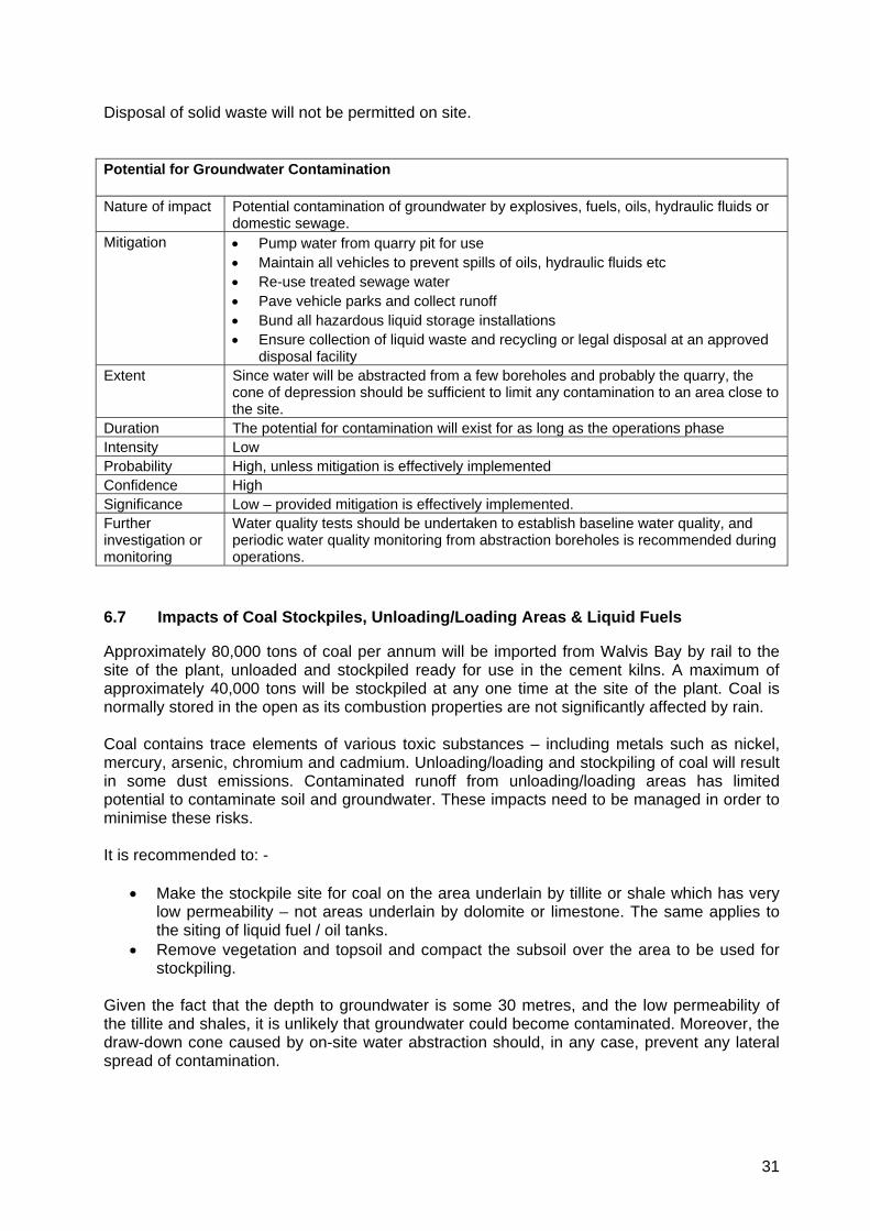
31
Disposal of solid waste will not be permitted on site. Potential for Groundwater Contamination Nature of impact Potential contamination of groundwater by explosives, fuels, oils, hydraulic fluids or
domestic sewage. Mitigation • Pump water from quarry pit for use
• Maintain all vehicles to prevent spills of oils, hydraulic fluids etc • Re-use treated sewage water • Pave vehicle parks and collect runoff • Bund all hazardous liquid storage installations • Ensure collection of liquid waste and recycling or legal disposal at an approved
disposal facility Extent Since water will be abstracted from a few boreholes and probably the quarry, the
cone of depression should be sufficient to limit any contamination to an area close to the site.
Duration The potential for contamination will exist for as long as the operations phase Intensity Low Probability High, unless mitigation is effectively implemented Confidence High Significance Low – provided mitigation is effectively implemented. Further investigation or monitoring
Water quality tests should be undertaken to establish baseline water quality, and periodic water quality monitoring from abstraction boreholes is recommended during operations.
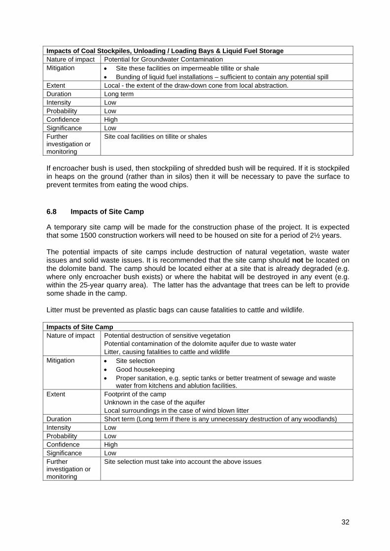
6.7 Impacts of Coal Stockpiles, Unloading/Loading Areas & Liquid Fuels
Approximately 80,000 tons of coal per annum will be imported from Walvis Bay by rail to the site of the plant, unloaded and stockpiled ready for use in the cement kilns. A maximum of approximately 40,000 tons will be stockpiled at any one time at the site of the plant. Coal is normally stored in the open as its combustion properties are not significantly affected by rain. Coal contains trace elements of various toxic substances – including metals such as nickel, mercury, arsenic, chromium and cadmium. Unloading/loading and stockpiling of coal will result in some dust emissions. Contaminated runoff from unloading/loading areas has limited potential to contaminate soil and groundwater. These impacts need to be managed in order to minimise these risks. It is recommended to: -
• Make the stockpile site for coal on the area underlain by tillite or shale which has very low permeability – not areas underlain by dolomite or limestone. The same applies to the siting of liquid fuel / oil tanks.
• Remove vegetation and topsoil and compact the subsoil over the area to be used for stockpiling.
Given the fact that the depth to groundwater is some 30 metres, and the low permeability of the tillite and shales, it is unlikely that groundwater could become contaminated. Moreover, the draw-down cone caused by on-site water abstraction should, in any case, prevent any lateral spread of contamination.
32
Impacts of Coal Stockpiles, Unloading / Loading Bays & Liquid Fuel Storage Nature of impact Potential for Groundwater Contamination Mitigation • Site these facilities on impermeable tillite or shale
• Bunding of liquid fuel installations – sufficient to contain any potential spill Extent Local - the extent of the draw-down cone from local abstraction. Duration Long term Intensity Low Probability Low Confidence High Significance Low Further investigation or monitoring
Site coal facilities on tillite or shales
If encroacher bush is used, then stockpiling of shredded bush will be required. If it is stockpiled in heaps on the ground (rather than in silos) then it will be necessary to pave the surface to prevent termites from eating the wood chips. 6.8 Impacts of Site Camp
A temporary site camp will be made for the construction phase of the project. It is expected that some 1500 construction workers will need to be housed on site for a period of 2½ years. The potential impacts of site camps include destruction of natural vegetation, waste water issues and solid waste issues. It is recommended that the site camp should not be located on the dolomite band. The camp should be located either at a site that is already degraded (e.g. where only encroacher bush exists) or where the habitat will be destroyed in any event (e.g. within the 25-year quarry area). The latter has the advantage that trees can be left to provide some shade in the camp. Litter must be prevented as plastic bags can cause fatalities to cattle and wildlife. Impacts of Site Camp Nature of impact Potential destruction of sensitive vegetation
Potential contamination of the dolomite aquifer due to waste water Litter, causing fatalities to cattle and wildlife
Mitigation • Site selection • Good housekeeping • Proper sanitation, e.g. septic tanks or better treatment of sewage and waste
water from kitchens and ablution facilities. Extent Footprint of the camp
Unknown in the case of the aquifer Local surroundings in the case of wind blown litter
Duration Short term (Long term if there is any unnecessary destruction of any woodlands) Intensity Low Probability Low Confidence High Significance Low Further investigation or monitoring
Site selection must take into account the above issues
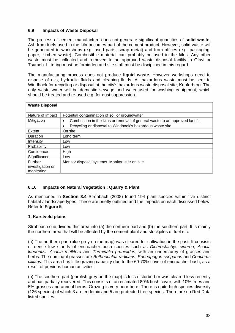
33
6.9 Impacts of Waste Disposal
The process of cement manufacture does not generate significant quantities of solid waste. Ash from fuels used in the kiln becomes part of the cement product. However, solid waste will be generated in workshops (e.g. used parts, scrap metal) and from offices (e.g. packaging, paper, kitchen waste). Combustible material can probably be used in the kilns. Any other waste must be collected and removed to an approved waste disposal facility in Otavi or Tsumeb. Littering must be forbidden and site staff must be disciplined in this regard. The manufacturing process does not produce liquid waste. However workshops need to dispose of oils, hydraulic fluids and cleaning fluids. All hazardous waste must be sent to Windhoek for recycling or disposal at the city’s hazardous waste disposal site, Kupferberg. The only waste water will be domestic sewage and water used for washing equipment, which should be treated and re-used e.g. for dust suppression. Waste Disposal Nature of impact Potential contamination of soil or groundwater Mitigation • Combustion in the kilns or removal of general waste to an approved landfill
• Recycling or disposal to Windhoek’s hazardous waste site Extent On site Duration Long term Intensity Low Probability Low Confidence High Significance Low Further investigation or monitoring
Monitor disposal systems. Monitor litter on site.
6.10 Impacts on Natural Vegetation : Quarry & Plant
As mentioned in Section 3.4 Strohbach (2008) found 194 plant species within five distinct habitat / landscape types. These are briefly outlined and the impacts on each discussed below. Refer to Figure 5. 1. Karstveld plains Strohbach sub-divided this area into (a) the northern part and (b) the southern part. It is mainly the northern area that will be affected by the cement plant and stockpiles of fuel etc. (a) The northern part (blue-grey on the map) was cleared for cultivation in the past. It consists of dense low stands of encroacher bush species such as Dichrostachys cinerea, Acacia luederitzii, Acacia mellifera and Terminalia prunioides, with an understorey of grasses and herbs. The dominant grasses are Bothriochloa radicans, Enneapogon scoparius and Cenchrus cilliaris. This area has little grazing capacity due to the 60-70% cover of encroacher bush, as a result of previous human activities. (b) The southern part (purplish-grey on the map) is less disturbed or was cleared less recently and has partially recovered. This consists of an estimated 80% bush cover, with 10% trees and 5% grasses and annual herbs. Grazing is very poor here. There is quite high species diversity (126 species) of which 3 are endemic and 5 are protected tree species. There are no Red Data listed species.
34
The plant, stockpiles and access road through this habitat will affect a very small area. A vast extent of similar disturbed habitat can be found in plains elsewhere between the Otavi Mountains. Thus the plant will have no significant impact on the Karstveld plains habitat. 2. Footslopes The area defined as “footslopes” (brown colour in Figure 5) is a mixture of plains and mountain species, with Acacia luederitzii dominating the tree layer together with Dichrostachys cinerea and Terminalia prunioides. Further upslope, Spirostachys africana (tamboti) trees become dominant with Acacia luederitzii, Terminalia prunioides, Combretum imberbe (leadwood), and occasionally Sclerocarrya birrea (marula). The well developed taboti woodlands are a sensitive habitat. This habitat also contains a number of species of conservation concern. Cyphostemma juttae is endemic, Red Data listed (classified as “Least Concern”) and protected under the Nature Conservation Ordinance. Nine other species are protected under the Forestry Act. The mining plan for the first 25 years will not affect the Tamboti woodlands (see Figure 5). Only in the 25-100 year plan do these habitats become significantly affected. But even then less than half of the similar habitat on the farm Sargberg would be affected by mining. (Note that similar habitat extends even further east of the surveyed area shown in brown in Figure 5). The impact on this habitat could possibly be further reduced by extending the quarry to the west of the 25-year planned pit instead of to the east. A licence is required from the Directorate of Forestry to harvest the Tamboti, which is a useful timber species. The access road will also have a minor impact on this habitat, which could be reduced if the road alignment was shifted slightly north as shown by the orange dotted line in Figure 5. In summary, the quarry and access road, as proposed will have a significant but not a major impact on the Foothills habitats, but there is the potential for further reducing this impact through careful planning. 3. Low limestone hills The low limestone hills (pale green in Figure 5) rise to about 20 – 55m above the plains. They are of low species diversity, with only 61 species are represented. These include typical limestone species like Commiphora glaucescens, Combretum apiculatum, and Terminalia prunioides. No endemic or Red Data listed species were found here. However, Euphorbia guerichiana, is listed under CITES 2, the common Combretum imberbe is protected under the Forestry Act, and a Stapelia species is protected under the Nature Conservation Ordinance. Strohbach expressed concern that, if quarrying resulted in a significantly lowered water table, then a stand of Ficus thoningii on the farm Ma Foi, south of the ridge, could be threatened. This vegetation unit is not regarded as sensitive. 4. Steep limestone hill The steep limestone hill (dark green on Figure 5) is part of the lower slopes of the Sargberg mountain. This area supports 87 species including Kirkia acuminata, Commiphora guerchiana, Spirostachys africana, Sclerocarrya birrea and Terminalia prunioides trees. Protected species include 7 tree species under the Forest Act, including the rare Erythrina decora, 2 species under the Nature Conservation Ordinance – Cyphostemma juttae and
35
Ceropegia dinteri), whilst the latter and Euphorbia guerchiana are listed under CITES 2 which means they are restricted for international trade. Ceropegia dinteri and Ornithoglossum calcicola are endemic species that are limited to limestone rocky habitat, although not limited to this site. Also limited to such rocky habitat are Actiniopteris radiate and Cissus nymphaeifolia. Due to a high number of specialised species, endemic and protected species Strohbach (2008) classified this steep hill as the most sensitive vegetation unit. It lies within the 25-100 year mining plan and will not be affected for the first 25 years. It is recommended that this small area (dark green) be excluded from mining if possible by expanding the mine westwards or avoiding mining this small steep area if at all possible. If this small area was mined it would have a significant impact due to the species present. However there is an extensive area of similar habitat to the southeast that would not be affected at all. 5. Intermontane valley The intermontane valley habitat (yellow in Figure 5) occurs where deposition of sand and clay over geological time has resulted in sandy loam soils. These areas have mostly been severely encroached by Dichrostachys cinerea, up to 90% cover. Some of the washes have only 50% woody cover and 30% shrubs – where the grass cover is fairly well developed. Certain climax grasses, such as Heteropogon contortus occur in these less woody areas. In the more open areas, 16 geophytes occur, including Ammocharis coranica, Crinum species, Nerine laticoma, Dipcadi glauca, Dipcadi longifolium. Although fairly diverse overall with 122 species, this habitat type has only 3 endemic species, and 7 protected species. More than half of this habitat (locally) will be mined, but it has little conservation value due to the high level of bush encroachment. It is therefore considered to be of low sensitivity. However, it is recommended that a plant rescue operation should be undertaken in advance of the mining at each stage of expansion. This should be carried out during the growing season of the geophytes to remove them to a safe location and/or for horticultural purposes. Outside the core study area for the quarry and plant, one other habitat deserves mention as a fairly sensitive habitat that could be affected by the access road. This is an area covered by Kalahari Sand next to the B1 tar road on the farm Gaub Pad. This supports large trees such as Terminalia sericea and Acacia fleckii, together with Bauhinia petersiana, Acacia ataxacantha, Peltophorum africanum, Lonchocarpus nelsii, and a few Burkea Africana. This could be suitable habitat for ground orchids Habenaria spp., which were found in similar habitat on the adjacent farm Ma Foi. It is recommended to shift the eastern end of the access road northwards to avoid this habitat. Impacts on Vegetation Nature of impact Destruction of habitat, including some areas containing species of conservation
concern. Mitigation • Avoid the Steep limestone hill habitat, possibly by expanding westwards
• Rescue of geophytes, especially in the intermontane valley • Minor adjustments to the proposed access road route
Extent Of the order of 320 hectares over 100 years Duration Permanent
36
Intensity High Probability Definite Confidence High Significance Medium Further investigation or monitoring
See mitigation above. Monitor the stand of Ficus thoningii on the farm Ma Foi if the water table is lowered at all in the quarry area.
6.11 Impacts of Alien Invasive Plants
There are a number of introduced species of plants that have become invasive and therefore problematic. Alien invasive species are those which can out-compete local indigenous plants and therefore result in a loss of species diversity. They are usually accidentally introduced on vehicles, in materials (e.g. building sand or stone that is brought onto a site) or by birds. Being vigorous pioneer species, they tend to colonise disturbed sites. Exponential growth of these plants can rapidly lead to a situation where the costs of eradication become prohibitive. Neither the environmental scientist nor the botanist saw any important alien invasive plants on site. However most developments lead to the introduction of some aliens. Species that are most likely to become a problem in the study area are listed in the table below. Scientific name Common name Comment Prosopis glandulosa
Mesquite Large tree with drooping weeping soft foliage, thorns. Known to have negative impact on groundwater resources.
Melia azedarach Syringa Prolific lilac flowers, and orange fruits (pea sized and round)
Opuntia species Prickly pear cactus and all other cacti
Used for fodder by some farmers. Grows from just a piece of its large succulent leaves. There are no indigenous cacti in southern Africa.
Datura species (e.g. innoxia and ferox)
Thorn-apple A medium sized bush, often seen at cattle kraals. Has large spiky green pods
Ricinus communis Castor oil plant A tall bush, usually seen near homesteads, kraals and disturbed areas
Lantana camara Lantana Distinguished by bright yellow and orange flowers, and square, thorny stems. Note that there is an indigenous Lantana which is a much smaller plant, lacks the thorny square stems and it’s flowers are less colourful. The two species should not be confused.
It is difficult to prevent the introduction of seed or vegetative material. Therefore it is recommended that annual monitoring inspections be carried out to detect any alien species, followed by prompt eradication – preferably before the flower and set seed. Refer to Bromilow (2001) for further details and photos to identify these species, and methods of eradication. Impacts of Alien Invasive Plants Nature of impact Invasion of introduced plant species, resulting in reduced biodiversity in time Mitigation • Regular monitoring and eradication Extent All areas affected by the project Duration Long term Intensity Unknown, usually low-medium in Namibia due to the dry climate
37
Probability Highly probable Confidence High Significance Medium Further investigation or monitoring
Regular monitoring, and prompt eradication of any new infestations
6.12 Impacts of Harvesting Encroacher Bush for Fuel
Schultz (2007) undertook a desktop study on the potential to use encroacher bush as fuel in the cement kilns. Refer to Appendix H and Section 5.4 in the Scoping Report - CCA (2007). The following key findings have emerged: - • Imported coal will be the main source of fuel for the cement kilns, but various types of fuel
can be burned simultaneously. There are various potential alternative fuels which can be used as a secondary fuel source. Encroacher bush from Namibia was identified as one of the most promising options.
• It is technically feasible to use encroacher bush with coal in the kilns, and bush has a calorific value of about 15 MJ/kg, which is about half that of anthracite coal.
• Approximately 26 million hectares in Namibia is considered to be infested by encroacher bush (de Klerk, 1999). The highest concentrations of encroacher bush occur in the Otjozondjupa and Oshikoto Regions. Thus the project is very well located to take advantage of this resource.
• Encroacher bush has caused considerable loss of grazing in Namibia such that the national commercial livestock herd has declined by over 60% in 40 years,
• Annual recharge of groundwater from rainfall has declined from 6% to 0.2% as bush has replaced grasslands.
• The economic losses resulting from bush encroachment amount to € 70 million (N$ 700 million) per annum, excluding the costs of attempts to combat this problem.
• The main encroacher species in the study area are Dichrostachys cinerea, Acacia mellifera, while further afield Colophospermum mopane and Terminalia sericea also become important as encroacher species.
• Encroacher bush produces from 5 to 20 tons of usable biomass per hectare. At a moisture content of approximately 20%, its calorific value is about 15 MJ / kg (VTT, 2007). For comparison, anthracite coal has a calorific value of 33 MJ / kg. (http: //www.engineeringtoolbox.com/fuels-higher-calorific-values-d_169.html)
• CBEND (2007) compiled a map of the “Calorific equivalent of bush in Namibia” which indicates that the study area falls within the highest calorific zone for encroacher bush in Namibia. Refer to Figure 2 in Schultz (2007) in Appendix H to the Scoping Report.
• De Klerk (1999) found that encroacher bush species have a re-growth cycle of about 8 to 15 years.
• Schultz (2007) provides calculations (in the context of bush-to-electricity) which indicate that there is more than enough bush in Namibia to be harvested on a sustainable basis.
• Clearing of encroacher bush leads to an increase of carrying capacity for large livestock units (LSU) from 20 to 10 hectare per LSU. Clearing also encourages the establishment of better grass species for grazing after a few years. Thus the production value of the veld is doubled.
• Namibia has an unemployment rate of 35%. Harvesting provides a vast opportunity for employment creation.
• The current costs to farmers for manual clearing of encroacher bush are € 15 to € 40 per hectare (or N$ 200 to N$ 400).
38
• Various strategies can be employed to clear bush depending on the desired outcome. Simply cutting the bush will result in rapid regrowth. This is advantageous for sustainability of the fuel supply but results in shorter periods of suitable grazing. Poisoning the stumps or pulling them out results in more sustainable grazing resources but less sustainable fuel supply. Follow up weeding by hoeing is also a means to reduce regrowth from seed. The economics of these strategies and land owners’ preferences will affect the strategy selected. Distance from the cement plant - affecting transport costs - would also affect the strategy selected for a particular source area.
• There may be an opportunity for synergy with charcoal producers who can use only the thicker stems. Their unused material could be used in the cement kilns.
• Various business models need to be developed for bush clearing and supply to the plant. These could include: -
- Operations controlled by Ohorongo Cement, - Operations controlled by individual farmers or groups of farmers, - Development of small businesses, with teams moving from farm to farm.
• Harvesting has the potential for good distribution of benefits, particularly if a labour-
intensive strategy is employed rather than a solely mechanical approach. • Schultz (2007) discussed a number of harvesting methods and strategies in relation to the
sustainable yield of bush versus optimisation of grazing capacity in the medium to long term. The choice of various harvesting methods should be influenced by: -
- Costs and benefits to farm owners, labourers and Ohorongo Cement, - Technical competence of teams to manage and service mechanical equipment, - Working conditions, affecting productivity and motivation, - Social acceptability to farmers – manual labour requires larger teams for longer
periods than mechanical harvesting. This can have implications for farm security and social issues, such as the spread of HIV/AIDS.
• VTT (2007) provides some figures for the areas that can be cleared per day by various methods, both manual to mechanical.
Overall, assuming good management, the benefits of harvesting encroacher bush should far outweigh any negative impacts. This EIA cannot provide a site-specific assessment of the impacts of clearing encroacher bush because the potential sources have not yet been identified. However, there can be no doubt that harvesting of encroacher species will have significantly positive impacts in economic and environmental terms for the farms affected. The negative impacts of clearing would be the potential for removal of non-encroacher species, and possible soil erosion. These issues would need to be managed through training and supervision of debushing operations. Positive Impacts of Harvesting Encroacher Bush for Fuel Nature of impact Considerably increased grazing capacity and livestock production.
Use of bush for fuel will give it a value, which will enhance the cost-benefit ratio of clearing thus making clearing more viable.
Enhancement • Various business models need to be explored to minimise the costs of clearing and transporting, and ensure good distribution of benefits.
• Ensure good distribution of benefits to the labour force. Extent All areas that are cleared of encroacher bush. Duration Medium term, but repeatable (i.e. regrowth of bush will occur within several years,
then it can be harvested again) Intensity High (positive)
39
Probability Definite Confidence High Significance Highly positive Further investigation or monitoring
Further investigation is needed to optimise clearing strategies and business strategies. Determine how far bush can be economically transported.
Negative Impacts of Harvesting Encroacher Bush for Fuel Nature of impact Potential destruction of non-encroacher species of bush or trees.
Potential erosion by wind and water. Mitigation • Education and supervision
• Possibly leaving strips on steep slopes to prevent erosion. Extent All areas that are cleared of encroacher bush. Duration Medium to long term (some protected species such as Boscia albitrunca are very
slow growing) Intensity This would depend on the habitat of each specific site and the quality of
management of the clearing operation. Probability This also depends on the habitat and the quality of management. Confidence High Significance Medium (low if well managed) Further investigation or monitoring
Develop a generic EMP that will cover all situations where bush may be harvested. All business models must include a requirement for implementation of the EMP. Ohorongo Cement can enforce this by making compliance with the EMP a condition of purchase of the harvested bush.
Ohorongo Cement has made it clear that bush for fuel is an option for them but it is not necessary to the success of the project. It is recommended that some form of obligation should be placed upon Ohorongo Cement in this regard as a condition of approval of the project. Such obligation should be framed in terms that would not require them to undertake something that is uneconomic but should encourage Ohorongo Cement to support harvesting programmes even if it is of marginal benefit to them – because the benefits to others could be significant. A suggested condition could read; “... a commitment to investigations leading to significant levels of harvesting within reasonable economic constraints”. 6.13 Impacts on Indigenous Fauna (Amphibians, Reptiles and Mammals)
Griffin (2008) undertook a desktop study of the fauna that are likely to occur in the study area. Refer to Appendix M and Section 3.5 of this EIA report. Potential impacts on fauna would be mainly due to loss of habitat. This will amount to some 100 ha of reasonably good quality habitat over 100 years for the quarry and up to 30 ha of already degraded habitat for the plant and ancillary works. However none of the populations of species would be significantly affected by the project because the area affected is very small in relation to the areas of similar habitat in the Otavi Mountain area. Other impacts may include blasting, noise, and road kills. Many species will habituate to these conditions. Some of the larger species habituate well to noise – as evidenced by the amount of wildlife seen along roadsides in Namibia or around lodges. Those species that do not like the disturbance will simply move away. Speed limits and traffic control measures should be implemented on access roads, and driver training must warn drivers of the risk of hitting animals such as kudu and warthog.
40
Other hazards could be exploration pits, cans and bottles, scrap metal or wire that could trap animals. Litter is also a common cause of fatalities to wildlife and domestic stock. Plastic bags get eaten and lodged in the gut of the animal. Illegal hunting or trapping by site staff or visitors must be prevented. Some large antelope, such as eland and kudu were reported by local farmers to move through this area. Fencing could prevent movement of large mammals. Eland will not normally jump over stock fences but Kudu will only be impeded by high game fences. Animals should not have access to artificial water sources such as the quarry or sewage treatment ponds. Impacts on Fauna Nature of impact Displacement from the footprint of the site, potential fatalities due to contaminated
surface water, road kills or other hazards / litter. Restriction of movement. Mitigation • Prevent access to artificial water bodies
• Speed limits and traffic control measures to minimise the risk of road kills • Prevent hunting and trapping • Prevent creation of hazards by means of good “housekeeping” and prevention
of litter. Extent The footprint of the site, access roads and immediate surrounds Duration Lifespan of the project Intensity Low Probability High Confidence High Significance Medium Further investigation or monitoring
Any animal fatalities should be recorded and the causes established and remedied.
6.14 Impacts on Birds
An assessment of the potential impacts on birds was provided by Brown (2008) for this EIA – refer to Appendix N. He provided a list of species annotated with the conservation status of each, and in his report those species that were of conservation concern were considered more closely. Six of the species occurring there are endemic to Namibia, but the impact of the project on these is considered to be very low due to the small area of habitat affected and the wide distributions of these species. Only Rüppel’s Parrot is of some concern because it may nest in large trees near the foot of the hillsides, where it may be displaced by quarrying or the access road. However, its conservation status will not be significantly affected by the project.
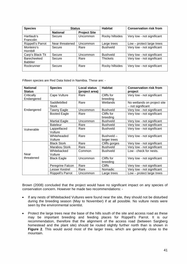
41
Status Species
National Project Site Habitat Conservation risk from
Hartlaub’s Francolin
Secure Uncommon Rocky hillsides Very low - not significant
Rüppell’s Parrot Near threatened Uncommon Large trees Low – protect large trees Monteiro’s Hornbill
Secure Rare Bushveld Very low - not significant
Carp’s Black Tit Secure Uncommon Bushveld Very low - not significant Barecheeked Babbler
Secure Rare Thickets Very low - not significant
Rockrunner Secure Rare Rocky hillsides
Very low - not significant
Fifteen species are Red Data listed in Namibia. These are: - National Status
Species Local status (project area)
Habitat Conservation risk from project
Critically Endangered
Cape Vulture Rare Cliffs for breeding
Very low - not significant
Saddlebilled Stork
Rare Wetlands No wetlands on project site – not significant
Tawny Eagle Uncommon Bushveld Very low - not significant Booted Eagle Rare Cliffs for
breeding Very low - not significant
Martial Eagle Uncommon Bushveld Very low - not significant
Endangered
Bateleur Rare Bushveld Very low - not significant Lappetfaced Vulture
Rare Bushveld Very low - not significant Vulnerable
Whiteheaded Vulture
Rare Bushveld – larger trees
Very low - not significant
Black Stork Rare Cliffs gorges Very low - not significant Marabou Stork Rare Bushveld Very low - not significant Whitebacked Vulture
Common Bushveld Low - check for nests.
Black Eagle Uncommon Cliffs for breeding
Very low - not significant
Peregrine Falcon Rare Cliffs Very low - not significant Lesser Kestrel Rare Nomadic Very low - not significant
Near threatened
Rüppell’s Parrot Uncommon Large trees Low – protect large trees Brown (2008) concluded that the project would have no significant impact on any species of conservation concern. However he made two recommendations: - • If any nests of Whitebacked Vultures were found near the site, they should not be disturbed
during the breeding season (May to November) if at all possible. No vulture nests were seen by the environmental scientist.
• Protect the large trees near the base of the hills south of the site and access road as these
may be important breeding and feeding places for Rüppell’s Parrot. It is our recommendation, therefore that the alignment of the access road (between Sargberg homestead and the plant site) should be routed slightly further north than is shown in Figure 2. This would avoid most of the larger trees, which are generally close to the mountain.
42
Impacts on Birds Nature of impact
Loss of habitat for feeding, and in some cases for breeding.
Mitigation • Avoid disturbance of vulture nests (if any) during the breeding season • Avoid activities close to large trees near the base of the mountains
Extent Within 1- 2 km of on site activities, depending on the species Duration Long term Intensity Low Probability Highly probably Confidence Medium Significance Low Further investigation or monitoring
See mitigation above
6.15 Impacts of New Access Road
A new access road will be built through the farms Gaub Pad and Mignon to the site. It is proposed that this will be a gravel road, though it may be upgraded to a tar road in due course in order to minimise dust and wear and tear on vehicles and the road itself. The road will be 6 – 10m wide, with an additional 25m cleared of vegetation on either side of the road surface. A least-impact route was considered which ran on the north side of the Sargberg farmstead. However this route was rejected for technical reasons, there being shales with low bearing capacity along that route. This would have meant that the road design would have required greater layer works, involving much greater costs. Therefore a route shown in Figure 2 was selected for technical reasons, having better founding conditions. The road route proposed by Ohorongo Mining is shown by the red dotted line in Figure 2. This route will not have some impact on important vegetation. The vegetation on the lower limestone slopes is of little conservation importance. However, Strohbach (pers comm), recommended two minor re-alignments, shown by the orange dotted lines in Figure 2. The “orange route” would avoid most of the woodland west of the Sargberg farmstead and some large trees on Kalahari sands at the eastern end (on the farm Gaub Pad). Therefore, the “orange route” is recommended for botanical reasons. It is likely that road kills of small animals, or even kudu, and nocturnal birds will occur unless speed limits are set and strictly enforced. The road poses a risk to farm children who are not used to fast-moving traffic. The families need to be given instruction in road safety for pedestrians. The following recommendations are made with respect to the exact alignment of the road.
• The final alignment should be designed to minimise impacts on the woodlands west of the Sargberg farmstead. Large trees should be avoided.
• The Kalahari sands on the farm Gaub Pad support vegetation that may include species of conservation importance, such as ground orchids. Therefore Strohbach recommended shifting the eastern end of the road northwards to avoid the Kalahari sands as far as possible.
43
• The intersection with the B1 tar road should be a safe distance from bends in the B1 road. This recommendation supports Strohbach’s recommendation, above but for reasons of road safety as well as vegetation.
• The proposed route should be designed with gentle curves to discourage speeding, • Consultations with the land owners are recommended to ensure acceptability of the
designed route. • The Roads Authority needs to be consulted about the position of the intersection and
the construction of turning lanes. Impacts of New Access Road Nature of impact Impacts on vegetation
Risk to farm children Potential road kills (birds and animals)
Mitigation • Selection of “orange” road alignment to minimise impacts vegetation • Selection of safe point to intersect with the B1 road (consult Roads Authority) • Design road with curves to discourage speeding • Set and enforce appropriate speed limits (suggest 50km/h) • Consultation with affected farm owners.
Extent Limited to the footprint of the access road Duration Long term Intensity Medium Probability Probable Confidence Medium Significance Medium Further investigation or monitoring
Consider environmental impacts in selecting the alignment in the design stage
6.16 Impacts of New Power Line
A power line will be constructed from an existing line near the B1 tar road to the site of the cement plant. NamPower have not yet made the route known. It is understood that it will most likely cross the farms Gaub Pad, Mignon and Sargberg – similar to the route of the access road. The power line will probably have a capacity of 132 kV. The towers, of 23m high, will look like that shown in Photo 7 on page 46. The visual impacts of such a line will be insignificant as there are no sensitive receivers. A review of literature was conducted by the author for Eco.plan (2005) for a 400kV powerline proposed by NamPower. The relevant literature dealt with the potential effects of electromagnetic fields on human health. It was concluded that electromagnetic fields from high voltage power lines are reduced to background levels within 100 – 300m and that beyond 100m there was no significant risk of any impact on human health. For the much lower voltage 132kV transmission line it is recommended that a distance of 100m from any dwellings or work stations for farm residents should be completely safe with regard to electromagnetic fields and human or animal health.
44
Power lines are often a cause of fatalities to large birds such as vultures, cranes, and bustards. However, this area is not important for large birds. No sign was found of any large raptor nests in the hills to the south. Due to bush encroachment there are no extensive grasslands to attract cranes, secretary birds or other larger walking birds, and there is no surface water to attract large water birds such as pelicans or flamingos. It is recommended that the line be constructed alongside the new access road for several reasons: -
• A corridor underneath the powerline needs to be cleared to prevent veld fires from resulting in “flashovers” that could cause power interruptions.
• The new road can be used for construction and maintenance instead of yet another access track being created.
• Regular traffic along this road will help to scare birds away, so that there is less risk of collision with the lines in flight.
Impacts of Power Line Nature of impact Minor visual impacts for residents on the farm Sargberg
Electromagnetic fields and human health Risk to birds due to the conductors
Mitigation Construct the line further than 100m away from dwellings, work stations and cattle kraals. If any bird strikes occur, bird flappers could be put on the relevant section of the line, but there is no indication that this will be necessary at this stage.
Extent Visual impacts – nominally 500m Electromagnetic – 100m
Duration Long term Intensity Low Probability Low Confidence High Significance Low Further investigation or monitoring
Design route at more than 100m from people and livestock places Report any bird strikes and fit bird flappers if necessary
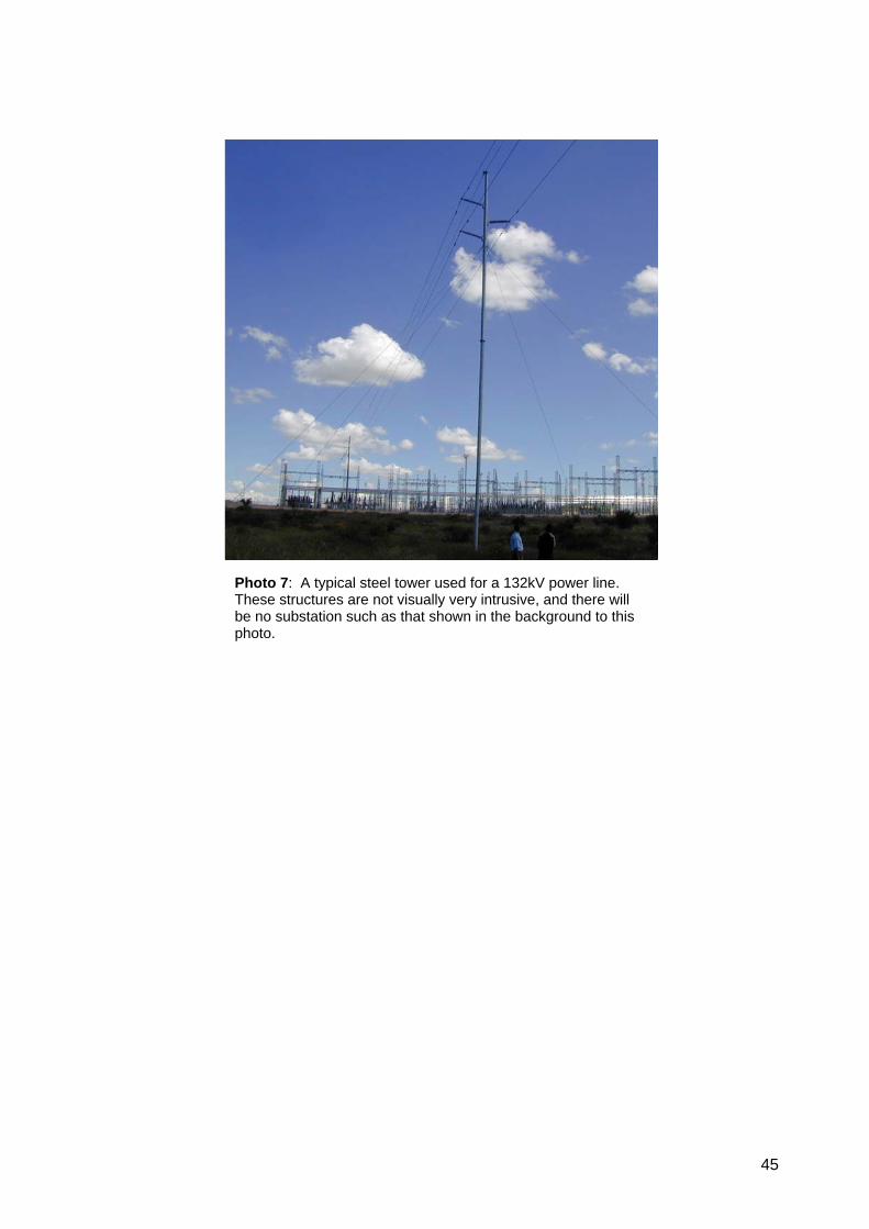
45
Photo 7: A typical steel tower used for a 132kV power line. These structures are not visually very intrusive, and there will be no substation such as that shown in the background to this photo.

46
6.17 Impacts of New Housing Provision
Housing will not be provided on site, with the possible exception of a few security staff quarters. Housing will be built or obtained in Otavi and/or Tsumeb. No details are yet available on the required housing needs. It is assumed that many of the labourers will already have their own accommodation in Otavi or Tsumeb. The provision of additional housing in an urban area should not give rise to any significant impacts and an EIA for such activity is not normally required in Namibia. Provided that there is proper consultation with the local authorities and neighbouring suburbs, good planning practices and good service provision then any potentially significant impacts can be avoided. This issue has therefore not been investigated in this EIA. 6.18 Impacts of Noise and Vibration
Sources of noise at the quarry will be mainly blasting, crushing, and vehicles. Blasting would probably be done once per day. Crushing would be continuous for about 16 hours per day Monday to Saturday. Large trucks would move to and from the plant anytime during daylight hours. This would normally be limited to 12 hours per day and would be intermittent. Sources of noise at the plant would include noisy equipment such as the ball mill for grinding the clinker. This noise will be contained in a building which can be designed with sound-absorbent materials. Noise will also be generated by vehicles in loading yards and on the access road. Environmental Noise SABS 10103 (2004) provides “acceptable rating levels for noise in districts”. For rural districts an acceptable outdoor noise level is considered to be 45 dBA during the daytime, and 35 dBA at night. (Again definitions and measurement methods are specified in the standard). Mitigation of noise impacts out of doors is influenced by a number of factors: - • The best way to mitigate this impact is at source. For example, the noise specifications of
equipment and vehicles can be taken into account when ordering equipment. Tarred roads are better than gravel roads. The type of finish on a tar road affects the noise from tyres – smooth surfaces are less noisy. The design of the road is also important. The ideal is that a vehicle should be able to travel at a constant speed because braking, accelerating and changing gear aggravate the noise impacts on people. Vehicles should travel at a slow speed without having to drive in low gears, which increases engine noise. The design of the road needs to take into account all these factors as there are a number of families on the farm Sargberg who live close to where the road will pass.
• The frequency (or pitch) of sound has a major influence on the distance that sound will
travel. Low frequency noise travels further than high frequencies. The sound of blasting will probably carry furthest, but that will be restricted to daylight hours. Other than that there is no way to mitigate the noise of blasting.
47
• Sound carries further when the air is densest – i.e. on cold winter nights. Therefore blasting should be restricted to daylight hours.
• Distance from the source is also an important factor in noise attenuation. The decibel level
decreases most rapidly over the first 100m and then less and less for each additional 100m from the source. Since the nearest farmstead is more than 3km away, noise will be attenuated naturally to a significant degree.
• A solid barrier, such as a range of hills is one of the best natural noise attenuation factors.
Thus the two ridges will largely shield the closest farmsteads from noise – except for the Sargberg farmstead, which will not be shielded in this way.
• Dense vegetation cover helps to absorb sound to a limited extent. Therefore it would be an
advantage to leave broad strips of encroacher bush (say 100m wide) along the access road and around the quarry and crusher site.
Overall, it is considered that the impact of noise will be very limited due to the fact that there are so few people living near the site, and the nearest neighbours are more than 3km from the quarry and plant. Impacts of noise from the quarry Nature of impact Noise from blasting, crusher, vehicles in the quarry Mitigation • Blast only during daylight hours
• Maintain silencers on equipment and vehicles • Leave as much vegetation in the surroundings as possible
Extent • Blasting - several km • Crusher and vehicles in the quarry – a few km
Duration • Blasting – once per day • Crusher and vehicles in the quarry – 16 hours/day x 6 days/week • All long term (over 100 years)
Intensity At 3km from the site, the impact should be low. Probability Depends on distance from the site Confidence Medium Significance Low – although fairly intense nearby, it will be of very short duration each day Further investigation or monitoring
Design of the crusher – the crusher will be contained in a structure, therefore noise dampening should be possible to a degree.
The manufacturing plant will generate more persistent noise than the quarry site and it will operate 24 hours / day. However, as the plant is enclosed within buildings there is an opportunity to design the structures to substantially reduce noise emissions. Distance to farm dwellings will also act to attenuate noise to some degree. The SABS 10103 (2004) Standard for acceptable noise levels out of doors is 45 dBA in the daytime and 35 dBA at night. The nearest sensitive receptor will be the dwellings on the farm Sargberg, which are approximately 3km from the site of the plant. It is recommended that the plant be designed to meet these SABS standards at a distance of 3km from the plant in order to avoid justifiable complaints about noise. Impacts of noise from the plant Nature of impact Noise from machinery, especially the grinding machine / mill. Mitigation • Design to meet the SABS Standards for noise exposure in rural areas. Extent • Must meet standards at 3km from plant
48
Duration • Day and night all year round except during shut down for maintenance Intensity Low at a few hundred metres away Probability Low Confidence Medium Significance Low Further investigation or monitoring
Design to meet OHS standards indoors and with sound-absorbent materials inside buildings. Must meet standards at 3km from plant.
The families living on Sargberg will experience the impact of traffic noise. Impacts of noise from the access road Nature of impact • Noise from tyres, engines, exhausts from long haul trucks
Mitigation • Design and alignment of access road
• Smooth - tarred surface of access road • Maintain exhausts and silencers on vehicles • Earth berms to screen dwellings / homesteads • Limit the removal of vegetation from the roadside to the minimum that is
compatible with road safety. Note that vegetation close to the road also makes the road look narrower and thus discourages speeding.
• Limit traffic, under normal circumstances, to 12 hours / day. Extent • Up to 1km Duration • Day and night almost all year for over 100 years Intensity Medium - high for dwellings on Sargberg – depending on distance and mitigation Probability Highly probable Confidence High Significance Medium Further investigation or monitoring
Design of access road and berms
Vibration Vibrations will be generated from blasting, milling the clinker, other mechanical operations, and heavy vehicles on the access road. Any vibrations from blasting cannot be mitigated but there are no near receptors that could be adversely affected. Vibrations from the road can best be mitigated by ensuring a flat, smooth road surface. In any event such vibrations would only be felt on or very close to the road. Vibrations within the plant have to be dealt with in the design of the plant in order to protect the machinery from damage. Therefore it is standard practice to mount machinery in such a manner that vibrations are dampened. Therefore no significant impact is expected from any of the potential sources of vibration. 6.19 Impacts on Road Traffic on Major Roads
It is estimated that some 70 heavy vehicles per day will be moving to and from the plant transporting goods and products. That would equate to approximately 6 per hour during their daylight operating hours.
49
This volume of traffic should not in itself be problematic. However it will represent a noticeable increase in the number of heavy vehicles travelling along the roads in the directions of Otavi, Tsumeb and Grootfontein. The intersection of the access road with the B1 tar road at the farm Gaub Pad represents a potential hazard to other road users as slow-moving large trucks enter a road that currently has low volumes of traffic. The position of the intersection should be carefully chosen to avoid proximity to existing bends in the road. There is a straight section of approximately 2.4km, which means that the intersection could be a maximum of 1.2km from a bend. It is recommended that turning lanes be added to both sides of the road to facilitate smooth merging of traffic onto the B1 tar road. It is also recommended that rumble strips and good signage be installed in order to warn other road users of heavy vehicles entering and turning off the road. These measures will require consultation with the Roads Authority. Impacts of many heavy vehicles will increase the wear and tear on the road. Ohorongo Cement must ensure that transport operators do not overload vehicles. Loading must comply with the requirements of the Roads Authority. Impacts of Traffic on Major Roads Nature of impact Potential collisions, mainly due to heavy vehicles entering or turning off the B1 road
Increased wear and tear on the roads. Mitigation • Location of intersection
• Construction of turning lanes on both sides of the road • Avoid overloading vehicles.
Extent The new intersection with the B1 tar road at the farm Mignon All local roads will carry slightly increased traffic as well
Duration Long term Intensity • Potential collisions at the intersection - medium
• Overall traffic increase – low • Wear and tear – low, provided there is no overloading
Probability • Potential collisions at the intersection - highly probable • Overall traffic increase – definite
Confidence High Significance Medium (essential mitigation would reduce this to “low” ) Further investigation or monitoring
Consultations with Roads Authority
6.20 Impacts on Air Quality
During the public participation many people raised concerns about dust and smoke from the plant. These concerns were based on experience of the old cement plant at Otjiwarongo, which had a poor environmental record as a result of outdated technology. Ohorongo Cement will use modern technology that reduces air emissions to within EU standards. A desktop study was compiled for this EIA by air quality specialists Simpson & Ryder (2007). Their report was contained in Appendix E of the Scoping Report (CCA, 2007). Their study took into account information supplied by the Client – namely technical data, details of the manufacturing process, and air emissions data based on experience at their plants in Europe.
50
They also used topographic maps, orthophotos, photographs of the site, and wind direction data for Grootfontein (the nearest wind data that was available). The sources of potential air quality impacts are the quarry and crusher, unpaved roads, and the plant itself. Quarry, Crusher and Unpaved Roads Simpson & Ryder considered that the quarry and crusher were likely to be the main source of dust, in fact the only significant sources of dust. The dust will be emitted as a result of blasting, loading and vehicle movement in the quarry. Periodic earth moving to remove and stockpile the overburden of soil will also result in dust emissions. Dust from these sources tends to be of larger particle size which is associated with a nuisance factor, rather than a health hazard. However, the larger particle size, low wind velocities and low population density will result in a low impact of this dust on people in the environment. The crusher will be fitted with bag filters (Schauer, pers comm). The crushed material will be transported by conveyor to the plant and not by trucks. These measures will substantially reduce the dust emissions. It is inevitable that some vehicular movement around the site will be necessary. Water can also be used for dust suppression where required. Simpson & Ryder recommended that an air quality monitoring and management programme be implemented as part of an EMP for the operations stage of the quarry. We further recommend the following measures to minimise dust emissions: -
• Vegetation and soil should be removed together (mixed) so that the plant matter helps to hold the soil. Alternatively, vegetation can be stripped and stockpiled and then spread over the newly made stockpiles of soil,
• Where practical, rehabilitation of the quarry should be progressive – i.e. it should be implemented as soon as a section is worked out. (This is only possible if there is no water standing in the pit.)
• Natural vegetation surrounding the quarry can play an important role in minimising dust emissions. It will reduce surface wind speeds and also trap a lot of the dust. Therefore vegetation should only be cleared where it is absolutely necessary for operation. As the quarry expands, clearing should not take place a long time in advance of quarrying.
• Use recycled water to spray tracks and dust generating surfaces. • Dust filters on the crusher and enclosed conveyor system are measures already
proposed by Ohorongo Cement. Impacts of the quarry, crusher and unpaved roads on air quality Nature of impact Dust will be emitted from these activities Mitigation • Clear and stockpile soil with vegetation in/on it
• Avoid clearing vegetation unnecessarily or too far in advance of quarrying • Spraying with recycled water • Dust filters on crusher, and enclosed conveyor system.
Extent Nominally 2 – 3km decreasing in intensity with distance Duration Long term Intensity Medium Probability Highly Probable Confidence High
51
Significance Medium Further investigation or monitoring
Background dust levels should be established prior to construction, and periodic monitoring during operations.
Cement Manufacturing Plant The plant will be completely enclosed, so that fugitive dust will be very limited but certain noxious gases will be emitted as a result of the fuel burned in the kilns. Air emissions from coal are usually associated with trace elements including nickel, mercury, arsenic, chromium and cadmium. Other contaminants are sulphur, nitrogen, chlorine and fluorine. Sulphur dioxide (SO2) will be the most significant air pollutant from the combustion of coal. This has the potential for negative health impacts. However, the technology to be used will ensure compliance with the EU accepted emission standards. This fact, together with the distance from near neighbours and lack of other sources of industrial or urban pollution, should result in a very low level of human health impact. Alternative fuels such as plastics and car tyres may be considered at a later stage but are not part of the current proposal. In any event the very high temperatures of combustion ensure complete combustion, thus minimising any harmful emissions – which tend to occur only if combustion occurs at temperatures lower than 800ºC. The proposed use of encroacher bush will have minimal impacts due to the high temperatures of the flame temperature in the kiln (2200 ºC) and high gas temperature in the precalciner (over 850ºC). These high temperatures ensure complete combustion. High temperatures also ensure the minimum formation of harmful substances such as dioxins and furans. The technology to be employed will meet the EU directive 200/76/EC and ensure that emissions will be within internationally acceptable standards. The use of wood chips from encroacher bush should present no particular air emission problems, again because of the high temperatures of combustion and modern technology used. Dust is generated by the cement grinding plant, which will be fitted with the best available technology to limit dust emissions - in the workplace and emissions to the environment - to within internationally accepted standards. Schwenk has the experience from their plants in Europe to ensure that a high standard of air quality is achieved using tried and proven technology. Simpson & Ryder (2007) considered that no specialist study of air quality would be needed for the construction and operation of the cement manufacturing plant. Refer to Appendix E of the Scoping Report. Impacts of manufacturing plant on air quality Nature of impact Low levels of dust emissions, and noxious gases from the kiln. Mitigation • High temperatures ensure complete combustion
• Modern technology ensures minimal particulate emissions Extent • Unknown, depending on atmospheric dispersion factors, but decreasing in
intensity with distance Duration • Long term (but experienced intermittently due to changing wind directions) Intensity Low – within EU standards Probability Definite Confidence High Significance Low
52
Further investigation or monitoring
Application of best available technology in the design, construction and operations stages.
6.21 Health and Emergency & Hospital Services
Potential accidents may require the use of emergency services and hospital facilities nearby. There are no emergency services available in Otavi. The Tsumeb Emergency Services (TEMS) sometimes assists outside of their municipal area but are required to get Council permission for this, which can delay their response. ISOS has a depot in Tsumeb, and there are two GRN ambulances. In Grootfontein there is one GRN ambulance. It is recommended that: -
• Ohorongo Cement should establish an understanding with International SOS (ISOS) or E-Med to handle emergencies,
• Personnel on site should be trained in handling emergencies such as response to fire, accidents etc. Mr Bul van der Merwe from TEMS has indicated that they would be willing to offer such training.
• Qualified personnel should make regular trips to the quarry and plant to give training updates and check emergency equipment, such as fire fighting equipment.
Otavi has only a clinic/health centre, which has four beds. There is one private doctor in Otavi. Tsumeb has a GRN hospital (Lombard Hospital) with four beds in the casualty unit and 90 beds in the general wards. There is an X-ray unit, and one operating theatre but it does not always have oxygen available. A state doctor is on call at all times at the hospital. There is a private hospital in Tsumeb with four beds in a casualty unit, three in an emergency room and 25 beds in general wards. There is an X-ray unit, blood testing laboratory, and operating theatre with oxygen. Tsumeb has six private doctors and there is always a doctor on call for emergencies. Grootfontein GRN hospital has 3 beds in casualty unit, and 160 in general wards. It has an operating theatre. A GRN doctor is always on call. There is also a private hospital in Grootfontein with one bed in casualty unit and 12 beds in general wards. They have an operating theatre. Grootfontein has five private doctors and one of these is on call for emergencies. Both Tsumeb and Grootfontein have tarred airfields, but Otavi has only a gravel landing strip. Impacts on Emergency & Hospital Services Nature of impact The availability of emergency and hospital services represent a constraint for
Ohorongo Cement in regard to providing health care for staff in potential emergencies. If an accident occurred that affected many people, the available services may prove to be inadequate.
Mitigation • Careful planning of emergency procedures • Training in first aid and emergency response to employees on site
Extent • The quarry, plant and roads used in the area Duration • Long term Intensity Unknown
53
Probability Probable Confidence Low Significance Low Further investigation or monitoring
Planning and training in emergency response and first aid – regularly updated
6.22 Occupational Health & Safety Issues
OHS issues are not normally dealt with in an EIA but a brief mention is made here. The Labour Act (Act 6 of 1992) makes certain provisions with regard to occupational health and safety, e.g. in relation to hazardous substances. In particular it is expected that workers will need to be protected against dust and noise in the work place. SABS 10083 (2004) requires that noise levels in the work place (as defined and measured in accordance with that standard) should not exceed 85 dBA. If this limit is reached, then a noise zone must be declared. A noise zone has special requirements for protective equipment and for training of exposed personnel. Dust will be released into the air within the plant, a high percentage of which consists of PM10 particles. These are very small particles that are known to be associated with health impacts. SABS 1929 (2005) provides the following standards for PM10 particulate matter: -
• The daily limit for the protection of human health over a 24hour period is 75 µg/m3 (the permissible frequency for exceeding limit values is yet to be determined).
• The annual limit for a calendar year is 40 µg/m3. Target values have been set at an even lower level as follows: -
• The daily target for the protection of human health over a 24hour period is 50 µg/m3 (the permissible frequency for exceeding limit values is yet to be determined).
• The annual limit for a calendar year is 30 µg/m3. 6.23 Impact on HIV/AIDS and of this Disease on the Project
The HIV infection rate in Namibia is currently approximately 20%. Any large project has the potential to increase the rate of infection, especially during construction as a large workforce from outside the area is brought in for a period, without their families, to work on the project. That impact cannot be realistically assessed, but mitigation measures are recommended, namely instruction to all personnel on HIV/AIDS education, and making condoms readily available at little or no cost. Notwithstanding the above mitigation measures, it can be expected that HIV/AIDS will have an impact on the project because labourers will be lost to this disease. This results also in a loss of skills, so that training programmes will need to be ongoing.
54
Impacts of the project on HIV/AIDS Nature of impact Temporary work forces have the potential to aggravate the already high infection
rate. Mitigation • Staff education
• Voluntary testing to determine HIV status and counselling at existing medical facilities (by law this cannot be required by the employer)
Extent • The areas of Otavi and Tsumeb Duration • Long term Intensity Unknown – depends on staff response to awareness and education programmes Probability Probable Confidence Low Significance Low Further investigation or monitoring
-
Impacts ofHIV/AIDS on the project Nature of impact Loss of staff due to illness and death Mitigation • As above Extent • Ohorongo Cement’s staff Duration • Long term Intensity Likely to be of the order of 20% Probability Highly Probable Confidence Medium Significance Medium Further investigation or monitoring
Regular training of new recruits and re-skilling / upskilling of existing staff
6.24 Economic Benefits to Namibia
The economic benefits of the project to Namibia are expected to be substantial. These are expected to include: -
• The total investment in the plant will be N$ 1.5 billion. • The plant should provide permanent employment for some 300 people on site. • Many more employment opportunities will be created due to the multiplier effects of a
large industry in the region. • A housing project is proposed for employees. • The Schwenk Company in Germany is involved in a number of downstream industries
in fields such as insulation materials and concrete products. Therefore an opportunity exists for them to bring their technical experience to establish other industries around the cement production industry,
• Support industries usually grow up around a large industry, which requires mechanical engineering services, vehicle maintenance, and many other services.
Secondary economic benefits are likely to be achievable if encroacher bush is used for fuel. This would provide the following additional benefits: -
• Employment creation for large numbers of people, including many unskilled people, • Good distribution of economic benefits by means of various models that could be
implemented for small businesses that undertake contracts to supply bush as fuel,
55
• Considerably improved grazing for livestock, which would help to make some farms more viable than they are at present,
• Secondary industrial and commercial opportunities supporting the bush clearing companies and related transport industry.
6.25 Electricity Consumption
The total electricity consumption of the project is expected to be approximately 15 – 17 MW. This amounts to approximately 4.2% of Namibia’s current energy consumption of 400 MW at normal levels of consumption. Peak demand in winter can reach as high as 445MW in Namibia. Approximately half of Namibia’s power is generated at Ruacana Hydro Power Station on the Kunene River. Most of the rest is imported from South Africa. Both Namibia and South Africa are facing an imminent shortage of power. Eskom, South Africa has started load shedding because it can not meet the demand, and this form of load management is expected to spill over into Namibia as well. NamPower will soon be constructing a new 400 kV powerline through the Caprivi to link Namibia to sources of hydro power in Zambia and Zimbabwe. With a number of new uranium mines becoming established, the cumulative impacts on Namibia’s energy demand will place energy resources under pressure for many years to come. It would be prudent for Ohorongo Cement to consider this issue in the design of the plant, in order to limit the effects of any power cuts on productivity and in order to minimise their electricity demand. It is recommended that the following measures be designed into the plant wherever possible: -
• Direct solar water heating installations, • Selection of machinery and appliances that minimise energy consumption, • Use of low-energy lighting.
Impacts of the project on Namibia’s power demand Nature of impact An increase in Namibia’s power demand of some 4.2% Mitigation • Plan to minimise power consumption, especially by using solar water heating Extent • Namibia Duration • Long term Intensity Low Probability Definite Confidence High Significance Low Further investigation or monitoring
Consider all reasonable energy saving alternatives in the plant design and operation.
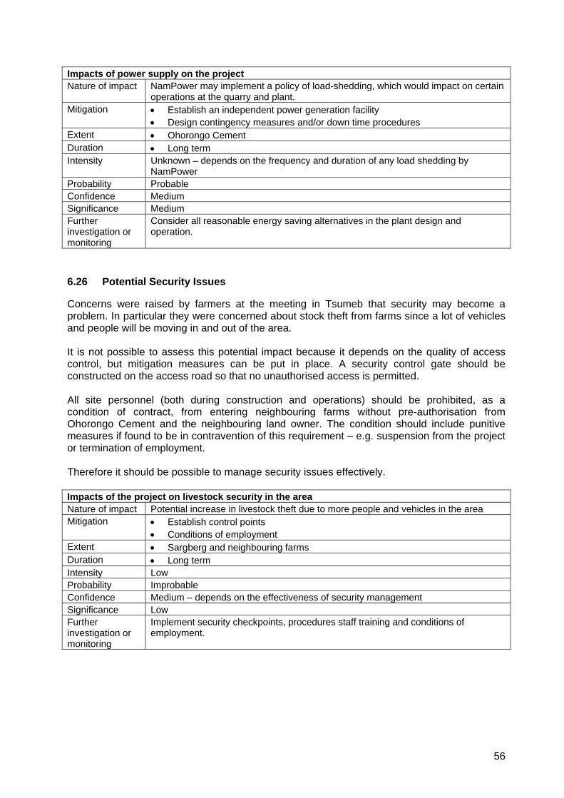
56
Impacts of power supply on the project Nature of impact NamPower may implement a policy of load-shedding, which would impact on certain
operations at the quarry and plant. Mitigation • Establish an independent power generation facility
• Design contingency measures and/or down time procedures Extent • Ohorongo Cement Duration • Long term Intensity Unknown – depends on the frequency and duration of any load shedding by
NamPower Probability Probable Confidence Medium Significance Medium Further investigation or monitoring
Consider all reasonable energy saving alternatives in the plant design and operation.
6.26 Potential Security Issues
Concerns were raised by farmers at the meeting in Tsumeb that security may become a problem. In particular they were concerned about stock theft from farms since a lot of vehicles and people will be moving in and out of the area. It is not possible to assess this potential impact because it depends on the quality of access control, but mitigation measures can be put in place. A security control gate should be constructed on the access road so that no unauthorised access is permitted. All site personnel (both during construction and operations) should be prohibited, as a condition of contract, from entering neighbouring farms without pre-authorisation from Ohorongo Cement and the neighbouring land owner. The condition should include punitive measures if found to be in contravention of this requirement – e.g. suspension from the project or termination of employment. Therefore it should be possible to manage security issues effectively. Impacts of the project on livestock security in the area Nature of impact Potential increase in livestock theft due to more people and vehicles in the area Mitigation • Establish control points
• Conditions of employment Extent • Sargberg and neighbouring farms Duration • Long term Intensity Low Probability Improbable Confidence Medium – depends on the effectiveness of security management Significance Low Further investigation or monitoring
Implement security checkpoints, procedures staff training and conditions of employment.
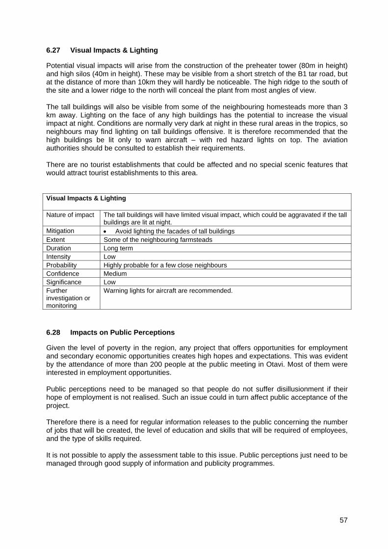
57
6.27 Visual Impacts & Lighting
Potential visual impacts will arise from the construction of the preheater tower (80m in height) and high silos (40m in height). These may be visible from a short stretch of the B1 tar road, but at the distance of more than 10km they will hardly be noticeable. The high ridge to the south of the site and a lower ridge to the north will conceal the plant from most angles of view. The tall buildings will also be visible from some of the neighbouring homesteads more than 3 km away. Lighting on the face of any high buildings has the potential to increase the visual impact at night. Conditions are normally very dark at night in these rural areas in the tropics, so neighbours may find lighting on tall buildings offensive. It is therefore recommended that the high buildings be lit only to warn aircraft – with red hazard lights on top. The aviation authorities should be consulted to establish their requirements. There are no tourist establishments that could be affected and no special scenic features that would attract tourist establishments to this area. Visual Impacts & Lighting Nature of impact The tall buildings will have limited visual impact, which could be aggravated if the tall
buildings are lit at night. Mitigation • Avoid lighting the facades of tall buildings Extent Some of the neighbouring farmsteads Duration Long term Intensity Low Probability Highly probable for a few close neighbours Confidence Medium Significance Low Further investigation or monitoring
Warning lights for aircraft are recommended.
6.28 Impacts on Public Perceptions
Given the level of poverty in the region, any project that offers opportunities for employment and secondary economic opportunities creates high hopes and expectations. This was evident by the attendance of more than 200 people at the public meeting in Otavi. Most of them were interested in employment opportunities. Public perceptions need to be managed so that people do not suffer disillusionment if their hope of employment is not realised. Such an issue could in turn affect public acceptance of the project. Therefore there is a need for regular information releases to the public concerning the number of jobs that will be created, the level of education and skills that will be required of employees, and the type of skills required. It is not possible to apply the assessment table to this issue. Public perceptions just need to be managed through good supply of information and publicity programmes.

58
7 SUMMARY & CONCLUSION
7.1 Summary
The following table provides a summary of the assessments in Section 6 above. For each potential environmental impact or issue, the significance is stated following the assessment in Section 6. Potential mitigation and further investigations that have been recommended are summarised in “key word” form. These may need to be applied at one or more stages of the project life cycle: -
• Planning, • Construction, • Operations, • Closure, & Post Closure
Environmental Impact or Issue
Significance Rating
Possible Mitigation Further Investigation or Monitoring Recommended
Impact on rock and landscape – quarry
Low Partial rehabilitation of quarry Response to mining plan
Management of topsoil Low Removal and stockpiling of topsoil
“
Potential for sinkhole formation
Low - Deep drilling to determine the presence of cavities, if any
Impacts of groundwater abstraction – local level
Medium - Regular hydrocensus
Impacts of groundwater abstraction – regional level (30km)
Low due to cement project alone
- Monitoring of water levels in karst “wet caves” for cumulative impacts
Impacts on karst fauna in “wet caves”
Low due to cement project alone
- “
Potential for groundwater contamination
Low Avoid dolomite and limestone substrates when siting activities that could pollute soil. Control all potential sources of pollution at source.
Periodic water quality tests
Solid & liquid fuels Low Compaction of soil, Bunding of liquid installations, Paving for woodchips
Site facilities on tillite or shales
Site camp Low Site selection, housekeeping, proper sanitation
Site selection to avoid sensitive areas
Waste disposal Low Use in kilns, recycling, or disposal at approved landfill
Monitor compliance with management plan
Impacts on natural vegetation
Medium Avoid the Steep limestone hill habitat, Rescue geophytes from intermontane valley, Minor adjustments to access road route.
Environmentally sensitive mine planning, Monitor Ficus thonningii on Ma Foi.
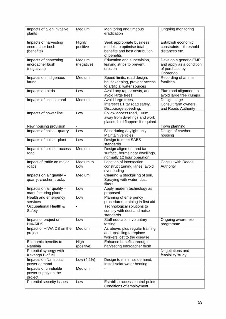
59
Impacts of alien invasive plants
Medium Monitoring and timeous eradication
Ongoing monitoring
Impacts of harvesting encroacher bush (benefits)
Highly positive
Seek appropriate business models to optimise total benefits and best distribution of benefits
Establish economic constraints – threshold distances etc.
Impacts of harvesting encroacher bush (negatives)
Medium (negative)
Education and supervision, leaving strips to prevent erosion
Develop a generic EMP and apply as a condition of purchase by Ohorongo
Impacts on indigenous fauna
Medium Speed limits, road design, housekeeping, prevent access to artificial water sources
Recording of animal fatalities
Impacts on birds Low Avoid any raptor nests, and avoid large trees
Plan road alignment to avoid large tree clumps
Impacts of access road Medium Avoid large trees, Intersect B1 tar road safely, Discourage speeding.
Design stage Consult farm owners and Roads Authority
Impacts of power line Low Follow access road, 100m away from dwellings and work places, bird flappers if required
New housing provision - Town planning Impacts of noise - quarry Low Blast during daylight only
Maintain vehicles Design of crusher-housing
Impacts of noise - plant Low Design to meet SABS standards
Impacts of noise – access road
Medium Design alignment and tar surface, berms near dwellings, normally 12 hour operation
Impact of traffic on major roads
Medium to Low
Location of intersection, construct turning lanes, avoid overloading
Consult with Roads Authority
Impacts on air quality – quarry, crusher, tracks
Medium Clearing & stockpiling of soil, Spraying with water, dust filters
Impacts on air quality – manufacturing plant
Low Apply modern technology as proposed
Health and emergency services
Low Planning of emergency procedures, training in first aid
Occupational Health & Safety
- Technological solutions to comply with dust and noise standards
Impact of project on HIV/AIDS
Low Staff education, voluntary testing
Ongoing awareness programme
Impact of HIV/AIDS on the project
Medium As above, plus regular training and upskilling to replace workers lost to the disease
Economic benefits to Namibia
High (positive)
Enhance benefits through harvesting encroacher bush
Potential synergy with Kavango Biofuel
- Negotiations and feasibility study
Impacts on Namibia’s power demand
Low (4.2%) Design to minimise demand, Install solar water heating
Impacts of unreliable power supply on the project
Medium -
Potential security issues Low Establish access control points Conditions of employment
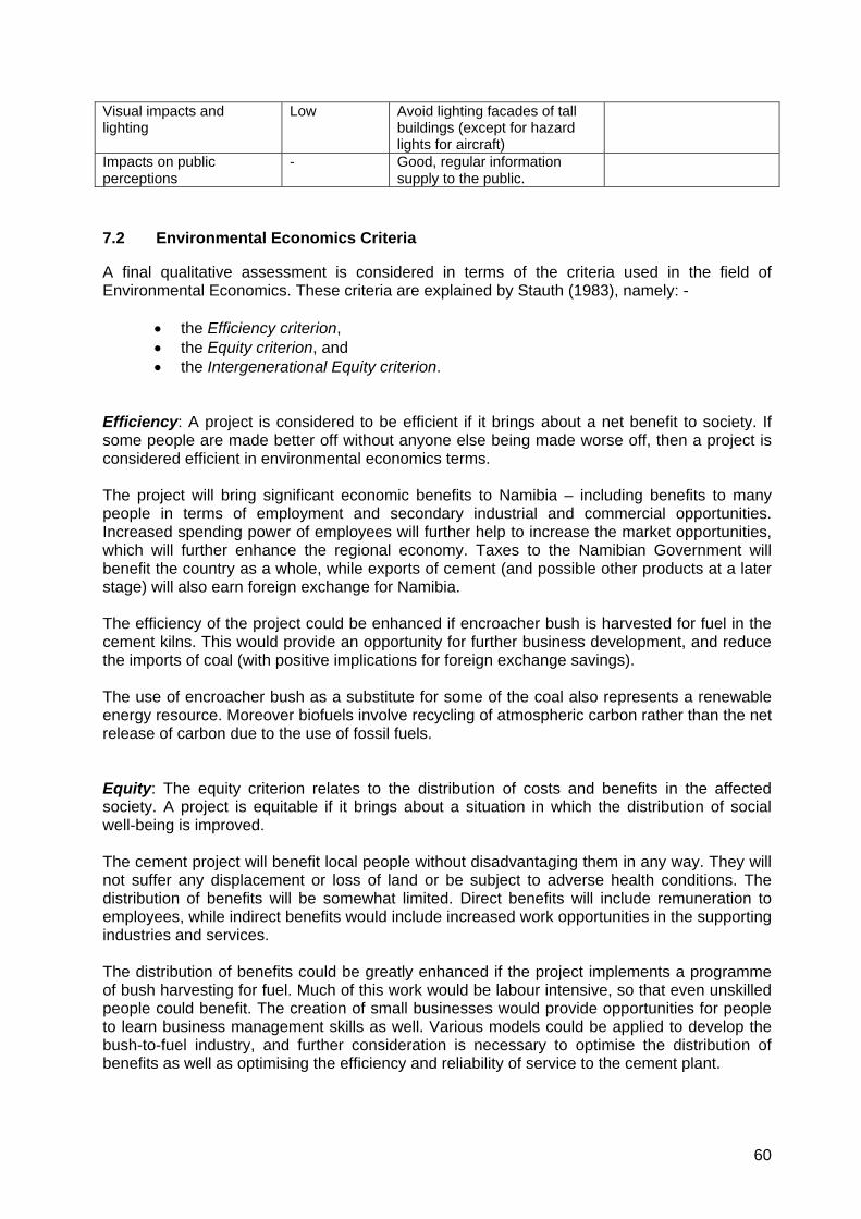
60
Visual impacts and lighting
Low Avoid lighting facades of tall buildings (except for hazard lights for aircraft)
Impacts on public perceptions
- Good, regular information supply to the public.
7.2 Environmental Economics Criteria
A final qualitative assessment is considered in terms of the criteria used in the field of Environmental Economics. These criteria are explained by Stauth (1983), namely: -
• the Efficiency criterion, • the Equity criterion, and • the Intergenerational Equity criterion.
Efficiency: A project is considered to be efficient if it brings about a net benefit to society. If some people are made better off without anyone else being made worse off, then a project is considered efficient in environmental economics terms. The project will bring significant economic benefits to Namibia – including benefits to many people in terms of employment and secondary industrial and commercial opportunities. Increased spending power of employees will further help to increase the market opportunities, which will further enhance the regional economy. Taxes to the Namibian Government will benefit the country as a whole, while exports of cement (and possible other products at a later stage) will also earn foreign exchange for Namibia. The efficiency of the project could be enhanced if encroacher bush is harvested for fuel in the cement kilns. This would provide an opportunity for further business development, and reduce the imports of coal (with positive implications for foreign exchange savings). The use of encroacher bush as a substitute for some of the coal also represents a renewable energy resource. Moreover biofuels involve recycling of atmospheric carbon rather than the net release of carbon due to the use of fossil fuels. Equity: The equity criterion relates to the distribution of costs and benefits in the affected society. A project is equitable if it brings about a situation in which the distribution of social well-being is improved. The cement project will benefit local people without disadvantaging them in any way. They will not suffer any displacement or loss of land or be subject to adverse health conditions. The distribution of benefits will be somewhat limited. Direct benefits will include remuneration to employees, while indirect benefits would include increased work opportunities in the supporting industries and services. The distribution of benefits could be greatly enhanced if the project implements a programme of bush harvesting for fuel. Much of this work would be labour intensive, so that even unskilled people could benefit. The creation of small businesses would provide opportunities for people to learn business management skills as well. Various models could be applied to develop the bush-to-fuel industry, and further consideration is necessary to optimise the distribution of benefits as well as optimising the efficiency and reliability of service to the cement plant.
61
The harvesting of bush will also benefit participating livestock farmers as a result of increased grass growth. Intergenerational Equity (or Sustainability): This criterion considers the economic impacts on future generations – i.e. it extends the considerations of equity to future generations. Thus a project should be able to make the present generation better off without making future generations worse off. It should be able to provide benefits to future generations without degrading the resource base that the society depends on for its wellbeing. It has been established by Ohorongo Cement that the raw materials of limestone, shale etc on site are sufficient for well over a 100 years. Groundwater resources are renewable within certain limits of abstraction, and this resource appears to be adequate for the project’s needs. However ongoing monitoring of groundwater is recommended during operations to confirm that this resource is sustainable in the long term, even with the effects of climate change. Electricity resources are very limited in Namibia and southern Africa generally, so this may pose a constraint on the project that may need to be addressed. The likelihood of load shedding would be a significant disadvantage for the operation of cement kilns, which need to operate continuously for almost the entire year, closing only for annual maintenance. The project poses no significant threats to human health, the health of domestic livestock or wildlife and birds, provided that the proposed control measures are effectively implemented. One proviso should be made, however with regard to karst fauna some distance from the plant. Abstraction of water from the karst aquifer has the potential for adverse impacts on unique and endemic karst fauna in wet caves. The water demand of the cement plant alone is very unlikely to impact these unique faunal communities, which are more than 19km away. However the cumulative impacts of abstraction from the affected compartments of the Otavi Mountain Lands needs to be monitored by Government to safeguard against extinction of certain species in the long term. The potential harvesting of encroacher bush is also considered to be sustainable at some level of utilisation, because the bush will regrow. The optimum level of utilisation, and the threshold distance for economically transporting shredded bush needs to be established. Not only would the harvesting of encroacher bush be sustainable, but it would also enhance the sustainability of cattle farming in the areas where it is implemented. The problem of bush encroachment has been proven to have a highly negative impact on the sustainability of grazing resources. The cement project could make a significant contribution to mitigating this problem. It is strongly recommended that Ohorongo Cement should investigate the economics of bush utilisation, and should implement a programme – even if it has marginal economic benefits for Ohorongo Cement – because it can have major benefits for farmers and employment opportunities for many labourers. 7.3 Conclusion
Overall the economic benefits of the cement project should outweigh the limited negative impacts on the natural environment. The project is expected to perform positively in relation to the efficiency, equity and sustainability criteria. If the project exploits the opportunity for the use of encroacher bush, the socio-economic benefits should be greatly enhanced, while even adding environmental benefits for a large number of farms, labourers and small businesses.

62
8 ENVIRONMENTAL MANAGEMENT PLAN

63

64

65

66

67
68
9 REFERENCES
AfriDev Associates (2004)
Environmental Assessment of water Abstraction from the Tsumeb and Karst Area 3 Aquifers, Namibia. Compiled for Namibia Water Corporation Ltd, Windhoek, Namibia. October 2004.
Bromilow, C. (2001) Problem Plants of South Africa. Briza. Pretoria.
Brown, C (2008) An Avifaunal Assessment for the proposed Ohorongo Cememnt Manufacturing Plant and Quarry Site, Otavi/Tsumeb. Prepared for Colin Christian & Associates, Windhoek.
CBEND (2007) Turning Namibian Invader Bush into Electricity: The CBEND Project, Desert Research Foundation of Namibia (DRFN), Windhoek, Namibia.
CCA (May, 2007) Kavango Biofuel Project: Plantations of Jatropha curcas: Environmental Impact Assessment, Volume 1. Prepared for Prime Investment (Pty) Ltd, Windhoek.
CCA (Nov 2007) Proposed Cement Manufacturing Plant and Quarry: Otavi/Tsumeb Environmental Scoping Report. Prepared for Ohorongo Cement, Windhoek.
Christellis, G. & Struckmeier, W. (ed) (2001)
Groundwater in Namibia. An explanation to the hydrogeological map. Department of Water Affairs, Division Geohydrology. Windhoek.
De Klerk, J.N. (1999) Bush Encroachment in Namibia. Ministry of Environment & Tourism, Windhoek, Namibia.
Eco.plan (2005) Environmental Impact Assessment of the Proposed Auas-Otjikoto-Lifa 400kV Transmission Line, Volume 2: EIA Report. Compiled for NamPower, Windhoek.
GKW Consult (2002) Tsumeb Groundwater Study. Prepared for Directorate of Water Affairs, Windhoek.
Griffin, M. (2008) The Potential Influence of the Proposed Ohorongo Cement Plant on Indigenous Namibian Amphibians, Reptiles and Mammals. Prepared for Colin Christian & Associates, Windhoek.
Mendelsohn, J., Jarvis, A., Roberts, C., and Robertson, T. (2002)
Atlas of Namibia Published for the Ministry of Environment & Tourism by David Philip, Cape Town.
RSA DEAT (1992) Checklist of Environmental Characteristics. Integrated Environmental Management Guideline Series. Department of Environment Affairs. Pretoria, RSA.
69
SABS 10083 (2004) South African National Standard. The measurement and assessment of
occupational noise for hearing conservation purposes. SABS, Pretoria.
SABS 10103 (2004) South African National Standard. The measurement and rating of environmental noise with respect to land use, health, annoyance and to speech communication. SABS, Pretoria.
SABS 1929 (2005) South African National Standard. Ambient air quality – Limits for common pollutants. SABS, Pretoria.
Schultz, R. (2007) Ohorongo Cement – EIA Scoping Information: Encroacher Bush-to- Energy. Compiled for Colin Christian & Associates CC, Windhoek, Namibia.
Schwenk (Jan, 2008) Statement Regarding the emissions by two cement grinding plants at the workplaces and in the surrounding area. Report No.1-08-01-019. Schwenk Zement KG, Germany.
Simpson A. and Rider (2007)
Environmental Scoping Study: Ohorongo Cement – Tsumeb / Otavi: Air Quality Comments. Prepared for Colin Christian & Associates, Windhoek.
Stauth R.B. (1983) Environmental Economics. In Fuggle R,F. and Rabie M, A. (ed.) (1983) Environmental Concerns in South Africa: Technical & Legal Perspectives. Juta, Cape Town.
Strohbach, B. (2008) Vegetation of the Ohorongo Cement Factory & Quarry Site, Farm Sargberg near Otavi. Prepared for Colin Christian & Associates, Windhoek.
VTT (2007) Power Generation: Feasibility of biofuel boiler plants and cofiring. Ministry of Foreign Affairs, Finland.
Water Sciences (Dec, 2007)
Ohorongo Cement - Farm Sargberg 585 – Aquifer Testing. Compiled for Schwenk Zement KG. Windhoek, Namibia.
Water Sciences (Oct, 2007)
Ohorongo Cement - Farm Sargberg 585 – Hydrogeology. Compiled for Schwenk Zement KG. Windhoek, Namibia.
PERSONAL COMMUNICATIONS P. Botha Geohydrologist - Water Sciences, Windhoek
E. Marais National Museum, Windhoek
E. Tordiff Directorate of Water Affairs, Windhoek
M. Schauer Geologist – Schwenk / Ohorongo Cement
B. van der Merwe Tsumeb Emergency Services
70
10 ACKNOWLEDGEMENTS
The following are kindly thanked for their valuable contribution to this study: - Eric Tordiff and Greg Cristellis from the Directorate of Water Affairs provided discussions on the geology and geohydrology, particularly on the potential for sinkhole formation. John Irish provided discussion on the potential risks to karst aquatic fauna, and Eugene Marais provided information on this subject as well as the locations of karst wet caves in the relevant area. Pierre Botha (Water Sciences) provided discussions on the geology and geohydrological issues, and assisted in the compilation of the map, Figure 4. NP du Plessis made available a copy of the AfriDev Associates (2004) report and a informal discussion on the likely draw-down zones around abstraction boreholes. Bul van der Merwe from the Tsumeb Emergency Services provided information on the emergency and hospital services available in Otavi, Tsumeb & Grootfontein. Davidzo Namate (NamPower) and Jeanene D'Emiljo (Enviro Dynamics) provided information and photos of a 132kV tower. Ian Galloway (engineer and charcoal producer) discussed the potential for synergy between charcoal producers and bush-for-fuel in cement kilns. Markus Schauer, Uwe Müller and Klaus Bauer provided discussions and project information throughout the study as well as comments on the draft EIA report. All of the above-mentioned contributions are gratefully acknowledged.