draft environmental impact statement/ environmental impact...
TRANSCRIPT

Los Angeles CountyMetropolitan Transportation Authority
Westside Subway ExtensionDraft Environmental Impact Statement/Environmental Impact Report
> Executive Summary September 2010
The U.S. Department of Transportation Federal
Transit Administration (FTA) and the Los Ange-
les County Metropolitan Transportation Authority
(Metro) are undertaking the Los Angeles Westside
Subway Extension Project (Project) that would extend
the Metro Purple Line/Metro Red Line heavy rail
subway system from its current western termini at
Wilshire/Western Station (Metro Purple Line) and
Hollywood/Highland Station (Metro Red Line) to a
new western terminus.
History and Background of the Westside Subway Extension ProjectMetro’s Westside Subway Extension has been an
integral element of local, regional, and Federal trans-
portation planning since the early 1980s. Extending
westward from the Los Angeles Central Business
District (CBD), the Westside Subway Extension
has been the subject of in-depth technical studies
and extensive community involvement during this
period. The transit investment has historically been
envisioned to extend toward Beverly Hills, Century
City, Westwood (the University of California, Los
Angeles (UCLA)), West Los Angeles, and Santa
Monica.
Suspension of Early Subway PlanningIn the early 1990s, plans were underway to extend
the Metro rail subway to the Westside. Construction
was underway on the Metro Red Line from Union
Station to Wilshire/Western Station and to Holly-
wood. Environmental clearance and a Full Funding
Grant Agreement (FFGA) were completed to extend
the subway from Wilshire/Western to Pico/San
Vicente at this time. The subway alignment was to
have deviated south of Wilshire Boulevard to avoid a
federally prohibited methane gas hazard zone (a zone
that was designated in 1985 after naturally occurring
methane gas caused a fire in the Fairfax District).
The planning for a subway in this corridor was later
suspended in 1998 due to a lack of funding, includ-
ing a ballot initiative that prohibited local funds from
being used for subway construction.
Resumption of Subway PlanningIn October 2005, at the request of Metro and the
Mayor of the City of Los Angeles, the American
Public Transportation Association (APTA) conducted
a Peer Review to reconsider the feasibility of tunnel-
ing along the federally precluded Wilshire Boulevard
segment of the Westside Corridor. As a result of this
review, which concluded that tunnels could be safely
constructed and operated along Wilshire Boulevard
due to advances in new tunnel construction meth-
ods that were previously unavailable, legislation was
enacted in Congress repealing the Federal prohibi-
tion on subway funding in December 2007.
Alternatives AnalysisAs discussed in Chapter 2 of this Draft Environmen-
tal Impact Statement/Environmental Impact Report
(EIS/EIR), Alternatives Analysis (AA) Study was
initiated in 2007 for all reasonable fixed-guideway
alternative alignments and transit technologies,
S-2 Westside Subway Extension September 2010
including heavy rail subway alternatives. The FTA
issued an Early Scoping Notice in the Federal Register
on October 1, 2007, to help define the appropriate
range of issues and alternatives to be addressed in
the AA Study.
The AA Study evaluated alignment and transit tech-
nology alternatives within the Study Area. After the
alternatives evaluation in the AA Study, two alterna-
tives were recommended for further consideration
in this Draft EIS/EIR. These two alternatives best
met the Purpose and Need while having the fewest
environmental impacts. The alternatives were: (1)
Extend the Metro Purple Line Subway via Wilshire
Boulevard to Santa Monica, and (2) Extend the Metro
Purple Line Subway via Wilshire Boulevard to Santa
Monica plus extend a subway from the Metro Red
Line Subway Hollywood/ Highland Station via Santa
Monica Boulevard to connect with the Wilshire line.
The alternative alignments studied during the AA
process were generally located along roadway rights-
of-way that could reasonably be used in an at-grade,
elevated, or subway configuration. Four technologies
were presented and analyzed in the AA Study—
heavy rail transit (HRT), light rail transit (LRT), bus
rapid transit (BRT), and monorail. The ridership
analysis demonstrated a need for a technology that
could provide a capacity of more than 700 passengers
per train set to accommodate the high-capacity peak-
period loading along the Wilshire and Santa Monica
alignments. HRT was identified as the preferred
technology for further study because it has the capac-
ity to meet the anticipated ridership demand and
limit the number of transfers.
In January 2009, the Metro Board approved the
Westside Subway Extension Project AA Study and
authorized preparation of this Draft EIS/EIR.
Public hearings will be held after the release of the
Draft EIS/EIR, and then a Locally Preferred Alterna-
tive (LPA) would be selected and Metro would apply
for entry into FTA’s Preliminary Engineering (PE)
Phase.
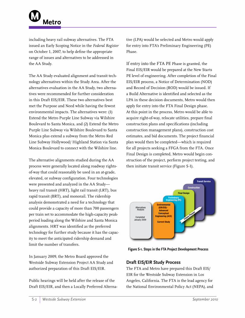
If entry into the FTA PE Phase is granted, the
Final EIS/EIR would be prepared at the New Starts
PE level of engineering. After completion of the Final
EIS/EIR process, a Notice of Determination (NOD)
and Record of Decision (ROD) would be issued. If
a Build Alternative is identified and selected as the
LPA in these decision documents, Metro would then
apply for entry into the FTA Final Design phase.
At this point in the process, Metro would be able to
acquire right-of-way, relocate utilities, prepare final
construction plans and specifications (including
construction management plans), construction cost
estimates, and bid documents. The project financial
plan would then be completed—which is required
for all projects seeking a FFGA from the FTA. Once
Final Design is completed, Metro would begin con-
struction of the project, perform project testing, and
then initiate transit service (Figure S-1).
Draft EIS/EIR Study ProcessThe FTA and Metro have prepared this Draft EIS/
EIR for the Westside Subway Extension in Los
Angeles, California. The FTA is the lead agency for
the National Environmental Policy Act (NEPA), and
Figure S‑1. Steps in the FTA Project Development Process
Construction
Final Design
Transit Service
PreliminaryEngineering (PE)
Environmental(EIR/EIS)-Advanced
Conceptual Engineering (ACE)
Current Study
Completed January 2009
AlternativesAnalysis
Future Phases

Draft Environmental Impact Statement/Environmental Impact Report S-3
Executive Summary
Metro is the lead agency for the California Environ-
mental Quality Act (CEQA).
This Draft EIS/EIR defines the Purpose and Need of
the Project and describes and evaluates the alterna-
tives, including a No Build Alternative and a rela-
tively low-cost Transportation System Management
(TSM) Alternative. The Draft EIS/EIR documents
the evaluation of the potential transportation and
environmental impacts and benefits, mitigation mea-
sures, operating and maintenance and capital costs,
and potential funding sources for the alternatives.
It also includes a comparison of alternatives and a
discussion of the public and agency outreach. The
components of the Project that are evaluated in this
Draft EIS/EIR include the following:
• Westside Subway Extension alternatives—Five
heavy rail subway alternatives are analyzed, rep-
resenting different project lengths
• Station location options and alignments—Con-
sideration whether to include certain stations,
the location of alternate station locations where
options exist, and comparison of optional routes
for connecting station locations
• Phasing options—Two minimum operable seg-
ments (MOS) with potential interim operation
are considered
• Other project components—traction powered
substations, vent shafts, trackwork options, a
rail operations center, and two options for the
maintenance yard
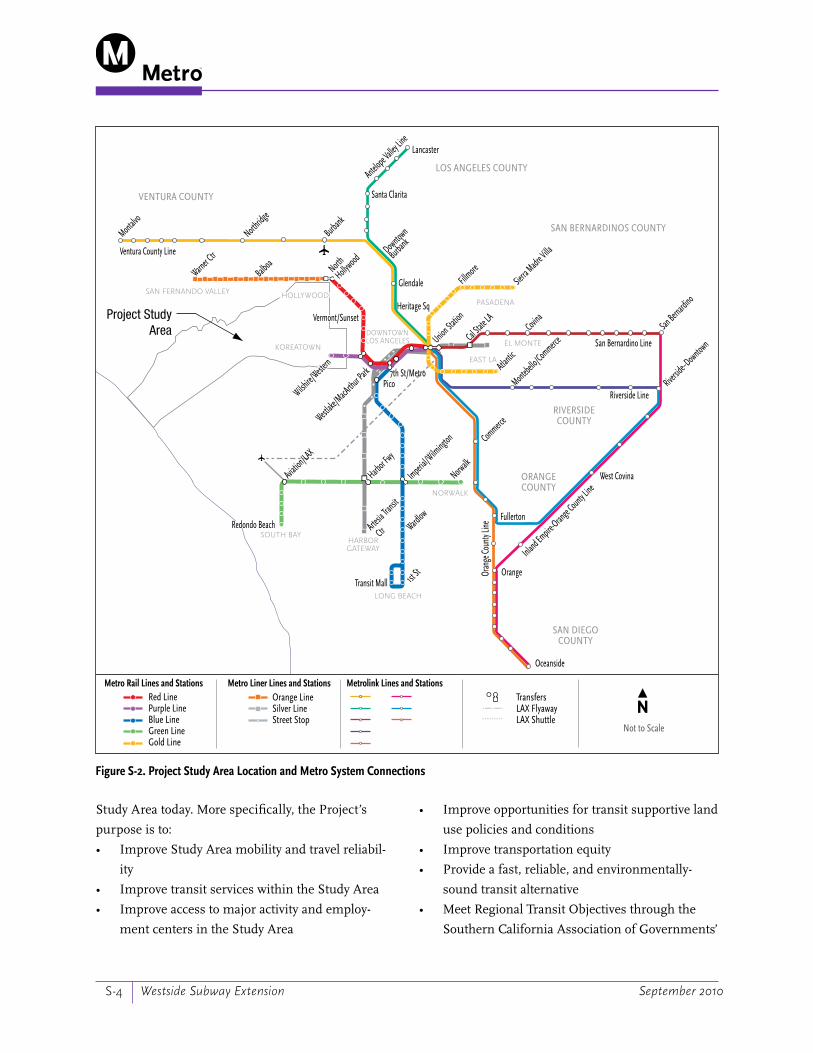
Description of the Westside Subway Extension Study Area The Study Area for the Project was defined during
the AA phase. It is located in western Los Angeles
County and encompasses approximately 38 square
miles. The Study Area is east/west oriented and
includes portions of the Cities of Los Angeles, West
Hollywood, Beverly Hills, and Santa Monica, as well
as portions of unincorporated Los Angeles County.
The Study Area boundaries generally extend north to
the base of the Santa Monica Mountains along Hol-
lywood, Sunset, and San Vicente Boulevards; east to
the Metro Rail stations at Hollywood/Highland and
Wilshire/Western; south to Pico Boulevard; and west
to the Pacific Ocean (Figure S-2).
Relationship of the Study Area to Metro’s Transit SystemSince 1990, Metro has constructed a regional fixed-
guideway transit system that consists of HRT, LRT,
BRT, and commuter rail. This system currently
includes more than 76 miles of Metro Rail service
(HRT and LRT) and 14 miles of BRT service. These
include the Metro Red Line (HRT), Metro Blue Line
(LRT), Metro Green Line (LRT), Metro Gold Line
(LRT) and Metro Orange Line (BRT). In addition, the
Southern California Regional Rail Authority (Metro-
link) has opened more than 500 miles of Metrolink
commuter rail lines that serve five counties.
The existing fixed-guideway transit service in the
region is complemented by the transit corridors
currently under study or construction, including:
Exposition Light Rail Transit Project Phases 1 and 2;
Metro Gold Line Foothill Extension; Metro Regional
Connector; Metro Gold Line Eastside Extension
Phase 2; Crenshaw/LAX Transit Corridor Project;
South Bay Metro Green Line Extension; Metro
Orange Line Extension; and Wilshire BRT. The
Westside Subway Extension would provide direct
connections from the west side of the county to all
elements of the existing Metro system. Enhance-
ments are also planned for the Division 20 Mainte-
nance and Storage Facility.
Purpose and Need for Transit Improvements in the Study AreaThe purpose of this Project is to improve transit
travel time and provide more reliable transit service
to the 286,246 transit riders who travel through the
S-4 Westside Subway Extension September 2010
Figure S‑2. Project Study Area Location and Metro System Connections
LOS ANGELES COUNTY
VENTURA COUNTY
HOLLYWOODPASADENA
EL MONTE
EAST LA
KOREATOWN
SOUTH BAYHARBORGATEWAY
NORWALK
LONG BEACH
DOWNTOWNLOS ANGELES
SAN FERNANDO VALLEY
SAN BERNARDINOS COUNTY
RIVERSIDE COUNTY
ORANGE COUNTY
SAN DIEGOCOUNTY
Inland Empire-
Orange C
ounty Line
Oran
ge Co
unty
Line
Riverside Line
San Bernardino Line
Ventura County Line
Antelope Va
lley Lin
e
Sierra M
adre Villa
Fillmore
Union Station
Cal State
LASan Bern
ardino
Riverside–Downtown
Montebello
/Commerce
Aviation/LA
X
Wilshire/
Western
North
Hollywood
Warner C
tr
BurbankNorthridge
BalboaDowntown
Burbank
Lancaster
Santa Clarita
Glendale
Vermont/Sunset
Pico
Redondo Beach
Transit MallOrange
Fullerton
West Covina
Oceanside
7th St/Metro
Heritage Sq
Montalvo
Westlake
/MacA
rthur Park
Harbor Fw
y
1st St
Wardlow
Norwalk
Commerce
Imperial/W
ilmington
Artesia T
ransit
Ctr
Covina
Atlantic
Red LinePurple LineBlue LineGreen LineGold Line
Orange LineSilver LineStreet Stop
TransfersLAX FlyawayLAX Shuttle
Metro Rail Lines and Stations Metro Liner Lines and Stations Metrolink Lines and Stations
Not to Scale
Project Study Area
Study Area today. More specifically, the Project’s
purpose is to:
• Improve Study Area mobility and travel reliabil-
ity
• Improve transit services within the Study Area
• Improve access to major activity and employ-
ment centers in the Study Area
• Improve opportunities for transit supportive land
use policies and conditions
• Improve transportation equity
• Provide a fast, reliable, and environmentally-
sound transit alternative
• Meet Regional Transit Objectives through the
Southern California Association of Governments’

Draft Environmental Impact Statement/Environmental Impact Report S-5
Executive Summary
(SCAG’s) Performance Indicators of mobility,
accessibility, reliability, and safety
The need for the Project is described in Chapter 1 of
this Draft EIS/EIR in the discussions on population
and employment growth, the high number of major
activity centers, high existing transit usage, and
severe traffic congestion. The Study Area currently
has, and is projected to have, large population and
employment centers scattered throughout 15 existing
major activity centers in the corridor. These activity
centers are served by extremely congested road net-
works that will deteriorate further with the projected
increase in population of 51,000 (10.1 percent) and
the 58,000 additional jobs in the corridor (a 12.1
percent increase) by 2035. This anticipated growth
will further affect transit travel speeds and reliability,
even with a dedicated lane for express bus service
on Wilshire Boulevard. By 2035, buses will travel at
speeds ranging from 8 to 11 miles per hour (mph).
The Study Area currently has high transit usage—
hundreds of thousands of transit riders every day.
This high level of transit usage will increase by 29
percent between 2006 and 2035 (from 286,246 to
370,520). The improved capacity that would result
from the subway extension is the best solution to
improve travel times and reliability and to provide a
high-capacity, environmentally-sound transit alterna-
tive.
�Study Area Population and EmploymentApproximately 5 percent of the Los Angeles County
population (504,000) and 10 percent of the jobs
(479,000) are concentrated in the Study Area. The
Study Area population and employment densities
are among the highest in the metropolitan region,
averaging approximately 13,100 persons per square
mile and 12,500 jobs per square mile.
According to forecasts by SCAG, the designated Met-
ropolitan Planning Organization (MPO), the Study
Area’s population density will increase to more than
14,400 persons per square mile and approximately
14,000 jobs per square mile by 2035. This repre-
sents a 10 percent increase in population density
and a 12 percent increase in employment density.
In particular, the three largest activity centers are in
Beverly Hills (26,000 jobs per square mile), Century
City (43,000 jobs per square mile), and Westwood
(84,000 jobs per square mile). Approximately 147,000
jobs were located in these three centers in 2006.
Major Activity Centers and Destinations Los Angeles has been characterized as a collection
of urban centers. The “Centers Concept” from the
1960s and 1970s identified urban centers of various
types throughout the region that represented con-
centrations of economic activities and higher-density
housing. The Centers Concept envisioned that these
areas would be interconnected by transit infrastruc-
ture. The City of Los Angeles General Plan Frame-
work originally adopted the Centers Concept in 1970,
and has subsequently re-adopted the concept in more
recent updates of the General Plan.
The concept specifically designated centers in
Wilshire Center, Hollywood, Miracle Mile, Sunset
Strip, Beverly Hills, Westwood, and Santa Monica.
The intent of the plan, which would be met for these
centers by this Project, is to link these centers with
transit to reduce the reliance on the automobile for
access to these higher density areas and to preserve
lower densities in existing communities outside
designated growth areas.
Major activity centers in the Study Area are shown
in Figure S-3, and land uses are shown in Figure
S-4. Some of Southern California’s most well-known
The Westwood and Century City business districts
each have more jobs than many mid-sized down-
towns.

S-6 Westside Subway Extension September 2010
entertainment, educational, and cultural activity
centers are in the Study Area. Many of these centers
are within the densest portions of the Study Area,
along the Wilshire and Santa Monica Boulevard cor-
ridors. As shown in Figure S-3, major activity centers
include Downtown Santa Monica, Westwood Village,
UCLA, Century City, Rodeo Drive/Beverly Hills, Bev-
erly Center/Cedars Sinai Hospital, Sunset Strip/West
Hollywood, the Grove/Farmer’s Market, Wilshire
Miracle Mile, Wilshire Center, and Hollywood.
Travel Markets, Transit Usage, Congestion, and Mobility in the Study AreaPresently, the transportation network consists of a
well-defined grid of arterials and freeways generally
following an east/west or north/south orientation.
These freeways and streets carry some of the highest
traffic volumes in California and throughout the
country.
Travel MarketsThe primary travel markets in the Study Area are the
east/west “within Westside” and the east/west trips
Figure S‑3. Activity Centers in the Study Area
Draft Environmental Impact Statement/Environmental Impact Report S-7
Executive Summary
to and from Westside. As shown in Figure S-5, on an
average weekday in 2006, about 301,000 home-based
work peak trips entered the Study Area from outside
origins, while about 123,000 trips left the Study Area
for outside destinations. More than twice as many
work trips entered the Study Area as left. There were
102,000 daily home-based work peak trips starting
and ending within the Study Area, suggesting that
approximately one in four Study Area jobs is filled
by local (Study Area) residents. The remaining 75
percent of the jobs were filled by individuals living
outside the Study Area. Projections suggest that the
ratio of home-based work peak trips entering or leav-
ing the Study Area daily will remain about the same
through 2035.
Transit UsageAll bus service is currently provided in mixed-flow
lanes, which subjects buses to the same high levels
of congestion experienced by automobiles. The
Wilshire Corridor Route (Line 20/720/920) is the
heaviest used bus corridor in Southern California
with nearly 60,000 daily boardings, surpassing the
ridership of many LRT routes including the Metro
Green Line and the Metro Gold Line in Los Angeles.
Congestion and MobilityBetween 2006 and 2035, substantial increases are
projected in vehicle miles traveled (VMT) and vehicle
hours traveled (VHT). Daily VMT within the Study
Area will increase by approximately 26 percent, from
4 million in 2006 to more than 5 million in 2035.
During the same period, regional VMT are projected
to increase from 304.2 million to 504.7 million, or
more than 65.9 percent. VHT in the Study Area are
projected to increase from about 165,000 to 247,000,
or almost 50 percent. Regional VHT are projected to
increase from 9.5 million to 29.2 million, or about
207 percent between 2006 and 2035.
The Study Area contains some of the most congested
arterial streets in the County. Key east/west arterials,
such as Wilshire, Santa Monica, Sunset, Hollywood,
Olympic, and Pico Boulevards, operate at congested
conditions throughout the day. North/south arterials
extending westward from Western Avenue include
Crenshaw Boulevard, La Brea Avenue, La Cienega
Boulevard, Beverly Drive, Westwood Boulevard,
Sepulveda Boulevard, Bundy Drive, and Lincoln
Boulevard.
Arterials in the Study Area serve employment cen-
ters as well as local and regional travel. They are also
used as alternatives to the Interstate 10 (I-10) and
Interstate 405 (I-405) freeways during heavy conges-
tion, accidents, breakdowns, lane closures, and other
random events. As a result, the Study Area’s roadway
capacity is insufficient to handle the traffic volumes,
thus reducing travel time reliability for motorists and
transit riders.
The current average speeds of the Metro Rapid
buses traveling through the study area range
between 10 and 15 mph along Wilshire Boulevard
and between 11 and 14 mph along Santa Monica
Boulevard. The average speeds of both local buses
and the Metro Rapid buses traveling through the
Study Area are anticipated to decrease further as
traffic congestion increases on roadways, as illus-
trated in Figure S-6.
The Study Area has substantial traffic congestion,
high transit ridership and load factors, and closely
spaced bus stops. Combined, these factors result
in declining bus operating speeds and reliability,
making transit less
competitive with the
private automobile.
With high passenger
loads and congested
roads, desirable headways (frequency of service)
are difficult to maintain and result in overcrowded
buses. As the road and transit systems become more
congested, the Study Area becomes a less desirable
Bus speeds are slow and
getting slower.

S-8 Westside Subway Extension September 2010
Figure S‑4. Land Use
LEGE
ND
Base
Sta
tion
Optio
nal S
tatio
n
Base
Tun
nel A
lignm
ent
Optio
nal T
unne
l Alig
nmen
t
Land
Use
with
in 0
.25
Mile
of
Sta
tion
Exis
ting
Land
Use
Sing
le F
amily
Res
iden
tial
Mul
ti-Fa
mily
Res
iden
tial
Com
mer
cial
Gove
rnm
ent/I
nstit
utio
nal
Open
Spa
ce/O
ther
Indu
stria
l
Park
ing/
Vaca
nt
05,
000 Fe
et
Nor
th
Wils
hire
/Fai
rfax
Exis
ting
Wils
hire
/W
este
rn
Exis
ting
Holly
woo
d/Hi
ghla
nd
Wes
twoo
d/UC
LA
Wils
hire
/La
Cien
ega
Wils
hire
/Rod
eo
Cent
ury
City
Wils
hire
/La
Brea
Wes
twoo
d/VA
Hosp
ital
Sant
a M
onic
a/Fa
irfax
Beve
rly C
ente
r Are
a
Sant
a M
onic
a/Sa
n Vi
cent
e
Sant
a M
onic
a/La
Bre
a
Wils
hire
/Bun
dy
Wils
hire
/26t
h
Wils
hire
/16t
h
Wils
hire
/4th
Wils
hire
/Cre
nsha
w
Holly
woo
d/Hi
ghla
nd

Draft Environmental Impact Statement/Environmental Impact Report S-9
Executive Summary
Figure S‑5. Home‑Based Work Peak Person Trip Comparison: 2006 to 2035
PICO
PICO
PICO
EXPOSITION
JEFFERSON
WASHINGTON BL
VENICE BL
VENICE BL
Veteran’s Administration
405
10
405
10
2
2
UCLA
WESTWOOD
WESTLOS ANGELES
CENTURYCITY
SANTA MONICA
CULVER CITY
MIRACLEMILE
HOLLYWOOD
KOREATOWN
BEVERLYHILLS
HANCOCKPARK
WEST HOLLYWOOD
MID-CITY
WINDSOR SQUARE
WILSHIRECENTER
WILSHIRE
SUNSET
BEVERLY DR
SUNSET
SAN
VICEN
TE
HOLLYWOOD BL
FAIR
FAX
SANTA MONIC
A BL
WA
LA C
IEN
EG
A
BE
VE
RLY
DR
FAIR
FAX
VENICE BL
SAN D
IEGO
FWY
SANTA MONICA FWY
BUNDY
OLYMPIC
PICO
WIL
SHIRE
SANTA MONIC
A BL
LINCOLN
SA
N D
IEG
O FW
Y
SUNSET
WESTW
OO
D
HIG
HLA
ND
WE
ST
ER
N
WILSHIRE
SANTA MONICA BL
BEVERLY
LA B
RE
A
VIN
ER
OS
SM
OR
E
OLYMPIC
VE
RM
ON
T
EXPOSITION
WASHINGTON BL
SANTA MONICA FWY
PICO
JEFFERSON
CR
ENSH
AW
BL
VENICE BL
OLYMPIC
PICO
Vermont
USC/Exposition
Park
Western
CrenshawLa Brea
La Cienega
Washington/National
Wilshire/Normandie
Wilshire/Vermont
Wilshire/Western
Vermont/Beverly
Vermont/Santa Monica
Vermont/Sunset
Hollywood/Western
Hollywood/Vine
Hollywood/Highland
Expo Line Phase 1(under construction)
Expo Line Phase 2Options (under study)
Crenshaw CorridorPreferred Alignment
Subject to Change 08-1386 ©2009 LACMTA
Metro Rail & Station
Over 300,000 people travel into the Westside every day from throughout the region
Over 300,000 people travel into the Westside every day from throughout the region
2006: 123,000 trips2035: 159,000 trips (+29%)
2006: 102,000 trips2035: 126,000 trips (+24%)
2006: 301,000 trips2035: 372,000 trips (+24%)
Figure S‑6. Percent Increases in Transit Travel Times—Metro Bus Routes in Study Area, 2003 to 2006
20 EB 20 WB 720 EB 720 WB 217 NB 217 SB 4 EB 4 WB 304 EB 304 WB
Perc
ent
Incr
ease
s in
Tra
vel T
ime
Routes
AM Peak
PM Peak
25
20
15
10
5

S-10 Westside Subway Extension September 2010
place for people to live and work and less attractive
for planned growth and development.
Regional ObjectivesIn 2008, the SCAG Regional Council adopted the
Regional Transportation Plan (RTP) (SCAG 2008) to
establish the goals, objectives, and policies for the
transportation system and to establish an imple-
mentation plan for transportation investments. The
RTP includes regional performance indicators with
objectives against which specific transportation
investments can be measured. Four key performance
indicators and their 2003 base year results, 2035
baseline projections, and 2035 objectives are shown
in Table S-1. The Study Area is designated as one of
the most congested areas in the five-county region.
Significant improvement in these categories to meet
regional objectives for mobility, accessibility, and reli-
ability are needed.
Measure RIn November 2008, the voters of Los Angeles County
approved Measure R, a one-half cent sales tax mea-
sure to provide funding for several important new
transportation projects in Los Angeles County. A
total of $4.2 billion was identified over a period of 30
years for the Westside Subway Extension, comprised
of local sales tax dollars and Federal matching funds.
Alternatives Before Scoping PeriodAt the initiation of the Draft EIS/EIR phase, Metro
presented the public with the two general align-
ments for a western extension of the Metro Rail Red
Line and Metro Purple Line subway (Alternative 1 in
Figure S-7 and Alternative 11 in Figure S-8). A series
of NEPA/CEQA scoping meetings were held to solicit
public input. In addition to requesting input on the
general alignments of Alternatives 1 and 11, Metro
sought public comment on the two green-shaded
portions in Figure S-7 and Figure S-8 where differ-
ent alignment and station options were possible in
the Beverly Hills to Westwood area and along the
West Hollywood Branch alignment. The alternatives
and station options discussed in this Draft EIS/EIR
include those recommended at the conclusion of
the AA phase with alignment and station options.
The alignment refinements and options are based
on further design and issues identified by the public
during scoping.
In October 2009, Metro adopted a Long Range Trans-
portation Plan (LRTP). In response to funding and
phasing issues raised by fiscal constraints identified
Table S‑1. Southern California Association of Governments Performance Indicators
Performance Indicator
Measurement 2003 Base Year 2035 Baseline 2035 Objective
Mobility Average daily speed 30.5 mph 26.8 mph 29.3 mph
Average daily delay per capita
20.0 minutes 30.7 minutes 25.8 minutes
Accessibility Percent of PM work trips within 45 minutes of residence
77% of all auto trips43% of all transit trips
77% of all auto trips42% of all transit trips
79% of all auto trips45% of all transit trips
Reliability Percent variation in travel time—weekday 5 p.m. to 6 p.m.
28% (2005) N/A 25%
Safety Daily accident rate per million persons
28.9 (estimated from graph)
30.2 (estimated from graph)
30.1 (estimated from graph)

Draft Environmental Impact Statement/Environmental Impact Report S-11
Executive Summary
Source: Metro
Note: 304 now operates as 704
PICO
PICO
PICO
EXPOSITION
JEFFERSON
WASHINGTON BL
VENICE BL
VENICE BL
Veteran’s Administration
405
10
405
10
2
2
UCLA
WESTWOOD
WESTLOS ANGELES
CENTURYCITY
SANTA MONICA
CULVER CITY
MIRACLEMILE
HOLLYWOOD
KOREATOWN
BEVERLYHILLS
HANCOCKPARK
WEST HOLLYWOOD
MID-CITY
WINDSOR SQUARE
WILSHIRECENTER
WILSHIRE
SUNSET
BEVERLY DR
SUNSET
SA
N VIC
EN
TE
HOLLYWOOD BL
FA
IRF
AX
SANTA MONIC
A BL
WA
LA
CIE
NE
GA
BE
VE
RL
Y D
R
FA
IRF
AX
VENICE BL
SAN
DIEG
O FW
Y
SANTA MONICA FWY
BUNDY
OLYMPIC
PICO
WIL
SHIRE
SANTA MONIC
A BL
LINCOLN
SA
N D
IEG
O FW
Y
SUNSET
WESTW
OO
D
HIG
HL
AN
D
WE
ST
ER
N
WILSHIRE
SANTA MONICA BL
BEVERLY
LA
BR
EA
VIN
ER
OS
SM
OR
E
OLYMPIC
VE
RM
ON
T
EXPOSITION
WASHINGTON BL
SANTA MONICA FWY
PICO
JEFFERSON
CR
EN
SH
AW
BL
VENICE BL
OLYMPIC
PICO
Vermont
USC/Exposition
Park
Western
CrenshawLa Brea
La Cienega
Washington/National
Wilshire/Normandie
Wilshire/Vermont
Wilshire/Western
Vermont/Beverly
Vermont/Santa Monica
Vermont/Sunset
Hollywood/Western
Hollywood/Vine
Hollywood/Highland
Expo Line Phase 1(under construction)
Expo Line Phase 2Options (under study)
Crenshaw-Prairie Corridor Options (under study)
Subject to Change 08-1386 ©2007 LACMTA
Metro Rail & Station
HRT (Subway)
Other Crenshaw-Prairie Connections (further study)
Proposed Station Locations
Optional Station Locations
Alternative Sites forSingle Station
Single Alignment to beSelected
Century City
Westwood/UCLA
Wilshire/4th
Wilshire/Bundy
Wilshire/26th
Wilshire/16th
Wilshire/Beverly
Wilshire/FairfaxWilshire/La Brea
Wilshire/Crenshaw
Alternative 1
Wilshire/La Cienega
Figure S‑7. Alternatives Analysis Study Alternative 1
Figure S‑8. Alternatives Analysis Study Alternative 11
PICO
PICO
PICO
EXPOSITION
JEFFERSON
WASHINGTON BL
VENICE BL
VENICE BL
Veteran’s Administration
405
10
405
10
2
2
UCLA
WESTWOOD
WESTLOS ANGELES
CENTURYCITY
SANTA MONICA
CULVER CITY
MIRACLEMILE
HOLLYWOOD
KOREATOWN
BEVERLYHILLS
HANCOCKPARK
WEST HOLLYWOOD
MID-CITY
WINDSOR SQUARE
WILSHIRECENTER
WILSHIRE
SUNSET
BEVERLY DR
SUNSET
SAN
VICEN
TE
HOLLYWOOD BL
FAIR
FAX
SANTA MONIC
A BL
WA
LA C
IEN
EG
A
BE
VE
RLY
DR
FAIR
FAX
VENICE BL
SAN D
IEGO
FWY
SANTA MONICA FWY
BUNDY
OLYMPIC
PICO
WIL
SHIRE
SANTA MONIC
A BL
LINCOLN
SA
N D
IEG
O FW
Y
SUNSET
WESTW
OO
D
HIG
HLA
ND
WE
ST
ER
N
WILSHIRE
SANTA MONICA BL
BEVERLY
LA B
RE
A
VIN
ER
OS
SM
OR
E
OLYMPIC
VE
RM
ON
T
EXPOSITION
WASHINGTON BL
SANTA MONICA FWY
PICO
JEFFERSON
CR
ENSH
AW
BL
VENICE BL
OLYMPIC
PICO
Vermont
USC/Exposition
Park
Western
CrenshawLa Brea
La Cienega
Washington/National
Wilshire/Normandie
Wilshire/Vermont
Wilshire/Western
Vermont/Beverly
Vermont/Santa Monica
Vermont/Sunset
Hollywood/Western
Hollywood/Vine
Hollywood/Highland
Expo Line Phase 1(under construction)
Expo Line Phase 2Options (under study)
Crenshaw-Prairie Corridor Options (under study)
Subject to Change 08-1386 ©2007 LACMTA
Metro Rail & Station
HRT (Subway)
Other Crenshaw-Prairie Connections (further study)
Proposed Station Locations
Optional Station Locations
Alternative Sites forSingle Station
Single Alignment to beSelected
Century City
Westwood/UCLA
Wilshire/4th
Wilshire/Bundy
Wilshire/26th
Wilshire/16th
Wilshire/Beverly
Wilshire/FairfaxWilshire/La Brea
Wilshire/Crenshaw
Transfer Required
Alternative 11
Santa Monica /Fairfax
Santa Monica /La Brea
Beverly CenterArea
Santa Monica/ La Cienega or San Vicente
Wilshire/La Cienega

S-12 Westside Subway Extension September 2010
during the LRTP process, Metro developed Minimal
Operating Segments (MOSs) to correspond to the
timeframe for the availability of Measure R funding.
Initial construction segments were identified to Fair-
fax (2019), Century City (2026) and Westwood (2036).
Refinement of the Alignments and Station LocationsDuring preparation of this Draft EIS/EIR, the align-
ment and station locations have been refined to avoid
impacts to the natural and built environments where
feasible, provide a cost-effective solution to increase
east/west mobility in the Study Area, and respond to
public and agency input. Chapter 2 of this Draft EIS/
EIR and the Post Scoping Analysis and Refinement of
Alternatives (May 2010) document the evaluation of
the alternatives. A summary of the public and agency
comments and how the alignments and stations
were refined is provided below.
Wilshire/Crenshaw Station Option (Option 1)Scoping comments were divided on this station with
some expressing support while others argued that
it is not needed. This location is only one-half mile
west of the Wilshire/Western Station in a relatively
low density area that is not planned to grow in the
future. Also Crenshaw Boulevard terminates at
Wilshire Boulevard so there are less connectively
opportunities than at other sites. For these reasons,
an option has been provided that evaluates operating
the project without a station at Wilshire Crenshaw.
Wilshire/Fairfax Station Option (Option 2)During the NEPA/CEQA scoping period, public
comments stated that the Wilshire/Fairfax Station
should more directly serve the Los Angeles County
Museum of Art (LACMA) and the Page Museum/
Hancock Park facilities. To address these comments,
a second station site closer to the LACMA and park
facilities was included in the Draft EIS/EIR for more
detailed analysis.
Wilshire/La Cienega Station Option (Option 3)Different station locations were examined to respond
to public comment and address potential connections
and transfers to a future West Hollywood alignment.
There was strong public preference for a station loca-
tion east of La Cienega Boulevard (which would have
no transfer/connection structure between lines).
Another station option west of La Cienega Boulevard
was developed that would allow for transfers to the
West Hollywood Line. Therefore, it was concluded
that two station location options should be studied in
this Draft EIS/EIR.
Century City Station and Alignment Options (Option 4)Wilshire/Rodeo Station to Century City StationThe different Century City Station options necessi-
tated development of different route options between
the Wilshire/Rodeo Station and Century City Sta-
tions. Alignment options were developed and evalu-
ated in response to scoping comments to consider
ways to minimize subsurface easements under resi-
dential properties. The analysis concluded that three
alignment options—Constellation South, Constella-
tion North, and Santa Monica—should be studied in
this Draft EIS/EIR, only one of which would ulti-
mately be selected as part of a Build Alternative.
Century City to Westwood/UCLA Station The AA Study identified multiple sites for subway
stations in Century City and Westwood and multiple
connecting routes between the different stations.
The analysis in this area concluded that two stations
(Santa Monica Boulevard at Avenue of the Stars
and Constellation Boulevard at Avenue of the Stars)
should be evaluated in this Draft EIS/EIR.
Six alignment routes were considered for connecting
the Century City and Westwood Stations. By com-
bining station options with route options, a total of
22 route options were considered in this area. Based

Draft Environmental Impact Statement/Environmental Impact Report S-13
Executive Summary
on the location of the station options, several route
options were eliminated from further consideration.
Following the review of scoping comments, more
detailed engineering and environmental studies and
targeted stakeholder outreach were conducted. The
conclusion of these studies resulted in the further
consideration of three route alignments: East Route,
Central Route, and West Route. The three routes
were carried forward for further analysis in the
Draft EIS/EIR, only one of which would ultimately
be selected as part of a Build Alternative. The East
Route provides the shortest, fastest route and the
least costly route between Century City and West-
wood; it also tunnels under fewer residential proper-
ties than the Central Route. The West route passes
beneath fewer residential properties but is consider-
ably longer than the Central and East routes.
Westwood/VA Hospital Station (Option 6)Scoping comments suggested that an additional
station should be provided west of the I-405 Free-
way because there was too much distance between
the Westwood/UCLA and Wilshire/Bundy Stations.
Additionally, by extending the Project one station
west of the I-405 Freeway, access for residents west of
I-405 would be significantly improved, and the Proj-
ect would still be within Measure R funding. Several
sites for stations were considered and evaluated. The
analysis in this area concluded that two potential
station locations at the Veterans Administration
(VA) Hospital—VA Hospital South and VA Hospital
North—should be evaluated in this Draft EIS/EIR.
West Hollywood AlignmentsDuring scoping for the Draft EIS/EIR, the public
was presented with two possible routes for the West
Hollywood alignment for the north/south segment
between Santa Monica and Wilshire Boulevards:
one followed La Cienega Boulevard and one followed
San Vicente Boulevard. The two routes located the
stations for the Santa Monica Boulevard/La Cienega
Boulevard and Beverly Center areas, which would
result in differences in ridership, impacts, and access
to and from destinations, as well as community
preference. A screening analysis was performed on
the two route options that examined the ability of
this alternative to meet the Purpose and Need of
the Project, as well as engineering and construction
feasibility, urban design considerations, and cost
differentials. Based on the analysis, it was concluded
that the La Cienega Boulevard alignment would be
eliminated from further consideration and the San
Vicente Boulevard alignment should be studied fur-
ther in this Draft EIS/EIR.
Alternatives Considered in this Draft EIS/EIRFive Build Alternatives, station and alignment
options, other components of the Build Alterna-
tives including the maintenance facility, and the
phasing of the alternatives (i.e. minimum operable
segments or MOSs) are presented in this Draft
EIS/EIR. No Build and TSM Alternatives are also
under consideration.
No Build Alternative The No Build Alternative includes all existing
highway and transit services and facilities, and the
committed highway and transit projects in the Metro
LRTP and the SCAG RTP. Under the No Build Alter-
native, no new transportation infrastructure would
be built within the Study Area, aside from projects
currently under construction or projects funded for
construction, environ mentally cleared, planned to be
in operation by 2035, and identified in the adopted
Metro LRTP. The No Build Alternative is included in
this Draft EIS/EIR to provide a comparison of what
future conditions would be like if the Project were
not built.
Transportation Systems Management (TSM) AlternativeThe TSM Alternative includes more frequent bus
service than the No Build Alternative to reduce

S-14 Westside Subway Extension September 2010
delay and enhance mobility. The TSM Alternative
increases the frequency of service for Metro Bus Line
720 (Santa Monica–Commerce via Wilshire Boule-
vard and Whittier Boulevard) to between three and
four minutes during the peak period.
In the TSM Alternative, Metro Purple Line rail ser-
vice to the Wilshire/Western Station would operate
in each direction at 10-minute headways during peak
and off-peak periods. The Metro Red Line service
to Hollywood/Highland Station would operate in
each direction at five-minute headways during peak
periods and at 10-minute headways during midday
and off-peak periods.
Build AlternativesMetro refined the two AA Study Alternatives and
developed alternatives with different lengths to meet
the fiscal constraints and funding timelines identi-
fied in the LRTP. This Draft EIS/EIR includes five
Build Alternatives, station and alignment options,
the base stations (i.e., stations without options), other
A base alternative for the Build Alternatives and
stations is described in Chapter 2 of this Draft EIS/
Draft EIR. Alignment (or segment) and station
options to the base alternative alignment and sta-
tions are also included. The options are compared
against the base alternatives and base stations to
determine, among many environmental factors and
goals and objectives, which more adequately meet
the Project’s Purpose and Need.
Overview of Heavy-Rail Transit (HRT) TechnologyThe Build Alternatives overlay HRT on the rail and
bus networks in the No Build and TSM Alterna-
tives. HRT systems are at the upper end of the urban
transit spectrum in terms of speed, capacity, service
predict ability, and cost. HRT operates in an exclusive
grade-separated right-of-way, picking up electrical
power from a third rail adjacent to and parallel with
the running rail. For the Build Alternatives, the
separated right-of-way is all in a tunnel, with the top
of the tunnel being a minimum 30 to 70 feet below
the ground. No crossings of the right-of-way are per-
mitted in the same plane with HRT operations.
• Very high passenger-carrying capacity of up to
1,000 passengers per train
• Maximum speed of 70 mph
• Multiple-unit trains with up to six cars per train
HRT is best suited for service in long, high-density,
congested corridors to connect the central city with
major activity centers and large, dense suburban
communities.
HRT StationsHRT stations are the gateways to the transit system.
HRT stations consist of a station “box,” or area in which the basic components are located (Figure S-9). The station box would be accessed from street-level entrances by stairs, escalators, and elevators that would bring patrons to a mezzanine level where the ticketing functions are located. Three types of mezzanines are possible: center, single-ended, or double-ended.
The 450-foot platforms would be one level below the
mezzanine level and would allow level boarding (the
train car floor is at the same level as the platform) for
full accessibility. Stations would consist of a center or
side platform. Each station would be equipped with
Figure S‑9. Existing Metro HRT Train and Station

Draft Environmental Impact Statement/Environmental Impact Report S-15
Executive Summary
under-platform exhaust shafts, over-track exhaust
shafts, blast relief shafts, and fresh air intakes. Sta-
tions and station entrances would comply with the
Americans with Disabilities Act of 1990 (ADA).
Platforms would be well-lighted and include seat-
ing, trash receptacles, artwork, signage, safety and
security equipment (closed-circuit television, public
announcement system, and passenger assistance
telephones), and a transit passenger information sys-
tem to provide real-time information. The fare col-
lection area would include ticket vending machines,
fare gates, and information map cases.
Alternative 1—Westwood/UCLA ExtensionThis alternative extends HRT, in subway, from the
existing Metro Purple Line Wilshire/Western Sta-
tion to a Westwood/UCLA Station (Figure S-10).
The alignment is 8.60 miles long and would operate
in each direction at 3.3-minute headways during
morning and evening peak periods and at 10-minute
headways during midday. Service frequencies on
other Metro Rail lines and bus routes in the corridor
would be the same as for the No Build Alternative.
The estimated one-way running time is 12 minutes
39 seconds from the Wilshire/Western Station.
From the Wilshire/Western Station, Alternative 1
travels westerly beneath Wilshire Boulevard to the
Wilshire/Rodeo Station and then southwesterly
toward a Century City Station, then toward a West-
wood/UCLA Station.
Alternative 2—Westwood/VA Hospital ExtensionThis alternative extends HRT, in subway, from the
existing Metro Purple Line Wilshire/Western Station
to a Westwood/VA Hospital Station (Figure S-11).
This alignment is 8.96 miles long from the Wilshire/
Western Station and would operate in each direction
at 3.3-minute headways during the morning and eve-
ning peak periods and at 10-minute headways during
the midday, off-peak period. Service frequencies on
other Metro Rail lines and bus routes in the corridor
would be the same as for the No Build Alternative.
The estimated one-way running time is 13 minutes
53 seconds from the Wilshire/Western Station.
Following the same alignment as Alternative 1 to the
Westwood/UCLA Station, Alternative 2 then travels
westerly under Veteran Avenue and continues west
under the I-405 Freeway, terminating at a West-
wood/VA Hospital Station.
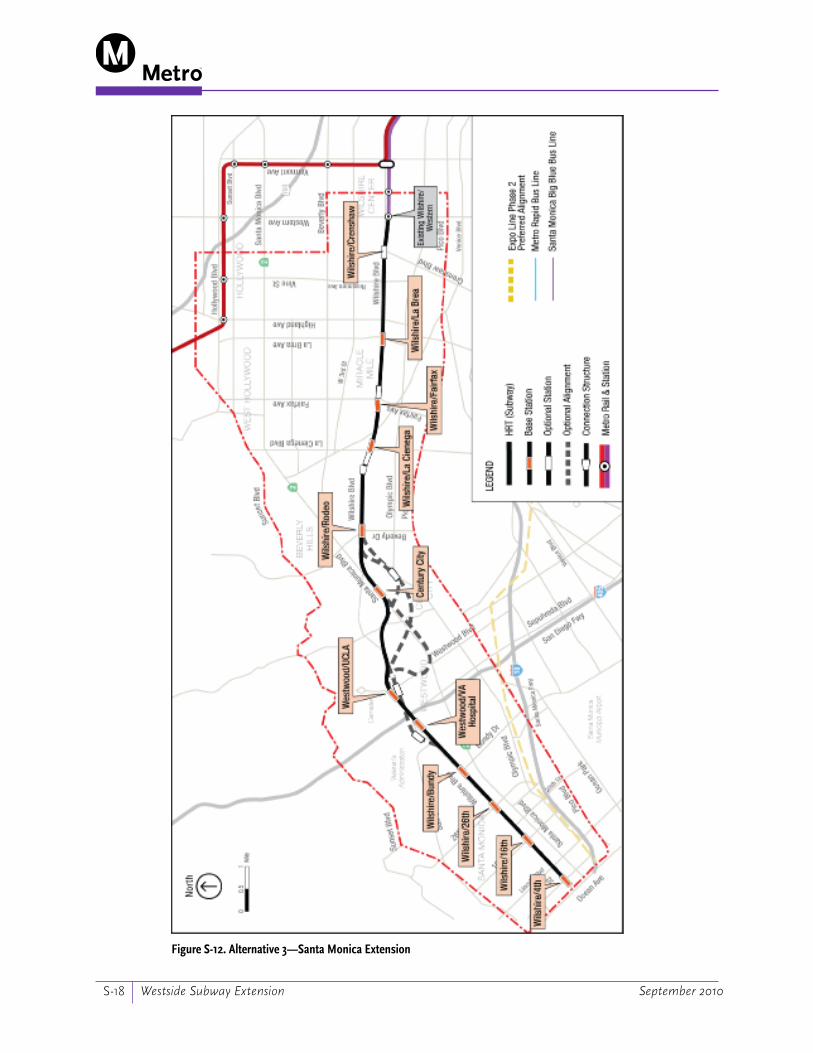
Alternative 3—Santa Monica ExtensionThis alternative extends from the existing Metro Pur-
ple Line Wilshire/Western Station to the Wilshire/4th
Station in Santa Monica (Figure S-12). The alignment
is 12.38 miles long from the Wilshire/Western Station,
would operate in each direction at 3.3-minute headways
during the morning and evening peak periods, and
operate with 10-minute headways during the midday,
off-peak period. The estimated one-way running time
is 19 minutes 27 seconds from the Wilshire/Western
Station to Wilshire/4th Street Station in Santa Monica.
Similar to Alternative 1, from the Wilshire/West-
ern Station, Alternative 3 travels westerly beneath
Wilshire Boulevard to the Wilshire/Rodeo Station
and then southwesterly toward a Century City Sta-
tion, then toward a Westwood/UCLA Station. Similar
to Alternative 2, Alternative 3 continues westerly
under the I-405 freeway to a Westwood/VA Hospital
Station. Alternative 3 would then continue west-
erly under Wilshire Boulevard, terminating at the
Wilshire/4th Street Station in Santa Monica.
Alternative 4—Westwood/VA Hospital Extension plus West Hollywood ExtensionSimilar to Alternative 2, this alternative extends
HRT, in subway, from the existing Metro Purple
Line Wilshire/Western Station to a Westwood/VA
Hospital Station but also adds a West Hollywood
Extension (Figure S-13). The West Hollywood Exten-

S-16 Westside Subway Extension September 2010
Figure S‑10. Alternative 1—Westwood/UCLA Extension

Draft Environmental Impact Statement/Environmental Impact Report S-17
Executive Summary
Figure S‑11. Alternative 2—Westwood/VA Hospital Extension
S-18 Westside Subway Extension September 2010
Figure S‑12. Alternative 3—Santa Monica Extension

Draft Environmental Impact Statement/Environmental Impact Report S-19
Executive Summary
Figure S‑13. Alternative 4—Westwood/VA Hospital Extension plus West Hollywood Extension
S-20 Westside Subway Extension September 2010
sion extends from the existing Metro Red Line Hol-
lywood/Highland Station to the west of the Wilshire/
La Cienega Station. The alignment is 14.06 miles
long from the Wilshire/Western Station to a West-
wood/UCLA Station and from Hollywood/Highland
Station to Wilshire junction.
Alternative 4 would operate from the Wilshire/
Western Station to a Westwood/VA Hospital Station
in each direction at 3.3-minute headways during
morning and evening peak periods and 10-minute
headways during the midday off-peak period. The
West Hollywood Line of Alternative 4 would oper-
ate at 5-minute headways during peak periods and
10-minute headways during the midday, off-peak
period. The estimated one-way running time for the
Metro Purple Line extension is 13 minutes 53 sec-
onds, and the running time for the West Hollywood
Extension from Hollywood/Highland to Westwood/
VA Hospital is 17 minutes 2 seconds.
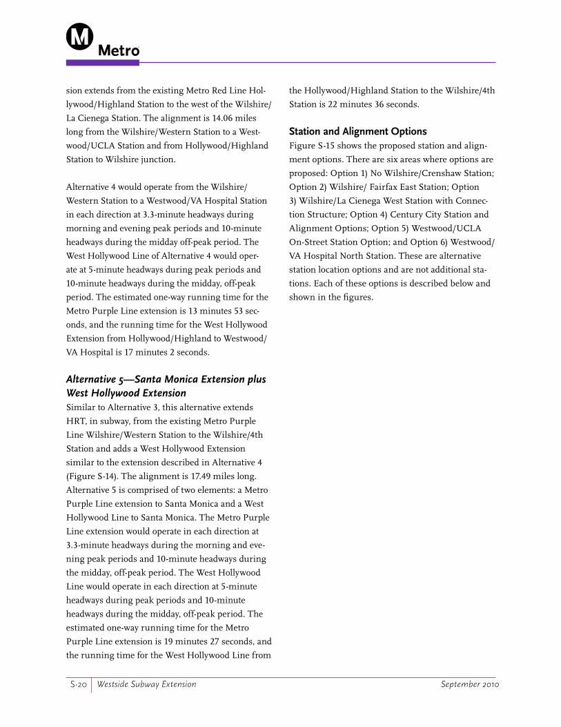
Alternative 5—Santa Monica Extension plus West Hollywood ExtensionSimilar to Alternative 3, this alternative extends
HRT, in subway, from the existing Metro Purple
Line Wilshire/Western Station to the Wilshire/4th
Station and adds a West Hollywood Extension
similar to the extension described in Alternative 4
(Figure S-14). The alignment is 17.49 miles long.
Alternative 5 is comprised of two elements: a Metro
Purple Line extension to Santa Monica and a West
Hollywood Line to Santa Monica. The Metro Purple
Line extension would operate in each direction at
3.3-minute headways during the morning and eve-
ning peak periods and 10-minute headways during
the midday, off-peak period. The West Hollywood
Line would operate in each direction at 5-minute
headways during peak periods and 10-minute
headways during the midday, off-peak period. The
estimated one-way running time for the Metro
Purple Line extension is 19 minutes 27 seconds, and
the running time for the West Hollywood Line from
the Hollywood/Highland Station to the Wilshire/4th
Station is 22 minutes 36 seconds.
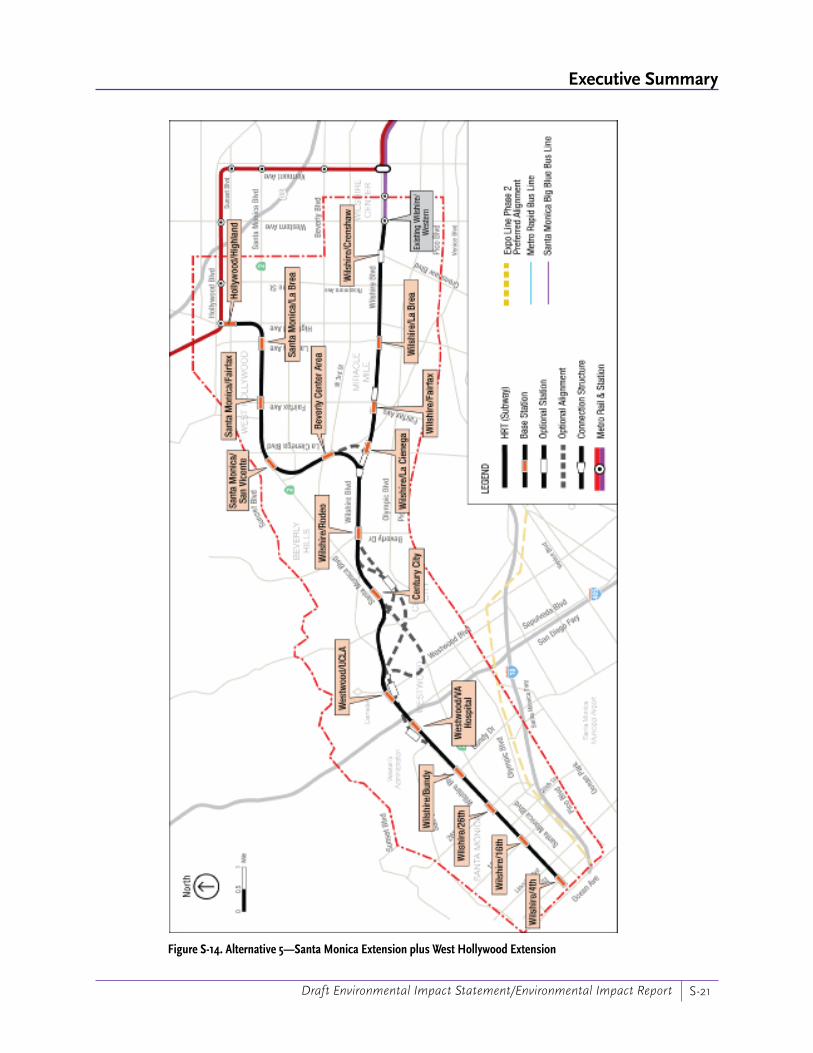
Station and Alignment OptionsFigure S-15 shows the proposed station and align-
ment options. There are six areas where options are
proposed: Option 1) No Wilshire/Crenshaw Station;
Option 2) Wilshire/ Fairfax East Station; Option
3) Wilshire/La Cienega West Station with Connec-
tion Structure; Option 4) Century City Station and
Alignment Options; Option 5) Westwood/UCLA
On-Street Station Option; and Option 6) Westwood/
VA Hospital North Station. These are alternative
station location options and are not additional sta-
tions. Each of these options is described below and
shown in the figures.
Draft Environmental Impact Statement/Environmental Impact Report S-21
Executive Summary
Figure S‑14. Alternative 5—Santa Monica Extension plus West Hollywood Extension
S-22 Westside Subway Extension September 2010
Figure S‑15. Station and Alignment Options
Pico
Blv
d
Pico
Blv
d
Beve
rly B
lvd
W 3
rd S
t
San Vicente Blvd
Fairfax Ave
La Brea Ave
La Brea Ave
Highland Ave
Vine StRossmore Ave
Crenshaw Blvd
Beverly Dr Bev
erly D
r
Ave of the
Stars
La Cienega BlvdLa Cienega Blvd
Fairfax Ave
Western Ave
Vermont Ave
Wils
hire
Blv
d
Wils
hire
Blv
d
Santa
Mon
ica Bl
vd
Santa
Mon
ica B
lvd
Olym
pic
Blvd
Sant
a M
onic
a Fw
y
Pico
Blvd Oc
ean
Park
Linco
ln Blvd
Bundy
Dr
26th
St
20th St
16th
St
Ocean
Ave4th
St
San Diego F
wy
Westwood Blvd
Sepulveda Blvd
Wilshir
e Blvd
Olym
pic
Blvd
Olym
pic
Blvd
Vete
ran’
sAd
min
istra
tion
Cem
eter
y
Sant
a M
onic
a M
unic
ipal
Airp
ort
Sant
a M
onic
a Bl
vd
Holly
woo
d Bl
vd
Suns
et B
lvd
Suns
et B
lvd
San
Vice
nte
Blvd
Veni
ce B
lvd
Venic
e Blvd
Veni
ce B
lvd
Was
hing
ton
Blvd
Sant
a M
onic
a Fw
y
Jeffe
rson
Blv
d
Expo
sitio
n Bl
vd
10
405
405
2
2
2
101
10
Suns
et B
lvd
Beverly Glen B lvd
Suns
et
Strip
The
Grov
e/Fa
rmer
’s M
arke
t
Beve
rly C
ente
r/Ce
dars
Sin
ai/
Med
ical
Cen
ter
BE
VE
RLY
H
ILLS
SA
NTA
MO
NIC
A
CU
LVE
RC
ITY
WE
ST
HO
LLY
WO
OD
Mira
cle
Mile
M
id-W
ilshi
re
HO
LLY
WO
OD
WE
ST
LOS
AN
GE
LES
Cen
tury
City
Wes
twoo
d/UC
LA
Dow
ntow
n Sa
nta
Mon
ica
WE
STW
OO
DW
ilshi
re
Cen
ter
<Sa
nta
Mon
ica
Met
ro R
apid
>
<Be
verly
Met
ro R
apid
><S
anta
Monica
Metr
o Rap
id>
<Wilsh
ire M
etro R
apid>
<Santa
Mon
ica M
etro R
apid>
<Santa
Mon
ica Bi
g Blue
Bus>
<San
ta Mon
ica Bi
g Blue
Bus>
<San
ta M
onica
Big
Blue
Bus
>
<Pico
Met
ro R
apid>
<Sepulveda Metro Rapid>
<Sepulveda Metro Rapid>
<Pi
co M
etro
Rap
id>
<Sa
nta
Mon
ica
Big
Blue
Bus
>
<Ol
ympi
c M
etro
Rap
id>
<Fa
irfax
Met
ro R
apid
>
<Fairfax Metro Rapid>
<Fairfax Metro Rapid>
<Crenshaw Metro Rapid>
<W
este
rn M
etro
Rap
id>
<Western Metro Rapid> <Western Metro Rapid>
<Santa Monica
Big Blue Bus>
04,
000
2,00
0Fe
et
Nor
th
Optio
n 1
Optio
n 3
Optio
n 2
Optio
n 6
Optio
n 5
Optio
n 4
Wils
hire
/Fai
rfax
Wes
twoo
d/VA
Hos
pita
l
Wes
twoo
d/UC
LA
Wils
hire
/La
Cien
ega
Wils
hire
/Rod
eoBe
verly
Cen
ter
Area
Wils
hire
/Bun
dy
Wils
hire
/26t
h
Wils
hire
/16t
h
Wils
hire
/4th
Cent
ury
City
Wils
hire
/La
Brea
Sant
a M
onic
a/La
Bre
aHo
llyw
ood/
High
land
Sant
a M
onic
a/Fa
irfax
Sant
a M
onic
a/Sa
n Vi
cent
e
Wils
hire
/Cre
nsha
w
Exis
ting
Wils
hire
/Wes
tern
Expo
Lin
e Ph
ase
1(u
nder
con
stru
ctio
n)
Expo
Lin
e Ph
ase
2Pr
efer
red
Alig
nmen
t
Cren
shaw
Cor
ridor
Pref
erre
d Al
ignm
ent
Met
ro R
ail &
Sta
tion
HRT
(Sub
way
)
LEGE
ND
Base
Sta
tion
Optio
nal S
tatio
n
Conn
ectio
n St
ruct
ure
Met
ro R
apid
Bus
Lin
e
Optio
nal A
lignm
ents
Sant
a M
onic
a Bi
g Bl
ue B
us L
ine
Draft Environmental Impact Statement/Environmental Impact Report S-23
Executive Summary
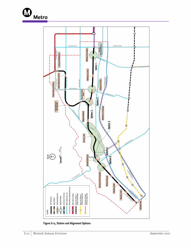
Option 1: No Wilshire/Crenshaw Station Option (Figure S-16)• Base Station: Wilshire/Crenshaw Station—The
base station straddles Crenshaw Boulevard,
between Bronson Avenue and Lorraine Boule-
vard.
• Station Option: Remove Wilshire/Crenshaw
Station—This alternate station option would
delete the Wilshire/Crenshaw Station. Trains
would run from the Wilshire/Western Station to
the Wilshire/LaBrea Station without stopping at
Crenshaw. If this option is selected, a vent shaft
(required for tunnel segments longer than 6,000
feet between stations) would be constructed
mid-way between Crenshaw Boulevard and Lor-
raine Boulevard.
Figure S‑16. No Wilshire/Crenshaw Station Option
No Crenshaw Station OptionBase Station
Purple Line
Wilshire/Crenshaw
ExistingWilshire/Western
Wilshire Blvd
Cren
shaw
Blv
d
La B
rea
Ave
Wes
tern
Ave
Wilshire/La Brea
Wilshire Blvd
Cren
shaw
Blv
d
La B
rea
Ave
Wes
tern
Ave
Purple Line
ExistingWilshire/Western
Wilshire/La Brea
Not to Scale
North

S-24 Westside Subway Extension September 2010
Option 2: Wilshire/Fairfax Station East Station Option (Figure S-17)• Base Station: Wilshire/Fairfax Station—Scoping
alternatives showed a single station at Wilshire/
Fairfax, west of Fairfax Avenue. This location was
selected to move the station as far as possible
from the gassy ground at the La Brea Tar Pits.
Therefore, the base station is under the center of
Wilshire Boulevard, immediately west of Fairfax
Avenue.
• Station Option: Wilshire/Fairfax Station East Sta-
tion Option—This alternate station option would
locate the Wilshire/Fairfax Station farther east,
with the station underneath the Wilshire/Fairfax
intersection.
�Figure S‑17. Wilshire/Fairfax Station East Station Option
Wilshire BlvdFa
irfax
Ave
McCar
thyVis
taCr
esce
nt H
eigh
ts B
lvd
Oran
ge G
rove
Dr
Oran
ge G
rove
Dr
Ogde
n Dr
Ogde
n Dr
Wilshire/Fairfax
Wilshire Blvd Fairf
ax A
ve
McCar
thyVis
taCr
esce
nt H
eigh
ts B
lvd
Wilshire/Fairfax(East)
LACMALACMA
Base Station Station Option
Not to Scale
North

Draft Environmental Impact Statement/Environmental Impact Report S-25
Executive Summary
Option 3: Wilshire/La Cienega Station West with Connection Structure (Figure S-18)• Base Station: Wilshire/La Cienega Station—
The base station would be under the center
of Wilshire Boulevard, immediately east of La
Cienega Boulevard. A direct transfer between the
Metro Purple Line and the potential future West
Hollywood Line is not provided with this station.
Instead, a connection structure is proposed to
the west near Robertson Boulevard as a means
to provide a future HRT connection to the West
Hollywood Line.
• Station Option: Wilshire/La Cienega Station
West with Connection Structure—The alter-
nate station option would be located west of La
Cienega Boulevard, with the station box extend-
ing from the Wilshire/Le Doux Road intersec-
tion to just west of the Wilshire/Carson Road
intersection. This station would be a multi-level
below-grade station. It also contains an align-
ment option that would provide an alternate
HRT connection to the future West Hollywood
Extension. This alignment portion of Option 3 is
only applicable to Alternatives 4 and 5.
Figure S‑18. Wilshire/La Cienega Station West with Connection Structure
Wilshire Blvd
La C
iene
ga B
lvd
Cars
on R
d
Will
aman
Dr
San Vicente Blvd
San Vicente BlvdRo
berts
on B
lvd
Gale
Dr
Wilshire BlvdLa
Cie
nega
Blv
d
Robe
rtson
Blv
d
Gale
Dr
Base Station Station Option
Possible West Hollywood Connection
(Alternatives 4 and 5)
Possible West Hollywood
Connection (Alternatives
4 and 5)
ConnectionStructure Wilshire/La CienegaWilshire/La Cienega
Not to Scale
North
S-26 Westside Subway Extension September 2010
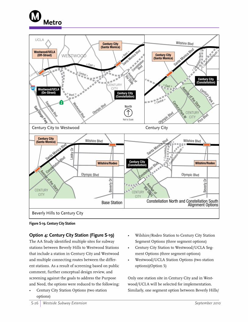
Option 4: Century City Station (Figure S-19)The AA Study identified multiple sites for subway
stations between Beverly Hills to Westwood Stations
that include a station in Century City and Westwood
and multiple connecting routes between the differ-
ent stations. As a result of screening based on public
comment, further conceptual design review, and
screening against the goals to address the Purpose
and Need, the options were reduced to the following:
• Century City Station Options (two station
options)
• Wilshire/Rodeo Station to Century City Station
Segment Options (three segment options)
• Century City Station to Westwood/UCLA Seg-
ment Options (three segment options)
• Westwood/UCLA Station Options (two station
options)(Option 5)
Only one station site in Century City and in West-
wood/UCLA will be selected for implementation.
Similarly, one segment option between Beverly Hills/
Figure S‑19. Century City Station
Beve
rly D
r
Lask
y Dr
Santa Monica
BlvdWilshire Blvd
Olympic Blvd
Avenue of the StarsCENTURYCITY
Conste
llation
Blvd
Beve
rly D
r
Santa Monica
Blvd
Constellat
ion Blvd
Wilshire Blvd
Olympic Blvd
Avenue of
the Stars
CENTURYCITY
Wilshire/Rodeo
< Con
stella
tion S
outh
>
< C
onst
ella
tion
North >
Century City(Santa Monica)
Wilshire/Rodeo Century City(Constellation)
Base Station Constellation North and Constellation South Alignment Options
Beve
rly D
r
Beverly Dr
Wilshire Blvd
Conste
llatio
n
BlvdSan
ta Mon
ica Blvd
San Diego Fwy
Westwood Blvd
Sepulveda Blvd
Wilshire
Blvd
Wilshire Blvd
Olympic B
lvd
Veteran’sAdministration
Cemetery
405
2
2
Avenue of
the Stars
UCLA
CENTURYCITY
WESTWOOD
Lask
y
< W est >
< East >
< Central >
< Base >
Century City(Santa Monica)
< L
asky
>
Westwood/UCLA(Off-Street)
Century City(Constellation)
Westwood/UCLA(On-Street)
Not to Scale
North
Santa
Monica
Blvd
Wilshire Blvd
Olympic B
lvd
Pico Blvd
Avenue of the Stars
Century Park W
CENTURYCITY
Century City(Santa Monica)
< Cons
tellat
ion So
uth >
< Central >
< East >Century Park E
Century City(Constellation)
< Conste
llatio
n No
rth >
Century City to Westwood Century City
Beverly Hills to Century City
Draft Environmental Impact Statement/Environmental Impact Report S-27
Executive Summary
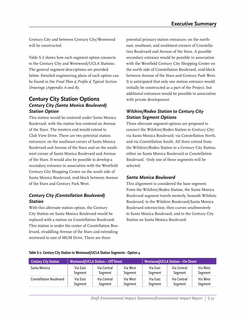
Table S‑2. Century City Station to Westwood/UCLA Station Segments ‑ Option 4
Century City Station Westwood/UCLA Station—Off Street Westwood/UCLA Station—On Street
Santa Monica Via East Segment
Via Central Segment
Via West Segment
Via East Segment
Via Central Segment
Via West Segment
Constellation Boulevard Via East Segment
Via CentralSegment
Via West Segment
Via East Segment
Via Central Segment
Via West Segment
Century City and between Century City/Westwood
will be constructed.
Table S-2 shows how each segment option connects
to the Century City and Westwood/UCLA Stations.
The general segment descriptions are provided
below. Detailed engineering plans of each option can
be found in the Final Plan & Profile & Typical Section
Drawings (Appendix A and B).
Century City Station Options Century City (Santa Monica Boulevard) Station OptionThis station would be centered under Santa Monica
Boulevard, with the station box centered on Avenue
of the Stars. The western end would extend to
Club View Drive. There are two potential station
entrances: on the southeast corner of Santa Monica
Boulevard and Avenue of the Stars and on the south-
west corner of Santa Monica Boulevard and Avenue
of the Stars. It would also be possible to develop a
secondary entrance in association with the Westfield
Century City Shopping Center on the south side of
Santa Monica Boulevard, mid-block between Avenue
of the Stars and Century Park West.
Century City (Constellation Boulevard) StationWith this alternate station option, the Century
City Station on Santa Monica Boulevard would be
replaced with a station on Constellation Boulevard.
This station is under the center of Constellation Bou-
levard, straddling Avenue of the Stars and extending
westward to east of MGM Drive. There are three
potential primary station entrances: on the north-
east, southeast, and southwest corners of Constella-
tion Boulevard and Avenue of the Stars. A possible
secondary entrance would be possible in association
with the Westfield Century City Shopping Center on
the north side of Constellation Boulevard, mid-block
between Avenue of the Stars and Century Park West.
It is anticipated that only one station entrance would
initially be constructed as a part of the Project, but
additional entrances would be possible in association
with private development.
Wilshire/Rodeo Station to Century City Station Segment Options Three alternate segment options are proposed to
connect the Wilshire/Rodeo Station to Century City:
via Santa Monica Boulevard, via Constellation North,
and via Constellation South. All three extend from
the Wilshire/Rodeo Station to a Century City Station,
either on Santa Monica Boulevard or Constellation
Boulevard. Only one of these segments will be
selected.
Santa Monica Boulevard This alignment is considered the base segment.
From the Wilshire/Rodeo Station, the Santa Monica
Boulevard segment travels westerly, beneath Wilshire
Boulevard, to the Wilshire Boulevard/Santa Monica
Boulevard intersection, then curves southwesterly
to Santa Monica Boulevard, and to the Century City
Station on Santa Monica Boulevard.

S-28 Westside Subway Extension September 2010
Constellation NorthThe Constellation North alternate segment option
begins at the Wilshire/Rodeo Station and travels
west to near Linden Drive. At this juncture, this seg-
ment curves southwesterly at Linden Drive to Lasky
Drive, and under Lasky Drive to just north of Young
Drive. The segment option then turns southwesterly
to under Constellation Boulevard and to the station
on Constellation Boulevard at Avenue of the Stars.
Constellation SouthThe Constellation South segment option begins
at the Wilshire/Rodeo Station and travels west to
Bedford Drive. At this juncture, this segment curves
to the southwest and travels directly southwest to
Constellation Boulevard and into the optional station
on Constellation Boulevard at Avenue of the Stars.
Century City Station to Westwood/UCLA Station OptionsThere are three general segments: East, Central,
and West. Each of these three segments would be
accessed from both Century City Stations and both
Westwood/UCLA Stations. The base segment is
shown in the solid black line and the options are
shown in the dashed grey lines. Only one of these
segments will be chosen.
East SegmentThis is the base segment when combined with the
Century City Station (Santa Monica Boulevard) and
the Westwood/UCLA Station (Off Street). From the
Century City Station (Santa Monica Boulevard), this
segment is accessed by traveling west on Santa Mon-
ica Boulevard. The segment turns at Century Park
West and continues northwesterly until Wilshire
Boulevard, where it turns and connects into the
Westwood/UCLA Station (Off Street) via Lindbrook
Drive. The connection into the Westwood/UCLA Sta-
tion (On Street) from either Century City Station is
made by continuing westerly on Wilshire Boulevard
to Westwood Boulevard.
From the Century City Station (Constellation
Boulevard), the East Segment is accessed by turn-
ing northwesterly under the Westfield Mall and
continuing northerly to connect into the segment as
described above.
Central SegmentFrom the Century City Station (Santa Monica
Boulevard), this alternate segment is accessed by
continuing farther west past the East Segment,
turning northwesterly near Beverly Glen Boulevard,
crossing Wilshire Boulevard and turning westerly at
Lindbrook Drive to enter into the Westwood/UCLA
Station (Off Street).
From the Century City Station (Constellation Boule-
vard), this segment is accessed by continuing farther
west past the East Segment, turning northwesterly,
crossing Santa Monica Boulevard, and connecting
with the Central Segment described above to enter
into the Westwood/UCLA Station (Off Street).
To enter into the Westwood/UCLA Station (On
Street) from either Century City Station, the Cen-
tral Segment as described above for each Century
City Station is followed to Wilshire Boulevard. At
Wilshire Boulevard, the Westwood/UCLA Sta-
tion (On Street) is accessed by continuing west on
Wilshire Boulevard to Westwood Boulevard.
West SegmentFrom the Century City Station (Santa Monica Boule-
vard), this alternate segment is accessed by traveling
farther west past both the East and Central Seg-
ments along Santa Monica Boulevard to Westwood
Boulevard. At Westwood Boulevard, the segment
travels north, curves slightly to the east mid-way
between Westwood and Wilshire Boulevards to be
able to curve westerly into either Westwood/UCLA
Station. To access the Westwood/UCLA Station (Off
Street) this segment crosses Wilshire Boulevard and

Draft Environmental Impact Statement/Environmental Impact Report S-29
Executive Summary
connects into the other two segments near Lind-
brook Drive and entering this station.
From the Century City Station (Constellation Bou-
levard), this segment travels along the same route
as the Central Segment until just south of Santa
Monica Boulevard, where it turns westerly under
Santa Monica Boulevard and connects into the West
Segment described above. The connection into either
Westwood/UCLA Station is the same as described
above.
Option 5: Westwood/UCLA On-Street Station Option (Figure S-20)Several station locations were considered in West-
wood. As a result of screening based on public
comment, further conceptual design review, and
screening against the goals to address the Purpose
and Need, two station options were developed and
included in this Draft EIS/EIR.
• Base Station: Westwood/UCLA Station Off-Street
Station Option—The base station is the West-
wood/UCLA Station located under the UCLA lot
on the north side of Wilshire Boulevard between
Gayley and Veteran.
• Station Option: Westwood/UCLA On-Street Sta-
tion Option—This alternate station option would
be located under the center of Wilshire Boule-
vard, immediately west of Westwood Boulevard.
Figure S‑20. Westwood/UCLA On‑Street Station Option
Westwood Blvd
Westwood Blvd
Veteran Ave
Wilshire Blvd
Kinross Ave
Kinross Ave
Lindbrook DrGayley Ave
WESTWOODVILLAGE
UCLALot 36
UCLA Police Department
Armand Hammer Museum Veteran Ave
Wilshire Blvd
Lindbrook DrGayley Ave
WESTWOODVILLAGE
UCLALot 36
UCLA Police Department
Armand Hammer Museum
Westwood/UCLAWestwood/UCLA
Base Station (Off-Street) Optional Station (under Wilshire Blvd)
Not to Scale
North

S-30 Westside Subway Extension September 2010
Option 6: Westwood/VA Hospital North Station (Figure S‑21)
• Base Station: Westwood/VA Hospital—The base
station would be below the VA Hospital parking
lot on the south side of Wilshire Boulevard in
between the I-405 exit ramp and Bonsall Avenue.
• Station Option: Westwood/VA Hospital North
Station—This alternate station option would
locate the Westwood/VA Hospital Station on the
north side of Wilshire Boulevard between Bon-
sall Avenue and Wadsworth Theater.
Base Stations
The following stations did not have optional sites and
are, therefore, presented here as the base stations. In
most stations, it is anticipated that only one station
entrance or portal would be constructed as part of
the Project, but additional portals could be developed
as a part of station area development (by others).
Wilshire/La Brea StationThis station is between La Brea and Cloverdale
Avenues.
Wilshire/Rodeo StationThis station would be under the center of Wilshire
Boulevard, beginning just west of South Canon
Drive and extending to El Camino Drive.
Wilshire/Bundy StationThis station would be under Wilshire Boulevard,
east of Bundy Drive, extending just east of Saltair
Avenue.
Wilshire/26th StationThis station would be under Wilshire Boulevard,
with the eastern end east of 26th Street and the west-
ern end west of 25th Street, midway between 25th
Street and Chelsea Avenue.
Wilshire/16th StationThis station would be under Wilshire Boulevard
with the eastern end just west of 16th Street and the
western end west of 15th Street.
Wilshire/4th StationThis station would be under Wilshire Boulevard.
Hollywood/Highland StationThis station is located under Highland Avenue and
provides a transfer option to the existing Metro Red
Line Hollywood/Highland Station under Hollywood
Boulevard.
Santa Monica/La Brea StationThis station would be under Santa Monica Boule-
vard, just west of La Brea Avenue, and would extend
westward to the center of the Santa Monica Boule-
vard/Formosa Avenue intersection.
Figure S‑21. Westwood/VA Hospital North Station
Eisenhower Ave San Diego Fwy
405
Federal AveWilshire
Blvd
Sepulveda BlvdSan Vicente Blvd
Westwood/VA Hospital
Westwood/VA Hospital(North)
VAHospital
Not to Scale
North

Draft Environmental Impact Statement/Environmental Impact Report S-31
Executive Summary
Santa Monica/Fairfax StationThis station is under Santa Monica Boulevard and
extends from just east of Fairfax Avenue on the west
to just east of Ogden Drive on the east.
Santa Monica/San Vicente StationThis station would be under Santa Monica Boule-
vard and would extend from just west of Hancock
Avenue on the west to just east of Westmount Drive
on the east.
Beverly Center Area StationThis station would be under San Vicente Boulevard,
extending from just south of Gracie Allen Drive to
south of 3rd Street.
Other Components of the Build AlternativesOther components of the Build Alternatives that are
included in the analysis of project costs and impacts
are described below.
Traction Power Substations and EmergencyTraction power substations (TPSS) are required to
provide traction power for the HRT system. Substa-
tions would be located in the station box or in the
crossover box and are generally in an underground
room that measures about 50 feet by 100 feet.
�Mid-Tunnel Vent ShaftEach alternative would require ventilation shafts.
The vent shafts are emergency ventilation shafts
with dampers, fans, and sound attenuators gener-
ally placed at both ends of a station box for exhaust-
ing smoke. The vent shafts are also required
in tunnel segments with more than 6,000 feet
between stations to meet fire/life safety require-
ments. At the surface, Metro generally incorporates
ventilation openings in the sidewalk grates or
incorporated into buildings.
Trackwork OptionsEach Build Alternative would require components
of special trackwork that provides for operational
efficiency and safety. These components include the
following:
• Tail tracks—a track, or tracks, that extends
beyond the end of a terminal station (the last sta-
tion on a line)
• Pocket tracks—an additional track adjacent to the
mainline tracks generally at terminal stations
• Crossovers—a pair of turnouts that connect two
parallel rail tracks, allowing a train on one track
to cross over to the other
• Double crossovers—when two sets of crossovers
are installed with a diamond allowing trains to
cross over to the other track
Rail Operations Center An important aspect of implementing the Project
is Metro’s expansion program of the existing Rail
Operations Center (ROC) that is located in Los Ange-
les near the intersection of Imperial Highway and
the Metro Blue Line. The current ROC configura-
tion has evolved over the years as new rail lines have
been added and expanded; it does not have sufficient
room to accommodate the new transit corridors and
line extensions in Metro’s expansion program. The
Build Alternatives assume an expanded ROC at this
location.
Maintenance Yards�Metro currently has a fleet size of 104 Heavy Rail
Vehicles (HRVs) to operate the existing Metro Red/
Metro Purple Lines. Increased service for the No
Build Alternative would require an additional 42
HRVs, for a total fleet of 146 vehicles. HRVs required
for the Build Alternatives range from 196 (MOS
1) to 336 (Alternative 5). The number of additional
vehicles over the No Build Alternative range from 50
HRVs (MOS 1) to 190 HRVs (Alternative 5).

S-32 Westside Subway Extension September 2010
Currently, Metro stores and maintains its Red Line/
Purple Line vehicle fleet at the existing Division
20 Maintenance and Storage Facility in Downtown
Los Angeles at the site bounded by 1st Street on the
north, the Los Angeles River on the east, 4th Street
on the south, and Santa Fe Avenue on the west. With
a capacity to accommodate up to 200 HRVs, the yard
currently has sufficient capacity to store 96 addi-
tional HRVs. Several enhancements to the facility are
planned and assumed in the No Build Alternative.
If any of the Build Alternatives are selected, addi-
tional storage capacity would be needed. Two options
for providing this expanded capacity are as follows:
• Additional storage immediately south of the
Division 20 Maintenance and Storage Facility
between the 4th and 6th Street Bridges. This
option would require purchasing 3.9 acres of
predominantly vacant private property abutting
the southern boundary of the existing facility,
and the construction of additional maintenance
and storage tracks. This would accommodate
up to 102 vehicles, sufficient added capacity for
Alternatives 1 and 2 (Figure S-22).
• In the event that the existing Metro Red Line
Rail Storage and Maintenance Yards could not
be expanded to accommodate the Project, an
alternate satellite facility could be built at the
Union Pacific (UP) Los Angeles Transportation
Center Rail Yard, connected by yard lead tracks to
the Division 20 Maintenance and Storage Facility.
This site is currently used as a truck/rail transfer
facility, and a portion of these facilities would
need to be relocated if this alternative were to be
used. This site has more than 123 acres, of which
approximately 53 acres would be needed for the
facility sufficient to accommodate the vehicle
fleet for all five HRT alternatives. An additional
1.3 miles of track and a new bridge over the Los
Angeles River would be constructed for vehicles
to reach this yard (Figure S-23).
Project PhasingThe final decision to be made in selecting a Locally
Preferred Alternative is the best terminus for an
initial phase of implementation, in the event that the
Project must be built in phases over time. Two MOS
options are evaluated in this Draft EIS/EIR and are
Figure S‑22. Expanded Division 20 Yard
Los Angeles River
Santa Fe Ave
Santa Fe Ave
E 6t
h St
Will
ow S
t
Palm
etto
St
Parking
Existing
Maintenance &
Storage Facility
New TrackExisting TrackLos Angeles River Channel
LEGEND0 100 200
North Feet

Draft Environmental Impact Statement/Environmental Impact Report S-33
Executive Summary
compared with the five Build Alternatives and the No
Build and TSM Alternatives:
• MOS 1—Interim terminus at Fairfax
• MOS 2—Interim terminus at Century City
Evaluation of the AlternativesAn evaluation of the alternatives based on the ability
of each alternative to meet the Project’s objectives
and the Purpose and Need is included in Chapter
7 of this Draft EIS/EIR. Table S-3 summarizes this
evaluation.
Mobility ImprovementsTransit Travel Time The Build Alternatives, operating in an exclusive
guideway that is fully separated from roadway traffic,
would achieve much higher speeds than would be
possible with buses, even with the priority treat-
ments assumed in the No Build and TSM Alterna-
tives. Thus, all five of the Build Alternatives would
have faster travel times than the No Build and TSM
Alternatives. The longer Build Alternatives—Alter-
natives 3 and 5 in particular—provide faster travel
to and from Santa Monica. For trips to and from the
San Fernando Valley, Alternatives 4 and 5 would be
7 to 10 minutes faster than Alternatives 1, 2, and 3,
reflecting the additional link to the Metro Red Line
in West Hollywood. New links between the Build
Alternatives and other transit lines would improve
transit travel time for residents throughout the
County.
Because of its higher operating speeds, the Build
Alternatives offer a travel mode that is more com-
petitive with the automobile. During peak periods,
rail operating speeds are faster than speeds for a
comparable auto trip. Competitiveness is greatest for
the alternatives with the greatest mileage of rail, as
the difference in speed becomes more apparent to
potential riders for trips covering longer distances
and reaching the more densely developed parts of
the Study Area.
Reliability, Comfort, and ConvenienceThe alternatives can be compared in terms of the
percentage of transit passenger miles that would
occur on an exclusive fixed guideway facility. The
percentage grows significantly with all of the Build
Alternatives and exceeds 50 percent with Alterna-
tives 3 and 5. The remaining transit passenger miles
would be in buses operating in mixed traffic or bus
lanes subject to various traffic delays. Under the
Build Alternatives, subway service would provide
frequent and reliable service no matter the traffic
conditions on Study Area streets and highways.
Another measure of transit travel time and con-
venience to passengers is the number of transfers
travelers must make to get from their origin to their
destination. Riders generally consider out-of-vehicle
travel time—i.e., the time spent waiting for a bus or
train to arrive—as being more onerous than time
spent moving in a vehicle. All of the rail alternatives
would lead to a significant reduction in the number
of transfers. Among the Build Alternatives, Alter-
natives 3 and 5 (which would extend rail to Santa
Figure S‑23. Union Pacific Railroad Rail Bridge and Extension of Tracks to Reach UP Yard
UPRR
Los Angeles River
Existing bridge
Construction easement
Proposed bridge piers
Proposed bridge
Bolero Ln
AlignmentHistoric Union Pacific BridgeLos Angeles River Channel
Proposed BridgeConstruction EasementProposed Bridge Piers
LEGEND
0 250 500Feet
North

S-34 Westside Subway Extension September 2010
Table S‑3. Evaluation Results for TSM and Build Alternatives
Relevant Goals, Objectives, Criteria No Build TSMWilshire HRT Combined HRT (Wilshire
Plus West Hollywood)Alt 1 Alt 2 Alt 3 Alt 4 Alt 5
Mobility ImprovementAverage peak period travel time between select origin-destination pairs and rating
70.0Low
69.6Low
49.6Medium
49.6Medium
46.6Medium-
High
44.7Medium-
High
41.6High
Average end-to-end transit operating speeds and rating
13.5Low
13.5Low
31.1High
30.8High
31.8High
32.0High
33.0High
Competitiveness with auto speed Low Low Low-Medium
Medium Medium-High
High High
Percentage of transit passenger miles on fixed guideway
4.7%Low
4.6%Low
39.2%Medium-
High
42.0%Medium-
High
51.6%High
44.0%Medium-
High
53.0%High
Number of transfers between select origin-destination pairs
Low Low Medium-High
Medium-High
High Medium-High
High
New transit trips (per day in 2035) Base 2,115 24,142Medium
27,615Medium
35,235Medium-
High
31,224Medium-
High
40,123High
Transit Supportive Land Use Policies and ConditionsHigh-density mixed use activity centers within 1/2 mile of alignment
NA NA 6 7 8 10 12
High-opportunity areas for redevelopment within 1/2 mile of alignment
NA NA 1 1 1 2 2
Cost EffectivenessCapital cost in million 2009 dollars Base $42 $4,036 $4,358 $6,116 $6,985 $8,747Year 2035 O&M cost in million 2009 dollars
$1,742 $1,746 $1,778 $1,782 $1,804 $1,831 $1,861
Cost per hour of user benefit compared with TSM Alternative (FTA Cost Effectiveness Index, or CEI)
NA Base $35.98 $33.58 $36.31 $49.50 $47.55
Project FeasibilityAffordability within limits of Metro’s Long-Range Transportation Plan
Yes Yes Yes Yes No No No
EquityLow income residents within 1/2 mile of guideway alignment
NA NA 25,707 27,180 32,114 38,799 43,733
% of residents who are low income NA NA 17.3% 17.1% 15.6% 16.4% 15.4%Minority residents within 1/2 mile of guideway alignment
NA NA 71,939 74,236 83,491 93,688 102,943
% of residents who are minority NA NA 47.0% 45.5% 39.5% 38.9% 35.6%Environmental ConsiderationsNumber of single-family residences displaced
0 0 1 1 1 1 1
Number of multi-family residences displaced
0 0 1 (32 units) 1 (32 units) 1 (32 units) 1 (32 units) 1 (32 units)
Number of jobs potentially displaced 0 0 302 302 413 363 474Daily reduction in vehicle miles traveled compared to No Build Alternative
Base 0 28,982 31,899 37,768 34,786 41,643
�Source: Westside Subway Extension Comparative Benefits and Costs Analysis Technical Report (Metro 2010w)

Draft Environmental Impact Statement/Environmental Impact Report S-35
Executive Summary
Monica) tend to require the fewest transfers, and are
rated high in Table S-3. The alternatives terminat-
ing at Westwood are rated medium-high, because
those transit riders traveling between Santa Monica
and places east of Westwood would need to transfer
between rail and bus. The No Build and TSM alter-
natives would lead to substantially more transfers.
Alternative 5 provides the largest number of direct
connections to other rail lines and to north-south
bus routes, followed by Alternatives 3 and 4. Under
each of the alternatives, riders from the Study Area
can access Metrolink and Amtrak with just one
transfer at Union Station.
Capacity and ExpandabilityAlternatives that attract the highest ridership are
those that offer the best service to the greatest num-
ber of people. Projected increases in transit ridership
also indicate the extent to which an alternative can
be expected to reduce vehicle miles of travel and con-
gestion on the highway system, reduce air pollutant
emissions, and reduce the use of gasoline.
As shown in Table S-3, Alternative 5 would lead to
the largest increase in transit ridership, as measured
by new transit trips. By covering the largest service
area, as well as making connections in West Hol-
lywood between the Metro Red and Purple Lines,
Alternative 5 offers the greatest improvement in
transit service. Alternative 3 has the second highest
increase in transit ridership. Several findings are of
particular note:
• A comparison between Alternatives 5 and 3 and
between Alternatives 4 and 2 shows the benefits
of the West Hollywood connection. The connec-
tion would result in about 3,600 to 4,900 new
daily transit trips per day, an increase of about
13 percent.
• The one-station extension from Westwood/
UCLA (Alternative 1) to the Westwood/VA Hos-
pital (Alternative 2) results in 3,500 new transit
trips, an increase of close to 15 percent.
• The benefits of extending the line from West-
wood to Santa Monica are shown by comparing
Alternatives 3 and 2 and Alternatives 5 and 4.
The Santa Monica extension would increase the
number of new daily transit trips by 7,500 to
8,900, or about 28 percent.
• The TSM Alternative is least effective, attracting
no more than 5 to 10 percent of the new riders
attracted by the rail alternatives.
Transit-supportive Land Use Policies and ConditionsThe extent to which each of the Build Alternatives
meet land use goals can be measured by the number
of high-density, mixed-use activity centers within
one-half mile of the alignment and by the number
of high opportunity areas for redevelopment within
one-half mile of the alignment. Twelve activity cen-
ters—defined as locations with major commercial
activity and mixed uses—and two high opportunity
areas are identified for this comparison.
All of the Build Alternatives were developed to serve
these activity centers and high opportunity areas.
The extent to which they are served is a function of
each alternative’s length and number of stations.
Alternatives 4 and 5, thus serve more activity centers
and high opportunity areas than the other alterna-
tives.
Transit-supportive land use is also a critical aspect
of the FTA’s rating of projects that are seeking
discretionary New Starts funds. Forty percent of the
project justification rating is a function of transit-
oriented land use.
Cost-effectivenessThe Build Alternatives are significantly more
expensive than the No Build and TSM Alternatives.

S-36 Westside Subway Extension September 2010
In 2009 dollars, the rail alternatives range in cost
from $4.0 to $8.7billion. The rail alternatives are also
more costly to operate and maintain.
With faster speeds, the Build Alternatives would save
transit riders between 31,000 and 52,000 hours of
equivalent travel time (transit system user benefits)
on an average weekday in 2035. This analysis further
reveals the following:
• Alternatives 1, 2, and 3 are substantially more
cost-effective than Alternatives 4 and 5. In other
words, while Alternatives 4 and 5 tend to have
more benefits than Alternatives 1, 2, and 3, they
achieve these additional benefits at a high incre-
mental cost.
• The cost-effectiveness indices (CEI) for Alterna-
tives 1, 2, and 3 are similar. The added invest-
ment of extending the line to Santa Monica has
roughly the same rate of return as a shorter
extension to Westwood/UCLA.
• Alternative 2 is the most cost effective.
Project Feasibility Comparing the capital funding requirements of
each alternative with the $2.7 billion set aside for the
Westside Subway Extension in the LRTP, and assum-
ing that the project is competitive for New Starts
funds, shows the following:
• The TSM Alternative and Alternatives 1 and 2
are financially feasible.
• Alternatives 3, 4, and 5 are not currently finan-
cially feasible. . Implementation of Alternative
1 or Alternative 2 would not preclude a future
extension to Santa Monica or a future subway
connection to West Hollywood. However, addi-
tional local funding would need to be identified.
EquityThe number of low-income and minority residents
living in close proximity to the Project increases with
the project scope and number of stations. However,
the percentage of residents within one-half mile who
are low income or minority varies little across the
alternatives.
Those alternatives with the larger number of stations
will provide better mobility to a larger number of
low-income and minority people. Similarly, alterna-
tives with a larger scope and number of stations will
expose more low-income and minority residents to
short-term construction impacts.
Environmental ConsiderationsEach of the five Build Alternatives would displace
one or more properties in order to construct station
portals and provide for construction staging. Some
business displacement would occur. The total num-
ber of jobs displaced would depend on which portal
location is selected at each station. Several alterna-
tive entrance locations have been identified at each
station; however, only one or two would be selected
for implementation. Several hundred jobs have been
identified for potential displacement, but only a
small percentage would actually be displaced.
All of the five Build Alternatives would reduce VMT
on the highway system, with attendant reductions in
Cost-Effectiveness Index
The cost-effectiveness measure used in this evalu-
ation is derived by annualizing each alternative’s
capital cost, adding the annual operating and
maintenance costs, and dividing the sum by the al-
ternative’s annual transit system user benefits. User
benefits refer primarily to travel-time savings.
This measure, referred to as the “cost effectiveness
index,” is used by FTA in its rating of projects seek-
ing New Starts funds.

Draft Environmental Impact Statement/Environmental Impact Report S-37
Executive Summary
congestion, pollutant emissions, and gasoline con-
sumption. The decrease is small in relation to total
VMT in the Study Area.
Each of the alternatives would also cause impacts
during construction. As discussed in Chapter 4, con-
struction impacts would include traffic and access
disruptions near station sites, construction noise and
emissions (nitrogen oxide (NOx) and particulate mat-
ter less than 10 micrometers in size (PM10)), tem-
porary removal of parking, visual effects, and haul
trucks removing material excavated from the tunnel
and station boxes. The amount of impact would gen-
erally be a function of the length of the subway and
the number of stations. The Draft EIS/EIR identifies
mitigation measures for these impacts.
Summary of Impacts and Benefits Considering the TSM and Build Alternatives in
terms of the project goals:
• All Build Alternatives are more effective than the
TSM Alternative in enhancing mobility, serving
development opportunities, and addressing other
aspects of the Purpose and Need. Alternatives 3,
4, and 5 are more effective than Alternatives 1
and 2.
• While offering few mobility benefits, the TSM
Alternative is the most cost-effective because of
its low cost.
• Alternatives 1, 2, and 3 have similar cost-effec-
tiveness indices and are more cost-effective than
Alternatives 4 and 5.
• Alternatives 1 and 2 are expected to be most
competitive for New Starts funds and can be
built with available Measure R and other identi-
fied funds. Alternatives 3, 4, and 5 are not finan-
cially feasible without a new source of revenues.
• Alternative 2, which extends the subway beyond
Westwood/UCLA to the VA Hospital, adds riders
and benefits at a reasonable cost and is finan-
cially feasible.
• All of the alternatives would reduce VMT, pol-
lutant emissions, and energy consumption.
The longer Build Alternatives have the greatest
environmental benefit.
• All of the alternatives would displace jobs and
have construction impacts, with the longer alter-
natives having the largest impacts.
Detailed information on transportation impacts and
mitigation are presented in Chapter 3 and environ-
mental impacts are presented in Chapter 4 of this
document. There are some differences in transporta-
tion impacts between the alternatives, including:
• Transit Travel Time—Higher operating speeds
of service on a dedicated guideway are expected
to reduce travel time. Service on an exclusive
guideway would and increase reliability com-
pared to No Build and TSM Alternatives.
• Traffic—Alternatives 3 and 5 would result in
the most reduction of Study Area Vehicle Miles
Traveled (VMT). For these alternatives the inter-
section of Wilshire Boulevard/16th Street would
be adversely affected during the hour hours. A
signal is proposed at this intersection to mitigate
impacts.
There would be temporary off-street parking loss at
Westwood/UCLA and Westwood/VA Hospital Sta-
tions. The rest of the transportation related construc-
tion impacts are similar for all alternatives. There
will be temporary traffic impacts, on-street parking
loss, and delays for bus transfer and pedestrian and
bicyclists.
For many of the environmental resources, there are
no or very little differences in impacts among the
Build Alternatives. In most instances the primary
reason for differences in impacts is due to the length
of the alignment rather than severity of the impact.

S-38 Westside Subway Extension September 2010
There are some distinctions, though in most cases
they are slight variations, including:
• Displacements – are the lowest for Alternative 1
(277) and highest for Alternative 5 (437), primar-
ily attributable to the length of the alternative
• Economic and Fiscal – operations and main-
tenance expenditures from direct and indirect
employment vary slightly among alternatives,
with lower number of Person Years (PY) for
Alternatives 1 and 2 and higher numbers for
Alternatives 3, 4, and 5
• Air Quality – slight differences in the quantity
of emissions burdens expected to be reduced by
the alternatives, with the greatest reductions with
Alternatives 4 and 5
• Energy – varies with alternative, with mobile
source energy consumption decreases much
lower for Alternative 5 (10,000 additional rail
miles over Alternative 4 results in more energy
use and less energy savings), and energy con-
sumption for stations nearly double for Alterna-
tive 5 than Alternative 1
• Geologic Hazards – some variations because of
additional station locations for Alternative 3 that
are in more susceptible areas
• Liquefaction – some variations due to the fact
that alternatives have different station locations
• Water Resources – some variation because a por-
tion of Alternatives 3 and 5 are in coastal zone
and would require Coastal Development Permit
• Safety and Security – Alternatives 2 – 5 would
require risk assessment because they pass by fed-
eral facilities, including the VA Medical Center
and California Army National Guard
Construction impacts are similar for all alternatives,
with differences occurring for some resource catego-
ries (primarily energy consumption and parklands
and community services and facilities) due to differ-
ences in alternative length.
Table S-4 provides an overview of the more detailed
transportation impact discussion found in Chapter
3 while Table S-5 presents a summary of environ-
mental impacts and mitigation measures for subway
operations discussed in Chapter 4. Table S-6 provides
highlights of construction impacts.
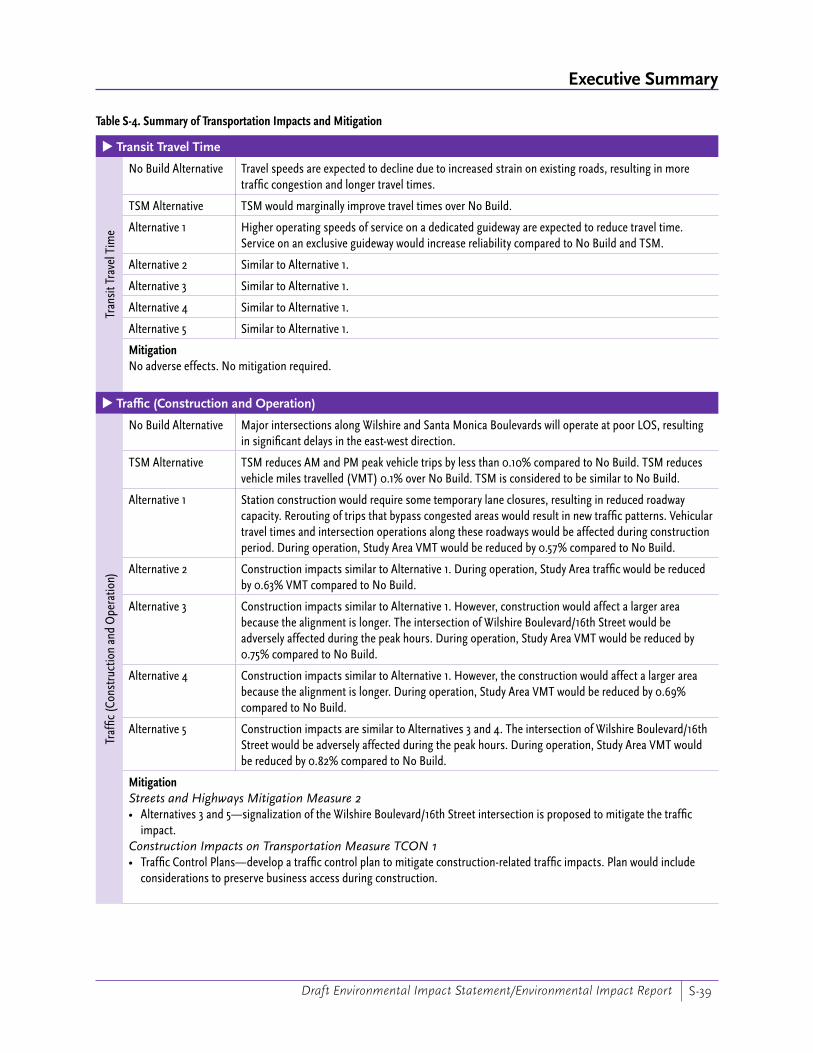
Draft Environmental Impact Statement/Environmental Impact Report S-39
Executive Summary
Table S‑4. Summary of Transportation Impacts and Mitigation
X Transit Travel Time
Tran
sit T
rave
l Tim
e
No Build Alternative Travel speeds are expected to decline due to increased strain on existing roads, resulting in more traffic congestion and longer travel times.
TSM Alternative TSM would marginally improve travel times over No Build.
Alternative 1 Higher operating speeds of service on a dedicated guideway are expected to reduce travel time. Service on an exclusive guideway would increase reliability compared to No Build and TSM.
Alternative 2 Similar to Alternative 1.
Alternative 3 Similar to Alternative 1.
Alternative 4 Similar to Alternative 1.
Alternative 5 Similar to Alternative 1.
MitigationNo adverse effects. No mitigation required.
X Traffic (Construction and Operation)
Traf
fic (C
onst
ruct
ion
and
Ope
ratio
n)
No Build Alternative Major intersections along Wilshire and Santa Monica Boulevards will operate at poor LOS, resulting in significant delays in the east-west direction.
TSM Alternative TSM reduces AM and PM peak vehicle trips by less than 0.10% compared to No Build. TSM reduces vehicle miles travelled (VMT) 0.1% over No Build. TSM is considered to be similar to No Build.
Alternative 1 Station construction would require some temporary lane closures, resulting in reduced roadway capacity. Rerouting of trips that bypass congested areas would result in new traffic patterns. Vehicular travel times and intersection operations along these roadways would be affected during construction period. During operation, Study Area VMT would be reduced by 0.57% compared to No Build.
Alternative 2 Construction impacts similar to Alternative 1. During operation, Study Area traffic would be reduced by 0.63% VMT compared to No Build.
Alternative 3 Construction impacts similar to Alternative 1. However, construction would affect a larger area because the alignment is longer. The intersection of Wilshire Boulevard/16th Street would be adversely affected during the peak hours. During operation, Study Area VMT would be reduced by 0.75% compared to No Build.
Alternative 4 Construction impacts similar to Alternative 1. However, the construction would affect a larger area because the alignment is longer. During operation, Study Area VMT would be reduced by 0.69% compared to No Build.
Alternative 5 Construction impacts are similar to Alternatives 3 and 4. The intersection of Wilshire Boulevard/16th Street would be adversely affected during the peak hours. During operation, Study Area VMT would be reduced by 0.82% compared to No Build.
MitigationStreets and Highways Mitigation Measure 2• Alternatives 3 and 5—signalization of the Wilshire Boulevard/16th Street intersection is proposed to mitigate the traffic
impact.Construction Impacts on Transportation Measure TCON 1• Traffic Control Plans—develop a traffic control plan to mitigate construction-related traffic impacts. Plan would include
considerations to preserve business access during construction.

S-40 Westside Subway Extension September 2010
X Parking (Construction and Operation)
Park
ing
(Con
stru
ctio
n an
d O
pera
tion)
No Build Alternative No adverse effects.
TSM Alternative No adverse effects.
Alternative 1 Temporary loss of off-street parking at Westwood/UCLA and Westwood/VA Hospital stations during construction. On-street parking may be temporarily unavailable near stations during construction. No permanent parking loss. Neighborhood spillover parking impacts may occur at station locations.
Alternative 2 Similar to Alternative 1.
Alternative 3 Similar to Alternative 1.
Alternative 4 Similar to Alternative 1.
Alternative 5 Similar to Alternative 1.
Mitigation Streets and Highways Mitigation Measure 1 and Parking Mitigation Measures 1 and 2• Find parking accommodations for temporary parking impacts during construction.• Monitor neighborhood parking. • Work with local jurisdictions and affected communities to assess the need for a residential permit parking program for
affected neighborhoods. Consider developing a shared parking program with operators of off-street parking facilities to accommodate parking demand.
Construction Impacts on Transportation Measure TCON-2• When construction activity impacts existing on-street parking spaces, Parking Circulation Plans would be prepared
X Bicycle and Pedestrians (Construction and Operation)
Bicy
cle
and
Pede
stria
ns (C
onst
ruct
ion
and
Ope
ratio
n)
No Build Alternative No adverse effect.
TSM Alternative No adverse effect.
Alternative 1 Temporary sidewalk and bicycle lane closures or detours will be required during station construction. Delays may occur for bus transfers temporarily during construction. During construction, bicyclists transferring between rail and bus may have to cross more than one road or block. During construction, pedestrians and bicyclists may be required to cross roadways of more than two lanes at unsignalized locations or at locations where marked crosswalks are not installed. Once in operation, access to transit for pedestrians and bicyclists is expected to improve.
Alternative 2 Similar to Alternative 1.
Alternative 3 Similar to Alternative 1.
Alternative 4 Similar to Alternative 1.
Alternative 5 Similar to Alternative 1.
MitigationBicycle and Pedestrian Mitigation Measure 1• Bus Transfer Delays: When construction activity encroaches into a sidewalk, walkway, or crosswalk, measures would be
considered for pedestrian safety in a temporary traffic control zone. For excessive bus transfer delays, potential mitigation measures include:
• Install marked crosswalks. • As feasible, relocate/consolidate bus stops to ensure transfers between bus transit and the subway do not require crossing
more than one roadway. • Relocate station entrances or bus stops or install signals to ensure that transfers between buses and the subway do not
require crossing more than one roadway.
Table S‑4. Summary of Transportation Impacts and Mitigation (continued)

Draft Environmental Impact Statement/Environmental Impact Report S-41
Executive Summary
Bicy
cle
and
Pede
stria
ns (C
onst
ruct
ion
and
Ope
ratio
n) • Construct a second station entrance or include a bus turnaround at the station where feasible. Bicycle and Pedestrian Mitigation Measure 2• Pedestrian Safety: Pedestrian safety measures include: • Relocate bus stops. • Construct a second station entrance or bus turnarounds.• Shift station entrances (or provide added marked crosswalks or signals depending on location.Construction Impacts on Transportation Measure 3• Pedestrian Access: Access to sidewalks would be maintained on both sides of the street at all Metro construction sites at
all times, including access to all businesses.Construction Impacts on Transportation Measure 4• Bicycle Access: Preliminary bike lane design analysis is being prepared for the Project, and this information would be used
during the stage construction and traffic handling phase of the Project. During construction, Metro-approved bike routes would be maintained past all construction sites.
Table S‑4. Summary of Transportation Impacts and Mitigation (continued)
Table S‑5. Summary of Environmental Impacts and Mitigation
X Land Use, Community and Neighborhoods, and Environmental Justice
Regi
onal
Lan
d U
se
No Build Alternative No adverse effects. Consistent with SCAG regional policies.
TSM Alternative No adverse effects. Consistent with SCAG regional policies.
Alternative 1 No adverse effects. Consistent with SCAG regional policies. Growth forecasted in study area may provide opportunities for transit-oriented development (TOD) around stations. The highest growth for all alternatives is projected to occur near the Wilshire/Fairfax Wilshire/Rodeo, and Westwood/UCLA stations. In addition, for Alternative 3 and 5, high growth is projected to occur near the Wilshire/Bundy Station.
Alternative 2
Alternative 3
Alternative 4
Alternative 5
MitigationNo adverse effects. Therefore, no mitigation is required.
Land
Use
Pla
ns
No Build Alternative Local land use policies and goals that promote transit supportive land uses and promote mass transit would not be met.
TSM Alternative Local land use policies and goals would not be met
Alternative 1 Consistent with applicable land use plans.
Alternative 2
Alternative 3
Alternative 4
Alternative 5
MitigationNo adverse effects. Therefore, no mitigation is required.

S-42 Westside Subway Extension September 2010
Table S‑5. Summary of Environmental Impacts and Mitigation (continued)D
ivis
ion
of E
stab
lishe
d Co
mm
unity
No Build Alternative No adverse effect.
TSM Alternative No adverse effect.
Alternative 1 Build Alternatives would not result in adverse effects related to land use. Alternatives 2-5 connect Westwood and West Los Angeles by providing fixed guideway connection across I-405.Alternative 2
Alternative 3
Alternative 4
Alternative 5
MitigationNo adverse effects. Therefore, no mitigation is required.
Dis
plac
emen
ts
No Build Alternative None
TSM Alternative None
Alternative 1 Total: 277 40 Full acquisitions (F), 5 Partial acquisitions(P), 12 Permanent easements (PE), 2 Temporary construction easements(TCE), 218 Permanent underground easements (PUE)
Alternative 2 Total: 278 40 F, 5 P, 12 PE, 2 TCE, 219 PUE,
Alternative 3 Total: 298 59 F, 5 P, 13 PE., 2 TCE, 219 PUE,
Alternative 4 Total: 417 64 F, 6 P, 16 PE, 3 TCE, 3 28 PUE,
Alternative 5 Total: 437 83 F, 6 P, 17 PE, 3 TCE , 328 PUE
Mitigation• CN-1 — Provide relocation assistance and compensation for all displaced businesses and residences, as required by both
the Uniform Act and the California Act. All real property acquired by Metro would be appraised to determine its fair market value. Just compensation, which would not be less than the approved appraisal, would be made to each property owner. Each business or residence displaced would be given advance written notice and would be informed of their eligibility for relocation assistance and payments under the Uniform Relocation Act. There would be businesses that relocate and, as such, most jobs would be relocated and would not be permanently displaced. However, there are permanent job losses anticipated. Metro would coordinate with the appropriate jurisdictions regarding business relocations.
• CN-2 — Consider joint-use agreements for the land it would take for station entrances and construction staging to induce job creation in areas where permanent job loss is anticipated.
• CN-3 — For easements, appraise each property to determine the fair market value of the portion that would be used either temporarily during construction or permanently above and below ground. Just compensation, which would not be less than the approved appraisal, would be made to each property owner.
Envi
ronm
enta
l Jus
tice
No Build Alternative No disproportionate adverse impacts.
TSM Alternative No disproportionate adverse impacts.
Alternative 1 No disproportionate adverse impacts. All Build Alternative are expected to result in beneficial effects for minority and low income communities (visual enhancement, improved accessibility, and improved mobility) with benefits distributed over a larger area in proportion to the length of the corridor.
Alternative 2
Alternative 3
Alternative 4
Alternative 5
MitigationNo disproportionate adverse impacts. Therefore, no mitigation is required.

Draft Environmental Impact Statement/Environmental Impact Report S-43
Executive Summary
Econ
omic
and
Fis
cal
No Build Alternative No adverse effects.
TSM Alternative No adverse effects.
Alternative 1 Operations and maintenance expenditures will result in both direct employment (5,775 Person Years [PY] ) and indirect employment (9,965 PY).
Alternative 2 Operations and maintenance expenditures will direct employment (5,789 PY) and indirect employment (9,989 PY).
Alternative 3 Operations and maintenance expenditures will direct employment (5,861 PY) and indirect employment (10,112 PY).
Alternative 4 Operations and maintenance expenditures will direct employment (5,944 PY) and indirect employment (10,257 PY).
Alternative 5 Operations and maintenance expenditures will direct employment (6,042 PY) and indirect employment (10,425 PY).
MitigationNo adverse effects. Therefore, no mitigation is required.
X Visual Quality
Visu
al Q
ualit
y
No Build Alternative No adverse effects.
TSM Alternative No adverse effects.
Alternative 1 Visible changes would include new station entrances and some station components. The Project would be consistent with Metro Design Criteria. Design of station entrances would to complement the cultural, historic, geographic, and aesthetic character of the surrounding areas. Where practicable, entrances would be integrated into existing buildings or could be integrated into future development.
Alternative 2
Alternative 3
Alternative 4
Alternative 5
Mitigation• In addition to the Metro Urban Design Criteria, design guidelines to avoid and minimize impacts include but are not limited
to 1) preserve and enhance the unique cultural identity of each station area and its surrounding community by implementing art and landscaping; and 2) promote a sense of place, safety, and walkability by providing street trees, walkways or sidewalks, lighting, awnings, public art, and/or street furniture.
• VQ-1 — To minimize visual clutter, integrate system components reduce the potential for conflicts between the transit system and adjacent communities; design of the system stations and components should follow the recommendations and guidance developed in the urban design analysis conducted for the Project.
• VQ-2 — Where mature trees are removed, replacement with landscape amenities of equal value should be considered to enhance visual integrity of the station area.
• VQ-3 — Source shielding in exterior lighting at stations and maintenance facilities should be used to limit spillover light and glare.
• VQ-4 — Station designs should be integrated with area redevelopment plans.
Table S‑5. Summary of Environmental Impacts and Mitigation (continued)

S-44 Westside Subway Extension September 2010
X Energy
Ener
gy
No Build Alternative No adverse effects.
TSM Alternative Mobile source energy consumption would decrease by 36.7 billion BTU per year. Net energy consumption would be less than No Build.
Alternative 1 Mobile source energy consumption would decrease by 500 billion BTU per year. Energy consumption for stations = 1.2 billion BTUs per year. Net energy consumption would be less than No Build.
Alternative 2 Mobile source energy consumption would decrease by 485 billion BTU per year. Energy consumption for stations = 1.4 billion BTUs per year. Net energy consumption would be less than No Build.
Alternative 3 Mobile source energy consumption would decrease by 374 billion BTU per year. Energy consumption for stations = 2.1 billion BTUs per year. Net energy consumption would be less than No Build.
Alternative 4 Mobile source energy consumption would decrease by 222 billion BTU per year. Energy consumption for stations = 2.3 billion BTUs per year. Net energy consumption would be less than No Build.
Alternative 5 Mobile source energy consumption would decrease by nearly 15 billion BTU per year. Energy consumption for station = 3 billion BTUs per year. Net energy consumption would be less than No Build.
MitigationOperational activity associated with each alternative would decrease regional energy consumption; therefore, no mitigation measures are necessary.
Table S‑5. Summary of Environmental Impacts and Mitigation (continued)

Draft Environmental Impact Statement/Environmental Impact Report S-45
Executive Summary
X Geologic Hazards
Seis
mic
No Build Alternative No adverse effects.
TSM Alternative No adverse effects.
Alternative 1 Multiple segments of the Build Alternatives traverse the Santa Monica Fault. The West Beverly Hills Lineament crosses the Study Area in the vicinity of the intersection of Moreno Drave and Santa Monica Boulevard in Century City. Alternatives are susceptible to possible surface fault rupture and strong ground shaking generated by nearby faults. In addition, Alternative 3 is subject to surface fault rupture hazards at three (3) additional locations: 1) Wilshire Boulevard and Bundy Drive, 2) Wilshire Boulevard between Stanford and Harvard Streets, and 3) Wilshire Boulevard between Chelsea and 21st Streets.
Alternative 2
Alternative 3
Alternative 4
Alternative 5
Mitigation• GEO-1—To minimize impacts related to repair of damage from surface fault rupture, the strategy used for the Red Line
North Hollywood Extension would be applied. During design, geotechnical investigations would be undertaken to study the fault characteristics (location, width of zone, expected offset, etc). Where sections cross a fault, a “Seismic Section” would be defined. At theses Seismic Sections, alternatives for design would be dependent on the fault properties. Design alternatives could include oversized tunnel for a distance of longer than the fault zone so as to facilitate an expedient repair of the tunnel, realignment of the tracks, and reinstatement of train operations in the event of damage from ground rupture. Another possible alternative to tunneling through a fault crossing—where the tunnel is relatively shallow—is to construct widened cut-and-cover box structures at those locations and incorporate a resilient and easily repaired support system for the trackwork as discussed above. If offset occurs over a longer distance a more flexible liner—such as steel segments—may be designed accommodate strain.
• GEO-2—Potential operational impact from fault rupture (i.e. derailment) to the safety of subway riders cannot be entirely mitigated. Increase in safety would be gained by installing linear monitoring systems along the tunnels within the zone of potential rupture to provide early warning triggered by strong ground motions and allow temporary control of subway traffic to reduce derailment risks. Metro would implement measures to provide uninterruptible fire, power, lighting and ventilation systems to increase safety.
• GEO -4—Ground shaking: The structural elements of the alignment alternatives would be designed and constructed to resist or accommodate appropriate site-specific ground motions and conform to Metro Design Standards for the operating design earthquake and maximum design earthquake.
Table S‑5. Summary of Environmental Impacts and Mitigation (continued)

S-46 Westside Subway Extension September 2010
Liqu
efac
tion
No Build Alternative No adverse effects.
TSM Alternative No adverse effects.
Alternative 1 Tunnels will be below potentially liquefiable soils. There may be potential adverse effects from liquefaction adjacent to the upper portions of some station walls at the Wilshire/La Cienega and Westwood/UCLA Stations.
Alternative 2 In addition to the impacts of Alternative 1, there may be potential adverse effects from liquefaction adjacent to the upper portions of some walls at Westwood/VA Hospital Station.
Alternative 3 In addition to the impacts of Alternative 2, there may be potential adverse effects from liquefaction adjacent to the upper portions of some station walls at the Wilshire/Bundy Station and Wilshire/4th Street Station.
Alternative 4 In addition to the impacts of Alternative 1, there may be potential adverse effects from liquefaction adjacent to the upper portions of some station walls at the Santa Monica/San Vicente and Beverly Center Stations.
Alternative 5 Same as Alternative 3 and 4
MitigationGEO-3—The only subway structures that are likely to be affected by liquefaction of the surrounding soils are the upper portions of some station walls. This potential impact can be mitigated by designing the upper portions of the station walls to resist greater lateral earth pressures. If soils are found to be liquefiable at the LATC yard, several measures could be considered to mitigate liquefaction. For example, foundations for structures could require ground improvement prior to construction or pile design to reach non-liquefiable zones.
Subs
iden
ce
No Build Alternative No adverse effects.
TSM Alternative No adverse effects.
Alternative 1 No adverse effects. Subsidence is not considered an impact during operations.
Alternative 2
Alternative 3
Alternative 4
Alternative 5
MitigationNo adverse effect; therefore, no mitigation measures are required.
Table S‑5. Summary of Environmental Impacts and Mitigation (continued)

Draft Environmental Impact Statement/Environmental Impact Report S-47
Executive Summary
Subs
urfa
ce G
ases
No Build Alternative No adverse effects.
TSM Alternative No adverse effects.
Alternative 1 Hazardous subsurface gasses (methane and hydrogen sulfide) pose a hazard during construction and operation.Alternative 2
Alternative 3
Alternative 4
Alternative 5
Mitigation• GEO-5—The City of Los Angeles Municipal Code, Chapter IX, Building Regulations, Article 1, Division 71, Methane
Seepage Regulations, requires construction projects located within the Methane Zone or Methane Buffer Zone to comply with the City’s Methane Mitigation Standards to control methane intrusion emanating from geologic formations. Mitigations required are determined according to the actual methane levels and pressures detected on a site.
• GEO-6—Tunnels and stations would include gas monitoring and detection systems with alarms, as well as special ventilation equipment to dissipate gas.
• GEO-7—Implement measures from Metro’s special studies for analysis and testing during design phases.
XHazardous Wastes and Materials
Haz
ardo
us W
aste
s an
d M
ater
ials
No Build Alternative No adverse effects.
TSM Alternative No adverse effects.
Alternative 1 No adverse effects. Subway tunnel is expected to be under the lowest point of contaminated soils; low or negligible potential impact expected. Any contaminated groundwater would be treated in accordance with applicable permits prior to discharge or disposal.
Alternative 2
Alternative 3
Alternative 4
Alternative 5
MitigationHAZ-1—Continued treatment of groundwater from underground structures, if necessary HAZ-2—Emergency response would be developed in conformance with Federal, State and local regulations in the unlikely event of a major hazardous materials release close to or within the vicinity of the proposed Project, particularly the maintenance facilities.
X Ecosystems/Biological Resources
Ecos
yste
ms/
Biol
ogic
al R
esou
rces
No Build Alternative No adverse effects.
TSM Alternative No adverse effects.
Alternative 1 No adverse effects.
Alternative 2
Alternative 3
Alternative 4
Alternative 5
MitigationNo adverse effect; therefore, no mitigation measures are required.
Table S‑5. Summary of Environmental Impacts and Mitigation (continued)

S-48 Westside Subway Extension September 2010
X Safety and Security
Safe
ty a
nd S
ecur
ity
No Build Alternative No adverse effects. Safety would remain at current levels or follow current trends.
TSM Alternative No adverse effects. Metro bus operators will perform under similar conditions as No Build and in accordance with Metro’s established safety program. Safety would remain at current levels or follow current trends.
Alternative 1 No adverse effects. Construction effects will be temporary and localized primarily in station and staging areas.Project elements/activities have a potential risk of fire and related hazards. With Metro safety programs in place, no adverse affects to employee safety during operations are anticipated. Metro is committed to following risk assessment processes performed by federal agencies of their sites and potential risk security countermeasures recommended by a federal agency to reduce risk at their site. Sites include: Los Angeles General Services Administration Building.A significant impact to law enforcement agencies located along the alignment would occur from a potential terrorist threat targeting the increase in pedestrian circulation and critical infrastructures at or near at-grade station portals and sub grade station platforms. For Alternatives 2 – 5, additional federal facilities, which risk assessment will be required include the VA Medical Center and California Army National Guard.
Alternative 2
Alternative 3
Alternative 4
Alternative 5
Mitigation• SS-1—Implementation of public safety awareness and employee training program. • SS-2—Development and implementation of project-specific safety certification plan.• SS-5 to 7—Design in accordance with Metro Fire/Life safety criteria, Metro ventilation criteria, California Building Code,
and other applicable Federal, State, and local rules and regulations.• SS-8—Implementation of public safety awareness, employee training program, and system design features.• SS-9—Implementation of security features, including lighting, communication devices (e.g., passenger telephones),
closed circuit television, signs and other design features, and law enforcement officers to reduce criminal activities. In addition, expand the Rail Operations Center to provide an integrated control facility that would allow monitoring of an expanded rail network.
• SS-10—Implementation of security features, including: security education and employee training specific to terrorism awareness, lighting, communication devices (e.g., passenger telephones), closed circuit television, signs and other design features to reduce terrorism activities.
• SS-11—Development and implementation of a comprehensive emergency preparedness plan, employee and emergency responders training, and system design features.
X Parklands and Community Services and Facilities
Park
land
s an
d Co
mm
unity
Ser
vice
s an
d Fa
cilit
ies No Build Alternative No adverse effects.
TSM Alternative No adverse effects.
Alternative 1 Access to over 14 community facilities and services within ¼ mile of stations would be improved. There would be some improvement in traffic flow, which could improve travel times for emergency responses.
Alternative 2 In addition to those facilities in Alternative 1, this alternative also improves accessibility to the West Los Angeles Healthcare Center (VA Hospital).
Alternative 3 In addition to those facilities in Alternative 1, this alternative improves accessibility to ten (10) additional community facilities and services within ¼ mile of the stations
Alternative 4 In addition to those facilities in Alternative 1, this alternative also improves accessibility to eight community facilities and services within ¼ mile of the stations.
Alternative 5 Similar to Alternatives 3 and 4.
MitigationProject operations would not result in adverse impacts to parks and community facilities. No mitigation is required.
Table S‑5. Summary of Environmental Impacts and Mitigation (continued)

Draft Environmental Impact Statement/Environmental Impact Report S-49
Executive Summary
XHistoric, Archeological, and Paleontological Resources
His
toric
, Arc
heol
ogic
al, a
nd P
aleo
ntol
ogic
al R
esou
rces
No Build Alternative No adverse effects.
TSM Alternative No adverse effects.
Alternative 1 Project could result in an adverse effect on historic properties at the Wilshire/Rodeo Station. Although there are two (2) historic sites at Wilshire/Rodeo, only one site may be selected as a station entrance and would be adversely affected. Alternative 3 could also result in an adverse effect on the Cheyenne Building at the Wilshire/4th Street Station, depending on the station entrance selected. Alternative 3 could impact to archaeological resources due to potential resources near proposed Wilshire/4th Street. Alternative 4 could also impact to archaeological resources due to potential resources near Highland Avenue and Hollywood Boulevard.
Alternative 2
Alternative 3
Alternative 4
Alternative 5
Mitigation• HR-1—To the extent possible, each phase of the Project would be designed in adherence to Secretary of the Interior’s
Standards for the Rehabilitation of Historic Properties (United States Department of the Interior, National Park Service 1997). Designs would ensure the preservation of the character defining features of the built environment properties, and would avoid damaging or destroying materials, features, or finishes that are important to the property, while also considering economic and technical feasibility.
• HR-2—In the event that activities associated with the Project cannot be implemented in a manner which meets adherence to Secretary of the Interior’s Standards for the Rehabilitation of Historic Properties, FTA, with the assistance of Metro, would prepare appropriate records and documentation, pursuant to Section 110(b) of the National Historic Preservation Act for properties which would be adversely affected.
• HR-3—In connection with HABS/HAER documentation, Metro would develop a public website concerning the history of adversely affected properties.
• PA-1—Metro would coordinate with the Page Museum of La Brea Discoveries and the Natural History Museum of Los Angeles County concerning any maintenance activities that might impact paleontological resources.
• PA-2— Station excavation design at or near potential fossil deposits (Wilshire/Fairfax and Wilshire/La Brea Stations) will be designed to facilitate fossil recovery.
X Growth‑inducing
Gro
wth
-indu
cing
No Build Alternative No adverse effects.
TSM Alternative No adverse effects.
Alternative 1 No adverse effects.
Alternative 2
Alternative 3
Alternative 4
Alternative 5
X Cumulative
Cum
ulat
ive
Impa
cts
No Build Alternative No contribution to cumulative impacts.
TSM Alternative No contribution to cumulative impacts.
Alternative 1 If the Project occurs at the same time as other projects in a particular community, cumulative effects associated with noise and vibration, street closures and traffic, parking, aesthetics, access to businesses, parks and public facilities, and other construction-related effects would be significant during construction.
Alternative 2
Alternative 3
Alternative 4
Alternative 5
Table S‑5. Summary of Environmental Impacts and Mitigation (continued)

S-50 Westside Subway Extension September 2010
X Land Use, Community and Neighborhoods, and Environmental Justice
Div
isio
n of
Est
ablis
hed
Com
mun
ity
No Build Alternative No adverse effects.
TSM Alternative No adverse effects.
Alternative 1 Adverse effects for limited durations due to street and sidewalk closures and traffic detours, especially in areas of station construction. Noise and emissions from the haul trucks and construction equipment could disrupt community activities. Local neighborhoods, community facilities and businesses may be inconvenienced temporarily because of traffic delays, noise, air quality, temporary removal of parking, and visual effects.
Alternative 2
Alternative 3
Alternative 4
Alternative 5
Mitigation• CON-1—To the maximum extent feasible, develop temporary detours for any road or sidewalk closures during
construction. Post signage (in appropriate language) to alert pedestrians and vehicles of any road or sidewalk closures or detours. Ensure pedestrian detours are accessible to seniors and disabled persons. Sidewalks, Americans with Disabilities Act (ADA) accessible, would be required on both sides of the street during construction. However, subject to Metro approval, sidewalks may be closed for short durations.
• CON-2—Develop a community outreach plan to notify local communities of construction schedule, road and sidewalk closures, and detours. Coordinate with local communities during preparation of the traffic management plans to minimize potential construction impacts to community resources and special events. Consider limiting construction activities during special events.
• CON-3—Develop construction mitigation plans with community input to directly address community concerns.
Econ
omic
and
Fis
cal
No Build Alternative No adverse effects.
TSM Alternative No adverse effects.
Alternative 1 Business impacts include some reduced access to businesses, decreased visibility of commercial signs; economic impacts to commercial establishments during construction. Construction would result in both direct employment (33,930 person years [PY]) and indirect employment (26,177 PY).
Alternative 2
Alternative 3
Alternative 4
Alternative 5
MitigationCON-79 — Develop both standard and site-specific mitigation measures to minimize disruption of pedestrian access to business and disruption of general vehicular traffic flow or access to specific businesses.
Table S‑6. Summary of Environmental Impacts and Mitigation—Construction
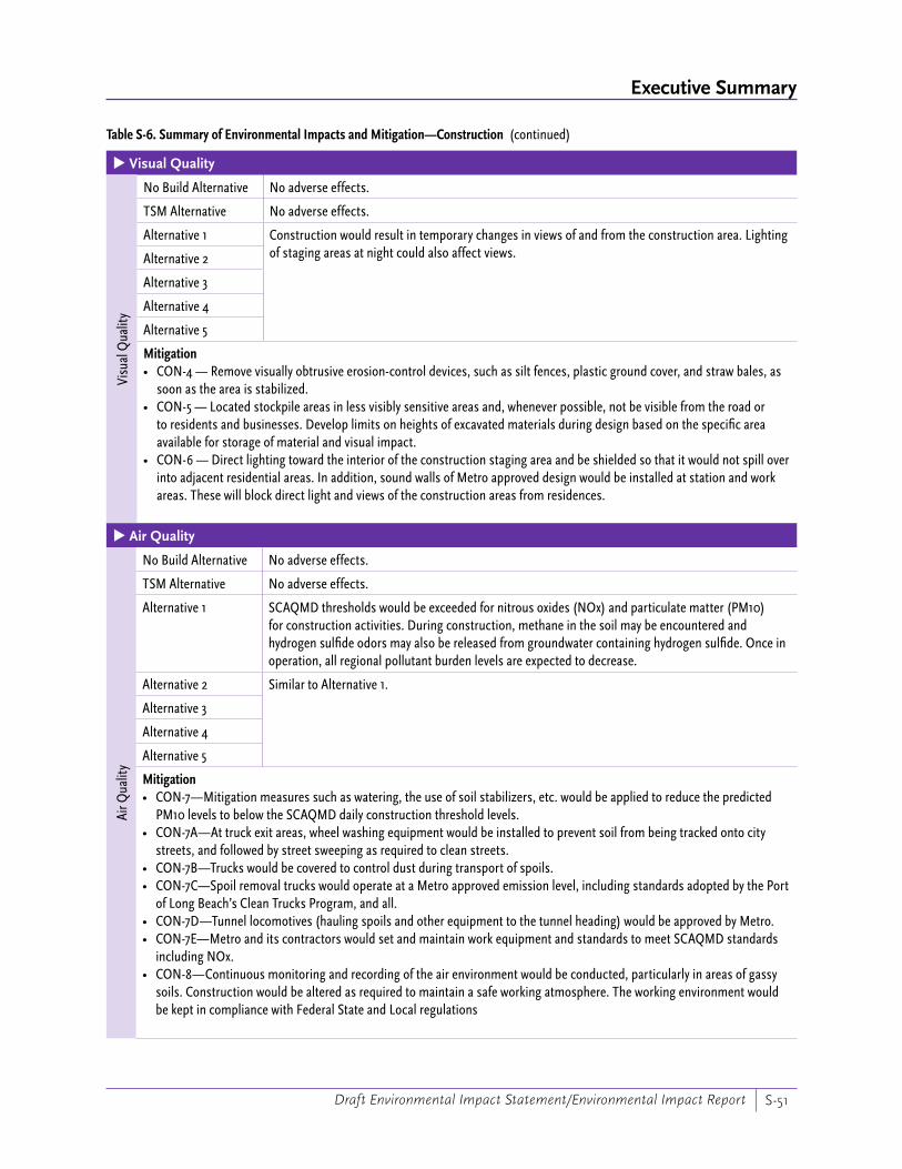
Draft Environmental Impact Statement/Environmental Impact Report S-51
Executive Summary
Table S‑6. Summary of Environmental Impacts and Mitigation—Construction (continued)
X Visual Quality
Visu
al Q
ualit
y
No Build Alternative No adverse effects.
TSM Alternative No adverse effects.
Alternative 1 Construction would result in temporary changes in views of and from the construction area. Lighting of staging areas at night could also affect views.Alternative 2
Alternative 3
Alternative 4
Alternative 5
Mitigation• CON-4 — Remove visually obtrusive erosion-control devices, such as silt fences, plastic ground cover, and straw bales, as
soon as the area is stabilized. • CON-5 — Located stockpile areas in less visibly sensitive areas and, whenever possible, not be visible from the road or
to residents and businesses. Develop limits on heights of excavated materials during design based on the specific area available for storage of material and visual impact.
• CON-6 — Direct lighting toward the interior of the construction staging area and be shielded so that it would not spill over into adjacent residential areas. In addition, sound walls of Metro approved design would be installed at station and work areas. These will block direct light and views of the construction areas from residences.
X Air Quality
Air Q
ualit
y
No Build Alternative No adverse effects.
TSM Alternative No adverse effects.
Alternative 1 SCAQMD thresholds would be exceeded for nitrous oxides (NOx) and particulate matter (PM10) for construction activities. During construction, methane in the soil may be encountered and hydrogen sulfide odors may also be released from groundwater containing hydrogen sulfide. Once in operation, all regional pollutant burden levels are expected to decrease.
Alternative 2 Similar to Alternative 1.
Alternative 3
Alternative 4
Alternative 5
Mitigation• CON-7—Mitigation measures such as watering, the use of soil stabilizers, etc. would be applied to reduce the predicted
PM10 levels to below the SCAQMD daily construction threshold levels. • CON-7A—At truck exit areas, wheel washing equipment would be installed to prevent soil from being tracked onto city
streets, and followed by street sweeping as required to clean streets. • CON-7B—Trucks would be covered to control dust during transport of spoils. • CON-7C—Spoil removal trucks would operate at a Metro approved emission level, including standards adopted by the Port
of Long Beach’s Clean Trucks Program, and all. • CON-7D—Tunnel locomotives (hauling spoils and other equipment to the tunnel heading) would be approved by Metro.• CON-7E—Metro and its contractors would set and maintain work equipment and standards to meet SCAQMD standards
including NOx.• CON-8—Continuous monitoring and recording of the air environment would be conducted, particularly in areas of gassy
soils. Construction would be altered as required to maintain a safe working atmosphere. The working environment would be kept in compliance with Federal State and Local regulations

S-52 Westside Subway Extension September 2010
X Climate Change
Clim
ate
Chan
ge
No Build Alternative No adverse effects.
TSM Alternative No adverse effects.
Alternative 1 Construction emissions may result in a short-term impact for greenhouse gases; however, these emissions are limited to the duration of construction and are not expected to result in a substantial long-term impact.
Alternative 2
Alternative 3
Alternative 4
Alternative 5
MitigationNo adverse effects; therefore, no mitigation measures are required.
XNoise and Vibration
Noi
se a
nd V
ibra
tion
No Build Alternative No adverse effects.
TSM Alternative No adverse effects.
Alternative 1 Noise impacts relating to construction are expected to be adverse. The largest potential impacts are located near stations, tunnel access portals, and construction laydown areas. Alternative 2
Alternative 3
Alternative 4
Alternative 5
Mitigation• CON-9—The Project would comply with the local noise ordinance during construction hours and local standards for
short-term operation of mobile equipment and long-term construction operations of stationary equipment, including noise levels and hours of operation.
• CON-10—Readily visible signs indicating “Noise Control Zone” would be prepared. • CON-11—Noise-control devices that meet original specifications and performance would be used. • CON-12—Fixed noise-producing equipment would be used to comply with regulations in the course of project activity. • CON-13—Mobile or fixed noise-producing equipment that are equipped to mitigate noise to the extent practical would be
used. • CON-14—Electrically-powered equipment would be used to the extent practical• CON-15—Temporary noise barriers and sound-control curtains would be erected where project activity is unavoidably close
to noise-sensitive receptors. • CON-16—Designated haul routes would be used based on the least overall noise impact Route heavily-loaded trucks away
from residential streets, if possible. Identification of haul routes would consider streets with the fewest noise sensitive receptors if no alternatives are available.
• CON-17—Non-noise sensitive, designated parking areas for project-related vehicles would be used. • CON-18—Earth-moving equipment, fixed noise-generating equipment, stockpiles, staging areas, and other noise-
producing operations would be located as far as practicable from noise-sensitive receptors.• CON-19—Use of horns, whistles, alarms, and bells would be limited.
Table S‑6. Summary of Environmental Impacts and Mitigation—Construction (continued)

Draft Environmental Impact Statement/Environmental Impact Report S-53
Executive Summary
X Energy
Ener
gy
No Build Alternative No adverse effects.
TSM Alternative No adverse effects.
Alternative 1 Energy consumption during construction would be 2.0 trillion BTUs
Alternative 2 Energy consumption during construction would be 2.3 trillion BTUs.
Alternative 3 Energy consumption during construction would be 3.4 trillion BTUs.
Alternative 4 Energy consumption during construction would be 3.7 trillion BTUs
Alternative 5 Energy consumption during construction would be 4.9 trillion BTUs.
Mitigation• No adverse effects; therefore, no mitigation measures are required.• Metro would require the construction contractor to implement energy conserving Best Management Practices in
accordance with Metro’s Energy and Sustainability Policy. Best Management Practices would include, but would not be limited to, implementing a construction energy conservation plan, using energy-efficient equipment, consolidating material delivery to ensure efficient vehicle use, scheduling delivery of materials during non-rush hours to maximize vehicle fuel efficiency, encouraging construction workers to carpool, and maintaining equipment and machinery in good working condition.
X Geologic Hazards
Seis
mic
and
Liq
uefa
ctio
n
No Build Alternative No adverse effects.
TSM Alternative No adverse effects.
Alternative 1 Alternative traverses the Santa Monica Fault and West Beverly Hills Lineament. Construction and operation are susceptible to possible seismic liquefaction, surface fault rupture and strong ground shaking generated by nearby faults.
Alternative 2
Alternative 3
Alternative 4
Alternative 5
Mitigation• No mitigation is required. • Construction would be performed in accordance with Metro criteria and the latest federal and state seismic and
environmental requirements as well as state and local building codes to protect the workers and work under construction under construction considering seismic conditions.
Table S‑6. Summary of Environmental Impacts and Mitigation—ConstructionN
oise
and
Vib
ratio
n
• CON-20—All noise-producing project equipment and vehicles would be required to use internal combustion engines equipped with mufflers and air-inlet silencers, where appropriate, and kept in good operating condition that meet or exceed original factory specifications. Mobile or fixed “package” equipment (e.g., arc- welders, air compressors) would be equipped with shrouds and noise control features that are readily available for that type of equipment.
• CON-21—Any project-related public address or music system would not be audible at any adjacent receptor. • CON-22—Demolition, earth moving, and ground impacting operations would be phased so as not to occur in the same
time period. • CON-23—Impact pile driving would be avoided. Drill piles or sonic or vibratory pile drivers would be used where the
geological conditions permit their use. • CON-24—Demolition methods would be selected to minimize noise and vibration impact where possible.• CON-25—Use of vibratory rollers and packers would be avoided near vibration sensitive areas. • CON-26—Temporary tracks for mine trains would be in good condition. In sensitive areas, require further measures to
reduce noise such as rail isolation materials.• CON-27—Enclosures for fixed equipment such as TBM slurry processing plants would be required in order to reduce noise.

S-54 Westside Subway Extension September 2010
Subs
urfa
ce G
ases
No Build Alternative No adverse effects.
TSM Alternative No adverse effects.
Alternative 1 Hazardous subsurface gasses (methane and hydrogen sulfide) pose a hazard during construction and operation.Alternative 2
Alternative 3
Alternative 4
Alternative 5
Mitigation• CON 32—In areas of potential hydrogen sulfide exposure, there are several techniques that can be used to lower the risk
of exposure. Areas that have been determined to be at risk of elevated hydrogen sulfide levels can be treated by displacing and oxidation of the hydrogen sulfide by injecting water possibly containing dilute hydrogen peroxide into the ground and groundwater in advance of the tunnel excavation. This “in-situ oxidation” method reduces hydrogen sulfide levels even before the ground is excavated. This pre-treatment method may be implemented at tunnel-to-station connections or at cross-passage excavation areas and where open excavation and limited dewatering may be conducted such as emergency exit shafts and low-point sump excavations.
• CON 33–Additives can be mixed with the bentonite (clay) slurry during the mining and/or prior to discharge into the slurry separation plant. For example, zinc oxide can be added to the slurry as a “scavenger” to precipitate dissolved hydrogen sulfide when slurry hydrogen sulfide levels get too high.
• CON 34–For the stations, the use of relatively impermeable diaphragm or slurry walls or equivalent would be implemented to reduce of gas inflows both during and after construction to provide a barrier against water and gas intrusion and reduce the need for dewatering the station during construction. Grout tubes can be pre-placed within slurry wall panels to be used in the event leakage occurs. Additional ventilation, continuous monitoring, and worker training for exposure to hazardous gases would also be required during construction. In extreme cases, some work may require use of personal protective equipment, such as fitted breathing apparatus.
• CON-35—If abandoned wells are found to be located within the alignment, the California Department of Conservation (Department of Oil, Gas and Geothermal Resources) would be contacted to determine the appropriate method to abandon the well. Similarly, during construction if an unknown well is encountered, the contractor would notify Metro, Cal/OSHA, and the Gas and Geothermal Resources for well abandonment procedures.
• CON-37—Although not specifically required for gassy tunnels, oxygen supply-type self-rescuers (required for evacuation during fires) would be used, as necessary.
Table S‑6. Summary of Environmental Impacts and Mitigation—Construction Noise and Vibration (continued)

Draft Environmental Impact Statement/Environmental Impact Report S-55
Executive Summary
XHazardous Waste and Materials
Haz
ardo
us W
aste
and
Mat
eria
ls
No Build Alternative No adverse effects.
TSM Alternative No adverse effects.
Alternative 1 Alignment is close to areas where underground storage tanks, volatile organic compounds and oil exploration sites occur. Subway tunnel is expected to be under the lowest point of contaminated soils; low or negligible potential impact expected. Contaminated groundwater may be encountered during construction and operation. Any contaminated groundwater would be treated in accordance with applicable permits prior to discharge or disposal. Preparation of construction staging areas will require demolition of structures. In locations where buildings may be demolished or modified, asbestos and/or lead may be present and will be handled by licensed contractors in accordance with applicable regulations. No adverse effect.
Alternative 2
Alternative 3
Alternative 4
Alternative 5
Mitigation• CON-38—An Environmental Site Assessment would be conducted prior to construction in areas of impacted soil. A base
line soil sampling protocol would be established with special attention to those areas of potential environmental concern. The soil would be assessed for constituents likely to be present in the subsurface including, but not limited to, total petroleum hydrocarbons, volatile and semi-volatile organic compounds, polychlorinated biphenyls, polynuclear aromatic hydrocarbons, pesticides, lead arsenates, and Title 22 metals. The depth of the sampling would be based on the depth of grading or type of construction activities. In addition, in areas where groundwater would be encountered, samples would also be analyzed for suspected contaminants prior to dewatering to ensure that National Pollutant Discharge Elimination System discharge requirements are satisfied.
• CON-39—A soil mitigation plan would be prepared showing the extent of soil excavation during construction. The soil mitigation plan would establish soil reuse criteria, a sampling plan for stockpiled materials, and the disposition of materials that do not satisfy the reuse criteria. It would specify guidelines for imported materials. The plan would include provisions for soil screening for contamination during grading or excavation activities.
• CON-40—Soil samples that are suspected of contamination would be analyzed for suspected chemicals by a California certified laboratory. If contaminated soil is found, it would be removed, transported to an approved disposal location and remediated or disposed according to State and federal laws. Soils would be used on-site as appropriate.
• CON-41— If unanticipated contaminated groundwater is encountered during construction, the contractor would stop work in the vicinity, cordon off the area, and contact Metro and the appropriate hazardous waste coordinator and maintenance hazardous spill coordinator at Metro and immediately notify the Certified Unified Program Agencies (City of Los Angeles Fire Department, County of Los Angeles Fire Department, and LARWQCB) responsible for hazardous materials and wastes.
• CON-42— In coordination with the LARWQCB, an investigation and remediation plan would be developed in order to protect public health and the environment. Any hazardous or toxic materials would be disposed according to local, state, and federal regulations.
• CON-43—A health and safety plan would be developed for persons with potential exposure to the constituents of concern identified in the limited Phase II Environmental Site Assessment.
• CON-44- Hazardous materials would be properly stored to prevent contact with precipitation and runoff.• CON-45—An effective monitoring and cleanup program would be developed and implemented for spills and leaks of
hazardous materials• CON-46—Equipment to be repaired or maintained would be placed in covered areas on a pad of absorbent material to
contain leaks, spills, or small discharges• CON 47- Any significant chemical residue on the project sites would be removed through appropriate methods .
Table S‑6. Summary of Environmental Impacts and Mitigation—Construction (continued)

S-56 Westside Subway Extension September 2010
X Ecosystems/Biological Resources
Ecos
yste
ms/
Biol
ogic
al R
esou
rces
No Build Alternative No adverse effects.
TSM Alternative No adverse effects.
Alternative 1 Construction may require the removal or disturbance (including trimming) of mature trees located at the construction sites. An adverse effect could occur if an active migratory bird nest located in any of these trees is disturbed during construction.
Alternative 2
Alternative 3
Alternative 4
Alternative 5
Mitigation• CON-48—Two biological surveys would be conducted, one 15 days prior and a second 72 hours prior to construction
that would remove or disturb suitable nesting habitat. The surveys would be performed by a biologist with experience conducting breeding bird surveys. The biologist would prepare survey reports documenting the presence or absence of any protected native bird in the habitat to be removed and any other such habitat within 300 feet of the construction work area (within 500 feet for raptors). If a protected native bird is found, surveys would be continued in order to locate any nests. If an active nest is located, construction within 300 feet of the nest (500 feet for raptor nests) would be postponed until the nest is vacated and juveniles have fledged and when there is no evidence of a second attempt at nesting.
• CON-49—If construction or operation of the Project requires removal or pruning of a protected tree, a removal permit would be required in accordance with applicable municipal codes and ordinances of the city in which the affected tree is located. Within the City of Los Angeles, compliance with the Native Tree Protection Ordinance would require a tree removal permit from the Los Angeles Board of Public Works. Similarly, within the cities of West Hollywood, Beverly Hills, and Santa Monica applicable tree protection requirements, such as tree removal permits, would be followed. Tree removal permits may require replanting of protected trees within the project area or at another location to mitigate for the removal of these trees.
• CON-50—If construction or operation would entail pruning of any protected tree, the pruning would be performed in a manner that does not cause permanent damage or adversely affect the health of the trees.
XWater Resources
Wat
er R
esou
rces
No Build Alternative No adverse effects.
TSM Alternative No adverse effects.
Alternative 1 No adverse effects. Groundwater is encountered at varying depths throughout the Study Area and dewatering during construction and operation may be required. For Alternatives 3 and 5 a portion of the alignment is in the coastal zone and would require a Coastal Development Permit.
Alternative 2
Alternative 3
Alternative 4
Alternative 5
Table S‑6. Summary of Environmental Impacts and Mitigation—Construction (continued)

Draft Environmental Impact Statement/Environmental Impact Report S-57
Executive Summary
Mitigation• CON-51—An erosion and sediment control plan would be established prior construction. • CON-52—Landscape and construction debris would be periodically and consistently removed.• CON-53—Non-toxic alternatives would be employed for any necessary applications of herbicides or fertilizers;• CON-54—Temporary detention basins would be installed to remove suspended solids by settlement.• CON-55—Water quality of runoff would be periodically monitored before discharge from the site and into the storm drainage
system.
As required under the National Pollution Discharge Elimination System permit, an Urban Stormwater Mitigation Plan and appropriate drainage plan would be implemented to control pollutants to the maximum extent practicable. The drainage control plan would be developed to properly convey drainage from the project area and avoid ponding on adjacent properties. Best Management Practices for tunnel construction activities include but not limited to the following measures as appropriate:• CON-56—Construction sites would have BMPs to divert potential storm water runoff from entering the construction area.
Containment around the site will include use of temporary measures such as fiber rolls to surround the construction areas to prevent any potential spills of slurry discharge or spoils recovered during the separation process. Downstream drainage inlets will also be temporarily covered to prevent potential discharge from entering the storm drain system.
• CON-57—Construction entrances/exits would be properly set up so as to reduce or eliminate the tracking of sediment and debris offsite. Appropriate measures would include measures such as grading to prevent runoff from leaving the site, and establishing “rumble racks” or wheel water points at the exit to remove sediment from construction vehicles.
• CON-58—Onsite rinsing or cleaning of any equipment would be performed in contained areas and rinse water collected for appropriate disposal.
• CON-59—A tank would be required on work sites to collect the water for periodic offsite disposal. Since the slurry production is a closed loop system in which the water separated from the discharge slurry is continually recycled, minimal and infrequent water discharges are anticipated. These discharges can be accommodated in a tank onsite to collect the water and dispose of periodically.
• CON-60—Soil and other building materials (e.g., gravel) stored onsite must be contained and covered to prevent contact with storm water and potential offsite discharge .
X Safety and Security
No Build Alternative No adverse effects. Safety would remain at current levels or follow current trends.
TSM Alternative No adverse effects. Metro bus operators will perform under similar conditions as No Build and in accordance with Metro’s established safety program. Safety would remain at current levels or follow current trends.
Alternative 1 No adverse effects. Construction effects will be temporary and localized primarily in station and staging areas. Construction equipment and haul trucks would create potential safety hazards for pedestrians, bicyclists and motorists. Safety impacts related to the number and proximity of vehicles and people adjacent to the construction facilities. Construction workers working at the various surface construction locations, and underground in tunnel bores, also subject to safety risk. Adverse effect would be temporary. During construction, subsurface gases (methane and hydrogen sulfide gas) could be encountered in tunneling and excavation staging areas.
Alternative 2
Alternative 3
Alternative 4
Alternative 5
Mitigation• SS-3—Implement safety rules, procedures, and policies to protect workers and work sites during construction.• SS-4—Provide warning and/or notification signs, detours, and barriers.
Table S‑6. Summary of Environmental Impacts and Mitigation—Construction (continued)

S-58 Westside Subway Extension September 2010
X Parklands and Community Services and Facilities
No Build Alternative No adverse effects.
TSM Alternative No adverse effects.
Alternative 1 Community facilities and services and parklands immediately adjacent to stations would experience disruptions as a result of noise and/or emissions during construction. Construction related impacts to schools include safety of students walking past construction sites and air and noise/vibration effects on schools close to construction sites and/or haul routes.
Alternative 2 Same as Alternative 1; however, the construction would affect a larger area because the alignment is longer.
Alternative 3 Same as Alternative 1; however, the construction would affect a larger area because the alignment is longer.
Alternative 4 Same as Alternative 1; however, the construction would affect a larger area because the alignment is longer.
Alternative 5 Same as Alternative 3 and 4.
Mitigation• CON-61—School districts and private school institutions along the alignment would be informed of changes to Metro bus
routes, school bus routes, and pedestrian crossings prior to construction.• CON-62—Metro would work with transportation, police, public works, and community services departments of jurisdictions
along the alignment to implement mutually agreed upon measures, such as posting of clearly marked signs, pavement markings, lighting as well as implementing safety instructional programs, to enhance the safety of pedestrians, particularly in the vicinity of schools and access routes to hospitals.
• The measures would be developed to conform to Metro Rail Transit Design Criteria and Standards, Fire/Life Safety Criteria.• CON-63—Metro would provide an instructional rail safety program with materials to all affected elementary and middle schools.• CON-64—Metro would provide an informational program to nearby medical facilities, senior centers, and parks if requested by
these facilities, to enhance safety. • CON-65—Safe emergency vehicle routes will be designated around construction sites and would be coordinated with other
agencies.
Table S‑6. Summary of Environmental Impacts and Mitigation—Construction (continued)
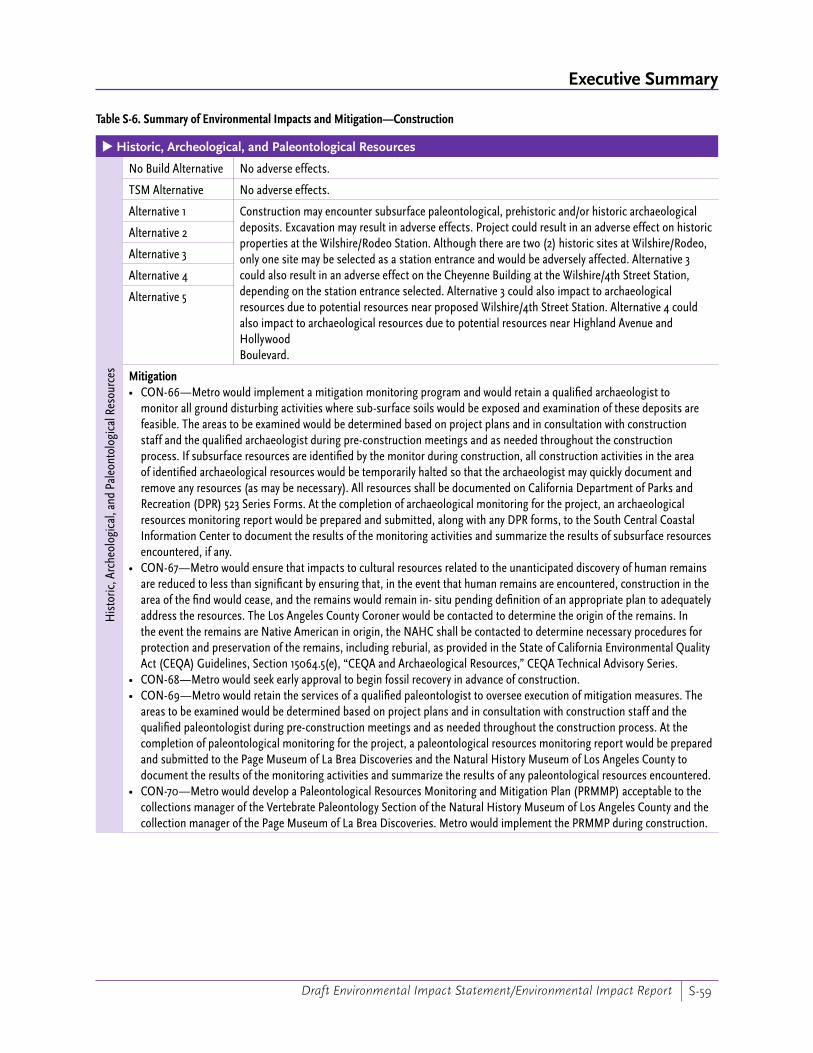
Draft Environmental Impact Statement/Environmental Impact Report S-59
Executive Summary
XHistoric, Archeological, and Paleontological Resources
His
toric
, Arc
heol
ogic
al, a
nd P
aleo
ntol
ogic
al R
esou
rces
No Build Alternative No adverse effects.
TSM Alternative No adverse effects.
Alternative 1 Construction may encounter subsurface paleontological, prehistoric and/or historic archaeological deposits. Excavation may result in adverse effects. Project could result in an adverse effect on historic properties at the Wilshire/Rodeo Station. Although there are two (2) historic sites at Wilshire/Rodeo, only one site may be selected as a station entrance and would be adversely affected. Alternative 3 could also result in an adverse effect on the Cheyenne Building at the Wilshire/4th Street Station, depending on the station entrance selected. Alternative 3 could also impact to archaeological resources due to potential resources near proposed Wilshire/4th Street Station. Alternative 4 could also impact to archaeological resources due to potential resources near Highland Avenue and Hollywood Boulevard.
Alternative 2
Alternative 3
Alternative 4
Alternative 5
Mitigation• CON-66—Metro would implement a mitigation monitoring program and would retain a qualified archaeologist to
monitor all ground disturbing activities where sub-surface soils would be exposed and examination of these deposits are feasible. The areas to be examined would be determined based on project plans and in consultation with construction staff and the qualified archaeologist during pre-construction meetings and as needed throughout the construction process. If subsurface resources are identified by the monitor during construction, all construction activities in the area of identified archaeological resources would be temporarily halted so that the archaeologist may quickly document and remove any resources (as may be necessary). All resources shall be documented on California Department of Parks and Recreation (DPR) 523 Series Forms. At the completion of archaeological monitoring for the project, an archaeological resources monitoring report would be prepared and submitted, along with any DPR forms, to the South Central Coastal Information Center to document the results of the monitoring activities and summarize the results of subsurface resources encountered, if any.
• CON-67—Metro would ensure that impacts to cultural resources related to the unanticipated discovery of human remains are reduced to less than significant by ensuring that, in the event that human remains are encountered, construction in the area of the find would cease, and the remains would remain in- situ pending definition of an appropriate plan to adequately address the resources. The Los Angeles County Coroner would be contacted to determine the origin of the remains. In the event the remains are Native American in origin, the NAHC shall be contacted to determine necessary procedures for protection and preservation of the remains, including reburial, as provided in the State of California Environmental Quality Act (CEQA) Guidelines, Section 15064.5(e), “CEQA and Archaeological Resources,” CEQA Technical Advisory Series.
• CON-68—Metro would seek early approval to begin fossil recovery in advance of construction.• CON-69—Metro would retain the services of a qualified paleontologist to oversee execution of mitigation measures. The
areas to be examined would be determined based on project plans and in consultation with construction staff and the qualified paleontologist during pre-construction meetings and as needed throughout the construction process. At the completion of paleontological monitoring for the project, a paleontological resources monitoring report would be prepared and submitted to the Page Museum of La Brea Discoveries and the Natural History Museum of Los Angeles County to document the results of the monitoring activities and summarize the results of any paleontological resources encountered.
• CON-70—Metro would develop a Paleontological Resources Monitoring and Mitigation Plan (PRMMP) acceptable to the collections manager of the Vertebrate Paleontology Section of the Natural History Museum of Los Angeles County and the collection manager of the Page Museum of La Brea Discoveries. Metro would implement the PRMMP during construction.
Table S‑6. Summary of Environmental Impacts and Mitigation—Construction

S-60 Westside Subway Extension September 2010
His
toric
, Arc
heol
ogic
al, a
nd P
aleo
ntol
ogic
al R
esou
rces
• CON-71—For any La Brea deposits encountered near the Hancock Park area, all fossils detected during excavation of the asphalt masses would be prepared and conserved, the remaining matrix degreased, and the resultant concentrate inspected for vertebrate, invertebrate, and plant fossils by a qualified paleontologist.
• CON-72—Metro would prepare a report detailing the paleontological resources recovered, their significance, and arrangements made for their curation at the conclusion of the monitoring effort.
• CON-73—Metro would provide the resources necessary to curate the identified and prepared fossils in a manner that meets the standards published by the Society of Vertebrate Paleontology and the Paleontological Resources Preservation Act. Those fossils collected near the Page Museum of La Brea Discoveries would be curated at this institution. All other fossils would be curated at the Natural History Museum of Los Angeles County.
X Cumulative Impacts
Cum
ulat
ive
Impa
cts
No Build Alternative No contribution to cumulative impacts
TSM Alternative No contribution to cumulative impacts
Alternative 1 The Build Alternatives when combined with other projects that could occur at the same time would result in cumulative construction impacts for localized air quality, and localized visual quality. If the Project occurs at the same time as other projects in a particular community, cumulative effects associated with noise and vibration, street closures and traffic, parking, aesthetics, access to businesses, parks and public facilities, and other construction-related effects would be significant to communities and neighborhoods during construction.
Alternative 2
Alternative 3
Alternative 4
Alternative 5
Table S‑6. Summary of Environmental Impacts and Mitigation—Construction (continued)
Summary Evaluation of Station and Alignment Options In general, the Project would improve VMT within
the Study Area. The station options would not cause
a negative impact on traffic. The one exception is the
intersection of Wilshire Boulevard and 16th Street
in Santa Monica under Alternatives 3 and 5. Near
the stations, parking impacts and consequences
include potential loss of on- and off-street capacity to
accommodate construction of rail stations. Spillover
parking potential may impact neighborhoods, as rid-
ers may drive to stations to access the subway.
At all of the stations there is the potential to tempo-
rarily impact local bus stops, bicyclists, and pedestri-
ans during construction. The operation plan for any
of the Build Alternatives would accommodate transit
and non-motorized facilities into the station design.
Stations and adjacent station area development is
anticipated to enhance pedestrian circulation pat-
terns and connectivity to maximize ridership.
The station options would not physically divide an
established community, would be consistent with
applicable local and regional adopted plans and
policies, and would be compatible with surrounding
land uses. These stations would not significantly
impact land use.

Draft Environmental Impact Statement/Environmental Impact Report S-61
Executive Summary
All station options would result in some full acquisi-
tions, partial acquisitions, permanent easements,
and temporary construction easements surrounding
station locations for the purposes of station boxes,
station entrances, and construction staging.
Design of station entrances is expected to comple-
ment the cultural, historic, geographic, and aesthetic
character of the surrounding areas. Where practi-
cable, entrances would be integrated into existing
buildings or could be integrated into future develop-
ment.
There would be no adverse effect from noise and
vibration at the stations. Multiple segments of the
Santa Monica Fault cross sections of the Study Area
and some of the stations are in designated liquefac-
tion hazard zones. However, no adverse effects are
anticipated. This fault has not produced any mod-
erate or large earthquakes in the historic record;
however, it has been suggested that the fault has had
at least six rupture events in the last 50,000 years,
with the most recent being between 1,000 and 3,000
years ago.
The potential exists to encounter subsurface gases
and hazardous materials near some of the stations.
While there is a potential impact, these materi-
als will be managed in accordance with regulatory
requirements.
A few historic sites are located near some of the
station options; however, there would be no adverse
effects to these historic sites.
The stations would be located within a densely devel-
oped urban area and would not extend into undevel-
oped areas that may induce changes in such areas.
Potential indirect growth-inducing effects may result
from opportunities the Build Alternatives provide for
micro-scale growth, including economic growth.
Cumulative effects would be the same for all the
Build Alternatives. The incremental effect of the
station options would be beneficial overall, although
parking loss during construction would be a signifi-
cation cumulative impact
Option 1: No Wilshire/Crenshaw Station Option Removal of this station would reduce transit access
for those residents and jobs within one-half mile of
the proposed Crenshaw Station. The area around
this station; however, has relatively low density and is
not planned for growth in the future. The Wilshire/
Western Station is more than one-half mile away, a
significant distance to walk. Residents of the sta-
tion area and workers with jobs in the station area
would be dependent on the bus system for the “last
mile” to their homes and jobs. As a result of the
slower speeds on buses and the possible need for an
additional transfer, they would be less likely to use
transit. Deleting this station would also respond to
community concerns about development pressures
that could change the character of this residential
area. Also, the costs to construct this station would
only provide modest ridership and travel time
benefits that would not be sufficient to improve the
cost-effectiveness of the overall project.
Option 2: Wilshire/Fairfax Station East Station Option Either of the two Fairfax Station options offers a sta-
tion portal serving the Los Angeles County Museum
of Art. The west option (Base) provides access to
the LACMA and Hancock Park. However, the east
option provides more direct access but it has a some-
what greater potential to encounter paleontological
remains and gassy soils and may cause more traffic
impacts during construction. Both locations have
similar costs.

S-62 Westside Subway Extension September 2010
Option 3: Wilshire/La Cienega Station West with Connection Structure The west station option creates the opportunity for
direct transfers between the Wilshire and the West
Hollywood line in Alternatives 4 and 5. With the east
station, transfers would be possible at the Wilshire/
Rodeo Station but would require out-of-direction
travel and added travel time. The east station site
offers better access to higher density residences and
businesses east of La Cienega.
Option 4: Century City Station For the Century City Station, the feasibility of the
Santa Monica Boulevard (Base) site assumed in
the Base Alignment for the five Build Alternatives
is compromised by its close proximity to the Santa
Monica Fault which runs directly beneath Santa
Monica Boulevard in this area. The optional Constel-
lation site is farther from the fault and would have
a lower seismic risk. The Constellation site is also
more centrally located within Century City, enhanc-
ing walk access for many passengers boarding and
alighting at Century City.
Relocating the station from Santa Monica Boulevard
to Constellation would save $4.1 million in station
costs. Because it increases the alignment length, a
station at Constellation would increase the overall
capital cost by $60.4 million.
If the Century City Station is located at Constella-
tion, there are two alignment options for connecting
to the Wilshire/Rodeo Station, the Constellation
north option and the Constellation south option. If
the Century City station is located on Santa Monica
Boulevard, the alignment between Century City and
Wilshire/Rodeo would follow Santa Monica Boule-
vard. Neither the alignment options nor the station
location options would have a significant impact on
transit travel time between Century City and the
Wilshire/Rodeo Station.
There are 3 alignment options to connect a Century
City Station to a Westwood/UCLA Station: East
(Base), Central and West alignments. At Westwood/
UCLA there are two possible station sites: on and
off-street.
The South Alignment is longer than the other two
and would increase travel time between Century City
and Westwood by more than two minutes. This, in
turn, would lead to somewhat lower ridership and
user benefits, and to fewer air quality and energy
conservation benefits. The South Alignment would
also increase capital costs by more than $140 million
compared with the Base Alignment and increase
operating and maintenance costs. Those alignment
options with higher costs will also have higher CEIs
and would be less competitive for FTA New Starts
funds.
Noise and vibration are key environmental concerns
for alignment options between the Wilshire/Rodeo
Station in Beverly Hills and Westwood. Residents
worry that subway trains could cause vibrations that
would be felt in properties above the tunnel. The
West Alignment option would require fewer sub-
surface easements and cross under fewer residential
units. The analysis has shown, however, that vibra-
tion impacts for subway tunnels are generally below
the threshold of human perception.
Option 5: Westwood/UCLA On-Street Station Option The on-street option under Wilshire Boulevard
increases capital costs by $10.1 million and would
disrupt roadway traffic during the construction
period due to the need for lane closures during
certain periods of the construction process. The
off-street site would reduce traffic and construction
impacts by relocating the primary construction site
off street. The off-street site would temporarily dis-
place existing surface parking during the construc-
tion period.

Draft Environmental Impact Statement/Environmental Impact Report S-63
Executive Summary
Option 6: Westwood/VA Hospital North Station The south station site (Base) is less than 300 feet
from the hospital, while the north option is more
than 1,000 feet away on the other side of Wilshire
Boulevard. Thus, the south option offers much bet-
ter access to the VA Hospital for employees, patients,
and visitors.
Moving the station to the north side of Wilshire Bou-
levard would increase project cost by $92.6 million
but would avoid construction impacts near the VA
Hospital. However, a station on the north side would
have greater potential to adversely affect cultural
resources such as the Wadsworth Theater and the
Chapel.
Project PhasingMOS 1—Interim terminus at Fairfax, and MOS 2—
Interim terminus at Century City are compared
with the five Build Alternatives, as well as the No
Build and TSM Alternatives, in Section 7.1 of this
Draft EIS/EIR. Two goals are considered to be most
relevant to a decision on phasing—cost-effectiveness
and equity. Station-area impacts at the interim ter-
mini (Fairfax for MOS-1 and Century City for MOS-
2) would not differ significantly from the impacts
noted previously.
The MOSs are less cost-effective than the five Build
Alternatives. However, MOS 1 serves a part of the
Study Area that has a larger percentage of resi-
dents who are low income or minority. Two goals
are considered to be most relevant to a decision on
phasing—cost-effectiveness and equity. Station area
impacts at the interim termini (Fairfax for MOS 1
and Century City for MOS 2) would not differ signifi-
cantly from the impacts for other stations.

S-64 Westside Subway Extension September 2010