environmental and social management …documents.worldbank.org/curated/en/... · annex 2:...
TRANSCRIPT

RURAL ACCESS IMPROVEMENT
AND
DECENTRALIZATION PROJECT (RAIDP)
ENVIRONMENTAL AND SOCIAL
MANAGEMENT FRAMEWORK
(ESMF)
Project Co-ordination Unit RAIDP
Department of Local Infrastructure Development and Agricultural Roads Government of Nepal
September 2009
RP843 V2
Pub
lic D
iscl
osur
e A
utho
rized
Pub
lic D
iscl
osur
e A
utho
rized
Pub
lic D
iscl
osur
e A
utho
rized
Pub
lic D
iscl
osur
e A
utho
rized
Pub
lic D
iscl
osur
e A
utho
rized
Pub
lic D
iscl
osur
e A
utho
rized
Pub
lic D
iscl
osur
e A
utho
rized
Pub
lic D
iscl
osur
e A
utho
rized

ABBREVIATIONS
BoQ : Bill of Quantity CBPM : Community Based Performance Monitoring CIDP : Community Infrastructure Development Plan CLE : Cluster Level Environmentalist DAO : District Administration Office DDC : District Development Committee DFO : District Forest Office DoLIDAR : Department of Local Infrastructure Development and Agricultural
Roads DoR : Department of Roads DRCC : District Road Co-ordination Committee DTO : District Technical Officer EIA : Environmental Impact Assessment EMP : Environment Management Plan EPA : Environmental Protection Act EPR : Environmental Protection Regulation EMP : Environmental Management Plan SMP : Social Management Plan GoN : Government of Nepal IEE : Initial Environmental Examination LRUC : Local Road Users’ Committee NGO : Non-Governmental Organization OD : Operational Directive OP : Operational Plan PCU : Project Co-ordination Unit PSC : Project Support Consultant RoW : Right of the Way SDC : Social Development Consultant SMO : Social Mobilization Officer SPAP/F : Seriously Project Affected People / Family VCDP : Vulnerable Communities Development Plan VDC : Village Development Committee VDIMF : Voluntary Donation Impact Mitigation Fund VDIMP : Voluntary Donation Impact Mitigation Plan VRCC : Village Road Co-ordination Committee WB : World Bank

TABLE OF CONTENTS CHAPTER I: INTRODUCTION ............................................................................1
BACKGROUND..............................................................................................................................1 THE PROJECT...............................................................................................................................1 OBJECTIVES.................................................................................................................................2 OUTLINE OF THE REPORT..............................................................................................................2
CHAPTER II: POLICES, REGULATIONS AND GUIDELINES .......................4 RELEVANT POLICIES OF GOVERNMENT OF NEPAL..........................................................................4
Government of Nepal’s Legislative Framework and Guidelines 5 Government of Nepal Policies Supporting Vulnerable Communities 6
WORLD BANK ENVIRONMENTAL AND SOCIAL SAFEGUARD POLICIES .............................................6 COMPARISON OF GOVERNMENT OF NEPAL AND WORLD BANK POLICIES........................................7
CHAPTER III: ENVIRONMENTAL AND SOCIAL MANAGEMENT FRAMEWORK ......................................................................................................10
ROAD CORRIDOR........................................................................................................................ 11 ENVIRONMENTAL IMPACTS......................................................................................................... 11
Environmental Screening 12 Environment Management Plan (EMP) 13 Tree Cutting and Re-plantation Principles 15 Extraction of Construction Materials 16
SOCIAL IMPACTS........................................................................................................................ 16 Social screening 16 Beneficiary Identification 17 Voluntary Land Donation 18 Voluntary Donation Impact Mitigation Fund (VDIMF) 20 Entitlement policy Matrix 21 Other Social Mitigation Plan 23
CONTRACTORS COMPLIANCE ON ENVIRONMENTAL AND SOCIAL SAFEGUARD MEASURES............. 24 CHAPTER IV: PLANNING AND IMPLEMENTATION MECHANISM ........26
ENVIRONMENTAL IMPACT MITIGATION MECHANISM................................................................... 27 Environmental Screening Criteria 27 Initial Environmental Examination/ Environmental Impact Assessment 28 Site Specific Environmental Management Plan (EMP) 28
SOCIAL MANAGEMENT PLANS .................................................................................................... 29 Implementation Arrangement 29 Process of Land Transfer 31
OTHER SOCIAL PLANS ................................................................................................................ 31 Vulnerable Community Development Program (VCDP) 31 Community Infrastructure Development Program (CIDP) 32 Disclosure 33
ROLE OF NGO AND SOCIAL DEVELOPMENT CONSULTANT .......................................................... 33 CAPACITY BUILDING .................................................................................................................. 33 ROLE AND RESPONSIBILITIES OF VARIOUS ORGANIZATIONS ........................................................ 34 SUPERVISION, MONITORING AND EVALUATION ........................................................................... 34 ENVIRONMENT AND SOCIAL AUDITING ....................................................................................... 36
Central Level Audit 36 Local level Audit 36 Evaluation 36
ANNEXES................................................................................................................................ 37 Annex 1: List of Protected Plant Species by Law....................................................................... 37

Annex 2: Environmental Screening Format ...............................................................................38 Annex 3: Sample Site-Specific Environmental Management Plan (EMP) Format ......................44 Annex 4: Survey Questionnaire for Social Screening.................................................................53 Annex 5: Outline to Prepare Voluntary Donation Impact Mitigation Plan (VDIMP) ..................58 Annex 6: a. Memorandum of agreement for Voluntary Land Donation (Individual)...................60 Annex 6: b. Memorandum of agreement for Voluntary Land Donation (Group) ........................61 Annex 7: Outline of Vulnerable Community Development Plan (VCDP) ..................................62 Annex 8: Community Infrastructure Development Plan (CDIP).................................................63 Annex 9: Environmental and Social Safeguard Integrations.......................................................64 Annex 10: Environmental Capacity at Different Levels for Implementation of ESMF ...............67 Annex 11: Format for District Level Monitoring ....................................................................... 69

1
Chapter I: INTRODUCTION
BACKGROUND
1.1 Development of a nation and its people is significantly contributed through improved access to physical facilities and social services. Roads are the only cheaper means of access to the people of rural area of a country like Nepal. Though Nepal has about 17,280 Kms road (excluding village roads) the road density is low, about 90m/sq Km and 0.66 Km per 1000 population. Almost all rural roads are dry-weather tracks that are not operational during the rainy season. Inadequate and inefficient rural transport service therefore is a major constraint for access to social services, including education, medical facilities, and markets. The studies reveal that maternal and infant mortality is more likely to be higher in less accessible areas. Similarly, per capita incomes are 50 to 65 percent lower in the more remote Far West Hill and Mountain Districts than they are in the more accessible Terai and Central Hill Districts. 1.2 Road construction bears potential risk on physical, biological, social and cultural environment of any area. Because of weak geology, rich biodiversity, high dependency of people on natural resources and widespread poverty, the social and environmental impacts are visibly significant, particularly when construction works are undertaken in rural areas. Generally, the environmental and social risks triggered by road construction include erosion and slope instability; loss of forest, biodiversity and agricultural land; effect to water sources due to sedimentation, water logging and drainage congestion, displacement/damage of permanent assets and loss of land. These problems are apparent not only during construction but also during operation phase, which has made road unsustainable with reduced dependency of people on road services, often resulting into even more harder life of the people. So, proper consideration of all environmental and social factors during design and implementation is of utmost concern in roads of Nepal.
THE PROJECT
1.3 Rural Access Improvement and Decentralization Project (RAIDP), aimed at improving rural accessibility, is funded by the World Bank (WB) grant. It is already under operation in 20 districts and 10 new districts are recently added under this project. Till May 2009, RAIDP have completed 445 Km roads (48 sub-projects) in 20 districts, which constitutes 259 Km otta/sand seal, 156 Km Gravel and 30 Km earthen roads. Besides road construction 131 community infrastructures have also been completed. This has given benefit to about 1.7 million people. The Government of Nepal (GoN) and WB have agreed for additional financing, which will be used for road improvement/construction in all 30 districts. From additional financing in new districts around 0.6 million people will be benefitted. The project will provide all-weather access to a network of 1202 km; the average number of beneficiary population per kilometer is around 1,434 person; and most of the beneficiary population live in Terai and valley plains, and 45 percent of the beneficiary population in the hills live within 30 minutes of the road. 1.4 The project’s road activities can be put in two broad categories: (i) The first category roads are All Season Rural Roads, which include upgrading of existing

2
district roads. The upgrading works involve widening of existing track to district road standard, embankment construction, gravelling, and construction of retaining and other structures, compaction, and otta seal. The environmental and social impacts vary from site to site. The widening activities may need to acquire additional land and structure, felling of trees and clearing forests; grading of the road may cause change in cut slopes, generate spoil material; raising embankment may change existing local drainage; construction activities may require quarry site operation; compaction requires operation of vibrator that may have impact on structures; borrowing activities may create pits, or removal of soil from agricultural land etc. The second categories of roads are (ii) Dry Season Roads, which include construction of new road as per district road standard. Activities posing environmental and social risks in this type of road include; alignment selection, new track opening, forest clearance, slope modification, spoil disposal etc. In new roads, alignment selection of the road is of crucial importance as it determines the type and level of environmental and social impacts. 1.5 The purpose of the Environmental and Social Management Framework (ESMF) is to provide guiding principles for assessment and management of environmental and social aspects of all physical works targeted under RAIDP. It will help to systematically identify, predict, and evaluate beneficial and adverse environmental and social impacts of rural road construction and upgrading activities, designing enhancement measures for beneficial impacts, and implement mitigating measures for adverse impacts. The earlier version of ESMF (December, 2004) has been used so far in the RAIDP roads. Based on the lessons learned and implementation experiences at the field level, the ESMF is being updated. The revision of ESMF has been done with consultations with project affected people, NGOs, SMO/SDC, PDE, DDC, DTO, DoLIDAR, MoLD, and other similar projects implemented by GoN. Once approved by GoN, this version will formally replace the earlier version and come into enforcement.
OBJECTIVES
1.6 The objective of ESMF is to frame guidelines and procedures to deal with environmental and social impacts associated with the implementation of this project. The specific objectives are as follows;
• Assess the compatibility of GoN policies and World Bank policies; identify the gaps, and develop mechanism for addressing these gaps.
• Outline the process for identify potential adverse social and environmental impacts due to construction and upgrading of rural roads.
• Provide guideline for preparing the environmental and social mitigation plans to address the adverse impacts; and
• Describe the implementation and institutional arrangements for managing environmental and social impacts.
OUTLINE OF THE REPORT
1.7 This report consists of four chapters and includes an overview of the project and purpose of this ESMF in the first chapter. The second chapter contains review of applicable environment and social policies, acts and guidelines of Government of Nepal. It also contains the World Bank’s operational policies and provides a

3
comparative picture and proposes appropriate actions for bridging the gaps between provisions of government of Nepal with that of World Bank. Chapter three presents detailed account of environmental and social framework to deal with impacts and preparation of mitigation plans. The fourth chapter describes the implementation arrangements including monitoring and evaluation mechanisms for implementing the mitigation measures.

4
chapter ii: POLICES, REGULATIONS AND GUIDELINES
RELEVANT POLICIES OF GOVERNMENT OF NEPAL
2.1 The Interim Constitution of Nepal, 2006: It states under clause number 2 of article 19 regarding Rights of Property that except for public benefits state cannot seize property of individuals and cannot create any type of rights under such property. The State may acquire the property from its owner by providing due compensation to owner of property for land acquired, as prescribed by law.
2.2 It commits the government for the protection and development of Indigenous Peoples (IPs). For the welfare of IPs (Adivasi/Janajatis), the government set up a national committee for development of nationalities in 1997. The parliament passed a bill in 2002 for the formation of national foundation for the development of indigenous nationalities. This foundation has been working for preservation of the languages, cultures and empowerment of marginalized ethnic nationalities. Similarly, the government of Nepal has set up National Dalit Commission and National Women Commission for the protection of their rights.
2.3 Local Self-Governance Act, 1998 and Local Self- Governance Rule, 1999. Public Procurement Act 2065: The Local Self-governance Act has been enacted to provide greater political, administrative and financial autonomy to local bodies and facilitate community participation at the local level. In accordance with the Act, local bodies have been formed at three levels: Village Development Committee (VDC) at village level, Municipality at town level, District Development Committee (DDC) at district level. The Act empowers these local bodies to formulate and implement periodical and annual plans within their own jurisdiction. There has not been election since 2001 due to political turmoil. So, there have been practices for forming local bodies through consensus among the local political parties.
2.4 Public Road Act, 1974: The Act prohibits the construction of permanent structures (buildings) within road Right of Way (RoW). If road projects temporarily require land and/or other properties during construction, rehabilitation and maintenance, compensation is determined by the Chief District Officer (CDO). Provisions are also detailed for compensation for the extraction of construction materials.
2.5 Environmental Protection Act, 1997 and Environmental Protection Regulations, 1997: According to the EPA 1997, all development projects, including roads, should first be screened using criteria that are based on project type, size, location and cost, stipulated in the Regulation to determine the level of environmental assessment required (whether IEE or EIA or none). Usually, small projects such as rehabilitation of rural roads are not expected to cause significant environmental damage and require only minor environmental assessment.
2.6 Forest Act, 1993 and Forest Regulation, 1995: The road projects need to comply with the provisions of forest Act and Regulation when it requires the use of forestland for road construction/improvements. Clause number 68 (1) allows implementation of development project of national priority in forested area, if it does not pose significant adverse impact to environment and if there are no other

5
alternatives, after approval of government (District Forest Office - DFO) and local forest authority (eg; Community Forestry User Groups). The forest regulation allows implementation of priority projects within forested area with adequate compensation to affected people and prior permission. Plant species and forest products legally protected under Forest Regulations, are presented in Annex 1.
2.7 National Park and Wildlife Conservation Act, 1972: This act prohibits any action that could be damaging to the park including; cutting of trees and other plants, any kind of residential structures, quarrying of materials, change in watercourse, etc. Activities prohibited in protected areas includes; hunting, damage or removal of forest products, grazing, mining, block or divert river systems flowing through the park, construction or possession of house, huts or other structures. Any intervention within National Park and Wildlife Conservation Area requires permission from Ministry of Forest, Soil and Water Conservation after recommendation from Department of National Parks and Wildlife Conservation.
2.8 Land Acquisition Act, 1977 and Land Acquisition Regulations, 1970: The Land Acquisition Act 1977 and the Land Acquisition Regulation 1969 clearly outline the procedures of land acquisition and compensation for public purposes. Clause number 3 of this act states that any land that is required for public purposes shall be acquired by providing compensation.
Government of Nepal’s Legislative Framework and Guidelines
2.9 Environmental Guidelines: Environmental guidelines relevant to road include National EIA Guidelines 1993, Road Sector EIA Guidelines 1997 and Road Sector Environmental Management Guidelines 1997. The Guidelines provide guidance to project proponent on integrating environmental management and mitigation measures, particularly on the management of quarries, borrow pits, stockpiling of materials and spoil disposal, operation of the work camps, earthworks and slope stabilization, location of stone crushing plants, etc.
2.10 Land Acquisition Guidelines. The guideline describes the process of land acquisition according to provisions made by Land Acquisition Act 1977.
2.11 Work Procedure to Provide Forest Area for other Purposes, 2006. The work procedure mentions that if EPA/EPR is not applicable to a project, then necessary mitigation measures should be incorporated during implementation. Prior approval for intervention in forested area is required form District Forest Office (DFO), and Forest User Groups (FUGs).
2.12 Master Plan for the Forestry Sector Nepal, 1988: Master plan for forestry sector clarifies the procedure for intervention in different types of forests. Any intervention (trees cutting, land acquisition, removal of protected species, etc.) in national forest under government requires prior approval from concerned authority. If it is community forest or similar forest handed over to the community then it requires permission form the concerned user group community also.
2.13 Public Work Directives, 2002: The directives allows contractor to choose any quarry site for construction material provided that the material conforms to the specifications. Project manager should examine the operation condition, legal status, quality and potential yield of these sites. The contractor should obtain license from

6
coordination with Department of Mines and Geology, DDC, DFO, Municipality and VDC. The directive also mentions that quarry site in environmentally sensitive area cannot be accepted.
2.14 Government Policy Regarding Extraction of Construction Materials: The local self-government regulation, 1999 has given authority to DDC and DFO (if the area lies within the forest boundary) to award license for extraction of riverbed materials. The EPR criterion requires IEE/EIA of such activities and approval from concerned ministry. The Mines and Mineral Act, 1985 requires that the extractable quantity of materials should be estimated, before tendering. There are no legal documents stating the specific conditions for protecting riverbed and surrounding environmental condition. Clause 33 of Mines and Mineral Regulation 1996 states measures to be done to protect environment of the area. The Environmental Management Guideline, 1999 (DoR) mentions that the quarry sites should be away from population centers, drinking water tank/supply, cultivation land, and bridge sites. For extraction of material from other areas including hill slopes, license should be obtained from Department of Mines and Geology, after meeting EPR criteria. The Forest Regulation, 1995 and National Park and Wildlife Conservation Act, 1972 also prohibits operation of quarry sites inside forested area, including community forestry.
Government of Nepal Policies Supporting Vulnerable Communities
2.15 The Three Years Interim Plan Paper, 2007 – 2010: This includes following policy for inclusive development of IPs and other disadvantageous groups: (i) creating an environment for social inclusion; (ii) participation of disadvantageous groups in policy and decision making; (iii) developing special programs for disadvantaged groups, (iv) positive discrimination or reservation in education, employment, etc. (iv) protection of their culture, language and knowledge, (vi) proportional representation in development, and (vii) making the country’s entire economic framework socially inclusive.
2.16 National Foundation for the Development of Indigenous Nationalities Act (2002), National Human Rights Action Plan (2005), National Women Commission (2002), National Dalit Commission (2002). These acts permit to setup respective commissions to work for protection and promotion of rights of indigenous, marginalized, Dalit and women.
WORLD BANK ENVIRONMENTAL AND SOCIAL SAFEGUARD POLICIES
The environmental and social safeguard policies of the WB applicable to RAIDP are as following:
2.17 Environmental Assessment (EA) OP 4.01: An Environmental Assessment is conducted to ensure that Bank-financed projects are environmentally sound and sustainable, and that decision-making is improved through appropriate analysis of actions and of their likely environmental impacts. Any World Bank project that is likely to have potential adverse environmental risks and impacts in its area of influence requires an EA indicating the potential risks, mitigation measures and environmental management framework or plan.
2.18 Natural Habitats (OP 4.04). The Natural Habitats Policy is triggered by any project (including any subproject under a sector investment or financial intermediary loan) with the potential to cause significant conversion (loss) or degradation of natural

7
habitats, whether directly (through construction) or indirectly (through human activities induced by the project). The policy has separate requirements for critical (either legally or proposed to be protected or high ecological value) and non-critical natural habitats. The Bank’s interpretation of “significant conversion or degradation” is on a case-by-case basis for each project, based on the information obtained through the EA.
2.19 Forestry (OP 4.36). This policy is triggered by forest sector activities and other Bank sponsored interventions, which have the potential to impact significantly upon forested areas. The Bank does not finance commercial logging operations but aims to reduce deforestation, enhance the environmental contribution of forested areas, promote afforestation, reduce poverty and encourage economic development.
2.20 Physical Cultural Resources (OP 4.11). The Bank seeks to assist countries to manage their physical cultural resources and to avoid or mitigate adverse impact of development projects on these resources. This policy is triggered for any project that requires an EA.
2.21 Involuntary Resettlement (OP 4.12). Key objectives of the World Bank’s policy on involuntary land acquisition are to avoid or minimize involuntary resettlement where feasible, exploring all viable alternative project designs; assist displaced persons in improving their former living standards, income earning capacity, and production level, or at least in restoring them; encourage community participation in planning and implementing resettlement; and provide assistance to affected people regardless of the legality of land tenure. The policy covers not only physical relocation, but any loss of land or other assets resulting in relocation or loss of shelter; loss of assets or access to assets; loss of income sources or means of livelihood whether or not the affected people must move to another location. When the policy is triggered, a Resettlement Action Plan must be prepared. An abbreviated plan may be developed when less than 200 people are affected by the project. In situations, where all the precise impacts cannot be assessed during project preparation, provision is made for preparing a Resettlement Policy Framework. The Resettlement Action Plan /Resettlement Policy Framework must ensure that all the Bank’s policy provisions detailed in OP 4.12 are addressed particularly the payment of compensation for affected assets at their replacement cost.
2.22 Indigenous Peoples (OD 4.10). Key objectives of the Indigenous Peoples policy are to: (i) ensure that indigenous people affected by World Bank funded projects have a voice in project design and implementation; (ii) ensure that adverse impacts on indigenous peoples are avoided, minimized or mitigated; and (iii) ensure that benefits intended for indigenous peoples are culturally appropriate. The policy is triggered when there are indigenous peoples in the project area and there are likely potential adverse impacts on the intended beneficiaries of these groups. When this policy is triggered an Indigenous Peoples Development Plan is to be prepared to mitigate the potential adverse impacts or maximize the positive benefits of the project interventions.
COMPARISON OF GOVERNMENT OF NEPAL AND WORLD BANK POLICIES
2.23 Table 2.1 presents a comparison of Government of Nepal and World Bank policies, and recommendations to bridge identified gaps.

8
Table 2.1: Comparison of GoN and World Bank Policies Gaps and Recommendations
Category GON Policy World Bank Policy Recommendations to Bridge Gaps
A. Environment (Natural Habitat , & Forest including terrestrial and aquatic)
Development Project falling under EPR criteria should be subjected to IEE/EIA (for example Construction of District Road requires IEE and Feeder Road requires EIA). According to recent amended EPR improvement of districts roads are not required to undertake IEE/EIA. This approach often ignores potential risks and impacts. For example, depending on site condition, a district road could be riskier than a feeder road. Forest regulation requires permission from related authorities (DFO, CFUG etc.) for any intervention in forested area. National Park and Wildlife Conservation Act, demands permission from Ministry of Forest and Soil Conservation besides Ministry of Environment. Compensatory re-plantation ratio is not defined for service-oriented project.
Environmental Assessment has to be carried out for identifying potential risks and adverse impacts, mitigation measures and environmental management plan. When natural habitat and forest policies are triggered environmental assessment and environmental management plan (EMP) will adequately address the relevant issues.
In order to fill the gap between WB and GON requirements/ approach, an Environmental Management Plan (EMP) shall be prepared for each contract during detail engineering design phase. The plan aims to address adverse environmental impacts arising due to project intervention. The project will strictly follow re-plantation and the ratio will be fixed by DDC in coordination with LRCU/VRCC DFO, and local forest authority (eg; CFUG).
B. Physical-Cultural Resources
Clause number 28 of EPR states that physical and cultural resources shall not be disturbed or damaged without the prior approval of concerned authority.
Environmental assessment has to be carried out in case such resources are found to be affected by the subproject.
ESMP shall address such issues following GoN and WB policy.
C. Land and Structures
Clause number 3 of this Land Acquisition Act states that any asset that is required for public purposes shall be acquired by providing compensation. Compensation Fixation Committee will establish the Compensation rates.
Full compensation at replacement cost for lost assets shall be provided according to asset types and location. Resettlement and Rehabilitation assistance to affected people to enable them to improve their living standard.
The road subprojects are demand driven and voluntary. The peoples expect to get more benefit from these subprojects. So, there has been general practice of voluntary land donation for rural roads. In case of adverse impacts based on past experience assistance will be provided according to VDIMP as per the Entitlement Matrix.
D. Indigenous Community
The Interim plan encourages each development program to incorporate infrastructure and income generation program targeted to indigenous community.
Ensures free, prior, and informed consultation with the affected indigenous people to obtain broad community support to the project. Social Assessment will be carried out to identity potential effect and prepare plan to ensure that indigenous peoples receive social and economic benefits that are culturally appropriate.
Project affected individual and families including already existing vulnerable communities will be addressed by developing VCDP. Such peoples will be benefited through community infrastructures subproject.
E. Loss of Income Source
Compensation shall be provided for loss of crop damage/income source.
Full compensation shall be provided.
Livelihood assistance shall be provided as per criteria set by 3.31 of ESMF Chapter III.

9

10
CHAPTER III: ENVIRONMENTAL AND SOCIAL MANAGEMENT FRAMEWORK
3.1 The Environmental and Social Management Framework is a guiding document to address the social and environmental issues in the subprojects. As the project involves mostly improvement and upgrading of the existing roads (except the dry season roads) the expected adverse impacts are generally considered to be minimal both on environmental and social fronts. For social impact purposes road corridor, which is defined as formation width of road as fixed by approach manual1
will be considered for identifying the impacts, especially the losses and damages caused by construction activities. For environmental impacts the project will consider Impact Corridor. This will be different in different site condition as determined by case basis. As a rule of thumb a corridor of 1.5 Km on both sides of road is used as potential impact corridor. Site-specific potential impact corridor will be determined during environmental screening. The key users of this framework will constitute a wide range of officials and staff involved in policy making, planning, implementation and monitoring of social and environmental mitigation measures in the subprojects.
3.2 The project envisages that the rural road improvement will enhance access of local people to national and feeder roads, which directly contributes to increased socio-economic wellbeing with improved access to different types of services and facilities. It ultimately aims to reduce poverty with enhanced level of livelihood accompanied by increased income, employment and access to services. Considering the nature and scope of the project there will not be any major environmental and social impacts for the following reasons:
• Most of the subprojects proposed under the project will consist of upgrading and improvement of existing roads. As a result the adverse impacts will be limited to loss of small parcels of land and little damage to local infrastructure, limited loss of vegetation and slope cutting,
• Hill roads often suffer from problems related to slope failure and erosion. Thus, the project will improve existing areas with unstable slopes, using protection structures and bio-engineering, and it will use labor-based technology which will minimize damage to fragile slopes,
• In the Terai almost all proposed roads are north south roads. The potential for flood damage is less in these roads than the east-west roads. Moreover, as some of the north-south roads also function as embankments, the roads will assist in flood control; and,
• Local communities will be involved in road construction, protection as well as monitoring which will assist to reduce adverse environmental and social impacts through use of indigenous skills and know how.
• Since the roads are improved and developed as per the spirit of GoN decentralized policy the respective DDCs (local government) will be directly accountable to take care of their maintenance after construction leading to better operation and sustainability of the subprojects including identification and mitigation of social and environmental issues.
1 5 meter in hill and 6 meter in terai.

11
3.3 Broadly, there are two types of roads in Nepal- strategic roads; which includes national highway and feeder roads; and district roads, which include district road of class A, B and C. Strategic roads are under the Department of Roads (DoR) and the district roads are under District Development Committee (DDC). All the RAIDP roads are under the category of district class ‘A’ roads, which are managed by the District Development Committees (DDCs). These roads will be considered under this project only at the request of the local communities and, if they wish to donate land voluntarily.
ROAD CORRIDOR
3.4 In case of rural roads, the usual Right of Way (ROW) is 10 meters both in hill and Terai regions and people will be informed that no construction should be undertaken in this road width. The road corridor is defined at the initial stage after the selection of a subproject. The road corridor denotes formation width of the road only, which will be according to the technical guideline but varies depending on the geographical, environmental and social contexts.
3.5 Based on the road corridor width, the required land for the improvement of roads will be obtained from the people as donation. Records of donation of lands and other assets will be maintained for the road corridor i.e. how much of additional land strip has actually been acquired in addition to the existing road width including list of affected people.
ENVIRONMENTAL IMPACTS
3.6 Environmental impacts observed in RAIDP differ from subproject to subproject in same region, from region to region (hill and terai), and from type of work done new track or upgrading. The experiences from implementation of past projects have shown that impact ranges from erosion, landslides, gullying, water logging, river bank cutting, trees loss, relocation of social infrastructures, spoil disposal, quarrying, etc. These impacts are summarized for hill and Terai roads in table 3.1. Table 3.1: Observed Environmental Impacts in RAIDP subprojects
Hill Terai Impact Cause Impact Cause
Stone Quarrying Undercutting of slope by runoff Vertical batter cuts
Landslide
Existing unstable slope
NA
Erosion Newly cut slopes NA Widening Widening Track opening Track opening Unnecessary tree cutting Spoil disposal
Lack of awareness among peoples on the role trees can play
Quarrying in forested area Quarrying in forested area
Trees loss and damage to forest
Workers encroachment / use of forest product
Trees loss and damage to forest
Workers encroachment / use of forest product
Gully Advancement
Diversion of natural channel by run off / road drains
NA

12
Hill Terai Impact Cause Impact Cause
Lack of protective measures. Embankment construction Water logging NA Water logging Burrow pit construction Road alignment selected near laterally shifting river.
River Bank Cutting
Selected road alignment is close to the river
River Bank cutting
Weak bank material Chocking of irrigation canal due to deposition of sediment from erosion Alignment selected without consideration of field condition
Damage to Irrigation System
Alignment selected without consideration of field condition
Damage to Irrigation System
Widening Widening Removal of surface soil for embankment construction Borrow pits construction
Decreased Productivity of land
Deposition of silt on agricultural land due to haphazard spoil dumping
Decreased Productivity of land
Inundation / water logging Spoil dumping near water sources
Damage to Water Sources / Supply lines Deposition of silt in water
sources due to widening
Damage to Water Sources (well, tap, etc.)
Widening
Damage to water bodies
Deposition of silt due to haphazard spoil disposal
Damage to water bodies (Pond)
Widening, spoil disposal
Quarry site operation Borrow pit construction High level of dust High level of dust Contaminated water Accidents during
construction
Health and Safety
Accidents during construction
Health and Safety
To address all potential environmental impacts and issues that could arise in any of the subprojects, principles adopted are;
• Incorporation of environmental issues from early stage of the subproject,
• Screening,
• Incorporation of environmental issues by preparing site specific EMP,
• Integration of mitigation measures in subproject activities, and
• Ensure implementation of the proposed measures.
Environmental Screening
3.7 Every subproject proposal to be funded under RAIDP will undergo an environmental screening before it is selected for implementation. The objectives of screening process are (i) to establish the level of environmental assessment required, and (ii) to help the project offices understand environmental issues related to the project before they are considered for implementation, and (iii) assist in decision making process. Proposal will be forwarded only after preparation of environmental screening report. Environmental screening will be done together with technical, economic and social screening. Screening will be done on the basis of (i) criteria mentioned in Schedule 1 and 2 of Environmental Protection Regulation (EPR) –1997, (ii) other government acts and regulations (Forest, National Park and Wildlife

13
Conservation, etc.) and (iii) potential impacts and risks. The Screening checklist is presented in Annex 2.
Environment Management Plan (EMP)
3.8 By nature of the physical activities, road constructions bring about changes in natural environment and therefore, are considered environmentally sensitive. RAIDP intends to reduce environmental problems arising from such intervention to as minimum extent as is possible. Regardless of outcome of environmental screening, each subproject shall have its site specific EMP. Generic EMP for subprojects requiring IEE or EIA will be prepared at the time of preparation of IEE or EIA. Although, the IEE/EIA requiring roads have EMP for full length, such EMP lacks site-specific detail, as they are prepared before detail engineering survey. Experiences have shown that only a section of the road is constructed/upgraded at a time. Therefore, all subprojects will have their site specific EMP for construction package, prepared during detail engineering design period, whether IEE or EIA is prepared or not.
3.9 Potential Impacts Identification and Analysis: Table 3.1 indicates potential environmental issues RAIDP roads may encounter. Environmental issues will be identified and potential impacts will be assessed in site-specific manner for each subproject. The impacts shall be identified based on findings of screening report, other relevant secondary sources and verified through site visits during follow ups assessment and EMP preparation. Prediction and assessment will try to quantify the impacts as far as possible. Proper prediction of impact plays a vital role as these predictions are used for developing mitigation measures.
3.10 Environmental Mitigation Principles: The approaches to mitigation measure include avoidance of the impact by changing plan and design, minimization of the impact by reducing the level of intervention at that site, mitigation of impact by proposing curative/stabilizing measures, and implementing compensatory measures for unavoidable impacts. Viable, practical and cost effective mitigation and enhancement measures for environmental impacts will be developed and integrated in plan and design, cost estimates, Bill of Quantities, which in turn would supplement its environmental sustainability. Site Specific EMP will address environmental problems and corresponding mitigation measures.
3.11 The tender instruction to bidders shall explicitly mention the site-specific mitigation measures to be performed, the materials to be used, labor camp arrangements, and waste disposal areas, as well as other site specific environmental requirements. The final acceptance of the completed works shall not occur until the EMP recommendations have been satisfactorily implemented. The general mitigation approaches to reduce environmental impacts are presented in Table 3.2.
Table 3.2: Mitigation Approaches to Reduce Environmental Impacts Issue/Impact Approaches to Reduce Environmental Impacts Landslide • Limit grading of road to 5%.
• Construction of drain, if grading exceeds 7%. • Keep optimum balance in extraction and filling of soil works. • Geo-hazard assessment and mapping. • Use designated disposal site and avoid site casting of spoil. • Use bioengineering on exposed slopes.
Spoil Disposal • Recommended spoil dumping sites should be used. • Such spoil disposal sites will have properly designed site pan with appropriate
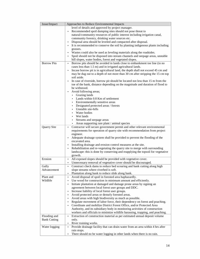
14
Issue/Impact Approaches to Reduce Environmental Impacts level of details and approved by project manager.
• Recommended spoil dumping sites should not pose threat to natural/community resources of public interest including irrigation canal, community forestry, drinking water sources etc.
• Disposal area should be leveled and compacted after disposal. • It is recommended to conserve the soil by planting indigenous plants including
grasses. • Wastes could also be used as leveling materials along the roadsides. • Spoil should not be disposed into stream channels and seepage areas, unstable
hill slopes, water bodies, forest and vegetated slopes. Borrow Pits • Borrow pits should be avoided in lands close to embankment toe line (in no
cases less than 1.5 m) and in irrigated agricultural lands. • Incase borrow pit is in agricultural land, the depth shall not exceed 45 cm and
may be dug out to a depth of not more than 30 cm after stripping the 15 cm top soil aside.
• In case of riverside, borrow pit should be located not less than 15 m from the toe of the bank, distance depending on the magnitude and duration of flood to be withstood.
• Avoid following areas; • Grazing lands • Lands within 0.8 Km of settlement • Environmentally sensitive areas • Designated protected areas / forests • Unstable site-hills • Water bodies • Wet lands • Streams and seepage areas • Areas supporting rare plant / animal species
Quarry Site • Contractor will secure government permit and other relevant environmental requirements for operation of quarry site with recommendation from project engineer.
• Adequate drainage system shall be provided to prevent the flooding of the excavated area.
• Installing drainage and erosion control measures at the site. • Rehabilitation and re-vegetating the quarry site to merge with surrounding
landscape: this is done by conserving and reapplying the topsoil for vegetative growth.
Erosion • All exposed slopes should be provided with vegetative cover. • Unnecessary removal of vegetative cover should be discouraged.
Gully Advancement
• Construct check dams to reduce bed scouring and bank cutting along high slope streams where riverbed is soft.
• Plantation along bank to reduce slide along bank. Plant and Wildlife
• Avoid disposal of spoil in forested area haphazardly. • Use wood for construction in minimum amount and efficiently. • Initiate plantation at damaged and damage prone areas by signing an
agreement between local forest user groups and DDC. • Increase liability of local forest user groups. • Avoid protected areas or densely forested areas. • Avoid areas with high biodiversity as much as possible. • Regulate movement of labor force, their dependency on forest and poaching. • Coordinate and mobilize District Forest Office, and/or Protected Area
Authority, and its subsidiary body in monitoring activities of construction workers and officials to minimize wildlife harassing, trapping, and poaching.
Flooding and Bank Cutting
• Extraction of construction material as per estimated annual deposit volume only.
• River training works. Water logging • Provide drainage facility that can drain water from an area within 4 hrs after
rain stops. • There should no be water logging in other lands when there is no rain.

15
Issue/Impact Approaches to Reduce Environmental Impacts Services Relocation
• Relocate / repair the social services as per the damage caused.
Cultural and Historical Monuments
• Avoid such monuments while selecting alignment. • Take prior approval from community, if the selected alignment causes damage
to such monuments. • Repair damages / relocate monuments if community gives permission to do so.
Health and Safety
• All workers should have accidental insurance. • Burrow pits should not be constructed in area where there is high movement of
people. • Chemicals used in construction should be stored in safe place with sealing. • Worker camp should be provided with adequate facility of toilet, waster
disposal site, and plenty of water needed for personal hygiene.
3.12 Site Specific Environmental Management Plan (EMP): Although most of RAIDP subprojects involve upgrading works on existing roads/tracks only minor adverse environmental impacts are expected in most cases. In order to manage environmental issues/ impacts specific to a road contract package, site specific EMP for the subproject in question would be prepared. The site specific EMP has to be prepared and submitted along with bid documents: it is a part of the bidding document, cost estimates, specification, and contract / agreement clauses. The site specific EMP shall be prepared following Annex 3. A simple hazard mapping will also be incorporated in EMP.
3.13 Other Plans: Any other environmental plans as required such as bioengineering plan, compensatory plantation plan etc. shall be prepared and included in EMP. If the slope to be protected is small then mitigation measures (including number and type of species to be used, plantation pattern, toe protection and drainage management measures) can be included in site specific EMP. If the area is large a separate plan, including site plan, is necessary.
Tree Cutting and Re-plantation Principles
3.14 A service-oriented project should follow following principles for tree cutting and re-plantation:
¾ The project should request the required land with DFO. The request letter should also include letter from National Planning Commission stating that the project is national priority project.
¾ Concerned DDC should send a request letter to DFO for forest clearance. The DFO surveyor will count and mark the trees to be cut in field in presence of DDC engineer, and Forest User Group (FUG).
¾ Concerned DFO will send approval letter to FUG to cut the marked trees, if the forest is handed over to user groups. If the forest is under the government then DFO will cut the tree according to its procedures and make necessary agreement with concerned DDC for re-plantation. DDC will do compensatory re-plantation in the ratio of 1:25.
¾ If construction work is to be carried out in Protected Areas then DDC will send a request letter to Department of National Parks and Wildlife Conservation for permission. The letter should define the area needed, type of intervention, possible impacts and mitigation measures. The Department of

16
National Parks and Wildlife Conservation will recommend Ministry of Forest, Soil and Water Conservation for approval if there is no adverse impact.
¾ The cost of re-plantation and protection will be included in EMP.
Extraction of Construction Materials
3.15 Following conditions has to be met while extracting construction materials;
¾ IEE/EIA has to be done as per legal requirement. The contractor should submit the proof letter to DDC before extracting materials.
¾ Copy of valid tender award certificate.
¾ Material should be extracted at least 15 m away from riverbank, extraction site should be 100 m upstream and 100 m downstream from bridges, materials should be extracted in pits at regular interval, the quarry site should be 50 m far from road and 500 m away from settlement.
SOCIAL IMPACTS
3.16 On the basis of past experience, the project will attempt to capture all possible social issues and impacts that are likely to arise due to project interventions from the beginning of a sub-project planning so that all range of impacts are well assessed and managed with due diligence.
3.17 The project experience shows limited social adverse impacts in comparison to the benefits that the people have been able to realize at large. Community members observed couples of tangible benefits due to road improvement. These include sudden appreciation in the land value, enhanced access to motorable roads, reduction in travel time and transport costs, and employment opportunities and income generation from the construction works. The negative impacts identified are loss of small parcel of land and structures to the project in some sections where improvement works required additional land strip for widening.
Social screening
3.18 Social screening will be undertaken at an early stage in all subprojects, which will provide necessary information on the potential social impacts likely to be encountered during implementation. This screening will be carried out in close consultation with various primary stakeholders: beneficiaries; roadside farmers; shopkeepers; women, Dalits and other local key informants. Social screening report will provide all information as determined by screening questionnaire presented in Annex 4.
3.19 Social screening provides first stage information about the road subproject which also identifies: (i) beneficiary population living within various impact zones of the project based on distance; (ii) extent of land required and number of land owners affected; (iii) impacts on poor and vulnerable groups including needs and priority for social and economic betterment; (iv) willingness of people for voluntary land donation; and v) other impacts.
3.20 Screening report also provides information about the potential damage / loss of common community structures such as resting place (Chautaro), water tank
17
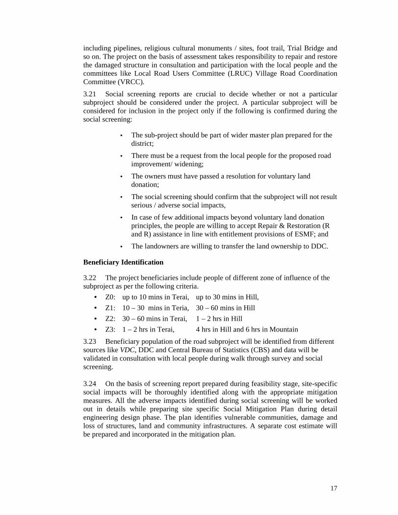
including pipelines, religious cultural monuments / sites, foot trail, Trial Bridge and so on. The project on the basis of assessment takes responsibility to repair and restore the damaged structure in consultation and participation with the local people and the committees like Local Road Users Committee (LRUC) Village Road Coordination Committee (VRCC).
3.21 Social screening reports are crucial to decide whether or not a particular subproject should be considered under the project. A particular subproject will be considered for inclusion in the project only if the following is confirmed during the social screening:
• The sub-project should be part of wider master plan prepared for the district;
• There must be a request from the local people for the proposed road improvement/ widening;
• The owners must have passed a resolution for voluntary land donation;
• The social screening should confirm that the subproject will not result serious / adverse social impacts,
• In case of few additional impacts beyond voluntary land donation principles, the people are willing to accept Repair & Restoration (R and R) assistance in line with entitlement provisions of ESMF; and
• The landowners are willing to transfer the land ownership to DDC.
Beneficiary Identification
3.22 The project beneficiaries include people of different zone of influence of the subproject as per the following criteria.
• Z0: up to 10 mins in Terai, up to 30 mins in Hill,
• Z1: 10 – 30 mins in Teria, 30 – 60 mins in Hill
• Z2: 30 – 60 mins in Terai, 1 – 2 hrs in Hill
• Z3: 1 – 2 hrs in Terai, 4 hrs in Hill and 6 hrs in Mountain
3.23 Beneficiary population of the road subproject will be identified from different sources like VDC, DDC and Central Bureau of Statistics (CBS) and data will be validated in consultation with local people during walk through survey and social screening. 3.24 On the basis of screening report prepared during feasibility stage, site-specific social impacts will be thoroughly identified along with the appropriate mitigation measures. All the adverse impacts identified during social screening will be worked out in details while preparing site specific Social Mitigation Plan during detail engineering design phase. The plan identifies vulnerable communities, damage and loss of structures, land and community infrastructures. A separate cost estimate will be prepared and incorporated in the mitigation plan.

18
Voluntary Land Donation
3.25 As mentioned earlier, most of subprojects proposed under the project are improvement of existing roads. So, it is expected that there will be either no or marginal loss of land, damage and disturbance in structures and livelihood. As the adverse impacts are likely to be limited compared to potential benefits, the affected people are expected to contribute their land and other impacts through donation for road improvement.
3.26 The project will comply with the practical safeguard measures to reduce impact to people due to the loss of land, damage of residential and other structures, livelihood and minor assets to as minimum level as possible by (i) avoiding loss or acquisition of land, damages or loss of structures and livelihoods as far as possible by seeking alternative options, and (ii) extending repair and restoration assistance and cash assistance to the affected families as per Entitlement Matrix provisions. The outline of VDIMP is presented in Annex 5.
3.27 Voluntary Land Donation Criteria: The project envisages acquisition of land through voluntarily donations, which will be based on the following donation criteria:
• Voluntary land donation will be limited to “ Corridor of Impact” area only;
• Impacts on individual households should be marginal limiting up to 10 percent of the productive assets and the remaining assets are economically viable to ensure livelihood or shelter;
• The individuals / households making voluntary donation will be considered as direct beneficiaries of the project;
• The land donation is made freely in public and without coercion and shall not affect household’s food security;
• In the event of few people’s remaining assets becomes unviable, they will be provided suitable assistance and support as outlined in the Entitlement Matrix.
• Project affected people are fully aware of required procedures and entitlement as well as principle of land donation to the road; and
• In case of public or government land, the encroacher cannot claim such land as donation.
3.28 Land Donation process: The main steps of land and other permanent assets acquisition process are:
a) The Village Road Coordination Committee and Local Road Users Committee will inform local people about the road corridor,
b) The NGOs and individual consultants will identify individual land donors, amount of donated land and remaining holding, damage / loss of residential structure and its percentage and loss of livelihood and minor structural damage or loss, at the time of social screening and inform the affected people about their damage/loss,
c) After availability of detail records of impacts, the DDC through Local Road Users Committee will publish notice about land and other permanent assets acquisition.

19
d) The local NGOs and individual consultants will raise awareness of local people about the benefit of the road and inform them about the provision of the project about land donation and structural damage.
e) The DDC, in coordination with Assistance Distribution Committee, local NGO and individual consultant and Local Road Users Committee, will distribute assistance to seriously project affected people (above 10 percent land donors and above 25 percent structural damage household) and will fill the voluntary land donation form of the land donors. In case of any complaints, the people can approach the grievance redress committees formed to hear complaints related to voluntary donation process.
f) The DDC in coordination with District Cadastral Survey Office will initiate cadastral survey of affected land parcels,
g) The DDC will bear cadastral survey and land transfer cost and will take lead role for land ownership transfer and,
h) The DDC through SMO / SDC will prepare documents of each event and finally forward it to PCU in monthly, quarterly and annual report.
3.29 The project will adopt different methods of social recognition viz; writing names in the hoarding board, and/ or offering letter of appreciation to the owners for voluntary land donation.
3.30 If donation of land is above 10 percent and remaining holding is between 850 to 1692 Sqm and below 849 Sqm then the project considers such voluntary land donors as Seriously Project Affected Families / People (SPAF/P) and will offer assistance according to the Entitlement Matrix. This implies that RAIDP does not accept voluntary donation of land without assistance if someone holds less than minimum economic land holding size i.e. 5 Kattha in Terai or 3.5 Ropani in hill (1692 Sqm). This amount of land is considered as minimum economic land holding size for livelihood in rural Nepal. The land donation format is attached in Annex 6.
3.31 Damage / Loss of Residential Structures: Based on past experience, the road improvement works under the project are likely to cause damages of various extents to the residential structures while widening the roads. The likely structural damages shall be categorized as follows;
• Damage or loss up to 25 percent is considered as marginal impacts. Project shall undertake necessary repairs of such damage.
• The damage or loss between 25 to 50 percent will be regarded as seriously project-affected people/family (SPAP/F). Project shall provide cash assistance for such households.
• The damage or loss between 50 to 100 percent will be considered as total loss implying full displacement of the families and consider them as SPAP/F. Project shall provide cash assistance according to the entitlement matrix.
3.32 In the case of structural damage or loss the project will treat titleholders and non-title holders differently because the titleholders lose land along with the structure whereas the non-title holders lose structure only. Damage or loss of other private structures such as compound wall, cowshed, water tap, tape pillar, tube wells, etc. are

20
considered minor structures. In minor structural damage, the project will provide fixed assistance as per the entitlement matrix. For the damage and loss of common community structures such as resting place, water tank, temple, foot trail, trial-bridge, and so on, the project would undertake repairs and renovations of damaged structures through the local committees such as Local Road User Committees (LRUCs) and Village Road Construction Committees (VRCCs).
3.33 Loss of Livelihood / Income Source: In case of loss of livelihood or income sources such as petty shops like teashops, Ghumti (mobile shop) and, whose land holdings become less than minimum economic land holdings and so on, the project shall provide rehabilitation assistance to the affected people. The livelihood assistance shall be provided calculating daily wage rate of the district for maximum of one economically active (16 to 60 years) members of a family for three months.
3.34 Crop Damage: In case of possible damage of crops by the subproject the concerned people will be informed in advance giving time to harvest the crops from the field. However, in case of crop damage due to subproject activities, it will be considered as direct impacts for which the project shall provide replacement value of the crops as per current market price in the same vicinity.
Voluntary Donation Impact Mitigation Fund (VDIMF)
3.35 Although the Government of Nepal acquires the land as per the Land Acquisition Act for the national level projects, RAIDP pursues the principles of limited voluntary land acquisition from owners who will be provided with some cash assistance in lieu of their contribution. In response to GoN policies of guarantying property rights and World Bank social safeguard policies, the project has devised the VDIMP to ensure some cash assistance and rehabilitation supports to project affected people of various categories even if the impacts are marginal as a result of voluntary donation.
3.36 Since the magnitude of impacts cannot be identified upfront it is proposed to create a “Voluntary Donation Impact Mitigation Fund”. This fund will be used to undertake repair and restore damage and loss of residential structures, rehabilitation of income sources and cash assistance for seriously project affected people / families by voluntary donation of their permanent assets and land transfer process.
3.37 One percent of total project cost (Additional Financing) shall be separated for this fund. The fund will be created out of counterpart funding of the project. The use of fund will be made as per the Vulnerable Donation Impact Mitigation Plan (VDIMP) and implemented according to the established procedures.
3.38 The VDIMP includes the total cost required for voluntary donation impact mitigation (which includes repair and restoration cost for damaged structures, assistance for land donors above 10%, livelihood assistance, land transfer cost and so on) and vulnerable community development. The concerned DDC will forward the plan with the estimated budget to PCU about voluntary donation impacts mitigation and vulnerable community development. PCU reconfirm the estimated cost and in coordination with DoLIDAR and MoLD approve it. Then the DDC through assistance distribution committee provide the assistance to concerned individuals / families in

21
coordination with local NGO and local road user committees. In the case of structural damage below 25%, the concerned DDC will undertake the repairs through LRUC.
3.39 Voluntary Donation Impact Mitigation Plan (VDIMP): Based on the findings of the Social screening report, the subproject specific Voluntary Donation Impact Mitigation Plans (VDIMP) will be prepared to address impacts associated with donation irrespective of the type and scale of impacts that could arise in various forms: (i) loss of land; (ii) loss of houses /structures; (iii) loss of livelihood systems/income sources; and (iv) loss of community property resources. The VDIMP (Annex 5) presents total land of the donors, donated land and its percentage, percentage of structural damage and loss or disturbance in income source and common community property. Moreover, it presents category of land donors as less than 10 % land donors, above 10% land donors whose remaining holding is above 1693 Sqm, in between 850 to 1692 Sqm and below 849 Sqm. The VDIMP will also suggest cost effective mitigation measures, required budget as per Entitlement Matrix and detail time frame to implement all activities starting from the beginning to land ownership transfer. The SMO / SDCs will be responsible for preparing a VDIMP in coordination with DDC. The mitigation measures and budget of VDIMP will depend upon the magnitude of impacts identified in the screening reports. As part of Mitigation plan, the key socio-economic characteristics of all the affected families (who need livelihood assistance and support for construction of houses) will be collected for assessing the impacts and estimating the required assistance. The key information relates to land holding, income, employment, assets, indebtedness, houses’ and related conditions, etc. This will be undertaken by the NGOs, SDCs/ SMOs who will also provide implementation support.
3.40 The VDIMP defines the legal, institutional and implementation principle to guide the assistance for loss / damage of social assets, and proposes rehabilitation assistance. The concept of VDIMP was developed after the mid term review of the project, which identified some gaps in the implementation of social safeguard measures to support the livelihood of project affected people.
Entitlement policy Matrix
3.41 The Entitlement Policy Matrix is prepared with a view to provide assistance and support to those who need some support and assistance even though the land donations are voluntary. Table 3.4: Entitlement Policy Matrix Impact Category Entitlement
Unit Entitlement Remarks
1. Land donors A. Loss of land up to 10%
Title holders • Voluntary donation • Land Transfer Incentives NRs.
2000/donor

22
Impact Category Entitlement Unit
Entitlement Remarks
B. Loss of land above 10% and remaining holding is: Above 1693Sqm
Between 850 to 1692Sqm
Below 849Sqm
Title holders • Assistance @ NRs. 30 in hill and 40 in Terai per Sqm beyond 10% of loss; subject to minimum NRs. 2000 for the land.
• Assistance @ NRs. 30 in hill and 40 in Terai / Sqm beyond 10% of loss; subject to minimum NRs. 2000 and livelihood assistance equivalent to minimum wages for two months for one adult member.
• Assistance @ NRs. 30 in hill and 40 in Terai / Sqm beyond 10% of loss; subject to minimum NRs. 2000 and livelihood assistance equivalent to minimum wages for four months for one adult members.
Considered local price of the land in the subproject areas of RAIDP and considered the price of land fixed by Napal Bank Limited for mortgaging the land and decided the amount which covers more than 60% of the actual price at present.
Land occupied by non title holders will not be considered as land donation
2. Loss of Residential Structure A. Loss up to 25 % Title holders • Project will undertake repairs
B. Loss between 25.1 to 50 %
Title holders • Support for repairs @ NRs. 300/Sqft for Kachhi @ NRs. 500/Sqft for Semi-Pakki @ NRs. 700/Sqft for Pakki
C. Loss between 25.1 to 50 %
Non-title holders
• Support for repairs @ NRs. 200/Sqft for Kacchi @ NRs. 400/Sqft for Semi-Pakki @ NRs. 600/Sqft for Pakki
D. Full loss (50.1 to 100%)
Title holders • Support for restoration @ NRs. 300/Sqft for Kachhi @ NRs. 500/Sqft for Semi-Pakki @ NRs. 700/Sqft for Pakki • Additional support Nrs.10000
for total loss E. Full loss (50.1 to 100%)
Non-title holders
• Support for restoration @ NRs. 200/Sqft for Kacchi @ NRs. 400/Sqft for Semi-Pakki @ NRs. 600/Sqft for Pakki • Additional support NRs. 5000.
Considered local price of the residential structure in the subproject areas of RAIDP and also considered the price of types of residential structure fixed by Napal Bank Limited for mortgaging the residential structure and decided the amount which covers more than 70% of the actual price at present.
3. Loss of Livelihood / Income Sources A. Loss of livelihood/income source
All • Rehabilitation assistance @ NRs district wage rate x one adult (16 to 60 years) family members x 3 months
Employment opportunities with contractors, if interested
4. Community Facilities / structures
A. Loss of community building, temple, irrigation canals, drinking water pipe, culvert, bridge, etc
• Repairs and restoration will be undertaken by the project
"
5. Loss of other assets

23
Impact Category Entitlement Unit
Entitlement Remarks
Minor structure/assets
(i) Up to 25% (ii) 25.1 to 50% (iii) 50.1 to 100%
Title holders
• Repair by the project • Assistance @ NRs. 3000.0
• Assistance @ NRs 5000.0
B. Minor structure / assets
(i) Up to 25% (ii) 25.1 to 50% (iii) 50.1 to 100%
Non-title holder
• Repair by the project
• Assistance @ NRs. 2000.0
• Assistance @ NRs 3000.0
6. Loss / damage of crops A. Crop damage / loss
Title holders • Advance notice for harvesting • Avoid damage as far as
possible • Crop damage compensation if
advance notice is not possible
B. Crop damage / loss
Non-title holders
• Advance notice for harvesting • Avoid damage as far as
possible • Crop damage compensation if
advance notice is not provided
Unidentified Impacts • Mitigation measures will be proposed based on the principle of assistance and support.
3.42 Land Transfer Process: After identification of land donors from screening report, such donors shall be assisted according to entitlement matrix and as proposed by VDIMP. Individual land donation forms will be filled and land transfer process initiated. The land donation form is attached in Annex 6. The land donors will be exempted from the tax of the government and other costs incurred during land ownership transfer.
3.43 Land ownership transfer will start from the beginning of construction period and continue until the transfer is completed for all affected families/ parcels. The land transfer process involves different stages: (i) obtaining group consent in written form from the affected people; (ii) mobilization of cadastral survey / surveyors from DDC; (ii), assistance distribution as per the entitlement matrix, and (iv) formal land transfer.
Other Social Mitigation Plan
3.44 Vulnerable Community Development Plan (VCDP): Vulnerable Community Development Plan (VCDP) will be prepared for the betterment of vulnerable people

24
(within Z0 population). The targeted beneficiaries of VCDP include mainly the following groups of people.
• Seriously Project Affected People / Families, • Marginalized groups, • Dalits, ethnic minorities and poorest people, • Single women/ women headed households, and • Landless, old aged and disabled people.
3.45 The VCDP identifies the needs and priority of vulnerable groups and proposes need-based programs to uplift their socio-economic condition through appropriate training and skill transfer. A brief outline of the Vulnerable Community Development Plan is presented in Annex 7. The SMOs / SDCs discuss with VRCC / LRUC about the vulnerable groups identifies their problems, needs and priorities and then prepare the detail plan of VCDP which will be included in SMP. The VCDP preparation process involves; (i) identification of vulnerable groups / communities, (ii) consultation with the group / community and identification of needs, and (iii) preparation of VCDP. Concerned members of VRCC / LRUC will assist to SMO / SDC for the preparation of VCDP. 3.46 Community Infrastructure Development Plan (CIDP): Along with VCDP there is Community Infrastructure Development (CID) component in the project, which assists to construct essential infrastructures such as market shed, health post, school, public toilet, community trail, community irrigation etc to create productive and useful community assets based on the demand of the community. The CIDP format is attached in Annex 8. The SMO / SDC during SMP preparation can also identify needs of community infrastructure development during the discussion with VRCC and LRUC and mention it in the SMP. Local people including VRCC / LRUC can come to DDC directly or through SMO / SDC with a demand letter for community infrastructure anytime during construction of a subproject. Based on the demand of the community and subsequent assessment by technical and social experts, the SMO / SDC prepares community infrastructure development plan (CIDP) for approval by DDC. In general, the SMO / SDC are responsible for informing local people about this component and selection criteria of CIDP.
CONTRACTORS COMPLIANCE ON ENVIRONMENTAL AND SOCIAL
SAFEGUARD MEASURES
3.47 The contractors are also principle stakeholders in the project whose roles and responsibilities are to identify and mitigate the adverse impacts right from the beginning. Therefore, contract document needs to clarify the following roles / responsibility of contractors:
a) Use construction materials form approved site, and of standard quality.
b) Reclaim the quarry site and fill up borrow pit after the completion of the work,
c) Keep the bitumen at least 0.8 Km far from the village /settlement,
d) Maintain health and sanitation of the labor camp,
e) Do not allow haphazard disposal of spoil along hill slopes, vegetated areas, water bodies and other environmentally sensitive areas,

25
f) Enforce use of recommended disposal sites that are approved by project manager,
g) Provide health and safety gears to the labors,
h) Restrict labors’ use of forest products, hunting and poaching.
i) Hire as many local laborer as possible (priority has to be given for poor, marginalized and Dalits),
j) Avoid use of child labor (below 16 years age),
k) Employ at least 33 percent women laborer in construction,
l) Ensure life insurance of the laborers
m) Avoid damage / disturbance to historical / cultural / archeological sites / natural habitats.
n) Relocate public infrastructure such as; electricity pole, telephone pole, taps, irrigation, etc.

26
Chapter IV: PLANNING AND IMPLEMENTATION MECHANISM
4.1 The project requires effective mechanism and process to implement its rural road construction activities and proposed interventions to mitigate the impacts. This chapter presents planning and implementation mechanism to be followed in addressing the environmental and social safeguard issues arising from the project.
4.2 The Environmental Assessment and Social Assessment are the integral part of the project cycle beginning with project identification to operation stage. All subprojects will start from screening, identification of impacts, preparation of action plan for mitigation of adverse impacts, implementation of action plans, monitoring of evaluation, and auditing of the project. The main aim of the planning is to address the environment and social impacts properly. However, planning includes activities from the beginning of identification and pre-feasibility study to post construction phase. A short summary of project planning including stages, steps in the assessment process and responsibility is presented in table 4.1. The detail steps are presented in Annex 9.
Table 4.1: Environmental and Social Management within the Project Cycle Stages in Project Environmental and Social Activities Responsibility Project Identification Selection of Sub-project: Brief outline of
environmental issues / problems with initial consultation of stakeholders
DDC/DTO SMO/SDC/ CLE
Project Screening Environmental and Social Screening together with Technical and Economic Screening – screening will be incomplete if any of the four screening is not included.
DDC/DTO SMO/SDC/ CLE
Submission of Screening Report to PCU DDC
Appraisal and Approval Review of environmental and social screening PCU
IEE or EIA as per requirement
Detail Engineering Design
Environmental Plan: Site specific EMP, Plantation Plan, Bioengineering Plan
Social Management Plan: VCDP, VDIMP, CIDP
DDC with help from Cluster Level Environmentalist (CLE), SMO/SDC
Construction Period EMP Implementation SMP Implementation DDC/DTO/CLE /SMO/SDC
Supe
rvis
ion
Rep
orti
ng
Mon
itor
ing
Inde
pend
ent
Com
plia
nce
Aud
it
DDC/DTO DRCC Independent 3rd party CLE /SMO/SDC
Operation Period Technical, Environmental and Social Audit NVC

27
ENVIRONMENTAL IMPACT MITIGATION MECHANISM
Environmental Screening Criteria
4.3 To determine the level of environmental assessment required, the screening criteria as mentioned in Environmental Protection Regulation (EPR) -1997 shall be used. The EPR criteria (Schedule 1 and 2) most likely to be applicable to RAIDP roads are presented in Table 4.2. Screening should not be done only as per EPR schedule, but also considering potential environmental impacts and risks.
Table 4.2: The RAIDP Criteria for EIA/IEE/EMP Roads Requiring IEE Roads Requiring EIA Construction of District Roads Construction of Urban Roads Improvement, Rehabilitation and reconstruction of Feeder Roads Any other projects with cost NRs 50 million to 250 million.
Construction of Main Feeder Roads Road Construction in Sensitive areas:Historical, cultural and archeological sites. Environmentally weak and wet areas. National parks, wild life sanctuaries and conservation areas. Semi-arid, mountainous and Himalayan regions. Flood prone and other dangerous areas. Residential, school and hospital areas. Areas with main sources of public water supply. Any other projects with total cost more than NRs 250 million.
Other legal requirements (Forest Act, National Park and Wildlife Conservation Act, etc.) Adverse impact on the following
• Protected Areas • Forest • Landslide and erosion • Flood prone areas • Areas prone to water logging • Water sources and water bodies • Historical, cultural and religious areas • Open public spaces • Community infrastructures • Special groups of people • View points • Development potential sites
Level of Environmental assessment will also depend on magnitude, extent and duration of the predicted impact. If impacts are serious the assessment team can recommend IEE/EIA. But if the impacts are of low magnitude, extent and duration site specific EMP will be prepared for all road subprojects.
4.4 The responsibility of environmental screening, and IEE/EIA, if any, will fall on DDC/DTO. It has to be submitted along with technical, economical and social screening report during Project Screening Stage. Subproject screening is not completed without environmental screening, and will not be considered for further processing. If IEE/EIA is done, it will include EMP chapter. If screening determines that no IEE/EIA is required then site specific EMP will be prepared separately by DDC during detail engineering design stage. Cluster Level Environmentalist (CLE) will support DDC to carryout screening. The qualifications and experiences of CLE is defined in Terms of Reference. The main roles of CLE are;
• Awareness creation about environmental issues and preparation of environmental plans.
• Organize workshop, training and meetings.

28
• Supervision of implementation of EMP.
• Reporting to DDC and PCU.
4.5 The PSC will forward the compilation of environmental screening report along with recommendations to PCU for approval. In recommendation of PCU, DOLIDAR will approve screening report submitted by PCU after review.
Initial Environmental Examination/ Environmental Impact Assessment
4.6 If the screening team determines that Initial Environmental Examination (IEE)/ Environmental Impact Assessment (EIA) is required, the team will carryout IEE/EIA after screening and before detail engineering design survey is started. IEE/EIA will be done as per the format given by EPR and approved by concerned ministry. Incase of IEE, public consultation will be collected once during baseline survey and another after preparation of draft IEE report but before approval. Incase of EIA it will be done during scoping, baseline survey and after preparation of draft EIA report but before approval. Suggestions from peoples will be incorporated in final IEE/EIA report.
Site Specific Environmental Management Plan (EMP)
4.7 Bidding process will not begin without approved site specific EMP. Site-specific EMP of construction section must be prepared during detailed engineering survey and design. The EMP includes following components;
4.8 Issues: The EMP presents detail pictures of the project impacts and mitigation measures. It includes environmental issues, and its significance for consideration under the subproject. An issue’s significance should be based on supporting information and their explanation. The issues that can come under EMP vary from subproject to subproject. These may include erosion control, slope protection measure, burrow pit management, vibration control, dust and noise control, protection of water sources, tree cutting, protection of road side vegetation and disturbance to wildlife, quarry site management, management of spoil, drainage management (impoundment and water logging / drainage congestion), conservation of cultural and historical monuments, social services relocation/maintenance (water supply lines, irrigation canals, telephone, electricity lines, etc).
4.9 Alternatives: The EMP can also recommend any alternative measures for avoiding impacts on existing design.
4.10 Mitigation: The EMP identifies site-specific, cost effective and detailed measures for each impact that will reduce the identified adverse impact to acceptable levels. The plan should include compensatory measures (such as tree plantation, repairs, etc.) if mitigation measures are not feasible, cost effective, or sufficient.
4.11 Capacity Development and Training: If necessary, EMP can recommend specific, targeted training for project staff, contractors, and community groups to ensure the implementation of environmental recommendation.
4.12 Implementation Schedule and Cost Estimates: For all mitigation and capacity development, the EMP provides (a) an implementation schedule for measures that must be carried as a part of the project, and (b) cost estimates for implementing the EMP.

29
4.13 Integration: The EMP must be integrated into the project’s plan and design, budget, specifications, cost estimated, bid documents, contract/agreement clauses. DDC/ DTO is responsible, but can mobilize Cluster Level Environmentalist for this, and help in proper implementation. Bid documents are finalized only after PCU/PSC certifies that site-specific EMP recommendations are adequately and appropriately incorporated in the plan and design, cost estimates, specification, BoQ, and contract clauses.
4.14 Timing: Site-specific EMP shall be prepared at initial stage of detail engineering design. Doing this will allow EMP activities to be incorporated in detail design. PCU, with help from Environmental Specialist of PSC, will certify that EMP recommendations are incorporated in Bid documents. PCU will consult DOLIDAR in case of complexity in EMP. Past experience has shown that it is being prepared after detail design, allowing limited time for incorporating the environmental costs, and implementation mechanism and procedures.
SOCIAL MANAGEMENT PLANS
4.15 As part of planning, social screening will be carried out by the NGOs/SDC in collaboration with DDCs to identify the potential impacts and accordingly prepare the corresponding mitigation plans. Various possible options will be explored to minimize the impacts. The Screening reports will also include the initial requests form the local villagers for the proposed road widening, community resolution for voluntary donation, etc. PSC will recommend PCU for approval of screening report. The PCU will consult DOLIDAR as necessary in the approval process of the screening reports.
4.16 Subsequent to social screening findings, the mitigation plans will be prepared in accordance with the Entitlement Matrix. The socio-economic data for all those who are categorized as seriously affected households will be carried out. The baseline data will be analyzed and incorporated in the Mitigation Plan. This will become basis for assessing the impact of assistance provided to the seriously affected households during the project implementation. Social Management Plan includes Voluntary Donation Impact Mitigation Plan (VDIMP) and Vulnerable Community Development Plan. The VDIMP is presented in Annex 5.
Implementation Arrangement
4.17 Assistance Distribution Committee: The mitigation plan will be implemented through respective DDCs with the following arrangements. The Assistance Distribution Committee will be formed under the chairmanship of Local Development Officer (LDO) in DDCs. The composition of the committee is as follows:
• Local Development Officer (LDO : Chairperson • District Technical Office Chief : Member • Chairperson of LRUC / VRCC : Member • SMO / SDC : Facilitator
4.18 The office of the Assistance Distribution Committee will be established within the premises of DDCs. The committee will carry out the following responsibilities:

30
a) Receive the name list of those donating land to DDC and disclose the name list in the DDC office and in the concerned VDC office.
b) Publish notice of assistance distribution through local newspaper and F.M. Radios prior to at least fifteen days.
c) Inform the affected people by SMO/SDC through LRUC/VRCC about the proposed action,
d) Fix the date and time of assistance distribution and inform to the concerned people at least one week before,
e) Distribute the assistance amount in public places (most probably in VDC office). All amounts above NRs. 5,000 will be paid through cheques. If the recipient does not have Bank accounts, NGOs will assist them to open Bank accounts. In case of cash payments, they will be distributed in public places in the presence of some witness.
f) Keep proper account of assistance distribution, and
g) Keep proper record of the assistance recipient (receive signatures), types of effect, assistance amount and purpose of the use of assistance and the time of land transfer.
4.19 The beneficiaries of assistance are expected to use the assistance for repair and restoration of losses and damages suffered due to land donation. The DDC through LRUC / VRCC and local NGO and individual consultant regularly monitor the use of fund and forward the progress report to PCU. 4.20 Grievance Hearing and Readdress Mechanism: Informal dispute resolution mechanism and practices, based primarily on negotiation between disputing parties with the involvement of third party, are common in most of the communities in Nepal. Following the local tradition and cultural practices, unsatisfied people will go to VRCC and LRUC with their complaints at first. The VRCC / LRUC are knowledgeable people of the localities, receive complaints and hear the grievances of people. Local Road Users Committee and Village Road Users Committee can resolve minor problems because laws allow resolving minor civil cases in the community. If they cannot resolve, then they forward such cases to Grievance Hearing Committee.
4.21 The grievances escalated due to land acquisition, structural damage, loss of livelihood and minor assets and related to assistance distribution, etc. directly goes to Grievance Hearing Committee. The Grievance Hearing Committee receives the complaints, examines the case with the support of SMO / SDC and from VRCC and LRUC and verifies the information and then gives its decision.
4.22 The grievance redress committee will consist of the following members at each district level. The Grievance Hearing Committee’s composition will be as follows:
• Nominee of District Road Coordination Committee : Chairperson

31
• Planning, Monitoring and Administration Office in DDC : Member
• SMO/SDC (invitee member) : Facilitator
4.23 The office of the Grievance Hearing Committee will be established in the premises of the DDCs. The decision of Grievance Hearing Committee will be final for the project but it does not restrict an individual to seek further legal recourse. The Grievance Hearing Committee will perform the following responsibilities:
• Receive the complaint in written letter and register and record it properly,
• Keep the complaint confidential and go through the issue / case by the support of SMO / SDC and concerned VRCC / LRUC members, check if there is any mistake made in the process,
• Based on the nature of compliant, the committee will verify all the supporting information and also hear the compliant views personally and other witnesses as needed and give their final verdict accordingly.
4.24 The project proposes to create a separate Assistance Distribution Committee and a Grievance Hearing Committee than the Government’s Compensation Fixation Committee, which is led by District Administration Office (DAO) on the basis of the discussion with other project staff within DoLIDAR and observing a lengthy and troublesome process followed by them.
Process of Land Transfer
4.25 Transfer of donated land to DDC is the last part of voluntary land donation process. Once the group and individual consent is obtained and legible assistance is provided, DDC will initiate the process for land transfer. In coordination with District Cadastral Survey Office, the actual extent of land lost will be identified and on mutual convenient date both the representatives of DDC and land owners will visit Land Revenue Office and complete the process. All those who are not eligible for assistance will be offered an incentive amount of NR.2000 to come forward and complete the process for land transfer. The DDC will maintain the record of land donors properly by the help of NGO and individual consultant. DDC will be responsible to record the process of land transfer, problem faced, lesson learnt and so on which will be reflected in the periodic reports of the project.
OTHER SOCIAL PLANS
Vulnerable Community Development Program (VCDP)
4.26 Vulnerable community development is a component of the project to enhance the livelihood of the SPAP/F, Dalits, poor, marginalized groups and single / women headed household of Zo zone. This component directly assists to achieve the goal of poverty reduction by enhancing their income generation capacity through various skills and occupational development training. The VCDP contains provisions to offer different types of training to vulnerable communities which are, however, not limited to the followings:

32
• Skill development training such as , driving, anvil work, mechanics, hair cutting, plumbing, masonry, carpentry, handicrafts, sewing, etc.
• Income generation training such as micro-enterprise, vegetable production, poultry, piggery, etc.,
• Safe motherhood, women empowerment, leadership, health and hygiene, • Nursery establishment, plantation of fruits and fodder and so on, and • Other appropriate skill development and vocation training as per the need
of the people. 4.27 The DDC through SMO / SDC will prepare VCDP immediately after social screening and will attach in SMP. The plan will present number of vulnerable people, their occupations, prioritized needs, proposed training / program, required resources, and date and time of its implementation. Approval of SMP by project allows SMO / SDC to proceed for necessary preparation. The concerned DDC through NGOs and Individual Consultants in coordination with VRCC/LRUC will organize vulnerable community development training / program. DDC will report project about the event and its achievement regularly (monthly, trimester and annual).
Community Infrastructure Development Program (CIDP)
4.28 Community Infrastructure development is a component of the project, whose objective is to enable the local people to identify their local infrastructure needs and seek funds from the project. The DDC through SMO / SDC inform LRUC/VRCC about this component and a community of the zone of influence can come to the LRUC / VRCC or SMO / SDC or DDC directly with their demand of community infrastructures. The DDC collects the demands of people and will decide the demand on the basis of priority and SMO / SDCs prepare detail CIDP. The Community people can demand CI for:
• Market shed, minor irrigation, school and health post rooms and public toilet,
• Track opening, community trails and footsteps, • Compound walls of schools and health post, • Drainage of the road and bus stop, etc.
4.29 Community Infrastructure Selection Criteria: Infrastructure as mentioned above is essential for all communities and therefore many demand letters may come to the project. The DDC by the support of SMO /SDC shall assess the needs of people, contribution of proposed CI to enhance economic betterment of people, physical facilities to women and poor and so on and contribution of people. The main selection criteria are number of people including poor, women and marginal sections benefited from the project and its contribution to enhance local economy and physical facilities. Moreover, contribution of local people to their infrastructure would be one criterion. 4.30 The District Engineer with necessary support from SMO/SDC prepares cost estimate of the proposed community infrastructure, which will come to DDC as CIDP. The DDC assess the plans of the district and forward the selected plans to PCU. PCU approves the plan and the DDC will implement the plan through LRUC. LRUC can implement the plan itself or through local users committee or through local construction groups. The main local level CI implementation body will be LRUC.

33
Disclosure
4.31 All the documents such as ESMF and Mitigation Plans will be disclosed in the web sites of MoLD, DoLIDAR, RAIDP and DDC. The summaries of the reports will also be made available in local languages in the project districts. Disclosure of name list of project affected people / family is a crucial step towards assistance handover process. The Project Coordination Unit will disclose the summary report of project affected individuals/ families in its website at the centre, DDC will disclose individual name list of the project affected individuals / families at the district and VDC at local level. Moreover, DDC will publish / broad-cast notice about the publication of name list of eligible for assistance through local News Paper and Media especially through FM Radios.
ROLE OF NGO AND SOCIAL DEVELOPMENT CONSULTANT 4.32 The project has hired some NGOs and individual consultants to assist DDC for implementing local level activities of the project. There are Social Mobilization Officers in the districts where NGOs-SMO have been involved, where there are not, Individual Consultants hired by the project directly. These professional have appropriate experience and understanding for undertaking social screening other related activities and accordingly their qualifications and experiences are defined in Terms of Reference. The main roles of Social Mobilization Officer and Social Development Consultants are:
a) Mobilization of local communities: awareness creation about the road sub-project activities, voluntary land donation, formation of LRUC / VRCC, assist them for meeting and minuting, coordination, community auditing and so on;
b) Carry sub-project level social screening and baseline socio-economic surveys among seriously affected land donors;
c) Preparation of Voluntary Land donation Mitigation plan and Vulnerable community development program; planning and assist LRUC / VRCC / DRCC and DDC for implementation;
d) Conduct workshops/trainings/meetings on concepts and procedures of the CBPM and other activities of social and environmental concern;
e) Assist DDCs to implement VDIMP and VCDPs as needed; f) Reporting to the DDC/DTO, PSC team and the Project Coordination Unit
regarding progress of community audit exercise and other sub-project related social activities.
CAPACITY BUILDING
4.33 Capacity constraints at various levels are explained in Annex 10 The various agencies involved in the planning and implementation of environmental and social safeguard functions - DDC, VRCC, LURC, NGOs, as well as field level workers (labor-gang leader, machine operators etc.) will be given orientation and other capacity building, training from time to time to sensitize and familiarize with the ESMF provisions and processes. After awarding contract, the contractor will be given capacity enhancement training on ESMF provisions and processes. Besides this human resources for environmental and social management will be provided at PCU/PSC and for independent third party audit. In addition, cluster level environmentalist, NGO, SDC at district level has been provided to strengthen the capacity of the project. Site-specific EMP and SMP will propose training and

34
orientation plan, including cost for the subproject in question, based on the need to enhance capacity of stakeholders.
ROLE AND RESPONSIBILITIES OF VARIOUS ORGANIZATIONS
4.34 The table 4.3 identifies the responsible agencies for various activities related to implementation of project activities pertaining to social and environmental impacts. Table 4.3: Responsibilities of key agencies
SN
Mechanism Responsibility
1Defining policy directions for RAIDP in light of the GoN policies and legislation.
MoLD, DoLIDAR
2 Drafting Term of Reference for specific subproject. DoLIDAR, concerned DDC
3Assembling teams to conduct environmental and social assessments.
Concerned DDC, Project Unit
4Ensure internal coordination among different level of authorities within the government agency.
DDC and DoLIDAR
5Getting up-dated with regulations and developments relevant to RAIDP.
DoLIDAR, DDC, Project Unit
6 Defining priorities for RAIDP. DoLIDAR, DDC, Project Unit
7Organizing consultations in public participation to ensure environmental and social assessment obligations.
DoLIDAR, DDC, Project Unit, NGOs
8Develop methods and operational tools for environmental and social awareness at policy, program, and operations level.
DoLIDAR, DDC
9 Organizing training and information campaigns. DoLIDAR, DDC with project support
4.35 Institutional arrangement to implement ESMF in RAIDP project shall be as follows:
SUPERVISION, MONITORING AND EVALUATION
4.36 Overall sustainability of a project depends on how well the social and environmental issues are managed during the implementation. The following
Contractor
DDC, DTO District Project Unit
Central, Cluster and District Level Consultants• Environmental Specialist (ES) • Social Development Expert (SDE) • Cluster Level Environmentalist (CLE) • Social Development Consultant (SDC) • Social Mobilization Officer (SMO)
User Groups
RAIDP, PCU
MoLD, DoLIDAR Environmental and social
section
Independent 3rd Party NVCDistrict Monitoring Team

35
mechanisms are proposed to ensure successful implementation of environmental and social impacts.
4.37 Central Level Supervision: Central level supervision shall be carried out to check progress and correct shortcomings of the project, the main aim of central level supervision is to observe the problem and to support the implementation team at local level. Central Level Supervision will be carried by PCU/PSC team in sample and high-risk roads at least once every four month. The supervision team will brief environmental and social findings at district and PCU after site visit and submit the field-visit report to PCU with recommendations and gaps for corrective measures. Findings of this will fed into GoN portfolio four monthly review.
4.38 District Level Supervision: District Level Supervision will be carried out by DDC/DTO with the help of Cluster Level Environmentalist and SDC/NGO; they will brief DDC/DTO together with contractor on status, program and problems; and will submit their report, of each road subproject, once every two months, through DDC to PCU.
4.39 District Level Independent Monitoring: District level monitoring is a component of the project that is carried out by monitoring committee formed by District Road Coordination Committee (DRCC) every six months for each road under construction. But one monitoring must be done after claim of construction completion by contractor and before awarding construction completion certificate by DDC. Any rectification of substantial mitigation works, and/or outstanding works defined under EMP should be completed before issuing construction completion certificate. The District Level Monitoring format is presented in Annex- 11. The DRCC forms a separate monitoring subcommittee of three members under the leadership of nominee of DRCC, which will be facilitated by Cluster Level Environmentalist and SDC/NGO as follows;
DRCC nominee : Team Leader
Line Agencies2 : Members
4.40 The Committee is also responsible for certification of completion of various tasks as envisioned by ESMF prior to invitation of bids, award of contracts, and award of construction completion certificate.
COORDINATION BETWEEN CIVIL WORKS AND MITIGATION OF SOCIAL IMPACTS
4.41 In order to ensure that social impacts will be mitigated timely along with civil works, the following coordination will be followed. Prior to invitation of bids for civil works, the following activities will be completed.
• Social Screening Report;
• Beneficiary Identification in the Impact Zone;
• Individual / Group consent from the land owners for voluntary land donation;
• VDIMP (endorsed by the World Bank and approved by the GoN including the budget): and,
2Two members from any of district forest office, district soil and water conservation office, division road office, district
agriculture office, protected area office, etc.

36
Prior to award of contract for civil work, the following activities would have been initiated.
• Payment of assistance to eligible affected households of land donation;
• Repairs to be undertaken by the project for affected structures;
• Reconstruction of the affected community assets, if any; and,
• VCDP (approved by the GoN including budget)
The satisfactory completion of the above tasks will be evaluated and certified by the District Monitoring Committee.
ENVIRONMENT AND SOCIAL AUDITING 4.42 Environmental and social audit will be have two tired; Central Level Audit and Local Level Audit.
Central Level Audit
4.43 Central Level Environmental and Social Compliance Audit will be carried out by an independent 3rd party, once a year during construction period. This audit will be conducted on behalf of MoLD/DOLIDAR. The auditing team will present a detail report of auditing to Bank and RAIDP. The auditing team will debrief district after site visit and also MoLD/DOLIDAR before submission of the audit report. MoLD/DOLIDAR will accept this audit report as a substitute to central level environmental and social monitoring.
4.44 Technical, Environmental and Social Audit will also be conducted during operation stage. This will be done by National Vigilance Centre on sample basis. The audit will check whether process and provisions envisioned in EMSF is followed or not, and the general quality of work. The concerned DDC will make necessary corrections on the basis of Audit recommendations.
Local level Audit
4.45 The local level audit especially denotes Community Based Performance Monitoring (CBPM). The VRCC/LRUC in coordination with DDC, SMO, SDC, Cluster Level Environmentalist and other line agencies will carryout CBPM, three times during the project period. First CBPM shall be carried out after awarding of tender, second CBPM during construction period and third immediately after completion of construction activities, but before awarding construction completion certificate. The CBPM report will be submitted to respective DDC for necessary actions. The CBPM will examine technical, social, financial and environmental performance of the project from peoples’ perspective.
Evaluation
4.46 The objective of evaluation is to judge the impact of implementation effectiveness. It will be done through independent consultants having experience in similar tasks. This will be undertaken during midterm and end of the project. The evaluation will assess ESMF’s effectiveness in addressing environmental and social impacts of the project. The midterm evaluation will give feedback for implementation of the ESMF.
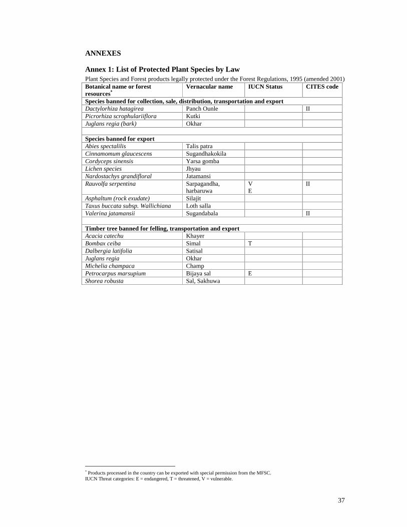
37
ANNEXES
Annex 1: List of Protected Plant Species by Law Plant Species and Forest products legally protected under the Forest Regulations, 1995 (amended 2001) Botanical name or forest resources*
Vernacular name IUCN Status CITES code
Species banned for collection, sale, distribution, transportation and export Dactylorhiza hatagirea Panch Ounle II Picrorhiza scrophulariiflora Kutki Juglans regia (bark) Okhar
Species banned for export Abies spectalilis Talis patra Cinnamomum glaucescens Sugandhakokila Cordyceps sinensis Yarsa gomba Lichen species Jhyau Nardostachys grandifloral Jatamansi Rauvolfa serpentina Sarpagandha,
harbaruwa VE
II
Asphaltum (rock exudate) Silajit Taxus buccata subsp. Wallichiana Loth salla Valerina jatamansii Sugandabala II
Timber tree banned for felling, transportation and export Acacia catechu Khayer Bombax ceiba Simal T Dalbergia latifolia Satisal Juglans regia Okhar Michelia champaca Champ Petrocarpus marsupium Bijaya sal E Shorea robusta Sal, Sakhuwa
* Products processed in the country can be exported with special permission from the MFSC. IUCN Threat categories: E = endangered, T = threatened, V = vulnerable.
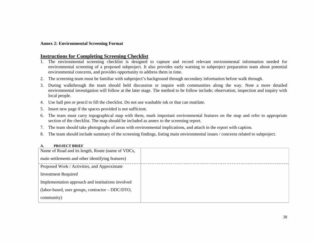
38
Annex 2: Environmental Screening Format
Instructions for Completing Screening Checklist1. The environmental screening checklist is designed to capture and record relevant environmental information needed for
environmental screening of a proposed subproject. It also provides early warning to subproject preparation team about potentialenvironmental concerns, and provides opportunity to address them in time.
2. The screening team must be familiar with subproject’s background through secondary information before walk through.
3. During walkthrough the team should held discussion or inquire with communities along the way. Note a more detailedenvironmental investigation will follow at the later stage. The method to be follow include; observation, inspection and inquiry withlocal people.
4. Use ball pen or pencil to fill the checklist. Do not use washable ink or that can mutilate.
5. Insert new page if the spaces provided is not sufficient.
6. The team must carry topographical map with them, mark important environmental features on the map and refer to appropriatesection of the checklist. The map should be included as annex to the screening report.
7. The team should take photographs of areas with environmental implications, and attach in the report with caption.
8. The team should include summary of the screening findings, listing main environmental issues / concerns related to subproject.
A. PROJECT BRIEFName of Road and its length, Route (name of VDCs,
main settlements and other identifying features)
Proposed Work / Activities, and Approximate
Investment Required
Implementation approach and institutions involved
(labor-based, user groups, contractor – DDC/DTO,
community)

39
B. ENVIRONMENTAL SETTING OF THE PROJECT LOCALITYB1. Protected Areas and/or Forest
Are thereany Protected Areasor Forest along impact corridor?(Tick)
Yes No
If yes, please provide following information.Name of Forest /PA
Location in relation to road(Chainage, distance from road,direction)
Existing conditions (including size, species found, ownership type),problems and causesof problems:
Potential problemsfrom road works:
B2. Landslides and Erosion Prone Areas
Are thereany Landslideand Erosion prone areasalong impact corridor?(Tick)
Yes No
If yes, please provide following information.Name of Place Location in relation to road
(Chainage, distance from road,direction)
Existing conditions (including type, tentative size, relative stability),problems and causesof problems:
Potential problemsfrom road works:
B3. Flood Prone / River Cutting / Low Lying Areas
Are thereany Flood Prone / River Cutting / Low Lying areasalong impactcorridor? (Tick)
Yes No
If yes, please provide following information.Name of Place Location in relation to road
(chainage, distance from road,Existing conditions (including tentative area to beaffected, riskyareas), problemsand causesof problems:

40
direction)
Potential problems from road works:
B4. Water Sources / Water Bodies such aspond, lakes, springs etc.
Are thereany Water Sources / Water Bodiesalong road corridor?(Tick)
Yes No
If yes, please provide following information.Name of Place Location in relation to road
(chainage, distance from road,direction)
Existing conditions (type, including purposeof use, number of users,areas served), problemsand causesof problems:
Potential problem form road works:
B5. Historical / Religious / Cultural Sites such as temple, mosque, palace, etc.
Are thereany Historical / Religious / Cultural sitesalong impactcorridor? (Tick)
Yes No
If yes, please provide following information.Name of Site/Place Location in relation to road
(chainage, distance from road,direction)
Existing conditions, problemsand causesof problems:
Potential problem from road works:
B6. Open Public Spaces

41
Are thereany Open Public Spacesalong impact corridor?(Tick)
Yes No
If yes, please provide following information.Name of Place Location in relation to road
(chainage, distance from road,direction)
Existing conditions (including type, tentative size, use), problemsandcausesof problems:
Potential problem from road works:
B7. Aesthetically Important Viewpoints
Are thereany Aesthetically Important Viewpointsalong impact corridor?(Tick)
Yes No
If yes, please provide following information.Name of Place Location in relation to road
(distance from road, direction)Existing conditions, problemsand causesof problems:
Potential problem from road works:
B8. Relocation of Community Infrastructures (Irrigation canal, water supply, foot trails, trailsbridges, chautara, electricity poles,
telephone polesetc.)
Are thereany Community Infrastructures to be relocated along impact corridor?(Tick)
Yes No
If yes, please provide following information.Name of CommunityInfrastructure
Location in relation to road(distance from road, direction)
Existing conditions, problemsand causesof problems:

42
Potential problem from road works:
B8. Main Settlement and Trade Centre: Bazaar areas, major settlements, settlement of special groups.
Name of Settlement andTrade Centre, Locationin relation to road
Description (approximate no. of HH andpopulation, natureand special feature /importance / significance)
Potential problems to thesesettlementsdue toproposed road works.
B9. Area or site of Significant Development Potential (tourism potential sites, deposits of construction materials, highly fertile land,horticultureetc.)Place Potential benefit or problem from proposed road works
B10. Induced Impacts (Road site settlements, encroachment of forest / marginal lands / common property, quarrying, health impact,
change in agricultural practices, girl trafficking etc.)
Place Induced Impacts
Prepare and attach Environmental map or strip map along the road alignment showing existing features (land use – forest, agriculture, grass land etc.; water bodies,rivers, land slide zone, proposed tipping and quarry sites; social infrastructures – irrigation canal, taps, other water sources; protected areas; etc) and environmentallyrisky areas (possible sliding areas, forest that needs tree cutting, water bodies that could be damaged, river cutting, and all other possible risky features are areas).
Summary of Screening Findings and RecommendationsFindings Recommendations

43

44
Annex 3: Sample Site-Specific Environmental Management Plan (EMP) Format
1. Introduction Makawanpur District is situated in Narayani Zone and is bounded by Bagmati river in east and Lothar river in west. The district is bounded in west by Chitwan district; in north by Dhading and Kathmandu districts; in east by Kathmandu, Lalitpur, Kavre, and Sindhuli district; and in south by Bara, Parsa and Rautahat Districts. The Daman-Dandabas road lies in northern part of Makawanpur District. The road is 11.22 Km long starting at Nagdaha, Sikharakot of Daman VDC (Ward no. 4) and ends at Kalikhola of Gogane VDC. This road links northern part of Mawawanpur district with Tribhuvan Highway at Nagdaha, Daman VDC. The road passes through Daman VDC, Gogane VDC and ends at Dandabas Bazaar of Agra VDC. The existing road width varies from 3 to 4 with average width of 3.5 m. The road is earthen and poorly graveled. The main settlements from which the road passes through are Dobato, Shikharkot, Gopali gaun, Dada gaun, Baghe Khola, Chauki Bhanjyang, Lamachaur, Aaldanda, Damki and Dandabas. The road mainly passes through hilly terrain having sub-tropical to cool temperate climate. Objectives Though the track already exists some environmental problems are observed. This EMP has been prepared to address the site-specific environmental problem arising from construction of the road. 2. Project Information 1.56 Km of the total road section is blacktopped. So, remaining 9.66 Km is proposed for consideration under RAIDP. This road belongs to Class-A, District Road standard. This road improvement work includes widening of the road, road slope and hill slope grading, embankment construction (1.5 m high), drainage and slope protection measures, gravelling, compaction, otta seal over sub-base course with road width 4.5 m excluding drain. Other road associated activities includes quarrying of river bed material from Risheshwor River, disposal of excess earth material, tree cutting in the area needing widening, etc. The total cost of the road is NRs. 33,620,134.09 (excluding VAT). The estimated total Environmental Management Plan (EMP) cost is NRs. 155,153.30. The impact includes scouring, soil slip, relocation of drinking water tap, landslide, erosion, trees loss, water logging, and gully advancement. To mitigate these impacts bioengineering measures, water management, gully protection, toe protection measures and re-plantation of lost trees and cross drainage structure have been proposed. 2.1 EMP Salient Features:
• Total EMP Cost: NRs. 378657.25
• Bioengineering: Gabion Wall (1320 m3), Grassing (320 m2)
• Service Maintenance: 3.75 m3 stone soling
• Hume pipe: 1 (7 m)

45
• Drinking water tap and pipeline relocation
• Compensatory Re-plantation: 625 trees
2.2 Existing Condition along the alignment The land use pattern along the road includes barren land, agriculture, settlement and forest. There is no any protected area located within 1.5 Km of the subproject corridor. The road passes through three-community forest area (Bageshwor CF, Daman-3; Rikheshwor CF, Daman-2; Bhairab Kali CF, Daman-2).
Chainage/ location Description of Features observed
Right side Left side
1+500, Nagdaha Drinking water-tank Cultivated land
2+400, Daman-1 Risheshwor / Khaire Stream
3+340, Danda Gaun Cultivated Land Temple
4+450, Bahun Gaun Cultivated land Scouring to the road edge due to flow natural surface water in high velocity
5+395, Tallogaun Soil slip Fruits farm
7+450 to 8+600 Community Forestry Community Forestry
8+600 to 9+000 Private forest Cultivated land
9+ 480 – 9+500 Land slide A house
9+560 Access trail to Ramche Gaun Private Forest
10+100 Water Tap Cultivated Land
10+740 Dry stone causeway on the road Private forest
2.3 Road Strip Map Showing Risky Areas

46
3. Potential Impacts and Sites i. Scouring [2+090, Bahun Gaun]: A small rivulet comes from left side of road, crosses the road and flows down hill. The width of the channel is about 2 m only but is steep. The existing road section has been damaged due to scouring activity of the rivulet. There is no drain facility so water flows over the road, crosses it and flows down hill. Widening of road has to cut the slope that will create vertical drop. Increased velocity of water due to vertical drop will increase scouring and formation of gully. This may also induce slide on downhill side of the road, affecting stability of the road and dumping debris in agricultural land down hill. Line drain of 50 m length will be provided to safely collect water up to the point of drainage outfall. ii. River Crossing [2+400]: Risheshwor / Khaire river crosses the road. The river is epimeral in type and has high flow during monsoon season. The river channel is narrow and has adequate vegetation in upper part of hill but above about 50 m the land use/land cover changes from forestland to agricultural land, where there are no vegetation along the bank. So, the river width increases to 12 m. There also sign of bank cutting by the river on both sides of river. The bank cutting has affected the agricultural land. There is no cross drainage structure. The cross drainage structure has been proposed in technical part. Expansion of river channel could damage more land, shift its current and make the proposed cross drainage structure useless. So, there is a need to protect the bank as well. Though this is not the effect of the project activities, this problem will be addressed as a enhancement measure. As the foundation is soft gabion wall has been proposed to reduce bank cutting in short time. Tree plantation has also been proposed to stabilize the riverbank in long run. This protection will be provided on both side of the bank and both sides of road up to 50 m.

47
iii. Soil Slip [5+395 to 5+407, Tallo gaun]: On the right side of the road there is area of high seepage. The depth of soil is also shallow, which has caused soil slip. The crown height of the slip is about 1.5 m from slip surface. The width is about 8 m and height is about 12 m. The slip material is silty in nature so, there is possibility of secondary slip in the area during widening, which may damage the road and fruit farm on the other side of the road. As the protective measure the slope of the hill has to be reduced to avoid possible danger of landslide in future, provide toe wall to support the toe and plantation in upper part of slope to provide anchoring and grassing for armoring. iv. Forest [7+500 to 8+010, Tallo gaun]: The road passes through Bangaphanta Community forest. The total area of the community forest is 546 ha. Many wild animals and plants are found in the area. Some important mammals include clouded leopard, barking deer, jackals, jungle cats, ghoral etc. The district considers this community forestry as an important forest supporting biodiversity. The road width is also narrow (3.5 m) in this section of the road. Widening of the road requires cutting of 15 trees of Chilaune (>10 cm dBh) and 10 trees of Uttis (>10 cm dBh). Discussion with users identified following options: (a) maintaining road width of 3.5 m in this section of road, (b) widening the road and cutting trees. Of the two possibilities the locals seems willing to sacrifice the trees and widening the road up to 5 m. But for protection of the forest they have demanded support for fencing of the forest along the roadside, they have also signed MoU with the project. According to the MoU the project will plant trees at a ratio of 1:25 for every tree cut. No proper area for compensatory re-plantation is found, so it is agreed that plantation will be done along the roadside where there are no trees between chainage 2+000 to 4+270. Plantation cost will be borne by DDC and maintained for one year. v. Landslide [9+480 to 9+500]: There is a landslide about 20 m wide near road surface and 15 m long on left side of the road. The slip surface is located above the road surface. The road is covered by debris brought by the landslide. The area is very sparsely vegetated, and annual precipitation in this area is also high. Due to high precipitation, it is highly likely that the landslide will be reactivated. There is a feeling of risk among the locals as this slide swept one house last year, although, no life was lost. This also blocked traffic for one week. There are three houses on the other side of the road. Locals have demanded some measures to be taken at this site of the road. For the stabilization of landslide toe wall (gabion) 4 m high and 20 m long (320 m3)has been proposed. As the moisture content in this area is high grass plantation will be done vertically constructing alternating ditch in 300 m2 area with the view to promote efficient drainage. Masonry line drain will also be provided and discharged in natural drain 30 m away. vi. Foot trail [9+560, Ramche Dobato]: An access trail to Ramche Gaun starts from this point of the road. The village is about 15 minutes walk from the road and there are about 35 households. Everyday about 25 people use this foot trail. The road width is also narrow at this place that increases chances of accidents. The discussion with locals has suggested that the road be widened and opening of access trail also be made wide. The foot trail will be leveled and stone soling will be done up to 15 m from roadside.

48
vii. Low lying area [9+880 to 10+000, Sitapur]: The altitude of the area is comparatively low in this road and there is only one natural drain. This drain has helped drain out the water of this area. Construction of embankment will led to impoundment of water in the right side of the road. There are about 10 HH on the right side that are at the risk of water impoundment. This could lead to problem in movement, increased possibility of water borne diseases etc. Extra cross drainage structure is required to drain the water out of this area. A hume pipe has been proposed. The embankment height will be 0.5 m lower in this area. viii. Drinking watertap [10+100, Dadagaun] and Pipe line [10+100 to 10+500]: The tap is improved local source and never dries. It provides service for 15 households and maintained by tap user groups. Road widening requires demolition of the tap. There is no option to widen road on the other side because there is another house adjoining the road. Discussion with the users put forward following options; (a) project will shift the tap by 10 m before starting widening activity. The new location is owned by one of the users, who is willing to permit the tap is the proposed location; (b) provide the cost required for shifting the tap to the users and they will shift the tap by themselves before widening. Of these two options 1st option is agreed by all. The landowner also signed the agreement to provide land voluntarily during the group meeting. The pipeline is also along roadside and needs relocation. The locals have agreed to contribute voluntarily to shift pipeline but they have demanded additional 20 m of pipeline needed to shift the tap. ix. Electricity poles [9+580]: An electricity pole is located 2.5 m from centerline. The pole has two-phase line and provides electricity to about 35 HH in Ramche VDC. If the road width is maintained as per the standard the pole has to be relocated. In meeting with locals, they said that if the pole is not relocated during this project, no one will think after it. So, they have demand that the pole be relocated and road width be maintained. As relocating pole requires help and permission from electricity authority, locals agreed to submit request letter to electricity authority demanding relocation of the pole. LRUC has agreed to take initiation in this matter. The minute of meeting is attached in Annex. As, this comes under jurisdiction of electricity authority no extra cost is needed for this. x. Riverbed material extraction: Contractor is informed to extract riverbed material from approved river only. Copy of valid license, and IEE approval letter has to be submitted by contractor while applying for tender. The principles for quarrying as mentioned in ESMF should be duly followed by contractor and will be monitored during district level monitoring. xi. Borrow pits: Borrow pits are constructed for embankment construction. Contractor, in no cases shall construct borrow pits in settlement areas and other sensitive areas as mentioned in ESMF. Consultation was done with locals for providing soil for embankment. They were told that soil would be stripped from agricultural land for depth of 30 cm, after removing 15 m topsoil. This topsoil will again be spread in agricultural land and leveled. Locals have agreed to provide their land for soil extraction during fallow period. The minute of meeting is attached in Annex.

49
xii. Widening in settlement areas: Among three major settlements along this road, Samser Tole has narrow width. The issue of damage during widening has been addressed in Social Management Plan (SMP) but locals have complained about dust problem in bazaar areas. Discussion with locals proposed three options; (i) installing traffic signal and encouraging drivers to reduce speed in bazaar area, (ii) regular watering in bazaar area, and (iii) sealing in bazaar areas. From discussion with locals and DDC officials the first and second option together have been recommended. Two traffic signals will be installed on starting and ending point of bazaar in Samser Tole, Bahun Gaun and Talo Gaun. LRUC have agreed to allocate the job of watering once during morning and once during late afternoon on rotation basis. This will be done voluntarily. xiii. View Point [6+000]: Road passes close to popular viewpoint named Ramailo Danda. The road width is narrow and widening will damage the access trail to view point and also expose cut slopes making it aesthetically unpleasing. The foot trail to view point about 15 m will be improved by stone pitching. The exposed cut slope of 250m2 will be covered by grassing. 3.1 Cost estimate of EMP mitigation measures S.N. Item Quantity Rate (NRs) Amount 1. Stone masonry line drain 5 m3 1233/m3 6165 2. River Bank Protection
2.1 Gabion box 1000 m3 250/m3 250000 2.1 Tree plantation 200 nos 5/
individual 1000
3. Landslide protection 3.1 Stone masonry toe wall 4 m3 950/m3 3800 3.2 Gabion wall 320 m3 250/m3 80000 3.3 Grassing 320 m2 50 / m2 16000
4 Forest Protection 4.1 Compensatory re-plantation 625 seedlings 5/seedling 3125 4.2 Maintenance 1 day per week
for 52 weeks = 52 days
160 / day 8320
5 Maintenance of foot trail 5.1 Dry stone soling 3.75 m3 975 3656.25
6 Drainage Improvement 6.1 600 mm Hume pipe 7 m 713 / m 4991
7 Tap and pipe relocation 7.1 Stone masonry 2 m3 800/m3 1600 7.2 Pipe 1” GI 20 m 150/m 3000

50
3.2 Site Specific EMP MatrixChainag
eLocation Issues/Significance Likely Potential
ImpactSuggested Mitigation
MeasuresBoQ/Cost
Time ofaction
Respon-sibility
Remarks
1+500 Nagdaha No No No No No Startingpoint
2+090 Bahun Gaun Scouring: Water fromrivulet crosses the roadand scours.
Induce land slides/erosion and
Gully formation
Masonry line drain approx.50 m length
Duringconstructio
n
DTO/CLE
2+400 River Crossing:Risheshwor / Khaire rivercrosses the road and hasstarted bank cutting.
Wash away road andcultivated land.
Gabion wall and treeplantation on both sidesofroad.
Duringconstructio
n
DTO/CLE
5+395 to5+407
Tallogaun Soil slip: Towards theright side there isarea ofseepage and thearea hasbeen newly filled whichhascaused soil to slipabout 3 m height and 2 mwide.
Risk of land slide,thereby damagingthe road and fruit
farm
Slop maintenance whileearth cutting, bio-
engineering works (use ofplants that provide
anchoring and armoring),provide toe wall
Duringconstructio
n
DTO/CLE
7+500 to8+010
Do Forest: The road isnarrow. There iscommunity forestry onboth sidesof road.
25 treesneeds to becut.
Permission from CFUG istaken, Tree re-plantation ata rate of 1:25 along roadside between 2+000 to
4+270
Duringconstructio
n
VRCC/LRUC/CLE
9+480 to9+500
Land Slide: A landslide15 m high and 20 m wideis present here.
Re-occurrenceoflandslide willdamage the road andhousesituated on theother side.
Gabion wall 4 m high and20 m long for toeprotection, grassingvertically for efficientdrainage.
Duringconstructio
n

51
Chainage
Location Issues/Significance Likely PotentialImpact
Suggested MitigationMeasures
BoQ/Cost
Time ofaction
Respon-sibility
Remarks
9+560 RamcheDobato
Access Trail: There isanaccess trail to Ramchegaun.
Difficulty inmovement.
Improvement of accessfoot trail by stone pitchingfor 15 m (3 m3) andleveling.
Duringconstructio
n
9+880 to10+ 000
Sitapur Low lying area: Theareais low lying that couldlead to inundation
Risk to damage theroad, blockage of
side drain
Hume pipe installation,embankment height 0.5 m
lower in this section
Duringconstructio
n
DTO/CLE
10+100 Dadagaun Drinking Water Tapand Pipeline: Water tapwith 1 inch GI pipe isinstalled within 2 m fromcentre line. 25 HH usethis tap for drinking andhousehold water.
Damage to the pipewill interrupt watersupply for 25 HH
Tap will be relocated 20 mtowards the road end,where there isa smallparcel of barren land.
Consent oflocals torelocatetap hasbeencollected.(SeeAnnex)WaterUserscommitteewill beinformedin advanceduringrelocation.
4. ANNEXES
Table: Summary of EMPCost (Add one Row for EMP cost in summary of technical cost and present that item number here)Table: Detailsof EMP (Matrix of Structures for EMP)

52
Table: Detail Quantity Calculation for EMP (Put this tableafter list of structuresand drain in detail design document and attachthis table here)
Bioengineering Site Plan/ Compensatory Re-plantation planList of team members (With Signatures)PHOTOGRAPHS

53
Annex 4: Survey Questionnaire for Social Screening A. BACKGROUND INFORMATION:
1. Name of the proposed road (including the length in km) : 2. Location of the road : From…. to …….. 3. Present condition of road (Specify type of quality and DTMP no.): 4. Proposed works under RAIDP (Specify type and quality) : 5. Address : District…………… VDCs……………………………… and number of settlements covered…………… 6. Name of Key informants (list out): 7. When and how many people have forwarded the demand letter of road to DDC:……………… 8. When and how the road corridor is fixed (specially the breadth of the road):……………… 9. Location and physical characteristics of road: Please prepare a social map that shows physical characters of the road alignments including settlement, river, forest, public buildings, land use pattern (private, public and their use) and also marked probable population and property affect by the road, possible sliding areas, tree cutting, flood prone, etc. B SOCIO-ECONOMIC INFORMATION:
10. Please fill the form if the road passes through villages / Settlements
SN Name of the VDC
Ward Name of the Settlements
Major ethnic / Caste / Cultural groups
Total population
Divide the total population into different occupations
11. Does the road need to acquire land, house and other private property ?
Yes: No:
If yes, please provide the following information
A. Land related information Full name of hh
VDC, ward & village
Chainage Land for donation (Sqm)
Total land in his name Sqm
Main source of livelihood
B. Structural damage /loss
Full name of hh
VDC and ward Chainage Type of structure
% of damage / loss*
Main source of livelihood
Land ownership
* Percentage of damage must be categorized as up to 25%, 25.1 to 50% and 50.1 to 100%.

54
12. Does the road disturb any public common community structure? (e.g. irrigation, water supply, trail bridge, Chautara, etc)
Yes: No: If yes, please provide the following information Types of structure Chainage % of loss &
damage Number of depended people on the resources
Remarks
Please mention the name including number of the damage property/resource/structure. Write percentage of damage as up to 25%, 25.1 to 50% and 50.1 to 100%.
13. Is there any low caste Dalit or special marginal group of people on the road alignment and within the Zo population (10 minutes in Terai and 30 minutes in hill)?
Yes: No:
14. Is there any low caste Dalit or special marginal group of people affected by the road subproject?
Yes: No:
If yes please provide the following information
Name of the affected hh head
Total family members
VDC and Ward Types of affect
Percentage of affect
Percentage of affects should be written as: if land categorize as up to 10%, above 10% land donors whose remaining holding is above 1693Sqm, above 10 land donors and remaining holding is 850 to 1692Sqm and above 10% land donors whose remaining holding is below 849Sqm. If structure damage simple write up to 25%, 25.1 to 50% and 50.1 to 100%.
15. In case of Seriously Project Affected People what can be mitigation options / measures?
a)………………………………..
b)…………………………………
c)…………………………………
D. DEMOGRAPHIC INFORMAITON
16. Please provide the following demographic information. Z0 Population Z1 population Z2 Popn Z3 ZPopulation Name of
Settlement Total HH
M F T Total HH
M F T Total HH
M F T Total HH
M F T
1234
If relevant pleas provide the Z4 population adding a column in the format (draw format in axel).
17. What are the major settlements and caste / ethnicity in Z0 to Z3 population?

55
ZO Population Caste / Ethnicity VDC & ward Male headed hh Female headed hh Total household Brahmin Chhetri Magar Kami Sarki
Z1 Population Caste / Ethnicity VDC & ward Male headed hh Female headed hh Total household
Z2 Population Caste / Ethnicity VDC & ward Male headed hh Female headed hh Total household
Z3 Population Caste / Ethnicity VDC & ward Male headed hh Female headed hh Total household
18 Land Acquisitions / Donation Status Is the acquisition of land based on voluntary donation?
Yes.......................No....................... If no, give reason…………………………………………………………….
D. ACCESS ENHANCEMENT 19. Does the road provide better access to health facilities?
Yes..... No......., If yes, how and in what way? Please specify……………………………………………………………………………. 20 Does the road provide better access to schools, education and communication?
Yes... No......., If yes, how and in what way? Please specify……………………………………………………………………………… 21. How the poor and disadvantaged people would benefit from RAIDP and to what extent? . ................................................................................................................................. 22. What are the potential income generating activities in the area following RAIDP? Please list five options: ……………………………………………………………….. 23. Would RAIDP promote marketing opportunities of the local products?
Yes..................No..................... If yes, how would that happen? Please elaborate

56
………………………………………………… 24. Are people ready to co-operate the project? Yes................No............... Yes or no? Please elaborate…………………………………………………… 25. How would the project benefit to women, children and minorities? Please specify details. …………………………………………………………………………………………….. 26. Are there disputes which might hinder/delay for successful accomplishment of proposed RAIDP works in this road? Yes........................No........................ If yes, how could these be resolved? How the ownership of locals could be ensured? ……………………………………………………………………………………………. E. LOCAL COMMUNITY MOBILISATION 27. Are there any groups similar to Local Road User Committee (LRUC)?
Yes.... No........ If yes, what would be their role in RAIDP works? Please specify……………………………………………………………………………. 28. What are the other needs of people for development? Please specify main five needs: 39. How the project can enhance livelihood of local people?Please specify five points………………………………………………………………… F. WAGE RATE
30. Please provide the daily rate fixed by government and prevalent local rate Government Rate Local Rate
Types of labour Male Female Male Female
Remarks
Skilled labor Unskilled labor
31. Please assess the local production system (agriculture, horticulture and so on). 32. What is the situation of bazaar and access of local products to the bazaar (situation and constraints)? 33. What are the possibilities of enhancing access of local people and their products to bazaar and other economic betterment? 34. Trace out your own observation about socio-economic, physical betterment of local people (possibilities, problems and prospects).

57
Name of Surveyor: Date
000 Thank you 000

58
Annex 5: Outline to Prepare Voluntary Donation Impact Mitigation Plan (VDIMP)
The VDIMP defines the legal, institutional and implementation framework to guide the assistance for lost assets, livelihoods, community property and repair, restore and rehabilitation of project affected people in accordance with the World Bank’s Operational Policy 4.12 on Involuntary Resettlement and GoN’s relevant guidelines.
The VDIMP is the main Social Management Plan for the project.
1. The VDIMP addresses impacts arising from: • Loss of land • Loss of residential structures • Loss of livelihood • Loss of minor assets and structures, and • Loss of community property resources such as religious or cultural structures,
VDC Building, Electrification Pole, School Building, Community Building etc
2. The outline of the report is as follows: • Introduction: Brief summary of the sub-project • Impacts of the sub-project
Impacts on land donation Name of the land donors
Land donated (in Sqm)
Total land in his/her name (in Sqm)
Percentage of donation
Remarks
Impacts on structure Name of HH head
Percentage of damage
Name of structure
Types of structure (Kachchi, Semi-Pakki and Pakki)
Remarks
Impacts on Livelihood Name of individual Type of livelihood loss/damage Remarks
3. Other impacts Please specify other impacts if any (as like impacts presented in above tables). Socio-economic information of Seriously Project Affected Families: Please present a bit detail socio-economic information of Seriously Project Affected Families/Individuals. Such detail information would include caste/ethnicity, economic condition of the family (land ownership, housing conditions, income, occupation or livelihood sources, assets, indebtnesss and related information) and so on.
4. Voluntary Donation Impact Mitigation Measures Mitigation Measures and Action Plan Name of affected individuals/hh head
Percentage of donation/damage / loss
Type of donation/ damage/loss
Mitigation measures/ assistances as per policy matrix
Date of implementation

59
5. Implementation Arrangements Please give detail of the implementation arrangement Activities (what has to be done?)
Time (When has to be done?)
Responsibility (Who has to do?)
Fund Required (as per Policy Matrix)
Remarks

60
Annex 6: a. Memorandum of agreement for Voluntary Land Donation (Individual)
1. I, Mr/Ms …………… the grandson/grand daughter of ………….. and son/daughter of …………., permanent resident of …….district……..VDC ward no …, have agreed to donate ……..Sqm land voluntarily as per ESMF provision to DDC………..on……. 200…for upgrading / improvement of the road………………………………with the support of Rural Access Improvement and Decentralization Project (RAIDP), DOLIDAR. To this effect, both parties have entered into agreement by consensus in presence of the witnesses signed below. 2. The land holding certificate no … contains ……….land of which …Sqm only is donated. I also, hereby, declare that the donated land amounts to …….% of the total land holding.
3. That the donated land is surrounded towards the a) eastern side by……………….b) western side by………………c) northern side by………………d) southern side by………………
4. That the land owner testifies that the land / structure is free of squatters and encroachers and is not subject to any other claims.
5. That the owner will not claim any compensation against the grant of this asset nor obstruct the construction works on the land in case of which he/ she would be subject to sanctions according to law / regulations. 6. That the DDC ……………. agrees to accept this grant of assets for the purpose. 7. That the DDC ……………shall construct and develop the RAIDP subproject considering possible precautions to avoid damages to adjacent land / structure / other assets. 8 That both the parties agree that the RAIDP subproject construction shall be the community property. 9. That the provision mentioned in this document will come into force from the date of signing of this deed. ……………………… ………………... Signature of the Owner Signature of the Chair of … Road User Committee Name and Signature of Witnesses 1.………………………………………………………….. 2.…………………………………………………………..

61
Annex 6: b. Memorandum of agreement for Voluntary Land Donation (Group)
We, the following permanent inhabitants of ………………….VDC have agreed through consensus to voluntarily donate our private land for construction/ upgrading of ……………………road under DDC through the support of RAIDP. We, hereby, provide our commitment to adhere the terms and conditions mentioned in this agreement and transfer the land rights to the DDC as per the rules of Land Revenue Office of Government of Nepal (GoN). All the donors have collectively signed this agreement after reaching common consensus for the donation upon informed choice from the project facilitators.
1. The land owner testifies that the land / structure is free of squatters and encroachers and is not subject to any other claims.
2. That the land donation is made to DDC……….… for the construction and
development of …..………….road in ……VDC/s supported by RAIDP.
3. We, the owners of the donated land, will not claim any compensation against the grant of this asset nor obstruct the construction on the land and in case of which we would be subject to sanctions according to law / regulations.
4. That the DDC………..agrees to accept this grant of assets for the specified
purpose.
5. That the DDC………shall construct or improve the road through Road User Committee considering possible precautions to avoid damages to adjacent land / structure / other assets.
6. Both the parties agree that the RAIDP subproject construction shall remain as
community property.
7. The provision mentioned herein will come into force from the date of signing of this paper.
SN Name of the
donors Address Total land
holding in Sqm Probable donated land in Sqm
Registration no of the donated plot
Lost land (as % of total)
Signatures of land donors
Date: Name and Signature of LRUC/VRCC (…………………………………..)
Note: Individual land donation form will be required at a later stage while transferring the ownership of land to the DDC. Therefore, it is equally important for all SDCs/ SMOs to fill up the individual land donation forms as far as possible immediately after signing the collective agreement.
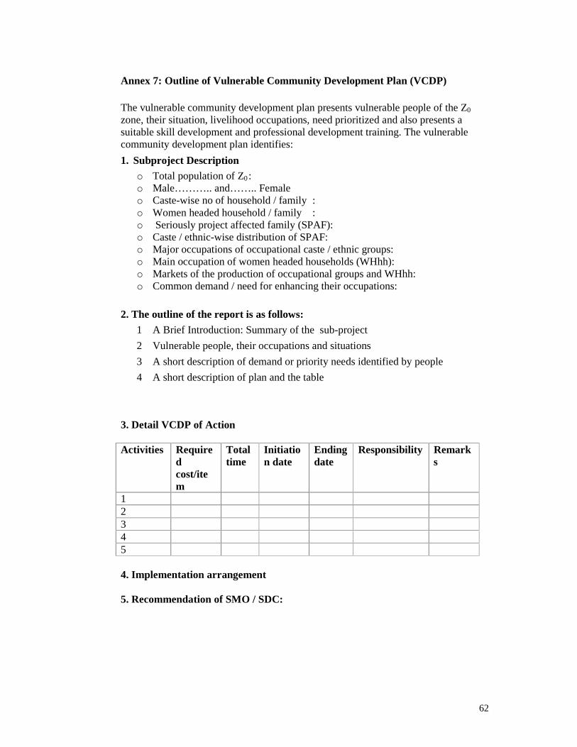
62
Annex 7: Outline of Vulnerable Community Development Plan (VCDP) The vulnerable community development plan presents vulnerable people of the Z0
zone, their situation, livelihood occupations, need prioritized and also presents a suitable skill development and professional development training. The vulnerable community development plan identifies:
1. Subproject Description
o Total population of Z0:o Male……….. and…….. Female o Caste-wise no of household / family : o Women headed household / family : o Seriously project affected family (SPAF): o Caste / ethnic-wise distribution of SPAF: o Major occupations of occupational caste / ethnic groups: o Main occupation of women headed households (WHhh): o Markets of the production of occupational groups and WHhh: o Common demand / need for enhancing their occupations:
2. The outline of the report is as follows:
1 A Brief Introduction: Summary of the sub-project
2 Vulnerable people, their occupations and situations
3 A short description of demand or priority needs identified by people
4 A short description of plan and the table
3. Detail VCDP of Action Activities Require
dcost/item
Total time
Initiation date
Ending date
Responsibility Remarks
12345
4. Implementation arrangement 5. Recommendation of SMO / SDC:

63
Annex 8: Community Infrastructure Development Plan (CDIP) Community infrastructure is an independent demand based component of the project. Local people of zone of influence may come with their demand letter of Community Infra-structure (CI) to DDC. The DDC in consultation with Social Mobilization Officer and Social Development Consultant selects Community Infrastructure project and forwards to PCU. The Social Mobilization Officer and Social Development Consultant assist local people for implementation of the selected CI.

64
Annex 9: Environmental and Social Safeguard IntegrationsProject Stages Activities Responsi-
bilitiesEnvironmental Activities Responsi-
bilitiesSocial Activities Responsi-
bilities
Selection of Road according toDTMP priority.
DTO/ DDC Brief outlineof environmental issues /problemswith initial consultation ofstakeholders
Brief outlineof social issues /problemswith initialconsultation of stakeholders
ProjectIdentification
Approval from theDDC board as perrecommendation from DRCC
DTO/ DDC
Screening of sub-project
Technical / Economical
DTO/ DDC Environmental Screening
• Identifies Level of environmentalassessment required
• Gives overview and early warningto potential environmentalproblems
DTO/DDC, CLE
Social Screening
• Identifies level of socialassessment required.
• Gives overview and earlywarning to potential ofsocial problems
DTO/DDC,SMO /SDC
Project Screening
Submission of Screening Report ofselected subproject to PCU3
DTO/DDC Screening Report Submission to PCU DTO/DDC, CLE
Screening Report Submission toPCU
DTO/DDC,SMO /SDC
Concurrenceof thesubproject on thebasis of Screening findingsand recommendation from each expert. PCU
If concurrencenot given, subproject dropped from consideration under RAIDP PCU
IEE/EIA doneand approved from concerned authority if screening demands it. DDC/DTO,CLE
ConcurrenceofScreening
Concurrence letter given for DDC forDetail Engineering Design
DTO/DDC
Detail Survey DTO/DDC Field Information/datacollection forpreparation of EMP [SiteSpecificEMP, Bio-engineering Plan, Re-plantation Plan]
DTO/DDC, CLE
Field Information/datacollection for preparation ofSMP [VDIMP, CIDP, VCDP]
DTO/DDC,SMO /SDC
DetailEngineeringDesign
Engineering Design DTO/DDC
PDE
Preparation of EMP [SiteSpecificEMP, Bio-engineering Plan, Re-plantation Plan];
EMP recommended mitigation measureincluded in Engineering Design
DTO/DDC, CLE
Preparation of SMP [VDIMP,CIDP, VCDP];
ESMP recommended mitigationmeasure included inEngineering Design
DTO/DDC,SDC/SMO
3Any Subproject will not be forwarded without submission of completescreening report.

65
Project Stages Activities Responsi-bilities
Environmental Activities Responsi-bilities
Social Activities Responsi-bilities
Preparation of Bid Documents,Submission of Design Documents toPCU
Review / suggestions, if any.
DTO/DDC IncorporateESMP recommendation inBoQ Submission of EMP to PCU forreview
Review / suggestions, if any.
DTO/DDC, CLE
Submission of SMP to PCU forreview
Review / suggestions, if any
DTO/DDC,
SDC/SMO
Incorporation of CommentsbyDistrict and Resubmission
DTO/DDC Incorporation of Comments by Districtand Resubmission
DTO/DDC, CLE
Incorporation of CommentsbyDistrict and Resubmission
DTO/DDC,
SDC/SMO
Recommendation for No ObjectionLetter (NoL) sent to bank
PCU
NoL from bank World Bank
Bid Invitation
Bid Briefing
Bid Submission
Bid Opening and Evaluation
Preparation of Bid Evaluation Report(BER) and submission to PCU
DTO/DDC
Briefing on EMP DDC/DTOCLE
Review of BER
Suggestions/comments given forincorporation in BER
PCU
Suggestions/comments incorporatedin BER and resubmitted to PCU
DTO/DDC
BER forwarded to Bank for NoL PCU
NoL from bank WB
Letter of intent, Letter of Acceptanceto winning bidder
DTO/DDC
PerformanceSecurity andNegotiation for award
DTO/DDC
Contract Agreement DTO/DDC,Contractor
Prepare record of contract under EMP
Mobilization of contractorsandMobilization Advance
DTO/DDC
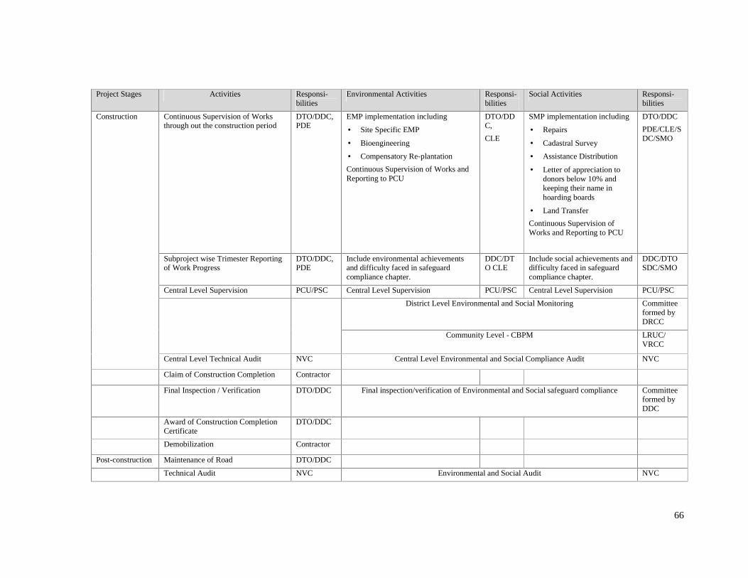
66
Project Stages Activities Responsi-bilities
Environmental Activities Responsi-bilities
Social Activities Responsi-bilities
Continuous Supervision of Worksthrough out theconstruction period
DTO/DDC,PDE
EMP implementation including
• SiteSpecific EMP
• Bioengineering
• Compensatory Re-plantation
ContinuousSupervision of Works andReporting to PCU
DTO/DDC,
CLE
SMP implementation including
• Repairs
• Cadastral Survey
• AssistanceDistribution
• Letter of appreciation todonors below 10% andkeeping their name inhoarding boards
• Land Transfer
ContinuousSupervision ofWorksand Reporting to PCU
DTO/DDC
PDE/CLE/SDC/SMO
Subproject wiseTrimester Reportingof Work Progress
DTO/DDC,PDE
Includeenvironmental achievementsand difficulty faced in safeguardcompliancechapter.
DDC/DTO CLE
Includesocial achievementsanddifficulty faced in safeguardcompliancechapter.
DDC/DTOSDC/SMO
Central Level Supervision PCU/PSC Central Level Supervision PCU/PSC Central Level Supervision PCU/PSC
District Level Environmental and Social Monitoring Committeeformed byDRCC
Community Level - CBPM LRUC/VRCC
Construction
Central Level Technical Audit NVC Central Level Environmental and Social ComplianceAudit NVC
Claim of Construction Completion Contractor
Final Inspection / Verification DTO/DDC Final inspection/verification of Environmental and Social safeguard compliance Committeeformed byDDC
Award of Construction CompletionCertif icate
DTO/DDC
Demobilization Contractor
Post-construction Maintenanceof Road DTO/DDC
Technical Audit NVC Environmental and Social Audit NVC

67
Annex 10: Environmental Capacity at Different Levels for Implementation of ESMF Central Level
• Ministry of Local development (MoLD): MoLD has an Environment Management Section under Municipal Management Division. This section has one Under-Secretary, one Section Officer and two non-Gazatted officer. Both of the Gazatted Officers have administrative background. The MoLD’s Environment section is responsible for all environment related activities under the ministry including those mandated by EPA/ EPR. Ministry is responsible for clearing terms of References (ToRs) for IEEs of all works of which MoLD is the designated line ministry as well as for carrying out environmental monitoring of projects of which it the line ministry. Besides, this section has been mandated for formulation of polices, plan, guideline, implementation, study, monitoring and evaluation related to environment of all projects under the ministry, solid waste management, environmental pollution, setting environmental standard at local level, and is also the main coordinating / facilitating unit for environmental projects under the auspices of the ministry, for example, Strengthening Environmental Administration and Management at Local Level- Nepal (SEAM-N) in Biratnagar-Dharan Industrial Corridor (2 district and 3 municipalities). The Section is, therefore, overloaded and do not have educational background required to contribute in environmental management.
• Department of Local Infrastructure Development and Agricultural Roads (DoLIDAR): DoLIDAR has established Monitoring and Environmental Section. This unit has one Senior Divisional Engineer, and three Engineers. This is a newly established unit with little experiences gained so far on environmental activities, and also the unit is not fully dedicated to environmental safeguard works. Over time, the unit may be expected to develop and strengthen its capacity for fully taking over environmental management responsibility from centre/ DoLIDAR level. However, at this stage, the experience and capacity of this unit is not adequate to take ESMF implementation and oversight responsibility.
• Experiences of RAIDP until now showed that central level agencies’ environmental functions including monitoring have not been as effective as it was envisaged in the original ESMF (2004). Besides the capacity issues, there was difficulty related to coordination and giving priority to RAIDP works when time was demanded by other routine works. Also, central agencies awareness and understanding about their responsibilities with regard to RAIDP ESMF implementation and oversight was low. Until now, central level monitoring was conducted only once in Palpa and Rupandehi districts (while ESMF 2004 requires such monitoring every six month on randomly selected samples of subprojects). The central monitoring in Palpa and Rupandehi has added little value, and therefore, more a formality than contributing in enhancing effectiveness and efficiency in safeguarding environmental protection.
District Level
• There are no environmental persons in the District Development Committee (DDC). Recently, under the support of Alternate Energy Promotion Centre (AEPC) / Ministry of Environment (MoE), Energy and Environment Officer has been recruited on contract basis (1 year) in 68 DDCs including all RAIDP districts, out of 75 districts. Among 30 RAIDP districts 8 districts have officers working at particular VDC. Out of remaining 22 districts 12 districts have engineers and 10 districts have overseer level staff. These engineers most have degree in mechanical or electrical engineering; they also do not have experience in environment related works. The officers are assigned more Energy related works than environmental safeguard, and their background fits that. Although DDC under LSGA can form Environment Committee, until now these have not been found active in the RAIDP districts.
• In RAIDP, until now, Planning and Design Engineer (PDE), who is hired from market for providing engineering technical support to DDC, has been defined also as focal point of environmental safeguard functions at district level. However, experiences have shown that this does not work effectively. Because PDEs are fully occupied by engineering works, and DDCs also would like to engage them in engineering works than environmental safeguard related works. PDE in general are also found less interested in the environmental activities and consider these as add-on responsibility/ formality. Therefore, standard and quality of environmental management, assessment, EMPs and implementation of mitigation suffered. Only one district level monitoring,

68
as envisioned by the ESMF 2004, was undertaken until now (while this was required once every four month).
• At DDC level, there is general lack of sufficient knowledge and expertise in managing environmental tasks. As a result, many road subproject lacked EMP, mitigations were not incorporated in projects plan, design, cost estimate, specification, BoQ and contract clauses.
In the above-mentioned context, the following measures have been proposed in the revised ESMF (these are elaborated in paragraph 4.32).
i) Cluster Level Environmentalist: One Cluster Level Environmentalist will work in one cluster. He/She will be responsible for; awareness creation about environmental issues and preparation of environmental plans; organize workshop, training and meetings; supervision of implementation of EMP; reporting to DDC and PCU.
ii) Central Independent Safeguard Auditing: Central independent safeguard auditing will be carried out by third party, once a year during construction in all construction packages.
iii) DRCC Environmental Sub-committee: This sub-committee will be Responsible for monitoring of environmental compliance. Monitoring will be carried out every six month in all construction packages. One such monitoring must be done after claim of completion of construction and before award of construction completion certificate. This monitoring team will be supported by Cluster Level Environmentalist and SDC/SMO.

69
Annex 11: Format for District Level Monitoring Objective: The overall objective of district level monitoring is to ensure compliance with site specific EMP, SMP and ESMF. The specific objectives are; � to collect information on status of mitigations including timing and quality aspects, � to ensure that ESMP/ESMF compliance � to check quality and effectiveness of mitigation works. District: Road: Length: Program Year: VDCs Crossed: Road Works Description: (Please mention below the works involved and surface type of this road)
Date of Monitoring:
Monitoring Team: SN Name of the Team Member Position Office Signature
1
2
3
4
PERFORMANCE CATEGORIES 1. Environmental Impact Mitigation
1.1 ESMF Compliance
(Please Tick [�] in the boxes below if your answer is Yes and put Cross mark [ ] if the answer is no.) Screening done
IEE prepared
EMP prepared
Variation asked for EMP
Last Monitoring and reporting date- mention
Monitoring findings discussed and used in correction
1.2 Environmental Performance (Please Tick [�] in the boxes below if the answer is Yes and Cross mark [×] if it is no. Disposal Site Approved
Approved Disposal Sites used
Quarry Site Approved
Use of unapproved quarry sites
Proper Storage of construction materials

70
1.3 Environmental Impact Mitigations as per EMP: Implementation of Site-specific Environmental Mitigation Measures as per ESMP and its Effectiveness
Location /Chainage
Identified Issue /Significance
Recommended Mitigation and Enhancement
Measures
Implemented Measure
Remarks
Note: Attach additional Sheet if necessary.
1.4 Were there any special unforeseen issues that have been encountered during construction? Please mention how was that solved? What Issue? Where? How solved? Remarks
1.5 Where there any unsolved environmental problems observed during monitoring? Please mention.
2. Social Impacts Mitigated as per SMP 2.1 ESMF Compliance (Write yes or no)
Land donation
Structure damage
Formation of DRCC/ VRCC/ LRUC
Displaced hh
Tot
alhh
Tot
aldo
nate
dla
nd
No
ofre
s.hh
Rep
air
byth
epr
ojec
t
Assistance distribution committee is functional
Employment of local labor
Training to user groups
CBPM carried out as per the principles
Assistance provided and initiated land transfer
2.2 Were there any special social issues that have been mitigated during the construction? Please mention how was that solved? 3. Any impressive or good practices

71
4. Any comments on works done/not done and performance

72