annex 1 ecological & environmental data
TRANSCRIPT
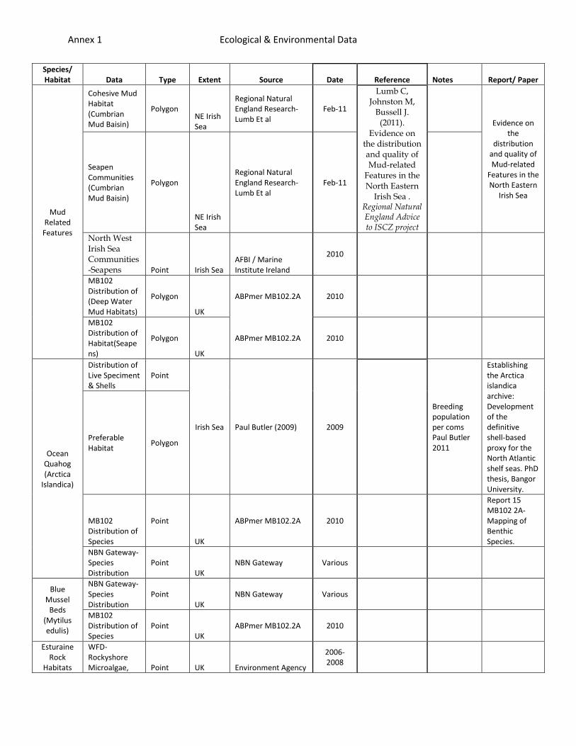
Annex 1 Ecological & Environmental Data
Species/ Habitat Data Type Extent Source Date Reference Notes Report/ Paper
Mud Related
Features
Cohesive Mud Habitat (Cumbrian Mud Baisin)
Polygon NE Irish Sea
Regional Natural England Research- Lumb Et al
Feb-11
Lumb C, Johnston M,
Bussell J. (2011).
Evidence on the distribution and quality of Mud-related
Features in the North Eastern
Irish Sea . Regional Natural England Advice to ISCZ project
Evidence on the
distribution and quality of Mud-related
Features in the North Eastern
Irish Sea
Seapen Communities (Cumbrian Mud Baisin)
Polygon
NE Irish Sea
Regional Natural England Research- Lumb Et al
Feb-11
North West Irish Sea Communities -Seapens Point Irish Sea
AFBI / Marine Institute Ireland
2010
MB102 Distribution of (Deep Water Mud Habitats)
Polygon
UK
ABPmer MB102.2A 2010
MB102 Distribution of Habitat(Seapens)
Polygon
UK
ABPmer MB102.2A 2010
Ocean Quahog (Arctica
Islandica)
Distribution of Live Speciment & Shells
Point
Irish Sea Paul Butler (2009) 2009
Breeding population per coms Paul Butler 2011
Establishing the Arctica islandica archive: Development of the definitive shell-based proxy for the North Atlantic shelf seas. PhD thesis, Bangor University.
Preferable Habitat
Polygon
MB102 Distribution of Species
Point
UK
ABPmer MB102.2A 2010
Report 15 MB102 2A- Mapping of Benthic Species.
NBN Gateway- Species Distribution
Point UK
NBN Gateway Various
Blue Mussel
Beds (Mytilus edulis)
NBN Gateway- Species Distribution
Point UK
NBN Gateway Various
MB102 Distribution of Species
Point UK
ABPmer MB102.2A 2010
Esturaine Rock
Habitats
WFD-Rockyshore Microalgae, Point UK Environment Agency
2006-2008
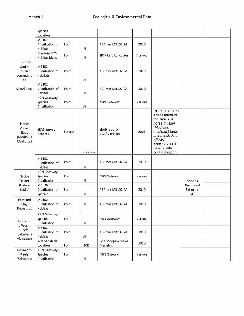
Annex 1 Ecological & Environmental Data
Species Location
MB102 Distribution of Habitat
Point UK
ABPmer MB102.2A 2010
Cumbria SFC-Habitat Maps
Point UK
SFC/ Jane Lancaster Various
Intertidal Under
Boulder Communiti
es
MB102 Distribution of Habitats
Point
UK
ABPmer MB102.2A 2010
Mearl Beds MB102 Distribution of Habitat
Point UK
ABPmer MB102.2A 2010
Horse Mussel
Beds (Modiolus Modiolus)
NBN Gateway- Species Distribution
Point UK
NBN Gateway Various
SEA6 Survey Records
Polygon
Irish Sea
SEA6 report/ BGS/Ivor Rees
2005
REES, I. (2005) Assessment of the status of horse mussel (Modiolus modiolus) beds in the Irish Sea off NW Anglesey. DTI-SEA 6 Sub-contract report.
MB102 Distribution of Habitat
Point
UK
ABPmer MB102.2A 2010
Native Oyster (Ostrea Edulis)
NBN Gateway- Species Distribution
Point UK
NBN Gateway Various
Species Presumed Extinct in
ISCZ
MB 102 Distribution of Species
Point UK
ABPmer MB102.2A 2010
Peat and Clay
Exposures
MB102 Distribution of Habitat
Point UK ABPmer MB102.2A 2010
Honeycomb Worm
Reefs (Saballeria Alveolata)
NBN Gateway- Species Distribution
Point UK
NBN Gateway Various
MB102 Distribution of Habitat
Point UK
ABPmer MB102.2A 2010
Wilf Sabaleria Location Point ISCZ
Wilf Morgan/ Steve Manning
2010
Rossworn Reefs
(Saballeria
NBN Gateway- Species Distribution
Point UK
NBN Gateway Various
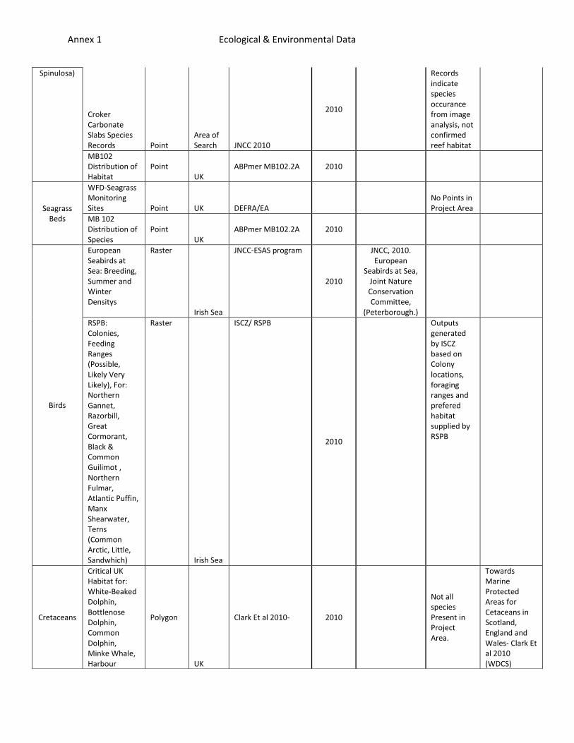
Annex 1 Ecological & Environmental Data
Spinulosa)
Croker Carbonate Slabs Species Records Point
Area of Search JNCC 2010
2010
Records indicate species occurance from image analysis, not confirmed reef habitat
MB102 Distribution of Habitat
Point UK
ABPmer MB102.2A 2010
Seagrass Beds
WFD-Seagrass Monitoring Sites Point UK DEFRA/EA
No Points in Project Area
MB 102 Distribution of Species
Point UK
ABPmer MB102.2A 2010
Birds
European Seabirds at Sea: Breeding, Summer and Winter Densitys
Raster
Irish Sea
JNCC-ESAS program
2010
JNCC, 2010. European
Seabirds at Sea, Joint Nature Conservation Committee,
(Peterborough.)
RSPB: Colonies, Feeding Ranges (Possible, Likely Very Likely), For: Northern Gannet, Razorbill, Great Cormorant, Black & Common Guilimot , Northern Fulmar, Atlantic Puffin, Manx Shearwater, Terns (Common Arctic, Little, Sandwhich)
Raster
Irish Sea
ISCZ/ RSPB
2010
Outputs generated by ISCZ based on Colony locations, foraging ranges and prefered habitat supplied by RSPB
Cretaceans
Critical UK Habitat for: White-Beaked Dolphin, Bottlenose Dolphin, Common Dolphin, Minke Whale, Harbour
Polygon
UK
Clark Et al 2010- 2010
Not all species Present in Project Area.
Towards Marine Protected Areas for Cetaceans in Scotland, England and Wales- Clark Et al 2010 (WDCS)
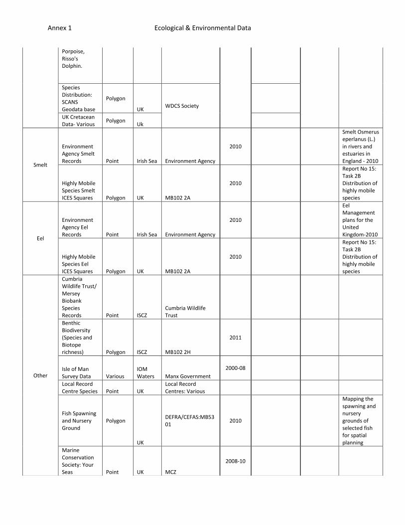
Annex 1 Ecological & Environmental Data
Porpoise, Risso's Dolphin.
Species Distribution: SCANS Geodata base
Polygon
UK WDCS Society
UK Cretacean Data- Various
Polygon Uk
Smelt
Environment Agency Smelt Records Point Irish Sea Environment Agency
2010
Smelt Osmerus eperlanus (L.) in rivers and estuaries in England - 2010
Highly Mobile Species Smelt ICES Squares Polygon UK MB102 2A
2010
Report No 15: Task 2B Distribution of highly mobile species
Eel
Environment Agency Eel Records Point Irish Sea Environment Agency
2010
Eel Management plans for the United Kingdom-2010
Highly Mobile Species Eel ICES Squares Polygon UK MB102 2A
2010
Report No 15: Task 2B Distribution of highly mobile species
Other
Cumbria Wildlife Trust/ Mersey Biobank Species Records Point ISCZ
Cumbria Wildlife Trust
Benthic Biodiversity (Species and Biotope richness) Polygon ISCZ MB102 2H
2011
Isle of Man Survey Data Various
IOM Waters Manx Government
2000-08
Local Record Centre Species Point UK
Local Record Centres: Various
Fish Spawning and Nursery Ground
Polygon
UK
DEFRA/CEFAS:MB5301
2010
Mapping the spawning and nursery grounds of selected fish for spatial planning
Marine Conservation Society: Your Seas Point UK MCZ
2008-10
Annex 1 Ecological & Environmental Data
Sector
Data Type Extent
Source Reference
Date
Oce
ano
grap
hy
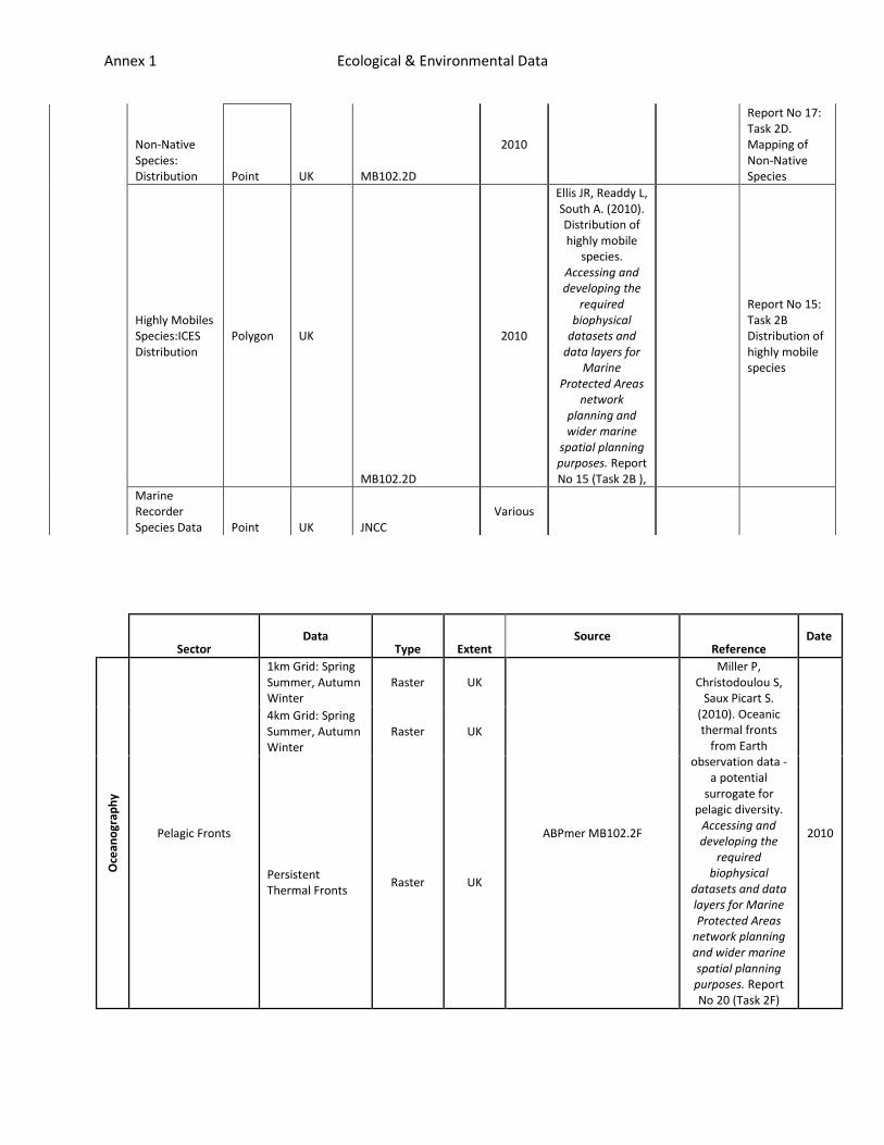
Pelagic Fronts
1km Grid: Spring Summer, Autumn Winter
Raster UK
ABPmer MB102.2F
Miller P, Christodoulou S,
Saux Picart S. (2010). Oceanic thermal fronts
from Earth observation data -
a potential surrogate for
pelagic diversity. Accessing and developing the
required biophysical
datasets and data layers for Marine Protected Areas
network planning and wider marine spatial planning purposes. Report No 20 (Task 2F)
2010
4km Grid: Spring Summer, Autumn Winter
Raster UK
Persistent Thermal Fronts
Raster UK
Non-Native Species: Distribution Point UK MB102.2D
2010
Report No 17: Task 2D. Mapping of Non-Native Species
Highly Mobiles Species:ICES Distribution
Polygon UK
MB102.2D
2010
Ellis JR, Readdy L, South A. (2010). Distribution of highly mobile
species. Accessing and developing the
required biophysical
datasets and data layers for
Marine Protected Areas
network planning and wider marine
spatial planning purposes. Report No 15 (Task 2B ),
Report No 15: Task 2B Distribution of highly mobile species
Marine Recorder Species Data Point UK JNCC
Various
Annex 1 Ecological & Environmental Data
Seabed Energy
Wave Height (1 in 5year significant wave height), Period and Direction
Raster UK
ABPmer MB102.2E
West N, Swift RH, Bell C . (2010). Seabed Energy
Layers . Accessing and developing the
required biophysical
datasets and data layers for Marine Protected Areas
network planning and wider marine spatial planning purposes. Report No 10 (Task 2E),
2010
Wave induced bed shear stress (from 1 in 5year wave)
Raster UK
Maximum tidal current at 10% above the sea bed and associated direction
Raster UK
Tidal maximum bed shear stress
Raster UK
Combined bed shear stress (wave and maximum tide)
Raster UK
Instantaneous wave energy
Raster UK
Instantaneous tidal energy
Raster UK
Classified instantaneous wave energy
Raster UK
Classified instantaneous tidal energy
Raster UK
Residual Current Flow
Currents at: 90,75,50,25% below surface
Vector
UK
ABPmer MB102.2G
Lambkin DO, Wakelin S, Holt J,
Bell C. (2010). Residual Current
flow datalayer:Descripti
on of approach. Accessing and developing the
required biophysical
datasets and data layers for Marine Protected Areas
network planning and wider marine spatial planning purposes. Report No 9 (Task 2G), .
2010
Grids of Currents: Annual, Spring, Summer, Autumn, Winter at: 90,65,60,25,10 below surface
Raster
UK 2010
UK SeaMap Water Column
Water Column Features: Spring Summer Autumn Winter
Raster
UK UK SeaMap JNCC
Connor, D.W., Gilliland, P.M., Golding, N, Robinson, P., Todd, D., & Verling, E. 2006. UKSeaMap: the mapping of seabed and water
2006
Annex 1 Ecological & Environmental Data
column features of UK seas. Joint Nature Conservation Committee, Peterborough.)
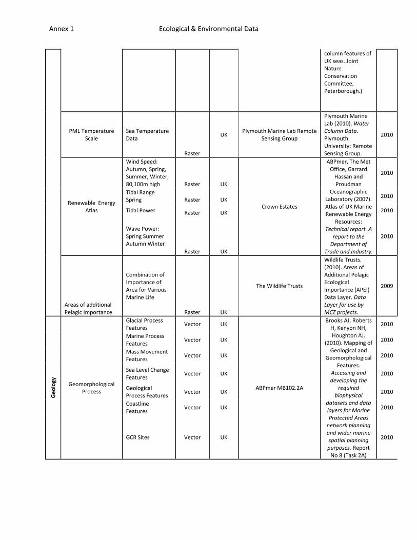
PML Temperature Scale
Sea Temperature Data
Raster
UK Plymouth Marine Lab Remote
Sensing Group
Plymouth Marine Lab (2010). Water Column Data. Plymouth University: Remote Sensing Group.
2010
Renewable Energy Atlas
Wind Speed: Autumn, Spring, Summer, Winter, 80,100m high Raster UK
Crown Estates
ABPmer, The Met Office, Garrard
Hassan and Proudman
Oceanographic Laboratory (2007). Atlas of UK Marine Renewable Energy
Resources: Technical report. A
report to the Department of
Trade and Industry.
2010
Tidal Range Spring Raster UK
2010
Tidal Power Raster UK 2010
Wave Power: Spring Summer Autumn Winter
Raster UK
2010
Areas of additional Pelagic Importance
Combination of Importance of Area for Various Marine Life
Raster UK
The Wildlife Trusts
Wildlife Trusts. (2010). Areas of Additional Pelagic Ecological Importance (APEI) Data Layer. Data Layer for use by MCZ projects.
2009
Ge
olo
gy
Geomorphological Process
Glacial Process Features
Vector UK
ABPmer MB102.2A
Brooks AJ, Roberts H, Kenyon NH, Houghton AJ.
(2010). Mapping of Geological and
Geomorphological Features.
Accessing and developing the
required biophysical
datasets and data layers for Marine Protected Areas
network planning and wider marine spatial planning purposes. Report
No 8 (Task 2A)
2010
Marine Process Features
Vector UK 2010
Mass Movement Features
Vector UK 2010
Sea Level Change Features
Vector UK 2010
Geological Process Features
Vector UK 2010
Coastline Features
Vector UK 2010
GCR Sites Vector UK 2010
Annex 1 Ecological & Environmental Data
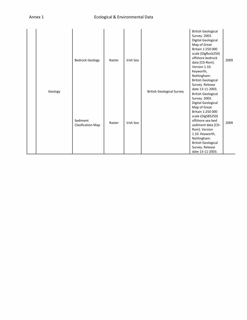
Geology
Bedrock Geology Raster Irish Sea
British Geological Survey
British Geological Survey. 2003. Digital Geological Map of Great Britain 1:250 000 scale (DigRock250) offshore bedrock data [CD-Rom]. Version 1.10. Keyworth, Nottingham: British Geological Survey. Release date 13-11-2003.
2009
Sediment Clasification Map
Raster Irish Sea
British Geological Survey. 2003. Digital Geological Map of Great Britain 1:250 000 scale (DigSBS250) offshore sea-bed sediment data [CD-Rom]. Version 1.10. Keyworth, Nottingham: British Geological Survey. Release date 13-11-2003.
2009

Annex 2 Socio-economic Data
Sector Data Type Extent Original Source Date Reference
Rec
reat
ion
Angling-Shore-Density Raster ISCZ
ISCZ Liaison Officers,
Fishermap Project
2009-2010
ISCZ. (2010). Fishermap Project.
Angling-Boat-Density Raster ISCZ
Diving-Density Raster ISCZ
Kite Surfing -Density Raster ISCZ
Bait Digging Density Raster ISCZ
Harbours-Marinas-Location Point Irish Sea Coast ABP mer 2011 Lee J, Stelzenmüller V, Rogers
S. (2010). Provision of geo-data on human activities and pressures to support the
selection of MCZ site. DEFRA contract MB106: Milestone 2.
Coastal Infrastructure-Location (jetty's, Piers) Point
UK Crown Estates 2011
Wildfowling Locations Polygon UK Crown Estates
2010 Bathing Waters condition-Location Point
North West Environment Agency
2010
Tran
spo
rt a
nd
Nav
igat
ion
Shipping 'routine traffic' Total- Density Raster
Irish Sea
Antec UK
2009
Amtec. (2009). Shipping Density Data for ISCZ. Ref:A2277-GH-TN-1.
Shipping 'routine traffic' Cargo Density Raster
Irish Sea 2009
Shipping 'routine traffic' Ferry Density Raster
Irish Sea 2009
Shipping 'routine traffic' Other Density Raster
Irish Sea 2009
Shipping 'routine traffic' Tanker Density Raster
Irish Sea 2009
Port Dredge Dumping-Area Polygon
Irish Sea Crown Estates
2010
Lee J, Stelzenmüller V, Rogers S. (2010). Provision of geo-data
on human activities and pressures to support the
selection of MCZ sites.. DEFRA contract MB106: Milestone 2.
Ports (ferry, cargo)-Location Point UK ABP mer 2010
Ferry routes-Areas Line Irish Sea
UKHO Nautical Charts 2009
Shipping traffic lanes Line Irish Sea
UKHO Nautical Charts 2009
Caution Areas Polygon Irish Sea UKHO Nautical Charts 2009
Port Dredge -Areas Polygon Irish Sea Crown Estates 2010
Disposal of Dredge Sites Polygon Irish Sea ABPmer
Barrow Channel Dredging Polygon Irish Sea ABP Ports
2011
ABP. (2011). Barrow Channels. Overview of Dredging Activity.
20110436BCO01/0
Coastal Protection Works Polygon UK Crown Estates 2010
Workington Pilotage Area- Polygon Polygon
Irish Sea Port of Workington
1988
Department for Transport. (1988). Workington Pilotage
Harbour Revision Order.
Agg
rega
te
s Licence dredging - Areas Polygon UK Crown Estates 2010 Lee J, Stelzenmüller V, Rogers S. (2010). Provision of geo-data
on human activities and Active dredging - Area Polygon UK Crown Estates 2010
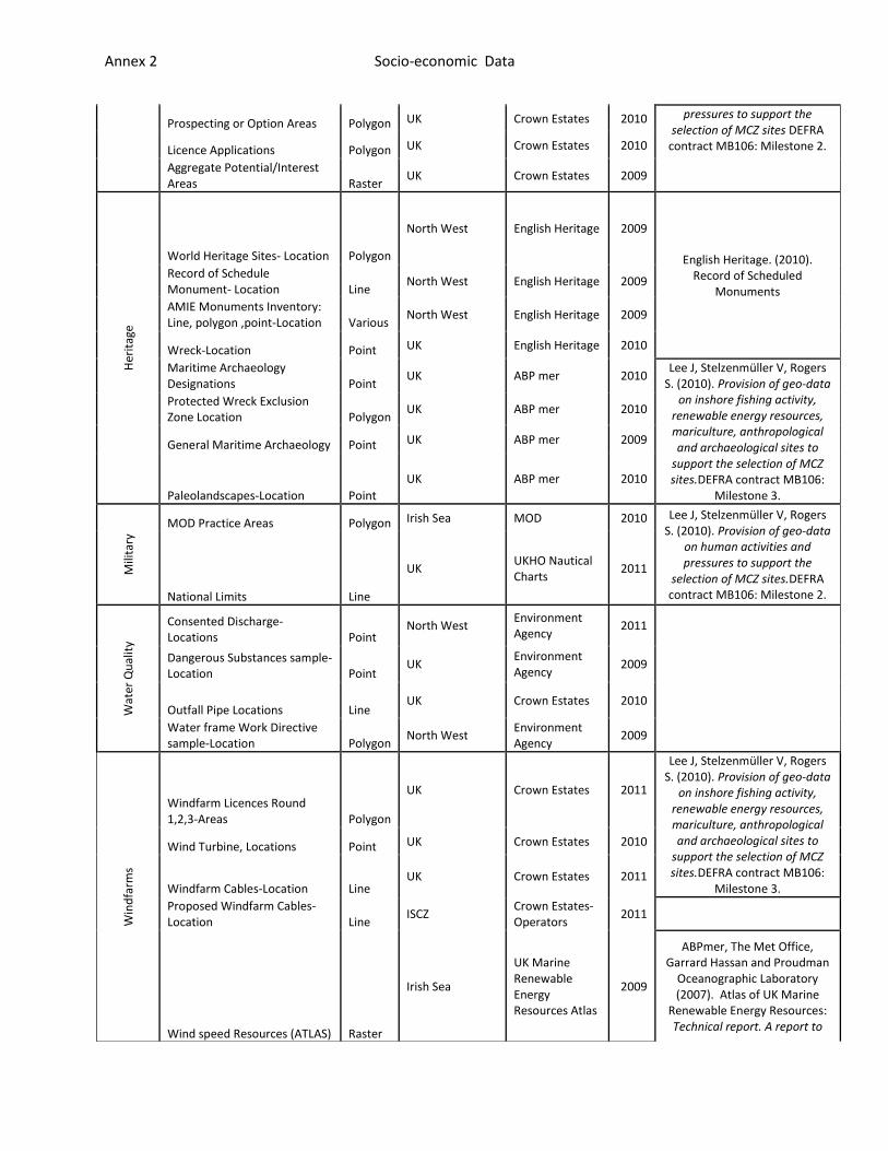
Annex 2 Socio-economic Data
Prospecting or Option Areas Polygon UK Crown Estates 2010 pressures to support the selection of MCZ sites DEFRA
contract MB106: Milestone 2. Licence Applications Polygon UK Crown Estates 2010
Aggregate Potential/Interest Areas Raster
UK Crown Estates 2009
Her
itag
e
World Heritage Sites- Location Polygon
North West English Heritage 2009
English Heritage. (2010). Record of Scheduled
Monuments
Record of Schedule Monument- Location Line
North West English Heritage 2009
AMIE Monuments Inventory: Line, polygon ,point-Location Various
North West English Heritage 2009
Wreck-Location Point UK English Heritage 2010
Maritime Archaeology Designations Point
UK ABP mer 2010 Lee J, Stelzenmüller V, Rogers
S. (2010). Provision of geo-data on inshore fishing activity,
renewable energy resources, mariculture, anthropological and archaeological sites to
support the selection of MCZ sites.DEFRA contract MB106:
Milestone 3.
Protected Wreck Exclusion Zone Location Polygon
UK ABP mer 2010
General Maritime Archaeology Point UK ABP mer 2009
Paleolandscapes-Location Point
UK ABP mer 2010
Mili
tary
MOD Practice Areas Polygon Irish Sea MOD 2010 Lee J, Stelzenmüller V, Rogers S. (2010). Provision of geo-data
on human activities and pressures to support the
selection of MCZ sites.DEFRA contract MB106: Milestone 2. National Limits Line
UK UKHO Nautical Charts
2011
Wat
er Q
ual
ity
Consented Discharge-Locations Point
North West Environment Agency
2011
Dangerous Substances sample-Location Point
UK Environment Agency
2009
Outfall Pipe Locations Line UK Crown Estates 2010
Water frame Work Directive sample-Location Polygon
North West Environment Agency
2009
Win
dfa
rms
Windfarm Licences Round 1,2,3-Areas Polygon
UK Crown Estates 2011
Lee J, Stelzenmüller V, Rogers S. (2010). Provision of geo-data
on inshore fishing activity, renewable energy resources, mariculture, anthropological and archaeological sites to
support the selection of MCZ sites.DEFRA contract MB106:
Milestone 3.
Wind Turbine, Locations Point UK Crown Estates 2010
Windfarm Cables-Location Line UK Crown Estates 2011
Proposed Windfarm Cables-Location Line
ISCZ Crown Estates-Operators
2011
Wind speed Resources (ATLAS) Raster
Irish Sea
UK Marine Renewable Energy Resources Atlas
2009
ABPmer, The Met Office, Garrard Hassan and Proudman
Oceanographic Laboratory (2007). Atlas of UK Marine
Renewable Energy Resources: Technical report. A report to
Annex 2 Socio-economic Data
Tid
al a
nd
Wav
e
Wave Speed Resources (ATLAS) Raster
UK Crown Estates / ABP mer
2010
the Department of Trade and Industry.
Current and Potential Tidal Power Locations Point
Irish Sea Crown Estates / ABP mer
2010
Lee J, Stelzenmüller V, Rogers S. (2010). Provision of geo-data
on inshore fishing activity, renewable energy resources, mariculture, anthropological and archaeological sites to
support the selection of MCZ sites.DEFRA contract MB106:
Milestone 3.
Current Wave Power Lease Locations Point
UK Crown Estates / ABP mer
2010
Tidal Range Raster UK
Crown Estates / ABP mer
2010
Tidal Sources Raster UK
Crown Estates / ABP mer
2010
Key Tidal Range Resources Polygon UK
Crown Estates / ABP mer
2010
Scottish Renewable -Location Various Scottish Waters
Crown Estates / ABP mer
2010
Cab
les
Current Subsea Cables-Location Line
UK ABP mer 2010
Lee J, Stelzenmüller V, Rogers S. (2010). Provision of geo-data
on human activities and pressures to support the
selection of MCZ sites.. DEFRA contract MB106: Milestone 2.
Proposed Cables- Location Line Irish Sea
Developers / Crown Estates
2011
Oil
and
Gas
Current Hydrocarbon Fields Area Polygon
UK UK DEAL 2010
Round 25 Offer status -Area Polygon UK UK DEAL 2010
Round 26 Offers -Area Polygon UK UK DEAL 2010
Current and Historic Well/Platform Location Point
UK UK DEAL 2010 Lee J, Stelzenmüller V, Rogers S. (2010). Provision of geo-data
on human activities and pressures to support the
selection of MCZ sites.DEFRA contract MB106: Milestone 2.
Current Pipelines Line UK UK DEAL 2010
Surface Installations Point UK UK DEAL 2010
Subsurface Installations Point UK UK DEAL 2010
DTI Licence History Polygon UK UK DEAL 2010
DTI Licence Current Polygon UK UK DEAL 2010
Safety Exclusion Zones Polygon UK UK DEAL 2010
3D Seismic Survey Locations Polygon UK UK DEAL 2010
Port Meridian Polygon ISCZ
Operator-Hoegh
2010
Proposed Pipeline Line ISCZ
Operator-Hoegh
2010
Gas Storage Caverns Point ISCZ
Operator Gateway Gas Storage
2010
Gateway Gas Storage Polygon ISCZ
Operator Gateway Gas Storage
2010
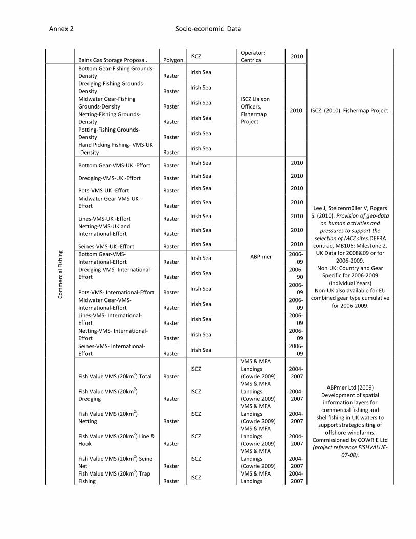
Annex 2 Socio-economic Data
Bains Gas Storage Proposal. Polygon ISCZ
Operator: Centrica
2010 C
om
mer
cial
Fis
hin
g
Bottom Gear-Fishing Grounds-Density Raster
Irish Sea
ISCZ Liaison Officers, Fishermap Project
2010 ISCZ. (2010). Fishermap Project.
Dredging-Fishing Grounds-Density Raster
Irish Sea
Midwater Gear-Fishing Grounds-Density Raster
Irish Sea
Netting-Fishing Grounds-Density Raster
Irish Sea
Potting-Fishing Grounds-Density Raster
Irish Sea
Hand Picking Fishing- VMS-UK -Density Raster
Irish Sea
Bottom Gear-VMS-UK -Effort Raster Irish Sea
ABP mer
2010
Lee J, Stelzenmüller V, Rogers S. (2010). Provision of geo-data
on human activities and pressures to support the
selection of MCZ sites.DEFRA contract MB106: Milestone 2.
UK Data for 2008&09 or for 2006-2009.
Non UK: Country and Gear Specific for 2006-2009
(Individual Years) Non-UK also available for EU
combined gear type cumulative for 2006-2009.
Dredging-VMS-UK -Effort Raster Irish Sea 2010
Pots-VMS-UK -Effort Raster Irish Sea 2010
Midwater Gear-VMS-UK -Effort Raster
Irish Sea 2010
Lines-VMS-UK -Effort Raster Irish Sea 2010
Netting-VMS-UK and International-Effort Raster
Irish Sea 2010
Seines-VMS-UK -Effort Raster Irish Sea 2010
Bottom Gear-VMS- International-Effort Raster
Irish Sea 2006-
09
Dredging-VMS- International-Effort Raster
Irish Sea 2006-
90
Pots-VMS- International-Effort Raster Irish Sea
2006-09
Midwater Gear-VMS- International-Effort Raster
Irish Sea 2006-
09
Lines-VMS- International-Effort Raster
Irish Sea 2006-
09
Netting-VMS- International-Effort Raster
Irish Sea 2006-
09
Seines-VMS- International-Effort Raster
Irish Sea 2006-
09
Fish Value VMS (20km2) Total Raster
ISCZ VMS & MFA Landings (Cowrie 2009)
2004-2007
ABPmer Ltd (2009) Development of spatial information layers for
commercial fishing and shellfishing in UK waters to support strategic siting of
offshore windfarms. Commissioned by COWRIE Ltd (project reference FISHVALUE-
07-08).
Fish Value VMS (20km2)
Dredging Raster ISCZ
VMS & MFA Landings (Cowrie 2009)
2004-2007
Fish Value VMS (20km2)
Netting Raster ISCZ
VMS & MFA Landings (Cowrie 2009)
2004-2007
Fish Value VMS (20km2) Line &
Hook Raster ISCZ
VMS & MFA Landings (Cowrie 2009)
2004-2007
Fish Value VMS (20km2) Seine
Net Raster ISCZ
VMS & MFA Landings (Cowrie 2009)
2004-2007
Fish Value VMS (20km2) Trap
Fishing Raster ISCZ
VMS & MFA Landings
2004-2007
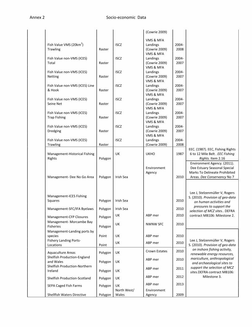
Annex 2 Socio-economic Data
(Cowrie 2009)
Fish Value VMS (20km2)
Trawling Raster ISCZ
VMS & MFA Landings (Cowrie 2009)
2004-2008
Fish Value non-VMS (ICES) Total Raster
ISCZ VMS & MFA Landings (Cowrie 2009)
2004-2007
Fish Value non-VMS (ICES) Netting Raster
ISCZ VMS & MFA Landings (Cowrie 2009)
2004-2007
Fish Value non-VMS (ICES) Line & Hook Raster
ISCZ VMS & MFA Landings (Cowrie 2009)
2004-2007
Fish Value non-VMS (ICES) Seine Net Raster
ISCZ VMS & MFA Landings (Cowrie 2009)
2004-2007
Fish Value non-VMS (ICES) Trap Fishing Raster
ISCZ VMS & MFA Landings (Cowrie 2009)
2004-2007
Fish Value non-VMS (ICES) Dredging Raster
ISCZ VMS & MFA Landings (Cowrie 2009)
2004-2007
Fish Value non-VMS (ICES) Trawling Raster
ISCZ VMS & MFA Landings (Cowrie 2009)
2004-2008
Management-Historical Fishing Rights Polygon
UK UKHO 1987 EEC. (1987). EEC, Fishing Rights 6 to 12 Mile Belt . EEC Fishing
Rights. Item 2.16
Management- Dee No Go Area Polygon Irish Sea
Environment Agency
2010
Environment Agency. (2011). Dee Estuary Seasonal Special
Marks To Delineate Prohibited Areas. Dee Conservancy No 7
Management-ICES Fishing Squares Polygon Irish Sea
2010
Lee J, Stelzenmüller V, Rogers S. (2010). Provision of geo-data
on human activities and pressures to support the
selection of MCZ sites.. DEFRA contract MB106: Milestone 2.
Management-SFC/IFA Byelaws Polygon Irish Sea 2010
Management-CFP Closures Polygon UK ABP mer 2010
Management- Morcambe Bay Fisheries Polygon
UK NWNW SFC 2010
Management-Landing ports by species Point UK ABP mer 2010
Lee J, Stelzenmüller V, Rogers S. (2010). Provision of geo-data
on inshore fishing activity, renewable energy resources, mariculture, anthropological and archaeological sites to
support the selection of MCZ sites.DEFRA contract MB106:
Milestone 3.
Fishery Landing Ports-Locations Point
UK ABP mer 2010
Aquaculture Areas Polygon UK Crown Estates 2010
Shelfish Production-England and Wales Polygon UK
ABP mer 2010
Shelfish Production-Northern Ireland Polygon UK
ABP mer 2011
Shelfish Production-Scotland Polygon UK ABP mer 2012
SEPA Caged Fish Farms Polygon UK ABP mer 2013
Shellfish Waters Directive Polygon North West/ Wales
Environment Agency 2009

Annex 2 Socio-economic Data
Annex 3 Management Tables
Final IA Assumptions - Management Measures (following Regional Review 2 on 2.6.11, meeting with NWIFCA and MMO on 7.6.11 and ISCZ additions 20.6.11, and RSG workshop 7 14.7.11 and development of potentially damaging activities 23.8.11)
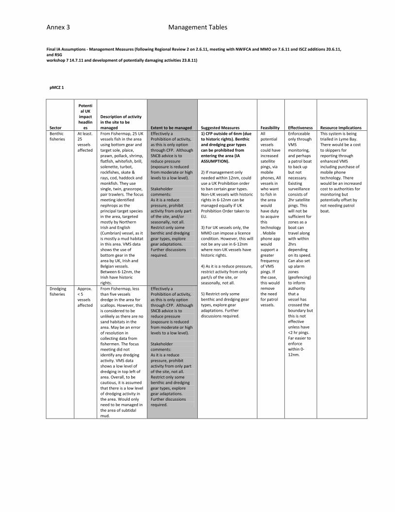
pMCZ 1
Sector
Potential UK
impact headlin
es
Description of activity in the site to be managed Extent to be managed Suggested Measures Feasibility Effectiveness Resource Implications
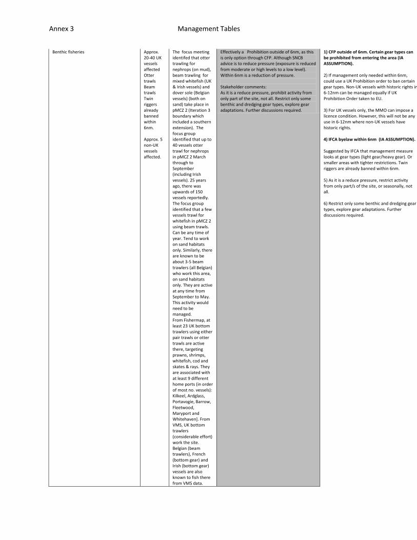
Benthic fisheries
At least. 25 vessels affected
From Fishermap, 25 UK vessels fish in the area using bottom gear and target sole, plaice, prawn, pollack, shrimp, flatfish, whitefish, brill, solenette, turbot, rockfishes, skate & rays, cod, haddock and monkfish. They use single, twin, grassrope, pair trawlers. The focus meeting identified nephrops as the principal target species in the area, targeted mostly by Northern Irish and English (Cumbrian) vessel, as it is mostly a mud habitat in this area. VMS data shows the use of bottom gear in the area by UK, Irish and Belgian vessels. Between 6-12nm, the Irish have historic rights.
Effectively a Prohibition of activity, as this is only option through CFP. Although SNCB advice is to reduce pressure (exposure is reduced from moderate or high levels to a low level). Stakeholder comments: As it is a reduce pressure, prohibit activity from only part of the site, and/or seasonally, not all. Restrict only some benthic and dredging gear types, explore gear adaptations. Further discussions required.
1) CFP outside of 6nm (due to historic rights). Benthic and dredging gear types can be prohibited from entering the area (IA ASSUMPTION). 2) If management only needed within 12nm, could use a UK Prohibition order to ban certain gear types. Non-UK vessels with historic rights in 6-12nm can be managed equally if UK Prohibition Order taken to EU. 3) For UK vessels only, the MMO can impose a licence condition. However, this will not be any use in 6-12nm where non-UK vessels have historic rights. 4) As it is a reduce pressure, restrict activity from only part/s of the site, or seasonally, not all. 5) Restrict only some benthic and dredging gear types, explore gear adaptations. Further discussions required.
All potential vessels could have increased satellite pings, via mobile phones, All vessels in who want to fish in the area would have duty to acquire this technology. Mobile phone app would support a greater frequency of VMS pings. If the case, this would remove the need for patrol vessels.
Enforceable only through VMS monitoring, and perhaps a patrol boat to back up but not necessary. Existing surveillance consists of 2hr satellite pings. This will not be sufficient for zones as a boat can travel along with within 2hrs depending on its speed. Can also set up alarm zones (geofencing) to inform authority that a vessel has crossed the boundary but this is not effective unless have <2 hr pings. Far easier to enforce within 0-12nm.
This system is being trialled in Lyme Bay. There would be a cost to skippers for reporting through enhanced VMS including purchase of mobile phone technology. There would be an increased cost to authorities for monitoring but potentially offset by not needing patrol boat.
Dredging fisheries
Approx. < 5 vessels affected
From Fishermap, less than five vessels dredge in the area for scallops. However, this is considered to be unlikely as there are no sand habitats in the area. May be an error of resolution in collecting data from fishermen. The focus meeting did not identify any dredging activity. VMS data shows a low level of dredging in top left of area. Overall, to be cautious, it is assumed that there is a low level of dredging activity in the area. Would only need to be managed in the area of subtidal mud.
Effectively a Prohibition of activity, as this is only option through CFP. Although SNCB advice is to reduce pressure (exposure is reduced from moderate or high levels to a low level). Stakeholder comments: As it is a reduce pressure, prohibit activity from only part of the site, not all. Restrict only some benthic and dredging gear types, explore gear adaptations. Further discussions required.
Annex 3 Management Tables
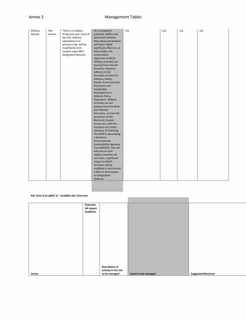
Military Activity
Not known
There is a military firing area over most of the site. Military operations in or around a site, will be modified to limit impacts upon MCZ designated features.
As a competent authority, MOD must determine whether their plans and projects will have a likely significant effect on, or least hinder, the conservation objectives of MCZs. Military activities are exempt from the EIA Directive. However, adheres to the Secretary of State for Defence, Safety, Health, Environmental Protection and Sustainable Development in Defence Policy Statement. Military activities are not exempt from the Birds and Habitats Directives, or from the provisions of the Marine & Coastal Access Act, with the exception of certain elements of licensing. The MOD is developing a Maritime Environmental Sustainability Appraisal Tool (MESAT). This will help ensure that military activities do not have a significant impact on MCZs. Activities will be modified in and around a MCZ to limit impact on designated features.
n/a n/a n/a n/a
Ref. Area A (in pMCZ 1) - straddles the 12nm line
Sector
Potential UK impact headlines
Description of activity in the site to be managed Extent to be managed Suggested Measures
Feasibility
Effectiveness
Resource Implications
Annex 3 Management Tables
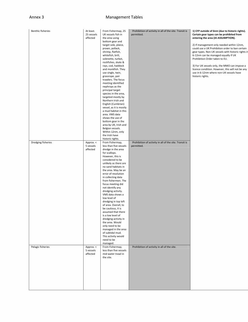
Benthic fisheries At least. 25 vessels affected
From Fishermap, 25 UK vessels fish in the area using bottom gear and target sole, plaice, prawn, pollack, shrimp, flatfish, whitefish, brill, solenette, turbot, rockfishes, skate & rays, cod, haddock and monkfish. They use single, twin, grassrope, pair trawlers. The focus meeting identified nephrops as the principal target species in the area, targeted mostly by Northern Irish and English (Cumbrian) vessel, as it is mostly a mud habitat in this area. VMS data shows the use of bottom gear in the area by UK, Irish and Belgian vessels. WIthin 12nm, only the Irish have historic rights.
Prohibition of activity in all of the site. Transit is permitted.
1) CFP outside of 6nm (due to historic rights). Certain gear types can be prohibited from entering the area (IA ASSUMPTION). 2) If management only needed within 12nm, could use a UK Prohibition order to ban certain gear types. Non-UK vessels with historic rights in 6-12nm can be managed equally if UK Prohibition Order taken to EU. 3) For UK vessels only, the MMO can impose a licence condition. However, this will not be any use in 6-12nm where non-UK vessels have historic rights.
All potential vessels could have increased pings, via mobile phones, All ve
Enforceable only through VMS monitoring, and perhaps a patrol boat to back
This system is being trialled in Lyme Bay. There would be a cost to skipper
Dredging fisheries Approx. < 5 vessels affected
From Fishermap, less than five vessels dredge in the area for scallops. However, this is considered to be unlikely as there are no sand habitats in the area. May be an error of resolution in collecting data from fishermen. The focus meeting did not identify any dredging activity. VMS data shows a low level of dredging in top left of area. Overall, to be cautious, it is assumed that there is a low level of dredging activity in the area. Would only need to be managed in the area of subtidal mud. This activity would need to be managed.
Prohibition of activity in all of the site. Transit is permitted.
Pelagic fisheries Approx. < 5 vessels affected
From Fishermap, less than five vessels mid-water trawl in the site.
Prohibition of activity in all of the site.

Annex 3 Management Tables
ssels in who want to fish in the area would have duty to acquire this techn
up but not necessary. Existing surveillance consists of 2hr pings. This wil
s for reporting through enhanced VMS including purchase of mobile phone tec

Annex 3 Management Tables
ology. Mobile phone app would support a greater frequency of VMS pings. If
l not be sufficient for zones as a boat can travel along with within 2hrs d
hnology. There would be an increased cost to authorities for monitoring but

Annex 3 Management Tables
the case, this would remove the need for patrol vessels.
epending on its speed. Can also set up alarm zones (geofencing) to inform a
potentially offset by not needing patrol boat.

Annex 3 Management Tables
uthority that a vessel has crossed the boundary but this is not effective u
Annex 3 Management Tables
nless have <2 hr pings.
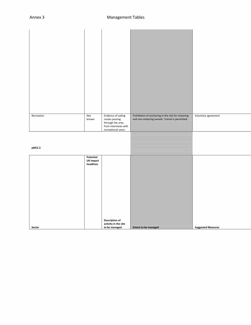
Recreation Not known
Evidence of sailing routes passing through the area from interviews with recreational users.
Prohibition of anchoring in the site for motoring and non-motoring vessels. Transit is permitted.
Voluntary agreement
pMCZ 2
Sector
Potential UK impact headlines
Description of activity in the site to be managed Extent to be managed Suggested Measures
Feasibility
Effectiveness
Resource Implications
Annex 3 Management Tables
Benthic fisheries Approx. 20-40 UK vessels affected Otter trawls Beam trawls Twin riggers already banned within 6nm. Approx. 5 non-UK vessels affected.
The focus meeting identifed that otter trawling for nephrops (on mud), beam trawling for mixed whitefish (UK & Irish vessels) and dover sole (Belgian vessels) (both on sand) take place in pMCZ 2 (Iteration 3 boundary which included a southern extension). The focus group identified that up to 40 vessels otter trawl for nephrops in pMCZ 2 March through to September (including Irish vessels). 25 years ago, there was upwards of 150 vessels reportedly. The focus group identified that a few vessels trawl for whitefish in pMCZ 2 using beam trawls. Can be any time of year. Tend to work on sand habitats only. Similarly, there are known to be about 3-5 beam trawlers (all Belgian) who work this area, on sand habitats only. They are active at any time from September to May. This activity would need to be managed. From Fishermap, at least 23 UK bottom trawlers using either pair trawls or otter trawls are active there, targeting prawns, shrimps, whitefish, cod and skates & rays. They are associated with at least 9 different home ports (in order of most no. vessels): Kilkeel, Ardglass, Portavogie, Barrow, Fleetwood, Maryport and Whitehaven]. From VMS, UK bottom trawlers (considerable effort) work the site. Belgian (beam trawlers), French (bottom gear) and Irish (bottom gear) vessels are also known to fish there from VMS data.
Effectively a Prohibition outside of 6nm, as this is only option through CFP. Although SNCB advice is to reduce pressure (exposure is reduced from moderate or high levels to a low level). Within 6nm is a reduction of pressure. Stakeholder comments: As it is a reduce pressure, prohibit activity from only part of the site, not all. Restrict only some benthic and dredging gear types, explore gear adaptations. Further discussions required.
1) CFP outside of 6nm. Certain gear types can be prohibited from entering the area (IA ASSUMPTION). 2) If management only needed within 6nm, could use a UK Prohibition order to ban certain gear types. Non-UK vessels with historic rights in 6-12nm can be managed equally if UK Prohibition Order taken to EU. 3) For UK vessels only, the MMO can impose a licence condition. However, this will not be any use in 6-12nm where non-UK vessels have historic rights. 4) IFCA byelaw within 6nm (IA ASSUMPTION). Suggested by IFCA that management measure looks at gear types (light gear/heavy gear). Or smaller areas with tighter restrictions. Twin riggers are already banned within 6nm. 5) As it is a reduce pressure, restrict activity from only part/s of the site, or seasonally, not all. 6) Restrict only some benthic and dredging gear types, explore gear adaptations. Further discussions required.
All potential vessels could have increased pings, via mobile phones, All ve
Enforceable only through VMS monitoring, and perhaps a patrol boat to back
This system is being trialled in Lyme Bay. There would be a cost to skipper
Annex 3 Management Tables
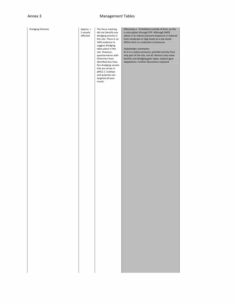
Dredging fisheries Approx. < 5 vessels affected
The focus meeting did not identify any dredging activity in this site. There is no VMS evidence to suggest dredging takes place in the site. However, questionnaires with fishermen have identified less than five dredging vessels that are active in pMCZ 2. Scallops and queenies are targeted all year round.
Effectively a Prohibition outside of 6nm, as this is only option through CFP. Although SNCB advice is to reduce pressure (exposure is reduced from moderate or high levels to a low level). Within 6nm is a reduction of pressure. Stakeholder comments: As it is a reduce pressure, prohibit activity from only part of the site, not all. Restrict only some benthic and dredging gear types, explore gear adaptations. Further discussions required.
ssels in who want to fish in the area would have duty to acquire this techn
up but not necessary. Existing surveillance consists of 2hr pings. This wil
s for reporting through enhanced VMS including purchase of mobile phone tec

Annex 3 Management Tables
ology. Mobile phone app would support a greater frequency of VMS pings. If
l not be sufficient for zones as a boat can travel along with within 2hrs d
hnology. There would be an increased cost to authorities for monitoring but

Annex 3 Management Tables
the case, this would remove the need for patrol vessels.
epending on its speed. Can also set up alarm zones (geofencing) to inform a
potentially offset by not needing patrol boat.

Annex 3 Management Tables
uthority that a vessel has crossed the boundary but this is not effective u

Annex 3 Management Tables
nless have <2 hr pings. IFCA byelaw is preferred within 6nm. Far easier to
Annex 3 Management Tables
enforce within 0-12nm.
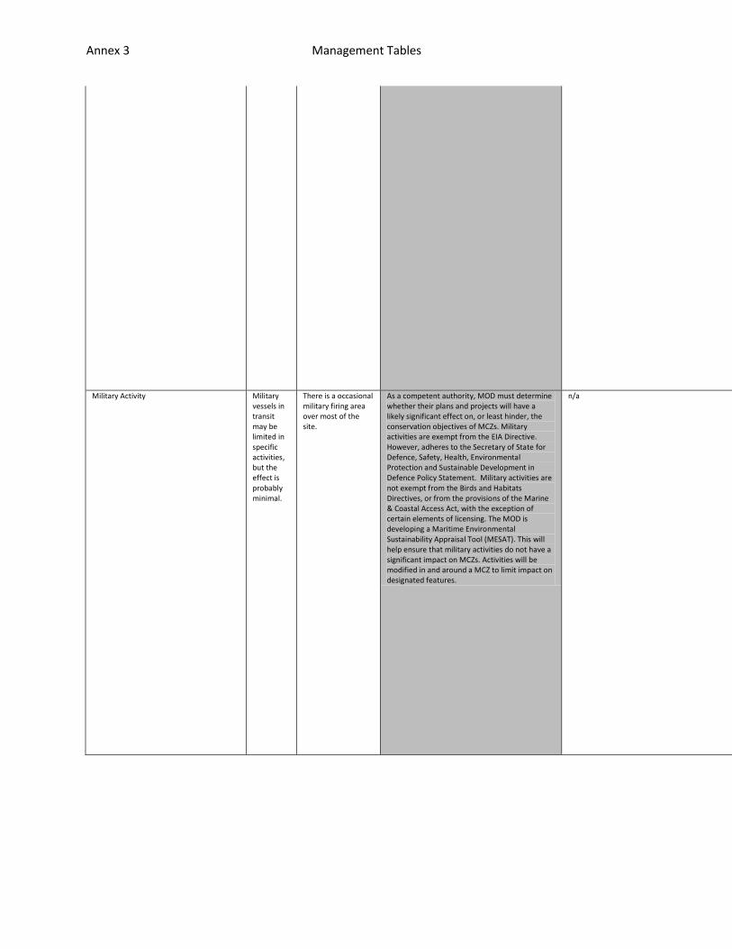
Military Activity Military vessels in transit may be limited in specific activities, but the effect is probably minimal.
There is a occasional military firing area over most of the site.
As a competent authority, MOD must determine whether their plans and projects will have a likely significant effect on, or least hinder, the conservation objectives of MCZs. Military activities are exempt from the EIA Directive. However, adheres to the Secretary of State for Defence, Safety, Health, Environmental Protection and Sustainable Development in Defence Policy Statement. Military activities are not exempt from the Birds and Habitats Directives, or from the provisions of the Marine & Coastal Access Act, with the exception of certain elements of licensing. The MOD is developing a Maritime Environmental Sustainability Appraisal Tool (MESAT). This will help ensure that military activities do not have a significant impact on MCZs. Activities will be modified in and around a MCZ to limit impact on designated features.
n/a n/a
n/a
n/a
Annex 3 Management Tables
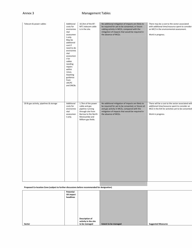
Telecom & power cables Additional costs for environmental assessment only. May be additional cost if need to do environmental assessment for cables needing repairs within 12nm. Awaiting guidance from UKCPC and SNCBs
10.2km of the BT-MT1 telecom cable is in the site.
No additional mitigation of impacts are likely to be required for yet to be consented, or future cabling activity in MCZs, compared with the mitigation of impacts that would be required in the absence of MCZs.
There may be a cost to the sector associated with additional time/resource spent to consider an MCZ in the environmental assessment. Work in progress.
n/a
n/a
n/a
Oil & gas activity, pipelines & storage Additional costs for environmental assessment only.
1.7km of the power cable and gas pipeline running through site from Barrow to the North Morecambe and Millom gas fields.
No additional mitigation of impacts are likely to be required for yet to be consented, or future oil and gas activity in MCZs, compared with the mitigation of impacts that would be required in the absence of MCZs.
There will be a cost to the sector associated with additional time/resource spent to consider an MCZ in the EIA for activities yet to be consented. Work in progress.
n/a
n/a
n/a
Proposed Co-location Zone (subject to further discussions before recommended for designation)
Sector
Potential UK impact headlines
Description of activity in the site to be managed Extent to be managed Suggested Measures
Feasibility
Effectiveness
Resource Impl
Annex 3 Management Tables
ications
Benthic fisheries Approx. 20-40 UK vessels affected Otter trawls Beam trawls Twin riggers already banned within 6nm. Approx. 5 non-UK vessels affected.
The focus meeting identifed that otter trawling for nephrops (on mud), beam trawling for mixed whitefish (UK & Irish vessels) and dover sole (Belgian vessels) (both on sand) take place in pMCZ 2 (Iteration 3 boundary which included a southern extension). The focus group identified that up to 40 vessels otter trawl for nephrops in pMCZ 2 March through to September (including Irish vessels). 25 years ago, there was upwards of 150 vessels reportedly. The focus group identified that a few vessels trawl for whitefish in pMCZ 2 using beam trawls. Can be any time of year. Tend to work on sand habitats only. Similarly, there are known to be about 3-5 beam trawlers (all Belgian) who work this area, on sand habitats only. They are active at any time from September to May. This activity would need to be managed. From Fishermap, at least 20 UK bottom trawlers using either pair trawls or otter trawls are active there, targeting prawns, shrimps, whitefish, cod and skates & rays. They are associated with at least 9 different home ports (in order of most no. vessels): Kilkeel, Ardglass, Portavogie, Barrow, Fleetwood, Maryport and Whitehaven]. From VMS, UK bottom trawlers (considerable effort)
Effectively a Prohibition, as this is only option through CFP. Although SNCB advice is to reduce pressure (exposure is reduced from moderate or high levels to a low level). Stakeholder comments: As it is a reduce pressure, prohibit activity from only part of the site, not all. Restrict only some benthic and dredging gear types, explore gear adaptations. Further discussions required.
1) CFP outside of 6nm. Certain gear types can be prohibited from entering the area (IA ASSUMPTION). 2) If management only needed within 6nm, could use a UK Prohibition order to ban certain gear types. Non-UK vessels with historic rights in 6-12nm can be managed equally if UK Prohibition Order taken to EU. 3) For UK vessels only, the MMO can impose a licence condition. However, this will not be any use in 6-12nm where non-UK vessels have historic rights. 4) IFCA byelaw within 6nm (IA ASSUMPTION). Twin riggers already banned. Suggested by IFCA that management measure looks at gear types (light gear/heavy gear). Or smaller areas with tighter restrictions. 5) As it is a reduce pressure, restrict activity from only part/s of the site, or seasonally, not all. 6) Restrict only some benthic and dredging gear types, explore gear adaptations. Further discussions required.
All potential vessels could have increased pings, via mobile phones
Enforceable only through VMS monitoring, and perhaps a patrol boat
This system is being trialled in Lyme Bay. There would be a cost to
Annex 3 Management Tables
work the site. Belgian (beam trawlers), French (bottom gear) and Irish (bottom gear) vessels are also known to fish there from VMS data.
, All vessels in who want to fish in the area would have duty to acquire th
to back up but not necessary. Existing surveillance consists of 2hr pings.
skippers for reporting through enhanced VMS including purchase of mobile p
Dredging fisheries Approx. < 5 vessels affected
The focus meeting did not identify any dredging activity in this site. There is no VMS evidence to suggest dredging takes place in the site. However, questionnaires with fishermen have identified less than five dredging vessels that are active in pMCZ 2. Scallops and queenies are targeted all year round.
Effectively a Prohibition, as this is only option through CFP. Although SNCB advice is to reduce pressure (exposure is reduced from moderate or high levels to a low level). Stakeholder comments: As it is a reduce pressure, prohibit activity from only part of the site, not all. Restrict only some benthic and dredging gear types, explore gear adaptations. Further discussions required.

Annex 3 Management Tables
is technology. Mobile phone app would support a greater frequency of VMS pi
This will not be sufficient for zones as a boat can travel along with withi
hone technology. There would be an increased cost to authorities for monito

Annex 3 Management Tables
ngs. If the case, this would remove the need for patrol vessels.
n 2hrs depending on its speed. Can also set up alarm zones (geofencing) to
ring but potentially offset by not needing patrol boat.

Annex 3 Management Tables
inform authority that a vessel has crossed the boundary but this is not eff

Annex 3 Management Tables
ective unless have <2 hr pings. IFCA byelaw is preferred within 6nm. Far ea
Annex 3 Management Tables
sier to enforce within 0-12nm.
Telecom & power cables Minimal. Additional costs for environmental assessment only. May be additional cost if need to do environmental assessment for cables needing repairs within 12nm. Awaiting guidance from UKCPC and SNCBs
10.2km of the BT-MT1 telecom cable is in the site.
No additional mitigation of impacts are likely to be required for yet to be consented, or future cabling activity in MCZs, compared with the mitigation of impacts that would be required in the absence of MCZs.
There may be a cost to the sector associated with additional time/resource spent to consider an MCZ in the environmental assessment. No additional mitigation is likely. Work in progress.
n/a
n/a
n/a
Annex 3 Management Tables
Offshore wind farms & cables To be mutually agreed with wind farm developers.
The potential co-location zone overlaps with: 60km
2 the Walney
Extension (pre-planning and not yet consented); 59km
2
of West of Duddon Sands (consented and in development);30km2 of Walney 1 (now operational); 43km
2
of Walney 2 (under construction); 9km2 the Ormonde wind farm (under construction). The following windfarm power cables fall within the potential co-location zone (no detail available for array cables): 5.3km of the Walney (Phase 1) export cable, 15.4km of the proposed Walney (Phase 2) export cable, 2.5km of the proposed West of Duddon Sands export cable, 9.5km of the proposed Walney Extension export cable, 1km of the Ormonde wind farm export cable.
No additional mitigation of impacts are likely to be required for yet to be consented, or future windfarm activity in MCZs, compared with the mitigation of impacts that would be required in the absence of MCZs. This follows a site specific assessment of the activities in this site by Natural England and JNCC with the site developers.
There will be a cost to the sector associated with additional time/resource spent to consider an MCZ in the EIA for the Walney Extension. No additional mitigation is likely. Work in progress.
n/a
n/a
n/a
Oil & gas activity, pipelines & storage Minimal. Additional costs for environmental assessment only. May be additional cost if need to do environmental assessment for cables needing repairs within 12nm. Awaiting guidance from Oil & Gas UK, BRINDEX, OGIA, GSOG and CCSA and SNCBs
8.9km of the power cable and gas pipeline running from Barrow to the North Morecambe and Millom gas fields. 1.7km of another gas pipeline clips the south east corner of the site. Further drilling will take place in the site in Autumn 2011 and a new gas pipeline laid in spring 2012 (yet to be consented). The Morecambe Bay gas fields are very close by and there are also consented plans for gas storage near by.
No additional mitigation of impacts are likely to be required for yet to be consented, or future oil and gas activity in MCZs, compared with the mitigation of impacts that would be required in the absence of MCZs. This is because generic mitigation measures are likely to be carried out in a similar way for features that are within or outside of a MCZ. This is because: a) the activties in the site are already consented, b) impacts on FOCI (all already offered protection by BAP, OSPAR or WCA) are already mitigated against outside of MCZs through the EIA process; and c) the footprint of oil & gas installations is unlikely to significantly impact on broad-scale habitats.
There will be a cost to the sector associated with additional time/resource spent to consider an MCZ in the EIA for activities yet to be consented. May be additional costs - to be clarified. To be confirmed.
n/a
n/a
n/a
pMCZ 3
Annex 3 Management Tables
Sector
Potential UK impact headlines
Description of activity in the site to be managed Extent to be managed Suggested Measures
Feasibility
Effectiveness
Resource Implications
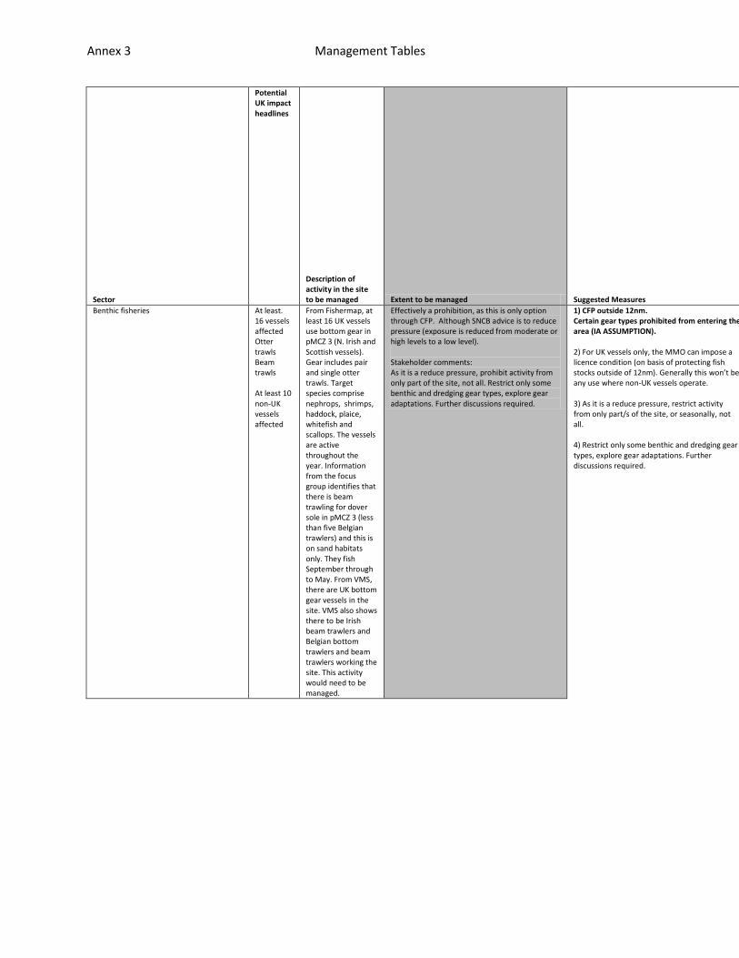
Benthic fisheries At least. 16 vessels affected Otter trawls Beam trawls At least 10 non-UK vessels affected
From Fishermap, at least 16 UK vessels use bottom gear in pMCZ 3 (N. Irish and Scottish vessels). Gear includes pair and single otter trawls. Target species comprise nephrops, shrimps, haddock, plaice, whitefish and scallops. The vessels are active throughout the year. Information from the focus group identifies that there is beam trawling for dover sole in pMCZ 3 (less than five Belgian trawlers) and this is on sand habitats only. They fish September through to May. From VMS, there are UK bottom gear vessels in the site. VMS also shows there to be Irish beam trawlers and Belgian bottom trawlers and beam trawlers working the site. This activity would need to be managed.
Effectively a prohibition, as this is only option through CFP. Although SNCB advice is to reduce pressure (exposure is reduced from moderate or high levels to a low level). Stakeholder comments: As it is a reduce pressure, prohibit activity from only part of the site, not all. Restrict only some benthic and dredging gear types, explore gear adaptations. Further discussions required.
1) CFP outside 12nm. Certain gear types prohibited from entering the area (IA ASSUMPTION). 2) For UK vessels only, the MMO can impose a licence condition (on basis of protecting fish stocks outside of 12nm). Generally this won’t be any use where non-UK vessels operate. 3) As it is a reduce pressure, restrict activity from only part/s of the site, or seasonally, not all. 4) Restrict only some benthic and dredging gear types, explore gear adaptations. Further discussions required.
All potential vessels could have incre
Enforceable only through VMS monitorin
This system is being trialled in Lyme

Annex 3 Management Tables
Static gear fisheries Approx. < 5 vessels affected
VMS data for UK >15m vessels identifies that some potting is known to take place in pMCZ 3. There is no evidence of non-UK vessels potting in the area. Interviews with UK fishermen have identified less than five vessels using pots to catch whelks in the area. They are active the whole year in the site. The focus group did not identify any potting in this area.
Effectively a prohibition, as this is only option through CFP, but only in a zoned part of the site (see map). Although SNCB advice is to reduce pressure (exposure is reduced from moderate or high levels to a low level). Stakeholder comments: As it is a reduce pressure, prohibit activity from only part of the site, not all. Restrict only some benthic and dredging gear types, explore gear adaptations. Further discussions required.
ased pings, via mobile phones, All vessels in who want to fish in the area
g, and perhaps a patrol boat to back up but not necessary. Existing surveil
Bay. There would be a cost to skippers for reporting through enhanced VMS i

Annex 3 Management Tables
would have duty to acquire this technology. Mobile phone app would support
lance consists of 2hr pings. This will not be sufficient for zones as a boa
ncluding purchase of mobile phone technology. There would be an increased c

Annex 3 Management Tables
a greater frequency of VMS pings. If the case, this would remove the need f
t can travel along with within 2hrs depending on its speed. Can also set up
ost to authorities for monitoring but potentially offset by not needing pat

Annex 3 Management Tables
or patrol vessels.
alarm zones (geofencing) to inform authority that a vessel has crossed the
rol boat.

Annex 3 Management Tables
boundary but this is not effective unless have <2 hr pings.
Annex 3 Management Tables
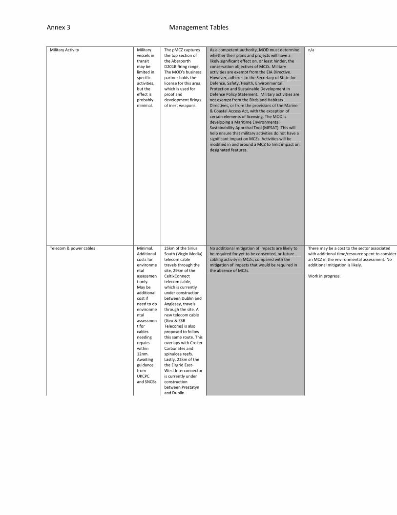
Military Activity Military vessels in transit may be limited in specific activities, but the effect is probably minimal.
The pMCZ captures the top section of the Aberporth D201B firing range. The MOD’s business partner holds the license for this area, which is used for proof and development firings of inert weapons.
As a competent authority, MOD must determine whether their plans and projects will have a likely significant effect on, or least hinder, the conservation objectives of MCZs. Military activities are exempt from the EIA Directive. However, adheres to the Secretary of State for Defence, Safety, Health, Environmental Protection and Sustainable Development in Defence Policy Statement. Military activities are not exempt from the Birds and Habitats Directives, or from the provisions of the Marine & Coastal Access Act, with the exception of certain elements of licensing. The MOD is developing a Maritime Environmental Sustainability Appraisal Tool (MESAT). This will help ensure that military activities do not have a significant impact on MCZs. Activities will be modified in and around a MCZ to limit impact on designated features.
n/a n/a
n/a
n/a
Telecom & power cables Minimal. Additional costs for environmental assessment only. May be additional cost if need to do environmental assessment for cables needing repairs within 12nm. Awaiting guidance from UKCPC and SNCBs
25km of the Sirius South (Virgin Media) telecom cable travels through the site, 29km of the CeltixConnect telecom cable, which is currently under construction between Dublin and Anglesey, travels through the site. A new telecom cable (Geo & ESB Telecoms) is also proposed to follow this same route. This overlaps with Croker Carbonates and spinulosa reefs. Lastly, 22km of the the Eirgrid East-West Interconnector is currently under construction between Prestatyn and Dublin.
No additional mitigation of impacts are likely to be required for yet to be consented, or future cabling activity in MCZs, compared with the mitigation of impacts that would be required in the absence of MCZs.
There may be a cost to the sector associated with additional time/resource spent to consider an MCZ in the environmental assessment. No additional mitigation is likely. Work in progress.
n/a
n/a
n/a
Annex 3 Management Tables
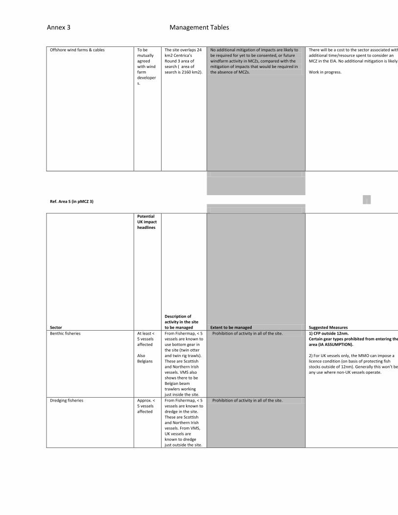
Offshore wind farms & cables To be mutually agreed with wind farm developers.
The site overlaps 24 km2 Centrica’s Round 3 area of search ( area of search is 2160 km2).
No additional mitigation of impacts are likely to be required for yet to be consented, or future windfarm activity in MCZs, compared with the mitigation of impacts that would be required in the absence of MCZs.
There will be a cost to the sector associated with additional time/resource spent to consider an MCZ in the EIA. No additional mitigation is likely. Work in progress.
n/a
n/a
n/a
Ref. Area S (in pMCZ 3)
Sector
Potential UK impact headlines
Description of activity in the site to be managed Extent to be managed Suggested Measures
Feasibility
Effectiveness
Resource Implications
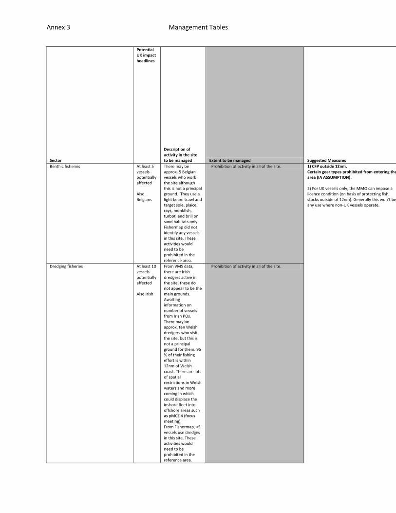
Benthic fisheries At least < 5 vessels affected Also Belgians
From Fishermap, < 5 vessels are known to use bottom gear in the site (twin otter and twin rig trawls). These are Scottish and Northern Irish vessels. VMS also shows there to be Belgian beam trawlers working just inside the site.
Prohibition of activity in all of the site. 1) CFP outside 12nm. Certain gear types prohibited from entering the area (IA ASSUMPTION). 2) For UK vessels only, the MMO can impose a licence condition (on basis of protecting fish stocks outside of 12nm). Generally this won’t be any use where non-UK vessels operate.
All potential vessels
Enforceable only thro
This system is being
Dredging fisheries Approx. < 5 vessels affected
From Fishermap, < 5 vessels are known to dredge in the site. These are Scottish and Northern Irish vessels. From VMS, UK vessels are known to dredge just outside the site.
Prohibition of activity in all of the site.
Annex 3 Management Tables
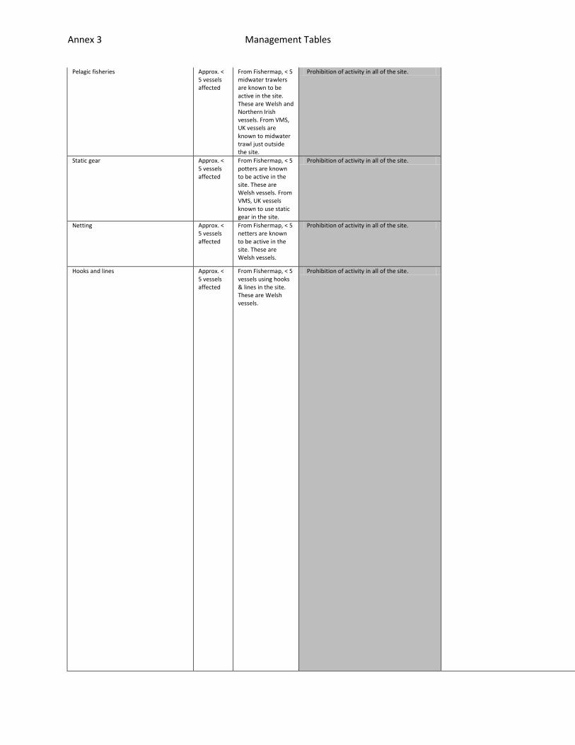
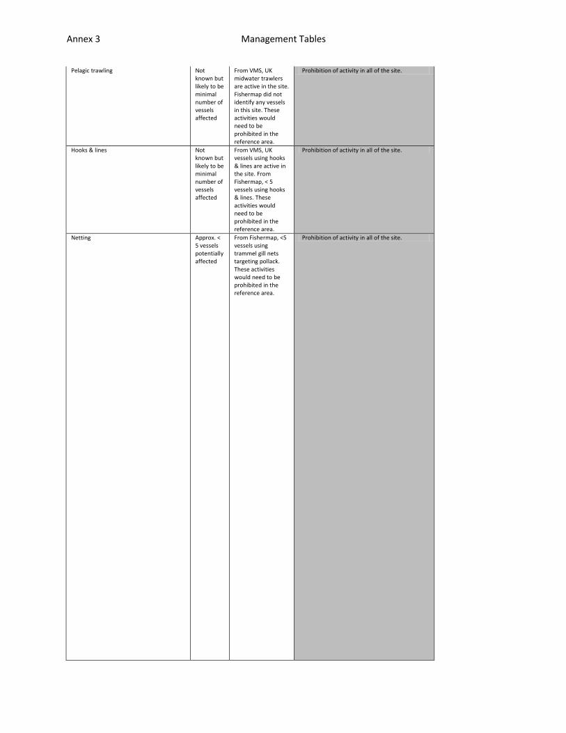
Pelagic fisheries Approx. < 5 vessels affected
From Fishermap, < 5 midwater trawlers are known to be active in the site. These are Welsh and Northern Irish vessels. From VMS, UK vessels are known to midwater trawl just outside the site.
Prohibition of activity in all of the site. could have increased pings, via mobile phones, All vessels in who want to
ugh VMS monitoring, and perhaps a patrol boat to back up but not necessary.
trialled in Lyme Bay. There would be a cost to skippers for reporting throu
Static gear Approx. < 5 vessels affected
From Fishermap, < 5 potters are known to be active in the site. These are Welsh vessels. From VMS, UK vessels known to use static gear in the site.
Prohibition of activity in all of the site.
Netting Approx. < 5 vessels affected
From Fishermap, < 5 netters are known to be active in the site. These are Welsh vessels.
Prohibition of activity in all of the site.
Hooks and lines Approx. < 5 vessels affected
From Fishermap, < 5 vessels using hooks & lines in the site. These are Welsh vessels.
Prohibition of activity in all of the site.

Annex 3 Management Tables
fish in the area would have duty to acquire this technology. Mobile phone a
Existing surveillance consists of 2hr pings. This will not be sufficient f
gh enhanced VMS including purchase of mobile phone technology. There would

Annex 3 Management Tables
pp would support a greater frequency of VMS pings. If the case, this would
or zones as a boat can travel along with within 2hrs depending on its speed
be an increased cost to authorities for monitoring but potentially offset b

Annex 3 Management Tables
remove the need for patrol vessels.
. Can also set up alarm zones (geofencing) to inform authority that a vesse
y not needing patrol boat.

Annex 3 Management Tables
l has crossed the boundary but this is not effective unless have <2 hr ping
Annex 3 Management Tables
s.
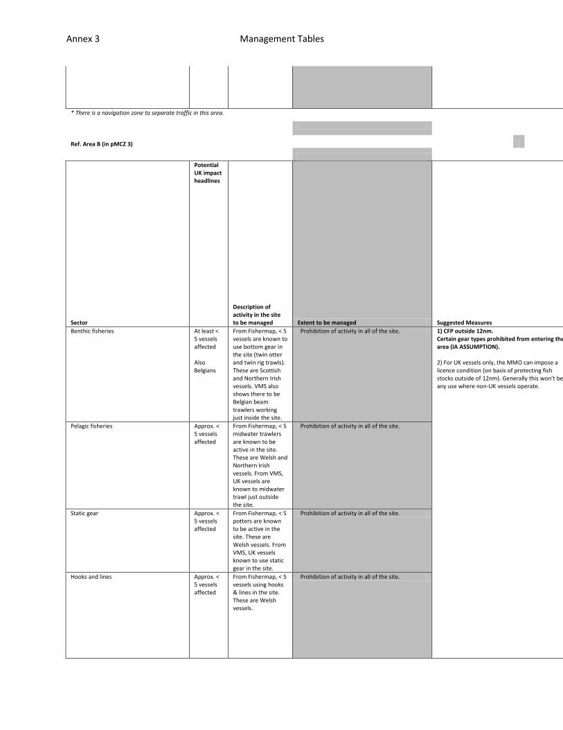
* There is a navigation zone to separate traffic in this area.
Ref. Area B (in pMCZ 3)
Sector
Potential UK impact headlines
Description of activity in the site to be managed Extent to be managed Suggested Measures
Feasibility
Effectiveness
Resource Implications
Benthic fisheries At least < 5 vessels affected Also Belgians
From Fishermap, < 5 vessels are known to use bottom gear in the site (twin otter and twin rig trawls). These are Scottish and Northern Irish vessels. VMS also shows there to be Belgian beam trawlers working just inside the site.
Prohibition of activity in all of the site. 1) CFP outside 12nm. Certain gear types prohibited from entering the area (IA ASSUMPTION). 2) For UK vessels only, the MMO can impose a licence condition (on basis of protecting fish stocks outside of 12nm). Generally this won’t be any use where non-UK vessels operate.
All potential vessels could have increased
Enforceable only through VMS monitoring, a
This system is being trialled in Lyme Bay.
Pelagic fisheries Approx. < 5 vessels affected
From Fishermap, < 5 midwater trawlers are known to be active in the site. These are Welsh and Northern Irish vessels. From VMS, UK vessels are known to midwater trawl just outside the site.
Prohibition of activity in all of the site.
Static gear Approx. < 5 vessels affected
From Fishermap, < 5 potters are known to be active in the site. These are Welsh vessels. From VMS, UK vessels known to use static gear in the site.
Prohibition of activity in all of the site.
Hooks and lines Approx. < 5 vessels affected
From Fishermap, < 5 vessels using hooks & lines in the site. These are Welsh vessels.
Prohibition of activity in all of the site.

Annex 3 Management Tables
pings, via mobile phones, All vessels in who want to fish in the area woul
nd perhaps a patrol boat to back up but not necessary. Existing surveillanc
There would be a cost to skippers for reporting through enhanced VMS inclu

Annex 3 Management Tables
d have duty to acquire this technology. Mobile phone app would support a gr
e consists of 2hr pings. This will not be sufficient for zones as a boat ca
ding purchase of mobile phone technology. There would be an increased cost

Annex 3 Management Tables
eater frequency of VMS pings. If the case, this would remove the need for p
n travel along with within 2hrs depending on its speed. Can also set up ala
to authorities for monitoring but potentially offset by not needing patrol

Annex 3 Management Tables
atrol vessels.
rm zones (geofencing) to inform authority that a vessel has crossed the bou
boat.
Annex 3 Management Tables
ndary but this is not effective unless have <2 hr pings.
pMCZ 4
Sector
Potential UK impact headlines
Description of activity in the site to be managed Extent to be managed Suggested Measures
Feasibility
Effectiveness
Resource Impl
Annex 3 Management Tables
ications
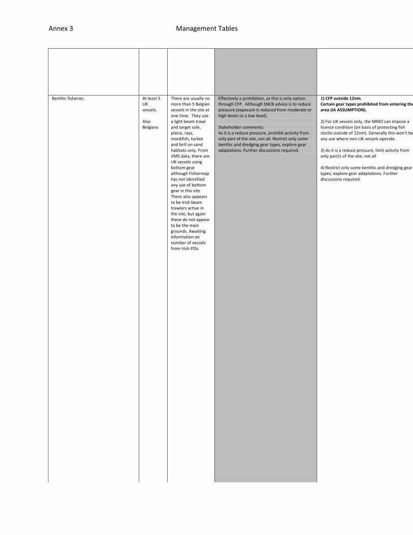
Benthic fisheries At least 5 UK vessels. Also Belgians
There are usually no more than 5 Belgian vessels in the site at one time. They use a light beam trawl and target sole, plaice, rays, monkfish, turbot and brill on sand habitats only. From VMS data, there are UK vessels using bottom gear although Fishermap has not identified any use of bottom gear in this site. There also appears to be Irish beam trawlers active in the site, but again these do not appear to be the main grounds. Awaiting information on number of vessels from Irish POs.
Effectively a prohibition, as this is only option through CFP. Although SNCB advice is to reduce pressure (exposure is reduced from moderate or high levels to a low level). Stakeholder comments: As it is a reduce pressure, prohibit activity from only part of the site, not all. Restrict only some benthic and dredging gear types, explore gear adaptations. Further discussions required.
1) CFP outside 12nm. Certain gear types prohibited from entering the area (IA ASSUMPTION). 2) For UK vessels only, the MMO can impose a licence condition (on basis of protecting fish stocks outside of 12nm). Generally this won’t be any use where non-UK vessels operate. 3) As it is a reduce pressure, limit activity from only part/s of the site, not all 4) Restrict only some benthic and dredging gear types, explore gear adaptations. Further discussions required.
All potential vessels could have increased pings, via mobile phones
Enforceable only through VMS monitoring, and perhaps a patrol boat
This system is being trialled in Lyme Bay. There would be a cost to

Annex 3 Management Tables
, All vessels in who want to fish in the area would have duty to acquire th
to back up but not necessary. Existing surveillance consists of 2hr pings.
skippers for reporting through enhanced VMS including purchase of mobile p

Annex 3 Management Tables
is technology. Mobile phone app would support a greater frequency of VMS pi
This will not be sufficient for zones as a boat can travel along with withi
hone technology. There would be an increased cost to authorities for monito

Annex 3 Management Tables
ngs. If the case, this would remove the need for patrol vessels.
n 2hrs depending on its speed. Can also set up alarm zones (geofencing) to
ring but potentially offset by not needing patrol boat.

Annex 3 Management Tables
inform authority that a vessel has crossed the boundary but this is not eff
Annex 3 Management Tables
ective unless have <2 hr pings.
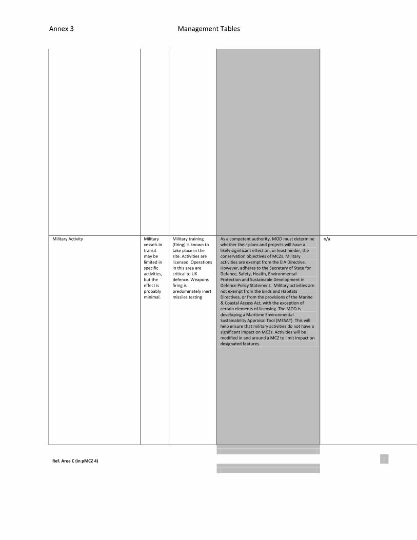
Military Activity Military vessels in transit may be limited in specific activities, but the effect is probably minimal.
Military training (firing) is known to take place in the site. Activities are licensed. Operations in this area are critical to UK defence. Weapons firing is predominately inert missiles testing
As a competent authority, MOD must determine whether their plans and projects will have a likely significant effect on, or least hinder, the conservation objectives of MCZs. Military activities are exempt from the EIA Directive. However, adheres to the Secretary of State for Defence, Safety, Health, Environmental Protection and Sustainable Development in Defence Policy Statement. Military activities are not exempt from the Birds and Habitats Directives, or from the provisions of the Marine & Coastal Access Act, with the exception of certain elements of licensing. The MOD is developing a Maritime Environmental Sustainability Appraisal Tool (MESAT). This will help ensure that military activities do not have a significant impact on MCZs. Activities will be modified in and around a MCZ to limit impact on designated features.
n/a n/a
n/a
n/a
Ref. Area C (in pMCZ 4)
Annex 3 Management Tables
Sector
Potential UK impact headlines
Description of activity in the site to be managed Extent to be managed Suggested Measures
Feasibility
Effectiveness
Resource Implications
Benthic fisheries At least 5 vessels potentially affected Also Belgians
There may be approx. 5 Belgian vessels who work the site although this is not a principal ground. They use a light beam trawl and target sole, plaice, rays, monkfish, turbot and brill on sand habitats only. Fishermap did not identify any vessels in this site. These activities would need to be prohibited in the reference area.
Prohibition of activity in all of the site. 1) CFP outside 12nm. Certain gear types prohibited from entering the area (IA ASSUMPTION). 2) For UK vessels only, the MMO can impose a licence condition (on basis of protecting fish stocks outside of 12nm). Generally this won’t be any use where non-UK vessels operate.
All potential vessels could have increased pings, via
Enforceable only through VMS monitoring, and perhaps a
This system is being trialled in Lyme Bay. There would
Dredging fisheries At least 10 vessels potentially affected Also Irish
From VMS data, there are Irish dredgers active in the site, these do not appear to be the main grounds. Awaiting information on number of vessels from Irish POs. There may be approx. ten Welsh dredgers who visit the site, but this is not a principal ground for them. 95 % of their fishing effort is within 12nm of Welsh coast. There are lots of spatial restrictions in Welsh waters and more coming in which could displace the inshore fleet into offshore areas such as pMCZ 4 (focus meeting). From Fishermap, <5 vessels use dredges in this site. These activities would need to be prohibited in the reference area.
Prohibition of activity in all of the site.
Annex 3 Management Tables
Pelagic trawling Not known but likely to be minimal number of vessels affected
From VMS, UK midwater trawlers are active in the site. Fishermap did not identify any vessels in this site. These activities would need to be prohibited in the reference area.
Prohibition of activity in all of the site. mobile phones, All vessels in who want to fish in the area would have duty
patrol boat to back up but not necessary. Existing surveillance consists o
be a cost to skippers for reporting through enhanced VMS including purchas
Hooks & lines Not known but likely to be minimal number of vessels affected
From VMS, UK vessels using hooks & lines are active in the site. From Fishermap, < 5 vessels using hooks & lines. These activities would need to be prohibited in the reference area.
Prohibition of activity in all of the site.
Netting Approx. < 5 vessels potentially affected
From Fishermap, <5 vessels using trammel gill nets targeting pollack. These activities would need to be prohibited in the reference area.
Prohibition of activity in all of the site.
Annex 3 Management Tables
to acquire this technology. Mobile phone app would support a greater freque
f 2hr pings. This will not be sufficient for zones as a boat can travel alo
e of mobile phone technology. There would be an increased cost to authoriti

Annex 3 Management Tables
ncy of VMS pings. If the case, this would remove the need for patrol vessel
ng with within 2hrs depending on its speed. Can also set up alarm zones (ge
es for monitoring but potentially offset by not needing patrol boat.

Annex 3 Management Tables
s.
ofencing) to inform authority that a vessel has crossed the boundary but th
Annex 3 Management Tables
is is not effective unless have <2 hr pings.
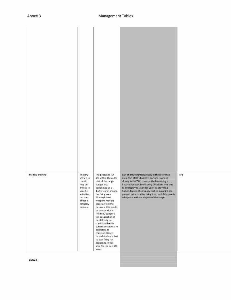
Military training Military vessels in transit may be limited in specific activities, but the effect is probably minimal.
The proposed RA lies within the outer part of the range danger area designated as a 'buffer zone' around the firing area. Although inert weapons may on occasion fall into this area, this would be unintentional. The MoD supports the designation of this RA only on condition that its current activities are permitted to continue. Range records indicate that no test firing has deposited in this area for the past 20 years.
Ban of programmed activity in the reference area. The MoD's business partner (working closely with CCW) is currently developing a Passive Acoustic Monitoring (PAM) system, due to be deployed later this year, to provide a higher degree of certainty that no dolphins are present prior to a live firing trial; such firings only take place in the main part of the range.
n/a n/a
n/a
n/a
pMCZ 5
Annex 3 Management Tables
Sector
Potential UK impact headlines
Description of activity in the site to be managed Extent to be managed Suggested Measures
Feasibility
Effectiveness
Resource Implications
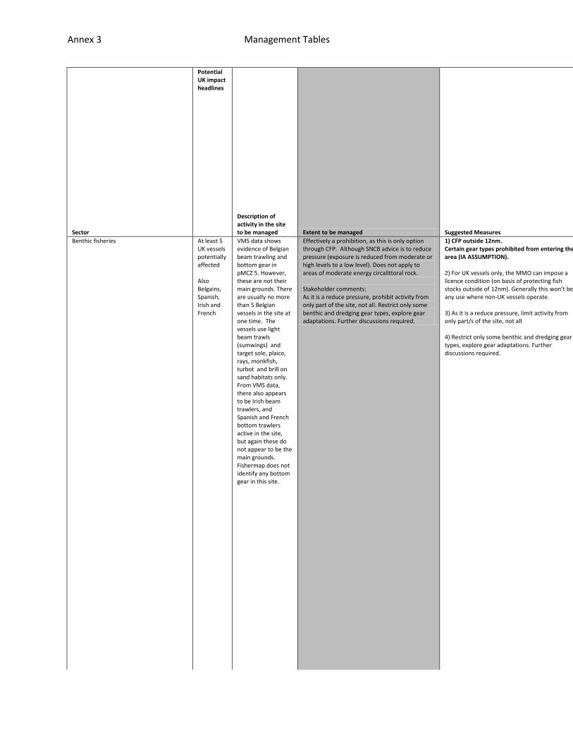
Benthic fisheries At least 5 UK vessels potentially affected Also Belgains, Spanish, Irish and French
VMS data shows evidence of Belgian beam trawling and bottom gear in pMCZ 5. However, these are not their main grounds. There are usually no more than 5 Belgian vessels in the site at one time. The vessels use light beam trawls (sumwings) and target sole, plaice, rays, monkfish, turbot and brill on sand habitats only. From VMS data, there also appears to be Irish beam trawlers, and Spanish and French bottom trawlers active in the site, but again these do not appear to be the main grounds. Fishermap does not identify any bottom gear in this site.
Effectively a prohibition, as this is only option through CFP. Although SNCB advice is to reduce pressure (exposure is reduced from moderate or high levels to a low level). Does not apply to areas of moderate energy circalittoral rock. Stakeholder comments: As it is a reduce pressure, prohibit activity from only part of the site, not all. Restrict only some benthic and dredging gear types, explore gear adaptations. Further discussions required.
1) CFP outside 12nm. Certain gear types prohibited from entering the area (IA ASSUMPTION). 2) For UK vessels only, the MMO can impose a licence condition (on basis of protecting fish stocks outside of 12nm). Generally this won’t be any use where non-UK vessels operate. 3) As it is a reduce pressure, limit activity from only part/s of the site, not all 4) Restrict only some benthic and dredging gear types, explore gear adaptations. Further discussions required.
All potential vessels could have increased pings, via
Enforceable only through VMS monitoring, and perhaps a
This system is being trialled in Lyme Bay. There would

Annex 3 Management Tables
mobile phones, All vessels in who want to fish in the area would have duty
patrol boat to back up but not necessary. Existing surveillance consists o
be a cost to skippers for reporting through enhanced VMS including purchas

Annex 3 Management Tables
to acquire this technology. Mobile phone app would support a greater freque
f 2hr pings. This will not be sufficient for zones as a boat can travel alo
e of mobile phone technology. There would be an increased cost to authoriti

Annex 3 Management Tables
ncy of VMS pings. If the case, this would remove the need for patrol vessel
ng with within 2hrs depending on its speed. Can also set up alarm zones (ge
es for monitoring but potentially offset by not needing patrol boat.

Annex 3 Management Tables
s.
ofencing) to inform authority that a vessel has crossed the boundary but th
Annex 3 Management Tables
is is not effective unless have <2 hr pings.
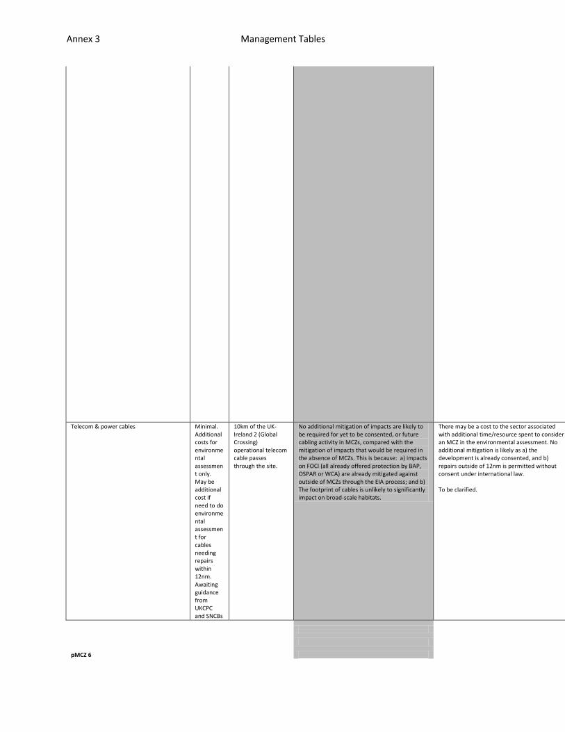
Telecom & power cables Minimal. Additional costs for environmental assessment only. May be additional cost if need to do environmental assessment for cables needing repairs within 12nm. Awaiting guidance from UKCPC and SNCBs
10km of the UK-Ireland 2 (Global Crossing) operational telecom cable passes through the site.
No additional mitigation of impacts are likely to be required for yet to be consented, or future cabling activity in MCZs, compared with the mitigation of impacts that would be required in the absence of MCZs. This is because: a) impacts on FOCI (all already offered protection by BAP, OSPAR or WCA) are already mitigated against outside of MCZs through the EIA process; and b) The footprint of cables is unlikely to significantly impact on broad-scale habitats.
There may be a cost to the sector associated with additional time/resource spent to consider an MCZ in the environmental assessment. No additional mitigation is likely as a) the development is already consented, and b) repairs outside of 12nm is permitted without consent under international law. To be clarified.
n/a
n/a
n/a
pMCZ 6
Annex 3 Management Tables
Sector
Potential UK impact headlines
Description of activity in the site to be managed Extent to be managed Suggested Measures
Feasibility
Effectiveness
Resource Implications
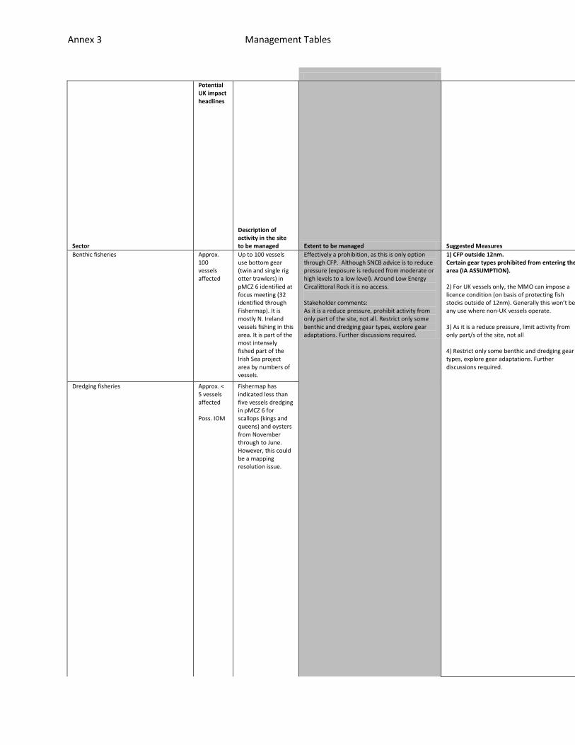
Benthic fisheries Approx. 100 vessels affected
Up to 100 vessels use bottom gear (twin and single rig otter trawlers) in pMCZ 6 identified at focus meeting (32 identified through Fishermap). It is mostly N. Ireland vessels fishing in this area. It is part of the most intensely fished part of the Irish Sea project area by numbers of vessels.
Effectively a prohibition, as this is only option through CFP. Although SNCB advice is to reduce pressure (exposure is reduced from moderate or high levels to a low level). Around Low Energy Circalittoral Rock it is no access. Stakeholder comments: As it is a reduce pressure, prohibit activity from only part of the site, not all. Restrict only some benthic and dredging gear types, explore gear adaptations. Further discussions required.
1) CFP outside 12nm. Certain gear types prohibited from entering the area (IA ASSUMPTION). 2) For UK vessels only, the MMO can impose a licence condition (on basis of protecting fish stocks outside of 12nm). Generally this won’t be any use where non-UK vessels operate. 3) As it is a reduce pressure, limit activity from only part/s of the site, not all 4) Restrict only some benthic and dredging gear types, explore gear adaptations. Further discussions required.
All potential vessels could have increased pings, via
Enforceable only through VMS monitoring, and perhaps
This system is being trialled in Lyme Bay. There woul
Dredging fisheries Approx. < 5 vessels affected Poss. IOM
Fishermap has indicated less than five vessels dredging in pMCZ 6 for scallops (kings and queens) and oysters from November through to June. However, this could be a mapping resolution issue.

Annex 3 Management Tables
mobile phones, All vessels in who want to fish in the area would have duty
a patrol boat to back up but not necessary. Existing surveillance consists
d be a cost to skippers for reporting through enhanced VMS including purcha

Annex 3 Management Tables
to acquire this technology. Mobile phone app would support a greater frequ
of 2hr pings. This will not be sufficient for zones as a boat can travel al
se of mobile phone technology. There would be an increased cost to authorit

Annex 3 Management Tables
ency of VMS pings. If the case, this would remove the need for patrol vesse
ong with within 2hrs depending on its speed. Can also set up alarm zones (g
ies for monitoring but potentially offset by not needing patrol boat.

Annex 3 Management Tables
ls.
eofencing) to inform authority that a vessel has crossed the boundary but t

Annex 3 Management Tables
his is not effective unless have <2 hr pings.
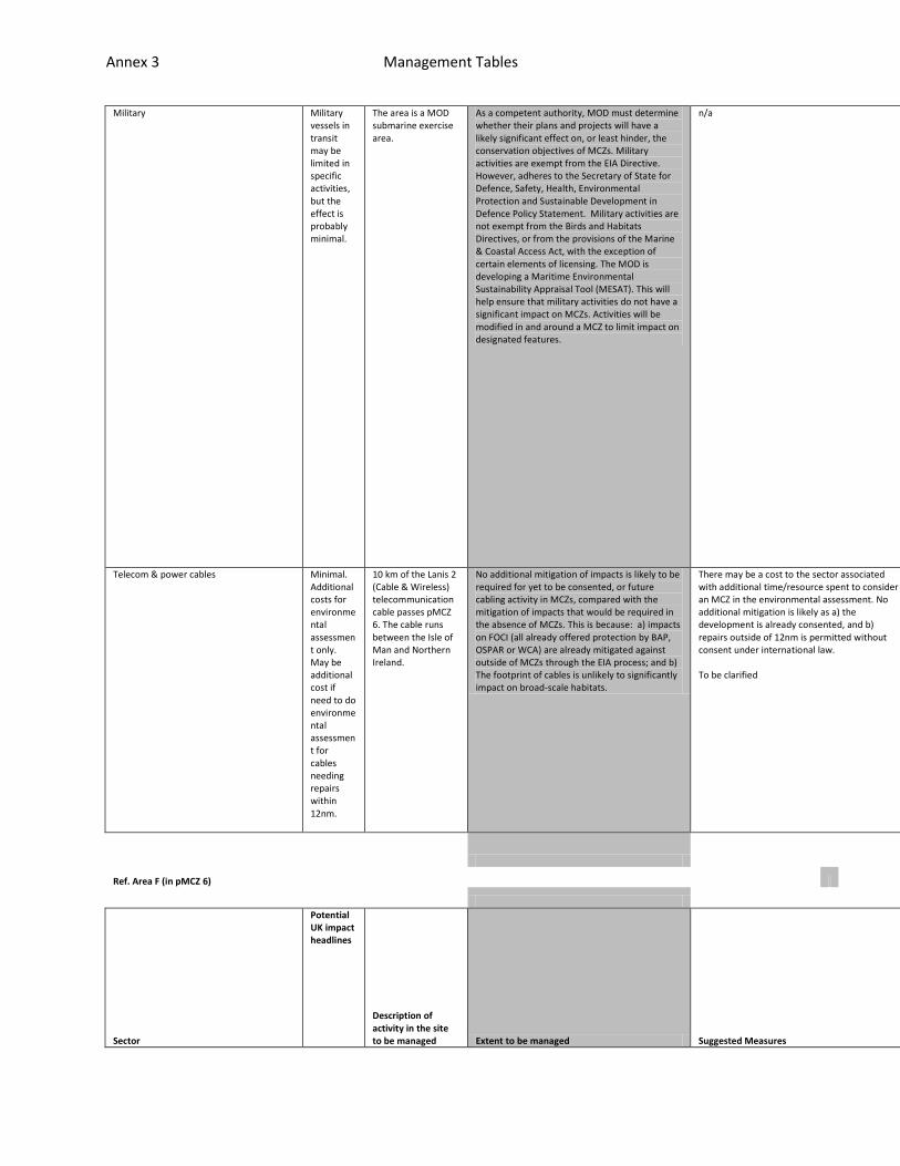
Annex 3 Management Tables
Military Military vessels in transit may be limited in specific activities, but the effect is probably minimal.
The area is a MOD submarine exercise area.
As a competent authority, MOD must determine whether their plans and projects will have a likely significant effect on, or least hinder, the conservation objectives of MCZs. Military activities are exempt from the EIA Directive. However, adheres to the Secretary of State for Defence, Safety, Health, Environmental Protection and Sustainable Development in Defence Policy Statement. Military activities are not exempt from the Birds and Habitats Directives, or from the provisions of the Marine & Coastal Access Act, with the exception of certain elements of licensing. The MOD is developing a Maritime Environmental Sustainability Appraisal Tool (MESAT). This will help ensure that military activities do not have a significant impact on MCZs. Activities will be modified in and around a MCZ to limit impact on designated features.
n/a n/a
n/a
n/a
Telecom & power cables Minimal. Additional costs for environmental assessment only. May be additional cost if need to do environmental assessment for cables needing repairs within 12nm.
10 km of the Lanis 2 (Cable & Wireless) telecommunication cable passes pMCZ 6. The cable runs between the Isle of Man and Northern Ireland.
No additional mitigation of impacts is likely to be required for yet to be consented, or future cabling activity in MCZs, compared with the mitigation of impacts that would be required in the absence of MCZs. This is because: a) impacts on FOCI (all already offered protection by BAP, OSPAR or WCA) are already mitigated against outside of MCZs through the EIA process; and b) The footprint of cables is unlikely to significantly impact on broad-scale habitats.
There may be a cost to the sector associated with additional time/resource spent to consider an MCZ in the environmental assessment. No additional mitigation is likely as a) the development is already consented, and b) repairs outside of 12nm is permitted without consent under international law. To be clarified
n/a
n/a
n/a
Ref. Area F (in pMCZ 6)
Sector
Potential UK impact headlines
Description of activity in the site to be managed Extent to be managed Suggested Measures
Feasibility
Effectivene
Resource Im
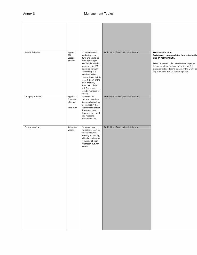
Annex 3 Management Tables
ss
plications
Benthic fisheries Approx. 100 vessels affected
Up to 100 vessels use bottom gear (twin and single rig otter trawlers) in pMCZ 6 identified at focus meeting (29 identified through Fishermap). It is mostly N. Ireland vessels fishing in this area. It is part of the most intensely fished part of the Irish Sea project area by numbers of vessels.
Prohibition of activity in all of the site. 1) CFP outside 12nm. Certain gear types prohibited from entering the area (IA ASSUMPTION). 2) For UK vessels only, the MMO can impose a licence condition (on basis of protecting fish stocks outside of 12nm). Generally this won’t be any use where non-UK vessels operate.
All potential vessels could have increased pings, via mobile phon
Enforceable only through VMS monitoring, and perhaps a patrol boa
This system is being trialled in Lyme Bay. There would be a cost
Dredging fisheries Approx. < 5 vessels affected Poss. IOM
Fishermap has indicated less than five vessels dredging for scallops in the site from November through to June. However, this could be a mapping resolution issue.
Prohibition of activity in all of the site.
Pelagic trawling At least 6 vessels
Fishermap has indicated at least six vessels midwater trawling for herring, whitefish and prawn in the site all year but mostly autumn months.
Prohibition of activity in all of the site.

Annex 3 Management Tables
es, All vessels in who want to fish in the area would have duty to acquire
t to back up but not necessary. Existing surveillance consists of 2hr pings
to skippers for reporting through enhanced VMS including purchase of mobile
Annex 3 Management Tables
this technology. Mobile phone app would support a greater frequency of VMS
. This will not be sufficient for zones as a boat can travel along with wit
phone technology. There would be an increased cost to authorities for moni

Annex 3 Management Tables
pings. If the case, this would remove the need for patrol vessels.
hin 2hrs depending on its speed. Can also set up alarm zones (geofencing) t
toring but potentially offset by not needing patrol boat.

Annex 3 Management Tables
o inform authority that a vessel has crossed the boundary but this is not e
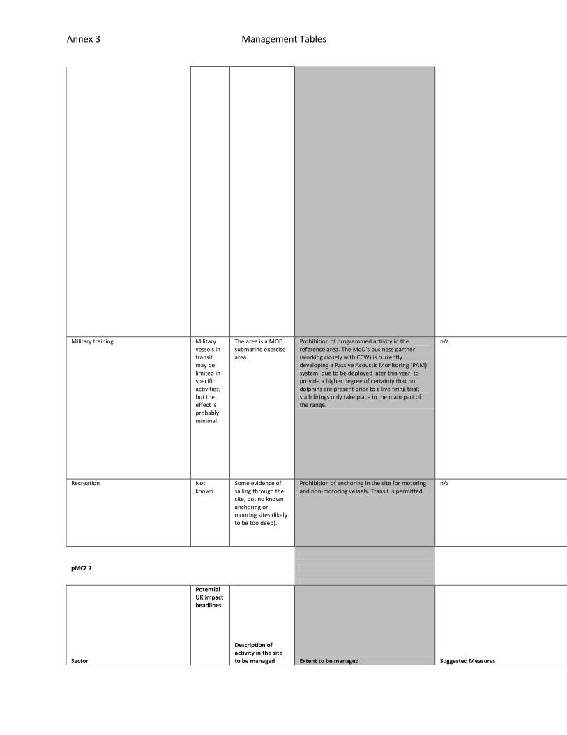
Annex 3 Management Tables
ffective unless have <2 hr pings.
Military training Military vessels in transit may be limited in specific activities, but the effect is probably minimal.
The area is a MOD submarine exercise area.
Prohibition of programmed activity in the reference area. The MoD's business partner (working closely with CCW) is currently developing a Passive Acoustic Monitoring (PAM) system, due to be deployed later this year, to provide a higher degree of certainty that no dolphins are present prior to a live firing trial; such firings only take place in the main part of the range.
n/a n/a
n/a
n/a
Recreation Not known
Some evidence of sailing through the site, but no known anchoring or mooring sites (likely to be too deep).
Prohibition of anchoring in the site for motoring and non-motoring vessels. Transit is permitted.
n/a n/a
n/a
n/a
pMCZ 7
Sector
Potential UK impact headlines
Description of activity in the site to be managed Extent to be managed Suggested Measures
Feasibilit
Effectiven
Resource I
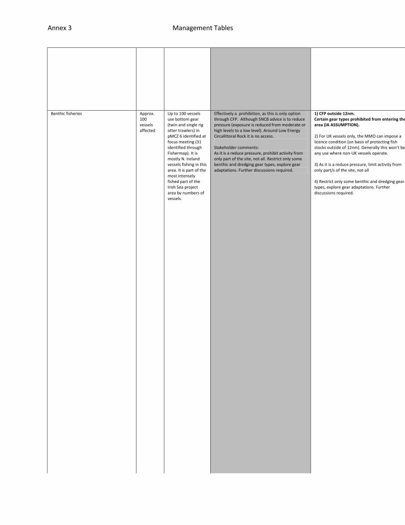
Annex 3 Management Tables
y ess
mplications
Benthic fisheries Approx. 100 vessels affected
Up to 100 vessels use bottom gear (twin and single rig otter trawlers) in pMCZ 6 identified at focus meeting (31 identified through Fishermap). It is mostly N. Ireland vessels fishing in this area. It is part of the most intensely fished part of the Irish Sea project area by numbers of vessels.
Effectively a prohibition, as this is only option through CFP. Although SNCB advice is to reduce pressure (exposure is reduced from moderate or high levels to a low level). Around Low Energy Circalittoral Rock it is no access. Stakeholder comments: As it is a reduce pressure, prohibit activity from only part of the site, not all. Restrict only some benthic and dredging gear types, explore gear adaptations. Further discussions required.
1) CFP outside 12nm. Certain gear types prohibited from entering the area (IA ASSUMPTION). 2) For UK vessels only, the MMO can impose a licence condition (on basis of protecting fish stocks outside of 12nm). Generally this won’t be any use where non-UK vessels operate. 3) As it is a reduce pressure, limit activity from only part/s of the site, not all 4) Restrict only some benthic and dredging gear types, explore gear adaptations. Further discussions required.
All potential vessels could have increased pings, via mobile pho
Enforceable only through VMS monitoring, and perhaps a patrol bo
This system is being trialled in Lyme Bay. There would be a cost

Annex 3 Management Tables
nes, All vessels in who want to fish in the area would have duty to acquire
at to back up but not necessary. Existing surveillance consists of 2hr ping
to skippers for reporting through enhanced VMS including purchase of mobil
Annex 3 Management Tables
this technology. Mobile phone app would support a greater frequency of VMS
s. This will not be sufficient for zones as a boat can travel along with wi
e phone technology. There would be an increased cost to authorities for mon

Annex 3 Management Tables
pings. If the case, this would remove the need for patrol vessels.
thin 2hrs depending on its speed. Can also set up alarm zones (geofencing)
itoring but potentially offset by not needing patrol boat.

Annex 3 Management Tables
to inform authority that a vessel has crossed the boundary but this is not
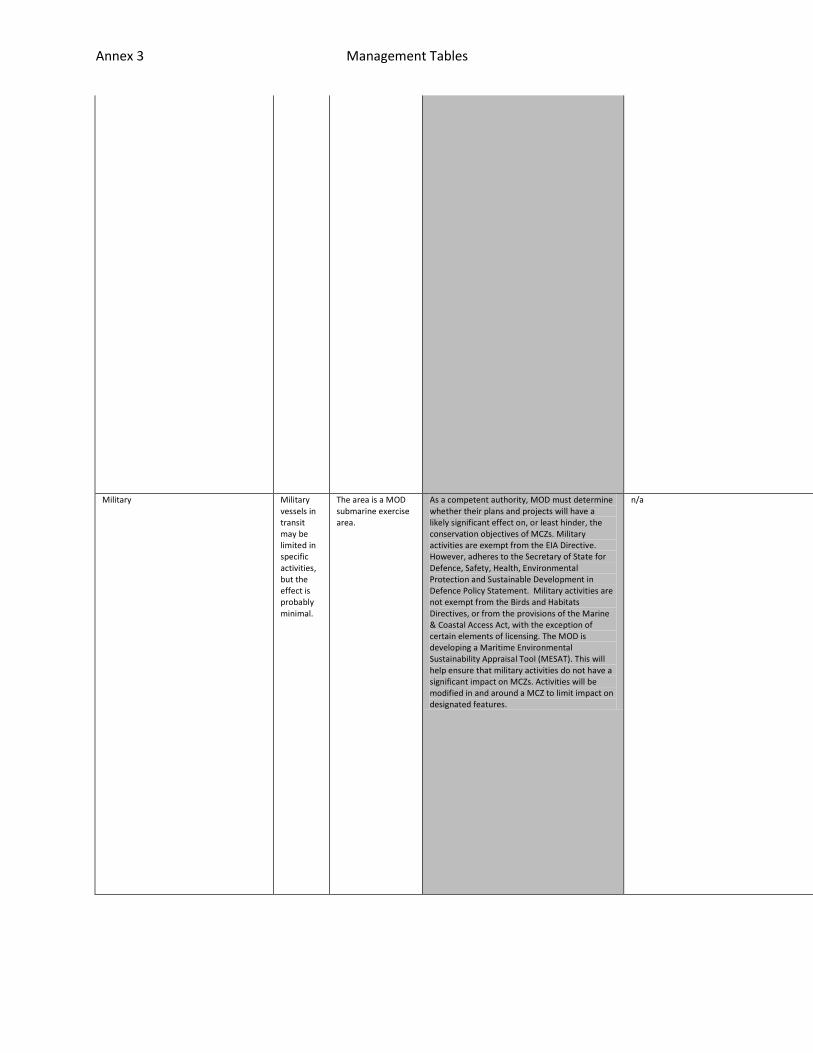
Annex 3 Management Tables
effective unless have <2 hr pings.
Military Military vessels in transit may be limited in specific activities, but the effect is probably minimal.
The area is a MOD submarine exercise area.
As a competent authority, MOD must determine whether their plans and projects will have a likely significant effect on, or least hinder, the conservation objectives of MCZs. Military activities are exempt from the EIA Directive. However, adheres to the Secretary of State for Defence, Safety, Health, Environmental Protection and Sustainable Development in Defence Policy Statement. Military activities are not exempt from the Birds and Habitats Directives, or from the provisions of the Marine & Coastal Access Act, with the exception of certain elements of licensing. The MOD is developing a Maritime Environmental Sustainability Appraisal Tool (MESAT). This will help ensure that military activities do not have a significant impact on MCZs. Activities will be modified in and around a MCZ to limit impact on designated features.
n/a n/a
n/a
n/a
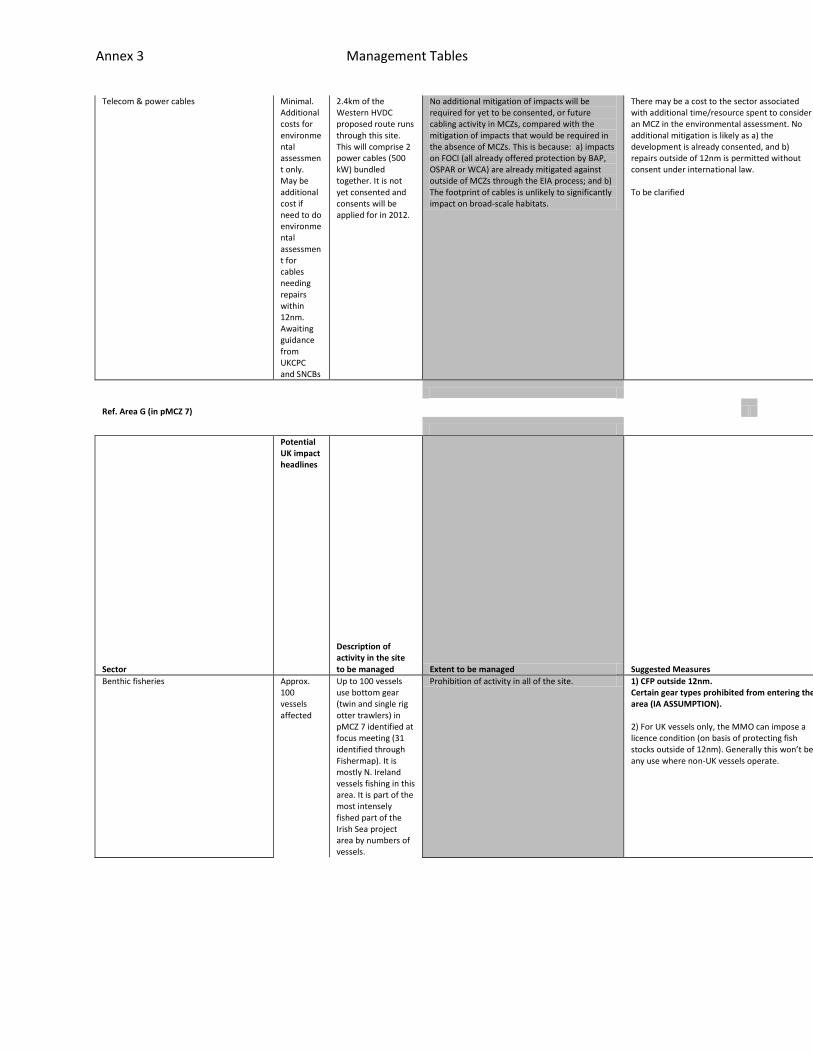
Annex 3 Management Tables
Telecom & power cables Minimal. Additional costs for environmental assessment only. May be additional cost if need to do environmental assessment for cables needing repairs within 12nm. Awaiting guidance from UKCPC and SNCBs
2.4km of the Western HVDC proposed route runs through this site. This will comprise 2 power cables (500 kW) bundled together. It is not yet consented and consents will be applied for in 2012.
No additional mitigation of impacts will be required for yet to be consented, or future cabling activity in MCZs, compared with the mitigation of impacts that would be required in the absence of MCZs. This is because: a) impacts on FOCI (all already offered protection by BAP, OSPAR or WCA) are already mitigated against outside of MCZs through the EIA process; and b) The footprint of cables is unlikely to significantly impact on broad-scale habitats.
There may be a cost to the sector associated with additional time/resource spent to consider an MCZ in the environmental assessment. No additional mitigation is likely as a) the development is already consented, and b) repairs outside of 12nm is permitted without consent under international law. To be clarified
n/a
n/a
n/a
Ref. Area G (in pMCZ 7)
Sector
Potential UK impact headlines
Description of activity in the site to be managed Extent to be managed Suggested Measures
Feasibility
Effectiveness
Resource Implications
Benthic fisheries Approx. 100 vessels affected
Up to 100 vessels use bottom gear (twin and single rig otter trawlers) in pMCZ 7 identified at focus meeting (31 identified through Fishermap). It is mostly N. Ireland vessels fishing in this area. It is part of the most intensely fished part of the Irish Sea project area by numbers of vessels.
Prohibition of activity in all of the site. 1) CFP outside 12nm. Certain gear types prohibited from entering the area (IA ASSUMPTION). 2) For UK vessels only, the MMO can impose a licence condition (on basis of protecting fish stocks outside of 12nm). Generally this won’t be any use where non-UK vessels operate.
All potential ve
Enforceable only
This system is b

Annex 3 Management Tables
Pelagic trawling At least 7 vessels
Fishermap has indicated at least seven vessels midwater trawling for herring, whitefish and prawn in the site all year but mostly autumn months.
Prohibition of activity in all of the site. ssels could have increased pings, via mobile phones, All vessels in who wan
through VMS monitoring, and perhaps a patrol boat to back up but not neces
eing trialled in Lyme Bay. There would be a cost to skippers for reporting

Annex 3 Management Tables
t to fish in the area would have duty to acquire this technology. Mobile ph
sary. Existing surveillance consists of 2hr pings. This will not be suffici
through enhanced VMS including purchase of mobile phone technology. There w

Annex 3 Management Tables
one app would support a greater frequency of VMS pings. If the case, this w
ent for zones as a boat can travel along with within 2hrs depending on its
ould be an increased cost to authorities for monitoring but potentially off

Annex 3 Management Tables
ould remove the need for patrol vessels.
speed. Can also set up alarm zones (geofencing) to inform authority that a
set by not needing patrol boat.

Annex 3 Management Tables
vessel has crossed the boundary but this is not effective unless have <2 hr
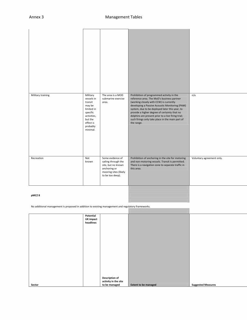
Annex 3 Management Tables
pings.
Military training Military vessels in transit may be limited in specific activities, but the effect is probably minimal.
The area is a MOD submarine exercise area.
Prohibition of programmed activity in the reference area. The MoD's business partner (working closely with CCW) is currently developing a Passive Acoustic Monitoring (PAM) system, due to be deployed later this year, to provide a higher degree of certainty that no dolphins are present prior to a live firing trial; such firings only take place in the main part of the range.
n/a n/a
n/a
n/a
Recreation Not known
Some evidence of sailing through the site, but no known anchoring or mooring sites (likely to be too deep).
Prohibition of anchoring in the site for motoring and non-motoring vessels. Transit is permitted. There is a navigation zone to separate traffic in this area.
Voluntary agreement only. n/a
n/a
n/a
pMCZ 8
No additional management is proposed in addition to existing management and regulatory frameworks.
Sector
Potential UK impact headlines
Description of activity in the site to be managed Extent to be managed Suggested Measures
Feasibility
Effectiveness
Resource Implications
Annex 3 Management Tables
Telecom & power cables Minimal. Additional costs for environmental assessment only. May be additional cost if need to do environmental assessment for cables needing repairs within 12nm. Awaiting guidance from UKCPC and SNCBs
There are five existing telecom cables and one existing power interconnector running between England and the Isle of Man. There is one disused cable within pMCZ 8 also.
No additional mitigation of impacts are likely to be required for yet to be consented, or future cabling activity in MCZs, compared with the mitigation of impacts that would be required in the absence of MCZs. This is because: a) impacts on FOCI (all already offered protection by BAP, OSPAR or WCA) are already mitigated against outside of MCZs through the EIA process; and b) The footprint of cables is unlikely to significantly impact on broad-scale habitats.
There may be a cost to the sector associated with additional time/resource spent to consider an MCZ in the environmental assessment. No additional mitigation is likely as a) the development is already consented, and b) repairs outside of 12nm is permitted without consent under international law. To be clarified.
n/a
n/a
n/a
Oil & gas activity Minimal. Additional costs for environmental assessment only. May be additional costs - to be finalised.
There is currently no oil and gas activity in the site, but the site joins onto the Liverpool Bay oil fields.
No additional mitigation of impacts are likely to be required for yet to be consented, or future oil and gas activity in MCZs, compared with the mitigation of impacts that would be required in the absence of MCZs. This is because generic mitigation measures are likely to be carried out in a similar way for features that are within or outside of a MCZ. This is because: a) impacts on FOCI (all already offered protection by BAP, OSPAR or WCA) are already mitigated against outside of MCZs through the EIA process; and b) the footprint of oil & gas installations is unlikely to significantly impact on broad-scale habitats.
There will be a cost to the sector associated with additional time/resource spent to consider an MCZ in the EIA for activities yet to be consented. May be additional costs - to be clarified. To be clarified.
n/a
n/a
n/a
* For information, there is a closed disposal site in pMCZ 8, formerly used for dumping dredge material dredged from Preston harbour.
pMCZ 10
No additional management is proposed in addition to existing management and regulatory frameworks
Sector
Potential UK impact headlines
Description of activity in the site to be managed Extent to be managed Suggested Measures
Feasibility
Effectiveness
Resource Impl
Annex 3 Management Tables
ications
Coastal defence Not known
There are some existing at Dudmill Point which may require maintenance or reinforcement. There may be 'gabions' in the site in intertidal areas. SMP Scenario A: No active involvement, current process will continue at current rates potentially increasing. SMP Scenario B: Monitoring of the coastal system will take place and involvement may be required if evidence indicated increased erosion
Any ecological impact of operation and maintenance of existing structures, or proposals for new, will need to be considered as part of the planning consent process, most likely via an EIA. Furthermore, the ecological impacts of any proposals will be considered as part of the Water Framework Directive process.
There may be a cost to the Environment Agency or local authority associated with additional time/resource spent to consider an MCZ in an EIA Managed realignment policy between Maryport golf course and Allonby. Will need to consider if temporary construction effects may have an impact on ability to implement managed re-alignment.
n/a
n/a
n/a
Consented discharges Not known
There are 3 known consented point discharges within pMCZ 10, all for Allonby sewage works. There are a further 6 known consented point discharges within 500m of the site. 3 of these are licensed to United Utilities and 3 are licensed privately.
None as it is already the EA remit to assess water quality issues with regard to water bodies out to 1nm. The most significant consented discharge is via a long outfall to the south of the proposed reference site. It is due to be upgraded by 2015. The work will install extra storage with no change in discharge location. The designated Shellfish Water at Silloth was recently extended but it does not look like it extends as far South as the proposed reference site. Therefore there are no additional implications
Any ecological impact will be considered and managed via the Water Framework Directive.
n/a
n/a
n/a
Ref. Area H (in pMCZ 10)
Sector
Potential UK impact headlines
Description of activity in the site to be managed Extent to be managed Suggested Measures
Feasibility
Effectiveness
Resource Impli
Annex 3 Management Tables
cations
Benthic fisheries Approx. < 5 vessels affected. Very unlikely to be any.
From Fishermap, less than five vessels use bottom gear in the site.
Prohibition of activity in all of the site. 1) Voluntary agreement with individuals concerned for fisheries and recreation (IA ASSUMPTION). 2) Publicise section 140 of the MCAA that states it is an offence to damage etc protected features of MCZs. Categories are listed. Can be fined up to £50,000. 3) A UK Prohibition order to ban certain gear types from entering an area within 12nm. 4) For UK vessels only, the MMO can impose a licence condition (on the basis of protecting fish stocks and marine ecosystems within 12nm). 5) IFCA byelaw (not for recreation) (IA ASSUMPTION). 6) MMO emergency byelaw
Speak to EA, local users and local authority. Depends on who is resp
If not adhered too, the back up is an IFCA byelaw or MMO emergency b
There would be a cost in setting up and advertising 1) or/and 2). To
Dredging fisheries Approx. < 5 vessels affected
From Fishermap, less than five vessels dredge in the site.
Prohibition of activity in all of the site.
Netting Approx. < 5 vessels affected
From Fishermap, less than five vessels gill netting for skate and plaice. Focus group identified netting for bass. No VMS data.
Prohibition of activity in all of the site.
Static gear Approx. < 5 vessels affected
From Fishermap, less than five vessels potting for lobsters (inkwells) in the site. This would need to be prohibited.
Prohibition of activity in all of the site.
Hand picking Approx. < 5 fishermen affected
From Fishermap, five people hand picking for cockles and mussels. Focus group identified that periwinkle picking takes place in the site.
Prohibition of activity in all of the site.

Annex 3 Management Tables
onsible to set up voluntary agreement and education.
yelaw.
whom would depend on who is responsible to set up voluntary agreement and

Annex 3 Management Tables
education. Greater costs incurred if this is deemed not to be effective an

Annex 3 Management Tables
d IFCA byelaw or MMO emergency byelaw would need ot be introduced.
Annex 3 Management Tables
Recreational angling Not known.
Shore angling takes place outside of the reference area but there are likely to be angling boats active in the reference area.
Prohibition of activity in all of the site. 1) Voluntary agreement, implemented by NWIFCA (IA ASSUMPTION). 2) NWIFCA byelaw (IA ASSUMPTION).
n/a
n/a
n/a
Coastal defence Minimal impact likely
Focus meeting identified none. There are some existing at Dudmill Point which may require maintenance or reinforcement. There may be 'gabions' in the site in intertidal areas.
Prohibition of activity in all of the site. To be clarified with EA and local authority. n/a
n/a
n/a
Recreation Potentially moderate numbers of recreational users affected
Allonby beach popular for beach visitors/walkers and kitesurfing (from interviews). These activities are assumed not to take palce in the reference area as it is subtidal and these are intertidal activities. Sailing and wind surfing are known to take place in the reference area.
Mitigation of various 'potentially damaging activities' required but there is not sufficient evidence to assess the mitigation needed and the impacts of this at this stage. Prohibition of anchoring in the site for motoring and non-motoring vessels. Transit is permitted.
1) Voluntary agreement, implemented by MMO (IA ASSUMPTION). 2) MMO byelaw (IA ASSUMPTION).
Speak to EA, local users and local authority. Depends
If not adhered too, the back up is an IFCA byelaw or M
There would be a cost in setting up and advertising 1)

Annex 3 Management Tables
on who is responsible to set up voluntary agreement and education.
MO emergency byelaw.
or/and 2). To whom would depend on who is responsible to set up voluntary

Annex 3 Management Tables
agreement and education. Greater costs incurred if this is deemed not to b

Annex 3 Management Tables
e effective and IFCA byelaw or MMO emergency byelaw would need ot be introd
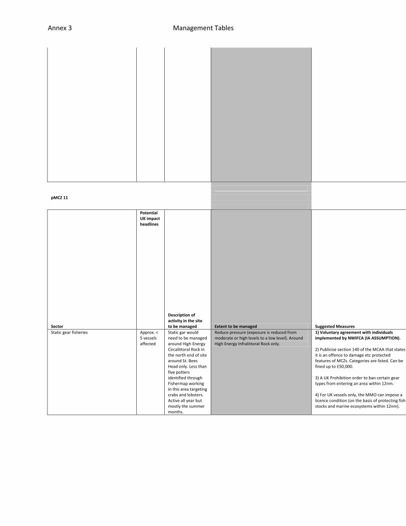
Annex 3 Management Tables
uced.
pMCZ 11
Sector
Potential UK impact headlines
Description of activity in the site to be managed Extent to be managed Suggested Measures
Feasibility
Effectiveness
Resource Implications
Static gear fisheries Approx. < 5 vessels affected
Static gar would need to be managed around High Energy Circalittoral Rock in the north end of site around St. Bees Head only. Less than five potters identified through Fishermap working in this area targeting crabs and lobsters. Active all year but mostly the summer months.
Reduce pressure (exposure is reduced from moderate or high levels to a low level). Around High Energy Infralittoral Rock only.
1) Voluntary agreement with individuals implemented by NWIFCA (IA ASSUMPTION). 2) Publicise section 140 of the MCAA that states it is an offence to damage etc protected features of MCZs. Categories are listed. Can be fined up to £50,000. 3) A UK Prohibition order to ban certain gear types from entering an area within 12nm. 4) For UK vessels only, the MMO can impose a licence condition (on the basis of protecting fish stocks and marine ecosystems within 12nm).
Speak to EA, lo
If not adhered
There would be
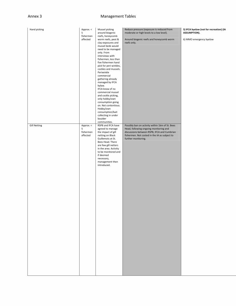
Annex 3 Management Tables
Hand picking Approx. < 5 fishermen affected
Mussel picking around biogenic reefs, honeycomb worm reefs, peat & clay exposures and mussel beds would need to be managed only. From interviews with fishermen, less than five fishermen hand pick for peri-winkles, cockles and mussels. Periwinkle commercial gathering already managed by IFCA bylaw. IFCA know of no commercial mussel and cockle picking, only hobby/own consumption going on. Not contentious. Hobby/own consumption/bait collecting in under boulder communities.
Reduce pressure (exposure is reduced from moderate or high levels to a low level). Around biogenic reefs and honeycomb worm reefs only.
5) IFCA byelaw (not for recreation) (IA ASSUMPTION). 6) MMO emergency byelaw
cal users and local authority. Depends on who is responsible to set up volu
too, the back up is an IFCA byelaw or MMO emergency byelaw.
a cost in setting up and advertising 1) or/and 2). To whom would depend on
Gill Netting Approx. < 5 fishermen affected
RSPB and IFCA have agreed to manage the impact of gill netting on Black Guillemots at St. Bees Head. There are few gill netters in the area. Activity to be monitored and if deemed necessary, management then introduced.
Possibly ban on activity within 1km of St. Bees Head, following ongoing monitoring and discussions between RSPB, IFCA and Cumbrian fishermen. Not costed in the IA as subject to further monitoring.

Annex 3 Management Tables
ntary agreement and education.
who is responsible to set up voluntary agreement and education. Greater co

Annex 3 Management Tables
sts incurred if this is deemed not to be effective and IFCA byelaw or MMO e
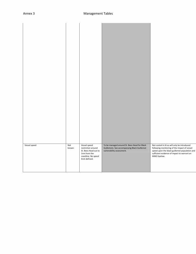
Annex 3 Management Tables
mergency byelaw would need ot be introduced.
Vessel speed Not known.
Vessel speed restriction around St. Bees Head out to 1nm from the coastline. No speed limit defined.
To be managed around St. Bees Head for Black Guillemots. See accompanying Black Guillemot vulnerability assessment.
Not costed in IA as will only be introduced following monitoring of the impact of vessel speed upon the black guillemot population and sufficient evidence of impact to warrant an MMO byelaw.
n/a
n/a
n/a
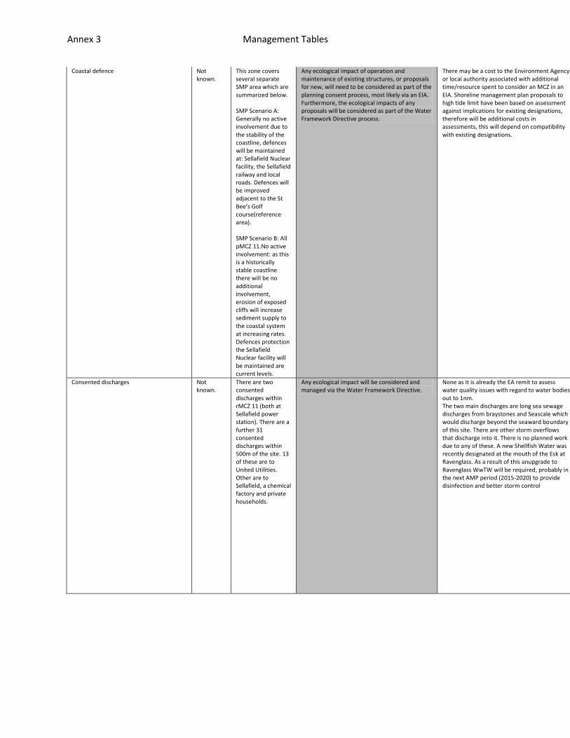
Annex 3 Management Tables
Coastal defence Not known.
This zone covers several separate SMP area which are summarized below. SMP Scenario A: Generally no active involvement due to the stability of the coastline, defences will be maintained at: Sellafield Nuclear facility, the Sellafield railway and local roads. Defences will be improved adjacent to the St Bee’s Golf course(reference area). SMP Scenario B: All pMCZ 11.No active involvement: as this is a historically stable coastline there will be no additional involvement, erosion of exposed cliffs will increase sediment supply to the coastal system at increasing rates. Defences protection the Sellafield Nuclear facility will be maintained are current levels.
Any ecological impact of operation and maintenance of existing structures, or proposals for new, will need to be considered as part of the planning consent process, most likely via an EIA. Furthermore, the ecological impacts of any proposals will be considered as part of the Water Framework Directive process.
There may be a cost to the Environment Agency or local authority associated with additional time/resource spent to consider an MCZ in an EIA. Shoreline management plan proposals to high tide limit have been based on assessment against implications for existing designations, therefore will be additional costs in assessments, this will depend on compatibility with existing designations.
n/a
n/a
n/a
Consented discharges Not known.
There are two consented discharges within rMCZ 11 (both at Sellafield power station). There are a further 31 consented discharges within 500m of the site. 13 of these are to United Utilities. Other are to Sellafield, a chemical factory and private households.
Any ecological impact will be considered and managed via the Water Framework Directive.
None as it is already the EA remit to assess water quality issues with regard to water bodies out to 1nm. The two main discharges are long sea sewage discharges from braystones and Seascale which would discharge beyond the seaward boundary of this site. There are other storm overflows that discharge into it. There is no planned work due to any of these. A new Shellfish Water was recently designated at the mouth of the Esk at Ravenglass. As a result of this anupgrade to Ravenglass WwTW will be required, probably in the next AMP period (2015-2020) to provide disinfection and better storm control
n/a
n/a
n/a
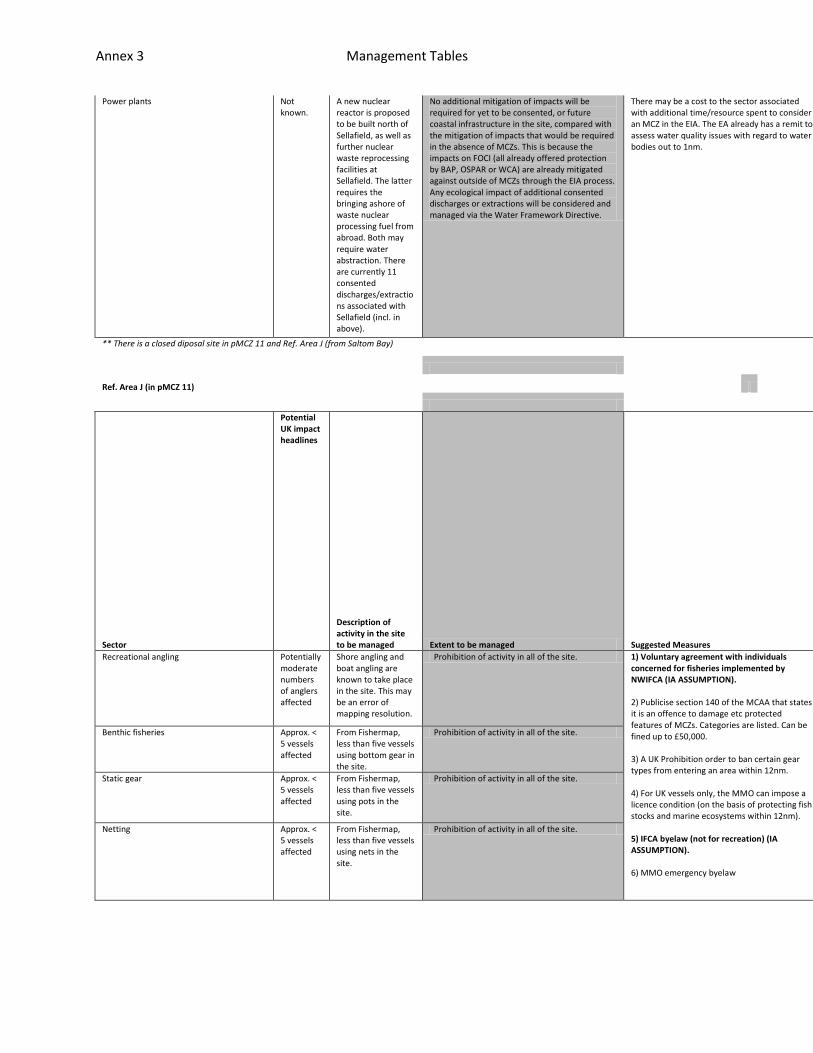
Annex 3 Management Tables
Power plants Not known.
A new nuclear reactor is proposed to be built north of Sellafield, as well as further nuclear waste reprocessing facilities at Sellafield. The latter requires the bringing ashore of waste nuclear processing fuel from abroad. Both may require water abstraction. There are currently 11 consented discharges/extractions associated with Sellafield (incl. in above).
No additional mitigation of impacts will be required for yet to be consented, or future coastal infrastructure in the site, compared with the mitigation of impacts that would be required in the absence of MCZs. This is because the impacts on FOCI (all already offered protection by BAP, OSPAR or WCA) are already mitigated against outside of MCZs through the EIA process. Any ecological impact of additional consented discharges or extractions will be considered and managed via the Water Framework Directive.
There may be a cost to the sector associated with additional time/resource spent to consider an MCZ in the EIA. The EA already has a remit to assess water quality issues with regard to water bodies out to 1nm.
n/a
n/a
n/a
** There is a closed diposal site in pMCZ 11 and Ref. Area J (from Saltom Bay)
Ref. Area J (in pMCZ 11)
Sector
Potential UK impact headlines
Description of activity in the site to be managed Extent to be managed Suggested Measures
Feasibility
Effectiveness
Resource Implications
Recreational angling Potentially moderate numbers of anglers affected
Shore angling and boat angling are known to take place in the site. This may be an error of mapping resolution.
Prohibition of activity in all of the site. 1) Voluntary agreement with individuals concerned for fisheries implemented by NWIFCA (IA ASSUMPTION). 2) Publicise section 140 of the MCAA that states it is an offence to damage etc protected features of MCZs. Categories are listed. Can be fined up to £50,000. 3) A UK Prohibition order to ban certain gear types from entering an area within 12nm. 4) For UK vessels only, the MMO can impose a licence condition (on the basis of protecting fish stocks and marine ecosystems within 12nm). 5) IFCA byelaw (not for recreation) (IA ASSUMPTION). 6) MMO emergency byelaw
Deemed to be very lit
If not adhered too, t
Sufficient evidence o
Benthic fisheries Approx. < 5 vessels affected
From Fishermap, less than five vessels using bottom gear in the site.
Prohibition of activity in all of the site.
Static gear Approx. < 5 vessels affected
From Fishermap, less than five vessels using pots in the site.
Prohibition of activity in all of the site.
Netting Approx. < 5 vessels affected
From Fishermap, less than five vessels using nets in the site.
Prohibition of activity in all of the site.
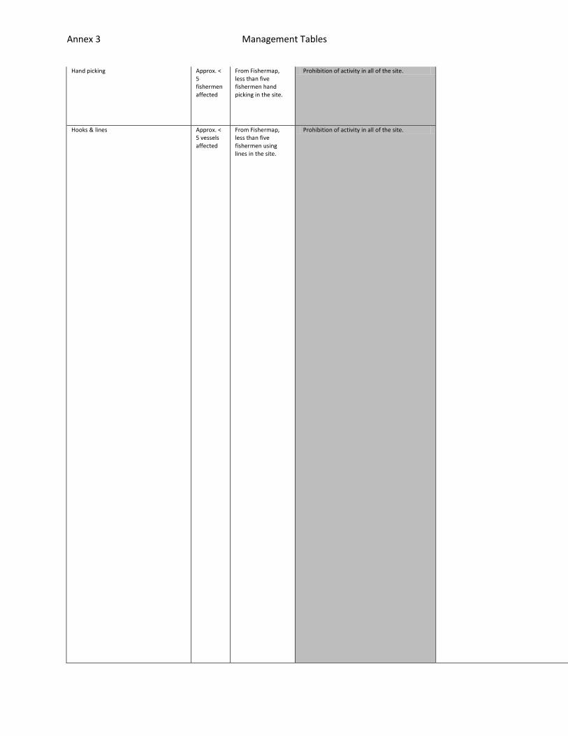
Annex 3 Management Tables
Hand picking Approx. < 5 fishermen affected
From Fishermap, less than five fishermen hand picking in the site.
Prohibition of activity in all of the site. tle activity going on, therefore IFCA byelaw or order is not warranted. Onl
he back up is an IFCA byelaw/order or MMO emergency byelaw.
f risk of impact required prior to byelaw. A statutory measure would be exp
Hooks & lines Approx. < 5 vessels affected
From Fishermap, less than five fishermen using lines in the site.
Prohibition of activity in all of the site.

Annex 3 Management Tables
y there as a back-up. A voluntary measure to be explored first, advertised
ensive to put in place and potentially disproportionate. Only put in if suf
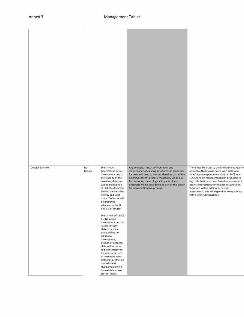
Annex 3 Management Tables
with offence under section 140 of MCAA.
ficient evidence of risk.
Coastal defence Not known
Scenario A: Generally no active involvement due to the stability of the coastline, defences will be maintained at: Sellafield Nuclear facility, the Sellafield railway and local roads. Defences will be improved adjacent to the St Bee’s Golf course. Scenario B: All pMCZ 11. No active involvement: as this is a historically stable coastline there will be no additional involvement, erosion of exposed cliffs will increase sediment supply to the coastal system at increasing rates. Defences protection the Sellafield Nuclear facility will be maintained are current levels.
Any ecological impact of operation and maintenance of existing structures, or proposals for new, will need to be considered as part of the planning consent process, most likely via an EIA. Furthermore, the ecological impacts of any proposals will be considered as part of the Water Framework Directive process.
There may be a cost to the Environment Agency or local authority associated with additional time/resource spent to consider an MCZ in an EIA. Shoreline management plan proposals to high tide limit have been based on assessment against implications for existing designations, therefore will be additional costs in assessments, this will depend on compatibility with existing designations.
n/a
n/a
n/a
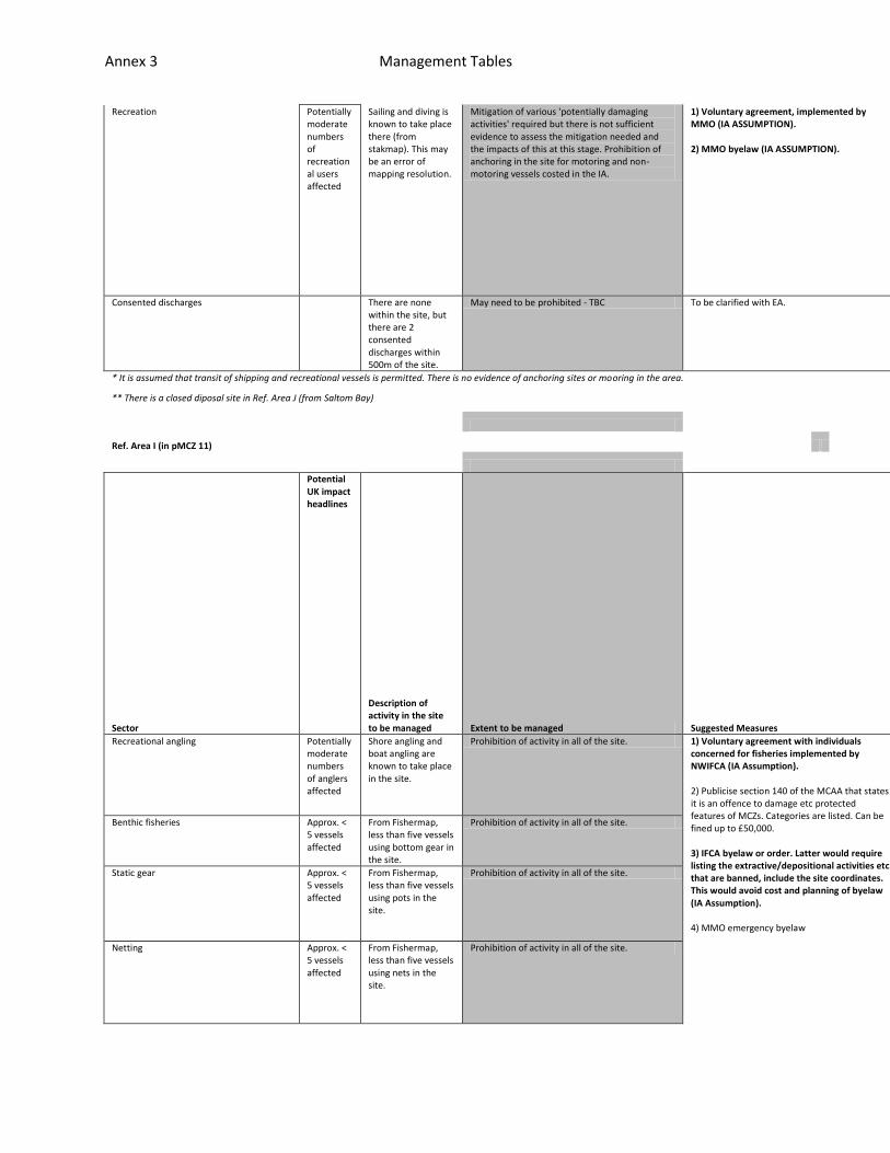
Annex 3 Management Tables
Recreation Potentially moderate numbers of recreational users affected
Sailing and diving is known to take place there (from stakmap). This may be an error of mapping resolution.
Mitigation of various 'potentially damaging activities' required but there is not sufficient evidence to assess the mitigation needed and the impacts of this at this stage. Prohibition of anchoring in the site for motoring and non-motoring vessels costed in the IA.
1) Voluntary agreement, implemented by MMO (IA ASSUMPTION). 2) MMO byelaw (IA ASSUMPTION).
n/a
n/a
n/a
Consented discharges
There are none within the site, but there are 2 consented discharges within 500m of the site.
May need to be prohibited - TBC To be clarified with EA. n/a
n/a
n/a
* It is assumed that transit of shipping and recreational vessels is permitted. There is no evidence of anchoring sites or mooring in the area.
** There is a closed diposal site in Ref. Area J (from Saltom Bay)
Ref. Area I (in pMCZ 11)
Sector
Potential UK impact headlines
Description of activity in the site to be managed Extent to be managed Suggested Measures
Feasibility
Effectiveness
Resource Implications
Recreational angling Potentially moderate numbers of anglers affected
Shore angling and boat angling are known to take place in the site.
Prohibition of activity in all of the site. 1) Voluntary agreement with individuals concerned for fisheries implemented by NWIFCA (IA Assumption). 2) Publicise section 140 of the MCAA that states it is an offence to damage etc protected features of MCZs. Categories are listed. Can be fined up to £50,000. 3) IFCA byelaw or order. Latter would require listing the extractive/depositional activities etc. that are banned, include the site coordinates. This would avoid cost and planning of byelaw (IA Assumption). 4) MMO emergency byelaw
Deemed to be very littl
If not adhered too, the
Sufficient evidence of
Benthic fisheries Approx. < 5 vessels affected
From Fishermap, less than five vessels using bottom gear in the site.
Prohibition of activity in all of the site.
Static gear Approx. < 5 vessels affected
From Fishermap, less than five vessels using pots in the site.
Prohibition of activity in all of the site.
Netting Approx. < 5 vessels affected
From Fishermap, less than five vessels using nets in the site.
Prohibition of activity in all of the site.

Annex 3 Management Tables
Hand picking Approx. < 5 fishermen affected
From Fishermap, less than five fishermen hand picking in the site.
Prohibition of activity in all of the site. e activity going on, therefore IFCA byelaw or order is not warranted. Only
back up is an IFCA byelaw/order or MMO emergency byelaw.
risk of impact required prior to byelaw. A statutory measure would be expen

Annex 3 Management Tables
there as a back-up. A voluntary measure to be explored first, advertised wi
sive to put in place and potentially disproportionate. Only put in if suffi
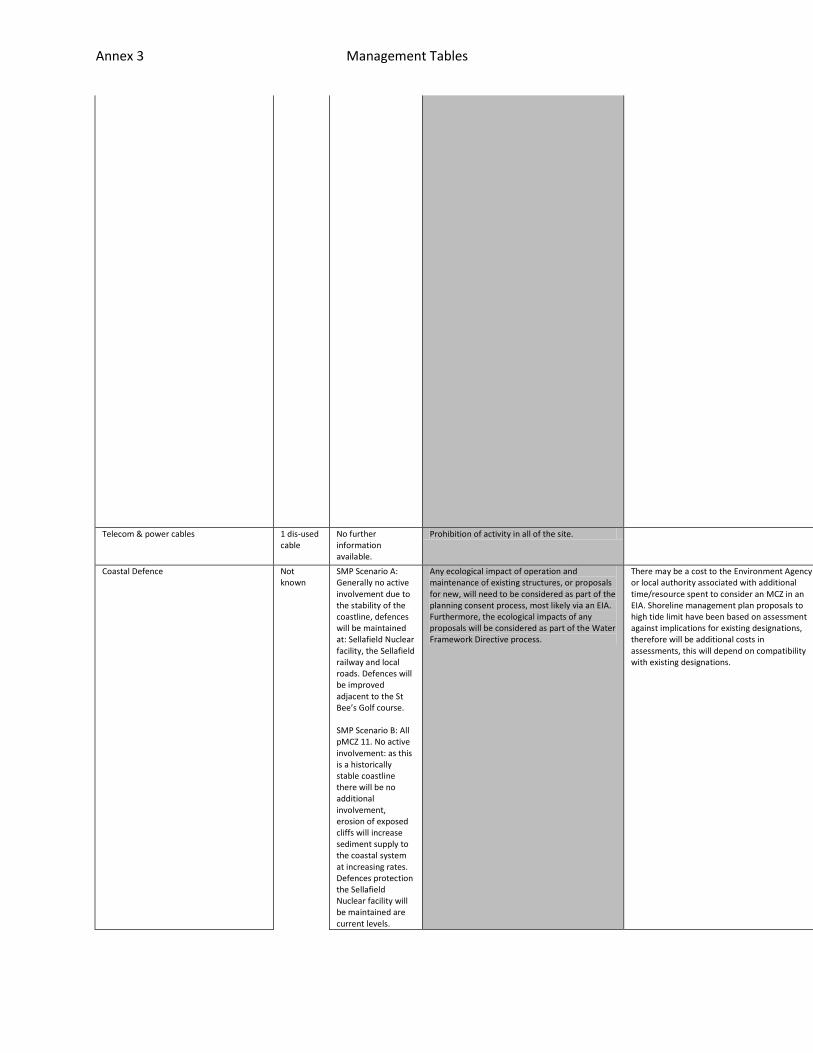
Annex 3 Management Tables
th offence under section 140 of MCAA.
cient evidence of risk.
Telecom & power cables 1 dis-used cable
No further information available.
Prohibition of activity in all of the site. n/a
n/a
n/a
Coastal Defence Not known
SMP Scenario A: Generally no active involvement due to the stability of the coastline, defences will be maintained at: Sellafield Nuclear facility, the Sellafield railway and local roads. Defences will be improved adjacent to the St Bee’s Golf course. SMP Scenario B: All pMCZ 11. No active involvement: as this is a historically stable coastline there will be no additional involvement, erosion of exposed cliffs will increase sediment supply to the coastal system at increasing rates. Defences protection the Sellafield Nuclear facility will be maintained are current levels.
Any ecological impact of operation and maintenance of existing structures, or proposals for new, will need to be considered as part of the planning consent process, most likely via an EIA. Furthermore, the ecological impacts of any proposals will be considered as part of the Water Framework Directive process.
There may be a cost to the Environment Agency or local authority associated with additional time/resource spent to consider an MCZ in an EIA. Shoreline management plan proposals to high tide limit have been based on assessment against implications for existing designations, therefore will be additional costs in assessments, this will depend on compatibility with existing designations.
n/a
n/a
n/a
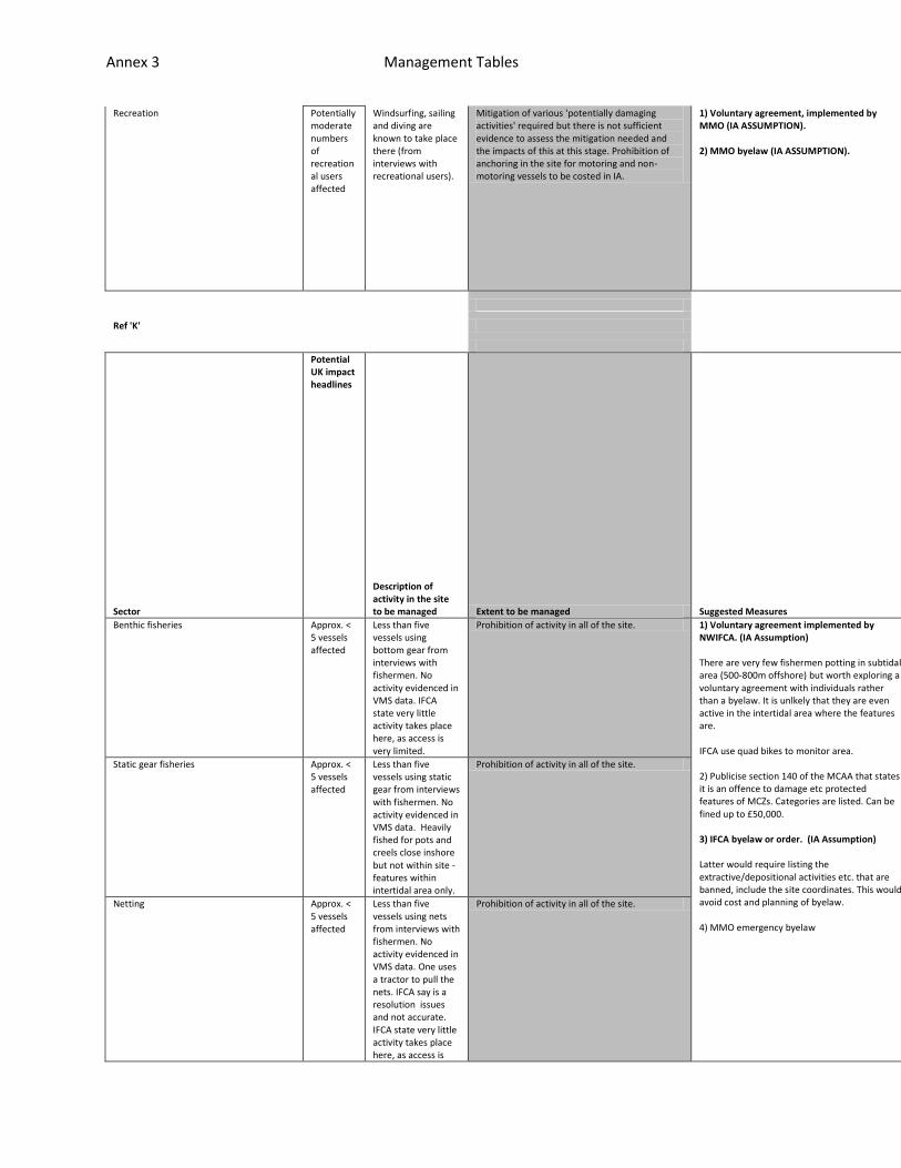
Annex 3 Management Tables
Recreation Potentially moderate numbers of recreational users affected
Windsurfing, sailing and diving are known to take place there (from interviews with recreational users).
Mitigation of various 'potentially damaging activities' required but there is not sufficient evidence to assess the mitigation needed and the impacts of this at this stage. Prohibition of anchoring in the site for motoring and non-motoring vessels to be costed in IA.
1) Voluntary agreement, implemented by MMO (IA ASSUMPTION). 2) MMO byelaw (IA ASSUMPTION).
n/a
n/a
n/a
Ref 'K'
Sector
Potential UK impact headlines
Description of activity in the site to be managed Extent to be managed Suggested Measures
Feasibility
Effectiveness
Resource Implications
Benthic fisheries Approx. < 5 vessels affected
Less than five vessels using bottom gear from interviews with fishermen. No activity evidenced in VMS data. IFCA state very little activity takes place here, as access is very limited.
Prohibition of activity in all of the site. 1) Voluntary agreement implemented by NWIFCA. (IA Assumption) There are very few fishermen potting in subtidal area (500-800m offshore) but worth exploring a voluntary agreement with individuals rather than a byelaw. It is unlkely that they are even active in the intertidal area where the features are. IFCA use quad bikes to monitor area. 2) Publicise section 140 of the MCAA that states it is an offence to damage etc protected features of MCZs. Categories are listed. Can be fined up to £50,000. 3) IFCA byelaw or order. (IA Assumption) Latter would require listing the extractive/depositional activities etc. that are banned, include the site coordinates. This would avoid cost and planning of byelaw. 4) MMO emergency byelaw
Deemed to be very little activity g
If not adhered too, the back up is
Sufficient evidence of risk of impa
Static gear fisheries Approx. < 5 vessels affected
Less than five vessels using static gear from interviews with fishermen. No activity evidenced in VMS data. Heavily fished for pots and creels close inshore but not within site - features within intertidal area only.
Prohibition of activity in all of the site.
Netting Approx. < 5 vessels affected
Less than five vessels using nets from interviews with fishermen. No activity evidenced in VMS data. One uses a tractor to pull the nets. IFCA say is a resolution issues and not accurate. IFCA state very little activity takes place here, as access is
Prohibition of activity in all of the site.
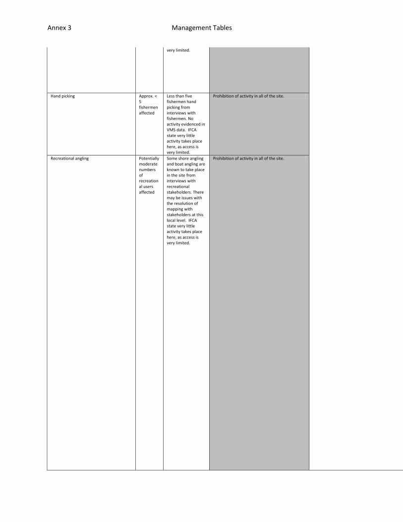
Annex 3 Management Tables
very limited. oing on, therefore IFCA byelaw or order is not warranted. Only there as a b
an IFCA byelaw/order or MMO emergency byelaw.
ct required prior to byelaw. A statutory measure would be expensive to put
Hand picking Approx. < 5 fishermen affected
Less than five fishermen hand picking from interviews with fishermen. No activity evidenced in VMS data. IFCA state very little activity takes place here, as access is very limited.
Prohibition of activity in all of the site.
Recreational angling Potentially moderate numbers of recreational users affected
Some shore angling and boat angling are known to take place in the site from interviews with recreational stakeholders. There may be issues with the resolution of mapping with stakeholders at this local level. IFCA state very little activity takes place here, as access is very limited.
Prohibition of activity in all of the site.
Annex 3 Management Tables
ack-up. A voluntary measure to be explored first, advertised with offence u
in place and potentially disproportionate. Only put in if sufficient eviden
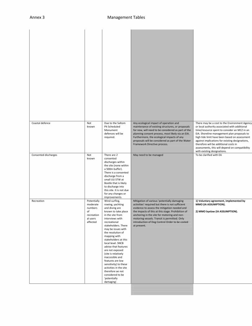
Annex 3 Management Tables
nder section 140 of MCAA.
ce of risk.
Coastal defence Not known
Due to the Saltom Pit Scheduled Monument defences will be required.
Any ecological impact of operation and maintenance of existing structures, or proposals for new, will need to be considered as part of the planning consent process, most likely via an EIA. Furthermore, the ecological impacts of any proposals will be considered as part of the Water Framework Directive process.
There may be a cost to the Environment Agency or local authority associated with additional time/resource spent to consider an MCZ in an EIA. Shoreline management plan proposals to high tide limit have been based on assessment against implications for existing designations, therefore will be additional costs in assessments, this will depend on compatibility with existing designations.
n/a
n/a
n/a
Consented discharges Not known
There are 2 consented discharges within the site (none within a 500m buffer). There is a consented discharge from a small UU STW at Bootle that is likely to discharge into this site. It is not due for any changes or improvements.
May need to be managed To be clarified with EA n/a
n/a
n/a
Recreation Potentially moderate numbers of recreational users affected
Wind surfing, rowing, yachting and diving are known to take place in the site from interviews with recreational stakeholders. There may be issues with the resolution of mapping with stakeholders at this local level. SNCB advise that features are not exposed (site is relatively inaccesible and features are low sensitivity) to these activities in the site therefore ae not considered to be 'potentially damaging'.
Mitigation of various 'potentially damaging activities' required but there is not sufficient evidence to assess the mitigation needed and the impacts of this at this stage. Prohibition of anchoring in the site for motoring and non-motoring vessels. Transit is permitted. Only introduction of Dog Control Order to be costed at present.
1) Voluntary agreement, implemented by MMO (IA ASSUMPTION). 2) MMO byelaw (IA ASSUMPTION).
n/a
n/a
n/a
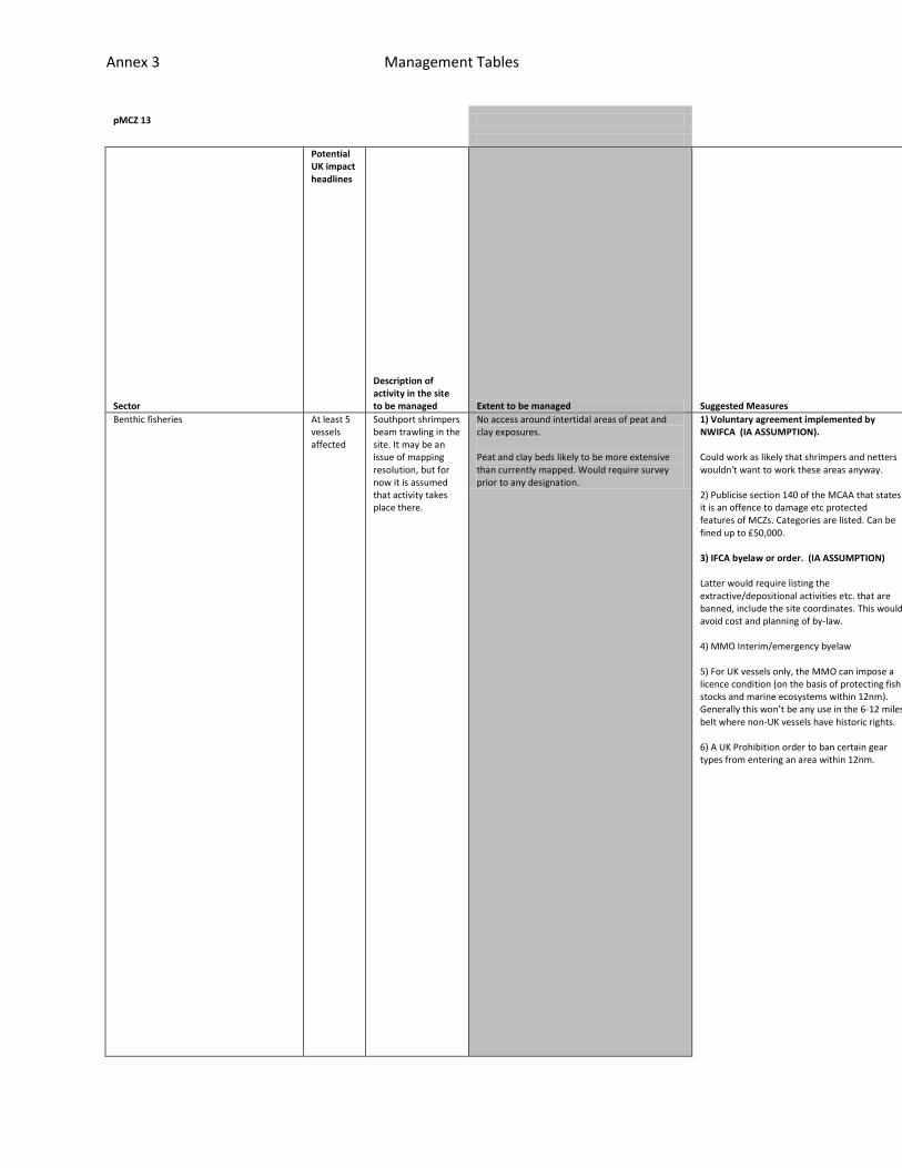
Annex 3 Management Tables
pMCZ 13
Sector
Potential UK impact headlines
Description of activity in the site to be managed Extent to be managed Suggested Measures
Feasibility
Effectiveness
Resource Implications
Benthic fisheries At least 5 vessels affected
Southport shrimpers beam trawling in the site. It may be an issue of mapping resolution, but for now it is assumed that activity takes place there.
No access around intertidal areas of peat and clay exposures. Peat and clay beds likely to be more extensive than currently mapped. Would require survey prior to any designation.
1) Voluntary agreement implemented by NWIFCA (IA ASSUMPTION). Could work as likely that shrimpers and netters wouldn't want to work these areas anyway. 2) Publicise section 140 of the MCAA that states it is an offence to damage etc protected features of MCZs. Categories are listed. Can be fined up to £50,000. 3) IFCA byelaw or order. (IA ASSUMPTION) Latter would require listing the extractive/depositional activities etc. that are banned, include the site coordinates. This would avoid cost and planning of by-law. 4) MMO Interim/emergency byelaw 5) For UK vessels only, the MMO can impose a licence condition (on the basis of protecting fish stocks and marine ecosystems within 12nm). Generally this won’t be any use in the 6-12 miles belt where non-UK vessels have historic rights. 6) A UK Prohibition order to ban certain gear types from entering an area within 12nm.
Deemed to be very little activity going on, therefo
If not adhered too, the back up is an IFCA byelaw/o
Sufficient evidence of risk of impact required prio

Annex 3 Management Tables
re IFCA byelaw or order is not warranted. Only there as a back-up. A volunt
rder or MMO emergency byelaw.
r to byelaw. A statutory measure would be expensive to put in place and pot

Annex 3 Management Tables
ary measure to be explored first, advertised with offence under section 140
entially disproportionate. Only put in if sufficient evidence of risk.

Annex 3 Management Tables
of MCAA.
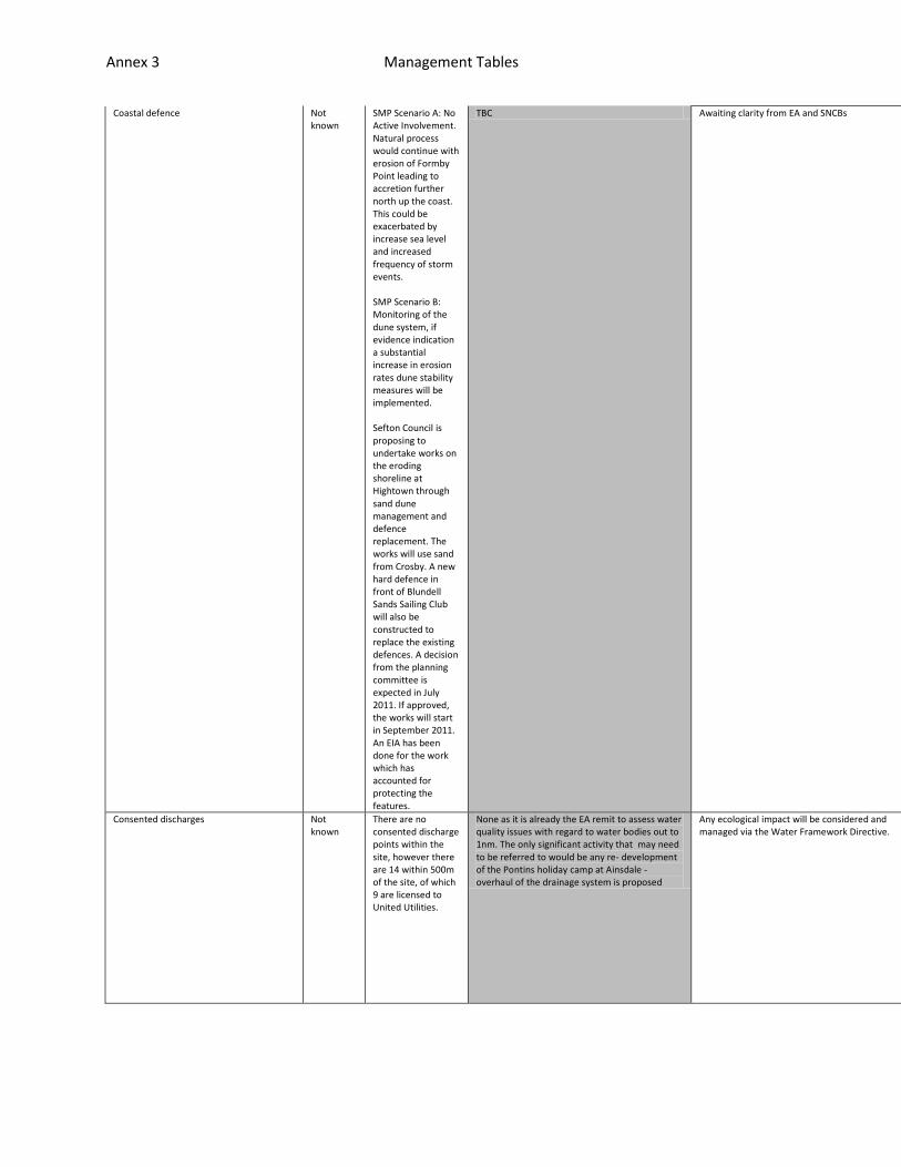
Annex 3 Management Tables
Coastal defence Not known
SMP Scenario A: No Active Involvement. Natural process would continue with erosion of Formby Point leading to accretion further north up the coast. This could be exacerbated by increase sea level and increased frequency of storm events. SMP Scenario B: Monitoring of the dune system, if evidence indication a substantial increase in erosion rates dune stability measures will be implemented. Sefton Council is proposing to undertake works on the eroding shoreline at Hightown through sand dune management and defence replacement. The works will use sand from Crosby. A new hard defence in front of Blundell Sands Sailing Club will also be constructed to replace the existing defences. A decision from the planning committee is expected in July 2011. If approved, the works will start in September 2011. An EIA has been done for the work which has accounted for protecting the features.
TBC Awaiting clarity from EA and SNCBs n/a
n/a
n/a
Consented discharges Not known
There are no consented discharge points within the site, however there are 14 within 500m of the site, of which 9 are licensed to United Utilities.
None as it is already the EA remit to assess water quality issues with regard to water bodies out to 1nm. The only significant activity that may need to be referred to would be any re- development of the Pontins holiday camp at Ainsdale - overhaul of the drainage system is proposed
Any ecological impact will be considered and managed via the Water Framework Directive.
n/a
n/a
n/a
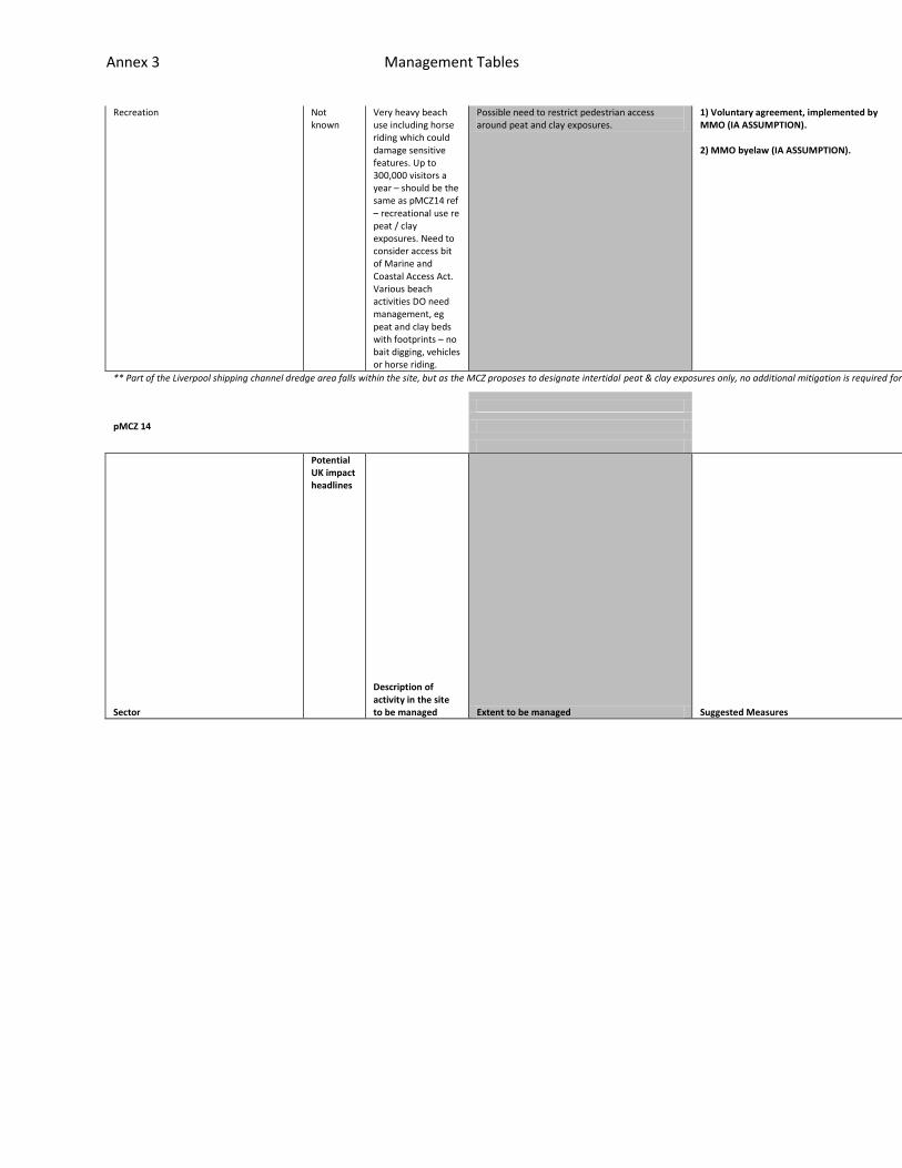
Annex 3 Management Tables
Recreation Not known
Very heavy beach use including horse riding which could damage sensitive features. Up to 300,000 visitors a year – should be the same as pMCZ14 ref – recreational use re peat / clay exposures. Need to consider access bit of Marine and Coastal Access Act. Various beach activities DO need management, eg peat and clay beds with footprints – no bait digging, vehicles or horse riding.
Possible need to restrict pedestrian access around peat and clay exposures.
1) Voluntary agreement, implemented by MMO (IA ASSUMPTION). 2) MMO byelaw (IA ASSUMPTION).
n/a
n/a
n/a
** Part of the Liverpool shipping channel dredge area falls within the site, but as the MCZ proposes to designate intertidal peat & clay exposures only, no additional mitigation is required for this activity.
pMCZ 14
Sector
Potential UK impact headlines
Description of activity in the site to be managed Extent to be managed Suggested Measures
Feasibility
Effectiveness
Resource Implications
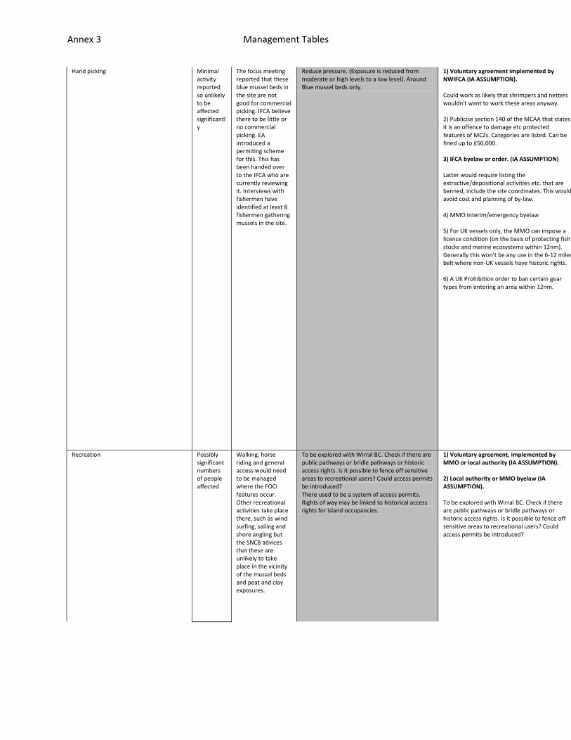
Annex 3 Management Tables
Hand picking Minimal activity reported so unlikely to be affected significantly
The focus meeting reported that these blue mussel beds in the site are not good for commercial picking. IFCA believe there to be little or no commercial picking. EA introduced a permiting scheme for this. This has been handed over to the IFCA who are currently reviewing it. Interviews with fishermen have identified at least 8 fishermen gathering mussels in the site.
Reduce pressure. (Exposure is reduced from moderate or high levels to a low level). Around Blue mussel beds only.
1) Voluntary agreement implemented by NWIFCA (IA ASSUMPTION). Could work as likely that shrimpers and netters wouldn't want to work these areas anyway. 2) Publicise section 140 of the MCAA that states it is an offence to damage etc protected features of MCZs. Categories are listed. Can be fined up to £50,000. 3) IFCA byelaw or order. (IA ASSUMPTION) Latter would require listing the extractive/depositional activities etc. that are banned, include the site coordinates. This would avoid cost and planning of by-law. 4) MMO Interim/emergency byelaw 5) For UK vessels only, the MMO can impose a licence condition (on the basis of protecting fish stocks and marine ecosystems within 12nm). Generally this won’t be any use in the 6-12 miles belt where non-UK vessels have historic rights. 6) A UK Prohibition order to ban certain gear types from entering an area within 12nm.
n/a
n/a
n/a
Recreation Possibly significant numbers of people affected
Walking, horse riding and general access would need to be managed where the FOCI features occur. Other recreational activities take place there, such as wind surfing, sailing and shore angling but the SNCB advices that these are unlikely to take place in the vicinity of the mussel beds and peat and clay exposures.
To be explored with Wirral BC. Check if there are public pathways or bridle pathways or historic access rights. Is it possible to fence off sensitive areas to recreational users? Could access permits be introduced? There used to be a system of access permits. Rights of way may be linked to historical access rights for island occupancies.
1) Voluntary agreement, implemented by MMO or local authority (IA ASSUMPTION). 2) Local authority or MMO byelaw (IA ASSUMPTION). To be explored with Wirral BC. Check if there are public pathways or bridle pathways or historic access rights. Is it possible to fence off sensitive areas to recreational users? Could access permits be introduced?
n/a
n/a
n/a
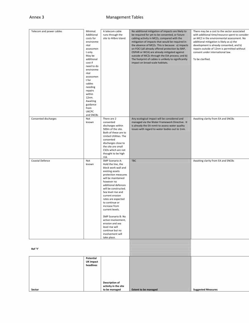
Annex 3 Management Tables
Telecom and power cables Minimal. Additional costs for environmental assessment only. May be additional cost if need to do environmental assessment for cables needing repairs within 12nm. Awaiting guidance from UKCPC and SNCBs
A telecom cable runs through the site to Hilbre Island.
No additional mitigation of impacts are likely to be required for yet to be consented, or future cabling activity in MCZs, compared with the mitigation of impacts that would be required in the absence of MCZs. This is because: a) impacts on FOCI (all already offered protection by BAP, OSPAR or WCA) are already mitigated against outside of MCZs through the EIA process; and b) The footprint of cables is unlikely to significantly impact on broad-scale habitats.
There may be a cost to the sector associated with additional time/resource spent to consider an MCZ in the environmental assessment. No additional mitigation is likely as a) the development is already consented, and b) repairs outside of 12nm is permitted without consent under international law. To be clarified.
n/a
n/a
n/a
Consented discharges Not known
There are 2 consented discharges within 500m of the site. Both of these are to United Utilities. The consented discharges close to the site are small CSOs which are not thought to be high risk.
Any ecological impact will be considered and managed via the Water Framework Directive. It is already the EA remit to assess water quality issues with regard to water bodies out to 1nm.
Awaiting clarity from EA and SNCBs n/a
n/a
n/a
Coastal Defence Not known
SMP Scenario A: Hold the line, the block work wall and existing assets protection measures will be maintained however no additional defences will be constructed. Sea level rise and current erosion rates are expected to continue or increase from current levels. SMP Scenario B: No active involvement, erosion and sea level rise will continue but no involvement will take place.
TBC Awaiting clarity from EA and SNCBs n/a
n/a
n/a
Ref 'Y'
Sector
Potential UK impact headlines
Description of activity in the site to be managed Extent to be managed Suggested Measures
Feasibilit
Effectiven
Resource I
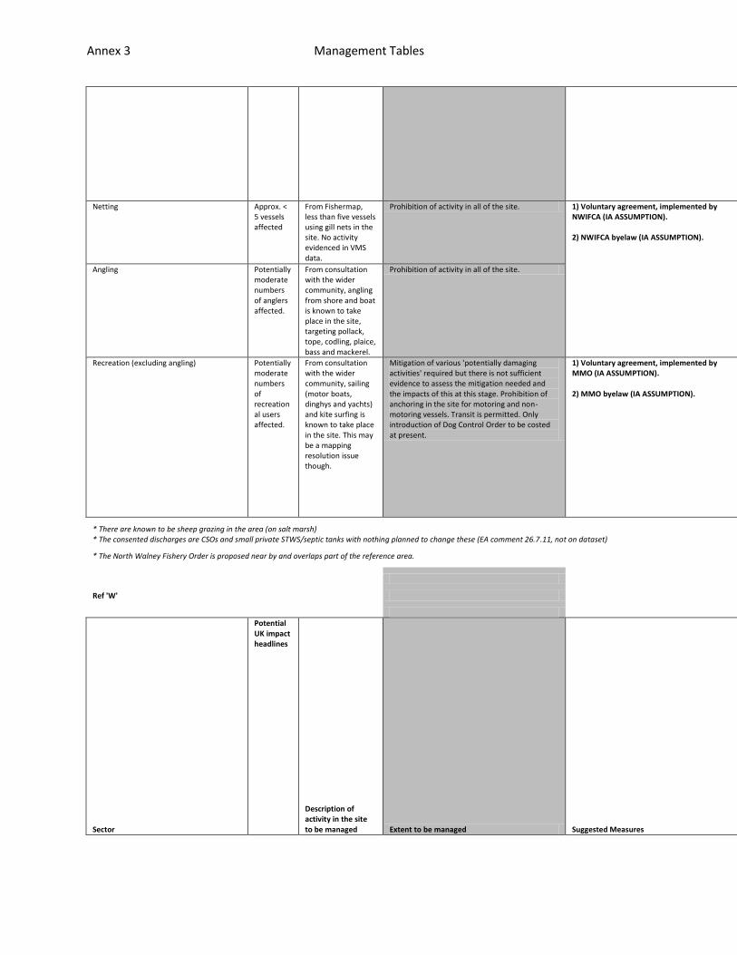
Annex 3 Management Tables
y ess
mplications
Netting Approx. < 5 vessels affected
From Fishermap, less than five vessels using gill nets in the site. No activity evidenced in VMS data.
Prohibition of activity in all of the site. 1) Voluntary agreement, implemented by NWIFCA (IA ASSUMPTION). 2) NWIFCA byelaw (IA ASSUMPTION).
n/a
n/a
n/a
Angling Potentially moderate numbers of anglers affected.
From consultation with the wider community, angling from shore and boat is known to take place in the site, targeting pollack, tope, codling, plaice, bass and mackerel.
Prohibition of activity in all of the site. n/a
n/a
n/a
Recreation (excluding angling) Potentially moderate numbers of recreational users affected.
From consultation with the wider community, sailing (motor boats, dinghys and yachts) and kite surfing is known to take place in the site. This may be a mapping resolution issue though.
Mitigation of various 'potentially damaging activities' required but there is not sufficient evidence to assess the mitigation needed and the impacts of this at this stage. Prohibition of anchoring in the site for motoring and non-motoring vessels. Transit is permitted. Only introduction of Dog Control Order to be costed at present.
1) Voluntary agreement, implemented by MMO (IA ASSUMPTION). 2) MMO byelaw (IA ASSUMPTION).
n/a
n/a
n/a
* There are known to be sheep grazing in the area (on salt marsh) * The consented discharges are CSOs and small private STWS/septic tanks with nothing planned to change these (EA comment 26.7.11, not on dataset)
* The North Walney Fishery Order is proposed near by and overlaps part of the reference area.
Ref 'W'
Sector
Potential UK impact headlines
Description of activity in the site to be managed Extent to be managed Suggested Measures
Feasibility
Effectiveness
Resource Implications
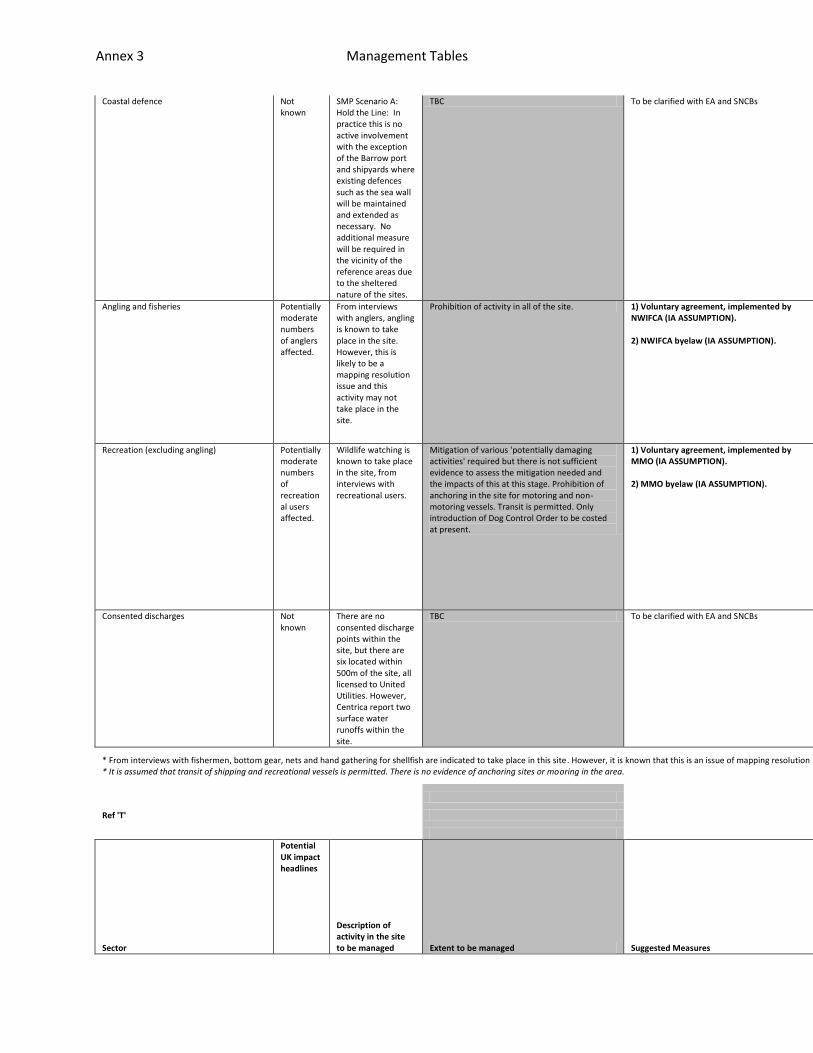
Annex 3 Management Tables
Coastal defence Not known
SMP Scenario A: Hold the Line: In practice this is no active involvement with the exception of the Barrow port and shipyards where existing defences such as the sea wall will be maintained and extended as necessary. No additional measure will be required in the vicinity of the reference areas due to the sheltered nature of the sites.
TBC To be clarified with EA and SNCBs n/a
n/a
n/a
Angling and fisheries Potentially moderate numbers of anglers affected.
From interviews with anglers, angling is known to take place in the site. However, this is likely to be a mapping resolution issue and this activity may not take place in the site.
Prohibition of activity in all of the site. 1) Voluntary agreement, implemented by NWIFCA (IA ASSUMPTION). 2) NWIFCA byelaw (IA ASSUMPTION).
n/a
n/a
n/a
Recreation (excluding angling) Potentially moderate numbers of recreational users affected.
Wildlife watching is known to take place in the site, from interviews with recreational users.
Mitigation of various 'potentially damaging activities' required but there is not sufficient evidence to assess the mitigation needed and the impacts of this at this stage. Prohibition of anchoring in the site for motoring and non-motoring vessels. Transit is permitted. Only introduction of Dog Control Order to be costed at present.
1) Voluntary agreement, implemented by MMO (IA ASSUMPTION). 2) MMO byelaw (IA ASSUMPTION).
n/a
n/a
n/a
Consented discharges Not known
There are no consented discharge points within the site, but there are six located within 500m of the site, all licensed to United Utilities. However, Centrica report two surface water runoffs within the site.
TBC To be clarified with EA and SNCBs n/a
n/a
n/a
* From interviews with fishermen, bottom gear, nets and hand gathering for shellfish are indicated to take place in this site. However, it is known that this is an issue of mapping resolution and no fishing takes place in this site. * It is assumed that transit of shipping and recreational vessels is permitted. There is no evidence of anchoring sites or mooring in the area.
Ref 'T'
Sector
Potential UK impact headlines
Description of activity in the site to be managed Extent to be managed Suggested Measures
Feasibilit
Effectiven
Resource I
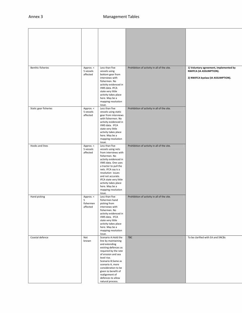
Annex 3 Management Tables
y ess
mplications
Benthic fisheries Approx. < 5 vessels affected
Less than five vessels using bottom gear from interviews with fishermen. No activity evidenced in VMS data. IFCA state very little activity takes place here. May be a mapping resolution issue.
Prohibition of activity in all of the site. 1) Voluntary agreement, implemented by NWIFCA (IA ASSUMPTION). 2) NWIFCA byelaw (IA ASSUMPTION).
n/a
n/a
n/a
Static gear fisheries Approx. < 5 vessels affected
Less than five vessels using static gear from interviews with fishermen. No activity evidenced in VMS data. IFCA state very little activity takes place here. May be a mapping resolution issue.
Prohibition of activity in all of the site. n/a
n/a
n/a
Hooks and lines Approx. < 5 vessels affected
Less than five vessels using nets from interviews with fishermen. No activity evidenced in VMS data. One uses a tractor to pull the nets. IFCA say is a resolution issues and not accurate. IFCA state very little activity takes place here. May be a mapping resolution issue.
Prohibition of activity in all of the site. n/a
n/a
n/a
Hand picking Approx. < 5 fishermen affected
Less than five fishermen hand picking from interviews with fishermen. No activity evidenced in VMS data. IFCA state very little activity takes place here. May be a mapping resolution issue.
Prohibition of activity in all of the site. n/a
n/a
n/a
Coastal defence Not known
Scenario A:Hold the line by maintaining and extending existing defences as required by the rate of erosion and sea level rise. Scenario B:Same as scenario A, more consideration to be given to benefit of realignment of defences to allow natural process.
TBC To be clarified with EA and SNCBs n/a
n/a
n/a
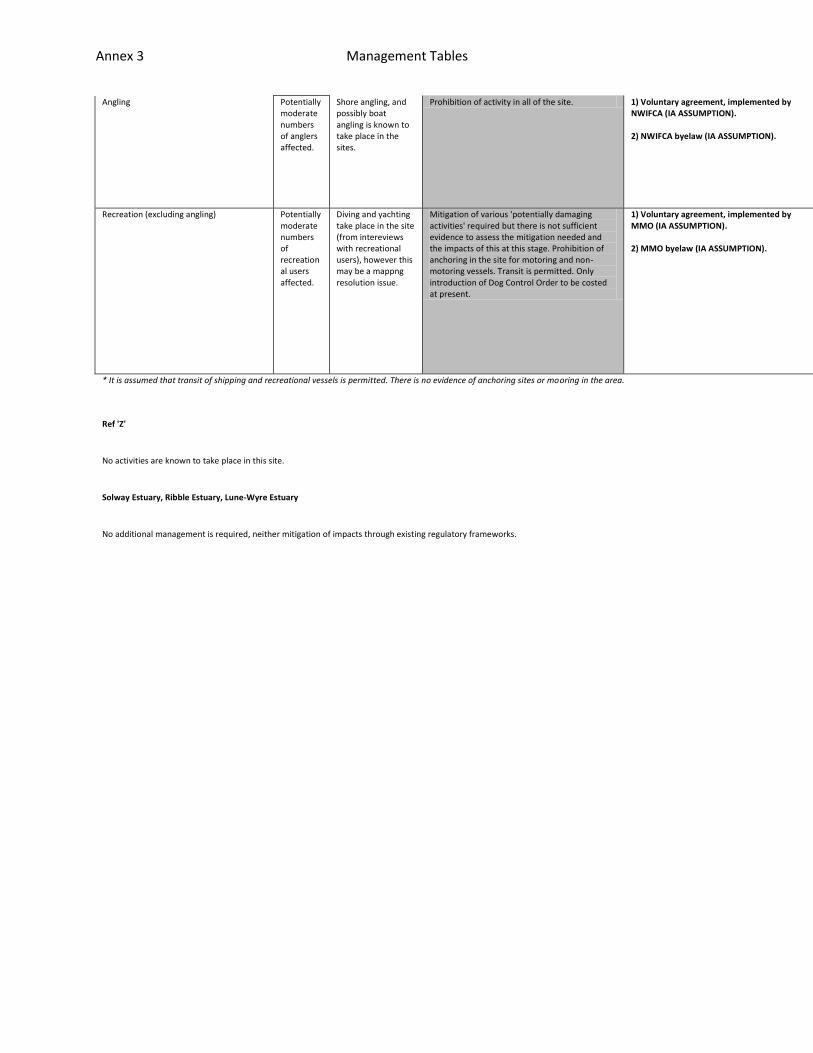
Annex 3 Management Tables
Angling Potentially moderate numbers of anglers affected.
Shore angling, and possibly boat angling is known to take place in the sites.
Prohibition of activity in all of the site. 1) Voluntary agreement, implemented by NWIFCA (IA ASSUMPTION). 2) NWIFCA byelaw (IA ASSUMPTION).
n/a
n/a
n/a
Recreation (excluding angling) Potentially moderate numbers of recreational users affected.
Diving and yachting take place in the site (from intereviews with recreational users), however this may be a mappng resolution issue.
Mitigation of various 'potentially damaging activities' required but there is not sufficient evidence to assess the mitigation needed and the impacts of this at this stage. Prohibition of anchoring in the site for motoring and non-motoring vessels. Transit is permitted. Only introduction of Dog Control Order to be costed at present.
1) Voluntary agreement, implemented by MMO (IA ASSUMPTION). 2) MMO byelaw (IA ASSUMPTION).
n/a
n/a
n/a
* It is assumed that transit of shipping and recreational vessels is permitted. There is no evidence of anchoring sites or mooring in the area.
Ref 'Z'
No activities are known to take place in this site.
Solway Estuary, Ribble Estuary, Lune-Wyre Estuary
No additional management is required, neither mitigation of impacts through existing regulatory frameworks.
Annex 4 Stakeholder Evaluation
ISCZ: End of Process Evaluation
Report: 8th August 2011
REPORT
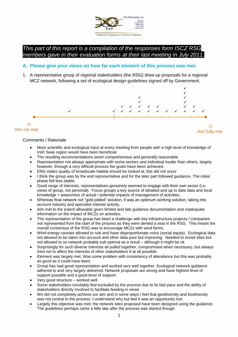
1
Aim not met
Aim fully met
This part of this report is a compilation of the responses form ISCZ RSG members gave in their evaluation forms at their last meeting in July 2011.
A. Please give your views on how far each element of this process was met.
1. A representative group of regional stakeholders (the RSG) drew up proposals for a regional
MCZ network, following a set of ecological design guidelines signed off by Government.
Comments / Rationale
More scientific and ecological input at every meeting from people with a high level of knowledge of Irish Seas region would have been beneficial
The resulting recommendations seem comprehensive and generally reasonable
Representation not always appropriate with some sectors and individual louder than others, largely however, through a very difficult process the goals have been achieved.
ENG states quality of broadscale habitat should be looked at, this did not occur
I think the group was by the end representative and for the later part followed guidance. The initial phase felt less stable.
Good range of interests, representatives genuinely seemed to engage with their own sector (i.e. views of group, not personal). Focus groups a key source of detailed and up to date data and local knowledge + awareness of actual / potential impacts of management of activities.
Whereas final network not “gold plated” solution, it was an optimum working solution, taking into account industry and specialist interest activity.
Aim met to the extent allowable given limited and late guidance documentation and inadequate information on the impact of MCZs on activities.
The representation of the group has been a challenge with key infrastructure projects / companies not represented from the start of the process as they were denied a seat in the RSG. This meant the overall consensus of the RSG was to encourage MCZs with wind farms.
Wind energy caveats allowed to rule and have disproportionate voice (social equity). Ecological data not allowed to be taken into account and other data poor but improving. Needed to revisit sites but not allowed to so network probably sub optimal as a result – although it might be ok
Surprisingly for such diverse interests all pulled together, compromised when necessary, but always tried not to affect the interests of other stakeholders if at all possible.
Element was largely met. Was some problem with consistency of attendance but this was probably as good as it could have been.
Group has had good representation and worked very well together. Ecological network guidance adhered to and very largely delivered. Network proposals are strong and have highest level of support possible and a good level of support.
Very good structure – worked well
Some stakeholders inevitably feel excluded by the process due to its fast pace and the ability of stakeholders directly involved to facilitate feeding in views
We did not completely achieve our aim and in some ways I feel that geodiversity and biodiversity was not central to the process. I understand why but feel it was an opportunity lost.
Largely this objective was met; the network sites proposed have been designed using the guidance. The guidelines perhaps came a little late after the process was started though.
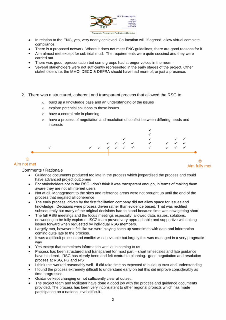
2
Aim not met
Aim fully met
In relation to the ENG, yes, very nearly achieved. Co-location will, if agreed, allow virtual complete compliance.
There is a proposed network. Where it does not meet ENG guidelines, there are good reasons for it.
Aim almost met except for sub tidal mud. The requirements were quite succinct and they were carried out.
There was good representation but some groups had stronger voices in the room.
Several stakeholders were not sufficiently represented in the early stages of the project. Other stakeholders i.e. the MMO, DECC & DEFRA should have had more of, or just a presence.
2. There was a structured, coherent and transparent process that allowed the RSG to:
o build up a knowledge base and an understanding of the issues
o explore potential solutions to these issues.
o have a central role in planning,
o have a process of negotiation and resolution of conflict between differing needs and
interests
Comments / Rationale Guidance documents produced too late in the process which jeopardised the process and could
have advanced project outcomes
For stakeholders not in the RSG I don’t think it was transparent enough, in terms of making them aware they are not all internet users
Not at all. Management to the sites and reference areas were not brought up until the end of the process that negated all coherence
The early process, driven by the first facilitation company did not allow space for issues and knowledge. Decisions were process driven rather than evidence based. That was rectified subsequently but many of the original decisions had to stand because time was now getting short
The full RSG meetings and the focus meetings especially, allowed data, issues, solutions, networking to be fully explored. ISCZ team proved very approachable and supportive with taking issues forward when requested by individual RSG members.
Largely met, however it felt like we were playing catch up sometimes with data and information coming quite late to the process.
It was a difficult process and conflict was inevitable but largely this was managed in a very pragmatic way
Yes except that sometimes information was lat in coming to us
Process has been structured and transparent for most part – short timescales and late guidance have hindered. RSG has clearly been and felt central to planning. good negotiation and resolution process at RSG, FG and I-IS
I think this worked reasonably well. If did take time as expected to build up trust and understanding.
I found the process extremely difficult to understand early on but this did improve considerably as time progressed.
Guidance kept changing or not sufficiently clear at outset.
The project team and facilitator have done a good job with the process and guidance documents provided. The process has been very inconsistent to other regional projects which has made participation on a national level difficult.
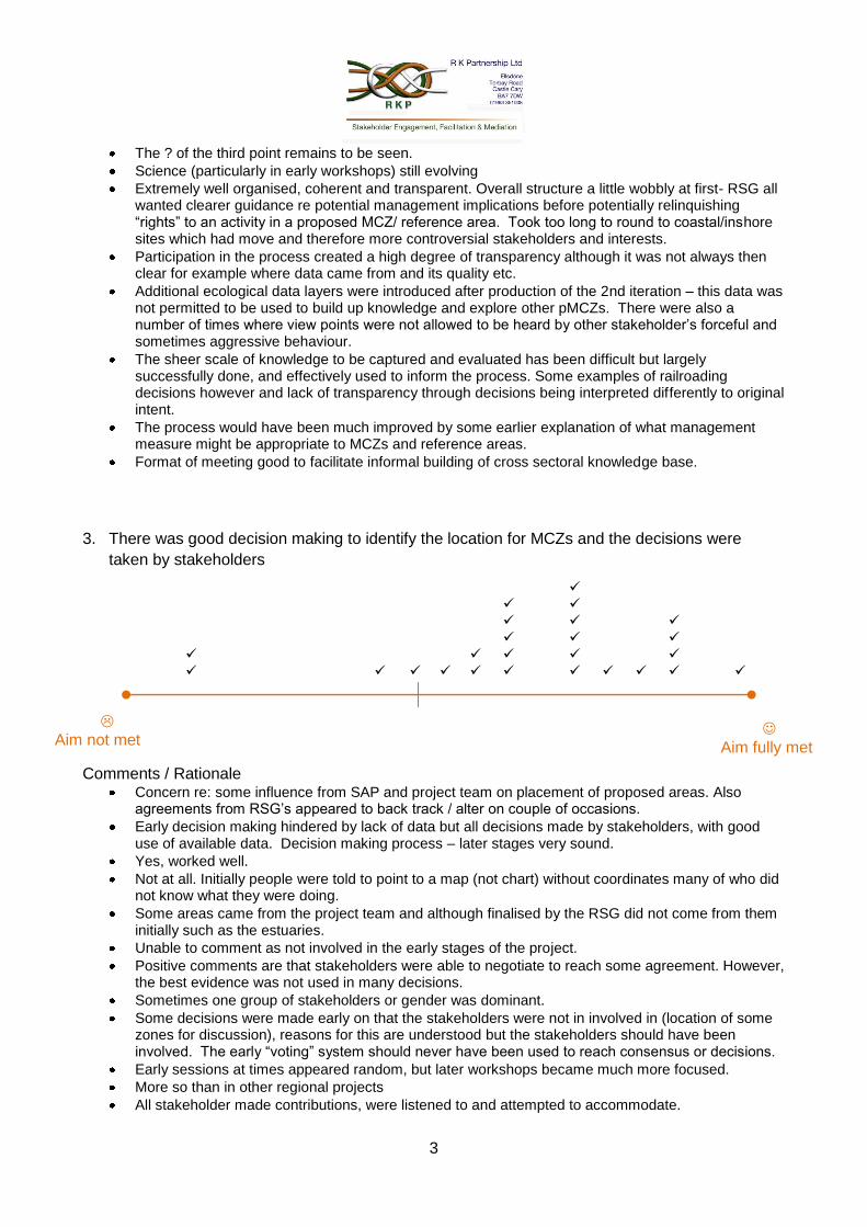
3
Aim not met
Aim fully met
The ? of the third point remains to be seen.
Science (particularly in early workshops) still evolving
Extremely well organised, coherent and transparent. Overall structure a little wobbly at first- RSG all wanted clearer guidance re potential management implications before potentially relinquishing “rights” to an activity in a proposed MCZ/ reference area. Took too long to round to coastal/inshore sites which had move and therefore more controversial stakeholders and interests.
Participation in the process created a high degree of transparency although it was not always then clear for example where data came from and its quality etc.
Additional ecological data layers were introduced after production of the 2nd iteration – this data was not permitted to be used to build up knowledge and explore other pMCZs. There were also a number of times where view points were not allowed to be heard by other stakeholder’s forceful and sometimes aggressive behaviour.
The sheer scale of knowledge to be captured and evaluated has been difficult but largely successfully done, and effectively used to inform the process. Some examples of railroading decisions however and lack of transparency through decisions being interpreted differently to original intent.
The process would have been much improved by some earlier explanation of what management measure might be appropriate to MCZs and reference areas.
Format of meeting good to facilitate informal building of cross sectoral knowledge base.
3. There was good decision making to identify the location for MCZs and the decisions were
taken by stakeholders
Comments / Rationale Concern re: some influence from SAP and project team on placement of proposed areas. Also
agreements from RSG’s appeared to back track / alter on couple of occasions.
Early decision making hindered by lack of data but all decisions made by stakeholders, with good use of available data. Decision making process – later stages very sound.
Yes, worked well.
Not at all. Initially people were told to point to a map (not chart) without coordinates many of who did not know what they were doing.
Some areas came from the project team and although finalised by the RSG did not come from them initially such as the estuaries.
Unable to comment as not involved in the early stages of the project.
Positive comments are that stakeholders were able to negotiate to reach some agreement. However, the best evidence was not used in many decisions.
Sometimes one group of stakeholders or gender was dominant.
Some decisions were made early on that the stakeholders were not in involved in (location of some zones for discussion), reasons for this are understood but the stakeholders should have been involved. The early “voting” system should never have been used to reach consensus or decisions.
Early sessions at times appeared random, but later workshops became much more focused.
More so than in other regional projects
All stakeholder made contributions, were listened to and attempted to accommodate.
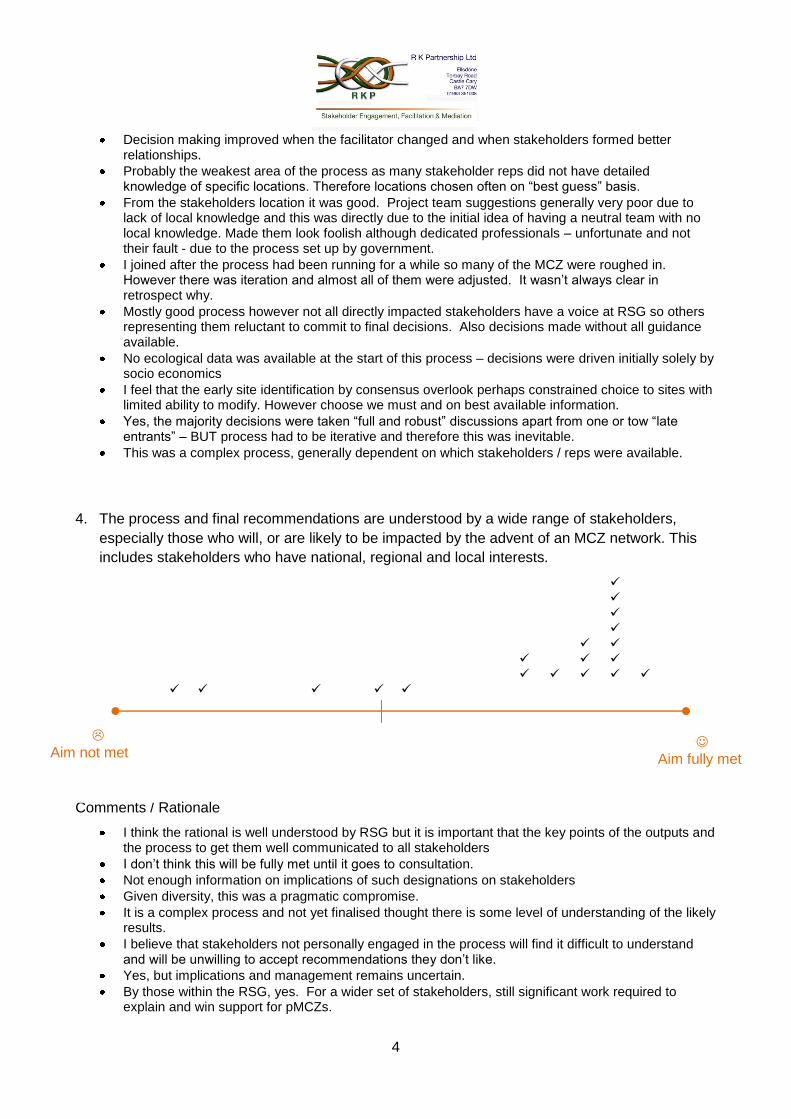
4
Decision making improved when the facilitator changed and when stakeholders formed better relationships.
Probably the weakest area of the process as many stakeholder reps did not have detailed knowledge of specific locations. Therefore locations chosen often on “best guess” basis.
From the stakeholders location it was good. Project team suggestions generally very poor due to lack of local knowledge and this was directly due to the initial idea of having a neutral team with no local knowledge. Made them look foolish although dedicated professionals – unfortunate and not their fault - due to the process set up by government.
I joined after the process had been running for a while so many of the MCZ were roughed in. However there was iteration and almost all of them were adjusted. It wasn’t always clear in retrospect why.
Mostly good process however not all directly impacted stakeholders have a voice at RSG so others representing them reluctant to commit to final decisions. Also decisions made without all guidance available.
No ecological data was available at the start of this process – decisions were driven initially solely by socio economics
I feel that the early site identification by consensus overlook perhaps constrained choice to sites with limited ability to modify. However choose we must and on best available information.
Yes, the majority decisions were taken “full and robust” discussions apart from one or tow “late entrants” – BUT process had to be iterative and therefore this was inevitable.
This was a complex process, generally dependent on which stakeholders / reps were available.
4. The process and final recommendations are understood by a wide range of stakeholders,
especially those who will, or are likely to be impacted by the advent of an MCZ network. This
includes stakeholders who have national, regional and local interests.
Comments / Rationale
I think the rational is well understood by RSG but it is important that the key points of the outputs and the process to get them well communicated to all stakeholders
I don’t think this will be fully met until it goes to consultation.
Not enough information on implications of such designations on stakeholders
Given diversity, this was a pragmatic compromise.
It is a complex process and not yet finalised thought there is some level of understanding of the likely results.
I believe that stakeholders not personally engaged in the process will find it difficult to understand and will be unwilling to accept recommendations they don’t like.
Yes, but implications and management remains uncertain.
By those within the RSG, yes. For a wider set of stakeholders, still significant work required to explain and win support for pMCZs.
Aim not met
Aim fully met
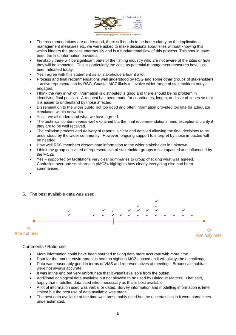
5
Aim not met
Aim fully met
The recommendations are understood, there still needs to be better clarity on the implications, management measures etc. we were asked to make decisions about sites without knowing this which hinders the process enormously and is a fundamental flaw of this process. This should have been the first information provided.
Inevitably there will be significant parts of the fishing industry who are not aware of the sites or how they will be impacted. This is particularly the case as potential management measures have just been released today.
Yes I agree with this statement as all stakeholders learnt a lot.
Process and final recommendations well understood by RSG and some other groups of stakeholders – active representation by RSG. Coastal MCZ likely to involve wider range of stakeholders not yet engaged.
I think the way in which information is distributed is good and there should be no problem in identifying final position. A request has been made for coordinates, length, and size of zones so that it is easier to understand by those affected.
Dissemination to the wider public not too good and often information provided too late for adequate circulation within networks.
Yes – we all understand what we have agreed.
The technical content seems well explained but the final recommendations need exceptional clarity if they are to be well received.
The collation process and delivery of reports is clear and detailed allowing the final decisions to be understood by the wider community. However, ongoing support to interpret by those impacted will be needed
How well RSG members disseminate information to the wider stakeholder in unknown.
I think the group consisted of representative of stakeholder groups most impacted and influenced by the MCZs
Yes – supported by facilitator’s very clear summaries to group checking what was agreed. Confusion over one small area in pMCZ4 highlights how clearly everything else had been summarised.
5. The best available data was used
Comments / Rationale
More information could have been sourced making date more accurate with more time.
Data for the marine environment is poor so sighting MCZs based on it will always be a challenge.
Data was reasonably good in terms of VMS and representatives at meetings. Broadscale habitats were not always accurate.
It was in the end but very unfortunate that it wasn’t available from the outset.
Additional ecological data available but not allowed to be used by Dialogue Matters! That said, happy that modelled data used when necessary as this is best available.
A lot of information used was verbal or dated. Survey information and modelling information is time limited but the best use of data available was made.
The best data available at the time was presumably used but the uncertainties in it were sometimes underestimated.
6
The main issue is that decisions were often based on a lack of data and that most new data obtained from SNCB commissioned reports etc. always seemed to arrive too late to incorporate.
Still think some data was either incorrect or inadequate.
Probably was but often the material provided in advance of a workshop severely lacking in detail / scale to enable us to make best use of it in decision making.
Yes.
Lots of data cam in late or had to be rejected / reviewed but a very definite and substantial increase in quality and quantity later on. Congratulations to team beavering away to seek out and make use of these.
Data was evolving. Groups were subject matter experts who frequently had knowledge that surpassed the presented data.
Limited time restricted potential to accommodate and integrate better datasets.
The DEFRA / SNCB guidance re mobile species made it very difficult to include these fully. But with the ISCZ RSG there was clearly some willingness to consider this interest – e.g. black guillemot at St Bees.
Understanding that this is a difficult thing to gather data but a lot of data came quite late in the process. Also a lot of data are just not available for the proposed sites.
Feel that much post grad research was missing but it is not easily accessible especially in the area of geodiversity.
There appears to be more detailed seabed data available in the Northern Irish administration that has not been incorporated into this project. I would wish to know the robustness of different AAEI data sets some of which have come from environmental NGOs.
It could always be argued that more information would have assisted the process but there was always going to be an argument that there was insufficient time and resource associated with the project. Sometimes, due to the time span between meetings and technical detail did not make it easy.
The initial meetings were handicapped by the delay in data contract reporting. Subsequently, best available data has been used to good effect.
Yes, I think so – there is never a right time as data is continuously being made available.
B. Any other comments that you want to make about how the Irish Seas Conservation Zones process delivered on the aims set for it at the outset?
I think it has made a big impact in terms of better cross sectoral understanding and given participants an insight into other users of the Irish Sea.
The most valuable element has been stakeholder engagement and the ongoing relationships that will need to be maintained. Awareness and understanding of other sectors needs is far more important than the actual designations.
Dialogue Matters were appalling – do not use again!
Initial attempts to provide coherent network according to guidance would have been facilitated if environmental / ecological / geodiversity data for adjacent water had also been made available – particularly relevant to connectivity.
Aims were achieved within a structured forum that allowed all stakeholders an equal voice.
Pleased to say that we virtually achieved all the target set.
ISCZ has delivered very strongly against ENG by strong working and personal relationships from RSG working has been a particularly valued outcome.
It was always going to be difficult to meet the ENG targets given the socio economic impact on certain sectors. But it is felt that the final recommendations were as near as possible and therefore I believe it delivered the aims.
Feel we achieved an incredible amount considering both the difficult geographical and social make up of the ISCZ. However geodiversity is always the poor relative of biodiversity conservation.
Taking the Irish Sea as a whole without the various territorial waters boundaries would have improved the representivity of MCZs in the region.
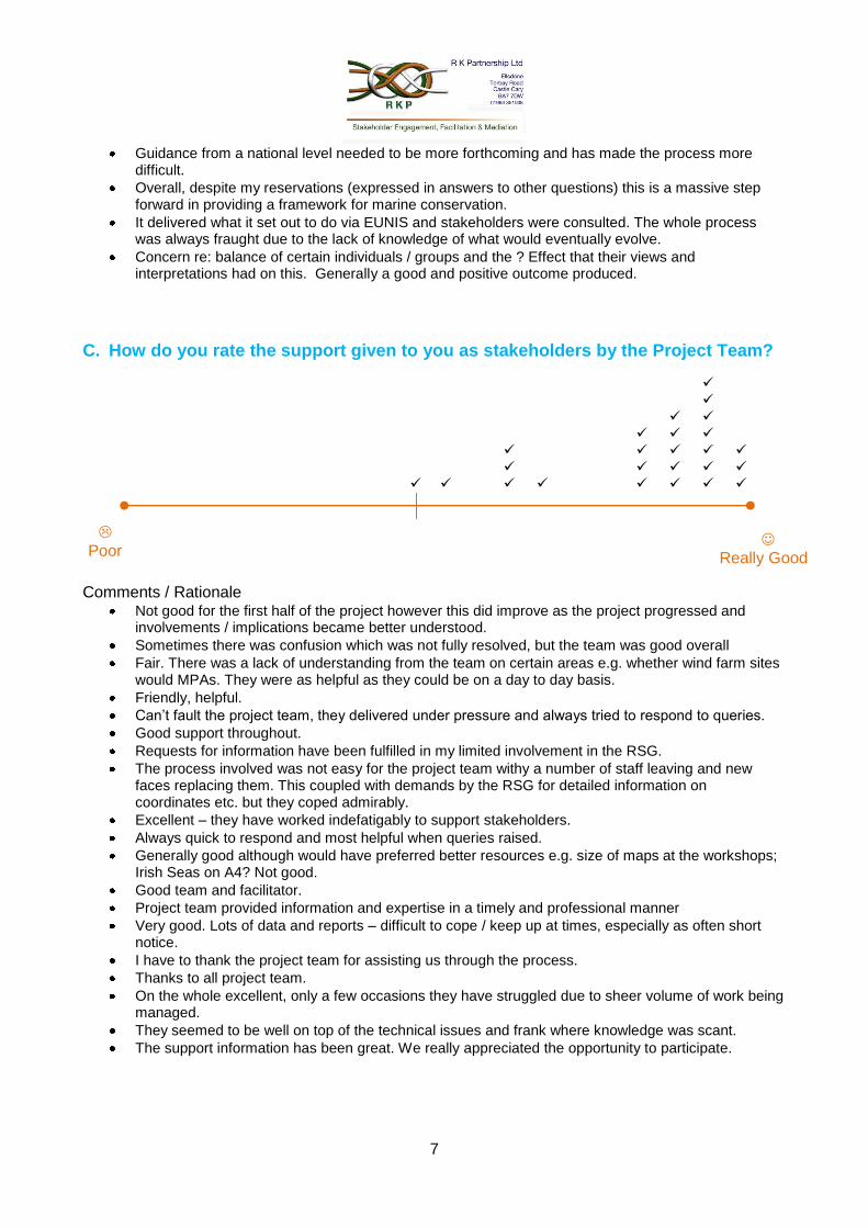
7
Poor
Really Good
Guidance from a national level needed to be more forthcoming and has made the process more difficult.
Overall, despite my reservations (expressed in answers to other questions) this is a massive step forward in providing a framework for marine conservation.
It delivered what it set out to do via EUNIS and stakeholders were consulted. The whole process was always fraught due to the lack of knowledge of what would eventually evolve.
Concern re: balance of certain individuals / groups and the ? Effect that their views and interpretations had on this. Generally a good and positive outcome produced.
C. How do you rate the support given to you as stakeholders by the Project Team?
Comments / Rationale
Not good for the first half of the project however this did improve as the project progressed and involvements / implications became better understood.
Sometimes there was confusion which was not fully resolved, but the team was good overall
Fair. There was a lack of understanding from the team on certain areas e.g. whether wind farm sites would MPAs. They were as helpful as they could be on a day to day basis.
Friendly, helpful.
Can’t fault the project team, they delivered under pressure and always tried to respond to queries.
Good support throughout.
Requests for information have been fulfilled in my limited involvement in the RSG.
The process involved was not easy for the project team withy a number of staff leaving and new faces replacing them. This coupled with demands by the RSG for detailed information on coordinates etc. but they coped admirably.
Excellent – they have worked indefatigably to support stakeholders.
Always quick to respond and most helpful when queries raised.
Generally good although would have preferred better resources e.g. size of maps at the workshops; Irish Seas on A4? Not good.
Good team and facilitator.
Project team provided information and expertise in a timely and professional manner
Very good. Lots of data and reports – difficult to cope / keep up at times, especially as often short notice.
I have to thank the project team for assisting us through the process.
Thanks to all project team.
On the whole excellent, only a few occasions they have struggled due to sheer volume of work being managed.
They seemed to be well on top of the technical issues and frank where knowledge was scant.
The support information has been great. We really appreciated the opportunity to participate.
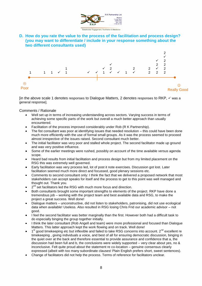
8
Poor
Really Good
D. How do you rate the value to the process of the facilitation and process design? (you may want to differentiate / include in your response something about the two different consultants used)
2 2 2 2 1 2 2 2 2 1 1 1 1 1 1 2 2 2
[in the above scale 1 denotes responses to Dialogue Matters, 2 denotes responses to RKP, was a
general response]. Comments / Rationale
Well set up in terms of increasing understanding across sectors. Varying success in terms of achieving some specific parts of the work but overall a much better approach than usually encountered.
Facilitation of the process improved considerably under Rob (R K Partnership).
The fist consultant was poor at identifying issues that needed resolution – this could have been done much more efficiently with the use of formal small groups. As it was the process seemed to proceed almost irrespective of the issues raised. Second consultant much better.
The initial facilitator was very poor and stalled whole project. The second facilitator made up ground and was very positive influence.
Some of the earlier meetings were rushed, possibly on account of the time available versus agenda scope.
Heard bad results from initial facilitation and process design but from my limited placement on the RSG this was extremely well governed.
Early facilitation was very process led, lot of post it note exercises. Discussion got lost. Later facilitation seemed much more direct and focussed, good plenary sessions etc.
Comments to second consultant only: I think the fact that we delivered a proposed network that most stakeholders can accept speaks for itself and the process to get to this point was well managed and thought out. Thank you.
2nd
set facilitators led the RSG with much more focus and direction.
Both consultants brought some important strengths to elements of the project. RKP have done a tremendous job – working with the project team and best available data and RSG, to make the project a great success. Well done!
Dialogue matters – unconstructive, did not listen to stakeholders, patronising, did not use ecological data when available! Useless. Also resulted in RSG losing Chris Frid our academic advisor – not good.
I feel the second facilitator was better marginally than the first. However both had a difficult task to do especially binging the group together initially.
I think the later consultant (Rob Angell and team) were more professional and focused than Dialogue Matters. This latter approach kept the work flowing and on track. Well done!
1st good timekeeping etc but inflexible and failed to take RSG concerns into account. 2
nd excellent re
timekeeping , giving individuals a voice, and best of all for ensuring democratic discussion, binging in the quiet over at the back and therefore essential to provide assurance and confidence that a, the discussion had been full and b, the conclusions were widely supported – very clear about yes, no & inconclusive. Felt quite proud about the statement re co-location – genuine consensus clearly expressed (albeit with too many subordinate clauses! Plain English prefers short, sweet sentences).
Change of facilitators did not help the process. Terms of reference for facilitators unclear.

9
Old consultant: ballot voting was very poor, stuck to process too tightly, no flexibility, upset stakeholders. New consultant: allowed time for RSG to have important discussions, more fair decisions made. However, by this time there was no opportunity to revisit pMCZ2.
Set up badly, too constrained and too process driven. Replacement facilitator although more flexible not too good at noting pertinent information. Also tended to paraphrase, also tended to lead – on at least one occasion up a blind alley.
10
This part of this report presents the comments made ISCZ RSG members in their evaluation forms at their last meeting in July 2011 grouped by relevant subject.
About the make up of the RSG
Representation not always appropriate with some sectors and individual louder than others, largely however, through a very difficult process the goals have been achieved.
I think the group was by the end representative and for the later part followed guidance. The initial phase felt less stable.
Good range of interests, representatives genuinely seemed to engage with their own sector (i.e. views of group, not personal). Focus groups a key source of detailed and up to date data and local knowledge + awareness of actual / potential impacts of management of activities.
The representation of the group has been a challenge with key infrastructure projects / companies not represented from the start of the process as they were denied a seat in the RSG. This meant the overall consensus of the RSG was to encourage MCZs with wind farms.
Group has had good representation and worked very well together
Was some problem with consistency of attendance but this was probably as good as it could have been.
Some stakeholders inevitably feel excluded by the process due to its fast pace and the ability of stakeholders directly involved to facilitate feeding in views
There was good representation but some groups had stronger voices in the room.
Several stakeholders were not sufficiently represented in the early stages of the project. Other stakeholders i.e. the MMO, DECC & DEFRA should have had more of, or just a presence.
not all directly impacted stakeholders have a voice at RSG so others representing them reluctant to commit to final decisions.
Coastal MCZ likely to involve wider range of stakeholders not yet engaged.
I think the group consisted of representative of stakeholder groups most impacted and influenced by the MCZs
About how the RSG worked as a group
Surprisingly for such diverse interests all pulled together, compromised when necessary, but always tried not to affect the interests of other stakeholders if at all possible.
Very good structure – worked well
Wind energy caveats allowed to rule and have disproportionate voice (social equity).
For stakeholders not in the RSG I don’t think it was transparent enough, in terms of making them aware they are not all internet users
Management of the sites and reference areas were not brought up until the end of the process that negated all coherence
I think this worked reasonably well. If did take time as expected to build up trust and understanding.
RSG has clearly been and felt central to planning.
Participation in the process created a high degree of transparency
generally dependent on which stakeholders / reps were available.
There were a number of times where view points were not allowed to be heard by other stakeholder’s forceful and sometimes aggressive behaviour.
11
Some examples of railroading decisions however and lack of transparency through decisions being interpreted differently to original intent.
Yes, worked well.
Sometimes one group of stakeholders or gender was dominant.
All stakeholder made contributions, were listened to and attempted to accommodate.
Aims were achieved within a structured forum that allowed all stakeholders an equal voice.
About the job the RSG did in relation to the ENG
The resulting recommendations seem comprehensive and generally reasonable
ENG states quality of broadscale habitat should be looked at, this did not occur
Whereas final network not “gold plated” solution, it was an optimum working solution, taking into account industry and specialist interest activity.
Aim met to the extent allowable given limited and late guidance documentation and inadequate information on the impact of MCZs on activities.
Element was largely met.
We did not completely achieve our aim and in some ways I feel that geodiversity and biodiversity was not central to the process. I understand why but feel it was an opportunity lost.
Ecological network guidance adhered to and very largely delivered. Network proposals are strong and have highest level of support possible and a good level of support.
There is a proposed network. Where it does not meet ENG guidelines, there are good reasons for it.
Aim almost met except for sub tidal mud. The requirements were quite succinct and they were carried out.
Largely this objective was met; the network sites proposed have been designed using the guidance. The guidelines perhaps came a little late after the process was started though.
In relation to the ENG, yes, very nearly achieved. Co-location will, if agreed, allow virtual complete compliance.
Needed to revisit sites but not allowed to so network probably sub optimal as a result – although it might be ok
Largely met
I don’t think this will be fully met until it goes to consultation.
Pleased to say that we virtually achieved all the target set.
It was always going to be difficult to meet the ENG targets given the socio economic impact on certain sectors. But it is felt that the final recommendations were as near as possible and therefore I believe it delivered the aims.
About guidance and guidance documents
Guidance documents produced too late in the process which jeopardised the process and could have advanced project outcomes
It felt like we were playing catch up sometimes with data and information coming quite late to the process.
Guidance kept changing or not sufficiently clear at outset.
short timescales and late guidance have hindered
sometimes information was lat in coming to us
RSG all wanted clearer guidance re potential management implications before potentially relinquishing “rights” to an activity in a proposed MCZ/ reference area
12
The project team and facilitator have done a good job with the process and guidance documents provided
decisions made without all guidance available.
The DEFRA / SNCB guidance re mobile species made it very difficult to include these fully. But with the ISCZ RSG there was clearly some willingness to consider this interest – e.g. black guillemot at St Bees.
Guidance from a national level needed to be more forthcoming and has made the process more difficult.
About the choices of sites
Some areas came from the project team and although finalised by the RSG did not come from them initially such as the estuaries.
Initially people were told to point to a map (not chart) without coordinates many of who did not know what they were doing.
I think the rational is well understood by RSG but it is important that the key points of the outputs and the process to get them well communicated to all stakeholders
stakeholders were able to negotiate to reach some agreement
Some decisions were made early on that the stakeholders were not in involved in (location of some zones for discussion), reasons for this are understood but the stakeholders should have been involved.
Probably the weakest area of the process as many stakeholder reps did not have detailed knowledge of specific locations. Therefore locations chosen often on “best guess” basis.
From the stakeholders location it was good. Project team suggestions generally very poor due to lack of local knowledge and this was directly due to the initial idea of having a neutral team with no local knowledge. Made them look foolish although dedicated professionals – unfortunate and not their fault - due to the process set up by government.
I joined after the process had been running for a while so many of the MCZ were roughed in. However there was iteration and almost all of them were adjusted. It wasn’t always clear in retrospect why.
I feel that the early site identification by consensus overlook perhaps constrained choice to sites with limited ability to modify. However choose we must and on best available information.
Given diversity, this was a pragmatic compromise.
It is a complex process and not yet finalised thought there is some level of understanding of the likely results.
implications and management remains uncertain.
there still needs to be better clarity on the implications, management measures etc. we were asked to make decisions about sites without knowing this which hinders the process enormously and is a fundamental flaw of this process. This should have been the first information provided.
About ownership of the work
By those within the RSG, yes. For a wider set of stakeholders, still significant work required to explain and win support for pMCZs.
I believe that stakeholders not personally engaged in the process will find it difficult to understand and will be unwilling to accept recommendations they don’t like.
The recommendations are understood
13
Inevitably there will be significant parts of the fishing industry who are not aware of the sites or how they will be impacted. This is particularly the case as potential management measures have just been released today.
Yes all stakeholders learnt a lot.
Process and final recommendations well understood by RSG and some other groups of stakeholders – active representation by RSG.
I think the way in which information is distributed is good and there should be no problem in identifying final position.
A request has been made for coordinates, length, and size of zones so that it is easier to understand by those affected.
Dissemination to the wider public not too good and often information provided too late for adequate circulation within networks.
Yes – we all understand what we have agreed.
The technical content seems well explained but the final recommendations need exceptional clarity if they are to be well received.
The collation process and delivery of reports is clear and detailed allowing the final decisions to be understood by the wider community. However, ongoing support to interpret by those impacted will be needed
How well RSG members disseminate information to the wider stakeholder in unknown.
About the use of data & information
More scientific and ecological input at every meeting from people with a high level of knowledge of Irish Seas region would have been beneficial
Ecological data not allowed to be taken into account and other data poor but improving.
The full RSG meetings and the focus meetings especially, allowed data, issues, solutions, networking to be fully explored
Science (particularly in early workshops) still evolving
although it was not always then clear for example where data came from and its quality etc.
Additional ecological data layers were introduced after production of the 2nd iteration – this data was not permitted to be used to build up knowledge and explore other pMCZs.
The sheer scale of knowledge to be captured and evaluated has been difficult but largely successfully done, and effectively used to inform the process.
the best evidence was not used in many decisions.
No ecological data was available at the start of this process – decisions were driven initially solely by socio economics
Not enough information on implications of such designations on stakeholders
More information could have been sourced making data more accurate with more time.
Data for the marine environment is poor so sighting MCZs based on it will always be a challenge.
Data was reasonably good in terms of VMS and representatives at meetings. Broadscale habitats were not always accurate.
It was in the end but very unfortunate that it wasn’t available from the outset.
Additional ecological data available but not allowed to be used by Dialogue Matters! That said, happy that modelled data used when necessary as this is best available.
A lot of information used was verbal or dated. Survey information and modelling information is time limited but the best use of data available was made.
The best data available at the time was presumably used but the uncertainties in it were sometimes underestimated.
14
The main issue is that decisions were often based on a lack of data and that most new data obtained from SNCB commissioned reports etc. always seemed to arrive too late to incorporate.
Still think some data was either incorrect or inadequate.
Probably was but often the material provided in advance of a workshop severely lacking in detail / scale to enable us to make best use of it in decision making.
Lots of data cam in late or had to be rejected / reviewed but a very definite and substantial increase in quality and quantity later on. Congratulations to team beavering away to seek out and make use of these.
Data was evolving. Groups were subject matter experts who frequently had knowledge that surpassed the presented data.
Limited time restricted potential to accommodate and integrate better datasets.
Understanding that this is a difficult thing to gather data but a lot of data came quite late in the process. Also a lot of data are just not available for the proposed sites.
Feel that much post grad research was missing but it is not easily accessible especially in the area of geodiversity.
There appears to be more detailed seabed data available in the Northern Irish administration that has not been incorporated into this project. I would wish to know the robustness of different AAEI data sets some of which have come from environmental NGOs.
It could always be argued that more information would have assisted the process but there was always going to be an argument that there was insufficient time and resource associated with the project. Sometimes, due to the time span between meetings and technical detail did not make it easy.
The initial meetings were handicapped by the delay in data contract reporting. Subsequently, best available data has been used to good effect.
there is never a right time as data is continuously being made available.
About the process
The process has been very inconsistent to other regional projects which has made participation on a national level difficult.
Process has been structured and transparent for most part
It was a difficult process and conflict was inevitable but largely this was managed in a very pragmatic way
Overall structure a little wobbly at first
Took too long to round to coastal/inshore sites which had move and therefore more controversial stakeholders and interests.
I found the process extremely difficult to understand early on but this did improve considerably as time progressed.
Extremely well organised, coherent and transparent.
Format of meeting good to facilitate informal building of cross sectoral knowledge base.
The process would have been much improved by some earlier explanation of what management measure might be appropriate to MCZs and reference areas.
Mostly good process
This was a complex process,
Well set up in terms of increasing understanding across sectors. Varying success in terms of achieving some specific parts of the work but overall a much better approach than usually encountered.
15
About decision making
The early process, driven by the first facilitation company did not allow space for issues and knowledge. Decisions were process driven rather than evidence based. That was rectified subsequently but many of the original decisions had to stand because time was now getting short
good negotiation and resolution process at RSG, FG
Concern re: some influence from SAP and project team on placement of proposed areas. Also agreements from RSG’s appeared to back track / alter on couple of occasions.
Early decision making hindered by lack of data
Decision making process – later stages very sound.
The early “voting” system should never have been used to reach consensus or decisions.
all decisions made by stakeholders, with good use of available data.
Early sessions at times appeared random, but later workshops became much more focused.
Decision making improved when the facilitator changed
Decision making improved when stakeholders formed better relationships.
the majority decisions were taken “full and robust” discussions apart from one or two “late entrants” – BUT process had to be iterative and therefore this was inevitable.
Second facilitator’s very clear summaries to group checking what was agreed
Confusion over one small area in pMCZ4 highlights how clearly everything else had been summarised.
Some of the earlier meetings were rushed, possibly on account of the time available versus agenda scope.
About the facilitation
Facilitation of the process improved considerably under Rob (R K Partnership).
The fist consultant was poor at identifying issues that needed resolution – this could have been done much more efficiently with the use of formal small groups. As it was the process seemed to proceed almost irrespective of the issues raised. Second consultant much better.
The initial facilitator was very poor and stalled whole project. The second facilitator made up ground and was very positive influence.
Heard bad results from initial facilitation and process design but from my limited placement on the RSG this was extremely well governed.
Early facilitation was very process led, lot of post it note exercises. Discussion got lost. Later facilitation seemed much more direct and focussed, good plenary sessions etc.
Comments to second consultant only: I think the fact that we delivered a proposed network that most stakeholders can accept speaks for itself and the process to get to this point was well managed and thought out. Thank you.
2nd set facilitators led the RSG with much more focus and direction.
Both consultants brought some important strengths to elements of the project. RKP have done a tremendous job – working with the project team and best available data and RSG, to make the project a great success. Well done!
Dialogue matters – unconstructive, did not listen to stakeholders, patronising, did not use ecological data when available! Useless. Also resulted in RSG losing Chris Frid our academic advisor – not good.
I feel the second facilitator was better marginally than the first. However both had a difficult task to do especially binging the group together initially.
I think the later consultant (Rob Angell and team) were more professional and focused than Dialogue Matters. This latter approach kept the work flowing and on track. Well done!
16
1st good timekeeping etc but inflexible and failed to take RSG concerns into account. 2nd excellent re timekeeping , giving individuals a voice, and best of all for ensuring democratic discussion, binging in the quiet over at the back and therefore essential to provide assurance and confidence that a, the discussion had been full and b, the conclusions were widely supported – very clear about yes, no & inconclusive. Felt quite proud about the statement re co-location – genuine consensus clearly expressed (albeit with too many subordinate clauses! Plain English prefers short, sweet sentences).
Change of facilitators did not help the process. Terms of reference for facilitators unclear.
Replacement facilitator although more flexible not too good at noting pertinent information. Also tended to paraphrase, also tended to lead – on at least one occasion up a blind alley.
Old consultant: ballot voting was very poor, stuck to process too tightly, no flexibility, upset stakeholders. New consultant: allowed time for RSG to have important discussions, more fair decisions made.
Dialogue Matters were appalling – do not use again!
About the ISCZ project team
ISCZ team proved very approachable and supportive with taking issues forward when requested by individual RSG members.
Not good for the first half of the project however this did improve as the project progressed and involvements / implications became better understood.
Sometimes there was confusion which was not fully resolved, but the team was good overall
Fair. There was a lack of understanding from the team on certain areas e.g. whether wind farm sites would MPAs. They were as helpful as they could be on a day to day basis.
Friendly, helpful.
Can’t fault the project team, they delivered under pressure and always tried to respond to queries.
Good support throughout.
Requests for information have been fulfilled in my limited involvement in the RSG.
The process involved was not easy for the project team withy a number of staff leaving and new faces replacing them. This coupled with demands by the RSG for detailed information on coordinates etc. but they coped admirably.
Excellent – they have worked indefatigably to support stakeholders.
Always quick to respond and most helpful when queries raised.
Generally good although would have preferred better resources e.g. size of maps at the workshops; Irish Seas on A4? Not good.
Good team and facilitator.
Project team provided information and expertise in a timely and professional manner
Very good. Lots of data and reports – difficult to cope / keep up at times, especially as often short notice.
I have to thank the project team for assisting us through the process.
Thanks to all project team.
On the whole excellent, only a few occasions they have struggled due to sheer volume of work being managed.
They seemed to be well on top of the technical issues and frank where knowledge was scant.
The support information has been great. We really appreciated the opportunity to participate.
17
Other comments
I think it has made a big impact in terms of better cross sectoral understanding and given participants an insight into other users of the Irish Sea.
The most valuable element has been stakeholder engagement and the ongoing relationships that will need to be maintained. Awareness and understanding of other sectors needs is far more important than the actual designations.
Initial attempts to provide coherent network according to guidance would have been facilitated if environmental / ecological / geodiversity data for adjacent water had also been made available – particularly relevant to connectivity.
ISCZ has delivered very strongly against ENG by strong working and personal relationships from RSG working has been a particularly valued outcome.
Feel we achieved an incredible amount considering both the difficult geographical and social make up of the ISCZ. However geodiversity is always the poor relative of biodiversity conservation.
Taking the Irish Sea as a whole without the various territorial waters boundaries would have improved the representivity of MCZs in the region.
Overall, this is a massive step forward in providing a framework for marine conservation.
It delivered what it set out to do via EUNIS and stakeholders were consulted. The whole process was always fraught due to the lack of knowledge of what would eventually evolve.
Concern re: balance of certain individuals / groups and the effect that their views and interpretations had.
Generally a good and positive outcome produced.
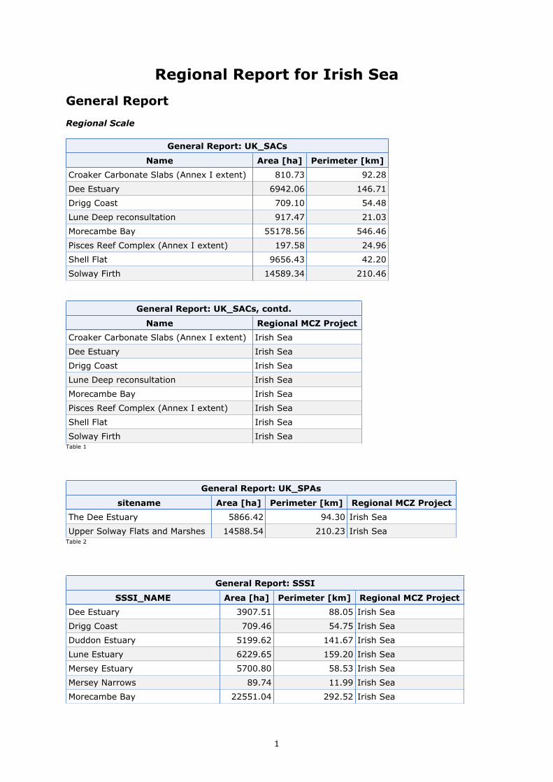
1
Regional Report for Irish Sea
General Report
Regional Scale
General Report: UK_SACs
Name Area [ha] Perimeter [km]
Croaker Carbonate Slabs (Annex I extent) 810.73 92.28
Dee Estuary 6942.06 146.71
Drigg Coast 709.10 54.48
Lune Deep reconsultation 917.47 21.03
Morecambe Bay 55178.56 546.46
Pisces Reef Complex (Annex I extent) 197.58 24.96
Shell Flat 9656.43 42.20
Solway Firth 14589.34 210.46
General Report: UK_SACs, contd.
Name Regional MCZ Project
Croaker Carbonate Slabs (Annex I extent) Irish Sea
Dee Estuary Irish Sea
Drigg Coast Irish Sea
Lune Deep reconsultation Irish Sea
Morecambe Bay Irish Sea
Pisces Reef Complex (Annex I extent) Irish Sea
Shell Flat Irish Sea
Solway Firth Irish SeaTable 1
General Report: UK_SPAs
sitename Area [ha] Perimeter [km] Regional MCZ Project
The Dee Estuary 5866.42 94.30 Irish Sea
Upper Solway Flats and Marshes 14588.54 210.23 Irish SeaTable 2
General Report: SSSI
SSSI_NAME Area [ha] Perimeter [km] Regional MCZ Project
Dee Estuary 3907.51 88.05 Irish Sea
Drigg Coast 709.46 54.75 Irish Sea
Duddon Estuary 5199.62 141.67 Irish Sea
Lune Estuary 6229.65 159.20 Irish Sea
Mersey Estuary 5700.80 58.53 Irish Sea
Mersey Narrows 89.74 11.99 Irish Sea
Morecambe Bay 22551.04 292.52 Irish Sea

Regional Report for Irish Sea [23/05/2011 09:35:12] 2
General Report: SSSI
SSSI_NAME Area [ha] Perimeter [km] Regional MCZ Project
New Ferry 71.66 8.22 Irish Sea
North Wirral Foreshore 1954.04 60.57 Irish Sea
Ribble Estuary 6871.23 167.85 Irish Sea
Sefton Coast 2858.80 66.15 Irish Sea
South Walney & Piel Channel Flats 1981.19 92.20 Irish Sea
Upper Solway Flats & Marshes 8623.90 299.07 Irish Sea
Wyre Estuary 1227.52 100.09 Irish SeaTable 3
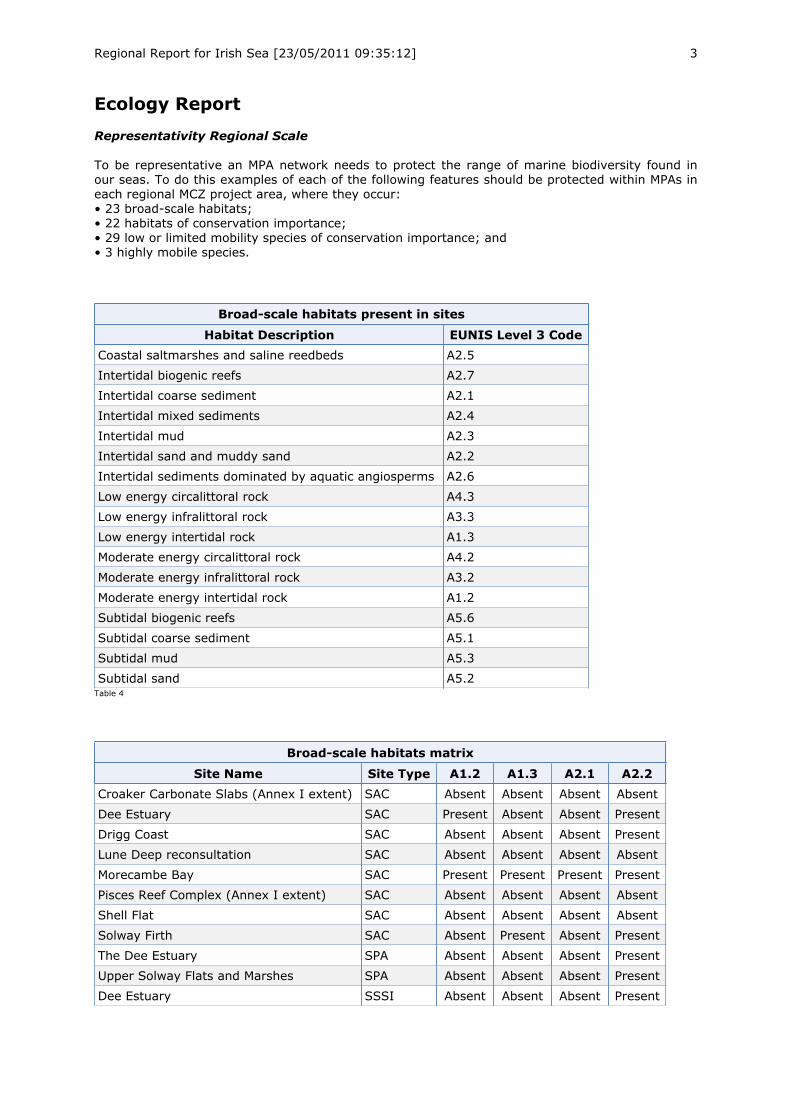
Regional Report for Irish Sea [23/05/2011 09:35:12] 3
Ecology Report
Representativity Regional Scale
To be representative an MPA network needs to protect the range of marine biodiversity found inour seas. To do this examples of each of the following features should be protected within MPAs ineach regional MCZ project area, where they occur:• 23 broad-scale habitats;• 22 habitats of conservation importance;• 29 low or limited mobility species of conservation importance; and• 3 highly mobile species.
Broad-scale habitats present in sites
Habitat Description EUNIS Level 3 Code
Coastal saltmarshes and saline reedbeds A2.5
Intertidal biogenic reefs A2.7
Intertidal coarse sediment A2.1
Intertidal mixed sediments A2.4
Intertidal mud A2.3
Intertidal sand and muddy sand A2.2
Intertidal sediments dominated by aquatic angiosperms A2.6
Low energy circalittoral rock A4.3
Low energy infralittoral rock A3.3
Low energy intertidal rock A1.3
Moderate energy circalittoral rock A4.2
Moderate energy infralittoral rock A3.2
Moderate energy intertidal rock A1.2
Subtidal biogenic reefs A5.6
Subtidal coarse sediment A5.1
Subtidal mud A5.3
Subtidal sand A5.2Table 4
Broad-scale habitats matrix
Site Name Site Type A1.2 A1.3 A2.1 A2.2
Croaker Carbonate Slabs (Annex I extent) SAC Absent Absent Absent Absent
Dee Estuary SAC Present Absent Absent Present
Drigg Coast SAC Absent Absent Absent Present
Lune Deep reconsultation SAC Absent Absent Absent Absent
Morecambe Bay SAC Present Present Present Present
Pisces Reef Complex (Annex I extent) SAC Absent Absent Absent Absent
Shell Flat SAC Absent Absent Absent Absent
Solway Firth SAC Absent Present Absent Present
The Dee Estuary SPA Absent Absent Absent Present
Upper Solway Flats and Marshes SPA Absent Absent Absent Present
Dee Estuary SSSI Absent Absent Absent Present
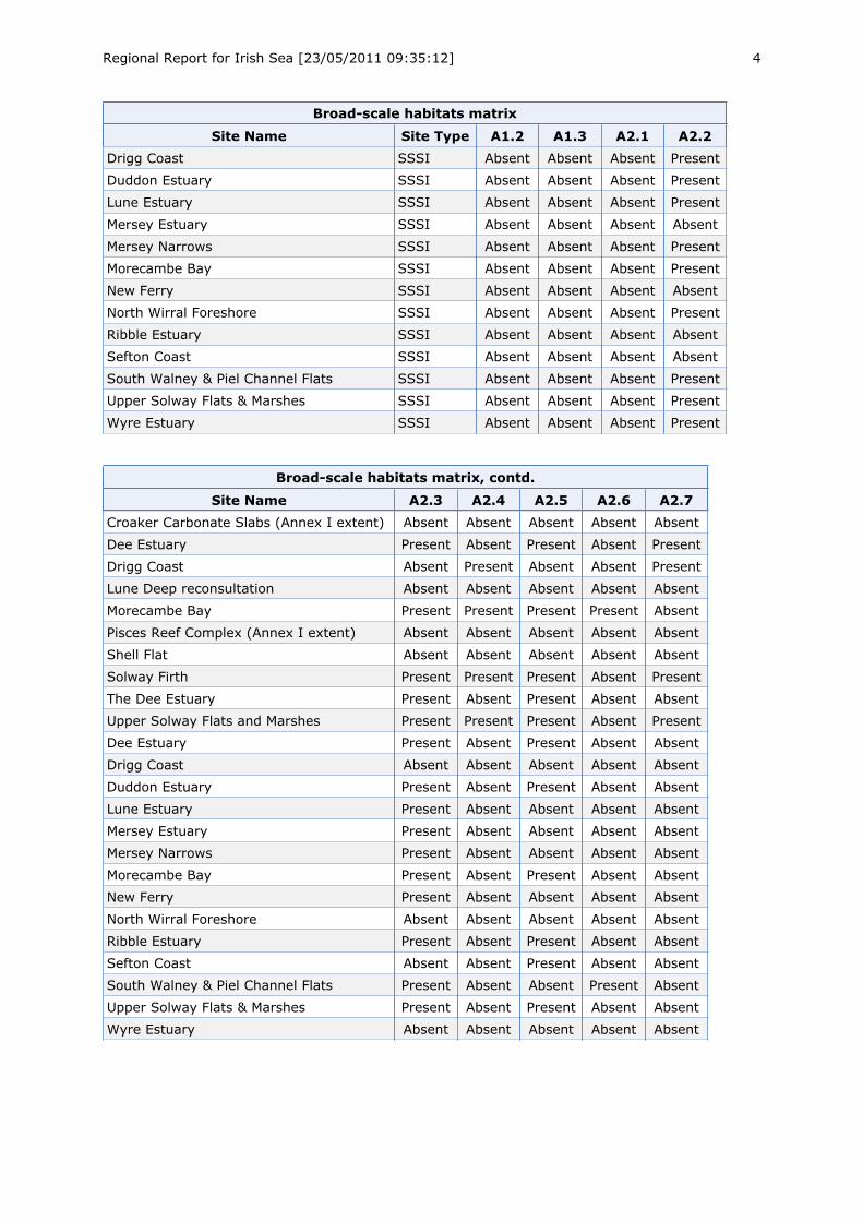
Regional Report for Irish Sea [23/05/2011 09:35:12] 4
Broad-scale habitats matrix
Site Name Site Type A1.2 A1.3 A2.1 A2.2
Drigg Coast SSSI Absent Absent Absent Present
Duddon Estuary SSSI Absent Absent Absent Present
Lune Estuary SSSI Absent Absent Absent Present
Mersey Estuary SSSI Absent Absent Absent Absent
Mersey Narrows SSSI Absent Absent Absent Present
Morecambe Bay SSSI Absent Absent Absent Present
New Ferry SSSI Absent Absent Absent Absent
North Wirral Foreshore SSSI Absent Absent Absent Present
Ribble Estuary SSSI Absent Absent Absent Absent
Sefton Coast SSSI Absent Absent Absent Absent
South Walney & Piel Channel Flats SSSI Absent Absent Absent Present
Upper Solway Flats & Marshes SSSI Absent Absent Absent Present
Wyre Estuary SSSI Absent Absent Absent Present
Broad-scale habitats matrix, contd.
Site Name A2.3 A2.4 A2.5 A2.6 A2.7
Croaker Carbonate Slabs (Annex I extent) Absent Absent Absent Absent Absent
Dee Estuary Present Absent Present Absent Present
Drigg Coast Absent Present Absent Absent Present
Lune Deep reconsultation Absent Absent Absent Absent Absent
Morecambe Bay Present Present Present Present Absent
Pisces Reef Complex (Annex I extent) Absent Absent Absent Absent Absent
Shell Flat Absent Absent Absent Absent Absent
Solway Firth Present Present Present Absent Present
The Dee Estuary Present Absent Present Absent Absent
Upper Solway Flats and Marshes Present Present Present Absent Present
Dee Estuary Present Absent Present Absent Absent
Drigg Coast Absent Absent Absent Absent Absent
Duddon Estuary Present Absent Present Absent Absent
Lune Estuary Present Absent Absent Absent Absent
Mersey Estuary Present Absent Absent Absent Absent
Mersey Narrows Present Absent Absent Absent Absent
Morecambe Bay Present Absent Present Absent Absent
New Ferry Present Absent Absent Absent Absent
North Wirral Foreshore Absent Absent Absent Absent Absent
Ribble Estuary Present Absent Present Absent Absent
Sefton Coast Absent Absent Present Absent Absent
South Walney & Piel Channel Flats Present Absent Absent Present Absent
Upper Solway Flats & Marshes Present Absent Present Absent Absent
Wyre Estuary Absent Absent Absent Absent Absent
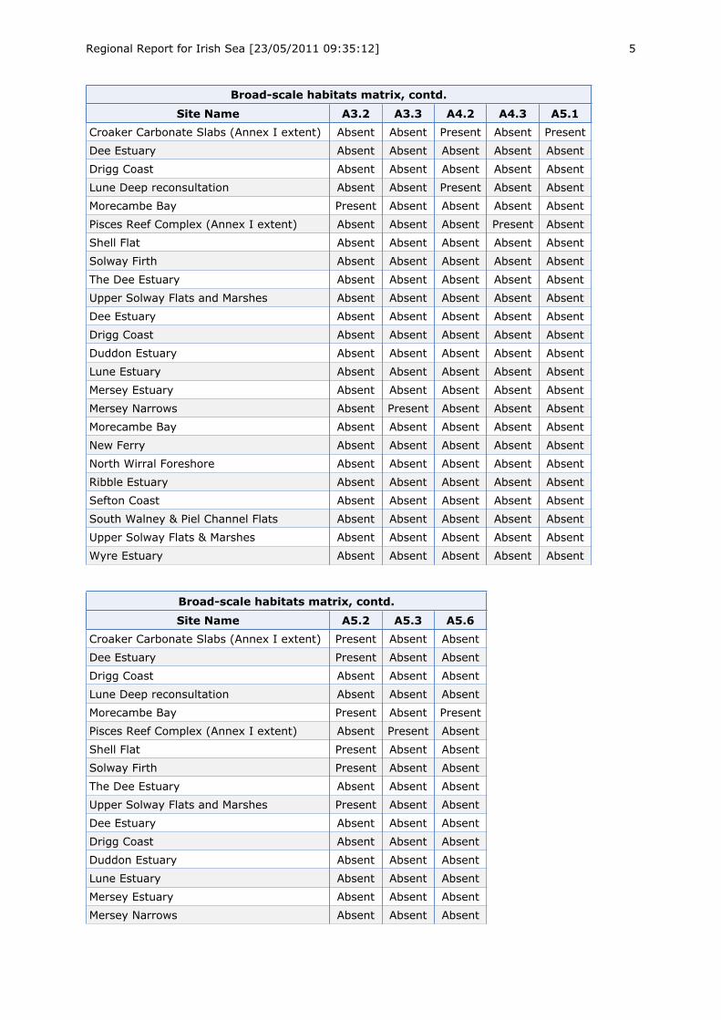
Regional Report for Irish Sea [23/05/2011 09:35:12] 5
Broad-scale habitats matrix, contd.
Site Name A3.2 A3.3 A4.2 A4.3 A5.1
Croaker Carbonate Slabs (Annex I extent) Absent Absent Present Absent Present
Dee Estuary Absent Absent Absent Absent Absent
Drigg Coast Absent Absent Absent Absent Absent
Lune Deep reconsultation Absent Absent Present Absent Absent
Morecambe Bay Present Absent Absent Absent Absent
Pisces Reef Complex (Annex I extent) Absent Absent Absent Present Absent
Shell Flat Absent Absent Absent Absent Absent
Solway Firth Absent Absent Absent Absent Absent
The Dee Estuary Absent Absent Absent Absent Absent
Upper Solway Flats and Marshes Absent Absent Absent Absent Absent
Dee Estuary Absent Absent Absent Absent Absent
Drigg Coast Absent Absent Absent Absent Absent
Duddon Estuary Absent Absent Absent Absent Absent
Lune Estuary Absent Absent Absent Absent Absent
Mersey Estuary Absent Absent Absent Absent Absent
Mersey Narrows Absent Present Absent Absent Absent
Morecambe Bay Absent Absent Absent Absent Absent
New Ferry Absent Absent Absent Absent Absent
North Wirral Foreshore Absent Absent Absent Absent Absent
Ribble Estuary Absent Absent Absent Absent Absent
Sefton Coast Absent Absent Absent Absent Absent
South Walney & Piel Channel Flats Absent Absent Absent Absent Absent
Upper Solway Flats & Marshes Absent Absent Absent Absent Absent
Wyre Estuary Absent Absent Absent Absent Absent
Broad-scale habitats matrix, contd.
Site Name A5.2 A5.3 A5.6
Croaker Carbonate Slabs (Annex I extent) Present Absent Absent
Dee Estuary Present Absent Absent
Drigg Coast Absent Absent Absent
Lune Deep reconsultation Absent Absent Absent
Morecambe Bay Present Absent Present
Pisces Reef Complex (Annex I extent) Absent Present Absent
Shell Flat Present Absent Absent
Solway Firth Present Absent Absent
The Dee Estuary Absent Absent Absent
Upper Solway Flats and Marshes Present Absent Absent
Dee Estuary Absent Absent Absent
Drigg Coast Absent Absent Absent
Duddon Estuary Absent Absent Absent
Lune Estuary Absent Absent Absent
Mersey Estuary Absent Absent Absent
Mersey Narrows Absent Absent Absent
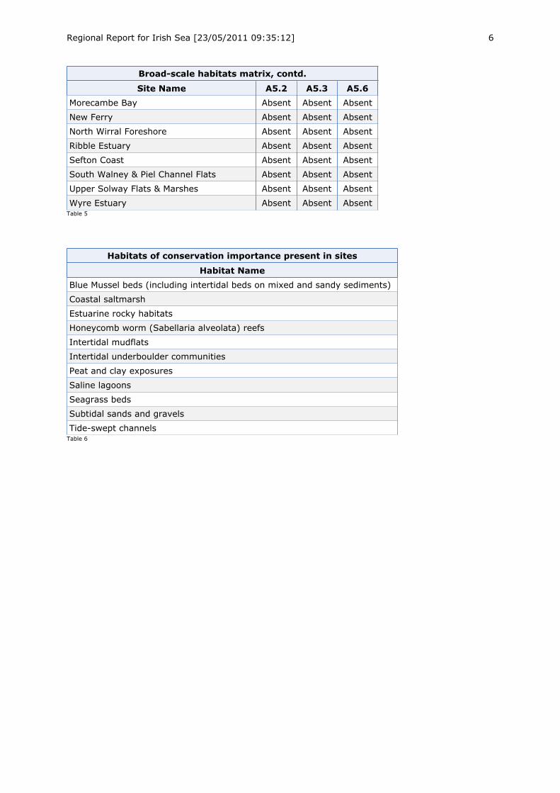
Regional Report for Irish Sea [23/05/2011 09:35:12] 6
Broad-scale habitats matrix, contd.
Site Name A5.2 A5.3 A5.6
Morecambe Bay Absent Absent Absent
New Ferry Absent Absent Absent
North Wirral Foreshore Absent Absent Absent
Ribble Estuary Absent Absent Absent
Sefton Coast Absent Absent Absent
South Walney & Piel Channel Flats Absent Absent Absent
Upper Solway Flats & Marshes Absent Absent Absent
Wyre Estuary Absent Absent AbsentTable 5
Habitats of conservation importance present in sites
Habitat Name
Blue Mussel beds (including intertidal beds on mixed and sandy sediments)
Coastal saltmarsh
Estuarine rocky habitats
Honeycomb worm (Sabellaria alveolata) reefs
Intertidal mudflats
Intertidal underboulder communities
Peat and clay exposures
Saline lagoons
Seagrass beds
Subtidal sands and gravels
Tide-swept channelsTable 6
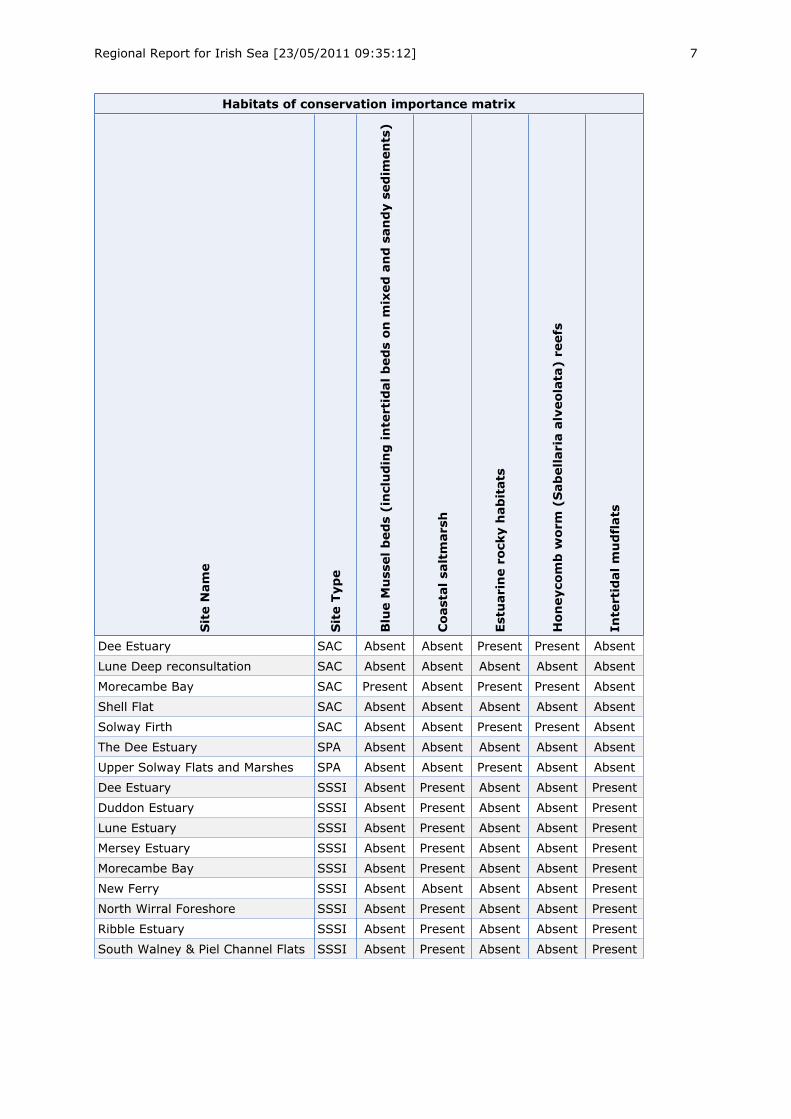
Regional Report for Irish Sea [23/05/2011 09:35:12] 7
Habitats of conservation importance matrix
SiteName
SiteType
BlueMusselbeds(includingintertidalbedsonmixedandsandysediments)
Coastalsaltmarsh
Estuarinerockyhabitats
Honeycombworm
(Sabellariaalveolata)reefs
Intertidalmudflats
Dee Estuary SAC Absent Absent Present Present Absent
Lune Deep reconsultation SAC Absent Absent Absent Absent Absent
Morecambe Bay SAC Present Absent Present Present Absent
Shell Flat SAC Absent Absent Absent Absent Absent
Solway Firth SAC Absent Absent Present Present Absent
The Dee Estuary SPA Absent Absent Absent Absent Absent
Upper Solway Flats and Marshes SPA Absent Absent Present Absent Absent
Dee Estuary SSSI Absent Present Absent Absent Present
Duddon Estuary SSSI Absent Present Absent Absent Present
Lune Estuary SSSI Absent Present Absent Absent Present
Mersey Estuary SSSI Absent Present Absent Absent Present
Morecambe Bay SSSI Absent Present Absent Absent Present
New Ferry SSSI Absent Absent Absent Absent Present
North Wirral Foreshore SSSI Absent Present Absent Absent Present
Ribble Estuary SSSI Absent Present Absent Absent Present
South Walney & Piel Channel Flats SSSI Absent Present Absent Absent Present
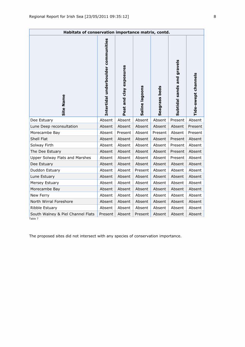
Regional Report for Irish Sea [23/05/2011 09:35:12] 8
Habitats of conservation importance matrix, contd.
SiteName
Intertidalunderbouldercommunities
Peatandclayexposures
Salinelagoons
Seagrassbeds
Subtidalsandsandgravels
Tide-sweptchannels
Dee Estuary Absent Absent Absent Absent Present Absent
Lune Deep reconsultation Absent Absent Absent Absent Absent Present
Morecambe Bay Absent Present Absent Present Absent Present
Shell Flat Absent Absent Absent Absent Present Absent
Solway Firth Absent Absent Absent Absent Present Absent
The Dee Estuary Absent Absent Absent Absent Present Absent
Upper Solway Flats and Marshes Absent Absent Absent Absent Present Absent
Dee Estuary Absent Absent Absent Absent Absent Absent
Duddon Estuary Absent Absent Present Absent Absent Absent
Lune Estuary Absent Absent Absent Absent Absent Absent
Mersey Estuary Absent Absent Absent Absent Absent Absent
Morecambe Bay Absent Absent Absent Absent Absent Absent
New Ferry Absent Absent Absent Absent Absent Absent
North Wirral Foreshore Absent Absent Absent Absent Absent Absent
Ribble Estuary Absent Absent Absent Absent Absent Absent
South Walney & Piel Channel Flats Present Absent Present Absent Absent AbsentTable 7
The proposed sites did not intersect with any species of conservation importance.
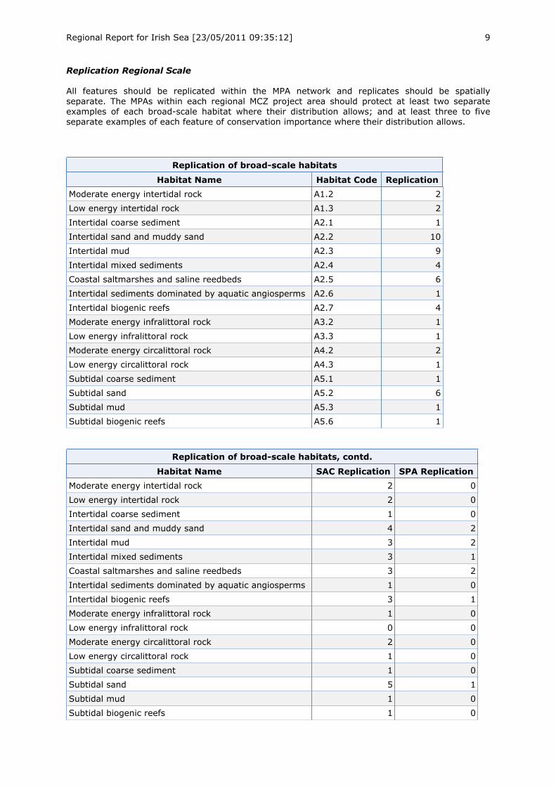
Regional Report for Irish Sea [23/05/2011 09:35:12] 9
Replication Regional Scale
All features should be replicated within the MPA network and replicates should be spatiallyseparate. The MPAs within each regional MCZ project area should protect at least two separateexamples of each broad-scale habitat where their distribution allows; and at least three to fiveseparate examples of each feature of conservation importance where their distribution allows.
Replication of broad-scale habitats
Habitat Name Habitat Code Replication
Moderate energy intertidal rock A1.2 2
Low energy intertidal rock A1.3 2
Intertidal coarse sediment A2.1 1
Intertidal sand and muddy sand A2.2 10
Intertidal mud A2.3 9
Intertidal mixed sediments A2.4 4
Coastal saltmarshes and saline reedbeds A2.5 6
Intertidal sediments dominated by aquatic angiosperms A2.6 1
Intertidal biogenic reefs A2.7 4
Moderate energy infralittoral rock A3.2 1
Low energy infralittoral rock A3.3 1
Moderate energy circalittoral rock A4.2 2
Low energy circalittoral rock A4.3 1
Subtidal coarse sediment A5.1 1
Subtidal sand A5.2 6
Subtidal mud A5.3 1
Subtidal biogenic reefs A5.6 1
Replication of broad-scale habitats, contd.
Habitat Name SAC Replication SPA Replication
Moderate energy intertidal rock 2 0
Low energy intertidal rock 2 0
Intertidal coarse sediment 1 0
Intertidal sand and muddy sand 4 2
Intertidal mud 3 2
Intertidal mixed sediments 3 1
Coastal saltmarshes and saline reedbeds 3 2
Intertidal sediments dominated by aquatic angiosperms 1 0
Intertidal biogenic reefs 3 1
Moderate energy infralittoral rock 1 0
Low energy infralittoral rock 0 0
Moderate energy circalittoral rock 2 0
Low energy circalittoral rock 1 0
Subtidal coarse sediment 1 0
Subtidal sand 5 1
Subtidal mud 1 0
Subtidal biogenic reefs 1 0
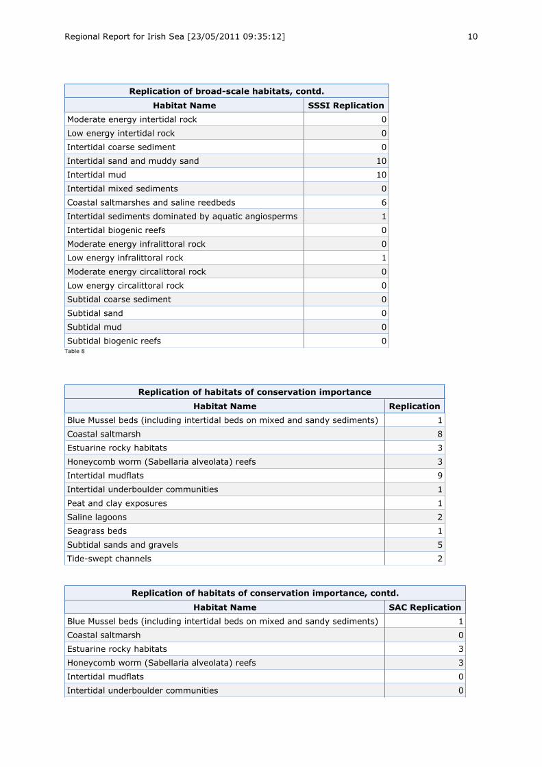
Regional Report for Irish Sea [23/05/2011 09:35:12] 10
Replication of broad-scale habitats, contd.
Habitat Name SSSI Replication
Moderate energy intertidal rock 0
Low energy intertidal rock 0
Intertidal coarse sediment 0
Intertidal sand and muddy sand 10
Intertidal mud 10
Intertidal mixed sediments 0
Coastal saltmarshes and saline reedbeds 6
Intertidal sediments dominated by aquatic angiosperms 1
Intertidal biogenic reefs 0
Moderate energy infralittoral rock 0
Low energy infralittoral rock 1
Moderate energy circalittoral rock 0
Low energy circalittoral rock 0
Subtidal coarse sediment 0
Subtidal sand 0
Subtidal mud 0
Subtidal biogenic reefs 0Table 8
Replication of habitats of conservation importance
Habitat Name Replication
Blue Mussel beds (including intertidal beds on mixed and sandy sediments) 1
Coastal saltmarsh 8
Estuarine rocky habitats 3
Honeycomb worm (Sabellaria alveolata) reefs 3
Intertidal mudflats 9
Intertidal underboulder communities 1
Peat and clay exposures 1
Saline lagoons 2
Seagrass beds 1
Subtidal sands and gravels 5
Tide-swept channels 2
Replication of habitats of conservation importance, contd.
Habitat Name SAC Replication
Blue Mussel beds (including intertidal beds on mixed and sandy sediments) 1
Coastal saltmarsh 0
Estuarine rocky habitats 3
Honeycomb worm (Sabellaria alveolata) reefs 3
Intertidal mudflats 0
Intertidal underboulder communities 0
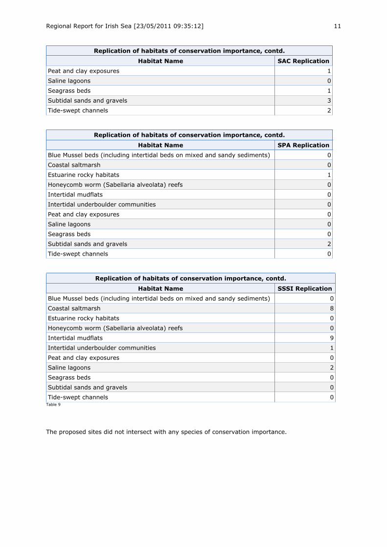
Regional Report for Irish Sea [23/05/2011 09:35:12] 11
Replication of habitats of conservation importance, contd.
Habitat Name SAC Replication
Peat and clay exposures 1
Saline lagoons 0
Seagrass beds 1
Subtidal sands and gravels 3
Tide-swept channels 2
Replication of habitats of conservation importance, contd.
Habitat Name SPA Replication
Blue Mussel beds (including intertidal beds on mixed and sandy sediments) 0
Coastal saltmarsh 0
Estuarine rocky habitats 1
Honeycomb worm (Sabellaria alveolata) reefs 0
Intertidal mudflats 0
Intertidal underboulder communities 0
Peat and clay exposures 0
Saline lagoons 0
Seagrass beds 0
Subtidal sands and gravels 2
Tide-swept channels 0
Replication of habitats of conservation importance, contd.
Habitat Name SSSI Replication
Blue Mussel beds (including intertidal beds on mixed and sandy sediments) 0
Coastal saltmarsh 8
Estuarine rocky habitats 0
Honeycomb worm (Sabellaria alveolata) reefs 0
Intertidal mudflats 9
Intertidal underboulder communities 1
Peat and clay exposures 0
Saline lagoons 2
Seagrass beds 0
Subtidal sands and gravels 0
Tide-swept channels 0Table 9
The proposed sites did not intersect with any species of conservation importance.
Regional Report for Irish Sea [23/05/2011 09:35:12] 12
Adequacy Regional Scale
To be considered adequate an MPA network needs to be of sufficient size and include a large enough proportion of features. For each broad-scale habitatthe MPAs within each regional MCZ project area should collectively protect a proportion of habitat known to occur in that area as specified in theEcological Network Guidance.
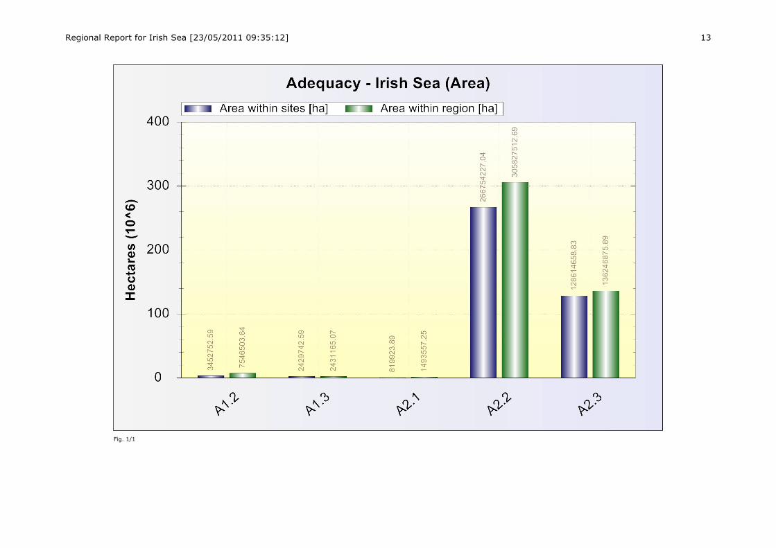
Regional Report for Irish Sea [23/05/2011 09:35:12] 13
Fig. 1/1
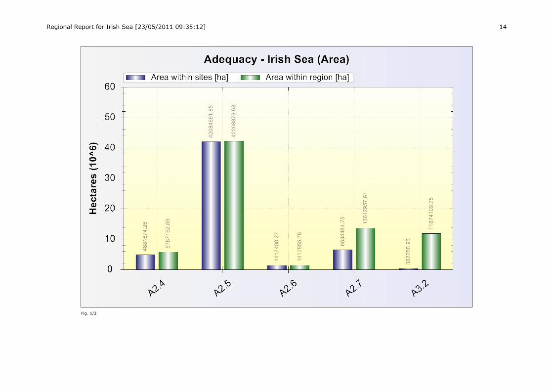
Regional Report for Irish Sea [23/05/2011 09:35:12] 14
Fig. 1/2
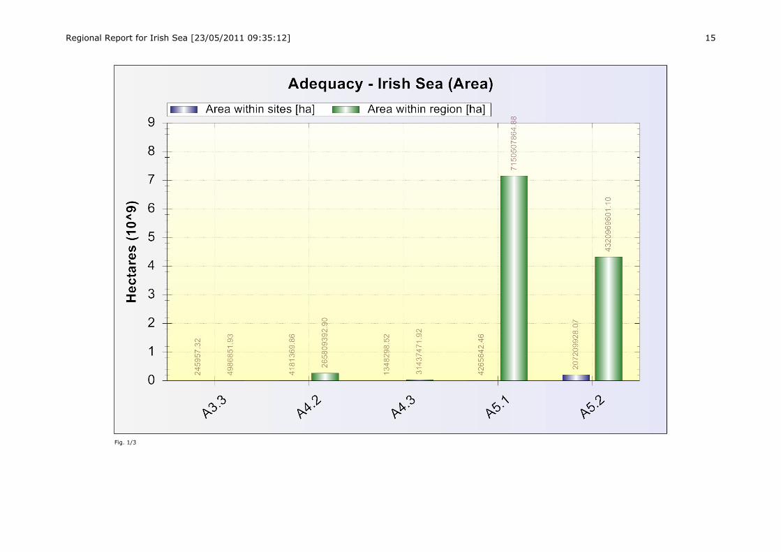
Regional Report for Irish Sea [23/05/2011 09:35:12] 15
Fig. 1/3
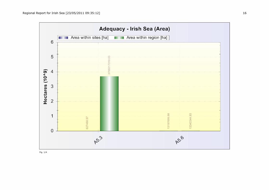
Regional Report for Irish Sea [23/05/2011 09:35:12] 16
Fig. 1/4
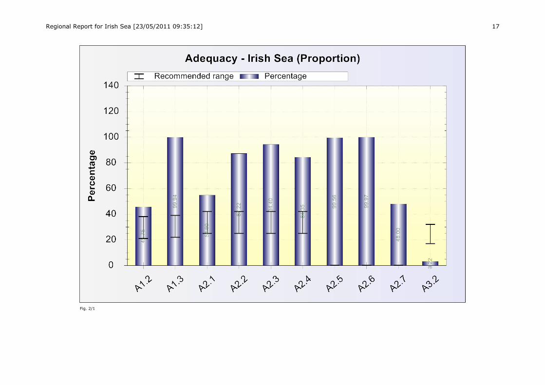
Regional Report for Irish Sea [23/05/2011 09:35:12] 17
Fig. 2/1
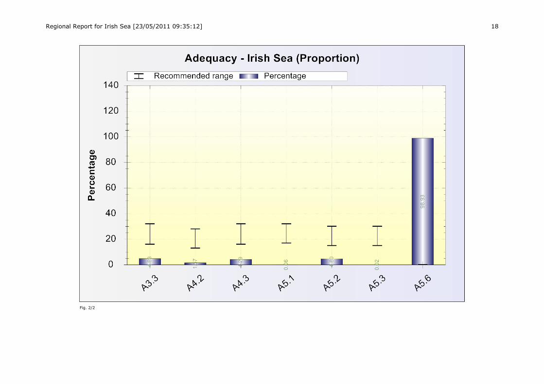
Regional Report for Irish Sea [23/05/2011 09:35:12] 18
Fig. 2/2