enhancement of earthquake and tsunami hfhkdi disaster...
TRANSCRIPT
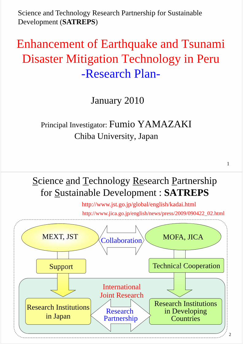
Science and Technology Research Partnership for Sustainable D l t (SATREPS)
h f h k d i
Development (SATREPS)
Enhancement of Earthquake and Tsunami Disaster Mitigation Technology in PeruDisaster Mitigation Technology in Peru
-Research Plan-Research Plan
January 2010
Principal Investigator: Fumio YAMAZAKIChiba University, Japan
1
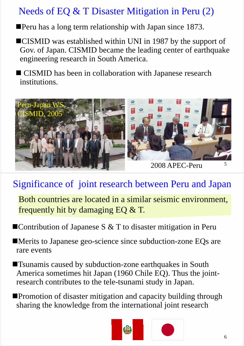
Science and Technology Research Partnership for Sustainable Development : SATREPSfor Sustainable Development : SATREPS
http://www.jst.go.jp/global/english/kadai.html
http://www.jica.go.jp/english/news/press/2009/090422_02.html
MOFA, JICAMEXT, JST Collaboration
Support Technical Cooperation
I t ti l
Support Technical Cooperation
International Joint Research
Research InstitutionsResearch Institutions in Developing
Countries
Research Institutions in Japan
Research Partnership
2

Background of the Peru Project
Earthquakes and tsunami disasters are the major obstacles for sustainable developments in the Asia-Pacific region.sustainable developments in the Asia Pacific region.
In order to reduce disaster risks, understanding of natural , ghazards and upgrading of societal resilience are necessary.
Since earthquakes and tsunamis are rare but devastating events, the data collection and action in a global scale is necessary.
Japan is expected to serve a leading role in the promotion of i t ti l di t iti tiinternational disaster mitigation.
– Hyogo Framework of Action 2005, ISDR
ISDR: International Strategy of Disaster Reduction
3
Needs of EQ & T Disaster Mitigation in Peru (1)Peru locates in the circum-Pacific seismic belt with high
seismic and tsunami risks.
Large inter-plate earthquakes occurred in Atico (2001) and in Pisco (2007) and thus EQ & T disaster mitigationand in Pisco (2007), and thus EQ & T disaster mitigation draws attention in Peru.
4
Needs of EQ & T Disaster Mitigation in Peru (2)
Peru has a long term relationship with Japan since 1873.
CISMID t bli h d ithi UNI i 1987 b th t fCISMID was established within UNI in 1987 by the support of Gov. of Japan. CISMID became the leading center of earthquake engineering research in South Americaengineering research in South America.
CISMID has been in collaboration with Japanese research pinstitutions.
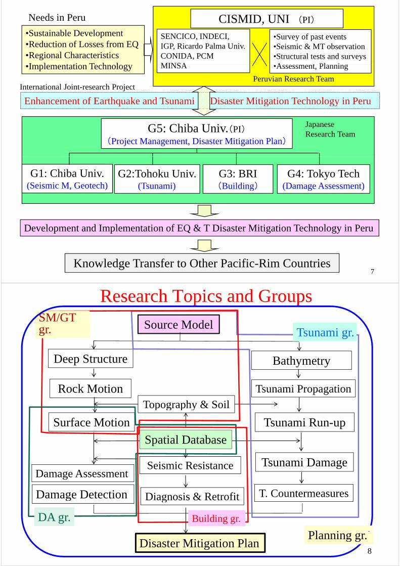
Peru-Japan WS,CISMID 2005CISMID, 2005
52008 APEC-Peru
Significance of joint research between Peru and Japan
Both countries are located in a similar seismic environment, frequently hit by damaging EQ & T.
Contribution of Japanese S & T to disaster mitigation in Peru
frequently hit by damaging EQ & T.
p g
Merits to Japanese geo-science since subduction-zone EQs are rare eventsrare events
Tsunamis caused by subduction-zone earthquakes in South y qAmerica sometimes hit Japan (1960 Chile EQ). Thus the joint-research contributes to the tele-tsunami study in Japan.
Promotion of disaster mitigation and capacity building through sharing the knowledge from the international joint researchsharing the knowledge from the international joint research
6
•Sustainable Development
CISMID, UNI (PI)
S f
Needs in Peru
SENCICO INDECI•Sustainable Development•Reduction of Losses from EQ•Regional CharacteristicsI l t ti T h l
•Survey of past events•Seismic & MT observation•Structural tests and surveysA t Pl i
SENCICO, INDECI, IGP, Ricardo Palma Univ.CONIDA, PCMMINSA•Implementation Technology •Assessment, Planning
International Joint-research Project
MINSA
Peruvian Research Team
Enhancement of Earthquake and Tsunami Disaster Mitigation Technology in Peru
G5 Chib U i ( )JapaneseG5: Chiba Univ.(PI)
(Project Management, Disaster Mitigation Plan)
Japanese Research Team
G3: BRI(Building)
G1: Chiba Univ.(Seismic M Geotech)
G4: Tokyo Tech(Damage Assessment)
G2:Tohoku Univ.(Tsunami) (Building)(Seismic M, Geotech) (Damage Assessment)(Tsunami)
Development and Implementation of EQ & T Disaster Mitigation Technology in Peru
Knowledge Transfer to Other Pacific-Rim Countries 7
Research Topics and GroupsSM/GT
Source Model Tsunami gr.
SM/GT gr.
Deep Structure Bathymetry
Tsunami PropagationRock MotionTopography & Soil
Surface Motion Tsunami Run-up
p g p y
Spatial Database
Seismic ResistanceD A
Tsunami Damage
Spatial Database
T. CountermeasuresDamage Detection
Damage Assessment
Diagnosis & Retrofitg g
DA gr. Building gr.
Pl iDisaster Mitigation Plan
8
Planning gr.
Research PlanProject Management:
PI F i Y ki (Chib U)PI: Fumio Yamazaki (Chiba U)【S. Nakai, S. Koshimura (Tohoku U), T. Saito (BRI), S. Midorikawa (TiTech)】
Project Management and Coordination•Project Management International & domestic coordinationProject Management, International & domestic coordination
•Public relations, Information dissemination, Reports
I t ti l k h S i•International workshops, Symposia
Peru-Japan WSPeru Japan WS
9
G1: Seismic Motion and Geotechnical Issues
GL: Shoich Nakai (Chiba Univ.)【H. Yamanaka (TiTech), N. Pulido (NIED), H. Arai (BRI), T. Sekiguchi】
1-1 Source Modeling and Prediction of Seismic Motion C ll ti f hi t i l EQ d t d i i d S i EQ•Collection of historical EQ data and seismic records, Scenario EQs
•Prediction of engineering bedrock motion•Development of ground structures based on seismic and microtremorobservations
f
Surface layers
surface
ye s
Eng. bedrockVS0.4km/s
Seismic bedrockVS3 0km/s
VS0.4km/s
10
VS3.0km/s
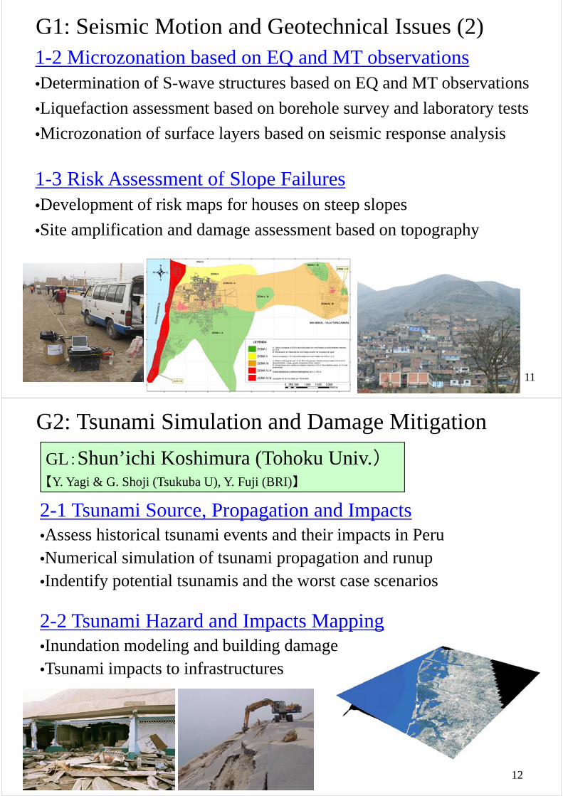
G1: Seismic Motion and Geotechnical Issues (2)1-2 Microzonation based on EQ and MT observations•Determination of S-wave structures based on EQ and MT observationsQ
•Liquefaction assessment based on borehole survey and laboratory tests
•Microzonation of surface layers based on seismic response analysis•Microzonation of surface layers based on seismic response analysis
1 3 Risk Assessment of Slope Failures1-3 Risk Assessment of Slope Failures•Development of risk maps for houses on steep slopes
•Site amplification and damage assessment based on topography
11
G2: Tsunami Simulation and Damage Mitigation
GL:Shun’ichi Koshimura (Tohoku Univ.)【Y. Yagi & G. Shoji (Tsukuba U), Y. Fuji (BRI)】
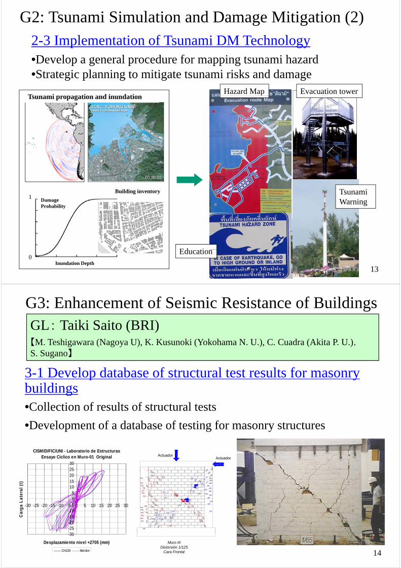
2-1 Tsunami Source, Propagation and ImpactsA hi t i l t i t d th i i t i P
g j ( ) j ( )
•Assess historical tsunami events and their impacts in Peru•Numerical simulation of tsunami propagation and runupI d if i l i d h i•Indentify potential tsunamis and the worst case scenarios
2 2 T i H d d I t M i2-2 Tsunami Hazard and Impacts Mapping•Inundation modeling and building damage•Tsunami impacts to infrastructures
12
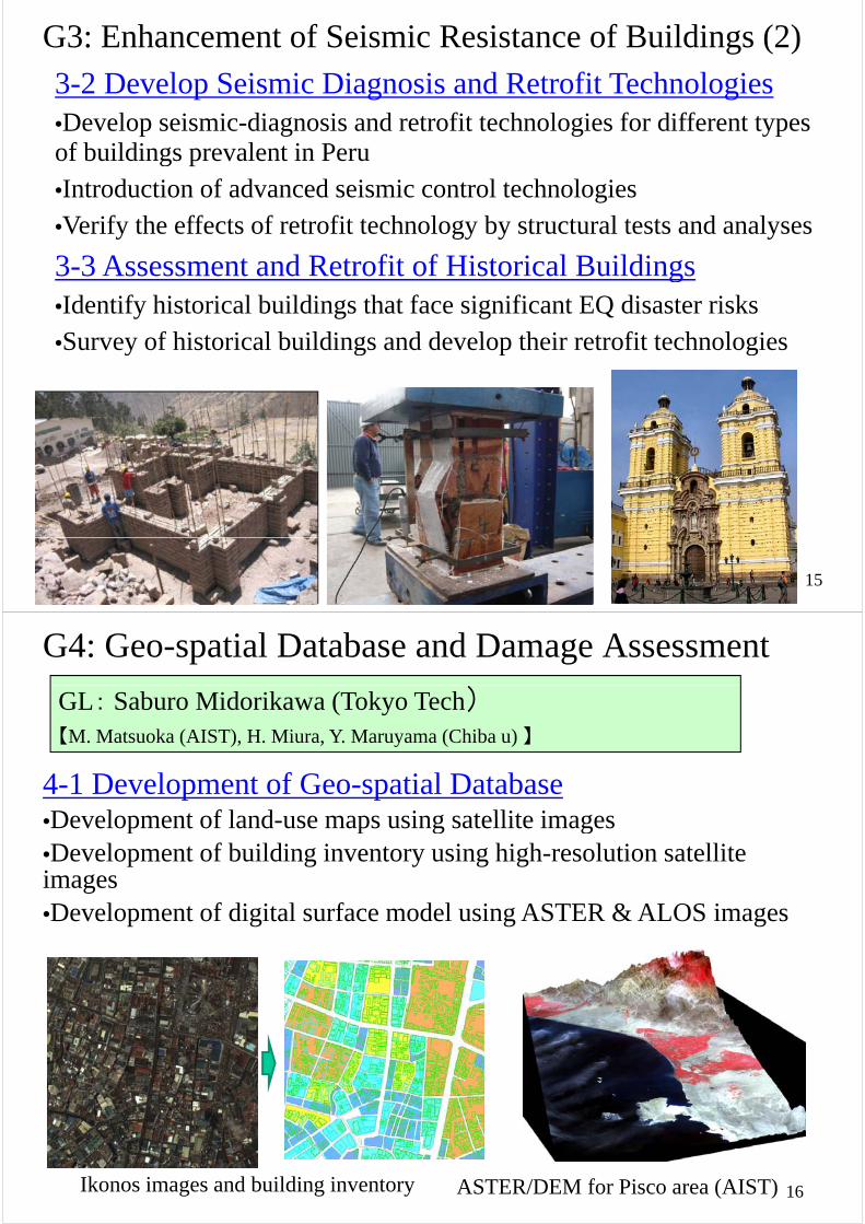
G2: Tsunami Simulation and Damage Mitigation (2)2-3 Implementation of Tsunami DM Technology•Develop a general procedure for mapping tsunami hazardp g p pp g•Strategic planning to mitigate tsunami risks and damage
T i ti d i d tiHazard Map Evacuation tower
Tsunami propagation and inundationp
Damage Probability
1Building inventory
避難ビル 避難場所
Tsunami Warning
避難 ル
Ed ti
13Inundation Depth
0Education
G3: Enhancement of Seismic Resistance of Buildings GL: Taiki Saito (BRI)【M. Teshigawara (Nagoya U), K. Kusunoki (Yokohama N. U.), C. Cuadra (Akita P. U.),
】
3-1 Develop database of structural test results for masonry
S. Sugano】
p ybuildings•Collection of results of structural testsCollection of results of structural tests
•Development of a database of testing for masonry structures
CISMID/FIC/UNI - Laboratorio de EstructurasEnsayo Ciclico en Muro-01 Original
2530
ActuadorActuador
340
428
428
05
101520
La
tera
l (t
)
23
312340
3
51
430
488
252308
430547
610
252
610
210
340
576
610
392235
392
578
514
514
514
336
338
578
174
430
308
308
435547
610
428
428
210
312
610
610
610
610
547
42631
2
510
578
576
356
578
538
578576 514
578 348
578
340308
30-25-20-15-10
-5-30 -25 -20 -15 -10 -5 0 5 10 15 20 25 30
Ca
rga
L
235
640
640
640
146
146
186
40
25
47
547
547
428
424
356
554
186
206
370
370
554
444
456
340
578
456
578402
210340
206
370
547
547
547
547
234
640
640
514186
644
234
35
356
356
174
174
340456
510
402
488
14
-30
Desplazamiento nivel +2705 (mm)
CH100 Monitor
Muro IIIDistorsión 1/125
Cara Frontal
G3: Enhancement of Seismic Resistance of Buildings (2)
3 2 D l S i i Di i d R fi T h l i3-2 Develop Seismic Diagnosis and Retrofit Technologies•Develop seismic-diagnosis and retrofit technologies for different types of buildings prevalent in Peru•Introduction of advanced seismic control technologies•Verify the effects of retrofit technology by structural tests and analyses
3-3 Assessment and Retrofit of Historical Buildings3 3 Assessment and Retrofit of Historical Buildings•Identify historical buildings that face significant EQ disaster risksSurvey of historical buildings and develop their retrofit technologies•Survey of historical buildings and develop their retrofit technologies
15
G4: Geo-spatial Database and Damage Assessment
GL: Saburo Midorikawa (Tokyo Tech)【M. Matsuoka (AIST), H. Miura, Y. Maruyama (Chiba u) 】
4-1 Development of Geo-spatial DatabaseDevelopment of land use maps using satellite images•Development of land-use maps using satellite images
•Development of building inventory using high-resolution satellite imagesimages•Development of digital surface model using ASTER & ALOS images
16ASTER/DEM for Pisco area (AIST)Ikonos images and building inventory

G4: Geo-spatial Database and Damage Assessment (2)4 2 Damage Detection using Satellite Images4-2 Damage Detection using Satellite Images• Earthquake damage detection of urban areas using optical/SAR
imagesimages• Detection of slope failures using optical/SAR images and DEM
4-3 Damage Assessment for Scenario Earthquakes• Predicting earthquake disaster losses of the study areasPredicting earthquake disaster losses of the study areas• Visualization of the assessment result on GIS
Damage map estimated
17
g pfrom ALOS/PALSAR image Damage survey by CISMID
G5: Development of Disaster Mitigation PlanGL: Fumio Yamazaki (Chiba U)GL: Fumio Yamazaki (Chiba U)【H. Kanegae (Ritsumeikan U), H. Kaji (TiTech), M. Muraki, all the GLs】
• Formulate land-use policies for mitigation of EQ & T disasters• Develop local disaster mitigation plans for the study areas• Awareness raising and dissemination activities for disaster
management organizations and local communities
( )
18Land-use plan after the 2007Pisco EQ (CISMID)Technical seminar(JICA-Peru, 2004)
R h IPeriod (2010-2014)
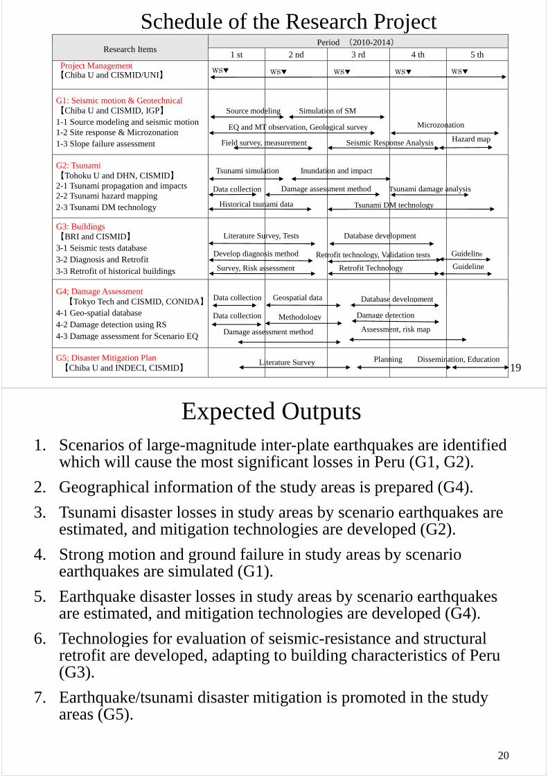
Schedule of the Research ProjectResearch Items
1 st 2 nd 3 rd 4 th 5 th Project Management 【Chiba U and CISMID/UNI】
WS▼ WS▼ WS▼ WS▼ WS▼
G1: Seismic motion & Geotechnical 【Chiba U and CISMID, IGP】 1-1 Source modeling and seismic motion 1 2 Sit & Mi ti
Source modeling Simulation of SM
EQ and MT observation, Geological survey Microzonation 1-2 Site response & Microzonation 1-3 Slope failure assessment
G2: Tsunami 【 h k d C S 】
Inundation and impactTsunami simulation
Field survey, measurement Seismic Response Analysis Hazard map
Q , g y
【Tohoku U and DHN, CISMID】2-1 Tsunami propagation and impacts 2-2 Tsunami hazard mapping 2-3 Tsunami DM technology Tsunami DM technology
Data collection Damage assessment method
Inundation and impact
Tsunami damage analysis
Historical tsunami data
Tsunami simulation
G3: Buildings 【BRI and CISMID】 3-1 Seismic tests database 3 2 Di i d R fi
Literature Survey, Tests
Develop diagnosis method
Database development
Retrofit technology, Validation tests Guideline3-2 Diagnosis and Retrofit 3-3 Retrofit of historical buildings
G4; Damage Assessment 【T k T h d CISMID CONIDA】
p g Retrofit technology, Validation tests
Survey, Risk assessment Retrofit Technology Guideline
Data collection Geospatial data Database development【Tokyo Tech and CISMID, CONIDA】
4-1 Geo-spatial database 4-2 Damage detection using RS 4-3 Damage assessment for Scenario EQ
Data collection Geospatial data
Methodology
Damage assessment method Assessment, risk map
Database development
Damage detection Data collection
19
g
G5; Disaster Mitigation Plan 【Chiba U and INDECI, CISMID】
Dissemination, Education Planning Literature Survey
Expected Outputs 1. Scenarios of large-magnitude inter-plate earthquakes are identified
which will cause the most significant losses in Peru (G1, G2).
2. Geographical information of the study areas is prepared (G4).
3. Tsunami disaster losses in study areas by scenario earthquakes are y y qestimated, and mitigation technologies are developed (G2).
4. Strong motion and ground failure in study areas by scenario g g y yearthquakes are simulated (G1).
5. Earthquake disaster losses in study areas by scenario earthquakes q y y qare estimated, and mitigation technologies are developed (G4).
6. Technologies for evaluation of seismic-resistance and structural gretrofit are developed, adapting to building characteristics of Peru (G3).
7. Earthquake/tsunami disaster mitigation is promoted in the study areas (G5).
20