ecosystem profile
TRANSCRIPT
Ecosystem Profile
East Melanesian Islands
Biodiversity Hotspot
FINAL VERSION
DECEMBER 2012
ii
Prepared by:
University of the South Pacific
in collaboration with:
Conservation International
University of Papua New Guinea
on behalf of:
Critical Ecosystem Partnership Fund
Drafted by the ecosystem profiling team:
Bill Aalbersberg
Michael Avosa Roger James
Chalapan Kaluwin
Paul Lokani Job Opu
Suliana Siwatibau
Marika Tuiwawa
Hilda Waqa-Sakiti Andrew W. Tordoff
Assisted by the following experts and contributors: Lawrence Abage Nathos Beach Club, New Ireland, Papua New Guinea
Michael Aigro University of Papua New Guinea
Julia Aimaea Ministry of Forests and Research, Papua New Guinea
Cosmos Akong Whiteman Range, West New Britain, Papua New Guinea
Philemon Ala Forestry Department, Vanuatu
Freddie Alei University of Papua New Guinea
Lui Allick Tafea Provincial Government, Vanuatu
Jason Alonk University of Papua New Guinea
Alwin Amat University of Papua New Guinea
Jeane Amos Raura Manager, New Ireland, Papua New Guinea
Lazarus Amos Samna Provincial Government, Vanuatu
Philip Anacleti Department of Environment and Conservation, Vanuatu
Ramokasa Anisi University of the South Pacific, Solomon Islands
Bill Apusae Live and Learn, Solomon Islands
Troy Apusae Solomon Islands College of Higher Education
Philip Arul University of Papua New Guinea

iii
Andrew Assman University of Papua New Guinea
James Atherton independent consultant, Samoa
Gabriel Bata Kilu Locally Managed Marine Area, West New Britain, Papua New Guinea
Bradley Ben Aua Wuvulu, Manus, Papua New Guinea
David Blair James Cook University, Australia
Wilco Bosma Natural Resources Development Foundation, Solomon Islands
Delvene Boso WorldFish Center, Solomon Islands
Souad Boudjelas Pacific Invasives Initiative, New Zealand
Gilliane Brodie University of the South Pacific, Fiji
Rose Buabua Ministry of Environment, Conservation, Disaster Management and
Meteorology, Solomon Islands
Prosper Buletare Samna Provincial Government, Vanuatu
Sam Chanel Forestry Department, Vanuatu
Steve Cranwell BirdLife Pacific Seabird Programme, New Zealand
John Daniel Keasi Forest Reserve, Vanuatu
Presly Devo Department of Environment and Conservation, Vanuatu
Chris Filardi American Museum of Natural History, USA
Robert Fisher US Geological Survey, USA
Charles Gevia Mami Local Level Government, Papua New Guinea
Kalkava George community representative, Vanuatu
Alois Ginia University of Papua New Guinea
Francis Gove Mahonia Na Dari, Papua New Guinea
Ronald Gumaira Department of Environment and Conservation, Papua New Guinea
Constance Hemmer Solomon Islands Community Conservation Partnership
Rex Horoi Foundation of the Peoples of the South Pacific International, Fiji
Chanel Iroi Ministry of Environment, Conservation, Disaster Management and
Meteorology, Solomon Islands
Emmanuel Jack community representative, West New Britain, Papua New Guinea
Donald James Wan Smolbag Theatre, Vanuatu
Abraham John Chief of Napauk village, Vanuatu
Kalpeau Joseph community representative, Vanuatu
Esau Kabin New Ireland Provincial Administration, Papua New Guinea
Donna Kalfatak Department of Environment and Conservation, Vanuatu
Rossette Kalmet Department of Geology, Mines and Water Resources, Vanuatu
Selan Kaluwin World Wide Fund for Nature, Manus, Papua New Guinea
Bruce Kanawa National Broadcasting Corporation, West New Britain, Papua New Guinea
Franky Kapin FM 100, New Ireland, Papua New Guinea
Sanalai Kautil New Ireland Provincial Administration, Papua New Guinea
Pierro Kawiseli landowner, Mount Tukusmera, Vanuatu
Bruna Kemah landowner, Mount Tukusmera, Vanuatu
Danny Kennedy Western Provincial Government, Solomon Islands
Chris Kiri Solomon Islands College of Higher Education
Victor Kohaia Makira Community Conservation Foundation, Solomon Islands
iv
Janet Konambe Manus Provincial Administration, Papua New Guinea
Ludwick Koipa University of Papua New Guinea
Max Kuduk The Nature Conservancy, New Ireland, Papua New Guinea
Gabriel Kuluma The Nature Conservancy, Manus, Papua New Guinea
Pang Kumin Strongim Pipol Strongim Nesen, New Ireland, Papua New Guinea
Titus Kuno Local Level Government, West New Britain, Papua New Guinea
Brigette Laboukly Department of Arts and Culture, Vanuatu
John Lamaris community representative, New Ireland, Papua New Guinea
Junior Lawrence Londra Community-based Organization, Papua New Guinea
Adolphina Luvonet Mahonia Na Dari, Papua New Guinea
Trevor Maeda Department of Environment, Solomon Islands
Peter Mahoa Solomon Islands College of Higher Education
Alex Makini Solomon Islands College of Higher Education
Bruno Manele WWF, Solomon Islands
Tia Masolo Department of Environment, Solomon Islands
Manuai Matawai The Nature Conservancy, Papua New Guinea
Will McClatchey Botanical Research Institute of Texas, USA
Bianca Meli New Ireland Tourism, Papua New Guinea
Noel Mobhia Prime Minster’s Department, Papua New Guinea
Wartut Molisa Chief of Penouaru village, Vanuatu
Esrom Molisa Department of Water Resources Management and Mines, Vanuatu
Tom Morove Wildlife Conservation Society, New Ireland, Papua New Guinea
Rose Moveni Western province, Solomon Islands
Thomas Mundri community representative, Papua New Guinea
Bill Nagle Pacific Invasives Initiative, New Zealand
Ellie Naron Londra Community-based Organization, Papua New Guinea
John Naron Londra Community-based Organization, Papua New Guinea
Simon Naupa Forestry Extension Office, Tafea, Vanuatu
Latin N’Drhin Qualican 555, Manus, Papua New Guinea
Sylvie Niras Women’s Affairs Officer, Tafea, Vanuatu
Alsen Obed Fisheries Department, Santo, Vanuatu
Mark O’Brien BirdLife International, Fiji
Diarmaid O’Foighil University of Michigan, USA
Taman Willie Onesmas community representative, Vanuatu
Brian Pake University of Papua New Guinea
Jarius Paror New Ireland Youth Advocacy Forum, Papua New Guinea
Jean Paul landowner, Mount Tukusmere, Vanuatu, Papua New Guinea
Paul Peterson community-based organization, New Ireland, Papua New Guinea
Patrick Pikacha Solomon Islands Community Conservation Partnership
John Pilgrim independent consultant, UK
John Pita The Nature Conservancy, Solomon Islands
Lemen Polau Bundro ASI Development Trust, Manus, Papua New Guinea
Aroen Ponowan community representative, Manus, Papua New Guinea

v
Modi Pontio Wildlife Conservation Society, New Ireland, Papua New Guinea
Valentine Popiu Nakanai Flora and Fauna Protectors, West New Britain, Papua New Guinea
David Posile Manus Provincial Administration, Papua New Guinea
Selan Pranis Palamot ASI Trust, Manus, Papua New Guinea
Jenaun Purewa New Ireland Provincial Administration, Papua New Guinea
Justin Puso Education Dept., Autonomous Region of Bougainville, Papua New Guinea
Nick Rau Mahonia Na Dari, Papua New Guinea
Nick Raui Live and Learn, Tanna, Vanuatu
Jeffrey Reuben Live and Learn, Tanna, Vanuatu
Lorena Ritsi Tourism Office, Autonomous Region of Bougainville, Papua New Guinea
John Ronneth Department of Environment and Conservation, Vanuatu
Caroline Rovo Department of Environment and Conservation, Vanuatu
Jorge Rumaropen Post Courier, New Ireland, Papua New Guinea
Michael Saikio University of Papua New Guinea
Ruth Anton Sale Manus Provincial Administration, Papua New Guinea
Nuprei Sam landowner, Mount Tukusmera, Vanuatu
Alan Saunders Pacific Invasives Initiative, New Zealand
Smith Savakana Forestry Department, Gizo, Solomon Islands
Remo Sela Penauro Conservation Committee, Vanuatu
Shannon Seeto World Wide Fund for Nature Western Melanesia Program, Solomon Islands
Waraker Ser Live and Learn, Santo, Vanuatu
Newell Sinagawi Fisheries Office, West New Britain, Papua New Guinea
Ross Sinclair Wildlife Conservation Society, Papua New Guinea
Myknee Sirikolo University of the South Pacific, Solomon Islands
Leo Soli Caritas, Autonomous Region of Bougainville, Papua New Guinea
Steve Suti Natural Resources and Development Foundation, Solomon Islands
Mary Taipul University of Papua New Guinea
Fidelma Takali Fisheries Office, West New Britain, Papua New Guinea
Reedly Tavi community representative, Vanuatu
Rolenas Tavue Department of Environment and Conservation, Vanuatu
Francis Tekatoha Western province, Solomon Islands
Ben Thomas community representative, New Ireland, Papua New Guinea
Janet Tilikewei Open College, Manus, Papua New Guinea
Esther Timpa Tourism Office, Autonomous Region of Bougainville, Papua New Guinea
Touasi Tiwok Department of Environment, Vanuatu
John Tokia community representative, New Ireland, Papua New Guinea
John Tokios community representative, Manus, Papua New Guinea
Dick Tomker Forestry Extension Office, Vanuatu
Patrick Topital Roots of Change, New Ireland, Papua New Guinea
Salome Topo WWF, Solomon Islands
David Tovovor Tafea Provincial Government, Vanuatu
Christine Trenorden International Union for the Conservation of Nature
Reuben Tuka Papua New Guinea Center for Locally Managed Marine Areas

vi
Morgan Wairiu University of the South Pacific, Fiji
Barth Waka Pokili Wildlife Management Area, West New Britain, Papua New Guinea
Joseph Willie Keasi Forest Reserve, Vanuatu
vii
CONTENTS
CONTENTS ........................................................................................................... VII EXECUTIVE SUMMARY ........................................................................................ IX
1. INTRODUCTION .................................................................................................. 1 2. BACKGROUND.................................................................................................... 3 3. BIOLOGICAL IMPORTANCE OF THE HOTSPOT ............................................ 4
3.1 Geography....................................................................................................... 4
3.2 Geology ........................................................................................................... 5
3.3 Climate ............................................................................................................ 7
3.4 Ecoregions, Habitats and Ecosystems .......................................................... 9
3.5 Coastal and Nearshore Marine Environment............................................... 16
3.6 Species Diversity and Endemism ................................................................. 18
3.7 Cultural Perspectives on Biodiversity ........................................................... 21
4. CONSERVATION OUTCOMES DEFINED FOR THE HOTSPOT ................... 22
4.1 Introduction ................................................................................................... 22
4.2 Methodology .................................................................................................. 23
4.3 Results .......................................................................................................... 29
5. SOCIO-ECONOMIC CONTEXT OF THE HOTSPOT ....................................... 40 5.1 Introduction ................................................................................................... 40
5.2 Socio-economic Context ............................................................................... 40
6. POLICY CONTEXT OF THE HOTSPOT ........................................................... 49 6.1 Introduction ................................................................................................... 49
6.2 Overview of the Regional and National Political Situation .......................... 50
6.3 Global and Regional Agreements ................................................................ 54
6.4 Environmental Policies and Legislation ....................................................... 60
6.5 Protected Areas ............................................................................................ 64
7. CIVIL SOCIETY CONTEXT OF THE HOTSPOT .............................................. 65 7.1 Introduction ................................................................................................... 65
7.2 Regulatory Framework ................................................................................. 65
7.3 Operating Environment ................................................................................. 68
7.4 Funding Environment .................................................................................... 73
7.5 Possible Recipients of Conservation Grants ............................................... 75
7.6 The Civil Society Sector................................................................................ 78
7.7 Geographic Coverage................................................................................... 83
7.8 Civil Society Capacity ................................................................................... 84
7.9 Networks and Partnerships .......................................................................... 87
7.10 Investment Types and Modalities ............................................................... 90
8. CLIMATE CHANGE ASSESSMENT................................................................. 91 8.1 Introduction ................................................................................................... 91
8.2 Climate Change and Variability .................................................................... 92
8.3 Potential Scenarios of Future Climate Change and Climate Variability...... 94
8.4 Climate Change Impacts on Biodiversity ..................................................... 99
8.5 Climate Change Initiatives Relevant to Biodiversity Conservation ...........106
viii
8.6 Factors Influencing Conservation Efforts ...................................................112
9. THREAT ASSESSMENT .................................................................................115 9.1 Introduction .................................................................................................115
9.2 Main Threats ...............................................................................................116
9.3 Drivers .........................................................................................................125
9.4 Solutions......................................................................................................129
10. ASSESSMENT OF CURRENT CONSERVATION INVESTMENT ..............133 10.1 Introduction ...............................................................................................133
10.2 Major Sources of Investment in the Hotspot ............................................134
10.3 Summary of Investment by Country .........................................................142
10.4 Thematic Distribution of Investment .........................................................145
10.5 Strategic Funding Initiatives .....................................................................146
10.6 Success Factors and Barriers to Success ...............................................148
10.7 Recommendations ....................................................................................158
11. CEPF INVESTMENT NICHE .........................................................................159 12. CEPF INVESTMENT STRATEGY AND PROGRAM FOCUS .....................162
12.1 Geographic Priorities ................................................................................162
12.2 Taxonomic Priorities .................................................................................168
12.3 Strategic Directions and Investment Priorities .........................................172
13. SUSTAINABILITY ..........................................................................................186 14. CONCLUSION ................................................................................................189
EAST MELANESIAN ISLANDS LOGICAL FRAMEWORK: 2013-2021...........191 ABBREVIATIONS USED IN THE TEXT .............................................................196 REFERENCES .....................................................................................................198
APPENDICES .......................................................................................................211

ix
EXECUTIVE SUMMARY
The Critical Ecosystem Partnership Fund (CEPF) is designed to safeguard the world’s
biologically richest and most threatened regions, known as biodiversity hotspots. It is a
joint initiative of l’Agence Française de Développement, Conservation International (CI),
the European Commission, the Global Environment Facility, the Government of Japan,
the John D. and Catherine T. MacArthur Foundation, and the World Bank.
A fundamental purpose of CEPF is to engage civil society, such as community groups,
nongovernmental organizations (NGOs), academic institutions and private enterprises, in
biodiversity conservation in the hotspots. To guarantee their success, these efforts must
complement existing strategies and programs of national governments and other
conservation funders. To this end, CEPF promotes working alliances among diverse
groups, combining unique capacities and reducing duplication of efforts for a
comprehensive, coordinated approach to conservation. One way in which CEPF does this
is through preparation of “ecosystem profiles”—shared strategies, developed in
consultation with local stakeholders, which articulate a five-year investment strategy
informed by a detailed situational analysis.
This document is the ecosystem profile for the East Melanesian Islands Hotspot, which
includes the island nations of Vanuatu and the Solomon Islands and the islands region of
Papua New Guinea (PNG), which includes the provinces of Manus, New Ireland, East
New Britain and West New Britain plus the Autonomous Region of Bougainville. The
East Melanesian Islands qualify as a hotspot due to their high levels of plant and animal
endemism and accelerating levels of habitat loss, caused chiefly by widespread
commercial logging and mining, expansion of subsistence and plantation agriculture,
population increase, and the impacts of climate change and variability. The East
Melanesian Islands Hotspot holds exceptional cultural and linguistic diversity. Vanuatu,
for example, has 108 living languages: more per unit area than any other country.
Because many languages are spoken by only a few hundred people, they are
disappearing, leading to a rapid erosion of traditional knowledge and practice. This is
highly significant in a region where most land and resources are under customary
ownership, and local people are true stewards of biodiversity.
Ecosystem profiling process
The ecosystem profile for the East Melanesian Islands Hotspot was developed through a
process of consultation and desk study led by the University of the South Pacific in
partnership with the University of PNG and CI’s Pacific Islands Program. Initial research
and analysis at the regional level provided draft biodiversity and thematic (or contextual)
priorities, which were subsequently reviewed by experts within the hotspot. The year-
long consultation process involved an expert roundtable meeting and nine stakeholder
consultation workshops, and engaged more than 150 stakeholders from local
communities, CSOs, government institutions and donor agencies.

x
The ecosystem profile presents an overview of the East Melanesian Islands in terms of
their biodiversity conservation importance, and socioeconomic, policy and civil society
contexts. It defines a suite of measurable conservation outcomes, at species, site and
corridor (or landscape) scales, as the scientific basis for determining CEPF’s geographic
and thematic niche for investment. The conservation outcomes for the East Melanesian
Islands Hotspot are framed by a situational analysis, which includes an assessment of the
predicted impacts of climate change in the region, as well as reviews of the policy, socio-
economic and civil society contexts for biodiversity conservation. It also includes an
assessment of patterns and trends in current conservation investment, which captures
lessons learned from past investments in the hotspot, as well as an overview of threats
and drivers of biodiversity loss.
The conservation outcomes and situational analysis provide the justification for a niche
and investment strategy for CEPF in the hotspot. The investment strategy comprises a set
of strategic funding opportunities, termed strategic directions, broken down into
investment priorities outlining the types of activities that will be eligible for CEPF
funding. Civil society actors may propose projects that will help implement the strategy
by fitting into at least one of the strategic directions. The ecosystem profile does not
include specific project concepts, as civil society groups will develop these as part of
their applications for CEPF grant funding.
CEPF Niche and Investment Strategy
The purpose of the investment niche is to define where CEPF investment can make the
greatest and most sustained contribution to the conservation of globally important
biodiversity in the East Melanesian Islands Hotspot, within the context of other
investments by governments, donors and civil society. To this end, the CEPF niche was
defined in three dimensions: geographic; taxonomic; and thematic.
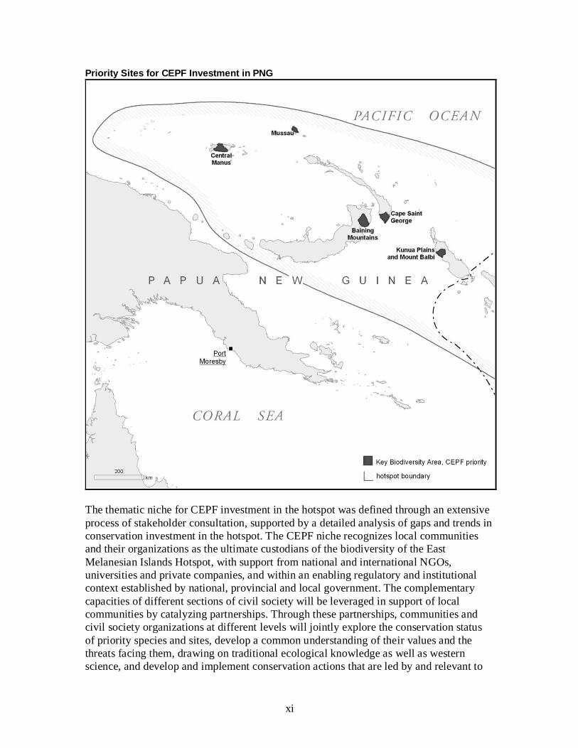
The geographic niche for CEPF investment in the East Melanesian Islands Hotspot is
defined in terms of priority sites. These were selected from among the full list of Key
Biodiversity Areas (KBAs) in the hotspot based on an initial biological prioritization,
followed by the application of expert opinion to identify sites where CEPF investment
could be expected to have the greatest impact. The list of priority sites contains 20 KBAs,
comprising five in PNG, nine in the Solomon Islands and six in Vanuatu, and covering a
total area of 1.5 million hectares. While the priority sites are principally terrestrial
conservation priorities, 11 of them contain significant areas of marine habitat, creating
opportunities for ridge-to-reef conservation.
The taxonomic niche for CEPF investment in the hotspot is provided by priority species,
selected by stakeholders following standard criteria. The purpose of selecting priority
species was to enable investments in species-focused conservation action to be directed at
those globally threatened species whose conservation needs cannot adequately be
addressed by habitat protection alone. Of the full list of 308 globally threatened species in
the hotspot, 48 were selected as priorities for CEPF investment, comprising 20 mammals,
11 birds, five reptiles, two amphibians and 10 plants.
xi
Priority Sites for CEPF Investment in PNG
The thematic niche for CEPF investment in the hotspot was defined through an extensive
process of stakeholder consultation, supported by a detailed analysis of gaps and trends in
conservation investment in the hotspot. The CEPF niche recognizes local communities
and their organizations as the ultimate custodians of the biodiversity of the East
Melanesian Islands Hotspot, with support from national and international NGOs,
universities and private companies, and within an enabling regulatory and institutional
context established by national, provincial and local government. The complementary
capacities of different sections of civil society will be leveraged in support of local
communities by catalyzing partnerships. Through these partnerships, communities and
civil society organizations at different levels will jointly explore the conservation status
of priority species and sites, develop a common understanding of their values and the
threats facing them, drawing on traditional ecological knowledge as well as western
science, and develop and implement conservation actions that are led by and relevant to

xii
local communities. To respond to threats originating outside of the community, such as
commercial logging and plantations, civil society will be supported to integrate
biodiversity conservation into local land-use and development planning.
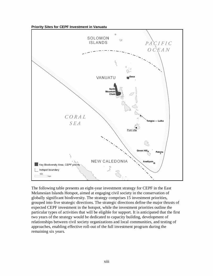
Priority Sites for CEPF Investment in the Solomon Islands
Drawing on lessons learned from past conservation programs in the region, conservation
interventions will be developed gradually, to allow sufficient time for trust and
understanding to be built among partners, for capacity and knowledge to be transferred,
and for long-term funding to be identified and secured. Central to the sustainability
strategy of the CEPF investment program in the East Melanesian Islands Hotspot will be
an explicit focus on capacity building for local and national civil society through
partnerships, networks and mentoring. To allow sufficient time for effective partnerships,
enduring capacity and sustained on-the-ground results to be achieved, an investment
period of eight years (rather than the usual five) is proposed.
xiii
Priority Sites for CEPF Investment in Vanuatu
The following table presents an eight-year investment strategy for CEPF in the East
Melanesian Islands Hotspot, aimed at engaging civil society in the conservation of
globally significant biodiversity. The strategy comprises 15 investment priorities,
grouped into five strategic directions. The strategic directions define the major thrusts of
expected CEPF investment in the hotspot, while the investment priorities outline the
particular types of activities that will be eligible for support. It is anticipated that the first
two years of the strategy would be dedicated to capacity building, development of
relationships between civil society organizations and local communities, and testing of
approaches, enabling effective roll-out of the full investment program during the
remaining six years.

xiv
CEPF Strategic Directions and Investment Priorities in the East Melanesian Islands Hotspot
Strategic Directions Investment Priorities
1. Empower local communities to protect and manage globally significant biodiversity at priority Key Biodiversity Areas under-served by current conservation efforts
1.1 Conduct baseline surveys of priority sites that build government-civil society partnerships and bridge political boundaries
1.2 Raise awareness about the values of biodiversity and the nature of threats and drivers among local communities at priority sites
1.3 Support local communities to design and implement locally relevant conservation actions that respond to major threats at priority sites
1.4 Demonstrate conservation incentives (ecotourism, payments for ecosystem services, conservation agreements, etc.) at priority sites
2. Integrate biodiversity conservation into local land-use and development planning
2.1 Conduct participatory ownership and tenure mapping of resources within customary lands at priority sites
2.2 Provide legal training and support to communities for effective enforcement of environmental protection regulations
2.3 Explore partnerships with private companies to promote sustainable development through better environmental and social practices in key natural resource sectors
3. Safeguard priority globally threatened species by addressing major threats and information gaps
3.1 Conduct research on six globally threatened species for which there is a need for greatly improved information on their status and distribution
3.2 Develop, implement and monitor species recovery plans for species most at risk, where their status and distribution are known
3.3 Introduce science-based harvest management of priority species important to local food security
4. Increase local, national and regional capacity to conserve biodiversity through catalyzing civil society partnerships
4.1 Strengthen the capacity of local and national civil society organizations in financial management, project management and organizational governance
4.2 Provide core support for the development of civil society organizations into national and regional conservation leaders
4.3 Strengthen civil society capacity in conservation management, science and leadership through short-term training courses at domestic academic institutions
5. Provide strategic leadership and effective coordination of conservation investment through a Regional Implementation Team
5.1 Operationalize and coordinate CEPF’s grant-making processes and procedures to ensure effective implementation of the investment strategy throughout the hotspot
5.2 Build a broad constituency of civil society groups working across institutional and political boundaries towards achieving the shared conservation goals described in the ecosystem profile

xv
Conclusion
In terms of species richness and, especially, endemism, the East Melanesian Islands are
one of the most biologically important regions on the planet. In addition, the mainly rural
population relies heavily on biodiversity for food security and livelihoods. Customary
land ownership and resource tenure are constitutionally guaranteed but boundaries are
often in dispute. Rural populations have long been isolated by barriers of geography and
language, resulting in a high level of self-reliance but also cultural differences among
groups. Threats to biodiversity have increased in recent decades through expansion of
subsistence agriculture and commercial plantations and the growth of the logging and
mining industries. The underlying drivers of these threats include population growth,
urbanization and migration patterns, economic growth and increasing consumption.
Over the last two decades, the countries in the hotspot have developed NBSAPs and other
conservation strategies, and INGOs have established programs there. Significant
investment in conservation has been made over this period but it has not always delivered
the expected results or left a legacy in terms of local capacity and appreciation of
conservation objectives. Nevertheless, domestic civil society organizations focusing on
biodiversity conservation have begun to emerge in all three countries. In addition, local
communities, sometimes with outside support and sometimes independently, have
responded to the conservation issues facing them with a range of strategies, often founded
on traditional customs and governance arrangements. The conservation approach that has
shown greatest promise in recent years has been community-managed conservation areas,
especially locally managed marine areas; although this requires significant capacity to be
built among both community-based organizations and the groups that give them technical
support, as well as clear communication and monitoring, to ensure that these areas deliver
on the overlapping but different goals of communities and conservation organizations.
Moreover, there is a need to integrate the goals of conservation areas into plans and
policies of other sectors, so that they are not undermined by incompatible developments.
In this context, there are significant opportunities for CEPF to support biodiversity
conservation in ways that deliver significant, meaningful benefits to local communities.
However, this will require an engagement longer than the typical five-year investment
period, a commitment to capacity building at multiple levels, and a readiness to align
global biodiversity priorities with local cultural and development priorities.
To develop its strategy to deliver a program of investment along these lines, CEPF
commissioned a year-long consultative process, which involved an expert roundtable
meeting and nine stakeholder consultation workshops, and engaged more than 150
stakeholders from local communities, CSOs, government institutions and donor agencies.
The process resulted in a common conservation vision for the hotspot and an eight-year
investment strategy for CEPF. This strategy comprises 15 investment priorities, grouped
under five strategic directions. The successful implementation of this strategy will require
time, persistence and, above all, a commitment to genuine and lasting partnership. The
cooperation and common vision that has been witnessed through the ecosystem profiling
process inspires confidence that such success will be achieved.
1
1. INTRODUCTION
Founded in 2000, the Critical Ecosystem Partnership Fund (CEPF) is designed to ensure
civil society is engaged in biodiversity conservation. It is a joint initiative of l’Agence
Française de Développement, Conservation International (CI), the European
Commission, the Global Environment Facility (GEF), the Government of Japan, the John
D. and Catherine T. MacArthur Foundation, and the World Bank. CI, as one of the
founding partners, administers the global program through the CEPF Secretariat.
CEPF is unique among funding mechanisms in that it focuses on biological areas rather
than political boundaries and examines conservation threats on a landscape-scale basis. A
fundamental purpose of CEPF is to ensure that civil society is engaged in efforts to
conserve biodiversity in the hotspots, and to this end, CEPF provides civil society with an
agile and flexible funding mechanism complementing funding currently available to
government agencies.
CEPF promotes working alliances among community-based organizations (CBOs),
nongovernmental organizations (NGOs), government, academic institutions and the
private sector, combining unique capacities and eliminating duplication of efforts for a
comprehensive approach to conservation. CEPF targets transboundary cooperation for
areas of rich biological value that straddle national borders or in areas where a regional
approach may be more effective than a national approach.
In 2011, CEPF began exploring an investment program in the East Melanesian Islands
Hotspot, comprising the island nations of Vanuatu and the Solomon Islands and the
islands region of Papua New Guinea (PNG), which includes the provinces of Manus,
New Ireland, East New Britain and West New Britain plus the Autonomous Region of
Bougainville (Figure 1). The East Melanesian Islands Hotspot holds exceptional cultural
and linguistic diversity. Vanuatu, for example, has 108 living languages (Lewis 2009),
more per unit area than any other country. The Solomon Islands, with 74 languages, are
only slightly less diverse. Because many languages are spoken by only a few hundred
people, they are dying out or mixing into pidgin-Austronesian creoles, leading to a rapid
erosion of traditional knowledge and practice. This is highly significant in a region where
most land and resources are under customary ownership, and local people are true
stewards of biodiversity.
The East Melanesian Islands qualify as a hotspot due to their high levels of endemism
and accelerating levels of habitat loss, caused chiefly by widespread commercial logging
and mining, expansion of subsistence and plantation agriculture, population increase, and
the impacts of climate change and variability.
The hotspot is one of the most geographically complex areas on the earth. Isolation and
adaptive radiation have led to very high levels of endemism, both within the hotspot as a
whole and on single islands. Because most of the islands have never been in land contact
with New Guinea, their fauna and flora are a mix of recent long-distance immigrants and
indigenous lineages derived from ancient Pacific-Gondwanaland species. Thus, the
2
hotspot contains classic examples of relatively recent adaptive radiation typical of
oceanic islands, such as the white-eyes (family Zosteropidae) and monarch flycatchers
(family Monarchidae), but also carries some odd colonizers from times past, such as the
Solomon Islands skink (Corucia zebrata), whose closest living relatives are the blue-
tongued skinks (genus Tiliqua) of Australia, New Guinea and Indonesia. The East
Melanesian Islands Hotspot also has affinities with Fiji (included as part of the Polynesia-
Micronesia Hotspot), such as the Platymantis frogs, ancient monkey-faced bats of the
genus Pteralopex, and Nesoclopeus rails.
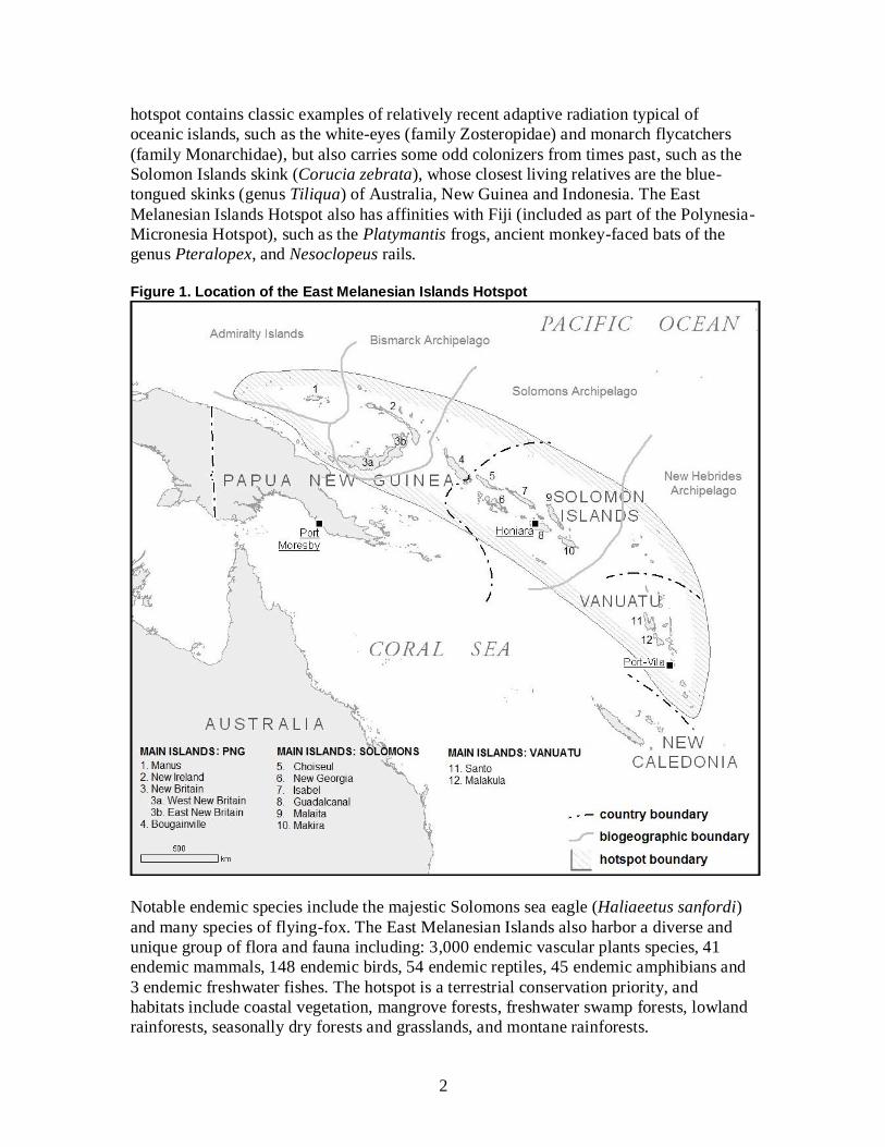
Figure 1. Location of the East Melanesian Islands Hotspot
Notable endemic species include the majestic Solomons sea eagle (Haliaeetus sanfordi)
and many species of flying-fox. The East Melanesian Islands also harbor a diverse and
unique group of flora and fauna including: 3,000 endemic vascular plants species, 41
endemic mammals, 148 endemic birds, 54 endemic reptiles, 45 endemic amphibians and
3 endemic freshwater fishes. The hotspot is a terrestrial conservation priority, and
habitats include coastal vegetation, mangrove forests, freshwater swamp forests, lowland
rainforests, seasonally dry forests and grasslands, and montane rainforests.

3
Nevertheless, the East Melanesian Islands Hotspot lies partly within the Coral Triangle
(The Coral Triangle Initiative 2012). The ecosystems of the Coral Triangle support 75
percent of known coral species, with an estimated 3,000 species of reef fishes, and are
considered one of the major centers of coral evolution. Thus, the geographic scope of the
hotspot is considered to include nearshore marine habitats, such as coral reefs and
seagrass beds, but to exclude offshore marine habitats.
Prior to investing in a region, CEPF commissions the preparation of an ecosystem profile,
through a participatory process. The purpose of this document is to provide an overview
of biodiversity values, conservation targets or “outcomes,” and causes of biodiversity loss
coupled with an assessment of existing and planned conservation activities in the hotspot
and other relevant information. This information is then used to identify the niche where
CEPF investment can provide the greatest incremental value for conservation.
Consultations with diverse governmental and nongovernmental stakeholders are an
integral part of the process, with the aim of creating a shared strategy from the outset. A
CEPF investment strategy is an integral part of each ecosystem profile. The ecosystem
profile is also designed to enable other donors and programs to effectively target their
efforts and thus complement CEPF investments.
Once the profile is approved by the CEPF Donor Council and a regional implementation
team (a locally based organization that will provide strategic leadership for the program)
has been appointed, civil society organizations can propose projects and actions that fall
within the identified strategic directions. The ecosystem profile does not define the
specific activities that prospective implementers may propose but outlines the strategy
and investment priorities that will guide those activities. Applicants for CEPF funding are
required to prepare proposals for the proposed activities and the performance indicators
that will be used to monitor project success.
2. BACKGROUND
This ecosystem profile and five-year investment strategy for the East Melanesian Islands
Hotspot has been developed by CEPF and the profiling team, led by the University of the
South Pacific (USP) in partnership with the University of PNG (UPNG) and CI’s Pacific
Islands Program. Initial research and analysis at the regional level provided draft
biodiversity and thematic (or contextual) priorities that were subsequently reviewed by
experts within the hotspot.
The CEPF profiling process incorporated regional stakeholder expertise through national
workshops. Preparation of the ecosystem profile began formally when the profiling team
launched the effort at the Pacific Islands Roundtable on Nature Conservation in Suva, Fiji
on July 27, 2011. In December 2011, the first consultation meeting (a technical workshop
to define conservation outcomes for the hotspot) took place on Motupore Island, PNG.
This meeting brought together 15 stakeholders from the three countries in the hotspot
plus two external experts. This was followed up by three national launch events, covering
PNG, the Solomon Islands and Vanuatu, over the following months.

4
In keeping with the participatory, bottom-up approach to strategy development followed
by CEPF, a series of eight provincial workshops followed, from January to May 2012, to
elicit input from representatives of provincial and local government, NGOs, CBOs, media
organizations and communities. In PNG, 69 stakeholders participated in meetings held in
Lorengau (Manus), Kavieng (New Ireland), Kimbe (West New Britain) and Buka
(Bougainville). For the Solomon Islands, 31 people participated in consultations were
held in Honiara city and Gizo (Western province). In Vanuatu, 34 people attended
meetings held in Port Vila, Luganvile (Santo) and Lenakel (Tanna). Finally, a three-day
regional stakeholder workshop was held in Honiara in May 2012, which brought together
24 representatives of government departments, domestic and international civil society
and local communities to review draft outputs from the profiling process and consider
conservation strategies from a regional perspective.
This ecosystem profile focuses on conservation outcomes (biodiversity targets against
which the success of investments can be measured) as the scientific basis for determining
CEPF’s geographic and thematic niche for investment. Such targets must be achieved by
the global community to prevent species extinctions and halt biodiversity loss. These
targets are defined at three levels: species (extinctions avoided); sites (areas protected);
and landscapes (corridors consolidated). As conservation in the field succeeds in
achieving these targets, they translate into demonstrable results or outcomes. While CEPF
cannot achieve all of the outcomes identified for a region on its own, the partnership is
trying to ensure that its conservation investments are targeted to where they can most
effectively engage civil society in the conservation of globally important biodiversity,
taking into account investments by governments and other donors, and in ways that allow
success to be monitored and measured.
The conservation outcomes for the East Melanesian Islands Hotspot are framed by a
situational analysis, which draws on the findings of specially commissioned thematic
studies, reviewed and verified through the stakeholder consultations. The analysis
includes an assessment of the predicted impacts of climate change in the region with
specific emphasis on adaptation and mitigation opportunities, as well as reviews of the
policy, socio-economic and civil society contexts for biodiversity conservation. It also
includes an assessment of patterns and trends in current conservation investment, which
captures lessons learned from past investments in biodiversity conservation in the
hotspot, as well as an overview of threats and drivers of biodiversity loss in the hotspot.
Finally, the results of the stakeholder consultations and the thematic studies are
synthesized to define a niche and investment strategy for CEPF in the hotspot. This
comprises a set of investment priorities, grouped into broad strategic directions.
3. BIOLOGICAL IMPORTANCE OF THE HOTSPOT
3.1 Geography
The East Melanesian Islands Hotspot lies northeast and east of the island of New Guinea
and includes the Bismarck and Admiralty Islands, the Solomon Islands, and the islands of
5
Vanuatu. Politically, this includes the islands region of PNG, and all of the Solomon
Islands and Vanuatu (Figure 1). In total, the hotspot includes some 1,600 islands,
encompassing a land area of nearly 100,000 km².
The region is one of the most geographically complex areas on Earth, with a diverse
range of islands of varying age and development. The two main islands of the Bismarck
Archipelago, New Ireland and New Britain, are mountainous, with peaks exceeding
2,000 meters in elevation. Several of the smaller islands in the archipelago are recent
volcanoes, some of which are still active. Bougainville, the largest island in the Solomon
chain, has several high massifs (some volcanic), including Mount Balbi, which, at
2,685 meters above sea level, is the highest point in the hotspot (Australian Bureau of
Meteorology 2011).
The East Melanesian Islands Hotspot is composed of four main island arcs: the Admiralty
Islands; the Bismarck Archipelago; the Solomons Archipelago; and the New Hebrides
Archipelago. The geological and tectonic history of these arcs underpins the patterns in
ecosystems, habitats, species diversity and endemism observed today.
The islands of the hotspot have lower levels of alpha diversity than the mainland of New
Guinea but, due to island speciation, have high beta diversity. Understanding island
biogeography is, therefore, critical for understanding the biological importance of the
hotspot. The limited geographical range of most of the island endemic species
predisposes them to extinction when habitats are rapidly modified through human
activities or ecosystems are altered through the introduction of exotic species.
Not only do species have importance at the global scale due to endemism and the
threatened status of many species but also in the patterns and processes that have
underpinned the development of theories of evolutionary biology. Moreover, the natural
environment still has extremely high local importance to the people of the islands, due to
its role in their traditional practices and cultural identity.
3.2 Geology
The geological history of the region underpins the current island formations and
biodiversity patterns. The initial arc volcanism and island-building of the hotspot began
in an area northeast of the Australian craton. This initial arc development included a
broad continuous line of island-building from what is now the Huon Peninsula of
mainland PNG, through to the Fiji plateau (Yan and Kroenke 1993), which has gradually
migrated south. Islands have appeared and subsided, and sea levels have risen and fallen,
so the current islands we see in the hotspot today are but the present state of a dynamic
and continuously changing array of above-sea land masses along the migrating arcs.
Young volcanic islands are composed of purely igneous rocks, while older islands, which
have subsided and then been uplifted subsequently, have a composite geology, with
limestone overlaying the original igneous rock, and sometimes with metamorphic rocks
where plate tectonic pressure and heat have exerted an influence. The oldest rocks in the
6
hotspot are Cretaceous lavas (Packham 1973) under limestone in the “central” geological
province of the Solomons Archipelago, with the rocks being oldest to the east of this arc,
especially around Guadalcanal. Nonetheless, the modern island arcs of the Solomons,
Bismarcks and Admiralties have been consistently above sea level since the Eocene
epoch (40 million years ago), allowing a long time for the evolution of unique biotas. As
well as the complex series of old igneous, sedimentary and metamorphic rocks, the
central geological province of the Solomons Archipelago is also characterized by
mineral-rich ultramafic intrusions along the arc (Hackman 1973). The oldest rocks of the
New Hebrides arc, which extend from Nendö through the Torres Islands to Santo and
Malakula, are of the younger pre-mid Miocene Epoch (Mallick 1973). As with the old
rocks of Admiralties, Bismarcks and Solomons, the older islands of the New Hebrides arc
have a significant layer of limestone overlaying an igneous basement.
Young volcanic islands are present in the western Solomons and in the New Hebrides arc
from Aneityum to Tinakula. Recent volcanoes also intrude through old islands, such as in
Bougainville and New Britain. Some examples of active volcanism in the hotspot are the
Tuluman Islands, formed in Manus province by a rhyolitic eruption in 1953-57, the active
Tavurvur volcano in East New Britain, which buried Rabaul town in 1994, and the active
Yasur volcano on the island of Tanna in southern Vanuatu. The submarine Kavachi
volcano in Western province of the Solomon Islands breaks the surface every few years
to appear as a new island, only to sink beneath the waves again once activity subsides.
Earthquakes are also associated with tectonic plate movements, which lift and sink land,
as the sunken coral island of Tego in Makira Ulawa province testifies. Tsunamis are often
associated with earthquakes, such as the 2007 earthquake in the western Solomons, which
triggered a tsunami that killed 52 people. The East Melanesian Islands Hotspot is just as
much a geological hotspot as a biodiversity hotspot, and the geology of the hotspot (the
age, height, size and substrates of the islands) has a strong bearing on the patterns of
biodiversity observed today.
The islands of the East Melanesian Islands Hotspot can be classified according to their
size, form and geology, and according to their position on tectonic plates (Nunn 1998).
The islands are almost all plate-boundary islands in proximity to subduction zones and
associated deep sea trenches, although the outlying islands of Rennell and Bellona in the
Solomon Islands are intraplate landforms. A sample of islands is given in Table 1 to
describe the variety of island types found within the hotspot. The tabulation highlights
that the largest islands all have composite geology and lie along the plate boundary but
that there is no such uniformity in geology and form for smaller islands.
The larger, higher islands of composite geology found along the plate boundary also
generally coincide with being the oldest of the arcs. If distance from source regions is
added in, then the island biogeographic prediction of the species diversity of the islands
(Whittaker 1998) becomes relatively simple: highest in the Bismarcks, falling off through
the Solomons and lastly Vanuatu. This is borne out by biological data, with the main
anomaly being New Ireland, which has relatively low diversity and endemism for its size

7
and position (Beehler et al. 2001, Mayr and Diamond 2001). This is most likely due to a
geologically recent re-emergence above sea level following a period of submersion.
Table 1. Classification of Selected Islands in the East Melanesian Islands Hotspot
Geology Intraplate Islands Plate Boundary Islands
Volcanic Tikopia (5 km²)
Anuta (0.37 km²)
Tanna (555 km²)
Vangunu (509 km²)
Ambae (402 km²)
Vanua Lava (334 km²)
Vanikoro (173 km²)
Kolombangara (117 km²)
Gatokae (93 km²)
Savo (30 km²)
Tinakula (10 km²)
Limestone Rennell (660 km²)
Bellona (17 km²)
Tetepare (118 km²)
Composite New Britain (35,145 km²)
Bougainville (9,318 km²)
New Ireland (7,405 km²)
Guadalcanal (5,353 km²)
Santo (3,956 km²)
Malaita (3,836 km²)
Isabel (3,665 km²)
Makira (3,191 km²)
Choiseul (2,971 km²)
Malakula (2,041 km²)
New Georgia (2,037 km²)
Manus (1,940 km²)
Vella Lavella (629 km²)
Nendö (505 km²)
Gela (386 km²)
Atoll Ontong Java (12 km²) Green Islands
3.3 Climate
The East Melanesian Islands have a predominantly hot, humid, tropical climate, with
year-round rainfall. There are two main seasons: a wet season, influenced by the
northwest monsoon, between December and May; and a dry season, influenced by trade-
winds from the southeast. Some parts of the hotspot experience a second, brief, dry
season during January and February.
The southern islands of Vanuatu experience greater seasonality than the rest of the
hotspot, with cooler temperatures and lower rainfall during the dry season, although
temperatures never fall below 17C. The southern part of the hotspot also has the greatest
incidence of tropical cyclones, although most storms pass to the south of Vanuatu, and
not all storms that hit the islands are strong ones.
8
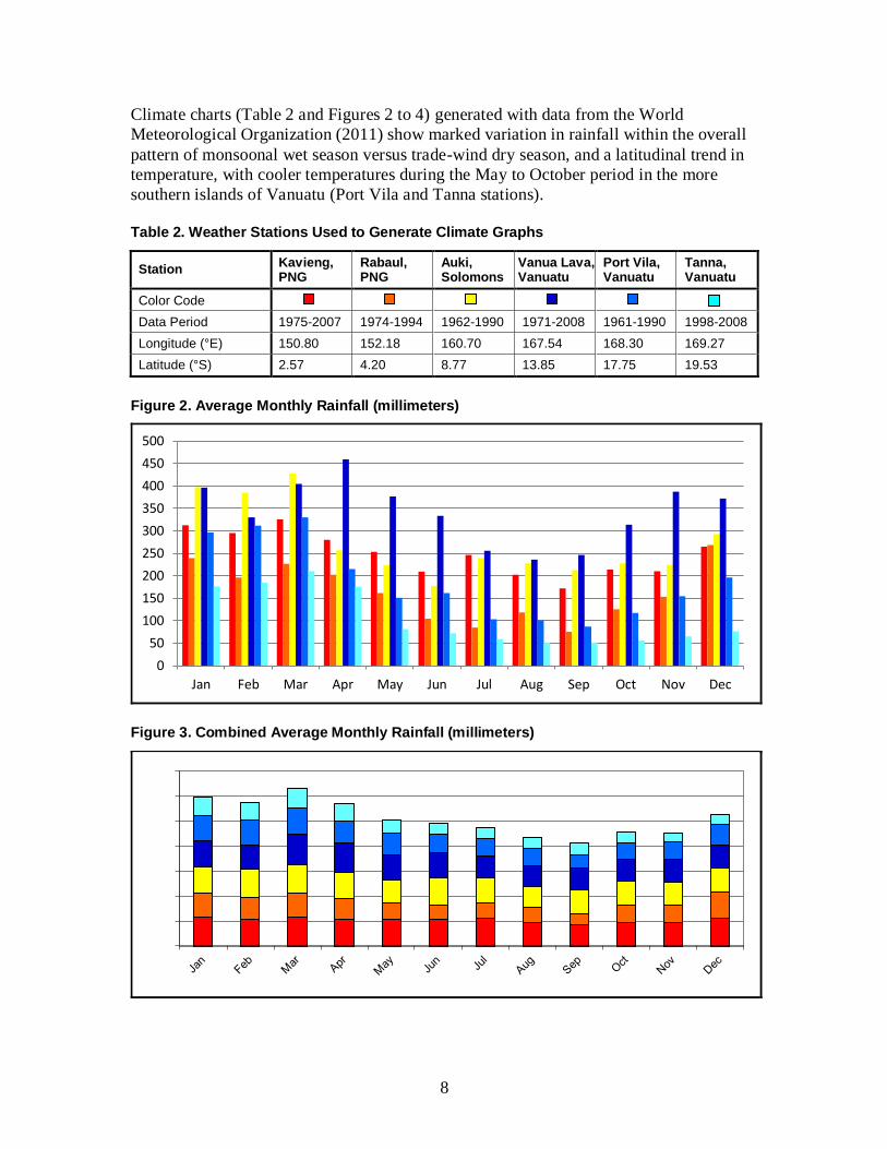
Climate charts (Table 2 and Figures 2 to 4) generated with data from the World
Meteorological Organization (2011) show marked variation in rainfall within the overall
pattern of monsoonal wet season versus trade-wind dry season, and a latitudinal trend in
temperature, with cooler temperatures during the May to October period in the more
southern islands of Vanuatu (Port Vila and Tanna stations).
Table 2. Weather Stations Used to Generate Climate Graphs
Station Kavieng, PNG
Rabaul, PNG
Auki, Solomons
Vanua Lava, Vanuatu
Port Vila, Vanuatu
Tanna, Vanuatu
Color Code
Data Period 1975-2007 1974-1994 1962-1990 1971-2008 1961-1990 1998-2008
Longitude (°E) 150.80 152.18 160.70 167.54 168.30 169.27
Latitude (°S) 2.57 4.20 8.77 13.85 17.75 19.53
Figure 2. Average Monthly Rainfall (millimeters)
Figure 3. Combined Average Monthly Rainfall (millimeters)
0
50
100
150
200
250
300
350
400
450
500
Jan Feb Mar Apr May Jun Jul Aug Sep Oct Nov Dec

9
Figure 4. Average Monthly Maximum and Minimum Temperatures
A significant factor in climate patterns from year to year is the El Niño/Southern
Oscillation (ENSO) cycle. During an El Niño year, the East Melanesian Islands are
subjected to drought conditions and cooler sea temperatures, whereas during a La Niña
year higher than normal rainfall and warmer sea temperatures (and therefore higher
likelihood of tropical cyclones) are experienced. The intensity of ENSO cycles and
frequency of cyclones may increase with climate change, although the relevant models
are unclear at this stage (Leisz et al. 2009).
3.4 Ecoregions, Habitats and Ecosystems
The East Melanesian Islands Hotspot contains six Endemic Bird Areas defined by
BirdLife International (Stattersfield et al. 1998; Table 3). These coincide closely with the
five terrestrial ecoregions of the hotspot defined by the World Wide Fund for Nature
(WWF) (Olson et al. 2001; Table 4). The only difference is that the Endemic Bird Areas
distinguish two smaller island groups (St Matthias in PNG, and Rennell and Bellona in
Solomon Islands) as unique ecosystems based on bird endemism, whereas the WWF
ecoregions distinguish between montane and lowland ecosystems in the Bismarck
Archipelago (New Britain and New Ireland).
In addition to the main habitats described in Table 4, all terrestrial ecoregions (apart from
the New Britain-New Ireland Montane Rainforests, for obvious reasons) also contain
freshwater swamps, mangroves and coastal strand vegetation, which form a transitional
zone between the terrestrial forests (mainly lowland rainforest) and nearshore marine
habitats, such as coral reefs and seagrass beds. Continua of natural habitat extend from
mountain ridge to reef, albeit fragmented by agricultural conversion and logging in many
places. These “ridge-to-reef” ecosystems are notable for their resilience to the effects of
climate change, and for delivering a wide range of ecosystem services to human
communities. As well as being connected by animal species, such as fishes and birds that
move between habitats, they are also linked by river systems that facilitate nutrient flow.
15
17
19
21
23
25
27
29
31
33
Jan Feb Mar Apr May Jun Jul Aug Sep Oct Nov Dec
Te
mp
era
ture
(˚C
)

10
Table 3. Endemic Bird Areas in the East Melanesian Islands Hotspot
EBA Name Priority Restricted-range Species
Key Habitats Main Threats
Admiralty Islands
High 13 Lowland rain forest Limited habitat loss (e.g. due to shifting cultivation)
St Matthias Islands
High 8 Lowland rain forest Possible habitat loss
New Britain and New Ireland
High 54 Lowland and montane rain forest
Moderate habitat loss (e.g. due to oil palm, coconuts and logging)
Solomon group Critical 78 Lowland and montane rain forest
Moderate habitat loss (e.g. due to logging, coconut plantations), introduced species
Rennell and Bellona
High 12 Lowland rain forest Limited habitat loss (e.g. due to logging), hunting, invasive species
Vanuatu and Temotu
High 30 Lowland and montane rain forest
Moderate habitat loss (e.g. due to logging, subsistence farming, pasture), invasive species
Table 4. Ecoregions in the East Melanesian Islands Hotspot
Ecoregion Threat Status Notes
Admiralty Islands Lowland Rainforests
Critical / Endangered
The Admiralty Islands Lowland Rainforests contain six endemic bird species, yet the biodiversity of these islands is still poorly known. Commercial logging and conversion of forests to agriculture are the greatest threats to the ecoregion.
New Britain-New Ireland Lowland Rainforests
Critical / Endangered
Past volcanic eruptions have been tremendous in the lowlands of New Britain and New Ireland. The New Britain city of Rabaul is surrounded by six volcanoes, and in September 1994 one of these forced the abandonment of the city. The numbers of animal endemics of the New Britain-New Ireland Lowland Rain Forests are as remarkable as the volcanoes that mark the landscape. Commercial logging and conversion of forests to agriculture have altered much of the ecoregion.
New Britain-New Ireland Montane Rainforests
Critical / Endangered
Like the lowland rainforests, the montane forests of New Britain and New Ireland are rich in endemic species. However, unlike the lowlands, the karst topography of the montane forests is too steep for plantations. The montane forests therefore are relatively intact yet under increasing threat of being logged or degraded as a result of increasing populations.
Solomon Islands Rainforests
Vulnerable The Solomon Islands Rainforests are true oceanic islands with high vertebrate endemism, including single-island endemics, restricted-range mammals, and an astounding 69 bird species found nowhere else in the world. Large lowland areas below 400 meters either have been or are under threat of logging or clearance for subsistence agriculture. Introduced cats have eliminated most native mammals on Guadalcanal.
Vanuatu Rainforests Critical / Endangered
The Vanuatu Rainforests consist of more than eighty true oceanic islands, in two groups, at the edge of both the Australasian realm and the Pacific Basin. They contain 15 bird species and several mammal species found nowhere else in the world. Although it is faced with population pressures and regular visits by destructive cyclones, with few exceptions Vanuatu’s natural heritage is nearly intact.
Source: WWF (2011b).

11
If the differences are taken to the closest possible match, then the montane and lowland
forests of New Britain can be treated as one unit, and small outlying island groups
distinguished for bird endemism (such as St Matthias and Rennell-Bellona) can be
merged into the nearby larger island groups with which they have biogeographic
affinities. The result is that there are four main biogeographically defined regions based
on the major island groups:
Admiralty Islands.
Bismarck Archipelago (comprising New Britain, New Ireland and the St Matthias
Group).
Solomons Archipelago (comprising Bougainville, the main islands of the
Solomons Islands and outlying Rennell and Bellona).
New Hebrides Archipelago (comprising the Santa Cruz Islands of the Solomon
Islands, and all the islands of Vanuatu).
The administrative dimension is not so straightforward, as a result of late 19th
and early
20th century European influence in defining territories, which later became independent
nations. Within these biogeographically incompatible national boundaries, however, there
are subnational units (provinces), which allow a greater degree of administrative
congruence with biogeographic zones (Figure 1 and Table 5):
Table 5. Provincial Level Administrative Units and Biogeographic Zones of the East Melanesian Islands Hotspot
Biogeographic Zone Country Political Unit(s)
Admiralty Islands PNG Manus province
Bismarck Archipelago PNG West New Britain, East New Britain and New Ireland provinces
Solomons Archipelago PNG, Solomon Islands
Autonomous Region of Bougainville in PNG, and all provinces in the Solomon Islands except Temotu
New Hebrides Archipelago Solomon Islands, Vanuatu
Temotu province in the Solomon Islands, and all provinces in Vanuatu
Within these biogeographic zones, finer scale ecosystem and habitat differentiation
exists. Plant communities are used as indicators of habitat, and these are summarized in
Table 6 for the four biogeographic zones of the hotspot (Mueller-Dombois and Fosberg
1998).
The original extent of terrestrial natural habitat in the East Melanesian Islands is
estimated to be 99,384 km², while the current remaining cover is estimated to be only
29,815 km². This equates to a 70 percent reduction: a key statistic in qualifying the region
for hotspot status. However, there is very strong evidence that nearly all of the natural
vegetation in the hotspot has been modified by humans for millennia; this is of direct
bearing on how conservation targets and benchmarks should be set (C. Filardi in litt.
2012).
12
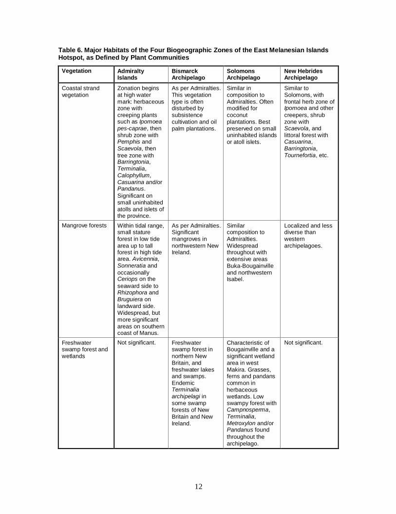
Table 6. Major Habitats of the Four Biogeographic Zones of the East Melanesian Islands Hotspot, as Defined by Plant Communities
Vegetation Admiralty Islands
Bismarck Archipelago
Solomons Archipelago
New Hebrides Archipelago
Coastal strand vegetation
Zonation begins at high water mark: herbaceous zone with creeping plants such as Ipomoea pes-caprae, then shrub zone with Pemphis and Scaevola, then
tree zone with Barringtonia, Terminalia, Calophyllum, Casuarina and/or Pandanus.
Significant on small uninhabited atolls and islets of the province.
As per Admiralties. This vegetation type is often disturbed by subsistence cultivation and oil palm plantations.
Similar in composition to Admiralties. Often modified for coconut plantations. Best preserved on small uninhabited islands or atoll islets.
Similar to Solomons, with frontal herb zone of Ipomoea and other
creepers, shrub zone with Scaevola, and littoral forest with Casuarina, Barringtonia, Tournefortia, etc.
Mangrove forests Within tidal range, small stature forest in low tide area up to tall forest in high tide area. Avicennia, Sonneratia and
occasionally Ceriops on the
seaward side to Rhizophora and Bruguiera on landward side. Widespread, but more significant areas on southern coast of Manus.
As per Admiralties. Significant mangroves in northwestern New Ireland.
Similar composition to Admiralties. Widespread throughout with extensive areas Buka-Bougainville and northwestern Isabel.
Localized and less diverse than western archipelagoes.
Freshwater swamp forest and wetlands
Not significant. Freshwater swamp forest in northern New Britain, and freshwater lakes and swamps. Endemic Terminalia archipelagi in some swamp forests of New Britain and New Ireland.
Characteristic of Bougainville and a significant wetland area in west Makira. Grasses, ferns and pandans common in herbaceous wetlands. Low swampy forest with Campnosperma, Terminalia, Metroxylon and/or Pandanus found
throughout the archipelago.
Not significant.
13
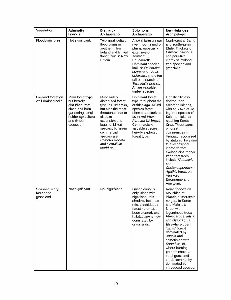
Vegetation Admiralty Islands
Bismarck Archipelago
Solomons Archipelago
New Hebrides Archipelago
Floodplain forest Not significant. Two small deltoid flood plains in southern New Ireland and limited floodplains in New Britain.
Alluvial forests near river mouths and on plains, especially extensive on southern Bougainville. Dominant species include Octomeles sumatrana, Vitex cofassus, and often
tall pure stands of Terminalia brassii. All are valuable timber species.
North-central Santo and southeastern Efate. Thickets of Hibiscus tiliaceus and park-like matrix of lowland tree species and grassland.
Lowland forest on well-drained soils
Main forest type, but heavily disturbed from slash and burn gardening, small-holder agriculture and timber extraction.
Most widely distributed forest type in Bismarcks, but also the most threatened due to oil palm expansion and logging. Mixed species, but main commercial species are Pometia pinnata and Homalium foetidum.
Dominant forest type throughout the archipelago. Mixed species forest, often characterized as mixed Vitex-Pometia tall forest.
Commercially valuable species, heavily exploited forest type.
Floristically less diverse than Solomon Islands, with only two of 12 big-tree species of Solomon Islands reaching Santa Cruz. Three types of forest communities in Vanuatu recognized by stature, likely due to successional recovery from cyclone disturbance. Important trees include Kleinhovia
and Castanospermum. Agathis forest on Vanikoro, Erromango and Aneityum.
Seasonally dry forest and grassland
Not significant. Not significant. Guadalcanal is only island with significant rain-shadow, but most mixed-deciduous forest here has been cleared, and habitat type is now dominated by grasslands.
Rainshadows on NW sides of islands or mountain ranges. In Santo and Malakula forest with leguminous trees Pterocarpus, Intsia and Gyrocarpus.
Elsewhere open “gaiac” forest dominated by Acacia and
sometimes with Santalum, or, where burning predominates, a seral grassland-shrub community dominated by introduced species.

14
Vegetation Admiralty Islands
Bismarck Archipelago
Solomons Archipelago
New Hebrides Archipelago
Lowland forest on limestone
Limited to limestone terraces. Not significant.
Extensive Karst landscapes in New Britain and New Ireland. Vegetation communities not very different from other lowland forests. Prone to drought in El Niño conditions and this can lead to scrubby, secondary growth.
Karst areas in northwestern Bougainville. Low stature forest with Phyllanthus, Dysoxylum and Ficus.
Karst areas on Santo, and limestone interiors on Torres islands. While many islands have limestone terraces and interiors, often the soil is developed on a layer of volcanic ash and therefore is not specifically limestone forest.
Lowland forest on ultramafic soils
Not significant. Not significant. Significant areas on Choiseul, Isabel and Makira. Dominated by Gymnostoma and Dacrydium. When
burnt, slow to regrow and dominated by Gleichenia fern
thickets.
Not significant.
Submontane rain forest
Not described, but possibly on Mount Dremsel.
Extensive areas of Nothofagus on
New Britain.
More significant on Bougainville, harder to detect further east. Indicated by Cryptocarya, but
mixed species including Palaquium, Canarium, Garcinia, Elaeocarpus, Syzigium, etc.
No clear submontane zone.
Montane rainforest and scrub
Not significant. No stunted montane cloud forest described for Bismarcks, but communities including Metrosideros and Weinmannia described from sites above 1,500 meters.
Found at low altitudes where islands or mountains are exposed to cold southeast trade-winds. Various communities, some dominated by tree ferns or bamboos, some by palms and pandans. Woody species include Metrosideros.
On Santo, unique communities of montane Agathis and Podocarpus. Otherwise similar to Solomon Islands with low altitude montane forest on exposed peaks or islands, and composed of Metrosideros, Syzygium, Weinmannia, etc.
15
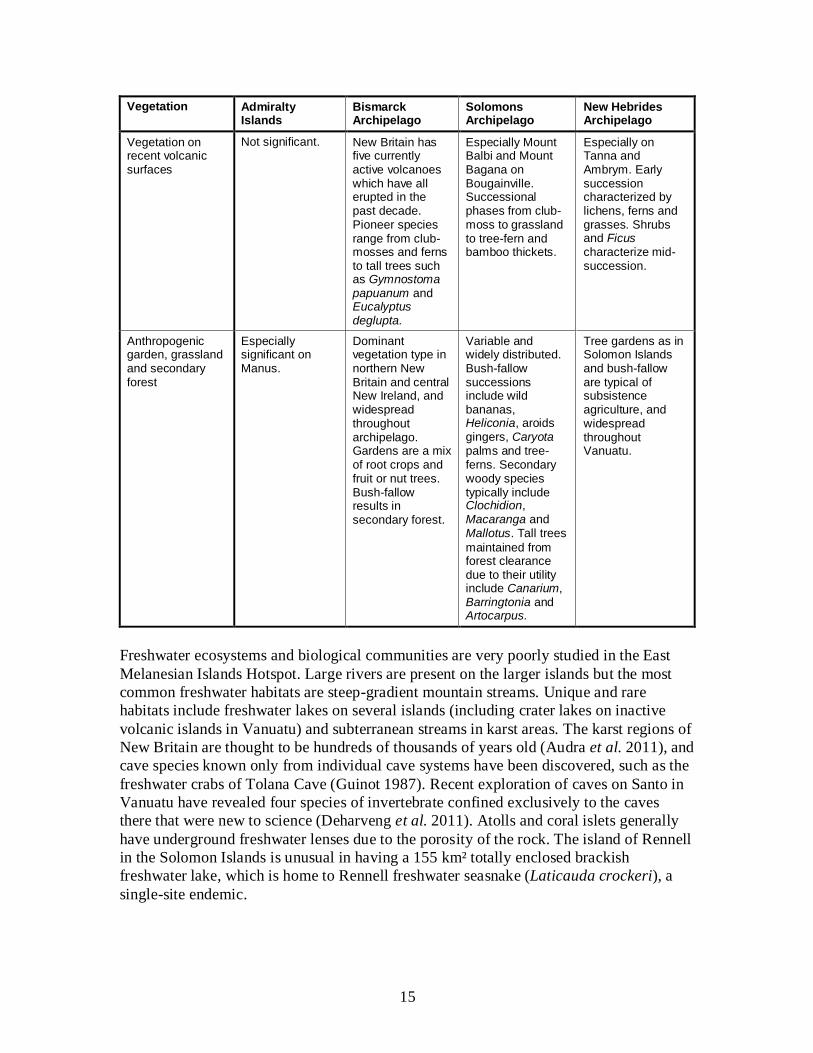
Vegetation Admiralty Islands
Bismarck Archipelago
Solomons Archipelago
New Hebrides Archipelago
Vegetation on recent volcanic surfaces
Not significant. New Britain has five currently active volcanoes which have all erupted in the past decade. Pioneer species range from club-mosses and ferns to tall trees such as Gymnostoma papuanum and Eucalyptus deglupta.
Especially Mount Balbi and Mount Bagana on Bougainville. Successional phases from club-moss to grassland to tree-fern and bamboo thickets.
Especially on Tanna and Ambrym. Early succession characterized by lichens, ferns and grasses. Shrubs and Ficus characterize mid-succession.
Anthropogenic garden, grassland and secondary forest
Especially significant on Manus.
Dominant vegetation type in northern New Britain and central New Ireland, and widespread throughout archipelago. Gardens are a mix of root crops and fruit or nut trees. Bush-fallow results in secondary forest.
Variable and widely distributed. Bush-fallow successions include wild bananas, Heliconia, aroids gingers, Caryota palms and tree-ferns. Secondary woody species typically include Clochidion, Macaranga and Mallotus. Tall trees
maintained from forest clearance due to their utility include Canarium, Barringtonia and Artocarpus.
Tree gardens as in Solomon Islands and bush-fallow are typical of subsistence agriculture, and widespread throughout Vanuatu.
Freshwater ecosystems and biological communities are very poorly studied in the East
Melanesian Islands Hotspot. Large rivers are present on the larger islands but the most
common freshwater habitats are steep-gradient mountain streams. Unique and rare
habitats include freshwater lakes on several islands (including crater lakes on inactive
volcanic islands in Vanuatu) and subterranean streams in karst areas. The karst regions of
New Britain are thought to be hundreds of thousands of years old (Audra et al. 2011), and
cave species known only from individual cave systems have been discovered, such as the
freshwater crabs of Tolana Cave (Guinot 1987). Recent exploration of caves on Santo in
Vanuatu have revealed four species of invertebrate confined exclusively to the caves
there that were new to science (Deharveng et al. 2011). Atolls and coral islets generally
have underground freshwater lenses due to the porosity of the rock. The island of Rennell
in the Solomon Islands is unusual in having a 155 km² totally enclosed brackish
freshwater lake, which is home to Rennell freshwater seasnake (Laticauda crockeri), a
single-site endemic.
16
From what little is known about freshwater ecosystems and their species composition, it
is clear that, compared with the mainland of New Guinea, the East Melanesian Islands
Hotspot has depauperate freshwater fish communities but high diversity and endemism in
freshwater invertebrates (Polhemus et al. 2008). All freshwater fishes in the hotspot are
amphidromous (i.e. with a marine larval stage). Diversity is dominated by gobies and
some endemism is known in the subfamily Sicydiinae. However, these are very small
fish, which are not currently utilized by local communities or represented in indigenous
taxonomies. The larger but non-endemic species like eels (Anguilla spp.), spot-tail bass
(Lutjanus fuscescens), mullets (Mugilidae) and grunters (Terapontidae) are utilized for
food, as are neritid snails and prawns, and reduction in their populations is of direct
concern to villagers. Surveys in Vanuatu indicate there may be some endemism in
freshwater crustacea (Marquet et al. 2002). The intense utilization of freshwater species
for protein in some areas is having an impact on freshwater ecosystems but there is little
to no research in this area. Also, the amphidromous life histories of freshwater species
provide a clear linkage between freshwater and marine ecosystems.
Protected area coverage in the East Melanesian Islands is almost non-existent. There are
only 12 formal protected areas in the hotspot, covering 895 km2, equivalent to just one
percent of the land area. Most of these are classified in the lower protection categories of
the International Union for the Conservation of Nature (IUCN), which allow sustainable
uses. Most of the land in the hotspot is under customary ownership, and traditional
natural resource rights and practices extend into many coastal and nearshore marine
areas. A growing number of community-based conservation areas have been established
in recent years, as an alternative to conventional, government-managed protected areas.
However, most of these areas are limited in extent, and coverage of critical ecosystems,
particularly terrestrial and freshwater ones, remains low.
3.5 Coastal and Nearshore Marine Environment
The Admiralty, Bismarck and Solomons Archipelagoes are part of the Coral Triangle, a
region defined by areas with more than 500 coral species and high alpha diversity of fish
and marine invertebrates. Nearshore marine ecoregions in the hotspot, as defined by
Spalding et al. (2007), are summarized in Table 7. The broad coastal and nearshore
habitat types are common to all four marine ecoregions.
Table 7. Nearshore Marine Ecoregions in the East Melanesian Islands Hotspot
Biome Region Marine Ecoregion
Central Indo-Pacific Eastern Coral Triangle Bismarck Sea
Solomon Sea
Solomons Archipelago
Tropical Southwestern Pacific Vanuatu
Source: Spalding et al. (2007).
These coincide closely with the terrestrial biogeographic zones (Figure 5). However, the
circulation and bathymetry of the Solomon Sea means the south coast of New Britain is
part of the Solomon Sea ecoregion. Another difference is the extension of the Solomons
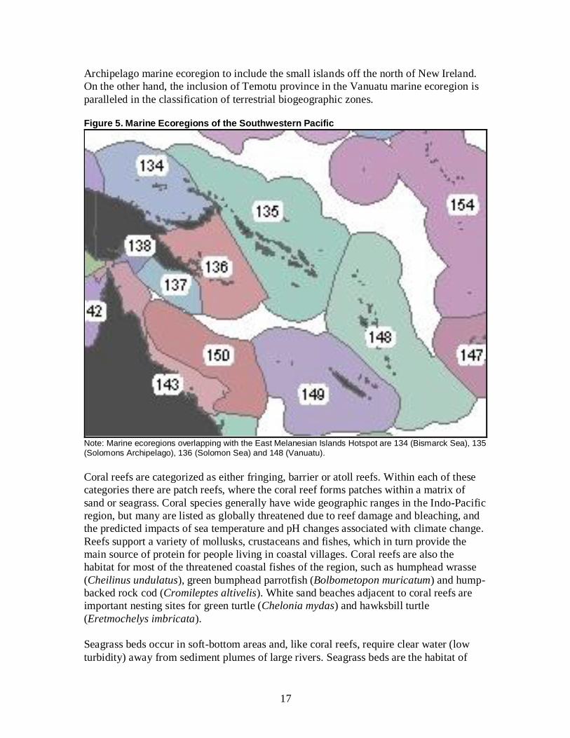
17
Archipelago marine ecoregion to include the small islands off the north of New Ireland.
On the other hand, the inclusion of Temotu province in the Vanuatu marine ecoregion is
paralleled in the classification of terrestrial biogeographic zones.
Figure 5. Marine Ecoregions of the Southwestern Pacific
Note: Marine ecoregions overlapping with the East Melanesian Islands Hotspot are 134 (Bismarck Sea), 135 (Solomons Archipelago), 136 (Solomon Sea) and 148 (Vanuatu).
Coral reefs are categorized as either fringing, barrier or atoll reefs. Within each of these
categories there are patch reefs, where the coral reef forms patches within a matrix of
sand or seagrass. Coral species generally have wide geographic ranges in the Indo-Pacific
region, but many are listed as globally threatened due to reef damage and bleaching, and
the predicted impacts of sea temperature and pH changes associated with climate change.
Reefs support a variety of mollusks, crustaceans and fishes, which in turn provide the
main source of protein for people living in coastal villages. Coral reefs are also the
habitat for most of the threatened coastal fishes of the region, such as humphead wrasse
(Cheilinus undulatus), green bumphead parrotfish (Bolbometopon muricatum) and hump-
backed rock cod (Cromileptes altivelis). White sand beaches adjacent to coral reefs are
important nesting sites for green turtle (Chelonia mydas) and hawksbill turtle
(Eretmochelys imbricata).
Seagrass beds occur in soft-bottom areas and, like coral reefs, require clear water (low
turbidity) away from sediment plumes of large rivers. Seagrass beds are the habitat of

18
dugong (Dugong dugon) which reaches the eastern limits of its distribution in Vanuatu.
Dugong was formerly hunted in the hotspot but its numbers are so low now that there are
few contemporary records of hunting.
Mangroves are a marine habitat and widely recognized as an important nursery for
juvenile fish. They are also an important habitat for saltwater crocodile (Crocodylus
porosus), which reaches its eastern limits in the East Melanesian Islands Hotspot, and
provide coastal buffering against tropical cyclones and other extreme weather events.
Rocky shorelines occur along the coasts of islands of recent volcanic origin, or where
rapid uplift or steep drop-offs preclude the development of coral reefs. The intertidal
zones are frequented by people collecting gastropods and chitons for food.
River mouths and sandy beaches often form small lagoons, which are important spawning
sites for amphidromous fish. The river mouths themselves are important for
larval/juvenile fish exchange between marine and freshwater ecosystems, and thus are
favorite sites for fishing during “whitebait” runs, with people targeting both the larval
fish themselves and the large predatory fish chasing them, such as trevallies. The dark
sand beaches extending from river mouths are favored nesting sites for leatherback turtles
(Dermochelys coriacea).
Intertidal zones on coral reef flats, mangrove mudflats, rocky shores and river mouths are
important habitats for migratory waders (families Charadriidae and Scolopacidae), which
migrate from breeding grounds mostly in Siberia but also in Alaska, for some species,
such as bristle-thighed curlew (Numenius taitensis). Most species recorded from the
hotspot are passage migrants en route to or from “wintering” (i.e. northern hemisphere
winter) grounds in New Zealand but a few are regular winter visitors, which remain in the
islands through the non-breeding season, and, in some cases, the first few years of life.
These include whimbrel (Numenius phaeopus), ruddy turnstone (Arenaria interpres),
common sandpiper (Actitis hypoleucos) and Pacific golden plover (Pluvialis fulva).
3.6 Species Diversity and Endemism
Patterns of species diversity across the hotspot reflect classic island biogeography, where
island size (generally a very coarse surrogate for diversity of habitats) and distance from
continental source are key determinants of number of species. Altitudinal gradients
provide opportunities for montane endemics, such as moustached kingfisher (Actenoides
bougainvillei), the Cettia warblers of Bougainville and Makira, or mountain starling
(Aplonis santovestris) of Santo, which add diversity to high island faunas that is not
possible on low islands no matter how large they are. The distance, size and altitude
factors do not explain why amphibians do not exist in Vanuatu but yet occur in the more
distant islands of Fiji. The frog genus Platymantis is most diverse on the Bismarck
Archipelago and the Solomon Islands but also occurs in the Philippines, northern New
Guinea, Fiji and Palau: a distribution pattern best explained by contiguous island arcs
from the mid-Eocene to early Miocene, as illustrated by Hall (2002), that have since
either coalesced with the New Guinea mainland or shifted further apart. The New

19
Hebrides island arc of Vanuatu and the Santa Cruz Islands did not develop until the early-
mid Miocene. Geological history is fundamental to understanding diversity patterns in
this region (Green 1979, Burret et al. 1991).
Endemism patterns reflect taxon cycles and genetic drift. Early work on the theory of
taxon cycles was developed by Wilson (1959) using pomerine ant fauna in the East
Melanesian Islands Hotspot.
Stage I Expansion phase, where archipelagoes are colonized from source. Usually
these are “tramp” species (Diamond 1975), which are generally fecund
species with high dispersability, and unspecialized habitat preferences or
tolerance to marginal habitats. These species are rarely threatened with
extinction.
Stage II Independent evolution and differentiation of island species, either due to
ecological release and habitat expansion followed by habitat specialization, or
simply due to founder effects and genetic drift.
Stage III Contraction phase, where source or intervening island populations contract
and results in an island-centered species or species-group. From this stage, the
islands themselves can become sources and the island species then re-enter
Stage I with successive expansion phases.
Where differentiation in Stage II involves minimal ecological differentiation, the result is
allospecies. These are simply geographically, and, therefore, reproductively, isolated
populations with superficial divergence but are essentially the same “superspecies”. In all
island taxa, the question arises of assessing endemism based on more and more finely
split allospecies versus the overarching superspecies. Mayr and Diamond (2001)
observed that the number of resident bird species in the Bismarck Archipelago and
Solomon Islands reduced from 251 to 191 if superspecies were used instead of
allospecies. The key issue regarding conservation of allospecies is that their conservation
status does not reflect their degree of relative phylogenetic distinctiveness.
The IUCN Red List is generated by class-level reviews (e.g. birds, mammals,
amphibians, reptiles) and the inclusion of allospecies versus superspecies depends on
consensus among the experts involved in reviewing the taxa. In birds and mammals,
allospecies are used but, for the amphibians of the hotspot, superspecies are used,
pending further research to distinguish allospecies. A useful exercise, to further refine
species-level conservation priorities in the hotspot, would be to create an index of
phylogenetic distinctiveness similar to the Zoological Society of London’s EDGE
(Evolutionary Distinct and Globally Endangered) index (Isaac et al. 2007). This can then
help focus investment on the most endangered and phylogenetically distinct species in the
hotspot.
Wilson went on to incorporate further Melanesian island data into his classic paper on
island biogeography (MacArthur and Wilson 1963), which has since led to the
methodical development and expansion of island biogeographic theory as known today.
Thus the global significance of the East Melanesian Islands Hotspot lies not just in the
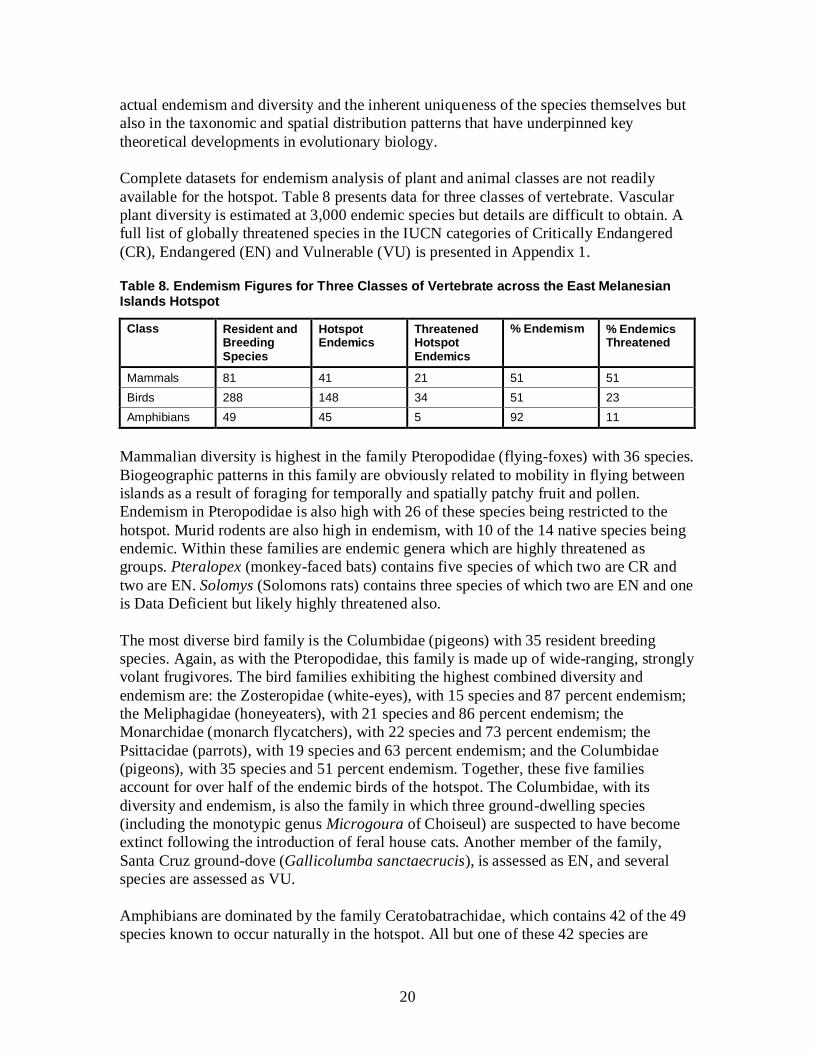
20
actual endemism and diversity and the inherent uniqueness of the species themselves but
also in the taxonomic and spatial distribution patterns that have underpinned key
theoretical developments in evolutionary biology.
Complete datasets for endemism analysis of plant and animal classes are not readily
available for the hotspot. Table 8 presents data for three classes of vertebrate. Vascular
plant diversity is estimated at 3,000 endemic species but details are difficult to obtain. A
full list of globally threatened species in the IUCN categories of Critically Endangered
(CR), Endangered (EN) and Vulnerable (VU) is presented in Appendix 1.
Table 8. Endemism Figures for Three Classes of Vertebrate across the East Melanesian Islands Hotspot
Class Resident and Breeding Species
Hotspot Endemics
Threatened Hotspot Endemics
% Endemism % Endemics Threatened
Mammals 81 41 21 51 51
Birds 288 148 34 51 23
Amphibians 49 45 5 92 11
Mammalian diversity is highest in the family Pteropodidae (flying-foxes) with 36 species.
Biogeographic patterns in this family are obviously related to mobility in flying between
islands as a result of foraging for temporally and spatially patchy fruit and pollen.
Endemism in Pteropodidae is also high with 26 of these species being restricted to the
hotspot. Murid rodents are also high in endemism, with 10 of the 14 native species being
endemic. Within these families are endemic genera which are highly threatened as
groups. Pteralopex (monkey-faced bats) contains five species of which two are CR and
two are EN. Solomys (Solomons rats) contains three species of which two are EN and one
is Data Deficient but likely highly threatened also.
The most diverse bird family is the Columbidae (pigeons) with 35 resident breeding
species. Again, as with the Pteropodidae, this family is made up of wide-ranging, strongly
volant frugivores. The bird families exhibiting the highest combined diversity and
endemism are: the Zosteropidae (white-eyes), with 15 species and 87 percent endemism;
the Meliphagidae (honeyeaters), with 21 species and 86 percent endemism; the
Monarchidae (monarch flycatchers), with 22 species and 73 percent endemism; the
Psittacidae (parrots), with 19 species and 63 percent endemism; and the Columbidae
(pigeons), with 35 species and 51 percent endemism. Together, these five families
account for over half of the endemic birds of the hotspot. The Columbidae, with its
diversity and endemism, is also the family in which three ground-dwelling species
(including the monotypic genus Microgoura of Choiseul) are suspected to have become
extinct following the introduction of feral house cats. Another member of the family,
Santa Cruz ground-dove (Gallicolumba sanctaecrucis), is assessed as EN, and several
species are assessed as VU.
Amphibians are dominated by the family Ceratobatrachidae, which contains 42 of the 49
species known to occur naturally in the hotspot. All but one of these 42 species are
21
endemic to the hotspot. The Ceratobatrachidae contains two endemic monotypic genera,
Palmatorappia and Ceratobatrachus, as well as a further endemic genus Discodeles with
five species. One of the latter, Shortland Island webbed frog (Discodeles guppyi), is very
large and weighs up to 1 kilogram. Solomon Islands leaf-nosed frog (Ceratobatrachus
guentheri) is so unusual and attractive in appearance that it is targeted for the
international wildlife trade; nevertheless, it so far remains reasonably common. Despite
the endemism, the amphibian fauna has very small proportion of species listed as
threatened but a relatively high proportion of endemics (36 percent) are assessed as Data
Deficient.
Beyond these groups are other notable representatives of the East Melanesian Islands
Hotspot biota. The endemic, monotypic Solomon Islands skink is the world’s largest
skink, an herbivorous prehensile tailed tree-dweller ecologically equivalent to the
possums of Australasia or leaf-monkeys of Asia. Land-snails of the southwest Pacific
family Placostylidae are well studied and known to be highly threatened in neighboring
hotspots in New Caledonia and New Zealand but the diversity and status of the many
Placostylids of the East Melanesian Islands Hotspot is poorly known. The endemic
Camaenid land-snail genus Papustyla contains the spectacular Manus green snail
(Papustyla pulcherrima) as well as the most likely extinct species: Ferguson’s papustyla
(P. fergusoni) of New Britain. The flagship butterfly of the hotspot is Schneider’s
surprise (Tiradelphe schneideri), a monotypic genus known only from the mountains of
Guadalcanal, which is assessed as EN.
Prehistoric human introductions of useful species in the East Melanesian Islands Hotspot
present a further complicating factor in analyses of species diversity and endemism. The
evidence for these introductions comes from the archaeological records of the islands.
These species include a large, flightless bird (dwarf cassowary (Casuarius bennetti)) and
two species of marsupial (common echymipera (Echymipera kalubu) and northern
pademelon (Thylogale browni)) in New Britain and a third species of marsupial (northern
common cuscus (Phalanger orientalis)) from the Bismarcks to the Solomons. These
introduced species were not included as native resident species in the analysis, except for
two problematic cases. Admiralty cuscus (Spilocuscus kraemeri), which is considered to
be an endemic marsupial to the Admiralty Islands, appears to be an introduction from as
recently as 2000 years before present but is obviously distinctive from known mainland
S. maculatus due to the founder effect (Flannery 1995). Similarly, the subspecies
Phalanger orientalis breviceps is restricted to the Bismarck Archipelago and Solomon
Islands, and while it is certainly a prehistoric introduction to the Solomon Islands portion
of its range; it is unclear if the New Britain population closer to the New Guinea
mainland was introduced early and evolved due to founder effect before being
transported further, or if it is a natural subspecies in New Britain.
3.7 Cultural Perspectives on Biodiversity
The East Melanesian Islands Hotspot is characterized by high cultural and linguistic
diversity, constitutionally-guaranteed customary land ownership and resource tenure,
more than 90 percent rural population on customary land, and a general retention of
22
kastom in belief systems and resource management practices to the modern day. The
word kastom is not a direct translation of the word custom in English but more about
identity in a rapidly changing social and cultural environment. Sillitoe (2000) describes it
as follows: “when people talk about kastom, they have in mind something we can gloss
as traditional lore, that is, practices that originate in their own cultural tradition and
rooted in their value system as opposed to deriving from elsewhere.” Any consideration
of biological diversity must take into account general patterns of human perceptions of
biodiversity in Melanesia if conservation efforts are to have any meaning to the rural
land-owning tribes and clans.
From the coastal communities reliant on fishing and collecting reef-dwelling species, to
far-inland bush communities reliant on freshwater and forest species, all tribal
communities in the hotspot have a traditional classification and nomenclature system for
the biodiversity that they and their ancestors have depended upon for survival. The key
determinants are totemic value, conspicuousness to the human eye, and utilitarian value.
The greater the utilitarian value, the more fine-scale the classification. A globally
threatened lizard will not be identifiable in local eyes from the dozen or more other
species on their land. The totemic Solomons sea eagle, on the other hand, will be readily
identifiable and have existing local value. Totemic value can be very important, as
members of the clan believed to descend from the totem may not kill or eat the totemic
animal. For this reason, ethnobiological prioritization is also included in the species
outcome section, to identify as much as is possible from a desktop summary, where local
priorities may overlap with global priorities.
Local language is the gateway to traditional ecological knowledge. With almost 300
languages in the hotspot, there is no simple means of accounting for the massive wealth
of nomenclatural and ethnobiological detail in advance, and any project simply needs to
consider traditional ecological knowledge as a necessity rather than a luxury when
implementing conservation activities on customary land in Melanesia. The added
dimension to traditional ecological knowledge in the hotspot is the ongoing loss of this
knowledge in younger generations and even the extinction of some languages.
4. CONSERVATION OUTCOMES DEFINED FOR THE HOTSPOT
4.1 Introduction
Biological diversity cannot be conserved by ad hoc actions (Pressey 1994). In order to
support the delivery of coordinated conservation action, CEPF invests effort in defining
conservation outcomes: the quantifiable set of species, sites and corridors that must be
conserved to maximize the long-term persistence of global biodiversity. By presenting
quantitative and justifiable targets against which the success of investments can be
measured, conservation outcomes allow the limited resources available for conservation
to be targeted more effectively, and their impacts to be monitored at the global scale.
Therefore, conservation outcomes form the basis for identifying biological priorities for
CEPF investment in the East Melanesian Islands.

23
Biodiversity cannot be measured in any single unit because it is distributed across a
hierarchical continuum of ecological scales (Wilson 1992). This continuum can be
condensed into three levels: species; sites; and corridors. These three levels interlock
geographically, through the occurrence of species at sites and of species and sites within
corridors, but are nonetheless identifiable. Given threats to biodiversity at each of the
three levels, quantifiable targets for conservation can be set in terms of “extinctions
avoided” (species outcomes), “areas protected” (site outcomes), and “corridors created”
(corridor outcomes).
4.2 Methodology
Conservation outcomes are defined sequentially, with species outcomes defined first,
followed by site outcomes and, finally, corridor outcomes. In theory, within any given
region, or, ultimately, for the whole world, conservation outcomes can and should be
defined for all taxonomic groups. However, this requires data on the global threat status
of each species, and on the distribution of globally threatened species at sites and across
corridors. Many of these data are incomplete or absent. For the hotspot, global threat
status has been assessed comprehensively only for mammals, birds and amphibians.
Some groups of reptiles, fish, invertebrates and plants have been assessed but many gaps
remain, particularly among the latter two groups. Also, the distribution of many taxa the
in the East Melanesian Islands remains poorly known, with amphibians, birds and
mammals being covered best. Thus, conservation outcomes have been defined mostly
around amphibians, birds and mammals, with information about plants, invertebrates,
reptiles and fish being incorporated where available.
4.2.1 Species Outcomes
Since species outcomes are extinctions avoided at the global level, they relate to globally
threatened species. This definition excludes species categorized as Data Deficient, which
are considered to be priorities for further research but not yet priorities for conservation
action per se, because many may turn out, on further research, not to be globally
threatened. Also excluded are species threatened locally but not globally, which may be
national or regional conservation priorities but are not high global priorities. Species
outcomes are met when a species’ global threat status improves, particularly when it
enters the IUCN Red List category of Least Concern.
Because CEPF has a focus on the conservation of globally significant biodiversity, the
process of setting conservation targets for the fund is based on a global standard. The
principal basis for defining species outcomes for the East Melanesian Islands Hotspot is
the global threat assessments contained within the 2011 IUCN Red List (IUCN 2011), as
of August 30, 2011. This list was current at the time of the expert roundtable, which was
held on Motupore Island, PNG, in December 2011.
Species outcomes are defined for all globally threatened species, regardless of whether
they require species-focused conservation action or not. For most threatened species, the
main conservation need is adequate habitat protection, which can be addressed through

24
conservation of the sites at which they occur. A significant number of threatened species,
however, require additional, species-focused actions in order to avert their extinction,
such as translocations, captive breeding, meta-population management or control of egg
collection. It is from among this group that priority species for CEPF investment were
identified, based upon expert opinion during the stakeholder consultation process.
4.2.2 Site Outcomes
As mentioned above, many species are best conserved by protecting their habitats and the
biological communities they are part of, through conservation actions at a network of
sites. The method used by CEPF to identify these sites is that of Key Biodiversity Areas
(KBAs), which are explicitly designed to conserve biodiversity at the greatest risk of
extinction (Langhammer et al. 2007). The KBA methodology is data-driven rather than
based on expert opinion, although, in data-poor regions, the role of experts does become
much more important. All KBAs meet one or more standard criteria (Table 9). This
transparency allows results to be critiqued and revised at any point in time. The simple
principle behind KBAs is that biodiversity conservation means avoiding extinction. Once
species are extinct, they are gone forever and biodiversity is diminished. Therefore, the
species most likely to become extinct are those already documented as being threatened
with extinction, according to the IUCN Red List, and those species not currently
threatened but restricted to a limited geographic range where a localized threat could have
a major impact on their population. Widespread and common species are covered
incidentally, as areas are identified for globally threatened and restricted-range species.
Table 9. Criteria for Identifying Key Biodiversity Areas, Based on Langhammer et al. (2007)
KBA Criteria
A1 Globally Threatened Species i Site with confirmed presence of CR or EN species
ii >10 pairs or 30 individuals of VU species
A2 Restricted-range Species (global range <50,000 km²)
i Site containing all or most restricted-range species of the area in question
ii Site containing 5 percent of the global population of one or more restricted-range species underrepresented at other KBAs
A3 Bioregionally Restricted Assemblages
i Site containing a “significant” component of the biota of the region in question
ii Site containing unusual species assemblages underrepresented by KBAs generated by previous criteria
A4 Congregations i Site that holds on a regular basis >1 percent of the biogeographic population of a congregatory waterbird
ii Site that holds on a regular basis >1 percent of the biogeographic population of any congregatory species
iii Site known or thought to hold on a regular basis >20,000 individuals of single or mixed species
iv Sites known or thought to exceed thresholds at bottleneck sites for migratory species (i.e. staging sites)
Note: Only criteria A1 and A2 were used to identify KBAs in the East Melanesian Islands Hotspot.
25
Another criterion that can be used to identify KBAs is a representational one, based on
“bioregionally restricted assemblages”, under which unique biological communities can
trigger sites not triggered by individual species. The methodology for identifying KBAs
under this criterion has not been elaborated, other than for birds, a group for which the
East Melanesian Islands are rich in threatened and restricted-range species in any case.
Thus, it was not applied in the hotspot. A further criterion is based on the occurrence of
significant congregations of individuals of particular species, such as seabird breeding
colonies, marine turtle nesting beaches, feeding assemblages or concentrations of
individuals of sessile species. Few sites in the hotspot are known to support globally
significant congregations and, hence, this criterion was not applied either. As all marine
turtles known to nest in the hotspot are globally threatened, the globally threatened
species criterion could be used to identify their nesting beaches as KBAs.
In hotspots where Important Bird Areas (IBAs) have been identified, these form the
starting point for KBA delineation. However, in the East Melanesian Islands Hotspot,
although it is one of the richest areas of bird endemism in the world, only preliminary
work on IBA identification has been undertaken to date. Therefore, data on the
distribution of globally threatened and restricted-range birds were integrated with those
on other taxonomic groups, to identify KBAs that were sufficient to support significant
populations of all the species they were identified for.
In other hotspots, existing protected area networks are also used to guide KBA
delineation. Again, this could not be used in the East Melanesian Islands Hotspot, where
there has been very limited application of conventional protected area approaches.
Consequently, a different approach, specifically tailored to the hotspot, was used to
delineate KBA boundaries. This took account of active conservation initiatives and
previously defined spatial priorities (e.g. Lees 1990, Swartzendruber 1993, Lipsett-Moore
et al. 2010) to delineate appropriate units for site-based conservation action.
The first step was to identify target species (globally threatened and restricted range) for
the East Melanesian Islands Hotspot. For globally threatened species, this meant taking
the entire IUCN Red List for the Solomon Islands and Vanuatu, and splitting the list for
PNG to exclude species not found in the islands region of PNG and surrounding waters.
For restricted-range species, this meant taking any species with a global breeding range
less than 50,000 km2 (which happened to be roughly half the land area of the hotspot:
99,384 km2). The second step was to undertake an extensive literature review and obtain
as much point locality data on globally threatened and restricted-range species as possible
in the available time. Direct observations by reliable observers and specimen records
from the last 50 years were taken to be “confirmed” records, while other records (such as
indirect observations, villager reports or historical specimen records over 50 years old)
were assessed as “provisional”. Normally, only confirmed records would have been used
to identify KBAs but, due to the extreme scarcity of data from the hotspot, provisional
records were also used, with the proviso that KBAs identified solely on the basis of these
records require further investigation and documentation to confirm their status as KBAs
before receiving investment from CEPF.

26
Once point locality data had been collated and assessed as confirmed or provisional,
KBA boundaries were delineated to include all locality records for CR and EN species,
following watersheds, boundaries between language groups and previous spatial
priorities. Where applicable, KBA boundaries included adjacent coastal and nearshore
marine habitats, such as coral reefs and mangroves, thereby identifying targets for “ridge-
to-reef” conservation approaches. However, in keeping with the definition of the hotspot
as a terrestrial conservation priority, no strictly marine KBAs were defined. Next, VU
species were attributed to these sites, and new KBAs were identified for any VU species
that were not sufficiently covered by them, so that, wherever possible, each VU species
was represented in at least three KBAs and each subspecies was found in at least two.
For restricted-range species, a matrix of species by island was prepared. For each major
taxonomic group, any island that supported more than 50 percent of the restricted-range
species in the hotspot was identified as a KBA. Next, restricted-range species were
attributed to existing KBAs, and new KBAs were identified where necessary, such that,
wherever possible, each species was represented in at least three KBAs.
The preparation of globally threatened and restricted-range species lists, and the collation
of point locality data, was undertaken as a desk study during the first months of the
ecosystem profiling process. Then KBAs were initially identified at the expert roundtable
meeting on Motupore Island in December 2011. The draft results from this meeting were
then presented at the stakeholder consultation meetings in the three countries between
January and May 2012, to elicit review, refine boundaries, incorporate further species
records, and capture contextual data on threats, conservation investments, etc.
In order to help discriminate among the large number of KBAs identified in the hotspot,
an initial, biological prioritization was undertaken, using the methodology set out in
Langhammer et al. (2007). This methodology is based upon the principles of
irreplaceability and vulnerability. Irreplaceable species are those that occur at few or no
other sites. The sites that support them are priorities for conservation because there are
few or no other places where these species can be conserved. Vulnerable species are
those threatened with global extinction (i.e. globally threatened species). The sites that
support them are priorities for conservation because action is urgently required to avert
their extinction (i.e. there is limited time in which to take action). A final consideration is
vulnerability at the site level, regardless of the species that occur there. All things being
equal, acutely threatened sites (due to, for example, commercial logging or mining) are
higher priorities for conservation action than sites not under severe, immediate threat,
because action is more urgently required to avoid the loss of the site and the species
populations it supports. These three criteria of irreplaceability, species-based
vulnerability and site-based vulnerability were combined to assign each KBA to one of
five priority levels, as shown in Table 10.
While the initial biological prioritization of sites is an objective approach, it is limited by
data availability and a reliance on global measures of conservation priority that may not
necessarily have relevance for local stakeholders. Consequently, it was supplemented by
a more subjective prioritization, based on expert opinion, undertaken during the
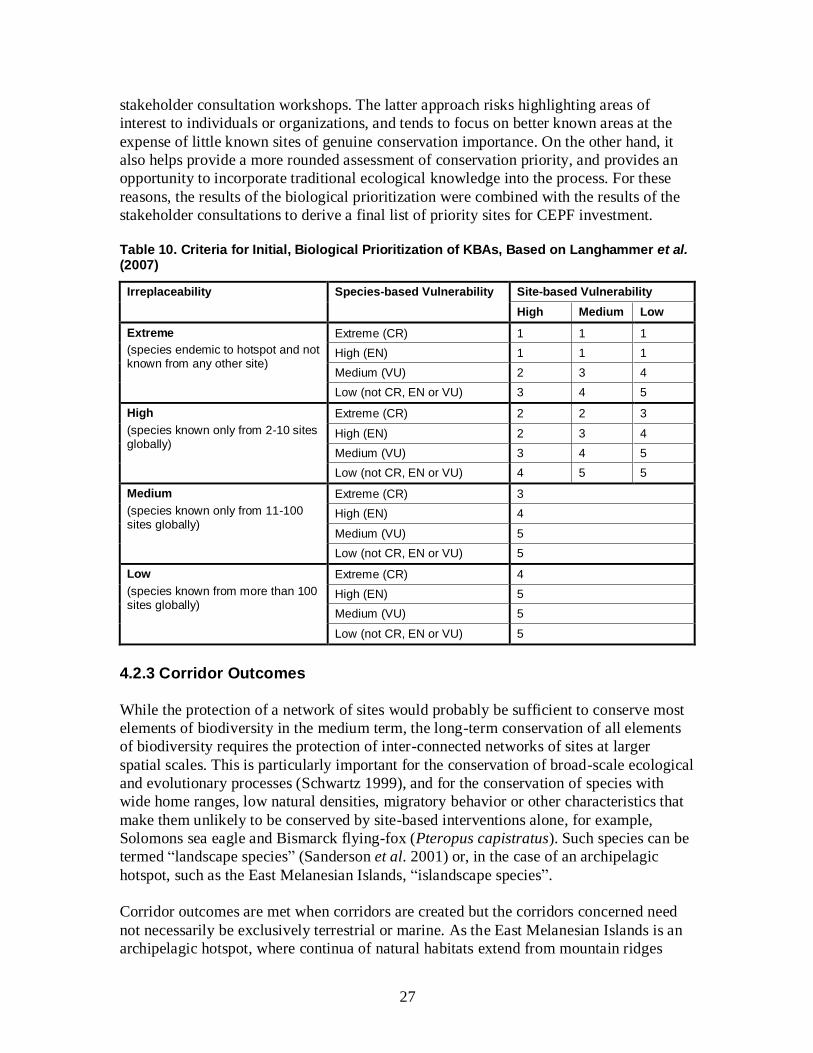
27
stakeholder consultation workshops. The latter approach risks highlighting areas of
interest to individuals or organizations, and tends to focus on better known areas at the
expense of little known sites of genuine conservation importance. On the other hand, it
also helps provide a more rounded assessment of conservation priority, and provides an
opportunity to incorporate traditional ecological knowledge into the process. For these
reasons, the results of the biological prioritization were combined with the results of the
stakeholder consultations to derive a final list of priority sites for CEPF investment.
Table 10. Criteria for Initial, Biological Prioritization of KBAs, Based on Langhammer et al. (2007)
Irreplaceability Species-based Vulnerability Site-based Vulnerability
High Medium Low
Extreme
(species endemic to hotspot and not known from any other site)
Extreme (CR) 1 1 1
High (EN) 1 1 1
Medium (VU) 2 3 4
Low (not CR, EN or VU) 3 4 5
High
(species known only from 2-10 sites globally)
Extreme (CR) 2 2 3
High (EN) 2 3 4
Medium (VU) 3 4 5
Low (not CR, EN or VU) 4 5 5
Medium
(species known only from 11-100 sites globally)
Extreme (CR) 3
High (EN) 4
Medium (VU) 5
Low (not CR, EN or VU) 5
Low
(species known from more than 100 sites globally)
Extreme (CR) 4
High (EN) 5
Medium (VU) 5
Low (not CR, EN or VU) 5
4.2.3 Corridor Outcomes
While the protection of a network of sites would probably be sufficient to conserve most
elements of biodiversity in the medium term, the long-term conservation of all elements
of biodiversity requires the protection of inter-connected networks of sites at larger
spatial scales. This is particularly important for the conservation of broad-scale ecological
and evolutionary processes (Schwartz 1999), and for the conservation of species with
wide home ranges, low natural densities, migratory behavior or other characteristics that
make them unlikely to be conserved by site-based interventions alone, for example,
Solomons sea eagle and Bismarck flying-fox (Pteropus capistratus). Such species can be
termed “landscape species” (Sanderson et al. 2001) or, in the case of an archipelagic
hotspot, such as the East Melanesian Islands, “islandscape species”.
Corridor outcomes are met when corridors are created but the corridors concerned need
not necessarily be exclusively terrestrial or marine. As the East Melanesian Islands is an
archipelagic hotspot, where continua of natural habitats extend from mountain ridges
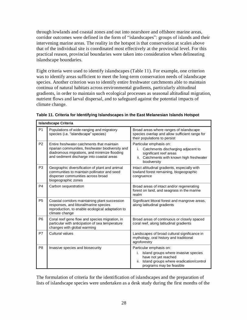
28
through lowlands and coastal zones and out into nearshore and offshore marine areas,
corridor outcomes were defined in the form of “islandscapes”: groups of islands and their
intervening marine areas. The reality in the hotspot is that conservation at scales above
that of the individual site is coordinated most effectively at the provincial level. For this
practical reason, provincial boundaries were taken into consideration when delineating
islandscape boundaries.
Eight criteria were used to identify islandscapes (Table 11). For example, one criterion
was to identify areas sufficient to meet the long-term conservation needs of islandscape
species. Another criterion was to identify entire freshwater catchments able to maintain
continua of natural habitats across environmental gradients, particularly altitudinal
gradients, in order to maintain such ecological processes as seasonal altitudinal migration,
nutrient flows and larval dispersal, and to safeguard against the potential impacts of
climate change.
Table 11. Criteria for Identifying Islandscapes in the East Melanesian Islands Hotspot
Islandscape Criteria
P1 Populations of wide-ranging and migratory species (i.e. “islandscape” species)
Broad areas where ranges of islandscape species overlap and allow sufficient range for their populations to persist
P2 Entire freshwater catchments that maintain riparian communities, freshwater biodiversity and diadromous migrations, and minimize flooding and sediment discharge into coastal areas
Particular emphasis on:
i. Catchments discharging adjacent to significant reef areas
ii. Catchments with known high freshwater biodiversity
P3 Geographic diversification of plant and animal communities to maintain pollinator and seed disperser communities across broad biogeographic zones
Intact altitudinal gradients, especially with lowland forest remaining, biogeographic congruence
P4 Carbon sequestration Broad areas of intact and/or regenerating forest on land, and seagrass in the marine realm
P5 Coastal corridors maintaining plant succession responses, and littoral/marine species reproduction, to enable ecological adaptation to climate change
Significant littoral forest and mangrove areas, along latitudinal gradients
P6 Coral reef gene flow and species migration, in particular with anticipation of sea temperature changes with global warming
Broad areas of continuous or closely spaced coral reef, along latitudinal gradients
P7 Cultural values Landscapes of broad cultural significance in mythology, oral history and traditional agroforestry
P8 Invasive species and biosecurity Particular emphasis on:
i. Island groups where invasive species have not yet reached
ii. Island groups where eradication/control programs may be feasible
The formulation of criteria for the identification of islandscapes and the preparation of
lists of islandscape species were undertaken as a desk study during the first months of the

29
ecosystem profiling process. The islandscapes were initially identified and delineated at
the expert roundtable meeting on Motupore Island in December 2011. The draft results
from this meeting were then reviewed and refined at the regional stakeholder consultation
workshop in Honiara in May 2012. Compared with definition of species and site
outcomes, definition of corridor outcomes was more subjective and expert-decision-
based, requiring attention to documenting decision justifications.
4.3 Results 4.3.1 Species Outcomes
In total, 308 species assessed on the IUCN Red List as globally threatened occur in the
East Melanesian Islands Hotspot (Table 12 and Appendix 1). These include 113
terrestrial species, 187 marine species and eight species that regularly occur in both
terrestrial and marine habitats. The incomplete Red List assessment of reptiles,
invertebrates and plants means that the relative numbers of species presently listed as
globally threatened per taxonomic group is not a fair representation of relative priorities.
In particular, invertebrates are grossly under-represented. Certain invertebrate groups
have high levels of endemism and are severely threatened by invasive species, for
instance the partulid tree snails include many Pacific island species that are now extinct
in the wild (D. O’Foighil in litt. 2012). Another example is freshwater invertebrates,
which are known to have high levels of diversity and endemism (Polhemus et al. 2008)
but yet to suffer from a lack of study in the hotspot (see Section 3.4).
Table 12. Summary of Globally Threatened Species in the East Melanesian Islands Hotspot
Taxonomic Group Global Threat Status Distribution by Country
CR EN VU Total PNG Solomon Islands
Vanuatu
Mammals 6 14 9 29 10 20 8
Birds 2 5 34 41 22 21 10
Reptiles 2 4 4 10 5 6 5
Amphibians 0 0 5 5 5 2 0
Fishes 1 3 21 25 21 16 15
Insects 0 2 5 7 5 4 0
Bivalves 0 0 2 2 2 2 2
Anthozoans 0 5 145 150 146 134 79
Plants 2 7 30 39 20 20 10
Total 13 40 255 308 236 225 129
Percentage 4 13 83 100 77 73 42
Of the 308 globally threatened species in the East Melanesian Islands: 236 (77 percent)
occur in PNG, including 57 that are not found elsewhere in the hotspot; 225 (73 percent)
30
occur in the Solomon Islands, including 40 not found elsewhere in the hotspot; and 129
(42 percent) occur in Vanuatu, including 26 not found elsewhere in the hotspot. Vanuatu
supports fewer globally threatened species than the other two countries in the hotspot but
it remains a high priority for global biodiversity conservation, because of the significant
number of globally threatened species that are found nowhere else.
Almost half of the globally threatened species in the hotspot are reef-building corals in
the class Anthozoa. Most of these anthozoans are widespread in the western Pacific
Ocean, and often the Indian Ocean as well. They are assessed as globally threatened
(mostly VU), because their reef habitats are subjected to a suite of threats, including coral
bleaching, disease, damage from tourism and fishing, and predation by crown-of-thorns
starfish (Acanthaster planci). The principal conservation actions required for these
species is habitat protection, and this is being addressed through a number of initiatives
within the hotspot and the wider western Pacific, most notably the Coral Triangle
Initiative (see Section 6.3.2).
Thirteen globally threatened species in the hotspot are CR, 40 are EN and 255 are VU.
The CR species are, by definition, the ones most at risk of imminent extinction and, all
things being equal, warrant greater attention than species in the lower threat categories.
The six CR mammal species in the hotspot comprise three species of giant rodent and
three species of bat. Unfortunately, three of these species in this group have no recent,
confirmed records and may possibly be extinct. Emperor rat (Uromys imperator) and
Guadalcanal rat (U. porculus) were both collected on Guadalcanal in the Solomon Islands
in the 19th
Century but have not been recorded since; although the island has not been
adequately surveyed for these species (Leary et al. 2008b,c). Vanikoro flying-fox
(Pteropus tuberculatus) was collected from the island of Vanikoro in the Solomon
Islands in the first half of the 20th
century but the island was heavily logged in the second
half of the century, and recent surveys did not find the species (Leary et al. 2008a). The
other three CR mammals are: montane monkey-faced bat (Pteralopex pulchra), known
only from Guadalcanal; greater monkey-faced bat (P. flanneryi), known from
Bougainville in PNG, and the islands of Choiseul and Isabel in the Solomon Islands; and
Poncelet’s giant rat (Solomys ponceleti), known from Bougainville and Choiseul.
The two CR bird species in the hotspot comprise a little-known seabird and a flightless
rail. Beck’s petrel (Pseudobulweria becki) was recently rediscovered after almost 80
years; its breeding grounds are suspected to include montane forest on New Ireland in
PNG (BirdLife International 2010). Makira moorhen (Gallinula silvestris) is known only
from Makira Island in the Solomon Islands, from where there have been no confirmed
records since the 1950s; although it cannot be presumed extinct because of credible
reports in recent years (BirdLife International 2009).
The two CR reptile species are both marine turtles: hawksbill turtle and leatherback. Both
species have circumglobal distributions, with only a small proportion of their global
populations in the hotspot. Both species nest at a number of beaches in the hotspot, which
are of regional, if not global, importance for the species.
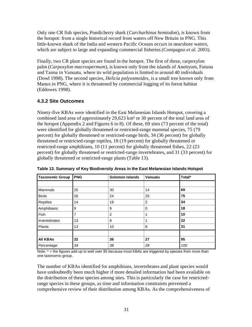
31
Only one CR fish species, Pondicherry shark (Carcharhinus hemiodon), is known from
the hotspot: from a single historical record from waters off New Britain in PNG. This
little-known shark of the India and western Pacific Oceans occurs in nearshore waters,
which are subject to large and expanding commercial fisheries (Compagno et al. 2003).
Finally, two CR plant species are found in the hotspot. The first of these, carpoxylon
palm (Carpoxylon macrospermum), is known only from the islands of Aneityum, Futuna
and Tanna in Vanuatu, where its wild population is limited to around 40 individuals
(Dowl 1998). The second species, Helicia polyosmoides, is a small tree known only from
Manus in PNG, where it is threatened by commercial logging of its forest habitat
(Eddowes 1998).
4.3.2 Site Outcomes
Ninety-five KBAs were identified in the East Melanesian Islands Hotspot, covering a
combined land area of approximately 29,623 km² or 30 percent of the total land area of
the hotspot (Appendix 2 and Figures 6 to 8). Of these, 69 sites (73 percent of the total)
were identified for globally threatened or restricted-range mammal species, 75 (79
percent) for globally threatened or restricted-range birds, 34 (36 percent) for globally
threatened or restricted-range reptiles, 18 (19 percent) for globally threatened or
restricted-range amphibians, 10 (11 percent) for globally threatened fishes, 22 (23
percent) for globally threatened or restricted-range invertebrates, and 31 (33 percent) for
globally threatened or restricted-range plants (Table 13).
Table 13. Summary of Key Biodiversity Areas in the East Melanesian Islands Hotspot
Taxonomic Group PNG Solomon Islands Vanuatu Total*
Mammals 25 30 14 69
Birds 26 24 25 75
Reptiles 14 18 2 34
Amphibians 9 9 0 18
Fish 7 2 1 10
Invertebrates 13 8 1 22
Plants 13 10 8 31
All KBAs 32 36 27 95
Percentage 34 38 28 100
Note: * = the figures add up to well over 95 because most KBAs are triggered by species from more than one taxonomic group.
The number of KBAs identified for amphibians, invertebrates and plant species would
have undoubtedly been much higher if more detailed information had been available on
the distribution of these species among sites. This is particularly the case for restricted-
range species in these groups, as time and information constraints prevented a
comprehensive review of their distribution among KBAs. As the comprehensiveness of

32
available data on the distribution of globally threatened species among KBAs varies
significantly among taxonomic groups, KBAs identified as being important for the
conservation of one taxonomic group may also be important for other groups for which
data are not yet available. Nevertheless, there are likely to be other sites that meet the
KBA criteria that were not identified during this process, especially for fish, invertebrates
and plants, and particularly in marine and freshwater ecosystems.
Eighty-six KBAs were identified based on confirmed records (i.e. direct observations or
specimens) of trigger species within the last 50 years. For the remaining nine KBAs,
there have been no recent, confirmed records of the trigger species, and surveys to
confirm their continued occurrence and establish their status and distribution are required
prior to investing significant resources in their conservation. None of these nine sites
were selected as priorities for CEPF investment.
Figure 6. Site and Corridor Outcomes for PNG

33
Code Key Biodiversity Area Province Total Area (hectares)
Land Area (hectares)
PNG1 Arawe West New Britain 115,015 87,365
PNG2 Baining Mountains East New Britain 137,140 135,864
PNG3 Buin Bougainville 79,183 78,175
PNG4 Buka Bougainville 6,636 6,636
PNG5 Bulu West New Britain 17,878 17,557
PNG6 Cape Saint George New Ireland 90,246 86,398
PNG7 Central Manus Manus 106,565 82,529
PNG8 Djaul New Ireland 30,326 11,417
PNG9 East Manus Manus 15,244 15,244
PNG10 East Mengen East New Britain 66,291 65,463
PNG11 Garu West New Britain 899 888
PNG12 Gasmata West New Britain 97,067 96,266
PNG13 Gloucester Volcanics West New Britain 21,164 21,164
PNG14 Kerevat Toma East New Britain 814 814
PNG15 Kimbe Bay Marine West New Britain 134,478 1,223
PNG16 Kunua Plains and Mount Balbi Bougainville 75,558 74,325
PNG17 Lavongai New Ireland 55,922 55,891
PNG18 Lelet Plateau New Ireland 33,720 33,412
PNG19 M’buke and Purdy Islands Manus 1,329 169
PNG20 Madina New Ireland 5,190 5,190
PNG21 Mussau New Ireland 34,071 31,756
PNG22 Nakanai Central Pomio East New Britain 118,904 118,205
PNG23 Ndrolowa Manus 14,697 6,695
PNG24 Ninigo Manus 376,010 1,551
PNG25 Open Bay East New Britain 604 604
PNG26 Pokili West New Britain 1,844 1,818
PNG27 Rambutyo Manus 9,636 9,220
PNG28 Tench Island New Ireland 55 39
PNG29 Tigak New Ireland 57,993 16,428
PNG30 Tong Manus 1,789 1,619
PNG31 Tsoi Island New Ireland 296 112
PNG32 Whiteman Range West New Britain 175,703 175,703
Seventy-six of the 95 KBAs were identified for globally threatened species, either alone
or together with restricted-range species. The remaining 19 KBAs are not known to
support any globally threatened species but were identified solely on the basis of the
occurrence of restricted-range species. Several KBAs were triggered by significant
numbers of globally threatened species. For instance, sites with records of 12 or more
globally threatened species include: Baining Mountains, Buin, and Kunua Plains-Mount
Balbi KBAs in PNG; and Guadalcanal Watersheds, Mount Maetambe-Kolombangara
River, and North Western Isabel KBAs in the Solomon Islands. These KBAs are not
necessarily the highest priority sites for conservation action in the region, for two
reasons: they may not be the most important site for the conservation of any particular
globally threatened species; and they may not be as severely threatened as other sites.

34
Only a handful of the 95 KBAs in the East Melanesian Islands Hotspot contain
conventional, government-managed protected areas. This is because of the unsuitability
of government-owned and managed protected areas in a region where approximately 90
percent of land is under customary ownership. A number of KBAs are known to contain
community-managed conservation areas but a comprehensive inventory of these areas
across the hotspot is not available.
Figure 7. Site and Corridor Outcomes for the Solomon Islands
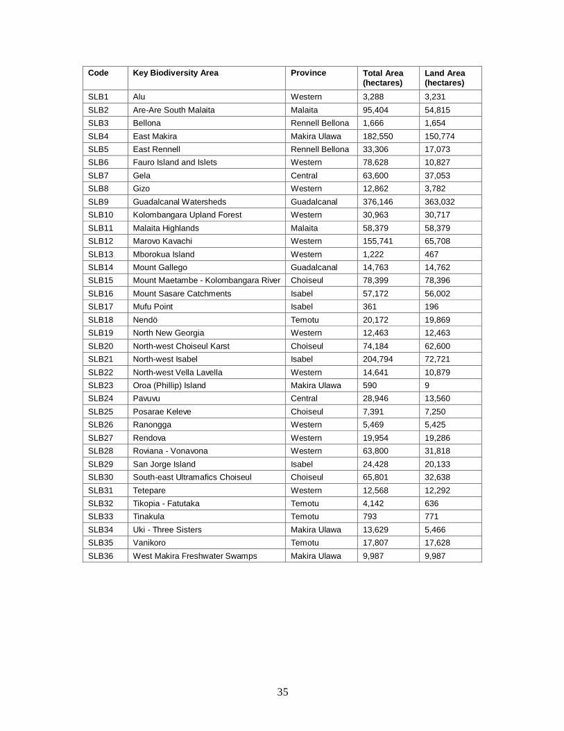
35
Code Key Biodiversity Area Province Total Area (hectares)
Land Area (hectares)
SLB1 Alu Western 3,288 3,231
SLB2 Are-Are South Malaita Malaita 95,404 54,815
SLB3 Bellona Rennell Bellona 1,666 1,654
SLB4 East Makira Makira Ulawa 182,550 150,774
SLB5 East Rennell Rennell Bellona 33,306 17,073
SLB6 Fauro Island and Islets Western 78,628 10,827
SLB7 Gela Central 63,600 37,053
SLB8 Gizo Western 12,862 3,782
SLB9 Guadalcanal Watersheds Guadalcanal 376,146 363,032
SLB10 Kolombangara Upland Forest Western 30,963 30,717
SLB11 Malaita Highlands Malaita 58,379 58,379
SLB12 Marovo Kavachi Western 155,741 65,708
SLB13 Mborokua Island Western 1,222 467
SLB14 Mount Gallego Guadalcanal 14,763 14,762
SLB15 Mount Maetambe - Kolombangara River Choiseul 78,399 78,396
SLB16 Mount Sasare Catchments Isabel 57,172 56,002
SLB17 Mufu Point Isabel 361 196
SLB18 Nendö Temotu 20,172 19,869
SLB19 North New Georgia Western 12,463 12,463
SLB20 North-west Choiseul Karst Choiseul 74,184 62,600
SLB21 North-west Isabel Isabel 204,794 72,721
SLB22 North-west Vella Lavella Western 14,641 10,879
SLB23 Oroa (Phillip) Island Makira Ulawa 590 9
SLB24 Pavuvu Central 28,946 13,560
SLB25 Posarae Keleve Choiseul 7,391 7,250
SLB26 Ranongga Western 5,469 5,425
SLB27 Rendova Western 19,954 19,286
SLB28 Roviana - Vonavona Western 63,800 31,818
SLB29 San Jorge Island Isabel 24,428 20,133
SLB30 South-east Ultramafics Choiseul Choiseul 65,801 32,638
SLB31 Tetepare Western 12,568 12,292
SLB32 Tikopia - Fatutaka Temotu 4,142 636
SLB33 Tinakula Temotu 793 771
SLB34 Uki - Three Sisters Makira Ulawa 13,629 5,466
SLB35 Vanikoro Temotu 17,807 17,628
SLB36 West Makira Freshwater Swamps Makira Ulawa 9,987 9,987
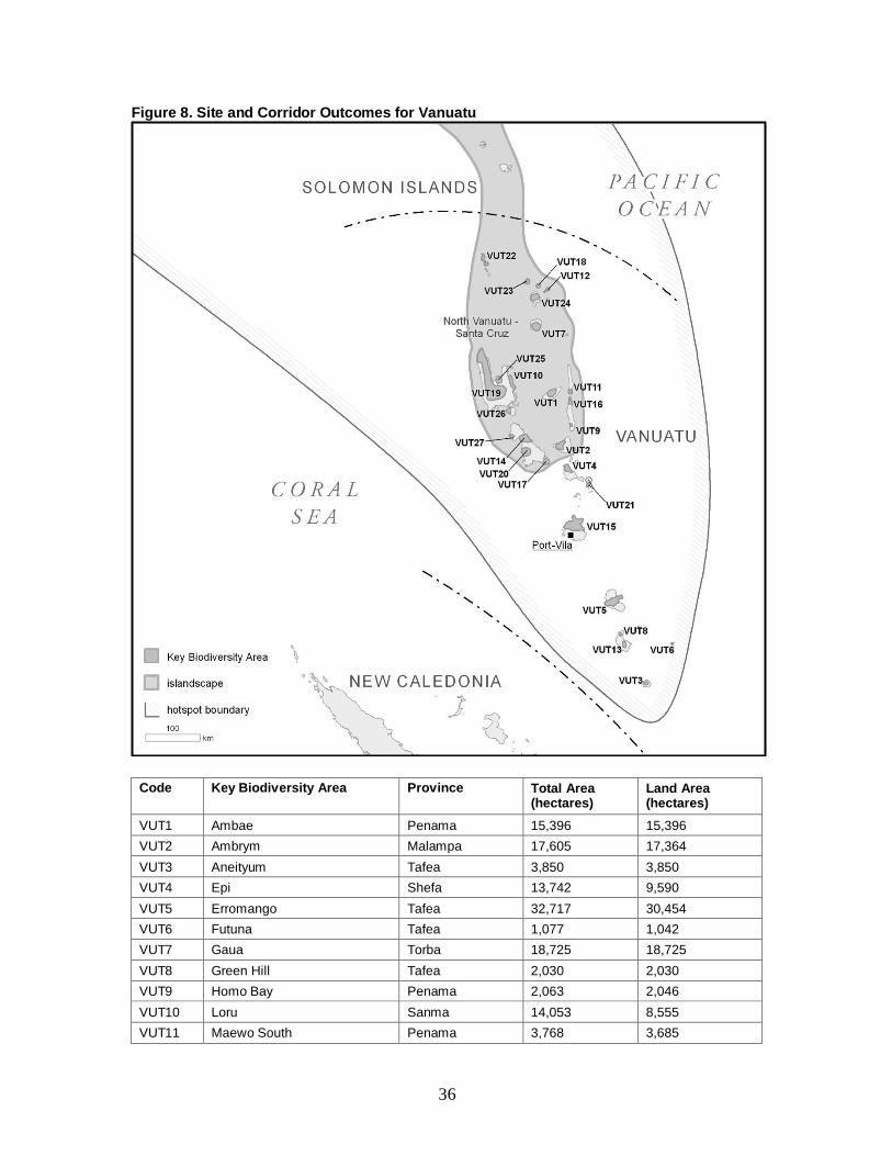
36
Figure 8. Site and Corridor Outcomes for Vanuatu
Code Key Biodiversity Area Province Total Area (hectares)
Land Area (hectares)
VUT1 Ambae Penama 15,396 15,396
VUT2 Ambrym Malampa 17,605 17,364
VUT3 Aneityum Tafea 3,850 3,850
VUT4 Epi Shefa 13,742 9,590
VUT5 Erromango Tafea 32,717 30,454
VUT6 Futuna Tafea 1,077 1,042
VUT7 Gaua Torba 18,725 18,725
VUT8 Green Hill Tafea 2,030 2,030
VUT9 Homo Bay Penama 2,063 2,046
VUT10 Loru Sanma 14,053 8,555
VUT11 Maewo South Penama 3,768 3,685

37
Code Key Biodiversity Area Province Total Area (hectares)
Land Area (hectares)
VUT12 Mota Lava Torba 3,562 3,362
VUT13 Mount Tukusmera Tafea 5,969 5,969
VUT14 Neck of Malakula - Crab Bay Malampa 22,246 17,676
VUT15 North Efate Shefa 61,201 38,345
VUT16 Pentecost North Penama 5,197 4,929
VUT17 Ringi Te Suh Malampa 9,732 2,836
VUT18 Rowa Reef Torba 4,637 360
VUT19 Santo Mountain Chain Sanma 168,360 167,482
VUT20 Small Nambas Malampa 21,390 21,156
VUT21 Tongoa - Laika Shefa 3,441 3,246
VUT22 Torres Islands Torba 373 8,261
VUT23 Ureparpara Torba 5,881 4,198
VUT24 Vanua Lava Torba 14,851 14,165
VUT25 Vatthe Sanma 11,332 5,785
VUT26 West Malo Sanma 5,645 5,596
VUT27 Wiawi Malampa 4,273 4,166
After undertaking the initial biological prioritization, seven KBAs were assigned to the
highest priority level (level 1), 11 sites were assigned to level 2, and a further 29 sites
were assigned to level 3 (Table 14). Each of the seven KBAs assigned to level 1 are the
only known site for one or more CR or EN species globally, and thus qualify as Alliance
for Zero Extinction (AZE) sites (Table 15). These sites are the highest biological
priorities for conservation in the hotspot, because the loss of any of them would result in
the global extinction of at least one species. Five AZE sites are located in the Solomon
Islands and two in Vanuatu.
Table 14. Results of the Initial, Biological Prioritization of KBAs in the East Melanesian Islands Hotspot
Priority Level PNG Solomon Islands Vanuatu Total
1 0 5 2 7
2 4 5 2 11
3 14 11 4 29
4 7 6 9 22
5 7 9 10 26
All KBAs 32 36 27 95
Note: Criteria for the initial, biological prioritization of KBAs are presented in Table 10.

38
Table 15. KBAs Qualifying as AZE Sites in the East Melanesian Islands Hotspot
KBA Country AZE Trigger Species
Aneityum Vanuatu Emoia aneityumensis (EN)
East Makira Solomon Islands Gallinula silvestris (CR)*
Pteropus cognatus (EN)
Gizo Solomon Islands Zosterops luteirostris (EN)
Guadalcanal Watersheds Solomon Islands Pteralopex pulchra (CR)
Tiradelphe schneideri (EN)
Uromys imperator (CR)*
Uromys porculus (CR)*
Nendö Solomon Islands Clytorhynchus sanctaecrucis (EN)
Pteropus nitendiensis (EN)
Santo Mountain Chain Vanuatu Cyphosperma voutmelense (EN)
Vanikoro Solomon Islands Pteropus tuberculatus (CR)*
Note: * = provisional record.
4.3.3 Corridor Outcomes
Four islandscapes were identified in the East Melanesian Islands Hotspot (Table 16 and
Figure 9). The islandscapes cover a total land area of 55,662 km², equivalent to 56
percent of the total area of the hotspot. The four islandscapes contain 60 KBAs
(equivalent to 63 percent of the total). The full list of KBAs within each islandscape is
presented in Appendix 3.
Table 16. Summary of Islandscapes in the East Melanesian Islands Hotspot
Islandscape Countries Total area (km
2)
Land area (km
2)
# of KBAs
Bismarck Sea PNG 221,754 23,440 15
Bukida PNG and Solomon Islands 70,254 17,233 13
New Georgia Archipelago Solomon Islands 17,362 5,085 9
North Vanuatu - Santa Cruz Solomon Islands and Vanuatu 100,005 9,904 23
All four islandscapes met at least six of the eight criteria for the identification of
islandscapes (Table 11). The four islandscapes were considered sufficient to sustain
populations of all 20 islandscape species identified in the hotspot, although only three of
these species have significant populations in more than one islandscape: Admiralty
flying-fox (Pteropus admiralitatum); Solomons sea eagle; and Heinroth’s shearwater
(Puffinus heinrothi). For all of these species, conservation of individual sites in isolation
is unlikely to meet their long-term conservation needs.
The delineation of islandscape boundaries was somewhat subjective, because of varying
degrees of ecological and biogeographic connectivity between nearby islands and island
groups. The Santa Cruz Islands of the southeastern Solomon Islands were merged with
the northern island groups of Vanuatu because of joint importance for sustaining seabird

39
populations, and to enhance resilience of marine ecosystems to climate change by
preserving a latitudinal continuum of corals. Manus was incorporated with the northern
and western catchments of islands in the Bismarck Archipelago, because a recent study of
ocean currents shows a discreet marine unit in the Bismarck Sea (Steinberg et al. 2006).
In addition, the current threat of deep-sea mining in the Bismarck Sea is placing the entire
ecosystem under threat. The New Georgia Archipelago was separated from Bukida
because it is geologically and biogeographically distinct, being composed of young
volcanic islands, rather than Eocene-epoch composite islands, and being a discrete
archipelago rather than an ancient land bridge.
Figure 9. Islandscapes in the East Melanesian Islands Hotspot
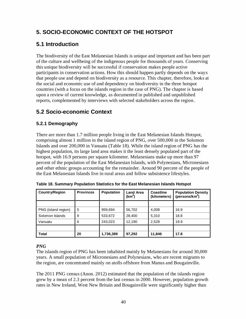
40
5. SOCIO-ECONOMIC CONTEXT OF THE HOTSPOT
5.1 Introduction
The biodiversity of the East Melanesian Islands is unique and important and has been part
of the culture and wellbeing of the indigenous people for thousands of years. Conserving
this unique biodiversity will be successful if conservation makes people active
participants in conservation actions. How this should happen partly depends on the ways
that people use and depend on biodiversity as a resource. This chapter, therefore, looks at
the social and economic use of and dependency on biodiversity in the three hotspot
countries (with a focus on the islands region in the case of PNG). The chapter is based
upon a review of current knowledge, as documented in published and unpublished
reports, complemented by interviews with selected stakeholders across the region.
5.2 Socio-economic Context
5.2.1 Demography
There are more than 1.7 million people living in the East Melanesian Islands Hotspot,
comprising almost 1 million in the island region of PNG, over 500,000 in the Solomon
Islands and over 200,000 in Vanuatu (Table 18). While the island region of PNG has the
highest population, its large land area makes it the least densely populated part of the
hotspot, with 16.9 persons per square kilometer. Melanesians make up more than 97
percent of the population of the East Melanesian Islands, with Polynesians, Micronesians
and other ethnic groups accounting for the remainder. Around 90 percent of the people of
the East Melanesian Islands live in rural areas and follow subsistence lifestyles.
Table 18. Summary Population Statistics for the East Melanesian Islands Hotspot
Country/Region Provinces Population
Land Area (km
2)
Coastline (kilometers)
Population Density (persons/km
2)
PNG (island region) 5 959,694 56,702 4,008 16.9
Solomon Islands 9 533,672 28,400 5,310 18.8
Vanuatu 6 243,023 12,190 2,528 19.9
Total 20 1,736,389 97,292 11,846 17.8
PNG
The islands region of PNG has been inhabited mainly by Melanesians for around 30,000
years. A small population of Micronesians and Polynesians, who are recent migrants to
the region, are concentrated mainly on atolls offshore from Manus and Bougainville.
The 2011 PNG census (Anon. 2012) estimated that the population of the islands region
grew by a mean of 2.3 percent from the last census in 2000. However, population growth
rates in New Ireland, West New Britain and Bougainville were significantly higher than

41
in Manus and East New Britain (Table 19). The high population growth rate in West New
Britain is influenced by in migration from other provinces to work mainly on oil palm
estates, which require a large labor force. The lower population growth rate in Manus is
influenced by out-migration of people, driven, in part, by a lack of higher education
institutions in the province. The overall sex ratio for the islands region is 52 percent male
versus 48 percent female (Anon. 2012).
Table 19. Summary Population Statistics for the PNG Islands Region
Province Population
Population Growth Rate
Population Density (pers/km
2)
Number of Households
Rural Population (%)
Urban Population (%)
Manus 50,321 1.3 24.0 11,229 83.4 16.6
New Ireland 161,165 2.8 16.7 34,422 91.1 8.9
East New Britain 271,252 1.9 17.5 58,517 95.5 4.5
West New Britain 242,676 2.5 11.6 49,077 89.1 10.9
Bougainville 234,280 2.6 25.1 47,888 97.7 2.3
Total 959,694 2.3 18.1 201,133 93.0 7.0
Notes: based on preliminary results of the 2011 census (Anon. 2012); urban and rural population estimates are based on the 2000 census.
More than 90 percent of people live in rural areas, where they depend on fishing and
agriculture to support their livelihoods. Like other developing countries, there is a
growing urban population, ranging from 2.3 percent of the population in Bougainville to
16.6 percent in Manus (Table 19). The increasing urban population is attributed to the
movement of people from rural areas to towns to seek employment and other benefits not
easily available in rural areas. Unfortunately this is contributing to the establishment of
informal settlements on the outskirts of towns throughout the islands region, as in other
parts of the hotspot. The growth of urban populations and informal urban settlements is
contributing to increasing destruction of forest adjacent to towns to make way for
gardens. Most of the people living in informal urban settlements are unemployed and
make gardens to grow food for home consumption or sale to urban markets.
Solomon Islands
The Solomon Islands have a population of 533,672, with a growth rate of 2.8 percent and
a very young population (Solomon Islands National Statistics Office 2006). Current
estimates indicate that 41.5 percent of the population is less than 15 years old (Solomon
Islands National Statistics Office 2006). The high proportion of young people means that
the population growth rate will continue to be high, driving competition and demand for
formal employment.
Melanesian’s make up 94.5 percent of the population, Polynesians 3 percent and
Micronesians 1.2 percent. The Polynesians inhabit the remote outer islands of Rennell
and Bellona, Ontong Java, Sikiana, Tikopia, Anuta, Reef Islands and Duff Islands
(Solomon Islands Curriculum Development Centre 1990). The Micronesian population is
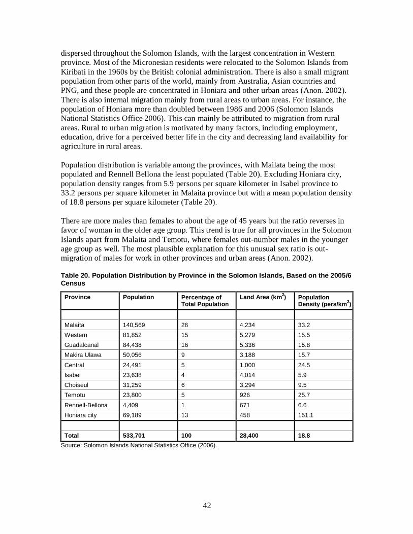
42
dispersed throughout the Solomon Islands, with the largest concentration in Western
province. Most of the Micronesian residents were relocated to the Solomon Islands from
Kiribati in the 1960s by the British colonial administration. There is also a small migrant
population from other parts of the world, mainly from Australia, Asian countries and
PNG, and these people are concentrated in Honiara and other urban areas (Anon. 2002).
There is also internal migration mainly from rural areas to urban areas. For instance, the
population of Honiara more than doubled between 1986 and 2006 (Solomon Islands
National Statistics Office 2006). This can mainly be attributed to migration from rural
areas. Rural to urban migration is motivated by many factors, including employment,
education, drive for a perceived better life in the city and decreasing land availability for
agriculture in rural areas.
Population distribution is variable among the provinces, with Mailata being the most
populated and Rennell Bellona the least populated (Table 20). Excluding Honiara city,
population density ranges from 5.9 persons per square kilometer in Isabel province to
33.2 persons per square kilometer in Malaita province but with a mean population density
of 18.8 persons per square kilometer (Table 20).
There are more males than females to about the age of 45 years but the ratio reverses in
favor of woman in the older age group. This trend is true for all provinces in the Solomon
Islands apart from Malaita and Temotu, where females out-number males in the younger
age group as well. The most plausible explanation for this unusual sex ratio is out-
migration of males for work in other provinces and urban areas (Anon. 2002).
Table 20. Population Distribution by Province in the Solomon Islands, Based on the 2005/6 Census
Province Population Percentage of Total Population
Land Area (km2) Population
Density (pers/km2)
Malaita 140,569 26 4,234 33.2
Western 81,852 15 5,279 15.5
Guadalcanal 84,438 16 5,336 15.8
Makira Ulawa 50,056 9 3,188 15.7
Central 24,491 5 1,000 24.5
Isabel 23,638 4 4,014 5.9
Choiseul 31,259 6 3,294 9.5
Temotu 23,800 5 926 25.7
Rennell-Bellona 4,409 1 671 6.6
Honiara city 69,189 13 458 151.1
Total 533,701 100 28,400 18.8
Source: Solomon Islands National Statistics Office (2006).

43
Vanuatu
According to the 2009 population and household census (Anon. 2009), Vanuatu’s
population is 234,023 (Table 21). Males outnumber females by a slight margin, making
up 51 percent of the population with females making up 49 percent. The population is
relatively young, with people less than 15 years old making up 39 percent of the total.
The proportion of people living in urban areas is 24 percent, making it the highest in the
East Melanesian Islands. However, the urban population is not distributed across
Vanuatu: only Sanma and Shefa provinces report urban populations (Anon. 2009).
Vanuatu’s urban population is growing at the rate of 3.6 percent per year compared to the
rural population growth rate of 1.9 percent (Anon. 2009). The most likely explanation for
this disparity is migration of people from rural areas to urban areas, and this is likely due
to similar factors driving this trend in PNG and the Solomon Islands.
Table 21. Population Distribution by Province in Vanuatu, Based on the 2009 Census
Province Population Percentage of Total Population
Land Area (km2) Population Density
(pers/km2)
Torba 9,359 4 867 10.8
Sanma 45,855 20 4,262 10.8
Penama 30,819 13 1,204 25.6
Malampa 36,727 15 2,809 13.1
Shefa 78,273 34 1,507 51.9
Tafea 32,540 14 1,632 19.9
Total 234,023 100 12,281 19.0
Source: Anon. (2009).
5.2.2 Ethnicity, Languages, Religion, Culture and Social Structure
The East Melanesians Islands are one of the most culturally and linguistically diverse
regions on earth, and the majority of the population, especially in rural areas where most
conservation takes place, qualify as indigenous people, according to the World Bank’s
Indigenous Peoples Policy (Operational Policy 4.10). They are distinct communities; the
land on which they live and the natural resources on which they depend are inextricably
linked to their identities and cultures. Recognizing this, representatives of local
indigenous communities and their organizations from across the hotspot were engaged in
the stakeholder consultations, and the resultant CEPF investment strategy fully respects
the dignity, human rights, economies and cultures of indigenous peoples, and embraces
the principle of free, prior and informed consultation.
Culture and custom are important throughout the East Melanesian Islands and have
supported the lives of these people for about 30,000 years since they were first settled.
Some of the most relevant aspects of culture and custom to biodiversity conservation
relate to user rights, ownership, conflict resolution, clanship, traditional leadership,
initiations and ceremonies. Traditional cultural practices have an influence on how the
44
modern economy grows in each of the three countries of the East Melanesian Islands. An
example is the practice of customary land ownership and customary tenure over marine
and coastal resources (e.g. reef fishes, sea-cucumbers, mangroves, etc.), which allows
customary owners to control access to land and resources. The vast majority of the people
still adhere to traditional culture and customs but as modern economies develop, some of
these customs are being sidelined or slowly lost.
The key point with customary ownership and tenure is that land and resources do not
belong to any one individual or household but are collectively owned by a community
(typically defined on the basis of kinship and descent rather than geographic proximity).
Consequently, decisions about use of land and resources are traditionally made
collectively and (although certain prominent individuals within the community may have
disproportionate influence) by consensus. Because customary ownership and tenure are
recognized in the constitutions of the three hotspot countries, these traditions are still
respected today, by both social convention and statutory law. Thus, for practical as well
as ethical reasons, all on-the-ground conservation activities in the East Melanesian
Islands must be implemented with the participation and consent of local communities.
PNG
A total of 110 languages are spoken across the islands region of PNG. Manus province
accounts for 30 languages, which is the most per province, while East New Britain
province has the fewest, with 13 languages. New Ireland province has 19 languages, the
Autonomous Region of Bougainville 23 and West New Britain province 25. Languages
often define culture and tradition, and this would make Manus the most culturally diverse
province, especially with its low population.
Christianity is the main religion practiced in the islands region, and churches play a
prominent role in society. The main denominations in Manus province are Roman
Catholic (45 percent), Adventist (21 percent), Evangelical (13 percent) and Lutheran (5
percent). In New Ireland province, United and Roman Catholic are the commonest
denominations, with 40 percent and 39 percent respectively, followed by Adventist (8.7
percent) and Pentecostal (5 percent). Roman Catholic is the main Christian denomination
in East New Britain, West New Britain and Bougainville, with 50.3 percent, 55.7 percent
and 68.2 percent respectively. The United Church is the second most common
denomination in East New Britain (32.3 percent) and Bougainville (14.5 percent).
Almost all the land (about 95 percent) in the PNG islands region is owned by customary
landowners. Only a small portion of the land is owned by the state and the private sector.
To have access to land, private agriculture companies (especially oil palm companies),
enter into deals with local clans on a lease back arrangement. Customary tenure and user
rights over natural resources are also very common, which allow clans to have access to
resources they need. User rights are commonly used to govern access to coastal and
nearshore marine resources.

45
Solomon Islands
There are 74 languages in the Solomon Islands, of which three have no living speakers
(Lewis 2009). Almost all of these languages belong to the Malayo-Polynesian subgroup
of the Austronesian language family. The two exceptions are English, the language of the
former colonial power, and Pijin, an English-based creole. The Pijin spoken in the
Solomon Islands is historically related to Tok Pisin of PNG and Bislama of Vanuatu, with
which it is mutually intelligible. English and Solomon Islands Pidgin are the common
languages of communication in the country.
Christians makes up 97 percent of the Solomon Islands population. The main
denominations are the Anglican Church of Melanesia (33 percent), Roman Catholic
(19 percent), South Seas Evangelical Church (17 percent), Seventh-day Adventist
(11 percent) and United Church (10 percent). There are fewer than 500 practicing
Muslims in the country, and around 3 percent of people subscribe to indigenous belief
systems.
Customary land ownership is practiced throughout the Solomon Islands and is recognized
through the constitution. Access to land for development is, therefore, limited by
customary ownership. A number of studies have identified customary ownership as a
major constraint for agriculture, infrastructure and urban development but this view is
contested by a study by Bourke et al. (2006), which found it not to be a limiting factor for
agricultural production because the informal sector of the economy that produces food for
local markets and domestic consumption is conducted entirely on land that is traditionally
owned.
Vanuatu
Vanuatu has 108 living languages (Lewis 2009) and, with its small population, is the
most linguistically diverse country in the world (Regenvanu 2007). On average, 2,000
people speak each language. English, French and Bislama are the common languages that
allow the people of Vanuatu to communicate with each other.
Melanesians have a very strong traditional culture and have the most influence on the
Vanuatu national culture. Although the culture is similar across the country, there are
three cultural regions: northern; central; and southern. Wealth in the northern cultural
region is acquired or established by how much one can give away. The central cultural
region exhibits a more typical Melanesian cultural system, involving the inheritance of
titles through lineage and being active in ceremonies as dictated by custom. In the
southern cultural region there is a system of granting titles and privileges, which appears
to have been influenced by religion and western culture.
Christianity is the main religion of Vanuatu. Presbyterian is the most common
denomination, accounting for a third of the population. Roman Catholic and Anglican are
the next most common denominations, accounting for 15 percent each. Other
denominations include Seventh-day Adventist, Church of Christ, and Neil Thomas
Ministries.

46
5.2.3 Economy
The economy of the East Melanesian Islands is very small by global standards and can be
divided into the formal and informal sector. The informal sector is mainly based on
agriculture and exploitation of marine resources and located in the rural areas, although it
is growing in urban areas. The PNG islands region, with the largest population and land
area in the hotspot, also contains the richest mineral, forestry and agricultural resources.
Because the East Melanesian Islands economy is small, governance, natural disasters and
climate change strongly impact how the economy performs. Vanuatu’s economy, the
smallest in the hotspot, is especially vulnerable to natural disasters and climate change
impacts (Anon. undated).
PNG
The economy of PNG’s islands region is dependent on mining, forestry, fisheries and
agriculture. New Ireland province hosts one of the largest gold mines in the world on
Lihir Island, while Bougainville is the location of the Panguna mine, the largest open-cut
copper mine in the world. The environmental impacts of this mine are commonly cited as
a contributory factor to the recent political conflict on Bougainville, which led to its
closure in 1989, since when it has not been in operation.
The palm oil sector in West New Britain province is the largest of its kind in both the
East Melanesian Islands and PNG as a whole. The province has more than 60,000
hectares of oil palm plantations, with New Britain Oil Palm Ltd accounting for 33,126
hectares (New Britain Oil Palm Ltd 2011), Hargy Oil Palms Ltd accounting for 9,500
hectares (Hargy Oil Palms Ltd 2012) and smallholders accounting for 18,000 hectares (I.
Orrel, pers. comm. cited by Brodie and Turak 2001). Further planting and expansion of
oil palm continues every year. For instance, Hargy Oil Palms Ltd (2012) has a vision to
increase annual production to 200,000 metric tons, by increasing its plantations to 20,000
hectares and purchasing palm oil from smallholders. Other significant oil palm
plantations can be found in New Ireland province, which has 8,145 hectares of plantings
(New Britain Oil Palm Ltd 2011).
Smallholder palm oil production is very important for the rural population, and involves
families from indigenous communities and other parts of PNG. Of the 1.9 million metric
tons of palm oil produced in PNG in 2005, smallholder production accounted for one-
third of the total (Curry et al. 2007). Smallholder blocks are owned by indigenous
communities, in the form of village oil palms, and also by in-migrants from other areas
under the Land Settlement Scheme.
The principal economic activity of the population of PNG in general, and the islands
region in particular, is agriculture, with more than 75 percent of households in the
country being dependent upon subsistence agriculture. The cash-based but informal
village economy is dependent on cocoa, coconut (copra), betelnut, oil palm, poultry,
livestock and fishing. Table 22 gives an indication of the involvement of the population
of the islands region in the cash economy. Working for wages, which ranges from 4 to
12 percent, is partly dictated by how the population is distributed between villages, where
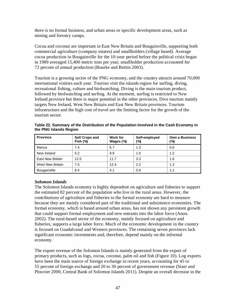
47
there is no formal business, and urban areas or specific development areas, such as
mining and forestry camps.
Cocoa and coconut are important in East New Britain and Bougainville, supporting both
commercial agriculture (company estates) and smallholders (village based). Average
cocoa production in Bougainville for the 10-year period before the political crisis began
in 1989 averaged 15,400 metric tons per year; smallholder production accounted for
72 percent of annual production (Bourke and Betitis 2003).
Tourism is a growing sector of the PNG economy, and the country attracts around 70,000
international visitors each year. Tourists visit the islands region for surfing, diving,
recreational fishing, culture and birdwatching. Diving is the main tourism product,
followed by birdwatching and surfing. At the moment, surfing is restricted to New
Ireland province but there is major potential in the other provinces. Dive tourism mainly
targets New Ireland, West New Britain and East New Britain provinces. Tourism
infrastructure and the high cost of travel are the limiting factor for the growth of the
tourism sector.
Table 22. Summary of the Distribution of the Population Involved in the Cash Economy in the PNG Islands Region
Province Sell Crops and Fish (%)
Work for Wages (%)
Self-employed (%)
Own a Business (%)
Manus 7.4 6.7 1.3 0.6
New Ireland 5.2 9.9 1.5 1.2
East New Britain 12.5 11.7 3.3 1.6
West New Britain 7.5 12.4 2.2 1.3
Bougainville 8.4 4.1 0.9 1.1
Solomon Islands
The Solomon Islands economy is highly dependent on agriculture and fisheries to support
the estimated 82 percent of the population who live in the rural areas. However, the
contributions of agriculture and fisheries to the formal economy are hard to measure
because they are mainly considered part of the traditional and subsistence economies. The
formal economy, which is based around urban areas, has not shown any persistent growth
that could support formal employment and new entrants into the labor force (Anon.
2002). The rural-based sector of the economy, mainly focused on agriculture and
fisheries, supports a large labor force. Much of the economic development in the country
is focused on Guadalcanal and Western provinces. The remaining seven provinces lack
significant economic investments and, therefore, depend mainly on the informal
economy.
The export revenue of the Solomon Islands is mainly generated from the export of
primary products, such as logs, cocoa, coconut, palm oil and fish (Figure 10). Log exports
have been the main source of foreign exchange in recent years, accounting for 45 to
55 percent of foreign exchange and 20 to 30 percent of government revenue (Sizer and
Plouvier 2000, Central Bank of Solomon Islands 2011). Despite an overall decrease in the
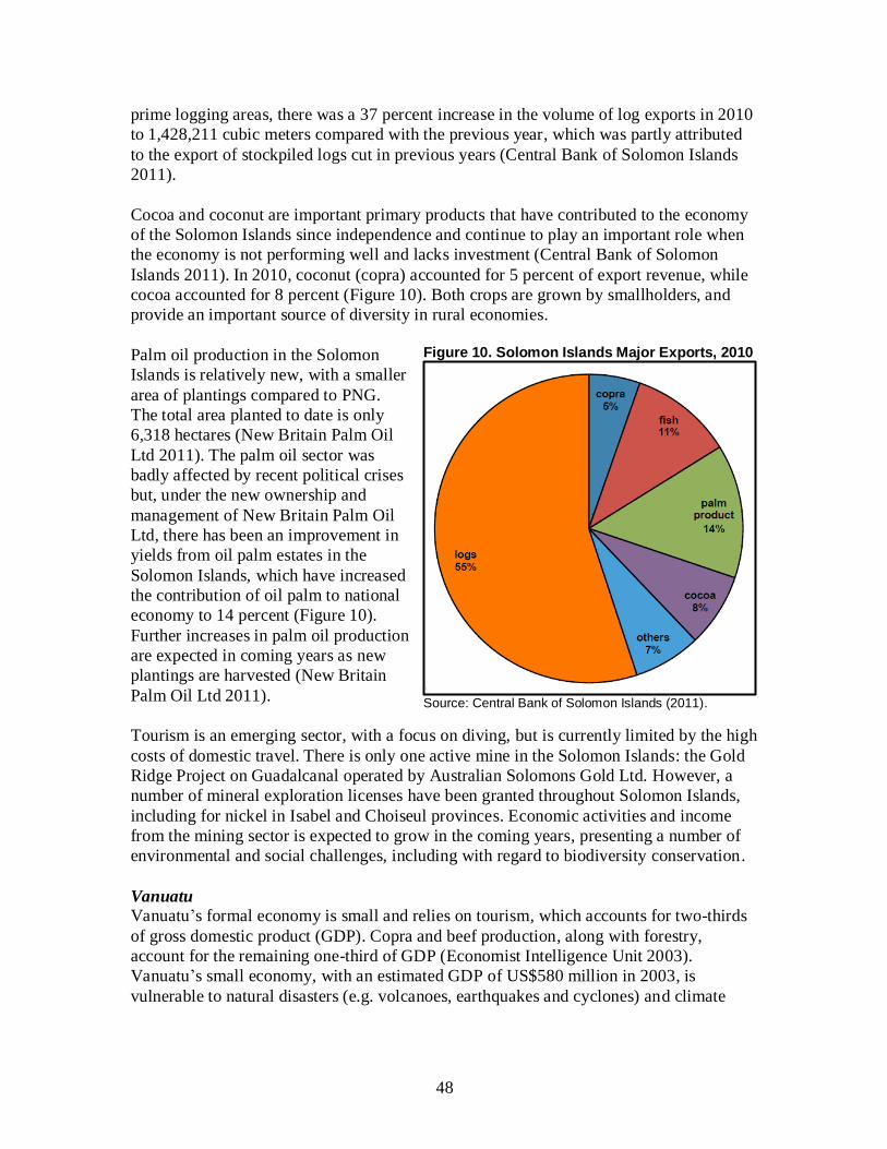
48
prime logging areas, there was a 37 percent increase in the volume of log exports in 2010
to 1,428,211 cubic meters compared with the previous year, which was partly attributed
to the export of stockpiled logs cut in previous years (Central Bank of Solomon Islands
2011).
Cocoa and coconut are important primary products that have contributed to the economy
of the Solomon Islands since independence and continue to play an important role when
the economy is not performing well and lacks investment (Central Bank of Solomon
Islands 2011). In 2010, coconut (copra) accounted for 5 percent of export revenue, while
cocoa accounted for 8 percent (Figure 10). Both crops are grown by smallholders, and
provide an important source of diversity in rural economies.
Palm oil production in the Solomon
Islands is relatively new, with a smaller
area of plantings compared to PNG.
The total area planted to date is only
6,318 hectares (New Britain Palm Oil
Ltd 2011). The palm oil sector was
badly affected by recent political crises
but, under the new ownership and
management of New Britain Palm Oil
Ltd, there has been an improvement in
yields from oil palm estates in the
Solomon Islands, which have increased
the contribution of oil palm to national
economy to 14 percent (Figure 10).
Further increases in palm oil production
are expected in coming years as new
plantings are harvested (New Britain
Palm Oil Ltd 2011).
Tourism is an emerging sector, with a focus on diving, but is currently limited by the high
costs of domestic travel. There is only one active mine in the Solomon Islands: the Gold
Ridge Project on Guadalcanal operated by Australian Solomons Gold Ltd. However, a
number of mineral exploration licenses have been granted throughout Solomon Islands,
including for nickel in Isabel and Choiseul provinces. Economic activities and income
from the mining sector is expected to grow in the coming years, presenting a number of
environmental and social challenges, including with regard to biodiversity conservation.
Vanuatu
Vanuatu’s formal economy is small and relies on tourism, which accounts for two-thirds
of gross domestic product (GDP). Copra and beef production, along with forestry,
account for the remaining one-third of GDP (Economist Intelligence Unit 2003).
Vanuatu’s small economy, with an estimated GDP of US$580 million in 2003, is
vulnerable to natural disasters (e.g. volcanoes, earthquakes and cyclones) and climate
Figure 10. Solomon Islands Major Exports, 2010
Source: Central Bank of Solomon Islands (2011).

49
change impacts (Anon. undated). For example, in 2003 there was a 7 percent decrease in
cocoa production due to damage caused by Cyclone Ivy (Anon. undated).
The main source of foreign exchange for Vanuatu is from tourism and fisheries. Tourism
supports and contributes to the vibrant services sector, which accounts for 77 percent of
GDP. The tourism sector is growing, and tourism arrivals are increasing. In 2003, tourism
arrivals grew by 25 percent compared to the 1997 levels (Anon. undated).
However, Regenvanu (2007) argues that the informal economy is more important than
the formal economy in Vanuatu, because the 84 percent of the population who live in
rural areas depend on it to support their livelihood on a daily basis. Even urban-dwellers
depend on it to subsidize their modern lifestyles. The informal economy is centered on
production, processing and sale of agricultural and marine products, supplemented by
provision of services such as carpentry and transportation, and production of baskets,
mats and other handicrafts.
Despite a positive outlook, GDP growth is being offset by a relatively high population
growth of 2.3 percent (Anon. 2009). Between 1994 and 2003, per capita income
decreased by 18 percent (Anon. undated). Because three-quarters of the population live in
rural areas and rely primarily on agriculture, slow growth of the agriculture sector, which
is constrained by poor access to markets and low productivity, is not sufficient to improve
per capita income. This is further constrained by Vanuatu’s social and cultural system,
which is geared towards sustaining a traditional subsistence economy not an externally
driven, market-based economy.
6. POLICY CONTEXT OF THE HOTSPOT
6.1 Introduction
In recent years, there has been growing pressure on the ecosystems of the East
Melanesian Islands Hotspot. Foreign investment, notably in the forestry and mining
sectors, has resulted in serious environmental degradation, with minimal economic
benefits for the majority of local people. In response, the governments of the East
Melanesian Islands countries have introduced a range of environmental policies, under
the framework provided by a lattice of multilateral environmental agreements at regional
and global levels.
The East Melanesian Islands countries have all ratified the United Nations Convention on
Biological Diversity and the United Nations Framework Convention on Climate Change
(UNFCCC), and made progress with localizing the key provisions of these global
agreements in their respective national laws. Thus, the global policy response to
biodiversity loss and climate change is embedded in the laws of each country. The size of
individual Pacific islands countries and territories and the similarities among the
environmental challenges they face means that certain capacities and responses to
conservation issues can be more efficiently delivered at the regional level rather than the
50
level of individual countries. In this way, national responses to global policy directions
are complemented by a range of regional agreements and institutions.
6.2 Overview of the Regional and National Political Situation
6.2.1 Governance Structures
PNG
PNG is a constitutional monarchy, with Queen Elizabeth II as the head of State. This
allows PNG to be a member of the Commonwealth. The Queen is represented in the
country by a governor-general. PNG has a parliamentary system of government, with
elections every five years. The government is led by the prime minister, who selects a
cabinet from among members of parliament. PNG is a multiparty democracy, with
numerous political parties. However, party loyalties are often weak, leading to a series of
unstable coalition governments, and frequent changes in leadership.
Included within the East Melanesian Islands Hotspot are four provinces, plus the
Autonomous Region of Bougainville. Bougainville is administered differently from the
other provinces under the peace agreement signed in 1998. While Manus, New Ireland,
East New Britain and West New Britain are each headed by a provincial governor, the
Autonomous Region of Bougainville is headed by a president.
In common with the other hotspot countries, PNG has a three-tier system of government.
At the provincial level, the provincial executive council is the highest decision making
body, comprising the provincial governor, elected representatives and appointed
representatives. The provincial governor is typically a member of parliament, thereby
creating a direct link between the national and provincial levels of government.
Each province contains one or more districts, each with one or more local-level
governments (LLGs). There are 12 districts and 50 LLGs in the four provinces of the
islands region (Table 17). Each LLG comprises a number of wards, each of which is
represented by a ward councilor. A ward is normally a village but, where a village has a
large population, it can be divided into several wards. The ward councilors are members
of the LLG assembly, which is chaired by the LLG president.
Under Sections 42 and 44 of the Organic Law on Provincial Governments and Local
Level Governments, provincial governments and LLGs have extensive law making
powers. A number of LLGs in Manus, West New Britain and New Ireland provinces have
utilized these provisions to pass environmental laws regulating the use of the marine and
terrestrial environment.
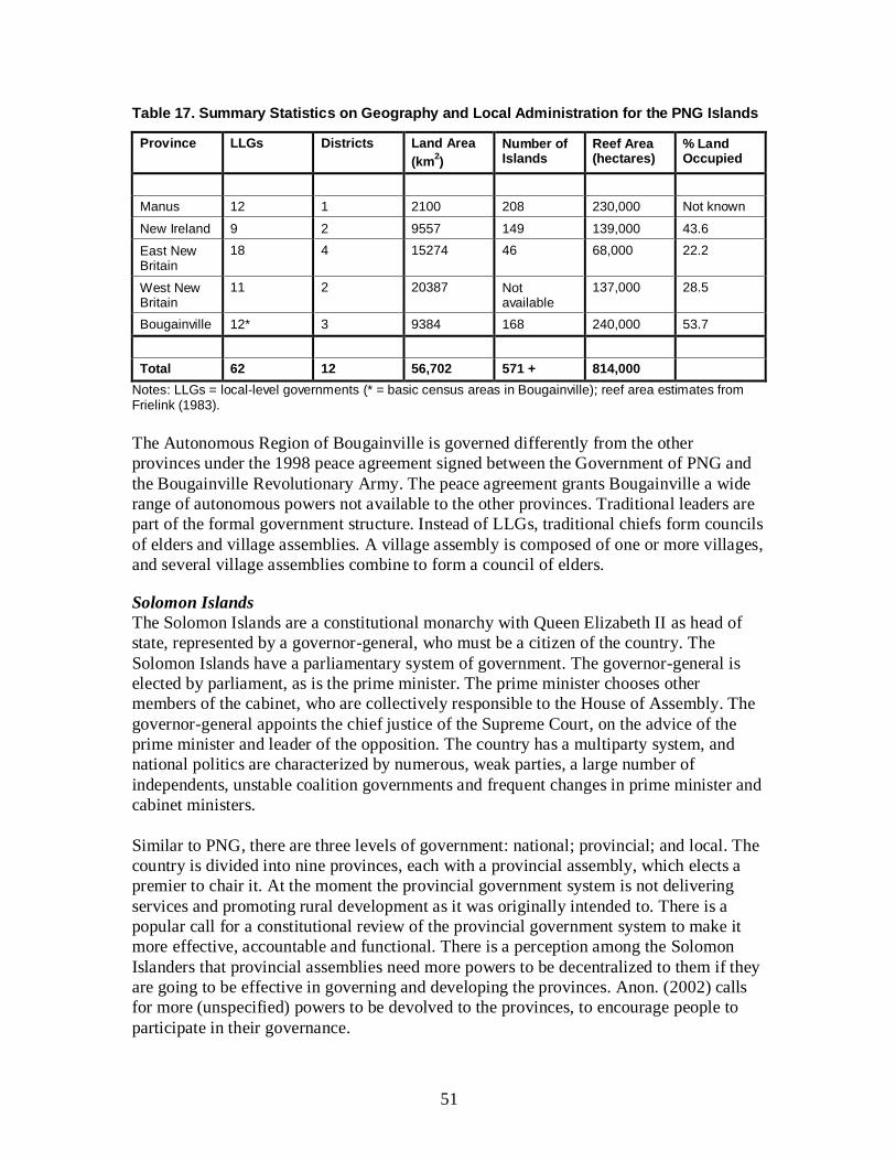
51
Table 17. Summary Statistics on Geography and Local Administration for the PNG Islands
Province LLGs Districts
Land Area
(km2)
Number of Islands
Reef Area (hectares)
% Land Occupied
Manus 12 1 2100 208 230,000 Not known
New Ireland 9 2 9557 149 139,000 43.6
East New Britain
18 4 15274 46 68,000 22.2
West New Britain
11 2 20387 Not available
137,000 28.5
Bougainville 12* 3 9384 168 240,000 53.7
Total 62 12 56,702 571 + 814,000
Notes: LLGs = local-level governments (* = basic census areas in Bougainville); reef area estimates from Frielink (1983).
The Autonomous Region of Bougainville is governed differently from the other
provinces under the 1998 peace agreement signed between the Government of PNG and
the Bougainville Revolutionary Army. The peace agreement grants Bougainville a wide
range of autonomous powers not available to the other provinces. Traditional leaders are
part of the formal government structure. Instead of LLGs, traditional chiefs form councils
of elders and village assemblies. A village assembly is composed of one or more villages,
and several village assemblies combine to form a council of elders.
Solomon Islands
The Solomon Islands are a constitutional monarchy with Queen Elizabeth II as head of
state, represented by a governor-general, who must be a citizen of the country. The
Solomon Islands have a parliamentary system of government. The governor-general is
elected by parliament, as is the prime minister. The prime minister chooses other
members of the cabinet, who are collectively responsible to the House of Assembly. The
governor-general appoints the chief justice of the Supreme Court, on the advice of the
prime minister and leader of the opposition. The country has a multiparty system, and
national politics are characterized by numerous, weak parties, a large number of
independents, unstable coalition governments and frequent changes in prime minister and
cabinet ministers.
Similar to PNG, there are three levels of government: national; provincial; and local. The
country is divided into nine provinces, each with a provincial assembly, which elects a
premier to chair it. At the moment the provincial government system is not delivering
services and promoting rural development as it was originally intended to. There is a
popular call for a constitutional review of the provincial government system to make it
more effective, accountable and functional. There is a perception among the Solomon
Islanders that provincial assemblies need more powers to be decentralized to them if they
are going to be effective in governing and developing the provinces. Anon. (2002) calls
for more (unspecified) powers to be devolved to the provinces, to encourage people to
participate in their governance.

52
Nevertheless, the Solomon Islands system of governance appears to be working well in
some areas where custom and tradition are still strong and respected, albeit not part of the
formal government structures. Solomon Islands law recognizes customary and traditional
laws and governance where they complement and are consistent with formal government
laws and policies. There are two main traditional systems of governance in the Solomon
Islands: the “Big Man System” and the “Chiefly System”. Under the Big Man System,
authority is acquired through wealth, respect and power, while, under the Chiefly System,
it is inherited through chiefly lineage. Martial prowess, fairness, generosity, care for
kinship and magic are all important qualities needed to acquire “big man” status.
Chiefs and big men, commonly referred to as traditional leaders, are still very active in
the Solomon Islands today. Some provinces recognize the importance of traditional
leaders and have formed institutions around them. Good examples are the Isabel Council
of Chiefs in Isabel province, the Shortland Islands Council of Chiefs in Western province
and the Lauru Land Conference of Tribal Chiefs in Choiseul province. These semi-formal
traditional institutions of governance play an important role in conflict resolution
(especially settlement of land disputes), promoting development aspirations of their
people and management of the both marine and forest resources.
Vanuatu
Like PNG and the Solomon Islands, Vanuatu has three levels of government. However,
in contrast to those countries, Vanuatu is a republic, with a president as head of state. The
role of the president, like that of the Queen, is largely ceremonial. A parliamentary
system is followed, with a 52-member parliament, which elects a prime minister as head
of government.
A significant feature of the governance system in Vanuatu is the National Council of
Chiefs, which has a formal role in advising the government on customary law, and is
influential in designating community conservation areas. The identification of sites of
national biodiversity significance to be declared as community conservation areas is
called for by the 2002 Environment and Conservation Act. The act stipulates a
transparent process of consultation with landowners, chiefs and other interested parties.
The act also stipulates the establishment of a Biodiversity Advisory Council, responsible
for advising the government on the implementation of the Convention on Biological
Diversity and, in particular, on matters related to bioprospecting.
The national government devolves some of its powers to six provinces, which are
governed by provincial councils with elected members. Each province is headed by a
chairman, elected by the provincial council members. The provincial councils have
significant autonomy to develop policies and development plans (called Rural Economic
Development Initiatives) to promote development in rural areas (Lane 2006).
Custom and culture are strong in Vanuatu and, therefore, traditional leaders are still
active and play a critical role in the governance of the rural communities and the
traditional economy. The Government of Vanuatu recognizes the importance of the
traditional economy and declared 2007 as the “Year of the Traditional Economy”
(Regenvanu 2007). Traditional leaders operating within the context of custom and culture
53
are better placed to manage the traditional economy than formal government. Thus, in
this case, formal government and traditional governance complement each other well.
6.2.2 Conflicts and Security Issues
PNG
Secession movements have been a problem in the islands region of PNG since long
before independence from Australia in 1975. During the 1960s, secession was on the
agenda of the Paliau Maloat cargo cult movement in Manus, and the Mataugan
Association in East New Britain and Bougainville. In 1989, armed conflict broke out on
Bougainville, which only ended a decade later with the recognition of Bougainville as an
autonomous region. According to the terms of the peace accord, signed in 1998, a
referendum on full independence will be held between 2015 and 2020. More recently,
citing Bougainville as a precedent, leaders from New Ireland and East New Britain have
called for similar autonomy for their provinces due to neglect by the national
government.
Problems with secession at the periphery of the country have been accompanied by
political instability at the center. National government has been marred by instability
since independence, with regular collapses of governing coalitions and political crises.
Since 2011, there has been a political impasse, brought about by wrangling among the
legislative, judicial and executive branches of government over who is the legitimate
prime minister. Parliamentary elections were held in mid 2012, in an attempt to create a
legitimate government. However, many analysts fear that PNG is in danger of political
and economic collapse. The country’s political system is unstable, the crime rate has
soared, corruption is rampant, essential services including health care and education
continue to decline, and smuggling of guns into the country is exacerbating ethnic
conflicts.
Solomon Islands
The Solomon Islands is very ethnically and linguistically diverse, and, like PNG, has
volatile national politics. In 1999, ethnic tensions between indigenous Isatabus on
Guadalacanal and Malaitan settlers spilled over into violence, expulsions and reprisals.
Rival militias were formed and parts of the country descended into lawlessness. A peace
agreement was signed between the two main militias in 2000 but the country continued to
suffer from lawlessness. In July 2003, at the request of the governor-general, a force of
Australian and Pacific island police and troops was dispatched to the Solomon Islands
under the auspices of the Regional Assistance Mission to Solomon Islands (RAMSI). The
intervention was successful and, within two years, the country was relatively stable. By
the end of 2007, RAMSI had been scaled back to around 600 police officers, military
advisors and civilian advisors. RAMSI remains in the country, and currently delivers a
wide program of development assistance, in addition to providing law and order.
In an effort to bring lasting stability and unity to the country, the Solomon Islands Truth
and Reconciliation Commission (TRC), established by an Act of Parliament in 2008, is a
key policy instrument of the government’s development strategy. The TRC was
54
conceived as an independent, nationally owned commission, with the objective of
promoting national unity and reconciliation, engaging all Solomon Islanders in the
reconciliation process and investigating the nature, causes and responsibility for the
human rights violations that occurred during the ethnic tensions. The government’s
development strategy affirms that reconciliation and the associated rehabilitation to
support it are fundamental to sustain development, peace and harmony in the Solomon
Islands (Commonwealth of Nations 2012).
Conflicts over land, resources and economic opportunities that were played out at the
national level during the tensions can also be observed within individual communities.
There are clear signs of conflict over resources in many communities, especially in places
where logging companies are operating, and these can develop into political conflict and
security concerns. In a country where 80 to 90 percent of the land is under customary
ownership, substantial areas of forest have been exploited with few benefits to the
majority of traditional owners. Conflicts have arisen among communities, even within
families, among those who benefit directly from employment or timber royalties and
those who are negatively affected by environmental degradation. In general, logging
activities have fuelled conflict and antagonism among Solomon Islanders due to state,
company and individual exploitation or manipulation of resource owners (Government of
the Solomon Islands 2008).
Vanuatu
Following independence from France and the United Kingdom in 1980, Vanuatu’s
national politics were initially very stable, characterized by the dominance of two
political parties (Lane 2006). However, since the late 1990s, national politics have
become more fragmented and unstable as a result of the emergence of more parties and
candidates. In the 2002 elections, for instance, 10 parties nominated a total of 261
candidates for only 52 seats (Lane 2006). This has led to a series of coalition
governments, which tend to be unstable and require compromises to minority parties.
Political instability in the 1990s led to greater devolution of powers to the provinces.
Vanuatu has, fortunately, escaped the types of armed conflict and lawlessness that have
plagued other parts of the hotspot in recent decades. The main exceptions were a brief
rebellion by French-speaking landowners and plantation workers on Santo Island in 1980,
and an attempted coup by a paramilitary group in 1996.
6.3 Global and Regional Agreements
The countries in the East Melanesian Islands Hotspot are signatories to a range of global
and regional agreements designed to promote environmental protection and sustainable
development. The impact of these agreements on national policy is variable, as economic
development is typically given precedence over environmental concerns. Nevertheless,
they may have mediated the impacts of population pressure, economic development and
climate change to some degree.
55
6.3.1 Hotspot Parties to Global Agreements
Convention on Biological Diversity
This convention, effective since 1993, has 193 member countries. Its objectives are the
conservation of biological diversity, the sustainable use of its components, and the fair
and equitable sharing of the benefits arising out of the utilization of genetic resources. It
seeks to promote conservation of biological diversity in the wild, through requesting
signatories to identify regions of biodiversity importance, establish a system of protected
areas, restore degraded ecosystems, maintain viable populations of species in natural
surroundings, and develop or maintain necessary legislation and/or other regulatory
provisions for the protection of threatened species and populations. All hotspot nations
now have an official National Biodiversity Strategy and Action Plan (NBSAP), which
acts as an overarching guide to biodiversity conservation in the country.
The NBSAP for PNG was developed over two years, through an extensive process of
stakeholder consultation. Published in 2007, the NBSAP provides a strategic roadmap for
sustainable development over the period from 2008 to 2013 and beyond (Government of
PNG 2007). The NBSAP has the following main goals:
Conserve, sustainably use and manage the country’s biological diversity.
Strengthen and promote institutional and human capacity building for biodiversity
conservation, management and sustainable use.
Strengthen partnership and promote coordination for conserving biodiversity.
Strengthen existing protected areas and ensure that protected areas for terrestrial
species and marine species are increased to 10% by 2010 and 2012 respectively.
Ensure a fair and equitable sharing of benefits arising out of genetic and
ecosystem resources.
Promote and strengthen research of the country’s biological diversity and the
sustainable development of the country’s biological resources.
The initial process to develop an NBSAP for the Solomon Islands was launched in 1996.
However, implementation was not completed, due to difficulties experienced by the
government, and funding for the process was withdrawn in 2006. A new process was
initiated, with support from the United Nations Development Programme (UNDP), The
Nature Conservancy (TNC) and WWF, resulting in the successful completion of the
country’s first NBSAP in 2009 (Government of the Solomon Islands 2009). The NBSAP
sets out 12 strategic goals for protecting, conserving and promoting the country’s unique
and endemic biodiversity, including:
Ensure the commitment of the Solomon Islands government and stakeholders to
conserving and managing biodiversity is integrated into national legislation,
sectoral plans, policies and programs.
Ensure unique plant and animal species are given appropriate levels of protection
and are managed sustainably with a better informed public on the significance of
the species.
56
Ensure biodiversity of the Solomon Islands is protected from introduced and
modified species, through legislation, monitoring, research and awareness.
Empower stakeholders to effectively participate in the conservation and
sustainable use of biological resources.
Ensure that people, resource owners and the public are better informed of the
importance and values of biodiversity through research, with improved
monitoring systems for information sharing.
Ensure that pressures, impacts and mitigation measures of climate change are
adequately supported and addressed to conserve the country’s biodiversity.
The first NBSAP for Vanuatu was published in 1999, again following a two-year period
of consultations and research. The strategy highlights six key objectives for the effective
management of the country’s biological resources (Government of Vanuatu 1999a):
Ensure sustainable management and conservation of Vanuatu's biodiversity.
Develop appropriate policy, planning and legal mechanisms for the management
of biodiversity.
Improve our knowledge about biodiversity in Vanuatu.
Improve the capacity of national and provincial governments, NGOs and
community organizations to manage biodiversity.
Increase local awareness of the importance and value of biodiversity.
Foster community participation in the management and conservation of
biodiversity.
UNFCCC and Kyoto Protocol
The UNFCCC, signed in 1992, aims to promote international cooperation with regard to
both mitigating the effects of climate change by limiting greenhouse gas (GHG)
emissions, and adapting to unavoidable impacts. There are now 195 parties to the
convention, which was ratified by the Solomon Islands in 1993, and PNG and Vanuatu in
1995. Realizing that the provisions with regard to GHG emissions reductions in the
original convention were inadequate to confine global temperature increases within
“safe” limits, parties to the convention began negotiations aimed at a stronger global
response. This led to the Kyoto Protocol being adopted in 1995, which contains legally
binding commitments for developed countries. The Kyoto Protocol was ratified by the
hotspot countries in 2002 and 2003, and finally came into force in 2005. The first
commitment period runs from 2008 to 2012, and this will be followed by a second five-
year period from 2013. As Non-Annex I countries, PNG, the Solomon Islands and
Vanuatu have no binding commitments to reduce GHG emissions under the Kyoto
Protocol.
Ramsar Convention
Effective since 1975, the Ramsar Convention, also known as the Convention on Wetlands
of International Importance especially as Waterfowl Habitat, has 162 member countries.
It is an “intergovernmental treaty that embodies the commitments of its member countries
to maintain the ecological character of their Wetlands of International Importance and to
plan for the ‘wise use’, or sustainable use, of all of the wetlands in their territories”
57
(Ramsar 2011). Of the hotspot countries, only PNG is a contracting party to the
convention, joining in 1993. To date, the PNG government has designated only two
wetlands as ‘Ramsar sites’, or wetlands of international importance, covering almost
6,000 km2. These wetlands are Tonda Wildlife Management Area in Western province
and Lake Kutubu in the Southern Highlands; neither is located inside the hotspot.
In general, wetlands, especially freshwater wetlands, are underrepresented within the
existing networks of protected areas and community conservation areas in the hotspot,
which is of great consequence because they are of high importance to human wellbeing.
Many of the KBAs identified in the hotspot (see Section 4.3.2) meet the criteria for
designation as Ramsar sites, and there is clearly considerable potential for further uptake
and application of the convention and the principle of wise use in the hotspot.
Convention on International Trade in Endangered Species of Wild Fauna and Flora
(CITES)
CITES has been in operation since 1975 and has 169 contracting parties. Its aim is to
ensure that international trade in specimens of wild animals and plants does not threaten
the survival of species. CITES works by subjecting international trade in specimens of
select species to certain controls. These require that all import, export, re-export and
introduction from the sea of species covered by the Convention must be authorized
through a licensing system. The species covered by CITES are listed in three appendices:
Appendix I includes species threatened with extinction and can only be traded in
exceptional circumstances; Appendix II includes species not necessarily threatened with
extinction, but in which trade must be controlled in order to avoid utilization
incompatible with their survival; and Appendix III contains species that are protected in
at least one country that has asked other CITES member countries to assist in controlling
the trade. CITES is an important convention for the East Melanesian Islands, where
international trade in wildlife and wildlife products is a major threat to some groups of
plants and animals, such as certain timber trees, reef fish and sea cucumbers. All three
countries are parties to the convention, with PNG acceding in 1975, Vanuatu in 1989 and
the Solomon Islands as recently as 2007.
World Heritage Convention
Effective since 1975, the World Heritage Convention has 189 member countries,
including all three from the hotspot. The convention’s aim is to identify and conserve
cultural and natural monuments and sites of outstanding universal value, through the
nomination of World Heritage Sites by national governments and their recognition by the
United Nations Educational, Scientific and Cultural Organization (UNESCO). As of
March 2012, only one natural World Heritage Site (East Rennell in the Solomon Islands)
had been declared in the hotspot, along with one cultural site (Chief Roi Mata’s Domain
in Vanuatu). East Rennell is a high conservation priority, which was identified as a KBA
during the ecosystem profiling process (see Section 4.3.2 and Appendix 2). Given the
global importance of many sites in the hotspot for the conservation of biodiversity, it is
highly likely that other areas would qualify for natural World Heritage Site status.

58
United Nations Declaration on the Rights of Indigenous Peoples While not a multilateral environmental agreement, the United Nations Declaration on the
Rights of Indigenous Peoples forms a significant part of the global legal framework
regulating the rights of indigenous people regarding ownership of, management of and
access to land and natural resources. It is, therefore, directly relevant to many
conservation issues in the hotspot, which relate to conflicts around resource rights. This
landmark declaration was adopted by the General Assembly of the United Nations in
2007 following approval by 143 member countries (including the three hotspot
countries). The declaration outlines the rights of the world’s indigenous peoples and
outlaws discrimination against them. In particular, it enshrines the principle of free, prior
and informed consent with indigenous communities regarding matters that affect them.
6.3.2 Hotspot Parties to Regional Agreements and Institutions
The hotspot countries are party to various regional agreements, which have led to the
establishment of the following regional institutions: the Secretariat of the Pacific
Regional Environment Programme (SPREP) in Apia, Samoa; the Forum Fisheries
Agency (FFA) in Honiara, Solomon Islands; the Melanesian Spearhead Group in Port
Vila, Vanuatu; the Secretariat of the Pacific Community (SPC) in Noumea, New
Caledonia; and the Pacific Islands Forum Secretariat in Suva, Fiji. These are all inter-
governmental institutions that play vital but neutral roles in helping national governments
comply with international standards and best practices. They help formulate regional
policies to help build regional capacities to respond to environmental issues, and address
shortfalls in human resources at the national level. The Melanesian Spearhead Group is a
political lobby grouping, while SPREP, FFA, SPC and the Pacific Islands Forum are
responsible for different aspects of regional governance and cooperation.
The Pacific Regional Environment Program has 21 member countries, and its secretariat,
SPREP, has been the driving force behind NBSAPs in the region, as part of the overall
Action Plan for Conservation of Nature. Its most recent meetings have been mainly to
allow member countries to update one another on progress with development and
implementation of NBSAPs. These meetings also have a role in shaping environmental
governance in the region. When capacities constraints are identified, SPREP provides the
necessary technical support and funding, where possible.
The Pacific Islands Forum is a political grouping of 16 independent and self-governing
states (of which one, Fiji, is currently suspended) that aims to enhance cooperation
among independent countries in the Pacific Ocean. The Pacific Islands Forum initiated
the Pacific Plan, following a report by a group of eminent persons, which sets out a road
map for development in the Pacific. Unlike SPREP and FFA, the Pacific Islands Forum,
SPC and the Melanesian Spearhead Group do not have a specific focus on environmental
issues. However, their meetings are large, high profile gatherings of senior officials,
which create opportunities to hold governments accountable for their development
policies and performance in meeting national, regional and international environmental
commitments. Such regional meetings are also important mechanisms for exchanging
information, negotiating common positions, and promoting collaborative research into
shared environmental and development problems.
59
A key environmental initiative being developed under the auspices of the Pacific Islands
Forum is the Pacific Oceanscape initiative, which was endorsed by the leaders of 15
countries at the Pacific Islands Forum Leaders Summit in August 2010, including the
three hotspot countries. This groundbreaking initiative envisions a secure future for
Pacific island countries and territories, based on sustainable development, management
and conservation of the ocean. The broad objectives of the initiative are: integrated ocean
management; adaptation to environmental and climate change; and liaising, listening,
learning and leading. Overall, the intent is to foster stewardship at local, national and
regional scales to ensure in perpetuity the health and wellbeing of the ocean and people.
The initiative is being taken forwards by the Forum’s Marine Sector Working Group,
comprising the Pacific Islands Forum Secretariat, FFA, the Secretariat of the Pacific
Community, USP and SPREP, with technical support from CI, IUCN and the United
Nations Environment Programme (UNEP).
The Pacific Oceanscape initiative is currently at an advanced planning stage. The Marine
Sector Working Group has developed a framework that sets out six strategic priorities for
immediate implementation. Most of these priorities relate to offshore marine
conservation, and are therefore not directly relevant to the East Melanesian Islands
Hotspot, which is, by definition, a terrestrial conservation priority. Nevertheless, there are
a number of potential linkages, particularly with regard coastal and nearshore marine
habitats, which are included in the CEPF investment strategy for the hotspot. Specifically,
under Strategic Priority 3 (sustainable development, management and conservation),
there is an action to “implement integrated coastal resource management arrangements,
drawing on the strengths and traditions of community, district, provincial and national
levels of government to achieve sustainable island life”. Under Strategic Priority 4
(listening, learning, liaising and leading), there are actions to facilitate “targeted capacity
building for achieving policy and management objectives” and to connect “people and
places for sharing, learning and action”. Finally, under Strategic Priority 5 (sustaining
action), there is an action to “incorporate consideration of the economic development
benefits of sustainable management of coastal and marine resources in decisions affecting
national development”.
Other regional agreements and initiatives relevant to the East Melanesian Islands Hotspot
include the Coral Triangle Initiative: the single largest marine conservation initiative in
the hotspot. The Coral Triangle Initiative is a regional cooperation program to protect the
outstanding coastal and marine resources of the Coral Triangle region (The Coral
Triangle Initiative 2012). The initiative involves the governments of PNG and the
Solomon Islands (although not Vanuatu, which lies outside the Coral Triangle), together
with those of Indonesia, Malaysia, the Philippines and Timor Leste, with technical
support from CI, TNC and WWF, and financial support from the GEF, via the Asian
Development Bank (ADB), and the United States Agency for International Development
(USAID).
Another important regional agreement relevant to marine conservation is the Multilateral
Treaty on Fisheries between Certain Governments of the Pacific Island States and the
Government of the United States of America (commonly known as the “US Treaty”).

60
This agreement is essentially a financial mechanism put in place by the US Government
to compensate Pacific island states for tuna resource extraction. In April 2011, PNG
withdrew from the treaty, citing the US Government’s failure to incorporate conservation
measures into the treaty following two years of negotiation (WWF 2011a).
6.4 Environmental Policies and Legislation 6.4.1 PNG
Legislative Framework
All three hotspot countries have a written constitution as their main law, which guides all
other laws and how the government behaves and functions. PNG’s constitution came into
effect in 1975 and sets forth a number of national goals. The fourth goal requires that
“natural resources and environment to be conserved and used for the collective benefit of
us all, and to be replenished for the benefit of future generations”. To further this goal,
the constitution calls for wise use of resources and directs that all necessary steps be
taken to ensure adequate protection of PNG’s flora and fauna (Clarke et al. 2008).
The key piece of environmental legislation in PNG is the 2000 Environment Act. This is
a comprehensive piece of legislation, designed to promote sustainable development of the
environment and wellbeing of the people. The act sets out to balance short-term
development needs with the long-term maintenance and replenishment of the country’s
natural capital. This is pursued through the promotion of the sustainable use natural
resources, the assignment of proportionate priorities to respective short-term and long-
term environmental, economic, and social considerations, and the regulation of industries
with adverse environmental effects (Clarke et al. 2008).
The act imposes a general duty mandating that no person shall carry or an activity that
will harm or is likely to harm the environment without taking all reasonable or
practicable measures to minimize such harm. Breach of this general duty is not a criminal
offence nor actionable in a civil suit but compliance may be enforced through an
Environment Protection Order, a Clean-Up Order, or an Emergency Direction. The Act
also provides for the drafting of environmental policies by which environmental
protection and sustainable development can be pursued.
Other pillars of the legislative framework for biodiversity conservation in PNG include:
the 1991 Forestry Act, which seeks to utilize and protect the country’s forest resources to
achieve economic growth, while conserving them for future generations; the 1982
National Parks Act, which provides for the establishment and management of protected
areas; the 1966 Fauna (Protection and Control) Act, which regulates the control,
harvesting and culling of fauna, and provides for the establishment of designated areas
where animals are protected; and the 1998 Fisheries Management Act, which regulates
the management and sustainable development of fisheries (Clarke et al. 2008).

61
Institutional Framework
All East Melanesian Islands countries have equivalent environment and conservation
agencies, which are primarily mandated to manage and establish both terrestrial and
marine protected areas under their respective constitutions. In PNG, the key government
agencies responsible for ensuring that natural resources are managed and exploited with
appropriate environmental safeguards are the PNG Forest Authority, the Department of
Lands and Physical Planning, the Department of Agriculture and Livestock, and the
Mineral Resources Authority. Institutions such as the PNG Forest Research Institute and
the National Agricultural Research Institute also play an important role, by conducting
applied research and monitoring the impacts of government policies in the natural
resources sector.
In common with many countries in the world, many of the key government agencies do
not work in a coordinated fashion to implement complex national development agendas.
In fact, many of these agencies seem to work against each other, as evidenced by the
recent spate of legislative amendments, which are an indication of agencies clashing over
their respective mandates.
6.4.2 Solomon Islands
Legislative Framework
The rights of customary landowners are enshrined in the constitution of the Solomon
Islands. In line with the constitution, certain pieces of legislation make explicit reference
to customary rights and/or contain exemptions from certain provisions for land and sea
areas held under customary tenure. The Provincial Government Act, for instance,
includes the wording: “nothing in this section shall be construed as affecting traditional
rights, privileges and usages in respect of land and fisheries in any part of the Solomon
Islands” (Cultural Survival 2010).
The central pillar of the legislative framework for biodiversity conservation in the
Solomon Islands is the 1998 Environment Act. The act promotes the protection of the
environment and prevention of pollution. To achieve these goals, the act provides for
controls on economic development, including pollution monitoring and controls, and an
environmental impact assessment (EIA) process. The act also includes necessary
measures to comply with and give effect to multilateral environmental agreements
(Clarke et al. 2008).
Other key elements of the legislative framework for biodiversity conservation include:
the 1954 National Parks Act, which provides for the declaration of national parks; the
1998 Fisheries Act, which provides for the proper management and development of
fisheries; the 1969 Forest Resources and Timber Utilization Act, which controls and
regulates the timber industry; the 1990 Mines and Minerals Act, which regulates the
mining industry; and the 1998 Wildlife Protection and Management Act, which provides
for the protection, conservation and management of wildlife by regulating the export and
import of certain animals and plants, in compliance with international obligations under
CITES (Clarke et al. 2008).
62
Recent additions to the legislative framework for biodiversity conservation include the
2010 Protected Areas Act, and the National Strategy for Inshore Fisheries and Marine
Resources (Kool et al. 2010). Both documents recognize customary land ownership and
resource rights. They also explicitly acknowledge the role of civil society organizations in
facilitating biodiversity conservation by customary landowners and their important
responsibility in resource management.
Institutional Framework
The Ministry of Forestry is responsible for the overall management of the forest resources
of the Solomon Islands, and for drafting, enacting and implementing forestry legislation
and policy. The ministry supports family-based reforestation initiatives and encourages
sustainable forestry activities, establishment of plantations, and domestic processing of
timber.
The national institution charged with environmental management and monitoring is the
Environment and Conservation Department within the Ministry of Environment, Climate
Change, Disaster Management and Meteorology. This is a new ministry, established in
2008. The division is responsible for coordinating environmental management and
monitoring, while at the same time mainstreaming environmental considerations across
all development sectors. The institutional mandate to integrated environmental
considerations into the development plans developed by other ministries is laudable.
Unfortunately, severe shortages in human resources have prevented the division from
effectively carrying out its responsibilities in this area, or in setting and monitoring
environmental standards, as prescribed by the 1998 Environment Act (Government of the
Solomon Islands 2008).
6.4.3 Vanuatu
Legislative Framework
The overarching framework for management of Vanuatu’s environment is set out in the
constitution, which was adopted in 1980. Section 7(d) states that every person has a
fundamental duty to safeguard the wealth, resources and environment of the country, in
the interests of the present and future generations. Importantly, Section 74 states that “the
rules of custom shall form the basis of ownership and use of land in the Republic of
Vanuatu” (Clarke et al. 2008).
Vanuatu’s legislative framework contains a number of innovative, forward-looking
provisions, related to the conservation of biodiversity. Most notable among these are
provisions for the establishment of “community conservation areas” under the 2002
Environment and Conservation Act. Under Section 35 of the act, the Director of
Environment can negotiate with customary landowners for any site to be registered as a
community conservation area if it is considered to have unique genetic, cultural,
geological or biological resources, or to provide habitat for animal or plant species of
national or international conservation importance. Before a site can be registered as a
community conservation area, prior consent must be obtained from all parties with an
interest in the land and an appropriate management plan must be in place.

63
Similar provisions are contained within the 2001 Forestry Act. Under Section 50 of the
act, an area of forest with particular cultural or social significance for local communities
can be declared as a “conservation area” upon the written request of the customary
landowners to the minister. This act also requires prior consultations to be held with
interested parties. The act also provides for the designation of plant species as protected
species, which may not be felled or removed in the course of commercial logging
operations without the express authorization of the ministry.
Establishment of conventional, government-managed protected areas is provided for in
the 1993 National Parks Act, which makes provision for the declaration of national parks
and nature reserves. The act also empowers the minister to formulate regulations for the
administration of national parks and nature reserves, and the implementation of
management plans for them. The act requires that concerns of customary landowners be
addressed in protected area management plans but does not prescribe a process of prior
informed consent.
With regard to regulating development activities with potential negative environmental
impacts, the key pieces of legislation are the 2002 Environmental Management and
Conservation Act and the 2011 EIA Regulation. These specify the requirements of an
EIA and lay out the process to be followed when carrying one out. The act applies to all
development activities that either impact or are likely to impact on the environment of
Vanuatu, and which require any license, permit or approval under any law (Clarke et al.
2008).
Other key pieces of environment-related legislation in Vanuatu include: the 1964 Import
of Plants Act and the 1986 Animal Imports Act, which regulate the movement of animal
and plants into and within the country; the 1986 Mines and Minerals Act, which regulates
the mining industry; the 1997 Plant Protection Act, which provides for the exclusion and
effective management of plant pests; the 2001 Forestry Act, which is the main piece of
legislation regulating the forestry industry; and the 2002 Water Resources Management
Act, which provides for management plans, committees and protection zones for the
management of water resources (Clarke et al. 2008).
Institutional Framework
The key government institutions responsible for the implementation of the above
legislation are the Forestry Department and the Department of Environment and
Conservation (formerly the Environment Unit) under the Ministry of Lands and Natural
Resources. Although being housed within a single ministry helps facilitate collaboration
between the two divisions, they both face severe human and financial resource
constraints, and are scarcely able to deliver on their mandates. In particular, the additional
activities needed to implement and report on activities under multilateral environmental
agreements depend almost entirely on international donor support. At the provincial level,
there are no full-time staff persons with a dedicated responsibility for environmental
issues. This impedes the implementation of environmental policies on the ground.
Another constraint to the effective implementation of environmental legislation is that
responsibility for environmental matters is dispersed among five ministries and 15 line
64
departments. There is a need for improved cooperation and coordination to facilitate
biodiversity conservation among all concerned agencies (Government of Vanuatu 1999a).
6.5 Protected Areas
The East Melanesian Islands Hotspot has a limited coverage of protected areas, whether
marine or terrestrial. Despite the identification of biological priority areas (e.g.
Swartzendruber 1993, Lipsett-Moore et al. 2010) and even with the necessary laws in
place, there has been little progress towards the establishment of formal protected areas.
In part this reflects the limitations of conventional protected area approaches in a context
of customary land ownership and resource tenure and limited government capacity, and
in part it reflects conflicting land-uses, especially logging in lowlands and mining in
highlands.
The World Database on Protected Areas (IUCN and UNEP 2009) lists only three formal
protected areas for the PNG Islands Region: Ndrolowa Marine Managed Area in Manus
province, Talele Island National Park in East New Britain; and Loroko National Park in
West New Britain. Together, these cover only 60 km2
or 0.1 percent of the PNG portion
of the hotspot. Similarly, only five formal protected areas are listed for the Solomon
Islands: Arnavon Islands Marine Conservation Area; East Rennell World Heritage Site;
Kolombangara Forest Reserve; Komarindi Catchment Conservation Area; and Queen
Elizabeth National Park. These cover a combined area of 737 km2, equivalent to
3 percent of the national land area. Finally, in Vanuatu, the World Database on Protected
Areas lists four formal protected areas, covering 98 km2 or 1 percent of the total land
area: Erromango Kauri Forest Conservation Area; Nguna-Pele Marine Protected Area;
President Coolidge and Million Dollar Point Marine Reserve; and Vatthe Forest
Conservation Area. Although established with government support, these areas are
typically managed by or in collaboration with customary land owners.
As an alternative to conventional, government-managed protected areas, various
approaches to community-managed conservation areas have been piloted in the hotspot,
for both terrestrial and marine areas. Government and civil society partners in all three
countries have promoted locally managed marine areas (LMMAs), which are seen as a
way to empower local people to manage their marine and coastal resources, while similar
approaches have been promoted for terrestrial forests, including community conserved
areas in Vanuatu. The World Database on Protected Areas (IUCN and UNEP 2009) lists
more than 100 community-managed protected areas in the hotspot, such as M’Buke
LMMA and Garu Wildlife Management Area in PNG, Redman Marine Conservation
Area and Tetepare Community Conservation Area in the Solomon Islands, and Emua
Marine Protected Area and Vatthe Forest Conservation Area in Vanuatu. Community-
managed protected areas are typically small areas of reef other nearshore marine habitats
but a few contain significant stands of terrestrial forest.

65
7. CIVIL SOCIETY CONTEXT OF THE HOTSPOT
7.1 Introduction
There are numerous interpretations of the term “civil society”. While the term is often
used synonymously with NGOs, CEPF adopts a broader definition of civil society as the
set of institutions, organizations and individuals located between the family, the state and
the market, in which people associate voluntarily to advance common interests
(Holloway 2001). Specifically, this includes many kinds of NGOs and voluntary
organizations, philanthropic institutions, and social movements (SustainAbility 2003). In
common with McIlwaine (2007), CEPF also includes private businesses, media and
professional organizations and cooperatives in its definition of civil society.
Organizations or associations of citizens outside the public sector are variously known as
civil society organizations, or non-state actors. Smaller groups, restricted in geographic
spread to one or more villages or islands and rooted in community initiatives, are referred
to as CBOs.
7.2 Regulatory Framework
All legislation quoted or described in this section may be consulted through the databases
of the Pacific Islands Legal Information Institute (2012).
7.2.1 PNG
With some qualifications, the PNG constitution recognizes the rights of persons to form
into associations. It also strongly affirms the rights of local indigenous communities to
their land and resources and calls for “development to take place primarily through the
use of Papua New Guinea forms of social and political organization” (Government of
PNG 1975).
With its Associations Incorporation Act, PNG is the only Pacific island country to have
introduced specific legislation concerning the establishment of the range of civil society
organizations that now serve modern island societies (Lakshman 2012). It is a
comprehensive piece of legislation that requires public notification of the intention to
form an association so that people may raise objections to the Registrar at the PNG
Investment Promotion Authority, before formal application for incorporation.
Incorporated associations are required to submit annual audited accounts and may own
property, invest, sue and be sued as legal entities. The act applies to most forms of non-
profit organization but not churches, which are governed by special legislation often
specific to individual cases.
While most civil society organizations register under the Associations Incorporation Act,
a few have chosen to register as non-profit companies (AusAID 2005). According to the
report of an Australian Agency for International Development (AusAID) scoping mission
(AusAID 2005), the greatest legal constraint to civil society freedom of action at the local
level is the Organic Law on Provincial and Local Level Government, which the report
66
describes as being centralized, top down and not inclusive of communities in relevant
service delivery systems. Other laws under which civil society organizations can register
apply mainly to for-profit companies and associations that act for private gain of their
members. These include the 1974 Business Groups Incorporation Act, the 1974 Land
Groups Incorporation Act, the 1982 Cooperative Societies Act and the 1961 Savings and
Loan Societies Act (Lidimani 2007). The Income Tax Act of (1959) exempts various
types of civil society organization from income tax, including charitable bodies, non-
profit bodies and research funds.
International NGOs (INGOs) can establish and work in the country through a
memorandum of understanding (MoU) with the PNG government. Most them are non-
membership organizations that work for the public good and are, therefore, recognized as
public-benefit organizations like charitable bodies (Lidimani 2007). As in the Solomon
Islands, there is no specific legislation governing the registration of INGOs.
7.2.2 Solomon Islands
The freedom to assemble and form associations is protected under Sections 12 and 13 of
the Solomon Islands constitution (Lidimani 2004), so that civil society groups can
coalesce without formal registration and act successfully in the interests of their members
or the country in general. Civil society groups may attain formal legal status through
registration, as is the case for many NGOs, or remain unregistered, as many CBOs do.
Neither the effectiveness nor the privileges enjoyed by civil society organizations are
affected by their legal status (Lidimani 2004).
The Solomon Islands Government recognizes civil society organizations’ important role
as alternative development partners. Active civil society organizations comprise both
membership and non-membership organizations, as well as international, national and
localized community-based groups.
NGOs may be registered under the Charitable Trusts Act of 1964 or the Cooperative
Societies Act of 1953. A charitable trust is registered with the Registrar of Companies
and is set up only for charitable purposes, as identified in the act. A charitable trust is not
for business; and it is not required to report or to submit audited financial reports to the
Registrar of Companies. It is governed by a board of trustees whose duties and
accountability are not clearly defined. A cooperative society, on the other hand, has to be
registered with the Registrar of Companies, as its major objective is the economic benefit
of its members. Its establishment is complex and time consuming. Both types of NGO
may receive grants and donations (Lidimani 2004, The Company Haus 2011).
A recent review of the enabling legislative framework for NGOs in the Solomon Islands
noted the need for both acts to be updated to take account of changed sociopolitical and
economic conditions (Lidimani 2004). For example, despite the substantial growth of
NGOs, there is no central registry of them except with the Registrar of Companies. In
their financial operations, NGOs have to comply with the Customs and Excise Act,
Goods Tax Act, Income Tax Act, Sales Tax, and Stamp Duties Act. NGOs may be

67
exempted from these tax acts by the instruction of the minister responsible for the
administration of the concerned acts. Of particular interest, from a financial perspective,
is Lidimani’s (2004) observation that NGOs registered under the Charitable Trusts Act
are not required to have annual audited accounts. This is a regulatory loophole that poorly
governed NGOs can exploit.
Churches and religious organizations are assured of freedom of worship and belief under
the constitution. They are required to be registered with the government and may do so
under the Charitable Trusts Act. Churches have a great influence on the people of the
Solomon Islands and are instrumental in maintaining a strong interest in biodiversity
conservation in the people. They also have a powerful voice nationally and can be
effective advocates for issues of concern to the public.
Depending on the purpose of the association, CBOs may register as either cooperative
societies or charitable trusts. While associations for setting up businesses for the profit of
their members are required to be registered under the Cooperatives Act, associations set
up solely for charitable purposes need not be formally registered. Some 200 trusts are
registered under the Charitable Trusts Act (The Company Haus 2011). In the absence of
comprehensive registration of CBOs, it is not possible to report how many exist. They
include women’s groups, youth groups, men’s clubs, village interest groups, church
affiliated groups, sports groups, and a wide variety of other interest groups.
An additional legal framework available for CBOs is the formation of community
companies under the Companies Act of 2009. Community companies are free and simple
to set up. Audits are not required, provided that profits are for the community and not for
individual gain, and priority is given to preservation and protection of community assets
(The Company Haus 2011).
There is no specific legislation governing the operations of INGOs in the Solomon
Islands, and they usually enter the country through signing an MOU with the government.
A recent increase in the number of INGOs either establishing local offices or forming
partnerships with local NGOs has been “facilitated arguably by a less rigorous
establishment environment” (Lidimani 2004).
The devolution of responsibility for land and marine resource management to provincial
levels under the 1996 Provincial Government Act facilitates liaison of locally active civil
society organizations with relevant provincial officials working with local community
resource owners (National Parliament of the Solomon Islands 1996). The same act allows
for the codification of customary law related to land, enabling official recognition of local
taboo sites (National Parliament of the Solomon Islands 1996). The Solomon Islands is
replete with small taboo sites, averaging one to two hectares, declared and respected for
generations through customary laws (T. Masolo verbally 2012).
The 1998 Environment Act and the 2010 Protected Areas Act both recognize the role of
civil society organizations in conservation activities. The former act stipulates the
inclusion of relevant NGO activities in the three-yearly report of the Director of
Environment and Conservation. The Protected Areas Act goes further than any previous

68
act by stipulating the inclusion of four NGO members on the 10-member Protected Areas
Advisory Committee to the Minister of Lands and Natural Resources. This has potential
to give the NGO members a very influential voice given the stipulated quorum of five.
The functions of the committee include the requirement of regular reports of activities
from relevant NGOs, and the formulation of a code of conduct for NGOs in relation to
the relevant standards of conduct under the Act.
7.2.3 Vanuatu
Articles 73 to 75 of the constitution of Vanuatu assure its citizens freedom of association.
As in the Solomon Islands, formal registration of civil society organizations is not
mandatory. However, it is seen as an advantage. Vanuatu NGOs may be registered either
under the 1981 Charitable Associations (Incorporated) Act or as companies limited by
guarantee under the 1986 Companies Act. As charitable associations, NGOs are
registered with the Vanuatu Financial Services Commission. The Tax Act exempts from
value added tax all charitable associations working for the public benefit. Charitable
purposes include scientific, cultural and general social welfare objectives.
Churches and other religious organizations have to be registered under the 1995
Religious Bodies (Registration) Act, which was supplemented by the 2005 Church of
Melanesia (Vanuatu) Trust Board Act. INGOs have no special provision in Vanuatu law
but may work in the country under an MoU with the government. The MoU may include
exemption from paying value added tax.
7.3 Operating Environment
PNG, the Solomon Islands and Vanuatu share similarities in terms of: cultural complexity
and linguistic diversity; complicated land and resource ownership systems that often
result in conflicts; a majority rural population residing in isolated villages largely
regulated by customary laws; high levels of spirituality, linking people closely to the
land, to their clan groups and to their ancestors; and difficulties in communication. In all
three countries, external agencies seeking to promote biodiversity conservation have to
recognize the existence of overlapping formal and informal rules in a system of legal
pluralism (Menzies 2007). For civil society organizations working on biodiversity
conservation, customary laws, church regulations and beliefs must be adhered to with as
much respect and rigor as statutory laws and the policies of donor agencies.
7.3.1 PNG
Formation of civil society organizations in PNG appears to be generally uninhibited by
legal, policy or regulatory barriers. Most civil society organizations focus primarily on
service delivery and, as such, are respected by government, as evidenced by the
availability of public funding to churches. There is, however, no clear policy for
government support to civil society organizations for service delivery.

69
The value of civil society’s contribution to public policies and public accountability is
officially recognized through sanctioned participation in a range of national and local
government bodies, including those dealing with resource governance, such as the
Forestry Board and the Fisheries Board, as well as politically influential bodies, such as
the Consultative Implementation and Monitoring Council, and the Ombudsman
Commission. The 1997 Provincial Government Administration Act requires provincial
government members who are also members of the national parliament to encourage
cooperation among government agencies and NGOs for development at district,
provincial and national levels.
At subnational levels, civil society organizations are represented on provincial
assemblies, ward development committees, and school board management committees. It
is of interest to note that civil society participation in these latter three institutions has
been subjected to abuse due to the appointment of cronies or relatives by those in
positions of authority (AusAID 2005). This is not surprising given the strong clan and
kinship links that exist within PNG society.
Conservation-focused civil society organizations can wield much power through their
influence on local communities, whose rights to ownership of land and resources are
recognized and affirmed in the country’s constitution. This relationship can be a source of
great strength when coordinating common responses to environmental issues but it can
also be open to abuse, due to the imbalance of power in favor of civil society
organizations, due to their greater resources, access to information and political influence.
The highly dissected terrain and difficulty in communication leaves many communities
isolated and difficult to service. The official languages of communication in PNG are
English, Tok Pisin and Hiri Motu but civil society organizations have to be able to
communicate to groups of communities belonging to different language groups that share
a single site or species of conservation priority.
Most land and natural resources are owned by local communities, so civil society
organizations involved in promotion of development activities or biodiversity
conservation have to be able to interact directly with multiple land and resource-owners
scattered through frequently remote and inaccessible territories. At the local community
level, civil society organizations must invest in understanding the system of rights both to
ownership and to use. In some areas, user rights may belong to communities at some
distance from the resource location, such as fishing rights to a coastal area belonging to
an inland tribe. The right of ownership may be to the land or to the resources on the land
or merely to the use of the land (Government of PNG 1991). Civil society organizations
that work closely with people have to deal daily with the conflict between traditional
cultures and values and the demands of modern economic development in determining
the use of natural resources.
In PNG, as elsewhere in the hotspot, customary relations within cultural groupings
provide a stronger basis of trust than do allegiances to cross-cultural groupings, such as
through NGO membership (AusAID 2005). Consequently, PNG civil society
70
organizations do not have a strong umbrella organization, although some of them are
linked to the Pacific Islands Association of NGOs through the Melanesian NGO Centre
for Leadership, which has 94 members (The Tanorama Network 2012).
The AusAID scoping mission of 2005 (AusAID 2005) made some interesting but
unsurprising findings on civil society organizations in PNG. These include the following:
The clan system tends to crowd out other forms of voluntary associations.
Political culture reflects values and practices of clan and kinship, which impede
the practice of democracy and good governance within civil society organizations
and the broader PNG polity.
Social capital (i.e. trust, tolerance, inclusion, etc.) is very high within clan/kinship
groups but low among civil society organizations with cross-clan membership.
A growing but still small number of intermediary/specialized civil society
organizations have influenced policy and raised accountability issues in limited
areas, including conservation and use of natural resources.
Overall, civil society organizations that deal with clans and local communities are close
to the power base for decisions on biodiversity conservation. Customary landowners
control 90 percent of the nation’s land and all nearshore reefs. The challenge for
biodiversity conservation in PNG is to determine and maintain a critical balance between
the increasing demand for national economic development through resource utilization,
and the integrity of the unique natural identity of the land, its living resources and its
people who are so closely bound to them. An important finding of the AusAID scoping
mission was that agreements with international extractives companies have led to
significant shifts in power from customary landowners to politicians and private sector
concerns with interests over natural resources (AusAid 2005). The mission noted that
civil society’s capacity to increase environmental accountability in PNG had yet to be
demonstrated.
Both an awareness of the relevant laws that govern resource management and an
understanding of the power dynamics within local communities are vital in order to
advise local resource owners wisely and avoid costly and time consuming litigation. This
is evident from the work of such organizations as the Centre for Environmental Law and
Community Rights, which services several development NGOs that deal directly with
local communities to manage or prevent conflicts arising over claims to resource use and
ownership (PNG Eco-forestry Forum 2010).
7.3.2 Solomon Islands
In general, civil society organizations in the Solomon Islands are able to form, associate
and function freely with minimal legal constraints. Those organizations that are involved
directly or indirectly in biodiversity conservation are increasingly recognized as
important partners by the government, as evidenced by explicit recognition of their role
in recent legislation. The work of civil society organizations with and for local

71
communities is enabled by official, widespread recognition of the key role of customary
land and resource owners in managing their own resources.
Politically, civil society organizations, inclusive of CBOs, are powerful agents for
resource management. Solomon Islanders own land communally with ownership
extending over contingent marine areas. The list in Appendix 8 includes several
landowner groups that have come together to pool conservation efforts, although these
represent only a small proportion of active CBOs in the country. A growing number of
community-based conservation areas have been set up and managed by landowners
themselves. These self-initiated actions are often in response to strong teachings of
churches about environmental stewardship (M. Wairiu verbally 2012). However,
community cohesion necessary for official recognition and sustainability of managed
resources, including protected areas, does not come easily, nor is it assured once
achieved.
The 1996 Provincial Government Act stipulates the maintenance of a registry of chiefs
and elders in each province. Chiefly positions may be contested and rights to resources
questioned by conflicting claims. Civil society organizations supporting and facilitating
community-based conservation initiatives have to be constantly aware of such
possibilities and deal with them sensitively, to ensure maximum benefit to the society as a
whole.
While close links with resource owners at the local community level lends some political
space to civil society organizations directly or indirectly involved in biodiversity
conservation, this privilege is often more limited at the national level. Demands on
natural resources for national economic development give large private sector concerns
greater political space, particularly in the forestry, fisheries, agriculture and mining
sectors.
Nevertheless, civil society organizations are increasingly recognized by government,
where they are often represented on important national committees, including ones
concerned with natural resources and the environment. In fact, civil society
organizations’ membership of the Protected Areas Advisory Committee and their
strengthened links with the Department for Environment and Conservation are credited
with greatly increasing the voice for community-based conservation at the national level.
Political space for civil society organizations is helped by substantial media interest.
Conservation issues are regularly featured in public media, including the national TV,
radio and newspaper. The latter offers an environment page for free whenever needed.
Regional associations of NGOs across the Pacific help create greater political space for
Solomon Islands civil society, as they are able to lobby together in support of
conservation, through regional forums and within individual nations. A recent example is
the Coral Triangle Initiative, under which the Solomon Islands Government (and those of
other participating nations) collaborates with CI, TNC, WWF and other partners (T.
Masolo verbally 2012). Another example is the Regional Conference on Development
Models, held in Bangkok in August 2011, at which Asia-Pacific civil society
72
organizations called on governments and donors to “affirm and ensure participation of
the full diversity of civil society organizations as independent development actors in their
own right” (BetterAid 2012).
As in PNG, inter-clan cooperation through membership of national NGOs is a recent
occurrence (Upton 2006), and cohesion is often strongest at the level of CBOs.
Difficulties in communication from island to island and over rough mountainous terrain
with few road linkages challenge civil society organizations working with scattered
village communities.
Civil society organizations that work closely with local communities can communicate
through the two official languages: Solomon Islands Pidgin; and English. Successful ones
have learnt to deal with differences of language, values, cultures and communications
that exist among different communities, and to build long-term relationships based on
trust.
A network of civil society organizations, the Development Services Exchange (DSE),
tries to facilitate sharing of resources between its members to improve overall service
delivery by civil society to Solomons Islands society in general. Close linkages between
the civil society sector and government are facilitated by frequent consultations with DSE
(T. Masolo verbally 2012).
7.3.3 Vanuatu
Vanuatu is a much smaller country than either PNG or the Solomon Islands, and there are
correspondingly fewer NGOs and CBOs active in conservation in the country.
Nevertheless, they are more prominent and appear to have greater influence in the
formulation of government policies. Their work is also better recognized by private sector
organizations that have become more interested in biodiversity conservation.
Conservation NGOs in Vanuatu generally have amicable relationships with government,
in recognition of the general interest in nature conservation that most communities have.
This public interest and the political space it gives conservation NGOs has been widened
by recent training of media persons organized by SPREP. Vanuatu’s public media outlets
have also been active in promoting awareness about climate change and other
environmental issues (T. Tiwok in litt. 2012).
In addition to wider media exposure, conservation NGOs continue to have positive
influence through their cooperative efforts with weakly resourced government
departments. A government environment official cited by T. Tiwok (in litt. 2012)
reported that “with increasing shortfalls in finances, government departments have
looked to strengthened links with NGOs for implementation of their plans. The
Department of Environment and Conservation, for example has signed several MoUs
with NGOs for sharing information and implementation of many of its activities”.

73
The official languages of communication are English, French and Bislama. The latter, a
local creole, is the most widely used of the three. Civil society organizations can get by in
most communities with Bislama. A good system of island airstrips make island-hopping
relatively straightforward for Vanuatu civil society organizations but the costs are
prohibitive and ground transportation within each island is typically not cheap.
As in the Solomon Islands, most NGOs in Vanuatu are members of a national network: in
this case, the Vanuatu Association of NGOs (VANGO). As in the Solomon Islands, the
Vanuatu government values its association with local NGOs and collaborates closely with
them through VANGO.
7.4 Funding Environment
7.4.1 PNG
Civil society organizations active in PNG receive funding both directly and indirectly
through intermediaries. The latter include: INGOs, such as the Global Greengrants Fund,
which has provided over 140 seed grants of between US$3,000 to US$5,000 to local
organizations in PNG since 2001 (Global Greengrants Fund 2012); church groups, such
as Bread for the World, which has its Pacific office in PNG; and UN organizations, such
as UNDP. Direct funding, on the other hand, comes mainly from bilateral and multilateral
donors and private foundations.
The largest international donor to PNG is Australia, which invested around US$360
million during its 2007/2008 financial year. One-quarter of this total was allocated to
civil society organizations, of which about US$7.6 million was granted directly to 13
civil society organizations and US$88.1 million was received by civil society
organizations indirectly through projects implemented by private companies, consultants,
INGOs and faith-based organizations (AusAID 2007). Other funders of civil society
organizations active in PNG include: the European Union (EU), which has committed
over US$8 million towards strengthening the role of civil society organizations in PNG;
the Climate Investment Fund, which has committed an estimated US$75,000 to building
civil society capacity to work on climate change resilience; the Packard Foundation; and
the Interchurch Organisation for Development Cooperation (ICCO).
INGOs active in PNG raise their own funds internationally. Those involved in
biodiversity conservation in the PNG islands region include organizations with a global
mission, such as CI, TNC, Wildlife Conservation Society (WCS) and WWF, as well as
those with a more restricted geographic focus, such as Live and Learn, and Seacology.
Funding sources for these international organizations include the Christensen and
Packard Foundations, USAID, private donations and their own internal resources.
International volunteer organizations send technical volunteers to PNG for short periods
to service civil society organizations’ specific needs. These are provided through
Canadian University Students Organisation, Japan Overseas Cooperation Volunteers
(JOCV), Peace Corps, United Nations Volunteers, Volunteer Service Organisation
74
(VSO), and Volunteer Service Abroad (VSA), among other organizations. A national
volunteer scheme also exists in PNG. Most of these are active in the part of the country
within the East Melanesian Islands Hotspot.
Domestic and international NGOs both report finding it increasingly difficult to raise
funds for biodiversity conservation, as evidenced by some NGOs putting major programs
on hold pending funding availability.
7.4.2 Solomon Islands
The DSE report of 2008 found that funding received by locally based NGOs, including
INGOs, was dominated by contributions from international donors, with smaller amounts
self-generated, gained through fundraising, granted by the Solomon Islands government
or donated from others (DSE 2008). Grants from international donors to civil society
organizations commonly range from US$18,000 to US$90,000. INGOs active in
biodiversity conservation usually fundraise internationally and are able to attract funding
from sources that are beyond the reach of most domestic NGOs.
One of the largest funders of civil society, the EU, supports both NGOs and private sector
organizations, such as the Solomon Islands Chamber of Commerce. In November 2011,
the EU committed some US$570,000 for capacity building of six civil society
organizations, including DSE, Kastom Garden Association, and Marovo Island Natural
Biodiversity and Livelihood Trust. The Australian government is another major funder
but its priority is currently on strengthening the public sector, although it recognizes the
importance of civil society organizations in community development. Its volunteer
program (Australian Volunteers International or AVI) provides technical assistance to
civil society organizations working in the conservation field. New Zealand is a smaller
donor, and supports organizations linking conservation with livelihoods, such as the
WorldFish Center. The Coral Triangle Initiative was able to attract the interest of a wider
range of international donors, including ADB, the GEF and USAID.
7.4.3 Vanuatu
Vanuatu civil society organizations are largely funded by international donors, including
the international development agencies of Australian, New Zealand, the United Kingdom,
Canada, Germany, France and the EU. Grants of up to US$50,000 are available from the
GEF and the Government of New Zealand, through a small grants program administered
by UNDP. A few private foundations, including the MacArthur Foundation, also support
civil-society-led conservation efforts, particularly in relation to LMMAs. Most donor
agencies prefer to support activity costs rather than provide core administrative support to
NGOs. This presents a continuing challenge, especially for domestic NGOs, which
struggle to meet day-to-day running costs and retain experienced staff.
Concern over long-term financial viability is one reason offered by T. Tiwok (in litt.
2012) for the close cooperation observed between NGOs, national governments and
provincial governments. Aware of the limited timeframe of project funding, NGOs look
to provincial and national governments to continue long-term support for the

75
conservation initiatives they helped establish. This is a precarious situation for
biodiversity conservation in light of the diminishing finances available to government
agencies, which already depend on NGOs for delivery of important aspects of their
missions, such as monitoring of biodiversity and natural resources. It is unrealistic to
expect national and provincial governments to support the operations of NGOs when they
scarcely have sufficient resources for their own operations.
7.5 Possible Recipients of Conservation Grants
7.5.1 PNG
Stakeholders consulted during the ecosystem profiling process recommended that
conservation funding for civil society be targeted towards civil organizations already
active in the hotspot. Such organizations were felt to be in the strongest position to
deliver conservation results in a very challenging operating environment, because of their
knowledge of local languages and customs, understanding of conservation issues,
existing relationships with local communities, and experience in working with provincial
and local governments in the islands region.
Among the civil society organizations active in the islands region, educational and
research institutions have important roles to play in a country that is still cataloguing its
biodiversity and where conservation success will depend upon local communities taking
informed decisions about natural resource management. Spirituality is an important
aspect of people’s life in PNG, whether through indigenous world views and belief
systems or through Christianity. In this context, engaging faith-based organizations with
an active interest in nature conservation can yield high dividends. Beyond these groups,
INGOs, domestic NGOs, CBOs and private sector organizations are all present in the
region, and all have complementary roles to play. Effective partnership arrangements
among these different actors will be essential.
The identification of potential recipients of conservation grants needs to take account of
several important issues that may impinge on the effectiveness of conservation efforts in
the islands provinces. Most important among these are proven sensitivity to the
development needs of customary land and resource owners, and willingness to form
partnerships with other organizations with complementary experience and expertise.
A list of potential recipients of conservation grants are presented in Appendices 5 to 7.
These include civil society organizations based in the hotspot, as well as ones based in
the adjacent north coast of the PNG mainland. The organizations based in the latter are
located in Lae, Lumi and Madang towns.
7.5.2 Solomon Islands
Most national NGOs in the Solomon Islands are either members or affiliates of DSE: an
umbrella body working to strengthen effective NGO coordination. DSE’s database
includes both national and provincial NGOs, as well as CBOs (DSE 2008). The sectors in
76
which domestic civil society is most active, as identified by the organizations themselves,
include: education; communication; health; livelihoods; recreation; governance;
conservation/environment; values/beliefs; social welfare; and disaster/rehabilitation.
A relatively small number of civil society organizations have a mission that directly
relates to biodiversity conservation. However, other groups active in natural resource
sectors, such as agriculture and forestry, have potential to become more active in
promoting biodiversity conservation as part of their activities. These include notable
development NGOs such as the Solomon Islands Development Trust (SIDT) and
Uttermost Rural Development Foundation, as well as suppliers of local resource products
inclusive of a few private sector associations, such as the Bee Keepers Cooperative
Association, Marangato Holdings and Village Eco Timber Enterprise. They also include a
few INGOs and CBOs active in conservation but not listed by DSE.
Most civil society organizations listed by DSE (2008) reported working in two or more
sectors. Without talking to them directly it is not possible to label any of them with a
specific sector of predominant focus. For the purposes of this report, civil society
organizations were identified as potential recipients of conservation grants if they
indicated that they work in agriculture, forestry, fisheries and/or conservation and
environment (Appendices 8, 9 and 10). Most of these organizations are NGOs or CBOs,
although they also include faith-based organizations, emphasizing their role in
strengthening spiritual links to nature through calls for stewardship, and private-sector
organizations, highlighting the importance of this section of civil society in promoting
environmentally sustainable management practices in natural resource sectors.
7.5.3 Vanuatu
While Vanuatu’s Environment and Conservation Department is under-resourced and the
country has only four NGOs whose activities address biodiversity conservation either
directly or indirectly (Appendix 11), CBOs in Vanuatu have shown great initiative in the
field (Appendix 12). Table 23 lists a selection of well known community-managed
conservation areas, which were largely initiated by customary land and resource owners
and are maintained through the attraction of tourists to the areas concerned. Other
examples of community-managed conservation areas in Vanuatu include Happyland
Kauri Reserve on Erromango, the last remaining substantial Pacific kauri (Agathis
macrophylla) stand in the country, which was established with support from the EU and
Vanuatu Forestry Department.
Sixty-four of the 92 civil society organizations in Vanuatu listed by VANGO (2011) are
classified as CBOs. These are small, geographically localized community organizations.
Development activities by civil society organizations in Vanuatu appear to be more
grassroots-based with less prominent participation by national NGOs. This is a reflection
of the diversity in language and culture that exists in the country. It also reflects the
power of customary land and resource owners to make independent decisions over the
management of their own resources.

77
Table 23. Selected Community-managed Conservation Areas in Vanuatu
Location Conservation Area Year Established
Notes
Ambae Duviara Conservation Area
1996 50 hectares of cloud forest with 12 endemic plants, 25 bird species, one endemic fish
Ambrym Lake Fantery Conservation Area
Not available 220 hectares with >30 bird species, marine turtles, forest
Efate Nguna-Pele Marine Protected Area
Not available >3,000 hectares of marine and land areas set aside as “resource factories” by an independent network of 16 communities on two islands
Epi Nikaura Marine Protected Area
2000 Dugong and marine life
Malakula Libansese Conservation Area
1998 Riverine area. Mangroves, freshwater and brackish habitats
Nabi Protected Area 1994 >1,000 hectares of diverse forest and coastline vegetation. Declared by customary owners under Chief Timothy Nehapi. Birds, marine turtles
Nial Botanical Conservation area
1990 2 hectare private reserve demonstrating agroforestry, nursery, spices and selected trees
Maskelyne Islands
Lorhari Marine Conservation Area
2001 Marine life
Nombong Sakao Marine Conservation Area
Not available Marine life
Ringi Te Suh Marine Conservation Area
1994 100 hectares of reef for research, education and recreation. Main activity is restocking of giant clams
Uri & Uripiv Islands
Uri Narong Marine Park 1994 >50 hectares of coastal and nearshore habitats, including mangroves, tidal flats and reefs
Santo Loru Rainforest Protected area
1995 220 hectares of coastal rainforest. 28 bird species with five endemics, bata, coconut crabs. Village run taboo plot for research/monitoring
Vatthe Conservation Area
1994 2,276 hectares of lowland alluvial forest. > 36 bird species with five endemics.
Source: Wantok Environment Centre (2012).
All of the conservation areas in Table 23 are owned and managed by local communities,
even if their establishment was assisted by government or other NGOs, as in the case of
Vatthe Conservation Area and Nguna-Pele Marine Protected Area. Demand for land and
marine resources on the part of a rapidly increasing population will threaten the
continuing existence of those conservation areas in highly populated islands, such as in
the Maskelynes. The challenge is to find suitable agricultural practices and fisheries
technologies that are socially acceptable and utilize resources more efficiently than is
currently the case. Further, these need to be integrated with livelihoods development
sensitive to local contexts.
Four NGOs active in promoting biodiversity conservation nationally are listed in
Appendix 11. These comprise three local NGOs and one INGO. Other INGOs listed by
VANGO include Transparency International, World Vision and CARE International,
none of which has an institutional focus on biodiversity conservation. Nevertheless, these
organizations could be important partners in conservation initiatives, due to their

78
implementation networks, relationships with local communities, and expertise in natural
resource management, resources rights, livelihoods and other areas.
While there are only a few national NGOs active in conservation efforts, they are
dependent for their success on political support from the Department of Environment and
Conservation and the Department of Fisheries. These two departments have important
roles to play in assisting national NGOs with coordinating the activities of so many CBOs
and even private sector concerns that have been encouraged to act for the benefit of
biodiversity in Vanuatu. Additionally, provincial councils can be effective supporters of
CBO conservation efforts, as they have the power to legislate on environmental issues.
7.6 The Civil Society Sector
7.6.1 PNG
Culturally extremely rich in diversity, PNG is challenged to keep its people united. The
common language of communications is Tok Pisin, one of three official languages of
PNG, along with English and Hiri Motu. The churches are a strong force in binding
people of different clans and are officially recognized as effective social service providers
for PNG’s scattered communities (AusAID 2005).
The bountiful natural wealth of PNG has attracted an influx of entities with conflicting
missions: from those intent on rapid exploitation, substantial profit and quick withdrawal,
to those with resolve for long-term investment in PNG’s natural capital. The former
include large multinational companies with ability to persuade influential politicians and
community leaders, while the latter include well meaning but often cash-strapped NGOs,
which may be treated with suspicion by national leaders as well as face an uneasy
welcome by the local communities they purport to serve.
Within this milieu, a growing number of INGOs have entered the country both to
establish local NGOs that implement their missions as well as to extend their own
presence to local communities in wider geographic locations. In general, while
conservation INGOs focus on biodiversity conservation, they may introduce development
activities into their programs as a means of assisting local resource owners to better
manage their total resources, inclusive of biodiversity. This may include facilitating entry
to specific markets, such as through fair trade certification (see TNC 2012).
While there is overlap between INGOs and domestic NGOs, the approach of the latter is
generally driven by tradition, which respects spiritual links with nature and values a
natural resource for its utility. Within this approach, biodiversity conservation is
translated into maintaining the long-term utility of natural resources bequeathed by
ancestors. Most domestic NGOs have, therefore, established themselves to respond to
specific development needs of local communities. Those NGOs that work on biodiversity
conservation often recognize the primacy of local people’s needs for basic survival, and,
therefore, focus on agriculture, land-use planning, forestry, fisheries management,
ecotourism and appropriate technology. They may also move into certified commodities

79
markets for the products of the communities they work with, such as for Forest
Stewardship Council (FSC) certified timber (PNG Eco-forestry Forum 2010). Local
NGOs and CBOs necessarily have limited boundaries dependent on clan relations,
language linkages, physical terrain, and challenges of communications and funding. For
stronger advocacy, some have formed national associations, such as the PNG Eco-
forestry Forum and the PNG Centre for LMMAs.
Papua New Guineans are largely Christians, and churches have a significant role to play
in people’s lives and in the establishment of values. The concepts of stewardship of
creation and the sacredness of life are fundamental biblical teachings, which make
churches and other faith-based organizations potentially strong partners in biodiversity
conservation efforts.
With the exception of the environmental management activities of mining and oil palm
companies, few private sector organizations are currently involved in biodiversity
conservation in the PNG islands region. This may be an area that could be encouraged,
for instance in the tourism sector, where active interest already exists through the Divers’
Association involved in installation of mooring buoys to protect fragile reefs, and the
partnership between Mahonia Na Dari and the Walindi tourist resort at Kimbe.
The collective expertise and skills of civil society organizations active in the PNG part of
the hotspot are inclusive of those necessary for successful delivery of conservation
outcomes. Academic institutions are well placed to generate information on biodiversity
and document traditional ecological knowledge, as well as to develop human capacity for
conservation through formal education and training. Faith-based organizations are well
placed for anchoring the values that link people to nature and promote biodiversity
conservation. Local NGOs are well placed to raise conservation awareness at the
community level, and to help communities make decisions, establish legal rights and
enter into agreements for conservation of biodiversity. National and international NGOs
are well placed to provide technical assistance to local NGOs and CBOs, undertake
policy analysis and advocacy, and raise resources internationally. Close cooperation
among different sections of civil society should be encouraged. This should include some
mentoring of local NGOs and CBOs by national and international organizations. This will
take considerable time, effort and trust but the eventual result should be a stronger
grassroots conservation movement that is effective, self-sustaining and accountable to the
people it supports.
7.6.2 Solomon Islands
Seventy-four different languages separate Solomon islanders, who use Solomon Islands
Pidgin as a common language, which, together with English, is the official language.
Religion unites people of different languages and cultural groupings, and is a potent force
in motivating resource owners to conserve their resources. The Solomon Islands civil
society sector has developed significantly in recent years, due to the influx of
development assistance associated with RAMSI. Activities of the sector can contribute
directly or indirectly to biodiversity conservation. Most domestic NGOs focus on

80
development activities. However, these can contribute indirectly to conservation goals,
for example through the promotion of local products based on natural resources, which
can encourage the sustainable management of the resource.
It is at the local community level, through the activities of CBOs, that conservation
actions in the Solomon Islands can be most effective (e.g. Upton 2006). However, most
CBOs are not formally registered, which precludes them from directly receiving external
funding for their conservation activities, because they are not recognized as legal entities
that can sign contracts and MoUs with donor agencies.
Some 13 CBOs are listed by DSE (2008) as being active in conservation (Appendix 8).
CBOs are mainly village based and may extend, through associations, to encompass
several villages in a single province. Village-based associations are usually governed
through a customary system of leadership that is accountable to the people in a largely
egalitarian society (R. Horoi verbally 2012). Choice of leadership varies through the
country from a more democratic system electing a “big man” leader, on most islands, to a
more hierarchical inherited leadership system in the Polynesian outliers.
DSE (2008) lists 10 national NGOs with a focus on conservation or related fields (see
Appendix 9). One characteristic of the approach adopted by these groups is the attention
they give to local people’s development in their conservation projects, to divert pressure
away from threatened species and habitats. Notable challenges for NGOs active at the
local community level include committing to long-term partnerships with CBOs
throughout the process of developing consensus-based solutions to conservation
challenges and integrating them into the customs and traditions that govern village life, as
strengthening CBO capacity through a mentoring process of hands-on training and
nurturing. National NGOs struggle to service the needs of the numerous, scattered
communities and their organizations, because they themselves also need institutional
strengthening. A partial exception is the Solomon Islands Community Conservation
Partnership (SICCP), which was established by the American Museum of Natural History
(AMNH) and CI, and has access to funding and technical support from international
partners, including the University of Queensland.
The role of the churches in promoting sustainable development can be important. Various
churches have already been active in this regard, such as the United Church, whose
ecotimber fairtrade project was unfortunately curtailed by national political upheaval, and
the Seventh Day Adventist Church, which as an organic gardening program, called
Kastom Garden. Other churches, such as the Anglican Church, emphasize stewardship
and care for creation, affirming the customary care for nature inherent in Solomon
Islander custom and tradition.
There has been little exploration on the role of the private sector in conservation. Several
ecotourism concerns do exist, and diving operations have been growing in popularity.
Greater involvement of the private sector, through integration of biodiversity
conservation into national development strategies and plans and introduction of
environmentally sustainable practices in the natural resource sectors, would be beneficial.
81
Twelve INGOs are listed by DSE (2008) as active in the Solomon Islands in conservation
and related fields (see Appendix 10). These include Asia-Pacific Sustainable
Development, Greenpeace, Live and Learn, Oxfam International, TNC, WWF,
WorldFish Centre, and international-volunteer-placing organizations from Australia
(AVI, Australian Youth Ambassadors for Development), Canada (Canadian University
Students Organisation) and New Zealand (VSA).
An additional international player is the Center for Biodiversity and Conservation (CBC)
at AMNH, which works with local communities through its local partner, SICCP. It is
developing a legal framework for obtaining local resource owners’ commitments to long-
term resource conservation, through community conservation agreements. Its aim is to
pilot a system of community-based conservation areas through the Solomon Islands that
will become the basis for a wider system of national conservation areas.
Given the complexity of resource ownership systems and the resulting vulnerability to
conflicts over rights, national and international civil society organizations working with
local communities for biodiversity conservation recognize the need for facilitation skills
for a wide variety of processes, including community consensus building, conflict
prevention and resolution, knowledge sharing, good governance and management skills
as well as for technical skills related to biodiversity conservation These are evident in the
staffing of well resourced local offices of INGOs and in the range of skills offered for a
fee by the various members of DSE (2008).
Unfortunately, a full complement of this range of skills cannot be accessed by any
individual domestic NGOs. They have neither the finances nor the international network
to attract the full range of necessary skills and experience. Domestic NGOs do, however,
possess the crucial advantage of being local, with an understanding of local communities
that INGOs can very rarely gain. Given sufficient resources and technical support,
domestic NGOs could build relationships with a wider range of CBOs spread throughout
the multiplicity of languages and cultures that exist in the Solomon Islands. Effective
biodiversity conservation has to cover more areas than a single INGO can cover with its
demonstration projects. Thus, efficient use of resources would dictate that INGOs should
strengthen the capacity of domestic NGOs, in order that they can, in turn, build capacity
of CBOs to implement conservation activities.
At present, however, this is not universally the case. When INGOs establish local offices,
even with local staff, they still remain responsive to the vision, mission and directives of
the international headquarters. Their conservation priorities may not necessarily coincide
with local priorities. They may bring a lot of resources into the country but these may not
always be utilized efficiently to meet locally determined conservation priorities or build
lasting capacity locally. Additionally, INGOs usually offer higher salaries and better
benefit packages than local NGOs, and tend to attract the most qualified and experienced
staff away from local organizations. In these ways, INGOs can be a negative influence on
development of local civil society as well as a positive one.
82
At the same time, there have certainly been good examples of INGOs introducing new
ideas, building local capacity and making lasting commitments to partnership with local
communities. Working with local communities can take considerable time and
commitment, however, as demonstrated by the work of TNC in setting up the Solomon
Islands’ first marine conservation area: Arnavon Islands Marine Conservation Area, in
1995. Comanaging the marine protected area with local resource owners and the
provincial government has kept TNC engaged for well over a decade. An assessment by
van Beukering et al. (2007) noted its fledgling success in addressing poverty and its
strong support from resource owners but the question arises as to when TNC’s
participation can be withdrawn without affecting the community’s commitment towards
protected area goals. Sustainability of biodiversity conservation by the people of
Solomon Islands in the long run has to be based on a set of values that they subscribe to.
7.6.3 Vanuatu
Vanuatu has over 100 traditional languages, each with its own cultural identity linked to
its land and resource ownership system. The common pidgin language is Bislama while
both French and English are recognized official languages. Vanuatu has the highest ratio
of languages to population of any country in the world. This is reflected in the wide
variety of cultures that characterize all three nations in this hotspot. As in the Solomon
Islands and PNG, the indigenous languages are not written and information is transmitted
through oral tradition. Hence communications across language groups remains limited,
except through Bislama.
Apart from churches and their affiliated groups, such as women’s and youth
organizations, organized civil society activity in Vanuatu is more limited than in the other
countries in the hotspot. In contrast, there are a large number of informal CBOs in
Vanuatu, many of which are engaged in community-based natural resource management.
Effective conservation efforts have to deal with numerous small resource and land
owning units that exist in Vanuatu. Formation of associations of small CBOs and strong
networking between them and national organizations is a key requirement for effective
nationwide conservation. Appendix 12 illustrates the general composition of the domestic
civil society sector in Vanuatu. It is largely composed of small CBOs with a very local
focus. Networking of these CBOs through coordination by national NGOs or relevant
government agencies will be necessary to establish a comprehensive system of
conservation areas that will more effectively conserve Vanuatu’s unique biodiversity. The
necessity of national networking is attested to by the NGOs involved in promoting
conservation nationally in Vanuatu. Their relevant missions, governance structures and
networking patterns are provided in Appendix 11.
Religion and faith-based organizations also play important roles in both uniting and
dividing people across language groups. Vanuatu’s churches have not been as active in
conservation activities as those in the Solomon Islands but they nevertheless have
significant potential to support conservation outreach, which is consistent with their
teachings of the importance of stewardship and care for creation.
83
Interest in biodiversity conservation in Vanuatu is also shared by private companies,
especially those involved in tourism. For example, a website promoting independent
travel in the country advertises 14 conservation areas scattered across six islands (Wantok
Environment Center 2012). It will be in the interest of such private sector concerns that
conservation areas are maintained as advertised. Conservation areas are typically
maintained by CBOs in partnership with national NGOs or relevant government
departments. Recognizing the value of unspoiled natural areas to the tourism industry,
domestic NGOs and tourism companies have mounted training programs at a number of
sites to help facilitate mutually beneficial interactions between tourists and their local
hosts. Such training programs could be usefully expanded to integrate biodiversity
conservation into the business practices of the tourism industry.
7.7 Geographic Coverage
7.7.1 PNG
Given the multitude of languages, clans and cultures and the localized distribution of
each, it is not surprising that civil society organizations that work at community level are
likewise restricted in geographic spread. All of the CBOs (Appendix 5) and most of the
domestic civil society organizations active in the PNG islands region (Appendix 6) are
local, and none of them (with the possible exception of the PNG Centre for LMMAs) are
active throughout the region. Similarly, no INGO has a presence in all four provinces
plus the Autonomous Region of Bougainville (Appendix 7). In the PNG provinces within
and adjacent to the hotspot, there appears to be a greater concentration of active civil
society organizations near the larger urban centers of Madang and Lae on the north coast
of the mainland (14 relevant civil society organizations), with decreasing numbers in
Manus (10), East New Britain (nine), West New Britain (eight); New Ireland (eight) and
Bougainville (five).
7.7.2 Solomon Islands
It should be noted that the CBOs listed in Appendix 8 are concentrated in only five of the
nine provinces of the country: Choiseul; Guadalcanal; Makira Ulawa; Malaita; and
Western. Conservation CBOs do exist in other provinces but are not registered, thus
information about them is difficult to obtain. National NGOs, such as Environment
Concerns Action Network Solomon Islands (ECANSI), service the needs of these
unregistered CBOs, which promote biodiversity conservation as part of customary natural
resource management systems. Regarding the domestic NGOs listed in Appendix 9, all of
them operate in more than one province but none of them work in all nine.
The only province that currently lacks some assistance with community-based
conservation efforts is the Temotu province in the southeast (M. Wairiu verbally 2012).
The recent successes of conservation NGOs, such as ECANSI, SICCP and TNC that
work closely with local communities by inducing or supporting CBOs, suggest that, in
the long term, it is CBOs that will play the leading role in biodiversity conservation, since
they comprise resource owners and act at the local level. Indeed, some NGOs observe
84
that development projects are most effective when delivered within family and clan
groups (Upton 2006).
7.7.3 Vanuatu
The CBO conservation areas and the activities of the NGOs listed in Appendix 9 are
located in four of the six provinces and eight of the 13 larger islands of Vanuatu. Larger
islands without recorded activities include Maewo, Pentecost, Santa Maria and Vanua
Lava. These islands belong to the provinces of Banks Torres and Penama.
7.8 Civil Society Capacity
The academic literature is replete with discussions and little concurrence on what civil
society capacity comprises. A quick exploration of the literature (Eade 1997, Low and
Davenport 2002, Social Designs 2012) indicates that the “capacity” of a civil society
organization may be categorized into three main aspects integral to its ability to effect the
changes it desires:
The capacities of the people who govern, manage, and implement the
organization’s mission through its programs.
The capacity of the organization itself to survive as an organic institution despite
changes in leadership and other personnel.
The capacity of the organization to act out or to implement its mission as related
to its vision.
The capacities of people in civil society organization management and program
implementation are usually addressed through appropriate training and assessed through
monitoring pre-identified achievement indicators. Necessary staff capacities for running a
civil society organization include planning, budgeting, organizational development,
fundraising, leadership and mentoring, as well as technical knowledge and skills for
implementing programs specific to the organization.
Specific training in civil society management and governance has not been paid sufficient
attention to in the East Melanesian Islands. Given the critical role of civil society
organizations in advancing biodiversity conservation goals, not to mention wider
development agendas, good governance and effective management of civil society
organization is imperative. Some attention needs to be paid, therefore, to appropriately
skilling not only the managers of civil society organizations but also their governing
boards. This need has been specifically identified for NGOs in the Solomon Islands
(Upton 2006).
The capacity of an organization to survive is determined by the strength of its
institutional structures, including its values, constitution, policies, procedures and
organizational culture. Without strong institutional structures, in particular good financial
management, civil society organizations can rapidly lose the trust of their staff, members,
funders or all three, and decline or disappear.

85
The capacity of an organization to implement its mission depends upon specific technical
capacities but also upon general organizational capacity discussed above. The technical
capacity needs of civil society organizations vary widely, depending on the scale and
nature of their missions. Capacity needs assessments, therefore, have to compare current
capacity against the ideal requirements for mission delivery.
Civil society capacity building can be delivered from one organization to another, either
vertically, through training and mentoring, or horizontally, through skill exchange and
networking. In addition, the potential for civil society organizations at all levels to learn
from the communities they serve should not be overlooked, especially given the wealth
and diversity of traditional ecological knowledge that exists in the hotspot.
7.8.1 PNG
Over the last decade, the capacity of many of the most prominent domestic NGOs
working on conservation in PNG appears to have decreased rather than increased, for
example Conservation Melanesia, Melanesian Environment Foundation, PNG Centre for
Research and Conservation Foundation, Pacific Heritage Foundation, Partners with
Melanesia, and Village Development Trust. It will be useful to explore the problems
encountered by these organizations, in order to learn from the experience. According to
one school of thought, biodiversity conservation in PNG has been compromised by large
INGOs, whose approaches have ignored generations of conservation practice through the
customary means and whose presence has impeded the development of a truly local
conservation movement (Barry 2003). According to this view, domestic NGOs have a
better understanding of the ways and values of people, which have enabled them to
conserve the country’s biodiversity since the first human settlement (Barry 2003).
7.8.2 Solomon Islands
Local community members are generally well motivated to address conservation issues
relevant to their lives, hence CBOs typically do not lack a pool of keen volunteers. What
they often require, however, is capacity building in the technical skills necessary to
establish and to maintain biodiversity conservation activities (D. Boso verbally 2012).
Specific skill requirements vary from CBO to CBO, according to the nature of the issues
they are addressing, but typically include: leadership skills; management skills; conflict-
management skills; fundraising and financial management acumen; networking skills;
ability to liaise effectively with provincial government; and good knowledge of local
biodiversity conservation issues. CBOs also require funding to implement activities, and
ideally this should be self-generated, to ensure sustainability. It may be necessary for
CBOs to provide some of their members with stipends to perform key functions on a part-
time or full-time basis, such as community conservation wardens, biodiversity monitors,
or community educators. Boats, trucks, diving gear and computers, for example, may also
be necessary, depending on the nature of conservation activity.
Strengthening of national civil society organizations that support and network CBOs is an
obvious necessity. These organizations include NGOs, church groups and, potentially,
private sector groups, such as diving operators and farmers associations. National civil
86
society organizations in the Solomon Islands have a variable record of success, which can
largely be attributed to differences between organizations with regard to quality of
leadership. Good leadership, however, has to be supported by capable staff members,
who in turn have to be offered attractive remuneration. Human resources development at
the national level often includes skills in community mobilization, such as facilitation of
participatory processes enabling communities to formulate, implement, manage, monitor
and evaluate their own development plans.
A recent analysis by Upton (2006) identifies a list of strengths needed by national civil
society organizations if they are to be effective at building CBO capacities: committed,
well informed governance board; strong management leadership; long-serving, capable
staff; good information management and storage system; well managed finances; and
legitimacy. Fortunately, these are not uncommon to civil society organizations in the
country. However, scrutiny of existing capacities, as extracted from the DSE (2008)
database, indicates an absence of key organization skills, as well as technical skills
specific to biodiversity conservation. These include budgeting, international fundraising,
strategic planning, wildlife identification, biodiversity research, natural resource and
public policy analysis, establishment of financing mechanisms, and application of forest
carbon finance and markets.
National and international civil society organizations have an important role in
facilitating relations between provincial government and CBOs during the establishment
of community-based conservation areas. However, not all provincial governments have
actually established offices for themselves in the provinces (M. Wairiu verbally 2012).
This hinders CBOs wishing to access local government assistance. Going forwards, a key
ingredient in successful community-based conservation approaches will be strong
provincial government support. Additional technical assistance from national and
international civil society organizations will continue to be required, particularly for such
activities as research, habitat management, invasive species management, monitoring and
evaluation.
Sharing of resources, particularly human resources, among civil society organizations can
be helpful, not only by filling in skills gaps but also by generating income for civil
society organizations. The DSE database of 2008 recorded human resources available for
sharing across civil society organizations: often for a fee. The most frequently offered
skills were: leadership training; financial management, book keeping and accountancy;
good governance; peace building and conflict resolution; participatory techniques; and
forestry and agriculture (DSE 2008). This list is an indicator of what civil society
organizations in the Solomon Islands consider as their needs for capacity building. High
on the list are leadership training and financial management.
7.8.3 Vanuatu
Vanuatu’s NGOs operate in a challenging environment of uncertain, inadequate finances,
high staff mobility, lack of appropriate volunteers for governing boards, and increasing
expectations from government and local communities. Like their counterparts elsewhere
in the hotspot, domestic NGOs in Vanuatu are continually challenged with attracting

87
finance and capable staff. When locally available human resources do not match their
requirements for technical skills, domestic NGOs often seek them through international-
volunteer-placing organizations, at least seven of which already work in the country:
Australian Business Volunteers; AVI; AYA; JOCV; Peace Corps; VSA; and VSO
(VANGO 2011). Shortage of skills and human resource capacity is typically linked to
lack of funding. NGOs usually offer less competitive salaries than other sectors.
Consequently, they suffer from high staff turnover, losing employees to private sector or
international organizations for more attractive remuneration packages and longer-term
positions. The short-term project funding typically available to domestic NGOs restricts
their ability to retain experienced staff for long periods, to maintain continuity of project
activities on the ground, or to meet their core organizational running costs (rent, utilities,
administrative staff, etc.). It also makes it difficult for organizations to develop their
programs in a strategic way, or to properly evaluate and reflect on the results of their
activities, as they are constantly under pressure to secure new grants and commence new
activities.
CBOs have made significant contributions to biodiversity conservation in Vanuatu
working under their own initiative and with locally available resources. Their
achievements include establishment of individual community-managed conservation
areas (Table 23). Although these achievements are impressive, effective biodiversity
conservation at national scale will require larger, continuous areas to be designated
spanning multiple land and resource owning groups. National and international NGOs
and provincial governments will be needed to facilitate the necessary coordination among
local communities to take conservation area networks to scale. Delivery of the necessary
coordination at the national and provincial levels and support to CBOs at the local level
will require well managed NGOs that have credibility not only with other NGOs but also
with the private sector, government and donor agencies.
The need for capacity building to achieve this for its NGOs and CBOs members is well
recognized in the current strategic plan of VANGO (2011). Revitalized from near
collapse as recently as 2009, VANGO recognized from painful experience the need to
build capacity for long-term sustainability in Vanuatu’s civil society sector. To strengthen
NGO effectiveness through good governance and partnerships, VANGO identifies five
areas to focus on: information sharing; building capacity; strengthening key relationships;
advocacy; and volunteerism (VANGO 2011).
7.9 Networks and Partnerships
Beyond organizational capacity and financial resources, the key capacity needs of civil
society organizations in the East Melanesian Islands Hotspot, identified by them during
the ecosystem profiling process, relate mainly to specific biodiversity conservation skills
and strategies for engaging with national and regional policy processes. Fortunately, the
civil society organizations in the hotspot are able to access the services of several
regional institutions and networks of which their countries are members.

88
These include:
The Pacific Invasives Learning Network, which brings members together to share
experiences and skills in invasive species management, and empowers them
through linking them to technical information and skills.
The Pacific Invasives Partnership, which is a partnership of conservation NGOs,
regional government bodies, and agencies of the New Zealand and US
Governments aiming to strengthen the capacity of Pacific Island Countries and
Territories to effectively manage invasive species threats.
The LMMA Network, which is a regional network of conservation practitioners
working on LMMAs across Southeast Asia, Micronesia, Polynesia and Melanesia,
which collaborate for capacity building, collective learning and understanding the
conditions under which LMMAs can contribute to conservation.
The Coral Triangle Initiative Network, which is a partnership of governments,
INGOs and funding bodies, to coordinate marine conservation initiatives in the
Coral Triangle.
SPREP, which facilitates cooperation and information sharing among Pacific
islands countries, particularly with regard to implementation of the Convention on
Biological Diversity.
As well as being a source of technical skills and information, the regional institutions and
networks outlined above also provide forums for networking among civil society
organizations, which can lead to collaborative actions or exchange of skills and
knowledge. There are also a variety of networks at national and sub-national level that
involve civil society organizations with a focus on biodiversity conservation, and these
are described in the following sections.
7.9.1 PNG
The range of skills and breadth of the geographic coverage of the civil society
organizations listed in Appendices 5 to 7 suggests that, with appropriate networking and
partnership arrangements among them, the major requirements for civil-society-led
conservation actions could be met throughout much of the PNG islands region.
Networking, however, often relies upon personal relationships, and these can be difficult
to maintain in a context of high turnover of staff. This comes back to the issue of civil
society organizations not having sufficient (or any) long-term funding to meet their core
operational costs and retain experienced staff.
7.9.2 Solomon Islands
Appendices 8 to 10 provide an indication of the types of local and national networks that
civil society organizations in the Solomon Islands are part of. Networking and
partnerships with other civil society groups and with government institutions are
generally weaker among domestic civil society organizations than among INGOs. One
exception to this pattern is SIDT, and its success is illustrative. SIDT is the oldest and
most successful national NGO in the Solomon Islands (M. Wairiu verbally 2012). Its

89
network partners include: the media, which give it space for advocacy, awareness raising
and publicity; the regional NGO Foundation of the Peoples of the South Pacific
International (FSPI), which gives it access to international expertise when needed,
assistance with raising funds from international sources, and advice on governance and
management problems when these arise; and key national NGOs and faith-based groups,
including the Solomon Islands Christian Association (SICA), which provides it with a
wide base of support and services to draw from.
National NGOs can benefit from supportive mentoring relationships with international
civil society organizations. Existing networks include: USP, which supports the Solomon
Islands LMMA (SILMMA) network and ECANSI; CBC at AMNH, which supports
SICCP; and various Australian and New Zealand universities, which have been invited to
provide assistance with particular projects.
As discussed in Section 7.9.3, achieving effective biodiversity conservation at scale will
require networks among local communities spanning multiple resource owning units.
This will require coalitions of CBOs across and, even, between provinces. The facilitation
of such CBO networks is a challenge for civil society and government. In the Solomon
Islands, however, some examples already exist, from which lessons can be learned for
replication elsewhere. These include: the Lauru Land Conference of Tribal Chiefs,
facilitated by TNC, which covers the whole of Choiseul Island; and the SILMMA
network, coordinated by the Fisheries Department with support from USP, which is
national in scope.
7.9.3 Vanuatu
The tight financial budgets of government departments and the problems NGOs
encounter at the community level have compelled the two groups to work more closely
together for their mutual benefit. One example is the NGO Reef Check Vanuatu, which
focuses on coral reef monitoring and which has extended its work to include community
awareness. Reef Check Vanuatu has signed an MoU with the Fisheries Department,
which agreed to host it. Having a government department’s official support eases
acceptance of the NGO by local communities. In return, Reef Check Vanuatu has agreed
to forward all information it collects from its coral reef monitoring activities to the
Fisheries Department, making it available to the government for the development of
policies and management plans.
Among themselves, Vanuatu’s NGOs network closely, in a variety of ad hoc and more
structured ways, especially when sharing of skills is necessary. For example, Wan
Smolbag Theatre and Foundation of the Peoples of the South Pacific Vanuatu collaborate
over several programs, particularly those targeting youth, to leverage their
complementary skills. The potential for networks and partnerships involving NGOs and
private sector organizations is largely untapped, although a few examples do exist,
particularly in the tourism sector. The work of the Vanua-Tai community volunteers for
the conservation of marine turtles in Vanuatu is a good example of a domestic civil
society organization (Wan Smolbag Theatre) engaging a private company (Positive Earth

90
Organisation Bungalows) to publicize and support conservation by local communities.
Partnerships and exchanges between conservation NGOs and private sector companies
can also help identify sources of long-term funding for community-based conservation
initiatives.
7.10 Investment Types and Modalities
From the analysis in this chapter and the results of the stakeholder consultations carried
out as part of the ecosystem profiling process, it is clear that local communities and their
organizations must be the agents of conservation action at the ground level, if it is to be
effective, and socially, politically and financially sustainable into the long-term.
Nevertheless, many individual resource owning units are, by themselves, too small to
sustain the species populations, habitats and ecosystem services for which they are
important. This requires linking together multiple units to establish conservation areas of
sufficient size that they are ecologically viable and resilient to the effects of climate
change. While it may be tempting to invest directly in multiple CBOs to maximize
impact, there are several strong reasons to suggest that this may not be successful.
First, most CBOs in the hotspot are not formally registered, do not have bank accounts
and, in case, lack the capacity necessary to comply with donor’s requirements for
financial management and reporting. Second, the processes of running a “modern” (i.e.
non-traditional) organization that requires formal meetings, minutes and financial reports
is alien to many village-based CBO members and cannot quickly be learned. Third, if
neighboring CBOs are required to work together directly, the challenges of cross-clan
cooperation may be too great to overcome, due to differences in language and culture, as
well as lack of trust, between clans; a series of parallel relationships with a national NGO
or other “outside” partner may be a more workable arrangement. Finally, the need for
conservation activities in an area where biodiversity is still abundant may not be easy to
appreciate by a local community not exposed to the devastation of the natural
environment that has occurred elsewhere.
Consequently, it may be of benefit for conservation funders, including CEPF, to affirm
and strengthen the roles that CBOs at are already good at and that can be sustained with
locally available resources, and not ask them to take on responsibilities too far beyond
that.
Strong domestic NGOs can be the conduit of international funding and other resources to
CBOs, together with knowledge, research capacity and innovative techniques provided
by INGOs or regional institutions. Domestic NGOs can act as mentors for CBOs:
advising them on their work, as well as monitoring the health of their organizations and
the impacts of their activities. INGOs, in turn, may mentor domestic NGOs, depending on
the needs of the latter.
As well as strengthening individual civil society organizations, it will also be necessary to
encourage and strengthen networking and partnership formation among them, so that they
can leverage each other’s capacities for a more effective conservation movement at local,
91
national and regional levels. For example, several NGOs with complementary expertise
in agriculture, social analysis, land use and biodiversity conservation may form a
coalition to serve a network of CBOs covering a series of contiguous conservation areas.
Nodal organizations to facilitate sharing of skills and expertise, such as DSE in the
Solomon Islands, can be very useful in this regard.
The mission statement of Coalition for Education Solomon Islands is a useful example of
what a civil society network for conservation could be set up to do. The members of the
coalition meet regularly and collaborate to produce deeper analysis on education issues,
build capacity, conduct advocacy campaigns, contribute to education policy formulation,
and network with other actors nationally and regionally (DSE 2008).
8. CLIMATE CHANGE ASSESSMENT
8.1 Introduction
National and regional awareness of the potential impacts of climate change and
variability on communities, natural resources and the environment has increased
considerably since the United Nations Conference on Environment and Development
(UNCED) in Rio de Janeiro in 1992. Climate change and variability are predicted to
cause severe impacts in the East Melanesian Islands Hotspot, partly due to the
dependence of much of its population on natural resources sensitive to climate change,
and the vulnerability of its coastal populations to sea-level rise. The last five years have
witnessed governments developing policies and plans to mitigate and/or adapt to the
adverse impacts of climate change at local, national and regional levels, in the
anticipation of mobilizing much needed resources outside their own budgets.
This chapter briefly outlines the main climate change and variability issues relevant to
biodiversity conservation in the East Melanesian Islands Hotspot, and describes how
these can be taken into account by conservation strategies. The chapter is based upon a
specially commissioned thematic study, based on a review of the most pertinent literature
from the last 20 years of climate change research in the Pacific and globally,
complemented by consultations with key stakeholders from government, NGOs, CBOs
and private sector organizations in the three hotspot countries. The draft findings of the
study were shared with government representatives from the hotspot countries during the
10th
International Conference on Southern Hemisphere Meteorology and Oceanography
in April 2012, with experts from eight Japanese universities at a meeting of the Japan
Council for Conservation of Biodiversity in the South Pacific Area, also in April 2012,
and with civil society stakeholders from across the hotspot during the consultation
meetings held between January and May 2012. Feedback from all of these consultations
was incorporated into the final report.

92
8.2 Climate Change and Variability 8.2.1 Greenhouse Gas Emissions
In compliance with the UNFCCC and the accompanying Kyoto Protocol, the countries of
the East Melanesian Islands have, since 1997, applied the methodology of the
Intergovernmental Panel on Climate Change (IPCC) to inventory GHG emissions and
identify major sources, both anthropogenic and natural. GHG emissions are mostly from:
burning fossil fuels (i.e. coal, oil and gas); decomposition of biomass (e.g. during
deforestation and other land-use change); and release of gases, principally methane, by
ruminant animals.
Based on 1998 data for 12 Pacific island countries, including those in the East
Melanesian Islands, per capita emissions by the energy sector averaged less than 1 metric
ton of CO2 per year. The comparable global figure for 1996 was 4 metric tons of CO2 per
capita per year. Thus, per capita and (because of the small total population) aggregate
emissions of CO2 from the energy sector of the East Melanesian Islands are both very low
by global standards.
GHG emissions from land use, land-use change and forestry (LULUCF), due mainly to
commercial logging and plantation agriculture, are also significant. The Government of
PNG (2000) estimated that annual LULUCF emissions from the country as a whole
totaled 82 to 99 million metric tons (Mt) of CO2 equivalent, representing 95 percent of
PNG’s current emissions. However, the first National Communications Reports to the
UNFCCC from the Government of the Solomon Islands (2001) and the Government of
Vanuatu (1999b) both reported LULUCF emissions less than 1Mt of CO2 per year.
It is expected that more current data on GHG emissions will become available for the
hotspot countries when they complete their second National Communication Reports to
the UNFCCC during 2012.
8.2.2 Observed and Projected Changes in Climate
There is strong regional (Australian Bureau of Meteorology 2007, 2011; SPC 2011) and
global scientific evidence (Metz et al. 2007, Parry et al. 2007, Solomon et al. 2007) that
there is warming of the climate system, which is now evident from observations of the
increase in global average air and ocean temperatures, widespread melting of snow and
ice, and rising sea level.
In 2001, the IPCC Third Assessment Report (Houghton et al. 2001) concluded that global
mean temperature has increased over the last 100 years, and that there is new and
stronger evidence that most of the warming over the last 50 years is attributable to human
activities. It was noted that the 1990s were the warmest decade in the last 100 years, at
least in the northern hemisphere. Other observations consistent with the observed
warming included increases in global average sea level and ocean heat content, and
decreases in snow cover, glacier ice and sea ice. In 2007, the IPCC Fourth Assessment
93
Report (Parry et al. 2007, Solomon et al. 2007) reaffirmed that global warming has taken
place over the 100 years, as a result of high confidence in the new data and information
that had been generated, and attributed the observed warming due to human activities.
Studies carried out in the Pacific region, especially in PNG, the Solomon Islands,
Vanuatu and Fiji, confirm that global patterns in climate change are mirrored at the
regional level, and that climate change and variability are expected to have adverse
impacts on people and natural resources (Holthus et al. 1992, Kay et al. 1993, Nunn et al.
1994a,b, Hay and Sem 2000, Hay et al. 2003). For example, there are now more intense
and longer droughts observed in these countries. Research by the Australian Bureau of
Meteorology (2011) in the East Melanesian Islands shows trends of temperature increase
of approximately 1ºC on land and up to 0.6ºC in the oceans over the last 15 years.
Globally, sea levels have risen by an average of 1.8 millimeters per year over the last 100
years, increasing to an average of 3.1 millimeters per year between 1993 and 2006.
Thermal expansion and the melting of glaciers and ice caps are major contributors to sea-
level rise. Observations from the East Melanesian Islands (Australian Bureau of
Meteorology 2011) are consistent with the global trend, although the rate of sea-level rise
for the hotspot is higher than the global average, at around 5 to 7 millimeters per year.
Climate variability coupled with climate change poses a great challenge to the East
Melanesian Islands region (Sem et al. 1996, Kaluwin and Hay 1998, Hay et al. 2003).
This variability ranges over many times and space scales, from small-scale weather
phenomena, such as localized thunderstorms, to large-scale features, such as low pressure
weather systems, to more prolonged features, such as droughts and floods. Longer-lived
climate phenomena are often associated with changes in the atmospheric circulation that
encompass a larger area, such as the Pacific Decadal Oscillation, ENSO, the South
Pacific Convergence Zone (SPCZ) and the Inter-tropical Convergence Zone (ITCZ).
One of the dominant features of atmospheric circulation in the southwest Pacific is the
SPCZ, whose location varies systematically with ENSO-related expansion and
contraction of the West Pacific Warm Pool (an area of low primary production found in
PNG and Solomon Islands waters); these movements result in large rainfall anomalies in
the East Melanesian Islands on inter-annual and decadal time scales (Kaluwin et al. 1998,
Salinger 2001).
The drivers of climate change and variability in the East Melanesian Islands have
significant impacts on the sustainability of the communities and their resources. This is
quite evident in the Solomon Sea and its atoll communities. Of particular concern is the
vulnerability of atolls and their human communities to extreme precipitation events. The
strongest tropical cyclones tend to develop when La Niña conditions are persistent,
leading to flooding in of low-lying islands and communities. However, the relative
influences on ENSO and the other strong signals, such as the SPCZ, on the precipitation
regime of the East Melanesian Islands are as yet not well understood (Kaluwin and Hay
1998, Salinger 2001).

94
The remainder of this section summarizes projected impacts of climate change and
variability on the Pacific region as a whole and the East Melanesian Islands Hotspot in
particular. It is based upon analyses such as the IPCC Fourth Assessment Report (Metz et
al. 2007, Parry et al. 2007, Solomon et al. 2007), Japanese and Australian government-
funded studies for the Pacific island governments (Hay et al. 2003, Australian Bureau of
Meteorology 2007, 2011), and a number of specific reports on climate change impacts
and vulnerabilities in the marine ecosystems of the Pacific region (Lehodey et al. 1997,
Reid et al. 2010, SPC 2011). It should be noted that there are significant differences (and,
hence, apparent inconsistencies) among the predictions made by different models, due
their different scales and the lack of information at global and regional levels.
All models are heavily dependent upon data of sufficient quality and reliability, and
collected over a suitable timeframe. Moreover, most models do not include uncertainties
in climate-carbon-cycle feedback nor do they include the full effects of changes in ice
sheet flow, due to lack of data. The models used by the IPCC (Solomon et al. 2007) and
Pacific reports (Australian Bureau of Meteorology 2007, 2011) have predicted that
average temperatures will increase by 0.4 to 1.0ºC by 2030. With increases of this
magnitude, thermal expansion alone (i.e. not accounting for melting of glaciers and
icecaps) would lead to 0.3 to 0.8 meters of sea-level rise by 2030. Thermal expansion
could continue for many centuries, however, due to the time required to transport heat
into the deep oceans. GHG emissions above the current rates would cause further
warming and induce many changes in global climate system during the 21st
century that
would likely be larger than those observed to date. Even if GHG concentrations were
stabilized by 2100, anthropogenic warming and sea-level rise would continue for
centuries due to the timescales associated with climate processes and feedback.
Increases in atmospheric CO2 concentrations will lead to increasing acidification of the
ocean. Ocean acidification will continue to increase and affect health of reefs,
irrespective of changes in sea surface temperatures. It is very likely that hot extremes,
heat waves, and heavy precipitation events will become more frequent in the hotspot. A
range of models have indicated it is likely that future tropical cyclones will become more
intense, with higher wind speeds and heavier precipitation, due to increases in tropical sea
surface temperatures. There is an increase in intensity of cyclones in the Solomon Sea
region. Storm surges, large waves, spring tides and low pressures continue to impact
terrestrial and marine resources and human communities. Long-term and short-term
drought is becoming persistent in the Pacific region, particularly on atolls but also on the
high islands of PNG, the Solomon Islands and Vanuatu.
8.3 Potential Scenarios of Future Climate Change and Climate Variability
The impacts of global climate change can be best described in terms of their effects on
the biophysical and human systems in the East Melanesian Islands Hotspot countries and
their neighbors (Hay and Sem 2000, Hay et al. 2003, Australian Bureau of Meteorology
2011). Climate change can affect both long-term climatic conditions and extreme weather
events, by changing the temperature, wind, rainfall and wave climate. These direct effects

95
can contribute to the incidence of drought, fire and other biological and natural hazards.
The combined effect of GHG-induced climate change and sea-level rise can contribute to
coastal erosion, flooding, salinization of soil and saltwater intrusion into lagoons and
groundwater lenses. The quantity and quality of available water supplies can affect
forestry, agricultural activities, fisheries production and human health. Any changes in
ocean circulation and upwelling could affect the fish populations and catch. Tourism, a
very important economic activity in the East Melanesian Islands region, could be affected
through beach erosion, loss of land and degradation of reef ecosystems, as well as
through changes in seasonal rainfall patterns.
8.3.1 Temperature
The IPCC Fourth Assessment Report (Solomon et al. 2007) and research by Australian
Government (Church et al. 2010, Australian Bureau of Meteorology 2011) project a
global average temperature increase in the order of 1.5 to 4.5C and an accompanying
sea-level rise of between 150 to 950 millimeters by the year 2100, based on different
emissions scenarios. There is also evidence that the ENSO and SPCZ phenomena will
have a major influence on changes and variability in atmospheric and sea surface
temperatures in the East Melanesian Islands Hotspot. Figure 12 shows the results of
National Oceanographic and Atmospheric Administration (NOAA 2011) measurements
of sea temperatures between Solomon Islands and PNG during the period from 1986 to
2000, indicating that El Niño episodes cause warming of approximately 1 to 2C at
depths below 150 meters. Such warming, if it became more frequent or intense, could
have significantly impacts on the marine biodiversity of the hotspot.
Figure 11: Temperature Variations for Kavieng in New Ireland Province
Source: PNG National Weather Service (2010).
28.5
29.0
29.5
30.0
30.5
31.0
31.5
32.0
32.5
33.0
Annual Maximum Temperature Variation for Kavieng (1973-
2009)
Annual 10 per. Mov. Avg. (Annual)

96
Analyzed data from 34 weather stations in the western Pacific show that surface air
temperatures increased during the 20th
century at rates well in access of the global
average, with the greatest increases in the zone southwest of the SPCZ in the East
Melanesian Islands (Kaluwin and Hay 1998, Salinger 2001). Compilation of data by New
Zealand’s Institute of Water and Atmospheric Research (Salinger 2001) and recent data
by PNG National Weather Service (2020; see Figure 11) and NOAA (2011; see Figure
12) shows a significant change in the climate of the East Melanesian Islands since the
mid-1970s.
Figure 12. Temperature and Depth Profile in the Solomon Sea, Showing the Influence of the El Niño Signal
Source: NOAA (2011).
The records also indicate that rainfall has increased in the northeast and decreased in the
southwest of the Pacific. Interannual variations in temperature and rainfall were found to
be associated with ENSO resulting in water shortages and drought in PNG, the Marshall
Islands and Fiji. Research also found that an eastward movement of the SPCZ had taken
place, and that the climates of PNG, the Solomon Islands and Vanuatu had all become
drier. These changes are considered to be consistent with anthropogenic activity.
When extrapolated, the temperature trends for the last 50 years in the East Melanesian
Islands suggest future temperature increases in the hotspot, which may have significant
effects on marine and terrestrial biodiversity. The need for research and better
understanding of the way in which ecosystems will be impacted by these changes is
needed, to develop appropriate adaptation measures.

97
8.3.2 Sea Level
The “best estimate” of sea-level rise, as projected by a mid-range IPCC scenario 2A
(Solomon et al. 2007), is a rise of about 50 millimeters by 2100. Current observational
data indicate a regional average sea-level rise of about 20 to 30 millimeters, which is not
far from the business-as-usual scenario (Australian Bureau of Meteorology 2011). At
present, little can be said with any certainty about regional or national-scale changes
attributable to such scenarios of sea-level rise.
Table 24: Recent Trends in Sea Level Based on SEAFRAME Stations in the East Melanesian Islands Hotspot
Location Latitude / Longitude Period of Measurement Trend (millimeters per year)
Vanuatu 17°45’19.2”S / 168°18’27.7”E
Jan 1993 to Mar 2011 +3.3
Solomon Islands 9°25’44.1”S / 159°57’19.3”E
Jul 1994 to Mar 2011 +4.8
PNG (Manus Island) 2°2’31.5”S / 147°22’25.6”E
Sep 1994 to Mar 2011 +6.3
Source: Australian Bureau of Meteorology (2011).
Globally, sea levels rose by an average of 3.1 millimeters per year between 1993 and
2006. However, data compiled from the tide gauges managed by the Australian National
Tidal Centre in South Australia from 1992-2012 (Australian Bureau of Meteorology
2007, 2011) show accelerated rates of sea-level rise across the East Melanesian Islands
Hotspot (Table 24). The cause and duration of this variation is unknown but it is likely to
be related to ENSO (Australian Bureau of Meteorology 2011).
8.3.3 Tropical Cyclones
Global climate models currently suggest that a doubling of CO2 concentrations will
increase sea-surface temperatures in the central equatorial Pacific by 1C and increase
rainfall intensity. Although the IPCC Second Assessment Report (Houghton et al. 1996,
Watson et al. 1996) and research by the Australian Bureau of Meteorology (2011) did not
reach a consensus regarding tropical cyclones in a changed climate regime, recent
research has indicated a possible increase in intensity of 10 to 20 percent, with a doubling
of CO2 concentrations. A great deal of international effort has enabled the identification
of seasonal and interannual trends in oceanic conditions but scientists are not yet in a
position to identify long-term trends in temperature and salinity. According to the
statistics on tropical cyclones between 1940 and 1994, the average number of tropical
cyclones per year was seven.
Changes in frequency, area of occurrence, time of occurrence, mean intensity and the
maximum intensity of the tropical cyclone cannot be predicted by present statistical
models. However, tropical cyclones usually take place between latitudes 8S and 20S
and longitude 145E and 125W. The probability of occurrence reaches a maximum near
8S and decreases with increasing latitude. During an ENSO, a tropical cyclone has more
98
than a 40 percent probability of being severe. The IPCC (Houghton et al. 1996, Solomon
et al. 2007) concludes that it is very much open as to whether the frequencies, area of
occurrence, time of occurrence, mean intensity or maximum intensity of tropical cyclones
will change as a consequence of global warming.
Recent variations in frequency and intensity of tropical cyclones over the tropical Pacific
Ocean and surrounding land areas are related to the fact that since the mid-1970s warm
ENSO episodes (El Niño) have been relatively more frequent or persistent than the
opposite phase (La Niña). Because the ENSO phenomenon is the primary mode of
climate variability on short timeframes (two to five years), the present large interannual
variability in rainfall associated with ENSO is likely to mask any effects attributable to
global warming.
8.3.4 Coastal Zones
Most of the East Melanesian Islands have a large ratio of coastline to land area, hence are
disproportionately affected by climate change impacts in their coastal zones. Moreover, a
majority of the human population of the hotspot lives within 1 kilometer of the sea.
Under the most likely scenarios for future climate change, human pressure on coastal
ecosystems will be exacerbated by increased storms, sea-level and wave action. The most
significant impacts are expected to include: damage to and loss of mangroves, coral reefs
and other habitats; declines in populations of clams, reef fish and other marine organisms;
and displacement of human communities inland, with subsequent conversion of natural
vegetation. There have been reports of land losses from the Solomon Islands, Vanuatu
and the PNG islands region due to rising sea levels (Duguman 2010).
8.3.5 Agriculture
Agriculture remains a major socio-economic activity in the hotspot. Under likely
scenarios of climate change, traditional crops will be affected, placing heavy reliance on
imported foodstuff. This will have implications for changing agricultural systems, as new
crops are introduced that are better suited to the altered climatic regime. Storm surges and
inundation of seawater on atoll islands and coastal areas will damage staple agricultural
crops and make land unsuitable for agriculture. Increased temperatures will cause heat
stress on many agricultural plants and could lead to drought, particularly during the dry
season. On the other hand, increased concentrations of CO2 are expected to stimulate
growth of many crops, except for sugar cane and maize. More research is needed on the
effects of climate change and sea-level rise on agricultural food crops in the East
Melanesian Islands. Preliminary research in this area is being conducted by the
agriculture departments of the three hotspot countries, with support from the EU. This
work has already demonstrated promising preliminary research, for instance on the
application of drought-resistant crops.

99
8.3.6 Social and Economic Dimensions
The IPCC assessment of the social and economic dimensions of climate change (Carter et
al. 1994, Watson et al. 1996) makes little specific reference to the East Melanesian
Islands or to the Pacific islands in general; all islands are treated as if they are the same.
For the world as a whole, the IPCC (Metz et al. 2007) estimates a net loss of about 1.5 to
2.0 percent of global Gross National Product (GNP) under a scenario of doubling of
atmospheric CO2 concentrations. Developing countries, however, are estimated to face a
net loss of 2 to 9 percent of GNP.
Global climate change has a number of social and economic dimensions in the East
Melanesian Islands countries with implications for biodiversity conservation and social
justice. These include that the hotspot countries make a small or negligible contribution
to GHG emissions, yet they are among the countries which are most impacted, and that
availability of relevant data and information is very low.
In spite of the pronounced vulnerability of communities in the East Melanesian Islands
(particularly atoll communities) to climate change, large-scale migration of people
between islands or between countries has not yet occurred. Perhaps the first example of
climate-change-induced migration in the hotspot has been the relocation of people from
the Carteret Islands to Bougainville, in response to sea-level rise, which has made the
atolls increasingly uninhabitable. More than 40 families have already been supported to
resettle in their new homes, with the introduction of new crops, plants and knowledge in
management of marine biodiversity (Duguman 2010). However, under likely scenarios of
climate change, this could be the first of many such relocations, placing additional
population pressure on land and natural resources in the resettlement areas.
8.4 Climate Change Impacts on Biodiversity
The terrestrial ecosystems of the hotspot continue to be adversely affected by increasing
temperatures, rainfall changes, the spread of weeds and pests, bush fires, commercial
logging, shifting agriculture and sea-level rise. Higher sea surface temperatures, changes
in ocean currents and changes in ocean chemistry combine to affect marine ecosystems.
Impacts on natural ecosystems, in turn, affect the delivery of ecosystem services, such as
water regulation and provisioning of food and fuel.
Data on the projected impacts of climate change on biodiversity in the East Melanesian
Islands Hotspot were collated from a number of sources. Principal among these were a
very useful baseline review of climate change vulnerability assessments for biodiversity
in Melanesia (Leisz et al. 2009) and the first National Communications Reports to the
UNFCCC by the three hotspot countries (Government of Vanuatu 1999b, Government of
PNG 2000, Government of the Solomon Islands 2001).
Given the serious knowledge gaps that currently exist with regard to the ways in which
global climate change will be manifested in the East Melanesian Islands Hotspot, and the
impacts these will have on biodiversity, it is difficult to predict with a high degree of
100
certainty how the hotspot’s biodiversity will respond to climate change, and what the
most significant impacts will be. It is important to recognize that the current scientific
capacity to understand and assess potential climate change impacts in the region has
inherent limitations. Furthermore, global climate models are designed to project a range
of broad-scale future changes in climate patterns over very large areas. While they are
increasingly good at predicting how global or, in some cases, regional changes will take
place, they are not sufficiently precise to predict changes on a local (e.g. island) scale.
This limits their value as policy inputs for assessing and mitigating climate change
impacts on biodiversity for any part of the world, and this is especially true for the East
Melanesian Islands, due to its archipelagic nature. With this caveat, there is still much
value in looking at global climate models in relation to the hotspot’s biodiversity, as
broad-scale changes are often reasonably clear, and can provide a meaningful context in
which to critically assess how biodiversity will fare at local levels.
In addition, a number of recent reports and studies (Carter et al. 1994, Lehodey et al.
1997, Hay and Sem 2000, Agence France Press 2001, Hay et al. 2003, Dow and
Downing 2006, Australian Bureau of Meteorology 2007, Solomon et al. 2007, Leisz et
al. 2009) on the science of climate change and variability impacts and vulnerability
assessments on the biodiversity in the Pacific have been qualitative in nature. However,
there remains a need for detail investigations into the potential biodiversity impacts of
climate change, in the context of other ongoing anthropogenic pressures in the East
Melanesian Islands.
8.4.1 Biodiversity Vulnerabilities
Experiences from elsewhere (e.g. Metz et al. 2007) provide evidence that relatively
modest climatic changes over the past century have already had significant impacts on a
wide range of species, including altered global ranges and population sizes, changes in
the timing of breeding and migration, length of growing season, and pest and disease
outbreaks (Bezuijen et al. 2011). Likely future changes may include the movement of
individuals to higher latitudes or elevations, changes in the structure, composition and
primary productivity of ecosystems, expanded ranges of some species, and the extinction
of others (Bezuijen et al. 2011). Of particular concern is the potential for large, non-linear
threshold responses, in which cascades of changes occur across ecosystems.
Climate change and variability in the East Melanesian Islands region are important factors
in determining the past and future distributions of biodiversity. Cheung et al. (2009)
reported that a changing climate regime will definitely have profound impacts on the
species richness and overall biodiversity, including landscape, species diversity,
ecosystems and genetic diversities. More resilient species will adjust to the changed
conditions, while others may face local or global extinction. Overall, changes in the
distribution and relative abundance of individual species, the composition of biotic
communities and the delivery of ecosystem services are already occurring due to other
human activities. Climate change impacts will not, therefore, occur in isolation but will
compound and interact with existing pressures on biodiversity.

101
As the distributions of many terrestrial species are determined, at least in part, by the
climatic conditions, changes in these conditions, even slight ones, can result in the
distributions of species shifting. Shifting of plant species depends on successful dispersal
into suitable environmental conditions, while shifting of animal species can occur
through the movement of individuals. The archipelagic nature of the hotspot, with a low
elevation range on many islands and large distances between them, makes it difficult for
species distributions to “track” shifts in climate envelopes, either within or between
islands.
The impacts of physical changes (i.e. changes in temperature, rainfall patterns, sea level,
etc.), which are driven by global-scale processes, are likely to be significantly
exacerbated by socio-economic changes (i.e. the response of human communities to
climate change, including population shifts, changing agricultural practices and
construction of new, climate resilient infrastructure). The combination of these physical
and socio-economic changes is expected to significantly increase pressures on species
and ecosystems within the East Melanesian Islands Hotspot. Predicted impacts on some
of the most vulnerable species and ecosystems are summarized in the following sections.
8.4.2 Impacts on Marine Fishes and Coral Reefs
A recent report by the SPC (2011) provides extensive coverage on the vulnerability of
Pacific fisheries to the impacts of climate change and variability. Studies on the impacts
of climate oscillation on tuna fisheries in the Pacific Ocean have found that the tuna
resource is very closely linked to the position of the West Pacific Warm Pool: an area of
low primary production that overlaps with the East Melanesian Islands Hotspot (Lehodey
et al. 1997, Hay et al. 2003). This is surprising, because tuna need to consume 10 percent
of their body weight each day. The reason for this surprising association may be the
positioning of the convergence zone along the eastern boundary of warm pool, where up-
welling enables secondary production, which tuna feed on. Simulation studies indicate
that this up-welling enables concentration of tuna in areas of otherwise low productivity.
Changes to ocean currents and ENSO signals due to climate change will impact
productivity and migration of tunas in the western Pacific region.
In addition to pelagic fishes, such as tunas, climate change is expected to have severe
impacts on reef fishes, though coral bleaching and ocean acidification (Church et al.
2010, Reid et al. 2010, Australian Bureau of Meteorology 2011, SPC 2011). Even
accounting for the significant level of uncertainty that attends regional climate
projections, if the temperature and acidification conditions projected by the IPCC
(Solomon et al. 2007) are close to accurate, corals and coral reefs will be severely
stressed by the end of the 21st century, and phase shifts to algae-dominated reefs, or even
degradation to rubble and sand, will be likely throughout the East Melanesian Islands.
Over the long-term, it is likely that erosion of coral reefs from the combined impacts of
coral beaching and acidification will exceed accretion rates. This loss of coral reef
structure will be accompanied by changes in the structure of reef fish assemblages, with a
reduction in species diversity, abundance, or trophic complexity (Sheppard 2006). Adult
reef fishes may not necessarily be affected by loss of corals directly but by the loss of

102
prey associated with corals. This type of cascade effect can lead to the collapse of entire
fish communities.
Ocean acidification may also negatively affect fish in their larval stages, leading to
greater impact upon fish assemblage structure and abundances on reefs and related
systems. Coastal human communities in the East Melanesian Islands are often heavily
dependent upon resources associated directly or indirectly with coral reefs. Thus, it is
likely that significant aspects of coral reef ecosystem function and services will decline or
even, in some cases, be lost to communities and other human users.
It is very important to recognize that coral bleaching and/or ocean acidification effects on
reefs will not operate in a vacuum. Any consideration of the effects of climate change
upon reef fish diversity and abundance should also factor in additional impacts from other
intrinsic and extrinsic factors. Intrinsic factors include over-exploitation of marine
resources and destructive fishing practices. Extrinsic factors include pollution, poor land-
use practices leading to sedimentation, and physical destruction (i.e. coral mining,
dredging and storm effects). The interaction of these factors with the effects of climate
change effect will influence extinction risk of individual species. Localized extinctions
are expected to proceed at a pace matching the loss of coral reef habitat, coupled with
increased pressure from exploitation and other factors (Reid et al. 2010).
8.4.3 Impacts on Mangroves
Approximately 50 percent of the global mangrove area has been lost since 1900, and 35
percent has been lost in the past two decades (Gilman et al. 2006). The Pacific islands,
while containing only 3 percent of the global mangrove area, support unique mangrove
community structures that provide valuable site-specific services and products (Gilman et
al. 2006). Pacific island mangroves decline in diversity from west to east, and the East
Melanesian Islands Hotspot has the highest global mangrove diversity and supports over
70 percent of the region’s mangrove area.
Small-scale modifications to the physical structure of mangroves can lead to significant
effects on the diversity and abundance of macro-benthic organisms in mangrove habitats
(Skilleter and Warren 2000). Such modifications have the potential to cause cascading
effects at higher trophic levels, resulting in deterioration in the value of these habitats as
nursery and feeding grounds (Skilleter and Warren 2000). However, the responses of
mangroves to global climate change effects other than sea-level rise, such as increased air
and sea-surface temperatures, changes in precipitation and salinity, and changes in
extreme weather events are not well understood (Gilman et al. 2006).
While mangroves are not expected to be adversely affected by projected increases in sea
temperature, increases in air temperature have been shown to impact development, with
temperatures above 35°C leading to thermal stress, which affects the establishment of
seedlings. Also, decreased precipitation, resulting in increased salinity, can reduce the
growth and survival of mangroves, and may lead to changes in species composition and
diversity (James 2008).
103
Mangroves migrate landward as a natural response to a rising sea level. If this natural
landward migration is not possible, for example because of the natural physiographic
setting or due to the presence of seawalls or other obstructing infrastructure, the
mangrove area reduces over time (James 2008). Global sea-level rise is projected to
average 3 millimeters per year, whereas the rate in the East Melanesian Islands Hotspot
has been measured at approximately 6 millimeters per year over the last two decades,
which may reflect bias due to the short period of monitoring (Australian Bureau of
Meteorology 2011). Mangroves could experience serious problems due to rising sea
level, and those on low islands may already be under stress. By the year 2100, a reduction
in area by as much as 13 percent of the mangroves distributed across the 16 Pacific island
countries and territories (including the hotspot countries) where they occur naturally is
possible (Ellison and Gilman 2004).
8.4.4 Impacts on Terrestrial Forests
Understanding of the complex interrelationship between forests and climate change in the
East Melanesian Islands Hotspot is not well developed and thus is currently insufficient
for informed policy-making and management strategies. However, the IPCC report
(Solomon et al. 2007) projects that substantial changes are likely to occur under a
scenario of a doubling of CO2 concentrations. Watson et al. (1997) estimated that one-
third (one-seventh to two-thirds, depending on the region) of the existing forested areas
of the world will undergo major changes in broad vegetation types; the greatest changes
are likely to occur in high latitudes, with minor changes in the tropics. Because the rate of
climate change is likely to be faster than the rate at which trees grow, reproduce and re-
establish themselves, species composition is likely to change. Research is needed to
examine how climate change scenarios are likely to impact forests in the East Melanesian
Islands Hotspot.
Extending the results of studies from other parts of the world to the East Melanesian
Islands, it can be predicted that montane forests will be among the most vulnerable to
climate change, in part because, being distributed near the tops of mountains, they have a
limited altitudinal range to “shift” into. The high peaks in the PNG islands region are
regularly enveloped by trade-wind-derived orographic clouds, resulting in the presence of
unique and diverse floral assemblages (James 2008). These cloud forests are adapted to
high precipitation and high winds, and their lower limits are determined by moisture
availability, with clouds contributing up to one-third of the moisture budgets of these
habitats (Bush et al. 2004). Climate change simulations suggest an upward shift in the
cloud layer, which may exacerbate the effects of longer and more variable dry seasons in
these areas (James 2008). Increases in air temperature associated with climate change
implies increased evapotranspiration by vegetation which, in combination with reduced
cloud contact, could lead to drying out of cloud forests, with serious implications for
biodiversity (Still et al. 1999).

104
8.4.5 Impacts on Freshwater Ecosystems
Analysis of the available long-term precipitation data (which are limited to those from
eight weather stations, mostly in lowlands) suggests no significant changes in the
precipitation regime so far in the PNG islands region. However, projections of future
precipitation for the East Melanesian Islands Hotspot by the Australian Bureau of
Meteorology (2011) suggest that dry-season rainfall may decrease and ENSO-related
prolonged drought events increase, with marked effects on stream discharge, both for
base flow as well as total flow. Base flow may alter due to prolonged drought condition.
Water resources remain very critical for many of the islands of Vanuatu and the Solomon
Islands. Most low-lying atolls in Manus, East New Britain and New Ireland provinces of
PNG rely almost entirely on rainwater, with some storage capacity in the freshwater lens:
a layer of freshwater that floats on saline groundwater. Even on high islands, changes in
rainfall patterns, either forced by large interannual variations and ENSO, or by a changed
climate regime, have contributed to severe shortages of water, which have restricted the
growth of coastal vegetation (such as Pandanus spp.) and drought-resistant taro.
8.4.6 Impacts on Plant Communities
By modifying the patterns of temperature and humidity that generally delimit species’
boundaries, climate change is predicted to result in shifts in species’ distributions
(Thuiller 2007). Many studies predict that climate change impacts will consist largely of
shifts in latitudinal and altitudinal distributions (e.g. Hole et al. 2009). Most plant
communities in the East Melanesian Islands will probably experience fine-scale shifts in
species composition, depending on the tolerance of each species to the changes in
climatic variables it is exposed to. Alterations in population size, species distribution, and
the geographical extent of habitats and ecosystems, as well as an increase in the rate of
species extinction and loss of biodiversity can be expected (Watson et al. 1997).
The ability of plant species to respond to climate change will largely depend on their
ability to colonize new territory or modify their physiology and seasonal behavior.
Species with broad climatic tolerances should be relatively resilient to change but species
with narrow ranges may be shifted outside their climatic niche within only one or two
plant generations (Bush et al. 2004). The ability of plants to “track” movements in their
climatic niche could potentially be impeded by a range of factors, including habitat
fragmentation, competition from invasive species or absence of a specific soil type or
microbial community. The critical point here is that protection of intact continua of
natural vegetation across environmental gradients, free from invasive species, will
increase the resilience of plant communities.
Many studies predict that overall biodiversity in the tropics is likely to suffer more
immediately from deforestation and forest degradation than from climate change
(Thuiller 2007). This is likely the case in the East Melanesian Islands, where rates of
habitat loss are rapid. However, deforestation and degradation also compounded the
effects of climate change on plant communities by making them less able to adapt to
105
change. Therefore, climate change adaptation strategies for plant (and animal)
communities must begin with habitat protection, and, if required, restoration.
8.4.7 Impacts on Animal Communities
Many of the East Melanesian Islands’ terrestrial animal communities are potentially
vulnerable to climate change, especially those that have limited distributions, are adapted
to narrow altitudinal ranges, or have evolved symbiotic relationships with other species.
Such species are more vulnerable than widespread species because they generally have
smaller overall population sizes, and because their distribution gets smaller as their
preferred climate niche increases in elevation, until the species eventually gets “pushed
off” the mountain top. This last factor suggests that montane species are more vulnerable
than lowland species inhabiting high islands, because they are less well able to “track”
shifts in climatic conditions.
Birds are a unique category among terrestrial vertebrates since they include a large
proportion on migrant species, which are potentially affected by climate change impacts
outside of the hotspot. However, resident bird species are also predicted to be vulnerable
to climate change, due to the restricted distributions of many species. In general, species
that occupy lowland habitats and species with strong ability to disperse between islands,
such as imperial pigeons (Ducula spp.), will be less vulnerable to shifts in the distribution
of habitats than species with poor dispersal ability, restricted to small islands or montane
habitats. Another potential impact on birds is increased mortality from diseases, such as
avian malaria, whose spread may be facilitated by new climatic conditions. Numerous
studies have demonstrated the susceptibility of native forest birds in Hawaii to avian
malaria (e.g. Atkinson et al. 1995), and the birds of the East Melanesian Islands may have
similar susceptibility to this or other diseases.
Many of the possible climate change-related dynamics discussed earlier for birds may
apply to mammals. It is thought that climate change may present enhanced opportunities
for non-native species to become invasive (Choat et al. 2006), which would increase
competition for food resources and/or introduce new predation pressures on native
mammal species. Similarly, viruses or other pathogens may exploit opportunities arising
from thermal or precipitation changes, or existing diseases such as malaria may move
into new areas. When combined with climate-stresses on animal physiology, this could
increase the disease risks for the East Melanesia Islands’ mammals (Leisz et al. 2009).
Patterns of climate change vulnerability of the hotspot’s amphibians and reptiles are
similar to those for other vertebrate groups. For instance, isolated and restricted-range
species are at higher risk, for example Pomugu wrinkled ground frog (Platymantis
akarithymus), whose known global range is restricted to three mountains in New Britain
(Richards and Parker 2004b). If anything, because reptiles and amphibians have weak
dispersal ability, compared with birds and bats, they may be the most vulnerable
terrestrial vertebrates as a group. Nevertheless, based on current understanding of climate
change, it is virtually impossible to predict impacts on particular species; all the more so
106
because study of distribution and diversity of the East Melanesian Islands’ herpetofauna
is in its infancy (Leisz et al. 2009).
A specific threat to marine turtles as a group is presented by temperature-dependent sex
ratios. Elevated temperatures (such as are predicted under climate change models) are
known to limit the hatching success of marine turtle eggs, and to skew the sex ration
towards females. A similar issue makes crocodiles susceptible to temperature increases,
although, in this case, high temperatures bias the sex ratio towards males (Woodward and
Murray 1993).
Specific threats to amphibians are presented by their lifecycle, which comprises an
aquatic phase and a terrestrial phase. Higher temperatures may desiccate eggs, while
warmer waters would hold less oxygen, which may increase tadpole mortality and impact
species that require cool water (Bickford et al. 2010).
Lastly, consideration of the possible impacts of climate change on insect communities is
warranted, due to the significance of many insects for pollination and other ecosystem
services. A recent study by Deutsch et al. (2008) concluded that warming in the tropics is
likely to have a more serious impact on tropical insects because they are relatively
sensitive to temperature change and are currently living very close to their
physiologically optimum temperature. This implies that the greatest extinction risk to
insects from global warming may be in the tropics (Deutsch et al. 2008).
8.5 Climate Change Initiatives Relevant to Biodiversity Conservation
8.5.1 International Agreements and National Frameworks
Over the last 20 years since the conclusion of the UNCED process, the signing of the
UNFCCC and the integration of its programs with the Convention on Biological
Diversity, the three hotspot countries have ratified these agreements and begun to
implement them at the national level, albeit with many constraints. Since the overarching
agreements signed in 1992, the hotspot countries have become party to a number of
subsequent and subsidiary agreements, including the Kyoto Protocol, adopted in 1997,
aimed at securing binding reductions in GHG emissions, and the Millennium
Development Goals, adopted in 2000, which aim to encourage development by
improving social, economic and environmental conditions in developing countries.
The governments of the hotspot countries have developed environmental laws and
policies, together with national strategies, such as NBSAPs and National Adaptation
Programs of Action, which provide a framework for responding to climate change at the
national level (see Chapter 6).
Most importantly, governments, with support from partners in civil society and the
international donor community, are providing a leadership role in supporting initiatives
that address the impacts of climate change on biodiversity, such as community-based

107
conservation areas, conservation trust funds and applied research. For example, the
establishment of the Mama Graun Conservation Trust Fund (MGCTF) provides a vehicle
for channeling resources, including, potentially, global climate finance, to projects that
conserve forests and other natural habitats, while ensuring the participation of and
benefits for customary landowners.
The national response to climate change has been driven by a combination of global
leadership, increasing national awareness of the issue, and a shift of focus by many
international donors toward climate initiatives. The countries of the East Melanesian
Islands Hotspot are all signatories of the Kyoto Protocol and the UNFCCC, which oblige
member countries to develop and implement strategies to address climate change. Each
hotspot country has a primary policy document, which outlines its strategy and responses
to climate change, and a nominated focal agency and national committee (Table 25).
National climate change policies are largely focused on human issues and make little
direct reference to biodiversity. However, there are signs that this compartmentalization
of biodiversity conservation and climate change may be changing. For example, the PNG
government has recently adopted a 40-year strategic plan, whose fifth pillar (climate
change and environmental sustainability) envisions sustainable development measures
that benefit both biodiversity and local communities (Prime Minister and National
Executive Council 2010).
Table 25. International and National Climate Change Frameworks in the East Melanesian Islands Hotspot
Country CBD UNFCCC Kyoto Protocol
National Policy National Committee
Focal Agency
PNG 1993 1995 2002 PNG Vision 2050 NCCC DEC
Solomon Islands 1994 1993 2002 NAPA NCCC MECDM
Vanuatu 1993 1995 2003 NAPA NCCC MLNR
Notes: CBD = Convention on Biological Diversity; UNFCCC = United Nations Framework Convention on Climate Change; NAPA = National Adaptation Program of Action (under UNFCCC); NCCC = National Climate Change Committee; DEC = Department of Environment and Conservation; MEM = Ministry of Environment, Climate Change, Disaster Management and Meteorology; MLNR = Ministry of Lands and Natural Resources.
All hotspot countries are implementing the Pacific Islands Framework for Action on
Climate Change 2006-2015 (SPREP 2011), which is linked to an earlier Pacific regional
agreement, the Convention on Conservation of Nature in the South Pacific (commonly
known as the Apia Convention) signed in 1976. However, the three countries are in the
early stages of implementing climate change policies, and these are not yet well
integrated into broader national policy frameworks. With the exception of the recently
prepared one for the Solomon Islands, the current NBSAPs, for instance, make little
mention of climate change.
8.5.2 Mitigation Projects
Reducing Emissions from Deforestation and Forest Degradation (REDD) is a mechanism
that has potential to improve and sustain forest management in the East Melanesian

108
Islands and enhance the conservation of biodiversity in these countries. For example, the
PNG Forest Authority has identified several potential REDD projects in Manus, New
Ireland, East New Britain, West New Britain and Bougainville. International donors,
including AusAID, TNC, USAID and WWF, have shown interest in the East Melanesian
Islands as a region in which to develop potential REDD projects.
In the context of climate change in the East Melanesian Islands Hotspot and according to
the Pacific Islands Framework for Action on Climate Change 2006-2015 (SPREP 2011),
the term “mitigation” encompasses the following:
Enhanced access to safe, secure, clean, efficient, and affordable energy supplies.
Enhanced ability to engage in carbon market mechanisms including REDD and
REDD+, as measures to reduce GHG emissions.
Cost-effective renewable energy technologies available and local sources
sustainable managed.
Clean Development Mechanisms initiatives developed and implemented, where
appropriate, to reduce GHG emissions.
In the East Melanesian Islands Hotspot, mitigation efforts are underway across most
sectors of the urban and rural economy, and include: national GHG inventory and
abatement strategies; Clean Development Mechanism initiatives for improving the
efficiency of existing lighting and cooking technology; and renewable energy projects.
Among mitigation efforts underway in the hotspot, the most significant approach, in
terms of its potential contributions to biodiversity conservation, is REDD. REDD is a
mechanism that aims to create financial incentives for developing countries to reduce
forest destruction, by creating a monetary value for the carbon stored in forests, which
can be sold as carbon offsets to companies in developed countries. The three hotspot
countries are members of the Rainforest Coalition, working with 45 other countries
around the world to ensure REDD becomes part of global financing mechanisms for
climate change mitigation after the Kyoto Protocol.
“REDD+” is a term referring to activities that build on REDD to deliver additional
benefits, including enhancement of human wellbeing and biodiversity conservation. If
successfully implemented, REDD investments could have significant positive impacts on
the hotspot’s forest ecosystems and biodiversity. Conversely, if REDD investments
encourage plantations of non-native tree species or conversion of natural non-forest
habitats to forest, they could have negative implications for biodiversity conservation.
In the marine realm, the concept of “Blue Carbon” was recently adopted by UNFCCC (in
Durban in 2011), to ensure that investments in conserving coastal and marine habitats
complement REDD and REDD+ investments in terrestrial forests, as well as enhance
research and conservation programs.
All three countries in the East Melanesian Islands Hotspot have significant potential for
avoided deforestation and degradation of forests, due to currently high rates of forest

109
degradation and loss. A number of climate change mitigation projects have already been
implemented in the hotspot, of which several support biodiversity conservation goals
(Table 26). However, these projects also include some with potential negative impacts on
biodiversity conservation, particularly a project under the Clean Development
Mechanism exploring the potential of hydropower development in PNG’s West New
Britain province.
Table 26: Active Climate Change Mitigation Projects in the East Melanesian Islands Hotspot Relevant to Biodiversity Conservation
Project Type Donor Amount (US$)
Timeframe Details
REDD WCS 20,000 2010-2015 Pilot project at the community level in Manus province. Planning and designing a REDD methodology
REDD+ CIFOR/USAID 30,000 2011-2012 Development of REDD+ policy for PNG
REDD FAO/UNDP
8 million 2011-2016 UN REDD Readiness Project for PNG
REDD+ JICA not available
2011-2014 National pilot project for voluntary certification.
REDD+ Pacific Rainforest Alliance and GTZ (Fiji)
20,000 2012-2013 REDD+ pilot project on Malakula Island, Vanuatu. Planning and design stages
Clean Energy ADB, PNG Government and PNG Power
4 million 2011-2013 Clean Development Mechanism project for hydropower. Planning stages continuing in West New Britain
Clean Energy Newcrest Mining Company
1 million 2000-2011 Clean Development Mechanism project for steam power on Lihir Island, New Ireland
8.5.3 Adaptation Projects
In the context of climate change, “adaptation” refers to human activities aimed at coping
with the impacts of a changing climate. With specific regard to the East Melanesian
Islands Hotspot, the term encompasses the following principles set out in the Pacific
Islands Framework for Action on Climate Change 2006-2015 (SPREP 2011):
Enhanced resilience to the adverse effects of climate change through the
implementation of best practice adaptation and risk reduction measures.
Improved access to equitable amounts of climate change financing at regional,
national and community levels.
Improved management and dissemination of equitable amounts of climate change
financing at regional, national and community levels.
In the hotspot, adaptation projects are underway across most levels of government, as
well as in the private sector. A selection of climate change adaptation projects directly
relevant to biodiversity conservation are summarized in Table 27. A far greater number
of adaptation projects are under implementation in the hotspot but, since they do not
directly concern biodiversity, they are not considered further here.

110
Table 27. Active Climate Change Adaptation Projects in the East Melanesian Islands Hotspot Relevant to Biodiversity Conservation
Project Title Donor(s) Amount (US$)
Timeframe Details
Climate Change and Agriculture
EU; Governments of PNG, Solomon Islands, Vanuatu
7 million 2011-2015 Responding to the impacts of climate change on agriculture and developing adaptation programs
Food Security in Pacific Islands
FAO
2 million 2007-2014 Addressing food security in the 14 countries of the Pacific Islands Forum, including the three hotspot countries
International Climate Change Adaptation Initiative
AusAID; Governments of the Pacific Islands Forum countries
20 million 2010- 2013 Developing and improving the understanding of climate change science in the Pacific region. Application of adaptation projects for coastal zones and small islands
Pacific Adaptation to Climate Change Project
GEF (managed by UNDP)
5 million 2009-2013 SPREP project addressing food security in 14 Pacific countries, including the three hotspot countries
Disaster Risk Reduction in Eight Pacific States Project
EU 14 million 2010-2014 Improving early warning, technology and communications in eight countries, including the three hotspot countries. Assisting with disaster planning and design of infrastructure
South Pacific Sea Level and Climate Monitoring Project
AusAID; Governments of the Pacific Islands Forum countries
40 million 1992-2016 Capacity building, monitoring and research on sea level and climate change in the 14 countries of the Pacific Islands Forum, including the three hotspot countries
National Adaptation Programs of Action
GEF (managed by UNDP)
500,000 2009-2012 Support to governments of the hotspot countries to develop and implement National Adaptation Programs of Action
Edulink Project EU 3 million 2009-2013 Capacity building and curriculum development to support understanding and awareness of climate change and biodiversity. Involves UPNG and USP
A major adaptation initiative currently under development is the GEF full-sized project,
Solomon Islands Water Sector Adaptation Project, for which a Project Preparation Grant
was approved by the GEF Council in May 2012. The project will be managed by UNDP,
with US$7 million of GEF funding and a further US$40 million in cofinancing. The
purpose of the project is to improve the resilience of water resources to the impacts of
climate change in order to improve health, sanitation and quality of life, and sustain
livelihoods in targeted vulnerable areas, and there could be linkages to biodiversity
conservation, particularly if investments in natural infrastructure (forests, riparian
vegetation, mangroves, etc.) were considered as part of the overall adaptation strategy.
Another GEF full-sized project on climate change adaptation currently under
development is the Increasing Resilience to Climate Change and Natural Hazards project
in Vanuatu. This project will be managed by the World Bank, with US$2.7 million in
GEF funding and US$3.2 million in cofinancing. The purpose of the project is to increase
111
the resilience of communities to the impacts of climate variability and change, and
geological hazards, on food and water security, as well as livelihoods. Again, if the
project promotes resilience strategies that incorporate natural infrastructure, there could
be linkages to biodiversity conservation.
Given that one of the most effective strategies to enhance resilience of species and
ecosystems to climate change is to alleviate other threats (e.g. habitat loss,
overharvesting, invasive alien species, etc.), in a broad sense, most conservation activities
in the hotspot may be termed adaptation activities.
Within the hotspot, as elsewhere, ecosystem-based management approaches are
increasingly being advocated for adaptation projects, in which the vulnerability of people
to climate change is reduced through the conservation, restoration, and management of
ecosystems. Examples include mangrove restoration instead of seawalls for shoreline
protection (the former can also enhance fish stocks and sequester carbon), and forest
restoration instead of agroforestry for catchment protection (the former can also build on
traditional ecological knowledge and benefits biodiversity).
Most adaptation projects in the hotspot involving biodiversity conservation are in the
early phases of planning or implementation, and it is too early to assess their success. In
general, the extent to which adaptation approaches will ultimately be able to offset the
impacts of climate change on biodiversity remains unclear.
8.5.4 Current Role of Civil Society
Civil society organizations in the hotspot are playing important roles in climate change
research. Some of the key climate modeling work is being undertaken in the region by
academic institutions, including UPNG, USP, the National Agriculture Research
Institutes in PNG, the National Forestry Institute in PNG and PNG Medical Research
Centre. Civil society organizations, both domestic and international, are also helping
design and implement many of the REDD and climate change adaptation projects
underway in the hotspot (see Table 28).
The massive scale of potential climate change impacts in the hotspot over the next
decade, affecting over 1.7 million people, is clearly beyond the power of government
agencies to respond to alone, even with support from international donors. Mobilizing the
support and active involvement of civil society throughout the hotspot will be necessary
for limiting climate change impacts on people and biodiversity. It will also help ensure
that community concerns and biodiversity priorities are addressed by climate change
mitigation initiatives, including REDD and Blue Carbon schemes.
Although civil society organizations with a focus on environmental issues can be found
throughout the hotspot (Chapter 7), and although many of them are working on climate-
change-related issues, many civil society organizations face severe capacity constraints.
For this reason, organizational capacity building and development of partnerships should
form an important part of strategies to facilitate broad engagement of civil society in
efforts to address climate change in the East Melanesian Islands.
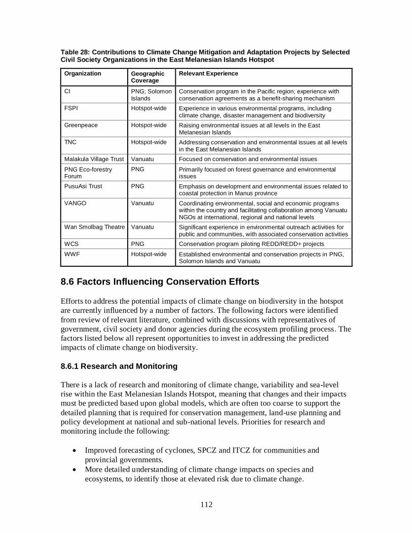
112
Table 28: Contributions to Climate Change Mitigation and Adaptation Projects by Selected Civil Society Organizations in the East Melanesian Islands Hotspot
Organization Geographic Coverage
Relevant Experience
CI PNG; Solomon Islands
Conservation program in the Pacific region; experience with conservation agreements as a benefit-sharing mechanism
FSPI Hotspot-wide Experience in various environmental programs, including climate change, disaster management and biodiversity
Greenpeace Hotspot-wide Raising environmental issues at all levels in the East Melanesian Islands
TNC Hotspot-wide Addressing conservation and environmental issues at all levels in the East Melanesian Islands
Malakula Village Trust Vanuatu Focused on conservation and environmental issues
PNG Eco-forestry Forum
PNG Primarily focused on forest governance and environmental issues
PusuAsi Trust PNG Emphasis on development and environmental issues related to coastal protection in Manus province
VANGO Vanuatu Coordinating environmental, social and economic programs within the country and facilitating collaboration among Vanuatu NGOs at international, regional and national levels
Wan Smolbag Theatre Vanuatu Significant experience in environmental outreach activities for public and communities, with associated conservation activities
WCS PNG Conservation program piloting REDD/REDD+ projects
WWF Hotspot-wide Established environmental and conservation projects in PNG, Solomon Islands and Vanuatu
8.6 Factors Influencing Conservation Efforts
Efforts to address the potential impacts of climate change on biodiversity in the hotspot
are currently influenced by a number of factors. The following factors were identified
from review of relevant literature, combined with discussions with representatives of
government, civil society and donor agencies during the ecosystem profiling process. The
factors listed below all represent opportunities to invest in addressing the predicted
impacts of climate change on biodiversity.
8.6.1 Research and Monitoring
There is a lack of research and monitoring of climate change, variability and sea-level
rise within the East Melanesian Islands Hotspot, meaning that changes and their impacts
must be predicted based upon global models, which are often too coarse to support the
detailed planning that is required for conservation management, land-use planning and
policy development at national and sub-national levels. Priorities for research and
monitoring include the following:
Improved forecasting of cyclones, SPCZ and ITCZ for communities and
provincial governments.
More detailed understanding of climate change impacts on species and
ecosystems, to identify those at elevated risk due to climate change.

113
Lessons learned from demonstration projects to test mitigation approaches, and
inform the development of national REDD/REDD+ policy and methodologies.
Detailed remote sensing maps of land-cover / land-cover change to support
implementation of REDD/REDD+.
Partnerships among governments, academic and research institutions and civil
society organizations, within and outside of the hotspot, focused on data sharing
and capacity building.
8.6.2 Adaptation Strategies
The lack of practical initiatives, research, capacity and models for climate change
adaptation, especially for globally threatened and endemic species and KBAs, is a barrier
to successful responses to climate change in the hotspot. Priorities for the development of
effective, locally appropriate adaptation strategies include the following:
Improved understanding of potential climate change impacts on protected areas
and other sites of conservation importance, through vulnerability assessments.
Vulnerability maps for flooding and other natural disasters.
Comprehensive strategies to conserve intact continua of natural habitats through
development of community-managed conservation areas combined with
introduction of sustainable management practices into logging concessions and
other production landscapes.
Demonstration of ecosystem-based management approaches to climate change
adaptation, especially for coastal protection, integrating traditional ecological
knowledge and customary management systems and practices.
8.6.3 Mitigation Measures
Developing mitigation measures and policies is critical at the global level. While the East
Melanesian Islands make a marginal contribution to global GHG emissions, it is
important that the biodiversity impacts of mitigation initiatives in the hotspot are positive
(or at least neutral), and that opportunities for benefit sharing with customary land and
resource owners are realized. To this end, priorities for the development of mitigation
measures include the following:
Updated GHG inventory for the East Melanesian Islands region.
REDD+ field demonstration projects to inform development of climate change
policy.
Alignment of Clean Development Mechanism and REDD approaches at national
and local level with biodiversity conservation goals.
8.6.4 Policy and Legislation
The legal framework for climate change responses in the three hotspot countries is
provided by the UNFCCC, the Kyoto Protocol and the Convention on Biological
Diversity at the global level, and the Apia Convention and the Pacific Islands Framework
114
for Action on Climate Change at the regional level. At the national level, appropriate
climate change policies and legislation are still evolving, and there remain a number of
gaps that need to be filled. Priorities for development of climate change policy and
legislation include the following:
Finalization of a national climate change policy for Vanuatu.
Inclusion of measurable goals for addressing climate change into the NBSAPs for
the hotspot countries.
Mainstreaming of climate change and biodiversity conservation objectives into
the policies and plans of each development sector.
Incorporation of national climate and biodiversity conservation policies into
provincial and local regulations and development plans.
Strengthened implementation of legislation at all levels.
8.6.5 Capacity Building
In their first National Communication Reports to the UNFCCC, all three hotspot
countries identified limited capacity as the greatest challenge to addressing climate
change. Sufficient, appropriate capacity is a prerequisite to the success of all strategies to
address climate change (i.e., mitigation, adaptation, awareness, etc.). Priorities for the
development of local capacity to address climate change in the hotspot include the
following:
Strengthened technical capacity of government agencies to plan for, and
implement, climate change initiatives.
Strengthened technical capacity of civil society organizations to monitor climate
and respond to its impacts.
Strengthened capacity of CBOs and the groups that support them in sustainable
natural resource management.
Increased number of domestic civil society organizations addressing climate
change issues.
Active partnerships among government agencies, civil society organizations,
donors and communities to implement climate change programs.
8.6.6 Education and Awareness
Although some national agencies in the hotspot countries, particularly in the energy and
forestry sectors, have already been the focus of considerable project support with regard
to climate change response, most government officials, especially at provincial and local
level, have a limited awareness and understanding of climate change and global best
practice with regard to monitoring and addressing its impacts. These limitations are not
confined to government but can also be found among civil society organizations and
communities, even though many people have been impacted by changing weather
patterns. Priorities for increasing awareness and understanding of climate change include
the following:
115
Climate change communication and information strategy for the East Melanesian
Islands Hotspot.
Climate change and biodiversity awareness in communities and schools,
supported by incorporation of climate change and biodiversity into school
curricula.
Targeted outreach on REDD+ for communities in areas targeted by these
schemes.
9. THREAT ASSESSMENT
9.1 Introduction
The East Melanesian Islands are home to a rich diversity of flora and fauna. However,
this biodiversity is seriously threatened largely due to ecosystem degradation, which
results in the endangerment or depletion of these species. An analysis of the IUCN Red
List reveals the major threats to Pacific plant and animal species to be habitat loss and
introduction of invasive species (IUCN 2011). In addition, frequent extreme weather
events and natural disasters, coupled with the projected future impacts of climate change
and sea-level rise are also significant threats to biodiversity in the Pacific (Thaman 2002).
Although the types of threat to Pacific biodiversity are similar to those throughout the
tropics, the small size and isolated nature of Pacific islands increases vulnerability to
disturbances that would otherwise be minor on large land masses (SPREP 1992).
Since the independence period (1975-1980), a number of factors have led to an escalation
in the scale and intensity of threats to biodiversity in the East Melanesian Islands Hotspot.
The dominant development paradigm has been one of growth and increased production,
with little concern for the environment. The UNCED process in 1992 highlighted the
need for a balanced approach to development, based on the three pillars economic,
environmental and social sustainability, and Pacific island countries began a process of
establishing environment departments and preparing NBSAPs. Nevertheless, these
departments remain small and preparation and implementation of NBSAPs has
progressed slowly (see Section 6.3.1). There exist a number of constraints to effective
protection of the environment in East Melanesia, including lack of information on
biodiversity, lack of taxonomic expertise, poor understanding of environmental issues
among the general population, and poor integration of environmental issues into national
development planning. Addressing these constraints would go a long way towards
providing solutions to the root causes of biodiversity loss within the East Melanesian
Islands Hotspot.
This chapter provides an overview of the main threats to terrestrial, coastal and nearshore
marine biodiversity and ecosystems in the East Melanesian Islands Hotspot, their impacts
and their root causes, before going on to propose possible solutions to address or at least
mitigate these threats and their root causes. The chapter is based on a review of relevant
literature, supplemented by the results of the stakeholder consultations conducted as part
of the ecosystem profiling process.

116
9.2 Main Threats
Historically, traditional land use practices in the hotspot were relatively sustainable, with
shifting agriculture of taro, bananas and other crops being used to meet subsistence needs.
Many islands in the hotspot have volcanic or composite geology, with steep mountain
slopes and a limited amount of flat arable land. During colonial times, small-scale
coconut plantations were developed along islands’ coasts, with cattle grazing in the
interior, especially in Vanuatu. As populations have continued to grow in the post-
colonial period, the need for land for subsistence farming has expanded. The advent of
the cash economy has also led to the adoption of small-scale plantation agriculture and
intensified fishing.
The resources of the East Melanesian Islands have been exploited for centuries to meet
demand in overseas markets. During the 19th
century, this led to local disappearances of
sandalwood, sea-cucumbers and other high value resources. In the late 20th
century,
extraction pressure has shifted to native hardwoods and tuna, for which the western
Pacific represents the major global fishery. Mining has occurred in PNG’s islands region
for decades, and has recently expanded to the Solomon Islands. The nature of these
threats is discussed in detail in the following sections.
9.2.1 Deforestation
Forest cover varies greatly across the hotspot, ranging from 40 to 90 percent of total land
area in the high islands. The economic value of these forests to countries of the East
Melanesian Islands is high and reasonably well documented. In 2005, PNG’s real GDP
was about US$3.8 billion, to which the agriculture, forestry and fishing sectors
contributed 38.5 percent (PNG Forest Authority 2007). The export of forest products
alone represented 4.7 percent of the value of all exports from PNG, making forest
products the largest non-mineral export from the country in terms of value (PNG Forest
Authority 2007). In the Solomon Islands, timber production was the single most
important contributor to growth of the economy in 2007 (Central Bank of Solomon
Islands 2008). This growth is also manifested through increased utilization of timber in
building construction and furniture-making in Honiara, provincial centers and rural
villages (Pauku 2009). In Vanuatu, forestry has traditionally been a major, if not the
largest, single source of export income, contributing around 14 percent of the total. In
contrast to the other two countries, where round log exports are by far the most important,
Vanuatu’s timber exports are all in the form of processed timber (Hunt 2001).
Despite constitutionally recognized customary land ownership, the logging industry
continues to wield tremendous influence over natural resources across the hotspot, often
taking advantage of the limited capacity of local communities to defend their interests
against outside entrepreneurs. Logging rights are issued by the national government, after
agreements have been made between logging companies and landowners. In theory, the
logging companies and communities then work in partnerships to conserve and manage
the forest and its resources sustainably, with oversight from the relevant government
department. In practice, however, the balance of power between logging companies and

117
landowners is often tilted in the companies’ favor, because of their tremendous
advantages in terms of information, money and political connections. The results are
commonly seen in the form of unsustainable logging practices, social conflict and
environmental degradation.
In PNG as a whole, Shearman et al. (2008) estimated that 1.4 percent of the country’s
forests were deforested annually over the period between 1972 and 2002, equivalent to
360,000 hectares per year, while the Food and Agriculture Organization of the United
Nations (FAO 2011b) calculated a rate 0.5 percent of forests, or 141,000 hectares per
year, over the last decade.
For the areas of PNG within the East Melanesian Islands Hotspot, Shearman et al. (2008)
recorded the following changes in forest cover between 1972 and 2002: the Admiralty
islands recorded a 30 to 45 percent loss; the Mussau islands recorded a 30 to 45 percent
loss; New Ireland recorded a 30 to 45 percent loss, although losses in upland areas were
much lower at 5 to 10 percent; New Britain recorded the highest loss, at between 60 and
70 percent, although, again, upland areas recorded the least change, with a 5 to 10 percent
loss; and Bougainville recorded a 30 to 45 percent loss, albeit limited to 5 to 10 percent in
inland montane areas. Shearman et al. (2008) further conducted an analysis to estimate
the contribution of each of the main drivers of forest-cover change between the years
1972 and 2002 in PNG as a whole (Figure 13).
Figure 13. Drivers of Forest-cover Change in PNG from 1972 to 2002
Source: Shearman et al. (2008).

118
The results showed that logging and expansion of subsistence agriculture were the main
drivers, although they play down the importance of oil palm plantations, which have been
a major cause of forest loss in the lowlands of West New Britain and New Ireland,
especially over the last decade.
In 2007, PNG’s National Parliament approved an amendment to the 1991 Forestry Act,
which permitted the “fast tracking” of logging permits for large tracts of forest under the
Forest Clearance Authority. This has enabled forest concession areas to operate under
Special Agriculture and Business Leases over an area totalling 5.2 million hectares. In
these areas (which overlap greatly with customary land), forestry regulations do not
apply, allowing clear-felling of forest and conversion to agriculture. Within the hotspot,
Special Agriculture and Business Leases are concentrated in East New Britain and New
Ireland, and the affected forest areas include Lavongai and Nakanai Central Pomio KBAs
(Winn 2012). While the ostensible economic justification for these leases is expansion of
oil palm plantations, they appear to be driven just as much by the profits to be gained
from logging, indicating how interlinked the logging and plantation industries can be.
In 2004, it was reported that around 1 million cubic meters of logs were harvested in the
Solomon Islands, which compared with a sustainable harvest estimated at around only
200,000 cubic meters. Not only is the current rate of extraction unsustainable, it has
continued to rise sharply over the last five years. At the current rate, it is projected that
the Solomon Islands’ timber resources will be depleted before 2020 (AusAID 2006;
Berdach and Llegu 2007). On some major islands (e.g. Isabel), much of the natural forest
has already been logged over. Nevertheless, the government has continued to grant “tax
holidays” to exporters of round logs, contributing to an escalation in logging activities
(Berdach and Llegu 2007).
In the mid-2000s, natural forest cover in Vanuatu was estimated at 444,000 hectares,
equivalent to 36 percent of the total land area (UNDP 2005), and at least 40 percent of the
commercial forest area was regarded as degraded (King 2007). Most of the high value
forests were over-exploited in the 1980s and 1990s, until the government imposed a ban
on the export of round logs in 1998.
Many logged areas have lost significant biodiversity and economic value, in terms of
their functions as habitats for plant and animal species, sinks for the sequestration of
atmospheric carbon, and water catchments. Forest species that are unable to adapt to
degraded habitats face possible extinction. A large proportion of the species of the
hotspot included on the IUCN Red List are assessed as globally threatened because of
threats to their habitats caused by logging, for example Solomon Islands palm frog
(Palmatorappia solomonis), a monotypic genus restricted to the Solomon Islands plus
Bougainville and Buka in PNG, which is assessed as VU (Richards and Parker 2004a).
Despite the extensive deforestation that has taken place across the hotspot, the PNG
islands region and, to some extent, the Solomon Islands still have significant stands of
relatively undisturbed forest remaining. In general, lowland forests have been more
susceptible to deforestation, due to their accessibility to logging operations and suitability

119
for conversion to small-scale agriculture and large-scale commercial plantations
(Swartzendruber 1993). A recent analysis of forest-cover change on New Britain by
Buchanan et al. (2008) concluded that lowland forest is of most urgent conservation
priority because it supports the largest proportion of endemic bird species and is under
the greatest pressure from logging and commercial plantations, while forests at higher
elevations are important for restricted-range bird species but are less severely threatened
by deforestation at present.
9.2.2 Agriculture
The lack of arable flat land for subsistence gardening and artisanal agriculture has forced
farmers to cultivate upland and steep-slope areas, which are more prone to erosion and
landslides. Agriculture has expanded as human populations have grown and consumption
patterns have changed. As cultivated land does not have a sufficient fallow period, soil
fertility is lost and new land, often primary forest on hill slopes, is cleared. This results in
deterioration in soil fertility, habitat destruction, and eventual loss of biodiversity.
Commercial agriculture within the hotspot includes oil palm, coconut, rubber, coffee and
sugar plantations as well as livestock. The increase in demand for these has resulted in
the clearing of the original vegetation from large tracts of land resulting in loss of
vegetation cover, loss of biodiversity and increased erosion. Oil palm cultivation has
increased in recent years in West New Britain and New Ireland (Berdach and Mandeakali
2004). In PNG, there was a total of 149,402 hectares under palm oil and rubber
plantations in 2002, with over 90 percent located in West New Britain, Milne Bay, Oro
and New Ireland. This led to the clearance of large areas of lowland forest, especially in
West New Britain and around Milne Bay. Associated impacts of oil palm development
include increased settlement and smallholder agriculture, as a result of people migrating
to live around plantations (Shearman et al. 2008).
9.2.3 Mining and Mineral Exploration
PNG is currently highly ranked in the world in terms of gold production (11th
) and copper
production (13th
). Nickel, zinc, cobalt and chromite have also been discovered, with huge
deposits of undeveloped mineral resources spread across the country, including the
islands region. Oil and natural gas deposits are also found in PNG and its territorial
waters, and the oil and gas sector currently contributes around 9 percent of GDP. In the
PNG islands region, there are two operating gold mines in New Ireland province: Lihir,
operated by Newcrest Mining Ltd; and Simberi, operated by Allied Gold. In addition,
New Guinea Gold Corporation operates the Sinivit gold mine in East New Britain
province, while Nautilus Minerals is planning an experimental deep-sea mining project,
called Solwara 1, in the Bismarck Sea.
Poor environmental practices in PNG’s mining industry have resulted in a number of
environmental problems, including the discharge of heavy metals, cyanide and acids into
rivers, streams and coastal waters, sediment loading in rivers, and land degradation and
loss of vegetation associated with land clearance for mines (Berdach and Mandeakali

120
2004). The impacts of mining are particular problems for freshwater ecosystem,
triggering collapses in populations of fish and other aquatic biodiversity, and causing die-
back of vegetation along rivers and streams. Submarine tailings disposal is also a threat to
marine biodiversity, and discharges into the Bismarck Sea are one of the major issues
associated with the Ramu nickel mine in Madang province, operated by Metallurgical
Corporation of China. The environmental impacts of mining are also manifested in the
immediate environs of mine sites, due to deforestation and earth removal for pits, tailings
dams and ancillary infrastructure.
In the Solomon Islands, extensive gold deposits have been confirmed for the Gold Ridge
area of Guadalcanal, and gold prospecting has been conducted in several areas of
Western province, including Fauro, Paraso, Masi Crater and Kele River. Nickel deposits
have been found at San Jorge and Tataka on Isabel Island, and diamonds have been found
in the seabed around Iron Bottom Sound, Manning Strait, and between Choiseul and the
Shortland Islands (Berdach and Llegu 2007).
Significant opportunities exist for further development in the minerals and mining sector
but environmental safeguards need to be put in place first, to ensure that adverse
environmental impacts are avoided, minimized and offset. Appropriate safeguards
include conduct of EIAs for all major mining operations, and regular compliance
monitoring (Berdach and Llegu 2007).
9.2.4 Coastal Development
The expansion of coastal settlements and tourism development is often accompanied by
habitat loss, particularly of mangroves and other coastal vegetation. Along with logging
and plantation establishment, these coastal developments increase the risk of siltation of
surrounding reef systems. Siltation kills coral polyps and is capable of altering the
community structure of reefs. Other anthropogenic pollution, such as untreated human
waste and non-biodegradable plastics, also contribute to coastal degradation (Government
of the Solomon Islands 2008). Although perhaps not a current problem in the hotspot,
issues that have severely affected coral habitats in other small island developing states
include eutrophication and algal overgrowth, due to nutrient runoff (fertilizers and animal
and human waste), and degradation, due to live rock and coral extraction and destructive
fishing practices.
9.2.5 Overharvesting
Pressures of population growth and enhanced material expectations have also resulted in
overharvesting of resources, both terrestrial and marine. The term overharvesting implies
gathering for local usage, as opposed to commercial extraction of resources (e.g. timber,
tuna, etc.), which may also cause massive overexploitation of natural resources but is
discussed separately. In the nearshore marine ecosystems, high-value species, such as
sea-cucumbers, trochus and giant clams, have been harvested to local rarity. Larger
species, such as dugong and marine turtles, are also under threat. Except in areas
accessible to commercial markets for high-value species, the extent of overfishing in the
hotspot seems not to be as severe as in many Polynesian countries (FAO 2011a).
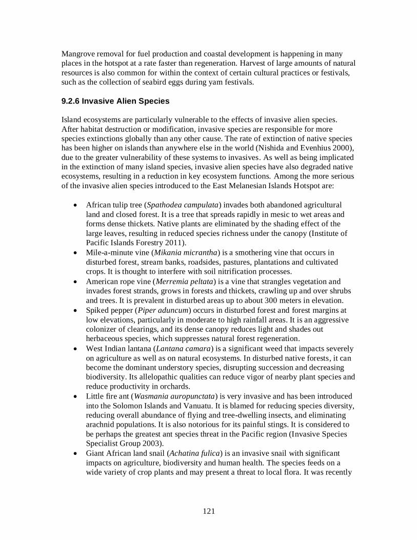
121
Mangrove removal for fuel production and coastal development is happening in many
places in the hotspot at a rate faster than regeneration. Harvest of large amounts of natural
resources is also common for within the context of certain cultural practices or festivals,
such as the collection of seabird eggs during yam festivals.
9.2.6 Invasive Alien Species
Island ecosystems are particularly vulnerable to the effects of invasive alien species.
After habitat destruction or modification, invasive species are responsible for more
species extinctions globally than any other cause. The rate of extinction of native species
has been higher on islands than anywhere else in the world (Nishida and Evenhius 2000),
due to the greater vulnerability of these systems to invasives. As well as being implicated
in the extinction of many island species, invasive alien species have also degraded native
ecosystems, resulting in a reduction in key ecosystem functions. Among the more serious
of the invasive alien species introduced to the East Melanesian Islands Hotspot are:
African tulip tree (Spathodea campulata) invades both abandoned agricultural
land and closed forest. It is a tree that spreads rapidly in mesic to wet areas and
forms dense thickets. Native plants are eliminated by the shading effect of the
large leaves, resulting in reduced species richness under the canopy (Institute of
Pacific Islands Forestry 2011).
Mile-a-minute vine (Mikania micrantha) is a smothering vine that occurs in
disturbed forest, stream banks, roadsides, pastures, plantations and cultivated
crops. It is thought to interfere with soil nitrification processes.
American rope vine (Merremia peltata) is a vine that strangles vegetation and
invades forest strands, grows in forests and thickets, crawling up and over shrubs
and trees. It is prevalent in disturbed areas up to about 300 meters in elevation.
Spiked pepper (Piper aduncum) occurs in disturbed forest and forest margins at
low elevations, particularly in moderate to high rainfall areas. It is an aggressive
colonizer of clearings, and its dense canopy reduces light and shades out
herbaceous species, which suppresses natural forest regeneration.
West Indian lantana (Lantana camara) is a significant weed that impacts severely
on agriculture as well as on natural ecosystems. In disturbed native forests, it can
become the dominant understory species, disrupting succession and decreasing
biodiversity. Its allelopathic qualities can reduce vigor of nearby plant species and
reduce productivity in orchards.
Little fire ant (Wasmania auropunctata) is very invasive and has been introduced
into the Solomon Islands and Vanuatu. It is blamed for reducing species diversity,
reducing overall abundance of flying and tree-dwelling insects, and eliminating
arachnid populations. It is also notorious for its painful stings. It is considered to
be perhaps the greatest ant species threat in the Pacific region (Invasive Species
Specialist Group 2003).
Giant African land snail (Achatina fulica) is an invasive snail with significant
impacts on agriculture, biodiversity and human health. The species feeds on a
wide variety of crop plants and may present a threat to local flora. It was recently
122
discovered in Honiara city on the Solomon Islands, and also occurs in the large
islands of Vanuatu and PNG.
Common myna (Acridotheres tristis) is a highly commensal song bird that lives in
close association with humans. It competes with small mammals and bird for
nesting hollows and on some islands it preys on other birds’ eggs and chicks
(Invasive Species Specialist Group 2003).
Cane toad (Bufo marinus) was introduced to many countries as a biological
control agent for various insect pests of sugarcane and other crops, including the
large islands of PNG and the Solomon Islands. However, cane toad proved to be a
pest itself. It predates almost any terrestrial animal and competes with native
amphibians for food and breeding habitats. Its toxic secretions are known to cause
illness and death in domestic animals and wildlife, such as snakes and lizards.
Feral house cat (Felis catus) has been introduced to many islands in the hotspot.
Small mammals and ground-dwelling and ground-nesting birds are common prey
of feral house cats. Several species of giant rodent are believed to have been
extirpated from Guadalcanal Island by cat predation. Cats are also responsible for
the extirpation of multiple seabird colonies (S. Boudjelas in litt. 2012). This is a
key threat to endemic species but difficult to manage.
Black rat (Rattus rattus) and brown rat (R. norvegicus) are among the most
significant threats to island biodiversity in the Pacific in general, particularly
brown rat, and extensive evidence supports the wave of extinctions that follow
their introduction (S. Boudjelas in litt. 2012). Within the East Melanesian Islands,
invasive rats are mainly an issue in Vanuatu and the Santa Cruz Islands of the
southeastern Solomon Islands, where native rats did not already occur prior to the
arrival of humans. Throughout the remainder of the hotspot, the native biota has
evolved alongside indigenous rats, and the more recently introduced black and
brown rats seem to be restricted to towns and villages, where they can cause crop
losses, contaminate food and water and carry diseases.
Invasive alien species are becoming increasingly widespread in the hotspot, especially
pigs, feral house cats, rats and little red fire ants, which have reached plague levels on
many of the islands. The Global Invasive Species Database lists 85 invasive species for
the Solomon Islands, 66 species for Vanuatu and 98 species for PNG (Invasive Species
Specialist Group 2003). Two large, ground-dwelling birds endemic to Solomon Islands
(Choiseul Crested Pigeon (Microgoura meeki), endemic to Choiseul; and thick-billed
ground dove (Gallicolumba salamonis), endemic to Makira and several outlying islands)
have almost certainly been extirpated, their demise likely connected to the spread of feral
house cats. However, the impacts on local fauna and flora of many other invasive species
that do occur in the Solomons remain undocumented, e.g. cane toad, American rope vine,
and Mimosa sp. (Filardi et al. 2007).
Arthropods, in particular ants, present one of the greatest threats to many native species
in the Pacific. They may affect whole communities at once, and may dramatically and
irreversibly change these through their ability to cause much local extinction. Within the
East Melanesian Islands Hotspot, the following invasive ant species present a grave threat
to conservation values because of their tendency to invade native communities and affect
123
many of the animals and plants in that community: long-legged ant (Anoplolepsis
longipes); crazy ant (Paratrechina longicornis); Argentine ant (Linepithema humile);
tropical fire ant (Solenopsis geminate) and little fire ant. The latter species may be one of
the biggest threats to the conservation of native communities because of its aggressive
behavior, pervasive effects on all sectors of biotic communities, and ease of spread to
new islands. It has also been noted to decrease local arthropod diversity. Greenslade
(1971) noted that species diversity in coconut plantations decreased wherever long-
legged ant populations flourished in the Solomon Islands; an observation that should also
hold true for native forests (Nishida and Evenhius 2000). Tropical fire ant is known to
reduce populations of native butterfly eggs and larvae.
The snail fauna on many Pacific islands is being destroyed very quickly by invasive
snails, resulting in a loss of diversity between and within island groups. Introduced land
snails may be extremely efficient predators, causing the relatively rapid extinction of
native land snail species, while other introduced land snails may be extremely efficient at
feeding on plants and may destroy the native habitat. Of particular concern, giant African
land snail is found in the hotspot; it feeds on a wide variety of crop plants and may
present a threat to local flora (Nishida and Evenhius 2000).
Currently, emphasis is being placed on controlling the import of invasive species at
national borders, recognizing that control of the spread of species (like the fire ant) from
island to island is difficult to control without additional human and financial resources
(King 2007). However, this strategy may underemphasize the importance of enhancing
internal biosecurity measures. The major challenge now is not only prevent new
introductions into the hotspot and their spread among islands but also to control
populations of existing invasive species.
9.2.7 Climate Change and Sea Level Rise
Climate change and variability are predicted to have severe impacts on Pacific countries
due to the characteristics of many islands, such as low-lying topography and limited
buffering from sea-level rise and extreme weather events. While the cooperative social
systems of Pacific islanders are considered to offer improved resilience to climate
change, Pacific countries are typically described as highly vulnerable to climate change
due to their developing country status and small island nature (ADB 2010, Hills et al.
2011).
Climate change is predicted to have significant impacts on marine, terrestrial and
freshwater ecosystems; these are covered in greater detail in Chapter 8. In response to
sea-level rise, mangroves may migrate landward and, where migration is not possible,
mangrove species and ecosystem area will decline or be lost (Hills et al. 2011).
Terrestrial ecosystems will also be threatened by climate change in a number of ways,
including by weakening their natural adaptive capacity through disturbance. With the
changes in precipitation and temperature patterns that are predicted to occur, forests will
become more susceptible to invasive species or fire, resulting in broad ecosystem shifts,
loss of ecosystem services, and loss of habitat for certain species. Terrestrial ecosystems
124
that are already degraded by non-climatic factors (e.g. logging and invasive species), are
fragmented, have highly specialized species or have narrow climatic tolerances will likely
be the most vulnerable to climate changes (Hills et al. 2011). Also, because of the strong
co-evolutionary interactions between species and strong linkages between marine and
terrestrial ecosystems typical of small islands, adverse impacts to one ecosystem will
impact other linked ecosystems and species, and may result in a decoupling of species
linkages that may lead to failure of reproduction and biodiversity loss (Hills et al. 2011).
Coral reef ecosystems are expected to be highly threatened by the cumulative impacts of
ocean acidification, rising sea temperature, sea-level rise and increased storm activity that
are projected to be experienced over the coming decade. With projected increases in sea-
surface temperatures, the thermal tolerances of reef-building corals are likely to be
exceeded within the next few decades. Climate change effects include coral bleaching,
with major bleaching events reported in the last decade in Fiji and PNG (Davies et al.
1997). An episode of coral bleaching in 1998 is known to have led to a loss of 16 percent
of the world’s coral reefs (All et al. 2009).
Climate change impacts are also expected for mangrove areas, wetlands and terrestrial
forests. Major shifts in temperature and rainfall may result in the disappearance of fragile
ecosystems, such as montane cloud forests and their associated biodiversity, which exist
within a very narrow envelope of physical, topographic and climatologically parameters
(Berdach and Mandeakali 2004, Berdach and Llegu 2007, King 2007). Forests will also
be more susceptible to invasive species or fire and may undergo ecosystem shifts, loss of
services or loss in habitat completely (Hills et al. 2011). Loss of forest cover would
undoubted have dramatic impacts on a wide range of forest-dependent plant and animal
species.
Between 1994 and 2011, sea levels in the hotspot rose by between 3.3 and 6.3 millimeters
per year (Australian Bureau of Meteorology 2011). The best estimate for future sea-level
rise is about 50 millimeters by 2100 (Solomon et al. 2007). Temperatures in the Pacific
are projected to increase between 1.4 and 3.1C with sea levels projected to rise by a total
of 0.35 meters by the end of the 21st century (Global Facility for Disaster Reduction and
Recovery 2011).
9.2.8 Natural Phenomena
Cyclones, floods, drought and volcanic eruptions are some potential contributing factors
to the stochastic extirpation of isolated populations of species throughout the hotspot.
Cyclones, in particular, can have devastating effects on faunal populations, habitats and
ecosystem health. In PNG, for example, Cyclone Justine caused an estimated loss of
more than 400,000 cubic meters of timber in 1996 (Brinton 1998). Volcanic eruptions are
worth mentioning as threats to biodiversity within the hotspot, especially given the large
number of active volcanoes, such as Tinakula in Temotu province of the Solomon
Islands, and Gaua in Torba province of Vanuatu.
125
9.2.9 Pollution
Indiscriminate land clearing is resulting in sedimentation of rivers, streams and coral
reefs. Pollution problems in river catchments are also increasing with rapid population
growth, and this poses a threat to coastal marine resources. Pollution of the coastal and
marine environment emanates from land-based sources, such as towns (via sewage and
solid waste disposal), logging concessions (via soil erosion), oil palm plantations (via
run-off of agrochemicals) and mines (via submarine tailings disposal), as well as sea-
based sources, such as marine shipping and fishing vessels.
Pollution from sewage, animal waste and plantation agriculture has led to elevated
nutrient levels in nearshore and coastal ecosystems. In 2011, for example, Morava
Lagoon had a massive fish kill that was linked to eutrophication and high nutrient levels.
In Honiara city, at least 75 percent of sewage flows directly into the sea through a piped
collection system without treatment. Discharges from ships in the form of garbage, bilge
water and other pollutants are a major source of sea-based pollution and, potentially,
invasive species (Government of the Solomon Islands 2008).
Chemical pollution from pesticides and heavy metals is believed to be a widespread issue
in the hotspot, although it is locally significant at locations where pesticides are stored or
where heavy metals have been released from mine waste. Cyanide, used in gold
processing has also been spilled into rivers. Poisons (bleach, pesticides and rotenone) are
used in streams and coral reefs to catch fish.
9.3 Drivers
9.3.1 Population Growth
The most important natural resource in the East Melanesian Islands is land. The
constitutions of the three countries in the hotspot all recognize and guarantee ownership
of land by the local indigenous population, apart from land alienated by the state (mainly
by the former colonial administrations). Communities in the East Melanesian Islands,
therefore, rely heavily on land to support their livelihoods through traditional subsistence
agriculture, hunting and gathering. The high population growth rates in the hotspot (2.3
percent in Vanuatu, 2.8 percent in the Solomon Islands and 2.3 percent in the PNG
islands region) is putting pressure on how local communities utilize the land and affecting
the agriculture sector’s contribution to the economy. In the small and remote atolls, the
major economic resource is marine resources, and these are what the primary economic
activities and social structures are based around.
Population pressure is a driver of forest loss for a number of reasons. Most obviously,
population growth can lead to expansion of the area under cultivation, as more land is
needed to feed more mouths. Population pressure is also changing the way communities
use their land for cultivation. Much food is grown in fields (commonly known as
“gardens”) cleared from the forest and cultivated on a rotational system. Because of
population growth, use of land for cash crops and land conflicts, many communities face
126
a shortage of land. This has led to a shortening of fallow periods in many areas, resulting
in land degradation, reduced crop yields, and pressure to open up new areas of forest to
cultivation.
For communities in coastal areas and on small islands, as population grows the area
available to them remains stay the same. This is because of customary tenure, which
restricts the area in which a community can harvest marine resources, and which cannot
be expanded without causing conflicts with neighboring communities. Faced with this
situation, the response of many communities is to intensify catch effort within the same,
limited area, which can rapidly deplete stock of reef fish and other marine resources.
9.3.2 Urbanization
The East Melanesian Islands, like almost everywhere else in the world, are experiencing a
population shift from rural to urban areas (see Section 5.2.1). With the expansion of
urban centers there comes a greater need for more space for settlements, more timber and
natural raw materials for buildings, more resources for food and fuel and more energy, as
well as more pollution. The ecological footprint of towns and cities falls most heavily on
surrounding marine and terrestrial ecosystems, although it can stretch further afield. For
instance, the need for urban electrification is being used as a justification for proposed
hydropower dams on Guadalcanal and New Britain. Unless they are accompanied by a
shift towards more sustainable patterns of land and resource use, population increases
will inevitably lead to greater pressure upon the natural ecosystems of the East
Melanesian Islands, and will cause significant damage to the hotspot’s unique and
globally important natural resources (Berdach and Mandeakali 2004, Berdach and Llegu
2007, King 2007).
9.3.3 Lack of Awareness
There is a widespread of lack of understanding of the biodiversity values of natural
ecosystems and the ecosystem services that they provide. Although rural people rely
heavily on natural ecosystems for tens of uses in their everyday lives, the value of any
given resource is generally not appreciated until it becomes scarce. In addition, the
intrinsic values and ecological functions of organisms not of direct use to humans are not
generally appreciated. In addition, people have a tendency to consider their short-term
needs rather than the long-term consequences of their actions, which has resulted in the
East Melanesian Islands in biodiversity exploitation to meet financial or tradition
obligations.
At the national level, the focus has largely been on economic development and growth.
UNCED in 1992 began a process of considering the ecological and sociocultural impacts
of development, which resulted in the establishment of environment departments by the
government of the hotspot countries and the development of environmental laws,
including EIA regulations for development projects. The application and enforcement of
these laws are still evolving, and some are more honored in the breach than in the
observance.

127
Awareness is a complex term. People who have grown up in a rural village, and have had
the experience of utilizing natural resources for food, fuel, medicine, construction
materials and other uses, must be aware of at least the utilitarian values of biodiversity.
However, understanding the non-use values of biodiversity, projecting the effects of over-
exploitation or anticipating the impacts of logging, mining or other development
activities may require a level of understanding that is beyond people’s direct experience.
Therefore, there is a widespread need for a fuller understanding of the values of
biodiversity and the potential impacts of different land-use and resource management
practices on them, so that resource owners can make more informed decisions over
different options available to them. Similarly, there is a need for a greater awareness of
the value of biodiversity and ecosystem services among government decision-makers at
national and provincial levels, so that they are considered more fully when evaluating
development options.
9.3.4 Unsustainable Economic Development Models
Population growth and the pressure to grow cash crops has driven the introduction of
harmful farming practices, such as extensive land clearing, reduction in fallow periods
and inappropriate soil cultivation. The occupation of most flat arable lands by cash
cropping is also pushing subsistence cropping (gardening) onto marginal areas, especially
steep slopes. About 63 percent of the total land area in the Solomon Islands comprises
steep lands (slopes greater than 20 percent), which are increasingly being used for
shifting cultivation by smallholders; the pattern in the other countries is similar.
Intensified and constant cultivation of marginal sloping lands is unsustainable, and is
responsible for soil erosion, loss of soil fertility, increase in pest and diseases, declines in
crop yields, and widespread land degradation (Cheatle 1987, Government of the Solomon
Islands 2008).
Such unsustainable development practices are encouraged by a combination of increased
individual material expectations and cash needs, international market demand for
valuable commodities and the need of the national government to generate foreign
exchange. In particular, the promotion of the logging, mining and plantation agriculture
industries is displacing and undermining traditional subsistence lifestyles and leading,
directly and indirectly, to biodiversity loss. The development of value addition efforts in
the natural resource sectors is also lagging, leading to an over-reliance on production of
raw materials that are exported for processing elsewhere.
9.3.5 Weak Governance
Governance at the national level is weak in PNG and the Solomon Islands as a result of
frequent changes in Prime Ministers. Vanuatu has also experienced political instability
recently, as a result of an increased number of political parties. In general, the large
number of political parties and the absence of stable coalitions is a contributing factor to
the instability of national governments in East Melanesian Islands. International reviews
have highlighted a high level of corruption in all three hotspot countries. Vanuatu, the
Solomon Islands and PNG have scores of 3.5, 2.7 and 2.2, respectively, on Transparency

128
International’s (2012) Corruption Perceptions Index, where a score below five indicates
extensive corruption.
Weak governance creates conditions under which companies can access and or acquire
rights to natural resources irrespective of environmental or social impacts. For example,
in the Solomon Islands, the forest policy and law specify the number of licenses and
forest blocks that can be logged but weak governance and corruption have resulted in
large tracts of forest being logged at intensities far higher than plans allowed for (Pauku
2009). Additionally, poor to non-existant enforcement of forestry regulations has resulted
in the vast majority of customary landholders being excluded from processes of consent
and negotiation of terms of engagement and benefit-sharing. This has left a minority of
“landowners”, often illegitimate and physically residing outside of customary lands (in
provincial centers or national capitols), in large part controlling the distribution of
benefits from timber. In turn, lack of meaningful regulation or clear implementation of
forestry policies, and resulting social and monetary inequities, have created conditions
ripe for graft and social conflict (e.g. AUSAID 2006, C. Filardi in litt. 2012). All too
frequently, the environmental impacts from logging and other forms of natural resource
exploitation are not adequately mitigated, and the compensation for landowners and
government in the form of royalties, taxes and other payments is well below international
norms.
9.3.6 Sociocultural Factors
Melanesian society is built on a complex web of social connection and responsibility.
Weddings, funerals and births are times of extensive exchange of goods among
interrelated groups. Groups from certain areas will be noted for certain goods, such as
plantains, taro or yams, and huge mounds of these will be harvested and presented at
important ceremonies. Major social occasions increasingly feature store-bought goods,
such as kerosene and bolts of cloth, and generating cash to buy these goods often requires
harvesting of natural resources for sale.
Besides ritual ceremonies around weddings, funerals and births, there are also exchange
ceremonies, by which a coastal and an inland group might exchange goods rare to one but
common to the other. Certain traditional festivals may involve products from threatened
plant and animal species, although these are only a threat in a small number of cases, they
can be significant where the species involved is already rare and under pressure from
other factors. Examples include such sing-sings in PNG, which can involve costumes
featuring wild bird feathers, and yam festivals in Vanuatu, which may require the harvest
of seabird chicks.
Social obligations and duties as a clan and family member determine a person’s standing
in society, and will often take precedence over longer-term economic or environmental
consequences. These same obligations, however, can have a positive influence, because
conservation measures are often justified in terms of safeguarding future generations’
access to the natural resources needed to maintain a traditional lifestyle.

129
A related form of social pressure to accumulate wealth is created by the “Big Man
System”, where accumulation of monetary wealth can used to influence community
decision making (see Section 6.2.1). One implication of this is that the economic interests
of traditional leaders may differ from those of fellow villagers when decisions regarding
access to land and resources by companies are being made.
Socially generated aspirations are also an important social driver of biodiversity loss.
Seeing that someone is making money from fishing or agriculture puts social pressure on
others to do the same. If people are seen to make money and send their children to school,
this rapidly becomes the local norm. In Manus province, for example, most families
aspire to send their children to further their education and find paid employment so that
they can remit money to their family. Seeing other families collect these funds from the
post office or the bank places great social pressure on other families to be in the same
position. Increased expectations and aspirations with regard to cash generation can lead
directly to intensification of agriculture and fisheries, and create conditions under which
companies are able to access land and resources.
Providing a backdrop to these trends is a gradual evolution of the traditional values
system throughout the East Melanesian Islands. These changes are exhibited in the
increasing use of cash in traditional ceremonies and events. This is because pigs, store-
bought goods, transport and bride price now often involve some form of cash transaction,
in contrast with the past, when transactions involved barter or other customary forms of
exchange.
Furthermore, cash contributions to community projects, such as the building of
classrooms, housing for teachers and churches, are almost obligatory, due to strong social
pressure on individuals and families. It is very common in the East Melanesian Islands
for the church to be the most expensive and impressive building in the community.
Finance for church construction comes mainly from community contributions and such
projects can take years to complete.
Despite the political, economic and environmental pressures brought about by the
region’s increasing exposure to a globalized world, local communities in East Melanesia
have responded in ways that augment and enhance their cultural identity and uniqueness.
The constitutional protection afforded by recognition of communities’ customs remains
the most secure bulwark against threats to their cultural survival (Weiner and Glaskin
2007).
9.4 Solutions
In response to the identified threats and their drivers, there is an urgent need for an
overall amplification of conservation activity in the East Melanesian Islands Hotspot,
based on the identification of effective, locally appropriate approaches, and their
replication. In each case, this may involve some combination of research (to understand
the issue and evaluate the effectiveness of existing responses), pilot projects (to further
test and refine approaches, and demonstrate their effectiveness to governments, donors
130
and communities), legal reform (to facilitate amplification of approaches), capacity
building (to build stronger institutions and networks, capable of implementing effective
approaches at scale), and long-term financing (to ensure sustainability). The specific
conservation approaches that form the basis of the CEPF investment strategy for the
hotspot are described in Chapter 12. This section captures some of the general
considerations that should be taken into account by conservation initiatives, as identified
through the stakeholder consultations held during the ecosystem profiling process.
The first consideration, strongly emphasized by stakeholders throughout the hotspot, is
the need for conservation approaches to build upon existing traditional and customary
knowledge and practices. In particular, it is essential for initiatives to recognize
customary land ownership and resource tenure, and support traditional land and resource
owners to asset their rights. In this regard, there exists a growing body of good practice in
community-based conservation that could be replicated, for instance with LMMAs across
the hotspot and with Tetepare Community Conservation Area in the Solomon Islands.
The next consideration is that, in order to enable governments and customary landowners
make appropriate management decisions, it is necessary to build up a body of knowledge
on biodiversity. Basic information gaps exist with regard to species’ conservation status,
distribution and taxonomy, distribution of critical habitats, rates of habitat loss, value of
ecosystem services and much more, and extensive research and fieldwork are required to
fill them. In all these initiatives, there is a need to engage local communities to
incorporate traditional knowledge on biodiversity (Government of Vanuatu 1999a).
Related to filling information gaps, there is also a need to strengthen the capacity of civil
society (i.e. at individual, organizational and network levels). At the individual level,
specialized skills in participatory tools and community engagement are especially
important. There is a need for training in organizational management and leadership, to
help the development of the next generation of leaders for the nascent conservation
movements in the hotspot countries. There are few formally trained taxonomists in the
region, and their numbers need to be increased as do opportunities for them to work with
international experts. Skills in research design, monitoring and evaluation, data
management and statistical analysis are also needed.
At the grassroots level, organizational capacity building on financial management,
governance and environmental legislation are important for CBOs. Local and national
conservation NGOs require these plus a wider range of skills to become established and
operate successfully and sustainably (see Section 7.9). There is a need for systematic
assessment of the capacity needs of domestic civil society organizations at all levels, to
identify priorities for capacity building and highlight shared requirements across groups
so they can be met through effective, shared initiatives.
Effective conservation of the hotspot’s biodiversity requires integrated efforts across a
range of sectors and disciplines. This calls for strong networks and partnerships at local,
national and regional levels. For example, networks among neighboring CBOs can allow
more effective and coordinated management of KBAs at a scale sufficient to maintain
131
populations of threatened species and other key components of biodiversity. Networks
among domestic and international NGOs can facilitate exchange of information and
experience about conservation issues and approaches, leading to the development of a
shared body of information on good practice. Partnerships between NGOs and private
companies can help to introduce new business practices that improve environmental and
social performance and bring business benefits, in terms of reduced reputational risk,
improved social license to operate, or reduction in costs.
Integration across institutions is also required for more effective management and
protection of biodiversity. This means that government agencies will need to work more
closely with NGOs and customary resource owners, to develop effective mechanisms for
management. Dealing with customary ownership and tenure issues will be especially
challenging, and will require innovative solutions and significant investments in trust
building. Ultimately, effective management will probably need to combine elements of
conventional approaches (such as formal designation of conservation areas), together
with community-based management by customary resource owners. Better coordination
and information sharing among government departments with responsibilities related to
biodiversity conservation will also be required, although it is largely outside the scope of
CEPF’s mission, which focuses on engaging civil society in biodiversity conservation.
Capacity constraints are not limited to civil society organizations, and there is also a need
for institutional strengthening of environment departments and other concerned agencies,
to provide them with adequate staffing, equipment and budgets to manage biodiversity.
There is a need to identify sustainable and sufficient funding streams for biodiversity
management. Support from government budgets and the international donor community
needs to increase, while, at the same time, there is a need for policies and demonstration
projects that encourage private sector investment in biodiversity conservation. For
example, in 1998, the Government of Vanuatu established the Vanuatu Biodiversity
Conservation Trust Fund (VBCTF) to finance biodiversity research and conservation
work.
Education and awareness-raising, targeting both government representatives and resource
owners alike, will need to be an integral part of effective conservation strategies.
Awareness raising should focus on the value and importance of biodiversity, as well as on
conservation issues, such as movement of invasive species among islands. There is also a
need to promote the awareness of environmental laws and regulations related to
sustainable biodiversity management, so that communities have a better understanding of
their provisions and the rationale behind them. The formal education sector should also
review and enhance national curricula, to place emphasis on nature, biodiversity,
environment and conservation (Government of PNG 2007).
Integrating conservation efforts into mainstream economic development will also play an
integral part of successful conservation strategies. The protection and management of
biodiversity cannot be carried out in isolation from other activities. If economic benefits
are tied to conserving biodiversity, then stakeholders will better appreciate the value of
these resources, and conservation efforts will be more sustainable. With the extensive

132
biodiversity resources present within the East Melanesian Islands Hotspot, there are
numerous opportunities to capitalize on biodiversity for sustainable economic
development in ways that enhance rather than deplete natural capital. Examples include
ecotourism, production of certified forest and marine products, forest carbon payments
under REDD+ schemes, or payments for hydrological services. To avoid irreversible
damage to biodiversity resources, efforts should be made to substitute such activities for
current, high-impact, extractive activities, which are causing extensive damage to
ecosystems and depleting populations of key species.
A key sector in which more environmentally sustainable practices are required is forestry.
There have been some initial efforts to introduce sustainable forestry practices to
commercial logging concessions and to shift towards small-scale exploitation of natural
forest by landowners, which may present more sustainable models, in terms of reduced
degradation and loss of natural forest, than the current dominant model. In PNG, for
instance, reforestation has begun in some areas, albeit on a relatively small scale, and a
five-year logging plan that emphasizes the practice of selective logging has been
introduced. Indeed, the logging codes of practice for all three hotspot countries have been
designed to attain sustainability of timber resources and the natural environment
(Government of PNG 2010, Government of the Solomon Islands 2011). However, there
is a need for a major overhaul of taxation policies and licensing regulations if
unsustainable logging practices are to be eliminated.
Regulation of the forestry industry is but one area in which there is a need for stronger
and more effective policy and legislation to support biodiversity conservation. Work on
improving forestry, fisheries and land-use policy and legislation is progressing slowly in
the region, and serious constraints remain regarding the implementation and enforcement
of existing regulations. Economic development strategies in the hotspot countries
continue to emphasize extractive logging practices, with only limited attention to
improving management systems so that they can become sustainable. In some cases, new
legislation, particularly laws promoting the establishment of community-managed
conservation areas, are keeping extractive logging in check, if only locally. Less attention
is being paid to broader management of forests outside these areas, however. Despite
some limited efforts to improve implementation of land-use planning, this remains very
weak across the majority of Pacific developing member countries (ADB 2003). Thus
efforts to integrate biodiversity considerations into policy and legislation remain
paramount.
Finally, in addressing problems associated with climate change, considerations for future
conservation strategies include pursuing support for reduction of GHGs through the
Kyoto Protocol, developing working models for REDD+ financing for forest
conservation that emphasize biodiversity conservation and benefit sharing for customary
resource owners, and mainstreaming adaptation measures into conservation strategies, to
enhance resilience to the future effects of climate change.

133
10. ASSESSMENT OF CURRENT CONSERVATION INVESTMENT
10.1 Introduction
This chapter presents an assessment of recent conservation investments in the East
Melanesian Islands Hotspot. Investments for which biodiversity conservation is a primary
objective are included in the assessment, together with a small number of investments in
rural development, civil society capacity building and climate change that are expected to
have significant indirect benefits for biodiversity conservation. The purpose of this
assessment is to assist in identifying funding gaps and opportunities for conservation
investment in the East Melanesian Islands, and thereby help define a niche for CEPF
investment that aligns well with investments by government and other donors.
Quantitative data on conservation investments were compiled from web searches, direct
inquiries to donors and grantees, and discussions with stakeholders during the
consultation workshops. To provide focus for data collection efforts, and to ensure that
results were current, the assessment was restricted to conservation investment in the
hotspot over a five-year period from July 1, 2007 to June 30, 2012. For each grant, data
on the country of implementation, donor, total award, duration of implementation and
project title were obtained. Wherever possible, additional information was collected
about the recipient and main objectives of each grant. Several of the assessed grants
started or finished outside of the period of analysis. Unless detailed information on
annual budgets was available, the amount of investment during the period of analysis was
calculated on a pro rata basis, based on the proportion of the grant period falling within
the period of analysis. Similarly, for multi-country projects, the amount of investment
within the hotspot was calculated based on the proportion of project countries within the
hotspot.
Quantitative data for the period before 2007 were not readily available for many donors.
Hence, it was decided to focus the quantitative analysis on a period for which relatively
complete data were available, and to analyze trends prior to July 1, 2007 qualitatively.
Even for the period 2007-2012, the quantitative data collated during the ecosystem
profiling process were not comprehensive. They are useful insofar as they illustrate key
patterns of conservation investment in the hotspot but they most likely underestimate the
total amount.
The quantitative data were complemented by a qualitative analysis of trends in funding
over the last decade (2002-2012). This analysis was based upon review of relevant
published and unpublished literature, email correspondence and interviews with selected
donors, and discussions with government and civil society recipients of conservation
investment at the consultation workshops. The qualitative analysis focused on identifying
the main trends and gaps in conservation investment, as well as success factors and
barriers to success for conservation projects in the hotspot.
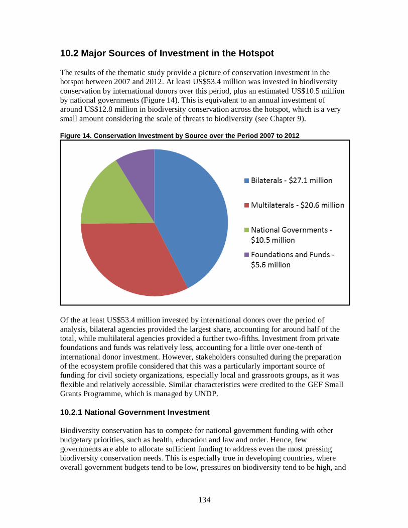
134
10.2 Major Sources of Investment in the Hotspot
The results of the thematic study provide a picture of conservation investment in the
hotspot between 2007 and 2012. At least US$53.4 million was invested in biodiversity
conservation by international donors over this period, plus an estimated US$10.5 million
by national governments (Figure 14). This is equivalent to an annual investment of
around US$12.8 million in biodiversity conservation across the hotspot, which is a very
small amount considering the scale of threats to biodiversity (see Chapter 9).
Figure 14. Conservation Investment by Source over the Period 2007 to 2012
Of the at least US$53.4 million invested by international donors over the period of
analysis, bilateral agencies provided the largest share, accounting for around half of the
total, while multilateral agencies provided a further two-fifths. Investment from private
foundations and funds was relatively less, accounting for a little over one-tenth of
international donor investment. However, stakeholders consulted during the preparation
of the ecosystem profile considered that this was a particularly important source of
funding for civil society organizations, especially local and grassroots groups, as it was
flexible and relatively accessible. Similar characteristics were credited to the GEF Small
Grants Programme, which is managed by UNDP.
10.2.1 National Government Investment
Biodiversity conservation has to compete for national government funding with other
budgetary priorities, such as health, education and law and order. Hence, few
governments are able to allocate sufficient funding to address even the most pressing
biodiversity conservation needs. This is especially true in developing countries, where
overall government budgets tend to be low, pressures on biodiversity tend to be high, and
135
financing conservation is frequently seen as the responsibility of the international
community.
Accurate information on national government investment in biodiversity conservation is
hard to come by. The governments of the hotspot countries do not report on their
expenditure on biodiversity conservation as a line item, and it is frequently difficult to
disaggregate biodiversity expenditure from spending on other forms of environmental
protection. Therefore, the figures presented in this chapter are estimates based upon an
annual expenditure on biodiversity of 0.05 percent of GDP. For PNG, this estimate is
further reduced by 80 percent, to account for the fact that only part of the country is
located within the hotspot. These calculations give estimates for annual government
expenditure on biodiversity conservation of US$1.3 million, US$400,000 and
US$400,000 in the PNG islands region, the Solomon Islands and Vanuatu, respectively.
There is clearly a need to conduct more detailed research into patterns and effectiveness
of national government investment in biodiversity conservation. For the purposes of the
ecosystem profile (which defines an investment strategy for civil society organizations),
however, national government investment is excluded from the remaining analyses in this
chapter.
10.2.2 Multilateral Donors
The total amount of conservation investment in the East Melanesian Islands Hotspot
made by multilateral funding agencies between 2007 and 2012 was at least
US$20.6 million (Table 29). The main source of multilateral donor investment over the
period of analysis was the GEF, with at least two medium and three full-sized projects
implemented, not including the Small Grants Programme. The total budget for these five
projects over the period of analysis was more than US$50 million, of which around
US$15 million was invested in the hotspot, with the remainder being invested in other
countries (and parts of PNG) as part of regional projects. ADB (one) and UNDP (four)
were the GEF implementing agencies for these projects, while the World Bank, a major
GEF implementing agency in other parts of the world, did not hold any biodiversity
projects during the period of analysis. Two of the GEF projects were major regional
initiatives with a focus on marine conservation. The other three focused on community-
based conservation, including piloting approaches to community-managed conservation
areas.
In addition to these five projects, the GEF Small Grants Programme, implemented by
UNDP, operates in the three countries of the hotspot. The program provides grants of up
to US$50,000 to local communities and NGOs for projects in the following focal areas:
biodiversity; climate change mitigation and adaptation; land degradation and sustainable
forest management; international waters; and chemicals. In Vanuatu, the Small Grants
Programme has been in operation since 2007, over which time around US$470,000 has
been awarded under the biodiversity focal area to a range of CBOs and NGOs. In the
Solomon Islands, the program has been in operation since 2008, and around US$340,000
has been awarded under the biodiversity focal area. In PNG, the program is much longer
136
established, having begun in 1994. Since this time, more than US$1.9 million in grants
has been awarded for biodiversity projects, although only a small amount (US$55,000)
was in the PNG islands region during the period of analysis (UNDP 2012). Additional
support for implementation of the Small Grants Programme in the Solomon Islands has
been provided by the New Zealand Agency for International Development (NZAID) and
AusAID.
Table 29: Overview of Conservation Investment by Multilateral Agencies, 2007-2012
Donor Main Countries of Intervention
Main Areas of Intervention Estimated Total Investment 2007-2012 (US$)
GEF (managed by ADB)
PNG, Solomon Islands
Supporting the largest marine conservation initiative in the region: the Coral Triangle Initiative. Total investment via ADB is around US$40 million spread across six countries, including two in the hotspot.
13.3 million
GEF (managed by UNDP)
PNG, Solomon Islands, Vanuatu
Three projects supporting community-based conservation activities in coastal and forest ecosystems. Locations targeted by these projects include Whiteman Range in PNG, Isabel Island in the Solomon Islands and various sites in Vanuatu. A major regional project supporting ocean fisheries management covers the three hotspot countries.
2.7 million
European Union
PNG, Solomon Islands, Vanuatu
Four projects supporting civil society capacity building and social participation in the Solomon Islands and Vanuatu. Several of the beneficiary groups have a focus on biodiversity conservation. An offshore marine conservation project focused on development of sustainable tuna fisheries in the Pacific covers three hotspot countries.
2.5 million
UNDP Solomon Islands
Strengthening capacity at the Ministry of Environment, Climate Change, Disaster Management and Meteorology and supporting environmental mainstreaming through the Strengthening Environment Management and Reducing the Impact of Climate Change in Solomon Islands project. Project includes community-based activities delivered via the GEF Small Grants Programme.
2.1 million
Total 20.6 million
Implementation of the GEF Small Grants Programme at the national level is overseen by
National Steering Committees, comprising representatives of government agencies and
domestic and international NGOs. These partners provide technical backstopping and
support grantees, especially CBOs, with project implementation. In each hotspot country,
the program addresses the following two biodiversity objectives of GEF Phase 5:
improve the sustainability of protected areas and indigenous and community conservation
areas through community-based actions; and mainstream biodiversity conservation into
production landscapes, seascapes and sectors. The CEPF investment strategy for the
hotspot (Chapter 12) aligns closely with these objectives, and there will be a need for
137
close coordination at the national level to identify opportunities for synergy and avoid
duplication of investment with regard to supporting local civil society.
The indicative allocations for the biodiversity focal area in GEF Phase 5 for the three
hotspot countries are provided in Table 30. These allocations are not guaranteed to be
invested but the actual figures are likely to be close to the indicative allocations in the
table. PNG has by far the largest national allocation under the biodiversity focal area but
only a proportion of these funds are expected to be invested in the PNG islands region,
with the majority focusing on activities on the mainland or at the national level.
Table 30. GEF-5 Allocations for Countries in the East Melanesian Islands Hotspot
Country Biodiversity Focal Area ($) Total Allocation ($)
PNG* 13,320,000 16,490,000
Solomon Islands 3,600,000 6,250,000
Vanuatu 2,550,000 5,440,000
Note: * = figures for the whole country.
The largest GEF investment in the East Melanesian Islands Hotspot under the
biodiversity focal area over the next five years will be the full-sized project PAS
Community-Based Forest and Coastal Conservation and Resource Management in PNG,
implemented by UNDP and supported with US$6,900,000 of GEF funding plus
US$12,000,000 in cofinancing. The objective of this project is to develop effective
natural resource management and financing systems for community conservation areas.
To this end, it will work at the national level to help establish a suitable national enabling
environment. This will be complemented by field activities, including at Whiteman
Range and other sites in West New Britain, to demonstrate community-based
conservation areas and pilot payment for ecosystem services in other complementary
sustainable financing systems. In this way, the project will adopt a set of approaches in
West New Britain that are similar to those CEPF plans to support in other parts of the
hotspot (Chapter 12).
The EU has also been a major investor in biodiversity-conservation-related activities in
the hotspot over the last five years. The EU has been a strong supporter of capacity
building for civil society organizations in PNG, the Solomon Islands and Vanuatu. These
investments have focused variously on CBOs and domestic NGOs. While none of them
have had an explicit focus on biodiversity conservation, many of the beneficiary
organizations have a conservation-related mission, such as Marovo Island Natural
Biodiversity and Livelihood Trust and Kastom Garden Association. One capacity-
building initiative not included in Table 29 is the EU-funded Support for Non-State
Actors in PNG project, implemented by the Department of Community Development
with a budget of US$8 million. This project did not focus explicitly on biodiversity
conservation and was nationwide in focus; hence it is unclear to what degree, if at all,
support was provided to conservation-focused civil society organizations active in the
hotspot. Like the GEF, the EU is also supporting a major regional marine fisheries
project. This project, entitled Development of Sustainable Tuna Fisheries in Pacific ACP
138
Countries Phase 2, has a total budget of more than US$11 million, and focuses on 14
Pacific countries, including the three in the East Melanesian Islands Hotspot. The project
is implemented by two key regional institutions: FFA; and the Secretariat of the Pacific
Community.
The EU and other multilateral donors are also making major investments in climate
change adaptation and mitigation in the hotspot. Examples from the EU include a US$7
million investment in climate change adaptation for the agriculture sector, covering the
three hotspot countries, and the US$14 million Disaster Risk Reduction for Eight Pacific
States Project, which also covers the hotspot countries (Table 27). Meanwhile, FAO and
UNDP are supporting a REDD readiness project in PNG with a budget of US$8 million
(Table 26). Bilateral investments in climate change mitigation and adaptation are
increasing in number, and already far exceed those in biodiversity conservation. This
trend does not necessarily mean a reduction in funding opportunities for conservation-
focused civil society organizations. However, representatives of several organizations
report that conservation projects increasingly have to be framed in terms of climate
change mitigation or adaptation in order to align with donor priorities. As discussed in
Chapter 8, most conservation activities in the hotspot may be labeled as climate change
adaptation. Because of the high dependence of human communities on natural
ecosystems, and the vulnerability of both to climate change, there is large area of overlap
between biodiversity, climate change and human well-being goals.
10.2.3 Bilateral Donors
Bilateral donors comprise the second largest category of international conservation donor
in the hotspot, investing at least US$27.1 million over the period 2007 to 2012 (Table
31). The majority of the bilateral investment in biodiversity conservation over this period
came from two countries: United States ($20.1 million), primarily in the form of support
to the Coral Triangle Initiative; and Japan ($5.9 million), for two nationally executed
conservation initiatives. One of these, the Project for Promotion of the Grace of the Sea in
Coastal Villages, is supporting the Department of Fisheries to implement community-
based natural resources management. The other, the Forest Preservation Program,
provides institutional support to the PNG Forest Authority. This project is nationwide in
scope but includes a forestry inventory for three provinces, including West New Britain.
The Government of France is a major supporter of marine conservation efforts in the
Pacific region, most notably through AFD and Fonds Français pour l'Environnement
Mondial (FFEM) support to the Coral Reef Initiative for the South Pacific. Total AFD
and FFEM investment was €5 million (US$6.2 million), spread across 13 countries,
including the Solomon Islands and Vanuatu. The main focus of French development
assistance in the hotspot is Vanuatu, where the main priorities are education and rural
development/food security. By addressing food security and increasing education levels,
these investments are helping establish an enabling environment for biodiversity
conservation, although few of them have explicit biodiversity objectives, and are thus not
included in this analysis. One exception was the FFEM-funded project Preserving and

139
Using the Agro-biodiversity of Root and Tuber Crops in Vanuatu, which ran from 2004
to 2009.
The Government of New Zealand, through NZAID, is another major bilateral donor to
Vanuatu. Again, many of its projects, while not having direct biodiversity goals, help
establish an enabling environment for conservation. An example is ongoing NZAID
funding to the Ministry of Lands and Natural Resources for improved security of land
ownership and more rapid resolution of land disputes. Investments with more explicit
biodiversity goals include a grant to the Forestry Department for a project entitled
Enhancing Rural Livelihood Development through Establishment of Community Forestry
Nurseries.
Table 31: Overview of Conservation Investment by Bilateral Agencies, 2007-2012
Donor Main Countries of Intervention
Main Areas of Intervention Estimated Total Investment 2007-2012 (US$)
United States (USAID, Peace Corps)
PNG, Solomon Islands, Vanuatu
Supporting the largest marine conservation initiative in the region: the Coral Triangle Initiative. Total investment via USAID is around US$60 million spread across six countries, including two in the hotspot.
Peace Corps volunteers supporting various projects, including a GEF medium-sized project on community-based conservation in Vanuatu, managed by UNDP.
20.1 million
Japan (JICA)
PNG, Vanuatu
Extensive support for institutional capacity building of PNG Forest Authority through the Forest Preservation Program. Supporting the Vanuatu Department of Fisheries to implemented community-based conservation in coastal communities.
5.9 million
France (AFD, FFEM)
Solomon Islands, Vanuatu
AFD and FFEM supported a major marine conservation initiative: the Coral Reef Initiative for the South Pacific.
FFEM also supported an initiative to conserve agro-biodiversity in Vanuatu.
0.8 million
New Zealand (NZAID)
Vanuatu Supporting various sustainable livelihoods and civil society capacity building initiatives in Vanuatu.
0.3 million
Total 27.1 million
As with multilateral donors, bilateral funding for climate change adaption and mitigation
is increasing. The Australian Government, in particular, is a major supporter of climate
change research and adaptation work in the Pacific region, including the hotspot (Table
27). One example is the International Climate Change Adaptation Initiative, supported
with US$20 million of AusAID funding to the Pacific Island Forum countries. This
project is improving the understanding of climate change science, and piloting adaptation
approaches for coastal zones and small islands. A related initiative, also with the Pacific
Islands Forum countries, is the South Pacific Sea Level and Climate Monitoring Project,

140
financed with US$40 million of AusAID funding. This project is building capacity and
conducting climate-change and sea-level monitoring across the 14 Pacific Islands Forum
countries. Because biodiversity conservation is not a direct objective of these projects,
they are not included in the analysis of conservation investment presented in this chapter.
10.2.4 Foundations and Funds
The third main source of conservation investment in the East Melanesian Islands Hotspot
is private foundations and funds. Grants from foundations and funds totaled at least
US$5.6 million over the period of analysis (Table 32). This figure is likely an
underestimate of the total investment by foundations and funds, as it was not possible to
collate the many (often small) grants made by foundations and funds.
Table 32. Overview of Conservation Investment by Foundations and Funds, 2007-2012
Donor Main Countries of Intervention
Main Areas of Intervention Estimated Total Investment 2007-2012 (US$)
MacArthur Foundation
PNG, Solomon Islands, Vanuatu
More than 20 grants awarded, supporting a range of initiatives. Particular focus on community-based conservation through the LMMA approach, community rights in the face of development projects, and marine conservation.
3.6 million
Packard Foundation
PNG, Solomon Islands
Sixteen grants awarded, supporting a similar set of grantees and range of initiatives to those supported by the MacArthur Foundation.
2.0 million
Global Greengrants Fund
PNG, Solomon Islands, Vanuatu
More than 10 small grants to domestic NGOs and CBOs for a range of initiatives, with a particular focus on community rights and capacity building for grassroots civil society.
<0.1 million
Mohamed bin Zayed Species Conservation Fund
PNG Small grant for research on Beck’s petrel <0.1 million
Total 5.6 million
Compared with other biodiversity hotspots, relatively few private foundations are actively
supporting conservation efforts in the East Melanesian Islands. The two main foundations
are the John D. and Catherine T. MacArthur Foundation and the David and Lucile
Packard Foundation, which, together, invested around US$5.6 million in biodiversity
conservation projects in the hotspot over the study period. In contrast to most bilateral
and multilateral donors, private foundations make civil society organizations the main
focus of their grantmaking, and thus the significance of the MacArthur and Packard
Foundations to civil-society-led conservation efforts in the hotspot is greater than
proportionate contribution to overall conservation investment (approximately 9 percent)
would imply.

141
The two foundations have closely aligned grant portfolios in the East Melanesian Islands
(although the Packard Foundation does not directly support activities in Vanuatu),
supporting a similar suite of grantees, comprising mostly international and regional civil
society organizations, plus a few domestic NGOs, such as FSPI and PNG Centre for
LMMAs. The two foundations’ grant-making is concentrated in the areas of marine
conservation, strengthening land and resource rights of local communities, and
community-based conservation, especially in coastal and nearshore marine ecosystems.
The two foundations have been instrumental in supporting the establishment of LMMAs
across the hotspot (and beyond), and the development of networks among communities
and practitioners involved in piloting the LMMA approach. These investments provide a
strong foundation for further expansion and strengthening of LMMA networks in the
hotspot, and a model for similar networks of community-managed conservation areas in
terrestrial ecosystems.
In addition to the two foundations, there are a number of global, regional and national
funds supporting biodiversity conservation efforts in the region. An example of a global
fund is the Mohammed bin Zayed Species Conservation Fund, which makes available
small grants for targeted species conservation efforts. Since its establishment in 2009, the
fund has awarded more than US$7 million to over 600 conservation projects globally.
Within the East Melanesian Islands Hotspot, however, only a single grant has been
awarded to date. Given that other global funds focused on species conservation, such as
the Rufford Small Grants Foundation, and the GEF-funded Save Our Species fund,
managed by the World Bank, did not support any projects in the hotspot over the period
of analysis, the demand for species-focused conservation investment remains largely
unmet.
Another example of a fund with global scope is the Global Greengrants Fund, a US-
registered nonprofit organization that channels funds from various donors to civil society
organizations in developing countries. Since its establishment in 1993, the fund has
awarded more than 7,000 small grants around the world, with a focus on global
environmental sustainability and social justice. While not all grants directly address
conservation issues, by building capacity for research and action among grassroots
groups engaged in environmental issues, they help put in place a key enabling condition
for effective and dynamic local conservation movements. In the East Melanesian Islands
Hotspot, relatively few grants were awarded over the period of analysis, although a large
number were awarded on the PNG mainland, which is the main focus of the fund’s
grantmaking in the Pacific. A particular feature of the Global Greengrants Fund is its use
of local advisory bodies to recommend grantee organizations. In the East Melanesia
Islands, the responsible body is the Regional Advisory Board for the Pacific Islands,
which is composed of representatives of local and international civil society
organizations, including Pacific Environment Consultants Ltd, FSPI, PNG Centre for
LMMAs and TNC.
At the regional level, the key fund investing in biodiversity conservation is the MGCTF.
Established in 2000, with and initial focus on PNG, the fund’s mission was extended in
2008 to include Fiji, New Caledonia, the Solomon Islands, Timor-Leste and Vanuatu.

142
Registered in PNG as a private charitable trust, the MGCTF is working to mobilize
funding from a variety of public and private sources to build an endowment of at least
US$30 million, which can be used to provide long-term support for sustainable
management of the biodiversity resources of the Melanesian Region (MGCTF 2009). The
fund is currently supporting numerous conservation areas across PNG, including five
within the East Melanesian Islands Hotspot. Elsewhere in the hotspot, the fund has
recently established pilot projects in both the Solomon Islands and Vanuatu. The fund has
tremendous potential to become a mechanism for sustainably financing civil-society-led
conservation efforts in the hotspot. However, the fund is not listed in Table 32 because
financial data about its grant portfolio could not be obtained during the ecosystem
profiling process.
10.2.5 Other Donors
Although detailed financial information could not be obtained about them, a number of
other donors are known to be supporting conservation efforts in the hotspot. These
include contributions for members of the WWF Network, which are an important source
of funding for the WWF West Melanesia Programme, which covers PNG and the
Solomon Islands. They also include investments by private companies in biodiversity
conservation. For instance, New Britain Palm Oil Ltd has entered into a partnership with
the Business and Biodiversity Offsets Program to ensure that there is no net loss of
biodiversity associated with any of the company’s operations (New Britain Palm Oil Ltd
2011). Other investments are made by tourism operators, to support conservation of coral
reefs and other ecosystems that attract tourists.
10.3 Summary of Investment by Country
The data on international donor funding (i.e. excluding investments by national
governments) reveal an apparent disparity in the level of investment in each county. The
Solomon Islands and the part of PNG within the hotspot both received significantly more
conservation investment over the period of analysis than did Vanuatu (Figure 15).
These disparities are largely accounted for by the involvement of PNG and the Solomon
Islands in a number of major regional projects, most notably the Coral Triangle Initiative,
which singlehanded accounted for more than three-fifths of international conservation
investment over the period of analysis. If multi-country projects such as these are
excluded from the analysis, then it can be seen that the three parts of the hotspot received
roughly similar amounts of investment over the period, with US$4.2 million in PNG,
US$6.4 million in the Solomon Islands and US$5.3 million in Vanuatu (Figure 15).
These sums, which amount to only around US$1 million per country per year, highlight
the tremendous shortfall in conservation investment faced by the three countries,
especially for domestic civil society organizations, which rarely access funding for
regional initiatives, at least not directly.

143
Figure 15. Conservation Investment by Country over the Period 2007 to 2012
Note: * = figures for the East Melanesian Islands Hotspot only.
10.3.1 PNG
PNG received very large sums of conservation investment over the period of analysis, of
which at least US$22 million was invested in activities within or related to the PNG
islands region. The largest conservation investments in the PNG part of the hotspot were
three large, multi-country initiatives focused on marine conservation: an EU-funded
project on development of sustainable tuna fisheries; a GEF full-sized project on ocean
fisheries management, managed by UNDP; and the Coral Triangle Initiative. Once these
three initiatives are excluded, PNG only received around US$4.6 million from other
sources (less than US$1 million per year), mostly in the form of medium and small grants
to civil society organizations from private foundations plus the JICA-supported Forest
Preservation Program, which has activities in West New Britain. This is a remarkably
small amount, given that the PNG islands region contains more than half the land area
and half the human population of the hotspot.
Considering that the three multi-country initiatives that contributed the lion’s share of
conservation investment in the PNG part of the hotspot over the last five years focused on
marine conservation, the conservation investment gap is most pronounced with regard to
terrestrial ecosystems. Over the next five years, this gap will be addressed to some degree
by the full-sized GEF project, PAS Community-Based Forest and Coastal Conservation
and Resource Management in PNG, which began in 2012. However, this project only
focuses on West New Britain province within the PNG islands region, and the gap in
investment for terrestrial conservation is expected to persist for the other three provinces
and Bougainville Autonomous Region. One opportunity to address this gap might be
144
created if forest carbon financing mechanisms can be successfully established for the
country.
10.3.2 Solomon Islands
The Solomon Islands received at least US$24.6 million in conservation investment over
the period of analysis. Once again, a large portion of this investment was accounted for
by large, multi-country initiatives focused on marine conservation. These included the
three projects mentioned under PNG, plus the Coral Reef Initiative for the South Pacific,
funded by AFD and FFEM. Once these four initiatives are excluded, the Solomon Islands
received at least US$7 million from other sources (around US$1.4 million per year). The
largest contributions were made by: UNDP’s support to the Ministry of Environment,
Conservation, Disaster Management and Meteorology under the Solomon Islands
Environment Management and Climate Change Project; a Packard Foundation grant to
TNC for development of a marine protected areas network; and a GEF medium-sized
project on Isabel Island, managed by UNDP.
As with PNG, the marine realm was the main focus of conservation investment in the
Solomon Islands over the period of analysis, with a mix of initiatives covering nearshore
and offshore marine ecosystems. Several grants did address the conservation of terrestrial
ecosystems, including a number of KBAs. For instance, a suite of MacArthur Foundation
grants to AMNH, TNC and the University of Queensland piloted community-managed
conservation areas in Gizo, Marovo, Kolombangara Upland Forest and Mount Maetambe
- Kolombangara River, spanning natural ecosystems from ridge to reef. Nevertheless, as
with PNG, there is a particular gap in conservation investment with regard to terrestrial
forest in the Solomon Islands.
10.3.3 Vanuatu
Vanuatu received more than US$6.8 million in conservation investment between 2007
and 2012, which was relatively low compared with the other hotspot countries. Vanuatu
was included in three of the large, multi-country marine conservation initiatives (namely
the EU-funded project on sustainable tuna fisheries, the GEF project on ocean fisheries
management, and the Coral Reef Initiative for the South Pacific) but was not included in
the Coral Triangle Initiative, because it lies outside of the areas of highest coral diversity.
Excluding these initiatives, Vanuatu received at least US$5.8 million from other sources
(around US$1.2 million per year). The largest single contribution was made by the JICA-
funded Project for Promotion of the Grace of the Sea in Coastal Villages, which
accounted for almost half. The project is implementing integrated community
development and sustainable natural resource management activities in pilot villages
located within three KBAs: Aneityum; Neck of Malakula-Crab Bay; and North Efate.
Vanuatu has benefited from several projects focused on capacity building for domestic
civil society. One example is the Helping People Take Their Destiny in Their Hands in
Remote Islands in Vanuatu project, supported by the EU, which reinforced CBOs across
the country. Another example is ongoing NZAID support to VANGO, which is helping
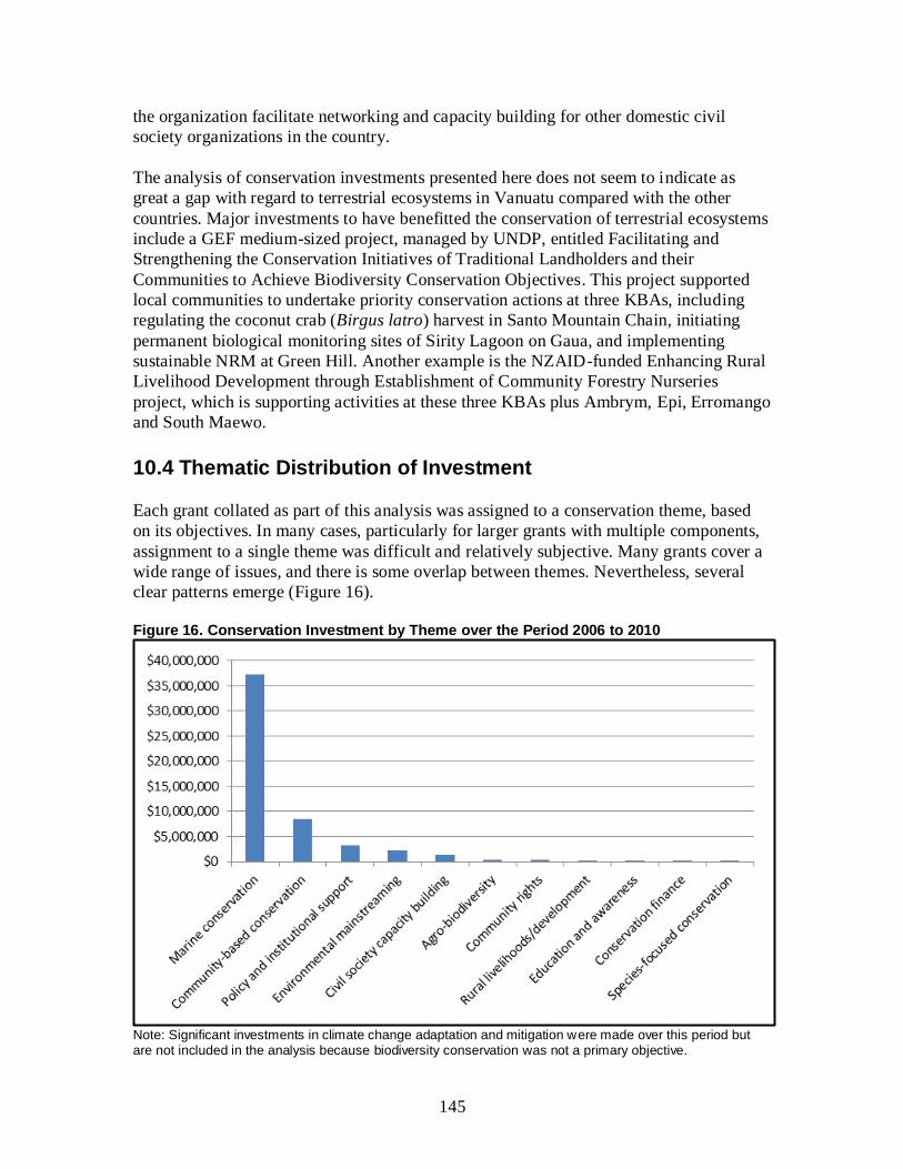
145
the organization facilitate networking and capacity building for other domestic civil
society organizations in the country.
The analysis of conservation investments presented here does not seem to indicate as
great a gap with regard to terrestrial ecosystems in Vanuatu compared with the other
countries. Major investments to have benefitted the conservation of terrestrial ecosystems
include a GEF medium-sized project, managed by UNDP, entitled Facilitating and
Strengthening the Conservation Initiatives of Traditional Landholders and their
Communities to Achieve Biodiversity Conservation Objectives. This project supported
local communities to undertake priority conservation actions at three KBAs, including
regulating the coconut crab (Birgus latro) harvest in Santo Mountain Chain, initiating
permanent biological monitoring sites of Sirity Lagoon on Gaua, and implementing
sustainable NRM at Green Hill. Another example is the NZAID-funded Enhancing Rural
Livelihood Development through Establishment of Community Forestry Nurseries
project, which is supporting activities at these three KBAs plus Ambrym, Epi, Erromango
and South Maewo.
10.4 Thematic Distribution of Investment
Each grant collated as part of this analysis was assigned to a conservation theme, based
on its objectives. In many cases, particularly for larger grants with multiple components,
assignment to a single theme was difficult and relatively subjective. Many grants cover a
wide range of issues, and there is some overlap between themes. Nevertheless, several
clear patterns emerge (Figure 16).
Figure 16. Conservation Investment by Theme over the Period 2006 to 2010
Note: Significant investments in climate change adaptation and mitigation were made over this period but are not included in the analysis because biodiversity conservation was not a primary objective.
146
The first is a clear trend towards marine conservation. This is in large part due to the
largest single conservation initiative in the hotspot over the period of analysis being the
Coral Triangle Initiative. Current funding commitments by ADB, GEF and USAID are
scheduled to end during 2012, and stakeholders interviewed were unclear about the future
form and scale of the initiative. Nevertheless, even excluding the Coral Triangle
Initiative, marine conservation continues to feature strongly in conservation efforts in the
region, not least because the focus of most of the investment under the theme of
community-based conservation is targeted towards the conservation of coastal and
nearshore marine ecosystems, through LMMAs and similar initiatives.
The next trend is towards community-based approaches to biodiversity conservation and
away from conventional protected area approaches, which feature strongly among
conservation responses to biodiversity loss elsewhere in the world. As discussed in
Section 6.6, there are limitations to the applicability and effectiveness of conventional
protected areas in countries where customary land ownership predominates and
government capacity to enforce management regulations on the ground is extremely
limited. As mentioned above, the predominant approach to date has been LMMAs,
focusing on coral reefs and other nearshore marine ecosystems. A number of models for
community-based conservation of terrestrial habitats have also been piloted, and, at least
in Vanuatu, a legislative framework for them put in place.
The other clear trend that emerges from the analysis of conservation investment by theme
is that there is an almost complete lack of conservation investment in most thematic
areas. The only exceptions are marine conservation, community-based conservation,
policy and institutional support (PNG only), environmental mainstreaming (the Solomon
Islands only), and civil society capacity building (Vanuatu only). Even for these themes,
a strong case could be made that additional funding is needed to respond to even the
highest priority conservation issues. For other themes, conservation investment is limited
to non-existent. For instance, education and awareness received only around US$100,000
of international donor investment over the period of analysis, while species-focused
conservation received less than this in targeted funding. Certain important conservation
themes, including invasive species management, did not appear to receive any targeted
investment over the period of analysis, although this may partly reflect limitations in data
collation.
10.5 Strategic Funding Initiatives
10.5.1 Conservation Trust Funds
Successful and enduring conservation results may require years if not decades of work,
and are not ideally suited to short-term, project-by-project financing. Indeed, uncertain
and irregular funding is a major constraint to conservation initiatives across the globe. To
overcome this constraint, sustainable financing mechanisms provide reliable funding to
meet the costs of conservation initiatives over many years, through debt swaps,
endowment funds, or other financing mechanisms, such as dedicated conservation taxes
and levies. One popular approach has been to establish conservation trust funds, which
147
can take the form of endowment funds, where only the interest is spent; sinking funds,
where the income and part of the capital is spent; and revolving funds, which continually
receive and spend new revenues (WWF 2012).
The development of sustainable financing mechanisms for biodiversity conservation is
most advanced in PNG and Vanuatu, where there are enabling policies and laws in place
governing environmental trust funds, as well as some forms of taxes levied in relation to
environmental damage. For instance, PNG’s 1991 National Forest Policy (Government of
PNG 1991) requires logging companies to pay a fixed reforestation levy based upon the
volume of timber extracted. A considerable amount of investment has been collected by
the Department of National Planning and Monitoring, as the recipient agency for the
levies, and used to establish Reforestation Trust Funds. However, concerns have been
raised by the provincial governments in the PNG islands region regarding disbursement
from these funds, which are supposed to be used for restoring degraded forest in the
impacted provinces.
While delivery and sustainability of the Reforestation Trust Funds is unclear at present, a
more effective model appears to be the MGCTF. A national conservation needs
assessment undertaken in 1993 recommended the establishment of a conservation trust
fund for PNG (Swartzendruber 1993). Following this recommendation, the MGCTF was
set up in 2000, with support from a GEF project managed by the World Bank, and has
been sustained by support from a wide range of donor organizations, including the
Packard Foundation, TNC, WWF, USAID and the German Government. The fund’s
mission is to provide long-term sustained conservation funding through a grants program.
Grant support is complemented by capacity building for landowners, resource users and
civil society organizations to design and implement conservation programs. The MGCTF
is registered as a private charitable trust and governed by a board of 12 trustees,
representing all sectors of national, regional and international civil society.
In 2008, the MGCTF’s trustees voted to expand its grants program to cover other
countries in Melanesia, including the Solomon Islands and Vanuatu. The expanded
mission of the fund has four strategies (MGCTF 2009):
Promote initiatives by people living in and around selected conservation areas to
increase the value and better evaluate the livelihood benefits of natural resources.
Empower people from the communities to assume responsibility for the long-term
management of their natural resources.
Encourage the creation of innovative partnerships between nonprofit
organizations, the private sector and government agencies.
Develop the technical, financial and management capability of natural resource
managers in targeted conservation areas.
The VBCTF was established by the Vanuatu government under the auspices of the
Forestry Department in September 1998. The VBCTF was principally established to
provide a continuous source of funding for the retention of forests in Vanuatu and related
biological conservation. A trustee (Pacific Integrated Trust Company) was appointed to
148
oversee the management of the fund, and a technical advisory board was established,
made up of representatives from the Forestry Department, the Department of
Environment and Conservation, the National Council of Chiefs, and Vanuatu Cultural
Center (Government of Vanuatu 2002). In contrast with the MGCTF, the VBCTF has a
representative from the National Council of Chiefs to ensure a voice for customary
landowners in the decision-making processes.
10.5.2 Payments for Ecosystem Services
Payments for ecosystem services are another rapidly developing field, and one with great
potential to provide long-term funding for biodiversity conservation. These payments
may be made directly to landowners to incentivize certain actions or compensate them for
the opportunity costs of conservation, or used to capitalize trust funds. The main area
currently receiving attention is payments for avoided deforestation, through REDD+
mechanisms. There is one national-level REDD+ pilot in West New Britain province,
PNG, at the design stage, as well as pilot projects in PNG’s Manus province and on
Vanuatu’s Malakula Island at the initial planning stage. Other areas with potential for the
development of payments for ecosystem services include hydrological services, for
hydropower dams or municipal water utilities, for instance.
10.6 Success Factors and Barriers to Success
As the analysis in this chapter shows, the level of investment in conservation by national
governments and international donors is insufficient to address the threats to biodiversity
outlined in Chapter 9. It is all the more important, therefore, to ensure that those
resources that are available are used as effectively and efficiently as possible. To this end,
particular emphasis was paid, during the stakeholder consultation workshops, to
capturing lessons learned from past conservation initiatives in the hotspot in order to
identify success factors and barriers to success. The factors influencing success of
conservation projects that were identified are, inevitably, subjective. However, they draw
on the combined experience of a broad spectrum of conservation practitioners from
government, civil society and donor agencies involved in initiatives across the hotspot.
10.6.1 Project Design
Barriers to Success
Too often, poor results of conservation initiatives can be traced back to shortcomings in
project design. While all projects and, thus, their specific designs are different, there are
general features of the design process that are common to most. Stakeholders identified
four main barriers to success related to project design: focus; expectations; power
dynamics; and scale. These are discussed in turn.
A weakness of the design of many projects is that they focus on issues of concern to
conservationists but not to communities. This may reflect lack of understanding of the
socioeconomic environment or a preoccupation with conservation goals. Focusing too
narrowly on the focal species or habitat can become a barrier to success if it results in
149
projects that do not take account of communities’ needs, have goals that appear esoteric
to them, or adopt approaches that are inconsistent with custom and traditional practices.
Another shortcoming of the project design process can be unrealistic expectations about
the goals of the project. Conservationists may think about a project in terms of the
conservation outcomes it is expected to deliver, while communities are more likely to
think in terms of the development benefits they will receive. Trade-offs between these
two overlapping but separate sets of objectives can lead to disillusionment and tensions
down the road. Moreover, some conservation organizations have reportedly inflated
communities’ expectations during the design phase in order to build support and
enthusiasm for their projects, for instance in regard to incentive payments. This pattern of
over-promising and under-delivering has undermined trust between conservation groups
and the communities they purport to be supporting.
The greater access to resources, information and political influence of national and
international civil society organizations creates power imbalances in their relationships
with local communities. These are compounded by the ability of civil society
organizations to “walk away from” a project if implementation goes awry, whereas
community members are left to deal with problems that have arisen. Where civil society
organizations are unaware of power inequalities or do not mitigate them, a lack of trust
can ensue, and a top-down, patron-client relationship can develop.
The fourth key barrier to success arising from project design is that of scale. Many
projects are too large and too complicated, with complex institutional arrangements, and
over-ambitious goals. These problems are compounded by short timeframes, which do
not allow time to build relationships with project partners, reach a common understanding
of project approach and goals, or respond to inevitable unforeseen delays in
implementation. Short project periods also constraint the sustainability of new
approaches, because these typically require time to demonstrate benefits and may require
additional funding to maintain.
Success Factors
Stakeholders reported that successful projects were ones that concentrated on local
people’s priorities, and found ways to match existing community interests or initiatives to
conservation goals. It was mentioned that there are some good examples from the work of
TNC with communities on Choiseul and Isabel Islands that could be drawn on, for
instance using three-dimensional participatory mapping as a means to develop a common
understanding of resource management issues and identify areas of overlap between
community interests and those of conservationists. This is consistent with the Principles
for Nature Conservation in the Pacific developed by the Roundtable for Nature
Conservation in the Pacific Islands Region, which state that “international and national
partners will actively recognise, respect and support community aspirations for
development and well-being” (SPREP and IUCN 2007).
To ensure realistic community expectations about projects, a key ingredient of project
design is open discussions, involving all sections of the community. These should be

150
spaced out to allow the community to discuss internally between each round of
discussion. Ideally, the timeline for project design should be open ended, so that the final
design is based on a shared understanding between all project partners, and the process is
not truncated to fit with an externally imposed deadline. Also, the design process should
result in a clear definition of the roles and responsibilities of all partners to manage
expectations of who will contribute what to implementation. This is in line with the
Principles for Nature Conservation in the Pacific, under which partners commit to
“reinforcing participatory approaches by involving all stakeholders, particularly
community representatives when designing, implementing and assessing conservation
programmes” (SPREP and IUCN 2007).
Projects that have successfully addressed power dynamics in project design, such as
TNC’s work with the Lauru Land Conference of Tribal Chiefs on Choiseul Island, have
been preceded by an extensive period of awareness raising and trust building. This has
allowed project partners to understand each other’s goals, establish equitable benefit
sharing and understand land ownership conditions. One suggestion, to operationalize
such an approach within a grants program, was to make provision for planning grants,
which would allow conservation groups to work with a community for one to three years,
to build relationships and a shared understanding of issues, without pressure to deliver
outputs. It was noted, however, that there would be a need to manage the community’s
expectations so that they were aware that the planning grant may not necessarily lead to a
project.
Finally, regarding scale, there was broad consensus that, at least for projects led by civil
society, small and medium-sized projects (i.e. under US$1 million) were most cost
effective, and least likely to encounter implementation delays due to complexity.
Moreover, there was complete consensus that longer timeframes were a key success
factor for conservation projects. As mentioned in Section 5.2.2, all on-the-ground
conservation activities in the hotspot must be implemented with the participation and
consent of local communities, and this requires considerable upfront investment in
relationship building, followed by community capacity building, and finally by
establishment of structures and financial mechanisms for sustainability. For instance,
before WCS commits to working at a site in PNG, it asks whether it would be reasonable
to work there for at least 20 years (R. Sinclair verbally 2012). Many stakeholders
advocated for project periods of seven to eight years, and some for as long as possible.
This is consistent with the Principles for Nature Conservation in the Pacific, under which
partners commit to “ensuring their conservation programmes are of a scale and budget
appropriate to the local context” (SPREP and IUCN 2007).
10.6.2 Project Implementation
Barriers to Success
Although the shortcomings of conservation projects can sometimes be attributed to the
project design process, more often the design of projects is relatively sound but they fail
due to problems encountered during implementation. Some of these problems are specific
to the enabling environment for conservation in the East Melanesian Islands, whereas
151
some are common to conservation projects globally. Stakeholders identified four main
barriers to success related to project implementation: relationships with communities;
government support; implementation capacity; and donor requirements. These are
considered in turn.
A weakness with the implementation of many projects is that, even when relationships
based on trust and shared goals have been developed between civil society organizations
and communities, these break down over time due to staffing turnover, delays and
miscommunication. Another reason for breakdown in relationships with communities is
that, once project implementation begins, there may be an unequal distribution of costs
and benefits among community members, for instance if people are not adequately
compensated for loss of income from natural resource exploitation.
In some cases, this weakness is compounded by civil society organizations establishing or
engaging with inappropriate governance structures at the community level. Simply being
composed of its members does not necessarily make a CBO representative of a
community or act in its best interests. Conservationists are not always sensitive to the fact
that CBOs may be composed of local elites with vested interest and conflicting agendas,
limited gender representation, and issues of authenticity and legitimacy.
Another problem commonly encountered during project implementation is weak
government support. With limited capacity and financial resources, and, in some cases,
without a clear mandate to support biodiversity conservation efforts, relevant government
agencies may be unwilling or unable to support a particular conservation project. Indeed,
in the absence of clear policy directives and appropriate performance incentives,
government officials may have very little motivation to support conservation initiatives,
particularly ones initiated by civil society organizations.
Another barrier to success encountered during project implementation is that
conservation groups do not always have the capacity to implement the projects they
develop. For international and domestic civil society organizations alike, the need to
cover staff salaries and other recurrent costs in their headquarters and field offices creates
an imperative to continually raise project funding. However, the persons responsible for
designing projects are often not the people implementing them, and the former are not
always conscious of the constraints and conflicting time demands on the latter. This
problem can be compounded by turnover in staff or failure to communicate the project
rationale and vision from designers to implementers.
Several stakeholders reported that capacity limitations were compounded by the
administrative and reporting requirements of conservation donors, which overwhelm staff
to the point that they cannot focus on implementing activities. It was observed that this
was a particular problem for domestic civil society organizations, which tend to be less
familiar with donor requirements, but also applied to INGOs. This barrier is linked to the
heavy dependence of civil society organizations on grant funding, with short project
cycles and frequent reporting. A related issue, identified by Hay and Schuster (2009) in
their review of NZAID’s support to the GEF Small Grants Programme in the Pacific, is

152
that delays in disbursement of project funds from donor to implementer have major
implications for the effectiveness of project implementation, such as creating difficulties
with the recruitment and retention of project staff.
Success Factors
Stakeholders participating in consultation workshops observed that successful projects
build strong, lasting relationship with communities. One way of achieving this is by
developing a good understanding of the social and cultural landscape, through making a
long-term commitment to working at a project site. Another means of building trust is to
invest in social capital, especially at the front end of an initiative, for instance by
providing scholarships to students from the community, such as AMNH has done in its
work on Kolombangara and Tetepare Islands. Yet another means is through instituting a
systematic process of participatory planning and monitoring, leading to the creation of
shared knowledge between conservation group and community, which can be used to
inform transparent decisions about project implementation. This is consistent with the
Principles for Nature Conservation in the Pacific, under which partners commit to
“actively recognise, respect and support community decision-making practices” (SPREP
and IUCN 2007).
Participatory planning and monitoring was also identified as a means of ensuring
government support for project objectives, as was establishing active links between
projects and government structures at local and provincial levels. The importance of
aligning project objectives to the goals of NBSAPs and other national conservation and
development strategies was emphasized as a requirement for building government
support at the national level. This is consistent with the Principles for Nature
Conservation in the Pacific, under which international partners commit to “working
within the legislation, policies, strategies, programmes and priorities established by
national partners” (SPREP and IUCN 2007).
Implementation capacity is related to the broader issue of civil society capacity, which is
discussed in the following section. As a general principle for conservation donors to
abide by, the following recommendation by Hay and Schuster (2009) is deserving of
attention: grantee capacity should be systematically assessed early in the grantmaking
process; it is insufficient to assess funding applications based upon their technical merit
alone. Beyond this recommendation, stakeholders emphasized the significant potential of
partnering as a means for overcoming capacity limitations, whereby a high-capacity
international or regional civil society organization regrants funds to local partners,
accompanied by strong technical and administrative support. It was observed that some
conservation donors insist upon such arrangements as a means of mitigating the risk of
funding local groups. This is consistent with the Principles for Nature Conservation in the
Pacific, under which international partners commit to “supporting national partners in
their efforts to build effective and sustainable national institutions” (SPREP and IUCN
2007).
With regard to donor requirements, private foundations and funds were cited as having
the least onerous application and reporting requirements, and, therefore, being accessible
153
to the widest range of civil society organizations. However, it was recognized that
accountability is a key requirement of all international donors, particularly where public
funds are concerned, and that partnership arrangements with larger organizations may
represent a good model for channeling resources to smaller, local groups.
10.6.3 Civil Society Capacity
Barriers to Success
Of the estimated US$53.4 million invested in biodiversity conservation in the hotspot by
international donors over the last five years, only US$1.2 million (2 percent of the total)
was granted directly to domestic civil society organizations. Although a larger amount
may have reached them indirectly, via subgrants under other projects, this low level of
funding is at once a symptom and a cause of limited capacity among domestic civil
society organizations working on biodiversity conservation in the hotspot. Stakeholders
identified three main barriers to success related to civil society capacity: human
resources; sustainable financing; and financial controls. These are considered in turn.
Human resources limitations are a barrier to conservation success because they constrain
civil society organizations’ ability to design and implement effective conservation
projects, and reduce their credibility with government as an independent source of advice
on conservation issues. One reason why civil society organizations face human resources
limitations is that there is a scarcity of appropriately qualified and experienced people in
the conservation field in each of the hotspot countries. A second reason is that
recruitment and retention of suitable staff is a challenge for organizations because
reliance on grant funding prevents them from offering permanent contracts or investing in
professional development. Domestic NGOs also report that they cannot compete with
INGOs and private sector companies in terms of the salary and benefit packages they can
offer employees.
Due to the human resource limitations outlined above, combined with a lack of access to
conservation donors based outside of the region, domestic NGOs report difficulties in
covering their core operating costs. Many NGOs are dependent upon securing grants to
sustain themselves over the long term. However, these grants typically place a cap on the
percentage of funds that can be used to cover general operating costs, such as rent, utility
bills and administrative staff. Inability to employ administrative staff or cover core costs
further limits the ability to raise new funding. Reliance on grant funding also creates
uncertainty and leads to “stop-start” project implementation, which can be damaging for
relationships with local communities.
Another barrier to accessing international donor funding faced by domestic NGOs is that
their financial controls are typically not at a standard that bilateral and multilateral donors
are comfortable with. In part, this relates back to the inability to recruit full-time
accountants and other administrative staff. As a result, domestic NGOs have access to a
limited number of funding sources, mainly private foundations and funds, plus the GEF
Small Grants Programme. There is often strong competition for grants from these
sources, which are, in any case, often of short duration (one to three years). Finally, in the
154
context of financial controls, the issue of weak civil society governance, which can create
opportunities for fraud and corruption, should not be overlooked.
Success Factors
A successful approach to addressing the barrier created by human resource constraints
has been investing in individual capacity development through courses at universities in
the region. A good model was the Strengthening Conservation Capacity Project at
UPNG, which ran a module-based course on conservation for NGO and CBO staff. This
course was funded by international donors, including the MacArthur Foundation, and ran
from 2002 until 2012, when the funding ran out. A similar example is provided by the
Pacific Islands Community-based Conservation Course, at USP, funded through a
combination of fees and scholarships. While such courses can increase the pool of talent
that domestic civil society organizations can draw on, they do nothing to address the
challenge of retaining qualified staff in the face of competition from INGOs and the
private sector. This requires the financial constraints facing civil society organizations to
be overcome. This is consistent with the Principles for Nature Conservation in the
Pacific, which emphasize “building effective and sustainable conservation capability and
organisations through on-going capacity development” (SPREP and IUCN 2007).
One approach to doing this is to make available unrestricted core funding to domestic
civil society organizations to enable them to invest in recruitment and professional
development of a small core of staff who can steer the development of the organization.
While all stakeholders agreed with the need to invest in the emergence of domestic civil
society organizations as a prerequisite for the long-term sustainability of conservation
efforts, a number pointed out the challenges inherent in awarding unrestricted funds,
including in relation to accountability in the use of funding and transparency in the
selection of recipient organizations.
With regard to the barrier presented by inadequate financial controls, partnering between
domestic NGOs and INGOs was pointed to as an approach with demonstrated success.
Another suggestion was to invest in a centralized accounting capacity that could be
shared among several organizations unable to hire full-time accountants. Such centralized
capacity would strengthen the financial controls of domestic NGOs without making them
dependent on INGOs as conduits for funding. It was further suggested that centralized
capacity could be considered as a solution for other capacity needs as well. This is
consistent with the Principles for Nature Conservation in the Pacific, which state that
“international partners will commit to strengthening national and local partners as an
alternative to establishing their own institutions and infrastructure” (SPREP and IUCN
2007).
10.6.4 Community Participation
Barriers to Success
In the East Melanesian Islands, communities and their organizations are critical to the
success and sustainability of conservation efforts on the ground. There was strong
agreement among stakeholders that strong and effective community participation was a

155
prerequisite of conservation success, although they identified four main barriers to
achieving this: land disputes; alternatives to resource exploitation; partnership
effectiveness; and delivery. This section discusses each barrier in turn.
Land disputes were considered by several stakeholders to be the number one barrier to
success, because of their negative impact on community cohesion, and their tendency to
impede collective action. Land disputes arise from competing claims of ownership over
land, and are sometimes exacerbated by outside interests taking advantage of them to
gain access to land for commercial resource extraction. In some cases, one of more of the
disputing parties may not actually be resident on or near the land in question but be
pursuing claims based upon ancestry.
Another obstacle to effective community participation is lack of alternatives to
unsustainable resource extraction. Several community-based conservation approaches
have been piloted in the hotspot, based upon models of sustainable natural resources
management within traditional governance frameworks. Some of these pilots have met
with success at the level of individual sites, such as with LMMAs in PNG and
community conservation areas in Vanuatu. However, these approaches have not always
been easy to replicate, particularly in places where commercial exploitation of natural
resources promises immediate income and employment generation (albeit short term). In
large part, this is because sustainable management of natural resources does not often
deliver comparable short-term returns to communities, especially ones living in remote
areas with limited market access. Indeed, it was observed for PNG that conservationists
have been unable to develop realistic economic alternatives to commercial logging,
mining and plantations, and have thus targeted areas that are not threatened by such
developments. PES mechanisms, especially REDD, do have the potential to provide
economically viable alternatives to commercial logging, plantations and (arguably)
mining. However, communities typically lack the information about costs and benefits to
make informed decisions, and are often dependent upon information provided by parties
with a vested interest in the development proceeding.
Lack of effective, equitable partnerships between communities and the NGOs and other
civil society organizations that work with them is another barrier to effective community
participation in conservation. It was reported that some civil society organizations
working at the community level pay lip service to the ideals of partnership but are quick
to walk away from their relationships with communities once funding dries up. At the
other extreme, it was mentioned that some NGOs, by working with particular
communities for too long, create dependency, inhibit grassroots capacity building, and
create confusion about ownership of the project. In both cases, top-down management,
with decisions being made in remote headquarters determining the direction of
relationships on the ground, was cited as an obstacle to equitable partnerships.
Even where communities are united, supportive of sustainable management of their land
and resources, and supported by equitable partnerships, the inability of communities and
their organizations to deliver on conservation commitments can be a major barrier to
success. Only a minority of CBOs in the hotspot are legally registered, with a bank
account, and therefore in a position to receive donor funding. For the ones that are not,

156
financial and technical support may be provided to them by NGO partners but the record
of delivery is mixed. For the ones that are legally entitled to receive grants, donor
reporting requirements may be quite alien to them, and activities may get sidelined as
CBO members attend to other priorities.
Success Factors
Addressing land disputes is a challenging undertaking, requiring expertise in dispute
resolution and trust on all sides. Projects that have been successful in this regard have
paid attention to including all sections of the community in design and implementation of
project activities. They have also invested time in developing a good understanding of the
social and cultural context of the project.
There are no simple solutions to the lack of viable alternatives to unsustainable resource
extraction. REDD mechanisms may provide a viable alternative in some contexts but
development of the necessary legislation and implementation frameworks at national and
sub-national levels is predicted to take years, and, even then, roll out of benefit-sharing
mechanisms at the community level is unlikely to be rapid. One successful approach
proposed by stakeholders was to focus on awareness raising for customary landowners to
help them understand the costs and benefits of different land-use options. In this regard,
the power of successful demonstration projects as a means of stimulating emulation and
replication was emphasized. Some stakeholders highlighted the potential of direct
financial incentives as a mechanism to compensate landowners for the opportunity costs
of foregone income from unsustainable resource extraction, such as the conservation
agreements piloted for Tetepare Island. It was added that, within the cultural context of
East Melanesia, social contracts can be powerful engines for reinforcing certain types of
behavior.
Stakeholders were clear about the success factors for effective, equitable partnerships
between conservation-focused civil society organizations and local communities: a
partnership should be long-term, based on a relationship of mutual trust; both parties
should invest in the partnership, so there is shared ownership, respect and pride; and both
parties should be accountable to one another. This is consistent with the Principles for
Nature Conservation in the Pacific, under which partners commit to “ensuring systems
are in place to enable full accountability to the people affected by conservation
programme implementation” (SPREP and IUCN 2007).
Successful approaches for enhancing the delivery of CBOs include partnering
arrangements with a domestic NGO. For example, Makira Community Conservation
Foundation, as a legal registered NGO, channels international donor funding, such as a
GEF small grants, to community groups, and helps them with their financial reporting. A
refinement of this approach is to build the capacity of CBOs to the point at which they
can apply for small grants directly, paying particular emphasis to governance
arrangements. This approach has been adopted with some success by BirdLife, SICCP
and TNC, and it is consistent with the Principles for Nature Conservation in the Pacific,
under which international partners commit to “supporting national partners and

157
communities in their efforts to develop leadership, project directing and management
skills” (SPREP and IUCN 2007).
10.6.5 Conservation Areas
Barriers to Success
As discussed in Section 6.6, there are limitations to the application of conventional
protected area approaches in the East Melanesian Islands, due to the context of customary
ownership of land and resources and limited government capacity. There a few formal
protected areas, mostly established on alienated land under state ownership, and with
little or no management capacity. Various community-based conservation areas have
been established by communities across the hotspot, often with external support.
However, despite some promising results from pilot projects, these have also encountered
barriers to success, particularly in relation to scale, formal recognition and management
planning.
With regard to scale, the key barrier is that ownership of areas of land or sea large enough
to support functioning ecological units and support viable populations of plant and animal
species is usually shared among multiple communities with little or no history of
cooperation. There is thus a mismatch between the scale at which conservation
interventions are practical from a social perspective and the scale at which they are
meaningful from an ecological perspective. Conservation-focused civil society
organizations that overlook this end up either supporting the establishment of
conservation areas that would not be viable if degradation of adjacent areas left them
isolated, or attempting to create management structures for which there is no basis in
traditional community institutions.
The legislative framework governing the establishment of community-based conservation
areas varies among the hotspot countries, and only in Vanuatu can it be considered
enabling of conservation of entire ecosystems. In the absence of a clear legislative
framework, some communities have established informal conservation areas under their
own initiative. While these can provide a framework for sustainable community-based
management of natural resources, the lack of formal recognition affords them no
protection from incompatible developments, such as logging concessions, mines or
hydropower dams. Even conservation areas that are formally recognized by one
government department are unlikely to be incorporated into plans developed by other
departments, due to limited inter-sectoral cooperation. Hence, conservation areas are at
risk of being undermined by developments in other sectors.
With the exception of Vanuatu, conservation areas are not required, under statutory law,
to develop management plans. Without development of management plans that are
reviewed and approved by a technical department responsible for biodiversity
conservation, communities are at liberty to introduce management regimes based on
unsustainable or destructive practices. This shortcoming was recognized by a recent
assessment of protected area management in PNG, conducted by WWF (2009), which
158
found most community-managed conservation areas to lack appropriate management
plans.
Success Factors
A successful approach to responding to the challenge of establishing conservation areas
at an appropriate social and ecological scale has been for civil society organizations to
work with all communities with customary ownership or tenure rights over an
ecologically meaningful unit (such as a river catchment) but to establish separate
management structures at the community level. An additional important consideration,
emphasized by stakeholders, is that communities are defined by genealogy, not
geography, and it may be important to engage groups that are located in urban areas, on
different islands or otherwise removed from the site in question.
Regarding formal recognition, there was consensus among stakeholders that registering
community-based conservation areas with government can provide benefits and create a
foundation for mainstreaming their conservation objectives into other sectors. However,
it was stressed that formal recognition is only the first stage in the mainstreaming process,
and there is a need to proactively engage with other sectors to ensure that these areas are
integrated into development plans and given adequate safeguards in processes to clear
applications for mining leases, special agriculture and business leases, etc. It was also
emphasized that registration of protected areas should be a tool not the endpoint of a
project, as it should be followed by support to the concerned communities with
development and implementation of management regimes and benefit sharing
mechanisms.
Stakeholders emphasized the value of clear and simple management plans with
descriptive rules, such as the one for Pere LMMA in Manus province, PNG. The
importance of building on customary conservation practices was also stressed, as was the
need to incorporate traditional knowledge into management plans, so that they are
relevant to local people. This is in line with the Principles for Nature Conservation in the
Pacific, under which partners commit to “actively recognise, respect and support
community property rights, including traditional rights over natural resources,
indigenous intellectual property relating to natural resources, and cultural knowledge”
(SPREP and IUCN 2007).
10.7 Recommendations
At more than US$10 million per year, conservation investment in the East Melanesian
Islands Hotspot over the period 2007 to 2012 has been substantial, albeit insufficient to
address the growing pressures on biodiversity from deforestation, agricultural expansion,
mining, coastal development, overexploitation and other threats. Apart from the overall
shortage of conservation investment in the hotspot, the investment that has been made
over the last five years has been skewed heavily towards marine conservation. Recent,
major investments in terrestrial conservation will go some way toward redressing this
imbalance, although these, in turn, are concentrated heavily in PNG’s West New Britain
province, leaving most other terrestrial areas severely lacking in conservation investment.

159
In terms of thematic distribution of investment, besides marine conservation, which has
been relatively well funded, the bulk of conservation investment has been directed
towards community-based conservation initiatives, such as the establishment of a
network of LMMAs across the western Pacific region. For all other thematic areas,
investments have either been minimal or concentrated in a single country, leaving gaps in
the other two.
Although not reviewed in detail in this chapter, climate change research, adaptation and
mitigation are attracting increasing amounts of investment from international donors.
Conservation-focused civil society organizations are increasingly framing their programs
in terms of reducing GHG emissions from deforestation and forest degradation, and
building resilience to climate change among communities and ecosystems. It is as yet
unclear how effective climate changing funding will be at conserving the biodiversity
values of the hotspot but it is unlikely to be an adequate substitute for dedicated
conservation funding focused on globally significant biodiversity.
Key areas that would benefit from CEPF investment and lead to maximum impact in the
East Melanesian Islands Hotspot include:
Conservation approaches that empower local communities to protect and manage
globally significant biodiversity, with a principal focus on terrestrial habitats but
also including contiguous coastal and nearshore marine habitats where
opportunities for ridge-to-reef conservation exist.
Targeted conservation efforts for globally threatened species that are not well
addressed by habitat conservation alone.
Strategic investment in civil society capacity building at individual, organization
and network scales, to support the emergence of local conservation movements
that can sustain and expand conservation efforts beyond the CEPF investment
period.
Use of a regional implementation team to coordinate CEPF investments into a
coherent grant portfolio, increase their accessibility to local groups, and align
them with investments by other donors active in the hotspot.
Extension of the investment period from five to eight years, to allow sufficient
time to invest in partnership and capacity building, and achieve durable results.
11. CEPF INVESTMENT NICHE
Over the last five years, governments, international donors and civil society organizations
(including the private sector) have made a collective investment of at least US$63 million
in biodiversity conservation in the East Melanesian Islands Hotspot (see Chapter 10).
Compared with many other hotspots, this baseline level of conservation investment is
low, and is projected to diminish further, as a number of traditional supporters of
biodiversity conservation scale down their activities in the hotspot or shift towards
climate change and other priorities. At the same time, pressures on biodiversity are
increasing, as population growth and urbanization proceed rapidly, and economic
development remains on an unsustainable path. Consequently, there is a large and

160
growing shortfall between the baseline level of conservation investment, and the level
required to address threats facing all globally significant biodiversity (i.e. species, site
and corridor outcomes) in the hotspot. With the level of resources typically available, the
incremental investment by CEPF will only be partly able to meet this shortfall. Thus,
there is a need to allocate this investment wisely, towards the highest priorities for civil-
society-led conservation action.
The purpose of the investment niche is to define where CEPF investment can make the
greatest and most sustained contribution to the conservation of globally important
biodiversity within the East Melanesian Islands Hotspot, within the context of other
investments made by government, donors and civil society. To this end, the CEPF niche
avoids duplicating other investments, while realizing opportunities for synergy, where
possible. The niche is informed by the conservation outcomes defined in Chapter 4, the
capacities and needs of civil society organizations reviewed in Chapter 7, the threats to
biodiversity assessed in Chapter 9, the patterns and trends in conservation investment by
other actors set out in Chapter 10, and the other thematic analyses presented in the
profile. The precise scope of the niche was established during the stakeholder
consultation workshops, at which draft results from desk studies were presented and
verified, and participants were invited to propose priorities for CEPF investment.
The CEPF investment niche was defined in three dimensions. Taxonomic priorities for
investment were defined as a set of “priority species”, by selecting priorities from among
the list of species outcomes (Appendix 1). Geographic priorities for investment were
defined as a set of “priority sites” by selecting priorities from among the list of site
outcomes (Appendix 2). Thematic priorities for investment were defined as a set of
investment priorities grouped under broad strategic directions by identifying fields of
work that: contribute to the conservation of priority species and sites; fill gaps in existing
conservation investment; address high priority threats; focus where civil society can make
the most effective contribution to conservation; and, where appropriate, deliver human
well-being benefits.
The ecosystem profile presents a common vision for action, formulated through an
inclusive, participatory process that engaged more than 150 representatives of civil
society, donor and government organizations in the East Melanesian Islands Hotspot. The
profile articulates an investment strategy (Chapter 12) that focuses on those taxonomic,
geographic and thematic priorities where additional resources can be used most
effectively in support of civil society initiatives that complement and better target
investments by national governments and other donors. At the same time, the profile
focuses attention on activities that can contribute to protection of the rights and assets of
the rural poor while addressing biodiversity conservation. The basic premise underlying
the investment niche is that conservation investment should be targeted where it can have
the maximum impact on the highest conservation priorities, while providing opportunities
to strengthen and engage civil society, and support the livelihoods of poor communities.
In this way, the investment niche complements funding provided by other organizations
while playing to CEPF’s unique strengths and contributing to the fund’s global
objectives.
161
Specifically, the CEPF niche recognizes the unique conditions that prevail in the East
Melanesian Islands Hotspot. First, constitutionally guaranteed customary land and
resource tenure, with more than 90 percent of the rural population remaining on
customary land and retaining traditional belief systems and resource management
practices, creates a particular set of challenges and opportunities. Conventional,
government-managed protected areas are generally not an effective or widely applicable
conservation tool, whereas community-managed conservation areas are better suited to
the local context, and a growing body of good practice exists, particularly with LMMAs.
Nevertheless, where there is a lack of community cohesion, customary ownership and
tenure arrangements can be vulnerable to exploitation by commercial logging, mining or
plantation interests.
Second, overall levels of capacity among civil society are relatively low, especially
among those sections that are best placed to conserve biodiversity on customary land. It
was widely recognized during the stakeholder consultations that conservation actions
need to be understood, owned and implemented by local communities themselves, if they
are to be sustained and effective. However, these conditions are rarely met by
communities in the hotspot, and very few have the necessary capacity and legal status to
receive CEPF funding directly. International and regional NGOs and universities
generally have much greater capacity to develop and manage conservation projects than
communities, with national NGOs being intermediate between the two. There are some
good examples of partnerships that draw on the relative strengths of civil society at
different levels but more needs to be done in this area.
Third, as an archipelagic hotspot, the East Melanesian Islands support high levels of
localized endemism. Coupled with this, the region has been the focus of relatively little
primary research, particularly in recent decades, meaning that reliable information on the
biodiversity values of many sites is either lacking or outdated. Moreover, traditional
ecological knowledge is rarely documented or integrated with western scientific tradition,
to develop a shared understanding of biodiversity values between local communities and
outside conservationists and researchers.
With these considerations in mind, the CEPF niche recognizes local communities and
their organizations as the ultimate custodians of the biodiversity of the East Melanesian
Islands Hotspot, with support from national and international NGOs, universities and
private companies, and within an enabling regulatory and institutional context established
by national, provincial and local government. The complementary capacities of different
sections of civil society will be leveraged in support of local communities by catalyzing
partnerships. Through these partnerships, communities and civil society organizations at
different levels will jointly explore the conservation status of priority species and sites,
develop a common understanding of the values of and threats facing them, drawing on
traditional ecological knowledge as well as western science, and develop and implement
conservation actions that are led by and relevant to local communities. To respond to
threats originating outside of the community, such as commercial logging and
plantations, civil society will be supported to integrate biodiversity conservation into
local land-use and development planning. Drawing on lessons learned from past
162
conservation programs in the region, conservation interventions for priority species and
sites will be developed gradually, to allow sufficient time for trust and understanding to
be built among partners, for capacity and knowledge to be transferred, and for long-term
funding to be identified and secured. Central to the sustainability strategy of the CEPF
investment program in the East Melanesian Islands Hotspot will be an explicit focus on
capacity building for local and national civil society, through partnerships, networks and
mentoring. To allow sufficient time for effective partnerships, enduring capacity and
sustained on-the-ground results to be achieved, an investment period of eight years
(rather than the usual five) is proposed.
12. CEPF INVESTMENT STRATEGY AND PROGRAM FOCUS
12.1 Geographic Priorities
To ensure that CEPF investments deliver significant, sustained impacts, it is important
that they are not spread too thinly across the hotspot. For this reason, a set of priority
geographies was selected from among the full list of site outcomes (KBAs) and corridor
outcomes (islandscapes) in the hotspot. These geographic priorities allow investments by
CEPF to focus on geographic areas of high global biodiversity value that present good
opportunities to engage civil society in conservation.
The CEPF niche prioritizes community-led conservation actions, facilitated through
active civil society partnerships. Within the context of the East Melanesian Islands
Hotspot, this is approach is eminently suitable for species and site conservation, although
less so for conservation actions at larger spatial scales, which present fewer opportunities
to engage local communities. For this reason, it was felt that islandscapes did not provide
a useful lens through which to select geographic proprieties for CEPF investment, and
emphasis was placed on setting site-level priorities.
Two exercises were conducted to identify priority sites from among the full list of KBAs
in the hotspot. First, an initial biological prioritization was conducted, to identify sites of
the highest biological importance, based on the principles of irreplaceability and
vulnerability (Langhammer et al. 2007). Second, during the stakeholder consultation
workshops, expert opinion was used to identify sites that presented the greatest
opportunity for CEPF investment, based upon the application of a set of standard criteria.
Finally, the results of the two exercises were combined, to produce a final prioritization
that took into account both biological importance (according to narrow set of global
criteria) and expert opinion.
Four standard criteria were used to guide deliberations among stakeholders regarding
selection of priority sites for CEPF investment. The first criterion was importance for
globally threatened species. This recognizes that, while all KBAs meet a minimum set of
biological criteria, they are not all of equal importance in terms of the contribution they
make to the conservation of globally threatened species. For instance, some KBAs
support highly threatened species found at few or no other sites, and are thus higher

163
priorities for conservation, all else being equal, than KBAs that support globally
threatened species that are less highly threatened or occur at many other sites.
The second criterion, importance for delivering ecosystem services of value to human
communities, recognizes that intrinsic biodiversity values (e.g. occurrence of globally
threatened and locally endemic species) are not the only nor, in many cases, the most
important values to local communities and government. KBAs that deliver valuable
ecosystem services (e.g. provisioning of food, regulation of stream flow, protection
against tropical storms, etc.) are, all things being equal, likely to have greater support for
their conservation, and to present greater opportunities to engage local communities in
conservation efforts.
The third criterion was urgency for conservation action. This criterion was used to
distinguish between sites that have high intrinsic or utilitarian biodiversity values but are
not imminently threatened from those under more immediate threat. The rationale for this
was that highly threatened sites are more likely to lose their biodiversity values without
conservation intervention, and thus, where resources are limited, their conservation
should be addressed first.
The fourth criterion, need for additional donor investment above the existing baseline
level, was used to minimize overlaps and duplication between CEPF investments and
those of government and other donors. Recognizing that additional investment by CEPF
could complement or improve the targeting of other investments, the mere presence of
investment from other sources was not sufficient reason to exclude a KBA from the list of
CEPF priority sites. Rather, an assessment was made of the gap between the presumed
investment needs of the site and the expected resources from non-CEPF sources.
Based on the results of the initial biological prioritization, seven KBAs were assigned to
the highest priority level (level 1). These sites are the highest biological priorities for
conservation in the hotspot, because the loss of any of them would result in the global
extinction of at least one species (Table 15). Six of these sites were proposed as priorities
during the stakeholder consultations. The only exception was Nendö KBA in the
Solomon Islands; the only known site for the EN Temotu flying-fox (Pteropus
nitendiensis) and the EN Santa Cruz shrikebill (Clytorhynchus sanctaecrucis). Because of
these values, Nendö was also included in the list of priority sites.
In addition to all seven level 1 KBAs, six of the 11 KBAs assigned to level 2 under the
initial biological prioritization were proposed as priorities during the stakeholder
consultations. There was a concentration of seven level 2 KBAs in the Bukida
islandscape (i.e. Bougainville province of PNG and Choiseul and Isabel provinces of the
Solomon Islands). There is considerable redundancy among these seven KBAs with
regard to the coverage of globally threatened and restricted-range species, and the two
identified priority sites support, between them, populations of all the most highly
threatened species: Bougainville monkey-faced bat (Pteralopex anceps); greater monkey-
faced bat; Poncelet’s giant rat; Bougainville giant rat (Solomys salebrosus); and white-
eyed starling (Aplonis bruneicapillus).

164
A further 13 KBAs were proposed as priority sites during the stakeholder consultations,
comprising four level 3 KBAs, five level 4 KBAs and four level 5 KBAs. In order to keep
the number of priority sites to a level commensurate to the expected level of CEPF
investment, the four level 5 KBAs and one of the level 4 KBAs were not included on the
final list of priority sites. In every case, the globally threatened and restricted-range
species that these KBAs were triggered by occur at other KBAs that were selected as
priority sites. Finally, a second level 4 KBA (Whiteman Range) was dropped from the list
of priority sites because it was included within the full-sized GEF project PAS
Community-Based Forest and Coastal Conservation and Resource Management in PNG,
which focuses on West New Britain and the Owen Stanley Range, and adopts a similar
set of strategies as those proposed by CEPF. Consequently, the final list of priority sites
contained 20 KBAs, comprising five in PNG, nine in the Solomon Islands and six in
Vanuatu, and covering a total area of 1,549,009 hectares (Table 33 and Figures 17 to 19).
Table 33. Priority Sites for CEPF Investment in the East Melanesian Islands Hotspot
Priority Site Province Total Area in Hectares
Land Area in Hectares
Bio
log
ica
l P
rio
rity
Other Investments
PAPUA NEW GUINEA
Baining Mountains East New Britain 137,140 135,864 3 None known
Cape Saint George New Ireland 90,246 86,398 2 Kansas University and PNG Institute for Biological Research survey planned for 2013
Central Manus Manus 106,565 82,529 3 Land-use planning and LMMAs facilitated by WCS, TNC and local CBOs, with support from Packard Foundation and other donors
Kunua Plains and Mount Balbi
Bougainville 75,558 74,325 2 Some of the many development NGOs on Bougainville dabbling in marine conservation and climate change adaptation
Mussau New Ireland 34,071 31,756 4 None known
SOLOMON ISLANDS
East Makira Makira Ulawa 182,550 150,774 1 Awareness raising and community outreach being conducted by the Kahua Association with support from the EU
East Rennell Rennell Bellona 33,306 17,073 3 A lot of work done under UNESCO World Heritage process, raising expectations of communities, but none has been sustained
Gizo Western 12,862 3,782 1 Existing community-based conservation initiative supported by the MacArthur and Prince Albert II of Monaco Foundations

165
Priority Site Province Total Area in Hectares
Land Area in Hectares
Bio
log
ica
l P
rio
rity
Other Investments
Guadalcanal Watersheds
Guadalcanal 376,146 363,032 1 Planned expedition funded by AMNH
Kolombangara Upland Forest
Western 30,963 30,717 2 Existing community-based conservation initiative supported by the MacArthur and Prince Albert II of Monaco Foundations
Marovo Kavachi Western 155,741 65,708 3 Existing community-based conservation initiative supported by the MacArthur and Prince Albert II of Monaco Foundations
Mount Maetambe - Kolombangara River
Choiseul 78,399 78,396 2 Various community engagement initiatives supported by the MacArthur Foundation
Nendö Temotu 20,172 19,869 1 None known
Vanikoro Temotu 17,807 17,628 1 None known
VANUATU
Aneityum Tafea 3,850 3,850 1 Mystery Island Marine Protected Area designated with previous support from the GEF International Waters Project
Community-based conservation initiatives supported by JICA
Futuna Tafea 1,077 1,042 2 None known
Gaua Torba 18,725 18,725 4 Previous community-based conservation activities under a GEF medium-sized project
Green Hill Tafea 2,030 2,030 2 Previous community-based conservation activities under a GEF medium-sized project
Santo Mountain Chain Sanma 168,360 167,482 1 Previous multidisciplinary expedition by MNHN Paris, IRD and Pro-Natura International
Ongoing REDD readiness activity supported by GIZ
Tongoa-Laika Shefa 3,441 3,246 4 None known

166
Figure 17. Priority Sites for CEPF Investment in PNG

167
Figure 18. Priority Sites for CEPF Investment in the Solomon Islands
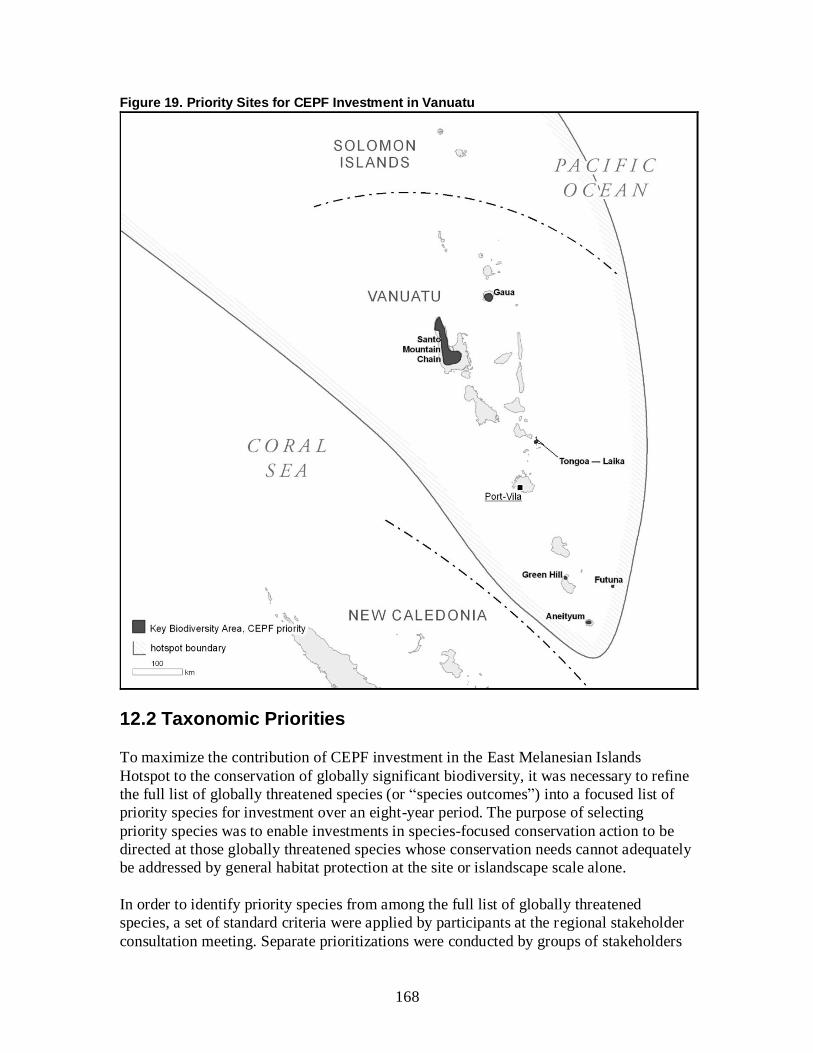
168
Figure 19. Priority Sites for CEPF Investment in Vanuatu
12.2 Taxonomic Priorities
To maximize the contribution of CEPF investment in the East Melanesian Islands
Hotspot to the conservation of globally significant biodiversity, it was necessary to refine
the full list of globally threatened species (or “species outcomes”) into a focused list of
priority species for investment over an eight-year period. The purpose of selecting
priority species was to enable investments in species-focused conservation action to be
directed at those globally threatened species whose conservation needs cannot adequately
be addressed by general habitat protection at the site or islandscape scale alone.
In order to identify priority species from among the full list of globally threatened
species, a set of standard criteria were applied by participants at the regional stakeholder
consultation meeting. Separate prioritizations were conducted by groups of stakeholders
169
familiar with the biodiversity of PNG, the Solomon Islands and Vanuatu, with species
identified by one or more groups being included on the overall list of priorities for the
hotspot. Due to limitations of time and available expertise, the prioritization criteria were
not applied comprehensively to all species during the workshop. Gaps in the assessment
were filled subsequently, through reference to available secondary information, especially
the species accounts on the IUCN Red List (IUCN 2011).
There were five criteria for selecting priority species from among the full list of globally
threatened species in the hotspot. The first criterion was the global threat status of the
species. Reflecting their status as the species most urgently in need of conservation
action, all CR species were automatically identified as priorities, unless the hotspot did
not support a globally significant population. EN and VU species were only selected as
priorities if the other four criteria were met.
The second criterion was whether the hotspot population is significant for conservation of
the species, relative to the global population; or, in other words, whether actions in the
East Melanesian Islands are an essential part of a successful global conservation strategy
for the species. The idea here was to exclude species for which the great majority of their
global population occurs outside of the hotspot, and for which conservation investment
should, therefore, be directed elsewhere.
The third criterion for selecting priority species was the need for species-focused
conservation action. Such species have conservation needs that cannot adequately be
addressed by general habitat protection alone. The purpose of this criterion was to
exclude species for which conservation of adequate areas of suitable habitat would be
sufficient to support viable populations into the long term and which could, therefore, be
conserved through investments in site conservation. Above and beyond habitat
protection, the main species-focused action required to conserve globally threatened
species in the East Melanesian Islands Hotspot was considered to be control of over-
exploitation, followed by control of invasive species. In addition, a small number of
globally threatened species are so little known that the priority action is research to locate
a viable population that can become the focus of conservation action.
The fourth criterion, urgency of conservation action, was intended to focus attention on
those species that, in the absence of targeted conservation action, would be at greatest
risk of extinction within the hotspot. This criterion was used in addition to Red List
status, to take account of the fact that the populations of some species within the hotspot
may be more threatened than their global threat status implies. For instance, dugong, one
of the most highly threatened mammals in the hotspot, is assessed as VU on the Red List,
because it has large, possibly stable populations along the coasts of Northern Territory
and Western Australia (Marsh 2008).
The fifth criterion, need for additional donor investment, was the most subjective and the
one most likely to undergo abrupt change in future. Nonetheless, it was important to
apply it, to ensure that, as far as possible, CEPF investments do not duplicate those of
other donors. In actual fact, there is relatively little investment in species conservation in
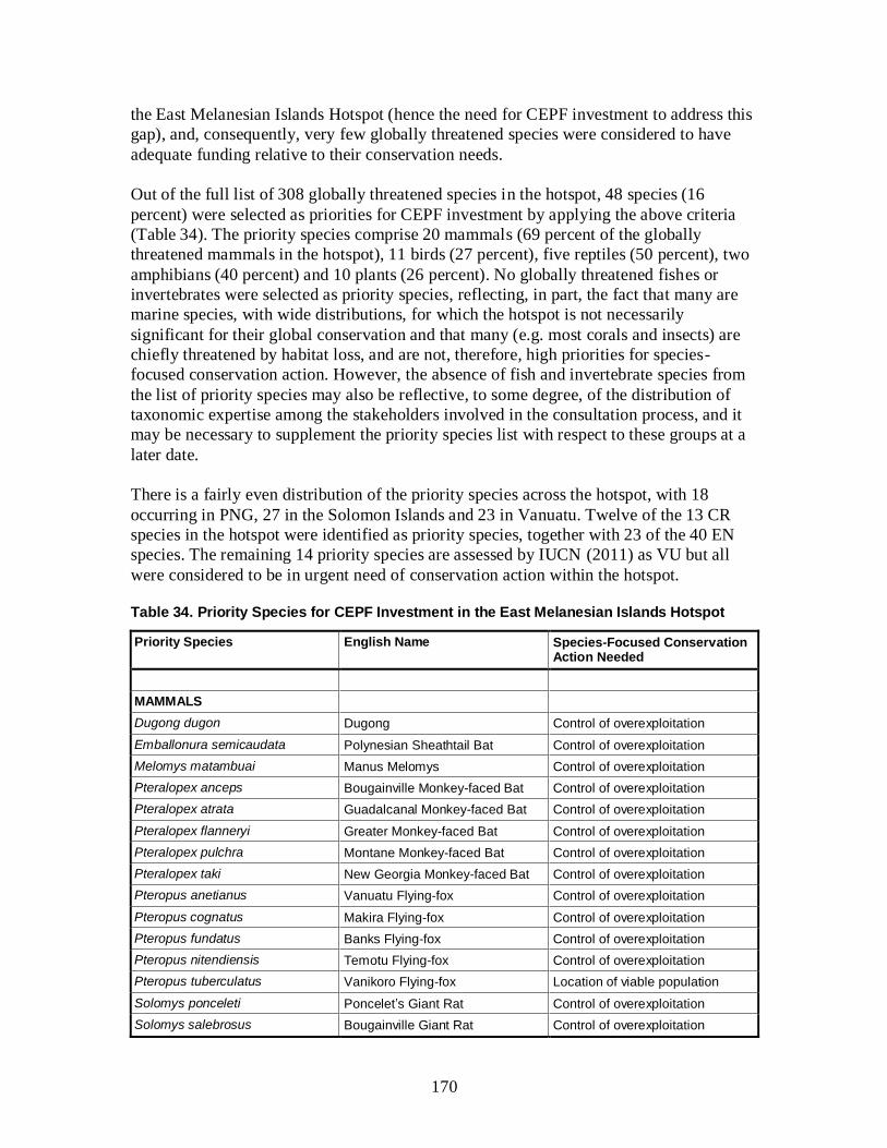
170
the East Melanesian Islands Hotspot (hence the need for CEPF investment to address this
gap), and, consequently, very few globally threatened species were considered to have
adequate funding relative to their conservation needs.
Out of the full list of 308 globally threatened species in the hotspot, 48 species (16
percent) were selected as priorities for CEPF investment by applying the above criteria
(Table 34). The priority species comprise 20 mammals (69 percent of the globally
threatened mammals in the hotspot), 11 birds (27 percent), five reptiles (50 percent), two
amphibians (40 percent) and 10 plants (26 percent). No globally threatened fishes or
invertebrates were selected as priority species, reflecting, in part, the fact that many are
marine species, with wide distributions, for which the hotspot is not necessarily
significant for their global conservation and that many (e.g. most corals and insects) are
chiefly threatened by habitat loss, and are not, therefore, high priorities for species-
focused conservation action. However, the absence of fish and invertebrate species from
the list of priority species may also be reflective, to some degree, of the distribution of
taxonomic expertise among the stakeholders involved in the consultation process, and it
may be necessary to supplement the priority species list with respect to these groups at a
later date.
There is a fairly even distribution of the priority species across the hotspot, with 18
occurring in PNG, 27 in the Solomon Islands and 23 in Vanuatu. Twelve of the 13 CR
species in the hotspot were identified as priority species, together with 23 of the 40 EN
species. The remaining 14 priority species are assessed by IUCN (2011) as VU but all
were considered to be in urgent need of conservation action within the hotspot.
Table 34. Priority Species for CEPF Investment in the East Melanesian Islands Hotspot
Priority Species English Name Species-Focused Conservation Action Needed
MAMMALS
Dugong dugon Dugong Control of overexploitation
Emballonura semicaudata Polynesian Sheathtail Bat Control of overexploitation
Melomys matambuai Manus Melomys Control of overexploitation
Pteralopex anceps Bougainville Monkey-faced Bat Control of overexploitation
Pteralopex atrata Guadalcanal Monkey-faced Bat Control of overexploitation
Pteralopex flanneryi Greater Monkey-faced Bat Control of overexploitation
Pteralopex pulchra Montane Monkey-faced Bat Control of overexploitation
Pteralopex taki New Georgia Monkey-faced Bat Control of overexploitation
Pteropus anetianus Vanuatu Flying-fox Control of overexploitation
Pteropus cognatus Makira Flying-fox Control of overexploitation
Pteropus fundatus Banks Flying-fox Control of overexploitation
Pteropus nitendiensis Temotu Flying-fox Control of overexploitation
Pteropus tuberculatus Vanikoro Flying-fox Location of viable population
Solomys ponceleti Poncelet’s Giant Rat Control of overexploitation
Solomys salebrosus Bougainville Giant Rat Control of overexploitation
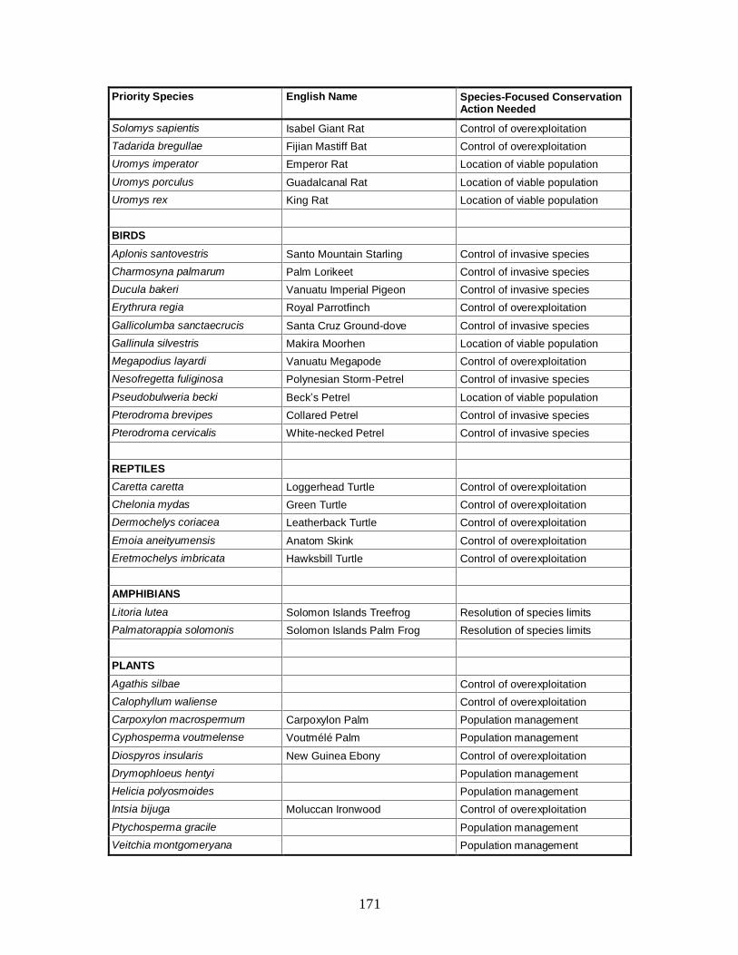
171
Priority Species English Name Species-Focused Conservation Action Needed
Solomys sapientis Isabel Giant Rat Control of overexploitation
Tadarida bregullae Fijian Mastiff Bat Control of overexploitation
Uromys imperator Emperor Rat Location of viable population
Uromys porculus Guadalcanal Rat Location of viable population
Uromys rex King Rat Location of viable population
BIRDS
Aplonis santovestris Santo Mountain Starling Control of invasive species
Charmosyna palmarum Palm Lorikeet Control of invasive species
Ducula bakeri Vanuatu Imperial Pigeon Control of invasive species
Erythrura regia Royal Parrotfinch Control of overexploitation
Gallicolumba sanctaecrucis Santa Cruz Ground-dove Control of invasive species
Gallinula silvestris Makira Moorhen Location of viable population
Megapodius layardi Vanuatu Megapode Control of overexploitation
Nesofregetta fuliginosa Polynesian Storm-Petrel Control of invasive species
Pseudobulweria becki Beck’s Petrel Location of viable population
Pterodroma brevipes Collared Petrel Control of invasive species
Pterodroma cervicalis White-necked Petrel Control of invasive species
REPTILES
Caretta caretta Loggerhead Turtle Control of overexploitation
Chelonia mydas Green Turtle Control of overexploitation
Dermochelys coriacea Leatherback Turtle Control of overexploitation
Emoia aneityumensis Anatom Skink Control of overexploitation
Eretmochelys imbricata Hawksbill Turtle Control of overexploitation
AMPHIBIANS
Litoria lutea Solomon Islands Treefrog Resolution of species limits
Palmatorappia solomonis Solomon Islands Palm Frog Resolution of species limits
PLANTS
Agathis silbae Control of overexploitation
Calophyllum waliense Control of overexploitation
Carpoxylon macrospermum Carpoxylon Palm Population management
Cyphosperma voutmelense Voutmélé Palm Population management
Diospyros insularis New Guinea Ebony Control of overexploitation
Drymophloeus hentyi Population management
Helicia polyosmoides Population management
Intsia bijuga Moluccan Ironwood Control of overexploitation
Ptychosperma gracile Population management
Veitchia montgomeryana Population management
172
In addition to the species in Table 34, 19 species or groups of species of elevated
conservation concern were identified that cannot presently be assessed as priority species
because they are not currently assessed as globally threatened. Two are listed on the
IUCN Red List as Data Deficient, while the others have not yet been evaluated. The
stakeholders proposed these species as candidate priority species because, apart from not
being assessed as globally threatened, they were considered to meet the other selection
criteria for priority species; in particular, they all require species-focused conservation
action. They were, therefore, included on a list of provisional priority species, which
could become eligible for CEPF investment if their global threat status is reassessed in
the future (Appendix 4). However, because whatever new information allows their
categorization as globally threatened may also affect their eligibility as priority species,
they will not automatically become priorities for CEPF investment; further review will be
needed at that stage.
12.3 Strategic Directions and Investment Priorities
This section presents an eight-year investment strategy for CEPF in the East Melanesian
Islands Hotspot, aimed at engaging civil society in the conservation of globally
significant biodiversity. The strategy comprises 15 investment priorities, grouped into
five strategic directions. The strategic directions define the major thrusts of expected
CEPF investment in the hotspot, while the investment priorities outline the particular
types of activities that will be eligible for support. The strategic directions and investment
priorities are summarized in Table 35, and described in more detail afterwards.
The investment strategy for the East Melanesian Islands Hotspot is based upon the
stakeholder consultation workshops conducted between January and May 2012, and also
draws on the findings of the thematic chapters, prepared through desk studies, with a
particular emphasis on alignment with NBSAPs and other national, regional and
international strategies for biodiversity conservation in the hotspot countries (Chapter 6).
At each workshop, stakeholders were asked to identify activities likely to address the
highest priority threats to biodiversity in the hotspot, where civil society could play a
leading role in their implementation (in collaboration with government, where
appropriate), and where additional funding would make a significant difference compared
with baseline levels of conservation investment from governments and international
donors. The suggested activities were then grouped under similar themes to derive draft
investment priorities. The investment strategy addresses many of the priorities identified
by stakeholders during the consultations but to incorporate them all would have been
unrealistic, given the level of funding that is likely to be available for the strategy.
Priority was given to investment priorities that formed a coherent strategy, and that
provided the greatest opportunity to deliver lasting results in terms of delivery of
conservation outcomes on the ground supported by strong and engaged civil society
partnerships.
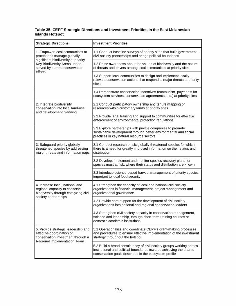
173
Table 35. CEPF Strategic Directions and Investment Priorities in the East Melanesian Islands Hotspot
Strategic Directions Investment Priorities
1. Empower local communities to protect and manage globally significant biodiversity at priority Key Biodiversity Areas under-served by current conservation efforts
1.1 Conduct baseline surveys of priority sites that build government-civil society partnerships and bridge political boundaries
1.2 Raise awareness about the values of biodiversity and the nature of threats and drivers among local communities at priority sites
1.3 Support local communities to design and implement locally relevant conservation actions that respond to major threats at priority sites
1.4 Demonstrate conservation incentives (ecotourism, payments for ecosystem services, conservation agreements, etc.) at priority sites
2. Integrate biodiversity conservation into local land-use and development planning
2.1 Conduct participatory ownership and tenure mapping of resources within customary lands at priority sites
2.2 Provide legal training and support to communities for effective enforcement of environmental protection regulations
2.3 Explore partnerships with private companies to promote sustainable development through better environmental and social practices in key natural resource sectors
3. Safeguard priority globally threatened species by addressing major threats and information gaps
3.1 Conduct research on six globally threatened species for which there is a need for greatly improved information on their status and distribution
3.2 Develop, implement and monitor species recovery plans for species most at risk, where their status and distribution are known
3.3 Introduce science-based harvest management of priority species important to local food security
4. Increase local, national and regional capacity to conserve biodiversity through catalyzing civil society partnerships
4.1 Strengthen the capacity of local and national civil society organizations in financial management, project management and organizational governance
4.2 Provide core support for the development of civil society organizations into national and regional conservation leaders
4.3 Strengthen civil society capacity in conservation management, science and leadership, through short-term training courses at domestic academic institutions
5. Provide strategic leadership and effective coordination of conservation investment through a Regional Implementation Team
5.1 Operationalize and coordinate CEPF’s grant-making processes and procedures to ensure effective implementation of the investment strategy throughout the hotspot
5.2 Build a broad constituency of civil society groups working across institutional and political boundaries towards achieving the shared conservation goals described in the ecosystem profile

174
Strategic Direction 1: Empower local communities to protect and manage globally significant biodiversity at priority Key Biodiversity Areas under-
served by current conservation efforts
The socio-cultural and policy context in the East Melanesian Islands Hotspot, particularly
the prevalence of customary land ownership and resource tenure, coupled with limited
government resources and capacity, means that conventional protected area approaches
are not widely applicable or effective tools for conservation. This is clearly evident at the
few formal protected areas that have been established in the hotspot, such as Queen
Elizabeth National Park on Guadalcanal, which is unmanaged and heavily degraded. On
the other hand, due to their strong cultural links to land, traditional ecological knowledge,
and economic dependence upon natural resources, local communities, if appropriately
organized and supported, are well placed to manage marine and terrestrial resources for
conservation. In addition to being effective tools for conservation, community-based
approaches also provide greater opportunities to engage civil society at all levels in
conservation efforts than do formal protected areas. In particular, by empowering local
communities to make decisions regarding the management of natural resources, they can
help strengthen and maintain community institutions, preserve traditional knowledge, and
contribute to improved livelihoods.
Over the last decade, several approaches to community-based conservation have been
piloted in the hotspot, most notably for nearshore marine ecosystems. As part of a
broader movement across the western Pacific, a network of LMMAs has been established
in the Solomon Islands, with coordination from the Ministry of Fisheries and support
from USP and the MacArthur and Packard foundations. In PNG, TNC and other partners
recently established an LMMA network, which includes sites in the islands region. As
neither network is fully established yet, it is too early to draw lessons but experience from
elsewhere in the western Pacific suggests that LMMAs can contribute to enhanced food
security and livelihood options through the maintenance of healthy marine ecosystems
(Rowe 2007).
Stakeholders consulted during the preparation of the ecosystem profile considered it a
priority to consolidate and amplify the LMMA approach, and demonstrate similar models
for terrestrial ecosystems. Tetepare Community Conservation Area was held up as a good
example of community-based conservation for a terrestrial forest. This site is managed by
the Tetepare Descendents Association, under a community conservation agreement with
SICCP, which compensates landowners for foregone income due to their choice of
conservation over logging.
Investment Priority 1.1 Conduct baseline surveys of priority sites that build
government-civil society partnerships and bridge political boundaries
Twenty priority sites have been identified for CEPF investment (Table 33), of which 11
contain significant areas (> 500 hectares) of marine habitat, and nine are predominantly
terrestrial. A very small number of priority sites (e.g. Santo Mountain Chain) have
benefited from recent, extensive, multidisciplinary biodiversity surveys, which have
confirmed the continued presence of key elements of biodiversity, and determined the

175
distribution and status of key species populations. For the majority of priority sites, such
information is lacking, and this presents a barrier to effective, science-based management
of natural resources, including design of community-managed conservation areas,
introduction of sustainable harvesting regimes for natural resources, and establishment of
long-term monitoring programs to assess the effectiveness of conservation interventions.
This investment priority will provide support for baseline surveys of priority sites that fill
gaps in knowledge with regard to target species. In addition to globally threatened and
restricted-range species, these surveys should also cover species of cultural and economic
importance to local people, and indicators of ecosystem health. The surveys should
involve relevant government institutions and community members, and provide
opportunities for capacity building in taxonomy and ethnobiology. This will help to build
relationships and establish a foundation for longer-term collaboration for site
conservation. Each project supported under this investment priority must demonstrate that
the survey results, and any subsequent conservation actions, will be published in an
appropriate form so they are freely available to other groups wanting to work at the site in
the future. Each project must also demonstrate that the survey is a means to an end, in
terms of developing a foundation of knowledge and relationships for future support to
communities at the site.
Investment Priority 1.2 Raise awareness about the values of biodiversity and the nature
of threats and drivers among local communities at priority sites
During the consultation workshops, low awareness of biodiversity conservation among
local communities, compounded by mixed, inappropriate and, often, confusing messages
from conservation organizations, was identified as a major factor contributing to
biodiversity loss. The consensus was that local communities are generally not motivated
to conserve biodiversity by notions of vulnerability or endemism but by a mixture of
utilitarian and cultural values. Therefore, there is a need to raise awareness about the
values of biodiversity and the need for conservation, and to frame messages in terms of
local communities’ motivation. To be eligible for support under this investment priority,
projects must focus on one or more priority sites, employ locally relevant media and
messaging, and include an evaluation component to assess the effectiveness of the
approach at changing attitudes and awareness.
Investment Priority 1.3 Support local communities to design and implement locally
relevant conservation actions that respond to major threats at priority sites
Building on the foundations of shared knowledge, understanding and trust that will be
established under Investment Priorities 1.1 and 1.2 (or that pre-exist, in a few cases), this
investment priority will provide support to local communities to design and implement
locally relevant conservation actions that respond to major conservation issues that they
have identified. Where communities have the necessary capacity and legal standing
(e.g. through officially registered CBOs), this support could be provided directly. More
commonly, however, it will need to be provided indirectly, via a national or international
civil society partner, combined with mentoring and capacity building.
176
The stakeholder consultations identified a number of common success factors among
existing community-based conservation initiatives in the hotspot, and projects should take
these into account. First, there should be strong community involvement and ownership
in design and implementation of conservation actions from inception, based on good
awareness of the issues. Second, conservation actions should address local people’s
priorities, including livelihoods and food security, but communities should have realistic
expectations about project benefits. Third, management plans for community-managed
conservation areas should be clear and simple, with descriptive rules. Fourth,
management should incorporate traditional ecological knowledge and customary and
religious conservation practices, with scientific support where relevant. Fifth, projects
should be based on long-term partnerships, with clearly defined roles and responsibilities
for all partners. Sixth, projects should align closely with provincial or local government
initiatives for resource management in key sectors.
Investment Priority 1.4 Demonstrate conservation incentives (ecotourism, payments for
ecosystem services, conservation agreements, etc.) at priority sites
Almost without exception, the marine and terrestrial resources within the priority sites
make a major contribution to the livelihoods and food security of local communities. In
many cases, however, population growth, increased material expectations and household
cash needs are driving unsustainable exploitation of these resources, undermining the
natural resource base that supports the traditional economy. The contribution of
biodiversity to livelihoods and food security can provide a strong motivation for local
people to engage in conservation. However, simply providing benefits to local
communities may not be sufficient to catalyze behavioral change; to be effective, there
need to be clear linkages between livelihood benefits and conservation goals.
Under this investment priority, support will be given to projects that demonstrate
conservation incentives at priority sites. Some approaches may be adapted from existing
experience in the hotspot. For instance, establishment of LMMAs can provide direct
livelihood benefits in terms of increased fisheries production. Other approaches may be
based on experience from elsewhere. For instance, there is growing body of experience
that negotiated agreements provide an effective tool for linking livelihood support to
conservation actions (e.g. Conservation Stewards Program 2012). It must be recognized,
however, that there a suite of drivers that motivate communities to take conservation
action, and that each approach must be tailored to the specific community and developed
with its full participation and consent.
Strategic Direction 2: Integrate biodiversity conservation into local land-use
and development planning
Natural ecosystems across the hotspot are being degraded and fragmented, with a
consequent loss of biodiversity and diminution of the essential goods and services they
provide. Some threats are local in origin, arising from population growth and rising
expectations and need for cash generation among local communities; these are addressed
by Strategic Direction 1. Other threats originate from provincial, national and global
development trends, and require different strategies to address.
177
Community-based conservation efforts risk being undermined by incompatible
development and land-use decisions, such as expansion of commercial logging,
plantations or mining. At some priority sites, these threats are already evident. For
instance, there is an active logging concession within East Makira KBA and an operating
gold mine within Guadalcanal Watersheds KBA, while part of Gaua KBA is leased to a
foreign company for cattle ranching. Elsewhere, these threats are imminent. For example,
hydropower dams are proposed in Guadalcanal, and most of the Solomon Islands are
under mineral exploration licenses. These threats are being driven by international market
demand for timber, metals and agricultural commodities, and national governments’ need
to generate foreign exchange. These drivers are compounded by a lack of integration of
the economic values of biodiversity and ecosystem services into land-use and
development planning. Consequently, there is a pressing need to support such integration,
particularly at the local level, where national policies and development trends are played
out.
This strategic direction is in line with Millennium Development Goal No. 7 of the United
Nations, which sets a target for the global community to “integrate the principles of
sustainable development into country policies and programs and reverse the loss of
environmental resources”. It also addresses Aichi Biodiversity Targets 2, that “by 2020,
at the latest, biodiversity values have been integrated into national and local development
and poverty reduction strategies and planning processes”, and 7, that “by 2020 areas
under agriculture, aquaculture and forestry are managed sustainably, ensuring
conservation of biodiversity” (SCBD 2010).
Investment Priority 2.1 Conduct participatory ownership and tenure mapping of
resources within customary lands at priority sites
In theory, customary ownership and tenure should make access to land and resources for
companies operating in the timber, mining or agro-industry sectors extremely difficult, as
consent from the community as a whole would be a prerequisite for operations. In reality
however, unclear or contested ownership and tenure arrangements over land and natural
resources enable companies to gain temporary access, by circumventing collective
decision-making processes and working directly with local elites. This investment
priority will strengthen the voice and legal rights of local communities in land-use and
development decision making at priority sites by clarifying ownership and tenure
arrangements over natural resources within customary lands. This activity will only be
relevant to some priority sites, and will involve some form of dispute
resolution/grievance mechanism, whereby overlapping claims among or within
communities can be resolved. As well as empowering communities to engage in
discussions with natural resource companies wishing to operate on their customary lands,
mapping tenure rights over natural resources can also contribute to subsequent
development of management plans for priority sites under Investment Priority 1.3.
Investment Priority 2.2 Provide legal training and support to communities for effective
enforcement of environmental protection regulations
The traditional rights of communities over land and natural resources are enshrined in the
constitutions of the three hotspot countries. In theory, most natural resources are under
178
the custody of the local communities who own them, and the national government should
only issue extraction rights after agreements have been made between natural resources
companies and landowners. In reality, however, the formal regulations governing
commercial agriculture, timber rights acquisition and mine licensing are often not well
understood by affected communities or not consistently applied by the concerned
authorities. As a result, natural resource companies are able to gain access to land and
resources without following due process, communities are losing access to their
traditional lands, and biodiversity is being eroded.
This investment priority will support civil society organizations to provide training and
outreach to communities affected by logging, mining, commercial agriculture and other
development projects incompatible with the goal of biodiversity conservation. The
purpose of this support will be to ensure that communities understand due process in
environmental licensing for development projects, and have access to legal redress if it is
not followed.
Investment Priority 2.3 Explore partnerships with private companies to promote
sustainable development through better environmental and social practices in key
natural resource sectors
Not all development projects in the natural resource sectors are necessarily detrimental to
biodiversity or the interests of local communities. Provided that adequate safeguards are
in place to minimize and mitigate environmental and social impacts, logging, mining,
commercial agriculture and hydropower projects can all deliver significant net benefits at
local, sub-national and national levels. For example, the impacts of existing logging
concessions could be greatly reduced by introducing sustainable harvesting practices,
such as longer inter-harvest intervals, back-felling and preservation of riparian strips.
This investment priority will support civil society organizations to explore and develop
partnerships with private companies operating in the key natural resources sectors of
forestry, fisheries, agriculture, mining and energy to develop and pilot better
environmental and social practices. These practices could draw on global standards for
sustainable business practices, such as the Forest Stewardship Council Principles and
Criteria for Forest Stewardship (FSC 1996), but should be adapted to the local context in
the East Melanesian Islands Hotspot.
Strategic Direction 3: Safeguard priority globally threatened species by
addressing major threats and information gaps
The East Melanesian Islands Hotspot is typical for a tropical archipelago in that it
supports high levels of plant and animal endemism. The restricted distributions of the
hotspot’s endemic species make them vulnerable to localized threats, and a significant
proportion are assessed as globally threatened (Section 3.5). The most common threat
affecting globally threatened species in the hotspot is habitat degradation and loss, and
this is addressed by Strategic Directions 1 and 2. However, a number of globally
threatened species have conservation needs that are not fully addressed by habitat
protection, especially control of over-exploitation and control of invasive species. It is for
such species that this strategic direction is included.
179
Despite supporting 308 globally threatened species (Appendix 1) plus a large number of
locally endemic species that have not yet been evaluated under the Red List criteria, the
East Melanesian Islands Hotspot currently receives almost no funding for species-focused
conservation, whether from national governments or international donors (Chapter 10). In
part, this reflects an overall lack of resources for conservation in the hotspot, and in part
this reflects a focus on ecosystem approaches, which take an integrated approach to the
conservation of whole ecosystems. While the conservation of many species can be
addressed through conservation of representative examples of natural ecosystems, certain
species require focused conservation action to avert their extinction. This strategic
direction addresses Aichi Biodiversity Target 12, that “by 2020 the extinction of known
threatened species has been prevented and their conservation status, particularly of those
most in decline, has been improved and sustained” (SCBC 2010). This strategic direction
is restricted to the 48 priority species listed in Table 34 but is not geographically
restricted to the priority sites.
Investment Priority 3.1 Conduct research on six globally threatened species for which
there is a need for greatly improved information on their status and distribution
Six priority species require greatly improved information on their status and distribution
before conservation action can be taken in any meaningful way (Table 34). These
comprise four mammals (Vanikoro flying-fox, emperor rat, Guadalcanal rat and king rat
(Uromys rex)) and one bird (Makira moorhen) with no confirmed records from the last 25
years, plus one bird (Beck’s petrel) that was recently discovered after a gap of almost 80
years but whose breeding grounds (where the main threats are thought to operate) are
unknown. Under this investment priority, civil society organizations will be supported to
undertake applied research on the status, abundance, ecology and distribution of these
species, evaluate the threats facing any remnant populations found, and disseminate the
results through freely accessible journal articles or other open media.
Although the conservation of all globally threatened species would benefit from
improved information, this investment priority is reserved for just six species that are not
confirmed to persist at any site. If potentially viable populations of any of the six species
are located during the CEPF investment period, they will automatically become eligible
for support under Investment Priorities 3.2 and 3.3.
Investment Priority 3.2 Develop, implement and monitor species recovery plans for
species most at risk, where their status and distribution are known
For the other 42 priority species (Table 34), there is sufficient knowledge about their
status and distribution to commence conservation action to address the most urgent
threats facing them. For many species, the most urgent threat is over-exploitation. For
instance, many bats are vulnerable to hunting because of their communal roosting habits,
while marine turtles are vulnerable to egg collection at their nesting beaches. For other
species, invasive species present the most urgent threat. For example, Pacific rats and
feral house cats are a major threat to seabird colonies, such as around the Banks Islands in
Vanuatu. For some plant species, their population is so reduced that active population
management is required to avert extinction. This is the case for carpoxylon palm

180
(Carpoxylon macrospermum), for example, whose wild population numbers around 40
individuals.
Under this investment priority, civil society organizations will be resourced to develop,
implement and monitor recovery plans for priority species. These plans must be
developed in collaboration with relevant government institutions, and with the full
participation of local communities. The bulk of CEPF funding under this investment
priority will be made available for implementation of conservation actions, although
some resources will be made available for the development of species recovery plans
where they do not already exist and where there is a clear commitment to turn planning
into action.
Investment Priority 3.3 Introduce science-based harvest management of priority
species important to local food security
As mentioned above, over-exploitation is the most common issue requiring species-
focused conservation action for the priority species. In some cases, the species in question
is of marginal significance to local livelihoods or food security, and a complete
moratorium on off-take is straightforward. In other cases, the status of the species is
simply too fragile to permit any off-take, and a complete moratorium is the only
alternative to extinction. For some priority species, however, the species is of importance
to local food security, and has populations that can support regulated harvest. These
species potentially include Vanuatu megapode (Megapodius layardi) and several seabirds
whose eggs are widely harvested, as well as several species of bat that are hunted for
food.
Under this investment priority, civil society organizations will establish sustainable yields
for priority species where appropriate to do so, develop science-based harvesting plans,
and integrate these into community-based management plans for populations of the
species. All projects should be conducted on a pilot basis, in line with government
regulations on harvest of natural resources, and results should be documented and
disseminated in open-access formats. Where relevant, projects should be based upon
existing customary management practices, such as the taboo governing collection of
megapode eggs on Ambrym, which may have significantly reduced human disturbance
(O’Brien et al. 2003). Research into sustainable yields and harvesting practices will only
be eligible for support as part of projects that lead to the development and introduction of
science-based harvesting plans.
Strategic Direction 4: Increase local, national and regional capacity to
conserve biodiversity through catalyzing civil society partnerships
Capacity building for civil society in one form or another was identified as a thematic
priority for CEPF investment at all of the stakeholder consultations. Capacity building is
required to ensure the effective delivery of Strategic Directions 1, 2 and 3, at three levels:
(i) individual, in terms of conservation practitioners and researchers with necessary skills
in biodiversity survey, community engagement and outreach, and biodiversity
management; (ii) organizational, in terms of skilled, authoritative and accountable civil

181
society organizations; and (iii) network, in terms of strong and active partnerships
facilitating exchange of skills and knowledge, and providing mutual support. Beyond the
immediate delivery of the investment strategy, a stronger civil society sector, led by
conservation leaders drawn from within the hotspot, will also be central to securing the
impacts of CEPF projects into the long term, in the face of new pressures emerging from
future social, political, economic and climatic changes.
Prior to awarding grants under this strategic direction, the Regional Implementation
Team (see Strategic Direction 5) should map out the landscape of CBOs and local NGOs
active at the 20 priority sites, and explore mentoring or partnership opportunities with
national civil society organizations. The aim will be to facilitate the development of
partnerships or networks of civil society organizations at different levels, with
complementary skills, resources and relationships, which are able to address threats to
biodiversity originating at local, provincial or national levels.
CEPF support will not, however, be limited to civil society organizations working at
priority sites or on the conservation of priority species. Where engaging civil society
organizations working in other areas would create opportunities to build stronger civil
society partnerships, these will also be eligible for support. Moreover, CEPF support will
not necessarily by limited to groups currently working on conservation but will be
available to other civil society organizations with the potential to contribute positively to
biodiversity conservation. For example, there are several NGOs focused on human rights
in the PNG islands that could focus on community outreach and training on
environmental law, while, throughout the hotspot, churches and other faith-based
organizations have a major influence on people’s behavior and attitudes towards nature.
Investment Priority 4.1 Strengthen the capacity of local and national civil society
organizations in financial management, project management and organizational
governance
The financial controls, management capacity and governance arrangements of many local
and national civil society organizations, especially CBOs, are not to the standards that
many international donors are comfortable with. For example, many organizations are too
small to be able to recruit qualified accountants. INGOs and the larger national and
regional civil society organizations, on the other hand, do have the capacity to handle
grants, including large ones, from international donors, as well as to actively fundraise.
Given these disparities among different civil society organizations, partnerships can be an
effective strategy to make donor funding available to the organizations that are best
placed to engage with local communities and deliver lasting results on the ground.
Experience shows that partnerships maintaining an explicit focus on capacity building
can build the capacity of CBOs and local NGOs to the point at which they can
successfully secure funding themselves, such as from the GEF Small Grants Programme.
Under this investment priority, civil society organizations will provide capacity building
to local and national organizations within their formal or informal partnerships and
networks. Capacity building may take the form of training in financial management and
project management but it may also include mentoring to facilitate the development of
182
appropriate governance arrangements, which are a critical element in organizational
capacity and sustainability. Capacity building should be provided within the context of
partnerships or networks with explicit codes of conduct or social contracts among their
members, to ensure that issues of power, equity and accountability are given due
consideration.
Investment Priority 4.2 Provide core support for the development of civil society
organizations into national and regional conservation leaders
The conservation-focused civil society sector in all three hotspot countries remains
dominated by international organizations. While international organizations provide an
important channel for external funding and technical expertise, they do not always have
the local relationships and legitimacy, or the stability of mission, necessary to support
successful, long-term conservation interventions on the ground. There is a need,
therefore, to support the emergence of national and regional conservation leaders that can
advocate for conservation objectives at these levels, and strengthen, coordinate and give
voice to grassroots organizations and local communities engaged in conservation.
The analysis of the civil society context for conservation (Chapter 7) identifies lack of
long-term support for core costs as a key constraint on the development of civil society
organizations in the hotspot. Most national and regional civil society organizations
working on conservation issues in the hotspot are dependent upon grant funding to
sustain their operations. Funding cycles are typically only one to three years in length,
making it difficult for these organizations to invest in professional development, retain
trained staff or compete with the private sector on salaries and benefits. As a result,
national and regional civil society organizations report high levels of staff turnover, with
ensuing implications for technical capacity, relationships with local communities, and
institutional memory. The instability of funding for civil society organizations also has an
impact on individual capacity, as it is very difficult for individuals to pursue a career path
within civil society; most professionals working in conservation spend periods working in
government or the private sector, not necessarily on related issues, because of limited job
security and career development opportunities within the civil society sector. This
investment priority will foster the organizational development of national and regional
civil society organizations by covering their core operating costs for a fixed period, to
enable them to invest in developing and retaining a core of skilled staff, diversify their
funding sources to reduce dependence on short-term grants, and take on leadership roles.
Investment Priority 4.3 Strengthen civil society capacity in conservation management,
science and leadership, through short-term training courses at domestic academic
institutions
The stakeholders consulted during the preparation of the ecosystem profile recommended
that the most cost-effective way to invest in the development of individual capacity for
biodiversity conservation in the hotspot would be to take advantage of established
programs at academic institutions in the region to provide short-term training courses for
conservation professionals. Experience with similar initiatives in the past has been
positive, although several stakeholders identified financial sustainability as a challenge.
Consequently, to be eligible for support under this investment priority, applicants must
183
demonstrate a clear commitment to ensuring institutional and financial sustainability. In
addition, training courses must be short-term (undergraduate and postgraduate programs
will not be eligible for support) and focus on conservation management, conservation
science and/or conservation leadership.
Strategic Direction 5: Provide strategic leadership and effective coordination of conservation investment through a Regional Implementation Team
In every hotspot approved for investment from July 2007 onwards, CEPF will support a
Regional Implementation Team to convert the plans in the ecosystem profile into a
cohesive portfolio of grants that exceeds in impact the sum of its parts. Each Regional
Implementation Team will consist of one or more civil society organizations active in
conservation in the hotspot. For example, a team could be a partnership of civil society
organizations or it could be a lead organization with a formal plan to engage others in
overseeing implementation, such as through an inclusive advisory committee.
The Regional Implementation Team will be selected by the CEPF Donor Council based
on an approved terms of reference, competitive process and selection criteria available at
www.cepf.net. The team will operate in a transparent and open manner, consistent with
CEPF’s mission and all provisions of the CEPF Operational Manual. Organizations that
are members of the Regional Implementation Team will not be eligible to apply for other
CEPF grants within the East Melanesian Islands Hotspot. However, grant applications
from formal affiliates of those organizations that have an independent board of directors
will be accepted and will be subject to additional external review.
The Regional Implementation Team will provide strategic leadership and local
knowledge to build a broad constituency of civil society groups working across
institutional and political boundaries toward achieving the conservation goals described
in the ecosystem profile. The team’s major functions and specific activities will be based
on an approved terms of reference. Each major function is regarded as being distinctly
administrative, or distinctly programmatic. As these types of function are very different,
they are assigned to separate investment priorities.
Investment Priority 5.1 Operationalize and coordinate CEPF’s grant-making processes
and procedures to ensure effective implementation of the investment strategy
throughout the hotspot
This investment priority covers the three functions in the Regional Implementation
Team’s terms of reference that are administrative in nature:
i) Establish and coordinate a process for proposal solicitation and review.
ii) Manage a program of small grants (less than US$20,000).
iii) Provide reporting and monitoring.
Administrative costs are those expenses incurred by the Regional Implementation Team
to support the various aspects of CEPF grant making. For large grants, the Regional

184
Implementation Team assists applicants and the CEPF Secretariat by reviewing and
processing grant applications, ensuring compliance with CEPF policies, and facilitating
on-time and accurate grantee and portfolio reporting and monitoring. In particular, the
Regional Implementation Team has a very important role to play in soliciting and
reviewing proposals. This role encompasses a wide range of activities, from issuing calls
for proposals to establishing review committees to making final recommendations for
approval or rejection. While much of this work is labeled as administrative, it does have a
sound programmatic foundation, as grants need to be strategic and of high quality. As
such, the activities covered under this investment priority include evaluation of
applications and making recommendations on which projects to support. These tasks
require technical expertise, knowledge of strategy, and the ability to understand that all
selected projects will make a unique contribution to the achievement of CEPF’s
objectives.
The Regional Implementation Team also assumes significant administrative
responsibilities as manager of CEPF’s small granting mechanism, including budgeting,
processing proposals, and drafting and monitoring contracts. Small grants play an
extremely important role in the CEPF portfolio. These grants can address themes or
geographic areas of importance, serve as planning grants, or provide opportunities to
engage local and grassroots groups that may not have the capacity to implement large
grants. The strategic role that these grants should play cannot be underestimated.
Therefore, although most of the activities pertaining to this function are administrative,
two very important ones must be highlighted: (i) conduct strategic oversight of the small
grants portfolio to ensure coherence with the overall grant portfolio, CEPF donor partners
and others active in the hotspot; and (ii) decide on the award of all grant applications.
Without these activities, both of which ensure that small grants are integrated and
strategic, the small grants program would not be able to contribute to the achievement of
CEPF’s objectives.
This investment priority also covers reporting and monitoring. This entails collecting data
on portfolio performance, ensuring compliance with reporting requirements, ensuring that
grantees understand and comply with social and environmental safeguard policies, and
reviewing reports. It also includes site visits to grants, which may identify needs for
follow-up capacity building. This will ensure effective project implementation and
monitoring, and requires technical expertise to be performed effectively and inform
adaptive management.
Investment Priority 5.2 Build a broad constituency of civil society groups working
across institutional and political boundaries towards achieving the shared conservation
goals described in the ecosystem profile
This investment priority covers the two functions in the Regional Implementation Team’s
terms of reference that are programmatic in nature:
iv) Coordinate and communicate CEPF investment, build partnerships and promote
information exchange in the hotspot.
v) Build the capacity of grantees.

185
These functions include programmatic duties that directly support strategic development
of the grant portfolio and contribute in their own right to the achievement of conservation
results that yield portfolio-wide benefits. Such duties include facilitating learning
exchanges among grantees and other stakeholders, identifying leveraging opportunities
for CEPF, and aligning CEPF investment with investments by other donors.
Programmatic functions require the Regional Implementation Team to maintain in-house
conservation expertise to ensure that CEPF funds are strategically channeled to optimize
the achievement of its conservation objectives.
A critical programmatic function covered by this investment priority, especially in the
context of the East Melanesian Islands Hotspot, is to coordinate different CEPF
investments and facilitate partnership building among different actors. The Regional
Implementation Team will be responsible for identifying local civil society organizations
active at the 20 priority sites, facilitating partnerships between them and the national civil
society organizations best placed to provide technical and financial support, and building
networks of civil society organizations at the national and regional levels to address
issues of common concern.
This investment priority also covers capacity building, a function that is regarded as
being at the core of the Regional Implementation Team’s responsibilities. It places the
Regional Implementation Team at the heart of strategy implementation by making it
responsible for coordination, communication, collaboration and liaison with donors,
partners, governments and other stakeholders. It also puts the Regional Implementation
Team in charge of ensuring that the CEPF grant portfolio is geared to meeting the
objectives laid out in the ecosystem profile. It includes the promotion of synergies
between CEPF’s objectives and local, national and regional initiatives.
This function focuses on building the capacity of domestic civil society organizations to
access and make effective use of CEPF funding. It is a cornerstone of the Regional
Implementation Team’s work to ensure that partners have the institutional and individual
ability to design and implement projects that contribute to the targets of the investment
strategy. This is not capacity building for its own sake; rather, it is specifically targeted at
appropriate strategic stakeholders to ensure delivery of CEPF’s objectives through
improved projects and higher quality implementation. Experience has shown that these
capacity building efforts are essential to ensuring good projects that are integrated into a
wider hotspot strategy and a common conservation vision. Capacity building for civil
society organizations in project design, implementation and reporting will also help them
access funding from other available funding sources, such as the Mama Graun
Conservation Trust Fund, the Vanuatu Biodiversity Conservation Trust Fund (see Section
10.5.1) and the GEF Small Grants Programme (see Section 10.2.2), and thereby
contribute to the sustainability of CEPF investments. Other aspects of capacity building
for civil society in the hotspot are addressed by Strategic Direction 4.

186
13. SUSTAINABILITY
Sustainability is achieved if the impacts of CEPF’s investments are maintained beyond
the lifetime of the funding, and if the desired outcomes are ultimately achieved. Strategies
to achieve this must be built into the very fabric of the investment strategy itself. The
approach suggested for the East Melanesian Islands Hotspot has been developed with this
very much in mind. Some of the key factors to achieve sustainability are:
Mainstreaming.
Sustainable financing.
Commitment.
Partnerships.
Capacity.
Mainstreaming suggests that the key components, outputs and lessons-learned of a
project or initiative become part of the long-term program of established conservation
agencies within the country or region. The most important of these are governments and
local communities. Governments will always be there making policies that affect
biodiversity and communities will always be there managing biodiversity on a day-to-day
basis. The importance of these agencies has been reflected in the process to develop the
investment strategy, in which special emphasis was made to involve government officials
and communities. Moreover, the process has paid particular attention to ensuring that the
investment strategy fits and aligns with NBSAPs and other national conservation
strategies developed by the governments of the hotspot countries. This is in line with
commitments to harmonization of international development assistance under the 2005
Paris Declaration on Aid Effectiveness and the 2009 Cairns Compact on Strengthening
Development Coordination in the Pacific (commonly known as the Forum Compact),
which all Pacific states have endorsed.
NBSAPs are the key ongoing roadmap for effective conservation action in the hotspot.
To achieve sustainability, it is important for each country to have its NBSAP translated
into a strategic plan and practical annual workplans. This is being achieved in the hotspot
with support from the Pacific Roundtable on Nature Conservation coordinated by IUCN.
The CEPF investment strategy is designed to be strongly supportive of the
implementation of actions under the NBSAPs and other national conservation strategies.
Specifically, the CEPF investment strategy aligns with the main goals of the NBSAP for
PNG in the following ways:
Strategic Directions 1 (community-based conservation) and 2 (biodiversity
mainstreaming) align with the goal to conserve, sustainably use and manage the
country’s biological diversity.
Strategic Direction 3 (species conservation) aligns with the goal to promote and
strengthen research of the country’s biological diversity and the sustainable
development of the country’s biological resources.

187
Strategic Direction 4 (capacity building) aligns with the goal to strengthen and
promote institutional and human capacity building for biodiversity conservation,
management and sustainable use.
Strategic Direction 5 (Regional Implementation Team) aligns with the goal to
strengthen partnership and promote coordination for conserving biodiversity.
Regarding the NBSAP for the Solomon Islands, the CEPF investment strategy aligns
with the strategic goals in the following ways:
Strategic Direction 1 (community-based conservation) aligns with the goal to
ensure full commitment to a national protected area system by developing
appropriate legislation and protected area design, as well as with the goal to
ensure that people, resource owners and the public are better informed of the
importance and values of biodiversity through research.
Strategic Direction 2 (biodiversity mainstreaming) aligns with the goal to ensure
that the commitment of government and stakeholders to conserving and managing
biodiversity is integrated into national legislation, sectoral plans, policies and
programs.
Strategic Direction 3 (species conservation) aligns with the goal to ensure that
unique plant and animal species are given appropriate levels of protection and are
managed sustainably with a better informed public on their significance, and the
goal to ensure biodiversity of the Solomon Islands is protected from introduced
and modified species, through legislation, monitoring, research and awareness.
Strategic Directions 4 (capacity building) and 5 (Regional Implementation Team)
align with the goal to empower stakeholders to effectively participate in the
conservation and sustainable use of biological resources.
Finally, the CEPF investment strategy aligns with the key objectives of the NBSAP for
Vanuatu as follows:
Strategic Direction 1 (community-based conservation) aligns with the objective to
foster community participation in the management and conservation of
biodiversity, as well as the objective to increase local awareness of the importance
and value of biodiversity.
Strategic Direction 2 (biodiversity mainstreaming) aligns with the objective to
develop appropriate policy, planning and legal mechanisms for the management
of biodiversity.
Strategic Direction 3 (species conservation) aligns with the objective to ensure
sustainable management and conservation of Vanuatu's biodiversity, as well as
the objective to improve our knowledge about biodiversity in Vanuatu.
Strategic Directions 4 (capacity building) and 5 (Regional Implementation Team)
align with the objective to improve the capacity of national and provincial
governments, NGOs and community organizations to manage biodiversity.
National and local civil society organizations can play a critical role, in supporting
governments and communities in their roles as stewards of the natural environment. Such
188
organizations in the East Melanesian Islands can lack appropriate capacity and staying
power, so a key focus of the investment strategy is to help achieve longevity in such
groups (Investment Priority 4.2). Larger INGOs and universities, which have extensive
capacity, can act as mentors, forming long-term partnerships to build capacity in national
and local organizations (Investment Priority 4.1) and also in key individuals in leadership
roles (Investment Priority 4.3). Capacity-building was universally identified as an
important need during the stakeholder consultations. However, it should be recognized
that capacity building is a long process, particularly when working at the community
level, and this is one reason why an extended timeframe is proposed for the East
Melanesian Islands Hotspot.
It is increasingly recognized that a key success factor is meaningful community
engagement in the conservation process. It is critical that all projects funded by CEPF
reflect this and, wherever relevant, adopt a bottom-up participatory approach to involving
local communities. The extended timeframe will allow national, regional and
international organizations, able to provide technical and financial support, to build
relationships and trust at the community level, and, over time, support the emergence of
strong local institutions that can implement sustainable conservation actions.
In order to be effective, conservation actions do not only need to be long-term but also
relevant to local people. For this reason, community wellbeing is identified as a key
approach in the investment strategy. This can be achieved by projects that achieve
increased income for communities, such as by increasing fishing yields through
establishment of LMMAs (Investment Priority 1.3), attracting more fee-paying tourists
through ecotourism ventures (Investment Priority 1.4) or increasing yields from
sustainable harvest of wild plants and animals (Investment Priority 3.3). It can also be
achieved by projects that strengthen local communities’ rights over land and resources,
such as by conducting participatory ownership and tenure mapping (Investment Priority
2.1) or providing legal training and support to landowners affected by incompatible
development projects (Investment Priority 2.2). It should also be recognized that
community cohesion and cultural pride (in preserving rare species) are also elements of
human wellbeing (Investment Priorities 1.2 and 3.2).
Conservation will always cost money, so sustainable financing is a key component of the
CEPF investment strategy. One approach will be to support projects that demonstrate
innovative conservation incentive and financing mechanisms, such as payments for
ecosystem services (Investment Priority 1.4). Another approach will be to support civil
society groups to explore partnerships with the private sector (Investment Priority 2.3).
Large companies operating in the hotspot need to realize that it is to their benefit to
conserve biodiversity and ways should be sought to engage such companies. Fiji Water in
Fiji has recently committed US$5 million to conserve a key biodiversity area and
rehabilitate the watershed from which they extract water, and similar models could be
developed in the East Melanesian Islands. Even mining and logging companies are
becoming increasingly aware of the business case for supporting conservation. A third
approach will be to develop linkages between the RIT, conservation trust funds and the
GEF Small Grants Programme, to align support to civil society organizations, and assist
189
CEPF grantees transition to these more permanent sources of funding. Overall, CEPF’s
focus on building partnerships at all levels that can provide lasting support, financial or
otherwise, for conservation goals will be critical to achieving sustainability.
14. CONCLUSION
In terms of species richness and especially endemism, the East Melanesian Islands are
one of the most biologically important regions on the planet. In addition, the mainly rural
population relies heavily on biodiversity for food security and livelihoods. Local
communities benefit from constitutionally guaranteed customary land ownership and
resource tenure but boundaries are often in dispute. Rural populations have been long
isolated, by barriers of geography and language, which has resulted in a high level of self-
reliance but also cultural differences among groups. Threats to biodiversity have
increased in recent decades through agricultural expansion, of both smallholdings and oil
palm plantations, and the growth of extractive industries, such as logging and mining.
The underlying causes of these threats include population growth, urbanization and
migration patterns, economic growth and increasing consumption.
Over the last two decades, the countries in the hotspot have developed NBSAPs and other
conservation strategies, and INGOs have established programs there. Significant
investment in conservation has been made over this period by different donors but it has
not always delivered the expected results or left a legacy in terms of local capacity and
appreciation of conservation objectives. Nevertheless, domestic civil society
organizations with a focus on biodiversity conservation have begun to emerge in all three
countries. In addition, local communities, sometimes with outside support and sometimes
independently, have responded to the conservation issues facing them with a range of
strategies, often founded on traditional customs and governance arrangements. The
conservation approach to have shown greatest promise in recent years has been
community-managed conservation areas, especially LMMAs; although this requires
significant capacity to be built among both community-based organizations and the
groups that give them technical support, as well as clear communication and monitoring,
to ensure that these areas deliver on the overlapping but different goals of both
communities and conservation organizations. Moreover, there is a need to integrate the
goals of conservation area into the plans and policies of other sectors, so that they are not
undermined by incompatible developments.
In this context, there are significant opportunities for CEPF to support biodiversity
conservation in ways that deliver significant, meaningful benefits to local communities.
However, this will require an engagement longer than the typical five-year period, a
commitment to capacity building at multiple levels, and a readiness to align global
biodiversity priorities with local cultural and development priorities.
To develop its strategy to deliver a program of investment along these lines, CEPF
commissioned a year-long consultative process that involved an expert roundtable
meeting and nine stakeholder consultation workshops, and engaged more than 150
stakeholders from local communities, CSOs, government institutions and donor agencies.
190
The process resulted in a common conservation vision for the hotspot and an eight-year
investment strategy for CEPF. This strategy comprises 15 investment priorities, grouped
under five strategic directions. The successful implementation of this strategy will require
time, persistence and, above all, a commitment to genuine and lasting partnership. The
cooperation and common vision that has been witnessed through the ecosystem profiling
process inspires confidence that such success will be achieved.

191
EAST MELANESIAN ISLANDS LOGICAL FRAMEWORK: 2013-2021
Objective Targets Means of Verification Important Assumptions
Engage civil society in the conservation of globally threatened biodiversity through targeted investments with maximum impact on the highest conservation priorities
20 key biodiversity areas covering 1,549,009 hectares have new or strengthened protection and management. At least 100,000 hectares within production landscapes are managed for biodiversity conservation or sustainable use. At least 5 local land-use or development plans influenced to accommodate biodiversity. 48 globally threatened species have improved conservation status and/or available information on status and distribution. At least 10 partnerships and networks formed among civil society, government and communities to leverage complementary capacities and maximize impact in support of the ecosystem profile. At least 40 civil society organizations, including at least 30 domestic organizations, actively participate in conservation actions guided by the ecosystem profile.
Grantee and Regional Implementation Team performance reports. Annual portfolio overview reports; portfolio midterm and final assessment reports. Protected Areas Tracking Tool (SP1 METT). IUCN Red List of Threatened Species.
The CEPF ecosystem portfolio will effectively guide and coordinate conservation action in the East Melanesian Islands Hotspot. Investments by other donors will support complementary activities that reduce threats to priority sites and species. Political stability will facilitate the implementation of conservation initiatives and improve the operating environment for civil society. Civil society organizations and private companies will be willing to engage in biodiversity conservation, form new partnerships, and adopt innovative approaches.
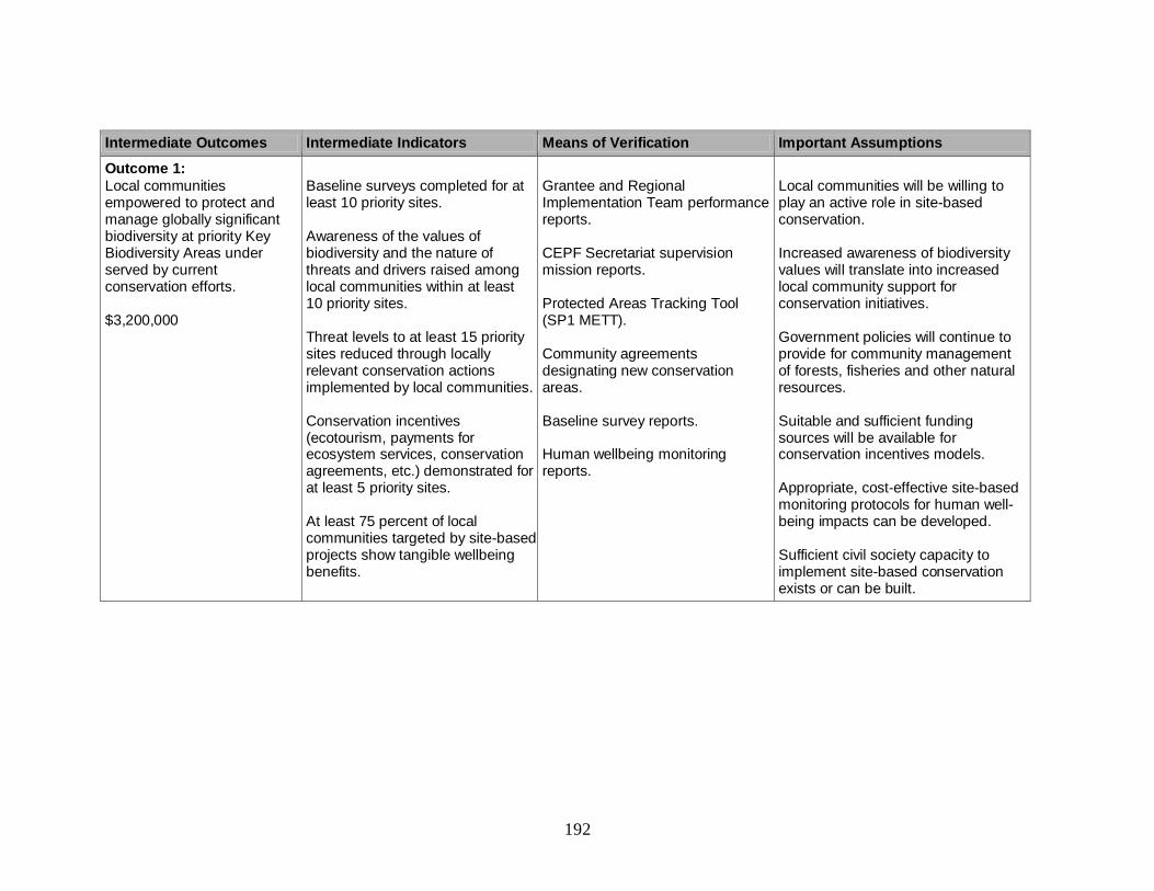
192
Intermediate Outcomes Intermediate Indicators Means of Verification Important Assumptions
Outcome 1:
Local communities empowered to protect and manage globally significant biodiversity at priority Key Biodiversity Areas under served by current conservation efforts. $3,200,000
Baseline surveys completed for at least 10 priority sites. Awareness of the values of biodiversity and the nature of threats and drivers raised among local communities within at least 10 priority sites. Threat levels to at least 15 priority sites reduced through locally relevant conservation actions implemented by local communities. Conservation incentives (ecotourism, payments for ecosystem services, conservation agreements, etc.) demonstrated for at least 5 priority sites. At least 75 percent of local communities targeted by site-based projects show tangible wellbeing benefits.
Grantee and Regional Implementation Team performance reports. CEPF Secretariat supervision mission reports. Protected Areas Tracking Tool (SP1 METT). Community agreements designating new conservation areas. Baseline survey reports. Human wellbeing monitoring reports.
Local communities will be willing to play an active role in site-based conservation. Increased awareness of biodiversity values will translate into increased local community support for conservation initiatives. Government policies will continue to provide for community management of forests, fisheries and other natural resources. Suitable and sufficient funding sources will be available for conservation incentives models. Appropriate, cost-effective site-based monitoring protocols for human well-being impacts can be developed. Sufficient civil society capacity to implement site-based conservation exists or can be built.

193
Intermediate Outcomes Intermediate Indicators Means of Verification Important Assumptions
Outcome 2:
Biodiversity conservation integrated into local land-use and development planning.
$1,000,000
Ownership and tenure rights within customary lands mapped for at least 5 priority sites. At least 10 communities affected by incompatible development projects provided with legal training and support. At least 3 partnerships catalyzed between civil society organizations and natural resource companies to promote sustainable development through better environmental and social practices. Biodiversity and ecosystem service values of at least 5 priority sites integrated into local land-use and/or development plans and policies.
Grantee and Regional Implementation Team performance reports. CEPF Secretariat supervision mission reports. Annual reports of private companies. Local land-use and development plans and policies covering the priority sites.
Governments and donors will remain committed to environmentally sustainable development. Governments will create space for civil society to engage in the review and formulation of local land-use and development plans. Land-use conflicts will not prevent participatory ownership and tenure mapping at the priority sites. Private companies in key natural resource sectors will appreciate the business case for better environmental and social practices. Sufficient civil society capacity to undertake biodiversity mainstreaming exists or can be built.

194
Intermediate Outcomes Intermediate Indicators Means of Verification Important Assumptions
Outcome 3:
Priority globally threatened species safeguarded by addressing major threats and information gaps.
$1,200,000
Knowledge of the status and distribution of at least 5 priority species improved through research Species recovery plans developed, implemented and monitored for at least 20 priority species. Science-based harvest management introduced for at least 3 priority species important to local food security.
Grantee and Regional Implementation Team performance reports. CEPF Secretariat supervision mission reports. IUCN Red List species accounts.
National and customary laws provide an appropriate basis for species-focused conservation action, including sustainable harvest of certain species. Sufficient civil society capacity to implement species-focused conservation exists among civil society or can be built. Governments and donors will remain committed to species conservation, and able to support implementation of species recovery plans.
Outcome 4:
Local and national capacity to conserve biodiversity increased through civil society partnerships. $2,100,000
At least 5 civil society networks enable collective responses to priority and emerging threats. At least 20 domestic civil society organizations demonstrate improvements in organizational capacity. At least two civil society organizations emerge as national conservation leaders in each hotspot country. At least 30 conservationists demonstrate strengthened capacity in conservation management, science and leadership.
Grantee and Regional Implementation Team performance reports. CEPF Secretariat supervision mission reports. Civil society organizational capacity tracking tool. Training needs assessments and evaluation reports.
The operating environment for civil society will remain constant or improve across the hotspot. The key capacity limitations of civil society organizations can be addressed through a combination of capacity building and grant support. National civil society organizations are willing to take on a leadership role. Domestic academic institutions will continue to provide short-term training courses in relevant fields.
195
Intermediate Outcomes Intermediate Indicators Means of Verification Important Assumptions
Outcome 5:
A Regional Implementation Team provides strategic leadership and effectively coordinates CEPF investment in the East
Melanesian Islands Hotspot.
$1,500,000
At least 40 civil society organizations, including at least 30 domestic organizations actively participate in conservation actions guided by the ecosystem profile. At least 80 percent of domestic civil society organizations receiving grants demonstrate more effective capacity to design and implement conservation actions. At least 20 civil society organizations supported by CEPF secure follow-up funding from conservation trust funds and/or the GEF Small Grants Programme. At least 2 participatory assessments are undertaken and lessons learned and best practices from the hotspot are documented.
Regional Implementation Team performance reports. CEPF Secretariat supervision mission reports. Civil society organizational capacity tracking tool.
Qualified organizations will apply to serve as the Regional Implementation Team in line with the approved terms of reference and the ecosystem profile. The CEPF call for proposals will elicit appropriate proposals that advance the goals of the ecosystem profile. Civil society organizations will collaborate with each other, government agencies, and private sector actors in a coordinated regional conservation program in line with the ecosystem profile.
Funding Summary Amount
Total Budget $9,000,000
196
ABBREVIATIONS USED IN THE TEXT ADB Asian Development Bank
AMNH American Museum of Natural History
AusAID Australian Agency for International Development
AVI Australian Volunteers International
AZE Alliance for Zero Extinction
CBC Center for Biodiversity and Conservation
CBO community-based organization
CEPF Critical Ecosystem Partnership Fund
CI Conservation International
CITES Convention on International Trade in Endangered Species of Wild Fauna
and Flora
CR Critically Endangered
DSE Development Services Exchange
ECANSI Environment Concerns Action Network Solomon Islands
EIA environmental impact assessment
EN Endangered
ENSO El Niño/Southern Oscillation
EU European Union
FAO Food and Agriculture Organization of the United Nations
FFA Forum Fisheries Agency
FSPI Foundation of the Peoples of the South Pacific International
GDP gross domestic product
GEF Global Environment Facility
GHG greenhouse gas
GNP Gross National Product
IBA Important Bird Area
ICCO Interchurch Organisation for Development Cooperation
INGO international nongovernmental organization
IPCC Intergovernmental Panel on Climate Change
ITCZ Inter-tropical Convergence Zone
IUCN International Union for the Conservation of Nature
JOCV Japan Overseas Cooperation Volunteers
KBA Key Biodiversity Area
LLG local-level government
LMMA locally managed marine area
LULUCF land use, land-use change and forestry
MGCTF Mama Graun Conservation Trust Fund
MoU memorandum of understanding
Mt million metric tons
NBSAP National Biodiversity Strategy and Action Plan
NGO nongovernmental organization
NOAA National Oceanographic and Atmospheric Administration
NZAID New Zealand Agency for International Development
PNG Papua New Guinea

197
RAMSI Regional Assistance Mission to Solomon Islands
REDD Reducing Emissions from Deforestation and Forest Degradation
SICA Solomon Islands Christian Association
SICCP Solomon Islands Community Conservation Partnership
SIDT Solomon Islands Development Trust
SILMMA Solomon Islands Locally Managed Marine Areas
SPC Secretariat of the Pacific Community
SPCZ South Pacific Convergence Zone
SPREP Secretariat of the Pacific Regional Environment Programme
TNC The Nature Conservancy
TRC Truth and Reconciliation Commission
UNCED United Nations Conference on Environment and Development
UNDP United Nations Development Programme
UNEP United Nations Environment Programme
UNESCO United Nations Educational, Scientific and Cultural Organization
UNFCCC United Nations Framework Convention on Climate Change
UPNG University of Papua New Guinea
USAID United States Agency for International Development
USP University of the South Pacific
VANGO Vanuatu Association of Nongovernmental Organizations
VBCTF Vanuatu Biodiversity Conservation Trust Fund
VSA Volunteer Service Abroad
VSO Volunteer Service Overseas
VU Vulnerable
WCS Wildlife Conservation Society
WWF World Wide Fund for Nature
198
REFERENCES
Agence France Press (2001) The Mortlock Islands sinking. Agence France Press 13
December 2001.
Anon. (2002) Solomon Islands human development report 2002: building a nation.
Volume 1. Main Report. Honiara: Government of the Solomon Islands.
ADB (2003) Pacific region environment strategy. Discussion draft, June 2003. Manila:
Asian Development Bank.
Anon. (2009) 2009 national population and housing census. Port Vila: Vanuatu National
Statistics Office.
ADB (2010) Responding to climate change in the Pacific: moving from strategy to
action. Manila: Asian Development Bank.
Anon. (2012) Preliminary figures, Papua New Guinea census 2011. Port Moresby:
National Statistical Office of Papua New Guinea.
Anon. (undated) Republic of Vanuatu national adaptation programme of action. Port
Vila: National Advisory Committee on Climate Change.
Atkinson, C. T., Woods, K. L., Dusek, R. J., Sileo, L. S. and Iko, W. M. (1995) Wildlife
disease and conservation in Hawaii: Pathogenicity of avian malaria (Plasmodium
relictum) in experimentally infected iiwi (Vestiaria coccinea). Parasitology 111:
S59-S69.
Audra, P., Lauritzen, S. E. and Rochette, P. (2011) Speleogensis in the hyperkarst of the
Nakanai Mountains (New Britain, Papua New Guinea). Evolution model of a
juvenile system (Muruk Cave) inferred from U/Th and palaeomagnetic dating.
Speleogensis 10: 25-30.
AusAID (1995) Forest resources and vegetation mapping of PNG. Canberra: Australian
Agency for International Development.
AusAID (2005) Civil society scoping mission, Papua New Guinea, 15 th to 29th August,
2005. Canberra: Australian Agency for International Development.
AusAID (2006) Solomon Islands national forest resource assessment update. Canberra:
URS Sustainable Development.
AusAID (2007) Mapping AusAID’s engagement with civil society in the PNG country
program. Downloaded from www.ode.ausaid.gov.au on 20 May 2012.
Australian Bureau of Meteorology (2007) South Pacific Sea Level and Climate
Monitoring Project Report. Adelaide: Australian National Tidal Facility.
Australian Bureau of Meteorology (2011) International Climate Change Adaptation
Initiative: Pacific Climate Change Science Programme. Volumes 1 and 2.
Canberra: Australian Government.
Avosa, M. (unpublished) Controversy surrounding the state’s usufruct rights over
indigenous-owned land-based resources and its environment implications in PNG.
Barry, G. (2003) Overview and commentary on “People against foreign NGO
neocolonialism: unheard rainforest conservation voices from Papua New
Guinea”. Downloaded from http://forests.org/archived_site/today/recent/2003/png
newc2.htm on 13 August 2012.
Beehler, B. M., Angle, J. P., Gibbs, D., Hedemark, M. and Kuro, D. (2001) A field
survey of the resident birds of southern New Ireland. Pp 61-66 in Beehler, B. M.

199
and Alonso, L. E. eds. Southern New Ireland, Papua New Guinea: a biodiversity
assessment. Washington, DC: Conservation International.
Berdach, J. T. and Llegu, M. (2007) Solomon Islands: country environmental analysis.
Manila: Asian Development Bank Mainstreaming Environmental Considerations
in Economic and Development Planning Processes Project.
Berdach, J. T. and Mandeakali, L. (2004) Papua New Guinea: country environmental
analysis. Manila: Asian Development Bank Mainstreaming Environmental
Considerations in Economic and Development Planning Processes Project.
BetterAid (2012) CSO analysis of the Busan Partnership. Downloaded from
http://betteraid.org/ en/news/286-latest-news/543-cso-analysis-of-the-busan-
partnership.html on 14 August 2012.
Bezuijen, M., Morgan, C. and Mather, R. (2011) A rapid vulnerability assessment of
coastal habitats and selected species to climate risks. Gland: International Union
for the Conservation of Nature.
Bickford, D., Howard, S. D., Ng, D. J. J. and Sheridan, J. A. (2010) Impacts of climate
change on the amphibians and reptiles of Southeast Asia. Biodiversity and
Conservation 19: 1043-1062.
BirdLife International (2009) Gallinula silvestris. In: IUCN (2011) IUCN Red List of
Threatened Species. Version 2011.2 <www.iucnredlist.org> Downloaded on 16
June 2012.
BirdLife International (2010) Pseudobulweria becki. In: IUCN (2011) IUCN Red List of
Threatened Species. Version 2011.2. <www.iucnredlist.org> Downloaded on 16
June 2012.
Bourke, R. M. and Betitis, T. (2003) Sustainability of agriculture in Bougainville
province, Papua New Guinea. Canberra: Australian National University.
Bourke, R. M., McGregor, A., Allen, M. G., Evans, B. R., Mullen, B. F., Pollard, A. A.,
Wairiu, M. and Zotalis, S. (2006) Solomon islands smallholder agriculture study.
Volume 1: main findings and recommendations. Canberra: Australian Agency for
International Development.
Brodie, T. and Turak, E. (2001) Land-use practices in the Stettin Bay catchment area and
their relation to the status of the coral reefs in the bay. Townsville: Australian
Centre for Tropical Freshwater Research.
Brunton, B. (1998) Forest loss in Papua New Guinea. Downloaded from
http://www.wrm.org.uy/deforestation/Oceania/Papua.html on 29 February 2012.
Buchanan, G. M., Butchart, S. H. M., Dutson, G., Pilgrim, J. D., Steininger, M. K.,
Bishop, K. D. and Mayaux, P. (2008) Using remote sensing to inform conservation
status assessment: estimates of recent deforestation rates on New Britain and the
impacts upon endemic birds. Biological Conservation 141: 55-66.
Burrett, C., Duhig, N., Berry, R. and Varne, R. (1991) Asian and South-western Pacific
continental terranes derived from Gondwana and their biogeographic significance.
Aust. Syst. Bot. 4: 13-24.
Bush, M. B., Silman, M. R. and Urrego, D. H. (2004) 48,000 years of climate and forest
change in a biodiversity hotspot. Science 303: 827-829.
Carter, T. R., Parry, M. L., Harasawa, H. and Nishioka, S. (1994) IPCC technical
guidelines for assessing climate change impacts and adaptation. London and

200
Tsukuba: Department of Geography, University College London, and Center for
Global Environmental Research, National Institute for Environmental Studies.
Central Bank of Solomon Islands (2008) 2007 Central Bank of Solomon Islands annual
report. Honiara: Central Bank of Solomon Islands.
Central Bank of Solomon Islands (2011) 2010 Central Bank of Solomon Islands annual
report. Honiara: Central Bank of Solomon Islands.
Cheatle, R. J. (1987) Strategies and tactics for development of steep land resources in
Solomon Islands. In: Proceedings of International Conference on Steep Land
Agriculture in the Humid Topics. Kuala Lumpur: Mardi Press.
Cheung, W. W. L., Lam, V. W. Y., Sarmiento, J. L., Kearney, K., Watson, R. and Pauly,
D. (2009) Projecting global marine biodiversity impacts under climate change
scenarios. J. of Fish and Fisheries 10: 235-251.
Choat, J., Van Herwerden, L., Robbin, W. and Hobbs, P. (2006) Report of the ecological
surveys undertaken at Middleton and Elizabeth Reefs. Townsville: James Cook
University.
Church, J., Woodworth, P., Aarup, T. and Wilson, S. eds. (2010) Understanding sea level
rise and variability. Oxford: Blackwell Publishing Ltd.
Clarke, P., Millar, I. and Solberger, K. (2008) South Pacific Regional Environmental Law
Capacity Building Project. Scoping report. Gland: IUCN.
Commonwealth of Nations (2012) Solomon Islands. Downloaded from
http://www.commonwealthofnations.org/ on 14 August 2012.
Compagno, L. J. V., White, W. and Fowler, S. (2003) Carcharhinus hemiodon. In: IUCN
(2011) IUCN Red List of Threatened Species. Version 2011.2.
<www.iucnredlist.org> Downloaded on 16 June 2012.
Conservation Stewards Program (2012) Conservation Stewards Program. Downloaded
from http://www.conservation.org/global/csp/Pages/partnerlanding.aspx on 6 July
2012.
Cultural Survival (2010) Asserting traditional rights: community conservation in
Solomon Islands. Downloaded from http://www.culturalsurvival.org/publications/
cultural-survival-quarterly/solomon-islands/asserting-traditional-rights-
community-cons on 14 August 2012.
Curry, G. N., Koczberski, L., Omuru, E., Duigu, J., Yala, C. and Imbun, B. (2007) Social
assessment report for the smallholder agriculture development project (SADP)
Papua New Guinea. Perth: Curtin University of Technology.
Davies, J., Dunne, R. and Brown, B. (1997) Coral bleaching and elevated sea-water
temperature in Milne Bay province, Papua New Guinea, 1996. Marine and
Freshwater Research 48: 513-516.
Deharveng, L., Bedos, A., Prié, V. and Queinnec, E. (2011) Focus on cave terrestrial
habitats. Pp 296-300 in Bouchet, P., Le Guyader, H. and Pascal, E. eds. The
natural history of Santo. Paris: Muséum National d’Histoire Naturelle, IRD and
Pro-Natura.
Deutsch, C. A., Tewksbury, J. J., Huey, R. B., Sheldon, K. S., Ghalambor, C. K., Haak,
D. C. and Martin, P. R. (2008) Impacts of climate change on terrestrial ecotherms
across latitude. Proc. Natl. Acad. Sci. 105(18): 6668-6672.
201
Diamond, J. M. (1975) Assembly of species communities. Pp 342-444 in: Diamond, J. M.
and Cody, M. L. eds. Ecology and evolution of species communities. Cambridge,
USA: Harvard University Press.
Dow, K. and Downing, T. (2006) The atlas of climate change: mapping the world’s
greatest challenge. London: Earthscan.
Dowl, J. L. (1998) Carpoxylon macrospermum. In: IUCN (2011) IUCN Red List of
Threatened Species. Version 2011.2. <www.iucnredlist.org> Downloaded on 16
June 2012.
DSE (2008) Development data base. Second edition. Honiara: Development Services
Exchange.
Duguman, J. (2010) Report on the relocation of the Carteret Islanders, Autonomous
Region of Bougainville, PNG. Apia: United Nations Educational, Scientific and
Cultural Organisation.
Eade, D. (1997) Capacity-building: an approach to people-centred development. Oxford:
Oxfam.
Economist Intelligence Unit (2003) Country profiles: Pacific islands 2003. New York:
Economist Intelligence Unit.
Eddowes, P. J. (1998) Helicia polyosmoides. In: IUCN Red List of Threatened Species.
Version 2011.2. <www.iucnredlist.org> Downloaded on 16 June 2012.
Ellison, J. and Gilman, E. (2004) Manual for American Samoa community-based
mangrove nonitoring: monitoring changes in mangrove community structure and
response to relative sea level rise. Pago Pago: American Samoa Coastal
Management Program, Department of Commerce.
FAO (2011a) Fisheries of the Pacific islands: regional and national information.
Bangkok: Food and Agriculture Organization of the United Nations Regional
Office for Asia and the Pacific.
FAO (2011b) State of the world’s forests. Rome: Food and Agriculture Organization of
the United Nations.
Filardi, C. E., Boseto, D. and Filardi, C. E. (2007) A preliminary desk study identifying
important bird areas (IBAs) in the Solomon Islands. Unpublished draft report
submitted to BirdLife International.
Flannery, T. F. (1995) Mammals of the south-west Pacific and Moluccan islands.
Chatswood: Australian Museum and Reed Books.
Frielink, A. B. J. (1983) Coastal fisheries in Papua New Guinea, the current situation.
Research report. Port Moresby: Department of Primary Industry.
FSC (1996) FSC international standard: FSC principles and criteria for forest
stewardship. Bonn: Forest Stewardship Council.
Gilman, E., Van Lavieren, H., Ellison, J., Jungblut, V., Wilson, L., Areki, F., Brighouse,
G., Bungitak, J., Dus, E., Henry, M., Sauni Jr., I., Kilman, M., Matthews, E.
Teariki-Ruatu, N., Tukia, S. and Yuknavage, K. (2006) Pacific island mangroves
in a changing climate and rising sea. Nairobi: United Nations Environment
Programme.
Global Facility for Disaster Reduction and Recovery (2011) Climate risk and adaptation
country profile: vulnerability, risk reduction and adaptation to climate change:
Solomon Islands. Washington, DC: The World Bank.

202
Global Greengrants Fund (2012) Global Greengrants Fund: for a just and sustainable
world. Downloaded from www.greengrants.org on 16 July 2012.
Government of PNG (1975) Constitution of the Independent State of Papua New Guinea.
Port Moresby: Government of Papua New Guinea.
Government of PNG (1991) National forest policy. Port Moresby: Papua New Guinea
Forest Authority.
Government of PNG (1996) National forest plan. Port Moresby: Papua New Guinea
Forest Authority.
Government of PNG (2000) Initial national communication to the United Nations
Framework Convention on Climate Change. Port Moresby: Government of Papua
New Guinea.
Government of PNG (2007) National biodiversity strategy and action plan. Port
Moresby: Department of Environment and Conservation.
Government of PNG (2010) Papua New Guinea’s fourth national report to the
Convention on Biological Diversity. Port Moresby: Government of Papua New
Guinea.
Government of the Solomon Islands (2001) Initial national communications to the United
Nations Framework Convention on Climate Change. Honiara: Ministry of Culture,
Tourism and Aviation.
Government of the Solomon Islands (2008) Solomon Islands state of environment report
2008. Honiara: Ministry of Environment, Conservation and Meteorology.
Government of the Solomon Islands (2009) Solomon Islands national biodiversity
strategy and action plan. Honiara: Ministry of Environment, Conservation and
Meteorology.
Government of the Solomon Islands (2011) Fourth national report to the Convention on
Biological Diversity. Honiara: Ministry of Environment, Climate Change, Disaster
Management and Meteorology.
Government of Vanuatu (1999a) Vanuatu National Biodiversity Strategy and Action Plan
Project: National Biodiversity Conservation Strategy. Port Vila: Vanuatu
Environment Unit.
Government of Vanuatu (1999b) Vanuatu national communication to the Conference of
the Parties to the United Nations Framework Convention on Climate Change. Port
Vila: Vanuatu Government Press.
Government of Vanuatu (2002) Environmental management and conservation act no. 12.
Port Vila: Government of Vanuatu.
Green, P. S. (1979) Observations on the phytogeography of the New Hebrides, Lord
Howe Island and Norfolk Island. Pp 41-53 in Bramwell, D. ed. Plants and islands.
London: Academic Press.
Greenslade, P. J. M. (1971) Interspecific competition and frequency changes among ants
in Solomon Islands coconut plantations. Journal of Applied Ecology 8: 323-352.
Guinot, D. (1987) Nouvelles decouvertes dans des grotter de Nouvelle-Bretagne du crabe
aveugle Troglapax joliveti Guinot, 1986, et description d’un crabe douce
cavernicole, Sendleria genuitei sp. nov. C. R. Acad. Sci. 305(111): 25-30.
Hackman, B. D. (1973) The Solomon Islands fractured arc. Pp 179-191 in: Coleman, P. J.
ed. The western Pacific: island arcs; marginal seas; geochemistry. Perth:
University of Western Australia Press.

203
Hall, R. (2002) Cenozoic geological and plate tectonic evolution of SE Asia and the SW
Pacific: computer-based reconstructions, model and animations. Journal of Asian
Earth Sciences 20: 353-431.
Hargy Oil Palms Ltd (2012) Hargy Oil Palms Limited. Downloaded from http://www.
hargy.com.pg/ on 14 August 2012.
Hay, J. E., Mimura, N., Campbell, J., Fifita, S., Koshy, K., Mclean, R., Nakalevu, T.,
Nunn, P. and de Wet, N. (2003) Climate variability and change and sea level rise
in the Pacific Island Region: a resource book for policy and decision makers,
educators and other stakeholders. Apia: Secretariat of the Pacific Regional
Environment Programme.
Hay, J. E. and Schuster, C. (2009) NZAID support to the Global Environment Facility’s
Small Grants Programme. Final Report. Unpublished report to the New Zealand
Agency for International Development.
Hay, J. E. and Sem, G. (2000) Vulnerability and adaptation: assessment of vulnerability
and adaptation to climate change. Apia: Secretariat of the Pacific Regional
Environment Programme.
Hills, T., Brooks, A., Atherton, J., Rao, N., and James, R. (2011) Pacific Island
biodiversity, ecosystems and climate change adaptation: building on nature’s
resilience. Apia: Secretariat of the Pacific Regional Environment Programme.
Hole, D. G., Willis, S. G., Pain, D. J., Fishpool, L. D. C., Butchart, S. H. M., Collingham,
Y. C., Rahbek, C. and Huntley, B. (2009) Projected impacts of climate change on a
continent-wide protected area network. Ecology Letters 12: 420-431.
Holloway, R. (2001) Using the Civil Society Index: assessing the health of civil society: a
handbook for using the CIVICUS index on civil society as a self-assessment tool.
Canada: CIVICUS.
Holthus, P., Crawford, C., Makro, C. and Sullivan, S. (1992) Case study: Majuro Atoll,
Republic of Marshall Islands. Apia: Secretariat of the Pacific Regional
Environment Programme.
Houghton, J. T., Meria Filho, L. G., Callander, N. H., Kattenberg, A. and Maskell, K.
eds. (1996) Climate change 1995: the science of climate change. Cambridge, UK
and New York: Cambridge University Press.
Houghton, J. T., Ding, Y., Griggs, D. J., Noguer, M., van der Linden, P. J., Dai, X.,
Maskell, K. and Johnson, C. A. eds. (2001) Climate change 2001: the scientific
basis: contribution of Working Group I to the Third Assessment Report of the
Intergovernmental Panel on Climate Change. Cambridge, UK and New York:
Cambridge University Press.
Hunt, C. (2001) The contribution of forestry to development in selected Pacific island
countries. Port Moresby: National Research Institute.
Institute of Pacific Islands Forestry (2011) Pacific Island Ecosystems at Risk (PIER):
plant threats to Pacific ecosystems. Downloaded from http://www.hear.org/pier/
on 29 February, 2012.
Invasive Species Specialist Group (2003) Global Invasive Species Database.
Downloaded from http://www.issg.org on 2 February 2012.
Isaac, N. J. B., Turvey, S. T., Collen, B., Waterman, C. and Baillie, J. E. M. (2007)
Mammals on the EDGE: conservation priorities based on threat and phylogeny.
PLoS ONE 2(3): e296. Doi: 10.1371/journal.pone.0000296.
204
IUCN (2011) IUCN Red List of Threatened Species. Downloaded from http://www.iucn
redlist.org/ on 2 February 2012.
IUCN and UNEP (2009) The World Database on Protected Areas (WDPA). Cambridge,
UK: United Nations Environment Programme-World Conservation Monitoring
Centre.
James, S. A. (2008) Climate change impacts on native plan communities in Melanesia.
Honolulu: Bishop Museum.
Kaluwin, C., Aung, T. H. and Lennon, G.W. (1998) Climate change and sea level, part 2:
social science. Adelaide: National Tidal Facility, The Flinders University of South
Australia.
Kaluwin, C. and Hay, J. eds. (1998) SPREP report of the 3rd Climate Change and Sea
Level Rise Conference 1997 in New Caledonia. Apia: Secretariat of the Pacific
Regional Environment Programme.
Kay, R. C., Cole, A., Elisara, F. M. and Yamada, K. (1993) Assessment of coastal
vulnerability and resilience to sea level rise and climate change. Case study:
Upolu Island, Western Samoa. Phase I: concepts and approach. Apia: Secretariat
of the Pacific Regional Environment Programme.
King, P. (2007) Country environmental analysis: Vanuatu. Manila: Asian Development
Bank.
Kool, J., Brewer, T., Mills, M. and Pressey, R. (2010) Ridges to reefs conservation for
Solomon Islands. Townsville: ARC Centre of Excellence for Coral Reef Studies,
James Cook University.
Lakshman, C. (2012) Review of legislative and regulations framework governing the
establishment and legal status of the civil society sector in the Pacific member
states of the ACP. Suva: Institute of Justice and Applied Legal Studies, University
of the South Pacific.
Lal, N. P., Kinch, J. and Wickham, F. (2009) Review of economic and livelihood impact
assessments of and adaptation to climate change in Melanesia. Apia: Secretariat of
the Pacific Regional Environment Programme.
Lane, B. M. (2006) Evaluating the governance of coastal resources and environments in
Vanuatu. Apia: Secretariat of the Pacific Regional Environment Programme.
Langhammer, P. E., Bakarr, J. I., Bennun, L. A., Brooks, T. M.. Clay, R. P., Darwall, W.,
De Silva, N., Edgar, G. J., Eken, G., Fishpool, L. D. C., de Fonseca, G. A. B.,
Foster, M. N., Knox, D. H., Matiku, P., Radford, E. A., Rodrigues, A. S. L.,
Salaman, P., Sechrest, W. and Tordoff, A. W. (2007) Identification and gap
analysis of key biodiversity areas: targets for comprehensive protected area
systems. Gland: IUCN.
Leary, T., Hamilton, S. and James, R. (2008a) Pteropus tuberculatus. In: IUCN (2011)
IUCN Red List of Threatened Species. Version 2011.2. <www.iucnredlist.org>
Downloaded on 15 June 2012.
Leary, T., Seri, L., Flannery, T., Wright, D., Hamilton, S., Helgen, K., Singadan, R.,
Allison, A., James, R. and Bonaccorso, F. (2008b) Uromys imperator. In: IUCN
(2011) IUCN Red List of Threatened Species. Version 2011.2.
<www.iucnredlist.org> Downloaded on 15 June 2012.
Leary, T., Wright, D., Hamilton, S., Singadan, R., Menzies, J., Bonaccorso, F., Helgen,
K. and Seri, L. (2008c) Uromys imperator. In: IUCN (2011) IUCN Red List of
205
Threatened Species. Version 2011.2. <www.iucnredlist.org> Downloaded on 15
June 2012.
Lees, A. (1990) A protected forests system for the Solomon Islands. Nelson: Maruia
Society and Canberra: Australian National Parks and Wildlife Service.
Lehodey, P., Bertignac, M., Hampton, J., Lewis, A. and Piaut, J. (1997) El Niño and tuna
in the western Pacific. Nature, 289: 715-717.
Leisz, S. J., Burnett, J. B. and Allison, A. (2009) Climate change and biodiversity in
Melanesia: what do we know? Consensus report. Honolulu: Bishop Museum.
Lewis, M. P. ed. (2009) Ethnologue: languages of the world. Sixteenth Edition. Dallas:
SIL International.
Lidimani, D. L. (2004) Law and civil society organisations in Solomon Islands: a review
of the enabling legislative framework. Country report. Port Moresby: International
Centre for Not for Profit Law.
Lidimani, D. L. (2007) Law and civil society organisations in Papua New Guinea: a
review of the enabling legislative framework. Country report. Port Moresby:
International Centre for Not for Profit Law.
Lipsett-Moore, G. Game, E., Peterson, N., Saxon, E., Sheppard, S., Allison, A., Michael,
J., Singadan, R., Sabi, J., Kula, G. and Gwaibo, R. (2010) Interim national
terrestrial conservation assessment for Papua New Guinea: protecting biodiversity
in a changing climate. Pacific Island Countries Report No. 1/2010. South
Brisbane: The Nature Conservancy.
Low, W. and Davenport, E. (2002) NGO capacity building and sustainability in the
Pacific. Asia Pacific Viewpoint 43(3): 367-379.
MacArthur, R. H. and Wilson, E. O. (1963) An equilibrium theory of insular
zoogeography. Evolution 17(4): 373-387.
Mallick, D. I. J. (1973) Some petrological and structural variations in the New Hebrides.
Pp 193-211 in: Coleman, P. J. ed. The western Pacific: island arcs; marginal seas;
geochemistry. Perth: University of Western Australia Press.
Marquet, G., Taiki, N., Chadderton, L. and Gerbeaux, P. (2002) Biodiversity and
biogeography of freshwater crustaceans (Decapodia: Natantia) from Vanuatu, a
comparison with Fiji and New Caledonia. Bull. Fr. Péche piscic. 364: 217-232.
Marsh, H. (2008) Dugong dugon. In: IUCN (2012) IUCN Red List of Threatened Species.
Version 2012.1. <www.iucnredlist.org> Downloaded on 5 July 2012.
Mayr, E. and Diamond, J. M. (2001) The birds of northern Melanesia: speciation,
ecology and evolution. Oxford: Oxford University Press.
McIlwaine, C. (2007) From local to transitional civil society: re-framing development
perspectives on the non-state sector. Geography Compass 1(6): 1252-1281.
Menzies, N. (2007) Legal pluralism and the post-conflict transition in the Solomon
Islands: kastom, human rights and international interventions. Discussion paper.
Berlin: Hertie School of Governance.
Metz, B., Davidson, O., Bosch, P., Dave, R. and Meyer, L. eds. (2007) Climate change
2007: mitigation of climate change. Cambridge, UK, and New York: Cambridge
University Press.
MGCTF (2009) Mama Graun Conservation Trust Fund. Brochure. Downloaded from
http://toolkit.conservationfinance.org/sites/default/files/documents/communication
s/brochure-2009-mama-graun-png.pdf on 19 August 2012.

206
Mueller-Dombois, D. and Fosberg, F. R. (1998) Vegetation of the tropical Pacific
islands. New York: Springer-Verlag.
National Parliament of Solomon Islands (1996) The provincial government act of 1996.
Downloaded from http://www.parliament.gov.sb/files/legislation/Acts/1996/The%
20Provincial%20Government%20ACT%201996.pdf on 14 August 2012.
New Britain Oil Palm Ltd (2011) Annual report 2011. Kimbe: New Britain Oil Palm Ltd.
Nishida, G. M. and Evenhuis, N. L. (2000) Arthropod pests of significance in the Pacific:
a preliminary assessment of selected groups. Pp 115-142 in Sherley, G. ed.
Invasive species in the Pacific: a technical review and draft strategy. Apia:
Secretariat of the Pacific Regional Environment Programme.
NOAA (2011) National Oceanographic Data Center. Online database accessed at
http://www.nodc.noaa.gov/General/temperature.html on 8 November 2011.
Nunn, P. D. (1998) Pacific island landscapes: landscape and geological development of
southwest Pacific islands, especially Fiji, Samoa and Tonga. Suva: Institute of
Pacific Studies, University of the South Pacific.
Nunn, P. D., Aalbersberg, W., Ravuvu, A. D., Mimura, N. and Yamada, K (1994a)
Assessment of coastal vulnerability and resilience to sea-level rise and climate
change. Case study: Yasawa Islands, Fiji. Phase II: development of methodology.
Apia: Secretariat of the Pacific Regional Environment Programme.
Nunn, P. D., Balogh, E., Ravuvu, A. D., Mimura, N. and Yamada, K. (1994b) Assessment
of coastal vulnerability and resilience to sea-level rise and climate change. Case
study: Savai’i Island, Western Samoa. Phase II: development of methodology.
Apia: Secretariat of the Pacific Regional Environment Programme.
O’Brien, M., Beaumont, D. J., Peacock, M. A., Hills, R. and Edwin, H. (2003) The
Vanuatu megapode Megapodius layardi monitoring and conservation. Sandy:
Royal Society for the Protection of Birds.
Olson, D. M., Dinerstein, E., Wikramanayake, E. D., Burgess, N. D., Powell, G. V. V.,
Underwood, E. C., D’Amico, J. A., Itoua, I., Strand, H. E., Morrison, J. C.,
Loucks, C. J., Allnutt, T. F., Ricketts, T. H., Kura, Y., Lamoreux, J. F., Wettengel,
W. W., Hedao, P. and Kassem, K. R. (2001) Terrestrial ecoregions of the world: a
new map of life on Earth. BioScience 51(11): 933-938.
Packham, G. H. (1973) A speculative phanerozoic history of the south-west Pacific. Pp
369-388 in: Coleman, P. J. ed. The western Pacific: island arcs; marginal Seas;
geochemistry. Perth: University of Western Australia Press.
Pacific Islands Legal Information Institute (2012) PacLII databases. Downloaded from
www.paclii.org/databases.html during May-July 2012.
Parry, M., Canziani, O., Palutiko, F. J. van der Linden, J. and Honson, E. eds. (2007)
Climate change 2007: impacts, adaptation and vulnerability. Cambridge, UK, and
New York: Cambridge University Press.
Pauku, R. L. (2009) Solomon Islands forestry outlook study. Honiara: Solomon Islands
Government.
Polhemus, D. A., Englund, R. A., Allen, G. R., Boseto, D. and Polhemus, J. T. (2008)
Freshwater biotas of the Solomon Islands: analysis of richness, endemism and
threats. Honolulu: Bishop Museum.
PNG Eco-forestry Forum (2010) Iko-forestri Nius April-September 2010. Downloaded
from http://www.ecoforestry.org.pg on 1 May 2012.
207
PNG Forest Authority (1995) Country report on timber trade statistics. Port Moresby:
Papua New Guinea Forest Authority.
PNG Forest Authority (2007) Welcome to the Papua New Guinea Forest Authority
website. Downloaded from http://www.forestry.gov.pg/site/index/php on 10 May
2012.
PNG National Weather Service (2010) Meteorological data provided by the National
Weather Service of the Government of Papua New Guinea.
Pressey, R. L. (1994) Ad hoc reservations: forward or backward steps in developing
representative reserve systems. Conservation Biology 8: 662-668.
Prime Minister and National Executive Council (2010) PNG Vision 2050 report. Port
Moresby: Government of Papua New Guinea.
Ramsar (2011) About the Ramsar Convention. Downloaded from http://www.ramsar.org/
cda/en/ramsar-about-about-ramsar/main/ramsar/1-36%5E7687_4000_0__ on 12
September 2011.
Regenvanu, R. (2007) Making policy to support living cultures: a case study in
‘mainstreaming culture’ from Vanuatu. Paper presented at the conference Islands
at a Crossroads: Cultural Diversities in Small Island Developing States, Victoria,
Seychelles, 11-13 April 2007.
Reid, C., Marshall, J., Logan, D. and Kleine, D. (2010) Coral reefs and climate change.
Brisbane: University of Queensland.
Richards, S. and Parker, F. (2004a) Palmatorappia solomonis. In: IUCN (2012) IUCN
Red List of Threatened Species. Version 2012.1. <www.iucnredlist.org>.
Downloaded on 14 August 2012.
Richards, S. and Parker, F. (2004b) Platymantis akarithymus. In: IUCN (2012) IUCN Red
List of Threatened Species. Version 2012.1. <www.iucnredlist.org>. Downloaded
on 14 August 202.
Rowe, A. (2007) Review of the LMMA network. Final report. Unpublished report to the
MacArthur Foundation and the Packard Foundation.
Salinger, M. J. (2001) Climate variation in New Zealand and southwest Pacific. Pp 130-
149 in Sturman, A. and Spronken-Smith, R. eds. The physical environment: a New
Zealand perspective. Melbourne and Auckland: Oxford University Press.
Sanderson, E. W., Redford, K. H., Vedder, A., Coppolillo, P. B. and Ward, S. E. (2001)
A conceptual model for conservation planning based on landscape species
requirements. Landscape and Urban Planning 878: 1-16.
SCBD (2010) Strategic plan for biodiversity 2011-2020 and the Aichi Targets: living in
harmony with nature. Montreal: Secretariat of the Convention on Biological
Diversity.
Schwartz, M. W. (1999) Choosing the appropriate scale of reserves for conservation.
Annual Review of Ecology and Systematics 30: 83-108.
Sem, G., Hay, J., Campbell, J., Yamada, K., Mimura, N. and Onno, K. (1996) Tuvalu
vulnerability studies 1996. Apia: Secretariat of the Pacific Regional Environment
Programme.
Shearmann, P. L., Bryan, J. E., Ash, J., Hunnam, P., Mackey, B. and Loks, B. (2008) The
state of the forests of Papua New Guinea: mapping the extent and condition of
forest cover and measuring drivers of forest change in the period 1972-2002. Port
Moresby: University of Papua New Guinea.
208
Sheppard, C. (2006) Longer-term impacts of climate change. Pp 392-418 in Cote, I. M.
and Reynolds, J. D. eds. Coral reef conservation. Cambridge, UK: Cambridge
University Press.
Sillitoe, P. (2000) Social change in Melanesia: development and history. Cambridge, UK:
Cambridge University Press.
Sizer, N. and Plouvier, D. (2000) Increased investment and trade by transnational
logging companies in Africa, the Caribbean and the Pacific: implications for the
sustainable management and conservation of tropical forests. Brussels: WWF,
World Resources Institute and the European Commission.
Skilleter, G. and Warren, S. (2000) Report of effects of habitat modification in
mangroves on the structure of mollusk and crab assemblages. Journal of
Experimental Marine Biology and Ecology 244(1): 107-129.
Social Designs (2012) NGO management and capacity building initiatives for GLI (UK)
networks and social entrepreneurs in Tamil Nadu, India. Downloaded from
www.socialdesignsite.com/content/view/317/73 on 19 July 2012.
Solomon, S. D., Qin, M., Manning, Z., Chen, M., Marquis, K., Averyt, B., Tignor, M.
and Miller, H. L. eds. (2007) Climate change 2007: the physical science basis.
Cambridge, UK and New York: Cambridge University Press.
Solomon Islands Curriculum Development Centre (1990) A social studies atlas of
Solomon Islands: an insight into the infra-structure of a developing nation.
Honiara: Curriculum Development Centre Press.
Solomon Islands National Statistics Office (2006) Household income and expenditure
survey 2005/6: national report. Part one. Honiara: National Statistics Office.
Spalding, M. D., Fox, H. E., Allen, G. R., Davidson, N., Ferdana, Z. A., Finlayson, M.,
Halpern, B. S., Jorge, M. A., Lombana, A., Louie, S. A., Martin, K. D., Mcmanus,
E., Molnar, J., Recchia, C. A. and Robertson, J. (2007) Marine ecoregions of the
world: a bioregionalization of coastal and shelf areas. BioScience 57(7): 573-583.
SPC (2011) Vulnerability of tropical Pacific fisheries and aquaculture to climate change.
Noumea: Secretariat of the Pacific Community.
SPREP (1992) The Pacific way: Pacific island developing countries’ report to the United
Nations Conference on Environment and Development. Noumea: Secretariat of the
Pacific Regional Environment Programme.
SPREP (2011) Pacific Islands Framework for Action on Climate Change 2006-2015.
Second edition. Apia: Secretariat of the Pacific Regional Environment Programme.
SPREP and IUCN (2007) Action Strategy for Nature Conservation and Protected Areas
in the Pacific Island Region 2008-2012: empowering local people, communities
and Pacific institutions. Apia: Secretariat of the Pacific Regional Environment
Programme, and Suva: IUCN Oceania Office.
Stattersfield, A. J., Crosby, M. J., Long, A. J. and Wege, D. C. (1998) Endemic bird
areas of the world: priorities for biodiversity conservation. Cambridge: BirdLife
International.
Steinberg, C. R., Choukroun, S. M., Slivkoff, M. M., Mahoney, M. V. and Brinkman, R.
M. (2006) Currents in the Bismarck Sea and Kimbe Bay, Papua New Guinea.
Brisbane: Australian Institute of Marine Science and The Nature Conservancy.
Still, C. J., Foster, N. F. and Schneider, S. H. (1999) Simulating the effects of climate
change on tropical montane cloud forests. Nature 398: 608-610.
209
SustainAbility (2003) The 21st century NGO: in the market for change. London:
SustainAbility, the United Nations Global Compact and the United Nations
Environment Programme.
Swartzendruber, J. F. (1993) PNG conservation needs assessment synopsis report. Port
Moresby: The Biodiversity Support Program.
Thaman, R. (2002) Threats to Pacific island biodiversity and biodiversity conservation in
the Pacific islands. Suva: University of the South Pacific.
The Company Haus (2011) The Company Haus of Solomon Islands. Downloaded from
http://www.companyhaus.gov.sb/ on 8 May 2012.
The Coral Triangle Initiative (2012) About the Coral Triangle Initiative. Downloaded
from http://www.coraltriangleinitiative.net/about-us on 14 August 2012.
The Tanorama Network (2012) The Tanorama Network. Downloaded from http://www.
tanorama.com/pngsrch_ngo_links.html on 10 May 2012.
Thuiller, W. (2007) Biodiversity: climate change and the ecologist. Nature 444: 550-552.
TNC (2012) Papua New Guinea: sweet success. Downloaded from
http://www.nature.org/ourinitiatives/regions/asiaandthepacific/papuanewguinea/ex
plore/sweet-success.xml on 10 May 2012.
Transparency International (2012) Corruption Perceptions Index 2011. Downloaded from
http://cpi.transparency.org/cpi2011/ on 14 August 2012.
UNDP (2005) Republic of Vanuatu: Millenium Development Goals report 2005. New
York: United Nations Development Programme.
UNDP (2012) SGP: the GEF Small Grants Programme. Downloaded from
http://sgp.undp.org/index.php?option=com_countrypages&view=countrypage&co
untry=89&Itemid=204 on 20 August 2012.
Upton, M. (2006) Strengthening civil society in Solomon Islands: organisational and
network development in Development Services Exchange. Canberra: Australian
National University.
van Beukering, P., Scherl, L. M., Sutabuabm E. and Keusgerm C. (2007) Case study 2:
Arnavon Community Marine Conservation Area (Solomon Islands): the role of
marine protected areas in contributing to poverty reduction. Brisbane: The Nature
Conservancy.
VANGO (2011) VANGO newsletter issue no. 3 2011. Port Vila: Vanuatu Association of
Nongovernmental Organisations.
Wantok Environment Center (2012) Vanuatu conservation areas directory. Downloaded
from http://www.positiveearth.org/bungalows/conservation.htm on 14 August
2012.
Watson, R. T., Zinyowera, M. C. and Moss, R. H. eds. (1996) Climate change 1995:
impacts, adaptation and mitigation of climate change: scientific-technical
analyses. Cambridge, UK: Cambridge University Press.
Watson, R. T., Zinyowera, M. C. and Moss, R. H. eds. (1997) The regional impacts of
climate change: an assessment of vulnerability. Cambridge, UK: Cambridge
University Press.
Weiner, J. F. and Glaskin, K. (2007) Customary land tenure and registration in Australia
and Papua New Guinea: anthropological perspectives. Canberra: Australian
National University.
210
Whittaker, R. J. (1998) Island biogeography: ecology, evolution and conservation.
Oxford: Oxford University Press.
Wilson, E. O. (1959) Adaptive shift and dispersal in a tropical ant fauna. Evolution 13(1):
122-144.
Wilson, E. O. (1992) The diversity of life. Boston: Belknap Harvard.
Winn, P. (2012) Up for grabs: millions of hectares of customary land in PNG stolen for
logging. Utimo: Greenpeace Australia Pacific.
Woodward, D. E. and Murray, J. D. (1993) On the effect of temperature-dependent sex
determination on sex ratio and survivorship in crocodilians. Proc. R. Soc. Lond. B
252(1334): 149-155; 1471-2954.
World Meteorological Organization (2011) World Weather Information Service.
Downloaded from http://worldweather.wmo.int/ on 14 November 2011.
WWF (2009) An assessment of the effectiveness of Papua New Guinea’s protected areas
using WWF’s RAPPAM methodology. Port Moresby: WWF, Department of
Environment and Conservation, and The Nature Conservancy.
WWF (2011a) Offshore fisheries: ensuring the sustainability of Pacific Tuna: the US
Treaty. Factsheet. Downloaded from assets.panda.org/downloads/factsheet_9.pdf
on 11 August 2012.
WWF (2011b) WildFinder. Downloaded from http://www.worldwildlife.org/science/
wildfinder/ on 14 September 2011.
WWF (2012) Conservation trust funds. Downloaded from http://www.worldwildlife.org/
what/howwedoit/conservationfinance/conservationtrustfunds.html on 14 August
2012.
Yan, C. Y. and Kroenke, L. W. (1993) A plate tectonic reconstruction of the SW Pacific
0-100Ma. Pp 697-709 in: Berger, T., Kroenke, L. W. and Mayer, L. eds.
Proceedings of the Ocean Drilling Program: scientific results 130. College
Station: Ocean Drilling Program.
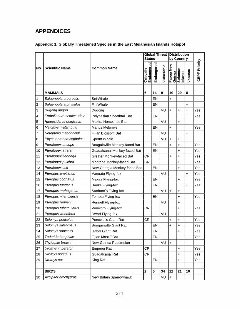
211
APPENDICES
Appendix 1. Globally Threatened Species in the East Melanesian Islands Hotspot
No. Scientific Name Common Name
Global Threat Status
Distribution by Country
CE
PF
Pri
ori
ty
Cri
tic
all
y
En
da
ng
ere
d
En
da
ng
ere
d
Vu
lne
rab
le
Pa
pu
a N
ew
G
uin
ea
So
lom
on
Is
lan
ds
Va
nu
atu
MAMMALS 6 14 9 10 20 8
1 Balaenoptera borealis Sei Whale EN +
2 Balaenoptera physalus Fin Whale EN +
3 Dugong dugon Dugong VU + + + Yes
4 Emballonura semicaudata Polynesian Sheathtail Bat EN + Yes
5 Hipposideros demissus Makira Horseshoe Bat VU +
6 Melomys matambuai Manus Melomys EN + Yes
7 Notopteris macdonaldi Fijian Blossom Bat VU +
8 Physeter macrocephalus Sperm Whale VU + + +
9 Pteralopex anceps Bougainville Monkey-faced Bat EN + + Yes
10 Pteralopex atrata Guadalcanal Monkey-faced Bat EN + Yes
11 Pteralopex flanneryi Greater Monkey-faced Bat CR + + Yes
12 Pteralopex pulchra Montane Monkey-faced Bat CR + Yes
13 Pteralopex taki New Georgia Monkey-faced Bat EN + Yes
14 Pteropus anetianus Vanuatu Flying-fox VU + Yes
15 Pteropus cognatus Makira Flying-fox EN + Yes
16 Pteropus fundatus Banks Flying-fox EN + Yes
17 Pteropus mahaganus Sanborn’s Flying-fox VU + +
18 Pteropus nitendiensis Temotu Flying-fox EN + Yes
19 Pteropus rennelli Rennell Flying-fox VU +
20 Pteropus tuberculatus Vanikoro Flying-fox CR + Yes
21 Pteropus woodfordi Dwarf Flying-fox VU +
22 Solomys ponceleti Poncelet’s Giant Rat CR + + Yes
23 Solomys salebrosus Bougainville Giant Rat EN + + Yes
24 Solomys sapientis Isabel Giant Rat EN + Yes
25 Tadarida bregullae Fijian Mastiff Bat EN + Yes
26 Thylogale browni New Guinea Pademelon VU +
27 Uromys imperator Emperor Rat CR + Yes
28 Uromys porculus Guadalcanal Rat CR + Yes
29 Uromys rex King Rat EN + Yes
BIRDS 2 5 34 22 21 10
30 Accipiter brachyurus New Britain Sparrowhawk VU +

212
No. Scientific Name Common Name
Global Threat Status
Distribution by Country
CE
PF
Pri
ori
ty
Cri
tic
all
y
En
da
ng
ere
d
En
da
ng
ere
d
Vu
lne
rab
le
Pa
pu
a N
ew
G
uin
ea
So
lom
on
Is
lan
ds
Va
nu
atu
31 Accipiter imitator Imitator Sparrowhawk VU + +
32 Accipiter luteoschistaceus Slaty-backed Goshawk VU +
33 Accipiter princeps New Britain Goshawk VU +
34 Actenoides bougainvillei Moustached Kingfisher VU + +
35 Alcedo websteri Bismarck Kingfisher VU +
36 Aplonis brunneicapillus White-eyed Starling EN + +
37 Aplonis santovestris Santo Mountain Starling VU + Yes
38 Cacatua ophthalmica Blue-eyed Cockatoo VU +
39 Charmosyna palmarum Palm Lorikeet VU + + Yes
40 Clytorhynchus sanctaecrucis Santa Cruz Shrikebill EN +
41 Columba pallidiceps Yellow-legged Pigeon VU + +
42 Ducula bakeri Vanuatu Imperial Pigeon VU + Yes
43 Ducula brenchleyi Chestnut-bellied Imperial Pigeon
VU +
44 Erythrura regia Royal Parrotfinch VU + Yes
45 Gallicolumba sanctaecrucis Santa Cruz Ground-dove EN + + Yes
46 Gallinula silvestris Makira Moorhen CR + Yes
47 Haliaeetus sanfordi Solomons Sea Eagle VU + +
48 Henicopernis infuscatus New Britain Honey-buzzard VU +
49 Henicophaps foersteri New Britain Bronzewing VU +
50 Megalurulus grosvenori Bismarck Thicketbird VU +
51 Megapodius layardi Vanuatu Megapode VU + Yes
52 Nesasio solomonensis Fearful Owl VU + +
53 Nesofregetta fuliginosa Polynesian Storm-Petrel EN + Yes
54 Ninox odiosa New Britain Boobook VU +
55 Numenius tahitiensis Bristle-thighed Curlew VU +
56 Phylloscopus amoenus Sombre Leaf-warbler VU +
57 Pitta anerythra Black-faced Pitta VU + +
58 Pitta superba Superb Pitta VU +
59 Pseudobulweria becki Beck’s Petrel CR + + Yes
60 Pterodroma brevipes Collared Petrel VU + + Yes
61 Pterodroma cervicalis White-necked Petrel VU + Yes
62 Pterodroma leucoptera Gould’s Petrel VU +
63 Puffinus heinrothi Heinroth’s Shearwater VU + +
64 Rhipidura malaitae Malaita Fantail VU +
65 Rhipidura semirubra Manus Fantail VU +
66 Tyto aurantia Bismarck Masked-owl VU +
67 Tyto manusi Manus Masked-owl VU +
68 Zoothera talaseae turipavae Guadalcanal Thrush VU +

213
No. Scientific Name Common Name
Global Threat Status
Distribution by Country
CE
PF
Pri
ori
ty
Cri
tic
all
y
En
da
ng
ere
d
En
da
ng
ere
d
Vu
lne
rab
le
Pa
pu
a N
ew
G
uin
ea
So
lom
on
Is
lan
ds
Va
nu
atu
69 Zosterops luteirostris Splendid White-eye EN +
70 Zosterops splendidus Ranongga White-eye VU +
REPTILES 2 4 4 5 6 5
71 Brachylophus fasciatus Fijian Banded Iguana EN +
72 Caretta caretta Loggerhead Turtle EN + Yes
73 Chelonia mydas Green Turtle EN + + + Yes
74 Dermochelys coriacea Leatherback Turtle CR + + Yes
75 Emoia aneityumensis Anatom Skink EN + Yes
76 Emoia isolata Bellona Skink VU +
77 Eretmochelys imbricata Hawksbill Turtle CR + + + Yes
78 Geomyersia coggeri Cogger’s Island Skink VU +
79 Laticauda crockeri Rennell Freshwater Seasnake VU +
80 Tribolonotus blanchardi Blanchard’s Crocodile Skink VU + +
AMPHIBIANS 0 0 5 5 2 0
81 Austrochaperina novaebritanniae
New Britain Land Frog VU +
82 Litoria lutea Solomon Islands Treefrog VU + + Yes
83 Palmatorappia solomonis Solomon Islands Palm Frog VU + + Yes
84 Platymantis akarithymus Pomugu Wrinkled Ground Frog VU +
85 Platymantis parkeri Parker’s Wrinkled Ground Frog VU +
FISHES 1 3 2+ 21 16 15
86 Alopias vulpinus Thresher Shark VU +
87 Bolbometopon muricatum Green Humphead Parrotfish VU + + +
88 Carcharhinus hemiodon Pondicherry Shark CR +
89 Carcharhinus longimanus Oceanic Whitetip Shark VU + + +
90 Carcharhinus plumbeus Sandbar Shark VU +
91 Centrophorus granulosus Gulper Shark VU +
92 Cheilinus undulatus Humphead Wrasse EN + + +
93 Cromileptes altivelis Humpback Grouper VU + + +
94 Epinephelus lanceolatus Giant Grouper VU + + +
95 Hippocampus kuda Estuary Seahorse VU + +
96 Isurus oxyrinchus Shortfin Mako Shark VU + + +
97 Isurus paucus Longfin Mako Shark VU +
98 Makaira nigricans Blue Marlin VU + + +
99 Manta alfredi Manta Ray VU +
100 Nebrius ferrugineus Tawny Nurse Shark VU +
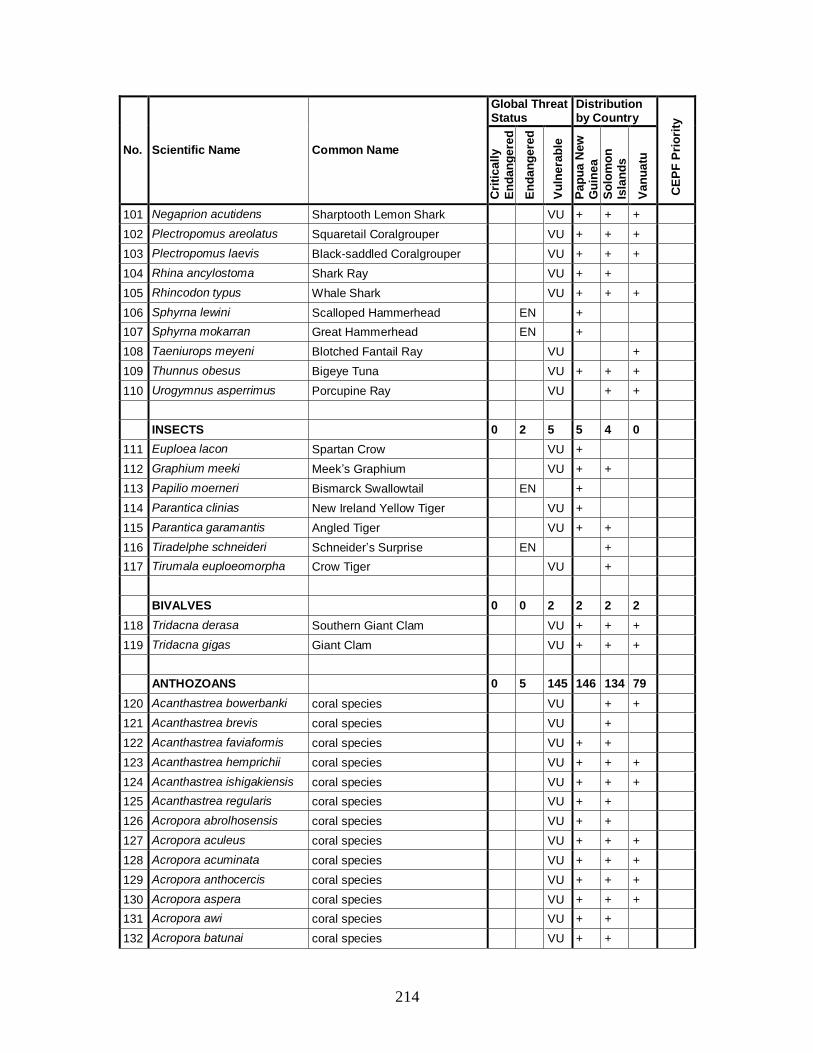
214
No. Scientific Name Common Name
Global Threat Status
Distribution by Country
CE
PF
Pri
ori
ty
Cri
tic
all
y
En
da
ng
ere
d
En
da
ng
ere
d
Vu
lne
rab
le
Pa
pu
a N
ew
G
uin
ea
So
lom
on
Is
lan
ds
Va
nu
atu
101 Negaprion acutidens Sharptooth Lemon Shark VU + + +
102 Plectropomus areolatus Squaretail Coralgrouper VU + + +
103 Plectropomus laevis Black-saddled Coralgrouper VU + + +
104 Rhina ancylostoma Shark Ray VU + +
105 Rhincodon typus Whale Shark VU + + +
106 Sphyrna lewini Scalloped Hammerhead EN +
107 Sphyrna mokarran Great Hammerhead EN +
108 Taeniurops meyeni Blotched Fantail Ray VU +
109 Thunnus obesus Bigeye Tuna VU + + +
110 Urogymnus asperrimus Porcupine Ray VU + +
INSECTS 0 2 5 5 4 0
111 Euploea lacon Spartan Crow VU +
112 Graphium meeki Meek’s Graphium VU + +
113 Papilio moerneri Bismarck Swallowtail EN +
114 Parantica clinias New Ireland Yellow Tiger VU +
115 Parantica garamantis Angled Tiger VU + +
116 Tiradelphe schneideri Schneider’s Surprise EN +
117 Tirumala euploeomorpha Crow Tiger VU +
BIVALVES 0 0 2 2 2 2
118 Tridacna derasa Southern Giant Clam VU + + +
119 Tridacna gigas Giant Clam VU + + +
ANTHOZOANS 0 5 145 146 134 79
120 Acanthastrea bowerbanki coral species VU + +
121 Acanthastrea brevis coral species VU +
122 Acanthastrea faviaformis coral species VU + +
123 Acanthastrea hemprichii coral species VU + + +
124 Acanthastrea ishigakiensis coral species VU + + +
125 Acanthastrea regularis coral species VU + +
126 Acropora abrolhosensis coral species VU + +
127 Acropora aculeus coral species VU + + +
128 Acropora acuminata coral species VU + + +
129 Acropora anthocercis coral species VU + + +
130 Acropora aspera coral species VU + + +
131 Acropora awi coral species VU + +
132 Acropora batunai coral species VU + +

215
No. Scientific Name Common Name
Global Threat Status
Distribution by Country
CE
PF
Pri
ori
ty
Cri
tic
all
y
En
da
ng
ere
d
En
da
ng
ere
d
Vu
lne
rab
le
Pa
pu
a N
ew
G
uin
ea
So
lom
on
Is
lan
ds
Va
nu
atu
133 Acropora caroliniana coral species VU + + +
134 Acropora dendrum coral species VU + + +
135 Acropora derawanensis coral species VU +
136 Acropora desalwii coral species VU + +
137 Acropora donei coral species VU + + +
138 Acropora echinata coral species VU + + +
139 Acropora elegans coral species VU +
140 Acropora globiceps coral species VU + + +
141 Acropora hoeksemai coral species VU + +
142 Acropora horrida coral species VU + + +
143 Acropora indonesia coral species VU + +
144 Acropora jacquelineae coral species VU + +
145 Acropora kimbeensis coral species VU + +
146 Acropora kirstyae coral species VU + + +
147 Acropora listeri coral species VU + + +
148 Acropora lokani coral species VU + +
149 Acropora lovelli coral species VU + + +
150 Acropora microclados coral species VU + + +
151 Acropora multiacuta coral species VU + +
152 Acropora palmerae coral species VU + + +
153 Acropora paniculata coral species VU + + +
154 Acropora plumosa coral species VU + +
155 Acropora polystoma coral species VU + + +
156 Acropora retusa coral species VU +
157 Acropora simplex coral species VU +
158 Acropora solitaryensis coral species VU + + +
159 Acropora speciosa coral species VU + + +
160 Acropora spicifera coral species VU + + +
161 Acropora striata coral species VU + +
162 Acropora tenella coral species VU + + +
163 Acropora turaki coral species VU + +
164 Acropora vaughani coral species VU + + +
165 Acropora verweyi coral species VU + + +
166 Acropora walindii coral species VU +
167 Acropora willisae coral species VU + +
168 Alveopora allingi coral species VU + + +
169 Alveopora daedalea coral species VU +
170 Alveopora fenestrata coral species VU + + +
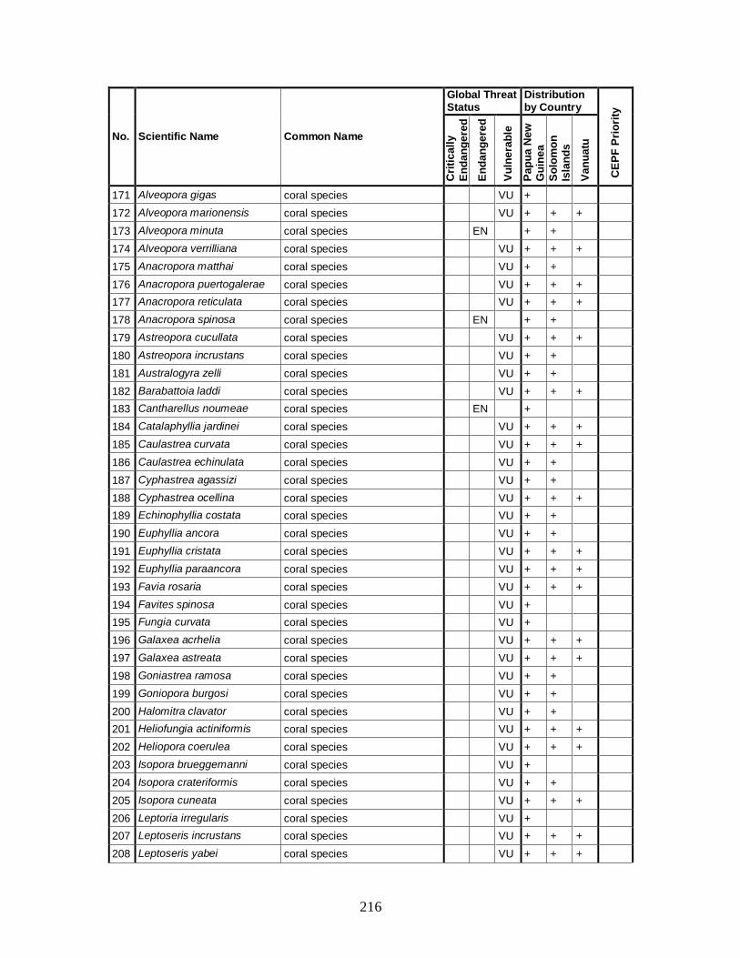
216
No. Scientific Name Common Name
Global Threat Status
Distribution by Country
CE
PF
Pri
ori
ty
Cri
tic
all
y
En
da
ng
ere
d
En
da
ng
ere
d
Vu
lne
rab
le
Pa
pu
a N
ew
G
uin
ea
So
lom
on
Is
lan
ds
Va
nu
atu
171 Alveopora gigas coral species VU +
172 Alveopora marionensis coral species VU + + +
173 Alveopora minuta coral species EN + +
174 Alveopora verrilliana coral species VU + + +
175 Anacropora matthai coral species VU + +
176 Anacropora puertogalerae coral species VU + + +
177 Anacropora reticulata coral species VU + + +
178 Anacropora spinosa coral species EN + +
179 Astreopora cucullata coral species VU + + +
180 Astreopora incrustans coral species VU + +
181 Australogyra zelli coral species VU + +
182 Barabattoia laddi coral species VU + + +
183 Cantharellus noumeae coral species EN +
184 Catalaphyllia jardinei coral species VU + + +
185 Caulastrea curvata coral species VU + + +
186 Caulastrea echinulata coral species VU + +
187 Cyphastrea agassizi coral species VU + +
188 Cyphastrea ocellina coral species VU + + +
189 Echinophyllia costata coral species VU + +
190 Euphyllia ancora coral species VU + +
191 Euphyllia cristata coral species VU + + +
192 Euphyllia paraancora coral species VU + + +
193 Favia rosaria coral species VU + + +
194 Favites spinosa coral species VU +
195 Fungia curvata coral species VU +
196 Galaxea acrhelia coral species VU + + +
197 Galaxea astreata coral species VU + + +
198 Goniastrea ramosa coral species VU + +
199 Goniopora burgosi coral species VU + +
200 Halomitra clavator coral species VU + +
201 Heliofungia actiniformis coral species VU + + +
202 Heliopora coerulea coral species VU + + +
203 Isopora brueggemanni coral species VU +
204 Isopora crateriformis coral species VU + +
205 Isopora cuneata coral species VU + + +
206 Leptoria irregularis coral species VU +
207 Leptoseris incrustans coral species VU + + +
208 Leptoseris yabei coral species VU + + +
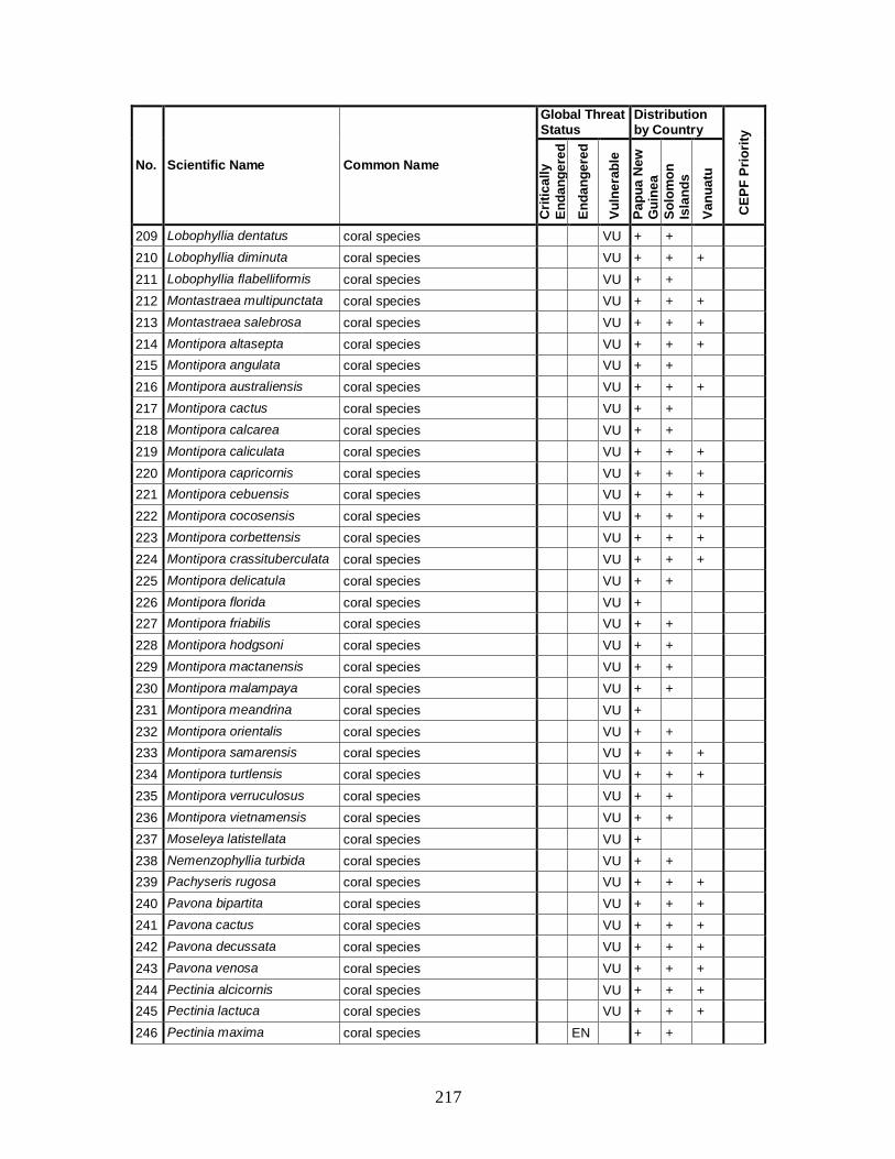
217
No. Scientific Name Common Name
Global Threat Status
Distribution by Country
CE
PF
Pri
ori
ty
Cri
tic
all
y
En
da
ng
ere
d
En
da
ng
ere
d
Vu
lne
rab
le
Pa
pu
a N
ew
G
uin
ea
So
lom
on
Is
lan
ds
Va
nu
atu
209 Lobophyllia dentatus coral species VU + +
210 Lobophyllia diminuta coral species VU + + +
211 Lobophyllia flabelliformis coral species VU + +
212 Montastraea multipunctata coral species VU + + +
213 Montastraea salebrosa coral species VU + + +
214 Montipora altasepta coral species VU + + +
215 Montipora angulata coral species VU + +
216 Montipora australiensis coral species VU + + +
217 Montipora cactus coral species VU + +
218 Montipora calcarea coral species VU + +
219 Montipora caliculata coral species VU + + +
220 Montipora capricornis coral species VU + + +
221 Montipora cebuensis coral species VU + + +
222 Montipora cocosensis coral species VU + + +
223 Montipora corbettensis coral species VU + + +
224 Montipora crassituberculata coral species VU + + +
225 Montipora delicatula coral species VU + +
226 Montipora florida coral species VU +
227 Montipora friabilis coral species VU + +
228 Montipora hodgsoni coral species VU + +
229 Montipora mactanensis coral species VU + +
230 Montipora malampaya coral species VU + +
231 Montipora meandrina coral species VU +
232 Montipora orientalis coral species VU + +
233 Montipora samarensis coral species VU + + +
234 Montipora turtlensis coral species VU + + +
235 Montipora verruculosus coral species VU + +
236 Montipora vietnamensis coral species VU + +
237 Moseleya latistellata coral species VU +
238 Nemenzophyllia turbida coral species VU + +
239 Pachyseris rugosa coral species VU + + +
240 Pavona bipartita coral species VU + + +
241 Pavona cactus coral species VU + + +
242 Pavona decussata coral species VU + + +
243 Pavona venosa coral species VU + + +
244 Pectinia alcicornis coral species VU + + +
245 Pectinia lactuca coral species VU + + +
246 Pectinia maxima coral species EN + +
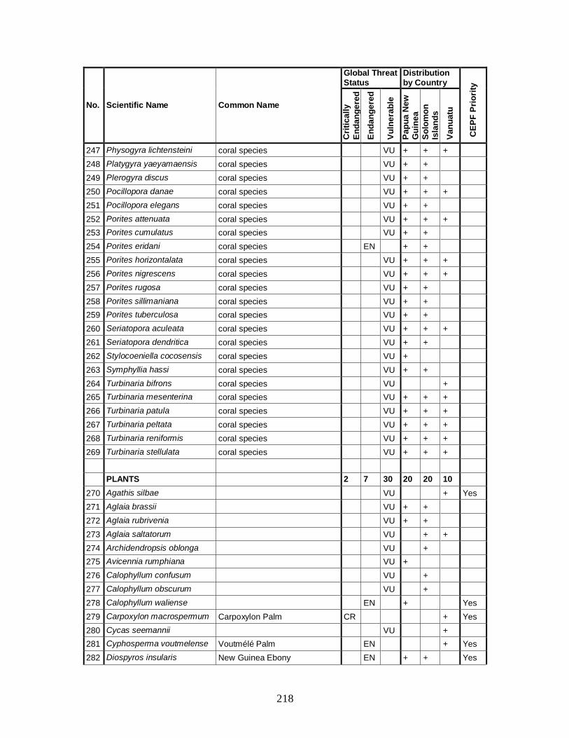
218
No. Scientific Name Common Name
Global Threat Status
Distribution by Country
CE
PF
Pri
ori
ty
Cri
tic
all
y
En
da
ng
ere
d
En
da
ng
ere
d
Vu
lne
rab
le
Pa
pu
a N
ew
G
uin
ea
So
lom
on
Is
lan
ds
Va
nu
atu
247 Physogyra lichtensteini coral species VU + + +
248 Platygyra yaeyamaensis coral species VU + +
249 Plerogyra discus coral species VU + +
250 Pocillopora danae coral species VU + + +
251 Pocillopora elegans coral species VU + +
252 Porites attenuata coral species VU + + +
253 Porites cumulatus coral species VU + +
254 Porites eridani coral species EN + +
255 Porites horizontalata coral species VU + + +
256 Porites nigrescens coral species VU + + +
257 Porites rugosa coral species VU + +
258 Porites sillimaniana coral species VU + +
259 Porites tuberculosa coral species VU + +
260 Seriatopora aculeata coral species VU + + +
261 Seriatopora dendritica coral species VU + +
262 Stylocoeniella cocosensis coral species VU +
263 Symphyllia hassi coral species VU + +
264 Turbinaria bifrons coral species VU +
265 Turbinaria mesenterina coral species VU + + +
266 Turbinaria patula coral species VU + + +
267 Turbinaria peltata coral species VU + + +
268 Turbinaria reniformis coral species VU + + +
269 Turbinaria stellulata coral species VU + + +
PLANTS 2 7 30 20 20 10
270 Agathis silbae VU + Yes
271 Aglaia brassii VU + +
272 Aglaia rubrivenia VU + +
273 Aglaia saltatorum VU + +
274 Archidendropsis oblonga VU +
275 Avicennia rumphiana VU +
276 Calophyllum confusum VU +
277 Calophyllum obscurum VU +
278 Calophyllum waliense EN + Yes
279 Carpoxylon macrospermum Carpoxylon Palm CR + Yes
280 Cycas seemannii VU +
281 Cyphosperma voutmelense Voutmélé Palm EN + Yes
282 Diospyros insularis New Guinea Ebony EN + + Yes
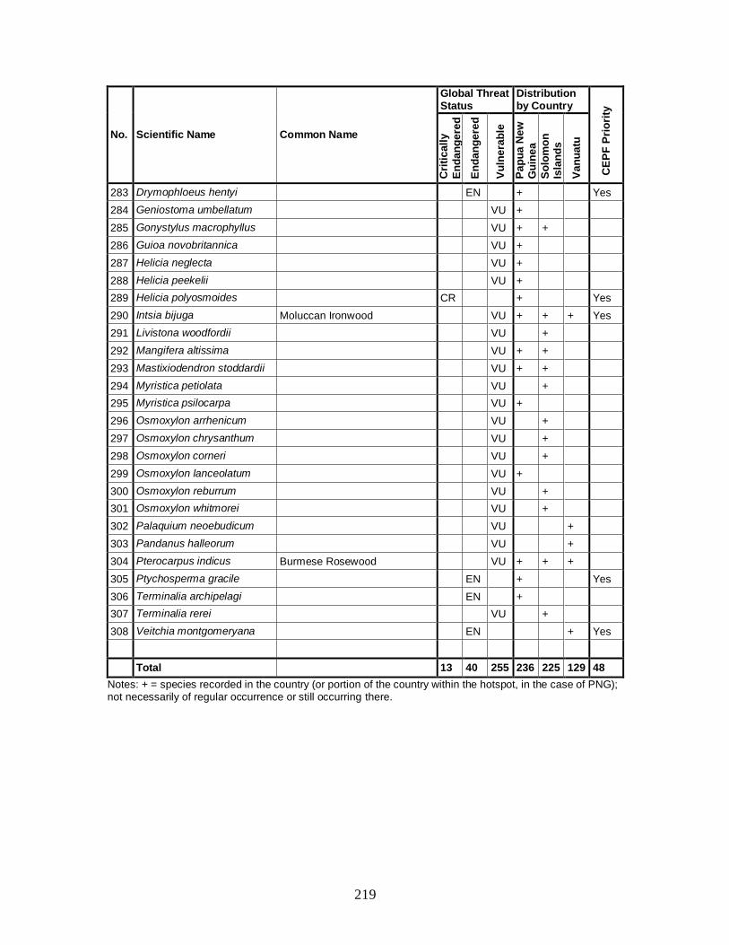
219
No. Scientific Name Common Name
Global Threat Status
Distribution by Country
CE
PF
Pri
ori
ty
Cri
tic
all
y
En
da
ng
ere
d
En
da
ng
ere
d
Vu
lne
rab
le
Pa
pu
a N
ew
G
uin
ea
So
lom
on
Is
lan
ds
Va
nu
atu
283 Drymophloeus hentyi EN + Yes
284 Geniostoma umbellatum VU +
285 Gonystylus macrophyllus VU + +
286 Guioa novobritannica VU +
287 Helicia neglecta VU +
288 Helicia peekelii VU +
289 Helicia polyosmoides CR + Yes
290 Intsia bijuga Moluccan Ironwood VU + + + Yes
291 Livistona woodfordii VU +
292 Mangifera altissima VU + +
293 Mastixiodendron stoddardii VU + +
294 Myristica petiolata VU +
295 Myristica psilocarpa VU +
296 Osmoxylon arrhenicum VU +
297 Osmoxylon chrysanthum VU +
298 Osmoxylon corneri VU +
299 Osmoxylon lanceolatum VU +
300 Osmoxylon reburrum VU +
301 Osmoxylon whitmorei VU +
302 Palaquium neoebudicum VU +
303 Pandanus halleorum VU +
304 Pterocarpus indicus Burmese Rosewood VU + + +
305 Ptychosperma gracile EN + Yes
306 Terminalia archipelagi EN +
307 Terminalia rerei VU +
308 Veitchia montgomeryana EN + Yes
Total 13 40 255 236 225 129 48
Notes: + = species recorded in the country (or portion of the country within the hotspot, in the case of PNG); not necessarily of regular occurrence or still occurring there.

220
Appendix 2. Key Biodiversity Areas in the East Melanesian Islands Hotspot
Map Code
Key Biodiversity Area
Ma
mm
als
Bir
ds
Rep
tile
s
Am
ph
ibia
ns
Fis
h
Inv
ert
eb
rate
s
Pla
nts
Province Islandscape
Bio
log
ica
l
Pri
ori
ty L
ev
el
CE
PF
Pri
ori
ty
PNG PAPUA NEW GUINEA
1 Arawe + + + + West New Britain None 3
2 Baining Mountains + + + + East New Britain None 3 Yes
3 Buin + + + + + Bougainville Bukida 2
4 Buka + + + + Bougainville Bukida 2
5 Bulu + + + + West New Britain Bismarck Sea 3
6 Cape Saint George + + + + + New Ireland None 2 Yes
7 Central Manus + + + + + + Manus Bismarck Sea 3 Yes
8 Djaul + + + New Ireland Bismarck Sea 5
9 East Manus + + + + + Manus None 3
10 East Mengen + + + + + East New Britain None 3
11 Garu* + West New Britain Bismarck Sea 5
12 Gasmata + + + + West New Britain None 3
13 Gloucester Volcanics + + + West New Britain Bismarck Sea 3
14 Kerevat Toma + + + + + East New Britain None 3
15 Kimbe Bay Marine + West New Britain Bismarck Sea 5
16 Kunua Plains and Mount Balbi + + + + + Bougainville Bukida 2 Yes
17 Lavongai + + + + New Ireland Bismarck Sea 3
18 Lelet Plateau + + + + + New Ireland Bismarck Sea 3
19 M’buke and Purdy Islands + + Manus Bismarck Sea 4
20 Madina + + + New Ireland None 4
21 Mussau + + New Ireland None 4 Yes
22 Nakanai Central Pomio + + + + East New Britain None 4
23 Ndrolowa + + Manus Bismarck Sea 5
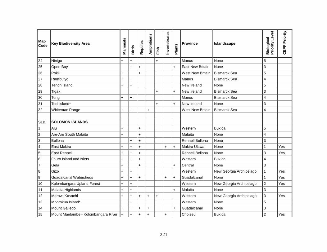
221
Map Code
Key Biodiversity Area
Ma
mm
als
Bir
ds
Rep
tile
s
Am
ph
ibia
ns
Fis
h
Inv
ert
eb
rate
s
Pla
nts
Province Islandscape
Bio
log
ica
l
Pri
ori
ty L
ev
el
CE
PF
Pri
ori
ty
24 Ninigo + + + Manus None 5
25 Open Bay + + + East New Britain None 3
26 Pokili + + West New Britain Bismarck Sea 5
27 Rambutyo + + Manus Bismarck Sea 4
28 Tench Island + + New Ireland None 5
29 Tigak + + New Ireland Bismarck Sea 3
30 Tong + + Manus Bismarck Sea 4
31 Tsoi Island* + + New Ireland None 3
32 Whiteman Range + + + West New Britain Bismarck Sea 4
SLB SOLOMON ISLANDS
1 Alu + + Western Bukida 5
2 Are-Are South Malaita + + Malaita None 4
3 Bellona + + Rennell Bellona None 3
4 East Makira + + + + + Makira Ulawa None 1 Yes
5 East Rennell + + + Rennell Bellona None 3 Yes
6 Fauro Island and Islets + + + Western Bukida 4
7 Gela + + + Central None 3
8 Gizo + + Western New Georgia Archipelago 1 Yes
9 Guadalcanal Watersheds + + + + + Guadalcanal None 1 Yes
10 Kolombangara Upland Forest + + Western New Georgia Archipelago 2 Yes
11 Malaita Highlands + + + Malaita None 3
12 Marovo Kavachi + + + + + Western New Georgia Archipelago 3 Yes
13 Mborokua Island* + Western None 5
14 Mount Gallego + + + + + Guadalcanal None 3
15 Mount Maetambe - Kolombangara River + + + + + Choiseul Bukida 2 Yes
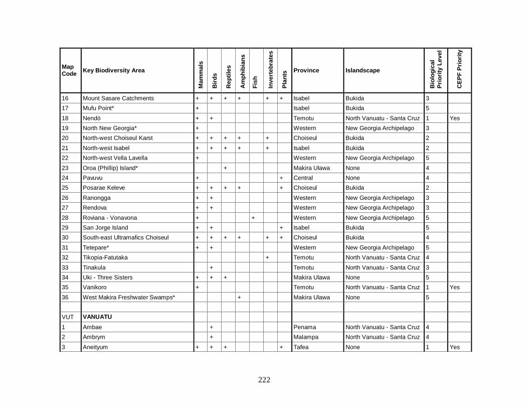
222
Map Code
Key Biodiversity Area
Ma
mm
als
Bir
ds
Rep
tile
s
Am
ph
ibia
ns
Fis
h
Inv
ert
eb
rate
s
Pla
nts
Province Islandscape
Bio
log
ica
l
Pri
ori
ty L
ev
el
CE
PF
Pri
ori
ty
16 Mount Sasare Catchments + + + + + + Isabel Bukida 3
17 Mufu Point* + Isabel Bukida 5
18 Nendö + + Temotu North Vanuatu - Santa Cruz 1 Yes
19 North New Georgia* + Western New Georgia Archipelago 3
20 North-west Choiseul Karst + + + + + Choiseul Bukida 2
21 North-west Isabel + + + + + Isabel Bukida 2
22 North-west Vella Lavella + Western New Georgia Archipelago 5
23 Oroa (Phillip) Island* + Makira Ulawa None 4
24 Pavuvu + + Central None 4
25 Posarae Keleve + + + + + Choiseul Bukida 2
26 Ranongga + + Western New Georgia Archipelago 3
27 Rendova + + Western New Georgia Archipelago 3
28 Roviana - Vonavona + + Western New Georgia Archipelago 5
29 San Jorge Island + + + Isabel Bukida 5
30 South-east Ultramafics Choiseul + + + + + + Choiseul Bukida 4
31 Tetepare* + + Western New Georgia Archipelago 5
32 Tikopia-Fatutaka + Temotu North Vanuatu - Santa Cruz 4
33 Tinakula + Temotu North Vanuatu - Santa Cruz 3
34 Uki - Three Sisters + + + Makira Ulawa None 5
35 Vanikoro + Temotu North Vanuatu - Santa Cruz 1 Yes
36 West Makira Freshwater Swamps* + Makira Ulawa None 5
VUT VANUATU
1 Ambae + Penama North Vanuatu - Santa Cruz 4
2 Ambrym + Malampa North Vanuatu - Santa Cruz 4
3 Aneityum + + + + Tafea None 1 Yes
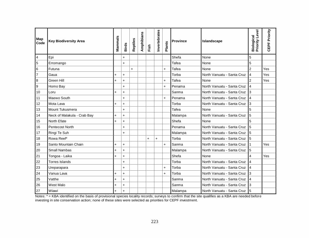
223
Map Code
Key Biodiversity Area
Ma
mm
als
Bir
ds
Rep
tile
s
Am
ph
ibia
ns
Fis
h
Inv
ert
eb
rate
s
Pla
nts
Province Islandscape
Bio
log
ica
l
Pri
ori
ty L
ev
el
CE
PF
Pri
ori
ty
4 Epi + Shefa None 5
5 Erromango + Tafea None 5
6 Futuna + + Tafea None 2 Yes
7 Gaua + + Torba North Vanuatu - Santa Cruz 4 Yes
8 Green Hill + + + Tafea None 2 Yes
9 Homo Bay + + Penama North Vanuatu - Santa Cruz 4
10 Loru + + Sanma North Vanuatu - Santa Cruz 3
11 Maewo South + + Penama North Vanuatu - Santa Cruz 4
12 Mota Lava + + Torba North Vanuatu - Santa Cruz 3
13 Mount Tukusmera + Tafea None 5
14 Neck of Malakula - Crab Bay + + Malampa North Vanuatu - Santa Cruz 5
15 North Efate + + Shefa None 5
16 Pentecost North + Penama North Vanuatu - Santa Cruz 5
17 Ringi Te Suh + Malampa North Vanuatu - Santa Cruz 5
18 Rowa Reef* + + Torba North Vanuatu - Santa Cruz 5
19 Santo Mountain Chain + + + Sanma North Vanuatu - Santa Cruz 1 Yes
20 Small Nambas + + Malampa North Vanuatu - Santa Cruz 5
21 Tongoa - Laika + + Shefa None 4 Yes
22 Torres Islands + Torba North Vanuatu - Santa Cruz 4
23 Ureparapara + + Torba North Vanuatu - Santa Cruz 4
24 Vanua Lava + + + Torba North Vanuatu - Santa Cruz 3
25 Vatthe + + Sanma North Vanuatu - Santa Cruz 4
26 West Malo + + Sanma North Vanuatu - Santa Cruz 3
27 Wiawi + + Malampa North Vanuatu - Santa Cruz 5
Notes: * = KBA identified on the basis of provisional species locality records; surveys to confirm that the site qualifies as a KBA are needed before investing in site conservation action; none of these sites were selected as priorities for CEPF investment.
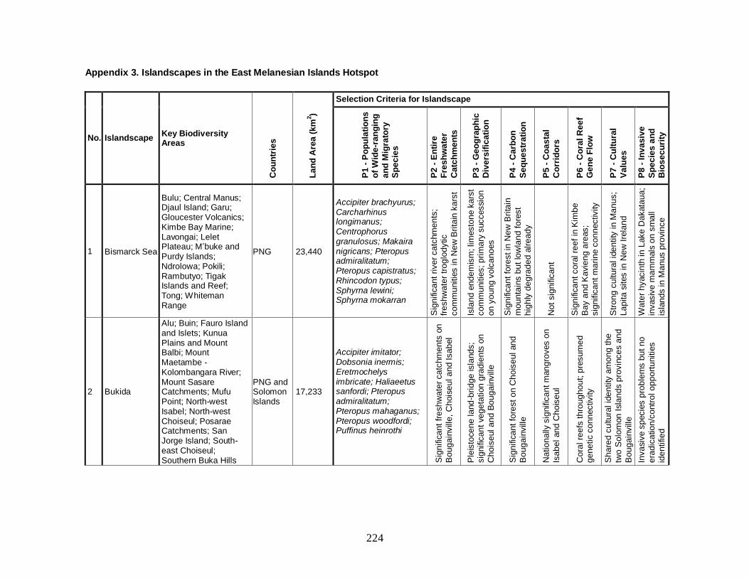
224
Appendix 3. Islandscapes in the East Melanesian Islands Hotspot
No. Islandscape Key Biodiversity Areas
Co
un
trie
s
La
nd
Are
a (
km
2)
Selection Criteria for Islandscape
P1
- P
op
ula
tio
ns
o
f W
ide
-ra
ng
ing
an
d M
igra
tory
S
pe
cie
s
P2
- E
nti
re
Fre
sh
wa
ter
Catc
hm
en
ts
P3
- G
eo
gra
ph
ic
Div
ers
ific
ati
on
P4
- C
arb
on
Se
qu
es
tra
tio
n
P5
- C
oa
sta
l
Co
rrid
ors
P6
- C
ora
l R
ee
f G
en
e F
low
P7
- C
ult
ura
l
Va
lue
s
P8
- I
nv
as
ive
Sp
ec
ies
an
d
Bio
se
cu
rity
1 Bismarck Sea
Bulu; Central Manus; Djaul Island; Garu; Gloucester Volcanics; Kimbe Bay Marine; Lavongai; Lelet Plateau; M’buke and Purdy Islands; Ndrolowa; Pokili; Rambutyo; Tigak Islands and Reef; Tong; Whiteman Range
PNG 23,440
Accipiter brachyurus; Carcharhinus longimanus; Centrophorus granulosus; Makaira nigricans; Pteropus admiralitatum; Pteropus capistratus; Rhincodon typus; Sphyrna lewini; Sphyrna mokarran
Sig
nific
an
t ri
ve
r ca
tchm
en
ts;
fre
sh
wate
r tr
og
lod
ytic
co
mm
unitie
s in
Ne
w B
rita
in k
ars
t
Isla
nd
en
de
mis
m; lim
esto
ne
ka
rst
co
mm
unitie
s;
pri
ma
ry s
uccessio
n
on
yo
un
g v
olc
an
oes
Sig
nific
an
t fo
rest in
Ne
w B
rita
in
mo
un
tain
s b
ut
low
lan
d f
ore
st
hig
hly
de
gra
de
d a
lre
ad
y
Not
sig
nific
an
t
Sig
nific
an
t co
ral re
ef
in K
imb
e
Ba
y a
nd
Ka
vie
ng
are
as;
sig
nific
an
t m
ari
ne c
on
nectivity
Str
on
g c
ultu
ral id
en
tity
in
Ma
nu
s;
La
pita
sites in
Ne
w I
rela
nd
Wa
ter
hyacin
th in
Lake
Da
kata
ua
;
invasiv
e m
am
mals
on
sm
all
isla
nd
s in
Ma
nus p
rovin
ce
2 Bukida
Alu; Buin; Fauro Island and Islets; Kunua Plains and Mount Balbi; Mount Maetambe - Kolombangara River; Mount Sasare Catchments; Mufu Point; North-west Isabel; North-west Choiseul; Posarae Catchments; San Jorge Island; South-east Choiseul; Southern Buka Hills
PNG and Solomon Islands
17,233
Accipiter imitator; Dobsonia inermis; Eretmochelys imbricate; Haliaeetus sanfordi; Pteropus admiralitatum; Pteropus mahaganus; Pteropus woodfordi; Puffinus heinrothi
Sig
nific
an
t fr
esh
wate
r ca
tchm
en
ts o
n
Bo
ug
ain
vill
e,
Chois
eu
l a
nd
Isa
bel
Ple
isto
ce
ne
la
nd
-bri
dg
e isla
nd
s;
sig
nific
an
t ve
ge
tation
gra
die
nts
on
Cho
ise
ul a
nd
Bo
ug
ain
vill
e
Sig
nific
an
t fo
rest
on C
ho
ise
ul an
d
Bo
ug
ain
vill
e
Natio
na
lly s
ignific
an
t m
an
gro
ves o
n
Isa
be
l an
d C
ho
ise
ul
Cora
l re
efs
th
rou
gh
ou
t; p
resu
me
d
ge
ne
tic c
on
nectivity
Sh
are
d c
ultu
ral id
en
tity
am
on
g th
e
two
So
lom
on
Isla
nd
s p
rovin
ce
s a
nd
Bo
ug
ain
vill
e
Inva
siv
e s
pecie
s p
rob
lem
s b
ut
no
era
dic
atio
n/c
ontr
ol o
pp
ort
unitie
s
ide
ntifie
d

225
No. Islandscape Key Biodiversity Areas
Co
un
trie
s
La
nd
Are
a (
km
2)
Selection Criteria for Islandscape
P1
- P
op
ula
tio
ns
o
f W
ide
-ra
ng
ing
an
d M
igra
tory
S
pe
cie
s
P2
- E
nti
re
Fre
sh
wa
ter
Catc
hm
en
ts
P3
- G
eo
gra
ph
ic
Div
ers
ific
ati
on
P4
- C
arb
on
Se
qu
es
tra
tio
n
P5
- C
oa
sta
l
Co
rrid
ors
P6
- C
ora
l R
ee
f G
en
e F
low
P7
- C
ult
ura
l
Va
lue
s
P8
- I
nv
as
ive
Sp
ec
ies
an
d
Bio
se
cu
rity
3 New Georgia Archipelago
Gizo; Kolombangara Upland Forest; Marovo; North New Georgia; North-west Vella Lavella; Ranongga; Rendova; Roviana-Vonavona; Tetepare
Solomon Islands
5,085
Haliaeetus sanfordi; Pseudobulweria becki; Puffinus heinrothi
Not
sig
nific
an
t
Hig
h a
ltitu
de
co
mm
unitie
s o
n
Ko
lom
ba
ng
ara
an
d N
ew
Ge
org
ia
with
gra
die
nts
to
se
a leve
l
Hig
hly
de
gra
de
d f
ore
sts
with
op
po
rtu
nitie
s f
or
reg
en
era
tio
n
Ma
ng
rove
s a
lon
g c
oasta
l a
reas
thro
ug
ho
ut
the
la
nd
sca
pe
Cora
l re
efs
th
rou
gh
ou
t, e
sp
ecia
lly in
Vo
na
vo
na
, R
ovia
na
an
d M
aro
vo
; p
resu
me
d g
en
etic c
on
nectivity
Not
sig
nific
an
t
Inva
siv
e s
pecie
s p
rob
lem
s;
un
inh
ab
ite
d isla
nds m
ay p
rovid
e
era
dic
atio
n o
pp
ort
unitie
s
4 North Vanuatu - Santa Cruz
Ambae; Ambrym; Gaua; Homo Bay; Loru; Mota Lava; Neck of Malakula - Crab Bay; Nendö; North Pentecost; Ringi Te Suh; Rowa Reef Islands; Santo Mountain Chain; Small Nambas; South Maewo; Tikopia - Fatutaka; Tinakula; Torres Islands; Ureparapara; Vanikoro; Vanua Lava - Mount Sereama; Vatthe; West Malo; Wiawi
Solomon Islands and Vanuatu
9,904 Pterodroma brevipes; Pterodroma occulta; Pteropus anetianus
Sig
nific
an
t fr
esh
wate
r ca
tchm
en
ts o
n
Sa
nto
an
d M
ala
ku
la;
uniq
ue
fre
sh
wate
r
co
mm
unitie
s o
n A
mb
ae
Dry
fo
rest
on
weste
rn S
an
to a
nd
M
ala
kula
,;altitu
din
al g
rad
ien
ts o
f n
atu
ral
ha
bita
t o
n S
an
to
Sig
nific
an
t fo
rest
on S
an
to a
nd
Ma
laku
la
Ma
lakula
su
pp
ort
s la
rge
st
are
a o
f
ma
ng
rove
in V
an
ua
tu
Imp
ort
an
t la
titu
din
al g
rad
ien
t fo
r co
ral
mig
ratio
n in
re
sp
onse
to
se
a t
em
pe
ratu
re
ch
an
ge
s
Po
tte
ry a
rea
s o
n w
este
rn S
an
to
an
d U
rep
ara
pa
ra;
lap
ita
site
on
Mala
kula
Inva
siv
e s
pecie
s c
on
trol re
qu
ire
d f
or
pe
tre
l
co
lonie
s o
n V
an
ua
La
va
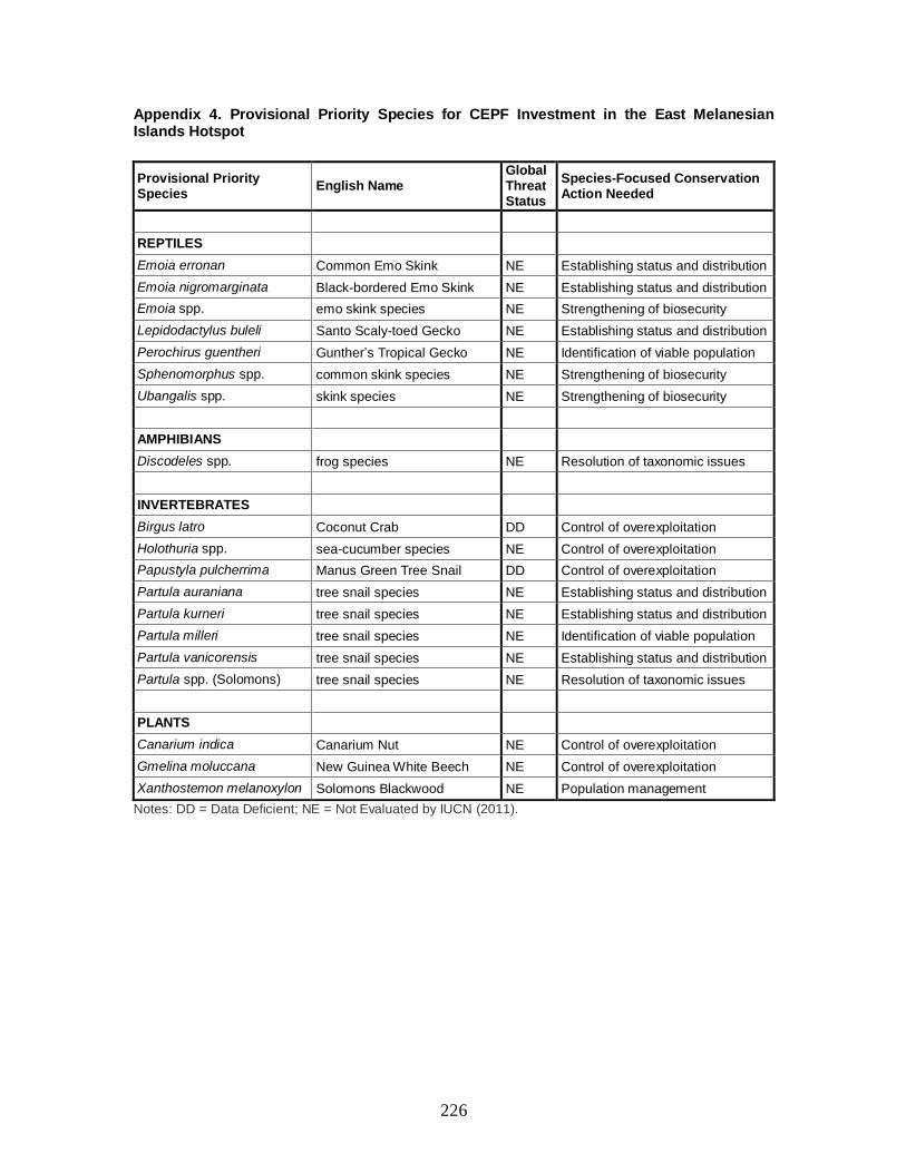
226
Appendix 4. Provisional Priority Species for CEPF Investment in the East Melanesian Islands Hotspot
Provisional Priority Species
English Name Global Threat Status
Species-Focused Conservation Action Needed
REPTILES
Emoia erronan Common Emo Skink NE Establishing status and distribution
Emoia nigromarginata Black-bordered Emo Skink NE Establishing status and distribution
Emoia spp. emo skink species NE Strengthening of biosecurity
Lepidodactylus buleli Santo Scaly-toed Gecko NE Establishing status and distribution
Perochirus guentheri Gunther’s Tropical Gecko NE Identification of viable population
Sphenomorphus spp. common skink species NE Strengthening of biosecurity
Ubangalis spp. skink species NE Strengthening of biosecurity
AMPHIBIANS
Discodeles spp. frog species NE Resolution of taxonomic issues
INVERTEBRATES
Birgus latro Coconut Crab DD Control of overexploitation
Holothuria spp. sea-cucumber species NE Control of overexploitation
Papustyla pulcherrima Manus Green Tree Snail DD Control of overexploitation
Partula auraniana tree snail species NE Establishing status and distribution
Partula kurneri tree snail species NE Establishing status and distribution
Partula milleri tree snail species NE Identification of viable population
Partula vanicorensis tree snail species NE Establishing status and distribution
Partula spp. (Solomons) tree snail species NE Resolution of taxonomic issues
PLANTS
Canarium indica Canarium Nut NE Control of overexploitation
Gmelina moluccana New Guinea White Beech NE Control of overexploitation
Xanthostemon melanoxylon Solomons Blackwood NE Population management
Notes: DD = Data Deficient; NE = Not Evaluated by IUCN (2011).

227
Appendix 5: CBOs Active in the PNG Part of the East Melanesian Islands Hotspot
Organization Location Focal Areas Notes
Kuka Community Group Bougainville Watershed restoration activities. Accompanies a water supply project
Leitana Neihan Women’s Development Agency
Bougainville Women’s concerns and peace building through training, counseling, information and working with other organisations.
Active players in bringing about community reconciliation and in contributing towards Bouganville peace settlement. Important in matrilineal inheritance system.
Marine Environment Resources Team
Manus Survey south coastal area and develop plan for potential income generation including ecotourism.
New Ireland Monitoring and Awareness Committee
New Ireland Publicise conservation issues, provide technical aid to sustainability initiatives. Support and collaborate with other NGOs to monitor development programmes.
Pacific Heritage Foundation
East New Britain
Run environment awareness campaigns, training in timber production skills and marketing villagers’ timber.
Promotes holistic development that includes economic, social and environmental concerns.
At least four communities with community -owned sawmill resist commercial loggers and harvest their own timber sustainably.
Tulele Peisa Incorporated
Bougainville Sustainable development projects
Whiteman Range Resource Development Limited
West New Britain Raise awareness in the importance of conservation in the Whiteman Range area. Conduct a survey to establish the region as a conservation area.
Engage in ecotourism, pharmaceutical research and participate in carbon trading.
Wide Bay Conservation Association Inc.
East New Britain, New Ireland, Manus
Environmental awareness on deep-sea mining. Promotes participatory development projects.
Note: Organizations initiated locally to serve local communities are classified as CBOs while those initiated for national coverage are identified as NGOs .
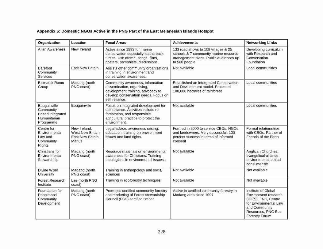
228
Appendix 6: Domestic NGOs Active in the PNG Part of the East Melanesian Islands Hotspot
Organization Location Focal Areas Achievements Networking Links
Ailan Awareness New Ireland Active since 1993 for marine conservation especially leatherback turtles. Use drama, songs, films, posters, pamphlets, discussions.
133 road shows to 108 villages & 25 schools & 7 community marine resource management plans. Public audiences up to 500 people
Developing curriculum with Research and Conservation Foundation
Barefoot Community Services
East New Britain Assists other community organizations in training in environment and conservation awareness.
Not available Local communities
Bismarck Ramu Group
Madang (north PNG coast)
Community awareness, information dissemination, organising, development training, advocacy to develop conservation deeds. Focus on self reliance.
Established an Intergrated Conservation and Development model. Protected 100,000 hectares of rainforest
Local communities
Bougainville Community Based Integrated Humanitarian Programme
Bougainville Focus on integrated development for self reliance. Activities include re forestation, and responsible agricultural practice to protect the environment.
Not available Local communities
Centre for Environmental Law and Community Rights
New Ireland, West New Britain, East New Britain, Manus
Legal advice, awareness raising, education, training on environment issues and land rights.
Formed in 2000 to service CBOs, NGOs and landowners. Very successful: 100 percent success in terms of informed consent
Formal relationships with CBOs. Partner of Friends of the Earth
Christians for Environmental Stewardship
Madang (north PNG coast)
Resource materials on environmental awareness for Christians. Training theologians in environmental issues.,
Not available Anglican Churches: evangelical alliance; environmental ethical consumerism
Divine Word University
Madang (north PNG coast)
Training in anthropology and social sciences
Not available Not available
Forest Research Institute
Lae (north PNG coast)
Training in ecoforestry techniques Not available Not available
Foundation for People and Community Development
Madang (north PNG coast)
Promotes certified community forestry and marketing of Forest stewardship Council (FSC) certified timber.
Active in certified community forestry in Madang area since 1997
Institute of Global Environment research (IGES), TNC, Centre for Environmental Law and Community Resources, PNG Eco Forestry Forum

229
Organization Location Focal Areas Achievements Networking Links
Grassroots Opportunities for Work
Madang (north PNG coast)
Training programmes and projects in sustainable agriculture, land use planning and rural business.
Not available Not available
Mahonia Na Dari (Guardian of the Sea)
West New Britain, Manus
Marine environment education for school children and teachers. Community-based conservation of marine areas. Support research and support ecotourism initiatives.
Since its inception in 1998, it has reached out to more than 150,000 students and teachers. It has facilitated setting aside marine protected areas by coastal communities around Kimbe Bay and is moving to Manus Is.
TNC, EU Islands Regional Environment Programme, Walindi Plantation Resort, Local schools and communities.
Papua New Guinea Center for Locally Managed Marine Areas
West New Britain, New Ireland, Manus
Mobilise communities to protect coastal marine ecosystems.
Communities beginning to take over ownership and provincial fisheries ready to take over monitoring with communities.
Fisheries Department, local fishing communities
Research and Conservation Foundation
Works with several NGOs active in the hotspot
Manages the Crater Wildlife Conservation Area and runs a Conservation Education Program (CEP) for teachers. Raise awareness and sustainable use of natural resources for biodiversity conservation
Established 1986 One of oldest conservation NGOs in PNG.CEP has been ongoing since 1999
Partners with relevant conservation NGOs for education – providing assistance in education resource development.
University of Natural Resources and Environment
East New Britain Courses in Diploma and Bachelor in tropical agriculture and in fisheries & marine resources
Established in 1965 as Vudal Agriculture University
Not available
University of Papua New Guinea (UPNG)
Port Moresby; works nationwide
The Strengthening Conservation Capacity Program: a diploma course resulting from combined effort from universities and NGOs to strengthen conservation capacity
Course trialled with some NGOs to about 300 participants. Grants expired but course design and content ready for delivery
Not available.
Village Development Trust
Lae, Morobe (north PNG coast)
Kamiali training centre: education and training in forestry, business development, ecotourism, gender and social issues. Kamiali integrated conservation and development project
Over 7 years -ran over 60 courses for at least 1,600 participants, 95 percent of whom were villagers. Established a training Centre, an ecotourism guest house and re-established the provincial based national botanical gardens
TITC, Unitech Dept of Forestry, Bulolo UniversityCollege, Habitat for Humanity, ADRA and other PNG NGOs.

230
Appendix 7: INGOs Active in the PNG Part of the East Melanesian Islands Hotspot
Organization Location Focal Areas Achievements Networking Links
Conservation International (CI)
New Britain Works in partnership with local NGOs for marine resource management, curriculum development and general public awareness of conservation issues. In 2009, conducted a biodiversity survey of the Nakanai Mountains in East New Britain.
Successful survey of Nakanai Mountains Not available
Live and Learn West New Britain Through school and community education & learning - encourage self reliance, environment conservation practices and innovation for sustainable development
Contributed to capacity building for biodiversity conservation through production of a popular resource manual for trainee teachers at the University of Goroka, and at Balob teachers College.
Research and Conservation Foundation, University of Goroka
New Guinea Binatang Research Centre
Madang (PNG north coast)
Capacity building of local field researchers, from paraecologists to postgraduate scientists. General public awareness and education in nature conservation and ecology
Significant achievement in trained Para ecologists some advancing to PhD. Some 30 graduates in tropical ecology each year. General public awareness active. International research publications.
Novotny Lab, University of South Bohemia, Czech Republic.
Organisation for Industrial, Spiritual and Cultural Advancement
East New Britain Agricultural training and children’s forest program
Established the Rabaul Training Centre in 1988. 65 schools and 500 students involved in tree planting in 2010
Not available
Seacology East New Britain, West New Britain, Manus
Negotiates with communities to set aside conservation areas in exchange for meeting a specific need they identify
Conservation areas and projects claimed throughout PNG. In the hotspot provinces these have included; Wanang Forest area of 2,200ha for 25 years, Tavolo, Pomio District of 988acres, West Manus 49,421 acres of coastal forest, Marine conservation areas in Kimbe, West New Britain, and installation of mooring buoys in fragile reef areas in New Ireland.
Mahonia Na Dari, PNG Divers’ Association
The Nature Conservancy
West New Britain, New Ireland, Manus
Facilitates conservation outcomes through working with resource owners, farmers, local governments and local NGOs
Set up MGCTF for up to US$30 million. Land Use planning and Mapping for communities agreed to by local governments, first fair trade certified cocoa in PNG, help Madang province adopt legislation inviting land owners to enter into conservation agreements protecting their rights and their forests. Now followed in West New Britain and Manus and extend to marine conservation.
Mahonia Na Dari, People and Community Development Fiji, PNG Centre for Locally Managed Marine Areas

231

232
Appendix 8: CBOs in the Solomon Islands with a Focus on Conservation or Related Fields
Organization Focal Areas Province Mission Statement Networking Links
Auki Assemblies of God Youth
Forestry Malaita To promote church planting, spiritual development and Christian growth
Pentecostal Churches
Dunde Council of Elders Forestry; marine Western To identify different sub-tribes to represent in decision-making and planning in the Council of Elders
United Church
Hanuato’o Conservation Forestry; biodiversity
Makira Ulawa To conserve the natural resources of the catchment of the Wai Tawatana and Haurahu River through a community consensus approach
DSE; Makira Community Conservation Foundation
Honiara Beautification Council
Biodiversity Guadalcanal Not available Not available
Kolombagara Island Biodiversity Association
Biodiversity Western Not available Not available
Kindu Resource Management
Resource management
Western Not available Not available
Lauru Indigenous Natural Resources
Resource management
Choiseul Not available Not available
Lauru Land Conference of Tribal Chiefs
Resource management
Choiseul Not available Not available
Makira Community Conservation Foundation
Forestry; biodiversity
Makira Ulawa To protect biodiversity of Makira Ulawa province, and develop resource management plans through a community consensus approach
Biodiversity conservation CSO network; Center for Biodiversity and Conservation
Marovo Island Nature, Biodiversity and Livelihood Trust
Biodiversity Western Not available Not available
Roviana Conservation Foundation
Coastal fisheries; marine
Western To create a model of conservation in Western province that can be used elsewhere in the Solomon Islands, Melanesia and Pacific
Roviana-Vonavona Resource Management Committee network
Tetepare Descendants Association
Forestry; marine; biodiversity
Western To ensure cooperation among Tetepare landowners for the conservation and sustainable management of Tetepare Island’s resources
Member of Solomon Islands LMMA network
Western Solomons Conservation
Coastal fisheries; marine
Western To create a model of conservation in Western province that can be used elsewhere in the Solomon Islands, Melanesia and Pacific
Roviana-Vonavona, Rendova, North New Georgia and Marova Resource Management Committee networks
Source: DSE (2008).
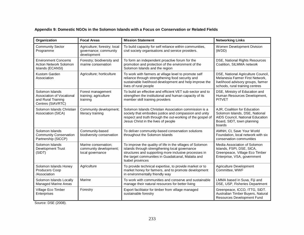
233
Appendix 9: Domestic NGOs in the Solomon Islands with a Focus on Conservation or Related Fields
Organization Focal Areas Mission Statement Networking Links
Community Sector Programme
Agriculture; forestry; local governance; community development
To build capacity for self reliance within communities, civil society organisations and service providers.
Women Development Division (WDD)
Environment Concerns Action Network Solomon Islands (ECANSI)
Forestry; biodiversity and marine conservation
To form an independent proactive forum for the promotion and protection of the environment of the Solomon Islands and the region
DSE, National Rights Resources Coalition, SILMMA network
Kustom Garden Association
Agriculture; horticulture To work with farmers at village level to promote self reliance through strengthening food security and sustainable livelihood development and help improve the lives of rural people
DSE, National Agriculture Council, Melanesia Farmer First Network, livelihood advisory groups, farmer schools, rural training centres
Solomon Islands Association of Vocational and Rural Training Centres (SIAVRTC)
Forest management training; agriculture training
To build an effective and efficient VET sub-sector and to strengthen the institutional and human capacity of its member skill training providers
DSE, Ministry of Education and Human Resources Development, PITVET
Solomon Islands Christian Association (SICA)
Community development; literacy training
Solomon Islands Christian Association commission is a society that embodies justice and compassion and unity respect and truth through the out-working of the gospel of Jesus Christ in the lives of people
AJR, Coalition for Education Solomon Islands, DSE, National AIDS Council, National Education Board, SIDT, town planning boards
Solomon Islands Community Conservation Partnership (SICCP)
Community-based biodiversity conservation
To deliver community-based conservation solutions throughout the Solomon Islands
AMNH, CI, Save Your World Foundation, local network with six conservation communities
Solomon Islands Development Trust (SIDT)
Marine conservation; community development; local governance
To improve the quality of life in the villages of Solomon islands through strengthening local governance structures and supporting more inclusive processes in the target communities in Guadalcanal, Malaita and Isabel provinces
Media Association of Solomon Islands, FSPI, DSE, SICA, Greenpeace, Village Eco Timber Enterprise, VSA, government
Solomon Islands Honey Producers Coop /Association
Agriculture To provide technical expertise, to provide market or to market honey for farmers, and to promote development in environmentally friendly way
Agriculture Development Committee, WWF
Solomon Islands Locally Managed Marine Areas
Marine To work with communities and conserve and sustainable manage their natural resources for better living
LMMA based in Suva, Fiji and DSE, USP, Fisheries Department
Village Eco Timber Enterprises
Forestry Export facilitator for timber from village managed sustainable forestry
Greenpeace, ICCO, ITTG, SIDT. Australian Timber Buyers, Natural Resources Development Fund
Source: DSE (2008).

234
Appendix 10: INGOs Active in the Solomon Islands with a Focus on Conservation or Related Fields
Organization Focal Areas Mission Statement Networking Links
Asia-Pacific Sustainable Development
Agriculture, Forestry Not available Not available
Australian People Health Education Development Agency (APHEDA)
Forestry Union Aid Abroad –APHEDA was established to contribute directly to countries and regions of the world where men and women workers are disadvantaged through poverty, a lack of workplace, denial of labour and human rights, civil conflict and war
DSE, Kastom Garden Association, SIAVRTC
Australian Volunteers International Forestry, Marine To share skills and build relationships with people of developing communities, We assist our partner organizations to reduce poverty, promote human rights and gender equity, protect the environment, provide health and education services and fight against HIV/AIDS
Australian Business Volunteers, Australian Youth Ambassadors for Development, JOCV, UNDP, VIDA, VSA, VSO
Australian Youth Ambassadors for Development
Forestry To strengthen mutual understanding between Australia and the countries of the Asia Pacific and make a positive contribution to development
Australian Business Volunteers, JOCV, VIDA, VSA
Canadian University Students Organisation
Marine conservation Canadian University Students Organisation supports alliance for global social justice, by sharing information, human and material resources, and by promoting policies for developing global sustainability
Community Sector Programme, DSE, EU Micro-projects, UNESCO.
*Centre for Biodiversity and Conservation at the American Museum of Natural History
Community based conservation
The center’s mission is to mitigate critical threats to global biological and cultural diversity
Makira Community Conservation Foundation; also working in Mount Popomanaseu, South Lauru Mangrove Reserve, and Kolombagara Reef to Ridges Reserve
Greenpeace Australia Pacific Mining, Oil Palm, Forestry, Marine.
Greenpeace is an independent campaigning organization which uses non-violent creative confrontation to explore global environmental problems and to force solutions which are essential to green and peaceful future
Forest network, Natural Resources Development Fund, SIDT, producer associations
Live and Learn Forestry , Marine Build more peaceful, self reliant and sustainable communities by developing potential for women, men and young people in formal and informal areas of peace, environment, well being, livelihood and vocational training
DSE, National Rights Resources Coalition
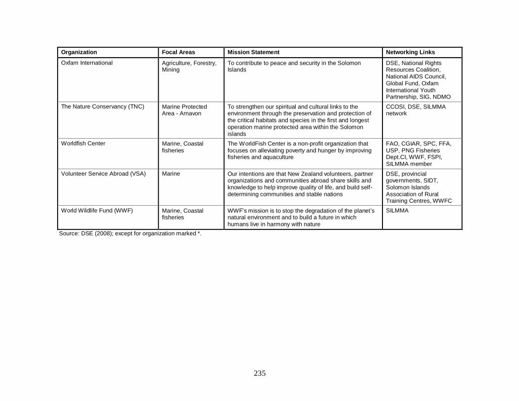
235
Organization Focal Areas Mission Statement Networking Links
Oxfam International Agriculture, Forestry, Mining
To contribute to peace and security in the Solomon Islands
DSE, National Rights Resources Coalition, National AIDS Council, Global Fund, Oxfam International Youth Partnership, SIG, NDMO
The Nature Conservancy (TNC) Marine Protected Area - Arnavon
To strengthen our spiritual and cultural links to the environment through the preservation and protection of the critical habitats and species in the first and longest operation marine protected area within the Solomon islands
CCOSI, DSE, SILMMA network
Worldfish Center Marine, Coastal fisheries
The WorldFish Center is a non-profit organization that focuses on alleviating poverty and hunger by improving fisheries and aquaculture
FAO, CGIAR, SPC, FFA, USP, PNG Fisheries Dept.CI, WWF, FSPI, SILMMA member
Volunteer Service Abroad (VSA) Marine Our intentions are that New Zealand volunteers, partner organizations and communities abroad share skills and knowledge to help improve quality of life, and build self-determining communities and stable nations
DSE, provincial governments, SIDT, Solomon Islands Association of Rural Training Centres, WWFC
World Wildlife Fund (WWF) Marine, Coastal fisheries
WWF’s mission is to stop the degradation of the planet’s natural environment and to build a future in which humans live in harmony with nature
SILMMA
Source: DSE (2008); except for organization marked *.

236
Appendix 11: Civil Society Organizations in Vanutu Active in Nationwide Conservation Efforts
Organization Mission Statement Governance Structure Networking Links
Foundation for the Peoples of the South Pacific Vanuatu
To support and promote the sustainable social, economic and environmental development of all people of Vanuatu.
Elected Board directs work of management and staff team. Membership organisation
Network with government and NGOs as well as CBOs. Set up Village Based Resource Management Association with wide membership of government and civil society bodies.
Wan Smolbag Theatre
Monitor conservation and manage the use of marine turtles in Vanuatu
Promote use of integrated resource management practices
Advocate and promote environmentally friendly development activities
Act as community mouthpiece for conservation and environment issues.
Vanua-Tai Resource monitors of 400 members coordinated by Wan Smolbag Theatre
Network with Vanuatu Fisheries Department, and communities.
Live and Learn Develop and implement projects and programmes for teachers, schools, communities and other target groups in environment and development education.
Promote integration of environment, human, cultural and peace concepts in all education projects and programmes.
INGO – the only one active in promoting conservation of seven INGOs in Vanuatu.
Network with government departments and communities.
Reef Check Vanuatu Provide tools for communities and custom land owners to monitor and assess community based management in coral reef areas.
Raise public awareness on coral reef ecology and threats
Member organization - hosted by the Fisheries department
Network with other NGOs, government agencies
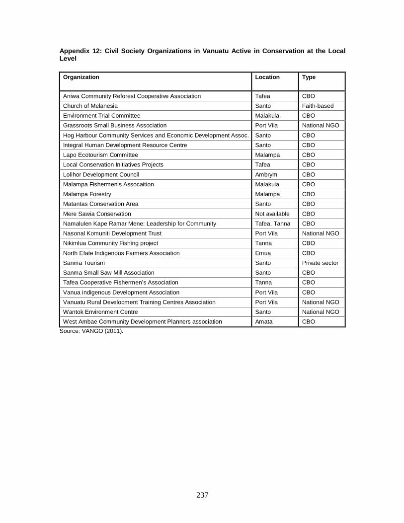
237
Appendix 12: Civil Society Organizations in Vanuatu Active in Conservation at the Local Level
Organization
Location Type
Aniwa Community Reforest Cooperative Association Tafea CBO
Church of Melanesia Santo Faith-based
Environment Trial Committee Malakula CBO
Grassroots Small Business Association Port Vila National NGO
Hog Harbour Community Services and Economic Development Assoc. Santo CBO
Integral Human Development Resource Centre Santo CBO
Lapo Ecotourism Committee Malampa CBO
Local Conservation Initiatives Projects Tafea CBO
Lolihor Development Council Ambrym CBO
Malampa Fishermen’s Assocaition Malakula CBO
Malampa Forestry Malampa CBO
Matantas Conservation Area Santo CBO
Mere Sawia Conservation Not available CBO
Namalulen Kape Ramar Mene: Leadership for Community Tafea, Tanna CBO
Nasonal Komuniti Development Trust Port Vila National NGO
Nikimlua Community Fishing project Tanna CBO
North Efate Indigenous Farmers Association Emua CBO
Sanma Tourism Santo Private sector
Sanma Small Saw Mill Association Santo CBO
Tafea Cooperative Fishermen’s Association Tanna CBO
Vanua indigenous Development Association Port Vila CBO
Vanuatu Rural Development Training Centres Association Port Vila National NGO
Wantok Environment Centre Santo National NGO
West Ambae Community Development Planners association Amata CBO
Source: VANGO (2011).