ecm 6988207 v3 dcp14 report - city of cockburn
TRANSCRIPT
2
DCP Report Development Contribution Plan 14 Development Contribution Plan Report Robb Jetty and Emplacement Precinct Last updated: 11 January 2019
Version: 3, Version Date: 16/01/2019Document Set ID: 6988207

3
CONTENTS
1. Introduction ..................................................................................................................................................... 6 1.1. Background .............................................................................................................................................. 6 1.2. Purpose of Development Contribution Plan ............................................................................................. 6 1.3. Purpose of Development Contribution Plan Report ................................................................................. 6 1.4. Relevant Documents ................................................................................................................................ 6
2. Period & Operation of the DCP ...................................................................................................................... 7 2.1. Period of the Plan .................................................................................................................................... 7 2.2. Operation of the DCP ............................................................................................................................... 7 2.3. Area of Operation ..................................................................................................................................... 7 2.4. Application Requirements ........................................................................................................................ 7
3. Infrastructure Items (Including Land) ........................................................................................................... 8 3.1. Land Acquisition ....................................................................................................................................... 8 3.2. Road and Service Infrastructure .............................................................................................................. 9 3.2.1. Cockburn Road ........................................................................................................................................ 9 3.2.2. Main Street ............................................................................................................................................. 10 3.2.3. Bus Rapid Transit Route ........................................................................................................................ 11 3.2.4. Rollinson Road Pedestrian Signals (Rail) .............................................................................................. 12 3.3. Public Realm and Environmental Improvements ................................................................................... 13 3.3.1. Land for Public Open Space .................................................................................................................. 13 3.3.2. Public Open Space Improvements ........................................................................................................ 14 3.3.3. Main Street ‘Local’ Community Building ................................................................................................. 16
4. Development Contribution Methodology ................................................................................................... 17 4.1. Key Principles ........................................................................................................................................ 17 4.2. Contribution Base .................................................................................................................................. 17 4.2.1. Non-Residential Uses ............................................................................................................................... 17 4.3. Calculating Development Potential ........................................................................................................ 18 4.4. Preferred Scheme Approach ................................................................................................................. 20
5. Statement of Compliance with Statement of Planning Policy 3.6 ............................................................ 22 5.1. Compliance with SPP 3.6 ...................................................................................................................... 22 5.2. Compliance with Clause 5.5 OF SPP 3.6 .............................................................................................. 23
6. Infrastructure Drivers & Capital Expenditure Plan .................................................................................... 24 6.1. Infrastructure Drivers .............................................................................................................................. 24
7. Operational Matters ...................................................................................................................................... 25 7.1. Cost Estimates ....................................................................................................................................... 25 7.2. Land Valuation ....................................................................................................................................... 25 7.3. Payment of Cost Contributions .............................................................................................................. 25 7.4. Works in Kind ......................................................................................................................................... 25 7.5. Arbitration ............................................................................................................................................... 25 7.6. Administration of Credits ........................................................................................................................ 25
Version: 3, Version Date: 16/01/2019Document Set ID: 6988207

4
8. Examples of Calculation .............................................................................................................................. 26 8.1. EXAMPLE: Lot 2108 Bennett Avenue ................................................................................................... 26 8.2. EXAMPLE: Lot 65 Rollinson Avenue ..................................................................................................... 27 8.3. EXAMPLE: Lot 69 Bennett Avenue ....................................................................................................... 28
Version: 3, Version Date: 16/01/2019Document Set ID: 6988207

5
APPENDICES
APPENDIX 1 - Map indicating location of Development Contribution Area 14
APPENDIX 2 - Current contribution rates
Version: 3, Version Date: 16/01/2019Document Set ID: 6988207

6
1. Introduction
1.1. Background
Two local structure plans have now been approved for the northern portion of the Cockburn Coast development area: • Robb Jetty Precinct Local Structure Plan. • Emplacement Precinct Local Structure.
In delivering the Cockburn Coast project, a development contribution plan is needed to coordinate and deliver key enabling infrastructure in a cohesive, fluent and equitable manner.
A further DCP will coordinate development within the Power Station Precinct, once structure planning has been undertaken.
1.2. Purpose of Development Contribution Plan
Development Contribution Plans (DCP’s) establish a framework for the coordination of key enabling infrastructure that is required to support the orderly development of an area, particularly in cases where there are large development areas with fragmented ownership.
Given the highly fragmented ownership of the Cockburn Coast, a DCP is required to ensure the provision of key enabling infrastructure, open space enhancements and amenities required to support the future urban population planned for the project area. The DCP will provide land owners in the Cockburn Coast a transparent mechanism to coordinate the provision of required local government infrastructure and amenities in a consistent manner whilst ensuring that costs are shared equitably.
A DCP will provide clarity to developers on the required monetary contribution necessary to deliver the infrastructure items documented in the following report. The purpose of the development contribution plan is to:
• promote the efficient and effective provision of public infrastructure and facilities to meet the demands arising
from new growth and development; • ensure that development contributions are necessary and relevant to the development to be permitted and are
charged equitably among those benefiting from the infrastructure and facilities to be provided; • ensure consistency and transparency in the system for apportioning, collecting and spending development
contributions; and • ensure the social well-being of communities arising from, or affected by, development.
1.3. Purpose of Development Contribution Plan Report
This document will address items included in the DCP for the Cockburn Coast, which are subject to development contributions specific to the Robb Jetty and Emplacement Precincts only.
This report has been prepared to set out in detail:
• The infrastructure, land and other items for which development contributions are to be collected • How land values are calculated and the valuation methodology applied • The cost estimates of infrastructure and other items • The periodic review of the cost estimates • The methodology to calculate development contributions applicable to each landholding • The cost contribution rates applicable to individual sites within the development contribution area • Principles for the priority and timing of infrastructure provision and land acquisition • The period of operation of the DCP • General operational matters
1.4. Relevant Documents
The report should be read in conjunction with the Scheme, including the Development Area No. 33 and DCP14 provisions and the relevant LSP.
This DCP Report does not form part of TPS 3.
Version: 3, Version Date: 16/01/2019Document Set ID: 6988207
7
2. Period & Operation of the DCP
2.1. Period of the Plan
It is proposed that the DCP for the Cockburn Coast operates for a period of 20 years, being until 30 June 2034. However the DCP may also be extended for further periods with or without modification by amendments and will be extensively reviewed when considered appropriate though not exceeding every five year, having regard to the rate of subsequent development in the catchment areas since the last review and the degree of development potential still existing.
2.2. Operation of the DCP
The DCP has been prepared in accordance with the provisions of State Planning Policy 3.6 Development Contributions for Infrastructure and came into effect on the date of gazettal of Amendment No 94, 17 March 2015.
Conditions will be included on subdivision and development approvals requiring payment of the DCP contribution which would be at the time of seeking clearance to a Deposited Plan or Strata Plan in the case of subdivision or at the time of issuing a building permit where there is no prior subdivision or subdivision is not proposed. This is consistent with the Scheme. It should be noted, DCP14 is operational in the same area as DCP13. Developers may need to comply with both (DCP13 only applies to residential developments). Each DCP relates to different infrastructure and is calculated differently. DCP14 relates to the specific infrastructure items needed to facilitate development in this area and DCP13 is for the community infrastructure items for the future residents shared beyond the boundaries of the development area. 2.3. Area of Operation
The development contribution area is shown on the scheme map to be known as the Cockburn Coast Development Contribution Area – Robb Jetty and Emplacement precincts (DCA 14).
2.4. Application Requirements
Where a subdivision, strata subdivision including both built and strata lots or a development application is lodged for the extension of an existing land use which related to land which this DCP applies, Council shall take the provisions of the DCP into account in making a recommendation on or determining that application.
Version: 3, Version Date: 16/01/2019Document Set ID: 6988207
8
3. Infrastructure Items (Including Land)
This section of the DCP Report identifies the infrastructure, land and other items for which development contributions will be collected in the Cockburn Coast. These items include:
• Key roads providing a district function (including land) • Traffic management devices (e.g. traffic signals and calming devices) • Land required for public open space • Construction of public open space (including minor earthworks and drainage) • Administration costs
3.1. Land Acquisition
Many of the items included in the DCP comprise a land component. To determine the total cost of DCP infrastructure items, an estimate of land value needs to be identified. Accordingly, a preliminary valuation has been provided for each site required to deliver key enabling infrastructure and public open space. Pursuant to TPS No. 3 the land cost estimate will be reviewed at least annually.
When required, land to be acquired through the DCP will be purchased at market value in accordance with TPS No. 3.
Where applicable, land required for DCP infrastructure will be credited as a ‘work in kind’ and offset the applicable landholdings development contribution.
Version: 3, Version Date: 16/01/2019Document Set ID: 6988207

9
3.2. Road and Service Infrastructure
3.2.1. Cockburn Road
Proposal Upgrade to Cockburn Road and nominated intersections required to accommodate additional traffic movement generated by the project area
Scope Upgrade of Cockburn Road (Between Rollinson Road and McTaggart Cove) including the following:
• 3,850m2 of land required for Road widening (between Rollinson Road and McTaggart Cove) • Construction of the signalised intersection, traffic management devices and drainage infrastructure associated
with the proposed Robb Jetty Main Street • Relocation of service infrastructure as a result of the intersection construction • Provision of a pedestrian foot path and landscaping along Cockburn Road (between Rollinson Road and
McTaggart Cove)
Need and Nexus Cockburn Road is critical to transport planning for the Cockburn Coast Project as it is the primary north-south road through the project area. It connects Coogee to the south and Fremantle to the north and functions as a primary north- south route for freight and regional traffic. Given its regional function Main Roads have a management order over the Cockburn Road carriageway (excluding verges). The Cockburn Coast development will accommodate over 4-5,000 new dwellings (along with a mixture of commercial uses) over a 20 year timeframe (by 2031) thus creating additional traffic on Cockburn Road. Together with increasing existing regional traffic, the Integrated Transport Plan for the Cockburn Coast project recommends that Cockburn Road be expanded to four lanes for its entire length within the project area over the long term. However, should Cockburn Coast Drive be constructed, the ITP identifies that Cockburn Road will only need to be two lanes. Access to the project area relies on Cockburn Road and on this basis, the upgrade of Cockburn Road is fundamental for the future of the project area but also in a regional context given the significance of the road. The scope of upgrades required for Cockburn Road has been dependent on the planning for Cockburn Coast Drive. Originally, regional traffic was intended to be accommodated by the proposed Cockburn Coast Drive (to the east of the project area). This scenario would have resulted in Main Roads undertaking ‘base’ upgrades to Cockburn Road and project owners funding remaining upgrades to Cockburn Road. In this scenario Cockburn Road would be classified as a local connector road. Following recent advice from Main Roads confirming that Cockburn Coast Drive would not be progressed it is clear that Cockburn Road will continue to play a regional role in the road network and require upgrading to four lanes. Whilst project owners, future occupants and visitors to the Cockburn Coast Project area will utilise Cockburn Road, it will primarily be a regional road in State Government control. Main Roads will therefore retain responsibility for Cockburn Road and future carriageway upgrades in accordance with the management order. Having regard to the current regional role of Cockburn Road and Main Roads recent advice to not progress Cockburn Coast Drive, the State Government has a primary role to play in funding the upgrade of Cockburn Road. As such, the project will be responsible only for the land required for widening, new signalised intersections (required to access the project area) and landscaping within verges along Cockburn Road. Contributions will be collected from all landowners and proposed uses within the project area. To reflect the timing of development (particularly the Power Station Precinct), project upgrade responsibilities will be split into two DCP schemes administered by the City of Cockburn:
• Robb Jetty and Emplacement Precincts (this DCP14) • Power Station Precinct (future DCP)
The DCP for the Power Station Precinct will involve a similar scope of work (as above) for the section of Cockburn Road between the McTaggart Cove intersection and Spearwood Avenue intersection.
Cost The estimated total cost for the Robb Jetty Precinct and Emplacement Precincts is $4,905,871 The proposal will be fully funded from DCP contributions as follows:
• 5.65% funded from the Mixed Business Zone (5.65% of net developable area). Contributions will be collected from the Mixed Business Zone at a rate per m2 of net developable land area.
• 94.35% funded from all other Zones – (94.35% of net developable area). Contributions will be collected from all other Zones in accordance with the apportionment methodology identified in Section 4.
Source Cockburn Coast Engineering Cost Estimate - Wood and Grieve Engineers, October 2018 Land Valuation - McGees September 2018
Version: 3, Version Date: 16/01/2019Document Set ID: 6988207
10
3.2.2. Main Street
Proposal Establishment of a high quality Main Street for the project area and provision of east-west access through the project area to the foreshore
Scope Provision of a Main Street between the Cockburn Road intersection and Robb Road as follows:
• Acquisition of 6m of land for the full length of the Main Street (over and above land requirement for a local road)
• Over and above construction requirements (granite paving or similar, landscaping, lighting, street furniture) • Construction of an at-grade rail crossing including vehicle and pedestrian signalisation associated with the
new Robb Road intersection • Fencing (of a sufficient length to deter unsafe pedestrian crossing)
Need and Nexus The Robb Jetty Main Street is an important road access and core place making component of the project area. It connects Cockburn Road (the primary north south access to the project) to the foreshore via a new at grade rail crossing. It will play a key role in providing vehicle and pedestrian access to the foreshore for both the Robb Jetty and Emplacement Precincts. The Main Street will also provide an essential mix of uses including commercial use (local goods and services) and employment opportunities for the local population. Given the scale of proposals within the Cockburn Coast and regional appeal of the location it is necessary to provide a high quality public realm and urban design outcome. Achieving a high quality setting and Main Street is very important for the attractiveness and viability of this location for commercial and employment generating uses. The Main Street plays a key role in achieving the sustainable planning and vibrant community outcome envisaged for the Robb Jetty and Emplacement Precincts and is necessary to support the dense residential population proposed and encourage visitors to the area. The specification of the Main Street enhancements is required to be of sufficient quality to meet future residential population and visitor expectations. The DCP therefore includes the additional land required to establish a high quality Main Street which is attractive and safe for visitors as well as functional from a commercial point of view. This includes the requirement for full verge pavements, appropriate street lighting, pedestrian crossing treatments, bike stands, planting and landscaping that distinguishes the Main Street from typical local access roads in the project area. Fencing associated with the rail crossing will be of a sufficient length to deter unsafe pedestrian crossing. Adjoining landowners will fund the equivalent cost of a typical local road.
Cost Estimated total cost $4,589,036. The Main Street comprises two sections:
• Shared surface - $2,297,606 • Non-shared surface - $2,291,430
The proposal will be funded from adjoining landowners and DCP contributions. The DCP funding is estimated to be $3,168,416 The DCP funding will be apportioned as follows:
• 5.65% funded from the Mixed Business Zone (5.65% of net developable area). Contributions will be collected from the Mixed Business Zone at a rate per m2 of net developable land area.
• 94.35% funded from all other Zones – (94.35% of net developable area). Contributions will be collected from all other Zones in accordance with the apportionment methodology identified in Section 4.
Adjoining landowners will fund $1,420,620 which represents the equivalent cost of a typical local road.
Source
Cockburn Coast Engineering Cost Estimate (Wood & Grieve Engineers, October 2018)
Land Valuation (McGees, August 2018)
Version: 3, Version Date: 16/01/2019Document Set ID: 6988207

11
3.2.3. Bus Rapid Transit Route
Proposal Provision of a north-south spine road required to service the project area with Bus Rapid Transit (BRT) infrastructure
Scope Upgrade of a section of Rollinson Road and construction of north-south spine road for future BRT service:
• Acquisition of Lots 18 Garston Way and 0.5m of land the full length of the route (over and above land requirement for a local road)
• Over and above construction requirements including stations (raised platform stops), IT, roadway (priority lane or queue jumper), landscaping and street furniture
Need and Nexus The BRT route is required to support and service the project area. Cockburn Coast is part of a Transit Oriented Development (TOD) as a result of the introduction of the Bus Rapid Transit (BRT). Only one bus service (service 825) currently runs north-south along the extent of the Cockburn Coast study area between Fremantle Station and Rockingham Station. The frequency of this service is limited with a maximum of two services operating in the peak hours. On this basis, a fundamental consideration in ensuring the success of the project is effective public transport. The BRT will help encourage public transport use within Cockburn Coast and will reduce the reliance on private car travel, additional the BRT has the ability to provide a similar service quality to rail (speed, reliability and comfort). The local, district and regional services that currently operate in the study area will remain and will benefit from being able to use the dedicated facilities on the BRT route. As it provides certainty through investment in infrastructure while still being cost effective, the BRT is the favoured approach to servicing the Cockburn Coast and surrounding communities. Access to frequent public transit is necessary to support the density of population and scale of commercial uses envisaged for the Cockburn Coast Project. As all land owners benefit from the ability to develop to a high density which generates the need for public transport infrastructure, it is justified the project landowners fund the additional land requirement needed to provide the BRT route (above a typical local access road reserve) and associated supporting infrastructure such as bus shelters and additional pavement and landscaping requirements. Adjoining landowners will fund the equivalent cost of a typical local road.
Cost Estimated total cost $5,369,737 The proposal will be funded from adjoining landowners and DCP contributions. The DCP funding is estimated to be $2,032,649 The DCP funding will be apportioned as follows:
• 5.65% funded from the Mixed Business Zone (5.65% of net developable area). Contributions will be collected from the Mixed Business Zone at a rate per m2of net developable land area.
• 94.35% funded from all other Zones – (94.35% of net developable area). Contributions will be collected from all other Zones in accordance with the apportionment methodology identified in Section 4.
Adjoining landowners will fund an estimated $3,337,088 which represents the equivalent cost of a typical local road.
Source
Cockburn Coast Engineering Cost Estimate (Wood & Grieve Engineers, October 2018)
Land Valuation (McGees, August 2018)
Version: 3, Version Date: 16/01/2019Document Set ID: 6988207

12
3.2.4. Rollinson Road Pedestrian Signals (Rail)
Proposal Upgrade of the Rollinson Road pedestrian crossing to provide safe east-west pedestrian access across the railway
Scope Provision of an upgraded pedestrian crossing comprising:
• Pedestrian signals • Fencing (of a sufficient length to deter unsafe pedestrian crossing) • Pavement
Need and Nexus Rollinson Road is one of two existing rail crossings to the foreshore. Given increasing freight movements and future intensification of the area with residential development it is necessary to upgrade of the pedestrian crossing to provide safe access to the foreshore. This upgrade will benefit all landowners and meet the future residential populations (and visitors) expectations.
Cost Estimated total $234,000
The proposal will be funded from DCP contributions. The DCP funding is estimated to be $234,000:
The DCP funding will be apportioned as follows: • 5.65% funded from the Mixed Business Zone (5.65% of net developable area). Contributions will be collected
from the Mixed Business Zone at a rate per m2 of net developable land area. • 94.35% funded from all other Zones – (94.35% of net developable area). Contributions will be collected from
all other Zones in accordance with the apportionment methodology identified in Section 4.
Source
Cockburn Coast Engineering Cost Estimate (Wood & Grieve Engineers, October 2018)
Version: 3, Version Date: 16/01/2019Document Set ID: 6988207
13
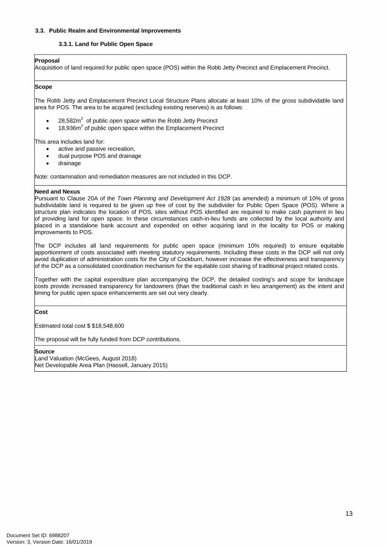
3.3. Public Realm and Environmental Improvements
3.3.1. Land for Public Open Space
Proposal Acquisition of land required for public open space (POS) within the Robb Jetty Precinct and Emplacement Precinct.
Scope The Robb Jetty and Emplacement Precinct Local Structure Plans allocate at least 10% of the gross subdividable land area for POS. The area to be acquired (excluding existing reserves) is as follows:
• 28,582m2 of public open space within the Robb Jetty Precinct • 18,936m2 of public open space within the Emplacement Precinct
This area includes land for:
• active and passive recreation, • dual purpose POS and drainage • drainage
Note: contamination and remediation measures are not included in this DCP.
Need and Nexus Pursuant to Clause 20A of the Town Planning and Development Act 1928 (as amended) a minimum of 10% of gross subdividable land is required to be given up free of cost by the subdivider for Public Open Space (POS). Where a structure plan indicates the location of POS, sites without POS identified are required to make cash payment in lieu of providing land for open space. In these circumstances cash-in-lieu funds are collected by the local authority and placed in a standalone bank account and expended on either acquiring land in the locality for POS or making improvements to POS. The DCP includes all land requirements for public open space (minimum 10% required) to ensure equitable apportionment of costs associated with meeting statutory requirements. Including these costs in the DCP will not only avoid duplication of administration costs for the City of Cockburn, however increase the effectiveness and transparency of the DCP as a consolidated coordination mechanism for the equitable cost sharing of traditional project related costs. Together with the capital expenditure plan accompanying the DCP, the detailed costing’s and scope for landscape costs provide increased transparency for landowners (than the traditional cash in lieu arrangement) as the intent and timing for public open space enhancements are set out very clearly.
Cost Estimated total cost $ $18,548,600 The proposal will be fully funded from DCP contributions.
Source Land Valuation (McGees, August 2018) Net Developable Area Plan (Hassell, January 2015)
Version: 3, Version Date: 16/01/2019Document Set ID: 6988207

14
3.3.2. Public Open Space Improvements
Proposal
Enhancement of Public Open Space to service the needs of existing and future residents within the Robb Jetty Precinct and Emplacement Precinct
Scope
To construct Local Parks, Neighbourhood Parks and a District Park in accordance with the Robb Jetty Precinct and Emplacement Precinct local structure plans within the project area as follows:
Local Parks (LP1 to LP9)
Local Parks should be provided for local children’s play and as resting places, designed as small intimate spaces, where appropriate, to allow pedestrian connectivity, and create a sense of place. Local parks are less intensively developed park areas for the local community to enjoy. They are predominantly lawn and planted areas with pockets of paved areas for seating nodes and winding pathways. Planted garden beds are predominantly endemic species to attract native wildlife. Adequate shade should be provided through structures and trees to provide comfortable resting spaces for people to enjoy. The proposal includes:
• Minor earthworks and drainage • Irrigated planting • Irrigated turf • Paved areas (stone and concrete areas) • Footpaths (in-situ concrete, stabilized gravel) • Custom and proprietary play equipment • Furniture (benches, shelters, bins, bike racks, water fountains, BBQ’s, exercise equipment) • Lighting and electrical • Interim Maintenance (to facilitate handover to Council)
Neighbourhood Parks (NP1 to NP8)
The Robb Jetty and Emplacement precincts have eight proposed neighbourhood parks which have been strategically located so that all residents are within close walking distance to a neighbourhood park.
The neighbourhood park is to act as a “backyard” for families to enjoy and to promote interaction with the local community. Neighbourhood parks are designed to promote an active lifestyle with play equipment for youth and children, sporting facilities, general open kick around areas and bbq facilities. Plentiful shade and seating should be provided to create comfortable enjoyable places for people to rest. Neighbourhood parks should be designed to allow passive surveillance through CEPTED principles to provide a safe space for people to enjoy day and night. Neighbourhood parks should be predominantly lawn And garden bed areas to provide a tranquil place of refuge with pockets of paved areas at seating nodes. Neighbourhood Parks are to include the following works:
• Minor earthworks and drainage • Irrigated planting • Irrigated turf • Paved areas (stone and concrete pavers) • Footpaths (in-situ concrete, stabilized gravel) • Furniture (benches, shelters, bins, bike racks, water fountains, BBQ’s, exercise equipment) • Lighting and electrical • Interim Maintenance (to facilitate handover to Council)
District Park (DP1)
There is one District Park in the project area, nominally named ‘Heritage Plaza’. The Heritage Plaza is a high quality urban space with the focus on the heritage Robb Chimney element. A potential interactive water feature can provide playfulness whist reflecting the Chimney, emphasising its scale. Resting opportunities with shade and seating will make this space a tranquil escape from the proposed vibrant development. This space interfaces with Main street to the north and the Community infrastructure associated with the sports oval to the south (refer to Community infrastructure DCP 13).
Version: 3, Version Date: 16/01/2019Document Set ID: 6988207

15
The District Park will incorporate the following works: District Park 1
• Minor earthworks and drainage • Irrigated planting • Paved areas (stone and concrete pavers) • Footpaths (in-situ concrete, stabilised gravel) • Custom and proprietary play equipment • Furniture (benches, shelters, bins, bike racks, water fountains, barbeques) • Water features • Lighting and electrical • Interim Maintenance (to facilitate handover to Council)
Consultancy Fees Consultant input is required to design, plan and deliver the public open spaces. Consultant costs include:
• Design Consultancy (e.g. Landscape Architecture etc.) • Project Management
Note: contamination and remediation measures are not included in this DCP.
Need and Nexus The project area requires parks and reserves to service the recreational needs of the future community within the Cockburn Coast region. The provision of open space is consistent with Statement of Planning Policy 3.6 – Open Space (SPP 3.6) and Liveable Neighbourhoods which require 10 per cent of the gross subdividable area to be provided as a standard development contribution requirement. Liveable Neighbourhoods outlines that public parkland that can be used by a wide range of people living or working in urban areas, contributes significantly to quality of life. Regional, district and local open space can be created efficiently through careful structure planning and site-responsive design. Parklands can contribute towards legibility, identify and sense of place that helps build community. The distribution of open spaces and proposed functional hierarchy is sufficient to support the needs of the future population and will contribute to the attractiveness of the area for visitors of the adjacent foreshore and regional open space. District Open Space is not included in the Robb Jetty and Emplacement Precinct DCP due to the broader catchment of this space. Instead District Open Space will be included in the existing Community Infrastructure DCP (DCA 13) and funds collected over a broader area that extends outside the project area. The specification and budget for landscape improvements have been based on the level of amenity provided within Port Coogee and are necessary to support the high population envisaged for the Cockburn Coast.
Cost Estimated total cost $11,100,437 broken down as follows: Local Parks - $7,335,434 Neighbourhood Parks - $2,941,464 District Park - $522,054 Consultancy Fees - $301,485 The proposal will be fully funded from DCP contributions.
Source Ecoscape Australia (December 2018)
Version: 3, Version Date: 16/01/2019Document Set ID: 6988207

16
3.3.3. Main Street ‘Local’ Community Building
Proposal Provision of a local community building in close proximity to the Robb Jetty Main Street to service the needs of the project area.
Scope To construct a new Community Building adjacent to the public open space and commercial core of the Cockburn Coast. The building and outside areas will provide 2,000m2 of community use over ground/upper floors on a 1,000m2
site.
Need and Nexus The Cockburn Coast District Structure Plan envisages that circa 10,000 future residents will reside in approximately 5,000 dwellings within the project area. Liveable Neighbourhoods outlines that sites for community purposes such as community centres, meeting halls, branch libraries and kindergartens are increasingly important for community development. The document recommends that community purpose sites should generally be provided on the basis of one for each group of three neighbourhoods (1500-1800 dwellings) located wither adjoining public open space or in centres. There is expected to be a significant increase in population and demand for community facilities in the locality. Further, other local community centres will not be able to support the Cockburn Coast population. Based on Liveable Neighbourhood recommendations, the resultant community will therefore require the development of a Community Building to satisfy local community needs of the area. The building has been designed to accommodate the needs of a 10,000 person community. For comparative purposes, the size of the community building required would be double the size and capacity of the local community facility located in Port Coogee which has been designed to serve a smaller population. Given that the local community building will also serve future residents of the Power Station Precinct, the cost of the facility will be apportioned to reflect the planned number of dwellings within each precinct. The following identifies the number of dwellings envisaged by the District Structure Plan (Part 2) and subsequent apportionment of the community building cost between the two DCP areas. LSP No Dwellings % Robb Jetty 2,439 47.97% Emplacement 1,538 29.62% Total 3,977 76.58%
Power Station 1,216 23.42% Total 5,193* 100.00% Source: 85% Scheme Approach of DCP *Indicative total referred to in the Master Plan DSP2
Cost Estimated total cost is $13,221,000 broken down as follows: Construction $9,440,000 Professional fees and contingency $3,230,000 Land acquisition (1,000m2) $ 551,000 Total $13,221,000 The proposal will be funded from two DCP schemes applicable to the Cockburn Coast:
• 76.584% from Robb Jetty and Emplacement Precincts (DCP14) • 23.416% from Power Station Precinct (future DCP)
The DCP funding applicable to Robb Jetty and Emplacement Precincts is estimated to be $10,125,170.64. the remaining $3,095,829.36 will be funded from the Power Station Precinct DCP (timing to be determined) Source Ralph & Beattie Bosworth Pty Ltd cost estimate– October 2018 McGees land valuations - August 2018
Version: 3, Version Date: 16/01/2019Document Set ID: 6988207

17
4. Development Contribution Methodology
Given that all infrastructure items identified for inclusion in the DCP provide a benefit to all landowners in the project, one DCP will apply to both the Robb Jetty Precinct and Emplacement Precincts.
The following section of the report outlines the key principles and methodology for determining the development contributions applicable to the Robb Jetty Precinct and Emplacement Precinct.
4.1. Key Principles
A key objective of the cost apportionment methodology is the need to provide certainty to each landowner on their cost contribution and ensure costs are shared in a transparent and equitable manner. It is also important to provide the custodian of the DCP appropriate certainty on the source of all funds required to deliver infrastructure and mitigate any potential for shortfalls in funding.
Having regard to the above and varying developer intentions, a significant constraint to development of the DCP is the inability to prepare a DCP that will guarantee contributions based on the actual/final development outcome.
Basing contributions on the actual development outcome is considered to be the most equitable outcome from a user pays point of view. In this instance contributions would be based on actual number of dwellings provided however underdevelopment may result in short falls in DCP funds or higher DCP costs for later subdividers. Further, whilst it is clear that this approach seeks to match cost contributions with the actual development of each site, there are inherent issues with preparing a long term DCP that factors the unknown and still maintains transparency and equitable outcomes for those developing first or last.
Accordingly, cost contributions within the Cockburn Coast will be commensurate with the development potential of each site within the Cockburn Coast. To achieve an equitable outcome, the development potential of each site will be determined in an equal and consistent manner. This approach is consistent with the overarching principle ‘beneficiary pays’ of the WAPC’s SPP 3.6.
4.2. Contribution Base
Developer contributions will be required from net developable land area only. Contributions will not be required from land identified by the local structure plans for reserve, local roads, public open space, land solely required for drainage and land required for DCP infrastructure.
The Robb Jetty Precinct and Emplacement Precinct Local Structure Plans propose a range of potential land uses with varying potential for development intensification. Residential development density allocations for example, range from R40 to R160. Mixed use development is also proposed within built form of similar height and bulk ranges however the precise mix of residential and commercial uses will vary from site to site depending on individual developer intentions and market considerations.
The DCP must therefore contemplate and seek cost recovery from all land uses and account for the varying development potential of landholdings in each land use and density classification. To ensure an equitable outcome for landowners, cost contributions towards infrastructure will be apportioned in a manner that is commensurate with the development potential of each landholding e.g. higher density land will pay a higher contribution than lower density land.
4.2.1. Non-Residential Uses
Mixed use development comprising commercial and residential floor space will not be differentiated from residential use due to the difficulty in determining varying landowner motivations and the final mix of uses. It is also difficult to determine the precise utilisation of infrastructure and amenities generated by future commercial/mixed uses (employees and visitors). It is however considered that mixed use sites will benefit from road infrastructure in a relatively equivalent manner to residential use however potentially to a lesser degree public open space enhancement.
Given the regional focus of the project, commercial use will contribute to the attractiveness of the area to visitors and result in increased use of the public open space. Similarly, the regional attractiveness of the area and increased number of visitors will reinforce the viability and exposure of commercial activities and thus provide benefit to operators and business owners. On this basis cost contributions will be collected from proposed mixed use sites on an equivalent floor space basis to residential use. This approach also acknowledges the current market reality that developers are likely to favour predominantly residential use over commercial use for mixed use sites.
Version: 3, Version Date: 16/01/2019Document Set ID: 6988207
18
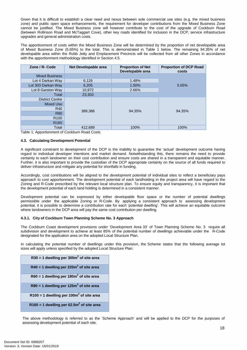
Given that it is difficult to establish a clear need and nexus between sole commercial use sites (e.g. the mixed business zone) and public open space enhancements, the requirement for developer contributions from the Mixed Business Zone cannot be justified. The Mixed Business zone will however contribute to the cost of the upgrade of Cockburn Road (between Rollinson Road and McTaggart Cove), other key roads identified for inclusion in the DCP, service infrastructure upgrades and general administration costs.
The apportionment of costs within the Mixed Business Zone will be determined by the proportion of net developable area of Mixed Business Zone (5.65%) to the total. This is demonstrated in Table 1 below. The remaining 94.35% of net developable area within the Robb Jetty and Emplacement Precincts will be collected from all other Zones in accordance with the apportionment methodology identified in Section 4.5.
Zone / R- Code Net Developable area Proportion of Net
Developable area Proportion of DCP Road
costs Mixed Business
5.65% Lot 4 Darkan Way 6,126 1.48%
Lot 303 Darkan Way 6,205 1.50% Lot 8 Garston Way 10,972 2.66%
Total 23,303 District Centre
389,386 94.35% 94.35%
Mixed Use R40 R80
R100 R160 Total 412,689 100% 100%
Table 1: Apportionment of Cockburn Road Costs
4.3. Calculating Development Potential
A significant constraint to development of the DCP is the inability to guarantee the ‘actual’ development outcome having regard to individual developer intentions and market demand. Notwithstanding this, there remains the need to provide certainty to each landowner on their cost contribution and ensure costs are shared in a transparent and equitable manner. Further, it is also important to provide the custodian of the DCP appropriate certainty on the source of all funds required to deliver infrastructure and mitigate any potential for shortfalls in funding.
Accordingly, cost contributions will be aligned to the development potential of individual sites to reflect a beneficiary pays approach to cost apportionment. The development potential of each landholding in the project area will have regard to the Zoning and R-Code prescribed by the relevant local structure plan. To ensure equity and transparency, it is important that the development potential of each land holding is determined in a consistent manner.
Development potential can be expressed by either developable floor space or the number of potential dwellings permissible under the applicable Zoning or R-Code. By applying a consistent approach to assessing development potential, it is possible to determine a contribution rate for each ‘potential dwelling’. This will achieve an equitable outcome where landowners in the DCP area will pay the same cost contribution per dwelling.
4.3.1. City of Cockburn Town Planning Scheme No. 3 Approach
The Cockburn Coast development provisions under ‘Development Area 33’ of Town Planning Scheme No. 3 require all subdivision and development to achieve at least 85% of the potential number of dwellings achievable under the R-Code designated for the application area on the adopted Local Structure Plan.
In calculating the potential number of dwellings under this provision, the Scheme states that the following average lot sizes will apply unless specified by the adopted Local Structure Plan:
R30 = 1 dwelling per 300m2 of site area
R40 = 1 dwelling per 220m2 of site area
R60 = 1 dwelling per 180m2 of site area
R80 = 1 dwelling per 125m2 of site area
R100 = 1 dwelling per 100m2 of site area
R160 = 1 dwelling per 62.5m2 of site area
The above methodology is referred to as the ‘Scheme Approach’ and will be applied to the DCP for the purposes of assessing development potential of each site.
Version: 3, Version Date: 16/01/2019Document Set ID: 6988207
19
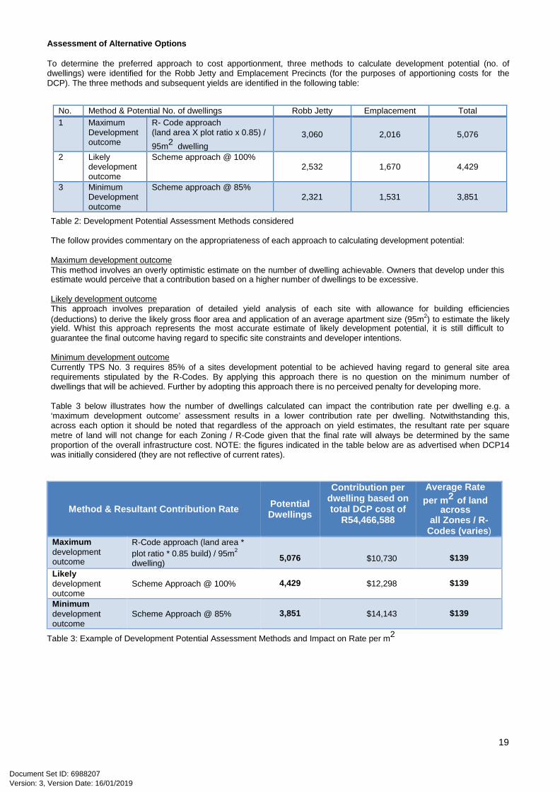
Assessment of Alternative Options
To determine the preferred approach to cost apportionment, three methods to calculate development potential (no. of dwellings) were identified for the Robb Jetty and Emplacement Precincts (for the purposes of apportioning costs for the DCP). The three methods and subsequent yields are identified in the following table:
Table 2: Development Potential Assessment Methods considered
The follow provides commentary on the appropriateness of each approach to calculating development potential:
Maximum development outcome This method involves an overly optimistic estimate on the number of dwelling achievable. Owners that develop under this estimate would perceive that a contribution based on a higher number of dwellings to be excessive.
Likely development outcome This approach involves preparation of detailed yield analysis of each site with allowance for building efficiencies (deductions) to derive the likely gross floor area and application of an average apartment size (95m2) to estimate the likely yield. Whist this approach represents the most accurate estimate of likely development potential, it is still difficult to guarantee the final outcome having regard to specific site constraints and developer intentions.
Minimum development outcome Currently TPS No. 3 requires 85% of a sites development potential to be achieved having regard to general site area requirements stipulated by the R-Codes. By applying this approach there is no question on the minimum number of dwellings that will be achieved. Further by adopting this approach there is no perceived penalty for developing more.
Table 3 below illustrates how the number of dwellings calculated can impact the contribution rate per dwelling e.g. a ‘maximum development outcome’ assessment results in a lower contribution rate per dwelling. Notwithstanding this, across each option it should be noted that regardless of the approach on yield estimates, the resultant rate per square metre of land will not change for each Zoning / R-Code given that the final rate will always be determined by the same proportion of the overall infrastructure cost. NOTE: the figures indicated in the table below are as advertised when DCP14 was initially considered (they are not reflective of current rates).
Method & Resultant Contribution Rate Potential Dwellings
Contribution per dwelling based on total DCP cost of
R54,466,588
Average Rate per m2 of land
across all Zones / R-
Codes (varies) Maximum development outcome
R-Code approach (land area * plot ratio * 0.85 build) / 95m2
dwelling)
5,076
$10,730
$139
Likely development outcome
Scheme Approach @ 100%
4,429 $12,298
$139
Minimum development outcome
Scheme Approach @ 85%
3,851 $14,143
$139
Table 3: Example of Development Potential Assessment Methods and Impact on Rate per m2
No. Method & Potential No. of dwellings Robb Jetty Emplacement Total 1 Maximum
Development outcome
R- Code approach (land area X plot ratio x 0.85) / 95m2 dwelling
3,060 2,016 5,076
2 Likely development outcome
Scheme approach @ 100% 2,532 1,670 4,429
3 Minimum Development outcome
Scheme approach @ 85% 2,321 1,531 3,851
Version: 3, Version Date: 16/01/2019Document Set ID: 6988207

20
4.4. Preferred Scheme Approach
The DCP adopts the Scheme Approach @ 85% as it is consistent with current City of Cockburn practice and the overall vision for the project in that it encourages developers to provide high densities without penalty. Given the understatement of potential dwellings applying this approach, a known constraint to this approach is the perception that the contribution rate (per dwelling) will appear excessive.
To determine the number of potential dwellings (or equivalent floor space) for each Zone or R-Code under the Scheme Approach, the following table identifies the methodology for calculating development potential (for the purposes of the DCP).
Zone / R-Code No. of dwellings permitted per m2 of land area
*Minimum Development Requirements under Table 10 of TPS
No. 3 District Centre (R160
equivalent) 1x equivalent dwelling per 62.5m2 site area
*Contributions will be based on the minimum No. of Potential Dwellings (85%) as determined by Table 10 of TPS No.3
Mixed Use (R100 equivalent) 1x equivalent dwelling per 100m2 site area R40 1x equivalent dwelling per 220m2 site area R80 1x equivalent dwelling per 125m2 site area
R100 1x equivalent dwelling per 100m2 site area R160 1x equivalent dwelling per 62.5 m2 site area
Table 4: Calculation Method for determining No. of Dwellings per m2 of Net Land Area estimated for each Zone/R-Code under Schedule 11 of TPS No. 3 Table 5 below summarises the amount of Net Developable Area (NDA) within each Zone/R-Code and the ‘minimum 85%’ number of potential dwellings estimated for each Zone/R-Code under the preferred approach.
Zone / R-Code Net
Developable Area
Density per m2
of land area No. Equivalent
Dwellings (@100%)
No. Equivalent Dwellings (@85%)
Proportion of Total
Dwellings
District Centre (R160 equivalent) 59,079 62.5m² site area 945 803 20.86%
Mixed Use (R100 equivalent) 70,692 100m² site area 707 601 15.60%
R40 29,057 220m² site area 132 112 2.92%
R80 32,243 125m² site area 258 219 5.69%
R100 114,075 100m² site area 1141 970 25.18%
R160 84,240 62.5m² site area 1348 1146 29.75%
Total 389,386 4,531 3,851 100%
Table 5: Proportion of dwellings within each zone/R-Code under the Scheme Approach
The percentage of total dwellings within each Zone/R-Code (identified in Table 5) will determine the proportion of overall infrastructure cost for each Zone/R-Code.
Table 6 on the following page summarises the costs per Zone/ R-Code. To differentiate sites (for the purposes of apportioning costs for the DCP) it is possible to determine a contribution rate for each square metre of land within each Zoning and R-Code allocation.
Version: 3, Version Date: 16/01/2019Document Set ID: 6988207

21
The varying rate per m2 demonstrates that cost contributions are commensurate with the development potential of the land whereby sites with a higher development potential will be required to pay a higher cost contribution per m2 than land with lower development potential. NOTE: the figures indicated in the table below are as advertised when DCP14 was initially considered (they are not reflective of current rates).
Importantly, the contribution rate (per equivalent dwelling) is the same across all Zones/R-Codes therefore demonstrating that all landowners are being treated equally and that equity is being achieved.
Zone / R-Code Net
Developable Area
No. Equivalent Dwellings (@85%)
Percentage of Total
Dwellings
Proportion of $54.46m*
Infrastructure Cost
Rate (2013*) per m2 of Land
($* / Area)
Rate (2013*) Per
Equivalent Dwelling
District Centre (R160 equivalent) 59,079 803 20.86% $11,363,415 $192 $14,143
Mixed Use (R100 equivalent) 70,692 601 15.60% $8,498,181 $120 $14,143
R40 29,057 112 2.92% $1,587,756 $55 $14,143
R80 32,243 219 5.69% $3,100,853 $96 $14,143
R100 114,075 970 25.18% $13,713,434 $120 $14,143
R160 84,240 1146 29.75% $16,202,949 $192 $14,143
Total 389,386 3,851 100% 54,466,588
Table 6: Proportion of Costs per Zone/R-Code (* $AUD based on 2013/14 Cost Estimates)
Based on the above, this approach provides a transparent method for determining the development potential and subsequent ‘infrastructure demand’ generated by individual land holdings for both residential and commercial uses on an equivalent basis.
Version: 3, Version Date: 16/01/2019Document Set ID: 6988207
22
5. Statement of Compliance with Statement of Planning Policy 3.6
5.1. Compliance with SPP 3.6
The City of Cockburn’s Town Planning Scheme No. 3 sets out the guiding principles for development contribution plans as follows:
Need and the nexus The need of each item of infrastructure included in the DCP and the connection between the development and the demand created by new development within the City is clearly set out in the individual Infrastructure Item sheets set out in Section 3 of this report.
Transparency The DCP ensures transparency by determining the contribution for each property within the DCA at the outset. Further the way development potential is calculated and the method for applying the contribution is simple to understand and administer.
Calculation of an owner’s contribution will be based on the minimum potential number of equivalent dwellings that can be created under the applicable Zoning or R Coding. The contribution rate is calculated per local structure plan zoning classification and is based on the proportion of ‘minimum potential’ dwellings to the total’ minimum potential’ dwellings. The development potential calculation method is applied consistently and equally across all landholdings.
The contribution rate for each site is pre-determined by the cost apportionment schedule located in Attachment 6. The approach is simple to understand particularly for landowners who wish to determine their obligations. It is also easily assessed and administered by the Council’s officers.
To provide further transparency, cost contributions collected by the City of Cockburn will be expended on improvements in the proximity of sites making cost contributions (for example local public open space enhancement costs). Where appropriate, landowners will have the potential to undertake works in kind (subject to City of Cockburn approval).
Equity The development contribution is to be calculated on the basis of the minimum number of dwellings that can be created through subdivision/development thus ensuring each of the owners contribution is assessed on a clear and consistent basis and thus reflective of the relative need generated by a particular development. By determining contributions upfront it is less likely that later subdividers will be confronted with excessively high contributions.
Certainty This DCP and associated Cost Apportionment Schedule sets out the items to which subdivision/development in the project area is making a contribution to. Further, the cost apportionment schedule indicates the final contribution payable for each property after all offsets (e.g. land for public open space or road widening) have been taken into account.
To provide certainty on the cost of the infrastructure items, the DCP provides that the cost of each infrastructure item is to be reviewed at least annually to reflect changes in funding and revenue sources and indexed based on the Building Cost Index or other appropriate index as approved by an appropriately qualified independent person.
Efficiency Development contribution should be justified on a whole of life capital cost basis consistent with maintaining financial discipline on service providers by precluding over recovery of costs.
Consistency The cost apportionment methodology will be uniformly applied across the whole DCP area. The contribution will be levied on development/subdivision or the change of use (from non-conforming use to a use specified in the local structure plan) in accordance with the Scheme that whatever form of development is contemplated, the owner/developer will make an appropriate contribution.
Right of consultation and arbitration The DCP provisions were advertised through Amendment No 94 which introduced DCP14 to the Scheme thus satisfying the requirement to consult with landowners and developers on the manner in which the development contributions are determined.
The Scheme provides that an owner may request that any estimate contained in a DCP be independently certified by an appropriately qualified person.
Version: 3, Version Date: 16/01/2019Document Set ID: 6988207
23
The Scheme provides that any dispute between an owner and the local government in respect to a cost contribution is to be resolved by arbitration.
Accountable The costs for each infrastructure item are to be reviewed annually and the DCP updated accordingly. The updated DCP will be available on the City’s website and owners can request the review of any cost in accordance with the Scheme and have a dispute in respect to the required contribution determined through arbitration in accordance with the Scheme.
A Statement of Accounts showing all revenue and expenditure for the DCP is to be prepared for each financial year and audited by the City’s auditors. The audited statements will be available on the City’s website.
5.2. Compliance with Clause 5.5 OF SPP 3.6
The matters of need and nexus are dealt with above and in detail in the Infrastructure Item sheets contained in Section 3. Other matters are addressed below.
Catchment Areas Given that all infrastructure items identified for inclusion in the DCP have a benefit to all landowners in the project; one DCP will apply to both the Robb Jetty and Emplacement Precincts (DCP14).
Cost of the infrastructure item The source of the cost is noted on each of the detailed sheets for each infrastructure item contained within the Section 3 of this report. All cost estimates have been based on preliminary concept plans and will need to be reviewed when detailed briefs and plans have been prepared. In some cases, the costs have been benchmarked on similar projects e.g. landscape costs are similar to South Beach and Port Coogee cost estimates.
As provided for in the DCP, the cost of the infrastructure item will be reviewed at least annually. If during the year more detailed costing is undertaken then these updated costs would be adopted in preference to broad based estimates. In all other instances the cost estimates will be adjusted to reflect changes in funding and revenue sources that may have been secured and the cost indexed based on the Building Cost Index or other appropriate index as approved by an appropriately qualified independent person.
A Capital Expenditure Plan to be prepared An overarching framework is provided in the Strategic Community Plan. This feeds into the City’s Corporate Business Plan and Annual Business Plan where indicative infrastructure timing and general sources of funds are identified. As most of the infrastructure items are to be provided within the next 10 years, the above satisfies the requirement for a Capital Infrastructure Plan.
The capital expenditure plan will be reviewed at least annually or when the City of Cockburn considers the plan requires review.
Version: 3, Version Date: 16/01/2019Document Set ID: 6988207
24
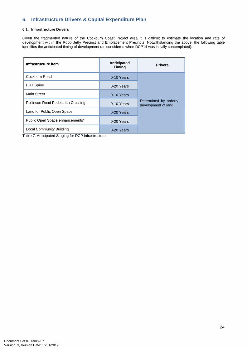
6. Infrastructure Drivers & Capital Expenditure Plan
6.1. Infrastructure Drivers
Given the fragmented nature of the Cockburn Coast Project area it is difficult to estimate the location and rate of development within the Robb Jetty Precinct and Emplacement Precincts. Notwithstanding the above, the following table identifies the anticipated timing of development (as considered when DCP14 was initially contemplated):
Infrastructure item Anticipated
Timing Drivers
Cockburn Road 0-10 Years
Determined by orderly development of land
BRT Spine 0-20 Years
Main Street 0-10 Years
Rollinson Road Pedestrian Crossing 0-10 Years
Land for Public Open Space 0-20 Years
Public Open Space enhancements* 0-20 Years
Local Community Building 0-20 Years Table 7: Anticipated Staging for DCP Infrastructure
Version: 3, Version Date: 16/01/2019Document Set ID: 6988207

25
7. Operational Matters
7.1. Cost Estimates
The determination of infrastructure costs and administration costs should be in accordance with the City of Cockburn TPS No. 3.
7.2. Land Valuation
Land valuation should be in accordance with the City of Cockburn TPS No. 3.
7.3. Payment of Cost Contributions
Owners must make a cost contribution in accordance with the City of Cockburn TPS No. 3, which details the timing and form of payment of cost contributions.
Notwithstanding DCP14, applications for continuance or extension of existing non-conforming uses will be exempt from development contributions towards this DCP.
7.4. Works in Kind
Owners may undertake ‘work in kind’ by way of the provision of land (associated with a DCP item) or physical infrastructure in lieu of a cash contribution in accordance with the City of Cockburn TPS No. 3.
Works in kind will only be accepted on the proviso that the City expressly agrees to this payment method prior to the works occurring and the scope and detail of the works actually relate to the DCP items.
7.5. Arbitration
Any dispute between an owner and the City of Cockburn regarding a cost contribution (or valuation) should be in accordance with the process outlined in the City of Cockburn TPS No. 3.
7.6. Administration of Credits
Owners that are in credit after completing ‘works in kind’ will be refunded by the DCP in the order the credits were received and as funds become available.
Version: 3, Version Date: 16/01/2019Document Set ID: 6988207

26
8. Examples of Calculation
8.1. EXAMPLE: Lot 2108 Bennett Avenue
Characteristics: Development of site identified by the LSP with Public Open Space and Residential R100 Density
Developable Area
*Example only - all cost estimates based on Original 2014 cost estimates ** Work-in-kind cost is an example only
Gross Area 42,863m2
POS Provided* 4,168m2
Civic Use 16,177m2
Local Roads 6,658m2
Net Area 15,861m2
Minimum Development Potential (@85%)
Yield: R100 @ 85% (15,861m2 /100m2)
135 dwellings
Cost Contributions
Contribution 135 dwellings @ $14,218 per unit
$1,916,873
Offsets* 4,168m2 POS
$1,750,600
Work in Kind (enhance POS)
$0
Final contribution payable $166,273 In Credit
Version: 3, Version Date: 16/01/2019Document Set ID: 6988207

27
8.2. EXAMPLE: Lot 65 Rollinson Avenue
Characteristics: Development of site identified by the LSP with Public Open Space and Varying Zonings and R-Codes
Developable Area
Gross Area 17,308m2
POS Provided* 4,093m2
Local Roads 1,632m2
DCP Roads 185m2
Net Area 11,339m2
Minimum Development Potential (@85%)
Mixed Use: R100 @ 85% (2,780m2 /100m2)
24
R100 @ 85% (8,619m2 /100m2)
73
Total Yield 97
Cost Contributions
Contribution 97 dwellings @ $14,218 per unit
$1,377,620*
Offset: 4,093m2 POS $2,169,300*
Offsets: 185m2 DCP roads $107,910*
Work in Kind ** (enhancements to POS)
$250,000 (Example)
Final contribution payable $1,167,629 In Credit
*Example only - all cost estimates based on Original 2014 cost estimates ** Work-in-kind cost is an example only
Version: 3, Version Date: 16/01/2019Document Set ID: 6988207

28
8.3. EXAMPLE: Lot 69 Bennett Avenue
Characteristics: Development of site identified by the LSP with no Public Open Space and R160 density coding
Developable Area
Gross Area 14,996m2
POS Provided* 0m2
Local Roads 0m2
DCP Roads 0m2
Net Area 14,996m2
Minimum Development Potential (@85%)
Mixed Use: R160 @ 85% (14,996m2 /62.5m2)
204
Cost Contributions
Contribution 204 dwellings @ $14,218 per unit
$2,915,569
Offset: N/A $0
Work in Kind ** (enhancements to POS)
$0
Final contribution payable $2,899,735 *Example only - all cost estimates based on Original 2014 cost estimates
Version: 3, Version Date: 16/01/2019Document Set ID: 6988207
29
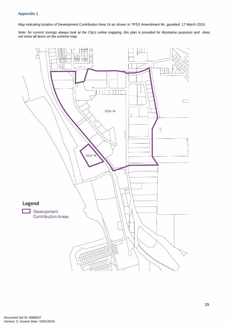
Appendix 1 Map indicating location of Development Contribution Area 14 as shown in TPS3 Amendment 94, gazetted 17 March 2015.
Note: for current zonings always look at the City’s online mapping, this plan is provided for illustrative purposes and does not show all items on the scheme map.
Version: 3, Version Date: 16/01/2019Document Set ID: 6988207

30
Appendix 2 Current contribution rates
Note: this document is updated annually to coincide with the commencement of each new financial year. The relevant year is written at the top of each schedule. The link below will take you to the City’s Development Contributions webpage where current rates are published. http://www.cockburn.wa.gov.au/Council_Services/City_Development/Projects/Developer_Contributions/default.asp If the link does not work: visit the City of Cockburn webpage and search ‘developer contribution’
Version: 3, Version Date: 16/01/2019Document Set ID: 6988207